Excavations South-East of Park Farm, Ashford, Kent Part 1 ... · EXCAVATIONS SOUTH-EAST OF PARK...
51
Excavations South-East of Park Farm, Ashford, Kent Part 1: Main Report Wessex Archaeology, Portway House, Old Sarum Park, Salisbury SP4 6EB tel: 01722 326867 fax: 01722 337562 email: [email protected] www.wessexarch.co.uk
Transcript of Excavations South-East of Park Farm, Ashford, Kent Part 1 ... · EXCAVATIONS SOUTH-EAST OF PARK...

Excavations South-East of Park Farm, Ashford, Kent
Part 1: Main Report
Wessex Archaeology, Portway House, Old Sarum Park,Salisbury SP4 6EB
tel: 01722 326867 fax: 01722 337562email: [email protected]
www.wessexarch.co.uk
EXCAVATIONS SOUTH-EAST OF PARK FARM, ASHFORD, KENT
with Dana Challinor, Nicholas Cooke, Grace Perpetua Jones, Stephanie Knight,
Victoria Lucas, Lorraine Mepham, Sarah Paynter, Patrice de Rijk, R.H Seager Smith
and Chris J. Stevens
and illustrations by S.E. James
Contents
Introduction 1
BackgroundStages of workTopography, hydrology and geology
Middle to Late Bronze AArea 1Area 3
Introduction
Area
Area
Late Iron Age – early Romano-BritishIntroductionArea 3Area 1Area 2Land at Bilham Farm
Medieval and laterPark Farm East and South EastLand at Bilham Farm
Discussion
Acknowledgements
Bibliography
This report describes the results of a series of archaeological evaluations and excavations undertaken on land south-east of Park Farm, on the south side of Ashford, Kent, between 2002 and 2007. Specialist finds and environmental reports relating to the stages of work undertaken by Wessex Archaeology are presented in separate document (Part 2 – http://www.kentarchaeology.ac/ archrep/archrep.html).
Background
The works were undertaken on two blocks of land, centred of NGR 602200 138600, separated by part of a floodplain drained by the Ruckinge and Bilham Dykes (Fig. 1). To the west of the valley are the Park Farm East and Park Farm South East residential and mixed-use development sites (together covering c. 38.7 ha), and to the east is Land at Bilham Farm that is proposed for flood remediation measures (covering c. 13.9 ha). Park Farm East and South East are bounded to the west by the Ashford to Hastings railway line and A2070 trunk road (Hamstreet Road), and to the south by Brockman’s Lane; Land at Bilham Farm lies west of Cheeseman’s Green Lane.
The site lies within a landscape that has been subject in recent years to a number of large-scale archaeological excavations related to developments around Ashford, including the construction of the Channel Tunnel Rail Link (High Speed 1). These have revealed evidence of extensive occupation spanning the late prehistoric and early Romano-British periods. They include a Middle/Late Iron Age to early Romano-British settlement at Waterbrook Park (Wessex Archaeology 2008a), and another with evidence of high status burials at Brisley Farm (Johnson 2002; Archaeology South-East 2006) (Fig. 1). An extensive Romano-British settlement was excavated at Westhawk Farm (Booth et al. 2008), located at the junction of two Roman roads, one being that between Lympne and Maidstone which also passed north of the Park Farm sites reported here. Other sites of this broad period in the area include Foster Road (Powell 2010; Powell and Birbeck 2010), Orbital Park (Philp 1991), West of Blind Lane, Sevington (Oxford Archaeology 1999), and Boys Hall Moat (Booth and Everson 1994).
Stages of work
The archaeological potential of the site, as suggested by the proximity of these other Ashford sites, was confirmed by desk-based assessments by Wessex Archaeology (WA) and CgMs Consulting (CgMs) which indicated finds and remains within the landscape of Mesolithic to post-medieval date, with particularly high potential in relation to the Late Iron Age and Romano-British periods (WA 1998; CgMs 2001).
In 2002, 72 evaluation trenches and three test pits were excavated by Pre-Construct Archaeology (PCA) at Park Farm East and South East (CgMs 2003) and on the basis of the evaluation results, and the excavation by WA of a further ten evaluation trenches, three areas in Park Farm East containing significant clusters of archaeological features (Areas 1–3) were selected for excavation by Wessex Archaeology in 2003 (WA 2004) (Fig. 2) (Table 1).
1

Figure 1: Location and topography of the site with main areas of fieldwork, areas without archaeology and other sites in the Ashford area
2
On Land at Bilham Farm in 2003, 39 evaluation trenches were excavated by Archaeology South-East (ASE) (ASE 2003). Subsequently, in 2007 (Phase ll), on the basis of the evaluation results, a small area was subject to strip, map and record excavation (WA 2008d); in addition, a further 77 evaluation trenches were excavated in the area extending to the south-east of the earlier trenches (WA 2007b).
The 2003 excavation of Park Farm East Areas 1–3, which covered an area of c. 2.6 ha, produced the bulk of the archaeological evidence from this programme of fieldwork and is therefore the focus of this report. However, the smaller excavation of Area 4 (c. 0.1 ha) in Park Farm South East also contained significant remains, as did the 2003 evaluation on Land at Bilham Farm. A possible Late Iron Age/early Romano-British settlement at the latter site has been preserved in situ and was therefore not further investigated.
Unless other areas are specifically referred to below, ‘the site’ in this report refers to the Park Farm Areas 1–4. Relevant findings from other phases of work are, therefore, only referred to in passing where appropriate. Due to the length of time over which the fieldwork was conducted, there was some duplication of context numbers between the evaluation and excavation phases. Where contexts are from an evaluation phase these are indicated with an ‘ev’ prefix.
Topography, hydrology and geology
The hydrology of the site is largely determined by the courses of the Ruckinge and Bilham Dykes which drain one of the headwater valleys of the East Stour River, connecting with a larger network of drainage ditches as they flow north (Fig. 1). The valley, which upstream of the site forms a wide shallow basin, narrows downstream towards the river. The topography is one of low relief, the ground in Park Farm East sloping down from c. 42 m above Ordnance Datum (aOD) at the west to 37 m aOD along the valley at the east; Areas 1 and 2 lie on the east-facing slope, while Area 3 lies on the edge of the valley floor. At the south of Park Farm East the ground falls to c. 38 m aOD in a branch of the valley running south-west, before rising onto a ridge, at c. 44 m aOD, at the west of Park Farm South East; Area 4 lay close to the top this ridge on its east side. In Land at Bilham Farm there is a general fall westwards towards the valley from c. 41 m aOD at the south-east.
The underlying solid geology comprises Cretaceous Wealden Clay (Geological Survey of Great Britain 1990), with drift geology consisting of superficial caps of Pleistocene Third Terrace gravel deposits on the higher ground to the west and recent Alluvium filling along the floodplain.
3
Table 1: Stages of fieldwork
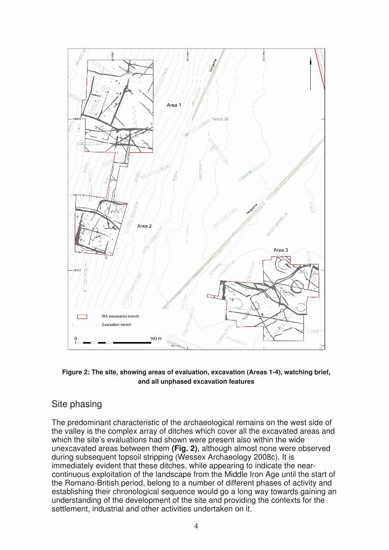
Figure 2: The site, showing areas of evaluation, excavation (Areas 1-4), watching brief, and all unphased excavation features
Site phasing
The predominant characteristic of the archaeological remains on the west side of the valley is the complex array of ditches which cover all the excavated areas and which the site’s evaluations had shown were present also within the wide unexcavated areas between them (Fig. 2), although almost none were observed during subsequent topsoil stripping (Wessex Archaeology 2008c). It is immediately evident that these ditches, while appearing to indicate the near-continuous exploitation of the landscape from the Middle Iron Age until the start of the Romano-British period, belong to a number of different phases of activity and establishing their chronological sequence would go a long way towards gaining an understanding of the development of the site and providing the contexts for the settlement, industrial and other activities undertaken on it.

Their phasing, however, was hampered not only by the low levels of chronologically diagnostic pottery and other finds from them, but also by the difficulties, due in part to the soil conditions, in establishing clear stratigraphical relationships between them. The following phasing, therefore, while consistent with the available stratigraphical relationships, is based, to a large degree, on the patterns, alignments and shared orientations observable in their layout. Inevitably, greater confidence can be placed in the phasing within each excavation area than across the whole site.
As will be described below, some of the ditch phases in Area 3 were clearly contemporary with the occupation of the nucleated settlement through and around which they passed while others post-dated its abandonment. Although such a pattern is less easy to demonstrate in the other areas of the site, which had more limited direct evidence for settlement activity, the main sequence of Middle Iron Age to early Romano-British activity is described below within two potentially overlapping periods, the first broadly relating to the period of the settlement’s occupation (i.e. Middle to Late Iron Age), the second apparently postdating its abandonment (i.e. Late Iron Age to early Romano-British).
The phasing of many of the discrete features, such as pits, hearths and post-holes, is however, more problematic. The predominance of Late Iron Age pottery from the datable features means that they could potentially date from almost any point within the main site sequence. However, in order to describe these features in some relatively consistent manner in the text below, all such features are described in relation to the Middle to Late Iron Age settlement phase, unless there are specific ceramic, stratigraphical or spatial reasons for suggesting a later date.
Middle to Late Bronze Age
A small assemblage (520 sherds, 7287 g) of Middle to Late Bronze Age pottery was recovered from the excavation of Areas 1 and 3. In addition, there was a significant quantity of pottery tempered with either grog or both grog and flint, for which only a general 1st millennium BC date can be given but some of which may relate to activity in the Late Bronze Age.
Area 1
Two small pits c. 50 m apart (Fig. 3) contained Middle–Late Bronze Age sherds, dated approximately to the 12th to 10th centuries BC. Pit 11430, which was c.1.3 m in diameter and 0.3 m deep with irregular, moderately steep sides and a flat base, produced 23 sherds (206 g) from a grog-tempered ovoid jar from the upper of three fills (11431), along with a fragment of fired clay, possibly from a perforated clay plate (ON 10001). A further three sherds (34 g), identified as Late Bronze Age/Early Iron Age, had been recovered during the evaluation from a smaller pit (ev451), c 0.6 m in diameter and 0.2 m deep, to its immediate south-east.
Pit 11795, to the north, was c. 0.8 m in diameter and 0.3 m deep with near vertical sides curving to a flat base. The upper (11796) of its two fills contained 70 sherds (609 g) of flint-tempered pottery. A smaller feature (11797) which cut into this fill produced a further 18 flint-tempered sherds (93 g), and four grog-and-flint-tempered sherds (253 g) from a convex jar and an ovoid jar), bothgroups being of similar date.
5
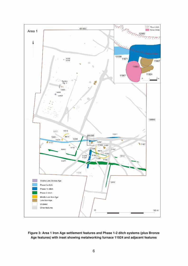
Figure 3: Area 1 Iron Age settlement features and Phase 1-2 ditch systems (plus Bronze Age features) with inset showing metalworking furnace 11924 and adjacent features
6

A third pit (11843), c. 0.7 m in diameter and 0.2 m deep, lay between these two and may be broadly contemporary (Figs 3 and 4). Its lower fill (11845) contained 28 Middle–Late Bronze Age sherds (543 g) in a grog-and-flint-tempered fabric including a small crudely made cup and a single flint-tempered sherd (16 g) along with single pieces of fired clay and struck flint. A thin charcoal-rich layer (11906) above contained a further three sherds (42 g). Late Iron Age pottery in the pit’s uppermost fill (11844) probably derives from the later ditch (11911) which cut its northern side.
Figure 4: Sections of M-LBA pit 11843 and phase 4 ditch 11911 (section 19120), MBA pit 31321 and phase 2 ditch 31716 (section 39073)
Area 3
A total of 79 sherds (1254 g) from a large thick-walled vessel in a flint-tempered fabric of Middle Bronze Age date was recovered from the upper fill (31238) of a slot (31266) through a Late Iron Age ditch (31716, below) (Fig. 5). This material may have derived from the disturbance of a small pit (31321) to the immediate west of the slot (Fig. 4). The pit, c. 1 m in diameter and 0.14 m deep, had a sterile primary fill (31376) overlain by a layer of clay silt (31320) containing a 299 sherds (4412 g), some possibly from the same vessel, but others with a greater quantity of grog in their fabric.
Approximately 13 m to the north, a further 33 sherds (263 g), were recovered during the evaluation from a pit (ev8) c. 0.7 m in diameter and 0.7 m deep, and dated to the Late Bronze Age.
A substantial quantity of pottery of Late Bronze Age date, comprising 142 sherds (1841 g) from a shouldered jar (ON 30017), was recovered from an entrance
7
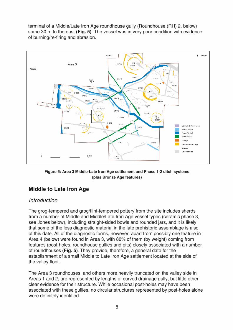
terminal of a Middle/Late Iron Age roundhouse gully (Roundhouse (RH) 2, below) some 30 m to the east (Fig. 5). The vessel was in very poor condition with evidence of burning/re-firing and abrasion.
Figure 5: Area 3 Middle-Late Iron Age settlement and Phase 1-2 ditch systems (plus Bronze Age features)
Introduction
The grog-tempered and grog/flint-tempered pottery from the site includes sherds from a number of Middle and Middle/Late Iron Age vessel types (ceramic phase 3, see Jones below), including straight-sided bowls and rounded jars, and it is likely that some of the less diagnostic material in the late prehistoric assemblage is also of this date. All of the diagnostic forms, however, apart from possibly one feature in Area 4 (below) were found in Area 3, with 80% of them (by weight) coming from features (post-holes, roundhouse gullies and pits) closely associated with a number of roundhouses (Fig. 5) They provide, therefore, a general date for the establishment of a small Middle to Late Iron Age settlement located at the side of the valley floor.
The Area 3 roundhouses, and others more heavily truncated on the valley side in Areas 1 and 2, are represented by lengths of curved drainage gully, but little other clear evidence for their structure. While occasional post-holes may have been associated with these gullies, no circular structures represented by post-holes alone were definitely identified.
8
Area 3
Part of a Middle to Late Iron Age nucleated settlement was exposed in Area 3, comprising at least eight circular structures defined by curved gullies (Fig. 5). Some of these are clearly roundhouses but it is possible that others had non-domestic functions; all, however, are referred to below as ‘roundhouses’. While it cannot be demonstrated that they were all contemporary, none overlap, although the presence at one of concentric gullies suggests that it might have been rebuilt.
Within and around the roundhouses there was a range of other features, including pits, post-holes, hearths and other lengths of gully. While some appear to be associated with the roundhouses, others are of uncertain phasing, their finds, where present, being often chronologically undiagnostic or, in some cases, possibly residual. A small number of features can be shown to be of relatively late date by their stratigraphical relationships to late phase ditches and these are described within the Late Iron Age/early Romano-British period (below). It should be noted however, that some of the features described here are also of potentially late date.
Roundhouse 1 and enclosure 31718
The most northerly roundhouse, located centrally within a small subcircular ditched enclosure (31718) was defined by a gully (31705) 13 m in internal diameter (Fig. 5). The gully, which was up to 0.5 m wide and 0.15 m deep, had been heavily truncated at the south-east, so that while the south-western terminal of a south-east facing entrance was identified, on the opposite side the gully petered out, leaving a gap some 5 m wide. There was also a narrow (0.4 m) break in the gully on the north side. The only finds, 27 sherds (92 g) of Middle Iron Age pottery, came from the southern side of the gully. There were no internal features.
The enclosure (31718) was c. 20 m wide and at least 24 m long, with a 13 m wide entrance at the south-east. Its V-shaped ditch was up to 1 m wide and 0.4 m deep, and all the finds, including Middle/Late Iron Age pottery, animal bone (some burnt) and fired clay, came from its south-western terminal, much of it from a single dump of material (31406), probably domestic waste, deposited when the ditch had silted to almost half its depth.
Roundhouse 2
To the south-east of Roundhouse 1 there were two concentric gullies (31700 inside and 31701 outside) which, unlike the ditch around Roundhouse 1, were no more than 0.2 m apart on the north side and were abutting at the south (Fig. 5). The outer gully was 0.4–1 m wide and up to 0.3 m deep, with an internal diameter of c. 16 m and a south-east facing entrance at least 4 m wide (the northern sides of the entrance of both gullies were cut by a later ditch). It contained Middle Iron Age pottery, a fired clay slingshot (ON 30013), animal bone and small quantities of probably structural fired clay. From the terminal on the north side of the entrance came sherds from a Late Bronze Age jar (see above), perhaps from a feature disturbed by the cutting of the gully but also possibly deliberately redeposited in it.
The internal gully, which was largely truncated on its north side, was 13 m in diameter with an entrance at least 3 m wide closely matching that of the outer gully. It varied considerably in width, being up to 1 m wide and 0.3 m deep on the south-west side but 0.3–0.5 m wide and no more than 0.2 m deep at the east. Most of the
9

pottery, which was of Middle Iron Age date, was recovered from the southern terminal.
Although the two gullies are clearly associated, the relationship between them is not clear. While it is possible that they comprise contemporary elements of a single, more complex structure, their slightly different centre points may indicate that one was a replacement of the other. A small patch of ash (31524, not shown on Fig. ) was recorded within the roundhouse.
Roundhouse 3
A third structure comprising approximately concentric gullies (31724 on the outside and 31725 on the inside) was recorded towards the south-west of Area 3 (Fig. 5). Only the south-eastern quadrants of each gully, which were 2.0–2.6 m apart, were present. The more substantial outer gully, 0.4–0.6 m wide and up to 0.2 m deep, had a projected diameter of 13.9 m. Its southern end, however, appears to have been subsequently straightened (although there was no clear terminal here), the rest of its circuit having possibly been truncated. It had a clear terminal at its northern end, however. The inner gully, which had a projected diameter of 10.4 m, was 0.2–0.4 m wide and up to 0.1 m deep and had a matching terminal at the north. The only find was a single fragment of Iron Age pottery from the outer gully.
Again, the two gullies have slightly different centre points, but the matching positions of their terminals suggest that they formed either component parts of a single structure, or the replacement of one structure by another with a similar aspect although of a different size. However, the fact that both gullies lie on the south-east quadrant, in the usual position of a roundhouse entrance, suggests that they may have had some other function. Three undated post-holes, c. 0.2–0.3 m in diameter, that lay between the gullies may be associated with them; a fourth, 0.5 m in diameter, cut the outer edge of the outer gully.
Roundhouse 4
Gully 31706 was 10.4 m in diameter and averaged 0.3 m wide and 0.2 m deep, with a steep V-shaped profile (Fig. 6). A number of stake-holes were recorded in the base or on the edge of the gully at the south and east (eg, 31066, 31290, 31291) perhaps indicating the presence of a wattle screen. There was, however, no entrance gap in the gully, although the finds, which comprised sherds of Middle Iron Age pottery, small quantities of burnt flint, fired clay and animal bone (some burnt), as well as a number of pebbles including a possible hammerstone, were concentrated along its south-eastern quadrant.
Also at the south and east were two pairs of circular features just inside the gully, each c. 0.6 m in diameter and 0.3 m deep. Each pair – 31160 and 31141 at the north and 31212 and 31118 at the south – was spaced c. 1. 8 m apart, with a gap of 3.6 m between the pairs. Their shapes and profiles are consistent with their being post-holes, with the central two possibly flanking a south-east-facing entrance. However, their fill sequences (Fig. 6), comprising between three and five naturally accumulated and possibly dumped layers, some rich in charcoal, led to their interpretation in the field as small pits, suggesting some non-domestic function for this structure. Only the southern pair produced finds – Middle Iron Age pottery (possibly sherds from the same vessel, see Jones) and animal bone; while this material is similar to that from the other roundhouses, feature 31118 also produced a Late Iron Age silver potin coin (ON 30041), a find that might add weight to a non-domestic, possibly religious or ritual function for this structure, perhaps as a shrine.
10
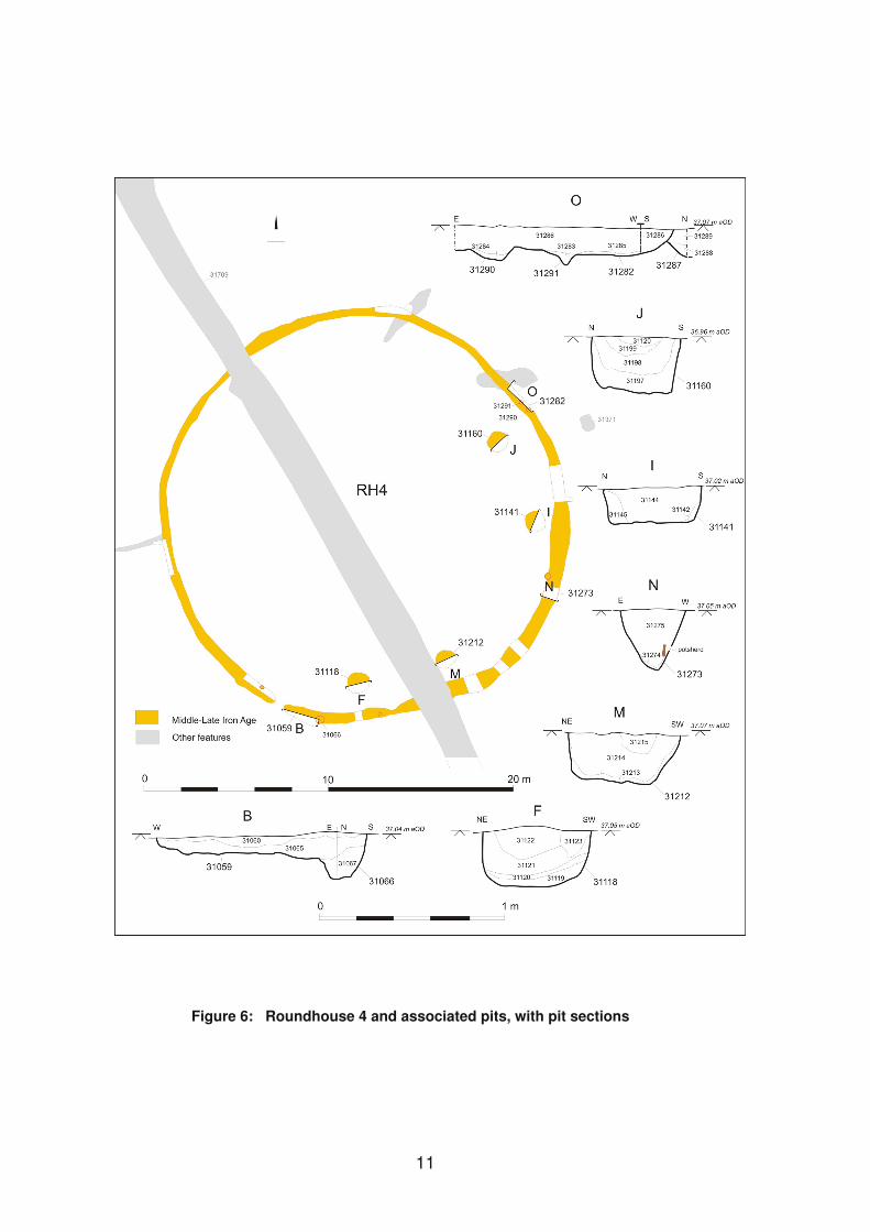
Figure 6: Roundhouse 4 and associated pits, with pit sections
11
As will be discussed below, this structure was one of a number of roundhouses that were subsequently bisected by Phase 3 ditches, perhaps marking the deliberate slighting and closure of the Area 3 settlement. It is possible, therefore, that these four internal features were in fact post-holes from which the timbers were removed when the settlement was closed, and which were then left to silt up. The charcoal-rich fills recorded within three of them may be further evidence of the building’s demolition and destruction. Nonetheless, this structure remains clearly different in a number of respects from the other roundhouses.
A small undated feature (31371) just east of Roundhouse 4 and possibly associated with it, had the appearance of a sub-square post-hole up to 0.4 m wide and 0.28 m deep but was notable for the large quantity of charred cereal grains (barley, spelt/emmer and free-threshing wheat) which was concentrated in the upper of its three fills.
Roundhouse 5
Gully 31708, which was c. 11 m in diameter, up to 0.5 m wide and 0.25 m deep, had two breaks in its circuit (Fig. 5). The 2.4 m wide gap at the north-west was probably the result of truncation, but that to the east, which was 4 m wide, was flanked by two clear terminals. Most of the finds, comprising Middle Iron Age pottery, fired clay and animal bone (some burnt), were recovered from within or close to the southern entrance terminal.
A number of post-holes were recorded close to the gully, both inside and out. Although possibly associated with this building, they display no consistent pattern and form no recognisable structure, and may represent earlier or later activity in this area. Two of the internal post-holes (31114 and 31223) produced further Iron Age sherds.
Roundhouse 6
Gully 31583, which was 9.5 m in diameter but less than 0.4 m wide and 0.1 m deep, was heavily truncated and in places barely visible, with a number of breaks in its circuit. It was 3 m wide at the north-north-west, 3.6 m wide at the east with two narrow gaps at the south o clear terminals mark an entrance, although the eastern gap is the most likely position (Fig. 5). The few Iron Age sherds all came from the south-east quadrant. There were no internal features, but a single post-hole (31392), 0.4 m in diameter and 0.15 m deep, containing further sherds, cut the gully on the south side.
Roundhouse 7
Some 8 m to the south of Roundhouse 6 was the southern arc of a gully (31584) with a projected diameter of c. 6 m (Fig. 5). This is considerably smaller than the other roundhouses (although comparable to possible gully 21407 in Area 2, below, Fig. 7), and it may have had some non-domestic function, perhaps ancillary to Roundhouse 6 to which it appeared to by linked by an unexcavated linear feature; another irregular gully (31723) running south-east from Roundhouse 7 produced a small quantity of Late Iron Age pottery. The roundhouse gully averaged 0.4 m wide and 0.1 m deep but petered out at both ends with no clear terminals, and it is not possible to determine whether it had originally been a complete circuit. It produced 12 sherds (68 g) of Middle/Late Iron Age pottery.
12
Roundhouse 8
Two short but opposed lengths of truncated curved gully (31707), both with different centre points and projected diameters (east – c. 14 m; west – c. 11 m) may represent a single slightly asymmetrical structure. The gullies averaged 0.3 m wide and were less than 0.1 m deep. The western gully was cut at the south by pit 31089 containing Iron Age pottery, fired clay and animal bone, while the eastern gully ended at a possible terminal, suggesting a south-east facing entrance. This terminal produced the only finds from either gully – further small quantities of Iron Age pottery and animal bone (some burnt). An undated stake-hole, 0.2 m in diameter and 0.1 m deep, lay just inside the terminal and may have been associated with it, but there were no other internal features.
Other settlement features
There was a small number of other discrete features between the roundhouses in Area 3 at least some of which are likely to have been associated with them Some contained Middle to Late Iron Age pottery, while others were undated (Fig. 5). They included a number of hearths, some of which were heavily truncated, but all of which were characterised by deposits of charcoal overlying heat-affected natural.
Among the best preserved was hearth 31026, located between Roundhouses 2 and 8, which was 1.8 m in diameter and 0.3 m deep with steep sides, and slightly concave base that showed signs of in situ burning. A short serpentine slot running north-east from it may have acted as a flue. A layer of charcoal covering the base was overlain by grey silty ash containing two small sherds of Iron Age pottery. Rather than being associated with the settlement, however, it is possible instead that the hearth was broadly contemporary with a similar, but stratigraphically late hearth (31047, below) 2.5 m to its south-east; the latter cut a Phase 4 ditch (31704) and therefore postdated the settlement; both hearths were cut by an undated, but post-Phase 4 ditch (31389).
A smaller (or more truncated) hearth (31136) lay to the south-east of this pair. It was 0.5 m diameter and less than 0.1 m deep, with a layer of charcoal overlying burnt natural. A similar feature (31052), immediately south-east of Roundhouse 2 (and probably too close to be contemporary with it), was 0.7 m in diameter and 0.05 m deep, with a narrow slot, possibly the remains of a flue, running to the south-west.
A very shallow subrectangular hearth (31415), 0.5 m by 0.7 m, with thin layers (from the base) of ashy silt, fired clay and charcoal, was recorded in the centre of Area 3, while two adjacent hearths (31450 and 31462), 2 m apart, were recorded at the south. Hearth 31450, which was very truncated, survived only as a 0.9 m diameter spread of silty charcoal overlying burnt natural. Hearth 31462, which was sub-oval in plan, 0.6 m by 0.8 m and 0.1 m deep with vertical sides and a flat base, had a thin layer of charcoal-rich silt on its base overlain by a light silty fill with charcoal flecks. Neither contained any finds.
A group of five undated post-holes (31403), 0.4–0.5 m in diameter and 0.3–0.5 m deep, lay midway between Roundhouses 2 and 4. They contained no finds and formed no obvious structure, although they were quite regularly spaced. They may
13
A large oval pit (31257) south-east of Roundhouse 4, measuring 2.6 m by 3.4 m and 0.9 m deep with steep sides and concave base, contained a sequence of four similar, naturally accumulated fills, the uppermost of which contained seven sherds (66 g) of Iron Age pottery but no other finds. It was of uncertain function although possibly used for clay extraction.
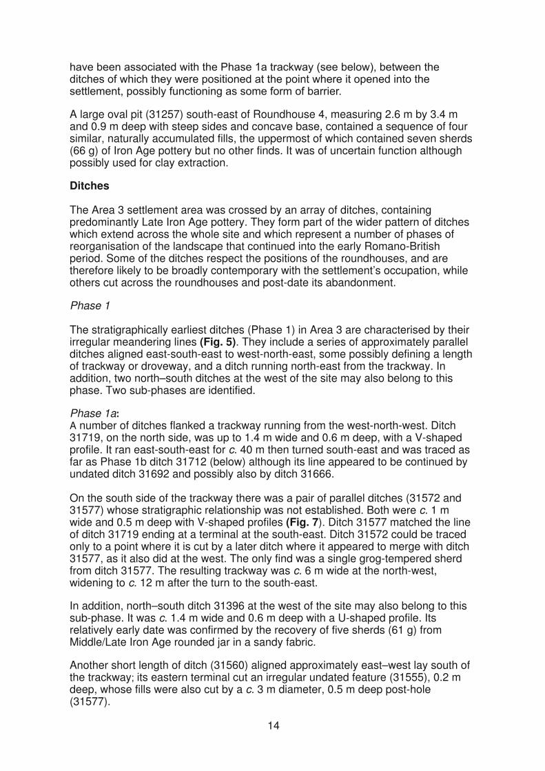
Ditches
The Area 3 settlement area was crossed by an array of ditches, containing predominantly Late Iron Age pottery. They form part of the wider pattern of ditches which extend across the whole site and which represent a number of phases of reorganisation of the landscape that continued into the early Romano-British period. Some of the ditches respect the positions of the roundhouses, and are therefore likely to be broadly contemporary with the settlement’s occupation, while others cut across the roundhouses and post-date its abandonment.
Phase 1
The stratigraphically earliest ditches (Phase 1) in Area 3 are characterised by their irregular meandering lines (Fig. 5). They include a series of approximately parallel ditches aligned east-south-east to west-north-east, some possibly defining a length of trackway or droveway, and a ditch running north-east from the trackway. In addition, two north–south ditches at the west of the site may also belong to this phase. Two sub-phases are identified.
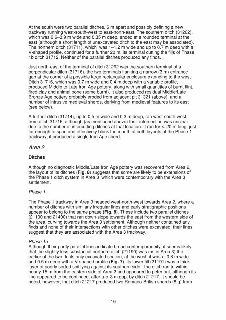
Phase 1aA number of ditches flanked a trackway running from the west-north-west. Ditch 31719, on the north side, was up to 1.4 m wide and 0.6 m deep, with a V-shaped profile. It ran east-south-east for c. 40 m then turned south-east and was traced as far as Phase 1b ditch 31712 (below) although its line appeared to be continued by undated ditch 31692 and possibly also by ditch 31666.
On the south side of the trackway there was a pair of parallel ditches (31572 and 31577) whose stratigraphic relationship was not established. Both were c. 1 m wide and 0.5 m deep with V-shaped profiles (Fig. 7). Ditch 31577 matched the line of ditch 31719 ending at a terminal at the south-east. Ditch 31572 could be traced only to a point where it is cut by a later ditch where it appeared to merge with ditch 31577, as it also did at the west. The only find was a single grog-tempered sherd from ditch 31577. The resulting trackway was c. 6 m wide at the north-west, widening to c. 12 m after the turn to the south-east.
In addition, north–south ditch 31396 at the west of the site may also belong to this sub-phase. It was c. 1.4 m wide and 0.6 m deep with a U-shaped profile. Its relatively early date was confirmed by the recovery of five sherds (61 g) from Middle/Late Iron Age rounded jar in a sandy fabric.
Another short length of ditch (31560) aligned approximately east–west lay south of the trackway its eastern terminal cut an irregular undated feature (31555), 0.2 m deep, whose fills were also cut by a c. 3 m diameter, 0.5 m deep post-hole (31577).
14

Figure 7: Section of Area 3 phase 1a-b trackway ditches 31572 and 31712
Section of Area 2 phase 1a-b boundary ditches 21400 and 21190
Phase 1b:The eastern end of the Phase 1a trackway was subsequently altered with the construction on its southern side of ditch 31712 (Fig. 5). At its north-west, where it was 1.1 m wide and is 0.7 m deep with a variable profile, this ditch ran parallel to ditch 31577 cutting its upper fills (Fig. 7). However, after the bend in the trackway it curved to the east-south-east, cutting the end of Phase 1a ditch 31719 and continuing along an irregular, unbroken line to the eastern edge of the excavation; there it was 2 m wide and 1 m deep with a V-shaped profile. The ditch, which appears to have silted up largely through natural processes, contained 36 sherds (195g) of Middle–Late Iron Age pottery, all of the later material coming from a secondary fill adjacent to Roundhouse 5 around which the ditch curved.
On the north side of the trackway, ditch 31720 cut the upper fills of Phase 1a ditch 31719. Although its precise course at the bend in the trackway was obscured by the intersections of a number of later ditches, it appears to have turned sharply to the north-east. It varied in profile along its course being most substantial towards the east where it was c. 2 m wide and 0.9 m deep with a V-shaped profile. It produced 35 Middle–Late Iron Age sherds (117g).
At the west of the site, north–south ditch 31399 cut the western edge of Phase 1a ditch 31396. It was 3.2 m wide and 0.7 m deep with a U-shaped profile and contained five Middle–Late Iron Age sherds (29 g).
Phase 2
The irregular lines and arrangement of the Phase 1 ditches were subsequently over-ridden by a system of rectilinear ditches laid out on a new orientation, representing a significant re-organisation of the landscape (Fig. 5). This appears to have taken place within the period of occupation of the Area 3 settlement, since the newly laid out ditches continued to respect the positions of the roundhouses.
15
At the south were two parallel ditches, 6 m apart and possibly defining a new trackway running west-south-west to east-north-east. The southern ditch (31262), which was 0.6–0.9 m wide and 0.35 m deep, ended at a rounded terminal at the east (although a short length of unexcavated ditch to the east may be associated). The northern ditch (31711), which was 1–1.2 m wide and up to 0.7 m deep with a V-shaped profile, continued for a further 20 m, its terminal cutting the fills of Phase 1b ditch 31712. Neither of the parallel ditches produced any finds.
Just north-east of the terminal of ditch 31262 was the southern terminal of a perpendicular ditch (31716), the two terminals flanking a narrow (3 m) entrance gap at the corner of a possible large rectangular enclosure extending to the west. Ditch 31716, which was 0.7 m wide and 0.4 m deep with a variable profile, produced Middle to Late Iron Age pottery, along with small quantities of burnt flint, fired clay and animal bone (some burnt). It also produced residual Middle/Late Bronze Age pottery probably eroded from adjacent pit 31321 (above), and a number of intrusive medieval sherds, deriving from medieval features to its east (see below).
A further ditch (31714), up to 0.5 m wide and 0.3 m deep, ran west-south-west from ditch 31716, although (as mentioned above) their intersection was unclear due to the number of intercutting ditches at that location. It ran for c. 20 m long, just far enough to span and effectively block the mouth both layouts of the Phase 1 trackway; it produced a single Iron Age sherd.
Area 2
Ditches
Although no diagnostic Middle/Late Iron Age pottery was recovered from Area 2, the layout of its ditches (Fig. 8) suggests that some are likely to be extensions of the Phase 1 ditch system in Area 3 which were contemporary with the Area 3 settlement.
Phase 1
The Phase 1 trackway in Area 3 headed west-north-west towards Area 2, where a number of ditches with similarly irregular lines and early stratigraphic positions appear to belong to the same phase (Fig. 8). These include two parallel ditches (21190 and 21400) that ran down-slope towards the east from the western side of the area, curving towards the Area 3 settlement. Although neither contained any finds and none of their intersections with other ditches were excavated, their lines suggest that they are associated with the Area 3 trackway.
Phase 1aAlthough their partly parallel lines indicate broad contemporaneity, it seems likely that the slightly less substantial northern ditch (21190) was (as in Area 3) the earlier of the two. In its only excavated section, at the west, it was c. 0.8 m wide and 0.5 m deep with a V-shaped profile (Fig. 7); its lower fill (21191) was a thick layer of poorly sorted soil lying against its southern side. The ditch ran to within nearly 15 m from the eastern side of Area 2 and appeared to peter out, although its line appeared to be continued, after a c. 3 m gap, by ditch 21217. It should be noted, however, that ditch 21217 produced two Romano-British sherds (8 g) from
16
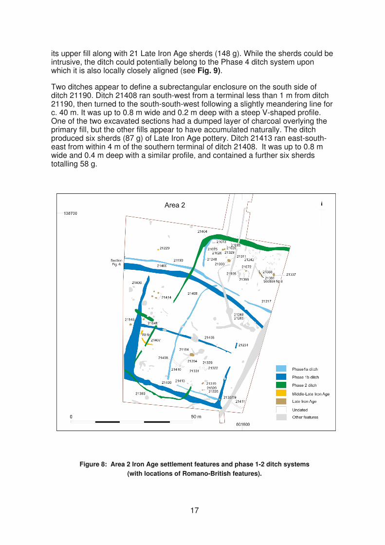
its upper fill along with 21 Late Iron Age sherds (148 g). While the sherds could be intrusive, the ditch could potentially belong to the Phase 4 ditch system upon which it is also locally closely aligned (see Fig. 9).
Two ditches appear to define a subrectangular enclosure on the south side of ditch 21190. Ditch 21408 ran south-west from a terminal less than 1 m from ditch 21190, then turned to the south-south-west following a slightly meandering line for c. 40 m. It was up to 0.8 m wide and 0.2 m deep with a steep V-shaped profile. One of the two excavated sections had a dumped layer of charcoal overlying the primary fill, but the other fills appear to have accumulated naturally. The ditch produced six sherds (87 g) of Late Iron Age pottery. Ditch 21413 ran east-south-east from within 4 m of the southern terminal of ditch 21408. It was up to 0.8 m wide and 0.4 m deep with a similar profile and contained a further six sherdstotalling 58 g.
Figure 8: Area 2 Iron Age settlement features and phase 1-2 ditch systems (with locations of Romano-British features).
17
Also possibly associated with ditch 21190 but on its northern side was a length of ditch (21248) running north from a terminal c. 2 m from it. This ditch, c. 0.7 m wide and 0.3 m deep, turned east after c. 12 m. It contained 25 sherds (70 g) of Late Iron Age pottery. The comparable scale and irregular lines of all these ditches suggest that they represent an early system of field or enclosure boundaries.
Phase 1bSubsequently a more substantial ditch (21400) was laid out on the south side of, and parallel to ditch 21190, separated from it by a gap of between 1.5 m and 3 m. This appeared to cut across the northern end of Phase 1a ditch 21408, and continued across the excavation area. It was between 1.8 m and 2.8 m wide and c. 0.7 m deep, with a variable profile. At the west it had a wide shallow lip on its north side (Fig. 7). Here a primary fill (21219) was overlain by what was described as ‘bank’ material eroded from the north side (21220); this was similar in appearance to the lower fill (21191, above) in ditch 21190 to its immediate north, perhaps indicating that these two ditches now formed a double-ditched boundary with a central bank. The ‘bank’ material in 21400 was overlain by a backfill layer (21221). Only a single fill was recorded further east.
Apparently associated with ditch 21400 was ditch 21406, which appeared to define a sub-square enclosure, c. 40 m square, on its southern side, perhaps the replacement of the earlier enclosure but shifted c. 20 m to the west. Ditch 21406 ran south-south-west from within 2 m of ditch 21400, turning first to the east-south-east then to north-north-east for c. 16 m, although its line may have been continued, after an 8 m gap, by a length of heavily truncated ditch (21231). Its dimensions as surveyed varied considerably along its length, being apparently 5 m wide where unexcavated at the south-west corner ut c. 1.3 m wide in the only fully excavated slot, on the east side. Here it was 0.8 m deep with steep sides and a flat base and contained a sequence of eight fills indicating natural silting; when fully silted it was cut by a small Romano-British pit (20307, below). As well as turning northwards at the enclosure’s south-eastern corner, it also appears to have continued to the east-south-east but it was cut at this point by a later ditch.
The pottery from ditch 21406 was predominantly Late Iron Age, although 17 sherds (69 g) from an early Romano-British greyware beaker were recovered from the upper of two fills at its intersection, on the western side of the enclosure, with ditch 21405. At the same point, ditch 21405 produced a further 41 Romano-British sherds (82 g), 37 of them possibly from the same beaker, and it is possible that the sherds recorded as coming from ditch 21406 were in fact from ditch 21405. The relationship between these two ditches was not established, and the phasing of ditch 21405 is problematic. A Phase 1b date for ditch 21405 is supported by the fact that it appears to divide the Phase 1b enclosure into two approximately equal halves. Moreover, it does not continue west beyond ditch 21406 and, at its other end, terminates on the line of the enclosure’s eastern side in the gap between ditch 21406 and gully 21231. Also, it was cut by Phase 2 ditch 21401 (below).
During the evaluation, six small pits containing pottery, charcoal and bone, were recorded as cutting the ditch fill. The only one excavated (ev687) produced 27 Romano-British sherds (155 g) (Fig. 9), but a further two (ev690 and ev691) were shown during the excavation to fall within a larger Romano-British pit (21165) cutting the ditch. Further Romano-British pottery was recovered during the excavation from another localised, charcoal-rich deposit (21052), this time recorded as a fill of ditch 21405 but equally possibly another shallow pit (see below). Despite the quantity of Romano-British pottery recorded as coming from
18
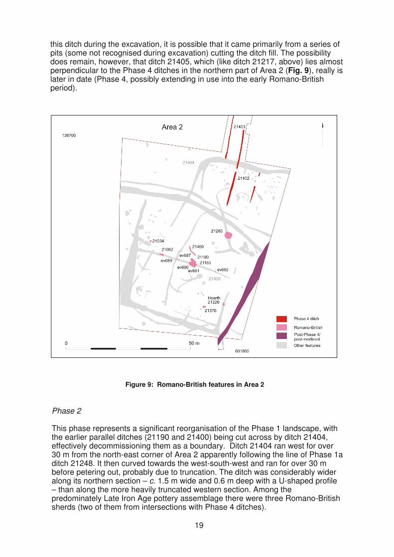
this ditch during the excavation, it is possible that it came primarily from a series of pits (some not recognised during excavation) cutting the ditch fill. The possibility does remain, however, that ditch 21405, which (like ditch 21217, above) lies almost perpendicular to the Phase 4 ditches in the northern part of Area 2 (Fig. 9), really is later in date (Phase 4, possibly extending in use into the early Romano-British period).
Figure 9: Romano-British features in Area 2
Phase 2
This phase represents a significant reorganisation of the Phase 1 landscape, with the earlier parallel ditches (21190 and 21400) being cut across by ditch 21404, effectively decommissioning them as a boundary. Ditch 21404 ran west for over 30 m from the north-east corner of Area 2 apparently following the line of Phase 1a ditch 21248. It then curved towards the west-south-west and ran for over 30 m before petering out, probably due to truncation. The ditch was considerably wider along its northern section – c. 1.5 m wide and 0.6 m deep with a U-shaped profile – than along the more heavily truncated western section. Among the predominately Late Iron Age pottery assemblage there were three Romano-British sherds (two of them from intersections with Phase 4 ditches).
19

The line of ditch 21404 was continued after a c. 40 m gap by a similarly truncated ditch (21401), which cut Roundhouse 9. This ran for a further 40 m to its intersection with Phase 1b enclosure ditch (21406) with which its relationship was not established and beyond the edge of which it has not traced. It may have connected, however, with a sinuous ditch (21360) running south-west across the corner of the Phase 1b enclosure before turning towards the north-north-east. Another, unexcavated but apparently wider ditch ran west-north-west for 9 m from the northern end of ditch 21401, also intersecting with ditch 21406. Together these ditches appear to form the western part of a large subrectangular enclosure.
Settlement features
There was a range of discrete, settlement-related features in Area 2 (Fig. 8). Their phasing is problematic, however, since they included features of both Late Iron Age and early Romano-British date, as well as a significant number that are undated. Nearly all the ditches in this area are assigned to Phases 1 or 2, and many of the Iron Age settlement features appear to be spatially associated with the early phase enclosures (which in Area 3 were directly associated with the Middle–Later Iron Age settlement). For this reason, all settlement features except those containing Romano-British pottery are described here, although it is possible, indeed likely, that some post-date the Area 3 settlement.
The features fell within two main groups, separated by the Phase 1 boundary ditches (21400 and 21190/21217).
Northern group
Apart from a single pit (21229) outside the enclosures at the north-west, measuring c. 0.6 m in diameter and 0.1 m deep and containing four grog/flint-tempered sherds (17 g), the northern group of features was concentrated in a small area within either the Phase 1b enclosure north of boundary ditch 21190/21217 or the northern part of the Phase 2 enclosure, all of them lying with 12 m of ditch 21404. The group comprised an angled gully, and a number of hearths and closely spaced pits and post-holes.
Gully 21105 and hearth 21066The undated gully (21105) was smaller than, and did not have the regular curve of, the roundhouse gullies in Area 3 but appeared to form the northern and eastern sides of a polygonal shape with rounded corners and a projected width of c. 5 m. It was also less substantial than the roundhouse gullies with a maximum width of nearly 0.2 m and depth of under 0.1 m. Off-centre within the area bounded by the gully there was a 0.8 m diameter hearth (21066) in a shallow (0.1 m ) concave cut, the base of which had been reddened by burning but whose lower fill contained only a moderate amount of charcoal, suggesting that it had been cleaned out; this was overlain by a layer of natural silting.
The position of the hearth might indicate that the gully held some form of screen or windbreak although there was no charcoal in the gully fill as might be expected if the two were directly associated. A small amount of charcoal, however, along with six sherds (33 g) of Late Iron Age pottery and burnt animal bone, was found in a small pit (21072), 0.6 m north-east of hearth 21066, cutting the gully. The pit was 0.2 m deep with steep sides and a flat base, and contained a single naturally accumulated fill.
20
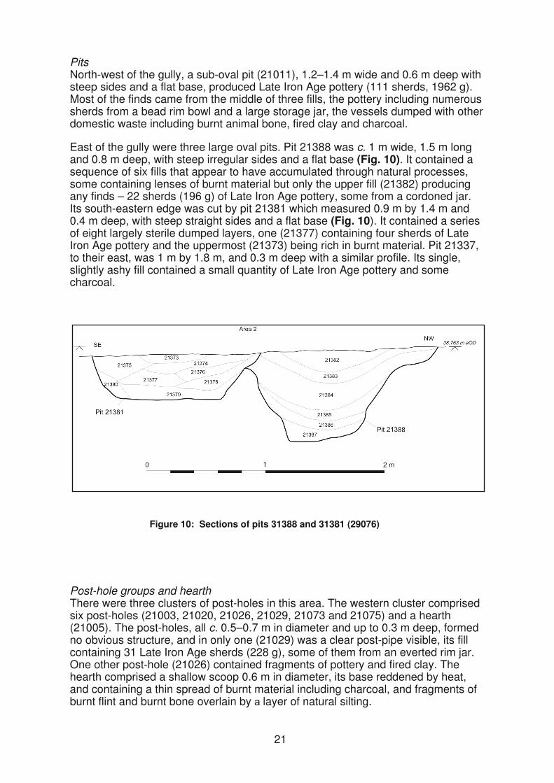
PitsNorth-west of the gully, a sub-oval pit (21011), 1.2–1.4 m wide and 0.6 m deep with steep sides and a flat base, produced Late Iron Age pottery (111 sherds, 1962 g). Most of the finds came from the middle of three fills, the pottery including numerous sherds from a bead rim bowl and a large storage jar, the vessels dumped with other domestic waste including burnt animal bone, fired clay and charcoal.
East of the gully were three large oval pits. Pit 21388 was c. 1 m wide, 1.5 m long and 0.8 m deep, with steep irregular sides and a flat base (Fig. 10). It contained a sequence of six fills that appear to have accumulated through natural processes, some containing lenses of burnt material but only the upper fill (21382) producing any finds – 22 sherds (196 g) of Late Iron Age pottery, some from a cordoned jar. Its south-eastern edge was cut by pit 21381 which measured 0.9 m by 1.4 m and 0.4 m deep, with steep straight sides and a flat base (Fig. 10). It contained a series of eight largely sterile dumped layers, one (21377) containing four sherds of Late Iron Age pottery and the uppermost (21373) being rich in burnt material. Pit 21337, to their east, was 1 m by 1.8 m, and 0.3 m deep with a similar profile. Its single, slightly ashy fill contained a small quantity of Late Iron Age pottery and some charcoal.
Post-hole groups and hearthThere were three clusters of post-holes in this area. The western cluster comprised six post-holes (21003, 21020, 21026, 21029, 21073 and 21075) and a hearth (21005). The post-holes, all c. 0.5–0.7 m in diameter and up to 0.3 m deep, formed no obvious structure, and in only one (21029) was a clear post-pipe visible, its fill containing 31 Late Iron Age sherds (228 g), some of them from an everted rim jar. One other post-hole (21026) contained fragments of pottery and fired clay. The hearth comprised a shallow scoop 0.6 m in diameter, its base reddened by heat, and containing a thin spread of burnt material including charcoal, and fragments of burnt flint and burnt bone overlain by layer of natural silting.
21
Figure 10: Sections of pits 31388 and 31381 (29076)

The central cluster comprised six probable post-holes of apparently similar size, although only one (21242) was excavated, this measuring 0.6 m in diameter and 0.45 m deep. Although four of them lay in a c. 4 m long line aligned north-west to south-east, with the other two parallel to them to their north-east, they still formed no clear structure.
The eastern cluster comprised 18 significantly smaller post-holes and two small pits, in an area c. 8 m across. Eleven were excavated, these averaging 0.4 m in diameter and 0.1 m deep, but this group, too, formed no recognisable structure(s), and all were undated.
Southern group of features
A similar range of features was recorded in the southern group, but they were more widely dispersed and, in contrast to the northern group, less obviously associated either with the ditches or with each other.
Roundhouse 9 and other curved gulliesA number of short lengths of undated curved gully may indicate possible structures, although their heavy truncation makes their function uncertain. At only one location did these display enough of a circuit to allow the tentative identification of a possible roundhouse – Roundhouse 9. This comprised two short lengths of gully (21407), up to 0.6 m wide and 0.15 m deep, with a projected diameter of c. 7 m. It may have pre-dated the Phase 1b enclosure since, although it lay immediately east of ditch 21406, its projected line would have intersected with ditch 21405; it was cut by Phase 2 ditch 21401.
Two other curving gullies, 21410 and 21411, had projected diameters of c. 11 m and 15 m respectively. Gully 21410 intersected with Phase 1a ditch 21408, although their relationship was not established, while the projected line of gully 21411 lay immediately east of the Phase 1b enclosure. A fourth length of gully (21204), which intersected with gully 21410, had a less regular curvature.
Pits, post-holes and hearthsOnly one post-built structure was identified, a probable four-post ‘granary-type’ structure (21414) located in the north-east corner of the Phase 1b enclosure. The four post-holes, set 1.8 m apart (centre to centre) on one axis and 2.2 m apart on the other, were 0.7–0.8 m in diameter and up to 0.35 m deep, two of them producing sherds of Late Iron Age pottery (4 sherds, 16 g).
A number of other possible post-holes, some isolated, others (e.g. 21320, 21325) in a loose cluster, were also recorded (some surveyed but not further investigated). Most were recorded at the south-east of the area, and could therefore be associated with the enclosure ditches of either Phases 1a, 1b or 2 (or even later); post-hole 21325 cut Phase 1a ditch 21413.
There was also a number of pits, of varying size and shape, many of which were in the same general area as the post-holes, suggesting a focus of activity in this area. One (21309) cut the fills of Phase 1b enclosure ditch 21406, perhaps indicating an association with Phase 2 or later. It was 0.8 m by 1 m, and 0.3 m deep with a single naturally accumulated fill that was subsequently cut by a smaller feature (21307), measuring 0.3 m by 0.6 m. The latter feature had four layers of charcoal-rich burnt material, one of which contained Late Iron Age pottery (4 sherds, 29 g), a piece of slag (35 g), fired clay (63 g) and fragments of burnt animal bone (20 g).
22

Also in this loose cluster was sub-oval pit 21319, 0.5 m by 1 m and 0.3 m deep, which produced eight sherds (47 g) of Late Iron Age pottery and three pieces of slag (416 g) from the upper of its two fills. To its north were three closely spaced but undated pits, two of which (21322 and 21331) were subcircular, 0.8 m in diameter, the third (21329) being oval, 0.6 m by 1.1 m, and all 0.3–0.4 m deep; all three had single fills containing no finds.
Another sub-oval pit (21154), lying within the projected circuit of curved gully 21410, measured c. 0.5 m by 1.7 m and 0.35 m deep, and contained a series of nine, possibly dumped, fill producing 26 sherds (303 g) of Late Iron Age pottery, along with burnt flint and fired clay as well as concentrations of charcoal.
Immediately south of Phase 1b boundary ditch 21400, there was a large sub-triangular feature (21265), 2 m by 3.4 m and 0.6 m deep, containing two naturally accumulated fills, the upper fill being cut by a smaller pit (21268) 1.1 m wide and 0.4 m deep, containing a sequence of five fills, two of them rich in charcoal and probably representing dumps of hearth waste. Neither feature produced any finds.
Two small features lay on the west side of the area. Pit 21148, just west of the Phase 1b enclosure, was c. 0.8 m in diameter and 0.25 m deep with steep sides and a flat base and had a single fill producing 58 sherds (503 g) of Late Iron Age pottery. Just inside the enclosure there was a tear-shaped hearth (21048) 0.7 m by 0.9 m and depth of 0.1 m The clay natural and a thin lining of redeposited natural on the base were reddened by heat above which was an ashy layer containing burnt flint, burnt bone and nine sherds from a Late Iron Age bead rim jar. The ash and charcoal was concentrated at the pointed end of the hearth, possibly indicating the position of the rake-out hole or a flue comparable to those recorded at a number of the other hearths.
Area 1
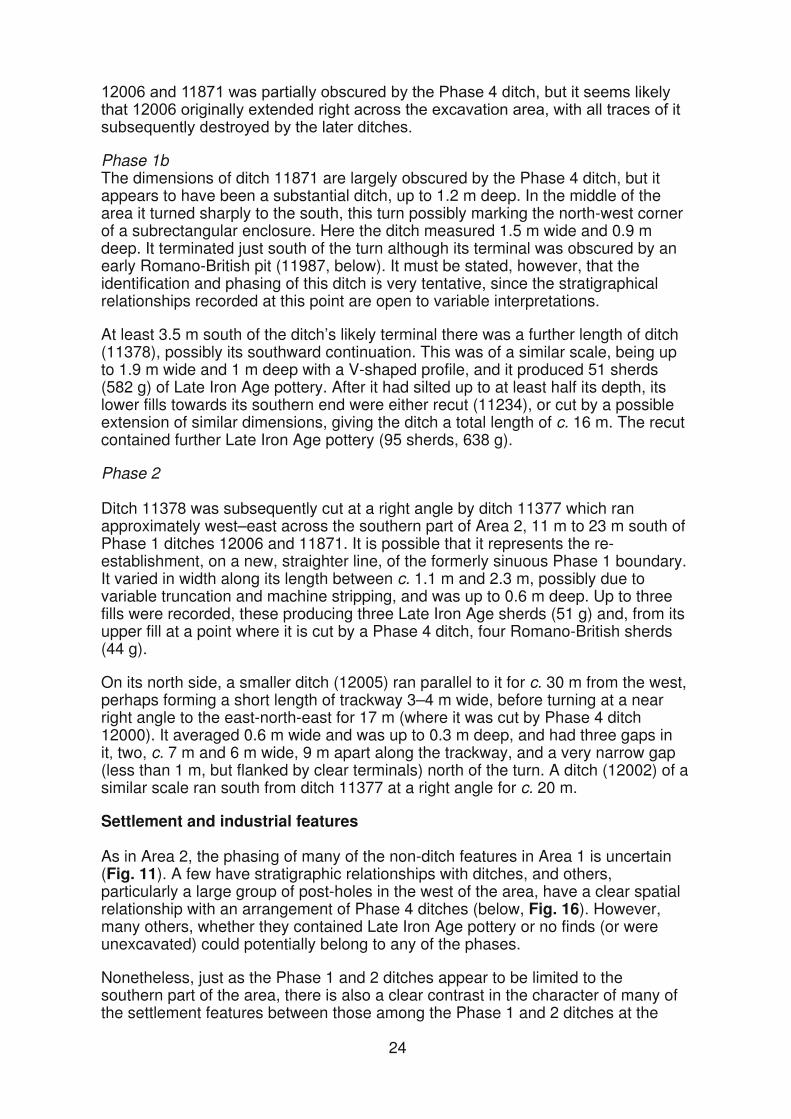
As in Area 2, no diagnostic Middle/Late Iron Age pottery was recovered from Area 1, and the features here are of predominantly Late Iron Age date, although a small number contained also some early Romano-British sherds. However, whereas in Area 2 it was possible to view the Phase 1a and 1b boundary ditches as continuations across the landscape of those recorded in Area 3, the complex array of overlapping ditch systems in Area 1 were not only less easy to place within a coherent sequence, but also less easy to relate to the phasing in the other areas.
DitchesNonetheless, there were a number of stratigraphically early ditches in the southern part of Area 1 that may be assigned to Phases 1 and 2, although the Phase 1 ditches are partly obscured by their being recut in later phases (Fig. 11).
Phase 1
Two main ditches in Area 2 may belong to Phase 1.
Phase 1aDitch 12006, which was up to c. 1.1 m wide and 0.5 m deep, ran down-slope towards the east on a slightly curving line from the western edge of the excavation area. It contained only Late Iron Age pottery. After c. 60 m, its apparent line appears to have been continued by Phase 1b ditch 11871, which was in turn subsequently recut by a Phase 4 ditch (12000, below). The intersection of ditches
23
Phase 1bThe dimensions of ditch 11871 are largely obscured by the Phase 4 ditch, but it appears to have been a substantial ditch, up to 1.2 m deep. In the middle of the area it turned sharply to the south, this turn possibly marking the north-west corner of a subrectangular enclosure. Here the ditch measured 1.5 m wide and 0.9 m deep. It terminated just south of the turn although its terminal was obscured by an early Romano-British pit (11987, below). It must be stated, however, that the identification and phasing of this ditch is very tentative, since the stratigraphical relationships recorded at this point are open to variable interpretations.
At least 3.5 m south of the ditch’s likely terminal there was a further length of ditch (11378), possibly its southward continuation. This was of a similar scale, being up to 1.9 m wide and 1 m deep with a V-shaped profile, and it produced 51 sherds (582 g) of Late Iron Age pottery. After it had silted up to at least half its depth, its lower fills towards its southern end were either recut (11234), or cut by a possible extension of similar dimensions, giving the ditch a total length of c. 16 m. The recut contained further Late Iron Age pottery (95 sherds, 638 g).
Phase 2
Ditch 11378 was subsequently cut at a right angle by ditch 11377 which ran approximately west–east across the southern part of Area 2, 11 m to 23 m south of Phase 1 ditches 12006 and 11871. It is possible that it represents the re-establishment, on a new, straighter line, of the formerly sinuous Phase 1 boundary. It varied in width along its length between c. 1.1 m and 2.3 m, possibly due to variable truncation and machine stripping, and was up to 0.6 m deep. Up to three fills were recorded, these producing three Late Iron Age sherds (51 g) and, from its upper fill at a point where it is cut by a Phase 4 ditch, four Romano-British sherds (44 g).
On its north side, a smaller ditch (12005) ran parallel to it for c. 30 m from the west, perhaps forming a short length of trackway 3–4 m wide, before turning at a near right angle to the east-north-east for 17 m (where it was cut by Phase 4 ditch 12000). It averaged 0.6 m wide and was up to 0.3 m deep, and had three gaps in it two, c. 7 m and 6 m wide, 9 m apart along the trackway, and a very narrow gap (less than 1 m, but flanked by clear terminals) north of the turn. A ditch (12002) of a similar scale ran south from ditch 11377 at a right angle for c. 20 m.
Settlement and industrial features
As in Area 2, the phasing of many of the non-ditch features in Area 1 is uncertain (Fig. 11). A few have stratigraphic relationships with ditches, and others, particularly a large group of post-holes in the west of the area, have a clear spatial relationship with an arrangement of Phase 4 ditches (below, Fig. 16). However, many others, whether they contained Late Iron Age pottery or no finds (or were unexcavated) could potentially belong to any of the phases.
Nonetheless, just as the Phase 1 and 2 ditches appear to be limited to the southern part of the area, there is also a clear contrast in the character of many of the settlement features between those among the Phase 1 and 2 ditches at the
24
south and those among the later, particularly Phase 4, ditches where they extended to the north. For this reason, the latter group of features (those north of Phase 4 ditch 12000, Fig. 16 are considered within the context of the Late Iron Age–early Romano-British activity (Phases 3 and 4, below).
Figure 11: Area 1 Iron Age settlement features and Phase 1-2 ditch systems (plus Bronze Age features) with inset showing metalworking furnace 11924 and adjacent features
25
Among the southern group of features there was a number of lengths of curving gully representing two roundhouses, one of which may have been altered. Both fall stratigraphically within Phases 1–2, although some of the pottery fabrics suggest a later date than some of the Area 1 roundhouses (see Jones). Between the roundhouses there was a metalworking furnace.
Roundhouse 10 The larger of the roundhouses was represented by ring gully 11199 which averaged c. 0.4 m wide and 0.1 m deep and contained four sherds (26 g) of Late Iron Age pottery along with fired clay and animal bone. The gully, which lay on the southern and western quadrants, had a projected diameter of c. 13 m, this falling in the area between the main east–west Phase 1 and Phase 2 ditches and in the corner of the possible Phase 1b enclosure, close to its possible entrance gap. It was cut on its eastern side by a Phase 4 ditch, which is likely to have destroyed any east- or south-east-facing entrance, and it was bisected through its centre by a Phase 3 ditch (11376); at the north it was cut by a post-medieval/modern ditch.
A second gully (11202) of similar dimensions but with a smaller diameter (c. 8–9 m), lay immediately inside gully 11199 for part of its circuit on the west side, then curved into the roundhouse interior, running parallel to a shallow ditch 12012 (also tentatively assigned to Phase 2) which cut across gully 11199. No stratigraphic relationship between the two curved gullies could be established but the apparent relationship between 11202 and ditch 12102 suggests that the small diameter gully may represent a later modification. It contained 17 sherds (65 g) of Late Iron Age pottery.
There were a number of features within Roundhouse 10 although these could not be definitely associated with it. These included seven possible post-holes, arranged in an approximate south-east to north-west line. Only an intercutting pair at the south-east (11018 and 11021) was excavated, the earlier (11021) being c. 0.4 m in diameter but less than 1.0 m deep, and cut on its western side by 11018, which was c. 0.5 m in diameter and 0.3 m deep and contained a glass bead (ON 10000). A number of other post-holes and stake-holes lay close to or cut the curved gullies (i.e. 11332, 11338, 11189). There was also a shallow sub-triangular pit (11003)which was 1.9 m by 2.3 m and 0.2 m deep, with three fills, containing seven sherds (61 g) of Late Iron Age pottery, separated by lenses of charcoal. There was no indication of in situ burning but patches of burnt natural were recorded in the southern central part of the roundhouse.
Roundhouse 11Evidence for this structure, c. 18 m west-north-west of Roundhouse 10, consisted of two short lengths of curved gully lying on the north-western quadrant of a circle with a projected diameter of c. 11 m. The two lengths were separated by a gap of 3.4 m with shallow post-holes flanking the gully terminals, suggesting a north-west-facing entrance, an atypical orientation for an Iron Age roundhouse. The gully was c. 0.3 m wide and 0.1 m deep and, with the two post-holes, contained 39 sherds (760 g) of Late Iron Age pottery of which 90% (by weight) came from the terminal of the northern gully (12015) and its adjacent post-hole.
The projected line of the gully overlapped with Phase 1a ditch 12006, although its truncation had destroyed their stratigraphical relationship; it could pre-date the ditch. The southern post-hole (11675), however, which cut the gully terminal, was in turn cut by a Phase 3 ditch (12003).
26

Metalworking
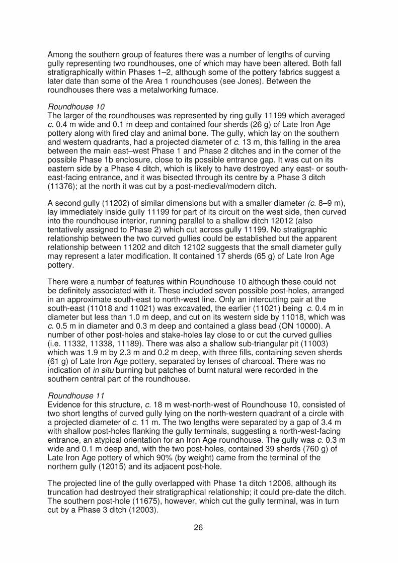
A prominent feature between the two roundhouses was part of an iron-smelting furnace (11924), this area also being used for iron smithing, and for the melting of copper alloy as indicated by the recovery of three crucibles (Fig. 11).
FurnaceThe surviving part of the furnace (11924), the western end of which was cut by a large Romano-British pit (11987, below), comprised an elongated pit 1.7 m long and c. 0.6 m wide with a rounded eastern end (Pl. 1). It had steep sides, with two prominent indentations along either side, and a flat base that sloped gradually (to a depth of c. 0.4 m) towards the west. It had a hard, fired-clay lining (11925) c. 70 mm thick on the base and sides, although it is not clear whether this was a man-made part of the furnace structure, or the thickness to which the natural clay had become fired hard through the furnace’s operation. Given the compact, cohesive character of the natural, a clay lining for the furnace pit would probably not be necessary. A number of holes were visible in the fired clay, possibly marking the positions of withy rods used to support the clay superstructure. The feature is interpreted as the pit of an early form of ‘slag pit’ furnace (see de Rijk, below), with the pit allowing the extraction of the iron bloom (to be worked), and the slag (to be discarded).
A large piece of slag (3.5 kg, ON 10008) lay on the base of the pit at its eastern end (Pl. 1), and there was a layer of fine charcoal (11926) on the base towards the west. This layer, representing the furnace’s final use, was sealed by demolition rubble (11927) consisting mainly of pieces of the furnace’s clay superstructure. The remaining hollow appears to have been used for the dumping of rubbish, being filled with a number of layers which together contained 47 sherds (541 g) of Late Iron Age pottery along with further fired clay, slag and stone.
The phasing of the furnace is of some importance. Its proximity to Roundhouse 10, just 3 m to its south-east (Fig. 11), suggests that it was probably not contemporary with the building and no slag was recovered from the larger roundhouse gully (11199), although the smaller, possibly later gully (11202) did produce a small quantity (61 g). Similarly, no slag or fired clay was
Plate 1: Furnace 11924 from the east
recovered from the eastern end of Phase 1a ditch 12006 Fig. 11). c.
m
27
c
The furnace’s northern edge was flanked by a Late Iron Age pit (11951), although their stratigraphic relationship was not entirely clear. This feature, at least 1.4 m wide and 0.5 m deep, contained a sequence of at least five fills, with one in the lower half containing four Late Iron Age sherds along with slag (448 g) and fired clay (172 g). However, only the southern edge of this pit survived as it was cut by another pit (11967), 1.5 m wide and 0.9 m deep. Unfortunately, due to the complex of intercutting features at this point, the finds from the sequence of 11 fills in this pit, which included fired clay and pottery and possibly other materials, cannot be further identified or quantified. The northern edge of pit 11967 was cut by the southern edge Phase 1b ditch 11871.
Overall, the evidence suggests that the furnace is associated with Phase 1, probably with the Phase 1b ditches, although as noted above, the phasing of these ditches themselves is not entirely secure.
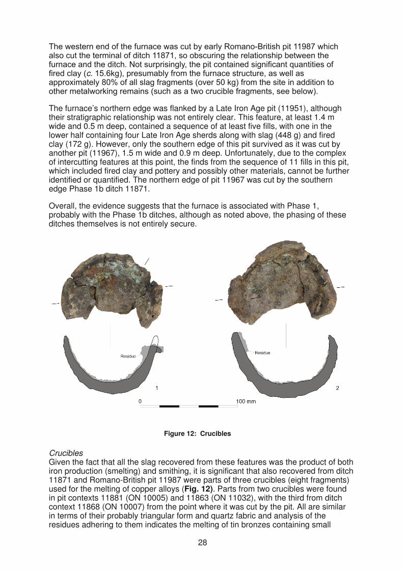
Figure 12: Crucibles
CruciblesGiven the fact that all the slag recovered from these features was the product of both iron production (smelting) and smithing, it is significant that also recovered from ditch 11871 and Romano-British pit 11987 were parts of three crucibles (eight fragments) used for the melting of copper alloys (Fig. 12). Parts from two crucibles were found in pit contexts 11881 (ON 10005) and 11863 (ON 11032), with the third from ditch context 11868 (ON 10007) from the point where it was cut by the pit. All are similar in terms of their probably triangular form and quartz fabric and analysis of the residues adhering to them indicates the melting of tin bronzes containing small
28
amounts of nickel and possibly lead and zinc, confirming the likely Late Iron Age (1st century AD) date (see Lucas and Paynter).
A small thumb pot (ON 20010), an object probably made for the melting of small quantities of copper alloy but in this case apparently not used, was recovered, about 140 m to the south in Area 2, from the intersection of Phase 1b ditches 20405 and 21406 (context 21087).
Other features
There was a range of other Late Iron Age (and undated) features in the general area of the two roundhouses and the furnace.
These included an undated oval pit (11804), 0.7 m by 1.2 m and 0.15 m deep, west of the entrance of Roundhouse 11, and another oval pit (11172), 0.7 m by 1.1 m and 0.6 m deep with near vertical sides and a flat base, within its interior; its four fills contained 20 Late Iron Age sherds (222 g), as well as 9.7 kg of fired clay. A third oval pit (11177), similar to 11172 and 18 m to the west of Roundhouse 11, measured 1 m by 2 m and was 0.8 m deep, with a sequence of seven fills producing 18 sherds (161 g) of Late Iron Age pottery.
At the east of the area, a 2 m long feature (11487) represents some form of hearth or fire-pit. It had a rounded north-west end 0.7 m wide, and a wider (1 m) bulbous end at the south-east, and steep sides and a flat base. The base, which had been heavily burnt, was overlain by a 0.03 m thick ash- and charcoal-rich layer, above which there was a backfill layer containing eight Late Iron Age sherds (82 g).
At the south of the area there was a group of seven undated possible post-holes, 0.3–0.7 m in diameter and 0.1–0.2 m deep. Five were unevenly spaced within an approximately straight line, but not sharing the alignment of any of the other features in this area. There were further isolated post-holes in the area, and other possible examples that were not excavated.
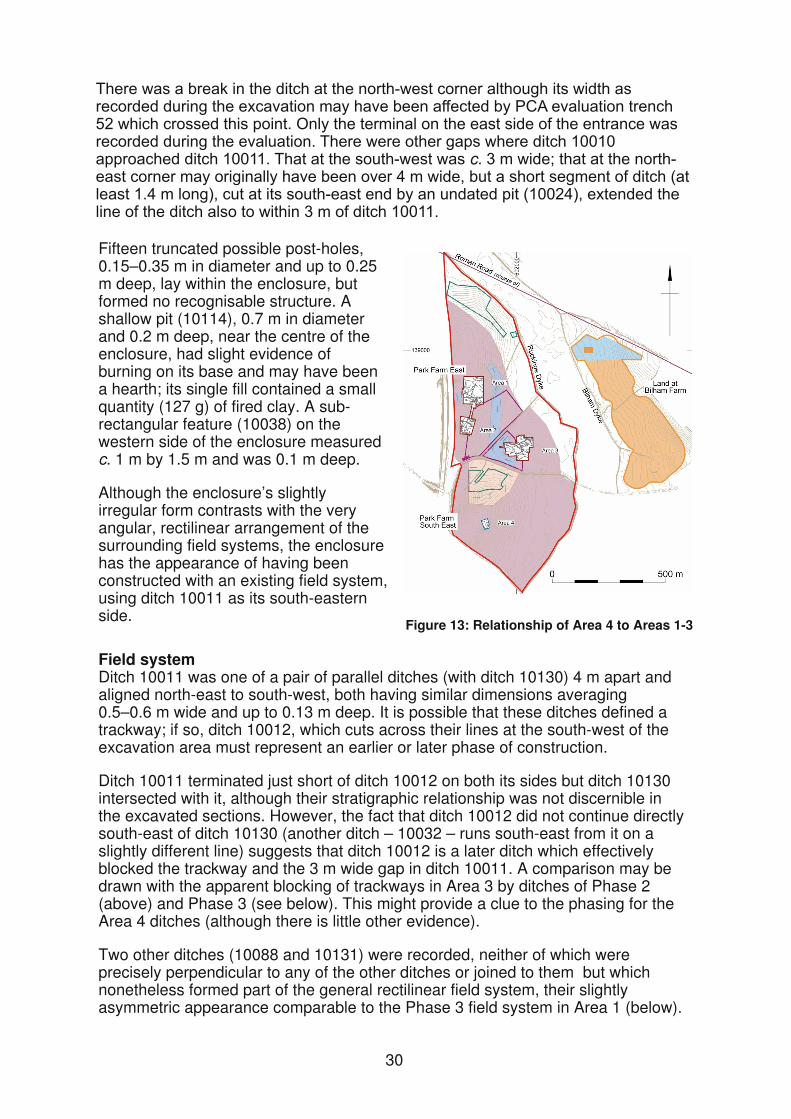
Area 4
Due to the distance between Area 4 and Areas 1–3, it is difficult or impossible to correlate their phasing (Fig 13). The excavation revealed a small sub-square enclosure set within an array of rectilinear field ditches. These ditches are comparable in their general appearance to the Phase 2 and Phase 3 ditches to the north, although their phasing on t at basis, as presented below, is necessarily tentative. There were a number of pits and post-holes inside and outside the enclosure, as well as a hearth inside. Apart from a single feature, pit 10122, containing Middle/Late Iron Age pottery, the small pottery assemblage was all of either Late Iron Age or undiagnostic late prehistoric date.
EnclosureThe enclosure measured approximately 10 m square and was bounded to the north-east, north-west and south-west by ditch 10010. It may have been open towards the south-east, or bounded on that side by a longer straight ditch (10011) which extended beyond it. Ditch 10010, which had been heavily truncated, was c. 0.4 m wide and up to 0.2 m deep, and small quantities of abraded pottery were recovered from its naturally accumulated fills.
29
c.
Fifteen truncated possible post-holes, 0.15–0.35 m in diameter and up to 0.25 m deep, lay within the enclosure, but formed no recognisable structure. A shallow pit (10114), 0.7 m in diameter and 0.2 m deep, near the centre of the enclosure, had slight evidence of burning on its base and may have been a hearth; its single fill contained a small quantity (127 g) of fired clay. A sub-rectangular feature (10038) on the western side of the enclosure measured c. 1 m by 1.5 m and was 0.1 m deep.
Although the enclosure’s slightly irregular form contrasts with the very angular, rectilinear arrangement of the surrounding field systems, the enclosure has the appearance of having been constructed with an existing field system, using ditch 10011 as its south-eastern side.
Figure 13: Relationship of Area 4 to Areas 1-3
Field systemDitch 10011 was one of a pair of parallel ditches (with ditch 10130) 4 m apart and aligned north-east to south-west, both having similar dimensions averaging 0.5–0.6 m wide and up to 0.13 m deep. It is possible that these ditches defined a trackway; if so, ditch 10012, which cuts across their lines at the south-west of the excavation area must represent an earlier or later phase of construction.
Ditch 10011 terminated just short of ditch 10012 on both its sides but ditch 10130 intersected with it, although their stratigraphic relationship was not discernible in the excavated sections. However, the fact that ditch 10012 did not continue directly south-east of ditch 10130 (another ditch – 10032 – runs south-east from it on a slightly different line) suggests that ditch 10012 is a later ditch which effectively blocked the trackway and the 3 m wide gap in ditch 10011. A comparison may be drawn with the apparent blocking of trackways in Area 3 by ditches of Phase 2 (above) and Phase 3 (see below). This might provide a clue to the phasing for the Area 4 ditches (although there is little other evidence).
Two other ditches (10088 and 10131) were recorded, neither of which were precisely perpendicular to any of the other ditches or joined to them but which nonetheless formed part of the general rectilinear field system, their slightly asymmetric appearance comparable to the Phase 3 field system in Area 1 (below).
30

Figure 14: Area 4
31
features
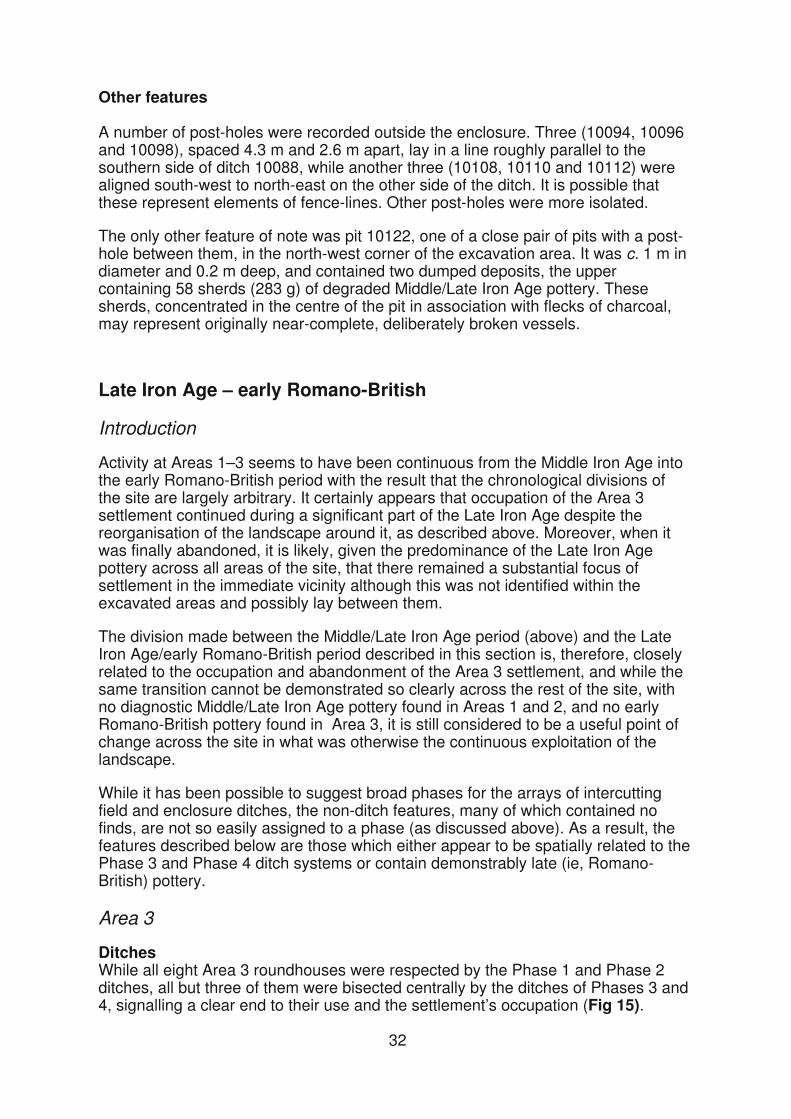
A number of post-holes were recorded outside the enclosure. Three (10094, 10096 and 10098), spaced 4.3 m and 2.6 m apart, lay in a line roughly parallel to the southern side of ditch 10088, while another three (10108, 10110 and 10112) were aligned south-west to north-east on the other side of the ditch. It is possible that these represent elements of fence-lines. Other post-holes were more isolated.
The only other feature of note was pit 10122, one of a close pair of pits with a post-hole between them, in the north-west corner of the excavation area. It was c. 1 m in diameter and 0.2 m deep, and contained two dumped deposits, the upper containing 58 sherds (283 g) of degraded Middle/Late Iron Age pottery. These sherds, concentrated in the centre of the pit in association with flecks of charcoal, may represent originally near-complete, deliberately broken vessels.
Late Iron Age – early Romano-British
Introduction
Activity at Areas 1–3 seems to have been continuous from the Middle Iron Age into the early Romano-British period with the result that the chronological divisions of the site are largely arbitrary. It certainly appears that occupation of the Area 3 settlement continued during a significant part of the Late Iron Age despite the reorganisation of the landscape around it, as described above. Moreover, when it was finally abandoned, it is likely, given the predominance of the Late Iron Age pottery across all areas of the site, that there remained a substantial focus of settlement in the immediate vicinity although this was not identified within the excavated areas and possibly lay between them.
The division made between the Middle/Late Iron Age period (above) and the Late Iron Age/early Romano-British period described in this section is, therefore, closely related to the occupation and abandonment of the Area 3 settlement, and while the same transition cannot be demonstrated so clearly across the rest of the site, with no diagnostic Middle/Late Iron Age pottery found in Areas 1 and 2, and no early Romano-British pottery found in Area 3, it is still considered to be a useful point of change across the site in what was otherwise the continuous exploitation of the landscape.
While it has been possible to suggest broad phases for the arrays of intercutting field and enclosure ditches, the non-ditch features, many of which contained no finds, are not so easily assigned to a phase (as discussed above). As a result, the features described below are those which either appear to be spatially related to the Phase 3 and Phase 4 ditch systems or contain demonstrably late (ie, Romano-British) pottery.
Area 3
DitchesWhile all eight Area 3 roundhouses were respected by the Phase 1 and Phase 2 ditches, all but three of them were bisected centrally by the ditches of Phases 3 and 4, signalling a clear end to their use and the settlement’s occupation (Fig 15).
32
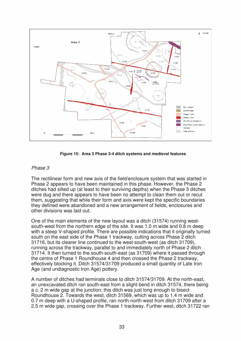
Figure 15: Area 3 Phase 3-4 ditch systems and medieval features
Phase 3
The rectilinear form and new axis of the field/enclosure system that was started in Phase 2 appears to have been maintained in this phase. However, the Phase 2 ditches had silted up (at least to their surviving depths) when the Phase 3 ditches were dug and there appears to have been no attempt to clean them out or recut them, suggesting that while their form and axis were kept the specific boundaries they defined were abandoned and a new arrangement of fields, enclosures and other divisions was laid out.
One of the main elements of the new layout was a ditch (31574) running west-south-west from the northern edge of the site. It was 1.0 m wide and 0.8 m deep with a steep V-shaped profile. There are possible indications that it originally turned south on the east side of the Phase 1 trackway, cutting across Phase 2 ditch 31716, but its clearer line continued to the west-south-west (as ditch 31709), running across the trackway, parallel to and immediately north of Phase 2 ditch 31714. It then turned to the south-south-east (as 31709) where it passed through the centre of Phase 1 Roundhouse 4 and then crossed the Phase 2 trackway, effectively blocking it. Ditch 31574/31709 produced a small quantity of Late Iron Age (and undiagnostic Iron Age) pottery.
A number of ditches had terminals close to ditch 31574/31709. At the north-east, an unexcavated ditch ran south-east from a slight bend in ditch 31574, there being a c. 2 m wide gap at the junction; this ditch was just long enough to bisect Roundhouse 2. Towards the west, ditch 31569, which was up to 1.4 m wide and 0.7 m deep with a U-shaped profile, ran north-north-west from ditch 31709 after a 2.5 m wide gap, crossing over the Phase 1 trackway. Further west, ditch 31722 ran
33
west-north-west from the corner in ditch 31574/31709, after a 4 m wide gap, bisecting Roundhouse 6; it was 0.8 m wide and 0.15 m deep and produced a single Iron Age sherd. At the south two slightly irregular lengths of ditch (31386 and 31655), each c. 0.9 m wide and 0.3 m deep, ran perpendicular from ditch 31709 towards the east.
Phase 4
This phase saw a further major reorganisation of the landscape on the valley floor cutting across all earlier ditch systems. This comprised two long, parallel, approximately east–west ditches (31388 to the north and 31713 to the south) positioned 45 m apart, with other ditches (31268 and 31704) running perpendicular to them.
The northern ditch, which contained small quantities of Late Iron Age pottery, was up to 0.7 m wide and 0.3 m deep; the southern ditch, which was undated, was up to 1 m wide and 0.4 m deep. The two cross-ditches produced further Late Iron Age sherds; another, less substantial ditch (31431) ran east from ditch 31704. Between them, these Phase 4 ditches bisected three of the earlier roundhouses (Roundhouses 2, 3 and 8).
Other featuresOnly two demonstrably late features were recorded in this area, an undated post-hole (31020) cutting Phase 4 ditch 31388, and hearth 31047 cutting Phase 4 ditch 31704. The hearth was 1.8 m in diameter and up to 0.3 m deep with steep sides and a flat or slightly concave base. It had a layer of charcoal covering the base, the reddening of the underlying natural indicating in situ burning, overlain by a layer of grey silty ash which contained fired clay and Late Iron Age pottery. It was cut by a later, undated (but possibly medieval, see below) ditch (31389). It should be noted that hearth 31026 (see Middle to Late Iron Age, above), located less than 3m to the north-east, was of a similar size and form (and likewise cut by ditch 31389) and could be broadly contemporary.
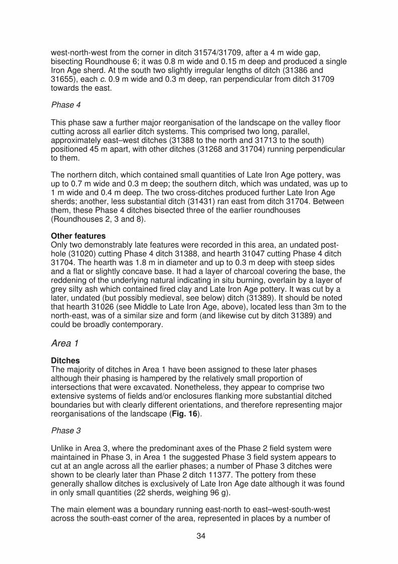
Area 1
Ditches The majority of ditches in Area 1 have been assigned to these later phases although their phasing is hampered by the relatively small proportion of intersections that were excavated. Nonetheless, they appear to comprise two extensive systems of fields and/or enclosures flanking more substantial ditched boundaries but with clearly different orientations, and therefore representing major reorganisations of the landscape (Fig. 16).
Phase 3
Unlike in Area 3, where the predominant axes of the Phase 2 field system were maintained in Phase 3, in Area 1 the suggested Phase 3 field system appears to cut at an angle across all the earlier phases; a number of Phase 3 ditches were shown to be clearly later than Phase 2 ditch 11377. The pottery from these generally shallow ditches is exclusively of Late Iron Age date although it was found in only small quantities (22 sherds, weighing 96 g).
The main element was a boundary running east-north to east–west-south-west across the south-east corner of the area, represented in places by a number of
34
parallel ditches 2–3 m apart. These may have formed a double-ditched boundary or a narrow trackway bounded to the south by ditch 11108 and to the north by ditch 11376. Both these ditches had shallow profiles, being up to 1 m wide and 0.25 m deep, and in places the northern ditch appears to have replaced, and/or cut, lengths of much smaller ditch (eg, 11092 and 11256) on approximately the same line.
Figure 16: Area 1, Phase 3-4
35
A number of similar ditches ran off this boundary to both the south-east (eg 12004 and 12007) and the north-west (eg, 11919, 11943 and 12003), although they were not exactly perpendicular to it; this slightly irregular layout is similar to that suggested for this phase in Area 4 (above). Further to the north and north-west there were additional ditches on both general orientations. Together they appeared to define an irregular arrangement of rectilinear fields/enclosures of varying size.
It may be significant that Phase 3 ditches 11376 and 12003 passed through the centres of Roundhouses 10 and 11 respectively, in the same way as Phase 3 ditches cut through the roundhouses in Area 3.
Phase 4
Although the Phase 4 ditches in Area 3 contained exclusively Late Iron Age pottery, a small amount of early Romano-British pottery (42 sherds, 282 g) was recovered from primary and secondary fills within a number of the ditches assigned to this phase in Area 1.
In the southern part of Area 1 the Phase 4 ditches extend south into, but not through, Area 2 and share exactly the same axes as those in Area 3. The most northern of these ditches (12001) is connected at its north end to a major east–west ditch (12000) which in its eastern half recuts Phase 1b ditch 11871 (although not to its full depth and varying slightly in its line). This suggests that the line of the earlier ditch was still a visible feature, despite the intervening reorganisations of the landscape (Phases 2 and 3); recutting its fills for part of its length would have been an easier option than digging a new ditch. Towards the west, however, ditch 12000 diverged from the line of the earlier ditch, turning towards the west-north-west. Ditch 12000 appears to represent a major east–west boundary, its overall (if less regular) alignment approximately matching those in Area 3. It averaged c. 2 m wide and was up to 0.8 m deep.
Three ditches (12008, 12009 and 12010) ran perpendicularly north from ditch 12000, forming a pattern of rectilinear enclosures, one of them subdivided by a cross-ditch (11911). The primary fill of ditch 12008 produced a Romano-British whiteware sherd (7 g). At the north of the area further ditches, including one less regular, curving ditch, appear to extend the field system to the north (11620), west (11641) and east (11619) (the latter also sharing the orientation of the main Area 3 ditches). The lower of two fills in ditch 11641 produced 27 sherds (251 g) from at least three Romano-British vessels, including a samian sherd.
The small amount of Romano-British pottery from just some of these ditches is far from conclusive evidence for a post-Roman-conquest date for the Phase 4 ditch system. Some Romano-British sherds were also recovered from earlier phase ditches but in all cases from the uppermost fills and therefore more easily explained as intrusive, given the evidence (below) for Romano-British activity in the area. However, the presence of Romano-British sherds in a number of primary and secondary contexts does provide some confirmation that it was this arrangement of ditches that was extant at the time of the Roman conquest and probably continued in use for some time afterwards, contemporary with the clearer evidence for Romano-British activity on the site.
Other featuresA number of Romano-British features were recorded in Area 2 (Fig. 16). There was also a significant number of features which, while either undated or of Late Iron Age date, appear to be closely associated particularly with the Phase 4 ditches and therefore are also considered here.
36
Features south of ditch 12000Most of the discrete features south of ditch 12000 have been described above within the context of Middle-Late Iron Age phases although some could equally belong to this Late Iron Age/early Romano-British phase. However, at least one pit (11408), containing seven sherds (35 g) of Late Iron Age pottery, was stratigraphically late as it cut the southern edge of the ditch; it was c. 1 m in diameter and 0.4 m deep with three fills. There was also a small hearth (11138), 0.7 m in diameter and 0.1 m deep with a layer of burnt clay and charcoal at the base, which contained three Romano-British sherds.
The largest feature, however, was an oval pit (11987) which cut the southern terminal of Phase 1b ditch 11871 and the western end of metalworking furnace 11924 (Fig. 11). It measured 2.1 m by 2.9 m and was 0.9 m deep, with irregular sides and a flattish base. It had a sequence of at least thirteen fills which, in addition to containing large quantities of redeposited metalworking debris and demolition rubble from the furnace superstructure (as well as crucible fragments – ON 10005), also produced 184 sherds (2593 g) of Late Iron Age pottery and 48 sherds (464 g) of early Romano-British pottery, the latter being recovered from throughout its fill sequence. A copper alloy rivet (ON 10012) and a piece of unidentified iron (ON 10004) were also recovered from the pit. In the lower part of the pit the fills comprised alternating thicker layers of rubble and waste and thin layers of largely sterile silty clay.
Features north of ditch 12000Two of the ditches (12008 and 12010) running north-north-east from ditch 12000 appear to form a subrectangular enclosure, internally divided by two further ditches (12009 and 11911). This enclosure, which has openings at it north-east and north-west corners, is bounded to the north by ditch 11641. There was a group of features within the three subdivisions of the enclosure (Fig. 17). While a few of these features contained early Romano-British pottery in addition to their predominantly Late Iron Age assemblages, a small number of features were stratigraphically later than the Phase 3 ditches, and some, particularly those in the south-western subdivision, were clearly laid out with reference to the Phase 4 ditches. Many features, however, are potentially of earlier date but all are considered here because they appear to form coherent, if variable, groupings.
Eastern group
Among the features in the long eastern subdivision there was a group of 10 post-holes (11389) in an area c. 6 m across, one of which (11415) cut Phase 3 ditch 12014. Their roughly symmetrical arrangement forming an approximate ‘H’ shape (although wider at the east than at the west) with a shallow oval feature (11387) near its centre, suggests that these comprised some type of structure, though of unknown form or function. The majority of the post-holes were oval, ranging in size from c. 0.2 m by 0.3 m up to 0.5 m by 0.7 m, with depths of up to 0.2 m, single fills and variable profiles. The largest, and the only one to contain any finds, was the most westerly of the group, pit 11412, which was 0.7 m in diameter and 0.3 m deep with steep straight sides and a flat base. Its two fills produced three Late Iron Age sherds (9 g).
Two further undated oval pits c. 5 m north-west of the structure, may be associated, as may an undated oval possible hearth (11495) c. 8 m to the south-west containing charcoal, ash and burnt animal bone.
37
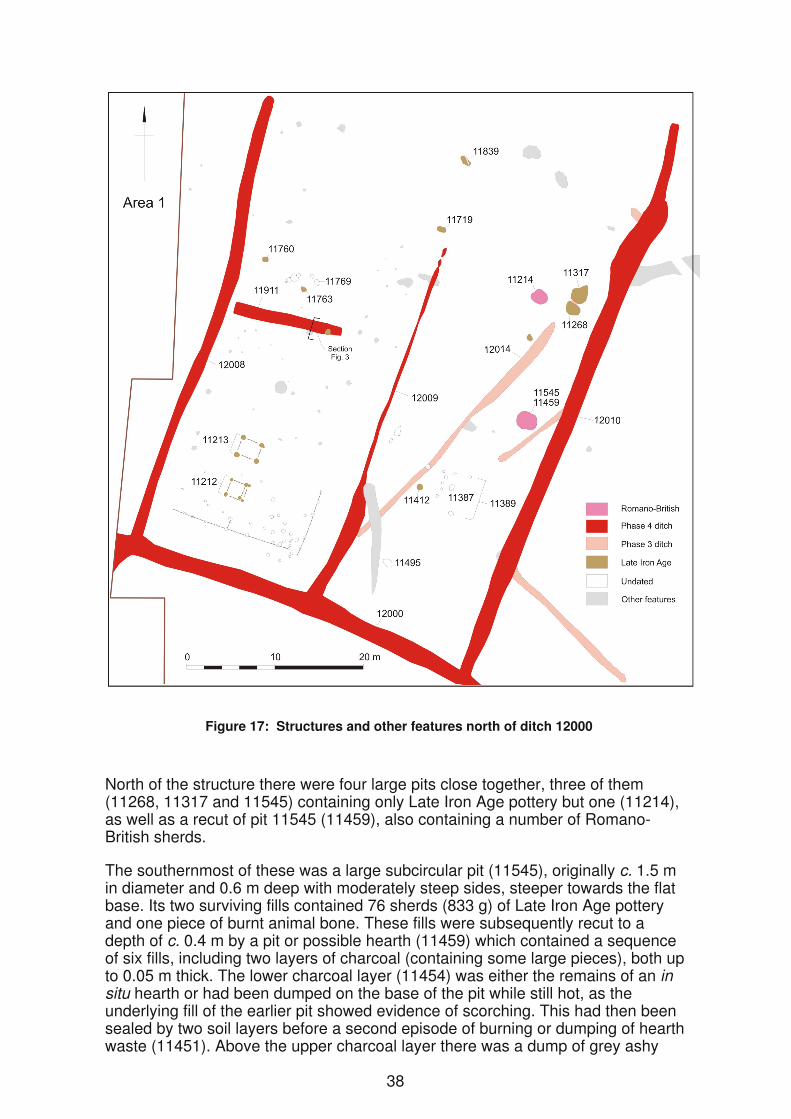
North of the structure there were four large pits close together, three of them (11268, 11317 and 11545) containing only Late Iron Age pottery but one (11214), as well as a recut of pit 11545 (11459), also containing a number of Romano-British sherds.
The southernmost of these was a large subcircular pit (11545), originally c. 1.5 m in diameter and 0.6 m deep with moderately steep sides, steeper towards the flat base. Its two surviving fills contained 76 sherds (833 g) of Late Iron Age pottery and one piece of burnt animal bone. These fills were subsequently recut to a depth of c. 0.4 m by a pit or possible hearth (11459) which contained a sequence of six fills, including two layers of charcoal (containing some large pieces), both up to 0.05 m thick. The lower charcoal layer (11454) was either the remains of an in situ hearth or had been dumped on the base of the pit while still hot, as the underlying fill of the earlier pit showed evidence of scorching. This had then been sealed by two soil layers before a second episode of burning or dumping of hearth waste (11451). Above the upper charcoal layer there was a dump of grey ashy
38
material (11450) containing a moderate amount of fired clay (259 g). In total, feature 11459 produced 178 sherds (1383 g) of Late Iron Age pottery and three early Romano-British sherds (20 g).
Approximately 12 m to the north there was a tight group of three other large pits, the two eastern ones cutting a short extension to Phase 3 ditch 12014. Oval pit 11268 measured c. 1.3 m by 2 m and 0.6 m deep and had a U-shaped profile containing four fills which together produced 32 sherds (333 g) of Late Iron Age pottery. To its immediate north, irregular pit 11317 measured 1.9 m by 2.3 m and 0.6 m deep and had shallow sloping side at the north-east but steeper concave sides elsewhere. It had a thin layer of sterile clay on the base overlain by four naturally accumulated fills containing 111 Late Iron Age sherds (1943 g).
The most western of this group was a subcircular pit (11214), up to 2 m wide and 0.9 m deep with steep concave sides and a narrow concave base, containing a sequence of six fills. Above a sterile primary fill, there was a layer containing 81 sherds (1808 g), possibly from a single Late Iron Age vessel broken before deposition, and two Romano-British sherds (5 g) overlain by a secondary fill (11240). The layer above (11239) contained further pottery – 46 Late Iron Age sherds (1055 g) and 29 Romano-British sherds (148 g) – as well as 3540 g of fired clay. This was overlain by a deposit of clay up to 0.3 m thick, a thin sterile layer of silt and an upper fill (11237) containing a further 92 Late Iron Age sherds (794 g) and six Romano-British sherds (26 g).
North-western group
There was an arrangement of stake-holes, post-holes and pits in the southern part of the north-western division of the enclosure, between 3 m and 6 m north of ditch 11911. These included a south-west to north-east line of five consisting of two stake-holes c. 0.15 m in diameter and 0.2 m deep, then three pits, 0.4–0.9 m in diameter, and up to 0.3 m deep, each feature being cut by that to its north-east. Each had a single fill, but none produced any finds. Two adjacent oval post-holes lay c. 1–2 m to the east the larger (11769) measuring 0.5 m by 0.7 m and morethan 0.6 m deep; these too contained no finds.
g). T
c
(84 g.)
The only other features in this area were two shallow oval pits just west of the line of ditch 12009 towards the north of the enclosure. Pit 11719, measuring 0.6 m by 1.1 m was 0.2 m deep, contained a single Late Iron Age sherd (2 g) and fragments of fired clay (8 g). Pit 11839, 0.8 m by 1.1 m and less than 0.1 m deep, contained a further 30 sherds (221 g).
South-western group
The largest group of features north of ditch 12000 lay within the south-western subdivision where 56 post-holes were excavated within its southern half in an area 11 m by 14 m; there were in addition a further 20 possible post-holes surveyed but
Figure 17: Structures and other features north of ditch 12000
North of the structure there were four large pits close together, three of them (11268, 11317 and 11545) containing only Late Iron Age pottery but one (11214), as well as a recut of pit 11545 (11459), also containing a number of Romano-British sherds.
The southernmost of these was a large subcircular pit (11545), originally c. 1.5 m in diameter and 0.6 m deep with moderately steep sides, steeper towards the flat base. Its two surviving fills contained 76 sherds (833 g) of Late Iron Age pottery and one piece of burnt animal bone. These fills were subsequently recut to a depth of c. 0.4 m by a pit or possible hearth (11459) which contained a sequence of six fills, including two layers of charcoal (containing some large pieces), both up to 0.05 m thick. The lower charcoal layer (11454) was either the remains of an in situ hearth or had been dumped on the base of the pit while still hot, as the underlying fill of the earlier pit showed evidence of scorching. This had then been sealed by two soil layers before a second episode of burning or dumping of hearth waste (11451). Above the upper charcoal layer there was a dump of grey ashy
38
material (11450) containing a moderate amount of fired clay (259 g). In total, feature 11459 produced 178 sherds (1383 g) of Late Iron Age pottery and three early Romano-British sherds (20 g).
Approximately 12 m to the north there was a tight group of three other large pits, the two eastern ones cutting a short extension to Phase 3 ditch 12014. Oval pit 11268 measured c. 1.3 m by 2 m and 0.6 m deep and had a U-shaped profile containing four fills which together produced 32 sherds (333 g) of Late Iron Age pottery. To its immediate north, irregular pit 11317 measured 1.9 m by 2.3 m and 0.6 m deep and had shallow sloping side at the north-east but steeper concave sides elsewhere. It had a thin layer of sterile clay on the base overlain by four naturally accumulated fills containing 111 Late Iron Age sherds (1943 g).
The most western of this group was a subcircular pit (11214), up to 2 m wide and 0.9 m deep with steep concave sides and a narrow concave base, containing a sequence of six fills. Above a sterile primary fill, there was a layer containing 81 sherds (1808 g), possibly from a single Late Iron Age vessel broken before deposition, and two Romano-British sherds (5 g) overlain by a secondary fill (11240). The layer above (11239) contained further pottery – 46 Late Iron Age sherds (1055 g) and 29 Romano-British sherds (148 g) – as well as 3540 g of fired clay. This was overlain by a deposit of clay up to 0.3 m thick, a thin sterile layer of silt and an upper fill (11237) containing a further 92 Late Iron Age sherds (794 g) and six Romano-British sherds (26 g).
North-western group
There was an arrangement of stake-holes, post-holes and pits in the southern part of the north-western division of the enclosure, between 3 m and 6 m north of ditch 11911. These included a south-west to north-east line of five consisting of two stake-holes c. 0.15 m in diameter and 0.2 m deep, then three pits, 0.4–0.9 m in diameter, and up to 0.3 m deep, each feature being cut by that to its north-east. Each had a single fill, but none produced any finds. Two adjacent oval post-holes lay c. 1–2 m to the east the larger (11769) measuring 0.5 m by 0.7 m and morethan 0.6 m deep; these too contained no finds.
g). T
c
(84 g.)
The only other features in this area were two shallow oval pits just west of the line of ditch 12009 towards the north of the enclosure. Pit 11719, measuring 0.6 m by 1.1 m was 0.2 m deep, contained a single Late Iron Age sherd (2 g) and fragments of fired clay (8 g). Pit 11839, 0.8 m by 1.1 m and less than 0.1 m deep, contained a further 30 sherds (221 g).
South-western group
The largest group of features north of ditch 12000 lay within the south-western subdivision where 56 post-holes were excavated within its southern half in an area 11 m by 14 m; there were in addition a further 20 possible post-holes surveyed but
39
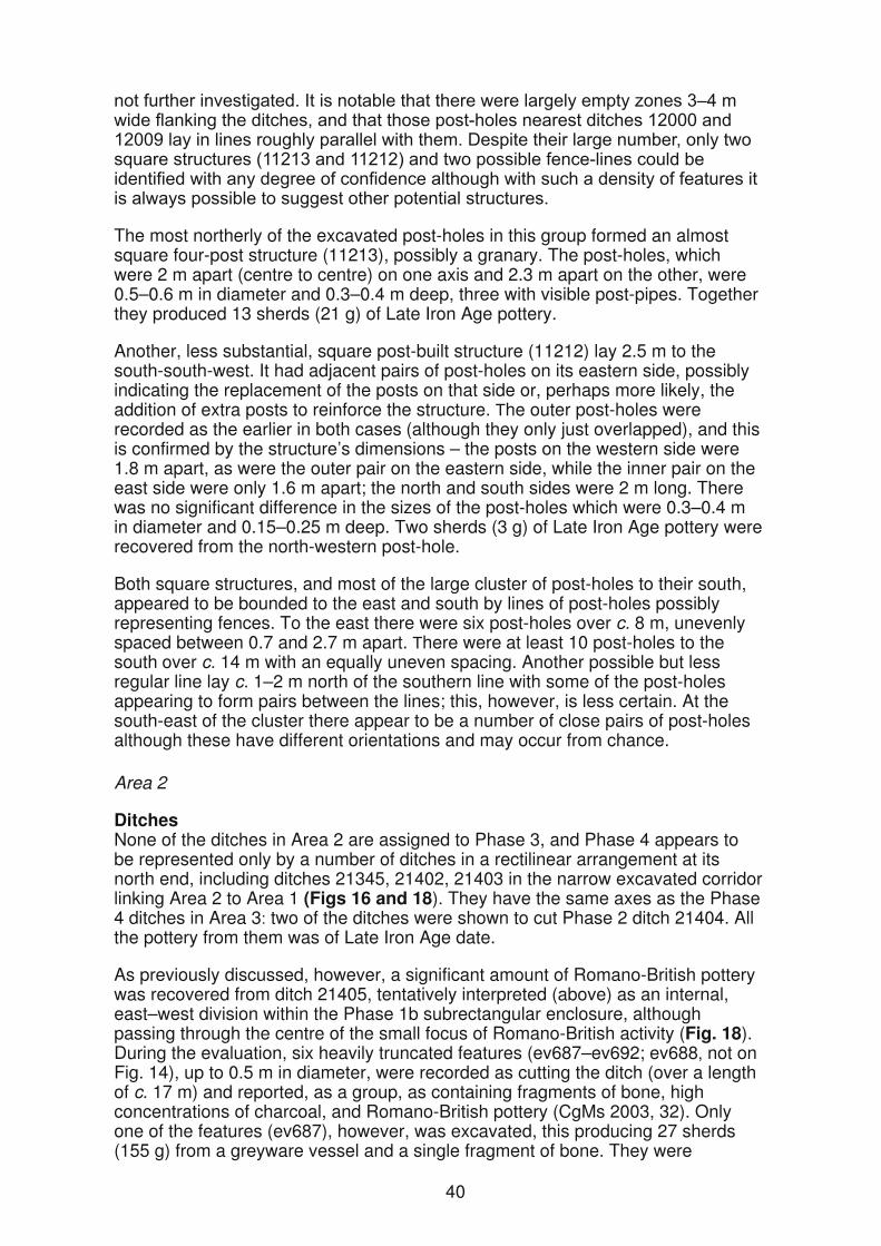
The most northerly of the excavated post-holes in this group formed an almost square four-post structure (11213), possibly a granary. The post-holes, which were 2 m apart (centre to centre) on one axis and 2.3 m apart on the other, were 0.5–0.6 m in diameter and 0.3–0.4 m deep, three with visible post-pipes. Together they produced 13 sherds (21 g) of Late Iron Age pottery.
Another, less substantial, square post-built structure (11212) lay 2.5 m to the south-south-west. It had adjacent pairs of post-holes on its eastern side, possibly indicating the replacement of the posts on that side or, perhaps more likely, the addition of extra posts to reinforce the structure. he outer post-holes were recorded as the earlier in both cases (although they only just overlapped), and this is confirmed by the structure’s dimensions – the posts on the western side were 1.8 m apart, as were the outer pair on the eastern side, while the inner pair on the east side were only 1.6 m apart; the north and south sides were 2 m long. There was no significant difference in the sizes of the post-holes which were 0.3–0.4 m in diameter and 0.15–0.25 m deep. Two sherds (3 g) of Late Iron Age pottery were recovered from the north-western post-hole.
Both square structures, and most of the large cluster of post-holes to their south, appeared to be bounded to the east and south by lines of post-holes possibly representing fences. To the east there were six post-holes over c. 8 m, unevenly spaced between 0.7 and 2.7 m apart. here were at least 10 post-holes to thesouth over c. 14 m with an equally uneven spacing. Another possible but less regular line lay c. 1–2 m north of the southern line with some of the post-holes appearing to form pairs between the lines; this, however, is less certain. At the south-east of the cluster there appear to be a number of close pairs of post-holes although these have different orientations and may occur from chance.
Area 2
DitchesNone of the ditches in Area 2 are assigned to Phase 3, and Phase 4 appears to be represented only by a number of ditches in a rectilinear arrangement at its north end, including ditches 21345, 21402, 21403 in the narrow excavated corridor linking Area 2 to Area 1 (Figs 16 and 18). They have the same axes as the Phase 4 ditches in Area 3 two of the ditches were shown to cut Phase 2 ditch 21404. All the pottery from them was of Late Iron Age date.
As previously discussed, however, a significant amount of Romano-British pottery was recovered from ditch 21405, tentatively interpreted (above) as an internal, east–west division within the Phase 1b subrectangular enclosure, although passing through the centre of the small focus of Romano-British activity (Fig. 18). During the evaluation, six heavily truncated features (ev687–ev692; ev688 not on Fig. 14), up to 0.5 m in diameter, were recorded as cutting the ditch (over a length of c. 17 m) and reported, as a group, as containing fragments of bone, high concentrations of charcoal, and Romano-British pottery (CgMs 2003, 32). Only one of the features (ev687), however, was excavated, this producing 27 sherds (155 g) from a greyware vessel and a single fragment of bone. They were
40
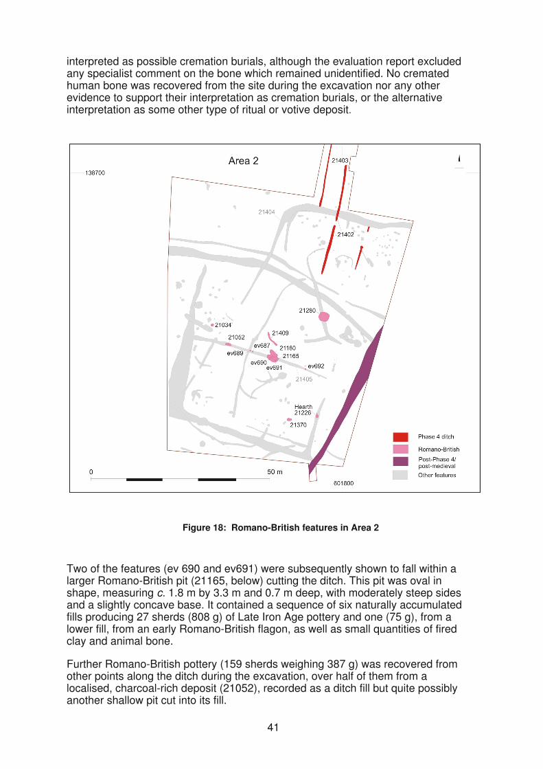
interpreted as possible cremation burials, although the evaluation report excluded any specialist comment on the bone which remained unidentified. No cremated human bone was recovered from the site during the excavation nor any other evidence to support their interpretation as cremation burials, or the alternative interpretation as some other type of ritual or votive deposit
41
Two of the features (ev 690 and ev691) were subsequently shown to fall within a larger Romano-British pit (21165, below) cutting the ditch. This pit was oval in shape, measuring c. 1.8 m by 3.3 m and 0.7 m deep, with moderately steep sides and a slightly concave base. It contained a sequence of six naturally accumulated fills producing 27 sherds (808 g) of Late Iron Age pottery and one (75 g), from a lower fill, from an early Romano-British flagon, as well as small quantities of fired clay and animal bone.
Further Romano-British pottery (159 sherds weighing 387 g) was recovered from other points along the ditch during the excavation, over half of them from a localised, charcoal-rich deposit (21052), recorded as a ditch fill but quite possibly another shallow pit cut into its fill.
Figure 18: Romano-British features in Area 2
42
Other featuresPit 21165 (above) was cut on its north side by another oval pit (21180), measuring 1.3 m by 2.7 m and 0.4 m deep, whose single backfilled layer contained a further 16 Late Iron Age sherds (174 g). A slightly angled gully (21409), less than 5 m long, lying just north of these two pits produced a single Romano-British sherd (7 g).
Phase 1b enclosure ditch 21406 was cut by hearth 21226. This was 0.8 m in diameter and 0.15 m deep with concave sides and a slightly concave base and a narrow channel, possibly the flue, running to the north. On the base and sides were 306 sherds (7444 g) from a Late Iron Age cordoned jar set in a matrix of sandy clay, 0.05–0.1 m thick, probably to act as a hearth lining (Pl. 2). Filling the hollow in the centre of this layer was further sandy clay that had been heavily burnt in situ, these two layers forming a level upper surface for the hearth. On this surface was a layer of burnt material containing a further 126 Late Iron Age sherds (958 g) as well as 22 Romano-British sherds (91 g), with the main concentration of charcoal over the most heavily burnt clay.
Plate 2: Pottery-lined hearth 21226 from the north-east
Pit 21280, which had a projected diameter of c. 2.5–3 m, was 1.7 m deep with a conical profile and may have been a waterhole. It was filled with a series of naturally accumulated silts, the upper fills possibly incorporating some dumped domestic waste. The pit produced 52 sherds (463 g) of Late Iron Age pottery andalso a small quantity of fired clay and, from a middle fill, two Romano-British sherds (13 g).
Two other small pits also contained Romano-British pottery, although their positions among features containing only Late Iron Age pottery (described in Middle to Late Iron Age, above) could indicate broad contemporaneity and hence a relatively late date for some of those features already described. Pit 21370, measuring 0.8 m by 1.4 m and 0.25 m deep, produced 50 Late Iron Age sherds (514 g) and two Romano-British sherds (13 g) from the upper of its two fills, both of which contained moderate amounts of charcoal. At the west pit 21034, which was 0.4 m deep with two fills, produced a further 38 Late Iron Age sherds (245 g) as well as one (33 g) from the lower fill, from a Romano-British everted rim jar.
Land at Bilham Farm
A number of pits, post-holes and gullies, several of them dated to the Late Iron Age/early Romano-British period, were recorded during the 2003 evaluation at the northern end of Land at Bilham Farm. They were thought to represent a possible small settlement or farmstead on the higher ground at the east of the evaluation area, to the immediate south of the Roman road, with associated field systems spreading into the lower ground to the west and south-west (Archaeology South-East 2003). Because the settlement site was to be preserved in situ, it was not subject to further investigation.
A contingency trench excavated to the north of the evaluation area in order to span the projected line of the Roman road between Lympne and Maidstone found no evidence for the road. An undated U-shaped ditch, c. 1 m wide and 0.3 m deep, having the same alignment as the road, was interpreted as a probable field boundary.
Medieval and later
Park Farm East and South East
A total of 85 sherds of medieval pottery (636 g) was recovered from the Park Farm East and South East sites. Over a third (by weight), comprising sandy/shelly body sherds of 12th/13th century date, came from a shallow sinuous ditch in the central part of Area 3 (Fig. 15), initially recorded in evaluation trench 18 (ev31 and ev37/39) but also during the excavation (31658/31664). The ditch, which was 0.6 m wide and 0.2 m deep, was over 20 m long. Its sinuous line and general north-west to south-east alignment are similar to those of another, undated but post-Phase 4, ditch (31389) c. 30 m to the north-east, which may also be of medieval date.
Immediately south-west of ditch 31658/31664 there were two very slight gullies. Gully 31721 appeared to form the rounded north-eastern corner of a possibly subrectangular structure that was either open or truncated to the south and west. It was c. 6 m long, 0.2 m wide and 0.1 m deep, and had a stake-hole on its inner edge. It appears to be associated with a similar, 7 m long, gully (31691) lying to the immediate south-east. Although neither contained any finds, a sample from the fill of gully 31691 contained seed-head fragments of stinking mayweed (Anthemis cotula), a common constituent of charred assemblages of Saxon, medieval and post-medieval date, as well as grains of free-threshing wheat.
Approximately a third of the medieval pottery, of similar date, came from three possible post-holes and a ditch at the eastern end of evaluation trench 36, to the east of Area 1 (Fig. 2). The three post-holes (ev536, ev538 and ev548), and another that was undated (ev540), were arranged in a north-east to south-west line, c. 12 m long, perpendicular to the ditch (ev542). The three post-holes were spaced 1.3 m and 2.6 m apart to the north-east of the ditch; the fourth lay a further 7 m to the south-west. They averaged c. 0.6 m wide and 0.15 m deep but their function, whether as part of a fence-line or some form of building, is not known. It is possible that the ditch is not related and that the medieval pottery from it is intrusive.
The remaining medieval pottery from the site was recovered in generally small (possibly residual) quantities from a range of features recorded during the evaluation.
43

Land at Bilham Farm
A small circular pit (ev8604) on the western edge of the Trench 86 (at the south-west of the 2007 evaluation site, Fig. 1) contained an upright medieval globular jar (2649 g) apparently deliberately placed (Wessex Archaeology 2007b). The pit was at least 0.5 m in diameter and 0.3 m deep, although truncated by ploughing which had damaged the rim of the vessel. The vessel is in Ashford-type (Potter’s Corner) shelly/sandy ware and has a developed (squared) rim, indicating a probable date in the 13th century. The reason for the vessel’s deposition is unclear although it might have had some symbolic or ritual significance.
A number of pits, between 0.5 m and 1.5 m in diameter and up to 0.2 m deep, with fills rich in charcoal, predominantly oak, and evidence of in situ burning, were recorded across Land at Bilham Farm during both the 2007 evaluation and the 2007 strip, map and record excavation at the north end of the site (Wessex Archaeology 2007b; 2008d). It is possible that they relate to charcoal burning (although probably not on the scale necessary to provide fuel for the Late Iron Age metalworking furnace in Park Farm East), and a relatively modern date is suggested by the fresh appearance of the charcoal they contain. It is possible that they relate to small-scale charcoal burning associated with the clearance of the once fairly densely wooded landscape.
Discussion
The archaeological works south-east of Park Farm have revealed a settled landscape subject to near-continuous occupation and re-organisation from the Middle Iron Age into the start of the Roman period. These findings complement the results from other excavations in the Ashford area, such as at Brisley Farm (Johnson 2002; Archaeology South-East 2006), Waterbrook Park (Wessex Archaeology 2008b) and Foster Road (Powell 2010; Powell and Birbeck 2010) as well as more widely in Kent (Champion 2007, 120).
There was a low level of later Bronze Age activity on the site, but the dispersed and limited nature of the evidence makes it hard to interpret the features beyond indicating the likelihood of settlement activity in the vicinity. Such activity is demonstrated by other findings in the area. A possible roundhouse was recorded at Waterbrook Farm, for example, and at Foster Road this period was represented by possible field and droveway ditches, a roundhouse and an area of craft/industrial activity. Evidence for the division of the landscape has also been recorded at Brisley Farm and Westhawk Farm (Booth et al. 2008) but there was no evidence to suggest that any of the field boundaries recorded at this site were of later Bronze Age date.
As is the case more widely, both in Kent and further afield (Champion 2007, 102; Wait and Cotton 2000, 105), this Middle and Late Bronze Age activity was followed by an apparent break in occupation until the Middle Iron Age when a small, nucleated, valley-floor settlement was established. This represented the start of a period of largely unbroken occupation and landscape organisation on the west side of the valley that continued into the start of the Roman period. The presence of at least one other comparable roundhouse (Roundhouse 10), as well as further possible examples and a broad spread of other Iron Age features, on the valley side west of the settlement focus, suggests that settlement activity spread out into the
44
adjacent landscape, organised in the laying out of a series of boundaries ditches, trackways and enclosures. Although there was some evidence for contemporary activity on Land at Bilham Farm, there was a noticeably lower density of features east of the valley as revealed by the evaluations.
The date for the start of the settlement, and its duration, has not been closely defined. Although the relatively small numbers of associated features, and the comparatively small quantities of domestic waste recovered, suggest that this was not a long-term settlement, at least one of the roundhouses appears to have been rebuilt (or substantially repaired) as indicated by its closely concentric gullies and there appears to have been two reorganisations of the landscape during the settlement’s occupation. This, combined with the ceramic evidence, suggests the settlement could have been established late in the Middle Iron Age, possibly in the 2nd century BC.
A level of social and functional differentiation may be evident in the sizes and locations of the settlement’s roundhouses. One was located in a small enclosure, and later separated from the others by a boundary ditch, while the positions of the other roundhouses in relation to the trackway suggests that the settlement was further divided into two zones, a division maintained even as the layout of those ditches was changed. Some roundhouses may not have been domestic structures at all. The predominance of Late Iron Age pottery from the ditches suggests that the settlement may have been occupied for some time before the ditches were laid out.
It is clear from the Park Farm East/South East evaluation trenches that there was a comparable density of archaeological features in the areas surrounding Areas 1–3. Because the courses of the ditches could not be securely traced beyond the limits of excavation, it is often unclear what role many of them played in the organisation of the landscape. For example, although the settlement appears initially to have been unenclosed, it is not clear to what extent it was eventually confined by ditched boundaries. The Phase 1 ditches appear to comprise a number of extended land boundaries, which divide the landscape into large land blocks, rather than into a close arrangement of contiguous fields. No systems of Iron Age field division in Kent have been securely dated before the Late Iron Age (Champion 2007, 102), as is the case here.
One of the extended land boundaries incorporated for part of its course a length of trackway and was abutted by a series of subrectangular enclosures. Although these enclosures may have contained some domestic features, such as pits, post-holes and even possible circular structures, they appear not to have been the focus of settlement and they have had primarily agricultural functions, perhaps as stock enclosures.
The settlement appears to have been that of a typical farming community, involved in animal husbandry (principally cattle and sheep/goat) and the cultivation of barley and wheat, and undertaking a range of domestic and craft activities. The charcoal from the site reflects the dominance of oak woodland in the immediate area, and this would have provided fuel for the metalworking furnace in Area 1. Although the wood for fuelling the furnace is likely to have been converted into charcoal within its woodland setting rather than on the site, the small charcoal-filled pits recorded on the east side of the valley appear to have been of more recent date. The furnace, at a distance from the main focus of settlement, provided evidence of both iron working (smelting and smithing) and the melting of copper alloy, suggesting that it was used by a person (or persons) possessing a range of metallurgical skills. This
45
is a little at odds with the relatively modest status of the settlement as seen in the rest of its finds assemblage although it is possible that these operations were undertaken by one or more peripatetic metalworkers.
During the period of the settlement’s occupation, the layout of the boundary, trackway and enclosure ditches appears to have undergone first some minor modification (in Phase 1b), and then a more significant reorganisation (in Phase 2). In Areas 1–3, the Phase 1a boundaries were enlarged in Phase 1b, and although their layout was not substantially changed, the reconfiguration of the end of the trackway in Area 3 seems to have altered the organisation of the settlement around it. In Phase 1a, the trackway appears to end within the settlement, although if ditches 31692 and 31666 were an extension of ditch 31719 (Fig. 5), the settlement would have been divided into two parts, in which case the trackway would have opened mainly into the south-western part. In Phase 1b, however, ditch 31712 blocked the end of the earlier trackway which, with the construction of ditch 31720, now opened into the eastern part of the settlement, although further separating Roundhouse 1.
Like the Phase 1 ditches, those of Phase 2 did not cut across the roundhouses, indicating that the settlement was probably still occupied at the time of this more substantial reorganisation. In fact, although having a far more regular layout, the Phase 2 ditches represent a comparable configuration of trackway and boundary elements (in relation to the settlement) to that in Phase 1b. In the new arrangement, for example, a 6.5 m wide trackway approaching from the south-west appears to terminate within the settlement, and a ditch running perpendicular (towards north-west) from its end divides the settlement into the same two parts as before. Moreover, like the old trackway, now blocked, the new one gives direct access only to the eastern group of larger roundhouses. A date for this phase of reorganisation in the later part of the settlement’s occupation (ie, in the Late Iron Age) seems likely therefore. Similarly in Area 1, the straight Phase 2 ditch 11377 appears to reproduce an earlier sinuous boundary, while still respecting the existing roundhouses.
Subsequent phases of reorganisation, however, were clearly undertaken after the settlement had been abandoned since the ditches no longer respect the positions of the roundhouse, and in many cases appear to have been deliberately aligned so as to cut through the former structures. In fact, the frequency with which roundhouses are actually bisected by the Phase 3 ditches (Roundhouses 2, 4, 6, 9, 10 and 11), and by the Phase 4 ditches (Roundhouses 2, 3 and 8), suggests a deliberate policy of slighting the former settlement. This process may be seen as making an explicit statement about a transformation of the social landscape at a time of general political uncertainty and rapid economic and social change.
The final phase of reorganisation may have taken place at the very end of the Iron Age, possibly continuing into the start of the Roman period. Although no Romano-British settlement structures were identified, a series of pits and hearths contained early Romano-British pottery along with larger quantities of Late Iron Age sherds. A small number of coins were dated to the 2nd and 3rd centuries AD (see Cooke) but the absence of contemporary pottery suggests that any settlement in the immediate vicinity of the site was probably short-lived, not continuing beyond the second half of the 1st century AD. Within a generation of the Conquest, an extensive Romano-British settlement was established just 2.5 km to the north-west of the site (Fig. 1) along a Roman road running from the Weald at its junction with the road between Lympne and Maidstone that passes 400 m north of the site.
46
As well as a new pattern of settlement, the Conquest saw changes in agricultural practices, as suggested by the new dominance of spelt wheat at Westhawk Farm, in contrast to the continued predominance, from the Iron Age, of emmer wheat in early Romano-British hearth 11459 at Park Farm East/South East, and by the presence of stinking mayweed in the weed assemblage (absent at Park Farm) perhaps pointing to the use of asymmetrical plough shares.
Acknowledgements
The archaeological fieldwork was commissioned by Duncan Hawkins of CgMs Consulting on behalf of Taylor Woodrow Developments Ltd and Persimmon Homes. Wessex Archaeology is grateful for the advice of Duncan Hawkins during all stages of the project and would also like to acknowledge the assistance of Casper Johnson and Wendy Rogers, Kent County Council Planning Archaeologists, and Dominique de Moulins, English Heritage Regional Advisor.
The initial evaluations at Park Farm East/South East and Land at Bilham Farm were undertaken by Pre-Construct Archaeology (PCA) and Archaeology South-East. The strip, map and record of Areas A–D at Park Farm East/South East was undertaken jointly by CgMs and PCA, with the survey undertaken by Wessex Archaeology.
All other stages of fieldwork were undertaken by Wessex Archaeology. The 2003 excavation was directed by Nick Wells, assisted by Nick Best and Mike Dinwiddy, and managed for Wessex Archaeology by Robert Wardill. The subsequent phases were directed by Catriona Gibson assisted by Dave Murdie, David Parry, Mike Dinwiddy and Kieron Cheek, and managed for Wessex Archaeology by Richard Greatorex.
The project archive will be held at Wessex Archaeology, under project codes WA 52891, 55420 and 65480–4, until accepted by a Kent museum.
Bibliography
Archaeology South-East, 2003. Bilham Farm, Park Farm East: archaeological evaluation report. Ditchling, unpubl. rep.
Archaeology South-East, 2006. Brisley Farm, Ashford, Archaeology South-East website, http://archaeologyse.co.uk/04-Projects/Kent/Brisley-Farm/index.html
Booth, P., Bingham, A.M. and Lawrence, S., 2008. The Roman Roadside Settlement at Westhawk Farm, Ashford, Kent: Excavations 1998–9. Oxford, Oxford Archaeology Monogr. 2
Booth, P. and Everson, P., 1994. Earthwork survey and excavation at Boys Hall Moat, Sevington, Ashford, Arch. Cant. 114, 411–34
CgMs, 2001, Archaeological desk based assessment: Land at Park Farm South and Park Farm East, Kent. CgMs unpubl. rep. July 2000
47
CgMs, 2003. An Archaeological Evaluation: Park Farm East, Ashford, Kent. CgMs revision of unpubl. 2002 PCA rep.
Champion, T., 2007. Prehistoric Kent, in J.H. Williams (ed.) The Archaeology of Kent to AD 800, The Boydell Press/Kent County Council
Eastbury, E. and Blackmore, L., 20 Excavations at Boys Hall Road, Willesborough, Ashford. Kent Archaeological Society website on-line report: http://www.kentarchaeology.ac/archrep/archrep.html
Geological Survey of Great Britain (England and Wales), 1990. Folkestone and Dover A, 1:50,000 Solid and Drift Sheets 305 and 306
Johnson, C., 2002. The excavation of a Late Iron Age and early Roman site at Brisley Farm, Chilmington Green, Ashford, Kent, Kent Archaeol. Soc. Newsl. 52, 1–2
Oxford Archaeology, 1999. West of Blind Lane, Sevington, Kent (ARC BLN 98): detailed archaeological works interim report. Oxford, unpubl. rep.
Philp, B., 1991, Excavations on the Orbital Park Site – Ashford, Kent Archaeological Review 104, 74–7
Powell, A.B., 2010. Foster Road, Ashford, Arch. Cant. 130, 376–9
Powell, A.B. and Birbeck, V., 2010. Excavation of a multi-period site at Foster Road, Ashford, 2006. Kent Archaeological Society website on-line report: http://www.kentarchaeology.ac/archrep/archrep.html
Wait, G. and Cotton, J., 2000. The Iron Age, in Museum of London Archaeology Service The Archaeology of Greater London: an assessment of archaeological evidence for human presence in the area now covered by Greater London, 101–17. London
Wessex Archaeology, 1998. Park Farm, Ashford, Kent: archaeological desk-based assessment. Salisbury, unpubl. rep. 44292a
Wessex Archaeology, 2004. Park Farm East, Ashford, Kent: post-excavation assessment and updated project design. Salisbury, unpubl. rep. 52891.01
Wessex Archaeology, 2007a. Park Farm East, Ashford, Kent: assessment report for additional trial trenching. Salisbury, unpubl. rep. 65481.01
Wessex Archaeology, 2007b. Park Farm East, phase II, Land at Bilham Farm, Ashford, Kent: results of an archaeological evaluation. Salisbury, unpubl. rep. 65480.01
Wessex Archaeology, 2008a. Area A, Waterbrook Park, Ashford, Kent: post-excavation assessment. Salisbury, unpubl. rep. 65742.02
Wessex Archaeology, 2008b. Park Farm South-East, phase II, Ashford, Kent: post-excavation assessment report for additional archaeological excavation. Salisbury, unpubl. rep. 65483.02
48

Wessex Archaeology, 2008c. Park Farm East/South-East, phase II, Ashford, Kent: results of a programme of strip, map and sample monitoring (Areas A–D). Salisbury, unpubl. rep. 65484.02
Wessex Archaeology, 2008d. Park Farm East, phase II, Land at Bilham Farm, Ashford, Kent: results of a strip map and record excavation. Salisbury, unpubl. rep. 65482.02
49