EXCAVATIONS AND SURVEYS IN NORFOLK IN 2010 · areas of interest and suggested that the area has ......
15
262 NORFOLK ARCHAEOLOGY This annual report comprises summaries of significant archaeological excavations, fieldwork and surveys carried out in Norfolk during 2010. It is often several years before post-excavation work on larger projects is completed and a full report is published, while many smaller projects are the subject of ‘grey reports’ produced for the client, the Local Planning Authority and the Norfolk Historic Environment Record (NHER) without further publication/dissemination. These summaries therefore provide a useful guide to the high- lights of recent archaeological research in the county. The NHER is maintained at Gressenhall by Norfolk County Council’s Historic Environment Service and may be consulted by appointment (01362 869281 or email [email protected]). An online version of the NHER database, the Norfolk Heritage Explorer, is available at http://www.heritage.norfolk.gov.uk. Where NHER Monument numbers have been allocated these are listed as ‘NHER #####’. Where monument numbers have yet to be allocated, NHER Event numbers are listed as ‘ENF ######’. Please note, Event numbers are not accessible online, but provide a link to the NHER in the event of an enquiry. Attleborough, land to the south of (NHER 55764–70, 55772–81; TG 050 940) by Yvonne Wolframm-Murray and John Walford, Northamptonshire Archaeology Geophysical survey and fieldwalking highlighted several areas of interest and suggested that the area has seen at least episodic use from the Late Mesolithic to the present day. Sites identified include two Bronze Age ring-ditches, two possible Iron Age or Romano-British enclosures and a complex of apparently Late Saxon to medieval features. Pottery scatters indicate further areas of Roman and Anglo-Saxon activity, one of which lay adjacent to Bunn’s Bank (NHER 9206). Bacton, All Saints’ church, Edingthorpe (NHER 6916; TG 3233 3315) by Paul Cope-Faulkner, Archaeological Project Services Archaeological monitoring of trenches for a new drainage system for Reynolds Jury Architecture Ltd on behalf of the PCC recorded an extensive graveyard soil in which several graves were apparent. Though undated, these graves are likely to be medieval and later. The foundations of three buttresses were also revealed, although it could not be determined if these were contemporary with the 14th-century nave or if they were later additions. APS Report 99/10. Bressingham, Chequers Inn (ENF 125240; TM 0763 8084) by Andy Phelps, NPS Archaeology A watching brief was conducted for T.M. Browne Ltd after underpinning of the north wall of the Chequers Inn led to the discovery of a grave, which subsequent excavation indicated pre-dated the 17th-century building. This burial may have been part of an extension beyond the current limits of the graveyard of St John the Baptist church, located immediately to the south of the Chequers Inn. A cache of firearms and ammunition had been buried in close proximity to the grave at some point after the first quarter of the 20th century. NPS Archaeology Report 2541. EXCAVATIONS AND SURVEYS IN NORFOLK IN 2010 edited by David Gurney, Jayne Bown y y and Richard Hoggett Rogers, N.S.H. 1993. Anglian and Other Finds from 46–54 Fishergate. York. Rogerson, A. and Ashley, S. 2008. ‘A selection of finds from Norfolk recorded in 2008 and earlier’, Norfolk Archaeology 45, 428–41. Rogerson, A. and Ashley, S. 2009. ‘A selection of finds from Norfolk recorded between 2006 and 2009’, Norfolk Archaeology 45, 556–70. y y Rogerson, A. and Ashley, S. 2010. ‘A selection of finds from Norfolk recorded in 2010 and earlier’, Norfolk Archaeology 46, 121–35. Taylor, R.J. and Brailsford, J.W. 1985. ‘British Iron Age Strap- Unions’, Proceedings of the Prehistoric Society 51, 247–72. y y Thomas, G. 2004. ‘Late Anglo-Saxon and Viking-Age strap- ends 750-1100: part 2’, Finds Research Group AD 700–1700 Datasheet 33. Vince, A. (ed.) 1991. Aspects of Saxo-Norman London; 2 Finds and Environmental Evidence. London. West, S. 1998. A Corpus of Anglo-Saxon Material from Suffolk. East Anglian Archaeology 84. Williams, D. 1997. Late Saxon stirrup-strap mounts: a classifi- cation and catalogue. York. Wilson, D.M. 1964. Anglo-Saxon Ornamental Metalwork 700–1100 in the British Museum. London. Youngs, S. 1989. ‘The Work of Angels’: masterpieces of Celtic metalwork, 6th–9th centuries AD. London.
Transcript of EXCAVATIONS AND SURVEYS IN NORFOLK IN 2010 · areas of interest and suggested that the area has ......

262 NORFOLK ARCHAEOLOGY
This annual report comprises summaries of signifi cant archaeological excavations, fi eldwork and surveys carried out in Norfolk during 2010. It is often several years before post-excavation work on larger projects is completed and a full report is published, while many smaller projects are the subject of ‘grey reports’ produced for the client, the Local Planning Authority and the Norfolk Historic Environment Record (NHER) without further publication/dissemination. These summaries therefore provide a useful guide to the high-lights of recent archaeological research in the county.
The NHER is maintained at Gressenhall by Norfolk County Council’s Historic Environment Service and may be consulted by appointment (01362 869281 or email [email protected]). An online version of the NHER database, the Norfolk Heritage Explorer, is available at http://www.heritage.norfolk.gov.uk.
Where NHER Monument numbers have been allocated these are listed as ‘NHER #####’. Where monument numbers have yet to be allocated, NHER Event numbers are listed as ‘ENF ######’. Please note, Event numbers are not accessible online, but provide a link to the NHER in the event of an enquiry.
Attleborough, land to the south of (NHER 55764–70, 55772–81; TG 050 940)by Yvonne Wolframm-Murray and John Walford, Northamptonshire Archaeology
Geophysical survey and fi eldwalking highlighted several areas of interest and suggested that the area has seen at least
episodic use from the Late Mesolithic to the present day. Sites identifi ed include two Bronze Age ring-ditches, two possible Iron Age or Romano-British enclosures and a complex of apparently Late Saxon to medieval features. Pottery scatters indicate further areas of Roman and Anglo-Saxon activity, one of which lay adjacent to Bunn’s Bank (NHER 9206).
Bacton, All Saints’ church, Edingthorpe (NHER 6916; TG 3233 3315) by Paul Cope-Faulkner, Archaeological Project Services
Archaeological monitoring of trenches for a new drainage system for Reynolds Jury Architecture Ltd on behalf of the PCC recorded an extensive graveyard soil in which several graves were apparent. Though undated, these graves are likely to be medieval and later. The foundations of three buttresses were also revealed, although it could not be determined if these were contemporary with the 14th-century nave or if they were later additions. APS Report 99/10.
Bressingham, Chequers Inn (ENF 125240; TM 0763 8084)by Andy Phelps, NPS Archaeology
A watching brief was conducted for T.M. Browne Ltd after underpinning of the north wall of the Chequers Inn led to the discovery of a grave, which subsequent excavation indicated pre-dated the 17th-century building. This burial may have been part of an extension beyond the current limits of the graveyard of St John the Baptist church, located immediately to the south of the Chequers Inn.
A cache of fi rearms and ammunition had been buried in close proximity to the grave at some point after the fi rst quarter of the 20th century. NPS Archaeology Report 2541.
EXCAVATIONS AND SURVEYS IN NORFOLK IN 2010
edited by David Gurney, Jayne Bown edited by David Gurney, Jayne Bown edited by and Richard Hoggett
Rogers, N.S.H. 1993. Anglian and Other Finds from 46–54 Fishergate. York.
Rogerson, A. and Ashley, S. 2008. ‘A selection of fi nds from Norfolk recorded in 2008 and earlier’, Norfolk Archaeology45, 428–41.
Rogerson, A. and Ashley, S. 2009. ‘A selection of fi nds from Norfolk recorded between 2006 and 2009’, Norfolk Archaeology 45, 556–70.Archaeology 45, 556–70.Archaeology
Rogerson, A. and Ashley, S. 2010. ‘A selection of fi nds from Norfolk recorded in 2010 and earlier’, Norfolk Archaeology46, 121–35.
Taylor, R.J. and Brailsford, J.W. 1985. ‘British Iron Age Strap-Unions’, Proceedings of the Prehistoric Society 51, 247–72.Proceedings of the Prehistoric Society 51, 247–72.Proceedings of the Prehistoric Society
Thomas, G. 2004. ‘Late Anglo-Saxon and Viking-Age strap-ends 750-1100: part 2’, Finds Research Group AD 700–1700 Datasheet 33.
Vince, A. (ed.) 1991. Aspects of Saxo-Norman London; 2 Finds and Environmental Evidence. London.
West, S. 1998. A Corpus of Anglo-Saxon Material from Suffolk. East Anglian Archaeology 84.
Williams, D. 1997. Late Saxon stirrup-strap mounts: a classifi -cation and catalogue. York.
Wilson, D.M. 1964. Anglo-Saxon Ornamental Metalwork 700–1100 in the British Museum. London.
Youngs, S. 1989. ‘The Work of Angels’: masterpieces of Celtic metalwork, 6th–9th centuries AD. London.

Bressingham, Hall Farm, Fersfi eld (NHER 55435; TM 0637 8279)by David Gill, Suffolk County Council Archaeological Service
An isolated Late Neolithic to Early Bronze Age (2600–1800 BC) burial consisting of a crouched inhumation accompanied by a ‘Beaker-style’ pot placed at the feet was found during an evaluation. SCCAS Report 2011/003.
Burnham Market, St Ethelbert’s Church (NHER 53898; TF 8364 41775)by Michelle Bull, NPS Archaeology
A watching brief was conducted for Norfolk County Council during work to widen Beacon Hill Road in the vicinity of the ruined St Ethelbert’s church. This revealed fi ve articulated burials, four adults and one infant. The burials were oriented west–east and were associated with the disused churchyard. All of the bones were in a poor state of preservation. NPS Archaeology Report 2267.
Caistor St Edmund, Caistor Roman Town Project (NHER 9786; TG 2306 0348)by Prof. Will Bowden, University of Nottingham
The 2010 season saw new excavations in three separate areas of the walled town. These were placed to investigate
possibly pre-Roman features identifi ed by the earlier geophysical survey and were also intended to provide further dating evidence for the street grid. Further excavations were carried out to the south of St Edmund’s church before the construction of a kitchen and toilet facility.
The largest of the trenches within the walled town was focused on the diagonal street in the north-east of the site (Plate 1). This street, which is at an angle of approximately 45° to the remainder of the street grid, has often been thought to refl ect the alignment of a pre-Roman route (suggested by earlier fi nds of Iron Age material in this area of the town). It also appeared to truncate a circular feature revealed by the geophysics. The excavations, however, showed no sign of pre-Roman activity in this area. The earliest level of the street (made of rammed gravel) was laid directly onto sand which contained some Mesolithic fl akes with no sign of any earlier trackway. Although no dating evidence was recovered from the street itself, a cobbled surface to the south, also laid directly over sand, was seemingly not much earlier than AD150. Other evidence from the town suggests that the street grid is much later than the foundation date of c. AD 70 that is often suggested.
A complex, although chronologically short, occupation sequence relating to the Roman town was revealed. The street itself was made of successive layers of rammed gravel and was at least 6m wide in its earliest phase with a pronounced camber. It had clearly been resurfaced on a number of
Plate 1 Caistor St Edmund: Looking north-west across the diagonal road in the north-eastern corner of the walled town. In the immediate foreground are cobbled surfaces that have been cut by a large pit. © Will Bowden
263RECENT ARCHAEOLOGY
264 NORFOLK ARCHAEOLOGY
occasions, although its earlier phases showed little sign of wear. A series of extensive cobbled surfaces lay to the south of the road, laid down over a fairly short period from the mid-2nd to early 3rd centuries. By the early 3rd century, however, this area was seemingly losing its coherence as a series of silt deposits developed over the cobbled surfaces. These were truncated by a number of pits dating from the 3rd century which contained a number of complete or semi-complete vessels, including a large mortarium with a hole resulting from wear or deliberate breakage. The 1929–35 excavations of the temple area found a number of pits with similarly
complete or near-complete vessels and it is tempting to interpret these as structured ritual deposits rather than simply rubbish pits.
During the late 3rd to 4th centuries the road was remade, with the new surfaces extending over the 3rd-century silt deposits. The new road was wider (at least 9m across) and without the camber of the original. The uppermost levels of the southern side of the road were pierced by at least three major post-holes that were driven down through the earlier cobbled surfaces. These may relate to a major post-built structure fronting onto the road. A series of gullies
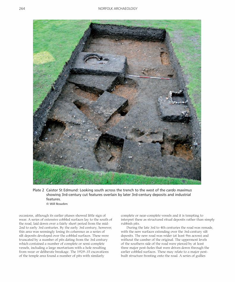
Plate 2 Caistor St Edmund: Looking south across the trench to the west of the cardo maximus showing 3rd-century cut features overlain by later 3rd-century deposits and industrial features.© Will Bowden

or ruts also cut into the uppermost levels of the road. The post-hole fi lls contained 3rd- and 4th-century material and the quantities of material present suggested intense activity during this period, although there was no evidence to suggest that occupation extended beyond the 4th century.
The second trench (Plate 2), in the north of the town immediately to the west of the cardo maximus, also showed activity of short duration with only one clear feature earlier than the 3rd century, an early to mid-2nd-century pit. Interestingly, the pit contained a coherent group of Flavian Samian ware and had the dating relied on Samian (as did much of Donald Atkinson’s dating on the site), it would have probably been ascribed an earlier date. This pit was overlain by mid- to late 3rd-century deposits, cut by four pits or post-holes that were in turn overlain by further mid- to late 3rd-century sandy deposits. These were cut by a curvilinear gulley with interspersed post-holes that is almost certainly a feature identifi ed by the geophysics and thought to be pre-Roman. This feature was sealed by a thick, dark deposit which contained large quantities of domestic rubbish dating from the later 3rd century. This deposit acted as the base for a small keyhole-shaped furnace, possibly a smithing hearth, which gave a calibrated radiocarbon date of AD 230–380 (Cal. BP 1720–1570). A small stone-lined tank, which ran under the western section of the trench, may be associated with this feature. As in the fi rst trench, the occupation sequence does not seem to extend beyond the 4th century.
Excavations on the south side of St Edmund’s church (NHER 1860) revealed traces of a hitherto unknown south aisle. This abutted the south-western corner of the nave (constructed almost entirely of Roman tile) and indicates that the existing southern wall of the nave must be a later reconstruction. The presence of a south aisle belonging to an apparently relatively early phase of the church is intriguing, suggesting that the Late Saxon or Norman church was a building of some status.
In summary, the Roman town that is being revealed by the project is signifi cantly different to that envisaged by Donald Atkinson. The excavations have uncovered no features earlier than the 2nd century, with all early material occurring in later contexts. The early town, as suggested by the geophysics, seems to have been sparsely occupied, with the most intensive occupation occurring in the later 3rd and early 4th centuries following the construction of the defences.
Cantley, Manor Farm (ENF 125181; TG 3809 0531)by Steve Malone, Archaeological Project Services
An area within an extensive cropmark complex which includes late prehistoric to Roman fi eld systems, enclosures and settlements (NHER 6096), was subject to magnetometer survey, fi eldwalking and metal-detecting for Dewing Grain Storage Ltd. Geophysical survey results were hindered by signifi cant magnetic disturbance affecting the southern half of the survey area, alongside an existing grain-drying facility, access roads and reinforced concrete surfaces. However, a possible small enclosure with internal features can be distinguished in the east of the survey area with other hints of linear features. A faint suggestion of ridge-and-furrow cultivation can also be discerned in the northern half of the site. Fieldwalking retrieved a sparse scatter of fi nds ranging from the Anglo-Saxon to early modern periods. APS Report 78/10.
Congham, St Andrew’s Lane (ENF124484; TF 7167 2337)by Steve Hickling, NPS Archaeology
An archaeological evaluation, excavation and watching brief were conducted ahead of and during construction of a stable block, menage area and associated roads and services. Results demonstrated that there were very few features and it was unlikely that this area had been densely occupied in the past. It is more likely that the area was peripheral to a signifi cant settlement, as the topsoil and subsoil were very rich in fi nds ranging from the prehistoric to post-medieval periods, with many fi nds being Anglo-Saxon. Metal artefacts included Roman nails, Roman/Early Saxon tweezers (Plate 3), a Roman/Early Saxon strap-end (Plate 4), two Early Saxon brooches (a narrow cruciform brooch and a small-long brooch), a decorated pin head, Late Saxon knives, a Late Saxon buckle, three strap-ends, two adzes and a pair of shears. A small amount of Roman roof tile was recovered from the site and medieval brick and tile was found close to the possible site of the lost church of All Saints. NPS Archaeology Report 2483.
East Winch, replacement water main at Middleton Quarry (ENF124453, ENF124582, ENF124584; TG 569 268, TG 316 281, TG 316 542–568 910, TG 567 094, TG 315 990, TG 316 188–567 525)by Steve Hickling, NPS Archaeology
An archaeological evaluation, excavation and watching brief were undertaken for Anglian Water Services along the route of a replacement water main. Recorded features included
Plate 3 Congham: Late Roman/Early Saxon tweezers. Scale 1:1.© NPS Archaeology
Plate 4 Congham: Late Roman/Early Saxon strap-end. Scale 1:1.© NPS Archaeology
265RECENT ARCHAEOLOGY

266 NORFOLK ARCHAEOLOGY
north–south Roman fi eld boundaries, which may have formed part of a semi-regular fi eld system, and also a possible pit fi lled with iron slag. Fifty-nine sherds of Roman pottery, predominantly found within the topsoil and subsoil, but also residual within later features, along with fi ve Roman coins suggest that the site was located close to Roman occupation. A concentration of Early Saxon activity was suggested by the presence of two or three sunken-featured buildings. Twenty sherds of Early Saxon pottery were recovered, along with a bone comb and a ceramic loomweight (Plate 5).
Over 100 sherds of Late Saxon/early medieval pottery were recovered and two main areas of activity identifi ed, one in the same location as the Early Saxon evidence and one close to the Late Saxon parish church. The fi rst area comprised a number of east–west and north–south ditches (possibly a continuation of the same fi eld system present in the Roman period) and a well preserved corn-dryer or malting kiln. The second area was less concentrated and consisted of two north–south ditches and a poorly preserved corn-dryer or malting kiln. Some of the features encountered during the excavation can be correlated with cropmarks identifi ed and recorded from aerial photographs by the Norfolk National Mapping Project. NPS Archaeology Report 2344.
Forncett, Chestnut Tree Farm (NHER 52968; TM 1451 9364)by Chris Birks in association with Calvencorp, Walworth Building Services
Historic building recording was undertaken prior to conversion into a residential property. The barn includes a timber-framed building, probably a stable or service building, dating from the fi rst half of the 17th century and consisting of three main bays and one narrow bay; one original partition survives. A timber-framed stable was added to the eastern end in the 18th century and a two-storey brick-and-fl int
extension to the western end in the 19th century. Loft fl oors were inserted in the earlier work and various alterations were made in the 19th century. Other alterations and re-roofi ng were carried out during the 20th century. There is also a 19th-century clay-lump woodshed of two phases. Report CB187R.
Gayton, Great Barn Farm (NHER 33843; TF 7478 1890)by Taleyna Fletcher, Oxford Archaeology East
Historic building recording was undertaken at a group of six redundant farm buildings, including a Grade II-listed threshing barn with two main phases of construction dating from the 18th and 19th centuries. The remaining buildings are all 19th-century and were probably intended to accommodate cattle and horses. Although many original materials survive in each building, most have been re-roofed and their original fi xtures and fi ttings removed. Successive phases of alteration and repair refl ect changes in agriculture practices and the subsequent use of the farm buildings over the past two centuries. OAE Report 1216.
Geldeston, River Waveney fl ood defences (NHER 54107; TM 3964 9147)by Heather Wallis, freelance archaeologist
Large quantities of burnt fl ints were noted during the widening of a dyke and examination for Broadland Environmental Services Ltd showed that a pot-boiler mound was present (Plate 6). The exceptional feature of this mound is its survival to a height of 0.5m, having been buried by subsequent deposits of peat. This site lay only 0.25km to the east of NHER 54133 (see below) which gives added signifi cance to the dating and understanding of the landscape in the Waveney Valley during the prehistoric period.
Geldeston, River Waveney fl ood defences (NHER 54133; TM 3946 9140)by Heather Wallis, freelance archaeologist
During the construction of a new dyke a number of large timbers were noted. Excavation for Broadland Environmental Services Ltd recorded three post-alignments which would have crossed the marshes from the river to the higher ground some 0.25km to the north. Twenty-two oak pile-points were recorded along with six stakes. Two layers of horizontally laid pieces of wood, mainly unmodifi ed small branches, were excavated. These, along with quantities of bark chips possibly formed surfaces. Two clear phases of construction were recorded, with a period of possible abandonment separating them. This is indicated by the different condition of the tops of the pile-points (Plate 7), some of which had been heavily worn and degraded in antiquity, and by the build up of material between the two horizontal surfaces. A further phase of repair may also have occurred, as the pile-points sometimes occurred in groups of three. Examination of the timbers has revealed a number of tool-marks and blade-edge profi les. The results of dendrochronological and environmental analyses are awaited. This discovery is particularly signifi cant as it is aligned with a similar site recorded on the southern side
Plate 5 East Winch, Middleton Quarry: the loomweight in situ.© NPS Archaeology

Plate 6 Geldeston: section of the pot-boiler mound seen in the side of the new dyke. Two 50cm monolith tins are in place for environmental sampling.© Heather Wallis
Plate 7 Geldeston: some of the pile-points soon after their removal from the ground.© Heather Wallis
267RECENT ARCHAEOLOGY

268 NORFOLK ARCHAEOLOGY
of the river in Barsham, Suffolk, during the construction of similar fl ood defences in 2007. The Suffolk site dated from the Late Iron Age/Early Roman period. Another Late Iron Age timber alignment was also recorded to the south of the river at Beccles in 2006.
Heckingham, Norton Subcourse quarry (NHER 40918; TG 398 996)by Mark Patenall, Northamptonshire Archaeology
Excavations on an extension to the quarry recorded two Late Neolithic/Early Bronze Age burials in a shallow depression. The more complete of the two was a female around 30 years old, with two jet toggles, possibly earrings, near the skull. One burial had been truncated by a ditch that formed part of a possible droveway with Middle Bronze Age/Early Iron Age pottery. One isolated pit contained Early Iron Age pottery, while other pits contained burnt fl int.
Horning (NHER 54221; TG 3732 1691)by Heather Wallis, freelance archaeologist
Major fl ood defence works, which are subject to an archaeological watching brief, are being undertaken along the Rivers Ant, Bure, Thurne, Yare and Waveney by the Environment Agency and Broadland Environmental Services Ltd. This involves the excavation of new dykes up to 18m wide and 3m deep. In July 2010, during the excavation of one such dyke near Ludham Bridge, one of the machine
drivers realised that he had pulled part of wooden boat from the ground. An archaeological excavation followed aiming to reveal, record and recover the remainder of the boat which lay below 2m of silts (Plate 8). The boat proved to be 3m long and had been created out of a single trunk of oak. It was in remarkably good condition and, until disturbed, had survived complete. Tool-marks were clearly visible, and initial inspection suggests little wear to both the inside and outside of the hull. The stern or transom of the boat had been carved as one with the rest of the boat.
The boat lay within a small creek or channel to the south of the River Ant, the line of which was identifi ed by augering and close inspection of the dyke sides. The boat appeared to be angled across the creek, and therefore would have caused an obstruction within it. Horse, cow and pig skulls were found within the spoil removed during the dyke digging (prior to excavation) and further animal bones were found during the excavation. These appear to be stratigraphically associated with the deposition of the boat. The ‘blocking’ of the creek with the boat and the deposition of animal skulls begs the question whether this was a ‘structured’ deposit, perhaps a ‘closing’ deposit within a rapidly silting creek. Alternatively, these could be animal parts thrown in as bait for eel fi shing. It is hoped that examination of the environmental indicators, such as pollen, insects and macrofossils, will indicate the environment within which the boat was deposited and perhaps throw some light on this.
Throughout the excavation the date of the boat was unknown. Examination of the tool-marks on the vessel could
Plate 8 Horning: excavating the stern of the boat.© Heather Wallis

do no more than indicate that it was constructed by narrow-blade technology which was used from the Bronze Age through to the medieval period. Two radiocarbon dates have since been obtained from wood samples within the sited creek. One, from a position stratigraphically earlier than the boat, returned a date of Cal. AD 650–780, while the other, from the upper deposits of the silted creek and was dated to Cal. AD890–1020, indicating a Middle to Late Saxon date.
This is an incredibly rare fi nd: only twelve other boats are recorded on the Norfolk HER. The majority of these relate to fi nds made in the 19th and early 20th-centuries and the reliability of several of these reports is questionable. Only three are of log boats (the others being of clinker construction) of which just one survives. This was found in 1927 at Smallburgh (also on the River Ant) and has been dated to AD669–775.
The boat is presently at the York Archaeological Trust, where it will be fully recorded and conserved with a view to future display by the Norfolk Museums and Archaeology Service.
Keswick and Intwood, All Saints’ church, Intwood (NHER 9514; TG 1968 0418)by Andrew Failes, Archaeological Project Services
Drainage works around the round tower of the 12th-century or earlier church were monitored for the PCC. The foundations and lower levels of the round tower were exposed and recorded, but there was no artefactual dating for its construction. Foundations of a former brick boiler room, probably fairly recent, were observed. Graveyard soils were also recorded. APS Report 42/10.
King’s Lynn, B Power Station, Saddlebow Industrial Estate (ENF125441; TF 6087 1720)by Peter Crawley and Dr Frances Green, NPS Archaeology
Following window sampling, an archaeological excavation was conducted for Centrica Energy. The planned building works impact on a north–south sea-bank earthwork (NHER 28348), which is situated immediately to the east of the power station. Three wide, stepped trenches were excavated through the sea-bank in order to examine the development of the bank and ascertain its date. Two episodes of bank construction and a fi nal re-structuring phase were revealed (Plate 9). Between the construction of the fi rst and second banks there appears to have been a period of natural deposition of windblown sand and possible erosion. A single fragment of baked clay, likely to have been Roman, was found within one of the earliest layers of the fi rst bank. However, the baked clay fragment is probably residual and the fi rst bank is more likely to have been constructed in the Late Saxon or early medieval period. NPS Archaeology Report 2564.
King’s Lynn, Blubberhouse Creek (NHER 55429; TF 6195 1919)by Paul Cope-Faulkner, Archaeological Project Services
Evaluation for the Borough Council adjacent to the River Nar in the area of the Civil War defences and 18th-century whale-oil factory and shipyards recorded a probably 19th-century timber quayside revetment. Behind the revetment were dumped deposits intended to raise and stabilise the ground. Possible dumped deposits associated with the canalisation of the Nar were encountered in the river channel, but no evidence
Plate 9 King’s Lynn, Saddlebow Industrial Estate: section through sea bank, looking north.© NPS Archaeology
269RECENT ARCHAEOLOGY

270 NORFOLK ARCHAEOLOGY
of the defences or whale-oil factories was revealed. APS Report 57/10.
King’s Lynn, Wisbech Road to Boal Quay (ENF125290; TF 6180 1930)by Steve Hickling, NPS Archaeology
An excavation and watching brief were conducted for Norfolk County Council during the construction of a new public transport route from Wisbech Road to Boal Quay in King’s Lynn. Excavation took place where the route passed through the precinct of the medieval Carmelite friary (Whitefriars) and two watching briefs monitored the route where it crossed the possible line of the 17th-century town wall.
Excavation was limited to the formation level of the new road and exposed a medieval wall on the same alignment as the upstanding gatehouse to the east. A large amount of medieval masonry, reused in later post-medieval structures, was present including a dressed ashlar fragment possibly dating to the foundation of the Friary. The mouth of a putative medieval watercourse located to the north of the Friary’s gatehouse may have present in the northern part of the excavation site.
A huge deposit of medieval to 17th-century silt was present over much of the eastern and southern part of the excavated area. Its origins and purpose are somewhat unclear, but it may be associated with defensive earthworks raised during the Civil War siege of 1643, although no direct evidence of the earthworks themselves was found. NPS Archaeology Report 2552.
Little Cressingham, All Saints’ church, Threxton (NHER 4686; TF 8848 0014)by Paul Cope-Faulkner, Archaeological Project Services
Evaluation for Birdsall Swash & Blackman LLP and the PCC recorded foundation deposits of the 12th-century west tower and an extensive graveyard of probable medieval origin. Post-medieval remains mostly related to the restoration of the chancel in the mid-19th century. At the north-eastern corner of the chancel the wall foundation sat on a layer of compacted mortar which contained Roman brick with attached opus signinum, perhaps from a nearby Roman building, although no other Roman artefacts were found. APS Report 84/10.
Long Stratton, St Mary’s church (NHER 10077; TM 1967 9227)by Ross Kendall, Archaeological Project Services
Monitoring of groundworks for a new extension and drainage for the PCC recorded a medieval burial pre-dating an early 14th-century buttress and probably associated with the 12th-century church. Medieval and later graveyard soils were also identifi ed. Evidence of later church renovation in the 19th and early 20th centuries was uncovered in the form of brick buttress footings and medieval roof tiles reused as build-up material for post-medieval pathways. APS Report 77/10.
Marham, The Old Bell (NHER 49785; TF 7084 0979)by Gareth Barlow, Archaeological Solutions Ltd
Evaluation in 2007 indicated potential for Anglo-Saxon and medieval remains, while an excavation in 2008 revealed extensive and well preserved Anglo-Saxon and medieval archaeology. Post-excavation analysis identifi ed fi ve phases of activity at this site, with the earliest being Middle Saxon. This period was represented by a sunken-featured building in the north-western corner of the site. Occupation during the Late Saxon period is evidenced by a further possible sunken-featured building and a possible cellared building. The third identifi able phase represented a period of rapid change within the area of the site and began with the construction of an enclosure ditch which may relate to a dwelling of elevated status. This enclosure appears to have been modifi ed at a later date and the culmination of activity in the Saxo-Norman period is the division of the western part of the site into apparent roadside plots. In 2010, further excavation was conducted at this site, identifying additional elements of the large enclosure ditch and helping to further characterise the enclosure itself and the structures it contains.
North Wootton, The Lodge, Manor Road (NHER 53908; TF 6403 2439) by Chris Birks, Chris Birks Archaeological Services
Excavation recorded Romano-British metalworking debris and pottery sherds from linear features and one pit. The results add to the evidence of metalworking, settlement and subsistence activities in this area during the 1st–4th centuries AD. Minimal evidence for activities during the medieval period was present. Report CB219R.
Plate 10 Norwich, Anglia Square: general view.© Oxford Archaeology East

Norwich, Anglia Square, Phase 2 (NHER 55296; TG 2290 0928)by Rachel Clarke and Heather Wallis, Oxford Archaeology East
The earliest signifi cant fi nds from evaluation were a few sherds of Middle Saxon pottery, which contribute to the growing body of evidence for Middle Saxon settlement on the north bank of the River Wensum. The line of the Late Saxon defensive ditch of the northern burh was successfully traced and excavation demonstrated that its depth, profi le and fi lls are similar to segments examined further south. The lower deposits were waterlogged and preservation of environmental evidence was good.
During the medieval period large quarry pits occupied the northern part of the site, having probably been dug for the extraction of iron ore from the natural gravels. This area later formed open ground or backyards behind the buildings along the street frontages. The southern part of the development area was thought to have been the site of St Olave’s church and, although the church itself was not located, three of the trenches contained burials associated with its graveyard (Plates 10 and 11). The church had fallen out of use by the Dissolution and material from it was re-used in one of the extant post-medieval buildings.
For much of the post-medieval period the entire site appears to have been open ground or yards behind street-frontage development on Pitt Street, Botolph Street and St George’s Street. It was not until the late 18th century that the southern part of the site became closely built up, the
demolished remains of these buildings lying just below the present ground surface. The northern part of the site did not demonstrate the same infi ll behind the frontages, although this may have been at least partially removed by 20th-century development. OAE Report 1202.
Norwich, 46–48 St Giles (ENF 125116; TG 2265 0855)by Simon Underdown, Rachel Clarke and Paul Spoerry, Oxford Archaeology East
An archaeological evaluation ran concurrently with a watching brief on demolition works. Four main phases of activity were identifi ed spanning the early medieval to post-medieval periods. Signifi cant remains included masonry wall foundations and a set of steps probably leading to an undercroft or cellar which appeared to have been robbed and infi lled by the 13th or 14th centuries. Evidence for medieval structures was recorded in the western part of the site, while several pits lay closer to Bethel Street. A probable chalk-lined well that was infi lled with demolition rubble from a probably 15th-century building lay towards the northern edge of the site, with other late medieval pits found to the south. These were sealed beneath dumped layers and former garden soils. Notable fi nds include two fragments of 15th-century or earlier painted window glass.
The remains of a brick culvert and the foundations of several walls that probably relate to 18th-century ranges extending to the rear of the frontage properties were revealed in the western half of the site, where truncation
Plate 11 Norwich, Anglia Square: burials associated with the cemetery of St Olave’s church.© Heather Wallis
271RECENT ARCHAEOLOGY

272 NORFOLK ARCHAEOLOGY
resulting from the construction of the former sports hall was particularly severe. A fragment of early wall was also observed at the eastern boundary of the site; re-used bricks from this wall date from the 16th century.
Norwich, Norwich School Refectory (NHER 54798; TG 2344 0900)by Andy Phelps, NPS Archaeology
A small evaluation trench was excavated for Norwich School ahead of a proposal to construct an extension to the south of the school’s refectory building. The trench provided tantalising evidence of occupation prior to construction of the cathedral. Despite the absence of prehistoric features, the recovery of worked fl ints re-deposited in later features suggests that the site and its environs have seen human activity since at least the Bronze Age. Occupation began on the site in the mid-7th to 9th centuries, possibly in the form of sunken-featured buildings, and the amount of Middle Saxon pottery recovered from this relatively small area is signifi cant when compared to that collected from much larger excavations nearby (Plate 12). Vitrifi ed hearth material suggests that smithing may have taken place in close proximity to the site, as well as evidence being found for local butchery.
It seems clear from pottery evidence that domestic occupation continued beyond the foundation of the cathedral in the 11th century, although the re-deposition of this material suggests that any further evidence of this period has been destroyed by later activity. Interestingly, the latest medieval pottery is 14th century, perhaps suggesting that
occupation in this area ceased after the cathedral precinct was enlarged to the north in 1318 to encompass this area.
In contrast to many excavations in Norwich where Middle Saxon evidence has been recovered as residual fi nds in later features, the depth of overlying soils present at the site meant that remains of Middle Saxon date had survived in situ. NPS Archaeology Report 2319.
Ormesby St Michael, Mud Pumping Site (NHER 30626; TG 4747 1519)by Nick Gilmour, Oxford Archaeology East
Investigations uncovered two Early Neolithic pits and several tree throws containing Mildenhall-type pottery and worked fl int. Middle Bronze Age fi eld systems and a large enclosure of similar date were also recorded, having previously been identifi ed by the National Mapping Programme. Structural features were dated by pottery and radiocarbon analysis to the Middle Bronze Age. A signifi cant Bronze Age lithic assemblage was found, along with pottery, loomweights and a Middle Bronze Age whetstone. Later fi eld systems cut across the Bronze Age enclosure.
Pulham Market, Grove Farmhouse (NHER 54174; TM 2149 8891)by Heather Wallis, freelance archaeologist
A Level 2 historic building survey identifi ed three main structural phases, the earliest being an open hall-house of the late 15th or early 16th century. A fl oor was later inserted
Plate 12 Norwich School Refectory: Middle Saxon features at the base of the evaluation trench.© NPS Archaeology

into the open hall, the decoration of the principal ceiling timbers suggesting that this occurred in the early to mid 16th century. The building was later extended to the west, the characteristics of which suggest a 17th-century construction date. Overall, this building can be seen to be one with an interesting and complex history. Many important structural elements have survived, hidden beneath modern plaster and render. The importance of this building is further emphasised by its location on the periphery of North Green, an area where similar buildings have been recorded by the Norfolk Historic Buildings Group.
Scole, land opposite the Scole Inn (NHER 54903; TF TM 1496 7886)by Andy Phelps, NPS Archaeology
Archaeological evaluation carried out for Cripps Developments Ltd revealed several possibly prehistoric pits containing numerous struck fl ints. There were also at least three pits containing 2nd-century pottery and animal bone. The pottery was consistent with the large Romano-British assemblage found during previous excavations in Scole and with that from the Scole Bypass. All of the features were sealed by a dark-earth material (Plate 13). An accumulation of soils dating from the medieval period was identifi ed in the north-eastern corner of the site, along with the remnants of a small possible medieval or post-medieval structure. NPS Archaeology Report 1817.
Shipdham, Pound Green Lane (ENF125538; TF 9650 0750)by Peter Crawley, NPS Archaeology
An archaeological evaluation was conducted ahead of a new housing development on the eastern side of Shipdham. A medieval moated enclosure lies immediately to the north of the site and the project revealed a large number of archaeological features including a small Early Saxon pit
and four medieval ditches. A gully containing 74 sherds of medieval pottery was also unearthed. Several other ditches contained burnt fl int, but due to their appearance and proximity to the moated site it is considered that they were likely to have been re-deposited in the medieval period. Several pits and two ditches contained large fragments of smithing slag indicate medieval smithing nearby. NPS Archaeology Report 2612.
Thetford, former Anchor Hotel (NHER 5762; TL 868 830) by Duncan Stirk, Suffolk County Council Archaeological Service
Evaluation recorded complex sequences of activity dating from the 10th or 11th until the 20th centuries in three trenches. The earliest phases of activity involved pits for rubbish disposal, and the presence of a cemetery in the vicinity is suggested by residual human remains recovered from these early pits. Post-holes and clay fl oors representing Late Saxon or early medieval buildings were evident, and this phase was succeeded by two or more similar medieval building phases.
A gravel road appears to have remained in use until the 17th century, when thick homogenous deposits accumulated over the site. During the 19th century a complex of maltings buildings was constructed on the site. These were demolished in the 1960s, at which time part of the site was designated as a Scheduled Monument and the remainder became parking for the Anchor Hotel. SSCAS Report 2010/073.
Thetford, Blakeney Farm (NHER 53464, 54509, 55878–9, 55882, 55884; TL 886 848)by John Walford, Yvonne Wolframm-Murray and Mark Holmes, Northamptonshire Archaeology
Evaluation comprising fi eldwalking, metal-detecting and geophysical survey was carried out over 330ha of land to the north of Thetford, including the late Iron Age and early Roman enclosures at Fison’s Way (NHER 5853). The geophysical survey located two ring-ditches thought to be Bronze Age round barrows, possible pits and modern disturbances. The fi eldwalking survey recovered an extensive scatter of worked fl int, with a possible Mesolithic and early Neolithic component, but dating predominantly to the late Neolithic/Early Bronze Age. Two concentrations within the fl int assemblage were identifi ed, one of which coincided with the location of the ring-ditches. Late Neolithic/Early Bronze Age pottery was also found in the vicinity of the ring-ditches, and elsewhere two concentrations of Iron Age pottery may betoken sites. Pottery from other periods was indicative of general manuring practices. The metal-detecting survey retrieved Bronze Age, Roman, medieval and post-medieval artefacts. A previously unrecorded post-medieval kiln was also located.
Walsingham, Little Walsingham (TF 93 36)by Adam Longcroft, Norfolk Historic Buildings Group
The Norfolk Historic Buildings Group has launched its third long-term (fi ve-year) project, this time focusing on the
Plate 13 Scole: features beneath the dark earth deposit.© NPS Archaeology
273RECENT ARCHAEOLOGY
274 NORFOLK ARCHAEOLOGY
surviving historic buildings of Little Walsingham. The town has a large number of buildings which survive from the later Middle Ages and which were remodelled in the post-Reformation period. Initial exploratory work suggests many are highly idiosyncratic in their construction, layout and function, refl ecting the role of the town as a destination for medieval pilgrims who, like modern-day tourists, required somewhere to sleep, eat and drink.
Working closely with the owners and tenants of the Abbey estate, the various churches and private residents, the Group aims to record in detail the buildings which survive, marrying them with the surviving medieval and post-medieval documents. These documents often shed valuable light on the ownership history of buildings and provide and insight into how they were used. It is also hoped to secure funding for dendrochronological survey work.
Walsoken, All Saints’ church (NHER 2209; TF 4772 1055)by Paul Cope-Faulkner, Archaeological Project Services
Monitoring for Birdsall Swash & Blackman LLP on behalf of the PCC on groundworks for a new fl oor in the north aisle
recorded a medieval pier base and post-medieval air ducts comprising low brick or stone walls on either side of a channel that had been capped by stone slabs. Post-medieval pew supports of brick and tile, including reused medieval material, were also recorded. APS Report 35/10.
Watton, Norwich Road, Former RAF Radar Station (NHER 42674; TF 926 007)by Paul Mason, Northamptonshire Archaeology
Excavation of a Middle Bronze Age round barrow recorded the ring-ditch around a central cremation burial in a Barrel Urn which had been lifted during evaluation in 2005. Four unurned satellite cremation burials in small pits lay to the north of the barrow, grouped in two pairs, and a fi fth un-urned cremation burial lay to the north-east. A small assemblage of pottery can be attributed to the Early Bronze Age, including two Beaker sherds. South-west of the barrow was a single, possibly Roman inhumation. A number of pits and post-holes were also recorded.
Weeting with Broomhill, Brandon Lignacite Quarry (NHER 40433; TL 7880 8710)by James Snee, Archaeological Project Services
A watching brief for Lignacite Ltd recorded extensive peat cover and deep and signifi cant Neolithic remains on the southern margins of the quarry area, including evidence for both fl int-tool production and tool-use and the site of a possible burnt mound. APS Report 24/10.
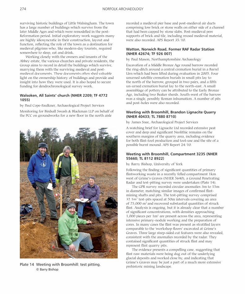
Weeting with Broomhill, Compartment 3235 (NHER 55660; TL 8112 8922)by Barry Bishop, University of York
Following the fi nding of signifi cant quantities of primary fl intworking waste in a recently felled compartment 1km west of Grime’s Graves (NHER 5640), a Ground Penetrating Radar and test-pitting survey were undertaken (Plate 14).
The GPR survey recorded circular anomalies 3m to 15m in diameter, matching similar images of confi rmed fl int-mining shafts and pits. The test-pitting survey comprised 32 1m2 test-pits spaced at 50m intervals covering an area of 75,000 m2 and recovered substantial quantities of struck fl int. Analysis is ongoing, but it is already clear that a number of signifi cant concentrations, with densities approaching 1,000 pieces per 1m2 are present across the area, representing intensive primary-nodule working and the preparation of cores. In many cases the fl int was present as stratifi ed layers comparable to the ‘workshop fl oors’ excavated at Grime’s Graves. Three large steep-sided cut features were also revealed, consistent with the anomalies recorded by the radar. They contained signifi cant quantities of struck fl int and may represent fl int quarry pits.
The evidence presents a compelling case, suggesting that fl int raw materials were being dug out of the underlying glacial deposits and worked close by, and indicating that Grime’s Graves may be just a part of a much more extensive prehistoric mining landscape.Plate 14 Weeting with Broomhill: test pitting.
© Barry Bishop

Plate 15 West Dereham, Crimplesham Quarry: slot structure. © NPS Archaeology
Plate 16 West Dereham, Crimplesham Quarry: a – cruciform brooch; b – gilded strapend; c – gilded tremissis © NPS Archaeology
275RECENT ARCHAEOLOGY

276 NORFOLK ARCHAEOLOGY
West Dereham, Crimplesham Quarry (NHER 50596; TF 6605 0335)by Jayne Bown, NPS Archaeology
Excavation in advance of proposed mineral extraction by Frimstone Ltd has revealed parts of an extensive prehistoric and Anglo-Saxon landscape. Prior evaluation of the site had demonstrated the presence of Bronze Age ring-ditches and Early Saxon sunken-featured buildings, as well as other features of earlier and later date. The density of archaeological features appears to increase towards the south-east (the centre of the extraction site). The 2010 excavation focused on the north-west of the site and encompasses approximately 35% of the proposed extraction area.
A Bronze Age ring-ditch with a blank central grave at the northern limit of the site appeared to be respected by a narrow north–south ditch adjacent to its eastern side which crossed the site. Many of the features excavated in this phase of work appear to be Anglo-Saxon. There were 14 sunken-featured buildings (SFBs), eleven of which formed three discrete groups (containing two, three and six SFBs), two rectangular structures (one a post-hole structure and one a slot structure), a small ring-gully, enclosures, post-holes groups, pit groups and ditches (Plate 15).
The majority of the pottery recovered is of Saxon date, along with some Romano-British and a small amount of prehistoric. An impressive assemblage of Early Saxon metal artefacts includes dress items such as strap-ends, brooches and a gilded tremissis (a 7th-century Anglo-Saxon coin) which had been pierced in antiquity for use as a pendant (Plates 16–18).
Wiggenhall St Mary Magdalen, St Mary Magdalen’s church (NHER 2254; TF 5986 1138)by Paul Cope-Faulkner, Archaeological Project Services
Excavation for the PCC in the south aisle revealed a mortar fl oor that may be original 15th-century work, cut by a post-hole with medieval and 15th-century artefacts. Also truncating the mortar surface were several graves. A later grave yielded an 18th- or early 19th-century coffi n-grip plate. Overlying these remains was a make-up deposit which contained 18th–19th-century artefacts as well as an appreciable amount of 15th-century painted window glass. This glass has many parallels with the extant windows of the north aisle. Moreover, this excavated assemblage has similar depictions to the array of male saints in the north aisle, and this may suggest that there was a matching series of female saints in the south aisle windows. A watching brief during drainage works in the churchyard revealed several graves, but these were undated. APS Report 9/10.
Wymondham (ENF 125229; TG 123 032)by Ian Fisher, Northamptonshire Archaeology
A magnetometer survey ahead of proposed large-scale urban development to the north and east of the town surveyed twelve blocks of land totalling some 80ha. A ring-ditch of presumed Bronze Age date was detected towards the western end of the development area and part of a Roman road was identifi ed in the same area.