Exam practice: Answers - · PDF fileThere is a chain of volcanoes and a linear band of...
56
My Revision Notes: AQA GCSE (9–1) Geography © Hodder Education 2017 Exam practice: Answers Unit 1: Living with the physical environment Section A: The challenge of natural hazards Page 1 1. Natural hazards are a natural event, such as an earthquake, volcanic eruption, tropical storm or flood that threatens people or has the potential to cause damage, destruction and death. 2. Two suggestions, or one developed suggestion. 1 mark each or 1 mark x 2. Hazard risk is likely to increase when there is an increase in population, because there is potential for more people to be vulnerable, and therefore the likelihood of death increases. An increase in population inevitably means more housing and therefore potential for damage and destruction to buildings. If there is an increase in population near hazard prone areas, due to cost or availability of resources, for example, the hazard risk further increases. Page 3 1. Any three descriptions or two with one developed. The distribution of earthquakes and volcanoes is not random and they do have a relationship with close proximity to plate margins. They both occur in narrow bands along plate margins. Earthquakes are found at all three types of plate margins; constructive, destructive and conservative. Volcanoes are found at constructive and destructive plate margins. There are small clusters of earthquakes and volcanoes occurring in southern Italy and Iceland. There is a chain of volcanoes and a linear band of earthquakes occurring along the Ring of Fire surrounding the Pacific Ocean. There are anomalies, as some occur in the middle of plates in 'hot spots' and not at plate margins. 2. Any two differences. 1 mark each. Plates move towards each other at destructive plate margins, whereas they move side by side past each other at conservative plate margins. The denser oceanic plate is subducted under the continental plate into the mantle at destructive plate margins, whereas no subduction occurs at conservative plate margins. Land is destroyed at destructive plate margins, whereas no land is destroyed at conservative plate margins. Volcanic eruptions occur at destructive plate margins, whereas no volcanoes are found at conservative plate margins. 3. Level Marks Description Level 1 (Basic) 1–2 marks Sequence incomplete. Description of initial plate movement or the release of pressure as a volcano. Partial explanation. Link between plate movement and formation of volcanoes basic or absent. Level 2 (Clear) 3–4 marks Sequence complete. Develops points. Will be clear how the plate movement at the destructive boundary results in volcanoes. Diagrams drawn may support written response. Two tectonic plates move towards each other at destructive plate margins. One is made from oceanic crust and the other is continental crust. When an oceanic and continental tectonic plate collide, the denser oceanic plate is subducted (sinks) under
Transcript of Exam practice: Answers - · PDF fileThere is a chain of volcanoes and a linear band of...
My Revision Notes: AQA GCSE (9–1) Geography © Hodder Education 2017
Exam practice: Answers Unit 1: Living with the physical environment Section A: The challenge of natural hazards Page 1
1. Natural hazards are a natural event, such as an earthquake, volcanic eruption, tropical storm or flood that threatens people or has the potential to cause damage, destruction and death.
2. Two suggestions, or one developed suggestion. 1 mark each or 1 mark x 2.
Hazard risk is likely to increase when there is an increase in population, because there is potential for more people to be vulnerable, and therefore the likelihood of death increases.
An increase in population inevitably means more housing and therefore potential for damage and destruction to buildings.
If there is an increase in population near hazard prone areas, due to cost or availability of resources, for example, the hazard risk further increases.
Page 3
1. Any three descriptions or two with one developed.
The distribution of earthquakes and volcanoes is not random and they do have a relationship with close proximity to plate margins.
They both occur in narrow bands along plate margins.
Earthquakes are found at all three types of plate margins; constructive, destructive and conservative.
Volcanoes are found at constructive and destructive plate margins.
There are small clusters of earthquakes and volcanoes occurring in southern Italy and Iceland.
There is a chain of volcanoes and a linear band of earthquakes occurring along the Ring of Fire surrounding the Pacific Ocean.
There are anomalies, as some occur in the middle of plates in 'hot spots' and not at plate margins.
2. Any two differences. 1 mark each.
Plates move towards each other at destructive plate margins, whereas they move side by side past each other at conservative plate margins.
The denser oceanic plate is subducted under the continental plate into the mantle at destructive plate margins, whereas no subduction occurs at conservative plate margins.
Land is destroyed at destructive plate margins, whereas no land is destroyed at conservative plate margins.
Volcanic eruptions occur at destructive plate margins, whereas no volcanoes are found at conservative plate margins.
3.
Level Marks Description
Level 1 (Basic) 1–2 marks Sequence incomplete. Description of initial plate movement or the release of pressure as a volcano. Partial explanation. Link between plate movement and formation of volcanoes basic or absent.
Level 2 (Clear) 3–4 marks Sequence complete. Develops points. Will be clear how the plate movement at the destructive boundary results in volcanoes. Diagrams drawn may support written response.
Two tectonic plates move towards each other at destructive plate margins. One is made from oceanic crust and the other is continental crust. When an oceanic and continental tectonic plate collide, the denser oceanic plate is subducted (sinks) under
My Revision Notes: AQA GCSE (9–1) Geography © Hodder Education 2017
the continental plate. It is pushed down into the mantle, where it melts. Pressure then builds in the mantle. Eventually, the hot magma rises through the lithosphere and erupts as lava through composite volcanoes.
4.
Level Marks Description
Level 1 (Basic) 1–2 marks A partial diagram probably showing the direction of plate movement. Sequence incomplete. No diagram can score maximum 1 mark if text credit worthy.
Level 2 (Clear) 3–4 marks Diagram is clear and supported with labels. Sequence complete. Develops points.
Diagram should show plates sliding past each other in opposite directions / or moving in the same direction, but at different speeds. Diagram labels should make this clear. The pressure builds up as the plates stick. As friction is overcome there is a sudden release of energy causing the jerking movement which is the earthquake. Diagram can be drawn from any perspective. Page 6
Level Marks Description
Level 1 (Basic) 1–3 marks Describes factors that influence the ability to cope with effects of a tectonic hazard. These may be list‐like at lower end. There will be some reference to rich and poor areas.
Level 2 (Clear) 4–6 marks Factors that influence the ability to cope with effects of a tectonic hazard are clearly described. Statements are developed. There may be reference to specific area studied. Begins to consider 'to what extent', but probably imbalanced.
Level 3 (Detailed) 7–9 marks Factors that influence the ability to cope with effects of a tectonic hazard are clearly described. Statements are developed. Support is provided through specific case study areas studied. Stronger attempt to consider 'the extent'.
To a greater extent a country's ability to cope with the effects of a tectonic hazard depends on its wealth, due to factors such as the ability to afford to train scientists in monitoring and prediction strategies to reduce the effects. Wealthier countries can afford more medical and educational facilities to train medics. Wealthier countries will have potentially immediate access to the resources and finances needed to cope with the large costs of recovery. However, corruption of governments could divert money into other causes, meaning there is less to be used to cope with the effects of tectonic hazards. To a lesser extent a country's ability to cope with the effects of a tectonic hazard depend on its wealth, as there are other factors involved that cannot be determined or overcome with simply more money. These factors include the possible secondary effects, such as tsunamis, landslides and avalanches. Some areas may not be in a hazard prone area, so would not be prepared even if they were wealthy. Some effects are harder to cope with due to the magnitude or scale of the hazard and area devastated. The population and building density can affect a country's ability to cope despite the wealth of the country. The time of day/year may also determine the effects and ability to cope, immaterial of wealth. Page 7
1. The emphasis should be on the protection strategies rather than the effects.
Level Marks Description
Level 1 (Basic) 1–2 marks Simple statements or no indication of how protection strategy will reduce damage.
Level 2 (Clear) 3–4 marks Linked statements showing how effects can be reduced by protection strategies.
Buildings can be designed with automatic shutters, which come down over the windows so that broken glass shards do not fall from windows as the building structure fails or collapses, so reducing further injuries. Buildings can be designed with fire‐resistant materials, so that if gas mains and electricity lines are damaged or ruptured during the earthquake causing fires, the building will slow the onset of fire raging through a building and therefore reduce the numbers of injuries and deaths due to smoke, fire and building collapse.

My Revision Notes: AQA GCSE (9–1) Geography © Hodder Education 2017
2.
Level Marks Description
Level 1 (Basic) 1–2 marks Simple statements or no indication of why reducing risks is challenging.
Level 2 (Clear) 3–4 marks Linked statements why reducing risks is challenging. More than one factor for maximum marks.
Population density in tectonic hazards prone areas makes reducing risks challenging – eight percent of the world's population live near volcanoes and fifty percent of the United States of America live in earthquake prone areas. People may have an over‐confidence in building design and not take sufficient precautions. Some people may not understand the hazard risk and therefore remain during a hazard event inadvertently and not act appropriately, increasing the adverse effects. Page 8
1. 1 mark each
Rain or wet weather. Cloudy. Windy.
2. A link needs to be drawn between surface winds and atmospheric pressure to be “accounting for”. Responses should identify and explain how surface winds and atmospheric pressure are associated.
Level Marks Description
Level 1 (Basic) 1–2 marks Simple statements and / or listed points with no / ineffective attempt to link policy to surface winds and atmospheric pressure. Possibly descriptive of surface winds or atmospheric pressure only. Maximum level 1 if no link made.
Level 2 (Clear) 3–4 marks Developed statements with attempt to account for the link between surface winds and atmospheric pressure.
Due to the Earth being spherical, the Sun's rays strike a smaller area of land at the Equator, so heat energy is more concentrated at the Equator. This causes the air to be heated strongly so it rises in low‐pressure conditions. Low‐pressure air rising at the Equator and then sinking at 30° north and south of the Equator under high‐pressure forms the convection cell known as the Hadley Cell. The Sun's rays are less concentrated over a much larger area at the Poles so the cooler air sinks under high‐pressure conditions. High‐pressure air sinking at the Poles, then flowing towards the Equator, warming as it reaches about 60 ° and then rising under low‐pressure conditions, forms the Polar Cell. Located between the Hadley and Polar Cell is the Ferrel Cell. Surface winds are experienced as air moves from high‐ to low‐pressure areas in the convection cells. Page 10
1. Two conditions required. 1 mark for each.
Low latitudes
Between 5°–30° north and south of the Equator
Originate in oceans with temperatures above 27°C
Ocean depth 60–70m
Between summer and autumn
Low wind shear
Not along the Equator
My Revision Notes: AQA GCSE (9–1) Geography © Hodder Education 2017
2. Diagrams, if included, should be credited as an integral part of the answer.
Level Marks Description
Level 1 (Basic) 1–2 marks Simple points – partial sequence. Statements are separate and in a random order –jumps about/sequence not correct.
Level 2 (Clear) 3–4 marks Complete, clear sequence. Statements are developed and linked in a logical order.
Air is heated above the surface of warm tropical oceans. Rising air draws up more air and large volumes of moisture. This causes strong winds. The Coriolis Effect causes the air to spin upwards around the eye of the storm. As the air rises it cools, condenses and torrential rain falls. As the air cools it powers the storm forward in the prevailing wind. On reaching land the tropical storm loses power and weakens. Page 13
1. The emphasis should be on the protection strategies rather than the effects.
Level Marks Description
Level 1 (Basic) 1–2 marks Simple statements or no indication of how protection strategy will reduce damage.
Level 2 (Clear) 3–4 marks Linked statements showing how effects can be reduced by protection strategies.
Buildings can be designed with automatic tropical storm shutters, which come down over the windows so that broken glass shards do not fall from windows as the building structure fails or collapses, so reducing further injuries. Building restrictions with 'no build zones' can stop property development in low lying areas, so that property is less likely to suffer water damage by flooding during storm surges, and there will be fewer deaths by drowning are likely as people are further away from flood prone areas.
2. Positive effects unlikely. Expect negative effects. Responses should be supported by a case study such as Typhoon Haiyan.
Level Marks Description
Level 1 (Basic) 1–3 marks Demonstrates limited knowledge of locations, places and environments. Shows limited geographical understanding of the effects of a tropical storm event. May give generic statements about the effects. Describes effects of tropical storms. Statements are general and in a random order.
Level 2 (Clear) 4–6 marks Demonstrates accurate knowledge of locations, places and environments. Shows sound geographical understanding of the effects of a tropical storm event. Effects are clearly described, in an organised way. Statements are linked. There is a clear reference to the case study named. At least one primary and secondary effect must be present for Level 2.
Level 3 (Detailed) 7–9 marks Demonstrates thorough application of knowledge and understanding to provide a well‐developed description by analysing both the primary and secondary effects of a tropical storm event. Will have a clear structure. Statements are logically ordered and linked. Detailed reference to specific case study.
Page 16
1. 1 mark for one of the following.
There have been more weather records broken recently than ever before.
December 2010 was the coldest on record for 100 years, yet the warmest April was in 2011.
Highest temperature (38.5°C) was 10 August 2003.
Lowest temperature (–27°C) was in Scotland in 1995.
My Revision Notes: AQA GCSE (9–1) Geography © Hodder Education 2017
Highest monthly total of rainfall (1,396.4 mm) was in 2015.
Highest two‐day record of rainfall (405 mm) was in 2015.
Highest three‐ and four‐day rainfall records were both in 2009.
Serious flooding has become more frequent in the winter, for example in Cumbria 2009 and the Somerset Levels 2013–14.
2. 1 mark for each point, or three points with one developed.
Evidence suggests climate change is warming the planet.
The Atlantic Ocean is increasing in temperature.
Rain bearing depressions will gain more energy and moisture due to the warmer ocean. This will change the UK's rainfall patterns. [1 mark x 2]
3. Emphasis should be placed on discussing whether climate change is responsible and not describing extreme weather in the UK. The command ‘to what extent’ requires an appraisal of the degree to which climate change is responsible. Answers may refer to a examples of extreme weather in the UK (although this is not essential). Responses may take a balanced view, recognising arguments for and against climate change being responsible.
Level Marks Description
Level 1 Basic 1–2 marks Shows limited and partially accurate knowledge of climate change and the UK's extreme weather. Demonstrates some understanding that climate change can be to blame for the UK's extreme weather or not.
Level 2 (Clear) (3‐4 marks) Shows clear and accurate knowledge of climate change and its impact on the UK's weather. Demonstrates sound understanding of how climate change can be held responsible for extreme weather in the UK or not.
Level 3 (Detailed) (5‐6 marks) Demonstrates thorough application of knowledge and understanding to the issue of climate change responsible for extreme weather. Demonstrates reasoned evaluation of the extent to which climate change is a key player in the UK's extreme weather.
Page 18
Responses will apply knowledge and understanding of the environmental and social effects of climate change, making a judgement based on relative advantages and disadvantages. The command word is ‘justify’, so answers should reach a conclusion and substantiate the choice made. Credit responses which highlight one side of the argument, as well as those which take a more balanced approach before reaching a conclusion
Level Marks Description
Level 1 Basic 1–2 marks Demonstrates limited knowledge of the effects of climate change. Answers may be largely generic. Shows some geographical understanding of effects of climate change. May either include limited application of knowledge and understanding in making a judgement about the issues and/or reach a conclusion. Justification is limited to one or more simple points.
Level 2 (Clear) 4–6 marks Demonstrates reasonable knowledge of both environmental and social effects of climate change. Shows clear geographical understanding of the effects of climate change. Includes reasonable application of knowledge and understanding in making a judgement about the issues and reaching a conclusion. Justification is clear and well supported.
Level 3 (Detailed) 7–9 marks Demonstrates comprehensive and specific knowledge of both environmental and social effects of climate change. Shows thorough and accurate geographical understanding of the effects of climate change. Demonstrates effective application of knowledge and understanding in making a judgement about the issues and reaching a substantiated conclusion. Justification is detailed and balanced.

My Revision Notes: AQA GCSE (9–1) Geography © Hodder Education 2017
Page 19
1. Responses should focus on both a similarity and a difference. 1 mark for each.
Mitigation and adaptation both try to deal with the challenge of climate change and reduce the impact on the planet. [1] However, mitigation seeks to deal with the cause of the problem by stopping it in the first place, whereas adaptation tries to respond to the impacts that have been caused by climate change to make population less vulnerable. [1] If mitigation was successful at stopping all carbon emissions from human activity (the enhanced greenhouse effect), then adaptation would only be required to manage the impacts of the natural induced climate change [1].
2. Credit one mitigation method only. Valid developed point awarded 2 marks.
One mark for appropriate mitigation:
alternative energy production
carbon capture
planting trees
international agreements. Second mark for developed reason: Using alternative energy production (such as wind, solar, geothermal, wave and tidal and biomass) reduces greenhouse gases compared to burning fossil fuels (coal, oil and gas), so less carbon dioxide will be emitted into the atmosphere adding to a thicker layer of greenhouse gases. [2 marks]
My Revision Notes: AQA GCSE (9–1) Geography © Hodder Education 2017
Section B: The living world Page 25
1. A decomposer is an organism such as bacteria or fungus that breaks down dead tissue, which is then recycled to the ecosystem.
2.
Level Marks Description
Level 1 (Basic) 1–2 marks Partial or incomplete chain.
Level 2 (Clear) (3– 4 Marks) Complete chain with producers, primary, secondary, tertiary and quaternary consumers as appropriate to the ecosystem.
A food chain shows the direct links between the various organisms which rely on each other as a source of food. Algae eaten by tadpoles, eaten by stickleback, eaten by perch, eaten by Heron – this is a food chain for a freshwater pond. Algae are the producers, tadpoles the primary consumers, stickleback is the secondary consumer, perch is the tertiary consumer and the heron is the quaternary consumer.
3.
Level Marks Description
Level 1 (Basic) 1–2 marks Simple statements, separate descriptions, no comparison.
Level 2 (Clear) 3–4 marks Developed points with clear comparison.
Coniferous forests are found at approximately 60 degrees north where winter temperatures are extremely cold, whereas tropical rainforests lie around the equator in a belt between the Tropic of Cancer and the Tropic of Capricorn. Tropical rainforests are widespread across central Asia, Africa and South America; coniferous forests are found in North America, Northern Europe and Northern Asia.
4.
Level Marks Description
Level 1 (Basic) 1–2 marks Simple points describing changes to ecosystems, little or no attempt to discuss the extent to which the changes are part of the ecosystem development.
Level 2 (Clear) 3–4 marks Developed points describing changes to ecosystems, some attempt to discuss the extent to which the changes are part of the ecosystem development.
Level 3 (Detailed) 5–6 marks Detailed points describing changes to the ecosystems, a clear attempt to discuss the extent to which the changes are part of the ecosystem development. A conclusion is drawn.
Ecosystems are the result of the complex interrelationships between the different components. All ecosystems change and evolve over time – sudden change can have disastrous effects, causing the ecosystem to become imbalanced. Sudden changes caused by humans can cause ecosystems permanent damage. Changes caused by physical factors over a long period of time tend to be less damaging, and cause evolution, rather than destruction, on the ecosystem. For example, the deforestation of tropical rainforests through logging, mining and farming, has happened in a very short period of time, relative to the existence of the ecosystem. Removing the tree cover has knock‐on effects on the soil, climate and animal species. The interrelationship between the components is destroyed through the removal of one major part – vegetation. The introduction of an alien species by people to an area, such as Sika Deer in the Dorset heathlands, has reduced the vegetation cover and impacted on the food supply for other species. Overall, changes to ecosystems are part of the natural process of evolution but sudden unexpected changes can have a much more dramatic effect on the ecosystem.
My Revision Notes: AQA GCSE (9–1) Geography © Hodder Education 2017
Page 29
1. Biodiversity refers to the variety of life, such as plants and animals, in the world, particular area, habitat or ecosystem.
2.
Level Marks Description
Level 1 (Basic) 1–2 marks Simple statements, isolated comments with no sense of pattern. Little spatial coverage.
Level 2 (Clear) 3–4 marks A clear sense of pattern. A greater spatial coverage showing a global aspect.
Tropical rainforests lie around the equator in a belt between the Tropic of Cancer and the Tropic of Capricorn. Tropical rainforests are widespread across Asia, Africa and South America.
3.
Level Marks Description
Level 1 (Basic) 1–2 marks Simple statements describing at least one plant adaptation with an attempt to link to physical conditions.
Level 2 (Clear) 3–4 marks Developed points with more than one plant adaptation described and clear links to the physical conditions.
Plants in the tropical rainforests adapt to the climate, which is hot and wet. Trees have buttress roots that help to anchor them in the shallow soil. Plants found in the shrub layer have little access to sunlight as it is blocked out by the dense vegetation of the canopy, so they have adapted to grow in low levels of light. Many plants have large leaves, which will enable them to absorb large amounts of sunlight in order to photosynthesise. The leaves also have drip tips to channel the water away from the branches and trunks to the ground to prevent waterlogging and rotting.
4.
Level Marks Description
Level 1 (Basic) 1–2 marks Simple points. Little or no attempt to discuss the extent to which tropical rainforests show interdependence between their components.
Level 2 (Clear) 3–4 marks Developed points. Some attempt to discuss the extent to which tropical rainforests show interdependence between their components.
Level 3 (Detailed) 5–6 marks Detailed points with clear attempt to discuss the extent to which tropical rainforests show interdependence between their components. A conclusion is drawn.
The tropical rainforest ecosystem exists due to the complex interdependence between the components. For example, nutrients are rapidly recycled from the biomass into the soil due to the warm and wet climate. From here they are taken back up into the biomass to be used again for plant growth. Different animal species contribute to the ecosystem by the spreading of seeds, leading to the continual renewal of plants and the addition to the soil nutrients through the organic waste they produce. The extent of the interdependence can be seen when one component is removed or damaged and the knock‐on effect this has on the other components. For example, the removal of trees through logging, mining and farming, leaves the soil exposed. The soil can then be washed away by the heavy rainfall. The lack of leaf fall from trees reduces the nutrients entering the soil. Both these impacts of deforestation can result in a lack of fertile soil, meaning little or no plant life is able to grow. It is clear that components of the tropical rainforest ecosystem show a high level of interdependence. Page 32
1. 34%

My Revision Notes: AQA GCSE (9–1) Geography © Hodder Education 2017
2.
Level Marks Description
Level 1 (Basic) 1–2 marks Simple statements, isolated comments with no sense of pattern. Only one aspect (increased or decreased deforestation) covered. Little spatial coverage.
Level 2 (Clear) 3–4 marks A clear sense of pattern. Only one aspect (increased or decreased deforestation) covered. A greater spatial coverage showing a global aspect.
Between 2000 and 2010 there appears to be a greater number of countries which have experienced an increase in the rates of deforestation compared to the countries which have experienced a decrease in the rate of deforestation. Nine countries experienced increased deforestation, whereas only seven have seen a decrease in deforestation. However, in some of the countries with large expanses of rainforest there has been a significant decrease. For example, Brazil has experienced a 21% drop in deforestation in the 10 year period. Malaysia has the fastest rate of increase at 107% in 10 years, compared to Thailand, which has seen a small increase at 7%. Overall though, even the countries that have seen a decrease in deforestation are still experiencing some deforestation.
3.
Level Marks Description
Level 1 (Basic) 1–2 marks Simple statements, economic benefits or losses given of deforestation. No attempt to discuss the extent. No case study or incorrect case study.
Level 2 (Clear) 3–4 marks Developed points, economic benefits and losses given of deforestation. Some discussion of the extent. Case study used – may be generic.
Level 3 (Detailed) 5–6 marks Details of both economic benefits and losses given of deforestation. A clear discussion of the extent. Detailed use of accurate case study.
Deforestation in the Amazon Rainforest has been happening for many years. Deforestation can be caused by different things, including mining, commercial and plantation farming, the building of hydroelectric dams and reservoirs, building new roads and logging for timber. All of these activities can contribute to the economic wellbeing of the local people as well as the country as a whole. The economic benefits can include the money gained from selling products such as timber, gold, bauxite, palm oil, rubber and beef. For example, in 2010 just over 65 million tonnes of soya beans were produced in rainforest areas in Brazil and today there are 50,000 hectares of land in the rainforests being used to mine gold. Local people benefit from an increase in jobs, which raises their income. The government gains from the increased tax revenue from both the companies and the individuals who are working. Industry will be encouraged by the availability of electricity and easy access through improved infrastructure – again providing jobs and income to both local people and the country. However, the destruction of the rainforest has negative effects as well. For example, there will be a loss of biodiversity caused by deforestation, which could impact on the tourist industry. Tourists come to see the wildlife in the rainforest and with continuing deforestation there will be less wildlife, and so the appeal to tourists will fall, causing a decline in the income earned from them. Plants that could bring medical benefits and income could be destroyed. Almost all of the activities giving economic gain to Brazil from deforestation are finite – they will eventually run out. For example, reserves of minerals will become exhausted, the soil will lose its fertility and eventually the crops grown will need large amounts of artificial fertilisers. Therefore the cost may outweigh the income gained and there will be few trees left to log. The short term economic benefits clearly outweigh the economic losses, but in the long term these activities are not sustainable and the benefits will decline.
4.
Level Marks Description
Level 1 (Basic) 1–2 marks Simple statements. Little or no links between deforestation and climate change made
Level 2 (Clear) 3–4 marks Developed points, clear explanation with an attempt to link deforestation and climate change.
Level 3 (Detailed) 5–6 marks Detailed explanation with a clear link between deforestation and climate change.
My Revision Notes: AQA GCSE (9–1) Geography © Hodder Education 2017
Deforestation can have an impact on both local and global climate. During photosynthesis plants absorb carbon dioxide and give out oxygen. Carbon dioxide is a greenhouse gas and contributes to the greenhouse layer in the atmosphere. As this layer gets thicker, more heat is retained within the earth’s atmosphere, leading to climate change globally. Deforestation reduces the amount of tress available to absorb the carbon dioxide and so the levels of carbon dioxide in the atmosphere will increase. In addition, the burning of trees as they are cleared creates carbon dioxide, and so increases the levels even more. Locally, the trees retain and emit moisture into the atmosphere maintaining high levels of humidity and contributing to the local water cycle. When large areas of trees are cut down, the local climate becomes drier. Evaporation from the leaves also cools the air and so without the trees the air becomes warmer. Page 34
1.
Level Marks Description
Level 1 (Basic) 1–2 marks Simple statements. Little or no links to the environment seen.
Level 2 (Clear) 3–4 marks Developed points, clear description with an attempt to link to the environment.
Level 3 (Detailed) 5–6 marks Detailed description with a clear links to the environment.
Tropical rainforests have a huge value to the environment. Rainforests are important sources of freshwater. About 20% of the worlds freshwater comes from the Amazon Basin. Tropical rainforests contain 50% of the world’s plants and animals, including thousands of different species – many yet to be discovered, which may produce cures for illnesses in the future. Rainforests are known as the ‘lungs of the world’ as they contribute 28% of the world’s oxygen. Moisture emitted through transpiration feeds into the water cycle and prevents the climate becoming too dry and hot. Evaporation of water from rainforests helps to cool the air (heat is extracted from the air during the process of evaporation). Rainforests absorb carbon dioxide (an important greenhouse gas) from the atmosphere, acting as a ‘carbon sink’. This helps to offset global warming. Rainforests shelter and bind together the tropical soils, preventing harmful soil erosion, which can silt up rivers and reservoirs.
2.
Level Marks Description
Level 1 (Basic) 1–2 marks Simple statements, isolated comments with little or no links to sustainable management.
Level 2 (Clear) 3–4 marks Developed statements with clear explanations and links to sustainable management.
Ecotourism is a sustainable form of tourism that relies on the natural environment to attract people. It has a very low impact on the area and usually employs local people and supports communities as the profits made stay in the local area, contributing to social improvements, such as health care and education. It aims to educate visitors and increase their understanding and appreciation of nature and the local environment. If ecotourism is promoted in the tropical rainforests it can preserve the forest and support local people, therefore reducing their need to work in destructive industries, such as mining, to earn money. Ecotourism is sustainable as it causes little or no damage to the environment and uses traditional skills and knowledge. The indigenous people are in charge and use appropriate technology such as huts made from local materials and solar energy, which are cheap and easy to maintain.

My Revision Notes: AQA GCSE (9–1) Geography © Hodder Education 2017
3.
Level Marks Description
Level 1 (Basic) 1–2 marks Simple statements on protection of the rainforests with little or no links to the international cooperation seen.
Level 2 (Clear) 3–4 marks Developed points on protection of the rainforests with links to the international cooperation seen.
Level 3 (Detailed) 5–6 marks Detailed points on protection of the rainforests with clear links to the international cooperation seen. A conclusion is drawn.
The tropical rainforests are an international resource impacting global climate and containing resources of international importance and as such should be protected. As many of the countries where the rainforests are located are LICs, they often do not have the money or resources to protect the forests and so need the help of the international community. There are a number of international agreements and strategies which could be used to protect tropical rainforests. The Forest Stewardship Council (FSC) promotes sustainable management by approving timber from sustainable sources. Suppliers are encouraged only to buy wood with the FSC stamp. This is a form of environmental quality control. The International Tropical Timber Agreement (2006) restricts the trade in hardwoods by only marking timber with a registration mark if it is from a sustainably managed forest. Most countries with tropical rainforests are less developed countries (low income countries, LICs, or newly emerging economies, NEEs). To promote development, some have taken out sizeable loans which they now find hard to repay and in order to do so are using income from mining, logging etc. Some high income countries have agreed to write off debts (debt reduction) in return for rainforests being protected. For example, in 2010 the USA agreed to convert a Brazilian debt of £13.5 million into a fund to protect areas of rainforest. This is called ‘debt for nature swapping’. Page 38
1.
Level Marks Description
Level 1 (Basic) 1–2 marks Simple statements, isolated comments with no sense of pattern. Little spatial coverage.
Level 2 (Clear) 3–4 marks A clear sense of pattern. A greater spatial coverage showing a global aspect.
Most of the world’s hot deserts are found between 20 degrees and 30 degrees north and south of the equator, around the Tropics of Cancer and Capricorn. There are hot deserts in all continents, for example, the Sahara desert in Africa, and the Thar Desert in India in Asia.
2.
Level Marks Description
Level 1 (Basic) 1–2 marks Simple statements describing at least one physical characteristic.
Level 2 (Clear) 3–4 marks Developed points describing more than one physical characteristic.
Hot desert are very dry or arid. Hot deserts have total annual rainfall below 250 millimetres per year. Summer temperatures of hot deserts rise well above 40°C. The mainly clear skies account for the very high daytime temperatures but quite cool night‐time temperatures, as heat is allowed to escape to the atmosphere. In the winter, hot deserts can experience the occasional frost and even light snowfall. There is very low rainfall, meaning water is in short supply for much of the year. When rainfall does occur, it will often take the form of short torrential downpours, which can cause flash flooding. Hot desert soils are typically sandy or stony and dry and contain little organic matter due to the sparse growth of vegetation. Due to the lack of organic matter, desert soils are generally not very fertile. When rain does fall, the soils rapidly absorb the rainfall and this can lead to a sudden flush of vegetation growth and colour on the desert floor as flowering plants burst into life. The high rate of evaporation draws water to the surface, leaving behind salt deposits that form an infertile crusty surface. This process is called salinisation. Most deserts are rocky, desolate places with isolated thorny bushes and cacti.
My Revision Notes: AQA GCSE (9–1) Geography © Hodder Education 2017
3.
Level Marks Description
Level 1 (Basic) 1–2 marks Simple statements describing at least one animal adaptation in hot deserts.
Level 2 (Clear) 3–4 marks Developed points with more than one animal adaptation in hot deserts.
Level 3 (Detailed) 5–6 marks Detailed points describing more than one animal adaptation in hot deserts.
Animals have adapted to living in hot deserts in the following ways. Many rodents are nocturnal, hunting during the cool nights. These animals often have large eyes to help them see in low light conditions. Animals often live in burrows, enabling them to stay cool during the daytime. Some animals, such as the jerboa, have large ears to enable heat loss to occur. Kangaroo rats obtain water from their food, live in burrows during the day and have highly efficient kidneys enabling them to produce little urine. They also do not perspire. Camels have long eyelashes and slit‐like nostrils, which can close to protect them from blowing sand. They also have wide feet for walking on the sand. Desert foxes have thick fur on the soles of their feet to protect them from the hot ground. Their light coloured fur reflects the sunlight and helps to keep them cool.
4.
Level Marks Description
Level 1 (Basic) 1–3 marks Simple statements referring to biotic and abiotic components. No attempt to assess the importance of the interdependence between them.
Level 2 (Clear) 4–6 marks Developed points referring to biotic and abiotic components. Some attempt to assess the importance of the interdependence between them.
Level 3 (Detailed) 7–9 marks Detailed points referring to biotic and abiotic components a detailed assessment of the importance of the interdependence between them.
The biotic and abiotic components of a hot desert ecosystem are the living parts (biotic), such as the animals and plants, and the non‐living parts (abiotic), such as the soil, rock and water supply. The interdependence of these parts is vital for the survival of the ecosystem. The importance of interdependence is shown by the existence of links between the various parts of the food web, such as animals eating plants that have gained nutrients from the soil. Interdependence is also shown by the adaptation of plants and animals to the soil and climatic conditions. For example, the cacti store water in their tissues, and the Saguaro cactus in particular has small waxy leaves, which reduce water loss through transpiration. Additionally, people, plants and animals who co‐exist successfully in these fragile ecosystems shows the importance of interdependence. Overgrazing, which reduces vegetation cover and leads to soil erosion, shows the potential damage that can be caused by the removal or damage of one component in an ecosystem. The interdependence of the components is what causes the existence of the hot desert ecosystem and the importance of this interdependence can be seem when it is destroyed and the fragile ecosystem is damaged permanently. Page 40
1.
Level Marks Description
Level 1 (Basic) 1–2 marks Simple statements, with either mining or energy production covered. No case study or incorrect case study.
Level 2 (Clear) 3–4 marks Developed points with both energy and mining covered. Case study used but could be generic.
Level 3 (Detailed) 5–6 marks Detailed points with both mining and energy production covered. Detailed use of case study.
My Revision Notes: AQA GCSE (9–1) Geography © Hodder Education 2017
The Western Desert in the USA stretches across three states in the south west of the country. The desert is rich in minerals such as copper, uranium and coal. Copper is mined in the Sonoran Desert, part of the Western Desert, in the south west of Arizona. Developments have been limited due to environmental concerns and the impact on tourism. For example, a plan to mine uranium near the Grand Canyon was halted due to the risk to wildlife and endangered species. There was also concern over contamination of the water supplies. The climate in this desert area is ideal for solar power. The Sonoran Solar Project in Arizona is a solar power plant that will eventually produce energy for 100,000 homes, and provide 360 jobs for workers to build it. Hydroelectric power plants also provide energy to Western Desert communities. These are powered by water leaving Lake Mead. Oil is also found in Arizona and drilling has taken place since 1905. Today there are 25 active oil drilling sites.
2.
Level Marks Description
Level 1 (Basic) 1–2 marks Simple statements on water supply. No use of a case study or incorrect case study used. No attempt to evaluate the statement.
Level 2 (Clear) 3–4 marks Developed points on water supply. Use of a case study but this may be generic. Some attempt to evaluate the statement.
Level 3 (Detailed) 5–6 marks Detailed points on water supply. Detailed use of a case study clear attempt to evaluate the statement. Conclusion drawn.
In the Western Desert in the USA, water supply could become a major challenge in the future as demand increases in cities, such as Phoenix in Arizona. Until now the area has prospered due to massive water transfers from the River Colorado, but this will not be able to sustain the predicted population increase of double the current population by 2050. In addition, several states have experienced rapid population growth of more than the national average, including a rise of 35% in Nevada. There is a physical limit to how much water can be taken from the Colorado River. The region’s water security is also threatened by predicted temperature rises and rainfall reduction due to climate change. The lack of surfaced roads in the Western Desert does cause limited accessibility and, combined with the extreme heat, is potentially very dangerous for tourists, but there are major highways linking the main cities and there are good direct air links. The climate is another challenge but people have used technology and learned to adapt to this. Air conditioning and the use of solar energy can keep homes cool. Plastic grass can be used instead of real grass and buildings can be painted white to reflect the sunlight and heat. Overall the issue of water supply is one which is much more difficult to deal with and is the most significant challenge facing the Western Desert. Page 42
1. Overgrazing is when too many livestock animals are grazed on an area of land for too long, leaving the vegetation unable to recover.
2.
Level Marks Description
Level 1 (Basic) 1–2 marks Simple statements on population growth or desertification.
Level 2 (Clear) 3–4 marks Developed points linking population growth to desertification.
Desertification is where the land turns to desert. In the Sahel, the population has increased from 30 million people in 1950 to almost 500 million today. As the demand for food from the increased population rises, the land is put under huge pressure. Areas of marginal land may be cultivated unsuccessfully and vegetation destroyed in the process. Without vegetation the soil cannot be held together and will be eroded by the wind and rain and eventually this land will turn into desert. Over‐cultivating land to meet the demand for more food can also exhaust the soils fertility.
My Revision Notes: AQA GCSE (9–1) Geography © Hodder Education 2017
3. Level Marks Description
Level 1 (Basic) 1–3 marks Simple statements describing one strategy. No attempt to evaluate the options for reducing the risk of desertification.
Level 2 (Clear) (3–6 marks) Developed points describing more than one strategy, with an attempt to evaluate the options for reducing the risk of desertification.
Level 3 (Detailed) 7–9 marks Detailed points describing one or more strategy, with an evaluation options used to reduce the risk of desertification.
There are a variety of strategies which can be used to reduce the risk of desertification.
Water and soil management addresses the problem of intense rainfall events washing away loose soil and causing soil erosion. It often involves water storage and attempts to control the surface flow of water. For example, in Burkina Faso a series of low rock walls called bunds are built. These are deliberately constructed to follow the contours of the land, interrupting the downslope flow of surface water. Any soil carried by the water is deposited on the upslope side of the walls, creating a reasonable thickness of soil that can then be cultivated.
Trees are very effective in preventing soil erosion and desertification. They act as an umbrella, protecting the soil from the direct impact of torrential rain and providing shade for seedlings. Their roots help to bind the soil together, preventing it being washed or blown away. In 2007, the African Union launched a project called the ‘Great Green Wall’, which is a plan to plant trees across the southern edge of the Sahara Desert with the aim of reducing desertification and addressing issues such as water management and food security. Some 21 African countries are involved, and already 15 million hectares of land have been restored in Ethiopia.
Appropriate technology has been used in a variety of ways to address desertification. As mentioned above the use of low walls (bunds) to manage water is a good example as it makes use of local materials, basic tools and transport and is based on a simple idea. Community‐led, it makes use of local people who work together for a common aim. Alternative cooking devices that use efficient stoves (often supplied by charities such as Practical Action) burn small amounts of wood or charcoal, reducing the quantity of fuelwood required.
All of these strategies are small scale and are operated by local people, so have much more chance of success than large scale top‐down strategies. The ownership of the projects by the local community makes them more likely to succeed, along with the simple technology and construction methods, which can easily be used by local people. Page 46
1. Permafrost is permanently frozen ground, found in polar and tundra regions.
2. Level Marks Description
Level 1 (Basic) 1–2 marks Simple statements describing at least one plant adaptation with an attempt to link to the cold environment.
Level 2 (Clear) 3–4 marks Developed points with more than one plant adaptation described and clear links to the cold environment.
Apart from a few isolated patches of moss and lichen, there are no plants in polar environments. Plants are much more prolific in tundra environments where they show a number of adaptations, such as shallow root systems to enable them to access nutrients and water close to the surface as roots cannot penetrate the permafrost. Low‐growing ‘cushions’ of plants retain moisture and provide shelter from the strong drying winds, e.g. the Arctic willow. The bearberry plant has thick, stunted stems to help it withstand strong winds, and hairs on its stems to retain warmth. Its small, leathery leaves retain moisture. Mosses can cope with waterlogged conditions in the summer and will also survive periods of winter drought. Flowering plants such as the snow buttercup and Arctic poppy have rapid life cycles, enabling them to flower and set seed very quickly during the short summers.

My Revision Notes: AQA GCSE (9–1) Geography © Hodder Education 2017
3.
Level Marks Description
Level 1 (Basic) 1–3 marks Simple statements referring to survival mechanisms in cold environments. No attempt to assess the extent of the importance of the interdependence between them.
Level 2 (Clear) 4–6 marks Developed points referring to survival mechanisms in cold environments. Some attempt to assess the extent of the importance of the interdependence between them.
Level 3 (Detailed) 7–9 marks Detailed points referring to survival mechanisms in cold environments. A detailed assessment of the extent of the importance of the interdependence between them. A conclusion given.
Interdependence is essential for survival in harsh cold environments. It can be demonstrated in a number of ways. For example, indigenous people depend on animals such as seals and whales for food, clothing and heating/lighting oil. The snow and ice are used in constructing traditional shelters (igloos). The bright red berries of the bearberry attract owls and other birds, which eat the berries and therefore disperse the seeds. Arctic birds use moss to provide warmth and shelter in their nests. In tundra environments, complex food webs are good illustrations of interdependence. Interdependence is widespread and can clearly be seen in cold environments between the living and non‐living parts of the ecosystem. All of the parts depend upon one another for survival and survival is dependent on this interdependence. Page 48
1.
Level Marks Description
Level 1 (Basic) 1–2 marks Simple statements, with either fishing or energy production covered. No case study or incorrect case study.
Level 2 (Clear) 3–4 marks Developed points with both energy and fishing covered. Case study used but could be generic.
Level 3 (Detailed) 5–6 marks Detailed points with both fishing and energy production covered. Detailed use of case study.
Alaska is the northern most state of the USA and covers 2 million square kilometers. It has vast reserves of oil and gas in the far north of the state. The industry employs 100,000 people and accounts for a third of the state’s annual income. Oil is transported some 1,300 kilometers from Prudhoe Bay in the north to the port of Valdez in the south by the trans‐Alaskan pipeline. From Valdez, the oil can be transported by tanker through ice‐free waters. Alaska’s rivers and coastal waters are rich in fish, including salmon, trout and several species of whitefish. Nearly 80,000 people are employed in the industry, which is worth $6 billion to the economy annually. Indigenous people use fish to provide food, oil and items of clothing (bones).
2. Level Marks Description
Level 1 (Basic) 1–2 marks Simple statements on accessibility. No use of a case study or incorrect case study used. No attempt to evaluate the statement.
Level 2 (Clear) 3–4 marks Developed points on accessibility. Use of a case study but this may be generic. Some attempt to evaluate the statement.
Level 3 (Detailed) 5–6 marks Detailed points on accessibility. Detailed use of a case study clear attempt to evaluate the statement. Conclusion drawn.
Adapting to the extreme cold is a major challenge for people living in cold tundra areas. In Alaska, a very remote region, there is virtually no settled population in the northern interior. The challenges of living there are a combination of weather conditions and the inaccessibility. In the winter the lack of daylight also contributes to this.
My Revision Notes: AQA GCSE (9–1) Geography © Hodder Education 2017
Alaska is accessible mainly by plane or ship. Road transport through Canada to reach Alaska is very lengthy and difficult in the winter. Anchorage is the main international gateway by plane and then has local flights connecting to smaller towns. The distances involved along with the weather conditions, including deep snow and ice in the winter, make road transport very difficult and therefore there is a lack of surfaced roads. In the summer, solifluction can cause roads to become covered with soil and mud, cutting many places off. In addition the seasonal melt of the permafrost means off‐road travel cannot be undertaken in the summer. Most people rely on 4x4 vehicles or snow mobiles. Other challenges include the extreme temperature and the damage to buildings and infrastructure but these can be overcome by modern technology. For example, domestic services, such as water, are provided above the ground in insulated pipes rather than buried underground as they are in most countries. In conclusion, the vast areas of inaccessible land and the distances involved in travelling make inaccessibility a significant challenge for people in Alaska.
Page 50
1. Fragile environments are environments which develop very slowly and take many years to recover from damage inflicted by people.
2.
Level Marks Description
Level 1 (Basic) 1–2 marks Simple statements with basic reasons for protection.
Level 2 (Clear) 3–4 marks Developed points with clear reasons for protection.
Level 3 (Detailed) 5–6 marks Detailed points with detailed reasons for protection.
There are many reasons why cold environment wilderness areas should be protected. Many indigenous people live in these areas and they survive through traditional activities such as hunting and fishing and so their survival depends upon the protection of the natural world. Cold environments are home to many species of birds, plants and animals such as the Artic fox and polar bears. Unpolluted environments are very important for scientists to be able to research global processes of change, such as climate change. The beauty of the areas could attract tourism, which may provide valuable income and other benefits to the local people. There is a global moral responsibility to retain some wilderness areas that reflect the natural world without human interference.
3. Level Marks Description
Level 1 (Basic) 1–3 marks Simple statements describing one strategy. No attempt to evaluate the balance between economic development and conservation.
Level 2 (Clear) 4–6 marks Developed points describing more than one strategy, with an attempt to evaluate the balance between economic development and conservation.
Level 3 (Detailed) 7–9 marks Detailed points describing one or more strategy, with a clear evaluation of the balance between economic development and conservation. A conclusion is made.
There are many strategies used to manage cold environments and to balance the need for economic development with the protection of the ecosystem. Technology can provide environmentally friendly solutions to some of the challenges of developing cold environments. These can include the use of insulated pipes to carry domestic services to people’s houses. On a larger scale, the trans‐Alaskan pipeline is a good example of how technology helps development without damaging the environment. Built in 1974, the 1,300 kilometre pipeline transports oil from Prudhoe Bay (where winter sea ice prevents the use of tankers) to the Pacific Ocean port of Valdez. The pipeline is insulated to retain the heat of the oil and prevent melting of the permafrost. It is raised well above the ground so herds of wild animals such as caribou can migrate across the area. Pumping stations keep the oil flowing over mountainous
My Revision Notes: AQA GCSE (9–1) Geography © Hodder Education 2017
areas and across river valleys. Special slides enable the pipeline to accommodate movement during an earthquake and prevent fracturing. This strategy enables the exploitation of the oil reserves but minimizes the impact on the environment. Governments can put in place regulations to protect the area. For example, the US government has been involved in the protection of Alaska since oil was discovered there in the 1960s. Fisheries and marine habitats are monitored and protected by the National Oceanographic and Atmospheric Administration (NOAA). The Department of the Interior has created the Western Arctic Reserve in the north of Alaska to protect the area from oil and gas developments, and conserve the habitats of animals such as caribou and migrating birds. International conservation groups can also help monitor and protect these areas. For example, the World Wide Fund for Nature (WWF) works with governments, businesses and local communities across the Arctic to protect the region’s biodiversity. In 1992 it launched the WWF Arctic programme to work with governments on issues such as climate change, shipping, oil and gas and polar bears. Specific projects include: supporting scientific research to protect endangered species, such as polar bears and Greenland sharks, and working with indigenous communities, oil companies and governments to promote sustainable development. However, often these strategies are not enough to protect the ecosystem. Conflicts between different interest groups often mean the strategies are hard to maintain. For example, low oil prices has meant that to maintain their income, Alaska needs to increase the amount of oil produced, but the US Government has banned any further oil exploitation in order to protect the environment. A balance between the economic development of these areas and conservation is vital if we are to preserve not only the ecosystem but the resources they have for future generations.
My Revision Notes: AQA GCSE (9–1) Geography © Hodder Education 2017
Section C: Physical landscapes in the UK Page 51
Level Marks Description
Level 1 (Basic) 1–2 marks Simple statements, isolated comments with no sense of pattern. Little spatial coverage.
Level 2 (Clear) 3–4 marks A clear sense of pattern. A greater spatial coverage.
In general the upland areas of the UK are in the west of the country and the lowland areas in the east. For example, the Grampian Mountains, the Lake District and the Welsh Cambrian Mountains are all in the west. However, there are some exceptions, for example, the Pennines form a central ridge down the centre of England with the North and South Downs found in the southern central part of England. Lowland areas such East Anglia and the Fens are found in the far east of England but there are lowland river valleys found throughout the country, such as the Severn Valley in the west of England bordering Wales. Page 56
1.
Level Marks Description
Level 1 (Basic) 1–2 marks Simple statements describing at least one factor affecting characteristic of waves.
Level 2 (Clear) 3–4 marks Developed points with more than one factors affecting the characteristics of waves described.
The characteristics of waves are affected by several factors. The speed of the wind will determine the strength of the wave. Strong winds will result in stronger waves as the energy is transferred to the wave. The fetch of the wind – the distance the wind has travelled over open sea – will affect the size of the waves. If the winds have travelled over long distances the waves will be bigger.
2. Mechanical weathering is when rocks disintegrate rather than decompose. There are two main types: freeze‐thaw action and salt weathering.
3.
Level Marks Description
Level 1 (Basic) 1–2 marks Simple statements describing at least one condition affecting hydraulic action.
Level 2 (Clear) 3–4 marks Developed points with more than one condition affecting hydraulic action.
Hydraulic action will be an important process of coastal erosion when the waves are able to reach the cliff face. When the waves are bigger and stronger then the power of the hydraulic action will also be stronger. In addition if the cliff face has cracks, faults, joints or bedding planes then the effect of hydraulic action will be greater.
4.
Level Marks Description
Level 1 (Basic) 1–2 marks Simple statements describing one reason why sediment is deposited in coastal areas.
Level 2 (Clear) 3–4 marks Developed points with more than one reason why sediment is deposited in coastal areas.
Level 3 (Detailed) 5–6 marks Detailed points with detailed reasons why sediment is deposited in coastal areas.
Coastal deposition occurs in areas of low wave energy where velocity is reduced and sediment can no longer be transported by the sea. Deposition is common in bays or other sheltered areas. Deposition occurs when constructive waves with a strong swash push material or sediment up the beach but the weaker backwash is unable to move the material back down again.
My Revision Notes: AQA GCSE (9–1) Geography © Hodder Education 2017
Page 62
1.
Level Marks Description
Level 1 (Basic) 1–2 marks Simple statements with basic descriptions of the influence of rock type on coastal landforms.
Level 2 (Clear) 3–4 marks Developed points with clear descriptions of the influence of rock type on coastal landforms.
Hard rocks such as limestone and granite are less easily eroded than soft rocks such as clay or sandstone. This means that the hard rocks tend to project out into the sea forming headlands and tall cliffs whereas the softer rocks are eroded to form low cliffs and bays.
2. Annotated diagrams can be credited here
Level Marks Description
Level 1 (Basic) 1–2 marks Simple statements with basic explanation of formation of either cliffs or wave‐cut platforms.
Level 2 (Clear) 3–4 marks Developed points with clear explanation of the formation of both cliffs and wave‐cut platforms, partial sequence seen, some description of processes.
Level 3 (Detailed) 5–6 marks Detailed points with detailed explanation of the formation of both cliffs and wave‐cut platforms. Sequence complete with detailed description of applicable process.
Erosion by the sea is concentrated in the area between high water mark and low water mark on the cliff face. The sea erodes the cliff through hydraulic action, where waves pound the cliffs, and abrasion, where shingle and rocks are hurled at the cliff and erode the base. Continued erosion causes the rock to break away and collect at the base of the cliff; destructive waves will remove this material. The cliff now has a notch carved out at the base of the cliff. The section of cliff above the notch is unsupported. Eventually the notch is enlarged to the point where the overhanging cliff collapses and falls onto the beach. The resulting steep drop is the cliff. As the cliff retreats, the former base is left as a wave‐cut platform. In places it will be continually smoothed by shingle moving over it.
3. Annotated diagrams can be credited here
Level Marks Description
Level 1 (Basic) 1–2 marks Simple statements with basic explanation of formation of either spits or bars.
Level 2 (Clear) 3–4 marks Developed points with clear explanation of the formation of both spits and bars, partial sequence seen.
Level 3 (Detailed) 5–6 marks Detailed points with detailed explanation of the formation of both spits and bars. Sequence complete.
A spit is a sand or shingle beach that is joined to the land but projects out into the sea. Spits form where the coastline changes direction suddenly, or at the mouth of an estuary. Longshore drift transports sand or shingle along the coast. The coastline changes direction but the longshore drift continues to move the material in the same direction. The material will build up under the water, eventually emerging above it to be seen as a spit. A spit will continue to grow until the water becomes too deep or the material is removed faster than it is deposited. If the spit is exposed to changes in wind and wave direction, it will start to bend back towards the land, forming a hook on the end. Hooks found along the spit can show where the previous end of the spit was. Saltmarshes will form behind the spit in the sheltered area. Bars are formed in the same way through the movement of material by longshore drift but they form across a bay, creating a lagoon and are usually joined to the land at both ends.
My Revision Notes: AQA GCSE (9–1) Geography © Hodder Education 2017
4.
Level Marks Description
Level 1 (Basic) 1–2 marks Simple statements with basic descriptions of one depositional landform.
Level 2 (Clear) 3–4 marks Developed points with clear description of more than one depositional landform.
Level 3 (Detailed) 5–6 marks Detailed points with detailed description of more than one depositional landform.
The south Dorset coastline has several landforms which have been formed by deposition. From Studland eastwards there are extensive sandy beaches. The beach at Studland is backed by sand dunes formed by onshore winds from the sand deposited on the beach. From Sandbanks along the coast to Hengistbury head are wide sandy beaches. From Hengistbury Head across the mouth of Christchurch harbour is a spit. Behind the spit are salt marshes. Longshore drift on this part of the coast runs from west to east due to the prevailing south westerly wind, and the sand from the beaches at Sandbanks and Bournemouth is moved along to form the Mudeford spit at Hengistbury Head. However, extensive beach management maintains the beaches for tourism through both beach replenishment and the use of groynes. Beach replenishment is from the offshore sandbanks formed in Poole Bay. Page 66
1. Soft engineering is a way of managing the coast using less intrusive methods, which are more environmentally friendly and work with the natural processes to protect the coast.
2.
Level Marks Description
Level 1 (Basic) 1–2 marks Simple statements with a basic explanation of how soft engineering protects the coast.
Level 2 (Clear) 3–4 marks Developed points with clear explanation of how soft engineering protects the coast with an attempt to link this to improving the natural environment.
Level 3 (Detailed) 5–6 marks Detailed points with a detailed explanation of how soft engineering protects the coast and detailed links to improving the natural environment.
Beach nourishment is the addition (feeding) of sand or pebbles to a beach to increase its height and/or width, providing protection from erosion or flooding by absorbing wave energy. This can take the form of beach recharge, where sand is taken from a bay and replaced on the beach, or beach recycling, where sand is taken from one end of the beach and replaced at the other. This happens when longshore drift moves the material along the beach. It can also take the form of beach reprofiling, where the beach is artificially reshaped. After heavy winter storms when beach material has been moved down the beach, the existing beach material is moved back up the beach. Beach nourishment provides a wider beach, which is natural and blends in to the environment. It can prevent erosion of the cliffs or flooding at the back of the beach. Another way of protecting the coast is to create, protect or regenerate sand dunes. This can be the artificial creation of new sand dunes or the restoring of existing ones. This can be done by fencing off areas to enable the vegetation to regrow, adding extra sand where it has been blown away, or planting new vegetation, such as Marram grass, to anchor and stabilize the sand. Sand dunes act as a physical barrier between the sea and the land. They absorb wave energy and protect the land from the sea. In addition, they provide a natural habitat for plants, birds and animals and look very natural.
3. Level Marks Description
Level 1 (Basic) 1–2 marks Simple statements with a basic description of a coastal management scheme. Little or no attempt to evaluate its success. No example used.
Level 2 (Clear) 3–4 marks Developed points with clear description of a coastal management scheme. Some attempt to evaluate its success. Example used but may be generic.
Level 3 (Detailed) 5–6 marks Detailed points with a detailed description of a coastal management scheme. Clear evaluation of its success. Conclusion given. Clear example used.

My Revision Notes: AQA GCSE (9–1) Geography © Hodder Education 2017
Coastal management in Lyme Regis has taken a variety of forms. A mixture of hard and soft engineering techniques have been used. New sea walls, promenades and rock armour have been used to protect the harbour walls and the eastern end of the town. Widespread beach nourishment using pebbles from the English Channel and sand from France has been completed to create a wide sandy beach to absorb wave energy and provide an amenity for local people and tourists. Finally, large nails were used to stabilise the cliffs by holding the rock together. In addition a drainage system was put in place in the cliffs. This project has made a huge improvement to the look of the seafront and beach, improving the environment for local people and tourists. The sea walls have provided protection from powerful storms and have withstood recent winter storms. The harbour is much better protected. The increased stability has given peace of mind to local people and increased trade for local businesses through tourism. The aim of the project was coastal protection and in that sense the project has been very successful. However, the scheme has had some impact on the natural environment and may have disrupted coastal processes. It may also have attracted more tourists, which may not be popular with all local people. Page 68
1. Level Marks Description
Level 1 (Basic) 1–2 marks Simple statements with basic descriptions of the changes in a river valley. Partial description of the length of the river.
Level 2 (Clear) 3–4 marks Developed points with clear descriptions of the changes in the river valley downstream covering the length of the river.
As you move downstream the river valley changes. Near the source of the river the valley will be narrow and steep with a V shape. The river will take up most of the space in the valley. Further down the valley becomes wider and the sides are not so steep. The valley will start to develop a small flood plain. As the river reaches its mouth the valley will be at its widest with a large expanse of flood plain on either side of the river. 2.
Level Marks Description
Level 1 (Basic) 1–2 marks Simple statements with basic explanation of one process.
Level 2 (Clear) 3–4 marks Developed points with clear explanations of more than one process.
Rivers erode their channels using a variety of different processes. Hydraulic action is when the sheer force of fast‐flowing water hits the river banks and river bed and forces water into cracks. This compresses air in the cracks. Repeated changes in air pressure weaken the channel. Abrasion is when small boulders and stones may scratch and scrape their way down a river during transport, thereby wearing down the river banks and bed. Solution refers to the dissolving of rocks such as chalk and limestone. The water in rivers travelling over these rocks will erode them in this way. Attrition affects a river’s load. When stones first enter a river, they will be jagged and angular. As they are transported downstream, stones collide with each other and also with the river banks and bed. This gradually knocks off the stones’ jagged edges so they become smooth and more rounded. Vertical erosion is the deepening of the river bed, mostly by hydraulic action. It is most evident in the upper course of a river. Here, what little energy the river has left over after overcoming friction is used to deepen its channel. Lateral erosion is ‘sideways’ erosion. It wears away the banks of the river. This is most evident in the lower course of the river
3. Level Marks Description
Level 1 (Basic) 1–2 marks Simple statements with basic descriptions of the conditions needed for deposition. May be in list form.
Level 2 (Clear) 3–4 marks Developed points with clear descriptions of the conditions needed for deposition.
My Revision Notes: AQA GCSE (9–1) Geography © Hodder Education 2017
Deposition is the process by which a river drops its load. Material deposited by a river is called sediment. The bigger the load particle, the greater the velocity needed to keep it moving. When velocity falls, large boulders are therefore the first to be deposited. The finest particles are deposited last. Along its course, a river will deposit its load wherever the velocity falls. This could be at the base of a waterfall, on the inside bend of a meander, or where the river enters a sea or lake. It will also deposit more of its load in a period of drought when the discharge is low. Page 72
1. Interlocking spurs are a series of ridges projecting out on alternate sides of a valley, causing the river to twist and wind around them.
2. Level Marks Description
Level 1 (Basic) 1–2 marks Simple statements describing at least one characteristic of a waterfall.
Level 2 (Clear) 3–4 marks Developed points with more than one characteristic of a waterfall described.
A waterfall has a vertical drop into the river channel, usually from a considerable height. There is usually fast flowing water, which plummets over the steep drop into a deep plunge pool below. There may be an overhang from the rock above the plunge pool.
3. Annotated diagrams can be credited here.
Level Marks Description
Level 1 (Basic) 1–2 marks Simple statements with basic explanation of how either erosion or deposition form a meander.
Level 2 (Clear) 3–4 marks Developed points with clear explanation of how erosion and deposition form a meander. Partial sequence seen.
Level 3 (Detailed) 5–6 marks Detailed points with detailed explanation of how erosion and deposition form a meander. Sequence complete.
A meander is a bend in a river. A meander has gentle slip‐off slopes on the inside of the bend, and steep river cliffs on the outside of the bend. On the inside of the bend there may also be a beach‐like area. These characteristics are formed through processes of erosion and deposition. Fast‐flowing water on the outside bank causes lateral erosion through abrasion and hydraulic action, which undercuts the bank and forms a river cliff. This also deepens the river bed, resulting in an asymmetrical cross‐profile. Sand and pebbles are deposited on the inside bank where the current is slower, forming a gentle slip‐off slope.
4. Level Marks Description
Level 1 (Basic) 1–2 marks Simple statements with basic descriptions of one depositional landform or incorrect landforms. No reference to a UK river.
Level 2 (Clear) 3–4 marks Developed points with clear descriptions of more than one depositional landform. Reference to a UK river but may be generic.
Level 3 (Detailed) 5–6 marks Detailed points with detailed description of more than one depositional landform. Clear reference to a UK river.
The River Severn runs through Worcestershire and Gloucestershire in the west of England. Levees are naturally raised banks found on the sides of a river channel that is prone to flooding. Levees are found in the lower part of the river Severn at Minsterworth near Gloucester. They are formed when the river bursts its banks and sediment in the river is deposited on the flood plain. The flood plain of the River Severn is large and flat and extends either side of the river in the lower course. The flood plain of the River Severn can be seen at Tewkesbury. It was formed when during flooding, large quantities of alluvium flows out
My Revision Notes: AQA GCSE (9–1) Geography © Hodder Education 2017
over the valley floor. The water slowly soaks into the ground leaving the alluvium behind. This process continues over hundreds of years, building up a flood plain. Page 76
1. Level Marks Description
Level 1 (Basic) 1–2 marks Simple statements with a basic explanation of one physical factor with an attempt to link to flood risk.
Level 2 (Clear) 3–4 marks Developed points with clear explanation of more than one physical factor with some to link to flood risk.
Level 3 (Detailed) 5–6 marks Detailed points with a detailed explanation of more than physical factor with clear links to flood risk.
There are three physical factors which can increase the risk of flooding. Heavy or prolonged rainfall can saturate soils and make flooding more likely as water flows quickly over the surface. The geology of an area can play an important part in flood risk. Impermeable rocks (rocks that do not allow water to pass through them) result in water remaining on the surface. In mountain areas there is often little vegetation cover to intercept the rainfall, which again increases surface flow. In lowland areas there is normally vegetation but often the soil is compacted and so does not allow infiltration, so increasing surface flow and flood risk. Angle of slope can also be important. Steep slopes encourage water to travel quickly down the slopes in mountainous areas, increasing the flood risk. However, low‐lying, flat flood plains are also at risk as there is not enough gradient to remove the water.
2. Discharge is the volume of water in a river passing a measuring point. It is calculated by multiplying the velocity of the river by the cross sectional area of the river. It is measured in cubic metres per second, or cumecs.
3. Level Marks Description
Level 1 (Basic) 1–2 marks Simple statements with a basic explanation of how soft engineering reduces flood risk.
Level 2 (Clear) 3–4 marks Developed points with clear explanation of how soft engineering reduces flood risk and the benefits it offers.
Level 3 (Detailed) 5–6 marks Detailed points with a detailed explanation of how soft engineering reduces flood risk and the benefits it offers.
There are various methods of soft engineering which can be used to reduce flood risk. Flood plain zoning is where land in a river valley is used in such a way as to minimise the impact of flooding. In England and Wales, the Environment Agency (EA) categorises land into four flood‐risk zones and issues flood risk maps. Zoning will guide decisions regarding new building applications. By restricting building on the active flood plain, local authorities do not increase impermeable surfaces, so the risk of flooding is reduced. It is low‐cost as only administration costs are involved. Traditional water meadows by a river are protected from development – by conserving the flood plain, planners provide a welcome green space in UK towns. The EA and other agencies, such as district councils and the Water and Highways Authorities, co‐ordinate efforts to devise and carry out action plans for areas at risk. The meteorological office analyses data from its 200 automated weather stations and passes this to the EA, who uses it, along with river level data, to provide updated flood alert information. The media publicise this information. The EA provides a flood map website, a three day flood forecast, and personalised warnings. The EA also provides information on how to prepare for a flood. This is a very cheap way of protecting people and their property, as it is largely dependent on communication via the internet. The EA’s personalised flood warning option makes people feel more secure and more in control. If people are warned in advance of a flood, then they protect their valuables earlier.
My Revision Notes: AQA GCSE (9–1) Geography © Hodder Education 2017
Planting shelter belts of trees across slopes and woodland in floodplains reduces the risk of flooding, as trees intercept water by taking it up through their roots. This reduces water flowing downstream, as shelter belts of broad‐leaf trees can reduce surface runoff. In addition, more carbon dioxide is absorbed. This method also adds variety to the landscape, creates new habitats and increases biodiversity. It is relatively inexpensive as there are EU grants available. River restoration is when a river that has previously been hard engineered is restored to a natural channel. For example, near Sutcliffe Park in Greenwich, River Quaggy had previously been re‐routed through underground drains, but by 2007 it was brought back to the surface and restored close to its original meandering course. Part of the floodplain was lowered to create a floodwater storage area, and wildflower meadows and avenues of trees were planted. This creates new wetland habitats and increases biodiversity. Increased water storage areas reduce the risk of flooding downstream – the River Quaggy scheme has protected 600 homes and businesses from flooding. It can be aesthetically pleasing.
4. Level Marks Description
Level 1 (Basic) 1–2 marks Simple statements with a basic description of a flood management scheme. Little or no attempt to justify its implementation. Reference to either economic or environmental issues. No use of an example.
Level 2 (Clear) 3–4 marks Developed points with clear description of a flood management scheme. Some attempt to justify its implementation. Reference to both economic and environmental issues. Use of an example but may be generic.
Level 3 (Detailed) 5–6 marks Detailed points with a detailed description of a flood management scheme. A clear attempt to justify its implementation. Reference to both economic and environmental issues. Clear use of an example.
The Jubilee River is a flood relief channel on the River Thames. It was constructed to reduce flood risk in a number of towns that had experienced expensive flooding in the past. This stretch of the River Thames is highly developed, with extensive housing developments and infrastructure. The scheme was completed in 2002 and cost £110 million. The new river is nearly 12 kilometres in length and up to 50 metres wide. It is maintained at low flow conditions and takes excess water from the River Thames when necessary. Social issues linked with this scheme include the reasons why it was built. It was deemed necessary to provide protection of wealthy properties in Maidenhead and Eton. This was at the expense of less affluent areas further downstream at Wraysbury, below the confluence of the Jubilee River and the River Thames. It should have provided a fully navigable river for boats, which were disrupted by weirs, but this has not happened and there are still several weirs where boaters have to carry their boats. Environmental issues linked to this scheme include the fact that there were still extensive floods in 2014 below the confluence, which damaged habitats and the built environment including roads and buildings. Concrete weirs are unattractive and algae collects above the weirs, affecting the aquatic habitat. Page 79
1.
Level Marks Description
Level 1 (Basic) 1–2 marks Simple statements, isolated comments with no sense of pattern. Little spatial coverage.
Level 2 (Clear) 3–4 marks A clear sense of pattern. A greater spatial coverage.
Ice covered the UK from the far north of Scotland to a line roughly across England from Bristol to the Wash in East Anglia. Southern England was never covered in ice. The ice extended from the West of Ireland to the East coast of the UK.
My Revision Notes: AQA GCSE (9–1) Geography © Hodder Education 2017
2. Annotated diagrams can be credited here.
Level Marks Description
Level 1 (Basic) 1–2 marks Simple statements describing at freeze‐thaw action. Partial sequence.
Level 2 (Clear) 3–4 marks Developed points describing freeze‐thaw action. Sequence complete.
Freeze‐thaw weathering is an active process of weathering in glacial environments where rocks are exposed to changing temperatures. Water seeps into cracks in a rock face (this may be water from summer rainfall or snowmelt). The temperature falls at night, causing the water to freeze. Water expands by ten per cent when it turns to ice. This expansion puts pressure on the rock either side of the crack, prising it apart and causing the crack to widen. During the next 24‐hour cycle, the ice melts, sinks deeper into the crack, and then freezes again. Over time, large blocks of rock can be shattered apart by repeated cycles of this weathering process.
3. Level Marks Description
Level 1 (Basic) 1–2 marks Simple separate statements describing either till or outwash. No identification of the differences.
Level 2 (Clear) 3–4 marks Developed points describing both till and outwash with a clear identification of the differences.
Glacial till is material dumped on the ground at the snout of a glacier. It has a range of sizes of material as it is unsorted. The rocks are mainly angular. However, the material in outwash has been sorted as it is deposited by the meltwater from the receding glacier. The meltwater coming from the glacier snout will carry sediment with it and then deposit it on the outwash plain beyond the glacier. The water will carry smaller light sediment further and will deposit larger heavier material first. The material is also rounder, having been subjected to the process of attrition during the movement by the water. Page 83
1. An arête is when two corries meet back to back forming a sharp ridge between them.
2. Annotated diagrams can be credited here.
Level Marks Description
Level 1 (Basic) 1–2 marks Simple statements with basic explanation of how either erosion or weathering form a corrie.
Level 2 (Clear) 3–4 marks Developed points with clear explanation of how erosion and weathering form a corrie. Partial sequence seen.
Level 3 (Detailed) 5–6 marks Detailed points with detailed explanation of how erosion and weathering form a corrie. Sequence complete.
A corrie is a deep armchair‐shaped hollow found on the side of a mountain. It is where glaciers begin. A corrie is formed by a combination of processes including freeze‐thaw action, plucking and abrasion. It starts as a snow patch in a sheltered hollow. Gradually the snow turns to ice. Through rotational slip, pieces of rock are plucked from the hollow. Once embedded in the base of the ice, these blocks abrade the hollow, causing it to get wider, deeper and steeper. Freeze‐thaw weathering takes place on the back wall of the hollow, above the surface of the ice, which soon becomes covered with fallen, weathered rock. Over time, the back wall retreats backwards, cutting deep into the side of the mountain.

My Revision Notes: AQA GCSE (9–1) Geography © Hodder Education 2017
3. Level Marks Description
Level 1 (Basic) 1–2 marks Simple statements describing at least one characteristic of a drumlin.
Level 2 (Clear) 3–4 marks Developed points with more than one characteristic of a drumlin described.
Drumlins are egg‐shaped hills often occurring in groups. They can be several metres long and have a height of ten metres or more. Drumlins have a blunt end and a tapered end. Drumlins are made of till.
4. Level Marks Description
Level 1 (Basic) 1–2 marks Simple statements with basic descriptions of either depositional or erosional landforms. No reference to an upland area in the UK.
Level 2 (Clear) 3–4 marks Developed points with clear description of either depositional or erosional landforms Reference to a UK upland area – may be generic.
Level 3 (Detailed) 5–6 marks Detailed points with detailed description of either depositional or erosional landforms. Clear references to an upland area in the UK.
The Lake District in northern England was previously glaciated. The area has many landforms created by glacial erosion and deposition. For example, there are numerous high peaks, such as Scafell Pike. A famous arête is Striding Edge, which forms a steep‐sided narrow divide between several corries. Many corries and corrie lakes are found here, including Red Tarn. They are seen as deep armchair‐shaped hollows often filled with water to form a small lake or tarn. There are many ribbon lakes in the area radiating out from the central dome of the highland area. Some of the most famous, such as Lake Windermere, are popular tourist destinations. These long thin lakes lie in the bottom of deep U‐shaped valleys of glacial troughs. The River Derwent flows through a deep valley which was formed through glacial erosion. The valley has steep vertical side with a wide flat floor. Depositional features can also be seen. Fields in Borrowdale use terminal moraines as field boundaries – these are small earth embankments. Swarms of drumlins, large egg‐shaped hills, can be seen at Swindale in the north east of the Lake District. Glacial erratics have also been deposited during the retreat and the Bowder Stone in Borrowdale is a famous example. Erratics are large and small rocks which have been transported from other areas by the ice. The Bowder Stone is believed to have come from Scotland. Page 88
1. Level Marks Description
Level 1 (Basic) 1–2 marks Simple statements with a basic description of an economic activity in a glaciated upland area.
Level 2 (Clear) 3–4 marks Developed points with clear description of more than one economic activity in a glaciated upland area.
Glaciated upland areas such as the Lake District provide many economic activities. Commercial forestry is widespread throughout upland glaciated areas, mostly involving conifer plantations. These fast‐growing trees are well suited to the harsh climate and can thrive on the thin, acidic soils. Trees are used to provide wood for furniture and construction. Some are chipped to use as biofuel. Glaciated upland areas are made of tough rocks that can be quarried and used for a variety of purposes, such as road building. In the Lake District slate is used around the world as a roofing and decorative material. The Lake District has thirteen active quarries.
My Revision Notes: AQA GCSE (9–1) Geography © Hodder Education 2017
Tourism is a hugely important economic activity, providing thousands of jobs and contributing greatly to local economies through shops, hotels, restaurants and visitor attractions. Vast numbers of people are drawn to glaciated upland, areas such as the Lake District, for hiking, cycling, climbing and nature watching. 2.
Level Marks Description
Level 1 (Basic) 1–2 marks Simple statements with a basic explanation of conflicts between development and conservation.
Level 2 (Clear) 3–4 marks Developed points with clear explanation of why conflicts between development and conservation may exist.
Level 3 (Detailed) 5–6 marks Detailed points with a detailed explanation of why conflicts between development and conservation may exist.
Glaciated upland areas are generally sparsely populated and so attractive for some types of economic development, for example, the development of energy. Glaciated upland areas offer some ideal locations for developing wind farms. Land prices are relatively low, population is sparse and exposed locations receive strong winds. However, local people are concerned about the impact of wind farms on the natural environment (visual pollution). Landscapes can become scarred by clusters of wind turbines. There is also some evidence that wind turbines can disrupt bird migration patterns which could affect the populations of birds in the area. Glaciated upland areas can be ideal locations for reservoirs, with high rainfall totals, deep valleys and a low population density. However, reservoirs can destroy habitats, impact river regimes and disrupt water flow. They can also, however, bring economic benefits and create tourist amenities (fishing, sailing). They can also reduce the flood risk. Conifer plantations can have a significant impact on the natural environment. Few species of tree are planted, leading to a reduction in biodiversity. As they grow, they block out light, restricting the range of flowering plants on the forest floor. With limited vegetation, plantations are often devoid of wildlife.
3. Level Marks Description
Level 1 (Basic) 1–2 marks Simple statements with a basic explanation of one strategy used to manage tourism. No reference to an example or incorrect area chosen.
Level 2 (Clear) 3–4 marks Developed points with clear explanation of more than one strategy used to manage tourism. Reference to an example but may be generic.
Level 3 (Detailed) 5–6 marks Detailed points with a detailed explanation of more than one strategy used to manage tourism. Clear reference to an example
Managing tourism in the Lake District means managing the impacts of tourism. One of the greatest impacts is the large number of visitors attracted to the honeypot sites, such as Windermere and Ambleside. This causes congestion, both on the roads from vehicles and in the towns from the people. Over 89% of people arrive by road and the roads are narrow, meaning congestion is a major problem. To manage this, several dual carriageways have been built around the Lake District to improve access. Transport hubs such as Ambleside create an interchange between car parking, walking, buses, cycling and ferries. This helps reduce congestion elsewhere. Park and ride bus schemes have been expanded. The Honister Rambler travels on a circular route from Keswick, linking together popular sites in the Lake District, reducing the traffic and enabling people to see more of the area. More car parks have been built on the edges of popular towns and villages, which reduces visitors parking on grass verges and blocking local peoples drives. Footpath erosion is another major impact due to large number of visitors. Fix the Fells is an organisation which maintains and repairs mountain paths. They use many techniques including stone pitching, where large stones are dug into a path to create a hard wearing surface. Some paths are closed or rested to allow them to recover, and advertising and promoting alternative walks has been done to encourage visitors to walk in less popular areas.

My Revision Notes: AQA GCSE (9–1) Geography © Hodder Education 2017
Unit 2: Challenges in the human environment Section A: Urban issues and challenges Page 90
1. Level Marks Description
Level 1 (Basic) 1–2 marks Simple statements, isolated comments with no sense of pattern. Only one aspect such as areas with high/low percentage of urban population covered or limited spatial coverage.
Level 2 (Clear) 3–4 marks A clear sense of pattern. More than one aspect such as high/low percentage of urban population covered with a greater spatial coverage showing a global aspect to the comments.
Areas with high percentages of urban population can be seen in the west, including countries such as the USA and Brazil, where the percentage is between 75 – 100%. Areas with low percentages of urban population can be seen in Africa, where the percentages are between 0 and 49%, although there are some areas in the north of Africa which have higher percentages. Europe and Australia have high percentages of urban population, whereas most of Asia seems to have a percentage of urban population which is between the high and low levels at 50 to 74%.
2. Urbanisation refers to the increasing percentage of people living in urban areas.
3.
Level Marks Description
Level 1 (Basic) 1–2 marks Simple statements with no development, only one cause stated.
Level 2 (Clear) (3 ‐4 marks) Developed points with more than one cause referred to.
Level 3 (Detailed) 5–6 marks Detailed explanation of more than one cause showing links.
Urbanisation is the increased percentage of people living in urban areas and is caused by population growth and migration to urban areas from other areas. Migration can be caused by push and pull factors. For example, the attraction of potential jobs in urban areas will pull people to the city where they believe they will be able to get a job and earn more money. A lack of schools and health care in rural areas will push people to the city where there may be better facilities. The growth of the population through increased birth rates will also increase the percentage of people living in urban areas Page 96
1. Level Marks Description
Level 1 (Basic) 1–2 marks Simple statements, isolated comments, national or international importance referred to. No case study or incorrect case study used.
Level 2 (Clear) 3–4 marks Developed points with both national and international importance referred to. Case study used.
Lagos is not the capital of Nigeria but about 80% of the country’s population live there. It is a major port where most of Nigeria’s imports and exports pass through. It has all the major financial institutions based there, such as the stock market and banks. Most large companies in Nigeria also have their headquarters there. Within Africa, Lagos has one of the highest standards of living and has hosted many major sporting events including the African Cup of Nations. The port in Lagos is one of the biggest in Africa.
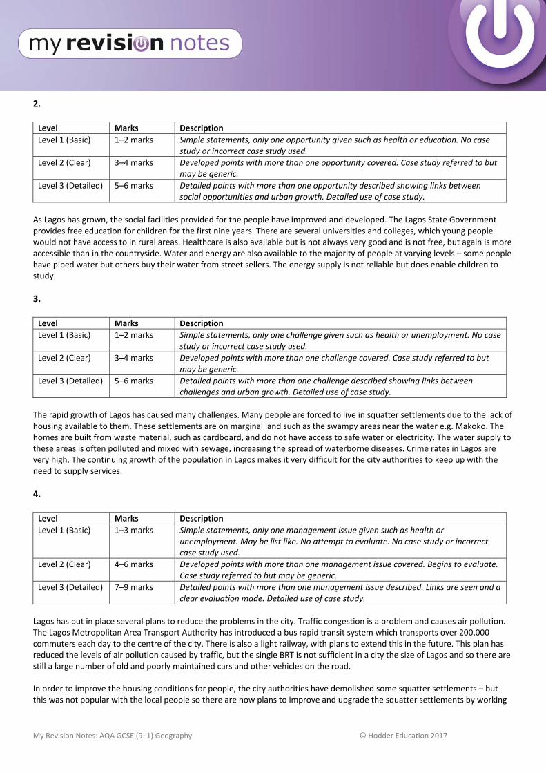
My Revision Notes: AQA GCSE (9–1) Geography © Hodder Education 2017
2. Level Marks Description
Level 1 (Basic) 1–2 marks Simple statements, only one opportunity given such as health or education. No case study or incorrect case study used.
Level 2 (Clear) 3–4 marks Developed points with more than one opportunity covered. Case study referred to but may be generic.
Level 3 (Detailed) 5–6 marks Detailed points with more than one opportunity described showing links between social opportunities and urban growth. Detailed use of case study.
As Lagos has grown, the social facilities provided for the people have improved and developed. The Lagos State Government provides free education for children for the first nine years. There are several universities and colleges, which young people would not have access to in rural areas. Healthcare is also available but is not always very good and is not free, but again is more accessible than in the countryside. Water and energy are also available to the majority of people at varying levels – some people have piped water but others buy their water from street sellers. The energy supply is not reliable but does enable children to study.
3. Level Marks Description
Level 1 (Basic) 1–2 marks Simple statements, only one challenge given such as health or unemployment. No case study or incorrect case study used.
Level 2 (Clear) 3–4 marks Developed points with more than one challenge covered. Case study referred to but may be generic.
Level 3 (Detailed) 5–6 marks Detailed points with more than one challenge described showing links between challenges and urban growth. Detailed use of case study.
The rapid growth of Lagos has caused many challenges. Many people are forced to live in squatter settlements due to the lack of housing available to them. These settlements are on marginal land such as the swampy areas near the water e.g. Makoko. The homes are built from waste material, such as cardboard, and do not have access to safe water or electricity. The water supply to these areas is often polluted and mixed with sewage, increasing the spread of waterborne diseases. Crime rates in Lagos are very high. The continuing growth of the population in Lagos makes it very difficult for the city authorities to keep up with the need to supply services.
4. Level Marks Description
Level 1 (Basic) 1–3 marks Simple statements, only one management issue given such as health or unemployment. May be list like. No attempt to evaluate. No case study or incorrect case study used.
Level 2 (Clear) 4–6 marks Developed points with more than one management issue covered. Begins to evaluate. Case study referred to but may be generic.
Level 3 (Detailed) 7–9 marks Detailed points with more than one management issue described. Links are seen and a clear evaluation made. Detailed use of case study.
Lagos has put in place several plans to reduce the problems in the city. Traffic congestion is a problem and causes air pollution. The Lagos Metropolitan Area Transport Authority has introduced a bus rapid transit system which transports over 200,000 commuters each day to the centre of the city. There is also a light railway, with plans to extend this in the future. This plan has reduced the levels of air pollution caused by traffic, but the single BRT is not sufficient in a city the size of Lagos and so there are still a large number of old and poorly maintained cars and other vehicles on the road. In order to improve the housing conditions for people, the city authorities have demolished some squatter settlements – but this was not popular with the local people so there are now plans to improve and upgrade the squatter settlements by working

My Revision Notes: AQA GCSE (9–1) Geography © Hodder Education 2017
with community groups to enable the local people to have a say in these plans. Many roads have been improved and new schools and health centres built, often using the local people who have gained new skills. In conclusion, the city authorities are making an effort to improve the situation in Lagos and have started to put plans in place. However, not all the ideas have been fully successful, such as the traffic plans.
Page 102
1. Level Marks Description
Level 1 (Basic) 1–2 marks Simple statements, isolated comments national or international importance referred to. No case study or incorrect case study used.
Level 2 (Clear) 3–4 marks Developed points with both national and international importance referred to. Case study used.
Rio de Janeiro is not the capital of Brazil but is the country’s second largest city. It is a major port and manufacturing area producing 5% of the country’s GDP. Many large companies in Brazil have their headquarters here, including the main mining and oil industries. Rio has hosted both the Olympics and the football world cup and is a major international tourist destination, with famous beaches, such as Copacabana, and the Statue of Christ the Redeemer – an iconic landmark known the world over. Rio is also a major international transport hub in South America with three airports.
2. Level Marks Description
Level 1 (Basic) 1–2 marks Simple statements, only one opportunity given such as health or education. No Case study or incorrect case study used.
Level 2 (Clear) 3–4 marks Developed points with more than one opportunity covered. Case study referred to but may be generic.
Level 3 (Detailed) 5–6 marks Detailed points with more than one opportunity described showing links between social opportunities and urban growth. Detailed use of case study.
As Rio has grown, the social facilities provided for the people have improved and developed. Rio has many primary and secondary schools with considerably better opportunities than in rural areas. The literacy rate in Rio is 95% higher than the national average. Water and energy are also available to the majority of people – 90% of people now have access to mains water supply. The energy supply is not reliable but does enable children to study.
3. Level Marks Description
Level 1 (Basic) 1–2 marks Simple statements, only one challenge given such as health or unemployment. No case study or incorrect case study used.
Level 2 (Clear) 3–4 marks Developed points with more than one challenge covered. Case study used but may be generic.
Level 3 (Detailed) 5–6 marks Detailed points with more than one challenge described showing links between challenges and urban growth. Detailed case study used.
The rapid growth of Rio has caused many challenges. Many people are forced to live in squatter settlements due to the lack of housing available to them. These settlements are on marginal land, such as the steep slopes around the edge of the city e.g. Rochina. Squatter settlements here are prone to landslides, destroying the homes. The homes are built from waste material, such as cardboard, and 10% of people do not have access to safe water, while 30% have no access to electricity. The water supply to these areas is often polluted and mixed with sewage, increasing the spread of waterborne diseases. Illegal electricity supplies can lead to fires. Crime rates in Rio are very high. The continuing growth of the population in Rio makes it very difficult for the city authorities to keep up with the need to supply services.
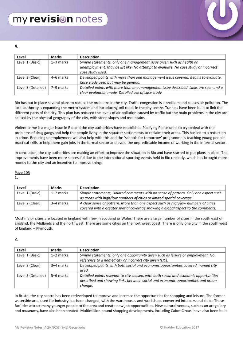
My Revision Notes: AQA GCSE (9–1) Geography © Hodder Education 2017
4. Level Marks Description
Level 1 (Basic) 1–3 marks Simple statements, only one management issue given such as health or unemployment. May be list like. No attempt to evaluate. No case study or incorrect case study used.
Level 2 (Clear) 4–6 marks Developed points with more than one management issue covered. Begins to evaluate. Case study used but may be generic.
Level 3 (Detailed) 7–9 marks Detailed points with more than one management issue described. Links are seen and a clear evaluation made. Detailed use of case study.
Rio has put in place several plans to reduce the problems in the city. Traffic congestion is a problem and causes air pollution. The local authority is expanding the metro system and introducing toll roads in the city centre. Tunnels have been built to link the different parts of the city. This plan has reduced the levels of air pollution caused by traffic but the main problems in the city are caused by the physical geography of the city, with steep slopes and mountains. Violent crime is a major issue in Rio and the city authorities have established Pacifying Police units to try to deal with the problems of drug gangs and help the people living in the squatter settlements to reclaim their areas. This has led to a reduction in crime. Reducing unemployment will also help with this and the ‘schools for tomorrow’ programme is teaching young people practical skills to help them gain jobs in the formal sector and avoid the unpredictable income of working in the informal sector. In conclusion, the city authorities are making an effort to improve the situation in Rio and have started to put plans in place. The improvements have been more successful due to the international sporting events held in Rio recently, which has brought more money to the city and an incentive to improve things. Page 105 1.
Level Marks Description
Level 1 (Basic) 1–2 marks Simple statements, isolated comments with no sense of pattern. Only one aspect such as areas with high/low numbers of cities or limited spatial coverage.
Level 2 (Clear) 3–4 marks A clear sense of pattern. More than one aspect such as high/low numbers of cities covered with a greater spatial coverage showing a global aspect to the comments.
Most major cities are located in England with few in Scotland or Wales. There are a large number of cities in the south east of England, the Midlands and the northwest. There are some cities on the northwest coast. There is only one city in the south west of England – Plymouth.
2. Level Marks Description
Level 1 (Basic) 1–2 marks Simple statements, only one opportunity given such as leisure or employment. No reference to a named city or incorrect city given (LIC).
Level 2 (Clear) 3–4 marks Developed points with both social and economic opportunities covered, named city used.
Level 3 (Detailed) 5–6 marks Detailed points relevant to city chosen, with both social and economic opportunities described and showing links between social and economic opportunities and urban change.
In Bristol the city centre has been redeveloped to improve and increase the opportunities for shopping and leisure. The former waterside area used for industry has been changed, with the warehouses and workshops converted into bars and clubs. These facilities attract many younger people to the area and create new job opportunities. New cultural venues, such as an art gallery and museums, have also been created. Multimillion pound shopping developments, including Cabot Circus, have also been built

My Revision Notes: AQA GCSE (9–1) Geography © Hodder Education 2017
again, providing new job opportunities. Improved public transport, pedestrianisation and open air street markets have all encouraged people to come back into the CBD. In addition, new hi tech industries have developed in Bristol with 50 microelectronic and silicon design businesses found in Bristol now, helped by links between the university and these industries.
3. Level Marks Description
Level 1 (Basic) 1–2 marks Simple statements, only one challenge given such as traffic congestion. No reference to a named city or incorrect city given (LIC).
Level 2 (Clear) 3–4 marks Developed points with more than one challenge covered, named city given.
Level 3 (Detailed) 5–6 marks Detailed points relevant to the city chosen with more than one challenge described showing links between challenges and urban change.
Industrial change in Bristol has left many areas with factory buildings that are no longer needed and which have become derelict. These areas are mainly in the inner city. Many of these building have been taken over by squatters, making it difficult to renovate or rebuild. The increased growth of the city has also led to urban sprawl, with large areas of greenfield sites being built on to provide housing, out of town shopping centres, such as Cribbs Causeway, and transport routes. The increased population has also increased the amount of waste produced and Bristol is among the worst cities in England with regard to the amount of food waste it produces.
4. This question has a high difficulty level.
Level Marks Description
Level 1 (Basic) 1–3 marks Simple statements, advantages or disadvantages given of either urban sprawl or commuter settlements. No attempt to assess. No named city used or incorrect city (non‐UK).
Level 2 (Clear) 4–6 marks Developed points, advantages and disadvantages given of both urban sprawl and commuter settlements. Some attempt to assess. Named city used.
Level 3 (Detailed) 7–9 marks Detailed advantages and disadvantages of both urban sprawl and commuter settlements with a clear assessment made. Named city used.
London has a major housing problem caused by population growth, which has led to a severe shortage of housing. London is a very crowded city and so there is little space to build new houses on. The advantages of building new houses on greenfield sites and creating urban sprawl is that the land is cheaper to build on and develop as no demolition of existing buildings is needed, and the land is unlikely to be contaminated, unlike brownfield sites in the city centre. Commuter settlements already have transport access, such as rail links and motorways. Services such as supermarkets and leisure facilities are in place. Commuter settlements again can provide large areas of land that are easily accessible to build on. However, continual building on the greenbelt and greenfield sites can destroy open areas and wildlife habitats. Valuable farmland or land used for recreation can be lost. The character of areas can also be lost. Access to the urban area will be congested as commuters all try to travel at the same time of the day. For example, commuters travelling from areas such as Maidenhead to the west of London often encounter congestion on the M4. Pressure on local services, such as schools and doctors, can cause problems and conflict with local residents. Overall, however, the need for housing can be seen as more important than the need to preserve open land around major cities such as London. Often the greenbelt has already been built on to provide transport routes. The need for cheaper properties for workers in London can outweigh the need to preserve areas of countryside and so it can be said that with this need in mind the advantages outweigh the disadvantages in London.
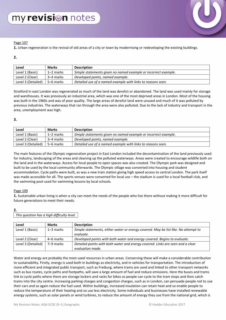
My Revision Notes: AQA GCSE (9–1) Geography © Hodder Education 2017
Page 107
1. Urban regeneration is the revival of old areas of a city or town by modernising or redeveloping the existing buildings.
2. Level Marks Description
Level 1 (Basic) 1–2 marks Simple statements given no named example or incorrect example.
Level 2 (Clear) 3–4 marks Developed points, named example.
Level 3 (Detailed) 5–6 marks Detailed use of a named example with links to reasons seen.
Stratford in east London was regenerated as much of the land was derelict or abandoned. The land was used mainly for storage and warehouses. It was previously an industrial area, which was one of the most deprived areas in London. Most of the housing was built in the 1960s and was of poor quality. The large areas of derelict land were unused and much of it was polluted by previous industries. The waterways that ran through the area were also polluted. Due to the lack of industry and transport in the area, unemployment was high.
3. Level Marks Description
Level 1 (Basic) 1–2 marks Simple statements given no named example or incorrect example.
Level 2 (Clear) 3–4 marks Developed points, named example.
Level 3 (Detailed) 5–6 marks Detailed use of a named example with links to reasons seen.
The main features of the Olympic regeneration project in East London included the decontamination of the land previously used for industry, landscaping of the areas and cleaning up the polluted waterways. Areas were created to encourage wildlife both on the land and in the waterways. Access for local people to open spaces was also created. The Olympic park was designed and built to be used by the local community afterwards. The Olympic village was converted into housing and student accommodation. Cycle paths were built, as was a new train station giving high speed access to central London. The park itself was made accessible for all. The sports venues were converted for local use – the stadium is used for a local football club, and the swimming pool used for swimming lessons by local schools. Page 109
1. Sustainable urban living is when a city can meet the needs of the people who live there without making it more difficult for future generations to meet their needs.
2. This question has a high difficulty level.
Level Marks Description
Level 1 (Basic) 1–3 marks Simple statements, either water or energy covered. May be list like. No attempt to evaluate.
Level 2 (Clear) 4–6 marks Developed points with both water and energy covered. Begins to evaluate.
Level 3 (Detailed) 7–9 marks Detailed points with both water and energy covered. Links are seen and a clear evaluation made.
Water and energy are probably the most used resources in urban areas. Conserving these will make a considerable contribution to sustainability. Firstly, energy is used both in buildings as electricity, and in vehicles for transportation. The introduction of more efficient and integrated public transport, such as Freiburg, where trams are used and linked to other transport networks such as bus routes, cycle paths and footpaths, will save a large amount of fuel and reduce emissions. Here the buses and trams link to cycle paths where there are storage lockers and racks for bikes so people can cycle to the tram stops and then catch trams into the city centre. Increasing parking charges and congestion charges, such as in London, can persuade people not to use their cars and so again reduce the fuel used. Within buildings, increased insulation can retain heat and so enable people to reduce the temperature of their heating and so use less electricity. Some individuals and businesses have installed renewable energy systems, such as solar panels or wind turbines, to reduce the amount of energy they use from the national grid, which is
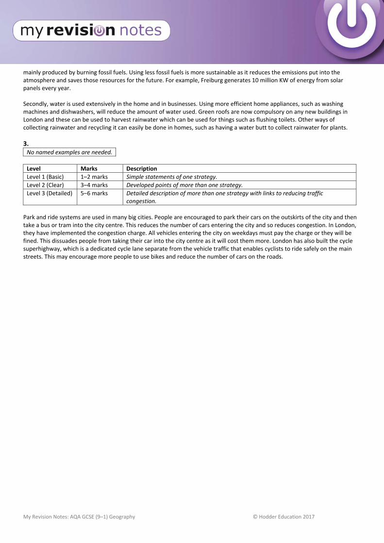
My Revision Notes: AQA GCSE (9–1) Geography © Hodder Education 2017
mainly produced by burning fossil fuels. Using less fossil fuels is more sustainable as it reduces the emissions put into the atmosphere and saves those resources for the future. For example, Freiburg generates 10 million KW of energy from solar panels every year. Secondly, water is used extensively in the home and in businesses. Using more efficient home appliances, such as washing machines and dishwashers, will reduce the amount of water used. Green roofs are now compulsory on any new buildings in London and these can be used to harvest rainwater which can be used for things such as flushing toilets. Other ways of collecting rainwater and recycling it can easily be done in homes, such as having a water butt to collect rainwater for plants.
3. No named examples are needed.
Level Marks Description
Level 1 (Basic) 1–2 marks Simple statements of one strategy.
Level 2 (Clear) 3–4 marks Developed points of more than one strategy.
Level 3 (Detailed) 5–6 marks Detailed description of more than one strategy with links to reducing traffic congestion.
Park and ride systems are used in many big cities. People are encouraged to park their cars on the outskirts of the city and then take a bus or tram into the city centre. This reduces the number of cars entering the city and so reduces congestion. In London, they have implemented the congestion charge. All vehicles entering the city on weekdays must pay the charge or they will be fined. This dissuades people from taking their car into the city centre as it will cost them more. London has also built the cycle superhighway, which is a dedicated cycle lane separate from the vehicle traffic that enables cyclists to ride safely on the main streets. This may encourage more people to use bikes and reduce the number of cars on the roads.
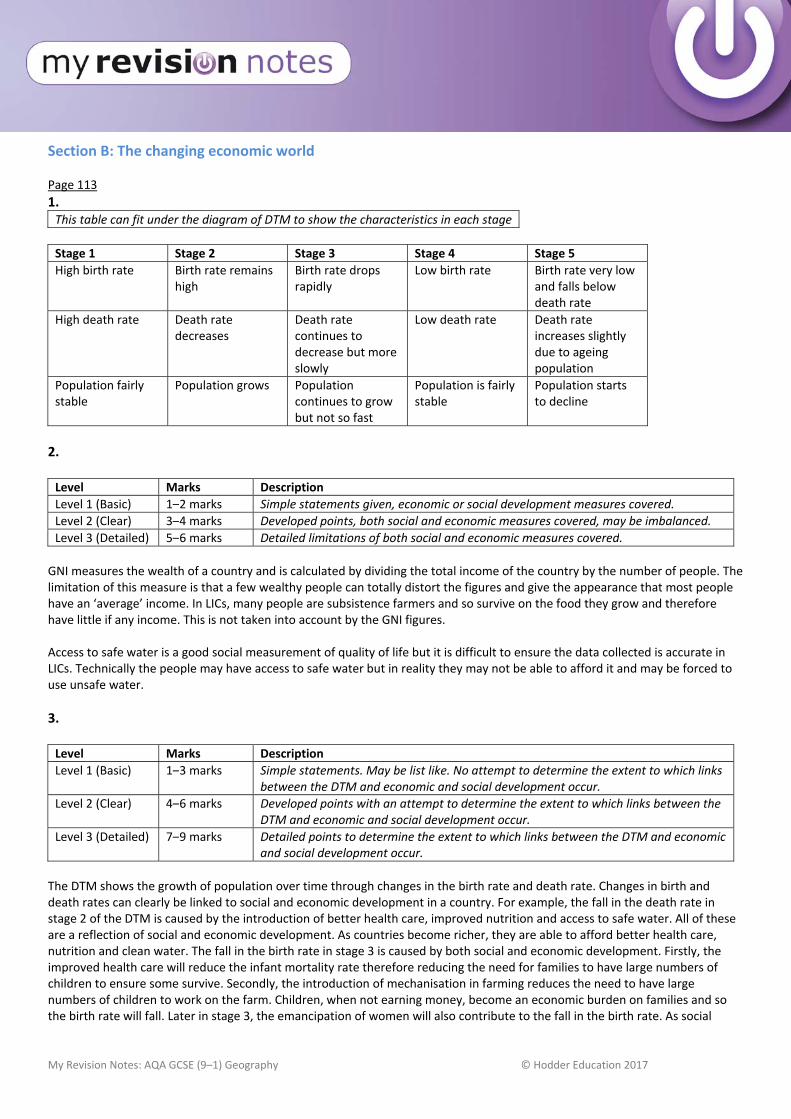
My Revision Notes: AQA GCSE (9–1) Geography © Hodder Education 2017
Section B: The changing economic world Page 113
1. This table can fit under the diagram of DTM to show the characteristics in each stage
Stage 1 Stage 2 Stage 3 Stage 4 Stage 5
High birth rate Birth rate remains high
Birth rate drops rapidly
Low birth rate Birth rate very low and falls below death rate
High death rate Death rate decreases
Death rate continues to decrease but more slowly
Low death rate Death rate increases slightly due to ageing population
Population fairly stable
Population grows Population continues to grow but not so fast
Population is fairly stable
Population starts to decline
2. Level Marks Description
Level 1 (Basic) 1–2 marks Simple statements given, economic or social development measures covered.
Level 2 (Clear) 3–4 marks Developed points, both social and economic measures covered, may be imbalanced.
Level 3 (Detailed) 5–6 marks Detailed limitations of both social and economic measures covered.
GNI measures the wealth of a country and is calculated by dividing the total income of the country by the number of people. The limitation of this measure is that a few wealthy people can totally distort the figures and give the appearance that most people have an ‘average’ income. In LICs, many people are subsistence farmers and so survive on the food they grow and therefore have little if any income. This is not taken into account by the GNI figures. Access to safe water is a good social measurement of quality of life but it is difficult to ensure the data collected is accurate in LICs. Technically the people may have access to safe water but in reality they may not be able to afford it and may be forced to use unsafe water.
3. Level Marks Description
Level 1 (Basic) 1–3 marks Simple statements. May be list like. No attempt to determine the extent to which links between the DTM and economic and social development occur.
Level 2 (Clear) 4–6 marks Developed points with an attempt to determine the extent to which links between the DTM and economic and social development occur.
Level 3 (Detailed) 7–9 marks Detailed points to determine the extent to which links between the DTM and economic and social development occur.
The DTM shows the growth of population over time through changes in the birth rate and death rate. Changes in birth and death rates can clearly be linked to social and economic development in a country. For example, the fall in the death rate in stage 2 of the DTM is caused by the introduction of better health care, improved nutrition and access to safe water. All of these are a reflection of social and economic development. As countries become richer, they are able to afford better health care, nutrition and clean water. The fall in the birth rate in stage 3 is caused by both social and economic development. Firstly, the improved health care will reduce the infant mortality rate therefore reducing the need for families to have large numbers of children to ensure some survive. Secondly, the introduction of mechanisation in farming reduces the need to have large numbers of children to work on the farm. Children, when not earning money, become an economic burden on families and so the birth rate will fall. Later in stage 3, the emancipation of women will also contribute to the fall in the birth rate. As social
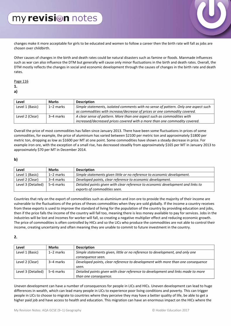
My Revision Notes: AQA GCSE (9–1) Geography © Hodder Education 2017
changes make it more acceptable for girls to be educated and women to follow a career then the birth rate will fall as jobs are chosen over childbirth. Other causes of changes in the birth and death rates could be natural disasters such as famine or floods. Manmade influences such as war can also influence the DTM but generally will cause only minor fluctuations in the birth and death rates. Overall, the DTM mostly reflects the changes in social and economic development through the causes of changes in the birth rate and death rates. Page 116
1. a) Level Marks Description
Level 1 (Basic) 1–2 marks Simple statements, isolated comments with no sense of pattern. Only one aspect such as commodities with increase/decrease of prices or one commodity covered.
Level 2 (Clear) 3–4 marks A clear sense of pattern. More than one aspect such as commodities with increased/decreased prices covered with a more than one commodity covered.
Overall the price of most commodities has fallen since January 2013. There have been some fluctuations in prices of some commodities, for example, the price of aluminium has varied between $2100 per metric ton and approximately $1800 per metric ton, dropping as low as $1600 per MT at one point. Some commodities have shown a steady decrease in price. For example iron ore, with the exception of a small rise, has decreased steadily from approximately $165 per MT in January 2013 to approximately $70 per MT in December 2014.
b) Level Marks Description
Level 1 (Basic) 1–2 marks Simple statements given little or no reference to economic development.
Level 2 (Clear) 3–4 marks Developed points, clear reference to economic development.
Level 3 (Detailed) 5–6 marks Detailed points given with clear reference to economic development and links to exports of commodities seen.
Countries that rely on the export of commodities such as aluminium and iron ore to provide the majority of their income are vulnerable to the fluctuations of the prices of theses commodities when they are sold globally. If the income a country receives from these exports is used to improve the standard of living for the population of the country by providing education and jobs, then if the price falls the income of the country will fall too, meaning there is less money available to pay for services. Jobs in the industries will be lost and incomes for worker will fall, so creating a negative multiplier effect and reducing economic growth. The price of commodities is often controlled by HICs and so the LICs who produce the commodities are not able to control their income, creating uncertainty and often meaning they are unable to commit to future investment in the country.
2. Level Marks Description
Level 1 (Basic) 1–2 marks Simple statements given, little or no reference to development, and only one consequence seen.
Level 2 (Clear) 3–4 marks Developed points, clear reference to development with more than one consequence seen.
Level 3 (Detailed) 5–6 marks Detailed points given with clear reference to development and links made to more than one consequence.
Uneven development can have a number of consequences for people in LICs and HICs. Uneven development can lead to huge differences in wealth, which can lead many people in LICs to experience poor living conditions and poverty. This can trigger people in LICs to choose to migrate to countries where they perceive they may have a better quality of life, be able to get a higher paid job and have access to health and education. This migration can have an enormous impact on the HICs where the
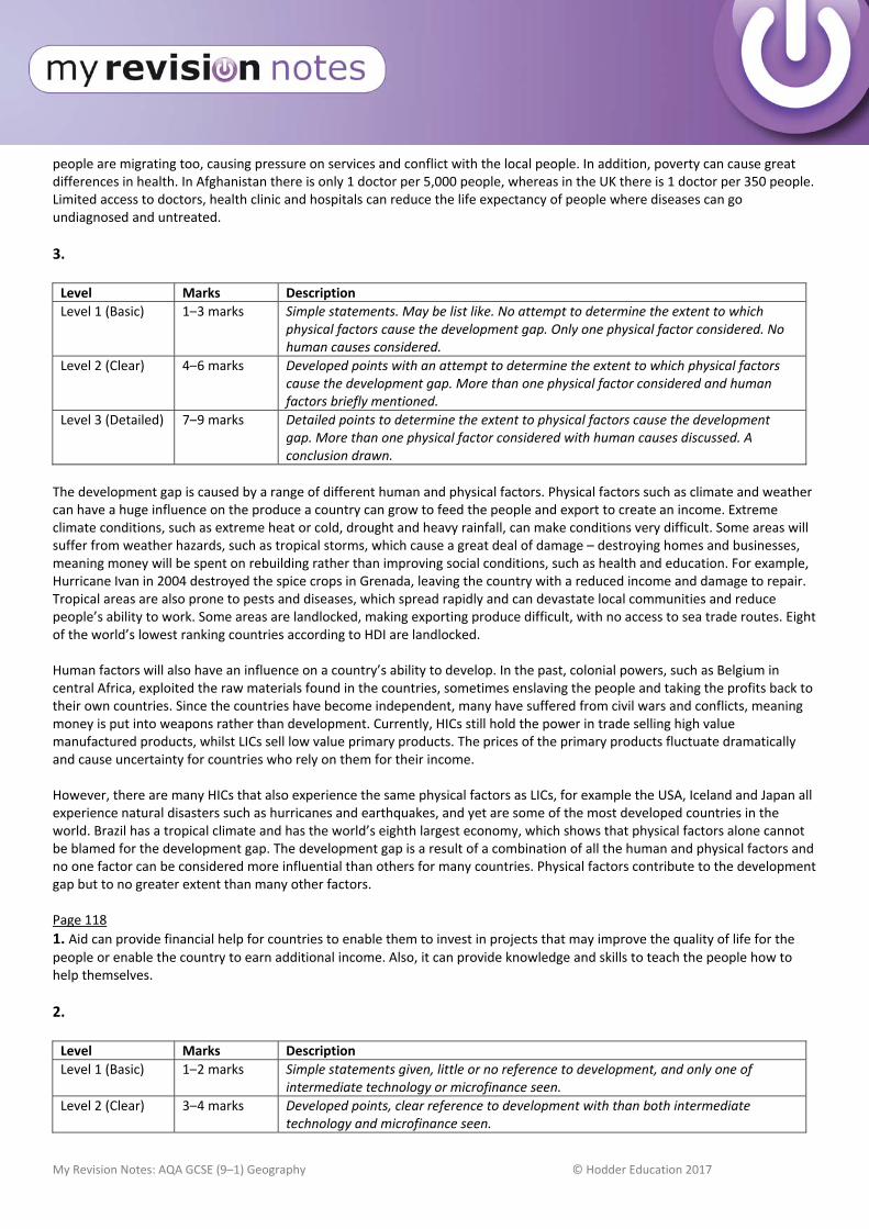
My Revision Notes: AQA GCSE (9–1) Geography © Hodder Education 2017
people are migrating too, causing pressure on services and conflict with the local people. In addition, poverty can cause great differences in health. In Afghanistan there is only 1 doctor per 5,000 people, whereas in the UK there is 1 doctor per 350 people. Limited access to doctors, health clinic and hospitals can reduce the life expectancy of people where diseases can go undiagnosed and untreated.
3. Level Marks Description
Level 1 (Basic) 1–3 marks Simple statements. May be list like. No attempt to determine the extent to which physical factors cause the development gap. Only one physical factor considered. No human causes considered.
Level 2 (Clear) 4–6 marks Developed points with an attempt to determine the extent to which physical factors cause the development gap. More than one physical factor considered and human factors briefly mentioned.
Level 3 (Detailed) 7–9 marks Detailed points to determine the extent to physical factors cause the development gap. More than one physical factor considered with human causes discussed. A conclusion drawn.
The development gap is caused by a range of different human and physical factors. Physical factors such as climate and weather can have a huge influence on the produce a country can grow to feed the people and export to create an income. Extreme climate conditions, such as extreme heat or cold, drought and heavy rainfall, can make conditions very difficult. Some areas will suffer from weather hazards, such as tropical storms, which cause a great deal of damage – destroying homes and businesses, meaning money will be spent on rebuilding rather than improving social conditions, such as health and education. For example, Hurricane Ivan in 2004 destroyed the spice crops in Grenada, leaving the country with a reduced income and damage to repair. Tropical areas are also prone to pests and diseases, which spread rapidly and can devastate local communities and reduce people’s ability to work. Some areas are landlocked, making exporting produce difficult, with no access to sea trade routes. Eight of the world’s lowest ranking countries according to HDI are landlocked. Human factors will also have an influence on a country’s ability to develop. In the past, colonial powers, such as Belgium in central Africa, exploited the raw materials found in the countries, sometimes enslaving the people and taking the profits back to their own countries. Since the countries have become independent, many have suffered from civil wars and conflicts, meaning money is put into weapons rather than development. Currently, HICs still hold the power in trade selling high value manufactured products, whilst LICs sell low value primary products. The prices of the primary products fluctuate dramatically and cause uncertainty for countries who rely on them for their income. However, there are many HICs that also experience the same physical factors as LICs, for example the USA, Iceland and Japan all experience natural disasters such as hurricanes and earthquakes, and yet are some of the most developed countries in the world. Brazil has a tropical climate and has the world’s eighth largest economy, which shows that physical factors alone cannot be blamed for the development gap. The development gap is a result of a combination of all the human and physical factors and no one factor can be considered more influential than others for many countries. Physical factors contribute to the development gap but to no greater extent than many other factors. Page 118
1. Aid can provide financial help for countries to enable them to invest in projects that may improve the quality of life for the people or enable the country to earn additional income. Also, it can provide knowledge and skills to teach the people how to help themselves.
2. Level Marks Description
Level 1 (Basic) 1–2 marks Simple statements given, little or no reference to development, and only one of intermediate technology or microfinance seen.
Level 2 (Clear) 3–4 marks Developed points, clear reference to development with than both intermediate technology and microfinance seen.
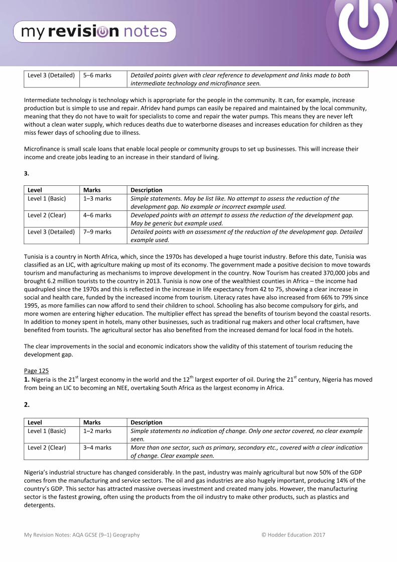
My Revision Notes: AQA GCSE (9–1) Geography © Hodder Education 2017
Level 3 (Detailed) 5–6 marks Detailed points given with clear reference to development and links made to both intermediate technology and microfinance seen.
Intermediate technology is technology which is appropriate for the people in the community. It can, for example, increase production but is simple to use and repair. Afridev hand pumps can easily be repaired and maintained by the local community, meaning that they do not have to wait for specialists to come and repair the water pumps. This means they are never left without a clean water supply, which reduces deaths due to waterborne diseases and increases education for children as they miss fewer days of schooling due to illness. Microfinance is small scale loans that enable local people or community groups to set up businesses. This will increase their income and create jobs leading to an increase in their standard of living. 3.
Level Marks Description
Level 1 (Basic) 1–3 marks Simple statements. May be list like. No attempt to assess the reduction of the development gap. No example or incorrect example used.
Level 2 (Clear) 4–6 marks Developed points with an attempt to assess the reduction of the development gap. May be generic but example used.
Level 3 (Detailed) 7–9 marks Detailed points with an assessment of the reduction of the development gap. Detailed example used.
Tunisia is a country in North Africa, which, since the 1970s has developed a huge tourist industry. Before this date, Tunisia was classified as an LIC, with agriculture making up most of its economy. The government made a positive decision to move towards tourism and manufacturing as mechanisms to improve development in the country. Now Tourism has created 370,000 jobs and brought 6.2 million tourists to the country in 2013. Tunisia is now one of the wealthiest counties in Africa – the income had quadrupled since the 1970s and this is reflected in the increase in life expectancy from 42 to 75, showing a clear increase in social and health care, funded by the increased income from tourism. Literacy rates have also increased from 66% to 79% since 1995, as more families can now afford to send their children to school. Schooling has also become compulsory for girls, and more women are entering higher education. The multiplier effect has spread the benefits of tourism beyond the coastal resorts. In addition to money spent in hotels, many other businesses, such as traditional rug makers and other local craftsmen, have benefited from tourists. The agricultural sector has also benefited from the increased demand for local food in the hotels. The clear improvements in the social and economic indicators show the validity of this statement of tourism reducing the development gap. Page 125
1. Nigeria is the 21st largest economy in the world and the 12th largest exporter of oil. During the 21st century, Nigeria has moved from being an LIC to becoming an NEE, overtaking South Africa as the largest economy in Africa.
2. Level Marks Description
Level 1 (Basic) 1–2 marks Simple statements no indication of change. Only one sector covered, no clear example seen.
Level 2 (Clear) 3–4 marks More than one sector, such as primary, secondary etc., covered with a clear indication of change. Clear example seen.
Nigeria’s industrial structure has changed considerably. In the past, industry was mainly agricultural but now 50% of the GDP comes from the manufacturing and service sectors. The oil and gas industries are also hugely important, producing 14% of the country’s GDP. This sector has attracted massive overseas investment and created many jobs. However, the manufacturing sector is the fastest growing, often using the products from the oil industry to make other products, such as plastics and detergents.
My Revision Notes: AQA GCSE (9–1) Geography © Hodder Education 2017
3. Level Marks Description
Level 1 (Basic) 1–2 marks Simple impacts given, little or no reference to the environment, little or no links to economic development. No example given.
Level 2 (Clear) 3–4 marks Developed points, clear reference to the environment, clear links to economic development. Clear use of an example.
Level 3 (Detailed) 5–6 marks Detailed points given with clear reference to environment and links made to the economic development. Detailed use of an example.
The development of the oil industry has increased income to Nigeria and so helped with economic development – creating not only wealth but jobs as well. However, it has had huge effects on the environment. There have been serious issues with pollution, particularly oil spills in the Niger delta. This has caused damage to aquatic wildlife and impacted on the whole ecosystem. In 2008/9 a massive oil spill devastated 20 square kilometres of wetlands close to Bodo in the Niger Delta. Fires also caused by leaking oil have resulted in wild fires creating toxic fumes in the atmosphere, impacting on people’s health. Rapid industrialisation in LICs often mean shortcuts are taken and measures to protect the environment are not put in place or are ignored due to lack of regulations or inspectors.
4. Level Marks Description
Level 1 (Basic) 1–3 marks Simple statements. May be list like. No attempt to determine the extent to which advantages outweigh disadvantages. No link to economic development.
Level 2 (Clear) 4–6 marks Developed points covering both advantage and disadvantages with an attempt to determine the extent to which advantages outweigh disadvantages. Some link to economic development.
Level 3 (Detailed) 7–9 marks Detailed points covering both advantages and disadvantages with a clear conclusion to determine the extent to which advantages outweigh disadvantages. Clear links to economic development.
TNC’s provide employment and training for their employees using modern technology. These companies often invest in the local area’s building infrastructure, such as road, water and electricity supplies. The planning conditions sometimes make sure that the company builds social facilities, such as schools and health clinics. Local companies may benefit by supplying parts or services to the TNC. Finally, the government will benefit from increased taxes, not only from the company but from the people employed there, which can be spent on improving education and health care facilities. The increased income both for the government and the employees adds to the economic development of the country, increasing the GDP. However, TNCs often pay low wages and can use loopholes to avoid paying tax. Working conditions may be poor with long hours and few health and safety regulations. Environmental damage may be caused through a lack of regulation. Highly paid management jobs are frequently taken by foreign nationals and the profits are sent back to the country where the TNC is based rather than being spent on the local area. Overall, if the government of the LIC is careful and puts in place clear regulations then the advantages of the TNC can outweigh the disadvantages, bringing increased wealth and skills to the local people.
5. Level Marks Description
Level 1 (Basic) 1–3 marks Simple statements referring to quality of life or economic development. May be list like. No attempt to determine the extent to which economic development has improved people’s quality of life.
Level 2 (Clear) 4–6 marks Developed points referring to quality of life and economic development. Some attempt to determine the extent to which economic development has improved people’s quality of life.
My Revision Notes: AQA GCSE (9–1) Geography © Hodder Education 2017
Level 3 (Detailed) 7–9 marks Detailed points referring to quality of life and economic development. Clear conclusion determining the extent to which economic development has improved people’s quality of life.
Many people in Nigeria have benefited from economic development; the HDI for Nigeria has increased from less than 0.47 in 2005 to over 0.5 today. In addition, life expectancy has risen from 45.6 to 52.5, access to safe water has increased from 46% to 64%, over 38% of Nigerians now have access to the internet, 70% have mobile phones and the number of years in education has increased from 6.7 to 9 years. All of these improvements to people’s lives are due to the increased wealth in the country. Better paid jobs in manufacturing and service industries rather than agriculture enable people to spend money on improving their quality of life and accessing better health care and education. The improved health care is reflected in the increased life expectancy. The increase in tax income for the government from higher paid jobs has meant investment in infrastructure, such as safer water supplies and education. However, people in rural parts of Nigeria (especially in the north) have not benefited from these improvements and so the challenge for Nigeria is to extend the economic development across the country. In conclusion, it is clear that economic development has improved the quality of life for many people in Nigeria but this development has not reached the whole population and so cannot be considered entirely successful. Page 127
1. Deindustrialisation is the decline of traditional or heavy industry in a country or area.
2. Must refer to UK.
Level Marks Description
Level 1 (Basic) 1–2 marks Simple changes given, little or no reference to globalisation, little or no links to economic change.
Level 2 (Clear) 3–4 marks Developed points, clear reference to globalisation, clear links to economic change.
Level 3 (Detailed) 5–6 marks Detailed points given with clear reference to globalisation and links made to the economic change.
Globalisation has created a more connected world, with increased communications between countries and people allowing a spread of ideas around the world. It can involve the movement of people, goods and services. This has impacted on the economic structure of the UK by enabling the growth of the quaternary sector and with many people now working for TNCs, and in service sectors, such as banking and finance, media and education. The tertiary and quaternary sectors of the economy has expanded considerably since the 1980s, now accounting for approximately 90% of employment as opposed to 50% in the 1960s, facilitated by globalisation.
3. Must refer to UK.
Level Marks Description
Level 1 (Basic) 1–3 marks Simple statements referring to one government policy. May be list like. No attempt to determine the extent to which government policies have caused economic change.
Level 2 (Clear) 4–6 marks Developed points referring to one or more government policies. Some attempt to determine the extent to which government policies have caused economic change.
Level 3 (Detailed) 7–9 marks Detailed points referring to government policies. Clear conclusion determining the extent to which government policies have caused economic change.
The UK government has played an important role in economic change over the past 70 years. Various policies have been implemented, which responded to global trends. For example, between 1979 and 2010, state run industries were privatised, leading to uneconomic heavy industries being closed. The government worked with the private sector to invest in former industrial areas to redevelop them into financial and service centres. An example is Docklands in London, where offices and retail areas were developed on the site of former warehouses and docks. From 2010 onwards, the government encouraged
My Revision Notes: AQA GCSE (9–1) Geography © Hodder Education 2017
investment in hi tech industries, such as aerospace and computer engineering. It has invested in hi tech infrastructure, such as London’s cross rail. Loans and other financial incentives are available to small business in these fields. The UK government has worked with private industries and financial institutions to engender economic changes and can be said to be instrumental in these changes by initiating them and encouraging the private sector to contribute. Page 129
1. A post‐industrial economy is where the manufacturing industry has been replaced with service industries or tertiary jobs.
2. Must refer to UK.
Level Marks Description
Level 1 (Basic) 1–2 marks Simple descriptions given.
Level 2 (Clear) 3–4 marks Clear descriptions given, more than one industry described.
Service industries provide support for manufacturing industries and can include a wide range of different activities. For example, ITC industries can provide computers, which store and transfer large amounts of information for companies. Research and development services enable manufacturing industries to produce new products, and financial services provide banking and insurance.
3. Level Marks Description
Level 1 (Basic) 1–2 marks Simple points no reference to the figure.
Level 2 (Clear) 3–4 marks Developed points with reference to the figure.
Level 3 (Detailed) 5–6 marks Detailed points with clear links to the UK’s economy.
Science parks have businesses linked to scientific and technical knowledge based on a single site. They are usually located on the edge of a university city, as can be seen in the photo of the science park at Cambridge. In the photo you can clearly see a main road, which provides good transport links. Being on the edge of the city provides a pleasant working environment and will attract skilled and specialist graduates. Businesses benefit from close collaboration and shared facilities. Having links to universities benefits the UK economy by having the latest and most up‐to‐date research and information available for industry whilst reducing costs from the shared facilities. Page 130
Level Marks Description
Level 1 (Basic) 1–2 marks Simple points, no example used, list like.
Level 2 (Clear) 3–4 marks Clear example used, developed point with some links to sustainability.
Level 3 (Detailed) 5–6 marks Detailed example used with specific links to sustainability.
The Nissan car plant in Sunderland produces over 500,000 cars per year and employs 7,000 people. The plant uses wind turbines to produce the energy it needs – 70% of the electricity is produced this way. Using wind turbines means no emissions are created and it is renewable meaning the source will not run out. Some of the new models of cars produced are hybrids, which mean that they run on a mixture of petrol and electricity. This means less fossil fuels are being burnt and so creates less CO2, which contributes to global climate change. Other new cars are being designed to be more fuel efficient and also to have less exhaust gases, so reducing the amount of emissions put into the atmosphere. New cars are designed using material that can be recycled, meaning less waste is going to land fill sites.
My Revision Notes: AQA GCSE (9–1) Geography © Hodder Education 2017
Page 131
Level Marks Description
Level 1 (Basic) 1–2 marks Simple points, social or economic changes seen.
Level 2 (Clear) 3–4 marks Developed points with clear links to both social and economic changes in a rural area of population decline.
Level 3 (Detailed) 5–6 marks Detailed social and economic changes explained with reference to a rural area of population decline.
In the Outer Hebrides there has been a 50% decline in the population since 1901. Mainly young people have moved to the mainland in search of better paid jobs. This has led to both social and economic changes. Social changes include the closure of schools as fewer children are based on the islands. As younger people leave the area, only older people without young families are left. This means the population is ageing and will need more social and health care. The lack of working‐age people will result in a decline in fishing and farming on the islands and the subsequent impact on the economy. The decline in the population will make services such as the ferries and the post offices uneconomic to run and could lead to their closure. Page 133
1. Must refer to UK.
Level Marks Description
Level 1 (Basic) 1–2 marks Simple descriptions given, either improvements or development covered.
Level 2 (Clear) 3–4 marks Clear descriptions given, both improvements and development covered.
New rail links are being developed in the UK. London’s cross rail has been built to improve east west connection across London. This will improve journey times and ease congestion on the tube network. It will reduce the journey time into London, allowing people who live further away to commute into London in a shorter time. There have also been a range of improvements to the rail network in the UK – for example the electrification of the Trans Pennine railway will improve the connection between Manchester and York.
2. Must refer to UK.
Level Marks Description
Level 1 (Basic) 1–2 marks Simple points, one development covered, little or no links to the UK economy.
Level 2 (Clear) 3–4 marks Developed points with clear links to the UK economy with more than one development covered.
Level 3 (Detailed) 5–6 marks Detailed links to the UK economy with more than one development covered.
In 2014, the government launched a £15 billion ‘Road Improvement Strategy’ to improve road condition and capacity. Many stretches of busy motorway are being converted into ‘smart motorways’, enabling traffic flow to be controlled to reduce congestion, for example the M3. Over 1,600 kilometres of new lanes will be added to busy motorways and major roads such as the heavily congested A303 in southwest England between Basingstoke (M3) and Exeter (M5), which will enable faster travel through less congestion. It will also reduce costs to industry and increase their profits. These improvements will provide construction jobs for hundreds of people, and should boost local and regional economies throughout the country. The government is keen to develop the UK’s railways to ease congestion and help stimulate economic growth, particularly in northern England. High Speed 2 (HS2) is a £50 billion project involving constructing a high‐speed rail line between London and Birmingham and then onwards to Manchester, Leeds and Sheffield. Quicker and easier access to northern England should encourage new businesses to locate there to combat deindustrialisation.

My Revision Notes: AQA GCSE (9–1) Geography © Hodder Education 2017
Page 135
1. There are higher unemployment levels in the north of the UK – for example in the north east unemployment is higher than 7%, whereas in the south east it is less than 5%. In general people living in the south have higher incomes than those in the north. Average pay in the north east is £24,000 per annum, whilst in the south east it is £28,000. House prices are higher in the south than in the north, and life expectancy is higher in the north than in the south. Life expectancy in the north east is ‐1.3 years on the average whilst in the south east it is +1.2 years on the average.
2. Level Marks Description
Level 1 (Basic) 1–2 marks Simple statements, isolated comments with no sense of pattern.
Level 2 (Clear) 3–4 marks A clear sense of pattern.
Many of the less advantaged assisted areas are in the Midlands, North East and North West of England. The extreme west of the UK, Wales and Cornwall are also assisted areas with low GNP. Large areas of the north of Scotland are assisted areas with a sparse population. The whole of Northern Ireland is a less advantaged assisted area.
3. Must refer to UK.
Level Marks Description
Level 1 (Basic) 1–2 marks Simple points, one strategy covered, little or no links to regional differences.
Level 2 (Clear) 3–4 marks Developed points with clear links to regional differences with more than one strategy covered.
Level 3 (Detailed) 5–6 marks Detailed links to the regional differences with more than one strategy covered.
The UK government and the EU have used several different strategies to reduce regional differences in the UK. Areas which are less economically advantaged are given special Assisted Area status where financial help is given to support new businesses to set up there and so create new jobs and reduce unemployment. In addition, the Regional Growth Fund supports projects in England that use private sector investment to create jobs. There are also government packages to reduce taxes and subsidise site development to encourage TNCs to locate in disadvantaged areas. An example of this is Nissan in Tyne and Wear where unemployment was high due to the closure of the ship yards. Enterprise Zones have also been created where incentives such as superfast broadband and simplified planning regulations are designed to encourage new businesses to set up in deprived areas. The idea behind these strategies is to reduce unemployment, create jobs and wealth through the multiplier effect in order to resolve the inequalities in regions in the UK Page 137
1. Level Marks Description
Level 1 (Basic) 1–2 marks Simple statements, isolated comments on transport with no links seen.
Level 2 (Clear) 3–4 marks Clear comments made describing transport links between the UK and the wider world.
The UK has a long history of global trading and therefore the transport links to other parts of the world are well established. In the UK there are many international airports, with London Heathrow and London Gatwick being two major global hubs. There are also a number of major international ports, such as Southampton and Liverpool. The UK is linked to mainland Europe via the channel tunnel rail and vehicle link with fast trains from London to Paris. Cross channel ferries also operate from south coast ports, such as Dover, and connect the UK to France, Belgium and Spain.
My Revision Notes: AQA GCSE (9–1) Geography © Hodder Education 2017
2. Level Marks Description
Level 1 (Basic) 1–2 marks Simple points, with little or no benefits given of membership of the EU or the Commonwealth.
Level 2 (Clear) 3–4 marks Developed point with clear links membership of the EU or Commonwealth.
Level 3 (Detailed) 5–6 marks Detailed points with links to both the EU and Commonwealth.
The UK is a member of both the EU and the Commonwealth. The EU is one of the world’s major trading blocks and has considerable political and economic influence. Within the EU, goods and services can move freely without incurring tariffs or quotas, which means that the UK can sell its goods and services to other EU countries at a cheaper rate then countries outside of the EU. It also means the UK can buy goods cheaply from other EU countries. From being in the EU the UK also has access to a range of funds and subsidies that support the UK’s farmers and less economically successful parts of the UK, such as the Highlands of Scotland. For example, £18 million was made available to UK dairy farmers in 2015 to support them from the EU Single Payment Scheme – part of the Common Agricultural Policy. The Commonwealth is a group of countries that were former British colonies. This organisation provides support to individual countries and encourages cooperation between them through trade links.
3. Level Marks Description
Level 1 (Basic) 1–3 marks Simple statements. May be list like. No attempt to determine the extent to which the UK plays an important role in the wider world.
Level 2 (Clear) 4–6 marks Developed points. Some attempt to determine the extent to which the UK plays an important role in the wider world.
Level 3 (Detailed) 7–9 marks Detailed points. Clear conclusion determining the extent to which the UK plays an important role in the wider world.
The UK is one of the world’s most powerful political and trading nations. The UK, through membership of global organisations such as the G8, NATO and the UN Security Council, has considerable political, economic and cultural influence. It remains one of the world’s major economies and is a global financial and transport hub. It is highly regarded for its fairness, tolerance, democratic principles and legal system. The UK trades with many countries mainly within the EU but also globally with the USA and China. The efficiency of the transport hubs, including air, rail and sea, within the UK enable this trade. UK Television and film is hugely successful and influential, with many programmes, such as Doctor Who, exported worldwide. In the film industry the UK has some of the top experts in CGI and special effects. The UK fashion industry is highly respected globally, and the music industry is world leading. In the field of electronics the UK is an important hub for research and development,, using the respected research facilities of the many top universities. The submarine cables linking Europe with the USA enable 99% of all internet traffic to be routed through the UK. Whilst there has been a rise in the importance of other countries especially in the Far East, including China and Malaysia, with regard to trade and manufacturing, no one other country has such influence on such a wide range of aspects of the world.
My Revision Notes: AQA GCSE (9–1) Geography © Hodder Education 2017
Section C: The challenge of resource management Page 139
1. Level Marks Description
Level 1 (Basic) 1–2 marks Simple statements, isolated comments on either water, energy or food with little or no links seen to social and economic wellbeing.
Level 2 (Clear) 3–4 marks Clear comments made describing the contribution energy, water and food make to social and economic wellbeing.
Food, water and energy are essential for economic and social wellbeing. Food is essential for a healthy life – food generates energy from the consumption of calories and enables us to work to generate income. Water is essential also for a healthy life but also for use in the production of food and manufactured goods. Energy not only keeps us warm and enables us to travel around but is used in the production of goods in factories and in agriculture. The production of goods to sell contributes to the wealth of a country, and this money can be used for health and education – part of our social wellbeing. The income we gain from working contributes to our economic wellbeing allowing us to buy goods and services which we need.
2. Level Marks Description
Level 1 (Basic) 1–2 marks Simple points on global inequalities of water, energy or food, little or no attempt to discuss the extent to which economic and social wellbeing are affected.
Level 2 (Clear) 3–4 marks Developed point, on global inequalities of water, energy and food, some attempt to discuss the extent to which economic and social wellbeing are affected.
Level 3 (Detailed) 5–6 marks Detailed points on global inequalities of water, energy and food, little clear attempt to discuss the extent to which economic and social wellbeing are affected with conclusion drawn.
Many HICs have a surplus of food. Countries such as the USA and Australia produce a food surplus due to a moderate climate and advanced technology. In these countries it is easy for people to achieve the daily requirement of calories, meaning that most people are healthy and able to participate in the economy of the country. However, other areas suffer from food deficit, such as Africa, where physical conditions together with political instability and low levels of technology make food production more difficult. In Somalia the average daily calorie intake is 1580 per person compared with the UK where it is 3200 per person. Without a reliable supply of food people may not be healthy enough to work or attend school and this will impact on their economic and social wellbeing. Water availability is mostly determined by climate. Fresh water is unevenly distributed across the world. Areas such as Africa and the Middle East are prone to water shortages and drought. People have to spend a large amount of time seeking water, which can reduce the time they have to earn money or be in education. Most HICs have a plentiful supply of water and the technology to store and transport it, meaning water availability is not an issue. Energy supply is often determined by wealth. In the past many HICs had plentiful supplies of fossil fuels, but these have now been exhausted. However, many LICs have supplies of fossil fuels but do not have the money to exploit them and so often these energy sources are exploited by TNC’s from HICs selling the fuels to wealthier countries, leaving the source country to rely on basic energy sources such as fuelwood. Despite the availability of renewable energy, such as wind and solar power, many LICs do not have the money to develop and exploit them. Without a reliable energy source it is difficult for industries to operate and provide employment for people, which impacts on their economic wellbeing. Given that social and economic wellbeing are determined by the availability of basic resources such as food, water and energy the global distribution of these resources will have a huge impact on wellbeing.
My Revision Notes: AQA GCSE (9–1) Geography © Hodder Education 2017
Page 141
1. Level Marks Description
Level 1 (Basic) 1–2 marks Simple points. Partial explanation. Little or no links to the reduction in carbon emissions. No credit for simply stating what local food sourcing is.
Level 2 (Clear) 3–4 marks Developed point(s). Clear links between the reduction in carbon emissions and local food sourcing.
Importing only the foods unable to be grown in the UK means there will be only limited or reduced transport of goods, which will reduce the amount of food miles and therefore cut their carbon emissions. Eating seasonal UK produce means that there are fewer goods transported from abroad and therefore fewer miles in vehicles, which cuts emissions. Also seasonal goods means that foods do not have to be grown in greenhouses, which means there is less artificial lighting and heating required and therefore fewer emissions through the production of electricity.
2. Level Marks Description
Level 1 (Basic) 1–2 marks Simple points. Partial explanation. Little or no links between increased food production and agribusiness. No credit for simply defining agribusiness.
Level 2 (Clear) 3–4 marks Developed point(s). Clear links between increased food production and agribusiness.
Removing hedgerows increases food production by creating more land to farm, but also reduces farm land lost to cultivation through tractors turning in the corners of fields. Combining smaller farms also achieves the same as removing hedgerows but can make greater efficiencies in the running of the farm and therefore allow for greater use of mechanisation and chemicals. An increased use of mechanisation and fertilisers can increase the speed of food production and therefore allow for more harvests. Pesticides can ensure that crops are not lost to pests and therefore ensure more food is produced.
3. Due to increased mechanisation, employment in agriculture may decline.
The increased use of pesticides and fertilisers can have a detrimental impact on the environment, such as causing eutrophication in nearby rivers and streams.
Removing hedgerows also reduces natural habitats for wildlife which can provide natural predators to control pests, e.g. ladybirds eat blackfly.
4. Level Marks Description
Level 1 (Basic) 1–2 marks Simple statements or listed points with no development. Use of figure or own knowledge only. Likely to be direct lifts with no understanding.
Level 2 (Clear) 3–4 marks Use of figure and own knowledge, though balance not required. At least two benefits of local food sourcing required. Developed points.
The sign shows food is 'organic'. This is a benefit because it reduces the negative impact on the environment and is healthier to eat. Instead of using chemical pesticides and fertilisers, organic produce is grown using natural predators to control pests, e.g. ladybirds eat blackfly, and natural fertilisers, e.g. compost, so there is less leaching of chemical fertilisers and pesticides. Organic also means animals are not fed drugs, for example, hormones to increase growth, which means the food is healthier to eat as there are fewer chemicals passed into the human food supply. The sign refers to 'farm shop'. This is a benefit because money is more likely to remain within the local area and therefore benefit the community through the multiplier effect. There are less likely to be more middle men to take cuts from the profits and this financially benefits the local farm shop and farmers.

My Revision Notes: AQA GCSE (9–1) Geography © Hodder Education 2017
The sign states 'local food'. This is a benefit because there will be only limited or reduced transport of goods, which will reduce the amount of miles vehicles drive and therefore cut their carbon emissions, which contribute to global warming and climate change. Page 143
1. Must make difference clear.
Water deficit exists where water demand is greater than water supply, whereas water surplus exists where water supply is greater than water demand. 2.
1 mark for each point.
The growing demand for water is due to:
an increase in the UK population;
an increase in wealth, which means UK residents have more water‐intensive appliances (e.g. washing machines);
an increase in the duration and frequency of showers/baths taken each week (especially power showers);
an increase in demand for out‐of‐season food requiring watering in greenhouses.
3. Must refer to UK.
Level Marks Description
Level 1 (Basic) 1–2 marks Simple comments or statements with no development. May simply refer to water deficit in one area.
Level 2 (Clear) 3–4 marks Linked statements showing development of idea(s) and clarity. Should make clear the deficit and surplus in different areas.
The UK receives enough rainfall to meet the UK’s demand for water. Unfortunately the rainfall does not occur evenly throughout the UK, or in areas with the highest population. Annual rainfall is greatest in the west of the UK, while the east of the UK has a lower average rainfall. One‐third of the UK’s population lives in the southeast, the driest part of the UK. Therefore the areas in the west of the UK with most rainfall have lower population densities, so are areas of water surplus. The areas in the east of the UK have the least rainfall but higher population densities, so are areas of water deficit. Water stress occurs when the water available is not sufficient to meet the needs of the population or is of poor quality. Therefore to match where the supplies of water are and where they are demanded in the UK requires water transfer.
4. The UK and EU have strict laws which ensure that factories and farms are limited in the amount and type of discharge they put into rivers. There are clear regulations and penalties for water companies that provide our drinking water. Education campaigns inform the public about the damage caused by putting inappropriate items into the sewage systems, such as engine oil and baby wipes, and advise how to dispose of them correctly. Local water treatment plants remove silt and soil, bacteria, algae, chemicals and minerals, to produce clean water for human consumption. Better sewers and water mains can prevent spills and accidents, but can lead to higher water and sewage bills to pay for the investment. Thames Water in London is investing heavily in its sewage works and building new tunnels to prevent the overflow of the current sewers. When new roads are built close to rivers and watercourses, pollution traps, such as reed beds, are often installed to ‘catch’ and filter out the pollution. In cities, new buildings are built with green roofs, which filter out the pollutants naturally in rainwater. Page 145
1. Energy exploitation is developing and using energy resources to the greatest possible advantage, usually for profit.

My Revision Notes: AQA GCSE (9–1) Geography © Hodder Education 2017
2. Must be one economic and one environmental.
Economic: Nuclear plants are expensive to build and decommission, but the raw material (uranium) is cheap as such small amounts are used. The cost to transport and store nuclear waste is high. Environmental: Waste remains radioactive for over 100 years and has to be stored safely to avoid contamination. Despite a good safety record, nuclear accidents release radiation into the atmosphere which has long‐term impacts on wildlife and people.
3. Level Marks Description
Level 1 (Basic) 1–3 marks Simple points on either fossil fuels or renewable energy with little or no attempt to evaluate the extent to which the environment is affected.
Level 2 (Clear) 4–6 marks Developed point, on fossil fuels and renewable energy, some attempt to evaluate the extent to which the environment is effected affected.
Level 3 (Detailed) 7–9 marks Detailed points on fossil fuels and renewable energy with a clear attempt to evaluate the extent to which the environment is affected with conclusion drawn.
When fossil fuels are used to generate energy, carbon dioxide is released, which contributes to climate change and acid rain. Oil spills can devastate wildlife and sea life. There is visual pollution from coal waste heaps and unsightly opencast coal mines. Fracking for shale gas can cause groundwater pollution and earthquakes. Many renewables are considered ugly as they ruin the views in both the countryside and coast. Wind turbines can affect bird migration and bat life. Hydroelectric dams flood land upstream of the dam changing the landscape and wildlife. Water held behind the dam changes temperature, affecting the ecology. Sediment is trapped by the dam. Biomass reduces biodiversity as only one crop grown such as sugar cane. Page 148
1. Level Marks Description
Level 1 (Basic) 1–2 marks Simple statements, isolated comments with no sense of pattern. Only one aspect such as areas with extreme risk/low risk or limited spatial coverage.
Level 2 (Clear) 3–4 marks A clear sense of pattern. More than one aspect such as areas with extreme risk/low risk covered with a greater spatial coverage showing a global aspect to the comments.
Countries in wealthier parts of the world such as the USA and Europe have a low risk of food insecurity. Areas with a medium risk are concentrated in South America and East and South East Asia, whilst the areas of extreme risk and high risk are in Africa and the Indian sub‐continent. Overall the least wealthy countries such as Ethiopia and Somalia have the highest risk of food insecurity whilst the richest countries such as the USA have the lowest risk.
2. Level Marks Description
Level 1 (Basic) 1–2 marks Simple points, with little or no links made between food insecurity and famine and undernutrition.
Level 2 (Clear) 3–4 marks Developed points, with some links made between food insecurity and famine and undernutrition.
Level 3 (Detailed) 5–6 marks Detailed points with clear links made between food insecurity and famine and undernutrition.
Food security is defined as when all people at all times have access to safe, nutritious and sufficient food. Food insecurity can lead to famine and undernutrition because if people do not have access to sufficient food they will suffer from famine, and if the

My Revision Notes: AQA GCSE (9–1) Geography © Hodder Education 2017
food they do have is not nutritious then they will suffer from undernutrition. Famine can cause death and also lead to undernutrition, which makes people more vulnerable to diseases such as Beriberi. It can also hinder the development of children.
3. Level Marks Description
Level 1 (Basic) 1–3 marks Simple points on physical or human factors with little or no attempt to discuss the extent to which food supply is affected.
Level 2 (Clear) 4–6 marks Developed point, on global inequalities of water, energy and food, some attempt to discuss the extent to which economic and social wellbeing are affected.
Level 3 (Detailed) 7–9 marks Detailed points on global inequalities of water, energy and food a clear attempt to discuss the extent to which economic and social wellbeing are affected with conclusion drawn.
The physical factors which affect food supply include climate, water supply and pests and diseases. Areas which experience extreme temperatures and rainfall struggle to produce food. Droughts, floods and climate change can all affect the reliability of the weather. For example, farmers in the East African countries of Ethiopia and Somalia are reliant on the seasonal rainfall, which sometimes fails. Without the rainfall there will be insufficient water to grow crops, affecting the food supply. At the other extreme, flooding can also cause problems for farmers by washing away the crops or soil. Climate change seems to be changing the patterns of rainfall and so areas are suffering from increased floods and droughts. If the water supply is unreliable or polluted then this can also effect food production. HICs have the money and technology to transfer water from areas with surplus to areas of deficit, which is not possible in LICs due to the cost. Many tropical regions suffer from pests and diseases, which affect crops and livestock, and LICs do not have the money to treat or prevent them. Human factors affecting food supply such as technology and its availability, conflict and poverty can to a certain extent be overcome with increased investment. However, the physical factors are much more difficult to deal with and impossible to change – only manage. Therefore the physical factors do have a greater effect on food supply than the human factors in the long term. Page 150
1. Level Marks Description
Level 1 (Basic) 1–2 marks Simple statements describing either aeroponics or hydroponics with little or no link to increased food supply.
Level 2 (Clear) 3–4 marks Clear statement describing aeroponics and hydroponics with links to increased food supply.
Aeroponics is growing plants using air rather than soil. The plants are suspended in the air and the roots sprayed with nutrients and water on a regular basis. Hydroponics is growing plants in water and the roots of the plants are submerged in a bath of nutrient‐rich water. In both these cases the plants are grown inside in artificially lit and heated greenhouses throughout the year. This means the plants are not grown seasonally but all year round. The plants grow quickly due to the best possible conditions being provided. This means that an increased crop can be produced continually rather than one crop in the correct season, therefore increasing food supply.
My Revision Notes: AQA GCSE (9–1) Geography © Hodder Education 2017
2. Level Marks Description
Level 1 (Basic) 1–2 marks Simple statements. May be list like. No attempt to evaluate the success of the development. No example or incorrect example used.
Level 2 (Clear) 3–4 marks Developed points with an attempt to evaluate the success of the development. May be generic but example used.
Level 3 (Detailed) 5–6 marks Detailed points with an evaluation of the success of the development. Detailed example used.
The large scale production of fruit and vegetables in Almeria in Southern Spain uses greenhouses all year round to grow out of season crops such as tomatoes, cucumbers and lettuces, for countries such as the UK. Drip irrigation and hydroponics are used to reduce costs through automated hi tech systems, reducing the need for labour. The local climate means that heating is not required in the greenhouses, which again reduces costs. Much of the labour is done by immigrants who are paid relatively less money than local people would be, so reducing costs. Greenhouse farming in this area brings in over $1.5 billion per year and creates jobs not only for low‐paid workers but also in research and in associated industries such as packaging and plastic recycling. Over 50% of Europe’s fruit and vegetables are grown here. Overall this could be seen as a huge success but there are disadvantages that should be considered. For example, vast areas of land have been covered with greenhouses, which affects the local wildlife and habitats. Plastic waste is an issue and some is dumped at sea. In order to get maximum yield from the greenhouse, pesticides and fertilisers are used, which may affect not only the ecosystems but human health as well. If the greenhouses are seen purely in terms of increasing food production and making some foods available out of season then the development can be said to be a huge success, but if it is considered in terms of the long‐term effects on the environment then it would be considered less successful. Page 152
1. Sustainable food supply is the production of food without damaging the environment. It involves the local community and supports the local economy.
2. Level Marks Description
Level 1 (Basic) 1–2 marks Simple points on urban farming initiatives or organic farming with little or no attempt to link to increasing sustainable food supplies.
Level 2 (Clear) 3–4 marks Developed points on urban farming initiatives and organic farming with some attempt to link to increasing sustainable food supplies.
Level 3 (Detailed) 5–6 marks Detailed points on urban farming initiatives and organic farming with clear links to increasing sustainable food supplies.
Organic farming involves the production of food without using any chemicals such as pesticides. Due to the lack of chemicals used it is much ‘friendlier’ to the local ecosystems, protecting the diversity of plants and animals. It can improve the quality of life of the farmers by reducing their exposure to chemicals. This type of farming is sustainable as it will not damage the environment and will not leave the soil ruined by long‐term chemical use. This will mean that the same areas of land can be used for the foreseeable future to produce food. Urban farming initiatives include planting gardens on unused areas of land in cities, using traditional allotments, rooftops, patios, city farms and Guerrilla gardening, where food crops are planted on roundabouts and roadside verges. All of these use land which may be unused and is readily accessible to people living in the cities. The connection between people and food production is increased and it also encourages wildlife, such as bees and butterflies, back in to urban areas. In HICs they are often run on a community basis by volunteers but in LICs they provide important sources of fresh fruit and vegetables. In London, Fortnum and Masons has beehives on its roof and sell the locally produced honey in the shop. Producing food in cities where it is eaten reduces food miles and carbon emissions, making the production more sustainable. It also increases the connection people have with their food.

My Revision Notes: AQA GCSE (9–1) Geography © Hodder Education 2017
3. Level Marks Description
Level 1 (Basic) 1–2 marks Simple statements. May be list like. No example or incorrect example used, little attempt to link to increased sustainable food supplies.
Level 2 (Clear) 3–4 marks Developed points with an attempt to link to increased sustainable food supplies. May be generic but example used.
Level 3 (Detailed) 5–6 marks Detailed points with clear links to increased sustainable food supplies. Detailed example used.
In Jamalpur in Bangladesh, Practical Action has introduced a method of increasing food supplies for local rice farmers. Small fish are introduced into the paddy fields when they are flooded and provide a good source of protein for the family, but they also aerate the water and fertilise the soil through their droppings. Rice yields have increased and family diets have improved. Surplus rice can be sold at the local market, increasing the family’s income as well. This farming system requires no sophisticated machinery and can easily be managed by the local farmers. The fish breed and so will continue to produce every year, therefore this project not only increases the food available but is sustainable. Page 155
1. Level Marks Description
Level 1 (Basic) 1–2 marks Simple statements, isolated comments with no sense of pattern. Only one aspect such as areas with water deficit/water surplus covered or limited spatial coverage.
Level 2 (Clear) 3–4 marks A clear sense of pattern. More than one aspect such as areas with water surplus/water deficit covered with a greater spatial coverage showing a global aspect to the comments.
Areas of water surplus are found around the equator in the tropical rainforest areas such as the Amazon Basin, and in the northern part of the world in areas such as Northern Europe and Russia. Areas of water deficit are around the tropics of Cancer and Capricorn including areas such as Northern Africa and Australia.
2. Level Marks Description
Level 1 (Basic) 1–2 marks Simple points, with little or no links made between economic development and water consumption.
Level 2 (Clear) 3–4 marks Developed points, with some links made between economic development and water consumption.
Level 3 (Detailed) 5–6 marks Detailed points with clear links between economic development and water consumption.
Increased economic development normally provides greater incomes for people and wealth for the country. As people become wealthier they choose to buy technology which uses more water, such as washing machines and dishwashers. It also increases the demand for water for leisure use, such as swimming pools and watering golf courses. Increased economic development will also lead to intensive farming, where large quantities of water are used to irrigate crops. Manufacturing also uses increased quantities of water, for example, food processing and paper manufacture.
3. Level Marks Description
Level 1 (Basic) 1–2 marks Simple points, with little or no links made between water insecurity and people’s lives.
Level 2 (Clear) 3–4 marks Developed points, with some links made between water insecurity and people’s lives.
Level 3 (Detailed) 5–6 marks Detailed points with clear links made between water insecurity and people’s lives.
My Revision Notes: AQA GCSE (9–1) Geography © Hodder Education 2017
Water insecurity occurs where there is an inadequate supply of water of an acceptable quality. Water insecurity can lead to people having to use polluted sources of water, which risks the spread of waterborne diseases such as Cholera and Typhoid. These diseases spread quickly and can cause severe illness and death. Some diseases such as Bilharzia are carried by parasites in the water. When people are ill then they are unable to work and their income will fall. Water insecurity may mean that water is not available to irrigate crops, which again causes problems for local people – reducing not only their income but their food supplies as well. Water shortages will affect livestock and the growth of fodder crops as well. Water insecurity can lead to conflict over water supplies on a local level and on a regional level. Page 157
1. Level Marks Description
Level 1 (Basic) 1–2 marks Simple statements. May be list like. Advantages or disadvantages discussed. No example or incorrect example used.
Level 2 (Clear) 3–4 marks Developed points with an attempt to discuss both advantages and disadvantages. May be generic but example used.
Level 3 (Detailed) 5–6 marks Detailed points with a clear discussion of both advantages and disadvantages. Detailed example used.
Water transfer schemes are used to move water from areas of surplus to areas of deficit. These schemes are usually very expensive but can be very effective. In China the South–North Water transfer Project (SNWTP) aims to move large water quantities from the humid south to the arid north of China. This scheme will reduce water insecurity in Northern China and will enable economic development due to a more reliable source of water for both agriculture and industry. The water used to irrigate agricultural land will increase food security in the region. The more reliable supply will improve people’s quality of life and improve their health. However, large numbers of people will be displaced to enable reservoirs to be constructed for water storage. The building of the reservoirs will flood extensive areas of land and impact on local wildlife and ecosystems. It is a very expensive project. This area is also prone to earthquakes and so the infrastructure must be built to withstand quakes, making it even more expensive. This project is badly needed to support economic development on the North China Plain, including the growth of Beijing and Tianjin. The increased demand from the 200 million people living there causes the advantages to outweigh the disadvantages of this project. Page 159
1. A sustainable water supply is one where there is a balance between water consumption and water supply. This balance must be able to be maintained in the long‐term as water demand rises. It will not cause any damage to the natural environment and will support the local community and the local economy. Sustainable use of water means using water more efficiently in order to reduce wastage.
2. Level Marks Description
Level 1 (Basic) 1–2 marks Simple points on water conservation or ground water management with little or no attempt to link to increasing sustainable supplies of water.
Level 2 (Clear) 3–4 marks Developed points on water conservation and ground water management with some attempt to link to increasing sustainable supplies of water.
Level 3 (Detailed) 5–6 marks Detailed points on water conservation or ground water management with clear links to increasing sustainable supplies of water.
Water conservation includes various ways to save water and reduce waste. There are several ways water can be conserved. Leaks from broken pipes can save an enormous amount of water. In the UK, 3.3 billion litres of water are lost every year from leaking pipes. Repairing leaking pipes can save large amounts of water. Installation of water meters in homes means people are more careful about the amount of water they use. Using water‐efficient appliances, such as washing machines and dishwashers,
My Revision Notes: AQA GCSE (9–1) Geography © Hodder Education 2017
will save a large amount as well. Agriculture can use more efficient forms of irrigation, such as drip irrigation, instead of large sprays where a lot of the water evaporates and does not reach the roots of the plants. In addition, water supplies need to be protected from pollution sources in order to increase the amount of useable water. Groundwater management means that water companies need to be careful with regard to the amount of water that is abstracted from underground aquifers. Water abstraction needs to be balanced by natural recharge from rainfall or by artificial recharge from pumping water from rivers and lakes back underground. Water companies in HICs usually monitor the levels of the water tables and regulations are imposed on water abstraction to ensure the aquifers remain healthy and surface water sources are not affected. These methods of water conservation and management will ensure that the water supplies available are maintained for future use without harming the environment.
3. Level Marks Description
Level 1 (Basic) 1–2 marks Simple statements. May be list like. No example or incorrect example used little attempt to link to increased sustainable water supplies.
Level 2 (Clear) 3–4 marks Developed points with an attempt to link to increased sustainable water supplies. May be generic but example used.
Level 3 (Detailed) 5–6 marks Detailed points with clear links to increased sustainable water supplies. Detailed example used.
The Wakel River Basin is in southern Rajastan in Northern India. It is a desert region which suffers from water insecurity due to over abstraction for irrigation. The project aims to increase water supply by improving storage and ensuring better management practices. The US agency for development has been working with the local people in the Wakel river basin. Local people have been actively involved with the decision making process in order to make the project more sustainable. Underground storage systems have been put in place to collect surface water from roofs. These underground storage tanks prevent evaporation. Small earth dams interrupt the surface flow of water and divert it into irrigation channels, soaking into the ground and so raising the water table. Farmers also use small dams to divert river channels into fields for irrigation of crops. This project is sustainable as it uses local people to manage it and the water is distributed evenly and fairly. Page 163
1. Level Marks Description
Level 1 (Basic) 1–2 marks Simple statements, isolated comments with no sense of pattern. Only one aspect such as areas with low/high energy security covered or limited spatial coverage.
Level 2 (Clear) 3–4 marks A clear sense of pattern. More than one aspect such as areas with high/low energy security covered with a greater spatial coverage showing a global aspect to the comments.
Richer countries such as the USA and Australia have low energy security; however, some rich countries such as most in Europe have a medium to high risk of energy insecurity. However, in Europe there are some anomalies, such as Norway, which has a low energy insecurity risk. There are only a few places in the world which have low energy insecurity, and they include oil rich countries such as those in the Middle East and South East Asia, along with Russia, who have a lot of natural gas. The rest of the world, including Africa and South America, has a medium/high level of energy insecurity.
2. Level Marks Description
Level 1 (Basic) 1–2 marks Simple points, with little or no links made between economic development and energy
My Revision Notes: AQA GCSE (9–1) Geography © Hodder Education 2017
consumption.
Level 2 (Clear) 3–4 marks Developed points, with some links made between economic development and energy consumption.
Level 3 (Detailed) 5–6 marks Detailed points with clear links between economic development and energy consumption.
As countries become richer they use more energy. The greatest demand for energy is in HICs, such as the USA, and rapidly developing NEEs, such as China. The increased use of technology in all aspects of life requires the use of energy to power them. For example, the use of machinery in agriculture requires fuel for the combine harvesters, and uses fertilizers based on petro chemicals. As countries move away from subsistence farming, food products will need to be transported and so use fuel will increase. Wealthy countries also import more food, for example, out of season fruit and vegetables, which require transportation. As living standards increase, the use of electrically powered technology in the home, such as washing machines and computers, will increase the domestic demand for energy as well. Increasing industrialisation will also increase the demand for energy to power machines in factories.
3. Level Marks Description
Level 1 (Basic) 1–2 marks Simple points, with little or no links made between energy insecurity and economic and environmental impacts.
Level 2 (Clear) 3–4 marks Developed points, with some links made between energy insecurity and economic and environmental impacts.
Level 3 (Detailed) 5–6 marks Detailed points with clear links made between energy insecurity and economic and environmental impacts.
As the demand for energy rises, energy insecurity increases and exploitation becomes more lucrative, meaning less accessible sources of energy, previously left, will be considered. These sources may have been in environmentally sensitive areas, such as Alaska. Drilling for gas and oil here can threaten highly fragile tundra ecosystems. The same applies to areas of rainforest where areas are being cleared for biofuels. Renewable energy will not always be completely environmentally friendly. Valleys will be dammed and flooded to create new reservoirs and to generate hydroelectric power, destroying not only habitats but valuable farmland, for example, the Three Gorges Dam in China. The construction of wind and solar farms can also have environmental impacts, such as ruining the landscapes in places like the Lake District in the UK. Exploitation of energy sources in less accessible places will increase the cost of energy as investment into new technology to access the sources is made. Page 166
1. The majority of electricity is generated by burning fossil fuels – 67.2%. Renewable energy, including hydroelectricity, solar and wind energy, generates 20.9% of electricity, while nuclear energy generates 11.9%.
2. Level Marks Description
Level 1 (Basic) 1–2 marks Simple statements, only one fossil fuel considered.
Level 2 (Clear) 3–4 marks Clear descriptions with more than one fossil fuel considered.
Fossil fuels include coal, gas and oil and are non‐renewable, meaning that at some point they will run out. New technology is necessary to exploit the remaining sources of fossil fuels, which are less accessible. Surveying areas, which in the past may have not been considered for mining fossil fuels, can now be done with new techniques that were unavailable in the past. An example of this is the ability now to extract shale gas through fracking and deep drilling to reach previously dangerous and inaccessible oil fields in the North Sea. Another way of increasing energy supply through the use of fossil fuels is reducing the emissions of carbon dioxide created, which make fossil fuels less attractive.
My Revision Notes: AQA GCSE (9–1) Geography © Hodder Education 2017
3. Level Marks Description
Level 1 (Basic) 1–2 marks Simple definition, little or no explanation.
Level 2 (Clear) 3–4 marks Clear definition with an explanation linked to renewable energy
Biomass is the burning of plant material such as wood or other organic material such as manure. This is a renewable form of energy as it can be continually produced by replanting trees or other plants used. Animals kept for meat or milk will continually produce manure, which can be used.
4. Example can be location or type of fossil fuel.
Level Marks Description
Level 1 (Basic) 1–2 marks Simple statements. May be list like. Advantages or disadvantages discussed. No example or incorrect example used.
Level 2 (Clear) 3–4 marks Developed points with an attempt to discuss both advantages and disadvantages. May be generic but example used.
Level 3 (Detailed) 5–6 marks Detailed points with a clear discussion of both advantages and disadvantages. Detailed example used.
Natural gas extraction in Russia and its surrounding countries has increased rapidly in recent years. There are advantage and disadvantages to the exploitation of natural gas. Natural gas is pumped up from deep underground and so does not cause huge scars on the landscape, which can happen with coal mining, and does not produce any visible waste products. The gas is normally transferred by underground pipeline and so once this has been built there are few impacts on the landscape, unlike the transport of coal or oil via road, rail and sea. Natural gas produces fewer carbon emissions compared to other fossil fuels – 45% less than coal and 30% less than oil. Gas can be used for many purposes; as an instant fuel in cooking and heating, and to generate electricity by being burnt. It can also be used as fuel in vehicles. It is more plentiful than other fossil fuels and is easier to distribute. However, there are disadvantages as well. Any leakages of gas are very dangerous and can cause explosions and fires. It is colourless and odourless and so is difficult to detect. Burning it still releases greenhouse gases into the atmosphere but less than oil and coal. Drilling for gas in inaccessible places is very expensive. Page 169
1. Level Marks Description
Level 1 (Basic) 1–2 marks Simple actions with little or no links to a sustainable future.
Level 2 (Clear) 3–4 marks Clear descriptions with links to a sustainable future.
Energy conservation in the home can be achieved in a number of ways. A simple and reasonably cheap way of saving energy is to insulate your home. Loft insulation and cavity wall insulation will reduce the amount of heat lost through the roof and walls and can enable you to reduce the temperature of your central heating, so using less energy. Windows can be double or triple glazed to keep heat in the house and reduce heat loss. Energy efficient lightbulbs use less electricity than traditional ones and so reduce electricity use. Other ideas include switching off lights, power sockets, phone and computer chargers and TVs when not in use. Using heavier curtains and blinds to insulate windows and wearing warmer clothes inside will all enable people to increase the temperature of their home and so save energy. Energy conservation in the home can reduce energy use and therefore save energy for future generations, so contributing to a sustainable future. Reducing energy use will also reduce carbon emissions – hopefully slowing global climate change.
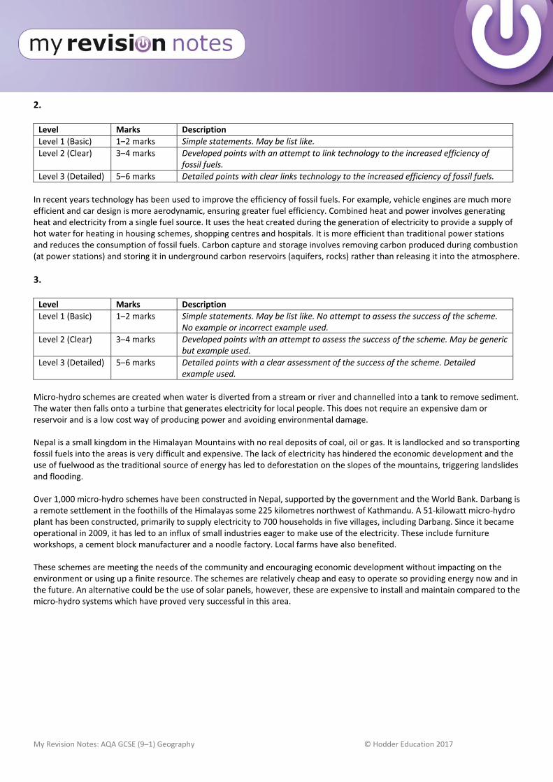
My Revision Notes: AQA GCSE (9–1) Geography © Hodder Education 2017
2. Level Marks Description
Level 1 (Basic) 1–2 marks Simple statements. May be list like.
Level 2 (Clear) 3–4 marks Developed points with an attempt to link technology to the increased efficiency of fossil fuels.
Level 3 (Detailed) 5–6 marks Detailed points with clear links technology to the increased efficiency of fossil fuels.
In recent years technology has been used to improve the efficiency of fossil fuels. For example, vehicle engines are much more efficient and car design is more aerodynamic, ensuring greater fuel efficiency. Combined heat and power involves generating heat and electricity from a single fuel source. It uses the heat created during the generation of electricity to provide a supply of hot water for heating in housing schemes, shopping centres and hospitals. It is more efficient than traditional power stations and reduces the consumption of fossil fuels. Carbon capture and storage involves removing carbon produced during combustion (at power stations) and storing it in underground carbon reservoirs (aquifers, rocks) rather than releasing it into the atmosphere.
3. Level Marks Description
Level 1 (Basic) 1–2 marks Simple statements. May be list like. No attempt to assess the success of the scheme. No example or incorrect example used.
Level 2 (Clear) 3–4 marks Developed points with an attempt to assess the success of the scheme. May be generic but example used.
Level 3 (Detailed) 5–6 marks Detailed points with a clear assessment of the success of the scheme. Detailed example used.
Micro‐hydro schemes are created when water is diverted from a stream or river and channelled into a tank to remove sediment. The water then falls onto a turbine that generates electricity for local people. This does not require an expensive dam or reservoir and is a low cost way of producing power and avoiding environmental damage. Nepal is a small kingdom in the Himalayan Mountains with no real deposits of coal, oil or gas. It is landlocked and so transporting fossil fuels into the areas is very difficult and expensive. The lack of electricity has hindered the economic development and the use of fuelwood as the traditional source of energy has led to deforestation on the slopes of the mountains, triggering landslides and flooding. Over 1,000 micro‐hydro schemes have been constructed in Nepal, supported by the government and the World Bank. Darbang is a remote settlement in the foothills of the Himalayas some 225 kilometres northwest of Kathmandu. A 51‐kilowatt micro‐hydro plant has been constructed, primarily to supply electricity to 700 households in five villages, including Darbang. Since it became operational in 2009, it has led to an influx of small industries eager to make use of the electricity. These include furniture workshops, a cement block manufacturer and a noodle factory. Local farms have also benefited. These schemes are meeting the needs of the community and encouraging economic development without impacting on the environment or using up a finite resource. The schemes are relatively cheap and easy to operate so providing energy now and in the future. An alternative could be the use of solar panels, however, these are expensive to install and maintain compared to the micro‐hydro systems which have proved very successful in this area.