Evaluation of the Opportunities and Challenges of Digitizing the
130
University of Pennsylvania ScholarlyCommons eses (Historic Preservation) Graduate Program in Historic Preservation January 2008 Evaluation of the Opportunities and Challenges of Digitizing the Practice of Conducting Field Surveys and Compiling Resource Inventories in the Preservation Profession Kimberly Diane Forman University of Pennsylvania Follow this and additional works at: hp://repository.upenn.edu/hp_theses A thesis in Historic Preservation Presented to the Faculties of the University of Pennsylvania in Partial Fulfillment of the Requirements of the Degree of Master of Science in Historic Preservation 2008. Advisor: David Hollenberg is paper is posted at ScholarlyCommons. hp://repository.upenn.edu/hp_theses/104 For more information, please contact [email protected]. Forman, Kimberly Diane, "Evaluation of the Opportunities and Challenges of Digitizing the Practice of Conducting Field Surveys and Compiling Resource Inventories in the Preservation Profession" (2008). eses (Historic Preservation). 104. hp://repository.upenn.edu/hp_theses/104
Transcript of Evaluation of the Opportunities and Challenges of Digitizing the

University of PennsylvaniaScholarlyCommons
Theses (Historic Preservation) Graduate Program in Historic Preservation
January 2008
Evaluation of the Opportunities and Challenges ofDigitizing the Practice of Conducting Field Surveysand Compiling Resource Inventories in thePreservation ProfessionKimberly Diane FormanUniversity of Pennsylvania
Follow this and additional works at: http://repository.upenn.edu/hp_theses
A thesis in Historic Preservation Presented to the Faculties of the University of Pennsylvania in Partial Fulfillment of the Requirements of the Degree ofMaster of Science in Historic Preservation 2008.Advisor: David Hollenberg
This paper is posted at ScholarlyCommons. http://repository.upenn.edu/hp_theses/104For more information, please contact [email protected].
Forman, Kimberly Diane, "Evaluation of the Opportunities and Challenges of Digitizing the Practice of Conducting Field Surveys andCompiling Resource Inventories in the Preservation Profession" (2008). Theses (Historic Preservation). 104.http://repository.upenn.edu/hp_theses/104

Evaluation of the Opportunities and Challenges of Digitizing the Practiceof Conducting Field Surveys and Compiling Resource Inventories in thePreservation Profession
AbstractAs technology advances, changes inevitably occur within the preservation community in the practice ofconducting field surveys and compiling and managing building inventories. The days of hand written formsand tedious data entry are passing as digital survey forms and hand held personal digital assistants (PDA's)make information compilation more efficient. Digital cameras simplify the process of capturing images andappending them to reports. Through the easy steps of pointing, shooting, uploading, and inserting, data issmoothly and clearly illustrated. With these advancements come both exciting possibilities and questions ofeffects. At this time, as the process of data compilation is changing, it is important as a professionalcommunity to reevaluate what it is we aim to achieve as we conduct surveys and compile inventories, andwhether and to what extent the evolving technologies are serving those goals.
CommentsA thesis in Historic Preservation Presented to the Faculties of the University of Pennsylvania in PartialFulfillment of the Requirements of the Degree of Master of Science in Historic Preservation 2008.Advisor: David Hollenberg
This thesis or dissertation is available at ScholarlyCommons: http://repository.upenn.edu/hp_theses/104

EVALUATION OF THE OPPORTUNITIES AND CHALLENGES OF DIGITIZING THE PRACTICE OF CONDUCTING FIELD SURVEYS AND COMPILING RESOURCE INVENTORIES IN THE PRESERVATION PROFESSION
Kimberly Diane Forman
A THESIS
in
Historic Preservation
Presented to the Faculties of the University of Pennsylvania in Partial Fulfillment of the Requirements of the Degree of
MASTER OF SCIENCE IN HISTORIC PRESERVATION
2008
Advisor David Hollenberg Lecturer Graduate Program in Historic Preservation School of Design University of Pennsylvania Program Chair Reader Frank G. Matero Judy Peters Professor of Architecture Lecturer in Historic Preservation

ii
Dedication This thesis is dedicated to Ray and Kathleen Forman, grandparents of the author. Without their love and support, attending the University of Pennsylvania, obtaining a master’s degree, and writing this thesis would not have been possible.
iii
Acknowledgements The author would like to thank David Hollenberg for his support, guidance and patience throughout the entire process of this thesis compilation. Thanks are due to Renee M. Hutter and Deborah Dobson-Brown of LopezGarcia Group for the internship that led to this thesis, and for their help in providing necessary documents and guidance. Lindsay Hannah of Goodwin & Associates provided information which made this thesis possible. Dominique Hawkins, AIA, of Preservation Design Partnership, and Judy Peters were invaluable resources throughout the thesis writing process. The author would also like to thank the various members of State Historic Preservation Offices across the country who responded to her calls for information. Elbert and Cheri Forman, Lauren Cortez, Heather Rozell and Thomas Wolfe provided an unending source of encouragement and dedication throughout the author’s graduate career and continue to humble her with their love and generosity.

iv
Table of Contents Introduction ………………………………………………………………… 1 Review of Existing Standards ……………………………………………. 11 Digitization Progress of Individual State Historic Preservation Offices ……………………………………… 21 Case Study Justification ………………………………………………….. 28 Case Study I: LopezGarcia Group ……………………………………... 38 Case Study II: Federal Emergency Management Agency/Goodwin & Associates ……………………... 46 Case Study III: Preservation Design Partnership ……………………… 56 Conclusion ………………………………………………………………….. 69 Bibliography ………………………………………………………………… 76 Appendix A: State by State Analysis of the Digitization Progress of Individual State Historic Preservation Offices ………….. 84 Appendix B: Survey Forms Used in Case Study Projects …………………………………………………......... 118 Index ………………………………………………………………………….. 122

1
Introduction
As technology advances, changes inevitably occur within the preservation
community in the practice of conducting field surveys and compiling and
managing building inventories. The days of hand written forms and tedious
data entry are passing as digital survey forms and hand held personal digital
assistants (PDA’s) make information compilation more efficient. Digital
cameras simplify the process of capturing images and appending them to
reports. Through the easy steps of pointing, shooting, uploading, and
inserting, data is smoothly and clearly illustrated. With these advancements
come both exciting possibilities and questions of effects. At this time, as the
process of data compilation is changing, it is important as a professional
community to reevaluate what it is we aim to achieve as we conduct surveys
and compile inventories, and whether and to what extent the evolving
technologies are serving those goals.
2
Currently, there are approximately 5 million historic properties and 500,000
survey reports included in State Historic Preservation Office (SHPO) inventories
nationwide. Over the last seventeen years the Historic Preservation Fund
(HPF)1 has provided over $150 million to SHPO’s to conduct archeological
and historical surveys. During these years, 1.8 million historic properties were
added to the SHPO inventories. These inventories are accessed and used by
SHPO staff, consultants, students, other state agencies, Federal agencies,
and the public.2 A significant amount of time and money is dedicated to the
survey process, and a broad range of the profession and the public depend
on the information in the resulting inventories.
This thesis reviews these efforts, towards a determination of whether
they have resulted in products worthy of the associated time, effort, and
money. Because the purpose of surveying is to gain information about an
area which enables us to make informed decisions about its future, attention
should be dedicated to ensuring the credibility and applicability of our
surveying process. The author identified issues and problems which she aims
to address through this thesis:
1 The Historic Preservation Fund is a grant program funded by the U.S. Congress
that provides matching grants to encourage private and non-federal investment in historic preservation efforts nationwide.
2 CRGIS, From Paper File to Digital Database, December 2007, available from http://www.nps.gov/history/hdp/standards/CRGIS/paper.htm; Internet; accessed 01 January 2008.

3
� No officially sanctioned nationwide standards for conducting digital
surveys exist which firms and practitioners can access when
planning the design of a survey form.
� Firms typically hire database managers or software specialists
(professionals unaffiliated with the preservation community) to
design their surveys. Disconnects frequently if not inevitably occur
between those who design the survey form, those who fill out the
survey form, and those who rely on the information of the resulting
survey report to make planning and management decisions.
� As digital devices and database managers make the surveying
process more and more efficient, what is being sacrificed? We as
humans have the natural desire to categorize, which resonates in
our profession as the desire to conduct surveys of districts and
produce inventories of buildings and sites. However, the nature of
our profession as preservationists is ephemeral and difficult to define.
We deal with values, which cannot be easily cataloged. As we
streamline the process more and more, are we venturing further
away from the “fundamental” nature and purpose of our field?
� Through the use of digital devices such as PDA’s and digital
cameras, we have the ability to link our survey data with Global
Information System (GIS) maps and interactive online documents.
While the potential to reach a greater portion of the public through

4
the accessibility of the internet presents an exciting opportunity, it
also presents challenges of coordination and integrity. How can we
be sure that the information we are producing is helpful, correct,
and understandable? Furthermore, how do we ensure that the right
information is reaching the proper audiences?
� While time is put into conducting field surveys, significant time and
thought must also be reserved for designing the survey form,
planning the survey process, and testing the survey tools (PDA’s,
digital cameras, manpower). The initial stages of design and
planning warrant more attention.
� How often are existing surveys updated? Who manages and checks
their content?
� As the survey process evolves from a paper based format towards a
digital format, what happens to inventories compiled prior to the
format change? What measures are being taken to convert these
paper-based, inaccessible inventories into a digital, accessible
format?
Such questions illustrate that the purpose of this thesis is to trace how data
collection and building inventorying has changed through the introduction of
digital technologies such as digital cameras and PDA devices; what resulting
practices and improvements are being implemented by firms, organizations,

5
and institutions throughout the country; and how the challenges and
opportunities of digitization are being addressed.
According to the National Register of Historic Places, the term survey “means
a process of identifying and gathering data on a community’s historic
resources.”3 This data is gathered through a field survey—“the physical
search for and recording of historic resources on the ground”4—which is
supplemented by planning and background research conducted prior to
the survey. The survey process results in an inventory, defined as an
“organized compilation of information on those properties that are
evaluated as significant.”5 Each of these steps—planning and background
research, field surveying, and compilation of an inventory—has seen the
effects of an ever-increasing accessibility of information, the interrelation of
multiple technologies and professional practices, and the digitization of
retrieving and compiling data.
Through the use of GIS software, data collected by historic preservationists
and architectural historians can be linked to data collected by city planners
and other professionals and practitioners. Once linked, this information can
be used to create interactive maps and documents. Furthermore, through
3 Derry, Anne et al. Guidelines for Local Surveys: A Basis for Preservation Planning.
(National Register Bulletin Number 24, 1977; revised 1985), 2. 4 Ibid. 5 Ibid.
6
the accessibility of the internet, these maps and documents can be posted
on city websites, making them accessible to city residents, visitors, scholars,
and consultants. A resident who accesses the city’s web page to find
information about building codes or zoning ordinances can also find
information about the history of his or her neighborhood. Visitors to a new
area can access the city’s website to find information about the city’s historic
resources. This has the potential to draw more tourism to historic areas.
Scholarly research can be supplemented as students and researchers are
given the ability to easily access information about the historic resources of
an area. The work of consultants can be facilitated in the same way, as
needed information is made more accessible.
Digital technology offers the opportunity to take information dissemination a
step further. While the ability to access a historic resource’s survey form,
photograph, and location on a map is helpful, the ability to access more
information about the resource is invaluable. Beyond survey information,
information such as historic photographs, original building documents, and
biographies of people associated with the historic resource can be linked to
the resource’s digital entry. Libraries, museums, archives, and other
institutions have made many documents available online. The internet allows
these documents to be linked to each other and to information on other
websites. By digitizing historic resource inventories, cities and states can utilize

7
material and information from other sources. In this way, a great deal of
information about the historic resources of a neighborhood, city, or state can
be made available to the public.
The City of Fort Worth, Texas participated in such a project. In the summer of
2007, the City of Fort Worth hired LopezGarcia Group, a civil engineering and
environmental planning firm based in Dallas, Texas, to conduct an intensive
architectural survey of four historic neighborhoods in the city. The proposed
five year project includes the investigation of over 4,000 residential buildings,
requiring consultation of city archives, the gathering of oral histories, and the
completion of field surveys. PDA’s were used by survey teams to quickly and
efficiently record data about individual houses, including information about
the history of the house, including the architect, contractor, and date of
construction; the physical characteristics of the house, such as building
footprint, number of stories, materials, and stylistic influence; and the historic
integrity of the house, including information about National Register of
Historic Places eligibility for individual properties.
This thesis includes case studies of survey projects such as this that rely on new
technologies utilized by firms, organizations, and entities across the country,
including LopezGarcia Group. The survey conducted by LopezGarcia Group
deals with surveys on a neighborhood level. A survey conducted in post-

8
Katrina New Orleans by Goodwin & Associates for the Federal Emergency
Management Agency (FEMA) deals with surveys conducted after a natural
disaster. A survey by the Preservation Design Partnership in Philadelphia deals
with surveys conducted on a city-wide level. The author selected each case
study so as to offer insight into specific challenges and opportunities relative
to digital survey practices.
Questions to be addressed include:
� By what means does the firm, organization, or entity conduct historic
surveys and compile building inventories?
� For what purposes are surveys conducted (local historic or
conservation districts, National Register districts, Section 106
compliance, public education, NEPA compliance)?
� How has the inclusion of digital technology changed the way in which
surveys are conducted?
� How much time is dedicated to designing survey forms and planning
the survey process?
� What qualifications are presumed to be necessary in order to utilize the
forms?
� What information and relevance has been gained or lost through the
conversion to a digital format?

9
� When surveys are conducted, who is involved in the process? Does
the firm seek assistance or advice from other professionals such as city
planners, GIS specialists, database managers, or community
representatives?
� In what ways is the completed inventory made accessible to the
public?
� Does the public have the opportunity to offer feedback in any way?
To answer such questions, interviews with firm members, project partners, and
clients involved in the survey projects were conducted, and objectives and
deliverables were assessed with the intent of gathering and comparing
information to determine the best practices occurring throughout the
country. Issues which have been overlooked and which beg attention were
also identified. In addition to these focused case studies, effort was made to
contact the SHPO in each state to gain an understanding of the current
survey and inventory practices and future plans of each. This information led
to an understanding of how each state is tackling the challenges of evolving
from a paper-based office to a digital office. Information was also gathered
which identified how technology has enabled SHPO’s to more easily conduct
surveys, to more responsibly manage information, and to more fully make
information about historic resources available to professionals and to the
public. Background research was aided by National Register bulletins

10
addressing guidelines for evaluating and documenting historic structures.6
Books and articles addressing the interdisciplinary relationship of historic
preservation and other professional practices, the documentation of historic
structures, and the relevance and effects of architectural surveys were
referenced.
This thesis is written from the perspective of a user. The author does not claim
to be a technology expert, nor does she claim to have a full understanding
of the opportunities available through digital technology. This purpose of this
thesis is not to offer solutions to the design of digital software or digital
programs. Rather, the purpose is to offer insight into practical ways in which
digital technology can best be incorporated into the practice of conducting
field surveys and compiling resource inventories.
The field surveys and building inventories that are the subject of this thesis are
absolutely fundamental to the practice of historic preservation. They are,
when done correctly, an irreplaceable resource. According to the National
Register of Historic Places,
From the standpoint of opportunities, survey data can be used to identify the historic contexts and their constituent elements—
6 Historic Residential Suburbs: Historic Guidelines for Evaluation and
Documentation for the National Register of Historic Places and Guidelines for Local Surveys: A Basis for Preservation Planning National Register Bulletin and Guidelines for Local Surveys: A Basis for Preservation Planning. National Register Bulletin Number 24.

11
buildings, streetscapes, building uses, cultural activities, and other resources—on which community development can build in order to make the most of the community’s unique historic qualities. Ideally, development planning should use survey data to identify opportunities for the use of the community’s historic character in creating its future, to minimize conflicts between preservation and development, and to provide for the orderly resolution of those conflicts that inevitably occur.7
By involving city planners, historic preservationists, local government
administrators, community-based preservation organizations, members of
preservation commissions, developers, Federal and State agency officials,
and other interested persons, the practice of property inventorying can gain
significant power and relevance. However, as we streamline the process
and involve more parties, we must not lose sight of the initial and
fundamental purposes of our profession. Through a greater understanding of
what is made possible by existing technology and what is being
accomplished and potentially overlooked by firms, organizations, and
institutions across the country, conclusions can be drawn which have the
potential to inform and instruct other practitioners.
7 Derry, Anne, 65.
12
Review of Existing Standards
The following is an overview of existing guidelines and standards regarding
the practice of recording and documenting historic resources. Each
guideline addresses measures that must be taken and standards that must
be upheld while conducting paper-based survey projects. Currently, no
standards exist regarding measures that must be taken when conducting
survey projects which utilize digital technology.
Secretary of the Interior’s Standards for Historical Documentation, 1983
The Secretary’s Standards address documentation as a “treatment” for
historical properties that lays the groundwork for further treatments, such as
rehabilitation plans or interpretive programming. Because documentation is
considered a treatment, the plan for the process must be outlined clearly
and followed closely. Furthermore, the product of the documentation
process must be understandable to future researchers.

13
Standard I: Historical Documentation Follows a Research Design that
Responds to Needs Identified in the Planning Process
The needs of the project must be identified and addressed specifically in the
research design. The research design is intended to create a guide for
methodology and evaluation.
Standard II: Historical Documentation Employs an Appropriate Methodology
to Obtain the Information Required by the Research Design
Efficiency is the most important consideration when methods and techniques
are considered. Consulted sources must be identified so that future
researchers can locate the information themselves.
Standard III: The Results of Historical Documentation Are Assessed Against the
Research Design and Integrated Into the Planning Process
The research process yields two products: documentation and information
concerning the effectiveness of the research design. Once this information is
gathered, the results of research must be assessed against the research
design, and then incorporated into the existing body of knowledge in order
to assess their implications for the planning process.
14
Standard IV: The Results of Historical Documentation Are Reported and Made
Available to the Public
The results of the process must be accessible to potential researchers. Both
the professional community and the public at large must be informed
through the availability of completed reports. The availability of this
information must be considered in relation to the possibility of undertaking
actions that could affect properties discussed in the report.8
Secretary of the Interior’s Standards for Architectural and Engineering
Documentation, 1983
These Standards address the compilation of documentation for historic
buildings, sites, structures and objects. Documentation typically includes
measured drawings, photographs and written data, and is meant to be easily
accessible for researchers, scholars, preservationists, architects, engineers
and other members of the public interested in historic properties.
Documentation may also offer information about a property that is to be
demolished. The standards are meant to be used by parties developing
documentation for the Historic American Building Survey (HABS) and the
Historic American Engineering Record (HAER) collections in the Library of
Congress.
8 National Park Service, Secretary of the Interior’s Standards and Guidelines for
Historical Documentation. 2007, available from http://www.nps.gov/history/local-law/arch_stnds_5.htm; Internet, accessed 28 September 2007.

15
Standard I: Documentation Shall Adequately Explicate and Illustrate What is
Significant or Valuable About the Historic Building, Site, Structure or Object
Being Documented.
Drawings, photographs, and other forms of documentation should convey
the historic significance of the building, site, structure or object of the project.
The values of the property, including historical, architectural, engineering or
cultural, should determine the level and methods of documentation. The
HABS/HAER Guidelines must also be met.
Standard II: Documentation Shall be Prepared Accurately From Reliable
Sources with Limitations Clearly Stated to Permit Independent Verification of
the Information.
An accurate record of historic properties is created only when
documentation includes information that allows for assessment of its validity.
Standard III: Documentation Shall be Prepared on Materials that are Readily
Reproducible, Durable and in Standard Sizes.
Standard IV: Documentation Shall be Clearly and Concisely Produced.
The future usefulness of information depends on the ability of future
researchers to access and understand the documentation products. 9
9 National Park Service, Secretary of the Interior's Standards and Guidelines for
Architectural and Engineering Documentation, 2007, available from

16
Historic American Buildings Survey and Historic American Engineering Record
Standards, 1983 [reissued 1990]
The HABS/HAER Standards provide guidelines for producing measured
drawings, large format photographs, and written histories to be included in
the Historic American Building Survey and/or the Historic American
Engineering Record. Once compiled, these reports are made available to
the public through the Library of Congress.
The American Institute of Architects, the American Society of Civil Engineers,
and the other engineering societies provide technical guidance to compilers
of the reports. The standards are intended for use in creating mitigation
documentation in accordance with the National Historic Preservation Act of
1966, as amended, in creating documentation to be donated to the
HABS/HAER Collection, and in creating documentation as a part of a
HABS/HAER recording project.
The Standards incorporate the Secretary of the Interior’s Standards for
Architectural and Engineering Documentation and add a section on
definitions which clearly articulate what is included in a HABS/HAER recording
project. No mention is made concerning who can or cannot participate in
projects, but the standards do mention that the National Park Service often http://www.nps.gov/history/local-law/arch_stnds_0.htm; Internet; accessed 28 September 2007.

17
employs summer teams of student architects, engineers, historians and
architectural historians who conduct their work under the supervision of
National Park Service professionals. Requirements for each project are as
follows:
Standard I: Content
The value of the historic building, site, structure or object being documented
must be clearly stated. Various levels of documentation are acceptable,
and should directly relate to the nature and significance of the historic
building, site, structure, or object being documented, with level I signifying
the highest level of significance. At documentation level III, an architectural
data form is acceptable as the written data portion of the project. At
documentation level IV, a HABS/HAER inventory card is the only product of
the project. Once a project is completed, the HABS/HAER staff inspects it
and offers comments.
Standard II: Quality
The finished product must be prepared correctly from reliable sources. Any
limitations encountered during the process should be clearly stated.
Standards for measured drawings, large format photographs, and written
histories are given.

18
Standards III and IV: Materials and Preservation
Ease of reproduction, storage and handling must be considered. Specific
requirements are given. It is explicitly stated that all HABS/HAER records are
intended for reproduction, with the intent to make information readily
available, standardized, and easily understood.
The standards state that HABS/HAER criteria may be used as a resource for
creating requirements for other inventories. Accuracy, availability, and
usefulness of documentation are addressed.10
Cultural Resources Geographical Information System Facility Guidelines
The Cultural Resources Geographical Information System (CRGIS) Facility,
created in 1989, is a division of the National Park System. The mission of
CRGIS is to institutionalize the use of Global Information Systems (GIS), Global
Positioning Systems (GPS), and Remote Sensing technologies in historic
preservation within the National Park system and within State Historic
Preservation Offices (SHPO) and Tribal Historic Preservation Offices (THPO).
CRGIS proposed an increase in the Historic Preservation Fund by $5 million a
year for five years, in order to automate existing state historic resource
inventories through computerized databases or geographic information
systems. Automation of these records would “produce significant proactive
10 Historic American Buildings Survey/Historic American Engineering Record Cultural Resources Program. HABS/HAER Standards. (Washington, D.C.: National Park Service, 1983 [Reissued 1990]), 4.
19
planning measures, reduce costs to Federal agencies engaged in regulatory
activities, allow data sharing across state and local boundaries, and increase
public access to historical sites.”11 With necessary funding achieved, full
automation of existing inventories will occur in fifteen years. However, if
funding is not received and automation does not occur, CRGIS argues that
the search and retrieval times of paper-based inventories will be
unacceptable to most regulatory environmental review processes, including
NEPA, historic preservation review processes such as Section 106, and their
state and local equivalents, resulting in the “inadvertent loss of historic
resources, increased expenditures on surveys, fewer nominations to the
National Register, and an inability to respond to disasters.”12 Inventory
automation is thus the key to preservation’s future.
The National Park Service has charged CRGIS with the task of developing
standards for the collection, management, and distribution of cultural
resource spatial data. These standards address the need for accurate
locational information in relation to GIS mapping. CRGIS states that, “there is
no umbrella organization of methodology for linking all the various cultural
11 CRGIS. From Paper File to Digital Database, December 2007, available from
http://www.nps.gov/history/hdp/standards/CRGIS/paper.htm; Internet; accessed 01 January 2008.
12 CRGIS. From Paper File to Digital Database. December 2007, available from http://www.nps.gov/history/hdp/standards/CRGIS/paper.htm; Internet; accessed 01 January 2008.

20
resource databases together.”13 Currently, each cultural resource database
operates independently and cannot be integrated into a single database.
However, through GIS, each database can be accessed through locational
data. A single point on a map can link information from various databases.
However, to date, locational data presents a problem in and of itself. It is the
weakest element across the board for all cultural resource databases. If
locational data (such as a single point on a map consisting of geographic
coordinates) is used to link databases together, care must be taken to ensure
that the linked data is clean. Standards would ensure that data is gathered
consistently—across varying disciplines and databases. Unfortunately, no
standards exist to ensure that coordinates are collected when surveys are
administered. CRGIS is addressing this problem through its efforts to create
standards that will generate consistent and accurate locational data.
While these efforts are pertinent, standards for conducting field surveys and
compiling resouce inventories must also be examined. At this time, as the
practice of data compilation is advancing, and as new technologies create
further educational opportunities for the field of historic preservation, the aim
of our surveys and inventories must be reevaluated. Currently, standards do
13 CRGIS. Critical Nature of Spatial Data in Cultural Resource Management.
December 2007, available from http://www.nps.gov/history/hdp/standards/CRGIS/spatial.htm; Internet; accessed 01 January 2008.

21
not exist which specifically address how digital survey forms are created, how
digital surveys are conducted, or how digital inventories are managed. With
no existing guidelines, we run the risk of generating information that lacks real
value and applicability. Standards must be created which address both the
opportunities and challenges of conducting surveys and managing
inventories in the digital age.
22
Digitization Progress of Individual State Historic Preservation Offices
Professionals across the country are making progress towards incorporating
digital technology into various aspects of the field of historic preservation. To
gain an understanding for this thesis of the progress that is being made by
individual state agencies to digitize the process of conducting field surveys
and compiling resource inventories, efforts were made to contact the State
Historic Preservation Office (SHPO) of each state. After a contact person was
identified, questions were asked via phone or email to determine how and to
what degree digital technology is being utilized in each office, and in
accordance with which standards and requirements.
Various members of SHPO’s, including state historic preservation officers,
survey coordinators, database administrators, architectural historians, and
state archaeologists provided information in response to the following series
of questions that were e-mailed to each office:
23
� Does the SHPO provide a general survey form that can be used by
preservationists and other consultants who are conducting field surveys
in the state? If so, are these forms considered the standard by which
state organizations, firms, etc. conduct their survey work?
� Are historic surveys conducted within the state done in a digital format
(utilizing PDA’s, digital cameras, and GPS devices?) If not, what is the
format currently employed?
� Does the state have a statewide historic register? If so, is it digitized
(contained in a searchable database)? If so, is it available online?
� If the statewide register is not digitized, is it in the process of being
digitized? How complete is the digitization process (percentage of
completeness)?
� Are there other historic resources inventories the state is working to
digitize?
� Does the SHPO have a GIS department? Please describe the
interrelatedness of the GIS department and the department
responsible for surveys and inventories. Is inventory data linked to GIS
layers? If so, are these maps accessible online?
Information acquired from the dissemination of these questions was then
streamlined and organized to address the main issues about which the
author aimed to gather information:

24
� Does the SHPO provide a general form to surveyors and is it considered
a standard form?
� Are these forms modifiable to suit specific survey needs?
� Are surveys conducted utilizing PDA’s, digital cameras, and GPS
devices, or is data collected on paper?
� Is the inventory of surveyed resources contained in a searchable
database?
� Does the SHPO have a GIS department?
� Does the public have access to information about surveyed
properties?
Responses were then assessed to determine which states are employing the
best practices for conducting field surveys and compiling historic resource
inventories. The general findings are as follows:
Interactive Databases
While not all SHPO’s have made their state register or inventory information
available online, most have this information contained in a searchable
database. SHPO’s identified as the most digitally progressive have created
databases that enable an interactive process between offices and surveyors.
For example, the Oregon SHPO has entered all of the state’s National
Register and surveyed properties into the Oregon Historic Sites Database, a
25
Microsoft Access database that contains over 40,000 surveyed properties in
Oregon. When surveyors begin an individual project, the Oregon SHPO
produces a customized database for the project. The customized database
is then uploaded to a secure file transfer protocol (FTP) site where it can be
accessed by the surveyors. From this database, survey forms can be
generated and printed for use in the field. If a record exists in the master
Oregon Historic Sites Database for a property that is in the survey project
area, the information not recorded in the master database will appear on
the form. From this, the surveyor can essentially check and edit any pre-
existing data that may no longer be correct. For example, if a house in the
master database has a listed construction date of 1910, this information is
printed on the form for the surveyor. If the surveyor finds the same house and
realizes that the house was actually constructed in 1930, this information can
be recorded and updated in the database. If a property has not been
previously recorded through survey work, the surveyor simply records the new
information. After fieldwork is completed, the forms are entered into the
custom database. When the data entry is completed, the entire database
(survey information, photos, maps, etc.) is submitted back to the SHPO and
uploaded into the master database. In this way, the master database is
easily updated and checked for accuracy, and remains consistent across

26
the state.14 Washington,15 Florida16 and Kansas17 SHPO’s have incorporated
similar systems.
One Person/Outsourced GIS Departments
Most SHPO’s do not have GIS departments. Among those that do, many
departments consist of one person, usually with minimal training in GIS
software and/or a job description which does not include performing GIS
operations. Many SHPO’s, such as the Oklahoma SHPO, that do not have GIS
departments utilize the skills and labor of students at nearby universities. The
Oklahoma SHPO works with the Oklahoma State University’s Department of
Geography to complete GIS projects.18
Standard and Suggestive Forms Provided
Most SHPO contacts indicated that a standard form is provided and required
for Community Land Grant and Section 106 surveys, while a suggested,
modifiable form is provided for other survey needs.
14 Kaser, Cara L., Architectural Historian, National Register Program, Oregon State
Historic Preservation Office, “Re: Information Needed for Thesis Research,” 2 April 2008, email to author.
15 Duvall, Megan, Certified Local Government Coordinator and Survey Program Manager, Washington Department of Archaeology and Historic Preservation, “Re: Information Needed for Thesis Research,” 2 April 2008, email to author.
16 Birdsong, Vince, Supervisor/Database Administrator, Florida Master Site File, Division of Historical Resources, “Re: Information Needed for Thesis Research,” 2 April 2008, email to author.
17 Meives, Caitlin, Survey Coordinator, Kansas State Historical Society, “Re: Information Needed for Thesis Research,” 14 April 2008.
18 Gaston, Kelli E., Oklahoma State Historic Preservation Office, “Re: Information Needed for Thesis Research,” 3 April 2008, email to author.
27
Experimental Electronic Survey Projects
Some states, including Indiana, are conducting experimental surveys which
utilize PDA’s and other digital equipment.19 These surveys are conducted to
determine the best methodology for incorporating digital technology into the
survey practice. Further information about such experimental projects is
described in Case Study III.
Best Practices
Washington, Florida, and Kansas SHPO’s have completed robust geospatial
databases that link all the data maintained by their offices. External users,
including federal and state agencies, local units of government, universities,
private firms, tourists, students, etc., can use easily and, if need be, integrate
into their own datasets. SHPO’s that have created such databases utilize
digital devices such as PDA’s, digital cameras, and GPS devices to expedite
the survey process. These SHPO’s also have substantial GIS departments,
consisting of multiple staff persons trained in GIS software who are solely
responsible for GIS projects.
More specific information concerning the digitization progress and survey
practices of individual states can be found in Appendix A.
19 Diebold, Paul C., Team Leader, Survey and Registration, Indiana Division of
Historic Preservation and Archaeology, “Re: Information Needed for Thesis Research,” 15 April 2008, email to author.

28
Case Study Justification
In choosing case studies, issues of structures and sites surveyed, field survey
location, and the timeline of projects were considered. This thesis addresses
the stages of planning, design, and implementation through analysis of field
surveys conducted by three different organizations in three different areas of
the country, each with different degrees of guidelines accessed,
cooperation garnered, areas surveyed, and intention planned. Each of the
projects began no more than five years ago and has a projected time span
of at least four years. Field survey locations of the projects represent three
areas of the country: the Southwest, the Southeast, and the Northeast.
Questions to be addressed in each case study include:
� Logistics
By what means does the firm conduct historic surveys and compile
building inventories? Does the firm utilize a survey form provided by the
29
State Historic Preservation Office (SHPO)? Is this form utilized in a digital or
paper format? Is information gathered during the survey uploaded into a
searchable database? If so, is this database linked to other information
such as a Geographic Information System (GIS)? Is any of this information
made available to other professionals or to the public?
� Planning and Preparation
How much time is dedicated to designing survey forms and planning the
survey process? Is the design of the survey form done by members of the
survey team, or are database designers contracted to provide the
service? Who is involved in the survey form design process?
� Involvement
When surveys are conducted, who is involved in the process? Does the
firm seek assistance or advice from other professionals such as city
planners, GIS specialists, database managers, or community
representatives? Are survey projects considered an interdisciplinary
collaborative, or are they conducted by one department to serve the
purposes of that department only?
30
� Qualifications
What qualifications are presumed to be necessary in order to utilize the
forms? Are surveys conducted by trained professionals or by volunteers?
Must team members and/or volunteers undergo any training in order to
participate in the survey process?
� Intention
For what purposes are surveys conducted (local historic or conservation
districts, National Register districts, Section 106 compliance, public
education, National Environmental Policy Act (NEPA) compliance)? Does
a specific purpose necessitate a specific form, or is a general form
adapted to serve the needs of the survey project?
� Inclusion of Digital Technology
How has the inclusion of digital technology changed the way in which
surveys are conducted? Does the inclusion of digital technology speed
up the process of conducting surveys, or does the learning curve cancel
out any potential time savings? Must more time be committed to training
employees, volunteers, and contractors who utilize digital technology?
During which portions of the project is digital technology used? Are PDA’s
and digital cameras used during the survey process? Are GIS linked
databases created during the report compilation process?
31
� The Benefits of Going Digital
What information and relevance has been gained or lost through the
conversion to a digital format? Can the same information gathered
during a paper-based survey be gathered during a digital survey that
utilizes PDA’s and Microsoft Access databases? Does the streamlining of
the process compromise the validity of the information gathered during
the survey process?
� Public Benefit
In what ways is the completed inventory made accessible to the public?
Can the public access any or all of the information online? Is the
information linked to maps and other information, or is the information
gathered during the survey process the only information that the public
can access? Are there levels of accessibility? Can preservation
professionals and other consultants access information that the public
cannot?
Through each case study, this thesis offers insight into what firms,
organizations, and institutions are doing across the country. Through the
analysis of information gained in the case study process, this thesis identifies
both the best practices currently utilized and the specific needs that must be

32
addressed through the drafting of standards for conducting surveys and
compiling inventories in the historic preservation profession.
Case Study I LopezGarcia Group Survey of Fort Worth, Texas Neighborhoods Through research of this survey project, the author gained insight into the
planning, design, implementation, and analysis of a residential survey. Over
4,000 structures were surveyed for the project, the majority of which are
residential structures. The project thus presents the opportunity to gain
deeper information and understanding about a single building type in a
specific location.
In the summer of 2007, the City of Fort Worth hired LopezGarcia Group, a civil
engineering and environmental planning firm based in Dallas, Texas, to
conduct an intensive architectural survey of four historic neighborhoods in
the city. Virtually all of the structures surveyed during the project are
residential, so this case study offers the opportunity to explore a survey that is
in essence focused on a particular building type.
The project is proposed to span five years. Tasks of the project include the
consultation of city archives, the gathering of oral histories, and the
completion of field surveys. PDA’s were used by survey teams to quickly and
efficiently record data about individual houses. This data includes

33
information about the history of each structure, including the architect,
contractor, and date of construction; the physical characteristics of the
house, such as building footprint, number of stories, materials, and stylistic
influence; and the historic integrity of the house, including information about
National Register of Historic Places eligibility for individual properties.
Specific issues to be addressed by this case study include the following:
� Because this survey is building type specific, was special care taken to
create a survey form that would result in deeper or wider information
gained about individual resources?
� If so, were surveyors trained to recognize the architectural styles
prevalent at the time of each neighborhood’s construction?
Case Study II FEMA/Goodwin & Associates Demolition Survey and National Register of Historic Places Re-Survey of Historic Structures in Post Katrina New Orleans, Louisiana Through research into this survey project, the author gained insight into the
planning, design, implementation, and analysis of a post-disaster survey. This
survey project spans many years, and presents a case in which the surveyed
buildings and sites are rapidly changing: some are exhibiting progressively
worsening conditions, while others are undergoing repairs. Also, the overall
context of these structures is undergoing dramatic changes as people return
to their homes and the city is reclaimed.
34
Lindsay Hannah, the contact person associated with the project, works for
Goodwin & Associates, a planning and compliance firm based in New
Orleans, Louisiana, and in cooperation with the Federal Emergency
Management Agency (FEMA) and the National Park Service to survey historic
structures affected by Hurricane Katrina in New Orleans. The survey analyzed
for this case study was developed by the National Park Service as part of its
efforts to develop a survey that can be applicable nationwide in post-
disaster situations. This case study thus presents the opportunity to address
such issues as the coordination of multiple parties in survey planning, design,
implementation, and analysis; the efficiency that digital formats offer in
regards to revising and editing the process of data collection; specific
measures that must be taken when structures and sites being surveyed are
significantly damaged; and the possibility of creating a standard survey form
that can be utilized nationwide in post-disaster situations.
Specific issues to be addressed by this case study include:
� How many different companies, organizations and institutions are
involved in the process, from survey planning, design, implementation
and analysis? Does the involvement of a broad range of practitioners
and organizations make things more difficult, or do things run more
smoothly when different tasks are assigned to different groups?
35
� Has the survey form designed by the National Park Service been
revised in response to field conditions? Do surveyors find revisions
easier to carry out since data is collected and stored digitally?
� What measures were taken during the planning process and through
the extent of the survey to address the fragility of the structures and
sites being surveyed?
� Can a generic survey form be utilized nationwide, or do site-specific
factors require a more individualized approach?
Case Study III Preservation Design Partnership/Preservation Alliance of Greater Philadelphia Parkside Historic District Nomination and City-wide Survey of Philadelphia, Pennsylvania Dominique M. Hawkins, AIA, the contact person for this case study, is the
principal architect of the Preservation Design Partnership in Philadelphia,
Pennsylvania, a preservation and architectural design consulting firm that
specializes in historic preservation, restoration, adaptive reuse, renovations,
and evaluations of buildings, sites, and districts. Hawkins was recruited by
John Gallery, Executive Director of the Preservation Alliance of Greater
Philadelphia, to participate in the Alliance’s project to develop a fully digital
historic resources survey methodology for the City of Philadelphia. The
project involved many participants, including preservation and design
professionals and graduate students and faculty from the University of
Pennsylvania’s School of Design.

36
Hawkins is familiar with the issues, challenges, and opportunities presented by
the inclusion of digital technology in the practice of surveying historic
resources. She and other professionals worked to complete a survey project
which was used as an experiment in which a methodology for implementing
digital technology in survey practices was developed. The survey project
was conducted in order to prepare a Philadelphia Historic District Nomination
for the Parkside neighborhood of Philadelphia.
This case study presents the opportunity to understand how a methodology
developed for a small scale neighborhood survey can be adapted and
expanded to respond to the needs of a large scale city-wide survey. The city
of Philadelphia presents many survey challenges, which are further
complicated as digitization is implemented throughout the survey process.
Specific issues to be addressed by this case study include:
� Can the same methodology developed for a small scale survey
project be used for a larger scale project?
� What modifications must be made to adapt the methodology to
respond to the needs of a larger scale project?
� What is the best way to design a city wide survey? What steps must be
taken, and in what order?

37
Through analysis of each case study, information was gained regarding the
specific issues, challenges, and opportunities presented by the inclusion of
digital technology in the practice of conducting surveys and compiling
resource inventories.

38
Case Study I Firm: LopezGarcia Group, Dallas, Texas Contact: Renee M. Hutter, Architectural Historian Project: Survey of Neighborhoods in Fort Worth, Texas Project Timeline
In January of 2007, the City of Fort Worth sent out a request for proposals for a
project involving the survey and documentation of four historic
neighborhoods in Fort Worth, Texas, to be used as a planning tool for
development of the city and as a vehicle for public education. LopezGarcia
Group, an engineering design and environmental planning firm located in
Dallas, Texas, was awarded the project in July of the same year. Kick off
meetings, archival research, and research design submission began soon
after the project was awarded. Field work began in September 2007 and
continued until January of 2008. Once field work was completed, the report
assessment and preparation began. Compilation of the report included
survey form preparation, historic context preparation, and gathering of all
materials for appendices. LopezGarcia Group presented the first draft of the
report to the City of Fort Worth in March 2008.
39
Involvement
Three entities were involved as part of the consultant team in the multiple
stages of the project: LopezGarcia Group, Cornerstone Historic Preservation
Services, and Susan Kline, a local historian. LopezGarcia Group and
Cornerstone were responsible for all fieldwork. Susan Kline was responsible for
conducting archival research and writing historic context reports. Analysis
and final report compilation was done by LopezGarcia Group.
Survey Process
LopezGarcia Group utilized a digital format for conducting all of the project’s
historic resource surveys. PDA’s, digital cameras, and GPS units are used to
input data, obtain images, and correctly identify the location of each
resource surveyed. The database and survey form were modified from a pre-
existing form provided by the State Historic Preservation Office. The digitized
form worked to guide the surveyor through the documentation process with
a series of easy to follow tasks:
1. Assign a field number to the resource
2. Identify the address of the property
3. Estimate dates of construction for the resource
4. Identify type of resource
5. Take digital photographs of each resource

40
6. Record photographs on a separate log and enter the data into the
PDA
7. Identify architectural styles
8. Record basic and prominent features of each resource
9. Assess condition of resource
10. Evaluate integrity of resource
11. Evaluate whether the resource contributes to a potential historic district
LopezGarcia Group spent time during the planning process to devise a
methodology for modifying the survey forms and for surveying the
neighborhoods. The team of surveyors thought carefully about what data
needed to be included in each form and what would be the best way to
record all necessary information. Efficiency and cohesion were the main
forces guiding the planning process. While the use of digital technology was
available to streamline the process, consideration was paid to the issue of
collecting data that was meaningful, understandable, usable, and
accessible to professionals, researchers, and the public.
As a requirement, surveyors participating in the project hold master’s degrees
in fields related to historic preservation, such as architecture, architectural
history, or historic preservation. While the survey teams spent time designing
and revising the forms and using the technology to familiarize themselves with
41
the project and the process, the real test of the form’s applicability and the
technology’s usefulness came when surveyors entered the field.
Assessment
The contact person for this survey, LopezGarcia Architectural Historian Renee
M. Hutter, attests that the collaboration of multiple entities, including
environmental planning and design firms such as LopezGarcia Group, historic
preservation consultant firms such as Cornerstone Historic Preservation
Services, and outside consultants such as local historians, meant less work in
some areas but more work in others. More surveyors enabled more individual
resource surveys to be completed in less time. However, with surveyors’
education and experience influencing their opinions on the style,
significance, and characteristics of each resource, conflicting ideas
inevitably arose. Those conflicting ideas revealed themselves on the
completed survey forms, as different terminology was used to describe the
same feature, or as resources of similar significance were ranked higher by
one surveyor and lower by another. Differences in opinion during the survey
process meant more work at the end of the project, during the report
compilation process. Assimilation of the information into a coherent form
and final document required editing of previously recorded data. The main
surveying process was completed quickly, but editing of data required
extensive attention and time. In her next project, Ms. Hutter plans to establish
42
an agreement among all surveyors on the proper terminology to use, the
items worthy of mention during the survey process, and the proper
methodology for the project as a whole before field work begins. She
believes that by doing so, issues that arose at the end of the Fort Worth
neighborhoods project can be mitigated.
The Form in the Field
The survey form was not revised during the field survey portion of the project.
Revisions and additions were noted, and will be used to improve forms used
in future projects. Ms. Hutter stated that altering the form mid-project may
have caused confusion among surveyors and difficulty in correctly aligning
database information. Problems that arose during the survey process were
used to inform and guide preparation for the next project.
The Digital Advantage
Ms. Hutter stated that the digital process has made it easier to perform
surveys in the field, and quicker to compile information for reports. Previously,
surveyors would use paper survey forms in the field, return to the office in the
afternoons, and enter information from each form into a database. The cost
and time needed to develop hard copy photographs and append them to
reports was an issue before the conversion to a digital format was made.
With digital cameras, photographs can easily be uploaded and appended
43
to project documents. While working with a paper based format, Ms. Hutter
was able to survey approximately 35 resources a day. With the efficiencies of
digital technology, that number was increased to over 70.
Ms. Hutter believes that more information will be gained during future survey
projects through the conversion to a digital format. If the same survey can
be performed in less time, she states, more time can be spent gathering other
field information or deeper historic context documentation. The digital
process will allow more resources to be surveyed, and more time to be spent
on other areas of the project, thereby providing the opportunity to complete
more complete surveys in less time.
Public Benefit
The City of Fort Worth plans to make the completed surveys available to the
pubic through online. If plans succeed, users will be able to access
information about the surveyed neighborhoods through the City of Ft. Worth’s
website. The neighborhood website will direct users to an aerial view of the
surveyed neighborhoods. Once there, users will be able to click on certain
areas of the neighborhoods and zoom to specific resources to access the
survey forms, historic documents, and photographs of each surveyed
resource.

44
Conclusion
This project illustrates the opportunities that the inclusion of digital technology
offers, and the many challenges that converting to a new format presents.
While the use of digital technology such as PDA’s aids the process of
conducting surveys, these devices also change the way in which surveyors
must address the project. When time is spent during the planning stages to
ensure that all team members understand the format and individual fields of
the survey form, confusion and incompatible data is less likely to arise during
the inventory assembly stage of the project. Once the form is designed and
uploaded onto the PDA’s that will be used for the project, survey team
members must assemble to familiarize themselves with the format and to
agree on the terminology that will be used to describe resources and the
rating systems that will be used to rank the significance of the resources.
Once these measures have been outlined and agreed upon, they must be
adhered to by each survey member throughout the entirety of the project.
Regular coordination to ensure that these measures are upheld throughout
the project is essential.
The survey of neighborhoods, both in this project and others, presents a
wonderful opportunity for pubic involvement and benefit. Neighborhood
residents, city residents, and visitors alike can benefit from the information
gathered during the project. These members of the public can also add

45
another level of information about the resources that may not be have been
gained during the survey project. By giving the public an opportunity to
share their information and add to the project, not only is the history of the
resources more fully understood, but a connection between people and
places is also made. While the main reason for the Ft. Worth Neighborhoods
project was to provide information to the City of Ft. Worth, the project could
be taken further. Information could be provided to the people of Ft. Worth
and those interested in the city and its historic resources. These people could
also contribute to depth and validity of the project by providing their own
information about the city and its historic resources.

46
Case Study II Agency/Firm: FEMA/Goodwin & Associates Contact: Lindsay Hannah, Historic Preservation Specialist, Goodwin & Associates Project: Demolition Survey and National Register of Historic Places Re-Survey of Historic Structures in Post Katrina New Orleans, Louisiana Project Timeline
Following the devastation of Hurricane Katrina in August of 2005, the Federal
Emergency Management Agency (FEMA) began planning and developing
an extensive survey project to identify and document damage and
destruction incurred by historic resources and other properties as a result of
the storm. Following the storm, home owners who assessed the damage
caused to their property and who made the decision to have the structures
on their property demolished were required to contact their local
government to inform them of the decision to demolish. The local
governments then compiled lists of properties requiring demolition which
were identified by owners. These lists were then sent to the FEMA. FEMA then
forwarded the lists to planning and compliance firms who served as survey
contractors, and who handled all responsibilities associated with the survey
and documentation of listed properties. These surveys are necessary for
47
Section 106 compliance and are one of approximately 15 steps property
owners must undergo before demolition is approved.
By November of 2005, survey teams comprised of planning and compliance
firm members from Goodwin & Associates, Coastal Environments, Inc., and
EarthSearch, Inc., were organized to conduct the demolition survey of
damaged structures in the Lower Ninth Ward in Orleans Parish, Louisiana. The
project spread to include neighboring St. Bernard, Plaquemines, Jefferson, St.
Tammany, and Washington Parishes. The demolition survey is still in the
process of completion, although the majority of data has been collected.
In January 2007 a National Register of Historic Places (NRHP) resurvey began
in New Orleans. Resurveys are conducted in previously surveyed and
designated historic districts that have been adversely affected by natural
disasters, demolition, etc. This project is also in the process of completion.
The survey teams now alternate between the two surveys as needed, with
the demolition survey always taking priority over the historic district survey. As
of February 2008, Goodwin & Associates, a planning and compliance firm
recruited to act as survey contractors, has surveyed a total of approximately
10,000 buildings for the demolition and historic district surveys.

48
Involvement
Lindsay Hannah, a survey coordinator for Goodwin & Associates, has been
involved throughout the implementation of both the demolition survey and
the NRHP historic district resurvey. The demolition survey originated with
FEMA, utilizing a database created by the National Park Service that acted
as a guiding framework for the project.
Three federal agencies, FEMA, the Army Corps of Engineers, and the National
Parks Service; one state agency, the Louisiana State Historic Preservation
Office (SHPO); three private firms, Goodwin & Associates, Coastal
Environments, Inc., and EarthSearch, Inc.; as well as various parish and city
government organizations, are involved in the demolition survey project.
FEMA, upon receiving lists of properties proposed for demolition, organized
the demolition survey. The survey is executed by members of planning and
compliance firms, acting as project subcontractors. Data collected during
the survey is then submitted to and reviewed by the Louisiana SHPO. Aside
from the involvement of local governments, the project process for the NRHP
historic district resurvey is essentially the same as that of the demolition survey.
Completed survey data is simply submitted to the National Park Service
rather than the Louisiana SHPO.
49
Subcontractors participating in the project are required to meet certain
criteria. Senior level surveyors are required to hold a master’s degree in
historic preservation, architectural history, or an associated field. Junior level
surveyors must hold a bachelor’s degree in any field. Every survey team
member undergoes a several day training period under a project manager,
then works with an experienced member of the team to be familiarized with
the survey process. Recurring and regular retraining sessions for all team
members are conducted as necessary to ensure understanding and
capability among the survey team and clarity and consistency in data
collection.
Survey Process
For the demolition survey, FEMA provides contractors with a digital and hard
copy list of the properties proposed for demolition. Survey teams then use
hard copy maps to locate each address identified on the list. Each survey
team is comprised of a senior level member and a junior level member. The
senior uses a FEMA-issued hand held Trimble Global Positioning System (GPS)
unit to record survey data of the structures found at each address into
individual forms. The fields of these forms correspond to the fields in the
database designed by FEMA. The junior records additional data, such as the
GPS location information, address, photo name, and a short description of
the structure on paper. He or she then takes a series of high resolution digital

50
photographs. Using a compass and a distance meter, the junior also collects
the data for the offset GPS point.
At the end of each day, all the data and photographs are downloaded, an
internal Quality Assurance/Quality Control (QA/QC) test is run to check for
data consistency, and the data is e-mailed to FEMA. The digital photographs
and information collected on paper is delivered to FEMA on a weekly basis.
During the demolition survey, surveyors often run into anomalies—buildings
that raise questions with surveyors as to whether or not the building is actually
proposed to be demolished. Anomalies can range from addresses not
matching the lists provided by FEMA to homes that have already been
actively gutted by volunteers. Many times these cases result from the lag in
time between the parish slating the houses for demolition and the delivery of
address lists to surveyors. These cases are compiled in a separate digital list
which is sent to FEMA.
When a resource is surveyed, the most important decision for surveyors to
make is whether or not the house is eligible for inclusion in the National
Register of Historic Places (NRHP) under Criterion C, which refers to
[Resources] that embody the distinctive characteristics of a type, period, or method of construction, or that represent the work of a master, or that possess high artistic values, or that represent a

51
significant and distinguishable entity whose components may lack individual distinction.20
The decisions made by surveyors concerning NRHP eligibility is reviewed by
the Louisiana SHPO. If the resource is declared eligible by the SHPO, it
undergoes further survey and documentation processes.
The survey process for the historic district resurvey is essentially the same. In
this case, however, FEMA does not provide the lists of addresses or maps of
survey areas. Contractors thus progress block by block in the defined NRHP
historic district and determine the best methodology for executing the survey.
Assessment
Because the labor was strictly divided between agencies and firms, Ms.
Hannah asserts that the majority of day-to-day operations ran smoothly.
Problems arose mostly at the beginning of the survey when temporary team
members made procedural decisions that affected the consistency of
gathered data. As the survey progressed, the procedure was streamlined
and permanent team members were able to mitigate the problems caused
by temporary team members.
20 National Parks Service, Listing a Property: Frequently Asked Questions, Summer
2007, available from http://www.nps.gov/nr/listing.htm; Internet; accessed 01 March 2008.

52
The Form in the Field
The survey form utilized for both projects underwent a series of revisions,
primarily at the beginning of the project when plans made in theory met with
the reality of field conditions. As new situations and unforeseen obstacles
required special attention from surveyors, the form had to be revised to
accommodate new information that was gathered. The form currently being
used by surveyors has remained unchanged for over a year.
The National Park Service is working to create a survey form that can be used
nationwide for all survey projects and is using methodology information
developed through the New Orleans survey to guide the design. Ms. Hannah
believes that while a nationwide framework can be designed, there must be
a wide allowance for regional variations. These variations, which are best
identified by local practitioners, would lead to a more specified form that
would be appropriate for individual projects.
The Digital Advantage
By utilizing digital technology, the most tedious task in the survey project—
that of transferring survey data from the paper to the computer—is
eliminated. The tedium of the process itself contributes to possible
inconsistencies in recorded data, as those responsible for entering the data
often make careless errors. When data is recorded digitally, decisions about
53
specific building materials, date of construction, etc., is done in the field,
while looking at the resource, rather than in the office, removed from the
resource entirely. The use of Trimble hand held devices allowed surveyors to
input data exactly as they saw it, while in the field. Digitization also allowed
for expediting the process, a key consideration for a project on a quick and
politically volatile schedule, such as post-Katrina New Orleans.
Public Benefit
Because the demolition survey was conducted to meet Section 106
compliance, the finished report will not be made available to the public.
Once the historic district resurvey is completed, however, interactive maps of
the survey sites and photographs and survey data of individual resources will
be made accessible to the public online.
Conclusion
The demolition survey and NRHP resurvey of resources in post-Katrina New
Orleans are examples of how digital technology can be utilized to address
the specific challenges of certain projects. For these projects, issues of
efficiency, cohesion, and conformability were key.
With resources in various states of disrepair, the step of conducting the field
survey had to be addressed in the most time conscious manner. By

54
equipping surveyors with Trimble hand held devices and digital cameras,
FEMA was able to speed the process dramatically. This not only allowed for
more properties to be surveyed in less time, but also ensured cohesion of
gathered data.
Digital technology allowed surveyors to modify the survey form to
accommodate the situations they discovered. When surveyors encountered
unforeseen anomalies, they were able to alter the survey form to
accommodate unexpected information. As the project progressed and
surveyors became more familiarized with the process and the resources, they
became more certain of the information necessary for inclusion in each
survey form. During the last year, as the project reaches completion, the
survey form has remained unchanged.
These projects are also examples of how digital technology can aid in the
documentation and dissemination of both historic and current information
about surveyed resources. Once the NRHP survey is completed, interactive
maps will be made accessible online. These maps will be linked to current
information, such as recent photographs and survey information, as well as
historic information, such as historic photographs, building documents, and
stories of people who made their way through the surveyed parishes. In this

55
way, the public can gain knowledge of an area both as it is and as it once
was.
56
Case Study III Organization: Preservation Design Alliance, Philadelphia, Pennsylvania Contact: Dominique Haskins, AIA Project: Parkside Historic District Nomination and Digital Survey in Philadelphia, Pennsylvania Timeline
Preservation Design Partnership (PDP) began discussions with the Preservation
Alliance of Greater Philadelphia in the summer of 2005 concerning the
potential of developing a fully electronic historic resources survey
methodology for surveying the City of Philadelphia. PDP was chosen
because of the digital survey development completed by the partnership for
Tredyffrin Township, Chester County, Pennsylvania, in 2002-2003. Dominique
M. Hawkins, AIA, of PDP, and other preservation professionals developed the
digital survey working within guidelines and minimum data fields established
by the Pennsylvania Historic and Museum Commission (PHMC). A user
friendly Microsoft Access database was developed in conjunction with a
Global Information System (GIS). Historic maps were incorporated into the
GIS to help locate and identify historic resources. John Gallery of the
Preservation Alliance was interested to see how the Tredyffrin project

57
approach could be applied to various urban neighborhoods within
Philadelphia.
A small scale, trial project was completed so that team members could
experiment with the various digital technologies and could sample city GIS
data for inclusion in the planned neighborhood projects. Future projects will
also include layers of historic maps scanned from the many Philadelphia
Atlases, but that was not required in this first project. The team agreed on the
Philadelphia neighborhood of Parkside as the survey site for the trial project.
A past paper-based survey used in preparation of a Philadelphia Historic
District nomination for the neighborhood was available for historic
background. Parkside was selected due to such strategic assets as:
� The proposed Philadelphia Historic District area represents a portion of
an existing National Register District.
� Due to the documentation previously collected for the National
Register nomination, minimal historical research would be required.
� The Philadelphia Historical Commission reviewed the proposed
National Register District and recommended a significantly smaller
boundary for the local historic district.
� The buildings within the bounds of the proposed local historic district
are architecturally cohesive and retain a high degree of integrity.
58
� The neighborhood is facing potential development that could
negatively impact the historic resources.
In January 2006 the Preservation Alliance retained PDP through funding
provided by the William Penn Foundation and the National Trust for Historic
Places to complete the development of a digital survey methodology and a
Historic District nomination for the neighborhood of Parkside. Methodology
development and initial field work began soon thereafter.
Involvement
Dominique M. Hawkins, AIA, of Preservation Design Partnership, and Judy
Peters, working as an individual consultant for the Preservation Design
Partnership, were mainly responsible for the completion of the project. Ms.
Peters was responsible for overseeing all digital information development and
coordination, while Ms. Hawkins oversaw all other aspects of the project.
John Gallery and Patrick Hauck represented the Preservation Alliance of
Philadelphia as Project Director and Project Manager, respectively.
A portion of the experimental project was dedicated to evaluating whether
or not individuals without extensive experience in surveying historic resources
could reasonably complete the field documentation of individual buildings.
For this portion of the project, six students from the University of Pennsylvania’s

59
Master’s Program in Historic Preservation assisted in the completion of field
work. The students underwent minimal training, including familiarizing
themselves with the equipment, consisting of PDA’s and digital cameras.
Because the students already had a working knowledge of the building
materials and styles represented by historic resources in the Parkside
neighborhood, they did not undergo training to familiarize themselves with
the historic resources they would encounter.
Survey Process
The Parkside historic district nomination process began in January 2006 and
was completed in June of the same year. The project included the surveying
of 161 parcels identified by the Preservation Alliance and the Parkside Historic
Preservation Corporation as resources worthy of inclusion in the historic
district. Following an evaluation of the area, PDP limited the survey area to
include only 126 parcels.
A GIS linked database was developed for the project with the intention of
future expansion. The database included the basic fields and definitions
established by PHMC for cultural resource surveys in Pennsylvania, plus
additional fields specific to Philadelphia survey needs. User friendly forms and
linked image tables were set up to simplify data entry and to yield colorful,
informative reports. A simpler companion database was set up on handheld

60
units for the field surveyors. The GIS base map data came from the City of
Philadelphia. The project GIS extracted and corrected that data into a
standalone cultural resource layer.
The actual field survey was done in one Saturday in the early spring by six
historic preservation graduate students from the University of Pennsylvania,
supervised by the PDP team. The field survey and photography was
completed in a few hours and all images and data were uploaded to the
database and checked while the group enjoyed lunch. Doing so allowed all
address and survey corrections to be made while the information was most
fresh. After the field survey, Hawkins completed the database entry of past
survey data, and made her professional significance assessments of each of
the resources and the neighborhood as a whole.
With all of this information now in digital form, extensive reports and maps
generated from any attribute were made available. The Historic Nomination
package was written and submitted. Based on the results of the project, the
Preservation Design Partnership team summarized the key steps for this and
future neighborhood projects as follows:
1. Initial Meetings with Stakeholders
With many people involved in these projects, it is essential to ensure that
each person understands his or her designated role, the goals of the project,
61
and the expectations of the team as a whole. Members of the Preservation
Alliance, representatives from each neighborhood and members of the
Philadelphia Historical Commission should be present during these meetings.
These neighborhood meetings enable professional team members to obtain
a greater understanding of the neighborhood’s history, revitalization efforts
affecting the neighborhood, and potential threats to historic resources.
2. Obtain Electronic Data from Philadelphia
To ensure the relevance of gathered information, linking it to specific,
location-defined parcels is imperative. Spatial data will be obtained from the
city, including a geodatabase with parcel data and real estate data. This
information will serve as the base map for each neighborhood project.
3. Create a Project Walk-Through Map
This map will be created based on the information obtained from the city.
This map outlines the boundaries of the project area and enables team
members to conduct a preliminary walk through of the site.
4. Field Review of Project Survey Area
This critical step of the process involves reviewing the project survey area to
identify areas of the base map that do not match the survey needs. The city
data may combine several historically significant buildings into on parcel, or
62
may break up one large resource into several resources. During this step,
anomalies in street addresses, numbers and shapes of parcels are identified
to ensure that the data collected during the field survey portion of the
project will cohesively merge with existing city data.
5. Assign a PhilaCRID Number
A Philadelphia Cultural Resource Identification Number (PhilaCRID Number) is
a unique number used to identify a historic resource or property and its
specific location. A unique number is assigned to each resource, regardless
of whether the resource is among many located on the same parcel. This
enables surveyors to collect and compile data on individual resources, rather
than groupings of resources.
6. Create a PhilaCRID Mapping and Data Layer
Within the GIS, a PhilaCRID map layer is created to reflect actual survey
conditions identified during the walk-through. The PhilaCRID provides the
spatial links to all survey and historical data, as well as all images for the
resource.
7. Load Historical Information into Database
This information will ideally be pre-loaded into the database to act as a
reference tool for surveyors to utilize during the survey process.
63
8. Load Data onto PDA’s
The specific fields required for the field survey are loaded onto the PDA’s.
Information such as address and parcel references and fields for information
to be collected during the survey are included. Historical information such as
construction dates and identified architects could also be loaded during this
stage as reference material. Historic images could also be loaded.
9. Provide Field Surveyor Training
Train each surveyor in the understanding of building features, materials, and
styles. An Illustrated Survey Manual is planned for future surveys with all the
materials, features and styles found in the study area with definitions
identifying the appropriate terminology to be entered in the PDA. The
training also will include the proper usage of PDA’s, digital cameras and
other equipment. A walk-through of the survey area should be conducted to
familiarize surveyors with the site and to develop their understanding of
typical features, materials, styles and other terminology.
10. Complete Field Survey
With the use of PDA’s and digital cameras, surveyors can record the
information for each property in the survey area. Survey teams should
attempt to complete this work between late fall and early spring, an ideal
period for visibility and photography due to the absence of leaves on the

64
trees. For the project, teams of two people each should be assembled, with
one team member responsible for data entry into the PDA and the other for
taking digital photographs of the resource.
11. Download Images and PDA Data
The PDA data is uploaded to the main database.
12. Quality Control
Ensuring quality control during the survey process is a difficult task. Editing of
data is therefore a crucial and time consuming step. Individuals with
sufficient experience and expertise should be responsible for ensuring the
accuracy of gathered data. The data should be reviewed digitally in its
table format, property by property in the digital form for each resource, and
as a printed draft copy of the report.
13. Add Additional Data and Assessment of Significance
The historical information that was not loaded before the field survey and
additional information gathered during the survey process should be loaded
during this stage of the project. The assessment of significance for each
resource should be reviewed and checked for cohesion.

65
14. Create Maps of Historic Resources
With the use of GIS mapping software, maps of the study area should be
produced using the data tables created throughout the project. Various
maps should be created which correlate to information including the date of
construction, assessment of significance, current or past use of resource,
materials, etc.
15. Provide Final Digital and Paper Copies of Report and/or Nomination
Package
Depending on the scope of each neighborhood project, the final submittal
will include printed and digital copies of the full survey report with all images
and maps. The GIS linked database will remain with Preservation Alliance.
The Digital Advantage
Because the experiment survey site was strategically chosen for its
compatibility with the goals of this pilot survey project, it lent itself well to the
digital survey process. Surveyors were able to complete the field work in a
fraction of the time it would take using a paper based format. Once a day’s
work was completed, surveyors returned to the office to upload the gathered
data into the database. Ms. Peters, who is knowledgeable about historic
resources in Philadelphia and who is familiar with the historic resource survey
process, was responsible for creating the database. Her knowledge and
66
experience enabled her to create a database into which data was easily
entered and clearly managed. When steps are taken to ensure the
database is properly designed and managed, the entire process of
surveying, uploading, editing and compiling reports can be done smoothly.
The Form in the Field
The inclusion of digital technology in the historic resource survey process
enables surveys to be completed in an efficient, cohesive manner. Because
all information is gathered electronically, discrepancies in descriptions,
locations, etc. can be eliminated. By limiting the possible entries for each
field of the form, the margin for error can be greatly reduced. This margin,
however, cannot be eliminated. Digital equipment still relies on a surveyor to
gather information and to input that data into the device. Regardless of how
much time is spent designing the survey form and managing the database,
data is only as good as the person collecting it, and documentation is only as
good as the person editing it. A great deal still relies on the personal and
professional knowledge and judgment of individual surveyors.
Public Benefit
Historic documentation and resource information about the buildings,
people, and places of Philadelphia is spread throughout the city. With digital
technology and the internet, the public can be informed of the

67
documentation resources that exist, and can be guided to the institutions
which house them. In a project such as Parkside, in which GIS linked
databases are created, and in which all survey, location, and photographic
information is collected digitally, the potential for public benefit is great.
These survey elements—GIS maps, survey forms, digital photographs, etc.—
can be made accessible online. Beyond that, these elements can be linked
to websites of museums, city directories, and other institutions which house
deeper information about the individual resources, the context of the
neighborhoods, and the stories of the people who passed through them.
Conclusion
The Parkside project illustrates the way in which an entirely digitized survey
project can be properly and effectively planned and executed. The project
methodology followed steps which ensured its success, but which can be
boiled down to one simple consideration: in each stage of the process, all
project team members were knowledgeable about the subject, the process,
and the survey intent. From the project director to the database manager to
the field surveyor, all team members had an understanding of what was
being surveyed, how it was being done, and what the final goals of the
project were. Those not entirely familiar with the resources were trained to
recognize the materials, building styles, and characteristic details they would
encounter. This guidance material was also made available to surveyors

68
while they were in the field. Each team member knew what to expect and
how to handle his or her specific roles. This careful planning and thorough
preparation led to a survey process which was efficiently completed.
69
Conclusion Digital technology presents many opportunities for the historic preservation
profession, but tools and methodology must be incorporated and utilized in a
responsible way in order for the available technology to live up to its full
potential. When conducting field surveys and compiling resource inventories,
the use of digital technology can speed the process, ensure cohesion of
data, and make gathered data and information available to the public. The
use of PDA’s, digital cameras, and GIS software allow field surveys to be
completed efficiently. By eliminating the tedious step of transferring
gathered data from paper to database, digital technology also decreases
the potential of inputting incorrect data. When data is entered in the field
rather than in the office, surveyors are in direct contact with the resources,
and can make proper judgments for entering information.
70
While a standardized methodology that can be utilized by surveyors across
the country for any field survey is not a feasible or appropriate response to
the issues digitization rises, certain standards must be upheld. Through the
review of three case studies and through the analysis of information provided
by State Historic Preservation Offices (SHPO’s) across the nation, I propose six
such standards:
1. Surveys projects are specific, and thus require specific forms
The practice of conducting field surveys covers a wide range of tasks and
intentions. Section 106 surveys are conducted to satisfy compliance
requirements; neighborhood surveys are conducted to provide planning
tools to city governments; historic district surveys are conducted to assess the
feasibility of including sites on local, state, and national registers; and
demolition surveys are conducted to assess damages caused by natural
disasters. These surveys require the gathering of various elements and levels
of information.
In order to satisfy the needs of every type of survey, a standardized form
would need to either be very specific, including fields for information
necessary in each type of survey, or very generic, including fields for only the
most basic of information. By requiring the use of such a form, surveyors

71
could potentially waste time gathering unnecessary information or worse yet,
not include pertinent information because the survey form didn’t allow for it.
The specific location of field surveys also adds to the impracticality of a
standardized form. A historic district survey conducted in Philadelphia is not
the same as a historic district survey conducted in Los Angeles. The
differences in building forms, materials, and dates of construction require
differences in survey forms.
2. Survey participants must design the form
Whether the form is a modified version of a form provided by the SHPO or
generated from scratch, it must be designed by the survey team in
collaboration with their client and the key agencies that will rely on it. Team
members are best aware of what to expect in the field. Their knowledge of
the resources that will be encountered and the situations that will arise during
the survey process makes them the best candidates for designing the form.
The entire survey team should be involved in this process, so that all
participants can voice their opinions concerning necessary fields for inclusion,
and so that all participants are familiar with the information that they will be
gathering.
72
3. Survey participants must know what they’re surveying: Sufficient time must
be dedicated to familiarizing survey participants with resource characteristics
Because each team member represents a different level of education and
experience, it is imperative to train each surveyor in the understanding of
building features, materials, and styles. Problems arise in data collection
when surveyors are met with building characteristics with which they are
unfamiliar. When surveyors do not know the correct terminology for certain
resource elements, and when they do not know the correct procedure for
documenting anomalies, data cohesion and correctness is compromised.
Training methodology developed by the Preservation Design Partnership’s
historic district survey of Parkside includes a walk-through of the survey area
to familiarize surveyors with the site and to develop their understanding of
typical features, materials, styles and other terminology. A survey guide is
also recommended to act as a “cheat sheet” for surveyors to access during
the survey process. This guide includes photographs of materials, features
and styles found in the study area with captions identifying appropriate
terminology to be entered into the PDA. By equipping surveyors with this
information—both during training and in the field—data cohesion and
correctness is ensured.

73
4. Survey participants must understand their tools: Sufficient time must be
dedicated to familiarizing survey participants with equipment
Data is only as good as the person collecting it, and documentation is only as
good as the person editing it. While digital technology makes the survey
process easier, it also requires the know-how of individual surveyors. Before
the field survey begins, surveyors must be familiar with all digital devices that
will be utilized in the field—PDA’s, digital cameras, etc. Before conducting
the Fort Worth Neighborhoods survey, LopezGarcia Group gathered the
survey team together to introduce them to the technology and to provide
them with guidance.
During training, survey participants underwent a “mock-up” training process.
In the office, images of neighborhood buildings were projected on a screen,
and surveyors—with PDA’s in hand—went through the survey forms, inputting
the data into the devices. This not only familiarized the team with the
equipment, but also provided an opportunity for issues with the survey form
and the survey process to be addressed. Team members agreed on
procedures and terminology for describing buildings, and thereby ensured
cohesion and efficiency of data collection.
5. Survey participants must revise the form as a team
Digital forms can be revised easily, but revisions must be agreed upon by all
74
team members. If one survey member comes in contact with an element
that is not addressed by a field in the survey form, he/she should bring this to
the attention of all surveyors. At the end of each day, surveyors should
gather to discuss how—if necessary—the form should be revised. By doing
so, everyone is informed of the changes, and everyone is aware of how the
changes will affect the survey process.
6. A tiered approach to accessibility enables the public to interact with
gathered information while protecting resources from potential harm
Digital technology can be used as a tool to disseminate survey information to
the public. By creating online websites that include interactive maps of the
survey sites, GIS software can be used to link survey information and
photographic images of individual resources to their locations on the maps.
This information must be disseminated responsibly. By incorporating a tiered
system of accessibility, the public will benefit and the resources will be
protected. Members of the general public should be able to access
information about their neighborhoods, cities, and places of interest, but
should not be allowed access to sensitive information about sites that include
vulnerable resources. This information should only be available to researchers
and professionals recognized as trustworthy by the entity producing the
website.
75
Because the purpose of surveying is to gain information about an area which
enables informed decisions about its future, attention and time should be
dedicated to ensuring the credibility and applicability of the survey process.
By incorporating these six standards into the planning and implementation
methodology of survey projects, digital technology can be integrated into
the practice of conducting field surveys and compiling resource inventories
so as to expedite the process, ensure clear and cohesive data, and inform
the public of the historic resources throughout the country.

76
Bibliography Case studies and contact interviews Renee M. Hutter, Architectural Historian, LopezGarcia Group
Ms. Hutter is the principle investigator for the city of Fort Worth’s neighborhood survey project. Through coordination with her, information was gained concerning the firm’s approach to surveying and inventorying.
Lindsey Hannah, Historic Preservation Specialist, Goodwin & Associates
Ms. Hannah has conducted field survey research in post-Katrina New Orleans for the past few years. Her research is funded by FEMA and is aimed at developing a universal data collection system for cultural resource management. Through coordination with her, information was gained about the data collection process and the pitfalls of poor planning and rushed surveys.
Dominique M. Hawkins, AIA, Preservation Design Partnership
Ms. Hawkins worked with the Preservation Alliance of Greater Philadelphia on a Philadelphia Register of Historic Places Historic District nomination survey that was conducted to develop a methodology for surveying the entire city of Philadelphia. Through coordination with her, information was gained about the feasibility of conducting a small scale survey to address the challenges of conducting a city-wide survey.
Ames, David L. and McClelland, Linda Flint. Historic Residential Suburbs: Historic Guidelines for Evaluation and Documentation for the National Register of Historic Places. National Register Bulletin, 2002. Anesty, Dr. Mary Therese, Historical and Architectural Survey Coordinator, Colorado Historical Society, “Re: Information Needed for Thesis Research,” 2 April 2008, email to author. Antonson, Jo, Alaska State Historian, “Re: Information Needed for Thesis Research,” 16 April 2008, email to author. Appleby, Joyce, Lynn Hunt, and Margaret Jacob. Telling the Truth About History. New York: W.W. Norton & Company, 1994. Arctur, David. Designing Geodatabases: Case Studies in GIS Data Modeling. Redlands, California: ESRI, 2004.
77
Arizona State Parks, Survey and Planning, [cited 29 April 2008]. Available from http://www.pr.state.az.us/partnerships/shpo/shpo_sp.html. Baughn, Jennifer V. Opager, Chief Architectural Historian, Mississippi Department of Archives and History, “Re: Information Needed for Thesis Research,” 29 April 2008, email to author. Birch, Eugenie L. and Douglas Roby. “The Planner and the Preservationist: An Uneasy Alliance.” Journal of the American Planning Association. 50 (2): 194-207. Birdsong, Vince, Supervisor/Database Administrator, Florida Master Site File, Division of Historical Resources, “Re: Information Needed for Thesis Research,” 2 April 2008, email to author. Brown, Elizabeth, Alabama State Historic Preservation Officer, “Re: Information Needed for Thesis Research,” 2 April 2008, email to author. Canaday, Tricia, Architectural Historian/National Register Coordinator, Idaho State Historic Preservation Office, “Re: Information Needed for Thesis Research,” 7 April 2008, email to author. Cinadr, Tom, Survey and Information Management Coordinator, Minnesota State Historic Preservation Office, “Re: Information Needed for Thesis Research,” 14 April 2008, email to author. Clark, J. “Historic Landscape Characterisation: A National Programme.” Conservation Bulletin. 47 (Winter): 20-22. Courtney, Paul. “Interdisciplinary Approaches in CRM: Archaeology, History, and Geography.” Historical Archaeology, 41(2): 8-9. CRGIS. From Paper File to Digital Database. [Updated December 2007; cited 01 January 2008] Available from http://www.nps.gov/history/hdp/standards/CRGIS/paper.htm. CRGIS. Critical Nature of Spatial Data in Cultural Resource Management. [updated December 2007; cited 01 January 2008] Available from http://www.nps.gov/history/hdp/standards/CRGIS/spatial.htm. DeDufour, Karen, Nevada State Historic Preservation Office, “Re: Information Needed for Thesis Research,” 15 April 2008, email to author.

78
Department of Land and Natural Resources, State of Hawaii. State Historic Preservation Division. [cited 30 April 2008]. Available from http://hawaii.gov/dlnr/hpd/hpgreeting.htm. Derry, Anne, H. Ward Jandl, Carol D. Shull and Jan Thorman. Guidelines for Local Surveys: A Basis for Preservation Planning. National Register Bulletin Number 24, 1977; revised 1985. Diebold, Paul C., Team Leader, Survey and Registration, Indiana Division of Historic Preservation and Archaeology, “Re: Information Needed for Thesis Research,” 15 April 2008, email to author. Dolberg, Jill E., Historic Buildings Survey Coordinator, Nebraska State Historic Preservation Office, “Re: Information Needed for Thesis Research,” 15 April 2008, email to author. Dunne, Mary, Connecticut State Historic Preservation Officer, “Re: Information Needed for Thesis Research,” 15 April 2008, email to author. Duvall, Megan, Certified Local Government Coordinator and Survey Program Manager, Washington Department of Archaeology and Historic Preservation, “Re: Information Needed for Thesis Research,” 2 April 2008, email to author. Emidy, Jeffrey D., Project Review Coordinator, State of Rhode Island and Providence Plantations Historical Preservation and Heritage Commission, “Re: Information Needed for Thesis Research,” 24 April 2008, email to author. Fleischhauer, Carl and Charles K. Wolfe. The Process of Field Research. Washington, D.C.: American Folklife, 1981.
Frisch, Michael. A Shared Authority: Essays on the Craft and Meaning of Oral and Public History. Albany: State University of New York Press, 1990.
Fukushima, Ayako. “Cultural Resource Management and Interpretation with GIS: A Pilot Project for the Independence National Historical
Park, Philadelphia, PA.” Master’s Thesis, University of Pennsylvania, 2004.
Gaston, Kelli E., Oklahoma State Historic Preservation Office, “Re: Information Needed for Thesis Research,” 3 April 2008, email to author.
79
Gibbs, Kenneth, Survey Coordinator, “Re: Information Needed for Thesis Research,” 24 April 2008, email to author. Grevstad-Nordbrock, Ted, Historian/Information Coordinator, Michigan State Historic Preservation Office, “Re: Information Needed for Thesis Research,” 15 April 2008, email to author. Haug, Jason, Historic Preservation Director, South Dakota State Historical Society, State Historic Preservation Office, “Re: Information Needed for Thesis Research,” 4 April 2008, email to author. Historic American Buildings Survey/Historic American Engineering Record Cultural Resources Program. HABS/HAER Standards. Washington, D.C.: National Park Service, 1983 [Reissued 1990]. Hobson, Edward. Conservation and Planning. New York: Spon Press, 1994. Hudson, John and Philip James. “The Changing Framework for Conservation of the Historic Environment. Structural Survey. 25 (3): 253-264. Illinois Historic Preservation Agency. HAARGIS. [updated 2007; cited 22 April 2008]. Available from http://www.illinoishistory.gov. Jamele, Suzanne, National Register Department, Vermont State Historic Preservation Office, “Re: Information Needed for Thesis Research,” 18 April 2008, email to author.
Johnson, Elizabeth M., South Carolina Deputy Historic Preservation Officer, “Re: Information Needed for Thesis Research,” 8 April 2008, email to author.
Kaser, Cara L., Architectural Historian, National Register Program, Oregon State Historic Preservation Office, “Re: Information Needed for Thesis Research,” 2 April 2008, email to author.
Kyvig, David E. and Myron A. Marty. Nearby History: Exploring the Past Around You. Nashville, Tennessee: The American Association for State and Local History, Tennessee, 1982.
Little, Barbara J. “What are We Learning? Who are We Serving? Publicly Funded Historical Archaeology and Public Scholarship.” Historical Archaeology 41(2): 72-79.

80
Louisiana Division of Historic Preservation. National Register Database. [cited 30 April 2008]. Available from http://www.crt.state.la.us/hp/?. Macintire, Bill, Survey Coordinator, Kentucky Heritage Council, “Re: Information Needed for Thesis Research,” 3 April 2008, email to author. Martin, Ian. “Confined by a Design Community Blog.” Building Design. (1781): 31-32. Maryland Historical Trust. Site Inventories.[cited 30 April 2008]. Available from http://www.marylandhistoricaltrust.net/. McGimsey, Charles Robert. CRM on CRM: One Person’s Perspective on the Birth and Early Development of Cultural Resource Management. Fayetteville, Arkansas: Arkansas Archaeological Survey, 2004. Meives, Caitlin, Survey Coordinator, Kansas State Historical Society, “Re: Information Needed for Thesis Research,” 14 April 2008. Missouri Department of Natural Resources. Cultural Resources Survey. [cited 30 April 2008]. Available from http://www.dnr.mo.gov/shpo/
Survey.htm. Mitchell, Barbara A., Architectural Historian and Deputy State Historic Preservation Officer, Iowa State Historic Preservation Office, “Re: Information Needed for Thesis Research,” 16 April 2008, email to author. National Park Service. Listing a Property: Frequently Asked Questions. [Updated 2007; cited 01 March 2008] Available from http://www.nps.gov/nr/listing.htm. Nelson, Marie, Survey/Certified Local Government Coordinator, California Office of Historic Preservation, “Re: Information Needed for Thesis Research,” 8 April 2008, email to author. New Jersey Department of Environmental Protection. Historic Preservation Office. [cited 30 April 2008]. Available from http://www.state.nj.us/dep/hpo/.

81
New Mexico Historic Preservation Division, Registers of Cultural Properties. [cited 30 April 2008]. Available from http://www.nmhistoricpreservation.org/PROGRAMS/index.html. New York State Historic Preservation Office. Preservation Planning. [cited 30 April 2008]. Available from http://nysparks.state.ny.us/shpo/. North Carolina State Historic Preservation Office. Architectural Surveys. [cited
30 April 2008]. Available from http://www.hpo.dcr.state.nc.us/bldgsurv.htm.
Parker, Patricia L and Thomas King. Guidelines for Evaluating and Documenting Traditional Cultural Properties. National Register Bulletin Number 38, 1998. Pennsylvania Historical and Museum Commission. Preservation Programs. [cited 30 April 2008]. Available from http://www.portal.state.pa.us. Picha, Paul R., Chief Archaeologist, Historic Preservation Division, State Historical Society of North Dakota, “Re: Information Needed for Thesis Research,” 24 April 2008, email to author. Powers, Barbara, Department Head, Inventory & Registration, Ohio Historic Preservation Office/Ohio Historical Society, “Re: Information Needed for Thesis Research,” 18 April, email to author. Riebe, Erin M., National Register and Survey Coordinator, West Virginia SHPO, “Re: Information Needed for Thesis Research,” 24 April 2008, email to author. Ryan, Mary Kate, Survey and Inventory Coordinator, New Hampshire Division of Historical Resources, “Re: Information Needed for Thesis Research,” 16 April 2008, email to author. Secretary of the Interior’s Standards and Guidelines for Historical Documentation. [Updated summer 2007; cited 28 September, 2007] Available from http://www.nps.gov/history/local- law/arch_stnds_5.htm. Secretary of the Interior's Standards and Guidelines for Architectural and Engineering Documentation. [Updated summer 2007; cited 28 September, 2007] Available from http://www.nps.gov/history/local- law/arch_stnds_0.htm.
82
Smith, Gregory W., National Register Coordinator, History Programs Division, Texas Historical Commission, “Re: Information Needed for Thesis Research,” 28 April 2008, email to author. Sprague, Paul E. Forum on the Meaningful Assessment of the Built Environment. Architectural Preservation Forum. The Society of Architectural Historians, Bulletin of the Committee on Architectural Preservation 1 (1). Stapp, Nicholas L. “Cultural Resource Management Using Computer Applications: A Case Study from Kotyiti, New Mexico. Master’s Thesis, University of Pennsylvania, 2000. State of Delaware, State Historic Preservation Office, [cited 29 April 2008] Available from http://history.delaware.gov/preservation/ default.shtml. State of Maine. Maine Historic Preservation Commission. [cited 30 April 2008]. Available from http://www.state.me.us/mhpc/index.shtml. State of Tennessee. Tennessee Historical Commission. [cited 30 April 2008]. Available from http://www.tennessee.gov/environment/hist/. State of Virginia. National Register of Historic Places & Landmarks Register. [cited 30 April 2008.] Available from http://www.dhr.virginia.gov/. Steinitz, Michael, Director of Preservation Planning Division, Massachusetts Historical Commission, “Re: Information Needed for Thesis Research,” 2 April 2008, email to author. Still, Julie M., editor. Creating Web-Accessible Databases: Case Studies for Libraries, Museums, and other Non Profits. Medford, New Jersey: Information Today, 2001. Sutter, Steve, Wyoming Cultural Records Office, “Re: Information Needed for Thesis Research,” 24 April 2008, email to author. Taylor, Martha Ross. Cataloging the Decorative Arts: Database Design Principles and Applications. Columbia: South Carolina Institute of Archaeology and Anthropology, University of South Carolina, 1991. Teorey, Toby J. Database Modeling & Design: Logical Design. Boston: Morgan Kaufmann Publishers, 2006.

83
Walker, Eldra D., Preservation Specialist, Washington D.C. State Historic Preservation Office, “Re: Information Needed for Thesis Research,” 10 April 2008, email to author. Wilcox, Ralph S., National Register & Survey Coordinator, Arkansas Historic Preservation Program, “Re: Information Needed for Thesis Research,” 16 April 2008, email to author. Wilmoth, Stan, Montana State Archaeologist, “Re: Information Needed for Thesis Research,” 3 April 2008, email to author. Wisconsin Historical Society, Historic Sites and Museums, [cited 30 April 2008]. Available from http://www.wisconsinhistory.org/.

84
Appendix A: State by State Analysis of the Digitization Progress of Individual State Historic Preservation Offices Alabama SHPO Website: http://www.preserveala.org/ Contact: Elizabeth Brown, Alabama State Historic Preservation Officer Phone: (334)230-2667 Email: [email protected] Required vs. Suggested Form(s) The Alabama State Historic Preservation Office has a suggested form which is made available to surveyors across the state. This form is modifiable to suit the needs of individual survey projects. Use of PDA/GPS/GIS Structures surveys are completed on paper forms. The SHPO does not have a GIS department. State Register/Inventory Alabama has a state register, but the information for specific properties, districts, and sites exists only in paper files. Searchable Database(s) Although the Alabama state register is not digitized, the current archaeological database is completely digitized, mapped, and web accessible. Plans for Digitization All old archaeological survey reports are in the process of being digitized, with plans to digitize all of the state’s archaeological information. Plans are in effect to model the structures inventory after the archaeological inventory, by digitizing the surveys and linking them to map data. Public Access to Data The Alabama SHPO does not make inventory or register information available to the public.21 Alaska SHPO website: http://www.dnr.state.ak.us/parks/oha/shpo/shpo.htm Contact: Jo Antonson, Alaska State Historian Email: [email protected] Required vs. Suggested Form(s) The Alaska Office of History and Archaeology has created a general form for surveyors, but it is not considered a standard.
21 Brown, Elizabeth, Alabama State Historic Preservation Officer, “Re: Information
Needed for Thesis Research,” 2 April 2008, email to author.
85
Use of PDA/GPS/GIS Various methods for gathering survey data are employed, including the use of PDA’s, digital cameras, GPS devices and GIS software. State Register/Inventory Alaska does not have a statewide register or a statewide inventory Searchable Database(s) Alaska’s survey projects are not contained within searchable databases. Plans for Digitization There are currently no plans to digitize any of Alaska’s survey information. Public Access to Data The Alaska SHPO does not make information about state resources available to the public.22 Arizona SHPO website: http://www.pr.state.az.us/partnerships/shpo/shpo.html Contact: William Collins Phone: (602) 542-7159 Required vs. Suggested Form(s) The Arizona SHPO provides standard forms to surveyors. Use of PDA/GPS/GIS Digital photography is allowed for survey projects. State Register/Inventory Arizona does not have a state register. Public Access to Data Arizona’s historic resource survey information is not available online.23 Arkansas SHPO website: http://www.arkansaspreservation.org/ Contact: Ralph S. Wilcox, National Register and Survey Coordinator, Arkansas Historic Preservation Program Email: [email protected] Required vs. Suggested Form(s) The Arkansas SHPO provides a general survey which the staff and all contractors use when completing survey work.
22 Antonson, Jo, Alaska State Historian, “Re: Information Needed for Thesis
Research,” 16 April 2008, email to author. 23 Arizona State Parks, Survey and Planning, available from
http://www.pr.state.az.us/partnerships/shpo/shpo_sp.html; Internet; accessed 29 April 2008.
86
Use of PDA/GPS/GIS While all surveys are completed using paper forms, capabilities exist to complete forms on handheld GPS units in order to more easily download information. State Register/Inventory Arkansas has a state register which includes properties that are significant to Arkansas history, but do not meet the National Register criteria for one reason or another. Searchable Database(s) The Arkansas state register is contained in a searchable database. Plans for Digitization Currently, the office is in the process of making all texts of register nominations and photographs of nominated properties available online. The process is approximately 50% complete. The office is also working to digitize its survey forms, which total over 30,000 forms. Public Access to Data The state register database is available online through the SHPO website.24 California SHPO website: www.ohp.parks.ca.gov Contac: Marie Nelson, Survey, Certified Local Government Coordinator Phone: (916)653-9514 Email: [email protected] Required vs. Suggested Form(s) The California SHPO has adopted the Department of Parks and Recreation (DPR) 523 series of forms for documenting resources. These forms are made available to surveyors via the SHPO website. Use of PDA/GPS/GIS Agencies, local governments, and consultants who access these forms use various methods and tools for completing survey projects, many of which include the use of digital devices. State Register/Inventory California has a statewide inventory which contains information about properties identified and evaluated by the Office of Historic Preservation (OHP), a division of the Parks Service. Searchable Database(s) The office has supported the development of the Cultural and Historic Resources Inventory Database through several Certified Local Government grants.
24 Wilcox, Ralph S., National Register & Survey Coordinator, Arkansas Historic
Preservation Program, “Re: Information Needed for Thesis Research,” 16 April 2008, email to author.
87
Plans for Digitization The California SHPO has digitized all survey information. Public Access to Data Information in the Historical Resources Inventory is managed by the office and is accessible to the public through one of 12 “Information Centers” which are under contract to manage the data. A searchable listing of all resources designated in one of the four registration programs (explained below) is available online. Additional Comments California has four registration programs: the California Register of Historic Resources, the California Historical Landmarks, California Historical Points of Interest, and the National Register of Historic Places. The City of Los Angeles is in the process of developing an electronic survey methodology and field tools to complete a citywide survey. Plans include the utilization of tablet computers and wi-fi cameras.25 Colorado SHPO website: http://www.coloradohistory-oahp.org/index.html Contact: Dr. Mary Therese Anesty, Historical and Architectural Survey Coordinator Phone: (303)866-4822 Email: [email protected] Required vs. Suggested Form(s) The Colorado Office of Archaeology and Historic Preservation has several forms available for the recording of archaeological, historical, and architectural resources. Colorado does not have a standard form for reconnaissance surveys; the forms available are for intensive level surveys. While communities and consultants are thereby free to structure a form which best meets the needs of their project, a list of nine (minimum) items must be included on the form. Use of PDA/GPS/GIS Colorado requires the submission of hardcopies of all historical and architectural survey products (including forms, photos, etc.) Many consultants utilize digital formats to collect the information then print the information to a hard copy for submission. The office began accepting digital photos for historical and architectural survey projects in July 2005. The Information Management Department is responsible for GIS related issues, but does not work closely with the Office of Archaeology and Historic Preservation.
25 Nelson, Marie, Survey/Certified Local Government Coordinator, California
Office of Historic Preservation, “Re: Information Needed for Thesis Research,” 8 April 2008, email to author.
88
State Register/Inventory The Colorado State Register of Historic Properties is a listing of the state’s significant cultural resources worthy of preservation for the future education and enjoyment of Colorado’s residents and visitors. Properties listed in the State Register include individual buildings, structures, objects, districts, and historic and archaeological sites. The state register program is administered by the Office of Archaeology and Historic Preservation (OAHP) within the Colorado Historical Society. Searchable Database(s) The OAHP maintains an official list of all properties included in the state register. Properties that are listed in the National Register of Historic Places are automatically placed on the state register. Properties may also be nominated separately to the state register without inclusion in the National Register. Plans for Digitization Insufficient staffing prohibits scanning more than the National Register forms and nominations. Public Access to Data The Colorado Office of Archaeology and Historic Preservation operates an online database into which hardcopy information (nominations, any previous survey forms) on California National Register listed properties has been scanned.26 Connecticut SHPO website: http://www.cultureandtourism.org/cct/ Contact: Mary Dunne, Certified Local Government Grants Coordinator Phone: (860) 256-2756 Email: [email protected] Required vs. Suggested Form(s) The Connecticut SHPO provides a standard survey form which they require all surveyors to use. Use of PDA/GPS/GIS The office accepts a variety of formats for field surveys, but is beginning to encourage collection of GPS information. Digital photographs are also accepted. The Connecticut SHPO does not have a GIS department. State Register/Inventory Connecticut has a state register which is modeled after the National Register.
26 Anesty, Dr. Mary Therese, Historical and Architectural Survey Coordinator,
Colorado Historical Society, “Re: Information Needed for Thesis Research,” 2 April 2008, email to author.

89
Searchable Database(s) The Connecticut state register is not in a digital format. The office is beginning to input information on National Register properties into a searchable database. Plans for Digitization Plans do not currently exist to digitize state register information. Public Access to Data Register and survey information is not currently available to the public.27 Delaware SHPO Website: http://history.delaware.gov/preservation/default.shtml Required vs. Suggested Form(s) The Delaware SHPO provides specified survey forms which correlate with specific survey projects. Use of PDA/GPS/GIS The office utilizes a paper based format for completing resource surveys. State Register/Inventory Delaware does not have a state register. Searchable Database(s)/ Plans for Digitization Information unavailable. Public Access to Data Delaware resource survey information is not available online.28 District of Columbia SHPO website: http://planning.dc.gov/planning Contact: Eldra D. Walker, Preservation Specialist Phone: (202) 442-8839 Email: [email protected] Required vs. Suggested Form(s) The SHPO provides a standard survey form which is customized by surveyors for the particular survey being conducted. Use of PDA/GPS/GIS Surveys are generally completed by hand, but can be completed using a laptop or PDA. Digital photographs are also encouraged. The office has a GIS department which creates layer files that can be used to create maps. These layer files are also made available to the public online. State Register/Inventory DC has a statewide historic registry called the DC Inventory of Historic Sites.
27 Dunne, Mary, Connecticut State Historic Preservation Officer, “Re: Information
Needed for Thesis Research,” 15 April 2008, email to author. 28 State of Delaware, State Historic Preservation Office, available from
http://history.delaware.gov/preservation/default.shtml; Internet; accessed 29 April 2008.

90
Searchable Database(s) The inventory is contained in a searchable database. Plans for Digitization The office plans to have a searchable database available online within two years. Implementation is currently 50% complete. Public Access to Data From the SHPO website, users can access a PDF containing an “Index of Historic Sites in DC,” and a PDF containing narratives about historic sites and districts, “District of Columbia Inventory of Historic Sites.” The index lists historic sites by street, while the narrative document lists sites and districts thematically and chronologically while providing important information about the site in paragraph form. The narrative document also contains an index which lists historic districts and sites in alphabetical order, which enables users to quickly find a site or district by name. Additional Comments The DC SHPO also has a Historic District Building Permit Database and digitized information regarding Historic Permit Easement and Tax Credits.29 Florida SHPO Website: http://www.flheritage.com Contact: Vincent Birdsong, Supervisor/ Database Administrator, Florida Master Site File Phone: (850) 245-6329 Email: [email protected] Required vs. Suggested Form(s) The forms used to complete Florida Master Site File (FMSF, explained below) surveys are used by surveyors across the state. Use of PDA/GPS/GIS Completed forms include a map and a photo of the resource. While the SHPO does not require that digital photos and GPS data be collected for surveys, most surveyors take digital photos, which are included in the FMSF. Resource recording forms may be submitted in paper format or by using a customized data entry program, SmartForm II. The SmartForm II program enables data entry and printing of survey forms. Surveys funded by the state are required to use SmartForm II. All resources are recorded in a searchable database and locations are maintained in a GIS database. GIS functions are carried out by the staff of the FMSF and are integrated into the data processing procedures.
29 Walker, Eldra D., Preservation Specialist, Washington D.C. State Historic
Preservation Office, “Re: Information Needed for Thesis Research,” 10 April 2008, email to author.
91
State Register/Inventory Florida does not have a statewide historic register, but does have a statewide inventory, the Florida Master Site File (FMSF). Resources may be recorded on the FMSF if they are at least 50 years old and have been documented on a completed resource recording form. Searchable Database(s)/Public Access to Data GIS datasets and access to an online version of the database is available to consultants, academics and other state and local government agencies. Plans for Digitization The FMSF is completely digitized.30 Georgia SHPO Website: http://www.GASHPO.org Contact: Kenneth Gibbs, Survey Coordinator Email: [email protected] Required vs. Suggested Form(s) The Georgia SHPO provides survey forms via their website. These forms are available to anyone wishing to utilize them. Use of PDA/GPS/GIS Georgia’s Natural, Archaeological and Historic Resources Geographic Information System (NAHRGIS) was crated by Information Technology Outreach Services at the University of Georgia. State Register/Inventory Georgia’s State Register follows the same format as the National Register, and all resources listed in the National Register are automatically in the state register as well. The Georgia Historic Resources Survey is a web-based database available to the public online. Searchable Database(s)/ Public Access to Data Survey information is contained in searchable databases within the NAHRGIS. Plans for Digitization Survey fieldwork data, including digital photographs and GPS coordinates, is entered online using Georgia’s NAHRGIS.31 Hawaii SHPO Website: http://hawaii.gov/dlnr/hpd/hpgreeting.htm
30 Birdsong, Vince, Supervisor/Database Administrator, Florida Master Site File,
Division of Historical Resources, “Re: Information Needed for Thesis Research,” 2 April 2008, email to author.
31 Gibbs, Kenneth, Survey Coordinator, “Re: Information Needed for Thesis Research,” 24 April 2008, email to author.
92
Required vs. Suggested Form(s) The Hawaii State Historic Preservation Division (SHPD) offers general forms to surveyors. Use of PDA/GPS/GIS Information unavailable. State Register/Inventory The SHPD maintains an Inventory of Historic Properties, which includes information on over 38,000 properties. The SHPD also operates the Hawaii Register of Historic Places program. Searchable Database(s)/ Public Access to Data Hawaii’s Inventory of Historic Properties is available online. Users can access a map of the islands, zoom down to specific areas, and access information about individual resources.32 Idaho SHPO website: http://www.idahohistory.net Contact: Tricia Canady, Architectural Historian/ National Register Coordinator Phone: (208) 334-3861 Email: [email protected] Required vs. Suggested Form(s) The Idaho SHPO developed an inventory form that contractors are required to use for Community Land Grant (CLG) and Section 106 Surveys. While all contractors use these forms, the means by which data is collected varies from survey to survey, depending on the availability of technical resources and trained professionals. Use of PDA/GPS/GIS The Idaho SHPO has no GIS department and relies on one Information Technology (IT) staff member. Some members of the staff are self-taught in the use of database and GIS, and handle survey and inventory work. State Register/Inventory While Idaho does not have a state register, the state does have a Historic Sites Inventory, which has tens of thousands of inventory records on historic buildings and structures. Searchable Database(s)/Plans for Digitization Currently, the Idaho SHPO is approximately 25% finished with a two year project to digitize all records and to enter them into a database, which will then be linked to a GIS database.
32 Department of Land and Natural Resources, State of Hawaii, State Historic
Preservation Division, http://hawaii.gov/dlnr/hpd/hpgreeting.htm, Internet; accessed 30 April 2008.

93
Public Access to Data No plans exist to make survey information available online. Other records, such as National Register nominations and Historic American Building Survey/Historic American Engineering Record (HABS/HAER) documents will be made available online.33 Illinois SHPO Website: http://www.illinoishistory.gov Required vs. Suggested Form(s) The Illinois Historic Preservation Agency provides modifiable forms for surveyors working in the state. Use of PDA/GPS/GIS The Agency encourages the use of digital devices. The Agency also has an active GIS department. State Register/Inventory Information unavailable. Searchable Database(s)/ Public Access to Data The Preservation Services Division has created the Historic Architectural and Archaeology Resources Geographic Information System (HAARGIS) which enables the public to locate and download information about Illinois’ cultural resources. The information is contained in a searchable database which is accessible online. The website is meant to be a research tool, but is not a constantly updated inventory. Users are encouraged to update the information by contacting the agency to alert them of incorrect or out of date entries. Plans for Digitization Resources of local designation or those included in local surveys are still in the process of being added to the system.34 Indiana SHPO Website: http://www.state.in.us/dnr/historic/ Contact: Paul C. Diebold, Team Leader, Survey & Registration, Indiana DNR-Division of Historic Preservation and Archaeology Phone: (317) 232-3493 Email: [email protected]
33 Canady, Tricia, Architectural Historian/National Register Coordinator, Idaho
State Historic Preservation Office, “Re: Information Needed for Thesis Research,” 7 April 2008, email to author.
34 Illinois Historic Preservation Agency, HAARGIS, 2007, available from http://www.illinoishistory.gov ; Internet; accessed 22 April 2008.
94
Required vs. Suggested Form(s) The Indiana Division of Historic Preservation and Archaeology has a standard form which is mainly used for surveys sponsored with their funds. Use of this form is not required for other surveys. Use of PDA/GPS/GIS Indiana is integrating digital technology into their survey practices (See Additional Comments below). The division does not have a GIS department. State Register/Inventory Indiana has a state register, the Indiana Register of Historic Sites and Structures, which uses the same criteria as the National Register. Searchable Database(s)/Plans for Digitization Digitizing the Indiana Register of Historic Sites and Structures is not currently a priority, but plans exist to digitize all National Register nominations. The department recently completed a database called SHAARD that is GIS based and that will be available to the public for research. The application will allow users to search for National Register, survey, and if they are qualified, for archaeological data. Public Access to Data The Indiana Register of Historic Sites and Structures is available online as a simple list of resources. Additional Comments A pilot survey project of Clark County (near Louisville) is scheduled to begin in the summer of 2008. The project will use tablet PCs with photo and GIS capability. Sites will be recorded on a field application that will allow managers to remotely review forms. The success of this project will inform future survey methodology.35 Iowa SHPO Website: http://www.iowahistory.org/ Contact: Barbara A. Mitchell, Architectural Historian, Deputy State Historic Preservation Officer Phone: (515) 281-4013 Email: [email protected] Required vs. Suggested Form(s) The Iowa Site Inventory Form is the standard form for surveying standing structures. All paper site forms submitted to the office are filed in file folders and placed on a shelf. Use of PDA/GPS/GIS Very few surveys in Iowa are conducted completely digitally. The data on inventory forms submitted to the office is entered manually into an inventory
35 Diebold, Paul C., Team Leader, Survey and Registration, Indiana Division of Historic Preservation and Archaeology, “Re: Information Needed for Thesis Research,” 15 April 2008, email to author.
95
database. One person is responsible for all GIS tasks for both the archaeology and historic resource departments State Register/Inventory Iowa has a statewide inventory of over 116,000 buildings, including National Register properties and any other properties submitted to the office whether eligible or not. Today, the survey grows primarily due to Certified Local Government surveys and inventories resulting from the federal review process. Searchable Database(s) The inventory is paper based, with basic location, function, stylistic, material, and eligibility information entered into a Microsoft Access database. Digital photographs and PDF’s of survey forms are integrated into the database. Plans for Digitization Due to space limitations, plans are in effect to digitize paper copies of forms. They will be entered into the database, then scanned and converted into PDFs, with the original paper form destroyed. Public Access to Data Register information is not available to online.36 Kansas SHPO Website: http://www.kshs.org/preserve/index.htm Contact: Caitlin Meives, Survey Coordinator Email: [email protected] Required vs. Suggested Form(s) Kansas has a general survey form that is provided to all surveyors. Use of PDA/GPS/GIS Surveys are not conducted with PDA’s but most involve the use of digital cameras. GPS information is required for all surveys. State Register/Inventory Kansas has a state register which includes state and National Register properties. Searchable Database(s) Survey information is contained within a Microsoft Access database. Plans for Digitization The office is moving toward an online database of surveyed properties which will enable users to enter survey information and upload images, site plans, etc. Users will also be able to search the database. Public Access to Data No information is currently available online.37
36 Mitchell, Barbara A., Architectural Historian and Deputy State Historic
Preservation Officer, Iowa State Historic Preservation Office, “Re: Information Needed for Thesis Research,” 16 April 2008, email to author.

96
Kentucky SHPO Website: http://www.state.ky.us/agencies/khc/khchome.htm Contact: Bill Macintire, Survey Coordinator Phone: (502) 564-7005 ext. 124 Email: [email protected] Required vs. Suggested Form(s) The Kentucky SHPO provides a standard paper-based form to all surveyors working in the state. Use of PDA/GPS/GIS Information collected on paper based forms is inserted by hand into a database. The office recently completed a two county survey with funding from a Preserve America grant which incorporated digital photography, GPS locational information, and GIS mapping. The office does not have a GIS department, but works closely with the University of Kentucky to compile digitized data into GIS layers. State Register/Inventory The state of Kentucky has a historic sites inventory which contains over 80,000 properties. Searchable Database(s) The register is digitized, and locations of the sites are plotted in a GIS layer. Plans for Digitization Plans exist to incorporate scans of survey forms and photographs into the database and to make it available online. Public Access to Data Information about surveyed properties is only available to members inside the department.38 Louisiana SHPO Website: http://www.crt.state.la.us/hp/? Required vs. Suggested Form(s) The Louisiana Division of Historic Preservation provides general forms for surveyors. Use of PDA/GPS/GIS Information unavailable. State Register/Inventory Louisiana does not have a state register.
37 Meives, Caitlin, Survey Coordinator, Kansas State Historical Society, “Re:
Information Needed for Thesis Research,” 14 April 2008. 38 Macintire, Bill, Survey Coordinator, Kentucky Heritage Council, “Re: Information
Needed for Thesis Research,” 3 April 2008, email to author.

97
Searchable Database(s)/ Public Access to Data Information about Louisiana properties listed on the National Register of Historic Places is available through an online database. Plans for Digitization Information unavailable.39 Maine SHPO Website: http://www.state.me.us/mhpc/ Required vs. Suggested Form(s) The Maine Historic Preservation Commission provides general forms for surveyors working in the state. The Commission also provides a survey manual. Use of PDA/GPS/GIS Information unavailable. State Register and Inventory/Searchable Database(s)/Public Access to Data Maine’s Public Historic Sites, Light Stations and National Register properties are contained in searchable databases which are available online. Additional Comments The Main Historic Preservation Commission has undertaken both geographic-based and theme-based surveys. Theme-based surveys include landscapes, railroad related buildings, shoe-industry related buildings, sporting camps, textile mills, motor courts, and historic highway bridges.40 Maryland SHPO Website: http://www.marylandhistoricaltrust.net/ Required vs. Suggested Form(s) The Maryland Historical Trust provides general forms to surveyors working in the state. Use of PDA/GPS/GIS The Maryland Historical Trust launched a major initiative in late 1991 with its development of a GIS for Maryland’s cultural resources. The GIS is designed to link Maryland’s cultural resources inventories through a user-friendly map interface. State Register/Inventory Maryland has a state register and an inventory of cultural resources. Searchable Database(s)/ Public Access to Data Users can access the SHPO Website to search for Maryland Inventory, State Register, or National Register Properties.
39 Louisiana Division of Historic Preservation, National Register Database, available
from http://www.crt.state.la.us/hp/?; Internet; accessed 30 April 2008. 40 State of Maine, Maine Historic Preservation Commission, available from
http://www.state.me.us/mhpc/; Internet; accessed 30 April 2008.
98
Plans for Digitization The Maryland Historical Trust Library serves as the repository of records on over 90,000 historic and archaeological sites in the state. In order to provide better access to these records, the digitization effort includes scanning forms and photographs and database development and maintenance. The data systems are being designed to provide access to records through three methods: keyword search, structured database queries, and digitized map query and display. As components of the system are completed, they are made available at library workstations.41 Massachusetts SHPO Website: http://www.sec.state.ma.us/mhc/mhcidx.htm Contact: Michael Steinitz Email: [email protected] Required vs. Suggested Form(s) The Massachusetts SHPO provides survey forms that are considered the standard to surveyors across the state. Use of PDA/GPS/GIS Survey photography is done with digital cameras. Paper submissions and photographic prints which meet longevity standards are still required by the office. Simultaneously, the office is encouraging electronic submission of survey information with an imbedded photo and locus map. Currently, this digital process is only required for projects that are funded by the office. State Register/Inventory Massachusetts has a statewide register which is maintained and generated from the statewide inventory database, the Massachusetts Cultural Resource Information System (MACRIS). The state register includes local, state and federally designated properties. Searchable Database(s) While the MACRIS, a 200,000 record database, is complete and maintained, it does not contain survey forms in their entirety (only certain fields), and does not contain photos. Plans for Digitization Scanning of related hard copy materials into the MACRIS is in the planning stages. Digitization goals of the office include providing staff and public access to scanned or electronic versions of inventory information, searchable through the database or through GIS; providing limited, password enabled access to sensitive and restricted archaeological data; and developing a format for electronic submission of new inventory information that will integrate with a GIS/database/scanned form system.
41 Maryland Historical Trust, Site Inventories, available from
http://www.marylandhistoricaltrust.net/; Internet; accessed 30 April 2008.

99
Public Access to Data Information linked by GIS exists, but is not yet available online. Additional Comments The SHPO is also considering the development of a reconnaissance level survey form that can capture basic locational information, a photograph, field description and some level of historic information. This form would be usable by laypersons and volunteers. Information gathered, including architectural descriptions and historical documentation, could inform decisions about which properties merited more intensive surveying.42 Michigan SHPO Website: http://www.michigan.gov/hal/ Contact: Ted Grevstad-Nordbrock, Historian/Information Coordinator Phone: (517) 335-2722 Email: [email protected] Required vs. Suggested Form(s) The Michigan SHPO provides a survey manual that is meant to define what information is collected by surveyors. Use of PDA/GPS/GIS Digital cameras and GPS devices are used to complete survey work. The state of Michigan has a Center for Geographic Information. This group worked with the SHPO to create Historic Sites Online in 2003. Within the office, there is no GIS department. State Register/Inventory Properties for which Michigan Historical Markers are erected are listed on the Michigan State Register of Historic Sites. Searchable Database(s) Most information about Michigan State Register properties is digitized and searchable within a Microsoft Access database. Plans for Digitization The office is in the process of updating their data collection tool and creating a new geospatial database. Public Access to Data Most information about Michigan State Register properties is available online.43
42 Steinitz, Michael, Director of Preservation Planning Division, Massachusetts
Historical Commission, “Re: Information Needed for Thesis Research,” 2 April 2008, email to author.
43 Grevstad-Nordbrock, Ted, Historian/Information Coordinator, Michigan State Historic Preservation Office, “Re: Information Needed for Thesis Research,” 15 April 2008, email to author.

100
Minnesota SHPO Website: http://www.mnhs.org/shpo/ Contact: Tom Cinadr, Survey and Information Management Coordinator Phone: (651) 259-3452 Email: [email protected] Required vs. Suggested Form(s) The Minnesota SHPO does not offer a standardized form but instead instructs surveyors to include certain fields and construct their own forms. Use of PDA/GPS/GIS While the use of digital equipment is not required, it is encouraged by the office. The office does not have a GIS department but they are currently working to implement GIS into a wide variety of activities. State Register/Inventory The office maintains a statewide register for historic properties, archaeological sites, National Register of Historic Places, survey reports, reuse studies, etc. Searchable Database(s) The statewide register is contained in a searchable database. Plans for Digitization Digitization is at various stages of completion. Most datasets are as up to date as possible, as form and reports come into the office regularly. Electronic data submission will ensure better timeliness, but doing so is not possible at this time. The office is also in the process of digitizing their images for all National Register Properties, to provide them to users of the SHPO website. Public Access to Data While plans exist to make register information available online, there is no current timeline for the project.44 Mississippi SHPO Website: http://www.mdah.state.ms.us/index.html Contact: Jennifer V. Opager Baughn, Chief Architectural Historian, Mississippi Department of Archives and History Phone: (601) 576-6940 Email: [email protected] Required vs. Suggested Form(s) The Mississippi Department of Archives and History (MDAH) provides a standard form for recording architectural resources.
44 Cinadr, Tom, Survey and Information Management Coordinator, Minnesota
State Historic Preservation Office, “Re: Information Needed for Thesis Research,” 14 April 2008, email to author.
101
Use of PDA/GPS/GIS MDAH utilizes a paper based format for conducting resource surveys because the office does not have PDAs, GPS units, technical expertise on staff, or necessary software. Digital photography is used in conjunction with black and white photography. The MDAH does not have a GIS department and none of Mississippi’s survey information is linked to GIS data. State Register/Inventory Mississippi’s statewide register is called the Mississippi Landmarks List, and performs a more regulatory function than the National Register. Through the Mississippi Antiquities Act of 1970, the MDAH was given authority to designate any publically owned building as a Mississippi Landmark and to review any changes of listed structures. The designation also entails an easement placed on the property that remains in perpetuity. Searchable Database(s) Mississippi’s Historic Resources Inventory is managed in a Microsoft Access database. A separate database is used to organize Mississippi Landmark information. Plans for Digitization/ Public Access to Data The MDAH plans to digitize and make available online the Historic Resources Inventory, which contains information on approximately 43,000 properties.45 Missouri SHPO Website: http://www.dnr.mo.gov/shpo/EducAwar.htm Required vs. Suggested Form(s) The Missouri SHPO provides general forms to surveyors working in the state. The SHPO also provides surveyors with “Minimum Survey Guidelines.” Use of PDA/GPS/GIS Information unavailable. State Register and Inventory/ Searchable Database(s) The Missouri Cultural Resource Inventory is contained in a searchable database. Public Access to Data Information about properties contained in the Missouri Cultural Resource Inventory and information about Missouri National Register of Historic Places properties is available online.46
45 Baughn, Jennifer V. Opager, Chief Architectural Historian, Mississippi
Department of Archives and History, “Re: Information Needed for Thesis Research,” 29 April 2008, email to author.
46 Missouri Department of Natural Resources, Cultural Resources Survey, available from http://www.dnr.mo.gov/shpo/Survey.htm; Internet; accessed 30 April 2008.
102
Montana SHPO Website: http://www.his.state.mt.us/shpo/default.asp Contact: Stan Wilmoth, State Archaeologist Email: [email protected] Required vs. Suggested Form(s) The Montana SHPO provides standard survey forms to surveyors working in the state. Use of PDA/GPS/GIS While digital surveying is becoming common in the state, it is not yet required. The office does not have a GIS department, but does have an information manager who is trained in the software. State Register/Inventory Montana does not have a state register, but has an inventory of all cultural and paleontological recorded sites. Searchable Database(s) Inventory information is contained in a searchable database. Plans for Digitization No plans exist to further digitize inventory information. Public Access to Data Inventory information is available to office staff. Currently, the only information available online is lists of National Register properties located in the state.47 Nebraska SHPO Website: http://www.nebraskahistory.org/histpres/ Contact: Jill E. Dolberg, Historic Buildings Survey Coordinator Phone: (402) 472-4773 Email: [email protected] Required vs. Suggested Form(s) The Nebraska SHPO does not provide standard forms to surveyors. Use of PDA/GPS/GIS All data entry is done straight into a database while in the field, through the use of a laptop computer. Digital photographs are taken, but PDAs and GPS units are not used. Location information is mapped on paper, and then converted to GIS back at the office. The office has one staff member who is responsible for GIS projects. State Register/Inventory Nebraska does not have a statewide historic register, but the office does maintain the Nebraska Historic Buildings Survey that contains the records of over 70,500 properties throughout the state.
47 Wilmoth, Stan, Montana State Archaeologist, “Re: Information Needed for Thesis Research,” 3 April 2008, email to author.

103
Searchable Database(s)/Plans for Digitization The Nebraska Historic Buildings Survey is contained in a searchable database. Public Access to Data The Nebraska Historic Buildings Survey is not available online due to concerns about resource vulnerability.48 Nevada SHPO Website: http://www.nh.gov/nhdhr/ Contact: Karen De Dufour, Data Manager Email: [email protected] Required vs. Suggested Form(s) The Nevada SHPO provides a standard form for all survey projects. Use of PDA/GPS/GIS Surveys are completed utilizing a paper-based format. State Register/Inventory Nevada has a statewide register. Searchable Database(s)/ Plans for Digitization Nevada’s statewide register is not in a database and no plans exist to digitize the information. Public Access to Data Information about properties on the statewide register is available through a list on the SHPO website. Additional Comments The archaeological department is currently building a GIS database. The information is available as an interactive online map to qualified individuals.49 New Hampshire SHPO Website: http://www.nh.gov/nhdhr/ Contact: Mary Kate Ryan, Survey and Inventory Coordinator Phone: (603) 217-6435 Email: [email protected] Required vs. Suggested Form(s) The New Hampshire SHPO provides a general form and guidance manual to surveyors.
48 Dolberg, Jill E., Historic Buildings Survey Coordinator, Nebraska State Historic
Preservation Office, “Re: Information Needed for Thesis Research,” 15 April 2008, email to author.
49 DeDufour, Karen, Nevada State Historic Preservation Office, “Re: Information Needed for Thesis Research,” 15 April 2008, email to author.

104
Use of PDA/GPS/GIS The form can be used in a digital format, but the office still requires 35 millimeter black and white photography and Universal Transverse Mercator (UTM) coordinates for all surveyed properties. The office does not have a GIS department. State Register/Inventory The New Hampshire State Register of Historic Places is being digitized as a part of the office’s overall historic properties database. Searchable Database(s)/ Plans for Digitization The historic properties database is searchable. The office is in the process of digitizing all information and the project is approximately 75% complete at this time. The project includes state survey and inventory information, National and State Register information, and some reviews and compliance work. Public Access to Data The database is not available online, nor are there any plans to make it available in the near future.50 New Jersey SHPO Website: http://www.state.nj.us/dep/hpo/ Required vs. Suggested Form(s) The New Jersey SHPO provides general survey forms to surveyors working in the state. Use of PDA/GPS/GIS Information unavailable. State Register/Inventory/Searchable Database(s)/ Public Access to Data The New Jersey Register of Historic Places is the state register for New Jersey. This information is contained in a searchable database, but is not made available to the public. Information about New Jersey properties listed on the National Register is available online.51 New Mexico SHPO Website: http://www.nmhistoricpreservation.org Required vs. Suggested Form(s) The New Mexico SHPO provides general forms for all types of surveys conducted in the state.
50 Ryan, Mary Kate, Survey and Inventory Coordinator, New Hampshire Division of
Historical Resources, “Re: Information Needed for Thesis Research,” 16 April 2008, email to author.
51 New Jersey Department of Environmental Protection, Historic Preservation Office, available from http://www.state.nj.us/dep/hpo/; Internet; accessed 30 April 2008.
105
Use of PDA/GPS/GIS Information unavailable. State Register/Inventory The New Mexico SHPO maintains the New Mexico State Register of Cultural Properties. Searchable Database(s)/ Public Access to Data Information about State Register properties can be downloaded based on three categories: county, name, or registry number. Plans for Digitization Information unavailable.52 New York SHPO Website: http://nysparks.state.ny.us/shpo/ Required vs. Suggested Form(s) The New York SHPO provides general forms to surveyors working in the state. Use of PDA/GPS/GIS The office operates the Geographic Information System for Archaeology and National Register Properties. The system began in 1989 and depicts the approximate boundaries of each of New York’s State and National Register properties and districts. A second overly depicts the general boundary of the state’s known archaeological areas. Users can select a county or town then zoom in on the map to find information about specific properties. State Register/Inventory The New York SHPO maintains an inventory of survey, State Register, and National Register properties. Searchable Database(s)/ Public Access to Data The New York SHPO maintains the State Preservation Historical Information Network Exchange (SPHINX), a system that tracks survey data on more than 250,000 properties in the state of New York. Access to the system can only be gained by approved users.53 North Carolina SHPO Website: http://www.hpo.dcr.state.nc.us/bldgsurv.htm Required vs. Suggested Form(s) The North Carolina SHPO provides general survey forms for surveyors working in the state.
52 New Mexico Historic Preservation Division, Registers of Cultural Properties,
available from http://www.nmhistoricpreservation.org/PROGRAMS/index.html; Internet; accessed 30 April 2008.
53 New York State Historic Preservation Office, Preservation Planning, available from http://nysparks.state.ny.us/shpo/; Internet; accessed 30 April 2008.
106
Use of PDA/GPS/GIS Surveys conducted in North Carolina are done using a paper-based format. State Register/Inventory North Carolina does not have a state register, but the SHPO maintains an inventory of all surveyed properties. Searchable Database(s) Survey information is contained in paper form. Plans for Digitization Information unavailable. Public Access to Data Users who access the SHPO website can gain information about what types of surveys have been conducted in particular counties in North Carolina. However, information about specific properties is not available.54 North Dakota SHPO Website: http://www.nd.gov/hist/ Contact: Paul R. Picha, Chief Archaeologist, Historic Preservation Division, State Historical Society of North Dakota Email: [email protected] Required vs. Suggested Form(s) The North Dakota Cultural Resource Survey (NDCRS) forms for architecture, historic archaeology, and archaeology are available through to surveyors through the SHPO website. Use of PDA/GPS/GIS Resource surveys are conducted with the use of PDA’s, digital cameras, and GPS devices. The Historic Preservation Division of the State Historical Society of North Dakota has a GIS department. State Register/Inventory North Dakota has a State Historic Register, but properties have not been added in recent years. Searchable Database(s)/ Plans for Digitization Information about North Dakota Cultural Resource Survey properties, including survey forms and photographs, are in the process of being digitized. The project is approximately 90% complete. Public Access to Data Survey and register information is not available online.55
54 North Carolina State Historic Preservation Office, Architectural Surveys,
available from http://www.hpo.dcr.state.nc.us/bldgsurv.htm; Internet; accessed 30 April 2008.
55 Picha, Paul, Chief Archaeologist, Historic Preservation Division, State Historical Society of North Dakota, “Re: Information Needed for Thesis Research,” 24 April 2008, email to author.

107
Ohio SHPO Website: http://www.ohiohistory.org/resource/histpres/ Contact: Barbara Powers, Department Head, Inventory and Registration Phone: (614) 298-2000 Email: [email protected] Required vs. Suggested Form(s) The Ohio SHPO provides a standard form for both historic and archaeological surveys. These forms are used by any surveyors conducting projects for the office, including federal agency compliance, grant projects, local neighborhood surveys, etc. Use of PDA/GPS/GIS The office utilizes an internet-based form that is saved as a PDF once completed. The office also accepts digital photographs and GIS mapping information from surveyors. An office GIS Coordinator and a Data Automation Coordinator work closely with preservation staff. State Register/Inventory Ohio has a state register. Searchable Database(s)/Plans for Digitization Only National Register properties are contained in a searchable database. Survey information is digitized as it is received and reviewed. Public Access to Data Information about National Register properties is available online.56 Oklahoma SHPO Website: http://www.ohiohistory.org/resource/histpres/ Contact: Kelli E. Gaston, National Register Coordinator Email: [email protected] Required vs. Suggested Form(s) The Oklahoma SHPO provides a standard Historic Preservation Resource Identification Form for surveys conducted in the state. These forms are used for survey work as well as for requesting a preliminary opinion of eligibility and for review and compliance projects. Use of PDA/GPS/GIS Survey forms are downloadable, but are printed out by surveyors and filled out by hand in the field. Office surveyors use digital cameras, while other surveyors still use black and white photography. The Oklahoma SHPO does not have a GIS department, but works with the Oklahoma State University’s Department of Geography to complete GIS projects.
56 Powers, Barbara, Department Head, Inventory & Registration, Ohio Historic
Preservation Office/Ohio Historical Society, “Re: Information Needed for Thesis Research,” 18 April, email to author.

108
State Register/Inventory Oklahoma’s State Register listings are combined with the Oklahoma Landmarks Inventory files. The Oklahoma Landmarks Inventory (OLI) is the collection of information the SHPO has compiled on thousands of individual properties throughout the state. This data is collected through the SHPO’s survey program, the Section 106 review process, or information submitted by individuals. Searchable Database(s)/ Plans for Digitization While many of the OLI files have been digitized, the process is not complete. Public Access to Data Inventory files are searchable on the SHPO website. The Oklahoma State University’s Department of Geography has successfully geocoded all of Oklahoma’s National Register listed properties and the information is available online.57 Oregon SHPO Website: http://egov.oregon.gov/OPRD/HCD/ Contact: Cara L. Kaser, Architectural Historian Phone: (503) 986-0784 Email: [email protected] Required vs. Suggested Form(s) In addition to providing customized forms to surveyors, the Oregon SHPO requires surveyors to undergo training and adhere to guidelines provided by the SHPO in their “Guidelines for Conducting Historic Resources.” Use of PDA/GPS/GIS Beginning in 2008, the SHPO no longer accepts paper based forms; all information must be submitted through use of the office’s database. Surveys are done on downloaded paper forms, and data is then entered into the database. Plans exist to use Trimble GPS receivers to supplement field work in the future. State Register/Inventory While Oregon does not have a statewide register, all of the National Register and surveyed properties in Oregon have been entered into the Historic Sites Database, a Microsoft Access database that contains over 40,000 surveyed properties in Oregon. Searchable Database(s) For survey purposes the SHPO produces a customized database, which relates to the survey project area, from the master database. The customized database is then uploaded to a secure FTP site where it can be
57 Gaston, Kelli E., Oklahoma State Historic Preservation Office, “Re: Information
Needed for Thesis Research,” 3 April 2008, email to author.
109
accessed by the client. From this database, survey forms can be generated and printed for use in the field. Plans for Digitization/ Public Access to Data Plans exist to convert the database into a format that can be web-accessible and editable. While the database currently contains both basic, and in some instances detailed information for properties in the state, plans exist to convert all paper survey and National Register forms into scanned documents that can be linked to the database and GIS data, and can be accessed online.58 Pennsylvania SHPO Website: http://www.portal.state.pa.us Required vs. Suggested Form(s) The Pennsylvania Historical and Museum Commission (PHMC) provides general survey forms to surveyors working in the state. Use of PDA/GPS/GIS Surveyors in Pennsylvania are beginning to utilize digital technology such as PDA’s, GPS devices, and GIS software. State Register/Inventory Pennsylvania has both a state register and an inventory of cultural resources. Searchable Database(s)/ Public Access to Data ARCH, Pennsylvania’s online directory of historic architecture and archaeology, provides public access to Pennsylvania’s inventory of National Historic Landmarks and National Register of Historic Places. The site contains the original, complete nomination forms for over 3000 National Register nominations and almost 200 National Historic Landmark properties.59 Rhode Island SHPO Website: http://www.preservation.ri.gov/ Contact: Jeffrey D. Emidy, Project Review Coordinator, State of Rhode Island and Providence Plantations Historical Preservation and Heritage Commission Phone: (401) 222-4134 Email: [email protected]
58 Kaser, Cara L., Architectural Historian, National Register Program, Oregon State Historic Preservation Office, “Re: Information Needed for Thesis Research,” 2 April 2008, email to author.
59 Pennsylvania Historical and Museum Commission, Preservation Programs, available from http://www.portal.state.pa.us; Internet; accessed 30 April 2008.

110
Required vs. Suggested Form(s) The SHPO has made variations of state survey forms available over the years. Because very few surveys are conducted in the state, creating an updated form is not a priority. Use of PDA/GPS/GIS For the few surveys that are conducted, the SHPO receives paper forms with photographic prints attached. No GPS information is gathered. Consultant firms, however, are beginning to utilize PDA’s to conduct their own surveys. The Rhode Island SHPO does not have a GIS department. State Register/Inventory The Rhode Island State Register consists of National Register properties, properties determined eligible for the National Register by the National Park Service, and archaeological landmarks. Searchable Database(s) State Register information is contained in searchable databases. Plans for Digitization A project is currently in the works to make available online the database containing information about Rhode Island National Register properties. The SHPO is also working with the State Department of Transportation on a project that will link the National Register properties, properties determined eligible for the National Register by the National Park Service, and state level registered properties to a GIS system. Public Access to Data No survey information is currently available online. Additional Comments The entire state of Rhode Island was surveyed in the 1970s and 1980s. The SHPO gives grants to organizations which can be used to hire consultants to conduct surveys. Rarely, however, is this done. General survey projects are typically skipped in favor or National Register Historic District nominations. The majority of the SHPO staff is of the pre-computer age, and all are over the age of 35. Because of this, there is limited interest among staff members to utilize the capabilities and opportunities of digital technology to make information available to other agencies and to the public.60 South Carolina SHPO Website: http://www.his.state.mt.us/shpo/default.asp Contact: Elizabeth M. Johnson, Deputy State Historic Preservation Officer Phone: (803) 896-6168 Email: [email protected]
60 Emidy, Jeffrey D., Project Review Coordinator, State of Rhode Island and
Providence Plantations Historical Preservation and Heritage Commission, “Re: Information Needed for Thesis Research,” 24 April 2008, email to author.

111
Required vs. Suggested Form(s) The South Carolina SHPO provides survey forms for reconnaissance and intensive surveys, each of which are available online. Use of PDA/GPS/GIS Currently, all survey work is done in a digital format, utilizing PDA’s, digital cameras, and GIS software. One member of the SHPO staff, an archaeologist, serves as the office’s GIS manager. He works closely with the survey, National Register, and compliance staff to ensure that survey information and National Register information and determinations of eligibility are incorporated into the SHPO GIS. State Register/Inventory/Searchable Database(s) While South Carolina does not have a statewide historic register, the SHPO has digitized information for all the National Register listings in the state. Plans for Digitization/ Public Access to Data The SHPO is currently in the process of launching an online GIS system in conjunction with the South Carolina Institute of Archaeology and Anthropology, called the ArchSite. The site combines information about above and below ground historic resources. Access is gained and limited by a tier system, with information about archaeological sites and restricted National Register listings available only to approved consultants and government agencies.61 South Dakota SHPO Website: http://www.sdhistory.org Contact: Jason Haug, Historic Preservation Director Phone: (605) 773-6296 Email: [email protected] Required vs. Suggested Form(s) The South Dakota SHPO provides a general survey form, which is considered the state standard, to surveyors working in the state. Use of PDA/GPS/GIS While surveyors use GPS devices to collect location data, and are able to submit forms to the SHPO online, data collection and entry is done by hand. The South Dakota SHPO does not have a GIS department, but a few staff members have GIS training and have transposed survey data into the SHPO’s GIS database.
61 Johnson, Elizabeth M., South Carolina Deputy Historic Preservation Officer, “Re: Information Needed for Thesis Research,” 8 April 2008, email to author.
112
State Register/Inventory According to South Dakota state law, any historic resource located in the state and listed on the National Register is automatically included on the State Register. Searchable Database(s)/ Plans for Digitization The State Register is digitized, but is not currently online. Public Access to Data The SHPO is in the process of developing an online system for professionals and the general public to access and use the data in the register.62 Tennessee SHPO Website: http://www.tennessee.gov/environment/hist/ Required vs. Suggested Form(s) Information unavailable. Use of PDA/GPS/GIS Information unavailable. Searchable Database(s)/ Public Access to Data Information about the fourteen state owned historic sites in Tennessee is available online.63 Texas SHPO Website: www.thc.state.tx.us Contact: Gregory W. Smith, National Register Coordinator, History Programs Division, Texas Historical Commission Phone: (512) 463-6013 Email: [email protected] Required vs. Suggested Form(s) The Texas Historical Commission provides a general survey form to surveyors working in the state. Use of PDA/GPS/GIS Many surveyors in the state are beginning to utilize digital cameras to complete surveys. GPS devices are also used. The Texas Historical Commission does not have a GIS department. State Register/Inventory Texas does not have a statewide register. The Commission does, however, operate the Recorded Texas Historic Landmark (RTHL) designation program.
62 Haug, Jason, Historic Preservation Director, South Dakota State Historical
Society, State Historic Preservation Office, “Re: Information Needed for Thesis Research,” 4 April 2008, email to author.
63 State of Tennessee, Tennessee Historical Commission, available from http://www.tennessee.gov/environment/hist/; Internet; accessed 30 April 2008.

113
Searchable Database(s) National Register, RTHL, and survey data is available through the Texas Historic Sites Atlas. Plans for Digitization/ Public Access to Data The Texas Historic Sites Atlas is an online source which allows users to access a map of the state and zoom down to particular areas to gain information about specific properties.64 Utah SHPO Website: http://history.utah.gov/ Contact: Cory Jensen, National Register Coordinator Email: [email protected] Required vs. Suggested Form(s) The Utah SHPO provides standard forms for surveyors. Use of PDA/GPS/GIS The office encourages the use of digital photos in survey projects. The office does not have a GIS department. One staff member in the Antiquities/Archaeology department of the office is the primary lead for all of the office’s digitization efforts. State Register/Inventory The state register went inactive in 1979. No properties have been added since then. Searchable Database(s)/ Plans for Digitization The state register is incorporated into the Historic Sites Database, a Microsoft Access database. The office is in a lengthy process of establishing an online database that consultants can access and enter data into. The office has geo-coded most properties, but several thousand rural properties and sites will be geo-coded by paid consultants. The National Register of Historic Places just finished digitizing all of Utah’s National Register nomination forms. Public Access to Data The office has been working with DTS Technical Services for assistance in establishing their online efforts. The information is GIS based and the maps will be made available online to qualified consultants. The estimated timeline for the project is two years.65
64 Smith, Gregory W., National Register Coordinator, History Programs Division,
Texas Historical Commission, “Re: Information Needed for Thesis Research,” 28 April 2008, email to author.
65 Jensen, Cory, National Register Coordinator, Utah State Historic Preservation Office, “Re: Information Needed for Thesis Research,”21 April 2008, email to author.

114
Vermont SHPO Website: http://www.historicvermont.org/ Contact: Suzanne Jamele, National Register Department Email: [email protected] Required vs. Suggested Form(s) The Vermont SHPO provides standard forms for surveyors. Use of PDA/GPS/GIS Historic surveys conducted within the state are done in a digital format, using PDA’s, digital cameras, and GPS information. The office does not have a GIS department. State Register/Inventory/Searchable Database(s) Vermont has a state register, but it is not digitized. Plans for Digitization Systems are being developed to digitize the register, the Vermont Archaeological Inventory, and survey information, but no progress has been made thus far. Public Access to Data The Vermont SHPO does not make register, inventory, or survey information available to the public.66 Virginia SHPO Website: http://www.dhr.virginia.gov/ Required vs. Suggested Form(s) The Virginia SHPO provides general survey forms to surveyors working in the state. Use of PDA/GPS/GIS Surveys conducted in Virginia are done using a paper-based format. State Register/Inventory The Virginia SHPO operates and maintains the Virginia Landmarks Register and the National Register of Historic Places in Virginia. Searchable Database(s) Survey information is contained in paper format. Plans for Digitization Information unavailable. Public Access to Data Periodically, the Virginia SHPO publishes an updated edition of The Virginia Landmarks Register, a book that contains a photograph and description of
66 Jamele, Suzanne, National Register Department, Vermont State Historic
Preservation Office, “Re: Information Needed for Thesis Research,”18 April 2008, email to author.
115
each property on the register. A list of Virginia properties on the state and national registers is available online.67 Washington SHPO Website: http://www.dahp.wa.gov/ Contact: Megan Duvall, Certified Local Government Coordinator and Survey Program Manager, Department of Archaeology and Historic Preservation Phone: (360) 586-3074 Email: [email protected] Required vs. Suggested Form(s) The Washington SHPO has a standard survey form that is accessed through a Microsoft Access database. This form is the only acceptable submission of survey data to the SHPO. Paper forms and hard copies of photographs are no longer accepted. The use of this database became a requirement in January of 2004, and now over 300 registered users access and contribute to the database. Use of PDA/GPS/GIS The database is an interactive tool. Once surveyors finish their survey project, they export the data along with accompanying jpeg images to the SHPO. In turn, the office imports the new records into the statewide database. Currently, over 50,000 records are stored in the database. State Register/Inventory Washington’s state historic register is known as the Washington Heritage Register. The register contains all of Washington’s National Register, Heritage Register, and Archaeological resources. Searchable Database(s) The Washington Heritage Register is digitized and available online through the SHPO website. Plans for Digitization Work is being done to convert existing paper based historic property inventory records into a digital format. Public Access to Data The SHPO’s GIS department is currently undertaking a large “web portal” project by which all of the state’s records will be available online. Two tiers of users, the public and “trusted” members, are expected to access the information. The public will have online access to all National Register, Washington Heritage Register, and historic property inventory forms. All forms, with the exception of historic property inventory forms, will be map-based. To supplement these maps, users will be offered the ability to search a database for the historic property inventory forms. Older historic inventory data (old forms that exist in hard copy) have been scanned and will be shown to the
67 State of Virginia, National Register of Historic Places and Virginia Landmarks Register, available form http://www.dhr.virginia.gov/; Internet; accessed 30 April 2008.

116
users. Newer data that has been entered into the database will be shown in a report format with photos. Users on the “trusted” member tier will have access to archaeology records as well as all records available to the general public.68 West Virginia SHPO Website: http://www.wvculture.org/shpo/shpoindex.aspx Contact: Erin M. Riebe, National Register and Survey Coordinator Phone: (304)558-0240 Email: [email protected] Required vs. Suggested Form(s) West Virginia provides general survey forms to surveyors. These forms are considered the standard by which state organizations, firms, etc. conduct their survey work. Use of PDA/GPS/GIS While the office offers either hard copy or electronic copies of the survey forms, some consultants develop their own system for compiling data. Consultants are allowed to use digital cameras for their photographs if the photos meet the National Park Service’s 75 year performance standard. State Register/Inventory In West Virginia, all resources listed in the National Register are automatically listed in the State Register. There is no separate process for nominating state properties. Searchable Database(s) The office is working to enter inventory information, including scans of all architectural/historic survey forms, archaeological survey forms, cemetery forms, and bridge survey forms, into a database. Plans for Digitization Information on National Register information is approximately 95% digitized. Public Access to Data No survey information is currently available online.69 Wisconsin SHPO Website: http://www.wisconsinhistory.org/ Required vs. Suggested Form(s) The Wisconsin SHPO provides general survey forms to surveyors working in the state.
68 Duvall, Megan, Certified Local Government Coordinator and Survey Program
Manager, Washington Department of Archaeology and Historic Preservation, “Re: Information Needed for Thesis Research,” 2 April 2008, email to author.
69 Riebe, Erin M., National Register and Survey Coordinator, West Virginia SHPO, “Re: Information Needed for Thesis Research,” 24 April 2008, email to author.
117
Use of PDA/GPS/GIS Surveyors are encouraged to use digital technology to complete surveys. State Register/Inventory Wisconsin Historic Sites is an online portal to information about cultural resources in the state of Wisconsin. Searchable Database(s)/ Public Access to Data Wisconsin Heritage Online is a digital collection of documentary sources and material culture from Wisconsin libraries, archives, and museums. Users can search for specific people, places, and properties.70 Wyoming SHPO Website: http://wyoshpo.state.wy.us Contact: Steven J. Sutter, Wyoming Cultural Records Office Phone: (307) 766-5335 Email: [email protected] Required vs. Suggested Form(s) Most surveyors in the state of Wyoming use the Wyoming Cultural Properties form, which the SHPO makes available through its website. A variety of forms are available to serve different survey projects: neighborhood surveys, National Register nominations, etc. Use of PDA/GPS/GIS Surveys submitted to the office are almost always in paper format. Most contractors use digital cameras and GPS devices. State Register/Inventory Wyoming does not have a state register. Searchable Database(s) The SHPO maintains an online database of all the survey sites and projects in the state. There are approximately 86,707 recorded sites and 51,380 recorded projects in the state, with approximately 4,000 sites added to the database every year. The level of information recorded in the database on historic sites is limited, but does include scanned survey forms for each site. Plans for Digitization There is an interest among SHPO staff members in creating a more detailed database of architecture in the state but work on the project as not started. The SHPO is in the process of entering Wyoming’s historic sites and survey projects into a GIS database. Public Access to Data All GIS and database information is available to approved users online through an internet map service.71
70 Wisconsin Historical Society, Historic Sites and Museums, available from
http://www.wisconsinhistory.org/; Internet; accessed 30 April 2008. 71 Sutter, Steve, Wyoming Cultural Records Office, “Re: Information Needed for
Thesis Research,” 24 April 2008, email to author.

118
Appendix B: Survey Forms Used in Case Study Projects
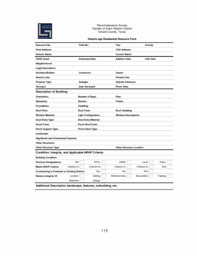
119
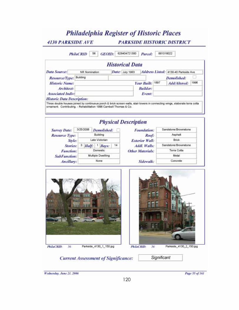
120

121
Due to the sensitivity of information gathered during the Federal Emergency Management Agency’s demolition survey in New Orleans, no form was available for duplication.

122
Index A Alabama 77, 84 Alaska 76, 84, 85 Anomalies 50, 54, 62, 72 Arizona 77, 85 Arkansas 83, 85, 86 C California 76, 80, 86, 87, 88 City of Fort Worth 7, 32, 38, 43, 76 Colorado 76, 87, 88 Connecticut 78, 88, 89 CRGIS 2, 18, 19, 20 D Delaware 82, 89 Demolition Survey 33, 46, 47, 48, 49, 50, 53, 70, 121 District of Columbia 89, 90 E EarthSearch Inc. 47, 48 F FEMA 8, 33, 34, 46, 48, 49, 50, 51, 54, 76 Florida 26, 27, 77, 90, 91 G Georgia 91 Goodwin & Associates 8, 33, 34, 46, 47, 48, 76 H Hannah, Lindsey 34, 46, 48, 51, 52, 76 Hawaii 78, 91, 92 Hawkins, Dominique 35, 36, 56, 58, 60, 76 Historic American Buildings Survey 16, 18, 79 Historic American Engineering Record 14, 16, 18, 79, 93 Hurricane Katrina 34, 46 Hutter, Renee 38, 41, 42, 43, 76 I Idaho 77, 92, 93 Illinois 79, 93
123
Indiana 27, 78, 93, 94 Iowa 79, 93 K Kansas 26, 27, 80, 95, 96 Kentucky 80, 96 L LopezGarcia Group 7, 32, 38, 39, 40, 41, 73, 76 Louisiana 33, 34, 46, 47, 48, 51, 80, 96, 97 M Maine 82, 97 Maryland 80, 97, 98 Massachusetts 82, 98, 99 Michigan 79, 99 Minnesota 77, 100 Mississippi 77, 100, 101 Missouri 80, 101 Montana 83, 102 N National Park Service 14, 16, 17, 18, 20, 34, 35, 48, 52, 79, 80, 110, 116 Nebraska 78, 102, 103 Nevada 77, 103 New Hampshire 81, 103, 104 New Jersey 80, 82, 104, 123 New Mexico 81, 82, 104, 105 New York 76, 78, 79, 81, 105 North Carolina 81, 105, 106 North Dakota 81, 106 O Ohio 81, 107 Oklahoma 26, 78, 107, 108 Oregon 24, 25, 26, 79, 108, 109 P Parkside 35, 36, 56, 57, 58, 59, 67, 72 Pennsylvania 35, 36, 56, 58, 59, 60, 78, 81, 82, 109 Peters, Judy 58, 65 Preservation Design Partnership 8, 35, 56, 58, 59, 60, 72, 76 Preservation Alliance of Greater Philadelphia 35, 56, 58, 59, 61, 65, 76
124
R Resurvey 47, 48, 51, 53 Rhode Island 78, 109, 110 S Section 106 8, 19, 26, 30, 47, 53, 70, 92, 108 South Carolina 79, 82, 110, 111 South Dakota 79, 111, 112 Stakeholders 60 T Tennessee 79, 82, 112 Texas 7, 32, 38, 82, 112, 113 Training 26, 30, 49, 59, 63, 72, 73, 108, 111 U Utah 113 V Vermont 79, 114 Virginia 82, 114, 115 W Washington 18, 26, 27, 47, 78, 115, 116 West Virginia 81, 116 Wisconsin 83, 116, 117 Wyoming 82, 117