
Evaluate Bull Trout Movements in the Tucannon · Micheal P. Faler United States Fish ... and code...
31
Evaluate Bull Trout Movements in the Tucannon And Lower Snake Rivers Project Number 2002-006-00 2004 Annual Report (January 1, 2004 - December 31, 2004) Field Investigators: Micheal P. Faler United States Fish and Wildlife Service Idaho Fishery Resource Office P.O. Box 18 Ahsahka, ID 83520 (208) 476-7242 Glen Mendel and Carl Fulton Washington Department of Fish and Wildlife Fish Management Division 529 W. Main Street Dayton, WA 99328 (509) 382-1005 November 1, 2005
Transcript of Evaluate Bull Trout Movements in the Tucannon · Micheal P. Faler United States Fish ... and code...

Evaluate Bull Trout Movements in the Tucannon And Lower Snake Rivers
Project Number 2002-006-00
2004 Annual Report (January 1, 2004 - December 31, 2004)
Field Investigators:
Micheal P. Faler
United States Fish and Wildlife Service Idaho Fishery Resource Office
P.O. Box 18 Ahsahka, ID 83520
(208) 476-7242
Glen Mendel and Carl Fulton Washington Department of Fish and Wildlife
Fish Management Division 529 W. Main Street Dayton, WA 99328
(509) 382-1005
November 1, 2005
2
Abstract
We sampled and released 313 bull trout (Salvelinus confluentus) from the Tucannon River in 2004. Passive Integrated Transponder (PIT) tags were inserted in 231 of these individuals, and we detected existing PIT tags in an additional 44 bull trout. Twenty-five of these were also surgically implanted with radio-tags, and we monitored the movements of these fish throughout the year.
Ten bull trout that were radio-tagged in 2003 were known to survive and carry their tags through the spring of 2004. One of these fish outmigrated into the Snake River in the fall, and remained undetected until February, when it’s tag was located near the confluence of Alkali Flat Creek and the Snake River. The remaining 9 fish spent the winter between Tucannon River miles 2.1 (Powers Road) and 36.0 (Tucannon Fish Hatchery). Seven of these fish retained their tags through the summer, and migrated to known spawning habitat prior to September 2004.
During June and July, radio-tagged bull trout again exhibited a general upstream movement into the upper reaches of the Tucannon subbasin. As in past years, we observed some downstream movements of radio-tagged bull trout in mid to late September and throughout October, suggesting post spawning outmigrations. By late November and early December, radio tagged bull trout were relatively stationary, and were distributed from river mile 42 at Camp Wooten downstream to river mile 17, near the Highway 12 bridge. As in previous years, we did not collect data associated with objectives 2, 3, or 4 of this study, because we were unable to monitor migratory movement of radio-tagged bull trout into the vicinity of the hydropower dams on the main stem Snake River.
Transmission tests of submerged Lotek model NTC-6-2 nano-tags in Lower Granite Pool showed that audible detection and individual tag identification was possible at depths of 20, 30, and 40 ft. We were able to maintain tag detection and code separation at all depths from both a boat and 200 ft. above water surface in a helicopter. However, we lost detection capability from 40 ft. water depth when we passed 700 ft. above the water surface in a helicopter. Two years of high tag loss, particularly after spawning, has prevented us from documenting fall and winter movements with an adequate sample of radio tagged bull trout. The high transmitter loss after spawning may be a reflection of high natural mortality for large, older age fish that we have been radio tagging to accommodate the longer life transmitters. Therefore, we reduced the size of the radio tags that we implanted, and delayed most of our collection and tagging of bull trout until after spawning. These changes are a new approach to try to maximize the number of radio tagged bull trout available post spawning to adequately document fall and winter movements and any use of the Snake River by bull trout from the Tucannon River.
3
Acknowledgements This study was funded by the U.S. Department of Energy, Bonneville Power Administration (BPA), Project number 2002-006-00, Contract number 00012207. Roy Beaty, then Tracy Hauser of the Bonneville Power Administration served as Fish and Wildlife Project Manager for the project during 2004. The authors would specifically like to thank Doug Maxey, Mike Sutterfield, Dave Clark, and Lyle Leslie of the Washington Department of Fish and Wildlife Tucannon Fish Hatchery for operation of the Tucannon trap and assistance with this study, and Joe Bumgarner and staff of the Washington Department of Fish and Wildlife Snake River Laboratory for cooperative management of the fish weir located on river mile 10.3 on the Tucannon River. We would also like to acknowledge Carrie Bretz, Frank Mullins, Stuart Rosenberger, and Holly Smith of the Idaho Fishery Resource Office for their assistance with field sampling, and Mike Gembala, Derek Gloyn, and Jeremy Trump of the Washington Department of Fish and Wildlife Dayton Fish Management Office for their assistance with field sampling, snorkeling, and radio tracking.

4
Table of Contents Abstract………………………………………………………………………… 2 Acknowledgements…………………………………………………………….. 3 List of Tables…………………………………………………………………… 5 List of Figures…………………………………………………………………… 5 List of Plates …………………………………………………………………… 6 Introduction……………………………………………………………………... 7 Study Area……………………………………………………………………… 9 Methods and Materials…………………………………………………………. 10
Depth Transmission Tests……………………………………………… 12 Results and Discussion…………………………………………………………. 12
Migration and Distribution (fish tagged in 2003)………..…………….. 12 Tag Recovery (fish tagged in 2003)………………….…..…………….. 15 Spring Sampling and Tagging (2004)………………………………….. 16
Tag Recovery (fish tagged in spring, 2004)………….…..…………….. 17 Fall Sampling and Tagging (2004)………….………………………….. 20 Migration and Distribution (fish tagged in 2004)………..……….…….. 20 Depth Transmission Tests……………………………………………… 25
Summary and Conclusions……………………………………………………... 26
Bull Trout Movements and Distribution……………………………….. 26 Depth Transmission Tests………………………………………………. 28
New Activities Planned for 2005……………………………………….. 28 Summary of Expenditures………………………………………………………. 29 References………………………………………………………………………. 29

5
List of Tables Table 1. Radio tags recovered in 2004 from bull trout tagged at the Tucannon Hatchery weir (RM 36.8) in spring 2003, and at the temporary downstream weir in fall 2003 (RM 35.9).……………………………………16 Table 2. Bull trout trapping data at the Tucannon Hatchery weir, 1998-2004……………………………………………………………………17
Table 3. Recovered radio tags from bull trout tagged near the Tucannon Fish Hatchery in spring 2004.……………………………………………….19 Table 4. Observations of radio-tagged bull trout in the Tucannon subbasin, 2004………………………………………………………………………….25
List of Figures
Figure 1. Map of Southeast Washington showing the location of the Tucannon River in relation to the four Lower Snake River dams………….…10 Figure 2. Fixed telemetry data logger stations (indicated by arrows) in the Tucannon Subbasin, fall, 2003………………………………………………..11 Figure 3. Distribution of 10 radio-tagged bull trout during January and February, 2004, that were tagged in 2003, retained their radio tags, and survived into 2004. One radio-tagged bull trout was located in Alkali Flat
Creek, which flows into the north shore of the Snake River. Each star may represent more than one fish location. The oval represents a high concentration of fish locations…………………………………………...13 Figure 4. Distribution of 9 radio-tagged bull trout during March, 2004, that were tagged in 2003, survived, and carried their tags through the winter in the Tucannon subbasin. Each star may represent more than one fish location. The oval represents a high concentration of fish locations.…..……..14

6
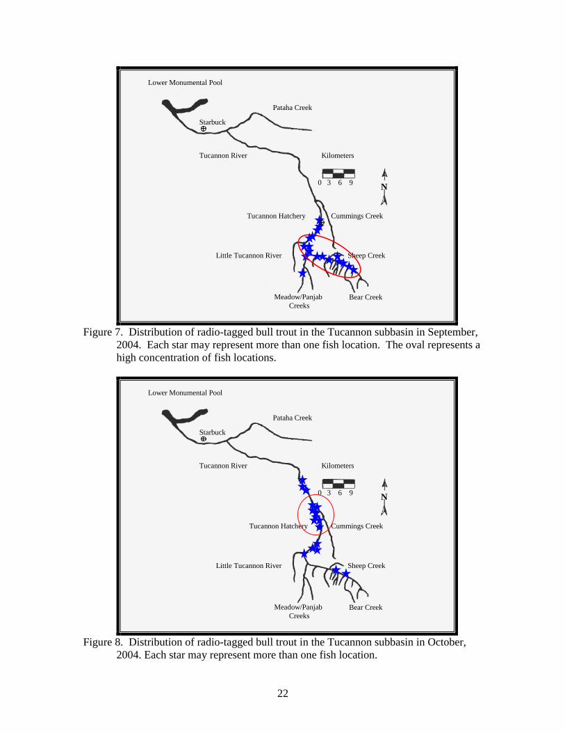
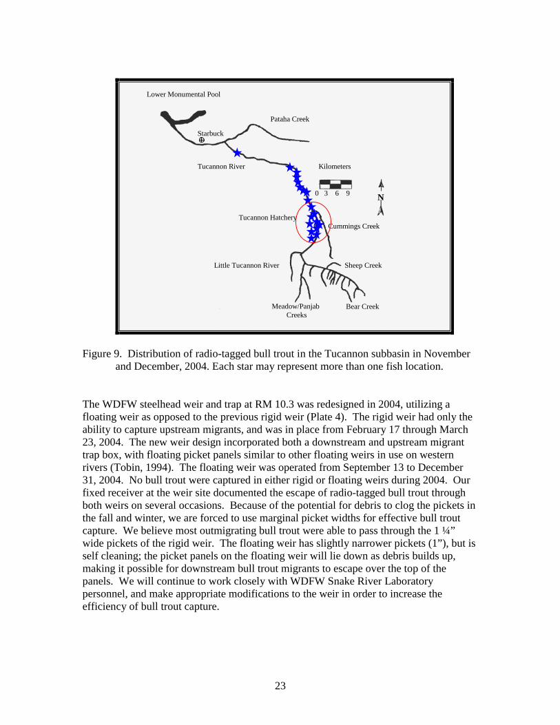
List of Figures (continued) Figure 5. Distribution of 9 radio-tagged bull trout during April and May, 2004, that were tagged in 2003, survived, and carried their tags into the following spring in the Tucannon subbasin. Each star may represent more than one fish location. The oval represents a high concentration of fish locations…………………………………………..………………………15 Figure 6. Distribution of radio-tagged bull trout in the Tucannon subbasin in June and July, 2004. Each star may represent more than one fish location. The oval represents a high concentration of fish locations.…………….……..21 Figure 7. Distribution of radio-tagged bull trout in the Tucannon subbasin in September, 2004. Each star may represent more than one fish location. The oval represents a high concentration of fish locations.…………………….………22 Figure 8. Distribution of radio- tagged bull trout in the Tucannon subbasin in October, 2004. Each star may represent more than one fish location…………22 Figure 9. Distribution of radio-tagged bull trout in the Tucannon subbasin in November and December, 2004. Each star may represent more than one fish location.………………………………………………………………..………22
List of Plates Plate 1. Digital photo of a dam built by campers on Panjab Creek.……………18 Plate 2. Digital photo of the dam built by campers on Panjab Creek, detailing the tight construction which impedes fish passage.………………..….……….. 18 Plate 3. Digital photo of the radio-tagged (code 47) bull trout carcass found impinged within a dam built by campers on Panjab Creek. This fish successfully spawned, but was trapped during the downstream post-spawn migration……………………………………...……………………….……….. 19 Plate 4. Digital photo of the redesigned steelhead weir and trap located at RM 10.3 on the Tucannon River. River is flowing from left to right in this photo, showing the floating picket panels and downstream migrant trap box.……….. 24
7
Introduction
The ESA (Threatened) listing of the Columbia River Distinct Population Segment of bull trout identified one of the major threats to the species as fragmentation resulting from dams on over wintering habitats of migratory subpopulations (Federal Register, 1998). At the time of listing, it appeared that a migratory subgroup in the Tucannon River may have utilized the mainstem Snake River for adult rearing on a seasonal basis (Underwood et al., 1995). The occurrence of bull trout in the hydropower system had been verified by a few incidental observations during sampling in Lower Monumental Pool (Buchanan et al. 1997 citing Ward), and in the adult passage facilities at Lower Monumental and Little Goose dams in the early 1990s (Kleist, in litt. 1993). Prior to 2001, documentation of fish movement past the adult fish counting windows at Lower Monumental Dam and Little Goose Dam occurred during spring, summer, and fall, but was suspended during winter months (November through March). The FCRPS Biological Opinion (USFWS 2000) required the U. S. Army Corps of Engineers (USACE) to provide data detailing the movement of bull trout past the adult fish counting stations at Lower Monumental and Little Goose Dams. This requirement prompted USACE to extend the collection of adult fish passage data into the winter months (i.e., November through March). Time-lapse video counting did not document the presence of bull trout at Lower Monumental and Little Goose dams during the winter of 2003/2004 (Richards, pers. comm., 2004). However, bull trout have been observed at the fish viewing windows during spring and summer at both hydroelectric facilities since records were kept in 2001 (Anglea, et. al., 2004). Additionally, bull trout have been found in the adult/juvenile separator at the juvenile fish facility at Little Goose Dam in 2004 and 2005. The origin of these fish is unclear. It remains unconfirmed if bull trout from the Tucannon River frequently utilize the main stem Snake River for rearing and foraging as observed in large rivers in other Columbia Basin subpopulations (Elle 1995; Faler and Bair 1992; Kelly Ringell and DeLaVergne 2000 and 2001; Schriever and Schiff; 2003; Theisfeld et al. 1996; Underwood et al. 1995). If bull trout originating from the Tucannon River migrate into the mainstem Snake River, it is also unknown if they attempt to pass the existing hydro facilities on a regular basis, or if the fishways are suitable for bull trout passage. The potential for bull trout movements throughout the migratory corridor is high, but from the standpoint of future delisting and requirements set forth in the FCRPS Biological Opinion (USFWS 2000), the determination of temporal and spatial distribution in the mainstem is crucial in developing recovery actions, estimating “take”, and successful consultation on system improvement actions. This project was designed to help meet Reasonable and Prudent Measures, and Conservation Recommendations associated with the Lower Snake River dams in the FCRPS Biological Opinion, and to increase understanding of bull trout movements within the Tucannon River drainage.
8
Rieman and McIntyre (1993) describe unimpeded migratory corridors as important habitats to the persistence and interaction of local populations. They also indicate that disruption and/or modification of migratory corridors can increase stress, reduce growth and survival, and potentially result in the loss of migratory life-history types in a subpopulation. With these factors in mind, the primary question to be answered is: Does the existing hydropower system on the Lower Snake River limit the capabilities of Tucannon River bull trout to complete their migratory behavior, or are the current hydropower operations compatible with recovery and conservation of the species? The secondary goal of the project is to examine the movements and spatial/temporal distribution of migratory bull trout within the Tucannon River and to determine the proportion of migratory fish that leave the Tucannon River to overwinter. The bull trout stock status in the Tucannon River is considered healthy by the Washington Department of Fish and Wildlife (WDFW 1998), but little is known about their migrations in the Tucannon and Snake river subbasins. Martin et al. (1992) and Underwood et al. (1995) studied the interactions of bull trout, steelhead, and Chinook salmon in the Tucannon River during the early 1990’s. As part of this larger study, there were 16 bull trout radio-tagged and tracked from July through November 1992. The authors indicated that 2 fish may have entered the main stem Snake River by the last week of October, but they were unable to verify these movements (Underwood et al. 1995). The objectives of this study are to:
1. Determine the spatial distribution, migration timing, and movements of adult migratory bull trout in the Tucannon and Snake rivers.
2. Determine bull trout use and passage efficiency in fishways at Lower Snake River dams.
3. Estimate frequency of bull trout fall back at Lower Snake River dams.
4. Determine if bull trout losses result from movements out of Lower Monumental Pool.
The primary assumption associated with the study is that the movements of radio-tagged bull trout are not different from the movements of other bull trout in the subgroup. This assumption is critical to the project as a whole. The use of long life transmitters and tagging well before spawning or major migrations should reduce the effects of tagging on fish behavior. Martin et al. (1995) found that surgically implanted dummy transmitters did not affect fish survival, growth, or gonad development in rainbow trout held in captivity. Radio transmitters have been used in other bull trout studies in recent years with good success (Elle 1995, Faler and Bair 1992, Kelly Ringel and DeLaVergne 2000/2001, Schriever and Schiff 2003, Underwood et al. 1995). Objectives 1, 2 and 4 have critical assumptions, in part, associated with each of those objectives. In order to determine distribution in the Snake River (Objective 1) and passage efficiency (Objective 2), we must assume that a portion of our group of radio-tagged bull trout will enter the Snake River and at least attempt to pass through a fish ladder in the Lower Snake River.
9
Likewise, in order to estimate the extent of losses in Objective 4, there must be some movement (upstream or downstream) of radio-tagged bull trout out of Lower Monumental Pool and we also assume that radio transmission will be adequate to track bull trout movements throughout the reservoirs.
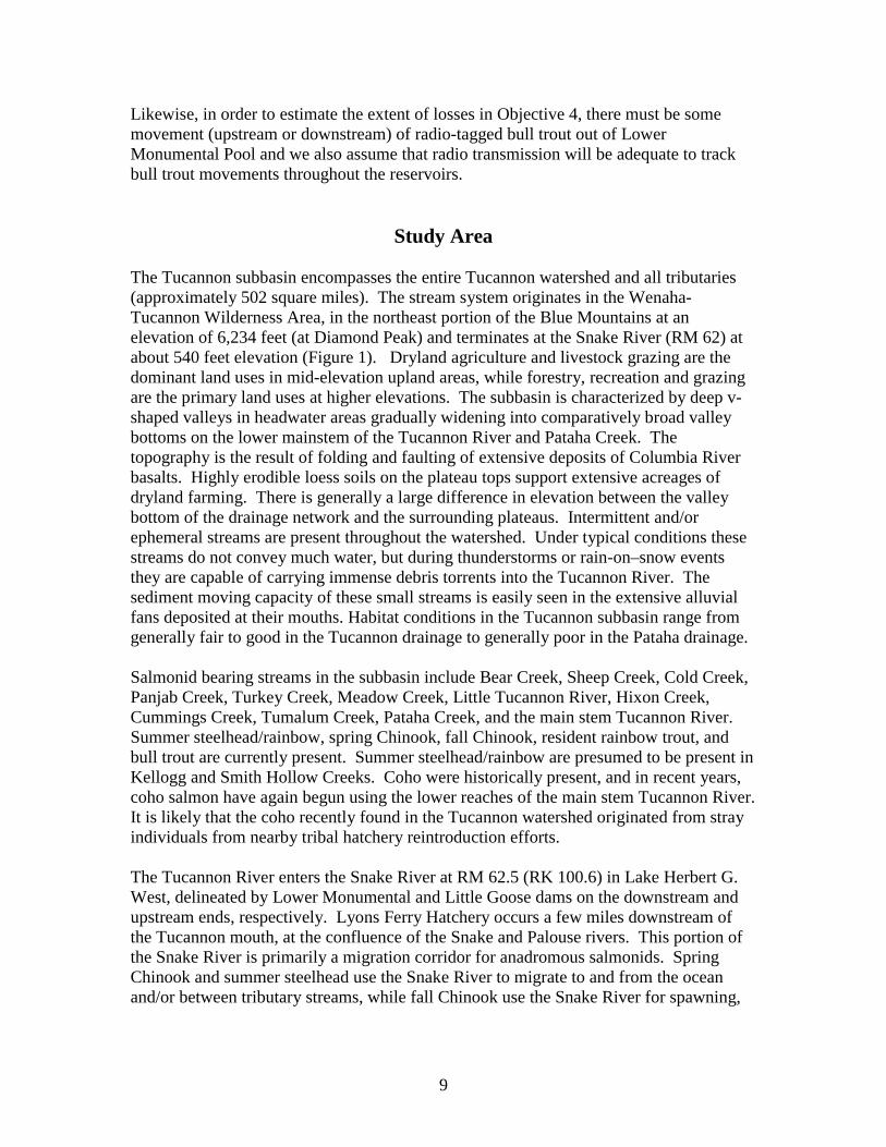
Study Area The Tucannon subbasin encompasses the entire Tucannon watershed and all tributaries (approximately 502 square miles). The stream system originates in the Wenaha-Tucannon Wilderness Area, in the northeast portion of the Blue Mountains at an elevation of 6,234 feet (at Diamond Peak) and terminates at the Snake River (RM 62) at about 540 feet elevation (Figure 1). Dryland agriculture and livestock grazing are the dominant land uses in mid-elevation upland areas, while forestry, recreation and grazing are the primary land uses at higher elevations. The subbasin is characterized by deep v-shaped valleys in headwater areas gradually widening into comparatively broad valley bottoms on the lower mainstem of the Tucannon River and Pataha Creek. The topography is the result of folding and faulting of extensive deposits of Columbia River basalts. Highly erodible loess soils on the plateau tops support extensive acreages of dryland farming. There is generally a large difference in elevation between the valley bottom of the drainage network and the surrounding plateaus. Intermittent and/or ephemeral streams are present throughout the watershed. Under typical conditions these streams do not convey much water, but during thunderstorms or rain-on–snow events they are capable of carrying immense debris torrents into the Tucannon River. The sediment moving capacity of these small streams is easily seen in the extensive alluvial fans deposited at their mouths. Habitat conditions in the Tucannon subbasin range from generally fair to good in the Tucannon drainage to generally poor in the Pataha drainage. Salmonid bearing streams in the subbasin include Bear Creek, Sheep Creek, Cold Creek, Panjab Creek, Turkey Creek, Meadow Creek, Little Tucannon River, Hixon Creek, Cummings Creek, Tumalum Creek, Pataha Creek, and the main stem Tucannon River. Summer steelhead/rainbow, spring Chinook, fall Chinook, resident rainbow trout, and bull trout are currently present. Summer steelhead/rainbow are presumed to be present in Kellogg and Smith Hollow Creeks. Coho were historically present, and in recent years, coho salmon have again begun using the lower reaches of the main stem Tucannon River. It is likely that the coho recently found in the Tucannon watershed originated from stray individuals from nearby tribal hatchery reintroduction efforts. The Tucannon River enters the Snake River at RM 62.5 (RK 100.6) in Lake Herbert G. West, delineated by Lower Monumental and Little Goose dams on the downstream and upstream ends, respectively. Lyons Ferry Hatchery occurs a few miles downstream of the Tucannon mouth, at the confluence of the Snake and Palouse rivers. This portion of the Snake River is primarily a migration corridor for anadromous salmonids. Spring Chinook and summer steelhead use the Snake River to migrate to and from the ocean and/or between tributary streams, while fall Chinook use the Snake River for spawning,
10
rearing and migration. Sockeye salmon migrate through this corridor to and from spawning grounds in Idaho’s Salmon River basin.
Figure 1. Map of Southeast Washington showing the location of the Tucannon River in
relation to the four Lower Snake River dams.
Methods and Materials: The approach of the study is to use radio-telemetry to monitor the movements of adult bull trout as they move within the Tucannon River basin, and as they emigrate to the Snake River to rear throughout the winter. We successfully captured and tagged adult and sub-adult bull trout at the Tucannon Hatchery weir in spring and early summer. We also angled in the fall and winter with lead-head jigs and spoons equipped with barbless hooks. This method proved successful for capturing bull trout in September through December, and allowed us to capture and tag fish in the lower reaches of the river. Fish of appropriate size (> 50 times transmitter weight in air) were surgically implanted with 294 or 334 day life expectancy radio-tags. Surgical procedures generally followed those used by Faler et al. (1988), Faler and Bair (1992), Kelly Ringel and DeLaVergne (2000/2001), and Schriever and Schiff (2003). Radio-tags used during 2004 were obtained from Lotek Engineering. In contrast to previous years, we utilized 2 different models/sizes of Lotek 3V micro coded fish transmitters: 1) model MCFT-3BM weighed 7.7 g in air, had a 334 day life expectancy
11
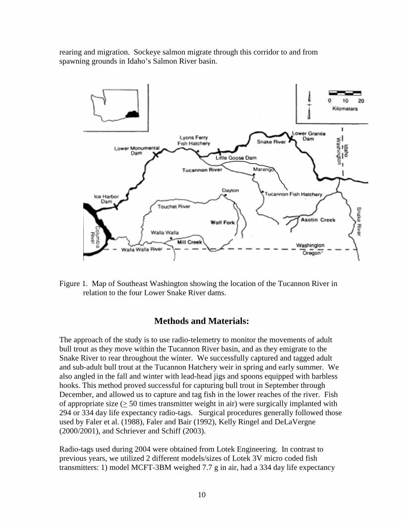
with a 8 sec burst rate, and was suitable for fish as small as 385 g; and 2) model NTC-6-2 weighed 4.5 g in air, had a 294 day life expectancy with a 7 sec burst rate, and was suitable for fish as small as 225 g. All radio-tags implanted during 2004 operated on RF frequency 149.380 MHz (Lotek Channel 4) and were individually micro-coded for easy separation of individual fish. Radio-tagged fish locations were monitored at least weekly in the Tucannon River from shore or aircraft. Individual fish locations were recorded by GPS coordinates during flights, and proximity to landmarks and/or road miles while tracking on ground. Snorkeling was employed as a means of determining whether a particular radio tag, which had lain stationary for a substantial period of time, was being carried by a live bull trout. Additionally, snorkeling was used to ascertain the physical condition of selected bull trout post-surgery. We continued use of the four fixed telemetry stations operated during FY03 (Figure 2). The lowermost station, at river mile 1.6, was operated to identify the timing of movements out of the Tucannon subbasin and into the mainstem Snake River. The station at river mile 10.0 was established to determine if operation of the WDFW Snake River Laboratory steelhead weir impeded the downstream migratory movements of bull trout attempting to pass that location. The two remaining fixed stations at the Tucannon Hatchery weir and Camp Wooten (RM 36.8 and 43.0) were operated to record timing of fish movement into and out of the upper Tucannon River.
Figure 2. Fixed telemetry data logger stations (indicated by arrows) in the Tucannon
subbasin, fall, 2003.
0 3 6 9
Kilometers
N
Lower Monumental Pool
Tucannon River
Pataha Creek
Tucannon Hatchery Cummings Creek
Sheep Creek Little Tucannon River
Meadow/Panjab Creeks
Bear Creek
Starbuck
12
Depth Transmission Tests On June 17, 2004, we submerged 3 Lotek nano-tags at depths of 20, 30, and 40 feet in Lower Granite Pool to test the transmission of nano-tags at these depths. We used a Lotek SRX 400 Receiver, and an “H” antenna. Tests were conducted from a helicopter at 200 and 700 feet above the water surface. Radio-tags were secured with rubber “O” rings and electrical tape on 5/8” braided nylon rope 5-6 feet above 5 lb pyramid lead anchors. Each transmitter was affixed to the rope so it would be positioned with the transmitter’s long axis horizontal under rope tension. Each rope was also affixed with a surface buoy marker for easy location and retrieval.
Results and Discussion This section includes several facets of work, some of which were initiated during the 2003 reporting cycle, but culminated in the 2004 reporting cycle. The data is organized both chronologically and by task for fish tagged in: 1) the spring and fall of 2003, 2) the spring of 2004, and 3) the fall and winter of 2004. Recoveries of radio-tags are also organized in this way. Migration and Distribution (fish tagged in 2003) Tag movements and visual observation of live fish indicate that ten of the thirty five bull trout (28.6%) tagged in 2003 survived and carried their radio tags through the winter into 2004 (codes 151.044, 151.086, 151.164, 4, 7, 9, 11, 13, 14, 26). Three of these fish were implanted with ATS tags which transmit on a unique frequency (151.044, 151.086, and 151.164 Mhz, respectively) and the remaining seven fish were implanted with Lotek coded tags which transmit a unique code on radio frequency 149.380 Mhz. Four of the ten fish were tagged in the spring near the Tucannon Fish Hatchery weir (4, 7, 9 and 26), and six were tagged in the fall near the temporary downstream migrant trap north of the hatchery bridge (151.044, 151.086, 151.164, 11, 13 and 14). Survival of fall tagged fish was twice as high as those tagged in the spring. Our data shows that of the 20 fish tagged in the spring of 2003, 4 individuals (20%) survived the winter and continued migratory movements into 2004, whereas 6 of the 15 fish (40%) tagged in the fall of 2003, survived the winter, retained their tags, and continued migratory movements into 2004. In early 2004, nine of the ten bull trout tagged in 2003 that survived the winter were widely spaced throughout the Tucannon subbasin (river mile 6.5 to 35.8), and the tenth individual (151.164) migrated into the Snake River and into lower Alkali Flat Creek (Figure 3). This fish, carrying code 151.164, escaped detection from October 12, 2003 to February 19, 2004 because it was carrying an ATS brand tag which could not be detected by the Lotek fixed stations. However, the tag was located in lower Alkali Flat Creek during a tracking flight on February 19, and recovered
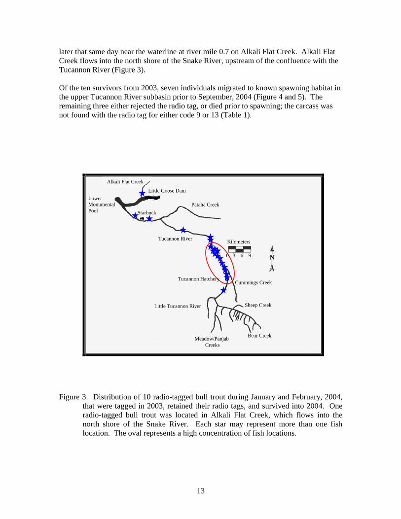
13
later that same day near the waterline at river mile 0.7 on Alkali Flat Creek. Alkali Flat Creek flows into the north shore of the Snake River, upstream of the confluence with the Tucannon River (Figure 3). Of the ten survivors from 2003, seven individuals migrated to known spawning habitat in the upper Tucannon River subbasin prior to September, 2004 (Figure 4 and 5). The remaining three either rejected the radio tag, or died prior to spawning; the carcass was not found with the radio tag for either code 9 or 13 (Table 1).
Figure 3. Distribution of 10 radio-tagged bull trout during January and February, 2004,
that were tagged in 2003, retained their radio tags, and survived into 2004. One radio-tagged bull trout was located in Alkali Flat Creek, which flows into the north shore of the Snake River. Each star may represent more than one fish location. The oval represents a high concentration of fish locations.
Starbuck
Lower Monumental Pool
Alkali Flat Creek
Pataha Creek
Tucannon River
Tucannon Hatchery
Kilometers
0 3 6 9 N
Cummings Creek
Little Tucannon River Sheep Creek
Bear CreekMeadow/Panjab Creeks
Little Goose Dam
14
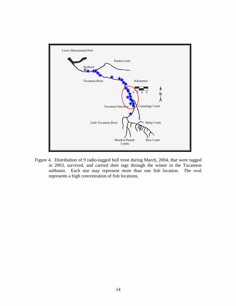
Figure 4. Distribution of 9 radio-tagged bull trout during March, 2004, that were tagged
in 2003, survived, and carried their tags through the winter in the Tucannon subbasin. Each star may represent more than one fish location. The oval represents a high concentration of fish locations.
0 3 6 9
Kilometers
N
Lower Monumental Pool
Tucannon River
Pataha Creek
Starbuck
Cummings Creek
Sheep Creek Little Tucannon River
Meadow/Panjab Creeks
Bear Creek
Tucannon Hatchery

15
Figure 5. Distribution of 9 radio-tagged bull trout during April and May, 2004, that were
tagged in 2003, survived, and carried their tags into the following spring in the Tucannon subbasin. Each star may represent more than one fish location. The oval represents a high concentration of fish locations.
Tag Recovery (fish tagged in 2003) Of the 35 bull trout radio tagged in 2003, 8 of their radio tags were recovered in 2004 (Table 1). Three of those 8 tags (codes 151.164, 9, and 17) were carried by bull trout which survived the winter and displayed movements during 2004; lack of movement prior to January 2004 indicates the remaining 5 individuals either died or rejected their tag prior to or during the 2003 spawning season. It is possible that one bull trout may have been poached by an angler (code 151.022) -- this tag was found hanging in brush near a campfire ring within the W. T. Wooten Wildlife Area campground #1. Another individual may have fallen prey to a predator; code 151.164 was found on top of a boulder lying in an undercut bank at the waters edge, hidden by a screen of vegetation hanging from the streambank above. Six of the 8 radio tags recovered in 2004 from bull trout tagged in 2003 left no indication as to the final disposition of the host fish; all 6 were found lying submerged on the stream bottom without definitive markings on the tag.
0 3 6 9
Kilometers
N
Lower Monumental Pool
Tucannon River
Pataha Creek
Starbuck
Cummings Creek
Sheep Creek Little Tucannon River
Meadow/Panjab Creeks
Bear Creek
Tucannon Hatchery
16
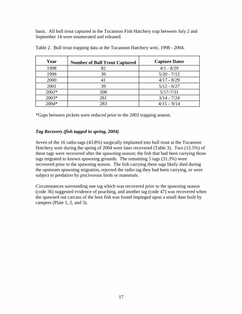
Thirteen of the 35 radio tags implanted into bull trout in 2003 remained in the field at the end of 2004 (codes 151.044, 151.086, 4, 5, 7, 10, 11, 14, 20, 22, 23, 24, and 26) . None of these tags continue to display movement to indicate that they are still carried by live bull trout. The status of these unrecovered tags fall into one of four categories: 1) the battery life of the tag expired and we were no longer able to locate the tag ; 2) the tag remains in known spawning areas within remote parts of the Wenaha-Tucannon Wilderness which has difficult terrain, no roads, and few trails, making tag recovery extremely difficult, so no attempts to recover the tags were made in 2004; 3) the tag remains in a location which requires access to private property for a recovery attempt, and trespass permission was not granted by the landowner; or 4) recovery attempts have been unsuccessful because the tag was found to be buried deeply under streambed substrate or within in-stream debris jams and could not be retrieved. Table 1. Radio tags recovered in 2004 from bull trout tagged at the Tucannon Hatchery weir (RM 36.8) in spring 2003, and at the temporary downstream weir in fall 2003 (RM 35.9).
Code Implant Date
Date of Recovery Final location and Comments
151.022 10/16/03 5/6/04 Tag recovered hanging in brush next to campfire ring in WDFW W. T. Wooten WA campground #1. May have been a poaching mortality.
151.121 9/24/03 6/4/04 Tag recovered under shallow layer of cobble on midstream gravel bar adjacent to Tucannon Road milepost 16.5.
151.145 10/22/03 5/6/04 Tag recovered from stream bottom 0.1 mile upstream of Cummings bridge. No damage to tag or antenna.
151.164 10/12/03 2/19/04 Tag recovered from top of boulder laying in undercut bank along Alkali Flat Creek 0.7 mile upstream of creek mouth. Tag was hidden behind thick screen of vegetation hanging down over bank.
1 10/6/03 5/6/04 Tag recovered near Tucannon Road milepost 20.0, lying on submerged midstream gravel bar. Antenna slightly damaged.
9 5/25/03 7/2/04 Tag recovered from mid-stream gravel bar slightly downstream of bridge 14. No damage to tag, antenna shortened.
13 9/25/03 8/11/04 Tag recovered slightly downstream of WDFW W. T. Wooten WA campground #7. Tag found in slackwater eddy; no damage to tag or antenna.
17 10/14/03 5/6/04 Tag recovered near Tucannon Road milepost 20.0 lying submerged in far right braid. No damage to tag or antenna.
Spring Sampling and Tagging (2004) Two hundred eighty six bull trout were captured at the Tucannon Hatchery weir in 2004 (Table 2), and we surgically implanted radio transmitters in 16 of them. Fork length (mm) and/or weight (g) was recorded for 257 (90%) and 253 (88%) were scanned for PIT tags. Five of these (< 2%) were radio-tag recaptures, and 42 (15%) of these were PIT-tag recaptures. New PIT tags were implanted in 210 (73%) of them; all tagging activities ceased after July 2, when peak water temperatures consistently exceeded 16 ºC on a daily
17
basis. All bull trout captured in the Tucannon Fish Hatchery trap between July 2 and September 14 were enumerated and released. Table 2. Bull trout trapping data at the Tucannon Hatchery weir, 1998 - 2004.
Year Number of Bull Trout Captured
Capture Dates
1998 82 4/1 - 8/29 1999 39 5/20 - 7/12 2000 41 4/17 - 8/29 2001 39 5/12 - 6/27 2002* 208 5/17-7/31 2003* 261 3/14 - 7/24 2004* 283 4/15 – 9/14
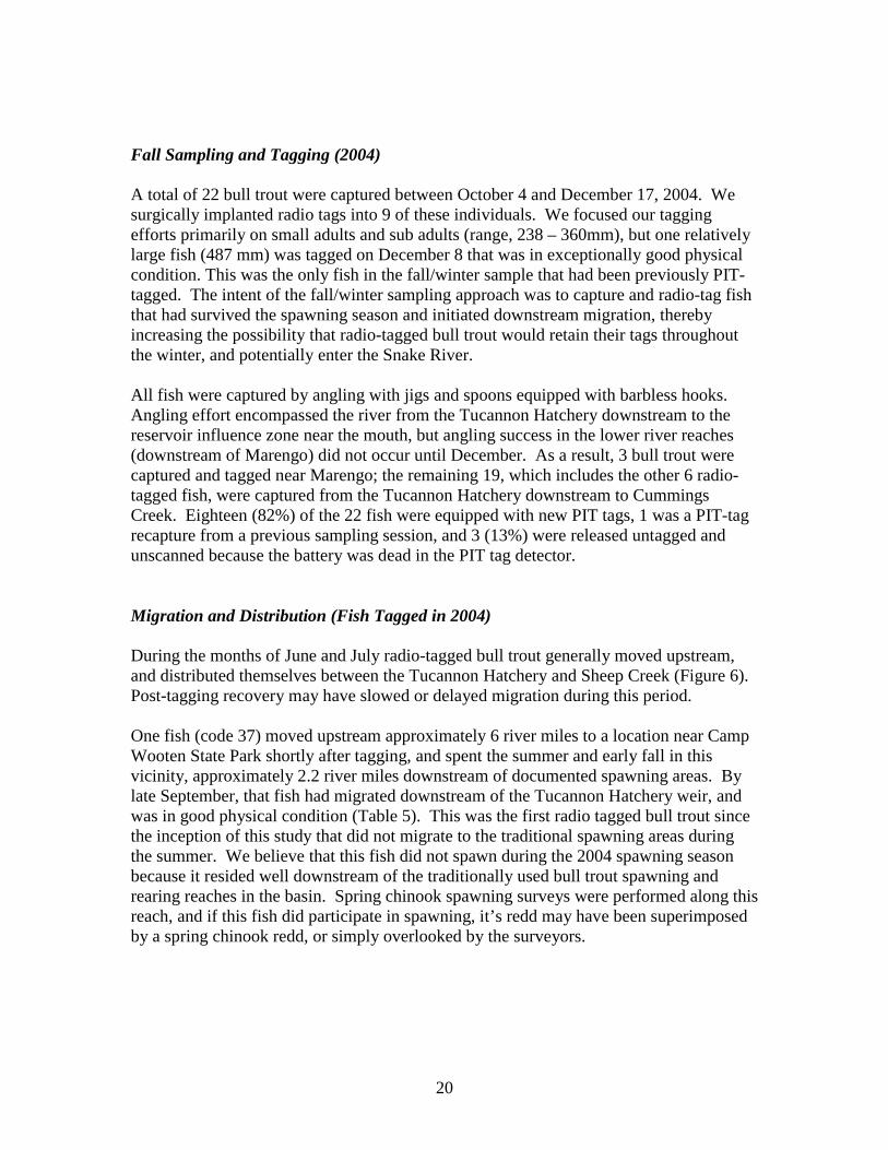
*Gaps between pickets were reduced prior to the 2002 trapping season. Tag Recovery (fish tagged in spring, 2004) Seven of the 16 radio-tags (43.8%) surgically implanted into bull trout at the Tucannon Hatchery weir during the spring of 2004 were later recovered (Table 3). Two (12.5%) of these tags were recovered after the spawning season; the fish that had been carrying those tags migrated to known spawning grounds. The remaining 5 tags (31.3%) were recovered prior to the spawning season. The fish carrying these tags likely died during the upstream spawning migration, rejected the radio tag they had been carrying, or were subject to predation by piscivorous birds or mammals. Circumstances surrounding one tag which was recovered prior to the spawning season (code 36) suggested evidence of poaching, and another tag (code 47) was recovered when the spawned out carcass of the host fish was found impinged upon a small dam built by campers (Plate 1, 2, and 3).
18
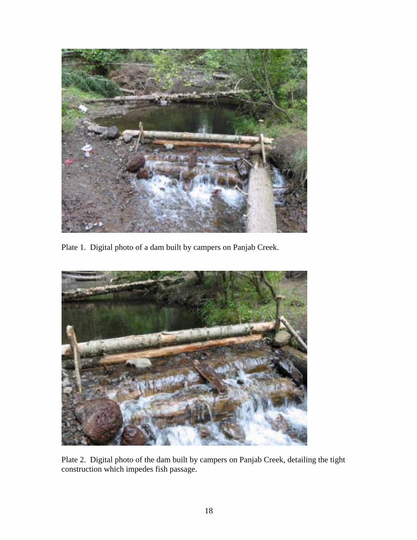
Plate 1. Digital photo of a dam built by campers on Panjab Creek.
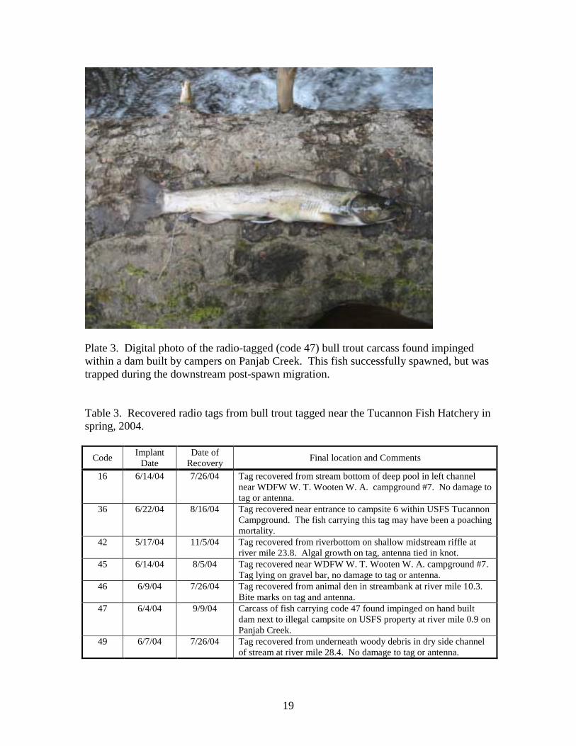
Plate 2. Digital photo of the dam built by campers on Panjab Creek, detailing the tight construction which impedes fish passage.
19
Plate 3. Digital photo of the radio-tagged (code 47) bull trout carcass found impinged within a dam built by campers on Panjab Creek. This fish successfully spawned, but was trapped during the downstream post-spawn migration. Table 3. Recovered radio tags from bull trout tagged near the Tucannon Fish Hatchery in spring, 2004.
Code Implant Date
Date of Recovery Final location and Comments
16 6/14/04 7/26/04 Tag recovered from stream bottom of deep pool in left channel near WDFW W. T. Wooten W. A. campground #7. No damage to tag or antenna.
36 6/22/04 8/16/04 Tag recovered near entrance to campsite 6 within USFS Tucannon Campground. The fish carrying this tag may have been a poaching mortality.
42 5/17/04 11/5/04 Tag recovered from riverbottom on shallow midstream riffle at river mile 23.8. Algal growth on tag, antenna tied in knot.
45 6/14/04 8/5/04 Tag recovered near WDFW W. T. Wooten W. A. campground #7. Tag lying on gravel bar, no damage to tag or antenna.
46 6/9/04 7/26/04 Tag recovered from animal den in streambank at river mile 10.3. Bite marks on tag and antenna.
47 6/4/04 9/9/04 Carcass of fish carrying code 47 found impinged on hand built dam next to illegal campsite on USFS property at river mile 0.9 on Panjab Creek.
49 6/7/04 7/26/04 Tag recovered from underneath woody debris in dry side channel of stream at river mile 28.4. No damage to tag or antenna.
20
Fall Sampling and Tagging (2004) A total of 22 bull trout were captured between October 4 and December 17, 2004. We surgically implanted radio tags into 9 of these individuals. We focused our tagging efforts primarily on small adults and sub adults (range, 238 – 360mm), but one relatively large fish (487 mm) was tagged on December 8 that was in exceptionally good physical condition. This was the only fish in the fall/winter sample that had been previously PIT-tagged. The intent of the fall/winter sampling approach was to capture and radio-tag fish that had survived the spawning season and initiated downstream migration, thereby increasing the possibility that radio-tagged bull trout would retain their tags throughout the winter, and potentially enter the Snake River. All fish were captured by angling with jigs and spoons equipped with barbless hooks. Angling effort encompassed the river from the Tucannon Hatchery downstream to the reservoir influence zone near the mouth, but angling success in the lower river reaches (downstream of Marengo) did not occur until December. As a result, 3 bull trout were captured and tagged near Marengo; the remaining 19, which includes the other 6 radio-tagged fish, were captured from the Tucannon Hatchery downstream to Cummings Creek. Eighteen (82%) of the 22 fish were equipped with new PIT tags, 1 was a PIT-tag recapture from a previous sampling session, and 3 (13%) were released untagged and unscanned because the battery was dead in the PIT tag detector. Migration and Distribution (Fish Tagged in 2004) During the months of June and July radio-tagged bull trout generally moved upstream, and distributed themselves between the Tucannon Hatchery and Sheep Creek (Figure 6). Post-tagging recovery may have slowed or delayed migration during this period. One fish (code 37) moved upstream approximately 6 river miles to a location near Camp Wooten State Park shortly after tagging, and spent the summer and early fall in this vicinity, approximately 2.2 river miles downstream of documented spawning areas. By late September, that fish had migrated downstream of the Tucannon Hatchery weir, and was in good physical condition (Table 5). This was the first radio tagged bull trout since the inception of this study that did not migrate to the traditional spawning areas during the summer. We believe that this fish did not spawn during the 2004 spawning season because it resided well downstream of the traditionally used bull trout spawning and rearing reaches in the basin. Spring chinook spawning surveys were performed along this reach, and if this fish did participate in spawning, it’s redd may have been superimposed by a spring chinook redd, or simply overlooked by the surveyors.
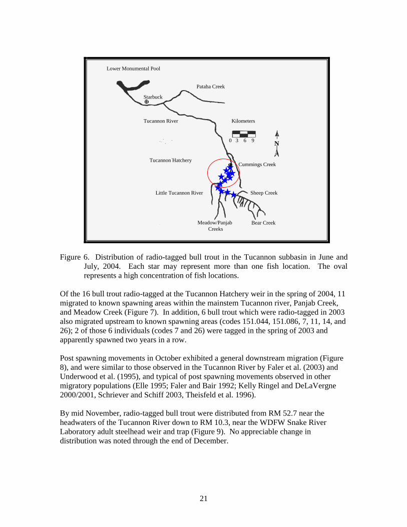
21
Figure 6. Distribution of radio-tagged bull trout in the Tucannon subbasin in June and
July, 2004. Each star may represent more than one fish location. The oval represents a high concentration of fish locations.
Of the 16 bull trout radio-tagged at the Tucannon Hatchery weir in the spring of 2004, 11 migrated to known spawning areas within the mainstem Tucannon river, Panjab Creek, and Meadow Creek (Figure 7). In addition, 6 bull trout which were radio-tagged in 2003 also migrated upstream to known spawning areas (codes 151.044, 151.086, 7, 11, 14, and 26); 2 of those 6 individuals (codes 7 and 26) were tagged in the spring of 2003 and apparently spawned two years in a row. Post spawning movements in October exhibited a general downstream migration (Figure 8), and were similar to those observed in the Tucannon River by Faler et al. (2003) and Underwood et al. (1995), and typical of post spawning movements observed in other migratory populations (Elle 1995; Faler and Bair 1992; Kelly Ringel and DeLaVergne 2000/2001, Schriever and Schiff 2003, Theisfeld et al. 1996). By mid November, radio-tagged bull trout were distributed from RM 52.7 near the headwaters of the Tucannon River down to RM 10.3, near the WDFW Snake River Laboratory adult steelhead weir and trap (Figure 9). No appreciable change in distribution was noted through the end of December.
0 3 6 9
Kilometers
N
Lower Monumental Pool
Tucannon River
Pataha Creek
Starbuck
Cummings Creek
Sheep Creek Little Tucannon River
Meadow/Panjab Creeks
Bear Creek
Tucannon Hatchery
22
Figure 7. Distribution of radio-tagged bull trout in the Tucannon subbasin in September,
2004. Each star may represent more than one fish location. The oval represents a high concentration of fish locations.
Figure 8. Distribution of radio-tagged bull trout in the Tucannon subbasin in October,
2004. Each star may represent more than one fish location.
0 3 6 9
Kilometers
N
Lower Monumental Pool
Tucannon River
Pataha Creek
Starbuck
Cummings Creek
Sheep Creek Little Tucannon River
Meadow/Panjab Creeks
Bear Creek
Tucannon Hatchery
0 3 6 9
Kilometers
N
Lower Monumental Pool
Tucannon River
Pataha Creek
Starbuck
Cummings Creek
Sheep Creek Little Tucannon River
Meadow/Panjab Creeks
Bear Creek
Tucannon Hatchery
23
Figure 9. Distribution of radio-tagged bull trout in the Tucannon subbasin in November
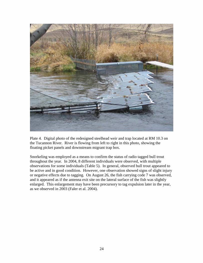
and December, 2004. Each star may represent more than one fish location. The WDFW steelhead weir and trap at RM 10.3 was redesigned in 2004, utilizing a floating weir as opposed to the previous rigid weir (Plate 4). The rigid weir had only the ability to capture upstream migrants, and was in place from February 17 through March 23, 2004. The new weir design incorporated both a downstream and upstream migrant trap box, with floating picket panels similar to other floating weirs in use on western rivers (Tobin, 1994). The floating weir was operated from September 13 to December 31, 2004. No bull trout were captured in either rigid or floating weirs during 2004. Our fixed receiver at the weir site documented the escape of radio-tagged bull trout through both weirs on several occasions. Because of the potential for debris to clog the pickets in the fall and winter, we are forced to use marginal picket widths for effective bull trout capture. We believe most outmigrating bull trout were able to pass through the 1 ¼” wide pickets of the rigid weir. The floating weir has slightly narrower pickets (1”), but is self cleaning; the picket panels on the floating weir will lie down as debris builds up, making it possible for downstream bull trout migrants to escape over the top of the panels. We will continue to work closely with WDFW Snake River Laboratory personnel, and make appropriate modifications to the weir in order to increase the efficiency of bull trout capture.
0 3 6 9
Kilometers
N
Lower Monumental Pool
Tucannon River
Pataha Creek
Starbuck
Cummings Creek
Sheep Creek Little Tucannon River
Meadow/Panjab Creeks
Bear Creek
Tucannon Hatchery
24
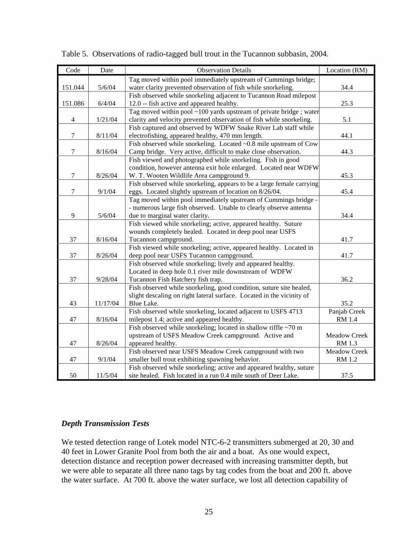
Plate 4. Digital photo of the redesigned steelhead weir and trap located at RM 10.3 on the Tucannon River. River is flowing from left to right in this photo, showing the floating picket panels and downstream migrant trap box. Snorkeling was employed as a means to confirm the status of radio tagged bull trout throughout the year. In 2004, 8 different individuals were observed, with multiple observations for some individuals (Table 5). In general, observed bull trout appeared to be active and in good condition. However, one observation showed signs of slight injury or negative effects due to tagging. On August 26, the fish carrying code 7 was observed, and it appeared as if the antenna exit site on the lateral surface of the fish was slightly enlarged. This enlargement may have been precursory to tag expulsion later in the year, as we observed in 2003 (Faler et al. 2004).
25
Table 5. Observations of radio-tagged bull trout in the Tucannon subbasin, 2004.
Depth Transmission Tests We tested detection range of Lotek model NTC-6-2 transmitters submerged at 20, 30 and 40 feet in Lower Granite Pool from both the air and a boat. As one would expect, detection distance and reception power decreased with increasing transmitter depth, but we were able to separate all three nano tags by tag codes from the boat and 200 ft. above the water surface. At 700 ft. above the water surface, we lost all detection capability of
Code Date Observation Details Location (RM)
151.044 5/6/04 Tag moved within pool immediately upstream of Cummings bridge; water clarity prevented observation of fish while snorkeling. 34.4
151.086 6/4/04 Fish observed while snorkeling adjacent to Tucannon Road milepost 12.0 -- fish active and appeared healthy. 25.3
4 1/21/04 Tag moved within pool ~100 yards upstream of private bridge ; waterclarity and velocity prevented observation of fish while snorkeling. 5.1
7 8/11/04 Fish captured and observed by WDFW Snake River Lab staff while electrofishing, appeared healthy, 470 mm length. 44.1
7 8/16/04 Fish observed while snorkeling. Located ~0.8 mile upstream of Cow Camp bridge. Very active, difficult to make close observation. 44.3
7 8/26/04
Fish viewed and photographed while snorkeling. Fish in good condition, however antenna exit hole enlarged. Located near WDFW W. T. Wooten Wildlife Area campground 9. 45.3
7 9/1/04 Fish observed while snorkeling, appears to be a large female carrying eggs. Located slightly upstream of location on 8/26/04. 45.4
9 5/6/04
Tag moved within pool immediately upstream of Cummings bridge -- numerous large fish observed. Unable to clearly observe antenna due to marginal water clarity. 34.4
37 8/16/04
Fish viewed while snorkeling; active, appeared healthy. Suture wounds completely healed. Located in deep pool near USFS Tucannon campground. 41.7
37 8/26/04 Fish viewed while snorkeling; active, appeared healthy. Located in deep pool near USFS Tucannon campground. 41.7
37 9/28/04
Fish observed while snorkeling; lively and appeared healthy. Located in deep hole 0.1 river mile downstream of WDFW Tucannon Fish Hatchery fish trap. 36.2
43 11/17/04
Fish observed while snorkeling, good condition, suture site healed, slight descaling on right lateral surface. Located in the vicinity of Blue Lake. 35.2
47 8/16/04 Fish observed while snorkeling, located adjacent to USFS 4713 milepost 1.4; active and appeared healthy.
Panjab Creek RM 1.4
47 8/26/04
Fish observed while snorkeling; located in shallow riffle ~70 m upstream of USFS Meadow Creek campground. Active and appeared healthy.
Meadow Creek RM 1.3
47 9/1/04 Fish observed near USFS Meadow Creek campground with two smaller bull trout exhibiting spawning behavior.
Meadow Creek RM 1.2
50 11/5/04 Fish observed while snorkeling; active and appeared healthy, suture site healed. Fish located in a run 0.4 mile south of Deer Lake. 37.5
26
the tag submerged at 40 ft., but we were able to audibly detect the other two tags from a greater linear distance and at a higher reception power than 200 feet above the water surface. These results are similar to the results obtained from transmission tests of submerged radio-tags conducted 2002 and 2003, but surprisingly, the nano tags out-performed both the Lotek MCFT and the ATS F1830 used in our previous deep water tests. These results suggest that the Lotek nano tags may be a suitable tag to use in the Snake River reservoirs for fish using depths down to 40 feet.
Summary and Conclusions Bull Trout Movements and Distribution As in past years, bull trout which were radio tagged in the spring generally moved upstream rapidly after recovering from tagging. By late June or early July most radio tagged bull trout had moved upstream into the Wenaha-Tucannon Wilderness, where recreational angling is prohibited and water temperatures typically remain below 50-55 o F. In September, radio tagged bull trout were typically located in known spawning areas including the Tucannon River upstream of Bear Creek, within Bear Creek, the Tucannon River between Panjab and Bear creeks, Panjab Creek, and Meadow Creek. Some bull trout initiated downstream movement from the spawning areas in September, and by mid November bull trout movements slowed. By this time bull trout radio-tags were distributed from the upper reaches of the Tucannon River subbasin within the Wenaha-Tucannon Wilderness Area downstream to within a few miles upstream of the reservoir influence zone. We suspect that radio-tags which remained within the Wenaha-Tucannon Wilderness Area into November are no longer carried by live bull trout, primarily based on tag recovery results obtained in the spring and summer of 2003. A basic assumption of radio tagging bull trout to monitor their movements is that the implanted transmitters and the tagging process does not affect their movements or behavior and that these tagged fish represent the movements of untagged fish. We have documented high rates of tag loss since the inception of this study. Most of the tag loss appears to occur during, or shortly after, spawning. Many of the radio tags never move from the spawning grounds. We are uncertain whether the observed high rates of tag loss on the spawning grounds indicates high rates of natural mortality associated with spawning, or whether our observations from radio tagged fish are representative of mortality rates for untagged bull trout. That uncertainty continues to concern us because it affects our confidence that radio telemetry enables us to accurately document and interpret the post spawning movements of bull trout. More importantly, few of the radio tags have remained in post spawning bull trout to provide information regarding our primary objectives to document fall and winter movements by bull trout and their migration into of the Snake River. Therefore, we have changed the size of radio tags that we use, and captured and radio tagged bull trout during the post spawning season timeframe in the lower reaches of the Tucannon River, from the Tucannon Fish Hatchery downstream to the fixed telemetry receiver station located at river mile 1.7. These
27
changes were an attempt to maximize the sample size of radio tagged bull trout during fall and winter in an attempt to document fall and winter movements and any use of the Snake River by bull trout from the Tucannon River. When we consider the high rate of post-spawn tag loss that this project has observed with large, older adults, modifying the approach to focus on out-migrating sub adults and small adults in the lower reaches of the Tucannon River seems a reasonable means of increasing the possibility that radio-tagged fish will retain their tags throughout the winter, and potentially migrate into the mainstem Snake River. In 2004, we radio tagged 16 bull trout in the spring, during the upstream migration, and 13 bull trout in the fall and winter, during the post-spawn downstream migration. Although these results occur outside of the 2004 reporting period for this annual report, we successfully tracked the migration of 2 individual bull trout into the mainstem Snake River in early 2005, and both of these bull trout were radio tagged in winter, long after the fall 2004 spawning season. This further reinforces our belief that by tagging downstream migrants during the post-spawning timeframe, we will increase the percentage of our sample that utilize the mainstem Snake River reservoir habitat. In spite of the obvious tag loss and mortalities associated with our radio-tagged bull trout, we continue to collect empirical data and incidental observations that reinforce the idea that a portion of the Tucannon River bull trout population utilizes the Snake River for over-wintering habitat. During the winter of 2004/2005, the incidental catch of both tagged and untagged bull trout was reported by steelhead anglers from RM 24 down to and including the reservoir influence zone. In addition, 5 sub adult or small adult bull trout were captured in the smolt trap operated by the WDFW Snake River Laboratory (RM 1.6) in the fall and winter months. The existence of these sub adults and small adults in the lowermost reaches of the watershed provides an opportunity to shift the focus of this project to a younger age-class, rather than tagging larger, older fish captured in the spring as they move towards the spawning grounds. It would seem reasonable to assume that those fish captured at RM 1.6 were destined to over-winter in or very close to the mainstem Snake River. One of the obstacles to migration and spawning success for bull trout within the Tucannon subbasin is caused by hand-built dams built by campers and recreationists on spawning tributaries. These dams are built presumably for the purpose of creating a deep hole for swimming or fishing. However, the problems these dams cause include impeding or blocking fish passage, which can effect spawning distribution, and timing and extent of outmigration. They could ultimately have a negative effect on overall population numbers. Extreme cases, like the dam displayed in Plate 1, will undoubtedly upset the normal migratory behavior of bull trout, and make it more difficult to accurately interpret our outmigration data.

28
Depth Transmission Tests Based on our test results, we may temporarily lose contact with bull trout tagged with Lotek nano tags that migrate to the Snake River if they utilize water depths greater than 30 – 40 feet. However, it is highly unlikely that fish tagged with Lotek transmitters could pass Lower Monumental or Little Goose dams without being detected at the fixed stations installed there. We intend to focus the remainder of our efforts with Lotek equipment. New Activities Planned for 2005 WDFW will continue to snorkel to determine if the radio-tags are being carried by live bull trout. WDFW will continue to integrate all radio tracking information into a single tracking summary for each fish to improve interpretation and understanding of fish movements. Our efforts in 2005 will continue to focus on the younger cohorts (sub adults and small adults) in order to increase the number of radio tagged fish retaining their tags through the winter. We will also switch our focus to the use of Lotek nano-tags because of their performance in the main stem and the ability to surgically implant them in sub adult sized fish. We will target 10-20 bull trout for radio-tagging in the spring. WDFW and USFWS will work closely with staff from the Snake River Lab to capture downstream migrant bull trout in the floating steelhead weir at RM 10.3. In addition, downstream migrant sub-adult bull trout captured in the screw trap operated by the Snake River Lab (RM 1.8) will continue to be interrogated for PIT tags, PIT tagged if not already carrying one, and surgically implanted with a radio-tag if of appropriate size. We will continue to increase angling efforts in the fall and winter to sample bull trout in the lower Tucannon River. In 2005, the U.S. Army Corps of Engineers funded Biomark to design and install 2 stream width PIT tag antenna array systems in the Lower Tucannon River. They also supplied funding to the U.S. Fish and Wildlife Service to increase the PIT-tagging efforts in the Tucannon River Basin. The intent of these efforts is to enhance the probability of qualifying and quantifying the use of the main stem Snake River by migratory bull trout from the Tucannon River. The PIT tag array project complements our radio telemetry study nicely because the PIT-tagged fish from both studies will have the capability of being interrogated at the stream width antenna arrays. This added layer of data collection will help us be successful at determining the temporal and spatial distribution of bull trout in the main stem Snake River.
29
Summary of Major Expenditures
• Helicopter time, Jan-May, Sept-Dec ($9,146)
• Radio tags (45) from Lotek Engineering ($14,338).
• Miscellaneous supplies (includes materials for floating weir and downstream trap box at RM 10 ($3,168).
References Anglea, S., R. Richmond, R. Brown, and J. Newell. 2004. Summary of Bull Trout Studies in the Lower Snake River and McNary Reservoir. Prepared for the U. S. Army Corps of Engineers Walla Walla District, Batelle Pacific Northwest Division. Richland, Washington. Buchanan, D., M Hanson, and R.M. Hooten. 1997. 1996 Status of Oregon’s Bull Trout.
Oregon Department of Fish and Wildlife, Portland, Oregon. Corps of Engineers. 1997. 1997 Annual Fish Passage Report, Columbia and Snake
Rivers for Salmon, Steelhead and Shad. North Pacific Division, U.S. Army Corps of Engineers, Portland and Walla Walla Districts.
Elle, S. 1995. Federal Aid to Fish Restoration. Job Performance Report. Grant F-73-
R17. Project 6, Bull Trout Investigations. Subproject 1, Rapid River bull trout movement and mortality studies, and Subproject 2, Bull Trout aging studies. IDFG 95-33. Idaho Fish and Game. Boise, Idaho.
Faler, M.P., L.M. Miller, and K.I. Welke. 1988. Effects of Variation in Flow on
Distributions of Northern Squawfish in the Columbia River below McNary Dam. North American Journal of Fisheries Management 8:30-35.
Faler, M.P. and T. B. Bair. 1992. Migration and Distribution of Adfluvial Bull Trout in
Swift Reservoir, North Fork Lewis River and Tributaries. Gifford Pinchot National Forest, Wind River Ranger District, Unpublished Report.

30
Faler, M.P., G. Mendel, and C. Fulton. 2003. Evaluate Bull Trout Movements in the Tucannon and Lower Snake Rivers. Project No. 2002-006-00, 20 electronic pages, (BPA Report DOE/BP-00009774-1).
Faler, M.P., G. Mendel, and C. Fulton. 2004. Evaluate Bull Trout Movements in the
Tucannon and Lower Snake Rivers. Project No. 2002-006-00, 31 electronic pages, (BPA Report DOE/BP-00009774-2).
Federal Register. 1998. Determination of Threatened Status for the Klamath River and
Columbia River Distinct Population Segments of Bull Trout. Vol. 63, No. 111. FR Doc. 98-15319. June 10, 1998.
Hubert, W.A. 1983. Passive Capture Techniques, in, Fisheries Techniques. Special
Publication of the American Fisheries Society. Southern Printing Company, Inc., Blacksburg, VA. L.A. Nielson and D. L. Johnson, ed.
Kelly Ringel, B. and J. DeLaVergne. 2000 Progress Report. Wenatchee River Basin
Bull Trout Telemetry Study. U. S. Fish and Wildlife Service, Leavenworth, Washington.
Kelly Ringel, B. and J. DeLaVergne. 2001 Progress Report. Wenatchee River Basin
Bull Trout Telemetry Study. U. S. Fish and Wildlife Service, Leavenworth, Washington.
Kleist, T. (Washington Department of Wildlife) 1993. Memorandum to Eric Anderson
(WDW) sumarizing fish passage at Snake River dams. Martin, S.W., M.A. Shuck, K.D. Underwood and A.T. Scholz. 1992. Investigations of
Bull Trout (Salvelinus confluentus), Steelhead Trout (Oncorhynchus mykiss), and Spring Chinook Salmon (O. tshawytscha) Interactions in Southeast Washington Streams. U.S. Department of Energy, Bonneville Power Administration, Division of Fish and Wildlife. Project No. 90-53, Contract No. DE-BI79-91BP17758. 206 pp.
Martin, S. W., J. A. Long, and T. N. Pearsons. 1995. Comparison of survival, gonad
development, and growth between rainbow trout with and without surgically implanted dummy radio tags. NAJFM 15: 494-498.
Mendel, G., C. Fulton, and R. Weldert. 2003. An Investigation Into the Migratory
Behavior of Bull Trout (Salvelinus confluentus) in the Touchet River Basin. Washington Department of Fish and Wildlife.
Rieman, B.E. and J.D. McIntyre. 1993. Demographic and Habitat Requirements for
Conservation of Bull Trout. USDA Forest Service, Intermountain Research Station. General Technical Report INT-302.
Schriever, E. and D. Schiff. 2003. Bull Trout Life History Investigations in the North
31
Fork Clearwater River Basin: Regional Fisheries Management Investigations; North Fork Clearwater River Bull Trout. U. S. Army Corps of Engineers, Walla Walla District, Contract No. DACW68-96-D0003, Delivery Order 0022.
Theisfeld, S.L., A.M. Stuart, D.E. Ratliff, and B.D. Lampman. 1996. Migration Patterns
of Adult Bull Trout in the Metolius River and Lake Billy Chinook, Oregon. Oregon Department of Fish and Wildlife Information Report 96-1. Portland, Oregon.
Tobin, J. H. 1994. Construction and performance of a portable resistance board weir for
counting migrating adult salmon in rivers. U. S. Fish and Wildlife Service, Kenai Fishery Resource Office, Alaska Fisheries Technical Report Number 22, Kenai, Alaska.
Underwood, K.D., S.W. Martin, M.L. Shuck, and A.T. Scholz. 1995. Investigations of Bull Trout (Salvelinus confluentus), Steelhead Trout (Oncorhynchus mykiss), and
Spring Chinook Salmon (O. tshawytscha) Interactions in Southeast Washington Streams--1992 Final Report. U.S. Department of Energy, Bonneville Power Administration, Division of Fish and Wildlife. Project No. 90-53, Contract No. DE-BI79-91BP17758. 173 pp.
USFWS. 2000. Biological Opinion, Effects to listed species from operations of the
Federal Columbia River Power System. Consultation Conducted by: U.S. Fish and Wildlife Service. December 20, 2000.
Washington Department of Fish and Wildlife (WDFW). 1998. Washington State
Salmonid Stock Inventory - Bull Trout and Dolly Varden. Olympia, WA.