European Transportation GIS Summit - Recent...
37
European Transportation GIS Summit Real-Time Systems
Transcript of European Transportation GIS Summit - Recent...

European Transportation GIS SummitReal-Time Systems

Space Time Analysis of Pavement Monitoring
Dr. Thanos Doganis Terra Ltd.
Georgia Gkania MSc Attikes Diadromes S.A.
2

European Transportation GIS Summit May 10 – 11 2017 Berlin
Where are we
3

Key figuresTotal Length 70 km
Lanes per direction 3 + Emergency Lane
Toll road Interchanges (I/C) 29
Toll stations 39/195 L.
Service/Side road network 150 km.
Overpasses 100
Underpasses 25
No. of bored & cut & cover tunnels 56
Length of Tunnels & cut & cover sections 12,5 km.
Length of flood protection works 67 km.
No. of Motorist Service Stations 4
Average transaction / day 0,25 million
4

European Transportation GIS Summit May 10 – 11 2017 Berlin
Key Dates Tender submitted 28/02/1995
Concession awarded 23/05/1996
Ratification of Contract 16/12/1996
Full Financial Close 06/03/2000
First Drawdown 04/08/2000
First section in operation 19/03/2001
Completion of the project 24/06/2004
End of Concession 05/10/2024
5

European Transportation GIS Summit May 10 – 11 2017 Berlin
GIS at Attiki Odos
Assets Failures Incidents AVL SignageSafety
barriersTraffic
VolumesPavement
ETC Statistics
6

European Transportation GIS Summit May 10 – 11 2017 Berlin 7
Pavement
European Transportation GIS Summit May 10 – 11 2017 Berlin
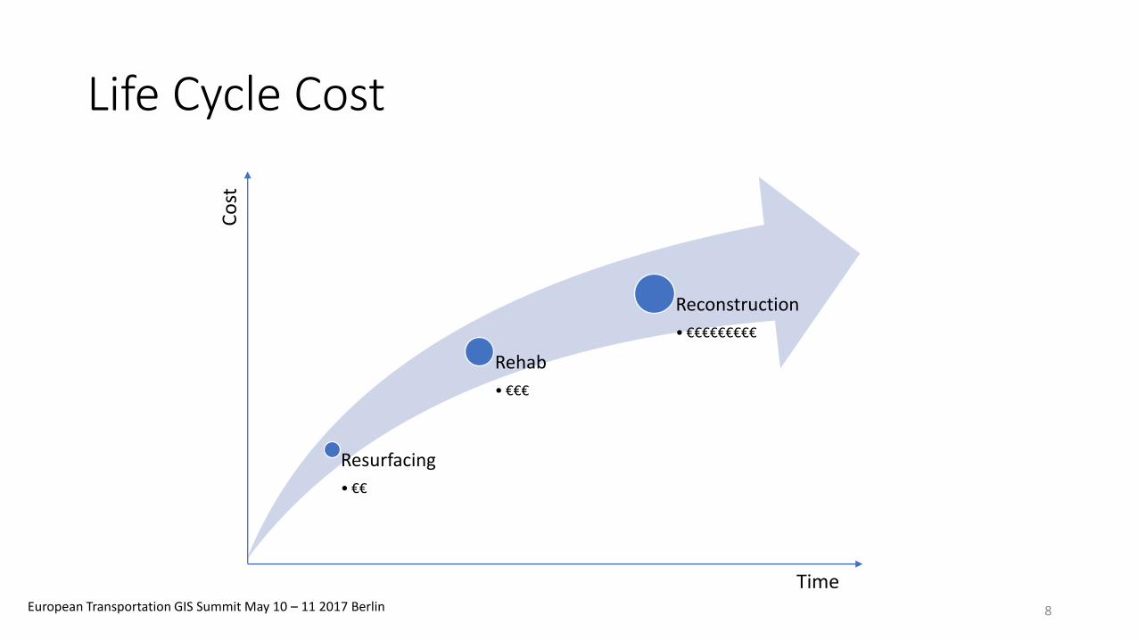
Life Cycle Cost
Resurfacing
• €€
Rehab
• €€€
Reconstruction
• €€€€€€€€€
Time
Co
st
8

European Transportation GIS Summit May 10 – 11 2017 Berlin
Lowest Life Cycle Cost
Source : Pavement Asset Management Report WS DOT 08/02/2016
9

European Transportation GIS Summit May 10 – 11 2017 Berlin
Parameters Measured
Measurments
Structural characteristics
Structural condition
Functional characteristics
Roughness
Skid resistance
Texture
Rutting
10

European Transportation GIS Summit May 10 – 11 2017 Berlin
Classification According to Measurements
Level 1 Level 2 Level 3
Good Condition
Moderate Condition
To be investigated
11

European Transportation GIS Summit May 10 – 11 2017 Berlin
Roughness
IRI* is used as a measure of current condition and a trigger for resurfacing. Expressed in m/km
* IRI International Roughness Index
Level 1 Level 2 Level 3
IRI < 1.5 m/km 1.5m/km <IRI < 2.5 m/km IRI > 1.5 m/km
12

Roughness Accepted Values in Various Countries
0
1
2
3
4
5
6
7
8
9
10
Greece (Highways) USA Brasil Spain
IRI* Values
Excelent Good Fair Poor
* IRI International Roughness Index expressed m/km
m/k
m
13

European Transportation GIS Summit May 10 – 11 2017 Berlin
Skid Resistance (transversal friction)
friction factor or skid number
Level 1 Level 2 Level 3
GN > 0.6 0.6 > GN > 0.41 0.41 < GN
14

European Transportation GIS Summit May 10 – 11 2017 Berlin
Rutting
Level 1 Level 2 Level 3
RD < 13 mm 17mm > RD > 13mm 17mm < RD
Rutting Depth (RD)
15

European Transportation GIS Summit May 10 – 11 2017 Berlin
Surface Texture
Mean Profile Depth MPD
Level 1 Level 2 Level 3
MPD > 0.8mm 0.8mm > MPD > 0.5mm MPD < 0.5mm
16

European Transportation GIS Summit May 10 – 11 2017 Berlin
Structural Characteristics D0 and SCI
Surface Curvature Index SCI and D0 (using Falling Weight Deflectometer)
Level 1 Level 2 Level 3
D0 < 90 90 < D0 < 270 D0 > 270
SCI < 30 30 < SCI < 90 SCI > 90
17

European Transportation GIS Summit May 10 – 11 2017 Berlin
Measurements• External Contractor: National Technical
University of Athens (NTUA).
• Periodically from biannually to every two or three years to depending on parameter.
• Measurements Density for functional characteristics (RD,MTD,GN and IRI) every 10 meters in all lanes.
18

European Transportation GIS Summit May 10 – 11 2017 Berlin
Organize Measurements
Linear Referencing System
(Route, Position, Lane, Time)
To Time Enabled Point Feature Classes (SQL Server)
From Measurements
19

European Transportation GIS Summit May 10 – 11 2017 Berlin
Identify & Search in space and time
20

European Transportation GIS Summit May 10 – 11 2017 Berlin
But what is the overall condition?
Texture classification September 2016
21

European Transportation GIS Summit May 10 – 11 2017 Berlin 22

81%
16%
3%
2016
Good Condition
Moderate Condition
To Be Investigated
Classification
82%
15%
3%
2008
IRI comparison of Classifications between 2008 and 2016 23

Is this evenly distributed?
Or there is concentration in certain areas? 24

Group measurements…
…and examine aggregated results25

26

Classification video through years
27

28

Change through time
0.97
0.98
0.99
1
1.01
1.02
1.03
1.04
1.05
1.06
0 2 4 6 8 10 12
(Branch E from km 14 to km 15)
Years
Ave
rage
IRI*
*International Roughness Index
ΔIR
I = 0
.08
29

To understand the change, map the differences
Index Actual ValuesIRI30

To understand the change, map the differences
Accepted Values Classification Deterioration31

European Transportation GIS Summit May 10 – 11 2017 Berlin
All of the above
•Packed as Web application and disseminated.
•Selections and exports to Excel files.
•Consumed as backdrops in CAD systems.
32

European Transportation GIS Summit May 10 – 11 2017 Berlin

European Transportation GIS Summit May 10 – 11 2017 Berlin

European Transportation GIS Summit May 10 – 11 2017 Berlin

European Transportation GIS Summit May 10 – 11 2017 Berlin

European Transportation GIS Summit May 10 – 11 2017 Berlin
More Info:
Thanos Doganis [email protected] Gkania [email protected]


![[Marvel] Thanos Rising - #01](https://static.fdocuments.in/doc/165x107/55cf933f550346f57b9d27d2/marvel-thanos-rising-01.jpg)