European GNSS for Surveying and MappingThe next call is just published H2020-SPACE-EGNSS-2019 35...
43
European GNSS for Surveying and Mapping Communication Workshop of the PosKEN Brussels, 26 April 2018 Alina Hriscu Market Development European GNSS Agency (GSA)
Transcript of European GNSS for Surveying and MappingThe next call is just published H2020-SPACE-EGNSS-2019 35...

European GNSS for Surveying and Mapping
Communication Workshop of the PosKEN
Brussels, 26 April 2018
Alina HriscuMarket DevelopmentEuropean GNSS Agency (GSA)

Launch

Agenda
GSA: Who We Are and What We Do
EGNOS and Galileo: State of Play
Market and Technology Trends
E-GNSS for Surveying and Mapping
GSA Strategy Towards Galileo Adoption

Agenda
GSA: Who We Are and What We Do
EGNOS and Galileo: State of Play
Market and Technology Trends
E-GNSS for Surveying and Mapping
GSA Strategy Towards Galileo Adoption

GSA in a nutshell
5
Who and where?What?
• Galileo & EGNOS Operations and Service Provision
• Market Development of the applications and the receivers
160 Staff
21Nationalities
Gateway to Services
Gatekeeper of security
• Security Accreditation
• Operation of Galileo Security Monitoring Centre, governmental service (PRS) activities
Prague, CZ Rep – HQSt. Germain en Laye, FR – GSMC
Swanwick, UK – GSMCTorrejon, ES – GSC
Noordwijk, NL – GRCToulouse, FR – EGNOS

How GSA fits in the EU structure
European
Commission
Development contracts
Political oversight
Programme management
Delegation
Council and
European Parliament
European GNSS
Programme Committee
Execution
European
Commission
European Space Agency
Assistance and
delegation
Deployment contracts
Market Development
Security
GSMC operation
GNSS exploitation
Upstream (space)
industry
Downstream
(applications) industry

Agenda
GSA: Who We Are and What We Do
EGNOS and Galileo: State of Play
Market and Technology Trends
E-GNSS for Surveying and Mapping
GSA Strategy Towards Galileo Adoption

EGNOS already available serving EU citizens and industry
Open Service (OS)
Safety of Life Service (SoL)
EGNOS Data Access Service (EDAS)
• Accuracy ~1m, free
• Accuracy ~1m, compliant to aviation standards by providing correction data and integrity
• Accuracy <1m, corrections provided via internet

Galileo is the European GNSS offering a wide range of services
• Freely accessible service forpositioning, timing and navigation message authentication
Open Service (OS)
OS-Navigation Message Authentication (OS-NMA)
Public Regulated Service (PRS)
Search and Rescue Service (SAR)
High Accuracy Service (HAS)
Signal Authentication Service (SAS)
• Encrypted service designed for greater robustness and higher availability
• Assists locating people in distress and confirmsthat help is on the way
• Freely accessible high accuracy positioning service
• Authentication service based on the E6 signal code encryption and OS-NMA, allowing for increased robustness of professional applications

Galileo is the European GNSS under civilian control, delivering unique features
• Worldwide navigation system “made in EU”
• Only constellation under civilian control
• Fully compatible with other GNSS constellations
• Open service free of charge, delivering multiple frequencies
• Only constellation that provide Signal authentication providing trustability for civilians and global high-accuracy service for free
Development of new value-
added services
Improvement of existing ones
Multi-Constellation
OS-NMA
Signal Authentication
Multipath Resistant
High Accuracy Service
Galileo differentiators
Galileo + other GNSS

Galileo’s implementation is progressing with Full Operation Capability in 2020
31-3227-28 29-30
2005 2006 2007 2008 2009 2010 2011 2012 2013 2014 2015
2016
"GIOVE-A" "GIOVE-B" 1-2 3-4 5-6 7-8
From
BaïkonourFrom
Kourou
2017 2018 2019 2020
9-10
2015
15-16
17-1811-12
Soyuz Ariane5
19-20
21-22
23-24
25-2613-14
Galileo Initial Services
15/12/2016
22 satellites
already launched
10 satellites will
follow by 2020

Galileo is used today on majority of professional devices and increasingly many consumer platforms

The European GNSS Service Centre provides a single and unique interface with the users
GSC Nucleus ▪ Web portal▪ Information on:
o system statuso almanacs o and user notifications
▪ Electronic Libraryo Iono Doc, OS SIS OSD, OS
SIS ICD, future SDD
▪ Helpdesk:o User querieso Galileo incident reporting
▪ EGNSS Dissemination Platform▪ User surveys▪ Galileo performance reports www.gsc-europa.eu
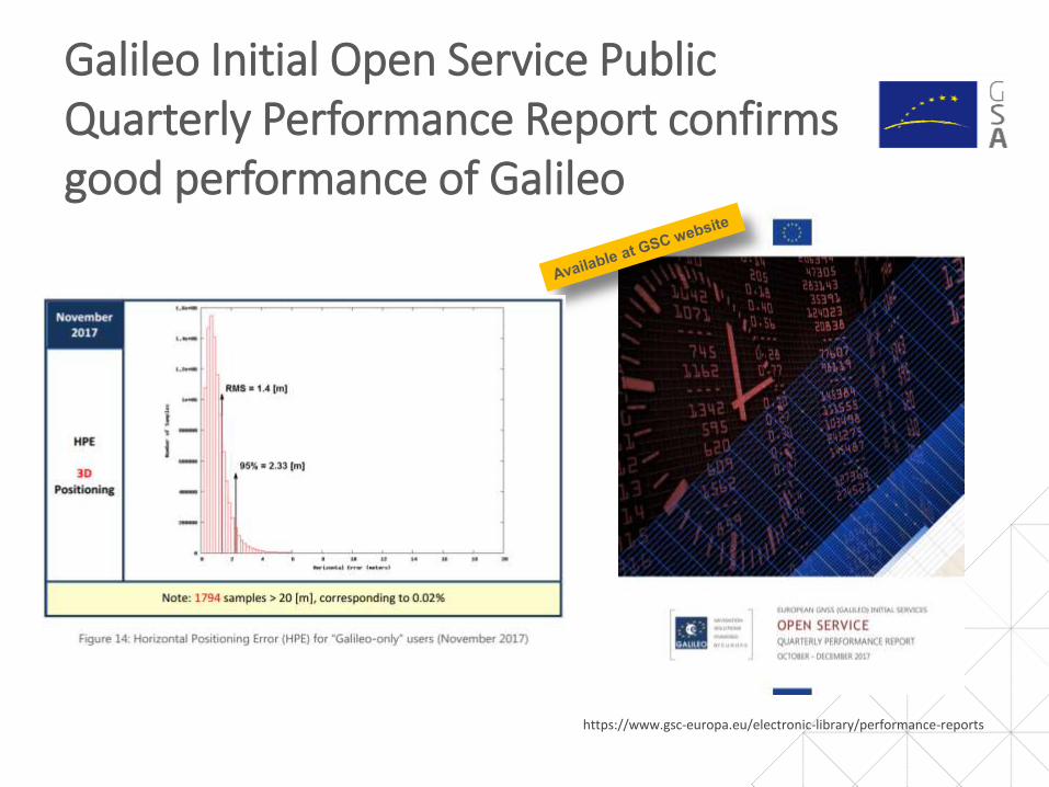
Galileo Initial Open Service Public Quarterly Performance Report confirms good performance of Galileo
https://www.gsc-europa.eu/electronic-library/performance-reports

Agenda
GSA: Who We Are and What We Do
EGNOS and Galileo: State of Play
Market and Technology Trends
E-GNSS for Surveying and Mapping
GSA Strategy Towards Galileo Adoption

Construction, mapping and cadastral industries stimulated growth in shipments of GNSS surveying equipment
Surveying, Mapping and Construction(both person-based and machinecontrol), accounted for 95% of theshipments of GNSS devices in highprecision market in 2016
In the coming decade, the total amount of shipments is expected to reach 815,000 units worldwide, representing almost a 4-fold increase over 2015

Multi-constellation and multi-frequency are widely adopted to fulfil stringent accuracy requirements

Trends and Prospects in surveying and mapping
Main drivers and trends:
• Increased availability of low-cost equipment delivering cm/dm-level precision (incl. multi-frequency and multi-constellation support)
• Uptake of PPP
• Integration of GNSS with other complementary technologies (LIDAR, robotics, mobile mapping, etc.)
• Synergies between GNSS and Earth Observation
• UAV penetration into mapping

Innovation areas and emerging concepts likely to influence future positioning and navigation
GNSS is the most cost-effective outdoor positioning technology currently available – and will remain so for the foreseeable future
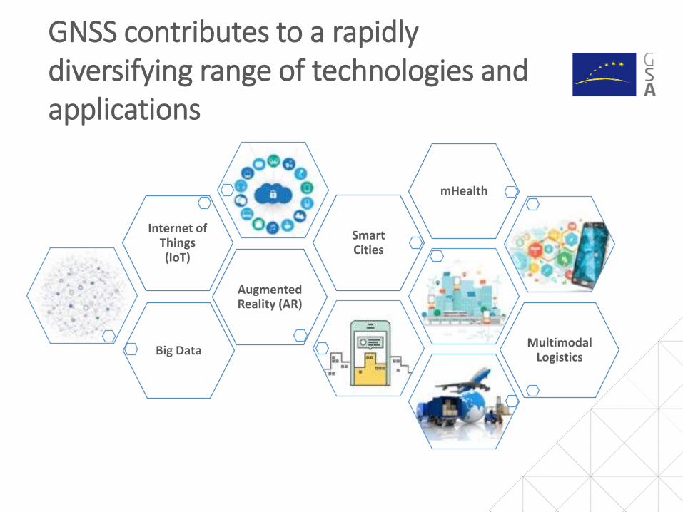
GNSS contributes to a rapidly diversifying range of technologies and applications
Big Data
Augmented Reality (AR)
Internet of Things (IoT)
Smart Cities
mHealth
Multimodal Logistics

Many emerging applications require higher accuracy of geolocation
Automation on the farm
Augmented reality
Smart cities
Self-driving cars Drones

Emerging apps and democratisation of mapping are drivers for the new evolution of the High-Precision Services
Dual frequency mass market receivers
Android 7+ access to raw GNSSmeasurements
Need for the ‘’absolute’’ high-precision location of autonomous cars, drones and other emerging apps
Democratisation of mapping
High-precision positioning penetrating to mass market
52 smartphones models Galileo
enabled

GNSS Raw Measurements set to be a game changer for GIS?
• With Android 7.0+ access to raw GNSS measurements
• This empowers the development of algorithms to provide better location performances
To help get a better understanding of this feature’s true potential and to promote its use to application developers, the GSA established the Raw Measurements Task Force

Interested to know more? Download GSA GNSS Market and GNSS User Technology reports
https://www.gsa.europa.eu/market/market-report https://www.gsa.europa.eu/european-gnss/gnss-market/2016-gnss-user-technology-report
GNSS market trends & applications GNSS receiver trends & technology

Agenda
GSA: Who We Are and What We Do
EGNOS and Galileo: State of Play
Market and Technology Trends – the Bigger Picture
E-GNSS for Surveying and Mapping
GSA Strategy Towards Galileo Adoption

Overview of signals Open service / Commercial service / E6 ranging
Service Signal
E1b
E1c
E5a
E5b
E6b
E6c
Spreading code
Unencrypted
Unencrypted
Unencrypted
Unencrypted
Unencrypted
Encrypted
Data
Yes I/Nav (+NMA)
No (Pilot)
Yes I/Nav
Yes F/Nav
Yes C/Nav
No (Pilot)
OS-NMA
Signal Authentication
E6 ranging
OS single frequency
OS dual frequency
Free multi-frequency
High Accuracy
HAS
SAS

Galileo Open Service improves positioning performance
Easier mitigation of multipath errors
Higher SNR (signal-to-noise ratio)-----------------------------------------------------Multi GNSS : provides additional advantages
• Increase availability, continuity and reliability
• Improved geometry-----------------------------------------------------Better results in harsh environement (urban canyons, tree canopy, etc.)-----------------------------------------------------OS-NMA: spoofing detection
Advantages of Galileo Open Service E1/E5/E6 multi-frequency

Choice for 2nd and 3rd GNSS frequency
• E5/L5, a protected frequency
• Shared by all GNSS and SBAS
• More widely separated from L1, thus minimising the iono-free linear combination errors
E5/L5: 2nd Frequency
• E6 High quality open signal (modulation, chip rate)
• Best frequency for tri-laning
• Multiple signals bring greater reliability and accuracy
E6: 3rd Frequency

Commercial Service goes for FREE
• Decision to redefine the High Accuracy service and provide it for free (Stakeholder Consultation complemented by industry and market analysis)
• The Decision has just been taken and most service features are currently under definition EC/GSA/ESA
• Full service provision is planned in FOC (2020+) with the following features:• Accuracy expected in the range of 20cm. • Global coverage, including high latitudes• Possible regional enhancement by
ionospheric corrections to reduce time to precise fix
• Between 2019 and FOC, the service will be incrementally deployed. A lower accuracy/coverage may be delivered in this period.

Augmentation service providers are accelerating the adoption of Galileo
PPP
Graham Purves, President and CEO of Veripos stated
“As an European company, we are particularly proud and excited about the opportunities the Galileo services create for our customers. The reliability and safety enhancements made possible to continue to expand the capabilities of our cutting edge safety critical positioning solutions.”
Anders Haneborg, Fugro commercial manager said“Galileo’s Initial Services operations […] a key consideration for our
customers during critical positioning operations”
President and CEO of NovAtel, Michael Ritter stated“Our OEM customers are already benefiting from the enhanced
reliability, availability and accuracy the Galileo constellation adds to the GNSS.”
INSIDERTK
• Majority of RTK providers upgraded or have started to upgrade • SWEPOS (SE), GeoSoft (ET), SAPOS (DE),
SOGEI (IT), GEONET (JP), TERIA (FR),etc.
“Our customers needing reliable high-precision are already
reporting improvements with Galileo RTK-corrections”

31

GSA workshops ‘’Integrating Galileo in RTK networks: success stories and open challenges’’ during CLGE GA
Invited speakers • Roberto Capua from Sogei (IT)
• Paul Chambon from Terria (FR)
• Mattias Eriksson from SWEPOS (SE)
• Hugo Toll from Gesosoft (EE)
✓ Usability of the Galileo constellation in high-precision RTK applications
✓ Improved availability, reliability, and accuracy and time-to-fix in difficult measuring environments (urban canyons and under tree canopy).
Ongoing issue with the inter-operability between the different brands of RX manufacturers within RTK-networkInclusion of Galileo into RTK network is cost demanding.
✓ End-users understand Galileo added value: 69% of the respondents are convinced that Galileo will improve their work.

Three main pillars towards E-GNSS adoption – the bigger picture
DOWNSTREAM VALUE CHAIN
E-GNSS USER ADOPTION
EU PUBLIC BENEFITS
MARKET SEGMENTS
User Satisfaction
Understand market
and user needs and
satisfactionDEMAND & ADOPTION
Stimulate
•EGNSS added Value
•Cooperate with receivers and aps
•Roadmaps with stakeholders
• Support EC policies
Bodies
influencing
the market
Navigation
Signal
Providers
Chipset,
receiver Devices
Content &
Apps
Service
providers
Road
LBS
Aviation
Rail
Maritime
Agriculture
Surveying & Mapping
Timing & Synchronization
Governmental
Support EU
of Services and applications applications
COMPETITIVE OFFER
Fundamental Elements

The GSA’s funding mechanisms promote the development of Galileo compatible solutions
34
Aims to foster adoption of Galileo and EGNOS mostly via content and application development and supports the integration of services provided by these programmes into devices and their commercialisation
Fundamental Elements projects focus on fostering the development of innovative Galileo- and EGNOS-enabled receivers, antennas and chipsets technologies. The objective is to achieve products that address user needs in priority market segments
http://www.gsa.europa.eu/r-d/gnss-r-d-programmes

The next call is just published H2020-SPACE-EGNSS-2019
35
Type of Action
TopicIndicative
budget (EUR mln)
Funding rate Indirect costs
IAEGNSS applications fostering green, safe and smart mobility
10.00
70% (except for non-profit legal entities, where
a rate of 100% applies)
25% of the total eligible costs excluding:• Subcontracting• Costs of resources
made available by 3rd
parties • Financial support to
3rd parties
IAEGNSS applications fostering digitisation
4.00
IA
EGNSS applications fostering societal resilience and protecting the environment
4.00
CSAEGNSS awareness raising and capacity building
2.00 100%
TOTAL budget: 20.00Opening: 16 October 2018Deadline: 05 March 2019
IA: activities aimed at producing plans and arrangements or designs for new, altered or improved products, processes or servicesCSA: consisting of accompanying measures such as standardisation, dissemination, awareness-raising and communication, networking, policydialogues and studies

• Tandem system composed by UAV and Vehicle equipped withcameras and LiDAR and operating as a virtual kite (the UAV followsthe Vehicle by receiving its navigation information), also introducingnovel element for images georeferencing - Kinematic Ground ControlPoints
• Potential game-changer for operational simplicity and cost savings
mapKITE – EGNOS-GPS/GALILEO-based high-
resolutionterrestrial-aerial sensing system
Mapping & Surveying: project examples and success stories
Developing a mobile solution for underground utility management that takes advantage of the Galileo and EGNOS:
• Uses and integrates mobile Augmented Reality (AR) interfaces.
• 3D models of complex underground utilities infrastructure (water, gas, electricity, etc.)
• Easy to understand and use during field work
LARA: Augmented Reality Assistive System for Utilities Infrastructure
Management through Galileo and EGNOS

Copernicus is EU’s Earth Observation programme offering free data through six services
• Revolutionary Earth Observation and Monitoring programme
• Delivers openly and freely in a wide range of application areas:
- operational data - information services
> 8 Petabytes / year

Synergies generated due to joint use of EGNSS and Copernicus enable a wide range of applications….
Value-added applications• Agriculture• Mapping & Surveying • Smart cities• Road transport • Maritime navigation• Emergency/crisis management• Utilities
Galileo/EGNOS together with Earth Observation
S
Y
N
E
R
G
I
E
S
COPERNICUSE-GNSS

Project examples and success stories
39
GIMS - Geodetic Integrated Monitoring System
• Vertical displacements ( via synthetic aperture radar interferometry InSAR)
• Horizontal displacements • Temporal interpolation • Geo-localisation of the in-situ sensors
Low-cost system based on EGNSS, Copernicus SAR and other in-situ sensors, for monitoring ground deformations with a focus on landslides and subsidence.
Features of upcoming products:- Register deformations with millimetric level accuracies and daily acquisition rate- Real-time alerts in case of sudden movements
I2GPS - Integrated Interferometry and GNSS for Precision Survey

• The interaction with users is essential for the success of E-GNSS
• User needs drive E-GNSS
• During the UCP all available knowledge on user needs shared
User Requirements discussed with industry leaders, users and experts to shape the future of Galileo Services
User driven E-GNSS

GSA supports Young Surveyors
CLGE Annual Young Surveyors’ Prize:fresh ideas to feed the surveying industry evolution
GSA is sponsoring a special prize dedicated to Galileo, EGNOS and Copernicus as part of the annual Council of Geodetic Surveyors’ Young Surveyors prize
2018 edition open

Linking space to user needs
GSA Twitter - @EU_GNSSEGNOS Twitter - @EGNOSPortal
GNSS Facebook page
GNSS YouTube Channel
GNSS Market, Research & Development
GSA Newsletter
GNSS Slideshare Page (presentations)
European GNSS Agency LinkedIn Page
www.GSA.europa.eu
How to get in touch: