Estimating aboveground carbon density and its uncertainty ... · and Mascaro, 2014; grey circles,...
20
Biogeosciences, 15, 3811–3830, 2018 https://doi.org/10.5194/bg-15-3811-2018 © Author(s) 2018. This work is distributed under the Creative Commons Attribution 4.0 License. Estimating aboveground carbon density and its uncertainty in Borneo’s structurally complex tropical forests using airborne laser scanning Tommaso Jucker 1,2 , Gregory P. Asner 3 , Michele Dalponte 4 , Philip G. Brodrick 3 , Christopher D. Philipson 5,6 , Nicholas R. Vaughn 3 , Yit Arn Teh 7 , Craig Brelsford 8 , David F. R. P. Burslem 7 , Nicolas J. Deere 9 , Robert M. Ewers 10 , Jakub Kvasnica 11 , Simon L. Lewis 12,13 , Yadvinder Malhi 14 , Sol Milne 7 , Reuben Nilus 15 , Marion Pfeifer 16 , Oliver L. Phillips 12 , Lan Qie 10,12 , Nathan Renneboog 17 , Glen Reynolds 18 , Terhi Riutta 10,14 , Matthew J. Struebig 9 , Martin Svátek 11 , Edgar C. Turner 19 , and David A. Coomes 1 1 Forest Ecology and Conservation group, Department of Plant Sciences, University of Cambridge, Cambridge CB2 3EA, UK 2 CSIRO Land and Water, 147 Underwood Avenue, Floreat, 6014, Western Australia, Australia 3 Department of Global Ecology, Carnegie Institution for Science, 260 Panama Street, Stanford, CA 94305, USA 4 Department of Sustainable Agro-ecosystems and Bioresources, Research and Innovation Centre, Fondazione E. Mach, Via E. Mach 1, 38010 San Michele all’Adige, Italy 5 Department of Environmental Systems Science, ETH Zürich, Universitätstrasse 16, 8092 Zürich, Switzerland 6 Centre for Environmental Change and Human Resilience, University of Dundee, Dundee DD1 4HN, UK 7 School of Biological Sciences, University of Aberdeen, Cruickshank Building, St Machar Drive, Aberdeen AB24 3UU, UK 8 Department of Biosciences, Viikki Plant Science Center (ViPS), University of Helsinki, 00014 Helsinki, Finland 9 Durrell Institute of Conservation and Ecology (DICE), School of Anthropology and Conservation, University of Kent, Canterbury CT2 7NR, UK 10 Imperial College London, Silwood Park Campus, Buckhusrt Road, Ascot SL5 7PY, UK 11 Faculty of Forestry and Wood Technology, Department of Forest Botany, Dendrology and Geobiocoenology, Mendel University, Brno, Czech Republic 12 School of Geography, University of Leeds, Leeds LS2 9JT, UK 13 Department of Geography, University College London, London WC1E 6BT, UK 14 Environmental Change Institute, School of Geography and the Environment, University of Oxford, Oxford OX1 3QY, UK 15 Forest Research Centre, Sabah Forestry Department, P.O. Box 1407, 90715 Sandakan, Sabah, Malaysia 16 School of Biology, Newcastle University, Newcastle NE1 7RU, UK 17 Permian Global, Savoy Hill House, 7-10 Savoy Hill, London WC2R 0BU, UK 18 South East Asia Rainforest Research Partnership (SEARRP), Danum Valley Field Centre, P.O. Box 60282, 91112 Lahad Datu, Sabah, Malaysia 19 Department of Zoology, University of Cambridge, Downing Street, Cambridge CB2 3EJ, UK Correspondence: David A. Coomes ([email protected]) Received: 7 February 2018 – Discussion started: 9 March 2018 Revised: 24 May 2018 – Accepted: 8 June 2018 – Published: 22 June 2018 Published by Copernicus Publications on behalf of the European Geosciences Union.
Transcript of Estimating aboveground carbon density and its uncertainty ... · and Mascaro, 2014; grey circles,...

Biogeosciences 15 3811ndash3830 2018httpsdoiorg105194bg-15-3811-2018copy Author(s) 2018 This work is distributed underthe Creative Commons Attribution 40 License
Estimating aboveground carbon density and its uncertainty inBorneorsquos structurally complex tropical forests using airborne laserscanningTommaso Jucker12 Gregory P Asner3 Michele Dalponte4 Philip G Brodrick3 Christopher D Philipson56Nicholas R Vaughn3 Yit Arn Teh7 Craig Brelsford8 David F R P Burslem7 Nicolas J Deere9 Robert M Ewers10Jakub Kvasnica11 Simon L Lewis1213 Yadvinder Malhi14 Sol Milne7 Reuben Nilus15 Marion Pfeifer16Oliver L Phillips12 Lan Qie1012 Nathan Renneboog17 Glen Reynolds18 Terhi Riutta1014 Matthew J Struebig9Martin Svaacutetek11 Edgar C Turner19 and David A Coomes1
1Forest Ecology and Conservation group Department of Plant Sciences University of Cambridge Cambridge CB2 3EA UK2CSIRO Land and Water 147 Underwood Avenue Floreat 6014 Western Australia Australia3Department of Global Ecology Carnegie Institution for Science 260 Panama Street Stanford CA 94305 USA4Department of Sustainable Agro-ecosystems and Bioresources Research and Innovation Centre Fondazione E MachVia E Mach 1 38010 San Michele allrsquoAdige Italy5Department of Environmental Systems Science ETH Zuumlrich Universitaumltstrasse 16 8092 Zuumlrich Switzerland6Centre for Environmental Change and Human Resilience University of Dundee Dundee DD1 4HN UK7School of Biological Sciences University of Aberdeen Cruickshank Building St Machar Drive Aberdeen AB24 3UU UK8Department of Biosciences Viikki Plant Science Center (ViPS) University of Helsinki 00014 Helsinki Finland9Durrell Institute of Conservation and Ecology (DICE) School of Anthropology and Conservation University of KentCanterbury CT2 7NR UK10Imperial College London Silwood Park Campus Buckhusrt Road Ascot SL5 7PY UK11Faculty of Forestry and Wood Technology Department of Forest Botany Dendrology and GeobiocoenologyMendel University Brno Czech Republic12School of Geography University of Leeds Leeds LS2 9JT UK13Department of Geography University College London London WC1E 6BT UK14Environmental Change Institute School of Geography and the Environment University of Oxford Oxford OX1 3QY UK15Forest Research Centre Sabah Forestry Department PO Box 1407 90715 Sandakan Sabah Malaysia16School of Biology Newcastle University Newcastle NE1 7RU UK17Permian Global Savoy Hill House 7-10 Savoy Hill London WC2R 0BU UK18South East Asia Rainforest Research Partnership (SEARRP) Danum Valley Field Centre PO Box 60282 91112 LahadDatu Sabah Malaysia19Department of Zoology University of Cambridge Downing Street Cambridge CB2 3EJ UK
Correspondence David A Coomes (dac18camacuk)
Received 7 February 2018 ndash Discussion started 9 March 2018Revised 24 May 2018 ndash Accepted 8 June 2018 ndash Published 22 June 2018
Published by Copernicus Publications on behalf of the European Geosciences Union
3812 T Jucker et al Estimating aboveground carbon density and its uncertainty in Borneorsquos tropical forests
Abstract Borneo contains some of the worldrsquos most biodi-verse and carbon-dense tropical forest but this 750 000 km2
island has lost 62 of its old-growth forests within the last40 years Efforts to protect and restore the remaining forestsof Borneo hinge on recognizing the ecosystem services theyprovide including their ability to store and sequester carbonAirborne laser scanning (ALS) is a remote sensing technol-ogy that allows forest structural properties to be captured ingreat detail across vast geographic areas In recent years ALShas been integrated into statewide assessments of forest car-bon in Neotropical and African regions but not yet in AsiaFor this to happen new regional models need to be developedfor estimating carbon stocks from ALS in tropical Asia asthe forests of this region are structurally and composition-ally distinct from those found elsewhere in the tropics Bycombining ALS imagery with data from 173 permanent for-est plots spanning the lowland rainforests of Sabah on theisland of Borneo we develop a simple yet general model forestimating forest carbon stocks using ALS-derived canopyheight and canopy cover as input metrics An advanced fea-ture of this new model is the propagation of uncertainty inboth ALS- and ground-based data allowing uncertainty inhectare-scale estimates of carbon stocks to be quantified ro-bustly We show that the model effectively captures vari-ation in aboveground carbon stocks across extreme distur-bance gradients spanning tall dipterocarp forests and heavilylogged regions and clearly outperforms existing ALS-basedmodels calibrated for the tropics as well as currently avail-able satellite-derived products Our model provides a simplegeneralized and effective approach for mapping forest carbonstocks in Borneo and underpins ongoing efforts to safeguardand facilitate the restoration of its unique tropical forests
1 Introduction
Forests are an important part of the global carbon cycle (Panet al 2011) storing and sequestering more carbon than anyother ecosystem (Gibbs et al 2007) Estimates of tropicaldeforestation rates vary but roughly 61 300 km2 of forestwere lost each year between 2000 and 2012 and an addi-tional 30 were degraded by logging or fire (Asner et al2009 Hansen et al 2013) Forest degradation and defor-estation result in about 1ndash2 billion tonnes of carbon beingreleased to the atmosphere each year which equates to about10 of global emissions (Baccini et al 2012) Even if na-tions decarbonize their energy supply chains within agreedschedules a rise of 2 C in mean annual temperature is un-avoidable unless 300 million hectares of degraded tropicalforests are protected and land unsuitable for agriculture isreforested (Houghton et al 2015) Signatories to the ParisAgreement brokered at COP21 in 2015 are now committedto reducing emissions from tropical deforestation and forestdegradation (ie REDD+ Agrawal et al 2011) whilst rec-
ognizing that these forests also harbour rich biodiversity andsupport livelihoods for around a billion people (Vira et al2015)
The accurate monitoring of forest carbon stocks underpinsthese initiatives to generate carbon credits through REDD+and similar forest conservation and climate change mitiga-tion programmes (Agrawal et al 2011) Airborne laser scan-ning (ALS) has shown particular promise in this regard be-cause it generates high-resolution maps of forest structurefrom which aboveground carbon density (ACD) can be es-timated (Asner et al 2010 Lefsky et al 1999 Nelson etal 1988 Popescu et al 2011 Wulder et al 2012) Theprinciple of ALS is that laser pulses are emitted downwardsfrom an aircraft and a sensor records the time it takes forindividual beams to strike a surface (eg leaves branches orthe ground) and bounce back to the emitting source therebyprecisely measuring the distance between the object and theairborne platform Divergence of the beam means it is widerthan leaves and allows for penetration into the canopy result-ing in a 3-D point cloud that captures the vertical structure ofthe forest By far the most common approach to using ALSdata for estimating forest carbon stocks involves develop-ing statistical models relating ACD estimates obtained frompermanent field plots to summary statistics derived from theALS point cloud such as the mean height of returns or theirskew (Zolkos et al 2013) These ldquoarea-basedrdquo approacheswere first used for mapping the structural attributes of com-plex multi-layered forests in the early 2000s (Drake et al2002 Lefsky et al 2002) and have since been applied tocarbon mapping in several tropical regions (Asner et al2010 2014 Jubanski et al 2013 Laurin et al 2014 Reacutejou-Meacutechain et al 2015)
This paper develops a statistical model for mapping for-est carbon and its uncertainty in South-east Asian forestsWe work with ALS and plot data collected in the Malaysianstate of Sabah on the north-eastern end of the island of Bor-neo (Fig 1) which is an important test bed for internationalefforts to protect and restore tropical forests Borneo lostaround 62 of its old-growth forest in just 40 years as aresult of heavy logging and the subsequent establishment ofoil palm and forestry plantations (Gaveau et al 2014 2016)Sabah lost its forests at an even faster rate in this period(Osman et al 2012) and because these forests are amongstthe most carbon dense in the tropics carbon loss has beenconsiderable (Carlson et al 2012a b Slik et al 2010) Inresponse to past and ongoing forest losses the Sabah stategovernment has recently taken a number of concrete steps to-wards becoming a regional leader in forest conservation andsustainable management Among these was commissioninga new high-resolution wall-to-wall carbon map for the en-tire state which will inform future forest conservation andrestoration efforts across the region Here we develop theALS-based model that underpins this new carbon map (As-ner et al 2018)
Biogeosciences 15 3811ndash3830 2018 wwwbiogeosciencesnet1538112018
T Jucker et al Estimating aboveground carbon density and its uncertainty in Borneorsquos tropical forests 3813
Figure 1 Panel (a) shows the location of the Sepilok and Kuamut Forest Reserve the Danum Valley and Maliau Basin ConservationArea and the SAFE landscape within Sabah (Malaysia) Green shading in the background represents forest cover at 30 m resolution in theyear 2000 (Hansen et al 2013) In panel (b) the relationship between field-measured aboveground carbon density and ALS-derived top-of-canopy height found across the study sites (coloured circles n= 173) is compared to measurements taken mostly in the Neotropics (Asnerand Mascaro 2014 grey circles n= 754)
The approach we take builds on the work of Asner andMascaro (2014) who proposed a general model for estimat-ing ACD (in MgC haminus1) in tropical forests using a singleALS metric ndash the mean top-of-canopy height (TCH in m)ndash and minimal field data inputs The method relates ACD toTCH stand basal area (BA in m2 haminus1) and the community-weighted mean wood density (WD in gcmminus3) over a pre-scribed area of forest such as 1 ha as follows
ACDGeneral = 3836timesTCH0281timesBA0972
timesWD1376 (1)
Asner and Mascaro (2014) demonstrated that tropical forestsfrom 14 regions differ greatly in structure Remarkably theyfound that a generalized power-law relationship could befitted that transcended these contrasting forests types onceregional differences in structure were incorporated as sub-models relating BA and WD to TCH However this generalmodel may generate systematic errors in ACD estimates ifapplied to regions outside the calibration range and Asnerand Mascaro (2014) make clear that regional models shouldbe obtained where possible Since South-east Asian rain-forests were not among the 14 regions used to calibrate thegeneral model and are phylogenetically and structurally dis-tinct from Neotropical and Afrotropical forests (Banin et al2012) new regional models are needed before Borneorsquos for-est carbon stocks can be surveyed using ALS Central to therobust estimation of ACD using ALS data is identifying ametric which captures variation in basal area among standsAsner and Mascarorsquos (2014) power-law model rests on an as-sumption that basal area is closely related to top-of-canopyheight an assumption supported in some studies but not inothers (Coomes et al 2017 Duncanson et al 2015 Spriggs2015) The dominance of Asian lowland rainforests by dipte-rocarp species makes them structurally unique (Banin et al
2012 Feldpausch et al 2011 Ghazoul 2016) and gives riseto greater aboveground carbon densities than anywhere elsein the tropics (Avitabile et al 2016 Sullivan et al 2017)highlighting the need for new ALS-based carbon estimationmodels for this region
Here we develop a regional model for estimating ACDfrom ALS data that underpins ongoing efforts to map Sabahrsquosforest carbon stocks at high resolution to inform conserva-tion and management decisions for one of the worldrsquos mostthreatened biodiversity hotspots (Asner et al 2018 Nuneset al 2017) Building on the work of Asner and Mascaro(2014) we combine ALS data with estimates of ACD from atotal of 173 permanent forests plots spanning the major low-land dipterocarp forest types and disturbance gradients foundin Borneo to derive a simple yet general equation for predict-ing carbon stocks from ALS metrics at hectare resolutionAs part of this approach we also develop a novel frameworkfor propagating uncertainty in both ALS- and ground-baseddata allowing uncertainty in hectare-scale estimates of car-bon stocks to be quantified robustly To assess the accuracy ofthis new model we then benchmark it against existing ALS-derived equations of ACD developed for the tropics (Asnerand Mascaro 2014) and satellite-based carbon maps of theregion (Avitabile et al 2016 Pfeifer et al 2016)
2 Materials and methods
21 Study region
The study was conducted in Sabah a Malaysian state innorthern Borneo (Fig 1a) Mean daily temperature is 267 Cand annual rainfall is 2600ndash3000 mm (Walsh and Newbery1999) Severe droughts linked to El Nintildeo events occur about
wwwbiogeosciencesnet1538112018 Biogeosciences 15 3811ndash3830 2018
3814 T Jucker et al Estimating aboveground carbon density and its uncertainty in Borneorsquos tropical forests
Table 1 Summary of permanent forest plot data collected at each study site and description of which ALS sensor was used at each locationPlot size is in hectares while minimum stem diameter thresholds (Dmin) are given in centimetres
Study site Census year No plots Plot size No trees Dmin Height Species ID ALS sensor
Sepilok Forest Reserve 2013ndash2015 36 1 22 430 10 X X NERC ARFKuamut Forest Reserve 2015ndash2016 39 0265a 5588 10 X X CAO-3Danum Valley Conservation Area
CTFS plot 2010ndash2016 45 1 215 016 1 X X NERC ARFCAO plots 2017 20 0271a 2771 10 X X CAO-3
SAFE landscapeSAFE experiment 2014 38b 00625 8444 1 X NERC ARFSAFE experiment 2010 101b 00625 2517 10 NERC ARFRiparian buffers 2014 48b 00625 1472 10 X NERC ARFGEM plots 2014 4 1 1900 10 X X NERC ARF
Maliau Basin Conservation AreaSAFE experiment 2010 27b 00625 894 10 NERC ARFGEM plots 2014 2 1 905 10 X X NERC ARF
a Mean plot size after applying slope correction (see Sect 222 for further details)b Plots established as part of the SAFE experiment and those located along riparian buffer zones in the SAFE landscape were aggregated into spatial blocks prior to statisticalanalyses (n= 27 with a mean plot size of 05 ha see Sect 224 for further details)
once every 10 years (Malhi and Wright 2004 Walsh andNewbery 1999) Sabah supports a wide range of forest typesincluding dipterocarp forests in the lowlands that are amongthe tallest in the tropics (Fig 1b Banin et al 2012)
22 Permanent forest plot data
We compiled permanent forest plot data from five forestedlandscapes across Sabah (Fig 1a) Sepilok Forest ReserveKuamut Forest Reserve Danum Valley Conservation Areathe Stability of Altered Forest Ecosystems (SAFE) experi-mental forest fragmentation landscape (Ewers et al 2011)and Maliau Basin Conservation Area Here we provide abrief description of the permanent plot data collected at eachsite which are summarized in Table 1 Additional details areprovided in Supplement S1
221 Sepilok Forest Reserve
The reserve is a protected area encompassing a remnant ofcoastal lowland old-growth tropical rainforest (Fox 1973)and is characterized by three strongly contrasting soil typesthat give rise to forests that are structurally and function-ally very different (Dent et al 2006 DeWalt et al 2006Nilus et al 2011) alluvial dipterocarp forest in the valleys(hereafter alluvial forests) sandstone hill dipterocarp foreston dissected hillsides and crests (hereafter sandstone forests)and heath forest on podzols associated with the dip slopesof cuestas (hereafter heath forests) We used data from ninepermanent 4 ha forest plots situated in the reserve three ineach forest type These were first established in 2000ndash2001and were most recently re-censused in 2013ndash2015 All stemswith a diameter (D in cm)ge 10 cm were recorded and iden-tified to species (or closest taxonomic unit) Tree height (H
in m) was measured for a subset of trees (n= 718) using alaser range finder For the purposes of this analysis each 4 haplot was subdivided into 1 ha subplots giving a total of 36plots 1 ha in size The corners of the plots were geolocatedusing a Geneq SXBlue II global positioning system (GPS)unit which uses satellite-based augmentation to perform dif-ferential correction and is capable of a positional accuracy ofless than 2 m (95 confidence intervals)
222 Kuamut Forest Reserve
The reserve is a former logging area that is now being devel-oped as a restoration project Selective logging during thepast 30 years has left large tracts of forest in a generallydegraded condition although the extent of this disturbancevaries across the landscape Floristically and topographicallythe Kuamut reserve is broadly similar to Danum Valley ndashwith which it shares a western border ndash and predominantlyconsists of lowland dipterocarp forests Within the forest re-serve 39 circular plots with a radius of 30 m were establishedin 2015ndash2016 spanning a range of forest successional stagesincluding young secondary forests characterized by the pres-ence of species with low wood densities (eg Macarangaspp) Coordinates for the plot centres were taken using aGarmin GPSMAP 64s device with an accuracy of plusmn10 m(95 confidence intervals) Within each plot all stems withD ge 10 cm were recorded and identified to species (or theclosest taxonomic unit) and H was measured using a laserrange finder Because the radius of the plots was measuredalong the slope of the terrain (as opposed to a horizontallyprojected distance) we slope-corrected the area of each plotby multiplying by cos(θ) where θ is the average slope of theplot in degrees as calculated from the digital elevation modelobtained from the ALS data The average plot size after ap-
Biogeosciences 15 3811ndash3830 2018 wwwbiogeosciencesnet1538112018
T Jucker et al Estimating aboveground carbon density and its uncertainty in Borneorsquos tropical forests 3815
plying this correction factor was 0265 ha (6 less than if noslope correction had been applied)
223 Danum Valley Conservation Area
The site encompasses the largest remaining tract of primarylowland dipterocarp forest in Sabah Within the protectedarea we obtained data from a 50 ha permanent forest plotwhich was established in 2010 as part of the Centre for Trop-ical Forest Science (CTFS) ForestGEO network (Anderson-Teixeira et al 2015) Here we focus on 45 ha of this plotfor which all stems with D ge 1 cm have been mapped andtaxonomically identified (mapping of the remaining 5 ha offorest was ongoing as of January 2017) For the purposes ofthis study we subdivided the mapped area into 45 1 ha plotsthe coordinates of which were recorded using the GeneqSXBlue II GPS In addition to the 50 ha CTSF plot we alsosecured data from 20 circular plots with a 30 m radius thatwere established across the protected area by the CarnegieAirborne Observatory (CAO) in 2017 These plots were sur-veyed following the same protocols as those described previ-ously for the plots at Kuamut in Sect 222
224 SAFE landscape and Maliau Basin ConservationArea
Plot data from three sources were acquired from the SAFElandscape and the Maliau Basin Conservation Area re-search plots established through the SAFE project plotsused to monitor riparian buffer zones and plots from theGlobal Ecosystem Monitoring (GEM) network (httpgemtropicalforestsoxacuk last access 20 June 2018) As partof the SAFE project 166 plots 25times 25 m in size were es-tablished in forested areas (Ewers et al 2011 Pfeifer etal 2016) Plots are organized in blocks which span a land-use intensity gradient ranging from twice-logged forests thatare currently in the early stages of secondary successionwithin the SAFE landscape to relatively undisturbed old-growth forests at Maliau Basin (Ewers et al 2011 Strue-big et al 2013) Plots were surveyed in 2010 at which timeall stems with D ge 10 cm were recorded and plot coordi-nates were taken using a Garmin GPSMAP60 device (accu-rate to within plusmn10 m 95 confidence intervals) Of these166 plots 38 were re-surveyed in 2014 at which time allstems with D ge 1 cm were recorded and tree heights weremeasured using a laser range finder Using these same pro-tocols a further 48 plots were established in 2014 alongriparian buffer zones in the SAFE landscape As with theSAFE project plots riparian plots are also spatially clus-tered into blocks The small size of the SAFE and ripar-ian plots (00625 ha) makes them prone to high uncertaintywhen modelling carbon stocks from ALS (Reacutejou-Meacutechain etal 2014) especially given the relatively low positional ac-curacy of the GPS coordinates To minimize this source oferror we chose to aggregate individual plots into blocks for
all subsequent analyses (n= 27 with a mean size of 05 ha)Lastly we obtained data from six GEM plots ndash four withinthe SAFE landscape and two at Maliau Basin The GEMplots are 1 ha in size and were established in 2014 All stemswith D ge 10 cm were mapped measured for height using alaser range finder and taxonomically identified The cornersof the plots were georeferenced using the Geneq SXBlue IIGPS
23 Estimating aboveground carbon density and itsuncertainty
Across the five study sites we compiled a total of 173 plotsthat together cover a cumulative area of 1161 ha of forestFor each of these plots we calculated aboveground carbondensity (ACD in MgChaminus1) following the approach out-lined in the BIOMASS package in R (R Core DevelopmentTeam 2016 Reacutejou-Meacutechain et al 2017) This provides aworkflow to not only quantify ACD but also propagate un-certainty in ACD estimates arising from both field mea-surement errors and uncertainty in allometric models Thefirst step is to estimate the aboveground biomass (AGB inkg) of individual trees using Chave et alrsquos (2014) pantropi-cal biomass equation AGB= 0067times
(D2timesH timesWD
)0976For trees with no height measurement in the field H was es-timated using a locally calibrated HndashD allometric equationwhile wood density (WD in gcmminus3) values were obtainedfrom the global wood density database (Chave et al 2009Zanne et al 2009 see Supplement S1 for additional detailson both H and WD estimation)
In addition to quantifying AGB Reacutejou-Meacutechain et alrsquos(2017) workflow uses Monte Carlo simulations to propagateuncertainty in biomass estimates due to (i) measurement er-rors inD (following Chave et alrsquos (2004) approach in which95 of stems are assumed to contain small measurement er-rors that are in proportion to D while the remaining 5 isassigned a gross measurement error of 46 cm) (ii) uncer-tainty in HndashD allometries (iii) uncertainty in WD estimatesarising from incomplete taxonomic identification andor cov-erage of the global wood density database and (iv) uncer-tainty in the AGB equation itself Using this approach wegenerated 100 estimates of AGB for each recorded tree ACDwas then quantified by summing the AGB of all trees withina plot dividing the total by the area of the plot and apply-ing a carbon content conversion factor of 047 (Martin andThomas 2011) By repeating this across all simulated val-ues of AGB we obtained 100 estimates of ACD for each ofthe 173 plots that reflect the uncertainty in stand-level car-bon stocks (note that a preliminary analysis showed that 100iterations were sufficient to robustly capture mean and stan-dard deviation values of plot-level ACD while also allow-ing for efficient computing times) As a last step we useddata from 45 plots in Danum Valley ndash where all stems withD ge 1 cm were measured ndash to develop a correction factor thatcompensates for the carbon stocks of stems with D lt 10 cm
wwwbiogeosciencesnet1538112018 Biogeosciences 15 3811ndash3830 2018
3816 T Jucker et al Estimating aboveground carbon density and its uncertainty in Borneorsquos tropical forests
that were not recorded (Phillips et al 1998 see Eq S2 inSupplement S1)
Stand basal area and wood density estimation
In addition to estimating ACD for each plot we also cal-culated basal area (BA in m2 haminus1) and the community-weighted mean WD as well as their uncertainties BA wasquantified by summing π times (D2)2 across all stems withina plot and then applying a correction factor that accounts forstems withD lt 10 cm that were not measured (see Eq S3 inSupplement S1) In the case of BA uncertainty arises frommeasurement errors in D which were propagated throughfollowing the approach of Chave et al (2004) described inSect 23 The community-weighted mean WD of each plotwas quantified as
sumBAij timesWDi where BAij is the relative
basal area of species i in plot j and WDi is the mean wooddensity of species i Uncertainty in plot-level WD reflects in-complete taxonomic information andor lack of coverage inthe global wood density database
24 Airborne laser scanning data
ALS data covering the permanent forest plots described inSect 22 were acquired through two independent surveysthe first undertaken by NERCrsquos Airborne Research Facil-ity (ARF) in November of 2014 and the second by theCarnegie Airborne Observatory (CAO) in April of 2016Table 1 specifies which plots were overflown with whichsystem NERC ARF operated a Leica ALS50-II lidar sen-sor flown on a Dornier 228-201 at an elevation of 1400ndash2400 m asl (depending on the study site) and a flight speedof 120ndash140 knots The sensor emits pulses at a frequencyof 120 kHz has a field of view of 12 and a footprint ofabout 40 cm The average point density was 73 pointsmminus2The Leica ALS50-II lidar sensor records both discrete pointand full-waveform ALS but for the purposes of this studyonly the discrete-return data with up to four returns recordedper pulse were used Accurate georeferencing of the ALSpoint cloud was ensured by incorporating data from a Le-ica base station running in the study area concurrently tothe flight The ALS data were preprocessed by NERCrsquosData Analysis Node and delivered in LAS format All fur-ther processing was undertaken using LAStools software(httprapidlassocomlastools last access 20 June 2018)The CAO campaign was conducted using the CAO-3 sys-tem a detailed description of which can be found in Asner etal (2012) Briefly CAO-3 is a custom-designed dual-laserfull-waveform system that was operated in discrete-returncollection mode for this project The aircraft was flown at3600 m asl at a flight speed of 120ndash140 knots The ALSsystem was set to a field of view of 34 (after 2 cut-offfrom each edge) and a combined-channel pulse frequency of200 kHz The ALS pulse footprint at 3600 m asl was ap-proximately 18 m With adjacent flight-line overlap these
settings yielded approximately 20 pointsmminus2 Despite dif-ferences in the acquisition parameters of the two surveyswhich can influence canopy metrics derived from ALS data(Gobakken and Naeligsset 2008 Roussel et al 2017) a com-parison of regions of overlap between the flight campaignsshowed strong agreement between data obtained from thetwo sensors (Supplement S2)
241 Airborne laser scanning metrics
ALS point clouds derived from both surveys were classifiedinto ground and non-ground points and a digital elevationmodel (DEM) was fitted to the ground returns to producea raster at 1 m resolution The DEM was then subtractedfrom the elevations of all non-ground returns to produce anormalized point cloud from which a canopy height model(CHM) was constructed by averaging the first returns Fi-nally any gaps in the raster of the CHM were filled by aver-aging neighbouring cells From the CHMs we calculated twometrics for each of the permanent field plots top-of-canopyheight (TCH in m) and canopy cover at 20 m aboveground(Cover20) TCH is the mean height of the pixels which makeup the surface of the CHM Canopy cover is defined as theproportion of area occupied by crowns at a given heightaboveground (ie 1 ndash gap fraction) Cover20 was calculatedby creating a plane horizontal to the ground in the CHM ata height of 20 m aboveground counting the number of pix-els for which the CHM lies above the plane and then dividingthis number by the total number of pixels in the plot A heightof 20 m aboveground was chosen as previous work showedthis to be the optimal height for estimating plot-level BA inan old-growth lowland dipterocarp forest in Sabah (Coomeset al 2017)
242 Accounting for geopositional uncertainty
Plot coordinates obtained using a GPS are inevitably associ-ated with a certain degree of error particularly when workingunder dense forest canopies However this source of uncer-tainty is generally overlooked when attempting to relate fieldestimates of ACD to ALS metrics To account for geoposi-tional uncertainty we introduced normally distributed ran-dom errors in the plot coordinates These errors were as-sumed to be proportional to the operational accuracy of theGPS unit used to geolocate a given plot plusmn2 m for plotsrecorded with the Geneq SXBlue II GPS andplusmn10 m for thosegeolocated using either the Garmin GPSMAP60 or GarminGPSMAP 64s devices This process was iterated 100 timesand at each step we calculated TCH and Cover20 across allplots Note that for plots from the SAFE project and thosesituated along riparian buffer zones ALS metrics were cal-culated for each individual 00625 ha plot before being ag-gregated into blocks (as was done for the field data)
Biogeosciences 15 3811ndash3830 2018 wwwbiogeosciencesnet1538112018
T Jucker et al Estimating aboveground carbon density and its uncertainty in Borneorsquos tropical forests 3817
25 Modelling aboveground carbon density andassociated uncertainty
We started by using data from the 173 field plots to fit a re-gional form of Asner and Mascarorsquos (2014) model in whichACD is expressed as the following function of ALS-derivedTCH and field-based estimates of BA and WD
ACD= ρ0timesTCHρ1 timesBAρ2 timesWDρ3 (2)
where ρ0minus3 represent constants to be estimated from empir-ical data In order to apply Eq (2) to areas where field dataare not available the next step is to develop sub-models toestimate BA and WD from ALS metrics Of particular im-portance in this regard is the accurate and unbiased estima-tion of BA which correlates very strongly with ACD (Pear-sonrsquos correlation coefficient (ρ)= 093 across the 173 plots)Asner and Mascaro (2014) found that a single ALS metricndash TCH ndash could be used to reliably estimate both BA andWD across a range of tropical forest regions However re-cent work suggests this may not always be the case (Dun-canson et al 2015 Spriggs 2015) In particular Coomes etal (2017) showed that ALS metrics that capture informationabout canopy cover at a given height aboveground ndash suchas Cover20 ndash were better suited to estimating BA Here wecompared these two approaches to test whether Cover20 canprove a useful metric to distinguish between forests with sim-ilar TCH but substantially different BA
251 Basal area sub-models
Asner and Mascaro (2014) modelled BA as the followingfunction of TCH
BA= ρ0timesTCH (3)
We compared the goodness-of-fit of Eq (3) to a model thatadditionally incorporates Cover20 as a predictor of BA Do-ing so however requires accounting for the fact that TCHand Cover20 are correlated To avoid issues of collinearity(Dormann et al 2013) we therefore first modelled the rela-tionship between Cover20 and TCH using logistic regressionand used the residuals of this model to identify plots that havehigher or lower than expected Cover20 for a given TCH
ln(
Cover20
1minusCover20
)= ρ0+ ρ1times ln(TCH) (4)
Predicted values of canopy cover (Cover20) can be obtainedfrom Eq (4) as follows
Cover20 =1
1+ eminusρ0 timesTCHminusρ1 (5)
From this we calculated the residual cover (Coverresid) foreach of the 173 field plots as Cover20minus Cover20 and then
modelled BA as the following non-linear function of TCHand Coverresid
BA= ρ0timesTCHρ1 times (1+ ρ2timesCoverresid) (6)
Equation (6) was chosen after careful comparison with alter-native functional forms This included modelling BA directlyas a function of Cover20 without including TCH in the re-gression We discarded this last option as BA estimates werefound to be highly sensitive to small variations in canopycover when Cover20 approaches 1
252 Wood density sub-models
Following Asner and Mascaro (2014) we modelled WD as apower-law function of TCH
WD= ρ0timesTCHρ1 (7)
The expectation is that because the proportion of denselywooded species tends to increase during forest succession(Slik et al 2008) taller forests should on average havehigher stand-level WD values While this explicitly ignoresthe well-known fact that WD is also influenced by environ-mental factors that have nothing to do with disturbance (egsoils or climate Quesada et al 2012) we chose to fit a singlefunction for all sites as from an operational standpoint ap-plying forest-type-specific equations would require informa-tion on the spatial distribution of these forest types across thelandscape (something which may not necessarily be avail-able particularly for the tropics) For comparison we alsotested whether replacing TCH with Cover20 would improvethe fit of the WD model
253 Error propagation and model validation
Just as deriving accurate estimates of ACD is critical to pro-ducing robust and useful maps of forest carbon stocks sotoo is the ability to place a degree of confidence on themean predicted values obtained from a given model (Reacutejou-Meacutechain et al 2017) In order to fully propagate uncertaintyin ALS-derived estimates of ACD as well as robustly as-sessing model performance we developed the following ap-proach based on leave-one-out cross validation (i) of the173 field plots 1 was set aside for validation while the restwere used to calibrate models (ii) the calibration datasetwas used to fit both the regional ACD model (Eq 2) andthe BA and WD sub-models (Eqs 3 6ndash7) and (iii) the fit-ted models were used to generate predictions of BA WDand ACD for the validation plot previously set aside Ineach case Monte Carlo simulations were used to incorporatemodel uncertainty in the predicted values For Eqs (4) and(6) parameter estimates were obtained using the L-BFGS-B non-linear optimization routine implemented in Python(Morales and Nocedal 2011) For power-law models fit tologndashlog-transformed data (ie Eqs 2 and 7) we applied the
wwwbiogeosciencesnet1538112018 Biogeosciences 15 3811ndash3830 2018
3818 T Jucker et al Estimating aboveground carbon density and its uncertainty in Borneorsquos tropical forests
Baskerville (1972) correction factor by multiplying predictedvalues by exp
(σ 22
) where σ is the estimated standard devi-
ation of the residuals (also known as the residual standard er-ror) (iv) model fitting and prediction steps (ii)ndash(iii) were re-peated 100 times across all estimates of ACD BA WD TCHand Cover20 that had previously been generated for each fieldplot This allowed us to fully propagate uncertainty in ACDarising from field measurement errors allometric models andgeopositional errors (v) lastly steps (i)ndash(iv) were repeatedfor all 173 field plots
Once predictions of ACD had been generated for all173 plots we assessed model performance by compar-ing predicted and observed ACD values (ACDpred andACDobs respectively) on the basis of root mean square er-
ror (RMSE) calculated as
radic1N
Nsumi=1
(ACDobsminusACDpred
)2 and
relative systematic error (or bias) which we calculated as1N
Nsumi=1
(ACDpredminusACDobs
ACDobs
)times100 (Chave et al 2014) Addition-
ally we tested how plot-level errors (calculated for each in-
dividual plot as |ACDobsminusACDpred|ACDobs
times 100) varied as a functionof forest carbon stocks and in relation to plot size (Reacutejou-Meacutechain et al 2014)
The modelling and error propagation framework describedabove was chosen after a thorough comparison with a num-ber of alternative approaches The objective of this compari-son was to identify the approach that would yield the lowestdegree of systematic bias in the predicted values of ACDas we consider this to be a critical requirement of any car-bon estimation model particularly if ndash as is the case herendash that model is to underpin the generation of a carbon mapdesigned to inform management and conservation policies(Asner et al 2018) Of the two alternative approaches wetested the first relied on fitting a combination of ordinary andnon-linear least squares regression models to parameterizethe equations presented above As with the modelling routinedescribed above this approach did not account for potentialspatial autocorrelation in the residuals of the models whichcould result in a slight underestimation of the true uncertaintyin the fitted parameter values We contrasted this approachwith one that used generalized and non-linear least squaresregression that explicitly account for spatial dependencies inthe data Both these approaches underperformed comparedto the routine described above as they substantially overesti-mated ACD values in low-carbon-density forests and under-estimated ACD in carbon-rich ones (see Supplement S3 fordetails) This tendency to introduce a systematic bias in theACD predictions was particularly evident in the case of thespatially explicit models (see Fig S4b in the Supplement)In light of this we opted for the approach presented hereeven though we acknowledge that it may slightly underesti-mate uncertainty in modelled ACD values due to spatial non-independence in the data
26 Comparison with satellite-derived estimates ofaboveground carbon density
We compared the accuracy of ACD estimates obtained fromALS with those of two existing carbon maps that cover thestudy area The first of these is a carbon map of the SAFElandscape and Maliau Basin derived from RapidEye satelliteimagery (Pfeifer et al 2016) The map has a resolution of25times 25 m and makes use of textural and intensity informa-tion from four wavebands to model forest biomass (which weconverted to carbon by applying a conversion factor of 047Martin and Thomas 2011) The second is a recently pub-lished consensus map of pantropical forest carbon stocks at1 km resolution (Avitabile et al 2016) It makes use of fielddata and high-resolution locally calibrated carbon maps torefine estimates from existing pantropical datasets obtainedthrough satellite observations (Baccini et al 2012 Saatchiet al 2011)
To assess the accuracy of the two satellite products we ex-tracted ACD values from both carbon maps for all overlap-ping field plots and then compared field and satellite-derivedestimates of ACD on the basis of RMSE and bias For consis-tency with previous analyses ACD values for SAFE projectplots and those in riparian buffer zones were extracted at theindividual plot level (ie 00625 ha scale) before being aggre-gated into the same blocks used for ALS model generationIn the case of Avitabile et al (2016) we acknowledge that be-cause of the large difference in resolution between the mapand the field plots comparisons between the two need to bemade with care This is particularly true when only a limitednumber of field plots are located within a given 1 km2 gridcell To at least partially account for these difference in res-olution when assessing agreement between Avitabile et alrsquos(2016) map and the field data we first averaged ACD valuesfrom field plots that fell within the same 1 km2 grid cell Wethen compared satellite- and plot-based estimates of ACD for(i) all grid cells within which field plots were sampled re-gardless of their number and size (n= 135) and for (ii) asubset of grid cells for which at least five plots covering a cu-mulative area ge 1 ha were sampled in the field (n= 8) Theexpectation is that grid cells for which a greater number oflarge plots have been surveyed should show closer alignmentbetween satellite- and plot-based estimates of ACD
3 Results
The regional model of ACD ndash parameterized using field esti-mates of wood density and basal area and ALS estimates ofcanopy height ndash was
ACDRegional = 0567timesTCH0554timesBA1081
timesWD0186 (8)
The model had an RMSE of 190 MgChaminus1 and a bias of06 (Fig 2a see Supplement S4 for confidence intervalson parameter estimates for all models reported here) The re-
Biogeosciences 15 3811ndash3830 2018 wwwbiogeosciencesnet1538112018
T Jucker et al Estimating aboveground carbon density and its uncertainty in Borneorsquos tropical forests 3819
Figure 2 Relationship between field-estimated and modelled aboveground carbon density (ACD) Panel (a) shows the fit of the regionallycalibrated ACD model (Eq 8 in Sect 3) which incorporates field-estimated basal area (BA) and wood density (WD) while panel (b) cor-responds to Asner and Mascarorsquos (2014) general ACD model (Eq 1 in Sect 1) Panels (c)ndash(d) illustrate the predictive accuracy of theregionally calibrated ACD model when field-measured BA and WD values are replaced with estimates derived from airborne laser scanningIn panel (c) BA and WD were estimated from top-of-canopy height (TCH) using Eqs (9) and (11) respectively In contrast ACD estimatesin panel (d) were obtained by modelling BA as a function of both TCH and canopy cover at 20 m aboveground following Eq (10) In allpanels predicted ACD values are based on leave-one-out cross validation Dashed lines correspond to a 1 1 relationship Error bars arestandard deviations and the RMSE of each comparison is printed in the bottom right-hand corner of the panels
gional ACD model fit the data better than Asner and Mas-carorsquos (2014) general model (ie Eq 1 in Sect 1) which hadan RMSE of 320 MgChaminus1 and tended to systematically un-derestimate ACD values (bias=minus71 Fig 2b)
31 Basal area sub-models
When modelling BA in relation to TCH we found the best-fitmodel to be
BA= 1112timesTCH (9)
In comparison when BA was expressed as a function of bothTCH and Coverresid we obtained the following model
BA= 1287timesTCH0987times (1+ 1983timesCoverresid) (10)
where Coverresid = Cover20minus1
1+e12431timesTCHminus4061 (Fig 3) Ofthe two sub-models used to predict BA Eq (10) proved the
better fit to the data (RMSE= 93 and 66 m2 haminus1 respec-tively see Supplement S5) reflecting the fact that in ourcase BA was more closely related to canopy cover than TCH(Fig 4)
32 Wood density sub-model
When modelling WD as a function of TCH we found thebest-fit model to be
WD= 0385timesTCH0097 (11)
Across the plot network WD showed a general tendency toincrease with TCH (Fig 5 RMSE of 0056 gcmminus3) How-ever the relationship was weak and Eq (11) did not cap-ture variation in WD equally well across the different for-est types (see Supplement S5) In particular heath forests
wwwbiogeosciencesnet1538112018 Biogeosciences 15 3811ndash3830 2018
3820 T Jucker et al Estimating aboveground carbon density and its uncertainty in Borneorsquos tropical forests
Figure 3 Relationship between ALS-derived canopy cover at 20 m aboveground and top-of-canopy height Panel (a) shows the distributionof the field plots with a line of best fit passing through the data with error bars corresponding to standard deviations Panel (b) illustrateshow estimates of aboveground carbon density (ACD obtained using Eq 8 with Eqs 10 and 11 as inputs) vary as a function of the two ALSmetrics for the range of values observed across the forests of Sabah
Figure 4 Relationship between field-measured basal area and (a) top-of-canopy height and (b) canopy cover at 20 m aboveground asmeasured through airborne laser scanning Error bars correspond to standard deviations
at Sepilok which have very high WD despite being muchshorter than surrounding lowland dipterocarp forests (064against 055 gcmminus3) were poorly captured by the WD sub-model We found no evidence to suggest that replacing TCHwith canopy cover at 20 m aboveground would improve theaccuracy of these estimates (see Supplement S5)
33 Estimating aboveground carbon density fromairborne laser scanning
When field-based estimates of BA and WD were replacedwith ones derived from TCH using Eqs (9) and (11) theregional ACD model generated unbiased estimates of ACD(bias=minus18 ) However the accuracy of the model de-creased substantially (RMSE= 481 MgChaminus1 Fig 2c) Inparticular the average plot-level error was 21 and re-mained relatively constant across the range of ACD values
observed in the field data (yellow line in Fig 6a) In con-trast when the combination of TCH and Cover20 was usedto estimate BA through Eq (10) we obtained more accurateestimates of ACD (RMSE= 393 MgChaminus1 bias= 53 Fig 2d) Moreover in this instance plot-level errors showeda clear tendency to decrease in large and high-carbon-densityplots (blue line in Fig 6a) declining from an average 250 at 01 ha scale to 195 at 025 ha 162 at 05 ha and134 at 1 ha (blue line in Fig 6b)
34 Comparison with satellite-derived estimates ofaboveground carbon density
When compared to ALS-derived estimates of ACD bothsatellite-based carbon maps of the study area showed muchpoorer agreement with field data (Fig 7) Pfeifer et alrsquos(2016) map covering the SAFE landscape and Maliau Basin
Biogeosciences 15 3811ndash3830 2018 wwwbiogeosciencesnet1538112018
T Jucker et al Estimating aboveground carbon density and its uncertainty in Borneorsquos tropical forests 3821
Figure 5 Relationship between community-weighted mean wooddensity (from field measurements) and top-of-canopy height (fromairborne laser scanning) Error bars correspond to standard devia-tions
systematically underestimated ACD (bias=minus369 ) andhad an RMSE of 778 MgChaminus1 (Fig 7a) By contrastAvitabile et alrsquos (2016) pantropical map tended to overes-timate carbon stocks When we compared field and satelliteestimates of ACD across all grid cells for which data wereavailable we found that carbon stocks were overestimated by1112 on average with an RMSE of 1001 MgChaminus1 (greycircles in Fig 7b) As expected limiting this comparison togrid cells for which at least five plots covering a cumulativearea ge 1 ha were sampled led to greater agreement betweenfield and satellite estimates of ACD (large black circles inFig 7b) Yet the accuracy of the satellite-derived estimatesof ACD remained much lower than that derived from ALSdata (RMSE= 828 MgChaminus1 bias= 593 )
4 Discussion
We developed an area-based model for estimating above-ground carbon stock from ALS data that can be applied tomapping the lowland tropical forests of Borneo We foundthat adding a canopy cover term to estimate BA to Asner andMascarorsquos (2014) general model substantially improved itsgoodness-of-fit (Fig 2cndashd) as it allowed us to capture vari-ation in stand basal area much more effectively comparedto models parameterized solely using plot-averaged TCH Inthis process we also implemented an error propagation ap-proach that allows various sources of uncertainty in ACD es-timates to be incorporated into carbon mapping efforts In thefollowing sections we place our approach in the context ofongoing efforts to use remotely sensed data to monitor forestcarbon stocks starting with ALS-based approaches and then
comparing these to satellite-based modelling Finally we endby discussing the implication of this work for the conserva-tion of Borneorsquos forests
41 Including canopy cover in the Asner and Mascaro(2014) carbon model
We found that incorporating a measure of canopy cover at20 m aboveground in the Asner and Mascaro (2014) modelimproves its goodness-of-fit substantially without compro-mising its generality Asner and Mascarorsquos (2014) modelis grounded in forest and tree geometry drawing its ba-sis from allometric equations for estimating tree above-ground biomass such as that of Chave et al (2014) inwhich a treersquos biomass is expressed as a multiplicative func-tion of its diameter height and wood density AGB= ρ0times(WDtimesD2
timesH)ρ1 By analogy the carbon stock within a
plot is related to the product of mean wood density totalbasal area and top-of-canopy height (each raised to a power)Deriving this power-law function from knowledge of the treesize distribution and treendashbiomass relationship is far fromstraightforward mathematically (Spriggs 2015 Vincent etal 2014) but this analogy seems to hold up well in a practi-cal sense When fitted to data from 14 forest types spanningaridity gradients in the Neotropics and Madagascar Asnerand Mascaro (2014) found that a single relationship appliedto all forests types once regional differences in structure wereincorporated as sub-models relating BA and WD to TCHHowever the modelrsquos fit depends critically on there being aclose relationship between BA and TCH as BA and ACDtend to be tightly coupled (ρ = 093 in our case) Whilstthat held true for the 14 forest types previously studied inBornean forest we found that the BA sub-models could beimproved considerably by including canopy cover as an ex-planatory variable particularly when it came to estimatingBA in densely packed stands This makes intuitive sense ifone considers an open forest comprised of just a few treesthe crown area of each tree scales with its basal area so thegap fraction at the ground level of a plot is negatively relatedto the basal area of its trees (Singh et al 2016) A similarprinciple applies in denser forests but in forests with multi-ple tiers formed by overlapping canopies such as those thatoccur in Borneo the best-fitting relationship between gapfraction and basal area is no longer at ground level but is in-stead further up the canopy (Coomes et al 2017) Meyer etal (2018) recently came to a very similar conclusion show-ing that the cumulative crown area of emergent trees esti-mated at a height of 27 m aboveground using ALS data wasstrongly and linearly related to ACD across a diverse rangeof Neotropical forest types
The functional form used to model BA in relation to TCHand residual forest cover (ie Eq 10 presented above) wasselected for two reasons first for a plot with average canopycover for a given TCH the model reduces to the classicmodel of Asner and Mascaro (2014) making comparisons
wwwbiogeosciencesnet1538112018 Biogeosciences 15 3811ndash3830 2018
3822 T Jucker et al Estimating aboveground carbon density and its uncertainty in Borneorsquos tropical forests
Figure 6 Model errors (calculated for each individual plot as(∣∣ACDobsminusACDpred
∣∣)ACDobstimes 100) in relation to (a) field-estimatedaboveground carbon density (ACD) and (b) plot size Curves (plusmn95 shaded confidence intervals) were obtained by fitting linear models tologndashlog-transformed data Black lines correspond to the regionally calibrated ACD model (Eq 8 in Sect 3) Orange lines show model errorswhen basal area (BA) was estimated from top-of-canopy height (TCH) using Eq (9) In contrast blue lines show model errors when BA wasexpressed as a function of both TCH and canopy cover at 20 m aboveground following Eq (10) Vertical dashed lines along the horizontalaxis show the distribution of the data (in panel b plot size values were jittered to avoid overlapping lines)
Figure 7 Comparison between field-estimated aboveground carbon density (ACD) and satellite-derived estimates of ACD reported in(a) Pfeifer et al (2016) and (b) Avitabile et al (2016) In panel (b) large black points correspond to grid cells in Avitabile et alrsquos (2016)pantropical biomass map for which at least five plots covering a cumulative area ge 1 ha were sampled in the field By contrast grid cells forwhich comparisons are based on less than five plots are depicted by small grey circles Error bars correspond to standard deviations whilethe RMSE of the satellite estimates is printed in the bottom right-hand corner of the panels (note that for panel b the RMSE in grey is thatcalculated across all plots whereas that in black is based only on the subset of grid cells for which at least five plots covering a cumulativearea ge 1 ha were sampled in the field) For comparison with ACD estimates obtained from airborne laser scanning a kernel density plot fitto the points in Fig 2d is displayed in the background
straightforward Second simpler functional forms (eg onesrelating BA directly to Cover20) were found to have very sim-ilar goodness-of-fit but predicted unrealistically high ACDestimates for a small fraction of pixels when applied to map-ping carbon across the landscape This study is the first toformally introduce canopy cover into the modelling frame-work of Asner and Mascaro (2014) but several other studieshave concluded that gap fraction is an important variable toinclude in multiple regression models of forest biomass (Col-
gan et al 2012 Meyer et al 2018 Ni-Meister et al 2010Pflugmacher et al 2012 Singh et al 2016) Regional cali-bration of the Asner and Mascaro (2014) model was neces-sary for the lowland forests of South-east Asia because domi-nance by dipterocarp species makes them structurally unique(Ghazoul 2016 Jucker et al 2018) trees in the region growtall but have narrow stems for their height (Banin et al 2012Feldpausch et al 2011) creating forests that have among the
Biogeosciences 15 3811ndash3830 2018 wwwbiogeosciencesnet1538112018
T Jucker et al Estimating aboveground carbon density and its uncertainty in Borneorsquos tropical forests 3823
greatest carbon densities of any in the tropics (Avitabile et al2016 Sullivan et al 2017)
The structural complexity and heterogeneity of Sabahrsquosforests is one reason why even though accounting for canopycover substantially improved the accuracy of our model (par-ticularly in the case of tall densely packed stands) a cer-tain degree of error remains in the ACD estimates (Fig 6)This error also reflects an inevitable trade-off between striv-ing for generality and attempting to maximize accuracy whenmodelling ACD using ALS In this regard our modellingframework differs from the multiple-regression-with-model-selection approach that is typically adopted for estimatingthe ACD of tropical forests using ALS data (Chen et al2015 Clark et al 2011 DrsquoOliveira et al 2012 Drake etal 2002 Hansen et al 2015 Ioki et al 2014 Jubanski etal 2013 Reacutejou-Meacutechain et al 2015 Singh et al 2016)These studies which build on 2 decades of research in tem-perate and boreal forests (Lefsky et al 1999 Nelson etal 1988 Popescu et al 2011 Wulder et al 2012) typi-cally calculate between 5 and 25 summary statistics from theheight distribution of ALS returns and explore the perfor-mance of models constructed using various combinations ofthose summary statistics as explanatory variables The ldquobest-supportedrdquo model is then selected from the list of compet-ing models on offer by comparing relative performance usingevaluation statistics such as R2 RMSE or AIC
There is no doubt that selecting regression models in thisway provides a solid basis for making model-assisted in-ferences about regional carbon stocks and their uncertainty(Ene et al 2012 Gregoire et al 2016) However a well-recognized problem is that models tend to be idiosyncraticby virtue of local fine-tuning so they cannot be applied morewidely than the region for which they were calibrated andcannot be compared very easily with other studies For exam-ple it comes as no surprise that almost all publications iden-tify mean height or some metric of upper-canopy height (eg90th or 99th percentile of the height distribution) as beingthe strongest determinant of biomass But different choicesof height metric make these models difficult to compareOther studies have included variance terms or measures oflaser penetration to the lower canopy in an effort to improvegoodness-of-fit For instance a combination of 75th quan-tile and variance of return heights proved effective in mod-elling ACD of selectively logged forests in Brazil (DrsquoOliveiraet al 2012) Similarly a model developed for lower mon-tane forests in Sabah included the proportion of last returnswithin 12 m of the ground (Ioki et al 2014) while the pro-portions of returns in various height tiers were selected forthe ALS carbon mapping of sub-montane forest in Tanza-nia (Hansen et al 2015) Working with Asner and Mas-carorsquos (2014) power-law model may well sacrifice goodness-of-fit compared with these locally tuned multiple regressionmodels However it provides a systematic framework for theALS modelling of forest carbon stocks which we expect willprove hugely valuable for calibrating and validating the next
generation of satellite sensors being designed specifically tomonitor the worldrsquos forests
42 Quantifying and propagating uncertainty
One of the most important applications of ACD estimationmodels is to infer carbon stocks within regions of interestCarbon stock estimation has traditionally been achieved bynetworks of inventory plots designed to provide unbiasedestimates of timber volumes within an acceptable level ofuncertainty using well-established design-based approaches(Saumlrndal et al 1992) Forest inventories are increasingly sup-ported by the collection of cost-effective auxiliary variablessuch as ALS-estimated forest height and cover that increasethe precision of carbon stock estimation when used to con-struct regression models which are in turn used to estimatecarbon across areas where the auxiliary variables have beenmeasured (eg McRoberts et al 2013) But just as produc-ing maps of our best estimates of carbon stocks across land-scapes is critical to informing conservation and managementstrategies so is the ability to provide robust estimates of theuncertainty associated with these products (Reacutejou-Meacutechainet al 2017)
Assessing the degree of confidence which we place on agiven estimate of ACD requires uncertainty to be quantifiedand propagated through all processes involved in the calcu-lation of plot-level carbon stocks and statistical model fitting(Chen et al 2015) Our Monte Carlo framework allows fieldmeasurement errors geopositional errors and model uncer-tainty to be propagated in a straightforward and robust man-ner (Yanai et al 2010) Our approach uses Reacutejou-Meacutechainet alrsquos (2017) framework as a starting point for propagat-ing errors associated with field measurements (eg stem di-ameter recording wood density estimation) and allometricmodels (eg heightndashdiameter relationships tree biomass es-timation) into plot-level estimates of ACD We then combinethese sources of uncertainty with those associated with co-location errors between field and ALS data and propagatethese through the regression models we develop to estimateACD from ALS metrics This approach which is fundamen-tally different to estimating uncertainty by comparing modelpredictions to validation field plots is not widely used withinthe remote sensing community (eg Gonzalez et al 2010)despite being the more appropriate technique for error propa-gation when there is uncertainty in field measurements (Chenet al 2015)
Nevertheless several sources of potential bias remainCommunity-weighted wood density is only weakly related toALS metrics and is estimated with large errors (Fig 5) Thefact that wood density cannot be measured remotely is wellrecognized and the assumptions used to map wood densityfrom limited field data have major implications for carbonmaps produced by satellites (Mitchard et al 2014) For Bor-neo it may prove necessary to develop separate wood den-sity sub-models for estimating carbon in heath forests versus
wwwbiogeosciencesnet1538112018 Biogeosciences 15 3811ndash3830 2018
3824 T Jucker et al Estimating aboveground carbon density and its uncertainty in Borneorsquos tropical forests
other lowland forest types (see Fig 5) Height estimation isanother source of potential bias (Rutishauser et al 2013)four published heightndashdiameter curves for Sabah show sim-ilar fits for small trees (lt 50 cm diameter) but diverge forlarge trees (Coomes et al 2017) which contain most of thebiomass (Bastin et al 2015) Terrestrial laser scanning islikely to address this issue in the coming years providingnot only new and improved allometries for estimating treeheight but also much more robust field reference estimatesof ACD from which to calibrate ALS-based models of for-est carbon stocks (Calders et al 2015 Gonzalez de TanagoMenaca et al 2017) As this transition happens careful con-sideration will also need to be given to differences in acquisi-tion parameters among ALS campaigns and how these in turninfluence ACD estimates derived from ALS metrics Whilewe found strong agreement between canopy metrics derivedfrom the two airborne campaigns (Supplement S2) previouswork has highlighted how decreasing ALS point density andchanging footprint size can impact the retrieval of canopy pa-rameters (Gobakken and Naeligsset 2008 Roussel et al 2017)In this regard new approaches designed to explicitly correctfor differences among ALS flight specifications (eg Rousselet al 2017) offer great promise for minimizing this source ofbias
Lastly another key issue influencing uncertainty in ACDestimates derived from ALS data is the size of the field plotsused to calibrate and validate prediction models As a ruleof thumb the smaller the field plots the poorer the fit be-tween field estimates of ACD and ALS-derived canopy met-rics (Asner and Mascaro 2014 Ruiz et al 2014 Watt et al2013) Aside from the fact that small plots inevitably cap-ture a greater degree of heterogeneity in ACD compared tolarger ones (leading to more noise around regression lines)they are also much more likely to suffer from errors associ-ated with poor alignment between airborne and field dataas well as exhibiting strong edge effects (eg large treeswhose crowns straddle the plot boundary) As expected forour best-fitting model of ACD we found that plot-level er-rors tended to decrease with plot size (blue curve in Fig 6b)going from 250 at 01 ha scale to 134 for 1 ha plotsThis result is remarkably consistent with previous theoreticaland empirical work conducted across the tropics which re-ported mean errors of around 25ndash30 at 01 ha scale and ap-proximately 10ndash15 at 1 ha resolution (Asner and Mascaro2014 Zolkos et al 2013) These results have led to the gen-eral consensus that 1 ha plots should become the standard forcalibrating against ALS data That being said because thereis a trade-off between the number of plots one can establishand their size working with 1 ha plots inevitably comes at thecost of replication and representativeness As such in somecases it may be preferable to sacrifice some precision (egby working with 025 ha plots which in our case had a meanerror of 195 ) in order to gain a better representation ofthe wider landscape ndash so long as uncertainty in ACD is fullypropagate throughout
43 Comparison with satellite-derived maps
Our results show that when compared to independent fielddata existing satellite products systematically underestimateor overestimate ACD (depending on the product Fig 7)While directly comparing satellite-derived estimates with in-dependent field data in not entirely straightforward partic-ularly when the resolution of the map is much coarser thanthat of the field plots (Reacutejou-Meacutechain et al 2014) as is thecase with Avitabile et al (2016) it does appear that ALS isable to provide much more robust and accurate estimates ofACD and its heterogeneity within the landscape than whatis possible with current satellite sensors This is unsurprisinggiven that in contrast to optical imagery which only capturesthe surface of the canopy ALS data provide high-resolutioninformation on the 3-D structure of canopies which directlyrelates to ACD However ALS data are limited in their tem-poral and spatial coverage due to high operational costs Con-sequently there is a growing need to focus on fusing ALS-derived maps of ACD with satellite data to advance our abil-ity to map forest carbon stocks across large spatial scalesand through time (eg Asner et al 2018) In this regardNASA plans to start making high-resolution laser-rangingobservations from the international space station in 2018 aspart of the GEDI mission while the ESA BIOMASS missionwill use P-band synthetic aperture radar to monitor forestsfrom space from 2021 Pantropical monitoring of forest car-bon using data from a combination of space-borne sensors isfast approaching and regional carbon equations derived fromALS data such as the one we develop here will be critical tocalibrate and validate these efforts
5 Conclusions
Since the 1970s Borneo has lost more than 60 of its old-growth forests the majority of which have been replacedby large-scale industrial palm oil plantations (Gaveau et al2014 2016) Nowhere else has this drastic transformation ofthe landscape been more evident than in the Malaysian stateof Sabah where forest clearing rates have been among thehighest across the entire region (Osman et al 2012) Certi-fication bodies such as the Roundtable on Sustainable PalmOil (RSPO) have responded to criticisms by adopting poli-cies that prohibit planting on land designated as high con-servation value (HCV) and have recently proposed to sup-plement the HCV approach with high carbon stock (HCS)assessments that would restrict the expansion of palm oilplantations onto carbon-dense forests Yet enforcing thesepolicies requires an accurate and spatially detailed under-stating of how carbon stocks are distributed cross the entirestate something which is currently lacking With the view ofhalting the further deforestation of carbon-dense old-growthforests and generating the necessary knowledge to bettermanage its forests into the future in 2016 the Sabah state
Biogeosciences 15 3811ndash3830 2018 wwwbiogeosciencesnet1538112018
T Jucker et al Estimating aboveground carbon density and its uncertainty in Borneorsquos tropical forests 3825
government commissioned CAO to deliver a high-resolutionALS-based carbon map of the entire state (Asner et al2018) The regional carbon model we develop here under-pins this initiative (Asner et al 2018 Nunes et al 2017)and more generally will contribute to ongoing efforts to useremote sensing tools to provide solutions for identifying andmanaging the more than 500 million ha of tropical lands thatare currently degraded (Lamb et al 2005)
Data availability The data supporting the results of this paper havebeen archived on the NERC Open Research Archive website (httpsnoranercacuk last access 20 June 2018)
The Supplement related to this article is available onlineat httpsdoiorg105194bg-15-3811-2018-supplement
Author contributions DAC and YAT coordinated the NERC air-borne campaign while GPA led the CAO airborne surveys of SabahTJ and DAC designed the study with input from GPA and PGB TJMD PGB and NRV processed the airborne imagery while otherauthors contributed field data TJ analysed the data with input fromDAC GPA PGB and CDP TJ wrote the first draft of the paperwith all other authors contributing to revisions
Competing interests The authors declare that they have no conflictof interest
Acknowledgements This study was funded by the UK Natural En-vironment Research Councilrsquos (NERC) Human Modified TropicalForests research programme (grant numbers NEK0163771 andNEK0164071 awarded to the BALI and LOMBOK consortiumsrespectively) We are grateful to NERCrsquos Airborne ResearchFacility and Data Analysis Node for conducting the survey andpreprocessing the airborne data and to Abdullah Ghani for manningthe GPS base station David A Coomes was supported in part by anInternational Academic Fellowship from the Leverhulme Trust TheCarnegie Airborne Observatory portion of the study was supportedby the UN Development Programme the Avatar Alliance Founda-tion the Roundtable on Sustainable Palm Oil the World WildlifeFund and the Rainforest Trust The Carnegie Airborne Observatoryis made possible by grants and donations to Gregory P Asnerfrom the Avatar Alliance Foundation the Margaret A CargillFoundation the David and Lucile Packard Foundation the Gordonand Betty Moore Foundation the Grantham Foundation for theProtection of the Environment the W M Keck Foundation theJohn D and Catherine T MacArthur Foundation the Andrew Mel-lon Foundation Mary Anne Nyburg Baker and G Leonard BakerJr and William R Hearst III The SAFE project was supportedby the Sime Darby Foundation We acknowledge the SAFEmanagement team Maliau Basin Management Committee DanumValley Management Committee South East Asia Rainforest
Research Partnership Sabah Foundation Benta Wawasan theState Secretary the Sabah Chief Ministerrsquos Departments theSabah Forestry Department the Sabah Biodiversity Centre andthe Economic Planning Unit for their support access to thefield sites and permission to carry out fieldwork in Sabah Fielddata collection at Sepilok was supported by an ERC AdvancedGrant (291585 T-FORCES) awarded to Oliver L Phillips whois also a Royal Society Wolfson Research Merit Award holderMartin Svaacutetek was funded through a grant from the Ministry ofEducation Youth and Sports of the Czech Republic (grant numberINGO II LG15051) and Jakub Kvasnica was funded through anIGA grant (grant number LDF_VP_2015038) We are grateful tothe many field assistants who contributed to data collection
Edited by Nobuhito OhteReviewed by two anonymous referees
References
Agrawal A Nepstad D and Chhatre A Reducing emissionsfrom deforestation and forest degradation Annu Rev EnvironResour 36 373ndash396 httpsdoiorg101146annurev-environ-042009-094508 2011
Anderson-Teixeira K J Davies S J Bennett A C Gonzalez-Akre E B Muller-Landau H C Joseph Wright S Abu SalimK Almeyda Zambrano A M Alonso A Baltzer J L BassetY Bourg N A Broadbent E N Brockelman W Y Bunyave-jchewin S Burslem D F R P Butt N Cao M CardenasD Chuyong G B Clay K Cordell S Dattaraja H S DengX Detto M Du X Duque A Erikson D L Ewango CE N Fischer G A Fletcher C Foster R B Giardina CP Gilbert G S Gunatilleke N Gunatilleke S Hao Z Har-grove W W Hart T B Hau B C H He F Hoffman F MHowe R W Hubbell S P Inman-Narahari F M Jansen PA Jiang M Johnson D J Kanzaki M Kassim A R Ken-fack D Kibet S Kinnaird M F Korte L Kral K KumarJ Larson A J Li Y Li X Liu S Lum S K Y Lutz J AMa K Maddalena D M Makana J-R Malhi Y MarthewsT Mat Serudin R McMahon S M McShea W J Memi-aghe H R Mi X Mizuno T Morecroft M Myers J ANovotny V de Oliveira A A Ong P S Orwig D A Os-tertag R den Ouden J Parker G G Phillips R P SackL Sainge M N Sang W Sri-ngernyuang K Sukumar RSun I-F Sungpalee W Suresh H S Tan S Thomas S CThomas D W Thompson J Turner B L Uriarte M Valen-cia R Vallejo M I Vicentini A Vrška T Wang X WangX Weiblen G Wolf A Xu H Yap S and ZimmermanJ CTFS-ForestGEO a worldwide network monitoring forestsin an era of global change Glob Change Biol 21 528ndash549httpsdoiorg101111gcb12712 2015
Asner G P and Mascaro J Mapping tropical for-est carbon calibrating plot estimates to a simple Li-DAR metric Remote Sens Environ 140 614ndash624httpsdoiorg101016jrse201309023 2014
Asner G P Rudel T K Aide T M DeFries Rand Emerson R A contemporary assessment of changein humid tropical forests Conserv Biol 23 1386ndash1395httpsdoiorg101111j1523-1739200901333x 2009
wwwbiogeosciencesnet1538112018 Biogeosciences 15 3811ndash3830 2018
3826 T Jucker et al Estimating aboveground carbon density and its uncertainty in Borneorsquos tropical forests
Asner G P Powell G V N Mascaro J Knapp D E ClarkJ K Jacobson J Kennedy-Bowdoin T Balaji A Paez-Acosta G Victoria E Secada L Valqui M and HughesR F High-resolution forest carbon stocks and emissions inthe Amazon P Natl Acad Sci USA 107 16738ndash16742httpsdoiorg101073pnas1004875107 2010
Asner G P Knapp D E Boardman J Green R OKennedy-Bowdoin T Eastwood M Martin R E Ander-son C and Field C B Carnegie Airborne Observatory-2 increasing science data dimensionality via high-fidelitymulti-sensor fusion Remote Sens Environ 124 454ndash465httpsdoiorg101016jrse201206012 2012
Asner G P Knapp D E Martin R E Tupayachi R An-derson C B Mascaro J Sinca F Chadwick K D Hig-gins M Farfan W Llactayo W and Silman M R Tar-geted carbon conservation at national scales with high-resolutionmonitoring P Natl Acad Sci USA 111 E5016ndashE5022httpsdoiorg101073pnas1419550111 2014
Asner G P Brodrick P G Philipson C Vaughn N R Mar-tin R E Knapp D E Heckler J Evans L J JuckerT Goossens B Stark D J Reynolds G Ong R Ren-neboog N Kugan F and Coomes D A Mapped above-ground carbon stocks to advance forest conservation and re-covery in Malaysian Borneo Biol Conserv 217 289ndash310httpsdoiorg101016jbiocon201710020 2018
Avitabile V Herold M Heuvelink G B M Lewis S LPhillips O L Asner G P Armston J Asthon P Banin LF Bayol N Berry N Boeckx P de Jong B DeVries BGirardin C Kearsley E Lindsell J A Lopez-Gonzalez GLucas R Malhi Y Morel A Mitchard E Nagy L QieL Quinones M Ryan C M Slik F Sunderland T VaglioLaurin G Valentini R Verbeeck H Wijaya A and Will-cock S An integrated pan-tropical biomass map using mul-tiple reference datasets Glob Change Biol 22 1406ndash1420httpsdoiorg101111gcb13139 2016
Baccini A Goetz S J Walker W S Laporte N T SunM Sulla-Menashe D Hackler J Beck P S A DubayahR Friedl M A Samanta S and Houghton R A Esti-mated carbon dioxide emissions from tropical deforestation im-proved by carbon-density maps Nat Clim Change 2 182ndash185httpsdoiorg101038nclimate1354 2012
Banin L Feldpausch T R Phillips O L Baker T R Lloyd JAffum-Baffoe K Arets E J M M Berry N J Bradford MBrienen R J W Davies S Drescher M Higuchi N HilbertD W Hladik A Iida Y Salim K A Kassim A R KingD A Lopez-Gonzalez G Metcalfe D Nilus R Peh K SH Reitsma J M Sonkeacute B Taedoumg H Tan S White LWoumlll H and Lewis S L What controls tropical forest architec-ture Testing environmental structural and floristic drivers GlobEcol Biogeogr 21 1179ndash1190 httpsdoiorg101111j1466-8238201200778x 2012
Baskerville G L Use of logarithmic regression in the estimationof plant biomass Can J For Res 2 49ndash53 1972
Bastin J-F Barbier N Reacutejou-Meacutechain M Fayolle A Gourlet-Fleury S Maniatis D de Haulleville T Baya F BeeckmanH Beina D Couteron P Chuyong G Dauby G DoucetJ-L Droissart V Dufrecircne M Ewango C Gillet J F Gon-madje C H Hart T Kavali T Kenfack D Libalah MMalhi Y Makana J-R Peacutelissier R Ploton P Serckx A
Sonkeacute B Stevart T Thomas D W De Canniegravere C andBogaert J Seeing Central African forests through their largesttrees Sci Rep 5 13156 httpsdoiorg101038srep131562015
Calders K Newnham G Burt A Murphy S Raumonen PHerold M Culvenor D Avitabile V Disney M Armston Jand Kaasalainen M Nondestructive estimates of above-groundbiomass using terrestrial laser scanning Methods Ecol Evol 6198ndash208 httpsdoiorg1011112041-210X12301 2015
Carlson K M Curran L M Asner G P Pittman A M TriggS N and Marion Adeney J Carbon emissions from forest con-version by Kalimantan oil palm plantations Nat Clim Change3 283ndash287 httpsdoiorg101038nclimate1702 2012a
Carlson K M Curran L M Ratnasari D Pittman A MSoares-Filho B S Asner G P Trigg S N GaveauD a Lawrence D and Rodrigues H O Committedcarbon emissions deforestation and community land con-version from oil palm plantation expansion in West Kali-mantan Indonesia P Natl Acad Sci USA 109 1ndash6httpsdoiorg101073pnas1200452109 2012b
Chave J Condit R Aguilar S Hernandez A Lao S andPerez R Error propagation and scaling for tropical for-est biomass estimates Philos T R Soc B 359 409ndash20httpsdoiorg101098rstb20031425 2004
Chave J Coomes D A Jansen S Lewis S L Swenson N Gand Zanne A E Towards a worldwide wood economics spec-trum Ecol Lett 12 351ndash366 httpsdoiorg101111j1461-0248200901285x 2009
Chave J Reacutejou-Meacutechain M Buacuterquez A Chidumayo E Col-gan M S Delitti W B C Duque A Eid T Fearnside PM Goodman R C Henry M Martiacutenez-Yriacutezar A MugashaW A Muller-Landau H C Mencuccini M Nelson B WNgomanda A Nogueira E M Ortiz-Malavassi E PeacutelissierR Ploton P Ryan C M Saldarriaga J G and VieilledentG Improved allometric models to estimate the abovegroundbiomass of tropical trees Glob Change Biol 20 3177ndash3190httpsdoiorg101111gcb12629 2014
Chen Q Vaglio Laurin G and Valentini R Uncer-tainty of remotely sensed aboveground biomass over anAfrican tropical forest Propagating errors from trees toplots to pixels Remote Sens Environ 160 134ndash143httpsdoiorg101016jrse201501009 2015
Clark M L Roberts D A Ewel J J and Clark D B Esti-mation of tropical rain forest aboveground biomass with small-footprint lidar and hyperspectral sensors Remote Sens Envi-ron 115 2931ndash2942 httpsdoiorg101016jrse2010080292011
Colgan M S Asner G P Levick S R Martin R E andChadwick O A Topo-edaphic controls over woody plantbiomass in South African savannas Biogeosciences 9 1809ndash1821 httpsdoiorg105194bg-9-1809-2012 2012
Coomes D A Dalponte M Jucker T Asner G P Banin LF Burslem D F R P Lewis S L Nilus R Phillips O LPhuag M-H Qiee L Phua M-H and Qie L Area-basedvs tree-centric approaches to mapping forest carbon in SoutheastAsian forests with airborne laser scanning data Remote SensEnviron 194 77ndash88 httpsdoiorg101016jrse2017030172017
Biogeosciences 15 3811ndash3830 2018 wwwbiogeosciencesnet1538112018
T Jucker et al Estimating aboveground carbon density and its uncertainty in Borneorsquos tropical forests 3827
Dent D H Bagchi R Robinson D Majalap-Lee N andBurslem D F R P Nutrient fluxes via litterfall and leaf lit-ter decomposition vary across a gradient of soil nutrient sup-ply in a lowland tropical rain forest Plant Soil 288 197ndash215httpsdoiorg101007s11104-006-9108-1 2006
DeWalt S J S S J Ickes K Nilus R Harms K E K andBurslem D D F R P Liana habitat associations and com-munity structure in a Bornean lowland tropical forest PlantEcol 186 203ndash216 httpsdoiorg101007s11258-006-9123-6 2006
DrsquoOliveira M V N Reutebuch S E McGaughey R Jand Andersen H-E Estimating forest biomass and iden-tifying low-intensity logging areas using airborne scan-ning lidar in Antimary State Forest Acre State WesternBrazilian Amazon Remote Sens Environ 124 479ndash491httpsdoiorg101016jrse201205014 2012
Dormann C F Elith J Bacher S Buchmann C Carl G CarreacuteG Marqueacutez J R G Gruber B Lafourcade B Leitatildeo P JMuumlnkemuumlller T McClean C Osborne P E Reineking BSchroumlder B Skidmore A K Zurell D and Lautenbach SCollinearity A review of methods to deal with it and a simula-tion study evaluating their performance Ecography 36 27ndash46httpsdoiorg101111j1600-0587201207348x 2013
Drake J B Dubayah R O Clark D B Knox R G Blair J BB Hofton M A Chazdon R L Weishampel J F and PrinceS D Estimation of tropical forest structural characteristics us-ing large-footprint lidar Remote Sens Environ 79 305ndash319httpsdoiorg101016S0034-4257(01)00281-4 2002
Duncanson L I Dubayah R O Cook B D Rosette J andParker G The importance of spatial detail Assessing the utilityof individual crown information and scaling approaches for lidar-based biomass density estimation Remote Sens Environ 168102ndash112 httpsdoiorg101016jrse201506021 2015
Ene L T Naeligsset E Gobakken T Gregoire T GStaringhl G and Nelson R Assessing the accuracy ofregional LiDAR-based biomass estimation using a sim-ulation approach Remote Sens Environ 123 579ndash592httpsdoiorg101016jrse201204017 2012
Ewers R M Didham R K Fahrig L Ferraz G Hec-tor A Holt R D and Turner E C A large-scale for-est fragmentation experiment the Stability of Altered ForestEcosystems Project Philos T R Soc B 366 3292ndash3302httpsdoiorg101098rstb20110049 2011
Feldpausch T R Banin L Phillips O L Baker T R LewisS L Quesada C A Affum-Baffoe K Arets E J M MBerry N J Bird M Brondizio E S de Camargo P ChaveJ Djagbletey G Domingues T F Drescher M FearnsideP M Franccedila M B Fyllas N M Lopez-Gonzalez G HladikA Higuchi N Hunter M O Iida Y Salim K A Kassim AR Keller M Kemp J King D A Lovett J C Marimon BS Marimon-Junior B H Lenza E Marshall A R MetcalfeD J Mitchard E T A Moran E F Nelson B W Nilus RNogueira E M Palace M Patintildeo S Peh K S-H Raven-tos M T Reitsma J M Saiz G Schrodt F Sonkeacute B Tae-doumg H E Tan S White L Woumlll H and Lloyd J Height-diameter allometry of tropical forest trees Biogeosciences 81081ndash1106 httpsdoiorg105194bg-8-1081-2011 2011
Fox J E D A handbook to Kabili-Sepilok Forest ReserveSabah Forest Record No 9 Borneo Literature Bureau KuchingSarawak Malaysia 1973
Gaveau D L A Sloan S Molidena E Yaen H SheilD Abram N K Ancrenaz M Nasi R Quinones MWielaard N and Meijaard E Four decades of forest persis-tence clearance and logging on Borneo PLoS One 9 e101654httpsdoiorg101371journalpone0101654 2014
Gaveau D L A Sheil D Husnayaen Salim M A Ar-jasakusuma S Ancrenaz M Pacheco P and Meijaard ERapid conversions and avoided deforestation examining fourdecades of industrial plantation expansion in Borneo Sci Rep6 32017 httpsdoiorg101038srep32017 2016
Ghazoul J Dipterocarp Biology Ecology and Conservation Ox-ford University Press Oxford UK 2016
Gibbs H K Brown S Niles J O and Foley J AMonitoring and estimating tropical forest carbon stocksmaking REDD a reality Environ Res Lett 2 045023httpsdoiorg1010881748-932624045023 2007
Gobakken T and Naeligsset E Assessing effects of laser pointdensity ground sampling intensity and field sample plotsize on biophysical stand properties derived from airbornelaser scanner data Can J Forest Res 38 1095ndash1109httpsdoiorg101139X07-219 2008
Gonzalez P Asner G P Battles J J Lefsky M AWaring K M and Palace M Forest carbon densitiesand uncertainties from Lidar QuickBird and field measure-ments in California Remote Sens Environ 114 1561ndash1575httpsdoiorg101016jrse201002011 2010
Gonzalez de Tanago Menaca J Lau A Bartholomeusm HHerold M Avitabile V Raumonen P Martius C Good-man R Disney M Manuri S Burt A and Calders KEstimation of above-ground biomass of large tropical treeswith Terrestrial LiDAR Methods Ecol Evol 8 223ndash234httpsdoiorg1011112041-210X12904 2017
Gregoire T G Naeligsset E McRoberts R E Staringhl GAndersen H-E Gobakken T Ene L and Nelson RStatistical rigor in LiDAR-assisted estimation of above-ground forest biomass Remote Sens Environ 173 98ndash108httpsdoiorg101016jrse201511012 2016
Hansen E Gobakken T Bollandsarings O Zahabu E and NaeligssetE Modeling aboveground biomass in dense tropical submon-tane rainforest using airborne laser scanner data Remote Sens7 788ndash807 httpsdoiorg103390rs70100788 2015
Hansen M C Potapov P V Moore R Hancher M TurubanovaS A Tyukavina A Thau D Stehman S V Goetz S JLoveland T R Kommareddy A Egorov A Chini L Jus-tice C O and Townshend J R G High-resolution globalmaps of 21st-century forest cover change Science 342 850ndash853 httpsdoiorg101126science1244693 2013
Houghton R A Byers B and Nassikas A A A role for tropicalforests in stabilizing atmospheric CO2 Nat Clim Change 51022ndash1023 httpsdoiorg101038nclimate2869 2015
Ioki K Tsuyuki S Hirata Y Phua M-H Wong W V CLing Z-Y Saito H and Takao G Estimating above-groundbiomass of tropical rainforest of different degradation levels inNorthern Borneo using airborne LiDAR Forest Ecol Manag328 335ndash341 httpsdoiorg101016jforeco2014060032014
wwwbiogeosciencesnet1538112018 Biogeosciences 15 3811ndash3830 2018
3828 T Jucker et al Estimating aboveground carbon density and its uncertainty in Borneorsquos tropical forests
Jubanski J Ballhorn U Kronseder K Franke J and SiegertF Detection of large above-ground biomass variability in low-land forest ecosystems by airborne LiDAR Biogeosciences 103917ndash3930 httpsdoiorg105194bg-10-3917-2013 2013
Jucker T Bongalov B Burslem D F R P Nilus R DalponteM Lewis S L Phillips O L Qie L and Coomes DA Topography shapes the structure composition and func-tion of tropical forest landscapes Ecol Lett 21 989ndash1000httpsdoiorg101111ele12964 2018
Lamb D Erskine P D and Parrotta J A Restoration of de-graded tropical forest landscapes Science 310 1628ndash16322005
Laurin G V Cheung-Wai Chan J Chen Q Lindsell J ACoomes D A Guerriero L Del Frate F Miglietta F andValentini R Biodiversity mapping in a tropical West Africanforest with airborne hyperspectral data PLoS One 9 e97910httpsdoiorg101371journalpone0097910 2014
Lefsky M Cohen W Acker S and Parker G Lidar remotesensing of the canopy structure and biophysical properties ofDouglas-fir western hemlock forests Remote Sens Environ 70339ndash361 1999
Lefsky M A Cohen W B Parker G G and Hard-ing D J Lidar remote sensing for ecosystem stud-ies BioScience 52 19ndash30 httpsdoiorg1016410006-3568(2002)052[0019LRSFES]20CO2 2002
Malhi Y and Wright J Spatial patterns and recent trends in theclimate of tropical rainforest regions Philos T R Soc B 359311ndash329 httpsdoiorg101098rstb20031433 2004
Martin A R and Thomas S C A reassessment of car-bon content in tropical trees PLoS One 6 e23533httpsdoiorg101371journalpone0023533 2011
McRoberts R E Naeligsset E and Gobakken T In-ference for lidar-assisted estimation of forest growingstock volume Remote Sens Environ 128 268ndash275httpsdoiorg101016jrse201210007 2013
Meyer V Saatchi S Clark D B Keller M Vincent G FerrazA Espiacuterito-Santo F drsquoOliveira M V N Kaki D and ChaveJ Canopy area of large trees explains aboveground biomass vari-ations across neotropical forest landscapes Biogeosciences 153377ndash3390 httpsdoiorg105194bg-15-3377-2018 2018
Mitchard E T A Feldpausch T R Brienen R J W Lopez-Gonzalez G Monteagudo A Baker T R Lewis S L LloydJ Quesada C A Gloor M ter Steege H Meir P AlvarezE Araujo-Murakami A Aragatildeo L E O C Arroyo L Ay-mard G Banki O Bonal D Brown S Brown F I CeroacutenC E Chama Moscoso V Chave J Comiskey J A CornejoF Corrales Medina M Da Costa L Costa F R C Di FioreA Domingues T F Erwin T L Frederickson T HiguchiN Honorio Coronado E N Killeen T J Laurance W FLevis C Magnusson W E Marimon B S Marimon JuniorB H Mendoza Polo I Mishra P Nascimento M T Neill DNuacutentildeez Vargas M P Palacios W A Parada A Pardo MolinaG Pentildea-Claros M Pitman N Peres C A Poorter L Pri-eto A Ramirez-Angulo H Restrepo Correa Z Roopsind ARoucoux K H Rudas A Salomatildeo R P Schietti J SilveiraM de Souza P F Steininger M K Stropp J Terborgh JThomas R Toledo M Torres-Lezama A van Andel T Rvan der Heijden G M F Vieira I C G Vieira S Vilanova-Torre E Vos V A Wang O Zartman C E Malhi Y and
Phillips O L Markedly divergent estimates of Amazon forestcarbon density from ground plots and satellites Glob Ecol Bio-geogr 23 935ndash946 httpsdoiorg101111geb12168 2014
Morales J L and Nocedal J Remark on Algorithm 778 L-BFGS-B FORTRAN routines for large scale bound constrained opti-mization ACM Trans Math Softw 38 available at httpwwwecenorthwesternedu~moralesPSfilesacm-remarkpdf (last ac-cess 20 June 2018) 2011
Nelson R Krabill W and Tonelli J Estimating forest biomassand volume using airborne laser data Remote Sens Environ 24247ndash267 1988
Nilus R Maycock C Majalap-Lee N and Burslem D Nutrientlimitation of tree seedling growth in three soil types found inSabah J Trop For Sci 23 133ndash142 2011
Ni-Meister W Lee S Strahler A H Woodcock C E SchaafC Yao T Ranson K J Sun G and Blair J B Assessinggeneral relationships between aboveground biomass and vege-tation structure parameters for improved carbon estimate fromlidar remote sensing J Geophys Res-Biogeosci 115 G00E11httpsdoiorg1010292009JG000936 2010
Nunes M H Ewers R M Turner E C and CoomesD A Mapping aboveground carbon in oil palm plan-tations using LiDAR A comparison of tree-centricversus area-based approaches Remote Sens 9 1ndash13httpsdoiorg103390rs9080816 2017
Osman R Phua M-H Ling Z Y and Kamlun K U Monitor-ing of deforestation rate and trend in Sabah between 1990 and2008 using multitemporal landsat data J For Environ Sci 28144ndash151 httpsdoiorg107747JFS2012283144 2012
Pan Y Birdsey R A Fang J Houghton R A Kauppi PE Kurz W A Phillips O L Shvidenko A Lewis S LCanadell J G Ciais P Jackson R B Pacala S W McGuireA D Piao S Rautiainen A Sitch S Hayes D CanadellJ G Khatiwala S Primeau F Hall T Queacutereacute C Le DixonR K Kauppi P E Kurz W A Stinson G Rampley G JDymond C C Neilson E T Stinson G Birdsey R A Pre-gitzer K Lucier A Kauppi P E Pan Y Pan Y BirdseyR A Hom J McCullough K van Mantgem P J BreshearsD D Ciais P Fang J Chen A Peng C Zhao S Ci LLewis S L Phillips O L Gloor M Lewis S L LloydJ Sitch S Mitchard E T A Laurance W F HoughtonR A Friedlingstein P Tarnocai C Hooijer A Page S ERieley J O Banks C J McGuire A D Goodale C LSarmiento J L Schulze E D Pacala S W Phillips O LMetsaranta J M Kurz W A Neilson E T Stinson G ZhaoM Running S W and Houghton R A A large and persis-tent carbon sink in the worldrsquos forests Science 333 988ndash993httpsdoiorg101126science1201609 2011
Pfeifer M Kor L Nilus R Turner E Cusack J LysenkoI Khoo M Chey V K Chung A C and Ewers RM Mapping the structure of Borneorsquos tropical forests acrossa degradation gradient Remote Sens Environ 176 84ndash97httpsdoiorg101016jrse201601014 2016
Pflugmacher D Cohen W B and Kennedy R E UsingLandsat-derived disturbance history (1972ndash2010) to predict cur-rent forest structure Remote Sens Environ 122 146ndash165httpsdoiorg101016jrse201109025 2012
Phillips O L Malhi Y Higuchi N Laurance W F Nuacutentildeez PV Vaacutesquez R M Laurance S G Ferreira L V Stern M
Biogeosciences 15 3811ndash3830 2018 wwwbiogeosciencesnet1538112018
T Jucker et al Estimating aboveground carbon density and its uncertainty in Borneorsquos tropical forests 3829
Brown S and Grace J Changes in the carbon balance of trop-ical forests Evidence from long-term plots Science 282 439ndash442 1998
Popescu S C Zhao K Neuenschwander A and Lin C Satel-lite lidar vs small footprint airborne lidar Comparing the ac-curacy of aboveground biomass estimates and forest structuremetrics at footprint level Remote Sens Environ 115 1ndash12httpsdoiorg101016jrse201101026 2011
Quesada C A Phillips O L Schwarz M Czimczik C I BakerT R Patintildeo S Fyllas N M Hodnett M G Herrera RAlmeida S Alvarez Daacutevila E Arneth A Arroyo L ChaoK J Dezzeo N Erwin T di Fiore A Higuchi N Hono-rio Coronado E Jimenez E M Killeen T Lezama A TLloyd G Loacutepez-Gonzaacutelez G Luizatildeo F J Malhi Y Mon-teagudo A Neill D A Nuacutentildeez Vargas P Paiva R PeacockJ Pentildeuela M C Pentildea Cruz A Pitman N Priante Filho NPrieto A Ramiacuterez H Rudas A Salomatildeo R Santos A JB Schmerler J Silva N Silveira M Vaacutesquez R VieiraI Terborgh J and Lloyd J Basin-wide variations in Amazonforest structure and function are mediated by both soils and cli-mate Biogeosciences 9 2203ndash2246 httpsdoiorg105194bg-9-2203-2012 2012
R Core Development Team R A language and environment forstatistical computing R Foundation for Statistical ComputingVienna Austria 2016
Reacutejou-Meacutechain M Muller-Landau H C Detto M Thomas SC Le Toan T Saatchi S S Barreto-Silva J S Bourg N ABunyavejchewin S Butt N Brockelman W Y Cao M Caacuter-denas D Chiang J-M Chuyong G B Clay K Condit RDattaraja H S Davies S J Duque A Esufali S Ewango CFernando R H S Fletcher C D Gunatilleke I A U N HaoZ Harms K E Hart T B Heacuterault B Howe R W HubbellS P Johnson D J Kenfack D Larson A J Lin L Lin YLutz J A Makana J-R Malhi Y Marthews T R McEwanR W McMahon S M McShea W J Muscarella R Natha-lang A Noor N S M Nytch C J Oliveira A A Phillips RP Pongpattananurak N Punchi-Manage R Salim R Schur-man J Sukumar R Suresh H S Suwanvecho U Thomas DW Thompson J Uriacutearte M Valencia R Vicentini A WolfA T Yap S Yuan Z Zartman C E Zimmerman J K andChave J Local spatial structure of forest biomass and its con-sequences for remote sensing of carbon stocks Biogeosciences11 6827ndash6840 httpsdoiorg105194bg-11-6827-2014 2014
Reacutejou-Meacutechain M Tymen B Blanc L Fauset S Feld-pausch T R Monteagudo A Phillips O L Richard Hand Chave J Using repeated small-footprint LiDAR acqui-sitions to infer spatial and temporal variations of a high-biomass Neotropical forest Remote Sens Environ 169 93ndash101 httpsdoiorg101016jrse201508001 2015
Reacutejou-Meacutechain M Tanguy A Piponiot C Chave J andHeacuterault B BIOMASS An R Package for estimating above-ground biomass and its uncertainty in tropical forests Meth-ods Ecol Evol 8 1163ndash1167 httpsdoiorg1011112041-210X12753 2017
Roussel J-R Caspersen J Beacuteland M Thomas S andAchim A Removing bias from LiDAR-based estimates ofcanopy height Accounting for the effects of pulse den-sity and footprint size Remote Sens Environ 198 1ndash16httpsdoiorg101016jrse201705032 2017
Ruiz L Hermosilla T Mauro F and Godino M Anal-ysis of the influence of plot size and LiDAR densityon forest structure attribute estimates Forests 5 936ndash951httpsdoiorg103390f5050936 2014
Rutishauser E Noorrsquoan F Laumonier Y Halperin J RufirsquoieHergoualcrsquoh K and Verchot L Generic allometric mod-els including height best estimate forest biomass and car-bon stocks in Indonesia Forest Ecol Manag 307 219ndash225httpsdoiorg101016jforeco201307013 2013
Saatchi S S Harris N L Brown S Lefsky M MitchardE T A Salas W Zutta B R Buermann W Lewis SL Hagen S Petrova S White L Silman M and MorelA Benchmark map of forest carbon stocks in tropical regionsacross three continents P Natl Acad Sci USA 108 9899ndash9904 httpsdoiorg101073pnas1019576108 2011
Saumlrndal C-E Swensson B and Wretman J H Model assistedsurvey sampling Springer-Verlag New York USA 1992
Singh M Evans D Coomes D A Friess D A SuyTan B and Samean Nin C Incorporating canopy coverfor airborne-derived assessments of forest biomass in thetropical forests of Cambodia PLoS One 11 e0154307httpsdoiorg101371journalpone0154307 2016
Slik J W F Aiba S I Brearley F Q Cannon C H ForshedO Kitayama K Nagamasu H Nilus R Payne J Paoli GPoulsen A D Raes N Sheil D Sidiyasa K Suzuki E andvan Valkenburg J L C H Environmental correlates of treebiomass basal area wood specific gravity and stem density gra-dients in Borneorsquos tropical forests Glob Ecol Biogeogr 19 50ndash60 httpsdoiorg101111j1466-8238200900489x 2010
Slik J W F F Bernard C S Breman F C Van Beek MSalim A and Sheil D Wood density as a conservation toolquantification of disturbance and identification of conservation-priority areas in tropical forests Conserv Biol 22 1299ndash1308httpsdoiorg101111j1523-1739200800986x 2008
Spriggs R Robust methods for estimating forest stand characteris-tics across landscapes using airborne LiDAR University of Cam-bridge Cambridge UK 2015
Struebig M J Turner A Giles E Lasmana F TollingtonS Bernard H and Bell D Quantifying the biodiversityvalue of repeatedly logged rainforests gradient and compara-tive approaches from Borneo Adv Ecol Res 48 183ndash224httpsdoiorg101016B978-0-12-417199-200003-3 2013
Sullivan M J P Talbot J Lewis S L Phillips O L Qie LBegne S K Chave J Cuni-Sanchez A Hubau W Lopez-Gonzalez G Miles L Monteagudo-Mendoza A Sonkeacute BSunderland T ter Steege H White L J T Affum-Baffoe KAiba S de Almeida E C de Oliveira E A Alvarez-LoayzaP Daacutevila E Aacute Andrade A Aragatildeo L E O C Ashton PAymard C G A Baker T R Balinga M Banin L F Bar-aloto C Bastin J-F Berry N Bogaert J Bonal D BongersF Brienen R Camargo J L C Ceroacuten C Moscoso V CChezeaux E Clark C J Pacheco Aacute C Comiskey J AValverde F C Coronado E N H Dargie G Davies S JDe Canniere C Djuikouo K M N Doucet J-L Erwin TL Espejo J S Ewango C E N Fauset S Feldpausch T RHerrera R Gilpin M Gloor E Hall J S Harris D J HartT B Kartawinata K Kho L K Kitayama K Laurance SG W Laurance W F Leal M E Lovejoy T Lovett J CLukasu F M Makana J-R Malhi Y Maracahipes L Ma-
wwwbiogeosciencesnet1538112018 Biogeosciences 15 3811ndash3830 2018
3830 T Jucker et al Estimating aboveground carbon density and its uncertainty in Borneorsquos tropical forests
rimon B S Junior B H M Marshall A R Morandi P SMukendi J T Mukinzi J Nilus R Vargas P N CamachoN C P Pardo G Pentildea-Claros M Peacutetronelli P PickavanceG C Poulsen A D Poulsen J R Primack R B PriyadiH Quesada C A Reitsma J Reacutejou-Meacutechain M RestrepoZ Rutishauser E Salim K A Salomatildeo R P SamsoedinI Sheil D Sierra R Silveira M Slik J W F Steel LTaedoumg H Tan S Terborgh J W Thomas S C ToledoM Umunay P M Gamarra L V Vieira I C G Vos VA Wang O Willcock S and Zemagho L Diversity and car-bon storage across the tropical forest biome Sci Rep 7 39102httpsdoiorg101038srep39102 2017
Vincent G Sabatier D and Rutishauser E Revisiting a univer-sal airborne light detection and ranging approach for tropicalforest carbon mapping scaling-up from tree to stand to land-scape Oecologia 175 439ndash443 httpsdoiorg101007s00442-014-2913-y 2014
Vira B Christoph W and Mansourian S Forests Trees andLandscapes for Food Security and Nutrition ndash A Global Assess-ment Report IUFRO World Series Volume 33 Vienna 2015
Walsh R P D and Newbery D M The ecoclimatology of DanumSabah in the context of the worldrsquos rainforest regions with par-ticular reference to dry periods and their impact Philos T RSoc B 354 1869ndash1883 httpsdoiorg101098rstb199905281999
Watt M S Adams T Gonzalez Aracil S Marshall H and WattP The influence of LiDAR pulse density and plot size on the ac-curacy of New Zealand plantation stand volume equations NewZeal J For Sci 43 15 httpsdoiorg1011861179-5395-43-15 2013
Wulder M A White J C Nelson R F Naeligsset E OslashrkaH O Coops N C Hilker T Bater C W and Gob-akken T Lidar sampling for large-area forest character-ization A review Remote Sens Environ 121 196ndash209httpsdoiorg101016jrse201202001 2012
Yanai R D Battles J J Richardson A D Blodgett C AWood D M and Rastetter E B Estimating uncertaintyin ecosystem budget calculations Ecosystems 13 239ndash248httpsdoiorg101007s10021-010-9315-8 2010
Zanne A E Lopez-Gonzalez G Coomes D A Ilic J JansenS Lewis S L Miller R B Swenson N G Wiemann MC and Chave J Global wood density database Dryad DigitRepos httpsdoiorg105061dryad234 2009
Zolkos S G Goetz S J and Dubayah R A meta-analysis of terrestrial aboveground biomass estimation usinglidar remote sensing Remote Sens Environ 128 289ndash298httpsdoiorg101016jrse201210017 2013
Biogeosciences 15 3811ndash3830 2018 wwwbiogeosciencesnet1538112018
- Abstract
- Introduction
- Materials and methods
-
- Study region
- Permanent forest plot data
-
- Sepilok Forest Reserve
- Kuamut Forest Reserve
- Danum Valley Conservation Area
- SAFE landscape and Maliau Basin Conservation Area
-
- Estimating aboveground carbon density and its uncertainty
- Airborne laser scanning data
-
- Airborne laser scanning metrics
- Accounting for geopositional uncertainty
-
- Modelling aboveground carbon density and associated uncertainty
-
- Basal area sub-models
- Wood density sub-models
- Error propagation and model validation
-
- Comparison with satellite-derived estimates of aboveground carbon density
-
- Results
-
- Basal area sub-models
- Wood density sub-model
- Estimating aboveground carbon density from airborne laser scanning
- Comparison with satellite-derived estimates of aboveground carbon density
-
- Discussion
-
- Including canopy cover in the Asner and Mascaro (2014) carbon model
- Quantifying and propagating uncertainty
- Comparison with satellite-derived maps
-
- Conclusions
- Data availability
- Author contributions
- Competing interests
- Acknowledgements
- References
-
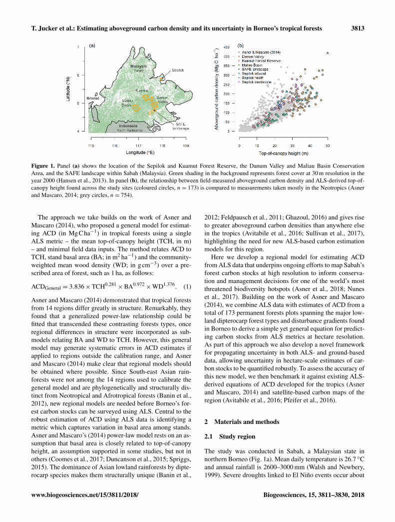