Esterhazy field trip guide
7
Ulrike Hardenbicker ISSN 1911-5814 42 Prairie Perspectives: Geographical Essays (Vol. 17) Esterhazy field trip guide Esterhazy field trip guide Ulrike Hardenbicker Department of Geography and Environmental Studies, University of Regina This field guide provides an overview of the geomorphic pat- terns of the Saskatchewan Plain and the Qu’Appelle Valley south of Esterhazy. The guide was first drafted to accompany a field trip conducted in conjunction with the 37th annual meeting of the Prairie Division of the Canadian Association of Geographers (PCAG). The meeting was held in Esterhazy from September 20 to 23, 2013 and was hosted by the Department of Geography and Environmental Studies, University of Regina. After leaving Esterhazy the field trip route heads south on Highway 637 (Figure 1). The first stop is approximately 5.7 km south of Esterhazy and 650 m east of Highway 637 on a gravel road at the Kaposvar National Historic Site (Stop 1). Once back on Highway 637 the route continues south for 5 km to Stop 2 located at the northern rim of the Qu’Appelle Valley. From the Stop 2 the route proceeds 1 km down into Qu’Appelle Valley on Highway 637 and then turns east on an unnamed road towards the community of Tantallon. After 9.6 km the route turns north on an unnamed road towards the rural municipality Hazel Cliffe. This road is followed for 5.7 km into the Kaposvar Valley before turning west on to Pioneer Road. Stop 3 is reached after traveling for 300 m on Pioneer Road. The route then continues west on Pioneer Road for 10.2 km before turning north on Highway 637 and heading back to Esterhazy. Stop 1: Kaposvar Historic Site The region south of Esterhazy is part of the Saskatchewan Plain (550 – 600 m ASL), a drift-mantled plain of relatively low relief underlain by soft Cretaceous sedimentary bedrock (Figures 2 and 3) (Klassen 1972). The transition from the Manitoba Low- lands, the First Prairie Level, to the Saskatchewan Plain, the Second Prairie Level, is marked by the Manitoba Escarpment (Figure 2). The escarpment is composed mainly of Cretaceous rocks (Odanah Member of the Pierre Formation.) The Odanah shale, formerly a member of the Riding Mountain Formation, caps the Manitoba Escarpment (Young and Moore 1994). Figure 1 Field trip route map Basemap: © Google Maps
Transcript of Esterhazy field trip guide

Ulrike Hardenbicker
ISSN 1911-581442Prairie Perspectives: Geographical Essays (Vol. 17)
Esterhazy field trip guide
Esterhazy field trip guide
Ulrike HardenbickerDepartment of Geography and Environmental Studies, University of Regina
This field guide provides an overview of the geomorphic pat-terns of the Saskatchewan Plain and the Qu’Appelle Valley south of Esterhazy. The guide was first drafted to accompany a field trip conducted in conjunction with the 37th annual meeting of the Prairie Division of the Canadian Association of Geographers (PCAG). The meeting was held in Esterhazy from September 20 to 23, 2013 and was hosted by the Department of Geography and Environmental Studies, University of Regina.
After leaving Esterhazy the field trip route heads south on Highway 637 (Figure 1). The first stop is approximately 5.7 km south of Esterhazy and 650 m east of Highway 637 on a gravel road at the Kaposvar National Historic Site (Stop 1). Once back on Highway 637 the route continues south for 5 km to Stop 2 located at the northern rim of the Qu’Appelle Valley.
From the Stop 2 the route proceeds 1 km down into Qu’Appelle Valley on Highway 637 and then turns east on an unnamed road towards the community of Tantallon. After 9.6 km the route turns north on an unnamed road towards the rural municipality Hazel Cliffe. This road is followed for 5.7 km into the Kaposvar Valley before turning west on to Pioneer Road. Stop 3 is reached after traveling for 300 m on Pioneer Road. The route then continues west on Pioneer Road for 10.2 km before turning north on Highway 637 and heading back to Esterhazy.
Stop 1: Kaposvar Historic Site
The region south of Esterhazy is part of the Saskatchewan Plain (550 – 600 m ASL), a drift-mantled plain of relatively low relief
underlain by soft Cretaceous sedimentary bedrock (Figures 2 and 3) (Klassen 1972). The transition from the Manitoba Low-lands, the First Prairie Level, to the Saskatchewan Plain, the Second Prairie Level, is marked by the Manitoba Escarpment (Figure 2). The escarpment is composed mainly of Cretaceous rocks (Odanah Member of the Pierre Formation.) The Odanah shale, formerly a member of the Riding Mountain Formation, caps the Manitoba Escarpment (Young and Moore 1994).
Figure 1 Field trip route map
Basemap: © Google Maps

Ulrike Hardenbicker
ISSN 1911-581443Prairie Perspectives: Geographical Essays (Vol. 17)
Esterhazy field trip guide
Figure 2 Terrain map of southern Saskatchewan
Figure 3 Surficial geology map and geomorphology (Source: http://www.infomaps.gov.sk.ca/website/SIR_Geo-logical_Atlas/viewer.htm)
Ulrike Hardenbicker
ISSN 1911-581444Prairie Perspectives: Geographical Essays (Vol. 17)
Esterhazy field trip guide
The Second Prairie Level underlain by marine shale of the Pierre Formation is mostly covered by glacial drift to a depth of 450 to 455 m. Overlying Quaternary till deposits of the Saska-toon Group are up to 60 m thick (Christiansen 1972).
The topography of the area is characterized by gentle to moderate slopes and a hummocky-ridged surface with kettles. The area around Esterhazy lies in the Qu’Appelle Valley basin, a sub-basin of the Assiniboine River Plain. Most of the area is drained by Kaposvar and Cutarm Creeks which drain to the Qu’Appelle River. The Kaposvar Creek Channel was eroded by meltwater, whereas water flowing from proglacial Saltcoats Lake eroded the Cutarm Spillway (Figures 1 and 3) (Christian-sen 1979; Kehew et al. 2009).
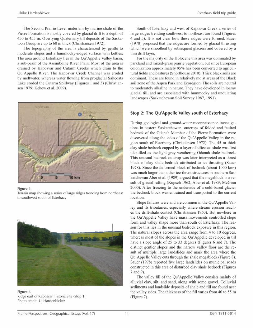
South of Esterhazy and west of Kaposvar Creek a series of large ridges trending southwest to northeast are found (Figures 4 and 5). It is not clear how these ridges were formed. Sauer (1978) proposed that the ridges are formed by glacial thrusting which were smoothed by subsequent glaciers and covered by a thin drift layer.
For the majority of the Holocene this area was dominated by parkland and mixed-grass prairie vegetation, but since European colonization approximately 95% has been converted to agricul-tural fields and pastures (Shorthouse 2010). Thick black soils are dominant. These are found in relatively moist areas of the Black soil zone of the Aspen Parkland Ecoregion. The soils are neutral to moderately alkaline in nature. They have developed in loamy glacial till, and are associated with hummocky and undulating landscapes (Saskatchewan Soil Survey 1987, 1991).
Stop 2: The Qu’Appelle Valley south of Esterhazy
During geological and ground-water reconnaissance investiga-tions in eastern Saskatchewan, outcrops of folded and faulted bedrock of the Odanah Member of the Pierre Formation were discovered along the sides of the Qu’Appelle Valley in the re-gion south of Esterhazy (Christiansen 1972). The 45 m thick clay shale bedrock capped by a layer of siliceous shale was first identified as the light grey weathering Odanah shale bedrock. This unusual bedrock outcrop was later interpreted as a thrust block of clay shale bedrock attributed to ice-thrusting (Sauer 1978). Since the deformed block of bedrock (about 1000 km2) was much larger than other ice-thrust structures in southern Sas-katchewan Aber et al. (1989) argued that the megablock is a re-sult of glacial rafting (Kupsch 1962; Aber et al. 1989; McGinn 2000). After freezing to the underside of a cold-based glacier the bedrock block was entrained and transported to the current location.
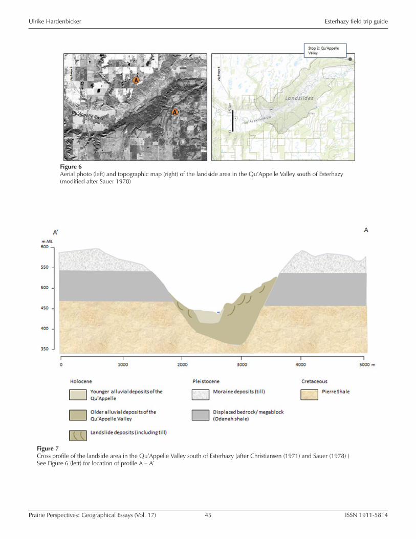
Slope failures were and are common in the Qu’Appelle Val-ley and its tributaries, especially where stream erosion reach-es the drift-shale contact (Christiansen 1960). But nowhere in the Qu’Appelle Valley have mass movements controlled slope form and valley shape more than south of Esterhazy. The rea-son for this lies in the unusual bedrock exposure in this region. The natural slopes across the area range from 4 to 10 degrees, whereas most of the slopes in the Qu’Appelle developed in till have a slope angle of 25 to 33 degrees (Figures 6 and 7). The distinct gentler slopes and the narrow valley floor are the re-sult of multiple large landslides and mark the area where the Qu’Appelle Valley cuts through the shale megablock (Figure 8). Sauer (1978) reported five large landslides on municipal roads constructed in this area of disturbed clay shale bedrock (Figures 7 and 9).
The valley fill of the Qu’Appelle Valley consists mainly of alluvial clay, silt, and sand, along with some gravel. Colluvial sediments and landslide deposits of shale and till are found near the valley sides. The thickness of the fill varies from 40 to 55 m (Figure 7).
Figure 4 Terrain map showing a series of large ridges trending from northeast to southwest south of Esterhazy
Figure 5 Ridge east of Kaposvar Historic Site (Stop 1) Photo credit: U. Hardenbicker
Ulrike Hardenbicker
ISSN 1911-581445Prairie Perspectives: Geographical Essays (Vol. 17)
Esterhazy field trip guide
Figure 6 Aerial photo (left) and topographic map (right) of the landside area in the Qu’Appelle Valley south of Esterhazy (modified after Sauer 1978)
Figure 7 Cross profile of the landside area in the Qu’Appelle Valley south of Esterhazy (after Christiansen (1971) and Sauer (1978) ) See Figure 6 (left) for location of profile A – A’

Ulrike Hardenbicker
ISSN 1911-581446Prairie Perspectives: Geographical Essays (Vol. 17)
Esterhazy field trip guide
Christiansen (1972) has identified six stages in the glacial history of the Qu’Appelle Valley south east of Esterhazy. Se-quentially, deposition of the Empress Group was followed by deposition of tills and incision of the Qu’Appelle Valley to about 457 m ASL. Aggradation of gravels by glacial meltwater then formed the Tantallon terrace (c. 35 m thick), a prominent land-scape feature which includes boulders from the Odanah shale (Figures 10 and 11). This depositional phase was followed by
further incision of the valley to about 380 m ASL and recent deposition of alluvium (c. 40 to 45 m thick).
Deposition of alluvium started more than 12,000 years ago. The initial rate of deposition was rapid and has continued at a decreasing rate to the present time (Christiansen 1972; Klassen 1972). The material in the Qu’Appelle Alluvium was brought to the valley in three ways.
First, sediment was deposited when the Qu’Appelle spillway was still functioning as a meltwater spillway. Second, sediments were deposited as a result of post-glacial down-valley transport mainly by overbank and channel deposition. Third, sediments were deposited from erosion (sheetwash and slumping) of the valley walls and adjacent uplands forming thick accumulations of colluvium and alluvial fans along the walls.
Figure 8 Location of the Esterhazy megablock (after Sauer 1978)
Figure 9 Warning sign on Higway 637 south of Esterhazy Photo credit: U. Hardenbicker
Figure 10 Highway 637 overlooking the Qu’Appelle Valley south of Esterhazy. Level parts of the middle slope section of the north facing slope marking the Tantallon terrace level (Stop 2) Photo credit: U. Hardenbicker
Figure 11 Outcrop of the Tantallon terrace south of Highway 637 Photo credit: U. Hardenbicker
Ulrike Hardenbicker
ISSN 1911-581447Prairie Perspectives: Geographical Essays (Vol. 17)
Esterhazy field trip guide
Stop 3: Hazel Cliffe
The Esterhazy megablock is more or less horizontal, slightly deformed, and mostly buried under till. This deformation is con-fined to bedrock above about 460 to 490 m ASL (Christiansen 1972). The 490 m contour line was used as a minimum outline for the megablock. Neither the direction of emplacement nor the source of the mega raft is known (Aber et al. 1989) (Figures 7 and 8).
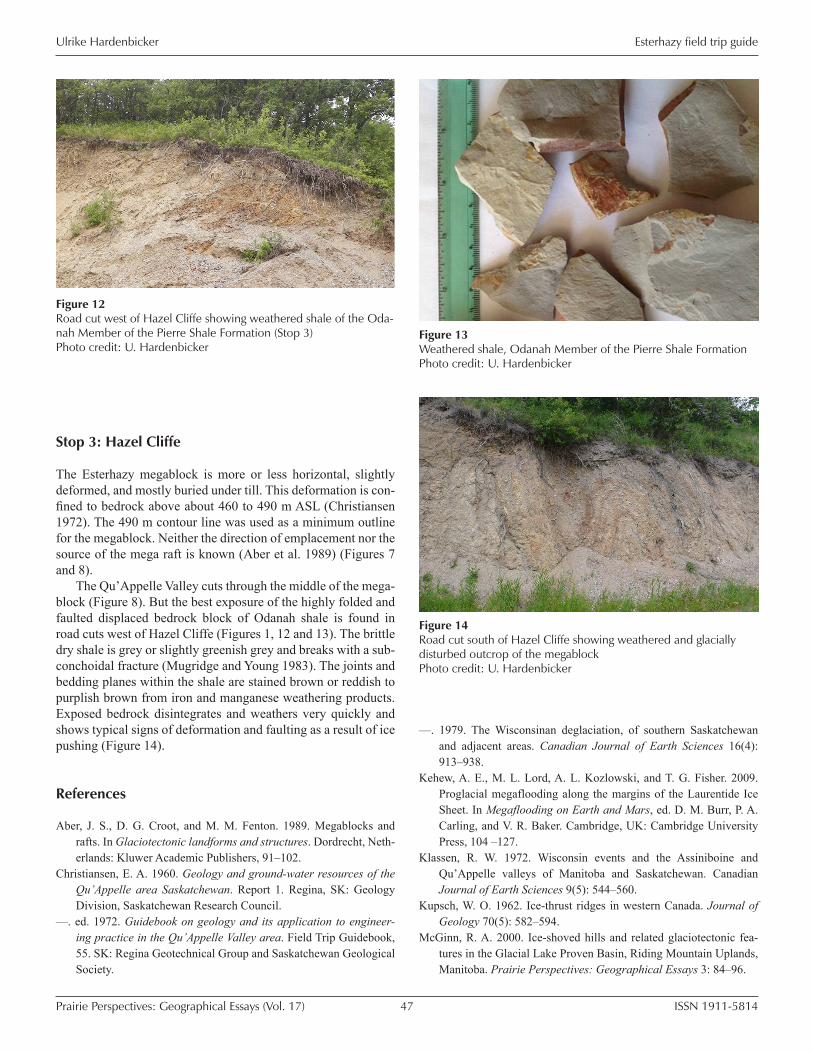
The Qu’Appelle Valley cuts through the middle of the mega-block (Figure 8). But the best exposure of the highly folded and faulted displaced bedrock block of Odanah shale is found in road cuts west of Hazel Cliffe (Figures 1, 12 and 13). The brittle dry shale is grey or slightly greenish grey and breaks with a sub-conchoidal fracture (Mugridge and Young 1983). The joints and bedding planes within the shale are stained brown or reddish to purplish brown from iron and manganese weathering products. Exposed bedrock disintegrates and weathers very quickly and shows typical signs of deformation and faulting as a result of ice pushing (Figure 14).
References
Aber, J. S., D. G. Croot, and M. M. Fenton. 1989. Megablocks and rafts. In Glaciotectonic landforms and structures. Dordrecht, Neth-erlands: Kluwer Academic Publishers, 91–102.
Christiansen, E. A. 1960. Geology and ground-water resources of the Qu’Appelle area Saskatchewan. Report 1. Regina, SK: Geology Division, Saskatchewan Research Council.
––. ed. 1972. Guidebook on geology and its application to engineer-ing practice in the Qu’Appelle Valley area. Field Trip Guidebook, 55. SK: Regina Geotechnical Group and Saskatchewan Geological Society.
Figure 12 Road cut west of Hazel Cliffe showing weathered shale of the Oda-nah Member of the Pierre Shale Formation (Stop 3) Photo credit: U. Hardenbicker
Figure 13 Weathered shale, Odanah Member of the Pierre Shale Formation Photo credit: U. Hardenbicker
Figure 14 Road cut south of Hazel Cliffe showing weathered and glacially disturbed outcrop of the megablock Photo credit: U. Hardenbicker
––. 1979. The Wisconsinan deglaciation, of southern Saskatchewan and adjacent areas. Canadian Journal of Earth Sciences 16(4): 913–938.
Kehew, A. E., M. L. Lord, A. L. Kozlowski, and T. G. Fisher. 2009. Proglacial megaflooding along the margins of the Laurentide Ice Sheet. In Megaflooding on Earth and Mars, ed. D. M. Burr, P. A. Carling, and V. R. Baker. Cambridge, UK: Cambridge University Press, 104 –127.
Klassen, R. W. 1972. Wisconsin events and the Assiniboine and Qu’Appelle valleys of Manitoba and Saskatchewan. Canadian Journal of Earth Sciences 9(5): 544–560.
Kupsch, W. O. 1962. Ice-thrust ridges in western Canada. Journal of Geology 70(5): 582–594.
McGinn, R. A. 2000. Ice-shoved hills and related glaciotectonic fea-tures in the Glacial Lake Proven Basin, Riding Mountain Uplands, Manitoba. Prairie Perspectives: Geographical Essays 3: 84–96.

Ulrike Hardenbicker
ISSN 1911-581448Prairie Perspectives: Geographical Essays (Vol. 17)
Esterhazy field trip guide
Mugridge, S-J., and H. R. Young. 1983. Disintegration of shale by cy-clic wetting and drying and frost action. Canadian Journal of Earth Sciences 20(4): 568–576.
Sauer, E. K. 1978. The engineering significance of glacier ice-thrusting. Canadian Geotechnical Journal 15(4): 457–472.
Saskatchewan Soil Survey. 1987. The soils of Moosomin (121) Martin (122) Rocanville (151) Spy Hill (152) rural municipalities Sas-katchewan. Saskatoon, SK: Saskatchewan Institute of Pedology, Publication S207.
––. 1991. The soils of Langenburg (181) Fertile Belt (183) Church-bridge (211) Saltcoats (213) rural municipalities Saskatchewan. Saskatoon, SK: Saskatchewan Institute of Pedology, Publication S208.
Shorthouse, J. D. 2010. Ecoregions of Canada’s prairie grasslands. In Arthropods of Canadian Grasslands (Volume 1): Ecology and In-teractions in Grassland Habitats. ed. J. D. Shorthouse and K. D. Floate. Ottawa, ON: Biological Survey of Canada, 53–81.
Young, H. R. and P. R. Moore. 1994. Composition and depositional environment of the siliceous Odanah Member (Campanian) of the Pierre Shale in Manitoba. Geological Society of America Special Papers 287: 175–196.


![Field trip[1]](https://static.fdocuments.in/doc/165x107/53fc63ca8d7f72aa518b4749/field-trip1.jpg)