Establishing Local Identity Through Planning and Landscape ...
76
Establishing Local Identity Through Planning and Landscape Design in Urban Waterfront Development by Huirong Liu A Thesis presented to The University of Guelph In partial fulfilment of requirements for the degree of Master of Landscape Architecture Guelph, Ontario, Canada © Huirong Liu, April, 2013
Transcript of Establishing Local Identity Through Planning and Landscape ...

Establishing Local Identity Through Planning and Landscape
Design in Urban Waterfront Development
by
Huirong Liu
A Thesis
presented to
The University of Guelph
In partial fulfilment of requirements
for the degree of
Master of Landscape Architecture
Guelph, Ontario, Canada
© Huirong Liu, April, 2013

ABSTRACT
Establishing Local Identity Through Planning and Landscape Design
in Urban Waterfront Development
Huirong Liu Advisor: University of Guelph, 2013 K. Landman
In an increasingly globalized world, emphasis on attracting investment, talent and tourists has
resulted in similar iconic urban landscapes in cities. This has increased concerns on the reduction
or complete loss of local identity along urban waterfronts. This study aimed to develop a set of
design guidelines that contribute to the establishment of local identity on urban waterfronts. The
research focused on the history and current status of urban waterfront development, globalization
impacts on urban landscape, notions of place identity and place making. It defined local identity
as one type of place identity and explored the key aspects that foster local identity in waterfront
development. A case study was conducted by analyzing these key aspects in a successful
waterfront development. From a synthesis of the findings, a set of design guidelines was
developed and then tested on an unsuccessful project; recommendations for future improvement
were based on the developed guidelines.
Keywords: urban landscape, waterfront development, place making, place identity, globalization

iii
ACKNOWLEDGEMENT
I wish to express my sincerest appreciation and gratitude to Prof. Karen Landman for her
invaluable guidance and support in bringing this thesis to fruition. I am especially grateful to her
for not only guiding me in scientific research, supporting my field study in China, but also teaching
me in manuscript writing and encouraging me over the hard time. It is a great privilege to
research under her.
I would also thank Prof. Robert Brown for his constructive comments on my research.
My deepest and loving thanks goes to my beloved husband, Xiaohui Xiao, for his care, love and
support at all stages of my research. His timely encouragement is my motivation. I also would like
to thank to my daughter, YiYi Xiao, who joined us when I was pursuing my graduate study, for
bring me a rich source of joys and happiness.
I am eternally grateful for my parents for giving me life in the first place and for unconditional
support and encouragement to pursue my dreams.
iv
TABLE OF CONTENTS
ABSTRACT ii
ACKNOWLEDGEMENTS iii
LIST OF TABLES vi
LIST OF FIGURES vii
1 Chapter One: Introduction ....................................................................................................... 1
1.1 Background ...................................................................................................................... 1
1.2 Justification of Research ................................................................................................. 2
1.3 Research Question, Goal and Objectives ....................................................................... 3
1.4 Thesis Organization ......................................................................................................... 3
2 Chapter Two: Literature Review .............................................................................................. 5
2.1 Waterfront and the City .................................................................................................... 5
2.2 Urban Waterfront Development ....................................................................................... 6
2.3 Globalization and Urban Waterfronts .............................................................................. 8
2.4 Place Identity and Place Making ................................................................................... 10
3 Chapter Three: Research Methods ....................................................................................... 14
4 Chapter Four: Results and Analysis ...................................................................................... 16
4.1 Local Identity .................................................................................................................. 16
4.2 Key aspects in Planning and Design that Foster a Sense of Local Identity .................. 17
4.3 Design Attributes in Each Key Aspect ........................................................................... 19
4.3.1 Functionality ........................................................................................................... 19
4.3.2 Accessibility ........................................................................................................... 21
4.3.3 Culture and History ................................................................................................ 22
4.3.4 Ecological Environment ......................................................................................... 24
4.4 Preliminary Design Guidelines ...................................................................................... 25
4.5 Case Study – Southeast False Creek ........................................................................... 27
4.5.1 Analysis of Southeast False Creek Using the Key Aspects .................................. 29

v
4.5.1.1 Functionality ....................................................................................................... 29
4.5.1.2 Accessibility ....................................................................................................... 33
4.5.1.3 Culture and History ............................................................................................ 35
4.5.1.4 Ecological Environment ..................................................................................... 37
4.6 Summary ....................................................................................................................... 41
5 Chapter Five: Synthesis of Design Guidelines ...................................................................... 43
6 Chapter Six: Testing of Design Guidelines ............................................................................ 45
6.1 Introduction of the testing project .................................................................................. 45
6.2 Analysis using the Key Aspects ..................................................................................... 48
6.2.1 Functionality ........................................................................................................... 48
6.2.2 Accessibility ........................................................................................................... 50
6.2.3 Culture and History ................................................................................................ 52
6.2.4 Ecological Environment ......................................................................................... 54
6.3 Summary ....................................................................................................................... 54
6.4 Recommendations for Future Improvement of ZJNT Waterfront .................................. 56
7 Chapter Seven: Discussion ................................................................................................... 59
7.1 Major Findings ............................................................................................................... 59
7.2 Critique of the Research ................................................................................................ 61
8 Chapter Eight: Conclusion ..................................................................................................... 63
8.1 Summary of the Research ............................................................................................. 63
8.2 Recommendations for Future Research........................................................................ 63
8.3 Recommendations for Planners and Designers ............................................................ 64
References ………………………………………………………………………………………………..65

vi
List of Tables
Table 4-1: Summarized design attributes for each key aspect. Source: Author, 2013 ................. 26
Table 4-2: Summary of SEFC Design, Vancouver. BC, Source: Author, 2013 ........................... 42
Table 5-1: Final Design Guidelines, Source: Author, 2013 .......................................................... 44
Table 6-1: Design Attribute in ZJNT, Guangzhou, China. Source: Author, 2013 ......................... 55
Table 6-2: Design Attribute in ZJNT, Guangzhou, China. Source: Author, 2013 ......................... 57

vii
List of Figures
Figure 3-1: Research Methodology Flowchart .............................................................................. 15
Figure 4-1: Key Aspects that Contribute to Local Identity ............................................................. 18
Figure 4-2: Key Aspects Present in Literature on Place Identity in Waterfront Development ....... 19
Figure 4-3: Location map of SEFC waterfront, Vancouver. BC .................................................... 28
Figure 4-4: Physical context of SEFC waterfront, Vancouver. BC ................................................ 28
Figure 4-5: SEFC Waterfront Official Development Plan, Vancouver. BC .................................... 30
Figure 4-6: The Mix of Housing in SEFC Proposed in 2006 Re-zoning, Vancouver. BC ............. 30
Figure 4-7: Park System & Facilities along Water Edge in SEFC, Vancouver. BC ...................... 32
Figure 4-8: Some Retail in SEFC, Vancouver. BC ........................................................................ 33
Figure 4-9: Transit Options in SEFC, Vancouver. BC ................................................................... 34
Figure 4-10: Accessibility to Water in SEFC, Vancouver. BC ....................................................... 34
Figure 4-11: Shipyard Plaza in SEFC, Vancouver. BC ................................................................. 36
Figure 4-12: Artwork at SEFC, Vancouver. BC ............................................................................. 37
Figure 6-1: Location of ZJNT Waterfront - Plan ............................................................................ 46
Figure 6-2: Location of ZJNT Waterfront - Bird view ..................................................................... 46
Figure 6-3: Bird’s Eye View of ZJNT, Guangzhou, China ............................................................. 47
Figure 6-4: Promenade in ZJNT Waterfront, Guangzhou, China .................................................. 48
Figure 6-6: Original planning of Haixinsha Island, Guangzhou, China ......................................... 50
Figure 6-7: Original Planning of Haixingsha Island, Guangzhou, China ....................................... 50
Figure 6-8: Promenade in ZJNT waterfront, Guangzhou, China ................................................... 51
Figure 6-9: Lingjiang Boulevard in ZJNT waterfront, Guangzhou, China...................................... 51
Figure 6-10: Hunter Lane in ZJNT, Guangzhou, China................................................................. 53
Figure 6-11: Opera House of Guangzhou, Museum of Guangdong and City Library, ZJNT,
Guangzhou, China ......................................................................................................................... 53
Figure 6-12: Design Recommendation Plan of ZJNT Waterfront, Guangzhou, China, ................ 58

1
1 CHAPTER ONE: INTRODUCTION
1.1 Background
The evolution of many cities is intimately related to water, whether it is a river, lake or ocean.
Waterfront is always the starting point of the evolution of human society and urban territory.
Under different economic structures, urban waterfronts present different landscapes, from
protective harbour in ancient times, to ports and industrial zones during the 19th to mid-20 century,
and then revitalized mixed-use urban space today. Over time, the waterfront has become one of
the most recognizable urban forms, providing high aesthetic connectivity and functional values.
Due to its proximity to water and the city core, the waterfront creates a link between land and
water, between peopleand nature.
Modenr urban waterfront development originated in North America in the early 1960’s (Breen &
Rigby, 1994), following the deindustrialization in downtown ports and urban revitalization that
aimed to attract people back to downtown for business, living and entertainment. After the
success of the revival Baltimore’s Inner Harbour in the 1970s, waterfront development has
gradually spread to Europe and elsewhere from the 1980s. It has become a well-established
phenomenon internationally.
Globalization, broadly conceived as the borderless movement and transnational reach of capital,
people, goods, services, and information (Chang & Huang, 2011), has greatly influenced urban
landscapes, development processes, and the lives of its inhabitants. Yeoh (1999, p.628) termed
the process as “globalizing cities” whereby urban areas “strategize and renegotiate their visions
and identities vis-à-vis the new world order.” The quest for world-class status is often envisioned
by state and city planners as an important way to attract investments, talent and tourists. In the
prime urban site of the waterfront, the convergence of tourism, cultural, retail and residential
functions testifies to a city’s vitality and attainment of world-class status (Chang & Huang, 2011).
Successful prototypes serve as guidelines for cities looking to redevelop their waterfronts.
Similarity appears along city waterfronts with key elements such as landmark buildings, a market

2
place, and upscale stadiums or convention centers for international events. The waterfront has
become a primary site of experimentation in architecture, planning and urban governance (Dovey,
2005). This phenomenon is even more obvious in developing countries. Scholars such as
Change and Huang (2008) caution that a ‘geography of everywhere’, encapsulating what other
cities have to offer, may result in a ‘geography of nowhere’. Furthermore, privatization and
gentrification have led to social disconnection in the waterfront. Scholars are increasingly urging
that, rather than continuing to attract investment, talent and tourists, cities should also retain their
unique and desirable local characteristics,advance sustainability in various levels, and create
attachments with local people. More than an international image, the waterfront should create
urban landscape with an authentic identity.
1.2 Justification of Research
In the era of globalization, urban waterfronts have been transformed for economic imperatives.
When exposed to global culture and capital flows, many cities respond with an aspiration to
achieve ‘world-class status’. Cities employing similar tactics look to successful world-class cities
and the employment of internationally-renowned architects. During the past twenty years, the
economic booming in China put the waterfront in the center of urban development in many
Chinese cities. Waterfronts have been built as ‘an international showcase’. For example,
Shanghai’s Lujiazui Central Area was observed by Olds (1995) as a site designed to be an
international space for global capital and multinational people.
Transformation of the urban waterfront that projects a global aspiration is inevitable and
necessary. However, an economically successful waterfront development might not be successful
socially and culturally. Major concerns focused on the waterfront include: the needs and desires
of local people tend to be over looked by world-class amenities; local culture and history tend to
be overridden by international and iconic design; local ecology environment tends to be spoiled
by mega-projects. In summary, the local identity of the waterfront tends to be reduced or totally
lost in the face of the impacts from globalization. There is some research on urban waterfront
transformation in the context of globalization (Olds, 1995; Change et al., 2004, 2008, 2011;
3
Dovey, 2005) but most are from a perspective of geography or sociology. Local identity in design
field has been generally related to the built history, local materials or cultural importance. This
study adds to the discussion regarding local identity from a planning and design perspective.
1.3 Research Question, Goal and Objectives
The key question that drives the research is: How can local identity be fostered though planning
and design in a city’s waterfront? The goal of the thesis is to develop a set of design guidelines
that contributes to the establishment of local identity in waterfront developments. To reach the
goal, the following objectives are addressed:
To learn the history and current status of urban waterfront development.
To understand the influences that globalization has on urban landscape in the waterfront.
To understand the notion of place, place identity and place making from a planning and
design perspective.
To define local identity as one of the place identities for this study.
To establish key design aspects that contribute to the establishment of local identity in
urban waterfront development.
To provide design attributes for each key aspect from related literature and a successful
waterfront case study.
To test the established design guidelines through a globalized waterfront project.
1.4 Thesis Organization
This thesis is organized into eight chapters. Chapter 1 depicts the general research background
of this study, explains the justification of research, defines the research goal and objectives, and
presents the organization of the thesis. Chapter 2 reviews related literature on urban waterfront
development and the influences that globalization has on urban landscape in waterfronts; and
discusses the notions of place, place identity and place making. Chapter 3 describes the research
methodology, and introduces the methods used to develop the design guidelines. Chapter 4
presents the results and analysis: the definition of local identity for the purpose of this study; the

4
key design aspects that contribute to the establishment of local identity in waterfront
developments and the preliminary guidelines; the findings from a case study of waterfront
development that successfully established a local identity. Chapter 5 presents the results of the
refined design guidelines. Chapter 6 tests the developed design guidelines on an unsuccessful
waterfront development project. Chapter 7 discusses the major findings, examines the research
process, and addresses the limitations of the current study. Chapter 8 highlights key findings and
implications of the research, and provides recommendations for design professionals and future
research.

5
2 CHAPTER TWO: LITERATURE REVIEW
This chapter reviews literature focused on waterfront development, globalization, and place
identity. The purpose of this review is to learn about the comprehensive knowledge about urban
waterfront development in an era of globalization and find theoretical basis for the definition of
local identity as one of the place identities. It starts with an investigation of the relationship
between the waterfront and the city; reviews the history and current status of urban waterfront
development; explores the influences that globalization has on urban development and
waterfronts in cities; and examines the notion of place identity and the theory of place making.
2.1 Waterfront and the City
The studied waterfronts in this paper are all in a well-established urban context with a dense
population. The definition from the CZMA (the US Federal Coastal Zone Management Act) is
appropriate for the study, defining the urban waterfront or port as: “any developed area that is
densely populated and is being used for, or has been used for, urban residential, recreational,
commercial, shipping, or industrial purposes” (OOCR, 1972: Section 306A (a) (2)).
The unique location at the interface of water and city makes the waterfront an important urban
form. In different periods, the urban waterfront has changed in response to the consequences of
economic restructuring. In the 19th century, waterfronts were the focal area of social and
economic life in many port cities, being closely associated with city cores. It was a time when
water transportation was the most important factor influencing urban development. During the
19th to early 20
th century, rapid maritime commerce and industrial growth forced ports to develop
beyond the city boundary. City ports continued to thrive, with huge warehouses, railroads and
wharves being built. This large infrastructure became specialized zones, causing a detachment
between city cores and waterfronts. New transportation options, such as railroads, reduced the
cities’ needs for water transportation. As a result, the central city was detached further and further
from the water’s edge. Up to the mid-20 century, the excessive industrial usage of the waterfront
caused severe pollution. Eventually, the waterfront began to lose its natural attraction and

6
became an inaccessible and unsafe area, further separating inhabitants from the water. In the
1960’s to 1980’s, ports retreated from urban waterfronts. The main factors causing waterfront
decline was researched by Tsukio (1984), namely the expansion of city size, the reforms in
transportation technologies and changes in industry.
During the second half of the 20th century, urban revitalization happened worldwide. “A vast
expansion of worldwide trade predicated on new markets, new forms of transport, new locations
of production, new forms of capital growth, and new forms of management and political control
have led to the resurgence of interest in waterfront spaces” (Smith & Garcia Ferrari, p.9).
Waterfronts have been planned and designed as a prime site to attract people and capital.
Development in the waterfront aims to re-join the city and the waterfront physically and
functionally. The waterfront has evolved to be the most recognizable urban form and as being
regarded as the gateway of the city.
2.2 Urban Waterfront Development
In this paper, waterfront development encompasses waterfront regeneration (Smith et al., 2012),
waterfront revitalization (Goodwin, 1999), and waterfront reclamation (Chang & Huang, 2011).
This form of development is associated with the trends of city revitalization and globalization, and
new commercial opportunities in downtown areas.
According to Breen and Rigby (1994), waterfront development originated in North America in the
early 1960’s. Two major factors were identified by Gordon (1997) that triggered waterfront
development: urban blight and economic development. With the deindustrialization of waterfronts,
derelict waterfronts became a high-profile affront to civic leaders. Many waterfront developments
were initiated to meet the need to re-use these abandoned areas. The displacement of traditional
industries from the core, the concentration of financial and other business services in the
downtown area, and the increasing demands for entertainment and recreation urged renewal in
the waterfront to attract investment, talent and tourists. Waterfront revitalization was initiated in
cities like Baltimore, Boston and Toronto in 1970’s, and then spread to Europe and elsewhere in
7
the world. Waterfronts once again play a significant role in the economic and social health of
urban centres.
Shaw (2001) distinguished three generations of post-industrial waterfront development. The first
is the early North American experiences that focused on creating retail and festival marketplaces,
represented by the prominent Baltimore waterfront. The second generation happened mostly
during the 1980s and spread around the world. This generation featured large-scale development
and the involvement of public-private partnerships that incorporated a large portion of private
investment; examples are London Docklands, Sydney, and Toronto. The third generation took the
developed elements from the first two generations as the mainstream of development practice
and used in a range of situations, from small to large cities. Vancouver and a large number of
developments in Asia, including Shanghai are worldwide examples.
From Baltimore’s Inner Harbour to London’s Dockland and Singapore’s riverfront, waterfronts
have been acclaimed by Breen and Rigby (1994) as the worldwide urban success story. Scholars
have tried to develop theoretical models, identifying the factors and aims of successful waterfront
development. Success can be assessed from different perspectives. Hoyle (2001) stated that the
popular sign of success of many waterfront developments is bringing citizens and visitors back to
the water’s edge, and providing tangible evidence of the continuing vitality of cities. Other signs of
success that are widely recognized are image improvement, infrastructure upgrades,
environmental rehabilitation, tourism opportunities, and economic revenue generation (Goodwin,
1999). How to create a successful waterfront has increased attention from professionals. From
the policy-making level, Smith and Garcia Ferrari (2012, p.155) observed that the success could
be achieved by “respectively focusing on the physical characteristics of place (with particular
relevance to urban design) and the processes of social interaction (with particular relevance to
planning process)”. Design and planning play a key role in the success of waterfront development.
However, waterfront development is a process full of challenges. The main challenges include the
inaccessibility, a fragmented and complex structure with involvement of many jurisdictions and
interests (Wrenn, 1983), and the long duration of development (Craig-Smith, 1995). The

8
inaccessibility resulted from the port and industrial history of waterfronts: crowded warehouses,
railways or highways along the waterfront, polluted water, and deteriorated structures. These
unfavourable conditions prevent people from accessing waterfronts. In addition to limitations on
the physical environment, waterfronts generally have a fragmented and complex structure of
many overlying jurisdictions and interest groups. The gap between different interests such as
private investors, the city and local communities is wide. Meticulous planning and sufficient
coordination are required. Furthermore, most waterfront developments take decades to perform
(Craig-Smith, 1995). Immense financial investment is demanded. These factors encourage the
emergence of uncoordinated independent projects. In many countries, waterfront developments
are almost completely left to private investors and market forces.
Local communities, including waterfront inhabitants and citizens, and tourists are two not
necessarily mutually exclusive kinds of users of the waterfront. A community group has been
defined as an unofficial gathering of people with a particular perspective or opinion that is not
necessarily represented by their government, either at municipal, provincial or federal levels
(Hoyle, 2000). In a waterfront development context, where top-down approaches are prevalent,
Hoyle (2000) conducted research into member-driven, bottom-up, community-development focus
developments. The primary characteristic of this kind of waterfront development was found to
have the common fundamental objective to enhance the quality of life. Urban policy is now
associated with a shift in emphasis from property-led regeneration towards a broader-based
partnership agenda with a focus on community interest. This, correspondingly, leads waterfront
development towards a balanced development that incorporates needs and desires of local
communities.
2.3 Globalization and Urban Waterfronts
While the definition of globalization varies with the context of analysis, it generally refers to an
increasing interaction across national boundaries that affect many aspects of life: economic,
social, cultural and political (United Nations Poverty and Development Division, 1999). It is
broadly accepted that globalization is a process of increasing interconnectedness.

9
Robertson (2003) described three waves of globalization in which urban development changed
due to economic restructuring. We are now immersed in the third one, which started after World
War II and was caused by the new information technologies and the continued development of
infrastructure and transport connections. It was not until the 1970s and 1980s that changes on
urban development became severe, when cities tried to regenerate the urban economy and adapt
to new economic roles in hosting service employment and centres for consumption (Couch et al.,
2003). Local government, together with local civil society, faces the imperative to foster and
sustain business competitiveness. Actions at the level of the city to influence competitive
advantage focus on improving infrastructure, creating image and branding. According to Muxi
(2004), image making in cities primarily involves regeneration of historical areas for new uses and
iconic buildings designed by star architects. City branding is the creation of theme parks,
universities, research parks and the like to generate urban concentration processes (Zukin, 1991).
These actions sustain cities’ competitive advantages on one hand, and increased social and
spatial fragmentation on the other hand.
Fundamentally, competition among cities shows the need for generating highly competitive
environments that aim to attract global capital. Waterfronts are, in this context, considered to be
opportunities for the city as a whole (Smith & Garcia Ferrari, 2012). From the market-driven
project of Docklands regeneration in London, to the ‘quality development’ of luxury housing and
high-tech commercial space constructed on Copenhagen’s waterfront, and the creation of
globalized ‘landscapes of desire’ along the Yarra River in Melbourne, waterfronts act as the
gateway to project a city’s aspiration of world-class status.
In an overview of British waterfront developments in the 1980s, Pinder et al. (1988) also noted a
trend toward “urban cloning.” They explained that it is “safer and far quicker for a city authority to
embark on revitalization in the type of port area that has been transformed in other ports, than it is
to pioneer new approaches to the problem” (Pinder et al., 1988, p252). Similarity appeared along
urban waterfronts with elements like sports stadiums, international museums and convention
centres. These elements are regarded as key to establish an international image for the city,

10
providing a ‘hook’ for the world economy (Olds, 1995). Chang and Huang (2008), in studying
Singapore’s waterfront, observed that the redevelopment process of the Singapore riverfront
involves borrowing ideas from global cities and waterfronts; infusing landscapes with foreign
aesthetics, alien designs and transnational businesses; and showcasing the best of the west by
festivals, events and ‘themed’ entertainment. They cautioned that encapsulating what other cities
have to offer may result in a “geography of nowhere; an urban environment that looks like
anywhere else on earth” (Chang & Huang, 2008, p.227). In addition to these landscape
transformation along waterfronts, negative impacts in social and cultural terms, have resulted
from the relentless privatisation (Cybriwsky, 1999), riverfront gentrification (Davidson, 2007), and
functional change in the waterfront to lure footloose investments and middle-class.
Along cities’ waterfronts, loss of a sense of place, ‘local identification’ (Cybriwsky, 1999), or ‘a
sense of local community’ (Chang & Huang, 2008) has raised increased concerns. As a planner
and researcher, Schmidt (2002) pointed out that “the challenge for the future is to determine how
this force [globalization] can pull with it an entire region without compromising our identity. In
other words we must remain locally anchored in a changing global world”. Urban waterfronts are
crucial sites in both a city’s history and its current development. Attempts must be made to
provide meaningful spaces for interaction and local identification. Chang and Huang (2008, p.244)
suggested a direction for future development in Singapore riverfront, “the waterfront development
should move on to the next stage to develop – rather than erase or adulterate – landscapes that
encourage a sense of local community, attachment and place”. This suggestion can be useful for
the waterfront development in many cities in this increasingly globalised world.
2.4 Place Identity and Place Making
‘Place’ as a notion related to place identity can be analyzed from various perspectives. It is
regarded as an important element of identity, whether individual or collective (Jenkins, 2005).
Dealing with the collective place identity, place can be defined as “the predominantly socio-
cultural perception and definition of space” (Jenkins, 2005, p.20); as studied from individual
experience within the field of environmental psychology, “place is defined by the bonds and

11
shared values created through perceptive experience of places”. (Ferrari et al., 2012, p.154). In
the planning and design field, Motloch (1989, p.231) defins place as “temporal, an inter-related
continuum of space, time and meaning, a collective consciousness where meaning has both
perceptual and associational aspects”. Motloch’s understanding of place adds the dimension of
time and highlights key elements of place as space, time and meaning. Place as a collective
consciousness in this definition is most related to the place identity analyzed in this research.
When exploring the concept of place identity by drawing on a literature from cultural studies and
geography, Hague (2005, p.7) summarized that:
Places are places (and not just spaces) because they have identity. Place identities are
formed through milieux of feelings, meanings, experiences, memories and actions that, while
ultimately personal, are substantially filtered through social structures and fostered through
socialization. Thus place identities are relational – i.e. they are formed in relation to other people,
other places and other identities for that place. Therefore, place identities are encapsulated within
power relations and are likely to be contested.
He concluded that there will be multiple, contested identities for any one area. Place identity
processes in different scales – national, regional and local (Amundsen, 2001). The genius loci
(Norgerg-Schulz, 1980) was the most frequently used concept regarding place identity to
underpin planning and design. It implies that there are essential characteristics that identify a
place.
As the major tool for waterfront development, planning and urban design were seen as being
about place making (Hague & Jenkins, 2005; Brown et al., 2009; Smith & Garcia Ferrari, 2012),
aiming to construct the identities of places through manipulation of the activities, feelings,
meanings and urban fabric that combine into place identity. The built environment, as the
outcome of planning and design, is the “physical and three-dimensional manifestation of place
identity” (Higgins, 2005, p.184).
The notion of place making originated in the 1960s with the appearance of a series of literature
discussing the qualities of place. The most well-known author is Jane Jacobs (1961) who
highlighted the importance of social space on the sidewalks and human activities on the street,

12
seeing cities as a setting for interaction. In the 1980s, William Whyte (1988) observed how public
spaces were being used and offered ideas on designing people-oriented cities with an emphasis
on essential elements for creating social life in public spaces. The study provided a basis for a
move towards proactive place-making within the field of urban renewal. After more than twenty
years of development, planning and design came to the age of place making for people (Brown et
al., 2009). New concepts and ideas appeared in response to changes and problems in our
societies, such as mixed use, sustainability, smart growth, and transit-oriented development just
to name a few. Community engagement plays an essential role in all these new currents of urban
planning and design.
Focusing on urban waterfronts, the Waterfront Center (www. Waterfrontcenter.org) in the United
States sees waterfronts as opportunities to enrich community life. The Center issued an ‘urban
waterfront manifesto’ in 1999, setting out basic principles of waterfront development. This
manifesto incorporates many of the values that urban designers bring to planning and designing
waterfronts:
1. The public sector should act as the ‘steward’ of waterfronts 2. Waterfront-dependent uses should receive preference in the redevelopment programs 3. Waterfront should accommodate a variety of uses 4. All urban waterfront projects should provide public access 5. One size does not fit all; waterfront developments should reflect the essential spirit of
each site 6. Waterfront projects should preserve and interpret the tangible aspects of the history of a
site
These values addressed the importance of public access to the waterfront and the mixed-use
functionality to attract people of different ages, backgrounds, incomes, and races; emphasized
the waterfront-dependent uses and heritage preservation; and paid special attention to the
distinctiveness, the essential spirit, of the waterfront. According to the genius loci (Norgerg-Schulz,
1980) theory, the distinctiveness of each site can be conveyed by natural, cultural and historical
characteristics of the place. These principles imply the key design aspects about the place
making in the waterfront that contributes to establishing place identity.
The participatory design process, involving different interests, has proved crucial in the
construction of place identity, especially on a local level (Hague & Jenkins, 2005; Brown et al.,

13
2009; Smith & Garcia Ferrari, 2012). Planners and designers have to be able to engage with local
residents and other members of civil society, for whom places may have very different meaning
and identities from politicians and economic interests. Higgins (2005, p.186) pointed out, “Design
is as much about process as it is about product, and the interaction between the two is a powerful
determinant of outcomes”. Focusing on praxis, successful place making was approached mainly
by focusing on the physical characteristics of place (with particular relevance to urban design)
and the processes of social interaction (with particular relevance to planning process) (Garcia
Ferrari et al., 2012).
However, a boundary has to be placed between the process and the outcome of planning and
design. The studied object is the product of design, the “physical and three-dimensional
manifestation of place identity” (Higgins, 2005, p184). As a profession, planners and designers
learn from the empirical. Numbers of variables contribute to the success of planning and design
projects; particular physical qualities have consistently proved crucial.
The literature review has examined the literature on urban waterfront development as it relates to
globalization and economic imperatives, and to place making. The following chapter provides
and overview of the research methods used in this study.

14
3 CHAPTER THREE: RESEARCH METHODS
This chapter presents the methods used for this study. To reach the research goal of developing
a set of design guidelines that contributes to the establishment of local identity in urban waterfront
development, the study starts with a literature review focused on waterfront development,
globalization, and place identity. This review provides comprehensive knowledge about waterfront
developments and a theoretical basis for defining local identity, for this study, as one of the place
identities in an increasingly globalised world.
The methods used consist of three steps. The first step is to define local identity as one type of
place identity by summarizing related literature. The second step is to distinguish key aspects in
planning and design that help to forge a local identity in waterfront developments, and to develop
a set of preliminary design guidelines from a focused literature review. A case study is then
conducted as the third step. The studied project has been popularly acknowledged by local
communities, citizens and design professionals as an achievement that successfully establishes
a sense of local identity in waterfront development. Following a detailed description of the studied
case, design attributes and design responses are summarized from the project. The final set of
design guidelines is developed from a synthesis of the preliminary design guidelines and the
findings from the case study. The guidelines consist of key design aspects, design attributes and
possible design responses.
With the establishment of the design guidelines, a waterfront development project in China was
then chosen to test the guidelines. This waterfront has been criticized by local professionals as
being unsuccessful in engaging local people, ignoring public good, and resulted from purely
economic imperative. Recommendations for future improvement for this waterfront are based on
the design guidelines will be provided.
The following flowchart (Figure 3-1) illustrates the methods used for this research.

15
Figure 3-1: Research Methodology Flowchart
Source: Author, 2013

16
4 CHAPTER FOUR: RESULTS AND ANALYSIS
4.1 Local Identity
When studying place identity on a local and regional level, Amundsen (2001, p.10) identified four
elements typically present, as follows:
1. Spatial qualities that distinguish the place from others --- e.g. location, but also infrastructure, communication and architecture;
2. Characteristics or qualities of the inhabitants that distinguish them from inhabitants of other places – e.g. values, customs, physical appearance;
3. Social conditions and social relations between the inhabitants; 4. Culture and/or history, seen as a unifying element that again connects the inhabitants to
tradition and again distinguishes them from ‘the other’.
These four elements give some indication of the specific content of local identity. The first two
elements, summarized as ‘the place’ and ‘local people’, are tangible and reflect social relations
and culture and/or history. It is important to understand that local people are a typical element of
local identity. An absence of local people will lead to a loss of a sense of local identity.
In ‘Place Identity, Participation and Planning’, Hague sees planning for place identity as “a
process writing a narrative. It is a selective way of imagining, acting and communicating about a
place” and “ is intimately involved in the cultural process of creating and disseminating meaning
and modes of perception that help form collective identities that underpin action” (Hague, 2005,
p.10). Knowing that place carries multiple identities, to understand whose interests define the
narrative of local identity is key to this study.
‘Local people’ in this study refers to general waterfront inhabitants and local citizens, not special
interest groups. Their perspective of place identity might not necessarily be the opposite from
those who have the power to publicize and act on their narratives of place identity, including
public institutions like political parties and media, as well as other officials and city planners. Their
interests might not be incorporated into the construction of place identity due to issues of power,
but their interests do define the narrative of local identity of a place.

17
In this research, local identity can be understood as a collective narrative of the place defined by
the interests of local people, presenting place qualities that fulfill their needs and desires,
connecting them to culture traditions, and creating place attachment amongst them. In the context
of globalization, waterfront development aims to manifest the competitive advantage of a city to
attract investments and talents. Two contested powers, the global and the local, are always
discussed from a city level. Thus, local identity will be studied from a city level in this paper. Local
identity is also intimately associated with place identities from community level.
4.2 Key aspects in Planning and Design that Foster a Sense of Local Identity
The Waterfront Center (www. Waterfrontcenter.org) has established itself as an active advocate
of the idea that waterfronts represent unique opportunities to enrich community life. The ‘urban
waterfront manifesto’ was issued by the Center in 1999, setting out basic principles of waterfront
development. This manifesto incorporates many of the values that urban designers bring to
planning and designing waterfronts. An analysis of the principles highlights potential key aspects,
namely functionality, accessibility, culture and history, and ecological environment (Figure 4-1).
The four aspects can be seen associated with different elements that convey local identity.
Among them, one aspect might contribute to different elements or multiple aspects can be linked
to one specific element of local identity. For example, accessibility is a need of local people while
it also expresses spatial quality; the four aspects can all be linked to people. However, the Figure
4-1 links the aspect and the element of local identity only with the most direct relationship.

18
Figure 4-1: Key Aspects that Contribute to Local Identity
Source: Author, 2013
These key aspects are then confirmed by reviewing literature on place identity in waterfront
development and linked to the specific aspect if it was mentioned in the literature as being linked
to the construction of place identity. Figure 4-2 depicts the result of this focused literature review.

19
Figure 4-2: Key Aspects Present in Literature on Place Identity in Waterfront Development
Source: Author, 2013
4.3 Design Attributes in Each Key Aspect
Functionality, accessibility, culture and history, and ecological environment are four aspects that
are supported by literature related to place identity in planning and design. This section provides
aspect-related design attributes, as found in the literature.
4.3.1 Functionality
The functionality of the waterfront refers to land uses or activities provided by the site.
International experience and literature pointed out that mixed-use is key in the success of urban
waterfront development (Gospodina, 2001). The needs of local people are varied in this
increasingly diverse society; a sole function or dual term such as ‘commerce and entertainment’
might result in low use in a specific time or season, or an absence of a specific event. A mix of
retail, recreational and cultural activities will attract people of different backgrounds, incomes, and
ages. This helps to create places of universal appeal (Brown et al., 2009).
Cities create various themes for their waterfronts, associated with their vision and strategy for
urban developments. This is always shown as an emphasis on one or two priority land uses.

20
However, the local community usually desires recreation opportunities. Paumier (2004) suggests
that urban waterfronts can be considered as a vital open-space opportunity because water edges
are natural magnets for people and can become valuable recreational and visual resources.
According to a 2001 Recreation Roundtable national survey in the United States, three-quarters
of the nation’s outdoor recreation is within a half-mile of streams or other water bodies. 57
percent of adults used natural open space and recreation areas for fitness walking, 29 percent for
wildlife viewing including bird watching, 28 percent of fishing, 22 percent for hiking, 21 percent for
running and jogging, and 7 percent for canoeing and kayaking (McHugh 2003; Recreation
Roundtable 2002). Urban waterfronts can provide various land-based and water-based activities
for waterfront inhabitants and citizens throughout the year.
Employment opportunities are also needed for local communities. Otto (2004, p.110) regards
riverfront revitalization as a “job-making enterprise” and recommends, “job creation in
construction and commercial businesses…can be targeted to low-income communities and inner-
city residents.” Waterfront development offers urban residents opportunities to get training and
experience in a new field or to start a business.
On tourism-oriented waterfronts, tourism-related amenities and activates tend to dominate, often
resulting in bad traffic conditions, inadequate parking, lack of privacy, and commercial intrusion
into neighbourhoods (Krausse 1995). Some local communities benefit from increased property
values, successful historic preservation, and participation in tourist-related events and amenities
from waterfront development. A fine balance is needed to achieve a design solution so that the
local community and tourists can bring out the best in each other. Thus, the waterfront will be a
site with a good blend of authentic neighbourhoods and street-level activities.
The functions of urban waterfronts should also be considered at the bigger scale, creating
functional connectivity to the rest of the city. A linkage to the city core is an emphasis in many
waterfront reclamations. Attracting people to the urban core can be a huge boon to downtown
service industries (Otto, 2004). Thus, waterfronts can obtain the character of being a lively
connection between the city and the water.

21
4.3.2 Accessibility
Bass Warner (1993) suggests that the spatial and social disconnections in waterfronts contribute
to fragmented interests and a lack of identity. Improving accessibility is an imperative to return
waterfronts to local people. Accessibility in this study includes physical access to waterfront
amenities, visual access to the water edge and access to the water itself. Physical and visual
access helps create lively, diverse places that encourage a sense of community and an
appreciation for nature (Otto et al., 2004).
Physically, easy access to the waterfront is essential. Expanded and well-designed public transit
brings people to the waterfront from every stratum of the city, especially for waterfront
development that adds regionally-valuable amenities (Brown et al., 2009). It is not rare to see
waterfronts being separated from the rest of the city by transportation corridors like railroads,
elevated highways or main traffic arteries. Some of these transportation corridors are from the
industrial era, a remnant of city function. This situation can be mediated by improving public
transportation system, waterborne transportation and a pedestrian system.
The unique location of waterfronts offers the possibility to connect them to other parts of the city
by waterborne transportation. This takes away some pressure from streets and presents a
pleasant kind of transportation experience. Therefore, the possibilities to establish waterborne
transportation should be fully exploited.
Pedestrian promenades along the water edge can be seen in many successful waterfront
developments. Ideally, the promenade should connect to local and regional trail systems with
facilities such as washrooms, seating areas and parking lots. Nodes, such as welcoming areas or
small plazas, should be provided at reasonable intervals along the promenade, where
opportunities for various forms of public access are provided. It is also important to connect the
waterfront to the downtown commercial and retail district with pedestrian and bicycle paths. This
connectivity with the city core ensures smooth movement of pedestrians to all amenities, thus
attracting local communities to use the waterfront more frequently.

22
Visual access is also an important concept in waterfront development. Preserving and providing
additional view corridors allows for visual permeability from the waterfront into the inner areas.
The visual links create opportunities for people in the inner city to enjoy waterfront views.
Water is an innately attractive medium, both aesthetically and as the location for a variety of
recreational activities (Wood & Handley, 1999). People should be able to touch and interact with
the water in appropriate locations, whether through wading, fishing, launching a boat, or sitting on
the riverbank.
4.3.3 Culture and History
Culture and history provide unique definition to the place and its communities. According to
Brown et al. (2009), in the United States, the best loved buildings, spaces, and neighbourhoods
are those where U.S. history remains visible. Built history is part of human cultural history.
Preservation of our built historical fabric is important for the construction of place identity
(Marshall, 2001). On urban waterfronts, some common heritage buildings include military
installations, industrial buildings, markets and trade centres, shipping terminals, warehouses,
fishing facilities, and municipal buildings (Wrenn, 1983). Preserving the architectural art with the
introduction of new uses is a widely-used strategy in urban development including waterfronts.
These buildings can again serve the surrounding communities when incorporating uses such as
live theatres, galleries, retails, cafes/restaurants and the like.
Cultural buildings and public arts can greatly enhance the ambience that celebrates a city’s
special character. Large cultural buildings, whether it be theatres, museums or art galleries, not
only enrich the citizens’ spiritual life, but also develop cultural identity for the city. Rather than
masterpieces from international renowned artists, public arts such as sculptures, art installations,
murals depicting local personalities that are created by local artists better convey a sense of the
place (Cheng et al., 2004). Using local materials, incorporating treasured signs or other
memorabilia help to capture the unique qualities of a place (Brown et al., 2009).

23
Waterfronts are also rich in natural history. Educating the public about the river and its natural
history will generate a sense of stewardship and a connection to the river’s history (Otta, 2004).
Ecological education is especially meaningful along waterfronts in ultra-urban environments, in
which people seem to have lost links with nature. The waterbody can be a powerful tool for
science and nature education. Interpretive boards, way findings and other sign systems explain
the river’s unique characteristics and the region’s natural assets. Furthermore, landscape
features like constructed wetlands or rain gardens bring some of the erased original ecosystems
back to the site. Local people can participate in riverfront interpretation and activities, learning
about their river by seeing, smelling and touching the water.
Programming is seen as an important means to engage local communities (Brown et al., 2009;
Otto et al., 2004). Cultural events like concerts, open-air movies, sport events and festivals are
crucial to bring local people together to celebrate their traditions, ideas and values. A multi-
functional gathering place provides an arena for such events. Whether simply a small area of
lawn or a small plaza, gathering places provide opportunities for vitality along the waterfront. A
certain number of activities should be connected to the original uses of the area, keeping alive the
memory of the past and contributing to the identity of the place (Otto et al., 2004).
Building form is also an important cultural history element. However, it will not be part of this
discussion, as this study will focus on planning and landscape design.

24
4.3.4 Ecological Environment
A city’s river is a place that grants the region its identity. Healthy, functioning rivers are appealing
and attractive to residents and businesses. An engaged public that enjoys riverfront features and
activities also cares about the river’s long-term health (Otto et al., 2004).
Otto et al. (2004) point out that preservation is the best way to ensure the health of an urban
waterway. However, it is a reality that the ecological environments of urban waterfronts have
being traded off for economic growth in cities. To reduce and to restore are probably the most
practical ways to protect natural environments in waterfront development. Natural river features,
such as meanders, backwaters, wetlands and gradually-sloped banks, serve essential ecological
functions. In many cities, it may not be possible to restore these features, but even small efforts
can have a positive impact.
The habitat function in the waterfront, being a small green buffer area on land or constructed
small island on water, benefits the river ecosystem. This can mean giving up some traditional
notions of what is ‘attractive’. Manicured lawns, formal landscape features, and pruned shrubs
are replaced by passively managed native plants providing food and shelter to fowl and small
animals. This kind of natural area has proved not to be a conflict for the commercial atmosphere
of downtown. Rather, it provides an escape experience for people living and working in the area.
Tommy Thompson Park on the Toronto waterfront can be seen as a good example.
Softened seawalls and other hardscape features through bioengineering approaches were
introduced in Otto’s book (2004). Bioengineering uses plants to stabilize watershed slopes. But it
needs to be applied carefully in ultra-urban settings where some structural components such as
stone or rock may be necessary due to current velocities, channel alterations for navigation, and
adjacent infrastructure, such as bridges. When the reconstruction of natural features in highly
altered environment is impossible, a ‘timber grid’ to support aquatic plants beneath the waterline
or ‘floating planters’ for native upper-shore plants can be incorporated. Successful practices can
be seen on the Williamette Riverbank in Portland, Oregon.

25
Landscape features that infused ecological and educational functions will get local communities
involved broadly. These features, including constructed wetlands, rain gardens, and bio-retention
areas, as examples, which substantially contribute to runoff management and the improved
quality of storm water. They allow people to see and interact with water, providing them
knowledge, fun and experience, which leads to an intimate attachment between the site and the
community.
Native plants interpret the local natural history and create a strong sense of the place. Native
plants that thrived on site before the industrial development are an important part of the local
landscape, differentiating a place from others. In many cultures, plants also carry particular
cultural meanings. The biotic properties of these plants, including fragrance, shape/form and the
ornamental characteristics, bring not only physical but spiritual joy to local people.
4.4 Preliminary Design Guidelines
The preliminary design guidelines (Table 4-1) consist of design attributes summarized from the
above literature review for each aspect. Sources of these design attributes are also listed for.

26
Table 4-1: Summarized design attributes for each key aspect. Source: Author, 2013

27
4.5 Case Study – Southeast False Creek
Southeast False Creek (SEFC) waterfront in Vancouver, Canada, was selected as a project that
successfully built a local identity in the waterfront development. This section begins with an introduction of
the project, including physical conditions, context information and design process. A detailed analysis is
then follows, using the key aspects: functionality, accessibility, culture and history, and ecological
environment. Finally, this section concludes with a summary of the findings from the analysis, which will
help refine the design guidelines for the establishment of local identity in waterfront development.
The City of Vancouver, Canada, is one of the important global cities in the Pacific Rim (Cohn & Smith,
1995). The waterfront development has been projecting the city’s global status with the appearance of
the Vancouver Convention Centre, BC Place Stadium, Canada Place, and the Fairmont Pacific Rim Hotel.
Examining Vancouver’s Pacific Place, Olds (1995) observes that the site is designed to be an
internationalised space for global capital and multinational people. However, the City of Vancouver has
the strictest green building codes in North America and promotes the concept of sustainable and liveable
communities, which has been helpful in balancing the impacts from the economic-imperative urban
development.
SEFC is the last untouched large-scale waterfront property adjacent to Vancouver’s downtown core,
stretching across the southeast shore of False Creek (Figure 4-3 & Figure 4-4). The site is 80 acres in
size, 50 acres of which are publicly owned, including 26 acres of open space. In 1991, the redevelopment
of this abandoned site was determined by the City Council to be a model sustainable community. Since
much of the land was owned by the City of Vancouver, it became important to determine whether form
should follow finances (the creation of value) or follow context (the creation of place). Finally, City Council
agreed and concluded that “authentic place making must drive design intent”, making a statement about
the direction of future development in Vancouver (City of Vancouver, 2010).

28
.
Figure 4-3: Location map of SEFC waterfront, Vancouver. BC
Source: Author, 2013
Figure 4-4: Physical context of SEFC waterfront, Vancouver. BC
Source: Author, 2013

29
The vision of creating a model sustainable community in SEFC came from concerned citizens who
wanted to see a vibrant, ecologically sound and socially cohesive community (Roger Bayley inc., 2010).
This vision has held strong. Many groups have participated in the SEFC planning process, including the
Southeast False Creek Working Group, Designers for Social Responsibility, and the Southeast False
Creek Stewardship Group, a City advisory committee established in 1997. They were involved in a
comprehensive public consultation program including numerous open houses, public workshops and
public hearings. Adjacent business improvement associations and residential associations also provided
inputs. Within the general goal of ‘building liveable neighbourhoods’, citizens considered a wide variety of
issues, including adequate housing, health care, education, employment, mobility, urban agriculture and
environmental restoration (Roger Bayley inc., 2010). Within the City’s global context, the development of
SEFC was member-driven and community-development focused.
The City’s ambitious goal for SEFC was to create “a place where people live, work, play, and learn in a
neighbourhood designed to maintain and balance the highest possible levels of social equity, liveability,
ecological health and economic prosperity” (City of Vancouver, 2010). The development was to
accommodate people of various incomes and ages, with family housing as a priority. Vancouver’s City
Council approved the Official Development Plan for SEFC in 2005 with construction completed in 2009.
SEFC was awarded LEED Neighbourhood Development Platinum certification with the highest point
allocation achieved in North America. The first phase of this project was used as the Olympic Village
during the 2010 Winter Olympics. It is now one of Canada’s leading sustainable communities. High
credits have been given not only for its sustainable and liveable environment, and vibrant ambience, but
also for the authentic identity built through place making.
4.5.1 Analysis of Southeast False Creek Using the Key Aspects
4.5.1.1 Functionality
Vancouver is one of the most diverse cities in the world. The 32.5ha SEFC site (Figure 4-5) can
accommodate 10,000 to 12,000 people with a range of incomes in market and non-market housing,
providing a mix of land use including residential uses, community amenities and commercial space.

30
Figure 4-5: SEFC Waterfront Official Development Plan, Vancouver. BC
Source: City of Vancouver, 2009
Figure 4-6: The Mix of Housing in SEFC Proposed in 2006 Re-zoning, Vancouver. BC
Source: City of Vancouver, 2010

31
In SEFC, market condominiums are complemented by the development of ‘affordable’ (subsidized)
housing and ‘modest market’ housing. Affordable housing provides low-rental housing for low–income
people and seniors. Modest market, in this project, refers to rental housing, which would welcome people
who cannot afford purchasing these properties but is not eligible for subsidized housing. This goal
supports the aspiration of maintaining a sense of balance and promoting social equity (Figure 4-6).
At SEFC, goods and services are within walking distance and jobs and housing are linked by transit.
People live, work, play and learn here. SEFC amenities include: approximately 26 acres of park land,
including habitat; playgrounds and opportunities for urban agriculture; one community centre and
recreational boating facility; one elementary school, three child care facilities, two out-of-school care
centres and eight family day care centres; Mid-size grocery store and community serving retail/services;
five heritage buildings and an opportunity for an inter-faith spiritual centre; and a central location in terms
of pedestrian, cyclist and transit connections (City of Vancouver, 2006). The edge of the water – 650
metres in length – was made into one continuous park, providing amenities such as sport field, dog park,
wetland garden, wildlife habitat island, boating center, shipyard plaza just to name a few. Various
elements attract people to enjoy the water scene: granite blocks tumbling down to the water; seating area
and different seating options; decks extending out over the water; 4.5 metres wide pedestrian and 4.5
metres wide cycling road, a fun bridge, and a softened seawall (Figure 4-7). These amenities help draw
people to the waterfront, and encourage an active lifestyle for residents.
In addition to the residential development and community amenities, this mixed-use community was to
accommodate 82,000 square feet of commercial space. Key commercial anchor tenants are a
supermarket, a drugstore and a liquor store, comprising approximately half of the commercial floor area.
Smaller tenants include two restaurants, a specialty food store, a video store, specialty retail and personal
and professional services. The diversity of retail options supports the vision of a self-sufficient community
(Figure 4-8).

32
Figure 4-7: Park System & Facilities along Water Edge in SEFC, Vancouver. BC
Source: Author, 2013

33
Figure 4-8: Some Retail in SEFC, Vancouver. BC
Source: Author, 2013
4.5.1.2 Accessibility
The SEFC transportation study identified a range of transportation options to support the vision of SEFC
as a model sustainable community (Figure 4-9). The overarching aim is to balance the transportation
system by improving transportation choices and reducing the environmental, social and economic costs
of an automobile-dependent transport system (City of Vancouver, 2006).
The SEFC site is closely connected to the Vancouver city core and adjacent areas by a wide variety of
conveniently accessible transportation options. The public transit system was well developed: major bus
routes pass by and connect through the neighbourhood, as does Vancouver’s new Downtown Streetcar;
the neighbourhood is within walking distance of Skytrain, a light rail system that connects Vancouver’s
downtown with the surrounding regional district. The neighbourhood will be a stop on the Canada Line, a
light rail transit line that connects the city’s downtown core with the Vancouver International Airport. The
waterfront will also be served by a pedestrian ferry that links to the city’s beaches and waterfront locales,
such as Granville Island and the Vancouver Aquatic Centre. The neighbourhood’s network of paths and
streets are designed for pedestrians, cyclists and transit. Three dedicated bike routes pass through SEFC
in addition to the seawall bike and pedestrian route that follows the city’s shoreline.

34
Figure 4-9: Transit Options in SEFC, Vancouver. BC
Source: City of Vancouver, 2006
SEFC also provides various opportunities for people accessing water: people can sit quietly on the
granite blocks that lead down to the water; kids can jump over the stepping stones to the habitat island
and watch the water flows on the river stone beach; water sport lovers can step down to the water with
their kayak, boat or floating board (Figure 4-10).
Figure 4-10: Accessibility to Water in SEFC, Vancouver. BC
Source: PWL Partnership, accessed 2013

35
4.5.1.3 Culture and History
The SEFC site was the centre of heavy industry in the City of Vancouver. Three distinct historic areas that
retain an industrial identity characterize SEFC: the city works yard, the shipyard and the rail yard. In 2004,
Kalman, the principal of Commonwealth Historic Resource Management Ltd., was hired as a consultant
to identify the character-defining elements that give the place its identity. The waterfront and public plaza
bear particular evidence of this heritage, which provides a unique pattern to the contemporary community
through forms, materials and structures that evoke memories of the past (Roger Bayley inc., 2010).
The shipyard was Vancouver’s largest employer during the First World War, with a 2,000-strong
workforce. The site saw the construction of the largest tonnage of steel ships in the British Empire. In the
Second World War, the shipbuilding industry on the site fabricated large sections of 10,000 freighters to
replace the ships sunk by German U-boats in the North Atlantic. Following the two wars, the shipyard site
produced steel for iconic structures such as the Alex Fraser Bridge, Canada Place and the largest
freestanding building in the world, the Boeing plant in Everett, Washington. Operations ceased in 1990
with onsite building demolished in 1998 (Roger Bayley inc., 2010).
The shipyard site was designed to be a public plaza, a lively gathering space, in the center of SEFC
(Figure 4-11). The design idea was to interpret the processes of shipbuilding. Lofting, the process of
laying out a full-size working drawing of a ship to begin shaping its parts, was chosen. The design of the
plaza recalls a huge lofting floor, with sweeping lines on the pavement outlining various sections of a
ship’s hull. Some lines rise three-dimensionally as the site grade changes, providing a built-in seating
area. Light standards on the plaza take the form of the varying ribs of a ship. Elsewhere throughout the
village, inset lines in paving surfaces mark the locations of the False Creek shoreline as it shifted over
time. The plaza is about telling a narrative story of the site’s history (PWL partnership, 2009). The
shipyard area features large metal dock ties along the seawall. Even historic lumber mill markers are
woven into the seawall. The robust character of the space features workaday materials such as iron,
timber, and rough granite.
At the plaza’s south end stands the red salt building, one of the last industrial buildings at SEFC that
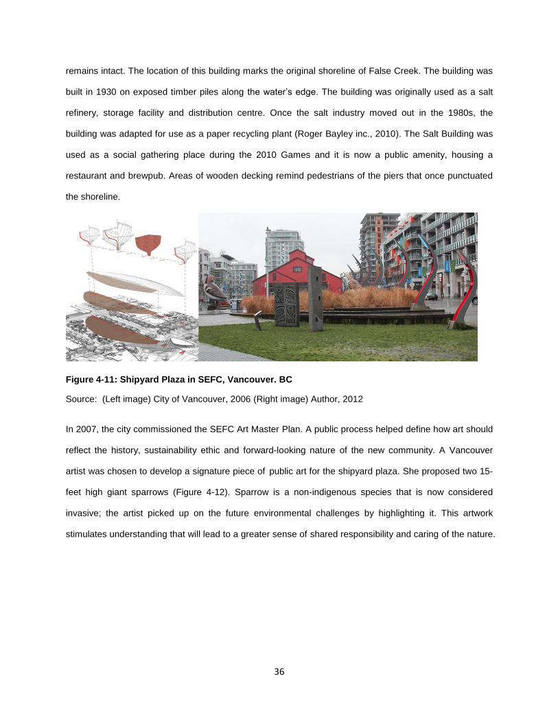
36
remains intact. The location of this building marks the original shoreline of False Creek. The building was
built in 1930 on exposed timber piles along the water’s edge. The building was originally used as a salt
refinery, storage facility and distribution centre. Once the salt industry moved out in the 1980s, the
building was adapted for use as a paper recycling plant (Roger Bayley inc., 2010). The Salt Building was
used as a social gathering place during the 2010 Games and it is now a public amenity, housing a
restaurant and brewpub. Areas of wooden decking remind pedestrians of the piers that once punctuated
the shoreline.
Figure 4-11: Shipyard Plaza in SEFC, Vancouver. BC
Source: (Left image) City of Vancouver, 2006 (Right image) Author, 2012
In 2007, the city commissioned the SEFC Art Master Plan. A public process helped define how art should
reflect the history, sustainability ethic and forward-looking nature of the new community. A Vancouver
artist was chosen to develop a signature piece of public art for the shipyard plaza. She proposed two 15-
feet high giant sparrows (Figure 4-12). Sparrow is a non-indigenous species that is now considered
invasive; the artist picked up on the future environmental challenges by highlighting it. This artwork
stimulates understanding that will lead to a greater sense of shared responsibility and caring of the nature.

37
Figure 4-12: Artwork at SEFC, Vancouver. BC
Source: Author, 2012
The SEFC site is located on the shared traditional territory of the Musqueam, Tsleil-Waututh, and
Squamish First Nations, three of the Four Host First Nations (Environment Canada, 2011). This west
coast first nation culture was also represented by the sculpture with the totem motif (Figure 4-12).
The industrial character of the site is also reflected in the play elements in parks at SEFC. For example,
in the pocket park, there are four gateways, where kids can go through a pipe and be in a playhouse. The
little park will also become home to the largest industrial artifact in SEFC – the old gantry crane saved
from the steel fabrication building.
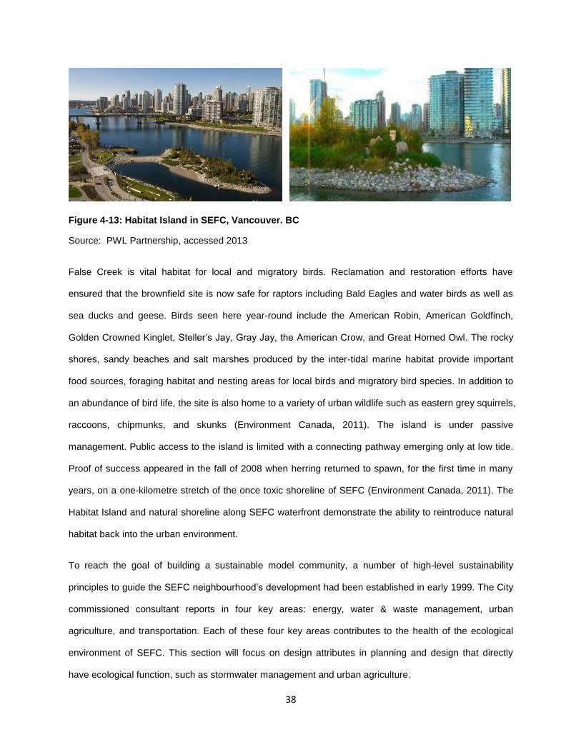
4.5.1.4 Ecological Environment
Industrial development over the last century destroyed much of the natural habitat at this site, turning the
area into an industrial brownfield. The construction of SEFC restored the shoreline including the creation
of Habitat Island. Habitat Island (Figure 4-13) is a human-made island that was built by using left-over dirt,
rocks, sand, and other material from excavations from the construction of SEFC. There are native shrubs,
trees, a natural shoreline, vertical snags with aquatic riparian (shoreline) habitat, inter-tidal fish habitat,
and an upland ecology where birds perch and nest. The creation of the island helps compensate for an
area of the False Creek shoreline that was filled in to accommodate the construction of the Village.
38
Figure 4-13: Habitat Island in SEFC, Vancouver. BC
Source: PWL Partnership, accessed 2013
False Creek is vital habitat for local and migratory birds. Reclamation and restoration efforts have
ensured that the brownfield site is now safe for raptors including Bald Eagles and water birds as well as
sea ducks and geese. Birds seen here year-round include the American Robin, American Goldfinch,
Golden Crowned Kinglet, Steller’s Jay, Gray Jay, the American Crow, and Great Horned Owl. The rocky
shores, sandy beaches and salt marshes produced by the inter-tidal marine habitat provide important
food sources, foraging habitat and nesting areas for local birds and migratory bird species. In addition to
an abundance of bird life, the site is also home to a variety of urban wildlife such as eastern grey squirrels,
raccoons, chipmunks, and skunks (Environment Canada, 2011). The island is under passive
management. Public access to the island is limited with a connecting pathway emerging only at low tide.
Proof of success appeared in the fall of 2008 when herring returned to spawn, for the first time in many
years, on a one-kilometre stretch of the once toxic shoreline of SEFC (Environment Canada, 2011). The
Habitat Island and natural shoreline along SEFC waterfront demonstrate the ability to reintroduce natural
habitat back into the urban environment.
To reach the goal of building a sustainable model community, a number of high-level sustainability
principles to guide the SEFC neighbourhood’s development had been established in early 1999. The City
commissioned consultant reports in four key areas: energy, water & waste management, urban
agriculture, and transportation. Each of these four key areas contributes to the health of the ecological
environment of SEFC. This section will focus on design attributes in planning and design that directly
have ecological function, such as stormwater management and urban agriculture.
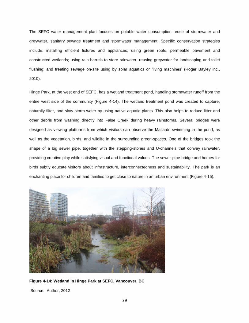
39
The SEFC water management plan focuses on potable water consumption reuse of stormwater and
greywater, sanitary sewage treatment and stormwater management. Specific conservation strategies
include: installing efficient fixtures and appliances; using green roofs, permeable pavement and
constructed wetlands; using rain barrels to store rainwater; reusing greywater for landscaping and toilet
flushing; and treating sewage on-site using by solar aquatics or ‘living machines’ (Roger Bayley inc.,
2010).
Hinge Park, at the west end of SEFC, has a wetland treatment pond, handling stormwater runoff from the
entire west side of the community (Figure 4-14). The wetland treatment pond was created to capture,
naturally filter, and slow storm-water by using native aquatic plants. This also helps to reduce litter and
other debris from washing directly into False Creek during heavy rainstorms. Several bridges were
designed as viewing platforms from which visitors can observe the Mallards swimming in the pond, as
well as the vegetation, birds, and wildlife in the surrounding green-spaces. One of the bridges took the
shape of a big sewer pipe, together with the stepping-stones and U-channels that convey rainwater,
providing creative play while satisfying visual and functional values. The sewer-pipe-bridge and homes for
birds subtly educate visitors about infrastructure, interconnectedness and sustainability. The park is an
enchanting place for children and families to get close to nature in an urban environment (Figure 4-15).
Figure 4-14: Wetland in Hinge Park at SEFC, Vancouver. BC
Source: Author, 2012

40
Figure 4-15: Wetland in Hinge Park at SEFC, Vancouver. BC
Source: Author, 2012
Urban agriculture has been highlighted as an important strategy for a sustainable community at SEFC.
The SEFC urban agriculture strategy study defines urban agriculture broadly as a complete system,
including on-site food production, processing and distribution. This study outlined a range of
recommendations from community gardens and rooftop gardens to more complex systems such as on-
site aquaculture and rooftop greenhouses (Roger Bayley inc., 2010). The community demonstration
garden has been planned and will be constructed. The garden will be a space that is programmed with
the school, community centre and neighbourhood for all to use and to learn about urban agriculture. Each
building’s strata council will manage how gardening plots will be allocated to residents. In non-market
urban agriculture areas, there are communal crops where plots are not delineated and where everyone
can harvest. The Olympics’ goal of sustainability plays in with the development’s social sustainability
goals by having ‘backyard’ courtyards that promote urban agriculture with personal garden plots and fruit-
bearing plants.
With the requirement of fifty percent of the site area having to be green, grade (street-level) growing and
rooftop gardens became key. Green roofs (Figure 4-16), referring to intensive roof gardens, are widely
used in SEFC. Intensive green roofs feature deeper soil (over 20cm) and can support a wider variety of
plant types such as trees, shrubs, and ground covers. Intensive green roofs are often more labour-
intensive than extensive green roofs, which are thinner and lighter, characterized by a light layer of
vegetation and growing medium (5-15cm on average). In SEFC, in addition to the aesthetic value, green
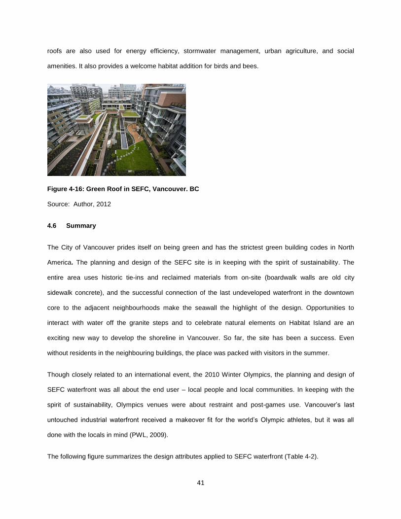
41
roofs are also used for energy efficiency, stormwater management, urban agriculture, and social
amenities. It also provides a welcome habitat addition for birds and bees.
Figure 4-16: Green Roof in SEFC, Vancouver. BC
Source: Author, 2012
4.6 Summary
The City of Vancouver prides itself on being green and has the strictest green building codes in North
America. The planning and design of the SEFC site is in keeping with the spirit of sustainability. The
entire area uses historic tie-ins and reclaimed materials from on-site (boardwalk walls are old city
sidewalk concrete), and the successful connection of the last undeveloped waterfront in the downtown
core to the adjacent neighbourhoods make the seawall the highlight of the design. Opportunities to
interact with water off the granite steps and to celebrate natural elements on Habitat Island are an
exciting new way to develop the shoreline in Vancouver. So far, the site has been a success. Even
without residents in the neighbouring buildings, the place was packed with visitors in the summer.
Though closely related to an international event, the 2010 Winter Olympics, the planning and design of
SEFC waterfront was all about the end user – local people and local communities. In keeping with the
spirit of sustainability, Olympics venues were about restraint and post-games use. Vancouver’s last
untouched industrial waterfront received a makeover fit for the world’s Olympic athletes, but it was all
done with the locals in mind (PWL, 2009).
The following figure summarizes the design attributes applied to SEFC waterfront (Table 4-2).

42
Table 4-2: Summary of SEFC Design, Vancouver. BC, Source: Author, 2013

43
5 CHAPTER FIVE: SYNTHESIS OF DESIGN GUIDELINES
The design guidelines presented in this chapter are mainly based on data obtained from three sources: (1)
related literature about waterfront development and place identity, (2) selected published works on design
attributes of key aspects that help to forge a sense of local identity, and (3) case study analysis of the
SEFC waterfront development that celebrated the local community.
The guidelines are intended to assist planners and landscape designers to inform the planning and
design of waterfronts in order to establish a local identity by providing them with design attributes that
help to foster a local identity and to help decision makers or other professionals to identify key aspects to
consider when analyzing and evaluating a waterfront development project on how to create a people
place for local communities through design and planning. The key aspects, namely functionality,
accessibility, culture and history, and ecological environment, provide a brief and clear analytic tool for
studying the place identity for any waterfront development. Moreover, the guidelines can be good
reference for any urban design that aims to set up a local identity for the place.
The aim of this chapter is to present design attributes that are essential for waterfront development in
order to establish a local identity. These attributes were primarily drawn from a focused literature review
and the analysis of a case study project in the earlier chapter. It is important to realize that the presence
of these design attributes will not guarantee the success of the project, but absence of these elements
could possibly contribute to its failure.
The design guidelines are presented in Table 5-1 below.
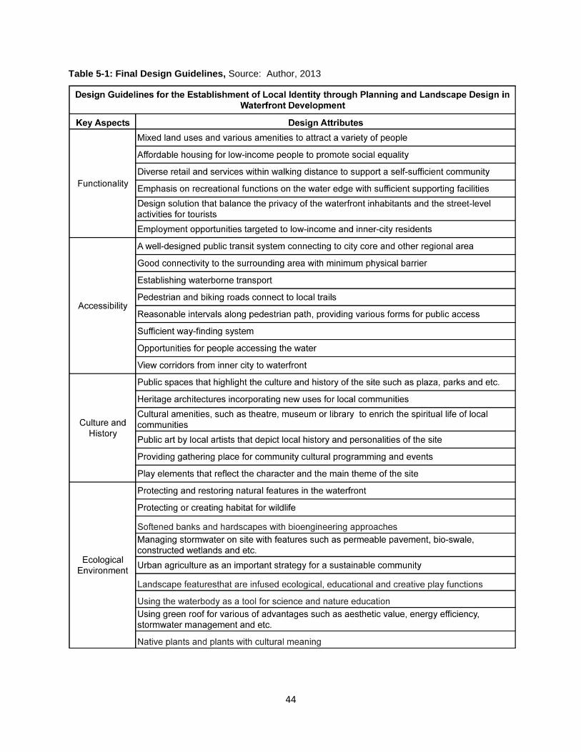
44
Table 5-1: Final Design Guidelines, Source: Author, 2013

45
6 CHAPTER SIX: TESTING OF DESIGN GUIDELINES
The Zhujiang New Town (ZJNT) waterfront in the City of Guangzhou, China, was chosen to test the
developed design guidelines. This waterfront development was considered by local professionals to be
purely an economic-imperative, under-used and a failure in engaging local people. This chapter begins
with an introduction to the project on physical conditions and context information. A detailed analysis on
the functionality, accessibility, culture and history and ecological environment is then provided. After a
review of the design attributes based on this project, recommendations for future improvements on the
waterfront are provided.
In this study, the ZJNT waterfront refers to the area approximately 400-meter from the water’s edge (a 5-
minute walking distance). The 5-minute walk contains a central building block for a walkable, liveable,
and sustainable community design; many recognized walking environments are designed on this metric.
All data of the project were collected from secondary documents and direct observations on-site. The site
visits were conducted in October of 2012, a season best suited for outdoor activities in the City of
Guangzhou. There were three visits in total, two on weekdays and one on the weekend with no special
events happening at those times. The observation focused on the number of people visiting the site, the
activities they had, and the physical context and design elements of the built environment.
6.1 Introduction of the testing project
Guangzhou is the third largest Chinese city with a recorded history dating back two thousand years ago.
As the political, economic and cultural centre in the Pearl River delta, the city has a population of almost
13 million. It is also one of the five national central cities located in South China. In 2008, Guangzhou was
identified as a beta world city by the global city produced by the Globalization and World Cities Research
Network. The City’s development target for 2011-2020 is to maintain a low-carbon economy, create a
smart city and provide for a happy life for citizens (City of Guangzhou, 2012). Ecological environment and
cultural soft power are emphasized together with core competitiveness and global influence in this vision.
The Zhujiang New Town (ZJNT) was established on former agricultural and industrial lands. The Pearl
River is running along the south edge of the ZJNT (Figure 6-1 & Figure 6-2). It was regarded as the

46
mother river of the city due to its intimate relationship to local people's lives as a key transport corridor,
trading site, and river activities resource. ZJNT is divided into east and west sections (Figure 6-3), with
the east section mainly designated for residential development and the west section as a commercial
zone. The core area of the west section is the proposed new city axis, which clusters high-end office
buildings, hotels, shopping malls as well as major public service and cultural facilities. The top luxury
hotels include the Ritz, W Hotel, St. Regis, Grand Hyatt and Jumeirah Hotel. The Four Seasons Hotel has
rented the 67th to 100th floors of the West Tower, the new city landmark, and will become one of the
highest hotels in the world.
Figure 6-1: Location of ZJNT Waterfront - Plan
Source: Author, 2013
Figure 6-2: Location of ZJNT Waterfront - Bird view
Source: Author, 2013

47
Figure 6-3: Bird’s Eye View of ZJNT, Guangzhou, China
Source: Author, 2013
The three-kilometer-long waterfront of ZJNT has been developed as the city’s ‘business card’, with high-
end condominium buildings, large-scale cultural facilities, and luxury hotels. It was in the spotlight during
the opening and closing ceremonies of the 2010 Asian Games held in Haixingsha Island.
However, through the planning and construction of the waterfront, and the supported facilities, this new
town has generated controversy. Local professionals criticized the area as a most crowded ‘concrete
habitat’, accommodating around two hundred thousands people within 6.5 square kilometers, with no
general hospital, public daycare and very limited public amenities provided. Concerns have also
increased about the massive introduction of prime office-space supply as well. Whether this supply is
diverging from the local economic fundamentals and will result in serious supply surplus remains the
biggest issue for the market. Although the enabling conditions for CBD have been met, ZJNT still faces
many other challenges and has to withstand the test of time and market before it can really take on the
role of the Guangzhou CBD (CBRE, 2009). Focusing on the waterfront, the development was based on
an economic imperative, fragmented by private developments and failed to engaging local communities,
creating a ‘dead zone’ in central Guangzhou. Local professionals urged for the creation of an environment
that attracts local talent and people (INFZM, 2012).

48
6.2 Analysis Using the Key Aspects
6.2.1 Functionality
There are different land uses along the three-kilometer long waterfront: offices, cultural facilities and
retails are mostly on the west side; residential condominiums buildings are on the east side (Figure 6-5)..
The four remarkable cultural buildings, namely Guangzhou Opera House, Guangzhou New Library, the
new Guangdong Museum, the second Children's Palace, and the Twin Towers surround the Huacheng
Park located on the new city axis, connecting the Haixingsha Island by a large bridge. This is the only
locus that attracts people. There is a tourist-oriented retail area built in the center of the waterfront, called
Hunter Lane. High-priced foreign bars and cafes have occupied this area; no service that fulfills the daily
life needs of local communities are being provided.
A greenbelt with a width ranging from 60 to 90 meters and a promenade are laid along the river,
connecting to local riverfront trails. However, only pathways, limited seating, and an intermittent bikeway
are provided. The lack of supporting facilities has always been challenging in the development of ZJNT.
Due to privatization of the lands, only one public washroom has been built in this new town that
accommodates two-hundred million people. Ironically, the waterfront-located washroom is underused
because few people visit the area. The design of the promenade is monotonous with the same granite
railings and tiles throughout the retire water edge. No spots are designated for people to access the water
(Figure 6-4).
Figure 6-4: Promenade in ZJNT Waterfront, Guangzhou, China
Source: Author, 2013

49
Figure 6-5: Land Uses in ZJNT Waterfront, Guangzhou, China
Source: INFZM, accessed 2013
After the 2010 Asian Game, the Haixingsha Island has been the center of a series of discussions and
criticism regarding its post-event usage. The island was planned to provide a new Civic Garden that
includes community recreation space, a large civic-scaled festival space, art and cultural amenities, and
public access to water transportation and the Pearl River environment (Figure 6-6). However, to hold the
opening and closing ceremonies for the Asian Games, a 30,000-seat stadium was built, covering a total
area of 176,000 square meters. The stadium was initially constructed as a temporary arena. But the
municipal government decided to keep it as the biggest open-air theatre in Guangzhou later on because
of its expensive construction fee. Top restaurants and bars will also be added to this island due to its high
property value. A public green space was finally turned to commercial uses. Without the island for green
space, the per capita greenery area of ZJNT is only around five square meters, 30% below than the
national standard. Instead of greenery, the island was covered with a large area of hardscape (Figure 6.6
& 6.7) (INFZM, 2012).
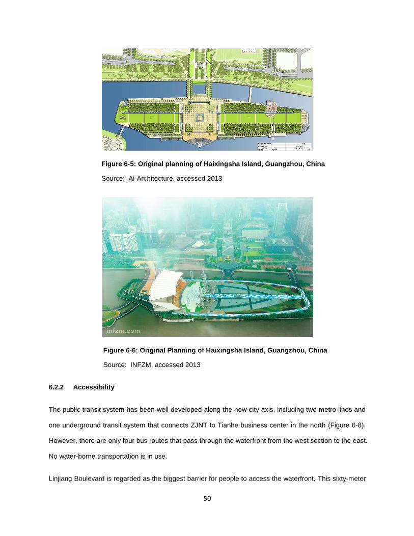
50
Figure 6-5: Original planning of Haixingsha Island, Guangzhou, China
Source: Ai-Architecture, accessed 2013
Figure 6-6: Original Planning of Haixingsha Island, Guangzhou, China
Source: INFZM, accessed 2013
6.2.2 Accessibility
The public transit system has been well developed along the new city axis, including two metro lines and
one underground transit system that connects ZJNT to Tianhe business center in the north (Figure 6-8).
However, there are only four bus routes that pass through the waterfront from the west section to the east.
No water-borne transportation is in use.
Linjiang Boulevard is regarded as the biggest barrier for people to access the waterfront. This sixty-meter
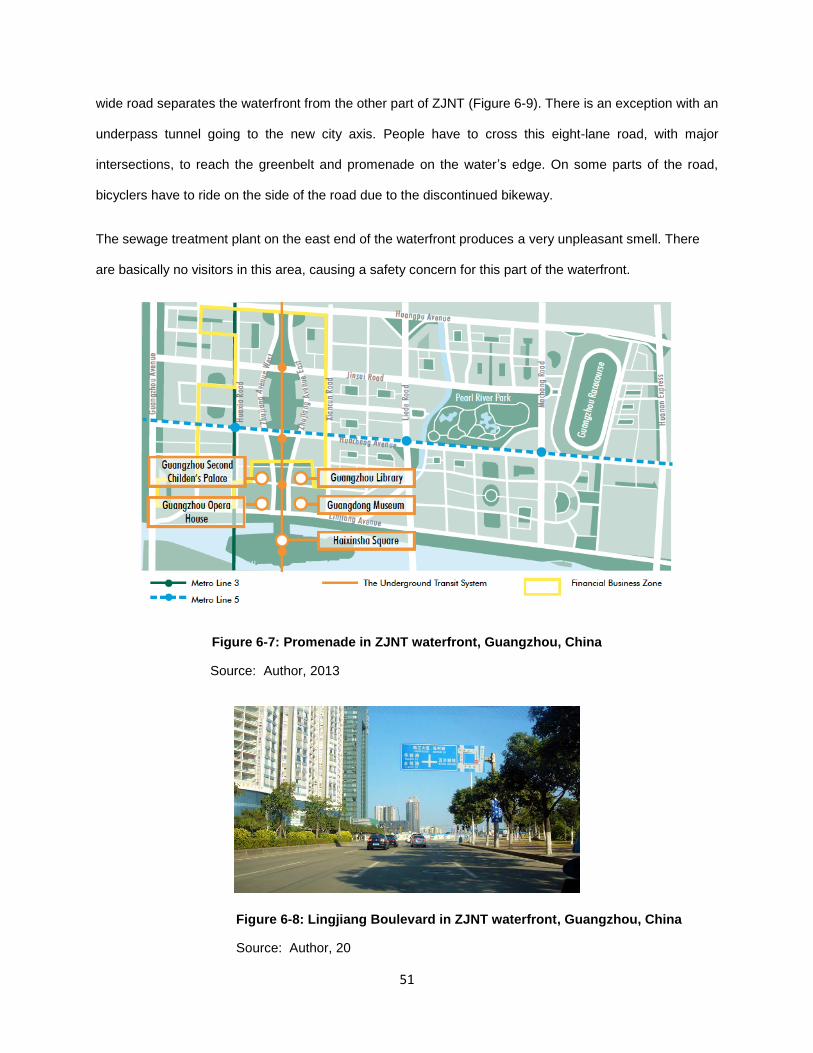
51
wide road separates the waterfront from the other part of ZJNT (Figure 6-9). There is an exception with an
underpass tunnel going to the new city axis. People have to cross this eight-lane road, with major
intersections, to reach the greenbelt and promenade on the water’s edge. On some parts of the road,
bicyclers have to ride on the side of the road due to the discontinued bikeway.
The sewage treatment plant on the east end of the waterfront produces a very unpleasant smell. There
are basically no visitors in this area, causing a safety concern for this part of the waterfront.
Figure 6-7: Promenade in ZJNT waterfront, Guangzhou, China
Source: Author, 2013
Figure 6-8: Lingjiang Boulevard in ZJNT waterfront, Guangzhou, China
Source: Author, 20

52
6.2.3 Culture and History
The City of Guangzhou dates back to the Han, Zhou, and Sui Dynasties, with nearly 1500 years of
international trade. Despite the various layers of history and different political systems the city has
experienced, LIngnan culture is broadly accepted as the city’s collective value and tradition. However, like
many other parts of the city, ZJNT is fulfilled with ultra-modern urban design, creating a strong sense of
economic growth and a weak sense of tangible heritage.
Building new architecture with a pure traditional appearance is a widely used method to fill the demand of
visualizing history in China. Hunter Lane (Figure 6.9) in the ZJNT waterfront is one of these kinds of
development. In the central part of the waterfront, a new strip of Lingnan style building stands
surrounded by contemporary condo towers. The buildings are ornamented with colorful plaster and clay
roofs, presenting the traditional Lingnan architectural art and a sense of history. However, there is no
local culture other than the appearance. It is a strip of high-priced foreign bars and cafes like Restaurant
Francias, with an expensive French menu with Latin dancing on Friday nights.
Liede Village resides in the waterfront with a history of nearly 900 years. The village is famous for Dragon
Boat Racing for over 800 years. In the development of ZJNT, most of the village buildings were
demolished and replaced by high-rise condominium towers. The residents received compensations from
the government and all moved into new condominiums. Several heritage buildings have remained and
are renovated as museums to show the unique water village history. However, these heritages buildings
are scattered among the high-rises and are not highlighted or connected to any public amenities. They
are known by the on-site inhabitants, but they cannot really benefit local citizens as cultural resources at a
larger scale. The Dragon Boat racing is still holding in the Liede creek, a branch of the Pearl river running
through the Hunter Lane.

53
Figure 6-9: Hunter Lane in ZJNT, Guangzhou, China
Source: Author, 2013
The four cultural facilities (Figure 6.10): the Opera House of Guangzhou, the Museum of Guangdong, the
city library, and the children’s place, are the focal point of the waterfront. These amenities have become
the most important cultural resource to local people. Even though their building forms are very
international, these buildings bring vitality to ZJNT waterfront. This area is becoming itself the new cultural
hub of the city, attracting waterfront inhabitants, local visitors and tourist.
Figure 6-10: Opera House of Guangzhou, Museum of Guangdong and City Library, ZJNT, Guangzhou, China
Source: Author, 2013

54
6.2.4 Ecological Environment
In an ultra-urban setting, the Pearl River in Guangzhou, including all river branches, has been
channelized with hardscape covering the entire riverbank. The original planning of ZJNT did not really
take the ecological environment into account. The Haixingsha Island had the most potential to create a
wildlife habitat in this ultra-urban environment. However, two-thirds of the island has been covered with
hard surface during the development.
The greenbelt along the river is more for aesthetic purpose than for ecological concerns. Trees and
plants in the greenbelt attract a small number of birds. There is also a 28-hectare park located one
kilometer away from the water’s edge. The Liede Creek connects the park to the waterfront, but two major
roads are a challenge for this connection.
6.3 Summary
Figure 6.11 provides a comparison on design attributes applied in ZJNT waterfront and the ones
summarized in the developed design guidelines. The results show that limited design attributes that
contribute to establishing a local identity in waterfront development were achieved. Insufficient provision
of supporting facilities, poor accessibility, little respect for the history and culture, and overriding the
ecological environment lead to an inaccessible and under-utilized waterfront in the ultra-high-density city
core.
As the CBRE observed (2009), consistent with local economic dynamics, the demand for prime office
space from domestic companies is surging dramatically over recent years, becoming a new force in a
market traditionally dominated by international companies. In addition to an international status, a place
that creates an attachment to local communities and citizens will benefit the economic in the long-term.
Failure to engage local people and loss of local identity might lead to the reduction of the city’s
competitiveness.
Armed with lessons learned, the municipal government of Guangzhou summarized development
experiences for the next decade in a broader CBD area, including paying special attention to plot ratio
control, traffic planning, and leaving room for future expansion. Focusing on the waterfront, Lingnan

55
riverine culture and protection of natural environment will be emphasized (City of Guangzhou, 2012).
Table 6-1: Design Attribute in ZJNT, Guangzhou, China. Source: Author, 2013

56
6.4 Recommendations for Future Improvement of ZJNT Waterfront
The recommendations for future improvement of ZJNT (Table 6-2) are based on the developed design
guidelines, the current status of the built environment in ZJNT waterfront, and the limitations on riverbank
design from the Bureau of Water Resource (BWR) in the city of Guangzhou. Design proposals of
riverbanks are usually rejected by BWR, as the main water corridors of the Pearl River are channelized to
drain off floodwaters. Therefore, naturalized riverbanks are only recommended for Liede Creek and
Haixingsha Island.
Most of the listed recommendations are visualized in the following Design Recommendation Plan (Figure
6-12). The items that are straightforward, such as Recommendation 3, are skipped in the plan. The
number of each recommendation corresponds with the number in the plan.

57
Table 6-2: Design Attribute in ZJNT, Guangzhou, China. Source: Author, 2013

58
Figure 6-11: Design Recommendation Plan of ZJNT Waterfront, Guangzhou, China,
Source: Author, 2013

59
7 CHAPTER SEVEN: DISCUSSION
7.1 Major Findings
The construction of local identity of a place relies not only on physical qualities. Local people are one of
the key elements in local identity. Their appearance and activities reflect their values and customs,
presenting the particularity of the place. Local identity is defined in this study as a collective narrative of
place defined by the interests of local people. To really present the interest of local people, the narrative
should be created based on a process of participation with a variety of local communities and citizens.
The built environment that is underpinned by the collective narrative will provide physical qualities that
attract local people to live, work and recreate in it. Research on these physical qualities is crucial to the
success of establishing the local identity of a place.
The key aspects that contribute to the establishment of local identity, namely functionality, accessibility,
culture and history, and ecological environment are supported by various literature on place identity in
waterfront development. The key aspects are also seen associated with different elements that convey a
sense of local identity. These key aspects can not only serve as a brief and clear analytic tool when
analyzing place identity in urban waterfront, but also can be applied to other urban spaces.
Worldwide, a mixed-use functionality has been proven to be key to the success of revitalizing urban
waterfronts. A mix of retail, recreational and cultural activities creates waterfronts of universal appeal,
fulfilling many needs in this increasingly diverse society. To forge a local identity in the waterfront, the
recreational function needs to be emphasized along the water’s edge by providing all kinds of amenities
and activities that draw inhabitants and citizens. Furthermore, land uses that prevent privatization and
gentrification should be promoted. In waterfronts, social disconnection leads to fragmented interests and
a lack of identity, which has increasingly raised increased concerns in the social sciences. The
appropriate planning and design of waterfronts should help to create a harmonized social environment in
this public realm.
The spatial disconnection reduces the vitality of the waterfront and leads to safety concerns. Improving
accessibility is an imperative to return waterfronts to local people. Physical and visual access help to

60
create lively and diverse places that encourage an appreciation for nature and a sense of place. In
addition, connectivity to the city core has been proved to be beneficial to both the vitality of waterfronts
and the service economy of downtown area.
Waterfronts are sites that are rich in culture and history, which provide unique definition to the place and
its communities. Place making is only achieved if there are individual and collective connections to, and
identification with, the place through the creation of significant meaning and memory. Tangible history and
culture, through forms, materials and structures, evoke memories of the past, and connects the public to
the place. The preservation of the built historical fabric, design elements that reflect the history, and public
art that depicts local personalities lead to memorable places. Moreover, programming related to culture
and history is seen as an important means to engage local communities. Multi-functional gathering places
need to be incorporated into waterfronts.
A sustainable environment is increasingly emphasized for any urban development. A healthy and
functioning ecological system in the waterfront is appealing and attractive to residents and businesses.
Local people also care about the waterbody’s long-term health. To protect and restore ecological function
in the waterfront will lead to a greater sense of shared responsibility and caring for local nature among
local communities. Landscape features, such as constructed wetlands, green roofs, soften seawalls and
contribute to the sustainability of natural environment and the communities.
Based on the key aspects, design attributes were collected to form the design guidelines. The guidelines
are intended to assist planners and landscape designers to inform their design of waterfronts to try to
establish a local identity. The design attributes provide useful references and can work as a checklist for
designers to exam their proposals. In addition to design professionals, the guidelines can also help
decision makers or other professionals to identify key aspects to consider when analyzing and evaluating
a waterfront development project, providing them with information on how to create a people’s place for
local communities through design and planning. More than this, the guidelines are good references for
other urban places that aim to create a local identity.

61
When facing globalization impacts, local needs, vernacular concerns and local identification are
discussed hotly in different fields. However, related studies for the perspective of planning and design are
insufficient. The study contributes to the discussion by focusing on establishing local identity at a city
waterfront level through planning and design. The developed guidelines might not be able to guarantee a
socially and culturally successful waterfront development. However, empirical studies prove that not
addressing design issues listed in the guidelines will lead to a loss of a sense of local community,
attachment and place identity.
7.2 Critique of the Research
This study has been undertaken with an aim to set up a set of design guidelines that contribute to the
establishment of local identity in urban waterfront development. The collected data for establishing and
testing the design guidelines was largely qualitative, drawn from the literature review and the case study.
Even though the research process might be seen as biased, this study was logically structured with an
attempt to achieve accurate results.
There are several limitations of this study. One limitation is the focus on design outcomes, the physical
qualities of the built environment. The design process is a powerful determinant of outcomes and cannot
be separated from design outcomes. The successful establishment of local identity was approached
mainly by focusing on the processes of social interaction and the physical characteristics of place. The
focus on design outcomes cannot provide a complete picture of how to successfully establish a local
identity through planning and design in waterfront developments. However, particular physical qualities
have consistently proved crucial in the construction of local identity.
Secondly, this study is particularly concerned with the establishment of local identity in urban waterfronts.
However, any place generally carries multiple place identities. The priority on the construction of a place
identity varied from case by case. For example, a waterfront development might be in the stage of
emphasizing its regional economic importance; the construction of its place identity will have a different
focus, other than local identity. Therefore, this study will be specifically useful to waterfront developments
that emphasize a local identity or try to balance economic imperative development with concerns for local

62
desires. However, the engagement of local people will benefit waterfront development on a long-term
basis, and is key to a successful waterfront. The study can generally provide good references for
waterfront developments.
Another limitation is that, due to time limits and lack of documented information, the understanding of the
development in ZJNT waterfront in China is general. And, given China’s political system, the provided
recommendations might not be very practical or easily implemented. However, they are good references
for future improvement in ZJNT waterfront.
63
8 CHAPTER EIGHT: CONCLUSION
8.1 Summary of the Research
During the past decades, economy-driven developments have been prevalent along urban waterfronts to
target international investment, talent and tourists. The construction of place identities largely represents
the vision of the elite class. The needs and desires of local people, local culture and history, and the local
ecological environment tend to be overlooked in waterfront development. However, on a long-term basis,
a local identity of the place contributes to attracting local talents and investments, thus advancing a city’s
competitive advantages (Chang & Huang, 2008).
In the new century, more and more scholars including sociologists, geographers and environmental
psychologists, call for member-driven, bottom-up, community-building focused waterfront developments.
In the era of increased globalization, a balance needs to be sought between the global and the local.
Waterfront developments that keep local in mind need to: provide functionality that attracts local people
from different backgrounds, promote social equality and improve quality of life; be conveniently accessible;
create ambience that connects people to local customs and traditions, celebrating local culture and
history; and respect the ecological environment. Achievements on these qualities forge a sense of local
identity, creating an attachment between local people and their waterfronts. Chang and Huang (2008,
p.244) suggested a direction for future development for the Singapore riverfront: “the waterfront
development should move on to the next stage to develop – rather than erase or adulterate – landscapes
that encourage a sense of local community, attachment and place”. This suggestion can be widely
applicable to waterfront developments in many cities.
8.2 Recommendations for Future Research
The established design guidelines will serve as a foundational tool for cities and communities to follow
and test in waterfront developments that emphasize a local identity. Additional research on a collection of
comprehensive design elements will further enhance the study in establishing a local identity in the
waterfront.

64
Waterfront developments generally involve a complex structure of many overlying jurisdictions and
interest groups. The gap between these interests, such as private investors, the city and local
communities, is wide. Meticulous planning and design are required. Further research could be applied to
the participatory design process focused on waterfronts. Good understanding of this design process will
provide planners and designers to better coordinate and achieve practical design solutions. Moreover, it
will contribute to the research in establishing local identity through planning and design in the waterfront.
The development boom in China in the past decades has led to a lack of documentation on a lot of
important urban development, including waterfronts, with the ZJNT site as an example. Only limited
reflections, analysis and literature are published. In the next decade, an area about 20 square kilometers
along the Pearl River has been targeted for development. It would be interesting to document these
projects from a design perspective, recording the processes and the outcomes.
8.3 Recommendations for Planners and Designers
Landscape architects, planners, and other environmental professionals involved in waterfront
development need to engage with local people and other members of civil society, for whom places may
have very different meaning and identities from politicians and economic interests. Waterfront
development is a process full of complications and challenges. However, place-making for people in this
public realm should be pursued by professionals. Addressing issues such as transportation infrastructure,
poorly-sited buildings, and flood control measures is not enough to engage local people and create a
sense of a place. Design solutions need to address problems beyond the physical setting, promote social
equality, provide sustainability at different levels, and celebrate the collective local values and traditions.
By following the developed design guidelines, designers and planners should be able to create a place
with an authentic identity that is treasured by local people.

65
References:
Amundsen, A.B. (2001). Articulations of identity: A methodological essay and a report on Askim and
Tidaholm, NoordXXI Report no. 19. Retrieved from – http -//www. Noordxxi.nl/
Breen, A. & Rigby, D. (1994). Waterfronts: Cities reclaim their edge. New York - McGraw-Hill.
Bruttomesso, R. (1993). Waterfronts = a new frontier for cities on water. Venice - International center
cities on water.
Bruttomesso, R. (2001). Complexity on the Urban Waterfront. In R. Marshall (ed.), Waterfronts in Post-
industrial Cities (pp. 39-50). New York - Spon Press.
Brown, L.J., Dixon, D., & Gillham, O. (2009). Urban design for an urban Century: Placemaking for people.
New Jersey - John Wiley & Sons, inc.
CBRE Research (2009). Pearl river new town, gearing up for the launch –special report on Guangzhou
prime office market. Retrieved 2013-04-20.
http://www.cbre.com.cn/Research/MarketReports/guangzhou%20office%20paper_e.pdf
Chang, T. C., & Huang S. (2011). Reclaiming the city, Urban Studies, 48(10), 2085–2100.
Chang, T. C., & Huang, S. (2008). Geographies of everywhere and nowhere: place-(un)making in a world
city. International Development Planning Review, 30(3), 225–245.
Chang, T. C., Huang, S. and Savage, V. (2004). On the waterfront: globalization and urbanization in
Singapore. Urban Geography, 25, 413–36.
City of Vancouver (2010). Retrieved March 15, 2013 from - http://vancouver.ca
City of Guangzhou (2012). Retrieved April 01, 2013 from - http://english.gz.gov.cn/
Craig-Smith, S. J., & Fagence, M. (Eds.). (1995). Recreation and tourism as a catalyst for urban
waterfront redevelopment. Westport - Praeger.
66
Cohn, T.H. & Smith, P.J. (1995) Developing global cities in the Pacific Northwest: the cases of Vancouver
and Seattle. In P. K. Kresl & G. Gappert (Eds.), North American cities and the global economy:
Challenges and opportunities, Thousand Oaks, California – Sage Publications.
Couch, C., Fraser, C., & Percy, S. (2003). Urban regeneration in Europe, Oxford - Blackwell Science Ltd.
Cybriwsky, R. (1999). Changing patterns of urban public space. Cities, 16(4), 223-231.
Dovey, K. (2005). Fluid City: Transforming Melbourne’s urban waterfront. Sydney - University of New
South Wales Press.
Davidson, M. (2007). Gentrification as global habitat: a process of class formation or Corporate creation.
Transaction of the Institute of British Geographers, 32, 490-506.
Environment Canada, Vancouver Olympic and Paralympic village: a profile in biodiversity of the
surrounding area, Retrieved April 1, 2013 from
- https -//www.ec.gc.ca/pbjobpog/default.asp?lang=En&n=5F0CA7DE-1
Goodwin, R. F. (1999). Redeveloping deteriorated urban waterfronts: the effectiveness of U.S. Coastal
Management Programs. Coastal Management, 27, 239-269.
Gordon, D. L. A. (1997). Managing the changing political environment in urban waterfront redevelopment.
Urban Studies, 34(1), 61-83.
Hague, C. (2005). Planning and place identity. In C. Hague, & P. Jenkins (Eds.), Place Identity,
Participation and Planning (pp. 3-17). New York – Routledge.
Higgins, M. (2005). Design and place identity. In C. Hague, & P. Jenkins (Eds.), Place Identity,
Participation and Planning (pp. 183-203). New York – Routledge.
Hoyle, B. (2000). Global and Local Change on the Port-City Waterfront. Geographical Review, 90(3),
395-417.
INFZM (2012). Retrieved April 01, 2013 from - http://www. Infzm.com
67
Jacob, J. (1961). The Death and Life of Great American Cities, Harmondsworth - Random House.
Jenkins, P. (2005). Space, place and territory: an analytical framework. In C. Hague, & P. Jenkins (Eds.),
Place Identity, Participation and Planning (pp. 19-37). New York – Routledge.
Krausse, G. H. (1995). Tourism and waterfront renewal: assessing residential perception in Newport,
Rhode Island, USA. Ocean & Coastal Management, 26(3),179-203.
Marshall, R. (2001). Waterfronts in Post-industrial Cities. New York - Spon Press
McHugh, (2003). as cited in Otto.B., McCormick K. & Leccese, M. (2004). Ecological riverfront design:
Restoring river, connecting communities. American Planning Association.
Motloch, J.L. (1989). Placemaking. Order and Spontaneity. In G. Hardie, R. moore, H. Sanoff (Eds.).
Changing Paradigms: Proceedings of Annual Conference Environmental Design Research Association
20, Oklahoma City: Environmental Design Research Association.
Muxi, Z. (2004) La Arquitectura de la Ciudad Global, Barcelona - Gustavo Gili.
Norberg-Schulz, C. (1980). Genius Loci: Towards a Phenomenology of Architecture, London - Academy
Editions.
Otto, B., McCormick K. & Leccese, M. (2004). Ecological riverfront design: Restoring river, connecting
communities. American Planning Association.
Olds, K. (1995). Globalization and the production of new urban spaces: Pacific Rim megaprojects in the
late 20th century. Environment and Planning, 27, 1714-1743.
Office of Ocean and Coastal Resources (OOCR), National Ocean Service, National Oceanic and
Atmospheric Administration, (1972). Coastal Zone Management Act. Retrieved from -
http://www.ocrm.nos.noaa.gov/czm/czm_act.html# anchor199989
Paumier, Cy. (2004). Creating a Vibrant City Center: Urban Design and Regeneration Principles,
Washington, D.C. - Urban Land Institute.

68
Pinder, D., Hoyle, B., & Hussain, S. (Eds.). (1988) Revitalising the Waterfront: International Dimensions of
Dockland Redevelopment, London - Belhaven.
Robertson, R. (2003). The three waves of globalisation: A history of a developing global consiousness.
London - Zed Books.
Roger Bayley inc. (2010). The Challenge Series, Retrieved November 15, 2012 from -
http://www.thechallengeseries.ca/about/
Schmidt, (2002). as cited in Hague, C. (2005). Planning and place identity. In C. Hague, & P. Jenkins
(Eds.), Place Identity, Participation and Planning (pp. 3-17). New York – Routledge.
Shaw, B. (2001). History at the water’s edge. In R. Marshall (Ed.), Waterfronts in post industrial cities,
London - Spon Press.
Steiner, F. (2011). Landscape ecological urbanism: Origins and trajectories, Landscape and Urban
Planning, 100, 333-337.
Smith, H. & Garcia Ferrari, M.S. (2012). Waterfront regeneration: Experience in city-building. New York –
Routledge.
Tsukio, Y. (1984). Waterfront. Tokyo - Process Architecture pub. Co.
United Nations Poverty and Development Division (1999). Economic and social survey of Asia and the
Pacific, 1999. New York - The United Nations; c1999 [updated 1999 Dec 20; cited 2006 June 1]
Whyte, W. (1998) City: Rediscovering the center. Philadelphia, PA – University of Pennsylvania Press.
Wood, R. & Handley, J. (1999). Urban waterfront regeneration in the Mersey Basin, North West England.
Environmental Planning and Management, 42(4), 565-580.
Wrenn, D. M. (1983). Urban Waterfront Development (1st Edition). Washington DC - Urban Land Institute.
Yeoh, B. (1999). Global/globalizing cities. Progress in Human Geography, Vol. 24, 627–636.

69
Zukin,S. (1991). Post-modern landscape: Mapping culture and power. In S, Lash & J. Friedman (Eds.).
Modernity and Identity, Oxford – Blackell Publishers.