
ESTABLISHED COUNTY GIS MAPPING PROGRAM - West Virginia
36
WV COUNTY GIS MONONGALIA COUNTY PLAN TEMPLATE GIS STRATEGIC PLAN Monongalia County GIS Strategic Plan and WV County GIS Plan Template Final Report July 2004 Prepared by: Kurt Donaldson WV GIS Technical Center Department of Geology and Geography West Virginia University 425 White Hall, PO Box 6300 Morgantown, West Virginia 26506-6300 Phone (304) 293-5603 ext. 4336 Fax (304) 293-6522 Email [email protected] Web http://wvgis.wvu.edu
Transcript of ESTABLISHED COUNTY GIS MAPPING PROGRAM - West Virginia
WV COUNTY GIS MONONGALIA COUNTY PLAN TEMPLATE GIS STRATEGIC PLAN
Monongalia County GIS Strategic Plan and WV County GIS Plan Template Final Report July 2004 Prepared by: Kurt Donaldson WV GIS Technical Center Department of Geology and Geography West Virginia University 425 White Hall, PO Box 6300 Morgantown, West Virginia 26506-6300 Phone (304) 293-5603 ext. 4336 Fax (304) 293-6522 Email [email protected] Web http://wvgis.wvu.edu
WV COUNTY GIS MONONGALIA COUNTY PLAN TEMPLATE GIS STRATEGIC PLAN
Table of Contents 1 EXECUTIVE SUMMARY .…..................................…...………….................................... 1 2 INTRODUCTION ...................................….…………..........…...................................…. 4 3 MAPPING ASSESSMENT ....…………..….………………………....…………………... 5 Digital Mapping Survey..................................…....……..................………….…..........…...........................5 Historical Background ..................................................…...……….….......…...........…...............................6 GIS Applications ...........................................……..................….…………………................................…..9 4 GIS EVALUATION AND NEEDS ANALYSIS .....………………….…………………..….. 11 People .........................................................................................……..………………..................................11 Software and Hardware ........................................................................….……….........................................14 Data .......................................................................................…………………………………………........ 15 Procedures .....................................................................……………………………………........................ 19 5 APPENDICES........................................................……………………………............... 27 Appendix A – GIS Data Catalog ...........................................……............................................................... 27 Appendix B – Performance Measures Checklist ……….......……............................................................... 31 References .....................................................................……………………………………………............ 32
July 2004 ii
WV COUNTY GIS MONONGALIA COUNTY PLAN TEMPLATE GIS STRATEGIC PLAN
Acknowledgments The completion of this GIS Strategic Plan would not have been possible without the assistance of many local government officials and mapping professionals who reside in Monongalia County, West Virginia. In the fall of 2003, the County Planner for Monongalia County requested that the GIS Technical Center at West Virginia University develop a computer mapping strategic plan for the County and its communities. From January to July 2004, representatives from city, county, regional, university, and utility organizations provided constructive information that resulted in the completion of this mapping business plan for Monongalia County, as well as a GIS planning template for other West Virginia counties which have similar needs. Listed below are agencies recognized for their valuable contributions. City of Morgantown (http://www.morgantown.com/) City Clerk’s Office Linda Little, City Clerk [email protected] City Manager’s Office Jeff Mikorski, Assistant City Manager [email protected] City Planner Jim Wood, Director of Planning [email protected] Public Works / Engineering Terry Hough, Public Works Director [email protected] Margaret Cale, Engineering Technician [email protected] Monongalia County (http://www.co.monongalia.wv.us/) Assessor’s Office Rodney Pyles, Assessor [email protected] John Ferguson, Mapper [email protected] County Clerk’s Office April Davies, Supervisor of Elections [email protected] County Planning Office Christopher Fletcher, Planning Director [email protected] County Surveyor John Horne, County Surveyor [email protected] Health Department Arthur Adams, Program Manager, Public Health Services [email protected]
July 2004 iii
WV COUNTY GIS MONONGALIA COUNTY PLAN TEMPLATE GIS STRATEGIC PLAN
Monongalia Emergency Centralized Communications Agency (MECCA-911) Ron Kyle, Director [email protected] Ryan Thorne, Addressing/GIS Coordinator [email protected] Mountain Line Transit Authority Dave Bruffy, General Manager [email protected] Morgantown Utility Board (http://www.mub.org/) Timothy Ball, Assistant General Manager [email protected] Lewis Lough, Engineering Technician [email protected] Morgantown-Monongalia County Transportation Organization (http://www.plantogether.org/) Chester Parsons, Director [email protected] West Virginia University (http://www.wvu.edu/) WVU Extension Service Tom McCutcheon, Extension Agent [email protected] WVU Health Sciences Facilities Planning Robert Carubia, Assistant Vice President [email protected] WVU Planning, Design, and Construction Robert Moyer, Program Coordinator [email protected] Michael J. Kraley, Senior Facilities Analyst [email protected]
July 2004 iv
WV COUNTY GIS MONONGALIA COUNTY PLAN TEMPLATE GIS STRATEGIC PLAN
1 Executive Summary Geographic Information System (GIS) strategic planning helps a county and its communities to resolve the necessary organization, people, processes, technology, and data for a successful GIS mapping program. This GIS Strategic Plan serves as a digital mapping business plan for Monongalia County, and as a template for other West Virginia counties and communities seeking to advance their digital mapping program. The target audience for this plan is county commissioners, assessors, city managers, other senior administrators, and mapping professionals and their supervisors who have an interest in establishing a sustainable countywide GIS program. A digital copy of this plan can be downloaded at http://wvgis.wvu.edu/ (click on State Activities). Monongalia County Recommendations At the request of the Director of Planning for Monongalia County, the WV GIS Technical Center (WVGISTC) surveyed local mapping stakeholders to determine if shortcomings exist that prevent the County from establishing a successful GIS program. The evaluation and needs analysis of the County’s GIS program were based upon the five elements required of a successful GIS program: people, software, hardware, data, and procedures. People: GIS technology is of limited value without people to promote and manage the system.
1. High-Level Sponsorship: High-level sponsorship is almost always a factor in successful GIS programs being established at the city and county levels in West Virginia. No high-level, elected official or senior administrator promotes or steers the GIS program for Monongalia County.
2. Mapping Advisory Committee: No mapping advisory committee exists to coordinate base layer maintenance, develop policies, and determine funding priorities; all of which need to be recorded in a continually updated strategic plan.
3. Adequate Staffing: The skill level of mapping professionals in different agencies varies from
limited computer mapping skills, to moderate and extensive, based upon the quantity, quality, and diversity of maps produced. The Assessor’s Office needs a dedicated GIS specialist to modernize its cadastral mapping program.
4. Adequate Training: Numerous organizations have purchased GIS software but do not have personnel with the necessary training and experience to utilize it. A coordinated training program is needed to further the computer mapping skills required of GIS data producers and users.
5. GIS Coordinator: No mapping professional in the County is responsible for managing
geographic information across multiple agencies and jurisdictions. This position does not necessarily have to be performed by a county employee, but by a qualified individual capable of
July 2004 1
WV COUNTY GIS MONONGALIA COUNTY PLAN TEMPLATE GIS STRATEGIC PLAN
coordinating the development and maintenance of mapping databases across the County.
6. Outsourcing: The County might consider outsourcing GIS services to accomplish one-time tasks, such as the digital conversion of its manual parcel mapping system to a digital environment.
Software and Hardware: Computer software and hardware are required elements of any GIS mapping program.
7. GIS Software: Based upon an inventory of the County’s mapping software, data producers should consider utilizing Environmental System Research Institute’s (ESRI) ArcGIS or AutoDesk’s AutoCAD for map production, while data users should consider employing ESRI ArcGIS for GIS applications requiring spatial analyses.
8. Mapping Facilities: The Assessor’s Office does not have enough adequate space for the people
and hardware to support its mapping functions. Data: One of the most important elements of a GIS program is the data.
9. Framework Base Layers: The County should periodically publish a countywide catalog of the best available mapping layers, which includes the core geographic or framework base layers (i.e. roads, boundaries, land ownership), from which application-specific data layers (i.e. soils, flood zones, land use) are often derived.
10. Principal Data Producers: County data producers should cooperatively produce and maintain
core GIS layers that form the base map for the County’s spatial data infrastructure. In Monongalia County, the principal local data producers are the Morgantown Utility Board (base layers), Assessor’s Office (cadastral layer), and MECCA 911 (addressable layers). The tax parcel layer requires the most attention to make it useful and compatible with other geographic layers, such as roads and structures, because it is out of date and spatially inaccurate.
11. Data Sharing and Cost Sharing: Elected officials and senior administrators should strive to integrate different agencies’ mapping budgets, which will increase data sharing and cost savings, and ensure that basic mapping services are sustained.
Procedures: Procedures are well-designed plans, methods, and business rules that describe how GIS technology is applied.
12. Published Standards and Guidelines: County mapping professionals and their supervisors should review all applicable mapping standards and guidelines associated with GIS technology.
13. Unique Identifiers: Data producers should link spatial and tabular data together with
standardized, unique identifiers (i.e. parcel identifier, street address identifier) to ensure that independently maintained spatial databases are interoperable.
14. GIS Business Plans and Procedures: The County should establish GIS business plans and procedures, especially among data producers, to maximize interoperability and cost savings.
July 2004 2
WV COUNTY GIS MONONGALIA COUNTY PLAN TEMPLATE GIS STRATEGIC PLAN
Special Consideration for the Cadastral (Tax) Layer Since the cadastral layer is a commonly used base layer in numerous applications, it is recommended that special attention be given to the development and maintenance of this data theme. Most West Virginia counties with major population centers – Beckley, Charleston, Fairmont, Huntington, Parkersburg, Weirton, and Wheeling – have converted, or are in the process of converting, their tax parcels to a digital (vector lines or polygons) format. The same should be done for Monongalia County’s urban and rural areas. It is estimated that it will take five years at a cost of $230,000 for the County to establish a viable digital cadastral mapping layer and associated cartographic products. The estimated cost is based upon a $5.00 per parcel conversion rate for 46,000 Monongalia County parcels. Variables which will affect the final conversion price include the (1) type of conversion (i.e. coordinate geometry from deeds versus digitizing from paper maps), (2) amount of updating to make existing digital parcel features complete and current, (3) final map design specifications, and (4) percentage of work done in-house. Since some parcel features in Monongalia County have already been digitized, the total cost should be lower; however, a majority of these static GIS files have not been updated for five years, and thus, are diminishing in value. It is recommended that a pilot study be conducted for select tax districts to attain a more accurate cost estimate. Funding should not commence for a GIS-based cadastral mapping layer until the Assessor’s Office develops a land records mapping modernization plan, which includes assuming maintenance of the seamless, digital, countywide, cadastral data theme. An outline of a possible modernization plan is provided in the Procedures section (page 19) of this document.
July 2004 3
WV COUNTY GIS MONONGALIA COUNTY PLAN TEMPLATE GIS STRATEGIC PLAN
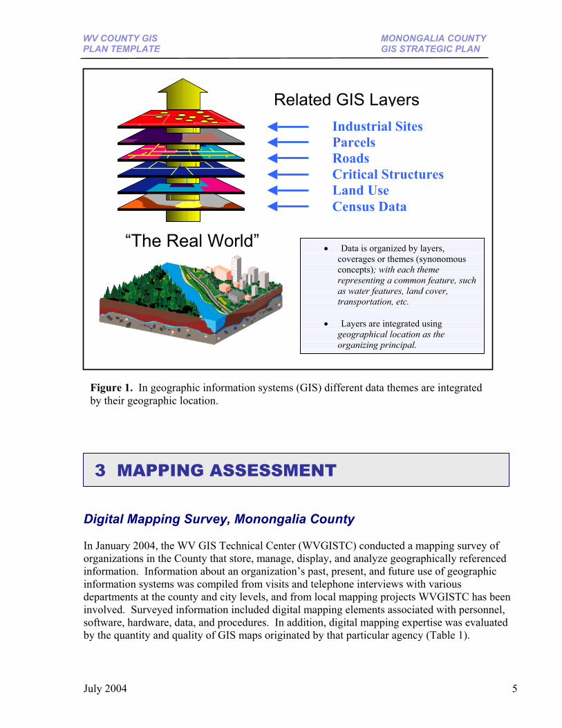
2 Introduction Geographic information is a valuable strategic asset. It is estimated that 80% of all government data contains a geographic component that can be referenced to a location on the earth’s surface, mapped, and converted into digital form. To manage this strategic asset, technologies that include global positioning systems (GPS), remote sensing, and geographic information systems (GIS) are employed extensively by business and government organizations in West Virginia. Through the use of common identifiers such as addresses or parcel identification, a geographic information system links locational (spatial) and database (tabular) information and enables a person to visualize patterns, relationships, and trends. This process gives an entirely new perspective to data analysis that cannot be seen in a table or list format. In a geographic information system, different data themes, such as streams, road networks, land use, parcels, and aerial photos, are integrated together by their geographic location (Figure 1). A geographic information system is more than just data. It also includes an organized collection of computer hardware, software, and personnel designed to efficiently capture, store, update, manipulate, analyze, and display all forms of geographically referenced information. The development of timely, accurate, and consistent spatial data can significantly enhance government services. Accomplishing this requires a coordinated effort of integrated budgets and integrated data across organizational and geographic boundaries. Any coordinated effort among multiple jurisdictions can be translated into a strategic plan, a vital mechanism for establishing a long term, successfully maintained countywide GIS program. Effective strategic planning provides an overall look at a county’s organization, people, processes, technology, and data. It also includes objectives and recommendations, along with cost and resource estimates, to advance an organized, countywide GIS program. To assemble a strategic plan, a historical and present-day survey of the county’s mapping activities is recommended. Interviews with stakeholders from different departments and jurisdictions should be conducted to evaluate an organization’s staffing capacity, technical expertise, and mapping applications, in place or desired. This collected information assists with the needs analysis and development of a county’s mapping plan. At the request of the Director of Planning for Monongalia County, WVGISTC prepared this County GIS Strategic Plan to provide strategies for implementing an effective GIS mapping program among all departments at the city and county levels. The following sections highlight this plan, beginning with a digital mapping survey for Monongalia County, and followed by a needs analysis, and recommendations. This plan should serve as a template for other West Virginia counties wanting to optimize their mapping services.
July 2004 4
WV COUNTY GIS MONONGALIA COUNTY PLAN TEMPLATE GIS STRATEGIC PLAN
• Data is organized by layers, coverages or themes (synonomous concepts); with each theme representing a common feature, such as water features, land cover, transportation, etc.
• Layers are integrated using geographical location as the organizing principal.
“The Real World”
Related GIS Layers Industrial Sites Parcels Roads Critical Structures Land Use Census Data
Figure 1. In geographic information systems (GIS) different data themes are integrated by their geographic location.
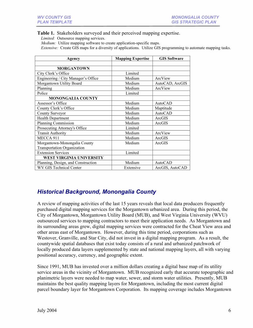
3 MAPPING ASSESSMENT Digital Mapping Survey, Monongalia County In January 2004, the WV GIS Technical Center (WVGISTC) conducted a mapping survey of organizations in the County that store, manage, display, and analyze geographically referenced information. Information about an organization’s past, present, and future use of geographic information systems was compiled from visits and telephone interviews with various departments at the county and city levels, and from local mapping projects WVGISTC has been involved. Surveyed information included digital mapping elements associated with personnel, software, hardware, data, and procedures. In addition, digital mapping expertise was evaluated by the quantity and quality of GIS maps originated by that particular agency (Table 1).
July 2004 5
WV COUNTY GIS MONONGALIA COUNTY PLAN TEMPLATE GIS STRATEGIC PLAN
Table 1. Stakeholders surveyed and their perceived mapping expertise. Limited: Outsource mapping services. Medium: Utilize mapping software to create application-specific maps. Extensive: Create GIS maps for a diversity of applications. Utilize GIS programming to automate mapping tasks.
Agency Mapping Expertise GIS Software
MORGANTOWN City Clerk’s Office Limited Engineering / City Manager’s Office Medium ArcView Morgantown Utility Board Medium AutoCAD, ArcGIS Planning Medium ArcView Police Limited
MONONGALIA COUNTY Assessor’s Office Medium AutoCAD County Clerk’s Office Medium Maptitude County Surveyor Medium AutoCAD Health Department Medium ArcGIS Planning Commission Medium ArcGIS Prosecuting Attorney's Office Limited Transit Authority Medium ArcView MECCA 911 Medium ArcGIS Morgantown-Monongalia County Transportation Organization
Medium ArcGIS
Extension Services Limited WEST VIRGINIA UNIVERSITY
Planning, Design, and Construction Medium AutoCAD WV GIS Technical Center Extensive ArcGIS, AutoCAD Historical Background, Monongalia County A review of mapping activities of the last 15 years reveals that local data producers frequently purchased digital mapping services for the Morgantown urbanized area. During this period, the City of Morgantown, Morgantown Utility Board (MUB), and West Virginia University (WVU) outsourced services to mapping contractors to meet their application needs. As Morgantown and its surrounding areas grew, digital mapping services were contracted for the Cheat View area and other areas east of Morgantown. However, during this time period, corporations such as Westover, Granville, and Star City, did not invest in a digital mapping program. As a result, the countywide spatial databases that exist today consists of a rural and urbanized patchwork of locally produced data layers supplemented by state and national mapping layers, all with varying positional accuracy, currency, and geographic extent. Since 1991, MUB has invested over a million dollars creating a digital base map of its utility service areas in the vicinity of Morgantown. MUB recognized early that accurate topographic and planimetric layers were needed to map water, sewer, and storm water utilities. Presently, MUB maintains the best quality mapping layers for Morgantown, including the most current digital parcel boundary layer for Morgantown Corporation. Its mapping coverage includes Morgantown
July 2004 6
WV COUNTY GIS MONONGALIA COUNTY PLAN TEMPLATE GIS STRATEGIC PLAN
and Cheat View, and MUB is looking to extend its mapping extent to include the entire County. The city of Morgantown depends on MUB for its base mapping layers and updates. The county tax maps, which were originally created in 1961-62 by the State Tax Department, are now maintained by the Assessor’s Office. These maps are used to aid the Assessor in the location and assessment of real estate, and also are used by residents, attorneys, realtors, surveyors and lending institutions to help them in various aspects when researching and conveying real estate. The Assessor is reviewing strategies to automate its current method of generating tax maps, thereby eliminating the need of sending maps to Charleston for updating. In the 1990’s, the Assessor’s Office contracted SBC Computer Systems to assist with the creation of its online tax map system. At an estimated cost of $130,000 over six years, the scanned tax maps became accessible via the Web (www.assessor.org) in 1997. Today, the online map room serves the public well and should be maintained; however, the mapping system is limited because the scanned tax maps are in an image format, which prevents the linkage of attribute data and other ownership information to geographically referenced parcels. Parcel geometry must be in a vector format, not image format, to link useful attributes such as ownership and land use information to spatially referenced data. The County’s Transit Authority Director, Dave Bruffy, has embraced GIS, evidenced by published Mountain Line Transit maps and the use of related geospatial technologies like Global Positioning Systems (GPS) for transportation applications. During the mid 1990’s, in his previous job assignment with the city of Morgantown, he was instrumental in creating key GIS mapping layers for the City. Over the last 10 years, West Virginia University has provided digital mapping support to a number of city and county agencies. Two mapping projects involving land ownership resulted in WVU digitally converting parcel boundaries for Morgantown Corporation in 1995 and for 7 rural county tax districts in 1998. In 2004, WVGISTC at WVU executed a data licensing agreement with MUB to use its base mapping layers to assist the City Planning Office with its revised Morgantown Zoning Map. As part of this mapping project, WVGISTC edited certain spatial databases to make them more accurately portray the ‘real world.’ Updated spatial databases included the corporation boundary, planning zones, wards, and city parks of Morgantown, along with revised WVU lands and buildings. The same year, at the request of several county organizations, WVGISTC cataloged and compiled commonly used mapping layers for the County (Appendix A). Other mapping products WVGISTC has completed for the community include the planning district boundary and preliminary land use maps for the County Planning Office, Census maps for the Morgantown City Manager’s Office, ward and boundary maps for the City Clerk and County Clerk Offices, criminal maps for the Prosecuting Attorneys Office, rail trail brochure map for the Greater Morgantown Convention and Visitors Bureau, and a trail planning map for Greenspace Coalition. In 1996, as part of statewide digital conversion project, WVGISTC created 1:24,000-scale elevation, transportation, hydrology, and boundary map layers for the entire County. The following year WVGISTC compiled and made publicly available 1:12,000-scale color orthophotos that had been created for the entire State. In 2004, the Federal Emergency
July 2004 7
WV COUNTY GIS MONONGALIA COUNTY PLAN TEMPLATE GIS STRATEGIC PLAN
Management Agency (FEMA) contracted WVGISTC for $25,000 to create seamless, digital flood hazard data from Monongalia County’s 52 Flood Insurance Rate paper maps. Currently a number of agencies, WVU Facilities and the Monongalia County Assessor’s Office for example, use CAD software for computer drawing. CAD software is suitable for drawings, but limited in its ability to link tabular databases to spatially referenced information. It is also difficult to import CAD mapping files that are not geographically referenced into a geographic information system. In the future, the statewide addressing and mapping project will provide a catalyst for Monongalia Emergency Centralized Communications Agency’s (MECCA 911) emergency response and disaster management. In 2004, 1:4,800-scale color orthophotos and derived mapping layers will be delivered to Monongalia County, followed by street and structure addressing files before 2007. MECCA 911 intends on using commercial GIS software such as computer aided dispatch and automatic vehicle location (AVL) systems to provide prompt and accurate emergency services. Below is a summary of GIS milestones and events for Monongalia County. Computerization of geographically referenced information began in the early 1990’s. Over the past 15 years, the Morgantown Utility Board (MUB), Morgantown Corporation, and West Virginia University (WVU) have had the most active GIS programs. 1991 MUB contracts 1:600-scale base mapping layers of Morgantown area for $500,000 1994 WVU contracts 1:2,400-scale base mapping layers (not georeferenced) of Morgantown area 1995 Morgantown contracts WVU for digital conversion of City’s 1:1,200-scale tax maps 1995 County Planning Commission GIS mapping program disbanded 1996 MUB contracts mapping layers of Cheat View area 1996 WVGISTC begins digital map conversion of U.S. Geological Survey (USGS) topographic maps 1997 Morgantown Corporation creates ESRI Arcview GIS layers: roads, parcels, wards, and zones 1997 USGS and State pay for countywide, 1:12,000-scale color orthophotos 1997 Assessor’s online map room established at an estimated cost of $130,000 2000 WVGISTC digitized parcel boundary polygons for 7 rural districts 2000 Morgantown City Planner convenes meeting to coordinate GIS resources 2001 MUB convenes meeting to identify partners to distribute costs of new mapping layers for Morgantown area 2002 WVGISTC creates new WVU campus map using MUB base layers 2002 MUB acquires updated imagery for Morgantown’s base layers 2003 WVU acquires “leaf-on” aerial photography for university lands at a cost of $15,000 2003 WVGISTC creates GIS planning district boundaries for County Planning Office 2004 WVGISTC update Morgantown’s zoning map using MUB base layers 2004 WVGISTC catalogs mapping layers for Monongalia County 2004 State Addressing and Mapping Board pays for countywide 1:4,800-scale base mapping layers 2004 WVGISTC contracted by FEMA to create digital flood hazard layer for $25,000 Since the inception of geographic information systems in the early 1990’s, the Morgantown Utility Board and other agencies have made significant progress in advancing the County’s spatial data infrastructure. However, reviewing past events can be useful in evaluating the efficiency and effectiveness of the County’s GIS mapping program. Certain events reveal where better planning, coordination, and cost sharing among agencies could have reduced costs and maximized benefits.
July 2004 8
WV COUNTY GIS MONONGALIA COUNTY PLAN TEMPLATE GIS STRATEGIC PLAN
Duplicative Efforts: In 1994, West Virginia University paid for the acquisition of digital base layers for the Morgantown area, even though the Morgantown Utility Board had contracted another company to perform the same mapping services at a cost of $500,000 only a few years earlier. Inactive Maintenance Program: In 1995 and 1998, the digital conversion of tax parcel boundaries for Morgantown Corporation and rural tax districts, respectively, was outsourced to West Virginia University for approximately $80,000. However, because the Assessor’s Office never assumed maintenance of these digital cadastral layers, whereby changes and corrections to the digital cadastral layers were made on a regular basis, substantial capital investment has been lost. Lack of Coordination: In 2003, the State Addressing and Mapping Board provided Monongalia County with the opportunity to assign address ranges to Morgantown Utility Board’s existing road centerline file. Because of the lack of coordination, the County will now have two road centerline files: a utility board road centerline file with higher positional accuracy but with no street address ranges; and a MECCA 911 road centerline file of lesser positional accuracy but with attributed street address ranges. In the future, to reduce duplication efforts stemming from the maintenance of multiple, independent layers, the County will probably pay for services to create a single master dataset from the best spatial and attribute qualities of these two road centerline files. GIS Applications, Monongalia County GIS applications extend geographic information technologies across a number of fields to include economic development, homeland security, environmental and natural resources management, flood mitigation, utilities and facilities management, city and county planning, transportation, and demography, in addition to roles in cartography and map production. As a result, GIS can be regarded as an effective planning tool that facilitates and enhances decision-making. In addition, the Internet is becoming a major platform for applications, since mapping services enable the public with better accessibility and interactivity to geographic information. Below are some ongoing or potential GIS applications for Monongalia County that are applicable to most counties in the State:
July 2004 9
WV COUNTY GIS MONONGALIA COUNTY PLAN TEMPLATE GIS STRATEGIC PLAN
Table 2. Local Government GIS Applications
Organization Application BOPARC Parks and Recreations Management City Engineering Public Works, Permits, Street Maintenance, Code Enforcement, Addressing City Clerk Municipal Ward and Corporation Boundaries City / County Planning Offices
Land Use Planning, Property Management, Demographic Profiling, Floodplain Management, Zoning Case Management
City Manager Community Development, Economic Development, Demographic Profiling County Assessor Tax maps, assessment maps, land ownership County Extension Service Tree Maps, Land Ownership County Clerk Redistricting County Health Department Disease Clusters / Prevention County Surveyor Political Boundaries MECCA 911 Addressing, Computer Aided Dispatch, Automatic Vehicle Locator, Hazard
Mitigation Morgantown Utility Board Water, Sewer, Stormwater Utilities Prosecuting Attorney / Police Criminal Investigations, Trend Analysis Transit Authority Transportation. Demographic Mapping Transportation Planning Organization
Transportation Studies
July 2004 10
WV COUNTY GIS MONONGALIA COUNTY PLAN TEMPLATE GIS STRATEGIC PLAN
4 GIS Evaluation and Needs Analysis A successful GIS program requires a number of elements to ensure its success. Five major elements – people, software, hardware, data, and procedures – are important components of a GIS program. Weaknesses in any one element will degrade the effectiveness of a countywide GIS program. Appendix B provides counties with a checklist of objectives or performance measures to attain a successful GIS program. In the following section, the effectiveness of a Monongalia County’s GIS program is evaluated by objectives (boldfaced type). These objectives set forth performance measures that a county should continuously strive to attain. Corresponding to each objective are recommendations for improving a county’s GIS program. (1) People GIS technology is of limited value without people to promote and manage the system. OBJECTIVE 1.1: Solicit the support of local government officials who can steer a mapping program from implementation to maturity. A successful countywide mapping system requires high-level sponsors or champions, such as the county commissioners, assessor, senior managers or administrators. City and county leaders should meet annually to (1) promote a shared vision, (2) coordinate sustainable funding and cost sharing, (3) oversee strategic planning, and (4) evaluate the effectiveness of its countywide mapping program. If there are multiple agencies and jurisdictions utilizing geospatial technologies, then the county may want to designate a GIS coordinator with central authority to coordinate mapping activities. This same authority would assist in grant writing to secure additional revenue for mapping activities. RECOMMENDATION 1.1A: Meetings of Monongalia County’s mapping stakeholders have convened in the past, but with limited success in defining a shared vision, clear goals and objectives, and a sustainable technology and organizational structure for supporting a countywide GIS program. For Monongalia County to implement an effective countywide mapping program, high-level sponsors must adopt a GIS strategic plan that supports the County’s assessed mapping needs. In doing so, the strategic plan would encompass all five elements of a successful GIS program. RECOMMENDATION 1.1B: Implementing a countywide GIS program for Monongalia County will require initiative and sustained commitment. If neither government leaders nor its technical staff are dedicated to promoting and implementing the system, then Monongalia County’s digital
July 2004 11
WV COUNTY GIS MONONGALIA COUNTY PLAN TEMPLATE GIS STRATEGIC PLAN
mapping program will not advance. As an example, GIS conferences and training workshops often convene in Morgantown, in which local government officials and their mapping professionals from all over the State converge to advance their digital mapping programs. However, few organizations in Monongalia County have attended or taken advantage of these training classes and workshops. OBJECTIVE 1.2: Establish a Mapping Advisory Committee. In counties that have multiple departments producing and using digital mapping data, a mapping committee should be formed to coordinate base layer maintenance, develop policies, and determine funding priorities; all of which should be recorded in a continually updated strategic plan. Its main purpose is to establish standardized mechanisms for integrating timely, accurate and consistent spatial data across organizational and geographic boundaries. The committee includes representatives from local and regional government agencies that are producers or users of geographic information. Local data producers and their supervisors who maintain base geographic layers should form the nucleus of this committee. A person having central authority and technical expertise to integrate base mapping layers into seamless, countywide, consistent data sets should chair the committee. Commercial mapping vendors associated with present or future countywide projects should also be invited. If local mapping expertise or authority is lacking, then the committee should solicit strategic planning services from mapping experts in the private or public sectors. RECOMMENDATION 1.2: Monongalia County should consider establishing a mapping advisory committee, whereby the principal data producers – Assessor’s Office, MECCA 911, and Morgantown Utility Board – form the nucleus of this committee. Data users, such as the city and countywide planning organizations, which depend upon the local data producers core geographic layers for their mapping applications, should also be on the advisory committee. The committee should consult with mapping experts from the public or private sectors for assistance in implementing an enterprise-wide GIS system across multiple agencies. OBJECTIVE 1.3: Consider organizational impacts of requiring technically advanced staff to implement a GIS mapping system. Staffing capacity, capability, and coordination should be evaluated continually. Adequate Staffing: GIS software and its application can be complex and not always intuitive. A specific mapping project may involve several technical specialties, including cartographers, GIS analysts and programmers, and system/database administrators. Consequently, local governments must ensure that adequate staffing resources are available to accomplish its mapping activities. Local governments’ salary structures may make it difficult to obtain and retrain qualified staff. RECOMMENDATION 1.3A: The Monongalia County Assessor’s Office does not have enough staff to fulfill its mapping obligations. The Standard on Digital Cadastral Maps and Parcel Identifiers (IAAO, 2003) recommends that an effective cadastral mapping and deed-processing program require approximately one staff person per 10,000 parcels. The total number of parcels
July 2004 12
WV COUNTY GIS MONONGALIA COUNTY PLAN TEMPLATE GIS STRATEGIC PLAN
in Monongalia County is approximately 45,329. Furthermore, approximately 750 new parcels are created every year. As a comparison, Kanawha County (123,831 parcels) has four mapping professionals, and counties of similar size in total tax parcels - Wood (59,368), Cabell (48,260), Berkeley (41,649), Marion (41,249), and Hancock/Brooke (36,793) – all have a minimum of two mapping professionals. Presently, the Monongalia County Assessor’s Office has one mapping professional, whose time is consumed by deed processing work and information technology duties involving database, network, and Web administration. Additional demands will be placed on the Assessor’s Office staff as the County switches over to the State’s Oracle Integrated Assessment System (IAS) in 2005. It is recommended that the Assessor’s Office employ an additional staff member whose duties are comprised entirely of cadastral mapping. Adequate Training: To remain proficient in their field, GIS specialists also require continual training in current and emerging geospatial technologies. Successful mapping programs correlate to the skill level of its mapping professionals. Trained GIS specialists are attentive to detail, computer literate, possessing strong spatial skills, and proficient in mapping and database software. In addition to drawing and editing skills associated with typical CAD software, a GIS specialist must know how to maintain or transfer geographic data among different coordinate systems, and how to link locational and database information for display and analysis. With adequate training, GIS specialists should be able to combine spatial and tabular information to produce visually appealing maps in a timely manner and with minimal supervision. RECOMMENDATION 1.3B: Monongalia County needs a coordinated training program to further the computer mapping skills required of GIS data users and producers. Numerous organizations have purchased GIS software but do not have personnel with the necessary training and experience to utilize it. State entities, like the WV GIS Technical Center, should assist local governments with specialized GIS training programs for cadastral staff, planners, floodplain managers, and general users. RECOMMENDATION 1.3C: The skill level of mapping professionals in different city and county agencies vary from limited computer mapping skills, to moderate and extensive, based upon the quantity and quality of maps produced. In hiring new GIS staff, Monongalia County and its communities should consider giving candidates a practical exam to certify their level of mapping expertise. GIS Coordinator: In counties that have numerous organizations using and producing geographic data, a designated county GIS coordinator should have the authority to coordinate the systematic integration and maintenance of all base mapping layers. Typically, this position is located at the county commission or another county office that has adequate staffing to perform its own unit’s mapping requirements in addition to coordinating a countywide mapping program. A county GIS coordinator must not only be technically proficient and experienced in geographic information systems, but also possess adequate communication, organizational, and management skills to implement an enterprise strategy that extends the value of GIS beyond a collection of separate department level systems. For credibility and leadership reasons, the county GIS coordinator’s experience and technical expertise should supercede that of other local GIS employees. If a county does not have the expertise to coordinate mapping activities across multiple agencies, then it should either seek technical assistance from its regional planning or
July 2004 13
WV COUNTY GIS MONONGALIA COUNTY PLAN TEMPLATE GIS STRATEGIC PLAN
transportation organizations that have established GIS programs, or consider outsourcing these services. RECOMMENDATION 1.3D: Monongalia County should designate a GIS professional with the duties of coordinating geographic information across multiple agencies and jurisdictions. This position could be at the regional level, but currently neither the Region 6 Planning and Development Council nor the new Morgantown-Monongalia County Transportation Organization (MPO) employs a full-time GIS professional. A more conceivable location for this position is the Assessor’s Office or County Commission’s Office. OBJECTIVE 1.4: Outsource GIS services to accomplish one-time tasks, provide unique skills, or meet peaks in workload demand. Organizations must decide which GIS services will be done internally or outsourced. Workload demands that are one-time or extraordinary in scope or skills, such as image acquisition, digital conversion, or customization services, can be outsourced to reputable vendors. Temporary employees can be hired through internship programs using university students or recent graduates to provide staffing flexibility. As the digital base layers are developed and synthesized with other data themes into useful applications, staffing and outsourcing needs should lessen, and local government agencies can shift their focus from data development to data maintenance. RECOMMENDATION 1.4: The Monongalia County Assessor’s Office should contract outside assistance to convert its manual parcel mapping system to a digital system. In a digitally maintained mapping system, seamless cadastral map layers are utilized to create print-ready, electronic map products. (2) Software and (3) Hardware Computer software and hardware are required elements of any GIS mapping program. OBJECTIVE 2-3: Identify essential software and hardware to meet the scale and complexity of your needs and budget. GIS software provides the functions and tools users need to store, analyze, and display geographical information. Hardware consists of the computer, along with the printing and scanning peripherals, on which the GIS software operates. Agencies will require adequate space for large-format scanners, plotters, and map documents. Due to continually advancing technology, agencies must plan to incorporate new GIS software releases and to replace outdated hardware devices. Counties should standardize their GIS and database software to maximize their ability to support maintenance fees and training, and for implementing integrated mapping solutions. Local government agencies should purchase software and hardware that meets the scale and complexity of the county’s needs and budget. As departmental GIS projects are proven
July 2004 14
WV COUNTY GIS MONONGALIA COUNTY PLAN TEMPLATE GIS STRATEGIC PLAN
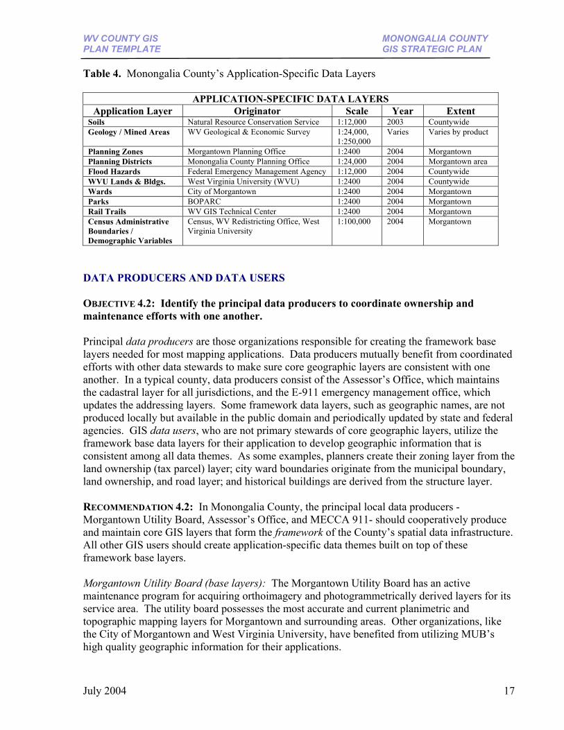
successful, consider integrated software and hardware solutions that link GIS applications across multiple departments. Some organizations choose a suite of GIS software products to achieve GIS functionality. In West Virginia, ESRI and AutoDesk are the most popular GIS software packages. A January 2004 digital tax mapping survey revealed that 85% of the county assessor offices in West Virginia utilize mapping software of ESRI or AutoDesk. RECOMMENDATION 2: It is recommended that Monongalia County’s data producers utilize ESRI ArcGIS or AutoDesk’s AutoCAD for map production, while data users employ ESRI ArcGIS for GIS applications requiring spatial analyses. Most Monongalia County agencies utilize ArcGIS or AutoCAD computer mapping software, or both. The County Clerks office utilizes Caliper’s Maptitude software for redistricting voting precincts. RECOMMENDATION 3: The Monongalia County Assessor’s Office does not have enough adequate space to support its mapping functions. A minimum of 100 square feet (10 square meters) of workspace per mapping professional is recommended by the International Association of Assessing Officers, in Standard on Digital Cadastral Maps and Parcel Identifiers, with added space for large-format plotters and scanners. (IAAO, 2003) (4) Data One of the most important elements of a GIS program is the data. Geographic information is a valuable resource and strategic asset, worth millions of dollars, with additional dollars continually being invested in spatial databases. FRAMEWORK BASE LAYERS OBJECTIVE 4.1: Periodically inventory, catalog, document, and publish the best quality GIS data layers. A county should periodically update the status of its framework base layers used by most GIS applications and application-specific data themes that are built on top of these foundation layers. The best geographic data should be inventoried, documented, and published for all GIS data users in the county. Documentation about GIS data layers should include ownership, spatial accuracy, currentness, and geographic extent. A detailed listing should also include the mapping file name and coordinate projection information. RECOMMENDATION 4.1: Monongalia County should periodically inventory commonly used base layers and other thematic layers used for mapping applications. GIS data layers should be documented according to prescribed guidelines so that stewardship, accuracy, geographic extent, and other useful information are recorded. Table 3 lists the status of nine core themes (hydrography, transportation, orthoimagery, elevation, land ownership, geodetic control, boundaries, structures, geographic names) used by most GIS applications; whereas Table 4 lists the applications-specific data themes (i.e. soils, geology, land cover, planning, and recreation)
July 2004 15
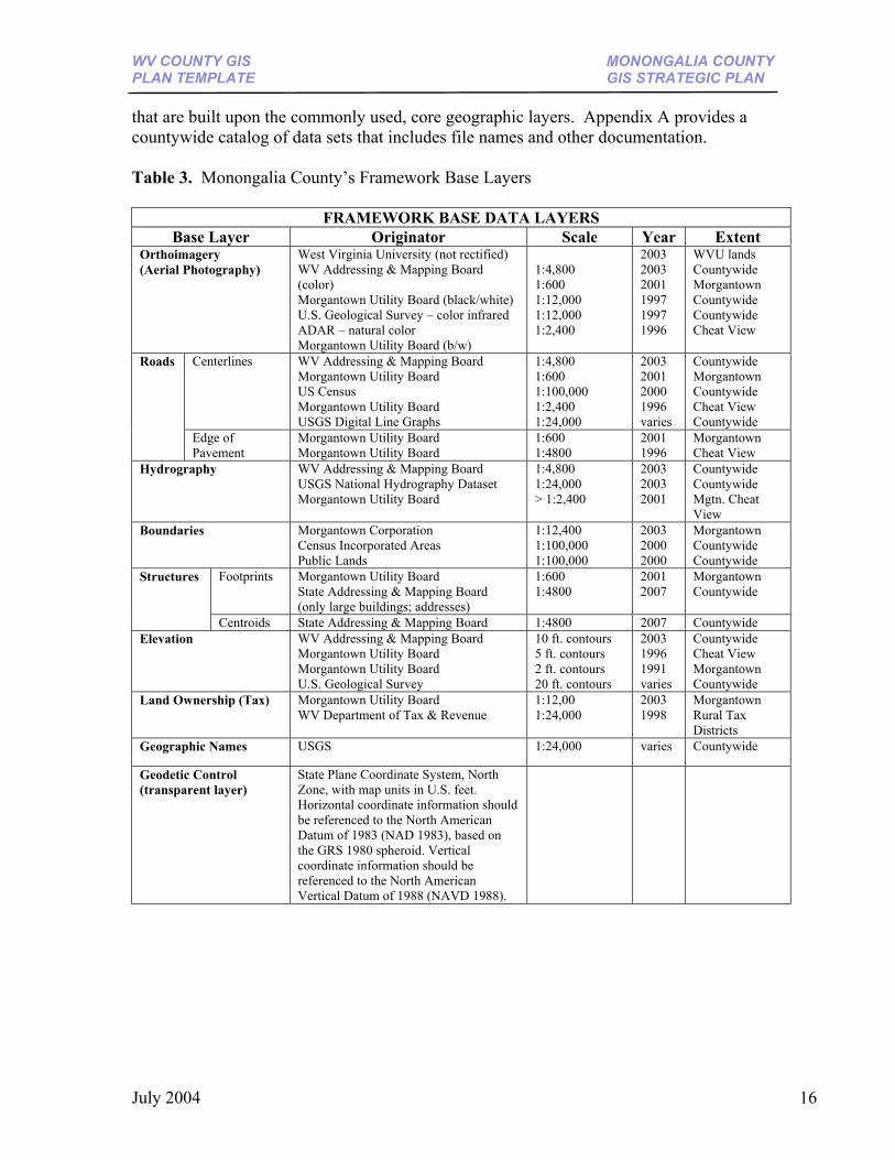
WV COUNTY GIS MONONGALIA COUNTY PLAN TEMPLATE GIS STRATEGIC PLAN
that are built upon the commonly used, core geographic layers. Appendix A provides a countywide catalog of data sets that includes file names and other documentation. Table 3. Monongalia County’s Framework Base Layers
FRAMEWORK BASE DATA LAYERS Base Layer Originator Scale Year Extent
Orthoimagery (Aerial Photography)
West Virginia University (not rectified) WV Addressing & Mapping Board (color) Morgantown Utility Board (black/white) U.S. Geological Survey – color infrared ADAR – natural color Morgantown Utility Board (b/w)
1:4,800 1:600 1:12,000 1:12,000 1:2,400
2003 2003 2001 1997 1997 1996
WVU lands Countywide Morgantown Countywide Countywide Cheat View
Centerlines WV Addressing & Mapping Board Morgantown Utility Board US Census Morgantown Utility Board USGS Digital Line Graphs
1:4,800 1:600 1:100,000 1:2,400 1:24,000
2003 2001 2000 1996 varies
Countywide Morgantown Countywide Cheat View Countywide
Roads
Edge of Pavement
Morgantown Utility Board Morgantown Utility Board
1:600 1:4800
2001 1996
Morgantown Cheat View
Hydrography WV Addressing & Mapping Board USGS National Hydrography Dataset Morgantown Utility Board
1:4,800 1:24,000 > 1:2,400
2003 2003 2001
Countywide Countywide Mgtn. Cheat View
Boundaries Morgantown Corporation Census Incorporated Areas Public Lands
1:12,400 1:100,000 1:100,000
2003 2000 2000
Morgantown Countywide Countywide
Footprints Morgantown Utility Board State Addressing & Mapping Board (only large buildings; addresses)
1:600 1:4800
2001 2007
Morgantown Countywide
Structures
Centroids State Addressing & Mapping Board 1:4800 2007 Countywide Elevation WV Addressing & Mapping Board
Morgantown Utility Board Morgantown Utility Board U.S. Geological Survey
10 ft. contours 5 ft. contours 2 ft. contours 20 ft. contours
2003 1996 1991 varies
Countywide Cheat View Morgantown Countywide
Land Ownership (Tax) Morgantown Utility Board WV Department of Tax & Revenue
1:12,00 1:24,000
2003 1998
Morgantown Rural Tax Districts
Geographic Names USGS 1:24,000 varies Countywide
Geodetic Control (transparent layer)
State Plane Coordinate System, North Zone, with map units in U.S. feet. Horizontal coordinate information should be referenced to the North American Datum of 1983 (NAD 1983), based on the GRS 1980 spheroid. Vertical coordinate information should be referenced to the North American Vertical Datum of 1988 (NAVD 1988).
July 2004 16
WV COUNTY GIS MONONGALIA COUNTY PLAN TEMPLATE GIS STRATEGIC PLAN
Table 4. Monongalia County’s Application-Specific Data Layers
APPLICATION-SPECIFIC DATA LAYERS Application Layer Originator Scale Year Extent
Soils Natural Resource Conservation Service 1:12,000 2003 Countywide Geology / Mined Areas WV Geological & Economic Survey 1:24,000,
1:250,000 Varies Varies by product
Planning Zones Morgantown Planning Office 1:2400 2004 Morgantown Planning Districts Monongalia County Planning Office 1:24,000 2004 Morgantown area Flood Hazards Federal Emergency Management Agency 1:12,000 2004 Countywide WVU Lands & Bldgs. West Virginia University (WVU) 1:2400 2004 Countywide Wards City of Morgantown 1:2400 2004 Morgantown Parks BOPARC 1:2400 2004 Morgantown Rail Trails WV GIS Technical Center 1:2400 2004 Morgantown Census Administrative Boundaries / Demographic Variables
Census, WV Redistricting Office, West Virginia University
1:100,000 2004 Morgantown
DATA PRODUCERS AND DATA USERS OBJECTIVE 4.2: Identify the principal data producers to coordinate ownership and maintenance efforts with one another. Principal data producers are those organizations responsible for creating the framework base layers needed for most mapping applications. Data producers mutually benefit from coordinated efforts with other data stewards to make sure core geographic layers are consistent with one another. In a typical county, data producers consist of the Assessor’s Office, which maintains the cadastral layer for all jurisdictions, and the E-911 emergency management office, which updates the addressing layers. Some framework data layers, such as geographic names, are not produced locally but available in the public domain and periodically updated by state and federal agencies. GIS data users, who are not primary stewards of core geographic layers, utilize the framework base data layers for their application to develop geographic information that is consistent among all data themes. As some examples, planners create their zoning layer from the land ownership (tax parcel) layer; city ward boundaries originate from the municipal boundary, land ownership, and road layer; and historical buildings are derived from the structure layer. RECOMMENDATION 4.2: In Monongalia County, the principal local data producers - Morgantown Utility Board, Assessor’s Office, and MECCA 911- should cooperatively produce and maintain core GIS layers that form the framework of the County’s spatial data infrastructure. All other GIS users should create application-specific data themes built on top of these framework base layers. Morgantown Utility Board (base layers): The Morgantown Utility Board has an active maintenance program for acquiring orthoimagery and photogrammetrically derived layers for its service area. The utility board possesses the most accurate and current planimetric and topographic mapping layers for Morgantown and surrounding areas. Other organizations, like the City of Morgantown and West Virginia University, have benefited from utilizing MUB’s high quality geographic information for their applications.
July 2004 17
WV COUNTY GIS MONONGALIA COUNTY PLAN TEMPLATE GIS STRATEGIC PLAN
Assessor’s Office (cadastral): Of all the county framework base layers, the cadastral layer requires the most attention to make it useful and compatible with other geographic layers. The parcel layer is especially out of date and spatially inaccurate in reference to other data layers, such as roads and structures. Digital parcel polygons exist for Morgantown Corporation and rural tax districts, but the data is not continually maintained. The steward of the County’s cadastral layer should be the Assessor’s Office, and not other agencies, such as Morgantown Corporation or the Morgantown Utility Board. The Assessor’s Office needs to create and maintain a parcel polygon map layer which is seamless across jurisdictions, comprised of clean polygons without gaps and overlaps, attributed with the correct parcel identifiers, georeferenced to a common coordinate system, and consistent with other base mapping layers. MECCA 911 (addressing): MECCA 911 is the address coordinator for all jurisdictions except Morgantown, and will assume primary stewardship of mapping and addressing files completed by the West Virginia Statewide Addressing and Mapping Board. Specific files include the street centerline file with addresses ranges and addressable structures. DATA SHARING AND COST SHARING OBJECTIVE 4.3: Coordinate effective data sharing and cost sharing among the multiple organizations at the city and county levels. An effective data sharing and cost sharing strategy is an important performance measure of an established, successful GIS program (Appendix B). Creating digital geospatial data is extremely costly, but when there is a network for data sharing via partnerships, an organization’s individual costs are substantially reduced. In addition to cost savings, developing and sharing base geographic data layers minimizes redundancy, ensures interoperability, and maximizes the benefits to the citizens. County and city agencies should strive to cooperatively produce and share the best available geographic data throughout all levels of government, private and non-profit sectors, and the academic community. Local data producers within a county should regularly coordinate data development and maintenance activities to avoid independent data collection efforts and to ensure that data are positionally and logically consistent among themes. New imagery should be acquired by jurisdictions for urban or rapid growth areas every 5 years, and for rural areas every 10 years, to keep base layers current and accurate. Data license agreements can be implemented for geographic information not in the public domain, or to protect private and sensitive data. Funding GIS operations in an environment of rising pensions, health insurance, and liability insurance can be challenging. Often local governments face the dilemma of the public’s right to public data versus a public agency’s need to fund its GIS operations. Local governments must identify data distribution policies that address the core issue of data sales versus free access. Free access data is defined as data provided at no more than the direct cost of distribution. Studies have shown that government agencies do not realize significant revenues from the sale of public data; this suggests that counties should look to alternative methods for funding, including:
July 2004 18
WV COUNTY GIS MONONGALIA COUNTY PLAN TEMPLATE GIS STRATEGIC PLAN
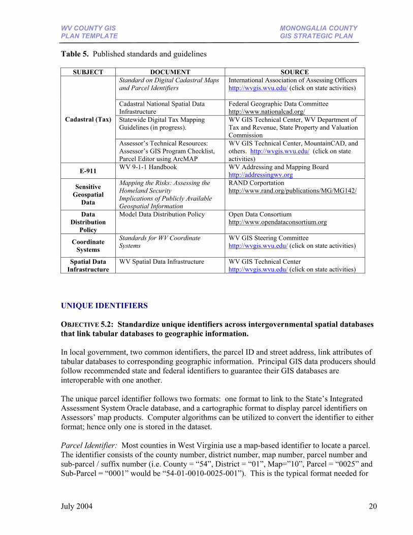
(1) cost savings accrued though multi-agency cooperation; (2) revenue produced from existing taxes; (3) revenue produced from service fees, (4) cost-savings from employing GIS technologies; and (5) internal budgeting (Joffe). RECOMMENDATIONS 4.3: Elected officials and senior administrators must coordinate effective data sharing and cost sharing among the multiple organizations at the city and county levels. For guidance, elected officials and policy makers should review articles published by the Open Data Consortium (http://www.opendataconsortium.org/) to provide a general framework for the distribution and funding of public geospatial data. High-level decision makers should also seek budget guidance and recommendations from a mapping advisory committee. Coordination at all levels of government – regional, state, and federal – will reduce redundant and duplicative data collection efforts and improve staffing efficiency. (5) Procedures Procedures are well-designed plans, methods, and business rules describing how GIS technology is applied. Approved mapping standards and procedures, along with cooperative efforts of local, state, federal, and private organizations, are necessary to create a reliable, seamless, continually maintained, consistent set of core geographic data. PUBLISHED STANDARDS AND GUIDELINES OBJECTIVE 5.1: Refer to published standards, guidelines, technical reports, and other documents to steer your GIS program. Organizations can refer to published standards and guidelines to apply GIS technology in an orderly and consistent manner. Table 5 provides some links to technical documents that may be useful. Some guidelines are in the progress of being created. For example, the State GIS Coordinator, the WVGISTC, WV Department of Tax and Revenue, and the Property Valuation Training and Procedures Commission (PVC) are spearheading an effort to create procedural rules for computer-generated tax maps. Private and public sector professionals familiar with digital tax maps are also assisting in this endeavor. RECOMMENDATION 5.1: Review all applicable mapping standards and guidelines associated with GIS technology.
July 2004 19
WV COUNTY GIS MONONGALIA COUNTY PLAN TEMPLATE GIS STRATEGIC PLAN
Table 5. Published standards and guidelines
SUBJECT DOCUMENT SOURCE Standard on Digital Cadastral Maps and Parcel Identifiers
International Association of Assessing Officers http://wvgis.wvu.edu/ (click on state activities)
Cadastral National Spatial Data Infrastructure
Federal Geographic Data Committee http://www.nationalcad.org/
Statewide Digital Tax Mapping Guidelines (in progress).
WV GIS Technical Center, WV Department of Tax and Revenue, State Property and Valuation Commission
Cadastral (Tax)
Assessor’s Technical Resources: Assessor’s GIS Program Checklist, Parcel Editor using ArcMAP
WV GIS Technical Center, MountainCAD, and others. http://wvgis.wvu.edu/ (click on state activities)
E-911 WV 9-1-1 Handbook
WV Addressing and Mapping Board http://addressingwv.org
Sensitive Geospatial
Data
Mapping the Risks: Assessing the Homeland Security Implications of Publicly Available Geospatial Information
RAND Corportation http://www.rand.org/publications/MG/MG142/
Data Distribution
Policy
Model Data Distribution Policy Open Data Consortium http://www.opendataconsortium.org
Coordinate Systems
Standards for WV Coordinate Systems
WV GIS Steering Committee http://wvgis.wvu.edu/ (click on state activities)
Spatial Data Infrastructure
WV Spatial Data Infrastructure
WV GIS Technical Center http://wvgis.wvu.edu/ (click on state activities)
UNIQUE IDENTIFIERS OBJECTIVE 5.2: Standardize unique identifiers across intergovernmental spatial databases that link tabular databases to geographic information. In local government, two common identifiers, the parcel ID and street address, link attributes of tabular databases to corresponding geographic information. Principal GIS data producers should follow recommended state and federal identifiers to guarantee their GIS databases are interoperable with one another. The unique parcel identifier follows two formats: one format to link to the State’s Integrated Assessment System Oracle database, and a cartographic format to display parcel identifiers on Assessors’ map products. Computer algorithms can be utilized to convert the identifier to either format; hence only one is stored in the dataset. Parcel Identifier: Most counties in West Virginia use a map-based identifier to locate a parcel. The identifier consists of the county number, district number, map number, parcel number and sub-parcel / suffix number (i.e. County = “54”, District = “01”, Map=”10”, Parcel = “0025” and Sub-Parcel = “0001” would be “54-01-0010-0025-001”). This is the typical format needed for
July 2004 20
WV COUNTY GIS MONONGALIA COUNTY PLAN TEMPLATE GIS STRATEGIC PLAN
the county assessor to link its geographic parcels to the State’s centralized assessment database. As for annotating the parcel identifier on the Assessors’ cartographic tax maps, usually only the parcel and sub-parcel fields are required, which are displayed in a decimal format, with all leading zeroes removed (i.e. 25.1). Non-exempt parcels should have a standard identifier and not be blank. Street Address Identifier: The street address, parsed into number, address, city, zip code, should be standardized across E-911, assessor, or utility databases. RECOMMENDATION 5.2: Monongalia County should adhere to standardized parcel and address identifiers to ensure spatial databases are consistent and compatible with one another. GIS BUSINESS PLANS AND PROCEDURES OBJECTIVE 5.3: Establish GIS business plans and procedures among data producers and data users to maximize interoperability and cost savings. Business rules among the agencies that depend on mapping activities will streamline workflow and minimize duplicative efforts. Below are some suggested guidelines for West Virginia counties. County Assessor’s Office: Local assessors retain ultimate authority and maintenance of the digital cadastral layer for both corporations and rural tax districts. Assessors can tie their cadastral map layer to other base layers such as roads and streams, and can coordinate with other departments if other stewards maintain those layers. Parcel polygons must be attributed with a unique parcel identifier to link to tabular data. Digital representations of other parcel features - lot lines, land hooks, annotation, and reference system grid – must be captured from paper maps into separate vector GIS layers for Assessors to create their computer-generated, cartographic “pretty maps” for public viewing. To form a statewide or multi-state cadastral coverage, counties can periodically submit their GIS drawing files along with their image maps to a centrally located, state-level repository. County Emergency Management Office (E-911): County emergency management offices are best situated to serve as the point of contact for the State’s addressing and mapping layers. This includes the address files for the road centerline and inhabitable structures. Professional Land Surveyors: Local governments can contract professional land surveyors to submit electronic surveys that are geographically referenced to a common coordinate system. Agencies can encourage surveyors’ use of GPS equipment or geodetic monuments to create electronic surveys that can be imported directly into a geographic information system. This will avoid the re-mapping of paper surveys, which is a time-consuming process that can introduce spatial inaccuracies. As examples, municipalities can contract georeferenced surveys for boundary changes or annexations. For large construction projects, utilities can solicit ‘as built’ surveys showing the locations of building footprints and new utility lines. Likewise, Assessor’s and address coordinators can encourage the submission of GIS-compatible plats and surveys of
July 2004 21
WV COUNTY GIS MONONGALIA COUNTY PLAN TEMPLATE GIS STRATEGIC PLAN
new subdivisions detailing new roads, structures, and lot boundaries. RECOMMENDATION 5.3: Below are specific recommendations for Monongalia County agencies, prioritized by order of importance and by classification as primarily a data producer or data user. Data Producers are the Assessor’s Office, Morgantown Utility Board, and County E-911 Office (MECCA 911); data users include the County Planning Office, City of Morgantown, Morgantown MPO, West Virginia University, and County Clerk. Monongalia County Assessor’s Office: It is recommended that the Assessor’s Office implement a GIS mapping program as soon as possible. The first step could be for the Assessor’s Office to assemble a digital conversion and mapping modernization plan and then proceed with a pilot project to implement this plan. The pilot study could correspond to a planning area needed by the County Planning Office, such as Union and Morgan Tax Districts, which are experiencing rapid population growth and land use change. Any cadastral mapping program utilizing GIS should not be funded unless the Assessor’s Office assumes maintenance of the digital cadastral layer. The Assessor can coordinate with other local data producers, principally MECCA 911 and the Morgantown Utility Board, to cooperatively produce GIS base layers together so that the data layers integrate and harmonize with one another. The land records mapping modernization plan can incorporate the following principles: (1). Digital Mapping Program Preparation: To prepare a countywide cadastral digital mapping program, refer to the International Association of Assessing Officers’ Standard on Digital Cadastral Maps and Parcel Identifiers (IAAO, 2003), and review performance measures of an “Established GIS Tax Program,” which are listed below:
Performance Measures of an Established GIS Tax Program
I. Computer tax mapping files are in a GIS format a. Seamless, countywide map parcel files b. Geo-referenced to a common coordinate system
II. Linked to external databases via the property identification number or city-style address III. Annotation is portable and stored as separate map layers IV. Continual map maintenance (maps revised digitally)
a. Parcel edits (splits / merges) b. Spatial adjustments of map layers to a more accurate base
V. Map publishing a. Computer-generated “pretty maps” (paper and electronic versions) b. Customized Map Books for easy map creation c. Optional Internet Mapping Application
(2). Parcel Identifier: A standardized parcel identifier, established by statewide guidelines and the local Assessor’s Office, ensures independently maintained mapping files are interoperable. Parcel files currently maintained by the City of Morgantown and Morgantown Utility Board follow unconventional formatting schemes. (3). Digital Conversion: In the Unites States it is estimated that over half of the 140 million private parcels have been converted into a GIS-compatible form (FGDC, 2003). A January 2004
July 2004 22
WV COUNTY GIS MONONGALIA COUNTY PLAN TEMPLATE GIS STRATEGIC PLAN
survey of West Virginia county Assessor’s revealed that 42 of 55 counties (76 %) are using, or transitioning to, GIS-based tax mapping programs. The conversion from paper to digital maps is tedious and time consuming. Depending on staffing and funding, it is estimated it will take five years for Monongalia County to establish a viable digital cadastral mapping system. Additional time will be required to spatially adjust the tax parcel layer so that it is consistent with framework data layers maintained by MECCA-911 and the Morgantown Utility Board. An appropriate mix of in-house versus contracted work will be required to perform the initial conversion work and the subsequent generation of visually appealing map products. At a cost of $5.00 per parcel, for 46,000 parcels, the conversion will cost $230,000.00 for the entire County. A pilot project for Union and Morgan Tax Districts, which have an estimated 15,000 parcels, would cost $75,000.00. Additional costs must be considered if parcel references need to be modified or geographic areas have numerous map inserts and insets. Variable such as existing digital data and final map design specifications will affect the final conversion price too. Some digital conversion of Monongalia County’s tax parcels has already occurred; but only tax parcel polygons were included and not other parcel related features such as interior lot lines, land hooks, and annotation. Previously digitized polygons will need to be updated with new parcel splits and subdivisions, and parcel-related features digitized.
Existing Parcel Polygons: At a cost of $80,000, digital tax polygons were created in the 1990’s for the rural tax districts and Morgantown Corporation. Although these files are now out of date, the Assessor’s Mapper has the following archives that could assist in making the digital tax files current: subdivisions in CAD format since 1994; scanned tax maps for each year since 1998; and split listings since 2000. This archived information, supplemented with other reference layers such as orthophotos and addressing layers, coordinate geometry (COGO) from deeds and plats, as well as the most recent scanned tax maps – georeferenced if necessary – would be the framework for updating existing digital tax parcel files. No Parcel Polygons: No digital cadastral files exist for the corporations other than Morgantown Corporation. For corporations with no digital parcel files, existing paper maps will need to be scanned, georeferenced, and then digitized.
(4). Correlation of Maps to Database: The correlation of digital maps and individual property records requires that every parcel link to a database record. A near-perfect correlation between the geographic parcels and parcel records in the tabular databases should be the goal of the Assessor’s Office. Reconciliation checks between the tax maps and property records measure the accuracy and completeness of the digital cadastral mapping system. In February 2004, using the unique property identification number, WVGISTC reconciled year 1998 Union and Morgan Tax District geographic parcel boundaries (best available digital layer) with a 2003 SpecPrint parcel tabular database file. Table 6 shows the correlation between database to parcel boundary layer and vice versa.
July 2004 23
WV COUNTY GIS MONONGALIA COUNTY PLAN TEMPLATE GIS STRATEGIC PLAN
Other quality checks can easily be done in a computerized cadastral system. For example, acreage attributes in property records should be reconciled with parcel areas of the map layer to check for disparities. Table 6. Correlation between geographic parcels and tabular database for Union and Morgan Tax Districts, Monongalia County
Union Tax District Morgan Tax District SpecPrint Database Total Database Records 6999 7585 Database (duplicative records) 202 341 No linkage to polygon parcel 1073 1782 Geographic Parcels (year 1998) Total Polygon Parcels 6200 7244 No linkage to database 346 1782
(5). Parcel Maintenance: Presently the Monongalia County Assessor’s Office contracts a draftsman in St. Albans, WV, at an approximate cost of $3.00 / parcel split. If a digital cadastral mapping program were established, then this money would be redirected to parcel maintenance activities performed by in-house employees. (6). Parcel and Address Data Model: A robust mapping program incorporates a GIS data model that correlates addresses to parcel identifiers. This allows users to access parcel databases via address identifiers, or in reverse, to query addressable spatial databases via parcel identifiers. (7). Map Tile Reference System: The present map tile reference system for Monongalia County is subdivided into seven rural tax districts and five corporations (not including Osage), which are further subdivided into map tiles / map sheets. Monongalia County follows a ‘true grid’ format, whereby primary maps tiles are oriented to true north, tiles are uniform in size (1’ = 400’ scale), and each tax district and corporation follows a different index numbering system. Urbanized areas and new subdivisions require inserts, a portion of the map that is shown in larger scale, usually at 1’=100’. In a cadastral digital mapping system, the County can set up an electronic map book that indexes the minimum number of map sheets required to cover the County’s geographic extent. Within urbanized areas, the use of map insets (enlarged area on same map) should be avoided and map inserts (enlarged area on another map) minimized because of the difficulty for viewers to juxtapose map information. Instead, a nested 100’ within a 400’ scale tile scheme is preferred because it allows for a logical transition to adjoining map sheets and reduces the number of map sheets. Two ways to optimize the map tile reference system, and thus avoiding an irregular patchwork of multiple inserts for population growth areas, include: (1) renumbering parcel identification numbers or (2) programming an electronic map book that incorporates secondary identifiers for nested 100’ scale tiles that correlate to map inserts. With the second method, the map number would have to be annotated on the maps, either by colorizing parcels according to its map number or by adding labels with the map number, or both.
July 2004 24
WV COUNTY GIS MONONGALIA COUNTY PLAN TEMPLATE GIS STRATEGIC PLAN
(8). Cartographic Content Standards for Map Products: Refer to the Statewide Procedures for the Manual Maintenance of Surface Tax Maps (PVC), Title-Series 189-04, set forth by the State’s Property Valuation Training and Procedures Commission, for general guidelines regarding map content and cartographic design. When producing digital tax maps, the assessor has much flexibility regarding line width, color, and annotation. The main guideline is that the computer-generated maps convey parcel information and other geographic features in a manner that is visually appealing, legible, accurate, and consistent. (9). Scanned Maps for Internet Mapping Application: The Assessor’s Office began scanning its paper tax maps in the middle-1990’s and made these raster images available on its website at http://www.assessor.org/ beginning in 1997. Although these scanned maps do not have linked property data (i.e. owners name, address, acreage), the tax map images are easily accessible to the public via the Internet. In the future, with a geographic information system, the Assessor’s Office will not need to scan any of the paper maps, because digital tax maps can be easily exported to an image format, eliminating the need for scanning paper to digital. Morgantown Utility Board: The utility could coordinate with MECCA-911 for its addressing layers and with the Assessor’s Office for its parcel layers. It is recommended that all data producers meet periodically to ensure mapping data layers are consistent with one another. Monongalia Emergency Centralized Communications Agency (MECCA-911): The local emergency management office could collaborate with other local data producers so that its addressing layers – road centerlines and structures – are consistent with other framework base layers. Secondly, digital plats or map surveys submitted to its office for address assignments could also be made available to the Assessor’s Office for editing its tax maps. Thirdly, MECCA-911 could create a master road centerline data set from the best qualities of two independently maintained road centerline databases; the more spatially accurate geometry of the Morgantown Utility Board road centerline file and the street addressing attributes of its E-911 road centerline file. Monongalia County Planning Commission: The County Planning Office requires an accurate digital landbase from the Assessor’s Office to create zoning maps and to manage ordinances. To eliminate duplicative efforts of independently maintained land ownership databases, the County’s zoning spatial database should be an extension of the Assessor’s parcel polygon layer and assessment / appraisal database. This arrangement will significantly reduce staffing requirements of the County Planning Office. As with the Assessor’s digital cadastral layer, the zoning spatial database should be seamless across all jurisdictional boundaries. This allows for the County and City Planning Offices to merge their land use planning designations into a uniform regional planning map across political boundaries. If an accurate cadastral data layer does not exist, then the County Planning Office will have to create zoning maps from interim parcel data sources until an accurate digital cadastral layer exists. City of Morgantown: The City has limited mapping capabilities, and relies on the Morgantown Utility Board for its base layers and contract work for specialized maps. Although the City of Morgantown has no employees whose primary duties evolve around mapping, the City should
July 2004 25

WV COUNTY GIS MONONGALIA COUNTY PLAN TEMPLATE GIS STRATEGIC PLAN
determine which staff could be trained and equipped to perform regular mapping functions that improve government services. For additional funding, the City and West Virginia University could seek funding from the U.S. Department of Housing and Urban Development’s Community Outreach Partnership (COPC) program. This grant program partners universities with community leaders to attack urban problems through creative technical assistance, which includes employing geographic information technologies. Morgantown-Monongalia County Transportation Organization (MPO): Working primarily with MECAA-911, the Morgantown MPO can supplement the road centerline and addressing base layers with data including, but not limited to, traffic counts, lane widths, number of lanes, shoulder widths, right-of-way, bicycle / pedestrian facilities, level of service, and accident data. West Virginia University: The two Planning, Design and Construction offices, located at the Evansdale and the Health Sciences Campuses, should consider utilizing the same geodetic reference base as the Morgantown Utility Board. This would allow WVU to exchange geographic information with other mapping stakeholders in a more simplified, accurate manner. Monongalia County Clerk’s Office: The Voting Office can integrate local data producers’ higher spatial and temporal mapping layers – using a geographic projection – into its redistricting mapping software. Other agencies can benefit from the redistricting software’s ability to generate boundary descriptions. The Voting Office should collaborate with local data producers, WV Legislative Services, and the U.S. Census Bureau to ensure voting districts align with physical boundaries as well as correspond to Census block boundaries.
July 2004 26
WV COUNTY GIS MONONGALIA COUNTY PLAN TEMPLATE GIS STRATEGIC PLAN
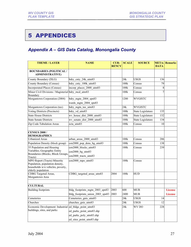
5 APPENDICES Appendix A – GIS Data Catalog, Monongalia County
THEME / LAYER NAME CUR-RENCY
SCALE SOURCE META-DATA
Remarks
BOUNDARIES (POLITICAL / ADMINISTRATIVE)
County Boundary (DLG) bdry_cnty_24k_utm83 24k USGS 136 County Boundary (Census) bdry_cnty_100k_utm83 100k Census 79 Incorporated Places (Census) incorp_places_2000_utm83 100k Census 8 Minor Civil Divisions / Magisterial Boundary
bdry_mcd_utm83 100k Census 7
bdry_mgtn_2004_spn83 Morgantown Corporation (2004) wards_mgtn_2004_spn83
1200 WVGISTC
Morgantown Corporation (tax) bdry_mgtn_tax_utm83 24k WVGISTC Voting Districts (Precincts) bdry_vd_utm83 100k State Legislature 135 State House Districts wv_house_dist_2000_utm83 100k State Legislature 132 State Senate Districts wv_senate_dist_2000_utm83 100k State Legislature 134 Zip Code Tabulation Areas zcta_utm83 100k Census 10 CENSUS 2000 / DEMOGRAPHICS
Urbanized Areas urban_areas_2000_utm83 100k Census 206 Population Density (block group) cen2000_pop_dens_bg_utm83 100k Census 138
cen2000_blocks_utm83 cen2000_bg_utm83
35 Population and Housing Variables; Geographic Entity Boundaries (Blocks, Block Groups, Tracts) cen2000_tracts_utm83
100k Census 239
MPO Report (Tracts) Minority Population, population density, households w/o vehicles, poverty, elderly population
cen2000_mpo_utm83 100k Census
CDBG_targeted_areas_utm83 100k HUD CDBG Targeted Areas, Morgantown Area
2004
CULTURAL
bldg_footprints_mgtn_2003_spn83 2003 600 MUB License Building footprints bldg_footprints_union_2003_spn83 2003 2400 MUB
License
Cemeteries Cemeteries_gnis_utm83 24k USGS 14 Churches churches_gnis_utm83 24k USGS 12
ed_bldgs_point_utm83 ed_parks_point_utm83.shp ed_parks_poly_utm83.shp
Economic Development: Industrial buildings, sites, and parks
ed_sites_point_utm83.shp
24k WV DO 228
July 2004 27
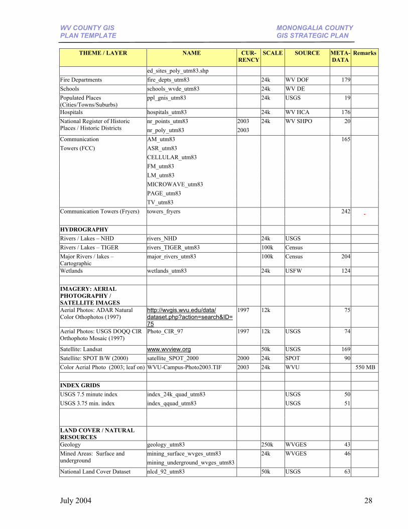
WV COUNTY GIS MONONGALIA COUNTY PLAN TEMPLATE GIS STRATEGIC PLAN
THEME / LAYER NAME CUR-
RENCYSCALE SOURCE META-
DATARemarks
ed_sites_poly_utm83.shp Fire Departments fire_depts_utm83 24k WV DOF 179 Schools schools_wvde_utm83 24k WV DE Populated Places (Cities/Towns/Suburbs)
ppl_gnis_utm83 24k USGS 19
Hospitals hospitals_utm83 24k WV HCA 176 nr_points_utm83 2003 National Register of Historic
Places / Historic Districts nr_poly_utm83 2003 24k WV SHPO 20
Communication AM_utm83 Towers (FCC) ASR_utm83 CELLULAR_utm83
FM_utm83 LM_utm83 MICROWAVE_utm83 PAGE_utm83 TV_utm83
165
Communication Towers (Fryers) towers_fryers 242 HYDROGRAPHY Rivers / Lakes – NHD rivers_NHD 24k USGS Rivers / Lakes – TIGER rivers_TIGER_utm83 100k Census Major Rivers / lakes – Cartographic
major_rivers_utm83 100k Census 204
Wetlands wetlands_utm83 24k USFW 124 IMAGERY: AERIAL PHOTOGRAPHY / SATELLITE IMAGES
Aerial Photos: ADAR Natural Color Othophotos (1997)
http://wvgis.wvu.edu/data/ dataset.php?action=search&ID=75
1997 12k 75
Aerial Photos: USGS DOQQ CIR Orthophoto Mosaic (1997)
Photo_CIR_97 1997 12k USGS 74
Satellite: Landsat www.wvview.org 50k USGS 169 Satellite: SPOT B/W (2000) satellite_SPOT_2000 2000 24k SPOT 90 Color Aerial Photo (2003; leaf on) WVU-Campus-Photo2003.TIF 2003 24k WVU 550 MB INDEX GRIDS USGS 7.5 minute index index_24k_quad_utm83 USGS 50USGS 3.75 min. index index_qquad_utm83
USGS 51
LAND COVER / NATURAL RESOURCES
Geology geology_utm83 250k WVGES 43 mining_surface_wvges_utm83 Mined Areas: Surface and
underground mining_underground_wvges_utm83 24k WVGES 46
National Land Cover Dataset nlcd_92_utm83 50k USGS 63
July 2004 28
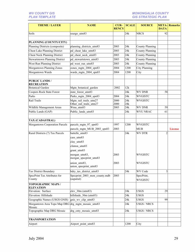
WV COUNTY GIS MONONGALIA COUNTY PLAN TEMPLATE GIS STRATEGIC PLAN
THEME / LAYER NAME CUR-
RENCYSCALE SOURCE META-
DATARemarks
Soils ssurgo_utm83 24k NRCS 92 PLANNING (COUNTY/CITY) Planning Districts (composite) planning_districts_utm83 2003 24k County Planning Cheat Lake Planning District pd_cheat_lake_utm83 2003 24k County Planning Cheat Neck Planning District pd_cheat_neck_utm83 2003 24k County Planning Stewartstown Planning District pd_stewartstown_utm83 2003 24k County Planning West Run Planning District pd_west_run_utm83 2003 24k County Planning Morgantown Planning Zones zones_mgtn_2004_spn83 2004 1200 City Planning Morgantown Wards wards_mgtn_2004_spn83 2004 1200 City PUBLIC LANDS / RECREATION
Botanical Garden Mgtn_botanical_garden 2002 12k Coopers Rock State Forest state_forest_utm83 24k WV DNR 58 Parks Parks_mgtn_2004_spn83 2004 24k WVGISTC Rail Trails Mgtn_rail_trails_utm27
Other_rail_trails_utm27 2000 2000
24k 24k
WVGISTC
Wildlife Management Areas Wma_utm83 2003 24k WV DNR 59 Public Lands (GAP) Public_lands_utm83 24k WVU NRAC 61 TAX (CADASTRAL)
parcels_mgtn_97_spn83 1997 WVGISTC Morgantown Corporation Parcels parcels_mgtn_MUB_2003_spn83 2003
1200 MUB
License
battelle_utm83 WV DTR cass_utm83 clay_utm83 clinton_utm83 grant_utm83 morgan_utm83, morgan_specprint_utm83
2003 WVGISTC
Rural Districts (7) Tax Parcels
union_utm83, union_specprint_utm83
2003
24k
WVGISTC
2
Tax District Boundary bdry_tax_district_utm83 24k WV Code 3 SpecPrint, SpecPrint Tax Attributes for
County Specprint_2003_mon_county.mdb (aspatial)
2003 WVGISTC
TOPOGRAPHIC MAPS / ELEVATION
Elevation: Surface elev_30m (utm83) 24k USGS 29 Elevation: Hillshade hillshade_30m (utm83) 24k USGS Geographic Names (USGS GNIS) gnis_wv_clip_utm83 24k USGS 99 Morgantown Area Topo Map DRG Mosaic
drg_mgtn_mosaic_utm83 24k USGS / NRCS
Topographic Map DRG Mosaic drg_cnty_mosaic_utm83 24k USGS / NRCS TRANSPORTATION Airport Airport_point_utm83 1200 City
July 2004 29
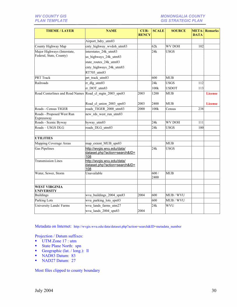
WV COUNTY GIS MONONGALIA COUNTY PLAN TEMPLATE GIS STRATEGIC PLAN
THEME / LAYER NAME CUR-
RENCYSCALE SOURCE META-
DATARemarks
Airport_bdry_utm83 County Highway Map cnty_highway_wvdoh_utm83 62k WV DOH 102
interstates_24k_utm83 us_highways_24k_utm83 state_routes_24k_utm83 cnty_highways_24k_utm83
Major Highways (Interstate, Federal, State, County)
RT705_utm83
24k USGS
PRT Track prt_track_utm83 600 MUB rr_dlg_utm83 24k USGS 112Railroads rr_DOT_utm83
100k USDOT 113
Road_cl_mgtn_2003_spn83 2003 1200 MUB License Road Centerlines and Road Names
Road_cl_union_2003_spn83 2003 2400 MUB
License Roads - Census TIGER roads_TIGER_2000_utm83 2000 100k Census 238 Roads - Proposed West Run Expressway
new_rds_west_run_utm83
Roads - Scenic Byway byway_utm83 24k WV DOH 111 Roads – USGS DLG roads_DLG_utm83 24k USGS 100 UTILITIES Mapping Coverage Areas map_extent_MUB_spn83 MUB Gas Pipelines http://wvgis.wvu.edu/data/
dataset.php?action=search&ID=108
24k USGS
Transmission Lines http://wvgis.wvu.edu/data/ dataset.php?action=search&ID=108
Water, Sewer, Storm Unavailable 600 / 2400
MUB
WEST VIRGINIA UNIVERSITY
Buildings wvu_buildings_2004_spn83 2004 600 MUB / WVU Parking Lots wvu_parking_lots_spn83 600 MUB / WVU
wvu_lands_farms_utm27 University Lands/ Farms wvu_lands_2004_spn83 2004
24k WVU
Metadata on Internet: http://wvgis.wvu.edu/data/dataset.php?action=search&ID=metadata_number Projection / Datum suffixes: UTM Zone 17 : utm State Plane North: spn Geographic (lat. / long.): ll NAD83 Datum: 83 NAD27 Datum: 27
Most files clipped to county boundary
July 2004 30
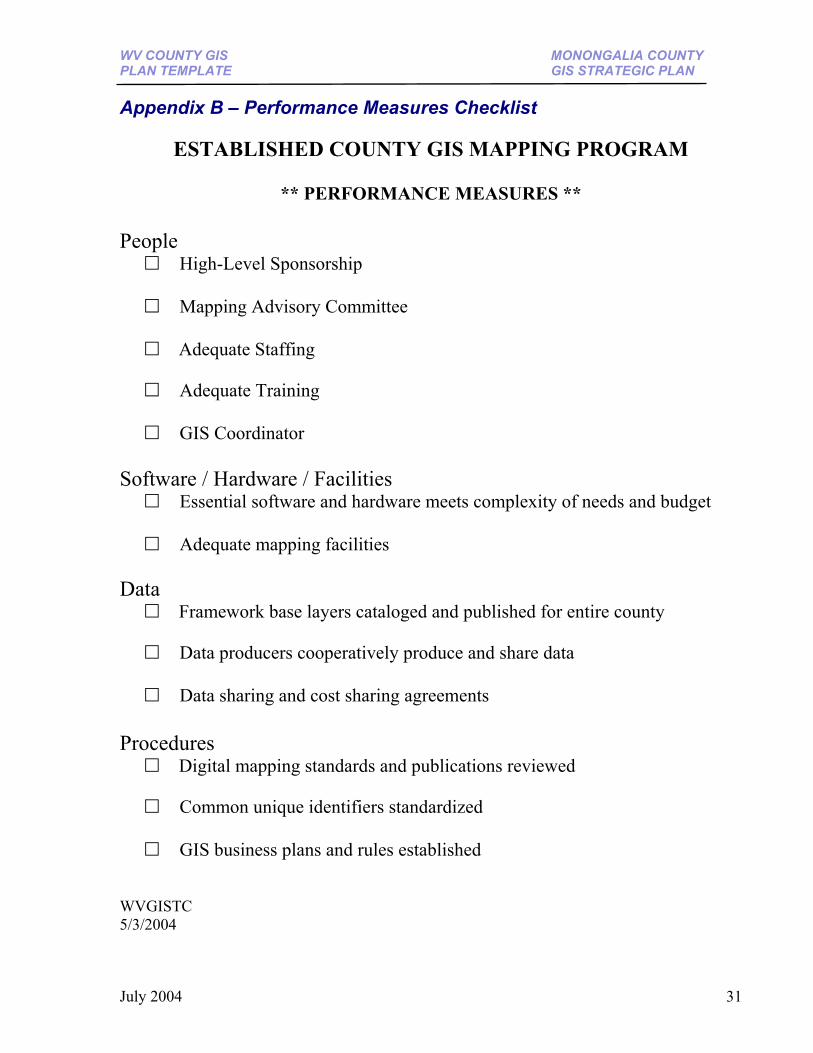
WV COUNTY GIS MONONGALIA COUNTY PLAN TEMPLATE GIS STRATEGIC PLAN
Appendix B – Performance Measures Checklist
ESTABLISHED COUNTY GIS MAPPING PROGRAM
** PERFORMANCE MEASURES ** People High-Level Sponsorship Mapping Advisory Committee
Adequate Staffing
Adequate Training GIS Coordinator Software / Hardware / Facilities Essential software and hardware meets complexity of needs and budget Adequate mapping facilities Data
Framework base layers cataloged and published for entire county
Data producers cooperatively produce and share data Data sharing and cost sharing agreements
Procedures
Digital mapping standards and publications reviewed
Common unique identifiers standardized GIS business plans and rules established WVGISTC 5/3/2004
July 2004 31
WV COUNTY GIS MONONGALIA COUNTY PLAN TEMPLATE GIS STRATEGIC PLAN
References International Association of Assessing Officers (IAAO). “Standard on Digital Cadastral Maps
and Parcel Identifiers.” July 2003. <http://wvgis.wvu.edu/stateactivities/standardsandguidelines/tax/IAAO_tax_standard_july03.pdf>
Joffe, Bruce. “10 Ways to Support Your GIS Without Selling Data.” Oakland, CA. 29 Oct.
2003. <http://www.opendataconsortium.org/> Stage, David, and Nancy Von Meyer. “An Assessment of Parcel Data in the United States,”
Federal Geographic Data Committee’s (FGDC) Subcommittee on Cadastral Data. Mar. 2003. <http://wvgis.wvu.edu/stateactivities/standardsandguidelines/tax/Assessment_of_Parcel_Data_in_50_States.pdf>
Property Valuation Training and Procedures Commission (PVC). “Statewide Procedures for the
Manual Maintenance of Surface Tax Maps.” 189-04. September 1990. <http://www.wvsos.com/csrdocs/worddocs/189-04.doc>
July 2004 32