ESSENTIAL MATHEMATICS 4 World Locations...Page 1 of 15 ESSENTIAL MATHEMATICS 4 WEEK 5 AND 6 NOTES...
15
Page 1 of 15 ESSENTIAL MATHEMATICS 4 WEEK 5 AND 6 NOTES AND EXERCISES World Locations Street directories use grid references, such as C5, to locate streets, parks and other features in the local area. On a world map, or globe, latitude and longitude lines are used as grid references. Parallels of latitude are imaginary lines that are parallel to the Equator. • The latitude of the North Pole is 90° north (90°N). • The latitude of the equator is 0°. • The latitude of the South Pole is 90° south (90°S). Meridians of longitude are imaginary lines running around the Earth from pole to pole. The meridian through Greenwich, near London in England, is called the Prime Meridian. It has longitude 0°. We measure longitude as degrees east or west of the Greenwich meridian. The 180°E and the 180°W meridians are the same line. This line, which runs through the Pacific Ocean, is called the International Date Line (IDL). When you travel across the IDL the date changes. The date is one day later west of the line than it is east of the line.
Transcript of ESSENTIAL MATHEMATICS 4 World Locations...Page 1 of 15 ESSENTIAL MATHEMATICS 4 WEEK 5 AND 6 NOTES...
Page 1 of 15
ESSENTIAL MATHEMATICS 4
WEEK 5 AND 6 NOTES AND EXERCISES
World Locations
Street directories use grid references, such as C5, to locate streets, parks and other features in the local area. On a world map, or globe, latitude and longitude lines are used as grid references.
Parallels of latitude are imaginary lines that are parallel to the Equator.
• The latitude of the North Pole is 90° north (90°N). • The latitude of the equator is 0°. • The latitude of the South Pole is 90° south (90°S).
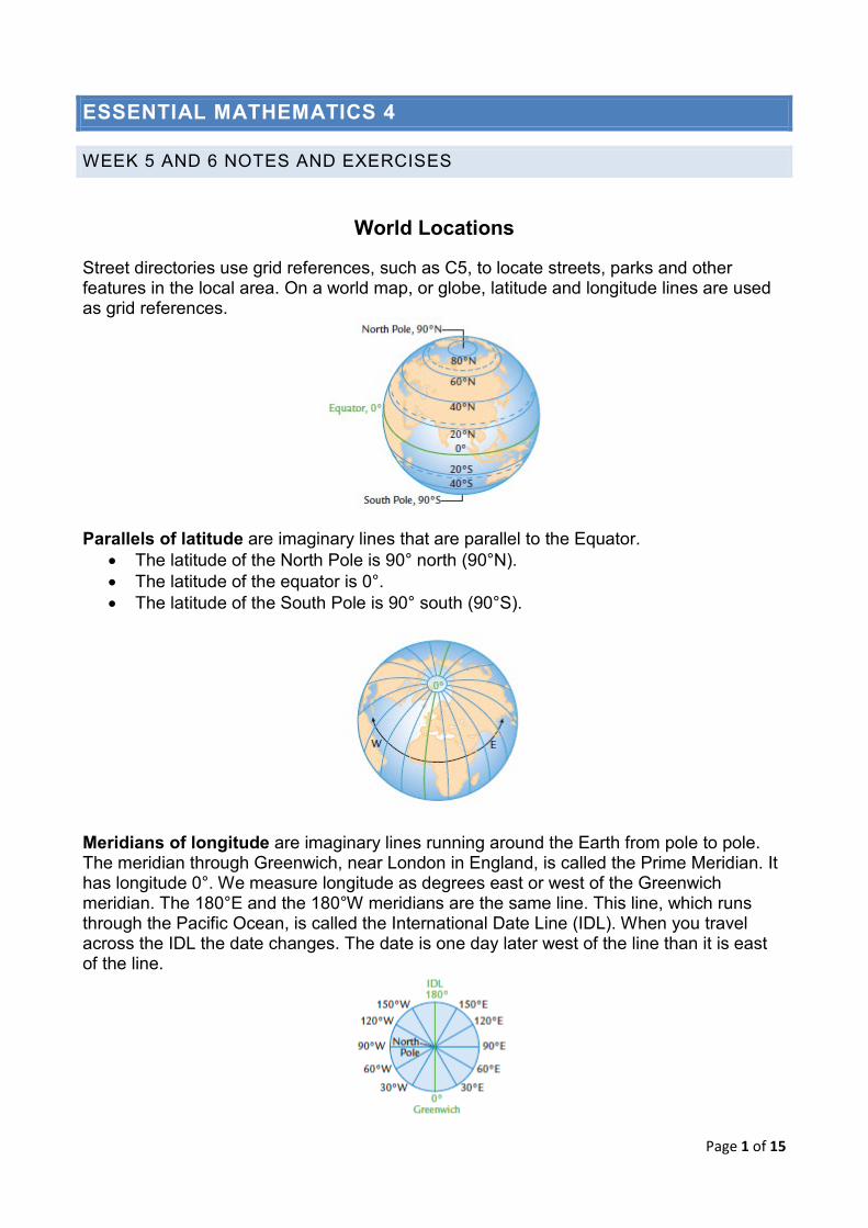
Meridians of longitude are imaginary lines running around the Earth from pole to pole. The meridian through Greenwich, near London in England, is called the Prime Meridian. It has longitude 0°. We measure longitude as degrees east or west of the Greenwich meridian. The 180°E and the 180°W meridians are the same line. This line, which runs through the Pacific Ocean, is called the International Date Line (IDL). When you travel across the IDL the date changes. The date is one day later west of the line than it is east of the line.
Page 2 of 15
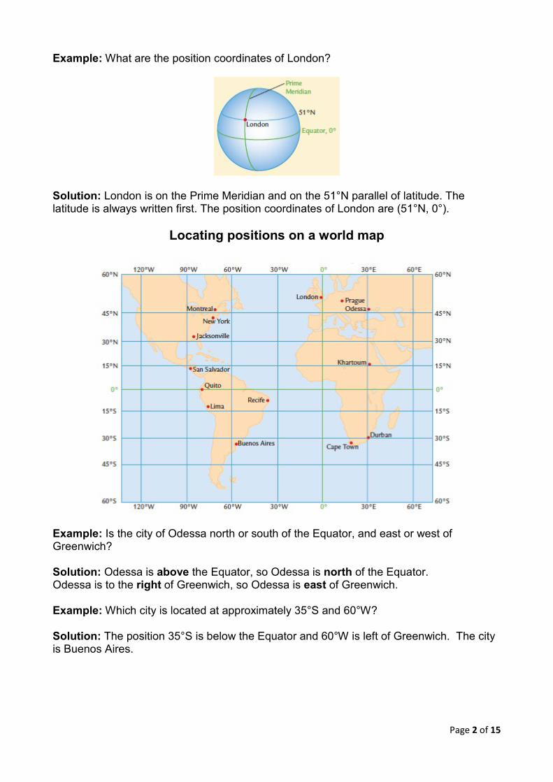
Example: What are the position coordinates of London?
Solution: London is on the Prime Meridian and on the 51°N parallel of latitude. The latitude is always written first. The position coordinates of London are (51°N, 0°).
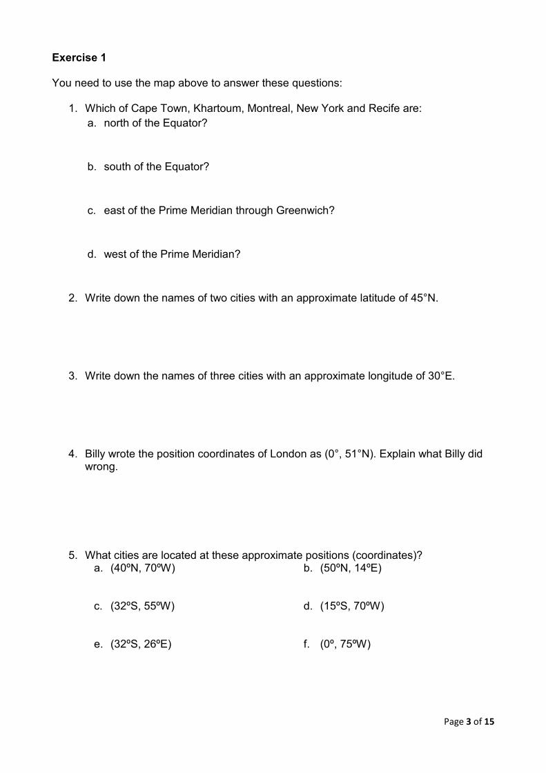
Locating positions on a world map
Example: Is the city of Odessa north or south of the Equator, and east or west of Greenwich? Solution: Odessa is above the Equator, so Odessa is north of the Equator. Odessa is to the right of Greenwich, so Odessa is east of Greenwich. Example: Which city is located at approximately 35°S and 60°W? Solution: The position 35°S is below the Equator and 60°W is left of Greenwich. The city is Buenos Aires.
Page 3 of 15
Exercise 1 You need to use the map above to answer these questions:
1. Which of Cape Town, Khartoum, Montreal, New York and Recife are: a. north of the Equator?
b. south of the Equator?
c. east of the Prime Meridian through Greenwich? d. west of the Prime Meridian?
2. Write down the names of two cities with an approximate latitude of 45°N.
3. Write down the names of three cities with an approximate longitude of 30°E.
4. Billy wrote the position coordinates of London as (0°, 51°N). Explain what Billy did wrong.
5. What cities are located at these approximate positions (coordinates)? a. (40ºN, 70ºW)
b. (50ºN, 14ºE)
c. (32ºS, 55ºW)
d. (15ºS, 70ºW)
e. (32ºS, 26ºE)
f. (0º, 75ºW)
Page 4 of 15
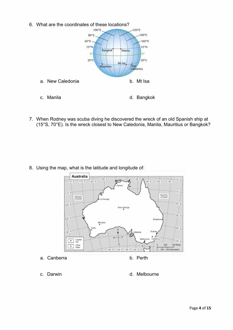
6. What are the coordinates of these locations?
a. New Caledonia
b. Mt Isa
c. Manila
d. Bangkok
7. When Rodney was scuba diving he discovered the wreck of an old Spanish ship at
(15°S, 70°E). Is the wreck closest to New Caledonia, Manila, Mauritius or Bangkok?
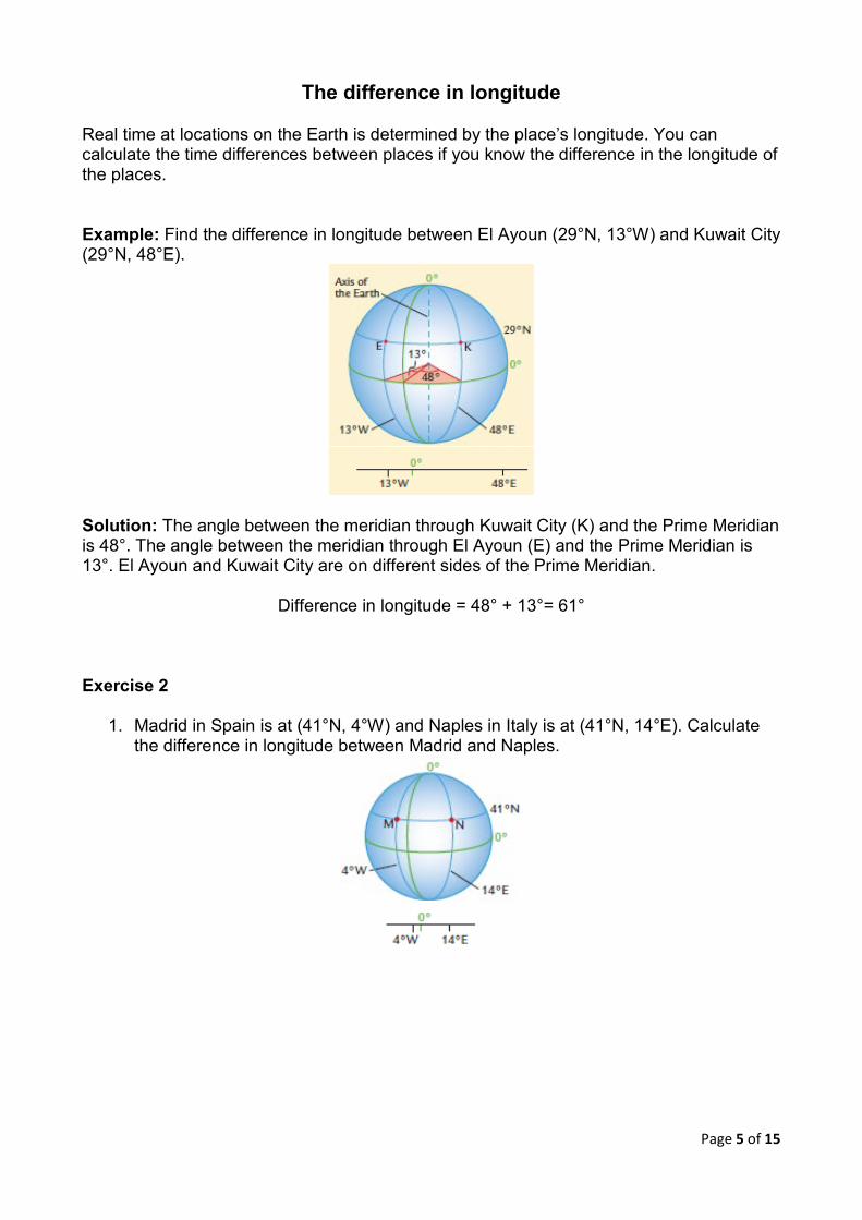
8. Using the map, what is the latitude and longitude of:
a. Canberra
b. Perth
c. Darwin
d. Melbourne
Page 5 of 15
The difference in longitude
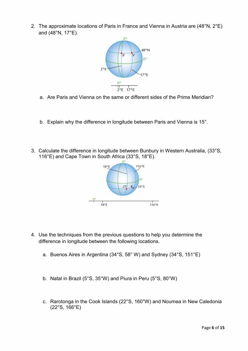
Real time at locations on the Earth is determined by the place’s longitude. You can calculate the time differences between places if you know the difference in the longitude of the places. Example: Find the difference in longitude between El Ayoun (29°N, 13°W) and Kuwait City (29°N, 48°E).
Solution: The angle between the meridian through Kuwait City (K) and the Prime Meridian is 48°. The angle between the meridian through El Ayoun (E) and the Prime Meridian is 13°. El Ayoun and Kuwait City are on different sides of the Prime Meridian.
Difference in longitude = 48° + 13°= 61° Exercise 2
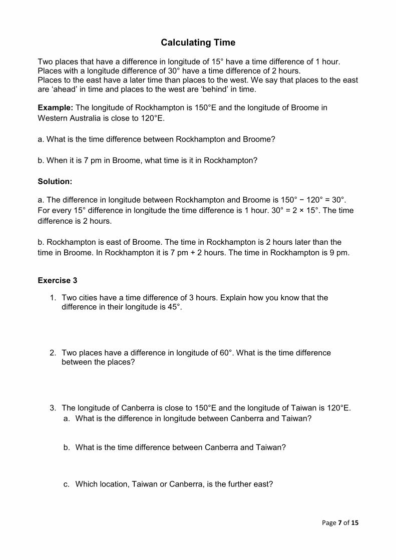
1. Madrid in Spain is at (41°N, 4°W) and Naples in Italy is at (41°N, 14°E). Calculate the difference in longitude between Madrid and Naples.
Page 6 of 15
2. The approximate locations of Paris in France and Vienna in Austria are (48°N, 2°E) and (48°N, 17°E).
a. Are Paris and Vienna on the same or different sides of the Prime Meridian?
b. Explain why the difference in longitude between Paris and Vienna is 15°.
3. Calculate the difference in longitude between Bunbury in Western Australia, (33°S, 116°E) and Cape Town in South Africa (33°S, 18°E).
4. Use the techniques from the previous questions to help you determine the difference in longitude between the following locations.
a. Buenos Aires in Argentina (34°S, 58° W) and Sydney (34°S, 151°E)
b. Natal in Brazil (5°S, 35°W) and Piura in Peru (5°S, 80°W)
c. Rarotonga in the Cook Islands (22°S, 160°W) and Noumea in New Caledonia (22°S, 166°E)
Page 7 of 15
Calculating Time
Two places that have a difference in longitude of 15° have a time difference of 1 hour. Places with a longitude difference of 30° have a time difference of 2 hours. Places to the east have a later time than places to the west. We say that places to the east are ‘ahead’ in time and places to the west are ‘behind’ in time.
Example: The longitude of Rockhampton is 150°E and the longitude of Broome in Western Australia is close to 120°E. a. What is the time difference between Rockhampton and Broome? b. When it is 7 pm in Broome, what time is it in Rockhampton? Solution: a. The difference in longitude between Rockhampton and Broome is 150° − 120° = 30°. For every 15° difference in longitude the time difference is 1 hour. 30° = 2 × 15°. The time difference is 2 hours. b. Rockhampton is east of Broome. The time in Rockhampton is 2 hours later than the time in Broome. In Rockhampton it is 7 pm + 2 hours. The time in Rockhampton is 9 pm.
Exercise 3
1. Two cities have a time difference of 3 hours. Explain how you know that the difference in their longitude is 45°.
2. Two places have a difference in longitude of 60°. What is the time difference between the places?
3. The longitude of Canberra is close to 150°E and the longitude of Taiwan is 120°E. a. What is the difference in longitude between Canberra and Taiwan?
b. What is the time difference between Canberra and Taiwan?
c. Which location, Taiwan or Canberra, is the further east?
Page 8 of 15
d. What time is it in Canberra when it is 12 noon in Taiwan?
e. When it is 7 pm in Canberra, what time is it in Taiwan?
4. The time in Sri Lanka is based on the 80°E meridian of longitude and the time in Vietnam is based on 110°E. a. What is the difference in longitude?
b. Calculate the time difference between Sri Lanka and Vietnam.
c. Is the time later in Sri Lanka or in Vietnam? Why?
d. When it is 9 pm in Vietnam, what time is it in Sri Lanka?
5. Kiev in the Ukraine is at (50°N, 30°E) and Shanghai in China is at (30°N, 120°E). a. Explain how you know that the time difference between Shanghai and Kiev is 6
hours.
b. When it is 12 noon in Shanghai, what time is it in Kiev?
Page 9 of 15
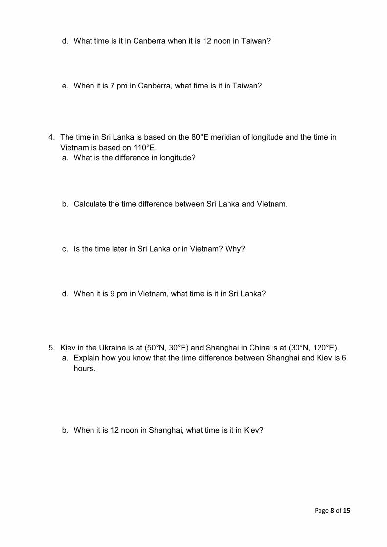
World time zones
It would be very inconvenient if places used the exact time determined by their longitude. Imagine the chaos if you had to change your watch by a few minutes when you travelled 100 km west! To avoid this problem the world is divided into 24 time zones. The 12th time zone east (+12) and the 12th time zone west (−12) meet at the International Date Line.
Example a. When it is 1 pm in Greenwich, what time is it in Beijing? b. When it is 9 am on Tuesday in Beijing, what time and day is it in New York? Solution The easiest way to determine local time is to use a time line. a.
Beijing is east of Greenwich. Add the time difference to the time in Greenwich. Time in Beijing = 1 pm + 8 hours = 9 pm b.
-5 0 +8
Page 10 of 15
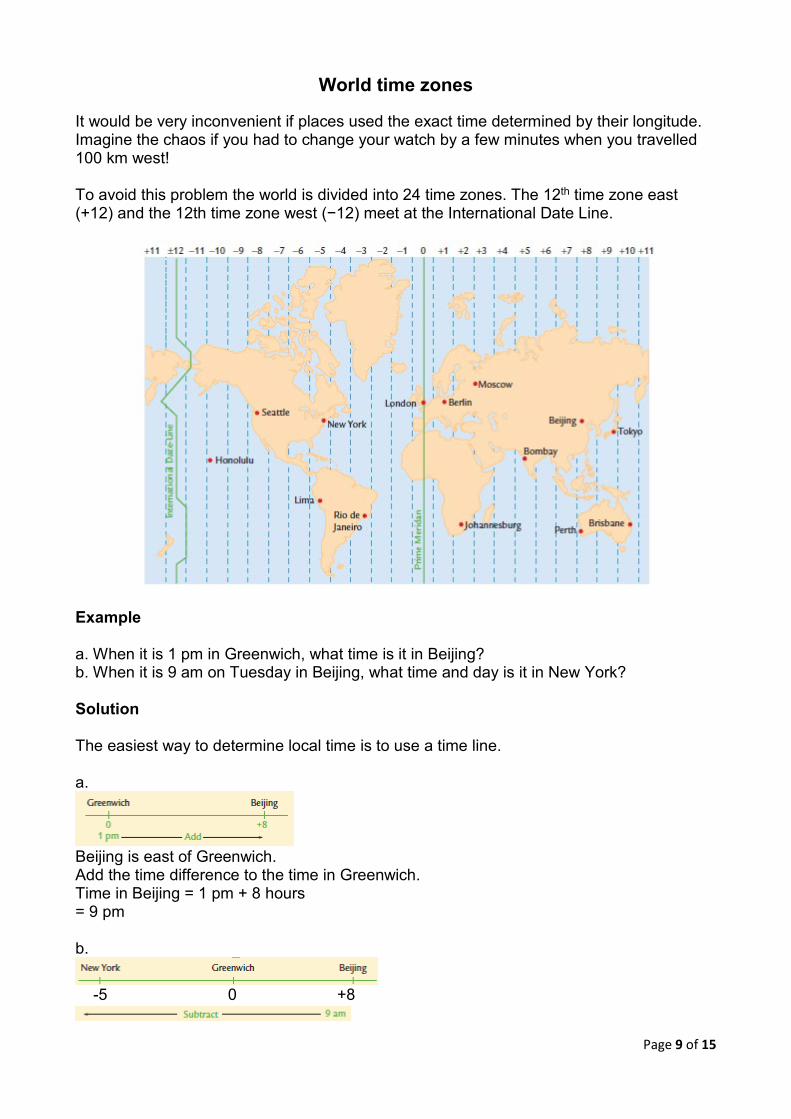
New York is west of Beijing. Subtract the time difference from the time in Beijing. Time in New York = 9 am Tuesday − 13 hours = 8 pm Monday Exercise 4 This time line shows the world time zones for seven cities. Use the time line to answer the questions in these questions.
1. What is the time difference between Athens and Hong Kong?
2. When Bruce was in Hong Kong he phoned his mother in Athens. The time in Hong Kong was 9 am. What time was it in Athens?
3. Peggy was in Rome enjoying her first overseas holiday. At 7:30 am, after she finished breakfast in the cafe, she phoned her father in Boston. What time was it in Boston?
4. Hogan is in Honolulu and wants to video call his friend, Peter, in Hong Kong. What time should Hogan call Peter, if Peter finishes work at 6pm in Hong Kong.
5. Samantha caught a non-stop flight from Boston to Athens. The flight left Boston at 0530 Boston time. a. What time was it in Athens when Samantha’s flight left Boston? Express your
answer in 24-hour time.
b. The flight landed in Athens at 2200 local time. How long did the flight take?
6. Frank’s flight from Rome to Hong Kong left Rome at 1400 Rome time. The flight took 11 hours. a. What time was it in Rome when Frank’s flight landed in Hong Kong?
Page 11 of 15
b. What was the local time in Hong Kong when Frank’s plane landed?
7. The Brisbane Broncos are going to play a football match in Auckland, New Zealand. The local time in Auckland is 2 hours ahead of the time in Brisbane. The live TV coverage of the match is going to start in Auckland at 7 pm local time. At what time will the live match start on Brisbane TV?
8. James caught a flight from Canberra to Heathrow, stopping at Perth. The duration of the flight from Canberra to Perth is 5 hours and the duration of the flight from Perth to Heathrow is 17 hours. James had a layover time of 2 hours. The flight left Canberra at 2:35 pm Wednesday. What time does the flight land in Heathrow?
World distances
The imaginary parallels of latitude and meridians of longitude make two different types of circles on the Earth’s surface. Great circles are the biggest circles on the Earth. The Equator and all the meridians of longitude are great circles. The radius of all great circles is the same as the radius of the Earth, about 6400 km. The Tropic of Capricorn and all other parallels of latitude, with the exception of the Equator, are different-sized small circles. The radii of small circles are less than 6400 km.
Distances on great circles
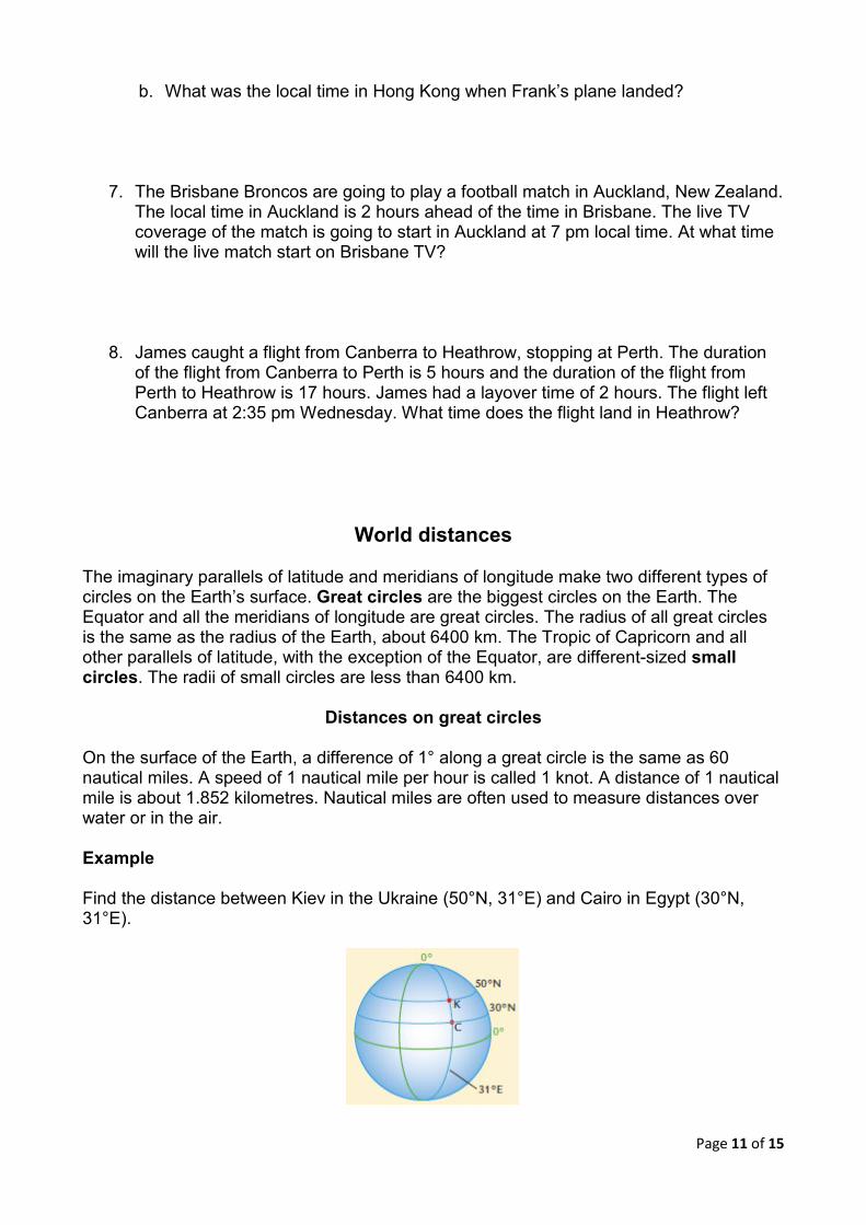
On the surface of the Earth, a difference of 1° along a great circle is the same as 60 nautical miles. A speed of 1 nautical mile per hour is called 1 knot. A distance of 1 nautical mile is about 1.852 kilometres. Nautical miles are often used to measure distances over water or in the air. Example Find the distance between Kiev in the Ukraine (50°N, 31°E) and Cairo in Egypt (30°N, 31°E).
Page 12 of 15
Solution: Kiev and Cairo lie on the same meridian of longitude. They are on the same great circle. There are 20° along the great circle between the locations. Each degree represents 60 nautical miles. Distance between Kiev and Cairo
= 20 × 60 nautical miles = 1200 nautical miles
To convert nautical miles to kilometres, just multiply by 1.852. Distance between Kiev and Cairo
= 1200 × 1.852 km = 2222.4 km
Exercise 5
1. Use the conversion factor, 1 nautical mile (M) = 1.852 km to convert the following distances to kilometres.
a. 700 M
b. 1550 M
c. 3600 M
d. 46.5 M
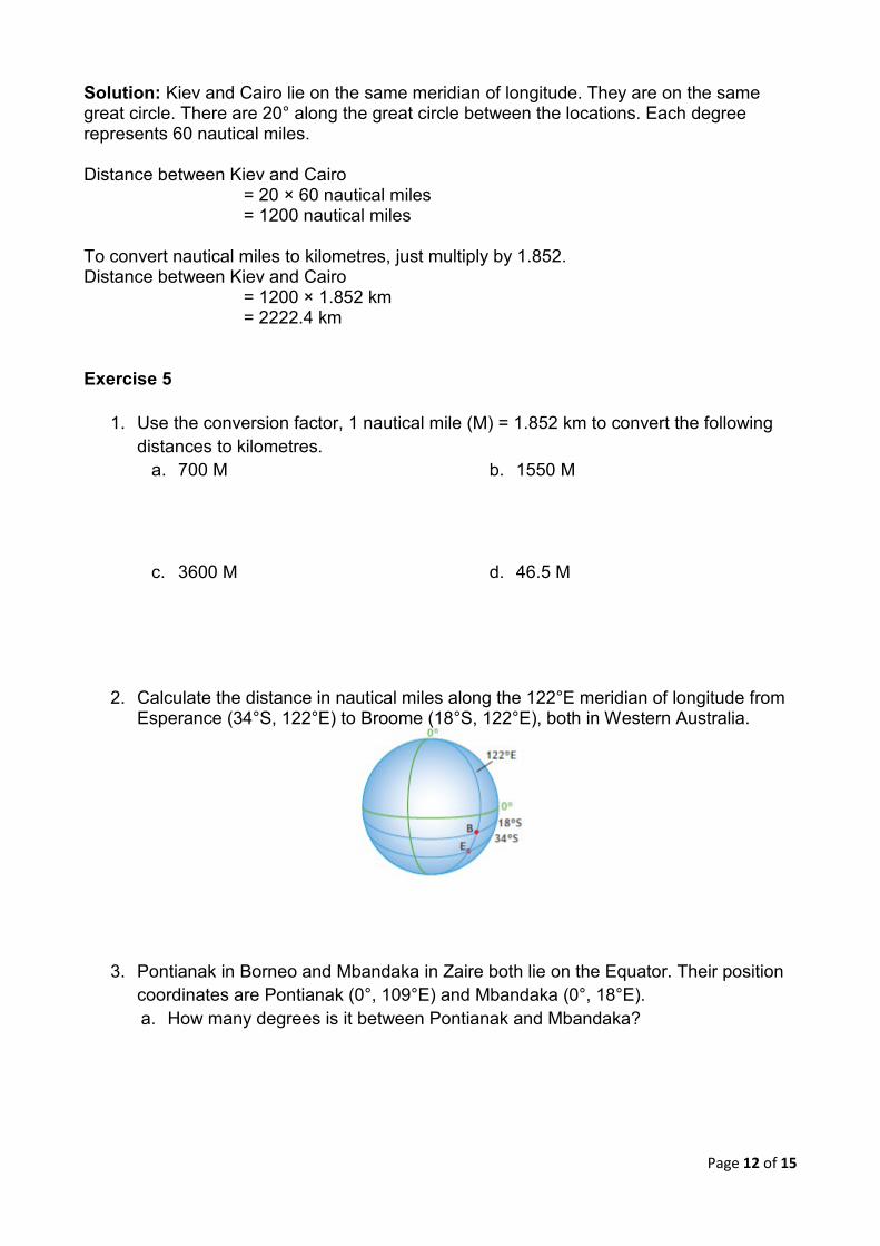
2. Calculate the distance in nautical miles along the 122°E meridian of longitude from Esperance (34°S, 122°E) to Broome (18°S, 122°E), both in Western Australia.
3. Pontianak in Borneo and Mbandaka in Zaire both lie on the Equator. Their position coordinates are Pontianak (0°, 109°E) and Mbandaka (0°, 18°E). a. How many degrees is it between Pontianak and Mbandaka?
Page 13 of 15
b. Calculate the distance between Pontianak and Mbandaka in nautical miles.
c. Convert the distance between the two places to kilometres.
4. Calculate the distance along the Equator from (0°, 30°E) to (0°, 10°W).
5. Patrick sailed along a great circle from Cuba (22°N, 80°W) to Miami (26°N, 80°W). a. How many nautical miles is it from Cuba to Miami?
b. Patrick’s boat averaged 6 knots for the trip. How many hours did it take him to sail from Cuba to Miami?
c. He left Cuba at 3 am on Monday 23 June. What were the day and time when he arrived in Miami?
6. A plane flies due South, from Canberra (35°S, 148°E) to Hobart (42°S, 148°E). a. What is the distance the plane has travelled to the nearest kilometre?
b. The plane averaged 750 km/hr for the trip. How long was the flight?
c. The plane leaves Canberra at 3:15 pm on Monday. What time will it land in Hobart?
Page 14 of 15
2019 EM4 Week 5/6 Investigation
PART A: To complete this part of the investigation you will need an atlas or a globe.
1. Find two cities in Europe that have the same latitude and a difference of between 5° and 10° in their longitudes. Provide the co-ordinates of these two cities.
2. The approximate coordinates of Mount Isa are (21°S, 139°E). The difference in longitude between Mount Isa and another town in Queensland is approximately 5°. a. The other town has the same latitude as Mount Isa. What is the town?
Provide the co-ordinates.
b. Find another town in Queensland that has 5° difference in longitude from Mount Isa and has a different latitude. What are the co-ordinates and name of this town?
c. What do the two places you found in parts a and b have in common?
Page 15 of 15
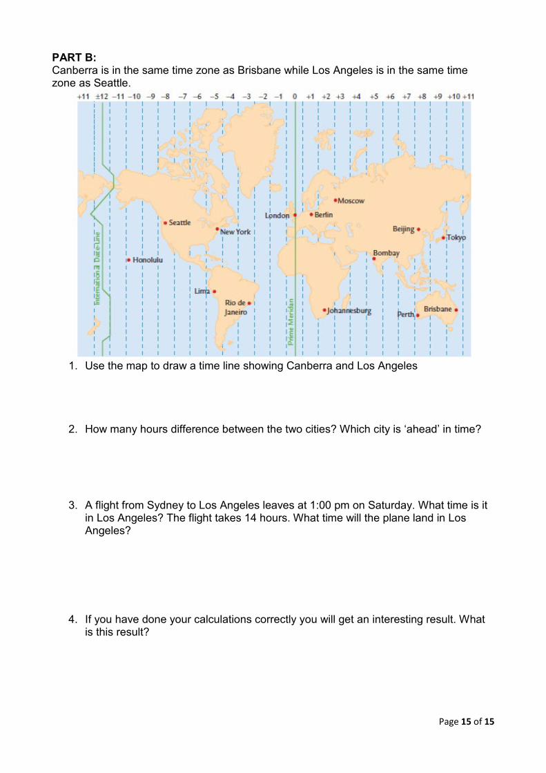
PART B: Canberra is in the same time zone as Brisbane while Los Angeles is in the same time zone as Seattle.
1. Use the map to draw a time line showing Canberra and Los Angeles
2. How many hours difference between the two cities? Which city is ‘ahead’ in time?
3. A flight from Sydney to Los Angeles leaves at 1:00 pm on Saturday. What time is it in Los Angeles? The flight takes 14 hours. What time will the plane land in Los Angeles?
4. If you have done your calculations correctly you will get an interesting result. What is this result?