
ESIA MAERSK OIL DBU - Energistyrelsen · ESIA MAERSK OIL DBU ... Figure 6-3 Jacket pile driving...
183
ESIA MAERSK OIL DBU ENVIRONMENTAL AND SOCIAL IMPACT STATEMENT ESIS-TYRA Intended for Maersk Oil Document type Report Date June, 2017
Transcript of ESIA MAERSK OIL DBU - Energistyrelsen · ESIA MAERSK OIL DBU ... Figure 6-3 Jacket pile driving...

ESIA MAERSK OIL DBU
ENVIRONMENTAL AND SOCIAL
IMPACT STATEMENT ESIS-TYRA
Intended for
Maersk Oil
Document type
Report
Date
June, 2017
ESIA MAERSK OIL DBU
ENVIRONMENTAL AND SOCIAL IMPACT STATEMENT
ESIS-TYRA
Ramboll
Hannemanns Allé 53
DK-2300 Copenhagen S
Denmark
T +45 5161 1000
F +45 5161 1001
www.ramboll.com
Revision E
Date 15/06/2017
Made by HFV, KEBS, MCO, CFJ
Checked by DMM, CFJ
Approved by CFJ
Description Environmental and Social Impact Statement - the
TYRA project
Ref 1100022384
Document ID NS-S-RA-000072
Environmental and social impact statement ESIS-TYRA
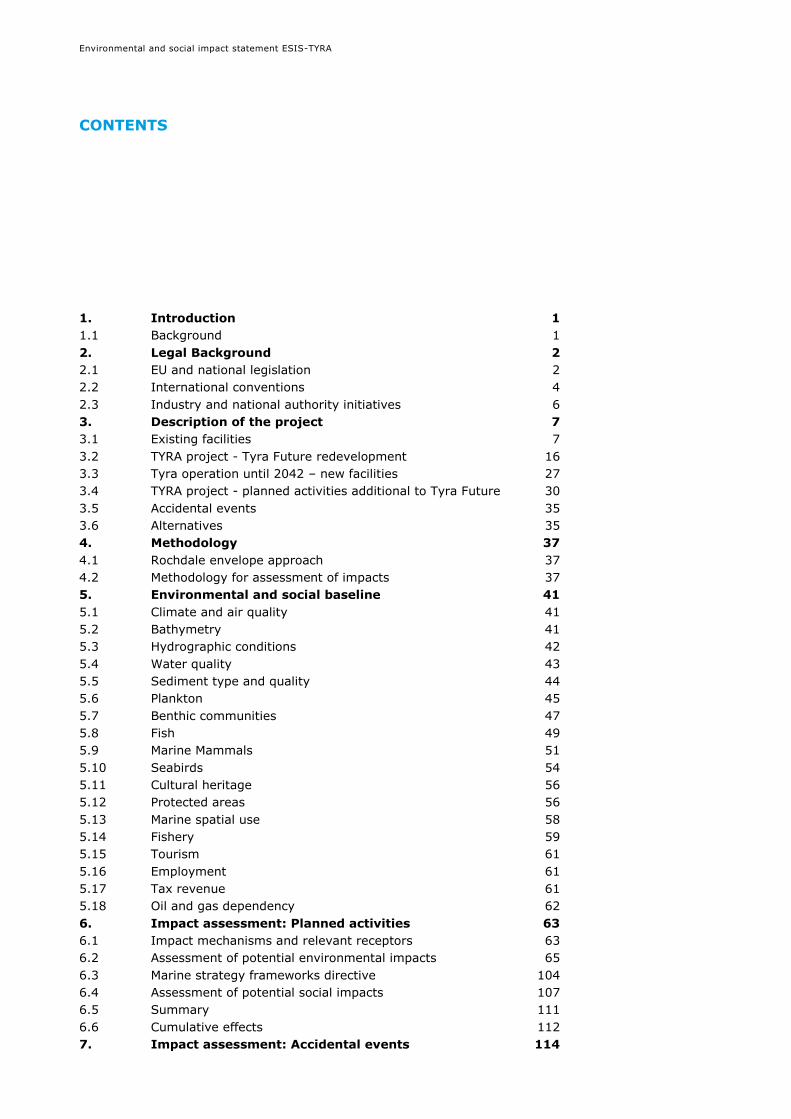
CONTENTS
1. Introduction 1 1.1 Background 1 2. Legal Background 2 2.1 EU and national legislation 2 2.2 International conventions 4 2.3 Industry and national authority initiatives 6 3. Description of the project 7 3.1 Existing facilities 7 3.2 TYRA project - Tyra Future redevelopment 16 3.3 Tyra operation until 2042 – new facilities 27 3.4 TYRA project - planned activities additional to Tyra Future 30 3.5 Accidental events 35 3.6 Alternatives 35 4. Methodology 37 4.1 Rochdale envelope approach 37 4.2 Methodology for assessment of impacts 37 5. Environmental and social baseline 41 5.1 Climate and air quality 41 5.2 Bathymetry 41 5.3 Hydrographic conditions 42 5.4 Water quality 43 5.5 Sediment type and quality 44 5.6 Plankton 45 5.7 Benthic communities 47 5.8 Fish 49 5.9 Marine Mammals 51 5.10 Seabirds 54 5.11 Cultural heritage 56 5.12 Protected areas 56 5.13 Marine spatial use 58 5.14 Fishery 59 5.15 Tourism 61 5.16 Employment 61 5.17 Tax revenue 61 5.18 Oil and gas dependency 62 6. Impact assessment: Planned activities 63 6.1 Impact mechanisms and relevant receptors 63 6.2 Assessment of potential environmental impacts 65 6.3 Marine strategy frameworks directive 104 6.4 Assessment of potential social impacts 107 6.5 Summary 111 6.6 Cumulative effects 112 7. Impact assessment: Accidental events 114
Environmental and social impact statement ESIS-TYRA
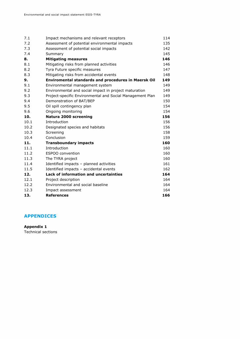
7.1 Impact mechanisms and relevant receptors 114 7.2 Assessment of potential environmental impacts 135 7.3 Assessment of potential social impacts 142 7.4 Summary 145 8. Mitigating measures 146 8.1 Mitigating risks from planned activities 146 8.2 Tyra Future specific measures 147 8.3 Mitigating risks from accidental events 148 9. Enviromental standards and procedures in Maersk Oil 149 9.1 Environmental management system 149 9.2 Environmental and social impact in project maturation 149 9.3 Project-specific Environmental and Social Management Plan 149 9.4 Demonstration of BAT/BEP 150 9.5 Oil spill contingency plan 154 9.6 Ongoing monitoring 154 10. Natura 2000 screening 156 10.1 Introduction 156 10.2 Designated species and habitats 156 10.3 Screening 158 10.4 Conclusion 159 11. Transboundary impacts 160 11.1 Introduction 160 11.2 ESPOO convention 160 11.3 The TYRA project 160 11.4 Identified impacts – planned activities 161 11.5 Identified impacts – accidental events 162 12. Lack of information and uncertainties 164 12.1 Project description 164 12.2 Environmental and social baseline 164 12.3 Impact assessment 164 13. References 166
APPENDICES
Appendix 1 Technical sections

Environmental and social impact statement ESIS-TYRA
LIST OF FIGURES
Figure 1-1 Maersk Oil/DUC platforms in the North Sea................................. 1 Figure 3-1 Overview of existing facilities at the TYRA project (not to scale) .... 8 Figure 3-2 Tyra East ................................................................................ 9 Figure 3-3 Tyra West .............................................................................. 10 Figure 3-4 Tyra Southeast ...................................................................... 11 Figure 3-5 Roar ..................................................................................... 11 Figure 3-6 Valdemar A ............................................................................ 12 Figure 3-7 Valdemar B ............................................................................ 12 Figure 3-8 Svend ................................................................................... 13 Figure 3-9 Simplified diagram of the process at Tyra West .......................... 14 Figure 3-10 Simplified diagram of the process at Tyra East ......................... 15 Figure 3-11 General arrangement of the Tyra field – present facilities .......... 16 Figure 3-12 General arrangement of the Tyra Field following Tyra Future
redevelopment ...................................................................................... 17 Figure 3-13 Tyra East field layout ............................................................ 18 Figure 3-14 Tyra West field layout ........................................................... 19 Figure 3-15 Temporary pipelines .............................................................. 20 Figure 3-16 Umbilical between Tyra East and Tyra West ............................. 20 Figure 3-17 Pipelines for decommissioning ................................................ 22 Figure 3-18 Tyra waste and materials breakdown, in operational condition and
when cleared for removal, weight % ........................................................ 26 Figure 3-19 Simplified diagram of the process at Tyra East following the Tyra
Future redevelopment ............................................................................ 29 Figure 3-20 Total expected production of oil from the TYRA project given as
standard barrels per day (uptime 90%) .................................................... 31 Figure 3-21 Expected production of gas from the TYRA project given in million
standard cubic feet per day (uptime 90%) ................................................ 32 Figure 3-22 Expected production of water from the TYRA project given in
standard barrels per day; no re-injection is undertaken and all produced water
is discharged (uptime 90%) .................................................................... 32 Figure 3-23 Oil in water discharges forecasts. Oil content in discharged
produced water is expected to range between 8 and 13 mg/l for the existing
facilities and from 6 to 9 mg/l after Tyra Future redevelopment project ........ 33 Figure 5-1 Bathymetry of the North Sea. Figure redrawn from Maersk Oil Atlas
/3/ ....................................................................................................... 42 Figure 5-2 Left: General water circulation in the North Sea. The width of
arrows is indicative of the magnitude of volume transport /10/. Right: Potential
for hydrographic fronts in the North Sea /10//2/ ........................................ 43 Figure 5-3 Seabed sediments in the North Sea. Figure redrawn from North Sea
Atlas /3/ ............................................................................................... 44 Figure 5-4 Phytoplankton colour index (PCI) for the North Sea. Figure redrawn
from North Sea Atlas /3/......................................................................... 46 Figure 5-5 Assemblages of the benthic fauna in the North Sea. Figure redrawn
from North Sea Atlas /3/......................................................................... 48 Figure 5-6 Spawning grounds for cod, whiting, mackerel and plaice in the
North Sea. Figure redrawn from North Sea Atlas /3/ .................................. 51 Figure 5-7 Distribution of harbour porpoise in the North Sea. Figure re-drawn
from North Sea Atlas /3/......................................................................... 53 Figure 5-8 Protected areas. Figure redrawn from North Sea Atlas /3/ ........... 57 Figure 5-9 Ship traffic and infrastructure in 2012. Figure re-drawn from North
Sea Atlas /3/. Ship traffic is based on all ships fitted with AIS system i.e. ships
of more than 300 gross tonnage engaged on international voyages, and cargo

Environmental and social impact statement ESIS-TYRA
ships of more than 500 gross tonnage not engaged on international voyages
and all passenger ships irrespective of size. Missing data in the middle of the
North Sea is due to poor AIS receiving coverage and not lack of ships.
Germany does not participate in the North Sea AIS data sharing program .... 59 Figure 5-10 Employment per sector in Denmark in 2013 /39/ ...................... 61 Figure 6-1 Sedimentation of discharged water based drilling mud modelled for
a typical well /1/. ................................................................................... 73 Figure 6-2 Sedimentation of water based drill cuttings modelled for a typical
well /1/. ............................................................................................... 73 Figure 6-3 Jacket pile driving unweighted cumulative SEL threshold level limit
contour plots for seals including animal fleeing for the whole driving period
(Tyra, winter conditions) ......................................................................... 92 Figure 6-4 Jacket pile driving unweighted cumulative SEL threshold level limit
contour plots for seals including animal fleeing for the whole driving period
(Tyra, summer conditions) ...................................................................... 93 Figure 6-5 Jacket pile driving unweighted cumulative SEL threshold level limit
contour plots for harbour porpoise including animal fleeing for the whole
driving period (Tyra, winter conditions) .................................................... 94 Figure 6-6 Jacket pile driving unweighted cumulative SEL threshold level limit
contour plots for harbour porpoise including animal fleeing for the whole
driving period (Tyra, summer conditions) .................................................. 95 Figure 6-7 Conductor driving unweighted cumulative SEL threshold level limit
contour plots for seals including animal fleeing for the whole driving period
(Tyra, winter conditions) ......................................................................... 96 Figure 6-8 Conductor driving unweighted cumulative SEL threshold level limit
contour plots for seals including animal fleeing for the whole driving
period (Tyra, summer conditions) ............................................................ 97 Figure 6-9 Conductor driving unweighted cumulative SEL threshold level limit
contour plots for harbour porpoise including animal fleeing for the whole
driving period (Tyra, winter conditions) .................................................... 98 Figure 6-10 Conductor driving unweighted cumulative SEL threshold level limit
contour plots for harbour porpoise including animal fleeing for the whole
driving period (Tyra, summer conditions) .................................................. 99 Figure 7-1 Minor accidental oil, diesel and chemical spills, Maersk Oil platforms
in the North Sea /160/ ......................................................................... 116 Figure 7-2 Probability that a surface of 1 km2 cell could be impacted by oil in
case of full pipeline rupture /151/ .......................................................... 118 Figure 7-3 Location of four Maersk Oil wells, for which oil spill modelling has
been undertaken. Siah NE-1X, Xana-1X and Svend are considered
representative for the TYRA project ........................................................ 120 Figure 7-4 Probability that a surface cell could be impacted in a surface
blowout at Svend well /151/. Note that these images DO NOT show the actual
footprint of an oil spill, they present a statistical picture based on 159
independently simulated trajectories ...................................................... 122 Figure 7-5 Probability that a water column cell could be impacted in a surface
blowout at Svend well /151/.................................................................. 123 Figure 7-6 Probability that a shoreline cell could be impacted in a surface
blowout at Svend well /151/.................................................................. 124 Figure 7-7 Probability that a surface of 1 km2 cell could be impacted in
Scenario 1 (sub-surface blowout between June and November, upper plot) and
Scenario 2 (sub-surface blowout between December and May, lower plot)
/5//25/ ............................................................................................... 126

Environmental and social impact statement ESIS-TYRA
Figure 7-8 Probability that a water column cell could be impacted in Scenario 1
(sub-surface blowout between June and November, upper plot) and Scenario 2
(sub-surface blowout between December and May, lower plot) /5//25/ ...... 127 Figure 7-9 Probability that a shoreline cell could be impacted in Scenario 1
(sub-surface blowout between June and November, upper plot) and Scenario 2
(sub-surface blowout between December and May, lower plot) /5//25/ ...... 128 Figure 7-10 Maximum time-averaged total oil concentration for the two
scenarios. Upper plot: June-November, Lower plot: December May /5/. Note
that the images does not show actual footprint of an oil spill but a statistical
picture based on 168/167 independently simulated trajectories ................. 129 Figure 7-11 Probability for a surface of 1km2 cell could be impacted. Note than
no surface oiling is probable, when threshold of 1 MT/km2 is applied /26//27/
......................................................................................................... 131 Figure 7-12 Probability that a water column grid cell could be impacted
/26//27/ ............................................................................................. 132 Figure 7-13 Probability of shoreline grid cells being impacted by oil /26//27/
......................................................................................................... 133 Figure 7-14 Maximum time-averaged total oil concentration in water column
cells /26//27/ ...................................................................................... 134 Figure 9-1 Illustration of best available technique /156/ ........................... 150 Figure 9-2 Tyra East produced water system overview ............................. 151 Figure 9-3 Tyra West produced water system overview ............................ 152 Figure 9-4 Tyra Future redeveloped produced water system overview ........ 153 Figure 9-5 Acoustic monitoring of marine mammals (Photo: Aarhus University,
DCE) .................................................................................................. 155 Figure 10-1 Natura 2000 sites in the North Sea ....................................... 156

Environmental and social impact statement ESIS-TYRA
LIST OF ABBREVIATIONS
ALARP As low as reasonably practicable
API American Petroleum Institute gravity. An industry standard used to determine
and classify oil according to its density
BAT Best available technique
BEP Best environmental practice
BOPD Barrels of oil per day
BPD Barrels per day
BWPD Barrels of water per day
CFR Cleared for Removal
CO2 Carbon dioxide
DEA Danish Energy Agency [Energistyrelsen]
DEPA Danish Environmental Protection Agency [Miljøstyrelsen]
DNA Danish Nature Agency [Naturstyrelsen]
DUC Danish Underground Consortium, a joint venture with A. P. Møller – Mærsk,
Shell, Chevron and the Danish North Sea Fund
EIA Environmental impact assessment
EIF Environmental impact factor
ESIA Environmental and social impact assessment
ESIS Environmental and social impact statement
FTEE Full time employee equivalent
GBS Gravity-based structure
Hz Hertz
ITOPF International tanker owners pollution federation
KSCF Thousand standard cubic foot of gas
MBES Multibeam echo sounder
MMO Marine mammal observer
MMSCFD Million standard cubic feet of gas per day
NMVOC Non methane volatile organic compounds
NORM Naturally occurring radioactive material
NO Nitric oxide
NO2 Nitrogen dioxide
NOx NOX is a generic term for mono-nitrogen oxides NO and NO2 (nitric oxide and
nitrogen dioxide)
OSPAR Oslo-Paris convention for the protection of the marine environment of the
North-East Atlantic
PAM Passive acoustic monitoring
PEC Predicted environmental concentration
PLONOR Pose little or no risk
PM2.5 Particulate matter less than 2.5 microns in diameter
PNEC Predicted no-effect concentration based on ecotoxicity data
PPM Parts per million
RBA Risk-based approach
ROV Remote operated vehicle
SIMOPS Simultaneous operations
STBO Stock tank barrels oil
SO2 Sulphur dioxide
SOx Refers to all sulphur oxides, the two major ones being sulphur dioxide and
sulphur trioxide
SSS Side scan sonar
Environmental and social impact statement ESIS-TYRA
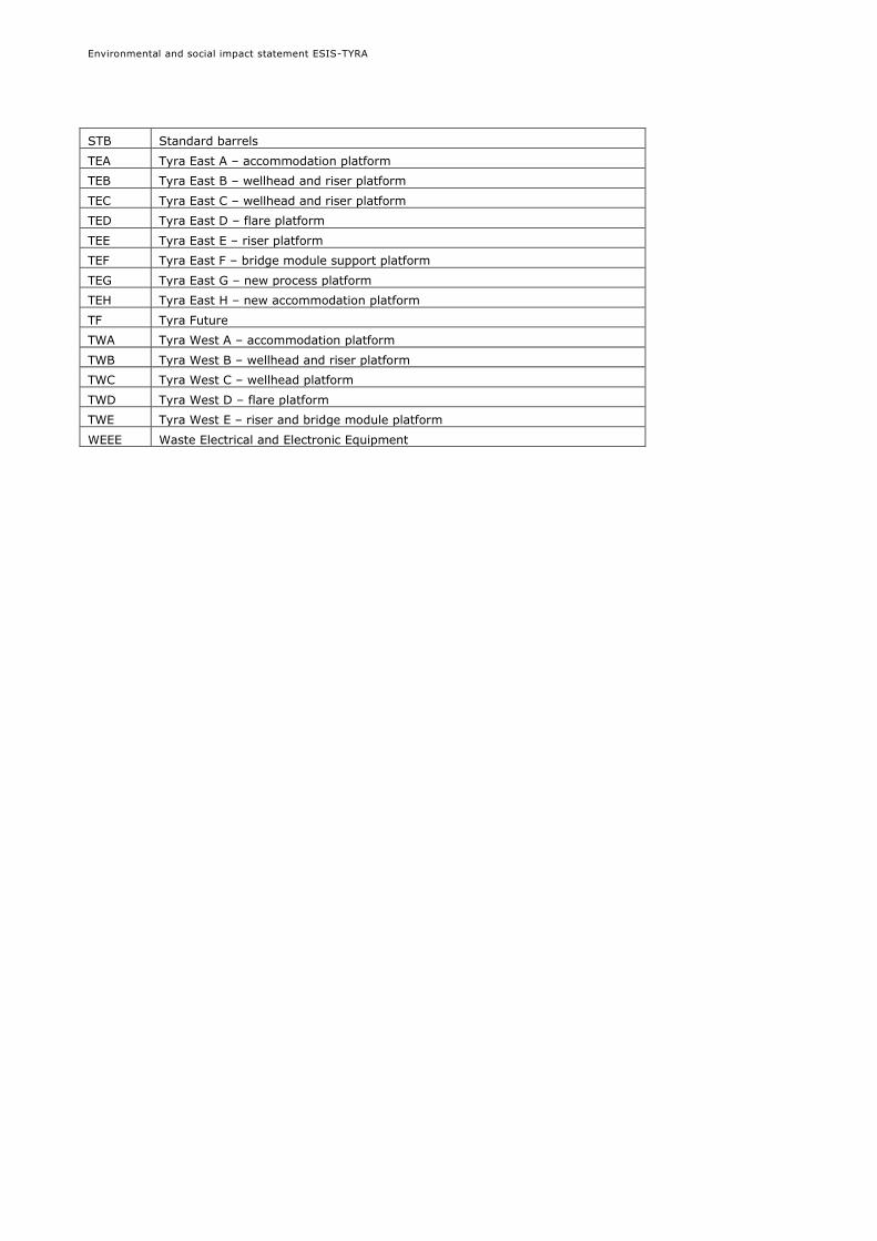
STB Standard barrels
TEA Tyra East A – accommodation platform
TEB Tyra East B – wellhead and riser platform
TEC Tyra East C – wellhead and riser platform
TED Tyra East D – flare platform
TEE Tyra East E – riser platform
TEF Tyra East F – bridge module support platform
TEG Tyra East G – new process platform
TEH Tyra East H – new accommodation platform
TF Tyra Future
TWA Tyra West A – accommodation platform
TWB Tyra West B – wellhead and riser platform
TWC Tyra West C – wellhead platform
TWD Tyra West D – flare platform
TWE Tyra West E – riser and bridge module platform
WEEE Waste Electrical and Electronic Equipment

Environmental and social impact statement ESIS-TYRA
1
1. INTRODUCTION
1.1 Background
In connection with ongoing and future oil and gas exploration, production and decommissioning
activities by Maersk Oil in the Danish North Sea, an environmental and social impact assessment
(ESIA) is being carried out. The overall aim of the ESIA is to identify, assess and mitigate the
impact of Maersk Oil activities on environmental and social receptors.
This document - Maersk Oil DBU ESIS TYRA - shall replace the ESIS prepared in 2016 (ESIA-16)
for TYRA. It is an update of the ESIA-16 ESIS TYRA incorporating the Tyra Future redevelopment
project intended to upgrade the existing facilities at the Tyra field. The facilities have been in
production for thirty years and are suffering from seabed subsidence, old age and increasing
operational expenditure.
The ESIS contains a description of ongoing and planned projects (from exploration to
decommissioning), a description of potential impact on the environmental and social receptors
and measures taken to avoid, prevent or reduce impact. The ESIS is supported by seven generic
technical sections that describe the typical activities (seismic, pipelines and structures,
production, drilling, well stimulation, transport and decommissioning; provided in appendix 1).
The ESIS TYRA covers the activities related to existing and planned projects for the Tyra (East
and West) facilities and their satellite platforms (Tyra Southeast, Valdemar A, Valdemar B, Roar
and Svend) up to 2042. The platforms are located in the North Sea about 230 km from the west
coast of Jutland, Denmark (Figure 1-1).
Figure 1-1 Maersk Oil/DUC platforms in the North Sea

Environmental and social impact statement ESIS-TYRA
2
2. LEGAL BACKGROUND
2.1 EU and national legislation
2.1.1 Environmental impact assessment directive (EIA directive)
The directive on the assessment of the effects of certain public and private projects on the
environment (directive 85/337/EEC), as amended by directives 7/11/EC, 2003/35/EC and
2009/31/EC, requires an assessment of the environmental impacts prior to consent being
granted. This directive is implemented in Denmark as act 425/2016 on environmental
assessment of plans and of projects and executive order 434/2017 on appropriate assessment
related to offshore hydrocarbon activities. This ESIS is processed subject to regulation in force at
time of notification, being executive order 1419 dated 03/12/2015 on environmental assessment
of offshore exploration and recovery of hydrocarbons.
This ESIS has been prepared in accordance with order 1419 dated 03/12/2015 on environmental
impact assessment (EIA) and appropriate assessment (AA) for the hydrocarbon activities
[Bekendtgørelse om VVM, konsekvensvurdering vedrørende internationale
naturbeskyttelsesområder og beskyttelse af visse arter ved efterforskning og indvinding af
kulbrinter, lagring i undergrunden, rørledninger, m.v. offshore]. The ESIS fulfils the requirements
set in appendix 2 of order 1419/2015 and includes:
Article 8: Transboundary adverse impacts are assessed and adequately communicated in
accordance with the ESPOO convention (section 0),
Article 9 and 10: A Natura 2000 screening is presented in this ESIS (section 10)
Article 12: Protection of certain species mentioned in the habitats directive, cf. section 2.1.3
(section 6)
The ESIS and its non-technical summary shall be made available for public consultation for a
period of at least 8 weeks, in accordance with article 6 of order 1419/2015.
2.1.2 Protection of the marine environment
The consolidation act 963 dated 03/07/2013 on protection of the marine environment aims to
protect the environment and ensure sustainable development.
The consolidation act and associated orders regulate e.g. discharges and emissions from
platforms. Relevant orders include: Order 394 dated 17/07/1984 on discharge from some marine
constructions, order 270/2008 on discharges of blackwater, order 9840/2007 on prevention on
air pollution from ships, and order 909/2015 on contingency plans.
2.1.3 Natura 2000 (Habitats and Bird protection directive)
The "Natura 2000" network is the largest ecological network in the world, ensuring biodiversity
by conserving natural habitats and wild fauna and flora in the territory of the EU. The network
comprises special areas of conservation designated under the directive on the conservation of
natural habitats and of wild fauna and flora (Habitats Directive, Directive 1992/43/EEC).
Furthermore, Natura 2000 also includes special protection areas classified pursuant to the Birds
Directive (Directive 2009/147/EC). The directives have been transposed to Danish legislation
through a number of orders (or regulatory instruments).
The Natura 2000 protection is included in the Order 1419/2015 (section 2.1.1).
2.1.4 National emissions ceiling directive
The national emission ceiling directive (directive 2001/81/EC) sets upper limits for each Member
State for the total emissions of the four pollutants nitrogen oxide NOx, volatile organic compound
(VOC), ammonia (NH3) and sulphur dioxide (SO2). The directive is under revision to include
Environmental and social impact statement ESIS-TYRA
3
particulate matter less than 2.5 microns in diameter (PM2.5). The directive has been implemented
by order 1325 dated 21/12/2011 on national emissions ceilings.
2.1.5 Marine strategy framework directive
The marine strategy framework directive (Directive 2008/56/EC) aims to achieve “good
environmental status” (GES) of the EU marine waters by 2020. The directive has been
implemented in Denmark by the act on marine strategy (act 522/2010). A marine strategy has
subsequently been developed by the Danish Agency of Water and Nature Management, now
Environmental Protection Agency, Nature, with an overall assessment of the state of the
environment including a definition of GES at regional level and the establishment of
environmental targets and monitoring programs (www.svana.dk).
2.1.6 Industrial emissions directive
The industrial emissions directive (Directive 2010/75/EU) is about minimising pollution from
various industrial sources. The directive addresses integrated pollution prevention and control
based on best available technique (BAT). The directive has been implemented by the
consolidation act 879/2010 on protection of the environment and with respect to offshore, order
1449/2012.
2.1.7 Emission allowances
The European Union Emissions Trading Scheme was launched in 2005 to combat climate change
and is a major pillar of EU climate policy. Under the 'cap and trade' principle, a cap is set on the
total amount of greenhouse gases that can be emitted by all participating installations.
The trading scheme is implemented by act 1605/2016 on CO2 emission allowances.
2.1.8 Safety directive of oil and gas operations
The directive 2013/30/EU on safety of offshore oil and gas operations aims to ensure that best
safety practices are implemented across all active offshore regions in Europe. The directive has
recently been implemented in Denmark by consolidated act 831/2015 on offshore safety.
2.1.9 Waste framework directive
The Directive 2008/98/EC of 19 November 2008 on waste provides a framework of waste
management requirements to prevent or reduce impacts of generation and management of waste
and to encourage the re-use and recycling of waste materials. The directive is implemented in
Denmark as order 1309/2012 on waste.
2.1.10 Shipment of waste regulation
Regulation (EC) No. 1013/2006 of the European Parliament and of the Council of 14 June 2006
on shipments of waste, establishes procedures and control regimes for the shipment of waste,
depending on the origin, destination and route of the shipment, the type of waste shipped and
the type of treatment to be applied to the waste at its destination. The regulation applies to
shipment of waste between member States within the Community, transit through third countries
and waste exported from the Community to third countries. The regulation implements the Basel
Convention in the EU.
2.1.11 Waste electrical and electronic equipment (WEEE)
Directive 2012/19/EU of 4 July 2012 on Waste electrical and electronic equipment (WEEE) lays
down measures to protect the environment and human health by preventing or reducing the
adverse impacts of the generation and management of waste from electrical and electronic
equipment (WEEE) and by reducing overall impacts of resource use and improving the efficiency
of such, thereby contributing to sustainable development
BEK 132 af 06/02/2014. Bekendtgørelse om overførsel af affald og overførsel af brugt elektrisk
og elektronisk udstyr, subject to the Danish environmental protection law, stipulates regulation

Environmental and social impact statement ESIS-TYRA
4
on transboundary transport of waste electrical and electronic equipment, hereunder specifically
import to Denmark for disposal.
2.2 International conventions
2.2.1 Espoo convention
The convention on environmental impact assessment in a transboundary context (Espoo
Convention) entered into force in 1991. The convention sets out the obligations of Parties to
assess the environmental impact of certain activities at an early stage of planning. It also lays
down the general obligation of States to notify and consult each other on all major projects under
consideration that are likely to have a significant adverse environmental impact across national
boundaries.
The Espoo convention is implemented in the EIA Directive. In Denmark, the Ministry of
Environment administrate the Espoo Convention rules and is the responsible authority for the
process of exchanging relevant information from the project owner to the potentially affected
countries and possible comments from those countries in connection with the Espoo Consultation
Process.
2.2.2 Convention on the prevention of marine pollution by dumping of wastes and other matter
International maritime organization (IMO) convention on the prevention of marine pollution by
dumping of wastes and other matter (London Convention) has been in force since 1975. Its
objective is to promote the effective control of all sources of marine pollution and to take all
practicable steps to prevent pollution of the sea by dumping of wastes and other matter.
2.2.3 The MARPOL Convention
The International Convention for the Prevention of Pollution from Ships adopted in November
1973 at IMO (International Maritime Organization). The International Convention for the
Prevention of Pollution from Ships (MARPOL) is the main international convention covering
prevention of pollution of the marine environment by ships from operational or accidental causes.
Annexes I - V regulates respectively prevention of pollution by oil, noxious liquid substances in
bulk, harmful substances in packaged form, sewage from ships and garbage from ships.
2.2.4 Convention for the control and management of ships' ballast water and sediments
The convention for the control and management of ships' ballast water and sediments (ballast
water management convention) was adopted in 2004. The convention aims to prevent the spread
of harmful aquatic organisms from one region to another, by establishing standards and
procedures for the management and control of ships' ballast water and sediments.
2.2.5 Ramsar convention
The Ramsar convention aims at the conservation and wise use of all wetlands through local and
national actions and international cooperation, as a contribution towards achieving sustainable
development throughout the world.
2.2.6 The convention for the protection of the marine environment of the North-East Atlantic
The convention for the protection of the marine Environment of the North-East Atlantic (the
‘OSPAR Convention') entered into force in 1998. Contained within the OSPAR Convention are a
series of Annexes which focus on prevention and control of pollution from different types of
activities. OSPAR has a focus on application of the precautionary principle, and on use of best
available technique (BAT), best environmental practice (BEP) and clean technologies.
A number of strategies and recommendations from OSPAR are relevant to the TYRA project, most
notably:

Environmental and social impact statement ESIS-TYRA
5
Annual OSPAR report on discharges, spills and emissions from offshore oil and gas
installations.
Reduction in the total quantity of oil in produced water discharged and the performance
standard of dispersed oil of 30 mg/l (OSPAR Recommendation 2001/1).
Harmonised mandatory control system for the use and reduction of the discharge of Offshore
chemicals (OSPAR decision 2005/1).
List of substances/preparations used and discharged offshore which are considered to pose
little or no risk to the environment (PLONOR) (OSPAR decision 2005/1).
To phase out, by 1 January 2017, the discharge of offshore chemicals that are, or which
contain substances, identified as candidates for substitution, except for those chemicals
where, despite considerable efforts, it can be demonstrated that this is not feasible due to
technical or safety reasons (OSPAR Recommendation 2006/3).
Risk based approach to assessment of discharged produced water (OSPAR recommendation
20012/5).
Decision 98/3 on the disposal of disused offshore installations.
2.2.7 The convention on access to information, public participation in decision-making and access to justice
in environmental matters
The UNECE convention on access to information, public participation in decision-making and
access to justice in environmental matters (Aarhus convention) was adopted in 1998. The
convention is about government accountability, transparency and responsiveness. The Aarhus
convention grants the public rights and imposes on parties and public authorities obligations
regarding access to information and public participation. The Aarhus convention is among others
implemented in Denmark by act 960/2013.
2.2.8 The Convention on Biological Diversity (CBD)
The Convention on Biological Diversity (CBD or Rio convention) entered into force in 1993. It has three main objectives:
The conservation of biological diversity
The sustainable use of the components of biological diversity
The fair and equitable sharing of the benefits arising out of the utilization of genetic
resources.
2.2.9 The Convention on the Conservation of Migratory Species of Wild Animals
The Convention on the Conservation of Migratory Species of Wild Animals (also known as CMS or
Bonn Convention) is an intergovernmental treaty, concluded under the United Nations
Environment Program. The Convention aims to conserve terrestrial, aquatic and avian migratory
species throughout their range.
CMS acts as a framework Convention. The Agreements may range from legally binding treaties to
less formal instruments, such as Memoranda of Understanding, and can be adapted to the
requirements of particular regions. Under the convention on the conservation of migratory
species of wild animals, a number of agreements and memoranda of understanding have been
signed. Agreements under the auspices of CMS, aim to conserve:
Populations of European Bats
Cetaceans of the Mediterranean Sea, Black Sea and Contiguous Atlantic Area
Small Cetaceans of the Baltic, North-East Atlantic, Irish and North Seas
Seals in the Wadden Sea
African-Eurasian Migratory Water birds
Albatrosses and Petrels
Gorillas and their Habitats
The Agreement on the Conservation of Small Cetaceans of the Baltic and North Seas
(ASCOBANS) was concluded under the auspices of the Convention on Migratory Species in 1991.

Environmental and social impact statement ESIS-TYRA
6
2.3 Industry and national authority initiatives
2.3.1 Offshore action plan
An offshore action plan was implemented by the Danish Environmental Protection Agency and the
Danish operators in 2005 in order to reduce the discharge of chemicals and oil in produced water.
A revised action plan for 2008-2010 was implemented to reduce emissions to air and further
reduce discharges.
2.3.2 Action plan on energy efficiency
An action plan on energy efficiency was implemented by the Danish Energy Agency and the
Danish oil and gas operators for 2008-2011 and 2012-2014 to improve energy efficiency for the
oil and gas industry. More specifically, the action plan included measures on energy management
and initiatives to reduce flaring and energy consumption.

Environmental and social impact statement ESIS-TYRA
7
3. DESCRIPTION OF THE PROJECT
This ESIS covers both planned redevelopment projects and future operations of the Tyra field. A
larger redevelopment project, the Tyra Future redevelopment project, is planned to start in 2019
consisting of installation of new facilities and decommissioning of redundant installations and
pipelines. The field is planned to be operated until 2042. The TYRA project concerns the
remaining operational lifetime of projects at the Tyra field, including Tyra Future redevelopment
project.
TYRA project
TYRA refers to the project that covers activities for the expected remaining lifetime of operation
at the Tyra facilities, until 2042. It covers existing and planned projects for the Tyra East and
West facilities and their satellite platforms Tyra South East, Valdemar (A and B), Roar and Svend,
including all pipelines that are departing from any of those platforms.
The TYRA project consists of activities relating to each of the seven technical sections (appendix
1): seismic data acquisition, regular maintenance and new developments of pipelines and
structures, continued production and maintenance and adjustment of production facilities for the
remaining Tyra field lifetime, drilling of new wells, well stimulation, transport of personnel and
cargo to support production and operations, and decommissioning of facilities at end of lifetime.
Tyra Future
Tyra Future refers to the redevelopment project of the existing Tyra East and Tyra West facilities,
planned for execution in the period 2019-2023.
The Tyra field has been in production for 30 years, and the facilities are suffering from seabed
subsidence, old age and increasing OPEX. It is therefore planned to upgrade the existing facilities
with new topside facilities installed at higher elevations in order to continue production of existing
reserves from Tyra and the associated satellites. A new processing and a new accommodation
platform will also be installed.
The following sections provide a description of existing Tyra facilities and a description of planned
redevelopment projects and future operation of the field:
Section 3.1 Existing facilities (up to ca.2020)
Section 3.2 TYRA project - Tyra Future redevelopment (ca. 2019-2022)
Section 3.3 TYRA operation until 2042
Section 3.4 TYRA project – other planned activities
A description of accidental events and of project alternatives is presented in sections 3.5 and 3.6.
3.1 Existing facilities
3.1.1 Overview
The main processing and production facilities Tyra East and West and the satellite platforms Tyra
Southeast, Valdemar (A and B), Roar and Svend are connected by subsea pipelines, through
which oil, gas and water are transported between the Tyra facilities and to Gorm E (oil) and to
the Netherlands (gas) for further processing or export to shore. Pipelines departing from the Tyra
(East, West and Southeast), Valdemar (A and B), Roar and Svend platforms are considered part
of the TYRA project.
An overview of the existing pipelines and structures for the TYRA project is provided in Figure
3-1.
Environmental and social impact statement ESIS-TYRA
8
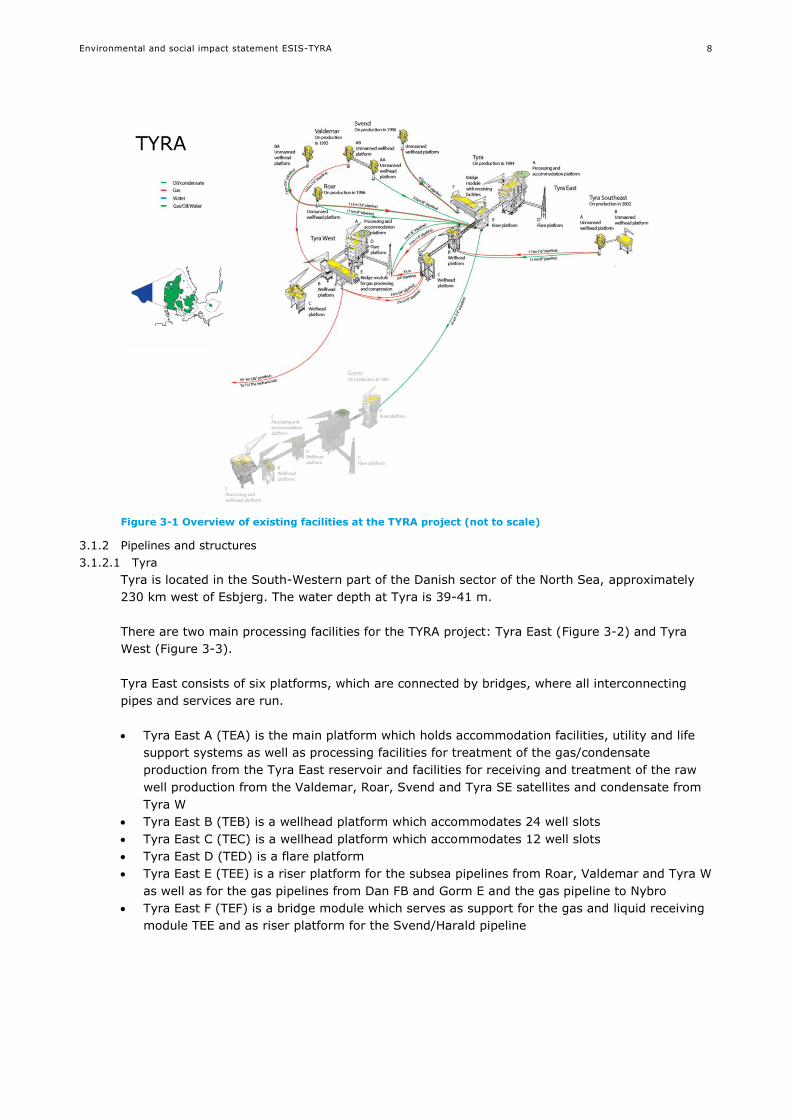
Figure 3-1 Overview of existing facilities at the TYRA project (not to scale)
3.1.2 Pipelines and structures
3.1.2.1 Tyra
Tyra is located in the South-Western part of the Danish sector of the North Sea, approximately
230 km west of Esbjerg. The water depth at Tyra is 39-41 m.
There are two main processing facilities for the TYRA project: Tyra East (Figure 3-2) and Tyra
West (Figure 3-3).
Tyra East consists of six platforms, which are connected by bridges, where all interconnecting
pipes and services are run.
Tyra East A (TEA) is the main platform which holds accommodation facilities, utility and life
support systems as well as processing facilities for treatment of the gas/condensate
production from the Tyra East reservoir and facilities for receiving and treatment of the raw
well production from the Valdemar, Roar, Svend and Tyra SE satellites and condensate from
Tyra W
Tyra East B (TEB) is a wellhead platform which accommodates 24 well slots
Tyra East C (TEC) is a wellhead platform which accommodates 12 well slots
Tyra East D (TED) is a flare platform
Tyra East E (TEE) is a riser platform for the subsea pipelines from Roar, Valdemar and Tyra W
as well as for the gas pipelines from Dan FB and Gorm E and the gas pipeline to Nybro
Tyra East F (TEF) is a bridge module which serves as support for the gas and liquid receiving
module TEE and as riser platform for the Svend/Harald pipeline

Environmental and social impact statement ESIS-TYRA
9
Figure 3-2 Tyra East
Tyra West consists of five platforms, which are connected by bridges where all interconnecting
pipes and services are run.
Tyra West A (TWA) is the main platform which holds accommodation facilities, utility and life
support systems as well as processing facilities for treatment of the gas/condensate
production from the western flank of the Tyra reservoir, wet gas from Valdemar AB, Low
Pressure (LP) gas from Roar and Tyra SE, High Pressure (HP) gas from Halfdan (mixed with
gas from Dan) and raw gas from Tyra East including its satellites and Harald, Lulita and Trym
(Norwegian field)
Tyra West B (TWB) is a wellhead platform which accommodates 12 well slots and riser
platform for the incoming 18 km 12" gas pipeline from Valdemar AB
Tyra West C (TWC) is a wellhead platform which accommodates 24 well slots
Tyra West D (TWD) is a flare platform
Tyra West E (TWE) is a combined bridge module and riser platform which holds the main gas
compression and gas conditioning facilities module and serves as riser platform for two gas
pipelines to Tyra East C; the gas pipeline from Halfdan BA and the gas export pipeline to F3
(NOGAT)

Environmental and social impact statement ESIS-TYRA
10
Figure 3-3 Tyra West
The Tyra East and West platforms form the export centre for all gas produced by Maersk Oil in
Denmark. The bulk of the gas produced is compressed and exported in two ways; either via Tyra
East to Nybro in Denmark, or from Tyra West through the NOGAT pipeline to Den Helder in the
Netherlands.
Continuous control and monitoring of the satellite platforms Tyra South East, Roar, Valdemar and
Svend is carried out remotely from Tyra East and West.
3.1.2.2 Tyra Southeast
Tyra Southeast is situated around10 kilometres Southeast of Tyra East. The water depth at Tyra
SE is 38 metres.
The Tyra Southeast facilities have been developed as a satellite to Tyra East. Tyra Southeast
includes TSA, an unmanned wellhead STAR platform with no helideck and TSB, a wellhead
platform installed in 2014 (Figure 3-4). After separation, the production is transported to Tyra
East in two pipelines to be processed and subsequently exported ashore.

Environmental and social impact statement ESIS-TYRA
11
Figure 3-4 Tyra Southeast
3.1.2.3 Roar
Roar is situated around 11 kilometres Northwest of Tyra East. The water depth at Roar is 41
metres.
Roar is a satellite platform to the Tyra East installation. Roar is an unmanned wellhead STAR
platform with no helideck. After separation, the hydrocarbons produced are conveyed through
two pipelines to Tyra East for processing and export.
Figure 3-5 Roar

Environmental and social impact statement ESIS-TYRA
12
3.1.2.4 Valdemar
Valdemar is situated around 17 kilometres Northwest of Tyra East. The water depth at Valdemar
is 40 metres.
Valdemar is two satellite installations to Tyra East, Valdemar A and Valdemar B. Valdemar A
comprises two unmanned wellhead STAR platforms (VAA and VAB) with no helideck, connected
by a bridge. After separation the production is transported to Tyra West for processing and
transportation ashore/export, while condensate is transported to Tyra East for processing and
export ashore.
Figure 3-6 Valdemar A
Valdemar B comprises an unmanned wellhead STAR platform (VBA) with no helideck, about 4
kilometres from the Valdemar VAA/VAB facility. The production from Valdemar VBA is conveyed
to Tyra East via Roar through a multiphase pipeline. The production from the Valdemar VBA
platform is transported to Tyra East for processing and export ashore.
Figure 3-7 Valdemar B
3.1.2.5 Svend
Svend is situated around 64 kilometres northwest of Tyra East. The water depth at Svend is 64
metres.

Environmental and social impact statement ESIS-TYRA
13
Svend is a satellite platform to Tyra East. Svend is an unmanned STAR wellhead platform with no
helideck (Figure 3-8). The hydrocarbons produced are conveyed to Tyra East for processing and
export.
Figure 3-8 Svend
3.1.2.6 Pipelines
The production facilities are connected by subsea pipelines where the well fluids and produced
products are transported. Pipelines are trenched typically to a depth of 2 m or covered by rock
situated above the seafloor. An overview of the existing pipelines and their content appears in
Figure 3-1.
3.1.3 Wells
The TYRA project currently has a total of 111 wells: 36 at Tyra East, 36 at Tyra West, 7 at Tyra
Southeast, 5 at Svend, 4 at Roar, 14 at Valdemar A and 9 at Valdemar B.
There are 24 free well slots which are available for drilling: 16 at Tyra South East, 2 at Svend, 3
at Roar, 2 at Valdemar A and 1 at Valdemar B.
3.1.4 Processing capabilities
The processing capabilities of the TYRA facilities (Tyra West and Tyra East) are provided in Table
3-1. The facilities are designed for continuous operation 24 hours a day. Maintenance is generally
planned so only part of the facility is shut down, thus only reducing the production. The facilities
will only be shut down in case of major emergencies or major maintenance operations.
Table 3-1 Processing capacity of the Tyra facilities (Tyra West and Tyra East)
Process Unit Tyra West Tyra East
Liquid separation BOPD 94,350 182,410
Gas separation MMscfd 634 933
Produced water treatment BWPD 82,399 88,060
Gas dehydration MMscfd 933 709
HP gas compression MMscfd 933 597
LP gas compression MMscfd 485 n/a
Hydrocarbon dew point control MMscfd n/a 597
Stabilization BPD n/a 70,448

Environmental and social impact statement ESIS-TYRA
14
At the Tyra West facility, there are 2 main processes:
Separation process
Gas compression and dehydration process including water dehydration and hydrocarbon
stabilization
The drawing shown in Figure 3-9 shows the overall process as a simplified process block diagram
of the oil condensate and gas production facilities on Tyra West. A more detailed produced water
treatment process diagram of the water treatment is provided in section 9.4.
Figure 3-9 Simplified diagram of the process at Tyra West
At the Tyra East facility, there are 2 main processes:
Separation process
Gas compression and dehydration process
Figure 3-10 shows the overall process as a simplified process block diagram of the oil and gas production facilities on Tyra East. A more detailed produced water treatment process diagram is provided in section 9.4.

Environmental and social impact statement ESIS-TYRA
15
Figure 3-10 Simplified diagram of the process at Tyra East
The energy supply to the TYRA facilities consists of self-produced natural gas, and diesel supplied
by ship.
Natural gas is used as fuel gas in gas turbines operating as drives for e.g. power generators, gas
compressors and high-pressure water injection pumps.
Diesel is used in dual-fuel gas turbines, for cranes and for emergency equipment such as fire
pumps.
Flaring of gas at compressor inlet/outlet might be required for short periods of time in relation to
planned and controlled process operations (e.g. start-up) and for safety reason in relation with
unforeseen process upsets which causes overpressure of process equipment and emergency
depressurization of platform equipment. The most important source of cold venting is degassers.
3.1.5 Waste
Maersk Oil transports all operational waste from its Danish North Sea facilities to shore where it
is recycled, incinerated or landfilled in accordance with current legislation. The last five years, an
average of about 12,000 tonnes of waste were collected and brought onshore from all Maersk Oil
facilities. In the last five years, about 99 % of the waste was recycled or incinerated. Landfilled
waste is partly made up of sandblasting materials. Since 2014, most of the sand is being reused
for roads construction and other building materials leading to a significant reduction in the
amount of landfilled waste.

Environmental and social impact statement ESIS-TYRA
16
3.1.6 Naturally occurring radioactive material (NORM)
Naturally occurring radioactive material (NORM) such as sand, scale, clean-up materials from
tubing, valves or pipes are collected and brought onshore, where they are treated to remove
traces of hydrocarbons or scale formation. After treatment, the NORM is securely stored. The
yearly average quantity of NORM brought for storage in 2013-2014 was approximately 70 tons.
The quantity of NORM is expected to increase as fields are maturing and Maersk Oil is currently
evaluating the best options for handling of NORM waste.
3.1.7 Discharges
A number of discharges are expected to occur as part of the planned activities, including drilling
mud and cuttings, produced water and cooling water. These are described in section 3.3 and
Appendix 1.
In addition, main liquid effluents generated by the vessels and platforms will comprise:
Greywater (water from culinary activities, shower and laundry facilities, deck drains and other
non-oily waste water drains (excluding sewage))
Treated Blackwater (sewage)
Drainage water
Service water / vessel engine cooling water.
3.2 TYRA project - Tyra Future redevelopment
Tyra Future is a redevelopment project aiming to prolong the field production life. The wells will
be temporarily plugged before redevelopment operations begin. New process and accommodation
platforms will be installed at Tyra East which will be the new field centre, while Tyra West will be
an unmanned satellite. Six of the existing jackets will be reused as substructure for new
wellheads after elongation of the jackets to mitigate current and future subsidence. All redundant
installations will be decommissioned and returned to shore for recycling and disposal. The wells
will be unplugged again after completion of redevelopment. Non-producing wells with potential
integrity issue will be suspended or abandoned.
An overview of the changes is shown in Figure 3-11 and Figure 3-12.
Figure 3-11 General arrangement of the Tyra field – present facilities

Environmental and social impact statement ESIS-TYRA
17
Figure 3-12 General arrangement of the Tyra Field following Tyra Future redevelopment
The redevelopment is planned for execution in the period 2019 – 2023 (Table 3-2). Production at
Tyra East, West and satellite platform producers (incl. Harald) will be stopped for approximately
two years in 2019-2020.
Table 3-2 Installation schedule
Campaign
2016-2018 Well workovers and abandonments
Temporary subsea bypasses
2019 Route Dan/Halfdan gas to Nogat
Gorm fuelgas supply from Halfdan
Shutdown all producers in Tyra and suspend Tyra resource wells
2020 Install TEG and TEH jackets
Remove existing wellheads, riser modules and bridges
Install new wellhead and riser modules
Reroute Harald pipeline to TEE
Install umbilical from TEG to TWE
2021 Install TEG and TEH modules
Complete hook-up and commissioning of new facilities
Reroute Dan/Halfdan gas to TEG
2021+ Remove TEA and TWA topsides
Remove TEA, TED, TEF, TWA and TWD jackets
3.2.1 Pipelines and structures
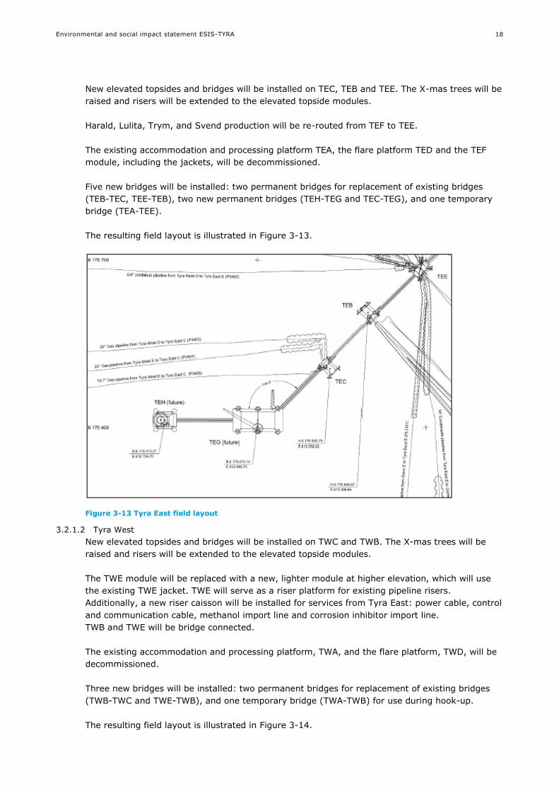
3.2.1.1 Tyra East
A new gas and oil processing module, TEG, and a new accommodation and utility platform, TEH,
with room for 80 persons, will be installed at Tyra East. TEG and TEH will be bridge connected
and TEG will be bridge connected to TEC.
Environmental and social impact statement ESIS-TYRA
18
New elevated topsides and bridges will be installed on TEC, TEB and TEE. The X-mas trees will be
raised and risers will be extended to the elevated topside modules.
Harald, Lulita, Trym, and Svend production will be re-routed from TEF to TEE.
The existing accommodation and processing platform TEA, the flare platform TED and the TEF
module, including the jackets, will be decommissioned.
Five new bridges will be installed: two permanent bridges for replacement of existing bridges
(TEB-TEC, TEE-TEB), two new permanent bridges (TEH-TEG and TEC-TEG), and one temporary
bridge (TEA-TEE).
The resulting field layout is illustrated in Figure 3-13.
Figure 3-13 Tyra East field layout
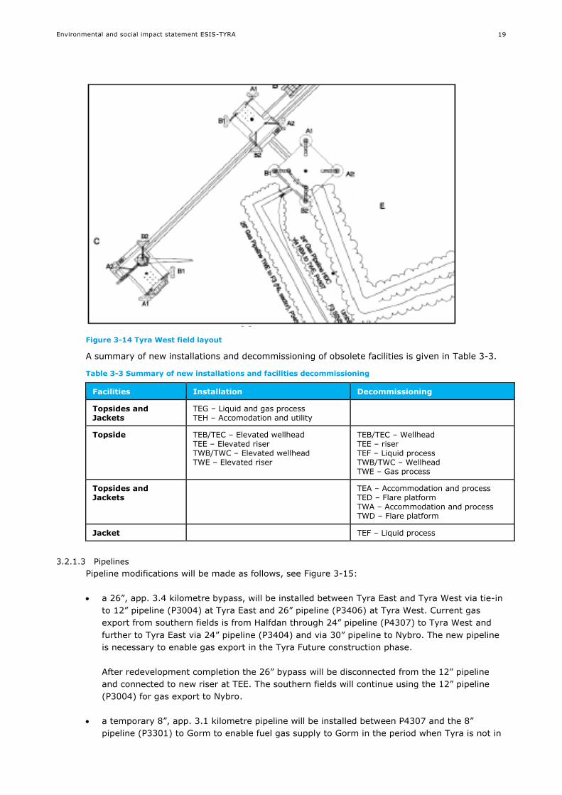
3.2.1.2 Tyra West
New elevated topsides and bridges will be installed on TWC and TWB. The X-mas trees will be
raised and risers will be extended to the elevated topside modules.
The TWE module will be replaced with a new, lighter module at higher elevation, which will use
the existing TWE jacket. TWE will serve as a riser platform for existing pipeline risers.
Additionally, a new riser caisson will be installed for services from Tyra East: power cable, control
and communication cable, methanol import line and corrosion inhibitor import line.
TWB and TWE will be bridge connected.
The existing accommodation and processing platform, TWA, and the flare platform, TWD, will be
decommissioned.
Three new bridges will be installed: two permanent bridges for replacement of existing bridges
(TWB-TWC and TWE-TWB), and one temporary bridge (TWA-TWB) for use during hook-up.
The resulting field layout is illustrated in Figure 3-14.
Environmental and social impact statement ESIS-TYRA
19
Figure 3-14 Tyra West field layout
A summary of new installations and decommissioning of obsolete facilities is given in Table 3-3.
Table 3-3 Summary of new installations and facilities decommissioning
Facilities Installation Decommissioning
Topsides and Jackets
TEG – Liquid and gas process TEH – Accomodation and utility
Topside TEB/TEC – Elevated wellhead TEE – Elevated riser TWB/TWC – Elevated wellhead TWE – Elevated riser
TEB/TEC – Wellhead TEE – riser TEF – Liquid process TWB/TWC – Wellhead TWE – Gas process
Topsides and Jackets
TEA – Accommodation and process TED – Flare platform TWA – Accommodation and process TWD – Flare platform
Jacket TEF – Liquid process
3.2.1.3 Pipelines
Pipeline modifications will be made as follows, see Figure 3-15:
a 26”, app. 3.4 kilometre bypass, will be installed between Tyra East and Tyra West via tie-in
to 12” pipeline (P3004) at Tyra East and 26” pipeline (P3406) at Tyra West. Current gas
export from southern fields is from Halfdan through 24” pipeline (P4307) to Tyra West and
further to Tyra East via 24” pipeline (P3404) and via 30” pipeline to Nybro. The new pipeline
is necessary to enable gas export in the Tyra Future construction phase.
After redevelopment completion the 26” bypass will be disconnected from the 12” pipeline
and connected to new riser at TEE. The southern fields will continue using the 12” pipeline
(P3004) for gas export to Nybro.
a temporary 8”, app. 3.1 kilometre pipeline will be installed between P4307 and the 8”
pipeline (P3301) to Gorm to enable fuel gas supply to Gorm in the period when Tyra is not in
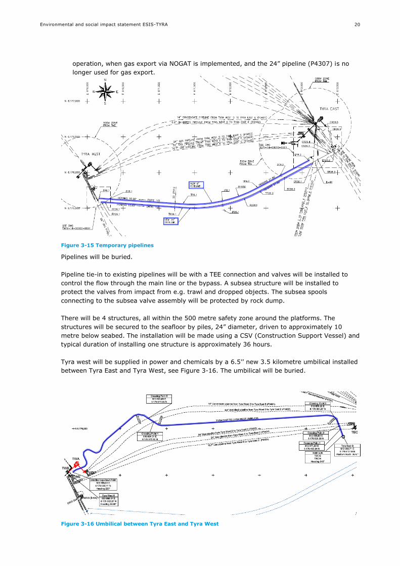
Environmental and social impact statement ESIS-TYRA
20
operation, when gas export via NOGAT is implemented, and the 24” pipeline (P4307) is no
longer used for gas export.
Figure 3-15 Temporary pipelines
Pipelines will be buried.
Pipeline tie-in to existing pipelines will be with a TEE connection and valves will be installed to
control the flow through the main line or the bypass. A subsea structure will be installed to
protect the valves from impact from e.g. trawl and dropped objects. The subsea spools
connecting to the subsea valve assembly will be protected by rock dump.
There will be 4 structures, all within the 500 metre safety zone around the platforms. The
structures will be secured to the seafloor by piles, 24” diameter, driven to approximately 10
metre below seabed. The installation will be made using a CSV (Construction Support Vessel) and
typical duration of installing one structure is approximately 36 hours.
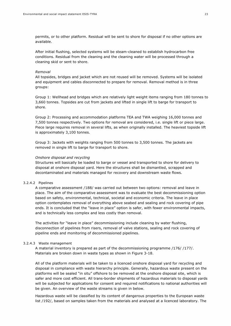
Tyra west will be supplied in power and chemicals by a 6.5’’ new 3.5 kilometre umbilical installed
between Tyra East and Tyra West, see Figure 3-16. The umbilical will be buried.
Figure 3-16 Umbilical between Tyra East and Tyra West

Environmental and social impact statement ESIS-TYRA
21
3.2.2 Wells
Of 36 wells at Tyra East, 28 will be suspended (21 TEB, 7 TEC) and 8 will be abandoned (3 TEB,
5 TEC).
Of 36 wells at Tyra West, 30 will be suspended (11 TWB, 19 TWC) and 6 will be abandoned (1
TWB, 5 TWC).
As explained in section 3.1.3, some original well slots are still not drilled. The Tyra Future
redevelopment project does not currently plan to produce from all wells as several of the wells
are already empty. Nevertheless, it remains an option to drill new producing wells to replace
empty wells.
3.2.3 Transport
Transport of new facilities from the fabrication yard to the Tyra field is typically on barges tugged
from shore to site. Origin of the new facilities is not decided but anticipated to be Asia for TEG
and TEH topsides and Europe for TEB, TEC, TWB, TWC topsides and TEG and TEH jackets.
Transport and installation efforts are outlined in technical section: pipelines and structures
(Appendix 1) and /183/.
3.2.4 Decommissioning
A total of 5 platforms and jackets are to be decommissioned: TEA, TED, TEF, TWA and TWD. The
jackets from remaining platforms: TEB, TEC, TEE, TWB, TWC and TWE will be reused but the
topsides will be replaced. An overview of facilities and their weights (approximate dry weight,
clean steel weight) is given in Table 3-4.
Table 3-4 Facilities and their weights
Topside Jacket
weight (tonnes) Legs (no) weight (tonnes)
TEA
TED
TEF
TWA
TWD
14,832
170
2,359
8,021
241
8
3
3
4
3
6,578
690
1,476
2,826
1,076
TEB
TEC
TEE
TWB
TWC
TWE
1,227
869
1,224
719
932
4,337
Jackets to be reused
The platforms will be cleaned to achieve approximate hydrocarbon free conditions to establish
cold platform and hazardous materials will be identified and secured. All platforms on the field
will be shut down simultaneously to achieve safe work environments and to minimise
simultaneous operations and reduce interfaces. The facilities will be handed over to contractors to
perform offshore removal and onshore disposal work.
The decommissioning work is arranged in phases consisting of installations with similarity and
independency to enable the full range of potential contractors to perform parts of the scope.
During a prequalification and tender process, removal contractors industry is invited to design
innovative, safe and effective solution to execute the scope. The removal of smaller installations
will be performed as single lifts, while the two larger process and accommodation modules may
be removed either by the industry standards piece small, reversed installation or as a single lift.

Environmental and social impact statement ESIS-TYRA
22
All installations will be transported to shore for recycling and disposal. The disposal will be
performed in accordance with the waste hierarchy and opportunities to reuse, recycle and
recover equipment and materials will be sought.
The following pipelines will be redundant and decommissioned, see Figure 3-17:
P3401, 14”, 3 kilometre gas pipeline from TWD to TEE
P3402, 6”, 3 kilometre condensate pipeline from TWD to TEE
P3403, 24”, 3 kilometre gas pipeline from TWD to TEC
P4307, 30 kilometre gas pipeline from Halfdan to TWE
8” gas pipeline from Tyra West to Tyra East (temporary bypass)
Section of 26” gas pipeline from Tyra East (P3004) to Tyra East (NOGAT) (temporary pipeline)
Figure 3-17 Pipelines for decommissioning
Decommissioning methods
Decommissioning methods are generally as per the technical sections, appendix 1.
Site specific decommissioning operations are summarised below, building on specific
decommissioning program /175/.
3.2.4.1 Platforms
Cleaning
Platforms will be shut down after cease of production in order to remove or secure hazardous
materials and establish safe conditions for preparatory work and waste management.
Wells will be sealed off with temporary plugs and X-mas trees will be removed.
The platforms will systematically be shut down and containments in pipelines, vessels and
equipment will be identified, cleaned and secured. Containments in their original packaging will
be sent to shore for reuse. Flushing water and residuals in pipework and vessels will be
processed in the existing water treatment system and disposed to sea, subject to discharge
Environmental and social impact statement ESIS-TYRA
23
permits, or to other platform. Residual will be sent to shore for disposal if no other options are
available.
After initial flushing, selected systems will be steam-cleaned to establish hydrocarbon free
conditions. Residual from the cleaning and the cleaning water will be processed through a
cleaning skid or sent to shore.
Removal
All topsides, bridges and jacket which are not reused will be removed. Systems will be isolated
and equipment and cables disconnected to prepare for removal. Removal method is in three
groups:
Group 1: Wellhead and bridges which are relatively light weight items ranging from 180 tonnes to
3,660 tonnes. Topsides are cut from jackets and lifted in single lift to barge for transport to
shore.
Group 2: Processing and accommodation platforms TEA and TWA weighing 16,000 tonnes and
7,500 tonnes respectively. Two options for removal are considered, i.e. single lift or piece large.
Piece large requires removal in several lifts, as when originally installed. The heaviest topside lift
is approximately 3,100 tonnes.
Group 3: Jackets with weights ranging from 500 tonnes to 3,500 tonnes. The jackets are
removed in single lift to barge for transport to shore.
Onshore disposal and recycling
Structures will basically be loaded to barge or vessel and transported to shore for delivery to
disposal at onshore disposal yard. Here the structures shall be dismantled, scrapped and
decontaminated and materials managed for recovery and downstream waste flows.
3.2.4.2 Pipelines
A comparative assessment /188/ was carried out between two options: removal and leave in
place. The aim of the comparative assessment was to evaluate the best decommissioning option
based on safety, environmental, technical, societal and economic criteria. The leave in place
option contemplates removal of everything above seabed and sealing and rock covering of pipe
ends. It is concluded that the “leave in place” option is safer, with fewer environmental impacts,
and is technically less complex and less costly than removal.
The activities for “leave in place” decommissioning include cleaning by water flushing,
disconnection of pipelines from risers, removal of valve stations, sealing and rock covering of
pipeline ends and monitoring of decommissioned pipelines.
3.2.4.3 Waste management
A material inventory is prepared as part of the decommissioning programme /176/ /177/.
Materials are broken down in waste types as shown in Figure 3-18.
All of the platform materials will be taken to a licenced onshore disposal yard for recycling and
disposal in compliance with waste hierarchy principle. Generally, hazardous waste present on the
platforms will be sealed “in situ” offshore to be removed at the onshore disposal site, which is
safer and more cost efficient. All trans-border shipments of hazardous materials to disposal yards
will be subjected for applications for consent and required notifications to national authorities will
be given. An overview of the waste streams is given in below.
Hazardous waste will be classified by its content of dangerous properties to the European waste
list /192/, based on samples taken from the materials and analysed at a licenced laboratory. The
Environmental and social impact statement ESIS-TYRA
24
waste will be removed, packed and transported to a final treatment facility for recovery or
disposal to landfill. Temporary storage of hazardous waste shall be subjected to control.
Process pipework will cleaned from residual hydrocarbons by use of HP jetting or steam cleaning
to achieve cleanliness suitable for metals recycling. Potential NORM and Hg contamination will be
removed and collected.
Process chemicals are basically used to support the process in various applications, such as
scavenges, inhibitors, biocides, detergents and various support functions, such as temperature
control. The chemicals are normally ranging from acids, bases and organic solutions such as
MEG, glycol and methanol. The process chemicals will as far as possible be returned to shore in
its original consignments.
Oils and fuels are used as lubricants and power supply and are present in rotating equipment,
hydraulic systems and engines. Generally, these products are well defined and present as
contained compartments as part of an equipment. It should be noted that used oil is often a
complex mixture of paraffinic, naphthenic and aromatic petroleum hydrocarbons that may
contain one or more hazardous substances including carcinogenic compounds. Used oils and fuels
shall be drained off and transported to shore for waste treatment.
Radioactive sources present in level transmitters, smoke detectors and small amounts present in
luminescent signs will be collected and disposed at special licenced depositories.
Hazardous fibres such as asbestos and ceramic fibres have been commonly used in a variety of
construction and insulation applications on offshore platforms due to their fire resistance,
insulation, chemical resistance and tensile strength. Asbestos may be mixed with other materials
such as cement in fire walls or woven into fabric such as pipe sealing and gaskets. Hidden
asbestos should be expected since record of asbestos is often scarce and may be lacking from
original vendor documentation.
Hazardous construction material is present in various applications. Prioritised chemicals such as
PCB and chlorinated paraffin may be present in sealing and cooling fluids. Brominated flame
retardants and Phthalates may be found in cell foam, pipe insulation, textiles and flooring. Heavy
metals additives may be found in plastics and paint.
Paint systems may contain several types of hazardous materials such as heavy metals, asbestos,
PCB and polyurethane. Most paint systems contain polyurethane which will generate isocyanates
when exposed to thermal treatment (hot cutting). From a waste management point of view, paint
coated scrap steel, based on chemical analysis and assessment of the overall risk, shall, to the
extent possible not be classified as hazardous material. Paint may therefore be in the scrap steel
delivered to re-melting in compliance with industry practice.
WEEE will be segregated from the waste stream and provided for material recovery. Hazardous
substances such as heavy metals, asbestos, flame retardants and plastics will be removed and
valuable trace metals and alloys will be recovered.
The majority of materials present on the platforms are non-hazardous waste such as scrap
metals and various construction materials. These materials will be segregated at the onshore
disposal site and be recovered according to the waste hierarchy to its purest possible waste
category. After options for reuse are exhausted, the scrap metal will be segregated and treated
to be recycled. Other material such as plastic, glass, concrete, wood and paper will be segregated
for material recovery. Marine growth disposal options include recovery or recycling.
Combustible waste to energy recovery and inert waste for landfill disposal will be minimised as
far as possible. However, after all other treatment options are exhausted; rest materials such as
mixed combustible waste not suitable for material recovery and lightweight concrete fire
protection and mineral isolation materials may be incinerated, if possible, or deposited at landfills
respectively.
Environmental and social impact statement ESIS-TYRA
25
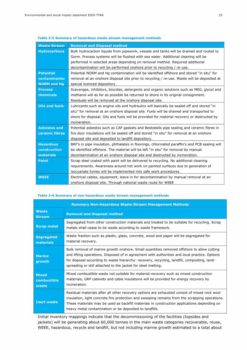
Table 3-5 Summary of hazardous waste stream management methods
Waste Stream Removal and Disposal method
Hydrocarbons Bulk hydrocarbon liquids from pipework, vessels and tanks will be drained and routed to
Gorm. Process systems will be flushed with sea water. Additional cleaning will be
performed in selected areas depending on removal method. Required additional
decontamination will be performed onshore prior to recycling / re-use.
Potential
contaminants:
NORM and Hg
Potential NORM and Hg contamination will be identified offshore and stored “in situ” for
removal at an onshore disposal site prior to recycling / re-use. Waste will be deposited at
special licenced depository.
Process
chemicals
Scavenges, inhibitors, biocides, detergents and organic solutions such as MEG, glycol and
methanol will as far as possible be returned to shore in its original consignment.
Residuals will be removed at the onshore disposal site.
Oils and fuels Lubricants such as engine oils and hydraulics will basically be sealed off and stored “in
situ” for removal at an onshore disposal site. Fuels will be drained and transported to
shore for disposal. Oils and fuels will be provided for material recovery or destructed by
incineration.
Asbestos and
ceramic fibres
Potential asbestos such as CAF gaskets and Bestobells pipe sealing and ceramic fibres in
fire door insulations will be sealed off and stored “in situ” for removal at an onshore
disposal site and deposited to landfill depository.
Hazardous
construction
materials
BRF’s in pipe insulation, phthalates in floorings, chlorinated paraffin’s and PCB sealing will
be identified offshore. The material will be left “in situ” for removal by manual
decontamination at an onshore disposal site and destructed by incineration.
Paint Scrap steel coated with paint will be delivered to recycling. No additional cleaning
requirements. Awareness around hot work on painted surfaces due to generation of
isocyanate fumes will be implemented into safe work procedures.
WEEE Electrical cables, equipment, leave in for decontamination by manual removal at an
onshore disposal site. Through national waste route for WEEE
Table 3-6 Summary of non-hazardous waste stream management methods
Summary Non-Hazardous Waste Stream Management Methods
Waste
Stream Removal and Disposal method
Scrap metal Segregated from other construction materials and treated to be suitable for recycling. Scrap
metals shall cease to be waste according to waste framework.
Segregated
materials
Waste fraction such as plastic, glass, concrete, wood and paper will be segregated for
material recovery.
Marine
growth
Bulk removal of marine growth onshore. Small quantities removed offshore to allow cutting
and lifting operations. Disposed of in agreement with authorities and local practice. Options
for disposal according to waste hierarchy: recovery, recycling, landfill, composting, land-
spreading or still attached to the jacket for steel melting.
Mixed
combustible
waste
Mixed combustible waste not suitable for material recovery such as mixed construction
materials, GRP cabinets and cable insulations will be provided for energy recovery by
incineration.
Inert waste
Residual materials after all other recovery options are exhausted consist of mixed rock wool
insulation, light concrete fire protection and sweeping remains from the scrapping operations.
These materials may be used as backfill materials in construction applications depending on
heavy metal contamination or be deposited to landfills.
Initial inventory mappings indicate that the decommissioning of the facilities (topsides and
jackets) will be generating about 60,000 tonnes in the main waste categories recoverable, reuse,
WEEE, hazardous, recycle and landfill, but not including marine growth estimated to a total about

Environmental and social impact statement ESIS-TYRA
26
2.500 Tones. When the facilities have been cleared for removal the weight will decrease to
around 51,000 tonnes. The weight % distribution is shown in Figure 3-18.
It must be noted that waste weight and material breakdown represents preliminary estimates of
the segregation into waste types (Level 1 inventory mapping). During the next mapping level and
finally at the demolition yard, the hazardous waste details will be refined and the recycling
fraction is expected to increase, e.g. in this Level 1 mapping, the WEEE waste type includes steel
trays and copper from cables which can be recycled.
Figure 3-18 Tyra waste and materials breakdown, in operational condition and when cleared for removal, weight %
3,0%
10,2% 3,2%
2,2%
79,4%
2,0%
Tyra Facilities - In operation
RECOVERABLE
REUSE
WEEE
HAZARDOUS
RECYCLE
LANDFILL
0,0%2,3%
3,8%
0,3%
91,2%
2,4%
Tyra Facilities - Cleared for removal
RECOVERABLE
REUSE
WEEE
HAZARDOUS
RECYCLE
LANDFILL
Environmental and social impact statement ESIS-TYRA
27
A waste management plan shall be established for safe handling of materials and to optimise
recycling and minimise amount of waste classified as hazardous and inert waste to landfill.
3.3 Tyra operation until 2042 – new facilities
3.3.1 Description of new facilities
Following Tyre Future redevelopment, the resulting facilities are:
Tyra East:
TEG Central processing platform
TEH Accommodation and utility platform
TEC Wellhead and riser platform
TEB Wellhead and riser platform
TEE Riser platform including reception facilities and slug catchers
Tyra West:
TWC Wellhead platform
TWB Wellhead platform, incoming risers and cable J-tube
TWE Riser platform with boat landing
The general arrangement appears in Figure 3-12.
For satellites: Tyra Southeast, Roar, Valdemar, and Svend no redevelopment within Tyra Future
project is planned and facilities remain and continue producing as under existing conditions, cf.
section 3.1.2.2 to 3.1.2.5; planned activities other than Tyra Future redevelopment, see 3.4.
3.3.2 Wells
Following Tyra Future redevelopment there will be 38 producers, 20 suspended wells and 14
abandoned wells:
18 wells will be reopened as producers after redevelopment (15 TEB, 3 TEC), while 10 will be left
suspended (6 TEB, 4 TEC), and 8 will be abandoned (3 TEB, 5 TEC).
20 wells will be reopened as producers after redevelopment (6 TWB, 14 TWC), while 10 will be
left suspended (5 TWB, 5 TWC), and 6 will be abandoned (1 TWB, 5 TWC).
3.3.3 Production
The main functionalities of the process facilities shall be to:
Separate produced gas, oil and water
Compress and treat the combined DUC sales gas stream to sales specification and export to
markets
Provide lift gas to Tyra and Tyra satellite fields
Dewater and stabilize the Tyra Asset oil production to transport and sales specification and
export to Gorm E
Clean the produced water to specifications acceptable for discharge to sea
The gas dominated satellite and local well fluid streams are gathered in LP gas separator at the
TEG platform. Downstream of the LP gas separator, gas is compressed, then dehydrated, HC
dewpoint controlled to sales specification and export compressed. Dehydrated gas is compressed
for liftgas circulation. Imported chilled gas from Harald is entered downstream the LP
compressor. Imported dehydrated gas from Dan/Halfdan is entered downstream the dehydration
column. The configuration in the main gas stream is assumed as 1 x 100% with exception of gas
HC dewpoint processing and export compressors which are assumed 2 x 50%.

Environmental and social impact statement ESIS-TYRA
28
The liquid dominated satellite well fluid streams are gathered in liquid slug catcher at TEE.
Downstream of the liquid slug catcher, the liquids are heated and dewatered in the liquid
separator, then stabilized in two stages to sales specification and pumped to Gorm. Flash gas
from liquid stabilisation is compressed in 2 x 100% flash gas compressors and routed to inlet of
LP gas separator. Liquids from LTS and scrubbers are routed to liquid stabilisation. Produced
water is treated to overboard specification.
Gas export will be from TEE platform to Nybro, utilizing the existing 30” pipeline. Condensate
export will be from TEE to Gorm utilising the existing 14” pipeline (P3103). In final configuration
the existing 12” pipeline between Dan and TEE (P3004) and 8” pipeline between Gorm and Tyra
East E, will be brought back to the original service.
New risers to accommodate Harald, Svend and Adda production will be installed on TEE.
Gorm will continue to receive fuel gas from Tyra East via P3301.
Dan and Halfdan dehydrated gas export will be exported from Dan FB to TEE via P3004.
The re-developed Tyra West will receive power and control, and communication via cable from
Tyra East. Tyra West will continue to receive the gas from Valdemar A field. The gas will however
simply be comingled into Tyra West production and exported to Tyra East.
The multiphase produced at TWC and TWB are merged in the production manifold on TWB and
then exported from TWE to Tyra East for processing. Gas produced at Valdemar is received at
TWB and exported from TWE to Tyra East together with the produced multiphase from TWB and
TWC. Liftgas for TWB and TWC is supplied from Tyra East.
Production chemicals are used to optimise the processing, and traces of chemicals and oil will be
present in the produced water (PW) that is discharged, cf. section 3.4. Maersk Oil has since 2008
been phasing out the use of red chemicals which contains components that bioaccumulate or
degrade slowly (section 8.1.3). Presently, about 70.000 BWPD of produced water is discharge to
sea at Tyra.
The discharged water contains app. 9 mg/l of oil, resulting in 37 tons of oil pr. year discharged to
sea with the produced water. The produced water associated with oil and gas production from the
Tyra asset is forecast to about 95.000 BWPD following Tyra Future redevelopment, and it is
expected to meet a monthly average target of 6 mg/l oil in water.
Maersk Oil is frequently re-evaluating the best practical options to reduce the risk and impacts
associated with PW discharges (see mitigation measures in section 8).
Chemicals use and discharge to sea is only permitted after authorisation from the DEPA.
3.3.3.1 Processing capabilities
The processing capabilities of the Tyra facilities following the Tyra Future redevelopment are
provided in Table 3-7.
Table 3-7 Processing capacity of the Tyra facilities following the Tyra Future redevelopment
Process Unit
HC Liquid production BOPD 40,000
Gas production, sales gas MMscfd 300
Gas production, lift gas MMscfd 140
Water production BWPD 115,000
The process on Tyra Future facilities are shown as a simplified block diagram in Figure 3-19.

Environmental and social impact statement ESIS-TYRA
29
Figure 3-19 Simplified diagram of the process at Tyra East following the Tyra Future redevelopment
Environmental and social impact statement ESIS-TYRA
30
3.3.4 Waste
See 3.1.5.
3.3.5 Naturally occurring radioactive material (NORM)
See 3.1.6.
3.3.6 Discharges
See 3.1.7.
3.4 TYRA project - planned activities additional to Tyra Future
3.4.1 Seismic
Seismic surveys are performed to provide information about the subsurface geological structure
to identify the location and volume of potential hydrocarbon reserves, and to ensure that seabed
and subsurface conditions are suitable for planned activities (e.g. drilling and construction of
production facilities).
For the TYRA project, several types of seismic data acquisition may be carried out at a later
stage:
4D seismic surveys are 3D seismic surveys repeated over a period of time, and can take
several months to complete. A 4D seismic covering an area of a few hundred km2. The latest
survey has been carried out in 2016, and expected to be repeated about every 4 years.
Drilling hazard site surveys (one per year expected) may include 2D high-resolution multi-
channel and single-channel seismic, side scan sonar, single and multi-beam echo-sounder,
seabed coring and magnetometer. Typical duration of such a survey is 1 week covering an
area of 1x1 kilometres.
Borehole seismic surveys (one per year expected) are conducted with a number of geophones
that are lowered into a wellbore to record data. The duration is usually one to two days.
3.4.2 Pipelines and structures
Regular maintenance of the existing pipelines and structures at the TYRA project will be
undertaken including external visual inspections by remotely operated vehicles (ROVs) and an
internal inspection/cleaning of pipelines (pigging). If inspection surveys reveal that the
replacement of existing pipelines is necessary, a separate project and environmental screening
will be carried out.
For the TYRA project a number of development projects are considered. The aim of the projects
is to optimise the current TYRA production and possibly access new resources. The development
projects are not all specified in detail at this stage, and only an outline is provided:
Valdemar LC development optimization: a wellhead platform (SLIC type, 8 well slots) with 6
new oil producing wells, and a 1 kilometre multiphase pipeline to the existing Valdemar BA
platform
Bo South development: a wellhead platform (SLIC type, 4 well slots) with 4 new oil producing
wells, and a 5 kilometres multiphase pipeline to the existing Valdemar BA platform
Adda Phase I + II: a wellhead platform (4 legged type, 16 well slots) with 8 new wells (7 gas
producing and one oil producing), and 2 new gas pipelines (each 12 kilometres) to Tyra
Tyra LC development: a wellhead platform (SLIC type, 4 well slots) with 3 new oil producing
wells (no new pipelines)
3.4.3 Production
Tyra production was initiated at Tyra in 1984, Valdemar in 1993, Roar in 1996, Svend in1996 and
then later at Tyra Southeast in 2002. The production at Tyra from 1984 to 2014 adds to a total of

Environmental and social impact statement ESIS-TYRA
31
342 million barrels of oil (stbo) and 4,472 billion standard cubic feet of gas. The total annual
production for the TYRA project peaked in 2005 and is now on a natural decline. This reflects the
fact that the majority of the fields are in a relatively mature stage in the production cycle. In
2015, TYRA had an annual production of 4 million barrels of oil and 64 billion standard cubic feet
of gas.
Throughout their productive life, most oil wells produce oil, gas, and water. Initially, the mixture
coming from the reservoir may be mostly hydrocarbons but over time, the proportion of water
increases and the fluids separation and processing becomes more challenging. Simultaneously,
the total volume of fluid to be processed decreases. Processing is required to separate the fluid
produced from the reservoirs. Separation of oil, gas and water usually takes place in several
stages by use of gravity.
The expected production of oil, gas and water from the TYRA project is shown in Figure 3-20 to
Figure 3-22. The production will be stopped in 2020 during the major redevelopment operations.
There is currently no water re-injection as part of the TYRA project.
Figure 3-20 Total expected production of oil from the TYRA project given as standard barrels per day (uptime 90%)
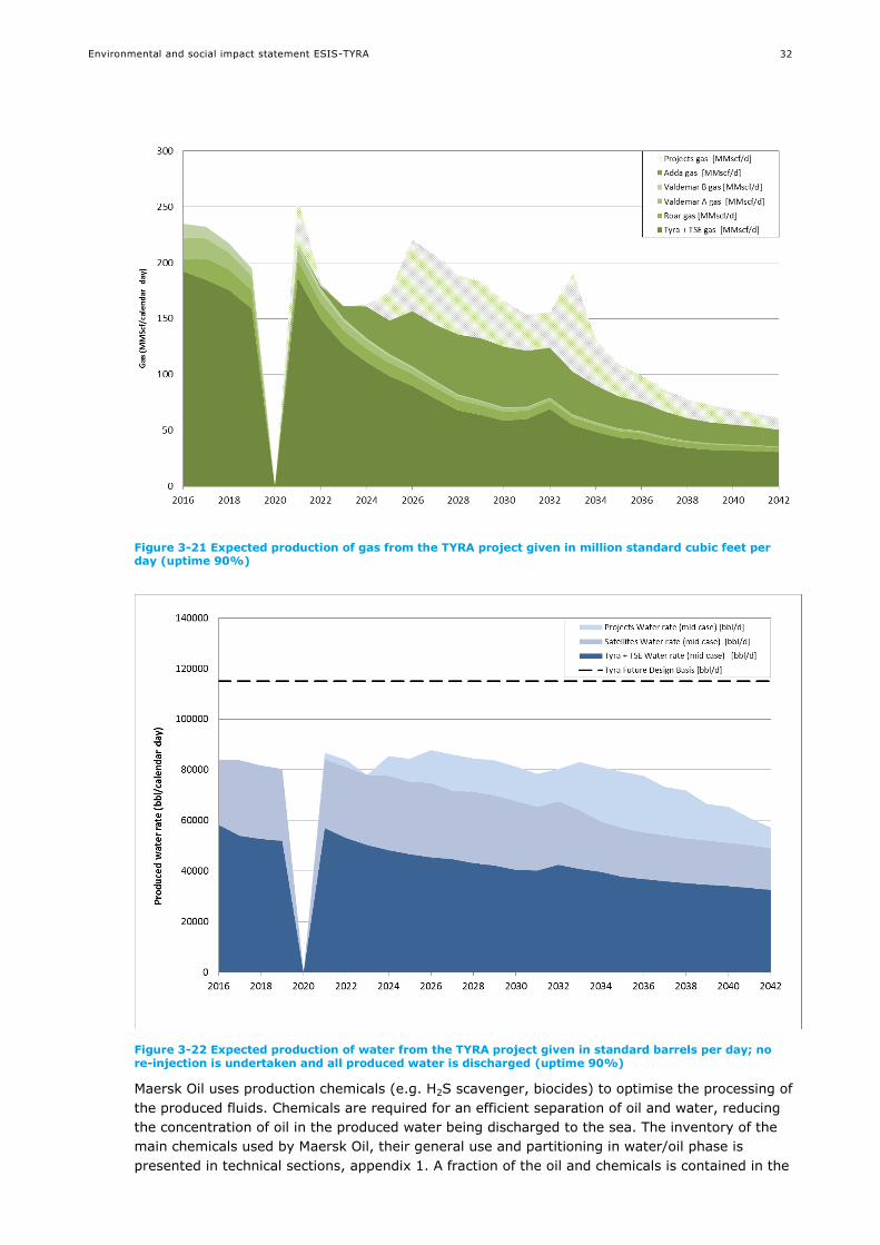
Environmental and social impact statement ESIS-TYRA
32
Figure 3-21 Expected production of gas from the TYRA project given in million standard cubic feet per day (uptime 90%)
Figure 3-22 Expected production of water from the TYRA project given in standard barrels per day; no re-injection is undertaken and all produced water is discharged (uptime 90%)
Maersk Oil uses production chemicals (e.g. H2S scavenger, biocides) to optimise the processing of
the produced fluids. Chemicals are required for an efficient separation of oil and water, reducing
the concentration of oil in the produced water being discharged to the sea. The inventory of the
main chemicals used by Maersk Oil, their general use and partitioning in water/oil phase is
presented in technical sections, appendix 1. A fraction of the oil and chemicals is contained in the
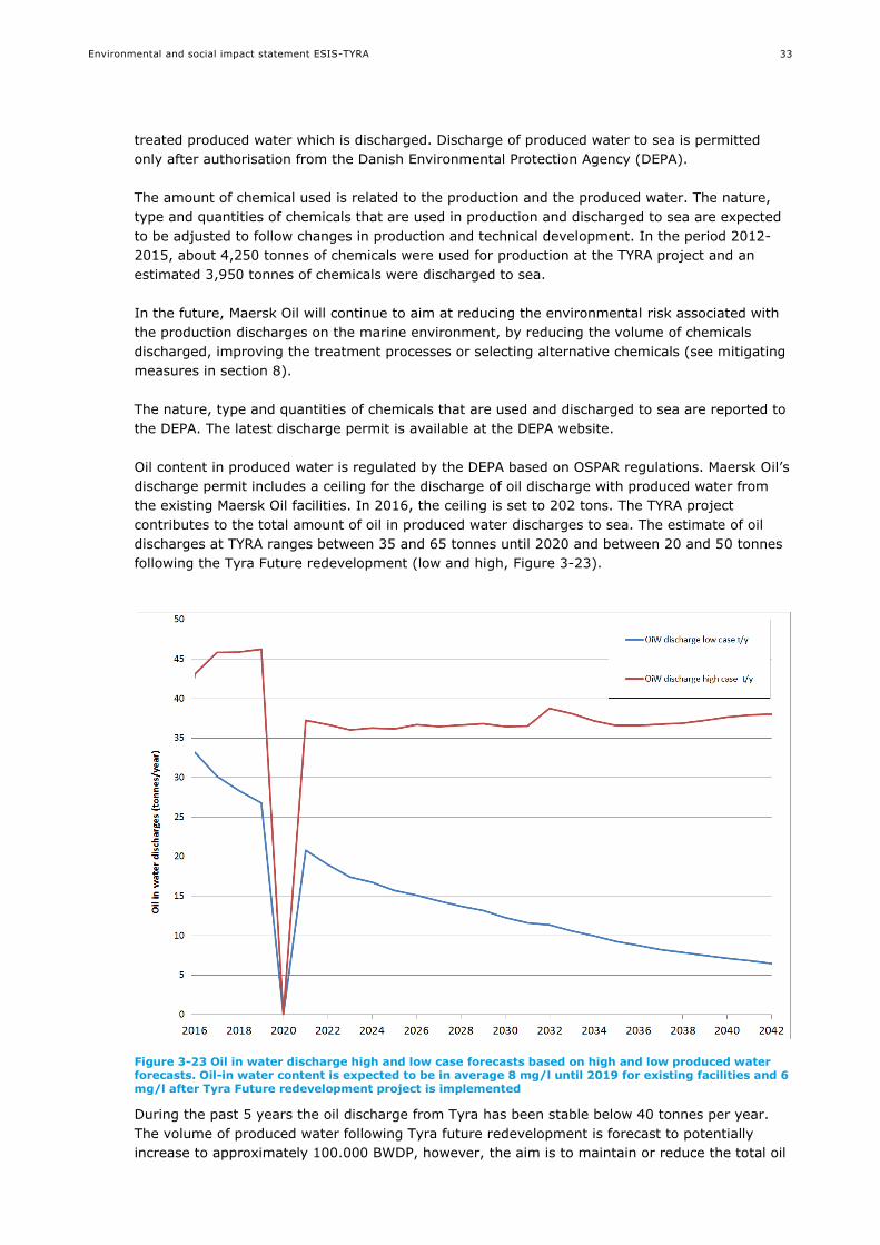
Environmental and social impact statement ESIS-TYRA
33
treated produced water which is discharged. Discharge of produced water to sea is permitted
only after authorisation from the Danish Environmental Protection Agency (DEPA).
The amount of chemical used is related to the production and the produced water. The nature,
type and quantities of chemicals that are used in production and discharged to sea are expected
to be adjusted to follow changes in production and technical development. In the period 2012-
2015, about 4,250 tonnes of chemicals were used for production at the TYRA project and an
estimated 3,950 tonnes of chemicals were discharged to sea.
In the future, Maersk Oil will continue to aim at reducing the environmental risk associated with
the production discharges on the marine environment, by reducing the volume of chemicals
discharged, improving the treatment processes or selecting alternative chemicals (see mitigating
measures in section 8).
The nature, type and quantities of chemicals that are used and discharged to sea are reported to
the DEPA. The latest discharge permit is available at the DEPA website.
Oil content in produced water is regulated by the DEPA based on OSPAR regulations. Maersk Oil’s
discharge permit includes a ceiling for the discharge of oil discharge with produced water from
the existing Maersk Oil facilities. In 2016, the ceiling is set to 202 tons. The TYRA project
contributes to the total amount of oil in produced water discharges to sea. The estimate of oil
discharges at TYRA ranges between 35 and 65 tonnes until 2020 and between 20 and 50 tonnes
following the Tyra Future redevelopment (low and high, Figure 3-23).
Figure 3-23 Oil in water discharge high and low case forecasts based on high and low produced water forecasts. Oil-in water content is expected to be in average 8 mg/l until 2019 for existing facilities and 6 mg/l after Tyra Future redevelopment project is implemented
During the past 5 years the oil discharge from Tyra has been stable below 40 tonnes per year.
The volume of produced water following Tyra future redevelopment is forecast to potentially
increase to approximately 100.000 BWDP, however, the aim is to maintain or reduce the total oil
Environmental and social impact statement ESIS-TYRA
34
discharge via a produced water treatment package designed to reduce oil-in-water concentration
to 6 mg/l. Additional requirements to upstream equipment are made to provide for successful
functioning of the water treatment.
On the existing facilities, Maersk Oil has placed flowmeters that measures continuously the
volume of discharged produced water, and water samples are taken daily for measurement of oil
content. Similar monitoring equipment and procedures will be implemented on the new facilities.
The amount of oil in produced water discharged to sea is reported to the DEPA, according to the
requirements in the Discharge Permit. New water treatment facilities at Tyra will be designed to
treat the water to a levetl acceptable for discharge. Other facilities shall meet OSPAR
requirements and are continuously adjusted to operate within oil in water limits.
3.4.4 Drilling
Drilling of wells is necessary for extracting oil and gas resources. Wells are used for transporting
the fluid (a mixture of oil, gas, water, sand and non-hydrocarbon gasses) from the geological
reservoir to Maersk Oil installations, where fluid processing takes place. Wells are also used for
injection of water (seawater or produced water) or gas to increase reservoir pressure and
enhance the oil and gas recovery rate.
For TYRA, 24 existing well slots are available for drilling (16 at Tyra South East, 2 at Svend, 3 at
Roar, 2 at Valdemar B and 1 at Valdemar A). Maersk Oil has not decided whether all free well
slots will be drilled. In addition, up to 32 well slots are expected to be drilled in relation with the
possible TYRA development projects. For the TYRA project, no wells are expected to be subjected
to slot recovery or re-drill, cf. technical sections, appendix 1.
Typical well types are presented in technical sections, appendix 1. It has not been decided which
type of well will be applicable for the TYRA project. Drilling is performed from a drilling rig, which
is placed on the seabed (with an expected area of a few hundred m2). Drilling of a well starts
with hammering a conductor into the seabed. A new well will typically take up to 150 days to
drill. Different types of drilling mud will be used based on the well and reservoir properties.
Water-based mud and cuttings will be discharged to the sea, whereas oil-based mud and cuttings
will be brought onshore to be dried and incinerated. Discharges to sea are permitted only after
authorisation from the Danish Environmental Protection Agency. Water-based drilling mud and
drill cuttings may contain traces of oil from the reservoir sections. The oil content in the water-
based drilling mud and drill cuttings is monitored regularly to ensure it does not exceed 2%, on
average. It is estimated that on average 7 tonnes of oil per 1,000 m reservoir section can be
discharged to sea corresponding to a maximum discharge of 28.8 tonnes of oil per well.
3.4.5 Well stimulation
The purpose of well stimulation is to improve the contact between the well and reservoir, thereby
facilitating hydrocarbon extraction (for a production well) or water injection (for an injection
well). Well testing is performed to evaluate the production potential of a well after stimulation.
At the TYRA project, the new wells (up to 24 in existing well slots and up to 32 wells in new
structures) may be subjected to matrix acid stimulation or acid fracturing. The existing wells at
the TYRA project may be subjected to matrix acid stimulations (in total up to 2 per year). Use
and discharge (e.g. drilling and maintenance) of chemicals are presented in technical sections,
appendix 1. Discharge to sea is permitted only after authorisation from DEPA.
3.4.6 Transport
Personnel and cargo are transported daily to support Maersk Oil’s production and drilling
operations via helicopters, supply vessels and survey vessels. Personnel will be reduced from

Environmental and social impact statement ESIS-TYRA
35
around 180 to 80 people when Tyra West becomes unmanned. Standby vessel may be employed
in connection with drilling and tasks requiring work over the side of the installation.
3.4.7 Decommissioning
Overall principles and methods of decommissioning are as per technical sections, appendix 1
Decommissioning will be done in accordance with technical capabilities, legislation, industry
experience, international conventions and the legal framework at the time of decommissioning.
Decommissioning will be planned in accordance with the OSPAR decision 98/3 on the disposal of
disused offshore installations.
It is expected that:
Wells will be permanently plugged towards the reservoir and the casing above the seabed will
be removed.
The platform facilities and jackets will be cleaned, removed and brought to shore for
dismantling. Hydrocarbons and waste will be sent to shore for disposal.
Buried pipelines will be cleaned, filled with seawater and left in situ.
Decommissioning of the TYRA facilities is expected to generate around 60,000 tonnes of waste
which will be brought onshore and treated accordingly. It is expected that the material
breakdown will be similar to the breakdown shown for Tyra Future, cf. section 3.2.4, i.e. the
majority of materials, around 90 %, are steel from jackets and topside facilities.
The waste management onshore will be performed by an approved recycling and disposal site.
The majority of the waste, such as scrap steel, will be recycled. In addition, hazardous waste
shall be documented and some waste (e.g. NORM) shall be returned to its country of origin in
case of transboundary transport of the platforms. A material account will be developed for
documentation and traceability of all waste streams from the platforms.
3.5 Accidental events
The accidental events, considered here, are accidents that could take place during exploration,
production and decommissioning activities at the TYRA project that can lead to environmental or
social impacts.
Major loss of primary containment (oil, gas or chemical) may also occur. Generally, the sequence
of events leading to such events are unlikely and complex and several scenarios can be
envisioned (e.g. /136//137/). The scenarios associated with Maersk Oil activities at the TYRA
project that can lead to accidents with a major significant impact are listed in the technical
sections and include vessels collisions, pipeline rupture due to corrosion, erosion or impact, well
blow out and impact on major platform equipment.
Small operational accidental spills of oil or chemical or gas release could also occur.
3.6 Alternatives
3.6.1 Project alternatives
The offshore oil and gas production is important to Danish security of supply and Danish
economy. Tyra has an estimated production reserve equivalent to 250 million barrels of oil
equivalent. About 500 people are employed with and on the Tyra facilities and another 4,000
Danish jobs are dependent on Tyra. Tax revenue to the state of Denmark is significant. The
state’s total revenue is estimated to DKK 20 billion per year.
The Danish government has set a target of 30 % of the Danish energy use is provided from
renewable energy by 2020. As part of a long-term Danish energy strategy, the oil and gas
production is considered instrumental in maintaining high security of supply. Denmark is

Environmental and social impact statement ESIS-TYRA
36
expected to continue being a net exporter of natural gas up to and including 2025 and Maersk Oil
has a license to operate until 2042 /35/.
The TYRA project has been subject to clarification of the economic framework for continued
production of oil and gas from TYRA. For the project at hand no alternatives exist for provision of
a similar redevelopment.
3.6.2 Facility re-use
Early in the project maturation process a number of studies were carried out to assess the
possibility of re-use/continued use of existing facilities. Such options included inter alia
construction of a barrier wall, similar to the concrete storage tank, Ekofisk 2/4T and jacking of
the platforms, similar to the Ekofisk steel jackets. The studies concluded that such options were
either technically in-feasible, economically un-viable or both. The conclusion is that the existing
facilities are without value for continued use. The remaining value is attributed to the wells and
the objective is to continue the production from existing wells, to new facilities.
3.6.3 Technological alternatives
Best technology selection for the design of the new facilities is evaluated through BAT/BEP
studies cf. 9.4.
3.6.4 Technical alternatives
Technical alternatives for seismic, pipelines and structures, production, drilling, well stimulation,
transport and decommissioning are presented in technical sections, appendix 1.

Environmental and social impact statement ESIS-TYRA
37
4. METHODOLOGY
The ESIS is based on information collected from the 2014 North Sea Atlas, technical reports,
EIAs, peer-reviewed scientific literature, Maersk Oil monitoring and modelling reports and
industry reports.
4.1 Rochdale envelope approach
The adoption of the Rochdale Envelope approach allows meaningful ESIA to take place by
defining a ’realistic worst case’ scenario that decision makers can consider in determining the
acceptability, or otherwise, of the environmental impacts of a project.
The Rochdale Envelope Approach allows a project description to be broadly defined. The project
can be described by a series of maximum extents – the ‘realistic worst case’ scenario. The
detailed design of the scheme can then vary within this ‘envelope’ without invalidating the
corresponding ESIA.
Where a range is provided, e.g. amounts of produced water or volume of drilling mud, the most
detrimental is assessed in each case. For example, the impact assessment for the TYRA project is
based on the likely maximum volume of discharged produced water, the maximum number of
wells and the maximum number of new structures.
4.2 Methodology for assessment of impacts
The potential impacts of the TYRA project on the environmental and social receptors (e.g. water
quality, climate and fishery) are assessed for exploration, production and decommissioning.
The assessment covers the direct and indirect, cumulative and transboundary, permanent or
temporary, positive and negative, impacts of the project. Impacts are evaluated based on their
nature, type, reversibility, intensity, extent and duration in relation to each receptor (social and
environmental).
The proposed methodology used for assessment of impacts includes the following criteria for
categorizing environmental and social impacts:
Value of the receptor
Nature, type and reversibility of impact
Intensity, geographic extent and duration of impacts
Overall significance of impacts
Level of confidence

Environmental and social impact statement ESIS-TYRA
38
4.2.1 Value of receptor
Various criteria are used to determine value/sensitivity of each receptor, including resistance to
change, rarity and value to other receptors (Table 4-1).
Table 4-1 Criteria used to assess the value of receptor
Value
Low A receptor that is not important to the functions/services of the wider
ecosystem/socioeconomy or that is important but resistant to change (in the context of
project activities) and will naturally or rapidly revert to pre-impact status once activities
cease.
Medium A receptor that is important to the functions/services of the wider
ecosystem/socioeconomy. It may not be resistant to change, but it can be actively
restored to pre-impact status or will revert naturally over time.
High A receptor that is critical to ecosystem/socioeconomy functions/services, not resistant to
change and cannot be restored to pre-impact status.
4.2.2 Nature, type and reversibility of impacts
Impacts are described and classified according to their nature, type and reversibility (Table 4-2).
Table 4-2 Classification of impacts: Nature, type and reversibility of impacts
Nature of impact
Negative Impacts that are considered to represent an adverse change from the
baseline (current condition).
Positive Impacts that are considered to represent an improvement to the baseline.
Type of impact
Direct Impacts that results from a direct interaction between a planned project
activity and the receiving environment.
Indirect or secondary Impacts which are not a direct result of the project, but as a result of a
pathway (e.g. environmental). Sometimes referred to as second level or
secondary impacts.
Cumulative Impacts that result from incremental changes caused by past, present or
reasonably foreseeable human activities with the project.
Degree of reversibility
Reversible Impacts on receptors that cease to be evident after termination of a project
activity.
Irreversible Impacts on receptors thatare evident following termination of a project
activity.
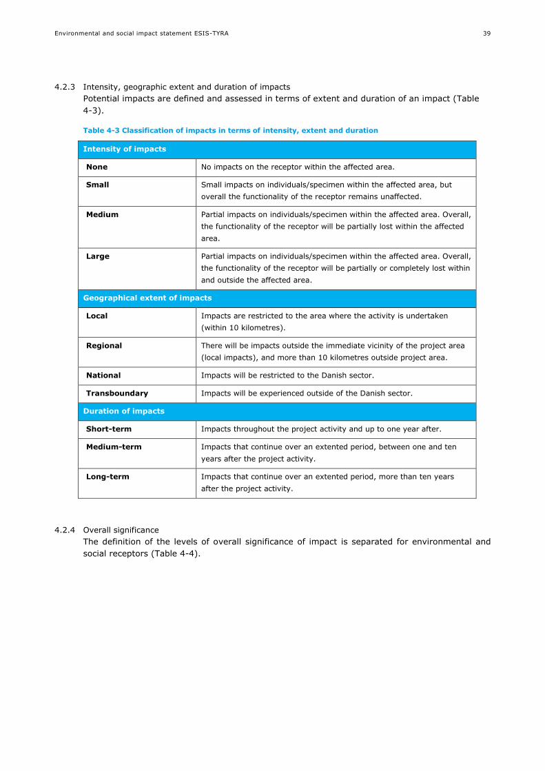
Environmental and social impact statement ESIS-TYRA
39
4.2.3 Intensity, geographic extent and duration of impacts
Potential impacts are defined and assessed in terms of extent and duration of an impact (Table
4-3).
Table 4-3 Classification of impacts in terms of intensity, extent and duration
Intensity of impacts
None No impacts on the receptor within the affected area.
Small Small impacts on individuals/specimen within the affected area, but
overall the functionality of the receptor remains unaffected.
Medium Partial impacts on individuals/specimen within the affected area. Overall,
the functionality of the receptor will be partially lost within the affected
area.
Large Partial impacts on individuals/specimen within the affected area. Overall,
the functionality of the receptor will be partially or completely lost within
and outside the affected area.
Geographical extent of impacts
Local Impacts are restricted to the area where the activity is undertaken
(within 10 kilometres).
Regional There will be impacts outside the immediate vicinity of the project area
(local impacts), and more than 10 kilometres outside project area.
National Impacts will be restricted to the Danish sector.
Transboundary Impacts will be experienced outside of the Danish sector.
Duration of impacts
Short-term Impacts throughout the project activity and up to one year after.
Medium-term Impacts that continue over an extented period, between one and ten
years after the project activity.
Long-term Impacts that continue over an extented period, more than ten years
after the project activity.
4.2.4 Overall significance
The definition of the levels of overall significance of impact is separated for environmental and
social receptors (Table 4-4).

Environmental and social impact statement ESIS-TYRA
40
Table 4-4 Classification of overall significance of impacts
Overall
significance
Impacts on environmental receptors Impacts on social receptors
Positive Positive impacts on the structure or function of the receptor
None/Negligible
negative
No measurable impacts on the structure or function of the receptor.
Minor negative Impact to the structure or function of
the receptor is localised and immediate
or short-term. When the activity ceases,
the impacted area naturally restores to
pre-impact status.
Impact that is inconvenient to a small
number of individual(s) with no long-term
consequence on culture, quality of life,
infrastructure and services. The impacted
receptor will be able to adapt to change
with relative ease and maintain pre-
impact livelihood.
Moderate
negative
Impact to the structure or function of
the receptor is local or regional and over
short- to medium-term. The structure or
ecosystem function of the receptor may
be partially lost. Populations or habitats
may be adversely impacted, but the
functions of the ecosystem are
maintained. When the activity ceases,
the impacted area restores to pre-
impact status through natural recovery
or some degree of intervention.
Impact that is inconvenient to several
individuals on culture, quality of life,
infrastructure and services. The impacted
receptor will be able to adapt to change
with some difficulties and maintain pre-
impact livelihood with some degree of
support.
Major negative Impact to the structure or function of
the receptor is regional, national or
international and medium- to long-term.
Populations or habitats and ecosystem
function are substantially adversely
impacted. The receptor cannot restore
to pre-impact status without
intervention.
Impact that is widespread and likely
impossible to reverse for. The impacted
receptors will not be able to adapt or
continue to maintain pre-impact livelihood
without intervention.
4.2.5 Level of confidence
It is important to establish the uncertainty or reliability of data that are used to predict the
magnitude of the effects and the vulnerability of the receptors, as the level of confidence in the
overall level of significance depends on it.
There are three levels of confidence for the impact:
Low: Interactions are poorly understood and not documented. Predictions are not modelled
and maps are based on expert interpretation using little or no quantitative data.
Information/data have poor spatial coverage/resolution.
Medium: Interactions are understood with some documented evidence. Predictions may be
modelled but not validated and/or calibrated. Mapped outputs are supported by a moderate
negative degree of evidence. Information/data have relatively moderate negative spatial
coverage/resolution.
High: Interactions are well understood and documented. Predictions are usually modelled and
maps based on interpretations are supported by a large volume of data. Information/data
have comprehensive spatial coverage/resolution.

Environmental and social impact statement ESIS-TYRA
41
5. ENVIRONMENTAL AND SOCIAL BASELINE
The environmental and social baseline contains a general description of each potential receptor,
and site-specific information to the TYRA project where applicable.
The baseline includes the following potential receptors:
Environmental
Climate and air quality
Bathymetry
Hydrographic conditions
Water quality
Sediment type and quality
Plankton (phytoplankton and zooplankton)
Benthic communities (fauna and flora)
Fish
Marine mammals
Seabirds
Social
Cultural heritage
Protected areas (Natura 2000, UNESCO world heritage, national nature reserves)
Marine spatial use
Fishery
Tourism
Employment
Tax revenue
Oil and Gas dependency
5.1 Climate and air quality
The North Sea is situated in temperate latitudes with a climate characterised by large seasonal
contrasts. The climate is strongly influenced by the inflow of oceanic water from the Atlantic
Ocean and by the large scale westerly air circulation which frequently contains low pressure
systems /10/.
Air quality in the North Sea is a combination of global and local emissions. Industrialisation of the
coast and inshore area adjacent to certain parts of the central North Sea has led to increased
levels of pollutants in these areas which decrease further offshore, though shipping and platforms
provide point sources of atmospheric pollution /141/.
5.2 Bathymetry
The North Sea is a part of the north-eastern Atlantic Ocean, located between the British Isles and
the mainland of north-western Europe. The western part of the Danish North Sea is relatively
shallow, with water depths between 20 – 40 metres, while the Northern part is deeper (e.g. the
Norwegian Trench and the Skagerrak; Figure 5-1).
The TYRA project is located in the shallowest part of the Maersk oil activity area, with depths
ranging from about 38 - 64 metre /3/.
The depths decrease further to the south-west of TYRA project, where the large sandbank Dogger Bank is located within the German, Dutch, and UK EEZ.

Environmental and social impact statement ESIS-TYRA
42
Figure 5-1 Bathymetry of the North Sea. Figure redrawn from Maersk Oil Atlas /3/
5.3 Hydrographic conditions
The North Sea is a semi-enclosed sea. The water circulation is determined by inflow from the
North Atlantic, water through the English Channel, river outflow from the Rhine and Meuse and
the outgoing current from the Baltic Sea through Skagerrak (Figure 5-2). These inputs of water,
in close interaction with tidal forces and wind and air pressures, create a complicated flow pattern
in the North Sea. The TYRA project is in the central North Sea, where the dominant water
circulation is eastward.
Hydrographic fronts are created where different water masses meet, and include areas of
upwelling, tidal fronts, and saline fronts. Hydrographic fronts are considered of great importance
to the North Sea ecosystems. No potential for hydrographic fronts has been identified in the
central North Sea where the TYRA project is located.

Environmental and social impact statement ESIS-TYRA
43
Figure 5-2 Left: General water circulation in the North Sea. The width of arrows is indicative of the magnitude of volume transport /10/. Right: Potential for hydrographic fronts in the North Sea /10//2/
5.4 Water quality
Salinity: Salinity in the North Sea varies from saline water in the west to brackish water along the
coastal areas in the East. In the TYRA project area, the salinity does not show much seasonal
variation with surface and bottom salinity of 34-35 psu /3/.
Temperature: Temperature in the North Sea varies seasonally. The lowest temperatures are
found in the Northern part of the North Sea, and the highest temperature in the shallower areas
in the Southern North Sea. In the TYRA project area, the surface temperature is approximately 7
˚C in winter (January) and between 15-19 ˚C in summer (August), while the bottom
temperature varies from 6-8 ˚C in winter (January) and 8-18 ˚C in summer (August) /3/.
Nutrients: Concentrations of nutrients in the North Sea surface layer have been modelled /3/.
The concentrations are highest (>0.04 mg/l for phosphate, and >0.30 mg/l for nitrate) along the
coastal areas, near output of large rivers. The concentrations in the surface layer in the TYRA
project area ranges between 0.025-0.035 mg/l for phosphate and between 0.1-0.15 mg/l for
nitrate/3/.
Heavy metals: Water concentrations of metals in North Sea for cadmium ranges 6-34 ng Cd/l,
copper 140-360 ng Cu/l, lead 20-30 ng Pb/l, mercury 0.05-1.3 ng Hg/l and nickel 100-400 ng
Ni/l /29/. Metal cycles in the ocean are governed by seasonally variable physical and biological
processes. The biologically driven metals (Cd, Cu, Ni) follow nutrient like distributions with higher
concentration found in deep water. Certain metals, including Cd and Cu, exhibit higher
concentrations near and on the shelf compared to the open sea areas /29/. No site-specific
information on metals in seawater is available.
Potential fronts
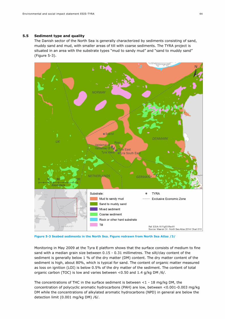
Environmental and social impact statement ESIS-TYRA
44
5.5 Sediment type and quality
The Danish sector of the North Sea is generally characterized by sediments consisting of sand,
muddy sand and mud, with smaller areas of till with coarse sediments. The TYRA project is
situated in an area with the substrate types “mud to sandy mud” and “sand to muddy sand”
(Figure 5-3).
Figure 5-3 Seabed sediments in the North Sea. Figure redrawn from North Sea Atlas /3/
Monitoring in May 2009 at the Tyra E platform shows that the surface consists of medium to fine
sand with a median grain size between 0.15 - 0.31 millimetres. The silt/clay content of the
sediment is generally below 1 % of the dry matter (DM) content. The dry matter content of the
sediment is high, about 80%, which is typical for sand. The content of organic matter measured
as loss on ignition (LOI) is below 0.5% of the dry matter of the sediment. The content of total
organic carbon (TOC) is low and varies between <0.50 and 1.4 g/kg DM /6/.
The concentrations of THC in the surface sediment is between <1 - 18 mg/kg DM, the
concentration of polycyclic aromatic hydrocarbons (PAH) are low, between <0.001-0.003 mg/kg
DM while the concentrations of alkylated aromatic hydrocarbons (NPD) in general are below the
detection limit (0.001 mg/kg DM) /6/.
Environmental and social impact statement ESIS-TYRA
45
Concentrations of metals (Cd, Cr, Cu, Pb and Zn /6/) are below the Lower Action Levels for
dumping of seabed material defined by the Danish EPA, and thus characterised as having
average background levels or insignificant concentrations with no expected negative impact on
marine organisms /8/.
5.6 Plankton
The plankton community may be broadly divided into a plant component (phytoplankton) and an
animal component (zooplankton). Via photosynthesis, phytoplankton constitute the main
contributor of organic matter in the North Sea, and thus for the whole marine food web. Apart of
light carbon fixation is determined by the availability of nutrients, primarily nitrogen and
phosphorous. The source of nutrients may either be imported from outside to the euphotic zone
where photosynthesis occurs or derived from local remineralisation. Due to the grazing by
zooplankton and subsequent decomposition of organic matter the metabolism of zooplankton and
phytoplankton is mutually connected.
In the North Sea, the phytoplankton is mainly light-limited in winter and nutrient-limited in the
water above the thermocline in summer /10/. Figure 5-4 shows the average annual
phytoplankton colour index (PCI) for the North Sea over across a thirty year period (1983-2003).
PCI is a visual proxy directly related to the biomass and abundance of the phytoplankton close to
the surface. The highest biomass and abundance of phytoplankton is found in the Eastern and
Southern parts of the North Sea. The TYRA project is located in an area with an average biomass
and abundance comparable to the rest of the North Sea. The phytoplankton community is
typically dominated by dinoflagellates and diatoms /3/.
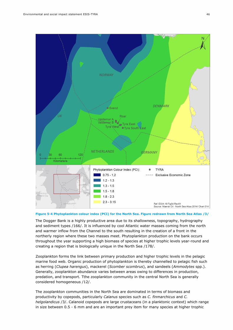
Environmental and social impact statement ESIS-TYRA
46
Figure 5-4 Phytoplankton colour index (PCI) for the North Sea. Figure redrawn from North Sea Atlas /3/
The Dogger Bank is a highly productive area due to its shallowness, topography, hydrography
and sediment types /166/. It is influenced by cool Atlantic water masses coming from the north
and warmer inflow from the Channel to the south resulting in the creation of a front in the
northerly region where these two masses meet. Phytoplankton production on the bank occurs
throughout the year supporting a high biomass of species at higher trophic levels year-round and
creating a region that is biologically unique in the North Sea /178/.
Zooplankton forms the link between primary production and higher trophic levels in the pelagic
marine food web. Organic production of phytoplankton is thereby channelled to pelagic fish such
as herring (Clupea harengus), mackerel (Scomber scombrus), and sandeels (Ammodytes spp.).
Generally, zooplankton abundance varies between areas owing to differences in production,
predation, and transport. Tthe zooplankton community in the central North Sea is generally
considered homogeneous /12/.
The zooplankton communities in the North Sea are dominated in terms of biomass and
productivity by copepods, particularly Calanus species such as C. finmarchicus and C.
helgolandicus /3/. Calanoid copepods are large crustaceans (in a planktonic context) which range
in size between 0.5 - 6 mm and are an important prey item for many species at higher trophic
Environmental and social impact statement ESIS-TYRA
47
levels. In the TYRA project area, the abundance of copepods is intermediate compared to the
North Sea, with 5.5 – 9.5 ind/m3 of C. finmarchicus and 6.5 – 12 ind/m3 for C. helgolandicus
/3/.
The larger zooplankton, known as megaplankton, includes euphausiids (krill), thaliacea (salps
and doliolids), siphonophores and medusae (jellyfish). Meroplankton comprises the pelagic larval
stages of benthic organisms and fish that spend a short period of their lifecycle in the free water
mass before settling on the benthos. Important groups within this category include the larvae of
starfish and sea urchins, crabs and lobsters and some fish /11/.
5.7 Benthic communities
5.7.1 Benthic flora
Macrophytes (macroalgae and higher plants) grow in conditions that feature relatively diverse
and dynamic light regimes. The water transparency and hydrodynamic conditions have profound
effects on the quantity and quality of the light available for benthic flora, thus directly influencing
the biomass, production and species composition of the benthic communities in the North Sea.
The depth of the photic zone for benthic plants is as rule of thumb defined as the depth where 1
% of the surface irradiance is available for photosynthesis /10/.
The water depth at the TYRA project and in its vicinity is approximately 40 m (64 m at Svend). At
this depth, there is no growth of macrophytes. On the submerse surfaces of the jacket legs
seaweeds especially in form of brown and red macroalgae grow to ca. 10 metres beneath the sea
surface. Their overall contribution to primary production is however negligible compared to the
planktonic production taking place in the passing water masses.
5.7.2 Benthic fauna
The benthic fauna consists of epifauna and infauna (organisms living on or in the seabed,
respectively) such as crustaceans, molluscs, annelids, echinoderms.
In studies of the benthic fauna distribution in the North Sea it had been shown that the 50 m,
100 m, and 200 m depth contours broadly define the boundaries between the main benthic
communities, with local community structure further modified by sediment type /13//14/.
Descriptions of the spatial distribution of infaunal and epifaunal invertebrates show that the
diversity of infauna and epifauna is lower in the southern North Sea than in the central and
northern North Sea. Epifaunal communities are dominated by free-living species as brittle stars,
starfish and bryozoans in the south and sessile species as sponges and corals in the north. Large-
scale spatial gradients in biomass are less pronounced /15/.
The benthic habitats of the Dogger Bank are composed of moderately mobile, clean sandy
sediments (sands and gravelly sands) in full salinity. It is non-vegetated which means that the
organic supply to the benthic communities is based on primary production in the overlying
surface water. The biological communities are typical of fine sand and muddy sand sublittoral
sediments /166/.
Biological monitoring in May 2009 in the TYRA project area recorded a total of 82 species in 154
samples collected around the Tyra E platform and reference stations. With respect to species
richness the benthic fauna was dominated by polychaetes followed by crustaceans, bivalve and
other taxonomic groups (sea anemones, phoronids and nemerteans) /6/.
Polychaetes accounted for 46% of the benthic abundance, crustaceans for 22%, other
taxa, for 12% and echinoderms for 11%. Bivalves and gastropods contributed with 6% and 3%,
respectively, of the abundance. Bivalves were the most important component of the benthic
biomass (42%), followed by echinoderms (29%) and crustaceans (21%).

Environmental and social impact statement ESIS-TYRA
48
Table 5-1 Composition of the benthic fauna around Tyra E in May 2009 /6/
Taxonomic
group
Number of species* Abundance Biomass
2.2 m-2 % ind.m-2 % gDWm-2 %
Polychaeta 31 38 281 46.3 1.3 5.4
Bivalvia 13 16 36 5.9 10.4 42.4
Gastropoda 5 6 20 3.3 0.18 0.7
Crustacea 18 22 133 21.8 5.2 21.1
Echinodermata 7 9 64 10.6 7.0 28.5
Other taxa 8 10 73 12.0 0.42 1.8
Total 82 100 607 100 24.4 100
* Sum of species in the 154 samples collected (143 cm2 each = 2.2 m2)
In comparison with other studies of macrofauna in the North Sea /166//167/ the number of
species and biomass found around the Tyra E is at the high end of the range. Figure 5-5 shows
benthic fauna in the North Sea by indicator species. The TYRA area is classified by the two
indicator species namely the polychaetes Ophelia borealis and Nephtys longosetosa.
Figure 5-5 Assemblages of the benthic fauna in the North Sea. Figure redrawn from North Sea Atlas /3/

Environmental and social impact statement ESIS-TYRA
49
5.8 Fish
Approximately 230 species of fish are found in the North Sea. Fish species diversity is low in the
shallow southern North Sea and eastern Channel and increases westwards. Species diversity is
also generally higher close to shore as the habitat diversity increases. Most of the variability of
the fish stocks is due to variation in egg and larval survival which is thought to be regulated by a
number of factors, such as sea temperature and currents affecting larval drift to nursery grounds,
as well as density-dependent predation on the eggs and larvae. Annual variability in recruitment
of juveniles can differ by a factor of 5 for plaice, 50 for sole and more than 100 for haddock. Most
species show annual or inter-annual movements related to feeding and spawning /10/.
A fish survey was carried out in the period from November 2002 to July 2003 at the Halfdan
platform located about 25 km from the TYRA project (Tyra East and Tyra West). A total of 16
species of fish were registered: Eight pelagic or semi-pelagic (Atlantic horse mackerel, Atlantic
mackerel, cod, grey gurnard, herring, sandeel, sprat, whiting), and eight benthic species
(American plaice, common dab, common dragonet, European plaice, haddock, hooknose/armed
bullhead, lemon sole, lumpfish) /19/.
The dominating species were: sprat, herring, whiting, grey gurnard, Atlantic horse mackerel,
Atlantic mackerel, common dab, American plaice and European plaice. Herring and sprat were
registered during autumn, whereas Atlantic horse mackerel and Atlantic mackerel were registered
in the summer period. Common dab, American plaice and grey gurnard were registered all time
of the year.
The biology of the dominating species registered in the area is described in Table 5-2.
Table 5-2 Distribution and biology of the dominating species registered in the area /23//24/. Further information on spawning areas and catch are presented for selected species in /3/
Species Distribution and biology
Atlantic horse
mackerel
(Trachurus
trachurus)
Horse mackerel has a restricted distribution during summer, with the greatest densities
in the south-eastern North Sea and adults also being found along the shelf edge in the
northern North Sea. The species is notably absent from the central North Sea. Juvenile
horse mackerel are pelagic feeders that prey on planktonic organisms. Larger individuals
feed on small fish (e.g. herring, cod and whiting). Peak spawning in the North Sea falls
in May and June. Spawning occurs off the coasts of Belgium, the Netherlands, Germany,
and Denmark.
American
plaice
(Hippoglossoides
platessoides)
American plaice can be found throughout the North Sea. It prefers soft bottoms. Larvae
feed on plankton, diatoms and copepods. Preferred food items for larger fish incudes sea
urchins, brittle stars, polychaetes, crustaceans and small fish. Spawning takes place
during spring at 100-200 metre depth.
Atlantic
mackerel
(Scomber
scombrus)
Mackerel are widespread throughout the North Sea. Mackerel feed on a variety of pelagic
crustaceans and small fish. In the North Sea, mackerel overwinter in deep water along
the edge of the continental shelf and, in the spring, adult mackerel migrate south to the
spawning areas in the central North Sea with extensions along the southern coast of
Norway and in the Skagerrak. Spawning takes place between May and July.
Common dab
(Limanda
limanda)
Dab is a demersal fish. It lives on sandy bottoms down to depths of about 150 metres.
Preferred food items incudes sea urchins, brittle stars, polychaetes, crustaceans,
mussels and small fish. In the North Sea spawning takes place between April and June.
European
plaice
(Pleuronectes
platessa)
European plaice has a preference for sandy sediments although older age groups may be
found on coarser sand. During summer juvenile plaice are concentrated in the Southern
and German Bights and also occur along the east coast of Britain and in the Skagerrak
and Kattegat. Juveniles are found at lower densities in the central North Sea and are
virtually absent from the north-eastern part. Plaice is an opportunistic species which
primarily forage on molluscs and polychaetes. Plaice spawns in winter from January to
Environmental and social impact statement ESIS-TYRA
50
Species Distribution and biology
March. Spawning areas occur in the central part of the North Sea and in the English
Channel.
Grey gurnard
(Eutrigla
gurnardus)
Grey gurnard occurs throughout the North Sea. Most common on sandy bottoms, but
also on mud, shell and rocky bottoms. During winter, grey gurnards are concentrated to
the northwest of the Dogger Bank at depths of 50-100 m, while densities are low in
areas off the Danish coast, and in the German Bight and eastern part of the Southern
Bight. Juveniles feed on a variety of small crustaceans. The diet of older specimens
mainly consists of larger crustaceans and small fish. The distribution maps indicate a
marked seasonal northwest-southeast migration pattern that is rather unusual. The
population is concentrated in the central western North Sea during winter and spreads
into the south eastern part during spring to spawn. In the northern North Sea, such
shifts appear to be absent. Spawning takes place in spring and summer.
Herring
(Clupea
harengus)
Within the North Sea herring may be found everywhere. The pelagic larvae feed on
copepods and other small planktonic organisms while juvenile mainly feeds on Calanoid
copepods but euphausids, hyperiid amphipods, juvenile sandeels and fish eggs are also
eaten. Larger herring also consuming predominantly copepods with small fish, arrow
worms and ctenophores as an aside. After spending their first few years in coastal
nurseries, two-year-old herring move offshore into deeper waters, eventually joining the
adult population in the feeding and spawning migrations to the western areas of the
North Sea. Herring is a demersal spawner on relatively shallow water depositing sticky
eggs on coarse sand, gravel, shells and small stones. The fish congregate on traditional
spawning grounds, many of which are on shoals and banks and in relatively shallow
water.
Sprat
(Sprattus
Sprattus)
Sprat is most abundant south of the Dogger Bank and in the Kattegat. Larvae feed on
diatoms, copepods and crustacean larvae. After metamorphosis larger planktonic
organisms are also eaten. Spawning occurs in both coastal and offshore waters during
spring and late summer, with peak spawning between May and June.
Whiting
(Merlangius
merlangus)
High densities of both small and large whiting may be found almost everywhere
throughout the North Sea. The species is typically found near the bottom in waters at 10
to 200 m depth. Pelagic larvae feed on nauplii and copepodite stages of copepods.
Immature whiting feed on crustaceans such as euphausids, mysids and crangonid
shrimps whereas mature whitings feed almost entirely on fish. Spawning takes place
from January in the southern North Sea to July in the northern part.
There are two main forms of spawning: Demersal and pelagic spawning.
Demersal spawners lay their eggs on the seafloor, algae or boulders. The preferred habitat for
demersal spawners is species specific.
Pelagic spawners have free floating eggs that are fertilized in the water column. Spawning
grounds for pelagic spawners are often large and less well defined as they can move from year to
year. Hydrographic conditions that are essential for the pelagic spawning have an important role
regulating the boundaries of the spawning grounds. Pelagic spawning takes place mostly at
depths of 20-100 m. Pelagic eggs and larvae are more or less passively carried around by ocean
currents. Some are carried to nursery areas others stay in the water column. Larval growth and
transport of larvae and eggs are regulated by a variety of environmental factors e.g. current,
wind and temperature.
A fish survey was carried out in the period from November 2002 to July 2003 at the Halfdan
platform located about 25 km from the TYRA project area (Tyra East and Tyra West). Fish eggs
from the following 13 species were registered: Common dab, European plaice, American plaice,
cod, lemon sole, Atlantic mackerel, whiting, turbot, greater weever, grey gurnard, Mediterranean

Environmental and social impact statement ESIS-TYRA
51
scaldfish, Arctic rockling and common dragonet /19/. Since Halfdan and the TYRA project is
relatively near each other (25 km) it is likely that these species also spawn at the TYRA project.
The TYRA project is in an area designated as a relatively important spawning ground for cod and
whiting. Mackerel and plaice are also known to be spawning in the area (Figure 5-6), but it does
not seem to be an important spawning and nursery area for other commercial species /3//22/.
Figure 5-6 Spawning grounds for cod, whiting, mackerel and plaice in the North Sea. Figure redrawn from North Sea Atlas /3/
5.9 Marine Mammals
Harbour seal, grey seal, white-beaked dolphin, minke whale and harbour porpoise are the most
common marine mammals in the North Sea /28/. The distribution and biology of these species as
well as their habitat preference is related to the food availability and are described in Table 5-3.
The site fidelity varies among species, and the distribution of marine mammals show both intra-
and interannual variations.

Environmental and social impact statement ESIS-TYRA
52
Table 5-3 Distribution and biology of the most common marine mammals; harbour seal, grey seal, harbour porpoise, white-beaked dolphin and minke whale /30//31//32//33//40//144/
Species Distribution and biology
Harbour seals
(Phoca vitulina)
Harbour seals are one of the most widespread of the pinnipeds. They are found
throughout coastal waters of the Northern Hemisphere, from temperate to Polar Regions.
Harbour seals are mainly found in the coastal waters of the continental shelf and slope,
and are also commonly found in bays, rivers, estuaries and intertidal areas. At sea, they
are most often seen alone, but occasionally occur in small groups. Haul-out sites include
rocks, sand and shingle beaches, sand bars, mud flats, vegetation and a variety of man-
made structures /30/. Harbour seals feed primarily on fish such as herring, mackerel, cod,
whiting and flatfish, and occasionally upon shrimp, crabs, molluscs and squid/144/
Grey seals
(Halichoerus
grypus)
Grey seals have a cold temperate to sub-Arctic distribution in North Atlantic waters over
the continental shelf. They often haul out on land, especially on outlying islands and
remote coastlines exposed to the open sea /32/.The grey seal feeds on a wide variety of
fish including sand eels, cod and other gadoids, flatfish, herring and skates. They may
also take octopus and lobster/144/
White-beaked
dolphin
(Lagenorhynchus
albirostris)
White-beaked dolphins have a wide distribution and inhabit cold temperate to subpolar
waters of the North Atlantic. White-beaked dolphins inhabit continental shelf and offshore
waters of the cold temperate to subpolar zones, although there is evidence suggesting
that their primary habitat is in waters less than 200 m deep. The species is found widely
over the continental shelf, but especially along the shelf edge /33/. They primarily feed on
fish such as herring, cod, haddock, whiting and hake but may also feed on squid, octopus
and benthic crustaceans /144/.
Two white-beaked dolphins were observed during aerial surveys in the Southern Maersk
area in March 2008. No animals have been registered by acoustic monitoring, and the
species is considered uncommon in the Southern Maersk area /40/.
Harbour porpoise
(Phocoena
phocoena)
Harbour porpoise are found in cold temperate to sub-polar waters of the Northern
Hemisphere. They are usually found in continental shelf waters, and frequent relatively
shallow bays, estuaries, and tidal channels /31/.
Harbour porpoise is the most common whale species in the North Sea, and the only
marine mammal which frequently occurs in the Maersk Oil area /40/. The North Sea
harbour porpoise population is estimated at 320,000 – 340,000 /31/. They are mostly
found in the eastern, western and southern parts of the North Sea, and generally found in
low densities in the central part of the North Sea (Figure 5-7). The TYRA project area is
not of particular importance as a breeding site to harbour porpoise, and few individuals
are observed.
Aerial surveys in the Southern Maersk area in May show densities of 0.25-0.4 harbour
porpoises/km2 near the platforms, and few animals in autumn. However, acoustic
monitoring shows high activity in autumn /40/. A recent study at the Dan platform /139/
showed that harbour porpoises are present around the platform all year with the highest
echolocation activity during fall and winter. Harbour porpoises feed mainly on fish such as
cod, whiting, mackerel, herring and sprat/144/.
Minke whale
(Balaenoptera
acutorostrata)
The minke whale is a cosmopolitan species found in all oceans and in virtually all
latitudes, including the Northeast Atlantic. Minke whale occurs in both coastal and offshore
waters and preys on a variety of species in different areas. Less than 0.025 animals/km2
is expected in the central North Sea /33/. Minke whale feed primarily on pelagic fish like
herring and sprat and on small crustaceans /144/.

Environmental and social impact statement ESIS-TYRA
53
Figure 5-7 Distribution of harbour porpoise in the North Sea. Figure re-drawn from North Sea Atlas /3/
The periods where the animals may be particularly vulnerable to disturbance are related to the
reproductive cycle (Table 5-3). The reproductive cycle of seals is primarily on land, while harbour
porpoise is at sea.
Table 5-4 Time of year where animals are breeding (B), moulting (M) or mating (A). No data available for the other North Sea species
Species J F M A M J J A S O N D
Grey seal B BA A M M M
Harbour seal B BA M M
Harbour porpoise B B A A
A recent study has shown that harbour porpoises have a high energy need and thus need to
forage nearly continuously day and night /165/. If they are disturbed by anthropogenic activities
during feeding activities in a way that results in lower food intake it may have severe fitness
consequences for harbour porpoises /165/.
Environmental and social impact statement ESIS-TYRA
54
5.10 Seabirds
Seabirds spend most of their life at sea but breed on rocky coasts and cliffs. In the North Sea
region, common seabirds include fulmars, gannets and auk species, kittiwakes and skuas.
The spatial distribution of the key species of seabirds is related to food availability and is
summarized in Table 5-5, based on the distribution presented in the North Sea Atlas /3/ and a
three-year aerial seabird monitoring survey in 2006-2008 covering the TYRA project area /40/.
Table 5-5 Spatial distribution of key species /3//40/
Species Spatial distribution and biology in the North Sea
Red and black-
throated diver
(Gavia stellata,
G. arctica)
The two species, which are sensitive to oil pollution due to their pursuit-diving
behaviour and low fecundity rate, are non-breeding visitors to the North Sea. Their
sensitivity to oil pollution increases during October-November (Red-throated) and
March-April (Black-throated) when the birds are undergoing moult of their flight
feathers. In spring, the highest densities of red- and black-throated divers are found
along the coast of Denmark, in the Wadden Sea and in the English Channel. In
winter, the distribution is more restricted and the highest densities are found along
the coast of Denmark and northern part of the shallow area off the Wadden Sea.
Almost all birds are found in waters of riverine influence shallower than 35 m, and
both species are rare (0 birds/km2) in the TYRA project area /3/, with few
observations during the aerial survey /40/. Both species feed on fish during their
visit to the North Sea, primarily cod, herring and sandeels.
Northern fulmar
(Fulmarus glacialis)
The species is the most abundant seabird in the North Sea. In summer, relatively
high densities of Northern fulmar are found at many locations throughout the North
Sea with the peak densities located along the southern edge of the Norwegian
Trench. In winter, the highest densities are found west of Norway and northwest of
Jutland Bank. In the southern part of the North Sea Northern Fulmars are found in
lower densities in winter than during summer. In the TYRA project area, Northern
Fulmar occurs at relatively high densities (up to 24 birds/km2 /40/ or up to 10
birds/km2 /3/). Northern fulmar feed on crustaceans, fish and fish waste and other
waste normally collected from the surface.
Northern gannet
(Morus bassanus)
Northern gannets are found in high densities east and north of the UK from spring to
autumn. In late summer-autumn high density areas are also found near the German
and Dutch coasts. In winter, the northern gannet is patchily distributed and found at
low to high densities throughout the North Sea. In the TYRA project area, northern
gannets occur mainly in low densities (< 0.5 birds/km2) all year round /3//40/, but
relatively high densities (up to 23 birds/km2) were observed during autumn /40/.
Feeds mainly on fish up to a size of 30 cm - often herring, sandeels , cod and squid.
Can pursue prey underwater for up to 20 seconds and to depths of up to 22 metres.
Great skua
(Stercorarius skua)
Great skua occurs in low densities from northeast of Greater Fisher Bank to the
Norwegian Trench, north of the UK coast, and in few small isolated patches. Unlike in
spring-summer, the great skua occurs over much of the North Sea during late
summer-autumn. In the TYRA project area, the species occurs in low densities (0-0.1
birds/km2 /3/), with few observations during the aerial surveys /40/. Feeds mainly
on fish by taking them from other birds or by finding dead fish. Are also know to
feed on small seabirds (e.g. puffins). Occasionally catches live fish or follows fishing
vessels.
Common gull
(Larus canus)
The common gull is not observed over much of the North Sea, but with intermediate
to high densities along the eastern part of the North Sea (e.g. Wadden Sea, German
Bight, Jutland Bank, and some isolated patches bordering the eastern UK coast). In
the TYRA project area, the species is rare (0 birds/km2 /3/). The common gull is very
versatile in its feeding preferences and feed on almost anything including fish and
fish waste from fishing vessels.
Lesser black-backed gull Lesser black-backed gulls are largely absent from much of the central and north-

Environmental and social impact statement ESIS-TYRA
55
Species Spatial distribution and biology in the North Sea
(Larus fuscus) western parts of the North Sea, and are concentrated mostly in the eastern parts of
the North Sea. In the TYRA project area, the species occurs in low densities (0
birds/km2 /3/). Like most gulls it is very versatile in its feeding preferences and can
eat both fish and other smaller birds.
Herring gull
(Larus argentatus)
The herring gull occurs throughout most of the coastal areas in the eastern North
Sea, particularly around Norway and in Skagerrak. Relatively high densities are
found in the German Bight, off the coast of the Netherlands, and in winter also in
areas further offshore like areas around Dogger Bank: Both the distribution and the
abundance of herring gulls seem mainly to be determined by working trawlers. The
species is rare in the TYRA project areas (0 birds/km2 /3/). The herring gull is
omnivorous but feeds mainly on fish, invertebrates, plants, smaller birds, carrion and
waste.
Great black-backed gull
(Larus marinus)
The distribution and the abundance of great black-backed gull in the activity areas
seem mainly to be determined by working trawlers. The species is common
throughout the North Sea during winter, and the highest densities are found south
and west of the Dogger Bank. In the TYRA project area, the species is rare (0
birds/km2 /3/). The main diet for great black-backed gulls is fish, bird eggs, young
birds, carrion and waste.
Black-legged Kittiwake
(Rissa tridactyla)
In summer, the species is concentrated primarily in the western North Sea. Outside
the breeding season, the species occurs throughout the North Sea with widespread
intermediate to high density areas. Most extensive concentrations are found along
the southern edges of the Norwegian Trench, northwest of Dogger Bank, off Borkum
and in the Channel. In the TYRA project area, the species is found in intermediate
density (0–5 birds/km2 /3//40/), and in spring and autumn large flocks are observed
/40/. Feeds on smaller fish like sandeels and small vertebrates by catching them at
the water surface.
Sandwich tern
(Sterna sandvicensis)
The species is mainly distributed in coastal waters on both sides of the North Sea. In
spring highest densities are found off the German coast and the Netherlands. In
summer-autumn highest densities are shown off the British coast just north of the
Wash. In the TYRA project area, the species is rare (0 birds/km2 /3/), and the few
observations during the aerial surveys confirm the low densities /40/. Feeds
primarily on small fish like sandeels, sprat and herring but also feed on crustaceans,
molluscs and worms. The foraging grounds are further offshore than other tern
species.
Common tern
(Sterna hirundo)
The species is absent throughout most of the offshore parts of the North Sea. In
spring highest densities are found off the northern German coast and the
Netherlands. In late summer highest densities are found off the Danish coast and the
Netherlands. In the TYRA project area, the species is rare (0 birds/km2 /3/), and the
few observations during the aerial surveys confirm the low densities /40/. Feeds
primarily on small fish by plunge-diving.
Common guillemot
(Uria aalge)
The common guillemot is the second most abundant seabird in the North Sea. In
early summer, high densities are found in the western parts, whereas the species is
found in lower densities in other parts of the North Sea. In late summer, the species
occurs in high densities in the central and eastern parts as they move across the
North Sea to moulting areas south of the Norwegian Trench. The species is very
sensitive to oil pollution due to its pursuit diving behaviour, and during August and
September both the adults and the accompanying young are flightless, and hence
highly sensitive to pollution. As seen for many other species of seabirds, the highest
numbers in the activity areas seem to be associated with the areas of lowest water
depth. In the TYRA project areas, the species occurs in intermediate densities (0-5
birds/km2) /3/. The common guillemot mainly feeds on small fish 20 cm long or less,
such as polar cod, capelin, sprat, sandeels, Atlantic cod and Atlantic herring.
Razorbill In early and late summer, the razorbill is largely absent in most of the North Sea and

Environmental and social impact statement ESIS-TYRA
56
Species Spatial distribution and biology in the North Sea
(Alca torda) the birds are concentrated in its western part. Higher densities are observed in late-
than in early-summer. The razorbill is largely absent in most of the northern and
central North Sea in winter when most birds are found in the Skagerrak and Kattegat
and off the coasts of the UK and NL. In the TYRA project area, the species is found in
densities of up to 2.5 birds/km2. The diet of a razorbill is very similar to that of the
common guillemot. It consists generally of fish such as capelin, sandeel, juvenile
cod, sprats and herring. It may also include crustaceans and polychaetes.
Little auk
(Alle alle)
The little auk is concentrated along the Norwegian Trench and NW of Dogger Bank
during winter, and the species occurs in intermediate densities (<5 birds/km2 /3/) in
the TYRA project area. The little auk primarily feed on krill and other small
crustaceans but also on small fish.
The four species of gulls (common gull, lesser black-backed gull, herring gull, great black-backed
gull) are presented as rare (0 birds/km2) /3/. However, aerial surveys show frequent
observations and density estimates for gulls range up to 11 gulls/km2, with the highest densities
in autumn /40/.
5.10.1 Important Bird Areas (IBAs)
Important Bird Areas (IBAs) are key sites for future conservation. A site is recognised as an IBA
only if it meets certain criteria, based on the occurrence of key bird species that are vulnerable to
global extinction or whose populations are otherwise irreplaceable. The Wadden Sea (in Dutch,
German and Danish waters) and Skagerrak/Southwest Norwegian trench are both recognised as
important areas for birds, more than 100 km from the TYRA project. There are no IBAs in the
central North Sea /34/.
5.11 Cultural heritage
Cultural heritage in the North Sea includes submerged prehistoric sites that were once land,
other coastal features such as early fish-traps, submerged structures from defending coast in the
World Wars, and shipwrecks from all ages. Part of the seabed of the North Sea is submerged
land, and quite a number of villages in the Southern Bight have been submerged by the sea.
5.12 Protected areas
Protected areas are shown in Figure 5-8. Protected areas include Natura 2000 sites, Ramsar
sites, UNESCO world heritage sites and nationally designated areas.

Environmental and social impact statement ESIS-TYRA
57
Figure 5-8 Protected areas. Figure redrawn from North Sea Atlas /3/
5.12.1 Natura 2000 sites
The Natura 2000 network comprises:
Habitats Directive Sites (Sites of Community Importance and Special Areas of Conservation)
designated by Member States for the conservation of habitat types and animal and plant
species listed in the Habitats Directive
Bird Directive Sites (Special Protection Areas) for the conservation of bird species listed in the
Birds Directive as well as migratory birds
Natura 2000 sites have been designated in the central North Sea for Dogger Bank in UK, the
Netherlands and Germany (Figure 5-8). The basis for designation is presented in section 10.
5.12.2 Ramsar sites
Ramsar sites are wetlands of international importance, and are present in coastal areas of the
North Sea. The Ramsar Convention requires Contracting Parties to ‘formulate and implement
their planning so as to promote the conservation of the wetlands included in the List, and as far
as possible the wise use of wetlands in their territory’ (article 3.1).

Environmental and social impact statement ESIS-TYRA
58
All Ramsar sites in the Danish sector of the North Sea are also designated Natura 2000 areas.
5.12.3 UNESCO world heritage sites
The Wadden Sea in Denmark, Germany and the Netherlands have been appointed UNESCO world
heritage site (Figure 5-8).
The Wadden Sea is the largest unbroken system of intertidal sand and mud flats in the world. It
is a large, temperate, relatively flat coastal wetland environment, formed by the intricate
interactions between physical and biological factors that have given rise to a multitude of
transitional habitats with tidal channels, sandy shoals, seagrass meadows, mussel beds,
sandbars, mudflats, salt marshes, estuaries, beaches and dunes. The area provides a habitat for
numerous plant and animal species.
5.12.4 Nationally designated areas
In Denmark, the Wadden Sea is designated as a national park. In addition, several nature
reserves (“natur- og vildtreservat”) have been appointed in Denmark along the west coast of
Jutland, several inshore nature reserves (e.g. Nissum Fjord and Ringkøbing Fjord) (Figure 5-8).
5.13 Marine spatial use
The TYRA project is not in an area with important shipping routes for the largest ships equipped
with automatic identification systems (Figure 5-9, < approximately 100 per year) /3/.
The infrastructure of oil and gas and wind includes both existing and planned installations. In the
North Sea, a number of oil and gas facilities are operational, and additional facilities are planned.
Operational wind farms are only present in Danish waters off Esbjerg, while a number of wind
farms are planned in UK and German waters. Pipelines and cables connecting platforms are not
shown in the figure, but should also be considered when planning new projects.

Environmental and social impact statement ESIS-TYRA
59
Figure 5-9 Ship traffic and infrastructure in 2012. Figure re-drawn from North Sea Atlas /3/. Ship traffic is based on all ships fitted with AIS system i.e. ships of more than 300 gross tonnage engaged on international voyages, and cargo ships of more than 500 gross tonnage not engaged on international voyages and all passenger ships irrespective of size. Missing data in the middle of the North Sea is due to poor AIS receiving coverage and not lack of ships. Germany does not participate in the North Sea AIS data sharing program
Further spatial restrictions include military areas, dump sites and reclamation areas. Dump sites
and reclamation areas are mainly located at a relatively short distance from the coast, and are
not present in the central North Sea. Military uses constitute a small part of the sea-borne and
coastal activities around the North Sea. There are extensive exercise areas, mainly in the United
Kingdom, but also along the west coast of Jutland (Denmark).
5.14 Fishery
Fishery is an important industry in the North Sea. The main targets of major commercial fisheries
are cod, haddock, whiting, saithe, plaice, sole, mackerel, herring, Norway pout, sprat, sandeel,
Norway lobster, and deep-water prawn. Norway pout, sprat and sandeel are predominantly the
targets of industrial fisheries for fish meal and oil, while other species are the targets of fisheries
for direct human consumption /10/.
A historic overview of production, trade, employment and fleet size for fishery in Denmark is
provided in Table 5-6 /36/.

Environmental and social impact statement ESIS-TYRA
60
Table 5-6 Historic overview of production, trade, employment and fleet for fishery in Denmark /36/
1990 2000 2010
Production (thousand tonnes)
Inland 36 37 23
Marine 1482 1541 840
Aquaculture 42 44 35
Capture 1476 1534 828
Total 1518 1578 863
Trade (USD million)
Import 1116 1806 2958
Export 2166 2756 4140
Employment (thousands)
Aquaculture 0 0.8 0.4
Capture 6.9 4.6 2.4
Total 6.9 5.4 2.9
Fleet (thousands)
Total 3.8 4.1 2.8
Landings of sandeel, European plaice, herring, cod, sprat and Norway pout are presented in the
North Sea Atlas /3/. The landings are presented for one year (2013), and show that the central
North Sea, including the TYRA project area, has some importance to the Danish fishery for
sandeel. In addition, some fishery takes place in the central North Sea, in particular for cod,
sprat and European plaice.
As inter-annual variation can be significant, fishery data for a period of ten years have been
extracted from the Danish AgriFish Agency /37/. The data has been extracted for Danish vessels
for area IVB, which covers an area of 280,000 km2 from the west coast of Jutland to the Eastern
coast of the UK.
Estimated value for the landing from Danish vessels in the North Sea for the last ten years shows
that the area IVB, where the TYRA project is located, is important for the fishing industry (Table
5-7) /37/.
Table 5-7 Total landings and value of fishery, as landed catch for important commercial species in the central North Sea (area IVB) /37/. Data from 2015 is not available for the central North Sea (area IVB)
Overall Species-species landed catch
(tonnes)
Total landed
catch
(tonnes)
Total value
(DKK)
Sandeel Cod Sprat European
plaice
2005 405,067 824,527,622 129,776 4,365 233,306 9,382
2006 376,174 894,837,171 239,144 3,556 97,208 9,721
2007 239,469 700,252,302 142,309 2,317 64,047 6,918
2008 320,488 696,990,031 231,321 2,596 62,680 6,854
2009 409,143 652,075,835 272,865 2,792 110,650 6,827
2010 344,744 858,381,192 250,676 3,359 68,827 7,837
2011 388,927 990,124,457 263,971 2,736 98,484 9,932
2012 160,556 746,792,906 47,439 2,547 70,907 9,557
2013 263,373 875,992,562 183,330 1,917 46,258 10,707
2014 328,063 855,349,857 147,963 2,712 135,366 9,551
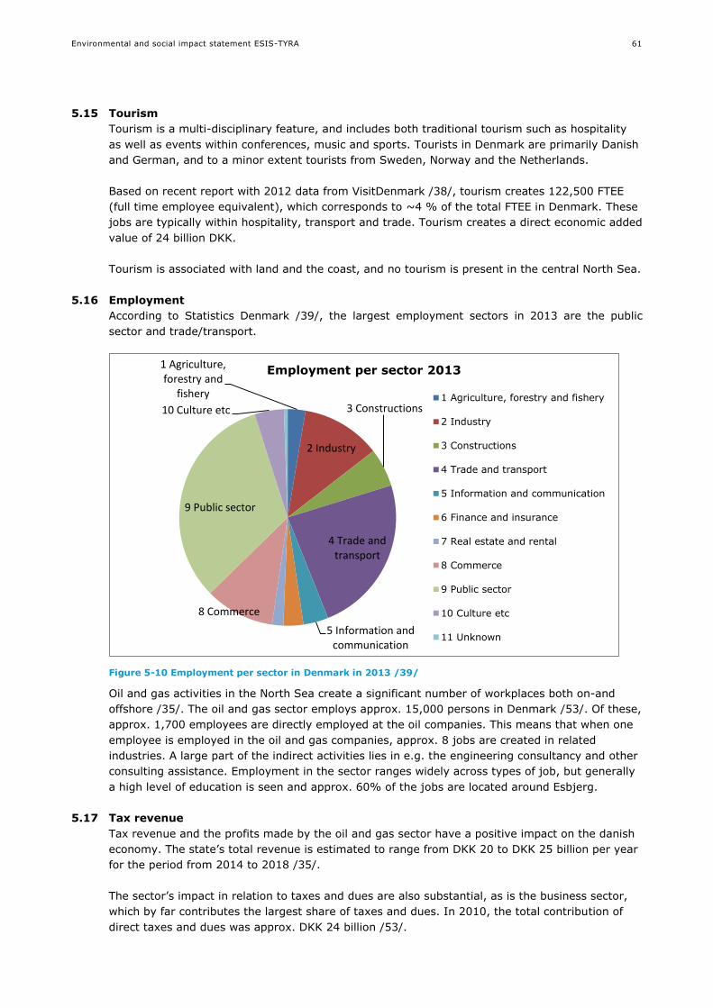
Environmental and social impact statement ESIS-TYRA
61
5.15 Tourism
Tourism is a multi-disciplinary feature, and includes both traditional tourism such as hospitality
as well as events within conferences, music and sports. Tourists in Denmark are primarily Danish
and German, and to a minor extent tourists from Sweden, Norway and the Netherlands.
Based on recent report with 2012 data from VisitDenmark /38/, tourism creates 122,500 FTEE
(full time employee equivalent), which corresponds to ~4 % of the total FTEE in Denmark. These
jobs are typically within hospitality, transport and trade. Tourism creates a direct economic added
value of 24 billion DKK.
Tourism is associated with land and the coast, and no tourism is present in the central North Sea.
5.16 Employment
According to Statistics Denmark /39/, the largest employment sectors in 2013 are the public
sector and trade/transport.
Figure 5-10 Employment per sector in Denmark in 2013 /39/
Oil and gas activities in the North Sea create a significant number of workplaces both on-and
offshore /35/. The oil and gas sector employs approx. 15,000 persons in Denmark /53/. Of these,
approx. 1,700 employees are directly employed at the oil companies. This means that when one
employee is employed in the oil and gas companies, approx. 8 jobs are created in related
industries. A large part of the indirect activities lies in e.g. the engineering consultancy and other
consulting assistance. Employment in the sector ranges widely across types of job, but generally
a high level of education is seen and approx. 60% of the jobs are located around Esbjerg.
5.17 Tax revenue
Tax revenue and the profits made by the oil and gas sector have a positive impact on the danish
economy. The state’s total revenue is estimated to range from DKK 20 to DKK 25 billion per year
for the period from 2014 to 2018 /35/.
The sector’s impact in relation to taxes and dues are also substantial, as is the business sector,
which by far contributes the largest share of taxes and dues. In 2010, the total contribution of
direct taxes and dues was approx. DKK 24 billion /53/.
1 Agriculture, forestry and
fishery
2 Industry
3 Constructions
4 Trade and transport
5 Information and communication
8 Commerce
9 Public sector
10 Culture etc
Employment per sector 2013
1 Agriculture, forestry and fishery
2 Industry
3 Constructions
4 Trade and transport
5 Information and communication
6 Finance and insurance
7 Real estate and rental
8 Commerce
9 Public sector
10 Culture etc
11 Unknown

Environmental and social impact statement ESIS-TYRA
62
5.18 Oil and gas dependency
Denmark has been supplied with gas from its North Sea fields since the 1980s and has also
exported natural gas, primarily to Sweden and Germany. This production has significantly
impacted the security of supply and balance of trade. Denmark is expected to continue being a
net exporter of natural gas up to and including 2025 and Maersk Oil has license to operate until
2042 /35/.
As part of a long-term Danish energy strategy, the oil and gas production is instrumental in
maintaining high security of supply, at the same time as renewable energy represents an
increasing share of the Danish energy mix /53/.

Environmental and social impact statement ESIS-TYRA
63
6. IMPACT ASSESSMENT: PLANNED ACTIVITIES
6.1 Impact mechanisms and relevant receptors
6.1.1 Potential impact mechanisms
Potential impact mechanisms associated with the planned activities at the TYRA project are
summarised based on the project description (section 3) and the technical sections (appendix 1).
Potential impact mechanisms include:
Underwater noise
Physical disturbance of seabed
Suspended sediment
Discharges (physical and chemical)
Solid waste
Emissions
Light
Resource use
Restricted zones
Employment and tax revenue
Oil and gas dependency
The source of the potential impact mechanisms is provided in Table 6-1. The sources of impacts
are related to the activities described in the seven technical sections (appendix 1).
Table 6-1 Sources of potential impact mechanisms for the TYRA project. “X” marks relevance, while “0“ marks no relevance
Potential impact mechanism
Sesim
ic
Pip
eli
nes a
nd
str
uctu
res
Pro
du
cti
on
Dril
lin
g
Well
sti
mu
lati
on
Tran
sp
ort
Decom
mis
sio
nin
g
Underwater noise X X X X X X X
Physical disturbance of seabed X X 0 X 0 0 X
Suspended sediment X X 0 X 0 0 X
Discharges X X X X X X X
Solid waste X X X X X X X
Emissions X X X X X X X
Light X X X X X X X
Presence/removal of structures 0 X X 0 0 0 X
Resource use X X X X X X X
Restricted zones X X X X 0 0 X
Employment and tax revenue X X X X X X X
Oil and gas dependency X X X X X X X

Environmental and social impact statement ESIS-TYRA
64
6.1.2 Relevant receptors (environmental and social)
The relevant environmental and social receptors described in the baseline for the TYRA project
are listed below.
Environmental receptors: Climate and air quality, hydrographic conditions, water quality,
sediment type and quality, plankton, benthic communities (flora and fauna), fish, marine
mammals, seabirds.
Social receptors: Cultural heritage, protected areas, marine spatial use, fishery, tourism,
employment, tax revenue, oil and gas dependency.
The relevant receptors have been assessed based on the project description (section 3) and the
potential impact mechanisms (section 6.1). Relevant receptors for the impact assessment are
summarised in Table 6-2.
Table 6-2 Relevant receptors for the impact assessment of planned activities for the TYRA project. “X” marks relevance, while “0“ marks no relevance
Environmental Receptors Social Receptors
Potential
impact
mechanism
– planned
activities
Clim
ate
an
d a
ir q
uality
Hyd
rog
rap
hic
con
dit
ion
Wate
r q
uality
Sed
imen
t ty
pe a
nd
qu
ality
Pla
nkto
n
Ben
thic
co
mm
un
itie
s
Fis
h
Marin
e m
am
mals
Seab
ird
s
Cu
ltu
ral h
erit
ag
e
Pro
tecte
d a
reas*
Marin
e s
pati
al
use
Fis
hery
To
uris
m
Em
plo
ym
en
t
Tax r
even
ue
Oil
an
d g
as d
ep
en
den
cy
Underwater
noise
0 0 0 0 X X X X X 0 0 0 0 0 0 0 0
Physical
disturbance
of seabed
0 0 0 X X X X 0 X X 0 0 X 0 0 0 0
Suspended
sediment
0 0 X 0 X X X X X 0 0 0 0 0 0 0 0
Discharges 0 0 X X X X X X X 0 X 0 0 0 0 0 0
Solid waste 0 0 0 0 0 0 0 0 0 0 0 0 0 0 0 0 0
Emissions X 0 0 0 0 0 0 0 0 0 0 0 0 0 0 0 0
Light 0 0 0 0 X 0 X X X 0 0 0 0 0 0 0 0
Presence/re
moval of of
structures
0 X 0 X 0 X X X 0 0 0 0 0 0 0 0 0
Resource
use
0 0 0 0 0 0 0 0 0 0 0 0 0 0 0 0 0
Restricted
zones
0 0 0 0 0 0 0 0 0 0 0 X X X 0 0 0
Employment
and tax
revenue
0 0 0 0 0 0 0 0 0 0 0 0 0 0 X X 0
Oil and gas
dependency
0 0 0 0 0 0 0 0 0 0 0 0 0 0 0 0 X
* Note that a separate assessment for Natura 2000 is undertaken in section 10.
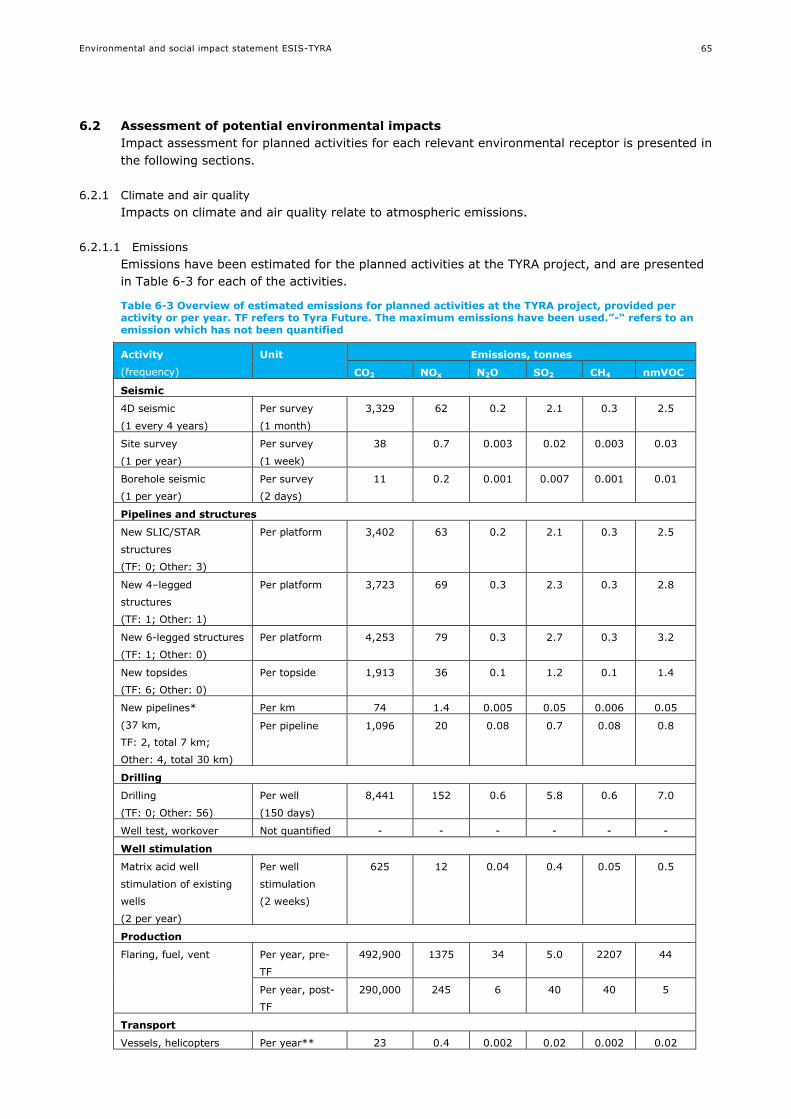
Environmental and social impact statement ESIS-TYRA
65
6.2 Assessment of potential environmental impacts
Impact assessment for planned activities for each relevant environmental receptor is presented in
the following sections.
6.2.1 Climate and air quality
Impacts on climate and air quality relate to atmospheric emissions.
6.2.1.1 Emissions
Emissions have been estimated for the planned activities at the TYRA project, and are presented
in Table 6-3 for each of the activities.
Table 6-3 Overview of estimated emissions for planned activities at the TYRA project, provided per activity or per year. TF refers to Tyra Future. The maximum emissions have been used.”-“ refers to an emission which has not been quantified
Activity
(frequency)
Unit Emissions, tonnes
CO2 NOx N2O SO2 CH4 nmVOC
Seismic
4D seismic
(1 every 4 years)
Per survey
(1 month)
3,329 62 0.2 2.1 0.3 2.5
Site survey
(1 per year)
Per survey
(1 week)
38 0.7 0.003 0.02 0.003 0.03
Borehole seismic
(1 per year)
Per survey
(2 days)
11 0.2 0.001 0.007 0.001 0.01
Pipelines and structures
New SLIC/STAR
structures
(TF: 0; Other: 3)
Per platform 3,402 63 0.2 2.1 0.3 2.5
New 4–legged
structures
(TF: 1; Other: 1)
Per platform 3,723 69 0.3 2.3 0.3 2.8
New 6-legged structures
(TF: 1; Other: 0)
Per platform 4,253 79 0.3 2.7 0.3 3.2
New topsides
(TF: 6; Other: 0)
Per topside 1,913 36 0.1 1.2 0.1 1.4
New pipelines*
(37 km,
TF: 2, total 7 km;
Other: 4, total 30 km)
Per km 74 1.4 0.005 0.05 0.006 0.05
Per pipeline 1,096 20 0.08 0.7 0.08 0.8
Drilling
Drilling
(TF: 0; Other: 56)
Per well
(150 days)
8,441 152 0.6 5.8 0.6 7.0
Well test, workover Not quantified - - - - - -
Well stimulation
Matrix acid well
stimulation of existing
wells
(2 per year)
Per well
stimulation
(2 weeks)
625 12 0.04 0.4 0.05 0.5
Production
Flaring, fuel, vent Per year, pre-
TF
492,900 1375 34 5.0 2207 44
Per year, post-
TF
290,000 245 6 40 40 5
Transport
Vessels, helicopters Per year** 23 0.4 0.002 0.02 0.002 0.02

Environmental and social impact statement ESIS-TYRA
66
Decommissioning***
Well abandonment
(TF: 8; Other: 159)
per well
(20 days)
1,125 20 0.08 0.8 0.08 0.9
SLIC/STAR structures
(TF: 1; Other: 9)
Per platform 5,103 95 0.3 3.2 0.5 3.8
3–legged structures
(TF: 2; Other: 0)
Per platform 5,103 95 0.3 3.2 0.5 3.8
4–legged structures
(TF: 1; Other: 9)
Per platform 5,585 104 0.5 3.5 0.4 4.2
6-legged structures
(TF: 0; Other: 1)
Per platform 6,380 119 0.5 4.1 0.5 4.8
8 legged structures
(TF: 1; Other: 0)
Per platform 6,380 119 0.5 4.1 0.5 4.8
Topsides
(TF: 6; Other: 0)
Per topside 2,869 54 0,2 1,8 0,2 2,1
*Emissions from pipelay, survey, trenching and DOS vessels amount to 74 tonnes CO2 per km. Guard and
diving support vessels are responsible for additional 1096 tonnes CO2 per pipeline (see technical section B for
details).
** The calculation for vessels and helicopters are assuming equal distribution among the 20% for each of
Maersk Oil’s five platform complexes Tyra, Harald, Dam, Gorm and Halfdan.
*** Emissions during decommissioning is approximately 150% of the emissions during installation.
Emissions are primarily caused by venting, flaring of gas and the use of fossil fuels for
production.
Table 6-4 provides an overview of the estimated annual emissions (from production, well
stimulation, transport and seismic), and total emissions for drilling, new structures and
decommissioning from the TYRA project, along with the annual Danish emissions in 2012.
Activities associated with Tyra Future are shown separately in the columns “Construction” and
“Decommissioning”.
Table 6-4 Emissions in tonnes from activities at the TYRA project and national emissions numbers for Denmark /20//21/. ”-“ refers to an emission which has not been quantified
Emis-
sions
Annual
Danish
emissions
2012
Total annual
emissions related to
production
Total emissions
Construction Decom-
missioning
Drilling
Pre Tyra
future
Post Tyra
future
Tyra
Future
Other Tyra
Future
Other
CO2 39,412,000 495,059 292,154 22,164 20,533 53,488 281,447 472,696
NOx - 1,416 286 414 380 992 5,090 8,512
N2O 116,071 34 6 1 1 4 20 34
SOx 12,510 6 41 14 13 34 192 325
CH4 - 2,207 40 1 2 4 21 34
nmVOC - 46 7 16 15 40 220 392
6.2.1.2 CO2, N2O and CH4 emissions
Greenhouse gases such as CO2, N2O and CH4 have a direct impact on climate and air quality.
The greenhouse gasses have different warming potential /141/, as some have a longer lifetime in
the atmosphere and a higher heat absorption than others. Per definition, CO2 has a global
warming potential (GWP) of 1, whereas the GWP is 21 for CH4 and 310 for N2O /141/. Including
these GWP corrections, CO2 emission is responsible for about 94% of the greenhouse effect
caused by the TYRA project.

Environmental and social impact statement ESIS-TYRA
67
The annual emissions related to production at the TYRA project (excluding new structures, drilling
and decommissioning) currently contributes up to 1.2 % of the total annual CO2 emission for
Denmark in 2012, falling to around 0.9 % post Tyra Future. Additional emissions associated with
drilling, construction and decommissioning will add to this percentile, but considering that the
emissions summarised in columns 4-6 in Table 6-4 are totals for a period of 25 years, this
addition is small.
The impact is considered to be of small intensity, a transboundary extent and long-term duration.
The overall impact on climate change from emissions at the TYRA project is assessed to be of
moderate negative significance.
6.2.1.3 NOx, SOx and nmVOC emissions (air pollution)
NOX and SOx are air pollutants which are spread by the wind and deposited in the surrounding
environment. The compounds have potential acidification effects that can impact the environment
in terms of defoliation and reduced vitality of trees, and declining fish stocks in acid-sensitive
lakes and rivers. Non methane VOCs can have a number of damaging impacts on human health.
Some have direct toxic effects (e.g. carcinogenic), but nmVOCs can also have indirect effects on
health by contributing to the formation of ground-level ozone, which causes respiratory and
cardiovascular problems.
Emissions of NOx from the TYRA project production corresponds to 1.2 % and SOx correspond to
0.06 % of total annual emission for Denmark in 2012. These percentages change post Tyra
Future to 0.2 % for NOx and 0.4 % for SOx. The impact is considered to be of small intensity,
transboundary extent and long-term duration. The overall impact on air pollution from emissions
at the TYRA project is assessed to be of moderate negative significance.
6.2.1.4 Overall assessment
The overall assessment of impacts on climate and air quality from planned activities at the TYRA
project is summarised in Table 6-5.
Table 6-5 Potential impacts on climate and air quality from planned activities at the TYRA project
Impact mechanism Intensity Extent Duration Overall
significance
Level of
confidence
CO2, N2O, SOx and CH4
emissions
(climate change)
Small Transboundary Long-
term
Moderate
negative
Medium
NOx, SOx and nmVOC
emissions (Air pollution)
Small Transboundary Long-
term
Moderate
negative
Medium
6.2.2 Hydrography
Impacts on hydrography relate to presence and removal of structures.
6.2.2.1 Presence and removal of structures
Pipelines are buried to a depth of about 1.5-2 metres. In places where the pipelines are at the
sediment surface (upheaval buckling or near platforms), they may block or redirect currents of
bottom water affecting local hydrographical regimes. Surfacing pipelines are covered by rocks to
prevent accident with, for example, trawler.
The presence of jackets will cause flowing water to accelerate as it passes around the structure.
The impact to hydrography of the presence of structures is assessed to be of small intensity, local
extent and of a short-term duration. The alteration of the hydrographical conditions for the
region comprising the Dogger Bank area (Figure 5-1) is considered almost non-existing. The
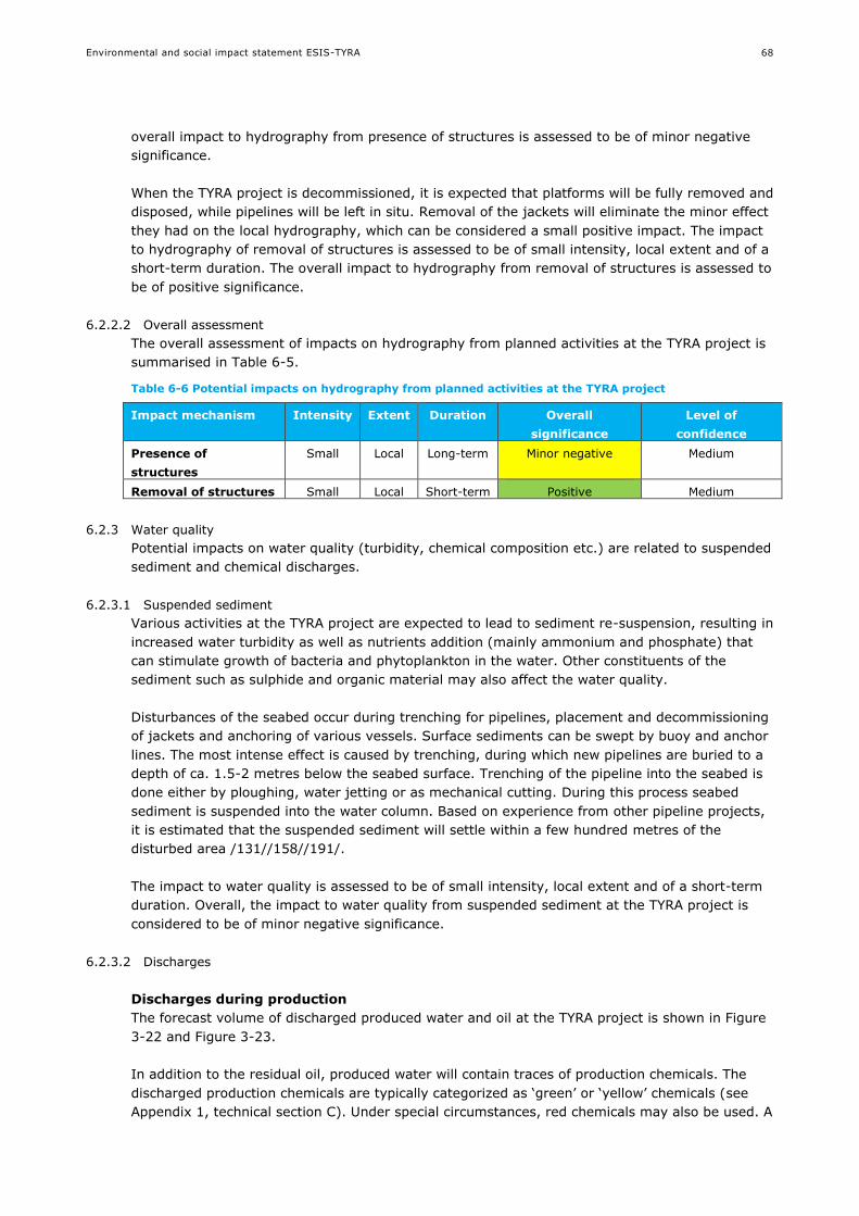
Environmental and social impact statement ESIS-TYRA
68
overall impact to hydrography from presence of structures is assessed to be of minor negative
significance.
When the TYRA project is decommissioned, it is expected that platforms will be fully removed and
disposed, while pipelines will be left in situ. Removal of the jackets will eliminate the minor effect
they had on the local hydrography, which can be considered a small positive impact. The impact
to hydrography of removal of structures is assessed to be of small intensity, local extent and of a
short-term duration. The overall impact to hydrography from removal of structures is assessed to
be of positive significance.
6.2.2.2 Overall assessment
The overall assessment of impacts on hydrography from planned activities at the TYRA project is
summarised in Table 6-5.
Table 6-6 Potential impacts on hydrography from planned activities at the TYRA project
Impact mechanism Intensity Extent Duration Overall
significance
Level of
confidence
Presence of
structures
Small Local Long-term Minor negative Medium
Removal of structures Small Local Short-term Positive Medium
6.2.3 Water quality
Potential impacts on water quality (turbidity, chemical composition etc.) are related to suspended
sediment and chemical discharges.
6.2.3.1 Suspended sediment
Various activities at the TYRA project are expected to lead to sediment re-suspension, resulting in
increased water turbidity as well as nutrients addition (mainly ammonium and phosphate) that
can stimulate growth of bacteria and phytoplankton in the water. Other constituents of the
sediment such as sulphide and organic material may also affect the water quality.
Disturbances of the seabed occur during trenching for pipelines, placement and decommissioning
of jackets and anchoring of various vessels. Surface sediments can be swept by buoy and anchor
lines. The most intense effect is caused by trenching, during which new pipelines are buried to a
depth of ca. 1.5-2 metres below the seabed surface. Trenching of the pipeline into the seabed is
done either by ploughing, water jetting or as mechanical cutting. During this process seabed
sediment is suspended into the water column. Based on experience from other pipeline projects,
it is estimated that the suspended sediment will settle within a few hundred metres of the
disturbed area /131//158//191/.
The impact to water quality is assessed to be of small intensity, local extent and of a short-term
duration. Overall, the impact to water quality from suspended sediment at the TYRA project is
considered to be of minor negative significance.
6.2.3.2 Discharges
Discharges during production
The forecast volume of discharged produced water and oil at the TYRA project is shown in Figure
3-22 and Figure 3-23.
In addition to the residual oil, produced water will contain traces of production chemicals. The
discharged production chemicals are typically categorized as ‘green’ or ‘yellow’ chemicals (see
Appendix 1, technical section C). Under special circumstances, red chemicals may also be used. A

Environmental and social impact statement ESIS-TYRA
69
list of production chemicals, their function and their partitioning in oil/water phase is presented in
appendix 1.
The content of oil in produced water at the TYRA project is currently between 8 mg/l and 13
mg/l. After the implementation of Tyra Future redevelopment, the oil content is expected to
decrease to between 6 and 9 mg/l. The expected amounts of discharged oil and chemicals are
provided in section 3. Flowmeters measure continuously the volume of produced water
discharged, and water samples are taken daily for analysis of the oil content in the produced
water.
Produced water may have toxic effects to the marine environment due to its content of BTEX ,
PAH, dispersed oil, metals etc. Results from laboratory experiments suggest that the existing
discharge of produced water should be diluted from 10 to 10,000 times to reach a concentration
where no acute toxic effects are expected. Discharges of substances that are persistent or bio-
accumulative will in principle increase the general background level of the substance, but due to
the relatively small amounts discharged, it is expected that such increases will not be measured
in practice /1/.
A hydrodynamic dispersion modelling of produced water for the TYRA project suggests that
produced water discharges are diluted relatively rapidly /42/. The modelling further suggests that
there could be an environmental impact up to a distance of 14 km from the Tyra platform /42/. It
should be noted that the calculations are highly conservative and that monitoring data in other
areas of the North Sea have demonstrated that the environmental impacts of produced water
discharges are local, confined to within 1-2 km from the outlet, and that environmental impacts
associated with produced water discharges are low /46/.
The discharged water, oil and chemicals also include compounds that may serve as nutrient
sources for phytoplankton and Bacteria in the water.
The impact to water quality is assessed to be of small intensity, with a local to regional extent
and of a long-term duration due to the constant discharge during the lifetime of the field. Overall,
the impact to water quality from discharge of produced water at the TYRA project is assessed to
be of minor negative significance.
During production other minor negative discharges take place, these include discharges from
vessels, and cooling water from production platforms. These discharges are considered negligible
in comparison with the produced water, and are not assessed further.
Discharges during drilling
There are currently 24 free well slots at the TYRA project. The planned development projects at
Valdemar, Bo South, Adda, and Tyra C, includes the construction up to 4 satellite wellhead
platforms, with a total of 32 new well slots. Typically, a well takes between 60 and 150 days to
drill. Water-based mud and cuttings will be discharged to the sea, whereas oil-based mud and
cuttings will be brought onshore to be dried and incinerated.
Cuttings from the formation collected in the water-based mud section of the well will be
discharged to the sea, along with the drilling mud and material used for cementing (mostly
cement and chemicals).
Discharges of cuttings can amount to 1,800 tonnes of cuttings per well (appendix 1). When
discharged to the sea water-based mud and cuttings, which are slurries of particles of different
sizes and densities in water containing dissolved salts and organic chemicals, form a plume that
dilutes rapidly as it drifts away from the discharge point with the prevailing water currents. Field
studies of the concentration of suspended solids in plumes of drilling mud and cuttings at

Environmental and social impact statement ESIS-TYRA
70
different distances from the drilling activity have confirmed this pattern, concluding that the
concentration of suspended drill cuttings and mud in the water column drops very quickly due to
sedimentation and dilution of the material /45//46/.
Discharges of drilling mud and cement per well are shown in Table 6-7. The discharges shown are
based on the worst case - defined as the well that leads to the largest amount of discharges.
Chemicals expected to be used are categorised in Denmark as ‘green’ or ‘yellow’ chemicals in
accordance with OSPARs classification system for offshore chemicals (section 2.2.2 and 8.1.3).
Table 6-7 Use and discharge tonnes of drilling mud and cement per well in a worst case discharge scenario. The classification colour code is explained above
OSPAR classification Use per well Discharge per well
Tonnes Tonnes
Drilling mud 2421 2421
994 994
Cement 631 76
14 1.7
Based on a review of results of modelling and field studies of drilling mud and cuttings it has
been concluded, that offshore discharges of water-based mud and associated cuttings will have
little or no harmful effects on water column organisms. This conclusion is based on the rapid
dilution in the water column and low toxicity to marine organisms of water-based mud and
cuttings /45/. The chemicals discharged to sea during Maersk Oil drilling have been modelled in
the EIA for Adda and Tyra /2/. The modelling was performed for a typical well and showed that
the predicted effect concentration in the water column extended up to 7 km downstream from
the platform /2/. These estimates are very conservative. Monitoring results in other areas of the
North Sea confirms that the environmental impacts of drilling discharges are local, in general
confined to within 1 - 2 km from the point of discharge /46/.
The impact to water quality is assessed to be of small intensity, local extent and of a short-term
duration due to dilution. Overall, the impact to water quality from discharge of drilling mud and
cuttings at the TYRA project is assessed to be of minor negative significance.
Discharges during well stimulation
The potential 56 new wells at the TYRA project may be subjected to well stimulation. In addition
to stimulation of the new wells, it is anticipated that approximately two well stimulations of
existing wells may take place per year at the TYRA project.
Expected discharges of chemicals during well stimulation at the TYRA project include chemicals
categorized as ‘green’ or ‘yellow’ chemicals (See Technical Section D). Typical discharges during
well stimulation are presented in Table 6-8.
Table 6-8 Use and discharge of chemicals per well stimulation. The classification colour code is explained above
OSPAR classification Use per well Discharge per well
Tonnes Tonnes
Matrix well stimulation 220 140
2603 522
Acid fracturing well stimulation
194 134
2816 564
The amount of discharge per well stimulation (Table 6-8) is significantly less than discharges
during drilling (Table 6-7). Modelling was undertaken for well stimulation as part of the Adda EIA,
Environmental and social impact statement ESIS-TYRA
71
suggesting that there could be an environmental impact up to a distance of 7 km from the
discharge point /2/. The modelled well stimulation had a duration of two days.
The impact to water quality is assessed to be of small intensity, local extent and of a short-term
duration due to dilution. Overall, the impact to water quality from discharges during well
stimulation at the TYRA project is assessed to be of minor negative significance.
Discharges during testing of new pipelines
During pre-commissioning the pipeline is flooded with treated seawater that contains low
concentration of corrosion inhibitor (typically max 500 ppm) to prevent pipeline damage.
Thereafter, the pipeline is cleaned and impurities are removed by pigging. After cleaning, the
pipeline is pressure-tested using treated seawater. During those operations a total volume of
treated seawater, corresponding to about 305 % of the pipeline volume, is discharged to the sea.
Experience from large pipeline projects show that the environmental impact (defined as a
concentration exceeding NOEC) is negligible at distances more than a few hundred metres from
the discharge point /162//163/. It is estimated that the discharge associated with the pre-
commissioning of a 11.6 km pipeline could have an environmental risk to a distance up to 2.8 km
from the discharge /2/.
The impact to water quality is assessed to be of small intensity, local extent and of a short-term
duration due to dilution. Overall, the impact to water quality from discharges during pre-
commissioning at the TYRA project is assessed to be of minor negative significance.
Discharges during decommissioning
Minor discharges are expected during decommissioning activities. In general, all structures
(jacket and topside) will be cleaned before transport to shore. The minor discharges during
decommissioning (e.g. cooling water, grey wastewater from vessels) are assessed to be of small
intensity, local extent and of a short-term duration due to dilution. Overall, the impact to water
quality from discharges during decommissioning at the TYRA project is assessed to be of minor
negative significance.
6.2.3.3 Overall assessment
The overall assessment of impacts on water quality from planned activities at the TYRA project is
summarised in Table 6-9.
Table 6-9 Potential impacts on water quality from planned activities at the TYRA project
Impact
mechanism
Intensity Extent Duration Overall
significance
Level of
confidence
Suspended
sediment
Small Local Short-term Minor negative High
Discharges Small Local/Regional Short-term Minor negative High
Minor cumulative effects on the water quality between production, drilling and construction
discharges cannot be ruled out, however due to the low toxicity of the discharges and the rapid
dilution in the seawater, the impact is estimated to be local and short-term. A review of the
cumulative impact of discharges from the Norwegian offshore petroleum industry based on
monitoring data demonstrates that the cumulative impacts of discharges remains local, in general
confined to few kilometres from the platforms /46/.
As mentioned above, no environmental effects of produced water discharge are expected outside
a radius of a few km from the discharge point at the TYRA project. The closest other oil field
where discharges may occur is Gorm, which is approximately 16 km away. Most of the produced

Environmental and social impact statement ESIS-TYRA
72
water at Gorm is re-injected into the reservoir, and no cumulative effects in regards to water
quality are expected from discharges from other Oil and Gas facilities in the North Sea.
6.2.4 Sediment type and quality
Potential impacts on the sediment type and quality are related to physical disturbance on the
seabed and discharges settling on the seabed that may affect the chemical and physical
composition.
6.2.4.1 Physical disturbance on the seabed
Physical disturbance on the seabed may occur during site surveys, 4D seismic, drilling,
installation of platforms and pipelines and decommissioning. The physical disturbances from
these activities are not expected to occur simultaneously.
During site surveys, which are expected to occur annually, seabed coring will be undertaken and
disturbance of seabed will occur where the sample is acquired, typically with an area of 0.1-0.25
m2. During 4D seismic surveys, presence of bottom nodes and cables may impact the seabed.
The area of such nodes and cables is expected to be small, as each node is 0,40-0,50 metre
broad. During drilling (up to 56 wells), a drilling rig will be present. The rig legs will be placed on
the seabed, and are expected to sink 1–2 metre into the seabed. The rig legs typically cover a
few hundred m2.
New pipelines are trenched and buried to a depth of ca. 1.5-2.0 metre below the seabed surface,
resulting in sediment suspension along the pipeline route.
Minor amounts of sediment will be re-suspended during installation of new platforms, when the
supporting jackets are placed on the seabed. During decommissioning, physical disturbance will
be related to removal of the existing structures.
Disturbance of small areas of sandy sediments is expected to be short term, as sand will rapidly
re-settle in the vicinity of the disturbed areas. The impact to sediment type and quality is
assessed to be of small intensity, local extent and of a short-term duration. The overall impact to
sediment type and quality from physical disturbance is therefore assessed to be of minor
negative significance.
6.2.4.2 Discharges during drilling
Water-based drilling mud and drill cuttings are expected to be discharged to sea from up to 56
wells. The discharges may settle on the seabed and impact the sediment quality.
Several field studies that have measured the concentration of suspended solids in plumes of
drilling mud and cuttings at different distances from the drill rigs have confirmed that the
concentration of suspended drill cuttings and mud in the water column decreases with distance
due to sedimentation and dilution of the material /45//46/.
Modelling of drilling mud and cuttings sedimentation for drilling of a typical Maersk Oil well shows
that most of the drilling mud will settle in the vicinity of the discharge point (1 - 2 kilometres)
(Figure 6-1). The layer of drilling mud settling on the seabed will be less than 1 millimetre thick.
Drill cuttings are heavier than the drilling mud and will settle more rapidly. Model data shows that
for a similar well discharge, a 50 millimetre layer of cuttings could be expected within 50 metres
of the well. The thickness of the layer is expected to decrease to <1 millimetre beyond 200
metres of the discharge (Figure 6-2).

Environmental and social impact statement ESIS-TYRA
73
Figure 6-1 Sedimentation of discharged water based drilling mud modelled for a typical well /1/.
Figure 6-2 Sedimentation of water based drill cuttings modelled for a typical well /1/.
Worst case scenario discharges from drilling of one well is approximately 1,800 tonnes of cuttings
and approximately 3,500 tonnes of water based drill mud and cement. If all 56 existing and
planned well slots at the TYRA project are being used it would result in a total discharge of
101,000 tons of cuttings and 196,000 tons of water-based drill mud. The worst case scenario is
estimated to be the case where the wells are drilled consecutively. However, it is noted that the
wells are located at 14 different locations at distances of 4 to 64 kilometres (see section 3).
Environmental and social impact statement ESIS-TYRA
74
The chemicals which are discharged with the mud and cuttings are categorized as ‘green’ or
‘yellow’ chemicals (section 6.2.2.1 and 8.1.3). The mud usually contains barite or trace of heavy
metals, while the cuttings may contain small quantities of oil. Chemical and biological seabed
monitoring around Tyra E shows that elevated concentrations of metals, THC, PAH and NPD in
the sediment are local (typical within a few hundred metres) and rapidly decreasing in all
directions with increasing distance from the platform /6/. According to this report contaminants
in the sediment around Tyra East do not exceed in advance OSPAR’s environmental assessment
criteria (EAC) or EU’s environmental quality standards (EQS) for which relevant threshold values
exist. It is therefore expected that concentration of contaminants will remain below these
threshold values with the activity connected to this project.
Sedimentation of drilling mud and cuttings may change the sediment grain size. However, seabed
monitoring shows that the median grain size variation after drilling at Tyra East and Valdemar
platform fall within the natural range /6/.
The water based drilling mud may contain biodegradable organic additives, which may stimulate
growth of microbial communities leading to depletion of oxygen in the sediments. Anaerobic,
sulphate-reducing bacteria may further degrade the organic matter, producing hydrogen sulphide
/45/. The seabed monitoring campaign of the seabed around the Tyra East platform reported that
sulphide was detected at a few of the station closest to the platform (less than 1 kilometre) /6/.
Based on the modelling results, the type of chemicals in the drilling mud and cuttings and the
results from the seabed monitoring, the impact is assessed to be of small intensity, local extent
and of a long-term duration. In conclusion, the overall impact to sediment type and quality from
discharges is assessed to be of minor negative significance.
6.2.4.3 Presence/removal of structures
Pipelines can cause water to accelerate in front of the pipeline, thus eroding the seabed and/or
depositing sedimentary material behind it. Water motion can also create free-spans of the
pipeline. Pipelines associated with the TYRA project are trenched into the bottom or covered by
rocks, which would minimize scouring effects.
Jackets may cause the water to accelerate around the piles, creating a scour hole around the
base. The changes may be visible at the seabed as erosion or deposition of sand close to the
jackets.
Existing and planned pipelines and jackets of the TYRA project provides a hard substrate for
growth of animals, plants and algae in an area where previously only sand was present. All
jackets will be removed as the TYRA project is decommissioned, whereas pipelines may be left in
place, but covered by sediment and/or rock dumping.
The impact to sediment type and quality is assessed to be of small intensity, local extent and of a
short-term duration. The overall impact to sediment type and quality from presence of structures
is assessed to be of minor negative significance.
6.2.4.4 Overall assessment
The overall assessment of impacts on sediment type and quality from planned activities at the
TYRA project is summarised in Table 6-10.

Environmental and social impact statement ESIS-TYRA
75
Table 6-10 Potential impacts on sediment type and quality from planned activities at the TYRA project
Potential impact
mechanism
Intensity of
impact
Extent of
impact
Duration of
impact
Overall
significance
of impact
Level of
confidence
Physical disturbance
on seabed
Small Local Short -term Minor negative Medium
Discharges of drill
cuttings
Small Local Long-term Minor negative High
Presence/removal of
structures
Small Local Short-term Minor negative High
Minor cumulative effects between the various discharges at the TYRA project can take place e.g.
from sedimentation of drilling mud and cuttings, which may settle on top of the previous
discharged drilling mud and cuttings (when drilling in the same area). However, based on Maersk
Oil knowledge from surveys of structures it is known that the cuttings and mud are eventually
dispersed. Overall, the cumulative impacts are estimated to be local.
6.2.5 Plankton
Potential impacts on plankton (phyto- and zooplankton) are related to underwater noise,
suspended sediment, discharges and light.
6.2.5.1 Underwater noise
Underwater noise is a form of energy which may in extreme cases impact plankton, due to e.g.
disruption of cells (cell lysis). Underwater noise at the TYRA project may be generated from
seismic activities (airguns, multibeam and sidescan), pile-driving during construction of new
platforms, driving of conductors, drilling, decommissioning and various vessels. Table 6-11 shows
typical frequency and noise levels for these activities.
Little research has been conducted in relation to impacts of underwater noise to plankton,
primarily focussed on emitted energy from airguns during seismic surveys. Mortality of plankton
has been observed at close range (within 5 metre) of the source of the seismic gun /54//55/. A
study found that close range (2 metre) seismic sound emission on snow crab eggs had impacts
on larval development and settlement /66/. Based on field measurements, it is expected that
impact on invertebrates and planktonic larvae, behaviour and physiology will only occur within a
few metres from a noise source of 240 dB re 1 μPa /61/. In general, effects of noise are only
expected to impact organisms close to (within a few metres) powerful noise sources e.g. seismic
surveys and pile-driving /64/ /65/.
Based on the ubiquitous abundance, productivity and size of planktonic populations and their
high reproductive rate, plankton populations will fast recover after disturbance. The impact is
assessed to be of small intensity, local extent and short-term duration. The overall impact on
plankton from underwater noise is assessed to be of negligible negative significance.

Environmental and social impact statement ESIS-TYRA
76
Table 6-11 Typical frequency and noise levels of activities at the TYRA project (based on appendix 1 (Technical Sections), /2//48//140//180/). RMS is the sound pressure averaged over a discrete period of noise and SEL is the sound exposure level expressing the total energy in a distinct sound. Peak-to-peak reflects the actual maximum sound pressure.
Activity Frequency Unit Noise level extrapolated back to 1m
distance from source (@1m)
Seismic
Airgun
(2D/3D/4D seismic)
0.005-0.200
kHz
Peak-to-peak
(dB re 1µPa)
244 (ca.)
0.005-80 kHz RMS
(dB re 1µPa)
179-266
SEL
(dB re 1µPa2s)
202-216
Multibeam
echosounder
70-100 kHz RMS
(dB re 1µPa)
225-232
Sidescan sonar 100-900 kHz Peak-to-peak
(dB re 1µPa)
220 (ca.)
100-500 kHz RMS
(dB re 1µPa)
220-226
Pipelines and structures
Jacket piling 0.001-170 kHz Peak-to-peak
(dB re 1µPa)
230
Production
Production platform 0.01-10 kHz RMS
(dB re 1µPa)
162
Drilling and well stimulation
Driving of
conductors
0.03-20 kHz Peak-to-peak
(dB re 1µPa)
219
Drilling rig 0.1-0.4 kHz RMS
(dB re 1µPa)
195
Transport
Support vessel 0.01-20 kHz RMS
(dB re 1µPa)
122-192
Decommissioning***
Underwater jet
cutting
RMS
(dB re 1µPa)
195
***Use of explosives for the decommissioning of facilities not planned
6.2.5.2 Physical disturbance on the seabed
Regarding the sessile organism living on the solid underwater structures, these will function as
filtering curtains for the plankton associated the passing water masses. This will alter the local
food chain and hence change the local biological production and decomposition of organic matter
in the area. Although this will affect the ecology in an area several fold larger than occupied by
the fields, it still remains a minor impact of the regional ecosystem.
6.2.5.3 Suspended sediment
Suspended sediments could potentially reduce light availability to phytoplankton and affect the
ingestion rate, egg production, egg-hatching success and survival rate of zooplankton. However,
only relative small amounts of sediment are expected to be suspended as part of the construction
of new platforms and pipelines as well as from decommissioning (see section 6.2.3.1).

Environmental and social impact statement ESIS-TYRA
77
The sediment spread will be local, temporary and spatially distributed along new pipelines and
structures during pipeline trenching and decommissioning and will mainly be limited to the lower
parts of the water column. It is assessed that any impact on phytoplankton and zooplankton from
suspended sediment will be negligible.
6.2.5.4 Discharges
Potential impacts on plankton from discharges are related to the impacts of different activities on
the water quality, which are described in section 6.2.3.
Studies show that discharges of water based drilling chemicals may have short-term effects on
phyto- and zooplankton communities /45//46//58/. The discharges of chemicals associated with
production, drilling, stimulation and cleaning of pipelines before in-situ decommissioning may
thus affect the phyto- and zooplankton communities. In general, it is expected that offshore
discharges dilute rapidly and that only plankton found in the vicinity of the discharge will be
affected. Laboratory and field data confirms that the risk of significant biological impact is limited
to 1 – 2 kilometres from the points of discharges /46/. The effect of chemical discharges on
plankton is expected to be small, local and short-term; therefore, the overall impact on
planktonic communities is assessed to be of minor negative significance.
6.2.5.5 Light
Vertical migration in the water column by some large zooplankton species may be influenced by
light from manned platforms.
Light is a factor controlling the daily vertical migration of large forms of zooplankton /60/. It has
been shown that some migrates closer to the surface on dark nights than they do on clear,
moonlit nights /62/. It is recognised that copepods foraging in darkness to avoid predation, only
to be intensively predated when illuminated by a rising full moon /63/. Planktonic organisms are
otherwise characterised to be almost entirely subjected to the prevailing ambient currents and
turbulence, and light is expected to be detectable for zooplankton organism only in the
immediate vicinity of the platforms.
The potential effects are expected to be local /190/, and may impact individuals but will not
impact plankton populations in the North Sea. The overall impact on plankton from light at the
TYRA project is assessed to have negligible negative significance.
6.2.5.6 Overall assessment
The overall assessment of impacts on plankton from planned activities is summarised in Table
6-12.
Table 6-12 Potential impacts on plankton from planned activities at the TYRA project
Potential impact
mechanism
Intensity of
impact
Extent of
impact
Duration of
impact
Overall
significance of
impact
Level of
confidence
Underwater
noise
Small Local Short-term Negligible
negative
Medium
Physical
disturbance on
seabed
Small Local Medium-term Minor negative High
Suspended
sediment
Small Local Short-term Negligible
negative
High
Discharges Small Local Short-term Minor negative Medium
Light Small Local Immediate Negligible
negative
Low

Environmental and social impact statement ESIS-TYRA
78
6.2.6 Benthic communities
Potential impacts on the benthic community are related to underwater noise, physical disturbance
on seabed, suspended sediment, discharges and physical presence/removal of structures.
6.2.6.1 Underwater noise
Underwater noise may potentially impact benthic communities through e.g. behavioural and
physiological effects.
Many invertebrates can detect and utilise sounds, and therefore may be susceptible to a changing
regime of noise. The behaviour of benthic fauna in response to noise is almost unknown.
Invertebrates typically do not have organs or tissues whose acoustic impedance is significantly
different from water. Unlike e.g. fish with swim bladders, the general consensus regarding
underwater noise effects on invertebrates and planktonic larvae, is, that very few direct damage
effects are expected unless the organisms are within a few metres of noise sources around 240
dB re 1 μPa /61/.
The masking of natural sound is likely one of the overall most serious threats associated with
man-made sound for the living conditions of animals in aquatic environments /179/. Masking is
the reduction in the detectability of given sound waves as a result of the simultaneous occurrence
of another sound. The critical question with regard to the behavioural effects of sound is whether
artificial noise interferes with, or masks, the ability of an animal to detect and respond to
biologically relevant sounds. For instance, carnivorous polychaetes are known to use low
frequency sounds for locating their prey. There is, however, a complete lack of data on the
masking of biologically important signals in polychaetes and other groups of benthic invertebrates
by man-made activities. However, taking the short-term impact of noise from the different
activities associated the TYRA Project into consideration; the harmful effect on the living
conditions for macrozoobenthos will probably be insignificant.
Long-term effects are thus not envisioned. Impacts on macrozoobenthos from noise are
considered to be small of intensity, local and short-term. It is assessed that there may be a
minor impact on single individuals, but no overall impacts on the population. The overall
significance of the noise from the project is assessed negligible negative.
6.2.6.2 Physical disturbance on the seabed
Physical disturbance on the seabed may physically impact the benthic fauna. At the TYRA project,
the disturbed area relates to pipe lay, cables from seismic surveys and legs from the drilling rig
and new platforms. During decommissioning, physical disturbance will be related to removal of
the existing structures.
The solid structures may impair its surrounding natural environments by modifying the pre-
existing ecosystem. The benthic communities inhabiting the adjacent soft bottom can be affected
by increased oxygen consumption of the sediment as a function of the accumulation of detritus
and detached epifaunal organisms from the submerse structures, by modification in grain size or
by predation by the organism attracted by the field constructions.
The placement of the spudcan of the drilling rig and the installation of the new platform will result
in the localised disturbance of the seabed and associated benthic fauna. Re-establishment of the
benthic fauna will depend on the species present and their life cycle, but studies from the North
Sea show that benthic communities on a sandy seabed generally re-establish within a period of
2-3 years after disturbance /67/.
The shape of pipelines and legs on the seabed may affect the water column currents and alter
local sediment erosion and deposition patterns, e.g. due to scour. The scour effects on accretion
and erosion processes on soft seabeds can be predicted to the immediate surroundings, i.e. up to
Environmental and social impact statement ESIS-TYRA
79
10-12 times the area of the solid emerging structure /171/. The possible change of the bottom
texture in the immediate vicinity of the pipeline as result of its shelter effects for transverse
current will not have any significance for the overall ecological conditions prevailing in the region.
The appearance of solid construction emerging from the seabed in a vast soft bottom area mainly
consisting of muddy sand will attract sessile organisms that otherwise are rare in the region. This
is a general observation obtained in studies of artificial marine installations /172//173/. The
colonisation of epifauna (and epiphytes when the light conditions allow) will attract other
organisms such as mobile crustaceans and gastropods looking for food and/or shelter /174/.
The majority of sessile organism colonising the legs and other of the submerge structures has no
significant role as prey for higher trophic levels in the marine food. Most part of the produced
biomass on these structures will end in the decomposition food web, mainly on the seafloor
beneath the rigs – cf. /181/. This will represent oxygen consumption but because of the usually
good existing water exchange anoxic condition will only appear in close proximity of the decaying
organism.
Although the introduction of an artificial solid habitat in a soft bottom environment generally
appears positive the beneficial impact of the construction on the ecological conditions in the
region must not be overestimated. Its contribution to the overall productivity in the region is
limited and will therefore hardly have any significance for the abundance of the marine life. This
again is because the solid structures only occupy a negligible part of the total productive volume
dominating the region and which sustains the ecosystem in this part of the North Sea. In
comparison to the adjacent Dogger Bank area the impact from TYRA on the productive volume is
estimated to represent less than 1 ‰. The impact magnitude of the TYRA project on the
adjacent benthic community is thus evaluated to be low. Consequently, this will also be the case
in the absence of the structures after they have been decommissioned.
In summary the intensity of the impact from physical disturbance on the seabed is assessed to
be small with a local extent and of medium-term duration. Overall, the impact on benthos is
assessed to be minor negative.
6.2.6.3 Suspended sediment
Following the installation and decommissioning of platforms and pipelines, sediments will be
dispersed to the water column. The impact will depend on the concentration of suspended
sediments and the duration. Increased concentrations of suspended sediment in the water
column may negatively affect benthic fauna by e.g. clogging of respiratory system or feeding
apparatus. Smothering by re-suspended sediment as it settles may have direct mechanical
effects.
Marine benthic invertebrates generally have poor if any visual ability and are unlikely to be
adversely affected by suspended matter. Suspension feeders may be considered as the most
sensitive to sediment suspension and sedimentation. The impact from a sand-extraction site on
suspension feeders resulted in lower activities and a reduced feeding rate up to a distance of 1-
1.5 kilometre, and no long-term impact was detected /75/.
The impact of sediment re-suspension on the benthic fauna is generally expected to be short
term. A study of the effects of pipeline construction on benthic invertebrates showed that six
months after disturbance there was no significant difference between the mean number of total
individuals in the impacted site and in the reference areas /72/. Other studies have shown that
benthic invertebrate communities began to re-colonise a disturbed seabed area quickly, but that
it could take up to five years for the structure of the community to recover to its original
composition /73/.
Environmental and social impact statement ESIS-TYRA
80
Due to the limited amount of dispersed sediment and sedimentation during construction of new
platforms and pipelines impacts are assessed to be very local. Any measurable impacts to the
benthic community are estimated to be within 10 metres from the area of activity.
The intensity of the impact from suspended sediment is assessed to be small with a local extent
and short-term duration. Overall, the impact is assessed to be of minor negative significance.
6.2.6.4 Discharges
Potential impacts on the benthic communities are related to discharges which can lead to
changes in water (section 6.2.2.1) and sediment quality (section 6.2.4).
Studies show that the effects of drilling discharges and of seawater used for cleaning on the
benthic fauna communities are minor and nearly always restricted to a zone within about 100
metre of the discharge of water based drilling mud and cuttings /45//46/. There is no evidence of
ecologically significant bioaccumulation of metals or hydrocarbons by benthic fauna residing or
deployed in cages near water based drilling mud and cuttings discharges. The lack of
bioaccumulation or toxicity of drilling waste components indicates that effects of water based
drilling mud cuttings piles are highly localized and will not be exported to the local food web
/45//46/. Monitoring at Tyra E and Valdemar platforms in 2009 showed a weak impact to the
benthic fauna from the drilling operation of the platform. The benthic fauna at the 100, 250 and
750 metre stations was significantly different from the benthic fauna at the reference stations.
The observed significant spatial difference in benthic similarity combined with the lower number
of species and abundance close to the platform compared to the reference stations may be
interpreted as an impact related to platform discharges. However, the contamination of the
sediment was low and sensitive species were common close to the platform /6/.
Sedimentation of water based drilling mud and cuttings on the seabed may bury some of the
sessile benthic fauna. Changes in the sediment grain size and texture may render the sediment
unsuitable for settling and growth of some species, while rendering the substrate more suitable
for other, opportunistic species. Organic enrichment can cause changes in the abundance,
species composition and diversity of the benthic community /45/. A higher content of silt/clay
and a weak smell of hydrogen sulphide in the sediment close to the platform are likely due to
drilling related discharges /6/.
Discharges of water based drilling mud and cuttings in the water column will shortly increase
turbidity and then settle on the seabed. Discharges have been determined to cause impacts at
concentrations above 0.5 mg/l, typically restricted to a radius of less than 1 kilometre from the
discharge point /46/. Marine benthic invertebrates generally have poor if any visual ability and
are unlikely to be adversely affected by suspended matter. However, smothering by settling
sediment has direct mechanical effects on epifauna and infauna and may result in the
modification of the substratum. Sediment may directly clog the feeding or respiratory
apparatuses of suspension feeders. The impact level depends on the grain-size distribution of the
settled sediments and on species-specific tolerances to increased rates of sedimentation and
accumulation. Water based drilling mud and cuttings have been found to affect the benthos at a
thickness of at least 3 millimetre or more. Such layer thicknesses will normally be confined to a
distance of 100-500 metres /46/. Mud and cuttings for a typical Maersk Oil well has been
modelled to settle at a thickness of above 1 millimetre only wwithin 200 metres of the discharge
(section 6.2.4).
The risk of widespread, long term impact from the operational discharges during construction,
operation and decommissioning on benthic populations is presently considered low /46/. A
monitoring campaign of the seabed around the Tyra E and Valdemar platforms shows that
measurable impacts on the benthic community are limited to the vicinity (a few hundred metres)
of the discharge point, but likely with a long-term duration /6/.

Environmental and social impact statement ESIS-TYRA
81
The impact is assessed to be of small intensity, local extent and long-term duration. The overall
impact on benthic communities from discharges is assessed to be of minor negative significance.
6.2.6.5 Presence/removal of structures
The platform jacket provides a new habitat for hard substrate benthic communities that are not
normally present in soft sediment environments. Structure inspections have shown that marine
growth (e.g. sea anemones, seaweed, soft corals, sea squirts and sponges) are found on most
jackets at Tyra. Depending on the season (and the solid surface properties) the colonisation
starts almost immediately after the structures being submerged and are visible for the naked eye
within a few months.
The impact is assessed to be of small intensity, local extent and short-term duration. The overall
impact on benthic communities from presence (or absence) of structures is assessed to be of
minor negative (or positive) significance and consequently on the existing benthic ecosystem.
6.2.6.6 Overall assessment
The overall assessment of impacts on benthic communities from planned activities at the TYRA
project is summarised in Table 6-13.
Table 6-13 Potential impacts on the benthic communities from planned activities at the TYRA project
Potential impact
mechanism
Intensity of
impact
Extent of
impact
Duration of
impact
Overall
significance of
impact
Level of
confidence
Underwater noise Small Local Short-term Negligible
negative
Low
Physical
disturbance on
seabed
Medium Local Medium-term Minor negative High
Suspended
sediment
Small Local Short-term Negligible
negative
High
Discharges Small Local Long-term Minor negative High
Presence/removal
of structures
Small Local Short-term Minor negative High
6.2.7 Fish
Potential impacts on fish are related to underwater noise, physical disturbance on seabed,
suspended sediment, discharges, light and physical presence/removal of structures.
6.2.7.1 Underwater noise
The extent to which underwater noise may impact fish is dependent upon a number of factors
including the level of noise produced at the source, the frequencies at which the sound is
produced, the rate at which sound attenuates (which will vary for different frequencies and
environmental conditions), the sensitivities of different species and individuals to different
volumes and frequencies of noise. Noise can impact fish in several ways, including:
Damage to non-auditory tissue
Damage to auditory tissues (generally sensory hair cells of the ear)
Hearing loss due to temporary threshold shift
Masking of communication
Behavioural effects (e.g. avoidance)
Fish behaviour in response to noise is not well understood. Sound pressure levels that may deter
some species, may attract others. The fish may also freeze and stay in place, leaving it exposed
Environmental and social impact statement ESIS-TYRA
82
to potential impact. When the fish swims away, it could minimise the impact. On the other hand,
it could lead to a fish swimming away from an important feeding ground, mating or spawning
area. This could lead to significant impact if there are long term effects /46/.
Very few investigations on the responses of eggs and larvae to man-made sounds have been
performed. But it appears that the hearing frequency range of fish larvae is similar to that of
adults /182/.
There are several sources of noise emitting from the planned activities, including drilling activities
(conductor driving), seismic surveys, construction of new platforms (pile driving),
decommissioning and vessels.
Underwater noise from seismic
Noise emitted during seismic survey can have an impact either directly through harmful
physiological effects or behavioural effects.
Research has shown that injuries and increased mortality can occur at distances less than 5 m
from the air guns, with fish in the early stages of life being most vulnerable. The risk of injuries
to individual from seismic is assessed to be low and it is further not considered to have a
significant negative impact on fish at the population level /99/. Some findings also indicated
harmful effects on the sensory cells of adult fish /92/. The fish were kept in cages and the
seismic vessel passed the cages along course lines running from 400-800 metre distance at the
beginning and up to 5-15 metres from the cages. Since the experimental fish were so close to
the air guns, one could discuss whether these types of injuries are representative for adult, free-
swimming fish.
Behaviour of herring schools exposed to 3D seismic survey was observed. No changes were
observed in swimming speed, swimming direction, or school size that could be attributed to the
transmitting seismic vessel as it approached from a distance of 27 to 2 kilometres, over a 6 hours
period /96/. The unexpected lack of a response to the seismic survey was interpreted as a
combination of a strong motivation for feeding, a lack of suddenness of the air gun stimulus, and
an increased level of habituation to the seismic shooting.
Behavioural change of fish may have implications for spawning and migration to the spawning
grounds. This can change the time of the arrival of fish to the spawning areas, so that spawning
conditions become less favourable. It must be emphasised that effects must be interpreted in the
light of the fact that they will be unique for each species, and that the vulnerability and effect of
external stimuli depend on the life stage. However, as spawning areas in the North Sea are large
(section 5.8), and the change in behaviour is within a few kilometres, impact to spawning is not
expected.
Seismic airguns may affect the behaviour of fish in the area close to the seismic vessel. However
it is expected that seismic will not lead to long term changes to the size of fish stocks in the
North Sea in general /97/.
The impact is assessed to be of small intensity, local extent and short-term duration. The overall
impact on fish from underwater noise from seismic is assessed to be of minor negative
significance.
Underwater noise from pile-driving and conductor driving
There are several examples of pile driving of mono-piles for wind farms resulting in the death of
caged fish in the immediate vicinity of the pile driving activity in the literature. Typically,
mortality is reported within a distance of 50 metres from pile driving activity /93/. Fish will most

Environmental and social impact statement ESIS-TYRA
83
likely move away from the sound source. It is estimated that, for example, flounder and cod will
respond within a distance of 500 m and 2 km, respectively /95/.
There is a substantial difference between pile driving for a wind farm monopile and pile and
conductor driving for an oil and gas installation. Typically wind farm monopiles have diameter of
5 – 10 metres and driving time 4 - 6 hours compared to jacket piles diameter up to 2.4 metres
(96’’). Conductors are of smaller dimension, usually 26-30” and the noise level from driving of
conductors is considerably lower than of pile driving. The hammering will usually be done within
2 hours for the pile used for the jacket (6 new platforms) and 6-8 hours for conductors (56 new
wells) that will be used for drilling of a new well. Conductor driving may occur either as batch or
separately after completion of the individual well.
The effects on the fish from pile-driving are assessed to be small, local and short-term. It is
concluded that the overall impacts will be minor negative. Mitigation measures such as ramp-
up/slow start procedures, where the first hammer blows are at reduced impact energy allowing
noise sensitive fish species to escape the immediate vicinity, impact are further reduced.
Underwater noise from other activities
Because blasting is not planned for the decommissioning, noise related to the removal of rigs and
pipelines will be rather limited and mainly connected to the use of the operation vessels and jet-
cutting.
Field studies have shown that some species may be disturbed by noise from passing ships, while
others are not affected. Species such as cod and haddock, which often occurs in large schools
around offshore platforms, do not respond to noise from passing vessels. Other species tend to
move away from a passing vessel. Reaction range varies from 100 - 200 metres for many typical
vessels but 400 metres for noisy ones /77/. The drilling rigs and offshore platforms attracts fish
indicating that the noise from drilling or processing and production platform generally does not
affect fish or that the fish tolerate the noise /78//79//80/. Observations from the platform and
underwater inspections at the TYRA project also confirm the presence of fish schools.
The impact is assessed to be of small intensity, local extent and short-term duration. The overall
impact on fish from underwater noise from other activities is assessed to be of negligible negative
significance.
6.2.7.2 Physical disturbance on seabed
Potential impact to fish caused by physical disturbance of the seabed could be related to
demersal fish or habitat fragmentation caused by changes to the seabed.
The physical disturbance on seabed is limited to pipe lay, sediment sampling and disturbance of
the seabed by the presence of cables during 4D seismic surveys, the placement of spud cans
from drilling rigs or of new platforms, and from decommissioning. Pipelines are expected to be
buried to depths of 1.5-2.0 metres below the sea floor and subsequently in-situ decommissioned.
The impacted area is expected to be small. It is estimated that natural processes such as erosion
or sedimentation will restore the disturbed seabed to its original state within a few years.
The impact is assessed to be of small intensity, local extent and short-term duration. The overall
impact on fish from physical disturbance is assessed to be of negligible negative significance.
6.2.7.3 Suspended sediment
The sensitivity of fish to suspended particles varies highly between species and their life stages
and depends on sediment composition, concentration and duration of exposure. High levels of
suspended sediment for a short period of time may be less of a problem than a lower level that
Environmental and social impact statement ESIS-TYRA
84
persists longer. Depending on the exposure the severity of impacts may go from behavioural
effects, to sub lethal and lethal effects.
Both laboratory and field investigations have showed that herring and smelt began to flee areas
with fine-grained suspended sediment when the concentration reached approximately 10 mg/l
and 20 mg/l, respectively /82/. Flatfish are especially tolerant to relatively high concentrations of
suspended sediment. Studies of plaice with concentrations of 3,000 mg/l showed no increased
lethality during a 14-day period /83/.
Many species use their vision for feeding, and the feeding activity of herring fry is shown to be
affected by concentrations of suspended matter of 20 mg/l /85/. The most likely effects due to
suspended material will be avoidance reactions or fish species fleeing an area during construction
activities. Larvae can live a few days without food /86//119/, and a short-term increase in
suspended sediment is expected to be of negligible impact.
Pelagic fish eggs may be affected if suspended matter adheres to eggs, causing them to sink to
the bottom, where there is a risk of oxygen depletion /85/. A laboratory study on herring eggs
has shown that short term exposure to relatively high concentration of suspended matter do not
affect the development of fish eggs /87/. Benthic eggs are associated with soft sediments, and
are assessed to be less sensitive to suspended particles than pelagic eggs. In addition, as the
TYRA project area is small compared to the vast uniform surrounding in the central North Sea, no
effect on plankton at population level is anticipated.
Based on the limited amounts of sediment dispersed during pipe lay and other activities at the
TYRA project, any impacts would be limited to the vicinity of the disturbed seabed sediment.
Food sources living in the seabed e.g. polychaetes will become exposed during pipe
lay/trenching, and fish that are not affected by noise and higher turbidity are likely to be
attracted to the construction site /88//89//90/.
The sensitivity of fish in relation to sediment spreading in the water column is assessed to be
low. The overall effects on fish from increased turbidity are assessed to be small, local and short-
term. It is concluded that the overall impacts on fish and fish stocks from sediment spreading will
be minor negative.
6.2.7.4 Discharges
Potential impacts on fish from discharge are related to a number of discharges, which may
change the water quality (section 6.2.2.1).
Calculation of the environmental risk from the discharged produced water at the TYRA project
suggests that risk may occur up to 14 kilometres from the combined discharges at the Tyra East
and West platforms /42/. However, a recent review of environmental impacts of produced water
and drilling waste discharges based on monitoring from the Norwegian offshore petroleum
industry suggests that the measured impacts of discharges are local, and in general confined to
within 1-2 kilometres from an outlet both in the waters and on the seabed, and that the risk of
widespread impact from the operational discharges is low /46/. The discharge of treated
wastewater resulting from the cleaning of structures during operation or decommissioning is
minor compared to the discharge of produced water.
Studies have showed that compounds present in produced water have a potential to exert
endocrine effects in fish. The experimental exposure levels studied cover a range of produced
water concentrations that are typically found in close proximity to the discharge points. They
might therefore elicit effects on fish standing close to platforms. However, it is concluded that
widespread and long lasting effects of produced water on the population level on fish are unlikely
/46/.

Environmental and social impact statement ESIS-TYRA
85
Modelling results shows that drilling mud generally settles on the seabed within a distance of 12
km downstream of the discharge point, with the majority settling within a few km. Drill cuttings
settle within a distance of 200 metre (section 6.2.4). Several field studies that have measured
the concentration of suspended solids in plumes of drilling mud and cuttings at different distances
from the drill rigs have confirmed this pattern. The measurements have shown that the
concentration of suspended drill cuttings and mud in the water column drops very quickly due to
sedimentation and dilution of the material /45//46/. A monitoring campaign of the seabed around
the Tyra East platform shows that measurable impacts on contaminants in the sediment are
limited to the vicinity of the discharge point /6/, and any impacts on fish are considered to fall
within this range.
Based on the modelling results and the type of chemicals discharged, the intensity of the impact
from discharges is assessed to be small with a local extent and of medium-term duration.
Overall, the impact is assessed to be of minor negative significance.
6.2.7.5 Light
Though safety lights are present at all satellite platforms and vessels, only manned platforms
Tyra East and West are illuminated and following Tyra Future redevelopment, when Tyra West
will be unmanned, only Tyra East will be illuminated. Platforms may be providing an enhanced
foraging environment for larval, juvenile and adult fishes by providing sufficient light to locate
and capture prey, as well as by concentrating positively phototaxic prey taxa. For juvenile fish
there is probably a trade-off between living and foraging in an artificially illuminated nocturnal
environment. The increased illumination likely allows them to feed on zooplankton that has
concentrated within the light field near the surface; however, the same light may make them
more vulnerable to predators.
The potential disturbance to fish of light emissions from rigs, platforms and vessels is expected to
be local, extending 90-100 metres from the source /98//190/. As such, any impacts on fish
arising from light emissions are considered to be minor and localised to a small proportion of the
population.
The impact is assessed to be of small intensity, local extent and short-term duration. The overall
impact on fish from light at the TYRA project is assessed to be of negligible negative significance.
6.2.7.6 Presence/removal of structures
It is known that fish density is higher in proximity of platforms and other structures in
comparison to the surrounding open water areas. However, the underlying mechanisms that
attract fishes around these structures are still not fully understood.
The artificial reef introduced by the existing and new jacket or the area covered by rock dumping
provide new habitats for fish to find hiding places and food areas /148/. Reef fish such as e.g.
goldsinny wrasse, corkwing wrasse and lumpsucker will profit from the new habitat. The fish are
attracted to the solid structures with their heterogeneous variety which creates a wealth of
cavities where e.g. small fish and fry can hide from predators. Also bentho-pelagic fish as cod
and whiting are attracted of the larger food supply and the sheltering offered by the rig
constructions and boulder reefs /149/.
The impact from platforms and connected installations on fish is assessed to be of small intensity,
local extent and short-term duration as most structures are removed during decommissioning.
The overall impact on fish from presence of structures is therefore assessed to be of negligible
negative significance to species which are associated to sand sediment. For fish species living in
reef habitats and which can be attracted by artificial solid structures a negligible positive impact
Environmental and social impact statement ESIS-TYRA
86
is expected due to a local reef effect. A negligible impact on fish population will also be the
consequence of the removal of these structures.
6.2.7.7 Overall assessment
The overall assessment of impacts on fish from planned activities at the TYRA project is
summarised in Table 6-14.
Table 6-14 Potential impacts on fish from planned activities at the TYRA project
Potential impact
mechanism
Intensity of
impact
Extent of
impact
Duration of
impact
Overall
significance of
impact
Level of
confidence
Underwater noise Small Local Short-term Minor negative Low
Physical disturbance
on seabed
Small Local Short-term Negligible
negative
Low
Suspended sediment Small Local Short-term Minor negative Low
Discharges Small Local Medium-term Minor negative High
Light Small Local Short-term Negligible
negative
Low
Presence/removal of
structures
Small Local Short-term Negligible
negative/positive
Low
6.2.8 Marine mammals
Potential impacts on marine mammals are related to underwater noise, physical disturbance,
suspended sediment, discharges, lights and presence of vessels and platforms.
All species of cetaceans are listed in the habitats directive appendix IV, and special protective
measures apply regarding deliberate capture or killing of individuals of these species in the wild;
and deterioration or destruction of breeding sites or resting places. The TYRA project area is not
a known breeding site for cetaceans, and no deliberate capture or killing is foreseen. Some
pinnipeds such as grey seal and harbour seal are listed in the habitats directive appendix II and
V. Appendix II species are strictly protected and habitat areas must be designated where special
needs for the species are respected and where there is no intervention on the species
distribution. Appendix V species must maintain a favourable conservation status.
6.2.8.1 Underwater noise
Hearing is the primary sense for many marine mammals for detecting prey, predators,
communication and navigation in the environment. Underwater noise introduced into the
environment has the potential to impact marine mammals.
Marine mammals are usually defined per functional hearing groups, based on their auditory
bandwidth /41/. The hearing groups and auditory bandwidth of mammals in the North Sea are
shown in Table 6-15.
Table 6-15 Functional hearing groups and auditory bandwidth for typical species found at the TYRA project area/164/
Species in the North Sea Functional hearing group Auditory bandwidth
Pinnipeds
Grey seal, harbour seal Pinnipeds in water 50 Hz to 86 kHz
Cetaceans
Harbour porpoise High frequency 275 Hz to 160 kHz
White beaked dolphin Mid-frequency 150 Hz to 160 kHz
Minke whale Low-frequency 7 Hz to 35 kHz

Environmental and social impact statement ESIS-TYRA
87
The effect of underwater noise on marine mammals can generally be divided into four broad
categories that largely depend on the individual’s proximity to the sound source: Detection,
masking, behavioural changes and physical damages /41/. The limits of each zone of impact are
not distinct, and there is a large overlap between the zones.
Detection is where the animals can hear the noise. Detection ranges depend on background
noise levels as well as species specific audible threshold profiles /41/.
Masking is where the noise conceals other sounds, e.g. communication between individuals.
The impact to e.g. communication is not well understood /41/.
Behavioural changes are difficult to evaluate. They range from very strong reactions, such as
avoidance, to more moderate negative reactions where the animal may orient itself towards
the sound or move slowly away. However, the animals’ reaction may vary greatly depending
on season, behavioural state, age, sex, as well as the intensity, frequency and time structure
of the sound causing behavioural changes /41/.
Physical damage to marine mammals relate to damage to the hearing apparatus. Physical
damages to the hearing apparatus may lead to permanent changes in the animals’ detection
threshold (permanent threshold shift, PTS). This can be caused by the destruction of sensory
cells in the inner ear, or by metabolic exhaustion of sensory cells, support cells or even
auditory nerve cells. Hearing loss can also be temporary (temporary threshold shift, TTS)
where the animal will regain its original detection abilities after a recovery period. For PTS
and TTS the sound intensity and profile is an important factor for the degree of hearing loss,
as is the frequency, the exposure duration, and the length of the recovery time /41/.
Outside the generalised hearing range, the risk of auditory impacts from sounds is considered
highly unlikely or very low (the exception would be if a sound above/below this range has the
potential to cause physical injury, i.e., lung or gastrointestinal tract injury from underwater
explosives)/164/.
In connection with the development of offshore wind in Denmark, an expert working group for
marine mammals and underwater noise have recommended thresholds for permanent hearing
loss (PTS), temporary hearing loss (TTS) as well as behavioural changes for seals and harbour
porpoise in Danish waters /138/. Threshold values are shown in Table 6-16. Threshold values for
inflicting impact have been determined from an assessment of available data from the scientific
literature, based on laboratory studies of animals. The working group was not able to recommend
a threshold value for behavioural effects on seal, as there is very limited evidence on how and
when seals react to underwater noise.
Table 6-16 Threshold values for permanent threshold shift (PTS), temporary threshold shift (TTS) and behavioural effects in grey and harbour seals (Phocid pinnipeds (Phocids in Water PW)) and in harbour porpoise (high frequency (HF) cetaceans) related to pile driving as recommended by a Danish expert working group /138/. All levels are un-weighted SEL. (- indicate that no threshold is available). Data for minke whale and white beaked dolphins are from low frequency (LF) and mid frequency (MF) cetaceans because specific values for these species have not been documented /164/.
Species Behavioural
response
(dB re 1 µPa2s SEL)
TTS
(dB re 1 µPa2s SEL cum)
PTS
(dB re 1 µPa2s SEL cum)
Grey seal and harbour
seal
(PW pinnipeds)
- 176 200
Harbour porpoise
(HF cetaceans)
140 (single strike) ≥164 ≥183
Minke whale
(LF cetaceans)
168 185
White beaked dolphin
(MF cetaceans)
170 183

Environmental and social impact statement ESIS-TYRA
88
A recent review concluded that very few data are available for assessment of impact on other
species relevant for Danish waters, primarily white-beaked dolphin and minke whale /142/. The
general TTS and PTS limits for LF and MF cetaceans from the Technical Guidance for Assessing
the Effects of Anthropogenic Sound on Marine Mammal Hearing /164/ are therefore used. No firm
data is available to base recommendations regarding behavioural reactions for both species.
The highest noise levels in the North Sea are caused by seismic activity in relation to oil and gas
industry and by pile driving associated with selected structures, in particular wind farms. Sonars
used during military activities or echolocation by fishing vessels to locate fish may also cause
high noise levels /142/. The possible impacts of noise on the North Sea harbour porpoise
population was recently evaluated by modelling the porpoise population sizes and distributions in
relation to different pile-driving scenarios. Although the results should be considered preliminary,
the patterns generated by the current version of the model did not suggest long-lasting effects of
wind farm pile-driving noise on the average porpoise population size and dynamics in the North
Sea /152/.
There is a substantial difference between pile driving for the construction of wind farm and oil
and gas construction operation. Monopiles for wind farms may be up to 10 metres in diameter
whereas platform piles may have a diameter of up to 2 metres and thus lower noise is expected
here /189/. The hammering of platform piles will typically have duration up to 2 hours (6 new
structures are planned under the TYRA project of which 2 in the Tyra Future redevelopment
project). The project also includes piles for support of subsea structures to protect pipeline tie-in
valves (4 structures, cf. section 3.2.1) and conductors for new wells (24 existing slots and 32
new wells, 56 wells in total); both of smaller dimensions though. Conductor driving may occur
either as batch or between each well.
Underwater noise from seismic
The planned seismic data acquisition in the TYRA project includes a 4D seismic survey with
airguns (an area of a few hundred km2, with a duration of few months), borehole seismic surveys
conducted with geophones (with a duration of some days) and drilling hazard site surveys which
may include 2D high-resolution multi-channel and single-channel seismic, side scan sonar, single
and multi-beam echo-sounder, seabed coring and magnetometer (typical area of 1 km2, with a
duration of around 1 week). Typical noise levels and frequencies for the planned activities at the
TYRA project are presented in Table 6-11 (section 6.2.5).
The underwater noise levels generated during seismic activities at the TYRA project can
potentially be above the threshold values established for PTS, TTS and behavioural impacts. The
loudest noise levels are generated by the sources used for 2D, 3D and 4D marine seismic
surveys.
An impact assessment was undertaken for a similar 4D marine seismic survey in the area /144/.
This concluded that:
The probability of the survey vessel encountering any marine mammals and other marine
species is small.
The risk of impacts on the marine species, if any, will take place at or within 30 metres from
the airgun. It was assessed that no marine animals would be exposed to sound levels which
could cause PTS, and that only TTS and behavioural impacts would occur.
At the TYRA project, the extent of the impact will depend on the final set-up for the seismic
survey. The 2012 impact assessment concluded that the effects of a seismic survey were local. A
study of behavioural response in harbour porpoise during a 2D seismic survey in the Moray Firth
found that animals showed short term avoidance within 5-10 km surrounding the area of seismic

Environmental and social impact statement ESIS-TYRA
89
data acquisition /150/. Overall, the risk of impacts on marine mammals may be local (PTS, TTS)
or regional (behavioural).
PTS, TTS and behavioural impacts are considered of small intensity as the probability of
encounters between survey vessels and marine mammals, at a range where there is a risk of
impact, are small. The TYRA project area is not of particular importance to harbour porpoise, and
few individuals are observed (0.4 harbour porpoises/km2 in the platforms areas), and it is
assessed that harbour porpoise populations in the North Sea will not be affected by seismic
activities at the TYRA project. In the study from the Moray Firth on potential impacts of seismic
survey on behavioural response in harbour porpoise, the harbour porpoises were typically
detected again within a few hours or even during the seismic survey /150/ which shows that the
tolerance to underwater noise may vary over time. Overall, the potential impacts of seismic
activities to marine mammals are considered of medium-term (TTS and behavioural) to long-
term (PTS) duration.
The impact is assessed to be of small intensity, local or regional extent and medium to long-term
duration. The overall impact on marine mammals from underwater noise from seismic is
assessed to be of moderate negative significance.
If mitigating measures (section 8.1) are implemented such as soft start and by implementing an
exclusion zone where operations will be delayed when the presence of marine mammal is
detected before start-up of the operations, the risk to marine mammals from seismic surveys can
be alleviated.
Underwater noise from drilling and pile driving
Underwater noise is primarily associated with ramming of conductor piles, with duration of
approximately 6-8 hours pr. pile, and ramming of jacket piles for new structures, with duration of
approximately ½ hour pr. pile. The planned drilling activities are associated with the drilling of up
to 56 wells, and six new platforms.
The impact assessment for drilling activities at the TYRA project is largely based on /140/, where
underwater sound monitoring was performed for background levels, drilling operations and
conductor ramming. Based on the monitoring results, potential impacts on marine mammals
were assessed:
Underwater drilling sound: The underwater noise from the drilling rig were masked by
background sound within 500 -1000 metres from the rig. It was concluded that no harmful
effects (threshold shifts or behavioural response) on marine mammals could be expected.
Ramming of conductors: The noise levels where there is a risk of causing hearing damage to
marine mammals is restricted to an area close to the drilling rig. However, behavioural effects
are most likely to be found within a few kilometres from the rig, and permanent exclusions
are not expected.
Modelling of underwater noise generated by pile driving and conductor driving activities in the
TYRA area has been carried out /184/. The method used is described in detail by the Danish
working group in /138/. The number of affected mammals is a result of the calculated cumulative
sound exposure (SELcum) including site specific underwater sound propagation curves, applicable
sound source levels (TTS or PTS), soft-start procedures with intensity of hammering increasing
linearly /184/. The calculation of cumulative SEL is performed with a ‘virtual animal’-fleeing
receptor with an initial distance from the pile at the onset of piling. The cumulative SEL is
calculated as the summation of the total sound energy to which the receptor is exposed during
the duration of the piling. The model calculates distances from pile or conductor driving to the
applicable threshold levels specified in Table 6-16, i.e. the maximum distance from the noise
source where the mammals can potentially be affected by noise above their PTS or TTS

Environmental and social impact statement ESIS-TYRA
90
threshold. The number of animals is found by multiplying the population density with the area
affected by noise being a circle with radius equal to the specified distance to threshold limits.
Results for pile driving are shown in Table 6-17 (winter) and Table 6-18 (summer) and results for
conductor driving are shown in Table 6-19 for winter conditions and Table 6-20 for summer
conditions.
Table 6-17 Number of marine mammals affected by underwater noise from jacket piling over TTS and PTS levels during winter. The number of animals is the density multiplied with the area affected by noise being a circle with radius equal to the specified distance to threshold limits.
Species Distance from
noise source to
threshold limits
PTS (metres)
Number of
potentially PTS
affected animals
Distance from
noise source to
threshold limits
TTS (metres)
Number of
potentially TTS
affected animals
Seals
(N = 0,01/km2)
0 0 5,000 1
Harbour porpoise
(N = 0,4/km2)
1,200 2 30,000 1,129
Minke whale
(N = 0,025/km2)
400 0 18,000 25
White beaked
dolphin
(N = 0,025/km2)
0 0 0 0
Table 6-18 Number of marine mammals affected by underwater noise from jacket piling over TTS and PTS levels during summer. The number of animals is the density multiplied with the area affected by noise being a circle with radius equal to the specified distance to threshold limits.
Species Distance from
noise source to
threshold limits
PTS (metres)
Number of
potentially PTS
affected animals
Distance from
noise source to
threshold limits
TTS (metres)
Number of
potentially TTS
affected animals
Seals
(N = 0,01/km2)
0 0 4,500 1
Harbour porpoise
(N = 0,25/km2)*
800 <1(0,5) 26,000 531
Minke whale
(N = 0,025/km2)
300 0 14,000 15
White beaked
dolphin
(N = 0,025/km2)
0 0 0 0
*lower densities during summer
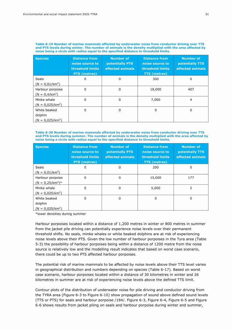
Environmental and social impact statement ESIS-TYRA
91
Table 6-19 Number of marine mammals affected by underwater noise from conductor driving over TTS and PTS levels during winter. The number of animals is the density multiplied with the area affected by noise being a circle with radius equal to the specified distance to threshold limits.
Species Distance from
noise source to
threshold limits
PTS (metres)
Number of
potentially PTS
affected animals
Distance from
noise source to
threshold limits
TTS (metres)
Number of
potentially TTS
affected animals
Seals
(N = 0,01/km2)
0 0 300 0
Harbour porpoise
(N = 0,4/km2)
0 0 18,000 407
Minke whale
(N = 0,025/km2)
0 0 7,000 4
White beaked
dolphin
(N = 0,025/km2)
0 0 0 0
Table 6-20 Number of marine mammals affected by underwater noise from conductor driving over TTS and PTS levels during summer. The number of animals is the density multiplied with the area affected by noise being a circle with radius equal to the specified distance to threshold limits.
Species Distance from
noise source to
threshold limits
PTS (metres)
Number of
potentially PTS
affected animals
Distance from
noise source to
threshold limits
TTS (metres)
Number of
potentially TTS
affected animals
Seals
(N = 0,01/km2)
0 0 200 0
Harbour porpoise
(N = 0,25/km2)*
0 0 15,000 177
Minke whale
(N = 0,025/km2)
0 0 5,000 2
White beaked
dolphin
(N = 0,025/km2)
0 0 0 0
*lower densities during summer
Harbour porpoises located within a distance of 1,200 metres in winter or 800 metres in summer
from the jacket pile driving can potentially experience noise levels over their permanent
threshold shifts. No seals, minke whales or white beaked dolphins are at risk of experiencing
noise levels above their PTS. Given the low number of harbour porpoises in the Tyra area (Table
5-3) the possibility of harbour porpoises being within a distance of 1200 metre from the noise
source is relatively low and the modelling result indicates that based on worst case scenario,
there could be up to two PTS affected harbour porpoises.
The potential risk of marine mammals to be affected by noise levels above their TTS level varies
in geographical distribution and numbers depending on species (Table 6-17). Based on worst
case scenario, harbour porpoises located within a distance of 30 kilometres in winter and 26
kilometres in summer are at risk of experiencing noise levels above the defined TTS limit.
Contour plots of the distribution of underwater noise for pile driving and conductor driving from
the TYRA area (Figure 6-3 to Figure 6-10) show propagation of sound above defined sound levels
(TTS or PTS) for seals and harbour porpoise /184/. Figure 6-3, Figure 6-4, Figure 6-5 and Figure
6-6 shows results from jacket piling on seals and harbour porpoise during winter and summer,

Environmental and social impact statement ESIS-TYRA
92
while Figure 6-7, Figure 6-8, Figure 6-9 and Figure 6-10 shows results from conductor driving on
seals and harbour porpoise during winter and summer.
Figure 6-3 Jacket pile driving unweighted cumulative SEL threshold level limit contour plots for seals including animal fleeing for the whole driving period (Tyra, winter conditions)

Environmental and social impact statement ESIS-TYRA
93
Figure 6-4 Jacket pile driving unweighted cumulative SEL threshold level limit contour plots for seals including animal fleeing for the whole driving period (Tyra, summer conditions)
Environmental and social impact statement ESIS-TYRA
94
Figure 6-5 Jacket pile driving unweighted cumulative SEL threshold level limit contour plots for harbour porpoise including animal fleeing for the whole driving period (Tyra, winter conditions)

Environmental and social impact statement ESIS-TYRA
95
Figure 6-6 Jacket pile driving unweighted cumulative SEL threshold level limit contour plots for harbour porpoise including animal fleeing for the whole driving period (Tyra, summer conditions)

Environmental and social impact statement ESIS-TYRA
96
Figure 6-7 Conductor driving unweighted cumulative SEL threshold level limit contour plots for seals including animal fleeing for the whole driving period (Tyra, winter conditions)

Environmental and social impact statement ESIS-TYRA
97
Figure 6-8 Conductor driving unweighted cumulative SEL threshold level limit contour plots for seals including animal fleeing for the whole driving period (Tyra, summer conditions)
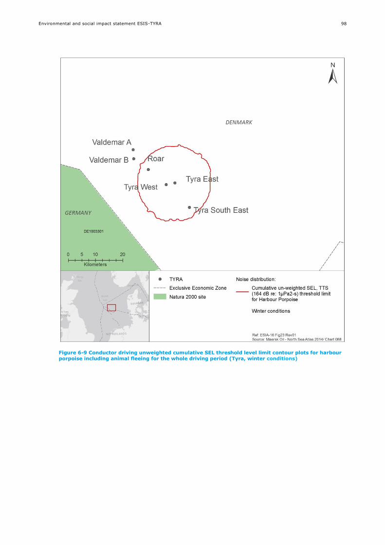
Environmental and social impact statement ESIS-TYRA
98
Figure 6-9 Conductor driving unweighted cumulative SEL threshold level limit contour plots for harbour porpoise including animal fleeing for the whole driving period (Tyra, winter conditions)

Environmental and social impact statement ESIS-TYRA
99
Figure 6-10 Conductor driving unweighted cumulative SEL threshold level limit contour plots for harbour porpoise including animal fleeing for the whole driving period (Tyra, summer conditions)
“PTS” and “TTS” distances were significantly shorter for conductor driving due to the smaller size
of the hammer being used for driving the conductor in the seabed.
Potential effects of noise levels above TTS will disappear again after a short time (minutes) or
longer (hours) depending on time of exposure /138/. The potential risk of TTS is not considered
critical for the population of harbour porpoises in the North Sea as the duration of the pile driving
is limited to a short period.
The extent of the impact for drilling and pile driving is expected to be local /140/, of moderate
intensity and with a short-term duration. Based on the modelling results in Table 6-17 to Table
6-20 the overall impact caused by noise from drilling and construction activities is assessed to be
of moderate negative significance.
Further potential mitigating measures to reduce the risk of injury to marine mammals are
presented in section 8.1.2 /184/.

Environmental and social impact statement ESIS-TYRA
100
Underwater noise from production, vessels and associated activities and
decommissioning
Noise will also be present from production and associated activities, and from vessels in the area,
with typical noise levels and frequencies presented in Table 6-11 (section 6.2.5). Vessels such as
barges and supply ships produce noise with energy content primarily below 1 kHz, as do the rigs
and platforms. The marine mammals in the area (harbour porpoise, mid-frequency cetaceans,
harbour seals and grey seals) are more sensitive to noise at higher frequencies. Some of the
most trafficked areas in Danish waters are also areas with a very high abundance of harbour
porpoise /120/.
Year-round presence of marine mammals observed at the Maersk Oil platforms show that the
animals make a trade-off between the noise levels and likely higher prey abundance /139/. In
this study noise from the operating oil field was measured with the 63 and 125 Hz frequency
band as required in the Marine Strategy Framework Directive. Preliminary results show medium
noise levels around 100 dB re 1μPa rms at a distance of 12,800 metres from the platform /139/
which is below the level of behavioural response in harbour porpoises. Any possible risk of
impacts on harbour porpoises due to this type of noise are thus expected to be short term, and
over relatively short distances.
During decommissioning there will be noise related to the removal of rigs and pipelines. Blasting
is not planned for the decommissioning, and therefore underwater noise will be connected to the
use of operation vessels and jet-cutting.
The impact is assessed to be of small intensity, local extent and short-term duration. The overall
impact on marine mammals from underwater noise from production, vessels and associated
activities is assessed to be of minor negative significance.
6.2.8.2 Suspended sediment
Suspended sediments could potentially reduce the visibility in the water and thus affect the
species, such as seals, relying on sight to prey. Relative small amounts of sediment are expected
to be suspended for the TYRA project as part of the construction of a total of six new platforms
and connecting pipelines as well as from decommissioning (see section 6.2.3.1).
The impact is assessed to be of small intensity, local extent and short-term duration. The overall
impact on marine mammals from suspended sediment due to construction and decommissioning
is assessed to be of negligible negative significance.
6.2.8.3 Discharges
As part of the planned activities a number of discharges are expected to occur (section 6.2.3.2).
The main discharges are related to the production at Tyra East and West and drilling activities at
Tyra Southeast, Svend, Roar, Valdemar B and Valdemar A, and six potential new wellhead
platforms. During decommissioning minor discharges of e.g. cooling water and grey waste water
from vessels are expected to occur. Conservative estimates suggest that there could be a risk to
some species up to a maximum of 14 km from the production discharges and up to a maximum
of 7 km from the drilling discharges (section 6.2.2.1). Any potential impacts on marine mammals
are thus confined to the local environment near the platforms, drilling rigs and vessels. The risk
of bioaccumulation will be species-specific and depend on the type of prey. Bioaccumulation is
not anticipated from the chemicals potentially being used (section 8.1.3).
The impact is assessed to be of small intensity, local extent and short-term duration. The overall
impact on marine mammals from discharges is assessed to be of minor negative significance.

Environmental and social impact statement ESIS-TYRA
101
6.2.8.4 Light
Though safety lights are present at all platforms and vessels only the manned Tyra East and
West platforms are fully illuminated and once the decommissioning is finished only Tyra East will
be illuminated. Navigational and deck working lights used to illuminate working areas, are
sources of artificial light into the environment. Light may locally attract plankton and fish (section
6.2.5 and 6.2.7), serving as prey for marine mammals.
A recent study at the Dan platform /139/ showed that harbour porpoises near the platform had
variable diurnal acoustic activity, but a general trend showed higher acoustic activity during the
night close to the platform. At further distance from the platform this pattern was not observed.
The presence of marine mammals at Maersk Oil platforms indicates that marine mammals do not
avoid light and may be following attracted prey /190/.
The impact is assessed to be of small intensity, local extent and short-term duration. The overall
impact on marine mammals from light is assessed to be of negligible negative significance.
6.2.8.5 Presence/removal of structures and vessels
Presence of structures and vessels may contribute to the animals increased tolerance to human
activities, and could potentially increase the risk of e.g. collisions. Marine mammal responses to
vessels often include changes in general activity (e.g., from resting or feeding, to active
avoidance), changes in surfacing-respiration-dive cycles, and changes in speed and direction of
movement. Behavioural reactions tend to be reduced when animals are actively involved in a
specific activity such as feeding or socialising /122/.
In addition to the existing structures at the TYRA project, six new platforms are planned, with
connecting with pipelines. Year-round presence of marine mammals observed at the Maersk Oil
platforms /139/ show that the animals are not deterred from the platforms.
The impact is assessed to be of small intensity, local extent and short-term duration. The overall
impact on marine mammals from presence of vessels is assessed to be of negligible negative
significance.
Once the structures are decommissioned, no impact to marine mammals is foreseen.
6.2.8.6 Overall assessment
The overall assessment of impacts on marine mammals from planned activities at the TYRA
project is summarised in Table 6-21.

Environmental and social impact statement ESIS-TYRA
102
Table 6-21 Potential impacts on marine mammals from planned activities at the TYRA project
Potential impact
mechanism
Intensity of
impact
Extent of
impact
Duration of
impact
Overall
significance of
impact
Level of
confidence
Underwater noise
from seismic
Small/
medium
Local or
regional
Medium-term
Long-term
Moderate
negative
Medium
Underwater noise
from drilling and
pile driving
Small Local Short-term Moderate
negative
Medium
Underwater noise
from production,
vessels, associated
activities and
decommissioning
Small Local Medium-term Minor negative Medium
Suspended sediment Small Local Short-term Negligible
negative
High
Discharges Small Local Medium-term Minor negative High
Light Small Local Short-term Negligible
negative
High
Presence/removal
of structures and
vessels
Small Local Short-term Negligible
negative
High
Regarding cumulative impact to marine mammals little geographical overlap is expected between
the activities (section 6.2.2.1 and 6.2.3), and it is expected that cumulative impacts will be
minor, see section 6.6. The current data from a long term marine mammals monitoring program
around several of Maersk Oil platforms suggest that there must be a trade-off between the
potential cumulative impact associated with the current offshore activities and the additional
foraging ground provided by the presence of the platforms /139/.
6.2.9 Seabirds
Seabirds may potentially be impacted by noise, physical disturbance of seabed, suspended
sediment, discharges and light.
6.2.9.1 Underwater noise
Noise may negatively affect the seabirds as physical damage or behavioural response.
Very little is known about underwater hearing in diving seabirds and information on effects from
underwater sound on birds are sparse, but observations from seismic vessels in the Irish Sea did
not reveal any behavioural response of seabirds to seismic survey activities /146/. Birds diving a
few metres to an air gun array, may potentially suffer damage to the auditory system. However,
birds have the ability to regenerate the sensory cells in the inner ear and a possible hearing
impairment would thus be temporary.
Due to the highly mobile nature of birds, they are generally not considered to be sensitive to
noise from surveys /147/.
The impact is assessed to be of small intensity, local extent and short-term duration. The overall
impact on seabirds from noise is assessed to be of negligible negative significance.

Environmental and social impact statement ESIS-TYRA
103
6.2.9.2 Physical disturbance of seabed
Physical disturbance of the seabed can be expected under production and decommissioning
activities. This can potentially impact some fish species that seabirds may feed on (sections
6.2.6.2 and 6.2.7.2). Any potential impacts on seabirds are thus confined to the local
environment near the platforms and pipelines.
The impact is assessed to be of small intensity, local extent and short-term duration. The overall
impact on seabirds from physical disturbance of seabed is assessed to be of negligible negative
significance.
6.2.9.3 Suspended sediment
Suspended sediments could potentially reduce the visibility in the water and thus the ability for
seabirds to locate their prey. However, only small amounts of sediment are expected to be
suspended for the TYRA project as part of the construction of six new platforms and pipelines as
well as from decommissioning (see section 6.2.3.1).
The impact is assessed to be of small intensity, local extent and short-term duration. The overall
impact on seabirds from suspended sediment due to construction and decommissioning is
assessed to be of negligible negative significance.
6.2.9.4 Discharges
Discharges have been described in section 6.2.2.1 and are assessed to have a minor negative
impact on water quality.
Seabirds may be impacted if they come into contact with the discharges. The impact can include
both direct impacts (contact) and indirect impacts (digestion of contaminated organisms), and
will depend on the oil or chemicals encountered. Any potential impacts are thus confined to the
local environment near the point of discharge. Bioaccumulation is not anticipated from the
chemical potentially being used (section 8.1.3).
The impact is assessed to be of small intensity, local extent and short-term duration. The overall
impact on seabirds from discharges is assessed to be of minor negative significance.
6.2.9.5 Light
Though safety lights are present at all platforms and vessels only the manned platform Tyra East
and West are fully illuminated and once the decommissioning is finished only Tyra East will be
illuminated. Light and illumination may attract seabirds when it is dark or under certain weather
conditions. There are observations at Maersk Oil showing that the platforms may function as a
resting place for seabirds. The potential attraction is related to individuals, and is not assessed to
have an effect on the North Sea population.
The impact is assessed to be of small intensity, local extent and short-term duration. The overall
impact on seabirds from light is assessed to be of negligible negative significance.
6.2.9.6 Overall assessment
The overall assessment of impacts on seabirds from planned activities at the TYRA project is
summarised in Table 6-22.

Environmental and social impact statement ESIS-TYRA
104
Table 6-22 Potential impacts on seabirds from planned activities at the TYRA project
Potential
impact
mechanism
Intensity of
impact
Extent of
impact
Duration of
impact
Overall
significance of
impact
Level of
confidence
Underwater
noise
Small Local Short-term Negligible
negative
High
Physical
disturbance of
seabed
Small Local Short-term Negligible
negative
Medium
Suspended
sediment
Small Local Short-term Negligible
negative
Medium
Discharges Small Local Short-term Minor negative Medium
Light Small Local Short-term Negligible
negative
High
6.3 Marine strategy frameworks directive
The list of receptors and impact mechanisms described in the ESIS (cf. section 6.1.2) can be
directly related to the descriptors set within the Marine Strategy Framework Directive (MSFD;
section 2.1.5). The MSFD outlines 11 descriptors used to assess the good environmental status of
the marine environment (Error! Reference source not found.). The environmental status of
the Danish North Sea waters is described in details in /157/.
The descriptors embrace both receptors and sources of impacts for identifying human impact on
marine ecosystems. This combination of causes and effects are described in rather general terms.
The MSFD does not include clear criteria that define “good” environmental status. The impact
assessment of the TYRA project on the descriptors in the MSFD is therefore anchored on more
specific thresholds (e.g. OSPAR convention).
The receptors identified in the ESIS are especially related to the MSFD state descriptors i.e. D1,
D4, D6 and D7 which more specifically relate to marine mammals porpoise, fish, benthic
communities and hydrography.
The impact mechanisms for planned activities in the ESIS are related to the MSFD pressure
descriptors D6, D8, D9 and D11 which more specifically relate to seabed disturbance, discharges
and underwater noise (Descriptor 11). The impact mechanisms are assessed for the relevant
receptors in sections 6.2 and 7.2.
The identified impacts of TYRA project on the physical-chemical, biological and socio-economic
environment have been generally summarised and further assessed for the overall impact in
accordance with the descriptors of the MSFD, see Error! Reference source not found.. The
overall conclusion is that the project will have no or negligible impact on the issues given by the
descriptors in the Directive.
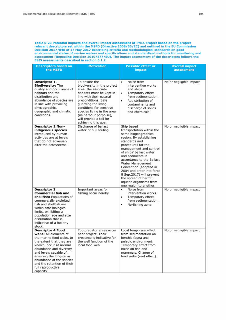
Environmental and social impact statement ESIS-TYRA
105
Table 6-23 Potential impacts and overall impact assessment of TYRA project based on the project relevant descriptors set within the MSFD (Directive 2008/56/EC) and outlined in the EU Commission Decision 2017/848 of 17 May 2017 describing criteria and methodological standards on good environmental status of marine waters and specifications and standardised methods for monitoring and assessment (Repealing Decision 2010/477/EU). The impact assessment of the descriptors follows the ESIS assessments described in section 6.1.2.
Descriptors based on the MSFD
Motivation Possible effect or impact
Overall impact assessment
Descriptor 1. Biodiversity: The quality and occurrence of habitats and the distribution and abundance of species are in line with prevailing physiographic, geographic and climatic conditions.
To ensure the biodiversity in the project area, the associate habitats must be kept in line with their natural preconditions. Safe guarding the living conditions for sensitive species living in the area (as harbour porpoise), will provide a toll for achieving this goal.
Noise from intervention works and ships.
Temporary effect from sedimentation.
Redistribution of
contaminants and discharge of solids and chemicals
No or negligible impact
Descriptor 2 Non-indigenous species introduced by human activities are at levels that do not adversely alter the ecosystems.
Discharge of ballast water or hull fouling
Ship based transportation within the same biogeographical region. By establishing standards and procedures for the management and control of ships' ballast water and sediments in accordance to the Ballast Water Management Convention (adopted in 2004 and enter into force 8 Sep.2017) will prevent the spread of harmful aquatic organisms from one region to another,
No or negligible impact
Descriptor 3 Commercial fish and shellfish: Populations of commercially exploited fish and shellfish are within safe biological limits, exhibiting a population age and size distribution that is indicative of a healthy stock.
Important areas for fishing occur nearby
Noise from intervention works.
Temporary effect from sedimentation.
No-fishing zone.
No or negligible impact
Descriptor 4 Food webs: All elements of
the marine food webs, to the extent that they are known, occur at normal abundance and diversity and levels capable of ensuring the long-term abundance of the species and the retention of their full reproductive capacity.
Top predator areas occur near project. Their
presence is indicative for the well function of the local food web
Local temporary effect from sedimentation on
benthic fauna and pelagic environment. Temporary effect from noise on fish and mammals. Change of food webs (reef effect).
No or negligible impact
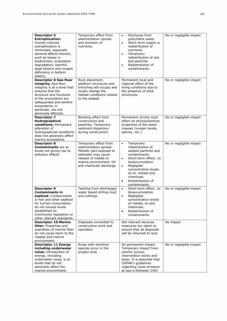
Environmental and social impact statement ESIS-TYRA
106
Descriptor 5 Eutrophication: Human-induced eutrophication is minimised, especially adverse effects thereof, such as losses in biodiversity, ecosystem degradation, harmful algal blooms and oxygen deficiency in bottom waters.
Temporary effect from sedimentation spread and emission of nutrients.
Discharge from grey/black water.
Short term supply or redistribution of nutrients.
Temporary redistribution of sea bed particles.
Redistribution of contaminants.
No or negligible impact
Descriptor 6 Sea-floor integrity: Sea-floor integrity is at a level that ensures that the structure and functions of the ecosystems are safeguarded and benthic ecosystems, in particular, are not adversely affected.
Rock placement, platform structures and trenching will occupy and locally change the habitat conditions related to the seabed
Permanent local and regional effect of the living conditions due to the presence of solid structures.
No or negligible impact
Descriptor 7 Hydrographical conditions: Permanent alteration of hydrographical conditions does not adversely affect marine ecosystems.
Blocking effect from construction and pipelines. Temporary sediment dispersion during construction.
Permanent strictly local effect on physiochemical properties of the water masses (oxygen levels, salinity, etc.)
No or negligible impact
Descriptor 8 Contaminants are at levels not giving rise to pollution effects.
Temporary effect from sedimentation spread. Metallic part exposed to saltwater may cause release of metals to
marine environment. Oil and chemicals discharge
Temporary redistribution of seabed particles and contaminants.
Short-term effect, no
bioaccumulation. Negligible
concentration levels of oil, metals and chemicals.
Redistribution of contaminants.
No or negligible impact
Descriptor 9 Contaminants in seafood: Contaminants in fish and other seafood for human consumption do not exceed levels established by Community legislation or other relevant standards.
Tainting from discharged water based drilling mud and cuttings.
Short term effect, no bioaccumulation.
Negligible concentration levels of metals, oil and chemicals.
Redistribution of
contaminants.
No or negligible impact
Descriptor 10 Marine litter: Properties and quantities of marine litter do not cause harm to the coastal and marine environment.
Disposals connected to construction work and operation
Not relevant because measures are taken to ensure that all disposals will be returned to land
No impact
Descriptor 11 Energy including underwater noise: Introduction of energy, including underwater noise, is at levels that do not adversely affect the marine environment.
Areas with sensitive species occur in the project area
No permanent impact. Temporary impact from seismic survey, intervention works and ships. It is assumed that OSPAR’s guidelines regarding noise emission at sea is followed /194/
No or negligible impact
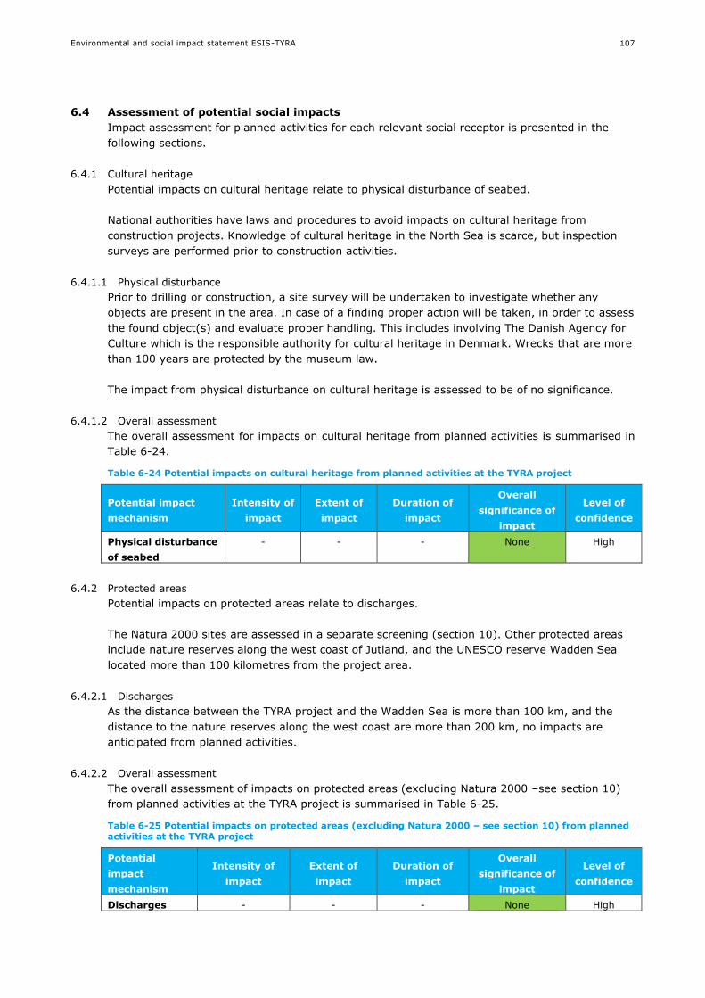
Environmental and social impact statement ESIS-TYRA
107
6.4 Assessment of potential social impacts
Impact assessment for planned activities for each relevant social receptor is presented in the
following sections.
6.4.1 Cultural heritage
Potential impacts on cultural heritage relate to physical disturbance of seabed.
National authorities have laws and procedures to avoid impacts on cultural heritage from
construction projects. Knowledge of cultural heritage in the North Sea is scarce, but inspection
surveys are performed prior to construction activities.
6.4.1.1 Physical disturbance
Prior to drilling or construction, a site survey will be undertaken to investigate whether any
objects are present in the area. In case of a finding proper action will be taken, in order to assess
the found object(s) and evaluate proper handling. This includes involving The Danish Agency for
Culture which is the responsible authority for cultural heritage in Denmark. Wrecks that are more
than 100 years are protected by the museum law.
The impact from physical disturbance on cultural heritage is assessed to be of no significance.
6.4.1.2 Overall assessment
The overall assessment for impacts on cultural heritage from planned activities is summarised in
Table 6-24.
Table 6-24 Potential impacts on cultural heritage from planned activities at the TYRA project
Potential impact
mechanism
Intensity of
impact
Extent of
impact
Duration of
impact
Overall
significance of
impact
Level of
confidence
Physical disturbance
of seabed
- - - None High
6.4.2 Protected areas
Potential impacts on protected areas relate to discharges.
The Natura 2000 sites are assessed in a separate screening (section 10). Other protected areas
include nature reserves along the west coast of Jutland, and the UNESCO reserve Wadden Sea
located more than 100 kilometres from the project area.
6.4.2.1 Discharges
As the distance between the TYRA project and the Wadden Sea is more than 100 km, and the
distance to the nature reserves along the west coast are more than 200 km, no impacts are
anticipated from planned activities.
6.4.2.2 Overall assessment
The overall assessment of impacts on protected areas (excluding Natura 2000 –see section 10)
from planned activities at the TYRA project is summarised in Table 6-25.
Table 6-25 Potential impacts on protected areas (excluding Natura 2000 – see section 10) from planned activities at the TYRA project
Potential
impact
mechanism
Intensity of
impact
Extent of
impact
Duration of
impact
Overall
significance of
impact
Level of
confidence
Discharges - - - None High
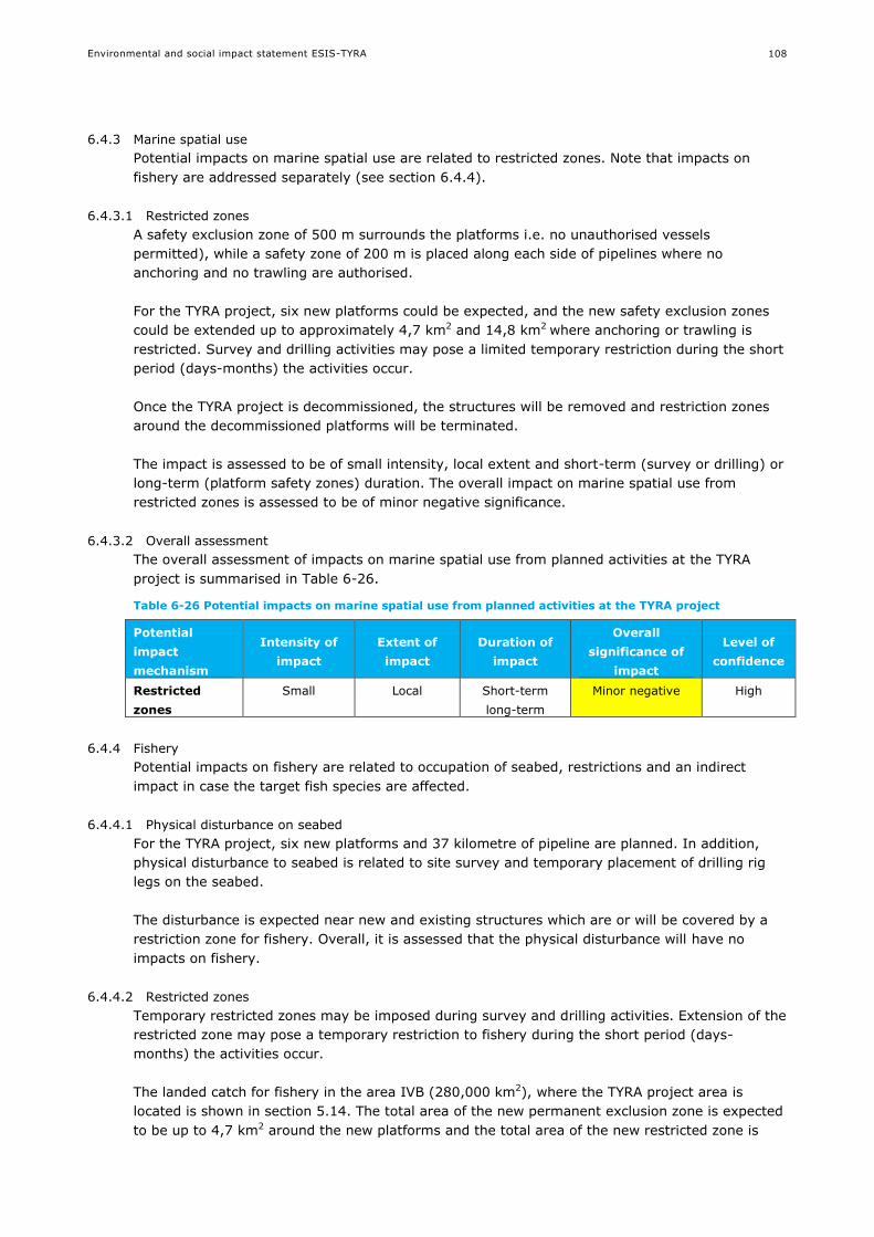
Environmental and social impact statement ESIS-TYRA
108
6.4.3 Marine spatial use
Potential impacts on marine spatial use are related to restricted zones. Note that impacts on
fishery are addressed separately (see section 6.4.4).
6.4.3.1 Restricted zones
A safety exclusion zone of 500 m surrounds the platforms i.e. no unauthorised vessels
permitted), while a safety zone of 200 m is placed along each side of pipelines where no
anchoring and no trawling are authorised.
For the TYRA project, six new platforms could be expected, and the new safety exclusion zones
could be extended up to approximately 4,7 km2 and 14,8 km2 where anchoring or trawling is
restricted. Survey and drilling activities may pose a limited temporary restriction during the short
period (days-months) the activities occur.
Once the TYRA project is decommissioned, the structures will be removed and restriction zones
around the decommissioned platforms will be terminated.
The impact is assessed to be of small intensity, local extent and short-term (survey or drilling) or
long-term (platform safety zones) duration. The overall impact on marine spatial use from
restricted zones is assessed to be of minor negative significance.
6.4.3.2 Overall assessment
The overall assessment of impacts on marine spatial use from planned activities at the TYRA
project is summarised in Table 6-26.
Table 6-26 Potential impacts on marine spatial use from planned activities at the TYRA project
Potential
impact
mechanism
Intensity of
impact
Extent of
impact
Duration of
impact
Overall
significance of
impact
Level of
confidence
Restricted
zones
Small Local Short-term
long-term
Minor negative High
6.4.4 Fishery
Potential impacts on fishery are related to occupation of seabed, restrictions and an indirect
impact in case the target fish species are affected.
6.4.4.1 Physical disturbance on seabed
For the TYRA project, six new platforms and 37 kilometre of pipeline are planned. In addition,
physical disturbance to seabed is related to site survey and temporary placement of drilling rig
legs on the seabed.
The disturbance is expected near new and existing structures which are or will be covered by a
restriction zone for fishery. Overall, it is assessed that the physical disturbance will have no
impacts on fishery.
6.4.4.2 Restricted zones
Temporary restricted zones may be imposed during survey and drilling activities. Extension of the
restricted zone may pose a temporary restriction to fishery during the short period (days-
months) the activities occur.
The landed catch for fishery in the area IVB (280,000 km2), where the TYRA project area is
located is shown in section 5.14. The total area of the new permanent exclusion zone is expected
to be up to 4,7 km2 around the new platforms and the total area of the new restricted zone is

Environmental and social impact statement ESIS-TYRA
109
expected to be approximately 14,8 km2 for new pipelines (6.4.3) and these areas are small
compared to the total fishing area (<0,0017% and <0.01%, respectively)
The impact is assessed to be of small intensity, local extent and short-term (survey or drilling) or
long-term (platform safety zones) duration. The overall impact on fishery from restricted zones is
assessed to be of minor negative significance.
6.4.4.3 Changes to target fish
Potential impacts on fishery could e.g. include seismic surveys resulting in target fish temporarily
moving away from the sound source, potentially causing a localized reduction in fish catch in
close proximity to the seismic source. Impacts on fish have been assessed in section 6.2.7 to be
negligible - minor negative. The impact is thus considered of small intensity, local extent and
short-long term duration. The overall impact on fishery from changes to target species is
assessed to be of negligible negative significance.
6.4.4.4 Overall assessment
The overall assessment of impacts on fishery from planned activities at the TYRA project is
summarised in Table 6-27.
Table 6-27 Potential impacts on fishery from planned activities at the TYRA project
Potential
impact
mechanism
Intensity of
impact
Extent of
impact
Duration of
impact
Overall
significance of
impact
Level of
confidence
Physical
disturbance on
seabed
None - - None High
Restricted
zones
Small Local Short-long term Minor negative High
Changes to
target species
None - - Negligible
negative
High
6.4.5 Tourism
Potential impacts on tourism relate to restriction zones at the TYRA project.
6.4.5.1 Restricted zones
The planned activities at the TYRA project take place offshore, at a distance of 200 kilometres
from shore. Tourism is related to the nearshore (and onshore) areas and no impacts of restricted
zones on tourism are expected.
6.4.5.2 Overall assessment
The overall assessment of impacts on tourism from planned activities at the TYRA project is
summarised in Table 6-28.
Table 6-28 Potential impacts on tourism from planned activities at the TYRA project
Potential
impact
mechanism
Intensity of
impact
Extent of
impact
Duration of
impact
Overall
significance of
impact
Level of
confidence
Restricted
zones
None - - None High
6.4.6 Employment and tax revenue
Potential impacts on employment and tax revenue relate to employment at the TYRA project.

Environmental and social impact statement ESIS-TYRA
110
6.4.6.1 Employment
The future developments of Maersk oils activities in the TYRA project includes seismic surveys,
maintenance of pipelines and structures, drilling of up to 56 new wells, establishment of up to six
new platforms, as well as production at the existing facilities at the TYRA project. All these
activities will contribute positively to the employment.
The offshore oil and gas production is important to Danish economy. The state’s revenue from oil
and gas production is estimated to DKK 20 billion per year. About 4,500 people are directly or
indirectly employed with and on the Tyra facilities and jobs dependent on Tyra, cf. section 3.6
and5.16).
The impact is assessed to be of medium intensity, from local to national extent and medium-term
duration. The overall impact on employment from activities at the TYRA project is assessed to be
of positive significance.
6.4.6.2 Tax revenue
The tax revenue from the TYRA project has not been quantified, but the tax revenue to the state
of Denmark from oil and gas activities is significant. The state’s total revenue is estimated to DKK
20 billion per year (section3.6).
The impact is assessed to be of medium intensity, from local to national extent and medium-term
duration. The overall impact on tax revenue from activities at the TYRA project is assessed to be
of positive significance.
6.4.6.3 Overall assessment
The overall assessment of impacts on employment and tax revenue from planned activities at the
TYRA project is summarised in Table 6-29.
Table 6-29 Potential impacts on employment from planned activities at the TYRA project
Impact
mechanism
Intensity Extent Duration Overall
significance
Level of
confidence
Employment Medium Local/national Medium term Positive Medium
Tax revenue Medium Local/national Medium term Positive Medium
6.4.7 Oil and gas dependency
6.4.7.1 Dependency
As part of a long-term Danish energy strategy, the oil and gas production is considered
instrumental in maintaining high security of supply. Denmark is expected to continue being a net
exporter of natural gas up to and including 2025 and Maersk Oil has a license to operate until
2042 (section 3 and 5).
If no production is undertaken by Maersk Oil for the TYRA project in the North Sea, there will be
no contribution to the Danish economy or security of supply from the TYRA project.
The impact is assessed to be of medium intensity, local or national extent and medium-term
duration. The overall impact on dependency from activities at the TYRA project is assessed to be
of positive significance.
6.4.7.2 Overall assessment
The overall assessment of impacts on oil and gas dependency from planned activities at the TYRA
project is summarised in Table 6-30.

Environmental and social impact statement ESIS-TYRA
111
Table 6-30 Potential impacts on oil and gas dependency from planned activities at the TYRA project
Impact
mechanism
Intensity Extent Duration Overall
significance
Level of
confidence
Oil and gas
dependency
Medium Local/national Medium term Positive Medium
6.5 Summary
The potential impacts on environmental and social receptors from planned activities at the TYRA
project are summarised in Table 6-31. The impact with the largest overall significance is provided
for each receptor.
Table 6-31 Summary of potential impacts on environmental and social receptors from planned activities at the TYRA project. The impact with the largest overall significance is provided for each receptor
Receptor Worst case potential impact
Climate and air quality Moderate negative
Hydrography Minor negative
Water quality Minor negative
Sediment type and quality Minor negative
Plankton Minor negative
Benthic communities Minor negative
Fish Minor negative
Marine mammals Moderate negative
Seabirds Minor negative
Cultural heritage None
Protected areas* None
Marine spatial use Minor negative
Fishery Minor negative
Tourism None
Employment and tax revenue Positive
Oil and gas dependency Positive
* A separate assessment for Natura 2000 is presented in section 10.
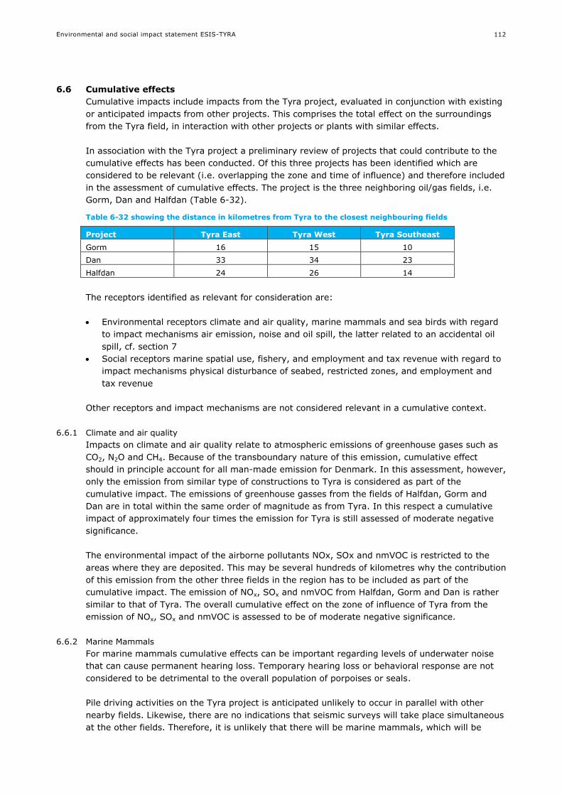
Environmental and social impact statement ESIS-TYRA
112
6.6 Cumulative effects
Cumulative impacts include impacts from the Tyra project, evaluated in conjunction with existing
or anticipated impacts from other projects. This comprises the total effect on the surroundings
from the Tyra field, in interaction with other projects or plants with similar effects.
In association with the Tyra project a preliminary review of projects that could contribute to the
cumulative effects has been conducted. Of this three projects has been identified which are
considered to be relevant (i.e. overlapping the zone and time of influence) and therefore included
in the assessment of cumulative effects. The project is the three neighboring oil/gas fields, i.e.
Gorm, Dan and Halfdan (Table 6-32).
Table 6-32 showing the distance in kilometres from Tyra to the closest neighbouring fields
Project Tyra East Tyra West Tyra Southeast
Gorm 16 15 10
Dan 33 34 23
Halfdan 24 26 14
The receptors identified as relevant for consideration are:
Environmental receptors climate and air quality, marine mammals and sea birds with regard
to impact mechanisms air emission, noise and oil spill, the latter related to an accidental oil
spill, cf. section 7
Social receptors marine spatial use, fishery, and employment and tax revenue with regard to
impact mechanisms physical disturbance of seabed, restricted zones, and employment and
tax revenue
Other receptors and impact mechanisms are not considered relevant in a cumulative context.
6.6.1 Climate and air quality
Impacts on climate and air quality relate to atmospheric emissions of greenhouse gases such as
CO2, N2O and CH4. Because of the transboundary nature of this emission, cumulative effect
should in principle account for all man-made emission for Denmark. In this assessment, however,
only the emission from similar type of constructions to Tyra is considered as part of the
cumulative impact. The emissions of greenhouse gasses from the fields of Halfdan, Gorm and
Dan are in total within the same order of magnitude as from Tyra. In this respect a cumulative
impact of approximately four times the emission for Tyra is still assessed of moderate negative
significance.
The environmental impact of the airborne pollutants NOx, SOx and nmVOC is restricted to the
areas where they are deposited. This may be several hundreds of kilometres why the contribution
of this emission from the other three fields in the region has to be included as part of the
cumulative impact. The emission of NOx, SOx and nmVOC from Halfdan, Gorm and Dan is rather
similar to that of Tyra. The overall cumulative effect on the zone of influence of Tyra from the
emission of NOx, SOx and nmVOC is assessed to be of moderate negative significance.
6.6.2 Marine Mammals
For marine mammals cumulative effects can be important regarding levels of underwater noise
that can cause permanent hearing loss. Temporary hearing loss or behavioral response are not
considered to be detrimental to the overall population of porpoises or seals.
Pile driving activities on the Tyra project is anticipated unlikely to occur in parallel with other
nearby fields. Likewise, there are no indications that seismic surveys will take place simultaneous
at the other fields. Therefore, it is unlikely that there will be marine mammals, which will be
Environmental and social impact statement ESIS-TYRA
113
potentially exposed to cumulative effects of critical noise levels, which may result in permanent
hearing loss.
6.6.3 Birds
Cumulative impacts on birds will occur in case of simultaneous accidents involving oil spills. This
could affect sea living birds living in open sea as auks, murres and gulls which will be at risk of
getting infected feathers and thus lose their plumage protective effect. Affected birds will likely
include species of international importance. Overall it is estimated that the cumulative effect of
several oil spill incidents at the same time together on these species will be comparable to the
effects of an oil spill from Tyra, alone. However it is very unlikely that several oil spills will occur
at the same time.
6.6.4 Marine spatial use
Marine spatial use is affected by the area occupied by the facilities and the safety zones
established around the facilities. This may potentially affect traffic and other spatial use, and the
effect will be increasing with increasing congestion of the marine territory. Given the limited use
as shipping routes of the project area, and the relatively large distance to other facilities or
activities and the impact of the facilities being assessed as small and local, a cumulative effect on
the marine spatial use is unlikely.
6.6.5 Fishery
Fishery is potentially affected by physical disturbance of seabed, restricted zones and indirectly if
target fish species are affected. The disturbance of seabed and restricted zones are directly
related insofar the disturbance will be within the restricted zones. The area affected by
restrictions for Tyra is relatively small compared to the total fishing area, cf. 6.4.4, and the
impact from Tyra is assessed as small and local. The total area of new exclusion zones from Tyra
together with the neighboring oil/gas field projects considered to potentially contribute
cumulative effects is around 24 km2, which is small (0.01%) compared to the total fishing area in
the Central North Sea fishing area, and the impact is assessed to be of minor significance.
Potential changes to target species is identified as a possible consequence of activities creating
underwater sound, resulting in local reduction of fish that has temporarily moved away from the
underwater sound. The possible impact form Tyra is assessed to be of negligible significance,
likewise for the other projects considered, and the overall cumulative effect is assessed to be
negligible.
6.6.6 Employment and tax revenue
Employment and tax revenue related to the TYRA project are both assessed of positive impact,
and the combined effect of Tyra and the other projects considered is of positive impact.

Environmental and social impact statement ESIS-TYRA
114
7. IMPACT ASSESSMENT: ACCIDENTAL EVENTS
7.1 Impact mechanisms and relevant receptors
7.1.1 Potential impact mechanisms
Potential impact mechanisms associated to the accidental events at the TYRA project are
screened based on the project description (section 3) and the technical sections (appendix 1).
Potential impact mechanisms include:
Minor accidental events (gas release, spill of chemical, diesel or oil)
Major accidental events (oil spill or gas release)
The source of the potential impact mechanisms is provided in Table 7-1.
Table 7-1 Sources of potential impact mechanisms for the TYRA project. “X” marks relevance, while “0“ marks no relevance
Potential impact mechanism
Seis
mic
Pip
eli
nes a
nd
str
uctu
res
Pro
du
cti
on
Dril
lin
g
Well
sti
mu
lati
on
Tran
sp
ort
Decom
mis
sio
nin
g
Minor accidental events
(gas, chemical, diesel or oil)
X X X X X X X
Major accidental events
(oil or gas)
0 0 X X X 0 0
7.1.2 Relevant receptors (environmental and social)
The environmental and social receptors described in the baseline are listed below.
Environmental receptors: Climate and air quality, hydrographic conditions, water quality,
sediment type and quality, plankton, benthic communities (flora and fauna), fish, marine
mammals, seabirds.
Social receptors: Cultural heritage, protected areas, marine spatial use, fishery, tourism,
employment, tax revenue, oil and gas dependency.
The relevant receptors have been assessed based on the project description (section 3) and the
potential impact mechanisms (section 7.1). Relevant receptors are summarized in Table 7-2.

Environmental and social impact statement ESIS-TYRA
115
Table 7-2 Relevant receptors for the impact assessment of accidental events for the TYRA project. “X” marks relevance, while “0“ marks no relevance
Potential
impact
mechanism
–
accidental
events
Environmental Receptors Social Receptors
Clim
ate
an
d a
ir q
uality
Hyd
rog
rap
hic
con
dit
ion
s
Wate
r q
uality
Sed
imen
t ty
pe a
nd
qu
ality
Pla
nkto
n
Ben
thic
co
mm
un
itie
s
Fis
h
Marin
e m
am
mals
Seab
ird
s
Cu
ltu
ral h
erit
ag
e
Pro
tecte
d a
reas*
*
Marin
e s
pati
al
use
Fis
hery
To
uris
m
Em
plo
ym
en
t
Tax r
even
ue
Oan
dG
dep
en
den
cy
Gas
release
X 0 0 0 0 0 0 0 0 0 0 0 0 0 0 0 0
Chemical
spill*
0 0 0 0 0 0 0 0 0 0 0 0 0 0 0 0 0
Oil spill 0 0 X X X X X X X X X X X X 0 0 0
*a worst case chemical spill is very local, and not assessed further (sections 7.1.4.1).
** a separate assessment for Natura 2000 is presented in section 10.
7.1.3 Marine strategy frameworks directive - descriptors
The list of receptors and impact mechanisms described in the ESIS can be generally related to
the descriptors set within the Marine Strategy Framework Directive (MSFD; section 2.1.5). The
MSFD outlines 11 descriptors used to assess the good environmental status of the marine
environment (see presentation of descriptors in section 6.3).
The receptors identified in the ESIS are related to the MSFD state descriptors i.e. D1, D4, D6 and
D7 and the impact mechanisms are related to the MSFD pressure descriptors D6, D8, D9 and
D11, cf. section 6.1.
7.1.4 Minor accidental events
A minor accidental event is a spill where the spilled volume is finite.
Minor spill could be chemical or diesel, and could occur following e.g. vessel collision, pipeline
leakage or rupture of a chemical container. Statistical analysis shows that collisions between
vessels, platforms, riser etc. are very unlikely, typically in the range of 1.4 10-7 to 6.5 10-4 per
year (Appendix 1).
Minor gas release of several m3 may also occur during venting.
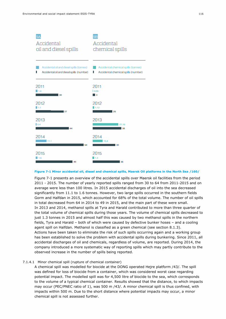
Environmental and social impact statement ESIS-TYRA
116
Figure 7-1 Minor accidental oil, diesel and chemical spills, Maersk Oil platforms in the North Sea /160/
Figure 7-1 presents an overview of the accidental spills over Maersk oil facilities from the period
2011 - 2015. The number of yearly reported spills ranged from 30 to 64 from 2011-2015 and on
average were less than 100 litres. In 2015 accidental discharges of oil into the sea decreased
significantly from 11.1 to 1.6 tonnes. However, two large spills occurred in the southern fields
Gorm and Halfdan in 2015, which accounted for 68% of the total volume. The number of oil spills
in total decreased from 64 in 2014 to 49 in 2015, and the main part of these were small.
In 2013 and 2014, methanol spills at Tyra and Harald contributed to more than three quarter of
the total volume of chemical spills during those years. The volume of chemical spills decreased to
just 1.3 tonnes in 2015 and almost half this was caused by two methanol spills in the northern
fields, Tyra and Harald – both of which were caused by defective bunker hoses – and a cooling
agent spill on Halfdan. Methanol is classified as a green chemical (see section 8.1.3).
Actions have been taken to eliminate the risk of such spills occurring again and a working group
has been established to solve the problem with accidental spills during bunkering. Since 2011, all
accidental discharges of oil and chemicals, regardless of volume, are reported. During 2014, the
company introduced a more systematic way of reporting spills which may partly contribute to the
observed increase in the number of spills being reported.
7.1.4.1 Minor chemical spill (rupture of chemical container)
A chemical spill was modelled for biocide at the DONG operated Hejre platform /43/. The spill
was defined for loss of biocide from a container, which was considered worst case regarding
potential impact. The modelled spill was for 4,500 litre of biocide to the sea, which corresponds
to the volume of a typical chemical container. Results showed that the distance, to which impacts
may occur (PEC/PNEC ratio of 1), was 500 m /43/. A minor chemical spill is thus confined, with
impacts within 500 m. Due to the short distance where potential impacts may occur, a minor
chemical spill is not assessed further.

Environmental and social impact statement ESIS-TYRA
117
7.1.4.2 Minor oil spill (vessel collision)
A diesel spill following a vessel collision has been modelled for a spill of marine diesel volume
corresponding to a typical tank size of 1,000 m3 during 1 hour, corresponding to the volume of
the vessels tank /5//25/. The modelling results show that no shoreline impact would occur, and
impacts are only expected in the local area. The results further show that most of the oil would
evaporate or emulsify into the water column after 7 days, and by day 20 all of the released oil is
no longer mobile; it has evaporated or biodegraded /5//25/.
7.1.4.3 Minor oil spill (full pipeline rupture)
A full rupture of a pipeline at the TYRA project in a worst case scenario is a rupture of pipeline
from Tyra East to Gorm E. Emergency valves will automatically close to isolate the pipeline, and
the expected maximum volume from a ruptures pipeline is a spill of 10,000 stbo crude oil.
A full bore pipeline rupture has been modelled for a spill of 10,000 stbo over 1 hour at the TYE to
Gorm midpoint /151/. The results show that the oil will spread locally (Figure 7-2) , and that it is
unlikely that the oil will cross a maritime border. The results show no risk of any shoreline being
impacted by oil.
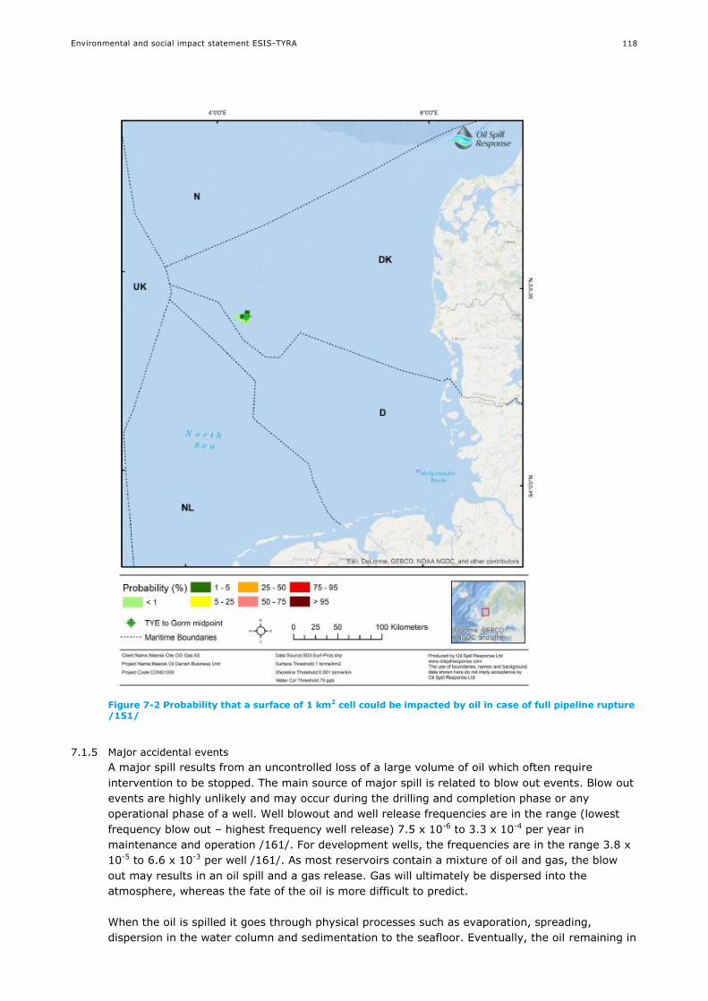
Environmental and social impact statement ESIS-TYRA
118
Figure 7-2 Probability that a surface of 1 km2 cell could be impacted by oil in case of full pipeline rupture /151/
7.1.5 Major accidental events
A major spill results from an uncontrolled loss of a large volume of oil which often require
intervention to be stopped. The main source of major spill is related to blow out events. Blow out
events are highly unlikely and may occur during the drilling and completion phase or any
operational phase of a well. Well blowout and well release frequencies are in the range (lowest
frequency blow out – highest frequency well release) 7.5 x 10⁻⁶ to 3.3 x 10⁻⁴ per year in
maintenance and operation /161/. For development wells, the frequencies are in the range 3.8 x
10-5 to 6.6 x 10⁻³ per well /161/. As most reservoirs contain a mixture of oil and gas, the blow
out may results in an oil spill and a gas release. Gas will ultimately be dispersed into the
atmosphere, whereas the fate of the oil is more difficult to predict.
When the oil is spilled it goes through physical processes such as evaporation, spreading,
dispersion in the water column and sedimentation to the seafloor. Eventually, the oil remaining in

Environmental and social impact statement ESIS-TYRA
119
the sea will be eliminated from the marine environment through biodegradation. The rate and
importance of these processes will depend on the type and quantity of the oil as well as the
prevailing weather and hydrodynamic conditions. Models are used to predict the fate of oil spills
and assess the potential impact on relevant environmental and social receptors.
Oils are classified following the ITOPF classification to allow a prediction of their likely behaviour
/153/. Group 1 oils (API>45) tend to dissipate completely through evaporation, whereas group 2
(API: 35-45) and group 3 (API: 17.5-35) can lose up to 40% volume through evaporation but
tend to form emulsion. Group 4 oils (API< 17.5) are highly viscous and do not tend to evaporate
and disperse. Group 4 is the most persistent oil type. For the TYRA project, the oil is diverse, with
relatively light oil with an API of 60 at Tyra East and Roar, 52 at Tyra West, 47 at Tyra South
East (Group 1), intermediate API of 42 at Valdemar (Group 2) and 29 at Svend (Group 3).
The maximum expected initial blow out flow rates from existing producing wells at the TYRA
project are 8,330 stbo/d (1,300 m3/d) for Tyra South East, 2,400 (380 m3/d) for Tyra West,
32,340 stbo/d (5,100 m3/d) for Roar, 4,200 stbo/d (660 m3/d) for Svend and 5,415 stbo/d(850
m3/d) for Tyra East /161/.
The oil spill model was done using the Oil Spill Contingency and Response (OSCAR) model. OSCAR is a 3D modelling tool developed by SINTEF, able to predict the movement and fate of oil
both on the surface and throughout the water column /5//25//26//27/. The model simulated
more than 150 trajectories under a wide range of weather and hydrodynamic conditions
representative of the TYRA area. The outputs of the model are statistical maps based on the
simulations that define the areas most at risk to be impacted by an oil spill. Modelling is
performed on the non-ignited spill without any oil spill response (e.g. mechanical recovery;
section 0 and 0).
Three models were used to investigate the possible fate of an ITOPF Group1 (Xana-1X), ITOPF
Group 2 (Siah NE-1X) and ITOPF group 3 (Svend) oil spill occurring at one of the wells for the
TYRA existing or new development project. An oil spill from the TYRA project will be ITOPF Group
2. The modelled exploration scenarios correspond to a continuous release for 16 days with a flow
rate of 8,534 stbo/d for ITOPF Group 3 oil (Xana-1X) and 40,432 stbo/d for ITOPF Group 2 oil
(Siah NE-1X) respectively, and 4,200 stbo/d for ITOPF Group 1 (Svend). The duration of the
modelled blowouts is based on the fact that most exploration wells such as Xana-1X and Siah NE-
1X would collapse within a duration of 16 days /155/. The casing of a production well is designed
to prevent the collapse of the well and a relief well may be necessary to stop the blow out. Such
intervention may require about 90 days. Nevertheless, the total volume of the oil spill modelled
for Siah NE-1X and Xana-1X (high flow rate and short duration) are higher or equivalent to the
maximum volume that could be expected from a producing well over a longer time. Furthermore,
it is expected that a high release rate over a short period would be a worse case than a lower
rate (for a production scenario) over a longer period. Thus, the results for Siah NE-1X and Xana-
1X can be used as representative of a worst credible well blow-out case at the TYRA project.

Environmental and social impact statement ESIS-TYRA
120
Figure 7-3 Location of four Maersk Oil wells, for which oil spill modelling has been undertaken. Siah NE-1X, Xana-1X and Svend are considered representative for the TYRA project
The oil spill modelling was used to determine how quickly the oil would reach shoreline and which
countries could be affected. It is also used to determine the different oil spill fate and the
relevant receptors at the TYRA project. The results are also used to assist in the development of
an adapted oil spill response plan (section 9.5).
The trajectory resulting in the most oil onshore is extracted to illustrate the potential fate of an
oil spill at the TYRA project in more details /151/. The model results are summarised in Table
7-3.
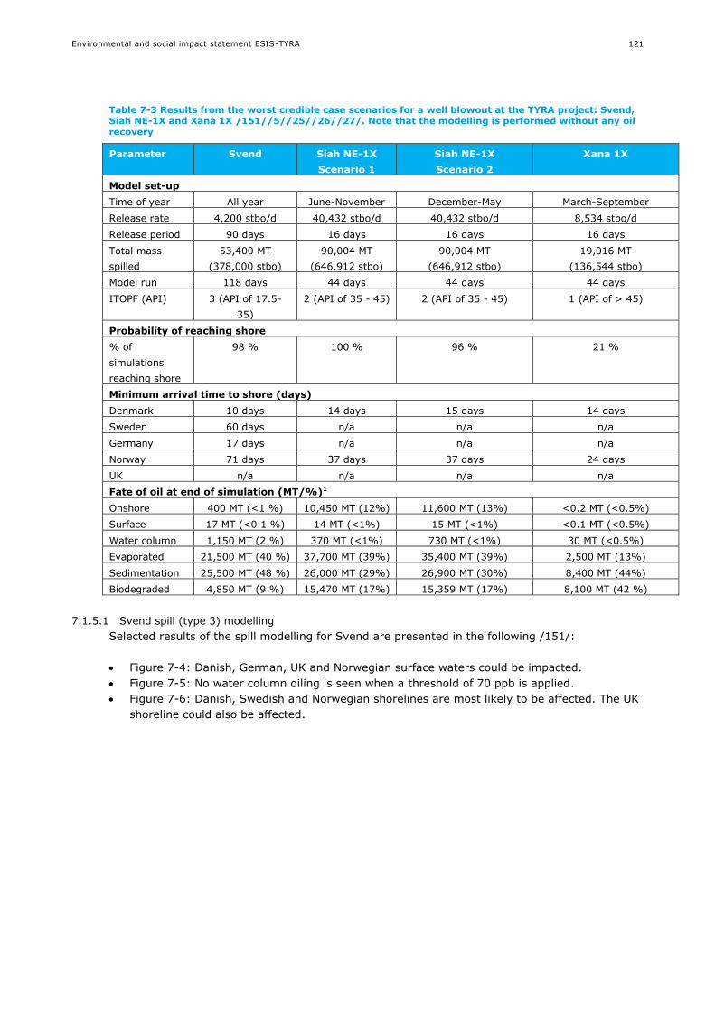
Environmental and social impact statement ESIS-TYRA
121
Table 7-3 Results from the worst credible case scenarios for a well blowout at the TYRA project: Svend, Siah NE-1X and Xana 1X /151//5//25//26//27/. Note that the modelling is performed without any oil recovery
Parameter Svend Siah NE-1X
Scenario 1
Siah NE-1X
Scenario 2
Xana 1X
Model set-up
Time of year All year June-November December-May March-September
Release rate 4,200 stbo/d 40,432 stbo/d 40,432 stbo/d 8,534 stbo/d
Release period 90 days 16 days 16 days 16 days
Total mass
spilled
53,400 MT
(378,000 stbo)
90,004 MT
(646,912 stbo)
90,004 MT
(646,912 stbo)
19,016 MT
(136,544 stbo)
Model run 118 days 44 days 44 days 44 days
ITOPF (API) 3 (API of 17.5-
35)
2 (API of 35 - 45) 2 (API of 35 - 45) 1 (API of > 45)
Probability of reaching shore
% of
simulations
reaching shore
98 % 100 % 96 % 21 %
Minimum arrival time to shore (days)
Denmark 10 days 14 days 15 days 14 days
Sweden 60 days n/a n/a n/a
Germany 17 days n/a n/a n/a
Norway 71 days 37 days 37 days 24 days
UK n/a n/a n/a n/a
Fate of oil at end of simulation (MT/%)1
Onshore 400 MT (<1 %) 10,450 MT (12%) 11,600 MT (13%) <0.2 MT (<0.5%)
Surface 17 MT (<0.1 %) 14 MT (<1%) 15 MT (<1%) <0.1 MT (<0.5%)
Water column 1,150 MT (2 %) 370 MT (<1%) 730 MT (<1%) 30 MT (<0.5%)
Evaporated 21,500 MT (40 %) 37,700 MT (39%) 35,400 MT (39%) 2,500 MT (13%)
Sedimentation 25,500 MT (48 %) 26,000 MT (29%) 26,900 MT (30%) 8,400 MT (44%)
Biodegraded 4,850 MT (9 %) 15,470 MT (17%) 15,359 MT (17%) 8,100 MT (42 %)
7.1.5.1 Svend spill (type 3) modelling
Selected results of the spill modelling for Svend are presented in the following /151/:
Figure 7-4: Danish, German, UK and Norwegian surface waters could be impacted.
Figure 7-5: No water column oiling is seen when a threshold of 70 ppb is applied.
Figure 7-6: Danish, Swedish and Norwegian shorelines are most likely to be affected. The UK
shoreline could also be affected.
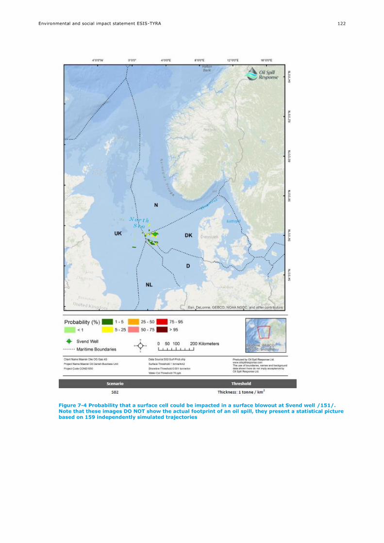
Environmental and social impact statement ESIS-TYRA
122
Figure 7-4 Probability that a surface cell could be impacted in a surface blowout at Svend well /151/. Note that these images DO NOT show the actual footprint of an oil spill, they present a statistical picture based on 159 independently simulated trajectories

Environmental and social impact statement ESIS-TYRA
123
Figure 7-5 Probability that a water column cell could be impacted in a surface blowout at Svend well /151/
Note that these images DO NOT show the actual footprint of an oil spill, they present a statistical picture based on 159 independently simulated trajectories

Environmental and social impact statement ESIS-TYRA
124
Figure 7-6 Probability that a shoreline cell could be impacted in a surface blowout at Svend well /151/
Note that these images DO NOT show the actual footprint of an oil spill, they present a statistical picture based on 159 independently simulated trajectories

Environmental and social impact statement ESIS-TYRA
125
7.1.5.2 Siah NE-1X spill (type 2) modelling
Selected results of the spill modelling for Siah NE-1X are presented in the following /5//25/:
Figure 7-7. Norwegian, German and Dutch surface waters have up to 50 % risk of being oiled
under these scenarios, while UK waters have at least a 6% risk of oiling. Danish waters
(where the release site is located) have a 100 % risk of oiling.
Figure 7-8. Norwegian, German, UK and Dutch surface waters have up to 25 % risk of being
oiled in these scenarios. Danish waters (where the release site is located) have a 100% risk
of oiling.
Figure 7-9. Danish, Norwegian, German and Dutch shorelines could be affected during
Scenario 1. The UK shoreline could also be affected during Scenario 2. The Danish shoreline is
the most likely to be affected in both scenarios.
Figure 7-10. In both scenarios, the total concentration of oil in water is generally less than
150 ppb, but could reach up to 300 ppb in Norwegian, Danish, German, Dutch and UK
waters.
For the TYRA project, oil type 2 is found at Valdemar, with an API of 42.

Environmental and social impact statement ESIS-TYRA
126
Figure 7-7 Probability that a surface of 1 km2 cell could be impacted in Scenario 1 (sub-surface blowout between June and November, upper plot) and Scenario 2 (sub-surface blowout between December and May, lower plot) /5//25/
Note that these images DO NOT show the actual footprint of an oil spill, they present a statistical picture based on 168/167 independently simulated trajectories

Environmental and social impact statement ESIS-TYRA
127
Figure 7-8 Probability that a water column cell could be impacted in Scenario 1 (sub-surface blowout between June and November, upper plot) and Scenario 2 (sub-surface blowout between December and May, lower plot) /5//25/
Note that these images DO NOT show the actual footprint of an oil spill, they present a statistical picture based on 168/167 independently simulated trajectories
Environmental and social impact statement ESIS-TYRA
128
Figure 7-9 Probability that a shoreline cell could be impacted in Scenario 1 (sub-surface blowout between June and November, upper plot) and Scenario 2 (sub-surface blowout between December and May, lower plot) /5//25/
Note that these images DO NOT show the actual footprint of an oil spill, they present a statistical picture based on 168/167 independently simulated trajectories
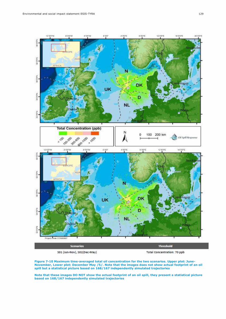
Environmental and social impact statement ESIS-TYRA
129
Figure 7-10 Maximum time-averaged total oil concentration for the two scenarios. Upper plot: June-November, Lower plot: December May /5/. Note that the images does not show actual footprint of an oil spill but a statistical picture based on 168/167 independently simulated trajectories
Note that these images DO NOT show the actual footprint of an oil spill, they present a statistical picture based on 168/167 independently simulated trajectories

Environmental and social impact statement ESIS-TYRA
130
7.1.5.3 Xana 1X spill (type 1 oil) modelling
One scenario has been modelled for a major oil spill at Xana. Selected results of the spill
modelling for Xana 1X are presented in the following /26//27/:
Figure 7-11: No surface oiling is probable anywhere, when threshold of 1 MT/km2 is applied,
though an oil sheen might be observed near the release location.
Figure 7-12: Other than Denmark, Norway is the only country where the water column could
be impacted by a spill.
Figure 7-13: Only Danish and Norwegian shorelines could be affected in case of a spill.
Figure 7-14: Concentrations can be over 1,500 ppb around the release site. The oil
concentration decreases further away from the site. If Norwegian waters experience oiling, it
is expected the concentrations will be less than 300 ppb.
For the TYRA project, type 1 oil is found at Tyra East and Roar (API of 60), at Tyra West (API of
52) and at Tyra Southeast (API of 47).
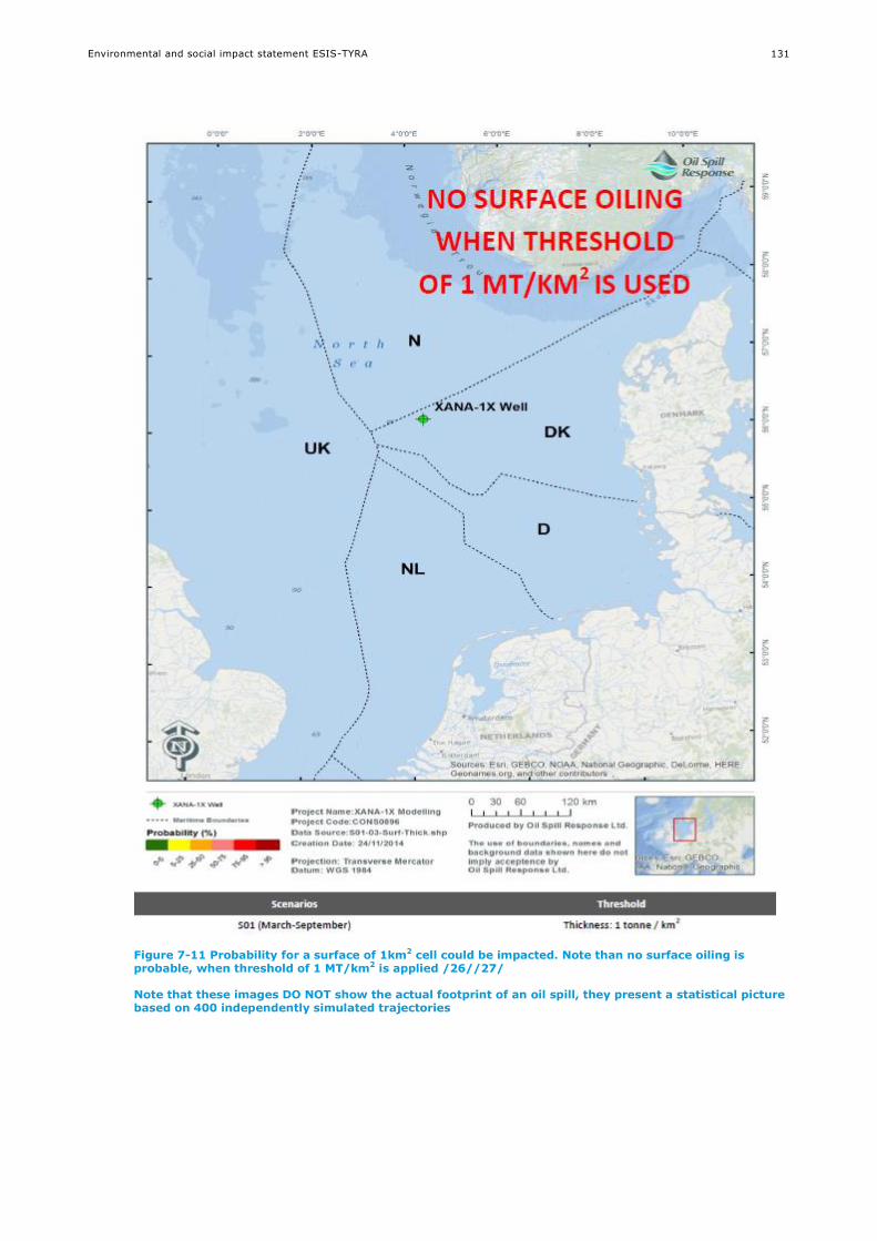
Environmental and social impact statement ESIS-TYRA
131
Figure 7-11 Probability for a surface of 1km2 cell could be impacted. Note than no surface oiling is probable, when threshold of 1 MT/km2 is applied /26//27/
Note that these images DO NOT show the actual footprint of an oil spill, they present a statistical picture based on 400 independently simulated trajectories
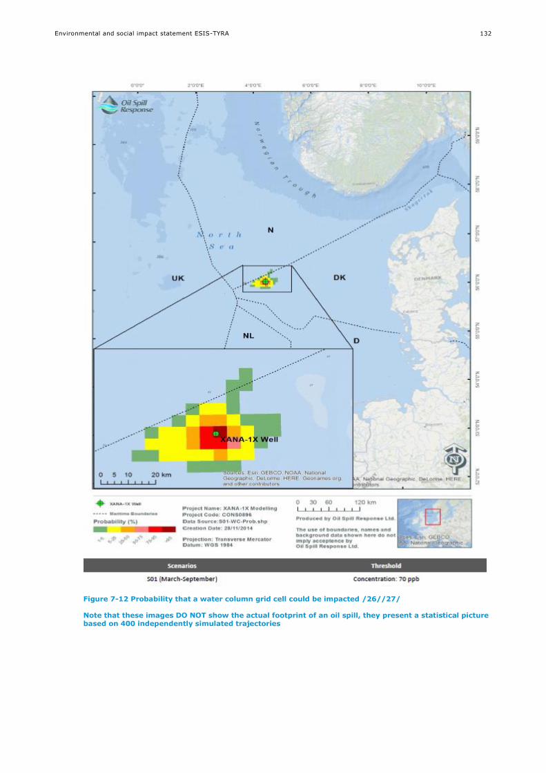
Environmental and social impact statement ESIS-TYRA
132
Figure 7-12 Probability that a water column grid cell could be impacted /26//27/
Note that these images DO NOT show the actual footprint of an oil spill, they present a statistical picture based on 400 independently simulated trajectories
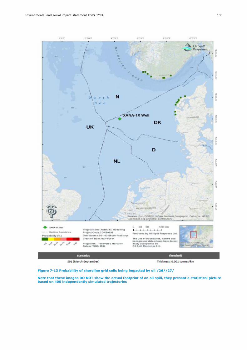
Environmental and social impact statement ESIS-TYRA
133
Figure 7-13 Probability of shoreline grid cells being impacted by oil /26//27/
Note that these images DO NOT show the actual footprint of an oil spill, they present a statistical picture based on 400 independently simulated trajectories
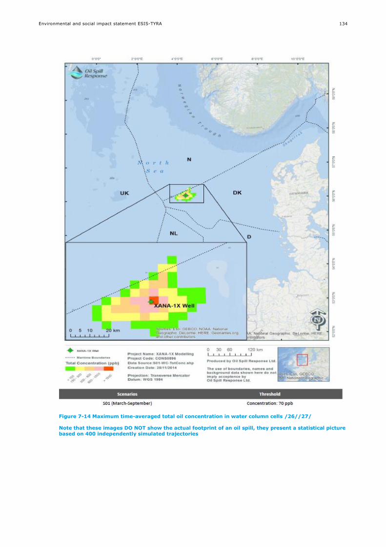
Environmental and social impact statement ESIS-TYRA
134
Figure 7-14 Maximum time-averaged total oil concentration in water column cells /26//27/
Note that these images DO NOT show the actual footprint of an oil spill, they present a statistical picture based on 400 independently simulated trajectories
Environmental and social impact statement ESIS-TYRA
135
7.2 Assessment of potential environmental impacts
Impact assessment for the relevant environmental receptors is presented in this section for
accidental events. The assessment is based on modelling data to evaluate the extent, while
literature data is applied to assess the intensity and duration of impact.
7.2.1 Climate and air quality
Potential impacts on climate and air quality from accidental events are related to gas release.
7.2.1.1 Major gas release
The gas release in case of a major leak is primarily composed of methane CH4 or CO2 if the gas is
ignited. In case of an uncontrolled gas release, gas will be released to the atmosphere. CH4 or
CO2 are greenhouse gas and a major gas release will contribute to the global pool of greenhouse
gas (see section 6.2.1).
The impact to climate and air quality from an uncontrolled gas release at the TYRA project is
assessed to be of medium intensity, with a transboundary extent and a long-term duration. The
overall significance of the impact is assessed to be moderate negative.
7.2.1.2 Overall assessment
The potential impacts are summarised in Table 7-4.
Table 7-4 Potential impacts on climate and air quality related to accidental events at the TYRA project
Potential
impact
mechanism
Intensity of
impact
Extent of
impact
Duration of
impact
Overall
significance of
impact
Level of
confidence
Major gas
release
Medium Transboundary Long-term Moderate
negative
Low
7.2.2 Water quality
Potential impact mechanisms to water quality from accidental spill are related to minor and major
oil spill.
7.2.2.1 Minor oil spill
Modelling results for a marine diesel spill from a vessel show that after 20 days all of the released
oil is no longer mobile; it has evaporated or biodegraded (section 7.1.4). Modelling results for a
pipeline rupture show that the dispersion is local near the rupture.
The physical presence of a large oil slick will cause considerable changes to physical and chemical
parameters of marine water quality, such as reduced light or oxygen levels. In addition, the
increased concentration of oil substances (THC, PAH etc.) will alter the water quality.
Based on the modelling results the extent of the impact on the water quality is assessed to be
local. The intensity is considered small with a short-term duration, as the oil will evaporate, settle
or biodegrade. Overall, the impact on the water quality from a minor oil spill will be of minor
negative significance.
7.2.2.2 Major oil spill
Based on the modelling of a major oil spill (section 7.1.5), oil components concentrations can be
over 1500 ppb around the release site, while concentrations are generally below 150 ppb in the
water column. At the end of the model simulation, most of the oil has either drifted onshore,
evaporated, sedimented or is biodegraded (section 7.1.5).

Environmental and social impact statement ESIS-TYRA
136
The physical presence of a large oil slick will cause considerable changes to physical and chemical
parameters of marine water quality, such as reduced light or oxygen levels. In addition, the
increased concentration of oil substances (THC, PAH etc.) will alter the water quality. The extent
of the impact depends to a large extent on the prevailing meteorological conditions.
Based on the modelling results the impact is assessed to be of medium intensity, transboundary
extent and a medium duration. Overall, the impact on water quality from a major oil spill will be
of moderate negative significance.
7.2.2.3 Overall assessment
The potential impacts are summarised in Table 7-5.
Table 7-5 Potential impacts on water quality related to accidental events at the TYRA project
Potential
impact
mechanism
Intensity of
impact
Extent of
impact
Duration of
impact
Overall
significance of
impact
Level of
confidence
Minor oil spill Small Regional Short-term Minor negative Medium
Major oil spill Medium Transboundary Medium-term Moderate negative Medium
7.2.3 Sediment type and quality
Potential impact mechanisms to sediment type and quality are related to minor and major oil
spill.
7.2.3.1 Minor oil spill
Modelling results for a marine diesel spill from a vessel show that after 20 days all of the released
oil is no longer mobile; it has evaporated or biodegraded (section 7.1.4).
Based on the modelling results the intensity of the impact is assessed to be small with a potential
regional extent and a short-term duration. Overall, the impact on sediment type and quality from
a minor oil spill will be of minor negative significance.
7.2.3.2 Major spill
Based on the modelling of a major oil spill, significant impacts on the sediment type and quality
may occur. Modelling of five different scenarios (section 7.1.5) shows, that between 29-55 % of
the oil will end up on the seabed, corresponding to up to approximately 159,000 MT over a large
area in the North Sea. The rest will either drift onshore, evaporate or biodegrade.
Full recovery will require degradation or burial of contaminants in combination with naturally slow
successional processes. Oil degradation in the marine environment is limited by temperature,
nutrient availability (especially nitrogen and phosphorous), biodegradability of the petroleum
hydrocarbons, presence of organic carbon, and the presence of microorganisms with oil
degrading enzymes /123//124/.
Based on the modelling results the intensity of the impact from a major oil spill is assessed to be
medium with a transboundary extent and a medium duration. Overall, the impact on the
sediment type and quality will be of moderate negative significance.

Environmental and social impact statement ESIS-TYRA
137
7.2.3.3 Overall assessment
The potential impacts are summarised in Table 7-6.
Table 7-6 Potential impacts on sediment type and quality related to accidental events at the TYRA project
Potential
impact
mechanism
Intensity of
impact
Extent of
impact
Duration of
impact
Overall
significance of
impact
Level of
confidence
Minor oil spill Small
Regional Short-term Minor negative Medium
Major oil spill Medium Transboundary Medium-term Moderate negative Medium
7.2.4 Plankton
Potential impact mechanisms to plankton are related to minor and major oil spill.
7.2.4.1 Minor oil spill
Based on the assessed impact to the water quality (section 7.2.2) a minor oil spill is assessed to
have a limited impact on plankton community. Though planktonic organisms may be affected, the
high reproductive potential of plankton is considered able to compensate.
The intensity of the impact is assessed to be small with a local extent and a short-term duration.
Overall, the impact on plankton is assessed to be of minor negative significance.
7.2.4.2 Major oil spill
Laboratory toxicity studies have demonstrated great variation amongst planktonic organisms in
response to the effects of spilled oil, with phytoplankton generally considered less sensitive than
zooplankton /125/.
Tests in containers of naturally occurring algae and water soluble fraction of North Sea oil
concentrations of 0.1 mg/l (=100 ppb) showed no significant effects on the total primary
production /126/. Toxic effects including decreases in growth rate and inhibition of
photosynthesis have been observed in phytoplankton exposed to water soluble fractions of oil
concentrations ranging from 1,000 ppb to 10,000 ppb /127/.
Acute lethal effects to zooplankton have been observed from contact with water soluble fractions
in concentrations greater than 200 ppb /125/. Sub-lethal effects to zooplankton, including
physiological, biochemical and behavioural effects have been observed at one-tenth of lethal
concentrations /125/. However, such laboratory toxicity studies have been shown to be of little
relevance for predicting long-term effects on natural populations. Such studies are typically
short-term and use robust, easily handled species not representative of the wide variety of
planktonic organisms that exist naturally. Although such experiments demonstrate oil spill effects
to plankton, field observations have typically shown minimal or transient effects /125/.
There are no examples of long-term effects on plankton stocks after oil spills. This is due to
plankton reproductive capacity and the water circulation bringing new plankton from outside the
affected area /128//129/. Plankton populations are thus not particularly vulnerable to oil spill,
and may compensate for any impact through a high reproductive potential.
Based on the assessed impact to the water quality (section 7.2.2.2) the duration of the impact on
plankton is short-term. The intensity of the impact is assessed to be medium with a
transboundary extent and a short-term duration. Overall, the impact of major oil spill on the
plankton community will be of minor negative significance.
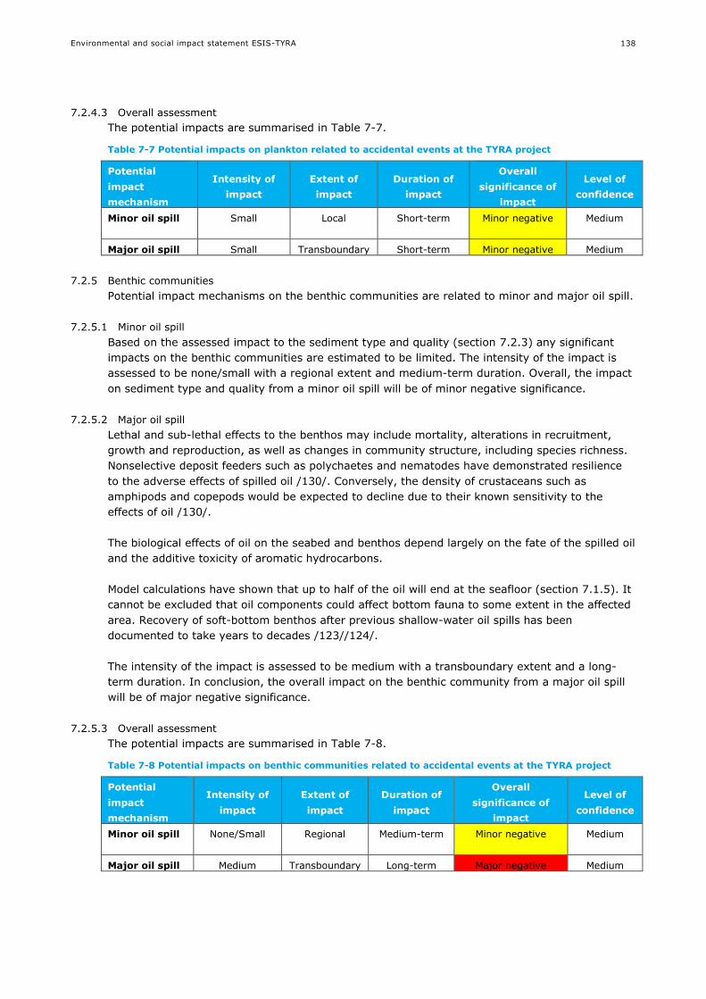
Environmental and social impact statement ESIS-TYRA
138
7.2.4.3 Overall assessment
The potential impacts are summarised in Table 7-7.
Table 7-7 Potential impacts on plankton related to accidental events at the TYRA project
Potential
impact
mechanism
Intensity of
impact
Extent of
impact
Duration of
impact
Overall
significance of
impact
Level of
confidence
Minor oil spill Small
Local
Short-term Minor negative Medium
Major oil spill Small Transboundary Short-term Minor negative Medium
7.2.5 Benthic communities
Potential impact mechanisms on the benthic communities are related to minor and major oil spill.
7.2.5.1 Minor oil spill
Based on the assessed impact to the sediment type and quality (section 7.2.3) any significant
impacts on the benthic communities are estimated to be limited. The intensity of the impact is
assessed to be none/small with a regional extent and medium-term duration. Overall, the impact
on sediment type and quality from a minor oil spill will be of minor negative significance.
7.2.5.2 Major oil spill
Lethal and sub-lethal effects to the benthos may include mortality, alterations in recruitment,
growth and reproduction, as well as changes in community structure, including species richness.
Nonselective deposit feeders such as polychaetes and nematodes have demonstrated resilience
to the adverse effects of spilled oil /130/. Conversely, the density of crustaceans such as
amphipods and copepods would be expected to decline due to their known sensitivity to the
effects of oil /130/.
The biological effects of oil on the seabed and benthos depend largely on the fate of the spilled oil
and the additive toxicity of aromatic hydrocarbons.
Model calculations have shown that up to half of the oil will end at the seafloor (section 7.1.5). It
cannot be excluded that oil components could affect bottom fauna to some extent in the affected
area. Recovery of soft-bottom benthos after previous shallow-water oil spills has been
documented to take years to decades /123//124/.
The intensity of the impact is assessed to be medium with a transboundary extent and a long-
term duration. In conclusion, the overall impact on the benthic community from a major oil spill
will be of major negative significance.
7.2.5.3 Overall assessment
The potential impacts are summarised in Table 7-8.
Table 7-8 Potential impacts on benthic communities related to accidental events at the TYRA project
Potential
impact
mechanism
Intensity of
impact
Extent of
impact
Duration of
impact
Overall
significance of
impact
Level of
confidence
Minor oil spill None/Small Regional
Medium-term Minor negative Medium
Major oil spill Medium Transboundary Long-term Major negative Medium
Environmental and social impact statement ESIS-TYRA
139
7.2.6 Fish
Potential impact mechanisms on fish are related to minor and major oil spill. Note that eggs and
larvae are assessed as part of plankton.
7.2.6.1 Minor oil spill
Based on the assessed impact to the water quality (section 7.2.2) and the sediment type and
quality (section 7.2.3) a minor oil spill is assessed to have a limited impact on the fish
communities. The impact of a minor oil spill is confined to impacts on individuals, and not
populations. The intensity of the impact is assessed to be small with a regional extent and a
short/medium-term duration. Overall, the impact on fish from a minor oil spill is assessed to be
of minor negative significance.
7.2.6.2 Major oil spill
Although laboratory studies have shown a range of lethal and sub-lethal effects of oil on fish
/131/ the hydrocarbon concentrations at which these have occurred have generally been
considerably higher than those occurring during oil spills /125/. Fish appear to be more sensitive
to short-term acute toxicity from the lighter aromatic components which are probably because
they possess the enzymes necessary to metabolise sub-lethal concentrations of hydrocarbons
/125//131/.
Laboratory studies have shown that adult fish are able to detect oil in water at very low
concentrations, and large numbers of dead fish have rarely been reported after oil spills /132/
/133/. This suggests that juvenile and adult fish are capable of avoiding water contaminated with
high concentrations of oil.
Fish are most susceptible to the effects of spilled oil in their early life stages, particularly during
egg and planktonic larval stages, which can become entrained in spilled oil. Contact with oil
droplets can mechanically damage feeding and breathing apparatus of embryos and larvae /134/.
The toxic compounds of oil in water can result in genetic damage, physical deformities and
altered developmental timing for larvae and eggs exposed to even low concentrations over
prolonged timeframes (days to weeks) /134/. More subtle, chronic effects on the life history of
fish as a result of exposure of early life stages to oil include disruption of complex behaviours
such as predator avoidance, reproductive and social behaviour /132/. Prolonged exposure of eggs
and larvae to weathered concentrations of oil in water has also been shown to cause
immunosuppression and allows expression of viral diseases /132/. However, the effect of an oil
spill on a population of fish in an area with fish larvae and/or eggs, and the extent to which any
of the adverse impacts may occur, depends greatly on prevailing oceanographic and ecological
conditions at the time of the spill and its contact with fish eggs or larvae.
Concentrations of 100 ppb THC (total hydrocarbons) has been found to cause acute death of fish
eggs and larvae /135/. According to the model results there is a risk that concentrations of 70-
150 ppb in the water column can be found out to a distance of a 200-300 kilometres. At this
concentration, the eggs and larvae of fish are likely to be affected.
Based on the modelling results, and the above information, the impact is assessed to be of
medium intensity with a transboundary extent and a short to medium-term duration. Overall, the
impact on the fish community from a major oil spill will be of major negative significance.

Environmental and social impact statement ESIS-TYRA
140
7.2.6.3 Overall assessment
The potential impacts on fish are summarised in Table 7-9.
Table 7-9 Potential impacts on fish related to accidental events at the TYRA project
Potential
impact
mechanism
Intensity of
impact
Extent of
impact
Duration of
impact
Overall
significance of
impact
Level of
confidence
Minor oil spill Small
Regional Short/medium-
term
Minor negative Medium
Major oil spill Medium Transboundary Short/medium-
term
Major negative Medium
7.2.7 Marine mammals
Potential impact mechanisms to marine mammals are related to minor and major oil spill.
7.2.7.1 Minor oil spill
Oil spill from collisions or pipeline rupture may impact marine mammals which come into contact
with the spill. Marine mammals generally avoid oil slicks, but impacts on individuals may occur
through ingestion, inhalation or consumption of contaminated organisms. The extent of a minor
oil spill is local (section 7.1.4). The intensity of the impacts is assessed to be small with a short-
term duration. The overall impacts on marine mammals at the TYRA project are assessed to be of
minor negative significance.
7.2.7.2 Major oil spill
A major oil spill may impact marine mammals which come into contact with the spill. Impacts are
related to direct contact with the oil, where smothering of seals may occur leading to
inflammation, infection, suffocation, hypothermia and reduced buoyancy /25/. Whales and
dolphins do not have hair, and are not susceptible to smothering. Both whales and seals may
accumulate toxins through ingestion (which can lead to digestive complications), inhalation
(which can lead to respiratory damage, paralysis, death) or consumption of contaminated marine
organisms.
The sensitive months for marine mammals in relation to a major oil spill have been determined
based on the months where the species are present in the North Sea /25/. Grey seal, harbour
seal and harbour porpoise are sensitive year-round, while minke whale and white-beaked dolping
are sensitive in summer (May-September).
Modelling results show that oil may impact Danish, Swedish, German, Dutch, UK or Norwegian
sectors of the North Sea, and the extent is thus considered transboundary. The intensity of the
impact is considered to be large, as there may be an impact to the individuals, and also to
populations.
Seals can also lose their shoreline habitat if oil washes up on their haul-out sites. Oil spill
modelling has identified Denmark, Sweden and Norway as most vulnerable to oil beaching,
although Germany, UK and the Netherlands could also be affected.
The intensity of the impact from a major oil spill is large, and may affect the ecosystem structure
of marine mammals in the North Sea. The duration of the impact is long-term, and the overall
impact on marine mammals from a major oil spill is assessed to be of major negative
significance.

Environmental and social impact statement ESIS-TYRA
141
7.2.7.3 Overall assessment
The potential impacts are summarised in Table 7-10.
Table 7-10 Potential impacts on marine mammals related to accidental events at the TYRA project
Potential
impact
mechanism
Intensity of
impact
Extent of
impact
Duration of
impact
Overall
significance of
impact
Level of
confidence
Minor oil spill Small Local Short-tem Minor negative Medium
Major oil spill Large Transboundary Long-term Major negative High
7.2.8 Seabirds
Potential impact mechanisms to seabirds are related to minor or major oil spill.
7.2.8.1 Minor oil spill
A minor oil spill may impact seabirds, if they come into contact with the oil (see description of
vulnerability below). The extent of a minor oil spill is considered local, and of medium-term
duration. The intensity is considered small, as the impact of a minor oil spill will affect individuals
and not populations. The overall impact on seabirds from a minor oil spill is assessed to be of
moderate negative significance.
7.2.8.2 Major oil spill
Seabirds are vulnerable to oil spills in the marine environment. Oil may impact the insulating and
water-resistant properties and affecting the buoyancy of the plumage causing the bird to suffer
from hypothermia, starvation or in severe cases drowning. In addition, birds may get intoxicated
from ingestion or inhalation of fuels when they are cleaning their plumages or are feeding on
contaminated food. Intoxication may cause irritation of the digestive organs, damages to liver,
kidneys and salt glands and leading to anaemia. The intensity of the impacts is therefore
assessed to be large /25/.
Birds tend to nest in late spring and summer, which means juveniles are most vulnerable to oil
spills in the spring and summer months, although adults of many species may be found in the
North Sea all year. The window of vulnerability for migratory birds depends on whether they
spend summer or winter along the North Sea coasts.
A major oil spill is assessed to have a transboundary extent and long-term duration. The overall
impact on seabirds from a major oil spill is assessed to be of major negative significance.
7.2.8.3 Overall assessment
The potential impacts are summarised in Table 7-11.
Table 7-11 Potential impacts on seabirds related to accidental events at the TYRA project
Potential
impact
mechanism
Intensity of
impact
Extent of
impact
Duration of
impact
Overall
significance of
impact
Level of
confidence
Minor oil spill Large Local-Regional Medium-term Moderate negative Medium
Major oil spill Large Transboundary Long-term Major negative High

Environmental and social impact statement ESIS-TYRA
142
7.3 Assessment of potential social impacts
Impact assessment for the relevant social receptors is presented in this section for accidental
events. The assessment is based on modelling data to evaluate the extent, while literature data
is applied to assess the intensity and duration of impact.
7.3.1 Cultural heritage
Potential impacts on cultural heritage are related to oil spill.
Cultural heritage as wrecks or submerged settlements can be impacted by smothering of oil in
connection with minor or major oil spills.
The impact will depend on the type of cultural heritage, and the type of oil spilled. The intensity
of potential impacts is assessed to be medium, with a transboundary extent and medium-term
duration. The overall impact on cultural heritage from oil spill at the TYRA project is assessed to
be moderate negative.
7.3.1.1 Overall assessment
The potential impacts are summarised in Table 7-12.
Table 7-12 Potential impacts on cultural heritage related to accidental events at the TYRA project
Potential
impact
mechanism
Intensity of
impact
Extent of
impact
Duration of
impact
Overall
significance of
impact
Level of
confidence
Minor or major
oil spill
Medium National Medium-term Moderate
negative
Low
7.3.2 Protected areas
Potential impact mechanisms are related to minor or major spill. Potential impacts on protected
areas concerns nature reserves along the west coast of Jutland, and the UNESCO reserve
Wadden Sea.
7.3.2.1 Minor oil spill
A chemical spill and an oil spill following vessel collision or pipeline rupture are all events which
are considered of local extent, based on the presented modelling (section 7.1). As the TYRA
project is located offshore (200 km from shore), minor oil spills are assessed to have no impact
on protected areas.
7.3.2.2 Major oil spill
Major oil spill has been modelled (section 7.1). The potentially impacted areas include the
Wadden Sea and the nature reserves along the west coast of Jutland. As a precautionary
approach, the intensity of the impacts is assessed to be large, with transboundary extent and
long-term duration. The overall significance of impacts on protected areas from major oil spill is
assessed to be major negative.
7.3.2.3 Overall assessment
The potential impacts are summarised in Table 7-13.
Table 7-13 Potential impacts on protected areas related to accidental events at the TYRA project
Potential
impact
mechanism
Intensity of
impact
Extent of
impact
Duration of
impact
Overall
significance of
impact
Level of
confidence
Minor oil spill None Local Short-term Negligible negative High
Major oil spill Large Transboundary Long-term Major negative Medium
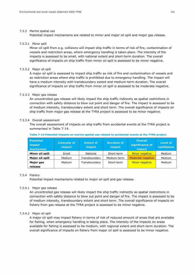
Environmental and social impact statement ESIS-TYRA
143
7.3.3 Marine spatial use
Potential impact mechanisms are related to minor and major oil spill and major gas release.
7.3.3.1 Minor spill
Minor oil spill from e.g. collisions will impact ship traffic in terms of risk of fire, contamination of
vessels and restriction areas, where emergency handling is taken place. The intensity of the
impacts is assessed to be small, with national extent and short-term duration. The overall
significance of impacts on ship traffic from minor oil spill is assessed to be minor negative.
7.3.3.2 Major oil spill
A major oil spill is assessed to impact ship traffic as risk of fire and contamination of vessels and
as restriction areas where ship traffic is prohibited due to emergency handling. The impact will
have a medium intensity with transboundary extent and medium-term duration. The overall
significance of impacts on ship traffic from minor oil spill is assessed to be moderate negative.
7.3.3.3 Major gas release
An uncontrolled gas release will likely impact the ship traffic indirectly as spatial restrictions in
connection with safety distance to blow out point and danger of fire. The impact is assessed to be
of medium intensity, transboundary extent and short term. The overall significance of impacts on
ship traffic from major gas release at the TYRA project is assessed to be minor negative.
7.3.3.4 Overall assessment
The overall assessment of impacts on ship traffic from accidental events at the TYRA project is
summarised in Table 7-14.
Table 7-14 Potential impacts on marine spatial use related to accidental events at the TYRA project
Potential
impact
mechanism
Intensity of
impact
Extent of
impact
Duration of
impact
Overall
significance of
impact
Level of
confidence
Minor oil spill Small National Short-term Minor negative Medium
Major oil spill Medium Transboundary Medium-term Moderate negative Medium
Major gas
release
Medium Transboundary Short-term Minor negative Medium
7.3.4 Fishery
Potential impact mechanisms related to major oil spill and gas release.
7.3.4.1 Major gas release
An uncontrolled gas release will likely impact the ship traffic indirectly as spatial restrictions in
connection with safety distance to blow out point and danger of fire. The impact is assessed to be
of medium intensity, transboundary extent and short term. The overall significance of impacts on
fishery from gas release at the TYRA project is assessed to be minor negative.
7.3.4.2 Major oil spill
A major oil spill may impact fishery in terms of risk of reduced amount of areas that are available
for fishing, when emergency handling is taking place. The intensity of the impacts on areas
available for fishing is assessed to be medium, with regional extent and short-term duration. The
overall significance of impacts on fishery from major oil spill is assessed to be minor negative.

Environmental and social impact statement ESIS-TYRA
144
Physical effects to target species for fishery may have other consequences for fishery. As impacts
on fish and marine invertebrates from an oil spill are expected to be major negative, it is
assessed that impacts on fisheries will also occur. Further impacts on fisheries may arise due to
market perceptions of poor product quality (no buyers or reduced prices, etc.). A major oil spill in
the North Sea may significantly decrease buyer’s interest in fish and shellfish from the area. This
can lead to loss of business and affect local economy. Perceptions are difficult to predict, since
the actual (physical) impacts of the spill might have little to do with these perceptions. As a
precautionary approach, the intensity of the impacts is assessed to be large, with transboundary
extent and long-term duration. The overall significance of impacts on fishery from major oil spill
is assessed to be major.
7.3.4.3 Overall assessment
The potential impacts are summarised in Table 7-15.
Table 7-15 Potential impacts on fisheries related to accidental events at the TYRA project
Potential impact
mechanism Intensity of
impact
Extent of
impact
Duration of
impact
Overall
significance of
impact
Level of
confidence
Gas release Medium Transboundary Short-term Minor negative Medium
Major oil spill
Impacts on fishery
areas
Medium Regional Short-term Minor negative Medium
Major oil spill
Impacts on target
species
Medium Transboundary Medium-
term
Major negative Low
Major oil spill
Perception/reputation
Large Transboundary Long-term Major negative Low
7.3.5 Tourism
Potential impact mechanisms for tourism are related to major oil spill.
7.3.5.1 Major oil spill
Impacts on tourism from accidental events include oil contamination on the beaches of the west
coast of Jutland and impacts on the Wadden Sea national parks and possible also the southern
coast of Norway.
The oil spill modelling show, that Danish, Norwegian, German, Dutch and UK shorelines could be
affected by oil, though the Danish shoreline is most likely to be affected. The reputation of this
can stop tourists from returning for years and give loss of business and affect local economy. An
oil spill can thus result in long term effects on tourist attraction.
The intensity of the impacts is assessed to be large, with transboundary extent and long-term
duration. The overall significance of impacts on tourism from a major oil spill at the TYRA project
is assessed to be major negative.
7.3.5.2 Overall assessment
The potential impacts are summarised in Table 7-16.
Table 7-16 Potential impacts on tourism related to accidental events at the TYRA project
Potential
impact
mechanism
Intensity of
impact
Extent of
impact
Duration of
impact
Overall
significance of
impact
Level of
confidence
Major oil spill Large Transboundary Long-term Major negative Medium
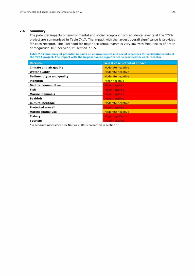
Environmental and social impact statement ESIS-TYRA
145
7.4 Summary
The potential impacts on environmental and social receptors from accidental events at the TYRA
project are summarised in Table 7-17. The impact with the largest overall significance is provided
for each receptor. The likelihood for major accidental events is very low with frequencies of order
of magnitude 10-4 per year, cf. section 7.1.5.
Table 7-17 Summary of potential impacts on environmental and social receptors for accidental events at the TYRA project. The impact with the largest overall significance is provided for each receptor
Receptor Worst case potential impact
Climate and air quality Moderate negative
Water quality Moderate negative
Sediment type and quality Moderate negative
Plankton Minor negative
Benthic communities Major negative
Fish Major negative
Marine mammals Major negative
Seabirds Major negative
Cultural heritage Moderate negative
Protected areas* Major negative
Marine spatial use Moderate negative
Fishery Major negative
Tourism Major negative
* a separate assessment for Natura 2000 is presented in section 10.

Environmental and social impact statement ESIS-TYRA
146
8. MITIGATING MEASURES
Maersk Oil has identified several mitigating measures for planned activities and accidental events
with an environmental or social risk. The mitigating measures are in place to eliminate or reduce
the risk as low as reasonably practicable (ALARP). In addition to the risk mitigating measures,
several monitoring campaigns are conducted around Maersk Oil platforms (section 9.3).
8.1 Mitigating risks from planned activities
8.1.1 Measures to reduce emissions
Generally, Maersk Oil works continuously to reduce emissions to the environment and improve
the energy efficiency offshore by keeping a sharp focus on fuel and flare gas consumption and
including energy efficiency considerations early in the design phase for all major projects and
modifications. The production has become more energy efficient over the years, and in 2013 the
Energy Management System at Maersk Oil was ISO-14001 certified. Annual audits of
performance are part of this and the system is to be re-certified every third year (See also
BAT/BEP in chapter 9).
8.1.2 Underwater noise mitigating measures
The risks of underwater noise on marine mammals in geophysical acquisition and construction
projects are generally mitigated by:
In areas where impacts on marine mammals are anticipated, best available technology will be
assessed
Planning and efficient execution of the geophysical data acquisition and construction projects
to minimise the overall duration of the operations and noise exposure of sensitive species.
Monitoring the presence of marine mammals before the onset of noise creating activities, and
throughout the geophysical data acquisition or construction.
An exclusion zone is implemented and operations will be delayed when the presence of
marine mammal is detected before start-up of the operations.
Soft-start procedures, also called ramp-up, are to be used in areas of known marine mammal
activity. This involves a gradual increase in sound signal level to full operational levels
allowing the animal to move away from any adverse sounds thus reducing the risk of possible
effects from the generated underwater noise.
8.1.3 Discharge mitigating measures
Maersk Oil uses chemicals in its operations, and is constantly examining the use and discharge of
chemicals. Maersk Oil has a target of zero harmful discharges. Before any chemicals can be
permitted for use and discharge offshore, an application must be submitted to the DEPA. Part of
the application is an environmental classification of each chemical carried out in accordance with
the OSPAR Recommendation 2010/4 on a harmonised pre-screening scheme for offshore
chemicals. The classification applies a colour coding system used by Maersk Oil based on the
criteria outlined in OSPAR, 2010 /44/:
Black: Black chemicals contain one or more components registered in OSPAR’s ‘List of
Chemicals for Priority Action’. The use of black chemicals is prohibited except in special
circumstances. Maersk Oil has not used them since 2005 but has dispensation in 2015 to use
black pipe dope in part of the casing in the drilling of a high-pressure, high temperature
exploration well.
Red: These are environmentally hazardous and contain one or more components that, for
example, accumulate in living organisms or degrade slowly. OSPAR recommendation is that
the discharge of these chemicals must end by 1 January 2017. Since 2008, Maersk Oil has
been phasing out red chemicals, using them only if safety, technological and environmental
arguments require use. Discharges have decreased sharply since 2010.

Environmental and social impact statement ESIS-TYRA
147
Green: These contain environmentally acceptable components recorded on OSPAR’s PLONOR
list that ‘pose little or no risk’ to the environment. Chemicals included in OSPARs List of
Substances / Preparations Used and Discharged Offshore which are Considered to Pose Little
or No Risk to the Environment (PLONOR) or covered by REACH EC1907/2006 Annex IV or
Annex V.
Yellow: These are chemicals not covered by other classifications, which either degrade
slowly, are toxic or bioaccumulate. Yellow chemicals are subject to ranking and can normally
be discharged.
The environmental risks and impact of operational discharges associated with production are
mitigated through management of produced water through Risk Based Approach (RBA) in
accordance with the OSPAR Guidelines and Recommendation /4/.
The RBA is used to review management options, evaluate measures and develop and implement
site-specific actions to reduce environmental risks of production chemicals discharges which are
not adequately controlled. Risk reduction measures may comprise some of the following:
Technical measures, such as abatement at the source by redesign of the applied processes
(water shut off in the well);
Substitution of chemicals;
Application of closed systems (e.g. injection of produced water);
End-of-pipe techniques such as separation or clarification techniques to treat produced water
prior to discharge, and;
Organisational measures such as management systems in place (training, instructions,
procedures and reporting).
An important tool within the RBA is the use of hydrodynamic models to predict the dispersion of
the produced water outflow with a substance based approach /154/. This allows identifying the
most important contributors to the risk and evaluating chemical substitution options while
ensuring the application of BAT/BEP.
Furthermore, BAT/BEP studies are carried out for existing and future facilities. The aim of the
studies is to assess options and ultimate use of technology and operating practices that provide
economically viable solution with greatest overall risk and impact reduction (see chapter 9).
8.2 Tyra Future specific measures
On an overall level, the Tyra Future project represents a step change, in rationalisation of the
existing facilities.
The existing facilities have undergone stepwise expanding development phases for its first 25
years of operation, with a peak capacity of some 1.300 MMscfd of gas for sales and re-injection.
Since 2006, the production has been declining and the capacity has been reduced, all at the
same power consumption, due to the gradually reducing pressure in the reservoir. The existing
facilities are characterised by many parallel trains, operating at reduced load.
The Tyra Future project in essence constitutes a rationalisation of many parallel trains into a
process based on one single train, and a downsized tail-end production rate.
8.2.1 Emissions /Flare
The main sources of emissions are power generation and flaring.
Power generation for Tyra Future is based upon central lower generation by gas turbines. All
main process drivers, small process drivers and utility drivers are electrical driven.

Environmental and social impact statement ESIS-TYRA
148
The advantage is twofold:
The sum of power required for the entire plant is distributed on common turbines, enabling
an optimised operating point, and thus better efficiency for the turbines, as compared to
individual turbine drivers for process equipment.
The dominating effect however, is that the configuration enables a choice of turbine models
with significantly higher fuel efficiency than smaller models available for individual equipment
drivers.
Flare emissions are reduced by several initiatives:
Use of nitrogen for purge and blanket gas
Recovery of most flash gas from produced water treatment into the flash gas compressors
Recovery of most flash gas from glycol regeneration into the flash gas compressors.
Potential use of hermetic sealed compressors avoiding seal gas emissions.
Use of “cold finger” technology for glycol regeneration. The “cold Finger” shall be maximized,
to reduce use of stripping gas.
8.2.2 Chemical use
Chemical use is optimised again by the rationalisation of many parallel trains into one, enabling
more efficient optimisation.
Application of process heating for liquid/liquid separation is expected to reduce emulsion breaker
chemicals.
Application of new produced water treatment technology is expected to reduce chemical
consumption. Processing of reject and skimmed streams is based on “once trough and out”,
rather than recycling, which again by avoiding recycle of impurities and production chemicals
improve the control of the process leading to optimisation of chemical use.
8.3 Mitigating risks from accidental events
Maersk Oil reports all accidental discharges of oil and chemicals, regardless of volume. Measures
are introduced to reduce the volume and number of spillage through e.g. inspections and
training. Maersk Oil follows industrial best practices for prevention of major accidents based on
identification of major hazards assessed through risk assessment /136/.
Maersk Oil strives to reduce the risk of major accidents to as low as reasonably practicable
(ALARP) through the identification of major hazards in risk analyses and the development of
barriers (e.g. procedure, training, and design). For example, facilities are protected against
collision by installing boat fenders to jackets. Processing facilities, wells and pipelines are
protected against large release by safety valves. A safety zone around pipelines and platforms is
implemented to prevent collisions from bottom trawling equipment or anchoring. Procedures are
in place to restrict supply vessel traffic and hose handling in case of rough weather (see also
Appendix 1).
The risk assessment and reduction measures are regularly updated in case of significant new
knowledge or technology development.
As part of the licensing process, the Danish Working Environment Authority assesses the risk
mitigation measures for new offshore platforms, in accordance with the ALARP principle.
Emergency response and contingency planning are also developed to limit the consequence in
case of a major accident related to its projects. Maersk Oil’s oil spill contingency plan is
summarised in section 9.5.
Environmental and social impact statement ESIS-TYRA
149
9. ENVIROMENTAL STANDARDS AND PROCEDURES IN
MAERSK OIL
9.1 Environmental management system
Maersk Oil operates with an ISO 14001 certified environmental management system /121/. The
objective of the environmental management system is to minimise the impact on the
environment by continually improving the environmental performance.
The objective shall be achieved by:
Maintaining a complete and effective environmental management system
Providing timely and effective innovative actions to reduce environmental impact
Promoting the awareness of environmental matters at all organisational levels
Minimising environmental impact through principles of best available technology (BAT) and
best environmental practice (BEP).
9.2 Environmental and social impact in project maturation
An Environmental and Social Impact Assessment standard /159/ that lays out the process for
managing environmental and social risk impacts of new large projects has recently been
implemented in Maersk Oil. The standard provides a framework embedded within the Maersk Oil
project maturation process which will be used from start and throughout the different
development phases of future development projects.
For example, the standard has been used in early phase of the TYRA Future project. Several
studies have been carried out during the design of the facilities. The aim of these studies was to
reduce operational environmental impact of the new facilities as low as reasonably practical, see
section 9.4.3. This included BAT studies for emissions and for produced water /185//186/, and an
Environmental Aspect Register /187/.
9.3 Project-specific Environmental and Social Management Plan
A project-specific environmental and social management plan (ESMP) is developed for the Tyra
Project /193/. The ESMP covers the construction, operation and decommissioning phases of the
project. The ESPM builds on requirements stipulated in Maersk Oil Standard – Environmental and
Social Impact Management in Projects /159/ in terms of environmental and social impact
activities and deliverables, consultation with regulators and communities, option evaluation,
baseline studies, Best Available Techniques studies, impact assessment, impact management
planning and mitigation and monitoring.
The purpose of the ESMP is to establish a framework for ensuring that systems and processes are
in place for facilitating the following during construction, operation and decommissioning:
HSE Risks (accidents) are reduced to a level As Low As Reasonably Practicable (ALARP),
Equipment and modes of operation are to be considered as Best Available Technology (BAT).
Both HSE risks and environmental impacts are minimised as an integral part of the design work.
The ESMP considers environmental and social risk management, environmental and social impact
assessment, regulatory context and compliance, performance targets and improvement plan and
monitoring and control mechanisms.
An environmental aspects register has been developed and reported as part of the Tyra Future
Redevelopment FEED /187/. The scope of this aspects register entails all activities impacting the
environment during the operation stage of the Tyra East, Tyra West, Wellhead and Riser

Environmental and social impact statement ESIS-TYRA
150
Platforms. Apart from normal operation phase, the environmental aspects register includes the
effect of non-routine situations during operation phase such as maintenance, emergency
conditions, start-up, and shutdown activities. Environmental aspects and impacts were identified
for energy and natural resources consumption, discharges to sea, emissions to air, waste, noise
and decommissioning.
The Technical Sections, appendix 1 to this Environmental and Social Impact Statement (ESIS),
includes an environmental aspects register that covers the entire project and is therefore what
has made the basis for the impact assessment as reported in the ESIS.
9.4 Demonstration of BAT/BEP
9.4.1 General philosophy
The OSPAR Convention of 1992 requires contracting parties to apply best available techniques
(BAT) and best environmental practice (BEP) including, where appropriate, clean technology, in
their efforts to prevent and eliminate marine pollution.
As defined the OSPAR convention BAT means the latest stage of development (state of the art) of
processes, of facilities or of methods of operation which indicate the practical suitability of a
particular measure for limiting discharges, emissions and waste. BEP is defined as the application
of the most appropriate combination of environmental control measures and strategies.
It follows that BAT and BEP for a particular source will change with time in the light of
technological advances, economic and social factors, as well as changes in scientific knowledge
and understanding.
BAT has also been implemented in the EU IPCC directive 96/61/EC, and the IE directive
(2010/75/EU). The Danish Law on Environmental Protection of the Sea refers to BAT and BEP
(§3). The BAT principle is illustrated in Figure 9-1.
Figure 9-1 Illustration of best available technique /156/
It is a Maersk Oil objective to implement the principles of BAT and BEP in an effort to minimize
the potential environmental impacts of activities in the North Sea. This entails that environmental
concerns are addressed and encompassed in the planning phase. The BAT/BEP principle has been
used in the design and operation of the installations and process equipment of Maersk Oil as well
as for the selection of materials and substances.
Examples of how Maersk Oil applies BAT and BEP include measures to:

Environmental and social impact statement ESIS-TYRA
151
Improving energy efficiency
Monitoring and minimising emissions
Optimising the use and discharge of chemicals, aiming towards zero discharge
Supporting the development of chemicals with less environmental impact
Use of efficient equipment during well test
Continuous review and assessment of projects and applied equipment
9.4.2 Produced water treatment
9.4.2.1 Current system
TYRA facilities are equipped with technology such as hydrocyclones for treatment of produced
water, which are included in the OSPAR, 2013, Background Document concerning Techniques for
the Management of Produced Water from Offshore Installations, providing an overview of BAT for
handling of produced water. Produced water system overview is shown for Tyra East and West in
Figure 9-2 and Figure 9-3.
Figure 9-2 Tyra East produced water system overview
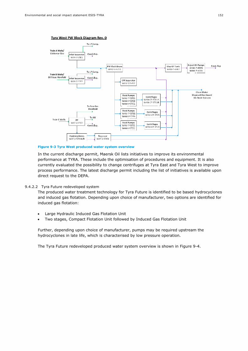
Environmental and social impact statement ESIS-TYRA
152
Figure 9-3 Tyra West produced water system overview
In the current discharge permit, Maersk Oil lists initiatives to improve its environmental
performance at TYRA. These include the optimisation of procedures and equipment. It is also
currently evaluated the possibility to change centrifuges at Tyra East and Tyra West to improve
process performance. The latest discharge permit including the list of initiatives is available upon
direct request to the DEPA.
9.4.2.2 Tyra Future redeveloped system
The produced water treatment technology for Tyra Future is identified to be based hydrocyclones
and induced gas flotation. Depending upon choice of manufacturer, two options are identified for
induced gas flotation:
Large Hydraulic Induced Gas Flotation Unit
Two stages, Compact Flotation Unit followed by Induced Gas Flotation Unit
Further, depending upon choice of manufacturer, pumps may be required upstream the
hydrocyclones in late life, which is characterised by low pressure operation.
The Tyra Future redeveloped produced water system overview is shown in Figure 9-4.
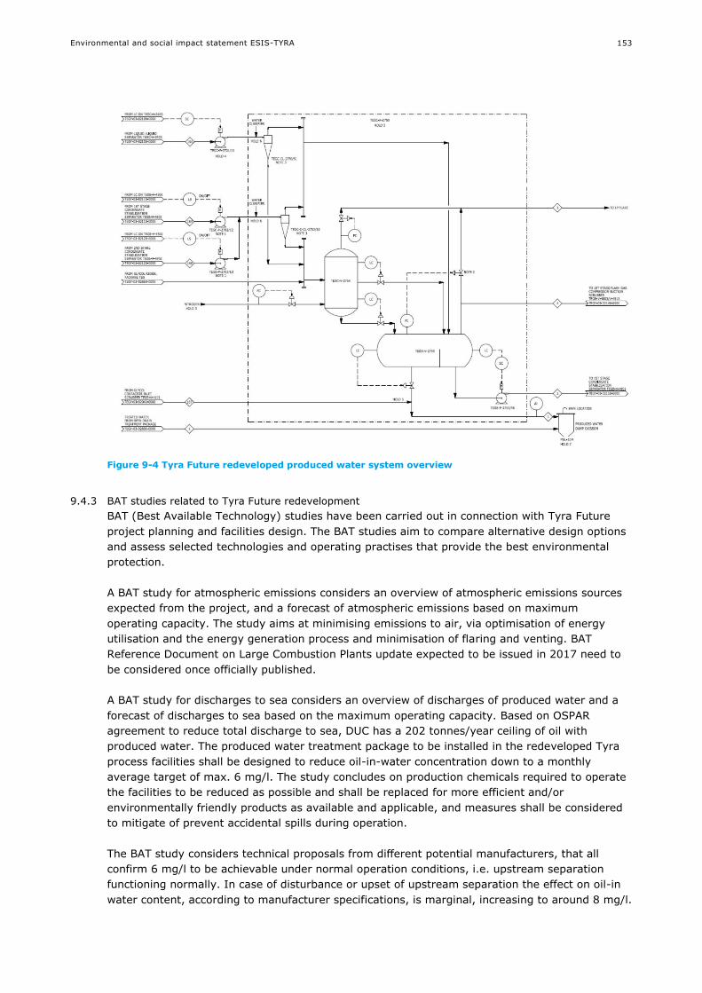
Environmental and social impact statement ESIS-TYRA
153
Figure 9-4 Tyra Future redeveloped produced water system overview
9.4.3 BAT studies related to Tyra Future redevelopment
BAT (Best Available Technology) studies have been carried out in connection with Tyra Future
project planning and facilities design. The BAT studies aim to compare alternative design options
and assess selected technologies and operating practises that provide the best environmental
protection.
A BAT study for atmospheric emissions considers an overview of atmospheric emissions sources
expected from the project, and a forecast of atmospheric emissions based on maximum
operating capacity. The study aims at minimising emissions to air, via optimisation of energy
utilisation and the energy generation process and minimisation of flaring and venting. BAT
Reference Document on Large Combustion Plants update expected to be issued in 2017 need to
be considered once officially published.
A BAT study for discharges to sea considers an overview of discharges of produced water and a
forecast of discharges to sea based on the maximum operating capacity. Based on OSPAR
agreement to reduce total discharge to sea, DUC has a 202 tonnes/year ceiling of oil with
produced water. The produced water treatment package to be installed in the redeveloped Tyra
process facilities shall be designed to reduce oil-in-water concentration down to a monthly
average target of max. 6 mg/l. The study concludes on production chemicals required to operate
the facilities to be reduced as possible and shall be replaced for more efficient and/or
environmentally friendly products as available and applicable, and measures shall be considered
to mitigate of prevent accidental spills during operation.
The BAT study considers technical proposals from different potential manufacturers, that all
confirm 6 mg/l to be achievable under normal operation conditions, i.e. upstream separation
functioning normally. In case of disturbance or upset of upstream separation the effect on oil-in
water content, according to manufacturer specifications, is marginal, increasing to around 8 mg/l.
Environmental and social impact statement ESIS-TYRA
154
9.5 Oil spill contingency plan
Maersk Oil's emergency preparedness in connection with serious incidents offshore on and
around Maersk Oil's installations and in Danish concession areas held by A.P. Møller-Mærsk is
centred around and coordinated by permanently established emergency committees.
Maersk Oil has developed an oil spill contingency plan /121/, which describes how to combat
possible oil spills. Oil spill scenarios up to and including the worst credible case discharge
scenario for Maersk Oil facilities and wells have been considered to ensure an appropriate tiered
capability is established.
Tier 1 for small operational spills
Mobilise oil spill monitoring/surveillance vessel
Oil spill drift modelling
Use in-field vessel with boom/250 m3 per hour skimmer equipment mobilised within 8
hours
Tier 2 for medium spill volume
Tier 1 measures with additional measures
Use of additional resources (boom, several 200 m3 per hour skimmer and transfer
pump/hoses) mobilised from Esbjerg or from the Danish National stockpile within 20
hours to handle more than 1,500 tons per day
Waste removal is done by dedicated tanker
Tier 3 for blow out
Tier 2 measures with additional measures
Mobilise trained personnel and additional equipment from Oil Spill Response Ltd (OSRL).
Mobilise relief well contractor
Consult NGOs regarding wildlife response
Maersk Oil has access to oil spill equipment offshore and in Esbjerg that can be mobilised to an
oil spill location immediately. If necessary, additional equipment will be mobilised from the
Danish stock pile and OSRL. Maersk Oil is a participant member of OSRL and has access to their
world-wide pool of personnel and equipment. OSRL’s main equipment stockpile in Europe is
based in Southampton in the UK but additional equipment is also available in Stavanger.
The use of dispersant chemicals to increase oil dispersion, dilution and natural breakdown will be
evaluated when relevant. The use of dispersant chemicals is regulated and dispersant may only
be used after approval by DEPA.
Regular emergency exercises (oil spills) are carried out as a minimum every three years to train
and motivate personnel, test the equipment and to ensure plans as described are effective.
Relevant authorities participate in the exercise.
9.6 Ongoing monitoring
Maersk Oil has flowmeters that continuously measures the volume of discharged produced water,
and water samples are regularly obtained for analysis of oil content. The nature, type and
quantities of chemicals used and chemicals and oil discharged to sea are reported to the
Environmental Protection Agency.
Monitoring of sediment quality and benthic fauna is undertaken at regular intervals around
Maersk Oil platforms /6/.
The physical and chemical analyses included grain size analysis, dry matter (DM), loss on
ignition (LOI), total organic carbon (TOC), metals (barium (Ba), cadmium (Cd), chromium

Environmental and social impact statement ESIS-TYRA
155
(Cr), copper (Cu), lead (Pb), zinc (Zn), mercury (Hg) and aluminium (Al)), Total
hydrocarbons (THC), Polycyclic aromatic hydrocarbons (PAH) and oil specific group of
alkylated aromatic hydrocarbons (NPD).
Samples obtained for identification and quantification of the benthic fauna
In addition, Maersk Oil monitors underwater noise and marine mammals through passive acoustic
monitoring and an offshore sighting program in which offshore staff reports sightings of marine
mammals near platforms.
Figure 9-5 Acoustic monitoring of marine mammals (Photo: Aarhus University, DCE)
Currently, emission monitoring is not installed at the gas turbines on Tyra. However, manual
samples are taken once a year to measure the composition of the emissions. Manual sampling of
the exhaust will be continued on new power generation. However a provision will be made to
install automatic monitoring of exhaust composition.

Environmental and social impact statement ESIS-TYRA
156
10. NATURA 2000 SCREENING
10.1 Introduction
The Natura 2000 network comprises:
Habitats Directive Sites (Sites of Community Importance and Special Areas of Conservation)
designated by Member States for the conservation of habitat types and animal and plant species listed in the Habitats Directive
Bird Directive Sites (Special Protection Areas) for the conservation of bird species listed in the Birds Directive as well as migratory birds
This section constitutes the Natura 2000 screening in accordance with the EC habits Directive and
Order 408/2007, § 7.
10.2 Designated species and habitats
The designated Natura 2000 sites are shown in Figure 10-1.
Figure 10-1 Natura 2000 sites in the North Sea
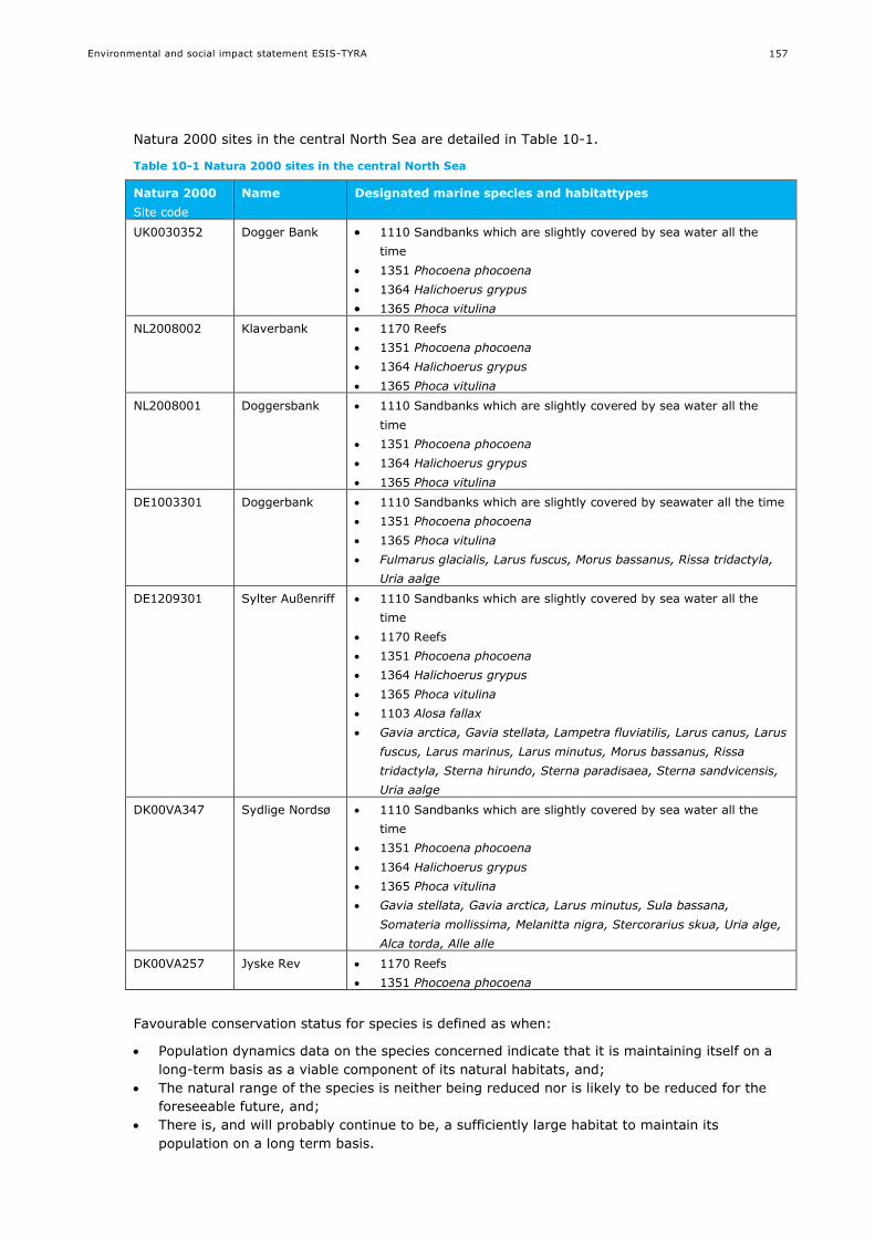
Environmental and social impact statement ESIS-TYRA
157
Natura 2000 sites in the central North Sea are detailed in Table 10-1.
Table 10-1 Natura 2000 sites in the central North Sea
Natura 2000
Site code
Name Designated marine species and habitattypes
UK0030352 Dogger Bank 1110 Sandbanks which are slightly covered by sea water all the
time
1351 Phocoena phocoena
1364 Halichoerus grypus
1365 Phoca vitulina
NL2008002 Klaverbank 1170 Reefs
1351 Phocoena phocoena
1364 Halichoerus grypus
1365 Phoca vitulina
NL2008001 Doggersbank 1110 Sandbanks which are slightly covered by sea water all the
time
1351 Phocoena phocoena
1364 Halichoerus grypus
1365 Phoca vitulina
DE1003301 Doggerbank 1110 Sandbanks which are slightly covered by seawater all the time
1351 Phocoena phocoena
1365 Phoca vitulina
Fulmarus glacialis, Larus fuscus, Morus bassanus, Rissa tridactyla,
Uria aalge
DE1209301 Sylter Außenriff 1110 Sandbanks which are slightly covered by sea water all the
time
1170 Reefs
1351 Phocoena phocoena
1364 Halichoerus grypus
1365 Phoca vitulina
1103 Alosa fallax
Gavia arctica, Gavia stellata, Lampetra fluviatilis, Larus canus, Larus
fuscus, Larus marinus, Larus minutus, Morus bassanus, Rissa
tridactyla, Sterna hirundo, Sterna paradisaea, Sterna sandvicensis,
Uria aalge
DK00VA347 Sydlige Nordsø 1110 Sandbanks which are slightly covered by sea water all the
time
1351 Phocoena phocoena
1364 Halichoerus grypus
1365 Phoca vitulina
Gavia stellata, Gavia arctica, Larus minutus, Sula bassana,
Somateria mollissima, Melanitta nigra, Stercorarius skua, Uria alge,
Alca torda, Alle alle
DK00VA257 Jyske Rev 1170 Reefs
1351 Phocoena phocoena
Favourable conservation status for species is defined as when:
Population dynamics data on the species concerned indicate that it is maintaining itself on a
long-term basis as a viable component of its natural habitats, and;
The natural range of the species is neither being reduced nor is likely to be reduced for the
foreseeable future, and;
There is, and will probably continue to be, a sufficiently large habitat to maintain its
population on a long term basis.

Environmental and social impact statement ESIS-TYRA
158
Favourable conservation status of habitat types requires that:
Its natural range and areas it covers within that range are stable or increasing, and; The specific structure and functions which are necessary for its long-term maintenance
exist and are likely to continue to exist for the foreseeable future, and; The conservation status of its typical species is favourable.
10.3 Screening
The screening is carried out to identify all those elements of the project or plan, alone or in
combination with other projects or plans that may have significant impacts on the Natura 2000
site.
No activities associated with the TYRA project are planned to occur within the designated Natura
2000 sites. The distance from the TYRA project to the nearest Natura 2000 site is 18 kilometres.
Planned activities at the TYRA project have been assessed in section 6. Potential impacts on
Natura 2000 sites include underwater noise and discharges.
10.3.1 Underwater noise
A number of activities at TYRA may generate underwater noise, including seismic surveys,
drilling, decommissioning and presence of production platforms and vessels. There is no
geographical overlap between the TYRA area and Natura 2000 sites, but underwater noise
propagate. The results from the modelling of underwater noise effects on marine mammals are
described in section 6.2.8.1 and in /184/. Contour plots of the distribution of underwater noise
for pile driving and conductor driving from the TYRA area (Figure 6-3 to Figure 6-10) show
propagation of sound above defined sound levels (TTS or PTS) /184/.
The modelling results on effects of underwater sound from piling on seals show no propagation of
sounds above TTS levels into nearby Natura 2000 sites. Figure 6-3 and Figure 6-4 shows results
from jacket piling, while Figure 6-7 and Figure 6-8 shows results from conductor driving.
Based on the modelling results on underwater sound from jacket piling in the Tyra area there is
an overlap of up to 0.6 km during summer and 4 km during winter between the TTS zone for
harbour porpoise and the Natura 2000 site DE1003301 Dogger Bank (Figure 6-5 and Figure 6-6)
when looking at the cumulative underwater noise during the whole piling period. Underwater
noise from conductor driving on harbour porpoise has a lower impact than jacket piling and does
not propagate into Natura 2000 sites (Figure 6-9 and Figure 6-10).
The potential risk of marine mammals to be affected by noise levels above their TTS level varies
in geographical distribution and numbers depending on species (Table 6-17). Time of year is also
important due to effects of water temperature on sound propagation and due to higher numbers
of harbour porpoises being present during winter. Based on worst case scenario (winter
conditions) harbour porpoises within a distance of 30 kilometres are at risk of experiencing noise
levels above the TTS limit. Potential effects of noise levels above TTS will disappear again after a
short time (minutes) or longer (hours) depending on time of exposure /138/. The potential risk of
TTS is therefore not considered critical for the population of harbour porpoises in the North Sea
as the duration of the pile driving is limited to a short period. Given the modelling result for piling
is based on worst case scenario and the short duration time of jacket piling, it is assessed that
underwater noise will not have significant environmental effects on the conservation objectives of
the habitat types or species in the Natura 2000 sites.
10.3.2 Discharges
The main discharges are related to production and drilling, though other minor negative
discharges may also occur (e.g. from vessels).

Environmental and social impact statement ESIS-TYRA
159
Discharges of water based mud and cuttings during planned drilling activities are expected to
occur from a drilling rig (at the existing and new wellhead platforms). The distance to which
impacts on pelagic environment may occur has previously been modelled for a typical well,
and is up to 7 km from the discharge (section 6). The area where impacts may occur will
depend on the currents, and will likely follow the prevailing northward currents. The distance
to which impacts on sediment quality has also been modelled, and is assessed to be within a
few hundred metres for the drilling rig (section 6.2.4). The distance from the point of
discharge (Tyra East and West) to the nearest Natura 2000 site it approximately 18 km.
Based on the distance, it is therefore assessed that production activities will not have
significant environmental effects on the conservation objectives of the habitat types or
species in the Natura 2000 sites.
Discharges from production are expected to continue until 2042, and will occur at Tyra East
and West. The distance to which potential risk of impacts on the pelagic environment may
occur has been modelled, and is up to 14 km from the point of discharge (section 6). The
area will depend on the currents, and will likely follow the prevailing northward currents. The
distance from the point of discharge (Tyra East and West) to the nearest Natura 2000 site is
18 km. Based on the distance, it is therefore assessed that production activities will not have
significant environmental impacts on the conservation objectives of the habitat types or
species in the Natura 2000 sites.
Discharges from decommissioning activities are expected to be minor (section 6.2.3.2).
Structures (jacket and topside) will be cleaned, before transport to shore. The minor
discharges during decommissioning (e.g. cooling water, grey wastewater from vessels) are
assessed to have no significant environmental effects on the conservation objectives of the
habitat types or species in the Natura 2000 sites.
10.4 Conclusion
It is assessed that planned activities at the TYRA project will not have significant environmental
impacts on the conservation objectives of the habitat types or species in the Natura 2000 sites.
Environmental and social impact statement ESIS-TYRA
160
11. TRANSBOUNDARY IMPACTS
11.1 Introduction
The TYRA project refers to the project that covers activities for the remaining lifetime of
operation at the Tyra facilities, until 2042. It covers existing and planned projects for the Tyra
East and West facilities and their satellite platforms Tyra Southeast, Valdemar (A and B), Roar
and Svend, including all pipelines that are departing from any of those platforms. Tyra Future
refers to the redevelopment project of the existing Tyra East and Tyra West facilities, planned for
execution in the period 2018-2022.
This Maersk Oil DBU ESIS TYRA shall replace the ESIS prepared in 2016 (ESIA-16) for TYRA. It is
an update of the ESIA-16 ESIS TYRA incorporating the Tyra Future redevelopment project.
In this section, a summary of the TYRA project and its likely significant transboundary impacts is
provided. The section is focused on providing sufficient information to facilitate the identification
of possible transboundary impacts. The rationale and support for the attributed level of
significance and spatial extent can be found in detail in the relevant sections of the ESIS (section
6 and 7).
11.2 ESPOO convention
The ESPOO convention states that the concerned parties likely to be affected by transboundary
adverse significant impacts are to be informed of and provided with possibilities for making
comments or objections on the proposed activity.
The TYRA project can be found as item 15 (offshore hydrocarbon production) on the list of
activities in appendix I to the convention, that are likely to cause a significant adverse
transboundary impact.
11.3 The TYRA project
11.3.1 Existing production and processing facilities
Production was initiated at Tyra East and West in 1984, then later Tyra South East (2002),
Valdemar (1993), Roar (1996) and Svend (1996). The total production peaked in 2005 and has
been on a natural decline since. Maersk Oil has the license to explore for and produce oil and gas
was extended until 8 July 2042.
Tyra East and West are primarily oil and gas producing and processing platforms that receives,
processes and sends to shore the entire gas production. Treated produced water is discharged to
sea at Tyra East and West
Valdemar (A and B) consist of three unmanned wellhead platform, while Tyra South East, Roar
and Svend each comprise one unmanned wellhead platform.
The processing facilities include hydrocarbon processing equipment (oil stabilisation, gas
processing and processing of production water), auxiliary safety systems such as an emergency
shutdown system, emergency blow-down system, fire and gas detection system, firewater
system, etc.
11.3.2 Planned development activities
The following main activities are planned to continue and optimise the production for the TYRA
project and potentially access new hydrocarbon resources:
Seismic investigations provide information to interpret the geological structure of the
subsurface and to identify the location and volume of remaining and potential new
hydrocarbon reserves. Seismic data is also acquired as part of drilling hazard site surveys to
Environmental and social impact statement ESIS-TYRA
161
map and identify potential hazards to the installation of drilling rigs and to the drilling
operation. Seismic data are also acquired as part of seabed and shallow geophysical surveys
to map seabed and shallow soil conditions for the design and installation of pipelines,
platforms and other structures.
New structures and pipelines are expected as a consequence of development projects planned
within the remaining lifetime of the facilities. Establishment of up to six new wellhead
platforms, with connecting pipelines.
Drilling of up to 24 wells in free well slots and 32 wells at the new structures may be done
under the TYRA project. Slot recovery or re-drilling from existing wells is not expected.
Drilling is performed from a drilling rig, which is placed on the seabed. Different types of
drilling mud will be used based on the well and reservoir properties. Water-based mud and
cuttings will be discharged to the sea, whereas oil-based mud and cuttings will be brought
onshore to be dried and incinerated.
Well stimulation will be performed to facilitate hydrocarbon extraction (for a production well)
or water injection (for an injection well).
11.3.3 Accidental events
As part of the production, accidental spills of oil, gas or chemical may occur. There is a risk of
accidents that could lead to major significant environmental and social impacts, such as vessels
collisions or a well blow out. The risk of a well blowout is very unlikely.
11.3.4 Alternatives
The offshore oil and gas production is important to Danish security of supply and Danish
economy. Tyra has an estimated production reserve equivalent to 250 million barrels of oil
equivalent. About 500 people are employed with and on the Tyra facilities and another 4,000
Danish jobs are dependent on Tyra. Tax revenue to the state of Denmark is significant. The
state’s total revenue is estimated to DKK 20 billion per year.
The Danish government has set a target of 30 % of the Danish energy use is provided from
renewable energy by 2020. As part of a long-term Danish energy strategy, the oil and gas
production is considered instrumental in maintaining high security of supply. Denmark is
expected to continue being a net exporter of natural gas up to and including 2025 and Maersk Oil
has a license to operate until 2042 /35/.
At the time of issue of this ESIS the project is subject to clarification of the economic framework
for continued production of oil and gas from TYRA. Should the project prove non-viable, a
number of options will be pursued, but for the project at hand no alternatives exist for provision
of a similar redevelopment.
Technical alternatives
Best environmental practice for the different type of activities planned for the TYRA project
(seismic, pipelines and structures, production, drilling, well stimulation, transport and
decommissioning) is frequently monitored and applied when feasible.
Alternative location
The TYRA project is a continuation of production and activities at existing facilities. As such, there
is no alternative location for the project.
11.4 Identified impacts – planned activities
Potential impacts to environmental and social receptors during planned activities at the TYRA
project have been assessed in section 6. A summary of the potential worst case impacts is
presented in Table 11-1.

Environmental and social impact statement ESIS-TYRA
162
Table 11-1 Summary of potential impacts on environmental and social receptors from planned activities at the TYRA project. The impact with the largest overall significance is provided for each receptor (without mitigating measures).
Receptor Worst case potential impact
Extent Overall significance of impact
Climate and air quality Transboundary Moderate negative
Hydrography Local Minor negative
Water quality Local Minor negative
Sediment type and quality Local Minor negative
Plankton Local Minor negative
Benthic communities Local Minor negative
Fish Local Minor negative
Marine mammals Local or regional Moderate negative
Seabirds Local Minor negative
Cultural heritage None None
Protected areas (UNESCO, nature reserve) None None
Natura 2000 No significant environmental effects
Marine spatial use Local Negligible negative
Fishery Local Negligible negative
Tourism None None
Employment and tax revenue Local or national Positive
Oil and gas dependency Local or national Positive
Transboundary adverse impacts have been identified for climate and air quality, where the
emissions from the TYRA project may contribute to climate change and air pollution. Maersk Oil
has implemented a structured energy efficiency process and conduct a comprehensive review to
identify ways to improve energy efficiency offshore. The production has become more energy
efficient over the years, and in 2010 the environmental management system at Maersk Oil was
ISO-14001 certified.
No other significant adverse transboundary impacts have been identified for the planned activities
at the TYRA project.
A Natura 2000 screening is presented for the planned activities. It is assessed that the planned
activities will have no significant environmental effects on the conservation objectives of the
habitat types or species in the national and international Natura 2000 sites (section 10).
11.5 Identified impacts – accidental events
Potential impacts to environmental and social receptors during accidental events from the TYRA
project have been assessed in section 7. A summary of the worst case potential impacts (without
mitigating measures) is presented in Table 11-2.
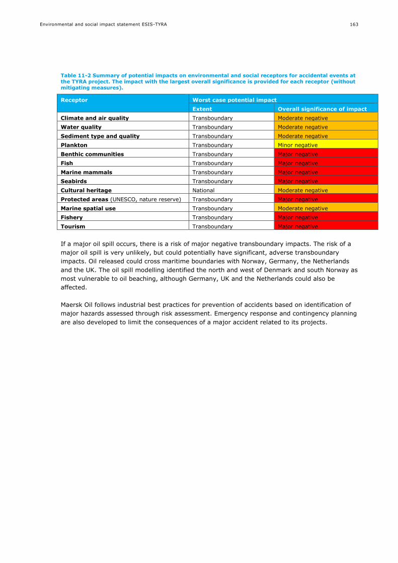
Environmental and social impact statement ESIS-TYRA
163
Table 11-2 Summary of potential impacts on environmental and social receptors for accidental events at the TYRA project. The impact with the largest overall significance is provided for each receptor (without mitigating measures).
Receptor Worst case potential impact
Extent Overall significance of impact
Climate and air quality Transboundary Moderate negative
Water quality Transboundary Moderate negative
Sediment type and quality Transboundary Moderate negative
Plankton Transboundary Minor negative
Benthic communities Transboundary Major negative
Fish Transboundary Major negative
Marine mammals Transboundary Major negative
Seabirds Transboundary Major negative
Cultural heritage National Moderate negative
Protected areas (UNESCO, nature reserve) Transboundary Major negative
Marine spatial use Transboundary Moderate negative
Fishery Transboundary Major negative
Tourism Transboundary Major negative
If a major oil spill occurs, there is a risk of major negative transboundary impacts. The risk of a
major oil spill is very unlikely, but could potentially have significant, adverse transboundary
impacts. Oil released could cross maritime boundaries with Norway, Germany, the Netherlands
and the UK. The oil spill modelling identified the north and west of Denmark and south Norway as
most vulnerable to oil beaching, although Germany, UK and the Netherlands could also be
affected.
Maersk Oil follows industrial best practices for prevention of accidents based on identification of
major hazards assessed through risk assessment. Emergency response and contingency planning
are also developed to limit the consequences of a major accident related to its projects.
Environmental and social impact statement ESIS-TYRA
164
12. LACK OF INFORMATION AND UNCERTAINTIES
Uncertainty may be viewed as an inescapable part of assessment of impacts of plans,
programmes or projects.
12.1 Project description
The project description has been based on input from Maersk Oil. The project description is based
on a scenario with maximum activity, emissions and discharges.
For some activities, the location and/or timing has not been decided. This will be done as part of
the preparation of the detailed planning of the activities. The ESIS is undertaken using a worst
case approach, and therefore alterations to location and/or timing is assessed to be of minor
influence to the assessments.
The understanding of the contribution of the TYRA project to the employment and tax revenue
has not been described specifically and in details. The assessment is based on the overall DUC
contribution.
12.2 Environmental and social baseline
The central North Sea is relatively well known, and the environmental and social baseline is
generally considered sufficient for the ESIS.
However, a few receptors are less well understood:
The distribution and biology of non-commercial fish species is scarce, and knowledge of
spawning areas is limited.
The variability of distribution of marine mammals within and between years is not well
known, and the breeding and moulting periods and locations are not certain.
Fishery is mapped based on the North Sea Atlas which is based on the ICES data. However,
the variability between years is not detailed for this ESIS.
12.3 Impact assessment
Impact predictions can be made using in different ways, ranging from qualitative assessment and
expert judgement to quantitative techniques like modelling. Use of these quantitative techniques
allows a reasonable degree of accuracy in predicting changes to the existing environmental and
social conditions. However, not all of the assessed impacts are easily quantified or modelled, and
expert judgement may be required.
Uncertainty has been addressed in this ESIS by presenting a level of confidence for each of the
assessments in section 6 and 7. The level of confidence includes interactions between impact
mechanisms and receptors, available baseline data as well as modelling (section 4).
Overall, impacts are assessed based on today’s technological capabilities. Maersk Oil expects that
technological development will lead to a reduction in emissions and discharges, which will reduce
the impact assessed here.

Environmental and social impact statement ESIS-TYRA
165
12.3.1 Planned activities
The potential environmental impacts have been assessed for each relevant environmental and
social receptor (e.g. water quality, marine mammal, fisheries, employment). The impact
assessment is based on empirical studies, best available scientific literature, modelling results as
well as previous environmental impact assessments.
Previous and recent modelling results have been applied in this ESIS that relate to Maersk oil and
gas exploration in the North Sea in the same area, including modelling of e.g. dispersion of drill
mud and cuttings, dilution of produced water and underwater noise propagation. In addition,
Maersk Oil prepared EIF and the PEC/PNEC calculations, using the Chemical Hazard Assessment
and Risk Management model (CHARM) developed by authorities and offshore industry. The
calculations have some weaknesses (as reviewed in /1/), but are considered valid for the impact
assessment.
The project which is assessed is at or near existing platforms, where monitoring of chemical and
biological conditions have been undertaken for many years. These surveys have contributed to a
solid knowledge of the baseline /3/, as well as an understanding of the environmental impacts.
Impacts of underwater noise are not well understood, and there is ongoing debate regarding
thresholds for potential impact.
12.3.2 Accidental events
Oil spill modelling has been undertaken for a number of selected spill scenarios. However, the
spill rates for blowouts are not directly comparable, but considered applicable as a worst case
scenario.
12.3.3 Cumulative impacts
Within the geographical scales of this project it is concluded that there is no immediate evidence
of substantial cumulative pressures that entails a worsening of the receptors identified. There
may be some serious consequence in the case of simultaneously accidental oil spill, but such
scenario is considered to be unlikely.
These assessments embrace direct effects on the receptors identified while more indirect effects
are difficult to unravel in detail. No clear elaborated and standardised methods exist for
describing the severity of environmental impact on the functioning of the ecosystem. The lack of
knowledge about the population status of species, the range and ecological status of habitat
types, and the combined impacts of environmental pressures add to the ambiguity of
assessments of cumulative impacts. Environmental monitoring can provide information on some
impacts and decrease some uncertainty, but cumulative effects will not be possible to deduce in
detail alone from looking at the status of the receptors.
The marine strategy frameworks directive (MSFD – see section 6.3) embraces both the nature of
sources and the receptors for identifying human impact on marine ecosystems. The descriptors
presented in the MSFD are meant as general criteria used to define environmental status. As
described above more detailed understanding on how system react on different external impacts
is however needed for an appropriate assessment of different cumulative impacts on system
level. We still have an insufficient knowledge of the precise ecological effects from different
human activities taking place in this part of the North Sea region and thus extract the possible
cumulative impacts on adjacent habitats to Tyra.
Environmental and social impact statement ESIS-TYRA
166
13. REFERENCES
/1/ Maersk Oil. 2011. Vurdering af virkningen på miljøet fra yderligere olie og gas aktiviteter i Nordsøen.
/2/ Maersk Oil. 2014. Vurdering af virkninger på miljøet (VVM) for etablering og drift af Adda og Tyra N.
/3/ DHI/Ramboll. 2014. Maersk Oil Atlas of Environment and Industrial Activities in the North Sea.
/4/ IRIS. 2014. Risk based approach to produces water management. EIF calculations Dan 2013.
/5/ OSRL. 2014. Oil spill modelling report: Siah NE-1X. Doc CONS0874, rev 02.
/6/ DHI, 2009. Chemical and biological monitoring of the seabed around the Tyra E platform in May 2009.
/7/ Statens Forurensning Tilsyn. 2007. Veileder for klassifisering av miljøkvalitet i fjorder og kystfarvann.
Revidering av klassifisering av metaller og organiske miljøgifter i vann og sedimenter . TA-2229/2007.
/8/ Vejledning fra By – og Landskabsstyrelsen. 2008. Dumpning af optaget havbundsmateriale – klapning.
Vejl. nr. 9702 af 20/10 2008.
/9/ OSPAR Commission. 2012. CEMP 2011 assessment report.
/10/ OSPAR. 2000. Quality Status Report 2000, Region II - Greater North Sea. OSPAR Commission,
London, 136 pages.
/11/ UK Offshore Energy - Department of Energy and Climate Change. 2009. Strategic Environmental
Assessment Future Leasing for Offshore Wind Farms and Licensing for Offshore Oil and Gas and Gas
Storage. Appendix 3a Biodiversity, habitats, flora and fauna.
/12/ SAHFOS. 2001. Technical report produced for Strategic Environmental Assessment – SEA2. An
overview of plankton ecology in the North Sea.
/13/ Callaway, R., Alsvåg, J., de Boois, I., Cotter, J., Ford, A., Hinz, H., Jennings, S., Kröncke, I.,
Lancaster, J., Piet, G., and Prince, P. 2002. Diversity and community structure of epibenthic
invertebrates and fish in the North Sea. ICES Journal of Marine Science, 59: 1199–1214.
/14/ Künitzer, A., Basford, D., Craeymeersch, J. A., Dewarumez, J. M., Dorjes, J., Duineveld, G. C. A.,
Eleftheriou, A., Heip, C., Herman, P., Kingston, P., Niermann, U., Rachor, E., Rumohr, H., and de
Wilde, P. A. J. 1992. The benthic infauna of the North Sea: species distribution and assemblages. ICES
Journal of Marine Science, 49: 127–143.
/15/ ICES Advice. 2008. Book 6 North Sea.
/16/ VKI. 1999. Analysis of Impact on Sediment and Bottom Fauna in Relation to Offshore Activities in the
Danish Sector of the North Sea 1989-1998. North Sea Operators Committee – Denmark.
/17/ DHI - Water Environment Health. 2008. Analyses and assessment of biological and chemical
monitoring data from offshore platforms in the Danish sector of the North Sea in 1989-2006. Report to
Danish Operators.
/18/ Olsgard, F. and J.S. Gray. 1995. A comprehensive analysis of the effects of offshore oil and gas
exploration and production on benthic communities of the Norwegian continental shelf. Marine Ecology
Progress Series Vol.122: 277-306.
/19/ Mærsk Olie og Gas AS. 2003. Registrering af fiskesamfund og fiskeæg omkring Halfdan-Feltet.
Hovedrapport. Udarbejdet af Carl Bro, Bio/consult og Simråd.
/20/ Mærsk Oil, Miljøstatusrapport 2013, Den danske Nordsø
/21/ DCE Emission Inventories, http://envs.au.dk/en/knowledge/air/emission-
inventories/emissioninventory/.
/22/ Worsøe, L.A, Horsten, M.B and Hoffmann, E. 2002. Gyde og opvækstpladser for kommercielle
fiskearter i Nordsøen, Skagerrak og Kattegat. DFU rapport nr. 118-02.
/23/ ICES FishMap http://www.ices.dk/marine-data/maps/Pages/ICES-FishMap.aspx.
/24/ Muus, B.J., Nielsen, J.G., Dahlstrøm, P. and Nyström, B.O. 1998. Havfisk og fiskeri. Gads Forlag.
/25/ OSRL. 2014. Oil spill risk assessment: Siah NE-1X. Doc CONS0874.
/26/ OSRL. 2014. Oil spill modelling report: Xana-1X. Doc CONS0896.
/27/ OSRL. 2014. Oil spill risk assessment: Xana-1X. Doc CONS0848.
/28/ Naturstyrelsen. 2012. Danmarks Havstrategi – Basisanalyse. www.nst.dk.
/29/ OSPAR. 2014. OSPAR/ICES Workshop on evaluation and update of BRCs and EACs. OSPAR report 214.
/30/ Thompson, D. and Härkönen, T. (IUCN SSC Pinniped Specialist Group) 2008. Phoca vitulina. The IUCN
Red List of Threatened Species. Version 2014.1. <www.iucnredlist.org>. Downloaded on 14 July 2014.

Environmental and social impact statement ESIS-TYRA
167
/31/ Hammond, P.S., Bearzi, G., Bjørge, A., Forney, K., Karczmarski, L., Kasuya, T., Perrin, W.F., Scott,
M.D., Wang, J.Y., Wells, R.S. and Wilson, B. 2008. Phocoena phocoena. The IUCN Red List of
Threatened Species. Version 2014.1. <www.iucnredlist.org>. Downloaded on 14 July 2014.
/32/ Thompson, D. and Härkönen, T. (IUCN SSC Pinniped Specialist Group) 2008. Halichoerus grypus. The
IUCN Red List of Threatened Species. Version 2014.1. <www.iucnredlist.org>. Downloaded on 14 July
2014.
/33/ Hammond, P.S., Bearzi, G., Bjørge, A., Forney, K.A., Karkzmarski, L., Kasuya, T., Perrin, W.F., Scott,
M.D., Wang, J.Y. , Wells, R.S. and Wilson, B. 2012. Lagenorhynchus albirostris. The IUCN Red List of
Threatened Species. Version 2014.1. <www.iucnredlist.org>. Downloaded on 15 July 2014.
/34/ Birdlife: Marine IBAs. http://maps.birdlife.org/marineIBAs/default.html. Accessed February 2nd 2015.
/35/ Danish Energy Agency. 2014. Oil and gas production in Denmark 2013.
/36/ FAO. 2013. Fishery Statistics and Information Unit in May 2013.
http://www.fao.org/fishery/facp/DNK/en
/37/ NaturErhvervstyrelsen. 2014. Dataudtræk fra landingsdatabasen. Accessed February 10th 2015.
/38/ VisitDenmark. 2014. Turismens økonomiske betydning i Danmark 2012. ISBN: 978-87-93227-00-2
/39/ Statistics Denmark. 2015. Beskæftigede efter branche og tid – RAS150. Accessed February 10th 2015.
/40/ Skov, H. and Piper, W. 2009. Kortlægning af havfugle og havpattedyr i Nordsøen 2006-2008. Rapport
over flytællingsresultater. Mærsk Olie and Gas AS.
/41/ Southall, B., Bowles, A. E., Ellison, W. T., Finneran, J. J., Gentry, R. L., Greene, C. R. Jr., Kastak, D.,
Ketten, D. R., Miller, J. H., Richardson, W. J., Thomas, J. A., Tyack, P. L. 2007. Marine mammal noise
exposure criteria: initial scientific recommendations. Aquatic mammals 33(4).
/42/ IRIS. 2014. Risk based approach to produced water management: EIF calculations Tyra 2013. Ref
2014/390
/43/ DONG Energy. 2010. Vurdering af virkninger på miljøet for udbygning af Hejre-felter, licens 05/98. Ref
CO86-COWI-S-DG-0002.
/44/ OSPAR, 2010. OSPAR Recommendation 2010/4 on a Harmonised Pre-screening Scheme for Offshore
Chemicals.
/45/ Neff, J.M. 2010. Fate and effects of water based drilling muds and cuttings in cold water
environments. Review prepared for Shell Exploration and Production Company Houston Texas. May 25,
2010.
/46/ Bakke, T., Klungsøyr, J. and Sanni, S. 2013. Environmental impacts of produced water and drilling
waste discharges from the Norwegian offshore petroleum industry. Marine Environmental Research 92
(2013) 154-169.
/47/ Popper, A.N. and Hastings, M.C. 2009. The effects of human generated sound on fish. Integrative
Zoology. 4: 43-52.
/48/ Genesis. 2011. Review and assessment of underwater sound produced from oil and gas sound
activities and potential reporting requirements under the marine strategy framework directive. Doc
J71656-Final Report_G2.
/49/ OSPAR. 2014. OSPAR inventory of measures to mitigate the emission and environmental impact of
underwater noise
/50/ JNCC. 2010. JNCC guidelines for minimising the risk of injury and disturbance to marine mammals
from seismic surveys
/51/ Expert Working Group 2014. Memorandum prepared for Energinet.dk. »Marine mammals and
underwater noise in relation to pile driving. .« 21. 01 2015.
/52/ Centre for Energy, Environment and Health. 2011. Assessment of Health-Cost Externalities of Air
Pollution at the National Level using the EVA Model System. CEEH Scientific Report No 3
/53/ QUARTZ+CO. 2012 The Danish oil and gas sector’s development and social impact (1992-2022)
/54/ Boertmann, D. and Mosbech, A. (eds.). 2011. Eastern Baffin Bay - A strategic environmental impact
assessment of hydrocarbon activities. Scientific Report no 9, from Danish Centre for Environment and
Energy. 270 pp.
/55/ Christian, J.R., Mathieu, A., Thomson, D.H., White, D., and Buchanan, R.A. 2003. Effects of Seismic
Energy on Snow Crab (Chionoecetes opilio). Report from LGL Ltd. and Oceans Ltd. for the National
Energy Board, File No.: CAL-1-00364, 11 April 2003.

Environmental and social impact statement ESIS-TYRA
168
/56/ Sherk, J.A., O'Connor, J.M., Neumann, D.A., Prince, R.D. and Wood, K.V. 1974. Effects of suspended
sedirnent on feeding activity of the copepods Eurytemora afiinis and Acartia tonsa. In: Effects of
suspended and deposited sediments on estuarine organisms, phase 11. Final Report, chapter 8.
Reference nos. 74-20. Natural Resources; Institute, University of Maryland, Prince Frederick, p.166-
200.
/57/ Paffenhöfer, G.A. 1972. The effects of suspended ”Red mud” on mortality, body weight and growth of
the marine planktonic copepod Calanus helgolandicus. Water, Air and Soil Pollution 1 (1972) 314-321
/58/ Alldredge, A.L., Elias. M. and Gotschalk, C.C. 1986. Effects of drilling muds and mud additives on the
primary production of natural assemblages of marine phytoplankton. Marine Environmental Research
19: 157 to 176.
/59/ Neff, J.M. 2005. Composition, environmental fates and biological effects of water based drilling muds
and cuttings discharged to the marine environment: A synthesis and annotated bibliography. Prepared
for Petroleum Environmental Research Forum (PERF) and American Petroleum Institute.
/60/ Haney, J.F. 1993. Environmental control of diel vertical migration behaviour, Arch. Hydrobiol. Beih.
Ergebn. Limnol 39, pp. 1–17.
/61/ Vella, G., Rushforth, I., Mason, E., Hough, A., England, R., Styles, P., Holt, T. and Thorne, P. 2001.
Assessment of the effects of noise and vibration from offshore wind farms on marine wildlife. ETSU
W/13/00566/REP – DTI/Pub URN 01/1341. 107 pages.
/62/ Dietz, R.S. 1962. The sea's deep scattering layers. Scientific American.
/63/ Gliwicz, Z.M. 1986. A lunar cycle in zooplankton. Ecology 67, pp. 883–97.
/64/ U.S. Geological Survey. 2011. Final programmatic environmental impact statement for marine seismic
research funded by the national science foundation or conducted by the U.S. Geological Survey.
/65/ Vella, G., Rushforth, I., Mason, E., Hough, A., England, R., Styles, P., Holt, T. and Thorne, P. 2001.
Assessment of the effects of noise and vibration from offshore wind frams on marine wildlife. ETSU
W/13/00566/REP – DTI/Pub URN 01/1341.
/66/ Christian, J.R., Mathieu, A., Thomson, D.H., White, D. and Buchanan, R.A. 2003. Effects of seismic
energy on snow crab (Chionoecetes opilio). Report from LGL Ltd. and Oceans Ltd. for the National
Energy Board, File No.: CAL-1-00364, 11 April 2003.
/67/ de Groot, S. J. 1986. Marine sand and gravel extraction in the North Atlantic and its potential
environmental impact, with emphasis on the North Sea, Ocean Management, Vol. 10, pp. 21- 36.
/68/ Currie, D.R. and Parry, G.D. 1996. Effects of scallop dredging on a soft sediment community: a large
scale experimental study. Marine Ecology Progress Series, Vol. 134, pp. 131- 150.
/69/ Caddy, J.F. 1973. Underwater observations on tracks of dredges and trawls and some effects of
dredging on a scallop ground. Journal of the Fisheries Research Board of Canada, Vol. 30, pp. 173-
180.
/70/ Chapman, C.J., Mason, J. and Drinkwater, J.A.M. 1977. Diving observations on the efficiency of
dredges used in the Scottish fishery for the scallop, Pecten maximus (L.). Scottish Fisheries Research,
Vol. 10.
/71/ Ramsay, K., Kaiser, M.J. and Hughes, R.N. 1998. Responses of benthic scavangers to fishing
disturbance by towed gears in different habitats. Journal of Experimental Marine Biology and Ecology,
Vol. 224, pp. 73- 89.
/72/ Turk, T.R. and Risk, M.J. 1981. Effect of sedimentation on infaunal invertebrate populations of
Cobequid Bay, Bay of Fund. Canadian Journal of Fisheries and Aquatic Sciences, Vol. 38, pp. 642- 648.
/73/ Lewis, L.J., Davenport, J. and Kelly, T.C.. 2002. A study of the impact of a pipeline construction on
estuarine benthic invertebrate communities, Estuarine, Coastal and Shelf Science, Vol. 55.
/74/ Turk, T.R. and Risk, M.J. 1981. Effect of sedimentation on infaunal invertebrate populations of
Cobequid Bay, Bay of Fund. Canadian Journal of Fisheries and Aquatic Sciences, Vol. 38, pp. 642- 648.
/75/ Lisbjerg, D., Petersen, J.K. and Dahl, K. 2002. Biologiske effekter af råstofindvinding på epifauna.
Faglig rapport fra DMU, nr. 391.
/76/ Currie, D.R. and Parry, G.D. 1996. Effects of scallop dredging on a soft sediment community: a large
scale experimental study, Marine Ecology Progress Series, Vol. 134, pp. 131- 150.
/77/ Mitson, R.B. Underwater Noise of Research Vessels: Review and Recommendations. ICES Cooperative
Research Report 1995;209:61.
Environmental and social impact statement ESIS-TYRA
169
/78/ Fabi, G., Grati, F., Lucchetti, A. and Trovarelli, L. 2002. Evolution of the fish assemblages around a gas
platform in the northern Adriatic Sea. ICES Journal of Marine Science. Vol. 59, Supplement 1, October
2002 pp. S309-S315.
/79/ Løkkeborg, S., Humborstad, O.B., Jørgensen, T. and Soldal, A.V. 2002. Spatiotemporal variations in
gillnet catch rates in the vicinity of North Sea oil platforms. ICES Journal of Marine Science Vol 59,
Supplement 1 October 2002 pp S294- S299.
/80/ Soldal, A.V., Svellingen, I., Jørgensen, T. and Løkkeborg, S. 2002. Rigs to reefs in the North Sea:
hydroacoustic quantification of fish in the vicinity of a ”semi-cold” platform. ICES Journal of Marine
Science 59: S281-S287.
/81/ Whomersley, P. and G.B. Picken. 2003. Long-term dynamics of fouling communities on offshore
installations in the North Sea. Journal of the Marine Biological Association of the UK. 83: 897-901.
Cambridge University Press.
/82/ COWI/VKI Joint Venture. 1992. Öresund impact assessment. Sub-report nr. 2. The
Öresundskonsortiet. Environmental impact assessment for the fixed link across the Öresund.
/83/ Moore, P.G. 1991. Inorganic particulate suspensions in the sea and their effects on marine animals. -
Oceanogr. Mar. Biol. Ann. Rev. 15: 335-363.
/84/ Popper, A.N., Smith, M.E., Cott, P.A., Hanna, B.W., MacGillivray, A.O., Austin, M.E. and Mann, D.A.
2005. Effects of exposure to seismic airgun use on hearing of three fish species. Journal of the
Acoustical Society of America 117 (6): 3958-3971.
/85/ Engell-Sörensen, K. and Skytt, P.H. 2001. Evaluation of the effect of Sediment Spill from Offshore
Wind Farm Construction on Marine Fish. Report to SEAS, Denmark.
/86/ Johnston, D.D. and Wildish, D.J. 1982. Effect of suspended sediment on feeding by larval herring
(Clupea harengus harengus L.). Bulletin of Environmental Contamination and Toxicology, vol. 29, 261-
267.
/87/ Rönbäck, P. and Westerberg, H. 1996. Sedimenteffekter på pelagiska fiskägg och gulesäckslarver.
Fiskeriverket, Kustlaboratoriet, Frölunda, Sweden.
/88/ Caddy, J.F. 1973. Underwater observations on tracks of dredges and trawls and some effects of
dredging on a scallop ground. Journal of the Fisheries Research Board of Canada, Vol. 30, pp. 173-
180.
/89/ Chapman, C.J., Mason, J. and Drinkwater, J.A.M. 1977. Diving observations on the efficiency of
dredges used in the Scottish fishery for the scallop, Pecten maximus (L.), Scottish Fisheries Research,
Vol. 10.
/90/ Ramsay, K., Kaiser, M.J. and Hughes, R.N. 1998. Responses of benthic scavangers to fishing
disturbance by towed gears in different habitats. Journal of Experimental Marine Biology and Ecology,
Vol. 224, pp. 73- 89.
/91/ Kioerboe, T., Frantsen, E., Jensen, C. and Nohr, O. 1981. Effects of suspended-sediment on
development and hatching of herring (Clupea harengus) eggs. Estuarine, Coastal and Shelf Science,
vol. 13, 107-111.
/92/ Booman, C., Dalen, J., Leivestad, H., Levsen, A., van der Meeren, T. and Toklum, K. 1996. Effekter av
luftkanonskyting på egg, larver og yngel. Undersøkelser ved Havforskningsinstituttet og Zoologisk
Laboratorium, UiB. (Engelsk sammendrag og figurtekster). Havforskningsinstituttet, Bergen. Fisken og
Havet, nr. 3 (1996). 83 s.
/93/ McCauley, R.D., Fewtrell, J., and Popper, A.N. 2003. High intensity anthropogenic sound damages fish
ears. Journal of the Acoustical Society of America 113: 638–642.
/94/ Thomsen, F., Lüdemann, K., Kafemann, R. and Piper, W. 2006. Effects of offshore wind farm noise on
marine mammals and fish. COWRIE Ltd.
/95/ Parvin, S.J., Nedwell, J.R. 2006. Underwater noise survey during impact piling to con-struct the
Barrow offshore windfarm. Report Reference: 544R0602.
/96/ Peña, H., Handegard, N.O. and Ona, E. 2013. Feeding herring schools do not react to seismic air gun
surveys. ICES Journal of Marine Science, 70: 1174–1180.
/97/ Norwegian Oil Industry Association (OLF). 2003. Seismic surveys impact on fish and fisheries by
Ingebret Gausland.

Environmental and social impact statement ESIS-TYRA
170
/98/ Browse FLNG Development 2010. Environmental Resources Management 2010. Browse Upstream
LNG Development: Light Impact. Appendix F16. Assessment, Report produced for Woodside Energy
Limited. Draft Environmental Impact Statement EP BC 2013/7079
/99/ DNV ENERGY. 2007. Effects of seismic surveys on fish, fish catches and sea mammals. Report for the
Cooperation group - Fishery Industry and Petroleum Industry. Report no.: 2007-0512.
/100/ Forteath, G.N.R., Picken, G.B., Ralph, R. and Williams, J. 1982. Marine growth studies on the North
Sea Oil Platform Montrose Alpha. Mar. Ecol. Prog. Ser Vol 8: 61- 68
/101/ Love, M.S. and Nishimoto, M.M. 2012. Completion of fish assemblage surveys around manmade
structures and natural reefs off California. Marine Science Institute, University of California, Santa
Barbara, California. BOEM Cooperative Agreement No.: M10AC2001.
/102/ Scarcella, G., Grati, F. and Fabi, G. 2011. Temporal and spatial Variation of the fish assemblage
around a gas platform in the Northern Adriatic Sea, Italy, Turkish Journal of Fisheries and Aquatic
Sciences 11: 433-444.
/103/ Jørgensen, T., Løkkeborg, S. and Soldal, A.V. 2002. Residence of fish in the vicinity of a
decommissioned oil platform in the North Sea. ICES Journal of Marine Science. Vol 59, Supplement 1,
October 2002, pp S288-S293.
/104/ Love, M.S., Saiki, M.K., May, T.W. and Yee, J.L. 2013. Whole-body concentrations of elements in three
fish species from offshore oil platforms and natural areas in the Southern California Bight. USA Bulletin
of Marine Science, Volume 89, Number 3, July 2013 , pp. 717-734(18).
/105/ Oceans inc. 2013. Monday April 22, 2013. US geological Survey study helps inform rigs-to.reef plans
(www. Oceans inc.org).
/106/ Clarke, D.G and Wilber, D.H. 2000. Assessment of potential impacts of dredging operations due to
sediment resuspension. DOER Technical Notes Collection (ERDC TN-DOER-E9), U.S. Army Engineer
Research and Development Center, Vicksburg, MS.
/107/ Moore, P.G. 1977. Inorganic particulate suspensions in the sea and their effects on marine animals.
Oceanogr. Mar. Biol. Ann. Rev. 15: 225-363.
/108/ Levings, C.D. 1982. The ecological consequences of dredging and dredge spoil disposal in Canadian
waters. National research council of Canada. NRCC Associate committee on scientific criteria for
environmental quality. Publication NRCC No. 18130.
/109/ Redding, J.M and Schreck, C.B. 1987. Physiological effects in Coho salmon and steelhead of exposures
to suspended solids. Trans. Am. Fish. Soc., 116: 737-744.
/110/ Noggle, C.C. 1978. Behavioural, physiological and lethal effects of suspended sediments on juvenile
salmonids. Master Thesis. University of Washington, Seattle, USA.
/111/ Auld, A.H. and Schubel, J.R. 1978. Effects of suspended sediment on fish eggs and larvae: A
laboratory assessment. Estuarine and Coastal Marine Science, 6. Page 153-164.
/112/ Birklund, J. and Wijsman, j.W.M. 2005. Agregate Extraction: A Review on the effect on ecological
funktions. - Prepared for: EC Fifth Framework Programme Project SANDPIT: 54
/113/ Rönbäck, P. and Westerberg, H. 1996. Sedimenteffekter på pelagiska fiskägg och gulesäckslarver.
Fiskeriverket, Kustlaboratoriet, Frölunda, Sweden.
/114/ Kioerboe, T., Frantsen, E., Jensen, C. and Nohr, O. 1981. Effects of suspended-sediment on
development and hatching of herring (Clupea harengus) eggs. Estuarine, Coastal and Shelf Science,
vol. 13, 107-111.
/115/ Caddy, J.F. 1973. Underwater observations on tracks of dredges and trawls and some effects of
dredging on a scallop ground. Journal of the Fisheries Research Board of Canada, Vol. 30, pp. 173-
180.
/116/ Chapman, C.J., Mason, J. and Drinkwater, J.A.M. 1977. Diving observations on the efficiency of
dredges used in the Scottish fishery for the scallop, Pecten maximus (L.), Scottish Fisheries Research,
Vol. 10
/117/ Ramsay, K., Kaiser, M.J. and Hughes, R.N. 1998. Responses of benthic scavangers to fishing
disturbance by towed gears in different habitats. Journal of Experimental Marine Biology and Ecology,
Vol. 224, pp. 73- 89.
/118/ Moles, A. and Norcross, B.L. 1995. Sediment preference in juvenile pacific flatfishes. Netherlands
Journal of Sea Research 34 (1-3). Page 177-182.

Environmental and social impact statement ESIS-TYRA
171
/119/ Groot, S.J. De. 1980. The consequences of marine gravel extraction on the spawning of herring,
Clupea harengus. Linne. Journal of Fish Biology, 16: 605–611.
/120/ Sveegaard S., Teilmann J., Tougaard J., and Dietz R. (2011) High-density areas for harbor porpoises
(Phocoena phocoena) identified by satellite tracking. Marine Mammal Science, 27, 230–246.
/121/ Maersk Oil. 2014. Environmental Management System: Danish Business Units. DK-HSE-PRO-0026 Rev
3.0.
/122/ Richardson, W.J., C.R. Greene Jr., C.I. Malme, and D.H. Thomson. (1995). Marine Mammals and
Noise. Academic Press, San Diego. 576 p.
/123/ Boucher, G. 1985. Long term monitoring of meiofauna densities after the Amoco Cadiz oil spill. Mar
Pollut Bull 16: 328–333.
/124/ Dauvin, J.C. 1998. The fine sand Abra alba community of the Bay of Morlaix twenty years after the
Amoco Cadiz oil spill. Mar Pollut Bull 36: 669–676.
/125/ Volkman, J.K., Miller, G.J., Revill, A.T. and Connell, D. W. 1994. Oil spills. Part 6. In: Environmental
Implications of Offshore Oil and Gas Development in Australia – The Findings of an Independent
Scientific Review. Eds. Swan, J. M., Neff, J. M. and Young, C. P. Australian Petroleum Exploration
Association, Sydney. pp. 509-695.
/126/ Davies, J.M. 1980. Some effects of oil-derived hydrocarbons on a pelagic food web from observations
in an enclosed ecosystem and a consideration of their implications for monitoring. Rapp. P.-v. Reún.
Cons. int. Explor. Mer. vol. 179, pp. 201-211.
/127/ Neff, J.M. 1991. Water quality in Prince William Sound and the Gulf of Alaska.
/128/ Anon (1985). Oil in the sea. Inputs, fates and effects. National Academy Press, Washington D.C 1985.
/129/ Varelaa, M. et al. 2006. The effect of the “Prestige” oil spill on the plankton of the N–NW Spanish
coast. Marine Pollution Bulletin Volume 53, Issues 5-7, 2006, Pages 272-286.
/130/ Wei, C.L., Rowe, G.T., Esobar-Briones, E., Nunnally, C., Soliman, Y. and Ellis, N. 2012. Standing
stocks and body size of deep-sea macrofauna: Predicting the baseline of 2010 Deepwater Horizon oil
spill in the northern Gulf of Mexico. Deep-Sea Research I, 69, 82-99.
/131/ Neff, J.M., Anderson, J.W. 1981. Response of marine animals to petroleum and specific petroleum
hydrocarbons. Halsted Press. New York.
/132/ Hjermann, D.O., Melsom, A., Dingsor, G.E., Durant, J.M., Eikeset, A.M., Roed, L.P., Ottersen, G.,
Storvik, G. and Stenseth, N.C. 2007. Fish and oil in the Lofoten-Barents Sea system: synoptic review
of the effect of oil spills on fish populations. Marine Ecology Progress Series, 339, 283-289.
/133/ Edwards, R. and White, I. 1999. The Sea Empress Oil Spill: Environmental Impact and recovery. In
International Oil Spill Conference (IOSC) Conference Proceedings 199, 97-102).
/134/ Fodrie, F.J. and Heck, K.L.Jr. 2011. Response of Coastal Fishes to the Gulf of Mexico Oil Disaster. PLoS
ONE 6(7).
/135/ OLF. 2008. Metodikk for miljørisiko på fisk ved akutte oljeutslipp. Oljeindustriens Landsforenig. DNV
Energy.
/136/ Ramboll, 2012. Dan Quantitative Risk Assessment (QRA), Prepared for Maersk Oil.
/137/ Ramboll, 2012. Kraka Quantitative Risk Assessment, Prepared for Maersk Oil.
/138/ Marine mammal working group. 2015. Marine mammals and underwater noise in relation to pile
driving – Working Group 2014. Revision 4, 17.04.2015. For Energinet.dk.
/139/ Balle, J.D., Clausen, K.T., Mikkelsen, L., Wisniewska, D.M. and Teilmann, J. 2014. Harbour porpoises
and noise around an operating oil and gas production platform in the North Sea – Status report. DCE.
/140/ Henriksen, O.D., Maxon, C. and Degn, U. 2005. Underwater sound from offshore drilling activities.
Potential effects on marine mammals. DDH consulting 362 05 124, rev4.
/141/ DCE. 2015. http://envs.au.dk/videnudveksling/luft/emissioner/. Accessed April 29th 2015.
/142/ Tougaard, J. 2014. Vurdering af effekter af undervandsstøj på marine organismer. Del 2 –
Påvirkninger. Aarhus Universitet, DCE – Nationalt Center for Miljø og Energi, 51 s. -Teknisk rapport fra
DCE - Nationalt Center for Miljø og Energi nr. 45 http://dce2.au.dk/pub/TR45.pdf
/143/ Teilmann J. and Carstensen J. (2012) Negative long term effects on harbour porpoises from a large
scale offshore wind farm in the Baltic - evidence of slow recovery. Environmental Research Letters, 7,
doi:10.1088/1748–9326/7/4/045101.
/144/ COWI. 2012. Assessment of impacts on marine mammals of seismic survey in DUC area in 2012.
AU28981.

Environmental and social impact statement ESIS-TYRA
172
/145/ OSPAR. 2009. Overview of the impacts of anthropogenic underwater sound in the marine
environment.
/146/ Stemp, R. (1985): Observations on the effects of seismic exploration on seabirds. p. 217-233 In: G.D.
Greene, F.R. Engelhardt, and R.J. Peterson (eds.), Proceedings of workshop on effects of explosives
use in the marine environment. Cdn. Oil and Gas Admin., Env. Prot. Branch, Tech. Rep. No. 5. Ottawa.
/147/ Evans, P.G.H., Lewis, E.J. and Fisher, P. (1993): A study of the possible effects of seismic testing upon
cetaceans in the Irish Sea. Rep. by Sea Watch Foundation, Oxford, to Marathon Oil UK Ltd. Aberdeen.
35 p.
/148/ Santos, M.N., Monteiro, C.C. and Lassèrre, G. (1996). Finfish attraction and fisheries en-hancement on
artificial reefs: a review. In: Jensen, A.C. (Ed.) European artificial reef re-search. Proceedings of the
1st EARRN conference, Ancona, Italy, March 1996. Pub. South-ampton Oceanography Centre: 97-114.
/149/ Valdemarsen, J.W. (1979). Behaviour aspects of fish in relation to oil platforms in the North Sea. ICES
C.M., B:27
/150/ Thompson, P., Brookes, K., Cordes, L., Barton, T., Cheney, B. and Graham, I. 2013. Assessing the
potential impact oil and gas exploration operations on cetaceans in the Moray Firth. Novembre 18th
2013.
/151/ OSRL. 2015. Oil spill modelling report: Danish Business Units. CONS1050-R01.
/152/ DCE. 2015. Disturbance Effects on the Harbour Porpoise Population in the North Sea (DEPONS): Status
report on model development.
/153/ International tanker owners pollution federation (ITOPF). Handbook 2014/2015.
/154/ OSPAR. 2012. Guidelines in support of Recommendation 2012/5 for a Risk-based Approach to the
Management of Produced Water Discharges from Offshore Installations
/155/ ACONA. Blowout and dynamic wellkill simulations. Rev1. Report for Maersk Oil.
/156/ EU. 2015. https://www.era-comm.eu/EU_Law_on_Industrial_Emissions/module_2/bat.html.
/157/ Naturstyrelsen. Danmarks Havstrategi. Miljømålsrapport.
/158/ Nord Stream. 2009. Environmental Impact Assessment: Documentation for Consultation under the
Espoo Convention Nord Stream Espoo Report: Key Issue Paper Seabed Intervention: Works and
Anchor Handling.
/159/ Maersk Oil. 2015. Standard - Environmental and Social Impact Management in Projects. MOG-HSE-
ENV-STD-0042
/160/ Maersk Oil. 2015. Maersk Oil’s oil and gas production in the Danish North Sea Environmental Status
Report 2015.
/161/ Maersk. 2015. DBU Oil spill risk assessment. DK-HSE-PRD-0001 Rev 1.0
/162/ Statoil. 2012. NSGI konsekvensutredning.
/163/ Nord Stream. 2009. Environmental Impact Assessment.
/164/ National Marine Fisheries Service. 2016. Technical Guidance for Assessing the Effects of Anthropogenic
Sound on Marine Mammal Hearing: Underwater Acoustic Thresholds for Onset of Permanent and
Temporary Threshold Shifts. U.S. Dept. of Commer., NOAA. NOAA Technical Memorandum NMFS-OPR-
55, 178 p.
/165/ Wisniewska, Danuta Maria et al.(2016). Ultra-High Foraging Rates of Harbor Porpoises Make Them
Vulnerable to Anthropogenic Disturbance. Current Biology , Volume 26 , Issue 11 , 1441 - 1446.
/166/ Wieking, G. & Kröncke, I. 2005. Is benthic trophic structure affected by food quality? The Dogger Bank
example. Marine Biology, 146, 387-400.
/167/ Dauwe B, Herman PMJ & Heip CHR 1998 Community structure and bioturbation potential of
macrofauna at four North Sea stations with contrasting food supply. Mar Ecol Prog Ser 173:67–83
/168/ CEFAS. 2007. Multispecies Fisheries Management: A Comprehensive Impact Assessment of the Sand
eel Fishery along the English East Coast. CEFAS Contract Report MF0323/01.
/169/ Fox, C.J., Taylor, M., Dickey-Collas, M., Fosum, P., Kraus, G., Rohlf, N., Munk, P., Van Damme, C.J.G.,
Bolle, L.J., Maxwell, D.L. & Wright, P.J. 2008. Mapping the spawning grounds of North Sea cod (Gadus
morhua) by direct and indirect means. Proceedings of the Royal Society B. 275: 1543-1548.
/170/ Nordic Council of Ministers 1994. Fish and Shellfish - Shared Nordic Marine Stocks .TemaNord
1994:519.
/171/ Møller, J. S. and Hansen, I. S., 1994, “Hydrographic processes and changes in the Baltic Sea”, Dana,
Vol. 10, pp. 87- 104.

Environmental and social impact statement ESIS-TYRA
173
/172/ Jensen, A. C., Collins, K. J. and Lockwood, A. P. M., 2000, "Artificial reefs in European seas", Kluweer
Academic Publishers.
/173/ Carl Bro, 2003, "Registrering af fiskesamfund og fiskeæg omkring Halfdan-Feltet (in Danish)".
/174/ Valdemarsen, J. W., 1979, "Behaviour aspects of fish in relation to oil platforms in the North Sea",
ICES Fishing Technology Committee, Vol. 27.
/175/ Maersk Oil, 2017. Tyra Facilities. Decommissioning Program
/176/ DNV-GL, 2017. Level II Hazardous Material Inventory Mapping, 2017-4016, Rev.
/177/ Ramboll, 2016. Tyra Future – Decommissioning and Environmental Engineering. Inventory Mapping.
/178/ Kröncke I & Knust R. 1995. The Dogger Bank: a special ecological region in the central North Sea.
Helgoländer Meeresunters, 49: 335-353.
/179/ Popper, A.N., Hawkins, A.D., Fay, R.R., Mann, D.A., Bartol, S., Carlson, T.J., Coombs, S., Ellison,
W.T., Gentry, R.L., Halvorsen, M.B., Løkkeborg, S., Rogers, P.H., Southall, B.L., Zeddies, D.G.,
Tavolga, W.N., 2014, “Sound Exposure Guidelines for Fishes and Sea Turtles: A Technical Report
prepared by ANSI-Accredited Standards Committee S3/SC1 and registered with ANSI”. Springer Briefs
in Oceanography.
/180/ Xodus Group, 2015. Brae Field Decommissioning Noise Study. Marathon Oil Decommissioning Services
LLC. Document Number: A-100057-S03-REPT-004.
/181/ Bomkamp RE, Page HM and Dugan JE, 2004. Role of food subsidies and habitat structure in influencing
benthic communities of shell mounds at sites of existing and former offshore oil platforms. Marine
Biology 146: 201-211.
/182/ Malishov, G. G., 1992, "The reaction of bottom-fish larvae to airgun pulses in the context of the
vulnarable Barents Sea ecosystem. Fishery and offshore Petroleum Exploitation 2nd International
Conference, Bergen, Norway, 6-8 April 1992".
/183/ Maersk, 2016. Tyra Future Redevelopment – Technical Sections – Input to VVM.
/184/ Ramboll, 2016. Maersk Oil DBU. Underwater noise modelling.
/185/ CBI, 2016. Tyra Future redevelopment FEED. BAT Study Report for Atmospheric Emissions.
/186/ CBI, 2016. Tyra Future redevelopment FEED. BAT Study Report for Discharges to Sea.
/187/ CBI, 2016. Tyra Future redevelopment FEED. Environmental Aspects register.
/188/ Ramboll, 2016. Tyra Future –Decommissioning and Environmental Engineering. Comparative
Assessment for Pipelines.
/189/ Joint Industry Programme on Sound and Marine Life Review of Existing Data on Underwater Sounds
Produced by the Oil and Gas Industry.
/190/ Keenan, S.F., Benfield, M.C., Blackburn, J.K., 2007. Importance of the artificial light field around
offshore petroleum platforms for the associated fish community. Mar Ecol Prog Ser 331: 219−231.
/191/ Todd VLG, Todd IB, Gardiner JC, Morris ECN, MacPherson NA, DiMarzio NA, Thomsen F, 2015. Review
of impacts of marine dredging activities on marine mammals. ICES Journal of Marine Science 72, 328–
340.
/192/ EU Waste Framework Directive. The European list of Waste Commission Decision 2000/532/EC
/193/ Ramboll, 2016. Tyra Future Decommissioning and Environmental Engineering. Environmental and
Social Management Plan
/194/ OSPAR Commission, 2011. MSFD Advice Manual and Background document on Good environmental
status - Descriptor 11:Underwater noise (Version 11, April 2011)

Environmental and social impact statement ESIS-TYRA
1-1
APPENDIX 1
TECHNICAL SECTIONS


![DBU Database Utility - ProData - Custom AS400 Software · Welcome to ProData’s DBU Database Utility documentation. ... On the command line enter [DBU] and press [F4] to bring up](https://static.fdocuments.in/doc/165x107/5ac2756f7f8b9a213f8e55c1/dbu-database-utility-prodata-custom-as400-software-to-prodatas-dbu-database.jpg)


