ESCARPMENT BROW INTERPRETATION DUNTROON QUARRY …Re: Escarpment Brow Interpretation Duntroon Quarry...
26
ESCARPMENT BROW INTERPRETATION DUNTROON QUARRY EXPANSION AREA CLEARVIEW TOWNSHIP, COUNTY OF SIMCOE Prepared for: Georgian Aggregates and Construction Inc. May 2007 File 04 930521.52 Distribution: 30 c MacNaughton Hermsen Britton Clarkson 2 c File
Transcript of ESCARPMENT BROW INTERPRETATION DUNTROON QUARRY …Re: Escarpment Brow Interpretation Duntroon Quarry...
ESCARPMENT BROW INTERPRETATION DUNTROON QUARRY EXPANSION AREA
CLEARVIEW TOWNSHIP, COUNTY OF SIMCOE
Prepared for: Georgian Aggregates and Construction Inc.
May 2007 File 04 930521.52 Distribution: 30 c MacNaughton Hermsen Britton Clarkson 2 c File
8/20/2007 4:22:59 PM C:\Documents and Settings\jsedore\Desktop\AJC-R Duntroon Brow 070105.doc
May 2, 2007 Walker Aggregates Inc. Duntroon Quarry, Simcoe Region P.O. Box 340 Collingwood, Ontario L9Y 3Z7 Dear Sirs: Re: Escarpment Brow Interpretation Duntroon Quarry Expansion Area File 930521.52 Further to your instructions, we have reviewed available data and reports on the location of the Niagara Escarpment “brow” in the vicinity of the Georgian Aggregates and Construction Inc. Duntroon Quarry Expansion property in the Township of Clearwater. The location of the brow in this area has been defined in conformance with the requirements of the Niagara Escarpment Plan definitions, the Plan maps and designations, previous interpretations by the Niagara Escarpment Commission, the definitions discussed by D.F. Hewitt in 1971, recognized geological definitions and accepted geological and planning practice in the Niagara Escarpment. Our research clearly demonstrates that the proposed extraction area is located in excess of 400 m west of (behind) the “brow” of the Niagara Escarpment. Thus, the proposed extraction plan conforms to the requirement of the Niagara Escarpment Plan which states the extraction area for any new license shall be situated a minimum of 200 m behind the brow of the Escarpment. We trust that this information assists you with your undertaking. Yours truly, JAGGER HIMS LIMITED Andrew J. Cooper, M.Sc., P.Geo. Andrew G. Hims, P.Eng Senior Geologist Consulting Engineer AJC:nah
8/20/2007 4:22:59 PM C:\Documents and Settings\jsedore\Desktop\AJC-R Duntroon Brow 070105.doc
TABLE OF CONTENTS PAGE Letter of Transmittal 1.0 INTRODUCTION....................................................................................... 1 2.0 GEOLOGY OF THE DUNTROON AREA................................................ 1 3.0 THE NIAGARA ESCARPMENT BROW.................................................. 7 3.1 BROW INTERPRETATION................................................................................. 7 3.2 DEFINITIONS ..................................................................................................... 8 3.2.1 Plan Definition ........................................................................................ 8 3.2.2 Hewitt Definition..................................................................................... 8 3.2.3 Geological Definition ........................................................................................... 9 3.2.4 Discussion ............................................................................................. 10 3.3 INTERPRETATIONS......................................................................................... 11 3.3.1 Methods................................................................................................. 12 3.3.2 Niagara Escarpment Plan ....................................................................... 12 3.3.3 Detailed Brow Determination................................................................. 18 4.0 CONCLUSIONS ....................................................................................... 21 5.0 REFERENCES ......................................................................................... 22
FIGURES FIGURE 1 LOCATION MAP ................................................................................................ 2 FIGURE 2 REGIONAL SETTING ......................................................................................... 3 FIGURE 3 REGIONAL GEOLOGY....................................................................................... 5 FIGURE 4 TOPOGRAPHY AND CROSS SECTION LINES................................................ 14 FIGURE 5 CROSS SECTION X-X’ ..................................................................................... 15 FIGURE 6 CROSS SECTION Y-Y’ ..................................................................................... 16 FIGURE 7 CROSS SECTION Z-Z’ ...................................................................................... 17 FIGURE 8 NIAGARA ESCARPMENT PLAN LAND USE DESIGNATIONS...................... 19 FIGURE 9 REGIONAL GEOLOGY AND BROW LOCATION............................................ 20
Escarpment Brow Interpretation – Duntroon Quarry Expansion Area 04 930521.50 Georgian Aggregates and Construction Inc. May 2, 2007
Jagger Hims Limited 8/20/2007 4:22:59 PM C:\Documents and Settings\jsedore\Desktop\AJC-R Duntroon Brow 070105.doc Page 1
1.0 INTRODUCTION
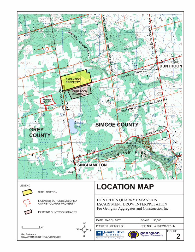
Georgian Aggregates and Construction Inc. (Georgian) operates a rock quarry and
aggregate production facility located on the south side of Simcoe Road 91, just east of
Grey Road 31 which is the boundary line between Simcoe and Grey counties. Georgian is
nearing the limits of extraction in the current quarry, and is making applications to expand
operations into adjacent lands owned by the Company north of Simcoe Road 91. The
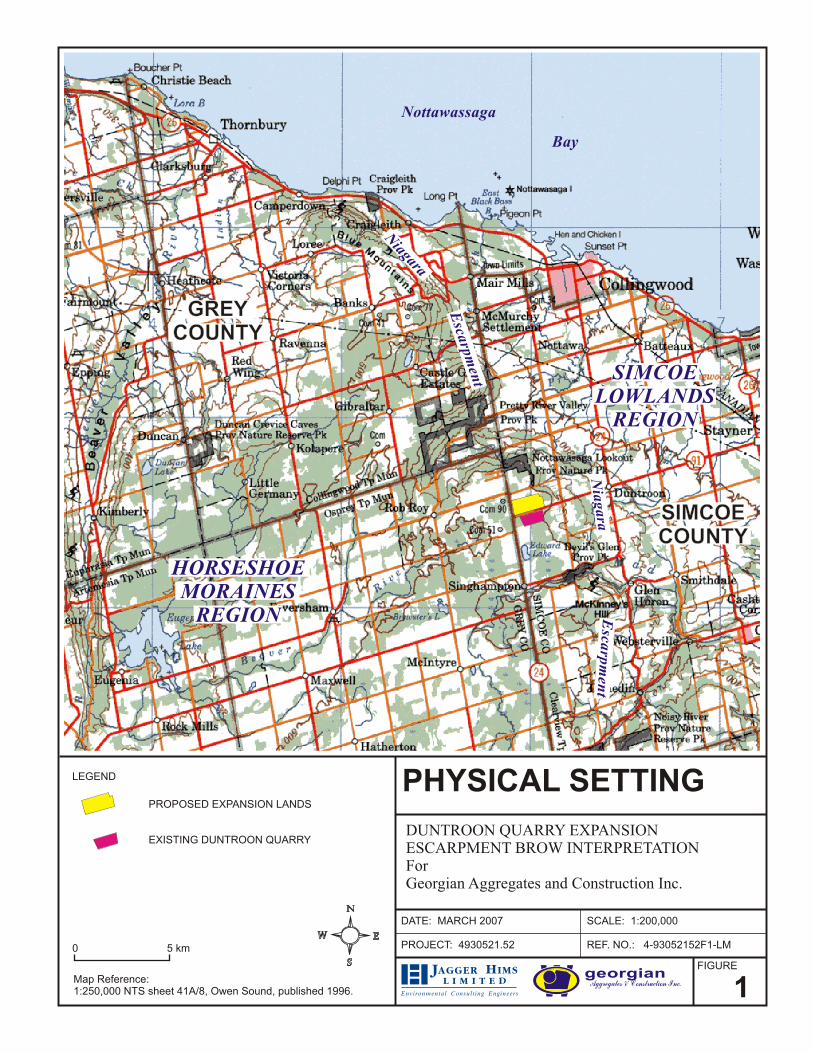
location of the currently licensed quarry, the proposed extension area, and other features in
the area are noted on Figures 1 and 2.
Details of the geology and hydrogeology of the Duntroon Quarry Expansion have been
described in “Duntroon Quarry Expansion Geological Report and Level 2 Hydrogeological
Assessment” prepared by Jagger Hims Limited for Georgian Aggregates and Construction
(File 930521.50, 3 Volumes, September 2005). The geology and location of the Niagara
Escarpment brow were discussed in the 2005 report, which concluded that the proposed
extraction area is situated in excess of 400 m west of (behind) the brow of the Niagara
Escarpment. The report concludes that the extraction area conforms to the Niagara
Escarpment Plan minimum separation distance of 200 m from the brow of the Escarpment.
Additional information is provided herein in response to requests raised during the review
process with respect to the location of the brow of the Escarpment. This current document
makes use of some of the text and figures produced in the September 2005 report.
2.0 GEOLOGY OF THE DUNTROON AREA
The Duntroon area was glaciated several times in the geologic past; however, the area on
top of the Niagara Escarpment around the existing quarry and expansion lands contains
variable thicknesses of surficial material, with bedrock outcrops being relatively common
in road cuts and as natural exposures. This pattern of bedrock exposure is common along
Escarpment Brow Interpretation – Duntroon Quarry Expansion Area 930521.50 Georgian Aggregates and Construction Inc. May 2, 2007
Jagger Hims Limited 8/20/2007 4:22:59 PM C:\Documents and Settings\jsedore\Desktop\AJC-R Duntroon Brow 070105.doc Page 4
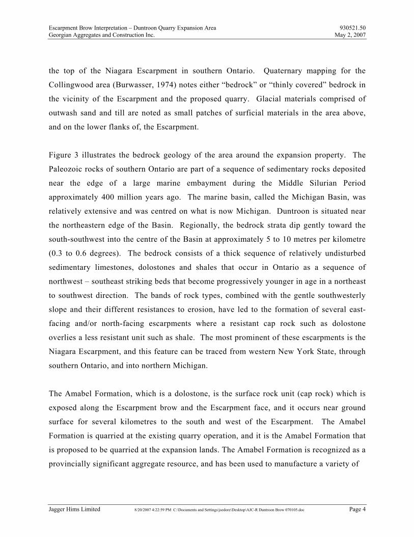
the top of the Niagara Escarpment in southern Ontario. Quaternary mapping for the
Collingwood area (Burwasser, 1974) notes either “bedrock” or “thinly covered” bedrock in
the vicinity of the Escarpment and the proposed quarry. Glacial materials comprised of
outwash sand and till are noted as small patches of surficial materials in the area above,
and on the lower flanks of, the Escarpment.
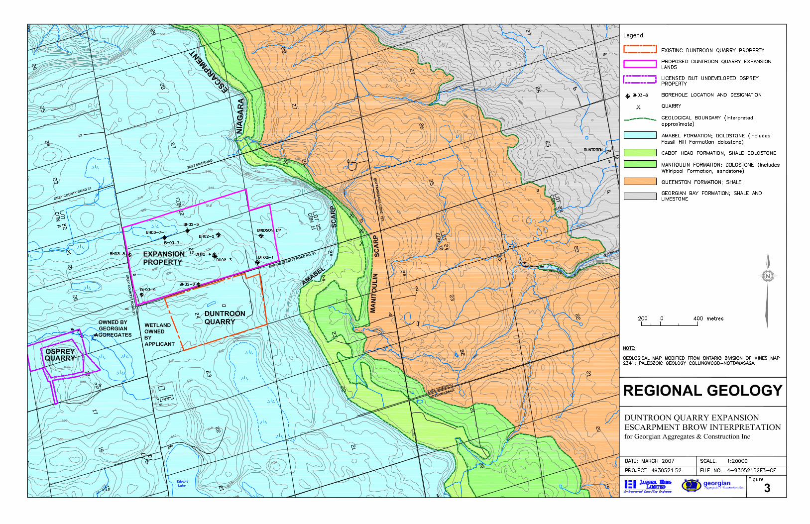
Figure 3 illustrates the bedrock geology of the area around the expansion property. The
Paleozoic rocks of southern Ontario are part of a sequence of sedimentary rocks deposited
near the edge of a large marine embayment during the Middle Silurian Period
approximately 400 million years ago. The marine basin, called the Michigan Basin, was
relatively extensive and was centred on what is now Michigan. Duntroon is situated near
the northeastern edge of the Basin. Regionally, the bedrock strata dip gently toward the
south-southwest into the centre of the Basin at approximately 5 to 10 metres per kilometre
(0.3 to 0.6 degrees). The bedrock consists of a thick sequence of relatively undisturbed
sedimentary limestones, dolostones and shales that occur in Ontario as a sequence of
northwest – southeast striking beds that become progressively younger in age in a northeast
to southwest direction. The bands of rock types, combined with the gentle southwesterly
slope and their different resistances to erosion, have led to the formation of several east-
facing and/or north-facing escarpments where a resistant cap rock such as dolostone
overlies a less resistant unit such as shale. The most prominent of these escarpments is the
Niagara Escarpment, and this feature can be traced from western New York State, through
southern Ontario, and into northern Michigan.
The Amabel Formation, which is a dolostone, is the surface rock unit (cap rock) which is
exposed along the Escarpment brow and the Escarpment face, and it occurs near ground
surface for several kilometres to the south and west of the Escarpment. The Amabel
Formation is quarried at the existing quarry operation, and it is the Amabel Formation that
is proposed to be quarried at the expansion lands. The Amabel Formation is recognized as a
provincially significant aggregate resource, and has been used to manufacture a variety of
Escarpment Brow Interpretation – Duntroon Quarry Expansion Area 930521.50 Georgian Aggregates and Construction Inc. May 2, 2007
Jagger Hims Limited 8/20/2007 4:22:59 PM C:\Documents and Settings\jsedore\Desktop\AJC-R Duntroon Brow 070105.doc Page 6
products, including crushed granular, asphalt and concrete products, building stone and
lime.
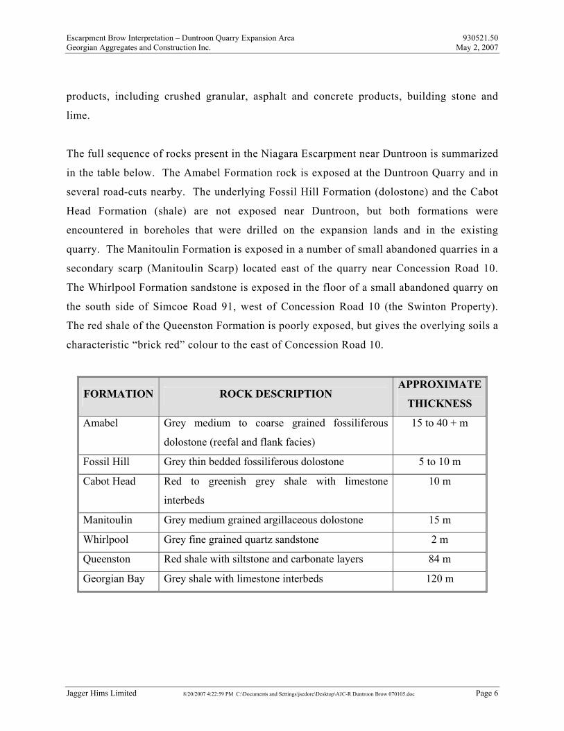
The full sequence of rocks present in the Niagara Escarpment near Duntroon is summarized
in the table below. The Amabel Formation rock is exposed at the Duntroon Quarry and in
several road-cuts nearby. The underlying Fossil Hill Formation (dolostone) and the Cabot
Head Formation (shale) are not exposed near Duntroon, but both formations were
encountered in boreholes that were drilled on the expansion lands and in the existing
quarry. The Manitoulin Formation is exposed in a number of small abandoned quarries in a
secondary scarp (Manitoulin Scarp) located east of the quarry near Concession Road 10.
The Whirlpool Formation sandstone is exposed in the floor of a small abandoned quarry on
the south side of Simcoe Road 91, west of Concession Road 10 (the Swinton Property).
The red shale of the Queenston Formation is poorly exposed, but gives the overlying soils a
characteristic “brick red” colour to the east of Concession Road 10.
FORMATION ROCK DESCRIPTION APPROXIMATE
THICKNESS
Amabel Grey medium to coarse grained fossiliferous
dolostone (reefal and flank facies)
15 to 40 + m
Fossil Hill Grey thin bedded fossiliferous dolostone 5 to 10 m
Cabot Head Red to greenish grey shale with limestone
interbeds
10 m
Manitoulin Grey medium grained argillaceous dolostone 15 m
Whirlpool Grey fine grained quartz sandstone 2 m
Queenston Red shale with siltstone and carbonate layers 84 m
Georgian Bay Grey shale with limestone interbeds 120 m
Escarpment Brow Interpretation – Duntroon Quarry Expansion Area 930521.50 Georgian Aggregates and Construction Inc. May 2, 2007
Jagger Hims Limited 8/20/2007 4:22:59 PM C:\Documents and Settings\jsedore\Desktop\AJC-R Duntroon Brow 070105.doc Page 7
3.0 THE NIAGARA ESCARPMENT BROW
3.1 BROW INTERPRETATION
The Niagara Escarpment is a physiographic and geologic feature which extends from New
York State, through southern Ontario, and westward and southward into Michigan and
Wisconsin. It is the most prominent of several bedrock escarpments associated with the
Michigan Basin geological structure, and it is recognized regionally as a nearly continuous
cliff separating two gently sloping surfaces. The Government of Ontario has recognized the
Niagara Escarpment as a distinct area of the province and created the Niagara Escarpment
Plan and the Niagara Escarpment Commission to assist in administering the Niagara
Escarpment and the adjoining lands.
The Niagara Escarpment is commonly perceived to be a continuous linear feature at a
regional level of assessment. However, the Niagara Escarpment includes occasional
interruptions in the physical escarpment which may take the form of imperfectly formed
portions of the escarpment, or areas where the escarpment is buried or obscured. The
Niagara Escarpment Plan addresses the escarpment as a “continuous natural environment”
for the purposes of administration.
The physical location of the escarpment brow is important in a planning and aggregate
extraction land use context. The Niagara Escarpment Planning and Development Act (and
associated regulations) requires that all extraction operations be situated at least 200m back
from (i.e. behind) the Escarpment brow.
The Niagara Escarpment Plan does not include a definition of the term “escarpment”. Dr.
D.F. Hewitt of the Department of Mines provided a discussion of the geological aspects of
Escarpment formation specifically as they apply to the Niagara Escarpment in Ontario
(Hewitt, 1971). It is documented that the Niagara Escarpment Commission depended
exclusively on the definitions provided by Hewitt to determine the location of the Niagara
Escarpment Brow Interpretation – Duntroon Quarry Expansion Area 930521.50 Georgian Aggregates and Construction Inc. May 2, 2007
Jagger Hims Limited 8/20/2007 4:22:59 PM C:\Documents and Settings\jsedore\Desktop\AJC-R Duntroon Brow 070105.doc Page 8
Escarpment (Report of the Niagara Escarpment Proposed Plan Hearing, 1983). Hewitt’s
definitions are also discussed.
The following interpretation of the position of the “brow” of the Niagara Escarpment in the
Duntroon area employs accepted geological definitions and practices, including the
definitions and discussions provided in Hewitt (1971), and the definitions and
interpretations contained in the Niagara Escarpment Plan.
3.2 DEFINITIONS
3.2.1 Plan Definition
The Niagara Escarpment Plan defines the Escarpment Brow (Edge) (p. 72):
"the uppermost point of the Escarpment slope or face. It
may be the top of a rock cliff, or where the bedrock is buried,
the most obvious break in slope associated with the
underlying bedrock."
The Escarpment Slope (Face) is defined (p. 72) as the following:
"the area between the brow and the toe of the Escarpment
and usually characterized by a steep gradient..."
3.2.2 Hewitt Definition
The Ontario government commissioned Dr. D.F. Hewitt of the Ontario Department of
Mines to provide a discussion of the geological aspects of the Niagara Escarpment during
the formulation of the Niagara Escarpment Plan. His discussion (Hewitt, 1971) provided a
review of standard definitions and related geological features. Hewitt recognized the
Escarpment Brow Interpretation – Duntroon Quarry Expansion Area 930521.50 Georgian Aggregates and Construction Inc. May 2, 2007
Jagger Hims Limited 8/20/2007 4:22:59 PM C:\Documents and Settings\jsedore\Desktop\AJC-R Duntroon Brow 070105.doc Page 9
inclusion of variations from the classical concept of the “escarpment” and included
definitions and discussions to assist in interpreting these features within the context of the
Niagara Escarpment Plan and the ‘continuous natural environment’ concept. The Niagara
Escarpment Commission staff relied exclusively on Hewitt’s definitions during the
preparation of the Plan. Following are selected quotes from Hewitt (1971).
Brow or Edge (P. 3)
"The brow or edge of the escarpment is the point where the
gradient changes from gentle to steep. Where the
escarpment is due to the presence of a resistant scarp
former, the brow or edge will be marked by a cliff or steep
bluff of rock."
Face (P. 3)
"The face of the escarpment includes the area of steep
gradient between the edge and the base of the escarpment."
3.2.3 Geological Definition
‘Brow’, ‘escarpment’, and ‘break in slope’ are geological terms. These terms and several
related terms are taken from the Glossary of Geology, which is a common reference for
geological and geomorphological terms.
Brow
The projecting upper part or margin of a slope just below
the crest; the edge of the top of a hill or mountain, or the
place at which a gentle slope becomes abrupt.
Escarpment Brow Interpretation – Duntroon Quarry Expansion Area 930521.50 Georgian Aggregates and Construction Inc. May 2, 2007
Jagger Hims Limited 8/20/2007 4:22:59 PM C:\Documents and Settings\jsedore\Desktop\AJC-R Duntroon Brow 070105.doc Page 10
Escarpment
(a) A long, more or less continuous cliff or relatively steep slope facing in one general
direction, breaking the continuity of the land by separating two level or gently
sloping surfaces, and produced by erosion or by faulting. The term is often used
synonymously with scarp, although escarpment is more often applied to a cliff formed
by differential erosion. (b) A steep, abrupt face of rock, often presented by the highest
strata in a line of cliffs, and generally marking the outcrop of a resistant layer
occurring in a series of gently dipping softer strata; specif. the steep face of a cuesta.
Scarp
(a) A line of cliffs produced by faulting or by erosion. The term is an abbreviated form
of escarpment, and the two terms commonly have the same meaning, although
"scarp" is more often applied to cliffs formed by faulting. (b) A relatively straight,
cliff-like face or slope of considerable linear extent, breaking the general continuity
of the land by separating surfaces lying at different levels, as along the margin of a
plateau or mesa. A scarp may be of any height. The term should not be used for a
slope of highly irregular outline.
3.2.4 Discussion
The term "escarpment" originated as a geological term with a distinct and specific
meaning. The geological definition refers to a cliff or steep slope which is composed of
rock, separating two level or gently sloping surfaces, and is formed by faulting or
differential erosion. The geological meaning of the term is also apparent in the general
public understanding of the term escarpment. The brow, break in slope, toe and other
terms relate to the escarpment definition, as they are components of the escarpment.
Escarpment Brow Interpretation – Duntroon Quarry Expansion Area 930521.50 Georgian Aggregates and Construction Inc. May 2, 2007
Jagger Hims Limited 8/20/2007 4:22:59 PM C:\Documents and Settings\jsedore\Desktop\AJC-R Duntroon Brow 070105.doc Page 11
The majority of the Niagara Escarpment in Ontario, including the portion of the
Escarpment near Duntroon, is a bedrock escarpment and the Plan definitions, the Hewitt
definitions, and geological definitions, are compatible and readily applicable.
The determination of the Escarpment "brow" in the Duntroon area is based upon the
bedrock landforms, the topography, the rock cliff, and the change in slope.
The "brow" can therefore be determined using the following.
"...the top of a rock cliff..." (Niagara Escarpment Plan p. 72)
"...the point where the gradient changes from gentle to
steep." (Hewitt, 1971)
"...the place at which a gentle slope becomes abrupt"
(Glossary of Geology)
It is important to note that the definitions do not relate the brow to either a particular
elevation or to a height of land – the above definitions focus on the brow as a change in
slope. One additional factor is relevant to the interpretation of the brow. The Glossary
definition for "scarp" (an abbreviated form of the term escarpment) indicates that the term
should not be used for a slope of highly irregular outline." (Glossary of Geology).
Escarpment Brow Interpretation – Duntroon Quarry Expansion Area 930521.50 Georgian Aggregates and Construction Inc. May 2, 2007
Jagger Hims Limited 8/20/2007 4:22:59 PM C:\Documents and Settings\jsedore\Desktop\AJC-R Duntroon Brow 070105.doc Page 12
3.3 INTERPRETATION
3.3.1 Methods
The interpretation of the “brow” of the Niagara Escarpment should be:
consistent with definitions in the Plan,
consistent with common geologic practice and definitions,
consistent throughout the Plan,
consistent over time unless new data become available,
reproducible.
There are a variety of techniques available to assist in determining the position of the
Niagara Escarpment Brow. The following are data and information which are commonly
used for such an analysis.
1. Geology: It is important to understand the basic geology of the landforms at any
location. Where these landforms are bedrock and fit the definitions, a ready and
reproducible interpretation can be rendered. The presence of the hard resistant
dolostone of the Amabel Formation overlying several less resistant strata is the
underlying geological control of the position of the Niagara Escarpment.
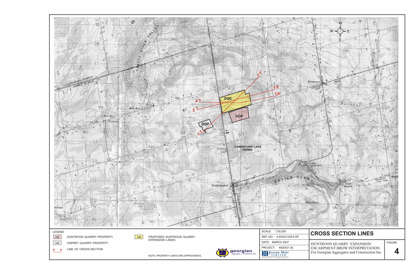
2. Topography: Topography can be addressed through a variety of ways. A common
way is to interpret the landform and slopes using topographic mapping (Figure 4),
and stereo air photo interpretation. Topographic contours are printed on the Plan
maps and it is often possible to estimate the position of the escarpment using these
1:50,000 scale maps. More detailed maps and air photos may be useful in
interpretations but excessive detail, particularly in areas of irregular topography, can
obscure broad features such as the brow and toe of the escarpment.
Escarpment Brow Interpretation – Duntroon Quarry Expansion Area 930521.50 Georgian Aggregates and Construction Inc. May 2, 2007
Jagger Hims Limited 8/20/2007 4:22:59 PM C:\Documents and Settings\jsedore\Desktop\AJC-R Duntroon Brow 070105.doc Page 13
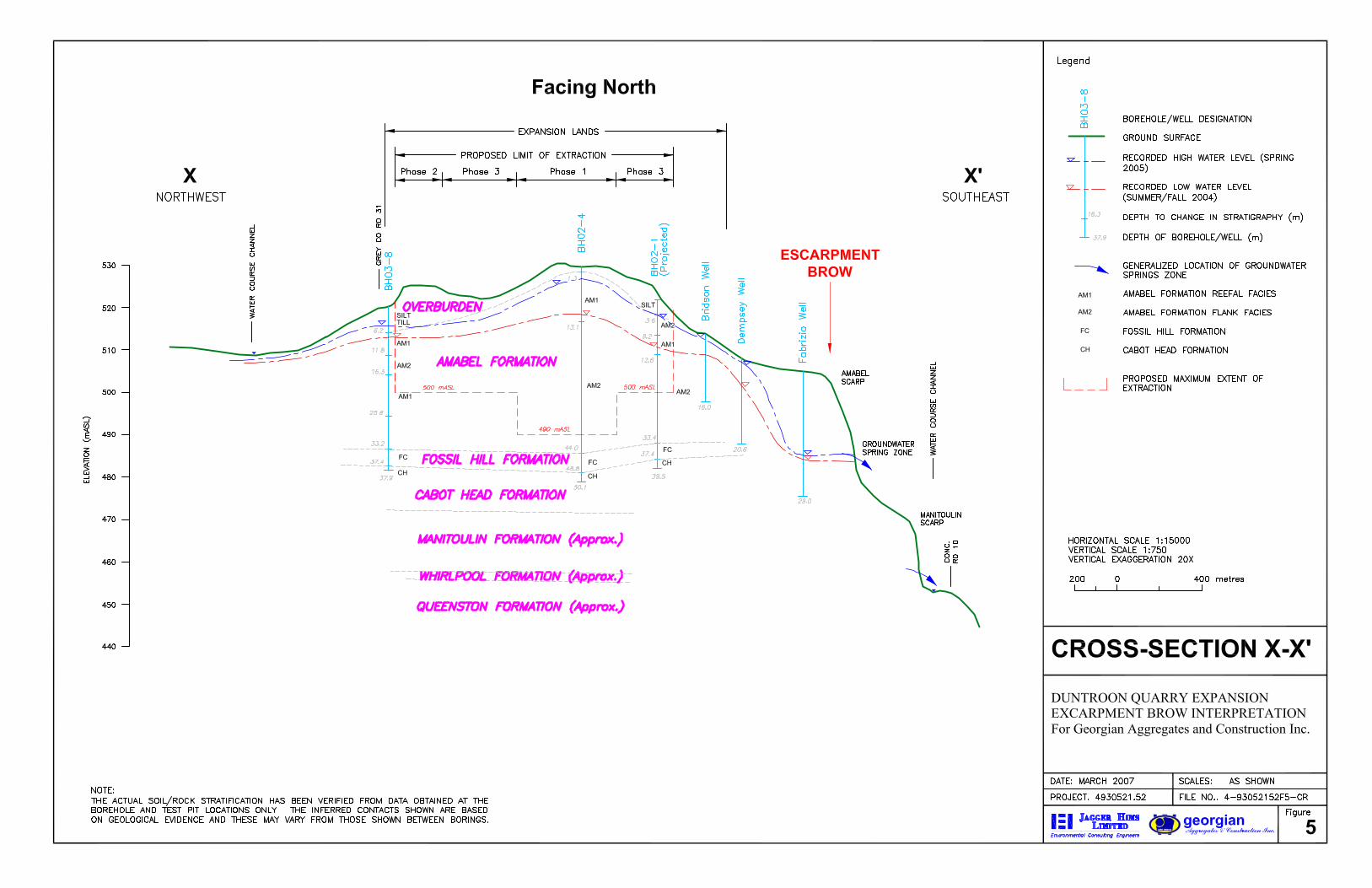
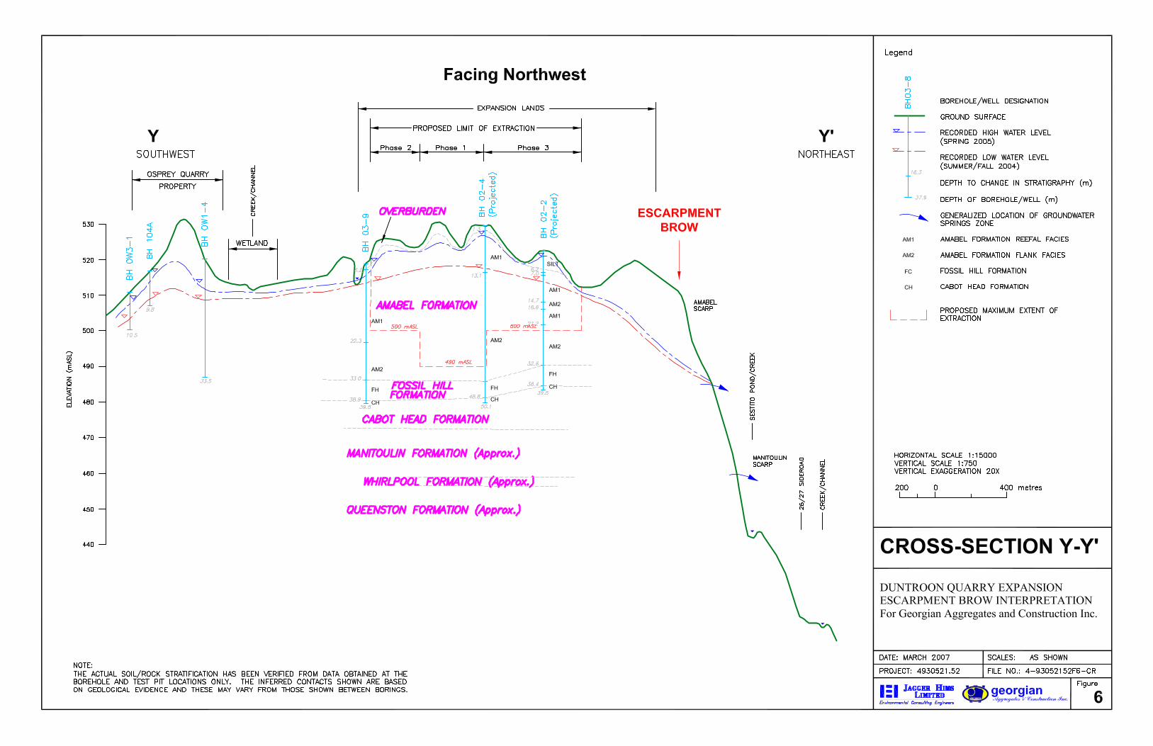
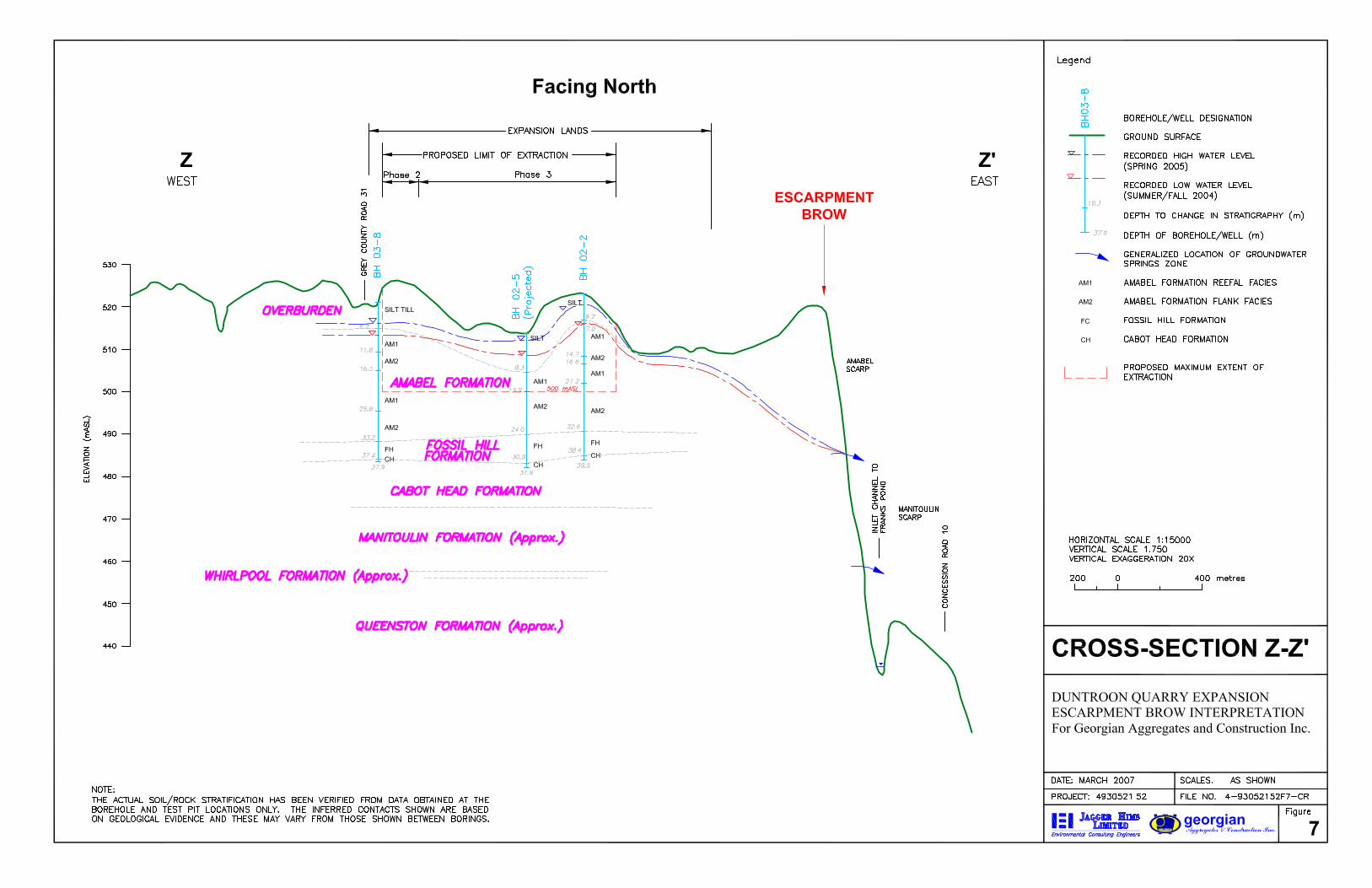
3. Cross-Sections: Cross-sections can be an aid to visualizing the profile of a portion of
the escarpment and can be of assistance in establishing changes in slope and the
brow. They must, however, be used in conjunction with topographic maps. Where
the topography is irregular, such as in the Collingwood-Owen Sound area, individual
cross-sections can encounter topography which may partially obscure the broader
landform, and several cross sections and other lines of evidence will be required to
make an accurate determination. Three cross sections through the Niagara
Escarpment in the Duntroon area are noted on Figure 4, and the cross sections are
included as Figures 5, 6, and 7.
4. Elevations: Elevations can be helpful in determining the overall position of a break
in slope or escarpment brow. The escarpment brow often maintains a similar
elevation over distances of several kilometers to tens of kilometres.
5. Slopes: The determination of changes in slope can be determined in the field using
direct observation, using topographic maps, constructing cross-sections, or analyzing
spot elevations. The overall or average slope of a hillside is an important aspect in
determining where a meaningful break in slope occurs when establishing the position
of the brow or the toe. It is critical to maintain a generalized or averaged slope over
a significant portion of terrain in order to assess the slope, otherwise one can be faced
with a variety of short slope intervals which relate more to small hills, knolls or
valleys, rather than to the dominant slope character.
6. Field Inspection: Topographic maps and cross sections are representations of what is
actually present in the field. A field inspection and walk-over will enable an
experienced observer to consider features in an appropriate context, thereby
facilitating a reasoned interpretation. Field-viewing of the Niagara Escarpment in the
Duntroon area is particularly informative, as the brow and the escarpment face are
well exposed and exhibit classical landform characteristics.
Escarpment Brow Interpretation – Duntroon Quarry Expansion Area 930521.50 Georgian Aggregates and Construction Inc. May 2, 2007
Jagger Hims Limited 8/20/2007 4:22:59 PM C:\Documents and Settings\jsedore\Desktop\AJC-R Duntroon Brow 070105.doc Page 18
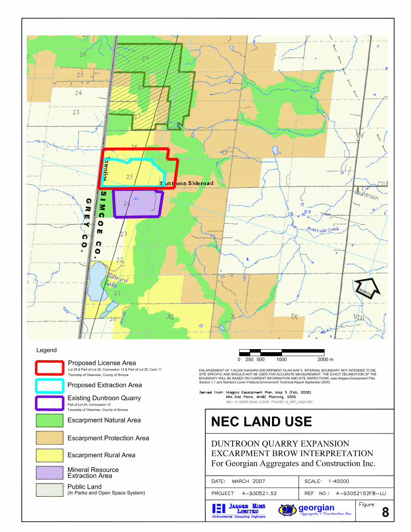
3.3.2 Niagara Escarpment Plan
The brow of the Niagara Escarpment (by Plan ‘Criteria for Designation’, p.11 and 13) is
located within the Escarpment Natural or Escarpment Protection areas of the Plan. The
brow is not situated in the Escarpment Rural Area, as this area includes "minor escarpment
slopes and landforms" (Ibid, p.16). While the maps included with the Plan do not
specifically locate the escarpment brow, they do identify Escarpment Natural and
Escarpment Protection areas which must contain the brow. Thus, the Plan maps establish a
zone within which the brow is expected to occur (Figure 8). The proposed extraction area
within the expansion lands is situated to the west of that zone, in lands designated
Escarpment Rural.
3.3.3 Detailed Brow Determination
An analysis of the geologic and geomorphological features in the vicinity of the Duntroon
property was completed in order to assess the position of the Niagara Escarpment brow.
The author conducted a field examination, reviewed various scales of topographic
mapping, reviewed 1:50,000 scale geological mapping for both Quaternary and Paleozoic
geology, reviewed aerial photography, constructed cross-sections, and reviewed other
mapping in completing the assessment. Close attention was given to the definitions of the
brow which have been discussed previously. The position of the brow as interpreted by the
author of this report is noted on Figure 9.
The determination of the "brow" is a relatively uncomplicated task in the Duntroon area
due to the classical escarpment geomorphology. The Plan notes that the uppermost point of
the Escarpment slope or face. “…may be the top of a rock cliff…”. The bedrock is at or
near ground surface over much of the area, so the break in slope is clearly visible at the top
of the well-exposed rock cliff.
Escarpment Brow Interpretation – Duntroon Quarry Expansion Area 930521.50 Georgian Aggregates and Construction Inc. May 2, 2007
Jagger Hims Limited 8/20/2007 4:22:59 PM C:\Documents and Settings\jsedore\Desktop\AJC-R Duntroon Brow 070105.doc Page 21
Thus, the position of the break in slope or brow can be identified with precision over much
of the area, and the position of the brow is plotted at a scale of 1:50,000 on Figure 9. The
figure also shows the proposed limit of extraction within the expansion lands, as well as
200 m and 400 m radius distances around the extraction area.
Figure 9 illustrates that at all points, the proposed limit of extraction is positioned in excess
of 400 m away from (behind) the brow of the Escarpment. Thus, the proposed expansion
complies with the Niagara Escarpment Plan in that the extraction area is not situated within
the minimum separation distance of 200 m from the brow of the Escarpment.
4.0 CONCLUSIONS
The current analysis of the position of the Niagara Escarpment “brow” in the Duntroon
area yields the following conclusions.
1. The Niagara Escarpment is clearly exposed as a classical bedrock escarpment in most of
the Duntroon area. The brow of the Escarpment is present to the east of the proposed
quarry expansion, and is situated a minimum of 400m from the extraction area, as noted on
Figure 9.
2. The proposed extraction plan conforms to the requirement of the Niagara Escarpment
Plan which states the extraction area for any new license shall be situated a minimum
of 200 m behind the brow of the Escarpment.
3. The Niagara Escarpment Plan has designated that the “Escarpment slopes and related
landforms…” occur within the Escarpment Natural and Escarpment Protection areas
of the Plan. The Plan maps for the Duntroon area identify Escarpment Natural and
Escarpment Protection areas to the east of the proposed expansion lands, and the
Escarpment Brow Interpretation – Duntroon Quarry Expansion Area 930521.50 Georgian Aggregates and Construction Inc. May 2, 2007
Jagger Hims Limited 8/20/2007 4:22:59 PM C:\Documents and Settings\jsedore\Desktop\AJC-R Duntroon Brow 070105.doc Page 22
current study has located the escarpment brow within these areas. The current
determination of the brow location and the Niagara Escarpment Plan are consistent.
5.0 REFERENCES
Burwasser, G.J., 1974:
Quaternary Geology of the Collingwood-Nottawasaga Area, southern Ontario;
Ontario Division of Mines Preliminary Map P.919, scale 1:50,000.
Glossary of Geology, 1987:
R.L. Bates and J.A. Jackson editors, American Geological Institute, Alexandria,
Virginia.
Hewitt, D.F., 1971:
The Niagara Escarpment: Ontario Department of Mines and Northern Affairs,
Industrial Mineral Report 35, 71 p.
Liberty, B. A., 1969:
Palaeozoic Geology of the Lake Simcoe Area, Southern Ontario; Geological Survey
of Canada, Memoir 355, 201 p., accompanied by map 1228A, scale 1:253,440.
Niagara Escarpment Plan:
Published by the Ministry of Municipal Affairs, including nine maps, Scale
1:50,000.
Niagara Escarpment Proposed Plan Hearing, 1983:
Report of the Hearing Officers
Escarpment Brow Interpretation – Duntroon Quarry Expansion Area 930521.50 Georgian Aggregates and Construction Inc. May 2, 2007
Jagger Hims Limited 8/20/2007 4:22:59 PM C:\Documents and Settings\jsedore\Desktop\AJC-R Duntroon Brow 070105.doc Page 23
Telford, P.G., 1976:
Paleozoic Geology of the Collingwood-Nottawasaga Area, southern Ontario,
Ontario Division of Mines, Map 2341, scale 1:50,000.