ES-1 Introduction - Walk Bridge Program app a.pdf · ES-1 Introduction The Federal Transit...
38
Environmental Assessment/Section 4(f) Evaluation Environmental Impact Evaluation Executive Summary Executive Summary ES-1 Introduction The Federal Transit Administration (FTA) and the Connecticut Department of Transportation (CTDOT) are preparing a combined Environmental Assessment (EA), Section 4(f) Evaluation, and Environmental Impact Evaluation (EIE) to evaluate proposed improvements to the New Haven Line railroad bridge over the Norwalk River (the Walk Bridge – Bridge No. 04288R) in Norwalk, Connecticut. Figure ES-1 shows the location of the Walk Bridge and approximate project limits. This document has been prepared in accordance with the requirements of the National Environmental Policy Act (NEPA), Title 42 of the United States Code (USC) Section 4321 et seq.; the Connecticut Environmental Policy Act (CEPA), Sections 22a-1a through 22a-1h of the Connecticut General Statutes (CGS); the joint Federal Highway Administration/FTA Environmental Impact and Related Procedures, 23 Code of Federal Regulations (CFR) 771; and Section 22a-1a-1 through 22a-1a-12 of the Regulations of Connecticut State Agencies (RCSA). This document also complies with the requirements of Title 49 USC Section 303 (referred to as Section 4(f) of the U.S. Department of Transportation Act of 1966), and other federal and state directives, policies, and regulations. ES-2 Background Walk Bridge is a four-span swing bridge that spans 564 feet over the Norwalk River, a navigable waterway used for both recreational and commercial marine traffic. Walk Bridge was built in 1896 by the Pennsylvania Steel Company’s Bridge and Construction Department as part of the four-tracking and elevation of the New Haven Line. Walk Bridge carries four tracks of the New Haven Line (NHL) of Metro-North Railroad commuter service. The NHL is one of three main lines of Metro-North, which had a total of 85.2 million riders in 2014, the highest in the railroad’s history. The NHL also is used for intercity and high-speed passenger service by the National Railroad Passenger Corporation (Amtrak) on the Northeast Corridor (NEC), and for freight service by the Providence & Worcester Railroad. The NHL’s right-of-way and physical infrastructure within Connecticut, including Walk Bridge, are owned by the State of Connecticut and maintained by CTDOT. The deteriorating condition of Walk Bridge has been extensively documented over the years. 1 A detailed fatigue analysis was completed in 2005, and it indicated that major portions of the bridge have exceeded their fatigue life and require replacement. Cumulative fatigue damage (damage due to repetitive train loadings) of the main load carrying elements of the bridge has occurred. The electrical systems are generally obsolete. Existing and projected deterioration and wear of mechanical systems are key elements which affect the reliability of the bridge. CTDOT performs maintenance and repairs on a regular basis; however, without action to rehabilitate or replace the bridge, failures are expected to increase. 1 Documentation of the deteriorating condition of Walk Bridge includes the Transportation Strategy Board, “Strategic Framework for Investing in Connecticut’s Transportation Infrastructure: Economic Growth – Infrastructure Preservation – Sustainable Communities,” January 2011; CTDOT, Accelerated Bridge Construction Study, March 2014 (draft). Walk Bridge Replacement, Project No. 0301-0176 August 2016 Connecticut Department of Transportation Page ES-1
Transcript of ES-1 Introduction - Walk Bridge Program app a.pdf · ES-1 Introduction The Federal Transit...

Environmental Assessment/Section 4(f) Evaluation Environmental Impact Evaluation Executive Summary
Executive Summary
ES-1 Introduction
The Federal Transit Administration (FTA) and the Connecticut Department of Transportation (CTDOT) are preparing a combined Environmental Assessment (EA), Section 4(f) Evaluation, and Environmental Impact Evaluation (EIE) to evaluate proposed improvements to the New Haven Line railroad bridge over the Norwalk River (the Walk Bridge – Bridge No. 04288R) in Norwalk, Connecticut. Figure ES-1 shows the location of the Walk Bridge and approximate project limits.
This document has been prepared in accordance with the requirements of the National Environmental Policy Act (NEPA), Title 42 of the United States Code (USC) Section 4321 et seq.; the Connecticut Environmental Policy Act (CEPA), Sections 22a-1a through 22a-1h of the Connecticut General Statutes (CGS); the joint Federal Highway Administration/FTA Environmental Impact and Related Procedures, 23 Code of Federal Regulations (CFR) 771; and Section 22a-1a-1 through 22a-1a-12 of the Regulations of Connecticut State Agencies (RCSA). This document also complies with the requirements of Title 49 USC Section 303 (referred to as Section 4(f) of the U.S. Department of Transportation Act of 1966), and other federal and state directives, policies, and regulations.
ES-2 Background
Walk Bridge is a four-span swing bridge that spans 564 feet over the Norwalk River, a navigable waterway used for both recreational and commercial marine traffic. Walk Bridge was built in 1896 by the Pennsylvania Steel Company’s Bridge and Construction Department as part of the four-tracking and elevation of the New Haven Line. Walk Bridge carries four tracks of the New Haven Line (NHL) of Metro-North Railroad commuter service. The NHL is one of three main lines of Metro-North, which had a total of 85.2 million riders in 2014, the highest in the railroad’s history. The NHL also is used for intercity and high-speed passenger service by the National Railroad Passenger Corporation (Amtrak) on the Northeast Corridor (NEC), and for freight service by the Providence & Worcester Railroad. The NHL’s right-of-way and physical infrastructure within Connecticut, including Walk Bridge, are owned by the State of Connecticut and maintained by CTDOT.
The deteriorating condition of Walk Bridge has been extensively documented over the years.1 A detailed fatigue analysis was completed in 2005, and it indicated that major portions of the bridge have exceeded their fatigue life and require replacement. Cumulative fatigue damage (damage due to repetitive train loadings) of the main load carrying elements of the bridge has occurred. The electrical systems are generally obsolete. Existing and projected deterioration and wear of mechanical systems are key elements which affect the reliability of the bridge. CTDOT performs maintenance and repairs on a regular basis; however, without action to rehabilitate or replace the bridge, failures are expected to increase.
1 Documentation of the deteriorating condition of Walk Bridge includes the Transportation Strategy Board, “Strategic Framework for Investing in Connecticut’s Transportation Infrastructure: Economic Growth – Infrastructure Preservation – Sustainable Communities,” January 2011; CTDOT, Accelerated Bridge Construction Study, March 2014 (draft).
Walk Bridge Replacement, Project No. 0301-0176 August 2016 Connecticut Department of Transportation Page ES-1

Environmental Assessment/Section 4(f) Evaluation Executive Summary Environmental Impact Evaluation
ES-3 Project Purpose and Need
CTDOT and FTA have determined that the project purpose and need is to restore or replace the existing deteriorated bridge with a resilient bridge structure which will enhance the safety and reliability of rail service; offer operational flexibility and ease of maintenance; and provide for increased capacity and efficiencies of rail transportation along the New Haven Line/ Northeast Corridor, while maintaining or improving navigational capacity and dependability for marine traffic in the Norwalk River. Upgrades to the Walk Bridge, through rehabilitation or replacement, are needed to increase bridge reliability, incorporate bridge redundancy, and provide a sustainable bridge for significant weather events, thereby accommodating current and future rail and marine traffic.
Figure ES-1—Project Location
August 2016 Walk Bridge Replacement, Project No. 0301-0176 Page ES-2 Connecticut Department of Transportation

Environmental Assessment/Section 4(f) Evaluation Environmental Impact Evaluation Executive Summary
ES-4 Project Alternatives Considered
CTDOT’s design strategy for the Walk Bridge Replacement Project focused upon meeting the project purpose and need: providing a resilient bridge structure to enhance the safety and reliability of rail service, offering operational flexibility and ease of maintenance, and providing for increased capacity and efficiencies of rail transportation, while maintaining or improving navigational capacity. An important overall design objective was therefore predicated upon providing system resiliency and operational redundancy, as mandated by FTA in its funding appropriation.
Alternatives Development and Screening
CTDOT identified a range of alternatives and grouped them into four general categories:
1. No Build (No Action) Alternative: continuing the existing operations and maintenance of the historic swing (movable) bridge;
2. Rehabilitation Alternative: rehabilitating the existing bridge to extend its useful life by 100 years, a timeframe comparable to the useful life of a new bridge;
3. Replacement Alternative – Movable Bridge: constructing a new movable bridge, of either the bascule type or vertical lift type, on the same general alignment, and demolishing the existing bridge; and
4. Replacement Alternative – Fixed Bridge: constructing a new fixed (non-movable) bridge on the same or a different general alignment and demolishing the existing bridge.
The parameters considered in the development and evaluation of alternatives and design options included:
• Horizontal and vertical navigation clearances
• Bridge aesthetics, including historic considerations
• Track spacing for center tracks • Environmental considerations • Span length • Resiliency • Counterweight locations • Redundancy • Pier locations • Constructability • Mechanical systems • Rail, marine, and local impacts during construction • Electrical systems • Cost, including initial costs and life cycle costs
More than 70 different design variations within the four groups of alternatives were initially investigated to identify representative options that consider these parameters and meet the project purpose and need. CTDOT identified and developed concepts to replace the existing Walk Bridge with dual, double-track movable spans in accordance with the design objectives for resiliency and redundancy. For a bascule movable bridge, design options included deck girder, through girder and through truss bascule bridges of both the trunnion and rolling lift genre.2 For a vertical lift movable bridge, design options included deck girder, through girder, or through truss vertical lift bridges with span-drive or tower-drive lift span operating systems.3
CTDOT held multiple meetings with public agencies and project stakeholders, including the U.S. Army Corps of Engineers (USACE), the U.S. Coast Guard (USCG), the City of Norwalk, Metro-North,
2 See Chapter 11, Acronyms and Glossary of Terms, for descriptions. 3 Ibid.
Walk Bridge Replacement, Project No. 0301-0176 August 2016 Connecticut Department of Transportation Page ES-3

Environmental Assessment/Section 4(f) Evaluation Executive Summary Environmental Impact Evaluation
property owners, and waterway users to ascertain concerns and requirements for the replacement bridge design and to obtain public and agency input. CTDOT also held a public scoping meeting on February 24, 2015, an agency scoping meeting on March 5, 2015, and a public information meeting on May 11, 2016. With input from those meetings, CTDOT concluded that the evaluation of alternatives would focus on replacement of the bridge and would include consideration of a bascule movable bridge type, a through truss vertical lift movable bridge type; as well as a fixed bridge (non-movable) type with three design options of varied vertical clearances over the Norwalk River: a low-level, a mid-level, and a high-level bridge.
Alternatives Not Advanced for Further Evaluation
Of the four alternative groups which were evaluated, the No Build Alternative, the Rehabilitation Alternative, and the Replacement Alternative – Fixed Bridge (all options) were dismissed from further evaluation for a number of reasons: they would not meet the project purpose and need; they would be inferior to other alternatives in meeting project purpose and need; they would result in higher initial or long-term costs; or they would have a higher potential for adverse environmental impact.
While it would not meet the project purpose and need, the No Build Alternative is carried forward in the EA/EIE as a baseline condition for comparison purposes; it represents the transportation conditions if no actions other than normal maintenance of the bridge were conducted.
Alternatives Retained for Further Evaluation
In addition to the No Build Alternative, CTDOT retained and advanced a Build Alternative for further evaluation in this EA/EIE: the Replacement Alternative – Movable Bridge. Two types of replacement movable bridges were considered for the Build Alternative: a rolling lift bascule bridge was advanced, and a through truss vertical lift bridge was advanced. A variation of the vertical lift bridge type with a longer span also was advanced.
No Build Alternative
In the No Build Alternative, CTDOT would retain the existing bridge and provide for normal maintenance activities during the life of the bridge. The No Build Alternative would not extend the useful life of the existing bridge. There would not be any major rehabilitation or replacement of structural elements, foundation elements, mechanical components, or electrical systems. The existing high towers would be retained and undergo normal maintenance. There would be no changes to the existing track configuration in South Norwalk and East Norwalk.
Build Alternative: Replacement Alternative – Movable Bridge
CTDOT has determined that Replacement Alternative – Movable Bridge is the Build Alternative. Three options of the Build Alternative are presented in the EA/EIE: Bascule Bridge (Option 4S), short span Vertical Lift Bridge (Option 8A), and long span Vertical Lift Bridge (Option 11C). These options are representative of the bascule and vertical lift bridge types as a balance of user needs, engineering, environmental, cost, and constructability needs and constraints. As design progresses on a bridge type, design refinements such as modifying final span lengths and other dimensional attributes are possible.
August 2016 Walk Bridge Replacement, Project No. 0301-0176 Page ES-4 Connecticut Department of Transportation

Environmental Assessment/Section 4(f) Evaluation Environmental Impact Evaluation Executive Summary
ES-5 Build Alternative
ES-5.1 Bascule Bridge Option (Option 4S)
The Bascule Bridge option (as shown in Figure ES-2 and Figure ES-3) would provide two side by side single-leaf rolling lift bascule spans across the Norwalk River, each with separate mechanical and electrical equipment and controls so that each span can work independently of the other, or in unison with the other. It would provide a vertical clearance of approximately 27 feet above mean high water (MHW) when the movable span is in the closed position, and a vertical clearance of at least 60 feet when the movable span is in the opened position, as shown in the elevation view of the Bascule Bridge, Figure ES-4. When closed, the vertical clearance of the Bascule Bridge is increased by approximately 11 feet over the existing vertical clearance of 16 feet due to the design of the structure. However, the top of rail elevations on the new bridge would be approximately the same as the top of rail elevations on the existing bridge. A horizontal clearance of at least 120 feet would be provided for navigation, and the alignment of the navigation channel under the new bridge with the alignment of the navigation channel under the Stroffolino Bridge would be improved.
Figure ES-2—Rendering of Bascule Bridge in the Closed Position (Option 4S)
The rolling bascule spans would be comprised of 170-foot movable truss spans with overhead counterweights. As the span moves, the structure would be supported by curved segmental girders that are connected to the bascule span and the counterweight. As the span rotates during movements, it would also translate, or roll, horizontally, with the movements guided by the curved segmental girder. The overhead counterweights would be configured to permit the counterweights to pass to the outside of the adjacent fixed approach spans. The drive machinery, electrical components, and controls for operating the span would be located above track level, improving the resiliency of the systems by offering protection from high water events.
Walk Bridge Replacement, Project No. 0301-0176 August 2016 Connecticut Department of Transportation Page ES-5

Environmental Assessment/Section 4(f) Evaluation Executive Summary Environmental Impact Evaluation
Figure ES-3—Rendering of Bascule Bridge in the Open Position (Option 4S)
Figure ES-4—Elevation View of the Bascule Bridge (Option 4S) ES-
The new movable spans would each carry two tracks: Tracks 1 and 3 on the northern span and Tracks 2 and 4 on the southern span. The tracks would be on a non-parallel alignment with adequate spacing between the two center tracks (Tracks 1 and 2) to accommodate structural and mechanical clearances. With this non-parallel alignment, the total width of the two bridge structures would vary from approximately 50 feet at the western abutment to 95 feet at the eastern abutment. The movable spans would be flanked by four spans on the western side and two spans on the eastern side. These approach spans would be fixed spans and would not move. Including the approach spans, the total length of Walk Bridge would be approximately 650 feet from bridge abutment to bridge abutment.
August 2016 Walk Bridge Replacement, Project No. 0301-0176 Page ES-6 Connecticut Department of Transportation
Environmental Assessment/Section 4(f) Evaluation Environmental Impact Evaluation Executive Summary
The Bascule Bridge would be supported by new abutments at each end and by six intermediate bridge piers, including the bascule pier and the bascule rest pier. The foundations for the bascule piers, rest pier, and intermediate pier supporting the control house would all be located in the Norwalk River and would be comprised of drilled shafts installed into bedrock with a cap beam connecting the drilled shafts. The construction of the piers in the river would be contained using sheet pile marine enclosures or oversized pipe enclosures. The western bridge abutment would be located approximately 100 feet further west than the existing abutment to avoid construction conflicts with the existing abutment, high tower foundations, and retaining walls. Although not the intent of the abutment relocation, this action would result in a more open environment on the west side of North Water Street under the bridge. A new control house would be located on the southern end of the intermediate pier.
The bascule pier would consist of two adjacent, open piers that support the rolling bascule span structural elements. Drilled shafts with cap beams would make up the bascule pier foundations. The open nature of the substructure would promote hydraulic flow through the limits of the bridge.
A new fender system would be constructed approximately 10 feet from the new bascule and rest piers to protect them, providing at least 120 feet of horizontal clearance in the navigation channel. The fenders would be supported by concrete or steel piles. Navigational lighting in accordance with USCG standards would be installed.
The probable construction cost of the Bascule Bridge (Option 4S) is estimated to range between $330 and $365 million in year 2020 dollars, which is the anticipated mid-point of construction. Life cycle costs, equalized to present worth of 100 year life, are estimated to range between $3.4 and $3.9 million per year.
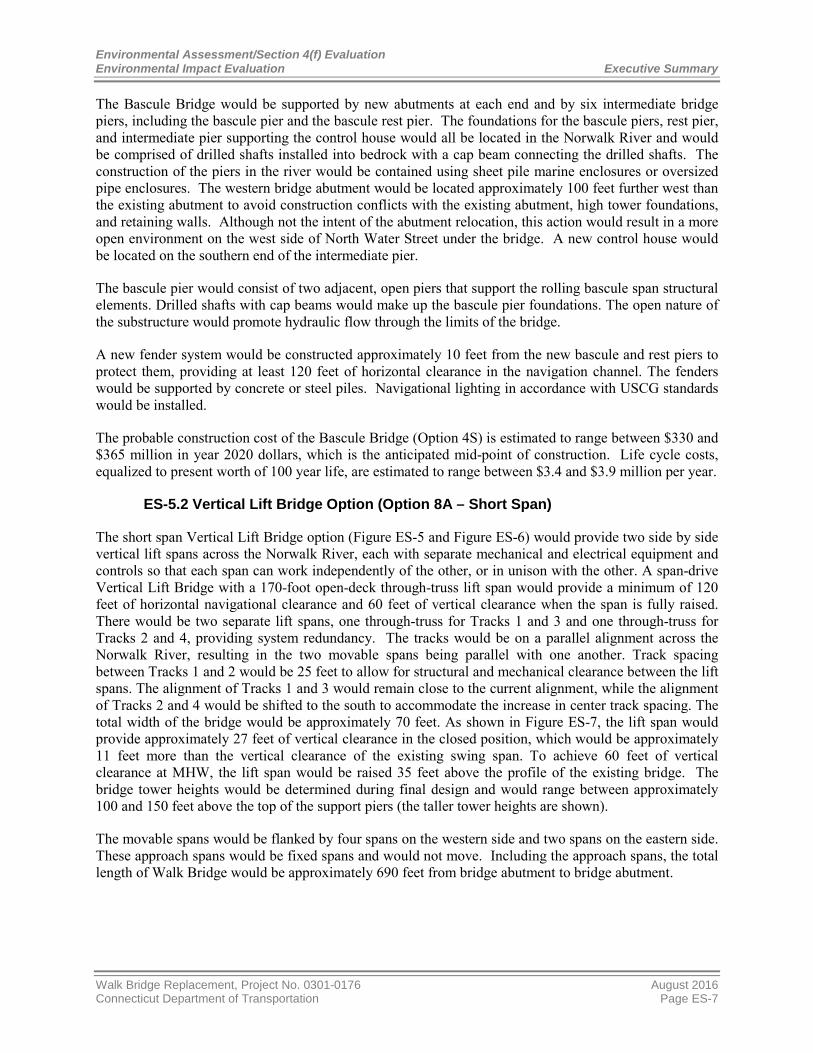
ES-5.2 Vertical Lift Bridge Option (Option 8A – Short Span)
The short span Vertical Lift Bridge option (Figure ES-5 and Figure ES-6) would provide two side by side vertical lift spans across the Norwalk River, each with separate mechanical and electrical equipment and controls so that each span can work independently of the other, or in unison with the other. A span-drive Vertical Lift Bridge with a 170-foot open-deck through-truss lift span would provide a minimum of 120 feet of horizontal navigational clearance and 60 feet of vertical clearance when the span is fully raised. There would be two separate lift spans, one through-truss for Tracks 1 and 3 and one through-truss for Tracks 2 and 4, providing system redundancy. The tracks would be on a parallel alignment across the Norwalk River, resulting in the two movable spans being parallel with one another. Track spacing between Tracks 1 and 2 would be 25 feet to allow for structural and mechanical clearance between the lift spans. The alignment of Tracks 1 and 3 would remain close to the current alignment, while the alignment of Tracks 2 and 4 would be shifted to the south to accommodate the increase in center track spacing. The total width of the bridge would be approximately 70 feet. As shown in Figure ES-7, the lift span would provide approximately 27 feet of vertical clearance in the closed position, which would be approximately 11 feet more than the vertical clearance of the existing swing span. To achieve 60 feet of vertical clearance at MHW, the lift span would be raised 35 feet above the profile of the existing bridge. The bridge tower heights would be determined during final design and would range between approximately 100 and 150 feet above the top of the support piers (the taller tower heights are shown).
The movable spans would be flanked by four spans on the western side and two spans on the eastern side. These approach spans would be fixed spans and would not move. Including the approach spans, the total length of Walk Bridge would be approximately 690 feet from bridge abutment to bridge abutment.
Walk Bridge Replacement, Project No. 0301-0176 August 2016 Connecticut Department of Transportation Page ES-7

Environmental Assessment/Section 4(f) Evaluation Executive Summary Environmental Impact Evaluation
Figure ES-5—Rendering of the Short Span Vertical Lift Bridge in the Closed Position (Option 8A) ES-
Figure ES-6—Rendering of the Short Span Vertical Lift Bridge in the Open Position (Option 8A) ES-
August 2016 Walk Bridge Replacement, Project No. 0301-0176 Page ES-8 Connecticut Department of Transportation

Environmental Assessment/Section 4(f) Evaluation Environmental Impact Evaluation Executive Summary
Figure ES-7—Elevation View of the Short Span Vertical Lift Bridge (Option 8A) ES-
The bridge would be supported by new abutments at each end and by six intermediate bridge piers, including the vertical lift bridge piers. The foundations for the vertical lift span piers and one intermediate pier would all be located in the Norwalk River and would be comprised of drilled shafts installed into bedrock, with a cap beam connecting the drilled shafts. The construction of the piers in the river would be contained using sheet pile marine enclosures or oversized pipe enclosures. The western bridge abutment would be located approximately 100 feet further west than the existing abutment to avoid construction conflicts with the existing abutment, high tower foundations, and retaining walls. Although not the intent of the abutment relocation, this action would result in a more open environment on the west side of North Water Street under the bridge. A new control house would be located on the southern end of the east vertical lift span pier.
A new fender system would be constructed approximately 10 feet from the new vertical lift span piers to protect them, providing at least 120 feet of horizontal clearance in the navigation channel. The fenders would be supported by concrete or steel piles. Navigational lighting in accordance with USCG standards would be installed.
The initial program cost of the short span Vertical Lift Bridge (Option 8A) is estimated to range between $380 and $415 million in year 2020 dollars, which is the anticipated mid-point of construction. Life cycle costs, equalized to present worth of 100 year life, are estimated to range between $3.4 and $3.9 million per year.
ES-5.3 Vertical Lift Bridge Option (Option 11C - Long Span)
Like the short span vertical lift bridge option, the long span Vertical Lift Bridge option (Figure ES-8 and Figure ES-9) would provide two side-by-side vertical lift spans across the Norwalk River, each with separate mechanical and electrical equipment and controls so that each span can work independently of the other, or in unison with the other. A vertical lift bridge with a 240-foot open-deck through-truss lift span would provide a minimum of 200 feet of horizontal navigational clearance and 60 feet of vertical clearance when the span is fully raised. There would be two separate lift spans, one through-truss for Tracks 1 and 3 and one through-truss for Tracks 2 and 4, providing system redundancy. The tracks would be on a parallel alignment across the Norwalk River, resulting in the two movable spans being parallel with one another. Track spacing between Tracks 1 and 2 would be 25 feet to allow for structural and
Walk Bridge Replacement, Project No. 0301-0176 August 2016 Connecticut Department of Transportation Page ES-9

Environmental Assessment/Section 4(f) Evaluation Executive Summary Environmental Impact Evaluation
mechanical clearance between the lift spans. The alignment of Tracks 1 and 3 would remain close to the current alignment, while the alignment of Tracks 2 and 4 would be shifted to the south to accommodate the increase in center track spacing. The total width of the bridge would be approximately 70 feet. As shown in Figure ES-10, the lift span would provide approximately 27 feet of vertical clearance in the closed position, which would be approximately 11 feet more than the vertical clearance of the existing swing span. To achieve 60 feet of vertical clearance at mean high water, the lift span would be raised 35 feet above the profile of the existing bridge. Like the short span vertical lift bridge, Option 11C’s bridge tower heights would be determined during final design and would range between approximately 100 and 150 feet above the top of the support piers (the taller tower heights are shown).
Figure ES-8—Rendering of the Long Span Vertical Lift Bridge in the Closed Position (Option 11C)
The movable spans would be flanked by four spans on the western side and one span on the eastern side. These approach spans would be fixed spans and would not move. Including the approach spans, the total length of Walk Bridge would be approximately 690 feet from bridge abutment to bridge abutment.
The differences between the short span (Option 8A) and long span (Option 11C) options lie in the pier placement and span length between the east and west bridge abutments of Walk Bridge. In Option 11C, the bridge would be supported by new abutments at each end and by five intermediate bridge piers, including the vertical lift bridge piers. The eastern pier in Option 11C would be located further east than the eastern pier for the short span vertical lift bridge (Option 8A), thus increasing the span length and the horizontal clearance between the vertical lift bridge piers. Both piers supporting the vertical lift span towers would be placed outside of the limits of the existing swing span, with no new foundation construction occurring in either the west or east navigation channels, as currently defined by the existing swing span. The foundations for the vertical lift span piers would be located in the Norwalk River and would be comprised of drilled shafts installed into bedrock, with a cap beam connecting the drilled shafts. The construction of the piers in the river would be contained using sheet pile marine enclosures or oversized pipe enclosures. The western bridge abutment would be located approximately 100 feet further west than the existing abutment to avoid construction conflicts with the existing abutment, high tower foundations, and retaining walls. Although not the intent of the abutment relocation, this action would
August 2016 Walk Bridge Replacement, Project No. 0301-0176 Page ES-10 Connecticut Department of Transportation

Environmental Assessment/Section 4(f) Evaluation Environmental Impact Evaluation Executive Summary
result in a more open environment on the west side of North Water Street under the bridge. A new control house would be located on the southern end of the east vertical lift span pier.
Figure ES-9—Rendering of the Long Span Vertical Lift Bridge in the Open Position (Option 11C)
Figure ES-10—Elevation View of the Long Span Vertical Lift Bridge (Option 11C)
A new fender system would be constructed approximately 10 feet from the new vertical lift span piers to protect them, providing at least 200 feet of horizontal clearance in the navigation channel. The fenders would be supported by concrete, steel, or composite material piles. Navigational lighting in accordance with USCG standards would be installed.
The probable construction cost of the long span Vertical Lift Bridge (Option 11C) is estimated to range between $425 and $460 million in year 2020 dollars, which is the anticipated mid-point of construction.
Walk Bridge Replacement, Project No. 0301-0176 August 2016 Connecticut Department of Transportation Page ES-11

Environmental Assessment/Section 4(f) Evaluation Executive Summary Environmental Impact Evaluation
Life cycle costs, equalized to present worth of 100 year life, were estimated to range between $3.7 and $4.2 million per year.
ES-5.4 Other Build Alternative Components
The Build Alternative will include other project improvements, which would be applicable to the Bascule Bridge (Option 4S) and the two Vertical Lift Bridge options (Option 8A and Option 11C).
Track, Catenary, and Signal Work
Track, catenary, and signal work will be performed in addition to the work to replace Walk Bridge. All approach track, catenary and signal work for the project will be accomplished within the existing state right-of-way (ROW). Track work will include replacing about one-half-mile of tracks and ballast, from approximately the Washington Street Bridge in South Norwalk to approximately 300 feet east of the Fort Point Street Bridge in East Norwalk. Overhead catenary and supports also will be replaced within the limits of the project.
Existing Bridge Removal – Pedestrian/Bicycle Connection
The existing Walk Bridge and fender system will be dismantled and removed. This will include removal of the foundations and fender supports in the river to a depth to be determined in consultation with USACE and USCG. The existing western bridge abutment will be removed in its entirety, while the eastern abutment will be retained and partially lowered so that the remaining portions of the abutment can be used as a retaining wall to support an extension of the pedestrian/bicycle trail north of the bridge to areas south of the bridge.
Fort Point Street Bridge Replacement
The railroad bridge over Fort Point Street will be replaced as part of the project. The Fort Point Street Bridge abutments may be constructed in the same general location as the existing bridge abutments, or may be pulled back to accommodate a wider Fort Point Street below. CTDOT will continue to work with the City of Norwalk as design progresses to determine the abutment locations and span length of this bridge.
Removal of High Towers
The project will require the removal of the two existing high towers which carry Eversource Energy high voltage power and Metro-North Railroad communications over the Norwalk River. These towers do not meet current structural design standards and conflict with the replacement bridge and associated track alignments. Several options for replacement of the high tower functions are under consideration from engineering, cost, environmental, and historical perspectives. Metro-North communication functions will potentially be carried on the bridge and then under the Norwalk River. Eversource Energy will be responsible for relocating its lines and the associated environmental evaluations and permits. CTDOT will be responsible for removing the existing high towers as part of the Walk Bridge Replacement Project.
Dredging for a Wider Navigation Channel
Because the existing bridge’s support piers will be removed, including the swing span’s pivot pier and rest piers, and protective fenders, the Build Alternative will provide for a wider navigational opening. Portions of the Norwalk River under the bridge that are not maintained as part of the federal navigation channel will be dredged to match the federal channel depth of ten feet and tie into the existing 125-foot
August 2016 Walk Bridge Replacement, Project No. 0301-0176 Page ES-12 Connecticut Department of Transportation

Environmental Assessment/Section 4(f) Evaluation Environmental Impact Evaluation Executive Summary
navigation channel that exists upstream of the bridge. Approximately 4,100 cubic yards (cy) of sediment would be dredged in the Bascule Bridge (Option 4S) and short span Vertical Lift Bridge (Option 8A), and approximately 4,900 cy of sediment would be dredged in the long span Vertical Lift Bridge (Option 11C). Channel dredging will be conducted using a hydraulic clamshell bucket during the approved in-water work months, typically November through January where containment is not required.
ES-6 Preferred Alternative
CTDOT considered the project purpose and need, engineering, constructability, potential impacts to rail and navigation traffic, estimated costs, and potential environmental impacts of the alternatives and options. With public input, CTDOT has determined that the Build Alternative, specifically the Replacement Alternative – Movable Bridge, Long Span Vertical Lift Bridge (Option 11C), is the preferred alternative. The Build Alternative is the only alternative that satisfies purpose and need. Each of the three design options for the Build Alternative would have similar environmental impacts. However, construction requirements and the associated impact to rail and navigation traffic, as well as the costs of the three design options, would be different.
The existing bridge, in whole or in part, is expected to remain in service throughout a significant portion of the construction duration. Maintaining the integrity of the existing bridge, in particular the foundations, is imperative to minimizing disruptions to rail and navigation traffic. Therefore, bridge replacement options requiring activities that limit proximity exposure of the existing bridge during construction are viewed favorably. For example, designs with foundations located in close proximity to the existing supports, specifically the pivot pier, exhibit more risk than other designs. Option 11C is the only alternative for which all foundations are located beyond the limits of the existing swing span.
Superstructure erection for all options will require a two-track outage. However, the amount of substructure work that can be completed without service disruptions (from a four-track operation to a two-track operation) would vary among the Build Alternative options. The design concept that allows for conducting the largest portion of substructure work in advance of an outage, along with the shortest period of superstructure construction, is expected to require the shortest overall construction duration. The shortest construction duration generally corresponds with the least disruptions to rail, maritime, and other users. Option 11C offers the greatest opportunity for maximum substructure construction prior to imposing a two-track outage, thereby minimizing the remaining duration of construction once the outage takes effect.
Designs that present fewer challenges during scheduled outages will have less risk of extending those outages and prolonging the disruptions to commuters and waterway users. The east movable span foundations for Option 4S and Option 8A would be located in the existing east navigation channel. Equipment access for float-in installation of the new lift spans is, therefore, obstructed by the existing pivot pier and limited to the west channel unless the pier is removed in advance of the span installation, indicating that additional temporary support is required for the tracks remaining in service. Option 4S also exhibits a highly asymmetric and unbalanced lift span configuration, further complicating a float-in installation. Symmetry and balance are favorable characteristics of Option 8A and Option 11C. Additionally, access to both channels would mitigate the pivot pier obstruction, presenting a potential advantage for Option 11C over Option 8A.
Work in the river is inherently riskier than work that is not in the water. For Option 11C, the elimination of the eastern intermediate approach span pier and the location of the east lift span tower foundation closer to shore, outside the navigation channel, and in shallower water (compared to Option 4S and Option 8A) introduce clear advantages regarding risks associated with in-water construction.
Walk Bridge Replacement, Project No. 0301-0176 August 2016 Connecticut Department of Transportation Page ES-13

Environmental Assessment/Section 4(f) Evaluation Executive Summary Environmental Impact Evaluation
Option 11C exhibits navigation advantages over Option 4S and Option 8A by not blocking the east channel and thereby delaying immobilization of the swing span. Construction equipment can be operated on one side of the existing pivot pier while maintaining safe vessel transit through the bridge on the opposite side. Since the swing span would be operational until it is removed, over-height vessels could pass through the bridge, albeit on a restricted schedule that balances construction efficiency with the reasonable needs of safe, efficient navigation. Based on the configuration of the new movable spans and the associated track alignment, Option 11C does not require the use of a temporary runaround alignment during construction.
Option 8A introduces a vertical navigation restriction prior to completion of the lift span towers due to locking down the swing span for partial demolition or replacement with a non-movable temporary span. Option 4S requires removal of the existing bridge in the east channel to install the bascule pier foundations, thereby imposing a vertical restriction with temporary spans for drilled shaft installation, which is earlier in the construction sequence than Option 8A.
Figure ES-11 illustrates the estimated construction durations for each of the three design options. At approximately 40 months, the long span Vertical Lift Bridge (Option 11C) would require the shortest overall time from the start of Walk Bridge construction to restoration of four-track service and full operation capability for marine traffic. This compares to 44 months for the short span Vertical Lift Bridge (Option 8A) and 47 months for the Bascule Bridge (Option 4S). Figure ES-11 shows that more construction activities can be undertaken while the existing swing span is operational with Option 11C, thereby reducing the vertical navigation restrictions during construction by up to 14 months compared to the other two options. A two-track rail operation with Option 11C would be four months shorter than Option 8A and seven months shorter than Option 4S, thus minimizing the duration of rail restrictions during construction. Construction of Option 11 C would result in less disruption to rail service and navigational traffic during construction.
Figure ES-11—Construction Schedule - Comparison of Bridge Options
August 2016 Walk Bridge Replacement, Project No. 0301-0176 Page ES-14 Connecticut Department of Transportation

Environmental Assessment/Section 4(f) Evaluation Environmental Impact Evaluation Executive Summary
Temporary track outages, temporary channel restrictions or closures, and temporary street detours will potentially affect businesses in the area of construction as well as water-dependent businesses upstream from Walk Bridge. Option 11C would minimize this temporary disruption by minimizing the duration of construction activities, restrictions, or closures. As a result, Option 11C corresponds with the least social and economic risks and impacts to the city of Norwalk and the larger region.
The anticipated environmental impacts of the three design options are comparable. All options would require that the historic Walk Bridge and high towers be demolished. Fort Point Street Bridge also would be replaced in all options. In general, all other environmental impacts would be similar. The Bascule Bridge option (Option 4S) would require a wider bridge and project footprint on the east side of the Norwalk River than would the two Vertical Lift Bridge options. The footprint impacts of the three options to natural resources would be comparable; however, the impacts of the Bascule Bridge option to tidal wetlands, freshwater wetlands and subtidal habitat would be slightly higher than the footprint impacts of the Vertical Lift Bridge options. When the impacts associated with a temporary runaround alignment are considered, some impacts are further increased. In all cases, the long span Vertical Lift Bridge Option (Option 11C) would have the same or slightly less impact to natural resources than the short span Vertical Lift Bridge Option (Option 8A).
The existing high towers present prominent vertical elements at the site and they contribute to the overall historic character of the project area. As previously noted, these latticed high towers must be removed. A potential advantage of the Vertical Lift Bridge options (Options 8A and 11C) is that these options would reintroduce a prominent vertical element to the site and would offer flexibility, as the design advances, to retain this vertical element and continue to contribute to the character of the project area.
The estimated costs of Option 11C are higher than the other two design options. At an estimated construction cost between $365 million and $415 million, Option 11C would cost about 12 percent more than Option 8A ($325 million -$375 million) and about 10 percent more than Option 4S ($330 million -$380 million). Life cycle costs also are highest for Option 11C at between $3.7 million and $4.2 million per year. This compares to annual life cycle costs ranging from $3.4 million to $3.9 million for Option 4S and $3.4 million to $3.9 million for Option 8A. CTDOT has determined that the benefits of Option 11C - shorter construction duration, reduced disruption to rail traffic along the NEC and navigation traffic on the Norwalk River, and less environmental impacts - outweigh the additional costs of Option11C.
ES-7 Project Benefits
The replacement of Walk Bridge with a new resilient bridge structure will provide substantial long-term functional benefits to rail transportation along the NHL and the NEC, as well as to marine transportation in Norwalk Harbor. The project is consistent with the long-term policies and goals of multiple regional and state documents, including: the Long Range Transportation Plan (LRTP) for the South Western Region; the Connecticut State Rail Plan: 2012 – 2016; and TransformCT, the State’s most recent strategic planning program for improving Connecticut’s transportation infrastructure. Walk Bridge is listed on both the South Western Region 2015-2018 Transportation Improvement Program (TIP) and the 2015-2018 Connecticut Statewide TIP as a federally- and state-funded project proposed for construction in 2017 and 2018.4,5 Replacement or repair of Walk Bridge is cited as a critical investment needed on the NEC by the Northeast Corridor Infrastructure and Advisory Commission (NEC Commission). Maintaining the viability of infrastructure in Norwalk Harbor to promote marine-based development is a goal of the Norwalk Harbor Management Commission and the State’s Maritime Commission.
4 SWRMPO, South Western Region 2015-2018 Transportation Improvement Program (TIP), Region 1, FA Code 5337, Project Number 0301-0040, AQCd X6, Route/System NHL-ML (pages 1/6 and 2/6), 3/17/16. Appendix 3 includes the TIP pages identifying Walk Bridge. 5 CTDOT, 2015 Statewide Transportation Improvement Program (STIP), Region 1, FA Code 5337, Project Number 0301-0040, AQCd X6, Route/System NHL-ML (page 1). Appendix 3 includes the STIP page identifying Walk Bridge.
Walk Bridge Replacement, Project No. 0301-0176 August 2016 Connecticut Department of Transportation Page ES-15

Environmental Assessment/Section 4(f) Evaluation Executive Summary Environmental Impact Evaluation
Table ES-1 presents a summary of the benefits of the Build Alternative relative to addressing the project needs, or deficiencies of the existing bridge. These benefits would be realized in all of the Build Alternative options.
Table ES-1 - Summary of Operational Benefits of the Walk Bridge Replacement Project Existing Deficiencies/ Project Needs
Project Benefits
Structure age and deterioration
The project will fully replace the existing bridge with a new structure with an estimated 100-year life span.
Decreasing reliability The project will replace all mechanical and electrical components, providing for a reliable bridge structure.
Lack of resiliency The project will substantially improve the bridge’s resistance to severe weather events. The replacement bridge will be located above the required elevation for critical actions (mechanical systems). Key structural elements of the replacement bridge will withstand inundation levels of a Category 3 and Category 4 hurricane, in comparison to the existing bridge’s ability to withstand inundation levels of a Category 1 and Category 2 hurricane. The replacement bridge will allow storms to flow through the bridge without inundating or impacting the bridge’s main span, including beams, deck, ballast, and rails. In all category storm events, storms will not impact critical mechanical and electrical elements in the control house or machine room.
Safety standards The project will be designed to current design standards. The existing bridge does not meet current design standards which reflect improved safety aspects compared to when the bridge was originally designed and built. Minimum requirements (loading, safety margins, etc.) for the design of railroad bridges have evolved throughout the twentieth century to reflect increases in demands on the infrastructure and advances in materials, methods, and technology.
The project will incorporate a number of safety and security measures, including a CCTV system, exterior lighting located along the bridge structure, and navigation lighting to meet USCG requirements. The CCTV system will provide for increased security relative to operations (bridge, navigation channel, and boat traffic) and surveillance (pedestrian and vehicular activity, control house and exit and entrance points, and anchorage and pier points).
Lack of redundancy The project will provide operational redundancy through the construction of two independent bridge spans, each with separate mechanical and electrical equipment and controls, which will minimize the potential for rail operation disruptions.
Limited operational flexibility
The project will maximize operational flexibility through construction of two independent bridge spans. Dual mechanical and electrical systems will be provided for each movable span, so that if the selected main drive system is inoperable, the alternative system can be used.
Difficulty of maintenance
The project will facilitate ease of regular maintenance, including in-water maintenance, by allowing for a closure of one span while the second span remains available for rail traffic operations.
August 2016 Walk Bridge Replacement, Project No. 0301-0176 Page ES-16 Connecticut Department of Transportation

Environmental Assessment/Section 4(f) Evaluation Environmental Impact Evaluation Executive Summary
Existing Deficiencies/ Project Needs
Project Benefits
Reduced rail capacity and efficiency
The project will correct existing deficiencies which directly impact Metro-North and Amtrak daily train service, particularly on-time performance (OTP). Combined with the CTDOT’s planned improvements to the New Haven Line, the project will increase rail efficiencies, contribute to Metro-North’s and Amtrak’s passenger ridership and OTP goals, and accommodate Providence and Worcester Railroad Company’s freight service needs, including weight standards.
Reduced dependability and capacity for marine traffic
The project’s increased vertical clearance will reduce the frequency of bridge openings, which will benefit commercial and recreational marine users. The additional horizontal clearance will facilitate easier barge and tow operations. The required dredging will enhance the federal navigation channel by straightening the alignment between Walk Bridge and the Stroffolino Bridge and improving the navigability of the river between and through the two bridges.
Lack of sustainability The project will incorporate sustainable materials to provide protection from accelerated corrosion due to condensation, cold weather conditions, and the marine environment. Project elements will be located to facilitate access and ease of maintenance.
ES-8 Summary of Project Construction
Construction of the Build Alternative is expected to occur over approximately three and one-half to four years, depending upon the Build option. The construction period for the project with a short span Vertical Lift Bridge may take several months less time than construction with a Bascule Bridge, and construction of a long span Vertical Lift Bridge is expected to take several fewer months than the short span.
The project will involve typical bridge and railroad construction activities, including work in and over water. Activities will include: construction of retaining walls along railroad; dredging within the waterway; bridge construction, including drilling foundation shafts, installing and removing sheeting and coffer dams, and erecting structural elements; demolition of existing bridge and support structures; installation of electrical and mechanical equipment; construction of control house; replacement of existing railroad track, signal systems and overhead contact (catenary) system (OCS) in South Norwalk and East Norwalk in proximity to the bridge; and contractor required staging, including installation of in-water trestle work platforms and the use of barges during construction. Initial and ongoing activities through the duration of the project will include implementation of mitigation measures and installation and maintenance of erosion and sedimentation controls.
Construction of the project will occur in multiple stages over the construction period with the objective of accommodating both railroad and marine traffic to the greatest extent possible. In all three Build Alternative options, relocation of the Eversource Energy wires will occur before bridge construction commences. Metro-North wires will be transferred to an underground duct bank and submarine cable early in construction. Construction sequencing and staging of the Build options is conceptual at this preliminary level of design, and will be refined as design progresses in future phases of project development.
Modifying the temporary trestles, backfilling earth excavations and behind retaining walls and abutments, installing drilled shaft foundation, pier caps and high tower (if used) foundations, and modifying OCS will occur as needed at various times during construction.
Walk Bridge Replacement, Project No. 0301-0176 August 2016 Connecticut Department of Transportation Page ES-17

Environmental Assessment/Section 4(f) Evaluation Executive Summary Environmental Impact Evaluation
ES-8.1 Construction Sequencing with the Bascule Bridge (Option 4S)
The Bascule Bridge option could be constructed using a temporary run-around structure or it could be constructed “online.” A run-around consists of a temporary two-track bridge structure placed on an alignment north of Walk Bridge. Once the run-around becomes functional, train operations shift from the existing bridge to the runaround; replacement of Walk Bridge then proceeds while rail service is accommodated on the run-around. The run-around is removed once rail service on the replacement bridge is fully operational.
Construction of the Bascule Bridge option would generally proceed in the following sequence with the use of a temporary run-around structure:
• Implement mitigation measures; • Build temporary trestles and temporary gravel access platform on the west bank under the bridge; • Build retaining walls on the east side; • Build run-around structure (if used) and switch rail traffic to Tracks 1 and 3 on runaround structure
and close Tracks 2 and 4; • Float out existing swing span; • Demolish existing piers and fenders within sheet pile marine enclosures; • Build retaining wall on west side; • Build new approach spans; • Demolish existing high towers; • Install new control house; • Float in new south bascule span and complete control house, counterweight, mechanical, and OCS
systems for both spans; • Finish track and OCS for Tracks 2 and 4 and open them to rail traffic; • Float in new north bascule span; • Finish work on north bascule if needed; install Tracks 1 and 3 and OCS and open them to rail traffic; • Remove any remaining trestles; • Complete on-site mitigation measures; and • Stabilize construction sites following removal of all construction-related equipment.
Construction sequencing would be similar under the “online” construction approach, which does not build run-around tracks. Instead of using temporary run-around tracks, rail traffic would operate on the existing northern tracks (Tracks 1 and 3) while the southern portion of the bridge and approaches are first demolished, and the new bridge and tracks are then built (Tracks 2 and 4). Once the southern side is finished and Tracks 2 and 4 are operational, rail traffic is shifted to these new tracks from Tracks 1 and 3, and the northern portion of the bridge and approaches is first demolished, and new Tracks 1 and 3 and approaches are then built.
ES-8.2 Construction Sequencing with the Vertical Lift Bridge Short Span Option (Option 8A)
Construction of the short span Vertical Lift option would generally proceed in the following sequence:
• Implement mitigation measures; • Build temporary trestles and temporary gravel access platform on the west bank under the bridge; • Relocate existing control house; • Build east retaining wall on the south side; • Close Tracks 2 and 4;
August 2016 Walk Bridge Replacement, Project No. 0301-0176 Page ES-18 Connecticut Department of Transportation

Environmental Assessment/Section 4(f) Evaluation Environmental Impact Evaluation Executive Summary
• Remove existing approach spans for Tracks 2 and 4; • Partially remove existing swing span; • Demolish existing high towers; • Erect lift span towers on south side; • Build south approach spans; • Build west retaining wall on south side; • Build new approach spans; • Float in new south lift span, counterweight, mechanical, and OCS systems, and testing; • Install new control house; • demolish pivot pier; • Finish track and OCS for Tracks 2 and 4 and open them to rail traffic; • Remove approach spans on north side; • Build west retaining wall on north side; • Build north approach spans; • Erect towers on north side; • Float in new north lift span; install counterweight, mechanical, OCS systems, and testing; • Install Tracks 1 and 3 and OCS and open them to rail traffic; • Remove any remaining trestles; and • Stabilize construction sites following removal of all construction-related equipment.
ES-8.3 Construction Sequencing with the Vertical Lift Bridge Long Span Option (Option 11C)
Construction of the long span Vertical Lift option would generally proceed in the following sequence:
• Implement mitigation measures; • Build temporary trestles and temporary gravel access platform on the west bank under the bridge; • Relocate existing control house; • Build new lift span foundations; • Demolish existing high towers; • Build lift span piers; • Remove Track 2 and 4 superstructure; • Build west approach substructure and walls; • Build east abutment and retaining walls; • Place new Track 2 and 4 superstructure; • Build west approach; • Build east approach; • Erect lift span towers on south side; • Remove existing swing span; • Demolish pivot pier; • Float in new vertical lift span for Tracks 2 and 4; install counterweight, mechanical, OCS system, and
testing; • Open Tracks 2 and 4; Lift span operational; • Remove existing fender system and piers; • Remove Track 1 and 3 superstructure; • Build west approach substructure and walls; • Build east abutment; • Place new Track 1 and 3 superstructure;
Walk Bridge Replacement, Project No. 0301-0176 August 2016 Connecticut Department of Transportation Page ES-19

Environmental Assessment/Section 4(f) Evaluation Executive Summary Environmental Impact Evaluation
• Build west approach; • Prepare east approach; • Erect lift span towers on north side; • Float in new vertical lift span for Tracks 1 and 3; install counterweight, mechanical, OCS system, and
testing; • Open Tracks 1 and 3; Lift span operational • Open channel to navigation • Remove any remaining trestles; and • Stabilize construction sites following removal of all construction-related equipment.
ES-9 Summary of Project Environmental Benefits
Table ES-2 summarizes the potential permanent benefits of the Walk Bridge Replacement Project. These permanent benefits will be realized with all three Build Alternative options. Where applicable to the environmental resource, temporary benefits of the project also are listed.
Table ES-2 - Summary of Walk Bridge Replacement Project Environmental Benefits Environmental Resource
Project Benefit
Rail Transportation The project will improve bridge operation and reliability, resulting in improved NHL operations.
Marine Transportation
The project will increase the bridge’s vertical clearance by approximately16 feet. The project will increase the bridge’s horizontal clearance by at least 62 feet. The project will improve the navigational channel alignment and bridge reliability.
Pedestrian and Bicycle Facilities
The project will provide a new north-south pedestrian and bicycle connection to the Norwalk Harbor Loop Trail at the existing bridge’s eastern abutment, which will extend the Norwalk River Valley Trail (NRVT)/Harbor Loop Trail on the Norwalk River’s eastern shorefront.
Consistency with Planning
The project is consistent with local, regional, state plans of conservation and development; the regional and statewide Transportation Improvement Program (TIP), and regional, state, and multi-state transportation plans and policies.
Socioeconomics
The project will create construction period jobs, which are estimated in job-years and include direct on-site jobs, indirect jobs in supplier industries, and jobs that are induced in consumer goods and service industries as workers with direct and indirect jobs spend their incomes. Estimated job-years generated each year during project construction are: • Option 4S: 1,100 - 1,200 job-years • Option 8A: 1,300 – 1,500 job-years • Option 11C: 1,600 – 1,700 job-years The project will increase the reliability of rail service on the NEC and improve the reliability of the bridge for commercial navigation, resulting in long-term benefits to the local and regional economy.
Water Quality
The project will include new water quality protections. The land-based rail approach grades will be constructed on retained fill and sheet flow runoff will be directed to side slopes by the rail bed and ballast drainage system and away from the river. Drainage swales may be used in locations where drainage requires conveyance. Where applicable, the closed deck approach span sections of the bridge will include drainage methods to direct water away from the river.
Floodplains
The project will decrease hydraulic constraints and reduce upstream flooding due to the increased hydraulic opening. The project will increase the flood storage volume of the Norwalk River due to removal of the existing large granite pivot pier and rest piers.
August 2016 Walk Bridge Replacement, Project No. 0301-0176 Page ES-20 Connecticut Department of Transportation

Environmental Assessment/Section 4(f) Evaluation Environmental Impact Evaluation Executive Summary
Environmental Resource
Project Benefit
Consistency with CT Coastal Management Act
The project will enhance coastal resources and coastal uses, by improving conditions in the Norwalk River for commercial and recreational boaters and enhancing the federal navigation channel and Norwalk Harbor. The project will expand coastal recreation and coastal access by providing opportunities to link to the Norwalk Harbor Loop Trail on the east side of the Norwalk River.
Water Dependent Uses
The project will improve navigation along the Norwalk River and will benefit water-dependent uses, particularly upriver commercial marine users and vessels with restricted maneuverability.
Parklands, Public Recreation and Community Facilities
The project will provide a north-south connection with the Norwalk Harbor Loop Trail on the east side of the Norwalk River at the existing bridge’s eastern abutment; it will provide opportunities for additional pedestrian/bicycle path extensions connections in East Norwalk; and it will contribute to the city’s open space and water views.
Visual Resources The project will improve the landscape of Norwalk River shore due to saltmarsh restoration.
Air Quality The project will provide a resilient bridge that will not lead to diversion to other travel modes during bridge opening failures, such as automobiles or additional bus trips.
Safety and Security The project will be designed to current design standards, including the minimum requirements for loading and safety margins. The project will improve safety and security measures at the bridge site.
Secondary and Cumulative Impacts
The project will provide regional secondary economic benefits on a temporary basis due to increased construction spending. The project will provide cumulative benefits on a permanent basis through improved NHL performance and reliability, improved marine conditions in Norwalk Harbor, and an expanded NRVT network in Norwalk.
ES-10 Summary of Project Environmental Impacts
Table ES-3 summarizes potential permanent and temporary construction-related environmental impacts of the Build Alternative. Where applicable to the environmental resource, Table ES-3 distinguishes between construction-related and permanent impacts of the three Build Alternative options.
Table ES-3 - Summary of Walk Bridge Replacement Project Impacts Environmental Resource
Potential Impacts Bascule Bridge
(Option 4S) Vertical Lift Bridge
(Option 8A-Short Span) Vertical Lift Bridge
(Option 11C-Long Span)
Rail Transportation
Temporary two-track outage would be needed for up to 37 months. Limited four-track outages would be required for specific construction activities and would be limited to several days per outage.
Temporary two-track outage would be needed for up to 34 months. Limited four-track outages would be required for specific construction activities and would be limited to several days per outage.
Temporary two-track outage would be needed for up to 30 months. Limited four-track outages would be required for specific construction activities and would be limited to several days per outage.
Marine Transportation
Temporary navigation restrictions would occur. Restrictions would occur at the start of the two-track outage. Vertical restrictions would occur for about 37 months without the temporary run-around and for about 40 months with the temporary run-around.
Temporary navigation restrictions would occur. Restrictions would occur at the start of the two-track outage. Vertical restrictions would occur for about 34 months. Horizontal restrictions and a limited number of full channel closures would be needed for
Temporary navigation restrictions would occur. The swing span would remain operational for up to 14 months after the start of the two-track outage. Vertical restrictions would occur for as few as 16 months. A limited number of full channel closures would be
Walk Bridge Replacement, Project No. 0301-0176 August 2016 Connecticut Department of Transportation Page ES-21
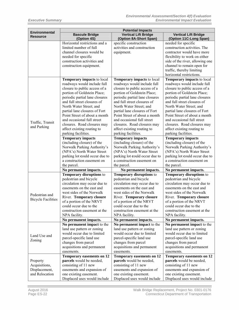
Environmental Assessment/Section 4(f) Evaluation Executive Summary Environmental Impact Evaluation
Environmental Resource
Potential Impacts Bascule Bridge
(Option 4S) Vertical Lift Bridge
(Option 8A-Short Span) Vertical Lift Bridge
(Option 11C-Long Span) Horizontal restrictions and a limited number of full channel closures would be needed for specific construction activities and construction equipment.
specific construction activities and construction equipment.
needed for specific construction activities. The contractor would have more flexibility to work on either side of the river, allowing one channel to remain open for traffic, thereby limiting horizontal restrictions.
Traffic, Transit and Parking
Temporary impacts to local roadways would include full closure to public access of a portion of Goldstein Place; periodic partial lane closures and full street closures of North Water Street; and partial lane closures of Fort Point Street of about a month and occasional full street closures. Road closures may affect existing routing to parking facilities.
Temporary impacts to local roadways would include full closure to public access of a portion of Goldstein Place; periodic partial lane closures and full street closures of North Water Street; and partial lane closures of Fort Point Street of about a month and occasional full street closures. Road closures may affect existing routing to parking facilities.
Temporary impacts to local roadways would include full closure to public access of a portion of Goldstein Place; periodic partial lane closures and full street closures of North Water Street; and partial lane closures of Fort Point Street of about a month and occasional full street closures. Road closures may affect existing routing to parking facilities.
Temporary impacts (including closure) of the Norwalk Parking Authority’s (NPA’s) North Water Street parking lot could occur due to a construction easement on the parcel.
Temporary impacts (including closure) of the Norwalk Parking Authority’s (NPA’s) North Water Street parking lot could occur due to a construction easement on the parcel.
Temporary impacts (including closure) of the Norwalk Parking Authority’s (NPA’s) North Water Street parking lot could occur due to a construction easement on the parcel.
No permanent impacts. No permanent impacts. No permanent impacts.
Pedestrian and Bicycle Facilities
Temporary disruptions to pedestrian and bicycle circulation may occur due to easements on the east and west sides of the Norwalk River. Temporary closure of a portion of the NRVT could occur due to the construction easement at the NPA facility.
Temporary disruptions to pedestrian and bicycle circulation may occur due to easements on the east and west sides of the Norwalk River. Temporary closure of a portion of the NRVT could occur due to the construction easement at the NPA facility.
Temporary disruptions to pedestrian and bicycle circulation may occur due to easements on the east and west sides of the Norwalk River. Temporary closure of a portion of the NRVT could occur due to the construction easement at the NPA facility.
No permanent impacts. No permanent impacts. No permanent impacts.
Land Use and Zoning
No permanent impact to the land use pattern or zoning would occur due to limited parcel-specific land use changes from parcel acquisitions and permanent easements.
No permanent impact to the land use pattern or zoning would occur due to limited parcel-specific land use changes from parcel acquisitions and permanent easements.
No permanent impact to the land use pattern or zoning would occur due to limited parcel-specific land use changes from parcel acquisitions and permanent easements.
Property Acquisitions, Displacement, and Relocation
Temporary easements on 12 parcels would be needed, consisting of 11 new easements and expansion of one existing easement. Displaced uses would include
Temporary easements on 12 parcels would be needed, consisting of 11 new easements and expansion of one existing easement. Displaced uses would include
Temporary easements on 12 parcels would be needed, consisting of 11 new easements and expansion of one existing easement. Displaced uses would include
August 2016 Walk Bridge Replacement, Project No. 0301-0176 Page ES-22 Connecticut Department of Transportation

Environmental Assessment/Section 4(f) Evaluation Environmental Impact Evaluation Executive Summary
Environmental Resource
Potential Impacts Bascule Bridge
(Option 4S) Vertical Lift Bridge
(Option 8A-Short Span) Vertical Lift Bridge
(Option 11C-Long Span) private and public parking in South Norwalk; some Maritime Aquarium facilities and operations; and a warehouse.
private and public parking in South Norwalk; some Maritime Aquarium facilities and operations; and a warehouse.
private and public parking in South Norwalk; some Maritime Aquarium facilities and operations; and a warehouse.
Nine parcel acquisitions would be needed, displacing four businesses, including a water-dependent use, and up to six residences on three parcels.
Nine parcel acquisitions would be needed, displacing four businesses, including a water-dependent use, and up to six residences on three parcels.
Nine parcel acquisitions would be needed, displacing four businesses, including a water-dependent use, and up to six residences on three parcels.
Permanent easements on three parcels (two properties) would be needed for access to and maintenance of the replacement bridge on both sides of the river.
Permanent easements on three parcels (two properties) would be needed for access to and maintenance of the replacement bridge on both sides of the river.
Permanent easements on three parcels (two properties) would be needed for access to and maintenance of the replacement bridge on both sides of the river.
Socioeconomics
Temporary access impacts would occur to land-based businesses proximate to Walk Bridge and water-based businesses upriver from Walk Bridge over an approximate 47-month construction period.
Temporary access impacts would occur to land-based businesses proximate to Walk Bridge and water-based businesses upriver from Walk Bridge over an approximate 44-month construction period.
Temporary access impacts would occur to land-based businesses proximate to Walk Bridge and water-based businesses upriver from Walk Bridge over an approximate 40-month construction period.
Temporary construction easements would adversely impact public and private parking facilities and some facilities and operations of the Maritime Aquarium. Evaluations are ongoing.
Temporary construction easements would adversely impact public and private parking facilities and some facilities and operations of the Maritime Aquarium. Evaluations are ongoing.
Temporary construction easements would adversely impact public and private parking facilities and some facilities and operations of the Maritime Aquarium. Evaluations are ongoing.
Loss of property tax revenue of approximately $91,000 per year over the 4-year construction period would result from parcel acquisitions.
Loss of property tax revenue of approximately $91,000 per year over the 4-year construction period would result from parcel acquisitions.
Loss of property tax revenue of approximately $91,000 per year over the 4-year construction period would result from parcel acquisitions.
Water Quality
Temporary impacts would include sediment disturbance due to waterway work and soil exposure due to land-based work.
Temporary impacts would include sediment disturbance due to waterway work and soil exposure due to land-based work.
Temporary impacts would include sediment disturbance due to waterway work and soil exposure due to land-based work.
No permanent impacts. No permanent impacts. No permanent impacts.
Tidal Wetlands
Indirect temporary impacts would occur to approximately 2,700 sf of vegetated tidal wetlands.
Indirect temporary impacts would occur to approximately 2,400 sf of vegetated tidal wetlands.
Indirect temporary impacts would occur to approximately 2,400 sf of vegetated tidal wetlands.
Permanent impacts would occur to approximately 3,100 sf of vegetated tidal wetlands.
Permanent Impacts would occur to approximately 2,500 sf of vegetated tidal wetlands.
Permanent Impacts would occur to approximately 2,500 sf of vegetated tidal wetlands.
Freshwater Wetlands
Permanent loss of 600-sf wetland would occur.
Permanent loss of 600-sf wetland would occur.
Permanent loss of 600-sf wetland would occur.
Walk Bridge Replacement, Project No. 0301-0176 August 2016 Connecticut Department of Transportation Page ES-23

Environmental Assessment/Section 4(f) Evaluation Executive Summary Environmental Impact Evaluation
Environmental Resource
Potential Impacts Bascule Bridge
(Option 4S) Vertical Lift Bridge
(Option 8A-Short Span) Vertical Lift Bridge
(Option 11C-Long Span)
Floodplains
Temporary impacts would occur to 230,000 feet of 100-year floodplain due primarily to construction staging and access to the railroad ROW.
Temporary impacts would occur to 230,000 feet of 100-year floodplain due primarily to construction staging and access to the railroad ROW.
Temporary impacts would occur to 230,000 feet of 100-year floodplain due primarily to construction staging and access to the railroad ROW.
Permanent impacts would occur to approximately 15,000 sf of 100-year floodplain.
Permanent impacts would occur to approximately 19,500 sf of 100-year floodplain.
Permanent impacts would occur to approximately 19,500 sf of 100-year floodplain.
Terrestrial Resources, Species and Critical Habitats
Temporary impacts would occur to terrestrial species due to loss of herbaceous coverage.
Temporary impacts would occur to terrestrial species due to loss of herbaceous coverage.
Temporary impacts would occur to terrestrial species due to loss of herbaceous coverage.
Minor permanent impacts would occur due to loss of narrow upland habitat patch.
Minor permanent impacts would occur due to loss of narrow upland habitat patch
Minor permanent impacts would occur due to loss of narrow upland habitat patch
Aquatic Resources, Species and Critical Habitats
Temporary impacts would occur to approximately 7,750 sf of intertidal habitat and 10,250 sf of subtidal habitat.
Temporary impacts would occur to approximately 7,700 sf of intertidal habitat and 8,400 sf subtidal habitat.
Temporary impacts would occur to approximately 7,700 sf of intertidal habitat and 8,400 sf subtidal habitat.
Conversion of approximately 300 sf of intertidal habitat to subtidal habitat and increased depth of subtidal areas would occur due to dredging.
Conversion of approximately 300 sf of intertidal habitat to subtidal habitat and increased depth of subtidal areas would occur due to dredging.
Conversion of approximately 300 sf of intertidal habitat to subtidal habitat and increased depth of subtidal areas would occur due to dredging.
Permanent impacts would occur to approximately 900 sf of intertidal habitat and 27,000 sf of subtidal habitat.
Permanent impacts would occur to approximately 900 sf of intertidal habitat and 26,800 sf of subtidal habitat.
Permanent impacts would occur to approximately 900 sf of intertidal habitat and 26,600 sf of subtidal habitat.
Endangered and Threatened Species
Potential temporary disruption of foraging activities would occur due to work in the water and vegetation clearing.
Potential temporary disruption of foraging activities would occur due to work in the water and vegetation clearing.
Potential temporary disruption of foraging activities would occur due to work in the water and vegetation clearing.
No permanent impacts. No permanent impacts. No permanent impacts.
Consistency with CT Coastal Management Act
Unavoidable temporary and permanent impacts would occur to tidal wetlands, intertidal and subtidal habitat, coastal access, water-dependent uses, and historic resources.
Unavoidable temporary and permanent impacts would occur to tidal wetlands, intertidal and subtidal habitat, coastal access, water-dependent uses, and historic resources.
Unavoidable temporary and permanent impacts would occur to tidal wetlands, intertidal and subtidal habitat, coastal access, water-dependent uses, and historic resources.
Water-Dependent Uses
Temporary impacts would occur to upstream uses and uses in immediate proximity to the bridge due to navigation restrictions for about 37 to 40 months.
Temporary impacts would occur to upstream uses and uses in immediate proximity to the bridge due to navigation restrictions for about 34 months.
Temporary impacts would occur to upstream uses and uses in immediate proximity to the bridge due to navigation restrictions for about 16 months.
Temporary relocation of the Sheffield Ferry and Maritime Aquarium vessel operations would be required.
Temporary relocation of the Sheffield Ferry and Maritime Aquarium vessel operations would be required.
Temporary relocation of the Sheffield Ferry and Maritime Aquarium vessel operations would be required.
August 2016 Walk Bridge Replacement, Project No. 0301-0176 Page ES-24 Connecticut Department of Transportation

Environmental Assessment/Section 4(f) Evaluation Environmental Impact Evaluation Executive Summary
Environmental Resource
Potential Impacts Bascule Bridge
(Option 4S) Vertical Lift Bridge
(Option 8A-Short Span) Vertical Lift Bridge
(Option 11C-Long Span) Permanent impact would occur through parcel acquisition of private marina.
Permanent impact would occur through parcel acquisition of private marina.
Permanent impact would occur through parcel acquisition of private marina.
Parklands, Public Recreation and Community Facilities
Temporary impacts would occur due to construction easements and would include the Wastewater Treatment Plant property, NRVT on both sides of the river, and some of the Maritime Aquarium’s facilities and operations. Evaluations are ongoing.
Temporary impacts would occur due to construction easements and would include the Wastewater Treatment Plant property, NRVT on both sides of the river, and some of the Maritime Aquarium’s facilities and operations. Evaluations are ongoing.
Temporary impacts would occur due to construction easements and would include the Wastewater Treatment Plant property, NRVT on both sides of the river, and some of the Maritime Aquarium’s facilities and operations. Evaluations are ongoing.
No permanent impacts would occur on the east side of the river. Potential impacts on the west side of the river would involve a permanent relocation of the Aquarium’s emergency egress.
No permanent impacts would occur on the east side of the river. Potential impacts on the west side of the river would involve a permanent relocation of the Aquarium’s emergency egress.
No permanent impacts would occur on the east side of the river. Potential impacts on the west side of the river would involve a permanent relocation of the Aquarium’s emergency egress.
Visual Resources
Temporary impacts would occur due to construction staging, including use of temporary trestles and barges in the water, and the temporary run-around in the river on the north side of the bridge, if this option is employed.
Temporary impacts would occur due to construction staging, including use of temporary trestles and barges in the water.
Temporary impacts would occur due to construction staging, including use of temporary trestles and barges in the water.
Permanent altered visual setting would occur due to loss of historic resources, and potential altered visual effect could occur due to new bridge in an historic setting.
Permanent altered visual setting would occur due to loss of historic resources, and potential altered visual effect could occur due to new bridge in an historic setting.
Permanent altered visual setting would occur due to loss of historic resources, and potential altered visual effect could occur due to new bridge in an historic setting.
Air Quality
Temporary minor impacts would occur from diesel equipment, fugitive dust.
Temporary minor impacts would occur from diesel equipment, fugitive dust.
Temporary minor impacts would occur from diesel equipment, fugitive dust.
No permanent impacts. No permanent impacts. No permanent impacts.
Noise and Vibration
Temporary impacts would occur due to daytime and night-time noise proximate to the project site.
Temporary impacts would occur due to daytime and night-time noise proximate to the project site.
Temporary impacts would occur due to daytime and night-time noise proximate to the project site.
Potential temporary impacts of ground-borne vibration would affect nearby buildings, including the Maritime Aquarium and historic structures that may not have the same physical resistance to vibration as modern buildings.
Potential temporary impacts of ground-borne vibration would affect nearby buildings, including the Maritime Aquarium and historic structures that may not have the same physical resistance to vibration as modern buildings.
Potential temporary impacts of ground-borne vibration would affect nearby buildings, including the Maritime Aquarium and historic structures that may not have the same physical resistance to vibration as modern buildings.
Walk Bridge Replacement, Project No. 0301-0176 August 2016 Connecticut Department of Transportation Page ES-25

Environmental Assessment/Section 4(f) Evaluation Executive Summary Environmental Impact Evaluation
Environmental Resource
Potential Impacts Bascule Bridge
(Option 4S) Vertical Lift Bridge
(Option 8A-Short Span) Vertical Lift Bridge
(Option 11C-Long Span) No permanent impacts. No permanent impacts. No permanent impacts.
Cultural Resources
No adverse effect would occur to historic buildings and settings due to temporary construction staging/access areas or permanent access areas, provided no physical damage occurs to the historic buildings.
No adverse effect would occur to historic buildings and settings due to temporary construction staging/access areas or permanent access areas, provided no physical damage occurs to the historic buildings.
No adverse effect would occur to historic buildings and settings due to temporary construction staging/access areas or permanent access areas, provided no physical damage occurs to the historic buildings.
Adverse effects would occur due to demolition of National Register-listed Walk Bridge and Fort Point Street Bridge; and historic stone abutment retaining walls, high towers, and catenary support structures.
Adverse effects would occur due to demolition of National Register-listed Walk Bridge and Fort Point Street Bridge; and historic stone abutment retaining walls, high towers, and catenary support structures.
Adverse effects would occur due to demolition of National Register-listed Walk Bridge and Fort Point Street Bridge; and historic stone abutment retaining walls, high towers. and catenary support structures.
Potential archaeological sensitivity for pre-colonial/contact and historic periods exists on many of the construction parcels, requiring subsurface testing and/or monitoring.
Potential archaeological sensitivity for pre-colonial/contact and historic periods exists on many of the construction parcels, requiring subsurface testing and/or monitoring.
Potential archaeological sensitivity for pre-colonial/contact and historic periods exists on many of the construction parcels, requiring subsurface testing and/or monitoring.
Potential underwater archaeological sensitivity exists within the project footprint, requiring subsurface testing.
Potential underwater archaeological sensitivity exists within the project footprint, requiring subsurface testing.
Potential underwater archaeological sensitivity exists within the project footprint, requiring subsurface testing.
Hazardous and Contaminated Materials/ Environmental Risk Sites
Potential exposure to hazardous materials could occur due to removal of existing bridge structures, rail and ties, ballast, and soil.
Potential exposure to hazardous materials could occur due to removal of existing bridge structures, rail and ties, ballast, and soil.
Potential exposure to hazardous materials could occur due to removal of existing bridge structures, rail and ties, ballast, and soil.
Permanent impacts would occur due to disposal of approximately 15,100 cy of dredged sediment.
Permanent impacts would occur due to disposal of approximately 16,700 cy of dredged sediment.
Permanent impacts would occur due to disposal of approximately 16,700 cy of dredged sediment.
Safety & Security
No temporary or permanent impacts.
No temporary or permanent impacts.
No temporary or permanent impacts.
Public Utilities and Service
No temporary or permanent impacts.
No temporary or permanent impacts.
No temporary or permanent impacts.
Title VI and Environmental Justice
No disproportionate temporary or permanent impacts.
No disproportionate temporary or permanent impacts.
No disproportionate temporary or permanent impacts.
Secondary and Cumulative Impacts
Secondary impacts would occur due to relocation of the Eversource power, currently on high towers abutting the existing bridge.
Secondary impacts would occur due to relocation of the Eversource power, currently on high towers abutting the existing bridge.
Secondary impacts would occur due to relocation of the Eversource power, currently on high towers abutting the existing bridge.
Cumulative impacts would occur due to loss of a tangible
Cumulative impacts would occur due to loss of a tangible
Cumulative impacts would occur due to loss of a tangible
August 2016 Walk Bridge Replacement, Project No. 0301-0176 Page ES-26 Connecticut Department of Transportation

Environmental Assessment/Section 4(f) Evaluation Environmental Impact Evaluation Executive Summary
Environmental Resource
Potential Impacts Bascule Bridge
(Option 4S) Vertical Lift Bridge
(Option 8A-Short Span) Vertical Lift Bridge
(Option 11C-Long Span) example of historic movable bridge technology in Connecticut, and a bridge on the National Register-listed Movable Railroad Bridges on the Northeast Corridor in Connecticut Thematic Resource.
example of historic movable bridge technology in Connecticut, and a bridge on the National Register-listed Movable Railroad Bridges on the Northeast Corridor in Connecticut Thematic Resource.
example of historic movable bridge technology in Connecticut, and a bridge on the National Register-listed Movable Railroad Bridges on the Northeast Corridor in Connecticut Thematic Resource.
ES-11 Summary of Mitigation and Commitments
Table ES-4 provides a summary of project mitigation and commitments of the project.
Table ES-4 - Summary of Proposed Mitigation and CTDOT Commitments Environmental Resource Mitigation and Commitments
Rail Transportation
CTDOT will maintain weekday passenger train service by keeping at least two tracks in service throughout nearly all of the construction period. CTDOT will schedule limited four-track outages required during construction time during an off-peak and/or weekend period, to the extent possible. CTDOT will complete planned independent NHL-improvement projects on the main line and Danbury Branch prior to implementing the long-term, two-track outages; these projects will facilitate considerable train movement flexibility on the NHL main line and minimize schedule adjustments associated with long-term two-track outages. CTDOT will minimize temporary impacts to rail traffic by coordinating the construction of the project with the East Avenue Railroad Bridge Project (Bridge No. 42.14) and the Osborne Avenue Railroad Bridge Project (Bridge No. 41.96). CTDOT will work with Metro-North, Amtrak, and freight service providers to ensure that train operations proceed in a manner that maintains service, facilitates passenger boarding and alighting at East Norwalk and South Norwalk Stations, and prioritizes the overall safety of the railroad corridor.
Marine Transportation
CTDOT will coordinate channel closures with the City of Norwalk, USCG, USACE, and waterway uses to the maximum extent possible. CTDOT will work with commercial and recreational marine users to develop mitigation strategies to address impacts to marine users during the project construction period, coordinating with USCG, USACE, the City of Norwalk, and the Norwalk Harbor Management Commission.
Traffic, Transit and Parking
CTDOT will maintain pedestrian and vehicular access to adjacent buildings and parking during periods of partial and full closures of streets during construction. However, if it becomes necessary to temporarily close the NPA’s North Water Street parking lot during construction, ample replacement parking is available nearby.
CTDOT will coordinate with the City of Norwalk and local businesses in developing traffic detour and mitigation plans in the vicinity of the Fort Point Street Bridge in East Norwalk and North Water Street in South Norwalk.
Pedestrian and Bicycle Facilities
CTDOT will explore opportunities for bicycle connections in South Norwalk in cooperation with the City of Norwalk and stakeholders.
Walk Bridge Replacement, Project No. 0301-0176 August 2016 Connecticut Department of Transportation Page ES-27

Environmental Assessment/Section 4(f) Evaluation Executive Summary Environmental Impact Evaluation
Environmental Resource Mitigation and Commitments
Property Acquisition and Displacement
CTDOT will provide monetary and other relocation assistance to displaced property owners in accordance with the procedures outlined in the Uniform Relocation Assistance and Real Property Acquisition Policies Act of 1970 and Connecticut’s Uniform Relocation Assistance Act. Relocation assistance could include relocation services, moving payments, replacement housing payments, and other payments related to commercial and residential moving costs and displacement.
CTDOT will manage the properties acquired for the project, including their sale or lease following completion of construction. CTDOT will work with affected property owners to provide replacement parking. There is adequate parking available to provide replacement parking, with City parking lots and other parking garages located in close proximity to affected property owners.
Socioeconomics CTDOT will coordinate with the City of Norwalk and stakeholders to minimize adverse effects of the project construction upon local land-based and water-based businesses, including developing a business coordination plan.
Water Quality
CTDOT will employ Best Management Practices (BMPs) while conducting all work within the water to minimize releases of sediment to the water; measures could include cofferdams, sheet pile marine enclosures, or oversized pipe enclosures, or other containment measures such as turbidity curtains, sheeting, and geotextile encapsulation.
CTDOT will prepare a site-specific Stormwater Pollution Prevention Plan (SWPPP), which will identify potential pollutant source areas and describe BMPs to be used for erosion and sedimentation control, temporary stormwater management, dust control, and site stabilization. All land-based activities will use erosion and sedimentation control BMPs to limit debris and runoff from entering the watercourse or offsite areas.
Tidal Wetlands
CTDOT will provide compensatory mitigation for temporary direct impacts to intertidal and subtidal habitats, and for indirect shading impacts to tidal vegetated wetlands, consisting of in-place restoration or enhancement of temporary impact areas, and restoration of tidal marsh areas that may be temporarily impacted from trestle platform shading.
CTDOT will provide compensatory mitigation for permanent impacts to vegetated tidal wetlands through restoration/enhancement of wetlands along the Norwalk River dominated by invasive species.
Freshwater Wetlands
CTDOT will provide compensatory mitigation for the loss of a state-regulated freshwater wetland through restoration or replacement in-kind; out-of-kind wetland creation; invasive species removal; or any combination of these methods.
Floodplains CTDOT will analyze both the temporary and permanent conditions to assess floodplain effects in compliance with Connecticut and FEMA floodplain management standards and criteria; if needed, CTDOT will take steps to mitigate effects.
Terrestrial Resources, Species, and Critical Habitats
CTDOT will implement BMPs, use construction phasing or sequencing, and comply with seasonal restrictions to avoid impacts to terrestrial resources and habitats.
August 2016 Walk Bridge Replacement, Project No. 0301-0176 Page ES-28 Connecticut Department of Transportation
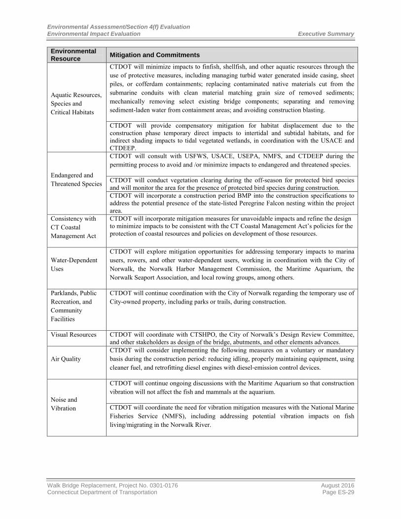
Environmental Assessment/Section 4(f) Evaluation Environmental Impact Evaluation Executive Summary
Environmental Resource Mitigation and Commitments
Aquatic Resources, Species and Critical Habitats
CTDOT will minimize impacts to finfish, shellfish, and other aquatic resources through the use of protective measures, including managing turbid water generated inside casing, sheet piles, or cofferdam containments; replacing contaminated native materials cut from the submarine conduits with clean material matching grain size of removed sediments; mechanically removing select existing bridge components; separating and removing sediment-laden water from containment areas; and avoiding construction blasting.
CTDOT will provide compensatory mitigation for habitat displacement due to the construction phase temporary direct impacts to intertidal and subtidal habitats, and for indirect shading impacts to tidal vegetated wetlands, in coordination with the USACE and CTDEEP.
Endangered and Threatened Species
CTDOT will consult with USFWS, USACE, USEPA, NMFS, and CTDEEP during the permitting process to avoid and /or minimize impacts to endangered and threatened species.
CTDOT will conduct vegetation clearing during the off-season for protected bird species and will monitor the area for the presence of protected bird species during construction. CTDOT will incorporate a construction period BMP into the construction specifications to address the potential presence of the state-listed Peregrine Falcon nesting within the project area.
Consistency with CT Coastal Management Act
CTDOT will incorporate mitigation measures for unavoidable impacts and refine the design to minimize impacts to be consistent with the CT Coastal Management Act’s policies for the protection of coastal resources and policies on development of those resources.
Water-Dependent Uses
CTDOT will explore mitigation opportunities for addressing temporary impacts to marina users, rowers, and other water-dependent users, working in coordination with the City of Norwalk, the Norwalk Harbor Management Commission, the Maritime Aquarium, the Norwalk Seaport Association, and local rowing groups, among others.
Parklands, Public Recreation, and Community Facilities
CTDOT will continue coordination with the City of Norwalk regarding the temporary use of City-owned property, including parks or trails, during construction.
Visual Resources CTDOT will coordinate with CTSHPO, the City of Norwalk’s Design Review Committee, and other stakeholders as design of the bridge, abutments, and other elements advances.
Air Quality CTDOT will consider implementing the following measures on a voluntary or mandatory basis during the construction period: reducing idling, properly maintaining equipment, using cleaner fuel, and retrofitting diesel engines with diesel‐emission control devices.
Noise and Vibration
CTDOT will continue ongoing discussions with the Maritime Aquarium so that construction vibration will not affect the fish and mammals at the aquarium.
CTDOT will coordinate the need for vibration mitigation measures with the National Marine Fisheries Service (NMFS), including addressing potential vibration impacts on fish living/migrating in the Norwalk River.
Walk Bridge Replacement, Project No. 0301-0176 August 2016 Connecticut Department of Transportation Page ES-29

Environmental Assessment/Section 4(f) Evaluation Executive Summary Environmental Impact Evaluation
Environmental Resource Mitigation and Commitments
CTDOT will investigate mitigation measures to prevent vibration damage to buildings in the area, and will consider the following mitigation measures during construction: locating temporary noise barriers between noise-sensitive receptors and noisy stationary equipment; locating stationary equipment as far from residential areas as possible; establishing dedicated truck routes to keep construction trucks from residential areas; scheduling noisy operations to be performed simultaneously, so that the slightly louder noise levels will be offset by less exposure to the public; and including appropriate noise control devices on construction equipment.
CTDOT will keep the public informed of proposed construction schedules, noisy activities and nighttime work. CTDOT will work with adjacent properties and facilities to address construction noise and vibration, work hours, and possible mitigation.
Cultural Resources
CTDOT will sponsor design charrettes with historic stakeholders during project design to develop mitigation measures.
CTDOT will coordinate with adjacent property owners of historic structures to establish protocols for conducting pre-construction and construction survey and monitoring activities, as required.
CTDOT will conduct subsurface testing in areas with potential archaeological sensitivity and will develop mitigation measures for impacts to archaeological resources once the types and significance of archaeological resources are known and following further design.
CTDOT and FTA will document agreed mitigation in a Memorandum of Agreement (MOA) among CTDOT, FTA, CTSHPO, and local stakeholders, the draft of which is included in Appendix 1. Stipulations in the MOA regarding historic properties include the implementation of an Archaeological Treatment Plan that will account for project impacts to archaeological resources.
Hazardous and Contaminated Materials/ Environmental Risk Sites
CTDOT will conduct its due diligence relative to contaminated material investigations on the nine parcels to be acquired for the project. As a part of this, sampling of soil, sediment, groundwater and other media anticipated to be impacted by project construction will be completed during the design phase of the project.
CTDOT will manage dredged sediments on-site and dispose of materials off-site at an approved location. CTDOT will survey and evaluate structures for asbestos containing material, lead-based paint, and potential polychlorinated biphenyl (PCB)-containing equipment prior to dismantling/demolishing the existing bridge, control tower, overhead catenary system (OCS), and high towers. CTDOT will locate any storage fuels, chemicals, and/or hazardous materials within contained, secure facilities at elevations above the 500-year floodplain.
Safety and Security
CTDOT will develop a site-specific Safety and Health Plan, in conformance with Occupational Safety and Health Administration (OSHA) regulations. The Plan will include protocols to be followed during project construction based on contamination detected during subsurface investigations conducted during the design phase of the project. CTDOT will require the contractor to develop an overall site safety plan addressing construction worker and site safety, site security, and public safety, including safety of adjacent properties.
August 2016 Walk Bridge Replacement, Project No. 0301-0176 Page ES-30 Connecticut Department of Transportation

Environmental Assessment/Section 4(f) Evaluation Environmental Impact Evaluation Executive Summary
Environmental Resource Mitigation and Commitments
Title VI and Environmental Justice
CTDOT will coordinate with the City of Norwalk to identify community organizations representing EJ communities and methods for outreach to EJ and LEP groups, which could include: translating communications materials in appropriate languages; advertising in multi-language publications; and conducting grassroots outreach by establishing partnerships in low-income neighborhoods, including community organizations, neighborhood groups, and small neighborhood businesses. CTDOT is developing an EJ and Title VI Outreach Plan to ensure that EJ and Title VI populations have equal access to information about the project, including the public comment period.
Secondary & Cumulative Impacts
CTDOT will coordinate with other non-rail infrastructure and construction projects in the vicinity of Walk Bridge to reduce public impacts.
ES-12 Required Permits and Approvals
CTDOT will be responsible for applying for and obtaining federal and state agency approvals for the construction and operation of Walk Bridge. Throughout the preparation of the EA/EIE, CTDOT has conducted coordination efforts with federal, state, and local agencies to identify issues and concerns associated with the bridge replacement. CTDOT will apply to federal and state agencies for project permits and authorizations at the project’s 60 percent design phase.
Table ES-5 lists federal and state requirements for the construction and operation of Walk Bridge, consisting of project coordination, reviews, permits, and notices.
Table ES-5 - Federal and State Requirements for the Walk Bridge Replacement Project Federal/State Regulation Review/Approval/Permit National Environmental Policy Act (42 USC 4321 et seq)
Review and Finding
Connecticut Environmental Policy Act (CGS Section 22a-1-22a-1h)
Record of Decision
Section 4(f), U.S. Department of Transportation Act (49 USC 303)
Individual Evaluation and Finding for potential use of Section 4(f) properties
Executive Order 11988, Floodplain Protection, as amended by Executive Order 13690, Federal Flood Risk Management
Review for impact to floodplain
Executive Order 11990, Wetlands Protection Review for impact to wetlands
Executive Order 12898, Environmental Justice Review for assessment of impact to EJ communities
Title VI Program/FTA Circular 4702.1B of October 1, 2012
Environmental Equity Review
Walk Bridge Replacement, Project No. 0301-0176 August 2016 Connecticut Department of Transportation Page ES-31

Environmental Assessment/Section 4(f) Evaluation Executive Summary Environmental Impact Evaluation
Federal/State Regulation Review/Approval/Permit Uniform Relocation Assistance and Real Property Acquisition Policy Act of 1970 (42 USC 4601 et seq); Uniform Relocation Assistance Act (CGS Section 8-266 et seq)
Review/relocation assistance
Clean Air Act (42 USC 7401 et seq) Conformity Determination
Section 106, National Historic Preservation Act (36 CFR 800)
Memorandum of Agreement
Section 7, Endangered Species Act (16 USC 1531 et seq)
Biological Evaluation
Magnuson-Stevens Fishery Conservation and Management Act (16 USC 1801 et seq)
Essential Fish Habitat Assessment
Coastal Zone Management Act/Connecticut Coastal Management Act (16 USC 1451 et seq)
Consistency Review
Section 9 of the Rivers and Harbors Act (33 USC 491)
Permit for construction of new bridge
Section 10 of the Rivers and Harbors Act (33 USC 403) Permit for dredging and filling in navigable waters/
impacts to waters and wetlands of the U.S. Section 404 of the Clean Water Act (33 USC 1344)
Section 14 of the Rivers and Harbors Act (33 USC 408)
Permit for impact to federal navigation channel
Section 401 of the Clean Water Act (33 USC 1341); Connecticut Surface Water Quality Standards (CGS Section 221-426)
Water Quality Certification
Section 402 of the Clean Water Act (33 USC 1342); General Conditions Applicable to Water Discharge Permits and Procedures and Criteria for Issuing Water Discharge Permits (CGS Section 22a-430b)
General Permit for Discharge of Stormwater and Dewatering Wastewaters from Construction Activity
49 CFR 77; Safe, Efficient Use and Preservation of the Navigable Airspace
Notice of Proposed Construction or Alteration (pending siting of bridge-related utilities)
Connecticut Endangered Species Act (CGS Section 26-303)
Natural Diversity Database Review
Connecticut Coastal Management Act; and Tidal Wetlands Regulations (CGS Section 22a-30-1)
Structures, Dredge and Fill, and Tidal Wetlands Permit
August 2016 Walk Bridge Replacement, Project No. 0301-0176 Page ES-32 Connecticut Department of Transportation

Environmental Assessment/Section 4(f) Evaluation Environmental Impact Evaluation Executive Summary
Federal/State Regulation Review/Approval/Permit Connecticut Flood Management Program (CGS Sections 25-68b - 25-68h)
Flood Management Certification
CGS Section 22a-36-45a Inland Wetlands General Permit CGS Section 22a-134, et seq., Hazardous Materials
Review of potential for hazardous material impacts, high-risk sites, site investigations, and environmental audits
CGS Section 22a-133z and 22a-208a General Permit for Contaminated Soil and/or Sediment
Management
CGS Chapter 446d and 446k, RCSA Sections 22a-208a-1, 22a-209-1, and 22a-209-8
Authorization for Disposal of Special Waste
CGS Section 22a-430(b) General Permit for the Discharge of
Groundwater Remediation Wastewater
ES-13 Public Involvement and Agency Coordination
CTDOT has developed a public outreach and agency coordination plan, which details requirements for public and agency involvement through the receipt of project permits. In accordance with NEPA and CEPA requirements, Section 106 consultation procedures, and FTA’s Environmental Review Process Guidance (draft),6 CTDOT provided extensive public involvement and agency coordination opportunities in the preparation and review of the EA/EIE.
CTDOT conducted the CEPA public scoping session on February 24, 2015 at Norwalk City Hall. Per CEPA requirements, the scoping session was noticed in the Environmental Monitor on February 3, 2015. CTDOT notified approximately 160 stakeholders and property owners of the public scoping session through a direct mailing invitation. Additionally, press releases were disseminated to news outlets to advertise the public scoping session. Approximately 160 people attended the public scoping session. The following is a summary of general requests from the public scoping session:
• Balance the interests of all water uses in and around the bridge, including barge traffic, boating, and rowing, including coordinating with the Stroffolino Bridge openings;
• Avoid negatively affecting local business owners by taking properties or affecting access to them during project construction;
• Preserve or echo, to the extent possible, the iconic look and historical features of the bridge, while also improving the bridge’s operations; and
• Accomplish other transportation needs such as completing missing bike path/trail links under the bridge on both sides of the river and providing other local road network connections.
CTDOT held a public information meeting on May 11, 2016, to update the public of the project, identify concerns and address questions. The meeting, held in the Community Room of Norwalk City Hall, was conducted in two sessions, from 4:30 to 6:30 pm, and from 7:00 to 9:00 pm, to solicit a wide audience. Each session included a presentation on the Walk Bridge Replacement Project; a question and answer
6 The Environmental Review Process Guidance (proposed revised guidance for public comment, 3/12/2015) was developed by FTA and the Federal Highway Administration.
Walk Bridge Replacement, Project No. 0301-0176 August 2016 Connecticut Department of Transportation Page ES-33

Environmental Assessment/Section 4(f) Evaluation Executive Summary Environmental Impact Evaluation
period; and an open house during which displays were available for viewing and project team members were available for informal discussion. The public information meeting also provided an update on the design of the new bridge and related projects, environmental reviews, and construction schedule. CTDOT held an open house on August 16, 2016 from 6:30 to 8:00 pm in the lobby of the IMAX Theater at the Maritime Aquarium, 10 North Water Street, Norwalk. This was an informal open house where the public was able to speak one-on-one with CTDOT staff, ask questions and view informational graphics about the project.
FTA is the Lead Federal Agency for the environmental review of the Walk Bridge Replacement Project, and is responsible for NEPA compliance and issuing its finding of the project relative to anticipated environmental impacts.
CTDOT is the Sponsoring Agency for the Walk Bridge Replacement Project. CTDOT is responsible for preparing the environmental review document in compliance with NEPA and CEPA and other federal and state regulations and policies. In addition to coordinating with FTA regarding compliance with NEPA, CTDOT is coordinating with the Connecticut Office of Policy and Management (OPM) regarding compliance with CEPA, including preparing the Record of Decision document for OPM’s review and approval.
CTDOT invited four federal agencies to participate in the development of the EA/EIE as Cooperating Agencies: USCG, USACE, the U.S. Environmental Protection Agency (USEPA), and the Federal Railroad Administration (FRA). USCG agreed to be a Cooperating Agency; and was responsible for reviewing the EA/EIE, including the level of detail required in the alternatives analysis, the project’s purpose and need, and goals and objectives.
Four agencies agreed to participate in the development of the EA/EIE as Participating Agencies: the National Marine Fisheries Service/ Greater Atlantic Regional Fisheries Office (NMFS/GARFO), the CT Department of Energy and Environmental Protection (CTDEEP), the City of Norwalk, and the Western Connecticut Council of Governments (WCCOG). As Participating Agencies, they reviewed the project’s anticipated impacts and proposed mitigation.
CTDOT’s ongoing coordination activities with the City of Norwalk include meetings with the Norwalk Harbor Management Commission and its Walk Bridge subcommittee, the Norwalk Harbormaster, the Mayor, the Norwalk Historical Commission, the Norwalk Board of Selectmen, and various City departments and agencies to provide project updates and solicit municipal information.
The Connecticut State Historic Preservation Office (CTSHPO), four local historical associations, and two Tribal Nations are participating in the review of the project. At the initiation of the project, CTDOT met with representatives from CTSHPO and project stakeholders to ascertain project issues. CTDOT has continued to apprise local historic stakeholders of the project as design advances, and CTDOT anticipates that its outreach and consultation activities with CTSHPO and local stakeholders will continue through project completion.
August 2016 Walk Bridge Replacement, Project No. 0301-0176 Page ES-34 Connecticut Department of Transportation

State of Connecticut Department of Transportation Walk Bridge Replacement Project – Bridge No. 04288R - Norwalk, Connecticut
RECORD OF DECISION
Walk Bridge Replacement, Project No. 0301-0176 June 2017 Connecticut Department of Transportation
Appendix A-2 Errata to the EA/EIE

State of Connecticut Department of Transportation Walk Bridge Replacement Project – Bridge No. 04288R - Norwalk, Connecticut
RECORD OF DECISION
June 2017 Walk Bridge Replacement, Project No. 0301-0176 Connecticut Department of Transportation
This Page Intentionally Left Blank

State of Connecticut Department of Transportation Walk Bridge Replacement Project – Bridge No. 04288R - Norwalk, Connecticut
RECORD OF DECISION
Walk Bridge Replacement, Project No. 0301-0176 June 2017 Connecticut Department of Transportation Page A-2-1
Appendix A-2 Errata to the EA/EIE
EA/EIE Section
Page Revision
2.3.2 2-6 Fixed Span – Low-Level Option. Revise the first sentence of the last paragraph in this subsection to read: CTDOT estimated the construction and program cost of the low-level option to range between $290 and $340 million in year 2020 dollars, which is the anticipated mid-point of construction.
2.3.2 2-6 Fixed Span – Mid-Level Option. Revise the first sentence of the last paragraph in this subsection to read: CTDOT estimated the construction and program cost of the mid-level option to range between $320 and $370 million in year 2020 dollars, which is the anticipated mid-point of construction.
2.3.2 2-7 Fixed Span – High-Level Option. Revise the first sentence of the last paragraph in this subsection to read: CTDOT estimated the construction and program cost of the high-level option to be in excess of $1 billion in year 2020 dollars, which is the anticipated mid-point of construction.
2.4.2 2-21 Dredging for a Wider Navigation Channel. Revise the last sentence in this subsection to read: State and federal permits from CTDEEP and USACE will be required for dredging activities in the federal navigation channel, as described in Chapter 7.
3.1.3 3-11 Build Alternative subsection, second paragraph. Revise all references to “Cooper 80” to “Cooper E-80.” 3.6.2 3-38 Delete the following row from Table 3-5:
Map/ Block/
Lot Address Existing Uses on
Parcels a Displaced
Uses Parcel Size
(acre)
Portion of Parcel to be
Used
FTA CPE b
3/1/8
217 Liberty Square
Plastic fabrication company -
4,452 sf structure
Plastic fabrication company 0.16 Full yes
3.6.2 3-38 Revise the following row in Table 3-5 to read as follows (correction in bold print):
Map/ Block/
Lot Address Existing Uses on
Parcels a Displaced
Uses Parcel Size
(acre)
Portion of Parcel to be
Used
FTA CPE b
2/24/10 1 North Water St. Mixed-use none 1.89 Partial yes
3.6.2 3-38 Revise the following rows in Table 3-5 to read as follows (corrections in bold print):
Map/ Block/
Lot Address Existing Uses on
Parcels a Displaced
Uses Parcel Size
(acre)
Portion of Parcel to be
Used
FTA CPE b
2/84/63 70 Water Street
Warehouse (vacant) - 2,370 sf warehouse 0.46 Full no
2/84/33 90 Water
Street
Undeveloped commercial apparently used for employee and
visitor parking
none 1.01 Full no

State of Connecticut Department of Transportation Walk Bridge Replacement Project – Bridge No. 04288R - Norwalk, Connecticut
RECORD OF DECISION
June 2017 Walk Bridge Replacement, Project No. 0301-0176 Page A-2-2 Connecticut Department of Transportation
3.17.5 3-105 Revise the second row in Table 3-13 to read as follows:
Potential Adverse Impact Preliminary Assessment Replacing an existing water-dependent use with a non-water-dependent use.
During construction of the bridge, the project will replace an existing water-dependent use, a commercial marina and community rowing facility, with a non-water dependent use, consisting of access to the waterfront for demolition of the existing bridge and construction of the replacement bridge. However, this will be a temporary condition. Upon completion of the project, CTDOT will sell the property. Per the Norwalk Building Zone Regulations, provisions for public access to the waterfront are required for new development on lots adjacent to the water.
5.3.20 5-25 Add the following sentences to the end of the paragraph: There could be project-related actions that warrant work on or affecting South Norwalk Electric and Water (SNEW) and the Third Taxing District (TTD) utilities. As design advances, CTDOT will coordinate with SNEW and TTD to perform site-specific adjustments.