Equinox Oil Spill
98
0 FINAL DAMAGE ASSESSMENT AND RESTORATION PLAN AND ENVIRONMENTAL ASSESSMENT Equinox Oil Company CRUDE OIL DISCHARGE LAKE GRANDE ECAILLE, LOUISIANA September 22, 1998 Prepared by: Louisiana Oil Spill Coordinator’s Office/Office of the Governor Louisiana Department of Environmental Quality Louisiana Department of Natural Resources Louisiana Department of Wildlife and Fisheries National Oceanic and Atmospheric Administration United States Fish and Wildlife Service State Register Notice Date: November 20, 2005
-
Upload
stophermosabeachoil -
Category
Environment
-
view
197 -
download
1
Transcript of Equinox Oil Spill
0
FINAL DAMAGE ASSESSMENT AND RESTORATION PLAN
AND ENVIRONMENTAL ASSESSMENT
Equinox Oil Company
CRUDE OIL DISCHARGE
LAKE GRANDE ECAILLE, LOUISIANA September 22, 1998
Prepared by:
Louisiana Oil Spill Coordinator’s Office/Office of the Governor Louisiana Department of Environmental Quality
Louisiana Department of Natural Resources Louisiana Department of Wildlife and Fisheries
National Oceanic and Atmospheric Administration United States Fish and Wildlife Service
State Register Notice Date: November 20, 2005
1
Table of Contents Chapter 1. Introduction and Summary Page 1.1 Overview of the Incident 4 1.2 Summary of Natural Resource Injuries 5 1.3 Summary of Proposed Restoration Alternatives 6 1.4 Plan of this Document 7 Chapter 2. Purpose of and Need for Restoration 2.1 The Lake Grande Ecaille Oil Spill: Summary of Incident 10 2.2 Authority and Legal Requirements 10 2.2.1 Overview of OPA Requirements 10 2.2.2 NEPA Compliance 11 2.3 Coordination with the Responsible Party 12 2.4 Public Participation 12 2.4.1 Administrative Record 13 Chapter 3. Affected Environment 3.1 Physical Environment 14 3.2 Biological Environment 14 3.3 Endangered and Threatened Species 15 3.4 Cultural Environment and Human Use 16 Chapter 4. Injury Determination and Quantification 4.1 Overview of the Preassessment Phase 17 4.1.1 Water Column Faunal Impacts 17 4.1.2 Benthic Impacts 18 4.1.3 Bird Impacts 18 4.1.4 Marsh Habitat Impacts 18 4.1.5 Human Use Impacts 18 4.2 Assessment Strategy 19 4.3 Summary of Injuries 20 4.3.1 Summary of Assessment Methods 21 4.3.2 Summary of Results 22 4.4 Injury to Specific Resources 22 4.4.1 Water Column Fauna 22 4.4.1.1 Determination of Injury 22 4.4.1.2 Injury Quantification Strategy 22 4.4.2 Benthic Habitat 24 4.4.2.1 Determination of Injury 24 4.4.2.2 Injury Quantification Strategy 25 4.4.3 Birds 25
2
4.4.3.1 Determination of Injury 25 4.4.3.2 Injury Quantification Strategy 25 4.4.4 Marsh 27 4.4.4.1 Determination of Injury 27 4.4.4.2 Injury Quantification Strategy 27 4.4.5 Human Use 29 4.4.5.1 Determination of Injury 29 Chapter 5. Restoration Alternatives 5.1 Restoration Strategy 30 5.2 General Restoration Alternatives 31 5.3 Evaluation of General Restoration Alternatives 32 5.3.1 Primary Restoration 33 5.3.2 Compensatory Restoration 34 5.3.2.1 Marsh 34 5.3.2.2 Benthic Habitat 34 5.3.2.3 Water Column Fauna 35 5.3.2.4 Birds 36 5.3.2.5 Human Use 37 5.4 Evaluation of Marsh Restoration Alternatives 38 5.4.1 Selection of Preferred Restoration Alternative 38 5.4.1.1 Preliminary List of Restoration Alternatives 38 5.4.1.2 First Tier Screening 38 5.4.1.3 Second Tier Screening 43 5.4.1.4 Ranking 50 5.4.2 Preferred Alternative: Option #3- South End of Robinson Canal 51 5.4.2.1 Project Description 51 5.4.2.2 Restoration Objective 54 5.4.2.3 Restoration Scaling Approach 54 5.4.2.3.1 HEA Debit 54 5.4.2.3.2 HEA Credit Model 55 5.4.2.4 Probability of Success 56 5.4.2.5 Performance Criteria and Monitoring 57 5.4.2.6 Corrective Actions 57 5.4.2.7 Environmental and Socioeconomic Impacts 57 5.4.2.8 Evaluation 58 5.4.3 Non-Preferred Alternative: Option #1- South End of Robinson Canal 58 5.4.3.1 Project Description 59 5.4.3.2 Environmental and Socioeconomic Impacts 59 5.4.3.3 Evaluation 59 5.4.4 Non-Preferred Alternative: Option #2- South End of Robinson Canal 59 5.4.4.1 Project Description 59 5.4.4.2 Environmental and Socioeconomic Impacts 60 5.4.4.3 Evaluation 60 5.4.5 Non-Preferred Alternative: Option #4- South End of Robinson Canal 60
3
5.4.5.1 Project Description 60 5.4.5.2 Environmental and Socioeconomic Impacts 60 5.4.5.3 Evaluation 60 5.4.6 Non-Preferred Alternative: Option #5- North End of Robinson Canal 61 5.4.6.1 Project Description 61 5.4.6.2 Environmental and Socioeconomic Impacts 61 5.4.6.3 Evaluation 61 5.5 Restoration Summary 62 Literature Cited 63 List of Preparers 66 Appendices Appendix A Administrative Record Index 67 Appendix B Compliance with Key Statutes, Regulations and Policies 69 Appendix C Thin-Layer Disposal White Paper 74 Appendix D Consultation Letters (LA SHPO, NMFS, USFWS) 86 Appendix E Finding of No Significant Impact (FONSI) 93
4
CHAPTER 1. INTRODUCTION AND SUMMARY This Final Damage Assessment and Restoration Plan/Environmental Assessment (Final DARP/EA) has
been prepared by State and Federal natural resource Trustees to address the restoration of natural
resources and resource services injured by the Equinox Oil Company (hereafter “Equinox”) Lake Grande
Ecaille oil spill on September 22, 1998 (the “incident”). This Final DARP/EA is intended to inform
members of the public on the results of natural resource injury studies and restoration actions. No public
comments were received by the Trustees on the Draft DARP that was available for public comment
between July 20, 2005 and August 22, 2005. This Final DARP also serves as an Environmental
Assessment (EA) as defined under the National Environmental Policy Act (NEPA) 42 U.S.C. 4321 et
seq., and addresses the potential impact of restoration actions on the quality of the physical, biological,
and cultural environment.
The Trustees and Equinox have considered the injuries resulting from this incident, evaluated restoration
alternatives suggested by the public and local scientists and other interested parties, ranked the
alternatives according to established criteria, and identified a preferred alternative. The Trustees believe
that the process undertaken to evaluate injuries to natural resources and services and identify the preferred
restoration alternative to make the public and the environment whole for losses resulting from this
incident has been consistent with regulatory requirements. Public input was essential to the restoration
process; however no comments were received on the proposed restoration action and on the NEPA
required analysis of significance of impact of the proposed action. It is determined that the proposed
restoration project is not likely to have significant impacts on the environment and the NEPA process is
concluded.
1.1 OVERVIEW OF THE INCIDENT
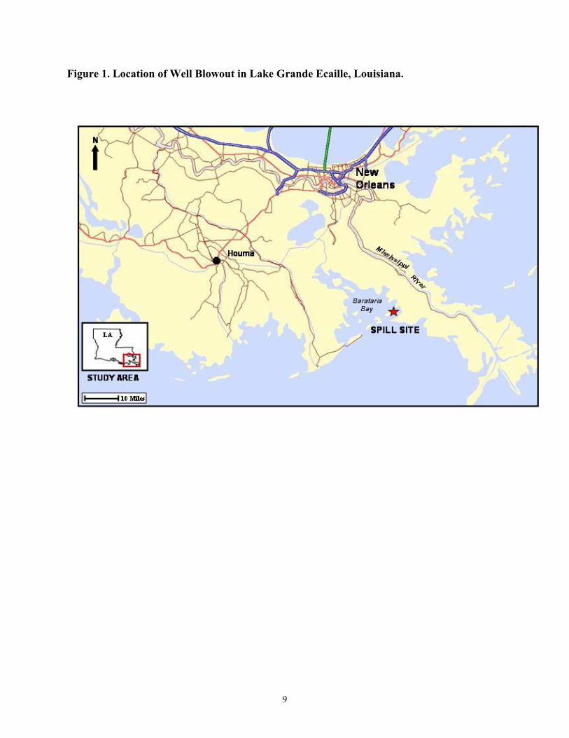
On September 22, 1998, an unknown volume of oil (similar to a medium weight crude oil) was discharged during a blowout of a well owned by Equinox into the waters of Lake Grande Ecaille, in Plaquemines Parish, coastal Louisiana (FIGURE 1). The exact volume of oil discharged is unknown, but estimates range from less than 450 bbl to 1,500 bbl. The oil was discharged in a jet that shot straight up approximately 200-300 feet into the air along with natural gas, produced water, and sand. The blowout continued for approximately 11 hours, at which point the discharge was stopped. Equinox responded to the spill, deploying booms, and later vacuuming up the oily sand that was deposited in the vicinity of the wellhead. Several thousand acres of surface water in Lake Grande Ecaille, as well as the Gulf of Mexico, were covered by slicks or sheens from the incident, and approximately 1,233 acres of wetlands (predominantly Spartina alterniflora marsh) were exposed to oil. Hurricane Georges passed near the area four days later on September 26, 1998, causing the response efforts to be suspended for a period, but also
5
removing some of the oil from the marshes and surface waters. After the passage of the hurricane, some areas that had previously been free of oil were oiled as a result of the redistribution of stranded oil.
Pursuant to Section 1006 of the Oil Pollution Act of 1990 (OPA) and OSPRA (L.R.S. 30:2451 et. seq.) , designated natural resource Trustees have conducted a damage assessment to evaluate potential injuries to natural resources and services, and to determine the need for and scale of restoration actions required. Equinox, the Responsible Party for this incident, participated actively in the damage assessment with the Trustees, including involvement in the design and implementation of some studies completed through the Cooperative Assessment Group (CAG). Information collected by all participants in the CAG was shared, as were the results of those analyses that were undertaken independently by the Trustees and Equinox.
1.2 SUMMARY OF NATURAL RESOURCE INJURIES
The Trustees reviewed the information gathered as a result of response activities as well as that collected specifically for injury assessment. Based on this work, the Trustees believe that the incident caused injuries to biota in the Lake Grande Ecaille estuarine and marsh environments, including a variety of birds.
Approximately 1,233 acres of marsh were exposed to oil resulting from the incident. The Trustees in cooperation with Equinox conducted a field study that determined that most of the exposed marsh was fully functioning or recovering to baseline function within six months after the discharge. For approximately 22 acres of marsh, field observations suggest that time to full recovery is two years. Marsh function in approximately 0.3 acres was affected more severely, and may not recover prior to this area eroding away due to natural processes. The pre-spill rate of land loss in the area was estimated from aerial photographs. Using this pre-spill erosion rate, the lifespan of marshes in this area was estimated at around five years (ENTRIX, 1999a). Based on field observations conducted in cooperation with Equinox, the Trustees estimate that a total of approximately 26.62 discounted acre-years of marsh1,2 service, abbreviated hereafter as DSAYs, may have been lost as a result of the impacts from the incident (there were 26.62 DSAYs lost for the Marsh injury; the total DSAY loss is 33.8). The Trustees extrapolated from the results of a previous oil spill injury assessment in the area to quantify injuries to water column organisms (i.e., finfish and shellfish) and birds for this incident. Injury to water column organisms was less than 1,707 kg of finfish and shellfish lost, and injury to birds was 95 birds killed. The methods used to extrapolate from the results of the other spill’s injury assessment for water column organisms and birds are explained in Sections 4.4.1.2 and 4.4.3.2, respectively. The Trustees believe that the creation of 0.85 acres of marsh will compensate for the bird and water column injuries. The Trustees believe that extrapolation from the other incident for estimating bird and water column fauna injuries is appropriate given the similarity in the environments, and the type
1 As discussed in next paragraph, this estimate includes injury to mangroves, which were treated as “marsh” for the purposes of this assessment.
2 An acre-year of marsh service is the amount of ecological function provided by one acre of marsh over one year
6
of product discharged, and is a technically defensible approach for assessing injury for an incident of this size.
An estimated 12.2 acres of mangroves were exposed to oil discharged during the incident. Approximately 3.0 acres of mangroves were lightly oiled, and were estimated to have recovered full service flows within two weeks following the discharge. Approximately 7.5 acres were oiled moderately and are believed to have recovered within six months following the incident. Recovery for the more heavily oiled 1.7 acres will take longer, and the time for full recovery is estimated at two years. Due to the relatively limited areal extent of mangrove oiling, and the fact that this area is near the northern geographic limit for supporting mangroves, the CAG decided to treat mangroves as a “marsh” injury for the purpose of determining restoration requirements. Therefore mangrove injury is included in the total estimate of 26.62 DSAYs given above for marsh injury.
Approximately 21 acres of subtidal sediments were adversely affected by the deposition of oily sand discharged during the incident. The deposited sand was removed by vacuuming it off the sediment surface by divers who finished this task approximately ten weeks following the beginning of the incident. Injury to benthic organisms from the oily sand is estimated to have resulted in the loss of 6.1 service-acre years of benthic services.
Boat-based recreational fishing was a public human-use activity that may have been affected during the incident. However, due to the limited duration of the active phase of the response actions, the close passage of Hurricane Georges four days after the incident began, and the numerous nearby alternative sites for recreational fishing, the recreational loss was judged by the Trustees to be relatively small. The cost of conducting studies to assess what appears to be a relatively small potential loss of recreational services was judged by the Trustees to be out of proportion to the potential value of the loss. However, restoration alternatives for other injuries were evaluated based on whether or not they provided benefits to recreational fishermen in addition to other criteria so as to provide some degree of compensation for the potential recreational loss.
1.3 SUMMARY OF PROPOSED RESTORATION ALTERNATIVES
Restoration actions under OPA are termed primary or compensatory. Primary restoration is any action taken to accelerate the return of injured natural resources and services to their baseline condition. Trustees may elect to rely on natural recovery rather than primary restoration actions in situations where feasible or cost-effective primary restoration actions are not available, or where the injured resources will recover relatively quickly without human intervention.
Compensatory restoration is any action taken to compensate for interim losses of natural resources and services pending recovery. The scale of the required compensatory restoration will depend both on the magnitude of initial resource injury and how quickly each resource and associated service returns to baseline. Primary restoration actions that speed resource recovery will reduce the requirement for compensatory restoration.
Based on observations made during the injury assessment studies, the Trustees determined that no active primary restoration actions were required beyond the original cleanup to return injured
7
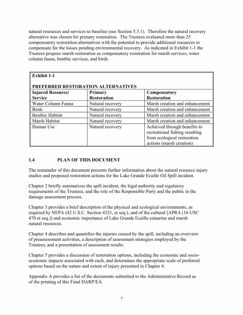
natural resources and services to baseline (see Section 5.3.1). Therefore the natural recovery alternative was chosen for primary restoration. The Trustees evaluated more than 25 compensatory restoration alternatives with the potential to provide additional resources to compensate for the losses pending environmental recovery. As indicated in Exhibit 1-1 the Trustees propose marsh restoration as compensatory restoration for marsh services, water column fauna, benthic services, and birds.
Exhibit 1-1 PREFERRED RESTORATION ALTERNATIVES Injured Resource/ Service
Primary Restoration
Compensatory Restoration
Water Column Fauna Natural recovery Marsh creation and enhancement Birds Natural recovery Marsh creation and enhancement Benthic Habitat Natural recovery Marsh creation and enhancement Marsh Habitat Natural recovery Marsh creation and enhancement Human Use Natural recovery Achieved through benefits to
recreational fishing resulting from ecological restoration actions (marsh creation)
1.4 PLAN OF THIS DOCUMENT
The remainder of this document presents further information about the natural resource injury studies and proposed restoration actions for the Lake Grande Ecaille Oil Spill incident.
Chapter 2 briefly summarizes the spill incident, the legal authority and regulatory requirements of the Trustees, and the role of the Responsible Party and the public in the damage assessment process.
Chapter 3 provides a brief description of the physical and ecological environments, as required by NEPA (42 U.S.C. Section 4321, et seq.), and of the cultural [APRA (16 USC 470 et seq.)] and economic importance of Lake Grande Ecaille estuarine and marsh natural resources.
Chapter 4 describes and quantifies the injuries caused by the spill, including an overview of preassessment activities, a description of assessment strategies employed by the Trustees, and a presentation of assessment results.
Chapter 5 provides a discussion of restoration options, including the economic and socio-economic impacts associated with each, and determines the appropriate scale of preferred options based on the nature and extent of injury presented in Chapter 4.
Appendix A provides a list of the documents submitted to the Administrative Record as of the printing of this Final DARP/EA.

8
Appendix B presents a list of applicable environmental laws that have been considered by the Trustees in conducting the assessment and planning restoration for this incident.
9
Figure 1. Location of Well Blowout in Lake Grande Ecaille, Louisiana.
10
CHAPTER 2. PURPOSE OF AND NEED FOR RESTORATION
2.1 THE LAKE GRANDE ECAILLE OIL SPILL: SUMMARY OF INCIDENT
At approximately 0450 hours on Tuesday, September 22, 1998, a loss of control was reported on the Cockrell-Moran #176 well. The well began to eject produced water, oil, gas, and sand. As soon as possible, well control operations began. Flow from the well was terminated at 1555 hours, and the well was considered controlled by 1935 hours the same day. The exact volume discharged is not known. Equinox has estimated that the volume discharged is less than 450 bbl, while estimates from Trustees range up to 1,500 bbl. (The Trustees used the 1,500 bbl estimate, while evaluating the magnitude of potential injuries, to be conservative in protecting the interests of the public).
The location of the well is approximately latitude 29o 21.6’ N, longitude 89o 47.5’, or about 11.35 miles SSW of Port Sulphur, Louisiana. Water depth in the vicinity of the well is around 3.5 m. Oil released from the well initially moved to the southeast, oiling marsh and beaches, and then into the Gulf of Mexico. Later, oil released from the well began moving to the west, oiling marshes and surface waters in that direction.
2.2 AUTHORITY AND LEGAL REQUIREMENTS
This Final DARP/EA has been prepared jointly by the Louisiana Oil Spill Coordinator’s Office (LOSCO), the Louisiana Department of Wildlife and Fisheries (LDWF), the Louisiana Department of Natural Resources (LDNR), the Louisiana Department of Environmental Quality (LDEQ), the National Oceanic and Atmospheric Administration (NOAA), and the U.S. Department of the Interior (DOI) which is represented by the United States Fish and Wildlife Service (USFWS) (collectively, "the Trustees"). Each of these agencies is a designated natural resource Trustee under the Oil Pollution Act of 1990 (OPA), 33 U.S.C. Section 2706(b), OSPRA (L.R.S. 30:2451 et. seq.), and the National Contingency Plan, 40 CFR Section 300.600, for natural resources injured by the Lake Grande Ecaille incident. As a designated Trustee, each agency is authorized to act on behalf of the public under State and/or Federal law to assess and recover natural resource damages, and to plan and implement actions to restore natural resources and resource services injured or lost as the result of a discharge of oil.
2.2.1 Overview of OPA Requirements
A natural resource damage assessment, as described under Section 1006 of OPA (33 U.S.C. Section 2706(c)) and OSPRA (L.R.S. 30:2451 et. seq.) the regulations for natural resource damage assessments under OPA at 15 CFR Part 990 and OSPRA at LAC 43:XXIX.101 et. seq. consists of three phases: 1) Preassessment; 2) Restoration Planning; and 3) Restoration Implementation. The Trustees may initiate a damage assessment provided that an incident has occurred; the incident is not from a public vessel or an onshore facility subject to the Trans-Alaska Pipeline Authority Act; the incident is not permitted under Federal, State or local law; and natural resources may have been injured as a result of the incident. Injury is defined as "an

11
observable or measurable adverse change in a natural resource or impairment of a natural resource service" (15 CFR Section 990.30 and LAC 43:XXIX.109).
Based on available information collected during the preassessment phase, Trustees make a preliminary determination whether natural resources or services have been injured and/or are threatened by ongoing injury. Through coordination with response agencies (e.g., the Coast Guard), Trustees next determine whether response actions will eliminate injury or the threat of ongoing injury. If injuries are expected to continue, and feasible restoration alternatives exist to address such injuries, Trustees may proceed with the restoration planning phase. Restoration planning also may be necessary if injuries are not expected to continue but are suspected to have resulted in interim losses of natural resources and services from the date of the incident until the date of recovery.
The purpose of the restoration planning phase is to evaluate potential injuries to natural resources and services, and use that information to determine the need for and scale of restoration actions. Natural resources are defined as "land, fish, wildlife, biota, air, ground water, drinking water supplies, and other such resources belonging to, managed by, held in trust by, appertaining to, or otherwise controlled by the United States, any State or local government or Indian tribe" (15 CFR Section 990.30 and LAC 43:XXIX.109). This phase provides the link between injury and restoration and has two basic components: injury assessment and restoration selection. The goal of injury assessment is to determine the nature and extent of injuries to natural resources and services, thus providing a factual basis for evaluating the need for, type of and scale of restoration actions. As the injury assessment is being completed, the Trustees develop a plan for restoring the injured natural resources and services. The Trustees must identify a reasonable range of restoration alternatives, evaluate and select the preferred alternative(s), develop a Draft Restoration Plan presenting the alternative(s) to the public, solicit public comment on the Plan, and consider comments when developing a Final Restoration Plan.
During the Restoration Implementation Phase, the Final Restoration Plan is presented to the Responsible Parties to implement or to fund the Trustees' costs of implementing the plan, thus providing the opportunity for settlement of damage claims without litigation. Should the Responsible Parties decline to settle a claim, OPA authorizes Trustees to bring a civil action against Responsible Parties for damages, or to seek disbursement from the Oil Spill Liability Trust Fund equal to the value of the damages. Components of damages are specified in sections 1002(b) and 1001(5) of OPA and OSPRA (L.R.S. 30:2480) and include the costs of damage assessment.
2.2.2 NEPA Compliance
Any restoration of natural resources under OPA must comply with the NEPA (40 CFR Section 1500, et seq.) and the Council on Environmental Quality (CEQ) regulations implementing NEPA. In compliance with NEPA and the CEQ regulations, this Final DARP/EA summarizes the current environmental setting, describes the purpose and need for action, identifies alternative actions, assesses their applicability and environmental consequences, and summarizes opportunities for public participation in the decision process. This information was used in
12
making a threshold determination as to whether preparation of an Environmental Impact Statement (EIS) is required prior to the selection of the final restoration action (i.e., the threshold for requiring an EIS is whether the proposed action is a major Federal action which has significant affect on the quality of the human environment). Based on the EA integrated in this plan, it was determined that the proposed restoration action does not meet the threshold requiring an EIS.
2.3 COORDINATION WITH THE RESPONSIBLE PARTY
The OPA and OSPRA regulations require the Trustees to invite Responsible Parties to participate in the damage assessment process. Although the Responsible Party may contribute to the process in many ways, final authority to make determinations regarding injury and restoration rests solely with the Trustees.
Accordingly, the Trustees invited Equinox to participate in the damage assessment in a letter dated January 29, 1999. In a letter dated March 9, 1999, Equinox responded that it wished to participate in the cooperative process. The designated technical representatives of Equinox participated actively in the damage assessment following the spill; they were involved in the design and implementation of studies completed as part of this assessment. They also participated actively in a Cooperative Assessment Group (CAG), which was created to design and interpret the studies and evaluate potential injuries. Coordination between the Trustees and Equinox helped reduce duplication of studies, increase the cost-effectiveness of the assessment process, increase sharing of information and experts, and is expected to decrease the likelihood of litigation. Input from Equinox was sought and considered, when provided, throughout the damage assessment process.
2.4 PUBLIC PARTICIPATION
Public review of the Draft DARP/EA is an integral component of the restoration planning process. Through the public review process, the Trustees seek public comment on the analyses used to define and quantify natural resource injuries and the methods being proposed to restore injured natural resources or replace lost resource services. The Draft DARP/EA provides the public with current information about the nature and extent of the natural resource injuries identified and restoration alternatives evaluated.
Following a public notice, the Draft DARP/EA Equinox Oil Company Crude Oil Discharge, Lake Grand Ecaille, Louisiana, September 22, 1998 was available to the public for a 30-day comment period. No comments were received during the public comment period and the Trustees have finalized the document. Public review of the Draft DARP/EA is consistent with all State and Federal laws and regulations that apply to the natural resource damage assessment process, including Section 1006 of OPA and OSPRA (L.R.S. 30:2451 et. seq.), the regulations for Natural Resource Damage Assessment under OPA (15 CFR Part 990) and OSPRA (LAC 43:XXIX.101 et.seq.), NEPA (42 USC Section 4371, et seq.) and the regulations implementing NEPA (40 CFR Part 1500, et seq.)
13
The deadline for submitting written comment on the Draft DARP/EA was August 22, 2005, which was specified in one or more public notices issued by the Trustees to announce the document's availability for public review and comment. An additional opportunity for public review would have been provided in the event that significant changes to the plan were required. Additional questions on this Final DARP/EA should be sent to Gina Muhs Saizan at the address provided below.
Louisiana Oil Spill Coordinator’s Office 150 Third Street, Suite 405 Baton Rouge, LA 70801 [email protected]
2.4.1 Administrative Record
The Trustees developed records documenting the information considered by the Trustees as they planned and implemented assessment activities and addressed restoration and compensation issues and decisions. These records have been compiled into an administrative record, which is now available for public review at the addresses given below. Although the record is still being added to, it presently contains the information that the Trustees relied upon to make the decisions described in the DARP/EA. The administrative record facilitates public participation in the assessment process and will be available for use in future administrative or judicial review of Trustee actions to the extent provided by Federal or State law. A list of those documents submitted to the administrative record through March 1, 2005 is attached as Appendix A to this document. Additional information and documents, including the Final DARP/EA and restoration planning documents will be included when completed. Documents within the administrative record can be viewed at: Louisiana Oil Spill Coordinator’s Office 150 Third Street, Suite 405 Baton Rouge, LA 70801 Arrangements should be made in advance to review the record, or to obtain copies of documents in the record by contacting Gina Muhs Saizan at the listed address or calling her at (225) 219-5800.
14
CHAPTER 3. AFFECTED ENVIRONMENT This chapter presents a brief description of the physical and biological environment affected by the Lake Grande Ecaille incident, as required by NEPA (40 U.S.C. Section 4321, et. seq.). The physical environment includes the marine waters of Lake Grande Ecaille and the Gulf of Mexico and associated coastal salt marsh, bird colony, oyster reef, and mudflat habitat. The biological environment includes a wide variety of fish, shellfish, birds, mammals and other organisms. Lake Grande Ecaille and its natural resources are part of the larger Barataria-Terrebonne estuary system (BTES). Commercial fishing, aquaculture, recreational fishing, hunting, and wildlife viewing provide contributions to the economy of Terrebonne, Lafourche, Plaquemines, and Jefferson parishes within the BTES. The wetlands in the BTES also provide ecosystem services such as protection from wind and storm surge damage and nutrient cycling/removal. These benefits depend on a healthy marine and coastal ecosystem in the BTES, including the Lake Grande Ecaille region. The Barataria-Terrebonne Bay complex is included in the National Estuary Program (BTNEP).
3.1 PHYSICAL ENVIRONMENT
The State of Louisiana is located along the north-central coast of the Gulf of Mexico. Lake Grande Ecaille is centrally located on the coast west of the Mississippi River delta, in the eastern portion of the BTES. The surrounding land is classified as Gulf Coast marsh and was created as a series of overlapping delta lobes of the Mississippi River during the past 10,000 years. The climate of the area is humid subtropical with abundant precipitation. Rainfall in May and June averages 4.8 and 6.7 inches, respectively. Summers are hot and winters are mild, with mean monthly temperatures of about 82oF and 57oF, respectively. The area is subject to tropical storms and hurricanes.
Lake Grande Ecaille and adjacent areas are a shallow estuarine bay system characterized by soft organic sediment. Tidal amplitude is small, driven primarily by wind. The shoreline in the Lake Grande Ecaille area is predominantly saltmarsh. Organic beaches are also present. The land in this area is subsiding, due to low influx of sediment, with land loss occurring rapidly. Since 1932, it is estimated that over 400,000 acres of wetlands in the BTES have been lost, forming open water (Barataria-Terrebone National Estuary Program website). The subsidence and resultant erosion of marsh has resulted in a very complex shoreline with a number of small islands and isolated patches of saltmarsh remaining in front of the main current shoreline. Numerous bayous, cuts, and canals in the shoreline of Lake Grande Ecaille allow exchange of water into interior portions of the marsh. Ponds are present in some areas of the marsh due to subsidence.
3.2 BIOLOGICAL ENVIRONMENT
Lake Grande Ecaille contains a variety of habitats including intertidal mudflat/fringe marsh, high marsh, mangroves, spoil-bank shrub, oyster reef, and open water that support a large array of
15
plant and animal species. Important habitats for many species include marsh areas and oyster beds. The predominant marsh plant species in the area is smooth cordgrass (Spartina alterniflora); black rush (Juncus roemerianus) and saltgrass (Distichlis spicata) are also present. The area supports black mangroves (Avicennia germinans), although this location is at the northern edge of their range, and consequently the mangroves are more shrub-like than those found in more hospitable locations, such as southern Florida. Mangroves, although a rare and extremely limited habitat type, are important to Louisiana coastal ecology.
Phytoplankton, zooplankton, and benthic and epibenthic invertebrates in the open water of Lake Grande Ecaille and associated wetlands serve as a food supply supporting a diversity of fish and bird species. Larger invertebrates expected to be found in Lake Grande Ecaille include the blue crab, white shrimp, brown shrimp, American oyster, stone crab, mud crab, fiddler crab, and periwinkles. Fish species expected to be found in Lake Grande Ecaille include red drum, spotted seatrout, sand seatrout, flounder, bay anchovy, spot, black drum, croaker, whiting, sheepshead, striped mullet, and Gulf menhaden. Several of these species are recreationally important along the Louisiana Gulf coast; these and other species are important as components of the Lake Grande Ecaille ecosystem.
Estuarine organisms of commercial, recreational, and ecological importance typically have inshore and offshore components to their life histories. Many species in Lake Grande Ecaille spawn offshore or near passes to estuaries, and their larvae migrate into estuarine nursery areas to grow and develop prior to offshore migration and maturation. Gulf coastal wetlands, such as those in Lake Grande Ecaille, act as nursery areas for a diversity of finfish, crustaceans, and mollusks, and are important to the life history requirements of over 90 percent of the Gulf’s commercially important species (Gulf of Mexico Fishery Management Council, 1981). Other taxa such as birds use estuarine habitats for seasonal feeding, refuge, and/or reproduction.
Many species of birds and mammals inhabit Lake Grande Ecaille and surrounding ecosystems. There are approximately 60 resident species of birds, and approximately 220 species of birds that regularly use the BTES for breeding or stopovers. Additionally, approximately 100 species are occasional visitors. Small marsh islands provide isolated nesting locations for several breeding bird species. Wading birds, gulls, shorebirds, waterfowl, diving birds, and raptors are among the types of birds that inhabit the area. Protected birds under the Migratory Bird Treaty Act and/or the Endangered Species Act that are known to be present in the area include bald eagles, osprey, piping plover, wading birds, seabirds and waterfowl. River otter, muskrat, mink, raccoon, bottlenose dolphin and nutria are among the mammal species that occur in the Lake Grande Ecaille area.
3.3 ENDANGERED AND THREATENED SPECIES
The Endangered Species Act of 1973 instructs Federal agencies to carry out programs for the conservation of endangered and threatened species and to conserve the ecosystems upon which these species depend. The Louisiana Department of Wildlife and Fisheries’ Natural Heritage Program also lists species that are of special concern to the State. Exhibit 3.1 at the end of this chapter provides a list of Federal and State recognized endangered or threatened species reported to reside in or migrate through south coastal Louisiana ecosystems.
16
3.4 CULTURAL ENVIRONMENT AND HUMAN USE
Ever since the early 1600’s when the explorer Pierre Le Moyne, Sieur d’Iberville discovered the region for France, the BTES has been recognized as an area with an abundance of fish and wildlife resources (Barataria-Terrebone National Estuary Program website). The BTES, including the Lake Grande Ecaille area, is directly used for commercial and recreational crabbing, trapping and hunting, and fishing, and is also used for wildlife viewing (“Economic Value Assessment of the Barataria-Terrebonne Estuarine System”, published research report 26, The Barataria-Terrebonne National Estuary Program). As discussed above, many of the commercially and recreationally important fish and shellfish species are dependent during at least part of their life history on the habitats within the BTES. Ecotourism (primarily bird and wildlife viewing and hunting and fishing) is increasingly important to the area. The wetlands in Lake Grande Ecaille also serve as protection from storms and saltwater intrusion, protecting both human development and freshwater supplies. After consultation with the State Historic Preservation Office, in compliance with ARPA, Section 106 (16 USC 470 et seq.) regarding archaeological and cultural resources at risk in the spill affected area and in the proposed restoration site, the Trustees have determined that no significant impacts exist.
Exhibit 3.1 FEDERAL AND STATE ENDANGERED OR THREATENED SPECIES IN PLAQUEMINES PARISH, LOUISIANA Common Name Scientific Name Status MAMMALS West Indian Manatee Trichechus manatus Endangered REPTILES Kemp’s Ridley Sea Turtle Lepidochelys kempii Endangered Hawksbill Sea Turtle Eretmochelys imbricata Endangered Leatherback Sea Turtle Dermochelys coriacea Endangered Loggerhead Sea Turtle Caretta caretta Threatened Green Sea Turtle Chelonia mydas Threatened BIRDS Brown Pelican Pelecanus occidentalis Endangered Piping Plover Charadrius melodus Threatened Bald Eagle Haliaeetus leucocephalus Threatened FISH Gulf Sturgeon Acipenser oxyrinchus desotoi Threatened Pallid Sturgeon Scaphirhynchus albus Endangered
17
CHAPTER 4. INJURY DETERMINATION AND QUANTIFICATION
This chapter describes and quantifies the injuries caused by the Lake Grande Ecaille incident. The chapter begins with an overview of data collected during the Preassessment Phase of the damage assessment process. The following section describes the Trustee's assessment strategy, including the approaches used to identify, determine, and quantify potential injuries. The remainder of the chapter presents the results of Trustee injury assessments for the specific resources affected by the Lake Grande Ecaille incident. Chapter 5 addresses the identification, selection, and scaling of restoration options to restore injured resources and services.
4.1 OVERVIEW OF THE PREASSESSMENT-PHASE
Three requirements identified in the Oil Pollution Act of 1990 (OPA) must be met before Restoration Planning can proceed:
• Injuries have resulted, or are likely to result, from the incident;
• Response actions have not adequately addressed, or are not expected to address, the injuries resulting from the incident; and
• Feasible primary and/or compensatory restoration actions exist to address the potential injuries.
Information collected during the Preassessment Phase of the incident is included in the Administrative Record. This information demonstrates that the three requirements listed above are met and confirms the need for restoration planning to address impacts resulting from the incident.
4.1.1 Water Column Faunal Impacts
The incident may have resulted in concentrations of polycyclic aromatic hydrocarbons (PAH) that could be toxic to aquatic organisms. Although there were no reports of large numbers of fish or shellfish mortalities observed as a result of the incident, it is likely that some mortality and sublethal effects occurred to organisms inhabiting the water column in the vicinity of the wellhead. The ability to look for impacts to water column fauna was limited by the near-passage of Hurricane Georges four days following the incident. Thousands of acres of surface waters in Lake Grande Ecaille and the Gulf of Mexico were exposed to surface slicks or sheens from this discharge.
18
4.1.2 Benthic Impacts
The deposition of oily sand, especially in the immediate vicinity of the well, is believed to have adversely affected benthic habitat services. Approximately 21 acres of water bottom were affected to some degree by deposited oiled sand, but the severest impacts are thought to have occurred over 1.6 acres immediately surrounding the wellhead.
4.1.3 Bird Impacts
Although reports indicated a great blue heron and some brown pelicans were oiled, no dead birds were recovered. Additionally, a USFWS observer, during the initial aerial reconnaissance, before Hurricane Georges, at an altitude of 1,000 feet, estimated that from 2,000 to 3,000 seabirds and wading birds were in the path of the slick, with many birds being seen within the plume itself. It is likely that some of these birds and other birds not seen were killed as a result of the spill. Severe weather from Hurricane Georges eliminated any possibility of a complete survey for oiled and dead birds.
4.1.4 Marsh Habitat Impacts
Approximately 1,233 acres of wetlands were exposed to oil (including sheen) from the well blowout, of which 12.2 acres were mangroves and the remainder saltmarsh. In small areas of the exposed marsh, oil was pooled as a result of the high water due to the hurricane, and resulted in a partial loss of aboveground biomass. In the vast majority of the marsh, the exposure to oil had less dramatic consequences, resulting in a smaller loss of marsh services. The oil caused stress to the marsh plants, resulting in an increase in chlorosis (yellowing of foliage) and potential reductions in primary productivity. The habitat value of the oiled marsh was also reduced. Some other marsh services were also potentially affected.
4.1.5 Human Use Impacts
The incident affected human use service in the Lake Grande Ecaille area. Under OPA and OSPRA, the Trustees are responsible for evaluating and obtaining compensation for public lost human use3. During the early stages of the cleanup, public access to the area was limited by cleanup activities, and later by the near-passage of Hurricane Georges, only four days following the onset of the incident. In the judgment of the Trustees, the effect of the incident on recreational uses of Lake Grande Ecaille was relatively limited in duration and magnitude. Recreational use of the area is believed to have returned to baseline levels shortly after the response actions ended. Therefore, no specific actions were required for recreational use to return to baseline conditions, allowing natural recovery to be the preferred alternative for primary restoration for this injury category. Additionally, there are numerous nearby substitute sites for fishing and shrimping that were not directly affected by the incident. Thus, there was little potential for significant interim loss and, therefore, it did not warrant further evaluation.
3 Under OPA, an individual may seek compensation for private losses resulting from an
incident; the Trustees only have authority to pursue restoration for public losses.

19
Instead, the Trustees considered benefits to recreational uses as an additional criterion in determining preferred restoration alternatives for other injury categories.
4.2 ASSESSMENT STRATEGY
The goal of injury assessment under OPA and OSPRA is to determine the nature and extent of injuries to natural resources and services, thus providing a technical basis for evaluating the need for, type of, and scale of restoration actions. The assessment process occurs in two stages: injury determination and injury quantification.
Injury determination begins with the identification and selection of potential injuries to investigate. The OPA regulations allow the Trustees to consider, and the Trustees did consider, several factors when making this determination, including, but not limited to:
• The natural resources and services of concern;
• The evidence indicating exposure, pathway and injury;
• The mechanism by which injury occurred;
• The type, degree, spatial and temporal extent of injury;
• The adverse change or impairment that constitutes injury;
• Available assessment procedures and their time and cost requirements;
• The potential natural recovery period; and
• The kinds of restoration actions feasible.
A list of the potential injuries investigated for the Lake Grande Ecaille incident is provided in the first column of Exhibit 4-1. As indicated in the exhibit, the Trustees evaluated possible injuries to four categories of ecological resources and also considered lost human use. These categories were selected based on input from preassessment activities; local, State and Federal government officials; the Responsible Party; and academic and other experts knowledgeable about the affected environment.
For each potential injury, the Trustees determine whether an injury has occurred, identify the nature of the injury and identify a pathway linking the injury to the incident. Injury is defined by the OPA and OSPRA regulations as "an observable or measurable adverse change in a natural resource or impairment of a natural resource service. Injury may occur directly or indirectly to a natural resource and/or service" (15 CFR Section 990.30 and LAC 43:XXIX.109). The assessment methods used for the incident are described in the second column of Exhibit 4-1, and discussed in greater detail in Section 4.3.1 and subsections of Section 4.4. Where feasible, the Trustees have used simplified, cost-effective procedures and methods to document resource injuries.

20
In selecting appropriate assessment procedures, the Trustees considered: (1) the range of procedures available under Section 990.27(b) of the OPA regulations; (2) the time and cost necessary to implement the procedures; (3) the potential nature, degree, and spatial and temporal extent of the injury; (4) the potential restoration actions for the injury; and (5) the relevance and adequacy of information generated by the procedures to meet information requirements of restoration planning. Accordingly, depending on the injury category, the Trustees relied on information and methodologies from the relevant scientific literature, literature-based calculations, experience from previous spills, and models and/or focused injury determination and quantification studies in assessing injury.
If the Trustees determine that a resource has been injured, the injury must be quantified. The injury quantification process determines the degree and spatial and temporal extent of injury relative to baseline, and therefore forms the basis for scaling restoration actions. Baseline refers to the condition that the resource would have maintained but for the effects of the incident.
Exhibit 4-1 LAKE GRANDE ECAILLE OIL SPILL: ASSESSMENT METHODS FOR POTENTIAL RESOURCE AND SERVICE INJURIES Potential Injuries Assessed
Injury Assessment Method(s)
Water Column Fauna
Trustees and Equinox cooperatively assessed information obtained during the response efforts, and extrapolated compensatory restoration needs from results of the assessment for this injury category in a previous oil spill.
Benthic Function Trustees and Equinox cooperatively assessed information obtained during the response efforts, and developed best professional judgment inputs for use in a Habitat Equivalency Analysis.
Birds
Trustees and Equinox cooperatively assessed information obtained during the response efforts, and extrapolated compensatory restoration needs from results of the assessment for this injury category in a previous oil spill.
Marsh Function Trustees and Equinox cooperatively performed a field study designed to obtain data allowing use of a Habitat Equivalency Analysis. Input parameters for the model were jointly developed based on the field observations.
Human Use Trustees determined that the potential extent of recreational losses was not sufficient to warrant a separate assessment.
4.3 SUMMARY OF INJURIES
A summary of injury assessment results is provided in Exhibit 4-2 and described in the following sections.
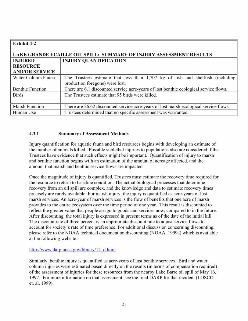
21
Exhibit 4-2 LAKE GRANDE ECAILLE OIL SPILL: SUMMARY OF INJURY ASSESSMENT RESULTS INJURED RESOURCE AND/OR SERVICE
INJURY QUANTIFICATION
Water Column Fauna
The Trustees estimate that less than 1,707 kg of fish and shellfish (including production foregone) were lost.
Benthic Function There are 6.1 discounted service acre-years of lost benthic ecological service flows. Birds
The Trustees estimate that 95 birds were killed.
Marsh Function There are 26.62 discounted service acre-years of lost marsh ecological service flows. Human Use Trustees determined that no specific assessment was warranted.
4.3.1 Summary of Assessment Methods
Injury quantification for aquatic fauna and bird resources begins with developing an estimate of the number of animals killed. Possible sublethal injuries to populations also are considered if the Trustees have evidence that such effects might be important. Quantification of injury to marsh and benthic function begins with an estimation of the amount of acreage affected, and the amount that marsh and benthic service flows are impacted.
Once the magnitude of injury is quantified, Trustees must estimate the recovery time required for the resource to return to baseline condition. The actual biological processes that determine recovery from an oil spill are complex, and the knowledge and data to estimate recovery times precisely are rarely available. For marsh injury, the injury is quantified as acre-years of lost marsh services. An acre-year of marsh services is the flow of benefits that one acre of marsh provides to the entire ecosystem over the time period of one year. This result is discounted to reflect the greater value that people assign to goods and services now, compared to in the future. After discounting, the total injury is expressed in present terms as of the date of the initial kill. The discount rate of three percent is an appropriate discount rate to adjust service flows to account for society’s rate of time preference. For additional discussion concerning discounting, please refer to the NOAA technical document on discounting (NOAA, 1999a) which is available at the following website: http://www.darp.noaa.gov/library/12_d.html Similarly, benthic injury is quantified as acre-years of lost benthic services. Bird and water column injuries were estimated based directly on the results (in terms of compensation required) of the assessment of injuries for these resources from the nearby Lake Barre oil spill of May 16, 1997. For more information on that assessment, see the final DARP for that incident (LOSCO et. al, 1999).

22
4.3.2 Summary of Results
An estimated 1,233 acres of marsh were exposed to oil as a result of this incident. The Trustees and Equinox conducted a joint field study and data analysis and the results indicated that approximately 26.62 Discounted Service Acre-Years (DSAYs) of marsh services were lost as a result of the oiling of the marsh. Water column faunal (e.g., fish, squid, shrimp, and other swimming animals) and bird injuries were evaluated by extrapolation from the results of a larger oil spill in a similar environment. A total of 0.85 acre of marsh creation was determined to be adequate to compensate for these losses. Benthic habitat injury was evaluated for the 21 acres that had been covered or partially covered by oily sand. Inputs to a Habitat Equivalency Analysis (HEA) were jointly developed from observations made during the response activities, and the HEA estimates that 6.1 DSAYs of benthic habitat functioning was lost as a result of this incident.
4.4 INJURIES TO SPECIFIC RESOURCES
The following sections of this chapter describe the results of the injury determination and quantification efforts for the incident that were conducted subsequent to the preassessment phase. Potential injuries are organized into five categories: water column fauna, benthos, birds, marsh, and human use (recreation).
4.4.1 Water Column Fauna
4.4.1.1 Determination of Injury
Barataria Bay, including the Lake Grande Ecaille area, is inhabited by a variety of water column organisms, including numerous species of fish. Trawl sampling by the LDWF in the vicinity of the spill site confirms this use. Oil (including sheen) from the incident was documented to cover thousands of acres of surface waters. Based on injury assessments for other oil spills in the area, it is likely that water column organisms were killed as a result of the spill.
4.4.1.2 Injury Quantification Strategy
The Trustees and Equinox agreed that conducting a large field study to investigate injury to water column organisms was not warranted, given the specific circumstances of this incident. A field effort designed to quantify injuries to fish, motile shellfish, and other water column organisms would be unlikely to result in a realistic estimate of injury to water column organisms. This is due to the large degree of natural variability that exists in plankton and nekton populations of the Gulf of Mexico region that would have made it impossible to detect the magnitude of injuries that the Trustees believed were present. Given the visual evidence suggesting that the magnitude of injury to water column organisms was relatively small, the Trustees decided to use a model-based approach to assess injury to this resource. The Trustees recently used a site-specific model to assess water column injury resulting from a crude oil spill in nearby Lake Barre. Although that spill involved the discharge of over 6,500 bbl from a submerged pipeline, the results indicated that water column injury from that incident was
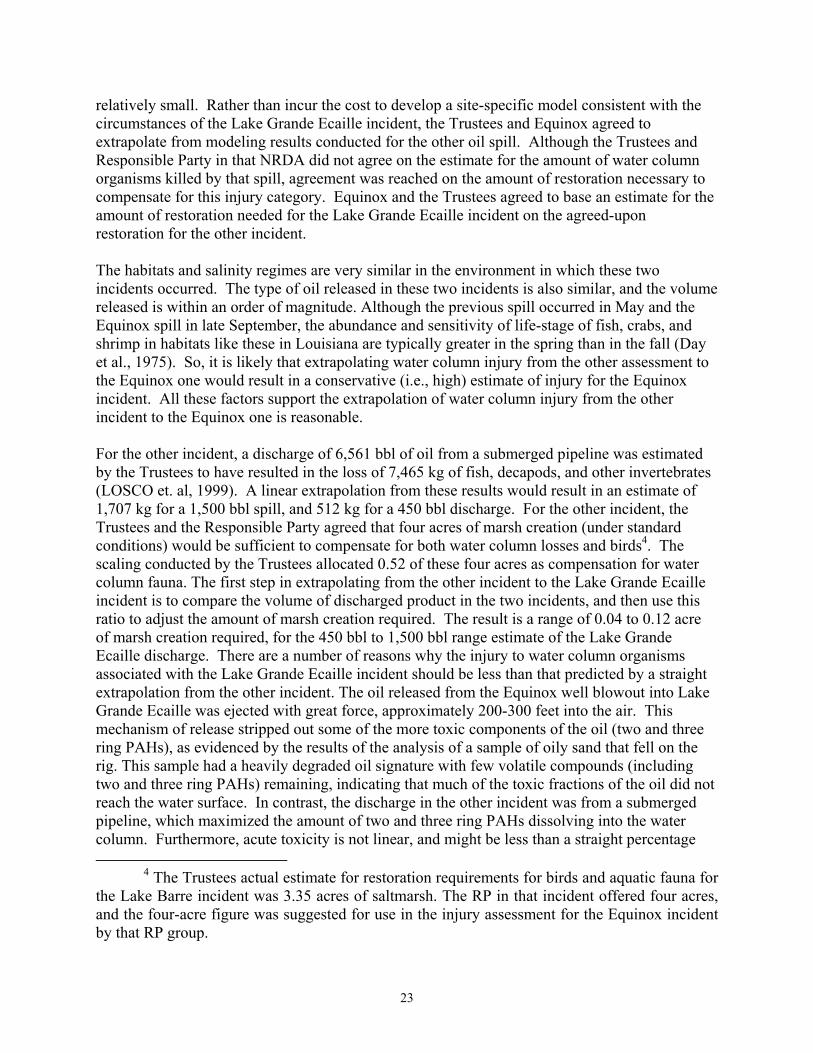
23
relatively small. Rather than incur the cost to develop a site-specific model consistent with the circumstances of the Lake Grande Ecaille incident, the Trustees and Equinox agreed to extrapolate from modeling results conducted for the other oil spill. Although the Trustees and Responsible Party in that NRDA did not agree on the estimate for the amount of water column organisms killed by that spill, agreement was reached on the amount of restoration necessary to compensate for this injury category. Equinox and the Trustees agreed to base an estimate for the amount of restoration needed for the Lake Grande Ecaille incident on the agreed-upon restoration for the other incident. The habitats and salinity regimes are very similar in the environment in which these two incidents occurred. The type of oil released in these two incidents is also similar, and the volume released is within an order of magnitude. Although the previous spill occurred in May and the Equinox spill in late September, the abundance and sensitivity of life-stage of fish, crabs, and shrimp in habitats like these in Louisiana are typically greater in the spring than in the fall (Day et al., 1975). So, it is likely that extrapolating water column injury from the other assessment to the Equinox one would result in a conservative (i.e., high) estimate of injury for the Equinox incident. All these factors support the extrapolation of water column injury from the other incident to the Equinox one is reasonable. For the other incident, a discharge of 6,561 bbl of oil from a submerged pipeline was estimated by the Trustees to have resulted in the loss of 7,465 kg of fish, decapods, and other invertebrates (LOSCO et. al, 1999). A linear extrapolation from these results would result in an estimate of 1,707 kg for a 1,500 bbl spill, and 512 kg for a 450 bbl discharge. For the other incident, the Trustees and the Responsible Party agreed that four acres of marsh creation (under standard conditions) would be sufficient to compensate for both water column losses and birds4. The scaling conducted by the Trustees allocated 0.52 of these four acres as compensation for water column fauna. The first step in extrapolating from the other incident to the Lake Grande Ecaille incident is to compare the volume of discharged product in the two incidents, and then use this ratio to adjust the amount of marsh creation required. The result is a range of 0.04 to 0.12 acre of marsh creation required, for the 450 bbl to 1,500 bbl range estimate of the Lake Grande Ecaille discharge. There are a number of reasons why the injury to water column organisms associated with the Lake Grande Ecaille incident should be less than that predicted by a straight extrapolation from the other incident. The oil released from the Equinox well blowout into Lake Grande Ecaille was ejected with great force, approximately 200-300 feet into the air. This mechanism of release stripped out some of the more toxic components of the oil (two and three ring PAHs), as evidenced by the results of the analysis of a sample of oily sand that fell on the rig. This sample had a heavily degraded oil signature with few volatile compounds (including two and three ring PAHs) remaining, indicating that much of the toxic fractions of the oil did not reach the water surface. In contrast, the discharge in the other incident was from a submerged pipeline, which maximized the amount of two and three ring PAHs dissolving into the water column. Furthermore, acute toxicity is not linear, and might be less than a straight percentage
4 The Trustees actual estimate for restoration requirements for birds and aquatic fauna for the Lake Barre incident was 3.35 acres of saltmarsh. The RP in that incident offered four acres, and the four-acre figure was suggested for use in the injury assessment for the Equinox incident by that RP group.
24
based on the volume discharged, regardless of other factors (French-McCay, 1999, pers. comm.). The above factors suggest that an appropriate amount of restoration for water column fauna may be less than 0.04 to 0.12 acre of marsh, depending on the actual volume discharged. As discussed in Section 4.4.3.2, the injury quantification approach used by the Trustees for birds estimates that the injury to birds would be compensated for by the equivalent of 0.99 acre of marsh creation. Therefore, without considering any mitigating factors, the amount of marsh creation required as compensation for injury to both water column fauna and birds was estimated by the Trustees to range from 1.03 to 1.11 acres of marsh. During discussions of the CAG, Equinox made an initial offer of 0.75 acre of marsh creation to compensate for water column, bird, and benthic habitat injuries. After consideration of the Trustees estimate for water column and bird injuries, Equinox increased their offer to 0.85 acre of marsh creation, and agreed to the Trustees’ injury quantification approach for benthic habitat (Section 4.4.2.2). After considering the mitigating factors discussed above, the Trustees concluded that 0.85 acre of marsh creation was sufficient as compensation for both bird and water column injuries believed to have resulted from this incident5. This assessment approach estimates the restoration needed to compensate for water column injury that resulted from death due to exposure to predicted concentrations of low molecular weight PAHs in the water column in the early days following the incident. It also estimates the resulting loss in growth of the organisms predicted to have died from exposure to PAHs. It does not account for a reduction in aquatic faunal production that resulted from reductions in marsh and benthic habitat services supporting aquatic fauna. Losses due to a reduction in marsh and benthic habitat services supporting water column organisms are accounted for in the assessments of injury to marsh and benthic habitats. In the judgment of the Trustees, assessing direct mortality to aquatic fauna and considering indirect aquatic faunal injuries through reductions in marsh and benthic habitat services, does not result in significant double-counting of aquatic faunal injuries, under the specific circumstances of this incident.
4.4.2 Benthic Habitat
4.4.2.1 Determination of Injury
Sediments in shallow estuarine lakes provide habitat for a variety of organisms that provide many services to the surrounding ecosystem. One important function is to serve as the base of the estuarine food web. As a result of the incident, 21 acres of subtidal sediments in Lake Grande Ecaille were covered to some degree by a layer of oily sand. Of the 21 acres, approximately 1.6 acres were covered to a large extent, and the remainder to a lesser degree.
5 This determination is supported by an extrapolation, based on volume released (using
1,500 bbl as the estimate for the Equinox incident) that uses the actual independent Trustee estimate of 3.35 acres for compensatory restoration for birds and aquatic fauna in Lake Barre. An estimated 0.77 acres of marsh required compensatory restoration for bird and aquatic injuries resulting from the Equinox incident, without considering any mitigating factors. Therefore the offer of 0.85 acres appears to be sufficient.

25
This cover of oily sand is likely to have reduced function of this sedimentary (or benthic) habitat by killing some benthic organisms and causing sublethal effects to others. 4.4.2.2 Injury Quantification Strategy
The Trustees decided to use Habitat Equivalency Analysis (HEA) a resource-to-resource scaling approach to determine restoration requirements for the benthic injury category, and therefore structured the assessment process to provide the necessary inputs for HEA. The Trustees decided not to undertake specific benthic sampling efforts, given the limited areal extent of injury to benthic habitat from this incident (based on observations made by divers who vacuumed off the oily sand during the response). Such an undertaking would be extremely expensive, requiring a large number of samples (due to the high level of variability expected in these benthic communities) to capture the initial injury and the subsequent recovery. Conservative assumptions (i.e., assumptions that would lead to more restoration) were used for initial level of injury (100% for the most heavily impacted area) and time to recovery (two years). The two-year estimate was based on the results of studies of benthic recovery following small-scale disturbance events (Swartz et al., 1980; Van Dolah et al., 1984). The cooperative assessment resulted in an estimate that 6.1 DSAYs of lost benthic habitat services were lost as a result of this incident. For more details on the injury assessment for this injury and the parameters used in the HEA, see Entrix (1999b). This injury quantification approach takes into account reductions in the entire flow of benthic habitat services. It is intended to account for a reduction in bird production that resulted from reductions in benthic service flows supporting birds. Likewise, it is intended to account for a reduction in water column faunal production from reductions in benthic service flows supporting fish, shrimp, crabs, and other aquatic fauna. It is also intended to capture the loss of other benthic habitat services. It is the judgment of the Trustees that accounting for reductions in benthic habitat services with this approach does not result in significant double counting of the bird and aquatic faunal injuries, under the specific circumstances of this incident. 4.4.3 Birds 4.4.3.1 Determination of Injury
The Lake Grande Ecaille area is used by a variety of bird species, including mottled ducks, snowy egrets, great egrets, Louisiana herons, sandpipers, rails, gulls, and terns. Although no dead birds were recovered, and only a few birds were observed oiled, the Trustees believe that some birds were killed as a result of direct exposure to the oil in the first few days following the incident. Oil sheen was documented to cover several thousand acres of surface waters and marsh in which numerous birds were observed.
4.4.3.2 Injury Quantification Strategy
The large area affected and the extensive marsh in which dead birds would be difficult to find, were practical obstacles in determining bird injury. Additionally, the passage of Hurricane Georges through the area complicated bird survey efforts. Rather than conduct an extensive field

26
survey that would be unlikely to produce accurate results, the Trustees decided to use a model-based approach to evaluate injury to birds. The Trustees had recently used a site-specific model to assess bird injury resulting from a nearby crude oil spill. Although that spill involved the discharge of over 6,500 bbl, the model predicted that relatively few birds were killed. The development of a site-specific model consistent with the circumstances of the Lake Grande Ecaille incident would be difficult, and given the expected low magnitude of bird injury, the Trustees and Equinox instead agreed to extrapolate from modeling results conducted for the earlier oil spill. Although the Trustees and Responsible Party in that NRDA did not agree on the estimate for the number of birds killed by that spill, agreement was reached on the amount of restoration necessary to compensate for this injury category. Equinox and the Trustees agreed to base an estimate for the amount of restoration needed for the Lake Grande Ecaille incident on the agreed-upon restoration for the other incident. For the previous incident, a discharge of 6,561 bbl of oil from a submerged pipeline was estimated by the Trustees to have resulted in the loss of 333 birds (LOSCO et al., 1999). Using the ratio of spill volume for the extrapolation, for spill estimates of 450 and 1,500 bbl, respectively, resulted in an estimate of 23 to 76 dead birds. Another approach for estimating bird loss in the Equinox incident from the results of the other incident is to compare the amount of marsh affected in the two incidents, since many of the birds located in the area are associated with marsh. Adjusting the bird injury number from the earlier spill by 28.5% (the ratio of marsh exposed to oil in the Equinox incident and the other incident) results in an estimate of 95 birds killed. The use of the comparison of acreage of oiled marsh provides the more conservative estimate. Therefore, the Trustees choose to extrapolate bird injury and restoration needs based on the relative marsh area affected in the two incidents.
For the other incident, the Trustees and the Responsible Party agreed that four acres of marsh creation (under standard conditions) would be sufficient to compensate for both water column losses and birds. The scaling conducted by the Trustees allocated 3.48 of the four acres as compensation for bird injury. Without considering possible mitigating factors, this method of extrapolation yields 0.99 acres of marsh creation as the compensatory restoration requirement for birds in this incident. As discussed in Section 4.4.1.2, the injury quantification approach used by the Trustees for water column fauna estimates that this injury would be compensated for by the equivalent of 0.04 to 0.12 acre of marsh creation. Therefore, without considering any mitigating factors, the Trustees estimated that the combined injury to birds and water column fauna would be compensated by 1.03 to 1.11 acres of marsh creation. As explained above, the Trustees concluded, after consideration of the previously discussed mitigating factors (e.g., the method of release and the less than linear relationship between toxicity and volume) that 0.85 acres of marsh creation is sufficient as compensation for both bird and water column faunal injury.
This injury category, as evaluated by extrapolation from other oil spill assessment, estimates the bird injury that the Trustees believe resulted from death due to exposure to surface slicks that were present in the early days following the incident. It does not estimate the potential reduction in bird production that resulted from reductions in marsh service flows supporting birds. Losses due to a reduction in marsh or benthic services supporting birds are accounted for in the assessments of injury to marsh and benthic habitats. In the judgment of the Trustees, assessing

27
direct mortality of birds in the first few days of the incident and considering longer-term indirect injury to birds through reduction in marsh and benthic services to birds does not result in significant double-counting of bird injuries, under the specific circumstances of this incident. 4.4.4 Marsh
4.4.4.1 Determination of Injury
The trajectory of the oil into the marsh and the extent of oiling were documented on a frequent basis during the initial response using overflights and on-water surveys. Trustees participated in surveys and field observations in September, October, and November 1998 and May 1999. It is estimated that approximately 785 acres of wetland vegetation were exposed to light oiling (including sheen), 426 acres to moderate oiling, and 22.5 acres were exposed to heavy oiling. Of these areas, 3.0, 7.5, and 1.7 acres, respectively, were made up of black mangroves, rather than being predominantly Spartina alterniflora marsh as was the remainder of the affected vegetated wetlands. The Trustees decided to treat injury to mangroves as a “marsh” injury together with that to Spartina alterniflora for several reasons. The first is that there was very limited acreage of mangrove exposure compared to that for Spartina alterniflora. The second is the fact that the Lake Grande Ecaille region is at the northernmost extreme of the mangrove range and therefore mangrove restoration is not as technically feasible here as is Spartina alterniflora restoration. Finally, the services provided by mangroves and marsh in Louisiana are largely similar, so that marsh restoration would provide most of the same services as were lost from the oiling of the mangroves. The Trustees’ decision to not undertake mangrove restoration for the small mangrove injury resulting from this incident is appropriate under the specific circumstances of this case, and does not reflect a general policy against mangrove restoration.
4.4.4.2 Injury Quantification Strategy
The Trustees, in cooperation with Equinox, conducted a field study designed to determine the loss of marsh services resulting from the September 22, 1998 incident. Observations on oiling, vegetative status, use of the area by invertebrates, and other factors was measured at specific locations in oiled and unoiled areas of marsh in November 1998 and May 1999. Photographic documentation was also used. These data were used to estimate the reduction in marsh service flows from the time of the incident until recovery to baseline could be estimated. These estimates of loss of marsh function were based on the observations made during this assessment (including comparisons to unoiled reference marshes), comparisons with the effects of other oil spills in similar environments, and the best professional judgment of the participants. The primary goals of the study were to determine the service reduction over time so that a total service loss calculation could be performed.
Based on the observations made during the response efforts and the marsh assessment field study, the CAG determined that the marsh exposed to oil showed five patterns of severity of injury and recovery. The estimates for recovery times and levels of service losses were developed based upon the analysis of available data and an evaluation of the types and
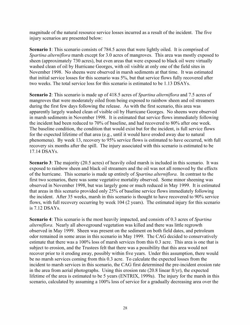
28
magnitude of the natural resource service losses incurred as a result of the incident. The five injury scenarios are presented below: Scenario 1: This scenario consists of 784.5 acres that were lightly oiled. It is comprised of Spartina alterniflora marsh except for 3.0 acres of mangroves. This area was mostly exposed to sheen (approximately 730 acres), but even areas that were exposed to black oil were virtually washed clean of oil by Hurricane Georges, with oil visible at only one of the field sites in November 1998. No sheens were observed in marsh sediments at that time. It was estimated that initial service losses for this scenario was 5%, but that service flows fully recovered after two weeks. The total service loss for this scenario is estimated to be 1.13 DSAYs. Scenario 2: This scenario is made up of 418.5 acres of Spartina alterniflora and 7.5 acres of mangroves that were moderately oiled from being exposed to rainbow sheen and oil streamers during the first few days following the release. As with the first scenario, this area was apparently largely washed clean of visible oil by Hurricane Georges. No sheens were observed in marsh sediments in November 1998. It is estimated that service flows immediately following the incident had been reduced to 70% of baseline, and had recovered to 80% after one week. The baseline condition, the condition that would exist but for the incident, is full service flows for the expected lifetime of that area (e.g., until it would have eroded away due to natural phenomena). By week 13, recovery to 95% service flows is estimated to have occurred, with full recovery six months after the spill. The injury associated with this scenario is estimated to be 17.14 DSAYs. Scenario 3: The majority (20.5 acres) of heavily oiled marsh is included in this scenario. It was exposed to rainbow sheen and black oil streamers and the oil was not all removed by the effects of the hurricane. This scenario is made up entirely of Spartina alterniflora. In contrast to the first two scenarios, there was some vegetative mortality observed. Some minor sheening was observed in November 1998, but was largely gone or much reduced in May 1999. It is estimated that areas in this scenario provided only 25% of baseline service flows immediately following the incident. After 35 weeks, marsh in this scenario is thought to have recovered to 90% service flows, with full recovery occurring by week 104 (2 years). The estimated injury for this scenario is 7.12 DSAYs. Scenario 4: This scenario is the most heavily impacted, and consists of 0.3 acres of Spartina alterniflora. Nearly all aboveground vegetation was killed and there was little regrowth observed in May 1999. Sheen was present on the sediment on both field dates, and petroleum odor remained in some areas in this scenario in May 1999. The CAG decided to conservatively estimate that there was a 100% loss of marsh services from this 0.3 acre. This area is one that is subject to erosion, and the Trustees felt that there was a possibility that this area would not recover prior to it eroding away, possibly within five years. Under this assumption, there would be no marsh services coming from this 0.3 acre. To calculate the expected losses from the incident to marsh services in this scenario, the CAG first determined the pre-incident erosion rate in the area from aerial photographs. Using this erosion rate (20.8 linear ft/yr), the expected lifetime of the area is estimated to be 5 years (ENTRIX, 1999a). The injury for the marsh in this scenario, calculated by assuming a 100% loss of service for a gradually decreasing area over the
29
expected lifetime of five years, when it is predicted that it would have been lost regardless of the incident, is 0.73 DSAYs. Scenario 5: This scenario consists of 1.7 acres of mangroves that were heavily oiled. The worst areas had a two-foot band of oil on the trees, which were mostly four to five feet in height. Some two-foot tall seedlings were completely covered. Oil was still visible on the plants in May 1999. Only the seedlings that were completely covered by oil were killed. It is estimated that service flows were initially reduced to 70% of baseline, with full recovery by week 104 (2 years). The injury estimated for this scenario is 0.50 DSAYs. This injury quantification approach attempts to take into account reductions in the entire flow of marsh services. It is intended to account for a reduction in bird production that resulted from reductions in marsh service flows supporting birds. Likewise, it is intended to account for a reduction in water column faunal production from reductions in marsh service flows supporting fish, shrimp, crabs, and other aquatic fauna. It is also intended to capture the loss of other marsh services. It is the judgment of the Trustees that accounting for reductions in marsh services with this approach does not result in significant double counting of the bird and aquatic faunal injuries, under the specific circumstances of this incident.
4.4.5 Human Use
4.4.5.1 Determination of Injury
As mentioned previously, the Trustees have determined that the likely magnitude of lost recreational use as a result of this incident is small, and therefore have foregone specific assessment efforts for this category of injury. This determination was based on observations made at the time of the incident, and later during the field studies. An independent study conducted by Louisiana State University concluded that there were modest, if any, effects on recreational users as a result of the much larger and less remote Lake Barre incident (Pulsipher et. al., 1998). This finding provides support for the Trustee position that the Lake Grande Ecaille incident was unlikely to have had significant impacts to human recreational use.
30
CHAPTER 5. RESTORATION ALTERNATIVES
5.1 RESTORATION STRATEGY
The goal of restoration under the Oil Pollution Act of 1990 (OPA) is to make the environment and public whole for injuries to natural resources and services resulting from the Lake Grande Ecaille incident. Restoration actions under OPA are termed primary or compensatory. Primary restoration is any action taken to accelerate the return of injured natural resources and services to their baseline condition. Natural recovery, in which no human intervention is taken to directly restore the injured natural resources and/or services to baseline conditions, is considered as a primary restoration alternative. Natural recovery is the appropriate restoration alternative in situations where feasible or cost-effective primary restoration actions are not available, or where the injured resources will recover relatively quickly without human intervention. Actual primary restoration actions (as opposed to natural recovery) are appropriate in situations where injured resources will not recover, or will recover slowly, without taking steps to bring about or speed recovery, and where feasible and cost-effective methods exist to assist recovery to baseline. Compensatory restoration is any action taken to compensate for interim losses of natural resources and/or services pending recovery to baseline. The scale of the required compensatory restoration is dependent on both the initial size of the injury and how quickly each resource and/or service returns to baseline. Primary restoration actions that speed recovery will reduce the requirement for compensatory restoration. To plan restoration for injuries resulting from the Lake Grande Ecaille incident, the Trustees first considered possible primary restoration actions for each injury and determined whether primary restoration can and should be implemented. The Trustees then consider the type and scale of compensatory restoration that can best compensate for lost resources and/or services during the recovery period. Restoration alternatives must be scaled to ensure that their size appropriately reflects the magnitude of injuries resulting from the incident. Where feasible, the Trustees employ a resource-to-resource scaling methodology. Under this approach, the Trustees determine the scale of restoration actions that will provide natural resources and/or services of the same type and quality and of comparable value to those lost. Here, equivalency is obtained between the resources and/or services lost and those to be provided through restoration. If a reasonable range of alternatives providing natural resources and/or services of the same type and quality and comparable value to those lost cannot be identified, other compensatory restoration actions may be considered. These other compensatory restoration actions must, in the judgment of the Trustees and as required by the NRDA regulations, provide services of comparable type and quality as those lost when practicable. When restoration provides resources

31
or services not of comparable value as those injured, the Trustees must determine the appropriate trade-off between the injured resources and those provided by restoration. The scaling calculations set forth in this chapter are based on straightforward methods combined with available data and the best professional judgment of the Trustees. Out of necessity, the calculations use simplifying assumptions while seeking to fairly estimate the magnitude of restoration required as compensation for injuries. Where necessary data are limited or unavailable, creating uncertainty in the true value for required inputs to the scaling calculations, the Trustees use conservative assumptions that will help ensure that the amount of restoration is sufficient. The Trustees believe that more complex scaling calculations would be difficult and expensive to undertake and would not significantly improve the accuracy of the scaling results in this case. Specific scaling assumptions and calculations are described later in this chapter. The Trustees assume that restoration alternatives will be implemented in the year 2005. In the event that actual implementation occurs after this date, the Trustees will appropriately revise the scaling calculations.
5.2 GENERAL RESTORATION ALTERNATIVES
In accordance with OPA regulations, the Trustees developed a reasonable range of restoration alternatives and selected a preferred alternative. For the Lake Grande Ecaille incident, this was a two-step process. The Trustees first identified and evaluated general alternatives capable of serving as primary or compensatory restoration for the injured natural resources and/or services (Exhibit 5-1). The Trustees and Equinox sought input from local scientists and Plaquemines Parish officials during meetings and in correspondence. These efforts were important in assisting the Trustees to identify feasible projects that would have strong net environmental benefits that would be accepted by the local public and meet restoration requirements to compensate for injuries resulting from the incident. As shown in Exhibit 5-1, most of the general restoration alternatives considered are for compensatory restoration. This is because the assessment studies have shown that resources and resource services impacted by the incident are, in the judgment of the Trustees, recovering to baseline conditions within an acceptably short time period. Therefore there was little need to consider active primary restoration alternatives. The only injured resource that is expected to take longer than two years to recover is the 0.3 acres of most heavily impacted marsh. Marsh replanting was considered as a primary restoration alternative for this small area but, as discussed in Section 5.3.1, the Trustees decided that it was not cost-effective to undertake actions to speed recovery for such a small area.
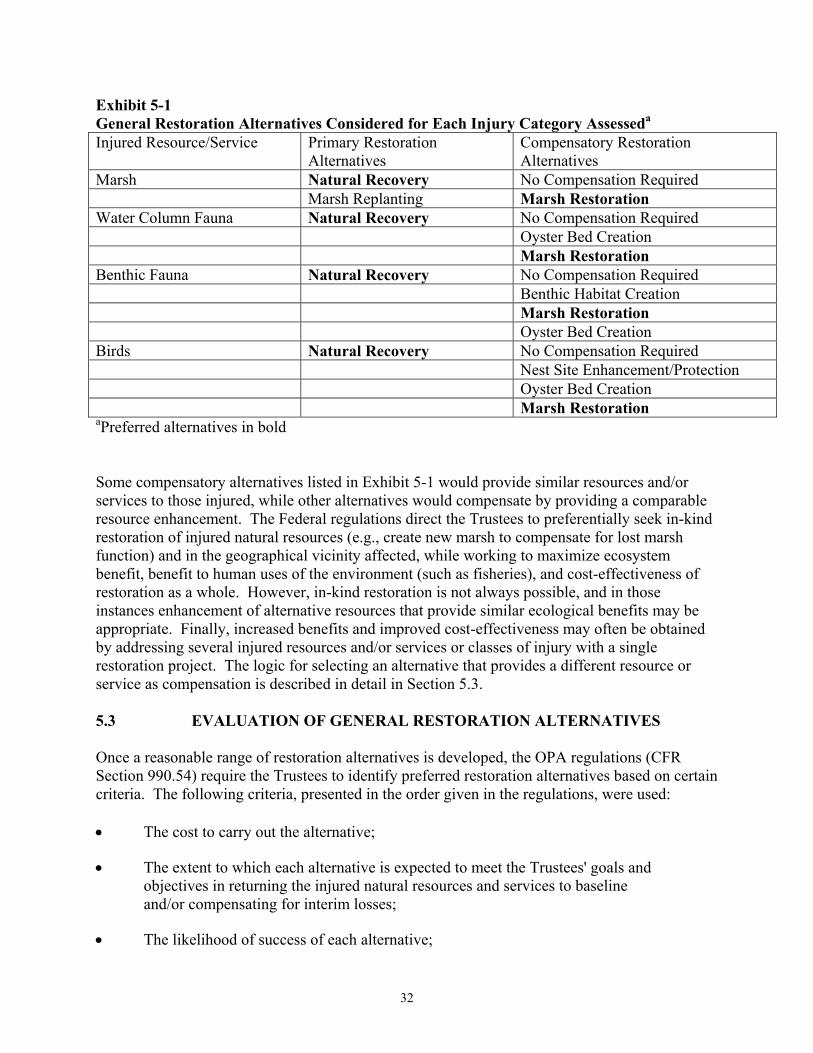
32
Exhibit 5-1 General Restoration Alternatives Considered for Each Injury Category Assesseda Injured Resource/Service Primary Restoration
Alternatives Compensatory Restoration Alternatives
Marsh Natural Recovery No Compensation Required Marsh Replanting Marsh Restoration Water Column Fauna Natural Recovery No Compensation Required Oyster Bed Creation Marsh Restoration Benthic Fauna Natural Recovery No Compensation Required Benthic Habitat Creation Marsh Restoration Oyster Bed Creation Birds Natural Recovery No Compensation Required Nest Site Enhancement/Protection Oyster Bed Creation Marsh Restoration aPreferred alternatives in bold Some compensatory alternatives listed in Exhibit 5-1 would provide similar resources and/or services to those injured, while other alternatives would compensate by providing a comparable resource enhancement. The Federal regulations direct the Trustees to preferentially seek in-kind restoration of injured natural resources (e.g., create new marsh to compensate for lost marsh function) and in the geographical vicinity affected, while working to maximize ecosystem benefit, benefit to human uses of the environment (such as fisheries), and cost-effectiveness of restoration as a whole. However, in-kind restoration is not always possible, and in those instances enhancement of alternative resources that provide similar ecological benefits may be appropriate. Finally, increased benefits and improved cost-effectiveness may often be obtained by addressing several injured resources and/or services or classes of injury with a single restoration project. The logic for selecting an alternative that provides a different resource or service as compensation is described in detail in Section 5.3. 5.3 EVALUATION OF GENERAL RESTORATION ALTERNATIVES Once a reasonable range of restoration alternatives is developed, the OPA regulations (CFR Section 990.54) require the Trustees to identify preferred restoration alternatives based on certain criteria. The following criteria, presented in the order given in the regulations, were used: • The cost to carry out the alternative;
• The extent to which each alternative is expected to meet the Trustees' goals and objectives in returning the injured natural resources and services to baseline and/or compensating for interim losses;
• The likelihood of success of each alternative;
33
• The extent to which each alternative will prevent future injury as a result of the incident, and avoid collateral injury as a result of implementing the alternative;
• The extent to which each alternative benefits more than one natural resource and/or service; and
• The effect of each alternative on public health and safety.
The regulations allow the Trustees to consider how to prioritize these criteria, and allow additional criteria to be used. The key criterion for the Trustees is the second in the list, since this criterion most clearly indicates whether the public has been made whole from losses resulting from the incident. The Trustees, as indicated previously, considered an additional criterion the extent to which the restoration alternative will provide benefits to recreational uses (such as fishing and wildlife viewing). Based on a thorough evaluation of a number of factors, including the criteria listed above, the Trustees have selected preferred restoration alternatives for primary and compensatory restoration of injured natural resources and/or services (highlighted in Exhibit 5-1). Information supporting the Trustees' selection of restoration alternatives is provided throughout the remainder of this chapter. In compliance with OPA and NEPA, the selection of restoration alternatives will be finalized following public review and comment on this DARP/EA. 5.3.1 Primary Restoration Based on field indications of recovery, the Trustees determined that most of the impacted marsh suffered only a partial loss of services and that the areas will recover to baseline within two years of the incident. A small area, 0.3 acre (Scenario 4, discussed in Section 4.4.4.2), is recovering more slowly, and, in fact, was conservatively assumed to have lost all marsh services in perpetuity. (For this incident, losses were calculated for a gradually diminishing area until the area was projected to be lost due to erosion in five years, based on the recent historical erosion trend in the area). However, the Trustees determined that primary restoration actions to aid in the recovery of the marsh habitat were neither necessary nor cost-effective due to the very limited size of the slowly recovering area, and the expectation that it would be lost from erosion within five years. The Trustees used conservative assumptions in estimating injury from this area, in order to ensure that the public receives sufficient compensation for this injury (see ENTRIX, 1999b). Therefore, the No Action/Natural Recovery option is selected as the preferred primary restoration alternative for this resource.
In addition, based on the magnitude of the estimated injury and site conditions, the Trustees determined that no additional actions were necessary to aid in the recovery of water column fauna, benthic habitat, birds, or recreational resources. Therefore, the No Action/Natural Recovery option is selected as the preferred primary restoration alternative for these resources. After determining the appropriate primary restoration alternative, the Trustees can proceed to determine the type and size of compensatory restoration to account for interim losses to injured resources and/or services (marsh, birds, aquatic fauna), which is addressed below.
34
5.3.2 Compensatory Restoration
5.3.2.1 Marsh Because interim losses of marsh services occurred during the period of recovery, and technically feasible alternatives exist to compensate for these losses, the Trustees determined that compensatory restoration is required for marsh injury, and the No Action alternative was rejected. As discussed in Section 5.2, the preference under OPA is for in-kind restoration where possible and otherwise consistent with restoration selection criteria. Since in-kind restoration as creation, enhancement, or protection of marsh is highly beneficial and technically feasible, and of particular import given the rapidly eroding coastal wetlands of Louisiana, the Trustees determined that the preferred compensatory restoration action for marsh injury was marsh restoration. In the discussion below, when marsh creation is discussed, it should be understood that the benefits apply to marsh restoration in general, including marsh creation, enhancement, and protection. Marsh restoration is an alternative that is consistent with the criteria used by the Trustees to evaluate restoration alternatives. It will provide an outflow of organic material that will generally benefit the Lake Grande Ecaille ecosystem by providing a source of organic carbon (energy supply supporting estuarine food web). Created marsh will provide services benefiting a wide range of resources, including benthic invertebrate species that inhabit marshes and the bird and fish species that feed on them. By providing critical nursery habitat for shrimp, fish, and other aquatic species, and nesting and foraging habitat for birds and other wildlife, created marsh will benefit recreational uses of the area by supporting increased populations of recreationally important species such as redfish and shrimp. Therefore, this alternative would have clear overall benefits to the environment. Additionally, marsh creation typically results in some impacts to existing habitats, such as subtidal sediments, on which it is created, has a high likelihood of success, tends to be cost-effective to implement, and is also consistent with Trustee regulations and laws.
The size of marsh restoration was determined using HEA to determine compensation for lost services based on the quantification of incident-related natural resource injuries. HEA considers several project-specific factors in scaling restoration, including elapsed time from onset of injury to restoration implementation, relative productivity of restored habitats (that is, the proportional equivalence of ecological services provided by the compensatory restoration project relative to the baseline productivity of the injured habitat), time required for restored habitats to reach full-function (i.e., maturity), and project lifespan. Therefore, selection of a preferred restoration project, with its own unique characteristics, was necessary before HEA could be applied. Section 5.4 discusses selection of the preferred restoration alternative and provides a detailed description of project scaling using HEA. 5.3.2.2 Benthic Habitat Because interim losses of benthic services occurred during the period of recovery, and technically feasible alternatives exist to compensate for these losses, the Trustees determined that compensatory restoration is required for benthic injury, and the No Action alternative was
35
rejected. As discussed in Section 5.2, the preference under OPA is for in-kind restoration where possible and otherwise consistent with restoration selection criteria. Therefore, creation of subtidal benthic habitat was considered as a compensatory restoration alternative. This restoration alternative is technically feasible and cost-effective, but was rejected by the Trustees due to the fact that Louisiana is losing land due to erosion and subsidence throughout the coastal zone. Creation of open water sediments from marsh or upland would only exacerbate this trend. Creation of an oyster bed by depositing cultch would increase habitat for oysters and other animals that require a hard surface for attachment. A created oyster reef would serve as a substrate for increased secondary productivity, and would provide many of the same sorts of services that soft-bottom sediment benthic habitat does as well as providing habitat and/or feeding areas for some fish. Oyster reef construction could benefit recreational use by creating a new fishing location where fishes may aggregate. Although oyster reef construction is technically feasible, the level of injury categorized within this document would require a large reef that is likely to be less cost-effective than other restoration alternatives. Salt marshes are widely recognized as providing a suite of critical services for aquatic life. Marshes serve as spawning and nursery areas for many species of juvenile fish and shellfish, export detritus (energy source for the aquatic food web) into the estuary, and can increase water quality by filtering sediments and other pollutants from the water column. In addition, marsh habitat provides many collateral benefits such as storm surge protection and habitat for birds and mammals. As already discussed, marsh creation will benefit recreational use of the area by increasing production of important recreational species and their prey items. Marsh restoration, creation, and/or protection can be successfully and cost-effectively implemented. The rapid loss of coastal marshes in Louisiana due to subsidence and erosion is a serious threat to the ecology and economy of Louisiana and efforts to increase the amount of marsh through creation projects and functioning of existing marsh through enhancement projects are widely supported throughout the State. In addition, marsh restoration is consistent with State and Federal regulations and laws concerning wetlands and essential fish habitat. The Trustees decided that, for this incident, restoration in the form of creation, enhancement, or protection of marsh habitat is more consistent with the restoration selection criteria as compensation for benthic habitat injuries than is creation of additional benthic habitat from marsh or upland, or oyster reef creation. Therefore, marsh restoration was selected as the preferred compensatory restoration action for benthic habitat injuries. 5.3.2.3 Water Column Fauna
The Trustees feel that technically feasible and cost-effective alternatives exist to compensate for interim losses to aquatic fauna. Thus, the Trustees determined that compensation was necessary for this injury, rejecting the No Action alternative. The Trustees considered two other alternatives for compensatory restoration: creation/restoration of oyster beds and marsh restoration (i.e., creation, enhancement, or protection). Creation of an oyster bed by depositing cultch would increase habitat for oysters and other animals that require a hard surface for attachment. A created oyster reef would serve as a
36
substrate for increased secondary productivity and would provide habitat and/or feeding areas for water column organisms. Oyster reef construction could benefit recreational use by creating a new fishing location where fish may aggregate. However, as discussed in Section 5.3.2.2, a large oyster reef is not cost-effective when compared to other available restoration alternatives.
Salt marshes are widely recognized as providing a suite of critical services for aquatic life. Marshes serve as spawning and nursery areas for many species of juvenile fish and shellfish, export detritus (energy source for the aquatic food web) into the estuary, and can increase water quality by filtering sediments and other pollutants from the water column. In addition, marsh habitat provides many collateral benefits such as storm surge protection and habitat for birds and mammals. As already discussed, marsh creation will benefit recreational use of the area by increasing production of important recreational species and their prey items. Marsh restoration, creation, and/or protection can be successfully and cost-effectively implemented. The rapid loss of coastal marshes in Louisiana due to subsidence and erosion is a serious threat to the ecology and economy of Louisiana and efforts to increase the amount of marsh through creation projects and functioning of existing marsh through enhancement projects are widely supported throughout the State. In addition, marsh restoration is consistent with State and Federal regulations and laws concerning wetlands and essential fish habitat. Additionally, the selection of salt marsh restoration allowed the Trustees to extrapolate directly from the Lake Barre assessment and restoration approach to evaluate the injury to water column fauna. A more costly assessment approach would have been unlikely to generate any better estimate for restoration needs given the small magnitude of injury.
The Trustees decided that, for this incident, restoration in the form of creation, enhancement, or protection of marsh habitat is more consistent with the restoration selection criteria as compensation for aquatic faunal injuries than is oyster reef creation. Therefore, marsh restoration was selected as the preferred compensatory restoration action for aquatic faunal injuries. 5.3.2.4 Birds The Trustees feel that technically feasible and cost-effective alternatives exist to compensate for interim losses to birds. Thus, the Trustees determined that the No Action alternative was not appropriate compensatory restoration for this injury and considered three other alternatives for compensatory restoration: actions that would create, enhance, or protect bird nesting sites, oyster reef creation, and marsh restoration.
The Trustees considered several actions that would directly compensate for bird losses by creating, enhancing, or protecting bird nesting sites: fenced enclosures to reduce predation on eggs and young, shelters to reduce predation on chicks, and wooden rafts and platforms to provide additional nesting sites. The purpose of these actions would be to increase the number of fledgling birds. In some cases, these types of actions have been successful in increasing survivorship and augmenting populations. However, in the studies considered by the Trustees in evaluating this restoration alternative, success was greatest when the actions were taken in response to known problems that were limiting the reproduction of a specific, targeted species. The Trustees carefully considered and discussed these options with State and Federal bird

37
experts, including managers of nearby LDWF and National Wildlife Refuges. The information provided to the Trustees suggests that reproduction by those bird species predicted to have been impacted by the incident does not appear to be limited by nest predation or the number or quality of nesting sites. Therefore, implementing these types of actions would not be an effective alternative for restoring bird resources lost as a result of this incident. The Trustees also considered creation of an oyster reef as a restoration alternative to benefit birds. A created oyster reef would serve as a substrate for increased secondary productivity, would support fish, and therefore could provide feeding areas for some bird species. If constructed appropriately, it could provide an important resting area for birds during low tides. As discussed in Section 5.3.2.2, oyster reef creation would also have some very positive benefits to fish, other organisms, and recreational fishing. Although technically feasible in theory, creation of an oyster reef, given the size of the injury, is not cost-effective compared to other available restoration alternatives. Therefore this alternative was not deemed viable for compensation for bird injuries. The Trustees decided that the preferred compensatory restoration action for bird injury is marsh restoration either through creation, enhancement, or protection of marsh habitat. As discussed in Section 5.3.2.2, salt marshes provide many services including nesting, cover, and foraging habitat for a variety of bird species. In addition, marshes export detritus to the surrounding estuarine environment, which serves as a food source for prey species fed upon by birds. Given the importance of marsh as habitat for birds, its cost-effectiveness relative to the creation of an oyster reef, and because of the many other collateral benefits marsh provides, the Trustees determined that creation, enhancement, or protection of existing marsh was the most beneficial and preferred compensatory restoration alternative for bird injuries resulting from the Lake Grande Ecaille incident. Selection of the marsh restoration alternative also allowed the Trustees to easily extrapolate directly from the Lake Barre assessment and restoration approach to evaluate the injury to birds. 5.3.2.5 Human Use The No Action alternative is appropriate for compensatory restoration of recreational losses since observations made by the Trustees suggest that the magnitude of recreational losses was very small. As discussed previously in Sections 1.2 and 4.4.4.1, the Trustees determined that, under the regulations and for the specific circumstances of this incident, the cost of conducting assessment studies to evaluate such a small potential injury was unjustified for this incident. However, the Trustees considered benefits to recreational uses as an additional criterion in determining the preferred restoration alternative so as to provide some degree of compensation for potential recreational losses. 5.4 EVALUATION OF MARSH RESTORATION ALTERNATIVES
The Trustees selected marsh restoration in the form of creation, protection, or enhancement as the preferred compensatory restoration project for all natural resource injuries. Since marsh
38
restoration is a broad category that could include many types of actions and sites, the Trustees completed the second step of the selection process: the development of a range of project-specific marsh restoration alternatives and selection of a preferred alternative from this list. The selection process for these marsh restoration alternatives is described in greater detail below. First, the Trustees compiled an initial comprehensive list of possible alternatives. The Trustees then conducted two “screenings” which narrowed the list to five manageable projects. These five alternatives were then ranked in order of preference. For each screening and ranking, two or more selection criteria, including the criteria listed in the OPA regulations, were applied to the list of alternatives. Section 5.4.1 describes the selection process. Sections 5.4.2 through 5.4.4 provide detailed information for the preferred alternative and the four alternates, and non-preferred alternatives. 5.4.1 Selection of Preferred Restoration Alternative 5.4.1.1 Preliminary List of Restoration Alternatives The Trustees identified 28 marsh restoration alternatives potentially capable of compensating for the natural resources and services injured as a result of the Lake Grande Ecaille incident. This list includes a variety of alternatives ranging in scope and design from shoreline armoring to marsh creation by terracing. The list, including a brief description of each option, is provided in Exhibit 5-2.
The Trustees and Equinox compiled this preliminary list from a variety of sources. Some of the alternatives originated from Coastal Wetlands Planning, Protection and Restoration Act (CWPPRA, also known as the Breaux Act) priority lists. These lists identify restoration opportunities to address coastal wetland loss in Louisiana. They are compiled annually and are submitted for Federal and State funding under the CWPPRA. In addition to using the CWPPRA lists, the Trustees and Equinox actively solicited restoration ideas and input from appropriate staff within State and Federal agencies, and from other interested parties including landowners, local government officials, and regional restoration agencies/consortiums. 5.4.1.2 First Tier Screening In order to pare down the large list of alternatives, the Trustees conducted a first tier screening to narrow the list and focus information-gathering efforts on the most likely alternatives. Two criteria were used in the first tier screening: similarity in attributes to the injured habitat, and proximity to the affected area. These two criteria were used because they reflect important project attributes and could be applied in the absence of detailed, extensive project information. These two first-tier screening criteria are defined below:
Similarity in Attributes to the Injured Habitat: This criterion considered the nature and extent to which restoration alternatives addressed the natural resource injuries that occurred as a result of the incident. This criterion includes the extent to which benefits of the action are in-kind, or are otherwise comparable in nature to the injured marsh habitat.
39
Alternatives met this criterion if they involved the enhancement, creation, and/or protection of salt or brackish marshes. Freshwater marsh options are not appropriate.
Proximity to Affected Area: This criterion considered whether the alternative was located within the affected area or was within a reasonable distance of the affected area (i.e., same watershed). This criterion also considered the extent to which the option directly or indirectly benefited injured habitats or compensated for lost use within the affected area. Barataria Bay was chosen as the appropriate geographic area for consideration.
Three alternatives that did not meet one or both of the proposed criteria were removed from the list (Exhibit 5-3).
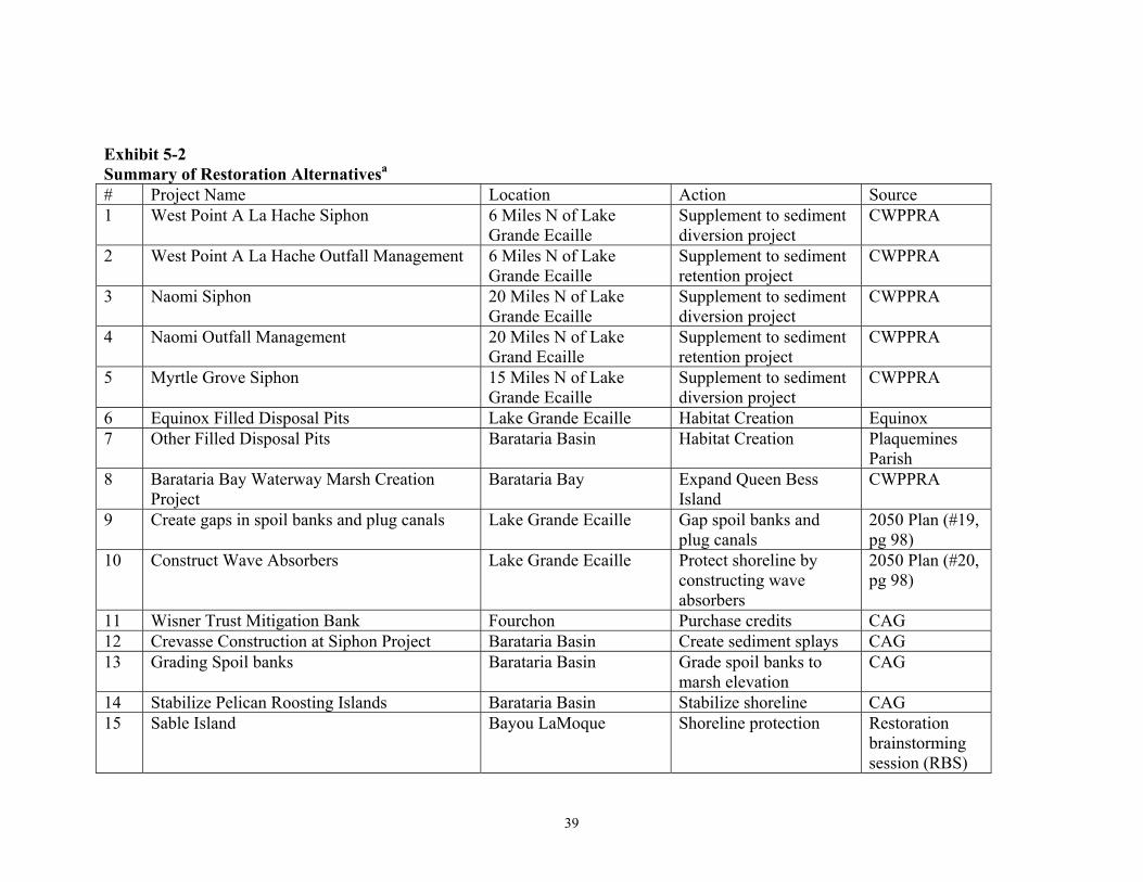
39
Exhibit 5-2 Summary of Restoration Alternativesa # Project Name Location Action Source 1 West Point A La Hache Siphon 6 Miles N of Lake
Grande Ecaille Supplement to sediment diversion project
CWPPRA
2 West Point A La Hache Outfall Management 6 Miles N of Lake Grande Ecaille
Supplement to sediment retention project
CWPPRA
3 Naomi Siphon 20 Miles N of Lake Grande Ecaille
Supplement to sediment diversion project
CWPPRA
4 Naomi Outfall Management 20 Miles N of Lake Grand Ecaille
Supplement to sediment retention project
CWPPRA
5 Myrtle Grove Siphon 15 Miles N of Lake Grande Ecaille
Supplement to sediment diversion project
CWPPRA
6 Equinox Filled Disposal Pits Lake Grande Ecaille Habitat Creation Equinox 7 Other Filled Disposal Pits Barataria Basin Habitat Creation Plaquemines
Parish 8 Barataria Bay Waterway Marsh Creation
Project Barataria Bay Expand Queen Bess
Island CWPPRA
9 Create gaps in spoil banks and plug canals Lake Grande Ecaille Gap spoil banks and plug canals
2050 Plan (#19, pg 98)
10 Construct Wave Absorbers Lake Grande Ecaille Protect shoreline by constructing wave absorbers
2050 Plan (#20, pg 98)
11 Wisner Trust Mitigation Bank Fourchon Purchase credits CAG 12 Crevasse Construction at Siphon Project Barataria Basin Create sediment splays CAG 13 Grading Spoil banks Barataria Basin Grade spoil banks to
marsh elevation CAG
14 Stabilize Pelican Roosting Islands Barataria Basin Stabilize shoreline CAG 15 Sable Island Bayou LaMoque Shoreline protection Restoration
brainstorming session (RBS)
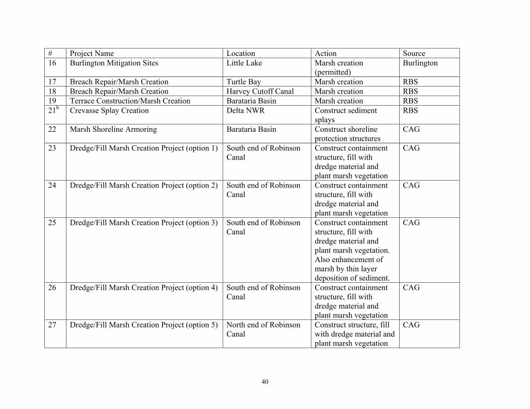
40
# Project Name Location Action Source 16 Burlington Mitigation Sites Little Lake Marsh creation
(permitted) Burlington
17 Breach Repair/Marsh Creation Turtle Bay Marsh creation RBS 18 Breach Repair/Marsh Creation Harvey Cutoff Canal Marsh creation RBS 19 Terrace Construction/Marsh Creation Barataria Basin Marsh creation RBS 21b Crevasse Splay Creation Delta NWR Construct sediment
splays RBS
22 Marsh Shoreline Armoring Barataria Basin Construct shoreline protection structures
CAG
23 Dredge/Fill Marsh Creation Project (option 1) South end of Robinson Canal
Construct containment structure, fill with dredge material and plant marsh vegetation
CAG
24 Dredge/Fill Marsh Creation Project (option 2) South end of Robinson Canal
Construct containment structure, fill with dredge material and plant marsh vegetation
CAG
25 Dredge/Fill Marsh Creation Project (option 3) South end of Robinson Canal
Construct containment structure, fill with dredge material and plant marsh vegetation. Also enhancement of marsh by thin layer deposition of sediment.
CAG
26 Dredge/Fill Marsh Creation Project (option 4) South end of Robinson Canal
Construct containment structure, fill with dredge material and plant marsh vegetation
CAG
27 Dredge/Fill Marsh Creation Project (option 5) North end of Robinson Canal
Construct structure, fill with dredge material and plant marsh vegetation
CAG

41
# Project Name Location Action Source 28 Dredge/Fill Marsh Creation Project (option 6) Vicinity of Freeport
Sulphur Canal Construct containment structure, fill with dredge material and plant marsh vegetation
CAG
aPreferred Alternative is in bold bProject #20 is a reef construction project, eliminated when marsh restoration selected as general restoration type
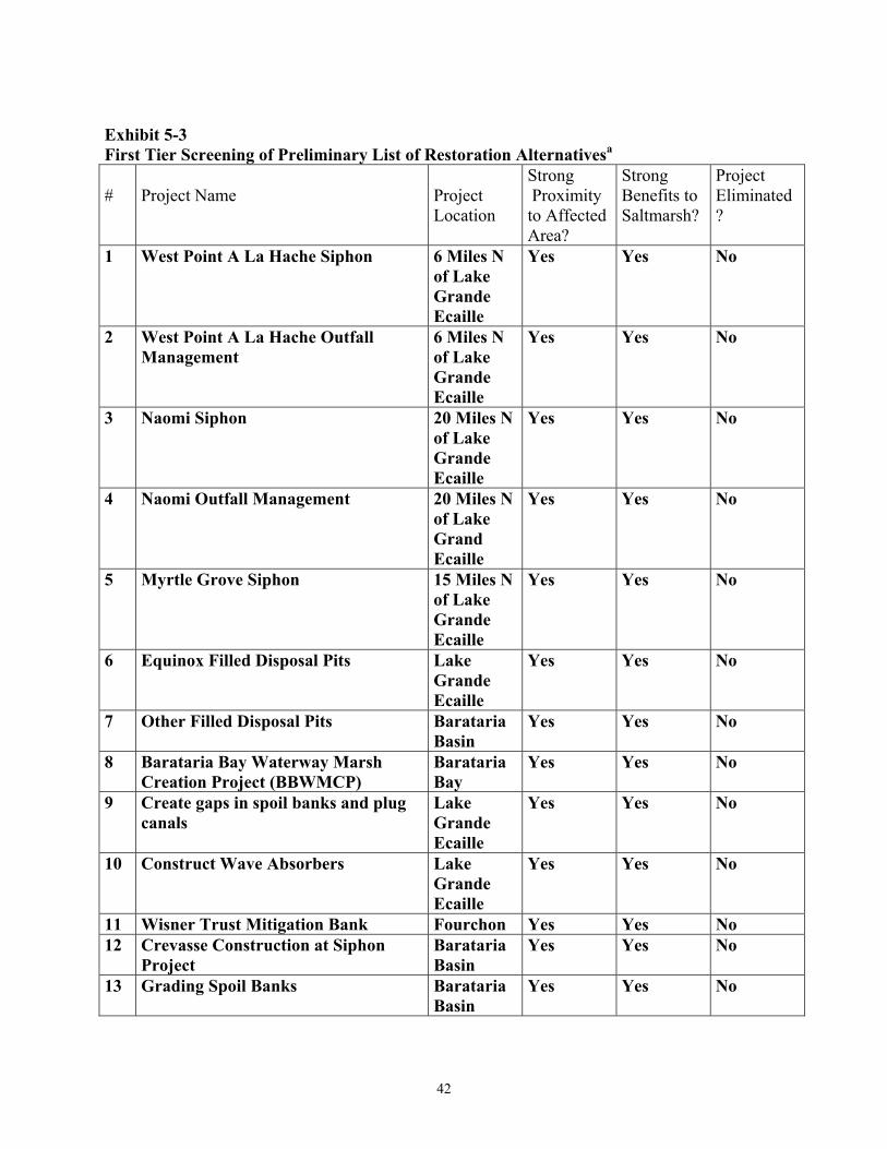
42
Exhibit 5-3 First Tier Screening of Preliminary List of Restoration Alternativesa #
Project Name
Project Location
Strong Proximity to Affected Area?
Strong Benefits to Saltmarsh?
Project Eliminated?
1 West Point A La Hache Siphon 6 Miles N of Lake Grande Ecaille
Yes Yes No
2 West Point A La Hache Outfall Management
6 Miles N of Lake Grande Ecaille
Yes Yes No
3 Naomi Siphon 20 Miles N of Lake Grande Ecaille
Yes Yes No
4 Naomi Outfall Management 20 Miles N of Lake Grand Ecaille
Yes Yes No
5 Myrtle Grove Siphon 15 Miles N of Lake Grande Ecaille
Yes Yes No
6 Equinox Filled Disposal Pits Lake Grande Ecaille
Yes Yes No
7 Other Filled Disposal Pits Barataria Basin
Yes Yes No
8 Barataria Bay Waterway Marsh Creation Project (BBWMCP)
Barataria Bay
Yes Yes No
9 Create gaps in spoil banks and plug canals
Lake Grande Ecaille
Yes Yes No
10 Construct Wave Absorbers Lake Grande Ecaille
Yes Yes No
11 Wisner Trust Mitigation Bank Fourchon Yes Yes No 12 Crevasse Construction at Siphon
Project Barataria Basin
Yes Yes No
13 Grading Spoil Banks Barataria Basin
Yes Yes No

43
#
Project Name
Project Location
Strong Proximity to Affected Area?
Strong Benefits to Saltmarsh?
Project Eliminated?
14 Stabilize Pelican Roosting Islands Barataria Basin
Yes No Yes
15 Sable Island Bayou LaMoque
No No Yes
16 Burlington Mitigation Sites Little Lake Yes Yes No 17 Breach Repair/Marsh Creation Turtle Bay Yes Yes No 18 Breach Repair/Marsh Creation Harvey
Cutoff Canal
Yes Yes No
19 Terrace Construction/Marsh Creation
Barataria Basin
Yes Yes No
21b Crevasse Splay Creation Delta NWR No Yes Yes 22 Marsh Shoreline Armoring Barataria
Basin Yes Yes No
23 Dredge/Fill Marsh Creation Project (option 1)
Robinson Canal
Yes Yes No
24 Dredge/Fill Marsh Creation Project (option 2)
Robinson Canal
Yes Yes No
25 Dredge/Fill Marsh Creation Project (option 3)
Robinson Canal
Yes Yes No
26 Dredge/Fill Marsh Creation Project (option 4)
Robinson Canal
Yes Yes No
27 Dredge/Fill Marsh Creation Project (option 5)
Robinson Canal
Yes Yes No
28 Dredge/Fill Marsh Creation Project (option 6)
Freeport Sulphur Canal
Yes Yes Yesc
aAlternatives remaining after screening in bold bProject #20 is a reef construction project, eliminated when marsh restoration selected as general restoration type. cProject #28 was not considered further since it was similar to other dredge/fill marsh creation projects, but located farther from the spill vicinity. 5.4.1.3 Second Tier Screening After the first tier screening was completed, the Trustees and Equinox collected additional, detailed information (e.g., project design, project status) on the remaining 23 alternatives. Once this information was assembled, a second set of screening criteria was applied and the list was narrowed to five alternatives: The second tier screening criteria are listed and described below, and the application of these criteria is shown in Exhibit 5-4.
44
Benefits to Saltmarsh – Based on the information gathered following the initial screening, the projects were re-examined using this first tier criterion. Project Status - This criterion referred to the stage of the project. Projects already completed and projects already fully funded from other sources were not considered for further evaluation. Projects that are still conceptual and would likely not be ready in the near-term are not favored.
Public Access - This criterion considered whether the site was publicly or privately owned and for private property, whether landowner permission has been granted for the project and the likelihood and type of public access and use of the land. Project sites that are available (not targeted for other use), have landowner/agency support, and provide access to the public, are favored. Sites that are managed for activities inconsistent with public use or where public use is otherwise discouraged are not favored. However, where the project benefits extend offsite to the general public, these benefits may offset, to some extent, restrictions in access to the specific project site.
Likelihood of Success of Each Alternative (Technical Feasibility) - This criterion considered whether a restoration project could be successfully implemented given currently available technology and expertise. Technically feasible alternatives were those that used proven methods, had a high rate of success as documented in the literature, and were well enough understood to characterize resulting natural resource service gains. This criterion also considered project and site-specific factors that may influence project success. Project attributes that may affect technical feasibility include the availability of a suitable sediment source (for dredge spoil projects), potential for wave or storm stress, fetch subsidence, and erosion. Site-specific technical feasibility issues include, but are not limited to, existing and adjacent land uses, existing right-of-ways, presence of nuisance animals or plants, and contamination.
Logistical Considerations - This criterion considered issues directly related to project coordination, oversight, and implementation such as site access and availability of equipment and materials (including dredge materials). This criterion also considered project-timing issues such as coordination with dredging schedules and coordination with agencies, project sponsors, and additional funding entities.
Cost to Carry Out the Restoration Alternative - This criterion considered the relationship of restoration project costs to natural resource benefits. For projects with similar attributes except cost, the lower cost projects that provide equivalent restoration benefits are preferred over more costly, but otherwise similar projects.
Extent to Which Each Alternative Will Prevent Future Injury as a Result of the Incident and Avoid Collateral Injury as a Result of Implementing the Alternative (Avoids Additional Injury) - This criterion considered the potential for a restoration project to aggravate or cause additional natural resource or habitat injuries, including to resources

45
or habitats that could be injured as a result of implementation of the project (e.g., such as to private oyster leases).
Extent to Which Each Alternative Benefits More Than One Natural Resource and/or Service (Multiple Benefits) - This criterion considered the ability of a restoration project to address more than one natural resource or habitat injury or loss. This criterion also considered whether the project provided public use opportunities (recreational, educational, and scientific) for the local community.
Community and Regulatory Considerations - This criterion considered the extent to which a restoration project supported, or was consistent with, national, regional, and local restoration initiatives and mandates, local resource management plans, town ordinances, and the agendas of various community groups. This criterion also considered whether a given restoration project complied with applicable Federal, State, and local laws, and regulations.
Public Health, Safety, and Welfare - This criterion evaluated the potential for a given restoration project to negatively impact public health, safety, and welfare.
The first five projects in Exhibit 5-4 were eliminated based on the evaluation that they would benefit freshwater marsh habitat more than saltmarsh. The next two projects, converting disposal pits into marsh, were eliminated based upon the concern of agencies that residual contamination in the pits may affect the service flows from marshes created on them. LOSCO has a program designed to closeout abandoned pits, so the suggestion by Plaquemines Parish officials to use the restoration for the Equinox incident to close out abandoned pits was problematic since the work would be done through an existing program (although it would not necessarily include marsh creation). Three possible locations for marsh creation under the Barataria Bay Waterway Marsh Creation Project were eliminated from further consideration based largely on the basis of project status; the first was completed, the second fully funded, and the third on hold for three years. The construction of wave absorbers was believed to be problematic on technical feasibility grounds. It would also be difficult to develop the appropriate scaling of the restoration project (logistical considerations). The shoreline armoring projects (#22) at all possible locations were judged to be problematic from a cost perspective. Input from local experts for the Lake Barre case led the Trustees to the conclusion that it would be prohibitively expensive to armor a sufficient length of shoreline to gain the appropriate amount of compensation. Additionally, there might be difficulties with respect to oyster leases, which could pose logistical problems in accessing the sites for construction of the shoreline armoring. Creating gaps in spoil banks, plug canals, and grade down spoil banks to marsh elevation (#9 and #13) were eliminated from consideration based largely on the determination by the Trustees that the existing spoil bank vegetation in these areas already provided valuable habitat. This determination was made during a site visit at these locations. Implementing this type of marsh restoration at either of these sites would destroy this existing habitat, which serves as a refuge for
46
wildlife during high water periods. The injury caused by grading down this existing habitat was judged too great to consider these alternatives further. The alternative of purchasing credits in the Wisner Trust Mitigation Bank (#11) was problematic from a regulatory perspective as well as from a status perspective since the bank was not currently set up to provide credits. Marsh terrace construction alternatives (#17, #19A, and #19B) were eliminated from further consideration primarily due to concerns about the technical feasibility of such projects in the Barataria Bay in the vicinity of the spill site. Restoration specialists at LDNR indicated that soils in the area are mostly organic and would not pile well. This is a concern for construction and maintenance of terraces. Additionally, modeling the benefits of a terracing project is quite complex, and uncertainty around the input parameters would be very high. Furthermore, it may be difficult to find a good location for constructing a terrace since the long linear terrace footprint may impact more landowners and oyster leases than would a dredge and fill marsh creation project. The remaining possible projects (#23-27) are marsh creation projects involving conventional dredge and fill techniques. Such projects have been successfully constructed around the country, so there is little concern about technical feasibility. A dredge and fill marsh creation project will provide multiple benefits to other resources, but will involve some degree of injury to presently existing soft-bottom subtidal habitat. The trade-off of subtidal habitat for marsh is one that would tend to counter the existing problem of marsh subsidence and erosion to form subtidal habitat that is so prevalent in Louisiana’s coastal zone. Overall, these five potential dredge and fill projects ranked highest among the 28 projects evaluated, and were carried forward for additional screening.

47
Exhibit 5-4 Second Tier Screening of Restoration Alternatives
#
Project Namea
Strong Benefits to Saltmarsh
Project Status
Public Access
Technical Feasibility
Logistical Consider-
ations
Cost to Carry Out
Altern-ative
Avoids Additional
Injury
Multiple Benefits
Community and
Regulatory Consider-
ations
Public Health, Safety,
and Welfare
Project Eliminated?
1 West Point A La Hache Siphon X X ? N/A N/A N/A N/A N/A N/A N/A Yes 2 West Point A La Hache Outfall
Management X N/A ? N/A N/A N/A N/A N/A N/A N/A Yes
3 Naomi Siphon X X ? N/A N/A N/A N/A N/A N/A N/A Yes 4 Naomi Outfall Management X N/A ? N/A N/A N/A N/A N/A N/A N/A Yes 5 Myrtle Grove Siphon X N/A ? N/A N/A N/A N/A N/A N/A N/A Yes 6 Equinox Filled Disposal Pits + + X + - + + - X - Yes 7 Other Filled Disposal Pits + X ? + - + + - X - Yes 8A
BBWMCP - Queen Bess Island + X + - - - - - - - Yes
8B
BBWMCP - Grande Terre + X + + - + - + + + Yes
8C
BBWMCP - Alternative 204 Program Sites
+ X + + - + - + + + Yes
10 Construct Wave Absorbers + - N/A ? X ? + + - X Yes 11 Wisner Trust Mitigation Bank + X ? N/A N/A N/A N/A N/A X N/A Yes 9, 13
Create gaps in spoil banks and plug canals/Grade spoil banks – Sites near Robinson Canal
+ - - + - + - + + + Yes
16 Burlington Mitigation Sites – Little Lake
+ + X + X X - + - + Yes
18 Breach repair/marsh creation – Harvey Cutoff Canal
+ ? ? + ? ? ? ? ? ? Yes
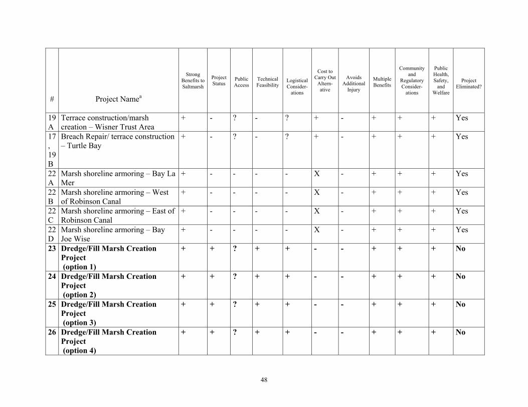
48
#
Project Namea
Strong Benefits to Saltmarsh
Project Status
Public Access
Technical Feasibility
Logistical Consider-
ations
Cost to Carry Out
Altern-ative
Avoids Additional
Injury
Multiple Benefits
Community and
Regulatory Consider-
ations
Public Health, Safety,
and Welfare
Project Eliminated?
19A
Terrace construction/marsh creation – Wisner Trust Area
+ - ? - ? + - + + + Yes
17, 19B
Breach Repair/ terrace construction – Turtle Bay
+ - ? - ? + - + + + Yes
22A
Marsh shoreline armoring – Bay La Mer
+ - - - - X - + + + Yes
22B
Marsh shoreline armoring – West of Robinson Canal
+ - - - - X - + + + Yes
22C
Marsh shoreline armoring – East of Robinson Canal
+ - - - - X - + + + Yes
22D
Marsh shoreline armoring – Bay Joe Wise
+ - - - - X - + + + Yes
23 Dredge/Fill Marsh Creation Project (option 1)
+ + ? + + - - + + + No
24 Dredge/Fill Marsh Creation Project (option 2)
+ + ? + + - - + + + No
25 Dredge/Fill Marsh Creation Project (option 3)
+ + ? + + - - + + + No
26 Dredge/Fill Marsh Creation Project (option 4)
+ + ? + + - - + + + No

49
#
Project Namea
Strong Benefits to Saltmarsh
Project Status
Public Access
Technical Feasibility
Logistical Consider-
ations
Cost to Carry Out
Altern-ative
Avoids Additional
Injury
Multiple Benefits
Community and
Regulatory Consider-
ations
Public Health, Safety,
and Welfare
Project Eliminated?
27 Dredge/Fill Marsh Creation Project (option 5)
+ + ? + + - - + + + No
“+” – available information suggested that the alternative is a good match for this criterion “-” – available information suggests that the alternative is a neutral match for this criterion “X” - available information suggests that the alternative is a poor match for this criterion. “?” – available information insufficient to adequately rate alternative for this criterion. “N/A” – not analyzed further due to failure to meet other criteria sufficient to eliminate project from further consideration. aRemaining projects are in bold.


51
5.4.1.4 Ranking The five potential sites are very similar in most respects in terms of the ecological service flows expected and the basic design. The potential locations and some of the specifics of the possible design for a dredge and fill marsh design are described in a Memorandum to the Trustees (ENTRIX, 2000a). These five potential sites are all located in Barataria Bay, close to Robinson Canal. A sixth option described in the Memorandum was eliminated earlier based on its greater distance from the location of the incident, and was not included as an option in the screening analysis since the five other options were all closer to the spill site and basically similar. In evaluating among the five potential dredge and fill marsh creation sites, the primary factors considered were finding a location that would provide an area of the appropriate size, minimize or avoid impacts to oyster leases near both the fill and borrow sites, and be cost effective. 5.4.2 Preferred Alternative: Option #3- South end of Robinson Canal The preferred alternative for marsh creation is Option #3 (alternative #25), located at the south end of Robinson Canal. The area available for marsh creation is 7.75 acres; however, suitable dredge material is only available to create a 3.5 – 4.0 acre marsh platform6. Additional marsh restoration benefits are required, so degraded marsh adjacent to the Created marsh will be enhanced through the beneficial use of dredge overburden from the proposed borrow site. The enhancement marsh is located just south of the marsh creation site and consists of 8.4 acres with approximately 3.4 acres of fragmented vegetation and 5 acres of open water. 5.4.2.1 Project Description Existing spoilbanks enclose most of an area of 3.5 acres of shallow water (less than two feet in depth) located on the east side of the southern end of Robinson Canal. The first step in the project will be to install a containment structure 270 feet long to fully enclose this area. Canals surrounding this site will be dredged, and the fill material placed within the area enclosed by the spoilbanks and the containment structure. The filled area will be allowed to dewater, and then marsh vegetation appropriate for the constructed elevation (maximum final elevation of + 2 ft NAVD 88) of the marsh platform will be planted. At some point in the project, the containment structure will be breached to allow access of marine and estuarine organisms into the newly created marsh, which is essential to allow anticipated service flows to the estuarine system in the area.
6 The original project design was altered to account for reduced borrow area resulting from a conflict with an adjacent CWPPRA project that had already received construction approval and applicable permits. The CWPPRA project footprint includes a portion of the borrow area that would be needed for this project to create 7.75 acres, thus the project area for the created marsh component of the preferred alternative was reduced.
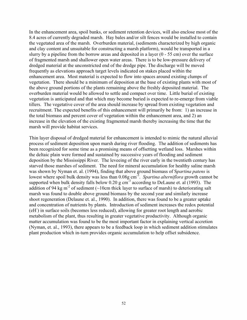
52
In the enhancement area, spoil banks, or sediment retention devices, will also enclose most of the 8.4 acres of currently degraded marsh. Hay bales and/or silt fences would be installed to contain the vegetated area of the marsh. Overburden material, (sediments characterized by high organic and clay content and unsuitable for constructing a marsh platform), would be transported in a slurry by a pipeline from the borrow areas and deposited in a layer (0 - 55 cm) over the surface of fragmented marsh and shallower open water areas. There is to be low-pressure delivery of dredged material at the unconstricted end of the dredge pipe. The discharge will be moved frequently as elevations approach target levels indicated on stakes placed within the enhancement area. Most material is expected to flow into spaces around existing clumps of vegetation. There should be a minimum of deposition at the base of existing plants with most of the above ground portions of the plants remaining above the freshly deposited material. The overburden material would be allowed to settle and compact over time. Little burial of existing vegetation is anticipated and that which may become buried is expected to re-emerge from viable tillers. The vegetative cover of the area should increase by spread from existing vegetation and recruitment. The expected benefits of this enhancement will primarily be from: 1) an increase in the total biomass and percent cover of vegetation within the enhancement area, and 2) an increase in the elevation of the existing fragmented marsh thereby increasing the time that the marsh will provide habitat services. Thin layer disposal of dredged material for enhancement is intended to mimic the natural alluvial process of sediment deposition upon marsh during river flooding. The addition of sediments has been recognized for some time as a promising means of offsetting wetland loss. Marshes within the deltaic plain were formed and sustained by successive years of flooding and sediment deposition by the Mississippi River. The leveeing of the river early in the twentieth century has starved those marshes of sediment. The need for mineral accumulation for healthy saline marsh was shown by Nyman et. al. (1994), finding that above ground biomass of Spartina patens is lowest where spoil bulk density was less than 0.08g cm-3. Spartina alterniflora growth cannot be supported when bulk density falls below 0.20 g cm-3 according to DeLaune et. al (1993). The addition of 94 kg m-2 of sediment (~10cm thick layer to surface of marsh) to deteriorating salt marsh was found to double above ground biomass by the second year and similarly increase shoot regeneration (Delaune et. al., 1990). In addition, there was found to be a greater uptake and concentration of nutrients by plants. Introduction of sediment increases the redox potential (eH-) in surface soils (becomes less reduced), allowing for greater root length and aerobic metabolism of the plant, thus resulting in greater vegetative productivity. Although organic matter accumulation was found to be the most important factor in explaining vertical accretion (Nyman, et. al., 1993), there appears to be a feedback loop in which sediment addition stimulates plant production which in-turn provides organic accumulation to help offset subsidence.
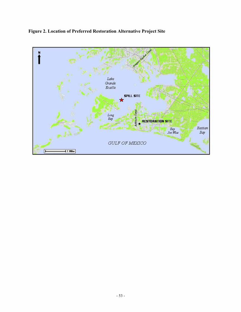
- 53 -
Figure 2. Location of Preferred Restoration Alternative Project Site

- 54 -
5.4.2.2 Restoration Objective The restoration objective is to create and enhance sufficient marsh habitat to compensate for injuries to marsh, aquatic organisms, benthic habitat, and birds caused by Equinox’s release. 5.4.2.3 Restoration Scaling Approach The scaling approach used to determine the extent of resource restoration required as compensation for natural resource injuries is based on Habitat Equivalency Analysis (HEA). HEA begins with the injury assessment and an identification of the habitat-specific resource services that were lost due to the incident. A “debit” is specified for the lost services for each type of resource habitat. The debit equals the loss in service-acre-years from the injury to the habitat, as a result of the incident, in present-value terms. The benefits that a compensatory restoration project will generate over its lifespan are quantified (this credit is the present value of the ecological services provided by the project) and the size of the compensating project is calculated so as to equate the total credit to the debit. Both the debit and credit are measured by service-acre-years, as discussed in Section 4.3.1. 5.4.2.3.1 HEA Debit The debit is composed of three parts. The first part corresponds to the reduction in the full set of marsh services from oiled marsh, including faunal support services. This part of the debit (26.62 marsh DSAYs) corresponds to the marsh injuries described in Chapter 4 (for quantification, see Lorentz, 2000). The second part of the debit corresponds to the benthic injuries translated into marsh services. The debit in benthic DSAYs is 6.1 (Section 4.4.2.2), and was translated to marsh services (1.22 DSAYs) by assuming that marsh provides approximately five times the service flows of subtidal unvegetated sediments (for quantification, see Webber, 1999). This assumption is conservative, and was adopted from the assumption developed for another NRDA in a Gulf of Mexico estuary (NOAA, 1999b). The third part of the debit corresponds to the direct water column faunal and bird injuries, translated into marsh services, required to restore these faunal losses. As described in Sections 4.4.1.2 and 4.4.3.2, the Trustees agreed to accept 0.85 acres of Spartina alterniflora marsh creation (which is equivalent to 5.95 DSAYs under standard marsh creation assumptions – see Lorentz 2000 for quantification) as compensation for these two injury categories. Thus, the DSAY debit amounts to 33.79.
- 55 -
5.4.2.3.2 HEA Credit Model To quantify the services from the salt marsh restoration projects and determine if the projects provide enough benefit, a number of parameters must be defined. The parameters include when the restoration project begins, the time until the project provides full services, the lifespan of the project, and the relative productivity of the restored resources and services compared to the injured resources and services. The Trustees, in cooperation with Equinox, determined the parameter values so as to identify the services of the salt marsh restoration projects. The parameters for each were determined based on literature information, data from previous damage assessment cases, and the Trustees’ judgment given their experience in the area. Marsh Creation Project Two methods were examined for calculating credits from the enhancement portion of this project. A simpler and less descriptive model of marsh response to sediment amendment was calculated to have a 21 years life expectancy. The more complex model projects the life expectancy to extend significantly longer. Both methods assumed full productivity at maturity since the platform for sediment addition is natural marsh, the method mimics the natural process of sedimentation, and the sediments will be high in organic material and nutrients. The similarity in credits by year 21 produced by the more complex model validates the estimated credits (DSAYS) calculate by the simpler model. Therefore, the use of the simpler model was agreed to by the Trustees and RP for this settlement, even though any future use of the simpler model may be subject to similar validation. Using past experience on the development of created marshes, the Trustees judged that the marsh would mature over five years, starting in 2006 when construction is anticipated. The Trustees assumed linear maturity over that time. After reaching maturity, the marsh is expected to provide services for another fifteen years.7 Finally, based on observations of created salt marshes compared to natural marshes, the Trustees determined that a created salt marsh would only be half as productive as a natural marsh. These parameters determine the discounted service-acre-years provided over the course of the created marsh’s expected lifetime. The HEA calculations indicate that 3.5 acres of salt marsh provide 14.97 DSAYs (see Harmon and Penn, 2005). Marsh Enhancement Project In order to calculate the credit provided by the enhancement project, the benefits currently provided by the area “without the project” must be subtracted from the total benefits that the area will provide “with the project.” The baseline credit is based on 8.4 acres of existing marsh with an average elevation of 1.2 feet NAVD88 and 41% cover, which is equivalent to 51% service. Given the existing elevation, this marsh is expected to provide services for 20 years. As a result,
7 The twenty year lifespan of the project, from start to finish, is based on a technical
memorandum from Jessica Webber to Warren Lorentz (ENTRIX, 2000b). The Trustees evaluated the project lifespan analysis in that memorandum, and concurred with the twenty-five year estimate.
- 56 -
in absence of marsh enhancement, the area would provide 51.82 DSAYs (see Harmon and Penn, 2005). Two methods were examined for calculating credits from the enhancement portion of this project. A simpler and less descriptive model of marsh response to sediment amendment was calculated to have a 21years life expectancy. The more complex model projects the life expectancy to extend significantly longer. Both methods assumed full productivity at maturity since the platform for sediment addition is natural marsh, the method mimics the natural process of sedimentation, and the sediments will be high in organic material and nutrients. The similarity in credits by year 21 produced by the more complex model validates the estimated credits (DSAYS) calculate by the simpler model. Therefore, the use of the simpler model was agreed to by the Trustees and RP for this settlement, even though any future use of the simpler model may be subject to similar validation. The enhancement marsh benefits (“with restoration” credit) are characterized by changes in several parameters (the basis for the following parameters are described in deMond and Penn, 2004). There will be an initial loss of service in the area (8.4 acres) to account for the potentially smothering impact of introduced material. The percent service level is assumed to fall from 51% to 38%. The Trustees assumed the marsh would reach its pre-project service level after two years (following a linear path). At that point, the marsh is expected to increase in service to 76% (equivalent to 61% cover) over three years following a linear path. This project will provide services for 20 years. The enhancement marsh provides a benefit of 71.98 DSAYs (see Harmon and Penn, 2005). The net benefit of the enhancement marsh totals 20.16 DSAYs (71.98 – 51.82). Together the marsh creation and enhancement projects provide a total benefit of 35.13 DSAYs, which is sufficient to offset the debit of 33.79 DSAYs. 5.4.2.4 Probability of Success Creating salt marsh vegetation on dredge materials is a feasible and proven technique with well-developed methodologies and well-documented results. This technique has been used successfully at a number of sites along the Gulf coast. For the project to be successful, it is important that the dredge material is at the appropriate elevation for Spartina alterniflora. Several additional measures will be taken to improve the likelihood of project success. Although the details of the project remain to be fully developed, the schedule calls planting the dredge material in spring 2006. Spartina alterniflora cv. Vermillion, a cultivated variety that is resistant to infection by the fungus Rhizoctonia solani, will be used. Rhizoctonia infections are prevalent in native stands of smooth cordgrass along the Gulf coast. Plants will also be acclimated to the local climate and habitat conditions found in the area for at least 90 days prior to installation. Planting will not be conducted during stormy weather or prior to predicted storms to avoid plant loss. The Trustees will carefully monitor plant handling and installation to ensure that the guidelines are being followed. All plant materials will be inspected to ensure that they are healthy and vigorous and will be protected during mobilization from drying and physical damage. Plants
- 57 -
will be treated with a slow-release fertilizer at the time of planting. Replanting may occur if a significant number of the plants die within the first 60 days. Although not previously used for compensation associated with any NRDA case, marsh enhancement by the deposition of dredged material has a high potential for success based upon studies of marsh receiving dredged material from canal maintenance dredging as well as recent pilot studies to examine its potential as a restoration tool. Oversight of dredge effluent placement will be key to successful enhancement, and monitoring will be conducted to document the benefits of this method. 5.4.2.5 Performance Criteria and Monitoring Post-implementation monitoring is an essential component of any restoration project and will be performed for this project. The monitoring program for this restoration effort is designed to objectively determine whether the project goals and objectives have been achieved. Information gathered during monitoring will help the Trustees assess the performance, viability, and stability of the restoration project. It will allow the Trustees and Equinox to determine whether corrective actions are required to meet the goals and objectives. Project performance will be assessed by a comparison of quantitative monitoring results to pre-determined performance standards. Performance standards are criteria developed by the Trustees that define the minimum physical or structural conditions of an enhancement project deemed to represent normal and acceptable growth and development. Details concerning the performance criteria and monitoring have been developed and will be appended to the final version of this document.
5.4.2.6 Corrective Actions
In the event the performance standards are not achieved or the interim monitoring suggests unsatisfactory project progress, corrective actions will be implemented. Corrective actions may include, but are not limited to, the following:
• Allowing additional time for site to develop (no action); • Replanting/seeding same species in same area; • Replanting/seeding different species; • Applying fertilizer; • Re-grade area to proper elevations; and/or • Deposition of additional dredged material.
5.4.2.7 Environmental and Socioeconomic Impacts Planting marsh vegetation on dredge material or thin layer application to enhance marsh is not expected to have any significant adverse environmental or economic impacts. These activities
- 58 -
will not disturb existing infrastructure including oil and gas pipelines, oil wells, and other facilities or cause adverse impacts to economic resources. In addition, no impacts to historical or archaeological resources or to the public health and safety are anticipated. There is only one oyster lease within 0.25 miles of either the proposed borrow or fill site. The project will involve the filling in of approximately 4 acres of subtidal benthic habitat. Although benthic habitat provides ecological services, marsh will provide much greater ecological benefit. Additionally, many square miles of marsh are being lost as a result of erosion and subsidence in Louisiana each year, forming subtidal benthic habitat in its place. This project, if implemented, will reduce, although in a limited fashion, this trend of marsh loss. Depending upon the thickness of the thin-layer disposal on the fragmented marsh, it is possible that the existing vegetation may be temporarily covered by addition of the new sediments. Several studies have shown, however, that deposition of dredged material could reliably be conducted to allow reemergence of vegetation when placement was a layer 5-15cm thick shown (Cahoon and Cowan, 1988; Ford et. al., 1999; Wilber, 1992, U.S. Army Engineer Waterways Experiment Station, 1993). In cases where dredged material exceeded this thickness, vegetation recovery was often observed after a period of two growing seasons. Planting marsh vegetation will have several positive environmental and economic benefits. A number of bird species also utilize marsh as habitat and feeding areas. Marsh provides critical nursery habitat for a number of marine and estuarine aquatic species, such as brown and white shrimp. Many of these species are ones that are of important commercial and recreational value, in addition to the ecological roles they play. Marsh is very productive, and the organic material produced in the marsh is exported to estuarine and marine environments. Marsh also serves as a barrier-reducing storm surge to more inland areas, thereby helping to reduce the impacts of major storms. 5.4.2.8 Evaluation This project site is preferred over the other four project sites because of a combination of cost factors, size of project compared to restoration requirements, and location compared to that of nearby oyster leases. This site is very shallow, and would require a relatively small containment structure to be constructed. Therefore the amount of fill material that would have to be dredged is less here than for other potential sites, a major factor in determining cost. There is only one oyster lease within 0.25 miles of the site, although dredging would start less than 100 feet away from this lease. It is the responsibility of the contracting party to avoid damages to this lease or adjacent property rights within the project area. Construction of an approximate 3.5-4 acre marsh platform, plus the enhancement of over 8 acres of fragmented marsh via thin-layer dredged material disposal, would provide sufficient acreage to satisfy the debit for this case . 5.4.3 Non-Preferred Alternative: Option #1- South End of Robinson Canal The Option #1 site is located at the south end of Robinson Canal, south of the preferred alternative project location. The area available for marsh creation is 9.4 acres, which could be adjusted to a smaller size to better fit the required size for the project, plus provide some “insurance” acreage. There is 3.7 acres of existing marsh within this area. The water depth at
- 59 -
the site is less than two feet. A containment structure of approximately 1,300 feet would be required. Only one oyster lease is within 0.25 miles of the site. 5.4.3.1 Project Description This project would be essentially similar to that of Option #3, the preferred alternative, in its method of construction. This site has a total of 9.4 acres, not including the 3.7 acres of existing marsh, and is enclosed on three sides. A containment structure of approximately 1,300 feet would be installed in this option, the configuration of which could be adjusted to reduce the size of the fill area. The project would likely cost more than the preferred alternative because of the larger containment structure that would be required. 5.4.3.2 Environmental and Socioeconomic Impacts This option is very similar to Option #3 in expected environmental and socioeconomic impacts in most respects, and it is largely the anticipated higher cost that led to it not being chosen. The existing marsh within the spoilbanks in the area to be filled would be affected if this alternative were to be implemented. In the short-term, the marsh function would be adversely affected since access to this existing marsh for aquatic organisms would be reduced. Additionally, it is possible that some of the fill material that would be placed within the enclosed area would cover marsh. In the long-term, however, the existing marsh might benefit from the sediment that would be transported from the fill area. 5.4.3.3 Evaluation This option was not selected as preferred for two reasons. First, the length of the containment structure that would need to be installed is much larger than that for the preferred option. Second, the existing marsh within the area to be enclosed could be adversely impacted by the project. Although the potential for a longer-term benefit to this marsh from the project exists, the possible short-term impacts could make it problematic for such a project to obtain all the necessary permits. 5.4.4 Non-Preferred Alternative: Option #2- South End of Robinson Canal The Option #2 site is located at the south end of Robinson Canal, immediately south of the preferred alternative project location. This option is for an area of 9.8 acres, mostly enclosed by existing spoilbanks. The water depth at the site is less than two feet. A containment structure of 130 feet would have to be installed to fully enclose the area. The project would likely cost more than the preferred alternative, because of its larger area, which cannot easily be reduced. This would require more dredging than for Option #3. Only one oyster lease is within 0.25 miles of the proposed location. 5.4.4.1 Project Description This project would be essentially similar to that of Option #3, the preferred alternative, in its method of construction. This site has a total of 9.8 acres, which could not easily be reduced to a
- 60 -
more appropriate size for the restoration requirements for this incident. A containment structure of approximately 130 feet would be installed in this option. The project would likely cost more than the preferred alternative, because of the larger area that would be filled, requiring more dredging than for Option #3. 5.4.4.2 Environmental and Socioeconomic Impacts This option is very similar to Option #3 in expected environmental and socioeconomic impacts in most respects, and it is largely the anticipated higher cost that led to it not being chosen. 5.4.4.3 Evaluation This alternative was not selected as preferred due solely to the higher cost. The projected impacts and benefits are essentially the same, and therefore the cost becomes the primary factor. 5.4.5 Non-Preferred Alternative: Option #4- South End of Robinson Canal Option #4 site is located near the south end of Robinson Canal, immediately north of the preferred alternative project location in a canal. This option is for an area of 5.7 acres, mostly enclosed by existing spoilbanks to the north and south. The water depth at the site is approximately three feet. A containment structure of 330 feet would have to be installed to fully enclose the area. The project would likely cost more than the preferred alternative, because of its greater depth and the larger containment structure, necessitating more dredging than the preferred option. Two oyster leases are within 0.25 miles of the location. 5.4.5.1 Project Description This project would involve the installation of a containment structure at one end of the canal, and a combination containment structure /dewatering box at the other end. The project would likely cost more than the preferred alternative, because of the greater amount of fill required than for Option #3, despite the smaller size. 5.4.5.2 Environmental and Socioeconomic Impacts This option is very similar to Option #3 in expected environmental and socioeconomic impacts in most respects, and it is largely the anticipated higher cost that led to it not being chosen. 5.4.5.3 Evaluation This alternative was not selected as preferred due primarily to the higher cost. The projected impacts and benefits are essentially the same, although this project has a second oyster lease in the vicinity, and therefore the cost becomes the primary factor.
- 61 -
5.4.6 Non-Preferred Alternative: Option #5- North End of Robinson Canal The Option #5 site is located in a canal near the north end of Robinson Canal, north of the other options. This option is for an area of 5.2 acres, enclosed by existing spoilbanks to the west and east, but open to the north and south. A second canal, located about 1,700 feet to the north could also be utilized. The water depth at the site is approximately three feet. A containment structure of 360 feet would have to be installed to fully enclose the first canal area. The project would likely cost more than the preferred alternative because of its greater depth and the larger containment structure. Additionally, five oyster leases are within 0.25 miles of the location. 5.4.6.1 Project Description This project involves the installation of a containment structure at one end of the canal, and a combination containment structure/dewatering box at the other end. If additional acreage is required, a second canal located approximately 1,200 feet to the north could be utilized. The project would likely cost more than the preferred alternative because of the greater amount of fill required than for Option #3. 5.4.6.2 Environmental and Socioeconomic Impacts This option is very similar to Option #3 in expected environmental and socioeconomic impacts in most respects, although the five oyster leases located in the vicinity make this site problematic. The higher anticipated cost for this option compared to that for Option #3, due to the greater amount of fill required, is the primary factor in this alternative not being chosen. 5.4.6.3 Evaluation The projected impacts and benefits are essentially the same, although this project has five oyster leases within 0.25 miles of the site. This alternative was not selected as preferred due to the presence of these oyster leases and the higher expected cost due to the larger containment structure and greater amount of fill than for the preferred option.

- 62 -
5.5 RESTORATION SUMMARY Exhibit 5-7 summarizes the restoration alternatives for the Lake Grande Ecaille incident. As indicated in this exhibit, the Trustees selected marsh restoration as the preferred type of restoration to compensate for all the assessed injuries. Marsh creation at the south end of Robinson Canal (Option #3) was chosen as preferred, due to its match in size to the 4.8 acres of required marsh creation. It is also expected to be the lowest cost of the five final alternatives evaluated. Exhibit 5-6 Summary of Injuries and Restoration Alternatives for the Lake Grande Ecaille Incident Injured Resource Restoration Alternativea Scale of Restorationb
Water Column Marsh Restoration A total of 0.85 acre of marsh creation for both aquatic fauna and birds.
Oyster Reef Creation N/A No Action N/A Birds Marsh Restoration A total of 0.85 acres of marsh creation for both
birds and aquatic fauna. Nest Enhancements/
Protection N/A
Oyster Bed Creation N/A No Action N/A Benthos Marsh Restoration Approximately 0.18 acres of marsh creation. Oyster Bed Creation N/A Subtidal Sediment Creation N/A No Action N/A Marsh Marsh Restoration Approximately 3.81 acres of marsh creation. No Action N/A aPreferred Alternative in bold bN/A = not applicable
- 63 -
LITERATURE CITED: Barataria-Terrebonne National Estuary Program (BTNEP), Economic Value Assessment of the Barataria-Terrebonne Estuarine System, published research report 26, B. Cahoon, D. R., Cowaan, J.H. Jr. 1988. Environmental impacts and regulatory policy implications of spray disposal of dredged material in Louisiana wetlands. Coastal Management. 16: 341-362. Day, J.W., Jr., Smith, W.G., Wagner, P.R. and W.C. Stowe, 1975. Community Structure and Carbon Budget of a Salt Marsh and Shallow Bay Estuarine System in Louisiana. Louisiana State University Press, Publication No. LSU-SG-=72-04. DeLaune, R.D., S.R. Pezeshki, J. H. Pardue, J.H. Witcomb and W.H. Partick, Jr. 1990. Some influences of sediment addition to a deteriorating salt marsh in the Mississippi River deltaic plain. Journal of Coastal Research 6: 181-188. DeLaune, R.D., S.R. Pexeshki and W.H. Patric, Jr. 1993. Response of coastal vegetation to flooding and salinity: a case study in the rapidly subsiding Mississippi River Deltaic Plain, USA. NATO ASI Series. Vol. I 16. Edited by M. B. Jackson, C.R. Black. pp 211-229. ENTRIX, 1999a. Memorandum from Jessie Webber (ENTRIX) to Warren Lorentz (LOSCO) dated August 25, 1999. Subject: Land Loss Analysis ENTRIX, 1999b. Letter from Ralph Markarian (ENTRIX) to Warren Lorentz (LOSCO), dated September 16, 1999. Subject: Offer of Compensation for Aquatic Fauna, Bird, and Sub-tidal Sediment Injuries that may have occurred due to the Equinox – Lake Grand Ecaille Oil Spill. ENTRIX, 2000a. Memorandum from Gary Harmon (ENTRIX) to Warren Lorentz (LOSCO) dated February 1, 2000. Subject: Potential Restoration Sites for Equinox Project. ENTRIX, 2000b. Memorandum from Jessie Webber (ENTRIX) to Warren Lorentz (LOSCO) dated March 8, 2000. Subject: Suggested HEA Credit Inputs for Five Possible Equinox Restoration Options (ENTRIX #711201). Ford, Mark A., D.R. Cahoon. J.C. Lynch. 1999. Restoring marsh elevation in a rapidly subsiding salt marsh by tin-layer deposition of dredged material. Ecological Engineering, 12:189-205. French-McCay, 1999. Personal Communication between John Kern, NOAA Damage Assessment Center and Debra French-McCay, Applied Sciences Associates, Inc. Gulf of Mexico Fishery Management Council. 1981. Fishery Management Plan for the Shrimp fishery of the Gulf of Mexico, United States Waters. (Revised November 1981). Gulf of Mexico Fishery Management Council, Tampa, Florida. As cited by: Upton, H.F., Hoar, P., and
- 64 -
M. Upton, 1992. The Gulf of Mexico Shrimp Fishery: Profile of a Valuable National Resource. Center for Marine Conservation. Harmon, Gary and Tony Penn, 2005. Memorandum from Gary Harmon and Tony Penn to the Administrative Record dated February 10, 2005. Subject: Restoration Project Benefits. Lorentz, Warren, 2000. Memorandum from Warren Lorentz to the Administrative Record dated October 27, 2000. Subject: Quantification of Marsh Injury and Quantification of Benefits of Marsh Restoration. LOSCO, LDEQ, LDNR, LDWF, NOAA, USFWS, 1999. Damage Assessment and Restoration Plan: Texaco Pipeline Inc. Crude Oil Discharge. Lake Barre, Louisiana. 79 pp. NOAA, 1999a. Discounting and the treatment of uncertainty in natural resource damage assessment. Technical Paper 99-1. National Oceanic and Atmospheric Administration, Damage Assessment and Restoration Program. NOAA, 1999b. Memorandum from John Kern (NOAA) to Jessie Webber (ENTRIX) dated July 28, 1999. Subject: Basis for Marsh:Subtidal Sediment Trade-off Ratio of 5:1. Nyman, J.A., R.D. Delaune, H.H. Roberts, and W.H. Patrick. 1993. Relationship between vegetation and soil formation in a rapidly submerging coastal marsh. Marine Ecology-Progress Series 96(3):269-279
Nyman, J.A., M. Carloss, R.D. Delaune, and W.H. Patrick. 1994. Erosion rather than plant dieback as the mechanism of marsh loss in an estuarine marsh. Earth Surface Processes and Landforms 19(1):69-84
Pulsipher, A., D. Tootle, and R. Pincomb, 1998. Economic and social consequences of the oil spill in Lake Barre, Louisiana. OCS Study MMS 998-00. Prepared by the Center for Energy Studies, Louisiana State University, Baton Rouge, LA. U.S. Department of the Interior, Minerals Management Service, Gulf of Mexico OCS Region, New Orleans, LA. 32 pp.
Swartz, R. C., W. A. DeBen, F. A. Cole, and L. C. Bentsen. 1980. Recovery of the macrobenthos at a dredge site in Yaquina Bay, Oregon. In: Contaminants and Sediments Vol. 2: analysis chemistry, biology, pp. 391-408. Ed. by R.A. Balcer, Ann Arbor, Michigan: Ann Arbor Science Publishers.
U.S. Army Engineer Waterways Experiment Station (Pace Wilber). 1993. Managing dredged material via thin-layer disposal in coastal marshes. Environmental Effects of Dredging Notes. EEDP-01-32. 14pp.
Van Dolah, R. F., D. R. Calder, and D. M. Knott. 1984. Effects of dredging and open-water disposal on benthic macroinvertebrates in a South Carolina Estuary. Estuaries 7:28-37.
- 65 -
Webber, Jessica, 1999. Memorandum from Jessica Webber to John Kern dated September 16, 1999. Subject: Offer of Compensation for Aquatic Fauna, Bird and Sub-tidal Sediment Injuries That May Have Occurred Due to The Equinox – Lake Grand Ecaille Oil Spill.
Wilber, Pace. 1992. Case studies of the thin-layer disposal of dredged material, Gull Rock, North Carolina. U.S. Army Engineer Waterways Experiment Station. Environmental Effects of Dredging. Vol. D-92-3.

- 66 -
LIST OF PREPARERS
Chris Piehler Louisiana Department of Environmental Quality John de Mond Louisiana Department of Environmental Quality Derek Hamilton Louisiana Department of Natural Resources Dick Stanek Louisiana Department of Natural Resources Heather Finley Louisiana Department of Wildlife and Fisheries Jim Hanifen Louisiana Department of Wildlife and Fisheries Terry Romaire Louisiana Department of Wildlife and Fisheries Gina Muhs Saizan Louisiana Oil Spill Coordinator’s Office, Office of the Governor Chuck Armbruster Louisiana Oil Spill Coordinator’s Office, Office of the Governor Cheryl Brodnax National Oceanic and Atmospheric Administration Linda Burlington National Oceanic and Atmospheric Administration John Iliff National Oceanic and Atmospheric Administration John Kern National Oceanic and Atmospheric Administration Tony Penn National Oceanic and Atmospheric Administration Christy Poulos National Oceanic and Atmospheric Administration Buddy Goatcher United States Fish and Wildlife Service Warren Lorentz United States Fish and Wildlife Service
- 67 -
Appendix A Administrative Record Index (through 11/08/05)
ADMINISTRATIVE RECORD INDEX EQUINOX NRDA CASE
LA1998_0922_0000
Date File File Description 09/22/98 1 NOAA 1st Class Reports 09/22/98 2 Letter from Clarence Luquet and Mike Windham 10/01/98 3 Equinox Reconnaissance Survey 10/23/98 4 Meeting minutes for the Oct. 15, 1998 Meeting 11/03/98 Meeting minutes for the Oct. 30, 1998 Conference Call 12/18/98 Meeting minutes for the Dec. 14, 1998 Conference Call 02/16/99 Meeting minutes for the Jan. 28, 1999 Technical Meeting 02/16/99 Meeting minutes for the Jan. 28, 1999 Legal Meeting 02/26/99 Meeting minutes for the Feb. 19, 1999 Conference Call 05/11/99 Meeting minutes for the April 21, 1999 Technical Meeting 06/11/99 Meeting minutes for the June 1, 1999 Conference Call 07/01/99 Meeting minutes for the June 24, 1999 Technical Meeting 07/19/99 Meeting minutes for the June 29-30, 1999 Technical Meeting 08/09/99 Meeting minutes for the July 24, 1999 Conference Call 09/08/99 Meeting minutes for the August 23, 1999 Conference Call 11/04/99 Meeting minutes for the October 26, 1999 Technical Meeting 12/22/99 Meeting minutes for the December 16, 1999 Conference Call 01/17/00 Meeting minutes for the January 6, 2000 Conference Call 02/25/00 Meeting minutes for the February 15, 2000 Conference Call 12/22/00 Meeting minutes for the November 16, 2000 Conference Call 02/05/01 Meeting minutes for the January 18, 2001 Conference Call 05/28/02 Meeting minutes for the May 2, 2002 Technical Meeting 11/26/03 Meeting minutes for the August 20, 2003 Conference Call 10/27/98 5 Comments to October 15, 1998 Meeting Minutes; Form Kern to Webber 10/28/99 6 NOAA 1st Class Reports 11/05/98 7 Comments October 30, 1998 Conference Call Minutes; From Finely to Webber 11/10/98 8 Oil Fingerprint Analysis; From Dr. Denoux to Moore 12/04/98 9 November 1998 Field Effort; From Harmon and Webber to Boulden 12/21/98 10 NOAA 1st Class Reports; From Pace to Webber 01/28/99 11 NRDA RP Invite Letter for Equinox Oil Spill; From Guidry to Ashworth 01/29/99 12 Trustee Notes - November 9 and 17, 1998 Field Sampling 03/09/99 13 RP NRDA Invite Acceptance; From Ashworth to Guidry 03/18/99 14 Notification of NOI; From Guidry to Ashworth 04/10/99 15 Notice of Intent to Conduct Restoration Planning 06/09/99 16a Invitation for Public Input; From Lorentz to Scurich 07/07/99 16b Invitation for Public Input; From Lorentz to Rousselle 06/14/99 17 Invitation for Public Input; From Lorentz to DeBlieux 07/28/99 18 Marsh: Subtidal Trade-off Letter; From John Kern to Jessica Webber

- 68 -
08/04/99 19 Oil Volume Released Estimate Letter; From Webber to Lorentz 08/24/99 20 Letter Inviting Plaquemines Parish Government to Submit Additional
Restoration Projects; From Lorentz to Rousselle 08/25/99 21 Land Loss Analysis; From Webber to Lorentz 09/07/99 22 Submittal of Restoration Projects; From Jeff Deblieux (LL&E) to Lorentz 09/16/99 23 Offer of Compensation for Aquatic Fauna, Bird, and Sub-tidal Sediment
Injuries; From Webber for Markarian to Lorentz 09/20/99 24 Calibration of HEA Debit Model for Marsh Injuries; From Poulos and Tomasi
to Lorentz 10/04/99 25 Proposed Screening Criteria; From Webber for Harmon 10/13/99 26 Notification of NOI; From Lorentz to AG (Lindsey) 12/14/99 27 Potential Credit Modeling for Restoration Options; From Webber to Lorentz 12/17/99 28 Field notes for Lexington; From Harmon to Lorentz 02/01/00 29 Potential Restoration Projects; From Harmon to Lorentz 03/08/00 30 Suggested HEA Credit Inputs for Possible Restoration Projects; From Webber
to Lorentz 10/27/00 31 Quantification of Marsh Injury and Quantification of Benefits of Marsh
Restoration; From Lorentz to Administrative Record 12/15/00 32 Success Criteria and Monitoring Requirements; From Iliff to Webber 02/13/01 33 Comments on January 18, 2001 Conference Call Minutes; From Lorentz to
Webber 06/13/01 34 Permit Preapplication Meeting; From Harmon to Lorentz 09/26/03 35 Cash-out Amount; From Edmonds to Brothers 01/16/04 36 Revised Restoration Project Proposal; From Brothers to Edmonds 12/23/04 37 A Case for the Use of Thin Layer Deposition of Sediments to Combat Loss of
Salt Marsh 02/25/05 38 Tony Penn and Gary Harmon - HEA Memo to AR 01/28/05 39 SHPO Consultation Letter 07/20/05 40 USFWS Consultation Letter from Russell Watson 10/20/05 41 ESA Consultation Letter from Roy Crabtree 11/02/05 42 EFH Consultation Letter from Mark Sramek 11/08/05 43 FONSI
CHAPTER 2 ADDITIONAL MATERIALS (APPENICIES)
A) May 1999 Photo Log Field Effort- May 28, 1999 B) Injury Assessment Study Plan for Marsh and Mangrove Habitats- October 22, 1999 C) Oil, water, sediment sample analytical data D) Aerial Photos - Response
- 69 -
Appendix B COMPLIANCE WITH KEY STATUTES, REGULATIONS AND POLICIES Oil Pollution Act of 1990 (OPA), 33 USC 2701, et seq., 15 CFR Part 990 OPA establishes a liability regime for oil spills that injure or are likely to injure natural resources and/or the services that those resources provide to the ecosystem or humans. OPA provides a framework for conducting sound natural resource damage assessments that achieve restoration. The process emphasizes both public involvement and participation by the Responsible Party(ies). The Trustees have followed the regulations in this assessment. Louisiana Oil Spill Prevention and Response Act (OSPRA), L.R.S. 30:2451, et seq., LAC 43:XXIX.101 et seq. OSPRA is the principal State statute that authorizes the State agencies to act as natural resource trustees for the recovery of damages for injuries resulting from oil spill incidents in Louisiana. The Trustees have followed the regulations in this assessment. National Environmental Policy Act (NEPA), 42 USC 4321, et seq., 40 CFR Parts 1500-1508 An Environmental Assessment (EA) was prepared for the restoration projects as part of the Damage Assessment and Restoration Plan/Environmental Assessment (DARP/EA). This EA evaluates the effects of implementing the restoration projects considered in the plan. If appropriate, a Finding of No Significant Impact (FONSI) will be signed and included in this Final DARP/EA.
Clean Water Act (CWA), 33 USC 1251, et seq. The CWA is the principal law governing pollution control and water quality of the nation’s waterways. Section 404 of the law authorizes a permit program for the beneficial uses of dredged or fill material in navigable waters. The Army Corps of Engineers (COE) administers the program. In general, restoration projects, which move significant amounts of material into or out of waters or wetlands—for example, hydrologic restoration or creation of tidal marshes—require 404 permits. Under section 401 of the CWA, restoration projects that involve discharge or fill to wetlands or navigable waters must obtain certification of compliance with state water quality standards. All necessary 404 permits will be obtained for the selected project.
Coastal Zone Management Act (CZMA), 16 USC 1451, et seq., 15 CFR 923 The goal of the CZMA is to preserve, protect, develop and, where possible, restore and enhance the nation’s coastal resources. The federal government provides grants to states with federally approved coastal management programs. Section 1456 of the CZMA requires that any federal action inside or outside of the coastal zone shall be consistent, to the maximum extent practicable, with the enforceable policies of approved state management programs. No federal license or permit may be granted without giving the state the opportunity to concur that the
- 70 -
project is consistent with the state’s coastal policies. The regulations outline the consistency procedures that will be followed by the Trustees. The Trustees believe that the restoration projects selected for implementation will be consistent with the Louisiana CZMA program, and will seek concurrence from the state.
Rivers and Harbors Act, 33 U.S.C. §§401, et seq.
The Rivers and Harbors Act regulates development and use of the nation’s navigable waterways. Section 10 of the Act prohibits unauthorized obstruction or alteration of navigable waters and vests the COE with authority to regulate discharges of fill and other materials into such waters. Restoration actions that comply with the substantive requirements of Section 404 of the CWA will also comply with the substantive requirements of Section 10 of the Rivers and Harbors Act.
Endangered Species Act (ESA), 16 USC 1531, et. seq., 50 CFR Parts 17, 222, 224 The ESA directs all federal agencies to conserve endangered and threatened species and their habitats to the extent their authority allows. Under the Act, the Department of Commerce through NOAA and the Department of the Interior through the United Stated Fish and Wildlife Service (USFWS) publish lists of endangered and threatened species. Section 7 of the Act requires that federal agencies consult with these departments to minimize the effects of federal actions on endangered and threatened species.
The restoration action described in the Final DARP/EA is not expected to adversely impact any species listed as threatened or endangered under the ESA. The Trustees have initiated and completed an informal consultation with the USFWS and NOAA’s National Marine Fisheries Service (NMFS) pursuant to the ESA to ensure that the restoration action selected is in accordance with all applicable provisions. Comments received from the USFWS and NMFS have been incorporated into the Final DARP/EA. Fish and Wildlife Conservation Act, 16 USC 2901, et seq. The proposed restoration project will either encourage the conservation of non-game fish and wildlife, or have no adverse effect. Fish and Wildlife Coordination Act (FWCA), 16 USC 661, et seq. The FWCA requires that federal agencies consult with the U.S. Fish and Wildlife Service, the National Marine Fisheries Service, and state wildlife agencies for activities that affect, control, or modify waters of any stream or bodies of water, in order to minimize the adverse impacts of such actions on fish and wildlife resources and habitat. This consultation is generally incorporated into the process of complying with Section 404 of the Clean Water Act, NEPA or other federal permit, license, or review requirements. The proposed restoration projects will have either a positive effect on fish and wildlife resources or no effect. Coordination between NOAA National Marine Fisheries Service and the U.S. Fish and Wildlife Service will take place concurrently with the ESA Section 7 consultation.
- 71 -
Magnuson Fishery Conservation and Management Act, , as amended and reauthorized by the Sustainable Fisheries Act (Public Law 104-297) (Magnuson-Stevens Act), 16 USC 1801 et seq. The Magnuson-Stevens Act provides for the conservation and management of the Nation’s fishery resources within the Exclusive Economic Zone (from the seaward boundary of every state to 200 miles from that baseline). The resource management goal is to achieve and maintain the optimum yield from U.S. marine fisheries. The Act also established a program to promote the protection of Essential Fish Habitat (EFH) in the review of projects conducted under federal permits, licenses, or other authorities that affect or have the potential to affect such habitat. After EFH has been described and identified in fishery management plans by the regional fishery management councils, Federal agencies are obligated to consult with the Secretary of Commerce with respect to any action authorized, funded, or undertaken, or proposed to be authorized funded, or undertaken by such agency that may adversely affect any EFH.
The Trustees do not believe that the preferred restoration alternative will have a net adverse impact on Essential Fish Habitat as designated under the Act. The restoration project is expected to have a positive effect in creating EFH. A determination of this finding will be made with NMFS. Marine Mammal Protection Act, 16 USC 1361 et seq. The Marine Mammal Protection Act provides for long-term management and research programs for marine mammals. It places a moratorium on the taking and importing of marine mammals and marine mammal products, with limited exceptions. The Department of Commerce is responsible for whales, porpoise, seals, and sea lions. The Department of the Interior is responsible for all other marine mammals. The proposed restoration project will not have an adverse effect on marine mammals. Migratory Bird Conservation Act, 126 USC 715 et seq. The proposed restoration project will have no adverse effect on migratory birds that are likely to benefit from the establishment of new marsh habitat. The National Historic Preservation Act of 1966 (NHPA), 16 U.S.C. 470 et seq.
Section 106 of the NHPA requires federal agencies, or federally funded entities, to consider the impacts of their projects on historic properties. NHPA regulations require that federal agencies take the lead in this process, and outline procedures to allow the Advisory Council on Historic Preservation to comment on any proposed federal action.
Inspection of the maps and records on file at the Louisiana Department of Culture, Recreation, and Tourism – Division of Archaeology – revealed that no recorded sites exist in the vicinity of the preferred project. A letter stating our findings, as well as a request for concurrence that the preferred project will not adversely affect any areas of cultural significance or registered historic places, has been sent to the State Historic Preservation Officer concurrent with the publication of the Draft DARP/EA.
- 72 -
Archeological Resources Protection Act, 16 USC 470 et seq. The marsh restoration site has been surveyed to determine its value as an archaeological resource. Survey results have been reviewed by the Louisiana Division of Historical and Cultural Programs. The marsh site has been determined to be ineligible for the National Register, and no further study is needed.
Executive Order Number 11514 (34 FR 8693) - Protection and Enhancement of Environmental Quality An Environmental Assessment has been prepared as part of this Final DARP/EA and environmental coordination is taking place as required by NEPA. Executive Order Number 11990 (42 FR 26961) - Protection of Wetlands On May 24, 1977, President Carter issued Executive Order 11990, Protection of Wetlands. This Executive Order requires each federal agency to take action to minimize the destruction, loss, or degradation of wetlands, and to preserve and enhance the natural and beneficial values of wetlands in carrying out the agency’s responsibilities for: acquiring, managing, and disposing of federal lands and facilities; providing federally undertaken, financed, or assisted construction and improvements; and conducting federal activities and programs affecting land use, including but not limited to water and related land resources planning, regulating, and licensing activities. The Trustees have concluded that the proposed restoration project will meet the goals of this executive order.
Executive Order Number 12962 (60 FR 30769) - Recreational Fisheries The proposed restoration project will help ensure the protection of recreational fisheries and the services they provide. The proposed project will have no adverse effects on recreational fisheries. Executive Order 12898 (59 FR 7,629) – Environmental Justice
On February 11, 1994, President Clinton issued Executive Order 12898, Federal Actions to Address Environmental Justice in Minority Populations and Low-Income Populations. This Executive Order requires each federal agency to identify and address, as appropriate, disproportionately high and adverse human health or environmental effects of its programs, policies, and activities on minority and low-income populations. EPA and the Council on Environmental Quality (CEQ) have emphasized the importance of incorporating environmental justice review in the analyses conducted by federal agencies under NEPA and of developing mitigation measures that avoid disproportionate environmental effects on minority and low-
- 73 -
income populations. The Trustees have concluded that there are no low-income or ethnic minority communities that would be adversely affected by the proposed restoration project.
Executive Order 13112 (64 FR 6,183) – Invasive Species
The proposed restoration project will not cause or promote the introduction or spread of invasive species. The location and elevation of the marsh creation and enhancement sites will promote colonization by native species; colonization by invasive species is unlikely.

- 74 -
Appendix C Thin-Layer Disposal White Paper
A Case for the Use of Thin Layer Deposition of Sediments
to Combat Loss of Salt marsh.
December 23, 2004
Prepared by John de Mond, LDEQ
and Tony Penn, NOAA
Introduction and Need Thin layer disposal of dredged material for enhancement is intended to mimic the natural
alluvial process of sediment deposition upon marsh during river flooding. The addition of sediments has been recognized for some time as a promising means of offsetting wetland loss. Marshes within the Deltaic Plain were formed and sustained by successive years of flooding and sediment deposition by the Mississippi River. The leveeing of the river early in the twentieth century has starved those marshes of sediment. DeLaune et. al (1990) estimates an average accretion deficit of 0.5 cm yr-1 for marshes in Barataria Basin. An estimated rate 1,798 g m-2 yr-1 of mineral accumulation is required to offset a subsidence rate of 1 cm yr-1 in saline marshes (Nyman and DeLaune 1991). An anaerobic condition from waterlogged soils produces SO4
-2
which reduces to a plant toxin. The introduction of mineral material (particularly iron) buffers the soil. The need for mineral accumulation for healthy saline marsh was shown by Nyman et. al. (1994), finding that above ground biomass of Spartina patens is lowest where spoil bulk density was less than 0.08g cm-3. Spartina alterniflora growth can not be supported when bulk density falls below 0.20 g cm-3 according to DeLaune et. al (1993) The addition of 94 kg m-2 of sediment (~10cm thick layer to surface of marsh) to deteriorating salt marsh was found to double above ground biomass by the second year and similarly increase shoot regeneration (Delaune et. al. 1990). In addition, there was found to be a greater uptake and concentration of nutrients by plants. Introduction of sediment increases the redox potential (eh-) in surface soils (becomes less reduced) allowing for greater root length and aerobic metabolism of the plant, thus resulting in greater vegetative productivity. Although organic matter accumulation was found to be the most important factor in explaining vertical accretion (Nyman, et. al. 1993), there appears to be a feedback loop in which sediment addition stimulates plant production which in-turn provides organic accumulation to help offset subsidence. Studies of Impacts from Dredge Material Placement on Marsh Associated with Navigation Maintenances Dredging.
A number of studies have examined the effects of dredged material deposition on wetlands (Cahoon and Cowaan, 1988; Ford et. al. 1999; Wilber, P, 1992; U.S. Army Engineer Waterways Experiment Station, 1993; LaSalle, M.W., 1992). The intent of many of these
- 75 -
studies was to determine the limits of placement on marsh (without regard to degree of existing deterioration, if any) without significant detrimental environmental impact for the purposes of disposal of material. Those projects associated with navigation maintenance were to consider methods in-lieu of confined disposal of dredged material. Consequently, emphasis was typically placed on time of recovery. Reimold, R. J., et al., 1978, experimentally placed dredged material in enclosures to test the impacts at different thickness of deposition, however, it was acknowledged that the presence of containers and their affect on hydrology, shading of plants as well as change of elevation above inter-tidal range probably substantially influenced the results of the study. Although the intent of these studies was to examine the potential impacts from thin layer disposal and consequently the tolerance of wetlands to thin layer disposal, the use of dredged material to benefit deteriorated marsh was frequently noted and the probability of its effectiveness for enhancement was considered. The thickness of deposition after settlement in these studies was typically < 20cm (except in the Reimold study where treatments were up to 91cm thick). Cahoon and Cowaan looked at marshes approximately 8 and 14 months post disposal at several sites permitted to receive thin layer deposition but examined more closely sites at Dog Lake and Lake Coquille in Louisiana. At the end of 18 months those sites exhibited limited revegetation. In personal communication with Dr. Don Cahoon, LaSalle notes that these sites appeared to be completely revegetated after 5 years based on an aerial survey. A more quantitative follow up study by LaSalle six years after deposition found sediment deposited marsh and reference marsh to be similar in cover at the two sites. Although there was some difference in species composition, Spartina alterniflora appeared to have greater vigor at one of the two disposal sites most studied. Monitoring the recovery of barrier island overwash by Courtemanche, et. al., (1999) found that Spartina alterniflora is capable of surviving sand loadings of 25 to 35cm. Pace Wilber (U.S. Army Engineer Waterways Experiment Station, 1993) concluded from a review of these and other east coast studies that deposition of dredged material could reliably be conducted to allow reemergence of vegetation when placement was a layer 5-15cm thick .
Faunal use was examined in those studies by counting fiddler crab burrows and the snail, Littorina irrorata. Compared to natural reference sites, LaSalle found at significantly greater densities of fiddler crab burrows at one disposal area, and similar but larger densities at another. Reimold found 24 burrows m-2 for sediment addition of 8cm and 8.9 burrows m-2 for the next level higher of 15cm (that number is closer to the 5.3 burrows /m2 found by LaSalle in reference marsh). He also noted a shift in crab species from Uca pugnax to include Uca pugilator and Sesarma reticulatum LaSalle also collected infauna samples, however they were not analyzed.
DEMONSTRATION PROJECTS/STUDIES OF USE OF DREDGE MATERIAL FOR ENHANCEMENT
Louisiana:
A project to investigate the utility of thin layer disposal for marsh restoration was conducted in July 1996 using material from an oil and gas canal off of Baptiste Collette near Breton Sound, Louisiana. Material consisted primarily of river sand and was sprayed over S. alterniflora mash to a thickness of 2.3cm. By February 1998, there was a three fold increase in percent cover with recovery by resurgence of on-site plants. An increase in elevation beyond
- 76 -
accretion was noted (but not statistically significant) which suggested that increased root biomass production and/or pore water storage influenced elevation. Placement of 129mm of sediment in a shallow water pond was sufficient for invasion of S. alterniflora.
The Barataria Terrebonne National Estuary Program (BTNEP) sponsored an “Alternative Dredging and Spoil Deposition Project” to determine the costs and benefits of using a small dredge for maintenance of oil field canals. Although no formal report is available, the BTNEP newsletter “Coastlines” reports that the method was “effective not only in enhancing existing marsh but also creating new marsh.” BTNEP director Kerry St. Pe indicated that they saw a rapid recovery of the marsh within one growing season and that they were very pleased with the results of the project (personal communication).
The overfill from backfilling a pipeline canal in January, 1992, provided a project of opportunity to examine thin layer deposition in a Spartina alterniflora marsh 13km southwest of Venice (I.A. Mendelssohn et. al. 1999, 2003 and N.L. Kuhn 1999). A gradient of sediments from 60cm at its thickest was deposited over a 43 acre area. Study areas were based upon thickness of deposition included: reference area, trace amounts not quantifiable by standard elevational survey, measurable sediment burial not greater than 15cm, between 15cm to 30cm, and greater than 30cm. After approximately two years, it was found that that there were significant increases in total cover with increased sediment subsidy with the >30cm sites having more than twice the cover and 30-60% greater height than vegetation at reference sites. Total above ground biomass of the 15-30cm sites and >30cm sites were 32-48% more than other treatment areas. Redox potential rose with increasing sediment thickness as did bulk density. Sulfide concentrations dropped significantly between reference sites/trace sites and sites with measurable sediment addition, and most nutrients were found to increase with one exception. Exchangeable and interstitial NH4-N concentrations decreased with elevation even though vegetative growth was not affected. Since dredge material was found to contain approximately forty times the NH4-N found in soils of the study area, it was thought that this decrease is a result of plant uptake and the alternating flooding and drying cycle of the thicker areas. The authors recommend that dredged material used in thin layer enhancement have high clay and silt content due to higher capacity to hold nutrients. Aerial photographs taken eight years after deposition, reveal that this area has persisted and appears to be supporting even denser vegetation than in 1994 (power point presentation to the New Orleans District COE by Irv Mendelssohn).
In August 2002, Louisiana Department of Natural Resources conducted a thin layer disposal demonstration project on a 44 acre site that had experienced a die back of Spartina alterniflora associated with the “brown marsh” phenomenon. Areas were to receive 6in, 9in and 12in lifts of sediments using a 12” diameter cutter head dredge with discharge pipe delivery (similar to the method proposed at the Equinox enhancement site). Although this area is currently being studied by LSU researchers, no biological or geochemical monitoring reports are available. However, the closure report submitted to the LDNR indicated that most of the vegetation survived the disposal. Rather than material flowing and covering the grasses at time of application, much of the existing marsh separated from the substrate and floated on the slurry material. From the December 2003 aerial photos provided in the report, it appears that there has been significant spread of vegetation after the first full growing season, however there were areas remaining to be colonized. The thickness of deposition was not as uniform as was desired by
- 77 -
researchers monitoring this site which required a change in sampling design (personal communication with Michael Matern of LSU Ag Center).
CHAPTER 3 EAST COAST DREDGE MATERIAL ENHANCEMENT STUDIES
Recently there have been studies and pilot projects specifically intended to examine or demonstrate the benefits of thin layer disposal with East Coast marshes. Blackwater National Wildlife Refuge in Maryland was the site of a USFWS/ USACE Baltimore District project intended to examine the effectiveness of spray dredging in restoring deteriorating wetlands. Although no formal studies were conducted, the method of dredging and the placement of dredged material was varied in a number of ways (including spraying and dredge piped delivery of sediments) to qualitatively determine results (personal communication with Robert Blama of the Baltimore District Corps of Engineers). In addition, various forms of retention were tried including hay bales and sediment fencing. Vegetation reportedly reestablished quickly even for areas with relatively thick layer of dredged material and the contractor was able to stack low density material to higher elevations with the use of hay bales and fencing material. A May 6th 2004 newsletter of Saving the Chesapeake Bay indicated that fifteen acres of mudflats and open water are now marsh habitat as a result. It was reported that this area had vigorous growth of vegetation and utilization by diamondback terrapins that were laying eggs. A similar project was also conducted at Pamunky River, Virginia and is being studied by Dr. Carl Hershner of VIMS. A summer of 2002 newsletter article by Dr. Hershner indicates that it was felt that the spray dredging appeared to be a potentially useful application of dredged material, however, there were no retention structures used and there is thought to be a significant loss of fine grained material due to runoff from the marsh surface. In fall of 2003, an experimental enhancement of two acres within Jamaica Bay, New York was conducted by the National Park Service in which dredge material from a nearby creek was spray deposited on a deteriorating Spartina alterniflora marsh to a thickness of 16-20inches. USGS is monitoring this site, however, no reports are available as of this time. From initial observations, agency representatives were pleased with the results of the material placement (personal communication with Dr. Donald Cahoon of the USGS Patuxent Wildlife Research Center).
A more comprehensive study was conducted for the NOAA/UNH Cooperative Institute for Coastal and Estuarine Environmental Technology (CICEET) which was designed to determine if dredged material can be used to offset elevation losses in deteriorating marshes. Plots of 6.4m X 6.4m were created using hauled-in dredged material from the intra-coastal waterway. Material was deposited by hand in a wedge like layer with a thickness varying from 0- 10 cm. In May 2000, plots were created in deteriorated and non-deteriorated marsh, which were sampled along with reference sites of deteriorated and non-deteriorated marsh through October, 2001. Plots were monitored for vascular plant stem density, vascular plant height, benthic microalgae (BMA), benthic infauna, particle deposition (total and % organic), redox potential and hydrology. Results of the study revealed that addition of sediment to deteriorated marsh can increase above ground biomass two fold or more, and there was no significant difference in mean stem density between non-deteriorated and deteriorated sites that received sediment additions. From review of figures in the paper, stem density for sediment treated deteriorated marsh appeared to exceed, to a large degree, the undeteriorated marsh control site (although it was not statistically significant). Velocity measurements indicate increased baffling from plant cover for

- 78 -
treatment sites compared to deteriorated controls but not as much as non deteriorated control sites. Treatment areas exhibited greater redox potentials than non-amended controls with exception of some very thin applications. It was stated that benthic microalgae (BMA) biomass can be one-third to 1.4 times that of marsh angiosperm production. The measure of BMA, chlorophyll a, was significantly greater in amended sites compared to control or non- amended sites but there were no significant differences between amended sites. Review of figure 16 of that report suggests that amended sites may have roughly twice the productivity of non-deteriorated marsh and four to six times the productivity of deteriorated marsh. It was stated that benthic results suggest that incremental sediment additions (inclusive of 10cm thick) do not have long term impacts to infauna. However, a review of table 6 reveals that species richness and species composition in thick sediment deposition lags behind thin at the end of ten months, but may be well progressed toward equivalency.
General Assumptions from these reports/ studies:
For moderate additions of sediment (10-15cm, and potentially up to 30cm) recovery of above ground vegetation to baseline reasonably can be expected to occur within two growing seasons if not sooner. In instances of very thin disposal, survival of existing grasses was apparent. In other cases it was not determined if regrowth was from existing plants (plant survival or reemergence from tillers), colonization by seed and/or encroachment. There seems to be agreement that a combination of the three is likely responsible to varying degrees depending upon the thickness of deposition.
Although revegetation to baseline typically is reached within two years, the full extent of
vegetative cover and density may not be realized until after two years (may be reasonable to expect it in 5 years). Vegetative response to sediment addition can significantly improve percent cover, stem height, stem density or biomass (or combinations of all) over that of deteriorated marsh and potentially exceed that of natural, healthy marsh. Deteriorated marsh vegetation that has received sediment amendment can become visually indistinguishable from natural marsh and may demonstrate additional vigor. In a number of studies, success improved with increasing thickness of deposition, however, there is concern that the elevational requirements may be exceeded for the desired species (Spartina alterniflora and Spartina patens) and/or the desired hydrology of the area.
Sediment properties including bulk density, available nutrients (with the possible except
nitrogen), improved eh-, and lower sulfides, may be improved in a number of ways. Nitrogen may be high in dredged material (particularly if high in clay) and serve to invigorate growth of marsh plants, however for some time after initial application, soils have lower sequestered nitrogen than reference sites and organic carbon may be lower than reference sites. Nitrogen content may improve with age at these sites but there are no, or insufficiently few, long term studies of thin layer enhancement to make that determination. Added sediment seemed to improve live root mass according to Ford and Cahoon based on limited macro-organic material (MOM) analysis of cores and elevational changes.
Sediment algae productivity may be greatly increased over deteriorated or reference
marshes. The Leonard study was of short duration and it is not clear how long additional productivity will exceed natural areas.

- 79 -
If the metric for success is based on above ground vegetation (e.g., percent cover, stem
density, biomass) the time of maturity is relatively soon after deposition. Except for the Leonard report, other salt marsh functions associated with thin layer projects have been studied to only a limited degree. The results of those studies and reports lend support to the assumption that enhanced marsh quickly develops toward equivalence for most service flows as well. However, because of the limited number and the short duration of studies, there is still a considerable uncertainty as to the time to maturity and degree of service flows compared to natural, healthy salt marsh.
Although thin layer enhancement differs from full marsh creation in a number of
significant ways (which will be discussed later), it is helpful to examine this method in light of marsh creation literature in an effort to determine time of maturity for some of the other ecological services they may provide. It would be extremely difficult here to provide a full discussion of relevant marsh creation literature, and fortunately there have been several papers in recent years that have summarized and synthesized that information for the sake of determining equivalency with natural marshes for different ecological functions and scaling for Habitat Equivalency Analysis (Craft, et.al. 2003 and Strange, et. al. 2002). Both organized data from those studies to assess time of maturity (equivalence) for different marsh services/functions including primary and secondary productivity, habitat suitability, element sequestering and mineralization (including soil organics and nutrients). Primary and secondary production (including vegetative above and below grown growth) was found to occur rapidly, followed generally by infauna, fish/macro invertebrate utilization, epiphytic maturity, with concentration of sequestered soil organic carbon and nutrients taking the longest time to reach equivalency. Strange, et. al. attempted to demonstrate how HEA outputs change depending upon what metric is used to base time of maturity of a compensation project. However, there was no suggestion as to what may be the relative percentage of contribution for each of those ecological attributes (functions/ processes) measured by those metrics to the whole of service flows or the shape of the curve over time of development (it was assumed to be considered linear for the sake of the study). Craft, et. al. found “…processes related to hydrology, sediment deposition and soil C and N accumulation developed almost instantaneously with the establishment of Spartina.” The development of other marsh services was closely associated with the accumulation of organic carbon. Craft, et. al., proposed a conceptual model of salt marsh development that predicted curves for relative equivalence to natural marsh over time for: a) physical process related to hydrology (sedimentation, soil C and N accumulation), b) Primary production, biological processes strongly linked to primary production (decomposition, benthic invertebrates), and c) wetland soil development. The time to reach equivalences was progressively longer for “a” through “c.” In addition Pearson correlation coefficients were determined for seventeen indicators of which there was a strong correlation with soil organics. Consequently, organic carbon was their number one choice as an inexpensive, easy to use, metric for equivalency, especially since it helps to predict nitrogen which is bound with organic C in nearly fixed ratios. They concluded that for most ecological attributes 5-15 years is required to achieve equivalence to natural marshes and is the time needed to accumulate 1,000g C/m2 and 100g N/M3 in soils.
- 80 -
CHAPTER 4 DISCUSSION ON APPLICABILITY OF CONSTRUCTED MARSH STUDIES TO PROPOSED THIN LAYER ENHANCEMENT PROJECT
Several things need to be kept in mind when considering these creation studies. Since most creation sites were constructed by using mineral sediments for deep borrow areas or the scraping down of upland areas to within intertidal range, they were nearly devoid of organic carbon in sediments and nutrients when first constructed. In addition, the reference marshes were often very old marshes (in excess of two thousand years of age). It was noted by Craft, et. al., that even though it may take more than 28 years to reach equivalency based on organic carbon content, younger marshes sequestered carbon at rates that may exceed natural marshes and contain more labile organic compounds and less recalcitrant material, thus making sequestered organics of higher quality. They go on to state that “there is a trade off, however, between organic matter quality and C sequestration in soil such that young constructed marshes, with high quality, decomposable macro-organic material, may be less effective in sequestering carbon over the long-term than natural marshes.” This suggests that created marshes may not have to have an accumulation of organic carbon and nutrients equivalent to natural marshes to be able to provide the services of natural marshes. This perhaps was taken into consideration when Craft, et. al. suggested a 5-15 year time of maturity.
The proposed project will utilize degraded marsh as a platform which will become subsoil after enhancement. This subsoil should already be rich in organic material and nutrients since it is currently “natural marsh.” The “overburden” from borrow sites in canals adjacent or nearby the enhancement site will be used as enhancement material. Much of that material contains detritus from surrounding marshes that has been deposited on the bottom since the construction of those canals for oil and gas exploration access. Dr. Ron DeLaune (personnel communication) indicated that the organic content of this material would be lower than marsh soil but should still have a range between 2 and 4% organic carbon. Craft, et. al, indicated that approximately 0.5%-1.0% organic carbon is necessary as a threshold for the support of high density of marsh infauna. Above this critical concentration, infaunal densities were found to be fairly uniform. Therefore at the time of placement of material conditions should be right to support a healthy invertebrate community within the sediment.
Because material is high in organic carbon in comparison to other material used in entirely created marshes, its organic carbon concentration may lose some of its utility as a metric for maturity. That is, other marsh attributes may develop concurrently with the accumulation of organic carbon at creation sites; and if the time to accumulate organic carbon is greatly shortened by the application of organic rich sediments that metric may not accurately represent the state of maturity for other functions (e.g. the development of a mature infauna community, or support for fish and macroinvertibrate utilization which may depend also upon vegetative cover and density). Open water benthic community and marsh infauna community share many of the same species most of which are rapid colonizers adapted to the Deltaic Region’s generally unconsolidated perturbable sediments. The addition of this sediment should contain a rich source of organisms for which to colonize the enhance area. In addition, there will likely be a certain degree of intermixing of dredged material with surfacial sediments of the deteriorated mash containing infauna organisms. Although probably not instantaneous with the presence of 0.5-1.0% organic carbon, the time of development to equivalency for enhanced marsh should be significantly shortened from what would be expected for a created marsh.
- 81 -
Since organic carbon and associated nitrogen requirements may actually be met early on in the project, the importance of vegetation productivity and structure could be of greater importance in determining the maturity of salt marsh and the success of the project. Craft, et. al. noted previously that many marsh functions develop almost instantaneous with the appearance of Spartina. In addition to primary productivity from above and below grown growth, marsh vegetation is important for cover for many bird and wildlife species’ as well as many aquatic species (Minello and Webb, 1997, and Minello and Zimmerman, 1992). Although those studies have found that created marshes that appear to be nearly equivalent to natural marshes in most ways, nonetheless they typically support fish and crustacean populations with smaller individuals even if species assemblages are similar. The oldest created marsh investigated in the Minello and Zimmerman study was 5 years of age, and perhaps the difference may be a result in lack of development of other sediment related attributes (organic carbon, nutrients etc., sediment diatoms etc.), which the dependency upon by fish may not be fully understood at present. Therefore, it is logical to assume that greater time to maturity may be needed with created marshes to reach equivalency than vegetative metrics would indicate. However, that assumption could not be supported by Minello and Webb from examination of created marshes in Galveston Bay, which were 15 years of age in some instances. Although the text refers to several commercially important crustaceans having much greater density in natural marsh, an examination of Figure 2 of this paper indicates that for three to five year old created marshes, the density of crustaceans and fish were often equivalent or greater (in several instances much greater) than that found in reference natural marsh. Even though no correlation was found with age, it does not necessarily mean that fewer numbers of aquatic organisms were supported by created marsh. Finding smaller organisms in created marsh was a significant discovery of this study, however, there was little data presented on this in the body of the paper. In the case of an enhanced marsh, it could be presumed that since it is built upon the base of a natural marsh and the enhancement material rich in organics and nutrients, it may provide those elements necessary (even though their exact nature is uncertain) for services to fisheries much sooner than created marsh. Nevertheless, without additional study, it is difficult to say with certainty if enhanced marsh that reaches vegetative maturity will provide the same level of services to fisheries as does natural marsh.
Vegetation also provides the substrate for the development of epiphytic algae. Craft, et. al. found maturity of this community associated with created marsh slower to develop than other attributes. Although there was no direct correlation with age, the percent similarity to natural marsh improved with age. Chlorophyll of epiphytic algae approached equivalency nearly the same time required for Spartina canopy to develop, in this instance, approximately 15 years. With the proposed enhancement project there is likely to be considerably ground vegetation to survive the initial deposition, which could accelerate maturity of the vegetation for the production of epiphytic algae. This same report indicates that sediment diatoms took even longer to reach maturity, however the Leonard et. al. study on renourishment indicated that benthic microalgae (BMA) was greatly enhanced by sediment addition. This greater production from BMA may help to offset any lack of production of epiphytic diatoms.
- 82 -
CHAPTER 5 ESTIMATED TIME OF MATURITY (EQUIVALENCY) OF ENHANCEMENT MARSH
As was discussed above there are a number of factors that work in favor of sediment enhancement of marsh to reduce the time to equivalency from what would be expected for a created marsh. If the marsh is 37% vegetated at time of enhancement and if 80% cover is characteristic of natural/healthy marsh, an assumption can be made that once the marsh has recovered to baseline the marsh provides 46.25% of the full service flows of natural marsh. Marsh equivalency is expected in 5-15 years for created marsh, which translates into an additional 2.7 to 8 years for enhanced marsh to reach equivalency after recovery to baseline. Given the additional benefits to attributes other than vegetation provided by this method of enhancement (as discussed above), that estimate should be considered very conservative in the favor of the resource. With longer growing periods in southern Louisiana and higher concentrations of nutrients from the high clay content in dredged material, more accelerated growth and development of service flows can be expected from this project than observed in many of the studies that these assumptions were based upon. Therefore, it may be appropriate to assume the lower end of this range with an acceptable level of confidence.

- 83 -
Literature Cited Boumans, R M. J., D. M. Burdick, M. Dionne. 2002. Modeling habitat change in salt marshes after tidal restoration. Restoration Ecology. 10(3):543-555. Broome, S. W., E. D. Seneca, W.W. Woodhouse, Jr. 1986. Long-term growth and development of transplants of the salt-marsh grass Spartina alterniflora. Estuaries. 9(1):63-74. Cahoon, D. R., Cowan, J.H. Jr. 1988. Environmental impacts and regulatory policy implications of spray disposal of dredged material in Louisiana wetlands. Coastal Management. 16: 341-362 Courtemanche, Richard P. Jr., M. W. Hester and I. A. Mendelssohn. Recovery of a Louisiana barrier island marsh plant community following extensive hurricane-induced overwash. 1999. Journal of Coastal Research. 15(4):872-883. Craft, Christopher. 2001. Soil organic carbon, nitrogen, and phosphorus as indicators of recovery in restored Spartina marshes. Ecological Restoration. 19(2):87-91 Craft, Christopher, S. Broome, C. Campbell. 2002. Fifteen years of vegetation and soil development after brackish-water marsh creation. Restoration Ecology. 10: 248-258. Craft, Christopher, P. Megonial, S. Broome, J. Stevenson, R Freese. 2003. The pace of ecosystem development of constructed Spartina alterniflora marshes. Ecological Applications. 14(5):1417-1432. Craft, Christopher, P. Megonigal, S. Broome, J. Stevenson, R. Freese, J. Cornell, L. Zheng, and J. Sacco. Applying Ecological Succession Theory to Evaluate Wetland Restoration in Urbanizing Coastal Watersheds. EPA Grant Number: R826111. 2001.8 August 2004 <http://cfpub2.epa.gov/ncer_abstracts/index.cfm/fuseaction/display.abstractDetail/abstract/181/report/F Craft, Christopher, J. Reader, J. Sacco, and W. Broome. 1999. Twenty-five years of ecosystem development of constructed Spartina alterniflora (Loisel) Marshes. Ecological Applications. 9(4): 1405-1419. DeLaune, R.D, . 1986. Use of *13 signature C-3 and C-4 plants in determining past depositional environments in rapidly accreting marshes of the Mississippi River Deltaic Plain, U.S.A. Chemical Geology (Isotope Geoscience Section). 59:315-320. DeLaune, R.D., S.R. Pezeshki, J. H. Pardue, J.H. Witcomb and W.H. Partick, Jr. 1990. Some influences of sediment addition to a deteriorating salt marsh in the Mississippi River deltaic plain. Journal of Coastal Research. 6: 181-188. DeLaune, R.D, C.W. Lindau. 1987. *13 Signature of organic carbon in estuarine bottom sediment as an indicator of carbon export form adjacent marshes. Biogeochemistry. 4:225-230.

- 84 -
DeLaune, R.D., S.R. Pexeshki and W.H. Patric, Jr. 1993. Response of coastal vegetation to flooding and salinity: a case study in the rapidly subsiding Mississippi River Deltaic Plain, USA. NATO ASI Series. Vol. I 16. Edited by M. B. Jackson, C.R. Black. pp211-229. Ford, Mark A., D.R. Cahoon and J.C. Lynch. 1999. Restoring marsh elevation in a rapidly subsiding salt marsh by thin-layer deposition of dredged material. Ecological Engineering. 12:189-205. Gross, Michael F., M. A. Hardisky, P.L. Wolf and V. Klemas. 1991. Relationship between aboveground and belowground biomass of Spartina alterniflora (Smooth Cordgrass). Estuaries. 14(2):180-191. Hershner, Carl. 2002. Impacts of sea level rise studied in Pamunkey River marshes. The Virginia Wetlands Report. 17(2):4-8. Hester, Mark W., and I. A. Mendelssohn. 1992. Barrier island vegetation dynamics: stabilization and maintenance projects on Timbilier Island- Final Report. Prepared for Texaco USA. 49pp. Kuhn, Nathan L. and I.A. Mendelssohn. 1999. Halophyte sustainability and sea level rise: mechanisms of impact and possible solutions. Halophyte uses in different climates I, H. Lieth et al. ed. pp113-126 LaSalle, M.W. 1992. Effects of thin-layer disposal of dredged material in Louisiana coastal marshes. Draft report of Coastal Ecology Group, Environmental Lab, U.S. Army Engineer Waterways Experiment Station, Vicksburg, MS. Mississippi State University, Coastal Research and Extension Center, Biloxi, MS. 32pp. Leonard, Lynn A., M Posey, L. Cahoon, R. Laws, T. Alphin. 2002a. Sediment recycling marsh renourishment through dredged material disposal – Final Report. NOAA Grant Number NA97OR0338. 38pp. Leonard. Lynn A., M Posey, L. Cahoon, R. Laws, T. Alphin. 2002b. Sediment recycling marsh renourishment through dredged material disposal – August 1, 1999 to July 31, 2002. NOAA Grant Number NA97OR0338. 49pp. Mendelssohn, Irving A. and N. L. Kuhn. 1999. The effects of sediment addition on salt marsh vegetation and soil physio-chemistry. From Symposium Recent Research in Coastal Louisiana: Natural System Function and Response to Human Influence. Rozas, L.P., J.A. Nyman, C.E. Proffitt, N. N. Rabalais, D. J. Reed, and R.E. Turner (editors). Published by Louisiana Sea Grant College Program. pp55-61. Mendelssohn, Irving A. and N. L. Kuhn. 2003. Sediment subsidy: effects on soil-plant responses in a rapidly submerging coastal salt marsh. Ecological Engineering : in press.
- 85 -
Minello, Thomas and J.W. Webb, Jr. 1997. Use of natural and created Spartina alterniflora salt marshes by fishery species and other aquatic fauna in Galveston Bay, Texas, USA, Marine Ecology Progress Series. 151:165-179. Minello, Thomas and R. J. Zimermann. 1992. Utilization of natural and transplanted Texas salt marshes by fish and decapod crustaceans. Marine Ecology Progress Series. 90:273-285. Morris Hebert Inc. 2003. Closure report Brown Marsh small dredge demonstration project (4351BRM) Lafource Parish, Louisiana – Draft. State of Louisiana Dept. of Natural Resources Coastal Restoration and Management Division. Moy, Larry D., L. A. Levin. 1991. Are Spartina marshes a replaceable resource? A functional approach to evaluation of marsh creation efforts. Estuaries. 14(1):16pp. Nyman, J.A., R.D. Delaune, H.H. Roberts, and W.H. Patrick. 1993. Relationship between vegetation and soil formation in a rapidly submerging coastal marsh. Marine Ecology-Progress Series 96(3):269-279 Nyman, J.A., M. Carloss, R.D. Delaune, and W.H. Patrick. 1994. Erosion rather than plant dieback as the mechanism of marsh loss in an estuarine marsh. Earth Surface Processes and Landforms 19(1):69-84 Reimold, Robert J., M.A. Hardisky, P. C. Adams. 1978. The effects of smothering a Spartina alterniflora salt marsh with dredged material – Final Report. Technical Report D-78-38. Dredged Material Research Program U.S. Army Engineer Waterways Experiment Station, Vicksburg, MS. 114pp. Sacco, John N., E.D. Seneca, T. R. Wentworth. 1994. Infaunal community development of artificially established salt marshes in North Carolina. Estuaries 17(2):489-500. Wilber, Pace. 1992. Case studies of the thin-layer disposal of dredged material- Gull Rock, North Carolina. U.S. Army Engineer Waterways Experiment Station. Environmental Effects of Dredging. Vol. D-92-3. U.S. Army Engineer Waterways Experiment Station (Pace Wilber). 1993. Managing dredged material via thin-layer disposal in coastal marshes. Environmental Effects of Dredging Notes. EEDP-01-32. 14pp. U.S. EPA/OWOW. New Options for Dredging in Barataria-Terrebonne. Coastlines Spring. 4pp. 1997 December 2 2003 <www.egp.gov/owow/estuaries/coastlines/spring97/insert.html.

- 86 -
Appendix D Consultation Letters
- 87 -

- 88 -
- 89 -
- 90 -
- 91 -

- 92 -
- 93 -
Appendix E Finding of No Significant Imapct (FONSI) Finding Of No Significant Impact National Oceanic and Atmospheric Administration Administrative Order 216-6 (May 20, 1999) contains criteria for determining the significance of the impacts of a proposed action. In addition, the Council on Environmental Quality regulations at 40 C.F.R. §1508.27 state that the significance of an action should be analyzed both in terms of “context” and “intensity.” Each criterion listed below is relevant to making a finding of no significant impact and has been considered individually, as well as in combination with the others. The significance of this action is analyzed based on the NAO 216-6 criteria and CEQ’s context and intensity criteria. These include: 1) Can the proposed action be reasonably expected to have a substantial adverse impact on public health or safety? No. The selected restoration project is designed to enhance habitat and be beneficial to the environment. No adverse impacts on public health and safety are expected. 2) Can the proposed action reasonably be expected to cause substantial damage to the ocean and coastal habitats and/or essential fish habitat as defined under the Magnuson-Stevens Act and identified in FMPs? No. The selected restoration project is designed to enhance the coastal habitat in the area and benefit fishery resources by restoring degraded wetlands. 3) Can the proposed action be reasonably expected to adversely affect endangered or threatened species, their critical habitat, marine mammals, or other non-target species? No. As described in Section 5.4.2.7 and Appendix B, the selected restoration project is not expected to adversely affect endangered or threatened species. Consultation with the USFWS and NOAA’s National Marine Fisheries Service (NMFS) pursuant to the ESA ensures that the selected restoration action is in accordance with all applicable provisions. 4) Can the proposed action be expected to have a substantial impact on biodiversity and/or ecosystem function within the affected area (e.g., benthic productivity, predator-prey relationships, etc.)? No. Although temporary disturbances to the sediment and water column will occur during construction, they are expected to be negligible and return to baseline quickly after construction.
5) Are significant social or economic impacts interrelated with natural or physical environmental effects? No. The selected restoration project is located in a remote location and is designed to enhance the natural environment and marine resources to be utilized by surrounding communities. 6) To what degree are the effects on the quality of the human environment likely to be highly controversial? Effects on the quality of the human environment are not expected to be controversial. Similar projects in the region have not been controversial. 7) Can the proposed action be reasonably expected to result in substantial impacts to unique areas, such as historic or cultural resources, park land, prime farmlands, wetlands, wild and
- 94 -
scenic rivers, essential fish habitat, or ecologically critical areas? No. Cultural and historical resources are not going to be impacted by the selected restoration project. The selected restoration project is designed to enhance brackish marsh habitat while increasing habitat for fish and wildlife. 8) To what degree are the effects on the human environment likely to be uncertain or involve unique or unknown risks? Unique or unknown risks to the human environment are unlikely. Marsh restoration using the designed construction technique is common in south Louisiana with established methods and documented results. Local, state, and federal agencies have successfully implemented similar projects in this region of the coast. 9) Is the proposed action related to other actions with individually insignificant, but cumulatively significant impacts? No. No past, present, or foreseeable actions appear likely to have any cumulative impacts when combined with the selected action that would cause significant impacts to the human environment. 10) Is the proposed action likely to adversely affect districts, sites, highways, structures, or objects listed in or eligible for listing in the National Register of Historic Places or may cause loss or destruction of significant scientific, cultural or historical resources? No. As stated and concurred with in Appendix B, the selected project will not adversely affect any known archaeological sites or sites of cultural or scientific significance. The project is not located near any highways or structures that might be affected by project implementation. 11) Can the proposed action be reasonably expected to result in the introduction or spread of a nonindigenous species? No. The selected restoration project should not cause or promote the introduction or spread of invasive species. The location and elevation of the marsh creation will promote colonization by native species; colonization by invasive species is unlikely. 12) Is the proposed action likely to establish a precedent for future actions with significant effects or represents a decision in principle about a future consideration? No. The selected action is not expected to have a precedent setting effect on future actions that may significantly affect the human environment. 13) Can the proposed action be reasonably expected to threaten a violation of Federal, State, or local law or requirements imposed for the protection of the environment? No. As described in Section 2.2.2, the selected restoration project will comply with all Federal, State, and local law requirements and is expected to enhance habitat and protect the environment. 14) Can the proposed action be reasonably expected to result in beneficial impacts, not otherwise identified and described above? Since the Trustees designed the project to achieve recovery of injured natural resources, the cumulative environmental consequences will be largely beneficial. ________________________________________________________________________ DETERMINATION
- 95 -
In view of the information presented in this document and the analysis contained in the attached Environmental Assessment prepared for the marsh restoration project in southeast Barataria Bay, it is hereby determined that this restoration project will not significantly impact the quality of the human environment as described above and in the Environmental Assessment. In addition, all impacts to potentially affected areas, including national, regional, and local, have been addressed to reach the conclusion of no significant impacts. Accordingly, preparation of an EIS for this action is not necessary. ____________________________________ Date ______________ William T. Hogarth Assistant Administrator for Fisheries National Marine Fisheries Service National Oceanic and Atmospheric Administration U. S. Department of Commerce

- 96 -