EPSG Geodetic Parameter Relational Database – define a coordinate ... Access table name SQL...
32
OGP Publication 373-7-4 – Geomatics Guidance Note number 7, part 4 – May 2009 To facilitate improvement, this document is subject to revision. The current version is available at www.epsg.org. Page 1 of 32 Geomatics Guidance Note Number 7, part 4 EPSG Geodetic Parameter Relational Database – Developers Guide Revision history: Version Date Amendments 1.0 October 2004 First release of this document, GN7 part 1. Former GN7 now released as part 2. 1.1 November 2004 Minor editorial corrections to text. Annex E SQL scripts updated. 2.0 April 2006 Amendment to deprecation rules. Updated references to EPSG. 2.1 February 2007 Deprecation rules updated. Policy on code uniqueness clarified. Additional information on user update utility added. Minor editorial corrections to text. 3 July 2007 Use of data conditions amended. Annex F added. 4 April 2009 Major revision to include web registry. Access- and SQL-specific discussion moved to new GN7 part 4.
Transcript of EPSG Geodetic Parameter Relational Database – define a coordinate ... Access table name SQL...

OGP Publication 373-7-4 – Geomatics Guidance Note number 7, part 4 – May 2009 To facilitate improvement, this document is subject to revision. The current version is available at www.epsg.org.
Page 1 of 32
Geomatics Guidance Note Number 7, part 4
EPSG Geodetic Parameter Relational Database – Developers Guide
Revision history: Version Date Amendments
1.0 October 2004 First release of this document, GN7 part 1. Former GN7 now released as part 2.
1.1 November 2004 Minor editorial corrections to text. Annex E SQL scripts updated. 2.0 April 2006 Amendment to deprecation rules. Updated references to EPSG. 2.1 February 2007 Deprecation rules updated. Policy on code uniqueness clarified. Additional
information on user update utility added. Minor editorial corrections to text. 3 July 2007 Use of data conditions amended. Annex F added. 4 April 2009 Major revision to include web registry. Access- and SQL-specific discussion
moved to new GN7 part 4.

OGP Publication 373-7-4 – Geomatics Guidance Note number 7, part 4 – May 2009 To facilitate improvement, this document is subject to revision. The current version is available at www.epsg.org.
Page 2 of 32
CONTENTS
PREFACE ............................................................................................................................................................... 3
1 EPSG DATASET RELATIONAL IMPLEMENTATION ......................................................................... 4 1.1 OVERVIEW OF RELATIONAL DATA STRUCTURE .......................................................................................... 4 1.2 SQL SCRIPTS DESCRIBING THE DATA MODEL AND DATASET CONTENT ...................................................... 6
2 SEARCHING THE RELATIONAL DATASET ......................................................................................... 8 2.1 MS ACCESS FORMS AND REPORTS ............................................................................................................. 8 2.2 MS ACCESS QUERIES ................................................................................................................................. 8 2.3 VALID DATA .............................................................................................................................................. 8 2.4 SEARCHING BY NAME ................................................................................................................................ 8 2.5 SEARCHING BY AREA OF USE .................................................................................................................... 8 2.6 COORDINATE REFERENCE SYSTEMS .......................................................................................................... 8 2.7 COORDINATE OPERATIONS ...................................................................................................................... 10
ANNEX A - MS ACCESS DATABASE FORMS AND REPORTS ................................................................ 12
ANNEX B – MS ACCESS USER UPDATE UTILITY ..................................................................................... 14
ANNEX C – MS ACCESS REGISTRY IMPORT UTILITY .......................................................................... 16
ANNEX E – SQL SCRIPTS FOR EXTRACTING DATA ............................................................................... 18 (There is no annex D in this document)

OGP Publication 373-7-4 – Geomatics Guidance Note number 7, part 4 – May 2009 To facilitate improvement, this document is subject to revision. The current version is available at www.epsg.org.
Page 3 of 32
PREFACE The EPSG Geodetic Parameter Dataset, abbreviated to the EPSG Dataset, is a repository of parameters required to:
• define a coordinate reference system (CRS), which ensures that coordinates describe position unambiguously.
• define transformations and conversions that allow coordinates to be changed from one CRS to another CRS. Transformations and conversions are collectively called coordinate operations.
The EPSG Dataset is maintained by the OGP Surveying and Positioning Committee's Geodetic Subcommittee. It conforms to ISO 19111 – Spatial referencing by coordinates. It is distributed in three ways:
• the EPSG Registry, in full the EPSG Geodetic Parameter Registry, a web-based delivery platform in which the data is held in GML using the CRS entities described in ISO 19136.
• the EPSG Database, in full the EPSG Geodetic Parameter Database, a relational database structure where the entities which form the components of CRSs and coordinate operations are in separate tables, distributed as an MS Access database;
• in a relational data model as SQL scripts which enable a user to create an Oracle, MySQL, PostgreSQL or other relational database and populate that database with the EPSG Dataset;
OGP Surveying and Positioning Guidance Note 7 is a multi-part document for users of the EPSG Dataset.
• Part 0, Quick Start Guide, gives a basic overview of the Dataset and its use.
• Part 1, Using the Dataset, sets out detailed information about the Dataset and its content, maintenance and terms of use.
• Part 2, Formulas, provides a detailed explanation of formulas necessary for executing coordinate
conversions and transformations using the coordinate operation methods supported in the EPSG dataset. Geodetic parameters in the Dataset are consistent with these formulas.
• Part 3, Registry Developer Guide, is primarily intended to assist computer application developers
who wish to use the API of the Registry to query and retrieve entities and attributes from the dataset.
• Part 4, Database Developer Guide, (this document), is primarily intended to assist computer
application developers who wish to use the Database or its relational data model to query and retrieve entities and attributes from the dataset.
The complete text may be found at http://www.epsg.org/guides/index.html. The terms of use of the dataset are also available at http://www.epsg.org/CurrentDB.html. In addition to these documents, the Registry user interface contains online help and the Database user interface includes context-sensitive help accessed by left-clicking on any label This Part 4 of the multipart Guidance Note is primarily intended to assist computer application developers in using the EPSG geodetic parameter relational database and SQL scripts. It may also be useful to other users of the data. Readers are recommended to have read Part 1 of the guidance note before this part.
OGP Publication 373-7-4 – Geomatics Guidance Note number 7, part 4 – May 2009 To facilitate improvement, this document is subject to revision. The current version is available at www.epsg.org.
Page 4 of 32
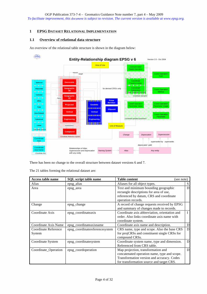
1 EPSG DATASET RELATIONAL IMPLEMENTATION 1.1 Overview of relational data structure An overview of the relational table structure is shown in the diagram below:
There has been no change to the overall structure between dataset versions 6 and 7. The 21 tables forming the relational dataset are:
Access table name SQL script table name Table content (see note) Alias epsg_alias Aliases for all object types. S Area epsg_area Text and minimum bounding geographic
rectangle descriptions for area of use, referenced by datum, CRS and coordinate operation records.
D
Change epsg_change A record of change requests received by EPSG and summary of changes made to records.
Coordinate Axis epsg_coordinateaxis Coordinate axis abbreviation, orientation and order. Also links coordinate axis name with coordinate system.
I
Coordinate Axis Name epsg_coordinateaxisname Coordinate axis name and description. D Coordinate Reference System
epsg_coordinatereferencesystem CRS name, type and scope. Also the base CRS for projCRSs and constituent single CRSs for compound CRSs.
D
Coordinate System epsg_coordinatesystem Coordinate system name, type and dimension. Referenced from CRS table.
D
Coordinate_Operation epsg_coordoperation Map projection, transformation and concatenated operation name, type and scope. Transformation version and accuracy. Codes for transformation source and target CRS.
D
Coordinate Reference System
Coordinate Operation
Coordinate Axis
Coordinate operation parameters
Single Coordinate Operation
Datum
Coordinate System
Geographic 2D
Geocentric
Projected
Vertical
Engineering
Ellipsoidal
Polar
Cartesian
Grav-Related
Linear
Compound
Coordinate Axis Name
Geodetic
Vertical
Engineering
Coord Operation Path
Coordinate Conversion Coord Operation
Method
Coord Operation Parameter Value
Coord Operation Parameter Usage
Coord Operation Parameter
Unit of Measure
Ellipsoid
Prime Meridian
Coordinate Transformation
Concatenated Coord Operation
Coordinate Axis
Version 2.0 - Oct 2004Entity-Relationship diagram EPSG v 6
Affine
Cylindrical
Geographic 3D
sourcetarget
Spherical
restrictions!
Area of Use
Deprecation
Any entityAliasNaming System
Change
Relationships of Alias, Supersession and Deprecation with any entity
for derived CRS's only
Supersession
base
superseded by superseded
deprecated valid

OGP Publication 373-7-4 – Geomatics Guidance Note number 7, part 4 – May 2009 To facilitate improvement, this document is subject to revision. The current version is available at www.epsg.org.
Page 5 of 32
Access table name SQL script table name Table content (see note) Coordinate_Operation Method
epsg_coordoperationmethod Transformation and conversion method name, formula, example and reversibility.
D
Coordinate_Operation Parameter
epsg_coordoperationparam Transformation and conversion parameter name and description.
D
Coordinate_Operation Parameter Usage
epsg_coordoperationparamusage Transformation and conversion parameter order and reversibility. Also links coordinate operation parameters with coordinate operation methods.
I
Coordinate_Operation Parameter Value
epsg_coordoperationparamvalue Transformation and conversion (map projection) parameter values.
I
Coordinate_Operation Path
epsg_coordoperationpath Concatenated operation step and step sequence information.
I
Datum epsg_datum Datum name, type, scope, epoch and origin information. Referenced from CRS table.
D
Deprecation epsg_deprecation Information for tracking deprecated records and their replacement (if any).
Ellipsoid epsg_ellipsoid Ellipsoid name and dimensions. Referenced from datum table.
D
Naming System epsg_namingsystem Alias naming system names. D Prime Meridian epsg_primemeridian Prime meridian name, Greenwich longitude. D Supersession epsg_supersession Information for tracking valid records which
have been superseded by more recent data.
Unit of Measure epsg_unitofmeasure Length, angle and scaling unit name and conversion factor. Referenced by ellipsoid and coordinate operation parameters, coordinate axis and prime meridian.
D
Version History epsg_versionhistory Dataset version release record. Notes: 1. Where the table content column has a D to its right, the table content includes primary object data such as name and code. These tables additionally include metadata to describe information origin. The table includes a field indicating whether records are deprecated. Valid records have deprecation = no = 0. For records where deprecation = yes = 1, the records are invalid, i.e. have been deprecated (flagged as invalid but remain in the dataset). Deprecated records should only be used when documenting or reversing use of the record that was made before it was declared invalid. 2. Where the table content column has an I to its right, the table is an intersection table within the relational data model. It includes essential data fields used by one or more of the tables to which it is joined. 3. Where the table content column has an S to its right, the table content is entirely secondary data which supplements the primary data. 4. Other tables contain supplementary information to facilitate data management or automated computer access to the primary data.
Field names within tables are consistent between the Access and SQL versions except for:
Access table name Access field name SQL script table name SQL script field name Alias ALIAS CODE epsg_alias alias_code Change COMMENT epsg_change change_comment Coordinate Axis ORDER epsg_coordinateaxis coord_axis_order

OGP Publication 373-7-4 – Geomatics Guidance Note number 7, part 4 – May 2009 To facilitate improvement, this document is subject to revision. The current version is available at www.epsg.org.
Page 6 of 32
Access to SQL data type conversions are:
Access type SQL type Comment Yes/No SMALLINT 1 = Yes / 0 = No Date/Time DATE Memo VARCHAR(4000) This will not work with MySQL, which needs TEXT Ole object BLOB (This type declaration not currently used). Text VARCHAR(length) Binary LONG (This type declaration not currently used). Double DOUBLE PRECISION Long integer INTEGER Integer SMALLINT Byte LONG
The strategy employed for the EPSG dataset is to commit to retaining backward compatibility with the above SQL table and field structure, data type and field names, which will remain unchanged. However in order to facilitate product improvement OGP reserves the right to supplement these by additional fields or tables when necessary. If there is perceived to be a need to include additional capability, this will be done such that the development will retain backward compatibility with the above structure. Note however that new fields might be inserted within existing tables: programmers should never rely on the order of fields in a table, but only on the names of the fields. 1.2 SQL scripts describing the data model and dataset content From v3.0 the EPSG dataset has been implemented in Microsoft Access, which in addition to being the data repository has acted both as a data entry tool for the OGP Geodesy Subcommittee (until replaced for these purposes by the registry from version 7) and as a searching, browsing and reporting tool for some users. A further use that the Geodesy Subcommittee hoped the database might be put to was the querying of the dataset by software programs. However, the reliance on a Microsoft Windows database server and the lack of cross platform support for such queries meant that such uses have not been developed. To address this issue, from version 6.5.3 onwards, three additional items are being provided. These are:
1) A Data Description Language (DDL) file called epsg_v[version].mdb_Tables.sql which contains the SQL CREATE statements necessary to create a database equivalent to the Access on an SQL server.
2) A Data Manipulation Language (DML) file called epsg_v[version].mdb_Data.sql which contains the SQL INSERT statements necessary to populate a database created using the EPSG*Tables.SQL DDL file with the current contents of the dataset.
3) A second DDL file epsg_v[version].mdb_fKeys.sql which contains the SQL ALTER statements necessary to enforce Foreign Key Constraints on the tables. Note that this should either not be run (if users are not intending to add supplementary data, there is no need to run this), or that it should be run after the tables have been populated using the DML file.
Platforms that have been tested are listed below. 1.2.1 Oracle The import of the DDL & DML scripts have been tested on an Oracle version 9i release 2 i386 server. The Oracle implementation is not in any way non-standard, the only constraint, already addressed in the table name translations, is that Oracle table names need be 30 characters or less. Refer to Oracle documentation for loading instructions. 1.2.2 PostgreSQL The import of the DDL & DML scripts have been tested on an PostgreSQL version 7.3.4. From the command line, execute the following (make sure your default user has sufficient privileges):
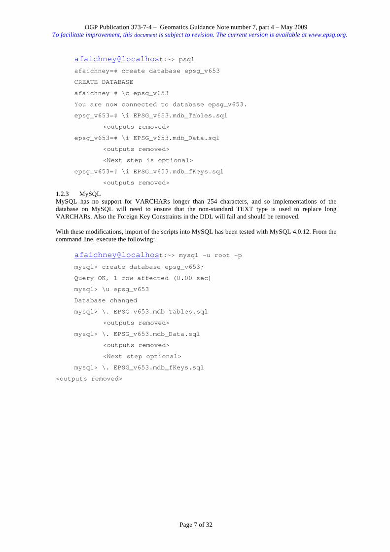
OGP Publication 373-7-4 – Geomatics Guidance Note number 7, part 4 – May 2009 To facilitate improvement, this document is subject to revision. The current version is available at www.epsg.org.
Page 7 of 32
afaichney@localhost:~> psql afaichney=# create database epsg_v653
CREATE DATABASE
afaichney=# \c epsg_v653
You are now connected to database epsg_v653.
epsg_v653=# \i EPSG_v653.mdb_Tables.sql
<outputs removed>
epsg_v653=# \i EPSG_v653.mdb_Data.sql
<outputs removed>
<Next step is optional>
epsg_v653=# \i EPSG_v653.mdb_fKeys.sql
<outputs removed> 1.2.3 MySQL MySQL has no support for VARCHARs longer than 254 characters, and so implementations of the database on MySQL will need to ensure that the non-standard TEXT type is used to replace long VARCHARs. Also the Foreign Key Constraints in the DDL will fail and should be removed. With these modifications, import of the scripts into MySQL has been tested with MySQL 4.0.12. From the command line, execute the following:
afaichney@localhost:~> mysql -u root -p mysql> create database epsg_v653;
Query OK, 1 row affected (0.00 sec)
mysql> \u epsg_v653
Database changed
mysql> \. EPSG_v653.mdb_Tables.sql
<outputs removed>
mysql> \. EPSG_v653.mdb_Data.sql
<outputs removed>
<Next step optional>
mysql> \. EPSG_v653.mdb_fKeys.sql
<outputs removed>
OGP Publication 373-7-4 – Geomatics Guidance Note number 7, part 4 – May 2009 To facilitate improvement, this document is subject to revision. The current version is available at www.epsg.org.
Page 8 of 32
2 SEARCHING THE RELATIONAL DATASET Information relevant to both the registry and relational database implementations is given in Guidance Note 7 part 1 (GN7-1) and should be read in conjunction with this section. 2.1 MS Access forms and reports Included within the Access version of the dataset are several forms and reports, underpinned by some queries and macros. These are for human interaction with the dataset. There are four groups:
• browse forms which allow users to review individual records by selected topic; • reports which give to users reports on records by selected topic; • edit/add forms which allow for maintenance of the dataset content; • forms which allow users to navigate the above database forms and reports.
Further detail of these forms and reports is given in annex A. 2.2 MS Access queries The Access database includes several queries which underpin the forms and reports. These have names beginning with "qry – ". Additionally, from version 6.6, there are queries which retrieve related data. These have names beginning with "qry_epsg_gn7_1_". Their use is described in the sections below and in annex E. The sample scripts in annex E are divided into three sections:
1. Data discovery – scripts to identify records or tabulate related data. 2. Coordinate Reference System description – scripts to retrieve data essential to describing a
coordinate reference system. This includes parameters necessary for geographical to/from grid coordinate conversions.
3. Coordinate Transformation description – scripts to retrieve data essential to describing a coordinate transformation. This includes parameters necessary for the execution of datum transformations 2.3 Valid data As described in GN7-1section 5.5 and annex B, the dataset includes records which are invalid. Record validity is indicated by the setting in the DEPRECATED field. In general, searches for data should exclude the invalid records. This may be accomplished by searching for data where the value of the DEPRECATED field = "false" (or "No" or "0"). Most of the example SQL scripts in annex E include this constraint. There may be occasions when there is a requirement to replicate data used previously, regardless of its current validity. On these rare occasions the search constraint criteria should omit the value of DEPRECATED. In Annex E to this document, example 1.00 gives SQL script to identify the version and date of a dataset. 2.4 Searching by Name See Guidance note 7 Part 1 section 6.2. An example SQL query to search by name or alias is given in annex E.1.01. 2.5 Searching by Area of Use See Guidance note 7 Part 1 section 6.3. 2.6 Coordinate Reference Systems See also Guidance note 7 Part 1 section 6.4. The primary information for all subtypes of coordinate reference system is stored within the table "Coordinate Reference System" (Access) or epsg_coordinatereferencesystem (SQL). The field COORD_REF_SYS_KIND indicates the type of CRS. The CRS table includes fields to cross-reference supporting information included within the coordinate system, datum and area tables (COORD_SYS_CODE, DATUM_CODE and AREA_OF_USE_CODE respectively). A SQL script to identify a CRS code from name or alias is given in annex E example 1.01. SQL scripts to identify CRS type and validity from CRS code are given in annex E examples 1.04 and 1.05.

OGP Publication 373-7-4 – Geomatics Guidance Note number 7, part 4 – May 2009 To facilitate improvement, this document is subject to revision. The current version is available at www.epsg.org.
Page 9 of 32
2.6.1 Geographic and geocentric CRSs SQL scripts to extract from the dataset the essential data for describing geographic and geocentric CRSs, including datum and ellipsoid information, are given in annex E examples 2.1 and 2.4. For a query which tabulates these related geodetic CRS records see annex E example 1.06. 2.6.2 Projected and other derived CRSs The CRS table includes a field named SOURCE_GEOGCRS_CODE which contains the code of the base CRS for projected (and other derived) coordinate reference systems. The field is only populated when the CRS is a derived (usually projected) CRS. When this field is populated, so too will be the field PROJECTION_CONV_CODE which cross-references a map projection (conversion) included within the coordinate operation table. Projected CRSs inherit geodetic datum from their base geographic CRS: the DATUM_CODE field is not used for projected CRS records. A record for a projected or other derived CRS cannot exist until there is a record for the base CRS in the CRS table and a record for the conversion in the coordinate operation table. SQL scripts to extract from the dataset the essential data for describing projected CRSs, including datum, ellipsoid and projection information, are given in annex E examples 2.2 and 2.4. 2.6.3 Vertical and engineering CRSs SQL scripts to extract from the dataset the essential data for describing a vertical CRS or an engineering CRS are given in annex E examples 2.3 and 2.4. 2.6.4 Compound CRSs In the EPSG Dataset, a compound CRS is a geographic or projected CRS combined with a vertical CRS. The CRS table includes two fields named CMPD_HORIZCRS_CODE and CMPD_VERTCRS_CODE. These give the codes of the two CRSs which together form the compound CRS. A record for a compound CRS cannot exist until the record for each of the component CRSs is in the CRS table. See annex E example 2.5 for an SQL query to retrieve identifying details (i.e. name and code) for each of the component single CRSs, given the code of the compound CRS. The details for each of the component single CRSs may then be found and described as above. 2.6.5 Coordinate Systems Coordinate system information is given in three tables: coordinate system, coordinate axis and coordinate axis name. A cryptic description of the CS is given in the coordinate system table's COORD_SYS_NAME field. The CS table also contains the type and dimension (i.e. number of axes) of the CS, together with CS metadata. The coordinate axis name table contains axis name and description. The coordinate axis table contains axis orientation, axis abbreviation and axis order information. If any of these axis attributes are changed, a new CS is defined which combines with a datum to form a new CRS. Axes for a CS should be presented sorted by ascending value of the field ORDER (in Access, coord_axis_order in SQL). See annex E example 2.4 for an SQL script to return coordinate system axis information from CRS code. This applies to any geographic, geocentric, projected, vertical or engineering CRS. Annex E example 1.07 tabulates projected CRSs with common datum but differing coordinate system. 2.6.6 Datums The primary information for all subtypes of datum is stored within the table Datum (Access) or epsg_datum (SQL). The field DATUM_TYPE indicates the type of datum. The datum table includes fields to cross-reference supporting information included within the area, ellipsoid and prime meridian tables (AREA_OF_USE_CODE, ELLIPSOID_CODE and PRIME_MERIDIAN_CODE respectively). The ellipsoid and prime meridian fields are populated only if the datum type is geodetic. 2.6.7 Ellipsoids See also GN7-1 section 5.11.4 and 6.4.3 The primary information for ellipsoids is stored within the table Ellipsoid (Access) or epsg_ellipsoid (SQL). The ellipsoid table includes a UOM_CODE field to cross-reference supporting information included within the unit of measure table.
OGP Publication 373-7-4 – Geomatics Guidance Note number 7, part 4 – May 2009 To facilitate improvement, this document is subject to revision. The current version is available at www.epsg.org.
Page 10 of 32
2.6.8 Prime meridians See also GN7-1 section 6.4.4 The primary information for prime meridians is stored within the table "Prime meridian" (Access) or epsg_primemeridian (SQL). The Prime meridian table includes a field UOM_CODE to cross-reference supporting information included within the unit of measure table. See section 5.5 above for comment upon the unit where the value of GREENWICH_LONGITUDE field is in degrees. 2.7 Coordinate Operations See also GN7-1 sections 5.11 and 6.5. The information for all subtypes of coordinate operation (transformation, conversion including map projection and concatenated operation) is stored in six tables. The primary information for all subtypes is stored within the table Coordinate_Operation (Access) or epsg_coordoperation (SQL). The field COORD_OP_TYPE indicates the type of coordinate operation. The coordinate operation table includes fields to cross-reference supporting information included within the area and coordinate operation method tables. The coordinate operation table also includes fields which reference a transformation's source and target CRSs (SOURCE_CRS_CODE and TARGET_CRS_CODE respectively). Neither of these fields is used for map projections; for map projections the base CRS information is included within the CRS table. The coordinate operation table also includes two fields UOM_CODE_SOURCE_COORD_DIFF and UOM_CODE_TARGET_COORD_DIFF which cross reference to the unit of measure table. These fields are only used for polynomial transformation methods and indicate the unit in which evaluation point coordinates are required to be in for application within the method formula. These fields should not be confused with those that indicate the unit in which parameter values are tabulated, discussed below. Four additional tables hold supplementary but critical information for single coordinate operations (i.e. transformations and conversions, including map projections). These are described in section 2.7.1 below. A further table holds information for concatenated operations. Scripts to identify the type of coordinate operation from coordinate operation code and to list all transformations to or from a CRS are given in annex E.1.08 and E.1.09. Scripts for accessing the essential information for describing a map projection are given in annex E.2.2(ii) and for describing a transformation in annex E.3. 2.7.1 Transformation and conversion methods and parameters Each transformation and conversion is related to a coordinate operation method through the coordinate operation table's COORD_OP_METHOD_CODE field. Primary information for transformation and conversion methods is held in the table "Coordinate_Operation Method" (Access) or epsg_coordoperationmethod (SQL). Information on coordinate operation parameters used by a particular method is held in the intersection table "Coordinate_Operation Parameter Usage" (Access) or epsg_coordoperationparamusage (SQL). This table has a dual key of COORD_OP_METHOD_CODE and PARAMETER_CODE. The record for each combination of method and parameter also includes a field SORT_ORDER. The name of each parameter, together with a description, is held in the table "Coordinate_Operation Parameter" (Access) or epsg_coordoperationparam (SQL). Transformation and conversion parameter values The values for coordinate operation parameters are held in the intersection table "Coordinate_Operation Parameter Value" (Access) or epsg_coordoperationparamvalue (SQL). In general these are in the field PARAMETER_VALUE. The coordinate operation parameter value table includes a field UOM_CODE to cross-reference supporting information included within the unit of measure table. See GN7-1 section 5.10 for comment upon the unit for angle values given in sexagesimal degree representation.

OGP Publication 373-7-4 – Geomatics Guidance Note number 7, part 4 – May 2009 To facilitate improvement, this document is subject to revision. The current version is available at www.epsg.org.
Page 11 of 32
Parameter values for methods which use gridded data files In the relational implementation, for any one record in the parameter value table, either the PARAMETER_VALUE or the PARAM_VALUE_FILE_REF field, but not both, will be populated.

OGP Publication 373-7-4 – Geomatics Guidance Note number 7, part 4 – May 2009 To facilitate improvement, this document is subject to revision. The current version is available at www.epsg.org.
Page 12 of 32
ANNEX A - MS ACCESS DATABASE FORMS AND REPORTS Included within the Access version of the dataset are several forms and reports, underpinned by some queries and macros. These are for human interaction with the dataset. There are four groups:
• browse forms which allow users to navigate the database forms and reports; • browse forms which allow users to review individual records by selected topic; • reports which give to users reports on records by selected topic; • edit/add forms which allow for maintenance of the dataset content.
Database Forms There are a total of 31 primary forms in the current version of the database. Within the forms, standard Access filtering functions can be used to limit a selection whilst standard Access sorting functions can be used to sort data. See the comments under the reports section below for filtering on the area of use field. To summarise, the forms provided in this version of the data base are as follows.
• four "Welcome Forms" to assist users in navigating the database's forms and reports. • a series of twelve forms that allow browsing of specific data types. • the browse forms offer options to go to a further series of fifteen forms allowing editing and
addition of data. • supporting the above are numerous subforms that provide integral components for the 31 primary
forms, including one subform for user provision of a Company Logo. • a form to facilitate the importation into Access of an Oracle script file of the dataset content. This
is described further in Annex C of this document. Help "Pop-ups" on Database Forms Pop-up hot-key "help" subforms are currently implemented on all Edit/Add and Browse forms. To utilise this feature, click on a field caption (e.g., the text "Information Source") and an appropriate help box will appear. This feature addresses comments on earlier versions to make data entry more intuitive for those unfamiliar with the database design. Database "Company Logo" Implementation There is provision for insertion of a user/company logo on forms and reports. To make use of this facility, a user should close the opening Welcome Form and open the first form listed, "1 - Company Logo". Substitute your company logo (sized to fit the subform) for the EPSG dataset logo currently there. Once this is done, the primary welcome form (and others) will open showing EPSG dataset logo on the left and your company logo on the right. If your logo is sized larger than the current company logo subform, part of your logo will be cut off when displayed. The same process should be applied to the first report listed, "1 - Company Logo". Database Reports The 54 reports (28 on valid data plus 26 to review deprecated records) include the ability to search the database and obtain reports based on user entry.
• Detailed reports based on an input area of use, name, or alias are available for various coordinate reference systems (geographic, projected, engineering, vertical and compound) and coordinate operations (map projections, transformations and concatenated operations). In detailed geographic coordinate reference system reports, most associated datum information is included.
• In addition, summary reports are available for most coordinate reference system types and for most transformations, with the same search criteria.
• Reports for reference purposes can also be run for all ellipsoids, angle units, length units, scale units, transformation parameters and prime meridians contained in the database. The report on transformation methods includes their formulae; these are given with improved clarity due to the use of multiple fonts in Guidance Note 7 part 2.
• Reports also review the database change requests that have been implemented in this version as well as any change requests that remain outstanding.
Each "area search" is actually a text search that runs on the area of use, name and code# fields in the relevant tables or queries, as well as on any associated alias fields in the alias table. Searches can be made by country name (ISO English spelling) and in the case of the projected coordinate reference system report in addition by US, Canada or Australia state/province/territory name, US state 2-character postal code abbreviation, or county name. In all these searches, MS Access requires an exact text string match. The
OGP Publication 373-7-4 – Geomatics Guidance Note number 7, part 4 – May 2009 To facilitate improvement, this document is subject to revision. The current version is available at www.epsg.org.
Page 13 of 32
area fields usually contain several country names and/or regional descriptions and a search on one country name will therefore generally fail. Users are recommended to include their search area text string within two asterisks as wild-card characters; for example to search for Oman enter *oman*. This will retrieve all records that include Oman within the area of use or name fields; however it will also retrieve data for Romania. To produce a report with all possible contents simply enter a single wildcard (*). Reports are dependent upon printer drivers in use. Users may need to modify printer setup the first time they use the report feature. For screen viewing, the reports work best at 75 % viewing size (user may set in MS Access) using large fonts (set in Control Panel/Display). Database Queries In the Access database there are a number of queries supporting the above forms and reports.
• sixteen queries are used to provide appropriate inputs for various reports and forms associated with datums, coordinate reference systems and coordinate operations (map projections, transformations, and concatenated operations). [Other control queries are incorporated into the specific reports and forms needing them].
• one make-table query is used to generate new coordinate operation (map projection and transformation) values in the edit/add coordinate transformation form.
• one query provides latest database version information for input into various form and report headers.
The Access database also includes five queries for monitoring the length of fields with memo type declaration (limited to 4000 characters in the SQL export). The database additionally includes a number of queries to demonstrate automated use of the EPSG dataset. These are discussed in section 2 and annex E of this document.
OGP Publication 373-7-4 – Geomatics Guidance Note number 7, part 4 – May 2009 To facilitate improvement, this document is subject to revision. The current version is available at www.epsg.org.
Page 14 of 32
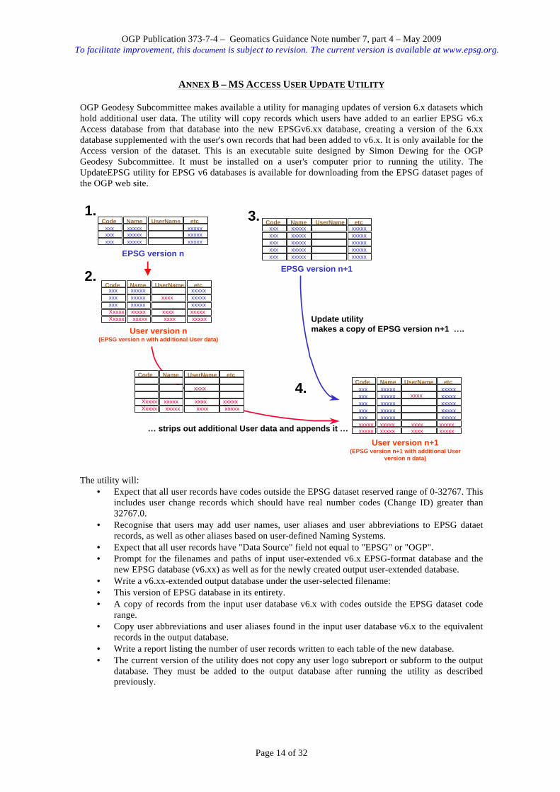
ANNEX B – MS ACCESS USER UPDATE UTILITY
OGP Geodesy Subcommittee makes available a utility for managing updates of version 6.x datasets which hold additional user data. The utility will copy records which users have added to an earlier EPSG v6.x Access database from that database into the new EPSGv6.xx database, creating a version of the 6.xx database supplemented with the user's own records that had been added to v6.x. It is only available for the Access version of the dataset. This is an executable suite designed by Simon Dewing for the OGP Geodesy Subcommittee. It must be installed on a user's computer prior to running the utility. The UpdateEPSG utility for EPSG v6 databases is available for downloading from the EPSG dataset pages of the OGP web site.
The utility will:
• Expect that all user records have codes outside the EPSG dataset reserved range of 0-32767. This includes user change records which should have real number codes (Change ID) greater than 32767.0.
• Recognise that users may add user names, user aliases and user abbreviations to EPSG dataet records, as well as other aliases based on user-defined Naming Systems.
• Expect that all user records have "Data Source" field not equal to "EPSG" or "OGP". • Prompt for the filenames and paths of input user-extended v6.x EPSG-format database and the
new EPSG database (v6.xx) as well as for the newly created output user-extended database. • Write a v6.xx-extended output database under the user-selected filename: • This version of EPSG database in its entirety. • A copy of records from the input user database v6.x with codes outside the EPSG dataset code
range. • Copy user abbreviations and user aliases found in the input user database v6.x to the equivalent
records in the output database. • Write a report listing the number of user records written to each table of the new database. • The current version of the utility does not copy any user logo subreport or subform to the output
database. They must be added to the output database after running the utility as described previously.
Code Name UserName etc
xxx xxxxx xxxxx
xxx xxxxx xxxxxxxx xxxxx xxxxx
EPSG version n
Code Name UserName etc
xxx xxxxx xxxxx
xxx xxxxx xxxxxxxx xxxxx xxxxx
Xxxxx xxxxx xxxx xxxxxXxxxx xxxxx xxxx xxxxx
xxxx
User version n(EPSG version n with additional User data)
Code Name UserName etc
xxx xxxxx xxxxx
xxx xxxxx xxxxxxxx xxxxx xxxxx
xxx xxxxx xxxxxxxx xxxxx xxxxx
EPSG version n+1
Code Name UserName etc
xxx xxxxx xxxxx
xxx xxxxx xxxxxxxx xxxxx xxxxx
xxx xxxxx xxxxxxxx xxxxx xxxxx
xxxxx xxxxx xxxx xxxxxxxxxx xxxxx xxxx xxxxx
xxxx
User version n+1(EPSG version n+1 with additional User
version n data)
Update utilitymakes a copy of EPSG version n+1 ….
… strips out additional User data and appends it …
1.
2.
3.
4.Code Name UserName etc
Xxxxx xxxxx xxxx xxxxxXxxxx xxxxx xxxx xxxxx
xxxx

OGP Publication 373-7-4 – Geomatics Guidance Note number 7, part 4 – May 2009 To facilitate improvement, this document is subject to revision. The current version is available at www.epsg.org.
Page 15 of 32
There have been several minor changes in the EPSG database structure since v6.2 was released. The User Update Utility currently has several known limitations, all of which have simple workarounds. These relate to:
• Incorrect Code Assignment in three tables with previously Auto Numbering Codes • Codes table (present in earlier EPSG v6,x dataset releases) • Extra Fields problem specific to EPSG_v6.9 (as originally posted to website) • Moving User Records in Version History table
Detailed procedures for workarounds to each of these issues are given in the separate file, epsg-update-help.pdf, downloadable from the EPSG website along with the epsg-update-exe.zip executable. Any changes to EPSG dataset records other than the addition of user-assigned names, aliases or abbreviations will not be resolved by the utility. The utility will not resolve duplications between user data and new EPSG dataset data.
OGP Publication 373-7-4 – Geomatics Guidance Note number 7, part 4 – May 2009 To facilitate improvement, this document is subject to revision. The current version is available at www.epsg.org.
Page 16 of 32
ANNEX C – MS ACCESS REGISTRY IMPORT UTILITY
The data release cycle for the EPSG Dataset is described in Guidance Note 7 part 1. In summary, Access and SQL versions of the Dataset are made available only for full releases, nominally about twice per year. Between these full releases additional interim releases of the Dataset may be made in the Registry. This annex describes how users can create Access versions of these interim releases. Registered Users of the on-line Registry have access to the registry export facility. There are options to export the dataset as GML or Oracle scripts. From v7.1 (May 2009) the published Access database includes a facility to import the Oracle script into Access. The steps of the process are:
• Make a copy of the current Access database. • Delete all EPSG records from this database. • Download the Oracle script from the Registry. • Import the Oracle script into the Access database.
Delete EPSG Records 1. Open the copy of the MS Access database; 2. Open the form ‘Import EPSG Oracle SQL’; 3. Click ‘Delete EPSG Records’. This will delete all records (data) from the database, but keeps the database tables, queries, forms, etc. Download Oracle script from the on-line Registry 1. Log in to the Registry; (this requires having a registry user account. Prompts to create an account
are given on the Registry home page. Details of how to create an account are given in Guidance Note 7 part 3.
2. Follow the ‘export registry’ link; 3. Choose the ‘Export Oracle SQL scripts’ link; 4. Save the zip file; 5. Extract ‘Oracle_Data_Script.sql’ to in the same folder as the MSAccess database to be populated. Import EPSG Oracle SQL 1. Open the MS Access database to be populated; 2. Close the Welcome screen; 3. Open the form ‘Import EPSG Oracle SQL’; 4. Click ‘Import EPSG Oracle SQL’ in the top menu (importing status is displayed in the status bar). Because of problems experienced by users of Access 2007, we have had to disable the automatic display of dataset version and data. The version displayed will be that copied at the tart of this process. To see the actual version of the Dataset, use the Dataset Version History button on the Forms selection screen and scroll to the last entry. The displayed version and date can be amended by those confident in using design mode for database forms and reports. The six that need editing are:
• subform browse Version History MainForms • subform browse Version History • subform edit/add Version History • subrpt footer • subrpt page header logo • subrpt report header logo

OGP Publication 373-7-4 – Geomatics Guidance Note number 7, part 4 – May 2009 To facilitate improvement, this document is subject to revision. The current version is available at www.epsg.org.
Page 17 of 32
ANNEX D
(This page is intentionally left blank)

OGP Publication 373-7-4 – Geomatics Guidance Note number 7, part 4 – May 2009 To facilitate improvement, this document is subject to revision. The current version is available at www.epsg.org.
Page 18 of 32
ANNEX E – SQL SCRIPTS FOR EXTRACTING DATA The sample scripts in this annex are divided into three sections:
E.1. Data discovery – scripts to identify record metadata. E.2. Coordinate Reference System description. E.3. Coordinate Transformation description.
The "description" examples also provide the information necessary to execute a geographical to geocentric coordinate conversion, a geographical to grid coordinate conversion, or a datum transformation. They return only critical data; no metadata is included. These simple examples have been constructed to illustrate the dataset content and its extraction. They should not be taken as fulfilling all extraction requirements, for which more extensive queries utilising several of the samples may be appropriate. The examples do not trap erroneous input. The scripts have been tested against a MySQL version 4.0.18 database. Equivalent scripts are also included within the MS Access database; the Access database query names are given with each example below. The example results are consistent with the v6.6 dataset of October 2004. E.1 Data Discovery Example Function returns Input argument E.1.00 version and date of a dataset. E.1.01 name, alias and code. user "name" (name or alias in dataset) E.1.02 metadata (remarks, information source, data source,
change table record id(s) and revision date). code
E.1.03 coordinate operation code, name, version and type. area "name" (area of use in dataset) E.1.04 CRS type. CRS code E.1.05 CRS type, validity and, if deprecated, the reason for
deprecation and code of replacement (if any). CRS code
E.1.06 geographic 2D CRS code geocentric or geographic 3D CRS code E.1.06a tabulation of geographic and geocentric CRSs
referenced to the same geodetic datum.
E.1.07 tabulation of projected CRSs which share datum but have differing CS.
E.1.08 retrieve Coordinate Operation code and type code for a non-reversible transformation E.1.09 tabulation of reciprocal non-reversible transformations code for non-reversible transformation E.1.10 list of transformations and concatenated operations
related to CRS. CRS code
E.1.00 SQL script to retrieve dataset version and date
(equivalent Access query: qry Version History) This is done in two steps: (i) Query to find the latest release date. SELECT MAX(epsg_versionhistory.version_date) AS 'Date' FROM epsg_versionhistory; (ii) Query which uses the date found above to return the dataset's release date and version number. SELECT epsg_versionhistory.version_date AS 'Date', epsg_versionhistory.version_number AS 'Dataset Version' FROM epsg_versionhistory WHERE (epsg_versionhistory.version_date = 'yyyy-mm-dd');

OGP Publication 373-7-4 – Geomatics Guidance Note number 7, part 4 – May 2009 To facilitate improvement, this document is subject to revision. The current version is available at www.epsg.org.
Page 19 of 32
E.1.01 SQL script to retrieve name, alias and code given user "name" (Access query qry_epsg_gn7_1_e101_nameAlias_crs)
This example uses the coordinate reference system table. Similar scripts can be applied to other primary tables. In MySQL, the process is split into two separate queries: (a) for searching for CRS name and (b) for searching for alias name. (a). This query is used to search for a match between user "name" and dataset CRS name: SELECT epsg_coordinatereferencesystem.coord_ref_sys_name, epsg_alias.alias, epsg_coordinatereferencesystem.coord_ref_sys_code FROM epsg_coordinatereferencesystem LEFT JOIN epsg_alias ON (epsg_coordinatereferencesystem.coord_ref_sys_code = epsg_alias.object_code) WHERE ((epsg_coordinatereferencesystem.coord_ref_sys_name LIKE 'abcd') AND (epsg_coordinatereferencesystem.deprecated = 0)) ORDER BY epsg_alias.alias; (b). This query is used to search for match between user "name" and dataset alias: SELECT epsg_coordinatereferencesystem.coord_ref_sys_name, epsg_alias.alias, epsg_coordinatereferencesystem.coord_ref_sys_code FROM epsg_coordinatereferencesystem INNER JOIN epsg_alias ON epsg_coordinatereferencesystem.coord_ref_sys_code = epsg_alias.object_code WHERE (epsg_alias.alias LIKE 'abcd') AND (epsg_alias.object_table_name = 'epsg_coordinatereferencesystem') ORDER BY epsg_coordinatereferencesystem.coord_ref_sys_name; Examples: (i) Input CRS name = "Port Bouet" CRS name Alias CRS code Abidjan 1987 Port Bouet 4143 Locodjo 1965 Port Bouet 4142 (ii) Input CRS name = "Abidjan 1987" CRS name Alias CRS code Abidjan 1987 Côte D'Ivoire 4143 Abidjan 1987 Port Bouet 4143 (iii) Input CRS name = "ED50" CRS name Alias CRS code ED50 (null) 4230 (Note: no alias or CRS ED50 in dataset.) E.1.02 SQL script to retrieve metadata for a record
(equivalent Access query: qry_epsg_gn7_1_e102_metadata_ellipsoid) This example uses the ellipsoid table. Similar scripts can be applied to other primary tables in the dataset. SELECT epsg_ellipsoid.ellipsoid_code, epsg_ellipsoid.remarks, epsg_ellipsoid.information_source, epsg_ellipsoid.data_source, epsg_ellipsoid.change_id, epsg_ellipsoid.revision_date FROM epsg_ellipsoid WHERE ((epsg_ellipsoid.ellipsoid_code = xxxx) AND (epsg_ellipsoid.deprecated = 0)); Example: Input ellipsoid code = 7001 Attribute Value
OGP Publication 373-7-4 – Geomatics Guidance Note number 7, part 4 – May 2009 To facilitate improvement, this document is subject to revision. The current version is available at www.epsg.org.
Page 20 of 32
Code: 7001 Remarks: Original definition is a=20923713 and b=20853810 feet of 1796. For the 1936
retriangulation OSGB defines the relationship of feet of 1796 to the International metre through log(1.48401603) exactly [=0.3048007491...]. 1/f is given to 7 decimal places.
Information source: Ordnance Survey of Great Britain. Data source: EPSG Change ID: 98.321 98.34 Revision date: 1995-06-02 E.1.03. SQL script to retrieve coordinate operation code, name, version and type, given area of use
(equivalent Access query: qry_epsg_gn7_1_e103_area_coordOp) SELECT epsg_coordoperation.coord_op_code, epsg_coordoperation.coord_op_name, epsg_coordoperation.coord_tfm_version, epsg_coordoperation.coord_op_type FROM epsg_coordoperation LEFT JOIN epsg_area ON epsg_coordoperation.area_of_use_code = epsg_area.area_code WHERE ((epsg_coordoperation.coord_op_type = 'transformation') OR (epsg_coordoperation.coord_op_type = 'concatenated operation')) AND (epsg_area.area_name = 'abcd') AND (epsg_coordoperation.deprecated = 0) ORDER BY epsg_coordoperation.coord_op_variant; Example: Input area of use = "Algeria" Code Coordinate Operation Name Version Coordinate Operation Type 1253 Nord Sahara 1959 to WGS 84 (1) DMA-Alg transformation 1882 Nord Sahara 1959 (Paris) to Nord Sahara 1959 IGN-Fra transformation 8640 Nord Sahara 1959 (Paris) to WGS 84 (1) EPSG-Dza concatenated operation E.1.04. SQL script to retrieve CRS type, given CRS code
(equivalent Access query: qry_epsg_gn7_1_e104_crs_findType) SELECT epsg_coordinatereferencesystem.coord_ref_sys_code, epsg_coordinatereferencesystem.coord_ref_sys_kind FROM epsg_coordinatereferencesystem WHERE ((epsg_coordinatereferencesystem.coord_ref_sys_code = xxxx) AND (epsg_coordinatereferencesystem.deprecated = 0)); Examples: CRS code CRS type (i) Input CRS code = 7405 7405 compound (ii) Input CRS code = 2105 2105 projected E.1.05. SQL scripts to retrieve CRS status, given CRS code
(equivalent Access queries: qry_epsg_gn7_1_e105a_crs_deprecation and qry_epsg_gn7_1_e105_crs_findStatus)
This search returns CRS type, validity and if deprecated the reason for deprecation and code of replacement record (if any). (In Access it is run in two parts. The first finds all CRS records in the Deprecation table. These results are used by the second part). SELECT epsg_coordinatereferencesystem.coord_ref_sys_code, epsg_coordinatereferencesystem.coord_ref_sys_kind, epsg_coordinatereferencesystem.deprecated, epsg_deprecation.replaced_by, epsg_deprecation.deprecation_reason FROM epsg_coordinatereferencesystem LEFT JOIN epsg_deprecation ON epsg_coordinatereferencesystem.coord_ref_sys_code = epsg_deprecation.object_code

OGP Publication 373-7-4 – Geomatics Guidance Note number 7, part 4 – May 2009 To facilitate improvement, this document is subject to revision. The current version is available at www.epsg.org.
Page 21 of 32
WHERE (epsg_coordinatereferencesystem.coord_ref_sys_code = xxxx); Examples: Attribute (i) Input CRS code = 4977 (ii) Input CRS code = 2141 CRS code: 4977 2141 CRS type: geographic 3D projected Deprecated?: 0 1 Replaced by (code): (null) 2946 Deprecation reason: (null) Change of base geogCRS name to accord with revised
Geomatics Canada practice. Note: The record is valid if deprecated = "No" or "False" or "0". E.1.06. SQL script to retrieve geographic 2D CRS code, given geocentric CRS or geographic 3D CRS code
(equivalent Access query: qry_epsg_gn7_1_e106_geocen2geog2D) SELECT epsg_coordinatereferencesystem.coord_ref_sys_code, epsg_coordinatereferencesystem.coord_ref_sys_kind, epsg_coordinatereferencesystem_1.coord_ref_sys_code, epsg_coordinatereferencesystem_1.coord_ref_sys_kind, epsg_coordinatereferencesystem.coord_ref_sys_name FROM epsg_coordinatereferencesystem AS epsg_coordinatereferencesystem_1 INNER JOIN epsg_coordinatereferencesystem ON epsg_coordinatereferencesystem_1.datum_code = epsg_coordinatereferencesystem.datum_code WHERE ((epsg_coordinatereferencesystem.coord_ref_sys_code = xxxx) AND ((epsg_coordinatereferencesystem.coord_ref_sys_kind = 'geocentric') OR (epsg_coordinatereferencesystem.coord_ref_sys_kind = 'geographic 3D')) AND (epsg_coordinatereferencesystem_1.coord_ref_sys_kind = 'geographic 2D') AND (epsg_coordinatereferencesystem.deprecated = 0) AND epsg_coordinatereferencesystem_1.deprecated = 0); Examples: Input CRS code CRS type Related geog2D CRS code Geog2D CRS type Geog2D CRS name 4976 geocentric 4619 geographic 2D SWEREF99 4978 geocentric 4326 geographic 2D WGS 84 4979 geographic 3D 4326 geographic 2D WGS 84 E.1.06a. SQL script to tabulate geographic and geocentric CRSs referenced to the same geodetic datum
(equivalent Access query: qry_epsg_gn7_1_e106a_tabulation_geocrs) This script provides similar information to the previous example but rather than returning information for a specific input it tabulates all dataset content.

OGP Publication 373-7-4 – Geomatics Guidance Note number 7, part 4 – May 2009 To facilitate improvement, this document is subject to revision. The current version is available at www.epsg.org.
Page 22 of 32
SELECT epsg_datum.datum_name, epsg_coordinatereferencesystem.coord_ref_sys_name, epsg_coordinatereferencesystem.coord_ref_sys_code, epsg_coordinatereferencesystem.coord_ref_sys_kind, epsg_coordinatereferencesystem_1.coord_ref_sys_code, epsg_coordinatereferencesystem_1.coord_ref_sys_kind, epsg_coordinatereferencesystem_2.coord_ref_sys_code, epsg_coordinatereferencesystem_2.coord_ref_sys_kind FROM ((epsg_coordinatereferencesystem INNER JOIN epsg_coordinatereferencesystem AS epsg_coordinatereferencesystem_1 ON epsg_coordinatereferencesystem.datum_code = epsg_coordinatereferencesystem_1.datum_code) INNER JOIN epsg_coordinatereferencesystem AS epsg_coordinatereferencesystem_2 ON epsg_coordinatereferencesystem.datum_code = epsg_coordinatereferencesystem_2.datum_code) INNER JOIN epsg_datum ON (epsg_datum.datum_code = epsg_coordinatereferencesystem.datum_code) AND (epsg_coordinatereferencesystem_1.datum_code = epsg_datum.datum_code) WHERE ((epsg_coordinatereferencesystem.coord_ref_sys_kind = 'geocentric') AND (epsg_coordinatereferencesystem_1.coord_ref_sys_kind = 'geographic 3D') AND (epsg_coordinatereferencesystem_2.coord_ref_sys_kind = 'geographic 2D') AND (epsg_coordinatereferencesystem.deprecated = 0) AND (epsg_coordinatereferencesystem_1.deprecated = 0) AND (epsg_coordinatereferencesystem_2.deprecated = 0)) ORDER BY epsg_datum.datum_name; E.1.07. SQL script to tabulate projected CRSs which share datum but have differing CS
(equivalent Access query: qry_epsg_gn7_1_e107_tabulation_projcrsCSchange) SELECT epsg_coordinatereferencesystem.coord_ref_sys_code, epsg_coordinatereferencesystem.coord_ref_sys_name, epsg_coordinatesystem.coord_sys_name, epsg_coordinatereferencesystem_1.coord_ref_sys_code, epsg_coordinatereferencesystem_1.coord_ref_sys_name, epsg_coordinatesystem_1.coord_sys_name FROM epsg_coordinatesystem INNER JOIN (epsg_coordinatesystem AS epsg_coordinatesystem_1 INNER JOIN (epsg_coordinatereferencesystem INNER JOIN epsg_coordinatereferencesystem AS epsg_coordinatereferencesystem_1 ON (epsg_coordinatereferencesystem.projection_conv_code = epsg_coordinatereferencesystem_1.projection_conv_code) AND (epsg_coordinatereferencesystem.source_geogcrs_code = epsg_coordinatereferencesystem_1.source_geogcrs_code)) ON epsg_coordinatesystem_1.coord_sys_code = epsg_coordinatereferencesystem_1.coord_sys_code) ON epsg_coordinatesystem.coord_sys_code = epsg_coordinatereferencesystem.coord_sys_code WHERE ((epsg_coordinatereferencesystem.deprecated = 0) AND (epsg_coordinatereferencesystem_1.deprecated = 0) AND ((epsg_coordinatereferencesystem_1.coord_sys_code) <> (epsg_coordinatereferencesystem.coord_sys_code))) ORDER BY epsg_coordinatereferencesystem.coord_ref_sys_code; E.1.08. SQL script to retrieve Coordinate Operation type, given Coordinate Operation code
(equivalent Access query: qry_epsg_gn7_1_e108_coordOp_findType) SELECT epsg_coordoperation.coord_op_code, epsg_coordoperation.coord_op_type FROM epsg_coordoperation WHERE ((epsg_coordoperation.coord_op_code = xxxx) AND (epsg_coordoperation.deprecated = 0)); Examples: Coordinate Operation code Coordinate Operation type (i) Input code = 1301 1301 transformation (ii) Input code = 10301 10301 conversion

OGP Publication 373-7-4 – Geomatics Guidance Note number 7, part 4 – May 2009 To facilitate improvement, this document is subject to revision. The current version is available at www.epsg.org.
Page 23 of 32
E.1.09. SQL script to retrieve CRS code for a reciprocal transformation, given CRS code for a non-
reversible transformation SELECT epsg_coordoperation.coord_op_code, epsg_coordoperation.coord_op_name, epsg_coordoperation_2.coord_op_code, epsg_coordoperation_2.coord_op_name FROM epsg_coordoperation INNER JOIN epsg_coordoperation AS epsg_coordoperation_2 ON (epsg_coordoperation.coord_op_method_code = epsg_coordoperation_2.coord_op_method_code) AND (epsg_coordoperation.source_crs_code = epsg_coordoperation_2.target_crs_code) AND (epsg_coordoperation.target_crs_code = epsg_coordoperation_2.source_crs_code) AND (epsg_coordoperation.coord_tfm_version = epsg_coordoperation_2.coord_tfm_version) WHERE ((epsg_coordoperation.coord_op_code = xxxx) AND (epsg_coordoperation_2.deprecated = 0)); Examples: Using coordinate operation code 1044 as the input argument should return coordinate operation code 1045. Note that not all transformations using non-reversible methods will have a reciprocal. The above SQL query using coordinate operation code 1028 as the input argument will not return anything. (Similar Access query of all which tabulates results: qry_epsg_gn7_1_e109_tabulation_reciprocalOperation). E.1.10. SQL script to retrieve data describing available coordinate transformations and concatenated
operations, given CRS code (equivalent Access query: qry_epsg_gn7_1_e110_tfmStatusByCRS)
SELECT epsg_coordinatereferencesystem.coord_ref_sys_code, epsg_coordinatereferencesystem_1.coord_ref_sys_code, epsg_coordoperation.coord_op_code, epsg_coordoperation.coord_op_name, epsg_coordoperation.coord_tfm_version, epsg_coordoperation.coord_op_type, epsg_coordoperationmethod.coord_op_method_name, epsg_coordoperationmethod.reverse_op, epsg_coordoperation.coord_op_accuracy, epsg_area.area_north_bound_lat, epsg_area.area_south_bound_lat, epsg_area.area_east_bound_lon, epsg_area.area_west_bound_lon, epsg_supersession.superseded_by, epsg_coordoperation_1.coord_op_name, epsg_coordoperation_1.coord_tfm_version FROM epsg_coordinatereferencesystem, epsg_coordinatereferencesystem AS epsg_coordinatereferencesystem_1 INNER JOIN epsg_coordoperation ON ((epsg_coordinatereferencesystem.coord_ref_sys_code = epsg_coordoperation.source_crs_code) AND (epsg_coordinatereferencesystem_1.coord_ref_sys_code = epsg_coordoperation.target_crs_code)) INNER JOIN epsg_coordoperationmethod ON (epsg_coordoperation.coord_op_method_code = epsg_coordoperationmethod.coord_op_method_code) INNER JOIN epsg_area ON (epsg_coordoperation.area_of_use_code = epsg_area.area_code) LEFT JOIN epsg_supersession ON ((epsg_supersession.object_table_name = 'epsg_coordoperation') AND (epsg_coordoperation.coord_op_code = epsg_supersession.object_code)) LEFT JOIN epsg_coordoperation AS epsg_coordoperation_1 ON (epsg_coordoperation_1.coord_op_code = epsg_supersession.superseded_by) WHERE ((epsg_coordinatereferencesystem.coord_ref_sys_code = xxxx) AND (epsg_coordoperation.deprecated = 0)) ORDER BY epsg_coordinatereferencesystem.coord_ref_sys_code, epsg_coordinatereferencesystem_1.coord_ref_sys_code; Example: Input CRS code = 4289 Transformation #1 Transformation #2 Transformation #3 Transformation #4 Source CRS code: 4289 4289 4289 4289 Target CRS code: 4258 4258 4326 4326

OGP Publication 373-7-4 – Geomatics Guidance Note number 7, part 4 – May 2009 To facilitate improvement, this document is subject to revision. The current version is available at www.epsg.org.
Page 24 of 32
Example: Input CRS code = 4289 Transformation #1 Transformation #2 Transformation #3 Transformation #4 Coord Operation Code: 1751 1066 1112 1672 Coord Operation Name: Amersfoort to
ETRS89 (1) Amersfoort to ETRS89 (2)
Amersfoort to WGS 84 (1)
Amersfoort to WGS 84 (2)
Coord Tfm Version: NCG-Nld 2000 NCG-Nld 2000 NCG-Nld 93 EPSG-Nld Coord Operation Type: transformation transformation transformation transformation Coord Op Method: Coordinate Frame
rotation Molodensky-Badekas 10-parameter transformation
Position Vector 7-param. transformation
Coordinate Frame rotation
Reverse Op? TRUE (or 1) TRUE (or 1) TRUE (or 1) TRUE (or 1) Coord Tfm Accuracy: 0.5 0.5 1 1 North latitude: 53.47 53.47 53.47 53.47 South latitude: 50.75 50.75 50.75 50.75 East longitude: 7.21 7.21 7.21 7.21 West longitude: 3.37 3.37 3.37 3.37 Succeeded by code: (null) (null) 1672 (null) Coord Operation name: (null) (null) Amersfoort to WGS
84 (2) (null)
Coord Tfm Version: (null) (null) EPSG-Nld (null) E.2 CRS Description This section exemplifies scripts to return the geodetic parameters essential to describing various types of coordinate reference system. These scripts also return all data required to perform geocentric to/from geographical and geographical to/from grid conversions. To select the appropriate script it is first necessary to know the type of CRS. (See example 1.04 above to determine CRS type from CRS code, and example 1.01 above to determine CRS code from text search on (any part of) CRS name). Then if the CRS type is not compound, run example script 2.1, 2.2 or 2.3 as appropriate for the CRS type followed by example 2.4. If the CRS type is compound first run example script 2.5 to determine the codes and types for the component CRSs, then run 2.1, 2.2 or 2.3 as appropriate and then 2.4 for each of the two component CRSs. Example Function returns Input argument E.2.1 geodetic data describing a geographic or geocentric CRS. CRS code E.2.2 geodetic data describing a projected CRS. CRS code E.2.3 geodetic data describing a vertical or engineering CRS. CRS code E.2.4 data describing a coordinate system (CS) for any single CRS. CRS code E.2.5 names and codes of CRSs forming a compound CRS compound CRS code E.2.1. SQL script to retrieve geodetic parameters describing a geographic or geocentric CRS, given CRS code
(equivalent Access query: qry_epsg_gn7_1_e21_crsID_geo)

OGP Publication 373-7-4 – Geomatics Guidance Note number 7, part 4 – May 2009 To facilitate improvement, this document is subject to revision. The current version is available at www.epsg.org.
Page 25 of 32
SELECT epsg_coordinatereferencesystem.coord_ref_sys_code, SELECT epsg_coordinatereferencesystem.coord_ref_sys_code, epsg_coordinatereferencesystem.coord_ref_sys_name, epsg_coordinatereferencesystem.coord_ref_sys_kind, epsg_datum.datum_name, ell.ellipsoid_name, ell.semi_major_axis, epsg_unitofmeasure.unit_of_meas_name, IF (ell.inv_flattening>0, ell.inv_flattening, IF ((ell.semi_major_axis - ell.semi_minor_axis) = 0, '', (ell.semi_major_axis/(ell.semi_major_axis - ell.semi_minor_axis)))) AS '1/f', IF (epsg_primemeridian.prime_meridian_name LIKE 'Greenwich', '', epsg_primemeridian.prime_meridian_name) AS 'Non-Greenwich_Prime_Meridian', IF (epsg_primemeridian.prime_meridian_name LIKE 'Greenwich', '', epsg_primemeridian.greenwich_longitude) AS 'PM_Greenwich_Longitude', IF (epsg_primemeridian.prime_meridian_name LIKE 'Greenwich', '', epsg_unitofmeasure_1.unit_of_meas_name) AS 'PM_LongitudeUnit' FROM epsg_unitofmeasure AS epsg_unitofmeasure_1 INNER JOIN (epsg_primemeridian INNER JOIN (epsg_unitofmeasure INNER JOIN epsg_ellipsoid AS ell ON epsg_unitofmeasure.uom_code = ell.uom_code INNER JOIN (epsg_datum INNER JOIN epsg_coordinatereferencesystem ON epsg_datum.datum_code = epsg_coordinatereferencesystem.datum_code) ON ell.ellipsoid_code = epsg_datum.ellipsoid_code) ON epsg_primemeridian.prime_meridian_code = epsg_datum.prime_meridian_code) ON epsg_unitofmeasure_1.uom_code = epsg_primemeridian.uom_code WHERE ((epsg_coordinatereferencesystem.coord_ref_sys_code = xxxx) AND (epsg_coordinatereferencesystem.coord_ref_sys_kind LIKE 'geo%') AND (epsg_coordinatereferencesystem.deprecated = 0)) ORDER BY epsg_coordinatereferencesystem.coord_ref_sys_name; Notes: 1. If ellipsoid inverse flattening is included in the dataset it is used, else it is calculated from the
semi-major and semi-minor axes. 2. Prime meridian details are shown only for CRS's using a prime meridian other than Greenwich. 3. See example E.2.4 for script to retrieve coordinate axis information.
Examples: (i) Input CRS code = 4230 (ii) Input CRS code = 4807 Attribute CRS name: ED50 NTF (Paris) CRS type: geographic 2D geographic 2D Datum name: European Datum 1950 Nouvelle Triangulation Francaise (Paris) Ellipsoid name: International 1924 Clarke 1880 (IGN) Semi-major axis: 6378388 6378249.2 Ellipsoid unit name: metre metre 1/f: 297 293.4660213 Prime meridian name: (null) Paris Prime meridian Greenwich longitude: (null) 2.5969213 Prime meridian longitude unit: (null) grad All of the data necessary for geographical to/from geocentric coordinate conversions are retrived within the above script. E.2.2. SQL script to retrieve geodetic parameters describing a projected CRS, given CRS code
(Access queries qry_epsg_gn7_1_e22a_crsID_proj and qry_epsg_gn7_1_e22b_crsID_projParam) This is done in two steps: (i) All information except for map projection parameter data is obtained from:
(equivalent Access query: qry_epsg_gn7_1_e22a_crsID_proj) SELECT DISTINCT epsg_coordinatereferencesystem.coord_ref_sys_code, epsg_coordinatereferencesystem.coord_ref_sys_name, epsg_coordinatereferencesystem.coord_ref_sys_kind,
OGP Publication 373-7-4 – Geomatics Guidance Note number 7, part 4 – May 2009 To facilitate improvement, this document is subject to revision. The current version is available at www.epsg.org.
Page 26 of 32
epsg_coordinatereferencesystem.source_geogcrs_code, epsg_coordinatereferencesystem_1.coord_ref_sys_name, epsg_datum.datum_name, epsg_ellipsoid.ellipsoid_name, epsg_ellipsoid.semi_major_axis * (epsg_unitofmeasure.factor_b * epsg_unitofmeasure_1.factor_c) / (epsg_unitofmeasure.factor_c * epsg_unitofmeasure_1.factor_b) AS 'sma in CS unit', epsg_unitofmeasure_1.unit_of_meas_name, IF (epsg_ellipsoid.inv_flattening>0, epsg_ellipsoid.inv_flattening, IF ((epsg_ellipsoid.semi_major_axis - epsg_ellipsoid.semi_minor_axis) = 0, '', (epsg_ellipsoid.semi_major_axis/(epsg_ellipsoid.semi_major_axis - epsg_ellipsoid.semi_minor_axis)))) AS '1/f', IF (epsg_primemeridian.prime_meridian_name LIKE 'Greenwich', '', prime_meridian_name) AS 'Non-Greenwich_Prime_Meridian', IF (epsg_primemeridian.prime_meridian_name LIKE 'Greenwich', '', greenwich_longitude) AS 'PM_Greenwich_Longitude', IF (epsg_primemeridian.prime_meridian_name LIKE 'Greenwich', '', epsg_unitofmeasure_2.unit_of_meas_name) AS 'PM_LongitudeUnit', epsg_coordoperationmethod.coord_op_method_name FROM epsg_coordinatereferencesystem LEFT JOIN epsg_coordinatereferencesystem AS epsg_coordinatereferencesystem_1 ON (epsg_coordinatereferencesystem.source_geogcrs_code = epsg_coordinatereferencesystem_1.coord_ref_sys_code) LEFT JOIN epsg_datum ON (epsg_coordinatereferencesystem_1.datum_code = epsg_datum.datum_code) LEFT JOIN epsg_ellipsoid ON (epsg_datum.ellipsoid_code = epsg_ellipsoid.ellipsoid_code) LEFT JOIN epsg_unitofmeasure ON (epsg_ellipsoid.uom_code = epsg_unitofmeasure.uom_code) LEFT JOIN epsg_datum AS epsg_datum_1 ON (epsg_ellipsoid.ellipsoid_code = epsg_datum_1.ellipsoid_code) LEFT JOIN epsg_coordinateaxis ON (epsg_coordinatereferencesystem.coord_sys_code = epsg_coordinateaxis.coord_sys_code) LEFT JOIN epsg_unitofmeasure AS epsg_unitofmeasure_1 ON (epsg_coordinateaxis.uom_code = epsg_unitofmeasure_1.uom_code) LEFT JOIN epsg_primemeridian ON (epsg_datum.prime_meridian_code = epsg_primemeridian.prime_meridian_code) LEFT JOIN epsg_unitofmeasure AS epsg_unitofmeasure_2 ON (epsg_primemeridian.uom_code = epsg_unitofmeasure_2.uom_code) LEFT JOIN epsg_coordoperation ON (epsg_coordinatereferencesystem.projection_conv_code = epsg_coordoperation.coord_op_code) LEFT JOIN epsg_coordoperationmethod ON (epsg_coordoperation.coord_op_method_code = epsg_coordoperationmethod.coord_op_method_code) WHERE ((epsg_coordinatereferencesystem.coord_ref_sys_code = xxxx) AND (epsg_coordinatereferencesystem.coord_ref_sys_kind = 'projected') AND (epsg_coordinatereferencesystem.deprecated = 0)) ORDER BY epsg_coordinatereferencesystem_1.coord_ref_sys_name; Notes:
1. Ellipsoid semi-major axis is converted to CS units. 2. If ellipsoid inverse flattening is included in the dataset it is used, else it is calculated from the
semi-major and semi-minor axes. 3. If the map projection uses spherical (as opposed to ellipsoidal) formulae, ellipsoid inverse
flattening is not shown. 4. Prime meridian details are shown only for base geographic CRS's using a prime meridian other
than Greenwich. 5. See example E.2.4 for script to retrieve coordinate axis information.

OGP Publication 373-7-4 – Geomatics Guidance Note number 7, part 4 – May 2009 To facilitate improvement, this document is subject to revision. The current version is available at www.epsg.org.
Page 27 of 32
Examples: Input CRS code Attribute (i) 23031 (ii) 32040 (iii) 27572 CRS name: ED50 / UTM zone 31N NAD27 / Texas
South Central NTF (Paris) / Lambert zone II
CRS type: projected Projected projected Base geogCRS name: 4230 4267 4807 Base geogCRS name: ED50 NAD27 NTF (Paris) Datum name: European Datum 1950 North American
Datum 1927 Nouvelle Triangulation Francaise (Paris)
Ellipsoid name: International 1924 Clarke 1866 Clarke 1880 (IGN) Semi-major axis (in CS units): 6378388 20925832.164 6378249.2 Ellipsoid unit name: metre US survey foot metre 1/f: 297 294.9786982 293.4660213 Prime meridian name: (null) (null) Paris Prime meridian Greenwich longitude: (null) (null) 2.5969213 Prime meridian longitude unit: (null) (null) grad Coordinate Operation method name: Transverse Mercator Lambert Conic
Conformal (2SP) Lambert Conic Conformal (1SP)
(ii) Then the map projection parameter names and values are obtained from:
(equivalent Access query: qry_epsg_gn7_1_e22b_crsID_projParam) SELECT epsg_coordoperationparam.parameter_name, epsg_coordoperationparamvalue.parameter_value, epsg_unitofmeasure.unit_of_meas_name FROM epsg_coordoperationparam INNER JOIN epsg_coordoperationparamusage ON (epsg_coordoperationparam.parameter_code = epsg_coordoperationparamusage.parameter_code) INNER JOIN epsg_coordoperationmethod ON (epsg_coordoperationparamusage.coord_op_method_code = epsg_coordoperationmethod.coord_op_method_code) INNER JOIN epsg_coordoperation ON (epsg_coordoperationmethod.coord_op_method_code = epsg_coordoperation.coord_op_method_code) INNER JOIN epsg_coordinatereferencesystem ON (epsg_coordoperation.coord_op_code = epsg_coordinatereferencesystem.projection_conv_code) INNER JOIN epsg_coordoperationparamvalue ON ((epsg_coordoperation.coord_op_code = epsg_coordoperationparamvalue.coord_op_code) AND (epsg_coordoperationmethod.coord_op_method_code = epsg_coordoperationparamvalue.coord_op_method_code) AND (epsg_coordoperationparam.parameter_code = epsg_coordoperationparamvalue.parameter_code)) INNER JOIN epsg_unitofmeasure ON (epsg_coordoperationparamvalue.uom_code = epsg_unitofmeasure.uom_code) WHERE (epsg_coordinatereferencesystem.coord_ref_sys_code = xxxx) ORDER BY epsg_coordoperationparamusage.sort_order; Examples: (i) Input CRS code = 23031 (ii) Input CRS code = 32040 Parameter name Parameter
value Unit Parameter name Parameter
value Parameter value unit
Latitude of natural origin 0 degree Latitude of false origin 27.5 sexagesimal DMS Longitude of natural origin 3 degree Longitude of false origin -99 sexagesimal DMS Scale factor at natural origin 0.9996 unity Latitude of 1st standard
parallel 28.23 sexagesimal DMS
False easting 500000 metre Latitude of 2nd standard parallel
30.17 sexagesimal DMS
False northing 0 metre Easting at false origin 2000000 US survey foot Northing at false origin 0 US survey foot Note the similarity between this script and that given in example E.3.1(ii) below. All of the data necessary for geographic to/from grid (i.e. projected) coordinate conversions are retrieved within the above two scripts E2.2a and E2.2b.

OGP Publication 373-7-4 – Geomatics Guidance Note number 7, part 4 – May 2009 To facilitate improvement, this document is subject to revision. The current version is available at www.epsg.org.
Page 28 of 32
E.2.3. SQL script to retrieve geodetic parameters describing a vertical or engineering CRS, given CRS code
(equivalent Access query: qry_epsg_gn7_1_e23_crsID_VertOrEng) SELECT epsg_coordinatereferencesystem.coord_ref_sys_name, epsg_coordinatereferencesystem.coord_ref_sys_kind, epsg_datum.datum_name FROM epsg_datum INNER JOIN epsg_coordinatereferencesystem ON epsg_datum.datum_code = epsg_coordinatereferencesystem.datum_code WHERE ((epsg_coordinatereferencesystem.coord_ref_sys_code = xxxx) AND (epsg_coordinatereferencesystem.coord_ref_sys_kind = 'vertical') AND (epsg_coordinatereferencesystem.deprecated = 0)) ORDER BY epsg_coordinatereferencesystem.coord_ref_sys_name; Notes:
1. For engineering CRSs, replace vertical with engineering. 2. See example E.2.4 for script to retrieve coordinate axis information.
Example: Input CRS code = 5783 CRS name CRS type Datum name DHHN92 vertical Deutches Haupthohennetz 1992 E.2.4. SQL script to retrieve data describing a coordinate system (CS), given CRS code
(equivalent Access query: qry_epsg_gn7_1_e24_crsID_singleCSaxes) This script is used in conjunction with each of the three examples E.2.1 through E.2.3 above. SELECT epsg_coordinateaxisname.coord_axis_name, epsg_coordinateaxis.coord_axis_abbreviation, epsg_coordinateaxis.coord_axis_orientation, epsg_unitofmeasure.unit_of_meas_name FROM epsg_coordinateaxis INNER JOIN epsg_coordinatesystem ON (epsg_coordinateaxis.coord_sys_code = epsg_coordinatesystem.coord_sys_code) INNER JOIN epsg_coordinatereferencesystem ON (epsg_coordinatesystem.coord_sys_code = epsg_coordinatereferencesystem.coord_sys_code) LEFT JOIN epsg_coordinateaxisname ON (epsg_coordinateaxis.coord_axis_name_code = epsg_coordinateaxisname.coord_axis_name_code) LEFT JOIN epsg_unitofmeasure ON (epsg_coordinateaxis.uom_code = epsg_unitofmeasure.uom_code) WHERE ((epsg_coordinatereferencesystem.coord_ref_sys_code = xxxx) AND (epsg_coordinatesystem.deprecated = 0)) ORDER BY epsg_coordinateaxis.coord_axis_order; Example: Input CRS code = 4979 Axis name Axis abbreviation Axis orientation Axis unit Geodetic latitude Lat north degree (supplier to define representation) Geodetic longitude Long east degree (supplier to define representation) Ellipsoidal height h up metre E.2.5. SQL script to retrieve names, codes and types of CRSs forming a compound CRS, given compound
CRS code (equivalent Access query: qry_epsg_gn7_1_e25_crsID_compound)
SELECT epsg_coordinatereferencesystem.coord_ref_sys_code, epsg_coordinatereferencesystem.coord_ref_sys_name, epsg_coordinatereferencesystem.coord_ref_sys_kind, epsg_coordinatereferencesystem.cmpd_horizcrs_code, epsg_coordinatereferencesystem_1.coord_ref_sys_name,
OGP Publication 373-7-4 – Geomatics Guidance Note number 7, part 4 – May 2009 To facilitate improvement, this document is subject to revision. The current version is available at www.epsg.org.
Page 29 of 32
epsg_coordinatereferencesystem_1.coord_ref_sys_kind, epsg_coordinatereferencesystem.cmpd_vertcrs_code, epsg_coordinatereferencesystem_2.coord_ref_sys_name, epsg_coordinatereferencesystem_2.coord_ref_sys_kind FROM epsg_coordinatereferencesystem LEFT JOIN epsg_coordinatereferencesystem AS epsg_coordinatereferencesystem_1 ON epsg_coordinatereferencesystem.cmpd_horizcrs_code = epsg_coordinatereferencesystem_1.coord_ref_sys_code LEFT JOIN epsg_coordinatereferencesystem AS epsg_coordinatereferencesystem_2 ON epsg_coordinatereferencesystem.cmpd_vertcrs_code = epsg_coordinatereferencesystem_2.coord_ref_sys_code WHERE ((epsg_coordinatereferencesystem.coord_ref_sys_code = xxxx) AND (epsg_coordinatereferencesystem.coord_ref_sys_kind = 'compound') AND (epsg_coordinatereferencesystem.deprecated = 0)) ORDER BY epsg_coordinatereferencesystem.coord_ref_sys_name; Example: Input CRS code = 7404 Attribute Value Compound CRS name: RT90 + RH70 CRS type: compound Horizontal CRS code: 4124 Horizontal CRS name: RT90 Horizontal CRS type: geographic 2D Vertical CRS code: 5718 Vertical CRS name: RH70 Vertical CRS type: vertical The details for each of the two component single CRSs may then be found by using the SQL queries in the previous examples E.2.1 through E2.3 (as appropriate for each single CRS type) and E.2.4 (twice, once for each of the two single systems). E.3 Coordinate Transformation Description Example Function returns Input argument E.3.1 geodetic data describing a transformation. Coordinate operation code E.3.2 ellipsoid parameters. CRS code E.3.3 names and codes of transformations forming a concatenated operation. Concatenated operation code E.3.1. SQL script to retrieve geodetic parameters describing a transformation, given coordinate operation code
(equivalent Access queries: qry_epsg_gn7_1_e31a_tfmID and qry_epsg_gn7_1_e31b_tfmID_tfmParam) This is done in two or more steps: (i) All general information except for transformation parameter data is obtained from:
(equivalent Access query: qry_epsg_gn7_1_e31a_tfmID) SELECT epsg_coordoperation.coord_op_code, epsg_coordoperation.coord_op_name, epsg_coordoperation.coord_op_type, epsg_coordoperation.source_crs_code, epsg_coordoperation.target_crs_code, epsg_coordoperation.coord_op_variant, epsg_coordoperation.coord_tfm_version, epsg_area.area_north_bound_lat, epsg_area.area_south_bound_lat, epsg_area.area_east_bound_lon, epsg_area.area_west_bound_lon, epsg_coordoperation.coord_op_accuracy, epsg_coordoperationmethod.coord_op_method_name, epsg_unitofmeasure.unit_of_meas_name, epsg_unitofmeasure_1.unit_of_meas_name FROM epsg_coordoperation LEFT JOIN epsg_area ON (epsg_coordoperation.area_of_use_code = epsg_area.area_code)

OGP Publication 373-7-4 – Geomatics Guidance Note number 7, part 4 – May 2009 To facilitate improvement, this document is subject to revision. The current version is available at www.epsg.org.
Page 30 of 32
LEFT JOIN epsg_coordoperationmethod ON (epsg_coordoperation.coord_op_method_code = epsg_coordoperationmethod.coord_op_method_code) LEFT JOIN epsg_unitofmeasure ON (epsg_coordoperation.uom_code_source_coord_diff = epsg_unitofmeasure.uom_code) LEFT JOIN epsg_unitofmeasure AS epsg_unitofmeasure_1 ON (epsg_coordoperation.uom_code_target_coord_diff = epsg_unitofmeasure_1.uom_code) WHERE ((epsg_coordoperation.coord_op_code = xxxx) AND (epsg_coordoperation.coord_op_type = 'transformation') AND (epsg_coordoperation.deprecated = 0)); Examples: Input Coord Op code = Attribute (i) 1086 (ii) 1048 Coord Operation name: JAD69 to WGS 84 (3) Belge 72 / Lambert to ED50 / UTM zone
31N (1) Coord Operation type: transformation transformation Source CRS code: 4242 31300 Target CRS code: 4326 23031 Coordinate transformation variant: 3 1 Coordinate transformation version: UT-Jam 1m NCG-Bel Geog bounding box north latitude: 19.42 51.83 Geog bounding box south latitude: 14.63 49.53 Geog bounding box right longitude: -74.38 6.4 Geog bounding box left longitude: -80.74 2.12 Coordinate transformation accuracy: 1 1 Coordinate Operation method name: Coordinate Frame rotation Complex polynomial of degree 3 Polynomial source CRS offset UoM (null) metre Polynomial target CRS offset UoM (null) metre (ii) Then the transformation parameter names and values are obtained from:
(equivalent Access query: qry_epsg_gn7_1_e31b_tfmID_tfmParam) SELECT epsg_coordoperationparam.parameter_name, epsg_coordoperationparamvalue.parameter_value, epsg_unitofmeasure.unit_of_meas_name, epsg_coordoperationparamvalue.param_value_file_ref FROM epsg_coordoperationparam INNER JOIN epsg_coordoperationparamusage ON (epsg_coordoperationparam.parameter_code = epsg_coordoperationparamusage.parameter_code) INNER JOIN epsg_coordoperationmethod ON (epsg_coordoperationparamusage.coord_op_method_code = epsg_coordoperationmethod.coord_op_method_code) INNER JOIN epsg_coordoperation ON (epsg_coordoperationmethod.coord_op_method_code = epsg_coordoperation.coord_op_method_code) LEFT JOIN epsg_coordoperationparamvalue ON ((epsg_coordoperation.coord_op_code = epsg_coordoperationparamvalue.coord_op_code) AND (epsg_coordoperationmethod.coord_op_method_code = epsg_coordoperationparamvalue.coord_op_method_code) AND (epsg_coordoperationparam.parameter_code = epsg_coordoperationparamvalue.parameter_code)) LEFT JOIN epsg_unitofmeasure ON (epsg_coordoperationparamvalue.uom_code = epsg_unitofmeasure.uom_code) WHERE (epsg_coordoperation.coord_op_code = xxxx) ORDER BY epsg_coordoperationparamusage.sort_order; Examples: (i) Input Coordinate Operation code = 1086 Parameter name Parameter value Unit Parameter file name X-axis translation -33.722 metre (null) Y-axis translation 153.789 metre (null) Z-axis translation 94.959 metre (null) X-axis rotation 8.581 arc-second (null) Y-axis rotation 4.478 arc-second (null) Z-axis rotation -4.54 arc-second (null) Scale difference -8.95 parts per million (null)
OGP Publication 373-7-4 – Geomatics Guidance Note number 7, part 4 – May 2009 To facilitate improvement, this document is subject to revision. The current version is available at www.epsg.org.
Page 31 of 32
(ii) Input Coordinate Operation code = 1241 Parameter name Parameter value Unit Parameter file name Latitude difference file (null) (null) ftp://ftp.ngs.noaa.gov/pub/pcsoft/nadcon/conus.las Longitude difference file (null) (null) ftp://ftp.ngs.noaa.gov/pub/pcsoft/nadcon/conus.los (iii) Some transformation method formulae require ellipsoid parameters related to the transformation's source and target CRSs. These may be obtained through two applications of the script in E.3.2 below, the argument for which is the CRS code for the source or target CRS, as appropriate. The CRS codes for the source and target CRSs are returned from qry_epsg_gn7_1_e31a_tfmID above. E.3.2. SQL script to retrieve ellipsoid parameters, given CRS code
(Equivalent Access query qry_epsg_gn7_1_e32_ellipsoidParam) SELECT DISTINCT epsg_ellipsoid.ellipsoid_name, epsg_ellipsoid.semi_major_axis, epsg_unitofmeasure.unit_of_meas_name, IF (epsg_ellipsoid.inv_flattening>0, epsg_ellipsoid.inv_flattening, IF ((epsg_ellipsoid.semi_major_axis - epsg_ellipsoid.semi_minor_axis) = 0, '', (epsg_ellipsoid.semi_major_axis/(epsg_ellipsoid.semi_major_axis - epsg_ellipsoid.semi_minor_axis)))) AS '1/f' FROM epsg_ellipsoid INNER JOIN epsg_datum ON (epsg_ellipsoid.ellipsoid_code = epsg_datum.ellipsoid_code) INNER JOIN epsg_coordinatereferencesystem ON (epsg_datum.datum_code = epsg_coordinatereferencesystem.datum_code) LEFT JOIN epsg_unitofmeasure ON (epsg_ellipsoid.uom_code = epsg_unitofmeasure.uom_code) WHERE ((epsg_coordinatereferencesystem.coord_ref_sys_code = xxxx) AND (epsg_ellipsoid.deprecated = 0)) ORDER BY epsg_ellipsoid.ellipsoid_name; Examples: Input CRS code Ellipsoid name Semi-major axis (a) Unit Inverse flattening (1/f) 4314 Bessel 1841 6377397.155 metre 299.1528128 4258 GRS 1980 6378137 metre 298.2572221 If the axes units differ they may require conversion to a unit consistent with other linear parameters required by the transformation method. E.3.3. SQL script to retrieve names and codes of transformations forming a concatenated operation, given
concatenated operation code (Access query qry_epsg_gn7_1_e33_tfmID_concat)
SELECT epsg_coordoperationpath.op_path_step, epsg_coordoperation_1.coord_op_code, epsg_coordoperation_1.coord_op_name, epsg_coordoperationmethod.reverse_op FROM epsg_coordoperation LEFT JOIN epsg_coordoperationpath ON (epsg_coordoperation.coord_op_code = epsg_coordoperationpath.concat_operation_code) LEFT JOIN epsg_coordoperation AS epsg_coordoperation_1 ON (epsg_coordoperationpath.single_operation_code = epsg_coordoperation_1.coord_op_code) LEFT JOIN epsg_coordoperationmethod ON (epsg_coordoperation_1.coord_op_method_code = epsg_coordoperationmethod.coord_op_method_code) WHERE ((epsg_coordoperation.coord_op_code = xxxx) AND (epsg_coordoperation.coord_op_type = 'concatenated operation') AND (epsg_coordoperation.deprecated=0)) ORDER BY epsg_coordoperationpath.op_path_step;

OGP Publication 373-7-4 – Geomatics Guidance Note number 7, part 4 – May 2009 To facilitate improvement, this document is subject to revision. The current version is available at www.epsg.org.
Page 32 of 32
Example: Input Concatenated Operation code = 8647 Step Coord Op Code Coord Op Name Op reversible?
1 1313 NAD27 to NAD83 (4) Yes (or 1) 2 1950 NAD83 to NAD83(CSRS) (4) Yes (or 1) 3 1946 NAD83(CSRS) to WGS 84 (2) Yes (or 1)
The details describing each of the component single operations may then be found using the SQL queries in the previous example E.3.1 and if necessary also E.3.2. © OGP 2004-2009 (OGP contact details, disclaimer and copyright notice to be inserted here).