EPA Region 3 RCRA Corrective Action Environmental ... · and sodium hydroxide from the...
10
DOCUMENTA TION OF ENVIRONMENTAL INDI CATOR DETERM(NATI ON Interim Final 2/5/99 RCRA Co rrective Action Enviro nmental Indi ca to r (E l) RCRIS code (CA 725) Current Human Expos ures Under Control Fac ility Name: Kimb er ly-Clark PA, LLC Fac ility Address: Front Street & Avenue of the States, Chester, PA 190 13 Faci lity EPA ID #: PAD00227499 1 I. Has a ll available relevan t/s ignificant information on known and reasonably suspected releases to so il , groundwater, su rface water/sediments, and air, subject to RCRA Correcti ve Action (e.g., from Solid Waste Management Units (SWMU), Regulated Units (RU), and Areas of Concern (AOC)), been cons id ered in thi s El deterrn ination? [Kl If yes - check here and continue wi th #2 below. D lfno - re-evaluate existing data, or D If data are not ava ilab le sk ip to #6 and enter " IN" (more information needed) status code. BAC KGROUND Defini tion of En vironmenta l Indi cators (for th e RCRA Correcti ve Ac ti on) Environment al Indicators (El) are meas ures being used by the RCRA Correcti ve Action program to go beyond programmatic activity measur es (e.g., reports recei ved and approved, etc .) to track changes in the qual i ty of the environment. The two El developed to-date indicate the qual i ty of the environment in re l at ion to current human exposures to contamination and the migration of contaminated groundwater. An El for non-human (ecological) receptors is intended to be developed in the future . Definition of "Current Human Ex posures Und er Contro l" El A positive "Current Human Exposures Under Control" El detennination (" YE" status code) indicates that there are no "unacceptable" human exposures to "contamination'' (i.e ., contaminants in concentrations in excess of appropriate risk-based levels) that can be reasonably expected under current land- and groundwater-use conditions (for all "contami nat ion" subject to RCRA corrective action at or from the identified facility (i.e., site-wide]). Rel at ion ship of El to Final Remedi es Whil e Final remedies remain the long- term objective of the RCRA Corrective Action program the El are near-tem1 objecti ves which are currently being used as Program measures fo r the Government Perfonnance and Resu l ts Act of 1993, GPRA). The ·'Current Human Exposures Under Control" El are for reasonably expected human exposures under current land- and groundwater-use conditions ONLY, and do not consider potl"ntial futu re land - or groundwater-use conditions or ecological receptors. The RCRA Corrective Action program's overall mission to protect human hea l th and the env ironment requires th at Fi nal remedies address these issues (i. e. , potential futu re human exposure scenarios, future land and groundwater uses, and ecologi cal receptors). Du ration / Applicabili tv of El Dete rminati ons El Detem1inations status codes should remain in RCRJS national database ONLY as long as the y remain true (i. e. , RCRIS status codes must be changed when the regulatory authoriti es become aware of contrary i nfom1at i on).
Transcript of EPA Region 3 RCRA Corrective Action Environmental ... · and sodium hydroxide from the...

DOCUMENTATION OF ENVIRONMENTAL INDICATOR DETERM (NATI ON Interim Final 2/5/99
RCRA Corrective Action Environmental Indicator (E l) RCRIS code (CA 725)
Current Human Exposures Under Control
Facility Name: Kimberly-Clark PA, LLC Facility Address: Front Street & Avenue of the States, Chester, PA 19013 Facility EPA ID #: PAD002274991
I. Has all available relevant/significant information on known and reasonably suspected releases to soil, groundwater, surface water/sediments, and air, subject to RCRA Corrective Action (e.g., from Solid Waste Management Units (SWMU), Regulated Units (RU), and Areas of Concern (AOC)), been considered in this El deterrn ination?
[Kl If yes - check here and continue with #2 below.
D lfno - re-evaluate existing data, or
D If data are not available skip to #6 and enter "IN" (more information needed) status code.
BACKGROUND
Defini tion of Environmental Indicators (for the RCRA Corrective Action)
Environmental Indicators (El) are measures being used by the RCRA Corrective Action program to go beyond programmatic activity measures (e.g., reports received and approved, etc.) to track changes in the quality of the environment. The two El developed to-date indicate the quality of the environment in relation to current human exposures to contamination and the migration of contaminated groundwater. An El for non-human ( ecological) receptors is intended to be developed in the future .
Definition of"Current Human Exposures Under Control" El
A positive "Current Human Exposures Under Control" El detennination ("YE" status code) indicates that there are no "unacceptable" human exposures to "contamination'' (i.e., contaminants in concentrations in excess of appropriate risk-based levels) that can be reasonably expected under current land- and groundwater-use conditions (for all "contamination" subject to RCRA corrective action at or from the identified facility (i.e., site-wide]).
Relationship of El to Final Remedies
While Final remedies remain the long-term objective of the RCRA Corrective Action program the El are near-tem1 objectives which are currently being used as Program measures for the Government Perfonnance and Results Act of 1993, GPRA). The ·'Current Human Exposures Under Control" El are for reasonably expected human exposures under current land- and groundwater-use conditions ONLY, and do not consider potl"ntial future land- or groundwater-use conditions or ecological receptors. The RCRA Corrective Action program's overall mission to protect human health and the environment requires that Final remedies address these issues (i.e., potential future human exposure scenarios, future land and groundwater uses, and ecological receptors).
Du ration / Applicabilitv of El Determinations
El Detem1inations status codes should remain in RCRJS national database ONLY as long as they remain true (i.e., RCRIS status codes must be changed when the regulatory authorities become aware of contrary infom1ation).

Current Human Exposures Under Control Environmental Indicator (El) RCRIS code (CA 725)
Page2
2. Are groundwater, soil, surface water, sediments, or air media known or reasonably suspected to be "contaminated"1 above appropriately protective risk-based "levels" (applicable promulgated standards, as well as other appropriate standards, guidelines, guidance, or criteria) from releases subject to RCRA Corrective Action (from SWMUs, RUs or AOCs)?
Yes No ? Rationale/Key Contaminants
Groundwater X Releases to groundwater have been documented for the three AOCs. VOCs, SVOCs and SPL present.
Air (indoors) 2 X Contaminated soil was left in place due to the presence of subsurface building strnctures and underground utility lines, and SPL remains in the subsurface in the No. 2 Fuel Oil Area and the Penn Steel Area. Contamination levels have likely decreased due to natural attenuation and contamination is deeper than 5ft.
Contamination detected in soil is below 2 feet inSurface Soil (e.g., <2 ft) X
depth. Contamination at the facility. has likely decreased dueSurface Water X to natural attenuation. Additional sampling will be done as ASTs are removed from site.
Same rationale as surface water.Sediment X
Releases to soils from the fac il ity's leaking AST and Subsurf. Soil ( e.g., >2 ft) X UST systems and former historic operations unrelated to the facility . VOCs, SVOCs and PA Hs pres~nt. The facility currently operates under a TVOP forAir (outdoors) X various emission units associated with paper manufacturing.
1 ·'Contamination" and "contaminated" describes media containing contaminants (in any form, NAPL and/or dissolved, vapors, or solids, that are subject to RCRA) in concentrations in excess of appropriately protective riskbased " levels" (for the media, that identify risks within the acceptable risk range).
2 Recent evidence (from the Colorado Dept. of Public Health and Environment, and others) suggest that unacceptable indoor air concentrations are more common in structures above groundwater with volatile contaminants than previously believed. This is a rapidly developing field and reviewers are encouraged to look to the latest guidance for the appropriate methods and scale of demonstration necessary to be reasonably certain that indoor air (in structures located above (and adjacent to) groundwater with volatile contaminants) does not present unacceptable risks.
,
C urrent Human Exposures Under Control Environmental Indicator (E l) RCRIS code (CA 725)
Page 3
If no (for all media) - skip to #6, and enter "YE," status code after providing or citing appropriate "levels," and referencing sufficient supporting documentation demonstrating that these "levels" are not exceeded.
X If yes (for any media) - continue after identifying key contaminants in each "contaminated" medium, citing appropriate "levels'' (or provide an explanation for the determination that the medium could pose an unacceptable risk), and referencing supporting documentation.
If unknown (for any media) - skip to #6 and enter "IN" status code.
Rationale and Reference(s): The Kimberly-Clark PA, LLC facility (Kimberly-Clark or faci lity) is situated between State Route 29 1 and the Delaware River at the intersection of Front Street and A venue of the States in Chester, Pennsylvania. The faci I ity' s operating area consists of 74 acres that has a variety of buildings including process areas, plant offices, and final product s torage and distribution warehouses, as well as a raw water filter plant, a cogeneration plant (power plant), and outdoor coal pile storage and handling areas. The majority of the operating area is covered with impenneable surfaces (i.e., bui ldings and asphalt-paved or concrete roads/parking lots); however, there are relatively small localized gravel areas throughout the property. These areas are located directly north of the mill bui lding (Mill Area Underground Storage Tank [UST) Removal Area), in the vicinity of the raw water filter plant (No. 2 Fuel Oil Area), and along the banks of the Delaware River. In the coa l handling and storage area (Penn Steel Area), the western halfofthe surface consists ofasphalt paving. The eastern half ofthe property is compacted gravel and coal, and the coal storage and handling stn1ctures. Topography at the site slopes gently toward the Delaware River with approximately six to IO feet of relief from Front Street to the Delaware River. Access to the property is limited. A chain link fence surrounds the entire property. The facil ity is secured by a 24-hour guard service.
The area is an "enterprise zone" designated by the City of Chester planning commission. Other industrial/commercial areas are located adjacent to the facility along the Delaware River. Physician offices are located to the north, Harrah's Casino and Race Track are located directly east, and a highway maintenance department is located to the west of the faci lity. The Delaware River and the New Jersey/Pennsylvania border form the south/southeast boundary ofthe fac ility. Chester Creek flo ws through the property and separates the coal pile storage and handling area from the facility ' s operational areas and the cogeneration plant. Kimberly-Clark owns the majority ofthe surrounding adjacent properties which are used primarily for parking.
Records indicate that the Chester Shipping Company, a ship building facility, operated some areas ofthe faci li ty from the early 1900s until the 1940s (Atlantic Environmental Consulting Services, LLC [Atlantic] , 2000). Scott Paper Company (Scott) took ownership ofthe property and began operating in 19 10. Chester Shipping Company continued to operate in several of the easternmost buildings until the 1940s. Scott then merged with Kimberly-Clark Corporation in December 1995 and the name changed to Kimberly-Clark Tissue Company effective 1996. On December 15, 2000, the faci lity noti tied Pennsylvania Department of Environmental Protection (PADEP) that Kimberly-Clark Tissue Company was to be liquidated and the assets were to be distributed to the parent company, Kimberly-Clark Corporation. The ownership and name changed to Kimberly-Clark Pennsylvania, LLC effective January I, 2003. Collectively, these three entities will be referred to as Kimberly-Clark hereafter. Kimberly-Clark Pennsylvania, LLC continues to maintain operations to date.
Kimberly-Clark currently operates as a small quantity generator (SQG) facility under United States Environmental Protection Agency (USEPA) ID No. PAD002274991. The facility also operates under a Title V Operating Penn it (TVOP-23-001 4) for air emissions, a National Pollutant Discharge Elimination System (N PDES) pennit (PA00 13081) for effluent outfall discharges, and a Delaware County Regional Water Quality Control Authority (DELCORA) Industrial

Current Human Exposures Under Control Environmental Indicator (El) RCRIS code (CA 725)
Page 4
Discharge Penn it (IDE O1-04) for discharges oftreated wastewater from the manufacture ofsanitary paper products, river water clarification, and associated utilities.
The facility obtains its process water directly from the Delaware River via its raw water intake. The raw water is piped from the intake, through the wet well and into the raw water filter plant, where it is treated in three of four clarifiers. The raw river water is mixed with a polymer. The mixture is then gravity settled in sand filters. Clean water is then held in the mill water silo prior to use.
The facil ity operates a permit-by-rule (PBR) wastewater elementary neutralization system that treats spent su lfuric acid and sodium hydroxide from the demineralizer bed regeneration process in the raw water filter plant. The demineralizer system treats mill supply water (raw water drawn from the Delaware River and/or city water) prior to use as boiler feed water. Treated wastewater (including water removed from the clarifiers during cleaning) generated at the facility is discharged into the DELCORA system under permit.
The faci lity also operates and maintains its own cogeneration power plant. The cogeneration power plant (Boiler No. I 0) provides steam to the mill using anthracite culm mixed with bituminous coal that is obtained from the Poconos area of Pennsylvania. The culm is stored outdoors or in sheds directly on the ground surface in the Penn Steel Area, a 14-acre parcel located directly southwest of, and across Chester Creek from the mill area of the facility.
The Penn Steel Area was fonnerly utilized as a saw mill and coal yard until the late 1880s and as a steel casting faci lity by the Penn Steel Casting and Machine Company (Penn Steel), from the early 1890s into the 1960s (Atlantic, 200 I). The western portion of the parcel was acquired by Scott in 1971 to undertake a Brownfield's initiative and return the abandoned industrial property into a functional entity ofthe facility. During the 1970s, Scott paved the Penn Steel Area and utilized it as a parking area for tractor trailers that stored fini shed goods prior to off-site shipment. In the 1980s, Scott developed the eastern half of the property as coal pile storage and handling areas that support the cogeneration plant. Kimberly-Clark entered into a I 00-year lease agreement with the City ofChester in 1985 for the eastern portion of the Penn Steel Area (Atlantic, 200 I). The majority ofthe flat-lying surface ofthe Penn Steel Area is capped with asphalt and the remaining areas are covered with coal piles, buildings, and coal handling/sorting structures. A buffer zone of small trees and overgrowth lies between the fenced portion ofthe Penn Steel Area, and Chester Creek and the Delaware River.
There have been inajor investigations and remedial activities completed at three areas ofconcern (AOCs): (I) the No. 2 Fuel Oi l Area located within the mill area, (2) the Mill Area UST Removal Area, and (3) the Penn Steel Area. Contaminated soil and groundwater were identified in each ofthe three areas. The faci li ty has requested no further action detenninations from PADEP for the No. 2 Fuel Oil Area and the Penn Steel Area; however, available records indicate that fonnal detern1inations have not been issued. (Note: These two areas of investigation were not fonnally entered into the PADEP Land Recycling Program [Act 2].) In addition, while a remediation system was proposed to treat contaminated soil and groundwater at the Mill Area UST Removal Area, facility representatives indicate that no response to the proposal was received from PADEP and the remediation system was never installed.
Waste Types and Quantities
On August 13, 1980, Scott submitted a Notification of Hazardous Waste Activity to USEPA for generation and treatment/storage/disposal (TSO) of hazardous wastes. With its submittal, the faci li ty indicated it was filing as a TSO facility as a precautionary measure in the event wastes would accumulate beyond 90 days due to circumstances beyond its control. The facility was assigned USEPA ID No. PAD002274991 on October 9, 1980.
According to the faci li ty's historical waste permitting documents, hazardous wastes generated at the fac ili ty have included:
• D-listed wastes D00 I (characteristically ignitable); D002 (characteristically corrosive); D003 (characteristically reactive); D007 (chromium); D008 (lead); D009 (mercury); and D039 (tetrachloroethene [PCE])

Current Human Exposures Under Control Environmenta l Indicator (El) RCRIS code (CA 725)
Page 5
• F-l isted wastes FOO I and F002 (spent halogenated solvents) and F003 , F004, and F005 (spent non-halogenated solvents)
• P-l isted wastes P030 (cyanide) and PI05 (sodium azide) • U-listed wastes U002 (acetone); U044 (chloroform); U 122 (fomialdehyde); U 144 (acetic acid/lead acetate);
U 154 (methanol/methyl alcohol); U 159 (methyl ethyl ketone [MEK]); U226 ( I, I, I-trichloroethane [TCA]); and U239 (xylene)
The facility currently operates as a SQG, generating minor quantities ofsolvents and paint related wastes (brushes, rollers, empty paint cans, etc.). The faci lity also generates nonhazardous wastes includ ing oil from machine maintenance, waste water-based polymers (glue), fluorescent/sodium vapor light bulbs and ballasts, baghouse wastes, wood wastes, refractory brick, and ash. The facility routinely submits biennial residual waste reports identifying these nonhazardous waste streams.
The paint-related wastes, waste oils, and glue are stored in 55-gallon drums or totes in Building 81 located on the east end of property. The hazardous wastes are stored in a caged area that consists of four bermed sections that are locked at all times. This area also stores empty 55-gallon drums. The light bulbs and ballasts are stored in a universal waste storage area located inside of the mill.
Groundwater: There have been no known releases to groundwater from the facility 's regulated hazardous waste accumulation area (Building 81 ); however, releases to groundwater have been documented for the three AOCs.
Extensive groundwater investigation and remed iation work was completed at the No. 2 Fuel Oil Area. Available groundwater data suggests that the removal of separate-phase liquid (SPL) occurred to the extent possible and the operation ofthe groundwater remediation system was successfu l at remediating groundwater at and southeast ofthe source area (Monitoring Well [MW]- I) below appropriate regulatory levels. According to the Final Report (Atlantic, 2000) submitted to PADEP in April 2000, an isolated area ofSPL (less than 0.1 inches thick) remains near MW- I. This area is covered with ballast and asphalt surfaces. The most recent groundwater sample, which consisted ofgroundwater in direct contact with the SPL, was collected from the source area monitoring well (MW-I) in July 1999. The sample was analyzed for the PADEP Short List of Petroleum Products for Fuel Oil Nos. 2, 4, 5, and 6. Low concentrations of benzene (0.3 (J] ug/L), cumene ( 1.5 ug/L), fluorene (2 [J] ug/L), and phenanthrene (3 [J] ug/L) were detected in the sample. The 1999 concentrations are below the current PADEP used aquifer total dissolved solids (TDS) less than 2,500 mill igrams per liter (mg/L) non-residential medium specific concentration (MSCs) of 5 micrograms per liter (ug/L) for benzene; 3,500 ug/L for cumene; 1,900 ug/L for fluorene; and I, I 00 ug/L for phenanthrene. Downgradient wells MW-I I, SUM P- I, SUMP-2, and GW-1 were last sampled January 1998. These samples were analyzed only for benzene, toluene, ethylbenzene and xylenes (BTEX) and naphthalene, none of which were detected above laboratory detection limits; therefore, it is unknown whether polynuclear aromatic hydrocarbons (PAHs) are present in groundwater southeast ofthe source area. Soil samples collected directly downgradient of MW- I I and GW- 1 in 1998 suggest that these constituents may have been present in groundwater at the time ofthe sampling although likely at low concentrations. The chemical quality of the groundwater southwest (vicinity ofthe No.' 6 fuel oil aboveground storage tank [AST]) ofthe source area is unknown. Relatively high total petroleum hydrocarbons (TPJ-1) concentrations were detected in soil samples in the vicinity ofthe No. 6 fue l oil AST and petroleum odors and sheens were observed on groundwater that infiltrated trenches dug around the bulkhead. No monitoring wells were installed; therefore, no groundwater data is available for this area.
In 1990, concentrations of benzene and ethylbenzene were detected above appropriate regulatory levels in two of the monitoring wells (MW-4 and MW-8) installed directly north ofBuildings 20 and 21 in the Mill Area UST Removal Area. The 1990 concentrations of benzene detected in monitoring wells MW-4 (6.4 ug/L) and MW-8 (43 ug/L) are above the current PADEP non-residential MSC of 5 ug/L. The 1990 concentration ofethylbenzene detected in monitoring well MW-8 (1,500 ug/L) is above the current MSC of700 ug/L. Elevated concentrations of xylenes were also present ranging from 40 ug/L in monitoring well MW-9 to 8,800 ug/L in monitoring well MW-5. These concentrations are below the MSC of 10,000 ug/L for total xylenes. Although a dual-phase vacuum extraction system was proposed to remediate
Current Human Exposures Under Control Environmental Indicator (El) RCRIS code (CA 725)
Page 6
groundwater, it was reportedly never implemented. Contaminants have likely decreased due to natural attenuation. The UST removal area, particularly directly north of Buildings 20 and 21, is gravel covered.
Groundwater analytical data for the Penn Steel Area suggests that while residual SPL remains, it is no longer degrading groundwater above appropriate regulatory levels. Groundwater samples collected from the groundwater/SPL interface at monitoring wells MW-8 and MW-IO during five sampling events conducted from March 2000 through May 200 I showed that none ofthe analytes analyzed for were detected above the PADEP non-residential MSCs, except for benzene that was detected at monitoring well MW-8 (6.2 ug/L) above the MSC of 5 ug/L during one sampl ing event (May 200 I). Benzene was not detected in either MW-8 or MW-IO above laboratory detection limits during any of the other sampling events. Removal ofthe SPL was deemed infeasible because it is present in isolated pockets or discontinuous sheens. According to the Final Report (Atlantic, 200 I), the facility maintains the asphalt parking lot that was placed over the former Penn Steel operations, and the areas where SPL was identified.
Groundwater at or in the vicinity of the facil ity is not used for municipal, domestic, or agricultural use. In addition, the majority of the property is asphalt or concrete covered, and it is not expected that contaminated groundwater or residual SPL would be easily accessible during daily operations. In addition, the faci li ty is entirely fenced and continuously monitored by security, which further limits accessibility to potentially contaminated areas to authorized personnel. Therefore, it is not expected that additional controls are needed for dai ly operations. However, because groundwater is shallow (three to five feet below the ground surface [bgs]), additional controls may be required for subsurface work (i.e., utility work) that may encounter contaminated groundwater.
Soil: There have been releases to soi ls at the faci lity resulting from the faci lity's leaking USTs and former historic operations unrelated to the fac ility (Penn Steel Area). These areas have been investigated. Contaminated soil and residual SPL was removed to the extent possible; however, some contaminated soil and SPL was left in place due to the presence of building foundations, underground utilities, and subsurface obstructions. In the No. 2 Fuel Oil Area, high TPH concentrations were detected in soil samples southwest of the recovery wells (SUMP-I and SUMP-2). The highest concentrations were detected near the bulkhead, northeast of the No. 6 Fuel Oil AST during the 1989 and 1995 investigations. Sheens were also observed in groundwater infiltrating test pits in this area. No additional sampling was conducted in this area after cessation of the remediation system in 1996. This area is presently gravel-covered. One soil sample collected northwest of(upgradient to) the recovery wells in 1998 contained elevated concentrations of PAHs. The concentrations of the PAHs detected in this sample were generally below the PADEP used aquifer soil to groundwater non-residential MSC, except naphthalene which was detected above the MSC. This sample was collected beneath the asphalt-paved roadway.
Contaminated soil was also left in place in the Mill Area UST Removal Area. Although a dual-phase remediation system was proposed for this area, available documentation suggests it was not installed. The majority ofthe excavation areas are gravel-covered. In the Penn Steel Area, SPL remains in the subsurface; however, the areas where SPL was observed are asphalt-covered.
It is not expected that contaminated soil or residual SPL would be easily accessible during daily operations. In addition, the faci lity is entirely fenced and continuously monitored by security, which further limits accessibili ty to potentially co11ta111 i11ated areas to authorized personnel. Therefore, it is not expected that additional controls are needed for daily operations. However, because some contaminated soil left in place may be shallow, additional controls may be required for subsurface work (i.e., util ity work). A SMP is maintained at the facil ity for the Penn Steel Area. The SMP includes maintenance of the asphalt surface and security fence , and 24-hour security that limits access to authorized personnel.
Current Human Exposures Under Control Environmental Indicator (E l) RCRIS code (CA 725)
Page 7
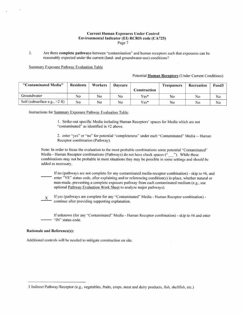
3. Are there complete pathways between ·'contamination" and human receptors such that exposures can be reasonably expected under the current (land- and groundwater-use) conditions?
Surnmarv Exposure Pathway Evaluation Table
Potential Human Receptors (Under Current Conditions)
"Contaminated Media " Residents Workers Daycare Construction
Trespassers Recreation Food3
Groundwater No No No Yes* No No No Soil (subsurface e.g., >2 ft) No No No Yes* No No No
lnstrnctions for Summaiy Exposure Pathway Evaluation Table:
I. Strike-out specific Media including Human Receptors' spaces for Media which are not ·'contaminated'' as identified in #2 above.
2. enter "yes" or "no" for potential "completeness" under each "Contaminated" Media -- Human Receptor combination (Pathway).
Note: In order to focus the evaluation to the most probable combinations some potential "Contaminated" Media - Human Receptor combinations (Pathways) do not have check spaces("_ "). Whi le these combinations may not be probable in most situations they may be possible in some settings and should be added as necessary.
lf no (pathways are not complete for any contaminated media-receptor combination) - skip to #6, and enter "YE'' status code, after explaining and/or referencing condition(s) in-place, whether natural or man-made, preventing a complete exposure pathway from each contaminated medium (e.g., use optional Pathway Evaluation Work Sheet to analyze major pathways).
X If yes (pathways are complete for any "Contaminated" Media - Human Receptor combination) -continue after providing supporting explanation.
If unknown (for any "Contaminated" Media - Human Receptor combination) - skip to #6 and enter "IN'' status code.
Rationale and Reference(s):
Additional controls wi ll be needed to mitigate construction on site.
3 Ind irect Pathway/Receptor (e.g. , vegetables, fruits, crops, meat and dairy products, fish, shellfish , etc.)
Current Human Exposures Under Control Environmental Indicator (E l) RCRIS code (CA 725)
Page 8
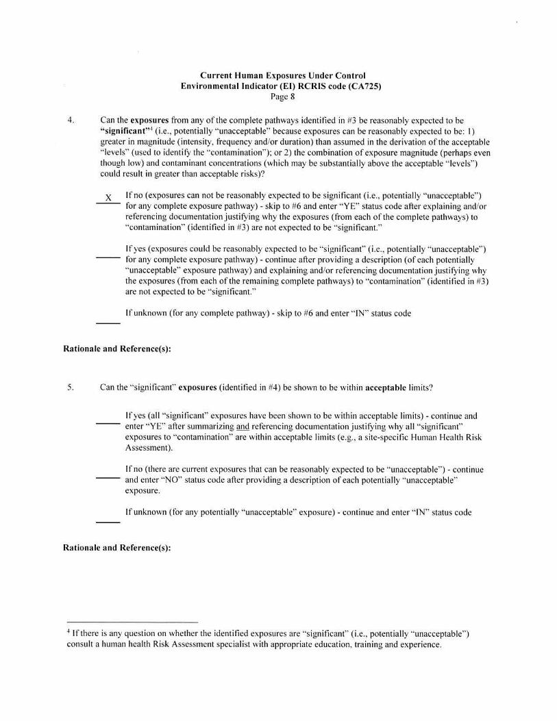
4. Can the exposures from any of the complete pathways identified in #3 be reasonably expected to be "significant"4 (i.e., potentially ·'unacceptable" because exposures can be reasonably expected to be: I) greater in magnitude (intensity, frequency and/or duration) than assumed in the derivation of the acceptable "levels" (used to identify the "contamination"); or 2) the combination of exposure magn itude (perhaps even though low) and contaminant concentrations (which may be substantially above the acceptable "levels") could result in greater than acceptable risks)?
x lfno (exposures can not be reasonably expected to be significant (i.e., potentially "unacceptable") for any complete exposure pathway) - skip to #6 and enter "YE" status code after explaining and/or referencing documentation justifying why the exposures (from each of the complete pathways) to "contamination" (identified in #3) are not expected to be "significant."
If yes (exposures could be reasonably expected to be "significant" (i.e., potentially "unacceptable") for any complete exposure pathway) - continue after providing a description (of each potentially ·'unacceptable" exposure pathway) and explaining and/or referencing documentation justifying why the exposures (from each of the remaining complete pathways) to ·'contamination" (identified in #3) are not expected to be "significant."
If unknown (for any complete pathway) - skip to #6 and enter " IN" status code
Rationale and Reference(s):
5. Can the "significant" exposures (identified in #4) be shown to be within acceptable limits?
If yes (al l "significant" exposures have been shown to be within acceptable limits) - continue and enter "YE'' after summarizing and referencing documentation justifying why all "significant" exposures to "contamination'' are within acceptable limits (e.g., a site-specific Human Health Risk Assessment).
If no (there are current exposures that can be reasonably expected to be "unacceptable") - continue and enter "NO" status code after providing a description of each potentially "unacceptable" exposure.
If unknown (for any potentially "unacceptable" exposure) - continue and enter ·' IN'. status code
Rationale and Reference(s):
4 If there is any question on whether the identified exposures are ·'significant" (i.e., potentially "unacceptable") consult a human health Risk Assessment specialist with appropriate education, training and experience.

Current Human Exposures Under Control Environmental Indicator (E l) RCRIS code (CA 725)
Page 9
6. Check the appropriate RCRIS status codes for the Current Human Exposures Under Control El event code (CA725), and obtain Supervisor (or appropriate Manager) signature and date on the El determination below (and attach appropriate supporting documentation as well as a map of the facility):
X YE - Yes, "Current Human Exposures Under Control" has been verified. Based on a review of the lnfonnation contained in th is El Determination, "Current Human Exposures" are expected to be "Under Control" at the Kimberly-Clark PA, LLC faci lity, EPA ID # PAD00227499I located at Front Street & Avenue of the States, Chester, PA 19013 under current and reasonably expected conditions. This determination will be re-evaluated when the Agency/State becomes aware ofsignificant changes at the facility.
NO - ''Current Human Exposures" are NOT "Under Control."
IN - More information is needed to make a detennination.
Completed by (signature) Date 9/ 19/20 I 7
(print) Catheryn Blankenbiller
(title)
Supervisor (signature) Dat~l912017- 9 A Z-1 - 1r (print)
RPM
(title) Associate Director
___......____________(EPA Region or State) EPA Reoion 3
Locations where References may be found:
USEPA Region Ill PADEP Waste and Chemical Mgmt. Division South East Regional Office 1650 Arch Street 2 E. Main Street Philadelphia, PA 19103 Norristown, PA 1940 I
Contact telephone and e-mail numbers (signature) (print) (title)
Fl~AL NO-fE: THE H UMAN EXPOSURES El IS A Q UALITATIVE SCREENING OF EXPOSURES AND THE
DETERM INATIONS W ITHIN THIS DOCUMENT SHOULD NOT BE USED AS THE SOLE BASIS FOR RESTRICTING T II E SCOPE OF MORE DETAILED (E.G., SITE-SPECIFIC) ASSESSMENTS OF RISK.

.