ENVIRONMENTALLY SOUND SPATIAL MANAGEMENT USING ...
14
Available Online at SAINS TANAH Website: http://jurnal.uns.ac.id/tanah SAINS TANAH – Journal of Soil Science and Agroclimatology, 16(1), 2019, 76-89 RESEARCH ARTICLE STJSSA, ISSN p-ISSN 1412-3606 e-ISSN 2356-1424, parent DOI: 10.20961/stjssa.v16i1.24004 ENVIRONMENTALLY SOUND SPATIAL MANAGEMENT USING CONSERVATION AND LAND EVALUATION APPROACH AT SLOPING LANDS IN HUMID TROPIC (A CASE STUDY OF ANTANG KALANG SUB-DISTRICT, CENTRAL KALIMANTAN, INDONESIA) Andy Bhermana* and Susilawati Assessment Institute for Agricultural Technology of Central Kalimantan, Indonesia Submitted: 2018-09-14 Accepted: 2019-05-06 ABSTRACT The main problem faced by sloping lands in the humid tropic includes land degradation influencing natural ecosystem damage broadly. Land conversion and improper land-use have been widely recognized as the main cause of environmental damage since the demands for agricultural lands become greater than land resource available. The objective of this study was to determine the concept of appropriate land-use planning through environmentally sound spatial management in order to prevent land and environmental degradation. The sub-district of Antang Kalang was chosen as study area representing sloping lands in humid tropic that have a susceptibility to erosion. Conservation approach by the use of USLE erosion risk prediction model and land evaluation through land suitability classification was used in this study. The geographic information system (GIS) and remote sensing (RS) technology were applied to generate spatial basic information and to assist in spatial analysis. Two crops, upland rice, and rubber, representing food crop and estate p have been selected based on the local resource that has been existed since a long time ago. The result of spatial analysis shown that the arable land for agricultural practices covers 9,039 hectares (23.19%) while for non-arable land, it is allocated for forest preservation with total areas 29,934 hectares (76.81%). Land-use planning and land resources management involving conservation aspect and land suitability evaluation should be taken into account for farming practice at sloping lands areas since the value of soil loss potential appears as an indicator of erosion risk. Permanent cultivation system and the intercropping farming system is the option of recommended agricultural practice at sloping lands in the humid tropic that have a susceptibility to erosion. Keywords: Land-use, Planning, Management, Land suitability, Conservation How to Cite: Bhermana, A., and Susilawati. (2019). Environmentally Sound Spatial Management Using Conservation and Land Evaluation Approach at Sloping Lands in Humid Tropic (A Case Study of Antang Kalang Sub-District, Central Kalimantan, Indonesia). Sains Tanah Journal of Soil Science and Agroclimatology, 16(1): 76-89 (doi: 10.20961/stjssa.v16i1.24004) Permalink/DOI: http://dx.doi.org/10.20961/stjssa.v16i1.24004 INTRODUCTION In Central Kalimantan, Indonesia, mostly, the demands for agricultural lands become greater than land resource available. _____________________________________ * Corresponding Author: Email: [email protected] This reasonable opinion appears since many land-use allocations ignore appropriate land- use for forestry and wildlife as well. With a population density of 16 people km -2 (BPS Provinsi Kalimantan Tengah, 2017), in general, a land resource that is still available should then be managed with environmentally sound
Transcript of ENVIRONMENTALLY SOUND SPATIAL MANAGEMENT USING ...

Available Online at SAINS TANAH Website: http://jurnal.uns.ac.id/tanah
SAINS TANAH – Journal of Soil Science and Agroclimatology, 16(1), 2019, 76-89
RESEARCH ARTICLE
STJSSA, ISSN p-ISSN 1412-3606 e-ISSN 2356-1424, parent DOI: 10.20961/stjssa.v16i1.24004
ENVIRONMENTALLY SOUND SPATIAL MANAGEMENT USING CONSERVATION AND LAND EVALUATION APPROACH AT SLOPING LANDS IN HUMID TROPIC
(A CASE STUDY OF ANTANG KALANG SUB-DISTRICT, CENTRAL KALIMANTAN, INDONESIA)
Andy Bhermana* and Susilawati
Assessment Institute for Agricultural Technology of Central Kalimantan, Indonesia Submitted: 2018-09-14 Accepted: 2019-05-06
ABSTRACT
The main problem faced by sloping lands in the humid tropic includes land degradation influencing natural ecosystem damage broadly. Land conversion and improper land-use have been widely recognized as the main cause of environmental damage since the demands for agricultural lands become greater than land resource available. The objective of this study was to determine the concept of appropriate land-use planning through environmentally sound spatial management in order to prevent land and environmental degradation. The sub-district of Antang Kalang was chosen as study area representing sloping lands in humid tropic that have a susceptibility to erosion. Conservation approach by the use of USLE erosion risk prediction model and land evaluation through land suitability classification was used in this study. The geographic information system (GIS) and remote sensing (RS) technology were applied to generate spatial basic information and to assist in spatial analysis. Two crops, upland rice, and rubber, representing food crop and estate p have been selected based on the local resource that has been existed since a long time ago. The result of spatial analysis shown that the arable land for agricultural practices covers 9,039 hectares (23.19%) while for non-arable land, it is allocated for forest preservation with total areas 29,934 hectares (76.81%). Land-use planning and land resources management involving conservation aspect and land suitability evaluation should be taken into account for farming practice at sloping lands areas since the value of soil loss potential appears as an indicator of erosion risk. Permanent cultivation system and the intercropping farming system is the option of recommended agricultural practice at sloping lands in the humid tropic that have a susceptibility to erosion. Keywords: Land-use, Planning, Management, Land suitability, Conservation How to Cite: Bhermana, A., and Susilawati. (2019). Environmentally Sound Spatial Management Using Conservation and Land Evaluation Approach at Sloping Lands in Humid Tropic (A Case Study of Antang Kalang Sub-District, Central Kalimantan, Indonesia). Sains Tanah Journal of Soil Science and Agroclimatology, 16(1): 76-89 (doi: 10.20961/stjssa.v16i1.24004) Permalink/DOI: http://dx.doi.org/10.20961/stjssa.v16i1.24004
INTRODUCTION
In Central Kalimantan, Indonesia,
mostly, the demands for agricultural lands
become greater than land resource available.
_____________________________________
* Corresponding Author: Email: [email protected]
This reasonable opinion appears since many
land-use allocations ignore appropriate land-
use for forestry and wildlife as well. With a
population density of 16 people km-2 (BPS
Provinsi Kalimantan Tengah, 2017), in general,
a land resource that is still available should
then be managed with environmentally sound

Bhermana & Susilawati / SAINS TANAH – Journal of Soil Science and Agroclimatology, 16(1), 2019, 77
STJSSA, ISSN p-ISSN 1412-3606 e-ISSN 2356-1424, parent DOI: 10.20961/stjssa.v16i1.24004
spatial management. In order to ensure land
resources can be used for the future
generation, on the basis of natural
environment condition and capability of land
resources, agricultural land-use must not be on
increased agricultural productivity solely, but
rather on sustainable development that is
appropriate to the environment.
Appropriate land-use planning is then
required in order to achieve long-term
sustained yields involving the successful
management of resources for agricultural lands
to satisfy changing human needs while
maintaining and enhancing the quality of the
environment and conserving natural resources
(Hoffman, 2017; Altieri, 1992). Planning is
underpinned by the assumption that adequate
information exists for those exercising public
authority to make decisions regarding the best
use of land in the future (Flaherty & Smit, 1982)
and is concerned with sustainable land-use
allocation (Garcia et al., 2017) and it must be
based on an understanding both of the natural
environment and of the kinds of land-use
envisaged (FAO, 1976). The function of land-
use planning for agricultural purposes is,
therefore, to guide decisions on land-use in
such way that the resources of environment
are put to the most beneficial use, while at the
same time conserving those resources for the
future.
The main problem related to land
resources and natural environment as well that
is still found in Central Kalimantan involve
improper land-use doing simultaneously with
deforestation. Initially, land-use changes are
the impact of the existence of shifting
cultivation as traditional agriculture system
(Mulyoutami et al., 2010). The present main
issues include land-use expansion for the
estate. Massively, opening new lands for oil
palm plantation has been practiced since 2005
when the local government established that
estate development is one of the leading
sectors of regional development.
The land conversion due to opening new
lands for agricultural purposes tend to have a
negative impact on the natural environment. In
central to northern part Central Kalimantan,
mainly dominated by acid tropical soils at
sloping lands, unfavorable soils development
process occurs since the lands were cultivated
inappropriately for agriculture, plantation,
mining, and transmigration as well (Angi &
Wiati, 2017; Gay‐des‐Combes et al., 2017).
Because of its susceptibility of erosion, many
agricultural practices lead to land degradation
and soil erosion especially at sloping areas
(Espinosa et al., 2017; van Uexkull & Bosshart,
1989; Notohadiprawiro, 1989).
The sub-district of Antang Kalang located
in Central Kalimantan was selected as a study
area because it represents relevant issues
concerning land resource availability including
its natural environment and local resource that
should be preserved. Further land degradation
and environmental damage including soil
erosion, deforestation, and loss of genetic
resource should then be prevented in order to
conserve the quality of the environment.
The objectives of this study were to
provide basic concepts of environmentally
sound spatial management through
appropriate land-use planning on the basis of
local resource and long-term use and yields.
The aspect of conservation and land evaluation
approach was used in order to determine the
spatial concept as basic plans. The geographic
information system (GIS) and remote sensing
(RS) technology were applied to generate
spatial basic information and to assist spatial
analysis.
MATERIAL AND METHODS
General Overview of Study Area
The study area is focussed on Antang
Kalang sub-district, Central Kalimantan

Bhermana & Susilawati / SAINS TANAH – Journal of Soil Science and Agroclimatology, 16(1), 2019, 78
STJSSA, ISSN p-ISSN 1412-3606 e-ISSN 2356-1424, parent DOI: 10.20961/stjssa.v16i1.24004
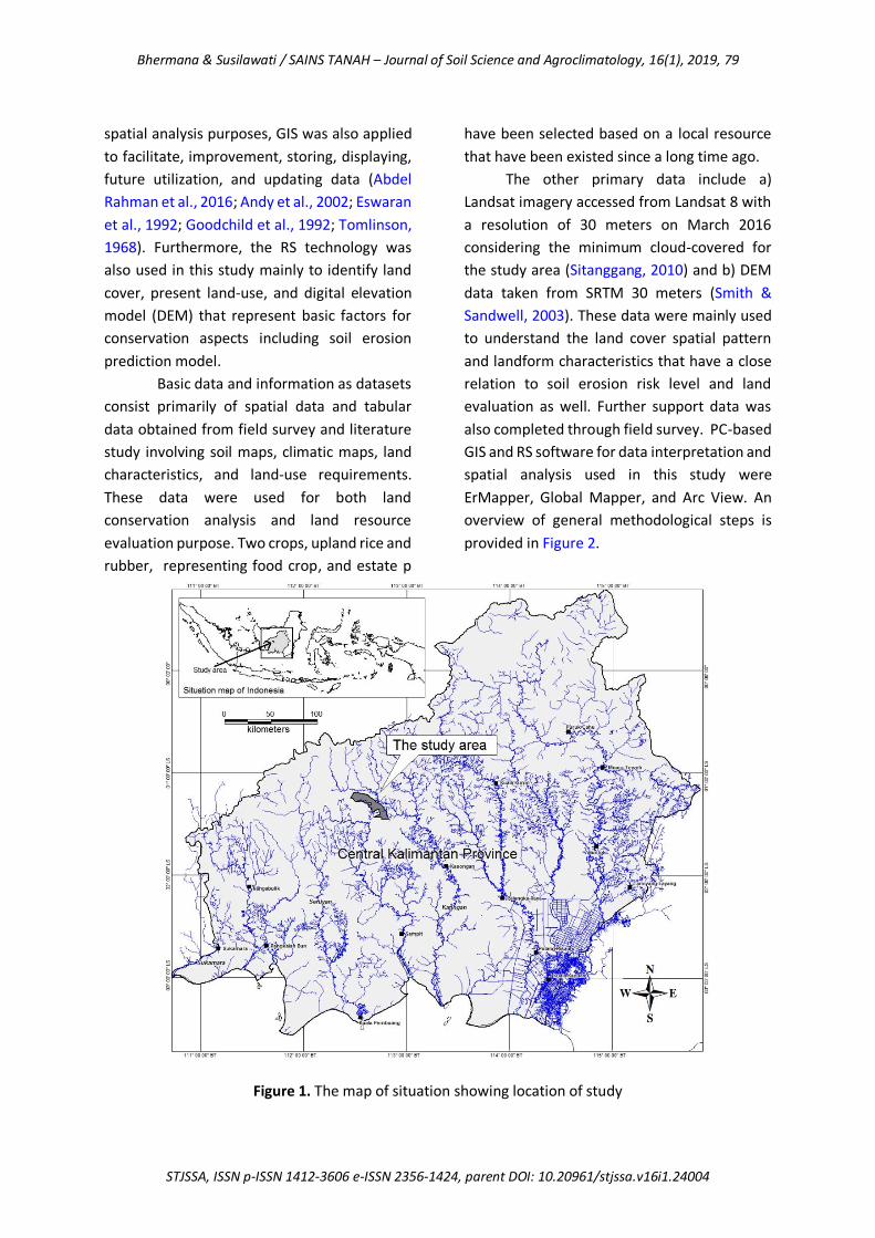
province, Indonesia with total areas 38,973
hectares (Figure 1). It is situated between
latitudes 01o 11’ 41” S and 01o 27’ 14” S and
longitudes 112o 27’ 07” E and 112o 49’ 45” E.
This site location is classified into a humid
tropical region because of its geographical
position located below the equatorial line with
humid climate system and rainfall distribution
throughout the years (Wohl et al., 2012).
Administratively, this area belongs to
Antang Kalang sub-district, Kotawatingin Timur
regency. Inside the location, there are only 5
groups of settlement, known as village, namely
Tumbang Ngahan, Tumbang Ramei, Tumbang
Hejan, Tumbang Nusa and Tumbang Gagu.
They are located at river stream areas with a
total population of 1,569 persons and mostly
dominated by Dayak tribe for these five
villages. With the density of 4 persons km-2, it
reflects that in general, the lands are still
widely available related to land-use for human
living.
The majority of the Dayak community in
this site location work as farmers and
traditional farming used to agricultural practice
is shifting cultivation. Some of them spend time
with latex rubber tapping, hunting, and
traditional mining. These daily activities have
been carried out since a long time ago, derived
from their ancestor in the past.
The climatic condition of study areas
generally determined by its geographical
position on the equator and it is categorized
into the humid tropical region, characterized
by a rather constant temperature throughout
the year, high humidity and high precipitation
(Loo et al., 2015). Based on available nearest
climate station records located in Katingan
around 103 kilometers from the center of the
study area, it has annual rainfall around 2947
mm. The rainy season starts from October to
May while the dry season runs from June to
September. The relative humidity is about 77%
with mean temperature 30oC. Additional
information for climate can be obtained from
Oldeman Agroclimatic Zone (1980) and it
shows that study area falls within climatic zone
A according to the Oldeman system. It implies
that the number of consecutive wet months is>
9 months and consecutive dry months less than
2 months.
The typology of land in the study area
classified into upland with specific acid tropical
soils that have low fertility status and
susceptible to erosion (Suharta, 2010; Amien,
1990). There are three soil great groups found
in the site study location, namely, Paleudults,
Hapludults, and Dystrudepts. These tropical
soils are the products of rapid weathering and
strong leaching, so that, most of these soils
would probably be best left under forest
(Suharta, 2010; van Uexkull & Bosshart, 1989).
The methodology used in this study was
the implementation of soil erosion prediction
model and land resource evaluation. Soil
erosion prediction model is applied to
determine areas susceptible to erosion
spatially. The universal soil loss equation (USLE)
with mathematical formula by multiplying
several factors involving rainfall erosivity, soil
erodibility, slope, land cover, and conservation
practice to determine the value of average soil
loss due to land surface erosion (ton ha-1 year-1)
(Wischmeier & Smith, 1978). While for land
evaluation, the procedure refers to The “FAO
Framework for Land Evaluation” through the
matching process between land parameters
with crop requirements leads to an assessment
of the suitability of land-use for the crop (FAO,
1976; Wahyunto et al., 2016; Sys et al., 1993).
The resulting evaluation was, therefore, then
integrated into a GIS environment for further
spatial analysis using qualitative descriptive
analysis procedure.
The GIS technology was applied to
generate spatial data as part of geospatial
information based on the result of USLE
calculation and land evaluation. In addition to
Bhermana & Susilawati / SAINS TANAH – Journal of Soil Science and Agroclimatology, 16(1), 2019, 79
STJSSA, ISSN p-ISSN 1412-3606 e-ISSN 2356-1424, parent DOI: 10.20961/stjssa.v16i1.24004
spatial analysis purposes, GIS was also applied
to facilitate, improvement, storing, displaying,
future utilization, and updating data (Abdel
Rahman et al., 2016; Andy et al., 2002; Eswaran
et al., 1992; Goodchild et al., 1992; Tomlinson,
1968). Furthermore, the RS technology was
also used in this study mainly to identify land
cover, present land-use, and digital elevation
model (DEM) that represent basic factors for
conservation aspects including soil erosion
prediction model.
Basic data and information as datasets
consist primarily of spatial data and tabular
data obtained from field survey and literature
study involving soil maps, climatic maps, land
characteristics, and land-use requirements.
These data were used for both land
conservation analysis and land resource
evaluation purpose. Two crops, upland rice and
rubber, representing food crop, and estate p
have been selected based on a local resource
that have been existed since a long time ago.
The other primary data include a)
Landsat imagery accessed from Landsat 8 with
a resolution of 30 meters on March 2016
considering the minimum cloud-covered for
the study area (Sitanggang, 2010) and b) DEM
data taken from SRTM 30 meters (Smith &
Sandwell, 2003). These data were mainly used
to understand the land cover spatial pattern
and landform characteristics that have a close
relation to soil erosion risk level and land
evaluation as well. Further support data was
also completed through field survey. PC-based
GIS and RS software for data interpretation and
spatial analysis used in this study were
ErMapper, Global Mapper, and Arc View. An
overview of general methodological steps is
provided in Figure 2.
Figure 1. The map of situation showing location of study

Bhermana & Susilawati / SAINS TANAH – Journal of Soil Science and Agroclimatology, 16(1), 2019, 80
STJSSA, ISSN p-ISSN 1412-3606 e-ISSN 2356-1424, parent DOI: 10.20961/stjssa.v16i1.24004
The discussion about landform and
natural feature of the earth's surface in this
study is mainly based on DEM data
interpretation taken from SRTM 30 meters.
The result of interpretation using remote
sensing (RS) technology application and field
ground check showed that the study area is
categorized into sloping land with altitude
ranging from 52.03 meters to 445.79 meters
above sea level. As hilly areas, there are three
major landform of undulating plains,
moderately steep hills, and hillocky plains that
cover this site location.
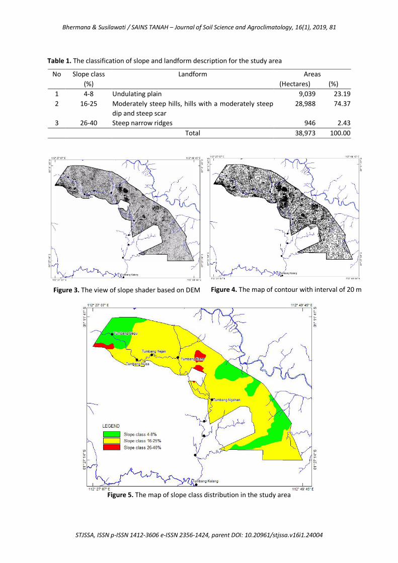
RESULTS
Based on DEM data interpretation, the
study areas were mainly categorized into
sloping land. It has been proven by the display
of slope shader based on DEM (Figure 3). This
data was then interpreted to provide spatial
data of contour including elevation and slope
gradient (Figure 4). The result of further
interpretation and spatial analysis, therefore,
showed that this area is geographically divided
into 3 slope classes i.e 4-8%; 16-25 and 26-40
(Figure 5) including each total areas (Table 1).
Table 1 shows that the study area is
mainly dominated by the slope class of 16-25%
with total area 28,988 hectares (74.37%).
Although the land could be suitable for
agricultural practice, landform description
should be taken into account especially for
conservation aspects because the slopes
greater than 8% is being prone to erosion
(Angima et al., 2003). However, the remaining
lands with slope 4-8% that constitute about
23.19% of total study area have the potential
to be developed.
Figure 2. An overview of general methodological steps
Bhermana & Susilawati / SAINS TANAH – Journal of Soil Science and Agroclimatology, 16(1), 2019, 81
STJSSA, ISSN p-ISSN 1412-3606 e-ISSN 2356-1424, parent DOI: 10.20961/stjssa.v16i1.24004
Table 1. The classification of slope and landform description for the study area
No Slope class
(%)
Landform Areas
(Hectares) (%)
1 4-8 Undulating plain 9,039 23.19
2 16-25 Moderately steep hills, hills with a moderately steep
dip and steep scar
28,988 74.37
3 26-40 Steep narrow ridges 946 2.43
Total 38,973 100.00
Figure 5. The map of slope class distribution in the study area
Figure 3. The view of slope shader based on DEM Figure 4. The map of contour with interval of 20 m

Bhermana & Susilawati / SAINS TANAH – Journal of Soil Science and Agroclimatology, 16(1), 2019, 82
STJSSA, ISSN p-ISSN 1412-3606 e-ISSN 2356-1424, parent DOI: 10.20961/stjssa.v16i1.24004
Figure 6. The map of land cover showing present land-use in the study area Land Cover and Vegetation
Spatial identification of land cover
including the specific location of vegetation
used mainly RS technology based on land
satellite imagery of Landsat 8 on March and
April 2015 considering the minimum cloud
cover percentage in order to obtain best
GeoTiff format images. The result of Landsat
imagery interpretation was then integrated
into GIS environment as shown in Figure 6 that
represent land cover and present land-use of
the study area. At present, the land is still
mainly covered by forest including high-density
bush with total areas 29,056 hectares or
74.55% of whole areas of a site study. It
indicates that the lands are still available for
general land-use.
However, in the south, it has been
identified that there are several parts of areas
that have been cultivated for the estate. Based
on the ground survey, several cultivated lands
are a land expansion of oil palm plantation that
has been existed in the southern part for
several years ago. Land conversion impact to
the existing natural environment is, therefore,
should be taken into account for future land-
use because these sloping land areas are still
covered by natural vegetation.
Figure 6 also shows that upland farming
has been practiced through opening new land
for shifting cultivation. It covers only 8,760
hectares (22.47%). Although the land has been
opened for agricultural practice, the local
farmer still uses traditional technique through
their indigenous knowledge. For instance,
based on the ground survey, they opened the
land at undulating plains with slope class less
than 8%. In this case, the aspect of
conservation has been fulfilled during farming
practice.
DISCUSSION
Land and Environment Degradation
Land is an important aspect in the
natural environment. In addition to soil, slope,
as part of landform, is one of several factors

Bhermana & Susilawati / SAINS TANAH – Journal of Soil Science and Agroclimatology, 16(1), 2019, 83
STJSSA, ISSN p-ISSN 1412-3606 e-ISSN 2356-1424, parent DOI: 10.20961/stjssa.v16i1.24004
that determine the type of agriculture (Altieri,
1987) so that it should be considered in
agricultural land-use planning (de Lima, 1988).
In this study, slope information was used not
only as one of several factors in the USLE
prediction model but it also was used to
determine land suitability classification in land
evaluation.
The potency of soil erosion is then
should be early known through erosion risk
level classification. The result of calculating
data input according to the USLE erosion
prediction model shown that there are 3
classes of erosion risk level in the study area.
Each class reflects the level of erosion risk
through soil loss potential (ton hectare-1 year-1),
total areas (Table 2) and spatial distribution
(Figure 7).
Table 2 and Figure 7 explain that the
lowest potential of erosion risk in site study is
class II with average soil loss potential 32.79
ton hectare-1 year-1. This class occupies 51.63%
(20,123 hectares) of the total study area
located geographically in the southern
spreading to the central part. On the other
side, it is also found in the northern part. This
region can then be allocated for agricultural
practice. However, because the value of soil
loss potential appears, both soil and
environment conservation intervention
measures should be implemented.
Table 2. The classification of the erosion risk potential in the study area
No Class Soil loss potential (ton/hectare/year)
The average of USLE model calculation results
(ton hectare-1 year-1)
Total area
(Hectares) (%)
1 II 15-60 32.79 20,123 51.63
2 III 60-180 72.91 938 2.41
3 IV 180-480 459.28 17,913 45.96
Figure 7. The map of erosion risk potential classification in the study area

Bhermana & Susilawati / SAINS TANAH – Journal of Soil Science and Agroclimatology, 16(1), 2019, 84
STJSSA, ISSN p-ISSN 1412-3606 e-ISSN 2356-1424, parent DOI: 10.20961/stjssa.v16i1.24004
Originally, located in humid tropical
regions, the whole areas of Antang Kalang in
which the study area take place is endowed by
a large area of tropical forest (Rahu et al.,
2013). In Kalimantan, on a larger scale of typical
lowland rainforest, there are almost 180 tree
species hectare-1 (Kartawinata et al., 1981).
During the field survey, in addition to giant
species of Shorea spp, the other plants that
have been found are local rubber (Hevea
brasiliensis). Along the river stream, some local
orchid species were also found beside other
species of ornamental plants. The existing of
land cover involving crop growth data as well
as cropping patterns and land-use contributes
to USLE erosion prediction model through the
value of vegetation practice (Angima et al.,
2003; Wischmeier & Smith, 1978).
Land Suitability for Farming Practice and
Genetic Resource Preservation
The availability of arable land is the
potency of land resource that can be used for
human living. However not all the lands can be
used optimally because of their limiting factors.
Land evaluation approach was then used in this
study to determine land suitability
classification for several existing crops in
certain areas. The importance of land
resources evaluation for better agricultural
land-use and sustainable agriculture become
more clear since it has taken environmental
control into account and an efficient land-use
that does not degrade the land resources can
be achieved (Sharu et al., 2013; Kumar et al.,
2017).
Two selected crops based on local
existing commodities consists of upland rice
and rubber have used for evaluation. In fact,
upland rice farming has been practicing by local
farmers to meet the basic need of food in these
areas. While, for rubber, it has been cultivated
since they leave the land to open the other
areas. The benefit of extra income taken from
rubber tapping has also been widely
understood by the local community in this
study area.
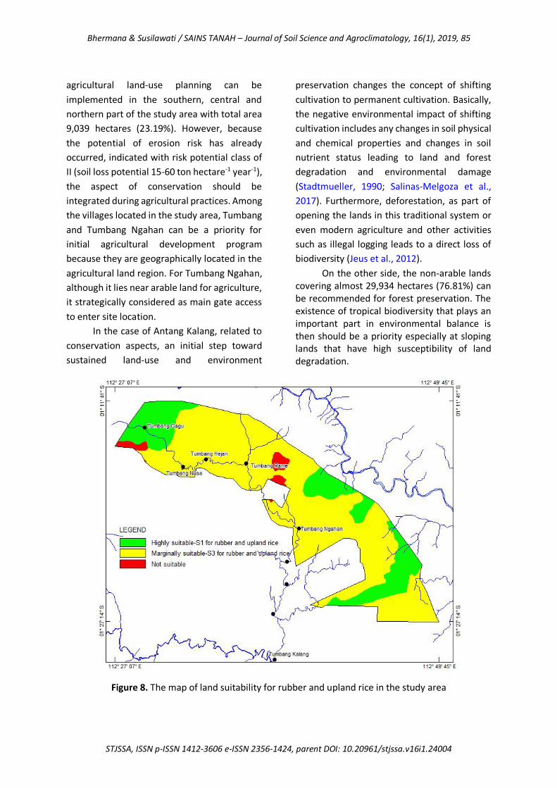
The result of land resource evaluation
provides information that both upland rice and
rubber were classified into marginally suitable-
S3 due to limiting factors of nutrient retention
such as pH and base saturation (Figure 8).
However, this condition can be solved through
proper improvement. Further evaluation to
determine potential land suitability after
improvement describe that both rubber and
upland rich can reach the higher suitability
class become highly suitable-S1. Land
allocation for each crop was then justified
according to the priority of the needs.
Therefore, mainly on the basis of land
suitability, landform and existing cultivated
land, the most suitable lands for rubber and
upland rice is located on undulating plains with
slope class 4-8% meanwhile at slope 16-25%,
the lands are not recommended to be
cultivated because of marginally suitable-S3 for
both of crops. The map of land suitability as a
result of the land evaluation is shown in Figure 8.
In order to ensure optimum yield on a
sustained basis and conserve the natural
environment, the result of the land evaluation
was then further integrated into erosion risk
potential data. The GIS application through an
overlay technique was used to provide new
layer information (O’Sullivan & Unwin, 2003).
In this study, land suitability map was then
overlayed to erosion risk potential map to
produce spatial information about the
appropriate land allocation for farming
practices and natural environment
preservation. The result of spatial analysis
shown that most suitability of the land for
selected crops occupy the region with the
lowest of erosion risk potential (Figure 7 and 9).
As a result, spatial information of land-use
allocation was then developed as shown in
Figure 9. It describes that recommended
Bhermana & Susilawati / SAINS TANAH – Journal of Soil Science and Agroclimatology, 16(1), 2019, 85
STJSSA, ISSN p-ISSN 1412-3606 e-ISSN 2356-1424, parent DOI: 10.20961/stjssa.v16i1.24004
agricultural land-use planning can be
implemented in the southern, central and
northern part of the study area with total area
9,039 hectares (23.19%). However, because
the potential of erosion risk has already
occurred, indicated with risk potential class of
II (soil loss potential 15-60 ton hectare-1 year-1),
the aspect of conservation should be
integrated during agricultural practices. Among
the villages located in the study area, Tumbang
and Tumbang Ngahan can be a priority for
initial agricultural development program
because they are geographically located in the
agricultural land region. For Tumbang Ngahan,
although it lies near arable land for agriculture,
it strategically considered as main gate access
to enter site location.
In the case of Antang Kalang, related to
conservation aspects, an initial step toward
sustained land-use and environment
preservation changes the concept of shifting
cultivation to permanent cultivation. Basically,
the negative environmental impact of shifting
cultivation includes any changes in soil physical
and chemical properties and changes in soil
nutrient status leading to land and forest
degradation and environmental damage
(Stadtmueller, 1990; Salinas-Melgoza et al.,
2017). Furthermore, deforestation, as part of
opening the lands in this traditional system or
even modern agriculture and other activities
such as illegal logging leads to a direct loss of
biodiversity (Jeus et al., 2012).
On the other side, the non-arable lands covering almost 29,934 hectares (76.81%) can be recommended for forest preservation. The existence of tropical biodiversity that plays an important part in environmental balance is then should be a priority especially at sloping lands that have high susceptibility of land degradation.
Figure 8. The map of land suitability for rubber and upland rice in the study area

Bhermana & Susilawati / SAINS TANAH – Journal of Soil Science and Agroclimatology, 16(1), 2019, 86
STJSSA, ISSN p-ISSN 1412-3606 e-ISSN 2356-1424, parent DOI: 10.20961/stjssa.v16i1.24004
In the study area and its surrounding,
local plants, wildlife, plants, and animals were
still found. Natural resource that could be
direct or indirect used involve goods and
service such as species for food, medicine and
buildings material as well.
As a final result, spatial information
about land allocation based on land resource
and its natural resources can then be used as
basic consideration for land-use planning at
sloping lands that have permanent limiting
factors for agricultural practice and other
relevant activities related to land conversion in
the future. The aspect of conservation should
be integrated into sloping lands management.
Intercropping of rubber and upland rice could
be an option that can be implemented for
farming practice (Simpson, 2010).
CONCLUSION
The concept of land suitability derived
from land evaluation and USLE erosion
prediction model can be used for
environmental spatial management to
determine the land-use allocation of the
agricultural land region and natural
environment areas precisely. In order to
provide relevant information within spatial
data, the use of geographic information system
(GIS) and remote sensing (RS) technology is
required in displaying data, interpretation and
spatial analysis.
ACKNOWLEDGMENTS
The authors wish to thank Prof. Dr.
Zulkifli Zaini as a team leader who contributes
both thought and funds. In addition, also thank
PT. Poyry Indonesia for any relevant data
required in this study. Any remaining errors or
omissions will be responsibility accepted by the
authors.
REFERENCES
Abdel Rahman, M. A. E., Natarajan, A., & Hegde, R. (2016). Assessment of Land Suitability and Capability by Integrating
Figure 9. The map of land allocation for farming practices and forest in the study area
Bhermana & Susilawati / SAINS TANAH – Journal of Soil Science and Agroclimatology, 16(1), 2019, 87
STJSSA, ISSN p-ISSN 1412-3606 e-ISSN 2356-1424, parent DOI: 10.20961/stjssa.v16i1.24004
Remote Sensing and GIS for Agriculture in Chamarajanagar District, Karnataka, India. The Egyptian Journal of Remote Sensing and Space Science, 19(1), 125–141. https://doi.org/10.1016/j.ejrs.2016.02.001
Altieri, M. A. (1987). Agroecology, The Scientific Basis of Alternative Agriculture. Boulder, Colorado, US: Westview Press.
Altieri, M. A. (1992). Agroecological Foundations of Alternative Agriculture in California. Agriculture, Ecosystems and Environment, 39(1–2), 23–53. https://doi.org/10.1016/0167-8809(92)90203-N
Amien, L. I. (1990). Utilization of Acid Tropical Soils for Sustainable Agriculture. Indonesian Agricultural Research and Development Journal, 12(2), 17–22.
Andy, B., Hamdan, J., Anuar, A. R., & Peli, M. (2002). Determination of Agricultural Land Regions Using Agroecological Zone (AEZ) Approach and Geographic Information System (A case study of Kotawaringin Barat Regency, Kalimantan, Indonesia). Proceeding of The Malaysian Society of Soil Science Conference 2002: Applications of Modern Tools in Agriculture, 36–40. Serdang, Selangor, Malaysia: Malaysian Society of Soil Science.
Angi, E. M., & Wiati, C. B. (2017). Kajian Ekonomi Politik Deforestasi dan Degradasi Hutan dan Lahan di Kabupaten Paser, Kalimantan Timur. Jurnal Penelitian Ekosistem Dipterokarpa, 3(2), 63–80.
Angima, S. D., Stott, D. E., O’Neill, M. K., Ong, C. K., & Weesies, G. A. (2003). Soil Erosion Prediction Using RUSLE for Central Kenyan Highland Conditions. Agriculture, Ecosystems and Environment, 97(1–3), 295–308. https://doi.org/10.1016/S0167-8809(03)00011-2
BPS Provinsi Kalimantan Tengah. (2017). Provinsi Kalimantan Tengan dalam Angka (Kalimantan Tengan Province in Figures). Palangka Raya, Indonesia: BPS Provinsi Kalimantan Tengah.
de Lima, J. L. M. P. (1988). Morphological Factors Affecting Overland Flow On
Slopes. In J. Bouma & A. K. Bregt (Eds.), Proceedings of the Symposium on Land Qualities in Space and Time (pp. 321–324). Wageningen, Netherlands: Wageningen. PUDOC.
Espinosa, J., López-Olvera, J. R., Cano-Manuel, J. F., Fandos, P., Pérez, J. M., López-Graells, C., … Granados, J. E. (2017). Guidelines for Managing Captive Iberian Ibex Herds for Conservation Purposes. Journal for Nature Conservation, 40, 24–32. https://doi.org/10.1016/j.jnc.2017.09.002
Eswaran, H., Kimble, J., Cook, T., & Beinroth, F. H. (1992). Soil Diversity in the Tropic: Implications for Agricultural Development. In Myths and Science of Soils of the Tropics (SSSA Speci, pp. 1–16). Madison, Wisconsin, USA: Soil Science Society of America and American Society of Agronomy.
FAO. (1976). A Framework for Land Evaluation (Soils Bull). Rome, Italy: FAO.
Flaherty, M., & Smit, B. (1982). An Assessment of Land Classification Techniques in Planning for Agricultural Land Use. Journal of Environmental Management, 15, 323–332.
Garcia, G. A., Rosas, E. P., García-Ferrer, A., & Barrios, P. M. (2017). Multi-Objective Spatial Optimization: Sustainable Land Use Allocation at Sub-Regional Scale. Sustainability, 9(927), 1–21. https://doi.org/10.3390/su9060927
Gay‐des‐Combes, J. M., Carrillo, C. S., Robroek, B. J. M., Jassey, V. E. J., Mills, R. T. E., Arif, M. S., … Buttler, A. (2017). Tropical Soils Degraded by Slash-and-Burn Cultivation can be Recultivated When Amended with Ashes and Compost. Ecology and Evolution, 7(14), 5378–5388. https://doi.org/10.1002/ece3.3104
Goodchild, M., Robert, H., & Stepen, W. (1992). Integrating GIS and Spatial Data Analysis: Problem and Possibilities. Geographical Information Systems, 6(5), 407–423. https://doi.org/10.1080/02693799208901923
Hoffman, M. (2017). The Role of Public Land Use Planning in Facilitating Conservation on Private Land. Natural Areas Journal, 37(4), 556–563.
Jeus, M., Henriques, P., Laranjeira, P., Narciso,

Bhermana & Susilawati / SAINS TANAH – Journal of Soil Science and Agroclimatology, 16(1), 2019, 88
STJSSA, ISSN p-ISSN 1412-3606 e-ISSN 2356-1424, parent DOI: 10.20961/stjssa.v16i1.24004
V., & da Silva Carvalho, M. L. (2012). The Impact of Shifting Cultivation in the Forestry Ecosystems of Timor-Leste (No. 2012/16). Évora, Portugal.
Kartawinata, K., Abdulhadi, R., & Partamiharjo, T. (1981). Composition and Structure of a Lowland Dipterocarp Forest at Wanariset, East Kalimantan. Malaysian Forester, 44, 397–406.
Kumar, A., Mahapatra, S. K., Lal, T., Yadav, R. P., & Singh, S. K. (2017). Land Evaluation for Land Use Planning towards Sustainable Crop Production: A Case Study of Chhata tehsil in Mathura District, Uttar Pradesh, India. International Journal of Current Microbiology and Applied Sciences, 6(9), 859–870.
Loo, Y. Y., Billa, L., & Singh, A. (2015). Effect of Climate Change On Seasonal Monsoon In Asia and Its Impact On The Variability of Monsoon Rainfall in Southeast Asia. Geoscience Frontiers, 6(6), 817–823. https://doi.org/10.1016/j.gsf.2014.02.009
Mulyoutami, E., van Noordwijk, M., Sakuntaladewi, N., & Agus, F. (2010). Perubahan Pola Perladangan: Pergeseran Persepsi Mengenai para Peladang di Indonesia. Bogor, Indonesia: World Agroforestry Centre.
Notohadiprawiro, T. (1989). Farming Acid Mineral Soils for Food Crops: an Indonesian Experience. In E. T. Craswell & E. Pushparajah (Eds.), Management of Acid Soils in the Humid Tropics of Asia (pp. 62–68). Canberra, Australia: Australian Centre for International Agricultural Research.
O’Sullivan, D., & Unwin, D. J. (2003). Geographic Information Analysis. Hoboken. New Jersey, USA: John Wiley & Sons, Inc.
Rahu, A. A., Hidayat, K., Ariyadi, M., & Hakim, L. (2013). Ethnoecology of Kaleka: Dayak’s Agroforestry in Kapuas, Central Kalimantan Indonesia. Research Journal of Agriculture and Forestry Sciences, 1(8), 5–12.
Salinas-Melgoza, M. A., Skutsch, M., Lovett, J. C., & Borrego, A. (2017). Carbon Emissions from Dryland Shifting Cultivation: a Case Study of Mexican
Tropical Dry Forest. Silva Fennica, 51(1B), 1–25. https://doi.org/10.14214/sf.1553
Sharu, M. B., Yakubu, M., Noma, S. S., & Tsafe, A. I. (2013). Land Evaluation of an Agriculture Landscape in Dingyadi District, Sokoto State, Nigeria. Nigerian Journal of Basic and Applied Science, 21(2), 148–156.
Simpson, L. A. (2010). A Manual of Soil Conservation and Slope Cultivation, Mainstreaming and Capacity Building for Sustainable Land Management (PIMS 3409-). Port of Spain, Trinidad and Tobago.
Sitanggang, G. (2010). Kajian Pemanfaatan Satelit Masa Depan: Sistem Penginderaan Jauh Satelit LDCM (Landsat8). Berita Dirgantara, 11(2), 47–58.
Smith, B., & Sandwell, D. (2003). Accuracy and Resolution of Shuttle Radar Topography mission data. Geophysical Research Letters, 30(9), 1467. https://doi.org/10.1029/2002GL016643, 2003
Stadtmueller, T. (1990). Soil Erosion in East Kalimantan, Indonesia. Proceedings of The Fiji Symposium: Research Needs and Applications to Reduce Erosion and Sedimentation in Tropical Steeplands, 221–230. Wallingford, UK: IAHS-AISH Publ.
Suharta, N. (2010). Karakteristik dan Permasalahan Tanah Marginal dari Batuan Sedimen Masam di Kalimantan. Jurnal Litbang Pertanian, 29(4), 139–146. https://doi.org/10.21082/jp3.v29n4.2010.p139-146
Sys, C., Van Ranst, E., Debaveye, J., & Beernaert, F. (1993). Land Evaluation. Part III. Crop requirements. Agricultural Publication No. 7. Brussels, Belgium: GADC.
Tomlinson, R. F. (1968). A Geographical Information System for Regional Planning. CSIRO Symposium, 200–210. Macmillan, Australia: UNESCO.
van Uexkull, H. R., & Bosshart, R. P. (1989). Management of Acid Upland Soils in Asia. In E. T. Craswell & E. Pushparajah (Eds.), Management of Acid Soils in the Humid Tropics of Asia (pp. 2–19). Canberra, Australia: Australian Centre for International Agricultural Research.

Bhermana & Susilawati / SAINS TANAH – Journal of Soil Science and Agroclimatology, 16(1), 2019, 89
STJSSA, ISSN p-ISSN 1412-3606 e-ISSN 2356-1424, parent DOI: 10.20961/stjssa.v16i1.24004
Wahyunto, Hikmatullah, Suryani, E., Tafakresnanto, C., Ritung, S., Mulyani, A., … Nuryamsi. (2016). Petunjuk Teknis: Pedoman Penilaian Kesesuaian Lahan Untuk Komoditas Pertanian Strategis. Bogor, Indonesia: Balai Besar Litbang Sumberdaya Lahan Pertanian.
Wischmeier, W. H., & Smith, D. D. (1978).
Predicting Rainfall Erosion Losses, A Guide to Conservation Planning (Handbook N). Washington, USA: United States Government Printing Office.
Wohl, E., Barros, A., Brunsell, N., Chappell, N. A., Coe, M., Giambelluca, T., … Ogden., F. (2012). The Hydrology of the Humid Tropics. Nature Climate Change, 2, 655–662.