
Environmental Statement - National Infrastructure Planning
322
Hard copy available in Environmental Statement Doc Ref: 6.2.26 Volume 26: Beckton Sewage Treatment Works site assessment APFP Regulations 2009: Regulation 5(2)(a) Box 40 Folder A January 2013 Thames Tideway Tunnel Thames Water Utilities Limited Application for Development Consent Application Reference Number: WWO10001
Transcript of Environmental Statement - National Infrastructure Planning

Hard copy available in
Environmental StatementDoc Ref: 6.2.26
Volume 26: Beckton Sewage Treatment Works site assessmentAPFP Regulations 2009: Regulation 5(2)(a)
Box 40 Folder A January 2013
Envi
ronm
enta
l Sta
tem
ent
Vol
ume
26: B
eckt
on S
ewag
e Tr
eatm
ent W
orks
site
ass
essm
ent
Thames Tideway Tunnel Thames Water Utilities Limited
Application for Development ConsentApplication Reference Number: WWO10001

This page is intentionally blank
Environmental Statement
Thames Tideway Tunnel
Environmental Statement
Volume 26: Beckton Sewage Treatment Works site assessment
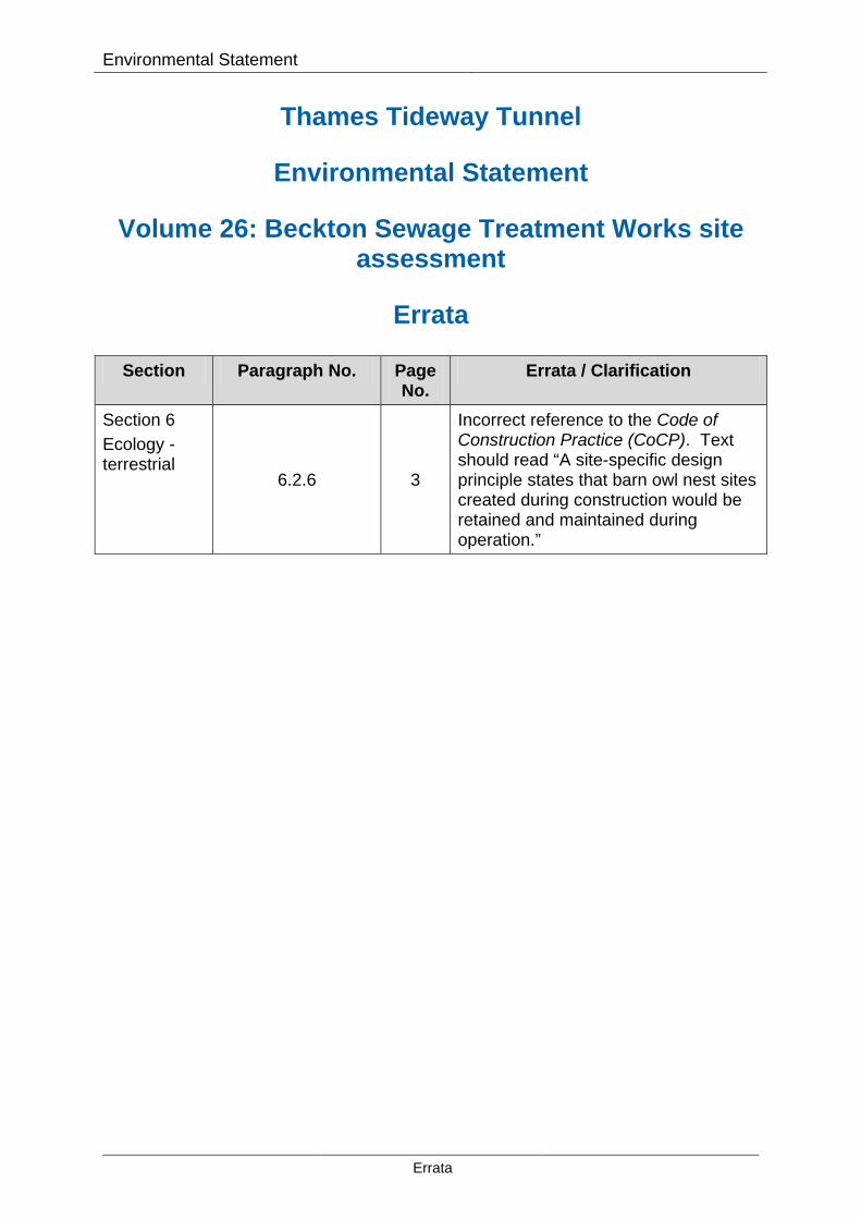
Errata
Section Paragraph No. Page No.
Errata / Clarification
Section 6 Ecology - terrestrial
6.2.6 3
Incorrect reference to the Code of Construction Practice (CoCP). Text should read “A site-specific design principle states that barn owl nest sites created during construction would be retained and maintained during operation.”
Errata

Environmental Statement
This page is intentionally blank
Errata

Environmental Statement
Thames Tideway Tunnel
Environmental Statement
List of contents
Environmental Statement glossary and abbreviations Volume 1 Introduction to the Environmental Statement Volume 2 Environmental assessment methodology Volume 3 Project-wide effects assessment Volume 4 Acton Storm Tanks site assessment Volume 5 Hammersmith Pumping Station site assessment Volume 6 Barn Elms site assessment Volume 7 Putney Embankment Foreshore site assessment Volume 8 Dormay Street site assessment Volume 9 King George’s Park site assessment Volume 10 Carnwath Road Riverside site assessment Volume 11 Falconbrook Pumping Station site assessment Volume 12 Cremorne Wharf Depot site assessment Volume 13 Chelsea Embankment Foreshore site assessment Volume 14 Kirtling Street site assessment Volume 15 Heathwall Pumping Station site assessment Volume 16 Albert Embankment Foreshore site assessment Volume 17 Victoria Embankment Foreshore site assessment Volume 18 Blackfriars Bridge Foreshore site assessment Volume 19 Shad Thames Pumping Station site assessment Volume 20 Chambers Wharf site assessment Volume 21 King Edward Memorial Park Foreshore site assessment Volume 22 Earl Pumping Station site assessment Volume 23 Deptford Church Street site assessment Volume 24 Greenwich Pumping Station site assessment Volume 25 Abbey Mills Pumping Station site assessment Volume 26 Beckton Sewage Treatment Works site assessment Volume 27 Minor work sites assessment
Volume 26: Beckton Sewage Treatment Works
Environmental Statement contents
Page i

Environmental Statement
This page is intentionally blank
Volume 26: Beckton Sewage Treatment Works
Environmental Statement contents
Page ii

Environmental Statement
Thames Tideway Tunnel
Environmental Statement
Volume 26: Beckton Sewage Treatment Works site assessment
List of contents
Section 1 Introduction Section 2 Site context Section 3 Proposed development Section 4 Air quality and odour Section 5 Ecology – aquatic Section 6 Ecology – terrestrial Section 7 Historic environment Section 8 Land quality Section 9 Noise and vibration Section 10 Socio-economics Section 11 Townscape and visual Section 12 Transport Section 13 Water resources – groundwater Section 14 Water resources – surface water Section 15 Water resources – flood risk Volume 26 Beckton Sewage Treatment Works figures Section 1 Plans from the Book of Plans Section 2 Environmental impact assessment figures Volume 26 Beckton Sewage Treatment Works appendices Appendix A Introduction Appendix B Air quality and odour Appendix C Ecology – aquatic Appendix D Ecology – terrestrial Appendix E Historic environment Appendix F Land quality Appendix G Noise and vibration Appendix H Socio-economics
Volume 26: Beckton Sewage Treatment Works
Volume contents Page iii

Environmental Statement
Appendix I Townscape and visual Appendix J Transport Appendix K Water resources – groundwater Appendix L Water resources – surface water Appendix M Water resources – flood risk Appendix N Development schedule
Volume 26: Beckton Sewage Treatment Works
Volume contents Page iv

Environmental Statement
Thames Tideway Tunnel
Environmental Statement
Volume 26: Beckton Sewage Treatment Works site assessment
Sections 1 to 3: Introduction, site context and proposed development
List of contents
Page number
1 Introduction ...................................................................................................... 1
2 Site context ....................................................................................................... 3
3 Proposed development ................................................................................... 7
3.1 Overview .................................................................................................. 7
3.2 Defined project ........................................................................................ 8
3.3 Construction assumptions ..................................................................... 13
3.4 Operational assumptions ....................................................................... 19
3.5 Base case and cumulative development ............................................... 21
3.6 On-site alternatives ................................................................................ 22
List of plates
Page number
Vol 26 Plate 2.1.1 Beckton Sewage Treatment Works − aerial photograph ............... 3
List of tables
Page number
Vol 26 Table 3.2.1 Beckton Sewage Treatment Works − plans and documents defining the proposed development ........................................................... 8
Vol 26 Table 3.3.1 Beckton Sewage Treatment Works − construction phase plans 14
Vol 26 Table 3.6.1 Beckton Sewage Treatment Works − on-site alternatives ......... 22
Volume 26: Beckton Sewage Treatment Works
Section 1 to 3 contents Page v

Environmental Statement
This page is intentionally blank
Volume 26: Beckton Sewage Treatment Works
Section 1 to 3 contents Page vi

Hard copy available in
Environmental StatementDoc Ref: 6.2.26
Volume 26: Beckton Sewage Treatment Works site assessmentSection 1: IntroductionAPFP Regulations 2009: Regulation 5(2)(a)
Box 40 Folder A January 2013
Sect
ion
1: In
trod
uctio
nThames Tideway Tunnel Thames Water Utilities Limited
Application for Development ConsentApplication Reference Number: WWO10001

This page is intentionally blank

Environmental Statement
1 Introduction 1.1.1 This volume of the Environmental Statement of the Thames Tideway
Tunnel project presents the results of the environmental impact assessment (EIA) of the proposed development at the Beckton Sewage Treatment Works (STW) site.
1.1.2 As part of a separate project, Beckton STW is being upgraded to cater for additional flows from the London Tideway Tunnels and future population growth. The Thames Tideway Tunnel project would collect combined sewer overflows (CSOs) along the length of the main tunnel and deliver these flows via the Lee Tunnel, which is already under construction, to Beckton STW. A worksite is required at the site for new infrastructure to transfer sewage from the Tideway Pumping Station to the STW for treatment, and a new siphon tunnel connected to the Tideway CSO.
1.1.3 Most of the works required at Beckton STW are currently under construction under the STW extension and Lee Tunnel projects; but some additional works would be constructed as part of Thames Tideway Tunnel project to cater for the additional volumes the main tunnel would transport (over and above that of the Lee Tunnel). The works would be carried out in two sites within the STW: a. Site A – siphon inlet works site b. Site B – siphon outlet works site.
1.1.4 The site and environmental context are described in Section 2. The proposed development, comprising both the construction and operational phases, is described in Section 3. Those elements of the proposal for which development consent is sought are described followed by a description of the assumptions applied to the assessment of construction and operational effects. Finally in Section 3.6, the main alternatives which have been considered for this site are presented.
1.1.5 Sections 4 to 15 present the environmental assessments for each topic, which are presented alphabetically. The order of these topics and the structure of each assessment remains the same across different sites.
1.1.6 Figures and appendices for this site are appended separately (see Vol 26 Beckton Sewage Treatment Works figures and Vol 26 Beckton Sewage Treatment Works appendices). In addition, there is a separate glossary and abbreviations document which explains technical terms used within this assessment.
Volume 26: Beckton Sewage Treatment Works
Section 1: Introduction Page 1

Environmental Statement
This page is intentionally blank
Volume 26: Beckton Sewage Treatment Works
Section 1: Introduction Page 2

Hard copy available in
Environmental StatementDoc Ref: 6.2.26
Volume 26: Beckton Sewage Treatment Works site assessmentSection 2: Site contextAPFP Regulations 2009: Regulation 5(2)(a)
Box 40 Folder A January 2013
Sect
ion
2: S
ite c
onte
xt
Thames Tideway Tunnel Thames Water Utilities Limited
Application for Development ConsentApplication Reference Number: WWO10001

This page is intentionally blank

Environmental Statement
2 Site context 2.1.1 The proposed development site is located in the London Borough (LB) of
Newham, within the existing Thames Water STW. The site’s extent is defined by the limits of land to be acquired or used (LLAU) and covers an area of approximately 15.9 hectares. The site context and location is indicated in Vol 26 Figure 2.1.1 (see separate volume of figures).
2.1.2 The existing Thames Water STW which contains the site is bounded by the A13 (Alfred’s Way) trunk road to the north and Barking Creek to the east. To the south of the site is the River Thames, and to the west there is an area of derelict land, along with a mixture of business and retail parks. Vol 26 Plate 2.1.1 below provides an aerial view of the site.
Vol 26 Plate 2.1.1 Beckton Sewage Treatment Works − aerial photograph
2.1.3 The site is surrounded by sewage treatment infrastructure and largely comprises tanks, roofs and roadway. The general pattern of existing land uses within and around the site is shown in Vol 26 Figure 2.1.2 (see separate volume of figures).
2.1.4 Existing access to the site is via Jenkins Lane (soon to be renamed Bazalgette Road), which joins on to the A13. The closest railway station is Gallions Reach Docklands Light Railway (DLR) station located approximately 1.3 km to the southwest of the site. A recreational permissive footpath is located along Barking Creek to the east.
2.1.5 There are a number of receptors in close proximity to the site and these include residential, educational, commercial and recreational receptors as
Volume 26: Beckton Sewage Treatment Works
Section 2: Site context Page 3

Environmental Statement
follows (approximate closest distance to the proposed main site hoarding is given): a. residential:
i there are no residential properties within 250m of the site hoarding
b. educational i there are no educational establishments within 250m of the site
hoarding c. commercial
i Galleons Reach Shopping Park would be approximately 9m south of Site A during phase 2 only, approximately 140m south of Site A during phase 1 and approximately 355m west of Site B
ii a mechanics workshop, plumbers merchants and a packaging/distribution business would be approximately 10m south of the hoarding
d. recreational i a playground would be 85m to the north of the hoarding beyond
churchyard ii a swimming pool would be 30m to the south of the hoarding
beyond a railway viaduct e. other
i St Paul’s church would be 30m to the north of hoarding. 2.1.6 Environmental designations for the site and immediate surrounds are
shown in Vol 26 Figure 2.1.3 (see separate volume of figures). 2.1.7 The site is not located within an air quality management area (AQMA).
However, the main access route to the site, the A13, is covered by an AQMA designation declared for nitrogen dioxide (NO2) and particulate matter (PM10).
2.1.8 Both the Beckton Lands South and the Greenway and Old Ford Nature Reserve are Sites of Importance for Nature Conservation (SINCs) within the boundary of the site. The River Thames and Tidal Tributaries SINC (Grade III Metropolitan importance) is adjacent to the south of the site and runs alongside the eastern boundary of the STW. Beckton Sewage Treatment Works Northern Settling Lagoon SINC also lies to the north of the site.
2.1.9 The site contains a Grade II listed chimney located in the southeast of the site. The chimney has been dismantled to enable the construction of the Lee Tunnel works and will be reinstated by them once construction is complete.
2.1.10 There are no areas designated for heritage value within or adjacent to the area.
2.1.11 There are no tree preservation orders (TPOs) on or adjacent to the site.
Volume 26: Beckton Sewage Treatment Works
Section 2: Site context Page 4

Environmental Statement 2.1.12 The wider area has historically been used for a number of activities that
represent potential sources of contamination including: as a Gas Works and associated industries that were located adjacent to the southern site boundary. The local geology comprises Made Ground, River Terrace Deposits, Lambeth group, Thanet sands and Chalk at depth (principal aquifer).
2.1.13 The site lies adjacent to the confluence between the River Roding (also known at this location as the Barking Creek) and the River Thames. The Environment Agency’s (EA) Flood Map identifies the Beckton Sewage Treatment Works site to lie within three different flood zones (Zones 3a, 2 and 1) as a result of tidal flooding from the tidal Thames and Barking Creek.
Volume 26: Beckton Sewage Treatment Works
Section 2: Site context Page 5

Environmental Statement
This page is intentionally blank
Volume 26: Beckton Sewage Treatment Works
Section 2: Site context Page 6

Hard copy available in
Environmental StatementDoc Ref: 6.2.26
Volume 26: Beckton Sewage Treatment Works site assessmentSection 3: Proposed developmentAPFP Regulations 2009: Regulation 5(2)(a)
Box 40 Folder A January 2013
Sect
ion
3: P
ropo
sed
deve
lopm
ent
Thames Tideway Tunnel Thames Water Utilities Limited
Application for Development ConsentApplication Reference Number: WWO10001

This page is intentionally blank

Environmental Statement
3 Proposed development
3.1 Overview
3.1.1 The proposed development at Beckton STW would cater for additional flows from the Thames Tideway Tunnel project over and above those from the Lee Tunnel. The Thames Tideway Tunnel project would collect combined sewer overflows (CSOs) along the length of the main tunnel and would deliver these flows via the Lee Tunnel to Beckton STW. The majority of the works required at Beckton STW are currently under construction as part of the Lee Tunnel and other projects. However, some additional works would be constructed as part of the Thames Tideway Tunnel project. This includes the construction of two shafts and a siphon tunnel to transfer main tunnel overflows to the Lee Tunnel overflow shaft, and the installation of two pumps in the Tideway Pumping Station, in addition to pumps that are already being installed as part of the Lee Tunnel project. Works would also be undertaken to transfer increased flows from the Tideway Pumping Station to the inlet works of the STW, where additional equipment would also be installed.
3.1.2 The geographic extent of the proposals for which development consent is sought is defined by the LLAU.
3.1.3 This section of the assessment presents information on the proposed development. The defined project for which consent is sought is described in Section 3.2. In Section 3.3, assumptions are presented on how the development at this site is likely to be constructed and include the assumed programme and typical construction activities. Section 3.4 sets out operational assumptions in terms of operational structures and typical maintenance regime. These construction and operational assumptions underpin the assessment.
3.1.4 Other development become operational in advance of or during the Thames Tideway Tunnel project thereby changing the baseline conditions. In order to undertake an accurate assessment it is necessary to compare the predicted situation with the Thames Tideway Tunnel project in place with this future baseline conditions (‘base case’) (rather than comparing it with the current conditions). In addition, other development may be under construction at the same time as construction or operation of the Thames Tideway Tunnel project and this could lead to cumulative effects. Information regarding schemes included in the base case and in the cumulative assessment is summarised in Section 3.5 with details included in Vol 26 Appendix N. The methodology for identifying these schemes is explained in Volume 2 Section 3.8. Finally, Section 3.6 describes how the development at this site has evolved and any alternatives considered.
Volume 26: Beckton Sewage Treatment Works
Section 3: Proposed development
Page 7

Environmental Statement
3.2 Defined project
3.2.1 This section identifies the proposals for which consent is sought and so those which can be regarded, subject to approval, as being ‘certain’ or nearly so (eg, indicative locations).
3.2.2 Vol 26 Table 3.2.1 below sets out the documents and plans for which consent is sought and which have been assessed.
Vol 26 Table 3.2.1 Beckton Sewage Treatment Works − plans and documents defining the proposed development
Document/plan title Status Location
Proposed schedule of works For approval
Schedule 1 of The Draft Thames Water
Utilities Limited (Thames Tideway
Tunnel) Development Consent Order 201[ ]
(Draft DCO) (and extracts below)
Site works parameter plan For approval
Vol 26 Beckton Sewage Treatment
Works figures – Section 1
Access plan For approval
Vol 26 Beckton Sewage Treatment
Works figures – Section 1
Design Principles: Generic For approval
Design Principles report Section 3 (see
Vol 1 Appendix B)
Design Principles: Site Specific principles (Beckton Sewage Treatment Works)
For approval Design Principles
report Section 4.22 (see Vol 1 Appendix B)
Code of Construction Practice (CoCP) Part A: General Requirements
For approval CoCP Part A (see Vol 1 Appendix A)
Code of Construction Practice (CoCP) Part B: Site-specific Requirements (Beckton Sewage Treatment Works)
For approval
CoCP Part B Beckton Sewage Treatment Works (see Vol 1
Appendix A)
Volume 26: Beckton Sewage Treatment Works
Section 3: Proposed development
Page 8

Environmental Statement
Description of the proposed works 3.2.1 Schedule 1 to the Draft DCO describes the proposed works for which
development consent is sought. The schedule describes the main tunnel, connection tunnels and also the works which would be required at each of the proposed sites within the project. This includes the works comprising the nationally significant infrastructure project (NSIP) and associated development (which are described in Part 1 of Schedule 1) and ancillary works (which are described in Part 2 of Schedule 1).
3.2.2 The following sections provide a description of the proposed works at this site under three headings: Nationally significant infrastructure project, Associated development and Ancillary works. The description of the proposed works has been taken from Schedule 1 to the Draft DCO and the codes given for the works are those given within that schedule.
3.2.3 In accordance with the Draft DCO, all distances, directions and lengths referred to are approximate. All distances for scheduled linear works referred to are measured along the centre line of the limit of deviation for that work. Internal diameters for tunnels and shafts are the approximate internal dimensions after the construction of a tunnel lining. Unless otherwise stated, depths are specified to invert level and are measured from the proposed final ground level. Nationally significant infrastructure project
3.2.4 There are no NSIP elements at this site and all works would comprise either associated development or ancillary works. Associated development
3.2.5 The proposed structures and works required at this site which comprise the associated development are as follows: a. Work No. 27: Beckton Sewage Treatment Works associated
development – modifications to the sewage treatment works to cater for sewage flows from the Thames Tideway Tunnel Project, including: i construction of works above and below ground to transfer flows
from the Tideway Pumping Station to the inlet works of the sewage treatment works
ii installation of additional equipment at the inlet works iii construction of a siphon tunnel inlet shaft with an internal diameter
of 9 metres and which has a depth (to invert level) of 32 metres [(when measured from the top of Work No. 27(iii))]
iv construction of a siphon tunnel outlet shaft with an internal diameter of 7 metres [(which extends 3 metres above the proposed ground level)] and which has a depth (to invert level) of 31 metres [(when measured from the top of Work No. 27(iv)]
v construction of a siphon tunnel with superstructure above the siphon inlet shaft between the siphon tunnel inlet and outlet shafts
Volume 26: Beckton Sewage Treatment Works
Section 3: Proposed development
Page 9

Environmental Statement
vi construction of pits, chambers, culverts, ducts and pipes for cables, hydraulic pipelines, utility connections, utility diversions and drainage, including facilities for drainage attenuation.
3.2.6 The maximum heights of above-ground structures, which are for approval, shown on the Site works parameter plan (see separate volume of figures – Section 1) are as follows: a. superstructure over siphon inlet shaft = 8.0m b. siphon inlet valve chamber(s) = 1.5m c. siphon outlet shaft = 2.0m d. siphon outlet valve chamber(s) = 3.5m e. discharge chamber(s) = 2.0m f. grit removal gantries = 5.0m
3.2.7 In addition, further works are required at this site that constitute associated development within the meaning of section 115(2) of the Planning Act 2008. These comprise: a. establishment of temporary construction areas at each works site to
include, as necessary, site hoardings/means of enclosure, demolition (including of existing walls, fences, planters, and other buildings and other above and below ground structures), provision of services, including telecommunications, water and power supplies (including substations) including means of enclosure, and ground preparation works including land remediation and groundwater de-watering
b. provision of welfare/office accommodation, workshops and stores, storage and handling areas, facilities for and equipment for processing of excavated materials, treatment enclosures and other temporary facilities, plant, cranes, machinery, temporary bridges and accesses, and any other temporary works required
c. in connection with Work Nos. 5, 6, [8] , 11, 12, 13, 14, 15, 16, 17, 19, [23], 24 [and 26] the provision of temporary moorings (including dolphins) and other equipment and facilities for temporary use by barges, pontoons and other floating structures and apparatus (including as necessary piling for support of such structures) for use in construction of those works, and works for the strengthening of river walls and other flood protection defences
d. temporary removal of coach and car parking bays and creation of temporary replacement coach and car-parking as required and temporary footpath diversions
e. restoration of temporary construction areas, works to restore and make safe temporary work sites and work areas, including (as necessary) removal of hardstanding areas, temporary structures and other temporary works and works to re-establish original ground levels
f. works to trees g. works to create temporary or permanent landscaping, including
drainage and flood compensation, means of enclosure, and
Volume 26: Beckton Sewage Treatment Works
Section 3: Proposed development
Page 10

Environmental Statement
reinstatement / replacement of, or construction of, boundary walls and fences including gates
h. formation of construction vehicle accesses and provision of temporary gated or other site accesses and other works to streets
i. diversions (both temporary and permanent) of existing traffic and pedestrian access routes and subsequent reinstatement of existing routes, and works to create permissive rights of way
j. modifications of existing accesses, railings and pedestrian accesses k. provision of construction traffic signage l. relocation of existing bus stops and provision of temporary bus lay-bys m. construction of new permanent moorings and piers, including access
brows, bank seats, gangways and means of access n. permanent and temporary works for the benefit or protection of land or
structures affected by the authorised project (including protective works to buildings and other structures, and works for the monitoring of buildings and structures)
o. temporary landing places, moorings or other means of accommodating vessels in the construction and/or maintenance of the authorised project
p. provision of buoys, beacons, fenders and other navigational warning or ship impact protection works
q. such other works as may be necessary or expedient for the purposes of or in connection with the construction of the authorised project which do not give rise to any materially new or materially different environmental effects from those assessed in the Environmental Statement.
3.2.8 The works defined by bullets c, d, f, g, j, k, l and m (in the list above) are not considered likely to be applicable to the works proposed to this site. These works have not been considered in the assessments for this site. Ancillary works
3.2.9 These works are not “development” as defined in section 32 of the Planning Act 2008, they do however form part of the Thames Tideway Tunnel project for which development consent will be sought and are included within Schedule 1 of the Draft DCO.
3.2.10 The following ancillary works are set out in Schedule 1 to the Draft DCO specifically for Beckton Sewage Treatment Works: a. installation of pumps and associated equipment and power supply
within Tideway Pumping Station b. installation of electrical equipment in existing building.
3.2.11 In addition, the following ancillary works are defined in the proposed schedule of works:
Volume 26: Beckton Sewage Treatment Works
Section 3: Proposed development
Page 11

Environmental Statement
a. works within the existing sewers, chambers and culverts and other structures that comprise the existing sewerage network for the purposes of enabling the authorised project, including reconfiguring, modifying, altering, repairing, strengthening or reinstating the existing network
b. works within existing pumping stations including structural alterations to the interior fabric of the pumping station(s), works to reconfigure existing pipework, provision of new pipework, new penstock valves and associated equipment, modification of existing electrical, mechanical and control equipment, and installation or provision of new electrical, mechanical and control equipment
c. installation of electrical, mechanical and control equipment in other buildings and kiosks and modification to existing electrical, mechanical and control equipment in such buildings and kiosks
d. installation of pumps in chambers and buildings e. works to trees and landscaping works not comprising development f. works associated with monitoring of buildings and structures g. provision of construction traffic signage h. the relocation of boats/vessels.
3.2.12 The works defined by bullets e and h (in the list above) are not considered likely to be applicable to the works proposed to this site.
Design principles 3.2.13 The design principles for the project have been developed with
stakeholders and set the parameters that must be met in the final detailed design of the above-ground structures and spaces associated with the project. The principles apply only to the operational phase of the project (ie, the permanent structures).
3.2.14 The generic principles include principles for the integration of functional components and also principles for heritage, in-river structures, landscape, lighting and site drainage.
3.2.15 The design principles form an integral part of the project and are assumed to be implemented within the design of the operational development. Where individual principles are relevant to a particular topic, this is indicated within the relevant assessments.
3.2.16 The Design Principles report is provided in Vol 1 Appendix B.
Site features and landscaping 3.2.1 The proposed above-ground structures would be integrated around the
existing vehicular and pedestrian routes within the site. No additional landscaping works are proposed.
Code of construction practice 3.2.2 All works would be undertaken in accordance with the Code of
Construction Practice (CoCP). The CoCP sets out a series of measures
Volume 26: Beckton Sewage Treatment Works
Section 3: Proposed development
Page 12

Environmental Statement
to protect the environment and limit disturbance from construction activities as far as reasonably practicable. These measures would be applied throughout the construction process at this site, and would be the responsibility of the contractor to implement. The CoCP is provided in Vol 1 Appendix A and comprises two parts, Part A and Part B. Part A presents measures which are applicable at all sites across the project and Part B defines measures which are only applicable at individual sites.
3.2.3 The CoCP forms an integral part of the project and all of the measures contained therein are assumed to be in place during the construction process described in Section 3.3 below. The measures are not described within Section 3.3 although further details on the measures within the CoCP Part B Beckton STW are given within the relevant assessments.
3.3 Construction assumptions
3.3.1 This section describes the approach to construction which has been assumed for the purposes of the EIA. The construction programme, layouts and working methods are illustrative and do not form part of the project for which consent is sought.
3.3.2 Although the programme, layouts and working methods described are illustrative, they represent what is considered to be the likely approach, given the existing site constraints, the adjacent land uses and the construction requirements. This section describes only the main activities with the focus on those that are relevant for the assessment of environmental effects.
3.3.3 The assumed construction programme is described first, followed by typical construction activities.
3.3.4 It is also assumed that, where the appropriate powers do not form part of the Development Consent Order, further consents may be required before certain construction activities are progressed. These could include various consents issued by the Environment Agency (EA) (including flood defence consents, abstraction licenses and discharge consents) and the Port of London Authority (PLA) (including river works licenses) as appropriate.
Assumed construction programme and working hours 3.3.5 Construction at this site would be likely to commence in 2017 (Site Year
1). Construction would be completed by 2022 (Site Year 5). The site would only become operational in 2023 when the Thames Tideway Tunnel project as a whole becomes operational.
3.3.6 Construction at Beckton Sewage Treatment Works is anticipated to take approximately four and a half years and would involve the following phases (with some overlaps): a. Site Year 1 – site setup (approximately two months) b. Site Year 1 - shaft construction (approximately ten months) c. Site Years 1 to 2 - tunnelling including secondary lining (approximately
nine months including two months for secondary lining)
Volume 26: Beckton Sewage Treatment Works
Section 3: Proposed development
Page 13

Environmental Statement
d. Site Years 2 to 4 – construction of other structures (approximately 18 months)
e. Site Years 4 to 5 – completion of works and site restoration (approximately 16 months).
3.3.7 This site would operate to the standard, extended and continuous working hours for various phases and activities as set out in the CoCP Part A and B (Section 4). Standard working hours would be applied to all of the above phases of construction work apart from elements of shaft construction, secondary lining and tunnel works as described below.
3.3.8 Extended working hours would be required at this site to allow for major concrete pours for shaft construction including diaphragm wall panels and other large elements (see Section 3.3 for further details). It has been assumed that extended hours would be required approximately twice a week during diaphragm walling for a total duration of approximately four months (two months per shaft).
3.3.9 It is also assumed that continuous hours would be required for a duration of approximately nine months during the tunnel boring machine (TBM) drive (approximately seven months) and during secondary lining (approximately two months). However, it is noted that there would be periods of activity within this phase where continuous 24 hour working would not be required.
3.3.10 The exact timing of any extended hours of working would be consulted on, and notified to the London Borough (LB) of Newham.
Typical construction activities 3.3.11 Vol 26 Table 3.3.1 identifies the construction phasing plans used for the
assessment of construction effects. These plans have been prepared to illustrate possible site layouts for the principle construction phases and relevant activities: Vol 26 Table 3.3.1 Beckton Sewage Treatment Works − construction
phase plans
Plan title Activities Status Location
Construction phases – phase 1 - site A
Site setup, shaft construction and siphon tunnelling
Illustrative
Vol 26 Beckton Sewage
Treatment Works figures – Section 1
Construction phases – phase 1 - site B
Site setup, shaft construction and other structures
Illustrative
Vol 26 Beckton Sewage
Treatment Works figures – Section 1
Construction Flow transfer and Illustrative Vol 26
Volume 26: Beckton Sewage Treatment Works
Section 3: Proposed development
Page 14

Environmental Statement
Plan title Activities Status Location phases – phase 2 -site A
other structures Beckton Sewage
Treatment Works figures – Section 1
3.3.12 The methods, order and timing of the construction work outlined herewith
are illustrative, but representative of a practical method to construct the works and suitable upon which to base the assessment.
3.3.13 The following physical construction works are described: a. site setup b. shaft construction c. tunnel construction d. tunnel and shaft secondary lining e. construction of other works f. completion of works and site restoration g. excavated materials and waste h. access and movement. Site setup
3.3.14 Hoarding would be erected around areas of heavy construction works to the heights specified in the CoCP Part B Beckton Sewage Treatment Works Section 4. Office and welfare facilities would be set up for the project.
3.3.15 The approach to any land remediation that might be required cannot be defined at this stage. However it is assumed that any remediation that is required would occur within this earliest phase of construction and that any associated lorry movements would be substantially lower than the subsequent peak during the main construction phases. Shaft construction
3.3.16 Once the site has been setup as described above, plant and material storage areas, excavated material handling area and delivery vehicle turning areas would be set up on site. Major plant required for the construction of the shafts would include cranes, diaphragm wall rigs, bentonite silos, water tanks, mixing pans, compressors, air receivers, excavators and dumpers.
3.3.17 The shafts would be constructed by diaphragm wall construction techniques. The first stage in the construction of each panel of diaphragm wall would be the excavation and forming of inner and outer guide walls. These guide walls would provide secure supports between which excavation for the diaphragm walls would be undertaken. During diaphragm wall excavation the trench would be filled with bentonite for ground support; on completion of the excavation, steel bar reinforcement
Volume 26: Beckton Sewage Treatment Works
Section 3: Proposed development
Page 15
Environmental Statement
cages would be lowered in before concrete would be pumped into the trench in order to displace the bentonite and form a wall panel.
3.3.18 This process would be repeated for each diaphragm wall panel in order to create the full circle of the shafts. Diaphragm wall excavated material would be processed as required and then loaded onto a lorry for transport off site.
3.3.19 The size of the diaphragm wall panels would require an extended working day to enable the concrete pour to be completed.
3.3.20 The diaphragm wall would be taken to a depth suitable to reduce the flow of water into the shafts. Grouting at the toe of the diaphragm wall and base would also be required to reduce the inflow of water. Dewatering would need to be undertaken as described below.
3.3.21 The shaft excavation would commence after the diaphragm walls are complete. The guide walls would be broken out, and the soil within the diaphragm walls excavated to expose the walls. The excavator within the shaft would load shaft skips, hoisted by crawler crane, depositing the excavated material within the excavated material handling area. Excavated material would be put into skips within the shaft working area and hoisted by crawler crane from the shaft and deposited in a suitable storage area. After any required treatment, the material would be loaded onto a lorry for transport off site. Once the excavation is complete, a steel reinforced concrete base slab would be formed at the base of each shaft.
3.3.22 It is anticipated that dewatering would be required. Dewatering wells would be drilled from within the shafts (a process known as ‘internal dewatering’) and groundwater extracted via pumps. These pumps would be operational during shaft excavation. It is assumed that extracted ground water would be discharged into the treatment works or by pipeline to the tidal Thames after being treated through a settlement system.
3.3.23 It is anticipated that grouting at the toe of the diaphragm wall would also be required to reduce the flow of water. Tunnel construction
3.3.24 The siphon tunnel would be driven from the siphon inlet shaft. It is assumed that the tunnel would be constructed by an earth pressure balance TBM. Ground treatment would be required for the TBM launch and reception.
3.3.25 On completion of the shaft construction the worksite layout would be reconfigured to support the tunnelling works. This includes: a. slurry processing plant (if a slurry tunnel machine is used) b. excavated material storage areas including conveyors c. tunnel lining storage areas including gantry cranes d. materials laydown areas. Including slurry/water pipes, ventilation
bagging, tunnel railway track, power cable drums, TBM consumables e. workshops/stores f. grout batching plant
Volume 26: Beckton Sewage Treatment Works
Section 3: Proposed development
Page 16

Environmental Statement
g. labour welfare facilities. 3.3.26 Once launched the TBM would cut the ground by rotating the cutter head
whilst hydraulic shove rams would propel it forward. Precast concrete segmental tunnel linings would be installed as the TBM progresses. The excavated material would be transported by conveyor to the surface. The TBM would move forward and a temporary railway built behind it within the tunnel as the TBM proceeds to bring material to the TBM including precast concrete segments. The TBM would be received into the shaft on a cradle and would be lifted out of the shaft by heavy lift mobile crane, cleaned then dismantled and transported off site. Secondary lining of tunnel and shaft
3.3.27 Secondary lining is an additional layer of concrete placed against the inside of a tunnel’s primary concrete segmental lining for watertightness and to improve the overall structural durability. For the purposes of assessment, it has been assumed that the shaft and siphon tunnel would have reinforced concrete secondary linings.
3.3.28 It has been assumed that on completion of the tunnelling phase, a batching plant would be mobilised to site. The plant would supply the secondary lining of the tunnel. Concrete would be batched on surface and pumped or skipped to the tunnel.
3.3.29 The secondary lining of the tunnel would be constructed by installing steel reinforcement, erecting a cylindrical shutter within a short length of tunnel and pumping concrete into the gap between the shutter and the primary lining. Once the concrete has hardened sufficiently, the shutters would be removed and erected in the next section of tunnel.
3.3.30 It is assumed that the lining of the shafts would be made of reinforced concrete placed inside the shaft’s primary support. The steel reinforcement would be assembled in sections and a shutter would be used to cast the concrete against. The shutter would be assembled at the bottom of the shaft and sections of reinforcement installed and lining cast progressively up the shaft.
3.3.31 Any reinforced concrete structures internal to the main tunnel shaft and the roof slab would be constructed in a similar manner progressively from the shaft bottom. In some cases precast concrete members may be used. Construction of other structures Flow transfer and inlet works
3.3.32 Approximately 0.5km of approximately 2.4m internal diameter pipe line would be constructed for flow transfer to the inlet works, either elevated above ground or in the tunnel below ground, depending on the design of the Lee Tunnel Flow Transfer System which it would duplicate. The discharge chamber which connects the flow transfer pipeline to the existing elevated inlet works would include a weir chamber and distribution pipes.
3.3.33 The siphon inlet shaft would be connected to the flow transfer pipeline by two approximately 2.1m diameter pipes constructed in open trench.
Volume 26: Beckton Sewage Treatment Works
Section 3: Proposed development
Page 17

Environmental Statement 3.3.34 The siphon inlet shaft would also have two 600mm internal diameter and
30m long drain-down pipes connecting to the existing connection shaft at a depth of approximately 35m. Prior to constructing the pipes, eyes would be formed in the base of the siphon inlet shaft and in the connection shaft and the ground in between treated to control groundwater. It is assumed that the pipe would be constructed by pipe-jacking, Horizontal Directional Drilling (HDD), micro-tunnel or auger bore.
3.3.35 The siphon outlet shaft would be connected to the Lee Tunnel overflow shaft via a reinforced concrete valve chamber and connecting culvert, constructed using an open trench approach. Additional pumps and associated equipment
3.3.36 Two additional pumps and motors, pipe work and controls are required in the pumping station currently under construction by the Lee Tunnel project. The Lee Tunnel project will install four of the six pumps required (with the Thames Tideway Tunnel project installing the two additional pumps). A mobile crane would be used to lower the pumps and motors to the base of the pumping station dry well, the existing station crane (located near the base of the station) would then be used to move the pumps and motors into their final positions.
3.3.37 The transformers, control panels and associated equipment to be installed in the existing power complex building would be delivered by lorry and offloaded and moved into position using a mobile crane.
3.3.38 The three duplicate grit removal gantries for the inlet works grit channels would be fabricated off-site, delivered to site on low-loaders and craned into position using a mobile crane. Completion of works and site restoration
3.3.39 On completion of the construction works the permanent works area would be finished in accordance with the landscaping requirements (see Section 3.2). Excavated materials and waste
3.3.40 The construction activities described above would generate a large volume of excavated material which would require removal. This is estimated at 38,000 tonnes, the main elements of which would comprise approximately 25,000 tonnes of material from the Lambeth group, 6,000 tonnes of Made ground, 6,000 tonnes of mixed materials from the diaphragm wall construction, 1,000 tonnes of site strip and 1,000 tonnes of Thanet sands.
3.3.41 In addition, it is estimated that approximately 16 tonnes of construction waste would be generated including 7 tonnes of concrete and 9 tonnes of other material.
3.3.42 Excavated materials and construction wastes would be exported from the site in accordance with the Transport Strategy which accompanies the application for the development consent (the ‘application’) (see Access and movement below).
Volume 26: Beckton Sewage Treatment Works
Section 3: Proposed development
Page 18

Environmental Statement
Access and movement 3.3.43 For the purposes of the assessment a single trip to or from the site is
referred to as a ‘movement’, while two trips, one to and one from the site, are referred to as a ‘lorry’.
3.3.44 The highest lorry movements (peak vehicle movements) at the site would occur during the siphon tunnel construction when material would be removed from the site by road. The daily vehicle movements at this time, averaged over a one month period, would be 25 HGV lorries, equivalent to 50 movements per day. It is estimated that total vehicle numbers for this site would be in the order of 8,600 HGV lorries, equivalent to 17,200 movements over the construction period.
3.3.45 Access to the site is via the existing Beckton STW route, via Jenkins Lane from the A13 and the existing internal site roads.
3.3.46 A Traffic management plan would be developed for the site, produced, coordinated and implemented by the contractor.
3.3.47 A Draft Project Framework Travel Plan, which accompanies the application, has been produced setting out the requirements and guidelines for the site-specific Travel plans to be developed by the contractor.
3.4 Operational assumptions
3.4.1 This section provides details of the assumptions which have been made for the operational phase for the purposes of the EIA. Unless otherwise also listed in Section 3.2, the details given are illustrative and do not form part of the project for which consent is sought.
3.4.2 The details given are considered to represent the likely approach, given the site constraints, the adjacent land uses and the operational requirements. This section describes only the main operational structures and activities with the focus on those that are relevant for the assessment of environmental effects.
3.4.3 The operational structures are described first, followed by the assumed maintenance regime.
3.4.4 Once developed the project would divert the majority of current CSO discharges via CSO drop shafts at other sites and to the main tunnel for treatment at Beckton STW. Provision of additional pumps and the second flow transfer pipeline constructed at Beckton STW under this project would augment emptying of the main tunnel into the treatment units after a storm event.
3.4.5 The overflow from the tunnel, constructed as a gravity overflow under the Lee Tunnel project, would be re-configured as a pumped overflow under this project. This is required because the height of the gravity overflow weir is such that low lying shafts on the Thames Tideway Tunnel project could overtop. The pumped overflow is to be achieved by the use of the pumps at the Tideway Pumping Station shaft feeding a new by-pass siphon from the pump-out shaft to the overflow shaft.
Volume 26: Beckton Sewage Treatment Works
Section 3: Proposed development
Page 19

Environmental Statement
Operational structures 3.4.6 For the purposes of the application, each of the main operational
structures is shown as being located within a defined zone, in which the structure would be located. The operational structures listed within the proposed schedule of work description in Section 3.2 along with the relevant plans, form part of the proposed development for consent. The defined zones for the structures are shown on the Site works parameter plan (see separate volume of figures – Section 1).
3.4.7 The heights of the permanent structures are defined and also form part of the project for consent (see Section 3.2). The following text provides additional clarification on the assumed form, purpose, function and working of these and other structures where this is considered helpful to the reader.
3.4.8 Once constructed and operational the structures listed in the following sections would remain on site. Inlet works – duplicate grit removal gantries
3.4.9 A duplicate set of three new grit removal gantries are to be installed at the inlet works grit channels. The height of the grit removal gantries are described in Section 3.2. These new grit removal gantries would operate as standby units to the existing gantries, and would be operated and maintained by the same on-site operation and maintenance teams. Siphon inlet shaft
3.4.10 The diameter and depth of the inlet shaft are described in Section 3.2. Normal operation would be fully automatic, monitored from the STW control room. Outlet shaft
3.4.11 The diameter and length of the outlet shaft are described in Section 3.2. Siphon tunnel
3.4.12 The siphon tunnel would have an internal diameter of approximately 2.8m. The tunnel would be approximately 29m deep and 750m long and would connect the Tideway Pumping Station (PS) to the outlet shaft. A new culvert and valve chamber would carry bypass flows from the outlet shaft to the existing overflow shaft outfall culverts (currently under construction). Flow transfer pipeline and associated structures
3.4.13 The flow transfer pipeline and discharge chamber are described in Section 3.2. Air management structures
3.4.14 The air management structures and equipment would to be constructed as part of the Lee Tunnel and STW extension works. The Thames Tideway Tunnel project would utilise this equipment with some adaptations but the ventilation column heights would not be altered.
3.4.15 The works would consist of four odour control facilities:
Volume 26: Beckton Sewage Treatment Works
Section 3: Proposed development
Page 20

Environmental Statement
a. ventilation and odour control plant with a capacity of 10m3/s at the connection shaft adjacent to the tunnel pump-out Tideway Pumping Station
b. ventilation and odour control plant with a capacity of 10m3/s at the overflow shaft close to the final effluent outfall at the river
c. a pump-out chamber ventilation and odour control plant with a capacity of about 6m3/s adjacent to the connection shaft
d. a discharge chamber and a ventilation and odour control plant at the inlet works with an approximate capacity of 3m3/s.
Permanent restoration and landscaping 3.4.16 The final design of the landscape and restoration proposals would be
subject to both the generic and site-specific design principles (see Section 3.2). The area around the siphon inlet and outlet shafts would be finished with hardstanding to allow access to the shafts.
3.4.17 Beckton STW would continue to be accessed from the A13 via its existing access roads via Jenkins Lane, and the existing internal site roads.
3.4.18 The Tideway pumping station itself would be accessed via the roads and hardstanding constructed under the Lee Tunnel project within the STW boundary. The inlet works and adjacent discharge structure would be accessed via the existing access roads and paths to the inlet works also within the STW boundary.
3.4.19 There would be no public realm lighting.
Typical maintenance regime 3.4.20 Maintenance visits for the structures proposed under the project would be
incorporated into the existing maintenance programme at Beckton STW. 3.4.21 Visits to the siphon and inlet shaft would be required approximately every
three months for inspection and routine maintenance of valves, ventilation plant, instruments and lifting equipment. This would be undertaken by operation and maintenance staff based at Beckton STW. Six-monthly statutory inspections of the lifting equipment would be undertaken during visits to inspect all lifting equipment at Beckton STW.
3.4.22 No additional maintenance visits would be required for the additional two pumps and associated electrical equipment to be installed in the existing Tideway Pumping Station under the project.
3.5 Base case and cumulative development
3.5.1 The assessments undertaken for this site take account of other relevant development projects within the vicinity of the site which are under construction, permitted but not yet implemented or submitted but not yet determined. In order to identify the relevant developments for consideration, the Planning Inspectorate, local planning authorities, Greater London Authority and Transport for London have been consulted on the methodology (Volume 2) and asked to assist in identifying and
Volume 26: Beckton Sewage Treatment Works
Section 3: Proposed development
Page 21
Environmental Statement
verifying the development projects included in the assessment. A schedule is provided in Vol 26 Appendix N of the resulting development projects, a description of what is proposed and assumptions on phasing. Longer term development projects may be included under both base case, with construction preceding that of the Thames Tideway Tunnel site, and cumulative with construction or operation occurring at the same time as a given Thames Tideway Tunnel site.
3.5.2 The development projects which have been included under base case, cumulative or both for the assessment of the proposed development at Beckton Sewage Treatment Works are listed below: a. Beckton STW – Sludge Digestion b. The Lee Tunnel & Beckton STW Extension / Upgrade Works c. Gallions Reach Shopping Park (unimplemented phase) d. Beckton Waterfront Masterplan e. Land at Jenkins Lane, north of A13.
3.6 On-site alternatives
3.6.1 Project-wide and site selection alternatives are addressed in Volume 1. Section 3. This section describes on-site alternatives that have been considered and provides the main reasons why these alternatives (to the proposed approach) have not been adopted.
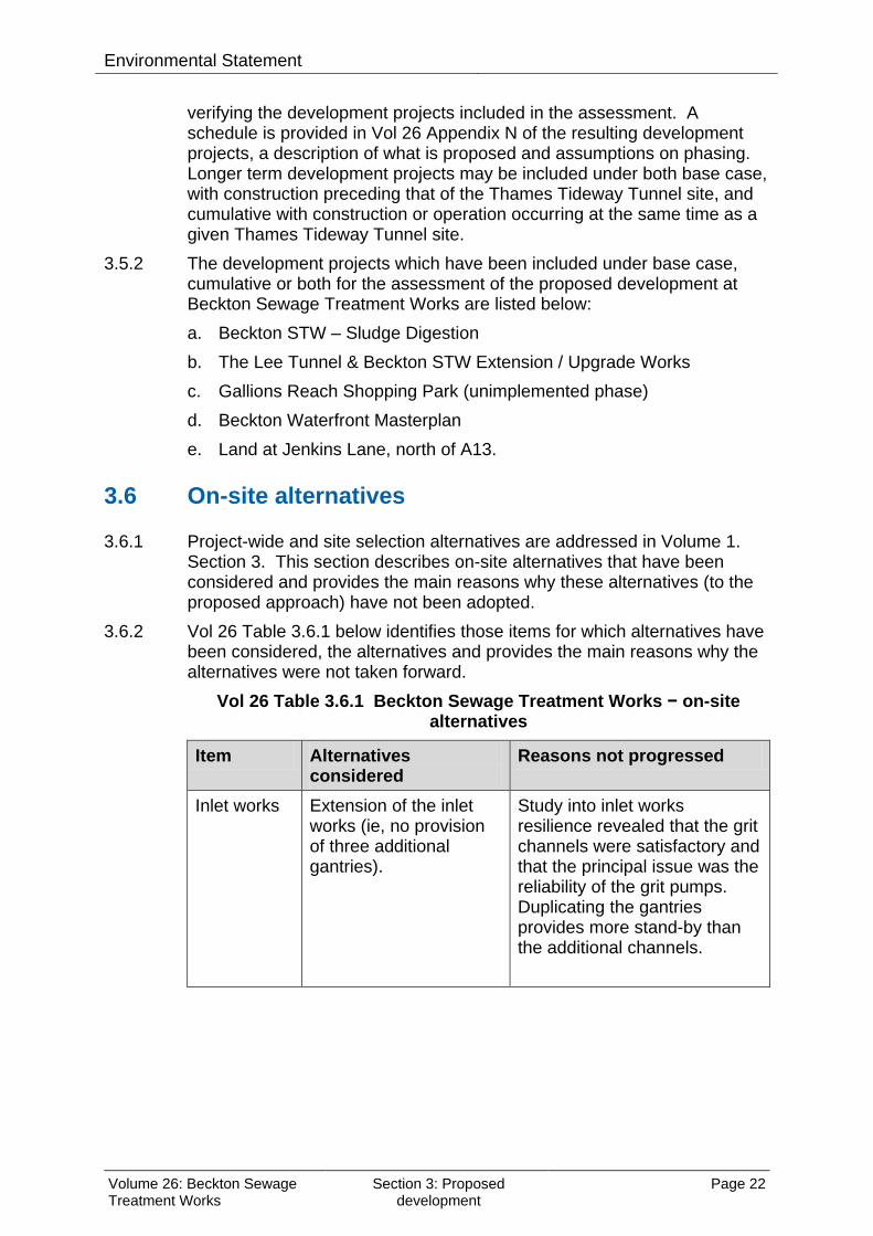
3.6.2 Vol 26 Table 3.6.1 below identifies those items for which alternatives have been considered, the alternatives and provides the main reasons why the alternatives were not taken forward.
Vol 26 Table 3.6.1 Beckton Sewage Treatment Works − on-site alternatives
Item Alternatives considered
Reasons not progressed
Inlet works Extension of the inlet works (ie, no provision of three additional gantries).
Study into inlet works resilience revealed that the grit channels were satisfactory and that the principal issue was the reliability of the grit pumps. Duplicating the gantries provides more stand-by than the additional channels.
Volume 26: Beckton Sewage Treatment Works
Section 3: Proposed development
Page 22

Environmental Statement
Item Alternatives considered
Reasons not progressed
Discharge chamber near inlet works
Proposal for the discharge chamber near the inlet works to be located on top of the Northern Outfall Sewer.
The proposed design (ie, locating part of the chamber north of the Northern Outfall Sewer rather than on top of it) reduces loading on existing structures and avoids diversion of elevated roadway at edge of sewage treatment works.
Volume 26: Beckton Sewage Treatment Works
Section 3: Proposed development
Page 23
Environmental Statement
This page is intentionally blank
Volume 26: Beckton Sewage Treatment Works
Section 3: Proposed development
Page 24

Hard copy available in
Environmental StatementDoc Ref: 6.2.26
Volume 26: Beckton Sewage Treatment Works site assessmentSection 4: Air quality and odourAPFP Regulations 2009: Regulation 5(2)(a)
Box 40 Folder A January 2013
Sect
ion
4: A
ir qu
alit
y an
d od
our
Thames Tideway Tunnel Thames Water Utilities Limited
Application for Development ConsentApplication Reference Number: WWO10001

This page is intentionally blank

Environmental Statement
Thames Tideway Tunnel
Environmental Statement
Volume 26: Beckton Sewage Treatment Works site assessment
Section 4: Air quality and odour
List of contents
Page number
4 Air quality and odour ....................................................................................... 1
4.1 Introduction .............................................................................................. 1
4.2 Proposed development relevant to air quality and odour ......................... 1
4.3 Assessment methodology ........................................................................ 4
4.4 Baseline conditions .................................................................................. 9
4.5 Construction effects assessment ........................................................... 18
4.6 Operational effects assessment ............................................................ 26
4.7 Cumulative effects assessment ............................................................. 26
4.8 Mitigation ............................................................................................... 27
4.9 Residual effects assessment ................................................................. 27
4.10 Assessment summary ........................................................................... 28
References .............................................................................................................. 31
List of tables
Page number
Vol 26 Table 4.3.1 Air quality and odour – stakeholder engagement ........................ 5
Vol 26 Table 4.4.1 Air quality – measured NO2 concentrations ............................... 10
Vol 26 Table 4.4.2 Air quality – additional monitoring locations ............................... 11
Vol 26 Table 4.4.3 Air quality – 2010 background pollutant concentrations ............ 11
Vol 26 Table 4.4.4 Odour – measured H2S concentrations ...................................... 12
Vol 26 Table 4.4.5 Air quality and odour – receptors ............................................... 15
Vol 26 Table 4.4.6 Air quality – annual mean background pollutant concentrations 17
Vol 26 Table 4.5.1 Air quality – predicted annual mean NO2 concentrations .......... 19
Vol 26 Table 4.5.2 Air quality – predicted annual mean PM10 concentrations ......... 21
Volume 26: Beckton Sewage Treatment Works
Section 4: Air quality and odour Page i

Environmental Statement Vol 26 Table 4.5.3 Air quality – predicted exceedances of the daily PM10 standard 23
Vol 26 Table 4.5.4 Air quality – numbers of dust sensitive receptors ...................... 24
Vol 26 Table 4.5.5 Air quality – construction dust risks ........................................... 25
Vol 26 Table 4.6.1 Odour – ground level impacts operation .................................... 26
Vol 26 Table 4.10.1 Air quality – summary of construction assessment .................. 28
Vol 26 Table 4.10.2 Odour – summary of operational assessment ......................... 30
Volume 26: Beckton Sewage Treatment Works
Section 4: Air quality and odour Page ii

Environmental Statement
4 Air quality and odour
4.1 Introduction 4.1.1 This section presents the findings of the assessment of the likely
significant air quality and odour effects of the proposed development at the Beckton Sewage Treatment Works (STW) site. This assessment covers the effects associated with both Site A and Site B. The project-wide air quality effects are described in Volume 3 Project-wide effects assessment.
4.1.2 The proposed development has the potential to affect air quality and odour due to: a. construction traffic on the roads leading to an increase in vehicle
emissions (air quality) b. emissions from construction plant (air quality) c. construction-generated dust (air quality) d. operation of the tunnel, resulting in air emissions (odour).
4.1.3 Each of these impacts is considered within the assessment. As a result the construction assessment for Beckton STW site comprises three separate components: effects on local air quality from construction road traffic; effects on local air quality from construction plant; and effects from construction dust. The effects on local air quality from construction road traffic and construction plant are assessed together (within the same model) while construction dust is assessed separately. The operational assessment considers the potential for nuisance odour emissions from the operation of the tunnel. As set out in the Scoping Report, local air quality effects are not assessed during operation on the basis that the only relevant operational source of air pollutants would be from the infrequent visits of maintenance vehicles which would not result in a likely significant effect.
4.1.4 The assessment of air quality and odour presented in this section has considered the requirements of the National Policy Statement for Waste Water Sections 4.3 (odour), 4.11 (air quality and emissions) and 4.12 (dust). Further details of these requirements can be found in Volume 2 Environmental assessment methodology Section 4.3.
4.1.5 Plans of the proposed development as well as figures included in the assessment for this site are contained in a separate volume (Volume 26 Beckton Sewage Treatment Works figures). Appendices supporting this site assessment are contained in Vol 26 Appendix B.
4.2 Proposed development relevant to air quality and odour
4.2.1 The proposed development is described in Section 3 of this volume. The elements of the proposed development relevant to air quality and odour are set out below.
Volume 26: Beckton Sewage Treatment Works
Section 4: Air quality and odour Page 1
Environmental Statement
Construction Construction road traffic
4.2.2 During the proposed construction period there would be construction traffic movementsi in and out of the site.
4.2.3 The highest number of lorry movements in any one year at the Beckton STW site would occur during the tunnel drive (Site Year 2 of construction). The average daily number of vehicle movements during the peak month would be approximately 50 movements per day.
4.2.4 The construction traffic routes, traffic management and access to the site are detailed in Section 12 of this volume.
4.2.5 Construction traffic is likely to affect local air quality as a result of increasing traffic and therefore emissions on the road network. Construction plant
4.2.6 Construction plant is likely to affect local air quality from direct exhaust emissions associated with the use and movement of the plant around the site.
4.2.7 There are a number of items of plant to be used on site that may produce emissions that could affect local air quality. Examples of such plant are excavators, generators and dumper trucks.
4.2.8 Typical construction plant which would be used at the Beckton STW site in the peak construction year and associated emissions data are presented in Vol 26 Appendix B.3. Construction dust
4.2.9 Activities with the potential to give rise to dust emissions from the proposed development during construction are as follows: a. site preparation and establishment b. demolition of existing infrastructure and buildings c. materials handling and earthworks d. construction traffic – from moving over unpaved ground and then
tracking out mud and dirt onto the public highway (termed ‘trackout’ hereafter).
4.2.10 At the Beckton STW site there would be approximately 165m3 of demolition material generated while the amount of material moved during the earthworks would be approximately 38,400 tonnes. The volume of building material used during construction would be approximately 12,200m3.
i A movement is a construction vehicle moving either to or from the site.
Volume 26: Beckton Sewage Treatment Works
Section 4: Air quality and odour Page 2

Environmental Statement
Code of Construction Practice 4.2.11 Appropriate dust and emission control measures are included in the Code
of Construction Practice (CoCP)ii Part A (Section 7) in accordance with the London Councils Best Practice Guidance (Greater London Authority and London Councils, 2006)1. Measures incorporated into the CoCP Part A (Section 7) to reduce air quality impacts include measures in relation to vehicle and plant emissions, measures to reduce dust formation and re-suspension, measures to control dust present and measures to reduce particulate emissions. These would be observed across all construction and demolition activities at the Beckton STW site.
4.2.12 The effective implementation of the CoCP Part A (Section 7) measures is assumed within the assessment.
Operation 4.2.13 There would be two separate main ventilation sites for the Thames
Tideway Tunnels within Beckton STW, Beckton connection and Beckton Overflow sites, constructed under the Lee Tunnel project and thus ‘existing’ at the start of the Thames Tideway Tunnel project construction.
4.2.14 The Beckton connection shaft would have three air release ventilation structures: a. A ventilation column which would release treated air after passing
through the air treatment unit. It would have a capacity of 10m3/s and would be used for approximately 1600 hours in a typical year.
b. A vent box with weighted louvres which would act as a bypass when the air treatment unit is operating at capacity and would be used for a total of 30 hours during a typical year over 25 separate events.
c. An air pressure release vent box with more heavily weighted louvres. This would operate infrequently during extreme rapid tunnel filling which causes extreme air displacement.
4.2.15 The maximum air flow during a typical year would be approximately 28m3/s.
4.2.16 In addition there would be an air inlet structure with heavily weighted dampers to allow air into the shaft when the wastewater is pumped out. This ventilation plant would also be used to treat air displaced from the filling of the tunnel used for diverting bypass flows from the pump-out pumping station to the river. This would occur for about half an hour at the start of the bypass event about three times during the typical year.
4.2.17 The Beckton Overflow site would be similar to the connection shaft plant with three ventilation air release structures:
ii The Code of Construction Practice (CoCP) is provided in Vol 1 Appendix A. It contains general requirements (Part A), and site specific requirements for this site (Part B).
Volume 26: Beckton Sewage Treatment Works
Section 4: Air quality and odour Page 3

Environmental Statement
a. One ventilation column would release air after treatment in the air treatment unit. It would have a capacity of 10m3/s and would be used for approximately 1200 hours in a typical year.
b. A vent box with weighted louvres which would act as a bypass when the air treatment unit is operating at capacity and would be used for a total of 30 hours during a typical year over 25 separate events.
c. An air pressure release vent box with more heavily weighted louvres. This would operate infrequently during extreme rapid tunnel filling which causes extreme air displacement.
4.2.18 The maximum air flow during a typical year would be about 28m3/s. 4.2.19 In addition there would be an air inlet structure with lightly weighted
dampers to allow the preferential inflow of air into the shaft during the tunnel empty condition and when the wastewater is pumped out. This ventilation plant would also be used to treat air displaced from the filling of the tunnel used for diverting bypass flows from the pump-out pumping station to the river. This would occur for about half an hour at the start of the bypass event about three times during the typical year.
4.2.20 There would be other small ventilation and air treatment plants (one at the pump-out chamber into which the tunnel pump-out pumping station discharges and one at the inlet works). These would operate when air is purged from the pump-out pipework for about half an hour at the start of the pump-out about 72 times during the typical year. The air treatment control plant for these is to be constructed under the Lee Tunnel works and ductwork to link to the plant is to be constructed under the Thames Tideway Tunnel works. Environmental design measures
4.2.21 The ventilation structure design and construction would treat the air prior to release (as described above) to remove odours.
4.3 Assessment methodology
Engagement 4.3.1 Vol 2 Section 4.2 documents the overall engagement which has been
undertaken in preparing the Environmental Statement. Specific comments relevant to this site for the assessment of air quality and odour are presented here (Vol 26 Table 4.3.1).
Volume 26: Beckton Sewage Treatment Works
Section 4: Air quality and odour Page 4

Environmental Statement
Vol 26 Table 4.3.1 Air quality and odour – stakeholder engagement
Organisation Comment Response
LB of Newham, Position Paper, January 2011
The adoption of a 1.5ouE standard is welcomed. This standard should be applied at the site boundary at the nearest point to the flue or louvre unless local conditions make this excessive. This will prevent the presence of the emission point constraining future off-site development.
Concentrations have been assessed over the assessment area with a 5m receptor grid resolution so includes predictions at and beyond the site boundary at all sites for comparison with the 1.5ouE standard.
LB of Newham, May 2011
Agree monitoring locations with of LB of Wandsworth
Locations agreed with LB of Newham Pollution Control Officer.
LB of Newham, July 2012
Odour complaints in the area should be considered
Sent through by LB of Newham Principal Environmental Health Officer.
LB of Newham, Phase two consultation, February 2012
The Air Management Report has been reviewed and we have the following comments to make: • Para 3.2 The Site Operation Manual includes functions that constitute an odour management plan. This should be agreed with the relevant local authority. • Para 3.3 There is active tunnel extract ventilation (which includes all the sites in Newham - Abbey Mills and two at Beckton STW) there should be a 'sniffer point' to allow Thames Water's operatives and local authority regulators to make a subjective assessment of odour releases in the event of complaint. • Para 3.4 Records of maintenance checks should be kept for at least 3 years and be available to local authority regulators on request.
Para 3.2: Where the contents of the Site Operating Manual relate to the Air management plan, these will be agreed with the relevant local authority. Para 3.3: Hydrogen sulphide (H2S) concentrations in the tunnel air and after treatment would be continuously monitored at the actively ventilated sites. These data can be used to identify whether emissions from the Tunnel were being released at the time of the complaint and what the H2S concentration was in the release. Para 3.4: Records of maintenance checks would be kept for at least three years and would be made available to local authority regulators.
Volume 26: Beckton Sewage Treatment Works
Section 4: Air quality and odour Page 5

Environmental Statement
Baseline 4.3.2 The baseline methodology follows the methodology described in Vol 2
Section 4. There are no site specific variations for identifying baseline conditions for this site.
Construction 4.3.3 The assessment methodology for the construction phase follows that
described in Vol 2 Section 4. There are no site specific variations for undertaking the construction assessment of this site.
4.3.4 Section 4.5 details the likely significant effects arising from the construction at the Beckton STW site. There are no other Thames Tideway Tunnel project sites which could elevate on construction dust nuisance effects within the assessment area (see para. 4.3.5 below). With regard to local air quality, the effect of all relevant traffic associated with Thames Tideway Tunnel project sites using the highway network in the vicinity of the site is taken into account in the assessment as traffic data used for the assessment includes traffic associated with all Thames Tideway Tunnel project sites. Construction assessment area
4.3.5 The assessment area for the local air quality study covers a square area of 1km by 1km centred on the Beckton STW site. This assessment area has been used for the assessment of road transport, construction plant and construction dust and has been selected on the basis of professional judgement to ensure that the effects of the Beckton STW site are fully assessed. A distance of 200m (Highways Agency, 2007)2 is generally considered sufficient to ensure that any significant effects are considered. The selected assessment area exceeds this considerably. Construction assessment year
4.3.6 The peak construction year in terms of construction traffic movements (Site Year 2 of construction) has been used as the year of assessment for construction effects (construction road transport, construction plant and construction dust) in which the development case (with Thames Tideway Tunnel project) has been assessed against the base case (without Thames Tideway Tunnel project) to identify likely significant effects of the Thames Tideway Tunnel project.
4.3.7 The assessment of construction effects also considers the extent to which the effects on local air quality would be likely to be materially different should the programme for the Thames Tideway Tunnel project be delayed by approximately one year. Other developments
4.3.8 As indicated in the site development schedule (see Vol 26 Appendix N), there are three other new non-Thames Water developments (Gallions Reach Shopping Park, Beckton Waterfront Masterplan and the Jenkins Lane development) within the assessment area, two of which (Gallions Reach Shopping Park and Beckton Waterfront Masterplan) are relevant to the air quality assessment being sensitive properties within 200m of the
Volume 26: Beckton Sewage Treatment Works
Section 4: Air quality and odour Page 6

Environmental Statement
site. These two developments are therefore considered as receptors in the air quality assessment. Trips associated with these developments are taken into account in the traffic data used for the air quality assessment.
4.3.9 Part of the Beckton Waterfront Masterplan would also still be under construction in the peak construction year. There is therefore the potential for cumulative effects which are considered in Section 4.7.
Operation 4.3.10 The operational phase methodology follows a different methodology to
that described in Vol 2 Section 4. As the Thames Tideway Tunnel project ventilation structures would be located in a sewage treatment works (STW) which is a significant source of odour, odour sources within the STW have been included in the modelling so that the total odour concentrations are predicted. Three scenarios have been modelled: a. baseline b. base case with the Beckton STW sludge digestion, the Lee Tunnel &
Beckton STW extension and the Beckton STW upgrade works in operation
c. development case with the Beckton STW sludge digestion, the Lee Tunnel & Beckton STW extension and the Beckton STW upgrade works in operation as well as the Thames Tideway Tunnel project.
4.3.11 The area predicted to have concentrations above the 98th percentile of hourly values of 1.5ouE/m3 was predicted for each of the scenarios.
4.3.12 As the results are presented as the change in area predicted to exceed the odour criterion, an alternative set of significance criteria for impact magnitude have been developed. These are based on the percentage change in concentrations comparing the base and development cases, using the EPUK guidance for local air quality (EPUK, 2010)3. It has been assumed that high, medium and low sensitivity receptors are distributed across the large assessment area (see para. 4.3.13 below). The significance criteria used are: a. negligible: less than 1% change in area predicted to exceed the
criterion b. small: 1-5% change in area predicted to exceed the criterion c. medium: 5-10% change in area predicted to exceed the criterion d. large: greater than 10% change in area predicted to exceed the
criterion. 4.3.13 Section 4.6 details the likely significant effects arising from the operation at
the Beckton STW site. Odour from the Beckton STW would also be released at this site and has been included in the modelling. There are no other Thames Tideway Tunnel project sites that could give rise to additional effects on odour within the assessment area for this site and therefore no other Thames Tideway Tunnel project sites are considered in this assessment.
Volume 26: Beckton Sewage Treatment Works
Section 4: Air quality and odour Page 7
Environmental Statement
Operational assessment area 4.3.14 Odour dispersion modelling has been carried out over an area of 11km by
7km centred on the Beckton STW site. The assessment area has been selected on professional judgement on the basis of it being considered the potential maximum extent of the impact area. Operational assessment year
4.3.15 The assessment undertaken for a typical use year (as described in Vol 2 Section 4) applies equally to all operational years. Therefore no specific year of operation has been assessed. Other developments
4.3.16 As indicated in the site development schedule (see Vol 26 Appendix N), there are five other new developments identified within 1km of the Beckton STW. Two of these relate to improvements at the Beckton STW and are included in the base and development cases. As discussed in para. 4.3.8, there are two other developments that are within 200m of the site (Beckton Waterfront Masterplan and Gallions Reach Shopping Park), both of which are relevant to the odour assessment being sensitive properties in close proximity to the site. These two developments are therefore considered as receptors in the odour assessment. Due to the nature of the developments there are however no cumulative operational odour effects to assess.
Assumptions and limitations Assumptions
4.3.17 The general assumptions associated with this assessment are presented in Vol 2 Section 4. Construction
4.3.18 The site specific assumptions in terms of model inputs for the local air quality dispersion modelling are set out in Vol 26 Appendix B.1. Operation
4.3.19 The site specific assumptions in terms of the assumed capacity of the carbon filter and air release rate used for the odour dispersion modelling are described in paras. 4.2.13 - 4.2.21.
4.3.20 Odour dispersion modelling for the development case includes emissions from all of the sources within the STW as explained in para. 4.3.10 and from the two ventilation structures associated with the Thames Tideway Tunnel project. It does not take account of other background sources beyond Beckton STW although these are considered to be small in relation to the STW. The large number of complaints made in the area indicates that concentrations are elevated in the vicinity of the Beckton STW.
4.3.21 The ventilation structures were located for the dispersion modelling at the position at which they are most likely to be located. However, the structures could be repositioned within the area marked on the Site parameter plan (see separate volume of figures - Section 1). This would
Volume 26: Beckton Sewage Treatment Works
Section 4: Air quality and odour Page 8

Environmental Statement
not affect the assessment results in Section 4.6 as the results are given in terms of the area predicted to exceed the odour benchmark which would not be significantly affected by the repositioning of the structures. Limitations
4.3.22 The general limitations associated with this assessment are presented in Vol 2 Section 4. Construction
4.3.23 As there are no PM10 monitoring sites located within the vicinity of the Beckton STW site, it has not been possible to verify PM10 modelling resultsiii. The adjustment factor derived for NOX (from a comparison of monitored and monitored NO2 data) has therefore been applied to the PM10 modelling results. Operation
4.3.24 There are no limitations specific to the odour assessment of this site.
4.4 Baseline conditions 4.4.1 The following section sets out the baseline conditions for air quality and
odour within and around the site. Future baseline conditions (base case) are also described.
Current baseline Local air quality
4.4.2 The current conditions with regard to local air quality are best established through long-term air quality monitoring.
4.4.3 As part of their duties under Part IV of the Environment Act 1995 (UK Government, 1995)4, local authorities, especially in urban areas where air quality is a significant issue, undertake long-term air quality monitoring within their administrative areas.
4.4.4 There are no continuous monitoring stations operated by London Borough (LB) of Newham which collect data pertinent to the Beckton STW site and associated construction traffic routes. There is one diffusion tube site, although this site is located over 1km from the Beckton STW site. Monitoring data for this site for the period 2007-2011 are provided in Vol 26 Table 4.4.1 (NO2 concentrations).
iii Model verification refers to checks that are carried out on model performance at a local level. This basically involves the comparison of predicted (modelled) versus measured concentrations. Where there is a disparity between the predicted and the measured concentrations, the first step should always be to check the input data and model parameters in order to minimise the errors. If required, the second step would be to determine an appropriate adjustment factor that can be applied to the modelled traffic contribution.
Volume 26: Beckton Sewage Treatment Works
Section 4: Air quality and odour Page 9

Environmental Statement
Vol 26 Table 4.4.1 Air quality – measured NO2 concentrations
Monitoring site Site type Annual mean (µg/m3) 2011 2010 2009 2008 2007
Galleons Roundabout (12) Roadside 44 44 48 51 46
Note: NM indicates not measured. Emboldened figures indicate an exceedance of the objective / limit value which is 40µg/m3 for the annual mean. Codes in brackets represent monitoring site identifiers used in Vol 26 Figure 4.4.1 (see separate volume of figures).
4.4.5 The monitoring data at this site shows that the annual mean NO2
objective/limit value has been exceeded in all five years between 2007 and 2011.
4.4.6 The LB of Newham has declared an AQMA along the main road corridors across the Borough for NO2 and PM10. The Beckton STW site is not in the AQMA, although the A13 corridor to the north of the sites is part of the AQMA.
4.4.7 In addition to the local authority monitoring, diffusion tube monitoring has been undertaken as part of the environmental impact assessment (EIA) to monitor NO2 concentrations in the vicinity of the Beckton STW site. This monitoring comprises three diffusion tubes based at the locations identified in Vol 26 Table 4.4.2. The table shows a 2010 annual mean concentration (baseline year), which has been calculated from the measurements made between April 2011 and April 2012 at each of the sites. To calculate the 2010 annual mean NO2 concentrations, the 2011/12 measurements are adjusted for bias using the co-located diffusion tubes and are then seasonally adjusted. Annual mean NO2 concentrations, for the period covered by the diffusion tubes, and for the year 2010 have been collated from four nearby background continuous monitoring sites measuring NO2 and with data capture rates greater than 90%. The average of the ratios between the period and annual means has been used to calculate the seasonal adjustment factor. To enable any bias to be corrected a triplicate site (comprising three diffusion tubes) was established at a continuous monitoring site in Putney (site PEFM4 – see Vol 7); for additional precision, a triplicate site was established at one of the monitoring sites (BSTM2); otherwise all the monitoring locations have single tubes.
Volume 26: Beckton Sewage Treatment Works
Section 4: Air quality and odour Page 10
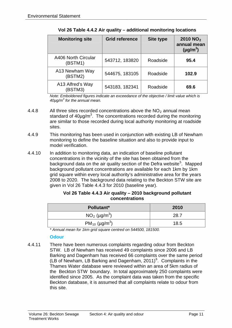
Environmental Statement
Vol 26 Table 4.4.2 Air quality – additional monitoring locations
Monitoring site Grid reference Site type 2010 NO2 annual mean
(µg/m3) A406 North Circular
(BSTM1) 543712, 183820 Roadside 95.4
A13 Newham Way (BSTM2) 544675, 183105 Roadside 102.9
A13 Alfred’s Way (BSTM3) 543183, 182341 Roadside 69.6
Note: Emboldened figures indicate an exceedance of the objective / limit value which is 40µg/m3 for the annual mean.
4.4.8 All three sites recorded concentrations above the NO2 annual mean
standard of 40µg/m3. The concentrations recorded during the monitoring are similar to those recorded during local authority monitoring at roadside sites.
4.4.9 This monitoring has been used in conjunction with existing LB of Newham monitoring to define the baseline situation and also to provide input to model verification.
4.4.10 In addition to monitoring data, an indication of baseline pollutant concentrations in the vicinity of the site has been obtained from the background data on the air quality section of the Defra website5. Mapped background pollutant concentrations are available for each 1km by 1km grid square within every local authority’s administrative area for the years 2008 to 2020. The background data relating to the Beckton STW site are given in Vol 26 Table 4.4.3 for 2010 (baseline year).
Vol 26 Table 4.4.3 Air quality – 2010 background pollutant concentrations
Pollutant* 2010 NO2 (µg/m3) 28.7
PM10 (µg/m3) 18.5 * Annual mean for 1km grid square centred on 544500, 181500.
Odour 4.4.11 There have been numerous complaints regarding odour from Beckton
STW. LB of Newham has received 49 complaints since 2006 and LB Barking and Dagenham has received 66 complaints over the same period (LB of Newham, LB Barking and Dagenham, 2011)6. Complaints in the Thames Water database were reviewed within an area of 5km radius of the Beckton STW boundary. In total approximately 250 complaints were identified since 2005. As the complaint data was taken from the specific Beckton database, it is assumed that all complaints relate to odour from this site.
Volume 26: Beckton Sewage Treatment Works
Section 4: Air quality and odour Page 11
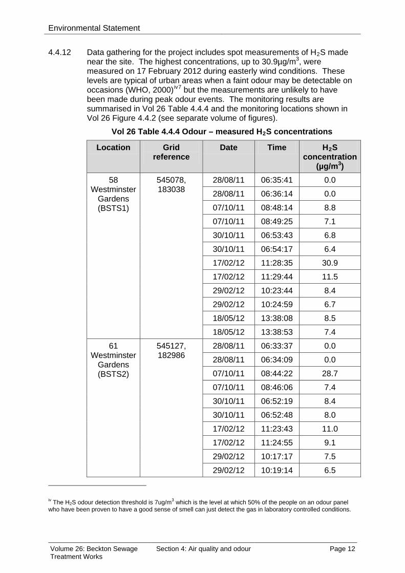
Environmental Statement 4.4.12 Data gathering for the project includes spot measurements of H2S made
near the site. The highest concentrations, up to 30.9µg/m3, were measured on 17 February 2012 during easterly wind conditions. These levels are typical of urban areas when a faint odour may be detectable on occasions (WHO, 2000)iv7 but the measurements are unlikely to have been made during peak odour events. The monitoring results are summarised in Vol 26 Table 4.4.4 and the monitoring locations shown in Vol 26 Figure 4.4.2 (see separate volume of figures).
Vol 26 Table 4.4.4 Odour – measured H2S concentrations
Location Grid reference
Date Time H2S concentration
(µg/m3) 58
Westminster Gardens (BSTS1)
545078, 183038
28/08/11 06:35:41 0.0
28/08/11 06:36:14 0.0
07/10/11 08:48:14 8.8
07/10/11 08:49:25 7.1
30/10/11 06:53:43 6.8
30/10/11 06:54:17 6.4
17/02/12 11:28:35 30.9
17/02/12 11:29:44 11.5
29/02/12 10:23:44 8.4
29/02/12 10:24:59 6.7
18/05/12 13:38:08 8.5
18/05/12 13:38:53 7.4
61 Westminster
Gardens (BSTS2)
545127, 182986
28/08/11 06:33:37 0.0
28/08/11 06:34:09 0.0
07/10/11 08:44:22 28.7
07/10/11 08:46:06 7.4
30/10/11 06:52:19 8.4
30/10/11 06:52:48 8.0
17/02/12 11:23:43 11.0
17/02/12 11:24:55 9.1
29/02/12 10:17:17 7.5
29/02/12 10:19:14 6.5
iv The H2S odour detection threshold is 7ug/m3 which is the level at which 50% of the people on an odour panel who have been proven to have a good sense of smell can just detect the gas in laboratory controlled conditions.
Volume 26: Beckton Sewage Treatment Works
Section 4: Air quality and odour Page 12

Environmental Statement
Location Grid reference
Date Time H2S concentration
(µg/m3) 18/05/12 13:31:42 10.0
18/05/12 13:36:47 28.8
Hornet Way (BSTS3)
544575, 181629
28/08/11 06:11:13 0.0
28/08/11 06:11:48 0.0
07/10/11 08:25:23 5.5
07/10/11 08:26:44 5.7
30/10/11 06:41:18 0.0
30/10/11 06:41:47 0.0
17/02/12 10:59:10 8.1
17/02/12 11:00:04 9.2
29/02/12 10:02:59 8.0
29/02/12 10:04:01 6.9
18/05/12 13:11:39 6.3
18/05/12 13:12:37 6.2
Tesco (BSTS4)
544085, 181977
28/08/11 06:18:53 0.0
28/08/11 06:19:37 0.0
07/10/11 08:32:17 8.6
07/10/11 08:34:02 6.4
30/10/11 06:45:14 4.8
30/10/11 06:45:43 0.0
17/02/12 11:07:08 9.8
17/02/12 11:08:27 8.2
29/02/12 10:05:45 7.8
29/02/12 10:07:09 6.9
18/05/12 13:15:29 7.2
18/05/12 13:16:24 6.6
18/05/12 13:30:33 9.3
Meteorological conditions: 28/08/11 SW wind up to 2m/s, partially cloudy, rain on previous day. 07/10/11 SW wind up to 4.8m/s, partially cloudy. 30/10/11 SW wind at 0.5m/s, cloudy, last rain on 27/10/11. 17/02/12 E wind, up to 1.7m/s, cloudy.
Volume 26: Beckton Sewage Treatment Works
Section 4: Air quality and odour Page 13

Environmental Statement
Location Grid reference
Date Time H2S concentration
(µg/m3) 29/02/12 S wind, up to 1.5m/s, cloudy. 18/05/12 N wind, up to 1.9m/s, cloudy.
Receptors 4.4.13 As set out in Section 4.1 and Vol 2 Section 4, the air quality assessment
involves the selection of appropriate receptors, which are shown in Vol 26 Figure 4.4.3 (see separate volume of figures) and the table below (Vol 26 Table 4.4.5) for the Beckton STW site. All of these receptors are relevant, albeit with different levels of sensitivity to each of the elements of the air quality assessment. The sensitivity of identified receptors has been determined using the criteria detailed in Vol 2 Section 4.
4.4.14 It is noted that Vol 26 Table 4.5.1 includes receptors associated with Beckton Waterfront Masterplan and Gallions Reach Shopping Park (see site development schedule in Vol 26 Appendix N) for consideration in the air quality and odour assessments.
Volume 26: Beckton Sewage Treatment Works
Section 4: Air quality and odour Page 14

Envi
ronm
enta
l Sta
tem
ent
Vol 2
6 Ta
ble
4.4.
5 A
ir qu
ality
and
odo
ur –
rece
ptor
s
Rec
epto
rs (r
elat
ing
to a
ll id
entif
ied
emis
sion
s so
urce
s)
App
roxi
mat
e di
stan
ce o
f m
odel
led
rece
ptor
fr
om s
ite
boun
dary
and
di
rect
ion
from
si
te
Rec
epto
r sen
sitiv
ity
Air
qual
ity (c
onst
ruct
ion
traf
fic,
river
tugs
for b
arge
s an
d co
nstr
uctio
n pl
ant)
Con
stru
ctio
n du
st (o
n-si
te
dem
oliti
on a
nd
cons
truc
tion
proc
esse
s)
Odo
ur
(ven
tilat
ion
colu
mn)
Res
iden
tial -
Bec
kton
Wat
erfro
nt
Mas
terp
lan
(BST
R6)
* 15
0m s
outh
H
igh
(exp
osur
e re
leva
nt fo
r ann
ual
mea
n, d
aily
mea
n an
d ho
urly
mea
n st
anda
rds)
M
ediu
m
Hig
h
Res
iden
tial -
Wes
tmin
ster
Gar
dens
(B
STR
2)
910m
nor
thea
st
Hig
h (e
xpos
ure
rele
vant
for a
nnua
l m
ean,
dai
ly m
ean
and
hour
ly m
ean
stan
dard
s)
Med
ium
H
igh
Educ
atio
nal -
Gal
lions
Prim
ary
Scho
ol (P
layg
roun
d) (B
STR
9)
630m
sou
thea
st
Med
ium
(exp
osur
e is
rele
vant
for t
he
NO
2 ho
urly
mea
n st
anda
rd o
nly)
. M
ediu
m
Hig
h
Educ
atio
nal -
Gal
lions
Prim
ary
Scho
ol (B
uild
ing)
(BST
R4)
65
0m s
outh
east
H
igh
(exp
osur
e re
leva
nt fo
r ann
ual
mea
n, d
aily
mea
n an
d ho
urly
mea
n st
anda
rds)
M
ediu
m
Hig
h
Com
mer
cial
- Su
pers
tore
(BST
R3)
30
m s
outh
M
ediu
m (e
xpos
ure
is re
leva
nt fo
r the
N
O2
hour
ly m
ean
stan
dard
onl
y).
Med
ium
M
ediu
m
Com
mer
cial
- G
allio
ns R
each
Sh
oppi
ng P
ark
(uni
mpl
emen
ted
part)
(BST
R5)
* 10
0m s
outh
M
ediu
m (e
xpos
ure
is re
leva
nt fo
r the
N
O2
hour
ly m
ean
stan
dard
onl
y).
Med
ium
M
ediu
m
Com
mer
cial
- G
emin
i Bus
ines
s P
ark
1 (B
STR
7)
150m
wes
t Lo
w (e
xpos
ure
is re
leva
nt fo
r the
ho
urly
mea
n N
O2
stan
dard
onl
y).
Med
ium
M
ediu
m
Com
mer
cial
- G
emin
i Bus
ines
s P
ark
2 (B
STR
8)
160m
wes
t Lo
w (e
xpos
ure
is re
leva
nt fo
r the
ho
urly
mea
n N
O2
stan
dard
onl
y).
Med
ium
M
ediu
m
Volu
me
26: B
eckt
on S
ewag
e Tr
eatm
ent W
orks
Se
ctio
n 4:
Air
qual
ity a
nd o
dour
Pa
ge 1
5

Envi
ronm
enta
l Sta
tem
ent
Rec
epto
rs (r
elat
ing
to a
ll id
entif
ied
emis
sion
s so
urce
s)
App
roxi
mat
e di
stan
ce o
f m
odel
led
rece
ptor
fr
om s
ite
boun
dary
and
di
rect
ion
from
si
te
Rec
epto
r sen
sitiv
ity
Air
qual
ity (c
onst
ruct
ion
traf
fic,
river
tugs
for b
arge
s an
d co
nstr
uctio
n pl
ant)
Con
stru
ctio
n du
st (o
n-si
te
dem
oliti
on a
nd
cons
truc
tion
proc
esse
s)
Odo
ur
(ven
tilat
ion
colu
mn)
Rec
reat
iona
l - R
iver
Tha
mes
(B
STR
1)
32m
sou
th
Low
(exp
osur
e is
rele
vant
for t
he
hour
ly m
ean
NO
2 st
anda
rd o
nly)
. Lo
w
Low
* D
enot
es re
cept
or th
at is
alte
red
or c
onst
ruct
ed a
fter t
he b
asel
ine
year
. Vo
lum
e 26
: Bec
kton
Sew
age
Trea
tmen
t Wor
ks
Sect
ion
4: A
ir qu
ality
and
odo
ur
Page
16

Environmental Statement
Construction base case 4.4.15 The base case conditions for the construction assessment year would be
expected to change from the baseline conditions due to modifications to the sources of the air pollution in the intervening period.
4.4.16 For road vehicles, there would be an increase in the penetration of new Euro emissions standards8 to the London vehicle fleet between the current situation and Site Year 2 of construction. Euro standards define the acceptable exhaust emission limits for new vehicles sold in the EU. These standards are defined through a series of European Union directives staging the progressive introduction of increasingly stringent standards over time. These changes in fleet composition and the emissions are covered in this assessment.
4.4.17 Other emissions sources should also reduce due to local and national policies. Therefore, the non-road sources of the background concentrations used in the modelling have been reduced in line with Defra guidance LAQM.TG(09) (Defra, 2009)9. Background pollutant concentrations for Site Year 2 of construction (peak construction year) used in the modelling are shown in Vol 26 Table 4.4.6.
4.4.18 The background concentration has been taken from the Defra mapped background data 5, as there are no suitable background monitors within the relevant assessment area.
Vol 26 Table 4.4.6 Air quality – annual mean background pollutant concentrations
Pollutant Baseline (2010) Peak construction year (Site Year 2 of
construction) NO2 (µg/m3)* 28.7 21.9
PM10 (µg/m3)* 18.5 16.9 * Taken from Defra mapped 1km grid square centred on 544500,181500.
4.4.19 As indicated in para. 4.4.15, the base case in Site Year 2 of construction
takes into account the new Gallions Reach Shopping Park and Beckton Waterfront Masterplan developments. The two new developments are included as receptor locations in the air quality assessment. These are included in the receptor list provided in Vol 26 Table 4.4.5.
Operational base case 4.4.20 Base case conditions are different to baseline conditions with respect to
odour concentrations as major improvement works are underway at the Beckton STW.
4.4.21 As indicated in para. 4.4.15, the base case for the odour assessment takes into account future developments. These include improvements to Beckton STW which are included as emission sources, and two new developments (Gallions Reach Shopping Park and Beckton Waterfront Masterplan), including them as receptor locations in the odour
Volume 26: Beckton Sewage Treatment Works
Section 4: Air quality and odour Page 17
Environmental Statement
assessment. These are included in the receptor list provided in Vol 26 Table 4.4.5. The effect of improvements to Beckton STW is shown in Vol 26 Table 4.6.1.
4.5 Construction effects assessment
Local air quality assessment 4.5.1 Construction effects on local air quality (comprising emissions from
construction road traffic and construction plant) have been assessed following the modelling methodology set out in Vol 2 Section 4. This involves predicting NO2 and PM10 concentrations in the baseline year (2010), and in the peak construction year (Site Year 2 of construction), without the proposed development (base case) and with the proposed development (development case). Predicted pollutant concentrations for the base case and development case can then be compared to determine the air quality impacts associated with the project and considering these in the context of statutory air quality objectives/limit values to determine the significance of effects at specified receptors (listed in Vol 26 Table 4.4.5).
4.5.2 The assessment has focussed on NO2 and PM10 concentrations as these are the only pollutants whose air quality standards may be exceeded. From professional experience, emissions of other pollutants (eg, volatile organic compounds (VOCs)) are very unlikely to be significant and therefore do not need to be assessed.
4.5.3 A model verification exercise has been undertaken at the Beckton STW site in line with the Defra guidance LAQM.TG(09)9. This checks the model performance against measured concentrations, using the three monitoring sites established for this assessment (BSTM1–BSTM3 – see Vol 26 Table 4.4.2). Further details regarding the verification process are included in Vol 26 Appendix B. The model adjustment factor derived from the verification process was applied to all model results for both NO2 and PM10.
4.5.4 The model inputs for the local air quality assessment for the Beckton STW site are also detailed in Vol 26 Appendix B.2 and B.3. This includes road traffic data (comprising annual average daily traffic flows, heavy goods vehicle proportions and speeds for each road link) and data pertaining to construction plant. NO2 concentrations
4.5.5 Predicted annual mean NO2 concentrations for the modelled scenarios are shown in Vol 26 Table 4.5.1. This table details the forecast NO2 concentrations at specific sensitive receptors. Annual mean results are shown for all of the sensitive receptors but the receptors are divided into two groups depending on whether the annual mean objective/limit value applies or not. The annual mean criteria only apply at those receptors which could be occupied continually for a year (eg, residential properties). Exceedances of the hourly criteria are inferred from the annual mean concentration. Additionally, contour plots are provided (Vol 26 Figures 4.5.1 - 4.5.3, see separate volume of figures) showing modelled
Volume 26: Beckton Sewage Treatment Works
Section 4: Air quality and odour Page 18

Environmental Statement
concentrations for the baseline, base case and development case scenarios over the construction assessment area. A plot showing the change in NO2 annual mean concentrations between the base and development cases (in the peak construction year) is also presented in Vol 26 Figure 4.5.4 (see separate volume of figures).
4.5.6 The modelled concentrations in Vol 26 Table 4.5.1 show that annual mean NO2 levels are predicted to decrease between 2010 and the peak construction year with or without the Thames Tideway Tunnel project. This decrease is due to predicted reductions in background concentrations and improved vehicle engine technology. The results for the development case show no increases over the base case at all modelled receptors due to the construction works at the Beckton STW site.
4.5.7 No exceedances of the annual mean objective/limit value (40µg/m3) are predicted for any receptor in either of the peak construction year scenarios, although an exceedance is predicted at the residential properties at Westminster Gardens (BSTR2) and Gallions Primary School (Building) (BSTR4) in 2010. In line with LAQM.TG(09)9, as no modelled concentrations in the peak construction year were above 60µg/m3, exceedances of the hourly NO2 air quality objective / limit value are considered unlikely in both the peak construction year base case and development case.
Vol 26 Table 4.5.1 Air quality – predicted annual mean NO2 concentrations
Receptor Predicted annual mean NO2 concentration (µg/m3)
Change (µg/m3)between base
and dev
cases
Magnitude of impact
2010 baseline
Peak construction
year base case
Peak construction
year dev case
Receptors where the annual mean objective / limit value applies
Beckton Waterfront Masterplan residential (BSTR6)*
35.5 26.4 26.5 0.1
Negligible
Westminster Gardens residential (BSTR2)
44.1 32.2 32.2 0.0
Negligible
Gallions Primary School (Building) (BSTR4)
40.3 29.4 29.4 0.0 Negligible
Receptors where the annual mean objective / limit value does not apply
Volume 26: Beckton Sewage Treatment Works
Section 4: Air quality and odour Page 19
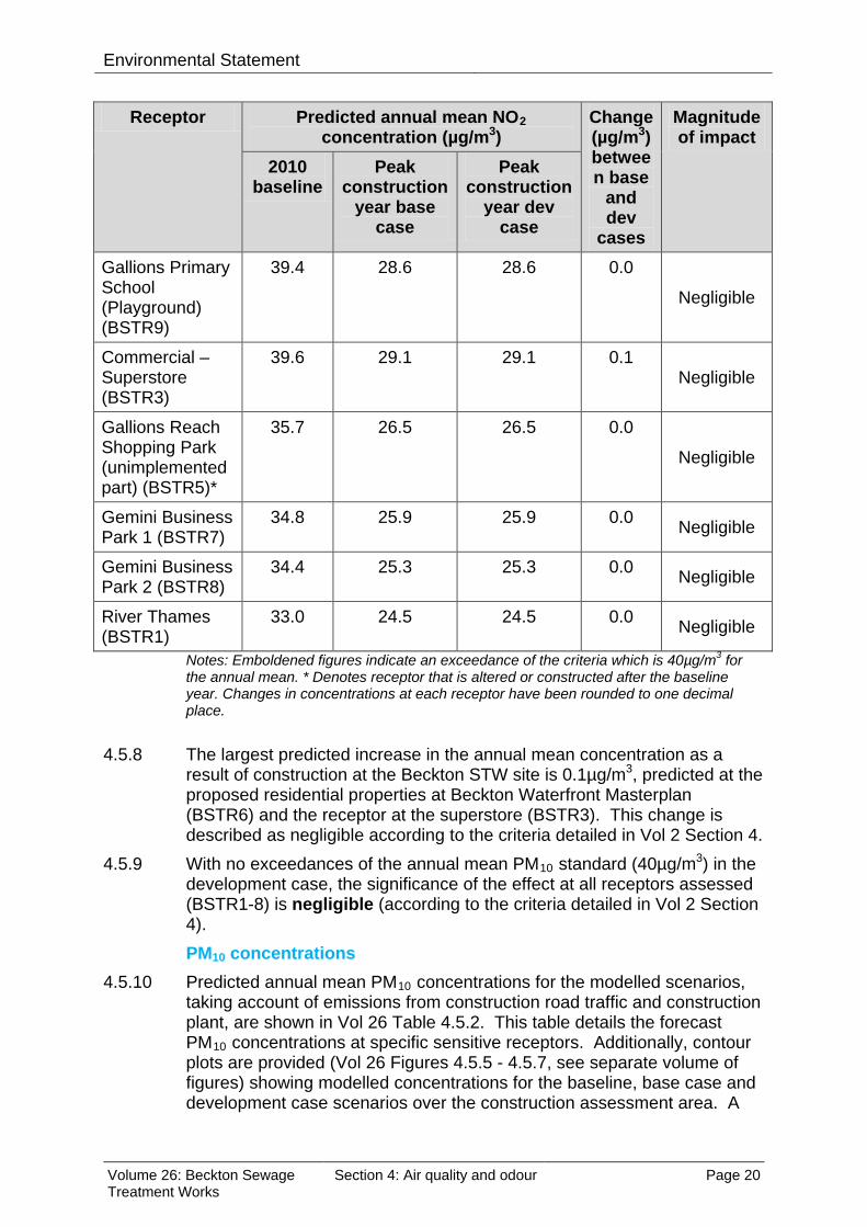
Environmental Statement
Receptor Predicted annual mean NO2 concentration (µg/m3)
Change (µg/m3)between base
and dev
cases
Magnitude of impact
2010 baseline
Peak construction
year base case
Peak construction
year dev case
Gallions Primary School (Playground) (BSTR9)
39.4 28.6 28.6 0.0
Negligible
Commercial – Superstore (BSTR3)
39.6 29.1 29.1 0.1 Negligible
Gallions Reach Shopping Park (unimplemented part) (BSTR5)*
35.7 26.5 26.5 0.0
Negligible
Gemini Business Park 1 (BSTR7)
34.8 25.9 25.9 0.0 Negligible
Gemini Business Park 2 (BSTR8)
34.4 25.3 25.3 0.0 Negligible
River Thames (BSTR1)
33.0 24.5 24.5 0.0 Negligible
Notes: Emboldened figures indicate an exceedance of the criteria which is 40µg/m3 for the annual mean. * Denotes receptor that is altered or constructed after the baseline year. Changes in concentrations at each receptor have been rounded to one decimal place.
4.5.8 The largest predicted increase in the annual mean concentration as a
result of construction at the Beckton STW site is 0.1µg/m3, predicted at the proposed residential properties at Beckton Waterfront Masterplan (BSTR6) and the receptor at the superstore (BSTR3). This change is described as negligible according to the criteria detailed in Vol 2 Section 4.
4.5.9 With no exceedances of the annual mean PM10 standard (40µg/m3) in the development case, the significance of the effect at all receptors assessed (BSTR1-8) is negligible (according to the criteria detailed in Vol 2 Section 4). PM10 concentrations
4.5.10 Predicted annual mean PM10 concentrations for the modelled scenarios, taking account of emissions from construction road traffic and construction plant, are shown in Vol 26 Table 4.5.2. This table details the forecast PM10 concentrations at specific sensitive receptors. Additionally, contour plots are provided (Vol 26 Figures 4.5.5 - 4.5.7, see separate volume of figures) showing modelled concentrations for the baseline, base case and development case scenarios over the construction assessment area. A
Volume 26: Beckton Sewage Treatment Works
Section 4: Air quality and odour Page 20
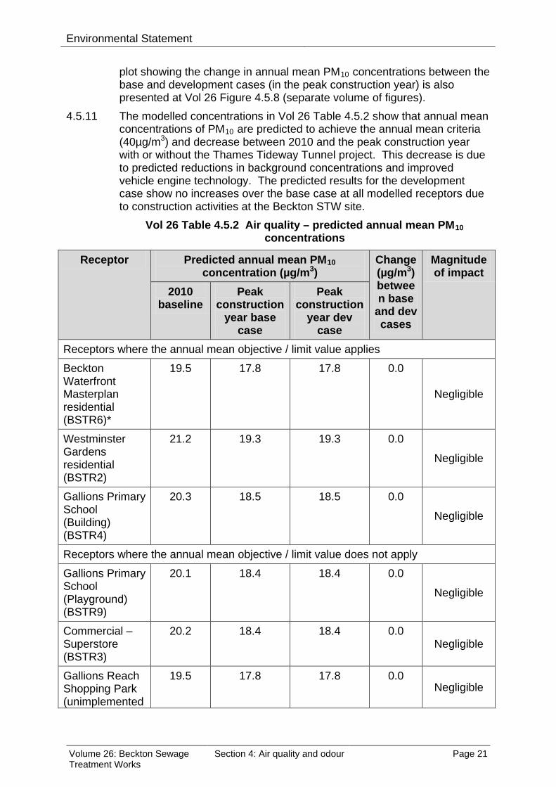
Environmental Statement
plot showing the change in annual mean PM10 concentrations between the base and development cases (in the peak construction year) is also presented at Vol 26 Figure 4.5.8 (separate volume of figures).
4.5.11 The modelled concentrations in Vol 26 Table 4.5.2 show that annual mean concentrations of PM10 are predicted to achieve the annual mean criteria (40µg/m3) and decrease between 2010 and the peak construction year with or without the Thames Tideway Tunnel project. This decrease is due to predicted reductions in background concentrations and improved vehicle engine technology. The predicted results for the development case show no increases over the base case at all modelled receptors due to construction activities at the Beckton STW site.
Vol 26 Table 4.5.2 Air quality – predicted annual mean PM10 concentrations
Receptor Predicted annual mean PM10 concentration (µg/m3)
Change (µg/m3)between base
and dev cases
Magnitude of impact
2010 baseline
Peak construction
year base case
Peak construction
year dev case
Receptors where the annual mean objective / limit value applies
Beckton Waterfront Masterplan residential (BSTR6)*
19.5 17.8 17.8 0.0
Negligible
Westminster Gardens residential (BSTR2)
21.2 19.3 19.3 0.0
Negligible
Gallions Primary School (Building) (BSTR4)
20.3 18.5 18.5 0.0
Negligible
Receptors where the annual mean objective / limit value does not apply
Gallions Primary School (Playground) (BSTR9)
20.1 18.4 18.4 0.0
Negligible
Commercial – Superstore (BSTR3)
20.2 18.4 18.4 0.0 Negligible
Gallions Reach Shopping Park (unimplemented
19.5 17.8 17.8 0.0 Negligible
Volume 26: Beckton Sewage Treatment Works
Section 4: Air quality and odour Page 21

Environmental Statement
Receptor Predicted annual mean PM10 concentration (µg/m3)
Change (µg/m3)between base
and dev cases
Magnitude of impact
2010 baseline
Peak construction
year base case
Peak construction
year dev case
part) (BSTR5)*
Gemini Business Park 1 (BSTR7)
19.4 17.7 17.7 0.0 Negligible
Gemini Business Park 2 (BSTR8)
19.3 17.6 17.6 0.0 Negligible
River Thames (BSTR1)
19.1 17.4 17.4 0.0 Negligible
Note: Changes in concentrations at each receptor have been rounded to one decimal place. * Denotes receptor that is altered or constructed after the baseline year.
4.5.12 No increases are predicted at any of the receptors. This change is
described as negligible according to the criteria detailed in Vol 2 Section 4. With no exceedances of the annual mean PM10 objective/limit value, the significance of the effects is negligible at all receptors.
4.5.13 With regard to the daily mean PM10 concentrations, Vol 26 Table 4.5.3 shows the predicted number exceedances of the daily PM10 standard (50µg/m3) for each modelled scenario. The objective/limit value allows no more than 35 exceedances in a year.
4.5.14 The results in Vol 26 Table 4.5.3 show that the number of daily exceedances of PM10 is predicted to decrease between 2010 and the peak construction year with or without the Thames Tideway Tunnel project. This decrease is due to predicted reductions in background concentrations and improved vehicle engine technology. The predicted results for the development case show no increase in the number of days per year with concentrations above 50µg/m3 compared with the base case at the modelled receptors due to construction works at the Beckton STW site.
4.5.15 With no exceedances of the daily PM10 criteria in the development case, the significance of the effects would be negligible at all sensitive receptors.
Volume 26: Beckton Sewage Treatment Works
Section 4: Air quality and odour Page 22

Environmental Statement
Vol 26 Table 4.5.3 Air quality – predicted exceedances of the daily PM10 standard
Receptor Predicted number of exceedances of the daily PM10 standard
Changebetween base
and dev
cases (days)
Magnitude of impact
2010 baseline
Peak construction
year base case
Peak construction
year dev case
Receptors where the objective / limit value does apply
Beckton Waterfront Masterplan residential (BSTR6)*
3 1 1 0
Negligible
Westminster Gardens residential (BSTR2)
5 3 3 0
Negligible
Gallions Primary School (Building) (BSTR4)
4 2 2 0 Negligible
Receptors where the objective / limit value does not apply
Gallions Primary School (Playground) (BSTR9)
4 2 2 0
Negligible
Superstore (BSTR3)
4 2 2 0 Negligible
Gallions Reach Shopping Park (unimplemented part) (BSTR5)*
3 1 1 0
Negligible
Gemini Business Park 1 (BSTR7)
3 1 1 0 Negligible
Gemini Business Park 2 (BSTR8)
3 1 1 0 Negligible
River Thames (BSTR1)
2 1 1 0 Negligible
Note: Changes in concentrations at each receptor have been rounded to nearest whole number. * Denotes receptor that is altered or constructed after the baseline year.
Sensitivity test for programme delay 4.5.16 For the assessment of local air quality effects during construction, a delay
to the Thames Tideway Tunnel project of approximately one year would
Volume 26: Beckton Sewage Treatment Works
Section 4: Air quality and odour Page 23

Environmental Statement
not be likely to materially change the assessment findings reported above for the existing and proposed receptors. Based on the development schedule (Vol 26 Appendix N), it is possible that as a result of the one year delay, more of the Beckton Waterfront Masterplan development may be completed and occupied. However, it is not expected that any new receptors would experience different effects to those receptors assessed above, rather it would be a case of the potential for some additional receptors to experience the same effects than those that have already been identified (see results for existing Beckton Waterfront Masterplan receptor, BSTR6).
Construction dust 4.5.17 Construction dust would be generated from both on-site activities and from
road vehicles accessing and servicing the site. 4.5.18 Dust sensitive receptors have been identified in the vicinity of the Beckton
STW site in accordance with the criteria in Vol 2 Section 4, as described in Vol 26 Table 4.4.5. A summary of the approximate numbers of receptors in distance bands from the Beckton STW site is detailed in Vol 26 Table 4.5.4. Vol 26 Table 4.5.4 Air quality – numbers of dust sensitive receptors
Buffer distance (m)
Number of receptors*
Receptor type
<20 0
20-50 Less than 10
Shops, financial, restaurants, business offices
50-100 Less than 10
Shops, financial, restaurants
100-350 10-100 Shops, financial, restaurants, offices, research and development, light industry
* Buildings or locations that could be affected by nuisance dust 4.5.19 In line with the Institute of Air Quality Management (IAQM) guidance
(IAQM, 2012)10, the site has been categorised using the criteria given in Vol 2 Section 4 to assess the likely impacts from demolition, earthworks, construction and trackout activities during construction and the likely effects of these activities on sensitive receptors close to the development.
4.5.20 The demolition for the Beckton STW site is classified as a ‘small’ dust emission class. This classification is based on the small size of the demolition volumes, which is less than 20,000m3. As the nearest receptor is located between 20m and 50m from the construction site, this makes the risk category for demolition activities low risk.
4.5.21 The earthworks have been assessed to be a ‘large’ dust emission class as the size of the construction site is bigger than 10,000m2, although the material to be moved is less than 100,000 tonnes. With the nearest
Volume 26: Beckton Sewage Treatment Works
Section 4: Air quality and odour Page 24

Environmental Statement
receptor between 20m and 50m from the construction site, the site is assessed to be high risk for earthworks.
4.5.22 The construction proposed for the Beckton STW site has a ‘medium’ dust emission class. This classification is based on the use of on-site concrete batching, although the size of the building volumes is below 25,000m3
. The risk category for construction activities is therefore assessed to be medium risk.
4.5.23 There would be more than 100m of unpaved haul roads on site and the number of construction lorries per day would be between 25-100, so the trackout dust emission class is classified as ‘large’. The closest receptor is approximately 30m of the affected roads. The risk category from trackout is therefore assessed to be medium risk.
4.5.24 The risk categories for the four activities are summarised in Vol 26 Table 4.5.5. This summary of these risks does not take into account the measures outlined in the CoCP Part A (Section 7).
Vol 26 Table 4.5.5 Air quality – construction dust risks
Source Dust soiling / PM10 effects Demolition Low risk site
Earthworks High risk site
Construction Medium risk site
Trackout Medium risk site Note: Without CoCP (Section 7) measures.
4.5.25 On this basis, the development at the Beckton STW site is classified as a
high risk site overall. 4.5.26 The receptor sensitivity (with respect to construction dust nuisance) is
identified as medium for all receptors except for the River Thames which is of low sensitivity (as identified in Vol 26 Table 4.4.5). The overall sensitivity of the area has therefore been defined as ‘medium’.
4.5.27 With regard to the significance of effects, a medium risk site with a medium sensitivity of the area would result in a minor adverse effect without control measures. When the measures outlined in the CoCP Part A (Section 7) are applied, the significance of the effect would be reduced to negligible (in accordance with IAQM guidance) at all receptors.
Overall construction effects 4.5.28 When considering the overall local air quality construction effects (ie,
effects from construction road traffic and construction plant), it is concluded that the overall significance of effects is negligible at the worst affected receptors for NO2 and negligible at all receptors for PM10. With regard to construction dust, the likely significance of effects is negligible at all surrounding receptors with the implementation of the CoCP Part A (Section 7) measures.
4.5.29 On this basis no significant construction effects are predicted.
Volume 26: Beckton Sewage Treatment Works
Section 4: Air quality and odour Page 25

Environmental Statement
4.6 Operational effects assessment 4.6.1 The operational assessment has been undertaken in accordance with the
modelling methodology set out in Vol 2 Section 4. Vol 26 Table 4.6.1 shows the area predicted to have concentrations above the 1.5ouE/m3
contour line for the 98th percentile of hourly average concentrations for each of the three scenarios assessed at the Beckton STW site. This is in accordance with the odour benchmark set by the Environment Agency. Achieving the 98th percentile is considered to prevent nuisance and protect amenity.
Vol 26 Table 4.6.1 Odour – ground level impacts operation
Scenario Area (km2) predicted to exceed
1.5ouE/m3 for the 98th percentile of hourly values
Baseline 38.8
Base case 12.7
Development case 13.1
4.6.2 The Thames Tideway Tunnel project is predicted to slightly increase the area exceeding the odour standard by 3% compared with the area that would exceed in the base case. However, even with the development case, the area predicted to exceed the standard would be 66% smaller than in the baseline due to the improvement works that are currently underway at the Beckton STW site. These improvements include odour control for the primary sedimentation tanks.
4.6.3 Low, medium and high sensitivity receptors would exceed the odour standard both with and without the Tunnel, mainly due to emissions from the existing Beckton STW. However, the increase in area predicted to exceed with the development case would be 3% so is classed as small for impact magnitude. With regard to the significance of effects, it is considered that an overall significance effect would be minor adverse in relation to the Beckton STW site as the 98th percentile benchmark would be exceeded due to the combination of activities at the STW. No significant effects are therefore predicted.
4.7 Cumulative effects assessment
Construction effects 4.7.1 There would be one development, Beckton Waterfront Masterplan, under
construction at the same time as the Beckton STW site. This is likely to increase traffic flows on local roads and could lead to increased dust emissions. However, due to the low numbers of sensitive receptors in this area, the negligible impacts from the Beckton STW site and the distance between the two developments, it is not expected that the cumulative impact would change significantly from that described in Section 4.5.
Volume 26: Beckton Sewage Treatment Works
Section 4: Air quality and odour Page 26
Environmental Statement 4.7.2 In the event that the programme for the Thames Tideway Tunnel is
delayed by approximately one year, more of the Beckton Waterfront Masterplan development may be built and occupied which would lead to a corresponding reduced level of cumulative activity. Cumulative effects would therefore be no greater than described above.
Operational effects 4.7.3 As described in Section 4.3, there would not be any cumulative
operational effects. Therefore the effects on odour would remain as described in Section 4.6 above.
4.8 Mitigation
Construction 4.8.1 Control measures of relevance to air quality are embedded in the CoCP
Part A (Section 7) as summarised in Section 4.2. No mitigation is required because effects are not significant.
Operation 4.8.2 Based on the assessment results (which includes the environmental
design measures detailed in para. 4.2.21) indicating that the effect would be minor adverse, no mitigation is required.
Monitoring 4.8.3 It is envisaged that an appropriate particulate monitoring regime would be
agreed with the LB of Newham prior to commencement of construction at the Beckton STW site.
4.9 Residual effects assessment
Construction effects 4.9.1 As no mitigation measures are required, the residual construction effects
remain as described in Section 4.5. All residual effects are presented in Section 4.10.
Operational effects 4.9.2 As no mitigation measures are required, the residual operational effects
remain as described in Section 4.6. All residual effects are presented in Section 4.10.
Volume 26: Beckton Sewage Treatment Works
Section 4: Air quality and odour Page 27

Envi
ronm
enta
l Sta
tem
ent
4.
10
Ass
essm
ent s
umm
ary
Vol 2
6 Ta
ble
4.10
.1 A
ir qu
ality
– s
umm
ary
of c
onst
ruct
ion
asse
ssm
ent
Rec
epto
r Ef
fect
Si
gnifi
canc
e of
ef
fect
M
itiga
tion
Sign
ifica
nce
of
resi
dual
effe
ct
Res
iden
tial -
Bec
kton
W
ater
front
Mas
terp
lan
(BST
R6)
*
Loca
l air
qual
ity –
effe
cts
from
con
stru
ctio
n ro
ad tr
affic
and
pla
nt e
mis
sion
s N
eglig
ible
N
one
Neg
ligib
le
Effe
cts
from
con
stru
ctio
n du
st
Neg
ligib
le
Non
e N
eglig
ible
Res
iden
tial -
W
estm
inst
er G
arde
ns
(BST
R2)
Loca
l air
qual
ity –
effe
cts
from
con
stru
ctio
n ro
ad tr
affic
and
pla
nt e
mis
sion
s N
eglig
ible
N
one
Neg
ligib
le
Effe
cts
from
con
stru
ctio
n du
st
Neg
ligib
le
Non
e N
eglig
ible
Educ
atio
nal -
Gal
lions
Pr
imar
y Sc
hool
(P
layg
roun
d) (B
STR
9)
Loca
l air
qual
ity –
effe
cts
from
con
stru
ctio
n ro
ad tr
affic
and
pla
nt e
mis
sion
s N
eglig
ible
N
one
Neg
ligib
le
Effe
cts
from
con
stru
ctio
n du
st
Neg
ligib
le
Non
e N
eglig
ible
Educ
atio
nal -
Gal
lions
Pr
imar
y Sc
hool
(B
uild
ing)
(BST
R4)
Loca
l air
qual
ity –
effe
cts
from
con
stru
ctio
n ro
ad tr
affic
and
pla
nt e
mis
sion
s N
eglig
ible
N
one
Neg
ligib
le
Effe
cts
from
con
stru
ctio
n du
st
Neg
ligib
le
Non
e N
eglig
ible
Com
mer
cial
–
Supe
rsto
re (B
STR
3)
Loca
l air
qual
ity –
effe
cts
from
con
stru
ctio
n ro
ad tr
affic
and
pla
nt e
mis
sion
s N
eglig
ible
N
one
Neg
ligib
le
Effe
cts
from
con
stru
ctio
n du
st
Neg
ligib
le
Non
e N
eglig
ible
Com
mer
cial
- G
allio
ns
Rea
ch S
hopp
ing
Par
k (u
nim
plem
ente
d pa
rt)
(BST
R5)
*
Loca
l air
qual
ity –
effe
cts
from
con
stru
ctio
n ro
ad tr
affic
and
pla
nt e
mis
sion
s N
eglig
ible
N
one
Neg
ligib
le
Effe
cts
from
con
stru
ctio
n du
st
Neg
ligib
le
Non
e N
eglig
ible
Com
mer
cial
- G
emin
i Bu
sine
ss P
ark
1 Lo
cal a
ir qu
ality
– e
ffect
s fro
m c
onst
ruct
ion
road
traf
fic a
nd p
lant
em
issi
ons
Neg
ligib
le
Non
e N
eglig
ible
Volu
me
26: B
eckt
on S
ewag
e Tr
eatm
ent W
orks
Se
ctio
n 4:
Air
qual
ity a
nd o
dour
Pa
ge 2
8

Envi
ronm
enta
l Sta
tem
ent
Rec
epto
r Ef
fect
Si
gnifi
canc
e of
ef
fect
M
itiga
tion
Sign
ifica
nce
of
resi
dual
effe
ct
(BST
R7)
Ef
fect
s fro
m c
onst
ruct
ion
dust
N
eglig
ible
N
one
Neg
ligib
le
Com
mer
cial
- G
emin
i Bu
sine
ss P
ark
2 (B
STR
8)
Loca
l air
qual
ity –
effe
cts
from
con
stru
ctio
n ro
ad tr
affic
and
pla
nt e
mis
sion
s N
eglig
ible
N
one
Neg
ligib
le
Effe
cts
from
con
stru
ctio
n du
st
Neg
ligib
le
Non
e N
eglig
ible
Rec
reat
iona
l - R
iver
Th
ames
(BST
R1)
Loca
l air
qual
ity –
effe
cts
from
con
stru
ctio
n ro
ad tr
affic
and
pla
nt e
mis
sion
s N
eglig
ible
N
one
Neg
ligib
le
Effe
cts
from
con
stru
ctio
n du
st
Neg
ligib
le
Non
e N
eglig
ible
*
Den
otes
rece
ptor
that
is a
ltere
d or
con
stru
cted
afte
r the
bas
elin
e ye
ar.
Volu
me
26: B
eckt
on S
ewag
e Tr
eatm
ent W
orks
Se
ctio
n 4:
Air
qual
ity a
nd o
dour
Pa
ge 2
9

Envi
ronm
enta
l Sta
tem
ent
Vol 2
6 Ta
ble
4.10
.2 O
dour
– s
umm
ary
of o
pera
tiona
l ass
essm
ent
Rec
epto
r Ef
fect
Si
gnifi
canc
e of
effe
ct
Miti
gatio
n Si
gnifi
canc
e of
resi
dual
ef
fect
R
esid
entia
l - B
eckt
on W
ater
front
Mas
terp
lan
(BST
R6)
* O
dour
M
inor
adv
erse
N
one
M
inor
adv
erse
Res
iden
tial -
Wes
tmin
ster
Gar
dens
(BST
R2)
M
inor
adv
erse
N
one
M
inor
adv
erse
Educ
atio
nal -
Gal
lions
Prim
ary
Scho
ol (P
layg
roun
d)
(BST
R9)
M
inor
adv
erse
N
one
M
inor
adv
erse
Educ
atio
nal -
Gal
lions
Prim
ary
Scho
ol (B
uild
ing)
(B
STR
4)
Min
or a
dver
se
Non
e
Min
or a
dver
se
Com
mer
cial
– S
uper
stor
e (B
STR
3)
Min
or a
dver
se
Non
e
Min
or a
dver
se
Com
mer
cial
- G
allio
ns R
each
Sho
ppin
g P
ark
(uni
mpl
emen
ted
part)
(BST
R5)
* M
inor
adv
erse
N
one
M
inor
adv
erse
Com
mer
cial
- G
emin
i Bus
ines
s P
ark
1 (B
STR
7)
Min
or a
dver
se
Non
e
Min
or a
dver
se
Com
mer
cial
- Gem
ini B
usin
ess
Park
2 (B
STR
8)
Min
or a
dver
se
Non
e
Min
or a
dver
se
Rec
reat
iona
l - R
iver
Tha
mes
(BST
R1)
M
inor
adv
erse
N
one
M
inor
adv
erse
*
Den
otes
rece
ptor
that
is a
ltere
d or
con
stru
cted
afte
r the
bas
elin
e ye
ar.
Volu
me
26: B
eckt
on S
ewag
e Tr
eatm
ent W
orks
Se
ctio
n 4:
Air
qual
ity a
nd o
dour
Pa
ge 3
0

Environmental Statement
References
1 Greater London Authority and London Councils, Best Practice Guidance: The Control of Dust and Emissions from Construction and Demolition (November 2006). 2 Highways Agency, Design Manual for Roads and Bridges, Volume 11 Environmental Assessment, Section 3 Environmental Assessment Techniques, Part 1 pg D-1 HA207/07 Air Quality (May 2007). 3 Environmental Protection UK, ‘Development Control: Planning for Air Quality’, (2010 Update). 4 UK Government, Environment Act 1995, http://www.legislation.gov.uk/ukpga/1995/25/contents. Accessed June 2012. 5 Defra, http://laqm.defra.gov.uk/review-and-assessment/tools/background-maps.html. Accessed June 2012. 6 LB of Newham, Personal Communication and LB Barking and Dagenham, Personal Communications, (April 2011). 7 World Health Organization, Air Quality Guidelines for Europe Second Edition, Chapter 6.6 (2000). 8 Defra, http://laqm.defra.gov.uk/review-and-assessment/tools/emissions.html#eft. Accessed June 2012. 9 Defra, Local Air Quality Management- Technical Guidance, LAQM.TG(09) (2009). 10 Institute of Air Quality Management, Guidance on the Assessment of the Impacts of Construction on Air Quality and the Determination of their Significance (January 2012).
Volume 26: Beckton Sewage Treatment Works
Section 4: Air quality and odour Page 31

Environmental Statement
This page is intentionally blank
Volume 26: Beckton Sewage Treatment Works
Section 4: Air quality and odour Page 32

Hard copy available in
Environmental StatementDoc Ref: 6.2.26
Volume 26: Beckton Sewage Treatment Works site assessmentSection 5: Ecology - aquaticAPFP Regulations 2009: Regulation 5(2)(a)
Box 40 Folder A January 2013
Sect
ion
5: E
colo
gy -
aqua
tic
Thames Tideway Tunnel Thames Water Utilities Limited
Application for Development ConsentApplication Reference Number: WWO10001

This page is intentionally blank

Environmental Statement
Thames Tideway Tunnel
Environmental Statement
Volume 26: Beckton Sewage Treatment Works site assessment
Section 5: Ecology – aquatic
List of contents
Page number
5 Ecology – aquatic ............................................................................................. 1
5.1 Introduction .............................................................................................. 1
5.2 Proposed development relevant to aquatic ecology ................................ 2
5.3 Assessment methodology ........................................................................ 2
5.4 Baseline conditions .................................................................................. 4
5.5 Construction effects assessment ........................................................... 13
5.6 Operational effects assessment ............................................................ 13
5.7 Cumulative effects assessment ............................................................. 18
5.8 Mitigation ............................................................................................... 18
5.9 Residual effects assessment ................................................................. 18
5.10 Assessment summary ........................................................................... 19
References .............................................................................................................. 21
List of tables
Page number
Vol 26 Table 5.4.1 Aquatic ecology – marine algae sampled at Barking between early 1970s and 1999 ....................................................................................... 10
Vol 26 Table 5.4.2 Aquatic ecology – summary of receptors and their values/sensitivities at Beckton STW ........................................................ 11
Vol 26 Table 5.10.1 Aquatic ecology – summary of operational assessment ........... 19
Volume 26: Beckton Sewage Treatment Works
Section 5: Ecology – aquatic Page i

Environmental Statement
This page is intentionally blank
Volume 26: Beckton Sewage Treatment Works
Section 5: Ecology – aquatic Page ii

Environmental Statement
5 Ecology – aquatic
5.1 Introduction 5.1.1 This section presents the findings of the assessment of the likely
significant effects of the proposed development on aquatic ecology at the Beckton Sewage Treatment Works (STW) site.
5.1.2 Construction effects for aquatic ecology for this site have not been assessed. This is on the basis that there would be no in-river construction works associated with this site. Therefore no significant construction effects are considered likely and for this reason only operational effects on aquatic ecology are assessed.
5.1.3 There would also be no in-river operational works, however during operation the discharge from the intercepted combined sewer overflows (CSOs) would be diverted to Beckton STW via the main tunnel, treated and the treated effluent discharged into the Tidal Thames at this location. In addition, there would also be an increase in the frequency, duration and volume of spill at the Tideway CSO at Beckton.
5.1.4 The presence of sewage in the aquatic environment has adverse effects on aquatic ecology receptors (habitats, mammals, fish, invertebrates and algae). In particular, discharges of untreated sewage effluent can result in low levels of dissolved oxygen (DO), which can cause mass fish mortalities known as hypoxia events. There are CSOs discharging at locations throughout the Tidal Thames.
5.1.5 The Tideway comprises a dynamic environment, in which tidal action leads to dispersal of discharges. Therefore the effects of the operational Thames Tideway Tunnel, which is designated to intercept the most problematic CSOs, would be most evident at a project-wide level. These effects are therefore reported in Volume 3 Project-wide assessment. This section assesses the localised effects at a site-specific level for Beckton STW.
5.1.6 The assessment of the likely significant effects of the project on aquatic ecology has considered the requirements of the National Policy Statement (NPS) for Waste Water. In line with these requirements, designations, species and habitats relevant to aquatic ecology are identified and measures incorporated into the construction and operation of the proposed development described. Based on assessment findings, measures to address likely significant adverse effects are identified. Vol 2 Section 5 provides further details on the methodology.
5.1.7 Plans of the proposed development as well as figures included in the assessment for this site are contained in a separate volume (Volume 26 Beckton Sewage Treatment Works Figures).
Volume 26: Beckton Sewage Treatment Works
Section 5: Ecology – aquatic Page 1

Environmental Statement
5.2 Proposed development relevant to aquatic ecology 5.2.1 The proposed development is described in Section 3 of this volume. The
elements of the proposed development relevant to aquatic ecology are set out below.
Operation 5.2.2 The Beckton STW treated effluent channel discharges into the River
Thames in the London Borough (LB) of Newham. There is anticipated to be an increase in the volume of treated effluent discharged at Beckton STW as a result of the Thames Tideway Tunnel project. Based on the base case (which includes permitted Thames Tideway sewage treatment works upgrades, and the Lee Tunnel project, as well as projected population increases) final treated effluent discharges, which have been modelled for 2021, during the Typical Yeari at Beckton STW are anticipated to be 514,700,000m3 by 2021. The treated discharge is predicted to increase to 530,800,000m3 per Typical Year once the Thames Tideway Tunnel project is operational. This represents an approximately 3% increase as a result of the Thames Tideway Tunnel project.
5.2.3 Once the Lee Tunnel and Beckton STW extension are operational, discharges of untreated effluent will occur from the newly created Tideway CSO at Beckton STW, with a discharge of 609,000m3 per Typical Year in 2021 during storm conditions when the STW is at capacity. The discharge volume is predicted to increase to 684,000m3 per Typical Year once the Thames Tideway Tunnel project is operational. This represents an approximately 12% increase as a result of the Thames Tideway Tunnel project.
5.3 Assessment methodology
Engagement 5.3.1 Volume 2 Environmental assessment methodology documents the overall
engagement which has been undertaken in preparing the Environmental Statement. There were no site-specific comments from consultees for this particular site relating to aquatic ecology.
Baseline 5.3.2 The baseline methodology follows the methodology described in Vol 2.
There are no site-specific variations for identifying the baseline conditions for this site.
5.3.3 The assessment is based on desk study data. For habitats, mammals, fish, invertebrates, and algae desk study data has been obtained for the whole of the Tidal Thames. The data sets for fish, invertebrates and algae are based on fixed sampling locations at intervals through the Tideway.
i The ‘Typical Year’ represents the most ‘typical’ 12 month period of rainfall observed between 1970 and 2011 and is represented by the period from October 1979 to September 1980.
Volume 26: Beckton Sewage Treatment Works
Section 5: Ecology – aquatic Page 2
Environmental Statement
Sites as close to Beckton STW as possible have been selected. Details of the background and data sets are provided in Vol 2.
5.3.4 Surveys for fish, invertebrates and algae were undertaken during 2010 and 2011 at locations in the Tidal Thames in close proximity to Thames Tideway Tunnel project foreshore sites. However, the closest to Beckton STW were over 10km upstream. The results of these surveys are not presented here due to the distance between the sites which means that they are not considered to reflect conditions at Beckton STW. Furthermore, the large volume of treated sewage effluent discharged at Beckton STW represents a large freshwater (i.e. non saline) contribution which has an influence on the ecology of the site.
Operation 5.3.5 The assessment methodology for the operation phase follows that
described in Vol 2. The assessment area is the zone which lies within a 100m radius of the existing CSO discharge point. There are two assessment years for operational effects; Year 1 and Year 6. Year 1 is the year that the Thames Tideway Tunnel project would be brought into operation. Year 6 provides sufficient time after operation commences to allow the longer term effects on aquatic ecology to be assessed. There are no site specific variations for undertaking the operational assessment of this site.
5.3.6 Section 5.6 details the likely significant effects arising from the operation at the Beckton STW site. The effects of the interception of all of the CSOs within the Thames Tideway Tunnel project on aquatic ecology receptors at a river wide level are considered in Vol 3 Project wide assessment.
5.3.7 The Beckton STW Sludge Digestion, Lee Tunnel and Beckton STW Extension, and Beckton STW Upgrade Works developments are considered part of the operational base case for aquatic ecology. The Beckton Waterfront Masterplan scheme lies adjacent to the River Thames approximately 150m downstream of the Beckton STW site, however the land adjacent to the river comprises a riverside walkway and landscaping, with development set back behind this. It is therefore considered that the scheme would not change the aquatic ecology baseline. All other developments identified in the site development schedule (Vol 26 Appendix N) are in-land, do not comprise in-river development, development adjacent to the river or development discharging into the river and therefore would not affect the aquatic ecology baseline.
5.3.8 There are no schemes in the site development schedule (Vol 26 Appendix N) that could lead to a cumulative impact at Beckton STW with regard to water quality by virtue of being adjacent to the river or in-river. Therefore no cumulative impact assessment has been undertaken.
5.3.9 The assessment of operational effects also considers the extent to which the assessment findings would be likely to be materially different, should the programme for the Thames Tideway Tunnel project be delayed by approximately one year.
Volume 26: Beckton Sewage Treatment Works
Section 5: Ecology – aquatic Page 3

Environmental Statement
Assumptions and limitations 5.3.10 The assumptions and limitations associated with this assessment are
presented in Vol 2. Assumptions and limitations specific to this site are outlined below. Assumptions
5.3.11 There are no assumptions specific to the assessment of the Beckton STW site. Limitations
5.3.12 There are no site-specific limitations.
5.4 Baseline conditions 5.4.1 The following section sets out the baseline conditions for aquatic ecology
within and around the site. Future baseline conditions (base case) are also described.
Current baseline 5.4.2 The following section sets out the existing baseline applicable to this site.
The section begins with a discussion of any statutory (i.e. with a basis in law) or non-statutory (i.e. designated only through policy) sites designated for their nature conservation value. It then addresses habitats followed by the species receptors associated with those habitats namely mammals, fish, invertebrates and algae. This order is followed throughout the assessment sections. Designations and habitats
5.4.3 This section sets out the effects on designations and habitats applicable at the site specific level. Designations and habitats applicable at the project wide scale are assessed in Vol 3.
5.4.4 The Tidal Thames is part of the proposed Thames Estuary South East Marine Conservation Zone (MCZ no. 5), the details of which were submitted to Government in early 2012. If adopted, it will be designated as a national statutory site under the Marine and Coastal Access Act 2009. The purpose of MCZs is to protect the full range of nationally important biodiversity, as well as certain rare and threatened species and habitats. Species include smelt (Osmerus eperlanus), European eel (Anguilla anguilla) and tentacled lagoon worm (Alkmaria romijnii) (Balanced Seas, 2011) 1. The Tidal Thames offers important spawning and migratory habitat for smelt, and migratory habitat for European eel.
5.4.5 There are no other international or national statutory sites (i.e. Sites of Special Scientific Interest or Local Nature Reserves) designated for aquatic ecology within the assessment area.
5.4.6 The Beckton Sewage Treatment Works outfall discharges directly into the non statutory River Thames and Tidal Tributaries Site of Importance for
Volume 26: Beckton Sewage Treatment Works
Section 5: Ecology – aquatic Page 4

Environmental Statement
Nature Conservation (SINC Grade III of Metropolitan importance)ii. The SINC is designated by the Greater London Authority and adopted by all boroughs which border the River Thames. It recognises the range and quality of estuarine habitats including mud flat, shingle beach, reedbeds and the river channel itself. This SINC citation notes that over 120 species of fish have been recorded in the Tideway, though many of these are only occasional visitors. The more common species include dace (Leuciscus leuciscus), bream (Abramis brama) and roach (Rutilus rutilus) in the freshwater reaches (described in para. 5.4.10), and sand-smelt (Atherina presbyter), flounder (Platichtyhys flesus) and Dover sole (Solea solea) in the estuarine reaches. Important migratory species include Twaite shad (Alosa fallax), European eel, smelt, salmon (Salmo salar) and sea trout (Salmo trutta). A number of nationally rare snails occur, including the swollen spire snail Mercuria confusa, as well as an important assemblage of wetland and wading birds.
5.4.7 The Tidal Thames is the subject of a Habitat Action Plan (HAP) within the London Biodiversity Action Plan (BAP) (Thames Estuary Partnership Biodiversity Action Group, undated)2 and the targets prescribed for this HAP are reflected in the LB of Newham HAP for Rivers and Wetlands (LB of Newham, 2010)3. The Tidal Thames HAP identifies a number of habitats and species which characterise the estuary, such as gravel foreshore, mudflat and saltmarsh. A number of these habitats and species, including mudflat, are also the subject of action plans under the UK BAP.
5.4.8 Habitat at Beckton STW foreshore is identified as the UK BAP priority habitat ‘mudflat’ (Natural England, undated)4 and forms one of the most extensive areas of intertidal mudflat in this part of the tidal Thames. Although not specifically identified on the website there are small stands of sea club rush Bolboschoenus maritimus at the crest of the foreshore which fall within the definition of ‘saltmarsh’ (also a UK BAP habitat).
5.4.9 The existing treated effluent discharge from the Beckton outfall has resulted in the development of a substantial scour hole immediately below the outfall, but has left the majority of the Beckton foreshore (over 95% of the intertidal mudflat) entirely unaffected.
5.4.10 The river is divided into three zones within the Tidal Thames HAP; freshwater, brackish and marine (Vol 3 Figure 5.4.1, see separate volume of figures). The brackish zone is equivalent to the category known as ‘transitional waters’ or estuaries under the Water Framework Directive (WFD). Further details of the WFD river zone classifications can be found in Vol 3.
5.4.11 The Beckton STW discharge point is within the brackish zone of the river, which means that the fish and invertebrate communities which occur within the river at this location consist of freshwater tolerant marine species and salt-water tolerant freshwater species. Invertebrate diversity is generally lower than in the freshwater zone as species must be able to
iii SINC (Grade M) = Site of Importance for Nature Conservation (Grade III of Metropolitan importance)
Volume 26: Beckton Sewage Treatment Works
Section 5: Ecology – aquatic Page 5

Environmental Statement
withstand some variations in salinity and a stressful environment. Stress is caused by the fluctuating tidal conditions, which means that flora and fauna have to be able to tolerate wide variations in their physical environment. Evaluation of designations and habitats for Beckton STW
5.4.12 The value of the habitats for individual aquatic ecology receptors is described in the relevant baseline sections. Habitats are considered to be of medium-high (metropolitan) value as part of the River Thames and Tidal Tributaries SINC (Grade M). Marine mammals
5.4.13 Records compiled by the Zoological Society of London for 2003 – 2011 indicate that harbour porpoise (Phocoena phocoena), bottlenose dolphin (Tursiops truncatus) and various seal species (grey seal (Halichoerus grypus) and common seal (Phoca vitulina)) migrate through the Tideway. Common seal and harbour porpoise have both been recorded in small numbers near Beckton Sewage Treatment Works. There are no records of the site being used as a ‘haul out’ site by seals. Evaluation of marine mammals for Beckton STW
5.4.14 The CSO outfall site is considered to be of low-medium (local) value for marine mammals due to the limited value of the habitats on site for them. Fish
5.4.15 In general, Tideway fish populations are mobile and wide ranging. Although the abundance and diversity of fish at any one site may provide some indication of the habitat quality offered at that site it is important to consider the data within the context of sites throughout the Tidal Thames, since the factors influencing distribution are likely to be acting at this wider scale. To this end, the findings of the EA background data are presented in this section and are used to inform the evaluation of the site. Effects at the project wide scale are assessed in Vol 3.
5.4.16 Fish are routinely categorised into four guilds according to their tolerance to salinity and habitat preference (Elliott, M, and Hemingway, KL, 20025, Elliott, M, and Taylor, CJL, 1989)6 which can be defined as follows: a. Freshwater – species which spend their complete lifecycle primarily in
freshwater b. Estuarine resident – species which remain in the estuary/transitional
water for their complete lifecycle c. Diadromous – species which migrate through the estuary to spawn
having spent most of their life at sea d. Marine juvenile – species which spawn at sea but spend part of their
lifecycle in the estuary. Environment Agency (EA) background data
5.4.17 The EA carry out annual surveys of fish within the Tidal Thames, with data available from 1992-2010. Methodologies for the surveys are provided in
Volume 26: Beckton Sewage Treatment Works
Section 5: Ecology – aquatic Page 6

Environmental Statement
Vol 2. The nearest sampling site to the Beckton CSO outfall is at Beckton itself.
5.4.18 EA data for 2002-2003 show that flounder, goby (Pomatoschistus spp.), bass (Dicentrarchus labrax) and smelt dominated the fauna whilst bream and roach were found on one occasion only. This implies that freshwater fish may occasionally be present in the Beckton effluent plume. Water quality and current fish baseline
5.4.19 Prior to the 1960s, water quality in the Tidal Thames was heavily degraded by raw sewage inputs caused by under-capacity of sewage treatment works (STWs). With the construction of new works (Wheeler, AC, 1979)7 the progressive improvement of fish populations from the 1960s onwards was recorded. The ecology of the Tidal Thames has undergone further improvement in recent decades, with some 125 fish species now recorded by the EA.
5.4.20 However, hypoxia events (see para. 5.1.4) arising from regular CSO spills and occasional discharges of untreated waste from STWs still occur. Discharges have the effect of depleting DO (measured in mg/l) by the biological breakdown of organic matter in the discharge. This is referred to as biochemical oxygen demand (BOD). Substantial fish mortalities begin to occur when DO levels drop beneath 4mg/l. An example of the effects of a hypoxia event occurred in June 2011, in which approximately 26,000 fish were killed across the Tidal Thames assessment area, following a release of around 450,000 tonnes of untreated sewage. This incident is discussed in further detail in the project-wide assessment (Vol 3 Section 5)
5.4.21 The Tideway Fish Risk Model (TFRM) was developed to evaluate DO standards for the Tidal Thames (Turnpenny, AWH, et al., 2004)8 as part of the Thames Tideway Strategic Study (TTSS). The DO standards for the Tidal Thames comprise four threshold levels expressed as concentrations of DO in mg/l over specified tidal durations. Frequencies are set on the number of times per year each of these thresholds can be exceeded. Further details of the standards are presented in Vol 2 Section 14. Details of the TFRM are presented in Vol 2 and Vol 2 Appendix C.3. The TFRM considers fish distribution and the effects of low DO conditions within defined 3km zones within the Tidal Thames. The zones are based on those used by the EAs automated water quality monitoring system (AQMS), for which DO data are collected continuously.
5.4.22 The model uses known hypoxia tolerance thresholds for seven species which are considered to represent the range of species which occur in the Tidal Thames. The model is based on the assumption that most species of fish populations would be sustainable provided hypoxia related mortality does not exceed 10% of the total population. The model considers both adult and juvenile fish (known as ‘lifestage cases’), since juveniles generally have a lower tolerance to hypoxia.
5.4.23 It is not possible to isolate the contribution of individual CSO discharges on hypoxia related fish mortalities in the Tidal Thames. This is because the TFRM provides outputs at a population level. For example, DO
Volume 26: Beckton Sewage Treatment Works
Section 5: Ecology – aquatic Page 7

Environmental Statement
conditions may be below a lethal threshold in one zone known to be used by a particular species of fish. However, provided conditions are above the threshold in other zones such that 90% of the population are unharmed then conditions are considered to be sustainable. The outputs are discussed in further detail in the project-wide assessment (Vol 3 Section 5.5). However, TFRM results for the existing baseline suggest that a total of five species/lifestage cases are expected to suffer unsustainable hypoxia related mortality in the Tidal Thames each year. Given that the indicator species used in the model act as surrogates for a wider range of ecosystem components, other sensitive taxa are also likely to be unsustainable under this water quality regime. Evaluation of fish community for Beckton STW
5.4.24 The Beckton STW site is considered to be of medium-high (metropolitan) value for fish due to the fact that the site is a component of the migratory route of all resident Tidal Thames fish populations and has records of smelt, a BAP species. Invertebrates
5.4.25 Benthic invertebrates are used in the freshwater, estuarine and marine environments as biological indicators of water and sediment quality since their diversity, abundance and distribution reflects natural or man-made fluctuations in environmental conditions. Species diversity is influenced by factors such as substrate and salinity. However high species diversity (or numbers of species) at any given site generally indicates good water and/or sediment quality, whilst low diversity may indicate poor quality.
5.4.26 Invertebrate populations and particularly those which occur in the water column (pelagic) are influenced by conditions throughout the estuary. The strongest influences on invertebrate distribution and density tend to be physical factors such as salinity, and substrate type followed by water quality and local habitat conditions. Environment Agency (EA) background data
5.4.27 Sampling at Beckton STW was undertaken by the EA over the period 1989 to 1993, 1995 to 2005 and 2008 to 2009, with at least four samples per annum. EA samples are taken using a number of techniques, including cores and kick sampling in the intertidal and day grab and core samples in the subtidal.
5.4.28 The benthic invertebrate community of the intertidal shore close to the Beckton outfall, showed the Beckton shore to be considerably different from adjacent sites. It contains predominately upper estuary and freshwater species compared to the more marine/middle estuary species that dominate in the adjacent sites. The numbers of individuals were on average much lower than in adjacent sites. This was interpreted as the effect of large volumes of freshwater entering the tidal Thames at this location from the discharged effluent and Barking Creek.
5.4.29 Samples taken from the Beckton intertidal and subtidal sites away from the areas influenced directly by the outfall show a rich fauna in terms of both species and individuals, dominated by estuarine Oligochaeta worms,
Volume 26: Beckton Sewage Treatment Works
Section 5: Ecology – aquatic Page 8

Environmental Statement
Polychaeta worms and bottom-living shrimps (Crustacea). Thus the local effects of the Beckton outfall are clearly defined and localised.
5.4.30 The dominance of each sample by a small number of very abundant taxa characterises them as being from organically polluted areas.
5.4.31 The only species of high nature conservation importance was the mudshrimp Apocorophium lacustre (CCI 8), a Red Data Book (RDB) species, which was present in subtidal samples at the site. EA data have however shown A. lacustre to be common in the Tidal Thames, and therefore the relative value of the invertebrate community is not considered to be of higher value in this instance.
5.4.32 The zebra mussel (Dreissena polymorpha) was also identified. This species can establish in densities that crowd-out native invertebrates. It also colonises shells of native species, reducing the ability of the host to feed and burrow. Water quality and current invertebrate baseline
5.4.33 The influence of water quality, and specifically CSO discharges was investigated through statistical analysis of the EA invertebrate background data, Thames Tideway Tunnel project baseline data, and EA water quality data. Although it was not possible to isolate trends over time at a site specific level, a number of observations were made that helps to identify the factors influencing invertebrate abundance and diversity. For example, certain species of Oligochaete worm, present at Beckton STW CSO, are indicative of polluted conditions because they are able to tolerate the low DO conditions and multiply rapidly in the enriched sediments.
5.4.34 The analysis is described in further detail in Vol 3 Section 5.4. The following summary is relevant to the brackish zone of the Tidal Thames in which the Beckton STW CSO is located.
5.4.35 The varying level of salinity and saline fluctuations appear to be a dominant factor determining the diversity and structure of benthic invertebrate assemblages. The analysis showed that, in general, samples in the brackish zone were less diverse compared with samples taken in the freshwater zone. This concurs with previous research into the invertebrate community of the tidal Thames and other estuaries, which show diversity decreasing downstream as the saline influence increases (Bailey-Brock, JH, et al, 2002)9. This is generally attributed to the fact that relatively few invertebrates are adapted to significant fluctuations in salinity. Other factors such as poor water quality and lack of habitat diversity, particularly in central London, are also likely to contribute.
5.4.36 Redundancy analysisiii (RDA) was used to compare the invertebrate dataset with water quality data for the period between 1992 and 2010. The analysis demonstrated the importance of environmental variables in determining the invertebrate communities in the Thames. It appears that
iii Redundancy analysis is a form of regression analysis which provides information on the influence of environmental variables on the composition/ abundances of the invertebrate assemblage.
Volume 26: Beckton Sewage Treatment Works
Section 5: Ecology – aquatic Page 9

Environmental Statement
dominance of either Gammaridae (sensitive to hypoxia) or Oligochaeta (more tolerant to hypoxia) is influenced by the DO concentrations and DO sags in the Thames, although other factors such as habitat are also highly important. Other invertebrate taxa also appeared to be affected by poor water quality (low DO) and/or saline intrusion, notably the insect group (mayflies), while other groups (essentially Polychaete and Oligochaete worms) were shown to be tolerant of these conditions. Evaluation of invertebrate community for Beckton STW
5.4.37 The invertebrate community at Beckton STW CSO is accorded medium (borough) value due to the dominance of the invertebrate community by a limited range of pollution tolerant species. Only a single species of conservation importance (A.lacustre) was recorded, and it is ubiquitous within the Tidal Thames. Algae
5.4.38 Algae occurs in the Tidal Thames both in the water column and growing on the river wall and associated structures. The range of species which occur in the tidal Thames reflect salinity, habitat and environmental conditions. As well as their intrinsic value algal communities provide valuable habitat for invertebrates and juvenile fish. Algae are often used as an indicator of water quality, since nutrients associated with sewage promote the growth of certain species of algae. This assessment focuses on the algal communities which grow on the river wall and associated structures. Natural History Museum background data
5.4.39 Data was obtained from the Natural History Museum, London (NHM) that identifies records of marine algae received for the period from the early 1970s to 1999. The nearest site where data is available is Barking. The records are shown in Vol 26 Table 5.4.1.
Vol 26 Table 5.4.1 Aquatic ecology – marine algae sampled at Barking between early 1970s and 1999
Species Species presence within the Thames Estuary Blidingia marginata
Upper littoral and supra-littoral, and floating structure just above the water-line. Widespread and abundant.
Blidingia minima
Upper littoral and supra-littoral, wood breakwaters and halophyte stems. Abundant in tidal Thames.
Ulva intestinalis
Upper littoral on sea walls. Common in tidal Thames.
Ulva prolifera Upper mid-littoral on sea walls and on floating structures above the water line. Widespread in the estuary.
Vaucheria compacta
Upper littoral on sea walls. Widespread in the Tidal Thames.
Fucus vesiculosis
Upper littoral levels on sea-walls in the lower to middle reaches of the estuary.
Volume 26: Beckton Sewage Treatment Works
Section 5: Ecology – aquatic Page 10
Environmental Statement
Water quality and algal communities
5.4.40 Algae depend on the nutrients nitrate and phosphate for growth. Although these nutrients occur naturally in water bodies, they are also present in sewage. Discharges of untreated sewage can result in elevated levels of nutrients which can lead to excessive growth of algae. As these algae die and decompose they use up oxygen in the water resulting in hypoxia (para. 5.1.4). This process is known as eutrophication. Excessive levels of algae can disrupt other elements of the ecosystem by smothering them.
5.4.41 Studies of the pelagic algae (para. 5.4.38) of the Tidal Thames to inform its classification for the WFD have concluded that the estuary is not eutrophic due to strong tidal flows (English Nature, 2001)10. However, historically, poor water quality has had a considerable negative influence on the algal communities of the Tidal Thames and the loss of pollution sensitive species. Improvements in sewage treatment since the 1960s have led to a gradual process of recovery (Tittley, 2009)11, although pollution tolerant species such as the green algal species still dominate the community. Evaluation of algal community for Beckton STW
5.4.42 None of the species recorded in Vol 26 Table 5.4.1 have protected or notable status (e.g. RDB species or UK or local BAP species). The algal populations are therefore given low-medium (local) value as only limited records of widespread species occur from this location. Aquatic ecology receptor values and sensitivities
5.4.43 Using the baseline set out in paras. 5.4.1 to 5.4.42 the value accorded to each receptor considered in this assessment is set out in Vol 26 Table 5.4.2. The definitions of the receptor values and sensitivities used in this evaluation are set out in Vol 2. Vol 26 Table 5.4.2 Aquatic ecology – summary of receptors and their
values/sensitivities at Beckton STW
Receptor Value/sensitivity Foreshore habitat (intertidal and subtidal)
Medium-high (metropolitan)
Marine mammals Low-medium (local)
Fish Medium-high (metropolitan)
Invertebrates Medium (borough)
Algae Low-medium (local)
Operational base case 5.4.44 The base case in Year 1 and Year 6 of operation would include the
improvements at the five main sewage treatment works that discharge into the Thames Tideway (Mogden, Beckton, Crossness, Long Reach and Riverside), and the Lee Tunnel project. Further improvements to water quality would be delivered through the Beckton STW Sludge Digestion project (para. 5.3.7) and are considered in the base case. TFRM
Volume 26: Beckton Sewage Treatment Works
Section 5: Ecology – aquatic Page 11

Environmental Statement
modelling (Vol 3 Appendix C.3) shows that at a river-wide level there would be significant reduction in the occurrence of mass or population level fish mortalities with these schemes (i.e. hypoxia events, which result in more than 10% mortality of fish populations). However, predictions for the base case show that, even with these schemes, unsustainable mortalities of salmon, the most sensitive species can be expected. Salmon is considered as acting as a surrogate for the more sensitive aspects of ecology, and thus taxa other than salmon may also be harmed under this condition. Further catchment modelling also shows that there would be increased discharge of treated effluent from Beckton STW, which would result from the construction of the sewage treatment works extension and there would also be additional discharges associated with the new Tideway CSO (spill volume and frequency as stated in para. 5.2.3: further details of the projected spills are presented in Section 14 of this volume [Water resources – surface water]). Therefore recovery due to water quality improvements would be suppressed at the Beckton STW and Tideway CSO discharge points. As a result there are unlikely to be significant changes in habitat quality at the site level and pollution sensitive fish species such as salmon would continue to be suppressed. Indeed, conditions in the immediate vicinity of the outfall may be more unfavourable for fish than the current baseline given the increase in frequency, volume and duration of CSO spills.
5.4.45 The invertebrate analysis demonstrates that more pollution sensitive groups such as shrimps (Gammaridae) are subject to significant fluctuations in abundances during low DO periods. With the improvements associated with the Lee Tunnel scheme and sewage treatment works upgrades at Mogden, these fluctuations are likely to be reduced. Whilst there may be minor changes, increase in abundance and diversity would be limited by the fact that even with the Lee Tunnel and STW improvements in place there are still predicted to be numerous failures of DO standards. Colonisation by DO sensitive taxa such as Corophiidae, Crangonidae and Gammaridae which would otherwise occur within the brackish zone, including the Beckton STW and Tideway CSO discharge points, would continue to be suppressed, and may also be less favourable than current baseline conditions because of the increased frequency volume and duration of CSO spills.
5.4.46 The recovery in algal communities that has taken place since the 1960’s is expected to continue under the base case, however the baseline conditions are not anticipated to significantly change from that described in Section 5.4. No changes in marine mammals are anticipated as they are relatively insensitive to point source sewage discharges.
5.4.47 As detailed in para. 5.3.7 no other developments have been identified which would alter the base case. Furthermore, there is unlikely to be any further encroachment onto the River Thames foreshore for non-river dependent uses as this is restricted through London Plan (GLA, 2012)12 Policy 7.28 Restoration of the Blue Ribbon Network which states that development should ‘protect the value of the foreshore of the Thames and tidal rivers’. The EA’s National Encroachment Policy for Tidal Rivers and Estuaries (Environment Agency, 2005) 13 also presumes against
Volume 26: Beckton Sewage Treatment Works
Section 5: Ecology – aquatic Page 12

Environmental Statement
developments riverward of the existing flood defences where these would, individually or cumulatively, change flows so that fisheries would be affected or cause loss or damage to habitat. Therefore no change to current baseline from other developments is considered likely.
5.5 Construction effects assessment 5.5.1 As stated in para. 5.1.2, there would be no construction activities ‘in-river’
at this site therefore no significant effects on aquatic ecology are likely.
5.6 Operational effects assessment 5.6.1 This section presents the findings of the operational phase assessment. It
outlines the operational impacts arising from the proposed development and the likely significant effects on aquatic ecology receptors.
Operational impacts Direct habitat loss through increased scour at the Beckton outfall
5.6.2 As noted in para. 5.4.9, the existing treated effluent discharge from the Beckton STW outfall has resulted in the development of a substantial scour hole immediately below the outfall, but has left the majority of the Beckton foreshore (over 95% of the intertidal mudflat) entirely unaffected. A 3% increase in treated effluent discharge rates/volumes may result in an increase in this scour hole, but the small increase in volumes of treated effluent is considered likely to result in only a small increase in the size of the areas currently affected by scour.
5.6.3 The frequency, duration and volume of spill at the Tideway CSO is also expected to increase by approximately 12% as a result of the operation of the Thames Tideway Tunnel. This also may lead to a small increase in the degree and extent of scour at this location, although the volume of discharge from the Tideway CSO is very small. The total volume that would be discharged from the Tideway CSO represents only 0.1% of the volume of the treated effluent discharge. Furthermore, the Tideway CSO would only spill three times per year.
5.6.4 Overall the limited further loss of habitat at the treated effluent discharge point and the Tideway CSO is considered to be a negligible impact, but probable and permanent. Alteration to salinity due to increase in freshwater discharge volume at the Beckton outfall
5.6.5 The approximately 3% increase in the volume of freshwater discharged from the Beckton STW outfall into the Tidal Thames could result in minor changes in salinity in the local area around the discharge. However, set against the volume of the existing discharge, any change would be undetectable and the impact is considered to be negligible.
Volume 26: Beckton Sewage Treatment Works
Section 5: Ecology – aquatic Page 13

Environmental Statement
Decreases in dissolved oxygen concentrations in the vicinity of Beckton STW
5.6.6 The increase in spills from the Tideway CSO as a result of the Thames Tideway Tunnel project would have an adverse impact on DO concentrations in vicinity of the outfall during times of operation. However, the water quality modelling undertaken for the development has demonstrated that it would not prevent WFD objectives being met as the negative change is very small in comparison to the improvements in water quality facilitated by the removal of CSO discharges upstream of the Beckton STW site. Considered in isolation, the discharge would have a detectable impact on water quality in the immediately vicinity of the outfall. It is therefore considered to be a low negative, certain and permanent impact. Increase in sediment nutrient levels
5.6.7 Elevated concentrations of nutrients (phosphate and nitrate) would be likely to accumulate in the sediments in proximity to the CSO discharge point as a result of the faecal material and sewage derived litter discharged from the CSO. In addition to the directly toxic effects of elevated ammonia (particularly in low oxygen situations) increased nutrients in the sediment can reduce the natural limits on algal growth and enable more nitrogen/phosphate responsive species to outcompete other species reducing diversity. Increased discharges from the Tideway CSO would lead to a small increase in sediment nutrient levels. The impact is considered to be low negative, probable and permanent. Increased levels of sewage derived litter
5.6.8 It is expected that sewage derived litter from the Tideway CSO would increase by approximately 12%, from the base case figure of 344t in the Typical Year to a figure of 386t. This is considered to be a low negative impact, and would be certain and permanent.
Operational effects 5.6.9 The following section describes the effects of these impacts on aquatic
ecology receptors based on the significance criteria set out in Vol 2 Section 2.3. Only those impacts which are considered relevant to each receptor are assessed, in accordance with the methodology presented in Vol 2.
5.6.10 Unless stated the effects described below apply to both Year 1 of operation and Year 6 of operation. Designated sites and habitats Direct habitat loss through increased scour at the Beckton outfall
5.6.11 A 3% increase in treated discharge rates/volumes from the Beckton STW outfall coupled with a 12% increase in discharge volumes from the Tideway CSO when it operates may result in a very small increase in the scour of the foreshore at these locations, leaving over 90% of the existing mudflat unaffected. Saltmarsh habitat is likely to be unaffected since it lies
Volume 26: Beckton Sewage Treatment Works
Section 5: Ecology – aquatic Page 14
Environmental Statement
landward of the discharge points. The increases in the volume of sewage derived litter would result in a slight deterioration in habitat quality.
5.6.12 Overall, there would be a negligible effect on habitats, given the medium-high (metropolitan) value of the receptor and the negligible magnitude of impact. Reduction in habitat quality through changes in water quality
5.6.13 The predicted increases in discharges from the Tideway CSO would result in minor reductions in DO concentrations and increases in organic material and sewage derived litter, leading to localised reductions in habitat quality. This may be characterised by decreased levels of photosynthesis by microscopic algae within the water column, termed primary production. These algae form the basis of the estuarine food chain, providing a food source for fish and invertebrates. The effects are considered to be negligible at Year 1 increasing to minor adverse by Year 6, given the medium-high (metropolitan) value of the receptor and the low negative magnitude of impact. Marine mammals Change in the number and/or change in the distribution of marine mammals
5.6.14 No changes are anticipated on marine mammals as although there would be increases in discharges of treated and untreated effluent at this location the overall improvements in water quality associated with the project would be more important for marine mammals. This is because they are relatively insensitive to point source sewage discharges. Minor reductions in habitat quality due to the increase in sewage derived litter may make the habitat less favourable, although the factor likely to determine its use by seals relates predominantly to the lack of disturbance rather than water quality. Effects are considered negligible, given the low-medium (local) value of the receptor and the low negative magnitude of impact. Fish Direct loss of feeding habitat due to increased scour
5.6.15 The increases in discharge rates/volumes at the treated effluent outfall and Tideway CSO would result in negligible increases in scour at these locations. It would result in a similarly small loss of mudflat and continue to leave the vast majority of the Beckton mudflats entirely unaffected. As such, there would be a negligible effect on fish due to habitat loss, given the medium-high (metropolitan) value of the receptor and the negligible magnitude of impact. Change in relative abundance of marine and freshwater species
5.6.16 It is considered that an increase in the volume of freshwater discharged from the outfalls into the Tidal Thames could (if the resulting dilution of the salt concentrations in the river was sufficiently great) result in a shift to a greater abundance of freshwater species and a lower abundance of marine species in the immediate locality of the outfall. The vicinity of the Beckton STW outfall already shows a generally greater abundance of
Volume 26: Beckton Sewage Treatment Works
Section 5: Ecology – aquatic Page 15

Environmental Statement
freshwater than marine species due to the large volumes of freshwater that are discharged into the Tidal Thames from the outfall and the adjacent confluence with the Barking Creek (River Roding).
5.6.17 However, since the increase in freshwater volumes discharged from the outfalls would only be 3.1% greater than the operational base case, there is likely to be a negligible effect on the relative abundance of saline/freshwater fish in the immediate locality, given the medium-high (metropolitan) value of the receptor and negligible magnitude of impact. This is also likely to be the case since a significant proportion of the freshwater discharged into this section of the River Thames derives from the Barking Creek further reducing the influence of the 3% increase in discharge volumes. Increase in the occurrence of dissolved oxygen related fish mortalities
5.6.18 Interception of the CSOs throughout the Tidal Thames would result in far fewer hypoxia events. The Tideway Fish Risk Model has been used to predict the change in the number of hypoxia events, and the results are reported in Vol 3. In summary, all Tideway fish populations would become sustainable (i.e., less than 10% mortality as a result of hypoxia[Turnpenny, AWH, et al. 2004]14), compared with the current baseline in which there is a greater than 10% mortality due to hypoxia for four key species (smelt, dace, flounder and common goby).
5.6.19 The localised decreases in DO would increase the risk of hypoxia. However, the affected area is limited in size and fish would be able to move away from it. This is in contrast to the base case where the combined effect of all the CSO discharges creates an extensive area of deoxygenated water which moves up and down the Tidal Thames with each tidal movement. Given that the impact is considered to be low negative, and the value of the receptors is medium-high (metropolitan) the effect is considered to be minor adverse. Reduction in the quality of foraging habitat
5.6.20 Intertidal habitat in the upper and middle Tideway is used by juvenile fish for foraging. For example, juvenile flounder, bass and smelt migrate to the tidal limit in spring and early summer and then migrate downstream in search of suitable foraging habitat. The invertebrate communities which act as a food source for fish are currently characterised by low diversity and high abundance of pollution tolerant species as a result of the existing discharge. It seems unlikely that the small percentage increase in discharges as a result of the Tideway CSO would result in more than a minor reduction in diversity (para. 5.6.23 to 5.6.25) and foraging opportunities for fish. Given that the impact is considered to be low negative, and the value of the receptors is medium-high (metropolitan), the effect is considered to be minor adverse.
Volume 26: Beckton Sewage Treatment Works
Section 5: Ecology – aquatic Page 16

Environmental Statement
Invertebrates Direct loss of habitat due to increased scour
5.6.21 The small loss of habitat due to increased scour at the outfall locations would have a negligible effect on invertebrates habitat, given the medium (borough) value of the receptor and the negligible magnitude of impact. Change in relative abundance of marine and freshwater species
5.6.22 As with fish, an increase in the volume of freshwater discharged from the outfalls into the tidal Thames could (if the resulting dilution of the salt concentrations in the river was sufficiently great) result in a shift to a greater abundance of freshwater species and a lower abundance of marine species in the immediate locality of the outfall. The vicinity of the Beckton STW outfall already shows a generally greater abundance of freshwater than marine species due to the large volumes of freshwater that is discharged into the River from the outfall. However, since the increase in freshwater volumes discharged from the outfall would only be 3% greater than the operational baseline, there is likely to be a negligible effect on the relative abundance of saline/freshwater invertebrates in the immediate locality. Localised reductions in invertebrate diversity and abundance
5.6.23 Reductions in DO concentrations are likely to lead to a decrease in the distribution of a range of species that are currently affected by poor water quality conditions. Colonisation by DO sensitive taxa such as Corophiidae, Crangonidae and Gammaridae which would otherwise occur within the brackish zone would continue to be suppressed.
5.6.24 Full compliance with the standards is expected to enable colonisation by these DO sensitive taxa. However, in the localised areas around CSO discharges gradual accumulation of organic material associated with sewage would not allow for a transition from invertebrate communities dominated by small numbers of species to a more diverse and balanced community.
5.6.25 Given that the impact is considered to be low negative, and the value of the receptors is medium (borough), the effect is considered to be negligible. Algae Changes in algal communities
5.6.26 The localised increase in nutrient levels, both in the water column and the sediments in the vicinity of the CSO discharge may cause local changes to the algal communities of the river wall. Whilst it is not possible to predict these changes precisely it is likely that the presence of organic nutrients would inhibit the diversity of algal flora, with pollution tolerant species more prevalent.
5.6.27 However, habitat availability would remain a key factor determining the diversity and abundance of algal communities and so the effects associated with the Thames Tideway Tunnel project are considered to be
Volume 26: Beckton Sewage Treatment Works
Section 5: Ecology – aquatic Page 17

Environmental Statement
negligible, given the low-medium (local) value of the receptor and the low negative magnitude of impact. Sensitivity test for programme delay
5.6.28 For the assessment of effects on aquatic ecology during operation, a delay to the Thames Tideway Tunnel project of approximately one year would not be likely to materially change the assessment findings reported above (paras. 5.6.9 to 5.6.27). This is because there are no developments in the site development schedule that would fall into the base case as a result of this delay. The base case for Year 1 and Year 6 of the operational assessment would remain as described in paras. 5.4.44 to 5.4.46.
5.7 Cumulative effects assessment 5.7.1 As described in Section 5.3, during the operational phase there are no
schemes within the site development schedule that would have an impact on aquatic ecology receptors, and so no cumulative impacts with the proposed development would arise. Therefore the effects on aquatic ecology would remain as described in Section 5.6. Sensitivity test for programme delay
5.7.2 In the event that the programme for the Thames Tideway Tunnel project is delayed by approximately a year, the cumulative effects assessment would remain unchanged. As described above in para. 5.7.1, there are no schemes anticipated to generate cumulative effects on aquatic ecology and this would remain the case with a programme delay of approximately one year.
5.8 Mitigation 5.8.1 No mitigation is required at Beckton STW since the effects on aquatic
ecology receptors are considered to be negligible in most cases, with minor adverse effects on designations and habitats.
5.8.2 A monitoring programme to measure the recovery of aquatic ecology receptors throughout the Tidal Thames following interception of the CSO network would be implemented.
5.9 Residual effects assessment
Operational effects 5.9.1 As no mitigation measures are proposed, the residual operation effects
remain as described in Section 5.6. All residual effects are presented in Section 5.10.
Volume 26: Beckton Sewage Treatment Works
Section 5: Ecology – aquatic Page 18

Envi
ronm
enta
l Sta
tem
ent
5.
10
Ass
essm
ent s
umm
ary
Vol 2
6 Ta
ble
5.10
.1 A
quat
ic e
colo
gy –
sum
mar
y of
ope
ratio
nal a
sses
smen
t
Rec
epto
r Ef
fect
Si
gnifi
canc
e of
effe
ct
Miti
gatio
n Si
gnifi
canc
e of
resi
dual
ef
fect
D
esig
natio
ns
and
habi
tats
D
irect
hab
itat l
oss
thro
ugh
incr
ease
d sc
our a
t the
Bec
kton
ou
tfall.
Neg
ligib
le
Neg
ligib
le
Non
e
Neg
ligib
le
Red
uctio
n in
hab
itat q
ualit
y th
roug
h ch
ange
s in
wat
er q
ualit
y N
eglig
ible
M
inor
ad
vers
e N
one
Min
or a
dver
se
Mam
mal
s C
hang
es in
the
num
ber a
nd/o
r ch
ange
in th
e di
strib
utio
n of
mar
ine
mam
mal
s
Neg
ligib
le
Neg
ligib
le
Non
e
Neg
ligib
le
Fish
D
irect
loss
of f
eedi
ng h
abita
t due
to
incr
ease
d sc
our.
Neg
ligib
le
Neg
ligib
le
Non
e
Neg
ligib
le
Mod
ifica
tion
of in
terti
dal f
eedi
ng
and
subt
idal
hab
itat f
or fi
sh
Neg
ligib
le
Min
or
bene
ficia
l N
one
Min
or b
enef
icia
l
Cha
nge
in re
lativ
e ab
unda
nce
of
mar
ine
and
fresh
wat
er s
peci
es
Neg
ligib
le
Neg
ligib
le
Non
e
Neg
ligib
le
Incr
ease
in th
e oc
curre
nce
of
diss
olve
d ox
ygen
rela
ted
fish
mor
talit
ies
Neg
ligib
le
Min
or
adve
rse
Non
e
Min
or a
dver
se
Red
uctio
n in
the
qual
ity o
f for
agin
g ha
bita
t N
eglig
ible
M
inor
ad
vers
e
Non
e
Min
or a
dver
se
Inve
rtebr
ates
D
irect
loss
of h
abita
t due
to
incr
ease
d sc
our
Neg
ligib
le
Neg
ligib
le
Non
e N
eglig
ible
Volu
me
26: B
eckt
on S
ewag
e Tr
eatm
ent W
orks
Se
ctio
n 5:
Eco
logy
– a
quat
ic
Page
19

Envi
ronm
enta
l Sta
tem
ent
Rec
epto
r Ef
fect
Si
gnifi
canc
e of
effe
ct
Miti
gatio
n Si
gnifi
canc
e of
resi
dual
ef
fect
C
hang
e in
rela
tive
abun
danc
e of
m
arin
e an
d fre
shw
ater
spe
cies
N
eglig
ible
N
eglig
ible
N
one
N
eglig
ible
Loca
lised
redu
ctio
ns in
in
verte
brat
e di
vers
ity a
nd
abun
danc
e
Neg
ligib
le
Neg
ligib
le
Non
e N
eglig
ible
Alga
e C
hang
es in
alg
al c
omm
uniti
es
Neg
ligib
le
Neg
ligib
le
Non
e
Neg
ligib
le
Volu
me
26: B
eckt
on S
ewag
e Tr
eatm
ent W
orks
Se
ctio
n 5:
Eco
logy
– a
quat
ic
Page
20

Environmental Statement
References
1 Balanced Seas. Marine Conservation Zone project – final recommendations (September, 2011). 2 Thames Estuary Partnership Biodiversity Action Group. Tidal Thames Habitat Action Plan. Thames Estuary Partnership (undated). 3 London Borough of Newham. Biodiversity Action Plan (2010). Available at: http://www.newham.gov.uk/NR/rdonlyres/DE815AB8-422B-4B19-9FF2-DF1556104AB0/0/NewhamBiodiversityActionPlan.pdf?bcsi_scan_E956BCBE8ADBC89F=0&bcsi_scan_filename=NewhamBiodiversityActionPlan.pdf. Last accessed July 2012. 4 Natural England. Nature on the Map (undated). Available at: http://www.natureonthemap.co.uk/map.aspx?m=bap. Last accessed January 2012. 5 Elliott, M. and Hemingway, KL. Fishes in Estuaries. London: Blackwell Science (2002). 6 Elliott, M. and Taylor, CJL. The structure and functioning of an estuarine/marine fish community in the Forth estuary, Scotland. Proc. 21st European Marine Biological Symposium (Gdansk). Polish Academy of Sciences, Institute of Oceanology, Warsaw, Poland, 227-240. (1989). 7 Wheeler AC (1979). The Tidal Thames. The History of a River and its Fishes. Routledge and Kegan Paul, London. 8 Turnpenny, AWH, Clough, SC, Holden, SDJ., Bridges, M, Bird, H, O’Keeffe, NJ, Johnson, D, Edmonds, M., Hinks, C. Thames Tideway Strategy: Experimental Studies on the Dissolved Oxygen Requirements of Fish. Consultancy Report no.FCR374/04 to Thames Water Utilities, Ltd. Fawley Aquatic Research, Fawley Southampton (April, 2004). 9 Bailey-Brock JH, Paavo B., Barrett BM and Dreyer J. Polychaetes associated with a tropical ocean outfall: synthesis of a biomonitoring program off O’ahu Hawai’i. Pac. Sci. 56: 459-479. (2002). 10 English Nature. Thames Estuary European Marine Site: English Nature’s advice given under Regulation 33(2) of the Conservation (Natural Habitats & c.). Regulations 1994 (2001). 11 Tittley. The Marine Algae (Seaweeds) of the Tidal Thames: a Floristic Account. The London Naturalist. No.88 (2009). 12 Greater London Authority. London Plan. (2012). Available at www.london.gov.uk/priorities/planning/londonplan. Last accessed May 2012. 13 Environment Agency. National Encroachment Policy for Tidal Rivers and Estuaries (2005) 14 Turnpenny, AWH, Clough, SC, Holden, SDJ., Bridges, M, Bird, H, O’Keeffe, NJ, Johnson, D, Edmonds, M., Hinks, C. (2004). See citation above.
Volume 26: Beckton Sewage Treatment Works
Section 5: Ecology – aquatic Page 21

Environmental Statement
This page is intentionally blank
Volume 26: Beckton Sewage Treatment Works
Section 5: Ecology – aquatic Page 22

Hard copy available in
Environmental StatementDoc Ref: 6.2.26
Volume 26: Beckton Sewage Treatment Works site assessmentSection 6: Ecology - terrestrialAPFP Regulations 2009: Regulation 5(2)(a)
Box 40 Folder A January 2013
Sect
ion
6: E
colo
gy -
terr
estr
ial
Thames Tideway Tunnel Thames Water Utilities Limited
Application for Development ConsentApplication Reference Number: WWO10001

This page is intentionally blank
Environmental Statement
Thames Tideway Tunnel
Environmental Statement
Volume 26: Beckton Sewage Treatment Works site assessment
Section 6: Ecology – terrestrial
List of contents
Page number
6 Ecology – terrestrial ......................................................................................... 1
6.1 Introduction .............................................................................................. 1
6.2 Proposed development relevant to terrestrial ecology ............................. 1
6.3 Assessment methodology ........................................................................ 3
6.4 Baseline conditions .................................................................................. 6
6.5 Construction effects assessment ........................................................... 20
6.6 Operational effects assessment ............................................................ 23
6.7 Cumulative effects assessment ............................................................. 24
6.8 Mitigation ............................................................................................... 24
6.9 Residual effects assessment ................................................................. 24
6.10 Assessment summary ........................................................................... 25
References .............................................................................................................. 28
List of tables
Page number
Vol 26 Table 6.3.1 Terrestrial ecology – stakeholder engagement ............................. 3
Vol 26 Table 6.4.1 Terrestrial ecology – Phase 1 Habitat Survey ............................... 7
Vol 26 Table 6.4.2 Terrestrial ecology – breeding birds of nature conservation importance recorded at Beckton Sewage Treatment Works .................... 12
Vol 26 Table 6.4.3 Terrestrial ecology – wintering waterbirds of nature conservation importance recorded within the survey area ............................................ 15
Vol 26 Table 6.10.1 Terrestrial ecology – construction assessment summary ......... 25
Volume 26: Beckton Sewage Treatment Works
Section 6: Ecology – terrestrial Page i

Environmental Statement
This page is intentionally blank
Volume 26: Beckton Sewage Treatment Works
Section 6: Ecology – terrestrial Page ii

Environmental Statement
6 Ecology – terrestrial
6.1 Introduction 6.1.1 This section presents the findings of the assessment of the likely
significant effects of the proposed development on terrestrial ecology at the Beckton Sewage Treatment Works (STW) site.
6.1.2 The proposed development has the potential to affect terrestrial ecology due to: a. vegetation clearance and habitat creation (Site A only) b. construction and site activities.
6.1.3 Operational effects for terrestrial ecology for this site have not been assessed. This is on the basis that permanent operational lighting is minimal and complies with the lighting design principles to minimise light spill, and maintenance works are limited to intermittent visits to site by maintenance personnel and vehicles. No significant operational effects are considered likely and for this reason, only construction effects are assessed.
6.1.4 The following are not considered within the assessment: a. Contaminated runoff and atmospheric pollution, as these would be
controlled through the implementation of the Code of Construction Practice (CoCP).
b. The presence of invasive plants listed on Schedule 9 of the Wildlife and Countryside Act 1981 (WCA 1981) as this would be managed in advance of site clearance. However, the baseline includes the results of the invasive plants survey (para. 6.4.41).
6.1.5 The assessment of the likely significant effects of the project on terrestrial ecology has considered the requirements of the National Policy Statement (NPS) for Waste Water (Defra, 2012)1. In line with these requirements, designations, species and habitats relevant to terrestrial ecology are identified and measures incorporated into the proposed development described. Based on assessment findings, measures to address likely significant adverse effects are identified. Vol 2 Section 6 provides further details on the methodology.
6.1.6 Plans of the proposed development as well as figures included in the assessment for this site are contained in a separate volume (Volume 26 Beckton Sewage Treatment Works Figures).
6.2 Proposed development relevant to terrestrial ecology
6.2.1 The proposed development is described in Section 3 of this volume. The elements of the proposed development relevant to terrestrial ecology are set out below.
Volume 26: Beckton Sewage Treatment Works
Section 6: Ecology – terrestrial Page 1
Environmental Statement
Construction 6.2.2 The following elements of the construction phase have the potential to
affect terrestrial ecology receptors: a. removal of vegetation as a result of site clearance at Site A b. provision of barn owl boxes c. construction works on site that would create noise and vibration, such
as the use of construction machinery and vehicles, and the tunnel excavation. This includes noise and vibration during 24 hour working
d. artificial lighting of the site in evenings during winter, and continuously during the secondary lining of the connection tunnel.
Code of Construction Practice 6.2.3 The CoCP is provided in Vol 1 Appendix A. It contains general
requirements (Part A), and site-specific requirements for this site (Part B). The CoCP sets out the standards, procedures, and measures for managing and reducing construction effects. These measures would be implemented through a site specific Construction environmental management plan (CEMP), which would encompass an Ecology and landscape management plan (ELMP). The ELMP would include measures to protect and minimise impacts on sensitive ecological receptors such as designated sites, sensitive habitats (e.g. trees, scrub, watercourses, grassland), and notable species. Part A
6.2.4 The CoCP Part A includes the following measures to reduce impacts on terrestrial ecology: a. consultation with a suitably qualified ecologist in preparing the control
measures within the ELMP and CEMP b. a check of the site in advance of the works to identify any ecological
constraints in addition to those discussed in this Environmental Statement (ES)
c. supervision of works by a suitably qualified ecologist d. protection of trees e. measures specific to bats such as the control of lighting, noise and
vibration, and procedures to follow if a bat roost is present on site f. measures to prevent harm to nesting birds and birds that are listed on
Schedule 1 of the Wildlife and Countryside Act 1981 (WCA, 1981) g. use of capped and cowled lighting that is directed away from sensitive
ecological receptors h. controls to minimise noise and vibration, including use of noise
enclosures, careful plant selection and careful programming of works i. controls for site drainage to minimise the potential for pollution of
watercourses and contamination of sensitive habitats
Volume 26: Beckton Sewage Treatment Works
Section 6: Ecology – terrestrial Page 2

Environmental Statement
j. controls to prevent spread of non-native invasive plants, where present.
Part B 6.2.5 The following site-specific measures are contained in CoCP Part B for
terrestrial ecology: a. Inlet upgrade works undertaken outside the bird nesting season to
avoid disturbing the barn owl nest identified on site. A survey by a suitably qualified ecologist prior to works to ensure the nest is not being used outside nesting season. If the nest is occupied, the steps described in CoCP Part A under ‘Schedule 1 Bird Species’ would be followed and mitigation such as alternative nest sites and noise control measures would be implemented.
b. Habitat within the Greenway Site of Importance for Nature Conservation (SINC) would be protected during works. Any essential works required to be undertaken within this site would be carried out so as to retain vegetation on site.
c. Protection for a tree next to Site B. Environmental design measures
6.2.6 The CoCP Part B states that the barn owl nest site created during construction would be retained and maintained during operation.
6.3 Assessment methodology
Engagement 6.3.1 Volume 2 Environmental assessment methodology documents the overall
engagement which has been undertaken in preparing the Environmental Statement. Specific comments relevant to this site for the assessment of terrestrial ecology are presented in Vol 26 Table 6.3.1 below.
Vol 26 Table 6.3.1 Terrestrial ecology – stakeholder engagement
Organisation Comments Response London Borough (LB) of Newham (scoping opinion May 2011)
The Beckton Lands South Site of Importance for Nature Conservation (SINC) needs inclusion in the designation considerations.
This has been included in Section 6.4.
The likelihood of invasive species occurring is high; these will need to be surveyed.
Invasive species were noted during the Phase 1 Habitat Survey, and an invasive species survey has been undertaken to map the extent of the infestation (August 2011). Further details are provided within this
Volume 26: Beckton Sewage Treatment Works
Section 6: Ecology – terrestrial Page 3

Environmental Statement
Organisation Comments Response assessment (para. 6.4.41).
Biodiversity Workshop (July 2012) -David Morrison, London Peregrine Falcon Group
Will there would be any barging at Beckton? Will the existing jetty, which is used by gulls, be used for barging?
There would be no river works or barging, and the Lee Tunnel project is barging excavated material from another jetty.
Baseline 6.3.2 The baseline methodology follows the methodology described in Vol 2. In
summary, the following baseline data has been reported in this assessment: a. desk study including the results of species surveys undertaken
between 2005 and 2008 at Beckton Sewage Treatment Works to inform the Lee Tunnel and Beckton Sewage Treatment Works Extension Environmental Statement (Scott Wilson, 2008)2
b. a Phase 1 Habitat Survey undertaken on 25 November 2010 c. bat triggering (remote recording) surveys undertaken on 13 and 14
May 2011 d. bat activity (dawn) survey undertaken on the 28 June 2011 e. breeding bird surveys undertaken on 13 May, 7 June and 17 June
2011 f. barn owl (Tyto alba) survey undertaken on 27 July 2012
g. wintering bird surveys undertaken on 23 December 2010 and on 28 January, 14 February, 14 March, 28 October and 18 November 2011
h. black redstart surveys (Phoenicurus ochruros) were undertaken on 13 May, 7 June, 17 June, 28 June and 5 July 2011
i. reptile surveys undertaken on two visits in June, two visits in July, and six visits in September 2011
j. an invasive plant survey (species listed on Schedule 9 of the Wildlife and Countryside Act 1981) was undertaken on 16 August 2011.
Construction 6.3.3 The assessment methodology for the construction phase follows that
described in Vol 2. There are no site specific variations for this site. All
Volume 26: Beckton Sewage Treatment Works
Section 6: Ecology – terrestrial Page 4

Environmental Statement
likely significant effects throughout the duration of the construction phase are assessed.
6.3.4 The term significance is used within this volume to refer to project significance levels from negligible to major effects (adverse and beneficial). Adverse moderate or major effects are considered to be significant and require mitigation. Negligible and minor effects are not considered significant and therefore do not require mitigation. These significance criteria and their relationship with levels of significance are based on the Institute for Ecology and Environmental Management guidelines (IEEM, 2006)3 is given in Vol 2 Section 5.
6.3.5 No effects on habitats are predicted beyond 10m of the site boundary. Therefore, the assessment area comprises the site and adjacent land within 10m of the site boundary.
6.3.6 The assessment considers bats, breeding birds, barn owls and wintering birds within 100m of the site. This is considered to be a sufficient distance within the context of the urban environment to ensure that any significant effects on species, for example from disturbance as a result of construction lighting and noise, are assessed.
6.3.7 Section 6.5 details the likely significant effects arising from the construction at the Beckton Sewage Treatment Works site. There are no other Thames Tideway Tunnel project sites which could give rise to additional effects on terrestrial ecology within the assessment area for this site, therefore no other Thames Tideway Tunnel project sites are considered in this assessment.
6.3.8 The following developments would be complete and operational at Site Year 1 of construction and would change the baseline conditions at Site Year 1 of construction (paras. 6.4.45 to 6.4.47): a. The upgraded Beckton Sewage Treatment Works sludge digestion
facility, including relocation of existing workshop. This is located on-site.
b. The Lee Tunnel and Beckton Sewage Treatment Works Extension / Upgrade Works, which is currently under construction on and adjacent to the proposed development site. The site would be reinstated with trees, scrub and grassland on completion of the Lee Tunnel and Beckton Sewage Treatment Works Extension.
6.3.9 The Gallions Reach Shopping Park development, located approximately 100m south of the site (commercial development), would be complete and operational at Site Year 1 of construction. No change to the base case conditions for terrestrial ecology are considered likely from this proposed development, due to its isolated location from the proposed development site, within the urban context.
6.3.10 The following developments listed in the site development schedule (Vol 26 Appendix N) would be under construction during the construction phase of the Thames Tideway Tunnel project, but are isolated from the proposed development site. No cumulative effects as a result of these
Volume 26: Beckton Sewage Treatment Works
Section 6: Ecology – terrestrial Page 5

Environmental Statement
developments have been identified. Therefore, cumulative effects of construction activities are not considered (Section 6.7).
6.3.11 The assessment of construction effects considers the extent to which the assessment findings would be likely to be materially different, should the programme for the Thames Tideway Tunnel project be delayed by approximately one year.
Assumptions and limitations 6.3.12 The assumptions and limitations associated with this assessment are
presented in Vol 2. Site specific assumptions and limitations are detailed below. Assumptions
6.3.13 It is assumed for the purposes of assessment that the current site use of both Site A and Site B would continue in accordance with the landscape proposals as set out in the 2008 Lee Tunnel and Beckton Sewage Treatment Works Environmental Statement. Limitations
6.3.14 The remote recording device used for the bat triggering survey did not record on the third night of the survey. Large numbers of bats were recorded during the first two nights, which triggered the need for a dawn survey. The data obtained during the first two nights of survey are therefore considered to be sufficient for a robust assessment of effects on bats.
6.3.15 Despite the limitations identified above, the assessment is considered robust.
6.4 Baseline conditions 6.4.1 The following section sets out the baseline conditions for terrestrial
ecology receptors within and around the site, including their value. Future baseline conditions (base case) are also described. All figures referred to in this section are contained in the Vol 26 Beckton Sewage Treatment Works Figures (see separate volume of figures).
Current baseline Designated sites
6.4.2 The following designated sites relevant to terrestrial ecology are within 250m of the site and are shown on Vol 26 Figure 6.4.1: a. Beckton Lands South Site of Importance for Nature Conservation
(SINC Grade II of Borough importancei) lies within Site A. However, the habitat for which the SINC was designated is no longer present
i SINC (Grade B) = Site of Importance for Nature Conservation (Grade II of Borough Importance)
Volume 26: Beckton Sewage Treatment Works
Section 6: Ecology – terrestrial Page 6

Environmental Statement
and therefore this is not considered to comprise an ecological resource (negligible value).
b. The Greenway and Old Ford Nature Reserve SINC (Grade Bi) runs west to east through the Beckton Sewage Treatment Works site. An area of grassland and scrub within this site falls within Site A and adjacent to the northern and eastern boundaries of Site B. This SINC is considered to be of medium (borough) value.
c. The River Thames and Tidal Tributaries Site of Importance for Nature Conservation (Grade III of Metropolitan Importanceii) is adjacent to Site B (south) and runs alongside the southern and eastern boundaries of the Sewage Treatment Works. The site comprises foreshore habitat and a river channel. This site is assessed within the aquatic ecology assessment in Vol 26 Section 5 and is not considered further here.
d. Beckton Sewage Treatment Works northern settling lagoon SINC (Grade Bi) is present in the north of the site. The site comprises reed-fringed settling lagoon with high banks vegetated by scattered scrub and tall ruderal vegetation. Waterbirds such as moorhen (Gallinula chloropus) and reed warbler (Acrocephalus scirpaceus) have been recorded nesting here, and the lake has a high density of fish. This designated site is of medium (borough) value.
Habitats 6.4.3 Habitats recorded within the survey area during the Phase 1 Habitat
Survey are described in the Vol 26 Table 6.4.1 and shown on Vol 26 Figure 6.4.2 (see separate volume of figures). Target notes (TN#) are indicated on this figure and are referred to within the text below.
Vol 26 Table 6.4.1 Terrestrial ecology – Phase 1 Habitat Survey
Habitat type Habitat description Hardstanding A large proportion of Site A and Site B comprises
hardstanding vehicle routes, pedestrian pathways and parking areas.
Buildings Buildings both within the boundary of Site B and off site within the Sewage Treatment Works, comprise a mixture of steel-framed industrial structures, brick-built office units, and infrastructure associated with the sewage works, such as chimneys. In Site A there are buildings associated with the inlet works in the south, and with the operation of the sewage treatment works to the north.
Semi-improved
A small area of unmanaged semi-improved grassland is located within Site A. This habitat is also located around
ii SINC (Grade M) = Site of Importance for Nature Conservation (Grade III of Metropolitan Importance)
Volume 26: Beckton Sewage Treatment Works
Section 6: Ecology – terrestrial Page 7

Environmental Statement
Habitat type Habitat description grassland the wider Beckton Sewage Treatment Works site outside
of both Site A and Site B.
Introduced shrub
In addition, a small extent of introduced shrub is located within Site A comprising ornamental shrub planting is located around vehicle parking areas outside the site boundary.
Ruderal vegetation and scrub
Areas of scrub and ruderal vegetation are located throughout Beckton Sewage Treatment Works and within Site A (TN1, TN2). Species present include butterfly-bush (Buddleia davidii), bramble (Rubus fruticosus agg.), elder (Sambucus nigra), teasel (Dipsacus fullonum), common nettle (Urtica dioica), thistles (Cirsium sp.) and docks (Rumex sp.).
Amenity grassland
There are two small areas of species-poor amenity grassland on site at Site B. Areas of mown amenity grassland are located within Beckton Sewage Treatment Works. This habitat is located adjacent to vehicle and pedestrian routes and comprises distinct lawn areas outside buildings and infrastructure.
Scattered trees
There are no scattered trees on site. Scattered trees are planted around the Sewage Treatment Works for ornamental purposes, for example alongside roadways. These trees are generally either semi-mature or mature in age. Species include London plane (Platanus × acerifolia), ash (Fraxinus excelsior), Leyland spruce (Lleylandii sp.), alder (Alnus glutinosa), oak (Quercus sp.), rowan (Sorbus aucuparia) and sycamore (Acer pseudoplatanus)(TN3). A small area of dense tree and scrub planting within amenity grassland is located off site and to the north of the main Sludge Powered Generator building (TN4). Species present include poplar (Populus sp.) and cotoneaster (Cotoneaster sp.).
Standing water
There is no standing water on site. Storage tanks associated with the sewage treatment works are located adjacent to both Site A and Site B. These comprise open structures (the majority of which are covered as part of odour control associated with ongoing projects) and are located in the east, southeast and northwest of the Sewage Treatment Works (TN5).
Running water and intertidal habitat
There is no running water or intertidal habitat on site. To the east of the site there are canalised channels (some of which are covered as part of odour control associated with on-going projects at the site). These comprise concrete channels devoid of vegetation. Scrub and
Volume 26: Beckton Sewage Treatment Works
Section 6: Ecology – terrestrial Page 8

Environmental Statement
Habitat type Habitat description ruderal vegetation occur alongside the channels. Adjacent and to the east of these channels is the River Roding and Barking Creek.
Other (spoil piles)
A large rubble pile comprising boulders and pieces of broken hardstanding material is located to the northeast of the survey area and outside of the sites (TN6).
6.4.4 The hardstanding within Site A and Site B is not considered to have
biodiversity value as habitat and therefore is of negligible value 6.4.5 The scattered scrub and semi-improved grassland on site provide semi-
natural habitat in an urban context. These do not comprise BAP priority habitats and have limited intrinsic value. Whilst this type of vegetation is common in the local context, in view of the relatively large extent of the vegetation, the habitat is of low-medium (local) value.
6.4.6 The small area of amenity grassland on site is limited in extent and ecological value, and can be easily recreated, therefore this habitat is considered to be of negligible value.
6.4.7 The introduced shrub within Site A on site comprises non-native invasive species, which provide no intrinsic biodiversity value. Therefore the introduced shrub is of negligible value.
6.4.8 Semi-natural habitat is absent within Site B, the footprint of which comprises hardstanding and buildings, considered to be of negligible value. Notable species
6.4.9 Survey results are set out in a notable species report, which is included in Vol 26 Appendix D.1. A summary of the results and an assessment of the value of species associated with the site are set out below. Bats
6.4.10 During the Phase 1 Habitat Survey, the potential for roosting bats was identified in buildings off-site but within proximity to Site A and Site B. Mature lines of trees that were identified within close proximity of the sites could be used by bats as commuting corridors, and vegetation within Site A could be used for foraging purposes. Therefore, remote recording surveys and an activity survey at dawn were undertaken for bats.
6.4.11 All bats are European Protected Species (EPS) under the Conservation of Habitats and Species Regulations 2010. Seven of the 18 bat species that regularly occur in England are listed as priority species on the UK BAP. Nine bat species are listed on the London BAP including common pipistrelle (Pipistrellus pipistrellus). This species was recorded during the survey. Detailed survey results are provided in Vol 26 Appendix D.1 and on Vol 26 Figure 6.4.3 (see separate volume of figures).
6.4.12 Semi-natural vegetation within Site A provides suitable habitat to support foraging bats, comprising scrub, ruderal vegetation and semi-improved
Volume 26: Beckton Sewage Treatment Works
Section 6: Ecology – terrestrial Page 9
Environmental Statement
grassland. The absence of buildings within Site A precludes its use for roosting purposes.
6.4.13 Buildings within Site B are considered to be sub-optimal for supporting roosting bats, comprising operational units with an absence of suitable features that bats would use for roosting purposes. The absence of semi-natural habitat within Site B precludes its use for foraging.
6.4.14 High numbers of common pipistrelle bat passes were recorded during remote recording surveys at location one. This activity was likely to be associated with foraging around vegetation and tree lines adjacent to Site B. No bat passes were recorded close to dusk or dawn (when bats leave and return to their roosts). Therefore, it was considered unlikely that there is a roost within trees or buildings on or in close proximity to the site.
6.4.15 The dawn activity survey did not record any bat activity at either Site A or Site B, although common pipistrelle bats were recorded in small numbers foraging in the southeast of the Sewage Treatment Works (off-site). No bat roosts were identified within the survey area.
6.4.16 The common pipistrelle bat is the UK’s most common bat species, and is a widespread species in Greater London. It is in decline mainly due to habitat loss (London Bat Group, 2012)4. With consideration to the habitats present on and adjacent to the site, and the numbers of bat passes recorded during the remote recording survey and dawn activity survey, the common pipistrelle bat population associated with the site is considered to be of low-medium (local) value. Breeding birds
6.4.17 During the Phase 1 Habitat Survey within Site A, the bramble (Rubus fruticosus agg.), and elder (Sambucus nigra) scrub occuring around the inlet works was considered to provide suitable nest sites and foraging habitat for a number of bird species. Buildings within Site B were considered to have some potential to support nesting birds. Breeding bird surveys were subsequently undertaken. Details of the surveys are provided in Vol 26 Appendix D.1 and shown on Vol 26 Figure 6.4.4 (see separate volume of figures).
6.4.18 129 breeding territories comprising 21 breeding bird species were recorded within the survey area. Of these, five species recorded are of nature conservation importance and are included on the Birds of Conservation Concern 3 (RSPB, 2009iii) Red or Amber List and/or UK and London BAP (Vol 26 Table 6.4.2): a. The scattered scrub and trees on and adjacent to the site within the
Greenway and Old Ford SINC (Grade B) provided suitable nesting and foraging habitat for nine whitethroat (Sylvia communis) breeding territories. Three of these breeding territories are within the proposed
iii The UK's birds can be split into three categories of conservation importance - red, amber and green. Red is the highest conservation priority, with species needing urgent action. Amber is the next most critical group, followed by green.
Volume 26: Beckton Sewage Treatment Works
Section 6: Ecology – terrestrial Page 10

Environmental Statement
site boundary. A further whitethroat breeding territory was recorded within trees to the north of Site B.
b. Two linnet (Carduelis cannabina) breeding bird territories were recorded within scrub vegetation within the Greenway and Old Ford SINC (Grade B). Both of these breeding territories are within the proposed site boundary.
c. A disused jetty, which is located on the foreshore 230m to the south of Site B, was found to support approximately 46 breeding pairs of lesser black-backed gull (Larus fuscus ssp. graellsii) and 18 breeding pairs of herring gull (Larus argentatus ssp. argenteus).
d. One dunnock (Prunella modularis) breeding territory was recorded within the survey area and was positioned within the site boundary in the northwest of Site A.
e. Green woodpecker (Picus viridis) was observed foraging in the northwestern corner of the survey area and is considered to be breeding nearby.
6.4.19 According to the London Bird Report 2008 (London Natural History Society, 2011)5, sites that support more than five breeding territories of whitethroat are of importance in London. As the whitethroat population within the survey area comprised ten breeding territories, the whitethroat population is considered to be of medium-high (metropolitan) value.
6.4.20 The presence of approximately 18 breeding pairs of herring gull and 46 breeding pairs of lesser black-backed gull are of importance because both species are experiencing national population declines. These species were nesting on the jetties to the south of Site B. Many traditional nesting sites (on sea cliffs and islands) have been abandoned since the 1970s and there has been an increase in breeding activity on built structures further inland, which has been linked to increased food availability. Using published information, including the London Bird Report 2008, site counts of more 10 breeding herring gull and lesser black-backed gull are particularly notable in London. Therefore the populations of 18 or more breeding territories of herring gull and 46 breeding pairs of lesser black-backed gull within the survey area are likely to be of medium-high (metropolitan) value.
6.4.21 The number of breeding territories of linnet and dunnock were compared to were compared the populations recorded within the London Bird Report 2008. As small numbers of linnet and dunnock were recorded within the survey area, the populations of these species are each of low-medium (local) value. All other bird species recorded that are not of conservation concern are considered to be of low (site) value.
Volume 26: Beckton Sewage Treatment Works
Section 6: Ecology – terrestrial Page 11

Environmental Statement
Vol 26 Table 6.4.2 Terrestrial ecology – breeding birds of nature conservation importance recorded at Beckton Sewage Treatment
Works
Common name
Latin name Nature conservation designationiv
Number of breeding territories
Value
Lesser Black-backed gull
Larus fuscus Amber List 46 Medium-high (metropolitan)
Herring gull Larus argentatus Red List, UK and London BAP Priority List
18 Medium-high (metropolitan)
Dunnock Prunella modularis
Amber List, UK and London Priority List
1 Low-medium (local)
Green woodpecker
Picus viridis Amber List 1 Low-medium (local)
Whitethroat Sylvia communis Amber List 10 Medium-high (metropolitan)
Linnet Carduelis cannabina
Red List, UK and London Priority List
2 Low-medium (local)
Barn owls
6.4.22 Barn owls have been recorded nesting on site. Therefore, a survey was undertaken. Details of the survey are provided in Vol 26 Appendix D.1 and shown on Vol 26 Figure 6.4.5 (see separate volume of figures).
6.4.23 The survey found that barn owls nest within an old pipe within the north side ‘undercroft’ of the elevated inlet works (within Site A). Whilst no birds were recorded during the survey, recent evidence of barn owls was identified in the form of fresh pellets and droppings. The site been monitored by a local ornithologists with observations of barn owls at the
iv A species that is listed in the following publications: Batten, LA, Bibby, CJ, Clement, P, Elliot, GD and Porter, RF. Red Data Birds in Britain. T. & A.D. Poyser, London. (1990). Commission of the European Communities. Council Directive 79/409/EEC on the Conservation of Wild Birds. Official Journal of European Communities, L103. (1979). Holliday, M & Rare Breeding Bird Panel. Rare Breeding Birds in the United Kingdom in 2009. British Birds, 104, 9, 476-537. (2011). Royal Society for the Protection Birds. Birds of Conservation Concern 3. RSPB, Sandy. (2009). United Kingdom Biodiversity Action Plan Steering Group. United Kingdom Biodiversity Action Plan http://jncc.defra.gov.uk/page-5163 [10.11]. (2011).
Volume 26: Beckton Sewage Treatment Works
Section 6: Ecology – terrestrial Page 12

Environmental Statement
site since 2004. Local ornithologists have confirmed that barn owl have been successfully breeding at this location for the last three years.
6.4.24 Barn owls are recorded in relatively low numbers in London. Therefore, the breeding pair of barn owls recorded within the survey areas are considered to be of medium-high (metropolitan) value. Wintering birds
6.4.25 The Phase 1 Habitat Survey identified that within Site A, the bramble and elder scrub occuring around the inlet works, in addition to the foreshore habitat to the south and east of the Beckton Sewage Treatment Works, was considered suitable for supporting wintering bird species. Wintering bird surveys were subsequently undertaken. Details of the surveys are provided in Vol 26 Appendix D.1 and shown on Vol 26 Figure 6.4.6 (see separate volume of figures).
6.4.26 A small number of common bird species including feral pigeon (Columba livia (domest.), wren (Troglodytes troglodytes), robin (Erithacus rubecula) and blackbird (Turdus merula) were recorded in the bramble and elder scrub within Site A on a few occasions.
6.4.27 Wintering birds within Site A were recorded in low abundance and low species diversity. Furthermore, these species are common and are not of nature conservation concern. Since the wintering bird species are common and do not appreciably enrich the local biodiversity resource, the wintering bird resource at Site A is considered to be of low (site) value.
6.4.28 No wintering birds were recorded at Site B. It is likely that Site B is unattractive to wintering birds because there are no areas of vegetation that could be used for shelter or as a foraging resource, and there was disturbance from personnel and machinery associated with construction of the Lee Tunnel project.
6.4.29 Within the wider survey area, a number of wintering bird species were also recorded. Further information is summarised as follows: a. Trees and scrub adjacent to both Site A and Site B support a low
abundance and diversity of common bird species, including feral pigeon, wren, robin, thrushes and finches.
b. Two rock pipits (Anthus petrosus) were recorded on the sea wall and jetties above the foreshore. This species is a regular, but scarce visitor to East London, with six winter records from near the site at Creekmouth, Barking in 20071.
c. A total of 25 waterbirdv species were recorded on the intertidal mudflats which are located approximately 30m south of Site B. Of these, 20 species are of nature conservation importance because they are included on the Birds of Conservation Concern Red or Amber List
v A waterbird is a species which is listed in the Wetland Bird Survey (WeBS) methodology – British Trust for Ornithology, Royal Society for the Protection of Birds, Joint Nature Conservation Committee and Wildfowl and Wetlands Trust.
Volume 26: Beckton Sewage Treatment Works
Section 6: Ecology – terrestrial Page 13
Environmental Statement
and/or UK and London BAP as priority species (see Vol 26 Table 6.4.3).
d. Shoveler (Anas clypeata), pochard (Aythya farina), tufted duck (Aythya fuligula), scaup (Aythya fuligula) and black-headed gull (Larus ridibundus) foraging activity was restricted to the scour pool by the Beckton combined sewer overflow (CSO), approximately 230m to the east of Site B.
e. The intertidal mud along the foreshore, particularly around the CSO was used for foraging by shelduck (Tadorna tadorna), gadwall (Anas strepera), teal (Anas crecca), mallard (Anas platyrhynchos), black-tailed godwit (Limosa limosa) and redshank (Tringa tetanus).
f. The mudflats beyond 100m of the CSO were used mainly for resting by oystercatcher (Haematopus ostralegus), golden plover (Pluvialis apricaria), lapwing (Vanellus vanellus), snipe (Gallinago gallinago), curlew (Numenius arquata), and common gull (Larus canus) in single species flocks. The nearby jetties were favoured resting sites for lesser black-backed, herring and great black-backed gulls (Larus marinus).
6.4.30 The maximum monthly counts of waterbirds of nature conservation importance recorded within the surrounding area were compared to counts at other sites published in the London Bird Report 2008. Of particular importance are the peak counts of 202 black-tailed godwit and 46 shelduck recorded during November 2011 and March 2011 respectively. According to the London Bird Report 2007 (London Natural History Society, 2011)6, sites that support more than 10 black-tailed godwit and/or more than 10 shelduck during the winter are of importance. Therefore, the black-tailed godwit and shelduck populations recorded within the survey area are considered to be of medium-high (metropolitan) value.
6.4.31 The peak counts of 187 teal and 68 shoveler recorded during March 2011 and January 2011 respectively are notable. According to the London Bird Report 2008, sites that support more than 100 teal and/or more than 30 shoveler during the winter are of importance. Therefore, the teal and shelduck populations recorded within the survey area are considered to be of medium (borough) value.
6.4.32 The populations of other waterbird species are recorded at numbers below the levels that would make them of importance in a London context, but are considered to be of low-medium (local) value, based upon a comparison between the numbers recorded at the site and the counts of these species at other sites in London (London Bird Report).
Volume 26: Beckton Sewage Treatment Works
Section 6: Ecology – terrestrial Page 14

Envi
ronm
enta
l Sta
tem
ent
Vol 2
6 Ta
ble
6.4.
3 Te
rres
tria
l eco
logy
– w
inte
ring
wat
erbi
rds
of n
atur
e co
nser
vatio
n im
port
ance
reco
rded
with
in
the
surv
ey a
rea
Com
mon
na
me
Latin
nam
e N
atur
e co
nser
vatio
n de
sign
atio
nvi
Com
men
ts
Valu
e
Shel
duck
Ta
dorn
a ta
dorn
a Am
ber L
ist
Rec
orde
d ea
ch m
onth
, with
a m
axim
um c
ount
of 4
6 in
Mar
ch 2
011
and
num
bers
var
ying
bet
wee
n 20
an
d 37
indi
vidu
als
in o
ther
mon
ths.
Med
ium
-hig
h (m
etro
polit
an)
Gad
wal
l A
nas
stre
pera
Am
ber L
ist
Rec
orde
d be
twee
n D
ecem
ber 2
010
and
Mar
ch
2011
, and
als
o in
Nov
embe
r 201
1, w
ith a
max
imum
co
unt o
f 28
in J
anua
ry 2
011,
and
num
bers
var
ying
be
twee
n th
ree
and
16 in
divi
dual
s in
oth
er m
onth
s.
Low
-med
ium
(lo
cal)
Teal
A
nas
crec
ca
Ambe
r Lis
t R
ecor
ded
each
mon
th, w
ith a
max
imum
cou
nt o
f 18
7 in
Mar
ch 2
011
and
num
bers
var
ying
bet
wee
n 75
and
177
indi
vidu
als
in o
ther
mon
ths.
Med
ium
(b
orou
gh)
Mal
lard
A
nas
plat
yrhy
nchu
s Am
ber L
ist
Rec
orde
d ea
ch m
onth
, with
a m
axim
um c
ount
of 7
4 in
Dec
embe
r 201
0 an
d nu
mbe
rs v
aryi
ng b
etw
een
29
and
60 in
divi
dual
s in
oth
er m
onth
s.
Low
-med
ium
(lo
cal)
Shov
eler
A
nas
clyp
eata
Am
ber L
ist
Rec
orde
d ea
ch m
onth
, with
a m
axim
um c
ount
of 6
8 in
Jan
uary
201
1 an
d nu
mbe
rs v
aryi
ng b
etw
een
six
Med
ium
(b
orou
gh)
vi A
spe
cies
that
is li
sted
in th
e fo
llow
ing
publ
icat
ions
: B
atte
n, L
A, B
ibby
, CJ,
Cle
men
t, P
, Ellio
t, G
D, a
nd P
orte
r, R
F. R
ed D
ata
Bird
s in
Brit
ain.
T. &
A.D
. Poy
ser,
Lond
on.
(199
0).
Com
mis
sion
of t
he E
urop
ean
Com
mun
ities
. C
ounc
il D
irect
ive
79/4
09/E
EC
on
the
Con
serv
atio
n of
Wild
Bird
s. O
ffici
al J
ourn
al o
f Eur
opea
n C
omm
uniti
es, L
103.
(19
79).
Hol
liday
, M &
Rar
e B
reed
ing
Bird
Pan
el.
Rar
e B
reed
ing
Bird
s in
the
Uni
ted
Kin
gdom
in 2
009.
Brit
ish
Bird
s, 1
04, 9
, 476
-537
. (2
011)
. R
oyal
Soc
iety
for t
he P
rote
ctio
n B
irds.
Bird
s of
Con
serv
atio
n C
once
rn 3
. R
SP
B, S
andy
. (2
009)
. U
nite
d K
ingd
om B
iodi
vers
ity A
ctio
n P
lan
Ste
erin
g G
roup
. U
nite
d K
ingd
om B
iodi
vers
ity A
ctio
n P
lan
http
://jn
cc.d
efra
.gov
.uk/
page
-516
3 [1
0.11
]. (2
011)
.
Volu
me
26: B
eckt
on S
ewag
e Tr
eatm
ent W
orks
Se
ctio
n 6:
Eco
logy
– te
rrest
rial
Page
15
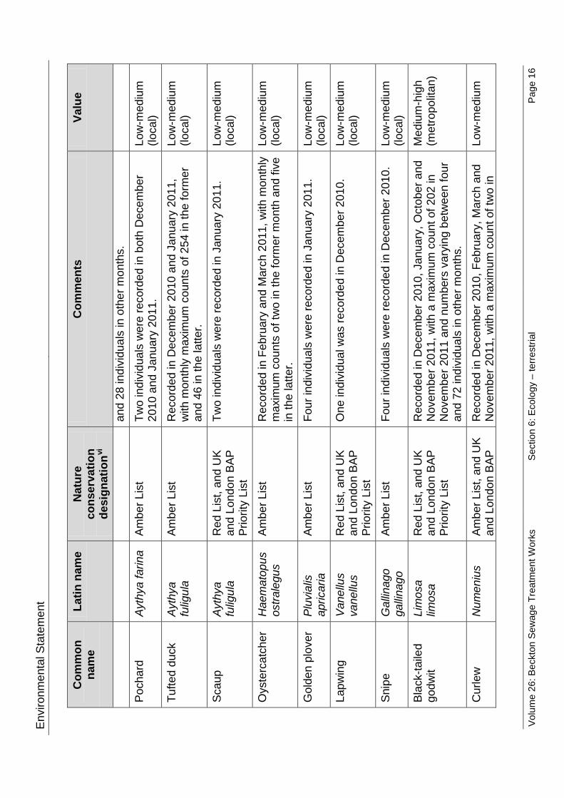
Envi
ronm
enta
l Sta
tem
ent
Com
mon
na
me
Latin
nam
e N
atur
e co
nser
vatio
n de
sign
atio
nvi
Com
men
ts
Valu
e
and
28 in
divi
dual
s in
oth
er m
onth
s.
Poch
ard
A
ythy
a fa
rina
Ambe
r Lis
t Tw
o in
divi
dual
s w
ere
reco
rded
in b
oth
Dec
embe
r 20
10 a
nd J
anua
ry 2
011.
Lo
w-m
ediu
m
(loca
l)
Tufte
d du
ck
Ayt
hya
fulig
ula
Ambe
r Lis
t R
ecor
ded
in D
ecem
ber 2
010
and
Janu
ary
2011
, w
ith m
onth
ly m
axim
um c
ount
s of
254
in th
e fo
rmer
an
d 46
in th
e la
tter.
Low
-med
ium
(lo
cal)
Scau
p A
ythy
a fu
ligul
a R
ed L
ist,
and
UK
and
Lond
on B
AP
Prio
rity
List
Two
indi
vidu
als
wer
e re
cord
ed in
Jan
uary
201
1.
Low
-med
ium
(lo
cal)
Oys
terc
atch
er
Hae
mat
opus
os
trale
gus
Ambe
r Lis
t R
ecor
ded
in F
ebru
ary
and
Mar
ch 2
011,
with
mon
thly
m
axim
um c
ount
s of
two
in th
e fo
rmer
mon
th a
nd fi
ve
in th
e la
tter.
Low
-med
ium
(lo
cal)
Gol
den
plov
er
Plu
vial
is
apric
aria
Am
ber L
ist
Four
indi
vidu
als
wer
e re
cord
ed in
Jan
uary
201
1.
Low
-med
ium
(lo
cal)
Lapw
ing
Van
ellu
s va
nellu
s R
ed L
ist,
and
UK
and
Lond
on B
AP
Prio
rity
List
One
indi
vidu
al w
as re
cord
ed in
Dec
embe
r 201
0.
Low
-med
ium
(lo
cal)
Snip
e G
allin
ago
galli
nago
Am
ber L
ist
Four
indi
vidu
als
wer
e re
cord
ed in
Dec
embe
r 201
0.
Low
-med
ium
(lo
cal)
Blac
k-ta
iled
godw
it Li
mos
a lim
osa
Red
Lis
t, an
d U
K an
d Lo
ndon
BAP
Pr
iorit
y Li
st
Rec
orde
d in
Dec
embe
r 201
0, J
anua
ry, O
ctob
er a
nd
Nov
embe
r 201
1, w
ith a
max
imum
cou
nt o
f 202
in
Nov
embe
r 201
1 an
d nu
mbe
rs v
aryi
ng b
etw
een
four
an
d 72
indi
vidu
als
in o
ther
mon
ths.
Med
ium
-hig
h (m
etro
polit
an)
Cur
lew
N
umen
ius
Ambe
r Lis
t, an
d U
K an
d Lo
ndon
BAP
R
ecor
ded
in D
ecem
ber 2
010,
Feb
ruar
y, M
arch
and
N
ovem
ber 2
011,
with
a m
axim
um c
ount
of t
wo
in
Low
-med
ium
Volu
me
26: B
eckt
on S
ewag
e Tr
eatm
ent W
orks
Se
ctio
n 6:
Eco
logy
– te
rrest
rial
Page
16

Envi
ronm
enta
l Sta
tem
ent
Com
mon
na
me
Latin
nam
e N
atur
e co
nser
vatio
n de
sign
atio
nvi
Com
men
ts
Valu
e
arqu
ata
Prio
rity
List
Fe
brua
ry 2
011
and
one
indi
vidu
al re
cord
ed in
all
othe
r mon
ths.
(lo
cal)
Red
shan
k Tr
inga
to
tanu
s Am
ber L
ist
Rec
orde
d ea
ch m
onth
, with
a m
axim
um c
ount
of 2
9 in
Mar
ch 2
011
and
num
bers
var
ying
bet
wee
n tw
o an
d 23
indi
vidu
als
in o
ther
mon
ths.
Low
-med
ium
(lo
cal)
Blac
k-he
aded
gu
ll
Laru
s rid
ibun
dus
Ambe
r Lis
t R
ecor
ded
each
mon
th, w
ith a
max
imum
cou
nt o
f 65
0 in
Feb
ruar
y 20
11 a
nd n
umbe
rs v
aryi
ng b
etw
een
eigh
t and
367
indi
vidu
als
in o
ther
mon
ths.
Low
-med
ium
(lo
cal)
Com
mon
gul
l La
rus
canu
s Am
ber L
ist
Rec
orde
d in
Jan
uary
and
Feb
ruar
y 20
11, w
ith
mon
thly
max
imum
cou
nts
of th
ree
in th
e fo
rmer
and
ei
ght i
n th
e la
tter.
Low
-med
ium
(lo
cal)
Less
er b
lack
-ba
cked
gul
l La
rus
fusc
us
Ambe
r Lis
t R
ecor
ded
each
mon
th b
etw
een
Janu
ary
and
Nov
embe
r 201
1, w
ith a
max
imum
cou
nt o
f 42
in
Mar
ch 2
011
and
num
bers
var
ying
bet
wee
n tw
o an
d fiv
e in
divi
dual
s in
oth
er m
onth
s.
Low
-med
ium
(lo
cal)
Her
ring
gull
La
rus
arge
ntat
us
Red
Lis
t and
UK
and
Lond
on B
AP
Prio
rity
List
Rec
orde
d ea
ch m
onth
, with
a m
axim
um c
ount
of 3
9 in
Mar
ch 2
011
and
num
bers
var
ying
bet
wee
n fo
ur
and
eigh
t ind
ivid
uals
in o
ther
mon
ths.
Low
-med
ium
(lo
cal)
Gre
at b
lack
-ba
cked
gul
l La
rus
mar
inus
Am
ber L
ist
Rec
orde
d in
Dec
embe
r 201
0, J
anua
ry, F
ebru
ary
and
Nov
embe
r 201
1, w
ith a
max
imum
cou
nt o
f thr
ee
durin
g D
ecem
ber 2
010
and
num
bers
var
ying
be
twee
n on
e an
d tw
o in
divi
dual
s in
oth
er m
onth
s.
Low
-med
ium
(lo
cal)
Volu
me
26: B
eckt
on S
ewag
e Tr
eatm
ent W
orks
Se
ctio
n 6:
Eco
logy
– te
rrest
rial
Page
17

Environmental Statement
Black redstart 6.4.33 The Phase 1 Habitat Survey identified that habitat at the Beckton STW site
is considered to have the potential to support nesting black redstart. Therefore, breeding surveys have been undertaken for this species. Full results are provided in Vol 26 Appendix D.1 and shown on Vol 26 Figure 6.4.7 (see separate volume of figures).
6.4.34 Black redstart are typically supported by a combination of complex structures which they use for refuge, singing and breeding purposes, and brownfield habitat which they use for foraging purposes (Black Redstarts website, 2012)7. Buildings are present within the sewage treatment works site in the form of towers, offices and other units, which comprise part of the sewage treatment process. Buildings are also present within Site B. Areas of suitable foraging habitat are present around the survey area including Site A.
6.4.35 Black redstarts have historically been identified breeding adjacent to the Beckton STW site at Beckton Gas Works, according to desk study data. The Lee Tunnel and Beckton Sewage Treatment Works extension Environmental Statement reported that black redstart were thought to use the Sewage Treatment Works for foraging purposes.
6.4.36 However, black redstart was not recorded at Beckton Sewage Treatment works during surveys undertaken for the Lee Tunnel and Beckton Sewage Treatment Works Extension Environmental Statement in 2006, nor were they identified during surveys in 2011. Therefore, there is considered to be no current black redstart resource on or in close proximity to the site (negligible). Black redstart is therefore not considered further in this assessment. Reptiles
6.4.37 The Phase 1 Habitat Survey identified that Site A could support reptiles due to the presence of semi-natural vegetation and banks with a ruderal, grassland and scrub mosaic, which would offer refuge and a potential foraging resource for reptiles. Therefore, reptile surveys were undertaken. Full results are given in Vol 26 Appendix D.1 and shown on Vol 26 Figure 6.4.8 (see separate volume of figures).
6.4.38 Surveys undertaken for the 2008 Lee Tunnel and Beckton Sewage Treatment Works Extension Environmental Statement identified a low population of grass snake (Natrix natrix) within habitat to the south of Site A. As part of the assessment for the Environmental Statement, mitigation was proposed to ensure that reptiles were not affected by construction works. This included a translocation exercise to move the reptiles off site. No reptiles were recorded during the 2011 surveys on site or in suitable habitat in the wider area.
6.4.39 Site B is considered to be of negligible value for reptiles, comprising hardstanding, bare ground and buildings with an absence of vegetation that would support reptiles. In view of the survey results, the site is considered to be of negligible value for reptiles.
6.4.40 Therefore, reptiles are not considered further in this assessment.
Volume 26: Beckton Sewage Treatment Works
Section 6: Ecology – terrestrial Page 18

Environmental Statement
Invasive plants 6.4.41 Japanese knotweed (Fallopia japonica) and Virginia creeper
(Parthenocissus inserta) were recorded in two locations within and adjacent to the Site A boundary as shown on Vol 26 Figure 6.4.9 (see separate volume of figures). Both of these plants are listed in Schedule 9 Part II of the Wildlife and Countryside Act 1981 (as amended). It is illegal to cause these species to spread or grow in the wild. Invasive plants are not considered further within this assessment as the eradication and control of such invasive species would be managed by the measures set out in the CoCP, as discussed in paras. 6.2.3 to 6.2.5. Noise, vibration and lighting
6.4.42 As noise, vibration and lighting have the potential to disturb species on and adjacent to the site, baseline conditions are described here.
6.4.43 Current sources of noise and vibration are mainly derived from vehicle movement along roads around the site, and noise associated with general operations and construction activities at the Sewage Treatment Works. Some noise is currently generated by the Lee Tunnel construction works on and adjacent to the site.
6.4.44 At night the site is lit in places by streetlights and security lights are attached to buildings.
Construction base case 6.4.45 As part of works associated with the Lee Tunnel project, a landscaping
scheme would have been completed on and adjacent to Site A by the first year of construction of the Thames Tideway Tunnel project. This landscaping is therefore considered as part of the base case for the Thames Tideway Tunnel project. The habitat present at Site A would therefore include: a. retained scrub, buildings and hardstanding b. scattered tree planting c. wasteland BAP habitat (passive regeneration) d. introduced shrub e. species-rich neutral grassland f. amenity grassland.
6.4.46 No planting is proposed for Site B which would continue to comprise hardstanding and buildings.
6.4.47 It is considered likely for the base case that the landscaping in Site A would be in the early stages of establishment. Trees, introduced shrubs and scrub would be relatively immature; grassland and wasteland habitat (ephemeral/short perennial) is likely to be established. These are habitats likely to be of low-medium (local) intrinsic value, and are considered likely to be of no more than low-medium (local) value for common bird species, low (site) value for invertebrate species and low-medium (local) value for foraging bats and black redstart.
Volume 26: Beckton Sewage Treatment Works
Section 6: Ecology – terrestrial Page 19

Environmental Statement 6.4.48 The noise and vibration base case is described in detail in Section 9 of this
volume. The base case for noise and vibration is anticipated to be similar to the current baseline. Lighting levels are anticipated to be the same as the current baseline.
6.5 Construction effects assessment
Construction impacts Habitat clearance and creation
6.5.1 Site clearance as part of enabling works for Site A would result in the removal of introduced shrub, scattered trees, wasteland habitat, and recently created neutral grassland of low-medium (local) value. This could affect breeding birds (including barn owls), and foraging bats. Scrub vegetation within the Greenway and Old Ford Nature Reserve SINC at Site A would be retained.
6.5.2 Only buildings and hardstanding of negligible value would be removed from Site B. Movement, noise, vibration and lighting
6.5.3 Noise and vibration impacts are based upon the data and assessment in Section 9 of this volume. Noise and vibration is likely to increase during the construction period with most of the works taking place during the day. These activities could cause disturbance to breeding and wintering birds adjacent to the sites. Given the distance between the proposed works on Site B and the foreshore to the south, as well as the existing high levels of activity and movement of personnel and machinery within the STW, it is considered unlikely that wintering birds on the foreshore would be disturbed.
6.5.4 Given the existing high background light levels, evening lighting during construction of the connection tunnel would be slightly higher on site than current levels. However, the horizontal and vertical light spill beyond those areas at ground level would be minimal due to control measures in the CoCP. Construction lighting would be directed away from dark vegetated areas, used by bats and barn owls for commuting and foraging. Therefore, no lighting impacts are anticipated on birds and bats.
6.5.5 As no bat roosts have been identified immediately adjacent to the sites, bats are only likely to be present within habitat adjacent to the sites whilst foraging at night. Foraging bats are unlikely to be affected by the increases in noise and vibration levels, and movements of vehicles at night.
6.5.6 Barn owls have been identified using a building in Site A for nesting purposes. It is likely that they use habitat adjacent to the site for foraging at night. There is the potential for barn owls to be affected by the increases in noise and vibration levels, and movements of vehicles at night.
Volume 26: Beckton Sewage Treatment Works
Section 6: Ecology – terrestrial Page 20

Environmental Statement
Construction effects Designated sites
6.5.7 There would be temporary loss of a small area of semi-improved grassland and scrub habitat from the Greenway and Old Ford Nature Reserve SINC (Grade Bi), to the east and west of the inlet works at Site A. There may also be occasional displacement of breeding birds such as whitethroat from vegetation on and adjacent to the site, within the SINC. However, birds are likely to habituate to the movement of vehicles and site personnel. Construction activities were present in close proximity to the habitats surveyed at the time of the survey. This indicates that nesting birds within this habitat are already habituated to some noise, vibration and movement associated with construction activities in close proximity to their nest sites. As the buildings and hardstanding within the designated sites do not contribute to the status of the greenway as a SINC, works within this area would not affect the integrity of the SINC. Where works in these areas could affect scrub habitat within the SINC, the scrub would be retained (CoCP Part B). Therefore, the integrity of the habitats for which the site has been designated would be maintained. Therefore, there would be no significant effect on the integrity of the designated site and the effect is considered to be probable, negligible and not significant.
6.5.8 The existing hardstanding and roads through the Beckton STW northern settling lagoon SINC (Grade B) would be used for the movement of construction vehicles as currently used on site. No likely significant adverse effects on the SINC have been identified. Habitats
6.5.9 Habitat to be lost during construction comprise low-medium (local) value habitat. The loss of a small amount of introduced shrub, scattered scrub, scattered trees and wasteland habitat would result in a reduction in the local habitat resource. Therefore, the effect would be probable, moderate adverse and significant. Species Bats
6.5.10 Bats were not identified using either Site A or Site B as part of dawn activity surveys, although common pipistrelle bats are likely to occasionally forage around vegetation at Site A. The temporary loss of an occasional foraging resource for common pipistrelle bats is unlikely to result in a perceptible change to bat populations as other more optimal and more frequently visited foraging areas are likely to be present in the wider area, such as the lagoons and associated scrub to the north of the site. Therefore, the effect of habitat loss on bats is considered to be probable, negligible and not significant.
6.5.11 Small changes in light levels during evening construction works are unlikely to create a barrier to the movement of commuting bats. Common pipistrelle bats can tolerate relatively high light levels, up to 14 lux. As there are currently no roosts on or adjacent to the site, there would be no disturbance to roosting bats. It is considered unlikely that changes in light
Volume 26: Beckton Sewage Treatment Works
Section 6: Ecology – terrestrial Page 21

Environmental Statement
levels and any subsequent changes in commuting behaviour would have an effect on the local distribution and abundance of bat populations. Therefore, the effect is considered to be probable, negligible and not significant. Breeding birds
6.5.12 Within Site A, the bramble and elder scrub immediately west of the inlet works would be disturbed by the construction of new structures. This would result in the temporary loss of nesting and foraging habitat for breeding birds. Based on the current use of vegetation on site, it is estimated that the breeding territories of three whitethroats, one dunnock and two linnets would be temporarily lost from the site.
6.5.13 Considering the number of whitethroat breeding territories within the survey area (10) and that the Greenway and Old Ford SINC (Grade B) continues for a considerable distance to the west and is also thought to support more whitethroat breeding territories, it is likely that breeding whitethroat would be displaced to alternative scrub habitat within the wider area. Any slight reduction in breeding success is unlikely to be perceptible against background fluctuations. It is considered unlikely that there would be a perceptible long term effect on their populations. Therefore, the effect is considered to be probable, negligible and not significant.
6.5.14 As only small numbers of linnet and dunnock breeding territories were recorded on site, which are of conservation concern, and small numbers of breeding territories of species that are not of conservation concern were recorded on site, it is considered likely that these species would also be displaced to alternative habitat in the wider area. This is unlikely to result in a perceptible change to breeding bird populations. Therefore, this effect is considered to be probable, negligible and not significant.
6.5.15 Any birds adjacent to the sites are likely to habituate to changes in noise and vibration levels as currently demonstrated on site, where construction works are being undertaken in close proximity to the breeding territories recorded during the breeding bird survey. Suitable habitat is available within the wider area and any birds displaced could move to these areas. Any change in populations would not be perceptible against background populations. Therefore, the effect of disturbance on breeding birds is considered to be probable, negligible and not significant.
6.5.16 It is considered that the predicted increase in noise, vibration and lighting levels would not affect breeding birds associated with the disused jetty. The Lee Tunnel construction works undertaken at Site B during summer 2011 are considered not to have had an adverse effect on the breeding success of the herring gull and lesser black-backed gull colony on the disused jetty 230m south of Site B, as the gull species were continuing to breed successfully on the jetty. Similar noise and vibration impacts that are associated with the Lee Tunnel works are predicted during construction of this scheme. Therefore the effects on breeding bird populations on the jetty are considered to be probable, negligible and not significant.
Volume 26: Beckton Sewage Treatment Works
Section 6: Ecology – terrestrial Page 22

Environmental Statement
Barn owls 6.5.17 The nest site itself would not be lost due to the proposed works and
foraging habitat would be retained during works. It is considered that the predicted increase in noise, vibration and lighting levels would disturb barn owls within the inlet works at Site A. However, with CoCP Part B measures works would be undertaken during the winter months and would not affect breeding of barn owls. Alternative nest sites would be provided where the barn owl is confirmed to be present during pre-start checks to ensure that shelter remains available for this species. Therefore the effect on barn owl populations is considered to be probable, negligible and not significant. Wintering birds
6.5.18 Birds may be displaced from adjacent habitat due to small changes in disturbance from noise, vibration and lighting. Occasional displacement of birds is expected where sudden noises occur with small numbers of wintering birds temporarily moving away from the habitat and returning shortly after. It is considered unlikely that this displacement would result in a perceptible change in wintering bird populations. Therefore, the effect of disturbance on wintering bird populations is considered to be probable, negligible and not significant.
6.5.19 It is considered that the predicted increase in noise, vibration and lighting levels would not affect wintering waterbirds within the survey area. The Lee Tunnel construction works undertaken at Site B during winter 2010/11 did not appear to have had an adverse effect on the wintering waterbird foraging behaviour on the intertidal mudflats and scour pool by the CSO approximately 230m to the east. Similar impacts are predicted during construction of this scheme. The effect on wintering waterbirds within intertidal habitat is considered to be probable, negligible and not significant.
Sensitivity test for programme delay 6.5.20 For the assessment of effects on terrestrial ecology during construction, a
delay to the Thames Tideway Tunnel project of approximately one year would not be likely to materially change the assessment findings reported above (paras. 6.5.1 to 6.5.19). This is because there are no developments in the site development schedule (Vol 26 Appendix N) that would fall into the base case as a result of this delay and therefore the base case would remain as described in paras. 6.4.45 to 6.4.48.
6.6 Operational effects assessment 6.6.1 As stated in para. 6.1.3, operational activities are limited at this site and
are not considered likely to lead to significant operational effects.
Volume 26: Beckton Sewage Treatment Works
Section 6: Ecology – terrestrial Page 23
Environmental Statement
6.7 Cumulative effects assessment
Construction effects 6.7.1 No likely significant cumulative effects on terrestrial ecology have been
identified as a result of construction activities from those developments identified in para. 6.3.9. Therefore, the effects on terrestrial ecology would remain as described in Section 6.5.
Sensitivity test for programme delay 6.7.2 In the event that the programme for the Thames Tideway Tunnel project is
delayed by approximately a year, the cumulative effects assessment would remain unchanged. As described above in para. 6.7.1, there are no schemes anticipated to generate cumulative effects on terrestrial ecology and this would remain the case with a programme delay of approximately one year.
6.8 Mitigation 6.8.1 All measures embedded in the design and the CoCP of relevance to
terrestrial ecology are summarised in para. 6.2.6. 6.8.2 To mitigate the loss of low-medium (local) value habitat on site,
replacement planting comprising native trees, scrub and brownfield land of at least the same quality or quantity as that lost would be required.
6.9 Residual effects assessment
Construction effects 6.9.1 With replacement planting for habitat lost during construction, the effect on
habitats would be reduced from a probable, moderate adverse and significant effect to a probable, negligible and non significant effect. All residual effects are presented in Section 6.10.
Volume 26: Beckton Sewage Treatment Works
Section 6: Ecology – terrestrial Page 24

Envi
ronm
enta
l Sta
tem
ent
6.
10
Ass
essm
ent s
umm
ary
Vo
l 26
Tabl
e 6.
10.1
Ter
rest
rial e
colo
gy –
con
stru
ctio
n as
sess
men
t sum
mar
y
Rec
epto
r Ef
fect
Si
gnifi
canc
e of
effe
ct
Miti
gatio
n Si
gnifi
canc
e of
re
sidu
al e
ffect
D
esig
nate
d si
tes
Gre
enw
ay a
nd
Old
For
d SI
NC
(s
crub
and
gr
assl
and)
No
sign
ifica
nt c
hang
e to
the
habi
tat
func
tiona
lity
of th
e G
reen
way
and
O
ld F
ord
Nat
ure
Res
erve
SIN
C
(Gra
de B
i)
Neg
ligib
le
Non
e
Neg
ligib
le
Hab
itats
Intro
duce
d sh
rubs
, scr
ub,
scat
tere
d tre
es,
was
tela
nd
habi
tat,
and
gras
slan
d
The
perm
anen
t los
s of
hab
itat o
f low
-m
ediu
m (l
ocal
) val
ue h
abita
t. M
oder
ate
adve
rse
Rep
lace
men
t pl
antin
g w
ith a
t lea
st
the
sam
e qu
antit
y an
d qu
ality
of h
abita
t as
that
lost
.
Neg
ligib
le
Spec
ies
Bats
N
o ch
ange
in b
at p
opul
atio
ns a
s a
resu
lt of
tem
pora
ry d
ispl
acem
ent o
f fo
ragi
ng b
ats
from
the
site
to th
e su
rrou
ndin
g ar
ea d
ue to
hab
itat l
oss
on s
ite.
Neg
ligib
le
Non
e N
eglig
ible
No
sign
ifica
nt c
hang
es to
bat
po
pula
tions
as
a re
sult
of d
istu
rban
ce
from
cha
nges
in li
ght l
evel
s.
Neg
ligib
le
Non
e N
eglig
ible
Volu
me
26: B
eckt
on S
ewag
e Tr
eatm
ent W
orks
Se
ctio
n 6:
Eco
logy
– te
rrest
rial
Page
25

Envi
ronm
enta
l Sta
tem
ent
Rec
epto
r Ef
fect
Si
gnifi
canc
e of
effe
ct
Miti
gatio
n Si
gnifi
canc
e of
re
sidu
al e
ffect
Bi
rds
No
perc
eptib
le c
hang
e in
pop
ulat
ions
of
whi
teth
roat
as
a re
sult
of
disp
lace
men
t fro
m s
ite d
ue to
di
stur
banc
e du
ring
cons
truct
ion.
Neg
ligib
le
Non
e N
eglig
ible
No
perc
eptib
le c
hang
e in
dun
nock
an
d lin
net p
opul
atio
ns a
s a
resu
lt of
di
spla
cem
ent f
rom
site
due
to
dist
urba
nce
durin
g co
nstru
ctio
n.
Neg
ligib
le
Non
e N
eglig
ible
No
perc
eptib
le c
hang
e in
bre
edin
g bi
rd p
opul
atio
ns a
djac
ent t
o th
e si
te
as a
resu
lt of
dis
plac
emen
t due
to
nois
e an
d vi
brat
ion.
Neg
ligib
le
Non
e N
eglig
ible
No
chan
ge in
bird
pop
ulat
ions
on
the
jetty
to th
e ea
st o
f the
site
as
resu
lt of
le
vels
of d
istu
rban
ce fr
om n
oise
, vi
brat
ion
and
light
ing.
Neg
ligib
le
Non
e N
eglig
ible
Barn
ow
ls
No
chan
ge in
bar
n ow
l pop
ulat
ions
as
a re
sult
of le
vels
of d
istu
rban
ce
from
noi
se, l
ight
ing
and
vibr
atio
n.
Neg
ligib
le
Non
e N
eglig
ible
Win
terin
g bi
rds
No
effe
ct o
n w
inte
ring
bird
s as
soci
ated
with
the
fore
shor
e an
d je
tty a
djac
ent t
o th
e si
te
Neg
ligib
le
Non
e N
eglig
ible
No
sign
ifica
nt c
hang
e in
wat
erbi
rd
popu
latio
ns a
s a
resu
lt of
dis
turb
ance
fro
m n
oise
, vib
ratio
n an
d lig
htin
g.
Neg
ligib
le
Non
e N
eglig
ible
Volu
me
26: B
eckt
on S
ewag
e Tr
eatm
ent W
orks
Se
ctio
n 6:
Eco
logy
– te
rrest
rial
Page
26

Envi
ronm
enta
l Sta
tem
ent
Rec
epto
r Ef
fect
Si
gnifi
canc
e of
effe
ct
Miti
gatio
n Si
gnifi
canc
e of
re
sidu
al e
ffect
N
o si
gnifi
cant
cha
nge
in w
inte
ring
bird
pop
ulat
ions
as
a re
sult
of
dist
urba
nce
from
noi
se, v
ibra
tion
and
light
ing
Neg
ligib
le
Non
e N
eglig
ible
Volu
me
26: B
eckt
on S
ewag
e Tr
eatm
ent W
orks
Se
ctio
n 6:
Eco
logy
– te
rrest
rial
Page
27

Environmental Statement
References
1Department of Environment, Food and Rural Affairs (Defra). National Policy Statement for Waste Water. (2012). Available at: http://www.defra.gov.uk/publications/files/pb13709-waste-water-nps.pdf last accessed November 2012 2 Scott Wilson. Lee Tunnel and Beckton STW Extension Environmental Statement (May 2008). 3 IEEM. Guidelines for Ecological Impact Assessment in the United Kingdom (2006). 4 London Bat Group. Greater London Bat Action Plan (2012). Available online at: http://londonbats.org.uk/lbpsap.htm. Accessed 19 January 2012. 5 London Natural History Society. London Bird Report 2008. (2011) 6 London Natural History Society. London Bird Report 2007. (2011) 7 Black Redstarts website. Available at: http://www.blackredstarts.org.uk. Accessed February, 2012.
Volume 26: Beckton Sewage Treatment Works
Section 6: Ecology – terrestrial Page 28

Hard copy available in
Environmental StatementDoc Ref: 6.2.26
Volume 26: Beckton Sewage Treatment Works site assessmentSection 7: Historic environmentAPFP Regulations 2009: Regulation 5(2)(a)
Box 40 Folder A January 2013
Sect
ion
7: H
isto
ric e
nviro
nmen
t
Thames Tideway Tunnel Thames Water Utilities Limited
Application for Development ConsentApplication Reference Number: WWO10001

This page is intentionally blank

Environmental Statement
Thames Tideway Tunnel
Environmental Statement
Volume 26: Beckton Sewage Treatment Works site assessment
Section 7: Historic environment
List of contents
Page number
7 Historic environment ....................................................................................... 1
7.1 Introduction .............................................................................................. 1
7.2 Proposed development relevant to the historic environment ................... 2
7.3 Assessment methodology ........................................................................ 4
7.4 Baseline conditions .................................................................................. 7
7.5 Construction effects assessment ........................................................... 15
7.6 Operational effects assessment ............................................................ 18
7.7 Cumulative effects assessment ............................................................. 18
7.8 Mitigation ............................................................................................... 18
7.9 Residual effects assessment ................................................................. 19
7.10 Assessment summary ........................................................................... 20
References .............................................................................................................. 24
List of tables
Page number
Vol 26 Table 7.3.1 Historic environment – consultation response ............................. 4
Vol 26 Table 7.10.1 Historic environment – summary of construction assessment . 20
Volume 26: Beckton Sewage Treatment Works
Section 7: Historic environment Page i

Environmental Statement
This page is intentionally blank
Volume 26: Beckton Sewage Treatment Works
Section 7: Historic environment Page ii

Environmental Statement
7 Historic environment
7.1 Introduction 7.1.1 This section presents the findings of the assessment of the likely
significant effects of the proposed development on the historic environment at the Beckton STW site. The historic environment is defined in para 4.10.2 of the NPS as including all aspects of the environment resulting from the interaction between people and places through time, including all surviving physical remains of past human activity, whether visible, buried or submerged, and landscaped and planted or managed flora. For the purposes of this assessment, heritage assets comprise below and above-ground archaeological remains, buildings, structures, monuments and heritage landscapes within and around the site. Effects during construction are assessed with effects on buried heritage assets presented first, followed by above-ground assets.
7.1.2 There are no above-ground or buried heritage assets within the assessment area whose settings would be significantly adversely affected. Both construction and operational effects for the historic character and setting of heritage assets for this site have therefore been scoped out of the assessment.
7.1.3 Based on a review of the noise and vibration assessment (Section 9), it is concluded that there would be no significant noise or vibration effects requiring offsite mitigation to any listed building. Such effects are therefore not considered further in this assessment.
7.1.4 An assessment of effects from ground movement resulting from the Thames Tideway Tunnel itself is covered in Volume 3 Project-wide Effects. No effects are predicted on historic receptors in the vicinity of this site, therefore no assessment of ground movement effects is presented.
7.1.5 The assessment of the historic environment effects of the project has considered the requirements of the National Policy Statement for Waste Water (NPS). As such the assessment covers designated and non-designated assets, and a description of the significance of each heritage asset affected by the proposed development. The assessment covers both above and below ground assets. The effect of the proposed development on the significance of heritage assets is clearly detailed in line with the requirements of the NPS. The role of the design process in helping to minimise effects on the historic environment is explained, and where appropriate, mitigation is proposed. Vol 2 Section 7 provides further details on the methodology.
7.1.6 Plans of the proposed development as well as figures included in the assessment for this site are contained in a separate volume (Volume 26 Beckton Sewage Treatment Works Figures).
Volume 26: Beckton Sewage Treatment Works
Section 7: Historic environment Page 1

Environmental Statement
7.2 Proposed development relevant to the historic environment
7.2.1 The proposed development is described in Section 3 of this volume. The elements of the proposed development relevant to the historic environment are set out below.
7.2.2 The site is an irregular shape comprising three distinct areas linked by access roads within the limits of land to be acquired or used (LLAU). Site A is the central area and Site B is the easternmost area. A third area affording access to the construction and permanent works lies approximately 250m to the north of Site A. Together these areas are collectively referred to as ‘the site’.
Construction 7.2.3 All below-ground works during construction are relevant to the assessment
because they would potentially truncate or entirely remove any archaeological assets within the footprint of the works. These are described below.
7.2.4 For Sites A and B the following would be carried out: a. Site fencing would be erected, supported by timber posts in concrete
foundations b. Welfare facilities would be constructed over part of the site, assumed
for the purposes of this assessment to be set on foundations with a depth of up to approximately 1.0 metres below the ground level (mbgl)
c. The site set-up would also entail the provision of services and the construction of new service trenches up to approximately 1.5m deep
d. Foundations for cranes bases and plant for grout production are assumed to be likely to extend to a similar depth (see Construction phase 1 plan, separate volume of figures - Section 1).
7.2.5 Site setup would also entail new service trenches for connections to the site compounds up to approximately 1.5–2.0m deep. It is assumed for the purposes of this assessment that a preliminary site strip is unlikely to be necessary as both Site A and B fall within the work areas of the Lee Tunnel and Beckton STW extension, where this has already been carried out.
7.2.6 At Site A, the permanent works (see Site works parameter plan, separate volume of figures - Section 1) would include the construction of: a. A syphon tunnel inlet shaft. b. A valve chamber to control the connection between the new syphon
tunnel inlet shaft and the existing Lee Tunnel shaft (Construction Phase 2- Site A: Flow transfer and Other Structures). A depth of 7.0m is assumed for the purposes of this assessment
c. A flow transfer pipeline connection tunnel from the syphon tunnel inlet shaft to the inlet works beside the Northern Outfall Sewer
Volume 26: Beckton Sewage Treatment Works
Section 7: Historic environment Page 2
Environmental Statement
d. A tunnel pump-out discharge chamber and discharge structure would
be constructed to the west of the inlet works, connecting to the adjacent Northern Outfall Sewer.
7.2.7 At Site B, the permanent works (see Site works parameter plan, separate volume of figures - Section 1) would be located entirely within the footprint of former sludge tanks, now filled with concrete, and include the construction of : a. A syphon tunnel outlet shaft b. A culvert assumed for the purposes of this assessment to be 5.0m
deep, ventilation duct and penstock chamber. 7.2.8 Subsequent landscaping at both Sites A and B would not entail general
ground reduction. The two shafts at Sites A and B would be connected by a tunnel bored at a level too deep to have an archaeological impact. Code of Construction Practice
7.2.9 Measures incorporated into the Code of Construction Practice (CoCP) Part A (Section 12) to protect heritage assets include: a. The requirement for the contractor to prepare a site-specific Heritage
Management Plan (HMP), indicating how the historic environment is to be protected. This may take form of both physical protection and working practices.
b. Protective measures, such as temporary support, hoardings, barriers, screening and buffer zones around heritage assets, and archaeological mitigation areas within and adjacent to worksites.
c. Advance assessment to inform the types of plant and working methods for use where heritage assets are close to worksites, or attached to structures that form parts of worksites.
d. Procedures under EPP for the emergency repair of damage to listed buildings. Where there is damage that does not require emergency repair, repair will be affected as making good as part of the construction process. Final repairs to significant finishes will be 'like for like'.
e. Security procedures to prevent unauthorised access to heritage assets and archaeological investigations, and damage to or theft from them, including by the use of metal detectors.
f. Procedures in the event of the discovery of human remains. g. Procedures under the Treasure Act Code of Conduct 1997, to address
the discovery of any artefacts defined in the Treasure Act 1996. 7.2.10 The Code of Construction Practice (CoCP) is provided in Vol 1 Appendix
A. It contains general requirements (Part A), and site specific requirements for this site (Part B).
7.2.11 Site-specific measures incorporated in the CoCP Part B (Section 12) comprise protective measures to mitigate against potential accidental strike damage to the Grade II listed chimney.
Volume 26: Beckton Sewage Treatment Works
Section 7: Historic environment Page 3

Environmental Statement
7.2.12 All the measures detailed above form part of the proposed development
subject to the assessment, and therefore impacts such as strike damage on heritage assets are considered unlikely to occur and are not assessed. However, site specific measures to mitigate effects on buried heritage, which would be detailed in Site Specific Archaeological Written Scheme of Investigation (SSAWSI), in line with the Overarching Archaeological Written Scheme of Investigation (OAWSI) (Vol 2 Appendix E.2), would be subject to the findings of field evaluation, and are therefore reported as mitigation as detailed further in para 7.8.5.
7.3 Assessment methodology
Engagement 7.3.1 Volume 2 Environmental assessment methodology documents the overall
engagement which has been undertaken in preparing the Environmental Statement. Specific comments relevant to this site for the assessment of the historic environment are presented here. Throughout the environmental impact assessment (EIA) there has been regular liaison with English Heritage and other stakeholders. Vol 26 Table 7.3.1 below summarises the comments raised by consultees and how each comment has been addressed.
Vol 26 Table 7.3.1 Historic environment – consultation response
Organisation and date
Comment Response
English Heritage phase two consultation (February 2012)
Request that the position of the re-erected Grade II listed chimney be indicated on all of the relevant drawings
The chimney would be re-erected in the same location as illustrated on Vol 26 Figure 7.4.1
English Heritage broadly concur that deeply buried remains are likely to be the most important archaeological asset most at risk from the proposals
Noted in this assessment.
Request that a 19th century wall around the northeastern perimeter of Site B be noted in the ES
Noted in this assessment.
Each element of construction should be assessed separately in order to inform subsequent preparation of archaeological mitigation (fieldwork) scope and
This assessment covers each element of the construction and the likely effect upon heritage assets. This has informed the mitigation proposed.
Volume 26: Beckton Sewage Treatment Works
Section 7: Historic environment Page 4

Environmental Statement
Organisation and date
Comment Response
programme
English Heritage Section 48 publicity comments (October 2012)
English Heritage noted that an impact has been identified on the above ground structural remains of the Bazalgette northern outfall sewer and advised that any loss of the original Bazalgette structures would comprise a significant heritage impact.
At Becton Sewage Treatment Works, the impact on the Northern Outfall Sewer would be low and localised and without major loss of fabric from this heritage asset and functioning sewage pipe. The effect would be mitigated by preservation by record. EH accepted this approach at a meeting held on 11th November 2012 to discuss their S48 response.
Baseline 7.3.2 The baseline methodology follows that described in Vol 2. It should be
noted that whilst most of the topics within the ES use the term 'value' to define the sensitivity of environmental receptors within the baseline, the historic environment assessment uses 'asset significance' as per the terminology used within the NPS. Distinction is made between the significance of the resource, i.e. asset significance, and the significance of the environmental effect throughout the following assessment.
7.3.3 Baseline conditions for above ground and buried heritage assets are described within a survey area made up of two joined areas covering a 1km-radius area around the centre point of Site A and Site B, which is considered through professional judgement to be most appropriate to characterise the historic environment potential of the site. There are occasional references to assets beyond this area, for example, a Roman road from London to Colchester approximately 4.5km to the north of the site, which contribute to current understanding of the site and its environs in the Roman period.
7.3.4 A site visit was carried out in spring 2011. At the time Site A and Site B were both active construction works areas for the Lee Tunnel and Beckton Sewage Treatment Works extension.
Construction 7.3.5 The assessment methodology for the construction phase follows that
described in Vol 2. There are no site-specific variations for undertaking the construction assessment of this site.
7.3.6 In terms of physical effects on above-ground and buried heritage assets, likely significant effects could arise throughout the construction phase.
Volume 26: Beckton Sewage Treatment Works
Section 7: Historic environment Page 5

Environmental Statement
Effects arising from all stages of the construction period are therefore assessed. The construction assessment area for such effects is defined by the site boundary.
7.3.7 Section 7.5 details the likely significant effects arising from the construction at the site. There are no other Thames Tideway Tunnel project sites which could give rise to additional effects on the historic environment at this site, therefore no other Thames Tideway Tunnel project sites are considered in this assessment.
7.3.8 Archaeological remains are a static resource, which have reached equilibrium with their environment and do not change (ie decay or grow) unless their environment changes as a result of human or natural intervention. In terms of the assessment of effects on buried heritage assets or above-ground assets located within the site, the Lee Tunnel works development within the Thames Tideway Tunnel project site (Beckton STW Sludge Digestion; The Lee Tunnel & Beckton STW Extension / Upgrade Works), as listed in the development schedule (Vol 26 Appendix N), are relevant to the base case. However, archaeological mitigation for these developments has already been carried out and the results have been incorporated into the baseline. Whilst the baseline within the baseline area beyond the site may change as a result of any archaeological excavation and recording carried out as part of a standard programme of mitigation for other developments, such information is unlikely to significantly change the current understanding of the historic environment of the site, and is not considered further.
7.3.9 As detailed in the site development schedule (Vol 26 Appendix N) the Beckton Waterfront Masterplan scheme is the only development identified within 1km of the site which meets the criteria for inclusion in the cumulative assessment. However, this scheme would not impact on buried or above-ground heritage assets within the site because there are no assets common to Beckton Sewage Treatment Works and that scheme. Therefore no assessment of cumulative effects has been undertaken for physical effects on assets in the construction phase.
7.3.10 Should the programme for the Thames Tideway Tunnel project be delayed by approximately one year, this would lead to no change in the assessment findings, and is therefore not considered further in the assessment. As described above, whilst the baseline within the area beyond the site may change as a result of any archaeological excavation and recording carried out as part of a standard programme of mitigation for other developments, such information is unlikely to significantly change the current understanding of the historic environment of the site. Therefore a delay to the Thames Tideway Tunnel project, with a consequent change in other schemes which may have been developed by the time of Thames Tideway Tunnel construction, would not lead to any change in the baseline and therefore no change in the assessment of effects on these assets.
Volume 26: Beckton Sewage Treatment Works
Section 7: Historic environment Page 6
Environmental Statement
Assumptions and limitations 7.3.11 The assumptions and limitations associated with this assessment are
presented in Vol 2. Site-specific assumptions and limitations are detailed below. Assumptions
7.3.12 The assessment of effects on buried heritage assets is based on the shafts and other below-ground structures being located anywhere within the zones identified on the permanent works plan for these structures. The assessment is not sensitive to variations in location within these zones because the desk-based assessment has not located any buried heritage assets of high significance within the site, which would warrant preservation in situ (see Site works parameter plan, separate volume of figures - Section 1).
7.3.13 A number of assumptions have been made regarding the likely depth of temporary construction works (eg site strip, footings for plant and accommodation), based on professional knowledge of construction projects. Whilst the precise nature of construction effects on buried heritage would vary if the depths varied, the mitigation proposed to address any effects would remain as stated, as would the residual effects. These assumptions are detailed in Section 7.2. Limitations
7.3.14 No site-specific limitations have been identified.
7.4 Baseline conditions 7.4.1 The following section sets out the baseline conditions for the historic
environment within and around the site. Future baseline conditions (base case), which would remain as per the baseline, are also described. The section comprises seven sub-sections: a. a description of historic environment features within the 1km-radius
baseline area b. a description of statutorily designated assets within the site and
assessment area. Locally designated assets and known burial grounds are included, where relevant, as described in Volume 2.
c. a description of the site location, topography and geology d. a summary of past archaeological investigation, providing an indication
of how well the area is understood archaeologically e. a chronological summary of the archaeological and historical
background of the site and its environs f. a statement of significance for buried heritage assets, taking account
of factors affecting survival. g. a statement of significance for above-ground assets within and around
the site, describing the features which contribute to their significance, including historic character, appearance and setting.
Volume 26: Beckton Sewage Treatment Works
Section 7: Historic environment Page 7

Environmental Statement
Current baseline Historic environment features
7.4.2 The historic environment features map (see Vol 26 Figure 7.4.1 in separate volume of figures) shows the location of known above-ground and buried historic environment features within the 1km-radius baseline area, compiled from the baseline sources set out in the methodology in Vol 2. These have been allocated a unique historic environment assessment reference number (HEA 1, 2, etc), which are listed in the gazetteer in Vol 26 Appendix E.1. Designated assets International and national statutory designations
7.4.3 The site contains the site of a Grade II listed chimney (HEA 1A), constructed by Joseph Bazalgette as part of the sewage treatment works in 1887–1889. The chimney has been dismantled as mitigation for the Lee Tunnel works and will be reinstated by them. The wider baseline area does not contain any nationally or internationally designated (statutorily protected) heritage assets, such as scheduled monuments, listed buildings, or registered parks and gardens. The significance of assets is described further in the 'Statement of significance: above-ground heritage assets' below, in paras. 7.4.39–7.4.43. Local authority designations
7.4.4 The site lies within an extensive Archaeological Priority Area which covers the Thames floodplain in recognition of its high potential for palaeoenvironmental and other archaeological remains. The site does not lie within a conservation area and contains no locally listed buildings. Known burial grounds
7.4.5 There are no known burial grounds within the site or adjacent to it. Site location, topography and geology
7.4.6 Site A lies to the east of Royal Docks Road. Ground level within Site A, although variable, generally slopes down towards the centre of the site from both east and west. The western part lies at 107.0m ATD (above Tunnel Datum), the eastern part at 105.0m ATD, and central area at 102.5m ATD.
7.4.7 Site B lies within the southeast of the Sewage Treatment Works and is bounded by the mudflats of the River Thames to the south. Ground level within Site B slopes gently down from the northeast at 106.9m ATD, to the southwest at 105.6m ATD.
7.4.8 The site is located entirely on the Thames alluvial floodplain, over gravel geology. The ground levels have been raised artificially in the past, by several metres, following drainage and reclamation of the intertidal marshes in the medieval and post-medieval periods.
7.4.9 Geoarchaeological deposit modelling across the sewage works site in 2009 (HEA 31) indicated that the top of the gravel both undulates and dips away from higher ground of 98.5m ATD in the north to 91.0m ATD in the
Volume 26: Beckton Sewage Treatment Works
Section 7: Historic environment Page 8

Environmental Statement
south of the site, toward the Thames, where it probably encountered a former route of the River Roding (that later became Barking Creek). The top of the overlying alluvium is at 101.0m ATD in the north and 102.5m ATD in the south. The sequence contained thick peats (the rotted vegetation of a former land surface) up to 99.0m ATD. Overlying the alluvial sequence is made ground.
7.4.10 In the northern part of Site A, ground level has only been raised by c 1.3m of made ground, but beneath this lies < 1.5m of estuarine clay and 0.5m of peat. This reflects the original higher land surface on the northern part of the site, which was nonetheless subject to some inundation, which produced the peat and clay deposits.
7.4.11 The southern part of the site (Site B) has been extensively raised by up to 5.5m of made ground, probably to provide a high platform above the level of the tide. Below this lies < 3.5m of estuarine clay and < 8.0m of peat, reflecting the changing river environment of seasonal inundation.
7.4.12 The gravels were laid down by fast-flowing braided river channels of the Ice Age Thames, but as sea levels rose the environment changed and alluvial deposits would have built up. There may be subsidiary channels and small inlets which could locally affect the relative heights and levels of gravel, peat and alluvial deposits within the site.
7.4.13 The site topography and geology is discussed in more detail in Vol 26 Appendix E.2. Past archaeological investigations
7.4.14 In 2008, the 1880s Bazalgette sewage works Engine House (HEA 1D) within Site B was archaeologically recorded prior to demolition as part of the Lee Tunnel Works. The Grade II listed sewage works chimney was removed and recorded but would be reinstated before the construction phase of the Thames Tideway Tunnel project. In 2004, standing structure recording 390m to the north recorded other elements of the original sewage works (HEA 6).
7.4.15 In 2009, MOLA carried out an archaeological evaluation (HEA 1G) at the Triangle Site as part of the Lee Tunnel development, in the northern part of Site A. This was informed by a geoarchaeological deposit model across the sewage works (HEA 31), which profiled the likely depth of deposits based on historical borehole data. The evaluation recorded peat and alluvial deposits, which provided environmental evidence from the prehistoric period onwards, but no evidence of human activity.
7.4.16 Within the rest of the baseline area, beyond the site boundary, other archaeological investigations largely revealed palaeoenvironmental information and no evidence of human activity earlier than the post-medieval period. The remains of four yew trees, probably part of a prehistoric forest, along with water-worn burnt flint beneath a thick layer of peat, was recorded 180m to the north of Site B (HEA 8).
7.4.17 Further details of past archaeological investigations carried out within the site and baseline area are included in Vol 26 Appendix E.3.
Volume 26: Beckton Sewage Treatment Works
Section 7: Historic environment Page 9

Environmental Statement
Archaeological and historical background of the site
7.4.18 The following section presents a chronological summary of the archaeological and historical background of the site. Further detail is included in Vol 26 Appendix E.4.
7.4.19 During the prehistoric period (700,000 BC–AD 43), the site would have been marsh, dry land and river channel at different times, and increasingly subject to flooding following the rise in river levels during the late prehistoric period. The northern part of Site A lies on an island of higher gravel overlain by sands and this is likely to have been a dry land surface until the Neolithic or later. Site B lies in an area of deeper gravel, overlain by a variable long peat sequence. Pollen analysis of local peat indicates a range of wetland environments from alder carr wet woodland to reed swamp1. This environment, along with the River Thames and Barking Creek, would have been exploited for predictable resources (eg food, water, reeds). The Greater London Historic Environment Record (GLHER) contains a number of chance prehistoric finds, including Palaeolithic worked flint 540m to the south (HEA 15) and 790m to the west (HEA 27) of the site, Mesolithic animal remains 330m to the north (HEA 9), and a water-worn burnt flint 180m to the north of the site (HEA 8). The discovery of several isolated Neolithic and Bronze Age artefacts to the north and south/southwest of the site (HEA 4, 9, 11 and 26) suggest some activity in the area in the later prehistoric period. No wooden trackways, of the type which were built elsewhere in the Lower Thames valley to provide access across the marshes, have been found in the baseline area. By the early Iron Age, sea level rise changed the landscape to tidal mudflats and salt marsh. Deposits laid down by successive sea level rises have buried earlier land surfaces at considerable depth.
7.4.20 During the Roman period (AD 43–410) the site was prone to flooding and lay in open marshland or on the foreshore, or even partly within the Thames channel. As such it would have been unsuitable for settlement, but may have been exploited for a number of intertidal marshland resources, in some places on an industrial scale (eg pottery, kilns, salt production from evaporation, fish processing etc). The GLHER records the site of a possible Roman dock in Barking Creek (HEA 10), 730m to the north.
7.4.21 Throughout the medieval period (AD 410–1485) the site would have been in intertidal marshland and probably used for pasture. The closest main settlement, the village of East Ham, lay 1.6km to the west of the site. It is likely that the marshland began to be drained and reclaimed piecemeal in this period, with the construction of drainage ditches and river embankments, in order to provide good-quality grazing for livestock and fertile land for crops. No upstanding banks were noted on the site walkover survey, and any such features would lie beneath subsequent raised ground.
7.4.22 The site was reclaimed marshland throughout much of the post-medieval period (AD 1485–present). A map of 1805 shows a number of linear north-south oriented trackways across the former marsh from the higher gravel terrace to the north. These would have been on raised
Volume 26: Beckton Sewage Treatment Works
Section 7: Historic environment Page 10

Environmental Statement
embankments, which would also have served as flood defence embankments, and are probably of medieval origin.
7.4.23 In the early 1860s elements of the Bazalgette sewage infrastructure were built within the site, including the Northern Outfall Sewer in the southern half of Site A (HEA 1B), irrigation dams, and part of the northern outfall reservoir.
7.4.24 In the 1880s, the complex changed from the simple reservoir function of storing then releasing raw sewage into the Thames, to a sewage treatment works. This entailed a significant amount of building, including extensive reservoir tanks and aeration lanes, to the northeast of Site A and the north of Site B. The principal buildings included the Engine House (HEA 1D; no longer extant) and chimney (HEA 1A; temporarily removed). Sludge settling tanks beside these structures have recently been cut down to ground level and infilled with foam concrete. Within Site A was a small sewage works building (HEA 1E) beside the outfall sewer. Hachures on contemporary maps indicate extensive raised ground for improved drainage.
7.4.25 By the end of the 19th century, the completed sewage works covered the site, and this was to become the largest of its kind in Europe. The largest gasworks in Europe, owned by the Gas Light and Coke Company was constructed to the south of Site A and west of Site B. It included riverside piers and a railway, with huge by-products works, producing tar, ammonia, fertilizers and dyes. The complex closed in 1967 after the discovery of natural gas in the North Sea made coal gas uncompetitive, although a storage and distribution plant remained into the late 1990s.
7.4.26 Beckton STW continued to grow throughout the first half of the 20th century, and included a tramway and tram ‘Car Shed’ (HEA 1F) within Site A, and offices and accommodation to the northwest (HEA 33; outside Site A). Alterations since the 1950s have been relatively minor until the Thames Tideway Improvements programme, including the Lee Tunnel and Sewage Works Extension projects, started recently.
7.4.27 Both Sites A and B have been active construction sites as part of the Lee Tunnel works and the STW Extension. As part of that development, all 19th century infrastructure, other than the outfall sewer was removed prior to construction. The sludge tanks within Site B were cut down to ground level and filled with concrete. Statement of significance: buried heritage assets on the site Introduction
7.4.28 The following section discusses past impacts on the site which are likely to have compromised asset survival (generally from late 19th and 20th century developments, eg, building foundations), identified primarily from historic maps, the site walkover survey, the “Abbey Mills” Books and extensive record drawings and information on the likely depth of deposits.
7.4.29 In accordance with the National Policy Statement for Waste Water (Defra, 2012)2, National Planning Policy Framework (DCLG, 2012)3 and PPS5 Planning Practice Guide (DCLG, 2010)4, (which remains extant), this is
Volume 26: Beckton Sewage Treatment Works
Section 7: Historic environment Page 11

Environmental Statement
followed by a statement on the likely potential for and significance of buried heritage assets within the site, derived from current understanding of the baseline conditions, past impacts, and professional judgement. Factors affecting survival
7.4.30 Both Sites A and B have been subject to disturbance from building development from the late 19th century onwards, but deeper remains within the alluvium beneath the made ground are likely to survive intact to very variable depths. At Site B there is a considerable depth of modern made ground present (potentially up to approximately 5.5m), which would have protected underlying archaeological remains from any previous truncation from all but the deepest foundations and shafts (which would have locally penetrated the made ground and extended into the underlying alluvium). At Site A the modern made ground may not be as deep, but is likely to be at least 1.3m thick, overlying potentially another 4.5m depth of archaeological deposits including alluvium (as recorded west of Jenkin’s Lane, HEA 31) and around 3.5m depth on to a gravel island within peat margins (as recorded east of Jenkin’s Lane, HEA 31).
7.4.31 Other factors affecting survival include: a. Construction of 19th century sewage works: Archive plans and
sections of the ‘Abbey Mills Books’ (Thames Water, 1887)5 record that the late 19th century sewage infrastructure entailed deep ground disturbance. The Old Engine House (HEA 1D) had a deep basement founded on the gravels and the chimney (HEA 1A) had a very deep base founded on them. Sludge tanks, precipitation lanes, and culverts within Site B extended up to 8.7m below the late 19th century ground levels. Any earlier archaeological remains will have been removed from within the footprint of these constructions. Surviving elements of these structures would themselves be of archaeological interest.
b. 20th century works: From the mid-20th century, piled foundations were used for some of the larger buildings in Site B, which will have locally removed any archaeological remains within and around the footprint of each pile. Other 20th century structures are unlikely to have had an impact upon anything pre-dating the 19th century, due to the substantial depth of made ground here, which is up to 5.5m thick.
c. Lee Tunnel project works 1: Construction of the Lee Tunnel shafts within Site A and Site B will have entirely removed any archaeological remains from within the footprint of each shaft.
d. Lee Tunnel project works 2: The new pumping station constructed as part of the Lee Tunnel works in the northern part of Site A will have removed any post-medieval remains within the made ground beneath these structures, and possibly deeper (earlier) remains within the alluvium. Service trenches will have truncated buried remains of late 19th century sewage works infrastructure but are unlikely to have extended beneath the late 19th/20th century made ground.
Volume 26: Beckton Sewage Treatment Works
Section 7: Historic environment Page 12
Environmental Statement
Asset potential and significance
7.4.32 The following statement of asset significance takes into account the levels of natural geology and the level and nature of later disturbance and truncation.
Palaeoenvironmental 7.4.33 Site A has high potential to contain palaeoenvironmental remains. The
deposits recorded across the site form part of the floodplain sequence which is archaeologically well understood in this area of the Thames, and elsewhere have been shown to hold a record of environmental change stretching back to the late glacial period. Peat deposits have the potential to preserve a range of information which can be used to reconstruct the floodplain environment within which prehistoric occupation occurred. Similarly, any fluvial and estuarine deposits may preserve environmental indicators for past fluvial regimes, the onset of tidal inundations, and the transition to an estuarine river environment. The significance of any such remains based on their evidential value would be low to medium. The potential is likely to be significantly reduced at Site B due to the extent and depth of disturbance from the sewage works infrastructure, particularly the sludge tanks, but owing to the variable depth of naturally-formed deposits across the site, some survival of lower deposits is likely.
Prehistoric 7.4.34 Site A has a low potential for archaeological remains dating to the
prehistoric period. Evidence of activity from a Mesolithic to possibly an early Bronze Age date might survive beneath the peat horizons across the site. Prehistoric use and exploitation of the wetlands occurred and trackways, platforms or other timber structures were used to access and cross the wetlands. Such structures may be found preserved within the peat deposits and also at the interface of the peat and the overlying and underlying clays but are only very occasionally found within a corridor along the Thames several kilometres long and wide and usually close to the interface between the alluvial deposits and higher gravel terraces. No such remains have been recorded within the baseline area. Riverside or channel edge structures such as revetments, bridges, jetties, wharfs, boats or fishtraps may similarly occur within the alluvial clays and minor channel fills. The remains of such structures would be of high significance, derived from the evidential value of the remains. Isolated, redeposited finds, would be of low significance for their evidential value. The potential is substantially reduced at Site B due to the extent and depth of disturbance from the sewage works infrastructure but deep-level survival is possible.
Roman 7.4.35 Site A has a low potential for archaeological remains dating to the Roman
period. The site would have been within intertidal marshland prone to flooding and unsuitable for settlement. It is possible that the Romans used the creeks to cross the marsh, and there is low potential for hulked boats or revetments. The marshes may have been used for a number of economic activities known from other parts of the Lower Thames Estuary,
Volume 26: Beckton Sewage Treatment Works
Section 7: Historic environment Page 13

Environmental Statement
including pottery and salt production, although no evidence for such has been found in the baseline area. Such remains would be of low or medium asset significance, depending on their nature and extent, derived from the evidential value of the remains. The potential is reduced at Site B due to the extent and depth of disturbance from the sewage works infrastructure.
Medieval 7.4.36 Site A has a moderate potential for archaeological remains dating to the
medieval period. There may be evidence of features associated within drainage and reclamation of the marshes, such as river walls and drainage ditches buried beneath 19th and 20th century made ground, which may have taken place piecemeal in the later medieval period. Such assets would be of low heritage significance, which would be derived from the evidential and historical value of the remains. The potential is reduced at Site B due to the extent and depth of disturbance from the sewage works infrastructure.
Post-medieval 7.4.37 The site has a moderate potential for archaeological remains dating to the
post-medieval period. Throughout much of the post-medieval period the site lay within reclaimed marshland and there is potential for the remains of drainage ditches, river walls, water management features and boundary posts or stones, of low significance based on the low evidential value.
7.4.38 Site A also has potential for footings of the late 19th century sewage treatment works (HEA1C), including the pumping station building beside the outfall sewer (HEA 1E) and a tram car shed (HEA 1F). The main potential for Site B is for the buried footings of other parts of the late 19th century sewage works including the Engine House (HEA 1D). The extensive and very deep sludge tanks (Vol 26 Appendix E.5 Plate E.10) are part of this infrastructure in situ below ground but infilled with concrete. These features are assets of low significance, derived from the historical and evidential value of the remains. Statement of significance: above-ground heritage assets
7.4.39 In accordance with the National Policy Statement for Waste Water and the associated guidance, the following section provides a statement of the likely significance of heritage assets based on professional and expert judgment. The significance of assets is a reflection of their value or importance, derived from their perceived historical, evidential, aesthetic and communal value. These terms are defined in Vol 2. Within the site
7.4.40 The Bazalgette Northern Outfall Sewer, which dates to the 1860s (HEA 1B), follows the southern boundary of the site within an embankment. The structure is still in use as a sewer. It is not listed but is a major component of one of the greatest public infrastructure works of the Victorian period, and is an asset of medium significance. This is based on its historical and evidential value.
Volume 26: Beckton Sewage Treatment Works
Section 7: Historic environment Page 14

Environmental Statement
7.4.41 A statutorily designated Grade II chimney (HEA 1A) and Engine House
(HEA 1D) within Site B have recently been removed (and recorded archaeologically) to facilitate the construction of the Lee Tunnel extension. The listed chimney will be reinstated by Thames Water before the commencement of the Thames Tideway Tunnel construction works. It was constructed in 1887–1889 for the Metropolitan Board of Works, by Sir Joseph Bazalgette as part of the London sewage works with minor alterations at a later date. It is a heritage asset of high significance due to its historical and evidential values. Within the baseline area
7.4.42 Adjacent to Site B, there is a wall (HEA 30) following the curve of the northeastern boundary of the site (Vol 26 Appendix E.5 Plates E.11, E.19), from the northern corner to halfway down the northeastern boundary. The wall is constructed of yellow stock brick, in English bond, and formed part of a covered linear structure which runs to the south towards the Thames. The feature is formed of two lines of brick wall with a void in the centre and has been capped with a poured concrete slab. It once held pipes and ducting for the sewers and channels immediately to the northeast of the Northern Outfall Sewer. There is evidence of repair and tie-plates located 0.5m from the ground which suggests there were problems with the stability of the wall. Rectangular vents bounded by shuttered concrete are located at the top of the wall at regular intervals (Vol 26 Appendix E.5 Plate E.20). This feature was part of the group of structures around the pioneering Northern Outfall Sewer of Sir Joseph Bazalgette and was built in 1887. It housed the new sludge collection culvert between the sewer itself and the sludge settling reservoir immediately adjacent to the northeast6. The site has been redeveloped since this time but has retained its key functions as sewage treatment works for over 150 years. Due to its association with Bazalgette and the Northern Outfall Sewer, this feature is of evidential and historical value and is of low asset significance.
7.4.43 There would be no physical effects on this asset as a result of the proposed development. Measures incorporated into the CoCP Part A (Section 12) would protect against accidental strike damage. This asset is therefore not considered further in this assessment.
Construction base case 7.4.44 As described in Section 7.3, archaeological mitigation for above-ground
and buried heritage assets has already been carried out for the Lee Tunnel and Beckton STW developments within the site, and the results have been incorporated into the baseline. The base case for assessing construction effects on buried heritage assets would therefore be the same as the baseline.
7.5 Construction effects assessment
Buried heritage assets 7.5.1 Effects of construction works are described in the following section in the
sequence in which they would occur, with the individual impacts from each
Volume 26: Beckton Sewage Treatment Works
Section 7: Historic environment Page 15
Environmental Statement
phase described. The effects on heritage assets are summarised in Section 7.10, by chronological period.
7.5.2 The connecting tunnel between the two syphon tunnel shafts in Site A and Site B would be constructed using a tunnel boring machine at a depth too deep to have an archaeological impact. Site set-up
7.5.3 Site set-up, including footings for fencing and welfare facilities, along with the diversion of existing services would only have an impact on 19th/20th century made ground and possibly footings of former mid/late 19th century sewage infrastructure, of low significance. This would locally reduce the significance of the asset to negligible and comprise a medium magnitude of impact, resulting in a minor adverse effect. Construction of permanent syphon tunnel inlet shaft (Site A)
7.5.4 The construction of the syphon tunnel inlet shaft would entirely remove any archaeological remains from within its footprint, reducing their significance to negligible. The impacts would comprise a high magnitude of impact. The environmental effect would depend upon the type and significance of the assets removed: a. There is a high potential for palaeoenvironmental remains of low to
medium asset significance. Removal of these remains would comprise a minor adverse effect.
b. There is a low potential for prehistoric remains. The removal of isolated redeposited artefacts of low asset significance would result in a minor adverse effect. Remains of timber trackways and revetments of high asset significance, if present, would result in a major adverse effect.
c. There is a low potential for Roman remains in the form of isolated and redeposited artefacts (low significance) and for evidence of economic exploitation of the marsh (medium asset significance). The removal of these remains would comprise a minor or moderate adverse effect.
d. There is a moderate potential for later medieval drainage ditches and river walls. The removal of these remains of low asset significance would comprise a minor adverse effect.
e. There is a high potential for post-medieval drainage ditches, boundary posts or stone markers of low asset significance. The removal of these remains of low asset significance would comprise a minor adverse effect.
f. There is a high potential for buried remains associated with the 19th century sewage works, of low asset significance. The removal of these remains of low asset significance would comprise a minor adverse effect.
Construction of valve chamber (Site A) 7.5.5 The construction of a deep valve chamber, to control the connection
between the new syphon tunnel inlet shaft and the existing Lee Tunnel shaft, would extend through the made ground and into the underlying
Volume 26: Beckton Sewage Treatment Works
Section 7: Historic environment Page 16

Environmental Statement
alluvium. This would comprise a high magnitude of impact for any assets affected. The precise impact would depend upon the depth of made ground in the area of the proposed works, which is currently uncertain. The significance of effect on heritage assets would be as that of the syphon tunnel inlet shaft described in para. 7.5.4 above, although it is possible that in areas of low subsurface gravel, deeper remains (ie prehistoric and Roman) could potentially survive beneath the formation level of this proposed structure. Piling for discharge chamber, ventilation duct and the flow transfer pipeline connection tunnel (Site A)
7.5.6 Localised piling for the discharge chamber, ventilation duct and the flow transfer pipeline connection tunnel to the inlet works beside the Northern Outfall Sewer would remove any archaeological remains locally within the footprint of each pile. The piling is assumed for the purposes of this assessment not to be extensive or dense and the impact would be of low magnitude.
7.5.7 The assets listed in the para. 7.5.4 above would potentially be affected, but in the light of the low and highly localised nature of the impact, this would result in only minor adverse effects on each of the above assets. Construction of siphon outlet shaft (Site B)
7.5.8 The proposed siphon outlet shaft at Site B would be constructed in an area which has seen the extensive previous disturbance from the 19th century sewage works infrastructure, particularly the extensive and deep sludge settlement tanks. The extent of the 19th century works, along with ground contamination, led to this area being scoped out for buried heritage mitigation during the Lee Tunnel construction. The depth of the Victorian sludge tank foundations is shown on contemporary drawings as 22 feet below Ordnance Datum Liverpool (ODL), c 93.0m ATD (although there is some potential for inaccuracy in ODL measurements).
7.5.9 Given the past impact from the sludge tanks, the syphon tunnel outlet shaft at Site B is only likely to have further impact on the lowest palaeoenvironmental remains (low to medium asset significance), if they exist at that depth, because all later deposits will have been removed by the sludge tanks. This would result in a minor adverse effect.
7.5.10 The 19th century sludge tanks, now filled in with concrete, are of low asset significance. The localised removal by the shaft would result in a minor adverse effect. Construction of culvert, ventilation duct and penstock chamber (Site B)
7.5.11 The construction of a 5m-deep culvert, ventilation duct and penstock chamber would be located entirely within the footprint of the former sludge tanks, now filled with concrete (Vol 26 Appendix E.5 Plate E.10). This would have a low magnitude of impact on the sludge tanks, of low asset significance, resulting in a minor adverse effect.
Volume 26: Beckton Sewage Treatment Works
Section 7: Historic environment Page 17

Environmental Statement
Above-ground heritage assets 7.5.12 A tunnel pump-out discharge chamber and discharge structure would be
constructed to the west of the inlet syphon shaft works, connecting to the adjacent Northern Outfall Sewer (HEA 1B). The sewer is an asset of medium significance. The low magnitude of impact upon it would result in a minor adverse effect.
7.6 Operational effects assessment 7.6.1 As detailed in Section 7.1, operational effects on the historic environment
have not been assessed for Beckton STW site.
7.7 Cumulative effects assessment 7.7.1 As detailed in para. 7.3.9 no cumulative assessment has been undertaken
as no other developments have been identified which would affect receptors impacted by the Thames Tideway Tunnel development.
7.8 Mitigation 7.8.1 As per the NPS, (para 4.10.19), a documentary record of a heritage asset
is not as valuable as retaining the heritage asset, and it should not be a factor in the decision as to whether or not development consent is given. Nevertheless, it is the most appropriate form of mitigation available and in EIA terms serves to reduce the significance of the adverse effect, as has been agreed with English Heritage.
Buried heritage assets 7.8.2 Based on this assessment, no heritage assets of high significance are
anticipated that would merit a mitigation strategy of permanent preservation in situ. It is therefore considered that the environmental effects of the proposed development could be successfully mitigated by a suitable programme of archaeological investigation before and/or during construction, to achieve preservation by record, through advancing understanding of asset significance.
7.8.3 Mitigation requirements would be informed by selective site-based assessment. This could include a variety of techniques, such as geotechnical investigation, geoarchaeological deposit modelling, archaeological test pits and trial trenches, with palaeoenvironmental sampling. This evaluation would enable a more targeted and precise mitigation strategy to be developed for the site in advance of construction. Both evaluation and mitigation would be carried out in accordance with a scope of works (Site Specific Archaeological Written Scheme of Investigation [SSAWSI]), as detailed in para 7.8.5 below.
7.8.4 Subject to the findings of any subsequent field evaluation, mitigation of the adverse effects upon archaeological remains within the site may include the following:
Volume 26: Beckton Sewage Treatment Works
Section 7: Historic environment Page 18
Environmental Statement
a. An archaeological watching brief during demolition and construction in
order to mitigate the impacts on post-medieval remains, including parts of the 19th century sewage works infrastructure, of low significance.
b. Due to the depth of alluvium on the site, mitigation of the impacts of deeper proposed excavations on palaeoenvironmental, prehistoric and other possible earlier remains would only become feasible following the insertion of the perimeter walls or shaft segments of each proposed structure (the syphon shafts, the chambers etc). Targeted archaeological investigation would proceed as the ground within the perimeter walls/shaft segments is excavated downwards.
7.8.5 Both evaluation and mitigation would be carried out in accordance with a scope of works (Site Specific Archaeological Written Scheme of Investigation [SSAWSI]), based on the principles in the Overarching Archaeological Written Scheme of Investigation (OAWSI), to ensure that the scope and method of fieldwork are appropriate. The SSAWSI would be submitted in accordance with the application for development consent (the ‘application’) requirement.
Above-ground heritage assets 7.8.6 The proposed mitigation strategy for the minor adverse effect resulting
from the impact upon the Northern Outfall Sewer (HEA 1B) would comprise an English Heritage Level 1 basic archaeological visual record (English Heritage, 2006)7.
7.9 Residual effects assessment 7.9.1 With the mitigation described above in place, the residual construction
effects would be negligible. All residual effects are presented in Section 7.10.
Volume 26: Beckton Sewage Treatment Works
Section 7: Historic environment Page 19

Envi
ronm
enta
l Sta
tem
ent
7.
10
Ass
essm
ent s
umm
ary
Vol 2
6 Ta
ble
7.10
.1 H
isto
ric e
nviro
nmen
t – s
umm
ary
of c
onst
ruct
ion
asse
ssm
ent
Rec
epto
r (H
erita
ge a
sset
) Ef
fect
Si
gnifi
canc
e of
ef
fect
M
itiga
tion
Sign
ifica
nce
of
resi
dual
effe
ct
Bur
ied
herit
age
asse
ts
Hig
h po
tent
ial f
or
pala
eoen
viro
nmen
tal
rem
ains
(L
ow to
med
ium
ass
et
sign
ifica
nce)
Asse
t rem
oved
by
exca
vatio
n of
the
siph
on in
let s
haft
(Site
A).
Asse
t sig
nific
ance
redu
ced
to n
eglig
ible
lo
cally
.
Min
or a
dver
se
Prel
imin
ary
site
-ba
sed
field
ev
alua
tion,
fo
llow
ed if
ne
cess
ary
by
targ
eted
ar
chae
olog
ical
ex
cava
tion
and/
or
an a
rcha
eolo
gica
l w
atch
ing
brie
f to
achi
eve
pres
erva
tion
by
reco
rd, w
ithin
gr
ound
wor
ks
deep
er th
an 1
.5m
. In
clud
es
pala
eoen
viro
nmen
tal s
ampl
ing
of
any
wel
l-pr
eser
ved
allu
vial
se
quen
ces.
Neg
ligib
le
Asse
t rem
oved
by
exca
vatio
n of
the
valv
e ch
ambe
r (Si
te A
) As
set s
igni
fican
ce re
duce
d to
neg
ligib
le
loca
lly.
Min
or a
dver
se
Neg
ligib
le
Asse
t rem
oved
by
pilin
g fo
r dis
char
ge
cham
ber,
vent
ilatio
n du
ct a
nd fl
ow tr
ansf
er
pipe
line
conn
ectio
n tu
nnel
(Site
A)
Asse
t sig
nific
ance
redu
ced
to n
eglig
ible
lo
cally
.
Min
or a
dver
se
Neg
ligib
le
Asse
t rem
oved
by
exca
vatio
n of
the
siph
on o
utle
t sha
ft (S
ite B
). As
set s
igni
fican
ce re
duce
d to
neg
ligib
le
loca
lly.
Min
or a
dver
se
Neg
ligib
le
Low
pot
entia
l for
is
olat
ed p
rehi
stor
ic
arte
fact
s (L
ow a
sset
Asse
t rem
oved
by
exca
vatio
n of
the
siph
on in
let s
haft
(Site
A).
Asse
t sig
nific
ance
redu
ced
to n
eglig
ible
.
Min
or a
dver
se
(arte
fact
s) o
r maj
or
adve
rse
(in s
itu
activ
ity)
Neg
ligib
le
Volu
me
26: B
eckt
on S
ewag
e Tr
eatm
ent W
orks
Se
ctio
n 7:
His
toric
env
ironm
ent
Page
20

Envi
ronm
enta
l Sta
tem
ent
Rec
epto
r (H
erita
ge a
sset
) Ef
fect
Si
gnifi
canc
e of
ef
fect
M
itiga
tion
Sign
ifica
nce
of
resi
dual
effe
ct
sign
ifica
nce)
or
evid
ence
of p
rehi
stor
ic
activ
ity, e
g re
vetm
ents
, tra
ckw
ays
etc
(Hig
h as
set s
igni
fican
ce)
Asse
t rem
oved
by
exca
vatio
n of
the
valv
e ch
ambe
r (Si
te A
) As
set s
igni
fican
ce re
duce
d to
neg
ligib
le.
Min
or a
dver
se
(arte
fact
s) o
r maj
or
adve
rse
(in s
itu
activ
ity)
See
abov
e
Neg
ligib
le
Asse
t rem
oved
by
pilin
g fo
r dis
char
ge
cham
ber,
vent
ilatio
n du
ct a
nd fl
ow tr
ansf
er
pipe
line
conn
ectio
n tu
nnel
(Site
A)
Asse
t sig
nific
ance
redu
ced
to n
eglig
ible
lo
cally
.
Min
or a
dver
se
Neg
ligib
le
Low
pot
entia
l for
is
olat
ed R
oman
ar
tefa
cts
(Low
ass
et
sign
ifica
nce)
or
evid
ence
of a
ctiv
ity
(med
ium
ass
et
sign
ifica
nce)
Asse
t rem
oved
by
exca
vatio
n of
the
siph
on in
let s
haft
(Site
A).
Asse
t sig
nific
ance
redu
ced
to n
eglig
ible
.
Min
or a
dver
se
(arte
fact
s) o
r maj
or
adve
rse
(in s
itu
activ
ity)
Neg
ligib
le
Asse
t rem
oved
by
exca
vatio
n of
the
valv
e ch
ambe
r (Si
te A
) As
set s
igni
fican
ce re
duce
d to
neg
ligib
le.
Min
or a
dver
se
(arte
fact
s) o
r maj
or
adve
rse
(in s
itu
activ
ity)
Neg
ligib
le
Asse
t rem
oved
by
pilin
g fo
r dis
char
ge
cham
ber,
vent
ilatio
n du
ct a
nd fl
ow tr
ansf
er
pipe
line
conn
ectio
n tu
nnel
(Site
A)
Asse
t sig
nific
ance
redu
ced
to n
eglig
ible
lo
cally
.
Min
or a
dver
se
Neg
ligib
le
Mod
erat
e po
tent
ial f
or
med
ieva
l rem
ains
suc
h as
dra
inag
e di
tche
s an
d riv
er w
alls
Asse
t rem
oved
by
exca
vatio
n of
the
siph
on in
let s
haft
(Site
A).
Asse
t sig
nific
ance
redu
ced
to n
eglig
ible
.
Min
or a
dver
se
Neg
ligib
le
Asse
t rem
oved
by
exca
vatio
n of
the
valv
e M
inor
adv
erse
N
eglig
ible
Volu
me
26: B
eckt
on S
ewag
e Tr
eatm
ent W
orks
Se
ctio
n 7:
His
toric
env
ironm
ent
Page
21
Envi
ronm
enta
l Sta
tem
ent
Rec
epto
r (H
erita
ge a
sset
) Ef
fect
Si
gnifi
canc
e of
ef
fect
M
itiga
tion
Sign
ifica
nce
of
resi
dual
effe
ct
(Low
ass
et
sign
ifica
nce)
ch
ambe
r (Si
te A
) As
set s
igni
fican
ce re
duce
d to
neg
ligib
le.
See
abov
e
Asse
t rem
oved
by
pilin
g fo
r dis
char
ge
cham
ber,
vent
ilatio
n du
ct a
nd fl
ow tr
ansf
er
pipe
line
conn
ectio
n tu
nnel
(Site
A)
Asse
t sig
nific
ance
redu
ced
to n
eglig
ible
lo
cally
.
Min
or a
dver
se
Neg
ligib
le
Hig
h po
tent
ial f
or p
ost-
med
ieva
l rem
ains
suc
h as
dra
inag
e di
tche
s an
d riv
er w
alls
(L
ow a
sset
si
gnifi
canc
e)
Asse
t rem
oved
by
exca
vatio
n of
the
siph
on in
let s
haft
(Site
A).
Asse
t sig
nific
ance
redu
ced
loca
lly.
Min
or a
dver
se
Neg
ligib
le
Asse
t rem
oved
by
exca
vatio
n of
the
valv
e ch
ambe
r (Si
te A
) As
set s
igni
fican
ce re
duce
d lo
cally
.
Min
or a
dver
se
Neg
ligib
le
Asse
t rem
oved
by
pilin
g fo
r dis
char
ge
cham
ber,
vent
ilatio
n du
ct a
nd fl
ow tr
ansf
er
pipe
line
conn
ectio
n tu
nnel
(Site
A)
Asse
t sig
nific
ance
redu
ced
to n
eglig
ible
lo
cally
.
Min
or a
dver
se
Neg
ligib
le
Hig
h po
tent
ial f
or
rem
ains
ass
ocia
ted
with
the
19th
cen
tury
se
wag
e w
orks
(Low
si
gnifi
canc
e)
Asse
t rem
oved
by
exca
vatio
n of
the
siph
on in
let s
haft
(Site
A).
Asse
t sig
nific
ance
redu
ced
to n
eglig
ible
.
Min
or a
dver
se
Neg
ligib
le
Asse
t rem
oved
by
exca
vatio
n of
the
valv
e ch
ambe
r (Si
te A
) As
set s
igni
fican
ce re
duce
d to
neg
ligib
le.
Min
or a
dver
se
Neg
ligib
le
Asse
t rem
oved
by
pilin
g fo
r dis
char
ge
Min
or a
dver
se
Neg
ligib
le
Volu
me
26: B
eckt
on S
ewag
e Tr
eatm
ent W
orks
Se
ctio
n 7:
His
toric
env
ironm
ent
Page
22

Envi
ronm
enta
l Sta
tem
ent
Rec
epto
r (H
erita
ge a
sset
) Ef
fect
Si
gnifi
canc
e of
ef
fect
M
itiga
tion
Sign
ifica
nce
of
resi
dual
effe
ct
cham
ber,
vent
ilatio
n du
ct a
nd fl
ow tr
ansf
er
pipe
line
conn
ectio
n tu
nnel
(Site
A)
Asse
t sig
nific
ance
redu
ced
to n
eglig
ible
lo
cally
.
See
abov
e
Asse
ts re
mov
ed b
y si
te s
et-u
p M
inor
adv
erse
N
eglig
ible
Know
n po
tent
ial f
or
rem
ains
of l
ate
19th
ce
ntur
y sl
udge
tank
s (S
ite B
). (L
ow a
sset
si
gnifi
canc
e)
Asse
t rem
oved
by
exca
vatio
n of
the
siph
on o
utle
t sha
ft.
Asse
t sig
nific
ance
redu
ced
to n
eglig
ible
.
Min
or a
dver
se
Neg
ligib
le
Con
stru
ctio
n of
cul
vert,
ven
tilat
ion
duct
an
d pe
nsto
ck c
ham
ber (
Site
B)
Asse
t sig
nific
ance
redu
ced
to n
eglig
ible
.
Min
or a
dver
se
Neg
ligib
le
Abo
ve-g
roun
d he
ritag
e as
sets
Ba
zalg
ette
Nor
ther
n O
utfa
ll Se
wer
(HEA
1B
) (M
ediu
m a
sset
si
gnifi
canc
e)
Tunn
el p
ump-
out d
isch
arge
cha
mbe
r and
di
scha
rge
stru
ctur
e co
nnec
tion.
M
inor
adv
erse
En
glis
h H
erita
ge
Leve
l 1 b
asic
vi
sual
reco
rd
Neg
ligib
le
Volu
me
26: B
eckt
on S
ewag
e Tr
eatm
ent W
orks
Se
ctio
n 7:
His
toric
env
ironm
ent
Page
23

Environmental Statement
References
1 Halsey C, Lee Tunnel Thames Water Beckton Sewage Treatment Works, A Geoarchaeological Deposit Model. MOLA unpublished report (2009). 2 Department of Environment, Food and Rural Affairs. National Policy Statement for Waste Water (2012) 3 Communities and Local Government. National Planning Policy Framework (March 2012) 4 Department of Communities and Local Government, English Heritage & Department for Culture, Media and Sport. PPS5 Planning for the Historic Environment: Historic Environment Planning Practice Guide (March 2010) 5 Thames Water. ‘Abbey Mills Books. ’ Northern Outfall Works. Book 32 Vol 1 (1887). 6 Thames Water. ‘Abbey Mills Books. ’ Northern Outfall Works. Precipitation and sludge settling channels, engine house, boiler house and workshops as executed 1887, Book 34, (1887). 7 English Heritage. Understanding historic buildings: a guide to good recording practice. Swindon (2006).
Volume 26: Beckton Sewage Treatment Works
Section 7: Historic environment Page 24

Hard copy available in
Environmental StatementDoc Ref: 6.2.26
Volume 26: Beckton Sewage Treatment Works site assessmentSection 8: Land qualityAPFP Regulations 2009: Regulation 5(2)(a)
Box 40 Folder A January 2013 Se
ctio
n 8:
Lan
d qu
alit
y
Thames Tideway Tunnel Thames Water Utilities Limited
Application for Development ConsentApplication Reference Number: WWO10001

This page is intentionally blank

Environmental Statement
Thames Tideway Tunnel
Environmental Statement
Volume 26: Beckton Sewage Treatment Works
Section 8: Land quality
List of contents
Page number
8 Land quality ...................................................................................................... 1
8.1 Introduction .............................................................................................. 1
8.2 Proposed development relevant to land quality ....................................... 2
8.3 Assessment methodology ........................................................................ 4
8.4 Baseline conditions .................................................................................. 7
8.5 Construction effects assessment ............................................................. 9
8.6 Operational effects assessment ............................................................ 14
8.7 Cumulative effects assessment ............................................................. 14
8.8 Mitigation ............................................................................................... 14
8.9 Residual effects assessment ................................................................. 14
8.10 Assessment summary ........................................................................... 15
References .............................................................................................................. 17
List of tables
Page number
Vol 26 Table 8.3.1 Land quality – construction base case and cumulative assessment development (2016) ................................................................................... 5
Vol 26 Table 8.5.1 Land quality – source - pathway-receptor summary ................... 11
Vol 26 Table 8.10.1 Land quality – summary of construction assessment ............... 15
Volume 26: Beckton Sewage Treatment Works
Section 8: Land quality Page i

Environmental Statement
This page is intentionally blank
Volume 26: Beckton Sewage Treatment Works
Section 8: Land quality Page ii
Environmental Statement
8 Land quality
8.1 Introduction 8.1.1 This section presents the findings of the assessment of the likely
significant land quality effects of the proposed development at the Beckton Sewage Treatment Works (STW) site.
8.1.2 The scope of the land quality assessment is to: a. describe the condition of the site in terms of contaminant history and
likely presence and magnitude of soil/sediment and liquid contamination (such as groundwater or perched water within the Made Ground), in addition to unexploded ordnance (UXO) and the presence of Japanese Knotweed, an invasive plant species which can be regarded as a soil contaminant.
b. describe and assess the impacts and significant effects of the interaction between these contaminants and the built environment, human and environmental receptors as a result of construction of the proposed development (taking into account any embedded measures).
8.1.3 There are a number of interfaces between land quality and other topic sections, as summarised below: a. Section 13 – Water resources – groundwater assesses the likely
significant effects to water resources from soil, perched water and groundwater contamination. The land quality assessment considers potential risks to human health receptors (eg, construction workers) from contaminated perched water and groundwater, including free phase contaminationi.
b. Section 4 Air quality and odour assesses the potential impacts and effects to the air quality during the construction and operation of the site. The land quality assessment considers potential risks from, for example, the generation of dust and soil vapour from exposed ground and soils during construction
c. Section 14 - Water resources – surface water assesses potential impacts and effects to controlled waters from land contamination (eg contaminated run-off) and use of contaminating substances during construction. No further assessment is made in the land quality Section.
8.1.4 Operational land quality effects for this site have not been assessed. This is on the basis of the embedded measures adopted during the
i Free phase contamination – hydrocarbons that form a discrete layer within groundwater, either floating on the groundwater surface or at the base of a groundwater body.
Volume 26: Beckton Sewage Treatment Works
Section 8: Land quality Page 1
Environmental Statement
construction and operational phases (refer to Section 8.2 and Vol 2 Section 8.6). No significant operational effects are considered likely and for this reason only information relating to construction is presented in the assessment of effects on land quality.
8.1.5 The assessment of the likely significant effects of the project on land quality has considered the requirements of the National Policy Statement for Waste Water (Defra, 2012)1 Section 4.8 (further details can be found in Vol 2 Section 8.3).
8.1.6 Plans of the proposed development as well as figures included in the assessment for this site are contained in a separate volume (Volume 26 Beckton Sewage Treatment Works Figures).
8.2 Proposed development relevant to land quality 8.2.1 The proposed development is described in Section 3 of this volume. The
elements of the proposed development relevant to land quality are set out below.
Construction 8.2.2 The elements of the proposed development relevant to land quality would
consist of the following: a. installation of the above ground or below ground flow transfer to inlet
pipeline and installation of additional equipment at the inlet works of the STW
b. construction of a siphon tunnel inlet shaft, the invert of which would be located at a depth of approximately 32m below ground level (bgl)
c. construction of a siphon tunnel outlet shaft, the invert of which would be located at a depth of approximately 30mbgl
d. extension of inlet structure and duplication of grit removal gantries e. construction of a siphon tunnel between inlet and siphon outlet shaft f. construction of pits, chambers, ducts and pipes for cables, pipes, utility
connections and diversions and drainage. 8.2.3 There is no combined sewer overflow (CSO) connection at this site as it is
the final treatment point for the project. 8.2.4 The base of the siphon tunnel and associated shafts are within the Thanet
Sand Formation and Chalk, so dewatering and/or ground treatment would be required within these strata.
8.2.5 The above works would involve extensive below ground construction, resulting in the excavation and removal of material, including Made Ground and natural soils below.
8.2.6 An area would also be required within the site for construction logistics, such as materials handling and storage areas, segment storage, site welfare facilities and offices (see Vol 26 Beckton Sewage Treatment works construction plans - separate volume of figures).
Volume 26: Beckton Sewage Treatment Works
Section 8: Land quality Page 2

Environmental Statement
Code of construction practice 8.2.7 The embedded design measures relevant to land quality at the site are set
out in the Code of construction practice (CoCP) and are summarised below. The CoCP is provided in Vol 1 Appendix A. It contains general requirements (Part A), and site-specific requirements for this site (Part B). Reference should be made to the CoCP (Part A) for full details.
8.2.8 There are no CoCP Part B measures which are relevant to this land quality assessment.
8.2.9 Land quality issues would be managed in close liaison with the local authority, London Borough (LB) of Newham and the Environment Agency (EA) prior to and during construction. Pre-construction
8.2.10 The proposed development has been characterised and assessed with respect to land quality through the application of the following steps (which are dictated by the regulatory framework outlined in section 9 of the CoCP Part A): a. completion of a desk study which includes a review of available
information sources (see Vol 26 Appendix F.1) and production of an initial conceptual site model
b. undertaking of specialist site surveys, such as Japanese Knotweed and UXO surveys (see Vol 26 Appendix F.3).
8.2.11 In addition to the above, land quality would continue to be assessed via the following measures: a. preparation of a preliminary risk assessment, design of a ground
investigation rationale and ground investigation survey which would include construction of exploratory test holes (such as boreholes, collection of soil and water samples for laboratory chemical testing) and environmental monitoring (such as soil gas and soil vapour). A phased approach would be applied to ground investigation, with additional, detailed phases of investigation implemented as necessary to supplement, target and refine the findings and conclusions of the earlier assessments
b. site-specific land quality risk assessments would identify the need for specific remediation measures. Where necessary, the risk assessment would also be used to provide re-use criteria for soil material to be permanently placed at the site.
8.2.12 Where the site-specific land quality risk assessment identifies the need, a site-specific remediation strategy would be produced and implemented, including: a. remedial options appraisal (as required) b. details of the remediation strategy and methodology c. methodology for decommissioning and removal of structures, such as
underground storage tanks, if and where encountered
Volume 26: Beckton Sewage Treatment Works
Section 8: Land quality Page 3

Environmental Statement
d. details of validation requirements to document the successful clean-up works.
Construction 8.2.13 Health and safety measures for the protection of construction workers with
respect to land quality issues would include: a. the provision of adequate training for all construction site workers to
recognise and appropriately respond to potential land quality issues b. site welfare facilities and where appropriate, decontamination units (ie,
dirty in, clean out welfare units) c. use of standard construction site personal protective equipment (PPE)
(eg, high visibility clothing, safety boots, hard hat, safety glasses gloves and respiratory equipment)
d. robust emergency procedures (eg, with respect to UXO, previously unidentified contamination or structures), which are periodically reviewed. In the event of previously unidentified conditions being encountered, works would be suspended, the work area evacuated and specialist advice obtained. Where appropriate, additional risk assessments would be undertaken and additional control measures implemented prior to any works recommencing.
8.2.14 During construction, effective material management procedures, such as the storage and handling of excavated soils, fuels and other chemicals (as detailed further in the surface water section of the CoCP), would be implemented. Excavated materials with the potential to be contaminated would be removed from site as soon as practicable. Site control measures would be implemented to reduce dust (see air quality section of the CoCP) and the spread of mud by vehicles (see public access, the highway and river transport section of the CoCP).
8.2.15 Environmental monitoring, would include the following measures: a. on-site watching briefs during potentially high risk activities and an on
call watching brief for all other activities. Specialist watching briefs may include: UXO; contaminated land; health and safety/occupational health; and ecological (for invasive species, such as Japanese Knotweed)
b. dust and air/vapour monitoring (see CoCP Part A for further details). Where appropriate, this would include a combination of on-site and boundary monitoring.
8.3 Assessment methodology
Engagement 8.3.1 Volume 2 Environmental assessment methodology documents the overall
engagement which has been undertaken in preparing the Environmental Statement. Specific comments relevant to this site for the assessment of land quality are presented here.
Volume 26: Beckton Sewage Treatment Works
Section 8: Land quality Page 4

Environmental Statement 8.3.2 The LB of Newham was specifically consulted with respect to any land
quality data they hold at the site and surrounding area. A review of this data is presented in Vol 26 Appendix F.1.
Baseline 8.3.3 The baseline methodology follows the methodology described in Vol 2.
There are no site-specific variations for identifying the baseline conditions for this site.
Construction 8.3.4 The assessment methodology for the construction phase follows that
described in Vol 2. There are no site-specific variations for undertaking the construction assessment of this site.
8.3.5 The construction assessment area considered for the assessment of land quality includes the limits of land to be acquired or used (LLAU) plus an additional 250m buffer area. This assessment area has been selected in order to take account of any off-site sources that could impact on the land quality of the site as well as any nearby sensitive receptors.
8.3.6 The construction assessment has been undertaken for Site Year 1 of the construction phase. The base case and cumulative assessment in Site Year 1 of construction take into account the schemes described in Vol 26 Appendix N. The baseline is expected to change between the base case year and Site Year 1 of construction (2016). There are four developments within the 250m buffer area (as shown in Vol 26 Table 8.3.1) which are likely to be complete and operational before the commencement of the construction phase and as a result form part of the construction base case.
8.3.7 The developments within the 250m buffer area which are not considered as part of the construction base case are those developed during and after Site Year 1 of construction, they are included within the cumulative effect assessment and are also identified in Vol 26 Table 8.3.1.
Vol 26 Table 8.3.1 Land quality – construction base case and cumulative assessment development (2016)
Development Distance from site
Construction base case
Cumulative impact assessment
Beckton STW, (enhanced sludge digestion facility and relocation of workshop)
On-site
The Lee Tunnel and Beckton STW extension (interception of CSO and transfer into the Lee Tunnel)
On-site
Volume 26: Beckton Sewage Treatment Works
Section 8: Land quality Page 5

Environmental Statement
Development Distance from site
Construction base case
Cumulative impact assessment
Beckton STW (upgrade works)
On-site
Gallions Reach Shopping Park (development to provide retail floorspace)
100m south
Beckton Waterfront Masterplan, British Gas Land, Winsor Terrace (mixed use redevelopment including residential accommodation. Employment floorspace, retail and community service floor space and landscaping)
150m south
Symbols applies does not apply 8.3.8 Section 8.5 details the likely significant effects arising from the
construction at the Beckton STW site. There are no other Thames Tideway Tunnel project sites which could give rise to additional effects on land quality within the assessment area for this site, therefore no other Thames Tideway Tunnel project sites are considered in this assessment. Development of conceptual model
8.3.9 The assessment of land quality effects is based on the development of a source-pathway-receptor (SPR) conceptual model. This model aims to understand the presence and significance of potentially complete pollutant linkages.
8.3.10 The SPR conceptual model is based on guidance given in CLR11: Model procedures for the management of land contamination (EA, 2004)2. This type of assessment specifically relates to risk assessment and management of land contamination and has been used to inform the environmental impact assessment (EIA) which seeks to identify the likely significant effects of the proposed development.
8.3.11 The impact assessment considers the anticipated level of contamination likely during Site Year 1 of construction using the categories of receptor sensitivity and impact magnitude given in Vol 2 Table 8.4.2 and Vol 2 Table 8.5.1 respectively.
8.3.12 The significance of effects has been determined using the generic matrix given in Vol 2 Table 3.7.1. A description of the significance criteria is presented in Vol 2 Table 8.5.2.
Volume 26: Beckton Sewage Treatment Works
Section 8: Land quality Page 6

Environmental Statement 8.3.13 The methodology for undertaking both source-pathway-receptor analysis
and the impact assessment is provided in Vol 2 Section 8 Land quality.
Assumptions and limitations 8.3.14 The assumptions and limitations associated with this assessment are
presented in Vol 2. Assumptions and limitations specific to the site are detailed below. Assumptions
8.3.15 Some soil and groundwater contamination has been recorded locally at the site, for the purpose of the assessment it is assumed that contamination could feasibly be present across the site area prior to the introduction of design measures.
8.3.16 The approach to remediation cannot be defined at this stage. It is therefore assumed that some contamination would still remain on-site at the time construction commences (either because no pre-commencement remediation is deemed necessary or that following remediation of the construction area some contamination remains on the wider site). Limitations
8.3.17 No limitations have been identified for the land quality assessment at the Beckton Sewage Treatment Works site.
8.4 Baseline conditions 8.4.1 The following section sets out the baseline conditions for land quality
within and around the site. Future baseline conditions (base case) are also described.
Current baseline Introduction
8.4.2 A full list of the data sets drawn upon in this assessment is presented in Vol 2.
8.4.3 A baseline report is presented in Vol 26 Appendix F.1 which details the data obtained for this site and identifies the contamination sources that may have affected the site. In addition to Vol 26 Appendix F, this section should also be read in conjunction with Vol 26 Figure F.1.1, Vol 26 Figure F.1.2 and Vol 26 Figure F.1.3 (see separate volume of figures). Summary of baseline conditions Geology
8.4.4 The site is underlain by a variable cover of Made Ground (1.5m in Site A and potentially up to 9m in thickness in Site B). This is underlain (in turn) by Alluvium, River Terrace Deposits, London Clay (Site A only), Lambeth Group, Thanet Sand Formation and Chalk (See Vol 26 Appendix F.1, Vol 26 Table F.3 for the full geological succession).
Volume 26: Beckton Sewage Treatment Works
Section 8: Land quality Page 7
Environmental Statement
Contamination 8.4.5 The proposed construction activities are located within the wider Beckton
STW which has been progressively developed for wastewater treatment since the mid-19th Century.
8.4.6 The surrounding area has previously supported potentially highly contaminative activities including various works, rail sidings and significantly the former Beckton Gas Works and associated industries that were located adjacent to the southern site boundary.
8.4.7 The LB of Newham has provided several remediation reports for the Beckton Gas Works site which indicate that contamination with a variety of substances including polyaromatic hydrocarbons (PAHs), total petroleum hydrocarbons (TPH), metals cyanide, and phenols was present.
8.4.8 Remediation comprised limited source removal and widespread capping of the site. Some potentially mobile contamination could therefore remain below the adjacent site.
8.4.9 Extensive site investigations undertaken as part of the Lee Tunnel and AMP5 ground investigation works within the proposed construction areas have recorded localised soil contamination with copper, zinc, cyanide, lead and microbial contamination associated with the sewage works. Some contamination of the underlying soils is therefore assumed across the construction area. These can now be expected in the most part to have been removed or located beneath hardstanding.
8.4.10 Groundwater has also become impacted with a variety of substances including ammonium, zinc, nickel, copper, chromium, arsenic, benzene and naphthalene. These could theoretically pose a risk to construction workers if suitable precautions were not taken.
8.4.11 It was reported by MVB (the Lee Tunnel contractor) that during de-watering works for the Lee Tunnel connection and pumping station shafts, contamination with dissolved phase and free phase hydrocarbons was identified in dewatering effluent. Contamination may therefore be expected to extend to the full depth of the proposed Thames Tideway Tunnel inlet shaft and for a proportion of the siphon tunnel excavation.
8.4.12 See Section 13 Water resources – groundwater of this volume for further details on the groundwater quality at the site. UXO
8.4.13 A desk based assessment for UXO threat was undertaken for the Beckton Sewage Treatment Works site (Vol 26 Appendix F.2). The report reviews information sources such as the Ministry of Defence (MoD), Public Records Office and the Port of London Authority (PLA).
8.4.14 The report advises that two high explosive bomb strikes were recorded within the site and six within the buffered site boundary. In addition, a further 19 were recorded within 100m of the buffered site boundary.
8.4.15 The report also mentions that geology of the site during WWII was conducive to the deep burial of UXO and that the low population of the area could make the identification of burial holes unlikely.
Volume 26: Beckton Sewage Treatment Works
Section 8: Land quality Page 8

Environmental Statement 8.4.16 The site has undergone limited redevelopment since WWII. Taking into
account the findings of this study and the known extent of the proposed works at the Beckton Sewage Treatment Works site, it was considered that there is an overall high threat from UXO. Summary of receptors
8.4.17 The receptors identified at this site by the baseline survey (see Vol 26 Appendix F.1) and their corresponding sensitivity following the criteria set out in Vol 2 are as follows: a. construction workers: low sensitivity for general above ground site
workers such as staff in site offices or delivery drivers and high sensitivity for those site workers involved in below ground excavation works and associated activities
b. adjacent land-users: workers in the adjacent light industrial or commercial/retail land-users and footpath users (low sensitivity)
c. built environment: sewage treatment works buildings and infrastructure and light industrial/commercial/retail properties (low sensitivity) and Grade II listed chimney (high sensitivity)
d. controlled waters: groundwater locally present in upper aquifer (see Section 13 of this volume
e. controlled waters: groundwater in lower aquifer (see Section 13 of this volume)
f. controlled waters: surface water in the River Thames which is present beyond the southern boundary (see Section 14 Water resources – surface water).
Construction base case 8.4.18 For land quality, the assessment of construction effects is based on the
conditions which are likely to be experienced in Site Year 1 of construction (base case).
8.5 Construction effects assessment
Construction assessment case 8.5.1 The embedded requirement for a risk assessment and potential
remediation of land contamination that forms part of the proposed development (refer to the CoCP and summary presented in Section 8.2) mean that the land quality of the site may be different to that described in Section 8.4.
8.5.2 Where deemed necessary, problematic or gross contamination, which may substantially hinder the construction programme or which cannot be adequately dealt with in a controlled manner during construction, would have been remediated prior to the commencement of the main construction works.
8.5.3 Since the approach to remediation cannot be defined at this stage, it is assumed that some contamination would remain. Therefore some
Volume 26: Beckton Sewage Treatment Works
Section 8: Land quality Page 9

Environmental Statement
contamination is considered to be present for the purposes of this assessment.
8.5.4 Unless there are any immediate (as yet unknown) unacceptable risks elsewhere (for instance off-site migration of mobile free phase hydrocarbons or vapour risk to adjacent properties), remediation in areas away from planned intrusive construction works would not take place prior to construction.
Development of conceptual model Interactions between source-pathway-receptor
8.5.5 The following section outlines how the contamination sources summarised in paras. 8.4.5 to 8.4.10 may interact with the receptors identified during the construction phase (see para. 8.4.17) following the application of the embedded measures (see Section 8.2).
8.5.6 The main land quality SPR interactions are considered to be from the exposure of potential contamination to: a. construction workers (receptor) via dermal contact, ingestion,
inhalation of dust and soil vapours/soil gas and direct contact adjacent land-users, including members of the public (receptor) via off-site migration of soil vapour (by diffusion or due to wind) and wind-blown dust contaminant pathways as well as accidental UXO detonation
b. the built environment (on and off site receptors) via the accidental detonation of previously unidentified UXO or through the spread of Japanese Knotweed rhizome impacted soils excavated as part of construction works.
8.5.7 The source-pathway-receptor impacts are summarised in Vol 26 Table 8.5.1. For simplicity the various sources identified have been grouped together into the different phases which they may be found (ie, solid, liquid and gaseous), as these interact with receptors in a similar manner.
Volume 26: Beckton Sewage Treatment Works
Section 8: Land quality Page 10

Environmental Statement
Vol 26 Table 8.5.1 Land quality – source - pathway-receptor summary
Receptors
Generic sources
Construction workers
Adjacent land-users
Built environment
Contaminated soils Inhalation, dermal contact, ingestion
Wind -blown dust, vapour migration (and subsequent ingestion or inhalation)
N/A
Contaminated groundwater or
liquids
Inhalation, dermal contact, ingestion
N/A N/A
Soil gases/vapours Inhalation Vapour migration and subsequent inhalation)
N/A
UXO UXO detonation UXO detonation UXO detonation Japanese Knotweed
N/A N/A Spread of rhizomes
N/A= Not applicable
Impacts and effects 8.5.8 The following section discusses the potential impacts and likely significant
effects on receptors as a result of the land quality conditions at the site. 8.5.9 The assessment focuses on those linkages between sources, pathways
and receptors that could generate significant effects and is based on available information and professional judgement. Construction workers
8.5.10 A number of embedded measures set out in the CoCP are designed to effectively manage any potential land quality impacts to construction workers associated with the construction phase of the proposed development (measures are summarised in Section 8.2). Contamination
8.5.11 The management of contamination at the site is a two stage process, the first stage comprises the assessment, quantification and if necessary the removal of the main contamination sources which could impact upon construction worker health.
8.5.12 The second stage comprises safe methods of work and management of contamination during construction (assuming either that some contaminated soils could remain, or previously unidentified contamination could be found during the main construction works).
Volume 26: Beckton Sewage Treatment Works
Section 8: Land quality Page 11

Environmental Statement 8.5.13 Both of these stages include measures such as site-specific risk
assessments, watching brief, safe methods of work, use of PPE and mitigation from a specialist contractor who is experienced at managing such risks.
8.5.14 With these measures in place, the overall magnitude of the impact to construction workers (both below and above ground) is assessed to be negligible.
8.5.15 This would result in a negligible effect on above ground construction workers and a minor adverse effect on those involved in intensive below ground works (although the effect is defined as minor adverse, it is considered unlikely that the effects would occur). UXO
8.5.16 The management of UXO risk comprises advice from a specialist contractor who is experienced at managing such risks. This would include an initial assessment of UXO being present at the site (such as that already undertaken) and a proportional response to this risk. With a high risk site such as Beckton STW this is likely to include site-specific risk assessments, safe methods of work/tool box talks and emergency response procedures as well as a UXO watching brief as excavations progress.
8.5.17 These measures are successfully utilised in major construction schemes within London on regular basis. Therefore with these measures in place, the overall magnitude of the impact to construction workers (both below and above ground) is assessed to be negligible.
8.5.18 This would result in a negligible effect on above ground construction workers and a minor adverse effect on those involved in intensive below ground works (although the effect is defined as minor adverse, it is considered unlikely that the effects would occur). Adjacent land-users Contamination
8.5.19 Impacts on adjacent land-users could occur via excavation and exposure of previously unidentified contaminated soils. This contamination could then migrate onto neighbouring sites. The pathways via which the contamination could migrate are: wind-blown dust and vapour diffusion.
8.5.20 A number of embedded measures set out in the CoCP, as summarised in Section 8.2, are designed to effectively manage any land quality impacts to the adjacent land-users associated with the construction phase of the proposed development.
8.5.21 These measures include: a. the damping down of excavations, storage of potentially contaminated
soils in secure (covered) areas, wheel washes at site entrance and the maintenance, construction and cleaning of hardstanding
b. dust and air/vapour monitoring to provide a check that volatile contamination or construction dusts do not significantly affect adjacent land users. Where appropriate, this would include a combination of
Volume 26: Beckton Sewage Treatment Works
Section 8: Land quality Page 12

Environmental Statement
on-site and boundary monitoring, which would provide either real time measurements or collect samples for subsequent analysis. For further detail and guidance reference should be made to the CoCP Part A.
8.5.22 With these measures in place the overall magnitude of the impact to all adjacent land-users is assessed to be negligible.
8.5.23 Based on the assessed impact magnitude and receptor sensitivity, it is considered that the proposed development would result in a negligible effect on the adjacent light industrial, commercial and retail land-users and footpath users. UXO
8.5.24 Impacts on adjacent land-users could occur via accidental detonation of UXO during below ground works. The embedded measures are set out in the CoCP, such as the use of specialised UXO contractors offering site-specific advice and where necessary on-site monitoring. These measures are designed to effectively manage any impacts to the adjacent land-users associated with the construction phase of the proposed development.
8.5.25 With these measures in place the overall magnitude of the impact to all adjacent land-users is assessed to be negligible.
8.5.26 Based on the assessed impact magnitude and receptor sensitivity, it is considered that the proposed development would result in a negligible effect on the adjacent light industrial, commercial and retail land-users and footpath users. Built environment
8.5.27 A number of embedded design measures set out in the CoCP, as summarised in Section 8.2 are designed to effectively manage any land quality impacts from UXO and Japanese Knotweed to the built environment associated with the construction phase of the proposed development. UXO
8.5.28 Impacts from existing land quality relate to the accidental detonation of UXO during preliminary surveys or main construction works.
8.5.29 With the embedded design measures in place the overall magnitude of the impact to the built environment is assessed to be negligible.
8.5.30 Based on the assessed impact magnitude and receptor sensitivity, it is considered that the proposed development would result in a negligible effect on the sewage treatment works buildings/infrastructure and light industrial, commercial, retail properties and a minor adverse effect on the Grade II listed chimney (although the effect is defined as minor adverse, it is considered unlikely that the effects would occur). Japanese Knotweed
8.5.31 Impacts from existing land quality relate to the spread of Japanese Knotweed which, if left uncontrolled, can cause damage to structures and services.
Volume 26: Beckton Sewage Treatment Works
Section 8: Land quality Page 13

Environmental Statement 8.5.32 With the embedded design measures in place the overall magnitude of the
impact to the built environment is assessed to be negligible. 8.5.33 Based on the assessed impact magnitude and receptor sensitivity, it is
considered that the proposed development would result in a negligible effect on the sewage treatment works buildings/infrastructure and light industrial, commercial, retail properties and a minor adverse effect on the Grade II listed chimney (although the effect is defined as minor adverse, it is considered unlikely that the effects would occur).
8.6 Operational effects assessment 8.6.1 Operational effects have not been assessed for land quality (see para.
8.1.4).
8.7 Cumulative effects assessment
Construction effects 8.7.1 Of the projects described in Vol 26 Appendix N which could potentially
give rise to cumulative effects with the proposed development at Beckton STW, one development has been identified (see Vol 26 Table 8.3.1).
8.7.2 No cumulative effects of land quality are expected during the construction of the Thames Tideway Tunnel project, since impacts are constrained to the footprint of the development by the measures incorporated in the CoCP.
8.8 Mitigation 8.8.1 The assessment presented above does not identify the need for mitigation
during construction, over and above those measures set out in the CoCP. No further mitigation, enhancement or monitoring is required.
8.9 Residual effects assessment
Construction effects 8.9.1 As no mitigation measures are proposed, the residual construction effects
remain as described in Section 8.5. All residual effects are presented in Section 8.10.
Volume 26: Beckton Sewage Treatment Works
Section 8: Land quality Page 14

Envi
ronm
enta
l Sta
tem
ent
8.
10
Ass
essm
ent s
umm
ary
Vol 2
6 Ta
ble
8.10
.1 L
and
qual
ity –
sum
mar
y of
con
stru
ctio
n as
sess
men
t
Rec
epto
r (se
nsiti
vity
) Ef
fect
Si
gnifi
canc
e of
effe
ct
Miti
gatio
n Si
gnifi
canc
e of
re
sidu
al e
ffect
C
onst
ruct
ion
wor
kers
–
gene
ral a
bove
gro
und
site
sta
ff
(Low
)
Hea
lth e
ffect
s fro
m
expo
sure
to
cont
amin
ated
soi
ls,
liqui
ds, s
oil g
ases
/ va
pour
s
Neg
ligib
le
Non
e
Neg
ligib
le
Hea
lth e
ffect
s fro
m
the
deto
natio
n of
U
XO
Neg
ligib
le
Non
e
Neg
ligib
le
Con
stru
ctio
n w
orke
rs –
be
low
gro
und
site
sta
ff
(Hig
h)
Hea
lth e
ffect
s fro
m
expo
sure
to
cont
amin
ated
soi
ls,
liqui
ds, s
oil g
ases
/ va
pour
s
Min
or a
dver
se
Non
e M
inor
adv
erse
*
Hea
lth e
ffect
s fro
m
the
deto
natio
n of
U
XO
Min
or a
dver
se
Non
e M
inor
adv
erse
*
Adja
cent
land
-use
rs, l
ight
in
dust
rial,
com
mer
cial
an
d re
tail
land
-use
rs a
nd
foot
path
use
rs
(Low
)
Hea
lth e
ffect
s fro
m
expo
sure
to w
ind-
blow
n du
st o
r va
pour
s
Neg
ligib
le
Non
e
Neg
ligib
le a
dver
se
Hea
lth e
ffect
s fro
m
the
deto
natio
n of
U
XO
Neg
ligib
le
Non
e
Neg
ligib
le a
dver
se
Vol
ume
26: B
eckt
on S
ewag
e Tr
eatm
ent W
orks
S
ectio
n 8:
Lan
d qu
ality
P
age
15

Envi
ronm
enta
l Sta
tem
ent
R
ecep
tor (
sens
itivi
ty)
Effe
ct
Sign
ifica
nce
of e
ffect
M
itiga
tion
Sign
ifica
nce
of
resi
dual
effe
ct
Built
env
ironm
ent –
Se
wag
e tre
atm
ent w
orks
bu
ildin
gs a
nd
infra
stru
ctur
e, li
ght
indu
stria
l, co
mm
erci
al
and
reta
il b
uild
ings
(L
ow)
Dam
age
to
stru
ctur
es fr
om
deto
natio
n of
UXO
Neg
ligib
le
Non
e
Neg
ligib
le
Dam
age
to
stru
ctur
es fr
om
spre
ad o
f Jap
anes
e Kn
otw
eed
Neg
ligib
le
Non
e
Neg
ligib
le
Built
env
ironm
ent –
G
rade
II li
sted
chi
mne
y st
ruct
ures
(H
igh)
Dam
age
to
stru
ctur
es fr
om
deto
natio
n of
UXO
Min
or a
dver
se
Non
e
Min
or a
dver
se*
Dam
age
to
stru
ctur
es fr
om
spre
ad o
f Jap
anes
e Kn
otw
eed
Min
or a
dver
se
Non
e
Min
or a
dver
se*
*A
lthou
gh th
e ef
fect
is m
inor
adv
erse
, it i
s co
nsid
ered
unl
ikel
y th
at th
e ef
fect
wou
ld o
ccur
.
Vol
ume
26: B
eckt
on S
ewag
e Tr
eatm
ent W
orks
S
ectio
n 8:
Lan
d qu
ality
P
age
16

Environmental Statement
References
1 Defra. National Policy Statement for Waste Water (2012) 2 Environment Agency. Model procedures for the management of land contamination: Contaminated Land Report 11 (2004).
Volume 26: Beckton Sewage Treatment Works
Section 8: Land quality Page 17

Environmental Statement
This page is intentionally blank
Volume 26: Beckton Sewage Treatment Works
Section 8: Land quality Page 18

Hard copy available in
Environmental StatementDoc Ref: 6.2.26
Volume 26: Beckton Sewage Treatment Works site assessmentSection 9: Noise and vibrationAPFP Regulations 2009: Regulation 5(2)(a)
Box 40 Folder A January 2013
Sect
ion
9: N
oise
and
vib
ratio
n
Thames Tideway Tunnel Thames Water Utilities Limited
Application for Development ConsentApplication Reference Number: WWO10001

This page is intentionally blank

Environmental Statement
Volume 26: Beckton Sewage Treatment works
Section 9: Noise and vibration Page i
Thames Tideway Tunnel
Environmental Statement
Volume 26: Beckton Sewage Treatment works site assessment
Section 9: Noise and vibration
List of contents
Page number
9 Noise and Vibration ......................................................................................... 1
9.1 Introduction .............................................................................................. 1
9.2 Engagement ............................................................................................ 1
9.3 Baseline ................................................................................................... 1
9.4 Overview .................................................................................................. 1
Environmental Statement
Volume 26: Beckton Sewage Treatment works
Section 9: Noise and vibration Page ii
This page is intentionally blank
Environmental Statement
Volume 26: Beckton Sewage Treatment works
Section 9: Noise and vibration Page 1
9 Noise and Vibration
9.1 Introduction
9.1.1 Construction and operational effects for noise and vibration for this site have not been assessed. This is on the basis that there are no noise or vibration sensitive receptors / resources located within the 300m assessment area for the site. This section nevertheless presents details of engagement, baseline information and an overview of the reasons why this topic has been scoped out.
9.1.2 Plans of the proposed development as well as figures included in the assessment for this site are contained in a separate volume (Volume 26 Beckton Sewage Treatment Works figures).
9.2 Engagement
9.2.1 Volume 2 Environmental assessment methodology documents the overall engagement which has been undertaken in preparing the ES. There were no site specific comments from consultees in relation to noise and vibration.
9.3 Baseline
9.3.1 There are no residential or other high or medium sensitivity buildings within the assessment area for construction noise and therefore no baseline noise measurements have been undertaken for this site.
9.4 Overview
9.4.1 It is confirmed that there is no potential for likely significant effects on noise and vibration arising from the construction or operation of the proposed development at Beckton Sewage Treatment Works. All construction works and permanent installations are over 500m from nearby residential receptors. Volume 2 identifies that an assessment of impacts would only be undertaken for sensitive receptors / resources within 300m of the worksites.
9.4.2 Only non-sensitive building uses including retail, warehouses and industrial facilities to the south of the site are located within 300m of any construction activities (ie the extent of the assessment area defined in Volume 3). It should be noted that these buildings are over 200m from the construction works.
9.4.3 As no noise or vibration sensitive receptors / resources are located within 300m of the works, construction and operational assessments have not been undertaken.

Environmental Statement
Volume 26: Beckton Sewage Treatment works
Section 9: Noise and vibration Page 2
This page is intentionally blank

Hard copy available in
Environmental StatementDoc Ref: 6.2.26
Volume 26: Beckton Sewage Treatment Works site assessmentSection 10: Socio-economicsAPFP Regulations 2009: Regulation 5(2)(a)
Box 40 Folder A January 2013
Sect
ion
10: S
ocio
-eco
nom
ics
Thames Tideway Tunnel Thames Water Utilities Limited
Application for Development ConsentApplication Reference Number: WWO10001

This page is intentionally blank

Environmental Statement
Volume 29: Beckton Sewage Treatment Works
Section 10: Socio-economics Page i
Thames Tideway Tunnel
Environmental Statement
Volume 26: Beckton Sewage Treatment Works site assessment
Section 10: Socio-economics
List of contents
Page number
10 Socio-economics ............................................................................................. 1
10.1 Introduction .............................................................................................. 1
10.2 Engagement ............................................................................................ 1
10.3 Baseline ................................................................................................... 1
10.4 Overview .................................................................................................. 1

Environmental Statement
Volume 29: Beckton Sewage Treatment Works
Section 10: Socio-economics Page ii
This page is intentionally blank
Environmental Statement
Volume 29: Beckton Sewage Treatment Works
Section 10: Socio-economics Page 1
10 Socio-economics
10.1 Introduction
10.1.1 Construction and operational effects for socio-economics for this site have been scoped out. This is on the basis that the proposed works would be carried out on in existing sewage treatment works, in a very large industrial area.
10.1.2 This section nevertheless presents details of engagement, baseline information and an overview of the reasons why this topic has been scoped out.
10.1.3 Any potential effects associated with disruption to local residential amenity, or from increased operational noise are covered by the air quality (Section 4 of this volume) and noise and vibration (Section 9 of this volume) assessments.
10.1.4 Plans of the proposed development as well as figures included in the assessment for this site are contained in a separate volume (Volume 26 Beckton Sewage Treatment Works Figures).
10.2 Engagement
10.2.1 Socio-economic effects were scoped out of the assessment for Beckton STW at the scoping stage. Stakeholders were consulted on the Scoping Report and no comments specific to Beckton STW socio-economic effects were received.
10.3 Baseline
10.3.1 Beckton STW is an existing very large industrial site with frequent construction activity and improvement works. The surrounding area is predominantly industrial and commercial. It is therefore judged that the site baseline has low sensitivity to change.
10.4 Overview
10.4.1 It is confirmed that there is no potential for likely significant effects on socio-economics arising from the construction or operation of the proposed development at Beckton Sewage Treatment Works. There are no sensitive residential receptors in the vicinity. Volume 2 identifies that an assessment of impacts would only be undertaken for sensitive receptors/resources with 300m of the worksites.
10.4.2 As no sensitive socio-economic receptors/resources are located within 300m of the works, construction and operational assessments have not been undertaken.
10.4.3 None of the surrounding development schedule schemes are considered relevant to socio-economic effects assessment.

Environmental Statement
Volume 29: Beckton Sewage Treatment Works
Section 10: Socio-economics Page 2
This page is intentionally blank

Hard copy available in
Environmental StatementDoc Ref: 6.2.26
Volume 26: Beckton Sewage Treatment Works site assessmentSection 11: Townscape and visualAPFP Regulations 2009: Regulation 5(2)(a)
Box 40 Folder A January 2013
Sect
ion
11: T
owns
cape
and
vis
ual
Thames Tideway Tunnel Thames Water Utilities Limited
Application for Development ConsentApplication Reference Number: WWO10001

This page is intentionally blank
Environmental Statement
Thames Tideway Tunnel
Environmental Statement
Volume 26: Beckton Sewage Treatment Works site assessment
Section 11: Townscape and visual
List of contents
Page number
11 Townscape and visual ..................................................................................... 1
11.1 Introduction .............................................................................................. 1
11.2 Engagement ............................................................................................ 1
11.3 Baseline ................................................................................................... 1
11.4 Overview .................................................................................................. 2
Volume 26: Beckton Sewage Treatment Works
Section 11: Townscape and visual
Page i

Environmental Statement
This page is intentionally blank
Volume 26: Beckton Sewage Treatment Works
Section 11: Townscape and visual
Page ii

Environmental Statement
11 Townscape and visual
11.1 Introduction 11.1.1 Construction and operational effects on townscape and visual receptors at
the proposed development site at Beckon Sewage Treatment Works have been scoped out. This is on the basis that no significant effects on townscape character or visual receptors are anticipated for either construction or operation, due to: a. the low sensitivity of the site, and surrounding townscape character
areas and visual receptors b. the negligible magnitude of change during construction as the
proposed operations would be typical of the existing site c. the negligible magnitude of change during operation due to the
permanent works comprising predominantly below ground structures, alongside some above ground structures which would generally not exceed 3m in height and would be set amongst existing industrial structures similar in character.
11.1.2 This section nevertheless presents details of engagement, baseline information and an overview of the reasons why this topic has been scoped out.
11.1.3 Plans of the proposed development as well as figures included in the assessment for this site are contained in a separate volume (Volume 26 Minor work site Figures).
11.2 Engagement 11.2.1 Townscape and visual effects were scoped out of the assessment for
Beckton STW at the scoping stage. Stakeholders were consulted on the Scoping Report (as detailed in Volume 2 Environmental assessment methodology) and no comments specific to Beckton STW were received.
11.3 Baseline 11.3.1 Beckton STW is an existing large industrial utility site with frequent
construction activity and improvement works, and as such is judged to be of limited townscape value. The site is subject to constant activity and a high level of disturbance visually, and also in terms of noise. This is also true of the surrounding townscape which is predominantly industrial and commercial. It is therefore judged that the tranquillity of the site is low and its sensitivity to change is also low.
11.3.2 Gateway Retail Park and Gallions Reach Shopping Park are the nearest commercial receptors but these have a low sensitivity to change and are visually inward looking. The nearest highly sensitive receptors (residential) are approximately 480m away on Henry Addlington Close, with further properties approximately 900m away to the north east on
Volume 26: Beckton Sewage Treatment Works
Section 11: Townscape and visual
Page 1

Environmental Statement
Westminster Gardens and 1km away to the northwest on the other side of the A13 dual carriageway and A406/A1020 junction. These receptors do not have clear views towards the proposed site due to their orientation and also intervening buildings, landform, roads and vegetation. There would also not by any clear views towards the proposed site from blocks within the parts of the Beckton Waterfront Masterplan which are assumed to be complete by Site Year 2 of construction. In the event that the programme for the Thames Tideway Tunnel project is delayed by approximately one year, there would still not be any clear views between the Beckton Waterfront Masterplan development and this site.
11.4 Overview 11.4.1 There is no potential for likely significant effects on townscape and visual
receptors arising from the construction or operation of the proposed development at Beckton Sewage Treatment Works. This has been confirmed through the scoping process (described in Section 11.2).
Volume 26: Beckton Sewage Treatment Works
Section 11: Townscape and visual
Page 2
Hard copy available in
Environmental StatementDoc Ref: 6.2.26
Volume 26: Beckton Sewage Treatment Works site assessmentSection 12: TransportAPFP Regulations 2009: Regulation 5(2)(a)
Box 40 Folder A January 2013 Se
ctio
n 12
: Tra
nspo
rt
Thames Tideway Tunnel Thames Water Utilities Limited
Application for Development ConsentApplication Reference Number: WWO10001

This page is intentionally blank

Environmental Statement
Volume 26: Beckton Sewage Treatment Works
Section 12: Transport Page i
Thames Tideway Tunnel
Environmental Statement
Volume 26: Beckton Sewage Treatment Works site assessment
Section 12: Transport
List of contents
Page number
12 Transport .......................................................................................................... 1
12.1 Introduction .............................................................................................. 1
12.2 Proposed development relevant to transport ........................................... 2
12.3 Assessment methodology ........................................................................ 5
12.4 Baseline conditions ................................................................................ 13
12.5 Construction effects assessment ........................................................... 21
12.6 Operational effects assessment ............................................................ 30
12.7 Cumulative effects assessment ............................................................. 31
12.8 Mitigation ............................................................................................... 31
12.9 Residual effects assessment ................................................................. 32
12.10 Assessment summary ........................................................................... 33
References .............................................................................................................. 36
List of plates
Page number
Vol 26 Plate 12.3.1 Transport – estimated construction lorry profile ........................ 11
List of tables
Page number
Vol 26 Table 12.2.1 Transport – construction details ................................................. 2
Vol 26 Table 12.2.2 Transport – maximum estimated construction worker numbers 3
Vol 26 Table 12.3.1 Transport – stakeholder engagement ........................................ 6
Vol 26 Table 12.4.1 Transport – receptors and sensitivity ....................................... 19
Vol 26 Table 12.4.2 Transport – construction base case additional receptors......... 20

Environmental Statement
Volume 26: Beckton Sewage Treatment Works
Section 12: Transport Page ii
Vol 26 Table 12.5.1 Transport – mode split ............................................................. 22
Vol 26 Table 12.5.2 Transport – peak construction works vehicle movements ....... 25
Vol 26 Table 12.5.3 Transport – significance of effects during construction ............ 26
Vol 26 Table 12.10.1 Transport – summary of construction assessment ................ 33
Vol 26 Table 12.10.2 Transport – summary of operational assessment .................. 35

Environmental Statement
Volume 26: Beckton Sewage Treatment Works
Section 12: Transport Page 1
12 Transport
12.1 Introduction
12.1.1 This section presents the findings of the assessment of the likely significant transport effects of the proposed development at the Beckton Sewage Treatment Works (STW) site. The project-wide transport effects are described in Volume 3 Project-wide effects assessment.
12.1.2 Construction of the proposed development at the site has the potential to affect the following transport elements:
a. pedestrian routes
b. cycle routes
c. bus routes and patronage
d. DLR, National Rail, London Underground and London Overground services
e. highway layout, operation and capacity.
12.1.3 The assessment considers the effects on each of these elements during construction, as well as effects on specific receptors including the nearest commercial receptors. There are no river services in the vicinity of the Beckton STW site and it is not proposed to use the river to transport materials at this site, therefore effects on river passenger services and river navigation are not considered at this site.
12.1.4 The operation of the Beckton STW site has the potential to affect highway layout and operation and therefore effects on these are considered within the operational assessment.
12.1.5 The assessment of transport presented in this section has considered the requirements of the National Policy Statement for Waste Water (Defra, 2012)1 section 4.13. Further details of these requirements can be found in Vol 2 Section 12.3.
12.1.6 Additionally, a separate Transport Assessment has been produced which provides an assessment of the effects on the transport network as a result of the construction and operational phases at the Beckton STW site. The Transport Assessment will accompany the application.
12.1.7 Plans of the proposed development as well as figures included in the assessment for this site are contained in a separate volume (Volume 26 Beckton Sewage Treatment Works figures).
12.1.8 The separate but related assessments of effects of transport on air quality and noise and vibration are contained in Sections 4 and 9 respectively.

Environmental Statement
Volume 26: Beckton Sewage Treatment Works
Section 12: Transport Page 2
12.2 Proposed development relevant to transport
12.2.1 The proposed development is described in Section 3 of this volume. The elements of the proposed development relevant to transport are set out below.
Construction
12.2.2 The construction site would be located within the boundary of the existing Thames Water STW, on the north bank of the River Thames. Vehicle access to and from the site would take place from the A13 and Jenkins Lane, using the existing access to the STW facility.
12.2.3 During construction it is anticipated that the elements listed under para. 12.1.2 above may be affected as a result of the additional construction traffic associated with the Thames Tideway Tunnel project construction works at Beckton STW, with the construction route along Jenkins Lane and A13 and other construction sites with construction routes along A13.
12.2.4 Details of the peak year of construction, anticipated lorry movements and the activities which would generate these movements are provided in Vol 26 Table 12.2.1.
Vol 26 Table 12.2.1 Transport – construction details
Description Assumption
Assumed peak period of construction lorry movements
Site Year 2 of construction
Assumed average peak daily construction lorry vehicle movements (in peak month of Site Year 2 of construction)
50 movements per day (25 vehicle trips)
Typical types of lorry requiring access
(comprising rigid-bodied, flatbed and articulated vehicles)
Excavated material lorries
Plant and equipment deliveries
Ready mix concrete lorries
Office/general delivery lorries
Rebar lorries
Temporary construction material lorries including Pipe/track/oils/greases lorries
Note: a movement is a construction vehicle moving either to or from the site. . A Site Year is a 12 month period, one in a series of Site Years; Site Year 1 commences at the start of construction.
12.2.5 During construction all materials would be transported by road.
12.2.6 Vehicle movements would take place during the standard day shift of ten hours on weekdays (08:00 to 18:00) and five hours on Saturdays (08:00 to

Environmental Statement
Volume 26: Beckton Sewage Treatment Works
Section 12: Transport Page 3
13:00). It is only in exceptional circumstances that HGV and abnormal load movements could occur up to 22:00 on weekdays for large concrete pours and later at night on agreement with the London Borough (LB) of Newham.
Construction traffic routing
12.2.7 The access plan and highway layout during construction plans (see separate volume of figures – Section 1) present the highway layout during construction.
12.2.8 The construction vehicles would use Alfred’s Way (A13) to access the site via Jenkins Lane. Alfred’s Way (A13) forms part of the TLRN and is approximately 1.2km from the site.
12.2.9 The proposed routing strategy would use the grade-separated roundabout at the North Circular Road (A406) / Alfred’s Way (A13) / Newham Way (A13) / Royal Docks Road (A1020) which then allows access to Jenkins Lane via the A13 eastbound slip road. The site would use the existing access point on Jenkins Lane that serves the present Thames Water facility.
12.2.10 Vol 26 Figure 12.2.1 (see separate figures volume) shows the construction traffic routes for access to/from Beckton STW. Construction routes have been discussed with both Transport for London (TfL) and the Local Highway Authority (LHA), LB of Newham for the purposes of the assessment.
Construction workers
12.2.11 The construction site is expected to require a maximum workforce of approximately 65 workers over a 24-hour period. The number and type of workers is shown in Vol 26 Table 12.2.2. It is noted that the table shows the maximum total number of workers (65); however, as a result of shift patterns, there would be a maximum of 44 workers on site at any one time.
Vol 26 Table 12.2.2 Transport – maximum estimated construction worker numbers
Contractor Client
Staff* Labour** Staff***
08:00-18:00
18:00-08:00
07:00-19:00
19:00-07:00
08:00-18:00
18:00-08:00
20 5 20 15 4 1 *Staff Contractor – engineering and support staff to direct and project manage the engineering work and site. **Labour – those working on site doing engineering, construction and manual work. ***Staff Client – engineering and support staff managing the project and supervising the Contractor.
12.2.12 It is difficult to predict with certainty the directions from and to which
workers at the site would travel. Staff could potentially be based in the

Environmental Statement
Volume 26: Beckton Sewage Treatment Works
Section 12: Transport Page 4
local area or in the wider Greater London area and are unlikely to have the same trip origin-destination distributions as construction lorries.
12.2.13 On this basis it has been assumed that the origins of worker vehicle trips would be similar to the origins of trips to the zone in the TfL Highway Assignment Model (HAM) in which the Beckton STW site is located.
12.2.14 The methodology for assigning worker trips to the transport networks is described in Volume 2 Environmental assessment methodology.
12.2.15 At the Beckton STW site there would be parking provided within the site boundary for construction workers. Therefore, while measures would be incorporated into site-specific Travel Plan requirements to minimise the number of workers travelling to and from the site by car (in accordance with the overall aims and objectives of the Draft Project Framework Travel Plan), some construction workers may drive to the site. Approximately 30 construction workers would be expected to travel by car; therefore, about 30 car parking spaces would be required for construction workers. This is therefore considered as part of the assessment, further details of which is provided in paras. 12.5.2-12.5.3.
Code of Construction Practice
12.2.16 Measures incorporated into the Code of Construction Practice (CoCP)i Part A (Section 5) to reduce transport effects include:
a. site specific Traffic Management Plans (TMP): to set out how vehicular access to the site would be managed so as to minimise impact on the local area and communicate this with the local borough and other stakeholders. This includes any works on the highway, diversion or temporary closure of the highway or public right of way
b. HGV management and control: to ensure construction vehicles use appropriate routes to the sites and the vehicle fleet and/or drivers meet current safety and environmental standards.
12.2.17 In addition to the general measures within the CoCP Part A, the following measures have been incorporated into the CoCP Part B (Section 5) relating to the Beckton STW site:
a. the access to the Thames Tideway Tunnel project site would be through the Thames Water STW lands
b. access would be from the Alfred’s Way (A13) to the main Beckton STW entrance
c. limited parking for workers is allowed at this site
12.2.18 The effective implementation of the CoCP Part A and Part B measures is assumed within the assessment.
12.2.19 Based on current travel planning guidance including TfL’s Travel Planning for new development in London (TfL, 2011)2; this development falls within the threshold for producing a Strategic Framework Travel Plan. A Draft
i The Code of Construction Practice (CoCP) is provided in Vol 1 Appendix A. It contains general requirements (Part A), and site specific requirements for this site (Part B).
Environmental Statement
Volume 26: Beckton Sewage Treatment Works
Section 12: Transport Page 5
Project Framework Travel Plan has been prepared based on the TfL ATTrBuTE guidance (TfL, 2011)3; this will accompany the application. The Draft Project Framework Travel Plan addresses project-wide travel planning measures, including the need for a project-wide Travel Plan Manager, initial travel surveys during construction and a monitoring framework. It also contains requirements and guidelines for the site-specific Travel Plans to be prepared by the site contractors. The site-specific travel planning requirements of relevance to the Draft Project Framework Travel Plan are as follows:
a. information on existing transport networks and travel initiatives for the Beckton STW site
b. a mode split established for the Beckton STW site construction workers to establish and monitor travel patterns
c. site-specific targets and interim targets based on the mode share which would link to objectives based on local, regional and national policy
d. a nominated person with assigned responsibility for managing the Travel Plan monitoring and action plans specifically for this site
Operation
12.2.20 The access during operation would be from the existing access point on Jenkins Lane, as set out in the Beckton STW design principles report Section 4.22 (see Vol 1 Appendix B).
12.2.21 Maintenance visits for the structures proposed under the project would be incorporated into the existing maintenance programme at Beckton STW. There would be inspections and routine maintenance of valves, ventilation plant, instruments and lifting equipment every three months as well as six monthly statutory inspections of lifting equipment.
12.3 Assessment methodology
Engagement
12.3.1 Volume 2 documents the overall engagement which has been undertaken in preparing the Environmental Statement. Specific comments relevant to this site for the assessment of traffic and transport are presented here (see Vol 26 Table 12.3.1).
12.3.2 It was reported in the Scoping Report that operational traffic effects for the project as a whole were scoped out of the EIA. However, while the environmental effects associated with transport for the operational phase are not expected to be significant or adverse, the assessment of transport effects in the Environmental Statement examines relevant aspects of the operational phase in order to satisfy the relevant stakeholders that technical issues have been addressed.

Environmental Statement
Volume 26: Beckton Sewage Treatment Works
Section 12: Transport Page 6
Vol 26 Table 12.3.1 Transport – stakeholder engagement
Organisation Comment Response
LB of Newham, Transport Assessment workshop, November 2012
The percentages proposed for mode to work are from the 2001 Census. LB of Newham concerns firstly with the age of the information and secondly it is based on Newham residents. Perhaps information from the ongoing Thames Water project workforce for the Lee Tunnel works could be used to inform this mode split.
The use of 2001 Census data in the assessments at all sites has been agreed with TfL as the information required from the 2011 Census data was not available at the time of assessment.
LB of Newham, Transport Assessment workshop, November 2012
It would be useful to understand the impact of the site generated movements against flows on Jenkins Lane (for LBN's network) and TfL's roads by overlaying the predicted movements on the appropriate traffic survey/ELHAM figures. Following this we can then come to a view on the appropriateness of any modelling.
The number of vehicle movements per hour associated with this site would be very low and any impact on highway geometry would be small. It is not therefore necessary to undertake local highway modelling. This has been discussed with TfL and LB of Newham.
LB of Newham, Transport Assessment workshop, November 2012
It could be useful for some information on the transport requirements of the STW overall (as in numbers of staff at the STW and the volume of trips associated with the complete works) but it is of course recognised that these works produce only a small part of the overall transport demand arising from the site.
The assessment examines the Thames Tideway Tunnel proposals. The number of workers and vehicle movements for the project would be very small. Given the size of the existing Beckton STW it has not been considered necessary to make a detailed assessment of this kind.
LB of Newham, phase two consultation, February
The assessment should include any interaction with Crossrail construction traffic where the two project programmes
The topic methodology takes account of major new development as part of the assessment. The construction works at

Environmental Statement
Volume 26: Beckton Sewage Treatment Works
Section 12: Transport Page 7
Organisation Comment Response
2012 overlap. Beckton STW are not anticipated to overlap with Crossrail construction works.
LB of Newham, phase two consultation, February 2012
The assessment should include arrangements for dealing with construction arisings, in particular maximising the use of water-borne transport for muck away, and the import of construction materials where possible.
The transport assessment work both informs the Transport Strategy and assesses the proposed strategy. As set out in the Transport Strategy, barges are not proposed to be used at the Beckton STW site due to the limited volume of excavated material. All material would be transported to/from this site by road.
LB of Newham, phase two consultation, February 2012
The assessment should address minimising impacts on local residents, particularly in respect of parking arrangements and highway routes used for site access.
There would be no impacts on residents due to the distance of the closest residents from the site. The nearest existing residents to the site are on Westminster Gardens which is located more than a 1km walking distance to the north.
LB of Newham, phase two consultation, February 2012
Travel Plans should be included.
A Draft Project Framework Travel Plan has been prepared. Site-specific Travel Plans would be prepared by the contractor in accordance with the requirements and guidelines set out in the Draft Project Framework Travel Plan.
Transport for London, phase two consultation, February 2012
Any significant movement of construction materials/ spoil should be made by barge.
As set out in the Transport Strategy, barges are not proposed to be used at the Beckton STW site due to the limited volume of excavated material at the site. All material would be transported to/from this site by road.

Environmental Statement
Volume 26: Beckton Sewage Treatment Works
Section 12: Transport Page 8
Organisation Comment Response
London Councils, phase two consultation, February 2012
There is a concern at the number of lorry visits to construction sites. It is difficult to understand how such a significant number of lorry movements can work in practice. Thames Water needs to do much more work with boroughs on minimising local disruption and agreeing site access routes.
The assessment covers both the project-wide and site-specific issues (see Vol 3 for project-wide assessment and Section 12.5 of this volume for the site-specific assessment). The assessment for the Beckton STW site includes measures to minimise local disruption and the site access routes have been discussed with LB of Newham.
Transport for London, consultation workshop, September 2011
Barking Riverside development – proposed residential development will be under construction at approximately the same time.
The TfL Highway Assignment Models which have been used in the transport assessment have been developed using GLA employment and population forecasts. As a result the assessment inherently takes into account a level of future growth and development across London including the Barking Riverside development.
Transport for London, consultation workshop, September 2011
New bus service from Gallions Reach as part of the Barking Riverside development.
There is no new bus service from Gallions Reach as part of the Barking Riverside development. Bus routes EL1 and EL2 run between Ilford and Thames View Estate via Barking station. However, these bus routes are not within 640m of the site and hence have not been taken into account within the assessment.
Transport for London, consultation workshop, September 2011
Renwick Road bridge improvement works also due within construction timescale
The improvement works were completed in late 2011 so would not overlap with construction works at the Beckton STW works site. These bridge

Environmental Statement
Volume 26: Beckton Sewage Treatment Works
Section 12: Transport Page 9
Organisation Comment Response
improvement works have been taken into consideration in the assessment.
Baseline
12.3.3 The baseline methodology broadly follows the methodology described in Vol 2 Section 12. However, for Beckton STW there has been no local traffic modelling undertaken due to the low number of construction vehicles expected. Survey results have instead been used to understand the existing capacity and operation of the local highway network (as described in paras. 12.4.48-12.4.51 below).
Construction
12.3.4 The assessment methodology for the construction phase follows that described in Vol 2 Section 12 with the exception, as described above, that the change in traffic flows resulting from construction at the Beckton STW site would be very low and therefore no local traffic modelling has been undertaken at this site. The assessment undertaken is qualitative based on professional judgement drawing on survey data and the strategic traffic modelling (which covers all Thames Tideway Tunnel project sites) as appropriate. This enables the effect of all other Thames Tideway Tunnel project sites on the area surrounding Beckton STW to be taken into account within the assessment of the peak year of construction at this site.
12.3.5 As indicated in the site development schedule (see Vol 26 Appendix N), five developments identified within 1km of Beckton STW site would be complete and operational by Site Year 2 of construction. These developments have therefore been included in the construction base case. They comprise:
a. Beckton STW Sludge digestion
b. the Lee Tunnel and Beckton STW Extension/Upgrade Works
c. Gallions Reach Shopping Park
d. part of Beckton Waterfront Master plan (area 1, part of 2, 3, 4, 8 and 9)
e. land at Jenkins Lane, north of A13.
12.3.6 Additionally, development at Beckton Waterfront Master plan (area 2 (part), 5, 6, 7 and 10) would be under construction in Site Year 2 of construction at the Beckton STW site. This means that there are cumulative effects to assess; however, it is noted the TfL Highway Assignment Models (HAM) have been developed using GLA employment and population forecasts, which are based on the employment and housing projections set out in the London Plan (GLA, 2011)4. As a result the assessment inherently takes into account a level of future growth and development across London. Therefore the trips associated with Beckton Waterfront Master plan development (as well as the other developments

Environmental Statement
Volume 26: Beckton Sewage Treatment Works
Section 12: Transport Page 10
included in the base case) are already taken into consideration within the strategic traffic modelling.
Construction assessment area
12.3.7 The assessment area for the Beckton STW site includes Jenkins Lane, Jenkins Lane / Spur Road roundabout (south) (approximately 200m to the north of the site, and Jenkins Lane / Spur Road roundabout (north) (approximately 450m to the northwest of the site).
12.3.8 These roads and the roundabouts have been assessed for highway, cycle and pedestrian impacts. Effects on local bus services within 640m of the site and rail services within 960m of the site have also been assessedii.
Construction assessment year
12.3.9 A site-specific peak construction assessment year has been identified. The histogram in Vol 26 Plate 12.3.1 shows that the peak site-specific activity at the Beckton STW site would occur in Site Year 2 of construction.
12.3.10 The assessment of construction effects also considers the extent to which the assessment findings would be likely to be materially different should the programme for the Thames Tideway Tunnel project be delayed by approximately one year.
ii Distances derived from the Public Transport Accessibility Level (PTAL) methodology described in Volume 2.

Env
ironm
enta
l Sta
tem
ent
V
olum
e 26
: Bec
kton
Sew
age
Tre
atm
ent W
orks
S
ectio
n 12
: Tra
nspo
rt
Pag
e 11
Vo
l 26
Pla
te 1
2.3.
1 T
ran
spo
rt –
est
imat
ed c
on
stru
ctio
n lo
rry
pro
file
N
ote:
Pla
te s
how
s ap
prox
imat
e vo
lum
es a
nd n
umbe
r of
lorr
y tr
ips
base
d up
on a
ssum
ed ti
min
gs fo
r th
e w
orks
. It
is n
ot a
pro
gram
me
and
rem
ains
su
bjec
t to
chan
ge.

Environmental Statement
Volume 26: Beckton Sewage Treatment Works
Section 12: Transport Page 12
Operation
12.3.11 The assessment methodology for the operational phase follows that described in Vol 2 Section 12. There are no-site specific variations for undertaking the operational assessment of this site.
12.3.12 Once the Thames Tideway Tunnel project is operational it is not expected that there would be any significant effects on the transport infrastructure and operation within the local area because maintenance trips to the site would be infrequent and undertaken as part of the existing maintenance regime at Beckton STW. On this basis it is not necessary to assess the effects on all the elements listed at para. 12.1.2. The only elements considered are effects on highway layout and operation.
12.3.13 These elements are considered qualitatively (as described in Vol 2 Section 12) because the minimal effect on the highway network means that a quantitative assessment is not required. The scope of this analysis has been discussed with the LB of Newham and TfL.
12.3.14 Given the level of transport activity associated with the Thames Tideway Tunnel project during the operational phase. only the localised transport effects around the Beckton STW site are assessed. Other Thames Tideway Tunnel project sites would not affect the area around the Beckton STW site in the operational phase and therefore they are not considered in the assessment.
12.3.15 With regard to other developments in the vicinity of the site (as detailed in the site development schedule, see Vol 26 Appendix N), all the developments detailed in paras. 12.3.5 and 12.3.6 (including the whole of the Beckton Waterfront Master plan development) would be complete and operational by Year 1 of operation. As a result, the developments have been included within the operational base case which takes into consideration the effects on highway layout and operation (see para. 12.4.67). There are no operational cumulative effects requiring assessment.
Operational assessment area
12.3.16 The assessment area for the operational assessment remains the same as for the construction assessment as set out in paras. 12.3.7 and 12.3.8.
Operational assessment year
12.3.17 As outlined in Vol 2 Section 12 the operational assessment year has been taken as Year 1 of operation. As the number of vehicle movements associated with the operational phase is very low, there is no requirement to assess any other year beyond that date.
12.3.18 As with construction, the assessment of operational effects also considers the extent to which the assessment findings would be likely to be materially different should the programme for the Thames Tideway Tunnel project (and hence opening year) be delayed by approximately one year.

Environmental Statement
Volume 26: Beckton Sewage Treatment Works
Section 12: Transport Page 13
Assumptions and limitations
12.3.19 The general assumptions and limitations associated with this assessment are presented in Vol 2 Section 12.
Assumptions
12.3.20 There would be deliveries of fuel for construction plant to this site and a number of construction products may be classified as hazardous. For the Beckton STW site, it is assumed that there would be one hazardous load per fortnight generated by the site.
12.3.21 With regard to construction workers travelling to the site, it is assumed that some construction workers may drive to the site and this is taken into account in the assessment.
Limitations
12.3.22 There are no site-specific limitations of the transport assessment undertaken for this site.
12.4 Baseline conditions
12.4.1 The following section sets out the baseline conditions for transport within and around the site. Future baseline conditions (base case) are also described.
Current baseline
12.4.2 Vol 26 Figure 12.4.1 (see separate volume of figures) provides a transport site location plan for the Beckton STW site. The site is currently accessed by road via Jenkins Lane which connects to the A13.
Pedestrian routes
12.4.3 The existing pedestrian network in the vicinity of the site is shown in Vol 26 Figure 12.4.2 (see separate volume of figures). Jenkins Lane provides a continuous north-south link for pedestrians. The road features footways of between 1.4m and 2.1m in width on both sides of the two-way vehicular road. However, between the entrance to the Power League sport ground on Jenkins Lane and the junction of Eric Clarke Lane and Jenkins Lane, the footway is only available on the eastern side of the road.
12.4.4 The only pedestrian crossing located along Jenkins Lane is to the south of the Jenkins Lane / Spur Road roundabout (south). This is a zebra crossing which aids east-west pedestrian movements.
12.4.5 There are no strategic pedestrian routes that pass adjacent to the site. The nearest strategic pedestrian routes are the Capital Ring and the Jubilee Greenway, which are designated Public Rights of Way. The routes are located approximately 1.8km away from the site to the south.
Cycle facilities and routes
12.4.6 The existing cycle network and facilities in the vicinity of the site are shown in Vol 26 Figure 12.4.2 (see separate volume of figures).

Environmental Statement
Volume 26: Beckton Sewage Treatment Works
Section 12: Transport Page 14
12.4.7 The closest cycle route to the site links Royal Albert Dock to Victoria Park. This almost entirely traffic free route traverses the London Borough of Newham between Beckton and Victoria Park, via the London 2012 Olympic and Paralympic Games site. At Beckton the cycle route runs off-road parallel to Royal Docks Road (A1020).
12.4.8 The closest Cycle Superhighway (CS) to the site is CS3 which runs between Barking and Tower Gateway. The route begins to the east of the site at the junction of Alfred’s Way (A13) / River Road and passes along the A13 to East India where it continues on less trafficked roads to Tower Gateway. The closest point of approach to the site is at Alfred’s Way (A13), approximately 1.2km to the north.
12.4.9 There are no cycle hire docking stations in the vicinity of the site.
Public Transport Accessibility Level
12.4.10 The Public Transport Accessibility Level (PTAL) of the site has been calculated using TfL’s approved PTAL methodology (TfL, 2010)5 and assumes a walking speed of 4.8km/h and considers rail stations within a 12 minute walk (960m) of the site and bus stops within an eight minute walk (640m).
12.4.11 Using this methodology the site has a PTAL rating of 2, rated as ‘low’ (with 1 being the lowest accessibility and 6b being the highest accessibility).
12.4.12 Vol 26 Figure 12.4.3 (see separate volume of figures) shows the public transport network around the Beckton STW site.
Bus routes
12.4.13 There is currently a dedicated shuttle bus service operated by Thames Water from Gallions Reach DLR station to the Beckton STW site, associated with the Lee Tunnel construction works. This shuttle bus is used by workers using the DLR services to travel to and from the Beckton STW site.
12.4.14 As shown in Vol 26 Figure 12.4.3 (see separate volume of figures), three daytime bus routes operate within a 640m walking distance of the site serving local destinations. These bus routes operate from the following bus stops:
a. Beckton Showcase Cinema bus stop on Jenkins Lane (northbound and southbound), 130m walking distance to the north
b. Jenkins Lane bus stop on Alfred’s Way (A13) (eastbound and westbound), 460m walking distance to the north.
12.4.15 Gallions Reach Shopping Centre bus stops on Armada Way also provide three daytime and one night-time bus services serving the local area. Given that these bus stops are 2km walking distance to the south of Beckton STW, they have not been considered as part of the assessment.
12.4.16 On average there are 31 bus services in total per hour in the AM peak hour and 33 bus services in total per hour in the PM peak hour within a 640m walking distance of the site.
12.4.17 No night-time bus services operate within 640m of the site.
Environmental Statement
Volume 26: Beckton Sewage Treatment Works
Section 12: Transport Page 15
London Underground and London Overground
12.4.18 As shown on Vol 26 Figure 12.4.3 (see separate volume of figures), Barking station, which is served by the Hammersmith and City, and District Underground lines and London Overground line, is located approximately 2.4km walking distance to the north of the site. This is beyond the threshold distance of 960m used in the PTAL calculations, and represents approximately 30 minutes walking time.
12.4.19 The Hammersmith and City line trains serving this station travel west to Hammersmith. Barking is the eastern terminus on this line. In the AM and PM peak hours the frequency of the Hammersmith and City Line trains from this station is approximately every ten minutes providing six services per hour towards Hammersmith.
12.4.20 District Line trains travel west to Earl’s Court, Ealing Broadway, Richmond, Wimbledon, and Kensington (Olympia), and east to Upminster with AM and PM peak frequencies of approximately every three minutes providing 20 services per hour in each direction.
12.4.21 On average there are 26 underground services per hour in total during the AM and PM peak hours from Barking Underground station.
12.4.22 Barking is the eastern terminus on the London Overground line and services travel west to Gospel Oak. In the AM and PM peak hours there are four westbound trains per hour from this station towards Gospel Oak and four eastbound trains per hour arriving at Barking.
Docklands Light Railway (DLR)
12.4.23 As shown on Vol 26 Figure 12.4.3 (see separate volume of figures), Gallions Reach station is the nearest Docklands Light Railway (DLR) station to the site (located approximately 3.5km walking distance to the southwest of the site). This is beyond the PTAL threshold of 960m and represents approximately 45 minutes walk.
12.4.24 The DLR from Gallions Reach serves Beckton to the south and Tower Gateway and Bank to the west with AM and PM peak frequencies of approximately every five to ten minutes to Beckton providing six to 12 services, and eight to ten minutes to Tower Gateway providing six to eight services. DLR trains serving Gallions Reach station also provides services to Stratford International. The trains run every ten minutes during the AM and PM peak hours providing approximately six services.
National Rail
12.4.25 The closest National Rail station to the site is Barking station. It provides access to C2C train services to and from Shoeburyness, Grays, Southend Central, Laindon, Pitsea, and London Fenchurch Street.
12.4.26 In the AM peak hour there are approximately 22 National Rail services (nine eastbound and 13 westbound) and in the PM peak hour there are approximately 26 services (13 eastbound and 13 westbound) calling at Barking.
Environmental Statement
Volume 26: Beckton Sewage Treatment Works
Section 12: Transport Page 16
Parking
12.4.27 Vol 26 Figure 12.4.4 (see separate volume of figures) shows the locations of the existing car parks and car club spaces within the vicinity of the site.
Existing on-street car parking
12.4.28 Jenkins Lane does not have any on-street car parking available due to yellow line restrictions along the road.
Existing off-street/private car parking
12.4.29 There is parking for Thames Water operations and for contractor’s staff within each contractor’s area within the existing Beckton STW site.
12.4.30 There are also substantial car parks serving the Beckton Showcase Cinema, located on Jenkins Lane, 200m walking distance to the north of the site. In total, there are 533 parking bays in the car park. Additionally a further total of 46 disabled parking bays and four motorcycle bays are provided.
12.4.31 Additionally, there are car parks on the Beckton Triangle and Gateway retail parks located on Claps Gate Lane, 800m walking distance to the west of the site. Sainsbury’s superstore car park is also located on Claps Gate Lane, 1km to the west of the site and provides parking bays for its customers. A further 2,000 parking spaces are provided at Gallions Reach shopping centre car parks, located on Armada Way, 2km walking distance to the southwest of the site.
Servicing and deliveries
12.4.32 There are no loading bays in the vicinity of the site.
Highway network and operation
12.4.33 As shown in Vol 26 Figure 12.4.1 (see separate volume of figures), the site is located on Jenkins Lane, approximately 890m and 1.2km walking distance from Royal Docks Road (A1020) and Alfred’s Way (A13) respectively which both form part of the TLRN.
12.4.34 Jenkins Lane is a two-way road with a 30mph speed limit. The road runs from north to south joining North Circular Road (A406) in the north to a number of small industrial units and the Beckton STW compound in the south. Jenkins Lane runs under Alfred’s Way (A13).
12.4.35 Vehicular access to the Beckton STW from the strategic road network is gained via the grade-separated roundabout at the junction of North Circular Road (A406), Alfred’s Way (A13), Newham Way (A13) and Royal Docks Road (A1020).
12.4.36 To access the northern end of Jenkins Lane, drivers take the A13 eastbound on slip and turn left at a left in / left out junction into Spur Road. At the T-junction, drivers turn right into Jenkins Lane, and pass under the A13. They continue straight on at the roundabout and the site is located on the left. Egress from the site for destinations east along the A13 is via the reverse route. For all other destinations, drivers turn left at the first Spur Road roundabout to join the A13 grade-separated roundabout and the strategic road network.

Environmental Statement
Volume 26: Beckton Sewage Treatment Works
Section 12: Transport Page 17
12.4.37 Based on observation in January 2012 during the peak hours, the entry and exit to Alfred’s Way (A13) from Spur Road operate below capacity with limited queuing.
12.4.38 Traffic surveys results undertaken in May 2011 indicate that the traffic flow using Jenkins Lane / Spur Road mini-roundabout, and Jenkins Lane / Spur Road roundabout (south) are very low and the two roundabouts operate below capacity.
Data from third party sources
Description of data
12.4.39 Five years of accident data on roads within the vicinity of the site have been sourced from TfL.
Accident analysis
12.4.40 A total of three accidents have occurred in the vicinity of the site over the five years of accident data analysed, which have all been classified as slight. There have been no serious or fatal accidents.
12.4.41 Of the accidents that occurred along Jenkins Lane, none involved vulnerable road users (ie, pedestrian and pedal cycles). The accidents involved cars and a bus/coach. Goods vehicles were not involved in any of the accidents.
12.4.42 Of the five years of accident data analysed none of the accidents happened as a result of the road geometry.
Survey data
Description of surveys
12.4.43 Baseline survey data for Beckton STW were collected in May 2011 to establish the existing transport movements and parking usage in the area. Vol 26 Figure 12.4.5 (see separate volume of figures) shows the survey locations in the vicinity of the site.
12.4.44 As part of surveys in May 2011, manual and automated traffic surveys were undertaken to establish specific traffic, pedestrian and cycle movements including turning volumes and queue lengths. Parking surveys were undertaken to establish the usage of parking bays, disabled parking bays and motorcycle bays in the Beckton Showcase Cinema car park.
Results of the surveys
12.4.45 The surveys inform the baseline situation in the area surrounding the site.
Pedestrians and cyclists
12.4.46 The survey data indicate that there is a very low pedestrian flow on the zebra crossing located to the south of Jenkins Lane / Spur Road roundabout (south) on Jenkins Lane. Two-way flows of one and three pedestrians were observed during the AM and PM peak hours respectively.
12.4.47 The survey data show that there is a very low flow of cyclists on Jenkins Lane both in the northbound and southbound directions. Two-way flows of

Environmental Statement
Volume 26: Beckton Sewage Treatment Works
Section 12: Transport Page 18
two and five cyclists were observed during the AM and PM peak hours respectively.
Traffic flows
12.4.48 ATC data collected as part of the surveys have been analysed to identify the existing traffic flows along Jenkins Lane. Weekday flows are used as this is when the greatest impacts from the project are likely to be experienced. The weekday vehicle and HGV flows for a 12-hour period (07:00-19:00) show that 07:00 to 08:00 for Jenkins Lane (southbound) is the busiest hour with a maximum of approximately 60 vehicles every 15 minutes while for the northbound direction, 17:00 to 18:00 is the busiest hour with approximately 50 vehicles every 15 minutes.
12.4.49 The traffic flows for the busiest period within the area are shown in Vol 26 Figure 12.4.6 and Vol 26 Figure 12.4.7 (see separate volume of figures). Weekday flows are used as this is when the greatest impacts from the development are likely to be experienced.
12.4.50 Traffic surveys indicate that there is a total traffic flow of 299 and 354 vehicles in the AM and PM peak hours respectively using the Jenkins Lane / Spur Road roundabout (south).
12.4.51 In the AM and PM peak hours, a total traffic flow of 266 and 280 vehicles respectively use the Jenkins Lane / Spur Road mini-roundabout.
Parking
12.4.52 The results of the parking surveys undertaken in May 2011 indicate that the usage of the Beckton Showcase Cinema car park is very low and there is plenty of spare capacity on both weekdays and at weekends.
Transport receptors and sensitivity
12.4.53 The receptors and their sensitivities in the vicinity of the Beckton STW site are summarised in Vol 26 Table 12.4.1. The transport receptor sensitivity is defined as high, medium or low using the criteria detailed in Vol 2 Section 12.
12.4.54 The transport effects identified in this assessment are directly related to changes to the operation of transport networks which may occur as a result of physical changes to transport networks or of additional vessel or vehicle movements or additional public transport patronage. These changes in operation could lead to effects which would be experienced by people using those transport networks, whether as pedestrians, cyclists, public transport or private vehicle users. The assessment identifies several ‘generic’ groups of transport users in the list of transport receptors.
12.4.55 Receptors who are occupiers and users of or visitors to existing or committed developments in the vicinity of each of the project sites may experience transport effects on their journeys to and from those developments. In many cases those effects would be similar (or identical) to the effects identified for the ‘generic’ groups of transport users. However, the assessment specifically includes these receptors to ensure that any particular effects that they would be likely to experience (for

Environmental Statement
Volume 26: Beckton Sewage Treatment Works
Section 12: Transport Page 19
instance because they make use of particular routes or transport facilities) have been identified.
Vol 26 Table 12.4.1 Transport – receptors and sensitivity
Receptors (relating to all identified
transport effects)
Phase at which receptor is sensitive to identified impacts
Value/sensitivity and justification
Pedestrians and cyclists (including sensitive pedestriansiii) on Jenkins Lane
Construction High sensitivity to increases in HGV traffic, resulting in increases to journey times.
Private vehicle users in the area using the local highways
Construction
Operation
Medium sensitivity to increases in HGV traffic resulting in journey time delays.
Emergency vehicles in the area using the local highways
Construction
Operation
High sensitivity to journey time delays due to time constraints on journey purposes.
Bus users (passengers) travelling along Jenkins Lane
Construction
Operation
Medium sensitivity to journey time delays as a result of increases to traffic flows.
Public transport users using London Underground, London Overground, DLR, and National Rail services within the area
Construction Low sensitivity due to distance from the site and low numbers of construction workers.
Construction base case
12.4.56 As described in Section 12.3 above, the construction assessment year for transport effects in relation to this site is Site Year 2 of construction.
12.4.57 There are no known proposals to change the cycle or pedestrian network by Site Year 2 of construction and the network will operate as indicated in the baseline situation.
12.4.58 In terms of the public transport network, it is expected that as a result of the TfL London Underground Upgrade Plan (TfL, 2011)6, compared to the current baseline, peak hour passenger capacity on the London Underground District Line will increase by approximately 24%. The TfL London Underground Upgrade Plan envisages a combined increase in capacity on the Circle and Hammersmith and City Line of 65% although it
iii Sensitive pedestrians include those with mobility impairments, including wheelchair users.

Environmental Statement
Volume 26: Beckton Sewage Treatment Works
Section 12: Transport Page 20
is clear that a significant proportion of this increase is attributed to the revised service patterns implemented in 2009, which will already be reflected in the baseline data. It is envisaged that London Underground patronage will increase by Site Year 2 of construction.
12.4.59 There are no proposals to alter London Overground or DLR services from the current baseline conditions and therefore the construction base case in Site Year 2 of construction would remain similar to baseline situation.
12.4.60 In terms of National Rail services, a key requirement of the new Essex Thameside franchise (due to commence in 2013) is that all routes to London Fenchurch Street will be expected to be capable of operating 12-car trains after Network Rail has completed a programme of platform lengthening.
12.4.61 In order to ensure that the busiest base case scenario is used in the assessment, the capacity for National Rail, DLR, London Overground and London Underground in the base case has been assumed to remain the same as capacity in the baseline situation. This ensures a robust assessment as outlined in Vol 2 Section 12.
12.4.62 The construction base case takes into account traffic growth and new developments described in the site development schedule (see Vol 26 Appendix N) within the local area by Site Year 2 of construction. The new developments, Gallions Reach Shopping Park and Beckton Waterfront Master plan, are within 250m of the site, although given the access arrangements for these developments are 2km walking distance to the south of Beckton STW, it is not considered necessary to include them as specific receptors.
12.4.63 Additionally, the proposed commercial development on land at the northern end of Jenkins Lane is approximately 750m walking distance to the north of the site which will be complete and operational by Site Year 2 of construction. While the development is further than 250m from the site, the construction vehicles associated with the Beckton STW site would pass along Spur Road which runs through the development. For this reason it is therefore included as a receptor in the assessment as detailed in Vol 26 Table 12.4.2. Impacts could be experienced by the commercial occupiers at this development using the footways and the local highway network within the vicinity of the site.
Vol 26 Table 12.4.2 Transport – construction base case additional receptors
Receptors (relating to developments within
1km of the site)
Phase at which receptor is sensitive to identified impacts
Value/sensitivity and justification
Commercial occupants of development at the northern end of Jenkins Lane, 750m north of site
Construction
Low sensitivity to increases in construction traffic movements, resulting in journey time delays.

Environmental Statement
Volume 26: Beckton Sewage Treatment Works
Section 12: Transport Page 21
12.4.64 Due to adequate capacity being available on the roads in the immediate vicinity of Beckton STW, it is anticipated that the local network will continue to operate with available capacity when taking into account the construction base case traffic flows.
Operational base case
12.4.65 The operational assessment year for transport is Year 1 of operation.
12.4.66 As explained in para. 12.3.12, the elements of the transport network that would be affected during operation are the highway layout and operation. For the purposes of the operational base case, it is anticipated that the highway layout and operation will be as indicated in the construction base case.
12.4.67 The operational assessment in Year 1 of operation takes into account the developments detailed in the site development schedule (see Vol 26 Appendix N). While some of the developments are within 250m of the site, given the limited effects which are anticipated in the operational phase, these developments do not present any additional relevant transport receptors that require consideration in the operational effects assessment.
12.5 Construction effects assessment
12.5.1 This section summarises the findings of the assessment undertaken for the peak year of construction at the Beckton STW site (Site Year 2 of construction).
12.5.2 The worker mode split has been derived by taking the highest number of workers during the peak month and calculating the percentage of trips by mode using the 2001 Census journey to work data for the area in the vicinity of the Beckton STW siteiv. The Census data indicates that the predominant mode of travel for journeys to work in this area is car. The mode split outlined in Vol 26 Table 12.5.1 has been used to assess the impacts of worker journeys on the highway and public transport networks.
12.5.3 It is however noted that as there is no nearby on-street parking and measures to reduce car use would be incorporated into site-specific Travel Plan requirements, the number of construction workers driving to the site would in practice be much lower.
iv Based on 2001 Census as this type of data had not been released from the 2011 Census at the time of the assessment..

Environmental Statement
Volume 26: Beckton Sewage Treatment Works
Section 12: Transport Page 22
Vol 26 Table 12.5.1 Transport – mode split
Mode Percentage of
trips to site
Equivalent number of worker trips (based on 44 worker trips)
AM peak hour
(07:00-08:00)
PM peak hour
(18:00-19:00)
Bus 9% 4 4
National Rail 4% 2 2
DLR 8% 4 4
Overground 0% 0 0
Underground 0% 0 0
Car driver 68% 30 30
Car passenger 5% 2 2
Cycle 2% <1 <1
Walk 2% <1 <1
River 0% 0 0
Other (taxi/motorcycle)
2% <1 <1
Total 100% 44 44
Pedestrian routes
12.5.4 The construction phase plans (see separate volume of figures – Section 1) show the layout of pedestrian footways during construction.
12.5.5 Pedestrians would not be diverted in any way but they would have to cross the site access point when using the eastern footway of Jenkins Lane. To assess a busiest case scenario, it has been anticipated that all worker trips would finish their journeys by foot. As a result the 44 worker trips generated by the site have been added to the construction base case pedestrian flows during the AM and PM peak hours.
12.5.6 In determining the magnitude of impacts on pedestrian routes, the relevant impact criteria are pedestrian delay, pedestrian amenity and accidents and safety (as set out in Vol 2 Section 12).
12.5.7 Given this low number of worker trips on foot, the low levels of pedestrian flow in the base case and the fact that pedestrian routes are not anticipated to change from base case conditions, the impact magnitude for pedestrian amenity would be negligible.
12.5.8 Pedestrians using the pedestrian crossing located to the south of Jenkins Lane / Spur Road roundabout (south) and the pedestrian routes within the vicinity of the site would experience no additional delay in crossing Jenkins Lane (due to being a zebra crossing) and no pedestrian route diversion. Journey times on the wider pedestrian network would also be unaffected.

Environmental Statement
Volume 26: Beckton Sewage Treatment Works
Section 12: Transport Page 23
This would result in a negligible impact on pedestrian delay and journey times.
12.5.9 With regard to accidents and safety, there would be an increase in construction traffic flow of greater than four two-way HGV movements per hour (but less than 20 two-way HGV movements). This represents a low adverse impact.
Cycle facilities and routes
12.5.10 In determining the impacts for cycle facilities and routes, the relevant impact criteria are cycle delay and accidents and safety (as set out in Vol 2 Section 12).
12.5.11 Cyclists using Jenkins Lane would experience a slight delay as a result of an increase in construction traffic flow serving the site. The effect on journey times is outlined under the highway operation and network assessment (para. 12.5.33). Given the spare capacity available in the network it is expected that any additional delay would be less than 30 seconds and therefore the impact on cycle delay would be negligible.
12.5.12 With regard to accidents and safety, there would be an increase in construction traffic flow of greater than four two-way HGV movements per hour (but less than 20 two-way HGV movements). This represents a low adverse impact.
Bus routes and patronage
12.5.13 With regard to determining the magnitude of impacts, the relevant impact criteria with respect to the assessment of bus routes are road network delay and bus patronage (as set out in Vol 2 Section 12).
12.5.14 Bus routes are not anticipated to change from the base case network. Additional construction vehicles serving the site may affect bus journey times along Jenkins Lane with the effect on journey times detailed under the highway operation and network assessment (para. 12.5.33). Given the additional delay would be less than 30 seconds, the impact is negligible.
12.5.15 It is expected that approximately four additional two-way worker trips would be made by bus during the AM and PM peak hours, which would result in less than one worker trip per bus (based on a service of 31 buses and 33 buses within a 640m walking distance of the site during the AM and PM peak hours respectively). Based on the impact criteria outlined in Vol 2 Section 12, the additional worker trips made by bus in the peak hours would have a negligible impact on bus patronage.
12.5.16 If it is assumed that workers travelling by National Rail, DLR, London Overground or London Underground services were to complete their journeys by bus from surrounding stations, this would increase the additional bus journeys to a total of ten journeys in each peak hour. This would also be capable of being accommodated on the bus services so would remain a negligible impact on bus patronage.

Environmental Statement
Volume 26: Beckton Sewage Treatment Works
Section 12: Transport Page 24
London Underground and Overground services and patronage
12.5.17 No underground or Overground stations are directly adjacent to the site and therefore none would be directly affected by construction works at the Beckton STW site. It is anticipated that no construction workers and labourers would use London Underground or Overground services to access the site due to the distance from the site.
12.5.18 Based on the assessment of patronage, the impact criteria in Vol 2 Section 12 and the fact that there is no direct impact as a result of the construction work, the impact on London Underground and Overground services would be negligible.
DLR and National Rail services and patronage
12.5.19 No DLR or National Rail stations are directly adjacent to the site and therefore none would be directly affected by the construction works at the site. It is anticipated that approximately in total six construction workers and labourers would use DLR or National Rail services to access the site, comprising two additional person trips on National Rail services and four additional person trips on DLR services in each of the AM and PM peak hours.
12.5.20 On DLR services this equates to less than one person per train during the AM and PM peaks hours based on a frequency of approximately 22 DLR trains in both directions during the peak hours.
12.5.21 On National Rail services there would be less than one additional passenger per train based on the AM peak hour service of 22 and PM peak hour of 26 services.
12.5.22 Based on the quantitative assessment of patronage and the impact criteria on rail patronage in Vol 2 Section 12, this would result in a negligible impact on DLR and National Rail patronage.
12.5.23 This assessment does not take account of the shuttle bus which currently runs between Gallions Reach DLR station and the Beckton STW site which if still in operation would reduce impacts on public bus services described above.
Parking
12.5.24 The relevant impact criterion with respect to the assessment of parking is vehicle parking (as set out in Vol 2 Section 12). The loading change criterion is not relevant at this site as there are no loading bays in the vicinity of the site.
12.5.25 There would be parking facilities provided within the site boundary for construction workers and 30 workers are expected to travel by car each day. The impact on surrounding car parking would therefore be negligible.
Highway network and operation
12.5.26 The highway layout during construction plans (see separate volume of figures – Section 1) show the highway layout during construction at the

Environmental Statement
Volume 26: Beckton Sewage Treatment Works
Section 12: Transport Page 25
Beckton STW site. The existing access point on Jenkins Lane that serves the existing Thames Water facility would be used. The highway layout during construction vehicle swept path analysis plan (see Beckton Sewage Treatment Works Transport Assessment figures) demonstrates that the construction vehicles would be able to safely enter and leave the site.
12.5.27 No modification to highway or junction layouts would be required as a result of construction activity at the Beckton STW site.
12.5.28 Construction lorry movements would be limited to the day shift only (08:00 to 18:00 Monday to Friday, 08:00 to 13:00 Saturday). In exceptional circumstances HGV and abnormal load movements could occur to 22:00 on weekdays for large concrete pours and later at night on agreement with the LB of Newham.
12.5.29 Vol 26 Table 12.5.2 shows the construction lorry movement assumptions for the local peak traffic periods. These are based on the peak months of construction activity at this site. The assessment has been based on 10% of the daily number of lorry journeys occurring in the peak hours, which has been agreed with TfL as a reasonable approach. It is recognised that it may be desirable to reduce the number of construction lorry movements in peak hours and the mechanisms for addressing this would form part of the Traffic Management Plans which are required as part of the Code of Construction Practice.
Vol 26 Table 12.5.2 Transport – peak construction works vehicle movements
Vehicle type
Vehicle movements per time period
Total daily
07:00 to 08:00
08:00 to 09:00
17:00 to 18:00
18:00 to 19:00
Construction lorry vehicle movements 10%*
50 0 5 5 0
Other construction vehicle movements**
36 4 4 4 4
Worker vehicle movements***
60 30 0 0 30
Total 146 34 9 9 34 * The assessment has been based on 10% of the daily construction lorry movements associated with materials taking place in each of the peak hours. ** Other construction vehicle movements includes cars and light goods vehicles associated with site operations and contractor activity. ***Worker vehicle numbers based on 68% of workers driving, derived by taking the highest number of workers during the peak month and calculating the % of trips using the 2001 Census Journey to Work data.
12.5.30 Based on all materials being transported by road, an average peak flow of
146 vehicle movements a day is expected during the months of greatest activity during Site Year 2 of construction at this site. At other times in the

Environmental Statement
Volume 26: Beckton Sewage Treatment Works
Section 12: Transport Page 26
construction period, vehicle flows would be lower than this average peak figure.
12.5.31 The relevant impact criteria for determining the magnitude of impacts on the highway network and operation are accidents and safety, road network delay and hazardous loads (as set out in Vol 2 Section 12).
12.5.32 The change in traffic flows resulting from construction at the Beckton STW site would be relatively low. The results of the ATC and the roundabout surveys conducted in May 2011 and site observations indicate that the highway network operates with adequate capacity and therefore no quantitative assessment has been undertaken at this site.
12.5.33 Qualitative assessment based on professional judgement suggests that vehicles using the highway network could experience an increase in journey time as a result of the additional construction traffic flows on the local network. However, given that these would be low and the spare capacity available in the network, it is expected that any additional delay would be less than 30 seconds and therefore the impact is negligible.
12.5.34 It is anticipated that there would be an additional five HGV movements per hour along Jenkins Lane as a result of the construction works at Beckton STW. No other Thames Tideway Tunnel project site construction routes pass along Jenkins Lane, however in addition to the HGV movements generated by Beckton STW, there would be a further two two-way vehicle movements along the A13 during the peak hour in Site Year 2 of construction. This would result in a low adverse impact on accidents and safety.
12.5.35 It is assessed that potentially one hazardous load would be transported to or from this site every fortnight during construction. This equates to a low adverse impact in relation to the number of hazardous loads anticipated to be generated by the site.
Significance of effects
12.5.36 The significance of the effects has been determined based on the transport impacts described above, considered in the context of the sensitivity of the receptors identified in Vol 26 Table 12.4.1 and Vol 26 Table 12.4.2.
12.5.37 Vol 26 Table 12.5.3 sets out the effects on each receptor in the vicinity of the site.
Vol 26 Table 12.5.3 Transport – significance of effects during construction
Receptors (relating to all identified transport
effects)
Significance of effect Justification (receptor sensitivity and
impacts)
Pedestrians and cyclists (including sensitive pedestrians) on Jenkins Lane
Negligible effect on pedestrians
Negligible effect on cyclists
Pedestrians:
High sensitivity
Negligible impact on

Environmental Statement
Volume 26: Beckton Sewage Treatment Works
Section 12: Transport Page 27
Receptors (relating to all identified transport
effects)
Significance of effect Justification (receptor sensitivity and
impacts)
pedestrian delay and pedestrian amenity
Low adverse impact on accidents and safety
Due to majority of impacts of negligible magnitude, equates to negligible effect.
Cyclists:
High sensitivity but very low cycle flows
Negligible impact on cycle delay
Low adverse impact on accidents and safety
Due to impacts of negligible and low adverse magnitude and very low cycle activity in the area, equates to negligible effect.
Private vehicle users in the area using the local highways
Minor adverse effect Medium sensitivity
Negligible impact on road network delay
Low adverse impact on accidents and safety and from hazardous loads
Due to the majority of impacts of low adverse magnitude, equates to minor adverse effect.
Emergency vehicles travelling in the area using local highways
Minor adverse effect High sensitivity
Negligible impact on road network delay
Low adverse impact

Environmental Statement
Volume 26: Beckton Sewage Treatment Works
Section 12: Transport Page 28
Receptors (relating to all identified transport
effects)
Significance of effect Justification (receptor sensitivity and
impacts)
on accidents and safety and from hazardous loads
Due to the majority of impacts of low adverse magnitude, equates to minor adverse effect.
Bus users (passengers) travelling along Jenkins Lane
Negligible effect Medium sensitivity
Negligible impact on road network delay and patronage
Due to negligible impacts, equates to negligible effect.
Public transport users using London Underground, London Overground, DLR and rail services within the area
Negligible effect Low sensitivity
Negligible impact on patronage
Due to negligible impact, equates to negligible effect.
Occupants of the commercial development at northern end of Jenkins Lane
Negligible effect on pedestrians
Negligible effect on cyclists
Minor adverse effect on highway users
Pedestrians:
Low sensitivity
Negligible impact on pedestrian delay and pedestrian amenity
Low adverse impact on accidents and safety
Due to majority of impacts of negligible magnitude and the sensitivity of the receptor, equates to negligible effect.
Cyclists:
Low sensitivity
Negligible impact on

Environmental Statement
Volume 26: Beckton Sewage Treatment Works
Section 12: Transport Page 29
Receptors (relating to all identified transport
effects)
Significance of effect Justification (receptor sensitivity and
impacts)
cycle delay
Low adverse impact on accidents and safety
Due to impacts of negligible and low adverse magnitude and sensitivity of receptor, equates to negligible effect.
Highway users:
Low sensitivity
Negligible impact on road network delay
Low adverse impact on accidents and safety and from hazardous loads
Due to the majority of impacts of low adverse magnitude, equates to minor adverse effect.
Sensitivity test for programme delay
12.5.38 The assessment has been based on an estimated programme for the construction of the Thames Tideway Tunnel project. That programme has been used to derive construction vehicle numbers and to understand the relationships between the project and other developments in the vicinity of project sites, in order to allow appropriate receptors to be identified.
12.5.39 If the overall programme were to be delayed by approximately a year, the implications in relation to the transport effects would be as follows:
a. It is unlikely that the effects on pedestrians and cyclists would change. Over the course of one year, it is unlikely that pedestrian or cycle traffic in the vicinity of the project site would increase by a sufficient amount to change the magnitude of impacts or the significance of effects reported
b. Effects on public transport are unlikely to change as the rate of public transport patronage growth is relatively low and over the course of one year, any reduction in spare capacity on existing public transport networks would be small. Additionally, there is a general trend towards the enhancement of the public transport network through the provision

Environmental Statement
Volume 26: Beckton Sewage Treatment Works
Section 12: Transport Page 30
of additional bus and rail services in order to meet future demand and accommodate future patronage growth. The transport assessment typically indicates that the additional public transport patronage arising from Thames Tideway Tunnel project sites would be small and not significant in the context of the capacity available on the wider networks
c. Effects on the operation of the highway network have been identified through qualitative assessment which is not year specific. A programme delay of approximately one year would not alter the outcomes of the highway network assessment reported
d. Based on the site development schedule (see Vol 26 Appendix N), it is possible that as a result of a one year delay, the Beckton Waterfront Master plan development which has been assumed to be partially under construction in this assessment would be more complete and occupied. However, it is not expected that new receptors would experience any different effects to those receptors which have been assessed above; rather it would be a case of the potential for some additional receptors to experience the same effects that have already been identified.
12.6 Operational effects assessment
12.6.1 This section summarises the findings of the assessment undertaken for Year 1 of operation at the Beckton STW site.
12.6.2 As outlined in Section 12.2, it is anticipated that there would be no significant effects on the transport infrastructure and operation within the local area as maintenance visits for the structures proposed under the project would be incorporated into the existing maintenance programme at Beckton STW.
12.6.3 The assessment of the operational phase has therefore been limited to physical issues associated with accessing the site from the highway network as outlined in Section 12.2. This has been discussed with the LB of Newham and TfL.
12.6.4 The operational assessment has taken into consideration those elements that would be affected, which comprise the short-term impacts on the highway layout and operation when maintenance visits are made to the site.
Highway layout and operation
12.6.5 During the operational phase, the site would be served from the existing access point that serves the existing Thames Water facility on Jenkins Lane. The permanent highway layout plan (see separate volume of figures – Section 1) shows the highway layout during operational phase.
12.6.6 It is expected that existing staff at the Beckton STW site would undertake most of the necessary maintenance works, so there would be very few additional maintenance vehicles visiting the site during operation.
Environmental Statement
Volume 26: Beckton Sewage Treatment Works
Section 12: Transport Page 31
12.6.7 The permanent highway layout vehicle swept path analysis plan (see Beckton Sewage Treatment Works Transport Assessment figures) demonstrates that maintenance vehicles would be able to safely enter and leave the site.
12.6.8 In accordance with the criteria outlined in Vol 2 Section 12, during routine inspections of the operational site, there would be a negligible impact on road network delay.
12.6.9 Taking into consideration the various sensitivities of the receptors affected during the operational phase (private vehicle users, emergency vehicles and bus users as identified in Vol 26 Table 12.4.1), this would result in a negligible effect.
Sensitivity test for programme delay
12.6.10 If the opening year of the Thames Tideway Tunnel project were to be delayed by approximately one year, the results of the operational assessment would not be materially different to the assessment findings reported above.
12.7 Cumulative effects assessment
Construction effects
12.7.1 Paras. 12.3.5 and 12.3.6 discuss the status of other developments in the area surrounding the Beckton STW site by Site Year 2 of construction which identifies the Beckton Waterfront Master plan development as a nearby development under construction at the same time as construction works at the Beckton STW site. However, there are no specific cumulative effects to assess as the TfL Highway Assignment Models (HAM) which have been developed using GLA employment and population forecasts, which are based on the employment and housing projections set out in the London Plan (GLA, 2011)7. As a result the assessment inherently takes into account a level of future growth and development across London.
12.7.2 Therefore the effects on transport would remain as described in Section 12.5. This would also be the case if the programme for the Thames Tideway Tunnel project were delayed by approximately one year.
Operational effects
12.7.3 As indicated in the site development schedule (see Vol 26 Appendix N), all other developments within 1km of the site would be complete and operational by Year 1 of operation and therefore there is no need for a cumulative assessment on transport and the effects would remain as described in Section 12.6. This would also be the case if the programme for the Thames Tideway Tunnel project were delayed by approximately one year.
12.8 Mitigation
12.8.1 The project has been designed to limit the effects on transport networks as far as possible and many measures have been embedded directly in the

Environmental Statement
Volume 26: Beckton Sewage Treatment Works
Section 12: Transport Page 32
design of the project, including the CoCP and Draft Project Framework Travel Plan (see Section 12.2). No additional measures are required for transport and therefore there is no mitigation identified for either construction or operation.
12.9 Residual effects assessment
Construction effects
12.9.1 As no mitigation measures are proposed, the residual construction effects remain as described in Section 12.5. All residual effects are presented in Section 12.10.
Operational effects
12.9.2 As no mitigation measures are proposed, the residual operational effects remain as described in Section 12.6. All residual effects are presented in Section 12.10.

Env
ironm
enta
l Sta
tem
ent
V
olum
e 26
: Bec
kton
Sew
age
Tre
atm
ent W
orks
S
ectio
n 12
: Tra
nspo
rt
Pag
e 33
12.1
0 A
sses
smen
t su
mm
ary
Vo
l 26
Tab
le 1
2.10
.1
Tra
nsp
ort
– s
um
mar
y o
f co
nst
ruct
ion
ass
essm
ent
Rec
epto
r E
ffec
t S
ign
ific
ance
of
effe
ct
Mit
igat
ion
S
ign
ific
ance
of
resi
du
al e
ffec
t
Ped
estr
ians
and
cyc
lists
(in
clud
ing
sens
itive
pe
dest
rians
) on
Jen
kins
La
ne
M
ovem
ent o
f lar
ge
cons
truc
tion
vehi
cles
In
crea
sed
jour
ney
time
for
cycl
ists
Neg
ligib
le e
ffect
on
pede
stria
ns
Neg
ligib
le e
ffect
on
cycl
ists
Non
e
Neg
ligib
le e
ffect
on
pede
stria
ns
Neg
ligib
le e
ffect
on
cycl
ists
Priv
ate
vehi
cle
user
s in
th
e ar
ea u
sing
the
loca
l hi
ghw
ays
M
ovem
ent o
f lar
ge
cons
truc
tion
vehi
cles
D
elay
to
jour
ney
times
Min
or a
dver
se e
ffect
N
one
Min
or a
dver
se e
ffect
Em
erge
ncy
vehi
cles
in
the
area
usi
ng th
e lo
cal
high
way
s
M
ovem
ent o
f lar
ge
cons
truc
tion
vehi
cles
D
elay
to
jour
ney
times
Min
or a
dver
se e
ffect
N
one
Min
or a
dver
se e
ffect
Bus
use
rs (
pass
enge
rs)
trav
ellin
g al
ong
Jenk
ins
Lane
M
ovem
ent o
f lar
ge
cons
truc
tion
vehi
cles
D
elay
to
jour
ney
times
S
ome
addi
tiona
l pa
tron
age
from
co
nstr
uctio
n w
orke
rs
Neg
ligib
le e
ffect
N
one
N
eglig
ible
effe
ct
Pub
lic tr
ansp
ort u
sers
us
ing
Lond
on
S
ome
addi
tiona
l pa
tron
age
from
N
eglig
ible
effe
ct
Non
e
Neg
ligib
le e
ffect

Env
ironm
enta
l Sta
tem
ent
V
olum
e 26
: Bec
kton
Sew
age
Tre
atm
ent W
orks
S
ectio
n 12
: Tra
nspo
rt
Pag
e 34
Rec
epto
r E
ffec
t S
ign
ific
ance
of
effe
ct
Mit
igat
ion
S
ign
ific
ance
of
resi
du
al e
ffec
t
Und
ergr
ound
, Lo
ndon
O
verg
roun
d, D
LR a
nd
rail
serv
ice
s w
ithin
the
area
cons
truc
tion
wor
kers
Occ
upan
ts o
f th
e co
mm
erci
al
deve
lopm
ent
at n
orth
ern
end
of J
enki
ns L
ane
M
ovem
ent o
f lar
ge
cons
truc
tion
vehi
cles
D
elay
to
jour
ney
time
Neg
ligib
le e
ffect
on
pede
stria
ns
Neg
ligib
le e
ffect
on
cycl
ists
Min
or a
dver
se e
ffect
on
high
way
use
rs
Non
e
Neg
ligib
le e
ffect
on
pede
stria
ns
Neg
ligib
le e
ffect
on
cycl
ists
Min
or a
dver
se e
ffect
on
high
way
use
rs

Env
ironm
enta
l Sta
tem
ent
V
olum
e 26
: Bec
kton
Sew
age
Tre
atm
ent W
orks
S
ectio
n 12
: Tra
nspo
rt
Pag
e 35
Vo
l 26
Tab
le 1
2.10
.2
Tra
nsp
ort
– s
um
mar
y o
f o
per
atio
nal
ass
essm
ent
Rec
epto
r E
ffec
t S
ign
ific
ance
of
effe
ct
Mit
igat
ion
S
ign
ific
ance
of
resi
du
al e
ffec
t
Priv
ate
vehi
cle
user
s in
th
e ar
ea u
sing
the
loca
l hi
ghw
ays
O
ccas
iona
l del
ay t
o ro
ad u
sers
whe
n la
rge
mai
nten
ance
ve
hicl
es a
cces
sing
si
te
Neg
ligib
le e
ffect
N
one
N
eglig
ible
effe
ct
Em
erge
ncy
vehi
cles
in
the
area
usi
ng th
e lo
cal
high
way
s
O
ccas
iona
l m
aint
enan
ce t
rips
resu
lting
in s
ome
tem
pora
ry, s
hort
-ter
m
road
net
wor
k de
lay
Neg
ligib
le e
ffect
N
one
N
eglig
ible
effe
ct
Bus
use
rs (
pass
enge
rs)
trav
ellin
g al
ong
Jenk
ins
Lane
O
ccas
iona
l del
ay t
o bu
s us
ers
whe
n la
rge
mai
nten
ance
veh
icle
s ac
cess
ing
site
Neg
ligib
le e
ffect
N
one
N
eglig
ible
effe
ct

Environmental Statement
Volume 26: Beckton Sewage Treatment Works
Section 12: Transport Page 36
References
1 Defra, National Policy Statement for Waste Water, 2012. 2 Transport for London, Travel Planning for new development in London, 2011. 3 Transport for London, Assessment Tool for Travel plan Building Testing and Evaluation, (ATTrBuTE), 2011. http://www.attrbute.org.uk/ 4 Greater London Authority, London Plan, July 2011. 5 Transport for London, Transport Assessment Best Practice Guidance, April 2010. 6 Transport for London, London Underground Upgrade Plan, 2011. http://www.tfl.gov.uk/assets/downloads/corporate/our-upgrade-plan-london-underground-february-2011.pdf 7 Greater London Authority, 2011. See citation above.

Hard copy available in
Environmental StatementDoc Ref: 6.2.26
Volume 26: Beckton Sewage Treatment Works site assessmentSection 13: Water resources - groundwaterAPFP Regulations 2009: Regulation 5(2)(a)
Box 40 Folder A January 2013
Sect
ion
13: W
ater
reso
urce
s - g
roun
dwat
er
Thames Tideway Tunnel Thames Water Utilities Limited
Application for Development ConsentApplication Reference Number: WWO10001

This page is intentionally blank

Environmental Statement
Thames Tideway Tunnel
Environmental Statement
Volume 26: Beckton Sewage Treatment Works site assessment
Section 13: Water resources – groundwater
List of contents
Page number
13 Water resources – groundwater ..................................................................... 1
13.1 Introduction .............................................................................................. 1
13.2 Proposed development relevant to groundwater ..................................... 2
13.3 Assessment methodology ........................................................................ 7
13.4 Baseline conditions ................................................................................ 11
13.5 Construction effects assessment ........................................................... 18
13.6 Operational effects assessment ............................................................ 22
13.7 Cumulative effects assessment ............................................................. 23
13.8 Mitigation ............................................................................................... 24
13.9 Residual effects assessment ................................................................. 24
13.10 Assessment summary ........................................................................... 25
References .............................................................................................................. 29
List of plates
Page number
Vol 26 Plate 13.2.1 Groundwater – schematic of a diaphragm wall with internal dewatering ................................................................................................. 6
Vol 26 Plate 13.4.1 Groundwater – Chalk groundwater level contour map .............. 15
List of tables
Page number
Vol 26 Table 13.2.1 Groundwater – methods of construction ..................................... 3
Vol 26 Table 13.3.1 Groundwater – construction base case and cumulative assessment developments (2016) ............................................................. 8
Volume 26: Beckton Sewage Treatment Works
Section 13: Water resources – groundwater
Page i

Environmental Statement Vol 26 Table 13.3.2 Groundwater – operational base case and cumulative
assessment developments (2023) ............................................................. 9
Vol 26 Table 13.4.1 Groundwater – anticipated ground conditions/hydrogeology .... 12
Vol 26 Table 13.4.2 Groundwater – water level data ................................................ 13
Vol 26 Table 13.4.3 Groundwater – receptors .......................................................... 17
Vol 26 Table 13.4.4 Groundwater – receptor value/ sensitivity ................................. 18
Vol 26 Table 13.10.1 Groundwater – construction assessment summary ................ 25
Vol 26 Table 13.10.2 Groundwater – operational assessment summary ................. 27
Volume 26: Beckton Sewage Treatment Works
Section 13: Water resources – groundwater
Page ii

Environmental Statement
13 Water resources – groundwater
13.1 Introduction 13.1.1 This section presents the findings of the assessment of the likely
significant effects of the proposed development on groundwater at the Beckton Sewage Treatment Works (STW) site.
13.1.2 The proposed development has the potential to affect groundwater due to: a. dewatering of aquifer units b. grout/ground treatment to control ingress of water c. creation of pathways for pollution d. obstruction to groundwater flows e. seepage into and out of the shafts during operations.
13.1.3 The groundwater assessment at this site should be read in conjunction with the supporting Vol 26 Appendix K and the land quality assessment (see Vol 26 Section 8 Land quality).
13.1.4 The site is underlain by a secondary aquiferi (the upper aquifer) and a principal aquiferii (the lower aquifer), which are separated by a relatively impermeable layer of London Clay at the main tunnel drive site only. No dewatering of the upper aquifer would be required at the site and any dewatering of the lower aquifer would be internal to diaphragm wallsiii. There are no licensed groundwater abstractions from the upper or lower aquifers around the Beckton STW site.
13.1.5 An assessment of project-wide environmental effects on groundwater is presented in Volume 3 Project-wide assessment.
13.1.6 The assessment of groundwater presented in this section has considered the requirements of the National Policy Statement for Waste Water (Defra, 2012)1 section 4.2. The physical characteristics of the groundwater environment including groundwater resources and quality are presented and the anticipated effects (including cumulative effects) on these resources addressed in the assessment that follows (further detail can be found in Vol. 2 Section 13.3).
i Secondary aquifer – either permeable strata capable of supporting local supplies or low permeability strata with localised features such as fissures (was previously referred to as a minor aquifer). ii Principal aquifer – a geological stratum that exhibits high inter-granular and /or fracture permeability (was previously referred to as a major aquifer) iii Diaphragm wall – a sub-surface barrier installed around construction works to support the required excavation and which amongst other things helps to control inflows of groundwater typically formed of reinforced concrete. This barrier would extend down by up 8m below the base of the shaft invert, for structural reasons and to increase the length of the flow path and hence reduce the amount of groundwater inflows .
Volume 26: Beckton Sewage Treatment Works
Section 13: Water resources – groundwater
Page 1

Environmental Statement 13.1.7 Plans of the proposed development as well as figures included in the
assessment for this site are contained in a separate volume (Vol 26 Beckton Sewage Treatment Works Figures).
13.2 Proposed development relevant to groundwater 13.2.1 The proposed development is described in Section 3 of this volume. The
elements of the proposed development relevant to groundwater are set out below.
Construction 13.2.2 The elements of construction at the Beckton STW site, relevant to
groundwater, would include: a. An approximately 32m deep siphon inlet (drive) shaft (based on
72.5mATDiv from an assumed ground level of 104.5mATD) with an approximate 9m internal diameter (ID) and an approximate 3m thick base slab.
b. An approximately 28m deep siphon outlet (reception) shaft (based on 78mATD from an assumed ground level of 106mATD) with an approximate 7m ID and an approximate 3m thick base slab.
c. Two drain-out pipes (approximately 30m long with an approximate 0.75m ID) between the drive shaft and the existing Lee Tunnel connection shaft, and drop pipes within the connection shaft.
d. A siphon tunnel (approximately 730m long with an approximate 2.8m ID) between the two shafts.
e. A pipeline or a concrete aqueduct from Tideway Pumping Station (PS) to the inlet works (there is no combined sewer overflow [CSO] needing to be intercepted at this site).
f. A valve chamber to connect the new pipeline to the existing ring main system at the PS area and a discharge chamber and structure to connect the new pipeline to the existing Northern Outfall Sewer (NOS).
g. A box culvert and valve chamber between the reception shaft and the existing overflow shaft.
13.2.3 The proposed methods of construction for these elements of the site are described in Section 3 of this volume and summarised in Vol 26 Table 13.2.1. Approximate duration of construction and depths are also contained in Vol 26 Table 13.2.1.
iv In general, the measurements of depth are expressed as metres Above Tunnel Datum (mATD). The standard zero point for mATD scale is -100maOD (metres above Ordnance Datum is based on Newlyn datum point for mean sea level). The use of the mATD scale avoids the need for use of negative values, and is widely used for large scale sub-surface projects.v Grouting – a thin, coarse mortar injected into various narrow cavities or voids, such as rock fissures, to fill them and consolidate the adjoining objects into a solid mass and to eliminate water.
Volume 26: Beckton Sewage Treatment Works
Section 13: Water resources – groundwater
Page 2

Environmental Statement
Vol 26 Table 13.2.1 Groundwater – methods of construction
Design element Method of construction Construction
periods (years)*
Construction depth**
Two shafts Diaphragm wall, internal dewatering and possible jet groutingv
1-2 Deep (around 32 and 28 mbgl)
Two drain-out pipes between drive shaft and connection shaft
Pipe-jackvi/Horizontal Directional Drilling (HDD)vii, micro-tunnel or auger bore
<1 Deep (around 32 mbgl)
Siphon connection tunnel
Earth pressure balance machine (EPBM)viii or slurry tunnel boring machine (TBM)ix
<1 Deep (around 35 mbgl)
Pipeline from Tideway PS to inlet works
EPBM or slurry TBM where in tunnel or steel truss support columns within piled foundationsx and in situ reinforced concrete pile caps at ground level. Alternatively a concrete aqueduct would be used from PS to inlet works
<1 Shallow (around 5 mbgl) or above ground (around 10 magl)***
Valve chamber from pipeline to existing ring main system and discharge chamber
Piled base <1 Shallow (around 8)
v Grouting – a thin, coarse mortar injected into various narrow cavities or voids, such as rock fissures, to fill them and consolidate the adjoining objects into a solid mass and to eliminate water. vi Pipe-jack – a technique used for installing underground pipelines or culverts where hydraulic jacks push pipes through the ground behind a shield while excavation is taking place within the shield. vii Horizontal Directional Drilling (HDD) – a technique used for installing underground pipes where trenching and excavation is not practical. viii Earth Pressure Balance Machine (EPBM) – a mechanised tunnelling method in which excavated material is admitted into the tunnelling boring machine (TBM) via a screw conveyor which allows the pressure at the face of the TBM to remain balanced without the use of slurry. ix Slurry Tunnel Boring Machine (TBM) – a mechanised tunnelling method which allows the pressure at the face of the TBM to remain balanced with the use of slurry. x Piles – a sub-surface barrier installed around construction sites in order to control inflows of shallow groundwater typically formed of steel.
Volume 26: Beckton Sewage Treatment Works
Section 13: Water resources – groundwater
Page 3

Environmental Statement
Design element Method of construction Construction
periods (years)*
Construction depth**
from new pipeline to existing NOS
Box culvert and valve chamber
Open cut with sheet piles or drag-box trench supports
<1 Shallow (around 7)
* The site would be used for construction purposes for up to 5 and a half years ** In terms of construction depth - shallow (<10m) and deep (>10m) *** magl – metres above ground level (above ground structures only).
Code of construction practice 13.2.4 All works would be undertaken in accordance with the Code of
construction practice (CoCP). The CoCP is provided in Vol 1 Appendix A. It contains general requirements (Part A), and site specific requirements for this site (Part B). Relevant measures included within the CoCP Part A to ensure adverse effects on groundwater are minimised as follows: a. Measures include providing bunded stores for fuel/oils held on site and
the settlement of dewatering from excavations to prevent silty water from entering watercourses, surface water drains and onto roads as per Environment Agency (EA) guidelines (Environment Agency, 2011)2. The contractor would have plans and equipment in place to deal with emergency situations as well as ensuring that staff are appropriately trained.
b. A precautionary approach, involving targeted risk-based audits and checks of water quality monitoring, would be applied to licensed abstractions thought to be at risk.
c. Monitoring arrangements for dewatering permits would be developed in liaison with the EA (see also the groundwater monitoring strategy Vol 3 Appendix K.1).
d. At the end of construction where temporary support does not form part of the operational structure it would be removed, piped through or cut down to avoid the build up of groundwater on the upstream side of underground structures.
13.2.5 There are no site specific groundwater measures contained within the CoCP Part B. Other measures during construction
The depth of the inlet and outlet shafts (and associated base slabs) means that they would extend down into the Upnor Formation (base of the Lambeth Group and 5m into the lower aquifer) and into the Thanet Sand Formation (and 9m into the lower aquifer) respectively (see
Volume 26: Beckton Sewage Treatment Works
Section 13: Water resources – groundwater
Page 4

Environmental Statement 13.2.6 Vol 26 Table 13.4.1 and Vol 26 Appendix K.1), which are expected to
contain substantial quantities of groundwater under high pressure. 13.2.7 To prevent potential inundation of the shafts by groundwater from the
lower aquifer (Upnor Formation, Thanet Sand and Chalk), the shafts would be constructed using diaphragm walling techniques (see Vol 26 Plate 13.2.1) installed to a depth suitable to reduce the flow of water into the shaft, to below the base of the shafts. This method would reduce the amount of pumping required from within the diaphragm wall. There would be no pumping external to the diaphragm wall (internal dewatering would be undertaken). This should ensure any movement of known groundwater contamination beneath the site (see Section 13.4) is minimised as a result of pumping. The duration of pumping would be determined by ground conditions and groundwater volumes encountered but are likely to be of the order of up to 7 months, the time required to build and excavate the shafts and base slabs. Depending on the timing of the TBM receipt from the siphon inlet (drive) shaft there would then be either a break in dewatering or dewatering would continue to take place. Groundwater would be discharged directly to the river, following any necessary treatment and subject to EA approval.
Volume 26: Beckton Sewage Treatment Works
Section 13: Water resources – groundwater
Page 5

Environmental Statement
Vol 26 Plate 13.2.1 Groundwater – schematic of a diaphragm wall with internal dewatering
Volume 26: Beckton Sewage Treatment Works
Section 13: Water resources – groundwater
Page 6

Environmental Statement 13.2.8 The water levels outside the diaphragm wall would be drawn down by a
few metres. An estimate of the average amount of dewatering needed at Beckton STW site is less than 200m3/d. This relatively small volume is due to the method proposed to construct the shafts and the transmissivityxi of the Chalk at the Beckton STW site being around 90m2/d (this figure has been verified by the Lee Tunnel who are dewatering at approximately 1l/s or 86.4m3/d).
13.2.9 Ground treatment is anticipated to be required to further reduce inflows during the construction of the shafts and the two drain-out pipes within the Upnor Formation, the Thanet Sand and the Chalk.
13.2.10 The break into/out of the shafts for the TBM in the siphon tunnel is expected to require ground treatment around the base of each shaft. A block would be groutedxii for the full circumference for each of the shafts. Operation
13.2.11 A groundwater monitoring strategy is one of the project’s environmental design measures (see Vol 3 Appendix K.1). This covers groundwater levels and groundwater quality, and outlines the future monitoring and actions in the event of trigger levels being exceeded.
13.3 Assessment methodology
Engagement 13.3.1 Vol 2 documents the overall engagement which has been undertaken in
preparing the Environmental Statement. There were no site-specific comments relevant to the Beckton STW site for the assessment of groundwater.
Baseline 13.3.2 The baseline methodology follows the methodology described in Vol 2.
There are no site-specific variations for identifying the baseline conditions for this site.
13.3.3 The baseline describes receptors within 1km radius of the site during both construction and operation.
13.3.4 The effects on groundwater may however extend beyond a kilometre depending on the hydrogeological setting and the method of construction used. These effects are considered to be of wider regional significance and are assessed in the project-wide assessment (see Vol 3).
xi Transmissivity - the ability of rock to transmit water and is a function of its permeability and thickness. xii Grouting - a thin, coarse mortar poured into various narrow cavities, such as rock fissures, to fill them and consolidate the adjoining objects into a solid mass.
Volume 26: Beckton Sewage Treatment Works
Section 13: Water resources – groundwater
Page 7

Environmental Statement
Construction 13.3.5 The assessment methodology for the construction phase follows that
described in Vol 2. There are no site-specific variations for undertaking the construction assessment of this site.
13.3.6 The assessment year applied to the construction assessment is Site Year 1 of construction. The baseline is not anticipated to change substantially between 2011 and Site Year 1 of construction (2016) and so baseline data from 2011 have formed the basis (base case) for the construction assessment.
13.3.7 A number of proposed developments which are likely to be complete and operational before commencement of construction have formed part of the construction base case.
13.3.8 The developments considered as part of the base case and those included in the cumulative effects assessment are presented in Vol 26 Table 13.3.1. The developments relevant to groundwater are those which would contain basements.
Vol 26 Table 13.3.1 Groundwater – construction base case and cumulative assessment developments (2016)
Development Component or receptor relevant to
groundwater Construction
base case Cumulative effects
assessment Beckton STW – Sludge Digestion
Below ground chamber / tank*
The Lee Tunnel & Beckton STW Extension
Below ground Shafts & chambers*
Gallions Reach Shopping Park (Unimplemented part) Basement*
Beckton Waterfront Masterplan Basement*
Land at Jenkins Lane, north of A13 None
* Relevant to the upper aquifer Symbols applies does not apply
13.3.9 Section 13.5 details the likely significant effects arising from the construction at the Beckton STW site. There are no other Thames Tideway Tunnel project sites which could give rise to additional effects on groundwater resources within the assessment area for the site, therefore no other Thames Tideway Tunnel project sites are considered in this assessment.
Volume 26: Beckton Sewage Treatment Works
Section 13: Water resources – groundwater
Page 8

Environmental Statement
Operation 13.3.10 The assessment methodology for the operational phase follows that
described in Vol 2. There are no site-specific variations for undertaking the operational assessment of this site.
13.3.11 The assessment year applied to the operational assessment is Year 1 of operation. The baseline is not anticipated to vary significantly before the start of the operational phase in 2023; and therefore, baseline data from 2011 has formed the basis for the operational assessment. In addition, information on proposed development schemes likely to have been completed before commencement of the operation at this site has formed the operational base case.
13.3.12 The developments considered as part of the operational base case are included in Vol 26 Table 13.3.2. No developments have been identified which would be considered as part of the operational cumulative effects assessment. The developments relevant to groundwater are those which would contain basements.
Vol 26 Table 13.3.2 Groundwater – operational base case and cumulative assessment developments (2023)
Development Component or receptor relevant to
groundwater Operational base case Cumulative
effects assessment
Beckton STW – Sludge Digestion
Below ground chamber / tank*
The Lee Tunnel & Beckton STW Extension
Below ground Shafts & chambers *
Gallions Reach Shopping Park (Unimplemented part) Basement*
Beckton Waterfront Masterplan Basement*
Land at Jenkins Lane, north of A13 None
* Relevant to the upper aquifer Symbols applies does not apply
13.3.13 Section 13.6 details the likely significant effects arising from the operation
at the Beckton STW site. There are no other Thames Tideway Tunnel project sites which could give rise to additional effects on groundwater resources within the assessment area for this site during the operational phase and so no other Thames Tideway Tunnel project sites are considered in this assessment.
Volume 26: Beckton Sewage Treatment Works
Section 13: Water resources – groundwater
Page 9

Environmental Statement
Assumptions and limitations Assumptions
13.3.14 The construction assumptions relevant to this site are presented in Section 13.2.
13.3.15 The assessment of dewatering in Section 13.5 is based on a quantitative assessment of dewatering on the lower aquifer using the best available hydraulic property information from the EA’s London Basin groundwater model. The hydraulic properties for the Chalk obtained from this model include an average transmissivity value of approximately 90m2/d (Environment Agency and ESI, 2011)3 and a storativityxiii value of approximately 1 x10⁻⁴ (see Vol 2 Section 13).
13.3.16 The amount of pumping required from inside the diaphragm wall at the Beckton STW site is assumed to be less than 200m3/d.
13.3.17 The assessment of obstruction effects in Sections 13.5 and 13.6 is based on estimated hydraulic gradientxiv of 0.004 in the upper aquifer across the site.
13.3.18 The upper aquifer is assumed to be in hydraulic continuity with the overlying layers, Alluvium and Made Ground.
13.3.19 The regional groundwater flow direction in the Chalk is based on the EA groundwater contour map (Environment Agency and ESI, 2011)4 which indicates flow towards the west in the area of the Beckton STW site.
13.3.20 The Lee Tunnel monitoring boreholes are assumed to be representative of site conditions at the Beckton STW Tideway Tunnel site.
13.3.21 This assessment has assumed that the shaft would have a design criterion to limit the rate of seepage of 1l/m2/d (see Vol 2 Appendix K.3).
13.3.22 The measurements of the depth of shafts are quoted to two decimal places, however these measurements may be altered slightly in the future and are therefore indicative only.
13.3.23 For the purposes of this assessment, deep refers to greater than 10m below ground level (bgl) and shallow refers to less than 10m bgl. Limitations
13.3.24 No pumping tests have yet been undertaken outside the existing Lee Tunnel diaphragm walls in order to determine wider hydrogeological properties of the Chalk locally. In the absence of site-specific hydrogeological data, published sources of hydrogeological information have been used in this assessment (see Vol 26 Appendix K.2).
13.3.25 Groundwater level and quality data recorded at boreholes drilled for the Lee Tunnel ground investigation, and located within 150m from the
xiii Storativity – the volume of water released for a unit change in water level (in a confined aquifer) xiv Hydraulic gradient – the slope of the water table which drives groundwater movement
Volume 26: Beckton Sewage Treatment Works
Section 13: Water resources – groundwater
Page 10

Environmental Statement
Thames Tideway Tunnel Beckton STW site, have been used to represent site conditions.
13.3.26 Despite the limitations identified above, the assessment, which uses the best available information, is considered robust.
13.4 Baseline conditions 13.4.1 The following section sets out the baseline conditions for groundwater
within and around the site. Future baseline conditions (base case) are also described.
13.4.2 This section of the assessment is supported by Vol 26 Appendix K.
Current baseline Hydrogeology
13.4.3 The drive shaft at the Beckton STW site would pass through the Made Ground, Alluvium, River Terrace Deposits, London Clay Formation, Harwich Formation, Lambeth Group and be founded in the Upnor Formation at the base of the Lambeth Group, while the reception shaft would pass through the Made Ground/ Alluvium, River Terrace Deposits, Lambeth Group and be founded in the Thanet Sand. The superficial and solid geology in the vicinity of the site, as published by the British Geological Survey (BGS, 2009)5, is shown in Vol 26 Figure 13.4.1 and Vol 26 Figure 13.4.2 respectively (see separate volume of figures).
13.4.4 The River Terrace Deposits form the upper aquifer and are classified by the EA as a secondary A aquifer. The Upnor Formation, Thanet Sands and Chalk form the lower aquifer and are classified by the EA as a principal aquifer. There is expected to be hydraulic continuity between the upper and lower aquifers at the tunnel reception site.
13.4.5 The depths and thicknesses of geological layers have been determined by reference to ground investigation holes drilled for the Lee Tunnel located on site and within 140m of the site: these are boreholes BH01A-1 to BH01H-1, BH02A-1 to BH02E-1, BH03, BH04-1, BHF01-L1 and BHWJSP4. The locations of these boreholes around the site are shown in Vol 26 Figure 13.4.3 (see separate volume of figures). The depths and thicknesses of geological layers encountered are summarised in Vol 26 Table 13.4.1.
Volume 26: Beckton Sewage Treatment Works
Section 13: Water resources – groundwater
Page 11

Environmental Statement
Vol 26 Table 13.4.1 Groundwater – anticipated ground conditions/hydrogeology
Formation Top elevation*
(mATD)
Depth below ground level
(mbgl)
Thickness (m)
Hydrogeology
Beckton siphon inlet (drive) shaft Made Ground 103.50 0.00 1.50 Hydraulic
continuity with upper aquifer** Alluvium 102.00 1.50 3.00
River Terrace Deposits
99.00 4.50 5.80 Upper aquifer
London Clay formation
93.20 10.30 7.50 Aquicludexv
Harwich formation 85.70 17.80 2.50 Aquitardxvi/ aquifer
Lambeth Group LtB LSB LMB UPN (Gv) UPN
83.20 79.05 78.65 77.05 75.45
20.30 24.45 24.85 26.45 28.05
4.15 0.40 1.60 1.60 8.00
Aquitards/ aquifers
Lower aquifer
Beckton siphon outlet (reception) shaft Made Ground/ Alluvium
106.00 0.00 9.00 Hydraulic continuity with upper aquifer
River Terrace Deposits
97.00 9.00 4.00 Upper aquifer
Lambeth Group 93.00 13.00 8.00 Aquitards/ aquifers
Thanet Sand 85.00 21.00 19.00 Lower aquifer * Based on an assumed ground level of 103.50mATD at siphon inlet (drive) shaft and 106.00mATD at siphon outlet (reception) shaft. **It has been assumed that the made ground and alluvium are in hydraulic connectivity for the purposes of this assessment.
xv Aquiclude = a hydrogeological unit which, although porous and capable of storing water, does not transmit it at rates sufficient to furnish an appreciable supply for a well or spring (USGS website, 2012).xvi Aquitard = a poorly-permeable geological formation that does not yield water freely, but may still transmit significant quantities of water to or from adjacent aquifers (EA website, 2012).xvii Response zone – the section of a borehole that is open to the host strata (EA, 2006) xvi Aquitard = a poorly-permeable geological formation that does not yield water freely, but may still transmit significant quantities of water to or from adjacent aquifers (EA website, 2012).xvii Response zone – the section of a borehole that is open to the host strata (EA, 2006)
Volume 26: Beckton Sewage Treatment Works
Section 13: Water resources – groundwater
Page 12

Environmental Statement LtB–Laminated Beds; LSB-Lower Shelly Beds; LMB – Lower Mottled Beds; UPN (Gv)-Upnor Formation (Gravel); UPN-Upnor Formation
Groundwater level monitoring 13.4.6 Groundwater level monitoring has been undertaken at a number of
boreholes, drilled for the Lee Tunnel, across the assessment area (within a 1km radius of the site). In addition, the EA has a regional network of monitoring boreholes, mainly within the lower aquifer, across London with records available dating back over 50 years.
13.4.7 Information on groundwater levels for this assessment was collected from five ground investigation boreholes drilled for the Lee Tunnel located on site; these are boreholes BH02-E, BH02D-1, BH02B-1, BH01E-2 and BHF01L-1. These boreholes have response zonesxvii levels in the Alluvium/ River Terrace Deposits, Thanet Sand and Lower Mottled Beds/ Upnor Formation, and are monitoring groundwater levels in both the upper and lower aquifers. The locations are shown in Vol 26 Figure 13.4.3 (see separate volume of figures). Vol 26 Table 13.4.2 summarises the minimum, average and maximum water levels at the three ground investigation boreholes. Further detail on water level monitoring is provided in Vol 26 Appendix K.3.
Vol 26 Table 13.4.2 Groundwater – water level data
13.4.8 The recorded water levels in the Alluvium/ River Terrace Deposits at
BH02-E and in the River Terrace Deposits at BH01E-2 suggest that these formations are in hydraulic continuity and are unconfined.
xvii Response zone – the section of a borehole that is open to the host strata (EA, 2006)
Monitoring borehole ID
Formation Average over the period of
record (mATD)
Minimum (mATD)
Maximum
(mATD) Beckton siphon inlet (drive) shaft
BH02-E Alluvium/ River Terrace Deposits
100.20 99.77 100.53
BH02B-1 Lower Mottled Beds/ Upnor
99.37 97.75 99.90
BH02D-1 Thanet Sand 96.86 96.67 97.26
Beckton siphon outlet (reception) shaft BH01E-2 River Terrace
Deposits 99.11 98.45 100.01
BHF01L-1 Thanet Sand 99.56 99.02 100.27
TQ48/88A Chalk 99.63 90.11 100.67
Volume 26: Beckton Sewage Treatment Works
Section 13: Water resources – groundwater
Page 13

Environmental Statement 13.4.9 The recorded water levels (piezometric headxviii) in the Lower Mottled
Beds/ Upnor Formation at BH02B-1 consistently remained above the top of the formation at 78.65mATD, indicating that this formation is fully saturated and confined by the overlying London Clay Formation and Lambeth Group.
13.4.10 The recorded water levels (piezometric head) in the Thanet Sand at BH02D-1 and BHF01L-1 consistently remained above the top of the formation, indicating that this formation is fully saturated and confined by the overlying London Clay Formation and Lambeth Group. The water levels recorded at BH02D-1 are lower than those recorded in the Upnor Formation at BH02B-1, suggesting that there is a downward vertical hydraulic gradient between these formations in this area. However the water levels recorded at BHF01L-1 are higher than those recorded at BH02D-1, suggesting that there is an upward vertical hydraulic gradient in close proximity to the River Thames.
13.4.11 The EA network does not include any monitoring boreholes sufficiently close by to provide representative water level in the upper aquifer at the site. However the nearest EA groundwater level monitoring borehole in the lower aquifer is TQ48/88A, which is located approximately 0.4km west of the drive shaft and 0.3km north of the reception shaft. The recorded water levels here are approximately similar to levels recorded in the River Terrace Deposits and Thanet Sands at BH01E-1 and BHF01L-1 respectively, suggesting that these units are in hydraulic continuity. A groundwater level hydrograph from this regional observation borehole is shown in Vol 26 Figure 13.4.4 (see separate volume of figures).
13.4.12 The EA produces an annual regional groundwater level contour map (piezometry) of the Chalk showing a snap-shot of groundwater flows in time (EA, 2011b). The January 2011 map indicates that the regional direction of groundwater flow (orthogonal to groundwater contours) at this point in time was northwest in the Chalk around the Beckton STW site (see Vol 26 Plate 13.4.1). As the River Terrace Deposits, the Thanet Sands and the Seaford Chalk appear to be in hydraulic continuity at the main tunnel reception site, the groundwater flow direction in the River Terrace Deposits is also likely to be in a northwest direction in this area.
xviii Piezometric head – the level or pressure head to which confined groundwater would rise to in a piezometer if it is open to the atmosphere.
Volume 26: Beckton Sewage Treatment Works
Section 13: Water resources – groundwater
Page 14

Environmental Statement
Vol 26 Plate 13.4.1 Groundwater – Chalk groundwater level contour map
*Extract from Vol 26 Figure 13.4.2 (see separate volume of figures)
Licensed abstractions 13.4.13 There are no licensed or known unlicensed groundwater abstractions from
either the upper or lower aquifers within 1km of the Beckton STW main tunnel sites. Groundwater source protection zones
13.4.14 The EA defines Source Protection Zones (SPZ) around all major public water supply abstractions sources and large licensed private abstractions in order to safeguard groundwater resources from potentially polluting activities. The nearest modelled SPZ for a Chalk source lies at approximately 1.2km to the north. Environmental designations
13.4.15 There are no designations relevant to groundwater within 1km of the Beckton STW site.
Approximate Chalk groundwater flow
London Clay Formation
Lambeth Group
Thanet Sands Formation
Chalk
Chalk piezometry (EA, Jan 2011)
Shaft site working boundary
Volume 26: Beckton Sewage Treatment Works
Section 13: Water resources – groundwater
Page 15
Environmental Statement
Groundwater quality and land quality 13.4.16 Historical land use mapping at the Beckton STW main tunnel sites,
reviewed as part of the land quality assessment, has identified two sites located within a 250m radius with potential contamination sources (Vol 26 Section 8).
13.4.17 Groundwater quality data recorded at boreholes, drilled for the Lee Tunnel, located on site or within 140m of the Beckton STW site, has been used to represent site conditions. The data has been compared with the UK drinking water standards (The Water Supply Regulations, 2000)6 or relevant Environmental Quality Standards – EQS (River Basin Districts Typology, Standards and Groundwater Threshold Values, 2010)7.
13.4.18 The baseline groundwater quality assessment obtained from ground investigation boreholes BH01A-1, BH01B-4, BH01C-1, BH01F-1, BH01G-3, BH02B-1, BH02C, BH02E, BH02D-1 and BH3 (located within 140m of the Beckton STW site and shown in Vol 26 Figure 13.4.3 in separate volume of figures), show exceedances of the UK drinking water standards or relevant Environmental Quality Standards (EQS) pertaining to both brackish conditions (in the upper and lower aquifers). The occurrence of brackish conditions here is to be expected due to the location of the site close by the tidal Thames but it does appear from Lee Tunnel monitoring that salinity levels have increased within the Chalk aquifer due to the dewatering for the construction of the Lee Tunnel shafts.
13.4.19 The data also shows exceedances with respect to heavy metals, hydrocarbons and polycyclic aromatic hydrocarbons (PAH’s) in the Alluvium at BH01A-1 (on site), BH02D-1 (on site) and BH3 (140m from site), with respect to PAH’s in the River Terrace Deposits at BH01G-1 (on site) and with respect to PAH’s in the Chalk at BH02C (on site).
13.4.20 Total petroleum hydrocarbons (TPH) in the dissolved and free phase forms have been detected by the Lee Tunnel project in a series of new monitoring boreholes drilled into the Chalk aquifer along the southern and northern boundaries of the Beckton STW site. There have been no detections encountered in any of the Lee Tunnel works at shallower depths. Groundwater flood risk
13.4.21 There are no reported incidences of groundwater flooding in the vicinity of the site, based on information from the London Borough of Newham Strategic Flood Risk Assessment (SFRA) (Capita Symonds Ltd, 2010)8.
Groundwater receptors 13.4.22 Groundwater receptors which could be affected during construction or
operation are summarised in Vol 26 Table 13.4.3. It can be seen that the receptors of relevance to the Beckton STW site and which have therefore been assessed, are the upper aquifer and lower aquifer.
Volume 26: Beckton Sewage Treatment Works
Section 13: Water resources – groundwater
Page 16

Environmental Statement
Vol 26 Table 13.4.3 Groundwater – receptors
Receptor Construction Operation Comment Groundwater body – upper aquifer
Penetrated by shafts, pipelines to/from inlet works, siphon outlet/penstock and connecting culvert
Groundwater body – lower aquifer
Drive shaft into Upnor Beds and reception shaft into Thanet Sand
Licensed abstractions
No licensed abstractions from upper or lower aquifers
Unlicensed abstractions
No known unlicensed abstractions from upper or lower aquifers
Planned developments
No planned licensed abstractions or Ground Source Heat Pumps (GSHP’s)
*Symbols applies does not apply
Receptor sensitivity 13.4.23 The upper aquifer is classified by the EA as a secondary A aquifer and is
allocated a medium value in terms of quantity in this assessment. The upper aquifer has brackish water quality as a result of its location. Therefore it has been categorised as being of low value with regard to quality close to the tidal Thames.
13.4.24 The lower aquifer is a principal aquifer as classified by the EA, and hence is categorised as being of high value with regard to quantity. The lower aquifer also has brackish water quality as a result of its location. Therefore it is categorised as being of medium value with regard to quality close to the tidal Thames.
13.4.25 A summary of the value and sensitivity of relevant receptors are given in Vol 26 Table 13.4.4.
Volume 26: Beckton Sewage Treatment Works
Section 13: Water resources – groundwater
Page 17

Environmental Statement
Vol 26 Table 13.4.4 Groundwater – receptor value/ sensitivity
Receptor Value/sensitivity Groundwater quality
Upper aquifer Low value; the occurrence of brackish conditions reduces the importance of this secondary A aquifer and no licensed abstractions within 1km of site.
Lower aquifer Medium value; the occurrence of brackish conditions reduce the importance of this principal aquifer and no licensed abstractions within 1km of site.
Groundwater quantity (resources) Upper aquifer Medium value; secondary A aquifer.
Lower aquifer High value; principal aquifer.
Construction base case 13.4.26 The construction base case in Site Year 1 is as per the current baseline
and also includes developments that are likely to be complete and partially or fully operational during construction at the Beckton STW site and which would have the potential to lead to a change to groundwater in the upper aquifer and lower aquifer.
13.4.27 The basements associated with other developments identified in Vol 26 Table 13.3.1 could cause some disruption to groundwater flow in the upper aquifer. Any substantive changes from the baseline conditions prior to construction would be detected by monitoring of groundwater levels in the upper aquifer.
13.4.28 The base case in Site Year 1 of construction at the Thames Tideway Tunnel project site considers any residual impacts associated with dewatering and construction in the lower aquifer associated with The Lee Tunnel & Beckton STW Extension.
Operational base case 13.4.29 The operational base case is as per the construction base case.
Therefore it can be concluded that there would be no change to the base case on Year 1 of operation in terms of groundwater flow in both the upper and lower aquifers.
13.5 Construction effects assessment
Construction impacts Dewatering of aquifers
13.5.1 No dewatering would be required within the upper aquifer; instead the shafts would be constructed using diaphragm walls to below the base of
Volume 26: Beckton Sewage Treatment Works
Section 13: Water resources – groundwater
Page 18

Environmental Statement
the shafts. Therefore the magnitude of this impact on the upper aquifer has been assessed to be negligible.
13.5.2 The design at the Beckton STW site allows for diaphragm walls which would hydraulically isolate the inside of the shafts (but not the base) from the aquifers. An estimate of the amount of dewatering which would be needed at the Beckton STW site is less than 200m3/d and would be abstracted from within the diaphragm walls. The amount of drawdown (inside the shafts) would be around 30m, assuming a pumped water level of 100mATD and the base of shafts at 70mATD. Outside the diaphragm wall, groundwater levels would be lowered by a few centimetres (based on experience from the Lee Tunnel project (WJ Groundwater, 2012)9.
13.5.3 As there are no licensed or known unlicensed groundwater abstractions from either the upper or lower aquifers located within 1km of the Beckton STW site, there are no other receptors relevant to groundwater. The magnitude of the impact of dewatering on the lower aquifer has been assessed to be negligible. Groundwater quality
13.5.4 The baseline groundwater quality data shows exceedance of the relevant standards in close proximity to the Beckton STW main tunnel sites with respect to hydrocarbons and PAH’s in the Alluvium and River Terrace Deposits on site. The construction of the shafts may create a pathway for groundwater movement between the shaft and the ground, where an effective seal is not in place. However, the diaphragm walls would seal out the upper aquifer and any water encountered would be pumped out and disposed of appropriately, following the measures identified within the CoCP (and detailed in Section 13.2), the magnitude of the impact on the upper aquifer is assessed to be negligible.
13.5.5 In addition, there is the potential for poor quality groundwater to migrate and to further degrade groundwater quality in the lower aquifer. However there are no identified licensed abstractions within 1km of the site which could be at risk, dewatering of the lower aquifer would be internal to the diaphragm walls and any water encountered would be pumped out and disposed of appropriately, following the measures identified within the CoCP (and detailed in Section 13.2), the magnitude of the impact on the lower aquifer is assessed to be negligible.
13.5.6 Due to the distance from other Thames Tideway Tunnel project sites, the potential for movement of contamination at the Beckton STW site by project-wide dewatering is not anticipated. However having identified groundwater contamination with respect to TPH, PAH’s and Priority Hazardous Substances under the Water Framework Directive (Commission of the European Communities, 2009)10, at this site, a quantitative risk assessment would be undertaken for the site and approved by the EA prior to works commencing.
13.5.7 Minor ground treatment may be required within the upper aquifer for the construction of the interception works. Therefore the impact on groundwater quality within the upper aquifer is assessed to be negligible.
Volume 26: Beckton Sewage Treatment Works
Section 13: Water resources – groundwater
Page 19
Environmental Statement 13.5.8 Ground treatment is anticipated to be required within the Chalk
immediately below the toe of the diaphragm walls. The CoCP would stipulate acceptable materials and practices and in addition, there are no licensed abstractions within 1km of the site which could be at risk. However given that internal dewatering would limit the potential movement of grout contaminated groundwater, the impact on groundwater quality within the lower aquifer is assessed to be negligible.
13.5.9 The EA aims to manage groundwater abstractions to keep groundwater levels above the top of the Thanet Sands. The lowering of water levels below the top of the Thanet Sands may lead to deterioration in water quality within the lower aquifer. Project-wide dewatering within the lower aquifer would draw levels down at the Beckton Sewage Treatment Works site during construction by 1m and this level of drawdown at Beckton Sewage Treatment Works is not anticipated to result in water levels dropping below the top of the Thanet Sands. The magnitude of this impact on groundwater quality is assessed to be negligible and has been dealt with further in Vol 3 Section 13. Physical obstruction
13.5.10 The presence of the diaphragm walls used to build the shafts may disrupt groundwater flow and alter groundwater levels in the upper and lower aquifers.
13.5.11 The method for assessing the impact of all below ground activities upon the groundwater levels in the upper aquifer is described in Vol 2 Appendix K.2. It is estimated that the groundwater level would rise during the construction phase at Beckton STW site by around 0. 6m at the drive shaft and 0. 3m at the reception shaft, based on an estimated hydraulic gradientxix of 0.004.
13.5.12 Based on the limited available data, groundwater levels in the upper aquifer can reach 100.5mATD, which is between 3m and 5.5m below the existing ground surface at the Beckton STW site (around 103.5 to 106mATD). Given the small predicted rise in water levels (0.3 to 0. 6m) on the southeastern side of the shafts, the change in groundwater levels as a result of physical obstruction would result in a negligible magnitude of impact on the upper aquifer.
13.5.13 The construction activities associated with the shafts may form a physical obstruction to groundwater flow around the shaft within the lower aquifer. The drive and reception shafts would extend into the lower aquifer by approximately 4.5m and 7m and would have external diameters of approximately 13.4m and 11.4m respectively. The lower aquifer is up to 100m thick and therefore the physical obstruction is relatively small in comparison. In addition, the impact would be reduced by virtue that there are no licensed or known unlicensed groundwater abstractions within 1km of the Beckton STW site. The impact of physical obstruction on the lower aquifer has been assessed as negligible.
xix Hydraulic gradient - the slope of the water table which drives groundwater movement.
Volume 26: Beckton Sewage Treatment Works
Section 13: Water resources – groundwater
Page 20

Environmental Statement
Construction effects 13.5.14 By combining the impacts identified above with the receptor importance in
Vol 26 Table 13.4.4, the significance of the effects can be derived using the generic significance matrix (Vol 2 Section 2). The results are described in the following sections. Dewatering of aquifers
13.5.15 No dewatering of the upper aquifer would be required and there are no licensed abstraction sources from the upper aquifer located within 1km of the Beckton STW site. A negligible impact on a medium value receptor, the upper aquifer, would result in an overall negligible effect.
13.5.16 Dewatering of the lower aquifer would be required but there is no licensed abstraction sources from the lower aquifer located within 1km of the Beckton STW site. A negligible impact on a high value receptor, the lower aquifer with regard to quantity, would result in a minor adverse effect. Groundwater quality
13.5.17 Groundwater contamination has been identified within the upper aquifer at the Beckton Sewage Treatment Works main tunnel sites. The construction of diaphragm walls would prevent any movement of contaminated groundwater. A negligible impact on groundwater quality of a low value receptor, the upper aquifer with regard to quality, would result in a negligible effect.
13.5.18 Grouting may be required within the upper aquifer. A negligible impact on groundwater quality on a low value receptor, the upper aquifer with regard to quality, would result in a negligible effect.
13.5.19 Groundwater contamination has been identified within the lower aquifer in close proximity to the Beckton STW sites. The construction of diaphragm walls and internal dewatering would prevent any movement of contaminated groundwater and there are no licensed abstractions or other groundwater receptors within 1km of the site. A negligible impact on groundwater quality of a medium value receptor, the lower aquifer with regard to quality, would result in a negligible effect.
13.5.20 Ground treatment is anticipated to be required within the Chalk. However, the construction of diaphragm walls and internal dewatering would at to limit the movement of contaminated groundwater. A negligible impact on groundwater quality of a medium value receptor, the lower aquifer with regard to quality, would result in a negligible effect.
13.5.21 The drawing down of groundwater levels from the project-wide dewatering would be small and would not lead to levels being drawn down below the top of the Thanet Sand, therefore no deterioration in groundwater quality in the lower aquifer is predicted. The magnitude impact on groundwater quality is anticipated to be negligible and has been dealt with further in Vol 3 Section 13. A negligible impact on groundwater quality of a medium value receptor, the lower aquifer with regard to quality, would result in a negligible effect.
Volume 26: Beckton Sewage Treatment Works
Section 13: Water resources – groundwater
Page 21

Environmental Statement
Physical obstruction 13.5.22 The physical impact of all below ground activities upon the local
groundwater levels which is likely to resulting in a 0.6m and 0.3m rise in groundwater levels at the drive and reception shafts respectively is small compared to the estimated available headroom of at least 3m within the upper aquifer. A negligible impact on a medium value receptor, the upper aquifer with regard to quantity, would result in a negligible effect.
13.5.23 The impact of the shafts upon the lower aquifer is reduced by the thickness of the lower aquifer and by the distance to the nearest licensed abstraction source. A negligible impact on a high value receptor, the lower aquifer with regard to quantity, would result in a minor adverse effect.
13.6 Operational effects assessment
Operational impacts Physical obstruction
13.6.1 The presence of the shaft, interception chamber and connection culvert in the upper aquifer may disrupt groundwater flow and alter groundwater levels.
13.6.2 The method for assessing the impact upon the groundwater levels in the upper aquifer is described in Vol 2 Appendix K.2. It is been estimated that the groundwater level rise during the operational phase at Beckton STW would be less than 0.1m based on an estimated hydraulic gradient of 0.004.
13.6.3 The predicted rise in water levels within the upper aquifer of less than 0.1m on the southeast side of the structure is small compared to the estimated available headroom within the upper aquifer of approximately 3m. Therefore the magnitude of impact on the upper aquifer is assessed as negligible.
13.6.4 The impact of the shafts upon the lower aquifer is reduced by the thickness of the lower aquifer and by the distance to the nearest licensed abstraction source. Therefore the impact on the lower aquifer is assessed as negligible. Seepage into shafts
13.6.5 An estimate of the theoretical seepage volumes into the shaft at Beckton STW is included in Vol 2 Appendix K.3. The estimated loss of water resources from the upper aquifer is 52m3/annum (Vol 2 Appendix, Vol 2 K Table K.4). This figure is low and therefore the magnitude of impact is assessed as negligible for the upper aquifer.
13.6.6 The estimated loss of water resources from the lower aquifer is 263m3/annum. This figure is also low and therefore the magnitude of impact is assessed as negligible for the lower aquifer. Seepage from shafts
13.6.7 An estimate of the theoretical seepage volumes from the two shafts at Beckton STW site is included in Vol 2 Appendix K.3. The shafts would be
Volume 26: Beckton Sewage Treatment Works
Section 13: Water resources – groundwater
Page 22

Environmental Statement
full for only approximately 3% of the year or 11 days per year (Vol 3 Section 13). The estimated volume of seepage from the siphon inlet shaft into the upper aquifer is 1.5m3/annum and from the siphon outlet shaft into the upper aquifer is 1.2m3/annum (Vol 2 Appendix K, Vol 2 Table K.5). In addition, higher heads outside the shafts mean that any risk of seepage from the shafts into the upper aquifer would be further reduced. The magnitude of impact is assessed as negligible for the upper aquifer.
13.6.8 The estimated volume of seepage from the two shafts into the lower aquifer is 14m3/annum (Vol 2 Appendix K, Vol 2 Table K.5). The magnitude of impact is assessed as negligible for the lower aquifer.
13.6.9 No other operational impacts are envisaged.
Operational effects 13.6.10 Combining the receptor importance (Vol 26 Table 13.4.4) with the impacts
above; the significance of the effects can be derived using the generic significance matrix (Vol 2 Section 2). The results are described in the following sections. Physical obstruction
13.6.11 Altering groundwater levels on the southeast side of the shafts would be a negligible impact, on a medium value receptor (upper aquifer), would lead to a negligible effect.
13.6.12 The same impact on a high value receptor (lower aquifer), would lead to a minor adverse effect. Seepage into shafts
13.6.13 Seepage into the main tunnel shaft has been determined as a negligible impact, which on a medium value aquifer (the upper aquifer), would lead to a negligible effect.
13.6.14 The same impact on a high value receptor (the lower aquifer with regard to quantity), would lead to a minor adverse effect. Seepage from shafts
13.6.15 Seepage into the main tunnel shaft has been determined as a negligible impact, which on a low value receptor (the upper aquifer with regard to quality), would lead to a negligible effect.
13.6.16 The same impact on a medium value receptor (the lower aquifer with regard to quality) would lead to a negligible effect.
13.7 Cumulative effects assessment
Construction effects 13.7.1 One development has been identified in Vol 26 Table 13.3.1 which could
give rise to cumulative effects to groundwater in the upper aquifer through the inclusion of basements. It is considered that although there may be an impact on groundwater levels in the upper aquifer due to the vicinity of the development, any impacts would be highly localised and any changes to the baseline conditions prior to construction would be detected by
Volume 26: Beckton Sewage Treatment Works
Section 13: Water resources – groundwater
Page 23

Environmental Statement
monitoring of groundwater levels in the upper aquifer. No significant cumulative effects on the upper aquifer are expected because of the location of this development along the hydraulic gradient and at a distance of 150m away from the Beckton STW shafts.
13.7.2 The development would not impact on the lower aquifer, and therefore there would be no cumulative effects on the lower aquifer.
Operational effects 13.7.3 No cumulative operation effects assessment is requires as no
development schemes identified already for part of the base case prior to the operational phase of Thames Tideway Tunnel project. Therefore, the effects on groundwater during operation would remain as described in Section 13.6 above.
13.8 Mitigation 13.8.1 There are few impacts from the construction phase and those which have
been identified would have minor or negligible effects and therefore no mitigation is required.
13.8.2 Similarly, no significant effects are identified in the operational assessment and no mitigation is required.
13.9 Residual effects assessment
Construction effects 13.9.1 As no mitigation measures are required, the significance of residual
construction effects remain as described in Section 13.6. All residual effects are presented in Section 13.10.
Operational effects 13.9.2 As no mitigation measures are required, the significance of residual
operational effects remain as described in Section 13.6. All residual effects are presented in Section 13.10.
Volume 26: Beckton Sewage Treatment Works
Section 13: Water resources – groundwater
Page 24

Envi
ronm
enta
l Sta
tem
ent
13
.10
Ass
essm
ent s
umm
ary
Vol 2
6 Ta
ble
13.1
0.1
Gro
undw
ater
– c
onst
ruct
ion
asse
ssm
ent s
umm
ary
Rec
epto
r Ef
fect
Si
gnifi
canc
e of
effe
ct
Miti
gatio
n Si
gnifi
canc
e of
re
sidu
al e
ffect
U
pper
aqu
ifer
Low
erin
g of
gr
ound
wat
er
leve
ls
Neg
ligib
le
Non
e
Neg
ligib
le
Low
er a
quife
r Lo
wer
ing
of
grou
ndw
ater
le
vels
Min
or a
dver
se
Non
e
M
inor
adv
erse
Upp
er a
quife
r (g
roun
dwat
er q
ualit
y)
Det
erio
ratio
n in
gr
ound
wat
er
qual
ity c
ause
d by
cre
atio
n of
a
path
way
Neg
ligib
le
Non
e
Neg
ligib
le
Det
erio
ratio
n in
w
ater
qua
lity
from
gro
utin
g
Neg
ligib
le
Non
e
Neg
ligib
le
Low
er a
quife
r (g
roun
dwat
er q
ualit
y)
Det
erio
ratio
n in
gr
ound
wat
er
qual
ity c
ause
d by
cre
atio
n of
a
path
way
Neg
ligib
le
Non
e
Neg
ligib
le
Det
erio
ratio
n in
w
ater
qua
lity
from
gro
utin
g
Neg
ligib
le
Non
e
Neg
ligib
le
Volu
me
26: B
eckt
on S
ewag
e Tr
eatm
ent W
orks
Se
ctio
n 13
: Wat
er re
sour
ces
– gr
ound
wat
er
Page
25
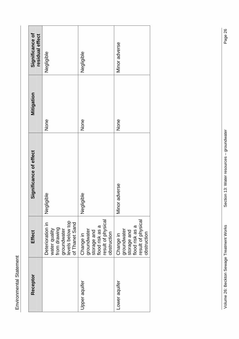
Envi
ronm
enta
l Sta
tem
ent
Rec
epto
r Ef
fect
Si
gnifi
canc
e of
effe
ct
Miti
gatio
n Si
gnifi
canc
e of
re
sidu
al e
ffect
D
eter
iora
tion
in
wat
er q
ualit
y fro
m d
raw
ing
grou
ndw
ater
le
vels
bel
ow to
p of
Tha
net S
and
Neg
ligib
le
Non
e
Neg
ligib
le
Upp
er a
quife
r C
hang
e in
gr
ound
wat
er
stor
age
and
flood
risk
as
a re
sult
of p
hysi
cal
obst
ruct
ion
Neg
ligib
le
Non
e
Neg
ligib
le
Low
er a
quife
r C
hang
e in
gr
ound
wat
er
stor
age
and
flood
risk
as
a re
sult
of p
hysi
cal
obst
ruct
ion
Min
or a
dver
se
Non
e
Min
or a
dver
se
Volu
me
26: B
eckt
on S
ewag
e Tr
eatm
ent W
orks
Se
ctio
n 13
: Wat
er re
sour
ces
– gr
ound
wat
er
Page
26

Envi
ronm
enta
l Sta
tem
ent
Vol 2
6 Ta
ble
13.1
0.2
Gro
undw
ater
– o
pera
tiona
l ass
essm
ent s
umm
ary
Rec
epto
r Ef
fect
Si
gnifi
canc
e of
effe
ct
Miti
gatio
n Si
gnifi
canc
e of
re
sidu
al e
ffect
U
pper
aqu
ifer
C
hang
e in
gr
ound
wat
er
leve
ls a
s a
resu
lt of
phy
sica
l ob
stru
ctio
n
Neg
ligib
le
Non
e
Neg
ligib
le
Low
er a
quife
r C
hang
e in
gr
ound
wat
er
leve
ls a
s a
resu
lt of
phy
sica
l ob
stru
ctio
n
Min
or a
dver
se
Non
e
Min
or a
dver
se
Upp
er a
quife
r
Seep
age
into
sh
afts
affe
ctin
g gr
ound
wat
er
reso
urce
s
Neg
ligib
le
Non
e
Neg
ligib
le
Low
er a
quife
r Se
epag
e in
to
shaf
ts a
ffect
ing
grou
ndw
ater
re
sour
ces
Min
or a
dver
se
Non
e
Min
or a
dver
se
Upp
er a
quife
r
Det
erio
ratio
n in
w
ater
qua
lity
in
the
uppe
r aqu
ifer
from
see
page
ou
t of s
hafts
Neg
ligib
le
Non
e
Neg
ligib
le
Volu
me
26: B
eckt
on S
ewag
e Tr
eatm
ent W
orks
Se
ctio
n 13
: Wat
er re
sour
ces
– gr
ound
wat
er
Page
27
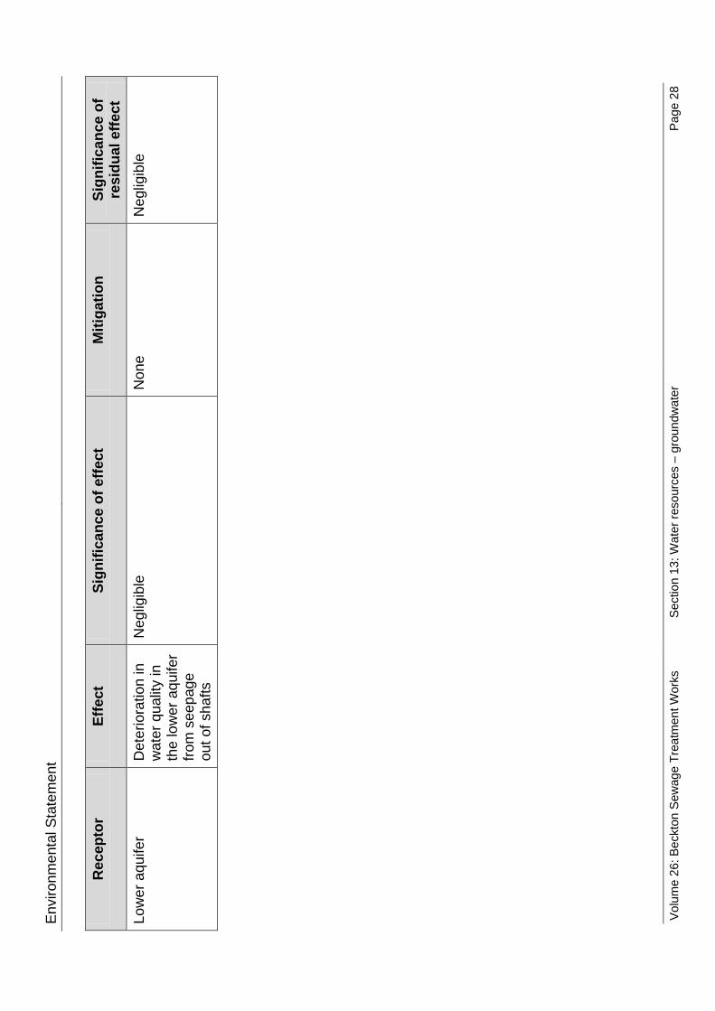
Envi
ronm
enta
l Sta
tem
ent
Rec
epto
r Ef
fect
Si
gnifi
canc
e of
effe
ct
Miti
gatio
n Si
gnifi
canc
e of
re
sidu
al e
ffect
Lo
wer
aqu
ifer
Det
erio
ratio
n in
w
ater
qua
lity
in
the
low
er a
quife
r fro
m s
eepa
ge
out o
f sha
fts
Neg
ligib
le
Non
e N
eglig
ible
Volu
me
26: B
eckt
on S
ewag
e Tr
eatm
ent W
orks
Se
ctio
n 13
: Wat
er re
sour
ces
– gr
ound
wat
er
Page
28

Environmental Statement
References
1 Defra. National Policy Statement for Waste Water (2012) 2 Environment Agency. Introducing pollution prevention: PPG 1 – EA Consultation (2011). 3 Environment Agency and ESI. London Basin Aquifer Conceptual Model. ESI Report Reference 60121R1 (June 2010). 4 Environment Agency. Groundwater levels contours in Chalk. Received from Environment Agency June (2011). 5 British Geological Survey. British geology onshore digital maps 1:50 000 scale. Received from Thames Tunnel. (February 2009). 6 The Water Supply (Water Quality) Regulations (2000). Available at: http://www.legislation.gov.uk/uksi/2000/3184/contents/made. 7 River Basin Districts Typology, Standards and Groundwater Threshold Values (Water Framework Directive) (England and Wales) Direction (2010). Available at: http://www.defra.gov.uk/environment/quality/water/legislation/water-framework-directive/. 8 Capita Symonds Ltd. London Borough of Newham Strategic Flood Risk Assessment Final Report. (May 2010). 9 WJ Groundwater. Lee Tunnel Abbey Mills Shaft F Pump Out Test Factual Report. 432/1770 (March 2012). 10 Commission of the European Communities. Directive of the European Parliament and of the Council on environmental quality standards in the field of water policy and amending Directive 2000/60/EC. (2009). Available at: http://ec.europa.eu/environment/water/water-dangersub/pdf/com_2006_397_en.pdf?lang=_e.
Volume 26: Beckton Sewage Treatment Works
Section 13: Water resources – groundwater
Page 29

Environmental Statement
This page is intentionally blank
Volume 26: Beckton Sewage Treatment Works
Section 13: Water resources – groundwater
Page 30

Hard copy available in
Environmental StatementDoc Ref: 6.2.26
Volume 26: Beckton Sewage Treatment Works site assessmentSection 14: Water resources - surface waterAPFP Regulations 2009: Regulation 5(2)(a)
Box 40 Folder A January 2013
Sect
ion
14: W
ater
reso
urce
s - su
rfac
e w
ater
Thames Tideway Tunnel Thames Water Utilities Limited
Application for Development ConsentApplication Reference Number: WWO10001

This page is intentionally blank

Environmental Statement
Thames Tideway Tunnel
Environmental Statement
Volume 26: Beckton Sewage Treatment Works site assessment
Section 14: Water resources – surface water
List of contents
Page number
14 Water resources – surface water .................................................................... 1
14.1 Introduction .............................................................................................. 1
14.2 Proposed development relevant to surface water .................................... 2
14.3 Assessment methodology ........................................................................ 3
14.4 Baseline conditions .................................................................................. 5
14.5 Construction effects assessment ............................................................. 9
14.6 Operational effects assessment ............................................................ 10
14.7 Cumulative effects assessment ............................................................. 12
14.8 Mitigation ............................................................................................... 12
14.9 Residual effects assessment ................................................................. 13
14.10 Assessment summary ........................................................................... 14
References .............................................................................................................. 15
List of tables
Page number
Vol 26 Table 14.2.1 Surface water – discharge volumes ............................................ 3
Vol 26 Table 14.4.1 Surface water – receptors ........................................................... 6
Vol 26 Table 14.4.2 Surface water – Woolwich spot samples .................................... 7
Vol 26 Table 14.10.1 Surface water – construction assessment summary .............. 14
Vol 26 Table 14.10.2 Surface water – resources operational assessment summary 14
Volume 26: Beckton Sewage Treatment Works
Section 14: Water resources – surface water
Page i

Environmental Statement
This page is intentionally blank
Volume 26: Beckton Sewage Treatment Works
Section 14: Water resources – surface water
Page ii

Environmental Statement
14 Water resources – surface water
14.1 Introduction 14.1.1 This section presents the findings of the assessment of the likely
significant effects of the proposed development on surface water at Beckton Sewage Treatment Works (STW) site. The assessment of surface water presented in this section has considered the requirements of the National Policy Statement for Waste Water (NPS) (Defra, 2012)1. The physical characteristics of the surface water environment including surface water resources and quality are presented and the anticipated effects (including cumulative effects) on these resources addressed in the assessment that follows. Further details on how the NPS requirements relevant to surface water resources have been met can be found in Vol 2 Section 14.3.
14.1.2 The proposed development has the potential to affect surface water resources (ie, surface waterbodies including the tidal reaches of the River Thames [tidal Thames]) due to:
a. construction activities b. operation of the main tunnel.
14.1.3 The assessment of construction and operational effects on surface water includes the following: a. identification of existing water resources baseline conditions b. determining base case conditions against which the proposed
development has been assessed c. assessment of significant effects of the proposed development during
construction and operation d. identification of mitigation measures and the residual effects both
during construction and operation. 14.1.4 The assessment of surface water partially overlaps with that for
groundwater, land quality, aquatic ecology and flood risk. Effects on groundwater resources are assessed separately in Section 13 Of this volume. Land quality is addressed in Section 8 of this volume. Effects on aquatic ecology are assessed in Section 5 of this volume. A Flood Risk Assessment (FRA), which assesses the effects of the proposed development on surface water run-off and considers the use of Sustainable Drainage Systems (SuDS), has been carried out separately and is included in Section 15 of this volume.
14.1.5 This assessment covers the effects of the proposed development at the Beckton STW site. The catchment-wide effects on the tidal Thames, particularly in relation to the water quality improvements anticipated from the proposed development, are assessed separately in Volume 3 Project-wide assessment.
Volume 26: Beckton Sewage Treatment Works
Section 14: Water resources – surface water
Page 1

Environmental Statement 14.1.6 Plans of the proposed development as well as figures included in the
assessment for this site are contained in a separate volume (Volume 26 Beckton Sewage Treatment Works Figures).
14.2 Proposed development relevant to surface water 14.2.1 The proposed development is described in Section 3 of this volume. The
elements of the proposed development relevant to surface water are set out below.
Construction 14.2.2 The site is located within the existing Thames Water Beckton STW,
adjacent to the tidal Thames and the confluence of the River Roding with the river Thames. Adjacent to the site, the River Roding is also known as the Barking Creek.
14.2.3 Based on the geology at the site, the base of the siphon tunnel shafts would require dewatering and or ground treatment. Disposal of dewatering effluent can have an effect on surface water resources. See Section 13 of this volume for further details on the dewatering requirements. Code of Construction Practice
14.2.4 There is an indirect pathway for pollutants to be discharged to the Tidal Thames via surface water drains. The Code of Construction Practice (CoCP)i Part A includes a number of measures to minimise the potential for impacts to surface waters, including impacts such as discharge of pollutants via surface water drains, and these are summarised below.
14.2.5 Appropriate drainage, sediment and pollution control measures are included in the CoCP Part A (Section 4 and Section 8) . These are in accordance with the relevant Pollution Prevention Guidelines (PPGs) issued by the Environment Agency (EA) and other Construction Industry Research and Information Association (CIRIA) documents.
14.2.6 All site drainage would be passed through the sewage treatment process on site. Raised formal flood defence walls are present along the frontage of the tidal Thames and River Roding. The presence of these walls forms a physical barrier to any potential contaminants reaching the watercourses via overland routes.
14.2.7 Suitable spill kits would be provided and positioned in vulnerable areas and staff would be trained in their use. A record should be kept of all pollution incidents or near-misses, to ensure appropriate action is taken and lessons are learned from incidents. Regular ‘toolbox talks’ would be held to raise staff awareness of pollution prevention and share lessons learned from any recorded incidents. There would be written procedures in place for dealing with spillages and pollution (The Pollution Incident Control Plan or PICP).
i The Code of Construction Practice (CoCP) is provided in Vol 1 Appendix A. It contains general requirements (Part A), and site-specific requirements for this site (Part B).
Volume 26: Beckton Sewage Treatment Works
Section 14: Water resources – surface water
Page 2

Environmental Statement 14.2.8 There are no site specific measures incorporated in the CoCP Part B
relevant to the surface water assessment.
Operation 14.2.9 The operation of the main tunnel would result in the following changes to
the discharge of treated effluent from Beckton STW during storm conditions: a. a greater volume of discharge after a storm event, due to tunnel pump
out of treated effluent via the existing final effluent outfall (this would be the volume not discharged as storm sewage during the storm event at overflows into the River Thames elsewhere)
b. a decrease in peak overflow rate but increase in the total volume discharged from the Tideway combined sewer overflow (CSO) from the tunnel via bypass pumping to the Lee Tunnel storm outfall, compared with the overflow rate from the tunnel by gravity from the Lee Tunnel alone.
14.2.10 Vol 26 Table 14.2.1 below shows the changes in estimated discharge volumes caused by the proposed Thames Tideway Tunnel project.
Vol 26 Table 14.2.1 Surface water – discharge volumes
Estimated discharge volumes – Typical Year (m3)
Baseline
(2006) Beckton STW
and Lee Tunnel (2021)
Beckton STW, Lee Tunnel and Thames
Tideway Tunnel (2021)
Beckton STW 444,600,000 514,700,000 530,800,000
Tideway CSO n/a 609,000 684,000 Note: n/a – not applicable
14.3 Assessment methodology 14.3.1 The methodology used for the assessment of effects on surface water and
their significance differs slightly from the standard Website Transport Analysis Guidance (WebTAG) (DFT, 2003)2 environmental impact assessment (EIA) methodology for water resources, in that the requirements of the Water Framework Directive (WFD) have also been taken into account. In the absence of an EIA specific assessment methodology for WFD compliance, an assessment methodology has been derived specifically for the Thames Tideway Tunnel project to assess significance of effect. The methodology also takes into consideration the requirements of the Urban Waste Water Treatment Directive (UWWTD)3 and is outlined in Volume 2 Environmental assessment methodology. A WFD assessment for the project as a whole is presented in Vol 3.
Volume 26: Beckton Sewage Treatment Works
Section 14: Water resources – surface water
Page 3

Environmental Statement
Engagement 14.3.1 Vol 2 documents the overall engagement which has been undertaken in
preparing the Environmental Statement. Vol 2 Section 14 Water resources – surface water summarises the engagement that has been undertaken for the surface water assessment and the consultation responses relevant to surface water.
14.3.2 There are no site-specific engagement comments relevant to the surface water assessment at the Beckton STW site.
Baseline 14.3.3 The baseline methodology follows the methodology described in Vol 2.
There are no site specific variations for identifying baseline conditions for this site.
Construction 14.3.4 The assessment methodology for the construction phase follows that
described in Vol 2. There are no site specific variations for undertaking the construction assessment of this site.
14.3.5 The assessment year for construction effects is Site Year 1 when construction would commence. No modelled water quality data are available for this year. The water quality conditions for the base case have therefore been derived from available modelled simulation data which uses population projections for 2021. This assumption is considered acceptable as substantial changes in water quality are considered unlikely between 2016 and 2021.
14.3.6 The Lee Tunnel and the sewage works upgrades at Mogden, Beckton, Crossness, Long Reach and Riverside sewage treatment works (STWs) would be operational by the time construction of the Thames Tideway Tunnel project commences, as described in Vol 2. Significant improvements in the water quality in the tidal Thames are anticipated as a result of these projects. Both the construction base case and the operational base case would be the water quality in the tidal Thames with the Lee Tunnel and sewage works upgrades in place.
14.3.7 The construction base case has considered the phases of developments that are scheduled to be complete and in operation by Site Year 1 (details presented in the site development schedule, Vol 26 Appendix N). With the exception of the Lee Tunnel Project and upgrades to the Beckton STW, the phases of the other development are considered unlikely to result in changes in water quality as these developments are remote from the tidal Thames. The base case would therefore not change from that outlined above.
14.3.8 Phases of the Beckton Waterfront Masterplan development, which is located adjacent to the tidal Thames, would be under construction during Site Year 1. These phases have been considered in the cumulative effects assessment (see Section 14.7).
14.3.9 The assessment area for the assessment of effects of construction activities at the Beckton STW site would be limited to a single section of
Volume 26: Beckton Sewage Treatment Works
Section 14: Water resources – surface water
Page 4

Environmental Statement
the river, namely the Thames Middle (including the River Roding) waterbody listed below in Vol 26 Table 14.4.1.
14.3.10 Section 14.5 details the likely significant effects arising from the construction at the Beckton STW site. There are no other Thames Tideway Tunnel project sites which could give rise to additional effects on surface water within the assessment area for this site, therefore no other Thames Tideway Tunnel project sites are considered in this assessment
Operation 14.3.11 The assessment methodology for the operation phase follows that
described in Vol 2. There are no site specific variations for undertaking the operational assessment of this site.
14.3.12 The assessment year for operation effects is Year 1 of operation. As with the construction assessment, the operational assessment also relies on modelled water quality data which uses population projections for 2021. In addition, the influence of climate change on the proposed development has been assessed in 2080.
14.3.13 As noted above, the operational base case would be the water quality in the tidal Thames with the Lee Tunnel and sewage works upgrades in place. The operational base case has considered the developments that are scheduled to be complete and in operation by Year 1 (details presented in Vol 26 Appendix N). With the exception of the Lee Tunnel project and upgrades to the Beckton STW which are already considered in the base case, the other development are considered unlikely to result in changes in water quality as these developments are remote from the tidal Thames. The base case would therefore not change from that outlined above.
14.3.14 No developments have been identified that would be under construction during Site Year 1 of operation, therefore a cumulative effects assessment has not been undertaken (see Section 14.7). The operational assessment uses the same assessment area identified above for the construction assessment.
14.3.15 Section 14.6 details the likely significant effects arising from the operation at the Beckton STW site.
Assumptions and limitations 14.3.16 The assumptions and limitations associated with this assessment are
presented in Vol 2. There are no assumptions and limitations specific to the assessment of this site.
14.4 Baseline conditions 14.4.1 The following section sets out the baseline conditions for surface water
within and around the site. Future baseline conditions (base case) are also described.
Volume 26: Beckton Sewage Treatment Works
Section 14: Water resources – surface water
Page 5

Environmental Statement
Current baseline Water quality
14.4.2 A list of all surface water receptors and their WFD status given in the River Basin Management Plan (RBMP) (EA, 2009)4 , which are either adjacent to the site, or downstream of the site and therefore have the potential to be affected by the proposed development, are included in Vol 26 Table 14.4.1 below.
14.4.3 The overall classification of status or potential under the WFD is a detailed process, which includes an assessment of water quality physico-chemical and hydromorphological elements. Reference should be made to the United Kingdom Technical Advisory Group (UKTAG)5 guidance, as given in the RBMP (EA, 2009)6.
Vol 26 Table 14.4.1 Surface water – receptors
Waterbody name/ID
Hydromorpho-logical status
Current ecological
quality
Current chemical quality
2015 Predicted ecological
quality
2015 Predicted chemical quality
2027 Target status
Thames Middle GB530603911402
Heavily Modified Moderate Potential Fail Moderate
Potential Fail Good
River Roding Not assessed under the WFD but included within the Thames Middle Waterbody
14.4.4 The River Thames and its tidal estuaries are designated as a Site of
Metropolitan Importance (SMI). The Thames Middle waterbody stretches from Battersea Bridge to Mucking Flats. It is considered to be a high value waterbody as although the current and predicted status in 2015 (target date from RBMP (EA, 2009)7) is moderate potential, a status objective of good by 2027 has been set. In addition, the tidal Thames is a valuable water resource, habitat, and source of amenity, recreation, and transport route throughout London.
14.4.5 The River Roding is not assessed under the WFD. However, as it forms part of the Thames Middle waterbody, which has a target status of good by 2027, the River Roding should also be assumed to have a target status of good. It is therefore considered to be a high value waterbody, due to the target of good status.
14.4.6 Sediment levels within the tidal Thames are estimated to currently reach a peak of 4,000kg/s in the lower tidal Thames estuary, or more than 40,000t of sediment a day during spring tides (HR Wallingford, 2006)8.
14.4.7 The discharge point for treated effluent from Beckton STW lies approximately 500m from the site. The Thames Water operated desalination plant abstracts surface water from the tidal Thames adjacent to the site.
Volume 26: Beckton Sewage Treatment Works
Section 14: Water resources – surface water
Page 6

Environmental Statement 14.4.8 The Beckton STW site CSO is approximately 2km downstream of the EA’s
spot sample site at Woolwich, as shown on Vol 26 Figure 14.4.1 (see separate volume of figures). Summary data from this monitoring point, which give 90 percentile values for Nitrogen (concentration that is exceeded 10% of the time) and 10 percentile values for dissolved oxygen (concentration exceeded 90% of the time), is presented below in Vol 26 Table 14.4.2.
Vol 26 Table 14.4.2 Surface water – Woolwich spot samples
Nitrogen (mg/l) as 90%ile DO (mg/l) as 10%ile
Woolwich 2.87 9.44 14.4.9 Classification of DO standards for transitional waters under the WFD is
dependent on the salinity levels. The above 10 percentile values would place the Thames Middle waterbody within the good or moderate potential range, dependent on the associated salinity values.
14.4.10 The site has operated as a STW since the 1860s and assessment of the soil contamination test data has revealed widespread elevated concentrations of numerous contaminants on site. The area to the south of the treatment works has a long legacy of previous industrial usage including a substantial gas works, which is thought to be the major source of contaminants migrating onto the Beckton STW site.
14.4.11 Comparison of groundwater and leachate results against corresponding Environmental Quality Standards (EQS) shows that to varying degrees, all development areas have some form of significantly elevated contamination, including copper, nickel and ammonium with isolated hotspots of arsenic, cadmium and lead. An assessment of potential on-site contamination is provided within Section 8 of this volume. Current CSO operation
14.4.12 There is no new CSO connection required at this site, although there is an existing storm overflow from the Tideway CSO.
Construction base case 14.4.13 As explained in Section 14.3, both the construction base case and the
operational base case would be the water quality in the tidal Thames with the Lee Tunnel and sewage works upgrades in place.
14.4.14 The virtual elimination of CSO spills from the Abbey Mills Pumping Station CSO will be achieved by transferring flows from Abbey Mills Pumping Station to the new Tideway CSO at Beckton STW via the Lee Tunnel. This work will be carried out as part of the Lee Tunnel project and will be completed before the proposed start of construction for the Thames Tideway Tunnel project. It is therefore considered to form the base case for this assessment.
14.4.15 Similarly, the increased discharge of treated effluent from Beckton STW (14.2.9a), which will result from the construction of the sewage treatment works extension is considered to form the base case for this assessment.
Volume 26: Beckton Sewage Treatment Works
Section 14: Water resources – surface water
Page 7

Environmental Statement
Operational base case 14.4.16 As noted above, the operation base case would be the same as the
construction base case and would include water quality improvement achieved by the Lee Tunnel and the sewage works upgrades.
14.4.17 Catchment modelling results of the base case have demonstrated that by Year 1 of operation (assessed using 2021 to use modelled assumptions) the frequency, duration and volume of the Tideway CSO would be as follows: a. the CSO would spill three times in the Typical Year b. the CSO would spill for 19 hours in the Typical Year c. the spill volume from the CSO would be approximately 609,000m3 in
the Typical Year. 14.4.18 The same catchment modelling has demonstrated that by the operational
assessment year the annual polluting loading of Biochemical oxygen demand (BOD), ammonia and Kjeldahl nitrogen (TKN) (the sum of organic nitrogen, ammonia (NH3), and ammonium (NH4
+)) would be as follows: a. the CSO would discharge 55,100kg of BOD in the Typical Yearii b. the CSO would discharge 1,800kg of ammonia in the Typical Year c. the CSO discharges 6,800kg of TKN in the Typical Year.
14.4.19 Each discharge increases the risk of exposure to pathogens for river users who come into contact with the water. An assessment of health impacts upon recreational users of the River Thames was conducted and reported by the Health Protection Agency in 2007 (Lane, C, et al., 2007)9. The study concluded that risk of infection can remain for two to four days following a spill as the water containing the sewage moves back and forward with the tideiii. The same study also noted that analysis of the illness events reported against discharges on the tidal Thames shows that 77% of cases related to rowing activities undertaken within three days of a CSO discharge.
14.4.20 Assuming the average three spills per annum occur from the Tideway CSO on separate days, there could be up to a maximum of 12 days per year where recreational users are at risk of exposure to pathogens in the vicinity of the outfall as a result of the Tideway CSO spills alone (Lane, C, et al., 2007)10.
14.4.21 The operation of the Tideway CSO results in the discharge of sewage litter along with the discharge of effluent. It was estimated by the Thames Tideway Strategic Study (TTSS) (Thames Water, 2005)11 that overflows from all the CSOs along the tidal Thames introduce approximately 10,000t of sewage derived solid material to the tidal Thames annually. Catchment
ii Typical Year: single year which is most representative of an observed typical year of rainfall with the dataset. The 1979-1980 ‘water year’ defined as the 12 month period ending on the 30th September 1980 iii The EA has provided advice on CSO excursion areas, which states that CSOs below Tower Bridge will only impact the Thames Middle waterbody and those upriver of Tower Bridge will impact both the Thames Upper and Thames Middle waterbodies.
Volume 26: Beckton Sewage Treatment Works
Section 14: Water resources – surface water
Page 8

Environmental Statement
modelling of the current CSO operation has defined the average volume of discharge from the Tideway CSO and assuming litter tonnages are proportional to discharge volumes, this would indicate that approximately 300t of sewage derived litter is discharged from the Tideway CSO in the Typical Year. An assessment of amenity effects of the sewage litter is given in Vol 3 Section 10 Socio-economics.
14.5 Construction effects assessment 14.5.1 This section presents the construction impacts that could occur at the site
and identifies where no further assessment of effects is required (for example where the impact pathway has been removed). The second part of the section identifies any effects that may occur and the likely significance of these effects.
Construction impacts Surface water drainage
14.5.2 The construction of the working areas and drainage of surface water from them could create an indirect pathway to the river via surface water drains for contaminated runoff, high suspended solids and other pollution from the site. However, appropriate site drainage would be used to control pollutants in the general site runoff, and all site drainage would be directed to the STW which would ensure all runoff receives treatment before being discharged to the tidal Thames via the final effluent channel. This would enable the pollution pathway to be removed and therefore there is considered to be no impact from this source. Surface water drainage is therefore not considered further within this assessment. Contamination and dewatering
14.5.3 Diaphragm walling techniques would be used to construct the shafts and pressure-relief wells drilled ahead of the shaft base may be required to dewater perched water tables in the Lambeth Group. Dewatering to allow excavation of the base of the shaft may also be required. The use of the diaphragm walling technique would limit the amount of dewatering required. See Section 13 of this volume for further details on the dewatering requirements.
14.5.4 All dewatering effluent would be discharged to the STW for treatment and it is therefore considered that there is no impact pathway and hence no impact or effect from contamination and dewatering.
Construction effects 14.5.5 The assessment above has not identified any potential impacts as a result
of the proposed development, therefore no significant construction effects are considered likely for the construction phase at this site.
Volume 26: Beckton Sewage Treatment Works
Section 14: Water resources – surface water
Page 9

Environmental Statement
14.6 Operational effects assessment 14.6.1 This section presents the operational impacts that could occur at the site.
The second part of the section then identifies any effects that may occur and the likely significance of these effects.
Operational impacts Change in Beckton STW treated effluent discharge volume
14.6.2 The Thames Tideway Tunnel project would divert flows that would previously have been discharged as combined sewage to the tidal Thames during rainfall events, to be discharged from Beckton STW as treated effluent. No effects on the discharge quality from the Beckton STW outfall would result from the project, but there would be a slight increase in the discharge quantity from the Beckton STW effluent channel during operation of the Thames Tideway Tunnel project. The discharge of treated effluent would increase from 514,700,000m3 in the Typical Year to 530,800,000m3 in the Typical Year. This equates to an increase of approximately 3% from the operational baseline, which would have an impact on water quality. Change in Tideway CSO discharges
14.6.3 Catchment modelling of the development case (with the operational Thames Tideway Tunnel project) predicts that by Site Year 1 of operation (2023) with the project in place, the duration and volume of spills from the Tideway CSO would increase as follows: a. the CSO would spill on average three times in the Typical Year (the
same as the operational base case) b. the CSO would spill for an average duration of 21 hours (three more
than the operational base case) c. the spill volume from the CSO would be approximately 684,000m3 per
year (75,000m3 more than the operational base case). 14.6.4 The duration and volume of spill at the Tideway CSO would therefore be
increased by approximately 12% as a result of the operation of the Thames Tideway Tunnel project.
14.6.5 Given that there would be no increase in spill frequency, the number of risk days in which river users would be exposed to pathogens in the development case year would remain as the operational base case, at a maximum of 12 days in the Typical Year.
14.6.6 The tonnage of sewage derived litter from the CSO can be expected to increase by approximately 12% to approximately 386t in the Typical Year.
14.6.7 The increase in spill volume and duration at Beckton would have an impact on water quality, and other uses of the watercourse as a result of increased sewage derived litter.
14.6.8 Catchment modelling of the 2080 development case (to account for the effects of climate change and predicted increases to population) has
Volume 26: Beckton Sewage Treatment Works
Section 14: Water resources – surface water
Page 10

Environmental Statement
simulated that by 2080 with the project in place, the frequency, duration and volume of the Tideway CSO would be the following: a. the CSO would spill on average three times per year (the same as the
Site Year 1 of operation development case) b. the CSO would spill for an average duration of 28 hours (seven more
than the Site Year 1 of operation development case) c. the spill volume from the CSO would be approximately 898,000m3 per
year (21,4,000m3 more than the Site Year 1 of operation development case).
14.6.9 It is predicted that in the 2080 development case scenario the Tideway CSO at Beckton STW would increase in total spill duration and volume. However, as these changes in spill duration and volume would be due to the impact of climate change, which is expected to lead to fewer, but more intense rainfall events during winter and drier summers; this is not considered further within the assessment.
Operational effects 14.6.10 The potential surface water impacts identified above as a result of
operation at Beckton STW have been assessed for their likely effects on WFD objective compliance, compliance with other legislation and effects on other users of the surface water.
14.6.11 The WFD objectives set out in Article 4 of the WFD are as follows: a. WFD1 – Prevent deterioration of the status of all bodies of surface
water b. WFD2 – Protect, enhance and restore all bodies of surface water, with
the aim of achieving good surface water status by 2015 c. WFD3 – Protect and enhance all artificial and heavily modified bodies
of water, with the aim of achieving good ecological potential and good surface water chemical status by 2015
d. WFD4 – Reduce pollution from priority substances and cease or phase out emissions, discharges and losses of priority hazardous substances.
14.6.12 The significance of the effects has then been assessed based on the approach described in Vol 2 Section 14. Change in treated effluent discharge
14.6.13 The slight increase in treated sewage effluent from Beckton STW represents just a 3% increase in consented volume and has been assessed as acceptable by the EA under the Operating Techniques agreement. The conclusion from this assessment is that it would not adversely affect attainment of water quality standards under the WFD, especially when considered in the context of the tidal Thames wide water quality improvements that would result from the proposed development. It can therefore be considered to have a negligible effect as there would be a change in water quality, but this would not be detectable in relation to natural variation.
Volume 26: Beckton Sewage Treatment Works
Section 14: Water resources – surface water
Page 11

Environmental Statement
Change in Tideway CSO spills 14.6.14 The increase in CSO spill duration and volume from the Tideway CSO as
a result of the construction of the Thames Tideway Tunnel project would have an adverse effect local to the outfall during times of operation. However, the water quality modelling undertaken for the development has demonstrated that it would not prevent WFD objectives being met as the negative change is very small in comparison to the improvements in water quality facilitated by the removal of CSO discharges upstream of the Beckton STW site. Considered in isolation, the discharge would have a detectable impact on water quality, but it would not be sufficient to prevent attainment of WFD objectives. It is therefore considered to be a minor adverse effect.
14.7 Cumulative effects assessment 14.7.1 Considerable improvements in the water quality of the tidal Thames will
occur as a result of the works associated with the Lee Tunnel and sewage works upgrades. These already form part of the base case and so are not considered as part of the assessment of cumulative effects.
14.7.2 The projects described in Vol 26 Appendix N which could potentially give rise to cumulative construction effects with the proposed development at the Beckton STW site are not considered to lead to cumulative effects on surface water. This is because no significant effects are considered likely for the construction phase. In addition, the developments are not of sufficient scale such that they are likely to generate significant effects in relation to surface water quality.
14.7.3 As explained in Section 0, no developments have been identified that would be under construction during Site Year 1 of operation, therefore a cumulative effects assessment has not been undertaken for the operational phase.
14.7.4 No significant cumulative effects have therefore been identified for the construction or operation phases at this site. Therefore the effects on surface water would remain as described in Section 14.5 and Section 14.6 above.
14.8 Mitigation
Construction effects 14.8.1 No significant adverse construction effects have been identified and
therefore no mitigation is required.
Operational effects 14.8.2 The assessment of significant effects for operation has identified one
minor adverse effect from the operation of the Beckton STW site, due to the increase in the spill duration and volume of the Tideway CSO.
14.8.3 While the increase in spill volume and duration from the Tideway CSO has been assessed to be a minor adverse effect, this needs to be considered
Volume 26: Beckton Sewage Treatment Works
Section 14: Water resources – surface water
Page 12

Environmental Statement
in the context of the overall water quality improvements in the tidal Thames that would result from the construction of the Thames Tideway Tunnel project (and the Lee Tunnel and sewage works upgrades). It is therefore not considered that further mitigation is required for this effect.
14.9 Residual effects assessment
Construction effects 14.9.1 As no mitigation measures are proposed the residual construction effects
remain as described in Section 14.5. All residual effects are presented in Section 14.10.
Operational effects 14.9.2 The assessment has identified one residual adverse effect from the
operation of the Beckton STW site, due to the increase in the spill duration and volume of the Tideway CSO. However, these effects are minor. All residual effects are presented in Section 14.10.
Volume 26: Beckton Sewage Treatment Works
Section 14: Water resources – surface water
Page 13

Envi
ronm
enta
l Sta
tem
ent
14
.10
Ass
essm
ent s
umm
ary
Vol 2
6 Ta
ble
14.1
0.1
Surf
ace
wat
er –
con
stru
ctio
n as
sess
men
t sum
mar
y
Rec
epto
r Ef
fect
Si
gnifi
canc
e of
ef
fect
M
itiga
tion
Sign
ifica
nce
of
resi
dual
effe
ct
Tham
es M
iddl
e Th
e as
sess
men
t has
not
iden
tifie
d an
y si
gnifi
cant
adv
erse
effe
cts.
N
/A
N/A
N
/A
Not
e: N
/A –
Not
app
licab
le
Vo
l 26
Tabl
e 14
.10.
2 Su
rfac
e w
ater
– re
sour
ces
oper
atio
nal a
sses
smen
t sum
mar
y
Rec
epto
r Ef
fect
Si
gnifi
canc
e of
ef
fect
M
itiga
tion
Sign
ifica
nce
of
resi
dual
effe
ct
Tham
es M
iddl
e In
crea
sed
volu
me
of tr
eate
d ef
fluen
t di
scha
rge
from
Bec
kton
STW
N
eglig
ible
N
one
Neg
ligib
le
Tham
es M
iddl
e In
crea
sed
spill
dura
tion
and
volu
me
from
the
Tide
way
CS
O.
Min
or a
dver
se
Non
e
Min
or a
dver
se
Volu
me
26: B
eckt
on S
ewag
e Tr
eatm
ent W
orks
Se
ctio
n 14
: Wat
er re
sour
ces
– su
rface
wat
er
Page
14

Environmental Statement
References
1 Defra. National Policy Statement for Waste Water: A framework document for planning decisions on nationally significant waste water (March, 2012). Available at: http://www.defra.gov.uk/publications/files/pb13709-waste-water-nps.pdf 2 Department for Transport (DFT). Transport Analysis Guidance (WebTAG) (2003). Available at: http://www.dft.gov.uk/webtag/documents/overview/unit1.2.php. 3 The Council Directive 91/271/EEC concerning urban waste-water treatment 4 Environment Agency. River Basin Management Plan, Thames River Basin District (2009). 5 The United Kingdom Technical Advisory Group (UKTAG) to the WFD. Available at: http://www.wfduk.org/. 6 Environment Agency (2009). See citation above. 7 Environment Agency (2009). See citation above. 8 HR Wallingford (report prepared for the Environment Agency). Thames Estuary 2100, Morphological changes in the Thames Estuary, Technical Note EP6.8. The development of an historical sediment budget (2006). 9 Lane, C, Surman-Lee, S, Sellwood, J and Lee, JV. The Thames Recreational Users Study Final Report (2007). 10 Lane, C, Surman-Lee, S, Sellwood, J and Lee, JV. (2007). See citation above. 11 Thames Water. Thames Tideway Strategic Study (February, 2005).
Volume 26: Beckton Sewage Treatment Works
Section 14: Water resources – surface water
Page 15
Environmental Statement
This page is intentionally blank
Volume 26: Beckton Sewage Treatment Works
Section 14: Water resources – surface water
Page 16

Hard copy available in
Environmental StatementDoc Ref: 6.2.26
Volume 26: Beckton Sewage Treatment Works site assessmentSection 15: Water resources - flood riskAPFP Regulations 2009: Regulation 5(2)(a)
Box 40 Folder A January 2013
Sect
ion
15: W
ater
reso
urce
s - fl
ood
risk
Thames Tideway Tunnel Thames Water Utilities Limited
Application for Development ConsentApplication Reference Number: WWO10001

This page is intentionally blank
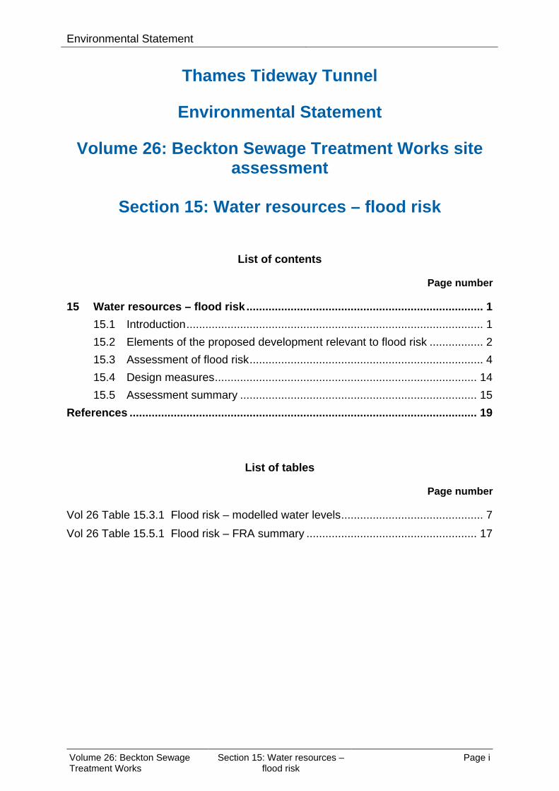
Environmental Statement
Thames Tideway Tunnel
Environmental Statement
Volume 26: Beckton Sewage Treatment Works site assessment
Section 15: Water resources – flood risk
List of contents
Page number
15 Water resources – flood risk ........................................................................... 1
15.1 Introduction .............................................................................................. 1
15.2 Elements of the proposed development relevant to flood risk ................. 2
15.3 Assessment of flood risk .......................................................................... 4
15.4 Design measures ................................................................................... 14
15.5 Assessment summary ........................................................................... 15
References .............................................................................................................. 19
List of tables
Page number
Vol 26 Table 15.3.1 Flood risk – modelled water levels ............................................. 7
Vol 26 Table 15.5.1 Flood risk – FRA summary ...................................................... 17
Volume 26: Beckton Sewage Treatment Works
Section 15: Water resources – flood risk
Page i

Environmental Statement
This page is intentionally blank
Volume 26: Beckton Sewage Treatment Works
Section 15: Water resources – flood risk
Page ii

Environmental Statement
15 Water resources – flood risk
15.1 Introduction
Background 15.1.1 This section forms a Flood Risk Assessment (FRA) for the Beckton
Sewage Treatment Works site. This FRA has been developed in line with the requirements of the National Policy Statement (NPS) for Waste Water (Defra, 2012)1 Section 4.4 and includes a qualitative appraisal of the flood risk posed to the site, the potential impact of the development on flood risk on and off the site and an appraisal of the scope of possible measures to reduce the flood risk to acceptable levels. Further details on how the NPS requirements relevant to flood risk have been met can be found in Volume 2 Environmental assessment methodology Section 15.3.
15.1.2 The proposed development is described in Section 3 of this volume. Plans of the proposed development as well as figures included in the assessment for this site are contained in a separate volume (Volume 26 Beckton Sewage Treatment Works Figures).
15.1.3 A summary of the regulations and policy that have informed the assessment are presented in this section. Section 15.2 provides a summary of the elements of the proposed development relevant to flood risk. Section 15.3 provides an assessment of the flood risk to the site and elsewhere as a result of the development, during both the construction and operational phases. Section 15.4 provides details of the design measures that have been adopted within the proposals to ensure the flood risk to the site is not increased and ensure that flood risk does not increase elsewhere.
15.1.4 The assessment of flood risk should be considered in conjunction with the assessment of other water resources ie, groundwater and surface water. The assessment of effects on groundwater and surface water is presented in Section 13 and Section 14 of this volume respectively.
15.1.5 A project-wide FRA has been undertaken and is presented in Volume 3 Project-wide effects assessment.
Regulatory context 15.1.6 The NPS seeks to ensure that where the development of new waste water
infrastructure is necessary in areas at risk of flooding, flood risk from all sources of flooding is taken into account at all stages in the planning process in order for the development to be safe without increasing flood risk elsewhere.
15.1.7 A review of planning policy relevant to the proposed development is provided in Vol 24 Appendix M.1.
Volume 26: Beckton Sewage Treatment Works
Section 15: Water resources – flood risk
Page 1

Environmental Statement
NPS Sequential and Exception Tests 15.1.8 The Waste Water NPS aims to direct development towards low risk areas
through the use of a sequential approach which avoids inappropriate development in areas at risk of flooding. Using this approach, preference should be given to locating projects in Flood Zone 1 although if there is no "reasonably available site" in Flood Zone 1 then projects could be located in Flood Zone 2. However if there is no "reasonably available site" in Flood Zones 1 or 2, then nationally significant waste water infrastructure projects can be located in Flood Zone 3 subject to the Exception Test.
15.1.9 The NPS states that the Exception Test should be applied where it is not possible for the project to be located in zones of lower probability of flooding than Flood Zone 3.
15.1.10 The requirements of the Exception Test are provided in Section 4.4.15 of the NPS. The test requires overall sustainability benefits (part a) to outweigh flood risk, whilst ensuring the development is safe and does not increase flood risk elsewhere (part c) and is preferably located on previously developed land (part b).
15.1.11 The overall project is considered to pass the Sequential Test, as explained in Vol 3 Section 15. A project-wide Exception Test is also detailed in Vol 3 Section 15.
15.1.12 The proposed development at Beckton Sewage Treatment Works would form an integral part of the Thames Tideway Tunnel project and so would help achieve the project-wide sustainability benefits described in the Sustainability Statement. Given the project-wide sustainability benefits, the proposed development is considered to satisfy part a) of the Exception Test.
15.1.13 The proposed development at Beckton Sewage Treatment Works would be located on previously developed land, therefore satisfying part b) of the Exception Test.
15.1.14 This FRA shows that the proposed development would be appropriate for the area as flood risk to the development would be managed through appropriate design measures and the development would not lead to an increase in flood risk on the surrounding areas. Therefore, part c) of the Exception Test has also been met.
15.2 Elements of the proposed development relevant to flood risk
15.2.1 The proposed development at this site is described in Section 3 of this volume. The elements of the proposed development relevant to flood risk are set out below.
Construction 15.2.2 The construction elements of the proposed development relevant to flood
risk would include:
Volume 26: Beckton Sewage Treatment Works
Section 15: Water resources – flood risk
Page 2

Environmental Statement
a. construction of works above and below ground to transfer flows from the Tideway Pumping Station to the inlet works of the sewage treatment works
b. A siphon tunnel would be constructed to carry flows from the pumping station, bypassing Beckton Sewage Treatment Works, to the storm overflow. The siphon tunnel would connect the pumping station to the siphon outlet shaft. The siphon outlet shaft would be connected to the existing Lee Tunnel overflow shaft via a valve chamber and connecting culvert.
c. construction of pits, chambers, ducts and pipes for cables, hydraulic pipelines, utility connections, utility diversions and drainage.
d. No works are proposed to the flood defences protecting the existing sewage treatment works as part of the construction or operation of the Thames Tideway Tunnel project works at Beckton Sewage Treatment Works site.
Code of Construction Practice 15.2.3 Appropriate guidance regarding flood defence construction and
emergency planning are included in the Code of Construction Practice (CoCP). The CoCP is provided in Vol 1 Appendix A. It contains general requirements (Part A), and site specific requirements for this site (Part B). The relevant measures are summarised below.
15.2.4 The CoCP (Section 8) states that no temporary living accommodation would be permitted onsite and that an evacuation route and safe refuge would be provided in the event of a flood event.
15.2.5 The CoCP (Section 8) states that the contractor would be responsible for providing and maintaining continuous flood defence provision, for both permanent and temporary works, to the statutory flood defence leveli as detailed within the FRA. This is a requirement of the Thames River Protection of Floods Amendment Act 1879 (Great Britain, 1879)2 Operation
15.2.6 The permanent elements of the proposed development relevant to flood risk would include: a. During storm conditions, sewage would be stored in the main tunnel
and the Lee Tunnel and subsequently pumped to the inlet works for treatment at the existing Beckton Sewage Treatment Works. Should both tunnels be full or unavailable, sewage flows would be diverted to the tidal reaches of the River Thames (tidal Thames).
i The level to which the flood defences must be maintained to ensure that both the sites themselves and third-party land and assets in the surrounding area are protected from flooding.
Volume 26: Beckton Sewage Treatment Works
Section 15: Water resources – flood risk
Page 3

Environmental Statement
15.3 Assessment of flood risk
Introduction 15.3.1 The Waste Water NPS requires that all potential sources of flooding that
could affect the proposed development are considered. 15.3.2 This assessment is based on a screening exercise that identified relevant
potential flood sources and pathways. The tidal and fluvial assessments have been based on the Environment Agency (EA) flood zones which do not take account of the presence of existing defences.
15.3.3 The assessment of flood risk from the proposed development takes into account the proposed design measures detailed in Section 15.4.
15.3.4 It should be noted that due to the nature of a flood risk assessment, the risk based approach outlined in the National Planning Policy Framework (NPPF) (DCLG, 2012)3 was considered to be preferable to the general environmental impact assessment (EIA) methodology described in Vol 2 Section 3. This approach is based on the probability of an event occurring as a result of the proposed development rather than a direct change in conditions. This is detailed further in the methodology (see Vol 2 Section 15).
Tidal flood risk to the proposed development Level of risk based on the flood zones
15.3.5 Beckton Sewage Treatment Works site lies adjacent to the confluence between the River Roding (also known at this location as the Barking Creek) and the River Thames. The EA Flood Map identifies the Beckton Sewage Treatment Works site to lie within three different flood zones (Zones 3a, 2 and 1) as a result of tidal flooding from the tidal Thames and Barking Creek. The location of the site in relation to the flood zones is shown in Vol 26 Figure 15.3.1 (see separate volume of figures).
15.3.6 The risk of tidal flooding at the Beckton Sewage Treatment Works site is therefore considered to be high due to parts of the site being located in Flood Zone 3a (see Vol 2 Section 15). Existing tidal defences
15.3.7 The Beckton Sewage Treatment Works site is protected from tidal flooding by three grouped sets of formal flood defences: a. a raised flood defence wall along the edge of the River Thames to the
south of Beckton Sewage Treatment Works b. the final effluent channel of the sewage treatment works which acts as
a formal flood defence along the Barking Creek c. the Barking Barrier which offers additional protection to land adjacent
to Barking Creek by preventing propagation of high water levels associated with storm surges up Barking Creek.
Volume 26: Beckton Sewage Treatment Works
Section 15: Water resources – flood risk
Page 4

Environmental Statement
Tidal Thames defence condition 15.3.8 The EA has stated that the statutory flood defence level for the tidal
Thames defences to the south of the site is 7.2m Above Ordinance datum (AOD). The National Flood and Coastal Defence Database (NFCDD) (EA, 2011)4 crest level of the tidal Thames flood defences near the site is 7.2mAOD.
15.3.9 Condition surveys carried out by the EA in November 2010 state that these defences are in good condition (Grade 2) with some areas in fair condition (Grade 3).
15.3.10 The existing flood defence to the south-east corner of Beckton Sewage Treatment Works is identified as a potential breach location in the London Borough (LB) of Newham Strategic Flood Risk Assessment (SFRA) (Mouchel Parkman, 2007)5. Barking Creek defence condition
15.3.11 The LB of Newham SFRA states that the statutory flood defence level for the Barking Creek defences (ie, the sewage treatment works final effluent channel outer wall) to the east of the site ranges is 5.5mAOD to 5.6mAOD. The National Flood and Coastal Defence Database (NFCDD)6 crest level of these flood defences is 5.5-5.6mAOD.
15.3.12 Condition surveys carried out by the EA in January 2011 state that these defences are in good condition (Grade 2) with some areas in fair condition (Grade 3). Flood defence walls summary
15.3.13 All flood defence walls protecting the Beckton Sewage Treatment Works site is considered by the EA to be at (or slightly above) the statutory 1 in 1000 year (0.1% AEPii) level. This means that the Beckton Sewage Treatment Works site would therefore not be subject to tidal flooding for events with less than a 1 in a 1000 year annual probability of flooding.
15.3.14 The risk of flooding from tidal sources to the Beckton Sewage Treatment Works site during construction and operation would only be residual, as a possibility exists for floodwaters to inundate the site in the event of a failure of the flood defences either as a result of a breach, or overtopping. Overtopping could also occur along the Barking Creek defences as a result of failure of the Barking Barrier.
15.3.15 The SFRA for the LB of Newham quantifies the residual risk in the event of a breach in the defence walls at the south-western corner of the sewage treatment works as well as a potential failure of the Barking Barrier.
15.3.16 As a result of these two scenarios, Beckton Sewage Treatment Works would be subject to an extreme hazard ratingiii (Defra and EA, 2006)7.
ii A flood with a 0.5% Annual Exceedance Probability (AEP) has a one in 200 year probability of occurring in a given year. A flood with a 0.1% AEP has a one in 1000 year probability of occurring in a given year. iii Designated using a combination of flood depth and velocity and distance from the defence as per the Defra publication ‘Flood Risks to People’.
Volume 26: Beckton Sewage Treatment Works
Section 15: Water resources – flood risk
Page 5

Environmental Statement 15.3.17 The breach modelling used to inform the SFRA was undertaken at a
coarse model scale to enable the results to be used for the LB of Newham as a whole. A site specific 2D hydraulic modelling of a defence breach was undertaken for Beckton Sewage Treatment Works as part of the Lee Tunnel and the sewage works upgradesiv. The results of this modelling have been used in this assessment to provide a finer level of detail on residual tidal flood risk to the Beckton Sewage Treatment Works site.
15.3.18 The detailed modelling assumed the same breach location assessed within the SFRA, with a worst case assumption that the defence would be completely removed over a 20m length. The model was run with a peak tidal level as predicted for 2107 (1 in 200 year, or 0.5% AEP, tidal level of 6.98mAOD) over a 36 hour period to include three tidal peaks.
15.3.19 The modelling indicated that during the 2107 0.5% AEP event, large sections of the existing sewage treatment works would become inundated with flood depths within the vicinity of the Beckton Sewage Treatment Works site in the region of 1-2m.
15.3.20 However, this risk is residual and is not considered to compromise the long term operational function of the main tunnel. Further detail regarding residual risk is provided within para. 15.5.4 and in Vol 3 Section 15. Furthermore, the majority of the proposed cover levels on key structures (with the exception of the valve chamber cover) would be above 7mAOD and therefore would not be inundated in the event of a breach or a failure of the Barking Barrier. Tidal flood level modelling Tidal Thames
15.3.21 The most extreme flood risk scenario that could affect the site would be a combination of a high tide with a storm surge in the Thames Estuary. This scenario, assuming the Thames Barrier is operational, is the EA’s ‘design flood’ event, a hypothetical flood event representing a specific likelihood of occurrence, in this case the 1 in 200 year (0.5% AEP) flood event.
15.3.22 The Thames Tidal Defences Joint Probability Extreme Water Level Study (EA, 2008)8 provides modelled tidal flood levels for the 1 in 200 year (0.5% AEP) for specific locations (model node locations) within the tidal Thames.
15.3.23 Vol 26 Table 15.3.1 presents the modelled tidal levels from this study for model node 3.05 which is the most relevant (ie, closest) to the Beckton Sewage Treatment Works site (see Vol 26 Figure 15.3.1 in separate volume of figures) and confirms that the existing defence levels at the site are above the 0.5% AEP tidal flood level. Therefore the site is protected from tidal flooding to the statutory level.
iv The Lee Tunnel and the sewage works upgrades proposed at Mogden, Beckton, Crossness, Long Reach and Riverside sewage treatment works (STWs) would be operational by the time construction of the Thames Tideway Tunnel project commences.
Volume 26: Beckton Sewage Treatment Works
Section 15: Water resources – flood risk
Page 6
Environmental Statement
Vol 26 Table 15.3.1 Flood risk – modelled water levels
Return period tidal Thames Flood level (mAOD)
Thames Statutory flood defence level (mAOD)
0.5% AEP (2005) 6.15
7.2 0.5% AEP (2107) 6.98
0.1% AEP (2005) 6.61
0.1% AEP (2107) 7.46
Barking Creek 15.3.24 According to the LB of Newham SFRA the Barking Barrier is operated in
the same way and at the same time as the Thames Barrier (see Vol 2 Section 15). The Thames Barrier, and hence the Barking Barrier would be closed during the ‘design event’ levels in the tidal Thames and therefore, these extreme levels would not propagate into the Barking Creek. The Barking Barrier would therefore provide protection to the Beckton Sewage Treatment Works site from tidal flooding from the Barking Creek in the design event.
15.3.25 The LB of Newham SFRA also states that defences along the Barking Creek are ‘staircased’ (ie, stepped gradually) at levels ranging between 5.5mAOD and 5.6mAOD, which in combination with the tidal Thames and Barking Barriers, provide protection for events up to the 1 in 1000 year standard.
15.3.26 The Beckton Sewage Treatment Works site is therefore defended from tidal flooding from the Barking Creek to the statutory level. However, as discussed in para 15.3.14, floodwaters could inundate the sites in the event of a failure of the flood defences either as a result of a breach, or overtopping of the defences, or failure of the Barking Barrier.
Tidal flood risk from the proposed development Flood defence integrity
15.3.27 The area where the siphon inlet shaft works would take place is located over 700m from the flood defences. As a result, inlet shaft construction works at this location is not anticipated to impact the local defences.
15.3.28 In order to construct the siphon tunnel between the inlet and outlet shafts, a Tunnel Boring Machine (TBM) of diameter 3.9m would be used. The TBM would not approach closer than 50m from the existing defence line south of the Beckton Sewage Treatment Works site to join the outlet shaft. Therefore, no impact on the defences is expected as a result of differential settlement (that is a gradual downward movement of foundations due to compression of soil which can lead to damage if settlement is uneven).
15.3.29 It can therefore be summarised that following construction of the proposed development, there are no proposed changes to the flood defences protecting the site. The risk of tidal flooding would remain a residual risk due to the defended nature of the site. As the site is partially located in
Volume 26: Beckton Sewage Treatment Works
Section 15: Water resources – flood risk
Page 7
Environmental Statement
Flood Zone 3a the flood risk from this source is considered to remain as high (see Vol 2 Section 15).
15.3.30 Where settlement of river walls is thought possible, this would be monitored and mitigated in agreement with the asset owner and the EA as appropriate. With this strategy in place, no effects of settlement are anticipated. Loss of volume from the tideway
15.3.31 The presence of temporary and permanent structures within the foreshore has the potential to reduce the availability of flood storage within the tidal Thames. The impact of the removal of flood storage on flood levels may propagate throughout the hydrological unit of the Thames reach and has been modelled on a project-wide basis.
15.3.32 The Beckton Sewage Treatment Works site is not located on the foreshore banks of the River Thames but is still within the tidal influence of the River Thames. Therefore a consideration has been made regarding the implications of the project on water levels within the Tideway and the implications for flood defence freeboard at the Beckton Sewage Treatment Works site .
15.3.33 The Beckton Sewage Treatment Works site is located within the reach of Charlton to Tilbury in the tidal and fluvial modelling study. The modelling identifies that for this reach there is no potential decrease in peak water levels during both the temporary and permanent works scenarios. The modelling identifies a potential maximum increase of 0.014m in peak water level during the temporary works scenario reducing to 0.004m during the permanent scenario. As identified in para. 15.3.8 and 15.3.11 the flood defences at this site are above the statutory flood defence level and when compared to the 1 in 200 year tidal level for the year 2107 would provide 0.22m in freeboard for the tidal Thames defences and 1.47-1.57m in freeboard for the Barking Creek defences. These predicted changes in water level and therefore freeboard are not considered to reduce flood protection at this site below design standard requirements and are therefore not deemed significant.
15.3.34 The results of the above modelling exercise show that the proposed project –wide works (both temporary and permanent works) are not considered to have a detrimental impact on the flood storage or tidal levels within the tidal Thames. This is discussed further in Vol 3 Section 15.
Fluvial flood risk to the proposed development Level of risk based on the flood zones Tidal Thames
15.3.35 At this location along the River Thames, both fluvial and tidal inputs are component parts of the resulting water level. The results of flooding from the tidal influence of the River Thames are judged to be of greater importance than those from fluvial influences. The Beckton Sewage Treatment Works site is partly located within Flood Zone 3a, and as the tidal and fluvial floodplain resulting from the tidal Thames cannot be
Volume 26: Beckton Sewage Treatment Works
Section 15: Water resources – flood risk
Page 8

Environmental Statement
distinguished in this location, the risk of flooding from the tidal Thames is considered to be high. Further detail is included in Vol 2 Section 15. Barking Creek
15.3.36 The Barking Creek (River Roding) in the vicinity of Beckton Sewage Treatment Works is influenced by fluvial flows upstream (where it is referred to as the River Roding).
15.3.37 The LB of Newham SFRA indicates that, even when ignoring the presence of the tidal defences along the Barking Creek, the Beckton Sewage Treatment Works site would not be inundated with flood water as a result of a fluvial flood event in the River Roding.
15.3.38 EA modelling for the Lower River Roding (Capita Symonds, 2009)9 show that in the vicinity of Beckton Sewage Treatment Works, the water levels remain in bank during both the 1 in 100 year event (1% AEP) with allowance for climate change and the 1 in 1000 year (0.1% AEP) event. This is shown in Vol 26 Figure 15.3.2 (see separate volume of figures).
15.3.39 Flood waters coming out of the bank further upstream of the existing sewage treatment works from the River Roding would not propagate to Beckton Sewage Treatment Works due to the hydraulic restriction of flowpaths posed by the presence of the A13 to the north of the sewage treatment works. No flood pathway has been identified and hence the Beckton Sewage Treatment Works site is not considered to be at risk of fluvial flooding from Barking Creek (River Roding). River Lee
15.3.40 The River Lee is approximately 6km away from the Beckton Sewage Treatment Works site. The LB of Newham SFRA modelling results indicate that the southern part of the site (ie, area of the proposed outlet shaft works) would be partially inundated during a 1 in 100 year (1% AEP) fluvial event on the River Lee (not taking into account the presence of defences) and therefore this area is located in fluvial Flood Zone 3a.
15.3.41 Fluvially influenced flows would propagate to the southern area of the site from the west but would be prevented from propagating northwards by the presence of the raised Northern Outfall Sewer.
15.3.42 The SFRA shows that with the inclusion of flood defences, none of the areas within the proposed Beckton Sewage Treatment Works site would be inundated during the 1 in 100 year (1% AEP) fluvial event. Therefore, the southern part of the site would potentially be at residual risk of fluvial flooding in the event of a breach or failure of the River Lee defences, whereas the northern part of the site is not considered to be at risk of fluvial flooding from the River Lee.
15.3.43 The fluvial flood risk to the Beckton Sewage Treatment Works site can be summarised as follows: a. The northern part of the site (ie, location of proposed inlet shaft) is not
at risk of fluvial flooding from any sources. Even without taking into account the presence of defences, there is no pathway for fluvial flooding to reach this part of the site.
Volume 26: Beckton Sewage Treatment Works
Section 15: Water resources – flood risk
Page 9

Environmental Statement
b. The southern part of the site (ie, location of proposed outlet shaft) would be at residual risk of fluvial flooding in the 1% AEP event if there was a breach in the River Lee defences.
Fluvial flood risk from the proposed development 15.3.44 Following construction of the proposed development, there are no
proposed changes to the flood defences that protect the site from fluvial flooding from the River Lee and no works are proposed in the functional floodplain of any fluvial system,
15.3.45 The northern part of the site would therefore remain as having no fluvial flood risk. Fluvial flood risk at the southern part of the site would remain as High (but residual).
Surface water flood risk to the proposed development 15.3.46 Flooding of land from surface water runoff is usually caused by heavy
rainfall that is unable to infiltrate into the ground or drain quickly enough into the local drainage network. Flooding can also occur at locations where the drainage network system is at full capacity and floodwater is not able to enter the system. This form of flooding often occurs in lower lying areas where the drainage system is unable to cope with the volume of water.
15.3.47 As part of the Drain London Projectv, a Surface Water Management Plan (SWMP) was prepared for the LB of Newham (GLA, 2012)10. The results of this study show that the site is not located within a Critical Drainage Areavi (CDA). Modelling results for a 1 in 100 year (1% AEP) rainfall event plus climate change allowance undertaken as part of the SWMP suggest that the site would be affected by small areas of ponded surface water up to 0.25m deep due to topographical low points. The extent of this flooding would be limited to small, specific locations and hence would be unlikely to impact on site operations or construction.
15.3.48 The surface water flood risk to the Beckton Sewage Treatment Works site is therefore considered to be low (see Vol 2 Section 15).
Surface water flood risk from the proposed development 15.3.49 An assessment of the likely significant effects on surface water from the
Beckton Sewage Treatment Works site is provided in Section 14 of this volume.
15.3.50 The Waste Water NPS requires that surface water runoff on new developments is effectively managed so that the risk of surface water flooding to the surrounding area is not increased. In accordance with NPS, runoff rates following the proposed development should not be greater than the existing (pre-development) rates. The London Plan 2011 (GLA, 2011)11 and the Mayor’s Water Strategy (GLA, 2011)12 set out a
v A London wide strategic surface water management study undertaken by the Greater London Authority (GLA) and London Councils vi An area susceptible to surface water flooding.
Volume 26: Beckton Sewage Treatment Works
Section 15: Water resources – flood risk
Page 10

Environmental Statement
preferred standard of attenuation to the greenfield runoff rate and an essential standard of 50% attenuation of the peak surface water runoff rate at peak times.
15.3.51 The Thames Tideway Tunnel project site within Beckton Sewage Treatment Works is currently almost all hard standing (impermeable) land and any surface water runoff currently generated drains to the existing network of surface water sewers within the sewage treatment works. Post development, the Beckton Sewage Treatment Works site would remain as largely hardstanding (impermeable).
15.3.52 The Beckton Sewage Treatment Works site is located within an operational sewage treatment works site with a history of contamination, which makes the use of Sustainable Drainage Systems (SuDS) measures an unviable solution. As such, surface water runoff from the site would be managed by the existing drainage system, where surface water runoff is collected and treated within the sewage treatment works, prior to being discharged back into the tidal Thames. There is approximately one day’s delay from initial capture for surface water to go through the treatment system prior to discharge.
15.3.53 This approach would be in line with the Waste Water NPS recommendations as the proposed development would not increase the amount of impermeable area currently generating runoff.
15.3.54 No further drainage measures are proposed on site. The flood risk as a result of the proposed development would therefore be unchanged and remain as low.
Groundwater flood risk to the proposed development 15.3.55 An assessment of the likely significant effects on groundwater at the
Beckton Sewage Treatment Works site is provided in Section 13 of this volume.
15.3.56 Groundwater flooding occurs where groundwater levels rise above ground surface levels. Across the Beckton Sewage Treatment Works site, there is a layer of made ground immediately below the site, followed by an upper aquifer consisting of alluvium and river terrace deposits and a lower aquifer consisting of Thanet Sands and Seaford Chalk. Below the north western part of the site a London Clay layer is present which prevents hydraulic connectivity between the upper and lower aquifers. The upper aquifer is therefore the most relevant source of groundwater flood risk to the site.
15.3.57 The groundwater assessment has confirmed that there is no monitoring of groundwater levels in the upper aquifer at the site, and hence data from the nearest monitoring points has been used to infer groundwater levels in relation to flood risk at the site. Data from monitoring points indicate that the made ground and alluvium are unlikely to confine the upper aquifer and hence there is a potential pathway for groundwater to reach the ground surface.
15.3.58 The LB of Newham SFRA indicates that the northern part of the site lies in an area of medium groundwater flood risk whilst the southern part of the
Volume 26: Beckton Sewage Treatment Works
Section 15: Water resources – flood risk
Page 11

Environmental Statement
site lies in an area of high groundwater flood risk based on geology. However, the SFRA confirms that there are no known records of groundwater flooding at the site.
15.3.59 Section 13 of this volume indicates that groundwater levels monitored in the upper aquifer fluctuate between 3m and 5.5m below ground level (bgl) at the Beckton Sewage Treatment Works site. Despite the medium to high flood risk categorisation for groundwater in the SFRA, flood risk from groundwater at the site is considered to be low as groundwater levels are unlikely to reach the ground surface based on monitoring data and the lack of known recorded groundwater flooding incidents at the site (see Vol 2 Section 15).
Groundwater flood risk from the proposed development 15.3.60 The presence of the diaphragm walls used to build the shafts may create a
physical barrier to groundwater flow in the upper aquifer resulting in groundwater level increases which may move groundwater closer to the ground surface and hence increase the risk of groundwater flooding.
15.3.61 The presence of the shafts within the upper aquifer would result in a predicted rise in groundwater levels of between 0.28 and 0.56m. This increase would not significantly alter the likelihood of groundwater rising to the surface as groundwater levels would still remain between 2.44 and 4.94m below ground surface. As a result, it is considered that there would be no subsequent increase in flood risk and the risk from groundwater flooding would remain low.
Sewers flood risk to the proposed development 15.3.62 Sewer flooding arises when the local sewer network is exceeded or a
problem arises such as a blockage or fracture. 15.3.63 The Northern Outfall Sewer runs from west to east through the northern
part of the site. The Northern Outfall Sewer transfers flows to the inlet works initially as five 2743mm sewers. The Northern Outfall Sewer also continues initially as five and subsequently three 2743mm storm overflow sewers. The storm overflow sewers flow immediately to the north of where the siphon tunnel outlet shaft would be located before entering the tidal Thames. Six manholes are present along the Northern Outfall Sewer at the point where it becomes a storm overflow sewer. Ten manholes are present along the Northern Outfall Sewer to the west of the site.
15.3.64 The combined Gascoigne Road Rising Main flows through the northern section of the site in a north to south direction as two 762mm sewers, before turning westward and connecting with the Northern Outfall Sewer immediately to the west of the site as four combined sewers.
15.3.65 Approximately 50m west of the Beckton Sewage Treatment Works site the combined North Woolwich Rising Mains (2 x 800mm diameter sewers) connect to the Northern Outfall Sewer.
15.3.66 The capacity of the Northern Outfall Sewer is unlikely to be exceeded as it is designed to discharge via the NOS outfall when the sewage treatment
Volume 26: Beckton Sewage Treatment Works
Section 15: Water resources – flood risk
Page 12
Environmental Statement
works are at capacity, therefore the flood risk from the storm overflow sewer is low.
15.3.67 Sewer flooding is only likely to occur in the event of a failure of the pumping stations or processing plant outages, power failures on site or during exceptionally high river levels in Barking Creek. If such an event was to occur sewage could surcharge through gullies and manholes along the reach of the combined Northern Outfall Sewer. Manholes are present along the Northern Outfall Sewer in and around the northern part of the site.
15.3.68 These incidents rarely occur due to the requirement for the sewage treatment works to remain operational to provide wastewater treatment within the large catchment that it serves.
15.3.69 No manholes are present along the local rising mains and therefore there is no pathway and no flood risk from these sewers.
15.3.70 Flooding records (Thames Water, 2012)13 show that there have been no flooding incidents resulting from the surcharge of sewers inundating properties within 200m of the site.
15.3.71 As there is a low incidence of sewer flooding in the area, and because of the unlikely circumstances required to cause system surcharging from the Northern Outfall Sewer to the Beckton Sewage Treatment Works site, the flood risk from this source is considered to be low.
Sewers flood risk from the proposed development 15.3.72 The capacity of the existing sewage treatment works would not be altered
as part of the Thames Tideway Tunnel project, either through construction or operation of the Beckton Sewage Treatment Works site.
15.3.73 The existing overflow from the Lee Tunnel would be re-configured from a gravity overflow to a pumped overflow so that the shafts constructed as part of the Thames Tideway Tunnel project in locations with low ground levels do not flood.
15.3.74 During construction the discharge chamber would connect the flow transfer pipeline to the Northern Outfall Sewer. The connection to the Northern Outfall Sewer would be made to one Northern Outfall Sewer barrel at a time during which sewage flow to that barrel would be prevented.
15.3.75 Following the construction of the proposed development the risk of flooding from this source would be unchanged and therefore would remain low.
Artificial sources flood risk to and from the development 15.3.76 There are no nearby artificial flood sources eg, canals, reservoirs, which
could lead to flooding of the site. 15.3.77 The flood risk from this source both to and from the proposed
development is not applicable at this site and therefore it has not been assessed further.
Volume 26: Beckton Sewage Treatment Works
Section 15: Water resources – flood risk
Page 13

Environmental Statement
15.4 Design measures 15.4.1 Measures have been incorporated into the design of the proposed
development to ensure that the risks of flooding to and from the site and surrounding areas are not increased during the construction and operational phases. These measures are described below although many have already been referred to in the preceding section.
Tidal and Fluvial Construction Emergency plan
15.4.2 Appropriate emergency planning procedures would be adopted by the contractor during the construction phase to mitigate the potential consequences in the event of a breach in the tidal Thames or Barking Creek flood defence walls local to the proposed Beckton Sewage Treatment Works site or a failure of the Barking Barrier. Further information is included within the CoCP (Section 8). Operation Emergency plan
15.4.3 The site is an operational sewage treatment works site, therefore the existing emergency plan regarding staff procedures in the event of flooding would be adhered to.
Surface water Construction
15.4.4 In accordance with the CoCP (Section 8), during construction, all site drainage would be drained and discharged to mains foul or combined sewers and where this is not practicable, the site would be drained such that accumulating surface water would be directed to holding or settling tanks, separators and other measures prior to discharge to the combined or surface water drains. Foul drainage from the site welfare facilities would be connected to the mains foul or combined sewer. This approach would help to manage the risk of surface water flooding during construction but would not reduce the overall level of flood risk associated with surface water. Operation Surface water management
15.4.5 As described in para. 15.3.53 surface water runoff on site would be captured in the existing drainage system and attenuated by the sewage treatment works before being discharged into the tidal Thames. There is approximately one day delay from initial capture to discharge as the runoff goes through the treatment system.
15.4.6 Due to the onsite contamination and existing operations no further design measures are proposed to manage surface water runoff.
Volume 26: Beckton Sewage Treatment Works
Section 15: Water resources – flood risk
Page 14

Environmental Statement
Groundwater Construction and operation
15.4.7 Groundwater monitoring is proposed during construction and operation. Dewatering would be undertaken and groundwater from this would be discharged to the existing sewage treatment works. Further measures regarding dewatering and groundwater levels are described in Section 13 of this volume.
Sewer Construction
15.4.8 During construction the discharge chamber would connect the flow transfer pipeline to the Northern Outfall Sewer. The connection to the Northern Outfall Sewer would be made to one Northern Outfall Sewer barrel at a time during which sewage flow to that barrel would be prevented.
Operation 15.4.9 Following construction, sewage would be stored in the main tunnel and the
Lee Tunnel and subsequently pumped to the inlet works for treatment at Beckton Sewage Treatment Works. Should both the tunnels be full or unavailable, sewage flows would be diverted to the tidal Thames, ensuring no increase in flood risk compared to the existing scenario.
15.5 Assessment summary
Flood risk 15.5.1 The Beckton Sewage Treatment Works site is located within Flood Zones
3a, 2 and 1 associated with the River Thames and Barking Creek, however the site is protected from both tidal and fluvial flooding by the flood defences alongside the tidal Thames, the River Lee and the Barking Creek as well as the operation of the Barking Barrier.
15.5.2 In accordance with the requirements of the Waste Water NPS, this FRA demonstrates that the proposed development would be appropriate for the area as flood risk to the development would remain unchanged as it would be managed through appropriate design measures and the development would not lead to an increase in flood risk on the surrounding areas. Therefore, no significant flood risk effects are likely.
15.5.3 Vol 26 Table 15.5.1 provides a summary of the findings of the FRA undertaken for this site.
Residual risk to the development 15.5.4 The residual risk to the site is the risk that remains after all design
measures have been incorporated. 15.5.5 The site would be at residual risk of tidal flooding in the event of a breach
of the local flood defence walls, or overtopping of the defence walls as a result of the failure of the Barking Barrier. The southern part of the site
Volume 26: Beckton Sewage Treatment Works
Section 15: Water resources – flood risk
Page 15

Environmental Statement
would also be at residual risk of fluvial flooding in the event of a breach of the defences along the River Lee.
15.5.6 A breach or failure of flood defences would not compromise the long term operational function of the tunnel and therefore no additional measures above those outlined above are proposed. Further detail is provided in Vol 3 Section 15.
Residual risk from the development 15.5.7 Following the incorporation of the design measures outlined in Vol 26
Table 15.5.1, the level of residual risk from the development to adjacent areas would remain unchanged. The project wide residual risks are discussed in Vol 3 Section 15.
Volume 26: Beckton Sewage Treatment Works
Section 15: Water resources – flood risk
Page 16

Envi
ronm
enta
l Sta
tem
ent
Vol 2
6 Ta
ble
15.5
.1 F
lood
risk
– F
RA
sum
mar
y
Sour
ce
Path
way
C
urre
nt fl
ood
risk
to th
e pr
opos
ed
deve
lopm
ent s
ite
Des
ign
mea
sure
s
Floo
d ris
k fr
om th
e pr
opos
ed d
evel
opm
ent
(pos
t des
ign
mea
sure
s)
Floo
d ris
k to
pr
opos
ed
deve
lopm
ent p
ost
desi
gn m
easu
res
Tida
l Br
each
/ ov
erto
ppin
g of
th
e tid
al
Tham
es fl
ood
defe
nce
wal
ls.
Hig
h (b
ut re
sidu
al
only
) E
mer
genc
y P
lan
N
o in
crea
se in
tida
l flo
od
risk
as a
resu
lt of
pr
opos
ed d
evel
opm
ent.
Hig
h (b
ut re
sidu
al
only
)
Fluv
ial
Brea
ch/
over
topp
ing
of
the
tidal
Th
ames
floo
d de
fenc
e w
alls
.
Hig
h (b
ut re
sidu
al
only
)
Em
erge
ncy
Pla
n
No
incr
ease
in fl
uvia
l flo
od ri
sk a
s a
resu
lt of
pr
opos
ed d
evel
opm
ent.
Hig
h (b
ut re
sidu
al
only
)
Bark
ing
Cre
ek
(Riv
er R
odin
g)
No
risk
N
o de
sign
mea
sure
s re
quire
d
No
incr
ease
in fl
uvia
l flo
od ri
sk a
s a
resu
lt of
pr
opos
ed d
evel
opm
ent.
No
risk
Riv
er L
ee
Hig
h fo
r the
so
uthe
rn p
art o
f th
e si
te (b
ut
resi
dual
onl
y)
Nor
ther
n pa
rt of
th
e si
te n
o at
risk
Em
erge
ncy
Pla
n
No
incr
ease
in fl
uvia
l flo
od ri
sk a
s a
resu
lt of
pr
opos
ed d
evel
opm
ent.
Hig
h fo
r sou
ther
n pa
rt of
the
site
(but
re
sidu
al o
nly)
N
orth
ern
part
of th
e si
te n
ot a
t ris
k
Surfa
ce
wat
er
Surr
ound
ing
area
Lo
w
CoC
P (S
ectio
n 8)
pro
cedu
res
follo
wed
dur
ing
cons
truct
ion.
N
o in
crea
se o
f im
perm
eabl
e ar
ea a
nd s
ite d
rain
ed a
s pe
r ex
istin
g co
nditi
ons.
No
incr
ease
in s
urfa
ce
wat
er fl
ood
risk
as a
re
sult
of p
ropo
sed
deve
lopm
ent
Low
Volu
me
26: B
eckt
on S
ewag
e Tr
eatm
ent W
orks
Se
ctio
n 15
: Wat
er re
sour
ces
– flo
od ri
sk
Page
17

Envi
ronm
enta
l Sta
tem
ent
So
urce
Pa
thw
ay
Cur
rent
floo
d ris
k to
the
prop
osed
de
velo
pmen
t site
Des
ign
mea
sure
s
Floo
d ris
k fr
om th
e pr
opos
ed d
evel
opm
ent
(pos
t des
ign
mea
sure
s)
Floo
d ris
k to
pr
opos
ed
deve
lopm
ent p
ost
desi
gn m
easu
res
Gro
und
wat
er
Und
erly
ing
geol
ogy
and
grou
ndw
ater
le
vels
rest
ricte
d pa
thw
ay
Low
D
ewat
erin
g du
ring
cons
truct
ion.
Gro
undw
ater
di
scha
rged
to th
e ex
istin
g se
wag
e tre
atm
ent w
orks
.
Mon
itorin
g pr
opos
ed d
urin
g co
nstru
ctio
n an
d op
erat
ion.
No
incr
ease
in
grou
ndw
ater
floo
d ris
k as
a
resu
lt of
pro
pose
d de
velo
pmen
t.
Low
Sew
ers
Loca
l dra
inag
e sy
stem
Lo
w
Sew
erag
e sy
stem
rem
ain
oper
atio
nal t
hrou
gh a
ltera
tion
of o
pera
tion.
C
onne
ctio
ns to
sew
er m
ade
in s
tage
s.
No
incr
ease
in s
ewer
s flo
od ri
sk a
s a
resu
lt of
pr
opos
ed d
evel
opm
ent.
Low
Artif
icia
l so
urce
s N
one
Not
app
licab
le
Not
app
licab
le
Not
app
licab
le
Not
app
licab
le
* D
efin
ition
s of
thes
e cl
assi
ficat
ions
are
incl
uded
in V
ol 2
Sec
tion
15
() in
dica
te th
e flo
od ri
sk is
resi
dual
ie, i
n th
e ev
ent o
f a fa
ilure
or o
verto
ppin
g of
floo
d de
fenc
es
Volu
me
26: B
eckt
on S
ewag
e Tr
eatm
ent W
orks
Se
ctio
n 15
: Wat
er re
sour
ces
– flo
od ri
sk
Page
18

Environmental Statement
References
2 Great Britain. Thames River Protection of Floods Amendment Act 1879 London, The Stationery Office. 3 Department of Communities and Local Government (DCLG). National Planning Policy Framework (March, 2012). 4 Environment Agency. National Flood and Coastal Defence Database (October, 2011). 5 Mouchel Parkman. City of London Strategic Flood Risk Assessment (August 2007). 6 Environment Agency. See citation above. 7 Defra and Environment Agency. Flood Risk to People, The Flood Risk to People Methodology (FD2321/TR1) (March 2006). 8 Environment Agency. Thames Tidal Defences Joint Probability Extreme Water Levels 2008 Final Modelling Report (April 2008). 9 Capita Symonds. Environment Agency Lower Roding modelling study (2009). 10 Greater London Authority. Surface Water Management Plan for the London Borough of Newham (2012). 11 Greater London Authority. The London Plan Spatial Development Strategy for Greater London (July 2011). 12 Mayor of London. Greater London Authority. Securing London’s Water Future. The Mayor’s Water Strategy (October 2011). 13 Thames Water. Sewer Flooding Records (received June 2012).
Volume 26: Beckton Sewage Treatment Works
Section 15: Water resources – flood risk
Page 19

This page is intentionally blank

This page is intentionally blank

Copyright notice Copyright © Thames Water Utilities Limited January 2013. All rights reserved. Any plans, drawings, designs and materials (materials) submitted by Thames Water Utilities Limited (Thames Water) as part of this application for Development Consent to the Planning Inspectorate are protected by copyright. You may only use this material (including making copies of it) in order to (a) inspect those plans, drawings, designs and materials at a more convenient time or place; or (b) to facilitate the exercise of a right to participate in the pre-examination or examination stages of the application which is available under the Planning Act 2008 and related regulations. Use for any other purpose is prohibited and further copies must not be made without the prior written consent of Thames Water. Thames Water Utilities LimitedClearwater Court, Vastern Road, Reading RG1 8DB The Thames Water logo and Thames Tideway Tunnel logo are © Thames Water Utilities Limited. All rights reserved. DCO-DT-000-ZZZZZ-060226