Environmental Statement - Home | Tornagrain · EIA Process Overview EIA is a structured process for...
16
Environmental Statement Non-Technical Summary
Transcript of Environmental Statement - Home | Tornagrain · EIA Process Overview EIA is a structured process for...
Environmental StatementNon-Technical Summary
Table of Contents
Introduction 3
Strategic Context 4
EIA Process 5
Environmental Baseline 6
The Proposed Development 8
Predicted Effects and Proposed Mitigation 11
Moray Estates Development Company Limited (MEDCO) is submitting an outline planning application to The Highland Council (THC) for development of a new settlement on land at Tornagrain, between Inverness and Nairn. The proposals are deemed by THC to be an urban development project under Schedule 2 of the Environmental Impact Assessment (Scotland) Regulations, 1999, as amended, and an environmental impact assessment (EIA) has been carried out.
The findings of the assessment are presented in the form of an Environmental Statement (ES) which is being submitted with the application. The ES comprises a Main Report, 12 Technical Annexes, a Construction Environmental Management Plan (CEMP) and this Non-Technical Summary.
Introduction
3
Strategic Context
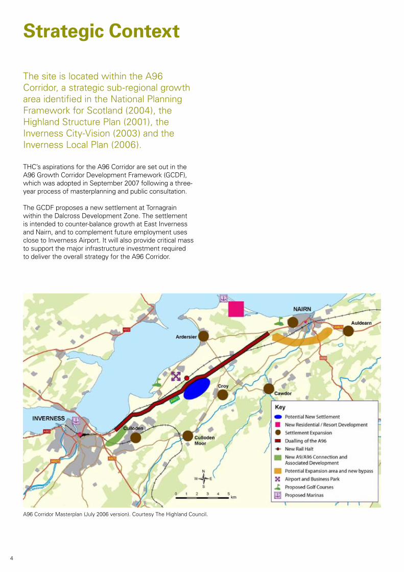
The site is located within the A96 Corridor, a strategic sub-regional growth area identified in the National Planning Framework for Scotland (2004), the Highland Structure Plan (2001), the Inverness City-Vision (2003) and the Inverness Local Plan (2006).
THC’s aspirations for the A96 Corridor are set out in the A96 Growth Corridor Development Framework (GCDF), which was adopted in September 2007 following a three-year process of masterplanning and public consultation.
The GCDF proposes a new settlement at Tornagrain within the Dalcross Development Zone. The settlement is intended to counter-balance growth at East Inverness and Nairn, and to complement future employment uses close to Inverness Airport. It will also provide critical mass to support the major infrastructure investment required to deliver the overall strategy for the A96 Corridor.
A96 Corridor Masterplan (July 2006 version). Courtesy The Highland Council.
4
EIA Process
Overview
EIA is a structured process for identifying the potential environmental effects of a development. The main steps in the process are as follows:
• definingthescope;
• consultingrelevantparties;
• carryingoutbaselinestudies;
• predictingthepotentialeffects;
• assessingthesignificanceofthoseeffects;
• identifyingandincorporatingmitigatingmeasures;
• assessingtheresidualeffects;and
• preparingtheES.
The ES identifies the “likely significant effects” arising from the construction, finished form and use of the development. These effects may be beneficial or adverse;wheresignificantadverseeffectsare likely, mitigation measures have been proposed, their effectiveness assessed and the residual effects reported.
ScopeA Scoping Opinion has been adopted by THC, following consultation with relevant parties. The following topics have been addressed:
• AgriculturalLand;
• AirQuality;
• CulturalHeritage;
• Ecology;
• Geo-Environment;
• LandscapeandVisualAmenity;
• NoiseandVibration;
• Socio-Economics;
• SurfacewaterDrainageandFloodRisk;
• Sustainability;
• Transport;and
• Waste.
ConsultationIn addition to the consultation carried out by THC, a wide range of agencies/officers have been consulted as part of the EIA process, mainly to obtain information and to confirm specific aspects of the technical work. These consultees have included THC, the Scottish Environmental Protection Agency (SEPA), Scottish Natural Heritage (SNH) and Transport Scotland. A programme of public consultation has also taken place, during which members of the EIA team attended three exhibitions at Petty Church.
5
Environmental Baseline
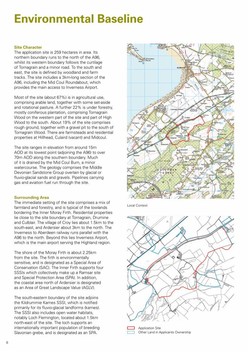
Site CharacterThe application site is 259 hectares in area. Its northern boundary runs to the north of the A96, whilst its western boundary follows the curtilage of Tornagrain and a minor road. To the south and east, the site is defined by woodland and farm tracks. The site includes a 3km-long section of the A96, including the Mid Coul Roundabout, which provides the main access to Inverness Airport.
Most of the site (about 67%) is in agricultural use, comprising arable land, together with some set-aside and rotational pasture. A further 22% is under forestry, mostly coniferous plantation, comprising Tornagrain WoodonthewesternpartofthesiteandpartofHighWoodtothesouth.About19%ofthesitecomprisesrough ground, together with a gravel pit to the south of TornagrainWood.Therearefarmsteadsandresidentialproperties at Hillhead, Culaird (vacant) and Midcoul.
The site ranges in elevation from around 15m AOD at its lowest point (adjoining the A96) to over 70m AOD along the southern boundary. Much of it is drained by the Mid Coul Burn, a minor watercourse. The geology comprises the Middle Devonian Sandstone Group overlain by glacial or fluvio-glacial sands and gravels. Pipelines carrying gas and aviation fuel run through the site.
Surrounding AreaThe immediate setting of the site comprises a mix of farmland and forestry, and is typical of the lowlands bordering the Inner Moray Firth. Residential properties lie close to the site boundary at Tornagrain, Drumine and Culblair. The village of Croy lies about 1.5km to the south-east, and Ardersier about 3km to the north. The Inverness to Aberdeen railway runs parallel with the A96 to the north. Beyond this lies Inverness Airport, which is the main airport serving the Highland region.
The shore of the Moray Firth is about 2.25km from the site. The firth is environmentally sensitive, and is designated as a Special Area of Conservation (SAC). The Inner Firth supports four SSSIs which collectively make up a Ramsar site and Special Protection Area (SPA). In addition, the coastal area north of Ardersier is designated as an Area of Great Landscape Value (AGLV).
The south-eastern boundary of the site adjoins the Kildrummie Kames SSSI, which is notified primarily for its fluvio-glacial landforms (kames). The SSSI also includes open water habitats, notably Loch Flemington, located about 1.5km north-east of the site. The loch supports an internationally important population of breeding Slavonian grebe, and is designated as an SPA.
Local Context
Application SiteOther Land in Applicants Ownership
6
Legend
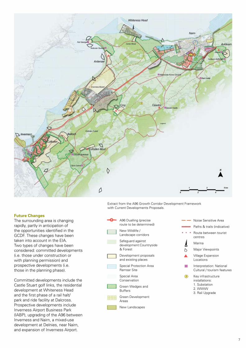
Future ChangesThe surrounding area is changing rapidly, partly in anticipation of the opportunities identified in the GCDF. These changes have been taken into account in the EIA. Two types of changes have been considered: committed developments (i.e. those under construction or with planning permission) and prospective developments (i.e. those in the planning phase).
Committed developments include the Castle Stuart golf links, the residential developmentatWhitenessHeadand the first phase of a rail halt/park and ride facility at Dalcross. Prospective developments include Inverness Airport Business Park (IABP), upgrading of the A96 between Inverness and Nairn, a mixed-use development at Delnies, near Nairn, and expansion of Inverness Airport.
A96 Dualling (precise route to be determined)
NewWildlife/ Landscape corridors
Safeguard against development:Countryside & Forest
Development proposals and existing places
Special Protection Area Ramsar Site
Special Area Conservation
GreenWedgesandBuffers
Green Development Areas
New Landscapes
Noise Sensitive Area
Paths & trails (indicative)
Route between tourist centres
Marina
Major Viewpoints
Village Expansion Locations
Interpretation: National Cultural / tourism features
Key infrastructure installations: 1. Substation 2.WWtW 3. Rail Upgrade
Extract from the A96 Growth Corridor Development Framework with Current Developments Proposals.
7
The Proposed Development
Background
The concept for a new settlement at Tornagrain has been developed in parallel with its endorsement within the strategic framework for the A96 Corridor. Initial studies began in 2004, including a range of baseline work to identify environmental constraints and opportunities.
These studies culminated in an intensive multi-disciplinary workshop and consultation exercise - known as a “charrette” - in September 2006. The charrette provided the springboard for preparation of a masterplan, which has been informed by further consultation and by information emerging from the EIA.
OverviewThe proposal is for a new settlement that is intended to be fully self-sufficient in terms of its main retail, community and recreational needs. Its key elements would comprise:
• 4,960homes(ofwhich25%wouldbeaffordable);
• 20,000m2ofretailspace;
• 9,000m2ofemploymentspace;
• 4,000m2ofhotelspace;
• 5,000m2ofresidentialinstitutions;
• 18,222m2 of non-residential institutions (including four primary schools, a secondary school and a range ofothercommunityfacilities;
• 3,000m2ofleisurefacilities;
• twopetrolstations;and
• landscapingandopenspace.
12
34
5
6
12
8
9
1011
3
3
37
12
Feature
1 TownHall/PlaceofWorship
2 Supermarket
3 Primary School
4 Secondary School
5 Police, Ambulance, Fire Station
6 Hotel
7 Community Leisure / Pool and Secondary School Sports Facilities
8 Tornagrain Park
9 Health Centre
10 Train Station
11 Inverness Airport Business Park
12 Allotments Colour Key
Civic / Schools
Commercial / Retail
8
Class 1-3 20,000 sq mClass 4 7,000 sq mClass 5 1,000 sq mClass 6 1,000 sq mClass 7 4,000 sq mClass 8 5,000 sq mClass 10 18,222 sq mIncluding schools 15,272 sq mClass 11 3,000 sq mSui Generis 1,500 sq m
TOTAL 60,722 sq m
Three Storey Maximum
Four Storey Maximum
Five Storey Maximum
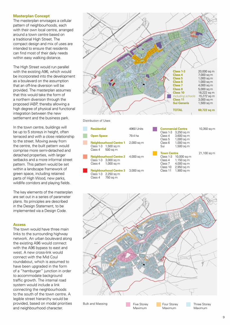
Masterplan ConceptThe masterplan envisages a cellular pattern of neighbourhoods, each with their own local centre, arranged around a town centre based on a traditional High Street. The compact design and mix of uses are intended to ensure that residents can find most of their daily needs within easy walking distance.
The High Street would run parallel with the existing A96, which would be incorporated into the development as a boulevard on the assumption that an off-line diversion will be provided. The masterplan assumes that this would take the form of a northern diversion through the proposed IABP, thereby allowing a high degree of physical and functional integration between the new settlement and the business park.
In the town centre, buildings will be up to 5 storeys in height, often terraced and with a close relationship to the street. Moving away from the centre, the built pattern would comprise more semi-detached and detached properties, with larger setbacks and a more informal street pattern. This pattern would be set within a landscape framework of green space, including retained partsofHighWood,newparks,wildlife corridors and playing fields.
The key elements of the masterplan are set out in a series of parameter plans. Its principles are described in the Design Statement, to be implemented via a Design Code.
AccessThe town would have three main links to the surrounding highway network. An urban boulevard along the existing A96 would connect with the A96 bypass to east and west. A new cross-link would connect with the Mid Coul roundabout, which is assumed to have been upgraded in the form of a “hamburger” junction in order to accommodate background traffic growth. The internal road system would include a link connecting the neighbourhoods to the south of the town centre. A legible street hierarchy would be provided, based on modal priorities and neighbourhood character.
Bulk and Massing
Distribution of Uses
Residential 4960 Units
Open Space 79.4 ha
Neighbourhood Centre 1 2,000 sq mClass 1-3 1,500 sq mClass 4 500 sq m
Neighbourhood Centre 2 4,000 sq mClass 1-3 3,000 sq mClass 4 1,000 sq m
Neighbourhood Centre 3 3,000 sq mClass 1-3 2,250 sq mClass 4 750 sq m
Commercial Centre 10,350 sq mClass 1-3 3,250 sq mClass 4 3,600 sq mClass 5 1,000 sq mClass 6 1,000 sq mSui 1,500 sq m
Town Centre 21,100 sq mClass 1-3 10,000 sq mClass 4 1,150 sq mClass 7 4,000 sq mClass 10 2,950 sq mClass 11 1,900 sq m
9
Bus links/bus ways would be provided along the High Street and the southern link road. All routes would allow for pedestrian/cycle access, using traffic-calming by design to achieve the necessary level of safety. A network of dedicated footpaths and cycleways would link neighbourhoods, local centres, open spaces and community facilities. These links would also connect externally to the rail halt/park and ride facility, the proposed business park and (subject to agreement with relevant parties) the surrounding countryside. Parking would be provided on the basis of the maximum standards set out in SPP17: Planning for Transport.
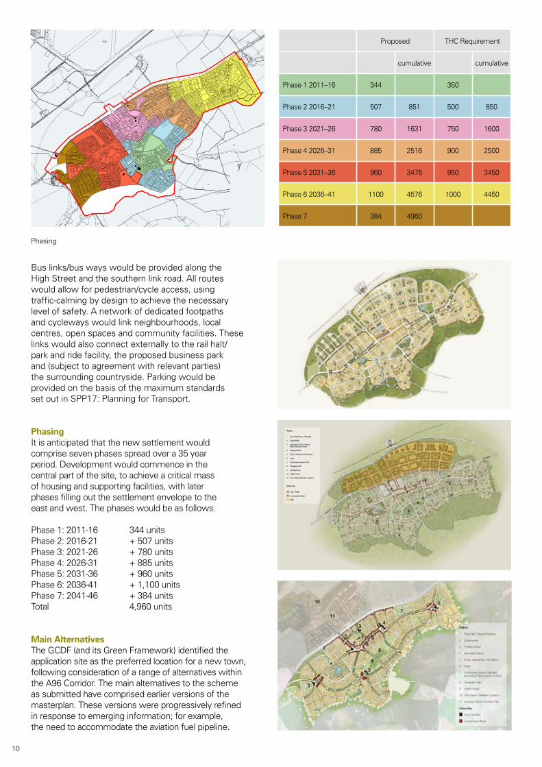
PhasingIt is anticipated that the new settlement would comprise seven phases spread over a 35 year period. Development would commence in the central part of the site, to achieve a critical mass of housing and supporting facilities, with later phases filling out the settlement envelope to the east and west. The phases would be as follows:
Phase 1: 2011-16 344 unitsPhase 2: 2016-21 + 507 unitsPhase 3: 2021-26 + 780 unitsPhase 4: 2026-31 + 885 unitsPhase 5: 2031-36 + 960 unitsPhase 6: 2036-41 + 1,100 unitsPhase 7: 2041-46 + 384 unitsTotal 4,960 units
Main AlternativesThe GCDF (and its Green Framework) identified the application site as the preferred location for a new town, following consideration of a range of alternatives within the A96 Corridor. The main alternatives to the scheme as submitted have comprised earlier versions of the masterplan. These versions were progressively refined inresponsetoemerginginformation;forexample,the need to accommodate the aviation fuel pipeline.
Phasing
Aerodrome
(Dalcross)Inverness
High Wood
N
FIGURE 3.4
Proposed Phasing
Not to scale - December 2008Reproduced from the ordnance survey map with the permission of the
Controller of Her Majesty's Stationery Office. Crown Copyright reserved.
Layout is for indicative purposes only. Realigned A96 not proposed as part of this development.
Proposed THC Requirement
cumulative cumulative
Phase 1 2011–16 344 350
Phase 2 2016–21 507 851 500 850
Phase 3 2021–26 780 1631 750 1600
Phase 4 2026–31 885 2516 900 2500
Phase 5 2031–36 960 3476 950 3450
Phase 6 2036–41 1100 4576 1000 4450
Phase 7 384 4960
10
Predicted Effects and Proposed MitigationThe predicted effects are identified belowforeachtopic.Wheresignificantadverse effects may occur and are avoidable, mitigation is proposed, and a distinction is made between the potential and residual effects.
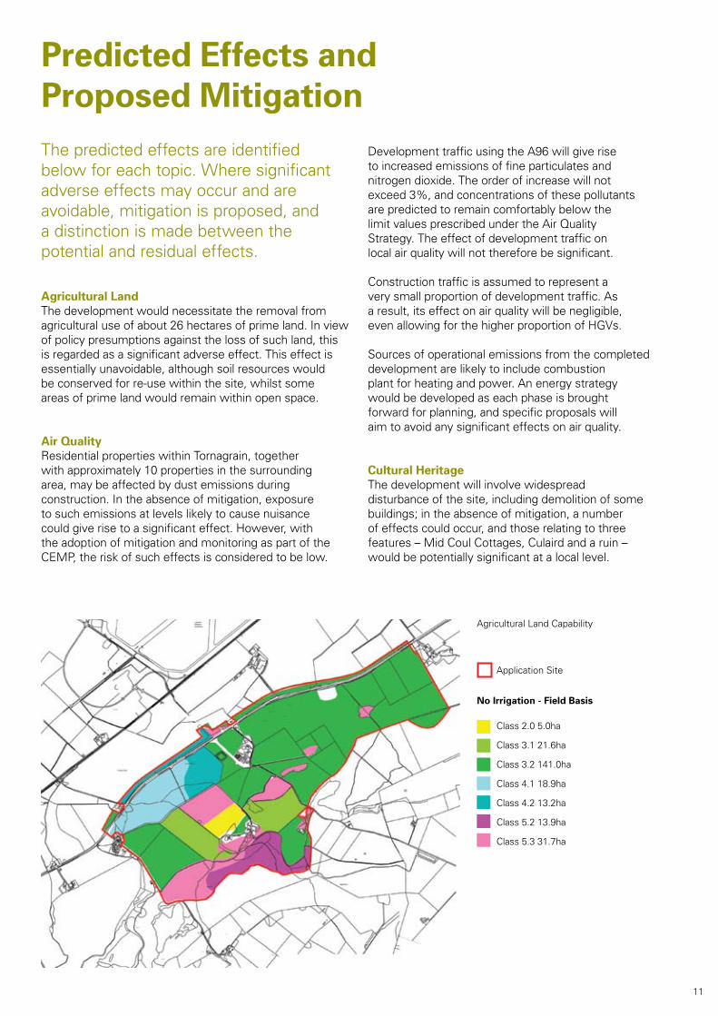
Agricultural LandThe development would necessitate the removal from agricultural use of about 26 hectares of prime land. In view of policy presumptions against the loss of such land, this is regarded as a significant adverse effect. This effect is essentially unavoidable, although soil resources would be conserved for re-use within the site, whilst some areas of prime land would remain within open space.
Air QualityResidential properties within Tornagrain, together with approximately 10 properties in the surrounding area, may be affected by dust emissions during construction. In the absence of mitigation, exposure to such emissions at levels likely to cause nuisance could give rise to a significant effect. However, with the adoption of mitigation and monitoring as part of the CEMP, the risk of such effects is considered to be low.
Development traffic using the A96 will give rise to increased emissions of fine particulates and nitrogen dioxide. The order of increase will not exceed 3%, and concentrations of these pollutants are predicted to remain comfortably below the limitvaluesprescribedundertheAirQualityStrategy. The effect of development traffic on local air quality will not therefore be significant.
Construction traffic is assumed to represent a very small proportion of development traffic. As a result, its effect on air quality will be negligible, even allowing for the higher proportion of HGVs.
Sources of operational emissions from the completed development are likely to include combustion plant for heating and power. An energy strategy would be developed as each phase is brought forward for planning, and specific proposals will aim to avoid any significant effects on air quality.
Cultural HeritageThe development will involve widespread disturbance of the site, including demolition of some buildings;intheabsenceofmitigation,anumberof effects could occur, and those relating to three features – Mid Coul Cottages, Culaird and a ruin – would be potentially significant at a local level.
Agricultural Land Capability
Class 2.0 5.0ha
Class 3.1 21.6ha
Class 3.2 141.0ha
Class 4.1 18.9ha
Class 4.2 13.2ha
Class 5.2 13.9ha
Class 5.3 31.7ha
No Irrigation - Field Basis
Application Site
11
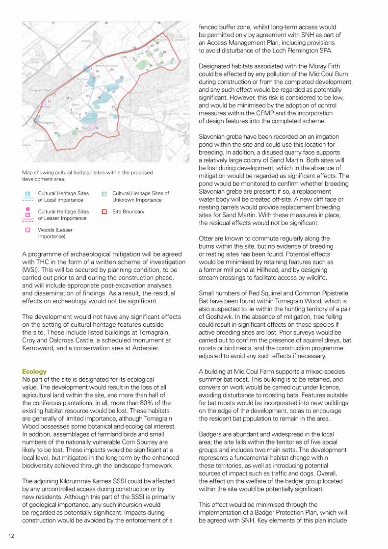
A programme of archaeological mitigation will be agreed with THC in the form of a written scheme of investigation (WSI).Thiswillbesecuredbyplanningcondition,tobecarried out prior to and during the construction phase, and will include appropriate post-excavation analyses and dissemination of findings. As a result, the residual effects on archaeology would not be significant.
The development would not have any significant effects on the setting of cultural heritage features outside the site. These include listed buildings at Tornagrain, Croy and Dalcross Castle, a scheduled monument at Kerrowaird, and a conservation area at Ardersier.
EcologyNo part of the site is designated for its ecological value. The development would result in the loss of all agricultural land within the site, and more than half of theconiferousplantations;inall,morethan80%oftheexisting habitat resource would be lost. These habitats are generally of limited importance, although Tornagrain Woodpossessessomebotanicalandecologicalinterest.In addition, assemblages of farmland birds and small numbers of the nationally vulnerable Corn Spurrey are likely to be lost. These impacts would be significant at a local level, but mitigated in the long-term by the enhanced biodiversity achieved through the landscape framework.
The adjoining Kildrummie Kames SSSI could be affected by any uncontrolled access during construction or by new residents. Although this part of the SSSI is primarily of geological importance, any such incursion would be regarded as potentially significant. Impacts during construction would be avoided by the enforcement of a
fenced buffer zone, whilst long-term access would be permitted only by agreement with SNH as part of an Access Management Plan, including provisions to avoid disturbance of the Loch Flemington SPA.
Designated habitats associated with the Moray Firth could be affected by any pollution of the Mid Coul Burn during construction or from the completed development, and any such effect would be regarded as potentially significant. However, this risk is considered to be low, and would be minimised by the adoption of control measures within the CEMP and the incorporation of design features into the completed scheme.
Slavonian grebe have been recorded on an irrigation pond within the site and could use this location for breeding. In addition, a disused quarry face supports a relatively large colony of Sand Martin. Both sites will be lost during development, which in the absence of mitigation would be regarded as significant effects. The pond would be monitored to confirm whether breeding Slavoniangrebearepresent;ifso,areplacementwater body will be created off-site. A new cliff face or nesting barrels would provide replacement breeding sitesforSandMartin.Withthesemeasuresinplace,the residual effects would not be significant.
Otter are known to commute regularly along the burns within the site, but no evidence of breeding or resting sites has been found. Potential effects would be minimised by retaining features such as a former mill pond at Hillhead, and by designing stream crossings to facilitate access by wildlife.
Small numbers of Red Squirrel and Common Pipistrelle BathavebeenfoundwithinTornagrainWood,whichisalso suspected to lie within the hunting territory of a pair of Goshawk. In the absence of mitigation, tree felling could result in significant effects on these species if active breeding sites are lost. Prior surveys would be carried out to confirm the presence of squirrel dreys, bat roosts or bird nests, and the construction programme adjusted to avoid any such effects if necessary.
A building at Mid Coul Farm supports a mixed-species summer bat roost. This building is to be retained, and conversion work would be carried out under licence, avoiding disturbance to roosting bats. Features suitable for bat roosts would be incorporated into new buildings on the edge of the development, so as to encourage the resident bat population to remain in the area.
Badgers are abundant and widespread in the local area;thesitefallswithintheterritoriesoffivesocialgroups and includes two main setts. The development represents a fundamental habitat change within these territories, as well as introducing potential sources of impact such as traffic and dogs. Overall, the effect on the welfare of the badger group located within the site would be potentially significant.
This effect would be minimised through the implementation of a Badger Protection Plan, which will be agreed with SNH. Key elements of this plan include
Map showing cultural heritage sites within the proposed development area.
Cultural Heritage Sites of Local Importance
Cultural Heritage Sites of Lesser Importance
Woods(LesserImportance)
Cultural Heritage Sites of Unknown Importance
Site Boundary
12
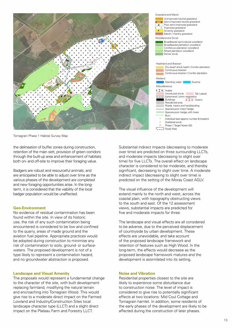
Grassland and Marsh
WoodlandandScrub
Unimproved neutral grasslandSemi improved neutral grasslandPoor semi-improved grasslandImproved grasslandAmenity grasslandMarsh / marshy grassland
Broadleaved semi-natural woodlandBroadleaved plantation woodlandConiferous plantation woodlandMixed plantation woodlandDense scrub
Heathland and BrackenDry dwarf shrub heath / Conifer plantationContinuous brackenContinuous bracken / Conifer plantation
Wetland
Miscellaneous
SwampStanding water
ArableIntroduced shrubEphemeral / short vegetationBuildingsResidential areaRoads, tracks and hardstandingSpecies-poor intact hedgeSpecies-poor hedge with treesBurnIndividual tees (approx number & location)Scattered scrubPhase 1 Target Notes (32)Study Area
Tall ruderal
Quarry
the delineation of buffer zones during construction, retention of the main sett, provision of green corridors through the built-up area and enhancement of habitats both on- and off-site to improve their foraging value.
Badgers are robust and resourceful animals, and are anticipated to be able to adjust over time as the various phases of the development are completed and new foraging opportunities arise. In the long-term, it is considered that the viability of the local badger population would be unaffected.
Geo-EnvironmentNo evidence of residual contamination has been found within the site. In view of its historic use, the risk of any such contamination being encountered is considered to be low and confined to the quarry, areas of made ground and the aviation fuel pipeline. Appropriate practices would be adopted during construction to minimise any risk of contamination to soils, ground- or surface-waters. The proposed development is not of a type likely to represent a contamination hazard, and no groundwater abstraction is proposed.
Landscape and Visual AmenityThe proposals would represent a fundamental change to the character of the site, with built development replacing farmland, modifying the natural terrain andencroachingintoTornagrainWood.Thiswouldgive rise to a moderate direct impact on the Farmed Lowland and Industry/Construction Sites local landscape character type (LLCT) and a slight direct impact on the Plateau Farm and Forestry LLCT.
Substantial indirect impacts (decreasing to moderate over time) are predicted on three surrounding LLCTs, and moderate impacts (decreasing to slight over time) for five LLCTs. The overall effect on landscape character is considered to be moderate, and thereby significant, decreasing to slight over time. A moderate indirect impact (decreasing to slight over time) is predicted on the setting of the Moray Coast AGLV.
The visual influence of the development will extend mainly to the north and west, across the coastal plain, with topography obstructing views to the south and east. Of the 12 assessment views, substantial impacts are predicted for five and moderate impacts for three.
The landscape and visual effects are all considered to be adverse, due to the perceived displacement of countryside by urban development. These effects are unavoidable, and take account of the proposed landscape framework and retentionoffeaturessuchasHighWood.Inthelong-term, the effects would decrease as the proposed landscape framework matures and the development is assimilated into its setting.
Noise and VibrationResidential properties closest to the site are likely to experience some disturbance due to construction noise. The level of impact is considered to give rise to potentially significant effects at two locations: Mid Coul Cottage and Tornagrain hamlet. In addition, some residents of the early phases of the development are likely to be affected during the construction of later phases.
Tornagrain Phase 1 Habitat Survey Map
13
Noise control measures based on best practicable means will be agreed with THC as part of the CEMP, with the aimofminimisingtheriskofsignificanteffects.Whilstvibration during construction may be perceptible at some locations, it is unlikely to give rise to significant effects.
Noise from development traffic is predicted to give rise to increases of no more than 1.0dB over future baseline levelsatmostlocations;suchincreasesarenegligible.Thehighest increases are predicted to be 1.6dB and 2.0dB duringpeakperiodsatEaster/WesterKerrogairandWesterConnage respectively. These increases are considered to be minimal and would not give rise to significant effects.
On the basis of the noise exposure categories (NECs) set out in PAN56, most of the site falls within NEC A, with Tornagrain hamlet falling within NEC B. The site is therefore considered to be suitable for its proposed use. This suitability is unlikely to change over time, even with growth in background traffic.
Socio-EconomicsIn recent years, the Highland labour market has experienced a shortfall in skills, and if new employment initiatives such as IABP proceed without associated housing provision, these constraints will be exacerbated. The new settlement would therefore have a significantly beneficial effect on labour supply.
The new settlement would provide around 2,650 jobs incategoriessuchasretailingandotherservices;this represents a significant beneficial contribution to employment opportunities, complementing the anticipated development of IABP. It is anticipated that a high proportion of these jobs would be filled by new residents, and that there would be little impact on other employment areas in terms of competition for labour supply.
During the construction phase, Tornagrain would directly support 349 full-time equivalent (FTE) jobs per annum, together with a further 323 FTE jobs indirectly. If most of these jobs are sourced locally, this employment could amount to a significant beneficial effect.
Direct spending by Tornagrain residents is calculated to reach £181 million per annum by 2046, of which between £74-£154 million is likely to be spent within the new settlement itself. This spending represents a potentially significant benefit to the local economy.
Tornagrain would represent about 26% of the anticipated provision of housing units within Inverness and the A96 Corridor up to 2041. In view of the constraints on housing supply within the Inverness area in recent years, this is regarded as a significant beneficial effect, both quantitatively and in terms of the range of accommodation to be provided.
The new settlement would generate a demand for around 1,000 primary school places and between 750-900 secondary school places. These places are not available within existing schools, and in the absence of mitigation the additional demand would
represent a significant effect. This effect would be avoided by providing four primary schools and a secondary school as part of the development.
The development of Tornagrain would generate a demand for one additional GP by 2020, which can be accommodated by existing health services. Additional demand would be met by providing a health centre of appropriate size as part of the development.
The recreational needs of the new residents would be met by incorporating a range of facilities within the masterplan, including provision for indoor sports and social activities, playing fields, play areas and informal open space. Outdoor facilities will meet the standards and locational requirements set by THC. The development is therefore likely to have a neutral or beneficial effect on recreation provision in the local area.
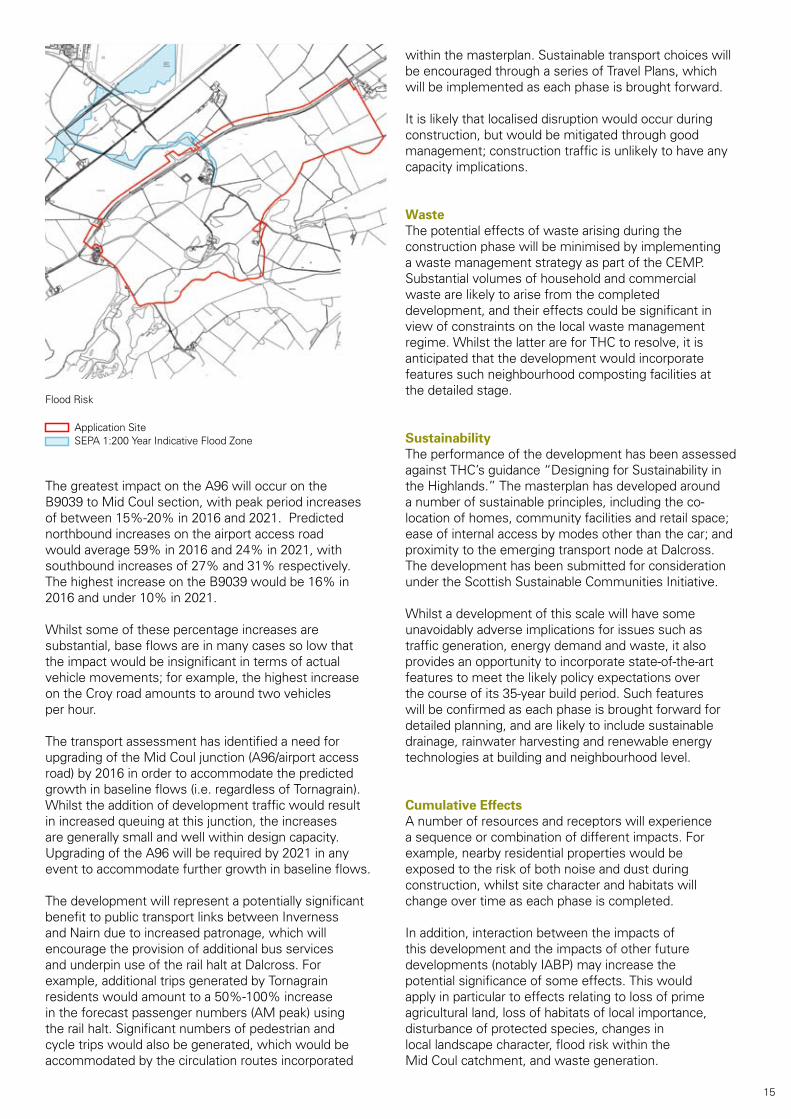
Surfacewater Drainage and Flood RiskThe development would have a significant effect on water resources within the site, notably the Mid Coul Burn, a pond and an agricultural dam. The effect on the burn would be mitigated by incorporating it within the layout and by detailed design measures such as minimising the need for culverting. Pollution risks to the burn would be minimised through careful management during construction and the incorporation of design features such as oil traps into the completed scheme.
Parts of the site close to the lower course of the burn fall within the 200-year indicative floodplain. The development would fundamentally alter the runoff characteristics of the site, and in the absence of mitigation would have a potentially significant effect on flood risk. This effect would be mitigated through detailed engineering design, as each phase is brought forward for planning.
In addition, a surfacewater drainage strategy has been developed on the basis of sustainable urban drainage (SUDS) principles. It is proposed to control runoff from storms up to a 10-year event using on-site or close-to-source infiltration measures, whilst runoff from heavier storms is conveyed to designated downstream attenuation areas. The strategy will be refined at the detailed stage, possibly including amendments to the development layout.
It is assumed that the demand for water supply and wastewater treatment generated by Tornagrain has been anticipated in infrastructure planning for theA96Corridor.Withappropriateupgrading,thedevelopment can be served by existing networks.
TransportDevelopment traffic is predicted to give rise to overall increases in flows on the surrounding highway network of 11% (AM peak) and 7% (PM peak) in 2016, and 13% and 10% respectively in 2021. These increases are considered to represent a minor adverse effect, which will vary substantially across the network.
14
The greatest impact on the A96 will occur on the B9039 to Mid Coul section, with peak period increases of between 15%-20% in 2016 and 2021. Predicted northbound increases on the airport access road would average 59% in 2016 and 24% in 2021, with southbound increases of 27% and 31% respectively. The highest increase on the B9039 would be 16% in 2016 and under 10% in 2021.
Whilstsomeofthesepercentageincreasesaresubstantial, base flows are in many cases so low that the impact would be insignificant in terms of actual vehiclemovements;forexample,thehighestincreaseon the Croy road amounts to around two vehicles per hour.
The transport assessment has identified a need for upgrading of the Mid Coul junction (A96/airport access road) by 2016 in order to accommodate the predicted growth in baseline flows (i.e. regardless of Tornagrain). Whilsttheadditionofdevelopmenttrafficwouldresultin increased queuing at this junction, the increases are generally small and well within design capacity. Upgrading of the A96 will be required by 2021 in any event to accommodate further growth in baseline flows.
The development will represent a potentially significant benefit to public transport links between Inverness and Nairn due to increased patronage, which will encourage the provision of additional bus services and underpin use of the rail halt at Dalcross. For example, additional trips generated by Tornagrain residents would amount to a 50%-100% increase in the forecast passenger numbers (AM peak) using the rail halt. Significant numbers of pedestrian and cycle trips would also be generated, which would be accommodated by the circulation routes incorporated
within the masterplan. Sustainable transport choices will be encouraged through a series of Travel Plans, which will be implemented as each phase is brought forward.
It is likely that localised disruption would occur during construction, but would be mitigated through good management;constructiontrafficisunlikelytohaveanycapacity implications.
WasteThe potential effects of waste arising during the construction phase will be minimised by implementing a waste management strategy as part of the CEMP. Substantial volumes of household and commercial waste are likely to arise from the completed development, and their effects could be significant in view of constraints on the local waste management regime.WhilstthelatterareforTHCtoresolve,itisanticipated that the development would incorporate features such neighbourhood composting facilities at the detailed stage.
SustainabilityThe performance of the development has been assessed against THC’s guidance “Designing for Sustainability in the Highlands.” The masterplan has developed around a number of sustainable principles, including the co-locationofhomes,communityfacilitiesandretailspace;easeofinternalaccessbymodesotherthanthecar;andproximity to the emerging transport node at Dalcross. The development has been submitted for consideration under the Scottish Sustainable Communities Initiative.
Whilstadevelopmentofthisscalewillhavesomeunavoidably adverse implications for issues such as traffic generation, energy demand and waste, it also provides an opportunity to incorporate state-of-the-art features to meet the likely policy expectations over the course of its 35-year build period. Such features will be confirmed as each phase is brought forward for detailed planning, and are likely to include sustainable drainage, rainwater harvesting and renewable energy technologies at building and neighbourhood level.
Cumulative EffectsA number of resources and receptors will experience a sequence or combination of different impacts. For example, nearby residential properties would be exposed to the risk of both noise and dust during construction, whilst site character and habitats will change over time as each phase is completed.
In addition, interaction between the impacts of this development and the impacts of other future developments (notably IABP) may increase the potential significance of some effects. This would apply in particular to effects relating to loss of prime agricultural land, loss of habitats of local importance, disturbance of protected species, changes in local landscape character, flood risk within the Mid Coul catchment, and waste generation.
Application SiteSEPA 1:200 Year Indicative Flood Zone
Flood Risk
15

Printed on Revive 100 – 100% recycled paper
Estates Office, Berryley, Darnaway,By Forres IV36 2ST
Andrew Howard – Managing [email protected]
www.tornagrain-newtown.co.uk.