ENVIRONMENTAL REVIEW TECHNICAL MEMORANDUM MID …...1 ENVIRONMENTAL REVIEW TECHNICAL MEMORANDUM...
33
1 ENVIRONMENTAL REVIEW TECHNICAL MEMORANDUM MID-ISLAND BLUEBELT GENERIC ENVIRONMENTAL IMPACT STATEMENT CEQR No. 07DEP063R April 19, 2019 This Environmental Review Technical Memorandum has been prepared to address several proposed modifications to the New York City Department of Environmental Protection (DEP) Mid-Island Watersheds Bluebelt Drainage Plans. An environmental impact analysis of these drainage plans was previously provided in the Staten Island Bluebelt Drainage Plans for Mid- Island Watersheds Final Generic Environmental Impact Statement ([FGEIS], CEQR: No. 07DEP063R) for which DEP issued a Notice of Completion on November 4, 2013. The Mid-island Bluebelt comprises three contiguous watersheds along the east shore of Staten Island totaling approximately 5,000 acres in an area defined by Lighthouse Hill, Todt Hill, South Beach and Oakwood Beach. As in the original Bluebelt watersheds in South Richmond, the Mid- Island Bluebelt incorporates wetlands, watercourses and other undeveloped land into an ecological system that captures, retains and safely discharges storm water runoff from urban surfaces. Mid-island surface water flows south and east from the higher elevations toward Lower New York Bay. At present much of the runoff is uncontrolled: many project area streets lack storm sewers, storm water velocities in the upper watershed cause streambed scouring and soil erosion, and watercourses in the lower watershed are silted up and fragmented. As described in the GEIS, Mid-Island watercourses will have their capacity enhanced by the construction of detention basins and similar features referred to collectively as “Best Management Practices (BMPs),” a term used to denote the features as well as the practices. The Mid-Island watersheds GEIS, completed in 2013, described and evaluated a detailed drainage plan that features 31 new BMPs to be located throughout the Mid-Island watersheds. Building the BMPs involves excavation and removal of contaminated and degraded soils, excavation of low-value plant communities dominated by common reed, clarification and reconnection of the discontinuous watercourses, installation of the detention basins and associated drainage features, and extensive grading and replanting of Bluebelt land adjacent to the BMPs. As design has progressed since 2013, agency officials have identified minor but advantageous improvements to the plan put forth in the GEIS. The purpose of this Technical Memorandum is to describe the changes presently under consideration and to determine whether they affect the conclusions of the GEIS. Three proposed changes are evaluated herein:
Transcript of ENVIRONMENTAL REVIEW TECHNICAL MEMORANDUM MID …...1 ENVIRONMENTAL REVIEW TECHNICAL MEMORANDUM...

1
ENVIRONMENTAL REVIEW TECHNICAL MEMORANDUM
MID-ISLAND BLUEBELT GENERIC ENVIRONMENTAL IMPACT STATEMENT
CEQR No. 07DEP063R
April 19, 2019
This Environmental Review Technical Memorandum has been prepared to address several
proposed modifications to the New York City Department of Environmental Protection (DEP)
Mid-Island Watersheds Bluebelt Drainage Plans. An environmental impact analysis of these
drainage plans was previously provided in the Staten Island Bluebelt Drainage Plans for Mid-
Island Watersheds Final Generic Environmental Impact Statement ([FGEIS], CEQR: No.
07DEP063R) for which DEP issued a Notice of Completion on November 4, 2013.
The Mid-island Bluebelt comprises three contiguous watersheds along the east shore of Staten
Island totaling approximately 5,000 acres in an area defined by Lighthouse Hill, Todt Hill, South
Beach and Oakwood Beach. As in the original Bluebelt watersheds in South Richmond, the Mid-
Island Bluebelt incorporates wetlands, watercourses and other undeveloped land into an
ecological system that captures, retains and safely discharges storm water runoff from urban
surfaces. Mid-island surface water flows south and east from the higher elevations toward
Lower New York Bay. At present much of the runoff is uncontrolled: many project area streets
lack storm sewers, storm water velocities in the upper watershed cause streambed scouring
and soil erosion, and watercourses in the lower watershed are silted up and fragmented. As
described in the GEIS, Mid-Island watercourses will have their capacity enhanced by the
construction of detention basins and similar features referred to collectively as “Best
Management Practices (BMPs),” a term used to denote the features as well as the practices.
The Mid-Island watersheds GEIS, completed in 2013, described and evaluated a detailed
drainage plan that features 31 new BMPs to be located throughout the Mid-Island watersheds.
Building the BMPs involves excavation and removal of contaminated and degraded soils,
excavation of low-value plant communities dominated by common reed, clarification and
reconnection of the discontinuous watercourses, installation of the detention basins and
associated drainage features, and extensive grading and replanting of Bluebelt land adjacent to
the BMPs. As design has progressed since 2013, agency officials have identified minor but
advantageous improvements to the plan put forth in the GEIS. The purpose of this Technical
Memorandum is to describe the changes presently under consideration and to determine
whether they affect the conclusions of the GEIS.
Three proposed changes are evaluated herein:

2
a) Acquisition of the street beds of two mapped streets, Nugent and Chicago Avenues, to build
sewer and/or water infrastructure;
b) Donation of several former residential sites damaged in Superstorm Sandy to the
Department of Environmental Protection to be incorporated within the Mid-Island Bluebelt;
and
c) Purchase of a private tax lot on Whitlock Avenue in the Todt Hill section for an expanded
BMP NC-4.
Background
The Staten Island Bluebelt is a DEP initiative in progress since the 1980s to provide natural
storm water management for unsewered areas of the borough. The natural storm water
management principles that inform the Bluebelt program revise the conventional drainage
plans for middle and southern Staten Island watersheds, adopted in the early 1960s, which
anticipated Staten Island developing more like the other boroughs with little unbuilt land and
most watercourses underground. The Bluebelt program preserves streams, ponds and other
wetland areas, allowing them to perform their natural functions of conveying, storing and
filtering runoff from adjacent developed areas. The name “Bluebelt,” i.e., a network of streams
and wetlands, alludes to Staten Island’s “Greenbelt” network of protected open space in central
Staten Island. The Bluebelt program was first implemented in the South Richmond (southern
Staten Island) watersheds where relatively more undeveloped land was in city ownership and
available for stormwater management purposes. The first approved amended drainage plan
was for the Richmond Creek watershed. Drainage plan amendments for Arbutus Creek, Blue
Heron, Lemon Creek, Wolfe’s Pond, Sweet Brook and ten other watersheds soon followed. The
Mid-Island program is building on the Bluebelt successes in South Richmond.
Environmental review is required for the land acquisitions and environmental permits needed
for the Bluebelt projects. For the Mid-Island watersheds, DEP prepared a Generic
Environmental Impact Statement (GEIS) because of the geographic scale and because the action
involved a number of separate but related projects in the same geographical area. The Final
GEIS for the Mid-Island watersheds, published November 4, 2013 (07DEP063R), evaluates the
amended drainage plan which combines collection sewers with the construction of BMPs and
related ecological improvements to the Mid-Island watercourses.
Watershed Geography
The topography of the Mid-island Bluebelt is shaped by the terminal moraine running
northeast-to-southwest through Staten Island, leaving steep slopes in the upper watersheds
and the flat, low-lying terrain of an outwash plain in the lower portions. The stormwater
3
management challenges are correspondingly different: scouring and erosion in the upper
watershed, ponding and flooding in the lower watershed. Eighty percent of Mid-Island
watershed streets lacked storm sewers in 2013 when the GEIS became final.
The watersheds are described in more detail below:
New Creek
The New Creek watershed occupies about 2,249 acres including 94 acres of Bluebelt property.
The upper watershed’s higher elevations, rolling topography, steep slopes, woodlands and
freshwater ponds contrast sharply with the flat relief and common-reed-dominated marshes of
the lower watershed, below Hylan Boulevard, which are just above sea level. Approximately
750 acres of the lower watershed drain directly into three sediment-laden stream channels
which meander between streets and homes and cause local flooding. The balance of the lower
watershed is served by storm sewers that drain ultimately to the Lower Bay via tide-gate
controlled outfalls. In the lower watershed the amended drainage plan includes storm sewers
to collect urban runoff and a series of BMPs within Bluebelt property. The lower watershed
BMPs are designed to detain storm flows that otherwise cannot drain to the Lower Bay during
high tide events when the outfall tide gates are closed. Of particular interest for this Technical
Memorandum are the areas of the lower watershed adjoining certain BMPs where DEP would
receive several former residential properties as donations to the Bluebelt, and at Nugent
Avenue, where the Department of Design and Construction (DDC) has determined public
acquisition of a portion of the roadbed is required to build the planned sewer and water
infrastructure. In the upper watershed, DEP is proposing to acquire Block 908 Lot 16 in order to
construct a slightly larger version of BMP NC-4 than what was envisioned in the GEIS.
BMPs NC-6, 7, 8, 9, 10 and 17 are under construction in the west branch of the New Creek
lower watershed under capital contract No. MIBBNC001. The design of this work involves
partial relocation of the silted-up parts of the west branch, identified on an 1896 map as
Moravian Creek1, to these BMPs and new channels in Bluebelt property. BMP NC-7 (New Creek
#7), below Nugent Avenue between Graham Boulevard and Hunter Avenue, has replaced a
silted-up channel and common reed monoculture with a wide, visually spacious
floodplain/wetland system with diverse native plantings.
1 So named in Leng, Charles W. and William T. Davis, 1896. Map of Staten Island (Motanucke, Monocknong, Aquehonga, Eghqueous, Staten Eylant). Leng was a local historian and Davis a naturalist in whose memory the William T. Davis Wildlife Refuge preserves a portion of the Fresh Kills wetland ecosystem.
4
The main channel, or Barton’s Creek,2 originates at Last Chance Pond, between Hylan Boulevard
and the Staten Island railway. NC-16 is one of a series of seven BMPs through which the main
channel will be restored under capital contract No. MIBBNC003. NC-16 occupies a 12-acre site
on Bluebelt property between Graham Boulevard and Seaver Avenue from Mason Avenue east
to Olympia Boulevard. Like most of the BMPs, its primary function will be large-scale storage of
flood water during high tides, when the tide gates to the Lower Bay are closed. The BMP will
involve substantial ecological restoration, a deep pond, and landscapes planted with a variety
of native species that will provide a wildlife habitat superior to the common reed monoculture
there now. Water will flow to the BMP from a rebuilt stream bed carrying water from
upstream BMPs NC-13, 14 and 15.
Oakwood Beach
This 1,329-acre watershed drains several east shore communities, among them New Dorp and
New Dorp Beach, Oakwood Beach and Bay Terrace. It extends from New Dorp Lane on the
northeast into Great Kills Park on the southeast, reaching inland about one-third mile
northwest of the Staten Island Railway.
The lower Oakwood Beach watershed has an unusually large proportion of open space for an
east shore Staten Island neighborhood. The Department of Parks and Recreation (City Parks)
has title to some of the open space in the Cedar Grove area east of Kissam Avenue and DEP has
Bluebelt property to be used for BMPs OB-1 and OB-3. The city parkland is not developed for
recreational use. Great Kills Park, just outside the watershed to the west and part of the
National Park System’s Gateway National Recreation Area, is well developed for park use,
including a walk-bike path, playground, bay beach, walking trails and miles of shoreline. The
Oakwood Beach neighborhood has some newer, denser housing, including a variety of duplexes
and townhouses built in the past 20 years on Aviston, Dugdale and Riga Streets, just east of the
planned OB-3 drainage feature, and smaller houses on long-established streets like Kissam
Avenue and Fox Lane that cross the marshes to the beach. Hurricane-induced flooding during
Superstorm Sandy damaged many of these homes, and in the years since, the Governor’s Office
of Storm Recovery has purchased many buildings, removed them, and cleared and greened the
sites. After decades of encroachment on natural areas, the urban footprint in Oakwood Beach
has gotten a little smaller since 2012.
2 Leng and Davis, 1896. Map of Staten Island (Motanucke, Monocknong, Aquehonga, Eghqueous, Staten
Eylant).

5
The GEIS describes five BMPs in the Oakwood Beach watershed. The BMP designated OB-3
(Oakwood Beach #3), relevant to this tech memo because of a prospective property donation,
will occupy a low, level area of 29 acres now covered in common reed. The BMP would handle
flow from a 263-acre area. OB-3’s irregular shape includes forebays at each of eight storm
sewer outfalls, channels, a permanent pool, perched ponds, and extensive wetland shelves that
can store floodwaters until they can be safely released into the bay.
South Beach
Smallest and easternmost of the Mid-Island watersheds, the 1,267-acre South Beach watershed
features the recreational South Beach and Franklin Delano Roosevelt Boardwalk. Of interest in
this tech memo is a prospective property donation adjacent to BMP SBE-1B, also the proposed
public acquisition of the street bed of Chicago Avenue to permit subsurface infrastructure
construction under Capital Contract No. MIBBNC003.
South and Midland Beaches were developed as commercial beach resorts with boardwalks,
hotels and amusements for local clienteles beginning in the 1880s. Fifty or so years later City
Parks acquired the beaches, replaced the commercial uses with park facilities, and built a
boardwalk named for President Franklin D. Roosevelt. Even as streets were laid out and houses
built closer to Hylan Boulevard, much of the marshy land immediately inland from the beach
resisted any more permanent development than the tent and cottage colonies that sprang up
temporarily around the beach resorts. These have all disappeared. Some of the undeveloped
land in the South Beach watershed is now in DEP’s possession for Bluebelt purposes, and City
Parks has a large, undeveloped open space of about 125 acres designated as Ocean Breeze
Park. As described in the GEIS three BMPs are planned for the Bluebelt tracts just inland from
the beach. Unlike the New Creek Bluebelt holdings, which follow sinuous stream corridors, the
South Beach watershed lacks open watercourses. Here the Bluebelt properties are mainly two
tracts of marshland comprising about 40 acres in total, which will provide sites for three BMPs.
The principal objectives of BMP SBE-1B are to provide some relief storage for high-level flows
from the Sand Lane trunk sewer and a receiving area for local street drainage. The BMP will
have a large extended detention wetland that will be inundated during storm events and
provide stormwater management, water quality and ecological benefits. This area will
incorporate two existing ponds on the site. Water released from the BMP will flow into the
planned trunk sewer in Father Capodanno Boulevard. Five storm sewer outfalls to SBE-1B are
planned, including one at the foot of Andrews Street next to the property proposed for
donation to the Bluebelt.

6
Project Modifications
The 2013 Final GEIS described all the proposed BMPs, the Bluebelt lands and prospective
Bluebelt acquisitions planned for the Mid-Island Bluebelt Watersheds. This technical
memorandum addresses three modifications to the scope of the project currently under
consideration. One is a street acquisition concerning Nugent and Chicago Avenues. The second
concerns a transfer of several former residential properties to the Bluebelt, essentially
increasing Bluebelt holdings. Lastly, plans for BMP NC-4 have changed as DEP officials propose
to acquire a private lot adjacent to the original NC-4 site with room to create an extended
detention basin with enough capacity to receive and detain storm water from its 103-acre
drainage area.
A. Street Bed Acquisitions
Nugent Avenue
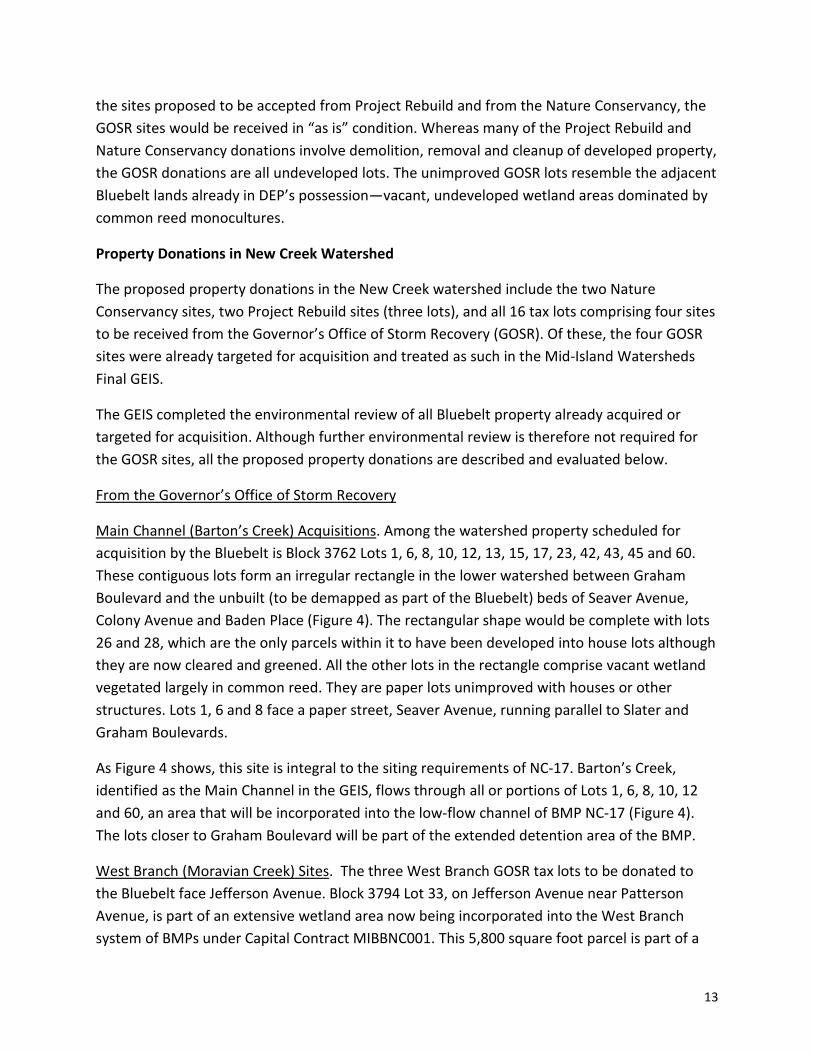
DDC proposes public acquisition of the middle 60 feet of the Nugent Avenue right-of-way, not
to include the 10-foot sidewalk margins, between Graham Boulevard and Jefferson Avenue. The
acquisition would allow DDC to build the sanitary sewer and water main planned under capital
contract MIBBNC003, in keeping with the New Creek lower watershed drainage system
described in the GEIS (Figure 1).
The length of Nugent Avenue to
be acquired is mapped as an 80
foot-wide right-of-way. The
material reality is quite
different: Most of the subject
length, from Graham Boulevard
to a point about 100 feet
beyond Stobe Avenue, is a
narrow lane of substandard
pavement; the remainder of the
right-of-way is comprised of
weedy vegetation and a loose
rubble embankment that closes
Stobe off to any communication
with Nugent (Insets 1 and 2).
Sidewalks and curbs exist only
at Block 3717 Lot 33.
Inset 1. Nugent Avenue looking south from Graham Boulevard. A narrow lane bordered by weedy vegetation.
Google Street View image, June 2018.

7
The lane gives access to a house on lot 33 and to Lots 14, 16, 18 and 21, in Block 3764, which
are all vacant but may be developable. The lane dead ends with a guard rail and an interval of
vegetation just past Lot 33. This unpaved interval is vegetated with grasses and mugwort
(Figure 2). After that interval Nugent Avenue reappears, now at legal grade with standard
sidewalk, curb and roadway occupying the westerly 40 feet of the mapped right-of-way. The
grade difference here is handled with a retaining wall at the edge of the vegetated interval.
Nugent continues in this form southwest to Jefferson Avenue and beyond. Here the built half of
Nugent serves an eight-unit townhouse development about 30 years old, in which four houses
face Nugent Avenue northeast of Jefferson and another four face Nugent Court, a short private
street off Nugent Avenue. The easterly half of the Nugent right-of-way, alongside BMP NC-7, is
essentially part of the Bluebelt lands. The part of Nugent Avenue near Jefferson is out of
alignment with the part near Stobe and Graham.
Inset 2. Illustration of Proposed Nugent Avenue Acquisition Showing Existing Conditions and Vegetation.
8
Although a final mapped street, ownership of the subject length of Nugent is divided among 15
separate tax lots (Figure 3). The proposed acquisition would involve the portions of those lots
that lie within the 60-foot acquisition area. On the west side of the street the acquisition would
abut developed property. Block 3717 Lots 35, 40, 41, 43 and 44 are part of the Nugent Court
development of eight townhouses. The proposed acquisition of the street bed portion of the
right of way conforms with the present spatial conditions; the city would take title to the street
bed and would leave the existing sidewalk space in the ownership of adjacent Nugent Court
property owners.
Block 3717 Lot 33, with a house built in the 1920s, has old-fashioned landscape features: a front
yard and lawn bordered by a white picket fence, a walk from the front door across the yard,
through a swing gate in the fence, down two steps and out to the sidewalk; a shallow retaining
wall from the front yard down to the sidewalk level, and a narrow paved sidewalk and planted
tree belt between sidewalk and curb. The proposed acquisition follows the line of the white
picket fence and retaining wall. The front yard of Lot 33 within the fence would remain part of
Lot 33. The sidewalk and treebelt outside the fence would become city property (Figure 3).
Stobe Avenue between Nugent and Mason is a block of about 42 three-story semi-detached
houses built in an early 1980s development, each house having a prominent garage and
shallow, paved driveway facing the street. Stobe Avenue was built several feet higher than
Nugent in keeping with the legal street grades. The transition between Stobe and Nugent was
handled by splitting the end of Stobe into two separate segments. The northerly segment
serves four houses at the end of Stobe Avenue (Block 3716 Lots 40, 41, 43 and 45; see Inset 2
illustration). This segment then rounds the corner of lot 40 and continues toward Graham
Boulevard, within the Nugent right-of-way, but well above and completely separate from the
existing Nugent street bed.
The southerly segment of the split end of Stobe is a remnant of the street as it was before the
1980s-era development of attached houses. It borders the side yard of the circa-1920 house in
Block 3717 Lot 33 and ends at an approximately four-foot high retaining wall. The grade
difference between Nugent and Stobe was handled with a loose rubble embankment. The
embankment separates the two segments at the end of Stobe Avenue and then rounds the
corner into Nugent and continues all the way to Graham Boulevard (Inset 3). The rubble
embankment supports volunteer trees and other plants.
The proposed acquisition follows the street line of Nugent where it crosses Stobe, then drops
back 10 feet, leaving a strip of the Nugent right-of-way for which the lot 40 property has an
easement. The occupants use this easement as a driveway and to extend the width of the pool
deck in their back yard. The proposed acquisition boundary coincides with the edge of that
easement, which is marked by a fence.

9
It will be necessary to excavate the rubble embankment, trees and guard rail fence that
separate the two end segments of Stobe Avenue to install the proposed sanitary sewer and
water main. These will be restored to their present condition following construction.
Stormwater Drainage. The GEIS indicated new storm sewer in the subject length of Nugent
Avenue and in the intersecting streets, which would drain the northern segment of Nugent
Avenue into NC-16 and the southern portion of Nugent Avenue into NC-7. In developing plans
for NC-16 it became apparent that a storm sewer and outfall in Nugent could not be built per
the amended drainage plan at the current grade of Nugent Avenue. As a result, the storm
sewer and outfall work in Nugent Avenue and Graham Boulevard were removed from
MIBBNC003. As shown in Inset 2, several lots along Nugent and Graham are potentially
developable; should the streets be raised to legal grade in the future the storm sewer and
outfall into NC-16 may be built per the drainage plan.
The drainage plan for Stobe Avenue anticipated directing flow from the southern half of the
street into the Nugent Avenue storm sewer and outfall to NC-16, and directing flow from the
northern half of the street to the Mason Avenue storm sewer and outfall into the same BMP.
The proposed modification is to direct all flow from Stobe Avenue north into the Mason Avenue
sewer and outfall. This would be accomplished by installing catch basins at either side of Stobe
approximately 140 feet northwest of Nugent Avenue. This minor modification of the drainage
plan does not affect the design of the sewer in Mason Avenue or the outfall to NC-16 at Mason
and Rowan Avenues.
Inset 3. Unimproved segment of Stobe Avenue, intersection of Nugent Avenue, showing the rubble embankment and guard rail. The higher segment of Stobe is just
beyond the guard rail. Google Street View image, August 2018.
10
Sanitary Sewer. The GEIS indicates some new and some upgraded sanitary sewer in the subject
length of Nugent Avenue. Figure 4.1-2b in the GEIS depicted an upgrade of existing sanitary in
Nugent, Stobe, and in Graham Boulevard alongside NC-16 as far east as Baden Place. As
illustrated in Figure 1, current plans for the subject length of Nugent Avenue indicate upgraded
sanitary only as far south as Block 3764 Lot 14, i.e., about 100 feet south of the intersection
with Stobe Avenue. New sanitary would extend a distance of 35 feet north from Stobe toward
Graham, far enough to serve Block 3764 Lot 21 in the event the owner wishes to build there in
the future. After construction the street surface will be returned to its present condition; the
northerly segment of Nugent remaining as a narrow irregular lane without curbs, sidewalks or
catchbasins at its present grade; the southerly segment built with sidewalk and curb on the
Nugent Court side and the other side of the right-of-way unbuilt. The sanitary sewer work will
require disturbance of the vegetated surface in the unpaved interval in Nugent Avenue. This
ground surface will be restored following construction.
Water Main. The GEIS makes no mention of water main work in the New Creek watershed. The
current plans call for new water main in the entire length of Nugent to be acquired, and
continuing for about 50 feet into Stobe Avenue and 50 feet into Graham Boulevard to connect
with existing water mains in those streets.
Chicago Avenue Acquisition
DDC has added infrastructure work in Chicago Avenue between Columbia Avenue and
Cleveland Place to Capital Contract MIBBNC003. Chicago Avenue, in the Arrochar neighborhood
of the South Beach watershed, is fully built with sidewalks and curbs on both sides. The city,
however, does not have title to the street bed itself and acquisition is therefore necessary to
support the proposed infrastructure work. DDC proposes to acquire the full 50-foot-wide, 615-
foot long right-of-way (Inset 4). The acquisition would be subject to existing low stone retaining
wall encroachments on Block 3089 Lots 1 and 9, and Block 3092 Lot 9. While the GEIS showed
proposed storm sewers in Chicago Avenue, along with proposed sanitary and some existing
sanitary to be upgraded, the work in Capital Contract MIBBNC003 only includes sanitary sewer
work.

11
B. Property Donations
Subsequent to the GEIS, three separate but related property donation projects have arisen as a
response to Superstorm Sandy. Through these projects DEP will receive storm-damaged
property to add to and manage as part of the Mid-Island Bluebelt. Most of the prospective
donations are in the lower New Creek watershed. One is in Oakwood Beach and one in South
Beach.
First, an overview of the three contributing donor parties.
NYC Housing Preservation and Development-Project Rebuild, Inc. The Department of Housing
Preservation and Development (HPD) is managing a land use action to secure responsible
future uses for 140 scattered, storm-damaged lots in Queens, Brooklyn and Staten Island as
either resilient housing or open space. This Resilient Housing and Open Space project is part of
the “Build It Back” Acquisition, Relocation and Buyout Program created following Superstorm
Sandy. Build-it-Back funds the purchase of substantially damaged homes or sites for resiliency

12
projects: Building new, resilient housing where feasible, and designating other sites as open
space. The sites were initially one- to four-family houses damaged in Sandy and subsequently
purchased by Project Rebuild, Inc., a non-profit organization, through the Build-it-Back
program.
DEP will only accept Build-it-Back sites that are contiguous to existing Bluebelt property already
in DEP’s possession. Of the 12 Build-it-Back sites in Staten Island designated for open space,
DEP proposes to accept four sites comprising five tax lots. Project Rebuild’s demolition
contractors will demolish all extant structures including pavements, foundations and, as
applicable, foundation pilings. Sites will be cleared of storage tanks and asbestos-containing
materials, graded and backfilled with clean fill. The seven remaining open space sites on Staten
Island not to be included in the Bluebelt will be transferred to City Parks for park-related uses,
or to the Department of Citywide Administrative Services to maintain until an appropriate open
space use has been determined. Such use could include vacant lot gardens or sale to an abutter
for use as a side yard. Lots could also be transferred to HPD for program-compliant housing
development.
All the Build-it-Back sites are subject to resiliency stipulations imposed by the federal funding
through which they were purchased. The stipulations relevant to the open space sites prohibit
permanent structures on the sites.
The transfer from Project Rebuild to New York City agencies under Resilient Housing and Open
Space is subject to the Uniform Land Use Review Procedure (ULURP). HPD is preparing a draft
Environmental Assessment Statement (EAS) on the Resilient Housing and Open Space project,
to cover the remainder of the sites in the Build-it-Back program, which, with this Technical
Memorandum, would complete the environmental review for the Resilient Housing and Open
Space project.
NRCS-Nature Conservancy. DEP proposes to accept two sites comprising three tax lots from
The Nature Conservancy, which acquired the sites as part of a flood plain restoration project led
by the Natural Resources Conservation Service (NRCS). The Nature Conservancy will have
demolished any structures remaining on the properties and conducted site cleanup and
environmental remediation as required before transferring the properties to DEP. Demolition
will be completed by summer 2019; removal of debris, grading and backfilling, and any required
remediation will occur thereafter, prior to transfer.
Governor’s Office of Storm Recovery. DEP proposes to accept four sites comprising 16 tax lots,
in the New Creek lower watershed, from the Governor’s Office of Storm Recovery, a state
agency. The GOSR sites were already identified for acquisition for the Bluebelt program. Now,
rather than having to acquire the sites, DEP will receive them as donations from GOSR. Unlike
13
the sites proposed to be accepted from Project Rebuild and from the Nature Conservancy, the
GOSR sites would be received in “as is” condition. Whereas many of the Project Rebuild and
Nature Conservancy donations involve demolition, removal and cleanup of developed property,
the GOSR donations are all undeveloped lots. The unimproved GOSR lots resemble the adjacent
Bluebelt lands already in DEP’s possession—vacant, undeveloped wetland areas dominated by
common reed monocultures.
Property Donations in New Creek Watershed
The proposed property donations in the New Creek watershed include the two Nature
Conservancy sites, two Project Rebuild sites (three lots), and all 16 tax lots comprising four sites
to be received from the Governor’s Office of Storm Recovery (GOSR). Of these, the four GOSR
sites were already targeted for acquisition and treated as such in the Mid-Island Watersheds
Final GEIS.
The GEIS completed the environmental review of all Bluebelt property already acquired or
targeted for acquisition. Although further environmental review is therefore not required for
the GOSR sites, all the proposed property donations are described and evaluated below.
From the Governor’s Office of Storm Recovery
Main Channel (Barton’s Creek) Acquisitions. Among the watershed property scheduled for
acquisition by the Bluebelt is Block 3762 Lots 1, 6, 8, 10, 12, 13, 15, 17, 23, 42, 43, 45 and 60.
These contiguous lots form an irregular rectangle in the lower watershed between Graham
Boulevard and the unbuilt (to be demapped as part of the Bluebelt) beds of Seaver Avenue,
Colony Avenue and Baden Place (Figure 4). The rectangular shape would be complete with lots
26 and 28, which are the only parcels within it to have been developed into house lots although
they are now cleared and greened. All the other lots in the rectangle comprise vacant wetland
vegetated largely in common reed. They are paper lots unimproved with houses or other
structures. Lots 1, 6 and 8 face a paper street, Seaver Avenue, running parallel to Slater and
Graham Boulevards.
As Figure 4 shows, this site is integral to the siting requirements of NC-17. Barton’s Creek,
identified as the Main Channel in the GEIS, flows through all or portions of Lots 1, 6, 8, 10, 12
and 60, an area that will be incorporated into the low-flow channel of BMP NC-17 (Figure 4).
The lots closer to Graham Boulevard will be part of the extended detention area of the BMP.
West Branch (Moravian Creek) Sites. The three West Branch GOSR tax lots to be donated to
the Bluebelt face Jefferson Avenue. Block 3794 Lot 33, on Jefferson Avenue near Patterson
Avenue, is part of an extensive wetland area now being incorporated into the West Branch
system of BMPs under Capital Contract MIBBNC001. This 5,800 square foot parcel is part of a

14
territory identified in the GEIS as either DEP Bluebelt property or property to be acquired for
the Bluebelt. This Bluebelt area includes the Jefferson Avenue right-of-way which is to be
acquired and demapped along Lot 33 and for much of the six blocks between Patterson and
Nugent Avenues. A reach of Moravian Creek, described in the GEIS as a non-functional stream
bed, occupies part of lot 33. This area is shown in Figure 4.1-10 in the GEIS as part of a planned
extended detention flood plain to be created in-between NC-9 and NC-10. An anomaly in this
immediate neighborhood is the active residential property on Block 3794 Lot 45, adjacent to lot
33, at 608 Jefferson Avenue.
Block 3860 Lot 31 (7,064 sq. feet) and Block 3864 Lot 111 (3,910 sq. feet) face each other across
a narrowly paved length of Jefferson Avenue. Both lots are part of an expanse of undeveloped
wetland broken only by the pavement of Jefferson Avenue. Lot 111 is adjacent to NC-10, as
Figure 4 shows. Both lots were among the properties the GEIS identified as land to be acquired
for the Bluebelt.
From the Nature Conservancy/Natural Resources Conservation Service
Block 3790 Lots 53 and 54 are contiguous lots that form a 5,800 square-foot site along Freeborn
Street between Hunter Avenue and the unbuilt line of Jefferson Avenue (Figure 4). Until
Superstorm Sandy this block of Freeborn had several one-story frame houses built 70 or more
years ago. Lot 53 has
been the site of one such
house, and its former
owner appears to have
used the adjacent lot 54
as a side yard. The
houses in the area were
damaged in Sandy. The
Nature Conservancy
purchased Lots 53 and 54
and will donate them to
DEP to be held as part of
the Bluebelt. Lots 51 and
56, adjacent to Lots 53
and 54, have been rebuilt
in resilient fashion, with
new houses elevated 10
or more feet above grade (Inset 5). The 5,800 square feet of Lots 53 and 54 will exist as Bluebelt
open space, adjacent to NC-7, between the neighboring rebuilt houses.
Inset 5. Block 3790 Lots 53 (with vacant house) and 54. Lots 56, at left and 51, at right, rebuilt with resilient houses.
Google Street View image, June 2018

15
Block 3791 Lot 50, 1,900 square feet and vacant, will be donated to the Bluebelt. The lot was
vacant prior to Superstorm Sandy. It remains a vacant lot between two houses. It is near NC-8
but not adjacent to it.
From Project Rebuild, Inc.
Block 3760 Lots 33 and 35, facing Graham Boulevard, comprise a 6,000 square-foot site
adjacent to DEP property on which BMP NC-16 will be constructed (Figure 4). Block 3760 is one
of a tier of tax mapped but largely undeveloped blocks lying between Graham Boulevard and
the line of unbuilt Seaver Avenue. Block 3760 will have one remaining developed property now
that Project Rebuild has acquired Lots 33 and 35. Barton’s Creek flows through the area. Lot 33
is a vacant site; a house stood on Lot 35.
Block 3793 Lot 50 is a 3,800 square foot lot. A one-family house built here in 1910 was the last
house on Baden Place at the edge of the wetland. When built the house overlooked Moravian
Creek. Lot 50 will be preserved as Bluebelt land adjacent to BMP NC-9 and an outfall to NC-10.
Property Donation in the Oakwood Beach Watershed
One of the Project Rebuild properties, Block 4688 Lot 30, at 564 Lynn Street, would become
part of the Bluebelt. This 6,600 square-foot rectangular parcel adjacent to BMP OB-3 (Figure 5)
has been the site of a 1-1/2 story frame house.
While some Oakwood Beach land has never been developed for urban uses, other areas were
intensively developed, including a variety of duplexes and townhouses built in the past 20 years
on Aviston, Dugdale and Riga Streets, just east of proposed BMP OB-3. Hurricane-induced
flooding during Superstorm Sandy damaged many of these buildings, and in the years since, the
Governor’s Office of Storm Recovery has purchased many buildings, removed them, and
cleared and greened the sites. Thus the clearance of Block 4688 Lot 30 and restoration of the
lot to an unimproved condition would be consistent with the trend since Sandy of repurposing
low-lying land in the neighborhood from residential to open space use, as well as with the
storm water detention purposes of the Bluebelt program.
Property Donation in South Beach Watershed
Block 3410 Lot 60, at the end of Andrews Street, is a 7,000 square foot lot near the proposed
BMP SBE-1B and the Andrews Street outfall (Figure 6). A house has stood there since 1920.
Project Rebuild, Inc. acquired the property for donation to the Bluebelt. The house would be
removed and the property accepted by DEP and managed as part of the Bluebelt. Lot 60 is
adjacent to the unbuilt street bed of Quincy Avenue, which supports much the same vegetative

16
community as can be observed on the wetlands being incorporated into SBE-1B. That street
bed will be demapped and included together with Lot 60 in the Bluebelt holdings in South
Beach.
C. BMP NC-4 Modifications and Property Acquisition on Whitlock Avenue
The New Creek upper watershed is characterized by the steep topography of the Staten Island
terminal moraine. The substantial open space in the upper watershed includes the NYS
Department of Environmental Conservation’s (DEC’s) Richmond County Country Club and St.
Francis Woodlands, City Parks’ Reeds Basket Willow Swamp Park, the Richmond Parkway right-
of-way and various other designated open spaces that make up the Staten Island Greenbelt.
The area does not suffer as much from street or property flooding as low-lying areas like
Midland Beach but its steep slopes create high stream velocities that cause erosion.
As described in the GEIS, the key stormwater management task in the upper New Creek
watershed is to attenuate the sudden velocity of storm water runoff caused by steep slopes
with its attendant erosion and scouring of watercourses. Several watercourses traverse open
space in the upper watershed. In the amended drainage plan, these will be enhanced with a
series of small BMPs (small in relation to those in the lower watershed) designed to capture
storm water from storm sewers in developed areas, reduce the flow velocity, and discharge the
water to the existing watercourses. One of these watercourses, Moravian Brook, rises in the St
Francis and Todt Hill Woodlands and takes the form of an intermittent stream across the
Richmond County Country Club golf course and then through Moravian Cemetery before
entering the lower watershed via a culvert.
NC-4 is the farthest upstream of the BMPs planned for Moravian Brook. It will receive storm
water from the 103-acre Willow Pond area of the New Creek upper watershed, which includes
Whitlock Avenue, Helena Road and other residential streets off Todt Hill Road. DEP’s drainage
plan includes new stormwater sewers to alleviate periodic flooding along Todt Hill Road that
will collect and convey stormwater to NC-4. As described in the Mid-Island Watersheds Final
GEIS, the original plan included a storm sewer through a partially unbuilt segment of Whitlock
Avenue and through an easement across Block 908 Lot 16 with an outfall to NC-4 just inside the
golf course property.
The GEIS described BMP NC-4 as a 0.3 acre detention basin on the state-owned golf course
property. DEP officials feared the basin was undersized for its 103-acre contributing area and
have since decided to acquire Block 908 Lot 16 in order to construct NC-4 as an extended
detention basin better able to manage the anticipated stormwater volumes. Officials also
anticipate greater increases in precipitation volume due to climate change than estimated

17
previously, which a larger detention basin would be better able to manage. The current, revised
proposal is to site the BMP primarily within Block 908 Lot 16, an undeveloped, privately owned
lot of approximately 32,665 square feet (0.75 acres) along a partially unbuilt length of Whitlock
Avenue (Figure 7). Adding lot 16 to the originally planned area within the golf course would
allow the BMP to provide an extended detention function, which, in turn, will better alleviate
the flooding on Todt Hill Road while protecting Moravian Brook from storm surges.
As shown in Figure 7, lot 16 has an irregular shape. It shares a 141-foot boundary with its
neighbor on the east (Block 908 Lot 11) and a 196-foot boundary with Block 908 Lot 14, its
neighbor on the southeast. The 420-foot boundary with the golf course delineates one side of
the lot’s narrow, curving, tail of land that extends along the curve of the Whitlock Avenue right-
of-way next to the golf course property.
Whitlock Avenue extends about 350 feet westward from Todt Hill Road as a narrow dead-end
lane. The mapped but unbuilt segment of the right-of-way curves sharply along the tail of Lot
16 into a northerly alignment up the slope to Helena Road, where Whitlock reappears as a
narrow dead-end lane giving access to two or three residential properties.
Lot 16 is hilly ground. As high as 250 feet at its eastern extremity, it drops to 230 feet at the
street line of Whitlock Avenue along the boundary with lot 11. Whitlock follows the slope
downhill from there to about 218 feet along the curve before ascending toward Helena Road.
Within lot 16 the land slopes steeply downhill from Block 908 Lot 11 and Block 905 Lot 14. The
contour follows a roughly north-south alignment with the direction of slope downhill from east
to west before reaching a more level, trough-shaped area in the middle of the lot. The trough is
shaped by the steep slope to the east and an equally steep but shallower slope down from the
line of Whitlock. This area of relatively level ground widens toward the golf course boundary at
elevation 220 feet and then descends on a more moderate gradient across the breadth of the
lot into the golf course to an elevation of 210 feet at the approximate site of the BMP as
originally planned.

18
Environmental Assessment
The proposed Nugent Avenue-Chicago Avenue acquisition, property donations to Mid-Island
Bluebelt holdings, and modification to BMP NC-4 with associated property acquisition will not
have an effect upon most of the impact areas discussed in the GEIS, and therefore do not alter
the conclusions and findings. The impact areas which could potentially be affected by the
proposed modifications are the following: land use and zoning, historic and cultural resources,
hazardous materials, natural resources and open space.
Land Use and Zoning
The proposed modifications described above would not alter land use or require any changes in
zoning. The Mid-Island Bluebelt represents the effort to protect and rehabilitate the natural
ecological functions of the remaining undeveloped land in the watersheds so as to make these
watercourses and unbuilt lands complementary to the needs of the predominantly residential
land uses in the area.
The acquisition of Nugent Avenue between Graham Boulevard and Jefferson Avenue, and
Chicago Avenue between Columbia Avenue and Cleveland Place, will enable DDC to complete
the planned sanitary sewer and/or water main to serve the existing and future uses along those
streets.
Nugent and Stobe Avenues will be restored to existing conditions after construction. In Nugent
the northerly segment will still be a narrow irregular lane lacking curbs and sidewalks; the
southerly segment will remain built out on only the Nugent court side of the street. Rainwater
and snowmelt will continue to drain from Nugent Avenue into adjoining woods and wetlands
except that these wetlands will now include BMPs designed to store this runoff.
For the present capital contract, NC-16 will be built without the Nugent storm sewer and
outfall. Otherwise NC-16 will be built as illustrated in GEIS Figure 4.1-13. The BMP’s main
hydrologic inlet is from the New Creek main channel (Barton’s Creek) entrance at Mason
Avenue. Storm sewer outfalls at Mason and Rowan Avenues and at Mason and Seaver Avenues
will be built as planned.
The prospective property donations are part of a larger effort at city and state level to improve
the resiliency of coastal communities in New York, in many cases by elevating houses above
flood plain, and in other cases by transforming parcels of land into wetlands, open space and
storm water management systems that create a coastal buffer against future storms. Most of
the proposed property donations fall within the New Creek lower watershed in or near BMPs
NC-7, 8, 9, 10, 16 & 17. This part of the watershed has two watercourses running through it and
much undeveloped land. The Bluebelt stormwater drainage projects evaluated in the GEIS

19
along the West Branch/Moravian Creek are well underway under Capital Contract MIBBNC001,
transforming unkempt expanses of common reed and disturbed streambeds into areas of open
water and newly planted landscape. Work on the BMPs of the Main Channel/Barton’s Creek will
proceed under Capital Contract MIBBNC003. The proposed property transfers will augment the
space available to use for development of the BMPs and adjacent lands. As an enhancement to
the Bluebelt, the proposed donations will have a moderately beneficial impact on the
residential land use of the area by increasing the proportion of aesthetically pleasing and well-
managed open space for neighbors to enjoy.
The site now proposed for BMP NC-4 (Block 908, Lot 16) is located in Todt Hill, a largely
residential and leafy neighborhood with large, single-family detached homes on spacious lots
with few sidewalks and no public transportation nearby. The various Greenbelt properties
contribute to the neighborhood’s relatively low density (for New York City). The hill itself
achieves the highest elevation in New York City, at 410 feet above sea level, and higher than
any point on the eastern seaboard of the United States south of Staten Island.
Residential properties at Block 905 Lot 14 and Block 908 Lots 11, 125 and 150 surround the
proposed project site. On the southwest, Block 905 Lot 1 is DEC’s golf course property of
approximately 44.6 acres.
The GEIS reviewed the building of storm sewers, sanitary sewers and water mains here and
throughout the New Creek watershed, also the siting of a BMP for storm water management on
the golf course off Whitlock Avenue. The proposed modification involves the acquisition of one
house lot to be devoted to Bluebelt use to allow for an extended detention BMP. Bluebelts and
their drainage features share many of the attributes of parks, preserves and other green spaces
that are widely considered complementary to residential uses. Expanding the BMP into Lot 16
will enhance the residential serenity of the neighborhood.
The parcel and surrounding area lie within an R1-1 residential zoning district and within the
Special Natural Area District NA-1 (SNAD). During design, all required SNAD approvals will be
obtained to ensure the project is consistent with the district goals and regulations. A zoning
analysis for compliance with SNAD requirements will be completed as part of the land use
review procedure to be followed for the acquisition of Block 908 Lot 16.
Natural Resources
The proposed acquisition of Nugent Avenue and Chicago Avenue would have no impact upon
natural resources, as they are partially and/or completely built streets which would be restored
to existing conditions following installation of the infrastructure. The sanitary sewer and water
main work would require disturbance of the unpaved segment in Nugent Avenue, which is

20
vegetated with grass and mugwort and would be replanted with native grasses once
construction is complete.
The omission of the Nugent-Graham storm sewer and outfall is not expected to affect the
hydraulics of NC-16. The storm sewer to be built in Stobe Avenue will direct all flow from Stobe
into NC-16 as planned, the difference being that it will all flow toward the Mason Avenue sewer
and outfall, rather than some to Mason Avenue and some to Nugent Avenue. Additionally,
runoff and snowmelt from Nugent Avenue, restored as proposed to existing condition, will
drain largely into the two adjacent BMPs, NC-7 and NC-16, even without storm sewers directing
it thereto. NC-16 will have a weir at its downstream end that controls water levels. The weir will
regulate water levels in the detention basin so that the BMP’s hydraulics function as designed.
Therefore, the proposed changes will not have a significant effect on the hydraulics of NC-16.
Narrative text in the GEIS for NC-4 (page 4.9-9) stated that NYSDEC and NWI-mapped wetlands
are not present on or adjacent to Block 908 Lot 16 where NC-4 is proposed to be located.
Elsewhere, the GEIS noted 0.14 acres of forested wetland loss in siting NC-4. DEP will field-
check the site during design to confirm the extent of forested wetlands, if any, on the expanded
site. Any required mitigation of forested wetland loss will be incorporated into the Bluebelt
program’s current forested wetland mitigation efforts for NC-11 and NC-6.
The GEIS described the original NC-4 golf course site as having two primary ecological
communities: a steep wooded slope and the mowed lawn of the golf course. The site also
revealed concrete and demolition debris and tires—evidence of disturbance. The GEIS
describes a nearby mature forest, lying to the west of the original site, of pignut hickory and
black cherry with sweet gum and tulip trees scattered within the canopy. The majority of the
vegetation in this forest was concentrated in the shrub layer where non-native species and/or
pioneer species, such as multiflora rose, blackberry, garlic mustard, Japanese honeysuckle,
mugwort, Japanese knotweed, bittersweet nightshade, wineberry, and devil’s walking stick
were dominant. Also observed were Norway maple, green ash, goldenrod, groundsel bush, joe-
pye weed, and soft rush.
Tree cover on Block 908 Lot 16 is similar to that described in the GEIS, with some oak, sweet
gum and tulip trees, cherry, hackberry and mulberry and lots of Norway maple. As described
above, the lot includes steep slopes. The BMP will be designed to allow for proper hydraulic
functioning while protecting slopes and landforms within all adjacent lots and along the
Whitlock Avenue right-of-way.
Natural Resources Monitoring
As part of the GEIS, DEP committed to monitoring of groundwater levels in the New Creek
tributaries through the design period. The monitoring provides the data needed to design the

21
drainage system to ensure it can provide effective drainage. The monitoring data, reported
below in Table 1, have been incorporated into the design process.
Table 1. Groundwater Monitoring at NC-16
MW-6 Graham Blvd NC-16
Date Depth to Groundwater
Groundwater Elevation
Groundwater Elevation
(Feet) (S.I. Datum) NAVD88)
4/27/2012 2.1 -1.01 1.11
5/17/2012 No Data No Data No Data
9/21/2012 No Data No Data No Data
12/6/2012 2.4 -1.31 0.81
3/6/2013 0.83 0.26 2.38
6/6/2013 1.08 0.01 2.13
9/23/2013 1.08 0.01 2.13
12/19/2013 1.08 0.01 2.13
4/24/2014 1.16 -0.07 2.05
6/25/2014 1 0.09 2.21
9/24/2014 1.41 -0.32 1.8
12/17/2014 0.58 0.51 2.63
1.18 -0.09 2.03
As part of the GEIS, DEP committed to preconstruction monitoring for certain species to inform
BMP designs including NC-16. The results are reported below in Table 2.

22
Table 2. Species Investigations at NC-16
Species FEIS Referenced Frequency
Survey Date(s) Observations Sampled by
Royal Fern One Spring Survey
5/7/12, 6/20/12, 7/11/12, 7/25/12, 8/8/12, 8/23/12, 9/30/15, 6/7/16
None Observed DEP
Cinnamon Fern One Spring Survey
5/7/12, 6/20/12, 7/11/12, 7/25/12, 8/8/12, 8/23/12, 9/30/15, 6/7/16
None Observed DEP
Spinulose Wood Fern
One Spring Survey
5/7/12, 6/20/12, 7/11/12, 7/25/12, 8/8/12, 8/23/12, 9/30/15, 6/7/16
None Observed DEP
Finfish & Shellfish
June & September
4/17/16, 6/27/16, 9/12/16 No Species of Special Concern
DEP Consultants
Pergrine Falcon One Season 9/30/15, 10/5/15, 10/19/15, 10/21/15, 11/24/15, 4/19/16, 5/15/16, 6/7/16
None Observed DEP
As shown in Table 2, no endangered, threatened, or species of special concern were noted on
the project sites.
The property donations would increase the portfolio of preserved land in the Mid-Island
watersheds. They would further the goals of maintaining existing natural resources and
protecting the watersheds from development pressures.
Open Space
While Bluebelt open space is not designed with recreation in mind, neighbors can enjoy the
views over open water and native plantings. The proposed property donations would make a
moderate addition to the proportion of open space within the neighborhood, particularly to the
dry-land portion of the Bluebelt, and thus have a moderately beneficial impact on open space.
As described in the GEIS, the proposed site for NC-4 just inside the golf course boundary would
not reduce usable open space as the BMP would not affect paths, fairways, or other usable
areas. With the proposed revised design and siting, NC-4 would still occupy a small area at the
edge of the golf course with an outfall to Moravian Brook. Therefore the revised siting and
design would not change the conclusions of the GEIS with regard to open space and NC-4.

23
Historic and Cultural Resources
The street bed acquisitions of Nugent Avenue and Chicago Avenue do not have the potential for
archaeological sensitivity. As part of the FEIS, historic maps were reviewed for BMP sites
including NC-16. The maps in the area of BMPs NC-7 through NC-19 did not show any naturally
raised landforms, or hummocks, that were elevated above the wetlands. During the twentieth
century, discrete portions of some of the BMP sites were filled, which show raised topography.
Review of soil borings for the proposed BMPs NC-7 through NC-19, coupled with site visit
surveys, suggested that those sites have been disturbed from grading and filling, and it was
therefore concluded that none of the sites possess any precontact archaeological sensitivity.
Further, no designated or potential architectural impacts were associated with any of the New
Creek BMPs. The New York City Landmarks Preservation Commission (LPC) was consulted about
Chicago Avenue; on March 7, 2019 LPC responded that there are no properties with
architectural or archaeological significance on Chicago Avenue.
The proposed property donations would not result in potential impacts on historic and cultural
resources, as the properties would be maintained as unbuilt, natural area.
The proposed site of BMP NC-4 is located along Moravian Brook, a small intermittent stream in
the upper New Creek watershed. The landform has a variety of slopes and the soils are well
drained; no significant disturbance to the originally proposed BMP site was evident based on a
field inspection during the preparation of the EIS. A Phase IA study was conducted covering the
site of BMP NC-4; the Phase 1A recommended that Phase 1B archaeology testing be performed.
The Phase 1B testing would involve several shovel tests to determine the presence or absence
of any archaeological resources. The Phase 1B would be implemented as part of the proposed
project and would not commence until after review and approval of a testing protocol by LPC
and the New York State Historic Preservation Office (SHPO). All Phase 1B testing would be
performed by a certified professional archaeologist in accordance with a protocol meeting
current guidelines for archaeological work. The archaeological team would be required to notify
LPC and SHPO when testing is scheduled to begin and it is anticipated that staff from each
agency may visit the site during testing. Once the Phase IB is completed, a report that
documents the investigations and findings would be submitted to LPC and SHPO. Following
consultation on the Phase IB, any requisite steps necessary to address or avoid impacts would
be incorporated into the project. The Phase 1B and the following of all recommendations would
be done throughout the expanded disturbance area—that is, both on the originally designated
portion of the site within the golf course and in the expansion area within Block 908 Lot 16.
Based on the above the proposed project, as modified, would not result in potential significant
adverse impacts to historic and cultural resources.

24
Hazardous Materials
As part of the design for MIBBNC003, a Phase II Subsurface Corridor Investigation with 13 soil
borings was undertaken by DDC to assess whether the project corridor’s environmental
condition could potential impact construction activities. A separate Phase II Subsurface Corridor
Investigation with three soil borings was also undertaken by DDC to characterize the Chicago
Avenue work, since that was originally part of another contract. The Phase II for MIBBNC003,
focused in the streets around BMP NC-16, found one volatile organic compound (VOC) below
applicable regulatory standards; several polycyclic aromatic hydrocarbons (PAHs), some of
which exceeded commercial, restricted-residential, or unrestricted soil cleanup objectives; one
polychlorinated biphenyl (PCB) was detected below applicable regulatory standards; and metals
were detected below hazardous waste levels. Groundwater in the MIBBNC003 corridor showed
exceedances of DEP sewer discharge criteria. In the Chicago Avenue corridor, no VOCs, PAHs,
PCBs, or metals were found above applicable regulatory standards; groundwater was not
encountered in any of the borings.
Based on the Phase II investigations, the MIBBNC003 contract (including Chicago Avenue) will
include a Material Handling Plan to manage waste in accordance with applicable regulations, a
site-specific Health and Safety Plan (HASP) to meet requirements set forth by the Occupational,
Safety and Health Administration and New York State Department of Health, and dust control
procedures to minimize the creation and dispersion of fugitive airborne dust. Discharge of
groundwater would require a DEP sewer discharge permit or New York State Department of
Environmental Conservation discharge permit and appropriate treatment for removal of
contaminants prior to discharge. Therefore, work within the street bed acquisition areas would
not result in impacts on human health or the environment.
The proposed property donations to the Bluebelt will involve, in general, demolition, removal
of debris, cleanup, backfilling and grading of the sites.
Project Rebuild: A contractor to Project Rebuild will demolish all extant structures on
the four prospective Bluebelt sites above and below ground, and remove all demolition
materials and debris and clean the sites of any tanks and asbestos-containing materials.
Nature Conservancy: A contractor to The Nature Conservancy will demolish structures,
conduct site cleanup and environmental remediation as conditions require.
The demolition and cleanup work contractors for Project Rebuild and The Nature
Conservancy are required to obtain necessary permits for such work.
Governor’s Office of Storm Recovery: DEP is prepared to accept the four GOSR sites in
the New Creek watershed in as-is condition. The sites are vacant with no extant
structures. As described above, some of these sites are fully within the pond of BMP NC-

25
17; some are at the edge of NC-17, one is at the edge of NC-10 and one is on the edge of
NC-9. Soils at all these locations will be tested as part of the DEP’s Bluebelt construction
projects under Capital Contracts MIBBNC001 and MIBBN003. Any hazardous materials
identified on the GOSR sites or elsewhere within the New Creek watershed Bluebelt
projects will be remediated as required.
Therefore, the property donations would not result in impacts on human health or the
environment.
No Phase II investigation was performed for BMP NC-4 during the EIS; however as part of the
field investigations an excavator and dumped materials were observed adjacent to the
originally proposed BMP site. Portions of the site could not be visually inspected due to dense
vegetation and a fence, and may have contained dumped materials. In addition, the site has
historically been part of a golf course which may have used pesticides. The proposed
modification also includes the acquisition of a private parcel which has not been characterized.
Therefore, as part of the design, a Phase I and Phase II Environmental Site Assessment would be
performed to inform any remedial or health and safety measures that should be incorporated
into the project.
With the above measures the proposed project, as modified, would not result in significant
adverse hazardous materials impacts.
Conclusion
This Technical Memorandum examined whether the project modifications would result in any
new or different significant environmental impacts from those identified in the GEIS. Based on
our analyses, no new or greater impacts would result from the proposed modifications.
Contact Person
Dana Taplin, Project Manager – Wastewater Review and Special Projects
New York City Department of Environmental Protection
Bureau of Environmental Planning and Analysis
59-17 Junction Blvd, 11th Floor
Flushing, NY 11373
Phone: (718) 595-7899

26
Attached Figures
Figure 1: Proposed Infrastructure Improvements in Nugent Avenue, Stobe Avenue and Graham
Boulevard
Figure 2: Views of the unpaved, vegetated interval in Nugent Avenue
Figure 3: Acquisition of Nugent Avenue Street Bed
Figure 4: Property Donations in New Creek Watershed
Figure 5: Property Donations in Oakwood Beach Watershed
Figure 6: Property Donations in South Beach Watershed
Figure 7: Concept Sketch for Revised BMP NC-4
c: J. Oddo, Staten Island Borough President S. Matteo, NYC Councilperson District 50 D. Magee, SI Community Board 2 Chair D. Derrico, SI Community Board 2 District Manager F. Morano, SI Community Board 3 Chair C. Wagner, SI Community Board 3 District Manager H. Semel, MOEC N. Handell, USACE S. Watts, NYSDEC C. Chu, DDC H. Carrie, DDC D. Gumb, DDC O. Abinader, DCP L. Kenny, DCP R. Leader, DCP K. Lowe, DCAS C. Grove, DCAS C. Nazaire, HPD C. Peterson, HPD C. Alderson, DPR N. Rasheed, DOT
N. Barbaro, DEP C. Olson, DEP
M. Page, DEP T. Estesen, DEP D. Taplin, DEP
Figure 1.
Proposed Infrastructure Improvements in Nugent Avenue, Stobe Avenue and Graham Boulevard.

Figure 2.
Views of the unpaved, vegetated interval in Nugent Avenue.
Looking south toward Jefferson Avenue
Looking north toward towardGraham Blvd and site of NC-16Google Street View image, January 2013, two
months after Hurricane Sandy. House in view at right has since been removed.
Figure 3.Acquisition of Nugent Avenue Street Bed

Pond
of NC-7
NC-8
Pond of NC-9
Pond of NC-10Block 3793
Lot 50
Block 3864
Lot 111
Block 3762
Lots 1, 6, 8,
Block 3760
Lots 33 & 35
Block 3860
Lot 31
Block 3794
Lot 33
Block 3791
Lot 50
Block 3790
Lots 53 & 54
17, 23, 42
10,12,13,15,
43, 45, 60
Property Donations in New Creek Watershed
Legend
Project Rebuild, Inc.
Nature Conservancy
Pond
of NC-17
Figure 4.
Sites already targeted for Bluebelt acquisition in the GEIS and now to be received as donations from the Governor’s Office of Storm Recovery
Pond of NC-16

Block 4688
Lot 30Pond of OB-3
Property Donation in Oakwood Beach Watershed
Figure 5.
From Project Rebuild, Inc.

Pond of SBE-1B
Pond of SBE-1A
Block 3410
Lot 60
Property Donation in South Beach Watershed
Figure 6.
From Project Rebuild, Inc.
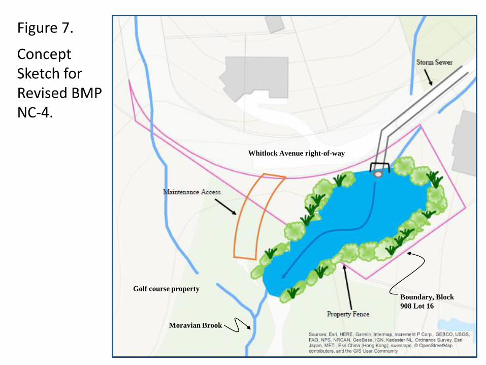
Figure 7.
Concept Sketch for Revised BMP NC-4.
Whitlock Avenue right-of-way
Boundary, Block
908 Lot 16
Golf course property
Moravian Brook