ENVIRONMENTAL MANAGEMENT PLAN (EMP) FOR … file1 . environmental management plan (emp) for...
61
i ENVIRONMENTAL MANAGEMENT PLAN (EMP) FOR JATILUHUR IRRIGATION MANAGEMENT AND IMPROVEMENT (JIMI) FOR THE REHABILITATION OF SUB- SYSTEMS OF BARUGBUG Cs, PAWELUTAN Cs AND SALAMDARMA KIRI Cs. - Content - 1. Background. ................................................................................................................................ 1 2. Location. ...................................................................................................................................... 2 3. Scope of Works for 3 Sub-Systems in the 1st year Program...................................................... 2 4. Construction Equipment. ............................................................................................................. 2 5. Environmental Assessment. ........................................................................................................ 3 6. Environmental Condition Summary............................................................................................. 3 6.1. Climate ..................................................................................................................................... 3 6.2. Air Quality and Noise ............................................................................................................... 4 6.3. Topographic Characteristics and Regional Geology ............................................................... 5 6.4. Hydrology and Water Quality................................................................................................... 6 6.5. Flora and Fauna ...................................................................................................................... 8 6.6. Spatial Plan............................................................................................................................ 11 6.7. Socio Economic and Culture, Public Health .......................................................................... 11 7. Potential Environmental Impacts............................................................................................... 16 7.1. Pre-construction Stage .......................................................................................................... 16 7.2. Construction Stage. ............................................................................................................... 17 7.2.1. Recruitment and Mobilization of Labor. ·············································································17 7.2.2. Equipment Mobilization. ·····································································································18 7.2.3. Excavation of Sediment. ····································································································19 7.2.4. Disposal Area. ····················································································································20 7.2.5. Chance Find Procedures ···································································································21 7.3. After Construction Stage (O&M Stage). ................................................................................ 22 8. Environmental Management Plan ............................................................................................. 22 9. Environmental Monitoring Plan ................................................................................................. 22 10. Reporting and Capacity Building ............................................................................................... 23 11. Integration of EMP into the project ............................................................................................ 25 12. Public Consultation Meeting (PCM) .......................................................................................... 25 Public Disclosure Authorized Public Disclosure Authorized Public Disclosure Authorized Public Disclosure Authorized Public Disclosure Authorized Public Disclosure Authorized Public Disclosure Authorized Public Disclosure Authorized
Transcript of ENVIRONMENTAL MANAGEMENT PLAN (EMP) FOR … file1 . environmental management plan (emp) for...
i
ENVIRONMENTAL MANAGEMENT PLAN (EMP)
FOR JATILUHUR IRRIGATION MANAGEMENT AND IMPROVEMENT
(JIMI)
FOR THE REHABILITATION OF SUB- SYSTEMS OF BARUGBUG Cs, PAWELUTAN
Cs AND SALAMDARMA KIRI Cs.
- Content -
1. Background. ................................................................................................................................ 1
2. Location. ...................................................................................................................................... 2
3. Scope of Works for 3 Sub-Systems in the 1st year Program...................................................... 2
4. Construction Equipment. ............................................................................................................. 2
5. Environmental Assessment. ........................................................................................................ 3
6. Environmental Condition Summary ............................................................................................. 3 6.1. Climate ..................................................................................................................................... 3 6.2. Air Quality and Noise ............................................................................................................... 4 6.3. Topographic Characteristics and Regional Geology ............................................................... 5 6.4. Hydrology and Water Quality ................................................................................................... 6 6.5. Flora and Fauna ...................................................................................................................... 8 6.6. Spatial Plan ............................................................................................................................ 11 6.7. Socio Economic and Culture, Public Health .......................................................................... 11
7. Potential Environmental Impacts ............................................................................................... 16 7.1. Pre-construction Stage .......................................................................................................... 16 7.2. Construction Stage. ............................................................................................................... 17 7.2.1. Recruitment and Mobilization of Labor. ············································································· 17 7.2.2. Equipment Mobilization. ····································································································· 18 7.2.3. Excavation of Sediment. ···································································································· 19 7.2.4. Disposal Area. ···················································································································· 20 7.2.5. Chance Find Procedures ··································································································· 21 7.3. After Construction Stage (O&M Stage). ................................................................................ 22
8. Environmental Management Plan ............................................................................................. 22
9. Environmental Monitoring Plan ................................................................................................. 22
10. Reporting and Capacity Building ............................................................................................... 23
11. Integration of EMP into the project ............................................................................................ 25
12. Public Consultation Meeting (PCM) .......................................................................................... 25
Pub
lic D
iscl
osur
e A
utho
rized
Pub
lic D
iscl
osur
e A
utho
rized
Pub
lic D
iscl
osur
e A
utho
rized
Pub
lic D
iscl
osur
e A
utho
rized
Pub
lic D
iscl
osur
e A
utho
rized
Pub
lic D
iscl
osur
e A
utho
rized
Pub
lic D
iscl
osur
e A
utho
rized
Pub
lic D
iscl
osur
e A
utho
rized
wb371432
Typewritten Text
E2597 V1 rev
wb371432
Typewritten Text
wb371432
Typewritten Text
1
ENVIRONMENTAL MANAGEMENT PLAN (EMP)
FOR JATILUHUR IRRIGATION MANAGEMENT AND IMPROVEMENT
(JIMI)
FOR THE REHABILITATION OF SUB- SYSTEMS OF BARUGBUG Cs,
PAWELUTAN Cs AND SALAMDARMA KIRI Cs.
1. Background.
Development of Jatiluhur Irrigation Project started in year 1925 by construction of Walahar weir including the irrigation system called North Tarum Canal (NTC) with 77.41 km length of canals and irrigated 85,945 ha paddy field.
In year 1965 it was followed by construction Curug weir located 8 km just upstream of Walahar weir, completed with irrigation system. The irrigation system from Curug weir divided into 2 (two) parts, for the left side called West Tarum Canal (WTC) with 68.67 km of canal length to irrigate 56,628 ha of paddy field and for the right side called East Tarum Canal (ETC) with 67.37 km of canal length to irrigate 90,230 ha paddy field.
The total irrigation area of Jatiluhur is 232,803 ha. This area spread over 4 (four) districts in West Java Province; they are Purwakarta District, Karawang District, Subang District and Indramayu District.
Beside for irrigation purpose, the Jatiluhur System also functions as water supply for Domestic, Municipal and Industrial (DMI) for the people and company along or around the canal and for Jakarta drinking water.
Citarum river is the longest river in West Java Province with 270 km of length with abundant water. At the upstream portion of river, the Government constructed 3 (three) dams. The first dam located at the upstream of Curug weir is called Juanda Dam as a multi-purpose dam for hydro-electric plant (PLTA) and regulator water for Jatiluhur Irrigation System. The capacity of Juanda dam is 3 billion m³. More upstream there are Cirata dam and Saguling dam having functions as a hydro-electric plant (PLTA).
Water supply for Jatiluhur Irrigation system is controlled and regulated by Juanda dam, firstly water use for electric power station, and then water flowing to downstream through Citarum river. At the Curug weir, the water pumped by hydraulic pump to the left irrigation canal WTC with capacity of 85 m³/sec, and by electric pump to the right irrigation canal ETC with capacity of 84 m³/sec. The excessive water flows to the downstream of Citarum River and at the Walahar weir is diverted to irrigation canal of NTC with capacity of 102 m³/sec.
In line with the rapid development in various sector, the water requirement for domestic, municipal and industrial sectors also increase. The existence of Jatiluhur Irrigation Canals becomes more important. But on the behind, after operated more than 45 years, the capacity of canals has been reduced continuously. The main factor reducing the conveyance capacity of the canals is the sediment flowing with irrigation water and settled in the canals. For example, the capacity of ETC is now only 62.5 m³/sec, this is
2
only 75% of designed capacity of 84 m³/sec. Due to reducing capacity, the conflict of using water becomes more serious.
In order to solve the problem of water supply at the Jatiluhur Irrigation System, the Government of Republic Indonesia, through Department of Public Works, Balai Besar Wilayah Sungai Citarum (BBWSC) plans to improve the irrigation system by implementing Water Resources and Irrigation Sector Management Program (WISMP-2) Stage 2, especially in West Java Province named Jatiluhur Irrigation Management Improvement (JIMI) Loan 4711-IND.
According to Loan Agreement, the improvement work should be executed in accordance with environmental requirement.
2. Location.
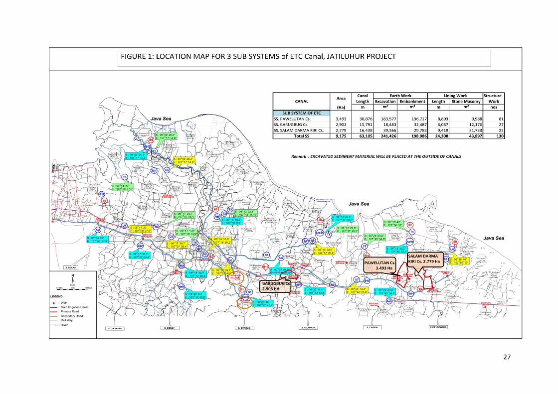
The Environmental Assessment was carried out for the 3 (three) Sub-Systems of Jatiluhur irrigation system, such as Barugbug Cs, Pawelutan Cs, and Salamdarma Kiri Cs, which administratively locate at Subang district, West Java Province. SS Pawelutan Cs and SS Salamdarma Kiri locate at the Binong Sub-District and SS Barugbug Cs locate at Jatisari Sub-District. Location of sub-systems can be seen in Figure 1 attached.
3. Scope of Works for 3 Sub-Systems in the 1st year Program
Scope of work for Improvement of Jatiluhur Irrigation System are divided into several packages. For the first stage planned in year 2011-2012, the rehab works for the 3 Sub-Systems in East Tarum Canal (ETC) will be implemented with the details as below:
1. SS. Pawelutan Cs for area of 3,592 ha, consists of 30,876 m canal long with the
excavation work of 183,578 m3, improvement of embankment for 136,718 m3,
canal lining for 8.803 km with 9,988 m³ of stone masonry and rehabilitation of 81
nos of structures.
2. SS. Barugbug Cs for area of 2,901 ha, with the irrigation canal of 15,791 m long,
the excavation work of 18,484 m3 and improvement of embankment for 32,487
m3, canal lining for 6.087 km with 12,176 m³ of stone masonry and rehabilitation
of 27 nos of structures.
3. SS. Salamdarma Kiri Cs for area of 2,922 ha, with the irrigation canal of 16,437 m
long, the excavation work of 39,366 m3 and improvement of embankment for
29,782 m3, canal lining for 9.418 km with 21,733 m³ of stone masonry and
rehabilitation of 22 nos of structures.
For more clear, the scope and quantity of the work can be seen in Table 1 attached.
4. Construction Equipment.
The Construction Period is planned for 18 months. For the execution of rehabilitation works as above will be used several kinds of the equipment consisting of bulldozer, excavator, vibrator roller, watertank truck, dump truck, concrete mixer and concrete vibrator.
The required number of such equipment can be seen in Table 2 attached.
3
5. Environmental Assessment.
For the environmental assessment for Improvement of Jatiluhur Irrigation system, various surveys were executed at the field covering area within East Tarum and North Tarum Irrigation System. The surveys consist of:
1) Physical-chemical survey
- Air Quality and Noise
- Water Quality
- Sediment Content.
2) Biological Survey
- Flora and Fauna
- Biota Aquatic
3) Social, Economic and Culture
- Demography
- Social Economy
- Cultural
- Community Health
- Community Response and Involvement
6. Environmental Condition Summary
6.1. Climate
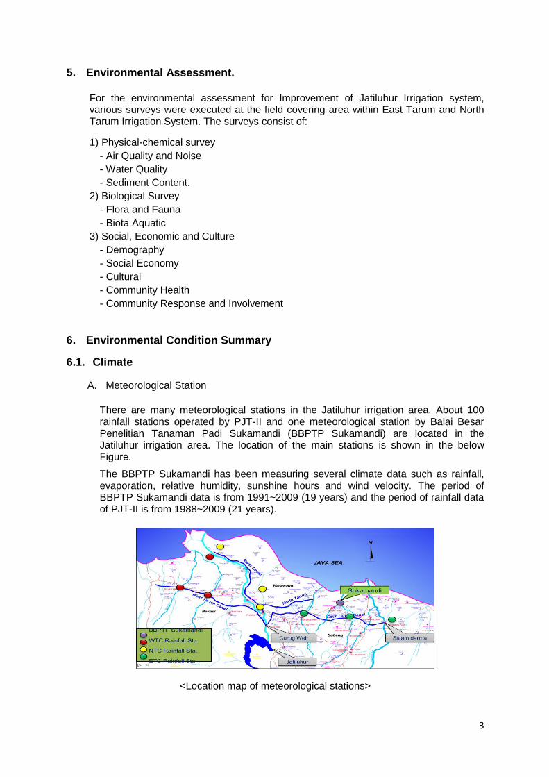
A. Meteorological Station
There are many meteorological stations in the Jatiluhur irrigation area. About 100 rainfall stations operated by PJT-II and one meteorological station by Balai Besar Penelitian Tanaman Padi Sukamandi (BBPTP Sukamandi) are located in the Jatiluhur irrigation area. The location of the main stations is shown in the below Figure.
The BBPTP Sukamandi has been measuring several climate data such as rainfall, evaporation, relative humidity, sunshine hours and wind velocity. The period of BBPTP Sukamandi data is from 1991~2009 (19 years) and the period of rainfall data of PJT-II is from 1988~2009 (21 years).
<Location map of meteorological stations>
4
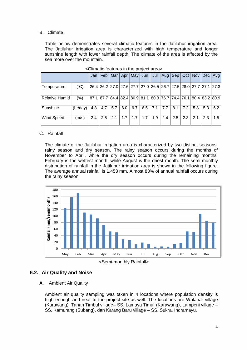
B. Climate
Table below demonstrates several climatic features in the Jatiluhur irrigation area. The Jatiluhur irrigation area is characterized with high temperature and longer sunshine length with lower rainfall depth. The climate of the area is affected by the sea more over the mountain.
<Climatic features in the project area>
Jan Feb Mar Apr May Jun Jul Aug Sep Oct Nov Dec Avg
Temperature (℃) 26.4 26.2 27.0 27.6 27.7 27.0 26.5 26.7 27.5 28.0 27.7 27.1 27.3
Relative Humid (%) 87.1 87.7 84.4 82.4 80.9 81.1 80.3 76.7 74.4 76.1 80.4 83.2 80.9
Sunshine (hr/day) 4.8 4.7 5.7 6.0 6.7 6.5 7.1 7.7 8.1 7.2 5.8 5.3 6.2
Wind Speed (m/s) 2.4 2.5 2.1 1.7 1.7 1.7 1.9 2.4 2.5 2.3 2.1 2.3 1.5
C. Rainfall
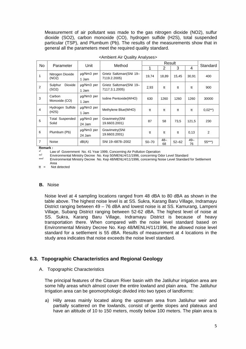
The climate of the Jatiluhur irrigation area is characterized by two distinct seasons: rainy season and dry season. The rainy season occurs during the months of November to April, while the dry season occurs during the remaining months. February is the wettest month, while August is the driest month. The semi-monthly distribution of rainfall in the Jatiluhur irrigation area is shown in the following figure. The average annual rainfall is 1,453 mm. Almost 83% of annual rainfall occurs during the rainy season.
<Semi-monthly Rainfall>
6.2. Air Quality and Noise
A. Ambient Air Quality
Ambient air quality sampling was taken in 4 locations where population density is high enough and near to the project site as well. The locations are Walahar village (Karawang), Tanah Timbul village– SS. Lamaya Timur (Karawang), Lampeni village – SS. Kamurang (Subang), dan Karang Baru village – SS. Sukra, Indramayu.
0
20
40
60
80
100
120
140
160
180
May Feb Mar Apr May Jun Jul Aug Sep Oct Nov Dec
Rai
nfal
l (m
m/s
emim
onth
)
5
Measurement of air pollutant was made to the gas nitrogen dioxide (NO2), sulfur dioxide (SO2), carbon monoxide (CO), hydrogen sulfide (H2S), total suspended particular (TSP), and Plumbum (Pb). The results of the measurements show that in general all the parameters meet the required quality standard.
<Ambient Air Quality Analyses>
No Parameter Unit Method Result
Standard 1 2 3 4
1 Nitrogen Dioxide (NO2)
μg/Nm3 per
1 Jam
Grietz Saltzman(SNI 19–
7119.2.2005) 19,74 18,89 15,45 30,91 400
2 Sulphur Dioxide
(SO2) μg/Nm3 per
1 Jam
Grietz Saltzman(SNI 19–
7117.3.1.2005) 2,93 tt tt tt 900
3 Carbon
Monoxide (CO) μg/Nm3 per
1 Jam Iodine Pentoxide(WHO) 630 1260 1260 1260 30000
4 Hydrogen Sulfide
(H2S) μg/Nm3 per
1 Jam Methylene Blue(WHO) tt tt tt tt 0,02**)
5 Total Suspended
Solid μg/Nm3 per
24 Jam
Gravimetry(SNI
19.6603.2001) 87 58 73,5 121,5 230
6 Plumbum (Pb) μg/Nm3 per
24 Jam
Gravimetry(SNI
19.6603.2001) tt tt tt 0,13 2
7 Noise dB(A) SNI 19–6878–2002 50–70 48–68
52–62 49–76
55***)
Remark : *
) Law of Government No. 41 Year 1999, Concerning Air Pollution Operation
**) Environmental Ministry Decree No. Kep 50/MENLH/11/1996, concerning Odor Level Standard
***) Environmental Ministry Decree No. Kep 48/MENLH/11/1996, concerning Noise Level Standard for Settlement
Area tt = Not detected
B. Noise
Noise level at 4 sampling locations ranged from 48 dBA to 80 dBA as shown in the table above. The highest noise level is at SS. Sukra, Karang Baru Village, Indramayu District ranging between 49 – 76 dBA and lowest noise is at SS. Kamurang, Lampeni Village, Subang District ranging between 52-62 dBA. The highest level of noise at SS. Sukra, Karang Baru Village, Indramayu District is because of heavy transportation there. When compared with the noise level standard based on Environmental Ministry Decree No. Kep 48/MENLH/11/1996, the allowed noise level standard for a settlement is 55 dBA. Results of measurement at 4 locations in the study area indicates that noise exceeds the noise level standard.
6.3. Topographic Characteristics and Regional Geology
A. Topographic Characteristics
The principal features of the Citarum River basin with the Jatiluhur irrigation area are some hilly areas which almost cover the entire lowland and plain area. The Jatiluhur Irrigation area can be geomorphologic divided into two types of landforms:
a) Hilly areas mainly located along the upstream area from Jatiluhur weir and partially scattered on the lowlands, consist of gentle slopes and plateaus and have an altitude of 10 to 150 meters, mostly below 100 meters. The plain area is
6
between 0 and 10 meters in height and mostly below 1.5 meters. In addition, hills are covered scarcely with plantation and agriculture production area.
b) Lowland and plain, below 10 meters in altitude, comprise the main fish-pounding and paddies area.
The length of North Tarum Canal (NTC) and East Tarum Canal (ETC) are approximately 144.76 km. The canal originates from the Curug Diversion Weir and Walahar Diversion Weir.
B. Regional Geology
The bedrock area of investigation was distributed on the ETC, NTC and upstream of curug weir consists of Tertiary sedimentary (mainly conglomeratic and tuffaceous sandstone) and Subang formation. The bedrock is exposed mainly on hilly and covered locally by Pliocene Beach ridge deposits. Quaternary alluvial deposits widely overlie the bedrock, especially on the lowlands.
6.4. Hydrology and Water Quality
A. Jatiluhur Dam
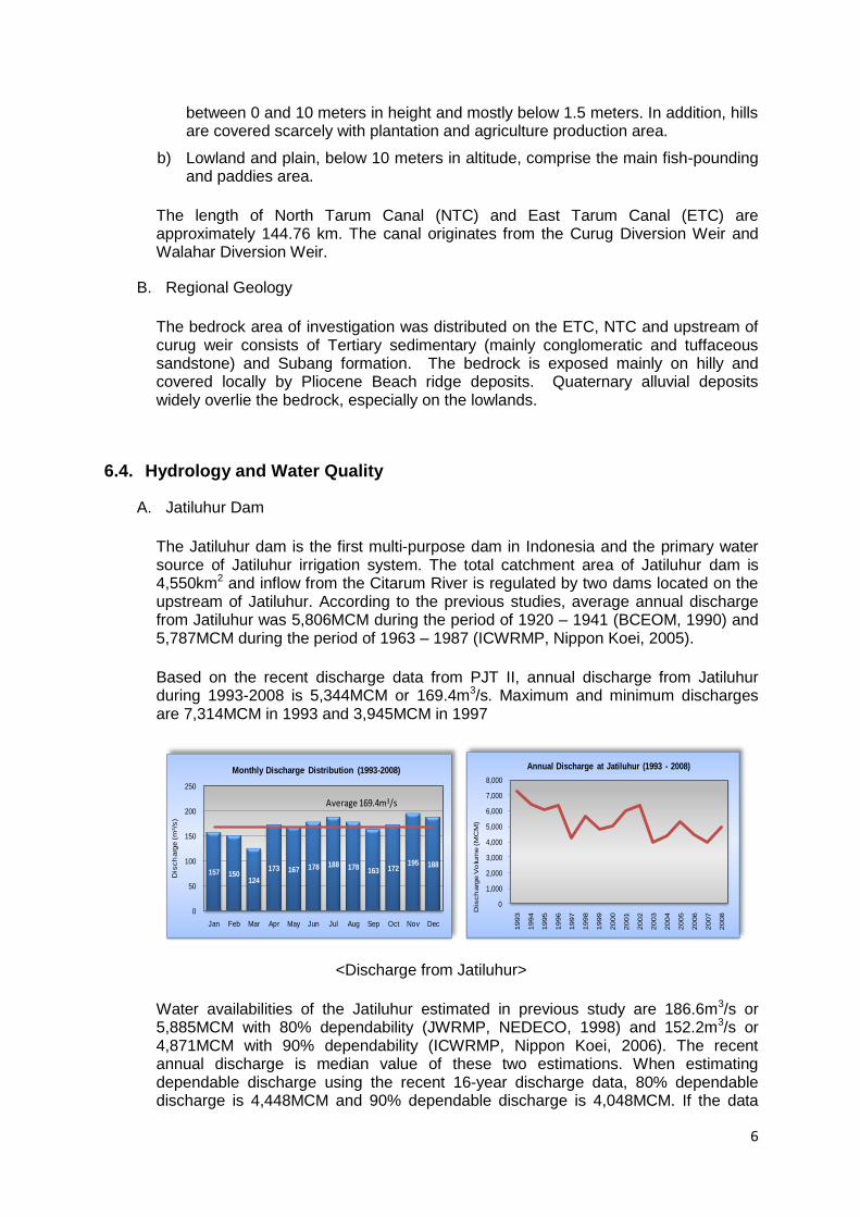
The Jatiluhur dam is the first multi-purpose dam in Indonesia and the primary water source of Jatiluhur irrigation system. The total catchment area of Jatiluhur dam is 4,550km2 and inflow from the Citarum River is regulated by two dams located on the upstream of Jatiluhur. According to the previous studies, average annual discharge from Jatiluhur was 5,806MCM during the period of 1920 – 1941 (BCEOM, 1990) and 5,787MCM during the period of 1963 – 1987 (ICWRMP, Nippon Koei, 2005).
Based on the recent discharge data from PJT II, annual discharge from Jatiluhur during 1993-2008 is 5,344MCM or 169.4m3/s. Maximum and minimum discharges are 7,314MCM in 1993 and 3,945MCM in 1997
<Discharge from Jatiluhur>
Water availabilities of the Jatiluhur estimated in previous study are 186.6m3/s or 5,885MCM with 80% dependability (JWRMP, NEDECO, 1998) and 152.2m3/s or 4,871MCM with 90% dependability (ICWRMP, Nippon Koei, 2006). The recent annual discharge is median value of these two estimations. When estimating dependable discharge using the recent 16-year discharge data, 80% dependable discharge is 4,448MCM and 90% dependable discharge is 4,048MCM. If the data
157 150124
173 167 178 188 178163 172
195 188
0
50
100
150
200
250
Jan Feb Mar Apr May Jun Jul Aug Sep Oct Nov Dec
Dis
ch
arg
e (m
3/s
)
Monthly Discharge Distribution (1993-2008)
Average 169.4m3/s
0
1,000
2,000
3,000
4,000
5,000
6,000
7,000
8,000
1993
1994
1995
1996
1997
1998
1999
2000
2001
2002
2003
2004
2005
2006
2007
2008
Dis
ch
arg
e V
olu
me (M
CM
)
Annual Discharge at Jatiluhur (1993 - 2008)
7
series in the past were included, the dependable discharge would be increased. This implies the reduction of water availability in Jatiluhur.
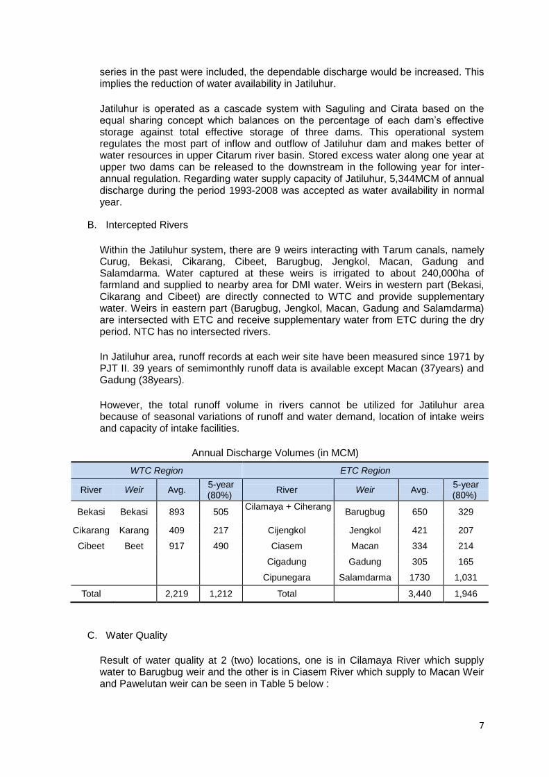
Jatiluhur is operated as a cascade system with Saguling and Cirata based on the equal sharing concept which balances on the percentage of each dam’s effective storage against total effective storage of three dams. This operational system regulates the most part of inflow and outflow of Jatiluhur dam and makes better of water resources in upper Citarum river basin. Stored excess water along one year at upper two dams can be released to the downstream in the following year for inter-annual regulation. Regarding water supply capacity of Jatiluhur, 5,344MCM of annual discharge during the period 1993-2008 was accepted as water availability in normal year.
B. Intercepted Rivers
Within the Jatiluhur system, there are 9 weirs interacting with Tarum canals, namely Curug, Bekasi, Cikarang, Cibeet, Barugbug, Jengkol, Macan, Gadung and Salamdarma. Water captured at these weirs is irrigated to about 240,000ha of farmland and supplied to nearby area for DMI water. Weirs in western part (Bekasi, Cikarang and Cibeet) are directly connected to WTC and provide supplementary water. Weirs in eastern part (Barugbug, Jengkol, Macan, Gadung and Salamdarma) are intersected with ETC and receive supplementary water from ETC during the dry period. NTC has no intersected rivers.
In Jatiluhur area, runoff records at each weir site have been measured since 1971 by PJT II. 39 years of semimonthly runoff data is available except Macan (37years) and Gadung (38years).
However, the total runoff volume in rivers cannot be utilized for Jatiluhur area because of seasonal variations of runoff and water demand, location of intake weirs and capacity of intake facilities.
Annual Discharge Volumes (in MCM)
WTC Region ETC Region
River Weir Avg. 5-year (80%)
River Weir Avg. 5-year (80%)
Bekasi Bekasi 893 505 Cilamaya + Ciherang
Barugbug 650 329
Cikarang Karang 409 217 Cijengkol Jengkol 421 207
Cibeet Beet 917 490 Ciasem Macan 334 214
Cigadung Gadung 305 165
Cipunegara Salamdarma 1730 1,031
Total 2,219 1,212 Total 3,440 1,946
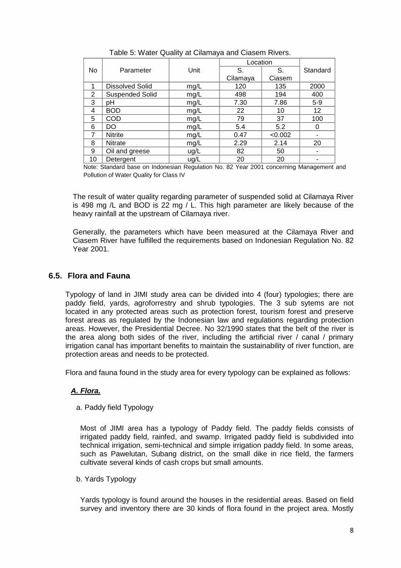
C. Water Quality
Result of water quality at 2 (two) locations, one is in Cilamaya River which supply water to Barugbug weir and the other is in Ciasem River which supply to Macan Weir and Pawelutan weir can be seen in Table 5 below :
8
Table 5: Water Quality at Cilamaya and Ciasem Rivers.
No Parameter Unit
Location
Standard S. Cilamaya
S. Ciasem
1 Dissolved Solid mg/L 120 135 2000
2 Suspended Solid mg/L 498 194 400
3 pH mg/L 7.30 7.86 5-9
4 BOD mg/L 22 10 12
5 COD mg/L 79 37 100
6 DO mg/L 5.4 5.2 0
7 Nitrite mg/L 0.47 <0.002 -
8 Nitrate mg/L 2.29 2.14 20
9 Oil and greese ug/L 82 50 -
10 Detergent ug/L 20 20 - Note: Standard base on Indonesian Regulation No. 82 Year 2001 concerning Management and
Pollution of Water Quality for Class IV
The result of water quality regarding parameter of suspended solid at Cilamaya River is 498 mg /L and BOD is 22 mg / L. This high parameter are likely because of the heavy rainfall at the upstream of Cilamaya river.
Generally, the parameters which have been measured at the Cilamaya River and Ciasem River have fulfilled the requirements based on Indonesian Regulation No. 82 Year 2001.
6.5. Flora and Fauna
Typology of land in JIMI study area can be divided into 4 (four) typologies; there are paddy field, yards, agroforrestry and shrub typologies. The 3 sub sytems are not located in any protected areas such as protection forest, tourism forest and preserve forest areas as regulated by the Indonesian law and regulations regarding protection areas. However, the Presidential Decree. No 32/1990 states that the belt of the river is the area along both sides of the river, including the artificial river / canal / primary irrigation canal has important benefits to maintain the sustainability of river function, are protection areas and needs to be protected.
Flora and fauna found in the study area for every typology can be explained as follows:
A. Flora.
a. Paddy field Typology
Most of JIMI area has a typology of Paddy field. The paddy fields consists of irrigated paddy field, rainfed, and swamp. Irrigated paddy field is subdivided into technical irrigation, semi-technical and simple irrigation paddy field. In some areas, such as Pawelutan, Subang district, on the small dike in rice field, the farmers cultivate several kinds of cash crops but small amounts.
b. Yards Typology
Yards typology is found around the houses in the residential areas. Based on field survey and inventory there are 30 kinds of flora found in the project area. Mostly
9
are fruit trees, like Breadfruit (Artocarpus communis), Jackfruit (Artocarpus Integra), Mango (Mangifera indica) and Guava (Psidium guajava).
c. Agroforrestry Typology
Agroforrestry typology is the area cultivated with mixed vegetation consisting of trees as a perenial crops (annual) and vegetable or plants that live only one year or one season. There are 50 kinds of flora in the study area with majority of wood-producing plants dominated by Jengjen (Albizzia falcataria) and Formis (Acacia auriculiformis).
d. Shrub
Shrub typology in study area consists 32 kinds of flora, majority of shrub species like kirinyuh (Eupathorium odoratum), kaliandra (Calliandra sp.), and Cucuk garut (Mimosa invisa).
The various kinds of flora found in the study area, more specifically, found along the irrigation canals, are not categorized as protected flora.
B. Fauna.
The collected fauna data is an inventory of terrestrial fauna species in each typology of land as above. Observed terrestrial fauna consists of four classes of animals, namely mammals, reptiles, amphibians, and birds.
Based on primary survey and interviews with local people, the type of land mammals found in the study area are only two kinds, namely rice field rats (Rattus argentiventer) and brown rat (Rattus rattus).
Class of reptiles found in the study area are Lacertilia (Lizards), Ophidia (Snakes), and Testudinata. Species of reptiles in the river banks or canals is a type of lizard (Varanus salvator). This species is a top predator from the class of reptiles that usually prey fish and other aquatic biota.
Class Amphibians found in the study area is Anura (frog). Out of amphibians most abundant types in the study area is paddy field frog species (Fejervarya cancrivora).
The diversity of birds was invetorized for every typologies of land as follow:
a. Paddy field typology
There are 25 kinds of fauna found in the project area. The most dominant species is the type of Java Scaly-breasted (Lonchura leucogastroides) and rabbit Swiftlet (Collocalia linchi). Both bird species are commonly found in the typology of paddy fields due to the paddy land provides an abundant food source. Seeds of rice became the main food source of the Scaly-breasted birds of Java and Peking Scaly-breasted (Lonchura punctulata). While various types of soil insects, and air insects, as a source of feed for birds Insectivora (insect eaters) such as rabbit Swiftlet (Collocalia linchi), Asian Kites (Hirundo rustica), and type of Zitting Cisticola (Cisticola juncidis).
10
b. Yard
There are 8 kinds of fauna found in the project area. The most dominant species is the type of rabbit Swiftlet (Collocalia linchi), whereas the others are Burunggereja Erasia (Passer montananus), Scaly-breasted Java (Lonchura leucogastroides), Chili Java (Diaceum trochileum), and Burungmadu Sriganti (Nectarinia jugularis). Burunggereja Erasia (Passer montananus) is an adaptive type of settlement, because its source of food is human food scraps, and usually nest at the houses roof.
c. Agroforrestry
Agroforestry is the typical land for the most bird species, because it has a stratification of vegetation composition and complex compared with other land typology. There are 38 kinds of fauna found in the project area. The most dominant species is the type of rabbit Swiftlet (Collocalia linchi), where the dominating species is similar to the yards typology. The other dominant species are Scaly-breasted Java (Lonchura leucogastroides), Burunggereja Erasia (Passer montananus), and Cucak Kutilang (Pycnonotus aurigaster).
d. Shrub
The Shrub has its own characteristics on the type of bird, although the dominant kind is similar to yards and agroforestry typology. There are 28 kinds of fauna found in the project area. Shrub typology has a special characteristic, which can not found in other typologies, such as reeds Coucal (Centropus bengalensis), Long-tailed Shrike (Lanius schach), and striped Gemak (Turnix suscitator).
Fauna recorded in this survey, generally, live in the paddy field, yard, agroforrestry and shrub, and not in the irrigation canals. No protected fauna based on international and Indonesian wildlife protection regulations were found in the study area.
C. Aquatic Biota
Aquatic biota in the study area is divided into three groups as follows: plankton, benthos, dan nekton.
a. Plankton
Plankton can be divided into two groups, namely phytoplankton which is the plant microorganisms and zooplankton which is the animal microorganisms. In aquatic ecosystems, phytoplankton determines the productivity of aquatic plants. In addition, phytoplankton can also be used as indicators of aquatic environmental conditions change, for example, the entry of polluting substances into waters will have an impact on the quantities of phytoplankton as well as zooplankton.
Based on the survey, in the study area was found as many as 19 species phytoplankton and 8 species of zooplankton. The most of phytoplankton population is Fragilaria sp. and Rhabdholaimus sp. for zooplankton.
b. Benthos
Benthos consists of stick biota, crawling or making a hole in the bottom of waters. Benthos is an important animal group which connects the energy transport and
11
benthic aquatic ecosystems. Composition and density of macrobenthos in the river is usually stable from year to year. Some communities respond to changes in habitat quality by adjusting the structure of their community.
There are three conditions that cause changes in community structure, namely organic matter, changes in the substrate, and contamination by toxic chemicals. There are 6 species of benthos found in the project area. The most population of benthos are Macrobrachium sp. and Melanoides sp.
c. Nekton
In irrigation canals was identified 8 nekton or fish species. Fish which is often found is the kind of Snakeskin Gourami (Trichogaster pectoralis), betok (Anabas Testudineus) and keting (Arius caelatus). Species of fish in the irrigation canal is a type that is carried from the river or from the fish ponds, because some species of fish found similar to those found in stream headwaters.
6.6. Spatial Plan
Inside JIMI land, most (over 80%) is agricultural area of paddy fields and only a small portion was developed as an aquaculture area.
Yet in some areas of JIMI study area there are local protection area, in accordance with Presidential Decree. No 32/1990 which states that the belt of the river is the area along both sides of the river, including the artificial river / canal / primary irrigation canal, which has important benefits to maintain the sustainability of river function.
Riverine criteria is as below:
At least 100 meters on either side of major rivers and 50 meters on either side of the creek is outside the settlement.
For the river in the form of riverine settlement area it is expected to build enough inspection road between 10 - 15 meters.
In addition to riverine areas, Cilamaya Wetan sub district is a forested coastal mangroves and tidal waves and flood-prone area, thus it is included in local conservation area boundary.
6.7. Socio Economic and Culture, Public Health
A. Population
Population by sex and sex ratio
Based on data from the Central Statistics Agency the study area where the 3 sub systems exist is located into 2 (two) sub-districts, there are Jatisari and Binong Sub-District. Total population is 117,652 of people consisting of 59,084 male and 58,568 female, with 33,447 households. The Sex ratio is 101%.
Population by Age Group
12
From the total population, the age with 40 years and over is the greatest number in the study area that is equal to 44,910 inhabitants or 38.17%. The age group from 10-14 years has least in the study area that is equal to 6,458 inhabitants or 6.49%.
Based on the results of interviews with respondents in the study area, who are the head of the family, the majority of respondents have aged between 41 and 50 years old, which were 31.48% of respondents. While respondents 15-20 years age group is the least number with 1 respondent or 0.37% of the total 270 respondents.
Population Density
Population density in project area in the Jatisari Sub-District is 13.44 people/ha, while in Binong Sub-district it is 9.04 people/ha.
B. Social Economy
Livelihood
Livelihoods of the study area consists of agriculture, industry, trade, and other services. Total population by type of livelihoods in the study area is dominated by agriculture and trade.
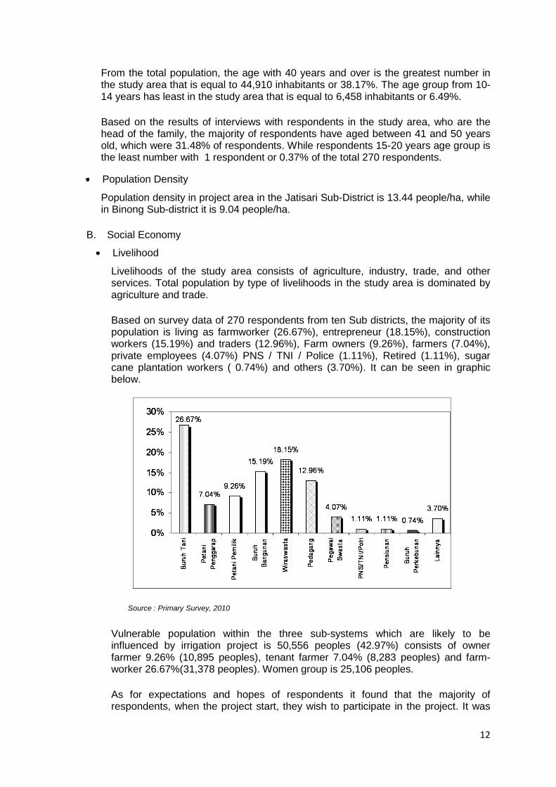
Based on survey data of 270 respondents from ten Sub districts, the majority of its population is living as farmworker (26.67%), entrepreneur (18.15%), construction workers (15.19%) and traders (12.96%), Farm owners (9.26%), farmers (7.04%), private employees (4.07%) PNS / TNI / Police (1.11%), Retired (1.11%), sugar cane plantation workers ( 0.74%) and others (3.70%). It can be seen in graphic below.
Source : Primary Survey, 2010
Vulnerable population within the three sub-systems which are likely to be influenced by irrigation project is 50,556 peoples (42.97%) consists of owner farmer 9.26% (10,895 peoples), tenant farmer 7.04% (8,283 peoples) and farm-worker 26.67%(31,378 peoples). Women group is 25,106 peoples.
As for expectations and hopes of respondents it found that the majority of respondents, when the project start, they wish to participate in the project. It was
13
revealed that as many as 37.04% of the respondents (n = 270) want to work for the project while 29.63% of respondents suggest to use local labour.
Population Economic Level
Based on the results of interviews with residents in the study area of 270 respondents carried out in February 2010, income of respondents varies greatly, the majority of respondents (25.93%) has an average income of between Rp. 500,000 - Rp. 750,000 per month, while respondents with incomes of less than Rp. 250,000 per month equal to 25.19%. Most respondents had an average expenditure of between Rp. 500,000 - Rp. 750,000 per month that is counted 33.33% of the total respondents.
Regional Economic Growth
Regarding economic contribution by each sector in the districts of Purwakarta, Kawarang, Bekasi, Subang and Indramayu, the greatest contribution is from the agriculture sector and manufacturing sector and trade sector. The agricultural sector is supported by sub-sector of food crops and plantations. The industrial sector is supported by the sub-sectors of food, beverages and printing matter. Trade sub-sector is supported by the wholesale and retail trade.
C. Cultural
Based on data from the Central Statistic Agency, out of people living in the study area, majority have a religion of Islam (98.79%, 116,217 peoples), followed by Christian Protestant (0.52%, 612 peoples), Budhist (0.41%, 482 peoples), Catholic (0.28%, 329 peoples) and Hindu (0.01%, 12 peoples). Religious service buildings recorded are 99 mosques and 319 musolas while church, temple and vihara were not available in the study area. Mosque and musola are located in the residential areas and not found along the irrigation canals.
No physical cultural resources such as archeological site were found in the study area. Cemeteries are located near to residential areas, relatively far from irrigation canals.
D. Community Health
Morbidity
Based on data from sub district health centers Jatisarii, type of disease that is often suffered by residents is acute respiratory infection as much as 16,542 cases, followed by fever with 2,778 cases.
Based on the interview and distributing questionnaires to the respondents, the disease often suffered by family members of respondents is Flu / Cough / Colds as many as 173 people infected (64.07%). Itching disease ranks number two of 34 patients (12.59%). Fever and Demam Bedarah ranks third with 31 people (11.48%) with most types of disease that are often suffered by family members of respondents.
Health facilities and Infrastructure
Basically the development in the health sector aims to provide health services easily, evenly, and cheap. One of the government's efforts in order to provide health services to the community is to provide health facilities especially health centers, because the facilities were able to reach all layers of society down to the
14
more remote areas. In the year 2008 in the Jatisari sub-district there are 2 health centers and 2 sub-health centers, since for Binong Sub-district there are also 2 health and 2 sub-health centers.
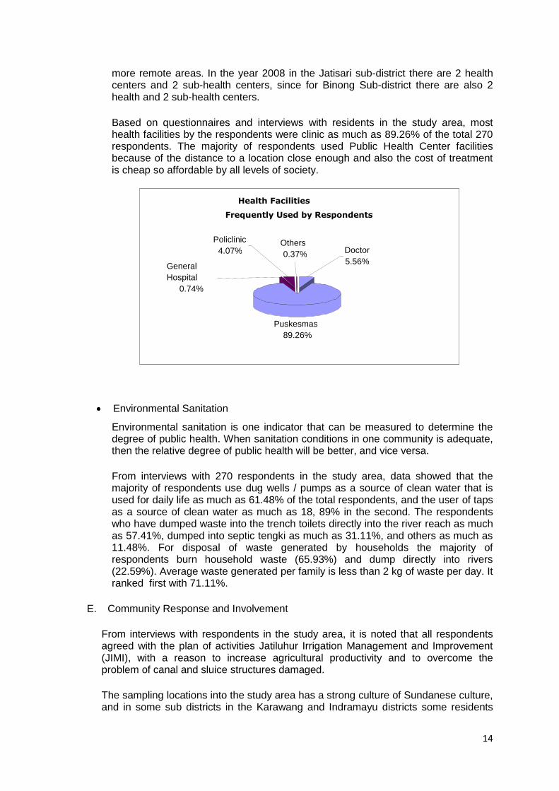
Based on questionnaires and interviews with residents in the study area, most health facilities by the respondents were clinic as much as 89.26% of the total 270 respondents. The majority of respondents used Public Health Center facilities because of the distance to a location close enough and also the cost of treatment is cheap so affordable by all levels of society.
Environmental Sanitation
Environmental sanitation is one indicator that can be measured to determine the degree of public health. When sanitation conditions in one community is adequate, then the relative degree of public health will be better, and vice versa.
From interviews with 270 respondents in the study area, data showed that the majority of respondents use dug wells / pumps as a source of clean water that is used for daily life as much as 61.48% of the total respondents, and the user of taps as a source of clean water as much as 18, 89% in the second. The respondents who have dumped waste into the trench toilets directly into the river reach as much as 57.41%, dumped into septic tengki as much as 31.11%, and others as much as 11.48%. For disposal of waste generated by households the majority of respondents burn household waste (65.93%) and dump directly into rivers (22.59%). Average waste generated per family is less than 2 kg of waste per day. It ranked first with 71.11%.
E. Community Response and Involvement
From interviews with respondents in the study area, it is noted that all respondents agreed with the plan of activities Jatiluhur Irrigation Management and Improvement (JIMI), with a reason to increase agricultural productivity and to overcome the problem of canal and sluice structures damaged.
The sampling locations into the study area has a strong culture of Sundanese culture, and in some sub districts in the Karawang and Indramayu districts some residents
Health Facilities
Frequently Used by Respondents
Puskesmas 89.26%
Policlinic 4.07%
Others 0.37%
General Hospital
0.74%
Doctor 5.56%
15
have mixed cultures of Sundanese and Javanese with the domination by the Javanese culture, because the area is bounded by the Central Java area mixing culturals that occur between the Javanese culture and Sundanese culture.
Also, people in the study area is very dynamic, hardworking and friendly, and it can be seen at the time of the survey. The community welcomed with open every new person who comes into their area, especially when there are guests from the big city.
Community Attitudes and perceptions of JIMI activity plan
Based on the results of questionnaires and interviews with people in the study area, generally they are not aware of any planned activity. Only some people who knew about JIMI activity plan.
The aspirations and expectations of respondents are as follows:
Planned JIMI Benefits
Based on the interview and distributed questionnaires to the respondents (n = 270) about JIMI activitiy plan in February 2010, approximately 66.30% of the respondents did not know the benefits and advantages of JIMI. While 74.81% of respondents gave their opinions that they agree with JIMI activity plan.
The reason they agree is that JIMI activities can increase agricultural productivity and overcome problems that arise around the location of irrigation. And they hope to participate and to be employed in JIMI activity.
Respondent opinions on JIMI Activity Plan
Respondent expressly agrees to JIMI activity plan (74.81%); the community hopes to participate in project work (37.04%), and hope to give priority to local residents who can work on this project (29.63%); the project should be completed quickly and environmentally friendly (27.78%) and the rest of respondents expect to be trained as employees of the project (2.59%) and others (2.96%).
Some community leaders and local officials expect the holding of socialization expecting any JIMI or media forum of communication between and the peoples of the community so that every complain or information to be conveyed to the implementators in order to be resolved. In addition, the majority of residents expect to be given priority to local residents in the recruitment of labor.
Community Participation in Project Planning and Design
Government policy calls for participatory irrigation management, whereby beneficiary participation is channeled and strengthened through organization of water user associations (WUAs, generally covering about 60-100 ha and 200-300 farmers), and the WUAs then are amalgamated into WUA federations (WUAFs). These organizations participate in all stages of management: planning, design, construction supervision, and operation and maintenance of completed works and sub-works.
Based on the surveys carried out in early 2010 and participatory irrigation approach, community aspirations and concerns are channeled through WUAs located in the 3 subsystems during project planning and design. During walk
16
throughs of sub systems planning, communities located near the irrigation canals were consulted for their inputs including decision of subsystem technical designs. Formal consultations was carried out in December 16 and 17, 2010 to share results of project design for each sub systems (Pawelutan, Barugbug, and Salamdharma SSs) and Environment Management Plan (EMP). Results of such consultations was recorded and updated in this EMP.
7. Potential Environmental Impacts
For the study and evaluation of potential environmental impact by the improvement of Jatiluhur Irrigation System, the Consultant assessed environmental and social impacts by dividing project implementation into 3 (three) stages, there are:
1. Pre- Construction Stage
2. Construction Stage, and
3. After Construction Stage (O&M).
7.1. Pre-construction Stage
During pre-construction period, the activities which will give impact on environment are:
a. Survey, Investigation and Design (SID).
It is very important to communicate the development plan with the peoples in the project area. Implementation of the project, starting from SID should be following the bottom-up process. Information and input from the farmers is very important especially in the rehabilitation project. Socialization of the project to the farmers will give a good feedback for successful development. From the survey with 270 respondents in the project area, majority (74.81%) of the respondents fully understand that improvement of Jatiluhur project will improve the quality of life of the farmers and they will give a support to the project. Using the participatory irrigation approach, communities within the proposed 3 sub systems were consulted to accommodate inputs during planning and design.
b. Land Acquisition.
Availability of land (space) for development of a project is a very important in the project activities. Since the scope of work for JIMI is rehabilitation or normalization of irrigation system, and the first priority is to re-function all the irrigation facility to meet the current requirement, there is no special land acquisitions required for irrigation purposes. The majority of work is removal of the sediment material deposited in canals from long time ago, and excavation to fit the original design dimension. Excavated material will be re-used to improve the canal embankment and inspection road as much as possible.
The excessive excavated sediment material will be placed at the outside of canals. These areas belong to Perum Jasa Tirta II and no need of land acquisition.
17
7.2. Construction Stage.
During construction stage, the activities which will have an impact on environment are as follows:
7.2.1. Recruitment and Mobilization of Labor.
a. Population Density.
During the construction stage, there will be required labor or worker. The number of labor or worker are estimated at 665 peoples consisting of 364 un-skill labors and 301 peoples of skill labor. Un-skilled labor can be supplied from people which stay in the project area, meanwhile the skill labor will be supplied from outside and will be mobilized to project area. Mobilization of the skill labor predicts that there will be additional population in the project area and increase of population density. Compared to the numbers of population in the project area, considering the big sizes of area, the impact of population increase on the society is relatively very small. The skill labor of 301 peoples will stay in the base camp provided by the project located near to the working sites, so they will not give important impact to the residence area of local peoples.
The labor required can be seen in Table 3 attached.
b. Income Level.
With the additional labor in the project area, it will increase additional income. By assuming the wage of un-skilled labor of Rp. 40,000/day, the increase of money circulation for one month with 364 labor will amount to be Rp. 364,000,000 ( Rp. 40,000.- x 25 day x 364 peoples). For 301 skilled labor, by assuming the wage of Rp. 2,000,000.-per month, the increase of money will amount to Rp. 602,000,000.- (Rp. 2,000,000.- x 301 people). The money will be used for daily life of labor and will give a positive impact.
c. Job Opportunities.
During construction, implementation of irrigation system in the study area, the impact will appear to the people such as tenant farmer and farm workers who have a direct influence due to decrease of farming works . The impact is the lost of source of income.
To minimize or reduce the negative impact of the lost farming work opportunity can be done the followings.
- Main construction activities to be scheduled during uncultivated period - Carry out construction of irrigation facilities without totally stoping delivery of
water to the field. The required water at the field can be supplied even with intermitten ways.
- Suggestion to the farmer to plant the crop with low requirement of water like palawija.
With the project, there is a chance for the people in the project area to get the job out of agriculture work. Job opportunity in construction activities will increase and have a positive impact on the community, direct or in-direct way. With the availability of job, it will reduce the un-working people in the project area.
18
d. Business Opportunities.
Labor mobilization activities will encourage for the creation of business opportunity in the project area. With arrival of 301 people outsite labor, it will bring opportunity for people in the project area to create some business to fulfill the requirement of the influxed labors, i.e.: transportation sector, lodging sector, food sector and etc. Women groups can utilize business oportunity in the food sector.
e. Attitudes and perceptions of Community.
Recruitment of labor for the project implementation will give some impacts on social environment. If majority of the labor working in the project area are supplied by local people, the impact will be small, otherwise it will give a relative high impact. Emphasis should be on socialization and information to the peoples in the project area about the quality and criteria of the labor for the project requirement.
Even though the people in the project area agree and support the project implementation for the Jatiluhur Irrigation Project, continuous socialization and information should be carried out through out the construction stage.
7.2.2. Equipment Mobilization.
There will be increase in mobilization of equipment due to execution of the project. Equipment required for project implementation as shown in Table 2. The type of equipments to be used are bulldozer, excavator, vibrator roller, watertank truck, dump truck, concrete mixer and concrete vibrator, and etc.
a. Air and Noise Quality.
As known from the results of ambient air quality measurements in the project area and its surroundings regarding the parameters of SO2, NO2, CO, H2S, TSP and pb, in general the concentration is still below the quality standard according to Government Regulation Number 41 Year 1999 on Ambient Air Pollution Control. There are 8 (eight) locations for this survey in the study area. In a total of 5 samplings cannot be identified H2S parameters, except for location no. 1 at Walahar Village 2.19 μg/Nm3 per 1 hour, and 4 locations in SS Rawa Baru respectively 0 , 58 μg/Nm3 per 1 Hour. Based on the Decree of the Minister of Environment No. Kep 50/MENLH/11/1996, about Standard Level odor, H2S parameters of the three locations do not exceed the required quality standard (28 μg/Nm3 per 1 hour). The parameter of pb, cannot be detected at 5 (five) locations, and at the others 3 (three) locations was detected very low and still below the standard level (detected 0.1 µg/Nm³ per 24 hours in SS. Rawa Sentul, 0.15 µg/Nm³ in SS. Rawa Baru and 0.13 µg/Nm³ in SS. Kamurang, while the Standard Level according to Indonesian Government Regulation No. 41 year 1999 regarding the Controlling Air Pollution is 2 µg/Nm³ per 24 hours).
Meanwhile, the noise level in the project area and the surrounding was measured at 8 points of measurement location. From 8 point measurement location, the measured noise levels range from 48 dBA to 80 dBA, where the Standard Level maximum is 70 dBA. The measured noise exceed the Standard Level located at SS. Rawa Sentul with value 62 – 80 dBA, at SS. Rawa Baru the value 56 – 71 dBA and at SS. Kamurang the value is 49 – 76 dBA. However these areas locate outside of the proposed sub-systems area.
19
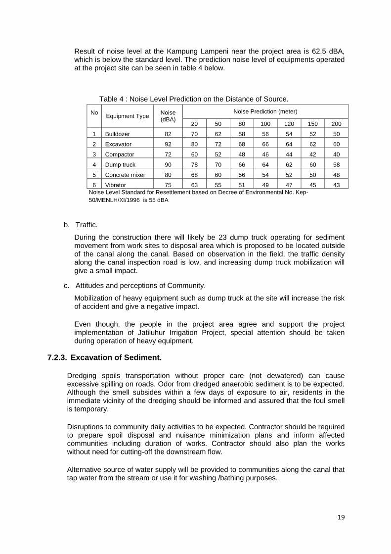
Result of noise level at the Kampung Lampeni near the project area is 62.5 dBA, which is below the standard level. The prediction noise level of equipments operated at the project site can be seen in table 4 below.
Table 4 : Noise Level Prediction on the Distance of Source.
No
Equipment Type Noise (dBA)
Noise Prediction (meter)
20 50 80 100 120 150 200
1 Bulldozer 82 70 62 58 56 54 52 50
2 Excavator 92 80 72 68 66 64 62 60
3 Compactor 72 60 52 48 46 44 42 40
4 Dump truck 90 78 70 66 64 62 60 58
5 Concrete mixer 80 68 60 56 54 52 50 48
6 Vibrator 75 63 55 51 49 47 45 43
Noise Level Standard for Resettlement based on Decree of Environmental No. Kep-
50/MENLH/XI/1996 is 55 dBA
b. Traffic.
During the construction there will likely be 23 dump truck operating for sediment movement from work sites to disposal area which is proposed to be located outside of the canal along the canal. Based on observation in the field, the traffic density along the canal inspection road is low, and increasing dump truck mobilization will give a small impact.
c. Attitudes and perceptions of Community.
Mobilization of heavy equipment such as dump truck at the site will increase the risk of accident and give a negative impact.
Even though, the people in the project area agree and support the project implementation of Jatiluhur Irrigation Project, special attention should be taken during operation of heavy equipment.
7.2.3. Excavation of Sediment.
Dredging spoils transportation without proper care (not dewatered) can cause excessive spilling on roads. Odor from dredged anaerobic sediment is to be expected. Although the smell subsides within a few days of exposure to air, residents in the immediate vicinity of the dredging should be informed and assured that the foul smell is temporary.
Disruptions to community daily activities to be expected. Contractor should be required to prepare spoil disposal and nuisance minimization plans and inform affected communities including duration of works. Contractor should also plan the works without need for cutting-off the downstream flow.
Alternative source of water supply will be provided to communities along the canal that tap water from the stream or use it for washing /bathing purposes.
20
Sediment Contents
Concentration in the sediment of a range of organic and heavy metal contaminants must be measured before dredging is started. The selection of the sediment contaminants to be checked should be based on an assessment of the surrounding land use and potential sources of contamination.
There are no samples truly representing the three sub-systems, available sediment testing results were taken from ETC and NTC main canals.
However, from long experiences it is known that the sediments from the canals of sub-systems are not easy exploded, not easy burn, un-reactive, and do not cause infection and un-corrosive material.
Excavated material can be directly placed at the disposal areas along the canal and will not give a negative impact.
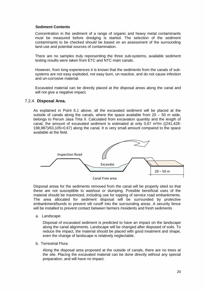
7.2.4. Disposal Area.
As explained in Point 6.1 above, all the excavated sediment will be placed at the outside of canals along the canals, where the space available from 20 – 50 m wide, belongs to Perum Jasa Tirta II. Calculated from excavation quantity and the length of canal, the amount of excavated sediment is estimated at only 0,67 m³/m ((241,428-198,987)/63,105=0.67) along the canal. It is very small amount compared to the space available at the field.
Disposal areas for the sediments removed from the canal will be properly sited so that these are not susceptible to washout or slumping. Possible beneficial uses of the material should be maximized, including use for topping of service road embankments. The area allocated for sediment disposal will be surrounded by protective embankment/bunds to prevent silt runoff into the surrounding areas. A security fence will be installed to prevent contact between farmers /residents and fresh sediments
a. Landscape
Disposal of excavated sediment is predicted to have an impact on the landscape along the canal alignments. Landscape will be changed after disposed of soils. To reduce the impact, the material should be placed with good treatment and shape, even the change of landscape is relatively neglectable.
b. Terrestrial Flora
Along the disposal area proposed at the outside of canals, there are no trees at the site. Placing the excavated material can be done directly without any special preparation, and will have no impact.
Excavate
Inspection Road
Canal Free area
20 – 50 m
21
c. Terrestrial Fauna
There are not found protected fauna at disposal area along the canal. Placing the excavated material can be done directly without special preparation, and will have no impact.
d. Diversity on Aquatic Biota
Excavation sediment activity predicts decrease in the diversity of aquatic biota inside the canals as a result of taking large amounts of sediment. Population of aquatic biota may be disturbed especially the benthos. Sediment excavation activity will change the sediment substances, which may affect the overall aquatic biota community structure, species of benthos, nekton, and plankton.
However, the impact can be neglected because the working area is inside of the canal where the aquatic biota is not so various.
e. Attitudes and perceptions of community
Based on the results of interviews with people in the study area (n = 270) regarding the implementation of improved management of irrigation systems, as much as 77.81% stated that they agree and strongly agree, while 1.48% stated not agree and the remaining stated they do not know. As much as 66.30% stated that they know the benefits of this project.
f. Environmental Sanitation
Since disposing activity along the canal is relatively far from the residential area (more than 100 m), it is predicted that there will not be the important impact from environmental sanitation point of view.
7.2.5. Chance Find Procedures
If any person discovers a physical cultural resource during construction, such as (not limited to) archeological sites, hystorical sites, remains and objects, or a cemetery and/or individual graves during excavation or construction, the contractor shall follow the Chance Find procedures as follows:
1. Stop the construction activities in the area of the chance find;
2. Delineate the discovered site or area;
3. Secure the site to prevent any damage or loss of removable objects. In case of removable antiquities or sensitive remains, a night quard shall be arranged until the responsible local authorities take over;
4. Notify the Supervising Engineer who in turn will notify BBWSC and the responsible local authorities immediately (within 24 hours or less);
5. Responsible local authorities are in charge of protecting and preserving the site before deciding on subsequent appropriate procedures. This would require a preliminary evaluation of the findings to be performed by archeologists. The significance and importance of the findings should be assessed according to the various criteria relevant to cultural heritage; those include the aesthetic, historic, scientific or research, social and economic values;
6. Decisions on how to handle the finding shall be taken by the responsible authorities. This could include changes in the layout (such as when finding an irremovable remain of cultural or archeological importance) conservation, preservation, restoration and salvage;
22
7. Implementation for the authority decision concerning the management of the finding shall be communicated in writing by relevant local authorities; and
8. Construction works could resume only after permission is granted from the responsible local authorities concerning safeguard of the physical cultural resource.
7.3. After Construction Stage (O&M Stage).
a. Irrigation Operation
- Income Level
Operations of irrigation system predict to generate a positive impact on community income levels around the location of the canals. The effects of improvement of irrigation canals will increase the water discharge in the canal; the farmer can cultivate their land according to proposed cropping pattern of two times rice cultivation a year. Another positive impact comes from improving infrastructure such as roads around the irrigation canals, so that the mobility of the population in and around the project area can utilize inspection road to travel to the work place or for other activities. Impacts cause to accelerate more active flow of agricultural commodities in the project area.
- Attitudes and perceptions of community
Operation of irrigation system has a positive impact on attitudes and perceptions of the community because of the availability of water for irrigation which in turn would spur economic development of the territory and increase of population. Improvement of the existing road infrastructure will also enhance the accommodative attitude of society towards the rehabilitation of irrigation canals.
b. Irrigation Maintenance
- Job Opportunities
Irrigation maintenance will need labor. The existence of such maintenance can cause a positive impact on employment of people around the irrigation area.
- Attitudes and perceptions of community
Irrigation maintenance activities would require worker. Impact of these employment opportunities is development of positive attitudes and perceptions of residents who are involved, and social interaction in the form of cooperation.
8. Environmental Management Plan
Potential Environmental Management Plan (EMP) for the rehabilitation of the Jatiluhur irrigation system can be seen in table 6.
9. Environmental Monitoring Plan
Potential Environmental Monitoring Plan for the rehabilitation of the Jatiluhur irrigation system can be seen in table 7.
23
10. Reporting and Capacity Building
To ensure that the environmental and social management and monitoring is effectively undertaken it will need resources which understand the requirements and are skilled in meeting techniques and procedure for the project. This will include:
Environment management implementer.
Environment Monitoring Implementer.
Report Writing Technique for environment management and monitoring
Understanding organizational management.
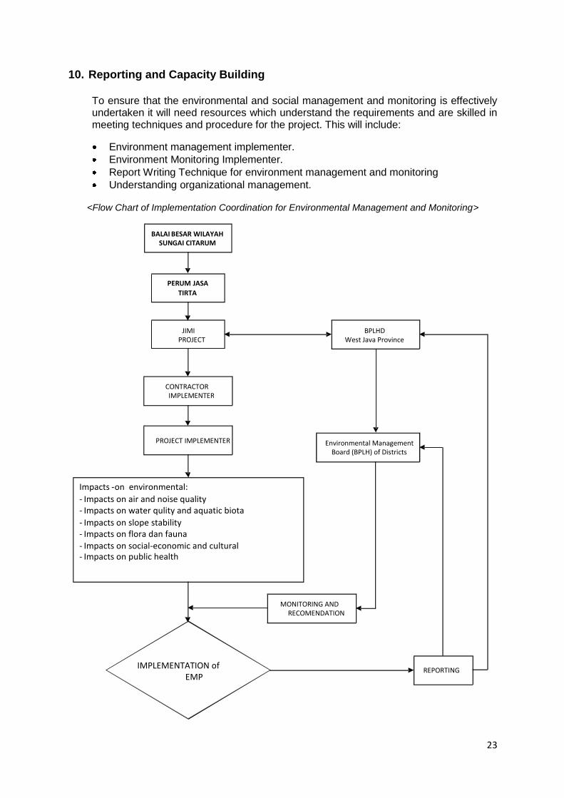
<Flow Chart of Implementation Coordination for Environmental Management and Monitoring>
REPORTING
PERUM JASA TIRTA
JIMI PROJECT
Impacts - on environmental: - Impacts on air and noise quality - Impacts on water qulity and aquatic biota - Impacts on slope stability - Impacts on flora dan fauna - Impacts on social-economic and cultural - Impacts on public health
IMPLEMENTATION of EMP
CONTRACTOR IMPLEMENTER
PROJECT IMPLEMENTER
MONITORING AND RECOMENDATION
Environmental Management Board (BPLH) of Districts
BPLHD West Java Province
BALAI BESAR WILAYAH SUNGAI CITARUM
24
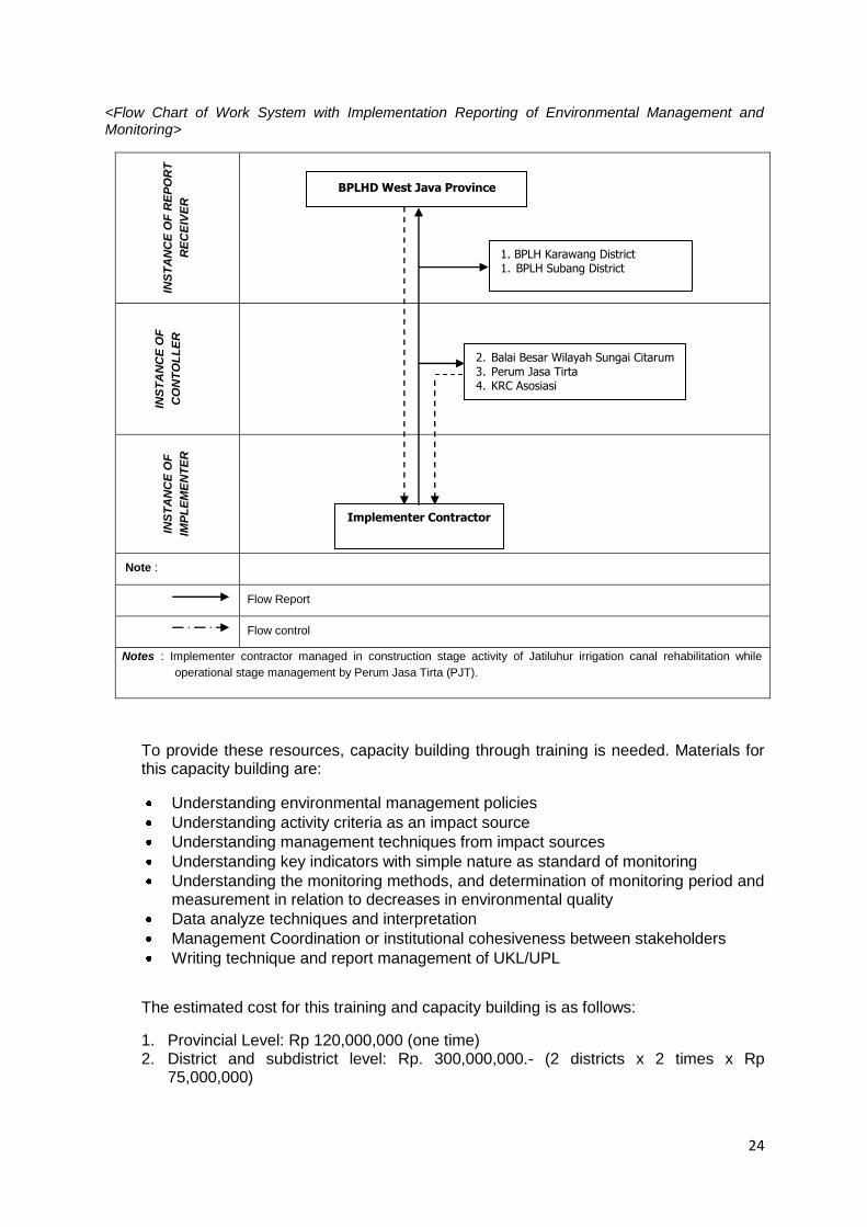
<Flow Chart of Work System with Implementation Reporting of Environmental Management and Monitoring>
INS
TA
NC
E O
F R
EP
OR
T
RE
CE
IVE
R
IN
ST
AN
CE
OF
CO
NT
OL
LE
R
INS
TA
NC
E O
F
IMP
LE
ME
NT
ER
Note :
Flow Report
Flow control
Notes : Implementer contractor managed in construction stage activity of Jatiluhur irrigation canal rehabilitation while
operational stage management by Perum Jasa Tirta (PJT).
To provide these resources, capacity building through training is needed. Materials for this capacity building are:
Understanding environmental management policies
Understanding activity criteria as an impact source
Understanding management techniques from impact sources
Understanding key indicators with simple nature as standard of monitoring
Understanding the monitoring methods, and determination of monitoring period and measurement in relation to decreases in environmental quality
Data analyze techniques and interpretation
Management Coordination or institutional cohesiveness between stakeholders
Writing technique and report management of UKL/UPL
The estimated cost for this training and capacity building is as follows:
1. Provincial Level: Rp 120,000,000 (one time) 2. District and subdistrict level: Rp. 300,000,000.- (2 districts x 2 times x Rp
75,000,000)
BPLHD West Java Province
1. BPLH Karawang District 1. BPLH Subang District
2. Balai Besar Wilayah Sungai Citarum 3. Perum Jasa Tirta 4. KRC Asosiasi
Implementer Contractor
25
11. Integration of EMP into the project
Compilation of UKL-UPL/EMP is one of the permit requirements to be undertaken for an activity as the basis of environmental feasibility. Environmental feasibility means that the work plan and planned activity will consider their impacts to the environment. Negative impact will be minimized or eliminated while positive impact will be optimized.
The purpose of environmental management and monitoring is technically not just assuring the environmental components but also protecting project interest because it could minimize negative impact to the environment from the project whether biophysical or social. As an example, unmanaged project management could have an impact on dam preservation, as well as the community around the activity location if the aspects and impacts associated with the project are not identified and mitigated against.
This EMP will be treated as one of the mandatory requirements for bidding and contractor documents.
From the legal policy aspect, the implementation of UKL-UPL/EMP shows conformance with the environmental management policy stipulated by the laws and also project protection if any environmental issues occur in the future.
From the integration aspect, Environmental management policy has an extremely interactional correlation on project management.
12. Public Consultation Meeting (PCM)
Public Consultation Meeting (PCM) was carried out December 16, 2010 in Jatimulya village office for SS Salam Darma Kiri Cs and SS Pawelutan Cs, and December 17, 2010 in Seksi Sukamandi Office of PJT II for SS Barugbug Cs. (Details: attachment 1,2 & 3)
Material presented and discussed in PCM are as follows:
a. Rehabilitation Design for three sub systems,m
b. Operation and Maintenance for ETC and NTC of Jatiluhur, and
c. Environmental Management Plan (EMP).
Result of PCM are as floows:
1. Rehabilitation Design by JIMI Consultant already confirmed with farmer proposal and input during walk-through and could be well accepted.
2. Farmer through WUA/WUAF will participate in operation and maintenance of the irrigation system according to regulation available.
3. Prior to main construction works implementation, construction activities should be started with a pra-construction Public Consultation Meeting in order to reach the real target of development according to plan.
4. WUA/WUAFs are proposed to be involved in supervision for the construction work for good quality of work according to technical specipication.
5. From the environment point of view, the farmers agree to and understand about:

26
a. Using heavy equipment during construction.
b. Disposal the material excavated along the outer side of canal.
c. Farmer full understands that during construction of irrigation system, the impact will appear to the peoples/farmers due to decrease of farming works, distributing of water to the field will be disturbed.
d. Farmer wants to minimize or reduce the negative impacts with; i) Main construction activities to be scheduled during uncultivated period (during maintenance period); ii) Delivering the irrigation water to the field with intermittent ways; iii) Using cofferdam to protect the special work.
27
28
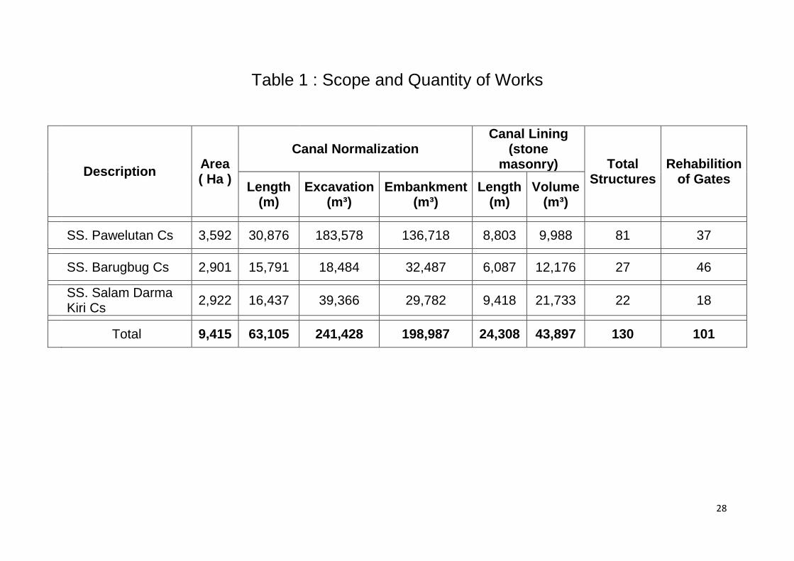
Table 1 : Scope and Quantity of Works
Description Area ( Ha )
Canal Normalization Canal Lining
(stone masonry) Total
Structures Rehabilition
of Gates Length
(m) Excavation
(m³) Embankment
(m³) Length
(m) Volume
(m³)
SS. Pawelutan Cs 3,592 30,876 183,578 136,718 8,803 9,988 81 37
SS. Barugbug Cs 2,901 15,791 18,484 32,487 6,087 12,176 27 46
SS. Salam Darma Kiri Cs
2,922 16,437 39,366 29,782 9,418 21,733 22 18
Total 9,415 63,105 241,428 198,987 24,308 43,897 130 101
29
Table 2 : LIST OF EQUIPMENT
NO Discription of Work Volume Estimate
time (month)
Quantity equipment to be used ( set )
Remark
Bu
ldo
zer
typ
e
100 -
15
0 H
P
Excavato
r 80 -
14
0 H
P
Vib
rato
r R
oller
5 -
8 t
on
Wa
ter
tan
k
50
00
lt
Du
mp
tru
ck
Co
nc
rete
Mix
er
Co
nc
ert
e
Vib
rato
r
1 SS. Pawelutan Cs
a.Stripping 27,139 1 1
b.Common Soil 183,578 12
3
5
c.Earthfill 136,718 15
2 2 2 3
d.Concrete 67.55 1
2 2
e.Stone Masonry 9,988 15
5
f.Inpection Road 28,549 12
1 1 2
Sub Total 1 5 3 3 11 7 2
2 SS. Barugbug Cs
a.Stripping 7,679 1 1
b.Common Soil 18,484 4
1
2
c.Earthfill 32,487 7
1 1 1 3
d.Concrete 47 1
1
e.Stone Masonry 12,176 15
5
f.Inpection Road 20,639 8
1 1 1
Sub Total 1 2 2 2 6 6 0
30
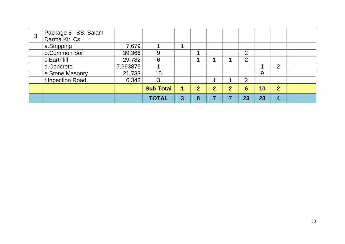
3 Package 5 : SS. Salam Darma Kiri Cs
a.Stripping 7,679 1 1
b.Common Soil 39,366 9
1
2
c.Earthfill 29,782 6
1 1 1 2
d.Concrete 7.993875 1
1 2
e.Stone Masonry 21,733 15
9
f.Inpection Road 6,343 3
1 1 2
Sub Total 1 2 2 2 6 10 2
TOTAL 3 8 7 7 23 23 4
31
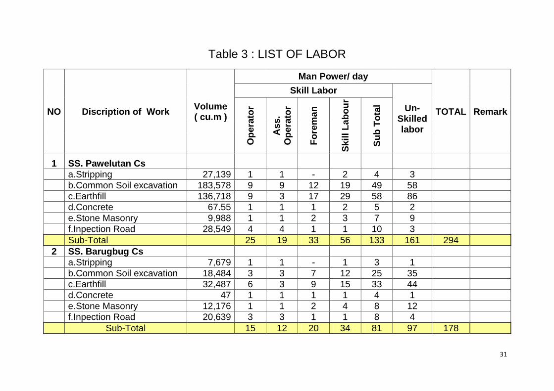
Table 3 : LIST OF LABOR
NO Discription of Work Volume ( cu.m )
Man Power/ day
TOTAL Remark
Skill Labor
Un-Skilled labor
Op
era
tor
As
s.
Op
era
tor
Fo
rem
an
Sk
ill L
ab
ou
r
Su
b T
ota
l
1 SS. Pawelutan Cs
a.Stripping 27,139 1 1 - 2 4 3
b.Common Soil excavation 183,578 9 9 12 19 49 58
c.Earthfill 136,718 9 3 17 29 58 86
d.Concrete 67.55 1 1 1 2 5 2
e.Stone Masonry 9,988 1 1 2 3 7 9
f.Inpection Road 28,549 4 4 1 1 10 3
Sub-Total
25 19 33 56 133 161 294
2 SS. Barugbug Cs
a.Stripping 7,679 1 1 - 1 3 1
b.Common Soil excavation 18,484 3 3 7 12 25 35
c.Earthfill 32,487 6 3 9 15 33 44
d.Concrete 47 1 1 1 1 4 1
e.Stone Masonry 12,176 1 1 2 4 8 12
f.Inpection Road 20,639 3 3 1 1 8 4
Sub-Total
15 12 20 34 81 97 178
32
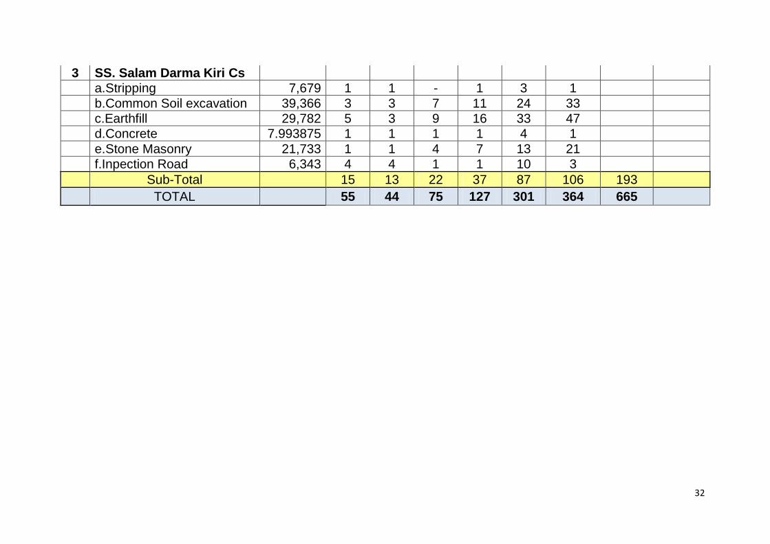
3 SS. Salam Darma Kiri Cs
a.Stripping 7,679 1 1 - 1 3 1
b.Common Soil excavation 39,366 3 3 7 11 24 33
c.Earthfill 29,782 5 3 9 16 33 47
d.Concrete 7.993875 1 1 1 1 4 1
e.Stone Masonry 21,733 1 1 4 7 13 21
f.Inpection Road 6,343 4 4 1 1 10 3
Sub-Total
15 13 22 37 87 106 193
TOTAL
55 44 75 127 301 364 665
33
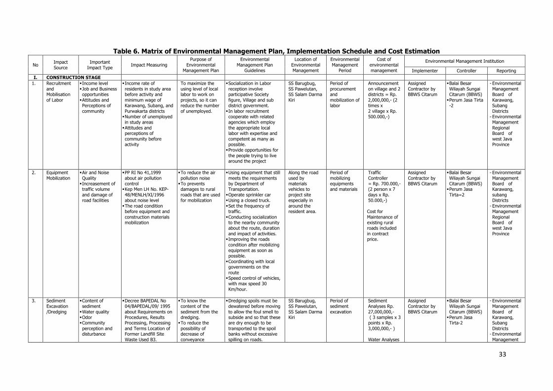
Table 6. Matrix of Environmental Management Plan, Implementation Schedule and Cost Estimation
No Impact
Source
Important
Impact Type Impact Measuring
Purpose of
Environmental Management Plan
Environmental
Management Plan Guidelines
Location of
Environmental Management
Environmental
Management Period
Cost of
environmental management
Environmental Management Institution
Implementer Controller Reporting
I. CONSTRUCTION STAGE
1. Recruitment
and Mobilisation
of Labor
Income level
Job and Business opportunities
Attitudes and Perceptions of
community
Income rate of
residents in study area before activity and
minimum wage of Karawang, Subang, and
Purwakarta districts Number of unemployed in study areas
Attitudes and perceptions of
community before activity
To maximize the
using level of local labor to work on
projects, so it can reduce the number
of unemployed.
Socialization in Labor
reception involve participative Society
figure, Village and sub district government.
In labor recruitment cooperate with related agencies which employ
the appropriate local labor with expertise and
competent as many as possible. Provide opportunities for
the people trying to live around the project
SS Barugbug,
SS Pawelutan, SS Salam Darma
Kiri
Period of
procurement and
mobilization of labor
Announcement
on village and 2 districts = Rp.
2,000,000,- (2 times x
2 village x Rp. 500.000,-)
Assigned
Contractor by BBWS Citarum
Balai Besar
Wilayah Sungai Citarum (BBWS)
Perum Jasa Tirta -2
- Environmental
Management Board of
Karawang, Subang
Districts - Environmental Management
Regional Board of
west Java Province
2. Equipment
Mobilization
Air and Noise
Quality Increasement of traffic volume
and damage of road facilities
PP RI No 41,1999
about air pollution control Kep Men LH No. KEP-
48/MENLH/XI/1996 about noise level
The road condition before equipment and
construction materials mobilization
To reduce the air
pollution noise To prevents damages to rural
roads that are used for mobilization
Using equipment that still
meets the requirements by Department of Transportation.
Operate sprinkler car Using a closed truck.
Set the frequency of traffic.
Conducting socialization to the nearby community about the route, duration
and impact of activities. Improving the roads
condition after mobilizing equipment as soon as possible.
Coordinating with local governments on the
route Speed control of vehicles, with max speed 30
Km/hour.
Along the road
used by materials vehicles to
project site especially in
around the resident area.
Period of
mobilizing equipments and materials
Traffic
Controller = Rp. 700.000,- (2 person x 7
days x Rp. 50.000,-)
Cost for
Maintenance of existing rural roads included
in contract price.
Assigned
Contractor by BBWS Citarum
Balai Besar
Wilayah Sungai Citarum (BBWS) Perum Jasa
Tirta=2
- Environmental
Management Board of Karawang,
subang Districts
- Environmental Management
Regional Board of west Java
Province
3. Sediment Excavation
/Dredging
Content of sediment
Water quality Odor Community
perception and disturbance
Decree BAPEDAL No 04/BAPEDAL/09/ 1995
about Requirements on Procedures, Results Processing, Processing
and Terms Location of Former Landfill Site
Waste Used B3.
To know the content of the
sediment from the dredging. To reduce the
possibility of decrease of
conveyance
Dredging spoils must be dewatered before moving
to allow the foul smell to subside and so that these are dry enough to be
transported to the spoil banks without excessive
spilling on roads.
SS Barugbug, SS Pawelutan,
SS Salam Darma Kiri
Period of sediment
excavation
Sediment Analyses Rp.
27,000,000,- ( 3 samples x 3 points x Rp.
3,000,000,- )
Water Analyses
Assigned Contractor by
BBWS Citarum
Balai Besar Wilayah Sungai
Citarum (BBWS) Perum Jasa Tirta-2
- Environmental Management
Board of Karawang, Subang
Districts - Environmental
Management
34
No Impact Source
Important Impact Type
Impact Measuring Purpose of
Environmental Management Plan
Environmental Management Plan
Guidelines
Location of Environmental Management
Environmental Management
Period
Cost of environmental management
Environmental Management Institution
Implementer Controller Reporting
PP RI No. 82, 2001
about Management and Water Pollution Control
capacity of canals.
Use dredging spoils as
resource. Coarse sediments could be used
as base material for improving inspection roads in the irrigation
service areas. Odor from dredged
anaerobic sediment is to be expected. Although the smell subsides within
a few days of exposure to air, residents in the
immediate vicinity of the dredging should be informed and assured
that the foul smell is temporary.
Contractor plan shall include measures to
minimize nuisance to nearby communities. Contractor will also be
responsible for notifying communities of
temporary nuisance to be expected, and for providing adequate signs
and detours in the work areas.
Affected communities should be informed of the disruptions to be
expected and their duration, and contractor
should be required to prepare spoil disposal and
nuisance minimization plans. Contractor should also plan the works
without need for cutting-off the downstream flow.
Alternative source of water supply should be provided to communities
along the canal that tap water from the stream or
use it for washing /bathing purposes
Rp.22,500,000,-
(3 samples x 3 points x Rp.
2,500,000,-) TCLP test
Rp.31,500,000,- (3 samples x 3
points x Rp. 3,500,000,-)
Provide sediment
screen: Rp. 450,000,000.- (3 SS each Rp.
150,000,000.-)
Regional
Board of west Java
Province
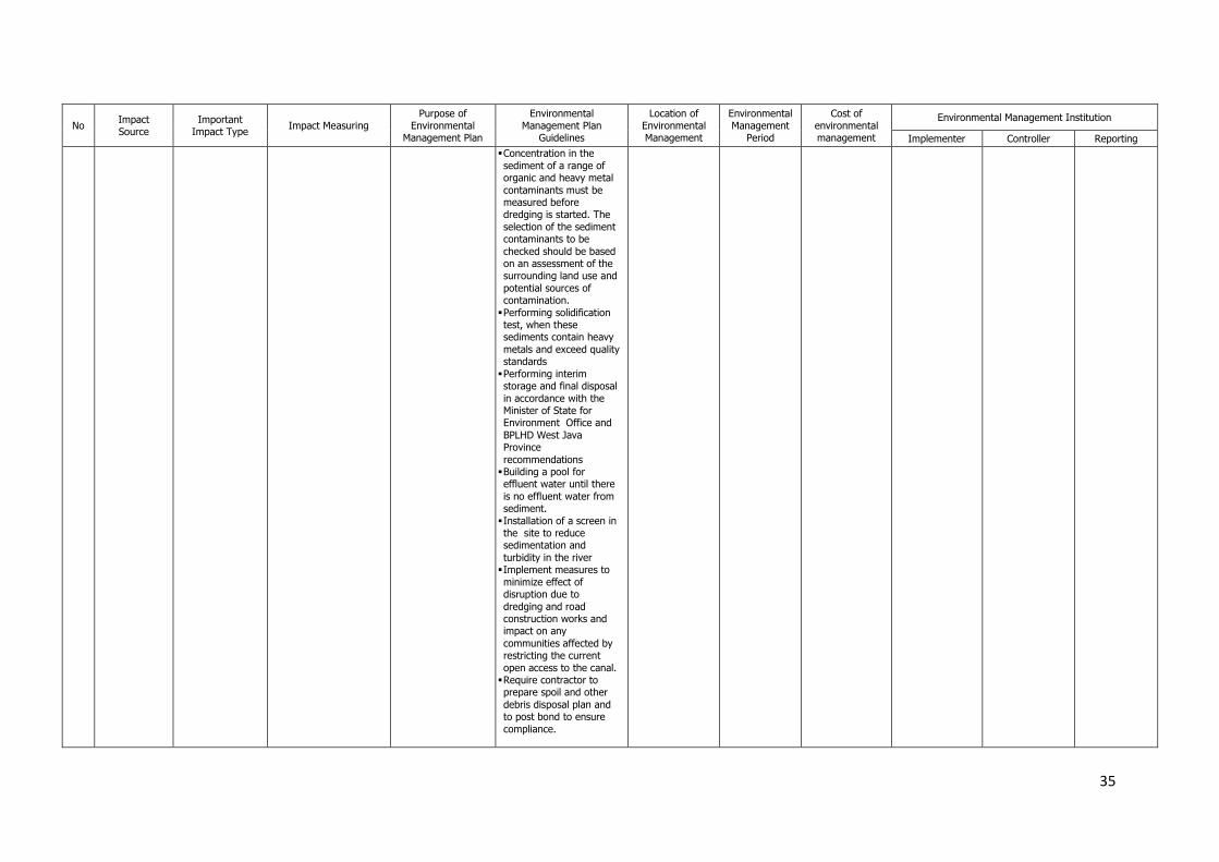
35
No Impact Source
Important Impact Type
Impact Measuring Purpose of
Environmental Management Plan
Environmental Management Plan
Guidelines
Location of Environmental Management
Environmental Management
Period
Cost of environmental management
Environmental Management Institution
Implementer Controller Reporting
Concentration in the
sediment of a range of organic and heavy metal
contaminants must be measured before dredging is started. The
selection of the sediment contaminants to be
checked should be based on an assessment of the surrounding land use and
potential sources of contamination.
Performing solidification test, when these sediments contain heavy
metals and exceed quality standards
Performing interim storage and final disposal
in accordance with the Minister of State for Environment Office and
BPLHD West Java Province
recommendations Building a pool for effluent water until there
is no effluent water from sediment.
Installation of a screen in the site to reduce sedimentation and
turbidity in the river Implement measures to
minimize effect of disruption due to
dredging and road construction works and impact on any
communities affected by restricting the current
open access to the canal. Require contractor to prepare spoil and other
debris disposal plan and to post bond to ensure
compliance.
36
No Impact Source
Important Impact Type
Impact Measuring Purpose of
Environmental Management Plan
Environmental Management Plan
Guidelines
Location of Environmental Management
Environmental Management
Period
Cost of environmental management
Environmental Management Institution
Implementer Controller Reporting
Require also to include in
plan various measures to minimize nuisance to
nearby communities. The contractor should plan works without need for
cutting-off the downstream flow.
4. Disposal Area Flora terrestrial
Fauna terrestrial Biota aquatic Attitudes and
perceptions of community about
environmental sanitation
Decrease in diversity of
vegetation and land area before the project. Biota abundance level
of water before construction
Frequency of public complaints due to turbid waters
To prevent the
decrease of biodiversity in the study area.
To reduce the decrease in the
diversity of biota and the aquatic ecosystem stability.
To increase accommodative
attitude of society to plan the project
activities. To prevent the unconvinience that
could create social conflict.
Disposal areas for the
sediments removed from the canal should be properly sited so that
these are not susceptible to washout or slumping.
Possible beneficial uses of the material should be maximized, including use
for topping of service road embankments.
The area allocated for sediment disposal should
be surrounded by protective embankment/bunds to
prevent silt runoff into the surrounding areas.
To reduce the impact, the excavated material should be placed with
good treatment and shape, even the change
of landscape is relatively neglectable.
Planned disposal
area
Period of
construction
Social surveys
Rp. 6,000,000,- ( 2 district x Rp. 3,000,000,-)
Treatment cost
of disposal material in outside canals
included in contract cost
Assigned
Contractor by BBWS Citarum
Balai Besar
Wilayah Sungai Citarum (BBWS) Perum Jasa
Tiirta
- Environmental
Management Board of Karawang
District - Environmental
Management Board of Subang
District - Environmental
Management Regional
Board of west Java Province
II OPERATIONAL STAGE
5. Irrigation Operation
Income level Attitudes and perceptions of
community
Level of population income before operating canal
Attitudes and perceptions of the
public before the project Accommodative
attitude of community to the canal operation
To increase public participative attitude about
preservation of canal
Keep the fluency of operational activities
To increase the economic growth
Preventing throw of garbage into the irrigation canal
Maintaining side of canal to reduce contamination
Cordinating with relevant agencies and communities around the
canal to maintain the canal
Obeying the regulations relating to areas
Along the canal Period of operating irrigation
system
Social surveys Rp. 6,000,000,- ( 2 district x Rp.
3,000,000,-)
Perum Jasa Tirta-II (PJT-II)
Balai Besar Wilayah Sungai Citarum (BBWS)
- Environmental Management Board of
Karawang, Subang
Districts - Environmental Management
Regional Board of
west Java Province
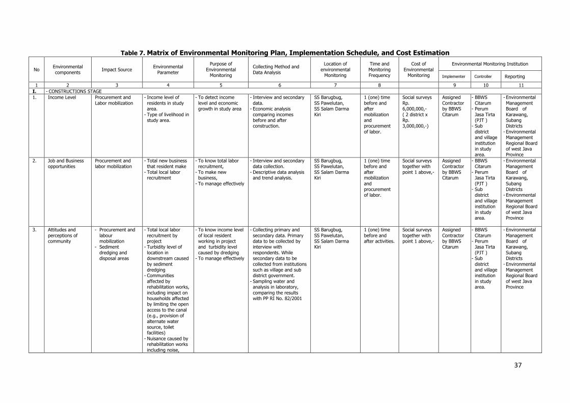
37
Table 7. Matrix of Environmental Monitoring Plan, Implementation Schedule, and Cost Estimation
No Environmental
components Impact Source
Environmental
Parameter
Purpose of
Environmental Monitoring
Collecting Method and
Data Analysis
Location of
environmental Monitoring
Time and
Monitoring Frequency
Cost of
Environmental Monitoring
Environmental Monitoring Institution
Implementer Controller Reporting
1 2 3 4 5 6 7 8 9 10 11
I. - CONSTRUCTIONS STAGE
1. Income Level Procurement and
Labor mobilization
- Income level of
residents in study area.
- Type of livelihood in study area.
- To detect income
level and economic growth in study area
- Interview and secondary
data. - Economic analysis
comparing incomes before and after construction.
SS Barugbug,
SS Pawelutan, SS Salam Darma
Kiri
1 (one) time
before and after
mobilization and procurement
of labor.
Social surveys
Rp. 6,000,000,-
( 2 district x Rp. 3,000,000,-)
Assigned
Contractor by BBWS
Citarum
- BBWS
Citarum - Perum
Jasa Tirta (PJT )
- Sub
district and village
institution in study area.
- Environmental
Management Board of
Karawang, Subang Districts
- Environmental Management
Regional Board of west Java Province
2. Job and Business opportunities
Procurement and labor mobilization
- Total new business that resident make
- Total local labor recruitment
- To know total labor recruitment,
- To make new business,
- To manage effectively
- Interview and secondary data collection.
- Descriptive data analysis and trend analysis.
SS Barugbug, SS Pawelutan,
SS Salam Darma Kiri
1 (one) time before and
after mobilization
and procurement of labor.
Social surveys together with
point 1 above,-
Assigned Contractor
by BBWS Citarum
- BBWS Citarum
- Perum Jasa Tirta
(PJT ) - Sub
district
and village institution
in study area.
- Environmental Management
Board of Karawang,
Subang Districts
- Environmental
Management Regional Board
of west Java Province
3. Attitudes and
perceptions of community
- Procurement and
labour mobilization
- Sediment
dredging and disposal areas
- Total local labor
recruitment by project
- Turbidity level of
location in downstream caused
by sediment dredging
- Communities
affected by rehabilitation works,
including impact on households affected by limiting the open
access to the canal (e.g., provision of
alternate water source, toilet facilities)
- Nuisance caused by rehabilitation works
including noise,
- To know income level
of local resident working in project and turbidity level
caused by dredging - To manage effectively
- Collecting primary and
secondary data. Primary data to be collected by interview with
respondents. While secondary data to be
collected from institutions such as village and sub district government.
- Sampling water and analysis in laboratory,
comparing the results with PP RI No. 82/2001
SS Barugbug,
SS Pawelutan, SS Salam Darma Kiri
1 (one) time
before and after activities.
Social surveys
together with point 1 above,-
Assigned
Contractor by BBWS Citarum
- BBWS
Citarum - Perum
Jasa Tirta
(PJT ) - Sub
district and village institution
in study area.
- Environmental
Management Board of Karawang,
Subang Districts
- Environmental Management Regional Board
of west Java Province
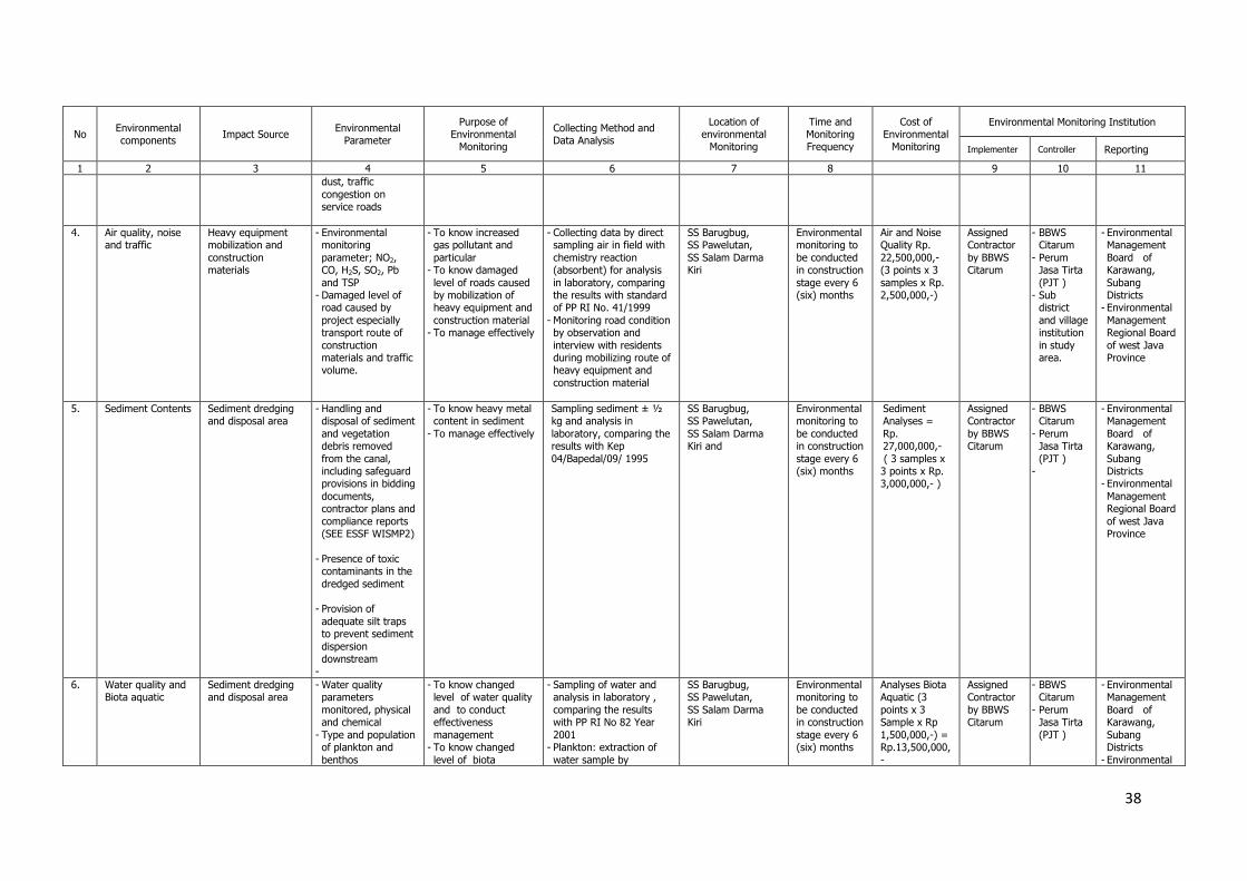
38
No Environmental components
Impact Source Environmental
Parameter
Purpose of Environmental
Monitoring
Collecting Method and Data Analysis
Location of environmental
Monitoring
Time and Monitoring Frequency
Cost of Environmental
Monitoring
Environmental Monitoring Institution
Implementer Controller Reporting
1 2 3 4 5 6 7 8 9 10 11 dust, traffic
congestion on service roads
4. Air quality, noise and traffic
Heavy equipment mobilization and
construction materials
- Environmental monitoring
parameter; NO2, CO, H2S, SO2, Pb
and TSP - Damaged level of road caused by
project especially transport route of
construction materials and traffic volume.
- To know increased gas pollutant and
particular - To know damaged
level of roads caused by mobilization of heavy equipment and
construction material - To manage effectively
- Collecting data by direct sampling air in field with
chemistry reaction (absorbent) for analysis
in laboratory, comparing the results with standard of PP RI No. 41/1999
- Monitoring road condition by observation and
interview with residents during mobilizing route of heavy equipment and
construction material
SS Barugbug, SS Pawelutan,
SS Salam Darma Kiri
Environmental monitoring to
be conducted in construction
stage every 6 (six) months
Air and Noise Quality Rp.
22,500,000,- (3 points x 3
samples x Rp. 2,500,000,-)
Assigned Contractor
by BBWS Citarum
- BBWS Citarum
- Perum Jasa Tirta
(PJT ) - Sub
district
and village institution
in study area.
- Environmental Management
Board of Karawang,
Subang Districts
- Environmental
Management Regional Board
of west Java Province
5. Sediment Contents Sediment dredging and disposal area
- Handling and disposal of sediment
and vegetation debris removed
from the canal, including safeguard provisions in bidding
documents, contractor plans and
compliance reports (SEE ESSF WISMP2)
- Presence of toxic contaminants in the
dredged sediment
- Provision of
adequate silt traps to prevent sediment
dispersion downstream
-
- To know heavy metal content in sediment
- To manage effectively
Sampling sediment ± ½ kg and analysis in
laboratory, comparing the results with Kep
04/Bapedal/09/ 1995
SS Barugbug, SS Pawelutan,
SS Salam Darma Kiri and
Environmental monitoring to
be conducted in construction
stage every 6 (six) months
Sediment Analyses =
Rp. 27,000,000,-
( 3 samples x 3 points x Rp. 3,000,000,- )
Assigned Contractor
by BBWS Citarum
- BBWS Citarum
- Perum Jasa Tirta
(PJT ) -
- Environmental Management
Board of Karawang,
Subang Districts
- Environmental
Management Regional Board
of west Java Province
6. Water quality and Biota aquatic
Sediment dredging and disposal area
- Water quality parameters
monitored, physical and chemical
- Type and population of plankton and
benthos
- To know changed level of water quality
and to conduct effectiveness
management - To know changed
level of biota
- Sampling of water and analysis in laboratory ,
comparing the results with PP RI No 82 Year
2001 - Plankton: extraction of
water sample by
SS Barugbug, SS Pawelutan,
SS Salam Darma Kiri
Environmental monitoring to
be conducted in construction
stage every 6 (six) months
Analyses Biota Aquatic (3
points x 3 Sample x Rp
1,500,000,-) = Rp.13,500,000,
-
Assigned Contractor
by BBWS Citarum
- BBWS Citarum
- Perum Jasa Tirta
(PJT )
- Environmental Management
Board of Karawang,
Subang Districts
- Environmental
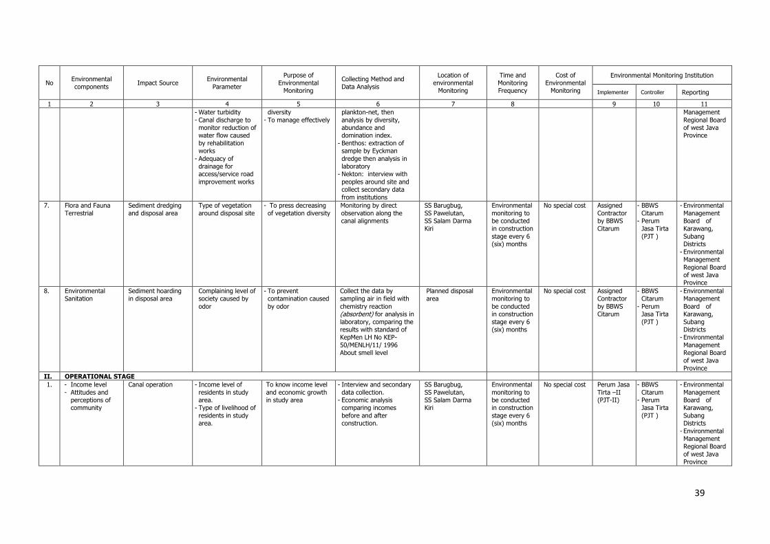
39
No Environmental components
Impact Source Environmental
Parameter
Purpose of Environmental
Monitoring
Collecting Method and Data Analysis
Location of environmental
Monitoring
Time and Monitoring Frequency
Cost of Environmental
Monitoring
Environmental Monitoring Institution
Implementer Controller Reporting
1 2 3 4 5 6 7 8 9 10 11 - Water turbidity
- Canal discharge to monitor reduction of water flow caused
by rehabilitation works
- Adequacy of drainage for access/service road
improvement works
diversity
- To manage effectively
plankton-net, then
analysis by diversity, abundance and domination index.
- Benthos: extraction of sample by Eyckman
dredge then analysis in laboratory
- Nekton: interview with
peoples around site and collect secondary data
from institutions
Management
Regional Board of west Java Province
7. Flora and Fauna
Terrestrial
Sediment dredging
and disposal area
Type of vegetation
around disposal site
- To press decreasing
of vegetation diversity
Monitoring by direct
observation along the canal alignments
SS Barugbug,
SS Pawelutan, SS Salam Darma Kiri
Environmental
monitoring to be conducted in construction
stage every 6 (six) months
No special cost Assigned
Contractor by BBWS Citarum
- BBWS
Citarum - Perum
Jasa Tirta
(PJT )
- Environmental
Management Board of Karawang,
Subang Districts
- Environmental Management
Regional Board of west Java Province
8. Environmental Sanitation
Sediment hoarding in disposal area
Complaining level of society caused by
odor
- To prevent contamination caused
by odor
Collect the data by sampling air in field with
chemistry reaction (absorbent) for analysis in
laboratory, comparing the results with standard of KepMen LH No KEP-
50/MENLH/11/ 1996 About smell level
Planned disposal area
Environmental monitoring to
be conducted in construction
stage every 6 (six) months
No special cost Assigned Contractor
by BBWS Citarum
- BBWS Citarum
- Perum Jasa Tirta
(PJT )
- Environmental Management
Board of Karawang,
Subang Districts
- Environmental
Management Regional Board
of west Java Province
II. OPERATIONAL STAGE
1. - Income level
- Attitudes and perceptions of community
Canal operation - Income level of
residents in study area.
- Type of livelihood of
residents in study area.
To know income level
and economic growth in study area
- Interview and secondary
data collection. - Economic analysis comparing incomes
before and after construction.
SS Barugbug,
SS Pawelutan, SS Salam Darma Kiri
Environmental
monitoring to be conducted in construction
stage every 6 (six) months
No special cost Perum Jasa
Tirta –II (PJT-II)
- BBWS
Citarum - Perum
Jasa Tirta
(PJT )
- Environmental
Management Board of Karawang,
Subang Districts
- Environmental Management Regional Board
of west Java Province
40
Attachment No. 1
NOTICE OF PCM (PUBLIC CONSULTATION MEETING) JATILUHUR IRRIGATION MANAGEMENT IMPROVEMENT (JIMI)
IMPROVEMENT OF SS BARUGBUG Cs, SS. PAWELUTAN CS DAN SALAM DARMA KIRI CS
Day : Thursday and Friday
Date : 16 and 17 December 2010
Place : 1. Jatimulya village Office for SS Pawelutan Cs and SS Salam Darma Kiri Cs,
Jl. Raya Pertamina Wates – Compreng, Kec. Compreng, Kab. Subang
2. Office of Seksi Sukamandi PJT II for SS Barugbug Cs
Jl. Purwadadi No. 21 Sukamandi, Kabupaten Subang
Subject : Presentation and discussing Rehabilitation of SS Barugbug Cs, SS Pawelutan Cs dan SS
Salam Darma Kiri Cs.
I. IINTRUDUCTION
The PCM was opened by Ir. Winskayati Sp.1 from BBWS Citarum as a meeting leader by explaining the purpose of this PCM. PCM (Public Consultation Meeting) is a part of JIMI (Jatiluhur Irrigation Management Improvement) consulting services by KRC (Korea Rural Community Corporation) Consultant. Speech was followed by Head of District Compreng Drs. H. Oong Saropi, and by Abu Syukur ST, Head of Technical Planning of PJT II.
In PCM attends 74 participants for SS Pawelutan Cs, SS Salam Darma Kiri Cs and 66 participants for SS Barugbug Cs (see attendant list in attachment no 2 and photo documentation in attachment no. 3) from BBWS Citarum, PJT II, Local Government (consists of: District Police Department, Head of District, Head of villages, staff of Districts and villages), WUA/WUAF with farmers, and local NGO in area of SS Barugbug Cs, SS. Pawelutan Cs and SS. Salam Darma Kiri Cs.
Purpose of PCM is to consult the result of rehabilitation design of SS Barugbug Cs, SS Pawelutan Cs and SS Salam Darma Kiri Cs and Environment Management Plan (EMP).
II. PRESENTATION
Presentation consists of 3 (three) sessions, they are:
1. Presentation of the result of Rehabilitation Design for SS. Pawelutan Cs and SS.
Salam Darma Kiri Cs. by Ir. Chrisnen Purba M. Eng as a Co-Team Leader from
KRC Consultant JIMI (Jatiluhur Irrigation Management Improvement).
2. Presentation of EMP (Environmental Management Plan) by PT Inasa Sakha Kirana
consultant.
3. Ppresentation of Operation and Maintenance for ETC and NTC Jatiluhur by Ir.
Abdullah Syarif M.Eng as a O&M Specialist from KRC Consultant JIMI.
III. COMMENT AND PROPOSED FROM MEETING
In the meeting gets the agreement as follows:
1. Design Agreement

41
a. The structures broken should be rehabilitated and the broken gate should be
replaced/repaired.
b. In some place the embankment become small, it should be resized according to
original condition with coordinating with PJT II.
c. The canal lining are vproposed to the location of widening canal and in the
residence area.
d. Normalizations of canal should follow the proposed design.
e. The broken measuring device should be rehabilitated according to previous
condition.
f. Proposal on Meeting building (saung meeting) in the field, by using PJT II land.
g. Before construction started, a coordination meeting should be held with local
government.
h. Required the re-check of works (especially aqueduct) in order to confirm the
actual condition before construction.
All the propose and input from the farmers already are accommodated in rehabilitation design by JIMI Consultant, and farmers agreed for all proposes of design since the participative process of design were executed by walk-through and field discussions.
2. Environments Agreement
a. Farmer agree and no objection in use of heavy equipment for construction of
works.
b. Disposing the excavation material along the outer side of canals.
c. During construction there will be a disturbance of water delivery to the field,
farmer fully understand and no objection. The negative impact should be
minimized or reduced by scheduling the main work during maintenance period,
or delivery of irrigation water with intermittent ways, or use cofferdam to protect
the work activities.
3. O&M Agreement
Municipals or farmers through WUA/WUAF agreed to involve in maintenance of
irrigation facilities.
IV. CLOSING
After presentation and discussion in the meeting, all the participants got agreement and fully understood about improvement of SS Barugbug Cs, SS Pawelutan and SS. Salam Darma Kiri Cs, then the meeting was closed.
Notice of PCM was prepared for improvement of design and also for implementation of guidance during construction stage for the success of works and signed by participant below.

42
43
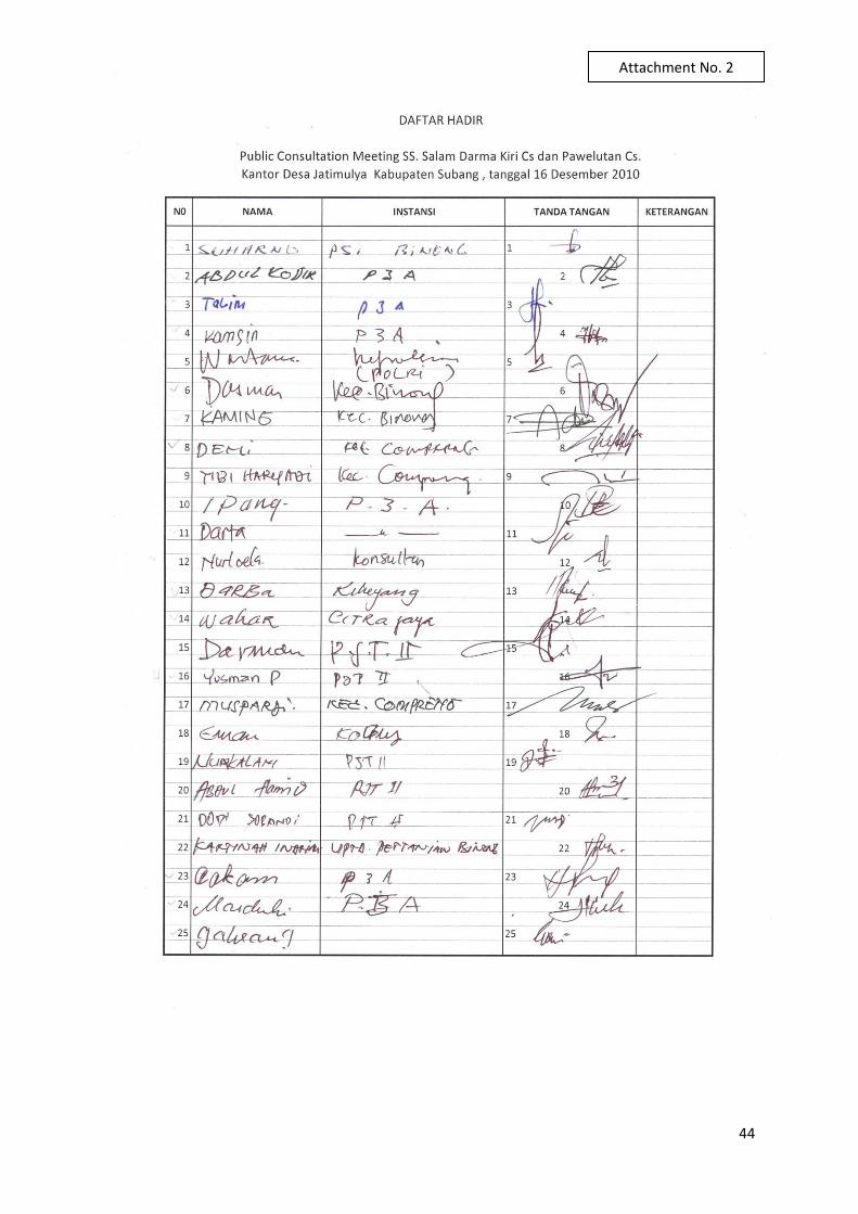
44
Attachment No. 2
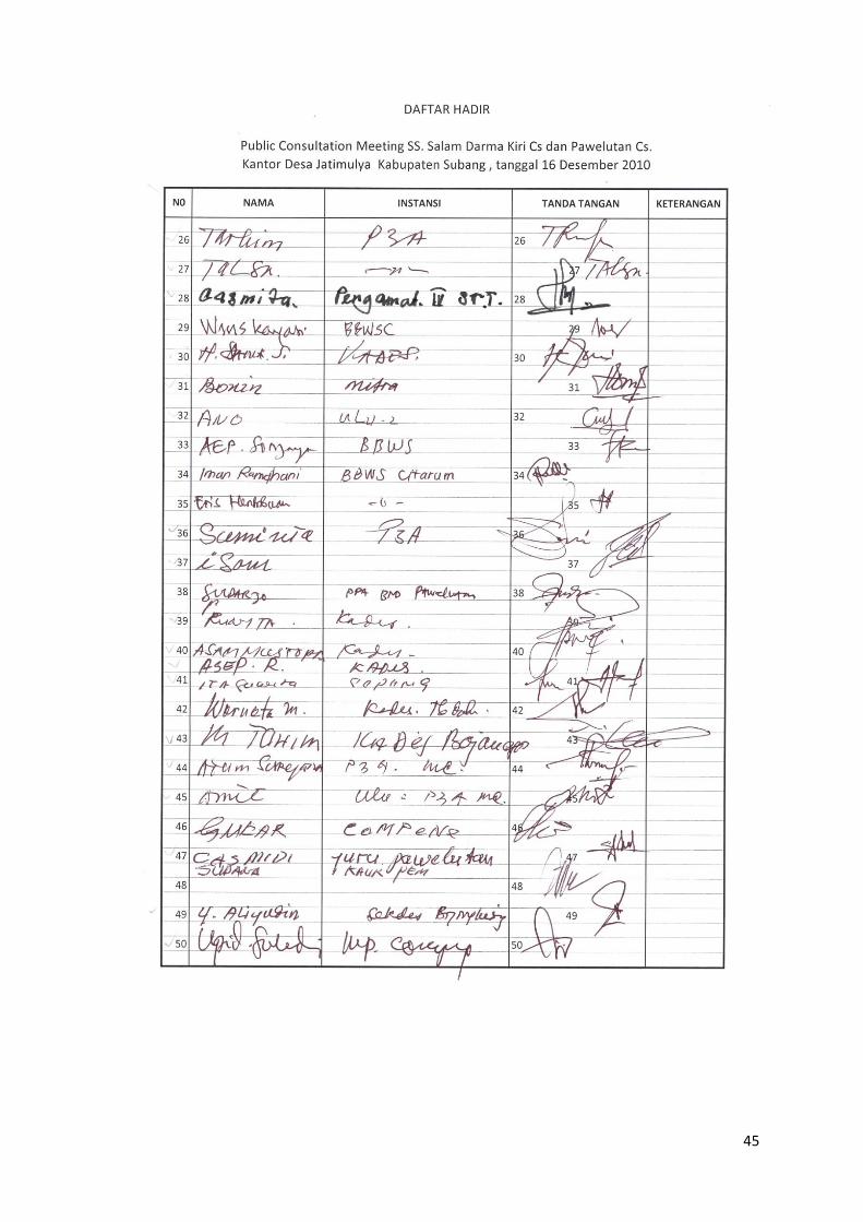
45
46
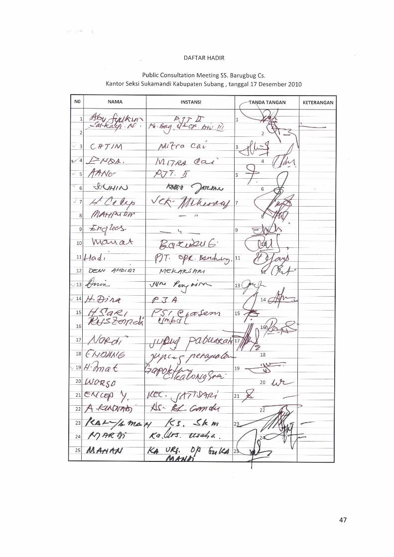
47
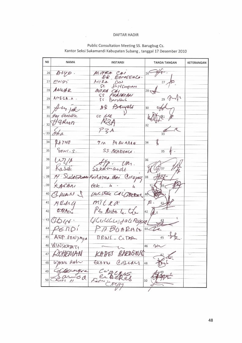
48
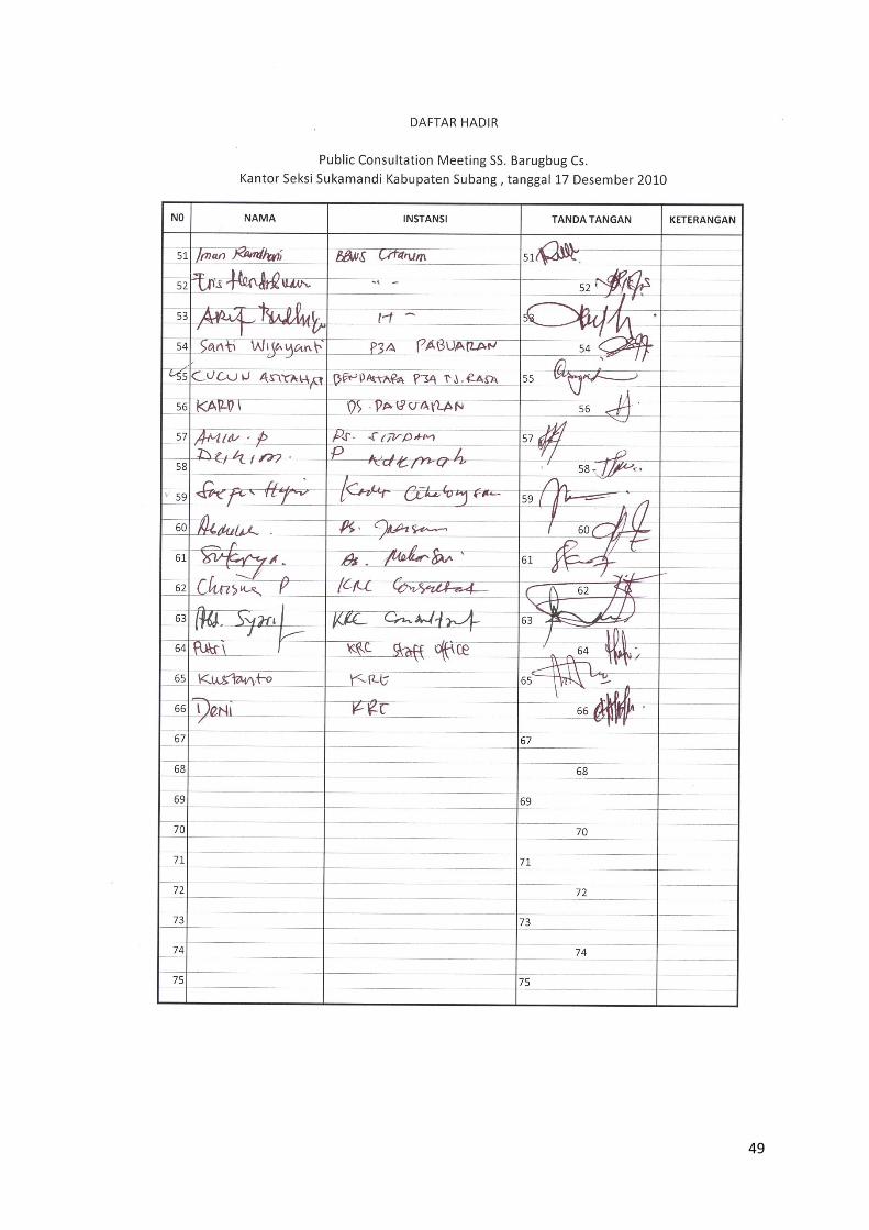
49
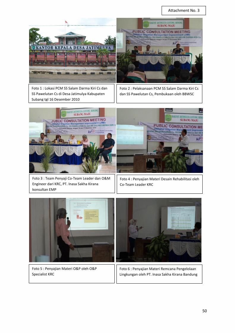
50
Foto 1 : Lokasi PCM SS Salam Darma Kiri Cs dan
SS Pawelutan Cs di Desa Jatimulya Kabupaten
Subang tgl 16 Desember 2010
Foto 2 : Pelaksanaan PCM SS Salam Darma Kiri Cs
dan SS Pawelutan Cs, Pembukaan oleh BBWSC
Foto 3 : Team Penyaji Co-Team Leader dan O&M
Engineer dari KRC, PT. Inasa Sakha Kirana
konsultan EMP
Foto 4 : Penyajian Materi Desain Rehabilitasi oleh
Co-Team Leader KRC
Foto 5 : Penyajian Materi O&P oleh O&P
Specialist KRC
Foto 6 : Penyajian Materi Remcana Pengelolaan
Lingkungan oleh PT. Inasa Sakha Kirana Bandung
Attachment No. 3
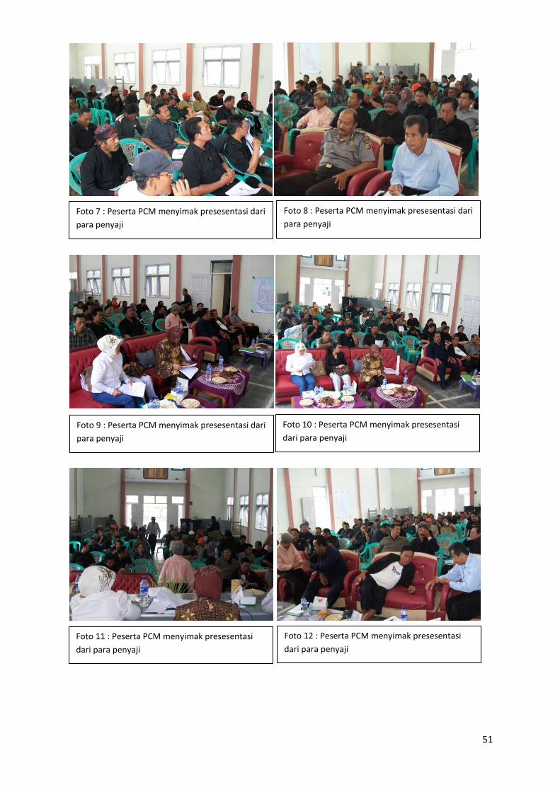
51
Foto 7 : Peserta PCM menyimak presesentasi dari
para penyaji
Foto 8 : Peserta PCM menyimak presesentasi dari
para penyaji
Foto 9 : Peserta PCM menyimak presesentasi dari
para penyaji
Foto 10 : Peserta PCM menyimak presesentasi
dari para penyaji
Foto 11 : Peserta PCM menyimak presesentasi
dari para penyaji
Foto 12 : Peserta PCM menyimak presesentasi
dari para penyaji
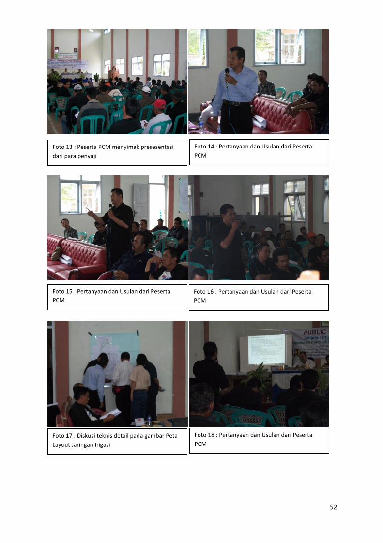
52
Foto 13 : Peserta PCM menyimak presesentasi
dari para penyaji
Foto 14 : Pertanyaan dan Usulan dari Peserta
PCM
Foto 15 : Pertanyaan dan Usulan dari Peserta
PCM
Foto 16 : Pertanyaan dan Usulan dari Peserta
PCM
Foto 17 : Diskusi teknis detail pada gambar Peta
Layout Jaringan Irigasi
Foto 18 : Pertanyaan dan Usulan dari Peserta
PCM
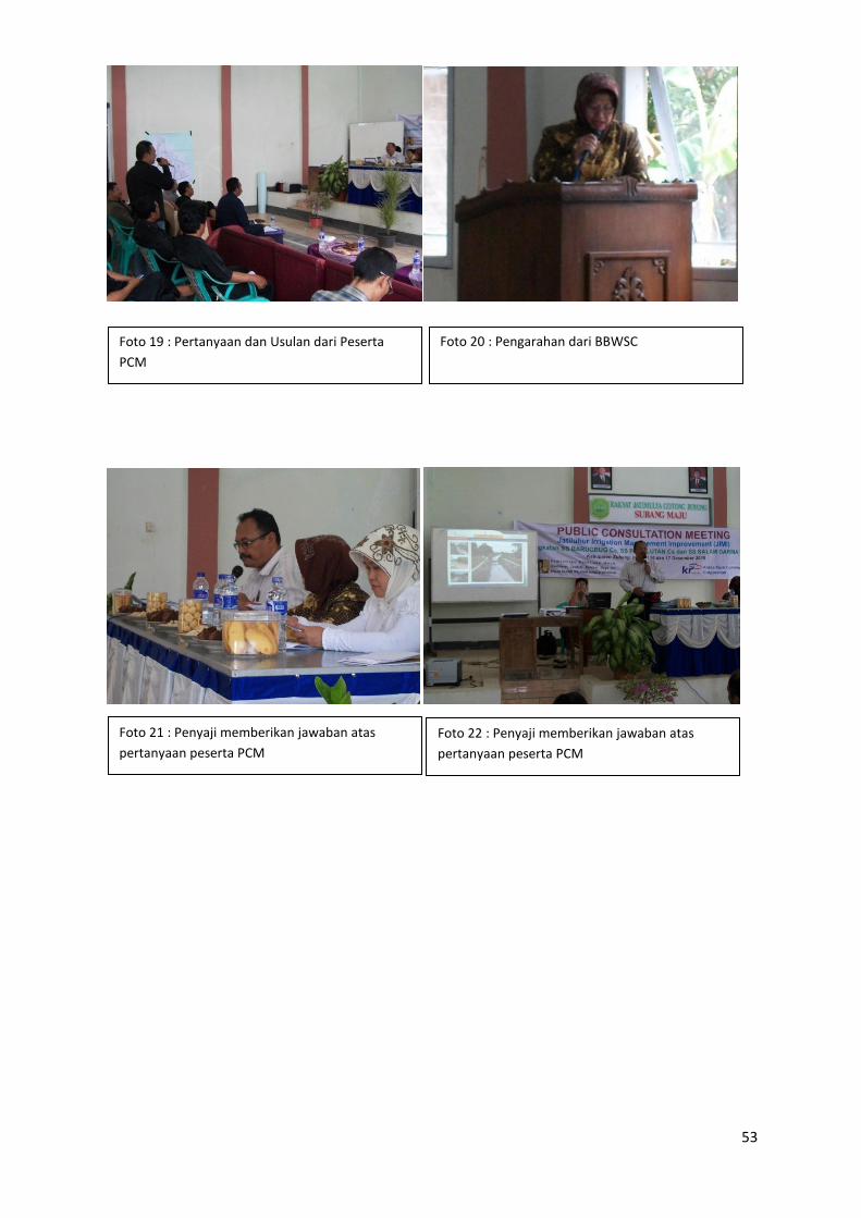
53
Foto 19 : Pertanyaan dan Usulan dari Peserta
PCM
Foto 20 : Pengarahan dari BBWSC
Foto 21 : Penyaji memberikan jawaban atas
pertanyaan peserta PCM
Foto 22 : Penyaji memberikan jawaban atas
pertanyaan peserta PCM
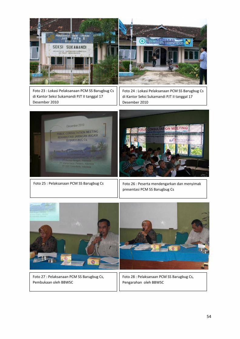
54
Foto 23 : Lokasi Pelaksanaan PCM SS Barugbug Cs
di Kantor Seksi Sukamandi PJT II tanggal 17
Desember 2010
Foto 24 : Lokasi Pelaksanaan PCM SS Barugbug Cs
di Kantor Seksi Sukamandi PJT II tanggal 17
Desember 2010
Foto 25 : Pelaksanaan PCM SS Barugbug Cs Foto 26 : Peserta mendengarkan dan menyimak
presentasi PCM SS Barugbug Cs
Foto 27 : Pelaksanaan PCM SS Barugbug Cs,
Pembukaan oleh BBWSC
Foto 28 : Pelaksanaan PCM SS Barugbug Cs,
Pengarahan oleh BBWSC
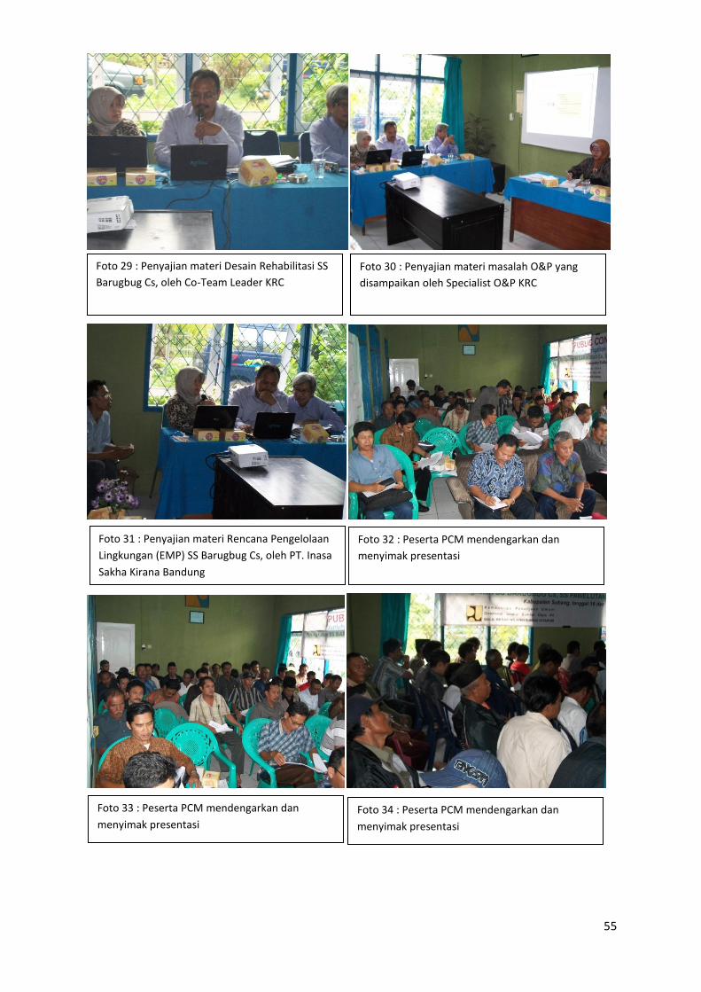
55
Foto 29 : Penyajian materi Desain Rehabilitasi SS
Barugbug Cs, oleh Co-Team Leader KRC
Foto 30 : Penyajian materi masalah O&P yang
disampaikan oleh Specialist O&P KRC
Foto 31 : Penyajian materi Rencana Pengelolaan
Lingkungan (EMP) SS Barugbug Cs, oleh PT. Inasa
Sakha Kirana Bandung
Foto 32 : Peserta PCM mendengarkan dan
menyimak presentasi
Foto 33 : Peserta PCM mendengarkan dan
menyimak presentasi
Foto 34 : Peserta PCM mendengarkan dan
menyimak presentasi
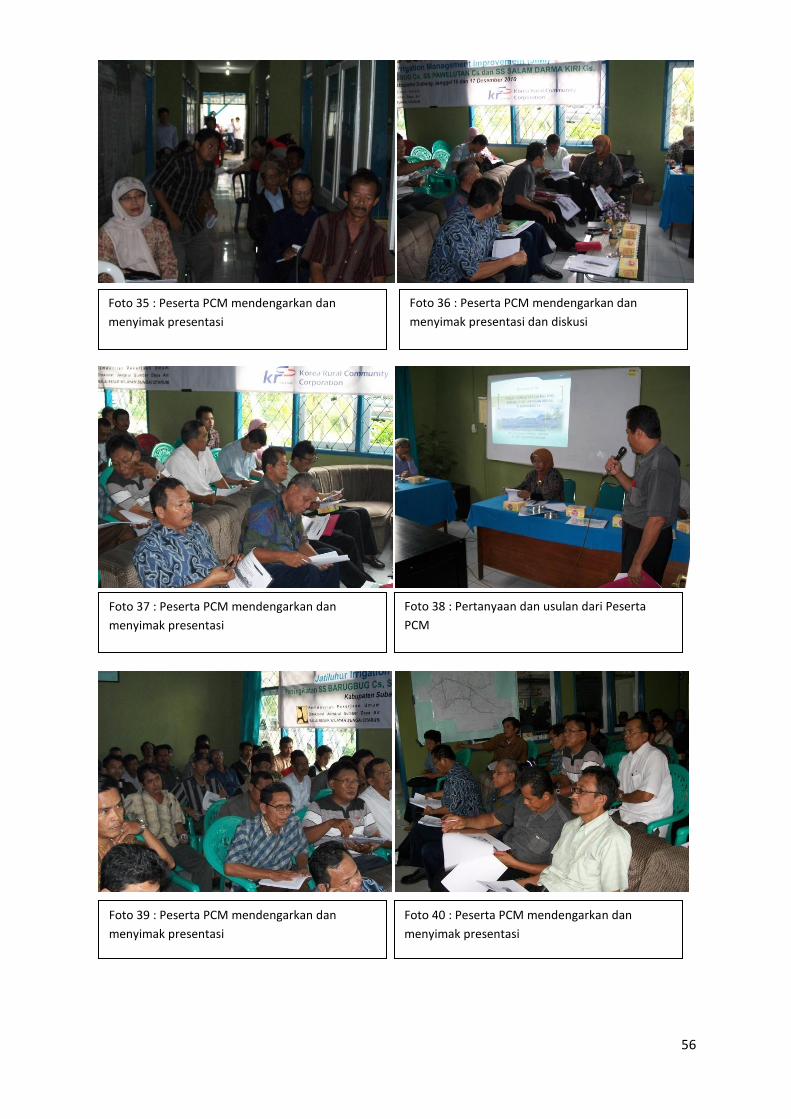
56
Foto 35 : Peserta PCM mendengarkan dan
menyimak presentasi
Foto 36 : Peserta PCM mendengarkan dan
menyimak presentasi dan diskusi
Foto 37 : Peserta PCM mendengarkan dan
menyimak presentasi
Foto 38 : Pertanyaan dan usulan dari Peserta
PCM
Foto 39 : Peserta PCM mendengarkan dan
menyimak presentasi
Foto 40 : Peserta PCM mendengarkan dan
menyimak presentasi

57
Foto 41 : Peserta PCM mendengarkan dan
menyimak presentasi Foto 42 : Peserta PCM menyampaikan
pertanyaan dan usulan
Foto 44 : Peserta PCM menyampaikan
pertanyaan dan usulan
Foto 43 : Peserta PCM menyampaikan
pertanyaan dan usulan
Foto 46 : Peserta PCM menyampaikan
pertanyaan dan usulan
Foto 45 : Peserta PCM menyampaikan
pertanyaan dan usulan
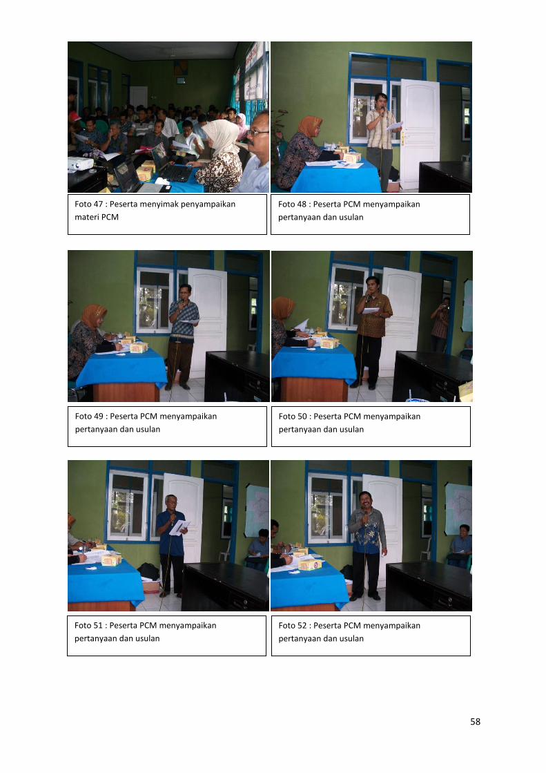
58
Foto 48 : Peserta PCM menyampaikan
pertanyaan dan usulan
Foto 47 : Peserta menyimak penyampaikan
materi PCM
Foto 50 : Peserta PCM menyampaikan
pertanyaan dan usulan
Foto 49 : Peserta PCM menyampaikan
pertanyaan dan usulan
Foto 52 : Peserta PCM menyampaikan
pertanyaan dan usulan
Foto 51 : Peserta PCM menyampaikan
pertanyaan dan usulan
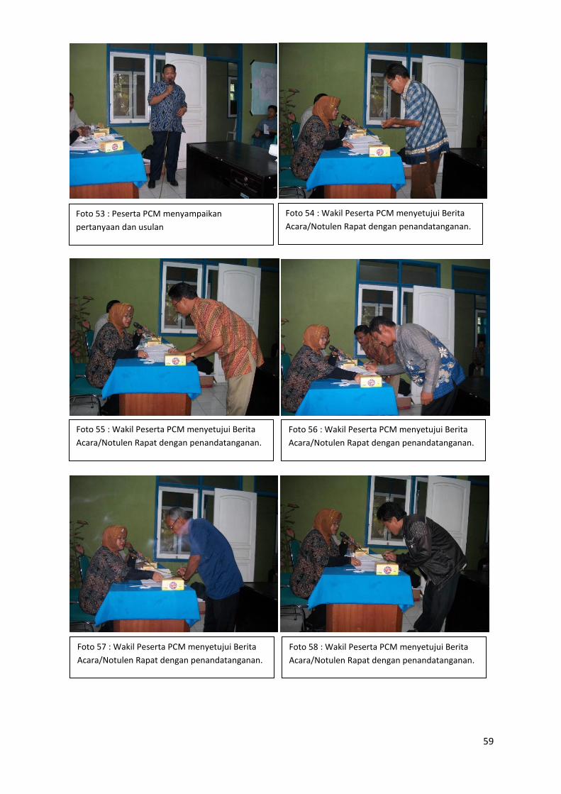
59
Foto 53 : Peserta PCM menyampaikan
pertanyaan dan usulan
Foto 54 : Wakil Peserta PCM menyetujui Berita
Acara/Notulen Rapat dengan penandatanganan.
Foto 56 : Wakil Peserta PCM menyetujui Berita
Acara/Notulen Rapat dengan penandatanganan.
Foto 55 : Wakil Peserta PCM menyetujui Berita
Acara/Notulen Rapat dengan penandatanganan.
Foto 58 : Wakil Peserta PCM menyetujui Berita
Acara/Notulen Rapat dengan penandatanganan.
Foto 57 : Wakil Peserta PCM menyetujui Berita
Acara/Notulen Rapat dengan penandatanganan.
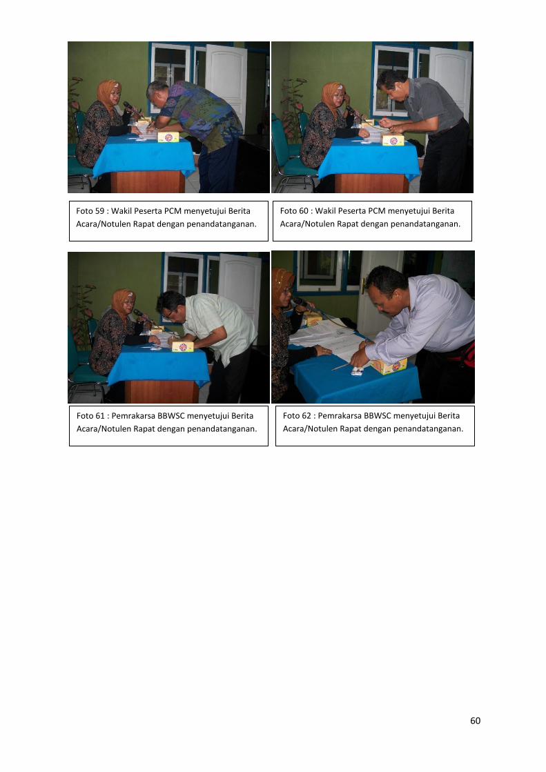
60
Foto 59 : Wakil Peserta PCM menyetujui Berita
Acara/Notulen Rapat dengan penandatanganan.
Foto 60 : Wakil Peserta PCM menyetujui Berita
Acara/Notulen Rapat dengan penandatanganan.
Foto 61 : Pemrakarsa BBWSC menyetujui Berita
Acara/Notulen Rapat dengan penandatanganan.
Foto 62 : Pemrakarsa BBWSC menyetujui Berita
Acara/Notulen Rapat dengan penandatanganan.