
Environmental Information Management and ... - trb.org · Transportation Research Board of the...
79
NCHRP Web Document 55 (Project B25-23): Contractor’s Final Report—Appendixes Environmental Information Management and Decision Support System Implementation Handbook—Appendixes B through F Prepared for: National Cooperative Highway Research Program Transportation Research Board of the National Academies Submitted by: Booz Allen Hamilton, Inc. McLean, Virginia Michael Baker Jr., Inc. Coraopolis, Pennsylvania March 2003
Transcript of Environmental Information Management and ... - trb.org · Transportation Research Board of the...

NCHRP Web Document 55 (Project B25-23): Contractor’s Final Report—Appendixes
Environmental Information Management and Decision
Support System Implementation Handbook—Appendixes B
through F
Prepared for: National Cooperative Highway Research Program
Transportation Research Board of the National Academies
Submitted by: Booz Allen Hamilton, Inc.
McLean, Virginia
Michael Baker Jr., Inc. Coraopolis, Pennsylvania
March 2003

ACKNOWLEDGMENT This work was sponsored by the American Association of State Highway and Transportation Officials (AASHTO), in cooperation with the Federal Highway Administration, and was conducted in the National Cooperative Highway Research Program (NCHRP), which is administered by the Transportation Research Board (TRB) of the National Academies.
DISCLAIMER The opinion and conclusions expressed or implied in the report are those of the research agency. They are not necessarily those of the TRB, the National Research Council, AASHTO, or the U.S. Government. This report has not been edited by TRB.

CONTENTS APPENDIX B. SURVEY RESULTS...........................................................................................B-1 APPENDIX C. USE CASES........................................................................................................ C-1 APPENDIX D. BEST PRACTICES...........................................................................................D-1 APPENDIX E. LAWS AND REGULATIONS.........................................................................E-1 APPENDIX F. DEFINITIONS OF ENTITIES .........................................................................F-1

Implementation Handbook for EIM&DSS Appendix B: Survey Results
B-1
Appendix B: Survey Results
Survey Response
On January 6, 2001, Booz·Allen mailed surveys to states and MPOs. The State surveys were distributed to American Association of State Highway and Transportation Officials (AASHTO) member states and selected affiliate organizations. The MPO survey was distributed to the Association of Metropolitan Planning Organizations (AMPO) mailing list. The state survey is included in Section B.2, and the MPO survey is included in Section B.3. The due date for the surveys was February 14th, although submissions received following that date were accepted as well. Several organizations still wish to provide feedback that will be accepted for Phase II of this project. The surveys received back in time for this interim report were:
Table 0-1: Summary of Survey Response
Distributed Received Comments
States 75 27
MPOs 613 53
Total 688 80
Some states provided multiple responses to either individual sections of the survey or multiple copies of the survey. In order to ensure that all organizations were given the same weighting, in these instances, the multiple submissions were combined where possible or not entered. Four provinces of Canada submitted surveys; these were each treated as states. The Port Authority of New York and New Jersey Illinois Toll Agency also submitted surveys and were counted as states. The former Director of the Pennsylvania Bureau of Environmental Quality submitted a survey and was counted as a state.
Where possible, survey results have been displayed as a total, and as a reflection of state vs. MPO responses. This Appendix is a preliminary analysis in support of the development of the general concept of operations. During Phase II, this data will be analyzed in more depth in order to prioritize requirements and define alternative implementation options.
Table 0-2: States Responding to Survey
State Name Notes Alaska Arizona California Canada Saskatchewan Canada New Brunswick Canada Quebec Canada Director, New Foundland & Labrador Hawaii Illinois Kansas Kentucky Maine Massachusetts Michigan Minnesota Missouri Nebraska Oklahoma Other New York/New Jersey Port Authority Other Former Director of PA Bureau of Env. Quality Other Illinois Tollway Pennsylvania South Carolina

Implementation Handbook for EIM&DSS Appendix B: Survey Results
B-2
State Name Notes Utah Washington West Virginia Wyoming
Table 0-3: MPOs Responding to Survey
MPO State Anderson Area Trans. Study South Carolina Ass'n of Central Ok Gov'ts Oklahoma Augusta Georgia Baltimore Regional Trans Board Maryland Bannock Planning Organization Idaho Baton Rouge Louisiana Biloxi/Gulfport & Pascagoula Mississippi Brownsville MPO Texas Bryan/College Station MPO Texas Calhoun Area MPO Alabama Capital Area (Raleigh) North Carolina Central Conn. Regional Planning Agency Connecticut Charlotte County Admin Center Florida Charlotte County Admin Center Florida Charlotte County Punta Gorda Florida Community Planning Association of Southwest Idaho Idaho Corpus Christi Texas Dover/Kent County Delaware Environmental Project Coordination Manager Illinois Fargo-Moorhead Metro Council of Gov'ts North Dakota Gadsden/Etowah Alabama Hampton Roads Virginia Harrisburg Pennsylvania High Pint North Carolina Indianapolis Indiana Jackson Mississippi Jackson Urban Area MPO Tennessee Killeen-Temple Texas Kyova Interstate Planning Commission West Virginia Las Cruces New Mexico Madison County Council of Gov'ts Indiana Maricopa Association of Governments Arizona

Implementation Handbook for EIM&DSS Appendix B: Survey Results
B-3
Metro. Transp. Commission (San Francisco Bay Area) California Metroplan Central Arkansas Miami Urbanized Area Florida Northeastern Indiana Regional Coord. Indiana Orlando Urbanized Area Florida Panama City, Fort Walton Beach, Pensacola Florida Puget Sound Regional Council Washington Rapid City Area South Dakota RI Statewide Planning Program Rhode Island Sarasota/Manatee Florida Semcog Michigan So California Association of Govt's. California So. California Association of Governments (SCAG) California St Cloud Minnesota Thurston Regional Planning Council Washington Wasatch Front Regional Council Utah West Memphis MPO Arkansas Wichita, Kansas Kansas Wichita/Sedgwick County Kansas Wilmington Are Planning Delaware York County Pennsylvania
General Analysis Features
Many of the results for the survey have been displayed in table format. In order to assist in identifying key data trends, the tables display values as follows:
Value ≥ 50%
26% - 49% ≤ 25%
EIM&DSS Characteristics Findings
Please rate on a scale of 1 to 5 how important it is for an EIM&DSS to have each of the following characteristics. If you do not have an opinion, please leave blank (Part 1, Question 1). Average Scores The following two charts display the average scores for each question in Part 1, Question 1. These average values were calculated for each question in two ways: • No zeros
A blank survey entry for a question counts as a zero. However, a zero cannot be read to mean unimportant, since that is what "1" was for; it can also mean that a user did not have enough information to rate the question. Averages in this category were calculated to show only the average value of people who actually entered a value for this entry.
• Zeros included To show the effect of non-entries on average values, averages in this category were calculated to show the overall average value for this question. Example 50 surveys were entered 27 people entered a value for question XXX Of those 27: 3 entered 1 9 entered 2 8 entered 3 6 entered 4 1 entered 5 No zeros average = 2.74 -- (1x3) + (2x9) + (3x8) + (4x6) + (5x1)/27 Zeros included = 1.48 -- (1x3) + (2x9) + (3x8) + (4x6) + (5x1)/50

Implementation Handbook for EIM&DSS Appendix B: Survey Results
B-4
Part 1, Question 1 - RequirementsAverage Scores
0
1
2
3
4
5Ex
isting
Leg
is. &
Reg
sPr
op'd
Legis
. & R
egs
Com
plian
cePe
rmits
Sche
dule
Site
Aud
itsBe
st M
gmt.
Prac
tices
Citiz
en In
volve
men
tPl
annin
gPr
ogra
mm
ingPr
ojects
Oper
ation
sM
ainte
nanc
eFr
eight
Mod
esPa
ssen
ger M
odes
Envir
onm
enta
l Are
asLin
ear &
Coo
rdina
te
Ave
rage
Sco
re
State Average Score (no zeros)State Average Score (zeros included)MPO Average Score (no zeros)MPO Average Score (zeros included)
Part 1, Question 1 - Requirements
Average Scores(cont.)
0
1
2
3
4
5
Map
s & L
inear
Log
sRD
BMS
Mult
imed
iaRe
mot
e Da
ta E
ntry
On-lin
e da
taba
ses
Inte
r-/In
tra-/E
xtran
ets
OLAP GI
S
ODBC
Alte
rnat
ive S
cena
rios
Sim
ulatio
n &
Mod
el Re
sults
DSS
with
in EI
M/D
SSIS
O 14
001
Env.
Lifec
ycle
Analy
sis
Econ
. Life
cycle
Ana
lysis
Ave
rage
Sco
re
State Average Score (no zeros)State Average Score (zeros included)MPO Average Score (no zeros)MPO Average Score (zeros included)
In general, when providing a value, States and MPOs tended to agree on the importance of the listed characteristic to the ultimate EIM&DSS. Both put high emphasis on projects, GIS, Internet/Intranet/Extranet availability, all major environmental areas, and RDBMSs. Lower emphasis was placed on remote data entry, proposed legislation and regulations, and OLAP. States tended to put more emphasis on the applicability of the system to operations and maintenance than did MPOs, while the MPOs tended to value Planning and Programming more than the States.

Implementation Handbook for EIM&DSS Appendix B: Survey Results
B-5
Part 1, Question 1 - RequirementsAverage Scores
0
1
2
3
4
5
Exist
ing L
egis.
& R
egs
Prop
'd Le
gis. &
Reg
sCo
mpli
ance
Perm
itsSc
hedu
leSi
te A
udits
Best
Mgm
t. Pr
actic
es
Citiz
en In
volve
men
tPl
annin
gPr
ogra
mm
ingPr
ojects
Oper
ation
sM
ainte
nanc
eFr
eight
Mod
es
Pass
enge
r Mod
es
Envir
onm
enta
l Are
as
Linea
r & C
oord
inate
Map
s & L
inear
Log
sRD
BMS
Mult
imed
ia
Rem
ote
Data
Ent
ry
On-lin
e da
taba
ses
Inte
r-/In
tra-/E
xtran
ets
OLAP GI
SOD
BC
Alte
rnat
ive S
cena
rios
Sim
ulatio
n &
Mod
el Re
sults
DSS
with
in EI
M/D
SSIS
O 14
001
Env.
Lifec
ycle
Analy
sis
Econ
. Life
cycle
Ana
lysis
Ave
rage
Sco
re
State Average Score (no zeros)MPO Average Score (no zeros)

Implementation Handbook for EIM&DSS Appendix B: Survey Results
B-6
State Breakdowns
The following chart provides a detailed breakdown of the weight States gave to each question when answering. Each bar displays the relative number of respondents that selected 1, 2, 3, 4, or 5 when answering each question.
Part 1, Question 1State
0%
20%
40%
60%
80%
100%
Exis
ting
Legi
s. &
Reg
s
Prop
'd L
egis
. & R
egs
Com
plia
nce
Perm
itsS
ched
ule
Site
Aud
its
Best
Mgm
t. P
ract
ices
Citi
zen
Invo
lvem
ent
Plan
ning
Pro
gram
min
gP
roje
cts
Ope
ratio
nsM
aint
enan
ceFr
eigh
t Mod
es
Pas
seng
er M
odes
Envi
ronm
enta
l Are
as
Line
ar &
Coo
rdin
ate
Map
s &
Line
ar L
ogs
RD
BMS
Mul
timed
ia
Rem
ote
Dat
a En
try
On-
line
data
base
s
Inte
r-/In
tra-/E
xtra
nets
OLA
P
GIS
OD
BC
Alte
rnat
ive
Sce
nario
s
Sim
ulat
ion
& M
odel
Res
ults
DS
S w
ithin
EIM
/DS
SIS
O 1
4001
Env
. Life
cycl
e An
alys
is
Eco
n. L
ifecy
cle
Ana
lysi
s
Question
% S
elec
tin
g E
ach
Val
ue
5
4
3
2
1
When States entered a value for a characteristic, it tended to be a higher one. Relatively few 1s and 2s were entered for any characteristic. Some items stand out as extremely important to the State survey respondents: • Projects • Environmental Areas • Maps and Linear Logs • RDBMSs • GIS. Items that were not rated extremely important by the States include: • Proposed legislation and regulations • Freight modes • Passenger modes.

Implementation Handbook for EIM&DSS Appendix B: Survey Results
B-7
MPO Breakdowns The following chart provides a detailed breakdown of the weight States gave to each question when answering. Each bar displays the relative number of respondents that selected 1, 2, 3, 4, or 5 when answering each question.
Part 1, Question 1MPO
0%
20%
40%
60%
80%
100%
Exis
ting
Legi
s. &
Reg
s
Prop
'd L
egis
. & R
egs
Com
plia
nce
Perm
itsS
ched
ule
Site
Aud
its
Best
Mgm
t. P
ract
ices
Citi
zen
Invo
lvem
ent
Plan
ning
Pro
gram
min
gP
roje
cts
Ope
ratio
nsM
aint
enan
ceFr
eigh
t Mod
es
Pas
seng
er M
odes
Envi
ronm
enta
l Are
as
Line
ar &
Coo
rdin
ate
Map
s &
Line
ar L
ogs
RD
BMS
Mul
timed
ia
Rem
ote
Dat
a En
try
On-
line
data
base
s
Inte
r-/In
tra-/E
xtra
nets
OLA
P
GIS
OD
BC
Alte
rnat
ive
Sce
nario
s
Sim
ulat
ion
& M
odel
Res
ults
DS
S w
ithin
EIM
/DS
SIS
O 1
4001
Env
. Life
cycl
e An
alys
is
Eco
n. L
ifecy
cle
Ana
lysi
s
Question
% S
elec
tin
g E
ach
Val
ue
5
4
3
2
1
When MPOs entered values for characteristics, they tended to be high, but not as high as the States' values. MPOs entered more 1s and 2s for characteristics. Some items stand out as extremely important to the MPO survey respondents: • Planning • Passenger modes • Environmental areas • Linear and Coordinate • Maps & Linear logs • Internet/Intranet/Extranet Availability • GIS. Items that were not rated extremely important by the MPOs include: • Proposed legislation and regulations • Site Audits • Operations • Maintenance • Economic Lifecycle analysis.

Implementation Handbook for EIM&DSS Appendix B: Survey Results
B-8
Individual Question Breakdowns Displays existing environmental legislation and regulations (p1_q1_a)
Existing Legis. & Regs.(A)
0%
25%
50%
75%
100%
State MPO Combined
% R
esp
on
din
g 54321
Displays information on proposed or projected environmental legislation & regulations (p1_q1_b)
Prop'd Legis. & Regs.(B)
0%
25%
50%
75%
100%
State MPO Combined
54321
Displays information on environmental compliance (p1_q1_c)
Compliance(C)
0%
25%
50%
75%
100%
State MPO Combined
54321
Displays information on permit requirements (p1_q1_d)
Permits(D)
0%
25%
50%
75%
100%
State MPO Combined
54321

Implementation Handbook for EIM&DSS Appendix B: Survey Results
B-9
Displays information on schedule and progress in obtaining permits (p1_q1_e)
Schedule(E)
0%
25%
50%
75%
100%
State MPO Combined
54321
Displays information regarding site audits (p1_q1_f)
Site Audits(F)
0%
25%
50%
75%
100%
State MPO Combined
54321
Displays information on best management practices (p1_q1_g)
Best Mgmt. Practices(G)
0%
25%
50%
75%
100%
State MPO Combined
54321
Displays information regarding citizen involvement including correspondence, comments on plans, and results of public hearings (p1_q1_h)
Citizen Involvement(H)
0%
25%
50%
75%
100%
State MPO Combined
54321

Implementation Handbook for EIM&DSS Appendix B: Survey Results
B-10
Applicable to planning (p1_q1_i)
Planning(I)
0%
25%
50%
75%
100%
State MPO Combined
54321
Applicable to programming (p1_q1_j)
Programming(J)
0%
25%
50%
75%
100%
State MPO Combined
54321
Applicable to projects (p1_q1_k)
Projects(K)
0%
25%
50%
75%
100%
State MPO Combined
54321
Applicable to operations (p1_q1_l)
Operations(L)
0%
25%
50%
75%
100%
State MPO Combined
54321

Implementation Handbook for EIM&DSS Appendix B: Survey Results
B-11
Applicable to maintenance (p1_q1_m)
Maintenance(M)
0%
25%
50%
75%
100%
State MPO Combined
54321
Addresses all freight modes (p1_q1_n)
Freight Modes(N)
0%
25%
50%
75%
100%
State MPO Combined
54321
Addresses all passenger modes (p1_q1_o)
Passenger Modes(O)
0%
25%
50%
75%
100%
State MPO Combined
54321
Addresses all major environmental areas (p1_q1_p)
Environmental Areas(P)
0%
25%
50%
75%
100%
State MPO Combined
54321

Implementation Handbook for EIM&DSS Appendix B: Survey Results
B-12
Supports linear (e.g., milepoint) and coordinate location referencing and conversion (p1_q1_q)
Linear & Coordinate(Q)
0%
25%
50%
75%
100%
State MPO Combined
54321
Supports display of environmental information in maps and linear logs (p1_q1_r)
Maps & Linear Logs(R)
0%
25%
50%
75%
100%
State MPO Combined
54321
Uses relational database management system or object/relational database (p1_q1_s)
RDBMS(S)
0%
25%
50%
75%
100%
State MPO Combined
54321
Permits the storage and retrieval of multimedia information (p1_q1_t)
Multimedia(T)
0%
25%
50%
75%
100%
State MPO Combined
54321

Implementation Handbook for EIM&DSS Appendix B: Survey Results
B-13
Supports remote data entry using a variety of technologies (p1_q1_u)
Remote Data Entry(U)
0%
25%
50%
75%
100%
State MPO Combined
54321
Supports connections with on-line databases (p1_q1_v)
On-line Databases(V)
0%
25%
50%
75%
100%
State MPO Combined
54321
Supports use over the internet/intranets/extranets (p1_q1_w)
Inter-/Intra-/Extranet(W)
0%
25%
50%
75%
100%
State MPO Combined
54321
Supports on-line analytic processing (p1_q1_x)
OLAP(X)
0%
25%
50%
75%
100%
State MPO Combined
54321

Implementation Handbook for EIM&DSS Appendix B: Survey Results
B-14
Capable of displaying information thematically in a GIS (p1_q1_y)
GIS(Y)
0%
25%
50%
75%
100%
State MPO Combined
54321
Uses Open Database Connectivity (ODBC) for information data transfer between relational data bases (p1_q1_z)
ODBC(Z)
0%
25%
50%
75%
100%
State MPO Combined
54321
Permits storage of alternative transportation and environmental simulation and decision support scenarios (p1_q1_aa)
Alternative Scenarios(AA)
0%
25%
50%
75%
100%
State MPO Combined
54321

Implementation Handbook for EIM&DSS Appendix B: Survey Results
B-15
Permits the storage of final and intermediate results obtained from other simulation and decision support and supports linking environmental impact analysis models or impact matrices to results (p1_q1_bb)
Simulation & Model Results(BB)
0%
25%
50%
75%
100%
State MPO Combined
54321
Allows the development of decision support or simulation modules/objects directly within the EIM&DSS (p1_q1_cc)
DSS within EIM/DSS(CC)
0%
25%
50%
75%
100%
State MPO Combined
54321
Satisfies the requirements of the ISO 14001 standard (p1_q1_dd)
ISO 14001(DD)
0%
25%
50%
75%
100%
State MPO Combined
54321

Implementation Handbook for EIM&DSS Appendix B: Survey Results
B-16
Supports environmental lifecycle analysis (p1_q1_ee)
Env. Lifecycle Analysis(EE)
0%
25%
50%
75%
100%
State MPO Combined
54321
Supports economic lifecycle analysis (p1_q1_ff)
Econ. Lifecycle Analysis(FF)
0%
25%
50%
75%
100%
State MPO Combined
54321

Implementation Handbook for EIM&DSS Appendix B: Survey Results
B-17
Place a check in those cells where you anticipate current and future information and decision support system (Part 1, Question 2). The following charts depict the percentage of respondents who indicated a current or future information or decision support need for each environmental, social, and economic area. The first chart shows the combined value placed by the States and MPOs, the second chart shows the States' responses, and the third chard shows the MPOs' responses. Overall, information needs were indicated more than decision support needs. High priority items included all Air Quality categories, economic growth, and land use. States tended to emphasize information needs, while MPOs had a less clear cut distinction between Information and Decision Support needs and tended to emphasize the categories more.
Environmental, Social, and Economic Area
Information Decision Support Information Decision Support Air Quality 75% 71% 73% 68% Water Quality 51% 38% 54% 44% Noise 51% 40% 60% 53% Hazardous Waste 45% 31% 50% 36% Solid Waste 40% 26% 40% 28% Wildlife 53% 34% 55% 44% Vegetation 45% 25% 46% 36% Wetland 61% 53% 59% 54% Parkland 53% 34% 58% 41% Environmental Justice 81% 65% 74% 63% Community Cohesion 49% 33% 60% 44% Aesthetics 43% 24% 45% 29% Urban Design 55% 29% 56% 36% Accessibility 70% 55% 64% 51% Mobility 70% 56% 65% 54% Economic Growth 74% 55% 70% 55% Residential Relocation 55% 31% 50% 30% Business Relocation 46% 26% 43% 28% Land Use 80% 69% 76% 68% Historic/Archeological 63% 48% 58% 43% Marine/Fisheries 30% 18% 34% 23% Stormwater/Drainage 59% 44% 54% 44% Civil Rights 50% 29% 50% 29% Abutter/Landowner 40% 18% 36% 21%
Current Environmental Assessment Needs
Future Environmental Assessment Needs
Combined

Implementation Handbook for EIM&DSS Appendix B: Survey Results
B-18
Environmental, Social,
and Economic Area Information Decision Support Information Decision Support
Air Quality 67% 67% 74% 70% Water Quality 63% 44% 63% 56% Noise 74% 67% 74% 67% Hazardous Waste 74% 48% 74% 56% Solid Waste 59% 41% 63% 44% Wildlife 70% 44% 74% 59% Vegetation 63% 30% 70% 48% Wetland 59% 63% 67% 67% Parkland 56% 41% 63% 48% Environmental Justice 74% 48% 70% 48% Community Cohesion 56% 33% 59% 44% Aesthetics 52% 37% 56% 44% Urban Design 56% 33% 59% 41% Accessibility 52% 41% 52% 41% Mobility 56% 48% 59% 52% Economic Growth 67% 52% 74% 59% Residential Relocation 59% 33% 59% 37% Business Relocation 56% 30% 56% 37% Land Use 74% 63% 70% 63% Historic/Archeological 70% 63% 67% 56% Marine/Fisheries 44% 19% 44% 26% Stormwater/Drainage 59% 56% 56% 59% Civil Rights 48% 26% 48% 22% Abutter/Landowner 52% 19% 48% 19%
State (Part 1, Question 2) Current Environmental Assessment
Needs Future Environmental Assessment
Needs

Implementation Handbook for EIM&DSS Appendix B: Survey Results
B-19
Environmental, Social,
and Economic Area Information Decision Support Information Decision Support
Air Quality 79% 74% 72% 66% Water Quality 45% 34% 49% 38% Noise 40% 26% 53% 45% Hazardous Waste 30% 23% 38% 26% Solid Waste 30% 19% 28% 19% Wildlife 43% 28% 45% 36% Vegetation 36% 23% 34% 30% Wetland 62% 47% 55% 47% Parkland 51% 30% 55% 38% Environmental Justice 85% 74% 75% 70% Community Cohesion 45% 32% 60% 43% Aesthetics 38% 17% 40% 21% Urban Design 55% 26% 55% 34% Accessibility 79% 62% 70% 57% Mobility 77% 60% 68% 55% Economic Growth 77% 57% 68% 53% Residential Relocation 53% 30% 45% 26% Business Relocation 42% 25% 36% 23% Land Use 83% 72% 79% 70% Historic/Archeological 58% 40% 53% 36% Marine/Fisheries 23% 17% 28% 21% Stormwater/Drainage 58% 38% 53% 36% Civil Rights 51% 30% 51% 32% Abutter/Landowner 34% 17% 30% 23%
MPO (Part 1, Question 2) Current Environmental Assessment
Needs Future Environmental Assessment
Needs

Implementation Handbook for EIM&DSS Appendix B: Survey Results
B-20
List the decision support systems or simulation models you currently use to estimate environmental impacts and for what levels of decision making you use them (Part 1, Question 3). Overall, there was a relatively low response rate on this question. Users who did select an impact area tended to enter multiple models for each impact area; to avoid displaying multiple responses on each survey for an impact area, the percentages calculated for each transportation lifecycle area were based only on the first response per impact areas. These numbers should be regarded as a preliminary reflection of decision support and simulation model system usage. States tended to use models for Air Quality and Noise, emphasizing planning and projects. MPOs tended to use models for Air Quality and Land Use, emphasizing planning. Some models stood out as used by multiple respondents from both States and MPOs: • Air Quality - Mobile • Noise - The Noise Model, Stamina • Wildlife - HEP.
Impact Plannin Programmin Project O&M
Land 29% 13% 14% 0% Air 38% 18% 24% 4% Water 8% 1% 11% 3% Noise 15% 5% 20% 4% Energ 5% 1% 3% 1% Economic 13% 5% 6% 0% Wildlife and 6% 3% 10% 0% Stormwater Management & 9% 1% 10% 5% Othe 15% 8% 13% 0%
Combine
Impact Plannin Programmin Project O&M
Land 15% 7% 15% 0% Air 37% 7% 48% 4% Water 11% 4% 30% 4% Noise 30% 15% 56 11% Energ 4% 0% 4% 4% Economic 4% 4% 7% 0% Wildlife and 11% 4% 22% 0% Stormwater Management & 15% 4% 22% 15% Othe 7% 7% 19% 0%
State (Part 1,
Impact Plannin Programmin Project O&M
Land 36% 15% 13% 0% Air 38% 23% 11% 4% Water 6% 0% 2% 2% Noise 8% 0% 2% 0% Energ 6% 2% 2% 0% Economic 17% 6% 6% 0% Wildlife and 4% 2% 4% 0% Stormwater Management & 6% 0% 4% 0% Othe 19% 8% 9% 0%
MPO (Part 1,

Implementation Handbook for EIM&DSS Appendix B: Survey Results
B-21
Do you have a GIS? If yes, do you have a database containing metadata? (Part 1, Question 5 State; Part 1 Question 4 MPO) As expected, the vast majority of States and MPOs indicated that they do have at least some form of a GIS, and half the MPOs indicated that they have a metadata database as well.
Table 0-4: State & MPO Response to GIS/Metadata Implementation
State MPO CombinedGIS 74% 92% 86%Metadata* NA 51% NA*Only asked on MPO survey
If yes, please provide a list of data coverages:
Table 0-5: State GIS Coverages
State GIS Coverages Arizona: Air Quality; Mapping for Transportation Assumptions; Population; Transportation Planning; Transportation Programming
Canada: GIS under development Canada: All infrastructures; population; specific industries; gravel reserves
Canada: CARIS; wetland information; geology; hydrogeology Canada: Highways Hawaii: Location of proposed developments. Brief information on the development Kansas: Historical; Archeology; Soils; Wetland; Cultural Habitat; Streams; Tiger Files; Land Cover
Kentucky: Soils; Archaeology; Wetlands; Endangered Species; NWI; Historic (Underway); Geology
Maine: Roads; Streams; Hydric Soils; NWI Maps; Surficial geology; Coastal characterization; Census data; Cover Type Massachusetts: Roadway Functional Classification; Access Control; Bridges; Railroads; Active Construction Projects; Dept. Maintenance Facilities; Water Supply Resources; Ortho-photos; Rare & Endangered Species; District-County-RPA-RTA-Legislative Boundaries
Michigan: Numerous
Missouri: Travelways; Bridge Locations; Census Data; Cemeteries; Public Lands; Land Use; Soils; Geology; Floodplains; Land Cover; Wetlands; Watersheds; Streams; Lakes; Sensitive Species; Habitats
Oklahoma: GIS is in development stage. Env. Data is not included in years 1-3 Other: Populations; major structures; zoning & land use; vegetation; CERCLA/RCRA Other: Cultural Resources - Location and Significance; Wetlands - USFWS Wetlands Mapping; PA Natural Diversity Index; Census Data; PA Fish and Wildlife Data Base; Underground Storage Tank Inventory
Other: T&E; wetlands; high quality wetlands; special waste; land use; ground cover; floodway/floodplain; forest preserves; natural areas; nature preserves; cultural sites; rail; road; municipal/county boundaries; rivers/lakes/streams; aerial photography; etc.
Pennsylvania: Wetlands; Archeological

Implementation Handbook for EIM&DSS Appendix B: Survey Results
B-22
State GIS Coverages South Carolina: GIS is developed by our planning office. Coverages include most natural/human resources.
Utah: Cultural Resources; Demographics; Wetlands
Washington: See attached list. Also archeology data model being developed. State transportation network; wildlife and fish habitats/species; hydrography; incorporated cities & counties; digital elevation models; (30M&10M) water quality impairments; fish passage barriers; stormwater outfalls; ground & surface water protection zones
Table 0-6: MPO GIS Coverages
MPO GIS Coverages Anderson Area Trans. Study (South Carolina) : Streams and waterbodies, zoning, land use (present & projected) parks, population by density & income Do not have geology, wetlands, hazardous waste sites, and wildlife
Ass'n of Central Ok Gov'ts (Oklahoma) : Population, employment, land use at traffic zone level
Augusta (Georgia) : Hydrology, topo, wetland, transportation, land use, drainage basin, zoning. Baltimore Regional Trans Board (Maryland) : Demographic, environmental, transportation, infrastructure, travel and demand forecasting model networks, land use, municipalities transit, census boundaries zip code boundaries, TAZZ boundaries, hydro features, state and county boundaries, crime statistics, designated "smart growth" areas.
Bannock Planning Organization (Idaho) : Population, employment, transportation
Baton Rouge (Louisiana) : Population employment housing school attendance
Biloxi/Gulfport & Pascagoula (Mississippi) : Population; land use; wetlands; traffic count; functional classified roads zoning; social economics; flood plain/FEMA
Brownsville MPO (Texas) : Streets, parcels, resacas (bodies of H20) canals, and ditches
Bryan/College Station MPO (Texas) : Roads, hydrology, zoning, building permits, and land use
Calhoun Area MPO (Alabama) : Wetlands; Historic Areas; Cemeteries; Slope; Sink Holes
Capital Area (Raleigh) (North Carolina) : Land use type, zoning pop & emp., DMV records, historic properties, wetlands, income, racial data, parks, streams, streets, rail lines and flow date
Central Conn. Regional Planning Agency (Connecticut) : Census data; Wetlands; Land Use; Zoning; Geology; Transportation; Pavement Management
Charlotte County Punta Gorda (Florida) : Public lands, strategic habitat conservation areas, listed species site., scrub jay metapopulations, flood plain, watersheds, wetlands, regionally-significant natural resources, specifically designated watersheds/waterbodies, coastal high hazards, storm surge, urban service area (inc infill), tar valuation for EJ) address coverage for EJ client matching neighborhoods, historic places, parks, Taz with population, regional trails, hazardous waste sites, churches.
Community Planning Association of Southwest Idaho (Idaho) : Basemap, flood plain, TAZ, zoning

Implementation Handbook for EIM&DSS Appendix B: Survey Results
B-23
MPO GIS Coverages Corpus Christi (Texas) : Land Use and Demographic Data
Dover/Kent County (Delaware) : Population, employment, land use, zoning transportation systems.
Fargo-Moorhead Metro Council of Gov'ts (North Dakota) : Centerline, sails, wetlands, hist/Arch, land use, row, utilities floodplanning
Gadsden/Etowah (Alabama) : Street, Wetlands, Soils, Hydro., parks, city limits, railroads.
Hampton Roads (Virginia) : NWI, Flood Data, Soils Data, Landuse, Shoreline, Traffic Counts
High Pint (North Carolina) : Land use, wetlands, historic properties, etc.
Indianapolis (Indiana) : Population, employment, household income and transportation network attributes
Jackson (Mississippi) : Population, dwelling units school enrollment, employment by place of work, floodplains/wetlands, permanent condition, traffic volumes, traffic capacities
Jackson Urban Area MPO (Tennessee) : Population, soil types, landuse, flood plain, and wetlands
Killeen-Temple (Texas) : Land use, population, employment, and hydrology
Kyova Interstate Planning Commission (West Virginia) : Environmental Justice, Average Daily Traffic, Traffic Analysis Zones(TAZs), all the information that can be obtained from the TIGER files from the US Census Bureau
Las Cruces (New Mexico) : Census, districts (City Council, schools, congressional). Truck and Bus Routes, streets, zoning, land use
Madison County Council of Gov'ts (Indiana) : Census, Topo, Soils, Wetlands, Traffic, Storm water
Maricopa Association of Governments (Arizona) : Street centerlines, land use, population, employment housing units, census geography, land features.
Metro. Transp. Commission (San Francisco Bay Area) (California) : Census geography & demographic data; disadvantaged areas; zip codes; legislative districts; transportation networks; water features; landmarks & cultural features; travel analysis zones (TAZ); super districts; MTZ's Metropolitan Transportation System (MTS); open space; farmlands; digital orthophotquartenquad (DOQQ) images; digital elevation models (DEM); Transportation Improvement Program (TIP) projects; cities; counties; urbanized areas
Metroplan Central (Arkansas) : Roads, land use, digital elevation hydro., rails, zoning, political subdivisions, steep slopes, flood plains, bridges, census geography, traffic zones, land cover, LandSAT TM imagery soils, cultural features, parks, forests, military reservations, sewerage, water service, goods movement, features.
Miami Urbanized Area (Florida) : Transportation-related data: social-economic data transit, traffic, A/Q, bicycle/pedestrian, roadway systems, pedestrian craster The FSUTMS-based transportation network (roadways & transit) for the simulation model and TAZ based demographic data are the primary analytic tools. GIS, per se, is not used for most analyses, though country-wide GIS, with roads, infrastructure, and a variety of shape file is available. The MPO Bike/red program Uses Arc-View GIS to map variety of items relevant to their program.
Orlando Urbanized Area (Florida) : Population Employment, Land Use, Wetlands, Jurisdictional Boundaries

Implementation Handbook for EIM&DSS Appendix B: Survey Results
B-24
MPO GIS Coverages Panama City, Fort Walton Beach, Pensacola (Florida) : We have all the data coverages that the University of Florida GeoPlan Center has on County CD's https://www.geoplan, ufl.EDU
Rapid City Area (South Dakota) : Ortho photography, geology, soils, land use, zoning, floodplain, water & sewer, streets
RI Statewide Planning Program (Rhode Island) : See Attached Semcog (Michigan) : Roads, rails, crashes, trans., projects, land use, land cover, population, other census data, hydro, community/economic development info. Intermodal facilities, more
So California Association of Govt's. (California) : Various, land use, vegetation, hydrology, sails geology, and wetlands
So. California Association of Governments (SCAG) (California) : Have 2,400+ coverages, including census; existing land use; general plan land use; environmental; political coverages
St Cloud (Minnesota) : Wetlands, soils, land use, roads, sensitive environmental areas, tazs, lakes and rivers.
Wasatch Front Regional Council (Utah) : Population, slope, dwelling units, water bodies, master plans, wetlands, income, schools, employment
West Memphis MPO (Arkansas) : In beginning stages of establishing GIS for our area.
Wichita, Kansas (Kansas) : Dwelling Units, Soils, Rivers and Streams, Streets and Highways, Groundwater Pollution Sites
Wichita/Sedgwick County (Kansas) : Dwelling units, soils, rivers, and streams. Streets and Highways, ground water, pollution sites
Wilmington Are Planning (Delaware) : Population, employment, highway, and rail system, governmental boundaries, and land use
York County (Pennsylvania) : Population, land uses, geology, wetlands
What do you think are the metadata requirements of an EIM&DSS?
Table 0-7: MPO Metadata Coverages
MPO Metadata Coverages Anderson Area Trans. Study (South Carolina) : Projection, source, dates, methodology, coverages
Augusta (Georgia) : Accuracy, precision Biloxi/Gulfport & Pascagoula (Mississippi) : The parameters; accuracy of data and what it can be used for Bryan/College Station MPO (Texas) : For some coverages we have such metadata but not all
Capital Area (Raleigh) (North Carolina) : five, format, source, update, contents, type (linear, point, area) Charlotte County Punta Gorda (Florida) : Field definitions, category definitions, source with email address, scale of source data, date of data, date of data entry
Community Planning Association of Southwest Idaho (Idaho) : Date of data, scale

Implementation Handbook for EIM&DSS Appendix B: Survey Results
B-25
MPO Metadata Coverages Corpus Christi (Texas) : Important for decision making and planning Hampton Roads (Virginia) : Same as standard requirements associated with any components of an EIM & DSS Indianapolis (Indiana) : Good idea
Killeen-Temple (Texas) : Unknown Las Cruces (New Mexico) : Unknown
Madison County Council of Gov'ts (Indiana) : Critical & Very Essential Maricopa Association of Governments (Arizona) : A thorough metadata database would be required.
Metroplan Central (Arkansas) : Service, date, accuracy, contact person/agency, format, type/description Miami Urbanized Area (Florida) : Apart from technical data structure attributes, source as well as dates, quality etc should be included
Panama City, Fort Walton Beach, Pensacola (Florida) : Sources of data, dates, quality of data, contact person Puget Sound Regional Council (Washington) : The system would need to be well documented RI Statewide Planning Program (Rhode Island) : See Attached RIGIS Standards
So California Association of Govt's. (California) : Similar to GIS So. California Association of Governments (SCAG) (California) : in beta test
St Cloud (Minnesota) : Must be seamless with national standards.

Implementation Handbook for EIM&DSS Appendix B: Survey Results
B-26
Do you maintain SOPs and/or flowcharts for each of the following (Part 1, Question 6 State; Part 1 Question 5 MPO): The majority of respondents did not keep an SOP and/or flowchart for Significant Operational and Maintenance Enhancements. About half the State respondents keep SOPs and/or flowcharts for Long Range and Transportation Improvement Plans and Major Projects and Investments. The majority of the MPOs kept SOPs and/or flowcharts for Long Range and Transportation Improvement Plans, fewer for Major Projects and Investments.
Table 0-8: State & MPO Flowcharts Response
Flowchart State MPO CombineLong Range 41% 75 64S/TI 48% 75 66Major Projects & 52 34% 40%Significant Operational 19% 11% 14%Significant Maintenance 15% 9% 11%

Implementation Handbook for EIM&DSS Appendix B: Survey Results
B-27
Do you have any suggestions regarding how an EIM&DSS could improve the business process in order to reduce delay in decision making (Part 1, Question 7 State; Part 1 Question 6 MPO)?
Table 0-9: State EIM&DSS Suggestions
State EIM&DSS Suggestions Arizona: Centralizing the data for all of the issues that have been described would greatly improve the processes.
Canada: By integrating all environmental analysis phases in the global decision process. However it requires changes in the methods of doing business. Illinois: Project Development would include the appropriate information to identify issues/resources to make modifications for better projects; Data validation with error notification would be helpful; Sharing information electronically is faster and more accurate.
Kentucky: Not at this time. Oklahoma: A methodology for comparing different impacts would be useful. I.e., is it more detrimental to impact a haz. waste site, or a archeological site?
Other: Include a model which attempts to convey values for what has been in the past only qualitatively provided: Ex: public access = $ per person use, area of total wetlands = $, Tree = $ Quantify externalized environmental elements in $$
Other: Improve data collection analysis and management; Make information readily available and improve communications; Make document preparation efficient; Reduce paper; Move toward collaborative decision making and away from reactive decision making
South Carolina: A support system that outlined the entire project development process and associated time frames for completion of activities would show the areas of concern. These areas could be broken down into constituent parts for further analysis. This would show whether delays were caused by internal or external decision-making processes.
Utah: Provide a data layer similar to ArcView, this would assist in analysis and presentation. Washington: We are currently conducting a needs assessment for an EMS for WSDOT. We believe such a system can help by improving access to information on environmental regulations and processes, clarify training requirements, institutionalize and standardize use of environmental data, and provide reports on compliance, mitigation commitments, and permitting time lines that can lead to improvements in delivery schedules, cost estimates, and environmental outcomes.
Table 0-10: MDO EIM&DSS Suggestions
MPO EIM&DSS Suggestions Anderson Area Trans. Study (South Carolina) : We simply do not have enough information to make informed decisions with regards to environmental impacts. We don't see those until the EIS stage which is often too late. I have a background in Environmental Science & Economics and therefore sensitive to these issues my predecessors were not.
Augusta (Georgia) : Stakeholder friendly system
Brownsville MPO (Texas) : May help Bryan/College Station MPO (Texas) : No comment other than from the jargon in this survey I still have had a hard time understanding the scope of your proposed EIM &DSS. Charlotte County Punta Gorda (Florida) : Early involvement of resource agencies common environmental database for transportation and resource agencies, involvement of MPOs in initial NEPA stages

Implementation Handbook for EIM&DSS Appendix B: Survey Results
B-28
MPO EIM&DSS Suggestions Corpus Christi (Texas) : When the results of data models analyzed through rules and policies would provide information that will help in planning, programming, and decision making
Dover/Kent County (Delaware) : Require State DOTS to share information at the project level more frequently with the MPO. Fargo-Moorhead Metro Council of Gov'ts (North Dakota) : No Hampton Roads (Virginia) : No Harrisburg (Pennsylvania) : Please do not assume all agencies operate at maximum tech. Efficiency or use same tech. Develop a "Decision Support System" that keeps politics to a minimum! High Pint (North Carolina) : No Jackson (Mississippi) : Operational enhancements = Cong. Manage System Transportation maintenance program = Pavement Manage System Jackson Urban Area MPO (Tennessee) : Such a system could help identify possible environmental impacts early in the process and allow for possible changes in design, if feasible Killeen-Temple (Texas) : No Las Cruces (New Mexico) : None Madison County Council of Gov'ts (Indiana) : No suggestions at this time. Maricopa Association of Governments (Arizona) : The availability of EIM&DSS might result in a marginal reduction in the time required to perform technical environmental studies.
Panama City, Fort Walton Beach, Pensacola (Florida) : We are working with FOOT to develop Florida's Environ. Streamlining Process. I see the 2 processes being similar. If a good and acceptable EIM&DSS were in use, MPOs will use it while developing concepts for the long range trans. Plan. Information on projects and impacts could be used by the MPO to screen projects. The database would then be forwarded to environmental resource agencies to initiate early involvement and an early environ. Screening. As the MPO refines project concepts, with the assistance of the early environ. Screening , a second better screening takes place as the project is identified in the "Trans. Improv. Prog "Early involvement, project screening and building of a project database which is electronically transmitted and reviewed will improve (decrease) delays of viable trans. Projects.
Puget Sound Regional Council (Washington) : Streamline the information system. Identify the cost to maintain the system and ways to minimize costs.
So California Association of Govt's. (California) : Ensure project development and implementation process incorporates and utilities available environmental regulatory compliance procedures in pre-planning activities St Cloud (Minnesota) : It could reduce time gathering data if maintained properly to keep information up- to- date. It could also help streamline environmental analysis for corridor studies.
Thurston Regional Planning Council (Washington) : Monitor progress of project applications and prompt reminders. York County (Pennsylvania) : None
Implementation Handbook for EIM&DSS Appendix B: Survey Results
B-29
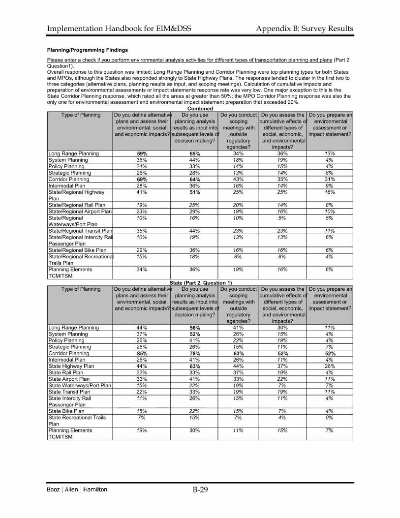
Planning/Programming Findings
Please enter a check if you perform environmental analysis activities for different types of transportation planning and plans (Part 2 Question1). Overall response to this question was limited; Long Range Planning and Corridor Planning were top planning types for both States and MPOs, although the States also responded strongly to State Highway Plans. The responses tended to cluster in the first two to three categories (alternative plans, planning results as input, and scoping meetings). Calculation of cumulative impacts and preparation of environmental assessments or impact statements response rate was very low. One major exception to this is the State Corridor Planning response, which rated all the areas at greater than 50%; the MPO Corridor Planning response was also the only one for environmental assessment and environmental impact statement preparation that exceeded 20%.
Type of Planning Do you define alternative plans and assess their environmental, social,
and economic impacts?
Do you use planning analysis
results as input into subsequent levels of
decision making?
Do you conduct scoping
meetings with outside
regulatory agencies?
Do you assess the cumulative effects of
different types of social, economic, and environmental
impacts?
Do you prepare an environmental
assessment or impact statement?
Long Range Planning 59% 65% 34% 36% 13% System Planning 36% 44% 18% 19% 4% Policy Planning 24% 33% 14% 15% 4% Strategic Planning 26% 28% 13% 14% 8% Corridor Planning 69% 64% 43% 35% 31% Intermodal Plan 28% 36% 16% 14% 9% State/Regional Highway Plan
41% 51% 25% 25% 16% State/Regional Rail Plan 19% 25% 20% 14% 8% State/Regional Airport Plan 23% 29% 19% 16% 10% State/Regional Waterways/Port Plan
10% 16% 10% 5% 5% State/Regional Transit Plan 35% 44% 23% 23% 11% State/Regional Intercity Rail Passenger Plan
10% 19% 13% 13% 6% State/Regional Bike Plan 29% 36% 16% 16% 6% State/Regional Recreational Trails Plan
15% 18% 8% 8% 4% Planning Elements TCM/TSM
34% 36% 19% 16% 6%
Combined
Type of Planning Do you define alternative plans and assess their environmental, social,
and economic impacts?
Do you use planning analysis
results as input into subsequent levels of
decision making?
Do you conduct scoping
meetings with outside
regulatory agencies?
Do you assess the cumulative effects of
different types of social, economic, and environmental
impacts?
Do you prepare an environmental
assessment or impact statement?
Long Range Planning 44% 56% 41% 30% 11% System Planning 37% 52% 26% 15% 4% Policy Planning 26% 41% 22% 19% 4% Strategic Planning 26% 26% 15% 11% 7% Corridor Planning 85% 78% 63% 52% 52% Intermodal Plan 26% 41% 26% 11% 4% State Highway Plan 44% 63% 44% 37% 26% State Rail Plan 22% 33% 37% 19% 4% State Airport Plan 33% 41% 33% 22% 11% State Waterways/Port Plan 15% 22% 19% 7% 7% State Transit Plan 22% 33% 19% 19% 11% State Intercity Rail Passenger Plan
11% 26% 15% 11% 4% State Bike Plan 15% 22% 15% 7% 4% State Recreational Trails Plan
7% 15% 7% 4% 0% Planning Elements TCM/TSM
19% 30% 11% 15% 7%
State (Part 2, Question 1)

Implementation Handbook for EIM&DSS Appendix B: Survey Results
B-30
Type of Planning Do you define alternative
plans and assess their environmental, social,
and economic impacts?
Do you use planning analysis
results as input into subsequent levels of
decision making?
Do you conduct scoping
meetings with outside
regulatory agencies?
Do you assess the cumulative effects of
different types of social, economic, and environmental
impacts?
Do you prepare an environmental
assessment or impact statement?
Long Range Planning 66% 70% 30% 40% 13% System Planning 36% 40% 13% 21% 4% Policy Planning 23% 28% 9% 13% 4% Strategic Planning 26% 28% 11% 15% 8% Corridor Planning 60% 57% 32% 26% 21% Intermodal Plan 28% 34% 11% 15% 11% Regional Highway Plan 40% 45% 15% 19% 11% Regional Rail Plan 17% 21% 11% 11% 9% Regional Airport Plan 17% 23% 11% 13% 9% Regional Waterways/Port Plan
8% 13% 6% 4% 4% Regional Transit Plan 42% 49% 25% 25% 11% Regional Intercity Rail Passenger Plan
9% 15% 11% 13% 8% Regional Bike Plan 36% 43% 17% 21% 8% Regional Recreational Trails Plan
19% 19% 8% 9% 6% Planning Elements TCM/TSM
42% 40% 23% 17% 6%
MPO (Part 2, Question 1)

Implementation Handbook for EIM&DSS Appendix B: Survey Results
B-31
Please enter a check if you perform environmental analysis activities for different types of transportation programming and programs (Part 3, Question 1 State; Part 2, Question2). States tended to answer this question at greater rates than the MPOs. The only category for States which displayed a greater than 50% response rate for any of the programming types was using programming analysis input results as input into subsequent levels of decision making. MPOs' greatest emphasis, which never exceeded 35% was on Transportation Improvement Programs, and the responses were fairly evenly spread across the categories, with the exception of environmental assessments or impact statements.
Type of Programming Do you define alternative programs
and assess their environmental, social,
and economic impacts?
Do you use programming analysis results as input into subsequent levels of
decision making?
Do you conduct scoping
meetings with outside
regulatory agencies?
Do you assess the cumulative effects of
different types of social, economic, and environmental
impacts?
Do you prepare an
environmental assessment or
impact statement?
State Transportation Improvement Program (STIP)*
NA NA NA NA NA
Metropolitan Transportation Improvement Program (TIP)
31% 43% 29% 24% 8%
Modal Programs 21% 29% 16% 15% 11% Other Specific Programs 4% 6% 6% 1% 0% *Only asked on State survey
Combined
Type of Programming Do you define alternative programs
and assess their environmental, social,
and economic impacts?
Do you use programming analysis results as input into subsequent levels of
decision making?
Do you conduct scoping
meetings with outside
regulatory agencies?
Do you assess the cumulative effects of
different types of social, economic, and environmental
impacts?
Do you prepare an
environmental assessment or
impact statement?
State Transportation Improvement Program (STIP)*
33% 74% 41% 33% 19%
Metropolitan Transportation Improvement Program (TIP)
33% 59% 30% 37% 11%
Modal Programs 26% 44% 19% 19% 15% Other Specific Programs 7% 15% 11% 4% 0% *Only asked on State survey
STATE (Part 3, Question 1)
Type of Programming Do you define alternative programs
and assess their environmental, social,
and economic impacts?
Do you use programming analysis results as input into subsequent levels of
decision making?
Do you conduct scoping
meetings with outside
regulatory agencies?
Do you assess the cumulative effects of
different types of social, economic, and environmental
impacts?
Do you prepare an
environmental assessment or
impact statement?
Metropolitan Transportation Improvement Program (TIP)
30% 34% 28% 17% 6%
Modal Programs 19% 21% 15% 13% 9% Other Specific Programs 2% 2% 4% 0% 0%
MPO (Part 2, Question 2)

Implementation Handbook for EIM&DSS Appendix B: Survey Results
B-32
Do you hold public hearings or meetings on all types of plans/programs listed above (Part 2 Question 2 and Part 3 Question 2 State; Part 2 Question 3 MPO)? This question asked respondents if they held hearings for the entire list of plans/programs rather than checking each category individually. Less than 50% of States indicated that they did hold hearings for all, most used the next question to list specifically the items that provoked hearings for them. The majority of MPOs indicated that they do hold hearings and meetings for all plans and programs.
Table 0-11: State & MPO Response to Planning Hearings/Meetings
Hearings/Meetings State MPO CombinedPlanning* 44% NA NAProgramming Hearings* 33% NA NATotal Hearings (Average) 39% 72% 61%*Distinction drawn only on State Survey
If not, list those types of plans/programs for which you do hold public hearings or meetings.
Table 0-12: State Response to Plans and Programs
State Plan Hearings California TSIP input is provided to the "Lead Agency" to hold required meetings or hearings Canada 1 where public so desires Canada 2 road construction Corridor Planning bridge projects Ferry services Canada 3 Corridor Planning Kentucky State Waterways Plan Long Range System Policy Intermodal State Highway Missouri Hold meetings as part of the STIP comments. Do not hold public hearings until have a project. Nebraska State Airport Plan Long Range Plan State Rail Plan State Highway Plans Corridor Plans Oklahoma Corridor plans Other 1 Environmental Assessments Environmental Impact Statements

Implementation Handbook for EIM&DSS Appendix B: Survey Results
B-33
State Plan Hearings Corridor Planning Other 2 Those requiring consensus due to political press Those mandated by law or regulation Utah Recreational Trails State Airport & Transit Strategic Planning Policy Planning West Virginia Corridor plans Wyoming Corridor Planning
State Program Hearings Canada1 ferries bridges corridors Canada2 Project specific transportation improvements Other1 Major Improvements Other2 Politically sensitive - consensus building is imp. As required by law or regulation South Carolina Modal Programs - Transit, Bicycle Metro TIPs State TIP Utah STIP Workshops on a Region Level New Projects for New Corridors West Virginia STIP MTIP
Table 0-13: MPO Response to Plans and Programs
MPO Planning/Programming Hearings Calhoun Area MPO (AL) TIP lRTP Paratransit Plan Sec. 5307 Application/Program Metro. Transp. Commission (San Francisco Bay Area) (CA) Long Range Planning Corridor Planning Regional Airport Plan Regional Waterways and/or Port Plan

Implementation Handbook for EIM&DSS Appendix B: Survey Results
B-34
MPO Planning/Programming Hearings TCM/ISM Metropolitan TIP Dover/Kent County (DE) Transportation Improvement Program High Pint(NC) MTIP Brownsville MPO (TX) MTP Metro Transportation Plan TIP Hampton Roads (VA) Regional Highway Plan Regional Transit Plan Regional Bike Plan TIP Augusta (GA) Plans for public mtg is req. as a cond. Baltimore Regional Trans Board (MD) TIP Long Range Plan Bicycle, Pedestrian and Greenway Plan Semcog (MI) Transit TIP Long Range Plan Corridor Studies Panama City, Fort Walton Beach, Pensacola (FL) The MPO holds meetings and public hearings on those planning activities which are checked Puget Sound Regional Council (WA) TIP Modal Programs (as part of Long Range Plan) Corpus Christi (TX) Metropolitan Trans. Plan (Long Range Plan) Transportation Improvement Program Thurston Regional Planning Council (WA) Long Range Regional Plan

Implementation Handbook for EIM&DSS Appendix B: Survey Results
B-35
Please check which models, management systems, and decision support systems you currently use to support the planning or programming process. The Standard 4-Step Transportation model received very strong responses from both the States and the MPOs. In addition, the States had high responses on Pavement and Bridge Management Systems, while the MPOs tended to focus on Traffic Simulation models. Neither group entered many checks for using the outputs from these models for environmental analysis, except for the Standard 4-Step model.
Model Do you use for planning or programming?
In the planning or programming process, do you use environmental analysis outputs from the
model/system or use the model/system outputs as input into environmental simulation models?
Standard 4-Step 79% 38% Traffic Simulation Models 39% 16% ITS Deployment Analysis System 20% 6% Highway Performance Monitoring System 36% 10% Highway Economic Requirements System 4% 0% Pavement Management System 34% 2% Bridge Management System 26% 2% Intermodal Management System 13% 2% Public Transit Management System 16% 1% Congestion Management System 42% 7% Maintenance Management System NA NA
Combined
Model Do you use for planning or programming?
In the planning or programming process, do you use environmental analysis outputs from the
model/system or use the model/system outputs as input into environmental simulation models?
Standard 4-Step 52% 22% Traffic Simulation Models 35% 11% ITS Deployment Analysis System 19% 6% Highway Performance Monitoring System 43% 11% Highway Economic Requirements System 6% 0% Pavement Management System 61% 6% Bridge Management System 63% 6% Intermodal Management System 15% 6% Public Transit Management System 17% 2% Congestion Management System 39% 9% Maintenance Management System* 11% 0% *State Programming Section only
State (Part 2, Question 3/Part 3, Question 3 - Average)
Model Do you use for planning or programming?
In the planning or programming process, do you use environmental analysis outputs from the
model/system or use the model/system outputs as input into environmental simulation models?
Standard 4-Step 92% 45% Traffic Simulation Models 42% 19% ITS Deployment Analysis System 21% 6% Highway Performance Monitoring System 32% 9% Highway Economic Requirements System 4% 0% Pavement Management System 21% 0% Bridge Management System 8% 0% Intermodal Management System 11% 0% Public Transit Management System 15% 0% Congestion Management System 43% 6%
MPO (Part 2, Question 3)

Implementation Handbook for EIM&DSS Appendix B: Survey Results
B-36
Project Development Findings
For each social, economic, and environmental area, please place a check in those cells where you anticipate your current and future needs for information and for environmental outputs from decision support systems (Part 4, Question 1 State). State respondents tended to emphasize the importance of environmental areas such as air quality, hazardous waste, and land use over the social areas such as community cohesion, aesthetics, and urban design. Economic areas such as economic growth and residential and business relocation were less heavily emphasized but still received around 40% responses. A notable exceptions to the lower social ratings trend is the historic/archeological area; two-thirds of respondents valued it. These findings are consistent with the Part 1 findings that emphasized the importance of covering all environmental areas for an EIM&DSS.
Environmental, Social, and Economic Area
Information Decision Support Information Decision Support
Air Quality 63% 63% 70% 70%Water Quality 59% 52% 63% 59%Noise 70% 67% 67% 70%Hazardous Waste 70% 44% 70% 52%Solid Waste 59% 33% 59% 41%Wildlife 63% 56% 63% 56%Vegetation 59% 44% 59% 52%Wetland 59% 59% 59% 63%Parkland 56% 41% 56% 44%Environmental Justice 52% 44% 48% 41%Community Cohesion 48% 26% 44% 33%Aesthetics 44% 33% 52% 41%Urban Design 37% 26% 41% 30%Accessibility 48% 30% 44% 41%Mobility 41% 33% 44% 44%Economic Growth 52% 33% 52% 44%Residential Relocation 44% 41% 44% 44%Business Relocation 44% 37% 44% 41%Land Use 70% 56% 67% 70%Historic/Archeological 67% 67% 67% 67%Marine/Fisheries 44% 30% 44% 33%Stormwater/Drainage 59% 67% 63% 67%Civil Rights 41% 26% 33% 22%Abutter/Landowner 44% 33% 41% 37%
State* (Part 4, Question 1)
*This section was not included on the MPO survey.
Current Environmental Assessment Needs
Future Environmental Assessment Needs

Implementation Handbook for EIM&DSS Appendix B: Survey Results
B-37
Operations Findings
Please enter a check in those cells where you anticipate your current and future needs for environmental information and environmental outputs linked to decision support systems for operations (Part 5, Question 1 State; Part 3, Question 1 MPO). States rated these areas fairly evenly, placing a slight emphasis on Intelligent Transportation System needs in the future. MPOs echoed the States' responses, with a slightly lower level of importance granted to each operations area.
Environmental, Social, and Economic Area
Information Decision Support Information Decision SupportIncident Management 43% 30% 38% 34%Intelligent Transportation Systems 53% 43% 59% 50%Traffic Signal Control 35% 28% 34% 26%
Current Environmental Assessment Needs
Future Environmental Assessment Needs
Combined
Environmental, Social, and Economic Area
Information Decision Support Information Decision SupportIncident Management 48% 41% 48% 52%Intelligent Transportation Systems 52% 44% 67% 56%Traffic Signal Control 44% 30% 48% 33%
State (Part 5, Question 1)Current Environmental Assessment
NeedsFuture Environmental Assessment
Needs
Environmental, Social, and Economic Area
Information Decision Support Information Decision Support Incident Management 40% 25% 32% 25% Intelligent Transportation Systems 53% 42% 55% 47% Traffic Signal Control 30% 26% 26% 23%
MPO (Part 3, Question 1) Current Environmental Assessment
Needs Future Environmental Assessment
Needs

Implementation Handbook for EIM&DSS Appendix B: Survey Results
B-38
If there were five types of information you could obtain from an EIM&DSS to support operations, what would they be (Part 5, Question 2 State)?
Table 0-14: State Operations Suggestions
State Operations Suggestions Alaska Real-time city-wide transportation MOEs Air quality in non attainment zones Real-time weather along transportation corridors MOEs: throughput, total delay, average speed, etc. Arizona Air Quality Information (Best Practices) ITS Enhancements Incident Management Enhancements State of the art traffic controls Transp.Planning & Env processes (best Practices) Canada 1 vehicle noise pollution env cost of congestion (vehicle delays) water, air & soil contamination from gravel pit op environmental cost of vehicle collision cleanup env cost of dangerous goods spills Kentucky Air quality analysis Maine Air Quality improvements by implementing ITS proj. Massachusetts Changes in environmental laws (Fed. & State) Road waste disposal costs Road waste disposal locations Winter materials effects - new products Classification of road waste Missouri Vehicle Noise-Typ Values & Acc Model Tool Vehicle Fuel Consump-Typ. Values & Acc. Model Tool Vehicle Emiss-Typical Values & Accurate Model Tool Nebraska Sign Inventory with low-impact data gathering reqs Freeway Operations Management Oklahoma Effects of ITS components given: Relationship of speeds to emissions (user costs) Emission changes as result of capacity restriction geometrics, volumes, exist emiss Predict improvement to air based on ea type of ITS component added Dynamic sim model-scenarios lane closure/user cost Other 1 Underground Storage Tank Mitigation - runoff, noise, walls, wetlands Mitigation Commitment & Tracking/Implementation Waste Streams Facilities (Storage, Equipment, Maintenance) Other 2 Comparison of __ with similar facilities nationwide Breakout of classification of facility patronage

Implementation Handbook for EIM&DSS Appendix B: Survey Results
B-39
State Operations Suggestions Sensitivity analysis of facility patronage Regression anal. of correlating factors of patron. Analysis of ___ reports for patterns Pennsylvania Impact of ITS Projects/Applications on Air Quality HAZMAT/MSDS Information South Carolina Env impact of coord signal control vs non-coord Env effects of incident management program Washington Compliance tracking Permit Schedules Environmental procedures Points of contact BMPs West Virginia Traffic simulation Air quality Accessibility Wyoming Quantify impacts - delay, congestion, queue length Alternate routing if possible

Implementation Handbook for EIM&DSS Appendix B: Survey Results
B-40
Maintenance Findings
Please enter a check in those cells where you anticipate your current and future needs for environmental information and environmental outputs linked to decision support systems for maintenance (Part 6, Question 1 State; Part 3 Question 1 MPO). States showed a far greater interest in maintenance topics than MPOs did. The only issues that MPOs rated greater than a 25% response rate was ITS maintenance. ITS maintenance was important to States, but bridge, landscaping, and other vegetation management were among the others that were rated higher.
Environmental, Social, and Economic Area
Information Decision Support Information Decision Support Pavement Maintenance 24% 25% 23% 23% Shoulder Maintenance 18% 19% 16% 20% Bridge Maintenance 29% 26% 21% 21% Landscaping 25% 15% 24% 15% Other Vegetation Management 23% 19% 21% 21% Signs, Striping, and Markings 23% 21% 18% 15% Drainage 23% 19% 23% 19% Ice and Snow Control 23% 19% 23% 24% Rest Area Maintenance 11% 11% 9% 11% Signal Maintenance 21% 13% 16% 10% ITS Equipment Maintenance 45% 33% 45% 35% Safety Feature Maintenance 13% 10% 10% 9%
Combined Current Environmental Assessment
Needs Future Environmental Assessment
Needs
Environmental, Social, and Economic Area
Information Decision Support Information Decision Support Pavement Maintenance 22% 30% 22% 37% Shoulder Maintenance 37% 44% 37% 52% Bridge Maintenance 44% 44% 37% 48% Landscaping 48% 33% 44% 37% Other Vegetation Management 48% 44% 44% 52% Signs, Striping, and Markings 33% 33% 30% 30% Drainage 44% 41% 37% 44% Ice and Snow Control 56% 48% 52% 59% Rest Area Maintenance 26% 26% 22% 30% Signal Maintenance 19% 11% 15% 7% ITS Equipment Maintenance 30% 15% 26% 11% Safety Feature Maintenance 22% 19% 22% 19%
State (Part 6, Question 1) Current Environmental Assessment
Needs Future Environmental Assessment
Needs
Environmental, Social, and Economic Area
Information Decision Support Information Decision Support Pavement Maintenance 25% 23% 23% 15% Shoulder Maintenance 8% 6% 6% 4% Bridge Maintenance 21% 17% 13% 8% Landscaping 13% 6% 13% 4% Other Vegetation Management 9% 6% 9% 6% Signs, Striping, and Markings 17% 15% 11% 8% Drainage 11% 8% 15% 6% Ice and Snow Control 6% 4% 8% 6% Rest Area Maintenance 4% 4% 2% 2% Signal Maintenance 23% 13% 17% 11% ITS Equipment Maintenance 53% 42% 55% 47% Safety Feature Maintenance 8% 6% 4% 4%
Current Environmental Assessment Needs
Future Environmental Assessment Needs
MPO (Part 3, Question 1)

Implementation Handbook for EIM&DSS Appendix B: Survey Results
B-41
Information Technology Findings
Please provide more information on systems that are in place today that either address or are beginning to address the requirements listed below (Part 7, Question 1 State; Part 4, Question 1 MPO). Overall, there was a relatively low response rate on this question. Users who did select system areas tended to enter multiple systems for each; to avoid displaying multiple responses on each survey for an system area, the percentages calculated for each transportation lifecycle area were based only on the first response per system areas. These numbers should be regarded as a preliminary reflection of true system usage. It is suspected that these results under-represent actual system usage, as many respondents declined to provide data for this section. The only truly universally reported system usage was for GIS, as has been reflected in earlier sections of the survey. States tended to report more system usage than MPOs, but both generally had response rates well below 50%.
System Plannin Programmin Project O&M
Data Exchange/Electronic Data 28% 20% 18% 8% Collaboration/Information 21% 15% 16% 10% Document 14% 11% 13% 10% Records 5% 5% 8% 1% Workflow 9% 8% 9% 4% Enterprise Application 13% 13% 13% 10% Business 5% 4% 4% 4% Reportin 9% 8% 9% 4% GIS 45% 30% 28% 10% Public 24% 14% 23% 6%
Combine
System Plannin Programmin Project O&M
Data Exchange/Electronic Data 30% 19% 30% 19% Collaboration/Information 33% 33% 37% 26% Document 30% 26% 30% 30% Records 11% 11% 19% 4% Workflow 22% 19% 22% 11% Enterprise Application 26% 30% 30% 30% Business 15% 11% 11% 11% Reportin 19% 22% 26% 11% GIS 52 44% 44% 15% Public 33% 30% 41% 15%
State (Part 7,
System Plannin Programmin Project O&MData Exchange/Electronic Data 26% 21% 11% 2% Collaboration/Information 15% 6% 6% 2% Document 6% 4% 4% 0% Records 2% 2% 2% 0% Workflow 2% 2% 2% 0% Enterprise Application 6% 4% 4% 0% Business 0% 0% 0% 0% Reportin 4% 0% 0% 0% GIS 42% 23% 19% 8% Public 19% 6% 13% 2%
MPO (Part 4,

Implementation Handbook for EIM&DSS Appendix C: Use Cases
C-1
Appendix C: Use Cases
CODE USER USE CASE A USE CASE B USE CASE C USE CASE D
General G1 Chief
Administrative Officer
Participates in legislative hearing – Responds to questions regarding environmental impacts of plans, programs, and major projects
Makes budget recommendation–Obtains answers to questions regarding politically sensitive environmental issues related to budget options
Makes major decisions on plans, programs, projects, operations, and maintenance – Uses information on environmental, social, and economic impacts to make decisions
Sets performance goals and objectives and monitors progress – Examines changes in performance based on transportation and environmental related outcome, output, and input measures
G2 Deputy Commissioners
Interact with constituents – Respond to transportation and environmental related issues or questions in person, by phone, by letter, or by e-mail
Interact with legislators – Respond to transportation and environmental related issues or questions at hearings, in meetings, by phone, by letter, or by e-mail.
Query project status – Determine if project is in planning, design or development stage and obtain information on environmental and other factors that may affect timely development and impacts of project
Help develop policy, plans, programs, and projects – Query information from a variety of sources (Executive Information System, reports) and help build support, remove barriers, increase benefits, reduce costs, and minimize adverse impacts
G3 Assistant CAO (e.g. Assistant Secretary)
Interacts with constituents - Responds to transportation and environmental related issues or questions in person, by phone or by letter, or by e-mail
Interacts with legislators - Responds to transportation and environmental related issues or questions in person, by phone, by letter, or by e-mail
Supports budget and program development – Draws on budget and program data to helps develop policy framework for budget including responsiveness to environmental issues
Helps address important urgent issues – Draws on real time data and regulatory information, compliance information, and analysis to responds to a wide variety of urgent problems including emergencies and contentious regulatory compliance and permit issues
G4 Elected Official Drafts law – Interacts with department in person, by telephone, via letters, or by e-mail on legislative proposals, including those with environmental ramifications.
Requests special study - Asks legislative research bureau to prepare a report on environmental related issue that requires departmental environmental data
Coordinates among government jurisdiction – Develops relationships, agreements, and partnerships among jurisdictions that require negotiation regarding environmental issues described in memos, reports, and databases.
Inquires on project status – Asks for information regarding project in his/her jurisdiction including status
G5 Public Interest Group/Industry Association
Advocates environmental positions – Communicates to DOT officials in person, by phone, by letter, e-mail and in public forums positions on various environmental issues, laws, and regulatory requirements.
Educates decision makers – Provides information and clarification in person, by phone by letter, by e-mail and in public forums regarding environmental impacts and impacts of environmental regulations in support of their positions.
Conducts analysis – Uses information from Department (e.g. Internet, published reports) and other sources to provide analysis in support of their positions.

Implementation Handbook for EIM&DSS Appendix C: Use Cases
C-2
CODE USER USE CASE A USE CASE B USE CASE C USE CASE D
G6 Citizen Advocates environmental positions -- Communicates to DOT officials in person, by phone, by letter, e-mail and in public forums position on various environmental issues, laws, and regulatory requirements.
Reacts to planned or proposed projects in his/her back door – Seeks clarification regarding direct or indirect impacts and responds in person, by phone, by letter, e-mail or in public forums.
Accesses information – Uses the internet to obtain plans, programs, Environmental Impact Statements, and other information regarding transportation actions and their environmental, social and economic impacts.
Makes service requests – Using the phone or e-mail, requests a specific service (e.g. more timely snow removal, need for noise attenuation) or reports a problem such as a stop sign knocked down or a tree fallen in the road.
G7 State Engineer Plan and implement Highway Program – Develop project planning, design and construction schedule including satisfaction of all environmental permit and regulatory requirements
Monitor progress in implementing highway program – Query status of projects including attainment of environmental permits and satisfaction of regulatory requirements
Oversee all project planning and design work – Approve all design manuals and procedures, including those pertaining to design features that affect the environment. Address major planning and design issues that affect environmental, social, and economic impacts, enhancement and mitigation.
Oversee contracting for construction, reconstruction, rehabilitation, and restoration projects – Approve all environmental related contract clauses.
G8 District Director Interacts with constituents - Responds to transportation and environmental related issues or questions in person, in meetings, hearings, by phone, by letter, or by e-mail
Develops district element of statewide plans – Provides input regarding district elements of statewide strategic, policy, system, modal or other plans by taking into account existing and planned facilities, public and industry input, and environmental issues.
Develops district element of statewide programs – Retrieves previous year district program from database and refines it based on department direction, taking into account performance goals and objectives, including environmental performance targets.
Responsible for operations and maintenance in districts – Uses real time traffic, fleet, environmental (ozone alerts) and weather data to help manage daily operations. Also collects feature inventory, condition, and environmental related data to support maintenance and operations.
G9 Head, Pavement Management
Develops, refines, and runs the Pavement Management System – Analyzes short, mid and long term network level strategies for pavement management, some of which have environmental ramifications (e.g. recycling and reuse of waste materials, drainage)
Helps develop pavement preservation program – Analyzes effect of different program levels and pavement treatments on system preservation and other issues including environmental (e.g. recycling and reuse of waste materials, drainage). Basis for many preservation projects included in the STIP, which is subject to air quality conformity analysis.
Provides input to analysis pavement preservation actions – Draws information from the Pavement Management System, GIS, roadway feature and condition inventory, and other sources to provide input for project level pavement preservation actions.
Prepares presentation materials on pavement for top management – Draws on PMS/GIS to prepare maps showing pavement condition (poor, fair, good) for presentation to legislators, top management, and attendees of meetings and hearings.

Implementation Handbook for EIM&DSS Appendix C: Use Cases
C-3
CODE USER USE CASE A USE CASE B USE CASE C USE CASE D
G10 State Bridge Engineer
Prepares bridge program– Develops bridge program using a variety of inputs including results from a bridge management system. Considers environmental impacts and protection costs in program development. Basis for bridge projects that are included in the STIP.
Bridge Project Development – Responsible for design, construction, and rehabilitation of structures, including obtaining water quality permits and mitigating environmental impacts.
Bridge Maintenance – Oversees key elements of bridge maintenance program including lead paint removal and repainting.
Develops bridge environmental mitigation program – Helps develop program for mitigation of adverse environmental effects of bridge work including lead paint removal, preservation of historic bridges, and avoiding adverse water quality impacts.
G11 Materials Research Engineer
Develops specifications for pavements and bridges – Conducts research and analysis, including assessment of environmental impacts, to support development of method and material specifications, including recycled and reused materials.
Performs assessment of materials performance – Accesses data base regarding historical field performance of different types of materials, including effects external factors (w
Design experiments to test pavement performance – Develops and implements experimental designs to take into account important factors (weather, terrain, environment, pavement treatment) to assess pavement performance.
G12 Head of Modal Bureau (e.g. rail, air, transit, ports and waterways)
Develops modal plan – Defines and analyzes alternative plans, draws on bureau data, GIS and other sources for information, and exercises transportation planning and environmental simulation models.
Develops modal program – Iteratively develops recommended program size and composition, possibly involving analysis of program options, by drawing on program data in a database.
Develops modal projects – Defines and analyzes alternative project concepts, possibly as a part of major investment study and EIS, by drawing on GIS and exercising transportation and environmental simulation models.
Support modal operations and maintenance
G13 Chief of Environmental Management Office
Participates in regulatory compliance determinations – Draws on document database and other sources to compare planning activities with regional, state and federal planning and environmental requirements
Approves state policy, procedures and guidance – Signs policy manuals, policies and procedures, and guidance documents concerning environmental analysis and management at the planning level.
Participates in scoping and tiering discussions with environmental agencies – Helps the department obtain agreement with environmental and regulatory agencies regarding the scope and detail of transportation plans and how the analysis will tier to lower-level program, project, and O&M analysis.
Approves all environmental related clauses in department contracts
G14 Outside Environmental Agency Official (U.S. EPA, state environmental agency)
Monitors compliance with laws and regulations – Accesses information (by Internet, e-mail, regular mail, etc., in person) on transportation department plans, programs, projects, operations and maintenance, including environmental performance measures (pollution concentrations, emissions) to determine compliance with laws and regulations.
Represents environmental interests and policy from federal or statewide point of view – Communicates by letter, e-mail, in person, or in meetings, issues that the agency is responsible for addressing under its mission.
Participates in scoping and tiering discussions with environmental agencies – Helps the department obtain agreement with environmental and regulatory agencies regarding the scope and detail of transportation plans and how the analysis will tier to lower-level program, project, and O&M analysis.
Obtains input from transportation agencies on proposed environmental regulations that may have an impact on transportation plans, programs, projects, operations, and maintenance – Receives from transportation agencies suggestions and comments in the form of letters, reports, e-mail, etc. regarding proposed laws and regulations.

Implementation Handbook for EIM&DSS Appendix C: Use Cases
C-4
CODE USER USE CASE A USE CASE B USE CASE C USE CASE D
G15 Environmental, Social or Economic Analyst (inhouse)
Analyzes alternative plans, programs, projects, and operations or maintenance actions – Accesses information from various databases, Internet, Intranet, GIS, document management system, etc., to use as input for conducting analysis. Also exercises appropriate simulation models (air quality, noise, water quality, land use) and related management systems (e.g. ITS Deployment Analysis System, Bridge Management System, Intermodal Management System) to obtain predicted transportation and environmental impacts.
Makes presentations on environmental, social, and economic impacts of specific projects.
Analyzes direct and indirect (secondary) as well as cumulative impacts – Accesses GIS and databases regarding impacts, uses spreadsheets or other software to sum up impacts to obtain measures of cumulative effects, and uses various qualitative and quantitative analytic procedures and models to asses indirect and secondary impacts.
G16 Environmental, Social or Economic Analyst (consultant)
Analyzes alternative plans, programs, projects, and operations or maintenance actions – Given password authorization, accesses through the Internet information from various department databases, GIS, document management system, etc., to use as input for conducting analysis. Also exercises appropriate simulation models (air quality, noise, water quality, land use) and related management systems (e.g. ITS Deployment Analysis System, Bridge Management System, Intermodal Management System) to obtain predicted transportation and environmental impacts.
Makes presentations on environmental, social, and economic impacts of specific projects.
Analyzes direct and indirect (secondary) as well as cumulative impacts – Given password authorization, accesses though the Internet GIS and databases regarding impacts. Uses spreadsheets or other software to sum up impacts to obtain measures of cumulative effects, and uses various qualitative and quantitative analytic procedures and models to asses indirect and secondary impacts.
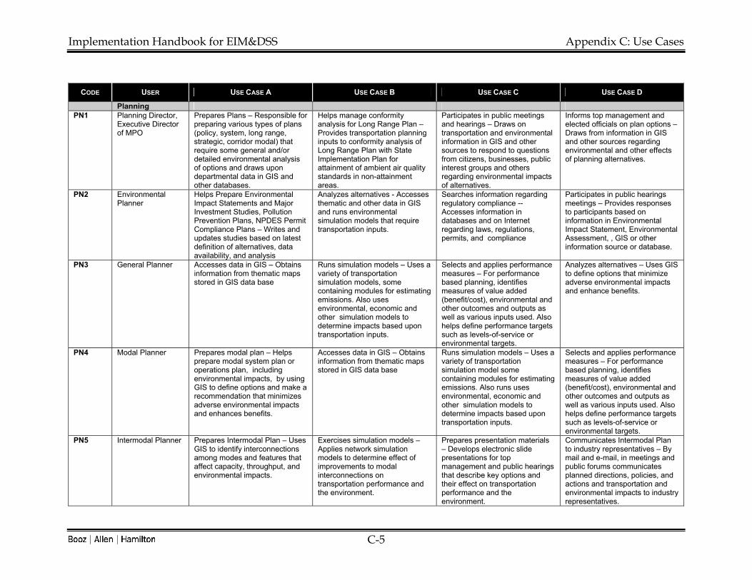
Implementation Handbook for EIM&DSS Appendix C: Use Cases
C-5
CODE USER USE CASE A USE CASE B USE CASE C USE CASE D
Planning PN1 Planning Director,
Executive Director of MPO
Prepares Plans – Responsible for preparing various types of plans (policy, system, long range, strategic, corridor modal) that require some general and/or detailed environmental analysis of options and draws upon departmental data in GIS and other databases.
Helps manage conformity analysis for Long Range Plan – Provides transportation planning inputs to conformity analysis of Long Range Plan with State Implementation Plan for attainment of ambient air quality standards in non-attainment areas.
Participates in public meetings and hearings – Draws on transportation and environmental information in GIS and other sources to respond to questions from citizens, businesses, public interest groups and others regarding environmental impacts of alternatives.
Informs top management and elected officials on plan options – Draws from information in GIS and other sources regarding environmental and other effects of planning alternatives.
PN2 Environmental Planner
Helps Prepare Environmental Impact Statements and Major Investment Studies, Pollution Prevention Plans, NPDES Permit Compliance Plans – Writes and updates studies based on latest definition of alternatives, data availability, and analysis
Analyzes alternatives - Accesses thematic and other data in GIS and runs environmental simulation models that require transportation inputs.
Searches information regarding regulatory compliance -- Accesses information in databases and on Internet regarding laws, regulations, permits, and compliance
Participates in public hearings meetings – Provides responses to participants based on information in Environmental Impact Statement, Environmental Assessment, , GIS or other information source or database.
PN3 General Planner Accesses data in GIS – Obtains information from thematic maps stored in GIS data base
Runs simulation models – Uses a variety of transportation simulation models, some containing modules for estimating emissions. Also uses environmental, economic and other simulation models to determine impacts based upon transportation inputs.
Selects and applies performance measures – For performance based planning, identifies measures of value added (benefit/cost), environmental and other outcomes and outputs as well as various inputs used. Also helps define performance targets such as levels-of-service or environmental targets.
Analyzes alternatives – Uses GIS to define options that minimize adverse environmental impacts and enhance benefits.
PN4 Modal Planner Prepares modal plan – Helps prepare modal system plan or operations plan, including environmental impacts, by using GIS to define options and make a recommendation that minimizes adverse environmental impacts and enhances benefits.
Accesses data in GIS – Obtains information from thematic maps stored in GIS data base
Runs simulation models – Uses a variety of transportation simulation model some containing modules for estimating emissions. Also runs uses environmental, economic and other simulation models to determine impacts based upon transportation inputs.
Selects and applies performance measures – For performance based planning, identifies measures of value added (benefit/cost), environmental and other outcomes and outputs as well as various inputs used. Also helps define performance targets such as levels-of-service or environmental targets.
PN5 Intermodal Planner Prepares Intermodal Plan – Uses GIS to identify interconnections among modes and features that affect capacity, throughput, and environmental impacts.
Exercises simulation models – Applies network simulation models to determine effect of improvements to modal interconnections on transportation performance and the environment.
Prepares presentation materials – Develops electronic slide presentations for top management and public hearings that describe key options and their effect on transportation performance and the environment.
Communicates Intermodal Plan to industry representatives – By mail and e-mail, in meetings and public forums communicates planned directions, policies, and actions and transportation and environmental impacts to industry representatives.

Implementation Handbook for EIM&DSS Appendix C: Use Cases
C-6
CODE USER USE CASE A USE CASE B USE CASE C USE CASE D
PN6 Chief of Right-of-Way
Views information on ROW usage -- Consults database for information regarding current and planned uses of existing rights of way as well as rights of way that will be acquired in the future.
Accesses contracts and agreements regarding use of public rights of way – Accesses document data base regarding leases, easements, licenses, franchises or other arrangements granting access to public rights-of-way to public utilities, telecommunications companies, pipelines, railroads, etc.
Manages relocation of residences and businesses in future transportation rights-of-way. Accesses GIS and other data for information on property values, and status of property to be acquired or sold as well as correspondence with affected residents and businesses.
Programming PG1 Director of Budget
and Finance Prepares budget options –Assesses the effect of alternative funding levels on program delivery by accessing information on composition and impacts of various transportation programs.
Analyzes sources of revenues – Revenue sources may include such actions as value (congestion) pricing and emissions testing which will have impacts on the environment.
Allocates approved budget – Allocations will go to program areas that will have specific environmental, social, and economic impacts.
PG2 Manager of Program Development
Analyzes program recommendations – Assess packages of packages and specific programs of key managers throughout the department and develops a recommended program and budget for approval of top management
Prepares Transportation Improvement Program (STIP) – Accesses database containing all program categories and all projects or activities within each program area and compiles a program plan listing each project or activity, location, cost, funding sources, and implementation schedule, status, and other data (environmental, permit requirements, public involvement)
Participates in conformity determination – Provides input into the determination of conformity of the STIP with the State Implementation Plan (SIP) for attainment of National Ambient Air Quality Standards for non-attainment areas.
Participates in scoping and tiering meetings – Helps define how environmental analysis will tier from program level evaluation to project, maintenance, or operations level. May requires access to program and project level environmental analysis.
PG3 Program Managers Develop program recommendations – Compile packages of projects or activities within a specific program area, assess program options including environmental effects and prepare recommendation for incorporation in overall department program and budget. Program detail includes a listing of each project or activity, location, funding sources, schedule, and status including if EIS completed.
Access information on program composition – Consult database containing list of projects or activities in program, including activities that affect the environment or are a consequence of environmental regulations.

Implementation Handbook for EIM&DSS Appendix C: Use Cases
C-7
CODE USER USE CASE A USE CASE B USE CASE C USE CASE D
Project Development
PJ1 Planning Engineer Participates in scoping meetings – Accesses digital photographs, GIS and other documents pertinent to discussion with other agencies regarding scoping process.
Helps prepares Corridor or Major Investment Study – Draws on GIS and other transportation and environmental data to identify alternatives and uses output of transportation and environmental simulation models to analyze alternatives, as well as performs benefit-cost analysis of options.
Helps prepare Environmental Impact Statement -- Draws on GIS and other transportation and environmental data to identify alternatives and uses output of transportation and environmental simulation models to analyze alternatives, as well as performs benefit-cost analysis of options.
Accesses information on project status – Draws on GIS, document management system, project tracking system, preconstruction management system, and/or construction management system to obtain information about current project status including phase of development, status regarding obtaining permits, and agreements with environmental agencies regarding planned mitigation actions.
PJ2 Design Engineer Prepares project design – Uses Computer Aided Design and Drafting to access, modify, and store plan sheets, photogrammetry, and specifications.
Participates in Public meetings or hearings – Draws on GIS, data bases, digital photographs, and impact analysis to communicate design features and impacts of alternatives to affected citizens, businesses, and public interest groups
Often serves as project manager -- responsible for alternatives analysis, EIS development, etc.
PJ3 Consultant Designer
Prepares project design – Uses Computer Aided Design and Drafting to access, modify, and store plan sheets, photogrammetry, and specifications.
Participates in Public meetings or hearings – Draws on GIS, data bases, digital photographs, and impact analysis to communicate design features and impacts of alternatives to affected citizens, businesses, and public interest groups
Helps analyze alternatives and prepare EIS
PJ4 Project Engineer Manages project development -- Accesses information on project schedule, expenditures, status, design, environmental, social, and economic impacts, agreements, correspondence and other related information.
Participates in Public meetings or hearings – Draws on GIS, data bases, digital photographs, and impact analysis to communicate design features and impacts of alternatives to affected citizens, businesses, and public interest groups.

Implementation Handbook for EIM&DSS Appendix C: Use Cases
C-8
CODE USER USE CASE A USE CASE B USE CASE C USE CASE D
PJ5 Project Inspectors Inspects projects as they are built – Accesses construction management system with bid items and fills out daily inspector reports, as well as ensures compliance with permit requirements and OSHA regulations.
Operations O1 Chief of Operations Has overall responsibility for
traffic operations – Uses information, including environmental data, to establish policies and business processes for managing operations.
Oversees development of plan and program recommendations for operations – Uses information on traffic, freeway and arterial signal management, transit performance, incident response, emergency management, and Intelligent Transportation Systems in order to analyze and develop plan and program recommendations.
Accesses information on hazardous waste transportation – Able to access information on historical and current (including real time) information regarding hazardous waste transportation. May works with local agencies as a part of Operations Respond which enables emergency response teams to view in real time data on the contents of railroad cars, including hazardous materials.
Uses real time information to respond to incidents and emergencies -- Accesses information on status of incidents from CCTV, traffic sensors, Road and Weather Information Systems (RWIS), environmental sensors, GIS databases, and Automated Vehicle Identification Systems.
O2 Traffic/Systems Engineer
Evaluates traffic signal warrants – Accesses information on traffic volumes, capacity, and environmental hot-spot data to determine if traffic signals are needed and if there is a need to mitigate air quality hot spots.
Designs and implements ITS – Uses systems design tools and simulation models to design ITS systems to improve transportation capacity utilization and reduce emissions.
Oversees traffic signal installation, timing, and upgrades – Accesses document management system and traffic signal management system to obtain plan sheets and controller specifications in order to install and time signals so as to maximize throughout put and minimize hot spot problems.
O3 Traffic Operations Center Manager
Disseminates information on traffic conditions – Accesses real time information on traffic and environmental conditions (e.g. ozone levels) and communicates to the public through various channels (Internet, variable message signs, highway advisory radio, kiosks, ISPs, radio & TV broadcasters)
Helps manage incident response – Plays key role in dispatching safety service vehicles and public safety officials to respond to incidents and emergencies, and assesses presence and response to hazardous spills.

Implementation Handbook for EIM&DSS Appendix C: Use Cases
C-9
CODE USER USE CASE A USE CASE B USE CASE C USE CASE D
Maintenance M1 State Maintenance
Engineer Develops recommended statewide budget, program, annual work plan – Works with maintenance planner in headquarters and districts to compile recommended program, budget, and annual work plan using a Maintenance Management System, historical funding levels, and other inputs including Bridge Management System, Pavement Management System, and changes in maintenance practices required by environmental regulations or being implemented under a philosophy of environmental stewardship.
Establishes key environmental policy issues related to maintenance – Approves policies and procedures concerning environmental issues related to maintenance, possibly including manual on good or best practices.
Makes broad decisions of statewide consequence regarding maintenance work methods, occupational safety, and environmental protection and enhancement – Approves standard work methods for different types of maintenance, including types of labor, equipment and material will be used, and occupational safety and environmental protection and enhancement procedures.
Plays key role in establishing maintenance performance measures and monitoring achievement of targets– Establishes customer-oriented outcome measures (levels of service), output measures, and measures of resource usage, including environmental related measures (e.g. tons of salt applied, salt concentration along roadsides).
M2 District Maintenance Engineer
Develops recommended district maintenance budget, program, annual work plan – Works with maintenance planner in headquarters and districts to compile recommended program, budget, and annual work plan using a Maintenance Management System, historical funding levels, and other inputs including Bridge Management System, Pavement Management System, and changes in maintenance practices required by environmental regulations or being implemented under a philosophy of environmental stewardship.
Interacts with citizens and business regarding district maintenance issues – In person, in meetings, by phone, by letter, and by e-mail addresses a broad range of maintenance issues, including environmental concerns.
Monitors attainment of level-of service goals for the district and the difference between planned and completed – Keeps an eye on district performance measures regarding levels of service, condition of maintenance assets, and any environmental related performance measures. Also periodically reviews reports from the Maintenance Management System to identify performance and expenditure problems including those related to environmental issues (e.g. effect of higher-cost, environmental friendly materials on budget balances).
Ensures compliance with environmental regulations for maintenance shops – Enforces compliance with for handling of used oil, spills, wash water, storage of salt, etc. in maintenance facilities throughout the District.
M3 County Engineer Interacts with constituents – Respond to transportation and environmental related issues or questions in person, by phone, by letter, or by e-mail
Interacts with County Board – Responds to transportation and environmental related issues or questions at hearings, in meetings, by phone, by letter, or by e-mail.
Queries information on roadway condition and performance measures– Accesses data base to determine condition of pavements, bridges, pavements and maintenance features, including landscaping and other roadside vegetation.
Develops maintenance element of county policy, plans, and programs – Queries information from a variety of sources (Executive Information System, reports) and helps build support, remove barriers, increase benefits, reduce costs, and minimize adverse impacts

Implementation Handbook for EIM&DSS Appendix C: Use Cases
C-10
CODE USER USE CASE A USE CASE B USE CASE C USE CASE D
M4 Area/Garage Maintenance Engineer
Develops recommended area or garage-level maintenance budget, program, and annual work plan – Works with maintenance planners in headquarters and district to compile recommended program, budget, and annual work plan using a Maintenance Management System, historical funding levels, and other inputs, including changes in maintenance practices required by environmental regulations or being implemented under a philosophy of environmental stewardship.
Interacts with citizens and business regarding district maintenance issues – In person, in meetings, by phone, by letter, and by e-mail addresses a broad range of maintenance issues, including environmental concerns.
Monitors attainment of level-of service goals for the area or the garage and the difference between planned and completed – Keeps an eye on district performance measures regarding levels of service, condition of maintenance assets, and any environmental related performance measures. Also periodically reviews reports from the Maintenance Management System to identify performance and expenditure problems, including those related to environmental issues (e.g. effect of higher-cost, environmental friendly materials on budget balances).
Ensures compliance with environmental regulations for maintenance shops – Enforces compliance with for handling of used oil, spills, wash water, storage of salt, etc. in maintenance facilities throughout the area or in a specific garage.
M5 Superintendent Plans work and schedules crew daily – Identifies candidate work in Maintenance Management System, in Customer Hot Line and other sources and prepares monthly, bi-weekly and weekly schedules of maintenance activities for crews, including activities that require attention to environmental issues. On a daily basis assigns crews to specific activities at specific locations and identifies key environmental related issues that need to be addressed (e.g. preventing erosion and runoff into streams)
Dispatches crews to address urgent problems – In response to urgent service requests logged in customer hot-line data base, dispatches labor, equipment and material to address problem, which may requiring addressing environmental issues (e.g. spills, removal and disposal of fallen trees).
Patrols roads and inspects work – Identifies conditions and problems that need to be addressed, including environmental related issues, and records them for future reference and action.
Helps manage snow and ice control operations – Ensures that anti-icing and deicing materials are loaded properly into trucks and spreaders, makes sure spreaders are calibrated properly to control placement chemicals and sand, and monitors progress in fighting storm, minimizing impact on the environment, and cleaning up.
M6 Crew Leader Assembles needed equipment and material for work – Makes sure the crew has vehicles, equipment, material, and other items needed for work, occasionally including Material Safety Data Sheets, for herbicides and other chemicals.
Supervises and performs various maintenance activities – Leads the crew in such activities as joint and crack sealing, ditch cleaning, trimming vegetation, cleaning bridge decks, patching potholes, rest area maintenance. Work may involve protecting or enhancing the environment and may require best environmental management practices.
Completes Daily Work Report – Fills out and submits a report for electronic processing that includes types of activities performed, date and location of work, quantity of work accomplished, resources used, and comments regarding any important issues, including environmental related ones.

Implementation Handbook for EIM&DSS Appendix C: Use Cases
C-11
CODE USER USE CASE A USE CASE B USE CASE C USE CASE D
M7 Shop Manager Ensures occupational safety in garages – Makes available to shop employees policies and procedures necessary to protect workers safety and health.
Oversees vehicle and equipment maintenance and cleaning – Ensures that oil water separators, drains, berms, and other devices for preventing water pollution are in good working order, sometimes requiring access to documents that provide specifications and maintenance procedures.
Oversees storage and handling of materials – Makes sure used oil and other materials are properly stored and that any hazardous wastes are transferred and disposed of properly in accordance with regulations concerning quantities of waste generated. Also responsible for documentation regarding all hazardous waste materials.
Ensures shop practices are in compliance with permits, plans and BMPs – As a result of side audits, or pollution prevention plans, ensures shop is in compliance with permits and approved practices.
M8 Mechanic Repairs Vehicles – Accesses manuals and uses equipment to keep vehicles in good repair and operating condition, including minimizing emissions.
Handles used oil – Follows procedures posted on walls, in manuals and on computer for safe handling of used oil and proper disposal in order to protect the environment.
M9 Snow Plow/ Spreader Operator
Applies anti-icing materials – Adjusts spreader so as to place chemicals in a manner that they most help prevent the build-up of ice while minimizing effects on vegetation, and streams, and other sensitive areas along side roads.
Reports position, progress and problems during winter event – Using special mobile radio, cell phone, Automated Vehicle Identification System, or some combination reports on progress fighting ice and snow, including any environmental related issue (e.g. difficulty placing salt-contaminated snow far enough away from stream or body of water)
M10 Maintenance Contractor – Chief Engineer
Monitors progress in achieving performance specifications – Accesses data from inspectors regarding degree level-of-service goals or other outcome measures are being achieved.
M11 Maintenance Contractor – Crew Leader
Assembles needed equipment and material for work – Makes sure the crew has vehicles, equipment, material, and other items needed for work, occasionally including Material Safety Data Sheets, for herbicides and other chemicals.
Supervises and performs various maintenance activities – Leads the crew in such activities as joint and crack sealing, ditch cleaning, trimming vegetation, cleaning bridge decks, patching potholes, rest area maintenance. Work may involve protecting or enhancing the environment and may require best environmental management practices.
Completes Daily Work Report – Fills out and submits a report for electronic processing that includes types of activities performed, date and location of work, quantity of work accomplished, resources used, and comments regarding any important issues, including environmental related ones.

Implementation Handbook for EIM&DSS Appendix D: Best Practices
D-1
Appendix D: Best Practices
A key task we conducted was to synthesize a best practices model for an EIM&DSS. This was accomplished by examining a variety of environmental related information management systems and a variety of transportation, environmental, and other decision support systems. Each one was evaluated according to different aspects of six criteria. Each aspect of the six criteria was scored on the following scale: • Not applicable – 0 • Does not meet – 1 • Partially meets – 2 • Meets – 3 • Exceeds – 4 • Outstanding – 5. The Best Practices model was developed by taking the qualitative descriptions of all the aspects that received a score of 4 or 5 and combining them into a single idealized EIM&DSS. The following is a list of aspects that were evaluated for each of six criteria. 1. Transportation • Accounts for all passenger modes • Accounts for all freight modes • Responsive to planner's needs • Aids in making program decisions • Supports project level decisions • Useful to maintenance decisions • Useful for operations decisions. 2. Environment • Useful to environmental agencies • Displays relevant legislation and regulations • Displays proposed legislation and regulations • Addresses major environmental areas • Accounts for environmental compliance and permits • Displays schedule and permitting status. 3. Decision Support • Promotes knowledge sharing • Supports alternative selection • Conforms to ISO 9000 or ISO 14001 standards. 4. Programs • Supports mission strategic objectives • Provides performance metrics • Stores and retrieves citizens comments. 5. IT Features • Accessible • Flexible User Interface • Promotes knowledge sharing • Useful output data • Provides current and timely data • Reliable data quality. 6. IT Factors • Supports linear coordinate and reference conversion • Incorporates GIS • Uses relational or object/relational databases • Supports Online Analytical Processing (OLAP) • Stores multimedia information • Supports connection with online databases.
Systems Surveyed for Best Practices

Implementation Handbook for EIM&DSS Appendix D: Best Practices
D-2
Table 4-19 below summarizes the systems surveyed for best practices.
Table 0-1: Systems Surveyed for Best Practices
System Abbreviation Description
Categorical Exclusion Expert System
CEE CEE is a software application developed for the Pennsylvania Department of Transportation as a test bed for the use of expert systems in the environmental approval process. Eventually PennDOT wishes to develop expert system applications for the majority of PennDOT's process related handbooks and manuals. Goals of the CEE expert system include improve the quality of CEE analyses, standardize CEE forms for NEPA documentation, streamline the environmental clearance effort, share available data, enhance coordination with partners, reduce time/effort/cost and integrate internal PennDOT functions (planning, funding, PM, QA/AC). Key features include on-line approvals, on-line manuals, data validation with error notification, online help system, links to other agency databases and websites, electronic submission and approval, web-based and stand-alone functionality, and finally portability. Eventually the system will be extended to other approvals (EA, EIS), state and federal permit processes, and other project approvals, such as Section 4(f).
Comprehensive Environmental Response, Compensation, and Liability Information System
CERCLIS CERCLIS is a client/server application that maintains an inventory of potentially uncontrolled hazardous waste sites. It covers the lifecycle of site activities, from discovery through investigation, clean up, and close out. It tracks multiple parties' activities, tracks enforcement actions, and financial expenditures. It plays an important role in tracking progress at individual sites, as well as rolling up data to evaluate program efficacy.
Strategic Environmental Management Program
SEMP SEMP is Pennsylvania statewide environmental management program that that addresses over 500 facilities, road planning construction and maintenance; aviation services, planning and safety; rail , freight, ports, and waterways; driver licensing and vehicle inspection; and rest area and welcome center facilities. SEMP is an integrated approach to PennDOT environmental management that fulfills the Governor's and DOT Secretary's commitment to move beyond environmental compliance. SEMP helps focus interest on the ISO 14001EMS environmental standard with its commitment to compliance, pollution prevention, and continuous improvement, leading to EMS goals of greater efficiency and effectiveness. SEMP has scoured all functional areas of PennDOT for environmental aspects of activities, products, and services and has identified 10,000 of them. A key issue is establishing significance and priorities of key aspects. An Environmental Action Guide has been prepared that identifies over 100 actions directed at SEMP objectives, SEMP will develop model EMS procedures that form the cornerstone of SEMP as well as provide the "guidebook" to implementation. SEMP includes flow charts for implementing each section of the EMS, step-by-step instructions that can be easily transferred into a facility procedures, software based worksheets, checklists and templates, and selected standard Level I and II procedures. SEMP also provides for establishment and rollout of pollution prevention (P2) and environmental enhancement (E2) procedures.
Lockheed Martin Environmental Management System
Lockheed EMS Lockheed Martin has implemented an environmental, health and safety management system following the ISO 14001 architecture. The EHS management system is a catalyst to improve efficiency and productivity of Lockheed Martin's business operations at all its sites throughout the world including its $8 billion per year electronics manufacturing facilities. Objectives include being proactive instead of reactive, exercising due diligence in regulatory compliance, and reducing emissions, chemicals, waste, and the number and scope of environmental permits. Lockheed Martin uses the standard ISO 14001 framework and tool kit, which includes policy development, planning, implementation operations, monitoring and management review. Setting performance targets, gap analysis, pollution prevention plans, facilities site audits, reporting and monitoring, and risk analysis are an integral part of the EMS. Consistent with corporate philosophy, resources are allocated in the EHS management system in accordance with risk. Management has sought to infuse an ethos of environmental sensitivity throughout the Corporation expecting significant benefits to result. Lockheed relies mainly upon internal self assessment audits, but also uses external audits by ISO 14001 examiners of the overall EMS process.

Implementation Handbook for EIM&DSS Appendix D: Best Practices
D-3
System Abbreviation Description
Transport Canada Environmental Management System
Canada EMS Transport Canada is implementing an ISO 14001 Environmental Management System. An implementation manual indicates the system addresses environmental policy, environmental aspects, objectives and targets, environmental management programs, responsibility and authority, a reporting system, management review, legal requirements, codes of practice, agreements, and EMS documentation. The EMS addresses a number of main environmental areas including air emissions, noise emissions, waste water discharges, waste disposal, non-hazardous waste, hazardous waste, hazardous materials handling, ozone depleting substances, PCBs, storage tanks, contaminated land management, building maintenance and construction, maintenance of equipment, fleet management, spills and emergency response. The EMS also explicitly addresses purchasing, contractors, environmental assessments, letters patent, lease agreements, property transfers, environmental baseline study, monitoring and inspection programs, self inspections, compliance audits, EMS audits, non-conformance and corrective action, training, awareness, communications, records, and document control.
Bentley Systems product continuum
Bentley Bentley Systems provides a suite of tightly integrated computer aided design, drafting, management and operations tools for the engineering/Construction/Operations (E/C/O) industry. The core of its technology is Microstation CAD software which 47 of the 50 state DOTS use as their standard engineering automation environment. Microstation is part of an integrated set of products intended to support collaborative engineering and operations management over the Internet. The latest version of Bentley Systems software consists of Java software components that encapsulate both form and function, and can be used for design, workflow management and integration, as well as operations management. Bentley's System's architecture provides for sharing of components rather than files. Component objects are intended to support collaborative and concurrent design. For example, each distinct object on a design can be treated as a separate component that can be acted upon by a designer or engineer. As a result it is possible to work on specific elements of a drawing independently of the larger drawing. Bentley Systems' approach is further facilitated by wrapping engineering data and information in an XML format, aecXML, developed under the aegis of the International Alliance for Interoperability. As a result two companies with different design and engineering can easily exchange project data. Bentley systems offers Microstation in three different configurations. One allows the creation and analysis of spatial data, in combination with non-graphical data, to be presented in maps as thematic layers. This configuration also allows the creation of topology and data cleanup.
Mitigation Commitment Tracking System
MCTS The Mitigation Commitment Tracking System (MCTS) provides a method of tracking the mitigation commitments resulting from the NEPA process and any required changes as the project proceeds through the final design process and construction. Mitigation commitments tracked with this system are generally defined during the NEPA Phase activities and may encompass the following: Historic Structures Recordation; Historic Structure Landscaping Plans; Phase II/III Archaeology Testing; Wetland Impact Minimization and Mitigation Strategies; Acid Mine Drainage Water-Quality Testing And Treatment; Stream Protection and Enhancements; Hazardous Waste Testing and Remediation; Gas Well Capping; Pennsylvania Utility Commission Application and Approval for Railroad Crossing; Mitigation of Culverted Stream Length; Congestion Management Strategies; Other Mitigation Required in Remote Locations not Adjacent to or within the Project Right-Of-Way.
Expanded EIS Right-Of-Way Tracking System
EWRTS The Expanded EIS Right-Of-Way Tracking System tabulates additional parcels of land outside the EIS right-of-way needed to accommodate design features that were not fully developed during the NEPA Phase. Field surveys determine the presence of environmental resources that are entered in the tables and identified by the parcel’s station and offset, the resource investigated, the date cleared, and any additional action required to resolve an issue. The tracking tables provided a means to efficiently evaluate the resulting environmental impacts for the projects and assess the applicability of the mitigation commitments as defined in the FEIS and incorporated any needed refinements into the final design plans.
Environmental Impact Tracking System
EITS The Environmental Impact Tracking System (EITS) identifies the individual resources identified during the NEPA process and the associated impacts. The EITS would then report any changes in impacts to the individual environmental resources that may occur during the pre-final and final design of the project. The EITS would also act as an informative tool for the design team that identifies the sensitive environmental resources by location in order to avoid and minimize impacts. The environmental resources tracked by the EITS would include: Perennial Streams; Wetlands; Productive Agriculture Lands; Section 4(F) Properties; Hazardous Waste Sites; and Residential and Business Displacements.
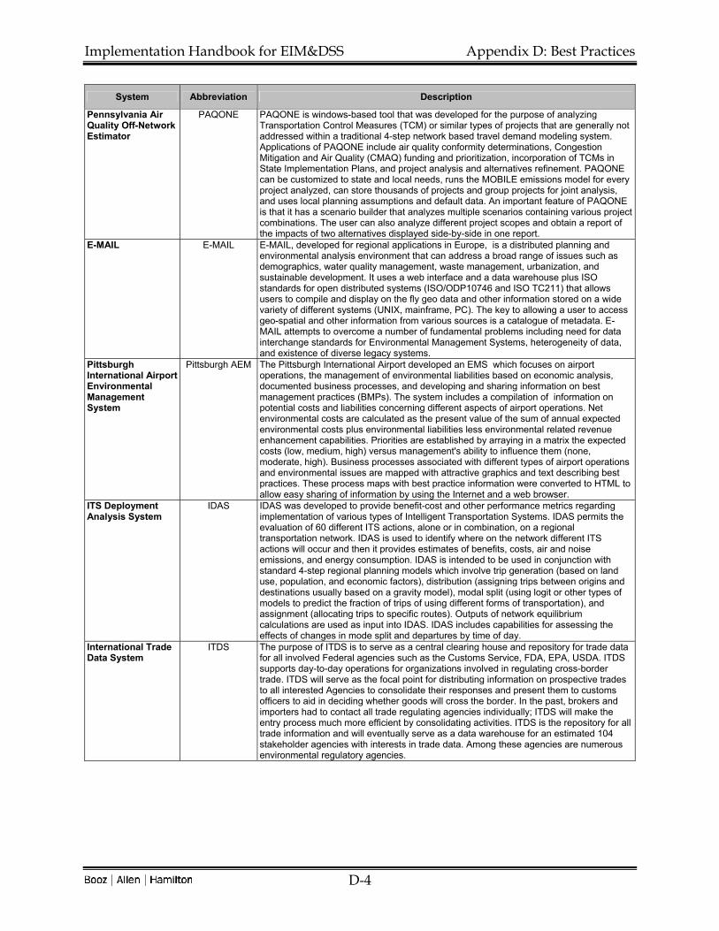
Implementation Handbook for EIM&DSS Appendix D: Best Practices
D-4
System Abbreviation Description
Pennsylvania Air Quality Off-Network Estimator
PAQONE PAQONE is windows-based tool that was developed for the purpose of analyzing Transportation Control Measures (TCM) or similar types of projects that are generally not addressed within a traditional 4-step network based travel demand modeling system. Applications of PAQONE include air quality conformity determinations, Congestion Mitigation and Air Quality (CMAQ) funding and prioritization, incorporation of TCMs in State Implementation Plans, and project analysis and alternatives refinement. PAQONE can be customized to state and local needs, runs the MOBILE emissions model for every project analyzed, can store thousands of projects and group projects for joint analysis, and uses local planning assumptions and default data. An important feature of PAQONE is that it has a scenario builder that analyzes multiple scenarios containing various project combinations. The user can also analyze different project scopes and obtain a report of the impacts of two alternatives displayed side-by-side in one report.
E-MAIL E-MAIL E-MAIL, developed for regional applications in Europe, is a distributed planning and environmental analysis environment that can address a broad range of issues such as demographics, water quality management, waste management, urbanization, and sustainable development. It uses a web interface and a data warehouse plus ISO standards for open distributed systems (ISO/ODP10746 and ISO TC211) that allows users to compile and display on the fly geo data and other information stored on a wide variety of different systems (UNIX, mainframe, PC). The key to allowing a user to access geo-spatial and other information from various sources is a catalogue of metadata. E-MAIL attempts to overcome a number of fundamental problems including need for data interchange standards for Environmental Management Systems, heterogeneity of data, and existence of diverse legacy systems.
Pittsburgh International Airport Environmental Management System
Pittsburgh AEM The Pittsburgh International Airport developed an EMS which focuses on airport operations, the management of environmental liabilities based on economic analysis, documented business processes, and developing and sharing information on best management practices (BMPs). The system includes a compilation of information on potential costs and liabilities concerning different aspects of airport operations. Net environmental costs are calculated as the present value of the sum of annual expected environmental costs plus environmental liabilities less environmental related revenue enhancement capabilities. Priorities are established by arraying in a matrix the expected costs (low, medium, high) versus management's ability to influence them (none, moderate, high). Business processes associated with different types of airport operations and environmental issues are mapped with attractive graphics and text describing best practices. These process maps with best practice information were converted to HTML to allow easy sharing of information by using the Internet and a web browser.
ITS Deployment Analysis System
IDAS IDAS was developed to provide benefit-cost and other performance metrics regarding implementation of various types of Intelligent Transportation Systems. IDAS permits the evaluation of 60 different ITS actions, alone or in combination, on a regional transportation network. IDAS is used to identify where on the network different ITS actions will occur and then it provides estimates of benefits, costs, air and noise emissions, and energy consumption. IDAS is intended to be used in conjunction with standard 4-step regional planning models which involve trip generation (based on land use, population, and economic factors), distribution (assigning trips between origins and destinations usually based on a gravity model), modal split (using logit or other types of models to predict the fraction of trips of using different forms of transportation), and assignment (allocating trips to specific routes). Outputs of network equilibrium calculations are used as input into IDAS. IDAS includes capabilities for assessing the effects of changes in mode split and departures by time of day.
International Trade Data System
ITDS The purpose of ITDS is to serve as a central clearing house and repository for trade data for all involved Federal agencies such as the Customs Service, FDA, EPA, USDA. ITDS supports day-to-day operations for organizations involved in regulating cross-border trade. ITDS will serve as the focal point for distributing information on prospective trades to all interested Agencies to consolidate their responses and present them to customs officers to aid in deciding whether goods will cross the border. In the past, brokers and importers had to contact all trade regulating agencies individually; ITDS will make the entry process much more efficient by consolidating activities. ITDS is the repository for all trade information and will eventually serve as a data warehouse for an estimated 104 stakeholder agencies with interests in trade data. Among these agencies are numerous environmental regulatory agencies.

Implementation Handbook for EIM&DSS Appendix D: Best Practices
D-5
System Abbreviation Description
Caltrans Intermodal Management System
Caltrans The California Department of Transportation (Caltrans) has developed an Intermodal Management System (IMS) that is able to analyze the effects of different investment strategies, bottlenecks, demand side actions, capacity improvements, and selected environmental impacts regarding all principal forms of passenger and freight transportation that are part of the multimodal/intermodal transport system in California. The system relies on Oracle Transportation Manager as a backbone that provides linear referencing and also interfaces with a Geographic Information System. A multimodal transportation network with intermodal connections, such as train, air, bus, and freight terminals and distribution facilities is defined within the IMS. The system interfaces with Mobile 5 Emissions model and can be used among other things, to assess the effects of different transportation improvements on air pollution emissions. It also is used to assess changes in energy consumption. The IMS also includes among its outputs various performance measures including benefits and costs of various improvements.
Highway Economic Requirements System
HERS HERS is a simulation model used by the Federal Highway Administration for conducting benefit-cost analysis of different highway program strategies, for assessing future highway needs and for assessing the transportation and selected aspects of environmental performance of the highway system. It operates on the HPMS database consisting of approximately 100,000 highway sections throughout the United States. Based on such factors as type of pavement surface, current measure of pavement roughness, number of lanes, volume-to-capacity ratio, traffic volumes, it uses benefit-cost analysis and minimum tolerable conditions to assess the mix of highway work (e.g. reconstruction, rehabilitation, resurfacing, widening) required on the network. One can impose budget constraints for various years into the future and analyze alternative scenarios. HERS calculates the benefits (avoidable travel time, vehicle operating, accident) and takes into account capital and maintenance costs. HERS also projects various performance measures including number of fatal and personal injury accidents, average speed, volume-to-capacity ratio, energy consumption, and air pollution emissions (CO, NOx, HC). States can apply HERS to their own HPMS data base and can use HERS for long range planning and exploring highway program options.
Highway Performance Monitoring System
HPMS HPMS is a simulation model for assessing future needs on the national highway system. It runs on a database consisting of over 100,000 sample highway sections from throughout the United States. It can also operate on a database for a single state. The simulation uses data on pavement type, pavement condition (International Roughness Index), number of lanes, lane width, shoulder width, traffic volume, percent trucks in order to determine whether capacity improvements or pavement actions such as reconstruction, rehabilitation and resurfacing are required. Minimum tolerable conditions for pavement condition and congestion (volume-to-capacity) determine actions that will be required in the future. HPMS estimates emissions, energy consumption, and accidents. Results obtained from using the model are included in annual reports to Congress on the condition and performance of the national surface transportation system. Numerous states have used HPMS as part of highway system planning studies.
internet Financial Accounting Cost Tracking System)
iFACTS Several years ago, the FAA ANS-500 division replaced the manual processes and applications used to record their facility and equipment Cuff records. Cuff records are defined as detailed, informal, unofficial, “off the cuff” accounting records. Starting In February 2000, Booz·Allen and Hamilton provided software development technical support for the development of the Intranet Financial Accounting and Cuff Tracking System (iFACTS). The data used by iFACTS is downloaded from several independent applications and will help integrate the ANS-500 financial management systems. iFACTS is a program management tracking system that allows ANS-500 administrators to execute and manage budgets. iFACTS provides a method to reconcile Cuff records with the official accounting system used to track appropriated funds, the Departmental Accounting Financial Information System (DAFIS). As a web-based application, iFACTS now makes available real-time regional and national budget execution information that was formerly available only through a tedious manual collection process. The system provides a means to facilitate communication between the regions and headquarters senior management on budget issues.

Implementation Handbook for EIM&DSS Appendix E: Laws and Regulations
E-1
Appendix E: Laws and Regulations
Historically, transportation organizations prioritized their environmental data collection needs based upon legislative and regulatory mandates. Although that orientation has shifted over the past decade to an emphasis on collecting the environmental and other data that would most support proactive, environmental stewardship decisions and actions, legislative and regulatory data drivers remain an important component of State DOT and MPO environmental data collection efforts.
Current Legislative and Regulatory Data Drivers The matrices in this section (Tables 4-10 through 4-16) outline environmental laws that are potentially applicable to each lifecycle phase of a transportation project. The matrices provide a summary of legal requirements that need to be supported by data. There is a great deal of overlap in data requirements among the transportation decision making lifecycle phases, which allows State DOTs and MPOs to identify opportunities for consolidation and streamlining. The matrices provide information on federal laws and do not cover state laws. State laws show wide variation and users should consult the local state department of transportation for advice on applicable laws and data requirements. Many states have published handbooks that explain the environmental requirements of transportation projects and include information on applicable federal and state laws. Many environmental laws provide states, territories, and Native American tribes with the opportunity to become authorized to implement regulations at a state level. These programs must be at least as stringent as federal requirements, and states, territories, and tribes are allowed to add additional requirements. An EIM&DSS for State DOTs and MPOs will need the ability for organizations to maintain their own banks of state and local legislative and regulatory requirements in addition to a core set of federal requirements. Each matrix shows existing environmental laws that are applicable to that life-cycle phase. These environmental laws dictate the data requirements for each life-cycle phase. However, the data requirements are not delineated in these matrices. The matrices provide only existing laws, and do not include proposed laws or regulations because 1) at the federal level there are not many new emerging environmental laws, and 2) survey results indicated that proposed laws and regulations are a low priority for most responding State DOTs and MPOs (see Appendix B for the detailed preliminary survey results). These matrices are based on a checklist approach and may not necessarily cover all relevant laws or regulations. The intention is to be broadly inclusive, but not to provide a complete checklist of all applicable laws. In addition, laws are continually being updated and amended with further data requirements being added to the transport project arena.

Implementation Handbook for EIM&DSS Appendix E: Laws and Regulations
E-2
Planning Legislative and Regulatory Data Drivers
Table ?: Planning Legislative and Regulatory Data Drivers
Long Range Plans
Strategic Plans
Modal Plans
Policy Plans
Business Plans
System Plans
American Indian Religious Freedom Act � � � � � � � � � � � �
Antiquities Act of 1906 � � � � � � � � � � � �
Archaeological and Historic Preservation Act of 1974 � � � � � � � � � � � �
Archaeological Resources Protection Act of 1979 � � � � � � � � � � � �
Bald and Golden Eagle Protection Act � � � � � � � � � � � �
Clean Air Act � � � � � � � � � � � �
Clean Water Act � � � � � � � � � � � �
Coastal Zone Management Act � � � � � � � � � � � �
Comprehensive Environmental Response, Compensation, and Liability Act (CERCLA) � � � � � � � � � � � �
Emergency Wetlands Resources Act of 1986 � � � � � � � � � � � �
Endangered Species Act � � � � � � � � � � � �
EO 11593 Protection and Enhancement of the Cultural Environment � � � � � � � � � � � �
EO 11990 Protection of Wetlands � � � � � � � � � � � �
EO 11988 Floodplain Management � � � � � � � � � � � �
EO 12898 Federal Actions to Address Environmental Justice in Minority Populations and Low-Income Populations � � � � � � � � � � � �
EO 13089 Coral Reef Protection � � � � � � � � � � � �
Farmland Protection Policy Act � � � � � � � � � � � �
Federal Aid Highway Act (Section 4(f) � � � � � � � � � � � �
Federal Insecticide, Fungicide and Rodenticide Act � � � � � � � � � � � �
Federal Water Pollution Control Act � � � � � � � � � � � �
Fish and Wildlife Coordination Act � � � � � � � � � � � �
Hazardous Materials Transportation Act � � � � � � � � � � � �
Land and Water Conservation Fund Act � � � � � � � � � � � �
Marine Mammal Protection Act � � � � � � � � � � � �
National Environmental Policy Act (NEPA) � � � � � � � � � � � �
National Historic Preservation Act � � � � � � � � � � � �
National Trails System Act � � � � � � � � � � � �
National Wild and Scenic Rivers Act � � � � � � � � � � � �
Noise Control Act of 1972 � � � � � � � � � � � �
Resource Conservation and Recovery Act (RCRA) � � � � � � � � � � � �
Rivers and Harbors Act � � � � � � � � � � � �
Safe Drinking Water Act � � � � � � � � � � � �
Solid Waste Disposal Act � � � � � � � � � � � �
Surface Transportation and Uniform Relocation Assistance Act of 1987 � � � � � � � � � � � �
Superfund Amendments and Reauthorization Act (SARA) � � � � � � � � � � � �
Toxic Substance Control Act � � � � � � � � � � � �
Wilderness Act � � � � � � � � � � � �

Implementation Handbook for EIM&DSS Appendix E: Laws and Regulations
E-3
Programming Legislative and Regulatory Data Drivers Table 2: Programming Legislative and Regulatory Data Drivers
Multi-Year Investment Program
Topical Program Development
Budget Development
American Indian Religious Freedom Act * � � * Antiquities Act of 1906 * � � * Archaeological and Historic Preservation Act of 1974 * � � * Archaeological Resources Protection Act of 1979 * � � * Bald and Golden Eagle Protection Act * � � * Clean Air Act � � � � * Clean Water Act * � � * Coastal Zone Management Act * � � * Comprehensive Environmental Response, Compensation, and Liability Act (CERCLA) * � � * Emergency Wetlands Resources Act of 1986 * � � * Endangered Species Act * � � * EO 11593 Protection and Enhancement of the Cultural Environment * � � * EO 11990 Protection of Wetlands * � � * EO 11988 Floodplain Management * � � * EO 12898 Federal Actions to Address Environmental Justice in Minority Populations & Low-Income Populations * � � * EO 13089 Coral Reef Protection * � � * Farmland Protection Policy Act * � � * Federal Aid Highway Act (Section 4(f) * � � * Federal Insecticide, Fungicide and Rodenticide Act * � � * Federal Water Pollution Control Act * � � * Fish and Wildlife Coordination Act * � � * Hazardous Materials Transportation Act * � � * Land and Water Conservation Fund Act * � � * Marine Mammal Protection Act * � � * National Environmental Policy Act (NEPA) * � � * National Historic Preservation Act * � � * National Trails System Act * � � * National Wild and Scenic Rivers Act * � � * Noise Control Act of 1972 * � � * Resource Conservation and Recovery Act (RCRA) * � � * Rivers and Harbors Act * � � * Safe Drinking Water Act * � � * Solid Waste Disposal Act * � � * Surface Transportation and Uniform Relocation Assistance Act of 1987 * � � * Superfund Amendments and Reauthorization Act (SARA) * � � * Toxic Substance Control Act * � � * Wilderness Act * � � * *Currently there is no formal requirement for State DOTs and MPOs to create Programmatic Environmental Impact Statements (EISs), however, over time the adoption of a Multi-Year
Investment program or a budget could be deemed a major action having a significant impact on the environment and require an EIS. This could trigger comprehensive data collection needs that are responsive to a broad range of legal and regulatory requirements.

Implementation Handbook for EIM&DSS Appendix E: Laws and Regulations
E-4
Project Development Legislative and Regulatory Data Drivers Table 0-3: Project Development Legislative and Regulatory Data Drivers
Project Planning Project Design Construction
American Indian Religious Freedom Act � � � � Antiquities Act of 1906 � � � � Archaeological and Historic Preservation Act of 1974 � � � � Archaeological Resources Protection Act of 1979 � � � � Bald and Golden Eagle Protection Act � � � � Clean Air Act � � � � � �
Clean Water Act � � � � � �
Coastal Zone Management Act � � � � Comprehensive Environmental Response, Compensation, and Liability Act (CERCLA) � � � � � �
Emergency Wetlands Resources Act of 1986 � � � � � �
Endangered Species Act � � � � � �
EO 11593 Protection and Enhancement of the Cultural Environment � � � � EO 11990 Protection of Wetlands � � � � � �
EO 11988 Floodplain Management � � � � � �
EO 12898 Federal Actions to Address Environmental Justice in Minority Populations and Low-Income Populations � � � � � �
EO 13089 Coral Reef Protection � � � � Farmland Protection Policy Act � � � � Federal Aid Highway Act (Section 4(f) � � � � Federal Insecticide, Fungicide and Rodenticide Act � � � � � �
Federal Water Pollution Control Act � � � � � �
Fish and Wildlife Coordination Act � � � � Hazardous Materials Transportation Act � � � � � �
Land and Water Conservation Fund Act � � � � Marine Mammal Protection Act � � � � National Environmental Policy Act (NEPA) � � � � National Historic Preservation Act � � � � National Trails System Act � � � � � �
National Wild and Scenic Rivers Act � � � � � �
Noise Control Act of 1972 � � � � � �
Resource Conservation and Recovery Act (RCRA) � � � � � �
Rivers and Harbors Act � � � � � �
Safe Drinking Water Act � � � � � �
Solid Waste Disposal Act � � � � � �
Surface Transportation and Uniform Relocation Assistance Act of 1987 � � � �
Superfund Amendments and Reauthorization Act (SARA) � � � � � �
Toxic Substance Control Act � � � � � �
Wilderness Act � � � �
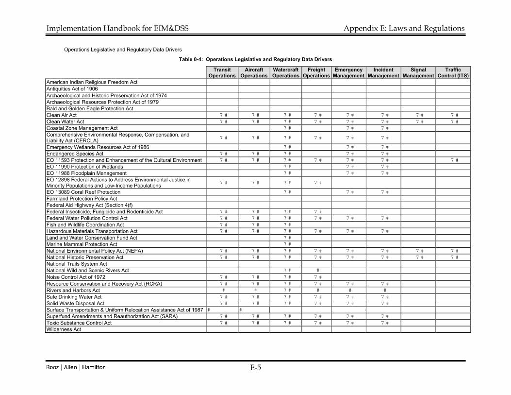
Implementation Handbook for EIM&DSS Appendix E: Laws and Regulations
E-5
Operations Legislative and Regulatory Data Drivers
Table 0-4: Operations Legislative and Regulatory Data Drivers
Transit Operations
Aircraft Operations
Watercraft Operations
Freight Operations
Emergency Management
Incident Management
Signal Management
Traffic Control (ITS)
American Indian Religious Freedom Act Antiquities Act of 1906 Archaeological and Historic Preservation Act of 1974 Archaeological Resources Protection Act of 1979 Bald and Golden Eagle Protection Act � Clean Air Act � � � � � � � � � � � � � � � �
Clean Water Act � � � � � � � � � � � � � � � �
Coastal Zone Management Act � � � � � �
Comprehensive Environmental Response, Compensation, and Liability Act (CERCLA) � � � � � � � � � � � �
Emergency Wetlands Resources Act of 1986 � � � � � �
Endangered Species Act � � � � � � � � � �
EO 11593 Protection and Enhancement of the Cultural Environment � � � � � � � � � � � � � �EO 11990 Protection of Wetlands � � � � � �
EO 11988 Floodplain Management � � � � � �EO 12898 Federal Actions to Address Environmental Justice in Minority Populations and Low-Income Populations � � � � � � � �
EO 13089 Coral Reef Protection � � � � � �
Farmland Protection Policy Act Federal Aid Highway Act (Section 4(f) Federal Insecticide, Fungicide and Rodenticide Act � � � � � � � � Federal Water Pollution Control Act � � � � � � � � � � � �
Fish and Wildlife Coordination Act � � � � � � Hazardous Materials Transportation Act � � � � � � � � � � � �
Land and Water Conservation Fund Act � � Marine Mammal Protection Act � � National Environmental Policy Act (NEPA) � � � � � � � � � � � � � � � �
National Historic Preservation Act � � � � � � � � � � � � � � � �
National Trails System Act National Wild and Scenic Rivers Act � � � Noise Control Act of 1972 � � � � � � � � Resource Conservation and Recovery Act (RCRA) � � � � � � � � � � � �
Rivers and Harbors Act � � � � � � �
Safe Drinking Water Act � � � � � � � � � � � �
Solid Waste Disposal Act � � � � � � � � � � � �
Surface Transportation & Uniform Relocation Assistance Act of 1987 � � � � � �Superfund Amendments and Reauthorization Act (SARA) � � � � � � � � � � � �
Toxic Substance Control Act � � � � � � � � � � � �
Wilderness Act

Implementation Handbook for EIM&DSS Appendix E: Laws and Regulations
E-6
Maintenance Legislative and Regulatory Data Drivers Table 0-5: Maintenance Legislative and Regulatory Data Drivers (Part 1)
Patching Shoulder Ditching Drainage Mowing & Veg. Control
Erosion Control Painting Bridge Signal
American Indian Religious Freedom Act � � � � � � � �
Antiquities Act of 1906 � � � � � � � �
Archaeological and Historic Preservation Act of 1974 � � � � � � � �
Archaeological Resources Protection Act of 1979 � � � � � � � � � � �
Bald and Golden Eagle Protection Act � � � � � � � �
Clean Air Act � � � � � � � � � � � �
Clean Water Act � � � � � � � � � � � � � � � �
Coastal Zone Management Act � � � � � � � � � � � � � � �
Comprehensive Environmental Response, Compensation & Liability Act (CERCLA) � � � � � � � � � � � � �
Emergency Wetlands Resources Act of 1986 � � � � � � � � � � � � � �
Endangered Species Act � � � � � � � � � � � � �
EO 11593 Protection and Enhancement of the Cultural Environment � � � � � � � �
EO 11990 Protection of Wetlands � � � � � � � � � � � � � �
EO 11988 Floodplain Management � � � � � � � � � � � � � �
EO 12898 Federal Actions to Address Environmental Justice in Minority Populations and Low-Income Populations �� � � � � � � �
EO 13089 Coral Reef Protection � � � � � � � � �
Farmland Protection Policy Act � � � � � � � � � � � � �
Federal Aid Highway Act (Section 4(f) � � � � � � � �
Federal Insecticide, Fungicide and Rodenticide Act � � � � � � � � � �
Federal Water Pollution Control Act � � � � � � � � � � � � � � � �
Fish and Wildlife Coordination Act � � � � � � � � � � � � � �
Hazardous Materials Transportation Act � � � � � � � � � � � � �
Land and Water Conservation Fund Act � � � � � � � � � � � � � �
Marine Mammal Protection Act � � � � � � � �
National Environmental Policy Act (NEPA) � � � � � � � � � � � � � � � �
National Historic Preservation Act � � � � � � � � �
National Trails System Act � � � � � � � �
National Wild and Scenic Rivers Act � � � � � � � � � � � � �
Noise Control Act of 1972 � � � � � � � � � � �
Resource Conservation and Recovery Act (RCRA) � � � � � � � � � � � � � �
Rivers and Harbors Act � � � � � � � � � �
Safe Drinking Water Act � � � � � � � � � � � � � � �
Solid Waste Disposal Act � � � � � � � � � � � � � � �
Surface Transportation and Uniform Relocation Assistance Act of 1987 � � � � � � � �
Superfund Amendments and Reauthorization Act (SARA) � � � � � � � � � � � � �
Toxic Substance Control Act � � � � � � � � � � � � �
Wilderness Act

Implementation Handbook for EIM&DSS Appendix E: Laws and Regulations
E-7
Table 0-6: Maintenance Legislative and Regulatory Data Drivers (Part 2)
Maintenance (cont.) Snow &
Ice Control
Emergency Maint.
Rest Areas
Tunnel Maint.
Material Handling &
Storage Equipment Servicing Resurfacing
American Indian Religious Freedom Act � � � � � � �
Antiquities Act of 1906 � � � � � � �
Archaeological and Historic Preservation Act of 1974 � � � � � � �
Archaeological Resources Protection Act of 1979 � � � � � � � � �
Bald and Golden Eagle Protection Act � � � � � � �
Clean Air Act � � � � � � � � � � � � �
Clean Water Act � � � � � � � � � � � � �
Coastal Zone Management Act � � � � � � � � � �Comprehensive Environmental Response, Compensation, and Liability Act � � � � � � � � �
Emergency Wetlands Resources Act of 1986 � � � � � � � � �
Endangered Species Act � � � � � � � � �
EO 11593 Protection and Enhancement of the Cultural Environment � � � � � � �
EO 11990 Protection of Wetlands � � � � � � � � � �
EO 11988 Floodplain Management � � � � � � � � �
EO 12898 Federal Actions to Address Environmental Justice in Minority Populations and Low-Income Populations � � � � � � �
EO 13089 Coral Reef Protection � � � � � � �
Farmland Protection Policy Act � � � � � � � �
Federal Aid Highway Act (Section 4(f) � � � � � � �
Federal Insecticide, Fungicide and Rodenticide Act � � � � � � � � � � �
Federal Water Pollution Control Act � � � � � � � � � � �
Fish and Wildlife Coordination Act � � � � � � � � � �
Hazardous Materials Transportation Act � � � � � � � � � �
Land and Water Conservation Fund Act � � � � � � � � �
Marine Mammal Protection Act � � � � � � �
National Environmental Policy Act (NEPA) � � � � � � � � � �
National Historic Preservation Act � � � � � � � �
National Trails System Act � � � � � � �
National Wild and Scenic Rivers Act � � � � � � � � � � �
Noise Control Act of 1972 � � � � � � � �
Resource Conservation and Recovery Act (RCRA) � � � � � � � � � � �
Rivers and Harbors Act � � � � � � � �
Safe Drinking Water Act � � � � � � � � �
Solid Waste Disposal Act � � � � � � � � �
Surface Transportation and Uniform Relocation Assistance Act of 1987 � � � � � � �
Superfund Amendments and Reauthorization Act (SARA) � � � � � � � � �
Toxic Substance Control Act � � � � � � � � � � � �
Wilderness Act � � � � � � � �

Implementation Handbook for EIM&DSS Appendix E: Laws and Regulations
E-8
Closure and Decommissioning Legislative and Regulatory Data Drivers
Table 0-7: Closure and Decommissioning Legislative and Regulatory Data Drivers
Facilities Airports Ports Roads Bridges Railways Deconstruction
American Indian Religious Freedom Act � � � � � � �
Antiquities Act of 1906 � � � � � � �
Archaeological and Historic Preservation Act of 1974 � � � � � � � � � � � � � �
Archaeological Resources Protection Act of 1979 � � � � � � � � � � � � � �
Bald and Golden Eagle Protection Act � � � � � � �
Clean Air Act � � � � � � � � � � � � � �
Clean Water Act � � � � � � � � � � � � � �
Coastal Zone Management Act � � � � � � � � � � �
Comprehensive Environmental Response, Compensation, and Liability Act (CERCLA) � � � � � � � � � � � � � �
Emergency Wetlands Resources Act of 1986 � � � � � � � � � � � � � �
Endangered Species Act � � � � � � � � � � � � � �
EO 11593 Protection and Enhancement of the Cultural Environment � � � � � � � � � � � �
EO 11990 Protection of Wetlands � � � � � � � � � � � � � �
EO 11988 Floodplain Management � � � � � � � � � � � � � �
EO 12898 Federal Actions to Address Environmental Justice in Minority Populations and Low-Income Populations � � � � � � � � � � � � � �
EO 13089 Coral Reef Protection � � � � � � � �
Farmland Protection Policy Act � � � � � � �
Federal Aid Highway Act (Section 4(f) � � � � � � �
Federal Insecticide, Fungicide and Rodenticide Act � � � � � � �
Federal Water Pollution Control Act � � � � � � � � � � � � � �
Fish and Wildlife Coordination Act � � � � � � � � � � � � � �
Hazardous Materials Transportation Act � � � � � � � � � � � � � �
Land and Water Conservation Fund Act � � � � � � � � � � � � � �
Marine Mammal Protection Act � � � � � � � �
National Environmental Policy Act (NEPA) � � � � � � � � � � � � � �
National Historic Preservation Act � � � � � � � � � � � � � �
National Trails System Act � � � � � � � � �
National Wild and Scenic Rivers Act � � � � � � � � �
Noise Control Act of 1972 � � � � � � � � � � � � � �
Resource Conservation and Recovery Act (RCRA) � � � � � � � � � � � � � �
Rivers and Harbors Act � � � � � � � � � �
Safe Drinking Water Act � � � � � � � � � � � � � �
Solid Waste Disposal Act � � � � � � � � � � � � � �
Surface Transportation and Uniform Relocation Assistance Act of 1987 � � � � � � � � � � �
Superfund Amendments and Reauthorization Act (SARA) � � � � � � � � � � � � � �
Toxic Substance Control Act � � � � � � � � � � � � � �
Wilderness Act

Implementation Handbook for EIM&DSS Appendix E: Laws and Regulations
E-9
Future Legislative and Regulatory Data Trends
The growth in global environmental awareness and the increasing human impact on the environment is likely to have influence on future environmental laws and regulations. Several trends that could potentially impact US transportation projects can be identified. Global Climate Change. These trends include the effects of international treaties to combat global climate change. Laws could be altered to encourage increases in less polluting transport modes, to restrict highway construction, or to mandate a shift to alternative fuel vehicles. The distribution of emissions allowances could also impact state laws and the requirements placed on transportation projects. As a result, managing the already important air quality and emissions data could become a large factor in any EIM&DSS. To accommodate such requirements, the system will have to be capable of including multiple air quality modeling and decision support tools. One potential solution under discussion is for some form of emissions trading scheme. This could have profound implications for transportation project programming and planning. Market Mechanisms and Laissez Faire. The new Bush administration is likely to encourage increased reliance on market forces on transportation and to place greater emphasis on voluntary pollution control mechanisms, rather than regulatory directives. This could have regulatory implications in terms of a shift to more relaxed environmental laws concerning air and water quality, and a reduction in the environmental data requirements placed on transportation planners. Market incentive programs could be used to encourage the reduction of polluting activities and the development of new less polluting alternatives. Shadow Prices for Environmental Impacts. Another trend that could impact environmental laws and regulations is an increased use of shadow prices to evaluate environmental impacts. A shadow price is an imputation of economic value when a market price is absent. Shadow pricing may become more prevalent as an aid to decision making to meet possible commitments to combat global climate change or more local (or state) issues. The trend towards socially and environmentally responsible investing may also create a driver for companies and organizations in the transport sector to value their environmental impacts in economic terms, allowing comparison with actions and resources already evaluated in the marketplace. In terms of legislation, such a trend could encourage lawmakers to demand shadow pricing of environmental impacts as a means of improving their decision-making processes. Globalization and the Harmonization of Regulations. The rise in globalization across many economic sectors could also have impacts for transportation. The air transport sector already has a global body: the International Civil Aviation Organization (ICAO) that seeks to bring harmonization to international air transport issues and laws across its member countries. This harmonization approach could spread to other parts of the transportation sector and have impacts on applicable environmental laws and regulations. This trend has been witnessed within the European Union and it is possible that it could also be applied within the North American Free Trade Agreement (NAFTA) countries or as part of global environmental agreements. Anti-Sprawl Agenda and Sustainable Development. The growth in the debate about urban sprawl could potentially bring regulatory changes to alter the balance in favor of more sustainable development. This could give rise to a greater focus on pedestrian, bicycle, and public transit transportation projects and a decreased emphasis on road building. Environmental analysis and decision support will need to accommodate these changes.

Implementation Handbook for EIM&DSS Appendix E: Laws and Regulations
E-10
DATA REQUIREMENTS
Table 4-17 below lists the high-level data requirements that must be supported by an EIM&DSS. These requirements are the result of a synthesis of the literature review, team knowledge, survey input, and best practices documents submitted in response to the email query for Task 2. The table lists data content areas, formats, and management requirements.
Table 0-8: Data Requirements
DATA REQUIREMENTS
Access/Manage cost and schedule data Access/Manage documents Access/Manage linear data Access/Manage coordinate data Access/Manage address matching data Convert Linear|Coordinate|Address matching data Access/Manage alternatives scenarios Access/Manage Impacts data Access/Manage permit/compliance data Access/Manage public and other agency comments Access/Manage water issues data Access/Manage air issues data Access/Manage cultural/historic data Access/Manage wildlife data Access/Manage habitat data Access/Manage land use data Access/Manage noise data Access/Manage mitigation data Access/Manage waste/disposal data Access/Manage socioeconomic data Access/Manage traffic data Access/Manage engineering data Access/Manage best management practices data Access/Manage simulation and model results Access/Manage plan sheets Store/Retrieve Geo-coded data formats Store/Retrieve spreadsheet data formats Store/Retrieve relational database data formats Store/Retrieve word processing data formats Store/Retrieve ITS data formats Store/Retrieve multimedia data formats Store/Retrieve real-time and static data

Implementation Handbook for EIM&DSS Appendix E: Laws and Regulations
E-11
BUSINESS PROCESS DATA DRIVERS
The team analyzed the relationship between the business process requirements of an EIM&DSS for transportation and the data requirements of the system. The results indicated an enormous overlap in data needs across the different business processes; conversely, the data formats and content areas must each be available to many business processes. Very few business processes do not require access to multiple data formats and content areas. The identification of this extreme cross-purpose need for data provides an opportunity for an EIM&DSS to aid State DOTs and MPOs in re-purposing and sharing existing data sources.

Implementation Handbook for EIM&DSS Appendix E: Laws and Regulations
E-12
Table 0-9: Business Process and Data Requirement Overlap
Publ
ic P
erfo
rman
ce R
epor
ting
Publ
ic In
volv
emen
t Pro
gram
s Ac
tiviti
es
Plan
ning
Act
iviti
es
Prog
ram
min
g Ac
tiviti
es
Proj
ect P
lann
ing
Activ
ities
Proj
ect D
esig
n Ac
tiviti
es
Proj
ect C
onst
ruct
ion
Miti
gatio
n/
Enha
ncem
ent A
ctiv
ities
Ope
ratio
n Ac
tiviti
es
Mai
nten
ance
Act
iviti
es
Clo
sure
& D
ecom
mis
sion
ing
Activ
ities
Reg
ulat
ory/
Polic
y C
ompl
ianc
e Ac
tiviti
es
Site
Aud
it Ac
tiviti
es
Exer
cise
Sim
ulat
ions
, Mod
els,
&
Man
agem
ent S
yste
ms
Prog
ram
/Pro
ject
Eva
luat
ion
Rep
ortin
g/
Dat
a M
inin
g Ac
tiviti
es
Rem
ote
data
ent
ry
Dat
a sh
arin
g
Inte
rface
with
ext
erna
l sy
stem
s
Ove
rlap
acro
ss b
usin
ess
prac
tices
Cost and schedule data � � � � � � � � � � � � � � � � � � � � � � � � � � � � � � � � � � �
Documents �� � � � � � � � � � � � � � � � � � � � � � � � � � � � � � � � � �
Linear data � � � � � � � � � � � � � � � � � � � � � � � � � � � � � � � � � � � � � � � �
Coordinate data � � � � � � � � � � � � � � � � � � � � � � � � � � � � � � � � � � � � � � � �
Address matching data � � � � � � � � � � � � � � � � � � � � � � � � � � � � � � � � � � � � � � � �
Convert Linear, Coordinate, Address matching data � � � � � � � � � � � � � � � � � � � � � � � � � � � � � � � � � � � � � � � �
Alternatives scenarios �� � � � � � � � � � � � � � � � � � � � � � � � � � � � � � �
Impacts data � � � � � � � � � � � � � � � � � � � � � � � � � � � � � � � � � � � �
Permit/compliance data � � � � � � � � � � � � � � � � � � � � � � � � � � � � � � � � � � � �
Public and other agency comments � � � � � � � � � � � � � � � � � � � � � � � � � � � � � � � � � � � � � � �
Water issues data � � � � � � � � � � � � � � � � � � � � � � � � � � � � � � � � � � � � � � � �
Air issues data � � � � � � � � � � � � � � � � � � � � � � � � � � � � � � � � � � � � � � � �
Cultural/historic data � � � � � � � � � � � � � � � � � � � � � � � � � � � � � � � � � � � � � � � �
Wildlife data � � � � � � � � � � � � � � � � � � � � � � � � � � � � � � � � � � � � � � � �
Habitat data � � � � � � � � � � � � � � � � � � � � � � � � � � � � � � � � � � � � � � � �
Land use data � � � � � � � � � � � � � � � � � � � � � � � � � � � � � � � � � � � � � � � �
Noise data � � � � � � � � � � � � � � � � � � � � � � � � � � � � � � � � � � � � � � � �
Mitigation data � � � � � � � � � � � � � � � � � � � � � � � � � � � � � � � � � � � � � � � �
Waste/disposal data � � � � � � � � � � � � � � � � � � � � � � � � � � � � � � � � � � � � � � � �
Socioeconomic data � � � � � � � � � � � � � � � � � � � � � � � � � � � � � � � � � � � � � � � �
Traffic data � � � � � � � � � � � � � � � � � � � � � � � � � � � � � � � � � � � � � � � �
Engineering data � � � � � � � � � � � � � � � � � � � � � � � � � � � � � � � � � � � � � � � �
Best management practices data � � � � � � � � � � � � � � � � � � � � � � � � � � � � � � � �
Simulation and model results �� � � � � � � � � � � � � � � � � � � � � � � � � � � � � � � �
Plan sheets �� � � � � � � � � � � � � � � � � � � � � � � � � � � � � � � � �
Geo-coded data formats � � � � � � � � � � � � � � � � � � � � � � � � � � � � � � � � � � � � � � � �
Spreadsheet data formats � � � � � � � � � � � � � � � � � � � � � � � � � � � � � � � � � � � � � � � �
Relational database data formats � � � � � � � � � � � � � � � � � � � � � � � � � � � � � � � � � � � � � � � �
Word processing data formats � � � � � � � � � � � � � � � � � � � � � � � � � � � � � � � � � � � � � � � �
ITS data formats � � � � � � � � � � � � � � � � � � � � � � � � � � � � � � � � �
Multimedia data formats � � � � � � � � � � � � � � � � � � � � � � � � � � � � � � � � � � � � �
Real-time and static data � � � � � � � � � � � � � � � � � � � � � � � � � � � � � � � � � � � � � � � �
Implementation Handbook for EIM&DSS Appendix F: DEFINITIONS OF ENTITIES
F-1
Appendix F. Definitions of Entities The entity relationship diagrams in this report were prepared with a computer-
assisted software engineering tool, ERwin. A relationship is used in an ERwin logical data model to show that there is an association or link between two entities, or between an entity and itself. You can use ERwin's logical modeling features to create these five types of relationships:
• Identifying relationship
• Non-identifying relationship
• Subtype relationship
• Many-to-many relationship
• Recursive relationship
An identifying relationship is a relationship between two entities in which an instance of a child entity is identified through its association with a parent entity, which means the child entity is dependent on the parent entity for its identify and cannot exist without it. In an identifying relationship, one instance of the parent entity is related to multiple instances of the child. ERwin draws, in IDEF1X notation, an identifying relationship line as a solid line with a diamond or a filled circle at either end of the line.
A non-identifying relationship is a relationship between two entities in which an instance of the child entity is not identified through its association with a parent entity, which means the child entity is not dependent on the parent entity for its identify and can exist without it. In a non-identifying relationship, one instance of the parent entity is related to multiple instances of the child.
A subtype relationship connects an entity that defines the category and two or more additional entities that define each of the elements of the category. The parent entity of the category is considered the supertype and each child entity is considered a subtype.
A many-to-many relationship is a relationship between two entities when each instance of the first entity can be related to many instances in the second entity, and vice versa. ERwin draws, in IDEF1X notation, a many-to-many relationship as a solid line with a solid dot on both the child end and the parent end.
A recursive relationship is a non-identifying relationship between two entities or tables that represents the fact that one company can own another company. In this type of relationship, the parent entity or table and the child entity or table are the same. You can use ERwin to create these two types of recursive relationships.
The following are descriptions of entities used in the entity relationship diagrams for EIM&DSS.

Implementation Handbook for EIM&DSS Appendix F: DEFINITIONS OF ENTITIES
F-2
Entity Definitions
Affected Environment This entity describes the environmental setting including all environmental, social, economic, and cultural issues, as well as source and target responsibilities for each phase.
Agency of Ownership This entity is the agency that owns the transportation assets.
Alternative This entity describes one of a number of specific transportation improvement proposals, alignments, designs, options, etc,. in a study. Following detailed analysis, one improvement alternative is chosen for implementation.
Analysis Method This entity describes all available methods that can be used to analyze different alternatives for the implementation of a transportation PPP&OM object. This is a super entity and it is further described by its three sub entities: Expert, Model, and Table Look Up.
Analysis Option This entity lists all analysis options for the implementation of a transportation PPP&OM object. It combines all alternatives to be considered together with different scenarios.
Anchor Point This entity lists all points on or near a network that represent “ground truth.” Anchor Section This entity lists all sections of a link, both ends of which are anchor points. Asset This entity lists all transportation asset for which the owner agency is responsible. Cartrographic Representation The entity lists all cartographic projection and scales.
Citizen This entity is a type of stakeholder represented by voting members of the public and/or users of transportation.
Constraint
This entity describes significant resources, facilities, or other features or study areas located in or adjacent to an existing or proposed transportation corridor that serve to restrain, restrict, or prevent the ready implementation of a proposed transportation improvements in a given area. It may include natural or physical resources, important structures, communication facilities, or topographic features.
Decision Analysis This entity contains the decision analysis results for all considered alternatives under different scenarios. Each alternative is evaluated with respect to a specific environment issue. The results are aligned under predefined performance measures.
Decision Maker and Elected OfficialThis is a sub-type entity of "Stakeholder". It describes all transportation decision makers and elected officials that are involved in the process of planning and implementing a transportation PPP&OM object.
Environment Issue
This entity provides a list of specific environmental issues that are related to an environmental area. There issues are typically included for environmental impact study for a transportational development project. For example, the environmental issues can be population, ethnic characteristics, neighborhoods in the social environmental area.

Implementation Handbook for EIM&DSS Appendix F: DEFINITIONS OF ENTITIES
F-3
Entity Definitions
Environmental Area This entity provides a list of environmental areas that are usually included for environmental impact analysis for a transportation development project. For example, the environmental areas can be social, economic and land use, cultural resources, farmlands, and wetland.
Environmental Regulatory Agency This is a sub-type entity of "Stakeholder". It describes all environmental regulatory agencies that are involved in the process of planning and implementing a transportation PPP&OM object.
Expert This entity is a sub entity of Analysis Method. It describes available expert system applications that can be used to improve the quality of decision analyses.
Interest Group This is a sub-type entity of "Stakeholder". It lists all groups that may have certain interests in the process of planning and implementing a transportation PPP&OM object.
Legal Requirement This entity is a type of requirement and is statutory in nature. Linear Datum This entity lists all methods for measuring distance as an elapsed linear measure. Linear Referencing Method This entity lists the names of all linear referencing methods. Link This entity consists of the links of a transportation network.
Maintenance Activity
Describing a planed maintenance related activity which cover infrastructure, facility, vehicle, and equipment maintenance. In the case of highway maintenance, the activity will include pavement and bridge maintenance, sign work, striping and markings, guardrail repair and replacement, drainage work, vegetation management, rest area maintenance, maintenance of weigh stations, and snow and ice control.
Model This entity is a sub entity of Analysis Method. It describes all models that can be exercised to support the decision analysis for the transportation PPP&OM alternative analysis. An model can be a simulation program, an analytical procedure, a decision support system, and a management system.
Network This entity is a single or multimodal transportation network. Node This entity is a node of a network.
Operational Activity
Describing an operation activity that can include real-time traffic management involving ITS, emergency response, and daily passenger and freight operations such as subways, airport terminals, and port activity. Operations may include traffic related activities that are sometimes included in the maintenance program such as installation, repair, and replacement of signs as well as striping and marking operations.
Performance Measure This entity identifies the appropriate performance measures to be used for decision analysis that is to be performed for a transportation PPP&OM object at a particular phase.

Implementation Handbook for EIM&DSS Appendix F: DEFINITIONS OF ENTITIES
F-4
Entity Definitions
Performance Measure Category
This entity describes major types of performance measures that can be used to help decision makers evaluate current and future options (i.e. alternatives) and actions pertinent to whatever level of decision making is relevant to a particular decision maker, customer, or stakeholder. Performance measures can generally be grouped into four classes: net value added, outcome, output, and input and resource.
Permit This entity lists all types of permits that a transportation agency needs to prepare and file with respect to different kinds of environmental requirements.
Plan Describing key characteristics of a transportation plan such as the purpose of the plan, the type of plan (strategic, regional, policy, etc.), current status, and its potential funding source.
Policy Requirement This entity is a type of requirement and consists of a policy. PPP&OM Object Location This entity is the location of a Plan, Program, Project, or O&M activity.
PPP/OM Object Phase This entity describes different phases of a transportation planning and operation object. For example, it can describe the life cycle development phases of a project from initial planning to construction.
Program Describing key characteristics of a transportation program such as program type, current status, program period, and its potential funding sources. The program can be single and multiyear modal and multimodal/intermodal.
Project Describing key characteristics for the development of a transportation project such as project location, boundary, schedule, current status, and general permit requirements.
Public Communication This entity describes the communication materials developed to support a public involvement plan. The material can be a brochure, public letter, or a presentation.
Public Involvement Plan
This entity describes the plan that coordinates events and informational materials geared at encouraging the public to participate in the Transportation Project Development Process. A successful Public Involvement Plan facilitates the exchange of information among project sponsors and outside groups and the general public, and includes meetings, surveys, committees, and presentations. Sometimes, a public involvement plan is developed to address the concerns from a particular type of stakeholders.
Public Involvement Process
This entity records specific processes and actions taken under a public involvement plan. An public involvement process is conducted by transportation officials designed to facilitate participation in the decision-making process and to assist the public in gaining an informed view of a proposed project at any level of the transportation project development process. An good example of this is the Public Information Meeting.

Implementation Handbook for EIM&DSS Appendix F: DEFINITIONS OF ENTITIES
F-5
Entity Definitions
Record of Decision (ROD)
This entity identifies the alternative selected in the final EIS, the alternative considered, measure to minimize harm, monitoring or enforcement programs, and in itemized of commitments and mitigation measures. It also contains the information for the ROD document prepared by the Division Office of the FHWA that presents the basis for selecting and approving a specific transportation proposal that has been evaluated through the various environmental and engineering studies of the Transportation Project Development Process.
Regulatory Requirement This entity is a type of requirement and addresses a regulatory requirement corresponding to a particular issue.
Requirement This entity describes all kinds of requirements that are required to fulfill with respect to an environmental issue during the process of planning and implementing a transportation PPP&OM object. It also identifies if any kind of permit is required.
Requirement Compliance This entity contains information on compliance with regulations, permits, mitigation or enhancement requirements based on the selected alternative and the requirements on the affected environment. It also has the information on compliance schedule and responsibilities.
Requirement Commitment This entity describes the commitment made by the transportation agency to fulfill legislated and regulated reactive environmental policies. It also contains the information about how the agency is going to achieve the commitment.
Scenario This entity describes all scenarios created to be used in evaluating different alternatives. The scenarios represent different possible situations and considerations that a transportation PPP/OM object can be implemented.
Stakeholder
This entity contains a list of customers and stakeholders that consist of: transportation decision makers and elected officials , citizens and public interest groups, environmental regulatory agencies, DOT management, planners, program managers, project managers, operations managers, maintenance managers, environmental analysts, modal managers. It is a supertype entity and is further described by its three sub-type entities: Citizen, Interest Group, Decision Maker and Elected Official, and Environmental Regulatory Agency.
Stakeholder Interest This entity describes concerns from stakeholder and their roles in decision making during the planning and implementation process of a transportation PPP&OM object.
Stewardship Commitment This entity describes proactive, comprehensive environmental conservation and protection efforts made by the transportation agency through partnering with stakeholders.
Stewardship Compliance This entity contains information on compliance with stewardship commitment, including compliance schedule and responsibilities.
Table Look Up This entity is a type of analysis method and consists of a table look-up of impacts.
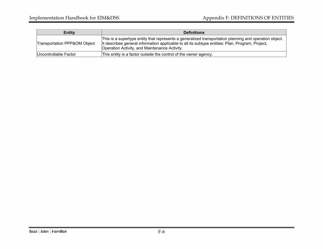
Implementation Handbook for EIM&DSS Appendix F: DEFINITIONS OF ENTITIES
F-6
Entity Definitions
Transportation PPP&OM Object This is a supertype entity that represents a generalized transportation planning and operation object. It describes general information applicable to all its subtype entities: Plan, Program, Project, Operation Activity, and Maintenance Activity.
Uncontrollable Factor This entity is a factor outside the control of the owner agency.

Cartographic Representation
Representation ID
Representation NameLinear Datum ID (FK)
Environment Area
Environment Area ID
Environment Feature
Anchor Point
Anchor Point ID
Linear Point IDLinear Datum ID (FK)
Location Description
Link
Link ID
From-Node ID (FK)To-Node ID (FK)Weight
Anchor Section
Anchor SectionLinear Datum ID (FK)
From Linear Datum ID (FK)To Linear Datum ID (FK)Distance
Stakeholder
Stakeholder ID
Stakeholder NameStakeholder Contact InformationBusiness Process FlowKey Business Processs Flow DecisionsStakeholder Type
Environmental Regulatory Agency
Stakeholder ID
Agency NameManagerContact Information
Network
Network ID
Network NameNetwork DescriptionLinear Datum ID (FK)
Agency of Ownership
Agency ID
Agency NameManager
Decision Maker and Elected Official
Stakeholder
NameOffice LocationContact Information
Citizen
Stakeholder ID (FK)
NameContact Information
Interest Group
Stakeholder ID (FK)
NamePrimary ConcernOther ConcernContact Information
Maintenance Activity
P_ID
Activity DescriptionActivity TypeSchedule
Plan
P_ID
Plan TypePlan DescriptionPlan Status
Operational Activity
P_ID
Activity DescriptionMaintenance RelatedEmergency NatureSchedule
Project
P_ID
Project DescriptionScheduleStatusPermit Requirement
Program
P_ID
Program TypeProgram DescriptionProgram PeriodProgram Status
Transportation PPP&OM Object
P_ID
Related P_ID (FK)Agency ID (FK)P_TypeTransportation ModeFunding Source
PPP&OM Object Location
P_ID (FK)LRM ID (FK)Network ID (FK)
Location Measurement
Linear Referencing Method
LRM ID
LRM Name
Scenario
P_ID (FK)Phase ID (FK)Scenario ID
Scenario DescriptionScenario Time PeriodPurpose of Scenario
Analysis Option
Phase ID (FK)P_ID (FK)Scenario IDAlternative ID (FK)
Alternative
Performance Measure
P_ID (FK)Phase ID (FK)Performance Measure ID
Measure Ype ID (FK)Performance Measure DescriptionWeightTargetCategorical Exclusion Threshold
P_ID (FK)Phase ID
Time Frame - FromTime Fram - ToPhase DescriptionResponsible Organizational UnitExpected Critical Decision
Performance Measure Category
Measure Type ID
Measure NameMeasure DescriptionIndiv Subtot Cum TypeMeasure Hierarchy TypeTran ESCE TypeBSC TypeOther Type
Environment Issue
Environment Issue ID
Environment Area ID (FK)Issue Description
Permit
Permit Type ID
Permit TypeFiling Requirement
Expert
Analysis Method ID (FK)
Expert NameArea of ExpertiseContact Information
Model
Analysis Method ID (FK)
Model NameModel DescriptionYN_Expert SystemYN_SimulationYN_Multi-attributeYN_Life Cycle CostYN_Others
Experimental Design
Analysis Method ID (FK)
Experiment NameHistorical DataRequired Resource
Table Look Up
Analysis Method ID (FK)
Table NameTable Source
Analysis Method
Analysis Method ID
Method Type
Stewardship Commitment
Decision Analysis
Stakeholder Internet
P_ID (FK)Phase ID (FK)Environment Issue ID (FK)Stakeholder ID (FK)Interest Topic
Role of StakeholderPrimary Specific ConcernOther specific concern
Requirement Commitment
P_ID (FK)Phase ID (FK)Requirement ID (FK)Environment Issue ID (FK)Commitment ID
Agency ID (FK)Compliance PlanCompliance Schedule
P_ID (FK)Phase ID (FK)Environment Issue ID (FK)Stakeholder ID (FK)Interest Topic (FK)Commitment ID
Agency ID (FK)Action PlanAction ScheduleExpected Outcome
Stewardship Compliance
P_ID (FK)Phase ID (FK)Environment Issue ID (FK)Stakeholder ID (FK)Interest Topic (FK)Commitment ID (FK)Compliance Action ID
Compliance ScheduleResponsibilityStatusRelated AgencyMitigation Action
Requirement Compliance
P_ID (FK)Phase ID (FK)Requirement ID (FK)Environment Issue ID (FK)Commitment ID (FK)Compliance Action ID
Compliance ScheduleResponsibilityStatusRelated AgencyMitigation Action
Uncontrollable Factor
P_ID (FK)Phase ID (FK)Factor ID
Factor DescriptionPotential ImpactSolution Strategy
Record of Decision (ROD)
P_ID (FK)Phase ID (FK)Alternative ID (FK)
Specified For Decision_YNRecord of DecisionWho ApprovedWhen Approved
Public Involvement Plan
P_ID (FK)Phase ID (FK)Public Involvement Plan ID (FK)
Stakeholder ID (FK)Plan Description
P_ID (FK)Phase ID (FK)Public Involvement Plan ID (FK)Process ID
Process DescriptionProcess GoalOutcome
Affected Environment
P_ID (FK)Phase ID (FK)Environment Issue ID (FK)
Issue ScopeHandoff Source Org UnitHandoff Target Org UnitPrior Solution CommitmentPost Solution Commitment
Requirement
P_ID (FK)Phase ID (FK)Environment Issue ID (FK)Requirement ID
Permit Type ID (FK)Requirement TypeGeneral DescriptionSourceRequirement Documentation
Regulatory Requirement
Phase ID (FK)Requirement ID (FK)Environment Issue ID (FK)P_ID (FK)
Policy Requirement
Phase ID (FK)Requirement ID (FK)Environment Issue ID (FK)P_ID (FK)
Legal Requirement
Phase ID (FK)Requirement ID (FK)Environment Issue ID (FK)P_ID (FK)
Public Involvement Process
Public Communication
P_ID (FK)Phase ID (FK)Public Involement Plan ID (FK)Communication Material ID
Material DescriptionTargeted Audience
Constraint
P_ID (FK)Phase ID (FK)Constraint ID
Constraint DescriptionExpected Major Restriction
P_ID (FK)Phase ID (FK)Alternative ID
Alternative StatusAlternative DescriptionAlternative Consideration
Phase ID (FK)P_ID (FK)Scenario ID (FK)Alternative ID (FK)Performance Measure ID (FK)
Analysis Method ID (FK)Quantitative Analytic ResultQualitative Analytic ResultAnalysis Time Report
PPP/OM Object Phase
Node
Node ID
Linear Datum ID (FK)Anchor Section ID (FK)Datum Measure
Linear Datum
Linear Datum ID
Linear Datum Name
Conceptual EIM&DSS Data Model for theNCHRP Project 25-23