Environmental Impact Statement Non Technical · 1 NON TECHNICAL SUMMARY 3 1.1 INTRODUCTION 3...
52
Copyright © ESB International Limited, all rights reserved. ESB International, Stephen Court, 18/21 St Stephen’s Green, Dublin 2, Ireland. Phone +353 (0)1 703 8000 www.esbi.ie Environmental Impact Statement Non Technical Summary Document No.: QS-000169-02-R460-005 Date: 15/10/2016
Transcript of Environmental Impact Statement Non Technical · 1 NON TECHNICAL SUMMARY 3 1.1 INTRODUCTION 3...

Copyright © ESB International Limited, all rights reserved.
ESB International, Stephen Court, 18/21 St Stephen’s Green, Dublin 2, Ireland.
Phone +353 (0)1 703 8000
www.esbi.ie
Environmental Impact Statement
Non Technical Summary
Document No.: QS-000169-02-R460-005
Date: 15/10/2016
Non Techncial Summary
QS-000169-02-R460-005 NTS 1
File Reference: QS-000169-02-R460-005
Client / Recipient:
Oweninny Power Limited
Project Title: Oweninny Wind Farm Environmental Impact Statement
Report Title: Non Technical Summary
Report No.: 1
Revision No.:
Prepared by: Jake Kinsella Date: 15/10/2015
Title: Environmental Engineer
Verified by: Paddy Kavanagh Date: 15/10/2015
Title: Senior Team Leader Planning & Environmental
Approved by: Neil Quinn Date: 15/10/2015
Title: Pre-Development Group Manager
Copyright © ESB International Limited
All rights reserved. No part of this work may be modified, reproduced or copied in
any form or by any means - graphic, electronic or mechanical, including
photocopying, recording, taping or used for any purpose other than its designated
purpose, without the written permission of ESBI Engineering & Facility
Management Ltd., trading as ESB International.
Template Used: T-020-007-ESBI Report Template
Change History of Report
Date New Revision Author Summary of Change

Non Techncial Summary
QS-000169-02-R460-005 NTS 1
Contents
1 NON TECHNICAL SUMMARY 3
1.1 INTRODUCTION 3
1.1.1 Background 3
1.1.2 Changes to Cumulative Impact Projects 4
1.1.3 Methodology 4
1.1.4 Oral Hearing Information 4
1.2 THE PROJECT 5
1.2.1 Proposed Wind Farm Site 5
1.2.2 Proposed development 6
1.3 SCOPING AND CONSULTATION 8
1.4 CONSTRUCTION 8
1.5 INDICATIVE PROJECT PHASING 9
1.5.1 Phasing 9
1.6 PROJECT OPERATION 9
1.7 PROJECT DECOMMISSIONING 10
1.8 OTHER DEVELOPMENTS IN THE AREA 10
1.9 EMERGENCY RESPONSE PLAN 11
1.10 ALTERNATIVES 11
1.11 POLICY 12
1.12 SIGNIFICANT IMPACTS AND MITIGATION 15
1.12.1 Human Beings 17
1.12.2 Noise 17
1.12.3 Shadow Flicker 19
1.12.4 Terrestrial Ecology 20
1.12.5 Aquatic Ecology 24
1.12.6 Landscape 26
1.12.7 Air & Climate 28
1.12.8 Geology and Soils 30
1.12.9 Traffic and Transport 31
1.12.10 Forestry 35

Non Techncial Summary
QS-000169-02-R460-005 NTS 2
1.12.11 Material Assets 35
1.12.12 Hydrogeology and the Bellacorick Iron Flush 38
1.12.13 Hydrology and Sediment 38
1.13 CONCLUSION 39

Non Techncial Summary
QS-000169-02-R460-005 NTS 3
1 NON TECHNICAL SUMMARY 1.1 INTRODUCTION
1.1.1 Background
Bord na Móna and ESB, through their wholly owned joint venture company Oweninny
Power Ltd., lodged an application for a wind farm development on the Oweninny site to
An Bord Pleanála in July 2013 (Ref 16.PA.0029). The proposed development comprised
a wind farm of 112 wind turbines with ancillary infrastructure comprising 4 electrical
substations, an Operation and Maintenance Building, 8 anemometer masts, 78
kilometres of access track, a visitor centre, temporary batching plant, borrow pit, peat
repository area and contractors lay down areas. The Oweninny site comprises some
50km2 being mainly a former industrial peat harvesting site providing peat to the now
decommissioned Bellacorick Power Station.
The country’s first commercial wind farm was established at the site at Bellacorick in Co.
Mayo in 1992 and in 2003 planning permission was granted for 180 wind turbines on the
site (Planning Reference 01/2542, ABP reference PL.16.131260). However, the
construction of this 180 turbine wind farm was evidently not progressed due primarily to
grid connection issues. A 5 year extension of the planning permission for this original
wind farm was sought from Mayo County Council and the request was granted by the
Planning Authority in 2014,
The proposed development at Oweninny in 2013, comprising 112 wind turbines with a
rated output of 372MW, was equivalent to the development granted permission by An
Bord Pleanála in 2003 and differs primarily only in terms of the number of turbines
(decreased from 180 to 112) from the original planning approved wind farm.
The project has received Grid Connection Offers from EirGrid for 371.9 MW. Of this, 172
MW of the project has been assigned connection capacity on the existing 110 kV grid at
Bellacorick substation with the remaining capacity scheduled to be available only after
EirGrid carries out further works to provide network capacity in the area under the Grid
West project. In addition the new proposal is to be developed in 3 Phases, with Phases
1 and 2, with a rated export of 172 MW being connected to the existing ESB 110kV
substation at Bellacorick. The balance, 200MW is to be exported in Phase 3 to the new
proposed Grid West Substation.
EirGrid has published details of underground and overhead options for the Grid West
project, as outlined in its report to the Government-appointed Independent Expert Panel
(http://www.eirgridprojects.com/projects/gridwest/iep/). The Grid West report sets out, in
detail, the technical, environmental and cost aspects of three technology options:
• a fully underground direct current cable;
• a 400kV overhead line and;
• a 220kV overhead line with partial use of underground cable
The final location of the Grid West substation site has not yet been identified by EirGrid
and no planning application for it has been made. For this reason planning permission
for Phase 3 of the development is no longer being sought. Instead permission is being

Non Techncial Summary
QS-000169-02-R460-005 NTS 4
sought for part of the development contained in the planning application i.e. the
development of Phases 1 and 2 only excluding Phase 3. These phases already have a
grid connection point at the existing Bellacorick Substation location. The Oweninny
planning application provided details and assessment of grid connections for Phases 1
and 2 to this substation. Renewable wind energy from the Oweninny Wind farm will
therefore be exported to the grid via the existing Bellacorick Substation
The option exists to proceed with the planning approved 180 turbine wind farm
If Phase 1 and Phase 2 is granted planning permission then the new design will replace
the existing planning approved design resulting in a reduced number of larger more
efficient turbines on the site.
This Phase 1 and Phase 2 development assessment has been prepared to accompany
the revised EIS application by Oweninny Power Limited as requested by An Bord
Pleanála in their Request for Further Information. It follows the format of the original EIS
submitted but with reference to Phase 3 in terms of description and impacts being
removed and focussing on updating information where relevant.
It should be noted that the red line boundary of the Oweninny wind farm site remains
unchanged from the original application and hence the baseline information remains the
same with minor updates.
The conclusions of the Assessment Report are contained in this Non-Technical
Summary.
1.1.2 Changes to Cumulative Impact Projects
A number of projects with potential for cumulative impact were assessed as part of the
Oweninny wind farm application. Since the application was made and following on from
the oral hearing some changes have occurred with respect to existing projects and some
additional projects have entered the planning process. The cumulative impact of these
have been assessed and is included for the Phase 1 and Phase 2 development under
each heading as appropriate.
1.1.3 Methodology
For the description, impact assessment and mitigation of the Phase 1 and Phase 2
development the assessment follows the EIA principles and format adhered to for the
Oweninny wind farm application and takes all elements into account including the
construction, operation and decommissioning of the wind farm.
1.1.4 Oral Hearing Information
Clarifications on issues raised by third parties were provided at the Oweninny Wind Farm
Oral hearing, which took place in Ballina in April 2014. The assessment of the Phase 1
and Phase 2 development includes clarification information provided at the oral hearing
where relevant.
Non Techncial Summary
QS-000169-02-R460-005 NTS 5
1.2 THE PROJECT
1.2.1 Proposed Wind Farm Site
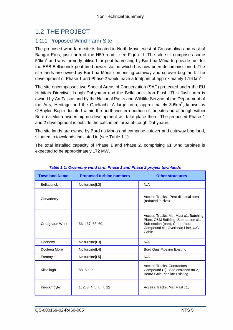
The proposed wind farm site is located in North Mayo, west of Crossmolina and east of
Bangor Erris, just north of the N59 road - see Figure 1. The site still comprises some
50km2 and was formerly utilised for peat harvesting by Bord na Móna to provide fuel for
the ESB Bellacorick peat fired power station which has now been decommissioned. The
site lands are owned by Bord na Móna comprising cutaway and cutover bog land. The
development of Phase 1 and Phase 2 would have a footprint of approximately 1.16 km2
The site encompasses two Special Areas of Conservation (SAC) protected under the EU
Habitats Directive; Lough Dahybaun and the Bellacorick Iron Flush. This flush area is
owned by An Taisce and by the National Parks and Wildlife Service of the Department of
the Arts, Heritage and the Gaeltacht. A large area, approximately 3.6km2, known as
O’Boyles Bog is located within the north-western portion of the site and although within
Bord na Móna ownership no development will take place there. The proposed Phase 1
and 2 development is outside the catchment area of Lough Dahybaun.
The site lands are owned by Bord na Móna and comprise cutover and cutaway bog land,
situated in townlands indicated in (see Table 1.1).
The total installed capacity of Phase 1 and Phase 2, comprising 61 wind turbines is
expected to be approximately 172 MW.
Table 1.1: Oweninny wind farm Phase 1 and Phase 2 project townlands
Townland Name Proposed turbine numbers Other structures
Bellacorick No turbine[L2] N/A
Corvoderry Access Tracks, Peat disposal area (reduced in size)
Croaghaun West 56, , 67, 68, 69,
Access Tracks, Met Mast x1, Batching Plant, O&M Building, Sub-station x1, Sub-station (part), Contractors Compound x1, Overhead Line, U/G Cable
Doobehy No turbine[L3] N/A
Dooleeg More No turbine[L4] Bord Gais Pipeline Existing
Formoyle No turbine[L5] N/A
Kilsallagh 88, 89, 90
Access Tracks, Contractors Compound (1), Site entrance no 2, Board Gais Pipeline Existing
Knockmoyle 1, 2, 3, 4, 5, 6, 7, 12 Access Tracks, Met Mast x1,

Non Techncial Summary
QS-000169-02-R460-005 NTS 6
Townland Name Proposed turbine numbers Other structures
Laghtanvack 8, 9, 10, 13, 14, 15, 23, 24, 25, 29, 30, 37, 41, 42, 43, 45, 46
Access Tracks, Met Mast x2, Borrow Pit, Gravel Storage Area (part)
Moneynierin
Access Tracks, Board Gais Pipeline Existing, Site entrance no 1 & 3, Gravel storage area x1, Visitor Centre & parking (part)
Shanvodinnaun 31, 44, Access Tracks, Contractors compounds x1, Gravel storage area (part)
Shanvolahan Access tracks
Sheskin 19 Access Tracks, Board Gais Pipeline Existing
Srahnakilly 11, 18, 20, 21, 22, 28, 36, 40, 54, 55, 65, 66, 80, 82, 91
Access Tracks, Met Mast x1, Sub-Station x1, Contractor Area x1, Overhead Line, U/G Cable
Tawnaghmore 27, 33, 34, 35, 39, 51, 52, 53, 64, 79, 87
Access Tracks, Met mast (1), Board Gais Pipeline Existing
N/A = No structure
1.2.2 Proposed development
The Phase 1 and Phase 2 wind farm development will comprise 61 wind turbines, which
will be used to harness the natural energy of the wind to generate electricity. The
exclusion of the Phase 3 part of the proposed development will of course result in a
reduction in the length of access track to 49km, number of turbines (from 112 to 61),
number of substations (only substation 1 and substation 2 are required) and
meteorological masts ( a reduction from 8 to 6).
The wind farm will comprise 61 wind turbine generators, each of approximately 2,500 -
3,500 kilowatt (kW) capacity. The rated electrical output of the wind farm will be
approximately 172 Mega Watts (MW) and the electricity generated will be supplied into
the deregulated electricity market on the national electricity network.
The development will include:
• Two electrical substations,
• Underground cables from the wind turbines to the substations,
• 49 kilometres of access tracks (these will be largely new with c.6km of existing
access tracks being upgraded),
• One operation and maintenance building,
• Two 110 kV overhead lines, (circa 1.7 km from Electrical Substation 1 and 2.5 km

Non Techncial Summary
QS-000169-02-R460-005 NTS 7
from Electrical Substation 2) comprising angle masts and twin wooden pole sets
connected to the existing Bellacorick substation by two underground electricity
cables.
• A visitors centre,
• Six permanent meteorological masts
Temporary works will include
• A borrow pit to provide material for access track construction
• Concrete batching plant with associated materials storage
• Contractor(s) construction lay down area and materials storage area.
• Peat repository area
The proposed development layout is shown on Figure 2. The total site area is 5,090
hectares and the development footprint of the wind turbines, cranestands, access tracks,
electrical substations, visitor centre, operation and maintenance building and
meteorological masts will occupy 2.3 % of this.
The site will also have an Operation and Maintenance facility and a purpose built Visitor
Interpretative Centre will be developed providing insight to the history of power
generation, peat production, wind energy development, the bog rehabilitation
programme, ecological interests and the social history of the area.
The wind turbines will have a maximum overall dimension of 176 m. All turbines will be
located a minimum of 1,000 m from dwellings outside the site which is well outside the
current best practice distance of 500m.
The basis of wind turbine operation is as follows:
• A yaw mechanism turns the turbines so that they face the wind
• The blades of the turbine rotate at a rate of once every 3 – 5 seconds.
• The rotation of the blades rotates a generator within a nacelle (housing) located
at the turbine hub to produce the electrical power output.
The electricity generated is fed via cables down the tower and then underground cables
to electrical transformers where it is transformed to a higher voltage for supply to the
National Grid.
Sensors are used to monitor wind direction and the tower head is turned to face into the
wind. Power is controlled automatically as wind speed varies and the turbines are
stopped at very high wind speeds to protect them from excessive loads.
The wind turbines for the project will be selected from a range of models that have been
demonstrated successfully throughout Europe and certified to the highest standard. The
contract to supply and construct the wind farm will be open to international competition.
Because sizes of wind turbines are particular to the design of individual manufacturers,
the exact rating of the turbines cannot be specified at this stage without prejudice or
favour to a particular manufacturer. The tendering process will be completed following a
grant of planning permission should one be forthcoming. However, the rated electrical
output is expected to be up to 172 megawatts (MW). The result of the tendering process
Non Techncial Summary
QS-000169-02-R460-005 NTS 8
will be the award of a contract for a particular model or models of wind turbine. The
choice of turbine model will not affect the assessment of impacts outlined herein.
1.3 SCOPING AND CONSULTATION
Scoping was originally undertaken for the Oweniny wind farm project as recommended in
the Irish Wind Energy Association Best Practice Guidelines for the Irish Wind Industry.
The scoping exercise was undertaken to obtain the views of statutory stakeholders, such
as National Parks and Wildlife Service, Inland Fisheries Ireland, An Taisce and Mayo
County Council, locally elected representatives and the general public. This exercise
helped identify the issues to be examined in the EIS.
Public consultation was also extensive prior to the original application to an Bord
Pleanála.
The issues identified through Stakeholder and public consultation and addressed in the
Oweninny Wind Farm EIS remain current and no additional consultation was undertaken
with respect to the assessment of Phase 1 and Phase 2 only.
Issues raised in submissions to An Bord Pleanála were addressed at the oral hearing
held in April 2014 and referenced in the Assessment Report for Phase 1 and Phase 2.
1.4 CONSTRUCTION
Construction will principally involve the following:
• Provision of turbine access tracks and cranepads and excavation and
construction of reinforced concrete bases with cast-in steel foundation section for
towers.
• The erection by cranes of the pre-fabricated turbine towers and the installation of
turbines and rotor blades.
• Construction of the two Electrical Substations containing the control buildings and
substations.
• Construction of the six permanent meteorological masts
• Installation of underground ducts and cabling from each turbine to the respective
Electrical Substation.
• Construction of the overhead electricity lines
• Construction of the Visitor Centre and Operation and Maintenance Building
Other elements of the development will comprise supporting works including very limited
tree felling and site infrastructure, such as site drainage, development of a borrow pit as
a source of material for construction of tracks, a peat repository area for placement of
material unsuitable for use in construction of the wind farm development and temporary
facilities during the construction phase.
The most significant requirement for materials for the project is for stone fill and concrete.
Fill material will be sourced in part from a proposed borrow pit within the site thereby

Non Techncial Summary
QS-000169-02-R460-005 NTS 9
eliminating a significant portion of the traffic usually associated with a development of
this type. The remaining fill material is likely to be imported from local quarries via the
N59 road. Concrete batching is also proposed on site to reduce the requirement for
imported concrete. This will not reduce the materials import requirement as concrete
constituents will need to be brought to the site for batching but it will reduce the peak
traffic by spreading the import requirement over a longer period of time.
A full construction management team will be deployed on site in accordance with
standard site construction procedures and all construction works will be carried out under
appropriate supervision. Works will be carried out by experienced contractors using
appropriate and established safe methods of construction.
1.5 INDICATIVE PROJECT PHASING
1.5.1 Phasing
The project will be developed in 2 phases which are influenced by grid connection and
construction scheduling and also by the nature of any planning permission granted for
the development. The following are indicative of the phase developments likely to take
place, (see Figure 3):
Phase 1 will comprise the construction of 70 - 90 MW of wind energy comprising
construction of wind turbines in the central section of the site, associated access tracks,
one electrical substation, overhead lines and cables. The Visitor Centre and Operation
and Maintenance Building will also be constructed during this phase. This phase will
connect to the existing 110 kV substation at Bellacorick and the construction is expected
to commence in 2016 with completion of Phase 1 by 2018.
Phase 2 will comprise the construction of 70 - 90 MW of wind energy comprising
construction of wind turbines in the western part of the site, associated access tracks
electrical substations, overhead lines and cables. This phase will also connect to the
existing 110 kV substation at Bellacorick and the construction is expected to commence.
The above is indicative only and the actual project phasing will be determined by the
nature of any permission granted for the site, the output size of the turbine selected
following a full procurement process and the availability of grid capacity.
1.6 PROJECT OPERATION
It is envisaged that Phase 1 and Phase 2 of Oweninny wind farm project will remain in
operation for about 30 years following its commissioning, although depending on
circumstances it may be viable to continue the project for further periods thereafter.
The existing Bellacorick wind farm on the site for example is in operation for 21 years
now and continues to perform well with high availability and turbines maintained in good
condition. It is expected to have a useful operating life in excess of 25 years in the same
environmental conditions and wind regime as those that can be expected for the
Oweninny wind farm.

Non Techncial Summary
QS-000169-02-R460-005 NTS 10
1.7 PROJECT DECOMMISSIONING
There are a number of options available when the Oweninny Phase 1 and Phase
development nears the projected end of its operational life as follows:
• Refit the turbines’ key components and continue electricity production.
• Repower with the most up-to-date technology and continue electricity production.
• Decommission the development and reinstate the site.
The most appropriate option will be adopted following a review of the wind farm
components and discussion with key stakeholders at that time.
1.8 OTHER DEVELOPMENTS IN THE AREA
A number of projects with potential for cumulative impact were assessed as part of the
Oweninny wind farm application. Since the application was made and following on from
the oral hearing some changes have occurred with respect to existing projects and some
additional projects have entered the planning process. These are outlined as follows:
• The Coillte Cluddaun Wind Farm Development has been refused planning
permission (ABP Planning Reference 16.PA0031).
• EirGrid proposed modification of existing Bellacorick Substation (see Mayo
Planning Reference 15456)
• EirGrid proposed upgrade of the Bellacorick to Castlebar 110kV OHL (that is the
Bellacorick substation to Castlebar substation) (Planning Reference P14/410).
Planning permission has been granted on appeal by An Bord Pleanála
(Reference: PL 16. 244534).
• EirGrid planning application for the Bellacorick to Moy 110 kV OHL deep works
(Mayo Planning Reference 1545). Notification of permission was issued on
04/08/2015.
• ESB Networks planning application for the Bellacorick to Bangor Erris 38kV
overhead line refurbishment/uprate project was lodged with Mayo County Council
in September (Reference P15/611)
• Proposed Windfarm development at Tawnanasool (Planning Reference
P14/666). Notification of refusal was issued by Mayo County Council on the 14th
August 2015. The applicant appealed the decision to An Bord Pleanála on the
20/08/2015 with case listed to be decided by the 23/12/2015.
• Planning permission has been granted for a temporary three year meteorological
mast development in the townland of Sheskin by ABO Wind Ireland Ltd
(Planning Reference P15/460)
• Grid West Project
EirGrid published the Government-appointed Independent Expert Panel Review
Report and accompanying appendices in July 2015 (expected end of June/July

Non Techncial Summary
QS-000169-02-R460-005 NTS 11
2015). The Grid West options assessed in the report include the following;
o 400kV Overhead line with 400kV substations
o 220kV overhead line with 220kV substations
o HVDC underground cable with Inverter Stations
A cumulative impact assessment of each of these projects is included for the
Phase 1 and Phase 2 development under each heading as appropriate.
1.9 EMERGENCY RESPONSE PLAN
Due care and precautions will be taken in the construction, operation and
decommissioning of the wind farm. However, in addition to this an emergency response
element is being included in the development.
The emergency response process makes clear how and who will be alerted in the event
of clear and immediate risk, or serious incidents, and will ensure that appropriate
mitigation can take place quickly. An emergency point of contact is provided and it is
intended that this will be manned by appropriately qualified personnel during all times of
the site’s construction, operation and decommissioning.
1.10 ALTERNATIVES
Climate change, security of electricity supply, and price stability are amongst the factors
supporting the main rationale underpinning the need for renewables as an alternative to
fossil fuel energy production. In the short-medium term at least, current and future
demand for electricity generation capacity in Ireland will remain predominantly supplied
by fossil fuel plants. However, renewable and alternative sources of power will play an
increasingly important role in meeting power needs in the future.
The development of renewable sources of energy is in line with EU and Government
policies, which have strong public support. This is also evident in Grid 25, EirGrid’s
strategy for the balanced and sustainable development of Ireland’s transmission system,
between now and 2025. The strategy will facilitate independent power production and
renewables helping to secure Ireland’s energy needs into the future.
Onshore wind power is still recognised as one of the most promising renewable energy
sources for electricity generation in Ireland. Wind energy currently represents by far the
most significant viable option for electricity generation from renewables. EirGrid, the Irish
transmission grid operator, has reported that the installed wind capacity in Ireland was
2,2011 MW at end December 2014 with a further 614 MW installed in Northern Ireland
(SONI) giving a total installed capacity of 2,825 MW on the island. The highest recorded
wind power output peaked on 21st December 2014 with a total of 2,315 MW on an all
island basis, sufficient to provide electricity to some 1.2 million homes
The site at Oweninny is ideally suited for wind energy development and the wind speeds
recorded, site size, topographic nature, heavily modified nature of land use and the
Non Techncial Summary
QS-000169-02-R460-005 NTS 12
acceptable levels of environmental impacts indicate that a wind farm with appropriately
sized turbines is economically viable at this location.
The suitability of the site is also evidenced by the fact that it holds planning for a 180
turbine wind farm development granted by An Bord Pleanála’s (Ref. PL 16.131260) for
Oweninny Wind Farm, following Mayo County Council’s similar assessment (Ref
01/2542).
Alternative layouts for the proposed development were considered during the design
phase for the layout proposed in the original EIS and which culminated in the final
proposed layout. The layout of the Phase 1 and Phase 2 wind farm components were
considered in the context of the overall Oweninny site development in phases and
evolved by taking account of various constraints as they arose during the design.
At the same time, the wind turbines and access tracks will occupy an even smaller
proportion of the overall lands at the site than in the currently permitted development and
the remainder will be available for existing or other uses.
The proposal represents the most sympathetic arrangement feasible for a wind energy
development of 61 turbines for Phase 1 and Phase 2 on this site taking account of the
constraints applying
1.11 POLICY
Renewable wind energy has developed in response to European Union policies and
directives and the road map set out by the EU towards achieving targeted reductions in
greenhouse gas emissions. The requirements of the EU have in turn been integrated into
national policy with clear targets set for the energy sector as to the level of penetration of
renewable energy into the overall energy mix for the country to be achieved by 2020.
Wind energy is recognised nationally as the option most likely to contribute maximally
towards achieving these targets which are essential to meet the requirements of
Ireland’s national climate change strategy.
The 2009 EU directive (Directive 2009/28/EC) on renewable energies requires the share
of renewable energies in the bloc's energy mix to reach 20% by 2020. Ireland’s 2005
share of renewables at 3.1% is required to increase to 16% by 2020.
Under the Kyoto Protocol the 15 countries that were EU members at the time committed
to reducing their collective emissions in the 2008-2012 period to 8% below 1990 levels.

Non Techncial Summary
QS-000169-02-R460-005 NTS 13
Further to the Renewable Energy Directives binding targets to 2020, the European
Commission acknowledged the growing concerns and clear message of the
Intergovernmental Panel on Climate Change (IPPC) Assessment Report 5 (AR5)1. In
January 2014 EU leaders agreed a 2030 policy framework that will see a domestic EU
greenhouse gas reduction target of at least 40% compared to 1990 to drive continued
progress towards a low carbon economy in the European Union.
In addition, an EU-level 2030 target for renewable energy is proposed with, at least, 27%
of EU energy consumption to come from renewable sources. This renewable energy
target does not, however, place binding targets on Member States and is to be reached
by the EU as a whole. Renewable energy will therefore play a key role in the transition
towards a competitive, secure and sustainable energy system for the EU.
Sustainability is at the heart of Government’s energy policy objectives and the Energy
White Paper in 2007 outlined the challenge of creating a sustainable energy future for
Ireland. The underpinning Strategic Goals include accelerating the growth of renewable
energy sources. The following key targets with regard to renewable electricity were set:
• 15% of Ireland’s gross electricity consumption from renewable sources to be
achieved by 2010.
• 40% of Ireland’s gross electricity from renewable sources to be achieved by 2020.
Tackling climate change is a key element of the European Commission’s energy road
map going forward to 2050. Climate change is now an accepted fact and is evidenced by
increasing temperature, changing weather patterns, glacial melting rates and sea level
rise.
Tackling climate change is also a key element for the Irish Government. In the National
context, the Irish Environmental Protection Agency has highlighted its concern at the
extent and rate of climate change which is now occurring and the consequences of this2.
“What is distinctive about the current period of global warming, compared to previous
cycles of climate change, is the extent and rate of change, which exceeds natural
variation. The impacts of climate change present very serious global risks and threaten
1 IPCC, 2013: Summary for Policymakers. In: Climate Change 2013: The Physical Science Basis.
Contribution of Working Group I to the Fifth Assessment Report of the Intergovernmental Panel on Climate Change [Stocker, T.F., D. Qin, G.-K. Plattner, M. Tignor, S.K. Allen, J. Boschung, A. Nauels, Y. Xia, V. Bex and P.M. Midgley (eds.)]. Cambridge University Press, Cambridge, United Kingdom and New York, NY, USA. 2 http://www.epa.ie/whatwedo/climate/

Non Techncial Summary
QS-000169-02-R460-005 NTS 14
the basic components of life, including health, access to water, food production and the
use of land. As the earth gets warmer the damage from climate change will accelerate”.
In its report “The EPA & Climate Change”3 the EPA indicates that
“Whilst Ireland can be justifiably proud of our scientific and technological
achievements, Ireland’s greenhouse gas emissions per person are amongst the
highest on the planet and the 2nd highest of the EU 27 countries. The reduction in
greenhouse gas emissions in Ireland and other parts of the globe which is primarily
due to the global financial crisis has shown that there is still a strong link between
economic growth and emissions.”
In its report “Ireland’s Provisional Greenhouse Gas Emissions”4 the EPA also indicates
that
For 2013, total national greenhouse gas emissions are estimated to be 57.81 million
tonnes carbon dioxide equivalent (Mt CO2 eq) which is 0.7 % lower (or 0.41 Mt CO2 eq)
than emissions in 2012 (58.22 Mt CO2 eq). This reverses the 1.0% increase in emissions
reported for 2012.
Agriculture remains the single largest contributor to the overall emissions at 32.3% of the
total. Energy and Transport are the second and third largest contributors at 19.6% and
19.1% respectively. The remainder is made up by the Industry and Commercial at
15.4%, Residential sector at 11.1% and Waste at 2.5%.
There remains a clear need in Ireland to tackle our greenhouse gas emissions with
renewable energy coming to the fore in this area. It is Government Policy to promote the
development of renewable energy sources. Sustainable energy policy includes
maximising the efficiency of generation and emphasising the use of renewable
resources. The Government’s national Climate Change Strategy 2007 – 2012 forecasts
that an annual emissions savings of 3.26 Mt of CO2 will be achieved on foot of the
Government’s renewable electricity 33% target for 2020 and even larger savings will
result from the revised renewable electricity target of 40%.
In May 2012 the Department of Communications, Energy and Natural Resources
published the Government’s Strategy for Renewable Energy, 2012 – 2020.
The Strategy notes as follows:
“The Government firmly believes that the development and deployment of Ireland’s
abundant indigenous renewable energy resources, both onshore and offshore, clearly
3 The EPA & Climate Change, Responsibilities, Challenges and Opportunities, 2011 Update
4 EPA, Ireland’s Provisional Greenhouse Gas Emissions in 2013, 3rd December 2014
Non Techncial Summary
QS-000169-02-R460-005 NTS 15
stands on its own merits in terms of the contribution to the economy, to the growth and
jobs agenda, to environmental sustainability and to diversity of energy supply. In
addition, and in support of the Government’s own energy policy objectives, Ireland is
committed to delivering on its obligations under European Union Energy Policy which
include the binding national target for renewable energy by 2020”.
In January 2015 the Department of Environment, Community and Local Government
published the Climate Action and Low Carbon Development Bill 2015. This sets out the
national objective of transitioning to a low carbon, climate resilient and environmentally
sustainable economy in the period up to and including the year 2050.
Mayo County Council’s County Development Plan 2014 to 2020 sets Policies and
Objectives which support the development of renewable energy in the county In
particular policy EY-02 sets an objective for the Council to implement the Renewable
Energy Strategy for County Mayo 2011 – 2020. The entire Oweninny site is designated
in the Mayo Renewable Energy Strategy, adopted by the Council in May 2011, as a
Priority Area for wind development.
The development of Phase 1 and Phase 2 of the Oweninny wind farm, amounting to
some 172 MW of installed wind energy, will contribute significantly to meeting the
commitments of the Governments National Renewable Energy Plan (NREAP) obligation
under the renewable energy Directive 2009/28/EC and towards meeting future EU
targets. It is fully in line with the Regional Planning Guidelines and Mayo County
Council’s energy and renewable energy policies and objectives set out in the current
County Development Plan 2014 – 2020 and is located within a Priority Area for wind
development as designated by the Mayo Renewable Energy Strategy. The development
will also contribute significantly to national greenhouse gas emission reduction and will
contribute towards achieving Ireland’s national target of renewable electricity generation.
1.12 SIGNIFICANT IMPACTS AND MITIGATION
The development of the proposed Oweninny Phase 1 and 2 will bring positive benefits to
the area in terms of employment associated directly with the construction and arising
from the spin off from associated materials supply, transport, temporary accommodation
and the community benefit which will be provided to the local community. Potential also
exists for negative impacts to occur, however these can be mitigated by good design and
good construction practice.
Incorporation of measures to mitigate environmental impacts is inherent in the planning
and design of wind farms such as at Oweninny. This extends to all phases of the wind
farm project from site selection and the concept phase, including consideration of
alternatives, through development, pre-planning and design phases to construction,
operation and decommissioning.
The hierarchy in mitigating environmental impacts in the Oweninny Wind Farm project
has been avoidance, reduction and remedy. The objective of the development has been
to maximise the sustainable wind energy capture of what is a very suitable site for wind
energy development without causing significant adverse environmental impacts. The
Non Techncial Summary
QS-000169-02-R460-005 NTS 16
design of Oweninny Wind Farm meets the primary objective of avoidance of impacts on
environmental resources.
A consideration in all projects is to manage the scope of project activity necessary to
achieve the project objectives in a manner that is environmentally responsible. At
Oweninny impacts on all aspects of the environment have been minimised by selection
of the proposed scheme for Phase 1 and 2 over the multiplicity of possible alternatives.
Key mitigating actions during design, construction and operation of the wind farm include
the following:
• Siting and design of construction of turbines to avoid potential impact on the
designated areas of the Bellacorick Iron Flush, Lough Dahybaun and other
surrounding designated areas.
• Siting of turbines, access tracks, substations and other buildings to avoid intact
bog remnants and minimise impact on bog remnants previously drained as part of
the peat harvesting operations.
• Siting of turbines outside communication corridors between telecommunication
and other transmission masts to ensure no interference with these signals.
• Siting of turbines at least one kilometre from the nearest occupied dwelling.
• Integration of the development into the existing bog rehabilitation works already
completed on the site.
• Design of foundations for the wind turbines will be undertaken by qualified
structural engineers who have successfully designed foundations for wind farm
developments in similar environments.
• A full construction management team will be deployed on site in accordance with
routine site construction procedures. This team will consist of a Resident Site
Manager and Assistant Engineers as appropriate.
• All construction works will be carried out under appropriate supervision. Works
will be carried out by experienced contractors using appropriate and established
safe methods of construction. All requirements arising from statutory obligations,
including the Safety, Health and Welfare at Work Act and associated regulations,
will be met in full.
• All forest felling will be carried out in accordance with the Forest Service
Guidelines.
Bord na Móna has a long history of peat management in Ireland and of contributing to
the energy needs of the country. It is mindful of its obligations to protect the environment
and the well being of the local people within its operational area.
ESB has had a long history of responsible operation of power plants throughout Ireland
and is mindful of its obligations in regard to environmental protection also.
Possible impacts of the proposed development were examined by assessing the
environment in terms of the existing conditions, the impact of the proposed development
and the measures taken to mitigate these impacts. The following are the key impacts
which were identified during the assessment stage of the project.

Non Techncial Summary
QS-000169-02-R460-005 NTS 17
1.12.1 Human Beings
The Oweninny wind farm project will provide meaningful direct employment in the
construction industry during the construction phases of the project which could see
employment opportunities over a 4 - 5 year period with additional spin off employment in
quarrying and materials supply. It is estimated that in excess of 100 people will be
employed directly on the wind farm site during the peak construction periods of Phase 1
and 2, with additional external employment arising from materials production and
transport to the site.
The project will involve a capital investment of about €326M and positive impacts are
expected as regards input to the local economy. In the longer term there will an ongoing
requirement for maintenance support, services and equipment. The proposed Visitor
Centre will also give rise to local employment opportunities.
Surveys both in Ireland and elsewhere of public attitudes show consistent support for
renewable energy in general and for wind power in particular.
All relevant health and safety legislation will be adhered to during all stages of the project
from construction through to decommissioning. Extensive operational experience has
shown that the health and safety record of wind turbines is exceptionally high, being
better in most instances than other forms of electricity production. The basic technology
to be employed in the project is well understood and is in an advanced state of
development. It has been used successfully in many equivalent projects both nationally
and internationally. There are no implications for health and safety.
The payment of local authority rates to Mayo County Council will provide indirect long-
term benefit for the broader community.
Community benefit schemes, which are over and above the local direct project
investment, are a well-established component of wind energy developments in Ireland.
Oweninny Power Limited will establish a community benefit scheme broadly in line with
the Irish Wind Energy Association (IWEA) community engagement and commitment
guidelines.
It is anticipated that the proposed development will not result in any significant adverse
long-term impacts on human beings. Set back distances of project components will
ensure no impact from EMF, potential turbine failure or possible ice throw during winter
weather conditions. Construction activities may cause some nuisance impacts in the
form of dust, noise, air emissions and increased traffic. However, these impacts will be
minor and of a temporary nature and will cease once construction has been completed.
Overall the benefits to human beings in the area will be positive, increasing economic
activity and providing employment opportunities in an area traditionally deprived of such
opportunities.
1.12.2 Noise
Noise is unwanted sound and can occur during construction, arising from construction
activities and machinery and during operation of the wind farm from the wind farm itself.
Construction works that could give rise to off-site noise will effectively be limited to
foundation piling, earth moving, excavating and concreting and materials delivery. Noise
Non Techncial Summary
QS-000169-02-R460-005 NTS 18
levels resulting from construction of the wind farm were calculated for various distances
from the site and it was concluded that noise levels will be well within the limits
commonly imposed for construction sites. Construction noise would also be intermittent
and temporary in nature and would occur mainly during daytime hours. Occasionally,
foundation construction may require a prolonged construction period extending into late
evening which could give rise to an extended noise impact period but this would occur at
isolated sites corresponding to turbine locations within the site and on a limited number
of days only. It is unlikely to give rise to significant impact
Continuous noise monitoring with simultaneous wind speed measurements was
undertaken to establish the existing noise environment at noise sensitive locations in the
environs of the site for the original EIS. Noise sensitive locations (NSLs) are deemed to
be any location in which the inhabitants can be disturbed by noise from the site
(including turbine noise). There are clusters of houses at Ballymunnelly Bridge,
Bellacorick, Dooleeg More, Shanvolahan and Doobehy with individual houses located on
the network of local roads surrounding the site which could potentially be impacted by
noise.
For the area in general the noise climate is typical of a rural environment and in some
areas is influenced by traffic movements on the N59 and local roads, the existing
substation at Bellacorick and farming activities in the area. Natural sounds such as the
Oweninny and Owenmore rivers, birdsong and animal calls are also evident.
Noise resulting from the operation of the wind turbines was predicted and assessed for a
range of wind speeds for the proposed Phase 1 and Phase 2 development using
computerised modelling in the context of recognised target noise levels derived from the
Department of Environment, Heritage and Local Government (now Department of
Environment, Community and Local Government) Planning Guidelines. Appropriate
noise limits for varying wind speeds were developed based on the established
background noise. Modelling predicts that noise levels attributable to the turbines will
comply with the Planning Guidelines.
As wind speed increases there is an increase in turbine noise level up to a maximum
amount; at higher wind speeds above this no noise increase occurs. The maximum noise
emission for a range of turbines was modelled to ensure that the worst case scenario
was assessed.
Distances from the turbines to the nearest dwellings outside the site ensure that noise
impacts of significance will not arise from the construction or operation of the wind farm.
Adherence to the operational noise limits set out in the Department of Environment,
Heritage and Local Government Planning Guidance will ensure that noise is unlikely to
be a significant problem at any residence located around the site.
An assessment of the cumulative noise impact of the Oweninny Phase 1 and Phase 2
proposed development from the planning approved Corvoderry wind farm was also
carried out. Although the predicted noise levels at noise sensitive locations, when both
wind farms are operating at the same time, are slightly higher than when Oweninny
Phase 1 and Phase 2 is acting alone the noise limits will not be exceeded and no
significant impact will occur, see predicted noise maps in Figure 4 and Figure 5.

Non Techncial Summary
QS-000169-02-R460-005 NTS 19
1.12.3 Shadow Flicker
Wind turbines, as with trees or any other tall structure, can cast long shadows when the
sun is shining and is low in the sky. If the sun is behind the rotor of a turbine a shadow
that flicks on and off could be created through windows of nearby houses as the blades
rotate. The shadow flicker effect lasts for just a short period and depends for its
occurrence on the following factors:
• The sun not being obscured and being at a low angle in the sky.
• The turbine(s) being directly between the sun and the affected property.
• There being enough wind for the turbine(s) to be in operation.
All three of the above factors must coincide for shadow flicker to occur. It is part of the
nature of long shadows that they pass any particular point relatively quickly and, due to
the movement of the sun across the sky, the effect, if present, lasts for only a short
period of time. It is generally only observed in the period after dawn and before sunset as
the sun is rising and setting.
Potential occurrence of shadow flicker requires that the disc outlined by the rotating
turbine blades be located in the path between the sun and a possible receptor. Each
latitude on the globe has its own shadow signature. In the northern hemisphere the sun
stays in the southern part of the sky and shadows are distributed in a V-shaped area to
the north of a turbine. There is no potential shadow flicker occurrence at receptors
located due south of a wind turbine because the arc of the sun’s movement is such that
sunshine from the north does not occur.
It is commonly acknowledged that shadow flicker does not arise at distances of greater
than ten turbine rotor blade diameters (potentially up to a maximum of 1,200m in this
instance) from the turbines. At Oweninny, there will be potential for shadow flicker to
impact on houses located to the west, central-eastern and northern locations around the
site. Shadow flicker analysis was carried out for residences in these areas with
calculations undertaken for (a) the largest size of rotor blade diameter proposed, i.e. 120
m, and (b) the largest hub height proposed, i.e. 120 m, up to an overall tip height
dimension of 176m in each case.
Some 12 properties are within a distance equivalent to ten rotor diameters (i.e. 1,200 m)
of a turbine and, therefore, have the potential to be affected by shadow flicker. However,
the calculation of the expected shadow flicker hours per year for all potentially affected
houses are significantly below the recommended guideline limit of 30 hours annually.
The recommended guideline of 30 minutes shadow flicker per day could potentially be
exceeded on 36 days in any given year at one location only on the Srahnakilla road,
although these days are all between 26th January - 12th February and 30th October – 14th
November, times of the year at which the sun is statistically less likely to be shining.
An assessment of the shadow flicker effect of Oweninny operating at the same time as
Corvoderry wind farm and the proposed Cluddaun wind farm indicates that no significant
cumulative impact will occur

Non Techncial Summary
QS-000169-02-R460-005 NTS 20
Overall, it is considered that significant impacts from shadow flicker will not arise as a
result of the Phase 1 and Phase 2 development at Oweninny. However, if valid evidence
of shadow flicker impacts is produced, the appropriate mitigation steps will be taken. This
could be achieved by pre-programming selected turbines to prevent their operation on
the dates and times when shadow flicker could cause a nuisance at a particular location
or planting of vegetation close to a residence in order to shield it from shadow flicker for
example.
1.12.4 Terrestrial Ecology
The Oweninny site is located in north-west Mayo an area dominated by Atlantic blanket
bog. On the site itself large areas of bog have been cut for peat extraction, planted with
coniferous forests or improved for agriculture. There are also substantial tracts of intact
or largely intact bog remnants within the site which are of high conservation importance
in both an Irish and European context.
The site is located in a region with many designated special areas of conservation
designated under Council Directive 92/43/EEC on the conservation of natural habitats
and of wild fauna and flora and special protection areas designated under Council
Directive 79/409/EEC on the conservation of wild birds.
The Bellacorick Bog Complex candidate Special Area of Conservation (code 01922) is a
large blanket bog site with some of the best examples of lowland blanket bog in the
country and particularly well developed pool systems. A small portion of O’Boyle’s Bog
(which is part of Oweninny wind farm site) is included within the SAC site. The Bog
Complex includes the Knockmoyle Sheskin Nature Reserve and the Owenboy Nature
Reserve.
The Bellacorick Iron Flush candidate Special Area of Conservation (cSAC - code 0466)
is a small site entirely surrounded by the Oweninny wind farm site. The site supports
several rare and protected plant species, including marsh saxifrage. Part of the SAC is
owned by An Taisce and part by National Parks and Wildlife Service of the Department
of the Arts. Heritage and the Gaeltacht and is managed for nature conservation.
The Lough Dahybaun candidate Special Area of Conservation (code 02177) is located
partly within the Oweninny wind farm site and is a good example of an oligotrophic lake
surrounded by blanket bog. It supports the rare and protected plant species Slender
Naiad. The Phase 1 and Phase 2 development will have no elements within the
catchment area of this lake.
External to the Oweninny site there are a number of very important designated Special
Areas of Conservation including; the Owenduff/Nephin Complex cSAC (code 0534), the
River Moy cSAC (code 02298), the Carrowmore Lake cSAC (code 0476), the
Broadhaven Bay cSAC (code 0542) and the Glenamoy Bog Complex SAC (code 0500).
Special Protection Areas include the Owenduff/Nephin Complex SPA (code 004098), the
Lough Conn and Lough Cullin SPA (code 004228), the Carrowmore Lake SPA (code
004052) and the Blacksod Bay/Broadhaven SPA (code 004037).

Non Techncial Summary
QS-000169-02-R460-005 NTS 21
In addition, there are Natural Heritage Areas designated under the Wildlife Amendment
Act 2000 within 20km of the site and there are proposed Natural Heritage Areas
designations which include the Bellacorick Iron Flush.
The Bellacorick Iron Flush cSAC is located within the site and the Lough Dahybaun
cSAC partially also. In addition, there are other designated sites, (Bellacorick Bog
Complex cSAC for example), within 15km of the site. A separate assessment process,
of the potential impact of the proposed development on these protected areas distinct
from the environmental impact assessment has been undertaken as required under the
EU Habitats Directive. A special study on the Bellacorick Iron flush and the Formoyle
flush located to the east of the site was undertaken to ensure that construction will not
impact on this very important area. Further information in relation to these flush areas
was provided at the oral hearing which indicated that the operation of the proposed
borrow pit and batching plant would not impact the Bellacorick Iron Flush or Formoyle
Flush.
The Oweniny site supports a substantial number of remnants of blanket bog that were
not cut for peat, though some were drained in preparation for cutting and others have
marginal disturbance from local cutting or tracks. Remedial works undertaken by Bord na
Móna have involved the blocking of drains at most of these sites in an attempt to restore
their hydrological integrity. While lowland blanket bog is the main habitat (some of which
is considered as active), other Annex I habitats are associated with these remnants,
including wet heath, dry heath, dystrophic lakes and oligotrophic lakes. After the
Bellacorick Iron Flush, O’Boyle’s Bog is by far the most important of the remnants and
also the largest in size (rated of County Importance). One other remnant is rated as of
County Importance, with eight rated as of Local Importance (higher value). The
remaining remnants are all rated as of Local Importance (lower value) as they are
generally small in size and disturbed to varying degrees. Apart from the intrinsic value of
each remnant, as a whole they provide useful corridors for plant and/or animal species
and also are a source of local species in the long-term re-vegetation process of the
cutaway areas. Some of the larger remnants occur along the margins of the site and
adjoin the extensive bogs of the Bellacorick Bog Complex SAC thereby extending the
total area of continuous bog.
An important feature of the site is the presence of a petrifying spring. This is considered
a good example of this rare habitat which is listed with priority status in Annex I of the EU
Habitats Directive. This habitat is rated as having County Importance. This is located
within the site but outside the development footprint of Phase 1 and Phase 2.
The majority of the remainder of the site is dominated by cutover blanket bog of varying
quality. Much of this has developed vegetation relatively recently and has been
encouraged by the Bord na Móna rehabilitation programme which was initiated in 2001.
At present, all of the cutover bog area is rated as Local Importance (lower value) but this
rating is expected to increase in the medium to long-term as bog vegetation becomes
better established.
The vast majority of the proposed construction locations and associated access tracks lie
within areas of cutover blanket bog which are of relatively low ecological value. These

Non Techncial Summary
QS-000169-02-R460-005 NTS 22
affected areas are dominated either by bare peat/exposed gravels, with sparse
associated vegetation.
The site supports a fairly typical mammalian fauna of open boglands. Evidence from the
site suggests that Otters tend to occur throughout the main river channels with some use
of the larger tributaries such as along the Oweninny and Muing rivers. The presence of
Otter, albeit rather sparsely, is of particular note as Otter is listed in Annex II and Annex
IV of the EU Habitats Directive. Otter is also listed as ‘Near threatened’ in the Irish Red
List. Ireland is a European stronghold for the species, and the larger rivers in the study
area provide good habitat for otter. Other species which occur on site, such as Pine
Marten and the Irish Hare, are listed in Annex V of the Habitats Directive. The Red Deer
is not a native population and hence is of low conservation importance. Badger was also
found on site.
The bat species which occur on site are listed in Annex IV of the Habitats Directive, with
Leisler’s bat also listed as ‘Near threatened’ in the Irish Red List. The common frog, a
widespread species throughout the site, is listed on Annex V of the Habitats Directive.
The common lizard is also found on site.
A total of 29 bird species of conservation importance was recorded on site, the majority
(21) of these are in the Amber list category only (i.e. of medium conservation concern in
Ireland) and many of the 29 occur on site only in small numbers or on an occasional
basis.
Four EU Birds Directive Annex I species were recorded on site. Of these the presence
of wintering Hen Harriers roosting (up to 6 individuals) is undoubtedly the most significant
and is of high importance in a local/county or even regional context. A regular night time
Hen Harrier roost occurs within the site on the ridge to the east of Lough Dahybaun. The
birds utilise the well grown heather (up to waist height in places) within this area. This is
a well established roost and provides optimum conditions for night roosting.
One pair of Golden Plover, now a rare breeding species in Ireland and very characteristic
of the extensive Atlantic blanket bogs of north-west Mayo (also a Red List species), was
found breeding on site.
Whooper Swans occur on site in low numbers and there is no longer a regular population
of Greenland White Fronted Geese in the wider area of Oweninny (though birds are
probably still attracted at times to Knockmoyle Bog). Kingfisher have been observed on
watercourses in the area.
Non Techncial Summary
QS-000169-02-R460-005 NTS 23
Red Grouse, a Red List species, was observed on site and this is of note as this species
has suffered an estimated 50% population decline in Ireland over the last four decades
(Cummins et al. 2010 5 ). The Red Grouse 2006-08 national survey found that the
northern half of County Mayo had reasonable populations, with grouse recorded in 46
out of 70 sites surveyed. The rehabilitation of the Oweninny bog will encourage further
Red Grouse to the area
Lapwing was recorded flying over the site in October 2012 and is likely to be an
occasional autumn and winter visitor.
Overall, the assemblage of breeding wetland bird species (all at least Amber listed), and
especially waders, is notable on the Oweninny site. Of particular interest is the
population of Ringed Plover, Common Sandpiper and breeding Snipe.
The discovery of a probable breeding event by Greenshank is only the second recorded
instance of breeding by this species in Ireland and so is of high significance. The
breeding at Oweninny in 2012 may have been a once-off event as rare breeding birds
will often breed or attempt to breed in an area for a season and then move on without
becoming established. However, Greenshank is known to be highly site-faithful and so
there is some chance that the same bird(s) could return in the coming years (Nethersole
Thompson & Nethersole-Thompson 19796). The breeding of Teal and Common Gull is
also significant as both of these are scarce breeding species in Ireland.
The site supports a very large population of Skylark, another Amber listed species.
Overall, the Oweninny site supports an important diversity of bird species that is
characteristic of western blanket bog, wetland habitats and forest/scrub habitats.
The development of the wind farm will result in some changes to the habitats within the
site but these changes can be considered as being consistent with the rehabilitation of
the site since commercial peat extraction ceased in the early 2000s and will be managed
so as to maximise the further development of wetland habitats.
Most bird species, including the wintering Hen Harriers, will not be affected by the Phase
1 and Phase 2 development. However, evidence from elsewhere shows that breeding
Snipe have a low tolerance to the presence of turbines and the population on site can be
expected to decrease (though any decrease may be offset by further development of
5 Cummins, S. et al. (2010) The status of Red Grouse in Ireland and the effects of land use, habitat
and habitat quality on their distribution. Irish Wildlife Manuals, No. 50. NPWS, Dublin.
6 Nethersole Thompson, D. & Nethersole-Thompson, M. (1979) Greenshanks. Poyser, London.

Non Techncial Summary
QS-000169-02-R460-005 NTS 24
suitable wetland habitat elsewhere on site). Some bird collisions may occur but species
particularly prone to collision, especially swans and geese, occur within the site area only
on an occasional basis and then in small numbers.
Other important fauna species, such as otters, bats and the common frog, are unlikely to
be affected by the project.
Sensitive design has ensured that the wind farm infrastructure is outside areas rated as
of ecological importance, especially the areas of relatively intact bog (bog remnants) and
the Hen Harrier winter roost site. The Hen Harrier roost is locate din the south east of the
site and well away from the Phase 1 and Phase 2 development area. In particular, the
project design and appropriate mitigation (as necessary) will ensure that sites designated
for nature conservation both within the site boundary and in adjoining areas are not
affected in any way (directly or indirectly). Overall, the mitigation followed in this project
has been a policy of avoidance, which is considered the best form of mitigation for
projects in ecologically sensitive areas.
1.12.5 Aquatic Ecology
The Oweninny wind farm site lies within three main river catchments – Owenmore
(Oweninny) flowing westwards to Tullaghan Bay on the west coast, Cloonaghmore (a
different Owenmore) flowing north east to Killala Bay on the north Mayo coast and the
Deel (Shanvolahan) flowing to Lough Conn in the Moy River Catchment. The main rivers
draining the site area are located in the Western River Basin District defined under the
Water Framework Directive and are therefore subject to its requirements to prevent
deterioration in water quality and to improve it where this is required. The rivers are
shown on Figure 6. Lough Dahybaun is a designated lake under the EU Habitats
Directive and is partially located within the Oweninny site. The Phase 1 and Phase 2
development is located outside the catchment areas of the Cloonaghmore, Deel and
Lough Dahybaun catchments and no potential impact could occur within these areas.
The rivers of North Mayo, particularly the Moy and its tributaries are a major tourist
attraction for both domestic and foreign anglers. In their own right the Owenmore and
Oweninny river systems are important fishery rivers in the area. This is clearly set out in
the Northwestern Regional Fisheries Board (now subsumed into the Inland Fisheries
Ireland (IFI)) publication “Towards a New Era for the Owenmore”. This is a specific
catchment management plan for this river with a main objective:
“To ensure that the Owenmore fisheries are effectively managed for today’s generation
and conserved for future generations”
Historically, the peat harvesting operations at Oweninny had a significant impact on the
aquatic ecology of the receiving waters in the catchments draining the area arising from
peat silt loss to these waters. Following the development of a comprehensive system of
drainage control using settlement ponds to trap sediment in surface runoff and a bog
rehabilitation programme to rewet bare peat areas there has been a significant reduction
in the loss of peat from the site. These measures, developed in conjunction with the
North-western Regional Fisheries Board and the Environmental Protection Agency
(EPA), have proved successful in significantly reducing peat particle loss to the aquatic
environment with a consequent major improvement in water clarity, ecology and fish
Non Techncial Summary
QS-000169-02-R460-005 NTS 25
habitat. This was evidenced by a major study undertaken by IFI and funded by Bord na
Móna between 2005 and 2008. As the bog rehabilitation programme effectiveness
continues, further reductions in peat material loss from the site will result as the extent of
bare peat areas reduces.
Fish surveys, undertaken by Inland Fisheries Ireland and by the Oweninny project team
recorded eight fish species in total in the rivers draining the site. These include salmon,
brown trout, eel, lamprey, roach, perch, pike, minnow and three spined stickleback.
Juvenile salmon were abundant on the Oweninny and Owenmore rivers.
The Environmental Protection Agency carries out water quality assessments periodically
on the rivers in North Mayo including those draining Oweninny. The most recent
assessments indicate that water quality in the rivers draining the Oweninny site is
generally of good to high status. The more recent EPA survey (2011) of the Owenmore
river flowing through Bangor Erris indicates the status as high at most locations with one
location at good (south east of Srahnakilly). The Muing river is rated as Good (2013).
The north-easterly flowing Owenmore (Cloonaghmore/Palmerstown) River is also
assessed as being at high/good status (2013) along its length. The Deel river was also
assessed as good to high at locations along its length. Water quality assessments
carried out as part of the proposed development generally confirm the EPA findings.
Water quality in Lough Dahybaun is of very high quality also.
Maintaining the water quality and fisheries habitat of these rivers is paramount during the
development, operation and decommissioning phases of the project.
In terms of potential impact on the aquatic environment the proposed wind farm
development has the potential to cause sediment material loss from construction areas
and pollution due to oil spills and waste material management which could reduce water
quality. However, unlike the peat harvesting operations of the past, only a small fraction
of the site will be disturbed by construction and potential sediment and other polluting
substances will be controlled by good engineering construction practice and through
implementation of a site specific drainage and sediment control plan. This plan integrates
the new proposed control measures into the existing peat control measures and will
ensure no significant impact on water quality and the aquatic environment.
Wind farm operation produces no discharges and, other than lubricants, uses no
chemicals. The risk of significant pollution from paved areas after construction is minimal.
Nevertheless, due care and best practice will be required to prevent any contamination
of surface waters with hydrocarbons.
Existing crossings on the Muing river and Sruffaunnamuingabatia Stream will be
upgraded as part of the development and to ensure no impact on the rivers will occur the
proposed crossing design will be discussed and agreed with Inland Fisheries Ireland
before construction takes place.
Forest plantation clearfell is required to for access track construction. The clearfelling
requirement is low (1.05 hectares) and although it has the potential to cause sediment
and nutrient loss to the rivers this will be limited and will be further minimised by ensuring
that it is carried out in accordance with the Forest Service Guidance documents. Where
Non Techncial Summary
QS-000169-02-R460-005 NTS 26
brash, a source of nutrient release occurs on deep peat it will be removed during access
track construction and placed in a peat repository area well away from any river.
The risk of potential peat slip arising from project activity has been assessed and with
mitigation proposed no significant residual risk has been identified.
Cumulative impacts could potentially arise from the construction of other projects located
near the site, including wind farms, proposed gas peaking plant near the Oweninny river
on lands running through the centre of the site and overhead line uprates. However,
each of these projects will have passed through environmental assessment and the
planning process and will be required to implement detailed pollution control measures
during construction, operation and decommissioning. Significant cumulative impacts are
therefore not expected.
1.12.6 Landscape
Where installed, wind turbines modify the traditionally perceived image of the countryside
and as they become part of the rural landscape they influence the character of the
surrounding area. It is a common conception that a significant impact of wind farms is
caused by the dominance of their visual characteristics. So it is desirable, when feasible,
to decrease that effect. However, wind farms like all developments should not be judged
solely on their visual properties but should also be valued for other qualities such as
what they symbolise.
The Phase 1 and Phase 2 development of the Oweninny site is located across the
former peat harvesting areas of Bellacorick, north of the N59, a modified landscape. The
R315 runs approximately 7km to the east at its closest. The R312 approaches the site
from the southwest before joining the N59. The R314 runs through the northern study
area arching from west to north to east at an approximate 9.5km distance to the nearest
turbine.
The Western Way passes along sections of the southern and western site boundary
approaching the proposed wind farm site from the south and continuing north, northeast.
Other walking and cycling routes are located outside of the landscape basin containing
the wind farm site. The wider area contains the Céide Fields and Visitor Centre located
on the northern slopes of Maumakeogh, north of the proposed wind farm site, and facing
the Atlantic Ocean. The Ballycroy National Park and the proposed Nephin Wild Project
are located to the south and southwest across sections of the Nephin Beg Range and
are separated from the wind farm by large coniferous plantations. A number of scenic
viewpoints and scenic roads are located within the vicinity of the development site and in
the wider study area.
The proposed wind farm site is located within a large basin of generally flat terrain and it
is surrounded by mountains of the Nephin Beg Range to the south and southwest, Slieve
Fyagh to the northwest and Maumakeogh with associated hills to the north. Views from
within the basin are open, panoramic and often unrestricted for long distances due to the
lack of significant vegetation or other landmarks. The surrounding landscape appears
remote. Despite the large scale of the landscape, human influence is recognisable in the
form of a number of overhead transmission lines in the vicinity of public roads and
commercial forest plantation. An existing 21 turbine wind farm is located in the south-
Non Techncial Summary
QS-000169-02-R460-005 NTS 27
eastern part of the site. The site also holds planning permission for a wind farm layout
comprising 180 wind turbines The former industrial character created by the Bellacorick
peat burning Power Station has been significantly reduced due to the removal of all
vertical power station structures and the commencing rehabilitation of the large peat
harvesting areas.
The landscape setting is large in scale and lends itself to the possibility of a large
number of turbines rather than a smaller wind farm. The proposed development
comprising 61 turbines would constitute a large wind farm.
The visual effects of a wind farm will depend upon the distance of the observer from the
wind farm, with visibility decreasing significantly over 5 to 20km. With other forms of
development, low visibility correlates to low visual effects and the less a development is
seen, the more positive the impact. With respect to wind farms however, of greater
importance than the extent of visibility in determining visual effects, is the nature of the
visibility (i.e. how a wind farm is seen within the landscape). For example whether it
appears balanced within the visual composition of a view, whether it creates a focal point
or if it blends into the background.
The Phase 1 and Phase 2 development will form two sections to the east and west
separated by the Oweninny River. The centre of the study area is characterised by open
and unimpeded panoramic views across a smooth and uniform landscape which lacks
significant vertical landmarks and results in a sense of openness, emptiness, remoteness
and isolation. Mountain ranges enclosing the basin to three sides provide a backdrop on
the horizon anchoring the scenery when looking north, west and south.
The proposed development will be often seen as one unit with a balanced composition of
turbines. It will form a prominent new feature and result in generally medium landscape
effects and moderate to substantial visual effects. The majority of available open views
will be experienced from within the proposed wind farm site, within approximately 8km of
its boundary and from mountain summits and slopes located to the north, west and south
facing the proposed development. A Zone of Theoretical Visibility (ZTV) map
representing visibility within a bare earth landscape, which is depicting a `worst case'
scenario with none of the screening effects of vegetation being taken into account for the
maximum tip height of 176m is provided in Figure 7. Examples of how the wind farm will
look from the N59 near Lough Dahybaun are shown in Figure 8 and in Figure 9.
The development will have an impact on the overall landscape and visual character of
the centre of the study area, which cannot be reduced due to number and scale of the
proposed wind turbines. However, the openness of short and long distance views will
remain due to the spacing of the turbines in relation to each other and due to the large
scale and uniformity of the landscape. Turbines can appear higher than the mountain
backdrop in some views to the west and south. Sections of mountains will then be seen
through the turbines, interfering with their ridgelines and minimising the scale of their
presence. These effects are localised and limited to locations within the wind farm site or
in close proximity to the development. The punctuation of verticality will structure the
landscape, removing the currently “empty” characteristic but retaining its openness and
underlying basin character.
Non Techncial Summary
QS-000169-02-R460-005 NTS 28
Long distance views, beyond 15km of the centre of the wind farm site will experience
generally slight to moderate visual effects and low landscape effects. The development
will be partially screened by intervening topography and vegetation helping to integrate
the turbines as one element of many in the wider view. Long distance views may lose the
sense of remoteness as a new man-made feature in an often already man altered
landscape will be added. Sections of the wind farm would form small moving features
within a wide panorama. Visibility of the wind farm, and particularly visibility from
viewpoints beyond a 15km radius from centre of the site, will increasingly depend on
clear weather conditions.
Cumulative effects will be experienced when Oweninny Wind Farm is seen together with
proposed Corvoderry and Tawnanasool wind farms and permitted Dooleeg wind turbine
developments. The majority will be cumulative effects in combination resulting in an
increase in density of vertical elements in the landscape and the strengthening of a
sustained presence of wind farm development within available views. In the majority of
available views, the wind farms will not be distinguishable from one another and will be
seen as one unit due to their close proximity to each other.
There are a number of walking and cycling routes, scenic viewpoints and scenic routes
within the study area. The majority of these recreation and tourism routes are located
outside of the Primary Principal Visual Zone and will experience therefore slight to
moderate visual effects or no visual effects due to intervening topography and
vegetation. Substantial visual effects will occur when in close proximity to the wind farm
site.
Oweninny Wind Farm will alter the landscape and visual character within the landscape
basin in the centre of the study area due to its extent and height. However, considering
the large scale of the surrounding generally homogeneous landscape, the introduction of
the wind farm will not be perceived as being out of context with the overall underlying
landscape character. Large areas within the basin have been transformed by industrial
peat harvesting activities in the past to fuel the now removed Bellacorick Power Station.
The majority of the former peat harvesting areas is now in the process of natural
rehabilitation. Considering the existing Bellacorick wind farm, operating for more than two
decades, and a planning permission to erect 180 wind turbines on the proposed site,
wind energy harvesting has already been introduced to the site location. The introduction
of large scale wind turbines will therefore not be uncharacteristic when set within the
attributes of the receiving landscape. It will intensify and re-establish an industrial sized
energy harvesting activity. In contrast to the large scale horizontal extraction method of
the past and the current small scale wind harvesting, the proposed development will
result in a sustained presence of vertical man-made elements, which will form a new
landmark over time.
1.12.7 Air & Climate
The Oweninny wind farm is located in an area where air quality is generally very good
with low concentrations of pollutants such as Nitrogen Dioxide (NO2), Sulphur Dioxide
(SO2) Particulate Matter 10 microns in size (PM10), Particulate Matter 2.5 microns in size
(PM2.5)and Carbon Monoxide (CO). This is due mainly to the prevailing clean westerly
air-flow from the Atlantic and the relative absence of large cities and heavy industry.
Non Techncial Summary
QS-000169-02-R460-005 NTS 29
Concentrations of ozone are higher in rural areas than in urban areas due to the
absence of nitrogen oxide in rural areas as an ozone scavenger. Ozone is also a
transboundary pollutant, with locations on the west coast having the highest
concentrations in Ireland.
Dust emissions during construction will be the main air quality issue but this will be
controlled through good construction practice on the site and given the distance of
dwellings to the construction areas will not give rise to any significant impact.
Construction, maintenance and operation of the wind farm will result in some Carbon
dioxide (CO2), Sulphur Dioxide (SO2) and Nitrous Oxide (NOx) emissions from transport
and construction activities. These include emissions from steel and cement production
and quarrying as well as from transport, erection, road building and maintenance.
Transport of materials to Oweninny will be the major contributor to CO2 emissions
associated with the project construction.
Amongst the benefits of electricity generation from wind are considered to be its
contribution to environmental sustainability and displacement of CO2 from combustion of
fossil fuels. Increased atmospheric levels of greenhouse gases enhance the natural
greenhouse effect and are widely recognised as the leading cause of climate change.
The most important long-lived greenhouse gases are Carbon Dioxide (CO2), Nitrous
Oxide (N2O), and Methane (CH4). CO2 arises from a range of sources including the
combustion of fossil fuels.
The renewable electricity from the development would displace electricity generated from
non-renewable sources. A life cycle analysis of the CO2 displacement over the project 30
year operational horizon of Phase 1 and Phase 2 development has been carried out. In
summary, it indicates that the carbon footprint and fossil carbon saved would be as
follows:
• The carbon footprint is: 383,817 tonnes CO2
• The fossil carbon saved is: 6,908,441 tonnes CO2
• The carbon emitted is: 5.56% of the carbon saved
• The carbon payback period is: 1.67 years
The construction emissions are insignificant when compared to the level of carbon
dioxide, sulphur dioxide and oxides of nitrogen that will be displaced from energy
production by conventional means from fossil fuels, see Table 2.
Table 2: Approximate Annual Equivalent Air Emissions Displaced from Fossil Fuel
combustion
Carbon Dioxide (CO2) Sulphur Dioxide (SO2) Oxides of Nitrogen (NOx)
213,804 t 3,490 t 2015 t
The International Energy Agency (IEA) has clearly acknowledged that wind power is now
a mainstream energy technology and that it must play a central role in combating climate
change. It also acknowledges that wind power, along with energy efficiency and fuel-
switching will play the major role in reducing emissions in the power sector in the next

Non Techncial Summary
QS-000169-02-R460-005 NTS 30
10-20 years, the critical period during which global emissions must peak and then begin
to decline if the worst effects of climate change are to be avoided.
The wind farm development overall will have a significant positive impact on air quality
and climate and will help meet the Irish Government’s international obligations regarding
reduction of carbon dioxide (CO2) emissions. The development of renewable energy and,
particularly in Ireland, wind energy with zero emissions is seen as an essential element
in achieving reductions in emissions, while allowing continuing economic expansion.
1.12.8 Geology and Soils
The project site is relatively flat lying, with cutover blanket peat overlying glacial till that in
turn overlie sedimentary bedrock of mixed lithology. No significant groundwater
resources are present at the site, although localised perched groundwater may be
associated with areas of granular overburden. No significant geological resources are
known at the site and geological heritage is limited to the banks of the
Oweninny/Owenmore River. Due to the relatively flat, drained and cutaway nature of the
site, peat stability risk is limited to discrete areas of the site. The outline design of the
proposed development has sought to minimise peat stability risks and these risks will be
further investigated and considered at the detail design stage.
Groundwater vulnerability mapping in this area indicates that soil/subsoil is over 5 m in
thickness across the site, apart from a small area adjacent to the Oweninny River in the
south of the site and to the east of Lough Dahybaun where soil is indicated to be thinner
in places. Historic investigation for the development of the former ESB Bellacorick
Power Station showed glacial deposits in excess of 20m thickness.
The construction work will require the excavation, handling and storage of soil, the
winning of construction aggregates on site from the proposed borrow pit and the
temporary storage of materials for reuse. It will also require the provision of contractor
compounds and laydown areas, concrete batching plant and other ancillary facilities. As
the works are located within cutover bog, it is intended that peat will be side cast, i.e.
placed adjacent to works locations where safe to do so, and otherwise will be placed in a
peat repository. The risks arising from the project are similar to those arising from any
large infrastructure construction project.
The excavation of soil will give rise to spoil, peat will be side cast and other soils may be
suitable for reuse at the work location or for re-use elsewhere. Excavated mineral soil
will generally need to be stored for a period of time to allow assessment of the material
and until it is required. Whilst in storage soils and broken rock may generate run-off with
high silt levels during wet periods or dust during dry periods.
General peat stability mitigation measures will be implemented across the site with
location specific mitigation measures designed for higher risk areas.
The excavation of soil reduces the natural protection of groundwater to contaminants at
or near the ground surface and makes the groundwater more vulnerable to any losses of
hydrocarbons, effluents and surface water run-off during construction. Hydrocarbons
may be lost to the ground and subsequently the groundwater during fuelling of plant and
vehicles or leakage of transformers, prior to and during installation.
Non Techncial Summary
QS-000169-02-R460-005 NTS 31
Wastewater effluents will be generated by site facilities, such as toilets. Given the scale
of the project it is expected that the construction phase will require the provision of foul
water holding tanks at the contractor’s compound areas. These will be emptied regularly
and routinely disposed of in a licensed facility. General surface water run-off from the
site may contain high levels of particulate matter associated with soil disturbance.
To connect Phase 1 of the development to the Bellacorick substation underground
electricity cables will either be ducted across the Oweninny River on the existing Bord na
Móna river crossing.
The only geoheritage feature within the environs of the site is the geomorphology of the
banks of the Oweninny River. No works are proposed on the river banks, with the
exception of the replacement or upgrading of the existing river crossing within the site. It
is not anticipated that this upgrade will affect the river bank substantially beyond the
extent of the existing crossing and is unlikely to present a significant risk.
The principal risks associated with soil and geology at the site are the management of
soils, particularly with regard to the generation of silty waters, and the loss of
construction and operational materials (concrete, fuel, oil and lubricants) to water. It is
expected that these risks can be fully mitigated through the adoption of construction and
operational good practice.
Prior to commencement of construction work the Contractor will be required to finalise a
Construction and Environment Management Plan (CEMP). The CEMP will detail the
procedures to prevent, control and mitigate potential environmental impacts from the
construction of the works and shall detail procedures and method statements for the
management of specific issues, e.g. the CEMP will include an oil spill response
procedure.
The Contractor will be required to obtain all permits and licences from the regulatory
authorities as required by environmental law or regulation and will discharge the relevant
conditions of the planning permission to commence site works, or as otherwise
appropriate in advance of specific site activities.
To facilitate operational activities at the site fuel and oil storage will be required, primarily
in the permanent maintenance/contractors compound, although remote use of fuel and
oil will be required from time to time. Fuel and oil storage and handling requirements will
be as detailed for construction, with permanent fuel and oil storage located within
permanent covered bunds. Electrical apparatus, such as transformers, will be required
within the substations and all such oil containing electrical apparatus will be constructed
within permanent concrete bunds tested to provide containment.
It is not expected that the project will give rise to any significant residual impacts with
regard to soil and geology.
1.12.9 Traffic and Transport
The construction of the wind farm at Oweninny is similar to many other wind farms in
Ireland although at a larger scale. It will generate construction traffic with heavy goods
vehicles transporting stone fill material from quarries, reinforcing iron bar and concrete
for foundations. Normal building construction materials, such as blocks, bricks, timber

Non Techncial Summary
QS-000169-02-R460-005 NTS 32
steel and glass will also be delivered to site during construction. There will also be a
number of abnormal loads of traffic for wind turbine component delivery and transformer
deliveries for the substation.
1.12.9.1 Site Entrances
Two existing site entrances off the N59 are proposed as access locations to the
Oweninny wind farm site as follows:
Access Point 1 - the existing entrance to the Bord na Móna Bellacorick wind farm located
approximately 260 metres east from the junction of the N59 with the R312. This access
will be utilised mainly during phase 1 of the construction and also for phase 2 and 3.
Access Point 2 - the existing entrance to the Bord na Móna lands located approximately
1.4 kilometres west of the local road (L52925) to Srahnakilly. This access point will be
used mainly during phase 2 of the wind farm construction.
The locations of the access points are shown on Figure 10. Safety audits of these
proposed entrances have been undertaken by an independent consultant and the
recommendations of the audit have been incorporated into the design of the entrances to
minimise the risk of accidents at these locations.
1.12.9.2 Abnormal load deliveries
Delivery of wind turbine components are considered to be abnormal size loads and each
turbine requires about ten deliveries, including separate blade deliveries, tower
components, hub and nacelle and transformer.
Example of a wind turbine blade in transport
Potential haul routes for abnormal loads have been identified from Dublin Port or
Killybegs to the site. Of these, the route from Killybegs through Sligo town, Ballisodare,
Ballina and Crossmolina was initially assessed as the most viable and cost effective
option for component delivery However, final haul route selection will be the

Non Techncial Summary
QS-000169-02-R460-005 NTS 33
responsibility of the turbine supplier and the final route and any modifications will be
agreed with local authorities along the route. The possibility of using rail freight transport
as opposed to road was investigated but was found to be non-viable. The road
infrastructure through the towns of Castlebar and Westport and the route approaching
the site using the N59 from Westport or the R312 from Castlebar were examined at a
high level and were also deemed non-viable due to the amount of buildings that impact
on the route and the amount of road widening and land take that would be required.
The routes from Foynes Port or Cork Port, while viable, do not to have any significant
advantages over Dublin Port or Killybegs.
Delivery of large wind turbine components poses special road traffic risks and there have
been a number of road accidents associated with collisions involving wind turbine
component delivery. These accidents can be avoided by undertaking comprehensive
route surveys with deliveries accompanied by an escort vehicle and, should the need
arise, the temporary closure of roads to traffic. Any local road improvements that are
necessary for delivery of wind turbine components will improve overall road safety in the
long term.
Abnormal load deliveries will be accompanied by safety vehicles and the timing of
delivery will be notified to the County Council and local residents along the transport
route.
1.12.9.3 Construction deliveries
During construction, vehicles requiring access during the civil engineering and
earthworks phase will include tracked excavators, dump trucks, fixed or articulated
haulage trucks and mobile cranes. Commercial traffic movements are likely to be spread
throughout the working day and there will be a small increase in private car movements
at the beginning and end of the day as the workforce arrives at and departs from the site.
A total of 100 miscellaneous vehicles have been assumed for a project of this size.
The major requirement for ready mixed concrete will be for construction of the turbine
bases, foundation piling, fencing bases, transformer bases and bunds at the electrical
substation and for the control building within it, for the O&M building foundation and
flooring, for the Visitor Centre foundation and flooring and for the meteorological mast
foundations. It is estimated that 33,222 cubic metres of concrete would be required for
phase 1 of the development with a further 30,180 and 56,430 cubic metres required for
phase 2 and phase 3 respectively. In the worst case scenario all concrete required will
be imported to the site from external suppliers. From experience on other wind farm
construction sites it is expected that 6 to 8 concrete vehicles per hour would be the
maximum number of deliveries associated with any single turbine foundation
construction or concrete piling operation that would be practical from a construction
aspect. This would equate to an additional 16 HGV movements associated with concrete
deliveries on the N59 per hour. Foundation concrete pours must be completed in one
day to ensure structural integrity of the concrete, hence on such days the duration of
increased traffic movements would extend from between 10 – 14 hours.
Non Techncial Summary
QS-000169-02-R460-005 NTS 34
An option to provide concrete batching on site has been included in the proposal and this
would reduce the peak traffic on the N59 when operational. However, it would be unlikely
to replace the delivery of all the concrete required for construction.
Crushed stone fill material will be required for construction of access tracks and crane
hard stands within the site. It is estimated that 196,153 cubic metres will be required for
phase 1 with a further 206,175 cubic metres required for phase 2.
As part of the proposal a borrow pit will be developed on site which could yield up to
340,000 cubic metres of fill material which would significantly reduce the traffic
associated with fill deliveries on the N59.
Traffic and transport impacts on the N59 will occur mainly during the construction phase
of the project. As a worst case scenario it is envisaged that all fill required will be
imported from external licensed quarries to the site for access track and crane stand
construction. This will generate increased traffic movements to the site along the N59 at
each phase of construction. However the existing capacity of the N59 is adequate to
cater for the additional traffic movements generated by Oweninny wind farm with a
residual capacity in excess of 50% throughout the construction.
1.12.9.4 Cumulative impacts
In the case where Corvoderry and Tawnanasool wind farms would be constructed at the
same time as Phase 1 and 2 of the Oweninny development there is still adequate
carrying capacity on the N59 at peak construction. At the peak in 2020 the forecast
traffic generation of the combined projects equates to approximately 8% of the carrying
capacity of the N59 to the west of the site and 5% to the east. Only modest transport
traffic demands would occur from the overhead line upgrades and these would not give
rise to a significant increase in cumulative impacts.
Potential impacts during construction can be mitigated significantly by on-site concrete
batching and by developing an on-site borrow pit. Concrete batching will not reduce the
required import of materials but would reduce peak traffic by spreading out delivery of
concrete batching materials over a prolonged period. The on-site borrow pit if developed
would substantially reduce the requirement for imported fill in the latter part of Phase 1
and for subsequent phases. This updated EIS shows the various scenarios which
include calculations of traffic generation both with and without the borrow pit.
A condition survey of the N59 will be undertaken prior to construction and any
strengthening works agreed with the local authority. Post construction surveys will be
undertaken and any required remedial works agreed with the local authority also.
Abnormal load deliveries will be accompanied by safety vehicles and a Garda escort and
the timing of delivery will be notified to the County Council and local residents along the
transport route.
A traffic management plan will be developed and agreed with Mayo County Council to
manage potential impacts from the site. With implementation of the mitigation measures
no residual significant impact is predicted.

Non Techncial Summary
QS-000169-02-R460-005 NTS 35
1.12.10 Forestry
Forest plantation within the Oweninny site is owned by Coillte Teoranta Ltd. A private
land holding within the Oweninny site boundary, the Corvoderry site is also forested.
Coillte forests within the site boundary are located on lands owned by Bord na Móna.
The development of the Oweninny wind farm will require linear clearfelling of 1.05ha
Coillte forest plantation along proposed access trackways.
A clearfell corridor 50m in width will be required for access track development (25m each
side of the centre line of the proposed access track).
Tree felling will be subject to a felling licence from the Forest Service and will be in
accordance with the conditions of such a licence.
The main potential impacts from the proposed development relate to changes in water
quality and ecology due to potential sediment release during the felling operations and
subsequent nutrient release from forest plantation brash. To ensure a reduction in the
potential for sediment and nutrient runoff during forest harvesting, the construction
methodology will adhere to the Forest Service Forestry and Water Quality Guidelines
(2000) and Forestry Harvesting and Environmental Guidelines (2000).
The loss of 1.05ha of forest plantation is of minimal significance in the context of the site
area and the Coillte Shannetra Forest Management Plan area, with 2,529 hectares of
forest managed for timber production.
1.12.10.1 Cumulative impact
The planning approved Corvoderry wind farm is located within the eastern section of the
Oweninny site and is entirely within a private forest commercial pine plantation. The EIS
for the wind farm indicates that a total of 19.4 hectares will be clear felled to facilitate this
development. Within the Oweninny site the total cumulative area of forest plantation to
be clearfelled, combining Corvoderry and Oweninny, will be 20.4 hectares. The forest
plantation clearfell will be subject to a Forest Service Felling Licence.
1.12.11 Material Assets
1.12.11.1 Tourism
Material assets comprise resources, such as tourism for example, that are valued and
intrinsic to specific places.
Tourism is a vital component of the national economy and is now regarded as one of the
greatest potential wealth creators and employers at national level. In 2014, out-of-state
tourist expenditure, including spending by visitors from Northern Ireland, amounted to
€3.9 billion. With a further €1 billion spent by overseas visitors on fares to Irish carriers,
total foreign exchange earnings were €5.1 billion. Domestic tourism expenditure
amounted to approximately €1.5 billion, making tourism in total a €6.6 billion industry.
North Mayo offers many tourist attractions particularly in its coastal areas and regional
towns. Most notable of these within the vicinity of Oweninny wind farm are the Céide
Fields located directly north on the coast of Mayo, the Enniscoe Museum located near
Crossmolina and Ionad Deirbhle located on the Iorrais peninsula south of Béal an
Mhuirthead.
Non Techncial Summary
QS-000169-02-R460-005 NTS 36
Generally, there is concern regarding the intrusion of this type of development within
landscapes that attract visitors for their scenic beauty. However, there are no scenic
views as described in the Mayo County Development Plan 2014 - 2020 looking north
from the N59 towards the Oweninny site. Surveys of tourist attitudes to wind farms
conducted by Fáilte Ireland and more recently by VisitScotland indicate that wind farms
are not incompatible with tourism, with the majority of those surveyed indicating that they
would not avoid areas where wind farms were located. Additionally, in the case of
Scotland almost half of those surveyed indicated that the presence of a visitor centre at
the wind farm would attract them to it.
The proposed visitor centre at Oweninny will be an added attraction to the area. This
centre will provide information on the cultural heritage of the area, particularly the history
of peat harvesting and power generation on the site, the development of renewable
energy generation and the story of the bog rehabilitation programme. The visitor centre
will also provide a hub for specialist groups, Bord na Móna for example, maintains a
carbon restore research site at Oweninny as part of the Environmental Protection
Agency’s Climate Change Research Programme demonstrating the value of bog
rehabilitation.
The internal access track network within the wind farm site, comprising some 49
kilometres, provides an opportunity to develop walking routes in some areas. The
proposed development will support the regional tourist industry providing added
attraction and will have an overall significant positive benefit on tourism to the area.
1.12.11.2 Electricity Supply
The proposed Oweninny wind farm will contribute to ensuring that adequate electricity
supplies are available to support economic activity and growth in a manner fully
compatible with Government energy and environmental policies. It will ensure that
national economic development is not constrained by shortfalls in the availability of
electric power.
The Sustainable Energy Authority of Ireland (SEAI) estimates that each additional
Megawatt (MW) of installed wind capacity generates in one year the equivalent electricity
consumed by 525 average homes for the same period. The electricity generated at
Oweninny will be the equivalent to the annual consumption of 90,300 homes.
A common assertion by opponents of wind power is that as much energy is consumed in
the manufacturing and installing wind turbines as they subsequently produce. However,
the average wind farm will pay back the energy used in its manufacture within 3-5
months of commencement of operation. This is dependent on turbine size and wind
speeds. Larger turbines such as those proposed at Oweninny will have longer pay back
times, up to 8 months for example. This means that over its operating life an onshore
turbine is expected to recover multiples of the input energy required. This takes account
of energy associated with maintenance of the wind farm, as well as the losses that are
inherently part of electricity transmission and distribution systems.
1.12.11.3 Air Navigation
The site is not within any of the zones for which guidelines are laid down by the Irish
Aviation Authority (IAA). The IAA operates a Monopulse secondary surveillance radar
Non Techncial Summary
QS-000169-02-R460-005 NTS 37
(MSSR) at Dooncarton on the northwest Mayo coast near Ross Port. Slieve Fyagh at
331 metres sits directly between the radar installation and the proposed wind farm
location. The current policy of the IAA is to consider each wind farm scheme on its merits
ensuring that the safety and efficiency of air navigation is not compromised. The
Authority was contacted in the course of the consultation process. The Oweninny
development will comply with any aeronautical lighting and positional data requirement
specified by the Authority.
1.12.11.4 Communication signals
Some evidence exists that in certain circumstances wind turbines, more particularly the
rotation of the blades, can adversely affect communication systems that use
electromagnetic waves as the transmission medium, e.g. television, radio and microwave
links.
Consultation with telecommunication providers was undertaken as part of the wind farm
design process to ensure that no impact on communication corridors would occur from
the development. A TV interference prediction study will be undertaken in advance of
any construction to determine whether signal interference would occur and all necessary
measures will be undertaken to fully eliminate the impact if this is required in line with the
protocol to be signed with RTE.
1.12.11.5 Cultural Heritage
Cultural Heritage, in respect of a project, is assumed to include all humanly created
features on the landscape, including portable artefacts which might reflect the
prehistoric, historic, architectural, engineering and/or social history of the area. North
Mayo is rich in cultural history. However, there are no significant historical events
associated with the proposed development lands which have the ability to be impacted
upon by the proposed development.
Only four sites of archaeological interest/potential are listed as being located within the
overall proposed wind farm development area. Three of these are listed as Recorded
Monuments, and one listed solely in the Sites and Monuments Record (SMR) of the
Archaeological Survey of Ireland. Additionally, there are a total of ten monuments
located outside the site boundary, largely to the southeast, but within 1km of it.
No additional monuments or surface features of archaeological interest/potential were
noted either from cartographic or aerial photographic research or by surface
reconnaissance surveys.
Groundworks associated with Oweninny have the general ability to uncover and disturb
hitherto unrecorded subsurface features, deposits, structures and artefacts of
archaeological interest and potential, particularly within, though not confined to, existing
peat-bog areas. However, in terms of the present site, much of the bog has been
removed and the surface of the underlying archaeologically sterile subsoil has been
exposed and subjected to detailed survey inspections. It is not considered likely that any
subsurface archaeological features might exist in such exposed areas. However, without
specific mitigation strategies, such subsurface archaeological features that might exist
within areas of existing peat cover would be disturbed and destroyed and not identified
and recorded.
Non Techncial Summary
QS-000169-02-R460-005 NTS 38
The reported archaeological discoveries associated with the subject lands were largely
associated with initial peat excavations, which were undertaken on a phased basis. None
of the artefacts appear to have been recovered from depths in excess of 1 – 1.5m from
the original bog surface.
Given the above, it is considered that there is low-medium potential for the discovery of
previously unrecorded subsurface archaeological features and artefacts within the
subject development areas that comprise peat cover, while such potential is considered
to be very low with regard to those areas where the subsoils are presently exposed.
There are no predicted impacts by the proposed development on archaeological
monuments identified as being located within, or in the general environs of, the overall
subject development landholding. In terms of architectural heritage, there are no
protected structures located within, or in the general environs of, the Phase 1 and Phase
2 Oweninny development lands.
It is not envisaged that any impacts will occur with respect to Cultural Heritage as a result
of the project proceeding, however, to ensure this, a qualified archaeologist will be
appointed during the construction phase of the development.
1.12.12 Hydrogeology and the Bellacorick Iron Flush
A key issue discussed at the Oral hearing and the subject of submissions from National
Parks and Wildlife Service and An Taisce was the impact that the development
construction could have on the Bellacorick Iron Flush a designated SAC within the
Oweninny site. This flush area supports a community of the Marsh Saxifrage a very rare
and protected plant which is dependent on the nature of the groundwater upwelling into
the flush and also its flow. Any interference in either of these, from construction activities
associated with the development and particularly the excavation of the borrow pit could
have significant on the ecology of the iron flush. Significant additional site investigation to
confirm groundwater flow and movement was undertaken prior to the oral hearing and
subsequently presented at it, which categorically demonstrated that there would be no
impact from the construction activities associated with wind turbines or access tracks or
from the extraction of materials from the borrow pit.
1.12.13 Hydrology and Sediment
Sediment loss and water management within the site are critical to protecting the water
environment. Historically peat harvesting on the site gave rise to peat sediment loss from
bare peat areas leading to downstream increases in suspended matter and sediment
deposition. The rate of surface runoff at high flows was reduced by provision of
additional storage within the drained areas of the peat bog. With the introduction of a
sediment control system, comprising settlement lagoons and subsequent implementation
of a bog rehabilitation plan by Bord na Mona, peat sediment loss has reduced
significantly and water clarity is now good as reported by Inland Fisheries Ireland.
It is important that activities associated with Oweninny wind farm do not result in any
significant loss of sediment to the receiving rivers and that they complement the
rehabilitation measures undertaken on the site, particularly during construction. A
sediment and Erosion Control Plan was developed for the original Oweninny EIS which
Non Techncial Summary
QS-000169-02-R460-005 NTS 39
included a detailed sediment control system and measures integrated in the overall bog
rehabilitation plan for the site. Drainage from the wind farm structures is compatible with
rewetting of the bog. As a result of this the percentage runoff in the river catchments
draining the site will not be significantly changed. .
The potential increase in sediment, particularly during construction, has been factored
into the design of the drainage system, based primarily on designed first-stage treatment
at structures using local settlement lagoons and ponds, followed by spreading flow
across the peat surface, wetlands and existing ponds.
It is worth noting that the drainage regime at the site is already a modified one, with its
natural hydrology having been amended by peat extraction and by commercial forests.
1.13 CONCLUSION
The Oweninny wind farm development will occur on a site which is well suited to wind
energy development. The site is home to Ireland’s first commercial wind farm
(Bellacorick) and has already been deemed suitable for further wind energy development
through achieving planning permission for a 180 wind turbine development. The site has
been designated as a priority area for wind energy in the Mayo Renewable Energy
Strategy.
The original proposed 180 wind turbine development did not proceed due to grid
connection issues. The new proposal, occupying 4% of the Oweninny site area and
comprising 112 wind turbines, reflects advances in wind turbine technology that have
occurred since the original grant of permission and which has resulted in a development
of fewer larger turbines being proposed for the site.
The most significant environmental impacts from the project have been examined. A
separate appropriate assessment procedure in line with the requirements of the
European Unions Habitats Directive of the potential for impact on ecological protected
areas within the Oweninny site and external to it has been made. These ecological
assessment have indicated that no significant impacts will occur on the Bellacorick Iron
Flush cSAC or Lough Dahybaun cSAC or any other protected areas such as the
Bellacorick Bog complex, around the site. The assessment of impacts on the bog
remnants, bird species, bats, and typical animal fauna found on the site also indicates
that no significant impact will occur, principally through good design and through
implementation of the recommended ecological mitigation measures during construction
and operation.
Similarly, good design and mitigation implementation will ensure no significant impact on
the rivers draining the site will occur and that water quality will continue to improve as a
result of Bord na Móna’s bog rehabilitation programme.
Impacts from noise and shadow flicker have been assessed to be within the Department
of Environment, Heritage and Local Government planning guidelines applied to wind
farms. Oweninny Wind Farm will alter the landscape and visual character within the
landscape basin in the centre of the study area due to its extent and height. However,
considering the large scale of the surrounding generally homogeneous landscape, the

Non Techncial Summary
QS-000169-02-R460-005 NTS 40
introduction of the wind farm will not be perceived as being out of context with the overall
underlying landscape character. Water quality will be protected through good
construction practice coupled with implementation of sediment loss and erosion control
loss measures.
The development will offer realistic employment opportunities, mainly during the
construction phases of the project over a prolonged period, but with some permanent
employment associated with wind farm maintenance. The proposed Visitor Centre will
provide employment opportunities also and will provide an additional tourist attraction in
the general area.
The development of the Oweninny wind farm will contribute significantly to meeting the
commitments of the Governments National Renewable Energy Action Plan (NREAP)
obligation under the renewable energy Directive 2009/28/EC and will also contribute
significantly to national greenhouse gas emission reduction and towards achieving
Ireland’s national target of renewable electricity generation.
The project will have no significant impact on the Cultural Heritage of the area
With the application of various mitigation measures, there are no impacts that are
considered unacceptable within the context of the planning policy framework for
assessing wind energy projects. It is therefore concluded that the proposed wind farm is
supported by Government policy regarding the promotion of renewable energy and is
consistent with planning guidance for the development of wind energy.
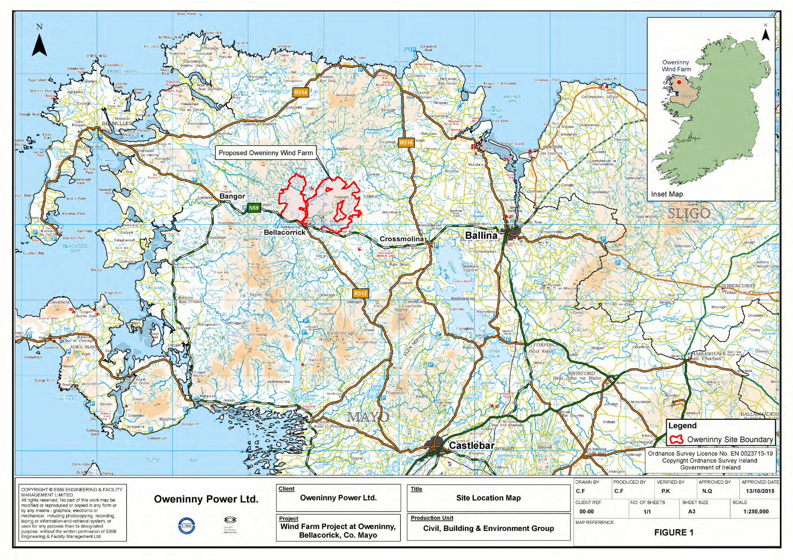
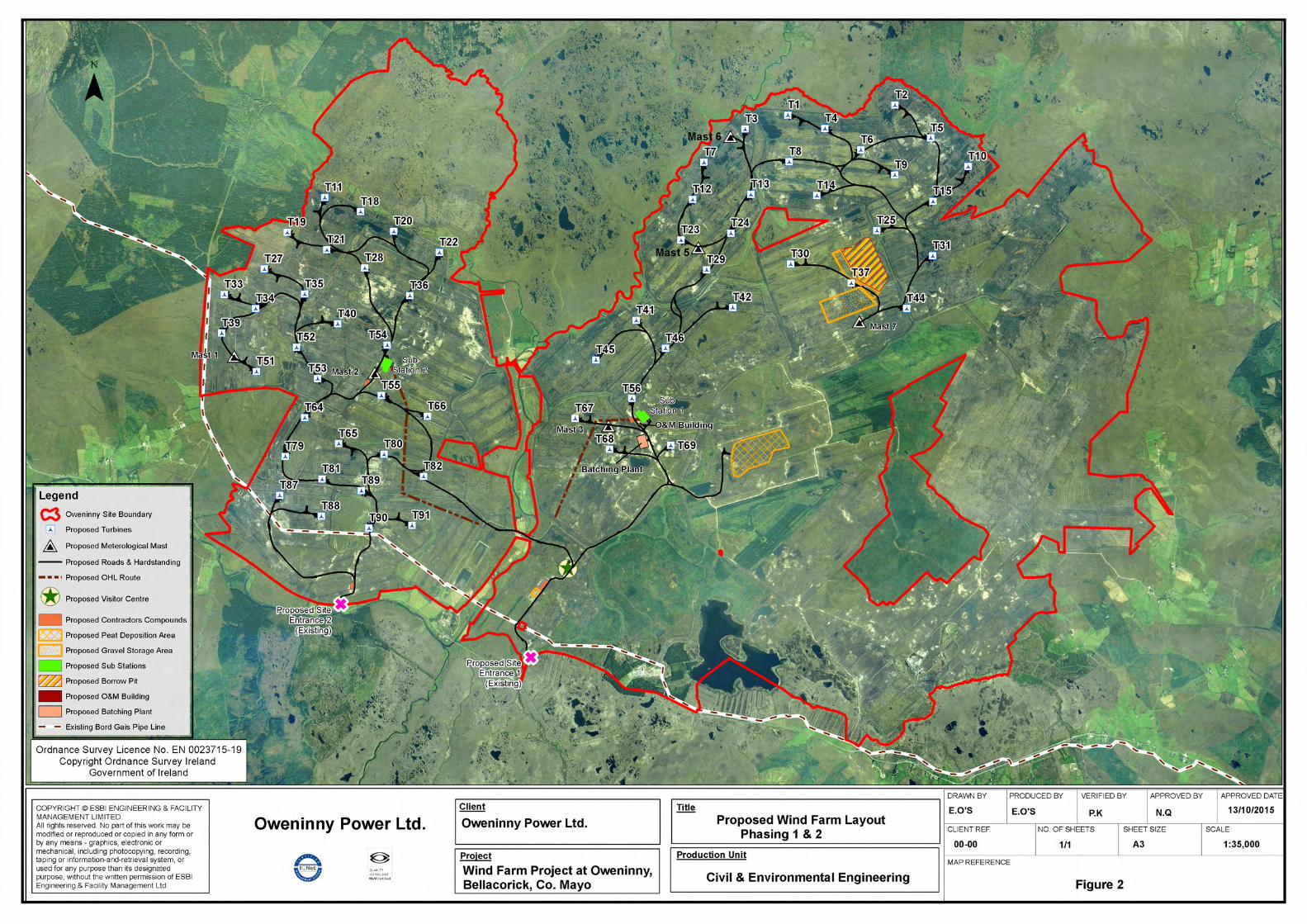

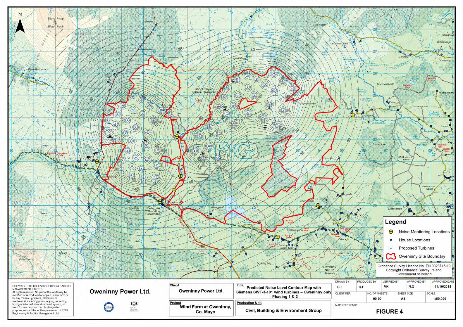

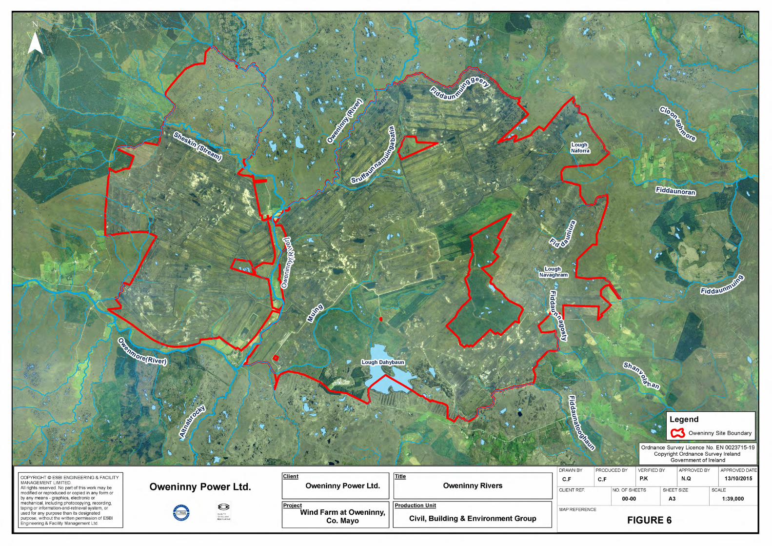

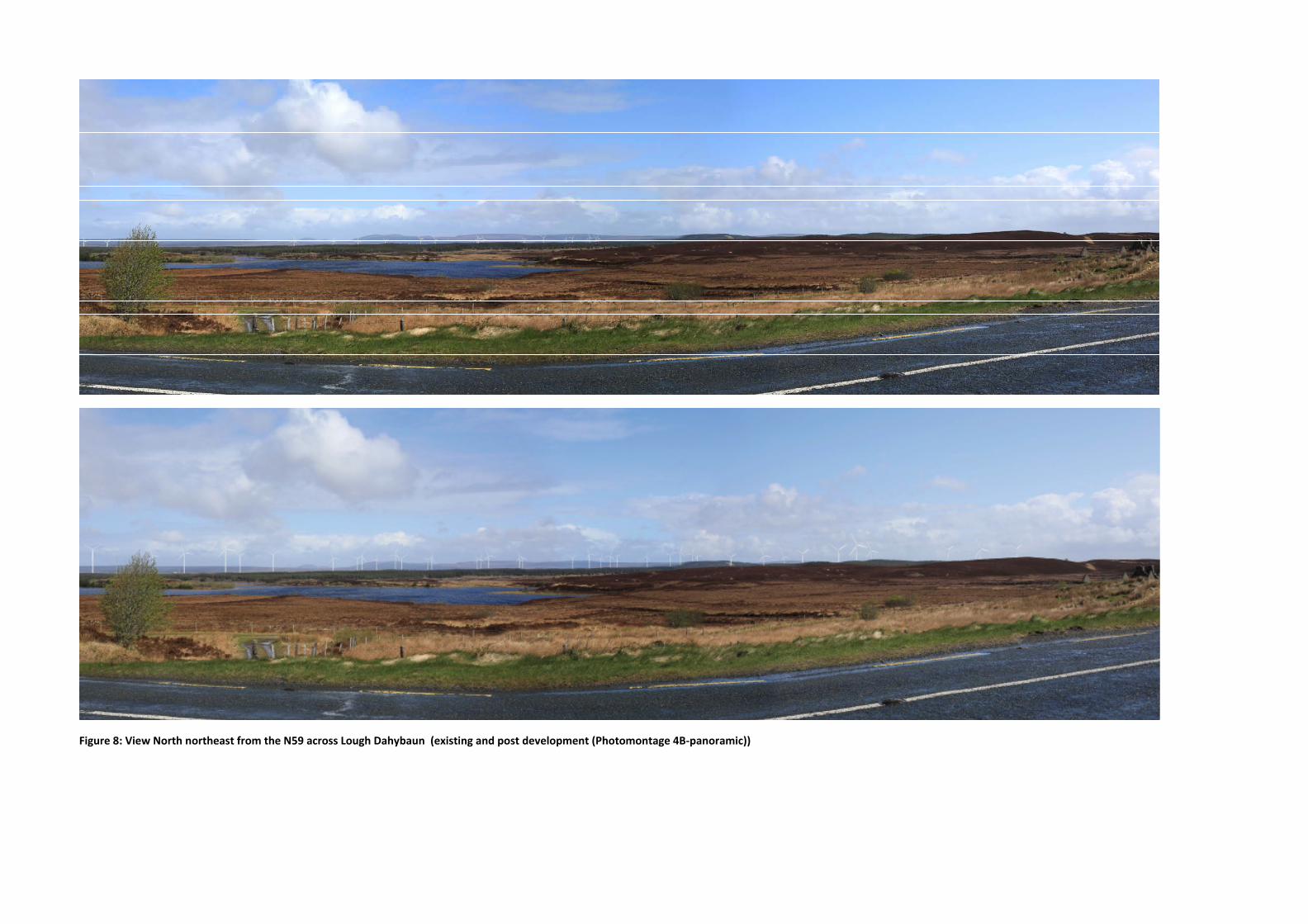
Figure 8: View North northeast from the N59 across Lough Dahybaun (existing and post development (Photomontage 4B-panoramic))

Figure 9: View north from Nephin Beg Mountain approximately 250m northeast from the summit (existing and post development (Photomontage 15-panoramic))