ENVIRONMENTAL IMPACT ASSESSMENT STUDY … IMPACT ASSESSMENT STUDY FOR THE PROPOSED GREENFIELD...
170
ENVIRONMENTAL IMPACT ASSESSMENT STUDY FOR THE PROPOSED GREENFIELD AIRPORT AT RAJKOT, GUJARAT GOVERNMENT OF GUJARAT AUGUST 2017 (QCI/NABET Accredited EIA Consultancy Organization)
Transcript of ENVIRONMENTAL IMPACT ASSESSMENT STUDY … IMPACT ASSESSMENT STUDY FOR THE PROPOSED GREENFIELD...
ENVIRONMENTAL IMPACT ASSESSMENT
STUDY FOR THE PROPOSED GREENFIELD
AIRPORT AT RAJKOT, GUJARAT
GOVERNMENT OF GUJARAT
AUGUST 2017
(QCI/NABET Accredited EIA Consultancy Organization)


Template No. 5-0000-0001-T2 Rev. 1 Copyrights EIL – All rights reserved
Document No. B046-EI-1742-1701
Rev. No. 0 Page 1 of 3
EIA STUDY FOR THE NEW GREENFIELD AIRPORT AT RAJKOT, GUJARAT
APPROVED TOR COMPLIANCE STATEMENT

Template No. 5-0000-0001-T2 Rev. 1 Copyrights EIL – All rights reserved
Document No. B046-EI-1742-1701
Rev. No. 0 Page 2 of 3
EIA STUDY FOR THE NEW GREENFIELD AIRPORT AT RAJKOT, GUJARAT
SPECIFIC TOR
S.No. Description Compliance
1 The Committee allowed to use data up to June, 2017.
Baseline data was collected from April - June 2017. Details of baseline data are given in Chapter-4.
2. Importance and benefits of the project Proposed setting up of Rajkot airport is of national importance. Projects benefits are given in Chapter-8.
3. A toposheet of the study area of radius of 10 km and site location on 1:50,000/1:25,000 scale on an A3/A2 sheet (including all eco-sensitive areas and environmentally sensitive places).
Site location map is shown in Figures 2.1 & 2.2 of Chapter-2.
4. Layout maps of proposed project indicating runway, airport building, parking, greenbelt area, utilities etc.
Lay out map is shown in Figure 2.3 of Chapter -2.
5. Cost of project and time of completion. Costs of project and time of completion is given in section 3.1 of Chapter-3.
6. The EIA report will give a justification of the land requirements for the project. It will also provide the guidelines, if any, developed by the Airport Authority of India regarding land requirements for airports in India and the conformity status with regards to the land provisions proposed.
Analysis of alternatives is described in Chapter-3.
7. A major part of the project land is reserve forest. The status of forest clearance should be provided along with the details on compensatory forestation and its impact on the nearest wild life sanctuary.
Forest clearance recommendation from Forest Department, Government of Gujarat is received on 13/07/2017 and same is sent to MoEF.
8. A management plan for the conservation of top soil in the cut and fill operations proposed. Area has a contour difference of about 20 m hence management of leveling and surplus/deficit of earth be given including Top soil preservation.
There will be no export of soil and it is estimated that there will be surplus of earth. Impact analysis on soil environment is given in section 5.3.3 of Chapter-5.
9. Details on environmental problems, compliance status and improvement plans, if any for the existing airport which is planned to be retained.
Environmental management plan for construction and operation of airport for various components of environment is given in Chapter 10.
10. A note on appropriate process and materials to be used to encourage reduction in carbon foot print. Optimize use of energy systems in buildings that should maintain a specified indoor environment conducive to the functional requirements of the building by following mandatory compliance measures (for all applicable buildings) as recommended in the Energy conservation building code (ECBC) 2007 of the Bureau of Energy
A detail of energy conservation measures/application of non-renewable energy measures and use of building materials is given in section 10.1.5 of Chapter-10.

Template No. 5-0000-0001-T2 Rev. 1 Copyrights EIL – All rights reserved
Document No. B046-EI-1742-1701
Rev. No. 0 Page 3 of 3
EIA STUDY FOR THE NEW GREENFIELD AIRPORT AT RAJKOT, GUJARAT
Efficiency, Government of India. The energy system includes air conditioning systems, indoor lighting systems, water heaters, air heaters and air circulation devices.
11. Electro-mechanical doors to be explored for the toilets meant for disabled persons.
A detail of possible use of building materials is given in section 10.1.5 of Chapter-10.
12. Details of emission, effluents, solid waste and hazardous waste generation and their management. Air quality modelling and noise modelling shall be carried out for the emissions from various types of aircraft.
Noise modeling assessment is given in section 5.3.4 of Chapter-5.
13. Classify all Cargo handled as perishable, explosive, solid, petroleum products, Hazardous Waste, Hazardous Chemical, Potential Air Pollutant, Potential Water Pollutant etc. and put up a handling and disposal management plan.
Details of cargo are given in Chapter-2 and roles and responsibilities of cargo emergencies are given in Disaster Management Plan in Annexure-II.
14. Noise monitoring shall be carried out in the funnel area of flight path.
Noise monitoring is carried out at 3 locations falling in funnel path and additional 3 locations in 10 km radius and details are given in Section 4.3 of Chapter-4.
15. Requirement of water, power, with source of supply, status of approval, water balance diagram, man-power requirement (regular and contract).
Details of water, powers etc. are given in sections 2.3.4, 2.3.7 of chapter-2.
16. Water bodies should not be disturbed. Layout is developed considering no disturbance to water bodies. Assessment on water bodies due to development of layout is given in section 5.3.2 of Chapter-5.
17. The E.I.A. should specifically address to vehicular traffic management as well as estimation of vehicular parking area.
Traffic analysis is given in section 4.3 of Chapter-4 and section 5.3.4 of Chapter-5.
18. Details of fuel tank farm and its risk assessment.
Risk assessment of fuel tank farm is given in section 7.3 of Chapter-7.
19. R & R plan for displaced families be given as per GoI rules.
R & R Plan is given in sections 2.3 and 5.3.7 of Chapter-2 & 5.

Template No. 5-0000-0001-T2 Rev. 1 Copyrights EIL – All rights reserved
Document No. B046-EI-1742-1701
Rev. No. 0
Page I of VIII
EIA STUDY FOR THE NEW GREENFIELD AIRPORT AT RAJKOT,
GUJARAT
EXECUTIVE SUMMARY

Template No. 5-0000-0001-T2 Rev. 1 Copyrights EIL – All rights reserved
EIA STUDY FOR THE NEW GREENFIELD AIRPORT AT RAJKOT,
GUJARAT
Document No. B046-EI-1742-1701
Rev. No. 0
Page II of VIII
1.0 INTRODUCTION Existing Rajkot airport spreads over 250 acres and has a single runway 05/23 suitable for operation of B737 type aircraft. Presently A320 type of aircraft is operating with load penalty. The airport is surrounded by a railway line and a state highway on the eastern side and residential development all around the airport. Since the existing runway length cannot be extended, the chances for operating wide bodied aircrafts from the current facility is ruled out. The main approach road to the airport passes through densely populated residential zones and is narrow and congested. Rajkot Urban Development Authority and Rajkot Municipal Corporation had proposed a plan to extend Rajkot airport runway from current 5,400 feet (1,600 m) to 6,000 feet (1,800 m) to accommodate larger aircrafts so as to provide better connectivity to major cities besides Mumbai and to cater to a large demand from the manufacturing companies located in Rajkot. The Airports Authority of India (AAI) and Ministry of Civil Aviation (MOCA) could not negotiate land acquisition price with Western Railways, thereby nullifying the only possibility of expansion of existing airport. Thus, Govt of Gujarat intends for the construction of an altogether new Greenfield Airport for the city of Rajkot. As per AAI traffic forecast, all airports in Gujarat have a moderate air-traffic growth of 5-8% with exceptions of Ahmedabad and Vadodara where traffic growth is between 8-10 %. The holistic development of Hirasar airport shall not only serve the demand generated by the city Rajkot but also, cater to the demand created on account of development in the neighbouring states. Over a due course of time, the airport shall also meet the spillover needs to Ahmedabad. Continued robust growth in the region and broader Indian economy are expected to be the primary drivers of domestic air travel at Rajkot. Also, the historical and architecturally rich cultural heritage of Gujarat and of the surrounding regions attracts international visitors throughout the year. To aid the development of trade and tourism and improve regional connectivity Gujarat needs additional aviation infrastructure. Considering the factor and the potential growth around the city, the airport is anticipated to have a considerable increase in air traffic. Owing to this, state government of Gujarat is desirous to develop a new green field international airport at Rajkot. Ministry of Environment and Forest & Climate change (MoEF & CC) has approved terms of reference (TOR) for EIA study wide letter no. 10-12/2017.IA.III dated 7th June 2017. Accordingly Govt. of Gujarat has entrusted the task of carrying out EIA to Engineers India Limited (EIL) as per approved TOR. The proposed site is accessible from State highway no.8A i.e. Ahmedabad- Rajkot state highway. An area of 1025.5 ha acres is envisaged for project development. The expected cost of the project in phase 1 excluding airport city is INR 1405 crores. The components in phase I includes Proposed Airport Size of Single Runway of Length 3040 m x Width (45 m), Single Runway for operation of C category aircrafts, Two number of parallel taxi tracks, Separation distance as per C category Aircrafts, Apron Layout, Rapid Exist Taxi Track, Development of Passenger Terminal Building, Cargo Terminal Building, MRO/Hangars, Six lane approach road to airport and boundary for new airport, Utilities and other miscellaneous facilities are envisaged. A study area of 10 km radius around the proposed airport at Hirasar village is considered for assessment and evaluation of impacts on various components of environment during both

Template No. 5-0000-0001-T2 Rev. 1 Copyrights EIL – All rights reserved
EIA STUDY FOR THE NEW GREENFIELD AIRPORT AT RAJKOT,
GUJARAT
Document No. B046-EI-1742-1701
Rev. No. 0
Page III of VIII
construction and operational phases of the project. M/s Pragati Laboratories Private Limited (PLPL), an NABL Accredited Lab collected environmental baseline data in terms of various parameters during the period April to June 2017.
2.0 BASELINE ENVIRONMENT
It can be seen fromt the above that within project site also wastelands occupy predominant land use. Administratively the proposed site falls within Doshalighuna (46.9%), Garida (29.8%), Hirasar (20.4%), Loma Kotadi (2.3%), and Bamanbore (0.7%). Meteorology– The temperature varied between 27 – 44oC in the months of April to June 2017. The predominant wind directions were west, south west, west south west and south-south west. Air environment: Ambient air quality was monitored at 8 locations. 98 Percentile concentrations of PM10 ranged from 54.7 to 62.5 µg/m3 and for and PM2.5 ranged from 24.7 to 32.7 µg/m3 respectively. The concentrations of SO2 & NOx were in the range of 10.8 – 14.7 µg/m3, and 12.3 – 18.8 µg/m3, respectively. The concentrations of PM10 & PM2.5, SO2, NOx, CO are found to be well within the NAAQS limits. Noise environment: Noise levels were monitored at 6 locations. Noise levels ranged between 48.5 – 69.0 dB (A) during day time and 39.9 – 58.9 dB (A) during night time and the levels were found to be well within limits. Land environment: Waste lands is the predominant land use in the study area. Soil samples were collected from 8 locations. The pH values ranged from 6.94 – 8.07, indicating moderate alkaline property. The nitrogen content present in the soil samples is sufficient. The soil samples for all locations are low to high in range of phosphorous. The potassium values in soil samples for all locations are mostly high. . Water environment: Three surface and four ground water samples were collected. In the ground water samples, pH, total dissolved solids, hardness, chlorides and sulphates ranged from 7.2 -7.5, 210 - 2348 mg/l, 128-450 mg/l, 36 - 930 mg/l and 25 - 350 mg/l respectively. At all locations these were within the permissible limits as per IS: 10500. Biological environment: A total of 203 plant species, 74 birds, 32 butterflies, 6 amphibians, 16 reptiles and 12 mammals are identified and enumerated in the surrounding areas. There are no National Park and Wildlife Sanctuary present in the 10 km radius from the proposed Rajkot airport. Socio-economic conditions: As per Census data (2011), study area of 10 km radius comprises of 30 villages with a total population of 47039. The perception of project affected persons is conditionally favourable for the proposed project as they are reluctant to relocate to an alternate land without same amount of agricultural and gauchar land for their cattle and provision of employment opportunities, and better public infrastructure facilities. The work of acquisition of Private land is given to Gujarat Industrial Development of Corporation by the Industries and Mines Government of Gujarat. For that, administrative approval is given to allocate of Rs. 10 Crore to the GIDC. The Government of Gujarat will suitably consider rehabilitation and resettlement if some families are to be relocated
2.1 Anticipated Environmental Impacts and Mitigation measures
Summary of potential impacts during construction and operational phases of the project are identified and is given in Table 2.0.

Template No. 5-0000-0001-T2 Rev. 1 Copyrights EIL – All rights reserved
EIA STUDY FOR THE NEW GREENFIELD AIRPORT AT RAJKOT,
GUJARAT
Document No. B046-EI-1742-1701
Rev. No. 0
Page IV of VIII
Table 2.0: Summary of Identified Impacts
Physical Biological Socio-economic
Activities
Am
bie
nt
air
qu
ality
Gro
un
d / s
urf
ace
wa
ter
(qu
an
tity
/ q
ua
lity
)
Am
bie
nt
no
ise
Lan
d (
lan
d u
se,
top
og
rap
hy
& d
rain
ag
e,
so
il)
Flo
ra
Fau
na
Liv
eli
ho
od
& o
cc
up
ati
on
Infr
as
tru
ctu
re
CONSTRUCTION
Civil and mechanical works
× × × × × × × ×
Movement of vehicles × × × × Waste water generation, handling and disposal
× × ×
Solid waste generation, handling and disposal
× ×
OPERATION
movement of Aircrafts during landing and takeoff
× ×
Storage of Fuel × Cleaning & maintenance × × Operation of emergency power generation facility
× ×
Waste water generation, handling and disposal
× ×
Solid waste generation, handling and disposal
×
Movement of vehicles × × × × 2.1.1 AIR ENVIRONMENT
Construction Phase Impacts (Significance - Low)
Dust will be generated from earth-moving, grading and civil works, and movement of vehicles on unpaved roads.
PM, CO, NOx, & SOx will be generated from operation of diesel sets and diesel engines of machineries and vehicles.
Mitigation Measures
Ensuring preventive maintenance of vehicles and equipment.
Ensuring vehicles with valid Pollution under Control certificates are used.
Implementing dust control activities such as water sprinkling on unpaved sites.
Ensure vertical stacks with height sufficient for dispersion as per CPCB guideline for DG stacks.

Template No. 5-0000-0001-T2 Rev. 1 Copyrights EIL – All rights reserved
EIA STUDY FOR THE NEW GREENFIELD AIRPORT AT RAJKOT,
GUJARAT
Document No. B046-EI-1742-1701
Rev. No. 0
Page V of VIII
Operation Phase Impacts (Significance - Medium)
HC, NOx and CO generation during aircraft movement within airport
PM, CO, NOx, & SOx generation due to passenger traffic movement.
Mitigation Measures
Developing peripheral green belt in the proposed Airport premises.
Ensuring preventive maintenance of vehicles and equipment.
2.1.2 WATER ENVIRONMENT Construction Phase Impacts (Significance: Water consumption – Medium, Effluent generation - Low)
Water required for construction phase will be sourced from Beti River/Rajkot.
Effluent streams will include cleaning and washing waste water from vehicle and equipment maintenance area, and sewage and grey water from construction camps and work sites.
Mitigation Measures
Monitoring water usage at construction camps to prevent wastage.
Ensuring that the STP at construction camps/ sites and the proposed facilities are properly designed to handle peak waste water load and properly maintained.
Ensuring supply of temporary/ portable toilets for construction staff. Operation Phase Impacts (Significance: Water consumption – Medium, Effluent generation - Low)
Water required for Airport during phase 1 will be 2 MLD, the same will be sourced from ground water. 80% of the same will be generated as sewage.
Mitigation Measures
Tracking of raw water consumption through water meters.
Installation of rainwater harvesting structures
Exploring opportunities for drip irrigation system for greenbelt development.
2.1.3 LAND ENVIRONMENT Construction Phase Impacts (Significance: Land-use & topography – Low, Soil quality - Low) 1. The impact on land environment during construction phase shall be due to
generation of debris/construction material, which shall be properly collected and disposed off.
Mitigation Measures
Avoiding rainy season for construction so as to avoid soil erosion.
Restricting all construction activities inside the project boundary.
Ensuring the top soil stock pile is not contaminated with any type of spills.
Ensuring any material resulting from clearing and grading should not be deposited on approach roads, streams or ditches, which may hinder the passage and/or natural water drainage.
Template No. 5-0000-0001-T2 Rev. 1 Copyrights EIL – All rights reserved
EIA STUDY FOR THE NEW GREENFIELD AIRPORT AT RAJKOT,
GUJARAT
Document No. B046-EI-1742-1701
Rev. No. 0
Page VI of VIII
Operation Phase Impacts (Significance: Soil Quality - Low ) Generation of hazardous and solid waste. The same will be collected, stored and disposed in their respective disposal facility owned by Government of Gujarat. Mitigation Measures
Developing and maintaining dedicated waste storage areas,
Ensuring hazardous waste storage areas are provided with secondary containment.
2.1.4 NOISE ENVIRONMENT Construction Phase Impacts (Significance - Low) Noise generation due to operation of heavy equipment and machinery, operation of DG sets and movement of heavy vehicles. Mitigation Measures
Ensuring preventive maintenance of equipment and vehicles
Ensuring DG sets are provided with acoustic enclosures and exhaust mufflers
Ensuring vehicle movement is avoided at night, and close to sensitive receptors (such as schools, hospitals, places of worship).
Operation Phase Impacts (Significance - Medium) Noise generation due to aircraft landing, takeoff and ground noise. Mitigation Measures
On top of the quota system, there is also an absolute limit on the number of flights permitted at the airport.
The noisiest aircraft use 16 points of the quota, and they’re called QC16s (QC = Quota Count). The next noisiest have eight points – QC8s. As planes get quieter, their points get smaller until the quietest planes have just half a point or are exempt altogether.
During the night quota period the noisiest types of planes are not permitted to be scheduled. Because there is a limit on the airport’s total quota of points for night-time flying, this system encourages airlines who want to fly at night to use the quietest aircraft.
Pilots are encouraged not to use reverse thrust between 23:00 and 06:00 except in the interests of safety.
2.1.5 BIOLOGICAL ENVIRONMENT Construction Phase Impacts (Significance –Medium) The area acquired for proposed airport have only few trees, mainly bushes. These will be cleared during site preparation. Mitigation Measures
Keeping a tally of trees cut.
Avoid cutting of tress wherever possible.
Closing of trenches as soon as possible after pipeline laying, if any.
Prohibiting use of firewood in project camps and making use of cooking gas mandatory.

Template No. 5-0000-0001-T2 Rev. 1 Copyrights EIL – All rights reserved
EIA STUDY FOR THE NEW GREENFIELD AIRPORT AT RAJKOT,
GUJARAT
Document No. B046-EI-1742-1701
Rev. No. 0
Page VII of VIII
Regulating speeding of vehicles. Operation Phase Impacts (Significance - Medium) Impact of hitting birds during take-off/landing operations. Mitigation Measures
Proper maintenance of green belt developed.
Regulating speeding of vehicles on the approach road of Airport. 2.1.6 SOCIO-ECONOMIC ENVIRONMENT
Construction Phase Impacts (Significance –Low)
Influx of construction workers
Local employment and business generation (positive impact). Mitigation Measures
Training contractors on company road safety policy requirements.
Determining safe, legal load limits of all bridges and roads that will be used by heavy vehicles and machinery.
Operation Phase Impacts (Significance –Low) Limited local employment and petty contracts for supplying water, providing security services, housekeeping and maintenance etc. (benefits) Mitigation Measures Ensure implementation of disaster management plan.
3.0 ENVIRONMENT MANAGEMENT AND MONITORING PLAN
A Health, Safety and Environment (HSE) management system will be established.
Dedicated environmental managers will be stationed.
Environment Management Plan (EMP) for the project covers the additional resource requirements required to implement the proposed mitigation measures and monitoring program.
Environment Monitoring Program for the proposed project describes the parameters, location and frequency for monitoring the effectiveness of the mitigation measures. It covers ambient air quality, ambient noise levels, stack emissions, source noise, raw water quality and effluent quality monitoring.
4.0 PROJECT BENEFITS
The significant positive impact on employment and occupation is envisaged on account of:
Generate direct and indirect employment.
Improve the social and economic environment in the vicinity and meets the fuel needs of the state.
Better economic status of the community due to better earnings.
Higher inputs towards infrastructural facilities.

Template No. 5-0000-0001-T2 Rev. 1 Copyrights EIL – All rights reserved
EIA STUDY FOR THE NEW GREENFIELD AIRPORT AT RAJKOT,
GUJARAT
Document No. B046-EI-1742-1701
Rev. No. 0
Page VIII of VIII
5.0 PUBLIC HEARING Based on the directive from Ministry of Environment, Forests and Climate Change, in their meeting held during 15th May 2017, Director, Civil Aviation made the draft EIA report and submitted an application to Gujarat Pollution Control Board (GPCB), Gandhinagar for organizing public hearing. The GPCB advised the Regional offices situated at Surendranagar and Rajkot to conduct the public hearing. Public Hearing was conducted at two sites in two different districts because the airport site falls in Surendrnagar and Rajkot districts of Gujarat.
Public hearing was carried out by GPCB on 3rd August 2017 at closed compound wall of primary school of Doshlighuna village, Chotila taluka of Surendranagar district. The regional officer Mr. A.M. Gadhiya of GPCB, Surendranagar and the representative of the Member Secretary of GPCB were present during public hearing. The meeting was chaired by Mr. Udit Agrawal, District Collector Surendranagar district and Mr. A.M. Gadhiya, Regional Officer-Surendranagar of GPCB. The public hearing advertisement was published in English newspaper “The Times of India” dated 01.07.2017 and in Gujarati Newspaper “Divya Bhaskar” dated 01.07.2017. Public hearing was also carried out by GPCB on 4th August 2017Juna Gam Tal of Hirashar village of Rajkot district. The regional officer Mr. H.P. Patel of GPCB, Rajkot and the representative of the Member Secretary of GPCB were present during public hearing. The meeting was chaired by Dr. Vikrant Pandey, District Collector Rajkot district and Mr. H.P. Patel, Regional Officer-Rajkot of GPCB. The public hearing advertisement was published in English newspaper “The Times of India” dated 01.07.2017 and in Gujarati Newspaper “Divya Bhaskar” dated 01.07.2017. During the process of public hearing, Regional Officer, Gujarat Pollution Control Board received submissions/ queries/ observations from Project Affected Persons (PAPs), members of public and NGOs regarding various aspects of the project. The minutes of the meeting (MoM) of public hearing and submissions (in English and Gujarati languages) received are numbered and complied. The advertisement of public hearing by GPCB, attendance of people at venue of public hearing, photographs of public hearing, questions raised by representatives present at the public hearing and appropriate replies from Director, Civil Aviation are attached in Annexure II.

Template No. 5-0000-0001-T2 Rev. 1 Copyrights EIL – All rights reserved
Document No. B046-EI-1742-1701
Rev. No.0
Page 1 of 156
EIA STUDY FOR THE NEW GREENFIELD AIRPORT AT RAJKOT,
GUJARAT
CHAPTER 1
INTRODUCTION

Template No. 5-0000-0001-T2 Rev. 1 Copyrights EIL – All rights reserved
Document No. B046-EI-1742-1701
Rev. No.0
Page 2 of 156
EIA STUDY FOR THE NEW GREENFIELD AIRPORT AT RAJKOT,
GUJARAT
1. INTRODUCTION
Rajkot is a District headquarter located on the banks of the Aji and Nyari rivers and is situated at a distance of 245 km from the state capital Gandhinagar. It was the capital of the Saurashtra State from 15 April 1948 to 31 October 1956, before its merger with Bombay State on 1 November 1956. The city was reincorporated into Gujarat State from 1 May 1960. The City of Rajkot effectively contributes to the economy of India through its small-scale and heavy industries that are under the support of the GIDC or Gujarat Industrial Development Corporation and the GSFC or Gujarat State Financial Corporation. The economy in the City of Rajkot garnered an arm aid (280 million us $) from the World Bank for the infrastructure development of the city. The plans to modernize and beautify the ancient City of Rajkot are already in place and all such infrastructure development projects promote the local business houses adding economic wealth to the country. With increased economic activity and employment, consumer behaviour changes, raising the standard of living of the people in the region. Thus, the availability of airports provides a thrust to the GDP of the local region, having a positively impact on the national economy. Airports offer increased accessibility, which in turn fuels the tourism sector. With an increase in the number of visitors and airport users, more money flows into the local economy. Existing Rajkot airport spreads over 250 acres and has a single runway 05/23 suitable for operation of B737 type aircraft. Presently A320 type of aircraft is operating with load penalty. The airport is surrounded by a railway line and a state highway on the eastern side and residential development all around the airport. Since the existing runway length cannot be extended, the chances for operating wide bodied aircrafts from the current facility is ruled out. The main approach road to the airport passes through densely populated residential zones and is narrow and congested. Rajkot Urban Development Authority and Rajkot Municipal Corporation had proposed a plan to extend Rajkot airport runway from current 5,400 feet (1,600 m) to 6,000 feet (1,800 m) to accommodate larger aircrafts so as to provide better connectivity to major cities besides Mumbai and to cater to a large demand from the manufacturing companies located in Rajkot. The Airports Authority of India (AAI) and Ministry of Civil Aviation (MOCA) could not negotiate land acquisition price with Western Railways, thereby nullifying the only possibility of expansion of existing airport. Thus, Govt of Gujarat intends for the construction of an altogether new Greenfield Airport for the city of Rajkot. As per Airport Authority of India (AAI) traffic forecast, all airports in Gujarat have a moderate air-traffic growth of 5-8% with exceptions of Ahmedabad and Vadodara where traffic growth is between 8-10 %. The holistic development of Hirasar airport shall not only serve the demand generated by the city Rajkot but also, cater to the demand created on account of development in the neighbouring states. Over a due course of time, the airport shall also meet the spill over needs to Ahmedabad.
Continued robust growth in the region and broader Indian economy are expected to be the primary drivers of domestic air travel at Rajkot. Also, the historical and architecturally rich cultural heritage of Gujarat and of the surrounding regions attracts international visitors throughout the year. To aid the development of trade and tourism and improve regional connectivity Gujarat needs additional aviation infrastructure. Considering the factor and the potential growth around the city, the airport is anticipated to have a considerable increase in air traffic. Owing to this, state government of Gujarat is desirous to develop a new green field international airport at Rajkot.

Template No. 5-0000-0001-T2 Rev. 1 Copyrights EIL – All rights reserved
Document No. B046-EI-1742-1701
Rev. No.0
Page 3 of 156
EIA STUDY FOR THE NEW GREENFIELD AIRPORT AT RAJKOT,
GUJARAT
Ministry of Environment, Forest & Climate Change (MoEFCC) has approved terms of reference (TOR) for Environmental Impact Assessment (EIA) study wide letter no. 10-12/2017.IA.III dated 7th June 2017. Accordingly Govt. of Gujarat has entrusted the task of carrying out EIA to Engineers India Limited (EIL) as per approved TOR.
1.1. PURPOSE OF THE PROJECT
Over the past few years, the city has started playing an important role when it comes to complex supply chains that involve many global engineering companies that create products such as bearings, machine tools, automobiles, electric motors and many more. The companies of Rolex Rings, Prashant Ferex and Echjay Industries are just few of the major sources of this trend. These companies have all found Rajkot favourable to establish business due to large investments made by private sectors as well as the government to local infrastructures such as power plants, ports, highways and more. Over the next years, more and more such companies are expected to come together and establish their industries in the city. The city has an estimated number of 500 foundry units. These units are made up of clusters with a main objective to cater to the casting requirements of the industry of local diesel engine. Most of the foundry units in the city produce grey iron castings for the local market. There is a small percentage of the foundry units that are to be exported. Among these include automobile castings and electric motor castings. The city is also well known for its gold purity and serves as one of the largest gold markets in India. Nevertheless, the city is also progressing when it comes to software industries with all the new call centres, multinational software companies and web development companies operating from the city. In the upcoming years, the city also plans to allocate a huge parcel of land for the development of a Special Economic Zone. According to a recent market review, the City of Rajkot has now become the Biggest Automobile Zone in Asia. Rajkot Airport is strategically located in the heart of the Saurastra region of Gujrat state and proposed to serve the entire Saurastra region. It is envisioned to be a transportation hub for the entire state for people travelling abroad. The purpose of the Master Plan of development of new airport is to provide a long term vision and framework, and at the same time, be realistic in the short term as well. The plan provides guidance for logical, balanced, sustainable yet flexible, and cost effective future development of the airport to cater to the forecast growth in air traffic and maximum use of the available land.
1.2. BRIEF DESCRIPTION OF PROJECT The summary of the proposed Airport site is given in Table 1.1.
Table – 1.1 Project Site Description
Sl. No. Particulars Details
1 Latitude & Longitude 22 23 25.2 N & 71 01 23.9 E
2 Elevation 175 m above MSL
3 Nearest village Hirasar (2 km)
4 Nearest Town Rajkot, 27 km
5 Nearest Highway NH-8A, 1 km
6 Nearest Railway Station Rajkot, 27 km
7 Nearest Airport Rajkot, 27 km
8 Nearest Water bodies Beti river, 4 km
9 Archaeologically important places None (within 10-km radius)
10 National Park / Wildlife Sanctuary None (within 10 KM radius)
11 Reserved/Protected Forests The site is 632 Ha reserved forest
12 Defence Installations None (within 10 km radius)
13 Seismic Zone Zone – III (as per IS-1893, Part III :2002)

Template No. 5-0000-0001-T2 Rev. 1 Copyrights EIL – All rights reserved
Document No. B046-EI-1742-1701
Rev. No.0
Page 4 of 156
EIA STUDY FOR THE NEW GREENFIELD AIRPORT AT RAJKOT,
GUJARAT
1.3. SCOPE OF THE EIA STUDY
TOR for the proposed Greenfield International Airport was approved wide letter no. 10-12/2017-IA-III dated 7th June 2017. EIA study has been carried out as per approved TOR. The same is attached as Annexure–I.
1.4. FRAME WORK OF ASSESSMENT The Environmental Impact Assessment (EIA) report shall cover the environmental components such as air, water, land, noise, biological and socio-economic aspects within a radius of 10 km from the project location. Major impact on account of development of the proposed green field airport shall be due to the following:
Location of airport
Construction activities
Airport operation, including air traffic and associated noise & emissions, and
Cargo handling & storage, and land transport Therefore, Chronological frame work for assessment of impacts has been made in three discrete phases of the project as:
Construction phase
Operation Phase
1.5. COVERAGE OF ENVIRONMENTAL IMPACT ASSESSMENT STUDY According to EIA Notification dated 14th September 2006, and amended in 2009 and past experience of EIL and as per provisions of section of Environment Act a corridor encompassing of area within 10km radius of proposed project location is considered as spatial frame for the impact assessment. The coverage of EIA report is outlined in the following sections.
1.5.1 PROJECT SETTING, DESCRIPTION AND ANALYSIS OF SITE AND TECHNOLOGY The proposed project site details, main Airport facilities have been defined and the description also gives details of wastes (gaseous / liquid / solid / noise) generation sources from the proposed Airport.
1.5.2 IDENTIFICATION OF IMPACTS This includes impact identification of each of the environmental parameters. In order to identify the impacts comprehensively, all the activities associated with the proposed airport facilities are analysed during the construction as well as operational phase of the project.
1.5.3 BASELINE DATA COLLECTION Once the affected environmental parameters are identified, various environmental parameters of concern are identified to establish its background quality. For this project, baseline data was provided by Client which was collected by M/s Pragati Labs Private
Limited, Hyderabad. The environmental data was collected for the period of April 2017 to June 2017. Data thus collected has been utilized here to establish baseline quality of various environmental parameters.

Template No. 5-0000-0001-T2 Rev. 1 Copyrights EIL – All rights reserved
Document No. B046-EI-1742-1701
Rev. No.0
Page 5 of 156
EIA STUDY FOR THE NEW GREENFIELD AIRPORT AT RAJKOT,
GUJARAT
1.5.4 ENVIRONMENTAL IMPACT PREDICTION & EVALUATION In this part of the report the sources of emissions (Gaseous, Liquid, Solid, Noise) due to the proposed activities will be identified and based on their emission loads their impacts are to be predicted. Such predictions are then superimposed on baseline quality (wherever there is an additional impact) and quantitative/qualitative assessments have been made for the impacts.
1.5.5 ENVIRONMENTAL MANAGEMENT PLAN (EMP) In order to mitigate or minimise the negative impacts of the proposed project, an effective EMP is called for. Therefore, in the final part of the report the planning and implementation of various pollution abatement strategies including the proposed monitoring/surveillance network has been described.
1.6 ADDITIONAL STUDIES
In addition to the above Disaster Management plan was carried out by EIL and is presented in chapter 7 of the EIA Report.

Template No. 5-0000-0001-T2 Rev. 1 Copyrights EIL – All rights reserved
Document No. B046-EI-1742-1701
Rev. No.0
Page 6 of 156
EIA STUDY FOR THE NEW GREENFIELD AIRPORT AT RAJKOT,
GUJARAT
CHAPTER 2
PROJECT DESCRIPTION

Template No. 5-0000-0001-T2 Rev. 1 Copyrights EIL – All rights reserved
Document No. B046-EI-1742-1701
Rev. No.0
Page 7 of 156
EIA STUDY FOR THE NEW GREENFIELD AIRPORT AT RAJKOT,
GUJARAT
2.1 DESCRIPTION OF THE PROPOSED SITE
The project site (22 23 25.2 N & 71 01 23.9 E) is located near the Village of Hirasar, Rajkot
District, Gujarat. Location of the project site is shown in figures 2.1 & 2.2. The proposed site is accessible from State highway no.8A i.e. Ahmedabad- Rajkot state highway. An area of 1025.5 ha acres is envisaged for project development. The expected cost of the project in phase 1 excluding airport city is INR 1405 crores. The components in phase I includes Proposed Airport Size of Single Runway of Length 3040 m x Width (45 m), Single Runway for operation of C category aircrafts, Two number of parallel taxi tracks, Separation distance as per C category Aircrafts, Apron Layout, Rapid Exist Taxi Track, Development of Passenger Terminal Building, Cargo Terminal Building, MRO/Hangars, Six lane approach road to airport and boundary for new airport, Utilities and other miscellaneous facilitiesdiscussed in detail in later sections.
Figure 2.1: Location Map of Project Site

Template No. 5-0000-0001-T2 Rev. 1 Copyrights EIL – All rights reserved
Document No. B046-EI-1742-1701
Rev. No.0
Page 8 of 156
EIA STUDY FOR THE NEW GREENFIELD AIRPORT AT RAJKOT,
GUJARAT
Figure 2.2: Location Map of Project Site
Template No. 5-0000-0001-T2 Rev. 1 Copyrights EIL – All rights reserved
Document No. B046-EI-1742-1701
Rev. No.0
Page 9 of 156
EIA STUDY FOR THE NEW GREENFIELD AIRPORT AT RAJKOT,
GUJARAT
The proposed site is accessible from State highway no. 8A i.e. Ahmedabad- Rajkot state highway. The proposed land is located at an aerial distance of 27.5 km from the existing airport. The site is approached from state highway no 8A close to Bamanbobor crossing which is at a distance around 1.5 kilometres. The elevation of site is approximately 175 meter above MSL. Details of Environmentally sensitive area falling within 15 Km from the project boundary is given in below Table – 2.1.
Table – 2.1 Environmentally sensitive areas
2.2 TRAFFIC FORECAST
The volatility experienced in the Indian aviation market over the past years has made it increasingly difficult to predict with confidence when specific volumes of passengers, cargo and air transport movements (ATMs) will be reached. Recognizing this volatility, five phases of demand, referred to as Phases of the Airport, were identified at which key airport facilities would be necessary. The transition period between the phases has been chosen in line with the recommendations of the IMG norms.
The total airport activities require lead time for planning, design and construction activities related to each phase of development. Hence, the Master plan update for the airport identified five levels of demand, referred to as Phases. Each Phase will be designed to provide a pre-determined level of capacity measured in terms of annual passenger volumes or millions of passenger per annum (mppa). Each Phase also has an associated volume of ATM, cross-referenced through the year in which each Phase is projected to be realized. The overall development program is then determined by the timing of each capacity increment which is driven by the aviation activity forecasts.
For convenience, these Phases are shown in Table 2.2 below the years in which the forecasts indicate they may occur.

Template No. 5-0000-0001-T2 Rev. 1 Copyrights EIL – All rights reserved
Document No. B046-EI-1742-1701
Rev. No.0
Page 10 of 156
EIA STUDY FOR THE NEW GREENFIELD AIRPORT AT RAJKOT,
GUJARAT
Table 2.2: Traffic Forecast
No
Historical Base case Phase -1 Phase-II Phase-III Phase-IV
2020-21 2030-31 2040-41 2050-51 2054-55
A ANNUAL Passengers in millions per annum
International passenger
0.25
0.43
0.86
1.49
2.03
Domestic Passenger
0.66
1.87
4.05
7.25
10.90
Total Passenger
0.91
2.30
4.99
8.73
12.93
Domestic traffic increases from 0.41 million passengers in 2016 to 1.87 million in 2030, an average annual growth of 11.45%. International traffic increases from 0.25 million passengers in 2020 to 0.43 million in 2030, an average annual growth of 5.57%. Total traffic increases from 0.91 million passengers in 2020 to 12.93 million in 2057, an average annual growth of 7.44%.
2.3 PROJECT DETAILS
Considering the requirements of present and future development, an area of 1025.5 ha is required for the proposed airport. The Government of Gujarat has negotiated for the purchase of 1025.5 ha to be utilized for development of the airport and commercial facilities at hirasar village. Government of Gujarat is the owner of the Hirasar Airport land. The work of acquisition of Private land is given to Gujarat Industrial Development of Corporation by the Industries and Mines Government of Gujarat.For that, administrative approval is given to allocate of Rs. 10 Crore to the GIDC. Proposed airport location is shown in figure 2.3. In addirion to Airport, a 6 lane approach road from NH-8A to Rajkot Airport site has been proposed. The land for proposed Aiport and approach road is shown in Figure 2.3.
Figure 2.3: Proposed Airport Location

Template No. 5-0000-0001-T2 Rev. 1 Copyrights EIL – All rights reserved
Document No. B046-EI-1742-1701
Rev. No.0
Page 11 of 156
EIA STUDY FOR THE NEW GREENFIELD AIRPORT AT RAJKOT,
GUJARAT
2.3.1 LAND USE The proposed site is a non-agricultural barren land. The land is stated to be forest/panchayat land and can easily be acquired as per State govt. officials. The land is undulated and has a level difference of 20-25 meters which shall require to be levelled. Hills of approximate height 50-60 meters exist in the vicinity of the proposed site. The hills appear to be of kuccha earthen type and are situated at around 12-15 kms from the proposed site. The hills may/ may not fall in the approach path or funnel. The same can be determined based on the OLS Survey. The OLS survey is being conducted through state government and shall be studied to determine whether the hills need to be cut or not. A water channel runs abutting the proposed land area. It was informed by the local people of the area that they have not come across any flood in the last so many years. Around 50-75 house/ habitations are existing in the proposed plot which shall be required to be relocated. The likely population of such habitation would be around 300 persons. A small industrial area is also located in the vicinity of the proposed land which is not found to be fouling with the proposed site and need not to be moved /shifted. Wind mills, HT/LT lines, mobile towers are also located in close proximity of site which either shall have to be lowered or relocated as per OLS Study for clear transitional surfaces. No big trees /plantation could be seen at site. Only bushes exist.

Template No. 5-0000-0001-T2 Rev. 1 Copyrights EIL – All rights reserved
Document No. B046-EI-1742-1701
Rev. No.0
Page 12 of 156
EIA STUDY FOR THE NEW GREENFIELD AIRPORT AT RAJKOT,
GUJARAT
Land use map for 10 km radius is shown in Figure 4.5 and existing landuse pattern of the proposed airport location is given in Table 2.3 and land use within 10 km radius is given in Table 2.4, below.
Table 2.3: Landuse landcover statistics of project site for Rajkot Airport
Table 2.4: Landuse landcover statistics for 10 km radius from Rajkot Airport
2.3.2 DRAINAGE PATTERN
The Airport site is presently undulated with respect to the storm water drainage and is at round 175 above the mean sea level. The natural drainage from site majorly falls towards the West and South side. The existing catchment divide and the drainage flow are shown in figure 5.1a of chapter 5. The site can be divided into 6 catchments according to the number of outfalls at the boundary which drains to the West and South of the site. The remaining area (shown as hatched) drains to the North and East. With the development of Airport infrastructure, the area contributing to the North or East will reduce and the reduced area will then contribute to the West and South side outfalls.
2.3.3 RAINFALL PATTERN/ INTENSITY
Meteorologically, Rajkot Airport region falls in central Gujrat. Monthly rainfall data available with Indian Metrological Department, Ahmedabad have been procured for the study. The summary is given in Table 2.5.

Template No. 5-0000-0001-T2 Rev. 1 Copyrights EIL – All rights reserved
Document No. B046-EI-1742-1701
Rev. No.0
Page 13 of 156
EIA STUDY FOR THE NEW GREENFIELD AIRPORT AT RAJKOT,
GUJARAT
Table 2.5: Summarized Meteorological Data (2011-2015)
Jan Feb Mar Apr May Jun Jul Aug Sep Oct Nov Dec
Avg. Temperature (°C)
19.4 21.9 26.2 30.1 32.4 32 28.9 27.8 27.9 28.2 24.8 21
Min. Temperature (°C)
10.7 13.1 17.3 21.4 24.8 26.3 25.1 24.1 23 21 16.5 12.4
Max. Temperature (°C)
28.1 30.7 35.2 38.8 40.1 37.8 32.7 31.6 32.8 35.4 33.1 29.6
Avg. Temperature (°F)
66.9 71.4 79.2 86.2 90.3 89.6 84.0 82.0 82.2 82.8 76.6 69.8
Min. Temperature (°F)
51.3 55.6 63.1 70.5 76.6 79.3 77.2 75.4 73.4 69.8 61.7 54.3
Max. Temperature (°F)
82.6 87.3 95.4 101.8 104.2 100.0 90.9 88.9 91.0 95.7 91.6 85.3
Precipitation /
Rainfall (mm) 1 0 3 1 3 101 260 183 95 15 10 2
2.3.4 WATER REQUIREMENT
Water shall be drawn from underground bore-wells @ 20,000 ltr/ hr. The water drawn from each tube well shall be limited to a maximum of 8 hours operation per day. Total water requirement is 160 m3/day after airport operation. Potable tanker supply shall be resorted only if bore well yield is not sufficient to meet the water requirement. The treated wastewater from this Airport STP shall be disinfected using chlorination and subsequently recycled for irrigation purposes. The tertiary treatment of sewage facilitates the recycle and reuse of water for non-domestic purposes like HVAC etc. Main pumping along with underground piping and intermediate pumping stations shall be provided to pump water to the Airport water storage tanks. Drinking water will be treated in order to comply with IS 10500 and World Health Organisation (WHO) guidelines. Total water requirement in 2030-31 will be 1.19 MLD. The primary driver of water supply requirements is the level of occupancy of airport buildings. Water supply requirements for employees, passenger, cleaning of floors, maintenance of aircraft, flight catering, HVAC, fire fighting and horticulture/landscaping etc. are normally worked out by first developing a criterion (which may vary from airport to airport) in terms of employees per million passenger and number of visitors per passenger. The following are the assumptions made for water demand estimation: • Passenger and terminal facilities as per NBC 2016 = 70 lts/person • Employee as per NBC 2016 = 45 lts/person • Visitor as per NBC 2016 = 15 lts/person • Flight catering as per NBC 2016 = 70 lts/person • Aircraft maintenance as per facility requirement = 500 lts/plane • Water for gardening = 6 lts/sqm/day • Water for turfing = 2 lts/sqm/day

Template No. 5-0000-0001-T2 Rev. 1 Copyrights EIL – All rights reserved
Document No. B046-EI-1742-1701
Rev. No.0
Page 14 of 156
EIA STUDY FOR THE NEW GREENFIELD AIRPORT AT RAJKOT,
GUJARAT
Development of green belt along road network has been considered for all phases. Turfing area has been calculated for existing and future using land-use plan and water application of 2.0 lts/sqm/day is considered. As per ICAO airport service manual, Part -1: Rescue and fire fighting for airport Category IX, Rajkot Airport shall fall under aerodrome category IX, hence water requirement for four (4) vehicles/station is 36400 litres plus 200% storage is provided. Total water requirement and sewage generation is estimated and detailed break-up is given in Table 2.6.
Table 2.6: Water requirement for the proposed airport
S. NO
Water Requirement in MLD
Category 2030-31 2040-41 2050-51 2057-58
Passenger/day 6301 13452 23945 35425
1. Water Required by Passengers 0.44 0.94 1.68 2.48
Employees/day 756 1614 2873 4251
2. Water Required by Employees 0.03 0.07 0.13 0.19
Visitors
3. Water Required by Retail within Terminal 0.1 0.2 0.3 0.4
4. Water required by Flight Catering 0.3 1 1.5 2.1
Daily ATM 42 93 156 234
5. Water required for Aircraft Maintenance 0.01 0.02 0.04 0.06
6. Water required for Gardening 0.3 0.5 0.9 1.2
7. Total Water Required 1.19 2.74 4.54 6.43
Total Sewerage Generation 1.07 2.46 4.09 5.79
2.3.5 WASTE WATER GENERATION AND REUSE Sewage from all facilities shall be conveyed through underground gravity / pumped lines depending on the slope available to the Central STP. The Central STP shall be sized for all the clusters to recover the recycled water to a quality suitable for use in air conditioning, flushing and irrigation. Development of this facility will be carried out in phased manner depending on the sewage load. Areas will be safeguarded for long-term demand. Standards of the Treated Effluent will be as follows: Parameters Value PH 5.5 - 9 BOD3 Less than 30 mg/L Suspended solids Less than 100 mg/L COD Less than 250 mg/L Oil and Grease Less than 10 mg/L
Template No. 5-0000-0001-T2 Rev. 1 Copyrights EIL – All rights reserved
Document No. B046-EI-1742-1701
Rev. No.0
Page 15 of 156
EIA STUDY FOR THE NEW GREENFIELD AIRPORT AT RAJKOT,
GUJARAT
It can be seen that the wastewater generation by 2058 would be approx. 5.79 MLD. The capacity of the STP required in the final phase (2057-58) shall be about 5.8 MLD. The sewage treatment plant will include tertiary treatment plant for re-using the treated effluent for irrigation of landscaping and garden areas. The aircraft waste will be chemically stabilized as primary treatment before blending into main packaged sewage treatment plant. The effluent quality will be suitable for use in irrigation of landscape / garden areas, flushing of urinals and toilets. The disposal of untreated effluent will not be allowed at any circumstances. The necessary buffer storage tank will be provided for storage of wastewater during shut-down of the treatment plant for reason. The excess sludge will be dewatered in dewatering system. The thickened sludge could be used as fertilizer in surrounding agriculture area.
2.3.6 SOLID WASTE GENERATION & DISPOSAL
Airport facilities continuously generate a large volume of solid waste. This waste will be of assorted variety including recyclable waste in the form of paper, glass and metal, food waste, and combustible materials and will have to be sorted at source for easy management. It is proposed to install a series of collection and deposit systems across The Airport, eventually culminating in bulk deposit bins located on the landside at selected locations. From these locations an external agency shall collect the bins at periodic intervals using modern mobile collection vans. Compacted waste shall be transported out of the site for eventual disposal either by dumping in the approved dump yards or by incinerators or both. The recyclable waste will be dispatched to respective recycling agencies, and to a composting facility for treatment of biodegradable waste.
2.3.7 POWER REQUIREMENT
The Rajkot Greenfield airport including all supporting facilities shall be provided with reliable electrical power. As informed by State government officials currently, power supply at 11 kV level fed from various sources (external to the Airport) by Gujarat Electricity board (GEB) is available in the vicinity. It is proposed to have two independent 33 KV power supply sources for the Airport to be sourced from the spare feeders available at the nearby sub-stations. The sources of power shall be identified by developer in consultation with State Electricity Board so that necessary routing of the HT lines to the airport can be finalized. Power requirement for the airport is 4.4 MW in 2010-31. Emergency Power Centralized 11kV, diesel generator (DG) sets of suitable capacity shall be considered to deliver emergency power. In case of failure of EB power supply, all essential loads shall be fed by these DG sets within 10-15 seconds to fulfil the Airport requirements.

Template No. 5-0000-0001-T2 Rev. 1 Copyrights EIL – All rights reserved
Document No. B046-EI-1742-1701
Rev. No.0
Page 16 of 156
EIA STUDY FOR THE NEW GREENFIELD AIRPORT AT RAJKOT,
GUJARAT
2.4 PROPOSED AIRPORT FACILITIES
2.4.1 AIRSIDE
Runway system
Design standards The preparation of the Masterplan has been done in compliance with the new edition of ICAO Annex 14, Volume 1, Aerodromes, 7th Edition.
The table 2.7 below lists a few of the critical ICAO and FAA Planning and Design Standards for ICAO Code 4E aircraft. Separations have been increased as required to accommodate future operations of Code F aircraft. The distance between the runway and parallel taxiway is 190 metres and the distance between the parallel taxiway and the future apron taxi lane is 97.5 metres.
Table 2.7: ICAO Criteria for Runways and taxiways designed to Code E
Design Criteria ICAO Design Standards DGCA CAR
Standards
Runway Width / Shoulder Width 45m / 7.5m 45m / 7.5m
Taxiway Width / Shoulder Width 23m / 17.5m 23m / 17.5m
From Runway Centre line to Parallel Taxiway Centreline
182.5m
182.5m
From Taxiway Centre line to Parallel Taxiway Centreline
76.0m 76.0m
From Taxiway Centre line to Fixed or Movable Object
43.5m 43.5m
Runway End Safety Area 90m x 120m 120m x 240m
Aprons have been designed to handle the future mix of aircraft that are currently in production and planned for future production, such as the B787. Phase 1 of the Terminal Building development includes Code C stands, all capable of handling the A320. There will be more than ample Code E stands sized to accommodate the long Code E aircraft such as the A340-600 and the B777-300 in the Third phase of the airport. Future narrow body stands allow for B737 aircraft with winglets to be handled. However no special provision has been allowed for Code D aircraft as these are out of production and are being replaced by larger wingspan aircraft such as the A350 and the B787. However, any Code D aircraft can be accommodated on the Code E Stands.
The runway is oriented due North east – South west (05-23) in line with orientation of existing runways at Ahmedabad and Rajkot airports. The proposed length of the runway is 3040 meters. A parallel taxiway is located about 183m (taxiway centreline) from the runway centreline. The parallel taxiway has been planned to serve as an Emergency Runway for Code E aircraft during periods of maintenance, or operational requirements.
In the ICAO Aerodrome Reference Code (Annex 14), runway characteristics are categorized with a code number for the required field length, where runways with a reference field length of more than 1,800 m have code number 4, and a code letter which is referenced to wing span and outer main gear wheel span of the largest aircraft intended to use The Airport.
In line with the previous feasibility studies for the Airport, it has been chosen to use the Code E aircraft, the maximum category, for all planning purposes. However, given the forecast traffic it is not anticipated that aircraft of Code F category will serve an origin and

Template No. 5-0000-0001-T2 Rev. 1 Copyrights EIL – All rights reserved
Document No. B046-EI-1742-1701
Rev. No.0
Page 17 of 156
EIA STUDY FOR THE NEW GREENFIELD AIRPORT AT RAJKOT,
GUJARAT
destination (O-D) airport in the short-term; the Masterplan protects (with separation distances) for the possibility of code F aircraft (should the need arise), but taxiway and runway pavements are planned to be constructed for code E in all the phases which can be augmented for code F aircraft, if the need may arise.
It is therefore proposed to construct the facilities in the initial stage with clearances corresponding to ICAO Code 4F, but develop the airfield pavements for ICAO Code 4E. Based on forecast demand and planned activity levels, the phasing of The Airport indicates that a parallel taxiway will required to be constructed in subsequent phases to take care of the increasing peak hour ATM.
Runway length
The runway length at the Airport is limited by the site and topography. Thus, the greatest available runway length is restricted to approximately 3040 m. Aircraft performance for typical aircraft types has been reviewed and the runway length is determined to be suitable for domestic and international destinations, as predicted in the traffic study.
Runway geometry
As it is intended to operate Code E aircraft on the runway, the minimum width of this runway must be 45 m and shoulders of 7.5 m will be established on both sides giving a total width of 60m. Transverse and longitudinal slopes and slope changes on runways as well as on the runway shoulders shall be planned in accordance with the recommendations in ICAO - Annex 14 for runways with reference code 4E.
Runway strips and safety areas
Runway is included in a strip. The strip extends 60 m beyond the physical end of the runway and laterally to 150 m on each side of the centreline. Grading, transverse and longitudinal slopes and slope changes are planned according to ICAO-Annex 14 for precision approach runways with code number 4. Runway End Safety Areas (RESA) are provided at each end of the runway strip. The area extends 240 m from the strip and has a width of 75 m on each side of the extended centreline of the runway. Blast Pads are planned at both ends of each runway to prevent erosion of the surfaces adjacent to the ends of runways due to jet blast or propeller wash. The areas are paved and have a width of 75 m and a length of at least 60 m.
Taxiway System
The taxiway system has been proposed with clearances that safeguard for code F aircraft (in the longer-term), and dimensions for code E aircraft, in accordance with Annex 14.
Parallel taxiway system
The runway is provided with a parallel taxiway and associated taxiway system. The runway - taxiway separation for the runway, i.e. the distance between centrelines of runway and parallel taxiway, is ~ 183 m.
Entrances to the runway and exits from the runway should be established as taxiways located at strategic points along the runway. Entrances are located at runway ends and at points giving the necessary take-off distance for most aircraft or aircraft groups. Rapid exit taxiways are designed to allow aircraft to exit the runway at higher speeds due to their angle of connection with the runway. This results in the landing aircraft occupying the runway for a shorter period of time, thus enhancing runway capacity. The number and location of exits

Template No. 5-0000-0001-T2 Rev. 1 Copyrights EIL – All rights reserved
Document No. B046-EI-1742-1701
Rev. No.0
Page 18 of 156
EIA STUDY FOR THE NEW GREENFIELD AIRPORT AT RAJKOT,
GUJARAT
also depends on the type and mix of aircraft using the runway. The exits should be located such that landing aircraft can vacate the runway as soon as possible.
Cross taxiways
To create sufficient connections and optimised taxiing, cross taxiways have been planned. The locations of these are also planned with due consideration to airport functions such as the passenger and maintenance areas as well as support functions. The Masterplan drawing describes the aircraft code which each taxiway is capable of serving.
Taxiway Geometry
As it is intended to operate code E aircraft, the minimum width of the taxiway shall be 23 m.
Further shoulders of 10.5 m shall be established on both sides giving a total width of 44 m. Separation distances between taxiways and a distance to objects of at least 43.5m means that there is room for expansion for code E aircraft in the future. Transverse & longitudinal slopes and slope changes on taxiways as well as on taxiway shoulders are planned in accordance with ICAO recommendations for taxiways serving Code E aircraft. At taxiway curves, intersections and junctions between runways and taxiways, as well as between taxiways, appropriate fillets shall be provided widening the taxiway to achieve the specified wheel clearance for taxiing code E aircraft.
Isolation Bay
A separate isolation parking position has been provided at the aerodrome. This is located on the South East side of the aerodrome.
2.4.2 Navigational Requirements
The Masterplan caters for typical navigational aid requirements; however the exact facilities and locations will be determined at a later stage.
Instrument Landing System (ILS)
As a modern, international airport, the new Greenfield Airport shall be equipped with Instrument Landing Systems. The use of ILS would provide safe approach and landing during periods of low visibility as well as enhanced safety during more favourable visibility conditions. For a Category I runway the following restrictions apply:
• Visibility must not be below 800 m • Runway Visual Range must not be below 550 m • Pilot decision height and consequently the ceiling must not be below 60 m
The ILS consists of localizer antennas (LLZ) providing the aircraft with information about the course and a Glide Path (GP) antenna providing the aircraft with information about the correct glide slope.
The LLZ antennas are located 300 m from the end of the runway. Additional land as required towards runway end 05 for locating LLZ and approach lighting is also shown on the master plan. A total length of 500m towards the river side is required. GP antennas are located 120-150 m away from the runway centre line and 300-400 m from the runway threshold. Within the critical zones and the sensitive zones indicated on the site plan

Template No. 5-0000-0001-T2 Rev. 1 Copyrights EIL – All rights reserved
Document No. B046-EI-1742-1701
Rev. No.0
Page 19 of 156
EIA STUDY FOR THE NEW GREENFIELD AIRPORT AT RAJKOT,
GUJARAT
drawing, no movement of aircraft or vehicles is allowed during operations. The critical area and the sensitive area of LLZ and GP antennas will be graded. All navigational aid systems shall comply with ICAO, Annex 10, Volume1, and DGCA CARs.
DVOR/DME
A DVOR with co-located Distance Measurement Equipment (DME) will be established on the airfield intended for the purpose of en-route navigation and non-precision approach of the Airport. The DVOR antenna will be located in accordance with ICAO, Annex 10, Vol. 1, i.e. the site should be on the highest ground in the vicinity. The site should be level or slope away from the station at a downgrade not exceeding 4% to a distance of at least 300 m from the station. The site contours should be circular with respect to the antenna array to a radius of at least 300 m. Furthermore, no structures should subtend a vertical angle of greater than 1.2 degrees or be situated within 150 m from the station.
Non Directional Beacon (NDB)
The aerodrome will be equipped with a NDB located on the South East side of the aerodrome. Commercial aircraft flying Instrument Flight Rules (IFR) are all equipped with navigational aids (navaids) for NDB and DVOR. Other aircraft flying Visual Flight Rules (VFR) are not required to be equipped with NDB and DVOR navaids equipment.
Airport Surveillance Radar (ASR)
The Airport Masterplan caters for the provision of radar facilities providing Terminal Area Control (TMA) and Area Control (ACC). It should be noted that requirements for the navigational aid systems will be as per CNS ATM agreement and will be clarified with the Airports Authority of India.
2.4.3 Marking, Lighting and Signage
The runways and taxiways shall be provided with marking, lighting and signage in accordance with the recommendations of ICAO Annex 14, Volume 1: "Aerodrome Design and Operations" and DGCA CAR. Marking Runways, taxiways and aprons shall be furnished with visual aids in the form of markings as recommended in ICAO-Annex 14 and in the Aerodrome Design Manual, Part 4 - Visual Aids. Runway markings are white and shall comprise as a minimum:
Runway designation marking
Runway centreline marking
Threshold marking
Aiming point marking
Touch down zone marking
Runway side stripe marking
All taxiway markings are yellow and shall comprise as a minimum:
Taxiway centreline marking
Taxiway edge marking
Runway holding position marking
Intermediate holding position marking
Template No. 5-0000-0001-T2 Rev. 1 Copyrights EIL – All rights reserved
Document No. B046-EI-1742-1701
Rev. No.0
Page 20 of 156
EIA STUDY FOR THE NEW GREENFIELD AIRPORT AT RAJKOT,
GUJARAT
Apron markings shall comprise as a minimum of:
Lead-in and lead-out lines
Lead-in and lead-out arrows
Aircraft stand numbering
Apron/aircraft stand safety lines
Stop lines
Apron markings are generally yellow. However, safety lines are normally orange or red.
Airfield Ground Lighting (AGL) The AGL shall be planned to comply with the requirements for a Category I precision approach runway in accordance with ICAO Annex 14 and DGCA CAR, which allows operations at a decision height not less than 60 m, a visibility not less than 800 m, and a runway visual range of not less than 550 m.
The AGL comprises of the following systems:
Approach lighting
Precision approach path indicator (PAPI)
Runway edge lights
Runway center line lights
Runway end lights
Runway threshold lights
Taxiway lighting
Stop bars or runway guard lights
Illuminated wind cones
Cabling and intensity control for the individual systems
In addition to the lighting systems directly associated with the runways and taxiways the following systems will be included:
Apron lighting
Obstacle lighting
PAPI
PAPI gives the pilot visual information about deviations from the optimal glide path (coinciding with the ILS glide path), and comprises a side bar of 4 light units with red/white colour coding, mounted at the left side of the runway, approximately 300-350 m from the threshold. The PAPI bar extends about 45 m from the runway edge. PAPI will be provided in one of the approach directions only. Runway edge lighting Elevated runway edge lights shall be placed at 60 m intervals in the runway shoulder to mark the width and direction of the runways. Runway center line lights Inset luminaires showing variable white lights towards landing aircraft shall be mounted in the pavement along the centreline of the runway. Runway end lights Runway end lights shall comprise of a row of elevated light units showing red towards the runway, mounted across the end of each runway, marking the end of the runway.
Template No. 5-0000-0001-T2 Rev. 1 Copyrights EIL – All rights reserved
Document No. B046-EI-1742-1701
Rev. No.0
Page 21 of 156
EIA STUDY FOR THE NEW GREENFIELD AIRPORT AT RAJKOT,
GUJARAT
Runway threshold lights Runway threshold lights shall comprise of a row of elevated light units showing green towards landing aircraft, mounted across the threshold of each runway, back to back with the end lights, but extending 10 m to each side beyond the runway edges, marking the position of the threshold. Taxiway lighting There are two systems of taxiway lighting: blue elevated edge lights and green inset centreline lights. Taxiways equipped with centreline lights shall have supplementary blue edge lights only at bends and curves to mark the side limitation of the taxiway. Stop bars & runway guard lights Where taxiway centreline lights are provided, all runway entries shall have stop bars consisting of red lights inset in a line across the taxiway at the stop positions. Illuminated wind cones An illuminated wind cone will be provided near each runway end. Apron lighting The apron areas will be illuminated in accordance with ICAO recommendations, by floodlighting luminaires mounted on 20-30 m high masts. The colour of the light will be white with good colour rendering properties to ensure safety and efficiency of the ground handling operations. Obstacle lighting All fixed objects protruding above the obstacle limitation surfaces shall be equipped with obstacle lighting. Inside the Airport site the towers and probably some antennas and shelters in the airfield, and the apron floodlighting masts shall require low intensity, red obstacle lights. Objects outside the Airport area which may extend above the obstacle limitation surfaces, for example existing and planned high voltage overhead lines should be identified and if necessary equipped with obstacle marking and lighting. Cabling and intensity control The aeronautical ground lighting systems shall be powered by constant current series circuits, with cables directly buried in trenches outside the hard shoulders of the runways and taxiways. The circuits shall be powered by constant current regulators (CCR's) placed in the airside power substations. The light intensities of the individual lighting systems shall be regulated by the CCR's, which can be remotely controlled from the tower. Signage The airside areas will be equipped with signs in accordance with Annex 14 and Aerodrome Design Manual, Part 4. The types of signage shall include:
Mandatory instruction signs
Information signs
Aircraft stand identification signs
Road holding position signs

Template No. 5-0000-0001-T2 Rev. 1 Copyrights EIL – All rights reserved
Document No. B046-EI-1742-1701
Rev. No.0
Page 22 of 156
EIA STUDY FOR THE NEW GREENFIELD AIRPORT AT RAJKOT,
GUJARAT
2.4.4 Apron Apron pavements for the airport shall be located on the north - west side of the proposed runway and adjacent to proposed terminal. The aprons proposed for new Greenfield airport include pavements for contact and remote aircraft stands, apron taxi lanes, ground support equipment (GSE) service roadways, and GSE parking areas. In total this shall add approx. 2,00,000 sqm of full strength pavements for aircraft stands and apron area, GSE circulation roadways, and GSE mid-term hold areas.
Based on the phasing plans for the airport, Apron pavements shall be constructed in four phases. The first phase will add 70,000 sqm of full-strength pavements supporting apron, GSE circulation roadways, and GSE mid-term hold areas. The second phase will add 50,000 sqm of full-strength pavements supporting apron and air-craft stands. The third phase shall add 35,000 sq.m of apron area for remote parking stands, apron taxiway and GSE circulation etc. The fourth phase shall add 30,000 sq.m of the apron area of pavements for aircraft stands, GSE circulation roadways, and GSE mid-term hold areas. Sufficient apron area and taxilanes have been provided to allow aircraft pushback and circulation for code C aircraft.
2.4.5 GSE Storage Area
Ground Support Equipment (GSE) Facilities provide both a staging area and a storage and maintenance facility for the GSE. As such, it must be located with access to the airside. Since it will also serve as a repair and maintenance facility for the GSE, landside access is also beneficial, although not mandatory. It is not uncommon for a GSE Facility to be located on the airside, particularly as part of the apron area. However, this does necessitate supplies and technicians to be transported to the secure airside in order to maintain or repair the GSE. It is recommended that the GSE Facilities be divided so that its primary functions can operate separately. The GSE maintenance area is envisioned to be located adjacent to the terminal apron. It is further envisioned that adequate areas will be provided on the terminal apron to stage the GSE, and thus reduce the amount or overall area required within the GSE maintenance area. The GSE maintenance area will require garages, workshops, restrooms, break areas, mess facilities, storage rooms, paint booths, waste disposal, offices and employee parking. The overall size of this facility is dependent upon how it is operated. If a sole concessionaire provides ground handling the facility will be necessarily larger, but consolidated. If multiple concessionaires or airlines will operate separate facilities the size of each will depend on the equipment to be maintained, and the operation will be more distributed. Ground Support Equipment Parking and Maintenance A GSE maintenance facility is required throughout the planning period. It is important that sufficient land area be provided adjacent to the maintenance area for parking and miscellaneous storage of GSE as well.
2.4.6 Aircraft Maintenance Hangar
The requirements in terms of hangars, workshops and service aircraft facilities will mainly depend on the strategy to be developed by the airport operator. The surface covered by one hangar to accommodate one aircraft, including the associated apron and vehicle parking lot, is approximately 7,500 m2. The surface required by the aircraft service area will mainly depend on the industrial activity developed at the airport, which will be larger or smaller in relation to the number of airlines that decide to service their aircraft in the airport at Rajkot and the size of the aircraft served. Aircraft maintenance areas should be located where there is access to taxiways systems and where runway crossings can be avoided. The
hangars are designed to deal maintenance on aircraft in a nose-in‟ orientation with
Template No. 5-0000-0001-T2 Rev. 1 Copyrights EIL – All rights reserved
Document No. B046-EI-1742-1701
Rev. No.0
Page 23 of 156
EIA STUDY FOR THE NEW GREENFIELD AIRPORT AT RAJKOT,
GUJARAT
coverage for the entire aircraft. It allows the aircraft‟s main components, including the
wings, entry doors, landing gear, engines, and empennage to be protected from weather while working on them. The overall size of the hangar(s) is based on the type of aircraft to be serviced, serving up to ICAO Code C (A320) Aircraft, as per the current market demand. The apron area associated with the maintenance facility will also be designed to ensure it does not interfere with the aircraft operations or penetrate obstruction clearance surfaces. The area for 10 nos. of such hangars is earmarked on the Master Plan.
2.4.7 Airside Roads
The airside service road system is planned to connect the different apron and service areas with each other. The airside roads are the following widths: • Head of stand road at the passenger terminal, 15m • Remote stand roads, 10m • Perimeter road, 4.5m sealed shoulder • Fire Service Road, 10m • Trafficable Emergency Road to Crash Gates, 4.5m
2.4.8 Crash, Fire and Rescue (CFR) facilities
The rescue fire facilities will be provided in accordance with the following regulations:
• ICAO Annex 14, Volume 1, Aerodromes, 9.2 Rescue Firefighting • In addition to ICAO regulations, DGCA CAR for response time of fire vehicles is two
minutes (higher than the ICAO requirement of three minutes), the same shall be adhered to.
• One ARFF- Category IX is proposed and suitably located on the Master Plan. 2.5 THE PASSENGER TERMINAL BUILDING (PTB) 2.5.1 General
New terminal has been planned to maximise the future use by a range of airlines provided equal access to the same high standards. It is planned that development of new terminal will allow the full service carriers to be located in the same terminal area providing easy connection between any aircraft and thus enhancing the opportunities for transfer traffic. Reservation for Multi-modal interchange shall also be built in the heart of the airport with links into the terminal.
Due to the peak operations of international and domestic traffic being at different times of the day the provision of swing piers and swing gates makes good sense for the best use of the facilities. In addition there will be a number of MARS stands giving the flexibility of use of the same stand by both one wide body or two narrow bodied aircraft for peak international and domestic use respectively. The Passenger Terminal Building (PTB) is of a linear configuration consisting of a Central Processor and a connected Pier. Both the Central Processor and the Pier are designed for incremental growth in both directions. The Central Processor has check-in and baggage claim facilities on the ground level. The security control and gate hold areas are located on first floor level. The linear Pier with contact stands on the airside allows for a highly efficient airside operation, with taxilane running parallel to the Pier. The remote stands are located to the north west of the Pier. The Passenger Terminal Building has been planned with an opening capacity of 1.87 MPPA and an ultimate design capacity of 12.93 MPPA. Given the huge changes in aviation market

Template No. 5-0000-0001-T2 Rev. 1 Copyrights EIL – All rights reserved
Document No. B046-EI-1742-1701
Rev. No.0
Page 24 of 156
EIA STUDY FOR THE NEW GREENFIELD AIRPORT AT RAJKOT,
GUJARAT
demand the terminal building has been envisaged as a flexible concept capable of modular development at each phase. The Phase 1 terminal is expected to open in 2021. The facilities have been planned for and will be designed to IATA LoS C and the gross terminal areas have been provided accordingly. Construction of each subsequent phase shall be initiated as soon as 80% of designed phase capacity is achieved.
2.5.2 Passenger Flows
Establishing an efficient sequence of flows - for aircraft, passengers, and baggage - should be one of the key objectives of terminal design. A key plan is shown in Figure 2.4.
Figure 2.4: Key Plan considered for design
Departures All departing passengers arrive on the western side of the terminal kerb. Passengers dropped at the kerb move towards the terminal building through the covered Airport Plaza. Upon entering the PTB, passengers will proceed to one of the check-in peninsulas or to an automated check-in kiosk. The check-in peninsulas consist of staffed counters and unmanned bag drop positions. Upon completion of the check-in process, passengers will proceed to the security screening area located on the first floor. International departing passengers will be directed to the eastern side of the security hall where they will go through an emigration inspection prior to security screening. After security, passengers will walk through the commercial areas before reaching the boarding gates. Arrivals All passengers arriving via contact stands will enter the terminal via PBBs. In the initial phase arriving passengers will drop down to the ground level via vertical cores and proceed to baggage reclaim. In later phases, passengers will travel up via a dedicated vertical core, to an arrivals mezzanine level. The mezzanine will be a glazed enclosure that will visually connect arriving passenger to the rest of the terminal.
Template No. 5-0000-0001-T2 Rev. 1 Copyrights EIL – All rights reserved
Document No. B046-EI-1742-1701
Rev. No.0
Page 25 of 156
EIA STUDY FOR THE NEW GREENFIELD AIRPORT AT RAJKOT,
GUJARAT
Domestic passengers move across on a bridge over the departures floor plate and drop down from the mezzanine directly into the domestic baggage reclaim hall. International passengers drop down to an immigration facility located on the first level. After processing, they continue to the international baggage reclaim hall to collect their bags before undergoing customs check and exiting the PTB. Domestic passengers arriving on a remote stand will be bussed to the arrivals bus lobby located centrally. A corridor from the arrivals bus lobby leads passengers to the domestic baggage reclaim Hall. International passengers arriving on a remote stand will be bussed to one of the bus boarding gates. Via stairs, escalators and elevators they will go up to the mezzanine and connect to the immigration on the first level. Design Strategy The design and development of the Masterplan and the terminal are based on airport industry standards such as IATA, ICAO, BCAS, building codes. The design principles are summarized under the following key statements: • EFFICIENCY: The terminal should be compact to make passenger flows and airport
functions as simple and effective as possible. • FLEXIBILITY: The terminal should be able to accommodate changing air traffic
patterns, changes in future technology and changing passenger expectations • SUSTAINABILITY: The terminal should maximize use of local materials, reduce
energy consumption and contribute to the preservation of natural resources. • LOCAL IDENTITY, CULTURE AND TECHNOLOGY: The terminal should reflect the
vision for GUJARAT. • OPERATIONAL EASE: The terminal should be easy to operate without disrupting
the operations during expansion. • ECONOMY: The terminal should balance investment costs with passenger
experience and provide maximum revenue generating potential. Terminal layout is based on the following criteria: • Capacity to expand incrementally • Capable of flexible use • Highly efficient and upgradable baggage handling system (BHS) • IATA LoS standard C • Optimum Cost effective phasing and to meet operational requirement
2.6 Landside
2.6.1 Approach Roads and Road Network
A 4 lane approach road to the Airport site has been proposed in the initial phases, all access roads will be at grade and as the traffic increases grade separation shall be introduced. Grade separated junctions to various facilities shall be provided in later phases to suit the traffic demand. A traffic loop system has been considered in front of the terminal building to connect them to the main access road and other facilities. Parking for passengers is situated within the loop along with a taxi reservoir and taxi pick-up kerb.
2.6.2 Car Parking
The car parking areas and taxi reservoir are located to the north west of the traffic forecourt. The Passenger Terminal, parking and taxi reservoirs are served by roads designed to facilitate way finding, minimise the internal traffic and to create an attractive approach to the

Template No. 5-0000-0001-T2 Rev. 1 Copyrights EIL – All rights reserved
Document No. B046-EI-1742-1701
Rev. No.0
Page 26 of 156
EIA STUDY FOR THE NEW GREENFIELD AIRPORT AT RAJKOT,
GUJARAT
Airport. Car parking generation has been prepared by making assumptions on use of car parks by passengers and escorts on the basis of the modal split indicated earlier. The characteristics of the car parking is understood to be mainly short term with a limited number passengers parking at the airport for the duration of their trip away from the airport. Through the application of the daily traffic flow profiles, development of short term car parking demand was derived and it is proposed that a total of 300 parking spaces as an open car park with tensile structures would be provided by 2030. The phase 2 of the airport shall also have provisions of open car parking structure to cater to a car park of 700 cars. The phase 3 of the airport in 2047 can have a multi-storied car parking structure to meet the requirement of 1000 car parks. The same building can be extended/ replicated to cater to the final phases of the airport. Car parking generation has been prepared using experience and observations from other major airports of world.
1. Car parking Average time taken to find parking space: • 95% of drivers take less than 5 minutes 2. Average time to depart airport from parking space • 95% of drivers take less than 5 minutes In addition to the above, another design consideration taken into the location of the car parking is the driving time from the terminal to the farthest car parking slot, which is considered acceptable at 5 minutes. With the three conditions above, in order to accommodate the total demand of car parking, it is practically not possible for the same to be on a single level. Hence, multi storied car parking is proposed to be developed. Entry and exit areas will be provided with sufficient space for drivers to manoeuvre their vehicles. Adequate turning radii will also be provided. The length and of the entry/exit areas shall be adequate to handle the worst demands and queues. The queues will be in multiple lanes approaching to the entry booths. Each lane would be 2.8m to 3.0m wide (without physical barriers) in order to facilitate easy alighting of passengers/drivers, if required. A turning radius of about 12 has been used, which is adequate for turning of any type of cars and in worst cases, even fire tenders. The entry and exit will be monitored through CCTV and would provide for systems that would help in quick service of the vehicles. The maximum distance of travel within the parking area after a driver enters the same is limited to around 450m.This will result in a maximum travel time of about 2.5 minutes (@around 10 kmph). Similarly, during exit also, the maximum distance travelled would be approximately the same. In addition to the multi storied parking, the following also are provided within the overall plans: • Surface parking in front of the terminal (more than 50m away from the façade) This
would be used as premium parking in line with the current practices of Indian Airports.
• Staff Parking – the development of the airport would also necessitate substantial employment and may result in high demand for parking from this section.

Template No. 5-0000-0001-T2 Rev. 1 Copyrights EIL – All rights reserved
Document No. B046-EI-1742-1701
Rev. No.0
Page 27 of 156
EIA STUDY FOR THE NEW GREENFIELD AIRPORT AT RAJKOT,
GUJARAT
• Long term parking – With the increasing travel demands, it is likely that the long term parking demand (parking for more than 24 hours) of the airport will increase. In order to cater to this, a separate area is identified for the same.
2.6.3 Landscape Design
Landscape at the upcoming Airport at Rajkot shall be a visual delight for travellers through plantation of a combination of trees, shrubs and ground covers along with lawns. The entire landscape design intent shall be contemporary and hardscape elements selected shall be combined with soft scape elements so as to accentuate the landscape. Plant species and landscape shall be mostly of indigenous, tropical zone flowering species with low water requirement, easy upkeep and green foliage. Trees selected for plantation throughout the Airport shall be so selected that they do not attract birds and bat species. Landscape shall be developed along approach road to Airport through plantation of avenue trees on either sides or flowering shrubs in the median. The Car Park will be landscaped through a combination of shade bearing trees and shrubs. The entire Landscape shall be irrigated though an automated irrigation system network with drips and sprinklers for water efficiency. Interior Landscape inside the PTB shall be done through a diverse palette of plant materials with diverse and complementing textures, achieving a harmony between built and natural environment to create maximum impact to Air travellers.
2.7 Other Buildings and Facilities 2.7.1 ATC tower and offices
The Air traffic control tower (ATC) is centrally located towards north east of terminal. The tower is provided with: • Ground floor: Entrance • Tower level 1: Technical • Tower level 2: Technical and Support (break room) • Tower level 3: The Control Room The cabin for the air traffic controllers shall be designed as a rounded structure to allow for (almost) 360-degree view of the aerodrome Adjacent to the ATC tower is a two level technical block. The tower is intended to handle both Air Traffic Control and Ramp Control. For the effective provision of airport control service, a clear unobstructed view of the entire movement area of the Airport and of air traffic in the vicinity of the Airport is necessary. The position and height of the tower should allow a clear visibility to runways, taxiways and the surrounding airspace, especially the approach and departure areas. To the maximum extent possible a direct view should be provided from the tower to all apron areas and aircraft stands. When aircraft stands cannot be seen directly from the tower cabin, the control will be assisted by CCTV. Considering the Airport concept and the position of the main passenger terminal a position of the tower North of the terminal complex is found to be the most advantageous. This location ensures that the tower will not obstruct terminal or apron expansion. With the position of the ATC tower North of the apron area, the height of the controller will be at approximately 50m elevation (NGL).
Template No. 5-0000-0001-T2 Rev. 1 Copyrights EIL – All rights reserved
Document No. B046-EI-1742-1701
Rev. No.0
Page 28 of 156
EIA STUDY FOR THE NEW GREENFIELD AIRPORT AT RAJKOT,
GUJARAT
2.7.2 Cargo terminal A suitably sized cargo terminal will be constructed based on the demand. The area to the west of the PTB has been safe guarded.
2.7.3 Catering facilities Catering facility has been indicated in the western utility precinct with close access to the airside access gate. The typical configuration for catering facilities includes airside truck parking, kitchens, food preparation areas, refrigerated storage, storage, break rooms, locker facilities with showers and restrooms, offices, landside delivery areas, and automobile parking. The overall size of these facilities is contingent upon the volume of meals they must prepare.
2.7.4 Fuel farm and distribution system
Fuel hydrants shall be constructed in the apron to facilitate aircraft fuelling. These fuel hydrants shall be supplied by pipeline from the fuel farm located on the site of the Airport near the boundary. The entire fuel farm and the hydrant system shall be planned for the ultimate capacity, i.e. layouts and piping dimensions shall allow for later capacity upgrades. The fuel farm shall be provided with a safety zone according to local regulations. The location of the fuel hydrants in the apron shall be based on the phase wise layout of aircraft parking on the apron for the various types of aircraft while providing as much flexibility as possible. Mobile dispensers shall be used to pump fuel into the aircraft from the hydrants. Parking facilities for fuel dispensers shall be provided near the apron. The plans for the fuel farm will take into account the following infrastructure and operations:
• Offloading facilities for Jet A1 fuel • Storage facilities for fuel • Bunded areas for fuel tanks • Pump station to supply the fuel hydrant system and airside loading racks • Fuel Hydrant System • Airside loading and off-loading racks • Slop tanks for drain from filters and sump drain in storage tanks • Fuel sampling system • Firefighting strategy
Airside fuel operators facilities
Based on an ultimate fuel storage capacity of 7-days reserve, an area has been reserved.
The jet fuel requirements in Table below apply a general lineal tendency of fuel supply depending on the number of annual aircraft operations and the application of the following assumptions: • Fuel tank volume capacity of approximately 2,000 m3 • Storage capacity for up to 7 days • Average fuel uplift of 8.5 m3 per aircraft departure.
2.7.5 Police and Security Facilities
In order to take care of the security of the Airport and to enforce law and order, a number of security and police personnel shall be required. While the buildings themselves shall have areas safeguarded for these functions, a separate police building is proposed in the car park near the Drivers Facility with easy landside access in the later phases.

Template No. 5-0000-0001-T2 Rev. 1 Copyrights EIL – All rights reserved
Document No. B046-EI-1742-1701
Rev. No.0
Page 29 of 156
EIA STUDY FOR THE NEW GREENFIELD AIRPORT AT RAJKOT,
GUJARAT
A special incident room shall be planned to be located within the PTB to take control of emergency services as required.
2.7.6 Customs and Excise Facilities
Facilities for the customs personnel include work stations, equipment, offices, search and interrogation rooms and rest rooms shall be provided within the PTB.
2.7.7 Materials and Elements
Service and support buildings shall be constructed using the most durable and cost effective building materials and methods. Exterior cladding on buildings when needed shall be functional. Flooring, ceiling and interior wall claddings shall be durable, easy to maintain and in accordance with local standards for workplaces and service buildings.
2.7.8 Airport Administration
Administration offices at Rajkot Airport are divided, some of them, as necessary for the daily functioning of an Airport of this category, are proposed in some areas at the Passenger Terminal Building, the rest will be housed in an ad-hoc Airport Maintenance/ Administrative Building, off-terminal premises. These offices are intended for staff in charge of administrative functions including: • Airport ownership and management functions • Airport accounting and budgeting functions • Planning and Media relations Those on the Terminal Building are intended for operational functions including: • Airport Operations Control • Duty Manager functions • Air terminal monitoring and control • Building automated systems management • Public address announcement system management
Airport Operations Control staff and Duty Managers office spaces should be strategically located in order to allow a responsive reaction and deal with public and kerb issues. Employee access to the terminal must also be located separately to allow all employees to be checked-in and monitored in their access to the Passenger Terminal. All administration functions and administration employees with airside access will be required to use the employee security portal or use the general outbound passenger screening portal located on the Departures Facilities. No other general means for airside access within the terminal shall be permitted. For purposes of general maintenance, the Passenger Terminal Building Maintenance Centre should be located at the landside Services Area and should be connected to loading docks and back of house service elevator (or other means of mechanical vertical transportation) for access to the upper levels (in case of a multi-level facility).
2.7.9 Airport Maintenance Building These facilities include the airport maintenance workshops, the landside and airside equipment garage and the general warehouse. Airlines/other stake holder offer storage for
Template No. 5-0000-0001-T2 Rev. 1 Copyrights EIL – All rights reserved
Document No. B046-EI-1742-1701
Rev. No.0
Page 30 of 156
EIA STUDY FOR THE NEW GREENFIELD AIRPORT AT RAJKOT,
GUJARAT
the spare parts and maintenance equipment necessary for maintenance of airports facilities and vehicles. The size of airport maintenance building is based on aircraft movements. The same shall be provided as per requirement in the first phase of the terminal building. Space provision for expansion shall be kept for subsequent phases.
2.7.10 Utilities and Miscellaneous Facilities In addition to the main airside, terminal and landside facilities, The Airport requires a range of support facilities and utilities such as water, sewage, power, air-conditioning system etc. The master plan has catered to all these requirements and the facilities are positioned to cater to the long-term requirement of the Airport while making use of the ground profile. In summary, the following areas have been safeguarded across the Airport: • The incoming power station shall be located in the corner of the site within the
restricted land use. • The utility building is located to the north west of the terminal. The utility building
houses the air-conditioning system along with the firefighting and water tanks for the terminal building.
• The sewage treatment plant (STP) is located in the north side of the terminal buildings making use of the natural gradient of the land.
These facilities will be built initially to cater for Phase 1 development, but sufficient space has been provided for modular expansion to cater for the future requirements. Rainwater Harvesting At least 30% of all runoff will be diverted for rainwater harvesting and irrigation reuse. ICT Infrastructure The Airport Community Network (ACN) comprises of the networking infrastructure including cabling systems, data network, Wi-Fi devices necessary to enable data communication between ICT systems and works as a backbone for extending connectivity across all airport facilities. The designed ACN provides secure, reliable connectivity for various systems and their respective users as per the master plan, all buildings shall be established with data and voice communication with optical fibre cable (OFC) networks. Cable routing and connectivity shall be provided throughout the Airport. Each building shall be integrated with the core equipment within the Primary Communication Room (PCR). The Secondary Communication Room (SCR) shall be similar to Primary Communication Room (PCR) and is expected to serve as a back-up to the PCR to improve operational resilience. The proposed ACN will be integrated with other IT and Non IT Systems. The Integration parameters will be as per the standard practices and operational requirements. The overall deployment architecture of ICT systems will be designed to support future technology and upgrades. Dedicated route and connectivity will be provided for Service providers to establish internet, voice and last mile connectivity for the Airport premises.

Template No. 5-0000-0001-T2 Rev. 1 Copyrights EIL – All rights reserved
Document No. B046-EI-1742-1701
Rev. No.0
Page 31 of 156
EIA STUDY FOR THE NEW GREENFIELD AIRPORT AT RAJKOT,
GUJARAT
CHAPTER 3
ANALYSIS OF ALTERNATIVES

Template No. 5-0000-0001-T2 Rev. 1 Copyrights EIL – All rights reserved
Document No. B046-EI-1742-1701
Rev. No.0
Page 32 of 156
EIA STUDY FOR THE NEW GREENFIELD AIRPORT AT RAJKOT,
GUJARAT
3.1 DESCRIPTION OF ALTERNATIVES
As described in chapter 2, based on the expected traffic and capabilities of the existing
Airport at Dhabolim the following two options were proposed for development:
A) Option – 1
To develop a new Greenfield airport with the following salient features:
- Design Year : 2061
- Total cost: INR 1200 crore.
- Land Requirement : 1025.5 ha
B) Option – 2
Augmentation of the existing International and Domestic Terminal and utilise it as a new international Terminal. However due to Capacity constraints and military restrictions Option – 1 is considered as the feasible workable solution.

Template No. 5-0000-0001-T2 Rev. 1 Copyrights EIL – All rights reserved
Document No. B046-EI-1742-1701
Rev. No.0
Page 33 of 156
EIA STUDY FOR THE NEW GREENFIELD AIRPORT AT RAJKOT,
GUJARAT
CHAPTER 4
DESCRIPTION OF ENVIRONMENT

Template No. 5-0000-0001-T2 Rev. 1 Copyrights EIL – All rights reserved
Document No. B046-EI-1742-1701
Rev. No.0
Page 34 of 156
EIA STUDY FOR THE NEW GREENFIELD AIRPORT AT RAJKOT,
GUJARAT
4 BASE LINE DATA COLLECTION
The present chapter highlights various aspects of baseline data and its analysis in the light of proposed project facilities. M/s. Pragati Labs Private Limited, Hyderabad (PLPL) had been entrusted the task of ambience air, water, soil and noise level monitoring of the area of influence near the proposed airport for a period of three moths, starting from April to June 2017. Data thus collected has been utilized here to establish baseline quality of various environmental parameters.
4.1 AIR ENVIRONMENT
Total Suspended Particulate Matter (SPM), Respirable Particulate Matter (RPM) during construction phase and unburnt hydrocarbons (HC) and Oxides of Nitrogen (NOx) during operation phase are the major pollutants in this kind of project. Ambient air quality collected at eight (8) locations by PLPL, within 10 kms around the airport is used as baseline levels. A detailed description of the observations is given in the following sections:
4.1.1 Micro Meteorology
Micrometeorology with respect to wind speed, wind direction, and temperature, recorded at meteorological station in the months of April to June 2017 is summarized in the following sections. Temperature, Relative Humidity, Barometric pressure
The minimum and maximum temperatures recorded during the study period were 44 and 27 oC respectively with an average temperature of 32.9 oC. Similarly the minimum and maximum relative humidity was 81 and 38 % respectively with an average relative humidity as 62.6 %. Barometric pressure was observed to be 747 mmhg on an average for the study period. From these readings it can be concluded that primary data is in-course with secondary data.
Wind speed, wind direction and Rainfall The predominant wind directions were west, south west, west south west and south-south west. The average wind speed was computed as 8.9 kmph with 22.4 kmph as the maximum wind speed during the study period. Based on the number of observations, wind speed and direction, percentage frequency is computed and the data is then used in preparation of wind roses. The shift wise wind roses and the total season wind rose is shown in Fig. No. 4.1. The predominant wind direction was west and south west with the percentage frequency of 19% for total season. The wind speed and direction are following the trends of IMD data for Rajkot district. The total rainfall received during the study period was 20.5 mm. From the baseline data collected for meteorology during summer season 2017 it can be concluded that the primary data is following the trends of secondary data. All the parameters considered during the meteorological studies are in course with the secondary data for summer season (March, April & May).

Template No. 5-0000-0001-T2 Rev. 1 Copyrights EIL – All rights reserved
Document No. B046-EI-1742-1701
Rev. No.0
Page 35 of 156
EIA STUDY FOR THE NEW GREENFIELD AIRPORT AT RAJKOT,
GUJARAT
Total wind rose (0-23 hrs) Shift wise wind rose (0-8hrs)
Shift wise wind rose (8-16hrs) Shift wise wind rose (16-23hrs)
Figure 4.1: Windrose Diagram (April – June 2017)
4.1.2 AMBIENT AIR QUALITY
Ambient air quality was monitored in terms of Particulate Matter (PM10 and PM2.5), Sulphur dioxide (SO2), Nitrogen dioxide (NO2), Carbon Monoxide (CO) and Hydro-Carbons (methane & non-methane)at eight locations. The AAQ locations are shown in figure 4.2. A brief summary of all recorded parameters, monitored during summer season (April - June) are discussed in the following subsections.

Template No. 5-0000-0001-T2 Rev. 1 Copyrights EIL – All rights reserved
Document No. B046-EI-1742-1701
Rev. No.0
Page 36 of 156
EIA STUDY FOR THE NEW GREENFIELD AIRPORT AT RAJKOT,
GUJARAT
Figure 4.2: Ambient Air Quality monitoring locations
No. Location Dist.(km) Dir. Latitude Longitude
1 Hirasar (AAQ-1) 0.5 S 22o23’53.10” N 71
o00’47.64” E
2 Rampara Beti (AAQ-2)
3 S 22o22’33.78” N 71
o00’10.14” E
3 Jivapar (AAQ-3) 1 W 22o24’22.98” N 70
o59’29.70” E
4 Bamanbore (AAQ-4) 2 N 22o24’38.82” N 71
o00’33.24” E
5 Gundala (AAQ-5) 3.1 NE 22o25’22.38” N 71
o01’42.66” E
6 Thikariyala (AAQ-6) 4.5 NW 22o24’55.92” N 71
o05’13.50” E
7 Navagam (AAQ-7) 4.1 NW 22o24’56.70” N 71
o03’26.28” E
8 Garida (AAQ-8) 4.8 NE 22o23’29.82” N 71
o03’48.60” E
Particulate Matter (PM10/PM2.5)
Results of 24-hour sampling conducted during the summer season were averaged to obtain the general baseline concentration for each sampling location. The overall average concentration for PM10 and PM2.5 was 58.6 and 25.9 µg/m3 respectively. The maximum, minimum and average values are given in Table No. 4.1.

Template No. 5-0000-0001-T2 Rev. 1 Copyrights EIL – All rights reserved
Document No. B046-EI-1742-1701
Rev. No.0
Page 37 of 156
EIA STUDY FOR THE NEW GREENFIELD AIRPORT AT RAJKOT,
GUJARAT
Among the 8 sampling stations, Maximum average concentration was found at the Bamanbore village sampling station (PM10 = 70.07 µg/m3 and PM2.5 = 30.06 µg/m3) Minimum average concentration was found at Jivapar village sampling station (PM10 = 50.2 µg/m3 and PM2.5 = 21.8 µg/m3). Possible reasons for high levels of Particulate matter for Bamanbore village can be attributed due to the vehicular movement, nearby small scale industries and NH-27 (1 km in N). However, all the results were within the NAAQS limits as specified for Industrial area.
Table 4.1: Ambient Air Quality at Various Monitoring Stations Particulate Matter
(PM10/PM2.5)
(All results are expressed in µg/m3)
Pollutant Location Codes
Min. Max. 98th Percentile
Avg.
PM10
(AAQ-1) 52 60 59.7 56.6
(AAQ-2) 53 59 59.0 56.8
(AAQ-3) 45 55 54.7 50.2
(AAQ-4) 68 73 72.7 70.1
(AAQ-5) 49 58 57.7 53.6
(AAQ-6) 53 63 62.5 57.6
(AAQ-7) 63 71 70.7 67.7
(AAQ-8) 53 61 60.7 56.8
PM2.5
(AAQ-1) 21 28 27.7 24.4
(AAQ-2) 22 29 28.7 25.6
(AAQ-3) 18 25 24.7 21.9
(AAQ-4) 28 33 32.7 30.1
(AAQ-5) 20 27 26.7 23.4
(AAQ-6) 22 31 30.5 26.3
(AAQ-7) 27 33 32.7 29.9
(AAQ-8) 22 31 30.7 25.9
Sulphur Dioxide (SO2) & Nitrogen Dioxide (NOX)
Results of 24-hour sampling conducted during the summer season for Sulphur dioxide and Nitrogen dioxides were averaged to obtain the general baseline concentration for each sampling location. The overall average concentration for SO2 and NOx was 12.3 and 14.9 µg/m3 respectively. The maximum, minimum and average values are given in Table No. 4.2. Among the 8 sampling stations, Maximum average concentration was found at the Bamanbore village sampling station (SO2 = 15.54 µg/m3 and NOx = 17.24 µg/m3) Minimum average concentration was found at Jivapar village sampling station (SO2 = 9.6 µg/m3 and NOx = 11.4 µg/m3). Possible reasons for high levels of Particulate matter for Bamanbore village can be attributed due to the vehicular movement, nearby small scale industries and NH-27 (1 km in N). However, all the results were within the NAAQS limits as specified for Industrial area.
Carbon Monoxide (CO)
Results of 8-hour sampling for CO showed concentrations ranging from 0.71 to 1.16 mg/m3. The overall resulting average level was found to be 0.92 mg/m3. The maximum, minimum and average values are given in Table No. 4.3. Averaging the concentrations for the all the sampling stations, Bamanbore village had the highest average concentration of 0.99 mg/m3, while the lowest concentration was found in Jivapar village with 0.83 mg/m3. However, these concentrations are still well within the NAAQS limits as specified for Industrial area.

Template No. 5-0000-0001-T2 Rev. 1 Copyrights EIL – All rights reserved
Document No. B046-EI-1742-1701
Rev. No.0
Page 38 of 156
EIA STUDY FOR THE NEW GREENFIELD AIRPORT AT RAJKOT,
GUJARAT
Table 4.2: Ambient Air Quality at Various Monitoring Stations (SO2 & NOX)
(All results are expressed in µg/m3)
Pollutant Location Codes
Min. Max. 98th Percentile
Avg.
SO2
(AAQ-1) 10.3 12.9 12.9 11.9
(AAQ-2) 10.2 12.8 12.8 11.7
(AAQ-3) 8.6 10.8 10.8 9.6
(AAQ-4) 13.1 17.4 17.3 15.5
(AAQ-5) 10.2 12.3 12.2 11.3
(AAQ-6) 10.1 12.9 12.9 11.7
(AAQ-7) 11.9 14.8 14.7 13.5
(AAQ-8) 11.9 14.8 14.7 13.3
NOX
(AAQ-1) 14.5 16.7 16.6 15.4
(AAQ-2) 14.4 16.2 16.1 15.4
(AAQ-3) 10.4 12.4 12.3 11.4
(AAQ-4) 15.1 18.9 18.8 17.2
(AAQ-5) 12.3 16.7 16.6 14.5
(AAQ-6) 12.7 15.8 15.8 14.2
(AAQ-7) 14.2 17.3 17.2 16.0
(AAQ-8) 14.6 16.1 16.0 15.5
Table 4.3: Ambient Air Quality at Various Monitoring Stations (CO)
(All results are expressed in mg/m3)
Pollutant Location Codes
Min. Max. 98th Percentile
Avg.
CO
(AAQ-1) 0.85 1.13 1.12 0.95
(AAQ-2) 0.83 1.1 1.09 0.96
(AAQ-3) 0.71 0.97 0.96 0.83
(AAQ-4) 0.89 1.16 1.15 0.99
(AAQ-5) 0.83 0.95 0.94 0.87
(AAQ-6) 0.85 0.97 0.97 0.90
(AAQ-7) 0.91 1.13 1.12 0.99
(AAQ-8) 0.82 0.93 0.93 0.87
Hydro Carbons (HC) Results of 8-hour sampling for HC showed concentrations ranging from 0.51 to 1.15 ppm. The overall resulting average level was found to be 0.74 ppm. The maximum, minimum and average values are given in Table No. 4.4. Averaging the concentrations for the all the sampling stations, Bamanbore village had the highest average concentration of 0.94 ppm, while the lowest concentration was found in Jivapar village with 0.79 ppm.
Table 4.4: Ambient Air Quality at Various Monitoring Stations (HC)
(All results are expressed in PPM)
Pollutant Location Codes
Min. Max. 98th Percentile
Avg.
HC
(AAQ-1) 0.58 1.15 1.12 0.95
(AAQ-2) 0.55 1.12 1.09 0.96
(AAQ-3) 0.51 0.98 0.96 0.83
(AAQ-4) 0.67 1.13 1.15 0.99
(AAQ-5) 0.51 0.66 0.65 0.57
(AAQ-6) 0.51 0.69 0.68 0.59

Template No. 5-0000-0001-T2 Rev. 1 Copyrights EIL – All rights reserved
Document No. B046-EI-1742-1701
Rev. No.0
Page 39 of 156
EIA STUDY FOR THE NEW GREENFIELD AIRPORT AT RAJKOT,
GUJARAT
(AAQ-7) 0.61 0.71 0.70 0.66
(AAQ-8) 0.52 0.68 0.67 0.59
4.2 WATER ENVIRONMENT
Water of high quality is essential to human life, and water of acceptable quality is essential for agricultural, industrial, domestic and commercial uses; in addition, most recreation is water based; therefore, major activities having potential effects on surface water are certain to be of appreciable concern to the consumers. The hydrological environment is composed of two interrelated phases; ground water and surface water. Impacts initiated in one phase eventually affect the other. For example, a ground water system may charge one surface water system and later be recharged by another surface water system. The complete assessment of an impact dictates consideration of both ground water and surface water. Thus, pollution at one point in the system can be passed throughout, and consideration of only one phase does not characterize the entire problem. Precipitation The only source of recharging for surface water and ground water is from precipitation (rainfall). The district has a semi-arid climate with a normal rainfall of 674 mm. Extreme temperatures, erratic rainfall and high evaporation are the characteristic features of this type of climate. General climate of the district is sub-tropical and is characterized by three well-defined seasons, i.e. summer - from March to June, monsoon - from July to October, and winter - from November to February. The present study area is around 24 km from Rajkot city. Climatic Conditions of Rajkot One of the most important weather phenomena that are associated with the city of Rajkot is cyclone. The cyclones generally occur in the Arabian Sea during the months after the rainy season. The region experiences a lot of rainfall and high-speed winds during the time of the year after the monsoon season as well as the months of May and June. However, May and June experience lesser amount of rainfall and winds than the post-monsoon time. Thunderstorms are another important part of the Rajkot weather in the months of June and July. Fog is one of the major phenomena of Rajkot climate during winter. During summer time, the temperature ranges between 24°C and 42°C. In the months of winter, Rajkot temperature varies between 10°C and 24°C. Hydrogeology Hydro geologically the district can be broadly divided into three i.e., Dhrangadhra Sandstone of Cretaceous period, Deccan Trap basalt and alluvium. Dhrangadhra Sandstone This is the oldest water bearing formations in the district. It occupies about 1000 sq. km area in the north-eastern part comprising parts of Wankaner and Morvi talukas in continuity with the sandstone exposures in the adjoining Surendranagar district. Few sandstone inliers are also seen within the overlying basalt. The sandstone is poorly permeable in general but moderate to high permeability may be observed along the bedding planes and fractures. Exploratory drilling in this formation has revealed that persistent carbonaceous shale; inter-bedded with medium to coarse-grained sandstone, occur at depths varying between 83 and 220 m. This shale horizon forms an important marker from the groundwater point of view as the groundwater is generally potable to brackish above it whereas as it is saline below. The

Template No. 5-0000-0001-T2 Rev. 1 Copyrights EIL – All rights reserved
Document No. B046-EI-1742-1701
Rev. No.0
Page 40 of 156
EIA STUDY FOR THE NEW GREENFIELD AIRPORT AT RAJKOT,
GUJARAT
groundwater in this formation occurs under phreatic to confined conditions. Exploitation of groundwater in areas underlain by Dhrangadhra sandstone is through dug well, dug-cum-bored wells and tube wells. The depth of dug wells generally range from 10 to 40 m. The tube wells and bores in the dug-cum-bored wells are generally drilled down to 80 to 200 mbgl depending on the occurrence of shale horizon as discussed above. The yields of dug wells range between 30 and 120 m3/day. Deccan Trap Deccan trap occupies a major part of the district (about 8850 sq. km) and forms the most important aquifer system. It generally forms a poor aquifer due to compactness and poor primary porosity. However, the upper weathered parts, which at places are up to 20 m thick, form good aquifer in the district. At deeper levels, the secondary porosity developed as a result of tectonic activities, in the form of joints, and fractures, shear zones, form repository of groundwater at many places. The dykes, particularly in the southern part of the district, play an important role in occurrence and movement of groundwater. At places, the dykes are highly weathered and themselves form potential aquifers. At other places where the dykes are more compact, they act as subsurface barrier for the groundwater flow and well-constructed upstream of these dykes have yield good yields. The groundwater in Deccan trap occurs under phreatic to confined conditions. The groundwater is generally tapped through dug wells varying in depth from 10 to 50 m. At places, dug-cum-bored wells are also constructing bores below the bottom of dug wells. The yield of dug wells and dug-cum-bored wells generally range from 20 to 100 m3/day. Alluvium The fluvio-marine alluvium of Upper Tertiary to Quaternary age occupy about 1200 sq. km area in the northern parts of district in Malia and Morvi talukas It mainly consists of clay, clayey sand, silt and gravel. The alluvium in the district generally forms a poor aquifer due to predominance of argillaceous material. The groundwater development in this formation is limited due to poor quality. Groundwater in this formation occurs under phreatic and confined conditions. It is exploited through dug wells ranging in depth from 3 to 20 m. The yields of wells range between 20 and 80 m3/day. Hydrology Surface Water The major rivers flowing through Rajkot district are Bhadar, Aji, Machhu, Demai and their tributaries. All the rivers, except the Bhadar, have very small catchments and are ephemeral in nature. Machhu Dam is the major source of water supply for nearby villages of Rajkot city. Ground water Rajkot district is bounded by little Rann of Kachchh in the north, Surendranagar district in the east, Jamnagar district in the west and Junagadh and Amreli districts in the south. The district is situated in central part of Saurashtra peninsula. The north part of district has alluvial plains with rugged topography in the south. This observation has been further supported by the recent geophysical investigations. Inter trap pean sedimentary horizons also serve as good aquifers. But no such beds have been reported in the region. Infiltration of rainwater is the only means by which the annual recharging of the groundwater takes place. Dug wells are mostly 10-40 m deep and while the depth of dug-cum bored wells and tube wells are between 80 to 180 m.

Template No. 5-0000-0001-T2 Rev. 1 Copyrights EIL – All rights reserved
Document No. B046-EI-1742-1701
Rev. No.0
Page 41 of 156
EIA STUDY FOR THE NEW GREENFIELD AIRPORT AT RAJKOT,
GUJARAT
Deccan trap which occupies the major part of the district has the upper part weathered which at places are upto 20 m thick forming a good aquifer. A deeper levels secondary porosity developed due to tectonic activity leads to storage of groundwater. The groundwater is developed through dug-cum bore wells with depth varying from 10 to 50 m. The yield of wells range from 20-100 m3/day. The fluvio-marine alluvium of Upper Tertiary to Quaternary age occupies 1200 sq. km. It mainly comprises of clay, clayey sand, silt and gravel. Methodology Water samples were collected from 10 locations. Samples were collected as per IS: 3025 (Part 1) methodology. Necessary precautions were taken while collecting, preserving and transporting. The parameters like pH, temperature and DO were measured at the site while collecting the sample. For analyzing other parameters the samples were brought to Head Laboratory situated in Hyderabad. All the rest parameters were analyzed as per "Methods of Sampling and Test (Physical and Chemical) for water and waste water” IS: 3025 and ‘Standard Methods for the Examination of Water and Wastewater’ APHA. The results are then compared with the standards (IS 10500 & IS 2296) as per the quality of water. The list of parameters and their specified methods are given below Table No. 4.5.
Table No. 4.5: List of Parameters and their method of analysis
No. Parameter Method of Analysis
1 pH IS:3025(Part11),1983 – RA: 2012
2 Temperature IS:3025 (Part 09),1984 – RA: 2006
3 Turbidity IS: 3025 (Part 10) : 1987 – RA: 2015
4 TDS IS 3025 (Part 16):1984 – RA: 2012
5 TSS IS 3025 (Part 17): 1984- RA: 2012
6 Total Alkalinity IS:3025 (Part 23): 1986 – RA: 2014
7 Total Hardness IS:3025 (Part 21): 2009 – RA: 2014
8 Ca. Hardness IS:3025 (Part 40): 1991 - RA: 2014
9 Mg. Hardness IS:3025 (Part 46): 1991 – RA: 2014
10 Chloride IS:3025 (Part 32): 1988 – RA: 2014
11 Sulphates as SO4 IS:3025 (Part 24): 1986 – RA: 2014
12 Sodium as Na IS:3025 (Part 45): 1993 – RA 2014
13 Potassium as K IS:3025 (Part 45): 1993 – RA 2014
14 Nitrates as NO3 APHA, 22nd Ed. 2012, 4500 - NO3, B
15 Total Phosphate IS: 3025 (Part 31): 1988 – RA: 2014
16 Phosphorous IS: 3025 (Part 31): 1988 – RA: 2014
17 Iron as Fe IS:3025 (Part 53): 2003 – RA: 2014
18 DO IS 3025 (Part 44): 1993 – RA: 2014
19 COD IS 3025 (Part 58): 2000 – RA: 2012
20 BOD, 3 days @ 27⁰C IS 3025 (Part 44): 1993 – RA: 2014
21 Lead as Pb IS 3025 (Part 47): 1994 – RA 2014
22 Copper as Cu IS: 3025 (Part – 42) : 1992 (RA - 2014)
23 Zinc as Zn IS 3025 (Part 49): 1994 – RA: 2014
24 Manganese as Mn IS: 3025 (Part - 59) : 2006 (RA - 2012)
25 Total Coliforms APHA, 22nd Edition 2012
The sampling locations are depicted in Fig. No. 4.3 and the descriptions of sampling locations are discussed below.
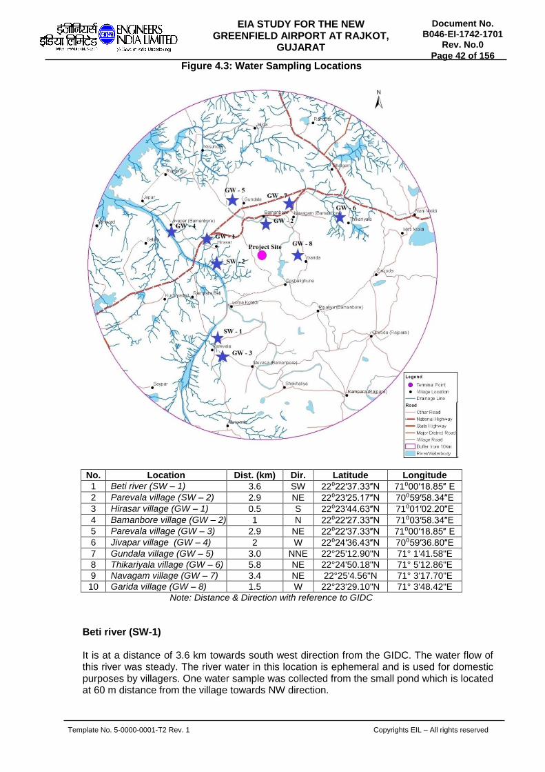
Template No. 5-0000-0001-T2 Rev. 1 Copyrights EIL – All rights reserved
Document No. B046-EI-1742-1701
Rev. No.0
Page 42 of 156
EIA STUDY FOR THE NEW GREENFIELD AIRPORT AT RAJKOT,
GUJARAT
Figure 4.3: Water Sampling Locations
No. Location Dist. (km) Dir. Latitude Longitude
1 Beti river (SW – 1) 3.6 SW 22⁰22′37.33″N 71⁰00′18.85″ E
2 Parevala village (SW – 2) 2.9 NE 22⁰23′25.17″N 70⁰59′58.34″E
3 Hirasar village (GW – 1) 0.5 S 22⁰23′44.63″N 71⁰01′02.20″E
4 Bamanbore village (GW – 2) 1 N 22⁰22′27.33″N 71⁰03′58.34″E
5 Parevala village (GW – 3) 2.9 NE 22⁰22′37.33″N 71⁰00′18.85″ E
6 Jivapar village (GW – 4) 2 W 22⁰24′36.43″N 70⁰59′36.80″E
7 Gundala village (GW – 5) 3.0 NNE 22°25'12.90"N 71° 1'41.58"E
8 Thikariyala village (GW – 6) 5.8 NE 22°24'50.18"N 71° 5'12.86"E
9 Navagam village (GW – 7) 3.4 NE 22°25'4.56"N 71° 3'17.70"E
10 Garida village (GW – 8) 1.5 W 22°23'29.10"N 71° 3'48.42"E
Note: Distance & Direction with reference to GIDC
Beti river (SW-1) It is at a distance of 3.6 km towards south west direction from the GIDC. The water flow of this river was steady. The river water in this location is ephemeral and is used for domestic purposes by villagers. One water sample was collected from the small pond which is located at 60 m distance from the village towards NW direction.

Template No. 5-0000-0001-T2 Rev. 1 Copyrights EIL – All rights reserved
Document No. B046-EI-1742-1701
Rev. No.0
Page 43 of 156
EIA STUDY FOR THE NEW GREENFIELD AIRPORT AT RAJKOT,
GUJARAT
Parevala village (SW-2) This location is 2.9 km away from the GIDC in north east direction. This village is 4.4 km away from the NH-27 in north-west direction. No major industries or factories are located nearby this village. The water sample was collected from the tap water at a distance of 0.2 km from the village towards NE direction. This surface water is used for drinking and domestic purposes by all nearby villages. Hirasar village (GW-1) This location is 0.5 km away from the GIDC in South direction. This village is 1.2 km away from the NH-27 in north direction. The main source of water in this village is provided by bore well water from tap which is used for domestic purpose by all nearby villages. One sample is collected at a distance of 0.4 km from the village towards north direction. Bamanbore village (GW-2) This location is 1 km away from the project boundary in north direction. This village is 1 km away from the NH-27 in north direction. The water sample collected at a distance of 1.4 km from GIDC towards NW direction. The main source of water in this village is provided by bore well for drinking & domestic purpose. Parevala village (GW-3) This location is 2.9 km away from the GIDC in north east direction. This village is 4.4 km away from the NH-27 in north-west direction. No major industries or factories are located nearby this village. The water sample was collected from the bore well water at a distance of 0.24 km from the village towards NE direction. The ground water is used for domestic purposes by all nearby villagers. Jivapar village (GW-4) This location is 2 km away from the project boundary in west direction. This village is 1.9 km away from the NH-27 in south-east direction. The village has moderate population. No major industries or factories are located nearby this village. One water sample was collected at a distance of 0.3 km from the village towards NW direction and the main source of water from bore water is used for domestic purposes by all nearby villages. Gundala village (GW-5) This location is at a distance of 3.0 km away from the GIDC towards north- north east direction and 0.09 km distance away from the NH-27 in south direction. The main source of water is provided by tankers from Chotila area which is used for drinking and domestic purpose by all neighbouring villages. Thikariyala village (GW-6) This location is at a distance of 3.64 km away from the project boundary towards east - north east direction and 1.0 km distance away from the NH-27 in north east direction. The water sample collected at a distance of 3.2 km from project boundary towards NE direction. The hand pump water is used for domestic purpose and tap water is used for drinking purpose by all surrounding villages.

Template No. 5-0000-0001-T2 Rev. 1 Copyrights EIL – All rights reserved
Document No. B046-EI-1742-1701
Rev. No.0
Page 44 of 156
EIA STUDY FOR THE NEW GREENFIELD AIRPORT AT RAJKOT,
GUJARAT
Navagam village (GW-7) This location is at a distance of 0.9 km away from the project boundary towards north-north east direction and 1.9 km away from the NH-27 in north direction. The water sample was collected from the bore well water at a distance of 0.2 km from the village towards NW direction. Tanker water is used for drinking purpose and bore well water is used for domestic purposes by nearby villages. Garida village (GW-8) This location is at a distance of 1.09 km away from the project boundary towards North West direction and 4.10 km away from the NH-27 in north-north west direction. One water sample was collected at a distance of 0.58 km from the village towards NE direction and the main source of water from tanker is used for drinking and domestic purposes by all nearby villages. Results and Discussions For assessing the quality of water around the 10 km radius of the GIDC, 10 samples were collected from the nearby villages. These water samples were analysed as per prescribed methodologies and subsequently results were obtained. Out of 10 samples, two (2) samples were collected from the surface water of Beti river and Parevala village and the remaining Four (8) samples were collected from ground water source of the nearby villages. The results for 10 locations collected during the summer season are given in Table 4.6 to 4.9.
Table 4.6: Surface Water Quality
No. Parameters Units SW-1 IS: 2296-1982
1 pH -- 7.4 6.5 – 8.5
2 Temperature ⁰C 24.8 Not Specified
3 Turbidity NTU 2.0 Not Specified
4 TDS mg/L 638 500
5 TSS mg/L 12 Not Specified
6 Total Alkalinity (as CaCO3) mg/L 219 Not Specified
7 Total Hardness (as CaCO3) mg/L 421 300
8 Ca. Hardness(as CaCO3) mg/L 406 200
9 Mg. Hardness(as CaCO3) mg/L 15 Not Specified
10 Chloride as Cl mg/L 230 250
11 Sulphates as SO4 mg/L 38 400
12 Sodium as Na mg/L 72 Not Specified
13 Potassium as K mg/L 3.0 Not Specified
14 Nitrates as NO3 mg/L 7.0 20
15 Total Phosphate as PO4 mg/L 0.3 Not Specified
16 Phosphorous as P mg/L 0.1 Not Specified
17 Iron as Fe mg/L 0.16 0.3
18 DO mg/L 3.1 6.0
19 COD mg/L 22 Not Specified
20 BOD, 3 days @ 27⁰C mg/L 2.1 2.0
21 Lead as Pb mg/L 0.03 0.1
22 Copper as Cu mg/L 0.1 1.5
23 Zinc as Zn mg/L 0.8 15
24 Manganese as Mn mg/L 0.01 0.5
25 Total Coliforms MPN/100
ml 14 50
SW – 1: Parevala village

Template No. 5-0000-0001-T2 Rev. 1 Copyrights EIL – All rights reserved
Document No. B046-EI-1742-1701
Rev. No.0
Page 45 of 156
EIA STUDY FOR THE NEW GREENFIELD AIRPORT AT RAJKOT,
GUJARAT
Table 4.7 Surface Water Quality Data
No. Parameters Units SW-2 IS: 2296-1982
1 pH -- 7.5 6.5 - 8.5
2 Temperature ⁰C 25 Not Specified
3 Turbidity NTU 6.0 Not Specified
4 TDS mg/L 820 Not Specified
5 TSS mg/L 16 Not Specified
6 Total Alkalinity (as CaCO3) mg/L 243 Not Specified
7 Total Hardness(as CaCO3) mg/L 464 Not Specified
8 Ca. Hardness(as CaCO3) mg/L 268 Not Specified
9 Mg. Hardness(as CaCO3) mg/L 196 Not Specified
10 Chloride as Cl mg/L 263 Not Specified
11 Sulphates as SO4 mg/L 28 Not Specified
12 Sodium as Na mg/L 80 Not Specified
13 Potassium as K mg/L 3.4 Not Specified
14 Nitrate as NO3 mg/L 6.2 Not Specified
15 Total Phosphate as PO4 mg/L 0.6 Not Specified
16 Phosphorous as P mg/L 0.2 Not Specified
17 Iron as Fe mg/L 0.3 Not Specified
18 DO mg/L 2.9 5.0
19 COD mg/L 62 Not Specified
20 BOD mg/L 3.8 3.0
21 Lead as Pb mg/L 0.2 Not Specified
22 Copper as Cu mg/L 0.1 Not Specified
23 Zinc as Zn mg/L 0.8 Not Specified
24 Manganese as Mn mg/L 0.06 Not Specified
25 Total Coliforms MPN/100 ml 65 500
SW – 2: Beti river (Ephemeral Water)
Table 4.8: Ground Water Quality
No Parameters Units GW-1 GW-2 GW-3 GW-4
IS: 10500-2012 Limits
Desirable Permissible
1 pH -- 7.2 7.7 7.4 7.6 6.5-8.5 NR
2 Temperature ⁰C 24.8 25 25.8 24.8 NS NS
3 Turbidity NTU 4 2 4 5 5 10
4 TDS mg/L 890 280 2294 2346 500 2000
5 TSS mg/L 3.0 2.0 5.0 8.0 NS NS
6 Total Alkalinity(as CaCO3) mg/L 75 169 90 164 200 600
7 Total Hardness(as CaCO3) mg/L 421 191 450 294 200 600
8 Ca. Hardness(as CaCO3) mg/L 387 171 411 254 NS NS
9 Mg. Hardness(as CaCO3) mg/L 34 20 39 40 NS NS
10 Chloride as Cl mg/L 354 44 921 930 250 1000
11 Sulphates as SO4 mg/L 108 25 350 302 200 400
12 Sodium as Na mg/L 122 29 598 694 NS NS
13 Potassium as K mg/L 3.0 2.0 9.4 5.0 NS NS
14 Nitrate as NO3 mg/L 3.2 0.7 18 21 45 NR
15 Total Phosphate as PO4 mg/L 0.6 0.3 1.2 1.8 NS NS
16 Phosphorous as P mg/L 0.2 0.1 0.4 0.6 NS NS

Template No. 5-0000-0001-T2 Rev. 1 Copyrights EIL – All rights reserved
Document No. B046-EI-1742-1701
Rev. No.0
Page 46 of 156
EIA STUDY FOR THE NEW GREENFIELD AIRPORT AT RAJKOT,
GUJARAT
17 Iron as Fe mg/L 0.12 0.09 0.18 0.21 0.3 NR
18 DO mg/L 3.3 2.9 2.8 2.4 NS NS
19 COD mg/L 8 8 16 14 NS NS
20 BOD, 3 days @ 27⁰C mg/L 2.0 2.0 4.0 4.0 NS NS
21 Lead as Pb mg/L <0.01 <0.01 <0.01 <0.01 0.01 NR
22 Copper as Cu mg/L <0.05 <0.05 <0.05 <0.05 0.05 1.5
23 Zinc as Zn mg/L 0.3 0.1 0.6 0.9 5 15
24 Manganese as Mn mg/L 0.05 0.04 0.07 0.08 0.1 0.3
25 Total Coliforms MPN/100
ml 5.0 3.0 4.0 4.0 NS NS
Note: NR- No Relaxation, NS – Not Specified
GW – 1: Hirasar village GW – 2: Bamanbore village GW – 3: Parevala village GW – 4: Jivapar village
Table 4.9: Ground Water Quality
No Parameters Units GW-5 GW-6 GW-7 GW-8 IS: 10500-2012 Limits
Desirable Permissible
1 pH -- 7.15 6.68 7.6 7.32 6.5-8.5 NR
2 Temperature ⁰C 25.6 25.2 25.0 25.5 NS NS
3 Turbidity NTU 2 4 1 2 5 10
4 TDS mg/L 191 1456 180 178 500 2000
5 TSS mg/L 2.0 6.0 3.0 1.0 NS NS
6 Total Alkalinity(as CaCO3) mg/L 99 318 114 109 200 600
7 Total Hardness(as CaCO3) mg/L 107 789 127 117 200 600
8 Ca. Hardness(as CaCO3) mg/L 68 720 112 93 NS NS
9 Mg. Hardness(as CaCO3) mg/L 39 69 15 24 NS NS
10 Chloride as Cl mg/L 32 414 16 16 250 1000
11 Sulphates as SO4 mg/L 8.0 317 13 14 200 400
12 Sodium as Na mg/L 20 208 9.0 14 NS NS
13 Potassium as K mg/L 0.3 5.0 0.4 0.5 NS NS
14 Nitrate as NO3 mg/L 2.0 24 1.2 5.0 45 NR
15 Total Phosphate as PO4 mg/L 0.3 1.2 0.3 0.6 NS NS
16 Phosphorous as P mg/L 0.1 0.4 0.1 0.2 NS NS
17 Iron as Fe mg/L 0.1 0.46 0.14 0.16 0.3 NR
18 DO mg/L 3.9 3.5 4.1 4.2 NS NS
19 COD mg/L 11 30 15 4.0 NS NS
20 BOD, 3 days @ 27⁰C mg/L 2.0 4.0 2.0 1.0 NS NS
21 Lead as Pb mg/L <0.01 <0.01 <0.01 <0.01 0.01 NR
22 Copper as Cu mg/L <0.05 <0.05 <0.05 <0.05 0.05 1.5
23 Zinc as Zn mg/L 0.12 0.23 0.14 0.15 5 15
24 Manganese as Mn mg/L 0.02 0.07 0.03 0.04 0.1 0.3
25 Total Coliforms MPN/100
ml 1.0 4.0 2.0 3.0 NS NS
Note: NR- No Relaxation, NS – Not Specified
GW – 5: Gundala village GW – 6: Thikariyala village GW – 7: Navagam village GW – 8: Garida village

Template No. 5-0000-0001-T2 Rev. 1 Copyrights EIL – All rights reserved
Document No. B046-EI-1742-1701
Rev. No.0
Page 47 of 156
EIA STUDY FOR THE NEW GREENFIELD AIRPORT AT RAJKOT,
GUJARAT
pH pH is measure of hydrogen ion concentration of the water. The pH of water indicates weather the water is acid or alkaline. The measurement of pH ranges from 1 to 14 with a pH of 7 indicating a neutral solution, neither acid nor alkaline. Numbers lower than 7 indicate acidity, numbers higher than 7 indicates alkalinity. Drinking water with a pH of between 6.5 and 8.5 is generally considered satisfactory. Acid water tends to be corrosive to plumbing and faucets, particularly if the pH is below 6. Alkaline waters are less corrosive. Water with a pH of above 8.5 may tend to have a bitter or soda like taste. The pH of water may have an effect on the treatment of the water and also should be considered if the water is used for field application of pesticides. Water with a pH of 7 to 8.5 will require more chlorine for the destruction of pathogens than will water that is slightly acidic. As per IS: 10500 and IS: 2296 standards, the pH value shall be between 6.5 and 8.5. The pH in all the 10 water samples collected in the study area, ranges from 7.2 to 7.8. Temperature
Temperature values for all ground water locations were found in the range of 24.8 to 25.8⁰C and for surface water locations were found to be as 24.8 & 25⁰C. Total Dissolved Solids (TDS) High amounts of TDS are objectionable because of physiological effects, mineral tastes, or economic effects. TDS is the aggregate of carbonates, bicarbonates, chlorides, sulfates, phosphates, nitrates, and other salts of calcium, magnesium, sodium, potassium, and other substances. All salts in solution change the physical and chemical nature of water and exert osmotic pressure. As per IS: 10500 drinking water standards the maximum permissible limit is 2000 mg/L and for IS: 2296 surface water standards the limit is 500 mg/L as per Class A type. TDS values are ranging from 210 to 2346 mg/L for ground water samples (GW – 1 to GW -8). In case of the surface water samples (SW – 1 & 2) the TDS was found to be 638 & 820 mg/L respectively. Dissolved Oxygen Dissolved oxygen is important in natural water because many microorganisms and fish require it in aquatic system. Dissolved oxygen also establishes an aerobic environment in which oxidized forms of many constituents in water are predominant. Under anoxic conditions in water, reduced forms of chemical species are formed and frequently lead to the release of undesirable odours until desired conditions develop. As per IS: 2296 surface water standards the limit for class A type is 6 mg/L and for class B type is 5 mg/L. The DO values for all ground water samples (GW – 1 to GW -8) were in the range of 2.4 to 4.2 mg/L. The DO value for Surface water samples (SW-1 & 2) was 3.1 & 2.9 mg/L respectively. Biological Oxygen Demand (BOD) BOD of water is an indirect measure of the amount of biologically degradable organic material present. It is thus indication of the amount of dissolved oxygen (DO) that will be depleted from water during the natural biological assimilation of organic pollutants. The discharge of wastes containing organic material imposes oxygen demand in the natural water and reduces the DO level. BOD values are expressed as the amount of oxygen

Template No. 5-0000-0001-T2 Rev. 1 Copyrights EIL – All rights reserved
Document No. B046-EI-1742-1701
Rev. No.0
Page 48 of 156
EIA STUDY FOR THE NEW GREENFIELD AIRPORT AT RAJKOT,
GUJARAT
consumed (mg/L) by organisms during 3 days period at 27oC. As per IS: 2296 surface water standards the limit for class A type is 2 mg/L and for class B type is 3 mg/L. The BOD values were found to be in the range of 1 to 4 mg/L for all the ground water samples. BOD values for Surface water samples (SW-1 & 2) were found to be 2.1 & 3.8 mg/L respectively. Chemical Oxygen Demand (COD) Chemical Oxygen Demand (COD) also used to represent the organic matter in water and wastewater. COD value indicates the total amount of utilizable material present and includes BOD. The chemical oxygen demand (COD) test of natural water yields the oxygen equivalent of the organic matter that can be oxidized by strong chemical oxidizing agent in an acidic medium. Potassium permanganate is the oxidizing chemical. Silver sulfate is added as a catalyst and to minimize the interference of chloride on the COD test. Mercuric sulfate is also added to inhibit interferences of metals on the oxidation of organic compounds. COD values for all the ground water samples were found to be in range of 4 to 30 mg/L. The COD values for Surface water samples (SW-1 & 2) were found to be 22 & 62 mg/L respectively. Heavy Metals Heavy metals such as Lead (Pb), Iron (Fe), Copper (Cu), Zinc (Zn), and Manganese (Mn) are found below the detectable limits. Toxic compounds Water containing concentration of heavy metals (mercury, cadmium, copper, silver, chromium etc.) either individually or combination may be toxic to aquatic organisms and thus, have a severe impact on the water community. Other toxic substances include pesticides, ammonia-ammonium compounds, cyanides, sulfides, fluorides and petrochemical wastes. Severely toxic substances will eliminate algal growth, except the species that are able to tolerate the observed concentration of the toxicant. Chemicals released into the environment may effect surface water or ground water systems by direct discharge of wastes containing toxic compounds or from surface runoff which may come in contact with toxic material left as residue over the ground surface. No Toxic compounds observed in all the 10 samples analyzed. Sulphates (SO4) Sulphate concentration for all ground water samples were found to be in range of 25 to 350 mg/L, and are observed to be within the permissible limits of 400 mg/L for all locations. Beyond the permissible limit causes gastro intestinal irritation when magnesium and sodium are present. For surface water locations (SW-1 & 2) sulphate concentration was found to be 24 & 38 mg/L respectively. Nitrate (NO3) The nitrate concentration was in the range of 0.7 to 21 mg/L for all ground water locations, and are observed to be within the desirable limits of 45 mg/L as per IS:10500. For surface water locations (SW-1 & 2) nitrate was found to be 6.2 and 7.0 mg/L respectively.

Template No. 5-0000-0001-T2 Rev. 1 Copyrights EIL – All rights reserved
Document No. B046-EI-1742-1701
Rev. No.0
Page 49 of 156
EIA STUDY FOR THE NEW GREENFIELD AIRPORT AT RAJKOT,
GUJARAT
Phosphorous (P) Phosphorous concentration was in the range of 0.1 to 0.6 mg/L for all ground water locations and for surface water locations (SW-1 & 2) concentration was found to be 0.1 & 0.2 mg/L respectively. Turbidity Turbidity values were found in range of 1 to 5 NTU for all ground water locations and are observed within the desirable limit of 5 NTU for all locations. For surface water locations (SW-1 & 2) were found to be 2 & 6 NTU. Total Hardness Total hardness were found to be in the range of 128 to 450 mg/L for all ground water locations and are observed within the permissible limit of 600 mg/L for all locations. For surface water locations (SW-1 & 2) TH was found to be 421 & 464 mg/L respectively. Total Alkalinity Total Alkalinity were found to be in the range of 75 to 178 mg/L for all ground water locations which were observed to be within the desirable limit of 200 mg/L as per IS:10500. For surface water locations (SW-1 & 2) total alkalinity was found to be 219 & 243 mg/L respectively. Chlorides (Cl) Chlorides concentration were found in the range of 36 to 930 mg/L for all ground water locations and are observed within the permissible limit of 1000 mg/L as per IS: 10500. For surface water locations (SW-1 & 2) chloride concentration was found to be 230 & 263 mg/L respectively. Total Suspended Solids (TSS) TSS concentration was found to be in the range of 0 to 8 mg/L for all ground water locations and for surface water locations (SW-1 & 2) the TSS was found to be 12 & 16 mg/L respectively. Sodium (Na) Sodium concentrations were found to be in the range of 11 to 694 mg/L for all ground water locations and for surface water locations (SW-1 & 2) the sodium concentrations were found to be 72 & 80 mg/L respectively. Potassium (K) Potassium concentrations were found to be in the range of 2 to 9.4 mg/L for all ground water locations and for surface water locations (SW-1 & 2) the concentration was found to be 3 & 3.4 mg/L respectively.

Template No. 5-0000-0001-T2 Rev. 1 Copyrights EIL – All rights reserved
Document No. B046-EI-1742-1701
Rev. No.0
Page 50 of 156
EIA STUDY FOR THE NEW GREENFIELD AIRPORT AT RAJKOT,
GUJARAT
Summary Ground water Ground water samples are compared with the prescribed limits of IS: 10500. Eight ground water samples are collected in the 10 km radius of GIDC. All the specified results of ground water samples were found within the limits. Surface water Surface water samples collected from the Beti river and Parevala village. The result of this water samples was compared with IS: 2296 class A & B norms.
4.3 NOISE ENVIRONMENT
Noise levels were recorded at 6 locations (Fig. no. 4.4) by integrated Sound Level Meter in dB (A). The noise levels were recorded at the selected locations around the vicinity of the project site. Following are the locations selected for Noise level recording. Rajkot-GIDC Bamanbore road (AN-1) This location is 3.17 km away from the GIDC in SW direction. This sampling station is 0.2 km away from the NH-27 in NW direction. The traffic was high during study period. Small scale industry was located at 2 km distance in SE direction from the sampling point. The sound level meter was placed 1 m above ground level and 3 m away from any walls. Ahmedabad – GIDC Bamanbore road (AN-2) This location is 2 km away from the GIDC in SW direction. This sampling station is 1 km away from the NH-27 in NW direction. The traffic was high during the study period. Two small scale industries were located at 1.2 km distance in E direction from the sampling point. The sound level meter was placed 1 m above ground level and 3 m away from any walls. Rampara Beti (AN-3) This location is 3 km away from the GIDC in south direction. This village is 1.7 km away from the NH-27 in north-west direction. The village has moderate population. No major or minor industrial activities were noticed nearby this village. The movement of vehicles was low. The sound level meter was placed 1 m above ground level and 3 m away from walls at the centre of village. Bhalgam Road (AN-4) This location is 4.5 km away from the GIDC in SW direction. This sampling station is 0.5 km away from the NH-27 in south direction. The village has moderate population. The movement of vehicles was very high. The sound level meter was placed 1 m above ground level and 3 m away from any walls. Thikariyala & NH junction (AN-5) This location is 4.75 km away from the GIDC in west direction. This sampling station is 0.2 km away from the NH-27 in north direction. The vehicular movement was very low particularly it is used by villagers only. The sound level meter was placed 1 m above ground level and 3 m away from any walls

Template No. 5-0000-0001-T2 Rev. 1 Copyrights EIL – All rights reserved
Document No. B046-EI-1742-1701
Rev. No.0
Page 51 of 156
EIA STUDY FOR THE NEW GREENFIELD AIRPORT AT RAJKOT,
GUJARAT
Navagam (AN-6) This location is 0.8 km away from the GIDC in west direction. This sampling station is 0.9 km away from the NH-27 in north direction. The vehicular movement was moderate during the study period. The sound level meter was placed 1 m above ground level and 3 m away from any walls.
Figure 4.4: Noise Monitoring Locations
No. Location Dist.(km) Dir. Latitude Longitude 1 Rajkot-GIDC Bamanbore road (AN-1) 3.17 SW 22
o24’22.86” N 71
o00’49.56” E
2 Ahmedabad – GIDC Bamanbore
road (AN-2)
2 SW 22o24’20.40” N 71
o01’37.08” E
3 Rampara Beti (AN-3) 3 S 22o22’33.12” N 71
o00’08.88” E
4 Bhalgam Road (AN-4) 4.5 SW 22o25’44.58” N 71
o05’05.10” E
5 Thikariyala & NH junction (AN-5) 4.7 W 22o25’19.50” N 71
o05’16.26” E
6 Navagam (AN-6) 0.8 W 22o25’00.30” N 71
o03’04.68” E
The recorded sound levels are given in Table 4.10. The Noise levels for all locations are plotted on the graph and depicted in Fig. 2.9 to 2.14. Out of all 6 locations measured for noise levels, the sample collected at Rajkot to GIDC Bamanbore road was found to be on slightly higher side (Ld/n = 69.0 dB(A)), which can be attributed to local prevailing environment (Traffic and small scale industrial activities). However the recorded noise levels were found to be within the industrial zone limits (75 dB(A)). Apart from this the noise levels recorded at Ahmedabad to GIDC, Bamanbore road were found to be of next higher level

Template No. 5-0000-0001-T2 Rev. 1 Copyrights EIL – All rights reserved
Document No. B046-EI-1742-1701
Rev. No.0
Page 52 of 156
EIA STUDY FOR THE NEW GREENFIELD AIRPORT AT RAJKOT,
GUJARAT
(Ld/n = 67.9 dB(A)), which can be attributed to heavy traffic. However these levels are found to be well within the permissible industrial limits (75 dB(A)).
Table 4.10: Ambient Noise Level [in Leq dB(A)]
Site codes AN-1 AN-2 AN-3 AN-4 AN-5 AN-6
Day Hours
06:00 - 07:00 59.3 56.9 41.1 57.3 57.6 56.2
07:00 - 08:00 61.2 59.1 43.8 60.2 58.2 57.3
08:00 - 09:00 63.5 61.4 45.1 61.7 58.9 59.4
09:00 - 10:00 65.4 63.3 46.7 62.9 59.7 60.1
10:00 - 11:00 67.3 64.8 47.7 63.5 61.1 61.3
11:00 - 12:00 69.8 66.7 46.9 65.7 62.5 63.1
12:00 - 13:00 70.9 67.9 48.1 64.9 63.7 64.8
13:00 - 14:00 71.5 69.1 49.2 66.8 65.8 65.2
14:00 - 15:00 72.4 70.8 47.7 67.7 67.2 67.8
15:00 - 16:00 72.9 71.6 50.3 66.9 66.3 68.4
16:00 - 17:00 70.1 70.4 51.7 68.4 67.9 69.3
17:00 - 18:00 70.8 71.3 52.3 67.3 66.8 68.7
18:00 - 19:00 68.9 70.7 51.7 68.5 65.2 67.2
19:00 - 20:00 67.3 68.9 48.6 67.1 64.3 65.3
20:00 - 21:00 65.4 66.5 45.9 66.2 62.1 62.8
21:00 - 22:00 63.3 64.4 43.8 64.2 61.7 60.9
Minimum 59.3 56.9 41.1 57.3 57.6 56.2
Maximum 72.9 71.6 52.3 68.5 67.9 69.3
Day Leq. 69.0 68.1 48.5 65.8 64.2 65.2
Day Limits 75 75 55 75 75 75
Night Hours
22:00 - 23:00 61.1 61.7 42.7 62.3 60.8 59.8
23:00 - 24:00 60.7 59.9 40.9 60.8 60.2 57.3
24:00 - 01:00 62.3 57.2 40.2 58.9 58.9 56.4
01:00 - 02:00 59.4 56.3 38.7 55.6 59.2 55.1
02:00 - 03:00 57.1 55.4 37.2 53.9 57.3 54.2
03:00 - 04:00 55.2 53.9 37.8 52.1 58.4 53.4
04:00 - 05:00 52.4 52.4 38.9 53.2 55.8 51.3
05:00 - 06:00 51.2 54.1 40.3 56.7 56.6 53.8
Minimum 51.2 52.4 37.2 52.1 55.8 51.3
Maximum 62.3 61.7 42.7 62.3 60.8 59.8
Night Leq 58.9 57.4 39.9 58.1 58.7 55.9
Limits 70 70 45 70 70 70
LD/N eq 69.0 67.9 49.0 66.7 66.2 65.5
Area type Industrial Industrial Residential Industrial Industrial Industrial
Codes Location AN-1 Rajkot-GIDC Bamanbore road
AN-2 Ahmedabad – GIDC Bamanbore road
AN-3 Rampara Beti
AN-4 Bhalgam Road
AN-5 Thikariyala & NH junction
AN-6 Navagam
Traffic Analysis
Traffic remains the concealed component of the impact analysis of any new development project. Therefore the impact of certain projects on traffic and transportation is too far reaching to be subsumed under a generalized EIA study. Traffic Analysis is a study carried out to predict the magnitude and effects that a proposed development project generated

Template No. 5-0000-0001-T2 Rev. 1 Copyrights EIL – All rights reserved
Document No. B046-EI-1742-1701
Rev. No.0
Page 53 of 156
EIA STUDY FOR THE NEW GREENFIELD AIRPORT AT RAJKOT,
GUJARAT
traffic will have on the transportation network. Traffic analysis is an important document in helping planning authorities in making decisions on land and its use. Traffic analysis can also be used to evaluate whether the proposed developmental project is appropriate and what type of transportation facility improvements would be necessary. Traffic impacts could be direct or cumulative. A direct impact would result solely from the implementation of the proposed project while cumulative impact is based on list of past, present and probable future projects in the area. This means that a cumulative impact would occur as a result of traffic growth both the project and from other projects in the area. A traffic impact is an effect, either positive or negative, on the traffic of the adjoining roads and other transportation infrastructures that may be associated with a proposed project activity. The assessment of the proposed project may be based on a synthesis of such criteria as, the nature of the impact, directness of the impacts, spatial extent, duration, intensive or magnitude and determination of significance. Traffic behaves in a complex and nonlinear way, depending on the interactions of a large number of vehicles. Due to the individual reactions of human drivers, vehicles do not interact simply following the laws of mechanics, but rather display cluster formation and shock wave propagation both forward and backward, depending on vehicle density. Some mathematical models of traffic flow use a vertical queue assumption, in which the vehicles along a congested link do not spill back along the length of the link. The contribution of automobile emissions aggravating the air pollution menaces. The three main types of automobile vehicles being used in the country are: Passenger cars powered by four strokes gasoline engines. Motor cars, scooters and auto rickshaws powered mostly by small two stroke diesel
engines. Large trucks and buses powered by mostly 4 stroked engines. The concept of forecasting the future use of the road network in terms of traffic loading and flow, is generally an accepted approach world-wide. The techniques used have become almost standard in both developing and developed countries. The accuracy of traffic data collection and the subsequent predictions are of paramount importance in the fulfillment of an appropriate planning, design, maintenance monitoring and management of the road network. As regards to the emission problems, diesel engines are more noisy and smoky. The smoke in the diesel exhaust is not just un-burnt hydrocarbons, some of which are proved carcinogens. In addition to being a traffic hazard by reducing the visibility, smoke contains extremely hazardous constituents. Carbon monoxide is a problem confined to gasoline engines, both two and four strokes. The causes and remedial measure for abatement of CO are similar to those of un- burnt hydrocarbons. Oxides of nitrogen have become a major concern from the point of health hazards caused by vehicle emissions. In traffic study the condition of engine, the quality of fuel and driving pattern, traffic density has a lot to contribute to this problem. Over loading, over speeding increases the magnitude of this problem considerably. Signal points are also one of the noise emanation sources as most of the vehicles keep running. The traffic data recorded once for a day at each location for continuous 24 hours in a day, under three different vehicular categories viz., Heavy: Multi axle trucks and trailors Medium: Trucks and buses Light: Cars, Jeeps, Light carriers vehicles

Template No. 5-0000-0001-T2 Rev. 1 Copyrights EIL – All rights reserved
Document No. B046-EI-1742-1701
Rev. No.0
Page 54 of 156
EIA STUDY FOR THE NEW GREENFIELD AIRPORT AT RAJKOT,
GUJARAT
Out of the total traffic vehicles, 2 wheelers are very high followed by light and medium vehicles. The movement of two wheelers and light vehicles are largely found in daytime. The difference of heavy vehicle movement both day and night time was very marginal. Data Analysis Rajkot-GIDC Bamanbore road (TA-1) This location is 3.17 km away from the GIDC in SW direction. This sampling station is 0.2 km away from the NH-27 in NW direction. The traffic was high during the study period. This road connects Bamanbor to Rajkot route through the NH-27. Ahmedabad – GIDC Bamanbore road (TA-2) This location is 2 km away from the GIDC in SW direction. This sampling station is 1 km away from the NH-27 in NW direction. The traffic was very high during the study period. This road connects Bamanbor to Ahmedabad route through the NH-27. Rampara Beti (TA-3) This location is 3 km away from the GIDC in south direction. This village is 1.7 km away from the NH-27 in north-west direction. The village has moderate population. No major industries or factories are located nearby this village. The movement of vehicles is low. In this village low frequency of heavy and medium vehicles are observed. Two wheelers are predominant in this village route. Bhalgam Road (TA-4) This location is 4.5 km away from the GIDC in SW direction. This sampling station is 0.5 km away from the NH-27 in south direction. The village has moderate population. The movement of vehicles was very high due to NH. This road connects the village to NH which goes through Rajkot. Thikariyala & NH junction (TA-5) This location is 4.75 km away from the GIDC in west direction. This sampling station is 0.2 km away from the NH-27 in north direction. The vehicular movement was very low particularly it is used by villagers only. The low density of traffic is usually because it is only used for farming transportation by villagers. Navagam (TA-6) This location is 0.8 km away from the GIDC in west direction. This sampling station is 0.9 km away from the NH-27 in north direction. The vehicular movement was moderate during the study period. The Navagam road connects to NH which is then routed to Ahmedabad. The locations of Traffic monitoring sites are depicted in Fig. No. 4.5 and the results are tabulated in Table No. 4.11 to 4.16.
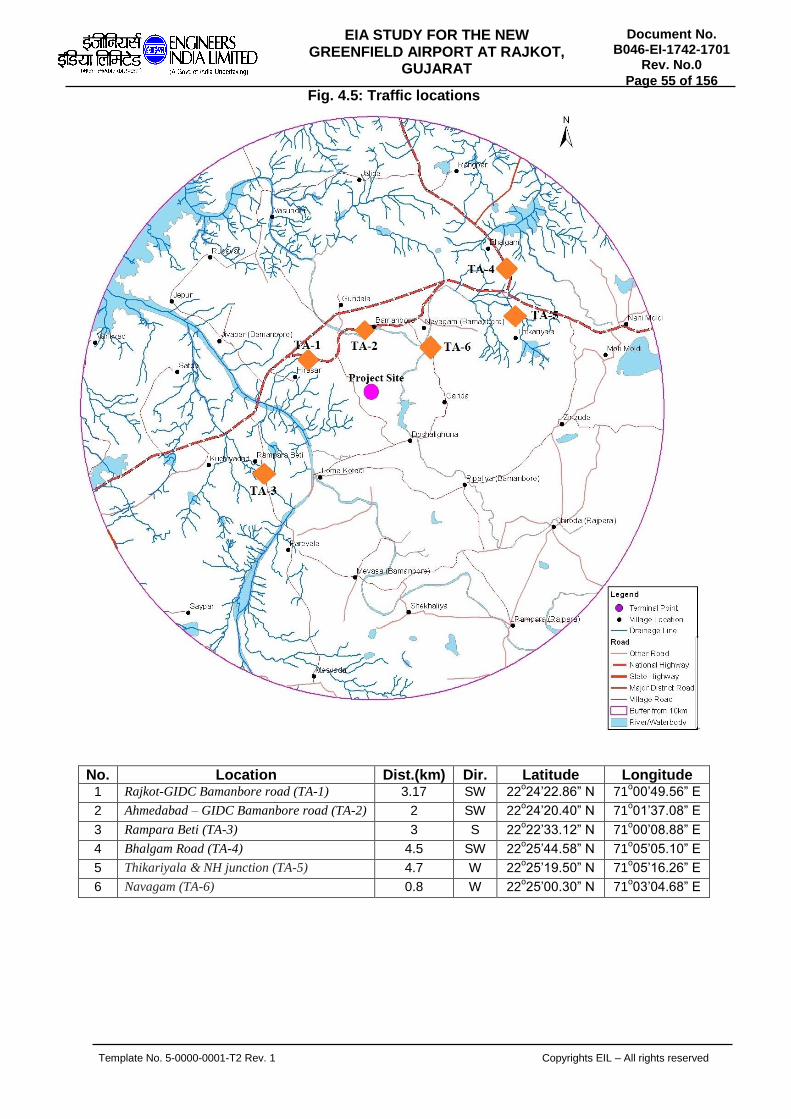
Template No. 5-0000-0001-T2 Rev. 1 Copyrights EIL – All rights reserved
Document No. B046-EI-1742-1701
Rev. No.0
Page 55 of 156
EIA STUDY FOR THE NEW GREENFIELD AIRPORT AT RAJKOT,
GUJARAT
Fig. 4.5: Traffic locations
No. Location Dist.(km) Dir. Latitude Longitude 1 Rajkot-GIDC Bamanbore road (TA-1) 3.17 SW 22
o24’22.86” N 71
o00’49.56” E
2 Ahmedabad – GIDC Bamanbore road (TA-2) 2 SW 22o24’20.40” N 71
o01’37.08” E
3 Rampara Beti (TA-3) 3 S 22o22’33.12” N 71
o00’08.88” E
4 Bhalgam Road (TA-4) 4.5 SW 22o25’44.58” N 71
o05’05.10” E
5 Thikariyala & NH junction (TA-5) 4.7 W 22o25’19.50” N 71
o05’16.26” E
6 Navagam (TA-6) 0.8 W 22o25’00.30” N 71
o03’04.68” E

Template No. 5-0000-0001-T2 Rev. 1 Copyrights EIL – All rights reserved
Document No. B046-EI-1742-1701
Rev. No.0
Page 56 of 156
EIA STUDY FOR THE NEW GREENFIELD AIRPORT AT RAJKOT,
GUJARAT
Table No. 4.11 Traffic Density Monitoring Data
Location: Rajkot to GIDC Bamanbore
TIME (HRS)
Rajkot to GIDC, Bamanbore GIDC, Bamanbore to Rajkot Total
Vehicles
3 W
he
ele
r
2 W
hee
ler
Cyc
les
Vehicles
3 W
he
ele
r
2 W
hee
ler
Cyc
les
Vehicles
3 W
he
ele
r
2 W
hee
ler
Cyc
les
Heavy Medium Light Heavy Medium Light Heavy Medium Light
6:00-7:00 1 0 2 0 7 0 1 1 1 0 5 1 2 1 3 0 12 1
7:00 -8:00 2 1 3 0 5 2 3 1 2 1 4 2 5 2 5 1 9 4
8:00 - 9:00 3 2 1 1 8 9 4 2 3 2 9 7 7 4 4 3 17 16
9:00 - 10:00 6 1 2 2 12 15 5 1 5 1 14 16 11 2 7 3 26 31
10:00 -11:00 2 2 3 3 9 10 3 2 4 2 11 11 5 4 7 5 20 21
11:00 - 12:00 5 1 5 2 8 8 3 1 6 3 10 11 8 2 11 5 18 19
12:00 - 13:00 2 0 6 1 11 9 2 0 2 1 8 9 4 0 8 2 19 18
13:00-14:00 4 1 8 2 11 6 2 0 5 1 13 8 6 1 13 3 24 14
14:00-15:00 5 1 3 2 10 11 4 0 3 3 11 9 9 1 6 5 21 20
15:00-16:00 3 0 7 1 9 5 2 1 2 0 8 7 5 1 9 1 17 12
16:00-17:00 6 2 3 1 8 13 3 2 4 1 7 11 9 4 7 2 15 24
17:00-18:00 3 2 5 2 9 16 2 3 9 1 10 15 5 5 14 3 19 31
18:00-19:00 2 1 6 0 13 12 3 0 3 1 14 8 5 1 9 1 27 20
19:00-20:00 1 0 7 0 10 6 0 1 5 0 11 8 1 1 12 0 21 14
20:00-21:00 1 1 5 0 7 7 0 0 3 0 9 5 1 1 8 0 16 12
21:00-22:00 1 0 2 0 5 5 1 0 4 0 7 3 2 0 6 0 12 8
22:00-23:00 0 0 3 0 5 1 1 0 4 0 5 1 1 0 7 0 10 2
23:00-0:00 0 0 2 1 2 0 0 0 1 0 3 1 0 0 3 1 5 1
0:00-1:00 2 0 0 0 3 0 0 1 0 1 2 0 2 1 0 1 5 0
1:00-2:00 0 0 1 0 1 0 0 0 0 0 2 0 0 0 1 0 3 0
2:00-3:00 0 0 0 0 2 0 0 0 0 0 0 0 0 0 0 0 2 0
3:00-4:00 0 0 0 0 3 0 0 0 0 0 1 0 0 0 0 0 4 0
4:00-5:00 1 0 1 0 2 0 1 0 1 0 1 1 2 0 2 0 3 1
5:00-6:00 1 0 2 1 4 2 0 0 1 1 4 1 1 0 3 2 8 3
Total 51 15 77 19 164 137 40 16 68 19 169 135 91 31 145 38 333 272

Template No. 5-0000-0001-T2 Rev. 1 Copyrights EIL – All rights reserved
Document No. B046-EI-1742-1701
Rev. No.0
Page 57 of 156
EIA STUDY FOR THE NEW GREENFIELD AIRPORT AT RAJKOT,
GUJARAT
Table No. 4.12 Traffic Density Monitoring Data
Location: Ahmedabad to GIDC Bamanbore
Time (HRS)
Ahmedabad to GIDC, Bamanbore GIDC, Bamanbore to Ahmedabad Total
Vehicles
3 W
he
ele
r
2 W
hee
ler
Cyc
les
Vehicles
3 W
he
ele
r
2 W
hee
ler
Cyc
les
Vehicles
3 W
he
ele
r
2 W
hee
ler
Cyc
les
Heavy Medium Light Heavy Medium Light Heavy Medium Light
6:00-7:00 1 0 1 1 11 1 2 0 1 1 8 1 3 0 2 2 19 2
7:00 -8:00 1 0 1 0 8 3 1 0 2 1 14 4 2 0 3 1 22 7
8:00 - 9:00 3 1 3 2 7 10 2 1 4 3 8 12 5 2 7 5 15 22
9:00 - 10:00 4 3 5 2 9 17 3 2 6 5 9 15 7 5 11 7 18 32
10:00 -11:00 5 3 4 5 8 10 7 1 2 6 7 9 12 4 6 11 15 19
11:00 - 12:00 6 1 5 3 12 13 4 1 3 4 10 11 10 2 8 7 22 24
12:00 - 13:00 3 2 1 4 9 6 3 0 3 2 7 8 6 2 4 6 16 14
13:00-14:00 2 1 5 1 13 5 2 0 7 1 11 7 4 1 12 2 24 12
14:00-15:00 3 0 5 0 10 7 2 0 3 0 8 3 5 0 8 0 18 10
15:00-16:00 1 0 3 2 9 8 2 0 4 2 10 7 3 0 7 4 19 15
16:00-17:00 2 0 2 1 10 11 4 2 2 1 11 6 6 2 4 2 21 17
17:00-18:00 5 1 5 1 8 10 3 0 4 0 8 14 8 1 9 1 16 24
18:00-19:00 6 3 2 1 11 15 6 2 3 0 13 18 12 5 5 1 24 33
19:00-20:00 7 1 8 1 10 12 3 2 3 1 11 13 10 3 11 2 21 25
20:00-21:00 1 2 4 0 9 10 1 1 4 0 8 7 2 3 8 0 17 17
21:00-22:00 1 1 2 0 7 5 0 0 3 0 8 9 1 1 5 0 15 14
22:00-23:00 0 0 3 1 5 6 0 0 3 1 6 3 0 0 6 2 11 9
23:00-0:00 2 0 1 0 5 2 0 0 1 0 5 2 2 0 2 0 10 4
0:00-1:00 1 0 0 0 3 0 0 1 0 0 5 0 1 1 0 0 8 0
1:00-2:00 0 0 0 0 1 1 0 0 0 0 1 1 0 0 0 0 2 2
2:00-3:00 0 0 1 0 0 0 0 0 0 0 0 0 0 0 1 0 0 0
3:00-4:00 0 0 0 0 0 0 1 0 0 0 0 0 1 0 0 0 0 0
4:00-5:00 0 0 0 0 0 0 1 0 0 1 0 0 1 0 0 1 0 0
5:00-6:00 1 0 1 0 1 1 0 1 1 0 2 3 1 1 2 0 3 4
Total 55 19 62 25 166 153 47 14 59 29 170 153 102 33 121 54 336 306

Template No. 5-0000-0001-T2 Rev. 1 Copyrights EIL – All rights reserved
Document No. B046-EI-1742-1701
Rev. No.0
Page 58 of 156
EIA STUDY FOR THE NEW GREENFIELD AIRPORT AT RAJKOT,
GUJARAT
Table No. 4.13 Traffic Density Monitoring Data
Location: Rampara Beti
TIME (HRS)
NH-27 to Rampara beti Rampara Beti to NH-27 Total
Vehicles
3 W
he
ele
r
2 W
hee
ler
Cyc
les
Vehicles
3 W
he
ele
r
2 W
hee
ler
Cyc
les
Vehicles
3 W
he
ele
r
2 W
hee
ler
Cyc
les
Heavy Medium Light Heavy Medium Light Heavy Medium Light
6:00-7:00 0 1 2 3 6 2 0 0 1 2 5 1 0 1 3 5 11 3
7:00 -8:00 0 0 4 5 8 4 0 0 3 3 6 3 0 0 7 8 14 7
8:00 - 9:00 0 1 2 2 7 8 0 0 1 3 11 6 0 1 3 5 18 14
9:00 - 10:00 0 1 3 3 8 7 1 0 2 4 7 13 1 1 5 7 15 20
10:00 -11:00 1 1 4 6 8 9 0 0 4 2 9 12 1 1 8 8 17 21
11:00 - 12:00 0 2 2 2 6 10 0 1 3 3 6 11 0 3 5 5 12 21
12:00 - 13:00 0 1 4 4 5 12 0 1 2 5 9 13 0 2 6 9 14 25
13:00-14:00 1 0 3 5 7 8 0 1 2 6 5 5 1 1 5 11 12 13
14:00-15:00 0 1 2 3 5 6 0 2 3 4 11 6 0 3 5 7 16 12
15:00-16:00 0 0 3 5 6 6 0 1 3 5 8 7 0 1 6 10 14 13
16:00-17:00 1 0 2 4 5 10 0 1 2 3 9 8 1 1 4 7 14 18
17:00-18:00 0 1 2 3 8 12 0 0 1 4 12 15 0 1 3 7 20 27
18:00-19:00 0 0 3 5 8 13 0 0 3 2 8 11 0 0 6 7 16 24
19:00-20:00 0 1 3 3 7 7 0 0 2 3 6 7 0 1 5 6 13 14
20:00-21:00 0 0 0 3 4 3 0 0 1 1 8 3 0 0 1 4 12 6
21:00-22:00 0 0 2 0 3 5 0 0 0 0 7 1 0 0 2 0 10 6
22:00-23:00 0 0 1 1 7 2 0 1 1 0 5 3 0 1 2 1 12 5
23:00-0:00 0 0 0 1 2 2 0 0 0 1 3 1 0 0 0 2 5 3
0:00-1:00 0 0 0 0 1 0 1 0 0 0 2 1 1 0 0 0 3 1
1:00-2:00 0 0 0 0 3 0 0 0 0 1 2 0 0 0 0 1 5 0
2:00-3:00 0 0 0 0 2 0 0 0 0 0 1 0 0 0 0 0 3 0
3:00-4:00 0 0 0 1 2 0 0 1 1 1 1 0 0 1 1 2 3 0
4:00-5:00 0 0 0 0 3 0 0 0 0 0 4 1 0 0 0 0 7 1
5:00-6:00 0 1 2 1 7 1 0 0 0 3 5 2 0 1 2 4 12 3
Total 3 11 44 60 128 127 2 9 35 56 150 130 5 20 79 116 278 257

Template No. 5-0000-0001-T2 Rev. 1 Copyrights EIL – All rights reserved
Document No. B046-EI-1742-1701
Rev. No.0
Page 59 of 156
EIA STUDY FOR THE NEW GREENFIELD AIRPORT AT RAJKOT,
GUJARAT
Table No. 4.14 Traffic Density Monitoring Data
Location: Bhalgam Road
TIME (HRS)
Bhalgam Road to NH27 NH27 to Bhalgam Road Total
Vehicles
3 W
he
ele
r
2 W
hee
ler
Cyc
les
Vehicles
3 W
he
ele
r
2 W
hee
ler
Cyc
les
Vehicles
3 W
he
ele
r
2 W
hee
ler
Cyc
les
Heavy Medium Light Heavy Medium Light Heavy Medium Light
6:00-7:00 2 1 4 0 4 5 1 2 5 1 5 6 3 3 9 1 9 11
7:00 -8:00 4 3 8 1 6 8 3 1 7 5 8 7 7 4 15 6 14 15
8:00 - 9:00 3 2 9 3 8 9 5 3 9 4 9 9 8 5 18 7 17 18
9:00 - 10:00 5 5 10 2 9 7 7 6 8 7 10 8 12 11 18 9 19 15
10:00 -11:00 9 4 12 3 7 9 5 5 11 8 12 12 14 9 23 11 19 21
11:00 - 12:00 11 6 13 5 9 10 6 7 12 6 10 10 17 13 25 11 19 20
12:00 - 13:00 10 8 11 2 10 12 8 4 10 9 12 11 18 12 21 11 22 23
13:00-14:00 9 7 13 4 12 14 4 9 12 7 11 13 13 16 25 11 23 27
14:00-15:00 10 6 15 5 10 15 6 8 16 5 15 14 16 14 31 10 25 29
15:00-16:00 11 9 16 2 11 14 8 7 17 3 14 15 19 16 33 5 25 29
16:00-17:00 9 8 17 3 10 16 7 9 15 5 13 16 16 17 32 8 23 32
17:00-18:00 10 10 16 5 13 17 9 6 13 6 12 12 19 16 29 11 25 29
18:00-19:00 9 7 18 6 11 15 8 8 14 2 15 13 17 15 32 8 26 28
19:00-20:00 8 9 14 2 10 13 6 8 12 3 14 11 14 17 26 5 24 24
20:00-21:00 7 7 12 3 13 12 7 7 14 3 11 14 14 14 26 6 24 26
21:00-22:00 5 8 10 4 8 11 9 5 13 3 10 12 14 13 23 7 18 23
22:00-23:00 6 6 9 2 6 10 5 8 9 5 12 10 11 14 18 7 18 20
23:00-0:00 7 9 7 4 9 14 6 6 8 2 9 8 13 15 15 6 18 22
0:00-1:00 5 8 10 3 8 12 5 7 7 3 7 9 10 15 17 6 15 21
1:00-2:00 4 5 8 5 7 11 4 6 9 2 9 7 8 11 17 7 16 18
2:00-3:00 6 3 9 2 8 9 6 5 10 1 8 6 12 8 19 3 16 15
3:00-4:00 5 6 7 3 9 7 2 4 8 2 6 8 7 10 15 5 15 15
4:00-5:00 3 4 8 2 5 9 2 2 9 4 8 5 5 6 17 6 13 14
5:00-6:00 4 2 6 1 4 8 1 2 7 1 7 6 5 4 13 2 11 14
Total 162 143 262 72 207 267 130 135 255 97 247 242 292 278 517 169 454 509

Template No. 5-0000-0001-T2 Rev. 1 Copyrights EIL – All rights reserved
Document No. B046-EI-1742-1701
Rev. No.0
Page 60 of 156
EIA STUDY FOR THE NEW GREENFIELD AIRPORT AT RAJKOT,
GUJARAT
Table No. 4.15 Traffic Density Monitoring Data
Location: Thikariyala & NH junction Road
TIME (HRS)
Thikariyala to NH Junction NH Junction to Thikariyala Total
Vehicles
3 W
he
ele
r
2 W
hee
ler
Cyc
les
Vehicles
3 W
he
ele
r
2 W
hee
ler
Cyc
les
Vehicles
3 W
he
ele
r
2 W
hee
ler
Cyc
les
Heavy Medium Light Heavy Medium Light Heavy Medium Light
6:00-7:00 0 0 0 0 2 3 0 0 0 0 3 4 0 0 0 0 5 7
7:00 -8:00 0 0 0 0 3 2 0 0 0 0 2 3 0 0 0 0 5 5
8:00 - 9:00 0 0 0 0 2 4 0 1 0 0 5 5 0 1 0 0 7 9
9:00 - 10:00 1 1 1 0 1 5 1 0 0 0 2 6 2 1 1 0 3 11
10:00 -11:00 0 1 1 1 2 7 0 0 0 1 6 8 0 1 1 2 8 15
11:00 - 12:00 0 0 1 1 3 6 0 1 1 0 3 7 0 1 2 1 6 13
12:00 - 13:00 0 0 2 1 5 8 0 0 2 1 5 8 0 0 4 2 10 16
13:00-14:00 0 0 1 2 6 7 0 0 1 1 6 9 0 0 2 3 12 16
14:00-15:00 0 2 1 1 7 9 0 0 3 1 7 10 0 2 4 2 14 19
15:00-16:00 0 1 1 3 8 10 0 2 2 2 8 12 0 3 3 5 16 22
16:00-17:00 0 0 2 2 8 12 0 0 1 2 9 10 0 0 3 4 17 22
17:00-18:00 1 0 1 3 9 11 0 0 2 1 5 13 1 0 3 4 14 24
18:00-19:00 0 0 2 0 7 12 0 1 1 2 7 10 0 1 3 2 14 22
19:00-20:00 0 0 2 0 8 7 0 0 2 3 8 7 0 0 4 3 16 14
20:00-21:00 0 0 3 1 9 6 0 0 1 2 9 8 0 0 4 3 18 14
21:00-22:00 0 0 0 0 5 5 0 0 2 1 7 9 0 0 2 1 12 14
22:00-23:00 0 0 1 1 6 7 0 2 4 0 5 5 0 2 5 1 11 12
23:00-0:00 0 0 1 0 4 4 0 0 2 0 6 9 0 0 3 0 10 13
0:00-1:00 0 0 0 0 3 3 0 0 3 0 5 6 0 0 3 0 8 9
1:00-2:00 1 0 1 0 2 2 0 0 0 0 3 7 1 0 1 0 5 9
2:00-3:00 1 0 1 1 3 3 1 1 1 0 2 5 2 1 2 1 5 8
3:00-4:00 0 1 1 0 3 2 0 0 1 0 1 4 0 1 2 0 4 6
4:00-5:00 0 0 2 0 2 1 1 0 0 0 1 2 1 0 2 0 3 3
5:00-6:00 0 0 0 0 1 1 0 0 0 0 1 1 0 0 0 0 2 2
Total 4 6 25 17 109 137 3 8 29 17 116 168 7 14 54 34 225 305
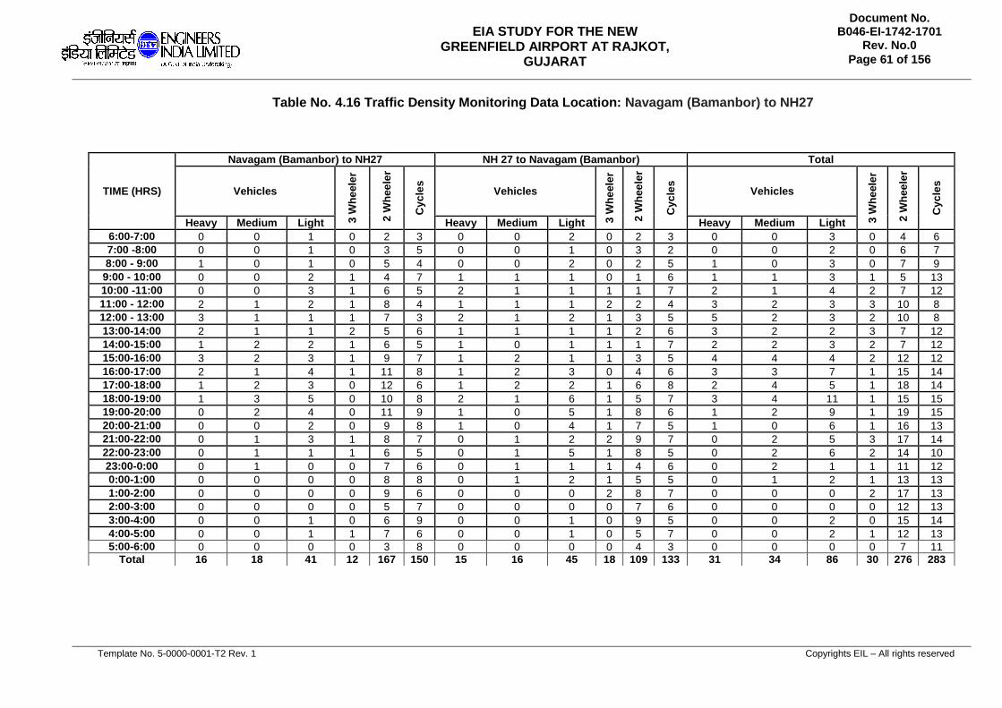
Template No. 5-0000-0001-T2 Rev. 1 Copyrights EIL – All rights reserved
Document No. B046-EI-1742-1701
Rev. No.0
Page 61 of 156
EIA STUDY FOR THE NEW GREENFIELD AIRPORT AT RAJKOT,
GUJARAT
Table No. 4.16 Traffic Density Monitoring Data Location: Navagam (Bamanbor) to NH27
TIME (HRS)
Navagam (Bamanbor) to NH27 NH 27 to Navagam (Bamanbor) Total
Vehicles
3 W
he
ele
r
2 W
hee
ler
Cyc
les
Vehicles
3 W
he
ele
r
2 W
hee
ler
Cyc
les
Vehicles
3 W
he
ele
r
2 W
hee
ler
Cyc
les
Heavy Medium Light Heavy Medium Light Heavy Medium Light
6:00-7:00 0 0 1 0 2 3 0 0 2 0 2 3 0 0 3 0 4 6
7:00 -8:00 0 0 1 0 3 5 0 0 1 0 3 2 0 0 2 0 6 7
8:00 - 9:00 1 0 1 0 5 4 0 0 2 0 2 5 1 0 3 0 7 9
9:00 - 10:00 0 0 2 1 4 7 1 1 1 0 1 6 1 1 3 1 5 13
10:00 -11:00 0 0 3 1 6 5 2 1 1 1 1 7 2 1 4 2 7 12
11:00 - 12:00 2 1 2 1 8 4 1 1 1 2 2 4 3 2 3 3 10 8
12:00 - 13:00 3 1 1 1 7 3 2 1 2 1 3 5 5 2 3 2 10 8
13:00-14:00 2 1 1 2 5 6 1 1 1 1 2 6 3 2 2 3 7 12
14:00-15:00 1 2 2 1 6 5 1 0 1 1 1 7 2 2 3 2 7 12
15:00-16:00 3 2 3 1 9 7 1 2 1 1 3 5 4 4 4 2 12 12
16:00-17:00 2 1 4 1 11 8 1 2 3 0 4 6 3 3 7 1 15 14
17:00-18:00 1 2 3 0 12 6 1 2 2 1 6 8 2 4 5 1 18 14
18:00-19:00 1 3 5 0 10 8 2 1 6 1 5 7 3 4 11 1 15 15
19:00-20:00 0 2 4 0 11 9 1 0 5 1 8 6 1 2 9 1 19 15
20:00-21:00 0 0 2 0 9 8 1 0 4 1 7 5 1 0 6 1 16 13
21:00-22:00 0 1 3 1 8 7 0 1 2 2 9 7 0 2 5 3 17 14
22:00-23:00 0 1 1 1 6 5 0 1 5 1 8 5 0 2 6 2 14 10
23:00-0:00 0 1 0 0 7 6 0 1 1 1 4 6 0 2 1 1 11 12
0:00-1:00 0 0 0 0 8 8 0 1 2 1 5 5 0 1 2 1 13 13
1:00-2:00 0 0 0 0 9 6 0 0 0 2 8 7 0 0 0 2 17 13
2:00-3:00 0 0 0 0 5 7 0 0 0 0 7 6 0 0 0 0 12 13
3:00-4:00 0 0 1 0 6 9 0 0 1 0 9 5 0 0 2 0 15 14
4:00-5:00 0 0 1 1 7 6 0 0 1 0 5 7 0 0 2 1 12 13
5:00-6:00 0 0 0 0 3 8 0 0 0 0 4 3 0 0 0 0 7 11
Total 16 18 41 12 167 150 15 16 45 18 109 133 31 34 86 30 276 283

Template No. 5-0000-0001-T2 Rev. 1 Copyrights EIL – All rights reserved
Document No. B046-EI-1742-1701
Rev. No.0
Page 62 of 156
EIA STUDY FOR THE NEW GREENFIELD AIRPORT AT RAJKOT,
GUJARAT
Conclusion Out of total traffic vehicles, 2 wheelers and cycles are very high followed by light and medium vehicles. The movement of two and four wheelers are largely found in daytime. The density of heavy vehicles was comparatively low at all locations. All six locations are connected to NH-27 which is the second longest national highway after NH-44. This highway connects the states of Gujarat, Rajasthan, Madhya Pradesh, Uttar Pradesh, Bihar, West Bengal and Assam. In Gujarat, it starts from Porbandar, passes from Rajkot and then further enters to Rajasthan. Out of 6 traffic observations, maximum number of vehicular movement is found in Bhalgam road sampling station. The traffic density was more because of the NH-27 which connects Rajkot and GIDC to Ahmedabad and Vadodara. Two and four wheelers were found to be ascendant for most of the time. Heavy vehicles were also observed to be in high density compared to other locations. Traffic density at Ahmedabad to GIDC, Bamanbore road was found to be the second highest as it is connecting GIDC to Ahmedabad. The most common vehicles were observed to be 2 and 4 wheelers. The heavy vehicles were moderate in number during the study period on this location. The traffic data of Rampura Beti, Navagam and Thikariyala locations was comparatively low as they are small villages with moderate population. Their village road connects to the NH-27. The density of cycles and two wheelers were more during the study period at these locations.
4.4 LAND ENVIRONMENT: Landuse/Land cover in its basic classification is assessed using remote sensing map and is given in Figure 4.6.

Template No. 5-0000-0001-T2 Rev. 1 Copyrights EIL – All rights reserved
Document No. B046-EI-1742-1701
Rev. No.0
Page 63 of 156
EIA STUDY FOR THE NEW GREENFIELD AIRPORT AT RAJKOT,
GUJARAT
Figure 4.6: Land use/Land Cover map around 10 km radius of proposed site
From the figure, it can be noticed that outside the hirasar airport site, agriculture and waste lands are predominant land uses. Further land use is assessed within site area and is shown in Figure 4.7.

Template No. 5-0000-0001-T2 Rev. 1 Copyrights EIL – All rights reserved
Document No. B046-EI-1742-1701
Rev. No.0
Page 64 of 156
EIA STUDY FOR THE NEW GREENFIELD AIRPORT AT RAJKOT,
GUJARAT
Figure 4.7: Land use/Land cover within proposed project site
It can be seen fromt the above that within project site also wastelands occupy predominant land use. Administratively the proposed site falls within Doshalighuna (46.9%), Garida (29.8%), Hirasar (20.4%), Loma Kotadi (2.3%), and Bamanbore (0.7%).
4.4.1 SOIL ANALYSIS
Soil Sampling was carried out at four sites to understand the soil quality. Meticulous attention was paid to collect adequate amount of composite soil samples for analysis. After removing the surface vegetation cover, visible roots, plant litter, gravel, plastic materials and other foreign materials. Samples were collected by using Agar at a depth of 50, 150 and 300 cm and mixed thoroughly and analyzed as a single unit sample. The samples were packed in dependable, waterproof zip lock pouch bag and was marked specifically, accurately and distinctly and brought to the laboratory for testing. This will establish the baseline characteristics and facilitate to identify contamination if any. Samples were analyzed for Texture, Specific gravity, Bulk density, Porosity, Organic matter, SAR, Conductivity, pH, Nitrogen, Phosphorous and Potassium. The method of analysis for various parameters is listed in the Table 4.17.
Table 4.17 List of Parameters and method of analysis
No. Parameter Method of Analysis
1 Type of soil IS: 2720, Part – 4
2 Ph IS: 2720, Part – 26: 1987 (RA: 2011)
3 Bulk Density ISO/ DIS 11272
4 Porosity ISO/ DIS 11274

Template No. 5-0000-0001-T2 Rev. 1 Copyrights EIL – All rights reserved
Document No. B046-EI-1742-1701
Rev. No.0
Page 65 of 156
EIA STUDY FOR THE NEW GREENFIELD AIRPORT AT RAJKOT,
GUJARAT
5 Soil Texture (Sand %, Clay % and Silt %) PLCPL-QC-SOP-SOIL-003
6 Organic Matter IS: 2720, Part – 22: 1972 (RA: 2015)
7 SAR By calculation
8 Specific Gravity IS: 2720, Part – 3: 1980 (RA: 2011)
9 Electrical Conductivity IS: 14767 – 2000, RA: 2016
10 Nitrogen as N PLCPL-QC-SOP-SOIL-N-029
11 Phosphorous as P2O5 PLCPL-QC-SOP-SOIL-005
12 Potassium as K2O PLCPL-QC-SOP-SOIL-006
The soil samples were collected as per the scope of work at 8 locations to assess pollution level of nearest locations of proposed project site. The soil sampling locations are depicted in Fig. No. 4.8 and the descriptions of sampling locations are discussed below.
Figure 4.8: Soil Sampling Locations
No. Location Dist. (km) Dir. Latitude Longitude
1 Hirasar village (S-01) 0.5 South 22⁰23′44.63″N 71⁰01′02.20″E
2 Rampara Beti village (S-02) 3.0 South 22⁰22′37.33″N 71⁰00′18.85″E
3 Jivapar village (S-03) 2.0 West 22⁰24′36.43″N 70⁰59′36.80″E
4 Bamanbore village (S-04) 1.0 North 22⁰22′27.33″N 71⁰03′58.34″E
5 Gundala village (S-05) 3.2 NNW 22°25'21.64"N 71°01'54.85"E
6 Thikariyala village (S-06) 6.1 NE 22°25'02.52"N 71°05'13.08"E
7 Navagam village (S-07) 3.4 NE 22°25'03.90"N 71°03'17.40"E
8 Garida village (S-08) 3.0 ESE 22°23'25.92"N 71°03'47.52"E

Template No. 5-0000-0001-T2 Rev. 1 Copyrights EIL – All rights reserved
Document No. B046-EI-1742-1701
Rev. No.0
Page 66 of 156
EIA STUDY FOR THE NEW GREENFIELD AIRPORT AT RAJKOT,
GUJARAT
Hirasar village (S-01) It is located at 0.5 km away from the GIDC towards south direction and 1.2 km away from the NH-27 towards north direction. The village has moderate population. No major industrial and allied activities are noticed. The colour of soil was Light grey. The sample was collected from the barren land which was 0.97 km away from the village towards north-west direction. Rampara Beti village (S -02) It is located at 3 km away from the GIDC towards south direction and 1.7 km away from the NH-27 towards north-west direction. The village has moderate population. The main source of water in this village is ground water through bore water. The soil of this village was less fertile. The appearance of soil was dark grey in colour. The soil sample was collected from agriculture land which was 2.6 km from the village towards south- east direction and touches the boundary of GIDC. Jivapar village (S-03) It is located at 2 km away from GIDC boundary towards west direction and 1.9 km away from the NH-27 towards south-east direction. The appearance of soil in this village was black in colour. The sampling location was 4 km away from GIDC in south west direction and sample was collected from the barren land. Bamanbore village (S - 04) It is located at 1 km away from GIDC boundary towards north direction and 1 km away from the NH-27 towards north direction. The sampling location was 0.74 km from GIDC towards north-west direction. The appearance of soil in this village was dark grey in colour. The sample was collected from the agriculture land. Gundala village (S - 05) It is located at 1.09 km away from GIDC boundary towards north direction and 0.3 km away from NH-27 towards south direction. The sampling location was 3.2 km from GIDC boundary towards north- north west direction. The appearance of soil was dark grey in colour. The sample was collected from the barren land. Thikariyala village (S-06) It is located at a distance of 3.6 km away from GIDC boundary towards north east direction and 0.6 km away from NH-27 towards south west direction. The sampling location was 3.3 km from GIDC boundary towards north east direction. The appearance of soil was black in colour. The sample was collected from the agriculture land. Navagam village (S-07) It is located at a distance of 1.0 km away from GIDC boundary towards north east direction and 0.9 km away from NH-27 towards south west direction. The sampling location was 0.76 km from GIDC boundary towards north east direction. The appearance of soil was dark grey in colour. The sample was collected from the barren land. Garida village (S-08) It is located at a distance of 0.9 km away from GIDC boundary towards east direction and 4.1 km away from NH-27 towards south direction. The sampling location was 1.5 km from

Template No. 5-0000-0001-T2 Rev. 1 Copyrights EIL – All rights reserved
Document No. B046-EI-1742-1701
Rev. No.0
Page 67 of 156
EIA STUDY FOR THE NEW GREENFIELD AIRPORT AT RAJKOT,
GUJARAT
GIDC boundary towards east direction. The appearance of soil was brown in colour. The sample was collected from agriculture land Results and Discussions The soil samples were collected from eight locations around the 10 km radius of GIDC. The samples were analyzed and the results were obtained. The samples were collected during the summer season from the selected locations. The results of all the specified parameters at each location are given in Table 4.18 and 4.19.
Table 4.18 Soil Quality Results
Parameter Unit S-01 S-02 S-03 S-04
pH -- 7.8 7.83 8.07 7.95
Bulk Density g/cc 1.36 1.39 1.42 1.41
Porosity % 74 72 70 71
Type of Soil -- Clay loam SC loam SC loam Clay loam
Soil Texture
a) Sand
b) Clay
c) Silt
% 45 55 57.5 40
% 32.5 22.5 25 37.5
% 22.5 22.5 17.5 22.5
Organic Matter % 1.0 1.04 0.85 1.13
SAR -- 2.4 2.8 3.0 2.1
Specific Gravity g/cc 2.65 2.67 2.68 2.64
Electrical Conductivity µmhos/cm 255 1130 428 2000
Nitrogen as N mg/Kg 790 916 840 952
Phosphorous as P2O5 mg/Kg 6.4 17.4 8.6 24.7
Potassium as K2O mg/Kg 327 410 354 433
S-01: Hirasar village S-02: Rampara Beti village S-03: Jivapar village S-04: Bamanbore village
Table 4.19 Soil Quality Results
Parameter Unit S-05 S-06 S-07 S-08
pH -- 7.61 6.94 7.58 7.64
Bulk Density g/cc 1.42 1.1 1.56 1.2
Porosity % 45 59 42 56
Type of Soil -- Sandy loam Clay loam Sandy loam
Clay loam
Soil Texture
a) Sand
b) Clay
c) Silt
% 58.5 42.5 64.5 40.5
% 26.5 45 24.5 48
% 15 12.5 11 11.5
Organic Matter % 3.2 9.5 3.5 9.3
SAR -- 2.1 3.5 1.9 3.2
Specific Gravity g/cc 2.67 2.69 2.64 2.71
Electrical Conductivity µmhos/cm 170 2170 212 282
Nitrogen as N mg/Kg 876 1560 950 1480
Phosphorous as P2O5 mg/Kg 7.2 12.7 9.4 13.5
Potassium as K2O mg/Kg 296 364 280 391

Template No. 5-0000-0001-T2 Rev. 1 Copyrights EIL – All rights reserved
Document No. B046-EI-1742-1701
Rev. No.0
Page 68 of 156
EIA STUDY FOR THE NEW GREENFIELD AIRPORT AT RAJKOT,
GUJARAT
pH Hydrogen ion activity is expressed in terms of pH. Environments containing more of the OH- ion than H+ ion exhibit a higher pH and are considered as alkaline. Low pH environments, termed as acidic, contain more H+ ions than OH- ions. Generally, for a pH in between 6.5 to 7.5 the environment is considered as neutral. Higher pH and lower pH would be considered as corrosive in environment.
Rating Light Soils
Acidic < 6.0
Normal 6.0-7.5
Weakly Alkaline 7.6-8.0
Tending to become Alkali 8.1-8.5
Alkaline > 8.5
The pH values obtained for all the locations were in the range of 7.58 to 8.07. The pH of soil for all locations are mostly weakly alkaline in nature. Soil Texture The proportion of sand, silt and clay particles in a soil is an important property of soils since many of the physical characteristics of soil are determined by soil texture. Soil particle size directly involves in deciding soil texture, porosity and infiltration capacity. Soil texture also affects the water permeability or percolation rate of a soil. Percolation is the downward movement of free water and is often referred to in the laboratory as the saturated hydraulic conductivity rate. With faster rate soil becomes coarser and with slower rate the soil becomes finer.
Soil separate fraction name Size
Coarse Sand 1.0 to 0.5 mm;
Medium sand 0.5 to 0.25 mm;
Fine sand 0.25 to 0.10 mm;
Very fine sand 0.10 to 0.05 mm;
Silt 0.05 to 0.002 mm;
Clay <0.002 mm.
S-05: Gunadala village S-06: Thikariyala village S-07: Navagam village S-08: Garida village

Template No. 5-0000-0001-T2 Rev. 1 Copyrights EIL – All rights reserved
Document No. B046-EI-1742-1701
Rev. No.0
Page 69 of 156
EIA STUDY FOR THE NEW GREENFIELD AIRPORT AT RAJKOT,
GUJARAT
Fig 4.9 Soil texture diagram of the study area
Based on particle sizes of the samples collected from the site, they are mostly falling in Sandy Clay and Loamy category. Sand percent was varying from 40 to 64.5 %, Silt percent was in the range of 11 to 22.5% and Clay was varying in range of 22.5 to 48%. Bulk Density Bulk density is defined as the mass of a unit volume of soil. Unlike the particle density, which is a characteristic of solid particle only, bulk density is determined by the volume of pore spaces as well as soil solids. Infiltration rate in soil depend on the bulk density. Thus, soils with high proportion of pore space to solids have lower bulk densities than those that are more compact and have less pore space. Fine textured soil surface such as silt loams, clays, and clay loams generally have lower bulk densities than sandy soils. The bulk density of all four samples was in the range from 1.1 to 1.56 %. Porosity Porosity of soils is the ratio between the volume of the interstices and the volume of the solid soil body. The interstices provide space for soil water and air, and thus porosity to a great degree determines the moisture and aeration conditions of soils which are two major factors of plant growth. Pore volume varies from 30 to 70%. Coarse textured soils usually have less total pore space than fine textured soils because of the smaller surface area of their particles. However, some compacted fine textured soils have a lower amount of pore space than coarse sandy soils. Soils of low porosity resist the infiltration of water. The porosity of soil collected from all the specific locations vary in the range from 42 to 74 %. Organic matter (OM) The concentration of OM in soils generally ranges from 1% to 6% of the total topsoil mass for most upland soils. Soils whose upper horizons consist of less than 1% organic matter are mostly limited to desert areas, while the OM content of soils in low-lying, wet areas can be as high as 90%. The organic matter in soil of all locations will be obtained in the range from 0.85 to 9.5%. The locations like Hirasar and Jivapar are drought lands and the organic matter of the soil is less which is not useful for agriculture purposes.

Template No. 5-0000-0001-T2 Rev. 1 Copyrights EIL – All rights reserved
Document No. B046-EI-1742-1701
Rev. No.0
Page 70 of 156
EIA STUDY FOR THE NEW GREENFIELD AIRPORT AT RAJKOT,
GUJARAT
Sodium Adsorption Ratio (SAR) Sodium adsorption ratio (SAR) is a ratio of the sodium (detrimental element) to the combination of calcium and magnesium (beneficial elements) in relation to known effects on soil dispersibility.
SAR = [Na+] / SQRT {([Ca2+] + [Mg2+])/2} In this expression, the concentrations for Na, Ca, and Mg are expressed in milli equivalents per liter. Where Na – Sodium ion concentration Ca – Calcium ion concentration Mg – Magnesium ion concentration The SAR for all soil samples collected from nearest of project site is varied from 1.9 to 3.5. Specific gravity Specific gravity is defined as the ratio of the weight of an equal volume of distilled water at that temperature both weights taken in air. The specific gravity of the soil particles lay within the range of 2.65 to 2.85. Soils containing organic matter and porous particles may have specific gravity values below 2.0. Soils having heavy substances may have values above 3.0. The specific gravity of soil samples collected from all locations nearer to the project site were obtained in the range of 2.64 to 2.71 g/cc. Electrical Conductivity (EC) Soil resistivity, the reciprocal of conductivity, has been used for years as an indicator of the corrosivity of soil. The lower the resistivity, the easier current will flow through the soil. Of the measurable soil characteristics, resistivity is generally accepted as the primary indicator of soil corrosivity. The electrical conductivity of the electrolyte is an important parameter in the rate of corrosion, the higher the conductivity the greater the rate of corrosion. Conductivity is a function of temperature, moisture and ionic content, since the corrosion current flows through the electrolyte by ionic conduction. Salt increase the electric conductivity of the ware and would therefore increases corrosion. The conductivity level also indicates low dissolved salts which is positive effect on corrosion. The electrical conductivity for all locations varies from 170 to 2150 µmhos/cm. Nitrogen (N) Nitrogen occurs in soils as organic and inorganic forms and soil testing may be performed to measure levels of either. Nitrate nitrogen (NO3-N) is most commonly measured in standard soil tests because it is the primary form of nitrogen available to trees and, therefore, an indicator of nitrogen soil fertility. However, soil concentrations of NO3-N depend upon the biological activity and may fluctuate with changes in soil temperature, soil moisture, and other conditions. Nitrate is also easily leached with rainfall or irrigation so current soil tests may not reflect future levels of nitrogen soil fertility.

Template No. 5-0000-0001-T2 Rev. 1 Copyrights EIL – All rights reserved
Document No. B046-EI-1742-1701
Rev. No.0
Page 71 of 156
EIA STUDY FOR THE NEW GREENFIELD AIRPORT AT RAJKOT,
GUJARAT
The nitrogen values obtained from all soil sample locations varies from 790 to 1560 mg/Kg. The nitrogen content present in the soil samples is sufficient. Phosphorous (P2O5) Phosphorous test are performed in soil to determine the concentrations of phosphorus in soil. Soils with inherent pH values between 6 and 7.5 are ideal for Phosphorous availability, while pH values below 5.5 and between 7.5 and 8.5 limits Phosphorous availability to plants due to fixation by aluminum, iron, or calcium, often associated with soil parent materials.
Available P (ppm or mg/kg) Ranges
>0.0 to 5.8 Low
>5.8 to 14.5 Medium
>14.5 to 23.3 High
The phosphorous values obtained from all the locations are varying in the range of 6.4 to 24.7 mg/Kg. The soil samples for all locations are low to high in range of phosphorous. Potassium (K2O) Potassium undergoes exchange reactions with other cations in the soil such as calcium, magnesium, sodium, and hydrogen and this affects the plant available potassium. Therefore, an ammonium acetate extraction method is the most common method to model these soil reactions and analyze for potassium fertility. The potassium values obtained for all locations vary from 280 to 433 mg/Kg. The potassium values in soil samples for all locations are mostly high.
Available N (ppm or mg/kg) Ranges
0.0 to 33.3 Very less
34 to 66.6 Less
67.3 to 100 Good
100.66 to 200 Better
>200 Sufficient
Available K (ppm or mg/kg) Ranges
>0.0 to 83 Low
>83 to 166 Medium
>166 High

Template No. 5-0000-0001-T2 Rev. 1 Copyrights EIL – All rights reserved
Document No. B046-EI-1742-1701
Rev. No.0
Page 72 of 156
EIA STUDY FOR THE NEW GREENFIELD AIRPORT AT RAJKOT,
GUJARAT
4.5 SOCIO-ECONOMIC ENVIRONMENT
Villages falling within 10 km radius are shown in Figure 4.10. Demographic characteristics of villages based on the Census Data for the year 2011 are given in Tables 4.20 & 4.21.
Figure 4.10: Villages within 10 km radius of proposed airport
Table 4.20: Demographic Characteristics of study area (2011)
Village Population Male
Population Female
Population
Saypar 1100 557 557
Mesvada 1398 701 697
Parevala 2015 1054 961
Mevasa (Bamanbore) 987 488 499
Shekhaliya 715 367 348
Rampara (Rajpara) 672 360 312
Chiroda (Rajpara) 2338 1206 1132
Pipaliya (Bamanbore) 1147 611 536
Loma Kotadi 59 31 28
Rampara Beti 1752 906 846
Kuchiyadad 1830 937 893
Doshalighuna 382 197 185
Garida 1160 598 562

Template No. 5-0000-0001-T2 Rev. 1 Copyrights EIL – All rights reserved
Document No. B046-EI-1742-1701
Rev. No.0
Page 73 of 156
EIA STUDY FOR THE NEW GREENFIELD AIRPORT AT RAJKOT,
GUJARAT
Table 4.21: Demographic Characteristics of study area (2011)
Name of villages
In the age group of 0 to 6 years
Scheduled Castes (SC)
Scheduled Tribes (ST)
Literates Illiterate Total Workers
T M F T M F T M F T M F T M F T M F
Saypar 543 90 76 204 103 101 20 11 9 765 415 350 335 142 193 586 338 248
Mesvada 206 92 114 38 24 14 0 0 0 929 521 408 469 180 289 949 472 477
Parevala 346 178 168 178 91 87 0 0 0 1054 649 405 961 405 556 1133 613 520
Mevasa (Bamanbore)
165 76 89 25 12 13 0 0 0 459 309 150 528 179 349 378 262 116
Shekhaliya 148 69 79 9 6 3 3 1 2 277 175 102 438 192 246 195 188 7
Rampara (Rajpara)
136 69 67 0 0 0 0 0 0 272 188 84 400 172 228 363 200 163
Chiroda (Rajpara)
380 192 188 57 28 29 0 0 0 1120 713 407 1218 493 725 1125 679 446
Pipaliya (Bamanbore)
195 106 89 196 107 89 0 0 0 483 293 190 664 318 346 515 320 195
Loma Kotadi 12 6 6 10 7 3 0 0 0 38 23 15 21 8 13 30 22 8
Rampara Beti 275 145 130 17 8 9 4 3 1 994 612 382 758 294 464 830 544 286
Kuchiyadad 274 144 130 61 35 26 0 0 0 1083 647 436 747 290 457 560 538 22
Doshalighuna 61 38 23 190 100 90 0 0 0 208 121 87 174 76 98 87 84 3
Garida 199 109 90 58 26 32 8 4 4 611 368 243 549 230 319 415 330 85
Zinzuda 640 346 294 166 83 83 0 0 0 1477 906 571 1685 760 925 1463 782 681
Moti Moldi 768 391 377 562 285 277 14 5 9 2547 1563 984 1963 755 1208 2088 1213 875
Thikariyala 286 138 148 204 105 99 0 0 0 1056 661 395 834 324 510 570 513 57
Nani Moldi 227 106 121 696 348 348 0 0 0 955 580 375 619 221 398 996 498 498
Navagam (Bamanbore)
260 131 129 3 2 1 4 2 2 761 476 285 753 305 448 558 432 126
Bamanbore 504 261 243 228 125 103 0 0 0 1895 1167 728 1413 570 843 1396 1023 373
Gundala 425 228 197 664 355 309 66 27 39 1751 1007 744 1033 465 568 966 836 130
Hirasar 189 96 93 42 22 20 0 0 0 651 405 246 572 216 356 696 340 356
Satda 187 96 91 21 10 11 0 0 0 691 411 280 487 188 299 481 359 122
vankvad 152 87 65 0 0 0 0 0 0 566 326 240 372 148 224 432 255 177
Jepur 255 151 104 125 61 64 0 0 0 2751 1472 1279 334 161 173 1505 969 536
Jivapar (Bamanbore)
109 54 55 1 1 0 0 0 0 466 301 165 240 62 178 231 191 40
Vasundra 99 51 48 0 0 0 0 0 0 299 197 102 210 76 134 191 164 27
Rupavati 177 90 87 68 35 33 0 0 0 536 369 167 607 227 380 368 359 9
Jalida 99 49 50 64 27 37 0 0 0 465 254 211 281 109 172 252 220 32
Rangpar 242 130 112 159 81 78 0 0 0 1491 851 640 632 241 391 701 655 46
Bhalgam 153 83 70 311 164 147 0 0 0 698 430 268 393 136 257 419 354 65
The 2011 Census data shows that the scheduled caste population ranges from 0.1 to 49.7%, scheduled tribes population ranges from nil to 2.4%, literates ranges from 38.7 to 89.2%, illiterates ranges from 10.8 to 61.3% and workers range from 22.8 to 67.9% in various villages within study area.
Zinzuda 3162 1666 1496
Moti Moldi 4510 2318 2192
Thikariyala 1890 985 905
ani Moldi 1574 801 773
Navagam (Bamanbore) 1514 781 733
Bamanbore 3308 1737 1571
Gundala 2784 1472 1312
Hirasar 1223 621 602
Satda 1178 599 579
vankvad 938 474 464
Jepur 3085 1633 1452
Jivapar (Bamanbore) 706 363 343
Vasundra 509 273 236
Rupavati 1143 596 547
Jalida 746 363 383
Rangpar 2123 1092 1031
Bhalgam 1091 566 525

Template No. 5-0000-0001-T2 Rev. 1 Copyrights EIL – All rights reserved
Document No. B046-EI-1742-1701
Rev. No.0
Page 74 of 156
EIA STUDY FOR THE NEW GREENFIELD AIRPORT AT RAJKOT,
GUJARAT
4.5.1 Baseline Perception Survey of Project Affected Villages
A baseline perception survey was undertaken to gauge the sentiments and ascertain the socio-economic status of the families likely to be displaced/relocated in the proposed project affected area. For the field survey, a questionnaire was designed to capture information on public perception about the proposed project and the status of the household socio-economic environment in the study area including health, educational facilities and availability of potable drinking water. The survey was undertaken in all the four villages viz., Hirasar, Garida, Dosalighuna and Lomakotadi, which form a part of the total 1025.54 hectares required for the proposed Greenfield airport project. Hirasar Hirasar village is primarily occupied by one large clan of Solanki family with around 60 families living in the area. Other families which live in the village is morvadiya,rathod, vajhani and parmar. The primary occupation of Solanki family is cattle rearing The clan together looks after 400-600 cattle. After acquisition of land for the proposed airport there will be no gauchar land left for cattle grazing and subsequently impact the local livelihood. Sale of milk products is a secondary income source for the residents although milk products are kept largely for their own use and just around 100 litres is used for selling in a day from the entire village. Their main source of income is through driving and labour work. As most of the Hirasar residents belong to the same family, they are reluctant to shift/relocate to a new place without their kins, who presently live in the same village. They would agree for resettlement/relocation, if they are provided with a single patch of land for all the members of Solanki family with suitable grazing land for cattle in addition to space for their houses and agricultural land. The people in Hirasar village undertake agricultural activities during rainy season wherein crops like Jowar, Bajra are cultivated. They are interested in availing employment opportunities which would arise from the proposed airport project. Besides, the project affected persons want improvement in their living conditions and public infrastructure including schools, availability of potable water, health and sanitation facilities. As per the field survey, the educational and health infrastructure/ facilities in the village for inadequate as the nearest primary school is 15 km away in Kudava and there no primary health centre exists in the village. Garida As per the survey, the people are not willing to relocate without alternate land of same area of agricultural and gauchar land for their cattle. Also, they perceive that their main source of water through a dam is going to be acquired for the proposed airport project which is another matter of concern for them. The main crops grown in the village is of cotton and vegetables. Availability of potable water is an issue in the village as there is no well or a community source of water. Besides, the village has a primary school but there is no primary health centre present. The people who are unwell have to go to Chotila or Rajkot city. DoshaliGhuna The main occupation of people in this village is cattle raring and people do not want the airport to come up in this area as it will lead to loss of gauchar land for grazing of cattle.
Template No. 5-0000-0001-T2 Rev. 1 Copyrights EIL – All rights reserved
Document No. B046-EI-1742-1701
Rev. No.0
Page 75 of 156
EIA STUDY FOR THE NEW GREENFIELD AIRPORT AT RAJKOT,
GUJARAT
However, if they are provided alternate land suitable for cattle grazing they will be willing to relocate. Besides, they are also interested in employment opportunities arising from the proposed project. The Public infrastructure is inadequate in this village with only a primary school present while no health facilities are available. The major village problems are inadequate sanitation, unavailability of potable water and poor road infrastructure. Lomakotadi Due to flooding in the village every year, the village is to be shifted to new gamtal and it is already approved from concerned government authority. Now, due to proposed airport project whole area of new gamtal is in the project area and the relocation of people has to be undertaken. As per the survey, the local people have stated they will relocate if they are provided the same area of agricultural and gauchar land elsewhere. The main occupation of the local residents is agriculture, cattle raring and labour work. The public utility infrastructure in the village is in a poor condition as per the field survey. Although the village has a primary school but there is no Primary Health Centre present. A doctor visits the village once a month. Summary of Perception Survey In Proposed Project Site The perception of project affected persons is conditionally favourable for the proposed project as they are reluctant to relocate to an alternate land without same amount of agricultural and gauchar land for their cattle and provision of employment opportunities, and better public infrastructure facilities. Hirasar village, with around 13.83 hectares of private land, has around 60-70 families of the same clan together and they are reluctant to shift to a new place if all the families are not relocated together. Besides, the villages surveyed have poor health and educational facilities which need to be kept in mind at the time of resettlement of project affected families. Feasibility of Rehabilitation Program & Costs Involved: The feasibility of Resettlement /Rehabilitation program depends on various factors such as the willingness of the project affected people to relocate to alternate land and their acceptance for agreed compensation. A Rehabilitation/Resettlement plan developed incorporating feedbacks from all stakeholders including the local population, local government authorities, project proponents etc. would be required to ensure feasibility of the program. The costs of the rehabilitation program should be based on the procedure and rules laid down in the ‘Right to Fair Compensation and Transparency in Land Acquisition, Rehabilitation and Resettlement Act, 2013’. The typical resettlement costs involve the following main factors: Value of land to be acquired (including market price etc as per R&R policy) Houses and other fixed assets Procuring alternative lands for agriculture & Gauchar land for cattle raring in this case Cost of constructing resettlement sites

Template No. 5-0000-0001-T2 Rev. 1 Copyrights EIL – All rights reserved
Document No. B046-EI-1742-1701
Rev. No.0
Page 76 of 156
EIA STUDY FOR THE NEW GREENFIELD AIRPORT AT RAJKOT,
GUJARAT
Costs associated with job creation and other economic rehabilitation activities Transfer allowances for the move to the resettlement sites and subsistence allowances
for a reasonable duration of transition. Provisions for inflation and other contingencies
4.6 BIOLOGICAL ENVIRONMENT
Ecological studies are one of the important aspects of Environmental Impact Assessment with a view to conserve environmental quality and biodiversity. Ecological systems show complex inter-relationships between biotic and abiotic components including dependence, competition and mutualism. Biotic components comprise of both plant and animal communities, which interact not only within and between themselves but also with the abiotic components viz. physical and chemical components of the environment.
Generally, biological communities are good indicators of climatic and edaphic factors. Studies on biological aspects of ecosystems are important in Environmental Impact Assessment for safety of natural flora and fauna. The biological environment includes terrestrial and aquatic ecosystems.
The animal and plant communities co-exist in a well-organized manner. Their natural settings can get disturbed by any externally induced anthropological activities or by naturally occurring calamities or disaster. So, once this setting is disturbed, it sometimes is either practically impossible or may take a longer time to come back to its original state. Hence changes in the status of flora and fauna are an elementary requirement of Environmental Impact Assessment studies, in view of the need for conservation of environmental quality and biodiversity. Information on flora and fauna was collected within the study area.
4.6.1 Forest Classification in Rajkot District
As per Champion and Seth’s classification 1968, forest of Rajkot division falls under the following categories.
a. Dry Tropical Forest
b. Tropical Thorn Forest
c. Moist Tropical Forest
d. Littoral and Swamp Forest
These forests can be further distinguished into following sub-type. Inland forests including hill forests: it includes all the undulating and plain areas of the division. The areas are comparatively better soil depth and hence support tree species like Desi baval (Acacia nilotica), Gando baval (Prosopis juliflora), Thor (Euphorbia nevulia), Khair (Acacia catechu), Khakhro (Butea monosperma), Bordi (Zizyphus mauritiana), Piludi (Salvadora persica) etc. Coastal forest: These forests have sandy soil and regeneration on such land is difficult. But profuse natural vegetation of Propsopis species is observed in the area. Mangrove forest: These forests occur in muddy creeks of Navlakhi and Maliya taluka of this division. Grasslands: Grasslands are found in most of the Rajkot division.

Template No. 5-0000-0001-T2 Rev. 1 Copyrights EIL – All rights reserved
Document No. B046-EI-1742-1701
Rev. No.0
Page 77 of 156
EIA STUDY FOR THE NEW GREENFIELD AIRPORT AT RAJKOT,
GUJARAT
4.6.2 Agricultural Crops Rajkot district has large areas under cultivation. The important crops such as groundnut, jawar, bajra, cotton and wheat are principal crops grown in the study area. Oil seed crops are also cultivated. The various agricultural operations start in the month of June. The cultivators start the preparatory tillage operation during the month of May before onset of monsoon. They are engaged in the agricultural activities from the first week of June to the end of October-November for Khariff crop. In case of Rabi crops, the agricultural activities commence from Novemebr and lasts upto march-April.
4.6.3 Grassland Development by Forest Department in the Study Area
Grassland is a landscape unit dominated by grasses. Grasses are one of the largest and most valuable recognized since time immemorial and mankind is sustained more by grasses than by any other group of plants. Since the vegetative productivity of grasses is very high, herbivorous animals, especially large mammals, are favoured in the grassland community. Grasses are widespread than any other family of flowering plants and the existence of human life and quality would be impossible without grasses. In arid area, rearing of livestock mainly depends on the extent and condition of the available grasslands. The importance of livestock is pastoral systems exceeds their value as source of milks, meat and hides. In order to supporting livestock, grassland serves as sources of other significant economic product, as well as medicinal plants, building materials, thatch, fencing, gums and other products important to the economics of rural populations.
Semi-arid grassland is found in western and southern part of Gujarat. Grassland in Gujarat is popularly called as vidis/rakhals. These vidis can be classified into reserved and non-reserved vidis. The grasslands or vidis that produce 1,00,000 kg and above of grass annually are termed as reserved vidis and rest are put under the category of no-reserved vidis. Grass is the main vegetation found in the vidi areas but at places the composition has got changed due to growth of certain tree species. Both annual and perennial grasses are found in these vidis. The different grasses which are palatable are Zinzavo (Bothrichloa ischaeum), Ratad (Themeda quadrivalvis), Shaniyar (Sehima sulcatum), Moshti (Iscillema prostratum) etc. The grass produced by vidis is not sufficient to sustain the increasing cattle population. Therefore, there is a shortage of grazing area for the large number of cattle. The requirement of grass & fodder is therefore very heavy. The grasslands (reserved vidis) which are under forest department are not allowed for grazing. The grasses are not allowed to grow and after rainy season, grasses with good quality are harvested and after cutting, they are stored in grass godwns. During the scarcity of time, this grass becomes useful and is given to the local villagers at subsidized rates.
The non-reserved vidis are calling for attention as they have been subject to continuous degradation due to uncontrolled and unplanned management practices. The uncontrolled grazing, has led to erosion of the top soil, besides causing its hardening. The quality of the grass growing in many non-reserved vidis is poor.
Hirasar is reserved vidi of Rajkot range and it is 2 km away from Beti village. Grasses like Shaniyar (Sehima sulcatum), Lapdu (Aristida adscensionis), Kagado (Heteropogon contortus), Jhinjhvo (Dicanthium annulatum), Foflu (Apluda mutica) and Dhaman (Cenchrus setigerus) are found while other plants like Deshi bawal (Acacia nilotica), Gorad (Acacia Senegal), Bor (Zizyphus mauritiana) and Harmo (Acacia leucophloea) are found in this vidi. Cutting of grass is done in the month of October and 1 lakh kg of grass is collected every year, storage of collected grass is done in Beti godown.

Template No. 5-0000-0001-T2 Rev. 1 Copyrights EIL – All rights reserved
Document No. B046-EI-1742-1701
Rev. No.0
Page 78 of 156
EIA STUDY FOR THE NEW GREENFIELD AIRPORT AT RAJKOT,
GUJARAT
Plantation of grass is done by seed sowing in the month of June. North side of vidi is surrounded by Jivapar village, South side is surrounded by Rampar Beti village, while East side is surrounded by Bamanpur village and West side of vidi is surrounded by Satda village. Fencing is available for the protection of vidi. Nilgai and Jungli bhund is present in large number in this vidi. Grasses found in the vidi area are given in Table 4.22.
Table 4.22 Grasses found in Hirasar vidi areas
Sr. No. Plot Category Local name Botanical Name
1 Dense Dharaf Bothricloa glabra
2 Ghaulu Iseilema laxum
3 Kagado Heteropogon contortus
4 Lapdu Aristida adscensionis
5 Shaniyar Sehima sulcatum
6 - Melanocenchris jacquemontii
7 Open Ghaulu Iseilema laxum
8 Jhinjhvo Dicanthium annulatum
9 Kagado Heteropogon contortus
10 Mohati Iseilema prostratum
11 Shaniyar Sehima sulcatum
12 Degraded Shaniyar Sehima sulcatum
13 Ghaulu Iseilema laxum
14 Kagado Heteropogon contortus
15 - Chloris barbata
Isilema laxum and Sehima sulcatum contain maximum frequency whereas Bothriochloa glabra, Aristida adscensionis, Melanocenchris jacquemontii, Sehima sulcatum, Heteropogon contortus & Chloris barbata contain minimum frequency. Heteropogon contortus contains maximum abundance while Chloris barbata contains minimum abundance & density. Sehima sulcatum has maximum density.
4.6.4 Vegetation in Rajkot district The floristic study reveals species composition, which represents poor gene pool uniformly spread in restricted vegetation patches around human settlements. Collection of dead and dried branches for fuel, hard wood and local trees for construction purpose, grazing practice on vegetated land is also common. The nature of vegetation cover in this region is mixed, tropical dry, uneven-age deciduous vegetation with marked dominance of Acacia sp., Dalbergia latifolia, Bauhinia purpurea, Ficus racemosa, Mangifera indica, Butea monosperma, Sapindus emarginatus, and Gmelina arborea. Most of the vegetation aggregates on agricultural bunds, near roadsides, on degraded village lands, canal sides and wastelands.
The vertical structure of the vegetation shows three distinguished storey i.e. Top, Middle and Ground. Azadirachta indica, Dalbergia latifolia, Bauhinia purpurea, Ficus racemosa, Mangifera indica, Butea monosperma etc. comprises top storey of the forest. Adhatoda vasica, Cassia fistula, Calotropis gigantea, Dalbergia sissoo, Lantana camara, Euphorbia nevulia, Opuntia elator, Prosopis juliflora, Zizyphus rugosa etc. forms middle storey of region. Ground vegetation cover is of Ageratum coyizoides, Argemone mexicana, Dipcadi montanum, Erantemum roseum, Leucas aspera, Phyllanthus niruri, Solanum xanthocarpum, Tinospora cardifolia etc.

Template No. 5-0000-0001-T2 Rev. 1 Copyrights EIL – All rights reserved
Document No. B046-EI-1742-1701
Rev. No.0
Page 79 of 156
EIA STUDY FOR THE NEW GREENFIELD AIRPORT AT RAJKOT,
GUJARAT
4.6.5 Floral Diversity Methodology The study area is dominated by the vegetation mostly of scrub and thorn forest mostly dominated by Prosopis julifora species. Therefore the observation of vegetation was made by visiting different sampling stations and accordingly among available plants, the dominant plants species were recorded. The survey was conducted 10 km radius of the airport.
The structure and composition of vegetation has been studied by phyto-sociological method of vegetation survey, i.e. biodiversity, density, dominance and frequency of different plant species.
The quadrate method of flora monitoring includes identification of a square sample plot or unit of suitable size for detailed analysis of vegetation. It is also called as sample plot method it may be a single sample plot or divided into several sub-plots. Random sampling method was used for the above study. In vegetation analysis, quadrate of any size, shape, number and arrangement may be used depending on the vegetation. In this study, quadrate sizes of 1 m x 1 m, 5 m x 5 m, 20 m x 20 m and were taken for herbs, shrubs and trees respectively.
Coexistence and competition both are affected directly by the number of individuals in the community. Therefore, it is essential to know the quantitative structure of community. To characterize the community as a whole, certain parameters are used. The parameters like frequency, density, abundance, Importance Value Index (IVI) and Simpson's Diversity Index (SDI) give a clear picture of community structure in quantitative terms. These parameters as estimated from the monitored data at sample plots. The formulae used to derive these parameters, are presented below.
Number of individuals of a species Density = ----------------------------------------------
Area sampled
Total No. of individuals for a species Relative Density = ------------------------------------------------- x 100
Total No. of individuals of all species
Total cover or Basal area for species A Dominance = ----------------------------------------------------
Area sampled
Dominance for species A Relative Dominance = ----------------------------------------- x 100
Total dominance for all species
No. of plots in which species A occurs Frequency = ----------------------------------------------------
Total No. of plot sampled
Frequency value for species A Relative Frequency = ------------------------------------------------- x 100
Total frequency value for all species Total No. of species A occur in all quadrates
Abundance/Quadrate = -------------------------------------------------------------- Total No. of quadrate in which species A occur

Template No. 5-0000-0001-T2 Rev. 1 Copyrights EIL – All rights reserved
Document No. B046-EI-1742-1701
Rev. No.0
Page 80 of 156
EIA STUDY FOR THE NEW GREENFIELD AIRPORT AT RAJKOT,
GUJARAT
Importance Value Index (IVI) = R. Density+ R. Frequency+ R. Dominance
n ni (ni-1) Simpson Diversity Index = Σ -------------------------
i=1 N(N-1)
ni = is the total number of individuals of the Ith species in the sample
N = is the number of individuals in the sample
The diversity measurements reflects as to how many diverse species are present, the density measurements indicate how many count a single species can make in a sample plots; the dominance measurements denote which species is largest in terms of its presence, the frequency measurements indicate, how widely a species is distributed or occurred. The density measurements may over-emphasize the importance of a species that consist of how many individuals are present in unit area. The frequency measurements emphasize the importance of distribution of individuals belonging to a particular species in the vegetation sampled. Therefore, Importance Value Index is a reasonable measure to assess the overall significance of a species.
4.6.6 Faunal Diversity Methodology
Random walk and opportunistic observations were used for documenting the birds. With the aid of a pair of binoculars the bird sampling were carried out during morning (06:00 to 10:00 hrs) and evening (17:00 to 19:00 hrs) hours. Birds were noted, counted and identified with the help of binocular and standard field identification guides. During the present study period, both direct and indirect methods (tracks & signs and visual encounter survey) were used to document the mammals occurring in the area. Visual Encounter Survey (VES) method was followed for the survey of the herpetofauna (amphibians and reptiles) in the study area during the present study. VES is a method one in which field personnel walk through an area or habitat for a prescribed time period systematically searching for animals. Other animals were directly counted from amongst the vegetation, bushes and the roadside fields.
4.6.7 Analysis of Floral Diversity
The study area consists of 10 km radial distance of the proposed airport. The study includes both aquatic and terrestrial ecosystems. Diverse systems such as scrub forest, cultivated lands and kitchen gardens of villages were visited and floral species identified.
A total of 203 species of plants (including wild, ornamental and cultivated plants) belonging 65 plant families were documented and identified. The identified plant species with scientific name, family, habit, habitat and type are given in Table 4.23. Photographs of plant species collected during the site visits are mentioned below.
Table 4.23 Enumeration of Plant species in surrounding areas of Rajkot airport
Sl No
Species Name Family Habit
1 Abelmoschus moschatus Medic. Malvaceae Herb
2 Abrus precatorius L. Fabaceae Climber
3 Abutilon indicum (L.)Sweet Sterculiaceae Herb
4 Acacia catechu (L. f.) Willd. Mimosaceae Tree
5 Acacia ferruginea DC. Mimosaceae Tree
6 Acacia leucophloea (Roxb.) Willd. Mimosaceae Tree
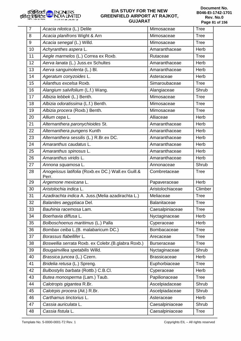
Template No. 5-0000-0001-T2 Rev. 1 Copyrights EIL – All rights reserved
Document No. B046-EI-1742-1701
Rev. No.0
Page 81 of 156
EIA STUDY FOR THE NEW GREENFIELD AIRPORT AT RAJKOT,
GUJARAT
7 Acacia nilotica (L.) Delile Mimosaceae Tree
8 Acacia planifrons Wight & Arn Mimosaceae Tree
9 Acacia senegal (L.) Willd. Mimosaceae Tree
10 Achyranthes aspera L. Amaranthaceae Herb
11 Aegle marmelos (L.) Correa ex Roxb. Rutaceae Tree
12 Aerva lanata (L.) Juss.ex Schultes Amaranthaceae Herb
13 Aerva sanguinolenta (L.) Bl. Amaranthaceae Herb
14 Ageratum conyzoides L. Asteraceae Herb
15 Ailanthus excelsa Roxb. Simaroubaceae Tree
16 Alangium salvifolium (L.f.) Wang. Alangiaceae Shrub
17 Albizia lebbek (L.) Benth. Mimosaceae Tree
18 Albizia odoratissima (L.f.) Benth. Mimosaceae Tree
19 Albizia procera (Roxb.) Benth. Mimosaceae Tree
20 Allium cepa L. Alliaceae Herb
21 Alternanthera paronychioides St. Amaranthaceae Herb
22 Alternanthera pungens Kunth Amaranthaceae Herb
23 Alternanthera sessilis (L.) R.Br.ex DC. Amaranthaceae Herb
24 Amaranthus caudatus L. Amaranthaceae Herb
25 Amaranthus spinosus L. Amaranthaceae Herb
26 Amaranthus viridis L. Amaranthaceae Herb
27 Annona squamosa L. Annonaceae Shrub
28 Anogeissus latifolia (Roxb.ex DC.) Wall.ex Guill.& Perr.
Combretaceae Tree
29 Argemone mexicana L. Papaveraceae Herb
30 Aristolochia indica L. Aristolochiaceae Climber
31 Azadirachta indica A. Juss.(Melia azadirachta L.) Meliaceae Tree
32 Balanites aegyptiaca Del. Balanitaceae Tree
33 Bauhinia racemosa Lam. Caesalpiniaceae Tree
34 Boerhavia diffusa L. Nyctaginaceae Herb
35 Bolboschoenus maritimus (L.) Palla Cyperaceae Herb
36 Bombax ceiba L.(B. malabaricum DC.) Bombacaceae Tree
37 Borassus flabellifer L. Arecaceae Tree
38 Boswellia serrata Roxb. ex Colebr.(B.glabra Roxb.) Burseraceae Tree
39 Bougainvillea spetabilis Willd. Nyctaginaceae Shrub
40 Brassica juncea (L.) Czern. Brassicaceae Herb
41 Bridelia retusa (L.) Spreng. Euphorbiaceae Tree
42 Bulbostylis barbata (Rottb.) C.B.Cl. Cyperaceae Herb
43 Butea monosperma (Lam.) Taub. Papilionaceae Tree
44 Calotropis gigantea R.Br. Ascelpiadaceae Shrub
45 Calotrpis procera (Ait.) R.Br. Ascelpiadaceae Shrub
46 Carthamus tinctorius L. Asteraceae Herb
47 Cassia auriculata L. Caesalpiniaceae Shrub
48 Cassia fistula L. Caesalpiniaceae Tree

Template No. 5-0000-0001-T2 Rev. 1 Copyrights EIL – All rights reserved
Document No. B046-EI-1742-1701
Rev. No.0
Page 82 of 156
EIA STUDY FOR THE NEW GREENFIELD AIRPORT AT RAJKOT,
GUJARAT
49 Cassia occidentalis L. Caesalpiniaceae Herb
50 Cassia senna L. Caesalpiniaceae Herb
51 Cassia siamea Lam. Caesalpiniaceae Tree
52 Cassia tora L. Caesalpiniaceae Herb
53 Casuarina equisetifolia L. Casurinaceae Tree
54 Celosia argentea L. var. argentea Amaranthaceae Herb
55 Chloris barbata Sw. Poaceae Herb
56 Chromolaena odorata (L.) R.King & H.Robins. Asteraceae Herb
57 Chrozophora rottleri (Geisel.) Juss. Euphorbiaceae Herb
58 Cicer arietinum L Papilionaceae Herb
59 Cleome viscosa L. Capparaceae Herb
60 Clerodendrum inerme (L.) Gaertn. Verbenaceae Herb
61 Cocos nucifera L. Arecaceae Tree
62 Colocasia esculenta (L.) Schott Araceae Herb
63 Commelina benghalensis L. Commelinaceae Herb
64 Commelina diffusa Burm.f. Commelinaceae Herb
65 Commiphora wightii (Arn.) Bhandari Burseraceae Tree
66 Cordia dichotoma Forst.f. Boraginaceae Tree
67 Cordia monoica Roxb. Ehretiaceae Tree
68 Coriandrum sativum L. Apiaceae Herb
69 Cressa cretica Convolvulaceae Herb
70 Crotalaria retusa L. Papilionaceae Climber
71 Croton bonplandianus Baill. Euphorbiaceae Herb
72 Cuminum cyminum L. Apiaceae Herb
73 Cynodon dactylon (L.) Pers. Poaceae Herb
74 Cyperus compressus L. Cyperaceae Herb
75 Cyperus kyllingia Endl. Cyperaceae Herb
76 Cyperus rotundus L. Cyperaceae Herb
77 Dactyloctenium aegyptium (L.) P.Beauv. Poaceae Herb
78 Dalbergia sisoo Roxb. Papilionaceae Tree
79 Datura innoxia Mill. Solanaceae Herb
80 Delonix elata (L.) Gamble Caesalpiniaceae Tree
81 Delonix regia (Boj.ex Hook.) Raf. Caesalpiniaceae Tree
82 Emblica officinalis Gaertn. Euphorbiaceae Tree
83 Emilia sonchifolia (L.) DC Asteraceae Herb
84 Erythrina variegata L. Papilionaceae Tree
85 Eucalyptus tereticornis Sm. Myrtaceae Tree
86 Euphorbia caducifolia Haines Euphorbiaceae Shrub
87 Euphorbia chamaesyce L. Euphorbiaceae Herb
88 Euphorbia hirta L. Euphorbiaceae Herb
89 Euphorbia neriifolia L. Euphorbiaceae Shrub
90 Euphorbia thymifolia L. Euphorbiaceae Herb

Template No. 5-0000-0001-T2 Rev. 1 Copyrights EIL – All rights reserved
Document No. B046-EI-1742-1701
Rev. No.0
Page 83 of 156
EIA STUDY FOR THE NEW GREENFIELD AIRPORT AT RAJKOT,
GUJARAT
91 Euphorbia tirucalli L. Euphorbiaceae Shrub
92 Euphorbia tirucalli L. Euphorbiaceae Shrub
93 Evolvulus alsinoides (L.) L. Convolvulaceae Herb
94 Evolvulus nummularius (L.) L. Convolvulaceae Herb
95 Ficsu benghalensis L. var. benghalensis Moraceae Tree
96 Ficus elastica Roxb.ex Hornem Moraceae Tree
97 Ficus hispida L.f. Moraceae Tree
98 Ficus microcarpa L.f. Moraceae Tree
99 Ficus racemosa L. Moraceae Tree
100 Ficus religiosa L. Moraceae Tree
101 Ficus virens L.f. Moraceae Tree
102 Fimbristylis ferruginea (L.) Vahl Cyperaceae Herb
103 Fimbristylis quinquangularis (Vahl) Kunth Cyperaceae Herb
104 Flacourtia montana Graham Flacourtiaceae Shrub
105 Foeniculum vulgare Mill. Apiaceae Herb
106 Garuga pinnata Roxb. Burseraceae Tree
107 Gmelina arborea Roxb. Verbenaceae Tree
108 Gomphrena celosioides Mart. Amaranthaceae Herb
109 Gomphrena globosa L. Amaranthaceae Herb
110 Gossypium herbaceum L. Malvaceae Shrub
111 Gossypium hirsutum L. Malvaceae Shrub
112 Grewia tiliifolia Vahl. Tiliaceae Tree
113 Heliotropium curassavicum L. Boraginaceae Herb
114 Heliotropium indicum L. Boraginaceae Herb
115 Hibiscus rosa-sinensis L. Malvaceae Shrub
116 Hybanthus enneaspermus (L.) F. Violaceae Herb
117 Indigofera linifolia (L.f.) Retz. Papilionaceae Herb
118 Indigofera linnaei Ali Papilionaceae Herb
119 Ipomoea carnea Jacq. Convolvulaceae Shrub
120 Ipomoea hederifolia L. Convolvulaceae Climber
121 Ipomoea nil (L.) Roth. Convolvulaceae Climber
122 Jatropha gossypifolia L. Euphorbiaceae Shrub
123 Justicia diffusa Willd. Acanthaceae Herb
124 Lantana camara L. Verbenaceae Shrub
125 Launaea sarmentosa (Willd.) Schultz-Bip.ex Kuntze Asteraceae Herb
126 Lepidagathis cristata Willd. Acanthaceae Herb
127 Leucas aspera (Willd.) Link Lamiaceae Herb
128 Leucas linifolia (Willd.) Link Lamiaceae Herb
129 Lycopersicon esculentum Mill. Solanaceae Herb
130 Mangifera indica L. Anacardiaceae Tree
131 Martynia annua L. Martyniaceae Herb
132 Martynia annua L. Martyniaceae Shrub

Template No. 5-0000-0001-T2 Rev. 1 Copyrights EIL – All rights reserved
Document No. B046-EI-1742-1701
Rev. No.0
Page 84 of 156
EIA STUDY FOR THE NEW GREENFIELD AIRPORT AT RAJKOT,
GUJARAT
133 Maytenus emarginata Celastraceae Shrub
134 Melia azedarach L. Meliaceae Tree
135 Millingtonia hortensis L.f. Bignoniaceae Tree
136 Mimosa pudica L. Mimosaceae Herb
137 Mimusops elengi L. Sapotaceae Tree
138 Mirabilis jalapa L. Nyctaginaceae Herb
139 Mollugo pentaphylla L. Molluginaceae Herb
140 Momordica charantia L. Cucurbitaceae Climber
141 Moringa oleifera Lam. Moringaceae Tree
142 Murraya koenigii (L.) Spreng. Rutaceae Shrub
143 Murraya paniculata (L.) Jack (M. exotica L.) Rutaceae Tree
144 Nepuntia oleracea Lour. Mimosaceae Herb
145 Nymphoides indica (L.) Kuntze Menyanthaceae Herb
146 Ocimum gratissimum L. Lamiaceae Herb
147 Ocimum sanctum L. Lamiaceae Herb
148 Oxalis corniculata L. Oxalidaceae Herb
149 Parthenium hysterophorus L. Asteraceae Herb
150 Pedalium murex Pedaliaceae Shrub
151 Pennisetum glaucum (L.) R. Br. Poaceae Herb
152 Pergularia daemia (Forssk.) Chiov. Ascelpiadaceae Climber
153 Phoenix sylvestris (L.) Roxb. Arecaceae Tree
154 Phyla nodiflora (L.) Greene Verbenaceae Herb
155 Phyllanthus amarus Schum.& Thonn. Euphorbiaceae Tree
156 Physalis minima L. Solanaceae Herb
157 Pithecellobium dulce (Roxb.) Benth. Mimosaceae Tree
158 Plantago ovata Forssk. Plataginaceae Herb
159 Polycarpaea corymbosa (L.) Lam. Caryophyllaceae Herb
160 Pongamia pinnata (L.) Pierre Papilionaceae Tree
161 Potamogeton pectinatus L. Potamogetonaceae Herb
162 Prosopis cineraria (L.) Druce Mimosaceae Tree
163 Prosopis juliflora (Sw.) DC. Mimosaceae Tree
164 Psidium guajava L. Myrtaceae Tree
165 Ricinus communis L. Euphorbiaceae Shrub
166 Salicornia brachiata Roxb. Chenopodiaceae Shrub
167 Salvadora oleoides Decne Salvadoraceae Tree
168 Salvadora persica L. Salvadoraceae Tree
169 Samanea saman (Jacq.) Merr. Mimosaceae Tree
170 Sesuvium portulacastrum (L.) L. Aizoaceae Herb
171 Sida acuta Burm.f. Malvaceae Herb
172 Sida cordata (Burm.f.) Borssum Malvaceae Herb
173 Sida cordifolia L. Malvaceae Herb
174 Solanum americanum Mill. Solanaceae Herb

Template No. 5-0000-0001-T2 Rev. 1 Copyrights EIL – All rights reserved
Document No. B046-EI-1742-1701
Rev. No.0
Page 85 of 156
EIA STUDY FOR THE NEW GREENFIELD AIRPORT AT RAJKOT,
GUJARAT
175 Solanum nigrum L. Solanaceae Herb
176 Sonchus oleraceus L. Asteraceae Herb
177 Sopubia delphinifolia (L.) G.don Scrophulariaceae Herb
178 Sorghum bicolor (L.) Moench Poaceae Shrub
179 Spinacia oleracea L. Chenopodiaceae Herb
180 Stachytarpheta jamaicensis (L.) Vahl Verbenaceae Herb
181 Suaeda maritima (L.) Dumort Chenopodiaceae Herb
182 Suaeda monoica Forssk. Chenopodiaceae Herb
183 Syzygium cumini (L.) Skeels Myrtaceae Tree
184 Tamarindus indica L. Caesalpiniaceae Tree
185 Tecoma stans (L.) Kunth Bignoniaceae Tree
186 Tephrosia purpurea (L.) Pers. Papilionaceae Herb
187 Terminalia arjuna (Roxb.ex DC.) Wight & Arn. Combretaceae Tree
188 Terminalia catapa L. Combretaceae Tree
189 Trichodesma indicum (L.) R.Br. Boraginaceae Herb
190 Trichodesma zeylanicum (Burm.f.) R.Br. Boraginaceae Herb
191 Tridax procumbens L. Asteraceae Herb
192 Trigonella foenum-graecum L. Papilionaceae Herb
193 Triticum aestivum L. Poaceae Herb
194 Triumfetta rhomboidea Jacq. Tiliaceae Herb
195 Urena lobata L. Malvaceae Herb
196 Vernonia cinerea (L.) Less. Asteraceae Herb
197 Wattakaka volubilis (L.f.) Stapf Ascelpiadaceae Climber
198 Woodfordia fruticosa (L.) Kurz. Lythraceae Tree
199 Wrightia tinctoria (Roxb,) R.Br. Apocynaceae Tree
200 Xanthium indicum Koenig Asteraceae Herb
201 Zea mays L. Poaceae Herb
202 Ziziphus mauritiana Lam. Rhamnaceae Tree
203 Ziziphus nummularia (Burm.f.) Wight & Arn Rhamnaceae Shrub
The five predominant IVI of plant species in the study area are given in Table 4.24.
Table 4.24 Vegetation Characteristics in the study area
Sl No Name of the species IVI
1 Prosopis juliflora 19.8
2 Zizyphus nummularia 17.6
3 Acacia senegal 15.4
4 Acacia catechu 14.3
5 Cassia auriculata 10.2
Grasses
The study area is dominated by grasses and the Forest Department is regularly cultivating grasses. Nineteen grass species are identified and given in table 4.25.

Template No. 5-0000-0001-T2 Rev. 1 Copyrights EIL – All rights reserved
Document No. B046-EI-1742-1701
Rev. No.0
Page 86 of 156
EIA STUDY FOR THE NEW GREENFIELD AIRPORT AT RAJKOT,
GUJARAT
Table 4.25 Grass species found in the study area
Sl No. Botanical Name Family
1 Apluda mutica Poaceae
2 Eragrostis unicloides Poaceae
3 Heteropogon contortus Poaceae
4 Desmostachya bipinnata Poaceae
5 Bothricloa glabra Poaceae
6 Ischaemum rugosum Poaceae
7 Cynodon dactylon Poaceae
8 Cymbopogon jwarancusa Poaceae
9 Oplimenus burmanii Poaceae
10 Dichanthium annulatum Poaceae
11 Sporobolus coromandelianus Poaceae
12 Dinebra retroflexa Poaceae
13 Iseilema prostratum Poaceae
14 Themeda quadrivalve Poaceae
15 Cymbopogon martini Poaceae
16 Sehima sulcatum Poaceae
17 Chloris dolichostachya Poaceae
18 Bothrichloa ischaemum Poaceae
19 Seteria glauca Poaceae
Family-wise distribution There are 65 plant families are recorded during the study period. The predominant family is Mimosaceae with 15 species followed by Euphorbiaceae (14 sps.), Amaranthaceae (12 sps.), Asteraceae, Caesalpiniaceae & Papilionaceae with 10 species each. The familywise distribution of species is given in Table 4.26.
Table 4.26 Family wise distribution of plant species in the study area
Sl No. Family Name No. of species
1 Mimosaceae 15
2 Euphorbiaceae 14
3 Amaranthaceae 12
4 Asteraceae 10
5 Caesalpiniaceae 10
6 Papilionaceae 10
7 Malvaceae 8
8 Cyperaceae 7
9 Moraceae 7
10 Poaceae 7
11 Convolvulaceae 6
12 Boraginaceae 5
13 Solanaceae 5
14 Verbenaceae 5
15 Ascelpiadaceae 4
16 Chenopodiaceae 4
17 Lamiaceae 4

Template No. 5-0000-0001-T2 Rev. 1 Copyrights EIL – All rights reserved
Document No. B046-EI-1742-1701
Rev. No.0
Page 87 of 156
EIA STUDY FOR THE NEW GREENFIELD AIRPORT AT RAJKOT,
GUJARAT
18 Apiaceae 3
19 Arecaceae 3
20 Burseraceae 3
21 Combretaceae 3
22 Myrtaceae 3
23 Nyctaginaceae 3
24 Rutaceae 3
25 Acanthaceae 2
26 Bignoniaceae 2
27 Commelinaceae 2
28 Martyniaceae 2
29 Meliaceae 2
30 Rhamnaceae 2
31 Salvadoraceae 2
32 Tiliaceae 2
33 Aizoaceae 1
34 Alangiaceae 1
35 Alliaceae 1
36 Anacardiaceae 1
37 Annonaceae 1
38 Apocynaceae 1
39 Araceae 1
40 Aristolochiaceae 1
41 Balanitaceae 1
42 Bombacaceae 1
43 Brassicaceae 1
44 Capparaceae 1
45 Caryophyllaceae 1
46 Casurinaceae 1
47 Celastraceae 1
48 Cucurbitaceae 1
49 Ehretiaceae 1
50 Fabaceae 1
51 Flacourtiaceae 1
52 Lythraceae 1
53 Menyanthaceae 1
54 Molluginaceae 1
55 Moringaceae 1
56 Oxalidaceae 1
57 Papaveraceae 1
58 Pedaliaceae 1
59 Plataginaceae 1
60 Potamogetonaceae 1
61 Sapotaceae 1
62 Scrophulariaceae 1
63 Simaroubaceae 1

Template No. 5-0000-0001-T2 Rev. 1 Copyrights EIL – All rights reserved
Document No. B046-EI-1742-1701
Rev. No.0
Page 88 of 156
EIA STUDY FOR THE NEW GREENFIELD AIRPORT AT RAJKOT,
GUJARAT
64 Sterculiaceae 1
65 Violaceae 1
Grand Total 203
Habitat wise representation
Based on habit types, among the 203 plant species, herbaceous plants were dominant in the study area and was represented with 103 species, followed by trees (67 species), shrubs (25 species) and climbers/stragglers with 8 species.
Threaten Plant Species There is no threatened plant species found in the study area as per “Red Data Book” published by Botanical Survey of India. Protected & Eco-sensitive areas There are no National Park and Wildlife Sanctuary present in the 10 km radius from the proposed Rajkot airport.
4.6.8 Analysis of faunal diversity
Avifauna A total of 74 species of birds were observed during the present survey. The habitat types of the area include agricultural land, scrub jungle, plantation, seasonal ponds, marshlands and fallow grasslands. The common terrestrial species of the area include Indian Robin (Saxicoloides fulicata), Green Bee-eater (Merops orientalis), Indian Roller (Coracias benghalensis) and Red vented Bulbul (Pycnonotus cafer). The list of avifauna is presented in the following Table 4.27. Indian Peafowl is the only schedule-I species found in the surrounding areas of the pipelines. Painted Stork and Oriental White Ibis are under IUCN threatened category.
Table 4.27 List of birds documented during the study period
S.No Common Name Scientific Name Family Migratory Status*
1 Alexandrine Parakeet
Psittacula eupatria Psittacidae O
2 Ashy Drongo Dicrurus leucophaeus Dicruridae R
3 Asian Koel Eudynamys scolopacea Cuculidae R
4 Asian Openbill-Stork Anastomus oscitans Ciconiidae R
5 Asian Pied Starling Gracupica contra Sturnidae R
6 Bank Myna Acridotheres ginginianus Sturnidae R
7 Baya Weaver Ploceus philippinus Ploceinae R
8 Black Drongo Dicrurus macrocercus Dicruridae R
9 Black Kite Milvus migrans Accipitridae R
10 Black-naped Oriole Oriolus chinensis Oriolidae R
11 Black-shouldered Kite
Elanus caeruleus Accipitridae R
12 Black-winged Stilt Himantopus himantopus Recurvirostridae M
13 Blue Rock Pigeon Columba livia Columbidae R

Template No. 5-0000-0001-T2 Rev. 1 Copyrights EIL – All rights reserved
Document No. B046-EI-1742-1701
Rev. No.0
Page 89 of 156
EIA STUDY FOR THE NEW GREENFIELD AIRPORT AT RAJKOT,
GUJARAT
14 Blue-tailed Bee-eater
Merops philippinus Meropidae R
15 Cattle Egret Bubulcus ibis Ardeidae R
16 Common Hoopoe Upupa epops Upupidae R
17 Common Myna Acridotheres tristis Sturnidae R
18 Common Swallow Hirundo rustica Hirundinidae M
19 Common Tailorbird Orthotomus sutorius Cisticolidae R
20 Coppersmith Barbet Megalaima haemacephala
Megalaimidae R
21 Crested Serpent Eagle
Spilornis cheela Accipitridae R
22 Demoiselle Crane Anthropoides virgo Gruidae M
23 Eurasian Collared Dove
Streptopelia decaocto Columbidae O
24 Eurasian Coot Fulica atra Rallidae O
25 Glossy Ibis Plegadis falcinellus Threskiornithidae R
26 Golden Fronted Leafbird
Chloropsis aurifrons Chloropseidae R
27 Great Cormorant Phalacrocorax carbo Phalacrocoracidae O
28 Greater Coucal Centropus sinensis Cuculidae R
29 Green Bee-eater Merops orientalis Meropidae R
30 Grey Francolin Francolinus pondicerianus
Phasianidae R
31 Grey Heron Ardea cinerea Ardeidae M
32 House Crow Corvus splendens Corvidae R
33 House Sparrow Passer domesticus Passeridae R
34 House Swift Apus nipalensis Apodidae R
35 Indian Cuckoo Cuculus micropterus Cuculidae R
36 Indian Peafowl Pavo cristatus Phasianidae R
37 Indian Pond-Heron Ardeola grayii Ardeidae R
38 Indian Robin Saxicoloides fulicata Muscicapidae R
39 Indian Roller Coracias benghalensis Coraciidae R
40 Intermediate Egret Mesophoyx intermedia Ardeidae R
41 Jungle Babbler Turdoides striata Leiothrichidae R
42 Jungle Crow Corvus macrorhynchos Corvidae R
43 Jungle Myna Acridotheres fuscus Sturnidae R
44 Large Pied Wagtail Motacilla maderaspatensis
Motacillidae R
45 Lesser Coucal Centropus bengalensis Cuculidae R
46 Little Cormorant Phalacrocorax niger Phalacrocoracidae R
47 Little Egret Egretta Garzetta Ardeidae R
48 Little Ringed Plover Charadrius dubius Charadriidae R
49 Oriental Magpie-Robin
Copsychus saularis Muscicapidae R
50 Oriental White Ibis Threskiornis melanocephalus
Threskiornithidae R

Template No. 5-0000-0001-T2 Rev. 1 Copyrights EIL – All rights reserved
Document No. B046-EI-1742-1701
Rev. No.0
Page 90 of 156
EIA STUDY FOR THE NEW GREENFIELD AIRPORT AT RAJKOT,
GUJARAT
51 Paddyfield Pipit Anthus rufulus Motacillidae R
52 Painted Stork Mycteria leucocephala Ciconiidae O
53 Pied Bush Chat Saxicola caprata Muscicapidae R
54 Pied Crested Cuckoo
Clamator jacobinus Cuculidae M
55 Pied Kingfisher Ceryle rudis Cerylidae R
56 Plain Prinia Prinia inornata Cisticolidae R
57 Purple Heron Ardea purpurea Ardeidae R
58 Purple Sunbird Nectarinia asiatica Nectariniidae R
59 Red-vented Bulbul Pycnonotus cafer Pycnonotidae R
60 Red-wattled Lapwing Vanellus indicus Charadriidae R
61 Rose-ringed Parakeet
Psittacula krameri Psittacidae R
62 Rufous Treepie Dendrocitta vagabunda Corvidae R
63 Small Blue Kingfisher
Alcedo atthis Alcedinidae R
64 Spotted Dove Streptopelia chinensis Columbidae R
65 Spotted Owlet Athene brama Strigidae O
66 Stork-billed Kingfisher
Pelargopsis capensis Halcyonidae O
67 Watercock Gallicrex cinerea Rallidae R
68 White Wagtail Motacilla alba Motacillidae R
69 White-breasted Kingfisher
Halcyon smyrnensis Alcedinidae R
70 White-breasted Water hen
Amaurornis phoenicurus Rallidae R
71 White-cheeked Barbet
Megalaima viridis Megalaimidae O
72 White-eared bulbul Pycnonotus leucotis Pycnonotidae R
73 White-headed Babbler
Turdoides leucocephala Timaliidae R
74 Yellow Wagtail Motacilla flava Motacillidae R
Butterfly A total of 32 butterfly species belonging to 5 families were recorded during the present study (Table 4.28). Species such as Chocolate Pansy, Common Jezebel, Plain Tiger, Common Crow, and Common Grass Yellow were commonly seen in and around the proposed project site.
Table 4.28 List of butterflies in and around the study area
S.No Common Name Scienticfic Name Family
1 Angled Pierrot Caleta caleta Lycaenidae
2 Baronet Euthalia nais Nymphalidae
3 Blue Pansy Junonia orithya Nymphalidae
4 Blue Tiger Tirumala limniace Nymphalidae

Template No. 5-0000-0001-T2 Rev. 1 Copyrights EIL – All rights reserved
Document No. B046-EI-1742-1701
Rev. No.0
Page 91 of 156
EIA STUDY FOR THE NEW GREENFIELD AIRPORT AT RAJKOT,
GUJARAT
5 Chocolate Pansy Junonia iphita Nymphalidae
6 Common Bushbrown Mycalesis perseus Nymphalidae
7 Common Emigrant Catopsilia pomona Pieridae
8 Common Grass Yellow
Eurema hecabe Pieridae
9 Common Gull Cepora nerissa Pieridae
10 Common Indian Crow Euploea core Nymphalidae
11 Common Jay Graphium doson Papilionidae
12 Common Jezebel Delias eucharis Pieridae
13 Common Leopard Phalanta phalanta Nymphalidae
14 Common Lime Butterfly
Papilio demoleus Papilionidae
15 Common Sailor Neptis hylas Nymphalidae
16 Common Wanderer Pareronia valeria Pieridae
17 Crimson Rose Pachliopta hector Papilionidae
18 Crimson Tip Calotis danae Pieridae
19 Dark cerulean Jamides bochus Lycaenidae
20 Glassy Tiger Parantica algea Nymphalidae
21 Grey Pansy Junonia atlites Nymphalidae
22 Lemon Pansy Junonia lemonias Nymphalidae
23 Lesser Grass Blue Zizina otis Lycaenidae
24 Mottled Emigrant Catopsilia pyranthe Pieridae
25 Painted Courtesan Euripus consimilis Nymphalidae
26 Peacock Pansy Junonia almana Nymphalidae
27 Plain Tiger Danaus chrysippus Nymphalidae
28 Plains Cupid Chilades pandava Lycaenidae
29 Small Orange Tip Calotis etrida Pieridae
30 Striped Tiger Danaus genutia Nymphalidae
31 Tawny Coster Acraea terpsicore Nymphalidae
32 Yellow Pansy Junonia hierta Nymphalidae
Amphibians
Based on field observations and the available secondary information, a total of 6 species of amphibians were recorded from the study area as given in the following Table 4.29.
Table 4.29 List of amphibians recorded in the study area
Sl No Common Name Scientific Name Family
1 Asian Common Toad Bufo melanostictus Bufonidae
2 Common Tree Frog Polypedates maculatus Rhacophoridae
3 Indian Skipper Frog Euphlyctis cyanophlyctis Ranidae
4 Indus Valley Toad Duttaphrynus stomaticus Bufonidae
5 Paddyfield Frog Fejervarya limnocharis Dicroglossidae

Template No. 5-0000-0001-T2 Rev. 1 Copyrights EIL – All rights reserved
Document No. B046-EI-1742-1701
Rev. No.0
Page 92 of 156
EIA STUDY FOR THE NEW GREENFIELD AIRPORT AT RAJKOT,
GUJARAT
6 Indian Flapshell Turtle Lissemys punctata Trionychidae
Reptiles
Based on field observations and the available secondary information, a total of 16 species of reptiles were recorded from the study area as given in the following Table 4.30.
Table 4.30 List of reptiles recorded in the study area
Sl No
Common Name Scientific Name Family
1 Asian House Gecko Hemidactylus frenatus Gekkonidae
2 Banded Racer Argyrogena fasciolata Colubridae
3 Brahminy worm snake Ramphotyphlops braminus Typhlopidae
4 Checkered Keelback Xenochrophis piscator Colubridae
5 Common House Gecko Hemidactylus flaviviridis Gekkonidae
6 Common Krait Bungarus Coeruleus Elapidae
7 Common Kukri Snake Oligodon arnensis Colubridae
8 Common Skink Mabuya macularia Scincidae
9 Common Trinket Snake
Coelognathus helena helena
Colubridae
10 Green Vine Snake Ahaetulla nasuta Colubridae
11 Indian Chameleon Chamaleon zeylanicus Chamaeleonidae
12 Indian Cobra Naja naja Elapidae
13 Indian fan-throated lizard
Sitana ponticeriana Agamidae
14 Indian Rat Snake Ptyas mucosa Colubridae
15 Little Skink Lygosoma punctata Scincidae
16 Oriental Garden Lizard Calotes versicolor Agamidae
Mammals
There are no major wild animals in the study area and 8 mammals were recorded in study area (Table 4.31). Blue Bull (Nilgai) is found all over the study area. Nearly 200-300 Nilgai are found in the airport site.
Table 4.31 Mammals recorded in the study area
Sl No
Common Name Scientific Name Family
1 Bengal Fox Vulpes bengalensis Canidae
2 Black-napped Hare Lepus nigricollis Leporidae
3 Common House Mouse
Mus musculus Muridae
4 Common Mongoose Herpestes edwardsi Herpestidae
5 Blue Bull Boselaphus tragocamelus Bovidae
6 Indian Wolf Canis lupus Canidae
7 Jackal Canis aureus Canidae
8 Three-striped Palm squirrel
Funambulus palmarum Sciuridae

Template No. 5-0000-0001-T2 Rev. 1 Copyrights EIL – All rights reserved
Document No. B046-EI-1742-1701
Rev. No.0
Page 93 of 156
EIA STUDY FOR THE NEW GREENFIELD AIRPORT AT RAJKOT,
GUJARAT
Conclusion The biological environment in the surrounding of proposed Rajkot airport is predominantly dominated by grasses with scattered tree/shrub species. No threated birds seen in the airport site. In the Beti river banks congregation of bird species are good. Blue bulls are found in almost all areas.

Template No. 5-0000-0001-T2 Rev. 1 Copyrights EIL – All rights reserved
Document No. B046-EI-1742-1701
Rev. No.0
Page 94 of 156
EIA STUDY FOR THE NEW GREENFIELD AIRPORT AT RAJKOT,
GUJARAT
CHAPTER 5
ANTICIPATED ENVIRONMENTAL IMPACTS AND
MITIGATION MEASURES

Template No. 5-0000-0001-T2 Rev. 1 Copyrights EIL – All rights reserved
Document No. B046-EI-1742-1701
Rev. No.0
Page 95 of 156
EIA STUDY FOR THE NEW GREENFIELD AIRPORT AT RAJKOT,
GUJARAT
5 IMPACT PREDICTION
In chapter four, various environmental elements, which are susceptible to impacts and the project activities that are likely to cause these impacts, have been identified. In this chapter the likely impacts have been evaluated by assessing their magnitude. Assessment is then carried out by weighting the magnitude of such impacts vis-a-vis the importance in terms of the environment.
The impact of the proposed facilities on the environment has been studied by comparing the load on environment before and after implementation of the proposed green field. The impact of the project has been studied for various phases for implementation i.e., during construction and operation.
5.1 METHODOLOGY
The methodology adopted for assessing the potential positive and negative environmental impacts from the proposed project is described below. Step1: Identification of environmental impacts All potential releases (emissions to air, generation of noise, effluent discharge, spills & leaks, etc.) from the construction & operation phases of the proposed project are identified. The potential positive and negative environmental impacts from these releases and other activities of the project have been identified. Step2: Environmental impact assessment The Significance (S) of the Environmental Impacts is identified and assessed by the following characteristics:
Intensity (I) of the environmental impact;
Spatial extension (Sp) of the environmental impact;
Temporal duration (T) of the environmental impact;&
Environmental Vulnerability (V) of the impacted area. Determination of Impact Intensity (I) Impact Intensity has been assessed based on the following criteria: H (High):
- Emissions/generation of highly pollutant substances, emissions/generation of high
quantity of pollutant substances and/or high noise emission - High consumption of resources (such as energy, water, land, fuel, chemicals) - Felling of large of trees or death of fauna
M (Medium):
- Emissions/generation of moderately pollutant substances, emissions/generation of moderate quantity of pollutant substances and/or moderately high noise emission
- Moderate consumption of resources (such as energy, water, land, fuel, chemicals) - Felling of few trees or physical damage of fauna

Template No. 5-0000-0001-T2 Rev. 1 Copyrights EIL – All rights reserved
Document No. B046-EI-1742-1701
Rev. No.0
Page 96 of 156
EIA STUDY FOR THE NEW GREENFIELD AIRPORT AT RAJKOT,
GUJARAT
L (Low):
- Emissions/generation of low pollutant substances, emissions/generation of low quantity of pollutant substances and/or low noise emission
- Low consumption of resources (such as energy, water, land, fuel, chemicals) - Damage to few trees or disturbance/ disorientation of fauna
N (Negligible):
- Emissions/generation of very low pollutant substances, emissions/generation of very low quantity of pollutant substances and/or very low noise emission
- Very low consumption of resources (such as energy, water, land, fuel, chemicals) - No measurable damage to flora/fauna
Determination of Impact Spatial extension (Sp) and Spatial Criteria (Is) Impact Spatial extension has been assessed based on the following criteria:
H (High): the impact extends in a wide area outside the site (about 10 km or more)
M (Medium): the impact extends in a restricted area outside the site (< 10 km)
L (Low): the impact extends inside the site.
N (Negligible): the impact extends in a restricted area inside the site. The product of Impact Intensity and Impact Spatial extension gives the impact evaluation as per Spatial criteria (Is).
Table 5.1: Matrix for Evaluating Spatial criteria
Determination of Impact Temporal duration (T) and Temporal Criteria (It) Impact Temporal Duration has been assessed based on the following criteria:
H (Very High): the impact has an important long-term effect (> 5 years)
H (High): the impact has an important long-term effect (1-5 years)
M (Medium): the impact has a medium-term effect (1 week – 1 year)
L (Low): the impact has a temporary and short-term effect (1 day – 1 week)
N (Negligible): the impact has an immediate effect and it is solved in a very short time.
HIGH MEDIUM LOW NEGLIGIBLE
HIGH H H H H
MEDIUM H M M M
LOW M L L L
NEGLIGIBLE N N N N
Impact Spatial extension (Sp)
Impa
ct In
tens
ity (I
)
Impact evaluation as per
SPATIAL CRITERIA (Is)

Template No. 5-0000-0001-T2 Rev. 1 Copyrights EIL – All rights reserved
Document No. B046-EI-1742-1701
Rev. No.0
Page 97 of 156
EIA STUDY FOR THE NEW GREENFIELD AIRPORT AT RAJKOT,
GUJARAT
The product of Impact Temporal duration and Spatial criteria gives the impact evaluations as per Temporal Criteria (It).
Table 5.2: Matrix for Evaluating Temporal criteria
Determination of Environmental Vulnerability (V) and Significance (S) Environmental Vulnerability has been assessed based on the following criteria:
H (High): Particular interesting area from the environmental, historical, social point of view. Parks, natural reserves and / or special areas of conservation. Contaminated areas in which a further impact may generate non-compliance with local environmental limits.
M (Medium): Interesting area from the environmental, historical, social point of views. Residential areas with low population density. Agricultural areas, forests, public parks.
L (Low): Industrial and commercial areas. The product of Vulnerability and Temporal criteria gives the Significance of the impact.
Table 5.3: Matrix for Evaluating Significance
The Impact Significance (S) levels obtained from the above-matrix are defined as follow:
H (High): Causes severe and acute effects to receptors, severe and irreversible deterioration of the quality of environment, and irreversible modification of landscape or of ecological equilibrium.
VERY HIGH HIGH MEDIUM LOW NEGLIGIBLE
HIGH H H H H H
MEDIUM H M M M L
LOW M M L L L
NEGLIGIBLE N N N N N
Impact evaluation as per
TEMPORAL CRITERIA (It)
Imp
act
Is
Impact Temporal duration (T)
HIGH MEDIUM LOW
HIGH H H M
MEDIUM H M M
LOW M M L
NEGLIGIBLE L N N
Impact evaluation as
per VULNERABILITY
CRITERIA
(SIGNIFICANCE S)
VULNERABILITY (V)
Imp
act
It

Template No. 5-0000-0001-T2 Rev. 1 Copyrights EIL – All rights reserved
Document No. B046-EI-1742-1701
Rev. No.0
Page 98 of 156
EIA STUDY FOR THE NEW GREENFIELD AIRPORT AT RAJKOT,
GUJARAT
M (Medium): Causes moderate effects to receptors, reversible deterioration of the quality of environment, and reversible modifications of landscape or ecological equilibrium.
L (Low): Causes limited effects to receptors, quickly reversible deterioration of the quality of environment, and slight and reversible modification of landscape or ecological equilibrium.
N (Negligible): Causes negligible or no effects to receptors, slight and reversible deterioration of quality of the environment, no measurable changes at landscape or ecological level.
The assessment has been carried out for each of the potential environmental impacts during both construction and operation, and has been discussed in this chapter.
5.2 IDENTIFICATION OF ENVIRONMENTAL IMPACTS The environmental impacts associated with the proposed project on various environmental components such as air, water, noise, soil, flora, fauna, land, socioeconomic, etc. has been identified using Impact Identification Matrix (Table 5.4).
Table 5.4: Impact Identification Matrix
Physical Biological Socio-economic
Activities
Am
bie
nt
air
qu
ality
Gro
un
d / s
urf
ace
wa
ter
(qu
an
tity
/ q
ua
lity
)
Am
bie
nt
no
ise
Lan
d (
lan
d u
se,
top
og
rap
hy
& d
rain
ag
e,
so
il)
Flo
ra
Fau
na
Liv
eli
ho
od
& o
cc
up
ati
on
Infr
as
tru
ctu
re
CONSTRUCTION
Civil and mechanical works
× × × × × × × ×
Movement of vehicles × × × × Waste water generation, handling and disposal
× × ×
Solid waste generation, handling and disposal
× ×
OPERATION
movement of Aircrafts during landing and takeoff
× ×
Storage of Fuel × Cleaning & maintenance × × Operation of emergency power generation facility
× ×
Waste water generation, handling and disposal
× ×
Solid waste generation, handling and disposal
×
Movement of vehicles × × × ×

Template No. 5-0000-0001-T2 Rev. 1 Copyrights EIL – All rights reserved
Document No. B046-EI-1742-1701
Rev. No.0
Page 99 of 156
EIA STUDY FOR THE NEW GREENFIELD AIRPORT AT RAJKOT,
GUJARAT
5.3 IMPACT EVALUATION AND MITIGATION MEASURES 5.3.1 AIR ENVIRONMENT
Construction Phase Impact Evaluation
Potential emissions sources during construction phase include the following:
Operation of construction equipment and machinery for earth-moving, grading and civil works at proposed Airport location.
Storage and handling of construction material (e,g. sand, cement) at airport site
Operation of temporary Diesel Generator (DG) sets
Movement of vehicles carrying equipment, construction material and project-related personnel
The impacts are described below:
Dust will be generated from earth-moving, grading and civil works, and movement of vehicles on unpaved roads.
PM, CO, NOx, & SOx will be generated from operation of diesel sets and diesel engines of machineries and vehicles.
The significance of the impacts of air emissions on ambient air quality during construction phase is summarized in Table 5.5.
Table 5.5: Impact of air emissions (construction phase)
Factors of assessment
Value of assessment
Justification
Intensity Low Emissions of low quantity/Low consumption of power
Spatial Low Impact extends inside the site
Temporal Low The impact has a temporary and short term effect (1 day – 1 week)
Vulnerability Low Open area
Evaluation of factors
Impact(Is) Low By combining intensity and spatial factors as per methodology given in Section 5.1
Impact(It) Low By combining Is and temporal factors as per methodology given in Section 5.1
Overall Significance Value of Impact (S)
Low By combining It and Vulnerability factors as per methodology given in Section 5.1
Mitigation Measures
Ensuring preventive maintenance of vehicles and equipment.
Ensuring vehicles with valid Pollution under Control certificates are used.
Avoiding unnecessary engine operations.
Implementing dust control activities such as water sprinkling on unpaved sites.
Ensure vertical stacks with height sufficient for dispersion as per CPCB guidelines.

Template No. 5-0000-0001-T2 Rev. 1 Copyrights EIL – All rights reserved
Document No. B046-EI-1742-1701
Rev. No.0
Page 100 of 156
EIA STUDY FOR THE NEW GREENFIELD AIRPORT AT RAJKOT,
GUJARAT
Operation Phase
Impact Evaluation The potential emissions sources during operation phase include the following:
Movement of Aircrafts during takeoff and landing
Operation of emergency power generator sets
Storage of fuel
Movement of vehicles. Impact due to Air movement Aviation Turbine Fuel (ATF) in a turbofan or turboprop engine releases gases into the atmosphere. The most important emission types to be considered are: carbon dioxide or CO2, water (vapor) or H2O, nitrogen oxides or NOx, carbon monoxide or CO, hydrocarbons or CxHy, sulfur dioxide or SO2, and soot. CO2 and H2O are the products of complete burning of which fixed amounts are formed with the burning of each kg of fuel. NOx is formed under high pressure and temperature in the combustion chamber the amounts of NOx produced depend on engine working conditions and thrust setting. Substances resulting from incomplete burning, such as CO, CxHy and soot are mainly produced when the engines are not operating at optimal conditions, which particularly occur during landing, taxiing, take-off and climb-out. SO2 is produced as a consequence of the small sulphur content in ATF. The most important pollution problems experienced at ground level to which aircraft engine emissions contribute are smog formation (due to emissions of NOx and CxHy) (AERO Model, 1994, Dutch Civil Aviation Authority). The emissions of HC, CO and NOx from different types of aircrafts i.e small , medium and large are estimated using emission indices given in Emission Database of International Civil Aviation Organization (ICAO) and are given below:
Table 5.6: Emissions of air pollutants
Engine Model
Take off Climbing off Approaching
Idle Highest EI g/kg of fuel used (1)
Condition Fuel flow at that Condition
(Kg/s) (2)
Time in minutes
Emission for one flight in
g/s ((1) x (2))
Emission index for HC in g/Kg
A 320
CFM 56 - 5 A1 0.23 0.23 0.40 1.4
Boeing 737
CFM56-7B27 0.10 0.10 0.10 1.70
CFM56-7B27/2 0.05 0.06 4.21 5.56 5.56 Idling 0.115 19 0.64
Boeing 777-200LR
GE 90-115B 0.04 0.03 0.06 4.24
Emission index for CO in g/Kg
A 320
CFM 56 – 5 A1 0.9 0.9 2.5 17.6

Template No. 5-0000-0001-T2 Rev. 1 Copyrights EIL – All rights reserved
Document No. B046-EI-1742-1701
Rev. No.0
Page 101 of 156
EIA STUDY FOR THE NEW GREENFIELD AIRPORT AT RAJKOT,
GUJARAT
Boeing 737
CFM56-7B27 0.20 0.50 1.40 17.90
CFM56-7B27/2 0.54 1.97 24.28 38.73
Boeing 777-200LR
GE 90-115B 0.08 0.07 1.98 39.11 39.11 Idling 0.380 26 14.86
Emission index for NOx in g/Kg
A 320
CFM 56 – 5 A1 24.6 19.6 8.0 4.0
Boeing 737
CFM56-7B27 30.90 23.70 11.00 4.80
CFM56-7B27/2 20.81 15.59 7.53 4.36
Boeing 777-200LR
GE 90-115B 50.34 35.98 16.5 5.19 50.34 Take off 4.690 0.7 236
From the above table, it can be noted that the maximum emission of HC and CO shall be 0.64 g/s and 14.86 g/s for a period of 19 minutes and 26 minutes respectively & 236 g/s of NOX for a period of 42 seconds only, which are insignificant. It is to be noted that the release occurs in such short time intervals and in an open corridor present on both sides of runway emissions shall get dispersed and impact remains within the boundaries. Hence, there shall be marginal addition of pollutants in the operational phase owing to clean fuel and time gap between the operations, the proposed project has no impact on air environment at ground level. Moreover, the impact shall be limited to within the boundaries of airport. Impact due to increase in Passenger Traffic Traffic increase shall also have an impact on air quality. Ambient air qualities monitored in terms of SPM, RPM, SO2, NOX, HC and CO at eight locations were found well within permissible limits, and are summarised below. Emission from Emergency power generation set Emergency power generation sets at the airport facilities are expected to run for a maximum of 3 – 4 hours in a day leading to minimal impact on air environment. All fuel tanks are of light hydrocarbons which has negligible fugitive HC emissions. The significance of the impacts of air emissions on ambient air quality during operation phase is summarized in Table 5.7.
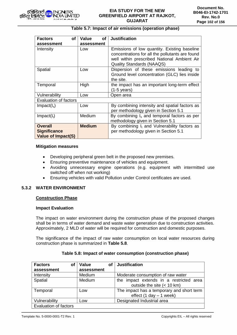
Template No. 5-0000-0001-T2 Rev. 1 Copyrights EIL – All rights reserved
Document No. B046-EI-1742-1701
Rev. No.0
Page 102 of 156
EIA STUDY FOR THE NEW GREENFIELD AIRPORT AT RAJKOT,
GUJARAT
Table 5.7: Impact of air emissions (operation phase)
Factors of assessment
Value of assessment
Justification
Intensity Low Emissions of low quantity. Existing baseline concentrations for all the pollutants are found well within prescribed National Ambient Air Quality Standards (NAAQS)
Spatial Low Dispersion of these emissions leading to Ground level concentration (GLC) lies inside the site.
Temporal High the impact has an important long-term effect (1-5 years)
Vulnerability Low Open area
Evaluation of factors
Impact(Is) Low By combining intensity and spatial factors as per methodology given in Section 5.1
Impact(It) Medium By combining Is and temporal factors as per methodology given in Section 5.1
Overall Significance Value of Impact(S)
Medium By combining It and Vulnerability factors as per methodology given in Section 5.1
Mitigation measures
Developing peripheral green belt in the proposed new premises.
Ensuring preventive maintenance of vehicles and equipment.
Avoiding unnecessary engine operations (e.g. equipment with intermitted use switched off when not working)
Ensuring vehicles with valid Pollution under Control certificates are used.
5.3.2 WATER ENVIRONMENT Construction Phase
Impact Evaluation The impact on water environment during the construction phase of the proposed changes shall be in terms of water demand and waste water generation due to construction activities. Approximately, 2 MLD of water will be required for construction and domestic purposes. The significance of the impact of raw water consumption on local water resources during construction phase is summarized in Table 5.8.
Table 5.8: Impact of water consumption (construction phase)
Factors of assessment
Value of assessment
Justification
Intensity Medium Moderate consumption of raw water
Spatial Medium the impact extends in a restricted area outside the site (< 10 km)
Temporal Low The impact has a temporary and short term effect (1 day – 1 week)
Vulnerability Low Designated Industrial area
Evaluation of factors
Template No. 5-0000-0001-T2 Rev. 1 Copyrights EIL – All rights reserved
Document No. B046-EI-1742-1701
Rev. No.0
Page 103 of 156
EIA STUDY FOR THE NEW GREENFIELD AIRPORT AT RAJKOT,
GUJARAT
Impact(Is) Medium By combining intensity and spatial factors
Impact(It) Medium By combining Is and temporal factors
Overall Significance Value of Impact(S)
Medium By combining It and Vulnerability factors
The effluent streams that will be generated regularly during construction stage include the
following:
Sewage and grey water from construction camps and work sites
Cleaning and washing water for vehicle and equipment maintenance area.
During construction phase, used construction water is the only effluent generated due to construction activities and most of the effluent generated will be so small that it will either get percolated to ground or get evaporated. And sanitary waste generated will be treated in STP package.
The significance of the impact of raw water consumption on local water resources during construction phase is summarized in Table 5.9.
Table 5.9: Impact of effluent generation (construction phase)
Factors of assessment Value of assessment
Justification
Intensity Low Releases of low quantity
Spatial Low Impact extends in a restricted area outside the site (< 1 km)
Temporal Low The impact has a temporary and short term effect (1 day – 1 week)
Vulnerability Low Open area
Evaluation of factors
Impact(Is) Low By combining intensity and spatial factors
Impact(It) Low By combining Is and temporal factors
Overall Significance Value of Impact(S)
Low By combining It and Vulnerability factors
Mitigation Measures
Monitoring water usage at construction camps to prevent wastage.
Ensuring there are no chemical or fuel spills at water body crossings.
Ensuring that the STP at construction camps/ sites and the proposed facilities are properly designed to handle peak waste water load and properly maintained.
Ensuring supply of temporary/ portable toilets for construction staff.
Operation Phase
Impact Evaluation
The impact on water environment during the operation phase of the proposed changes shall be in terms of water consumption and waste water generation. As the project will be implemented in four phases, the estimated water requirements for the year 2020, 2030, 2045 and beyond 2045 are 2 MLD, 3 MLD, 5 MLD and 10 MLD respectively. Water is used for domestic purposes mainly. The impact of water consumption on local resources during operation phase is summarized in Table 5.10.

Template No. 5-0000-0001-T2 Rev. 1 Copyrights EIL – All rights reserved
Document No. B046-EI-1742-1701
Rev. No.0
Page 104 of 156
EIA STUDY FOR THE NEW GREENFIELD AIRPORT AT RAJKOT,
GUJARAT
Table 5.10: Impact of water consumption (operation phase)
Factors of assessment Value of assessment
Justification
Intensity Low As per standard consumption
Spatial Medium the impact extends in a restricted area outside the site (< 10 km)
Temporal High the impact has an important long-term effect (1-5 years)
Vulnerability Low No sensitive site
Evaluation of factors
Impact(Is) Medium By combining intensity and spatial factors
Impact(It) Medium By combining Is and temporal factors
Overall Significance Value of Impact (S)
Medium By combining It and Vulnerability factors
The estimated sewage generation beyond year 2045 is estimated as 11 MLD. The sewage from terminal building, catering, housing, hotels, commercial areas and other business areas would be collected through a gravity sewerage system leading to a sewage pumping station. The treated effluent quality will be suitable for use in landscape/garden area, flushing of urinals and toilets etc. The impact of effluent generation during operation phase is summarized in Table 5.11.
Table 5.11: Impact of effluent generation (operation phase)
Factors of assessment
Value of assessment
Justification
Intensity Low Releases of low quantity
Spatial Low Impact extends in a restricted area outside the site (< 1 km)
Temporal Low The impact has a temporary and short term effect (1 day – 1 week)
Vulnerability Low Open area
Evaluation of factors
Impact(Is) Low By combining intensity and spatial factors
Impact(It) Low By combining Is and temporal factors
Overall Significance Value of Impact (S)
Low By combining It and Vulnerability factors
Mitigation Measures
Tracking of consumption and installing water meter at any new water abstraction source.
Installation of rainwater harvesting structures to collect and use rainwater, thereby reducing abstraction.

Template No. 5-0000-0001-T2 Rev. 1 Copyrights EIL – All rights reserved
Document No. B046-EI-1742-1701
Rev. No.0
Page 105 of 156
EIA STUDY FOR THE NEW GREENFIELD AIRPORT AT RAJKOT,
GUJARAT
Exploring opportunities for recharging of rainwater to augment local ground water resources.
Exploring opportunities for drip irrigation system for greenbelt development to reduce water demand.
5.3.3 LAND ENVIRONMENT
Drainage Pattern of Study Area
The drainage pattern within study area is shown in Figure 5.1.
Figure 5.1: Drainage pattern of the study area
As can be seen from the above there are main feeder stream falling with proposed project site. The water pond like structure which is appearing within project site is already relocated before 2 years. This has been found during physical survey. A latest remote sensing map is under scrutiny to re-establish the fact. Diversion of existing water channel and relocation of Check Dam The airport site essentially has to be a flat land with minimal difference in site elevations. After the grading of the site is complete, there shall be a plateau formed at a higher elevation than the surrounding ground levels. The entire plateau shall be given a mild slope towards the river maintaining the current local drainage pattern intact. The detailing of the same shall be performed during the development of the Master plan prepared during the implementation stages of the project.
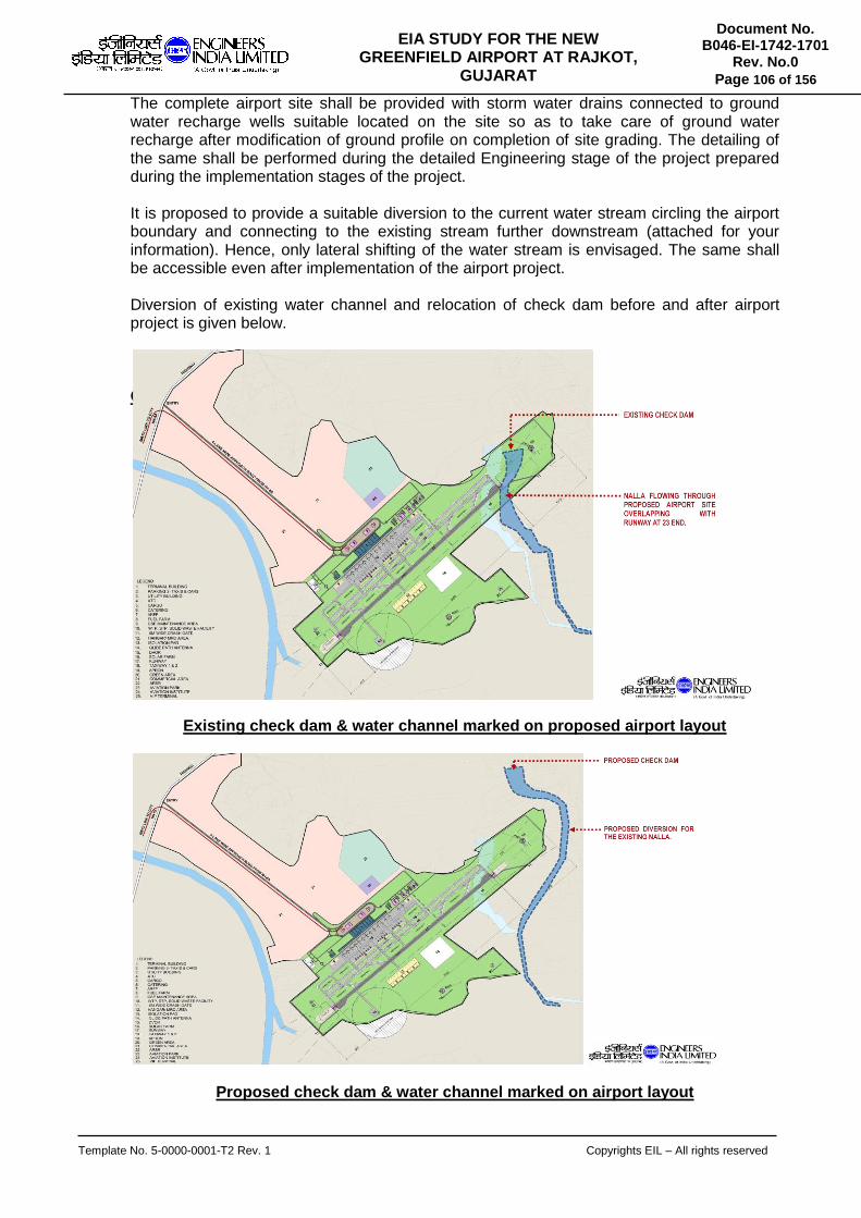
Template No. 5-0000-0001-T2 Rev. 1 Copyrights EIL – All rights reserved
Document No. B046-EI-1742-1701
Rev. No.0
Page 106 of 156
EIA STUDY FOR THE NEW GREENFIELD AIRPORT AT RAJKOT,
GUJARAT
The complete airport site shall be provided with storm water drains connected to ground water recharge wells suitable located on the site so as to take care of ground water recharge after modification of ground profile on completion of site grading. The detailing of the same shall be performed during the detailed Engineering stage of the project prepared during the implementation stages of the project. It is proposed to provide a suitable diversion to the current water stream circling the airport boundary and connecting to the existing stream further downstream (attached for your information). Hence, only lateral shifting of the water stream is envisaged. The same shall be accessible even after implementation of the airport project. Diversion of existing water channel and relocation of check dam before and after airport project is given below. C
Existing check dam & water channel marked on proposed airport layout
Proposed check dam & water channel marked on airport layout
Template No. 5-0000-0001-T2 Rev. 1 Copyrights EIL – All rights reserved
Document No. B046-EI-1742-1701
Rev. No.0
Page 107 of 156
EIA STUDY FOR THE NEW GREENFIELD AIRPORT AT RAJKOT,
GUJARAT
Construction Phase Impact Evaluation
The impact on land environment during construction phase shall be due to generation of debris/construction material, which shall be properly collected and disposed off. Debris will be segregated and whatever is resalable will be sold to buyers and rest of the waste will be used for filling up of low lying area and development of internal roads. The impact on land use and topography during construction phase is summarized in Table 5.12.
Table 5.12: Impact on land use & topography (construction phase)
Factors of assessment
Value of assessment
Justification
Intensity Low Complete land required for development of facilities will be acquired on permanent basis.
Spatial Low The impact extends inside the site.
Factors of assessment
Value of assessment
Justification
Temporal Medium the impact has a medium-term effect (1 week – 1 year)
Vulnerability Low Open area
Evaluation of factors
Impact(Is) Low By combining intensity and spatial factors
Impact(It) Low By combining Is and temporal factors
Overall Significance Value of Impact (S)
Low By combining It and Vulnerability factors
There is potential for impact on soil quality due to project-related spills and leaks of fuel and chemicals and uncontrolled disposal of wastes and wastewater. Care will be taken to avoid spills and leaks of hazardous substances and all project-related wastes. Littering of sites and areas beyond the site will be controlled. The impact on soil quality during construction phase is summarized in Table 5.13.
Table 5.13: Impact on soil quality (construction phase)
Factors of assessment
Value of assessment
Justification
Intensity Low Disposal includes on construction waste material which is non hazardous
Spatial Low The impact extends inside the site.
Temporal Medium the impact has a medium-term effect (1 week – 1 year)
Vulnerability Low Open area
Evaluation of factors
Impact(Is) Low By combining intensity and spatial factors
Impact(It) Low By combining Is and temporal factors

Template No. 5-0000-0001-T2 Rev. 1 Copyrights EIL – All rights reserved
Document No. B046-EI-1742-1701
Rev. No.0
Page 108 of 156
EIA STUDY FOR THE NEW GREENFIELD AIRPORT AT RAJKOT,
GUJARAT
Overall Significance Value of Impact (S)
Low By combining It and Vulnerability factors
Mitigation Measures
Avoiding rainy season for construction so as to avoid soil erosion.
Restricting all construction activities inside the project boundary.
Ensuring the top-soil stock pile is not contaminated with any type of spills.
Ensuring any material resulting from clearing and grading should not be deposited on approach roads, streams or ditches, which may hinder the passage and/or natural water drainage.
Restoration of construction camp sites before abandonment.
After final site grading is complete, ensuring that the excess excavated material is not dumped indiscriminately but used for filling low lying areas or berm construction by locals and keeping a record of the same.
Developing project specific waste management plan and hazardous material handling plan for the construction phase.
Providing drip trays and liners while working with hazardous liquid materials such as fuels and chemicals.
Developing and maintaining dedicated waste storage areas, with secondary containment for hazardous wastes.
Operation Phase
Impact Evaluation
The impact on land environment during operational phase shall be due to disposal of solid waste generated during operation. Solid waste collected during operation phase will be disposed in disposal facility owned by Government of Gujarat. Hazardous waste management: From Airport, used oil, lubricants, electronic wastes shall be generated and the same shall be disposed through SPCB authorized reprocessor. Used batteries will be given to dealer as part of buy back arrangement.
The impacts on soil quality during operation phase are summarized in Table 5.14.
Table 5.14: Impact on soil quality (operation phase)
Factors of assessment
Value of assessment
Justification
Intensity Low Releases of low quantity
Spatial Low The impact extends inside the site.
Temporal Medium the impact has a medium-term effect (1 week – 1 year)
Vulnerability Low Open area
Evaluation of factors
Impact(Is) Low By combining intensity and spatial factors
Impact(It) Low By combining Is and temporal factors
Overall Significance Value of Impact (S)
Low By combining It and Vulnerability factors

Template No. 5-0000-0001-T2 Rev. 1 Copyrights EIL – All rights reserved
Document No. B046-EI-1742-1701
Rev. No.0
Page 109 of 156
EIA STUDY FOR THE NEW GREENFIELD AIRPORT AT RAJKOT,
GUJARAT
Mitigation Measures
Developing and maintaining dedicated waste storage areas,
Ensuring hazardous waste storage areas are provided with secondary containment.
Disposing of hazardous wastes to vendors authorized by the concerned authorities. 5.3.4 NOISE ENVIRONMENT
Construction Phase Impact Evaluation The main sources of noise emissions during construction phase are operation of heavy equipment and machinery, operation of emergency power generation sets and movement of vehicles (heavy vehicles carrying materials and light vehicles carrying project related personnel). Construction noise levels associated with typical machinery based on “BS 5228: 1997 Noise and Vibration Control on Construction and Operation Sites” are summarized in the Table 5.15.
Table 5.15: Sound Pressure (noise) levels of Construction Machinery
Item Description Noise Level dB(A) Reference Distance
Earth Movers Front Loaders Backhoes Tractors Scrapers, Graders Pavers Trucks
72-84 72-93 72-96 80-93 86-88 82-94
0.9 m " " " " "
Material Handlers Concrete Mixers Concrete Pumps Cranes (movable) Cranes (derrick)
75-88 81-83 75-86 86-88
0.9 m " " '
Stationary Equipment Pumps Generators Compressors
69-71 71-82 74-86
0.9 m " "
The impact of noise emission on ambient noise levels are summarized in Table 5.16:
Table 5.16: Impact on ambient noise (construction phase)
Factors of assessment
Value of assessment
Justification
Intensity Low Releases of low quantity
Spatial Medium Impact extends in a restricted area outside the site (< 1 km)
Temporal Low The impact has a temporary and short term effect (1 day – 1 week)
Vulnerability Low Open area

Template No. 5-0000-0001-T2 Rev. 1 Copyrights EIL – All rights reserved
Document No. B046-EI-1742-1701
Rev. No.0
Page 110 of 156
EIA STUDY FOR THE NEW GREENFIELD AIRPORT AT RAJKOT,
GUJARAT
Evaluation of factors
Impact(Is) Low By combining intensity and spatial factors
Impact(It) Low By combining Is and temporal factors
Overall Significance Value of Impact (S)
Low By combining It and Vulnerability factors
Mitigation Measures
Ensuring preventive maintenance of equipment and vehicles Avoiding unnecessary engine operations (e.g. equipment with intermitted use switched off when not working) Ensuring DG sets are provided with acoustic enclosures and exhaust mufflers Ensuring vehicle movement is avoided close to sensitive receptors (such as schools, hospitals, places of worship.
Operation Phase
Impact Evaluation
During operation phase of the Airport, following are the main causes of noise emission:
Aircraft landing and taking off.
Ground Noise Noise emission due to aircraft: Noise emission from an aircraft is caused by two things: Airframe noise & Engine noise. Airframe noise occurs when air passes over the plane’s body (the fuselage) and its wings. This causes friction and turbulence, which make a noise. Engine noise is created by the sound from the moving parts of the engine, and also by the air being expelled at high speed once it has passed through the engine. Most of the engine noise comes from the exhaust or jet behind the engine as it mixes with the air around it. Ground noise shall be due to the following sources/factors: aircraft engine tests, airside vehicular traffic, Using reverse thrust to increase braking during landing, Planes travelling between the run-way and stands (their ‘parking space’), Planes sitting on their stands with their power units running, DG Sets, pumps etc. Transport links to an airport, particularly private vehicles and trains, can also make a significant contribution to noise around airports. Noise emission during night time: Many people are not bothered by aircraft noise during the day, but they can be affected at night. There are restrictions on the level of night time noise that is allowed and the number of planes that can fly at night. There shall be increase in noise generation due to increase in air traffic with the operation of new international terminal. Noise Model: Aircraft today are much quieter than they were in olden days and these will be replaced by even quieter aircraft in the future. But, there are more planes flying today considering the past. A software namely INM (Integrated Noise Model) is used to assess the increase in noise due to the proposed international Airport. Details of the same are described below. The Integrated Noise Model (INM) is a computer model that evaluates aircraft noise impacts in the vicinity of airports.

Template No. 5-0000-0001-T2 Rev. 1 Copyrights EIL – All rights reserved
Document No. B046-EI-1742-1701
Rev. No.0
Page 111 of 156
EIA STUDY FOR THE NEW GREENFIELD AIRPORT AT RAJKOT,
GUJARAT
The INM computer program calculates noise exposure contours in the vicinity of airports by using a large database of aircraft flight performance and acoustic data along with airport-specific user-input data. The INM graphical user interface provides a versatile, user-friendly, windows-style means for users to specify operational scenarios to be modeled and to review the noise results. INM outputs include noise contours used in land use compatibility studies, noise impacts by aircraft on individual flight tracks, and user-defined point analysis of noise impacts.
Inputs considered in the present study
Airport characteristics :
Runway length: 3750 m,
width: 60 m,
threshold displacement: 20 m and
Orientation: 95 NE- 275 SW
Aircraft :
Boeing 777-200
Approach and departure tracks in 10 km radius
Flight operations
Noise Metric
LAEQ
Output obtained from INM
Noise contours (contours of equal values of a noise metric)
Noise contours are plotted in INM considering following cases. (1) Aircraft Take-off from East side and landing from West side of runway. (2) Aircraft Take-off from North-East side and landing from South-west side of runway. (3) Aircraft Take-off from West side and landing from East side of runway. (4) Aircraft Take-off from North-west side and landing from South-east side of runway.
10 Km radius around proposed airport is considered for the purpose of noise study. The contours are provided in figure no. 5.2 to 5.5. The anticipated noise levels obtained from the study are less than 90 dB at the runway location. The noise levels started depreciating as the aircraft moves away from the runway where as it started appreciating while landing as the aircraft approaches runway. Considering the worst scenario of human exposure to this noise level, 8 hours continuous exposure is permitted for such noise levels, which is unlikely in the airport as the noise will not be continuous considering the proposed aircraft movements.

Template No. 5-0000-0001-T2 Rev. 1 Copyrights EIL – All rights reserved
Document No. B046-EI-1742-1701
Rev. No.0
Page 112 of 156
EIA STUDY FOR THE NEW GREENFIELD AIRPORT AT RAJKOT,
GUJARAT
Figure 5.2 Aircraft Take-off from East side and landing from West side of runway
(Noise model case 1)

Template No. 5-0000-0001-T2 Rev. 1 Copyrights EIL – All rights reserved
Document No. B046-EI-1742-1701
Rev. No.0
Page 113 of 156
EIA STUDY FOR THE NEW GREENFIELD AIRPORT AT RAJKOT,
GUJARAT
Figure 5.3 Aircraft Take-off from North-East side and landing from South-west side of runway (Noise model case 2)

Template No. 5-0000-0001-T2 Rev. 1 Copyrights EIL – All rights reserved
Document No. B046-EI-1742-1701
Rev. No.0
Page 114 of 156
EIA STUDY FOR THE NEW GREENFIELD AIRPORT AT RAJKOT,
GUJARAT
Figure 5.4 Aircraft Take-off from West side and landing from East side of runway
(Noise model case 3)

Template No. 5-0000-0001-T2 Rev. 1 Copyrights EIL – All rights reserved
Document No. B046-EI-1742-1701
Rev. No.0
Page 115 of 156
EIA STUDY FOR THE NEW GREENFIELD AIRPORT AT RAJKOT,
GUJARAT
Figure 5.5 Aircraft Take-off from North-west side and landing from South-east side of runway (Noise model case 4)

Template No. 5-0000-0001-T2 Rev. 1 Copyrights EIL – All rights reserved
Document No. B046-EI-1742-1701
Rev. No.0
Page 116 of 156
EIA STUDY FOR THE NEW GREENFIELD AIRPORT AT RAJKOT,
GUJARAT
The impact of these noise emissions during operation is summarized in Table 5.17.
Table 5.17: Impact on ambient noise (operation phase)
Factors of assessment
Value of assessment
Justification
Intensity Low Releases of low quantity
Spatial Low The impact extends inside the site.
Temporal High The impact has an important and long term effect (1 – 5 years)
Vulnerability Low Open area
Evaluation of factors
Impact(Is) Low By combining intensity and spatial factors
Impact(It) Medium By combining Is and temporal factors
Overall Significance Value of Impact (S)
Medium By combining It and Vulnerability factors
Mitigation Measures
Avoiding continuous (more than 8 hrs) exposure of workers to high noise areas.
Provision of ear muffs at the high noise areas
Ensuring preventive maintenance of equipment.
Ensuring DG sets have acoustic enclosures and exhaust mufflers as per design.
On top of the quota system, there is also an absolute limit on the number of flights permitted at the airport. Under the quota system, the airport has a total number of ‘quota points’, which are then used up by night time flights. Different types of planes use up different numbers of points, depending on how noisy they are.
The noisiest aircraft use 16 points of the quota, and they’re called QC16s (QC = Quota Count). The next noisiest have eight points – QC8s. As planes get quieter, their points get smaller until the quietest planes have just half a point or are exempt altogether.
During the night quota period the noisiest types of planes are not permitted to be scheduled. Because there is a limit on the airport’s total quota of points for night-time flying, this system encourages airlines who want to fly at night to use the quietest aircraft.
Pilots are encouraged not to use reverse thrust between 23:00 and 06:00 except in the interests of safety.
Planes shall be plugged into the mains electrical supply while they are on stand. This is a system known as Fixed Electrical Ground Power (FEGP) to replace the noisy auxiliary power units (APU) on the plane itself. It allows things like interior lighting and the air conditioning systems to operate.
5.3.5 IMPACT DUE TO TRAFFIC Construction phase
The impact on noise environment during the construction phase of the proposed Airport shall be due to movement of quarrying and borrow material, construction material and movement of construction workers etc.
Design & operation phase Traffic – Road
Out of the total traffic vehicles, 2 wheelers are very high followed by light and medium vehicles. The movement of two wheelers and light vehicles are largely found in daytime. The difference of heavy vehicle movement both day and night time was very marginal. There is no major traffic surrounding airport except on NH-27.
Template No. 5-0000-0001-T2 Rev. 1 Copyrights EIL – All rights reserved
Document No. B046-EI-1742-1701
Rev. No.0
Page 117 of 156
EIA STUDY FOR THE NEW GREENFIELD AIRPORT AT RAJKOT,
GUJARAT
5.3.6 BIOLOGICAL ENVIRONMENT
Construction Phase
Impact Evaluation
The area acquired for proposed airport has only few trees but mainly bushes. There are 2180 trees to be cut in the proposed airport site during site preparation. The proposed area is not a part of protected area/Sanctuary/National Park and project area of Rajkot Division & Surendranagar Division is respectively 12 km and 15 km away from the Rampara Wildlife Sanctuary. Reserved forest area of 429.90 Ha in Hirasar village, Taluka Rajkot, District Rajkot and 202.34 Ha in Doshlighuna, Taluka & District Surendranagar will be diverted for the proposed airport. Stage I forest clearance recommended by Gujarat Forest Department is attached in Annexure IV. The impacts on flora and fauna during construction phase are summarized in Table 5.18.
Table 5.18: Impact on Biological Environment (construction phase)
Factors of assessment
Value of assessment
Justification
Intensity High Felling of trees
Spatial Medium Impact extends in a restricted area outside the site (< 1 km)
Temporal High The impact has an important and long term effect (1 – 5 years)
Vulnerability Low Open area
Evaluation of factors
Impact(Is) High By combining intensity and spatial factors
Impact(It) High By combining Is and temporal factors
Overall Significance Value of Impact (S)
Medium By combining It and Vulnerability factors
Mitigation measures
Keeping a tally of trees cut – viz. no., species.
Avoid cutting of tress wherever possible, especially the endangered species observed in the study area.
Closing of trenches as soon as possible of construction.
Prevent littering of work sites with wastes, especially plastic and hazardous waste.
Regulating speeding of project-related vehicles.
Operation Phase
Impact Evaluation
Compensatory Afforestation is proposed at 367.08 Ha forest land at S. No. 137, 138, 139, 141, 174, 175, 188, 189, 190, 191, 192, 193, 194, 198, Village-Kunathiya, Taluka-Abdasa, Dist. Kutchh & 273.8774 Ha forest land at S. No. 209, 248, 249, 251, 252, 342, 343, 345/p3, 347, 350, 358, 369/2, 369/3, 369/4, 369/5, 372/1, 372/2, 373/1, 373/4, 374/1, 375/1, 376/1,

Template No. 5-0000-0001-T2 Rev. 1 Copyrights EIL – All rights reserved
Document No. B046-EI-1742-1701
Rev. No.0
Page 118 of 156
EIA STUDY FOR THE NEW GREENFIELD AIRPORT AT RAJKOT,
GUJARAT
377/1, 378/1, 378/5, 380/1, 380/2, 381/1, 381/2, 381/3, 381/5, 389/1, 391/1, 392/1, 417 village-Bhachunda, Taluka Abdasa, District Kutchh. The project proponent will comply with all conditions as per Afforestation scheme of MoEF. The movement of operation related vehicles may result in road kills of animals.
The impacts on flora and fauna during construction phase are summarized in Table 5.19.
Table 5.19: Impact on Biological Environment (operation phase)
Factors of assessment
Value of assessment
Justification
Intensity Low Releases of low quantity
Spatial Medium Impact extends in a restricted area outside the site (< 1 km)
Temporal High Impact has an important and long term effect (1 – 5 years)
Vulnerability Low Open area
Evaluation of factors
Impact(Is) Low By combining intensity and spatial factors
Impact(It) Medium By combining Is and temporal factors
Overall Significance Value of Impact (S)
Medium By combining It and Vulnerability factors
Mitigation Measures
Keeping a tally of trees cut – viz. no., species taluka-wise
Avoid cutting of tress wherever possible
Training of drivers to maintain speed limits and avoid road-kills
5.3.7 SOCIO ECONOMIC ENVIRONMENT
Construction Phase
Impact Evaluation
The impact on socio-economic environment during construction phase shall be due to acquisition of land for the project and the rehabilitation & relocation of households for the same. In the construction phase an influx of construction workers will have impact on some people, as the demand for goods and services in the area would increase. This impact can be negative in the short run but in the long term the impacts are reversible in nature and may lead to growth of overall infrastructure and commercial activities in the study area. Moreover, the project affected people would be rehabilitated by Government of Gujarat. Over the period of time, there shall be positive impact with better connectivity and transport facilities. There will be increase in employment opportunities with impetus for skilled jobs both from the project and the new international terminal along with secondary and tertiary sector services/ businesses. Further, both traffic congestion and distance to travel to reach new airport shall be less due to connectivity to existing highway and the proposed approach road, which would also bring business opportunities for transport services. Aggregative there shall be positive impact on socio-economic environment due to development of

Template No. 5-0000-0001-T2 Rev. 1 Copyrights EIL – All rights reserved
Document No. B046-EI-1742-1701
Rev. No.0
Page 119 of 156
EIA STUDY FOR THE NEW GREENFIELD AIRPORT AT RAJKOT,
GUJARAT
infrastructure in the area, growth of secondary and tertiary sector businesses and subsequent enhancement in the standards of living of the local populace.
The impact of construction activities on socio-economic environment during construction phase is summarized in Table 5.20.
Table 5.20: Impact on Socio-Economic Environment (construction phase)
Factors of assessment Value of assessment
Justification
Intensity Low Involvement of labor, infrastructure and other utilities in marginal quantities/Nos.
Spatial Medium Impact extends in a restricted area outside the site (< 1 km)
Temporal Medium The impact has an medium term effect (1 week – 1 year)
Vulnerability Low Open area
Evaluation of factors
Impact(Is) Low By combining intensity and spatial factors
Impact(It) Low By combining Is and temporal factors
Overall Significance Value of Impact(S)
Low By combining It and Vulnerability factors
Rehabilitation & Resettlement (R & R)
Government of Gujarat is the owner of the Rajkot Airport land. There are 15 families to be rehabilitated for the proposed project. All the compensation awards have been finalized and passed and the entire compensation amount of Rs. 10 crore has been placed with GIDC, the disbursing agency for the release of claims. The Government of Gujarat will suitably consider rehabilitation and resettlement as per Land Acquisition, Rehabilitation and Resettlement Act, 2013.
Mitigation Measures
Ensuring early payment of compensation
Training contractors on company road safety policy requirements
Monitoring speed and route of project-related vehicles
Determine of the safe, legal load limits of all bridges and roads that will be used by heavy vehicles and machinery.
Determining allowable traffic patterns in the affected area throughout the work week will be made based on community use, include a consideration of the large turning requirements of certain vehicles/machineries that might increase congestion and traffic hazards
Upgrading local roads, wherever required, to ensure ease of project activity and community safety
Consolidating deliveries of materials and personnel to project sites, whenever feasible, to minimize flow of traffic
Minimizing interruption of access to community use of public infrastructure
Providing prior notice to affected parties when their access will be blocked, even temporarily.
Returning all roads to a passable condition before the end of each working day
Monitoring construction camp safety and hygiene
Preventing use of drugs and alcohol in project-sites
Preventing possession of firearms by project-personnel, except those responsible for security

Template No. 5-0000-0001-T2 Rev. 1 Copyrights EIL – All rights reserved
Document No. B046-EI-1742-1701
Rev. No.0
Page 120 of 156
EIA STUDY FOR THE NEW GREENFIELD AIRPORT AT RAJKOT,
GUJARAT
Ensuring project-related waste and wastewater is disposed in a responsible manner
Operation Phase
Impact Evaluation
There will be increase in employment opportunities with impetus for skilled jobs both from the project and the new international terminal along with secondary and tertiary sector services/ businesses. Further, both traffic congestion and distance to travel to reach new airport shall be less due to connectivity to existing highway and the proposed approach road, which would also bring business opportunities for transport services. Aggregative there shall be positive impact on socio-economic environment due to development of infrastructure in the area, growth of secondary and tertiary sector businesses and subsequent enhancement in the standards of living of the local populace.
The impact of these activities on socio-economic environment during operation phase is summarized in Table 5.21:
Table 5.21: Impact on Socio-Economic Environment (operation phase)
Factors of assessment
Value of assessment
Justification
Intensity Low Involvement of labor, infrastructure and other utilities in marginal quantities/Nos.
Spatial Medium Impact extends in a restricted area outside the site (< 1 km)
Temporal Medium The impact has an medium term effect (1 week – 1 year)
Vulnerability Low Open area
Evaluation of factors
Impact(Is) Low By combining intensity and spatial factors
Impact(It) Low By combining Is and temporal factors
Overall Significance Value of Impact (S)
Low (Positive)
By combining It and Vulnerability factors
Mitigation Measures
Ensure implementation of disaster management plan. 5.4 SUMMARY OF IMPACT EVALUATION
Based on the above evaluation the significance value of impact on various components of environment during construction and operation phases is summarized and is given in Table 5.22.
Table 5.22: Summary of Impact Evaluation in terms of Significance Value
Environmental component Construction Operation
Air Low Medium
Water Consumption of Raw Water Medium Medium
Generation of Effluent Low Low
Land Land use & Topography Low -
Soil Quality Low Low
Noise Low Medium
Biological Medium Medium
Socio-Economic Low Low

Template No. 5-0000-0001-T2 Rev. 1 Copyrights EIL – All rights reserved
Document No. B046-EI-1742-1701
Rev. No.0
Page 121 of 156
EIA STUDY FOR THE NEW GREENFIELD AIRPORT AT RAJKOT,
GUJARAT
CHAPTER 6
ENVIRONMENTAL MONITORING PROGRAMME

Template No. 5-0000-0001-T2 Rev. 1 Copyrights EIL – All rights reserved
Document No. B046-EI-1742-1701
Rev. No.0
Page 122 of 156
EIA STUDY FOR THE NEW GREENFIELD AIRPORT AT RAJKOT,
GUJARAT
6 INTRODUCTION
Regular monitoring of environmental parameters is of immense importance to assess the status of environment during project operations. With the knowledge of baseline conditions, the monitoring programmed will serve as an indicator for any deterioration in environmental conditions due to operation of the project, to enable taking up suitable mitigation steps in time to safeguard the environment. Monitoring is as important as that of pollution since the efficiency of control measures can only be determined by monitoring. Usually, as in the case of the study, an impact assessment study is carried out over short period of time and the data cannot bring out all variations induced by the natural or human activities. Therefore, regular monitoring programme of the environmental parameters is essential to take into account the changes in the environmental quality.
6.1 ENVIRONMENTAL MONITORING 6.1.1 AMBIENT AIR QUALITY
Ambient air quality shall be monitored for NOX and SPM around the premises of the airport. The proposed monitoring program for the field monitoring and laboratory analysis of air is given in the following Table 6.1.
Table 6.1 Proposed monitoring programme (Air)
Monitoring Parameters to be monitored
Monitoring location/site
Sampling duration
Frequency Method of monitoring
Ambient air quality
NOX and SPM
Locations around the premises*
Twice a week, 4 weeks in a season
Seasonal As per CPCB standards for NAAQM, 1994
Monitoring locations to be finalised in consultation with State Pollution Control Board 6.1.2 NOISE LEVELS
Ambient Noise levels shall be monitored around the premises of the airport, near DG sets and at the main entrance/boundary of airport. The proposed monitoring programme for the Ambient noise levels is given in the following Table 6.2.
Table 6.2 Proposed monitoring programme (Noise)
Monitoring Parameters to be monitored
Monitoring location/ site
Sampling duration
Frequency Method of monitoring
Ambient Noise levels
Noise levels in dB(A)
Near the airport site, main entrance, near DG sets
Once a week
Weekly Instrument: Noise level meter IS: 4954-1968 as adopted by CPCB

Template No. 5-0000-0001-T2 Rev. 1 Copyrights EIL – All rights reserved
Document No. B046-EI-1742-1701
Rev. No.0
Page 123 of 156
EIA STUDY FOR THE NEW GREENFIELD AIRPORT AT RAJKOT,
GUJARAT
6.1.3 WATER QUALITY Water quality parameters shall be for one year before and for at least three years after completion of the proposed project. Monitoring shall be carried out at least four times a year to cover seasonal variations. Water quality shall be analysed by the standard technique (IS:2488, Standard methods American Public Health Association (APHA)). The parameters for monitoring would be: PH, Dissolved oxygen, BOD,COD, Total coliform count, TDS, Temperature, Total Hardness, Calcium, Magnesium, Iron, Manganese, Chlorides, Sulphates, Nitrates, Fluorides, Mercury, Cadmium, Arsenic, Cyanides, Lead, Zinc, Total Nitrogen and Phosphates The monitoring points shall be bore wells of airport and treated STP water at discharge point.
6.1.4 SOIL CONSERVATION
Soil erosion rates, slope stability of land faces, effectiveness of soil conservation measures, change in soil texture and structure should be monitored at frequent intervals.
6.2 SUBMISSION OF MONITORING REPORTS TO MoEF
As per the requirements, the status of environmental clearance stipulation implementation will be submitted to Regional MoEF office in hard and soft copy in December and June months of every calendar year. These reports will be put up on MoEF web site as per their procedure and will be updated every six months. The pollutants will be monitored and reports will be submitted to SPCB and CPCB respectively, as per the requirements.

Template No. 5-0000-0001-T2 Rev. 1 Copyrights EIL – All rights reserved
Document No. B046-EI-1742-1701
Rev. No.0
Page 124 of 156
EIA STUDY FOR THE NEW GREENFIELD AIRPORT AT RAJKOT,
GUJARAT
CHAPTER 7
ADDITIONAL STUDIES

Template No. 5-0000-0001-T2 Rev. 1 Copyrights EIL – All rights reserved
Document No. B046-EI-1742-1701
Rev. No.0
Page 125 of 156
EIA STUDY FOR THE NEW GREENFIELD AIRPORT AT RAJKOT,
GUJARAT
7.1 PUBLIC CONSULTATION
Based on the directive from Ministry of Environment, Forests and Climate Change, in their meeting held during 15th May 2017, Director, Civil Aviation made the draft EIA report and submitted an application to Gujarat Pollution Control Board (GPCB), Gandhinagar for organizing public hearing. The GPCB advised the Regional offices situated at Surendranagar and Rajkot to conduct the public hearing. Public Hearing was conducted at two sites in two different districts because the airport site falls in Surendrnagar and Rajkot districts of Gujarat. Public hearing was carried out by GPCB on 3rd August 2017 at closed compound wall of primary school of Doshlighuna village, Chotila taluka of Surendranagar district. The regional officer Mr. A.M. Gadhiya of GPCB, Surendranagar and the representative of the Member Secretary of GPCB were present during public hearing. The meeting was chaired by Mr. Udit Agrawal, District Collector Surendranagar district and Mr. A.M. Gadhiya, Regional Officer-Surendranagar of GPCB. The public hearing advertisement was published in English newspaper “The Times of India” dated 01.07.2017 and in Gujarati Newspaper “Divya Bhaskar” dated 01.07.2017. Public hearing was also carried out by GPCB on 4th August 2017Juna Gam Tal of Hirashar village of Rajkot district. The regional officer Mr. H.P. Patel of GPCB, Rajkot and the representative of the Member Secretary of GPCB were present during public hearing. The meeting was chaired by Dr. Vikrant Pandey, District Collector Rajkot district and Mr. H.P. Patel, Regional Officer-Rajkot of GPCB. The public hearing advertisement was published in English newspaper “The Times of India” dated 01.07.2017 and in Gujarati Newspaper “Divya Bhaskar” dated 01.07.2017. During the process of public hearing, Regional Officer, Gujarat Pollution Control Board received submissions/ queries/ observations from Project Affected Persons (PAPs), members of public and NGOs regarding various aspects of the project. The minutes of the meeting (MoM) of public hearing and submissions (in English and Gujarati languages) received are numbered and complied. The advertisement of public hearing by GPCB, attendance of people at venue of public hearing, photographs of public hearing, questions raised by representatives present at the public hearing and appropriate replies from Director, Civil Aviation are given below. Hindi and Gujarati minutes of meeting of public hearing have been compiled and being attached as Annexure II.

Template No. 5-0000-0001-T2 Rev. 1 Copyrights EIL – All rights reserved
Document No. B046-EI-1742-1701
Rev. No.0
Page 126 of 156
EIA STUDY FOR THE NEW GREENFIELD AIRPORT AT RAJKOT,
GUJARAT
Public Hearing questions and replies at Doshlighuna, Surendranagar district

Template No. 5-0000-0001-T2 Rev. 1 Copyrights EIL – All rights reserved
Document No. B046-EI-1742-1701
Rev. No.0
Page 127 of 156
EIA STUDY FOR THE NEW GREENFIELD AIRPORT AT RAJKOT,
GUJARAT

Template No. 5-0000-0001-T2 Rev. 1 Copyrights EIL – All rights reserved
Document No. B046-EI-1742-1701
Rev. No.0
Page 128 of 156
EIA STUDY FOR THE NEW GREENFIELD AIRPORT AT RAJKOT,
GUJARAT
The queries and replies in Juna Gam Tal public hearing were given below.

Template No. 5-0000-0001-T2 Rev. 1 Copyrights EIL – All rights reserved
Document No. B046-EI-1742-1701
Rev. No.0
Page 129 of 156
EIA STUDY FOR THE NEW GREENFIELD AIRPORT AT RAJKOT,
GUJARAT
Public Hearing questions and replies at Juna Gam Tal, Hirashar, Rajkot district
Template No. 5-0000-0001-T2 Rev. 1 Copyrights EIL – All rights reserved
Document No. B046-EI-1742-1701
Rev. No.0
Page 130 of 156
EIA STUDY FOR THE NEW GREENFIELD AIRPORT AT RAJKOT,
GUJARAT

Template No. 5-0000-0001-T2 Rev. 1 Copyrights EIL – All rights reserved
Document No. B046-EI-1742-1701
Rev. No.0
Page 131 of 156
EIA STUDY FOR THE NEW GREENFIELD AIRPORT AT RAJKOT,
GUJARAT

Template No. 5-0000-0001-T2 Rev. 1 Copyrights EIL – All rights reserved
Document No. B046-EI-1742-1701
Rev. No.0
Page 132 of 156
EIA STUDY FOR THE NEW GREENFIELD AIRPORT AT RAJKOT,
GUJARAT

Template No. 5-0000-0001-T2 Rev. 1 Copyrights EIL – All rights reserved
Document No. B046-EI-1742-1701
Rev. No.0
Page 133 of 156
EIA STUDY FOR THE NEW GREENFIELD AIRPORT AT RAJKOT,
GUJARAT
7.2 DISASTER MANAGEMENT PLAN
Various hazards have been identified and a plan for mitigating disasters during pre & post phases is given in Annexure III.
7.3 RISK ASSESSMENT FOR FUEL STORAGE TANKS Cases identified
i. 20 mm Leak at receipt line - 10 minutes ii. 20 mm Leak at receipt line - 30 minutes iii. 20 mm Leak at loading line - 10 minutes iv. 20 mm Leak at loading line - 30 minutes v. ATF Tank on fire - Pool fire
Assumptions considered 7.3.1 Operating Parameters
Operating conditions at receipt line: T=29 deg C, P=3 kg/cm2g Operating conditions at loading line: T=29 deg C, P=12 kg/cm2g Operating conditions of ATF tank: Atmospheric
7.3.2 Weather data
Weather data for Rajkot has been considered for the study. Climatological normals 1981-2010 have been used for evaluating the prevalent weather conditions.
The weather conditions considered for the study are: a) 2 F - 2 m/s velocity and stability F (very stable) b) 3 E - 3 m/s velocity and stability E (stable) and c) 5 D - 5 m/s velocity and stability D (neutral)
7.3.3 Composition
ATF composition has been taken from previous EIL projects. Composition typically contains C7-C15 hydrocarbons.
7.3.4 Consequence Results and Analysis
From the preliminary analysis of available data, following results have been obtained a) Leak at receipt line: From the consequence analysis of 20 mm leak for 10 and 30
minutes, it was observed that LFL distances extend up to 19 m without affecting any surroundings. The thermal radiation of 12.5/ 37.5 KW/m2 due to jet and pool fires are

Template No. 5-0000-0001-T2 Rev. 1 Copyrights EIL – All rights reserved
Document No. B046-EI-1742-1701
Rev. No.0
Page 134 of 156
EIA STUDY FOR THE NEW GREENFIELD AIRPORT AT RAJKOT,
GUJARAT
also well contained within 44 m and not affecting any equipment/ building. The 2/3 psi blast overpressure does not affect any buildings nearby.
b) Leak at loading line: From the outcome of consequence analysis, it was observed
that the thermal radiation of 8 KW/m2 due to pool fire might affect the tankages nearby. The 5/3 psi blast overpressure wave may affect the buildings within a radius of 73/ 78 m.
c) Tank on fire: From the pool fire modeling of ATF tank on fire scenario, it was
observed that the thermal radiation of 8 KW/m2 may affect tankages within a distance of 34 m whereas 32 KW/m2 radiation was not observed in this scenario.
7.3.5 Conclusion and Recommendations
The most adverse consequences are seen in case of a 20 mm leak at loading line for 30 minutes. Adjacent tanks within a distance of 107 m may be subjected to thermal radiation of 8 KW/m2 which may result in damage of thermally unprotected tanks. 1. It is therefore recommended to shift the tankages to a safer distance or provide
adequate protection for the tanks to nullify the consequence. The late explosion blast overpressure covers a distance of around 73-38 m.
2. Ensure that there are no manned buildings within this radius. In case if any, they must be made blast resistant. The thermal radiations of 8 KW/m2 due to ATF tank on fire may affect the adjacent tanks.
3. It is therefore recommended to provide adequate thermal protection for the tanks or increase the distance between tankages to more than 34 m.

Template No. 5-0000-0001-T2 Rev. 1 Copyrights EIL – All rights reserved
Document No. B046-EI-1742-1701
Rev. No.0
Page 135 of 156
EIA STUDY FOR THE NEW GREENFIELD AIRPORT AT RAJKOT,
GUJARAT
CHAPTER 8
PROJECT BENEFITS

Template No. 5-0000-0001-T2 Rev. 1 Copyrights EIL – All rights reserved
Document No. B046-EI-1742-1701
Rev. No.0
Page 136 of 156
EIA STUDY FOR THE NEW GREENFIELD AIRPORT AT RAJKOT,
GUJARAT
8.0 INTRODUCTION
It has been observed that the airports and especially International airports have become the catalysts for local economic development. Experts in the field are of the opinion that airports will shape business location and urban development in this century as much as seaports did in the 18th Century, railroads in the 19th Century and highways in 20th Century. Today’s airports are big business impacting the social, economic and political life and fabric of today’s communities. The employment generation has two aspects i.e. direct and indirect. Direct employment is the employment attributed to the operation and management of the airport, airline operations and associated services. Indirect employment is the employment in non-aviation industries that result from airport activity. Employment generated to support direct airport related employment. Following are the benefits of land side commercial developments.
Source of Revenue for Airport
Facilitates and supports development of cargo and passenger air services
Economic Benefits to Community Since the rise of commercial aviation during the mid-twentieth century, airports have become integral components of the economic activity of urban settings. The contribution of airports to local economic activity was traditionally oriented around their gateway for people and products, but in the last decade, the pursuit of non-aeronautical revenues has resulted in many airports leveraging their property assets to generate commercial development activity.
8.1 INFRASTRUCTURE The aviation linked commercial development has been evolved around airport including Basic Amenities , shopping plaza and office parks, hospitality industry, promotional activities of tourism, logistic park and housing.

Template No. 5-0000-0001-T2 Rev. 1 Copyrights EIL – All rights reserved
Document No. B046-EI-1742-1701
Rev. No.0
Page 137 of 156
EIA STUDY FOR THE NEW GREENFIELD AIRPORT AT RAJKOT,
GUJARAT
CHAPTER 9
ENVIRONMENTAL COST BENEFIT ANALYSIS

Template No. 5-0000-0001-T2 Rev. 1 Copyrights EIL – All rights reserved
Document No. B046-EI-1742-1701
Rev. No.0
Page 138 of 156
EIA STUDY FOR THE NEW GREENFIELD AIRPORT AT RAJKOT,
GUJARAT
9.0 ENVIRONMENTAL COST BENEFIT ANALYSIS
Finally, before the construction of new International Airport started, we also have to look at the cost benefit analysis.
9.1 INTERNAL RATES OF RETURN
It is expected by the development of new airport will give economic return to the state. By encouraging more investors and tourists throughout the world come to Gujarat, it is belief it will increase the demand for local industries especially in hotel and resorts, restaurants and so forth as the new interesting place to visit. A large position of investment is required to develop this airport. Therefore, the margin rate of return also should be high. The project has IRR (post tax) of 13.12 %, considering the cash flow generated by the business till 2061. Airport development is a ‘Greenfield’ project and has a high perceived commercial risk; however this level of return may be just sufficient to get nullify the same. For the calculation of IRR, it has been envisaged that 100% equity is arranged for this project. Key Result:
S. No. Project Parameter Return
1 Equity 100%
2 Pre Tax IRR 16.08%
3 Post Tax IRR 13.12%
9.2 ECONOMIC BENEFITS The new airport also will give economic benefit to the state. According to economic analyst, the major benefits will be (i) incremental net visitor expenditures, (ii) time savings of passengers, and (iii) the value of foregone passenger and cargo traffic. Besides that, the cost savings in domestic aircraft operation and time landed in the airport will also included in the analysis.
9.3 PROJECT COSTS
The allocation of the project cost will be approved by the government. This cost includes the following: (i) Civil works, (ii) Construction (iii) Equipment and its installation, and (iv) Consulting engineering design and supervision. Besides that, the abatement cost also should take into consideration in order to reduce the pollution which will harm the community and human beings.
9.4 MONITORING AND REPORTING COSTS
During the construction period, the monitoring process should be required in order to make sure that the construction of the airport is according to the schedule and the quality of the building is according to the world standard. Therefore, it will incur some cost that should be

Template No. 5-0000-0001-T2 Rev. 1 Copyrights EIL – All rights reserved
Document No. B046-EI-1742-1701
Rev. No.0
Page 139 of 156
EIA STUDY FOR THE NEW GREENFIELD AIRPORT AT RAJKOT,
GUJARAT
borne by the contractor. The minor cost of the equipment required for monitoring environmental impacts is also included in the project cost.
9.5 NON QUANTIFIED ENVIRONMENTAL IMPACTS
The construction of the new airport also will produce the non quantified environmental impacts from airport development and increased other development off-site, including noise pollution, air pollution, and surface water pollution, were considered marginal, and additional economic assessment. Therefore, as mentioned earlier, the abatement cost also should be included in the project cost.
Template No. 5-0000-0001-T2 Rev. 1 Copyrights EIL – All rights reserved
Document No. B046-EI-1742-1701
Rev. No.0
Page 140 of 156
EIA STUDY FOR THE NEW GREENFIELD AIRPORT AT RAJKOT,
GUJARAT
CHAPTER 10
ENVIRONMENTAL MANAGEMENT PLAN

Template No. 5-0000-0001-T2 Rev. 1 Copyrights EIL – All rights reserved
Document No. B046-EI-1742-1701
Rev. No.0
Page 141 of 156
EIA STUDY FOR THE NEW GREENFIELD AIRPORT AT RAJKOT,
GUJARAT
10.0 ENVIRONMENT MANAGEMENT
Environmental Management Plan (EMP) is planning and implementation of various pollution abatement for any proposed project. The EMP lists out all these measures not only for the operational phase of the plant but also for the construction phase and planning phase. The EMP is prepared keeping in view all possible strategies oriented towards impact minimisation.
The EMP for the proposed project is divided into two phases i.e. Construction and Operational phase. The construction and operational phase details out the control/abatement measures to be adopted during these phases.
10.1 CONSTRUCTION PHASE The overall impact of the pollution on the environment during construction phase is localised in nature and is for a short period. However, the control of Environmental pollution during construction phase even though for a shorter period is of vital importance. The required mitigatory measures with complete details have been considered. In order to develop effective mitigatory measures, it is important to conceive the specific activities during construction phase causing environmental pollution. The following subsections describe the mitigatory measures to be taken for controlling the pollution/disturbance of the environment during construction phase.
10.1.1 AIR ENVIRONMENT The suspended particulate pollution generated during transportation will be mitigated by proper planning of bringing the construction material, to avoid traffic disturbances and dust generation. Any significant dust generation activities shall be carried out in night time as possible.
10.1.2 NOISE ENVIRONMENT Noise emissions from construction equipment will be kept to a minimum by regular maintenance. Heavy and noisy construction work will be avoided during night time.
10.1.3 WATER ENVIRONMENT The drinking and sanitation facilities will be provided to the construction workforce. This is necessary to reduce pollution of any receiving water body and also to prevent hazards due to water borne vectors. Potable water shall be provided to the workers.
10.1.4 SOCIO ECONOMIC ENVIRONMENT - Local population is to be employed to the extent possible. - Adequate facilities, such as water supply and sanitation, are to be provided to the labourers. - Timely off-loading of trucks (construction materials) is to be ensured to minimize their
waiting period.
10.1.5 LAND ENVIRONMENT
For the construction of buildings and other structures following building material are proposed. These building materials with low carbon foot print and very low embodied energy in use shall be promoted for building material apart from quarrying material.

Template No. 5-0000-0001-T2 Rev. 1 Copyrights EIL – All rights reserved
Document No. B046-EI-1742-1701
Rev. No.0
Page 142 of 156
EIA STUDY FOR THE NEW GREENFIELD AIRPORT AT RAJKOT,
GUJARAT
a) Industrial waste fly ash can be used as alternative construction material. Fly ash has
the properties of cement and very low embodied energy is used. in combination with cements. Fly ash can be use in building blocks, reinforce concrete also in plaster and masonry.
b) Pre-cast hollow concrete blocks: These are manufactured using lean cement concrete
mixes and extruded through block-making machines of egg laying or static, type, need lesser cement mortar and enable speedy construction as compared to brick masonry; the cavity in the blocks provide better thermal insulation, and also do not need external/internal plastering.
c) Pre-cast stone blocks: Pre-cast stone blocks are of larger size than normal bricks.
These are manufactured by using waste stone pieces of various sizes with lean cement concrete and enable a rationalized use of locally available materials. This saves cement, reduces thickness of stone walls, and eliminates the use of plasters on internal/external surface. Use native or quarried stone where available within the delivery radius <100–150 kms, which has a very low-embodied energy content, negligible transport energy costs, and needs only shaping. Light weight stone, which is made from cement and recycled aggregates or furnace clinkers, can also be a resourceful option.
d) Perforated brick masonry: Perforated brick masonry comprises of high strength hollow
bricks with perforations of 50%–60%. These perforations act as sound and heat insulators and provide considerable savings in materials.
e) Stabilized compressed earth blocks: These blocks are made up of mud stabilized with
5% cement lime and compacted in block-making machines with no burning. The soil to be used for the blocks should have the requisite component of clay, silt, and sand. Soil-stabilized hollow and interlocking blocks can provide better thermal insulation
f) Composite ferrocement system: This system is simple to construct and made of
ferrocement, that is, rich mortar reinforced with chicken and welded wire mesh. This system reduces thickness of the wall and allows larger carpet area. Pre-cast ferrocement units in trough shape are integrated with RCC columns. Ferro cement units serve as a permanent skin unit and a diagonal strut between columns. Inside cladding can be done with mud blocks or any locally viable material.
g) Alternatively, rapidly renewable materials/products, which are made from small
diameter trees and fast growing low utilized species harvested within a 10 year cycle or shorter such as bamboo, rubber, eucrasia, eucalyptus, poplar, jute/cotton stalks, and so on. Rubber trees are grown to harvest rubber and at the end of their useful life, they are cut down. Thus, rubber tree wood can be utilized as a substitute for other woods. Bamboo is a rapidly renewable plant, which grows in 4–7 years. Thus, products made from bamboo can also be utilized. These products include engineered products, bamboo ply boards, rubber, jute stalk boards, and so on.
h) Composite wood products such as hardboards, block boards, lumber-core plywood,
veneered Panels, particleboards, medium/low density fiberboards made from recycled wood scrap from sawmill dusts or furniture industry bonded with glue or resin under heat and pressure, can also be used as low-energy finishes in interiors/partition walls.
i) Products, which utilize industrial waste such as wood waste, agricultural waste, and
natural fibres like sisal, coir, and glass fibre in inorganic matrices like gypsum, cement, and other binders such as fibrous gypsum plaster boards etc. can also be used.

Template No. 5-0000-0001-T2 Rev. 1 Copyrights EIL – All rights reserved
Document No. B046-EI-1742-1701
Rev. No.0
Page 143 of 156
EIA STUDY FOR THE NEW GREENFIELD AIRPORT AT RAJKOT,
GUJARAT
j) Products, which use recycled materials like glass, crushed stone and other waste, such as terrazzo or which are resource efficient finishes such as finished concrete flooring, ceiling tiles, and ceramic tiles are useful.
k) Gypsum board partitions use 92% gypsum, which can either be sourced naturally or is
produced as a by-product of power plants. Thus, gypsum used for partitions can contain 100% postindustrial recycled content. Gypsum has high recyclability potential as well
At the proposed Greenfield Rajkot Airport necessary measures will be taken for conservation of energy in line with “Energy Conservation Building Code –2006” and “National Building Code 2005”. The important energy conservation measures are described below: At the proposed Rajkot Greenfield airport, energy efficiency alternatives will be adopted in line with Energy Conservation Building Codes (ECBC):
Airport terminal building will be designed and constructed as Green Building.
Use of energy efficient building material & glass
Use of LED lamps instead of GLS lamps
Energy efficient HVAC system
Solar passive techniques for terminal building
Use of 5 star BEE energy efficiency rating electrical equipments
Microprocessor-based Building Management System (BMS) will be installed for minimization of energy consumption;
Automatic lighting on/ off control system will be provided in the airport area for optimum utilization of energy;
It is proposed that 500 KW solar power generation plant will be established at the proposed airport By adopting above energy efficiency alternatives measures, about 20-30% energy will be saved.
10.2 OPERATION PHASE It is envisaged that with strict adherence to the pollution prevention and control measures during the design stage of the complex, the environmental impacts could be moderated to the minimum possible level during the operation phase. The environmental management plan during the operational phase shall therefore be directed towards the following :
- Ensuring the operation of aircrafts as per specified international aviation standards. - Strict adherence to maintenance schedule for various machinery/equipment. - Good House keeping practices. - Post project environmental monitoring. The following subsections discuss in brief the management plan for individual components
of environment.

Template No. 5-0000-0001-T2 Rev. 1 Copyrights EIL – All rights reserved
Document No. B046-EI-1742-1701
Rev. No.0
Page 144 of 156
EIA STUDY FOR THE NEW GREENFIELD AIRPORT AT RAJKOT,
GUJARAT
10.2.1 AIR ENVIRONMENT
In-plant Control Measures Some of the important operational measures which can reduce the impact on air environment are as follows:
- Movement of cargo buses, passenger buses and other vehicles to be planned properly to reduce vehicular emissions.
- Scheduling of aircrafts to have minimum number of cars in the parking to be carried out.
Ambient Air Quality Monitoring
At present ambient air quality at the airport and the surrounding area is measured on continuous/periodic basis with six number of monitoring stations. The pollutants monitored are SPM, RPM, SO2, NOx, CO and HC. The monitoring of these pollutants will be continued in future also, on periodic basis.
DG set stack height
Minimum stack height shall be provided as per CPCB guidelines.
10.2.2 NOISE ENVIRONMENT
Proper management and allocation of aircrafts stopping areas is to be carried out to avoid noise disturbances to staff for cleaning and maintaining the aircrafts. Also at present noise monitoring is carried out at seven locations which shall be continued in future also, on periodic basis. Following measures are adopted in the design of airport buildings to reduce impact of the noise in operation phase: The terminal building shall be provided with sound absorbing material such as acoustical tile, carpets and drapes placed on ceiling floor or wall surface. Provision of adequate provisions at the airport to allow aircrafts to avoid over running on auxiliary power units during turn around time. DG sets shall be provided with acoustic enclosure Noise levels shall be monitored continuously.
10.2.3 WATER ENVIRONMENT Rainwater harvesting and drainage pattern study have been done in the project site area. The wastewater generated at the new international terminal shall be collected and treated and reused in irrigation of landscape/gardening, flushing of urinals and toilets.
10.2.4 SOCIO-ECONOMIC ENVIRONMENT
Expansion of air port will have positive impacts such as increase in tourism, transportation, communication, employment generation, and revenue income to state government. The local population is to be given opportunities afforded by the increased economic activities in the area.

Template No. 5-0000-0001-T2 Rev. 1 Copyrights EIL – All rights reserved
Document No. B046-EI-1742-1701
Rev. No.0
Page 145 of 156
EIA STUDY FOR THE NEW GREENFIELD AIRPORT AT RAJKOT,
GUJARAT
Energy Conservation measures Properly implemented energy saving measures may reduce considerable amount of expenditure and emission of green house gases. Various measures have been envisaged in the Project area to conserve energy. The suggested measures are as follows: a) Use of CFL/LED. b) Use of Low-pressure sodium lamps for outdoor lighting along the road and security lighting with Solar Street Lights mix. c) Solar lighting will be provided in the main control room and in areas where safety related equipment are located. d) Use of solar water heaters for hospital, guest house. e) Automatic timing control mechanism will be incorporated in the street lighting to save energy. Mechanism will involve staggering of on-off sequence of street lights. f) Designing the structures having proper ventilation and natural light. g) The hostels, guest house, hospital etc. shall have solar water heating systems. The street lights shall have 20% mix of solar lights. h) The street lighting shall be controlled by staggering of putting on-off of lights in particular sequence. Use of Renewable and Alternate Source of Energy A detailed survey of the site is carried out during environmental data collection for use of renewable and alternate source of energy such as wind energy and solar energy. However, based on techno-economic considerations, the following are suggested: a) Use of solar heaters and solar lights at public buildings such as guest houses, canteens, hospital etc b) Use of solar lights for street lighting limited to 20%. The street lighting shall be controlled by staggering of putting on-off of lights in particular sequence.
10.2.5 LAND ENVIRONMENT
The main solid waste generated from the airport like plastic cups, office waste and food material. Solid waste collected during operation phase will be disposed in disposal facility owned by Government of Gujarat. Hazardous waste management: From Airport, used oil, lubricants, electronic wastes shall be generated and the same shall be disposed through SPCB authorized reprocessor. Used batteries will be given to dealer as part of buy back arrangement.
10.3 HEALTH AND SAFETY In order to provide safe working environment and safeguard occupational health and hygiene, the following measures will be undertaken:
- Exposure of workers to hazardous/toxic substances will be minimized by adopting suitable engineering controls.
- All the employees shall be trained in Health, Safety and Environment (HSE) aspects related to their job.

Template No. 5-0000-0001-T2 Rev. 1 Copyrights EIL – All rights reserved
Document No. B046-EI-1742-1701
Rev. No.0
Page 146 of 156
EIA STUDY FOR THE NEW GREENFIELD AIRPORT AT RAJKOT,
GUJARAT
- Periodic compulsory health check up will be carried for all the site employees. Particular attention will be given to respiratory and hearing disorders. The yearly statistics along with observations will be reported each year to the chief executive of the plant.
10.4 GREENBELT DEVELOPMENT PLAN
A proper greenbelt plan for Rajkot Greenfield airport is envisaged in the design phase. The greenbelt development should be met the 33% of total area as per MoEF stipulated norms. The greenbelt programme is proposed in phased manner.
Guidelines for Plantation The plant species identified for greenbelt development will be planted using pitting technique. The pit size will be either 45 cm x 45 cm x 45 cm or 60 cm x 60 cm x 60 cm. Bigger pit size is preferred on marginal and poor quality soils. Soil proposed to be used for filling the pit will be mixed with well decomposed farm yard manure or sewage sludge at the rate of 2.5 kg (on dry weight basis) and 3.6 kg (on dry weight basis) for 45 cm x 45 cm x 45 cm and 60 cm x 60 cm x 60 cm size pits respectively. The filling of soils will be completed at least 5 - 10 days before the actual plantation. Healthy seedlings of identified species will be planted in each pit. Species Selection Based on the regional background and soil quality, greenbelt will be developed. In greenbelt development, monocultures are not advisable due to its climatic factor and other environmental constrains. Greenbelt with varieties of species is preferred to maintain species diversity, rational utilization of nutrients and for maintaining health of the trees. Prepared in this way, the greenbelt will develop a favorable microclimate to support different micro-organisms in the soil and as a result of which soil quality will improve further.
During the course of survey, it has been observed that the soil quality of the plant site is fairly good and can support varieties of dry deciduous plant species for greenbelt development. Manure and vermin-compost may be mixed with the soil used for filling the pit for getting better result for survival of plant species. Adequate watering is to be done to maintain the growth of young seedlings. Based on the regional background, extent of pollution load, soil quality, rainfall, temperature and human interactions, a number of species have been suggested to develop greenbelt in and around the proposed airport. These species can be planted in staggering arrangements within the airport premises. Some draught resistant plant species have been identified which can be planted for greenbelt development if sufficient water is not available. The suitable species for greenbelt development program are given in Table 10.1.
Table 10.1: List of tree species suggested for green belt development
Sl No
Species Name Family Type Areas to be planted
1 Acacia auriculiformis A.Cunn.ex Benth.
Mimosaceae Tree Avenue
2 Acacia catechu Willd. Mimosaceae Tree Greenbelt
3 Acacia farnesiana (L.) Willd.
Mimosaceae Tree Avenue
4 Acacia ferruginea DC. Mimosaceae Tree Avenue

Template No. 5-0000-0001-T2 Rev. 1 Copyrights EIL – All rights reserved
Document No. B046-EI-1742-1701
Rev. No.0
Page 147 of 156
EIA STUDY FOR THE NEW GREENFIELD AIRPORT AT RAJKOT,
GUJARAT
Sl No
Species Name Family Type Areas to be planted
5 Acacia leucophloea (Roxb.) Willd.
Mimosaceae Tree Greenbelt
6 Acacia mellifera (Vahl) Benth.
Mimosaceae Tree Avenue
7 Acacia polycantha Willd.
Mimosaceae Tree Greenbelt
8 Achras sapota L. Sapotaceae Tree Greenbelt
9 Actinodaphne angustifolia Nees.
Lauraceae Tree Avenue
10 Adenanthera pavonia L.
Mimosaceae Tree Avenue
11 Adina cordifolia Roxb. Rubiaceae Tree Greenbelt
12 Aegle marmelos (L.) Correa ex Roxb.
Rutaceae Tree Greenbelt
13 Ailanthus excelsa Simarubaceae Tree Greenbelt
14 Albizia amara Mimosaceae Tree Greenbelt
15 Albizia lebbeck Mimosaceae Tree Greenbelt
16 Albizia odoratissima Benth.
Mimosaceae Tree Greenbelt
17 Aleurites fordii Hemsl Euphorbiaceae Tree Greenbelt
18 Alstonia scholaris (L.) R.Br.
Apocynaceae Tree Avenue
19 Annona reticulata L. Annonaceae Tree Greenbelt
20 Annona sqamosa L. Annonaceae Tree Greenbelt
21 Anogeissus latifolia Wall.
Combretaceae Tree Greenbelt
22 Anthocephalus chinensis Lamk.
Rubiaceae Tree Avenue
23 Aphanamixis polystachya (Wall) Parker
Meliaceae Tree Avenue
24 Artocarpus heterophyllus Lamk.
Urticaceae Tree Greenbelt
25 Artocarpus lacucha Bucb.
Urticaceae Tree Greenbelt
26 Azadirachta indica A. Juss.
Meliaceae Tree Avenue
27 Balanites roxburghii Planch.
Zygophyllaceae Tree Avenue
28 Bambusa arundinacia (Retz.) Roxb.
Poaceae Shrub Office
29 Bambusa vulgaris Schrad.
Poaceae Shrub Office
30 Bauhinia acuminata L. Caesalpiniaceae Tree Avenue
31 Bauhinia purpurea L. Caesalpiniaceae Tree Avenue
32 Bauhinia racemosa Lam.
Caesalpiniaceae Tree Avenue

Template No. 5-0000-0001-T2 Rev. 1 Copyrights EIL – All rights reserved
Document No. B046-EI-1742-1701
Rev. No.0
Page 148 of 156
EIA STUDY FOR THE NEW GREENFIELD AIRPORT AT RAJKOT,
GUJARAT
Sl No
Species Name Family Type Areas to be planted
33 Bauhinia semla Wanderlin
Caesalpiniaceae Tree Avenue
34 Bauhinia variegata L. Caesalpiniaceae Tree Avenue
35 Bischofia javanica Blume
Euphorbiaceae Tree
36 Bougainvillea spetabilis Willd.
Nyctaginaceae Shrub Office
37 Bridelia squamosa Lamk.
Euphorbiaceae Tree Greenbelt
38 Buchnania lanzan Spreng
Anacardiaceae Tree Greenbelt
39 Butea monosperma (Lam.) Taub.
Papilionaceae Tree Greenbelt
40 Caesalpinia pulcherrima (L.) Swartz.
Caesalpiniaceae Shrub Avenue
41 Callistemon citrinus (Curtis) Stapf
Myrtaceae Shrub Office
42 Cassia fistula L. Caesalpiniaceae Tree Avenue
43 Cassia renigera Wall ex. Benth
Avenue
44 Ceiba pentandra (L.) Gaertn.
Bombacaceae Tree Greenbelt
45 Cordia dichotoma Forst
Cordiaceae Tree Greenbelt
46 Dalbergia latifolia Roxb.
Caesalpiniaceae Tree Greenbelt
47 Dalbergia sisoo Roxb. Tree Greenbelt/Avenue
48 Delonix regia (Bojer) Rafin.
Caesalpiniaceae Tree Avenue
49 Dendrocalamus strictus Nees
Poaceae Shrub Office
50 Duranta repens L. Verbenaceae Herb Office
51 Emblica officinalis Gaertn.
Euphorbiaceae Tree Greenbelt
52 Erythrina variegata L. Tree Avenue
53 Eucalyptus citriodora Hook.
Myrtaceae Tree Greenbelt
54 Eucalyptus tereticornis Sm.
Myrtaceae Tree Greenbelt
55 Ficsu benghalensis L. Moraceae Tree Greenbelt
56 Ficus benjamina L. Moraceae Tree Avenue
57 Ficus elastica Roxb.ex Hornem
Moraceae Tree Office
58 Ficus racemosa L. Moraceae Tree Greenbelt

Template No. 5-0000-0001-T2 Rev. 1 Copyrights EIL – All rights reserved
Document No. B046-EI-1742-1701
Rev. No.0
Page 149 of 156
EIA STUDY FOR THE NEW GREENFIELD AIRPORT AT RAJKOT,
GUJARAT
Sl No
Species Name Family Type Areas to be planted
59 Ficus religiosa L. Moraceae Tree Greenbelt
60 Gardenia jasminoides Ellis
Rubiaceae Shrub Office
61 Gardenia resinifera Roth
Rubiaceae Shrub Office
62 Grevillea robusta A. cunn.
Proteaceae Tree Greenbelt
63 Hibiscus rosa-sinensis L.
Malvaceae Shrub Office
64 Hippophae rhamnoides L.
Elaeganaceae Tree Avenue
65 Holoptelia integrifolia (Roxb.) DC.
Ulmaceae Tree Greenbelt
66 Ixora arborea Roxb. Rubiaceae Shrub Greenbelt
67 Ixora coccinea L. Rubiaceae Herb Office
68 Ixora rosea Wall. Rubiaceae Herb Office
69 Kigelia africana Lamk Bignoniaceae Tree Greenbelt
70 Lagerstroemia parviflora Roxb
Lythraceae Tree Avenue
71 Lagerstroemia speciosa L.
Lythraceae Tree Avenue
72 Lantana camara L. var. aculeata (L.) Mold.
Verbenaceae Herb Office
73 Mallotus philippensis (Lour) Muell
Euphorbiaceae Tree Greenbelt
74 Mangifera indica L. Anacardiaceae Tree Greenbelt
75 Millingtonia hortensis L.f.
Bignoniaceae Tree Avenue
76 Mimusops elengi L. Sapotaceae Tree Avenue
77 Murraya paniculata (L.) Jack
Rutaceae Shrub Residential
78 Nerium oleander L. Apocynaceae Shrub Office
79 Nyctanthus arbor-tristis L.
Oleaceae Shrub Office
80 Phoenix sylvestris (L.) Roxb.
Arecaceae Shrub Office
81 Plumeria alba L. Apocynaceae Shrub Office
82 Plumeria rubra L. Apocynaceae Shrub Office
83 Polyalthia longifolia (Sonn.) Thw
Annonaceae Tree Office
84 Pongamia pinnata (L.) Pierre
Tree Avenue

Template No. 5-0000-0001-T2 Rev. 1 Copyrights EIL – All rights reserved
Document No. B046-EI-1742-1701
Rev. No.0
Page 150 of 156
EIA STUDY FOR THE NEW GREENFIELD AIRPORT AT RAJKOT,
GUJARAT
Sl No
Species Name Family Type Areas to be planted
85 Psidium guajava L. Myrtaceae Tree Greenbelt
86 Samanea saman (Jacq.) Merr.
Mimosaceae Tree Avenue
87 Sesbania grandiflora (L.) Poir.
Caesalpiniaceae Shrub Greenbelt
88 Sesbania speciosa Taub. ex Engl.
Caesalpiniaceae Shrub Greenbelt
89 Soymida febrifuga A.Juss.
Meliaceae Tree Greenbelt
90 Spathodea campanulata Beauv.
Bignoniaceae Tree Avenue
91 Sterculia foetida L. Sterculiaceae Tree Greenbelt
92 Syzigium cumini L. Myrtaceae Tree Greenbelt
93 Taberneamontana divaricata (L.) Burkill
Apocynaceae Shrub Office
94 Tecoma stans (L.) Kunth
Bignoniaceae Shrub Office
95 Terminalia arjuna (Roxb.ex DC.) Wight & Arn.
Combretaceae Tree Greenbelt/Avenue
96 Terminalia chebula Retz.
Combretaceae Tree Greenbelt
97 Ziziphus mauritiana Lam.
Rhamnaceae Tree Greenbelt
Seedlings / saplings of these species can be easily procured from local nurseries. The selection of plant species for the green belt development depends on various factors such as climate, elevation and soil. The plants suggested for green belt were selected based on the following desirable characteristics.
Fast growing and providing optimum penetrability.
Evergreen with minimal litter fall.
Wind-firm and deep rooted.
The species will form a dense canopy.
Indigenous and locally available species.
Trees with high foliage density, larger of leaf sizes and hairy on surfaces.
Ability to withstand conditions like inundation and drought.
Soil improving plants, such as nitrogen fixing plants, rapidly decomposable leaf litter.
Attractive appearance with good flowering and fruit bearing.
Bird and insect attracting plant species.
Sustainable green cover with minimal maintenance
Species which can trap/sequester carbon
In addition, a lawn and floral garden with the varieties of small flowering plants may be developed near the office site for aesthetic value of the entire complex.
Template No. 5-0000-0001-T2 Rev. 1 Copyrights EIL – All rights reserved
Document No. B046-EI-1742-1701
Rev. No.0
Page 151 of 156
EIA STUDY FOR THE NEW GREENFIELD AIRPORT AT RAJKOT,
GUJARAT
Plantation scheme Plant sapling will be planted in pits of about 3.0 to 4.0 m intervals so that the tree density is about 1500 trees per ha. The pits will be filled with a mixture of good quality soil and organic manure (cow dung, agricultural waste, kitchen waste) and insecticide. The saplings / trees will be watered using the effluent from the sewage treatment plant and treated discharges from project. Sludge from the sewage treatment plant will be used as manure. In addition kitchen waste from plant canteen can be used as manure either after composting or by directly burying the manure at the base of the plants. Since, tests have shown that availability of phosphorus, a limiting nutrient, is low, phosphoric fertilisers will also be added. The saplings will be planted just after the commencement of the monsoons to ensure maximum survival. The species selected for plantation will be locally growing varieties with fast growth rate and ability to flourish even in poor quality soils. A total of more than 33% of total project area will be developed as green belt or green areas in project area and other areas. The greenbelt will be developed along the project boundary, depending on the availability of space. The areas, which need special attention regarding green belt development in the project area, are:
1. Parking areas 2. Entrance and exit points 3. Vacant Areas of the airport 4. Around Office Buildings, Garage, Stores etc. 5. Along Road Sides (Avenue Plantation)
Post plantation care Immediately after planting the seedlings, watering will be done. The wastewater discharges from different sewage treatment plant / out falls will be used for watering the plants during non-monsoon period. Further watering will depend on the rainfall. In the dry seasons watering will be regularly done especially during February to June. Watering of younger saplings will be more frequent. Organic manure will be used (animal dung, agricultural waste, kitchen waste etc.). Younger saplings will be surrounded with tree guards. Diseased and dead plants will be uprooted and destroyed and replaced by fresh saplings. Growth / health and survival rate of saplings will be regularly monitored and remedial actions will be undertaken as required. Phase wise Greenbelt Development Plan
Greenbelt will be developed in a phase wise manner right from the construction phase of the proposed project. In the first phase along with the start of the construction activity all along the roads leading to airport, open space areas will be planted. In the second phase the office building like Canteen, Administrative building, Fire Safety office area and other constructed buildings will be planted. In the third phase when all the construction activity is complete plantation will be taken up in the gap areas of plant area, around different units, in stretch of open land and along other connecting roads and parks.
The total construction period is 48 months from the date of starting of construction. The first phase of the plantation programme will start immediately with the start of construction and run upto 24th months. The second phase will start after 24th months and continue upto 36th months. The third phase will start after 36th months and continue upto 48th months or the end of construction which is earlier.

Template No. 5-0000-0001-T2 Rev. 1 Copyrights EIL – All rights reserved
Document No. B046-EI-1742-1701
Rev. No.0
Page 152 of 156
EIA STUDY FOR THE NEW GREENFIELD AIRPORT AT RAJKOT,
GUJARAT
10.5 ESTIMATED COST FOR IMPLEMENTATION OF ENVIRONMENTAL MANAGEMENT PLAN
Considering all measures suggested above, cost is worked out for implementation of environmental management plan and is given in Table 10.2 and Table 10.3. The total estimated budget for implementation of EMP is worked out as Rs. 380.0 Lakhs towards capital cost and Rs.100.8 Lakhs towards recurring cost per anum.
Table 10.2: BUDGET OF ENVIRONMENTAL MANAGEMENT PLAN (Capital Cost)
Sl. No. Activity Site A Time Frame*
(Rupees in Lakhs) in years
1 Air Environment
1.1 Plantation Activities 300 1
2 Noise Environment
2.1 Plantation Activities Included in 1.1 Included in 1.1
2.2 Audiometric tests 1 1.5
3 Water Environment
3.1 Rain water Harvesting pits 15 0.5
3.2 storage tank for treated wastewater and distribution network
2 0.5
4 Land Environment
4.1 Plantation Activities Included in 1.1 Included in 1.1
4.2 Solid waste management tracking and development of manure pits
2 1
5 Biological Environment
5.1 Plantation Activities Included in 1.1 Included in 1.1
6 Corporate Social Responsibility
6.1 Energy Conservation Measures 10 2
6.2 Use of Renewable Sources of Energy 5 2
6.3 Development of Carbon Manual & carbon footprint software
15 2
6.4 Infrastructure upgradation for Education & Health 20 2
6.5 Support for teaching aids and medical equipment 10 2
Budget for EMP (Capital Cost) 380
* Time frame: time required for completion of the activity from the date of completion of Airport

Template No. 5-0000-0001-T2 Rev. 1 Copyrights EIL – All rights reserved
Document No. B046-EI-1742-1701
Rev. No.0
Page 153 of 156
EIA STUDY FOR THE NEW GREENFIELD AIRPORT AT RAJKOT,
GUJARAT
Table 10.3: BUDGET OF ENVIRONMENTAL MANAGEMENT PLAN
(Recurring Cost per Anum)
Sl. No. Activity Cost
(Rupees in Lakhs)
1 Air Environment
1.1 Plantation Activities 80
2 Noise Environment
2.1 Plantation Activities Included in 1.1
2.2 Audiometric tests 0.5
3 Water Environment
3.1 Rain water Harvesting pits 0.5
3.2 Storage tank for treated wastewater and distribution network 0.8
4 Land Environment
4.1 Plantation Activities Included in 1.1
4.2 Solid waste management tracking and development of manure pits 1
5 Biological Environment
5.1 Plantation Activities Included in 1.1
6 Corporate Social Responsibility
6.1 Energy Conservation Measures 2
6.2 Use of Renewable Sources of Energy 1
6.3 Development of Carbon Manual & carbon footprint software 5
6.4 Awareness and Community Development Programmes (Neighbouring and Periphery Areas)
10
Budget for EMP (Recurring Cost per Anum) 100.8
All activities shall be monitored every 6 months

Template No. 5-0000-0001-T2 Rev. 1 Copyrights EIL – All rights reserved
Document No. B046-EI-1742-1701
Rev. No.0
Page 154 of 156
EIA STUDY FOR THE NEW GREENFIELD AIRPORT AT RAJKOT,
GUJARAT
CHAPTER 11 CONSULTANT’S DISCLOSURE

Template No. 5-0000-0001-T2 Rev. 1 Copyrights EIL – All rights reserved
Document No. B046-EI-1742-1701
Rev. No.0
Page 155 of 156
EIA STUDY FOR THE NEW GREENFIELD AIRPORT AT RAJKOT,
GUJARAT
11.0 INTRODUCTION
Environment Division of Engineers of India Limited (EIL) was established in 1975 with the objective of providing specialised services in the field of environment protection to the different industrial sectors served by EIL. The division is assisted by a multi-disciplinary team with engineers and scientists with experience ranging from seven to thirty years or more and equipped with the latest computer software and hardware. It is capable of providing the entire range of services related to environmental pollution assessment, control and management to the following major sectors of industry in India and abroad:
Airports
Petroleum Refining
Petrochemicals
Oil and Gas Processing
Metallurgy (Non-Ferrous only)
Thermal Power Plants
Infrastructure projects
EIL is also capable of providing environment related services for various other industries like textile, leather, pulp and paper etc. besides the different industries mentioned above. The Division has a unique advantage of utilising technological and engineering competence and experience, which is available to them in house from other specialised departments of EIL to provide the entire range of services related to environmental management. The Division has been instrumental in designing and commissioning a large number of industrial water treatment plants, wastewater treatment plants, Environmental Impact Assessment (EIA) studies and solid and hazardous waste management. During the past two decades, several schemes have been implemented for handling wastewater as well as gaseous effluents, solid as well as hazardous wastes so that these meet the stringent regulations imposed by statutory authorities from time to time. Much of the Division’s rich and varied experience is derived from the experience of working with International funding agencies like the World Bank, International Financial Consortium and Asian Development Bank etc. The Division has worked for many World Bank funded jobs including the one concerning development of guidelines for carrying out environmental audits for small and medium scale industries. Many of these projects being grass root projects in nature have large socio-economic and cultural dimensions besides the associated environmental problems. The present EIA report has been prepared by EIL, an engineering and consultancy organization in the country. EIL has been preparing regularly EIA / EMP reports for different projects. The environmental Engineering Division of EIL has carried out more than 300 numbers of Environmental Impact Assessment projects. National Accreditation Board for Education and Training (NABET) - under the Accreditation Scheme for EIA Consultant Organizations has accredited EIL as EIA consultant for 10 EIA Sectors including Petroleum Refining industry. The list of sectors for which the accreditation has been accorded by NABET is published by NABET-QCI and the same is given in Fig 11.1.

Template No. 5-0000-0001-T2 Rev. 1 Copyrights EIL – All rights reserved
Document No. B046-EI-1742-1701
Rev. No.0
Page 156 of 156
EIA STUDY FOR THE NEW GREENFIELD AIRPORT AT RAJKOT,
GUJARAT
Figure 11.1: NABET CERTIFICATE

iathd`r dk;kZy; % bathfu;lZ bafM;k Hkou] 1] Hkhdk,th dkek Iysl] ubZ fnYyh&110066
Regd. Office : Engineers India Bhawan, 1, Bhikaiji Cama Place , New Delhi – 110066