Environmental Impact Assessment: Song Bung 4 … · asian development bank electricity of vietnam...
319
Asian Development Bank Electricity of Vietnam TA 4625-VIE Song Bung 4 Hydropower Project Phase II Environmental Impact Assessment (EIA) January 2007 Final Report
Transcript of Environmental Impact Assessment: Song Bung 4 … · asian development bank electricity of vietnam...
Asian Development Bank Electricity of Vietnam
TA 4625-VIE Song Bung 4 Hydropower Project
Phase II
Environmental Impact Assessment (EIA)
January 2007
Fina
l Rep
ort
ASIAN DEVELOPMENT BANK
ELECTRICITY OF VIETNAM
TA 4625-VIE Song Bung 4 Hydropower Project, Phase II
FINAL REPORT
ENVIRONMENTAL IMPACT ASSESSMENT (EIA)
January 2007
Song Bung 4 Hydropower Project, TA No. 4625-VIE Final Report Environmental Impact Assessment (EIA) – Main Report
SWECO
FINAL 16/04/2007
Page i
Song Bung 4 Hydropower Project, TA No. 4625-VIE Final Report Environmental Impact Assessment (EIA) - Main Report
Table of Content
1 INTRODUCTION..................................................................................................................... 1 1.1 BACKGROUND OF THE EIA PROJECT .................................................................................. 1 1.2 OBJECTIVES......................................................................................................................... 2 1.3 SCOPE OF WORK AND LIMITATIONS ................................................................................... 2 1.4 STUDY METHODS................................................................................................................ 3 1.5 GENERAL BACKGROUND .................................................................................................... 4
1.5.1 Vietnam .......................................................................................................................... 4 1.5.2 Quang Nam Province .................................................................................................... 5 1.5.3 Forest and Biodiversity in Vietnam............................................................................... 6 1.5.4 Threats to Natural Resources and Rural Livelihoods................................................... 7
1.6 VIETNAM LEGISLATION AND INSTITUTIONS ....................................................................... 7 1.6.1 Environmental Legislation ............................................................................................ 7 1.6.2 Formulating and Implementing Environmental Protection Policies ........................... 8 1.6.3 Environmental Pollution Control and Environmental Monitoring .............................. 9 1.6.4 Vietnam Legal Documents Related to EIA.................................................................... 9 1.6.5 Institutions and Responsibility in Vietnam.................................................................. 10 1.6.6 Development of an Institutional System for Environmental Management................. 10 1.6.7 Current Capacity of Environmental Institutions......................................................... 10
2 PROJECT DESCRIPTION ................................................................................................... 11 2.1 GENERAL OVERVIEW........................................................................................................ 11 2.2 PROJECT COMPONENTS..................................................................................................... 12
2.2.1 General......................................................................................................................... 12 2.2.2 Dam.............................................................................................................................. 15 2.2.3 Water Conveyance System........................................................................................... 16 2.2.4 Power Station............................................................................................................... 16 2.2.5 Transmission ................................................................................................................ 17 2.2.6 Road Works.................................................................................................................. 17 2.2.7 Auxiliary Construction Areas ...................................................................................... 18
3 BASELINE CONDITIONS.................................................................................................... 18 3.1 PHYSICAL AND BIOLOGICAL ENVIRONMENT.................................................................... 18
3.1.1 Topography .................................................................................................................. 18 3.1.2 Air................................................................................................................................. 19 3.1.3 Noise............................................................................................................................. 19 3.1.4 Climate ......................................................................................................................... 20 3.1.5 Hydrology .................................................................................................................... 23 3.1.6 Geology ........................................................................................................................ 30 3.1.7 Soil................................................................................................................................ 33 3.1.8 Mining .......................................................................................................................... 34 3.1.9 Water Quality............................................................................................................... 38 3.1.10 Aquatic Ecology ...................................................................................................... 47 3.1.11 Terrestrial Ecology ................................................................................................. 59 3.1.12 Road Guidelines ...................................................................................................... 83
3.2 SOCIAL AND CULTURAL CONDITIONS .............................................................................. 83 3.2.1 Administrative Areas and Population ......................................................................... 83 3.2.2 Poverty Setting............................................................................................................. 85 3.2.3 Basic Infrastructure ..................................................................................................... 86
Song Bung 4 Hydropower Project, TA No. 4625-VIE Final Report Environmental Impact Assessment (EIA) – Main Report
SWECO
FINAL 16/04/2007
Page ii
3.2.4 Social Services ............................................................................................................. 87 3.2.5 Socio-economic Conditions ......................................................................................... 88 3.2.6 Co Tu Ethnic Minority Culture and Social Organization........................................... 91 3.2.7 Gender Situation .......................................................................................................... 93
4 ALTERNATIVES ................................................................................................................... 95 4.1 DO-NOTHING ALTERNATIVE ............................................................................................ 95 4.2 TECHNICAL ALTERNATIVES.............................................................................................. 95
5 IMPACT ASSESSMENT, MITIGATION AND ENHANCEMENT MEASURES........ 97 5.1 PHYSICAL AND BIOLOGICAL ENVIRONMENT.................................................................... 97
5.1.1 Air................................................................................................................................. 97 5.1.2 Noise............................................................................................................................. 97 5.1.3 Hydrology .................................................................................................................... 98 5.1.4 Soil.............................................................................................................................. 105 5.1.5 Mining ........................................................................................................................ 105 5.1.6 Water Quality............................................................................................................. 107 5.1.7 Aquatic Ecology......................................................................................................... 109 5.1.8 Terrestrial Ecology.................................................................................................... 113
5.2 SOCIO-CULTURAL IMPACTS AND MITIGATION............................................................... 129 5.2.1 The Reservoir Area .................................................................................................... 129 5.2.2 The Project Lands Areas ........................................................................................... 130 5.2.3 The Down/Upstream Areas ....................................................................................... 131 5.2.4 Human Impacts Management.................................................................................... 131
6 CUMULATIVE IMPACTS IN VU GIA – THU BON BASIN........................................ 132 6.1 HYDROLOGY ................................................................................................................... 132
6.1.1 Sediments ................................................................................................................... 135 6.2 POSSIBLE IMPACTS.......................................................................................................... 135
7 ENVIRONMENTAL MANAGEMENT PLAN ................................................................ 137 7.1 INTRODUCTION................................................................................................................ 137 7.2 ORGANIZATION AND IMPLEMENTATION. ........................................................................ 137
7.2.2 The Environmental Management Unit ...................................................................... 138 7.3 MANAGEMENT OF IMPACTS: ENVIRONMENTAL MANAGEMENT PLAN........................... 139 7.4 MONITORING PLAN......................................................................................................... 145 7.5 BUDGET........................................................................................................................... 148
8 ECONOMIC ASSESSMENT .............................................................................................. 150 8.1 INTRODUCTION................................................................................................................ 150 8.2 CAPACITY AND DEMAND ................................................................................................ 150 8.3 HYDROPOWER POTENTIAL.............................................................................................. 150 8.4 ECONOMIC VALUATION OF SONG BUNG 4 HPP ............................................................. 151
8.4.1 Costs........................................................................................................................... 151 8.4.2 Benefits....................................................................................................................... 151 8.4.3 Conclusion ................................................................................................................. 153
9 PUBLIC CONSULTATION AND INFORMATION DISCLOSURE ........................... 154 9.1 PREVIOUS CONSULTATIONS............................................................................................ 154 9.2 CONSULTATIONS IN THIS PPTA...................................................................................... 154
9.2.1 Institutional Consultations ........................................................................................ 154 9.2.2 Social and Resettlement Consultations ..................................................................... 154 9.2.3 EIA Multi Stakeholder Workshops ............................................................................ 154
10 CONCLUSION ................................................................................................................. 163
11 REFERENCES ................................................................................................................. 164

Song Bung 4 Hydropower Project, TA No. 4625-VIE Final Report Environmental Impact Assessment (EIA) – Main Report
SWECO
FINAL 16/04/2007
Page iii
Annexes Annex 1 Institutions visited and persons interviewed
Annex 2 Observed fish species in the Vu Gia-Thu Bon river system (for each river section)
Annex 3 Guidelines for Road Construction and Maintenance
Annex 4 Environmental Protection and Capacity Building Plan
Annex 5 Monitoring Aquatic Ecology and Water Quality
Annex 6 Community Based Forest Management Plan
Annex 7 Rehabilitation for Protected Areas. Song Thanh Nature Reserve
Annex 8 Terms of Reference for A study to improve the knowledge of the aquatic resources in Vu Gia River basin
Annex 9 Reports and list of participants from EIA Multi Stakeholder Workshops
Annex 10 Terms of Reference for a Study to improve the baseline for assessing compensation flows in Song Bung River between SB4 Dam and SB5 Reservoir
Song Bung 4 Hydropower Project, TA No. 4625-VIE Final Report Environmental Impact Assessment (EIA) – Main Report
SWECO
FINAL 16/04/2007
Page iv
Abbreviations ADB – Asian Development Bank
AP – affected person
a.s.l. – above sea level
ATD3 – Hydropower Project Management Board No. 3
BAP – Biodiversity Action Plan for Vietnam
CBFM – community-based forest management
COS – conservation off-set
DONRE – Department of Natural Resources and Environment
EA – executing agency
EIA – environmental impact assessment
EMP – environmental management plan
EMU – environment management unit
EVN – Electricity of Vietnam
FAP – fish and aquatic product
FPD – Forest Protection Department
FNU – formazin nephelometric unit
FTU – formazin turbidity unit
FSL – full supply level
GDP – gross domestic product
GIS – geographic information systems
GMS – Greater Mekong Subregion
HPP – hydropower project
IA – implementing agency
IUCN – The World Conservation Union
LEP – law on environmental protection
MARD – Ministry of Agricultural and Rural Development
MOL – minimum operation level
MONRE – Ministry of Natural Resources and Environment
MOST – Ministry of Science and Technology
MOSTE – Ministry of Science, Technology and Environment
MVND – Million Vietnamese dong
NCS – National Conservation Strategy
NEA – National Environmental Agency
NGO – non-governmental organization
NHP – National Hydropower Plan
Song Bung 4 Hydropower Project, TA No. 4625-VIE Final Report Environmental Impact Assessment (EIA) – Main Report
SWECO
FINAL 16/04/2007
Page v
NPESD – National Plan for Environment and Sustainable Development
NTFP – non timber forest product
PECC3 – Power Engineering Consulting Company No. 3
PMF – probable maximum flood
ppm – parts per million
PPTA – project preparatory technical assistance
RDP – red data book
REMDP – resettlement and ethnic minority development plan
SEIA – summary environmental impact assessment
SONRE – Section of Natural Resources and Environment
STNR – Song Thanh Nature Reserve
TA – technical assistance
TCVN – Vietnamese Standard
TOR – terms of reference
US EPA – US Environmental Protection Agency
VEPA – Vietnam Environmental Protection Agency
VND – Vietnamese dong
WHO – World Health Organization
WQG – water quality guidelines
Song Bung 4 Hydropower Project, TA No. 4625-VIE Final Report Environmental Impact Assessment (EIA) – Main Report
SWECO
FINAL 16/04/2007
Page 1
1 Introduction
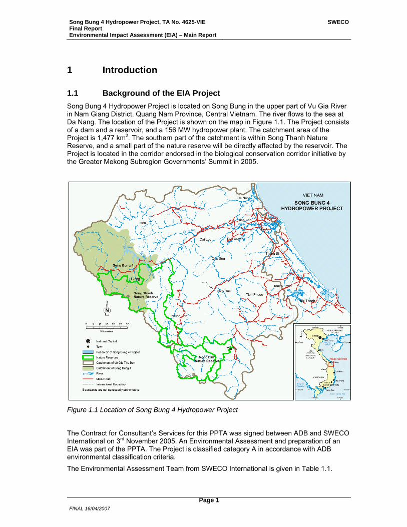
1.1 Background of the EIA Project Song Bung 4 Hydropower Project is located on Song Bung in the upper part of Vu Gia River in Nam Giang District, Quang Nam Province, Central Vietnam. The river flows to the sea at Da Nang. The location of the Project is shown on the map in Figure 1.1. The Project consists of a dam and a reservoir, and a 156 MW hydropower plant. The catchment area of the Project is 1,477 km2. The southern part of the catchment is within Song Thanh Nature Reserve, and a small part of the nature reserve will be directly affected by the reservoir. The Project is located in the corridor endorsed in the biological conservation corridor initiative by the Greater Mekong Subregion Governments’ Summit in 2005.
Figure 1.1 Location of Song Bung 4 Hydropower Project
The Contract for Consultant’s Services for this PPTA was signed between ADB and SWECO International on 3rd November 2005. An Environmental Assessment and preparation of an EIA was part of the PPTA. The Project is classified category A in accordance with ADB environmental classification criteria.
The Environmental Assessment Team from SWECO International is given in Table 1.1.
Song Bung 4 Hydropower Project, TA No. 4625-VIE Final Report Environmental Impact Assessment (EIA) – Main Report
SWECO
FINAL 16/04/2007
Page 2
Table 1.1 Environmental Assessment Team from SWECO International
Position Name International Consultants Environmental Planner & Team Leader Jan-Petter Magnell Terrestrial Ecologist/Forestry Specialist Shivcharn S. Dhillion Aquatic Ecologist Dag Berge Domestic Consultants Environmental Planner & Domestic Team Leader Dang Kim Nhung Forestry Specialist Phan Ke Loc Fauna Specialist Nguyen Quang Truong Aquatic Ecologist Ho Than Hai Fish Specialist Nguyen Kiem Son Road Engineer Tran Thanh Tuan Mining Engineer Pham Thai Nam GIS Expert Nguyen H. Quyen
1.2 Objectives The overall objective of this PPTA (4625-VIE) is to prepare for ADB financing of the proposed Song Bung 4 HPP in Quang Nam Province in the central part of Vietnam. The objective of the Environmental Assessment is, according to the Terms of Reference (TOR) for this PPTA, to revise the EIA prepared by PECC3 for the Project during the feasibility study (PECC3 2005A), and prepare an updated EIA in accordance with ADB’s Environment Policy (2002) and Environmental Assessment Guidelines (2003), as well as Vietnamese requirements.
1.3 Scope of Work and Limitations The full Scope of Work is given in the ToR for this PPTA, and further detailed in the Inception Report for the Project.
Main elements of the study include:
• Review of existing EIA
• Review of other relevant reports and material
• Visits to relevant governmental and other institutions to collect information and undertake interviews. A list of institutions visited and persons interviewed is given in Annex 1.
• Undertake necessary field studies, as supplements to previous studies and to fulfil special requirements in the TOR.
• Conduct public consultation and information disclosure activities in the Project-affected area.
• Prepare technical reports, main EIA report and Summary EIA report in accordance with ADB guidelines.
Song Bung 4 Hydropower Project, TA No. 4625-VIE Final Report Environmental Impact Assessment (EIA) – Main Report
SWECO
FINAL 16/04/2007
Page 3
The field studies, baseline descriptions and impact assessments were based on a technical description of the planned Project given to the Environmental team by ATD3 in January 2006. After the field studies were finished and technical reports written, two more resettlement areas were identified. Due to the timing these areas have not been assessed in this study. A general description of the Project, with the project areas assessed in this study, is given in Chapter 2. The field studies were mainly undertaken in February and March 2006.
Findings and recommendations in the Phase 1 study on water resources, environmental and social issues for this PPTA (Bird et al. 2005), have given important input to this EIA study.
A technical report on hydrology, including results from a hydrodynamic modelling study of the river system, has been prepared in the technical part of this PPTA.
Mitigation measures and monitoring recommended in this EIA have been discussed with ADB and EVN, and programmes and budgets in the EMP were endorsed by EVN in August 2006.
1.4 Study Methods Aquatic Ecology and Water Quality
As part of the water quality, an assessment of the impact from mining on water quality, sediment quality and fish meat quality was conducted in Project impacted area. In addition to elucidate the impact from mining, general water quality parameters and impacts from other human activities like settlement and agriculture, as well as to serve as quality assurance for earlier WQ studies, were studied. A survey of aquatic ecology was conducted in Vu Gia – Song Bung including sampling of all main biological groups, phytoplankton, periphyton, zooplankton, bottom dwelling animals and fish. For the lower groups the survey undertook practical sampling, whereas for fish the study was mainly based on interviews with fishermen and local residents that fish for daily life. Practical test fishing was also performed in tributary junctions to cover smaller fish species.
Terrestrial Ecology
The Song Bung 4 HPP areas were designated into groups and areas which could be assessed in an organized fashion during the period January to March 2006. Vegetation was recorded by direct observation, plot and line transect based surveys, interviews with key informants in villages, and assessment of results from previous studies. Wildlife species were recorded by direct opportunistic observation, vocalization, tracks and traces in the forest, interviews with key informants in villages and assessment results from previous studies. In addition animal bones (mostly skulls and horns) kept as trophies, markets, and specialty restaurants were explored. District and provincial government offices were also visited and respective officers were interviewed. Watershed areas were also considered as these serve as habitats for animals which move in the whole landscape and provide an overview of the forests of the area.
Mining
Mineral resources with potential for exploitation within the whole catchment of Song Bung 4 HPP were investigated. The study also included a survey of ongoing mining activity, as well as identification of locations where the mineral exploitation was finished. Geological reports and maps were reviewed, and combined with information in geological databases to obtain the overview of mineral resources in the area. District and provincial government offices were visited, and interviews were undertaken with representatives for local administrations, villagers and persons taking part in mining activity. During a field survey all identified locations with ongoing mining activity was visited, as well as several other identified potential sites. Information gathered through interviews and review of existing data, maps and reports were controlled and verified in the field.
Song Bung 4 Hydropower Project, TA No. 4625-VIE Final Report Environmental Impact Assessment (EIA) – Main Report
SWECO
FINAL 16/04/2007
Page 4
Road Guidelines
Experience from road construction and maintenance from the area were collected, together with general road experience from mountainous areas. Representatives from the regional road authority and the company responsible for maintenance of Highway 14D were interviewed. Existing literature were collected and reviewed.
Social
Social issues are assessed in a separate study within the Project, reported in the Resettlement and Ethnic Minority Development Plan (REMDP). Various issues in the Environmental and Social Studies are interconnected, and an outline of the baseline social issues is given below in Section 3.2 and a summary of the social impacts in Section 5.2.
The task of the social studies was to assess the present, baseline conditions of the people living in the Project area, and the expected Project impacts on their lives, subsistence systems, social and cultural conditions. The Project area and consequently social studies were divided into three impacted areas, each dealt with in a separate Volume of the REMDP: 1) Reservoir resettlement area; 2) Project lands area; 3) Down/upstream area.
Stakeholder consultation approach has been applied in all social information gathering work. The main methods in the process of social data collection and information gathering have been: household socio-economic and fishery surveys; participatory focus group meetings in villages; village consultation meetings; focused interviews of key persons at village and commune level; interviews of representatives for key authorities, ministries and mass organizations at commune, district and province level; cultural, historical, landscape and resource mapping of the historical and present residential and land utilisation areas; and field observations.
For a full account of the social studies methodology see the Resettlement and Ethnic Minority Development Plan (REMDP).
Stakeholder Consultations
In addition to village and household consultations undertaken by the social team, and interviews of representatives of the affected people during the field surveys, there have been three multi-stakeholder EIA workshops. The first workshop took part before start-up of field studies, the second workshop after most of the field studies were finished and the third workshop at the end of the Study to inform of identified impacts and recommended mitigation.
1.5 General Background
1.5.1 Vietnam
Vietnam stretches over 1,600 km along the eastern cost of the Indochina Peninsula with an area of nearly 330,000 km2. In 2001, Vietnam’s population was estimated at nearly 80 million, making it the 13th most populous country in the world. Some 80% of the population is ethnic Vietnamese while the rest is made up of over 50 ethno-linguistic groups. Vietnam’s economy is still an agriculture economy with 80% of the population living outside the main city centres and totally dependent on agricultural production for their daily living. Vietnam has an estimated per capita income of under USD 500 per year, however, increasing at a rate of over 6% per year.
Three-quarters of Vietnam consists of mountains and hills, and the country has an abundance of water with the total annual water resources estimated at 880 billion m3. The tropical monsoon climate, however, profoundly affect the quantity and distribution of water. Rainfall is highly uneven, causing frequent and often disastrous floods. Mean rainfall is about
Song Bung 4 Hydropower Project, TA No. 4625-VIE Final Report Environmental Impact Assessment (EIA) – Main Report
SWECO
FINAL 16/04/2007
Page 5
2,000 mm, but most accumulates between May and November when about 70-75% of the annual flow is generated. The mountainous topography and the abundance of water creates the possibility of hydropower development to cover the future energy demand for a sustainable economic development of the country, however, such development must also carter for providing water to the important agricultural economy and to mitigate the disastrous floods. Vu Gia-Thu Bon River Basin in the central part of the country and with the outlet in the East Sea near the city of Da Nang is one of the river basins with considerable hydropower potential. The Song Bung 4 HPP lies in the province of Quang Nam in the basin.
1.5.2 Quang Nam Province
Quang Nam is a central province of the Socialist Republic of Vietnam located between 14057' - 16005' North and 107012' – 108045' East. The north of Quang Nam Province is adjacent to Thua Thien-Hue province and Da Nang city, the west is contiguous to the People Democratic Republic of Laos, the south is Quang Ngai Province and the east is coastal. Quang Nam Province is 10,409 km² in size and is divided into 15 districts and two towns. The population at the end of 2004 was 1,438,818 at an average density of 138 pers./km² and an average natural growth rate of 12,85%. Quang Nam is a poor province with a GDP of 5,991,177 million VND (some 370 million USD). Of this, 35.66% comes from the agriculture and forestry sectors, 30.19% from manufacturing and 34.15% from retail. Twelve of these 15 districts have natural forest cover. Six districts are classed as mountainous, four district as mid-land and five districts and the two towns as coastal. Quang Nam Province has a sea boundary over 125 km length. Seven ethnic groups are found in Quang Nam Province; the Kinh majority inhabit the low and mid-land, although found throughout the province. The other groups are focused on the mountainous districts. The second largest ethnic group is Co Tu followed by the Xo Dang, who are closely related to the Ca Dong; the M'Nong; the Gie Trieng who are closely related to the Ta-Rieng and finally the Co.
Quang Nam Province has a humid, tropical climate with a hot, dry season during April to August; a hot, wet season during September to December and a mild, dry season between January and March. The average annual temperature in Tam Ky is some 26.0ºC with an average ranging from 21.2ºC in January to 29.3 in June. Humidity varies throughout the year but averages 84% annually in Tam Ky and 88% in Tra My. The precipitation is 2,072 mm in Tam Ky and 3,931 mm in Tra My district, but the majority of this fall between August and December. When precipitation exceeds 2,000 mm per year many lowland areas in Quang Nam are subject flooding. Quang Nam Province is bordered to the north by the Bach ma-Hai Van Mountains; an eastward running spur of the main Annamite ridge; which forms the western boundary of the province. The Kon Tum Plateaux has its northern reaches in southern Quang Nam Province, with its highest peak, Ngoc Linh (2,598 m a.s.l.) and its associated mountain chain creating the southern boarder of the province. Being bordered by mountains on three sides and the coast on the east, the majority of the province is comprised of a single watershed; the Vu Gia-Thu Bon. This large river divides in central Quang Nam Province with the Thu Bon catchment (3,350 km2) draining the southern part of the province, including the Ngoc Linh area. The Vu Gia system (5,500 km2) drains the western and northern districts, through Cai and Bung rivers, respectively, and joins the Thu Bon in Dai Loc District. A small drainage system; the Tam kK (800 km2), is located in the south-east of the province and drains the costal zone around Thanh Binh, Tam Ky and Nui Thanh districts. The costal zone has numerous large and small, slow-moving rivers, that in some places almost form lagoons. These, combined with the convergence of the Thu Bon and Vu Gia rivers and expanse of flat, low-lying land result in annual flooding during the heaviest rains. Quang Nam Province is located in the Indo-Malayan zoogeographic region (Corbet and Hill,
Song Bung 4 Hydropower Project, TA No. 4625-VIE Final Report Environmental Impact Assessment (EIA) – Main Report
SWECO
FINAL 16/04/2007
Page 6
1992) and according to the classification of MacKinnon (1997) is the sub-unit Ma (Central Annamese Mountains). On the global scale, the environmental processes of Quang Nam Province belong to the Annamite Range Moist Forests Ecoregion (Olson & Dinnerstein, 1998). But at the regional scale, three smaller ecoregions cover parts of the province; these being the Northern Vietnam Lowland Rain Forest, the Southern Vietnam Lowland Dry Forest and the Southern Annamites Mountain Rain Forest. Provincial statistics classify 539,869 ha of Quang Nam Province as forestry land, of which 173,414 ha is production forest; 288,420 ha is protective forest and 78,035 ha is special forest. The natural forest of Quang Nam Province are broadleaf evergreen, with their composition and structure depending on altitude, aspect and precipitation. Precipitation varies across the province, but in general is medium to high so even though the lowland forests are placed in the Southern Vietnam lowland Dry Forest Ecoregion, the forests of Quang Nam Province are, in general, moist to wet, although formations transitional between evergreen and semi-evergreen formations are likely to occur (Tordoff et al., 2003). 110,958 ha of Quang Nam Province is agriculture land, of which 87,248 ha is annual crops (including rice, grass land for breeding and others land) and 23,710 ha is covered by perennial crops.
1.5.3 Forest and Biodiversity in Vietnam
The forests in Vietnam are tropical moist forests, very abundant in the variety and numbers of species of flora and fauna, including micro-organisms. Because of the devastation caused by war, as well as the impact of former socio-economic development strategy that lacked adequate concern for environmental protection, the forest area has undergone serious degradation. The forest coverage has decreased from 43% in 1943 to 33% in 1976 and to only 27% by 1990. Since 1994, however, as a result of the national "327" afforestation program, the governmental policy of forest land allocation to people, as well as better protection, the forest coverage has increased gradually and reached 28.8% in early 1999. The target is to reach the forest coverage of 45% by 2010 through the 5 million hectare afforestation program. Vietnam has become well known for its remarkable and unique biodiversity, both fauna and flora. Vietnam is considered as one of 10 major or mega biodiversity centres in the world. The knowledge of the flora of Vietnam is, however, still far from satisfactory as much of it is based on incomplete botanical inventories from the past centuries. The flora of Vietnam has an estimated 12,000 native higher vascular plant species. Most recent accounts estimate that approximately 10,000 native species of higher vascular plants in 2,260 genera and 307 families, and about 750 introduced and cultivated species (Phan Ke Loc, 1998). For plants, 15 new genera and more than 200 new species were described during the 12 last years . The high degree of environmental heterogeneity in climate regime, soil, landscape and topography combined with the old geological history underlies this high diversity. Most of the species of flora of Vietnam is believed to be indigenous with at least 10-12% being endemic (Averyanov et al., 2003). In the flora of secondary plant communities species, with a wild distribution and of less subsistence and economic values, represent the main part. 356 plant species, mostly higher vascular species, are said to the well-known threatened species and listed in the Red Data Book of Vietnam (1996). The number of higher vascular plant species based on (local) floral account of Vietnam puts the flora species number for the areas similar to that of Quang Nam Province in the lowlands (forest) to be about 1,200-2,000. In the recent years Vietnam has particularly been recognized for its fauna where several new mammal species have been discovered in the recent years. Dang Huy Huynh et al. (1994) recorded 223 species of mammalian fauna. In the period from 1992 to 2003, three species of large mammals and at least five species of small mammals have been described as globally new species from Vietnam (e.g. Pseudoryx nghetinhensis, Muntiacus vuquangensis, Muntiacus truongsonensis, Muntiacus puhoatensis, Viverra tainguensis). Le Vu Khoi (2000)
Song Bung 4 Hydropower Project, TA No. 4625-VIE Final Report Environmental Impact Assessment (EIA) – Main Report
SWECO
FINAL 16/04/2007
Page 7
revised and updated work listed 289 species and subspecies of mammals in Vietnam. The avian (bird) diversity totals about 850 species (Nguyen Cu et al., 2000). The most recent herpetological checklist reports 458 species comprising 162 species of amphibians and 296 species of reptiles (Nguyen Van Sang et al., 2005). Recently, 106 species of butterflies were reported. Complete surveys are still to be conducted and when done will surely add to the growing number of species being recorded. The aquatic ecosystems in Vietnam are rich in both flora and fauna. So far, it has been possible to describe 1,402 species of algae, 782 species of invertebrates (including 48 species of crustacean, 52 species of lobster and crab, 141 species of oysters and shellfish, and 544 species of fresh-water fish).
1.5.4 Threats to Natural Resources and Rural Livelihoods
The landscape of Vietnam has and does suffer from deforestation (although rigorous forest rehabilitation and plantation are underway) caused by a number of reasons; large human population, direct war damage, lack of proper forest management as well as typhoon damage. All in all this causes severe stresses upon the environment, like degrading of the natural capital (e.g. forest production), degrading of the ecosystem services (e.g. disturbance and pollution regulation from for example forests and swamps) and degrading of biodiversity. The importance of water resources management through adequate watershed rehabilitation and conservation in most of the river systems is large and growing. Water is required to irrigate the lowlands, for hydroelectric energy generation, and for domestic and industrial use by the country's large population. In addition proper watershed management is required to mitigate the effects of floods and drought and to provide a livelihood for the large number of ethnic minority groups living in the mountains.
The main sources in Vietnam for degradation of the natural environment are: industrialization; urbanization and rural development; agricultural development; exploitation and development of natural resources, such as energy, minerals, water; and development within the transport and tourist sectors. Related to this development the key environmental issues of concern in Vietnam are and will continue to be: forest degradation; loss of biodiversity; land degradation; water pollution; air pollution, and; waste management. The Vietnamese responses for protecting the environment in a sustainable way are related to: development, formulation and promulgation of legislation on protection of the environment and action plans; environmental monitoring and pollution control, and; the development and strengthening of the institutional system for environmental management.
1.6 Vietnam Legislation and Institutions
1.6.1 Environmental Legislation
The Law on Environmental Protection (LEP) of Vietnam was passed by the Vietnam National Assembly on 12th December 1993 and came into force from 10th January 1994, under the authority of the former Ministry of Science, Technology and Environment (MOSTE). In 2002, MOSTE was dispersed, and two new ministries were established: Ministry of Science and Technology (MOST) and Ministry of Natural Resources and Environment (MONRE), of which the latter is now responsible for environmental issues. A new updated and refined LEP was approved in June 2006. The Law provides for the protection of the environment with a view to protecting the health of the people, serving the cause of sustainable development of the country and contributing to the protection of the regional and global environment. The Law on Environment Protection provides an umbrella framework for environmental management and protection in Vietnam, and the prime authority is the Ministry of National Resources and Environment (MONRE). The National Environmental Agency (NEA) is the environmental arm of MONRE, or the operating unit for overall environmental management in Vietnam. Besides
Song Bung 4 Hydropower Project, TA No. 4625-VIE Final Report Environmental Impact Assessment (EIA) – Main Report
SWECO
FINAL 16/04/2007
Page 8
NEA different departments in the Ministry, as well as institutes, NGOs, universities, provincial level organizations and research organizations play a role in the management.
In addition there are a number of other national laws, which are important for environmental protection and natural resources management. Besides the LEP important plans and programs for environmental management are State Plan on Environmental and Sustainable Development, 1991-2000 (1991), Biodiversity Action Plan of Vietnam (1995) as well as the Tropical Forest Action Program. Together with this, the Government has also promulgated several laws and regulations concerning environment protection, as follows: Forest Protection and Development Law (1991); the People Health Protection Law (1989); Land Use Law (1993); Law of Oil and Petrol; Mineral Resources Law (1996), Water Resources Law (1998); Criminal Affair Law (reform, 1999); Dykes Protection Ordinance (1989); Ordinance of Resources Taxes (1989); Ordinance of Aquatic Resource Protection (1989), Ordinance of Radiation Safety and Control (1996), Ordinance of Vegetation Protection and Quarantine (1993). In addition legal documents to elaborately instruct the implementation of the above laws and ordinances have been issued by the Government, the MONRE and other line ministries. The relevant legislation and institutional structures for the social studies are dealt with in REMDP Volume 1 Chapter 2.
1.6.2 Formulating and Implementing Environmental Protection Policies
The environmental policies for sustainable development of Vietnam were first systematically presented in the “National Plan on Environment and Sustainable Development, 1991-2000” that was approved by the Government in 1991. Since then, the Government has promulgated a series of policies for environmental protection and sustainable development, such as the policy on prohibition of fire-crackers production, transport and use; policy on land and forest entrustment for people; policy on afforestation in denuded land and bare hills; policy on promoting use of cleaner technologies; policy on biodiversity protection, policy on closing natural forests; policy on potable water supply and environmental sanitation in rural areas, and the programs for decreasing population growth rate etc. In 2003 the Ministry of Natural Resources and Environment have formulated the “National Strategy for Environmental Protection to 2010 and Orientation to 2020”. The provinces and cities are also formulating their local environment protection strategies to 2010. Most recently a draft Biodiversity Law has been prepared by the Vietnam Environmental Protection Agency (VEPA) a section of MONRE.
With regards to sustainable development four national policies and plans can be mentioned:
• National Conservation Strategy. In 1985, a (draft) National Conservation Strategy (NCS) was prepared. The strategy outlines the principles and means by which a new conservation ethos can be achieved among the peoples of Vietnam.
• National Plan for Environment and Sustainable Development. The NCS was never formally adopted as a policy document. Instead, in 1990, the National Plan for Environment and Sustainable Development (NPESD) was prepared. The NPESD was approved by the Government on 12th June 1992, and is to date the only official Government policy document on environment. The broad objective of the Plan is to further address the issues raised in the National Strategy.
• National Environmental Action Plan. As a follow up of the NPESD, a Vietnam Environmental Action Plan was prepared by MOSTE in 1995 with support from the World Bank and the Canadian International Development Agency with Technical Assistance from the International Research Centre. The draft of this report was never formally endorsement, and the document has not been printed officially.
Song Bung 4 Hydropower Project, TA No. 4625-VIE Final Report Environmental Impact Assessment (EIA) – Main Report
SWECO
FINAL 16/04/2007
Page 9
• Biodiversity Action Plan. Another action plan, the Biodiversity Action Plan for Vietnam (BAP) was prepared in 1993 and 1994, after Vietnam ratified the 1992 Convention on Biological Diversity. The BAP builds on the national Conservation Strategy and the National Plan for Environment and Sustainable Development, adding important information and a broader integrated scope of action, and in particular a list of priority projects. The BAP was officially approved by the Government on 22nd December 1995.
1.6.3 Environmental Pollution Control and Environmental Monitoring
Since 1994, after the promulgation of the Law on Environmental Protection, a number of significant efforts have been made by responsible institutions to control the air, inland water, sea water and soil pollution; to manage and to treat solid waste, especially hazardous wastes; to deal with the enterprises considered as serious polluters; and to timely respond to environmental disasters/occurrences such as oil spillage into the sea. Environmental impact assessment has been carefully carried out for all the socio-economic development projects as well as for all the existing industrial establishments operating before the promulgation of the Law on Environment Protection. Environmental inspection has been undertaken both at provincial and national levels.
A National Network of Environmental Monitoring managed by the former MOSTE was established since the end of 1994. By 1999, the national network comprised 19 stations responsible for environmental monitoring at 63 locations with a frequency of once every 3 months (4 times/year, since 1995). Basic parameters of air environment, water environment (inland and sea water), land environment, solid wastes, and noise caused by transportation and radioactivity (in 4 locations only) have been monitored and measured by these stations. In addition some other institutions responsible for water resources, hydrometeorology and hydrogeology also carry out water and air monitoring for their research and management purposes.
1.6.4 Vietnam Legal Documents Related to EIA
There are a number of legislative instruments that are directly and indirectly relevant to Environmental Assessments in Vietnam that are taken into consideration while preparing this EIA. These are as follows: Land Law of Vietnam Government, 14 July 1993 revised and approved by the Vietnam National Assembly in 2003; Law on Environmental Protection (LEP), 10 January 1994 signed by Vietnam National President. New law from June 2006; Degree No 175-CP of Vietnam Government, 18 October 1994 on Guidelines for LEP implementation; Degree No 143/2004/ND-CP of Vietnam Government, 12 July 2004 on revise of Article 14 of Degree 175/CP; Decision No 1806-QD/Mtg of MOSTE (now under MONRE), 31 December 1994 on organization and Activities of Approval Mission for EIA and Environmental Permission; Mineral Law, 20 March 1996 approved by Vietnam National Assembly; Degree No 68-CP of Vietnam Government, 18 October 1994 on Guidelines for Mineral Law implementation; Circular letter No 490/1998/TT-BKHCNMT of MOSTE (now under MONRE), 29 April 1998 on EIA Guideline and Approve for Investment Projects; Water Resource Law, 20 May 1998 approved by Vietnam National Assembly; Decision No 35/2002/QD, 25 June 2002 of MOSTE (now under MONRE); Degree No 149/2004/ND-CP, 27 July 2004 of Vietnam Government on permission for water resource use and drainage in to the water where hydropower projects above 2 MW are subject to licensing; Labor Law, 23 July 1994 approved by Vietnam National Assembly; and Guidelines on EIA for Hydropower Projects of the MOSTE (now under MONRE), 2001.

Song Bung 4 Hydropower Project, TA No. 4625-VIE Final Report Environmental Impact Assessment (EIA) – Main Report
SWECO
FINAL 16/04/2007
Page 10
1.6.5 Institutions and Responsibility in Vietnam
The Law on Environmental Protection elaborates in the State Management on Environmental Protection, Article 38 that “The Government shall, pursuant to its power and responsibility, exercise unified State management of environmental protection throughout the country. At present MONRE (previously part of MOSTE) is responsible to the Government for exercising the function of State management of environmental protection. The Department of Environment (DOE) of MONRE is to assist the Minister in the exercising the state management of environmental protection activities in terms of policy-making and the development of related legislations, strategies, planning and plans. The Department of Appraisal and EIA (DAEIA) is to assist the Minister in the exercising the state management of environmental impacts assessment and appraisal, and the Vietnam Environmental Protection Agency (VEPA) is to implement the state environmental management activities in terms of environmental inspectorate and supervision, pollution prevention, environmental quality improvement, natural conservation, environmental technology promotion and public awareness enhancement.
1.6.6 Development of an Institutional System for Environmental Management
In 1993, the National Environmental Agency was established in order to exercise the state management of environmental protection activities throughout the country. By 1999, the National Environmental Agency had 9 divisions with 79 staff. The Environment Management Division with an average of around 2-5 employees was also established in every province/city under the former Provincial Departments of Science, Technology and Environment (DOSTE). Several districts and provincial towns also have a cadre for environmental management. At present the provincial departments are called, Department of Natural Resources and Environment (DONRE) while those in the districts, when present, are called Section on Natural Resources and Environment (SONRE), both of which are under MONRE. The functional units for environment management normally attached to DONRE have been established in some line ministries and economic sectors. Generally, the capacity of environmental management institutions in Vietnam remains weak and disproportionate to the tasks. The environmental managers and regulators employed in the system have been deficient in both their number and qualification.
1.6.7 Current Capacity of Environmental Institutions
• The Department of Environmental Impact Assessment and Appraisal of MONRE has 15 full-time employees (4 with doctorate degrees, 5 Masters and 6 Bachelors degree holders). The department is able to appraise the HPP EIAs.
• DoNRE of QUang Nam Province has 66 individuals, including one person with Master of Science and 50 Bachelors. This department has 10 divisions, including Land (7 individuals), Mineral, Water and Hydrometeology (4), Environmental (6), Administration (13), Natural Resource and Environment Inspection Division (5), Center for Natural Resource and Environmental Technology and Information (20), Center for Survey and Analyze (8), Office for Residential land (10). In terms of HPPs the department has competence in controlling, monitoring the implementation of the mitigation and EMP during construction and operation phases. It can conduct monitoring activities related to, e.g. water, air quality, erosion, and pollution.
• Section of Natural Resource and Environment of Nam Giang District has 6 persons. The Environment and Resettlement Section of ATD3 has 25 persons including 20 Hydraulic and Irrigation engineers but no environmental specialists.
Song Bung 4 Hydropower Project, TA No. 4625-VIE Final Report Environmental Impact Assessment (EIA) – Main Report
SWECO
FINAL 16/04/2007
Page 11
2 Project Description
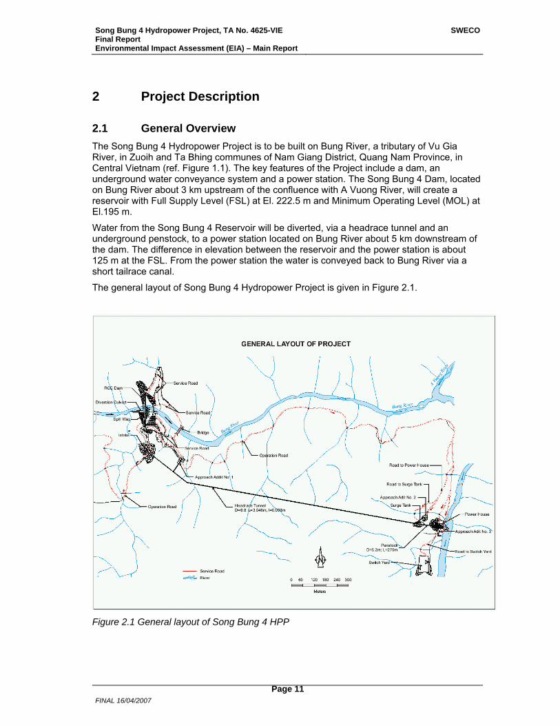
2.1 General Overview The Song Bung 4 Hydropower Project is to be built on Bung River, a tributary of Vu Gia River, in Zuoih and Ta Bhing communes of Nam Giang District, Quang Nam Province, in Central Vietnam (ref. Figure 1.1). The key features of the Project include a dam, an underground water conveyance system and a power station. The Song Bung 4 Dam, located on Bung River about 3 km upstream of the confluence with A Vuong River, will create a reservoir with Full Supply Level (FSL) at El. 222.5 m and Minimum Operating Level (MOL) at El.195 m.
Water from the Song Bung 4 Reservoir will be diverted, via a headrace tunnel and an underground penstock, to a power station located on Bung River about 5 km downstream of the dam. The difference in elevation between the reservoir and the power station is about 125 m at the FSL. From the power station the water is conveyed back to Bung River via a short tailrace canal.
The general layout of Song Bung 4 Hydropower Project is given in Figure 2.1.
Figure 2.1 General layout of Song Bung 4 HPP

Song Bung 4 Hydropower Project, TA No. 4625-VIE Final Report Environmental Impact Assessment (EIA) – Main Report
SWECO
FINAL 16/04/2007
Page 12
The total estimated cost of Song Bung 4 Hydropower Project is about 254 million USD, including taxes, contingencies and finance charges. Preliminary construction (access roads, etc.) is scheduled to start in the beginning of 2008, and main construction work in early 2009, with commissioning during the second half of 2012. A peak work force of 2,000 people is estimated to be employed during the construction of the Project.
The current project description is based on information given in the Feasibility Study of PECC3, and could be modified during the Technical Design Phase of the Project scheduled to commence in November/December of 2006
Song Bung 4 Hydropower Project is part of a plan to develop a number of hydropower projects in Vu Gia and Thu Bon rivers in Quang Nam Province. Two of these projects are under construction.
2.2 Project Components
2.2.1 General
The Song Bung 4 Hydropower Project will produce electricity to cover the increasing demand in Central Vietnam, to sustain the economic growth in the region, by utilizing the head created by the dam and the water conveyance system. To accomplish this certain infrastructure facilities will be constructed as follows:
• A dam on Bung River to create the reservoir. • Structures to divert the water from the reservoir to the power station. • A power station with the necessary facilities to generate electricity. • A transmission line to connect the power station with the national grid. • Road works to connect the project site and resettlement areas to the national road
system. • Auxiliary areas to enable construction and operation of the Project.
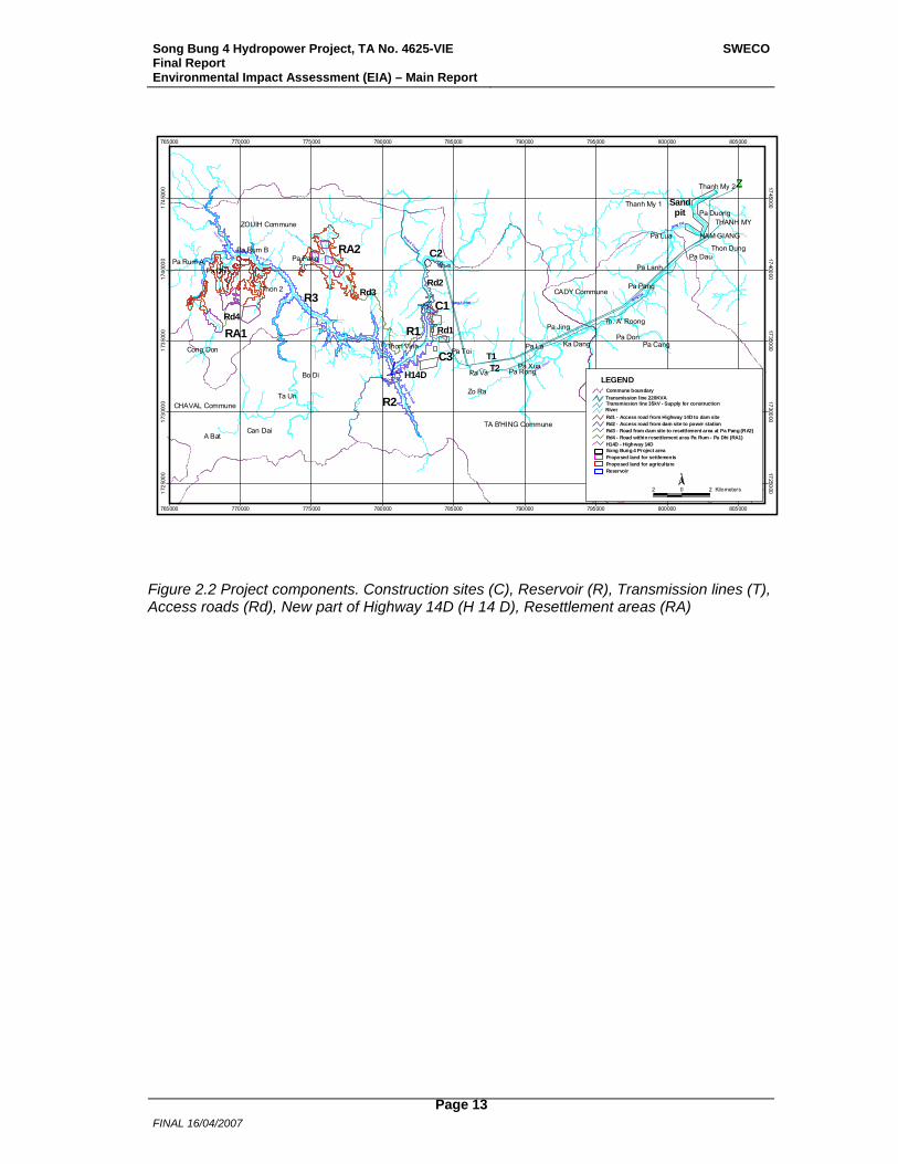
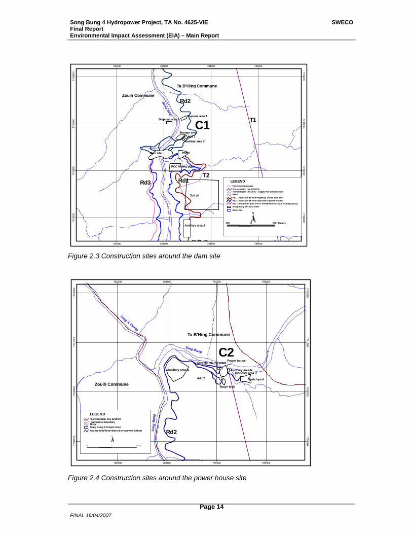
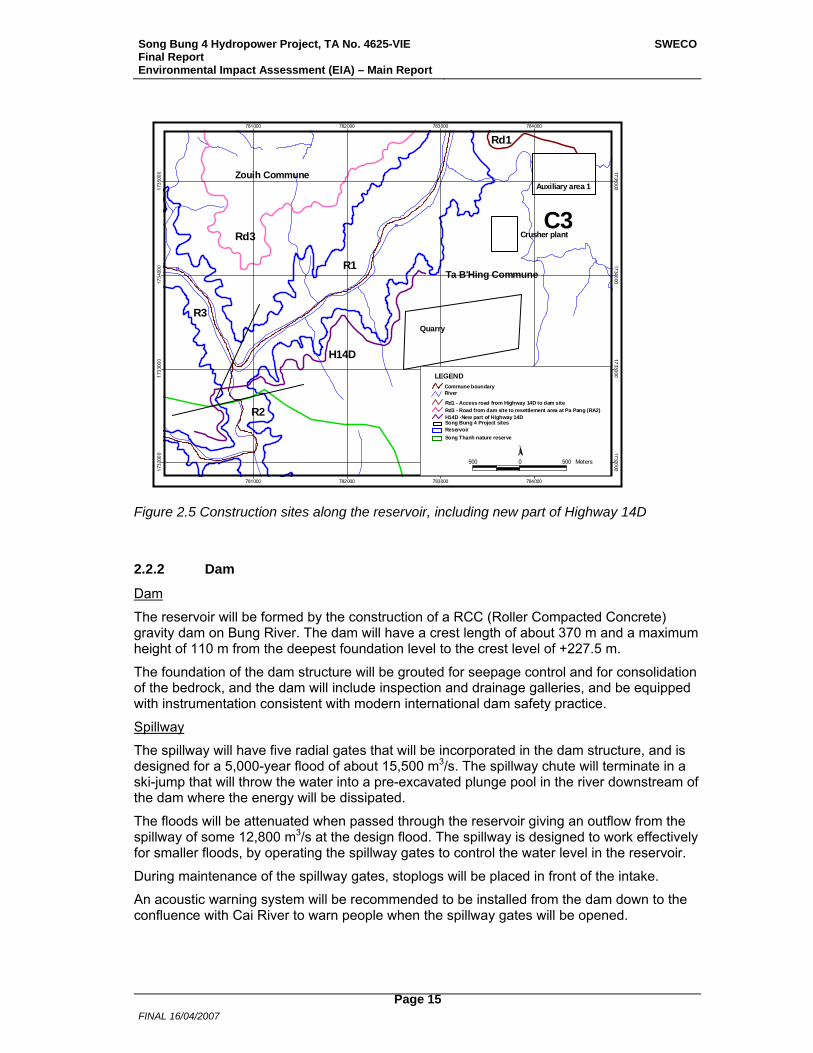
The various project components are described in more detail below with the location shown in Figures 2.2 to 2.5.
Song Bung 4 Hydropower Project, TA No. 4625-VIE Final Report Environmental Impact Assessment (EIA) – Main Report
SWECO
FINAL 16/04/2007
Page 13
#
#
#
#
#
#
#
#
#
#
#
#
#
#
#
#
# #
#
#
#
#
#
#
#
#
#
#
#
#
#
#
#
#
#
#
#
#
#
#
#
# Sand pi t
Pa La
Pa Va
Zo Ra
Bo Di
Ta Un
A Bat
Pa Xua
Pa Toi
Thon 2
Pa Dhi
Pa Don
Pa Lua
Pa Dau
Pa Jing
Ka Dang
Pa Pang
Can Dai
Pa Cang
Pa Lanh
Pa Pang
Pa Rum B
Cong Don
Pa DuongTHANH MY
Thon Vinh
Thanh My 1
Thanh My 2
CADY Commune
TA B'HING Commune
Pa Rong
Pa Rum A
Thon Dung
NAM GIANG
Th. A' Roong
ZOUIH Commune
CHAVAL Commune
C2
C1
C3
RA2
RA1
R3
R2
R1
Rd3
T1T2
Rd2
Rd1
H14D
Sandpit
Rd4
Song A Kia
Song Bung
Song A Xo
Son g. U Poo
Song B ung
Song. Ta Po
Song Cai
Song Thanh
Song Cai
Song A Nhat
Song Tra Vinh
Song A Vuong
765000
765000
770000
770000
775000
775000
780000
780000
785000
785000
790000
790000
795000
795000
800000
800000
805000
805000
1725
000 1725000
1730
000 1730000
1735
000 1735000
1740
000 1740000
1745
000 1745000
Proposed land for settlements Song Bung 4 Project area
River
Transmission line 220KVA
LEGEND
Transmission line 35kV - Supply for construction
Rd1 - Access road from Highway 14D to dam siteRd2 - Access road from dam site to power stationRd3 - Road from dam site to resettlement area at Pa Pang (RA2)
Commune boundary
H14D - Highway 14DRd4 - Road within resettlement area Pa Rum - Pa Dhi (RA1)
Proposed land for agriculture Reservoir
2 0 2 Kilometers
N
$Z
Figure 2.2 Project components. Construction sites (C), Reservoir (R), Transmission lines (T), Access roads (Rd), New part of Highway 14D (H 14 D), Resettlement areas (RA)
Song Bung 4 Hydropower Project, TA No. 4625-VIE Final Report Environmental Impact Assessment (EIA) – Main Report
SWECO
FINAL 16/04/2007
Page 14
RCC Mixing plant
Disposal area 2Disposal area 1
Storage area
Auxiliary area 2
Auxiliary area 3
Intake
Adit 1
Dam site
Soil pit
Rd1
Rd2
Rd1Rd3
Zouih Commune
Ta B'Hing Commune
Song
Bun
g
T1
T2
C1
782000
782000
783000
783000
784000
784000
785000
785000
1736
000 1736000
1737
000 1737000
1738
000 1738000
1739
000 1739000
ReservoirSong Bung 4 Project Sites
River
Transmission line 220KVA
LEGEND
Transmission line 35kV - Supply for construction
Rd1 - Access road from Highway 14D to dam siteRd2 - Access road from dam site to power stationRd3 - Road from dam site to resettlement area at Pa Pang (RA2)
Commune boundary
500 0 500 Meters
N
Figure 2.3 Construction sites around the dam site
Disposal area 3
Conrete mixing plant
Auxiliary area 4 Auxiliary area 5
Surge tank
Adit 2 Switchyard
Power house
Rd2
Song Bung
Song
Bu n
g
Ta B'Hing Commune
Zouih Commune
Song A Vuong
C2
782000
782000
783000
783000
784000
784000
785000
785000
1739
000 1739000
1740
000 1740000
1741
000 1741000
1742
000 1742000
Song Bung 4 Project sitesRiver
Transmission line 220KVALEGEND
Access road from dam site to power station
Commune boundary
500 0 500 Meters
N
Figure 2.4 Construction sites around the power house site
Song Bung 4 Hydropower Project, TA No. 4625-VIE Final Report Environmental Impact Assessment (EIA) – Main Report
SWECO
FINAL 16/04/2007
Page 15
Auxiliary area 1
Crusher plant
Quarry
R2
R1
R3
Rd3
H14D
Rd1
Ta B'Hing Commune
Zouih Commune
C3
781000
781000
782000
782000
783000
783000
784000
784000
1732
000 1732000
1733
000 1733000
1734
000 1734000
1735
000 1735000
ReservoirSong Bung 4 Project sites
River
LEGEND
H14D -New part of Highway 14DRd3 - Road from dam site to resettlement area at Pa Pang (RA2)
Song Thanh nature reserve
Commune boundary
Rd1 - Access road from Highway 14D to dam site
N
500 0 500 Meters
Figure 2.5 Construction sites along the reservoir, including new part of Highway 14D
2.2.2 Dam
Dam
The reservoir will be formed by the construction of a RCC (Roller Compacted Concrete) gravity dam on Bung River. The dam will have a crest length of about 370 m and a maximum height of 110 m from the deepest foundation level to the crest level of +227.5 m.
The foundation of the dam structure will be grouted for seepage control and for consolidation of the bedrock, and the dam will include inspection and drainage galleries, and be equipped with instrumentation consistent with modern international dam safety practice.
Spillway
The spillway will have five radial gates that will be incorporated in the dam structure, and is designed for a 5,000-year flood of about 15,500 m3/s. The spillway chute will terminate in a ski-jump that will throw the water into a pre-excavated plunge pool in the river downstream of the dam where the energy will be dissipated.
The floods will be attenuated when passed through the reservoir giving an outflow from the spillway of some 12,800 m3/s at the design flood. The spillway is designed to work effectively for smaller floods, by operating the spillway gates to control the water level in the reservoir.
During maintenance of the spillway gates, stoplogs will be placed in front of the intake.
An acoustic warning system will be recommended to be installed from the dam down to the confluence with Cai River to warn people when the spillway gates will be opened.
Song Bung 4 Hydropower Project, TA No. 4625-VIE Final Report Environmental Impact Assessment (EIA) – Main Report
SWECO
FINAL 16/04/2007
Page 16
2.2.3 Water Conveyance System
Intake
A freestanding 50 m high intake structure will be constructed about 150 m to the south of the dam to convey the water to the headrace tunnel. The intake will have one opening and be equipped with a downstream service gate and an upstream guard gate. The opening will be equipped with trash racks and mechanized trash-cleaning rakes. For maintenance of the guard gate, stoplogs may be placed in front of the intake. For dewatering of the water conveyance system during inspection and maintenance, both the services and guard gates will be closed.
Headrace Tunnel
A nearly horizontal headrace tunnel, with a total length of about 3 km and an inner diameter of 6.8 m, will be excavated from the intake to the surge tank. The tunnel will be concrete lined and supported by steel-ribs or other strengthening measures when the tunnel encounters week rock formations.
Construction of the headrace tunnel will be through two adits, one at the upstream end and one at the downstream end.
Surge Tank
At the downstream end of the headrace tunnel, a 75 m high (54 m below ground and 21 m above ground) surge tank will be constructed to reduce pressure transients created by start-up and load rejection operations of the turbine-generator units. The surge tank will be concrete lined and have an internal diameter of 24 m above ground and 15 m below ground.
Construction of the surge tank will be through the adit at the downstream end of the headrace tunnel and from above ground.
Penstock
Downstream of the surge tank, an underground penstock, with a total length of about 270 m and a diameter of 5.2 m, will be constructed, being horizontal for the first part followed by a vertical part and finally a horizontal part towards the power station.
Construction of the penstock will be through two adits, one utilizing the adit at the downstream end of the headrace tunnel and one at the downstream end of the penstock.
2.2.4 Power Station
Powerhouse
The powerhouse will be located close to Bung River, about 5 km downstream of the dam, and consists of a 68 m high, 58 m long and 24 m wide surface structure. The structure will house two turbine-generator units with a total capacity of 156 MW, an erection bay, and auxiliary facilities for operation and maintenance. Two 3-phase transformers will be placed outside at the back of the powerhouse.
The control building, for operation of the Project, will be located adjacent to the powerhouse structure.
The buildings will be placed at El. 125 m being 0.5 m above the level for a 5,000-year flood.
Tailrace Canal
A 20 m long tailrace canal will divert the water back to Bung River.
Switchyard
The transformers at the powerhouse will be connected to the transmission lines via a
Song Bung 4 Hydropower Project, TA No. 4625-VIE Final Report Environmental Impact Assessment (EIA) – Main Report
SWECO
FINAL 16/04/2007
Page 17
switchyard, with dimensions 70 m x 143 m, located about 500 m downstream of the powerhouse.
2.2.5 Transmission
The power generated at Song Bung 4 Hydropower Project will be connected to the national grid via a 35 km long double circuit 220 kV transmission line to a 220/110 kV substation at Thanh My.
The actual routing and design of the transmission line is not yet defined, but the standard design for 220 kV involves construction of approximately 100 self-supporting steel towers about 40 m high and 10 m wide.
In addition, it is proposed to construct a 35 kV transmission line from Thanh My to the project site for electricity supply during construction of the Project. This line, with a length of about 38 km, will follow Highway 14 D and the access road to the project site.
2.2.6 Road Works
Access Road to Project Site
For the construction of Song Bung 4 Hydropower Project, a considerable amount of materials need to be transported from Da Nang City, about 100 km to the east. The existing Highway 14D is reported to be adequate for this purpose, and no additional upgrading of this road is foreseen. For transport of heavy equipment, such as the generators, at least the last part from Nam Giang would probably need to be closed during the transportation.
From Highway 14D an estimated 5.4 km long access road will be constructed to the dam site along the right edge of Bung River. The standard of the road will be Grade 4 in mountainous areas with asphalt coating.
The actual routing and design of this access road is not yet defined.
Access Roads within the Project Site
A number of access and service roads with a total length of about 20 km will be constructed within the project site, to be used both during construction and operation. The road from the dam site to the powerhouse will have asphalt coating, the remaining roads will mainly be gravel roads.
A temporary bridge across Bung River is planned some 150 m downstream of the dam, to be used during the construction of the dam structure and thereafter removed. Permanent access across the river will be on the crest of the dam.
The actual routing and design of these access roads are not yet defined, and will partly be decided by the contractors.
Relocation of Highway 14 D
Some 6 km of Highway 14D will be relocated due to establishment of the reservoir, including a 350 m long and 60 m high new bridge.
Roads to Resettlement Areas
Access to the four resettlement areas will include about 40 km with new roads.
The actual routing and design of these roads are not yet defined.
Song Bung 4 Hydropower Project, TA No. 4625-VIE Final Report Environmental Impact Assessment (EIA) – Main Report
SWECO
FINAL 16/04/2007
Page 18
2.2.7 Auxiliary Construction Areas
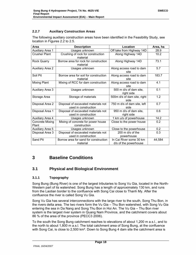
The following auxiliary construction areas have been identified in the Feasibility Study, see location in Figures 2.2 to 2.5. Area Description Location Area, ha Auxiliary Area 1 Usages unknown Off take from Highway 14D 28.9 Crusher Plant Crushing of rock for construction
material Along Highway 14D 10.2
Rock Quarry Borrow area for rock for construction material
Along Highway 14D 73.1
Auxiliary Area 2 Usages unknown Along access road to dam site
5.7
Soil Pit Borrow area for soil for construction material
Along access road to dam site
183.7
Mixing Plant Mixing of RCC for dam construction Along access road to dam site
4.1
Auxiliary Area 3 Usages unknown 500 m d/s of dam site, right side
0.1
Storage Area Storage of materials 500m d/s of dam site, right side
1.2
Disposal Area 2 Disposal of excavated materials not used in construction
750 m d/s of dam site, left side
0.7
Disposal Area 1 Disposal of excavated materials not used in construction
950 m d/s of dam site, right side
0.6
Auxiliary Area 4 Usages unknown 1 km u/s of powerhouse 14.2 Concrete Mixing Plant
Mixing of concrete for power house construction
Close to the power house 0.2
Auxiliary Area 5 Usages unknown Close to the powerhouse 0.2 Disposal Area 3 Disposal of excavated materials not
used in construction 200 m d/s of the
powerhouse 0.3
Sand Pit Borrow area for sand for construction material
In Cai River some 30 km d/s of the powerhouse
44,584
3 Baseline Conditions
3.1 Physical and Biological Environment
3.1.1 Topography
Song Bung (Bung River) is one of the largest tributaries to Song Vu Gia, located in the North-Western part of its watershed. Song Bung has a length of approximately 130 km, and runs from the Laotian border to the confluence with Song Cai close to Thanh My. After the confluence the river is called Song Vu Gia.
Song Vu Gia has several interconnections with the large river to the south, Song Thu Bon, in the rivers delta area. The two rivers form the Vu Gia – Thu Bon watershed, with Song Vu Gia entering the sea in Da Nang and Song Thu Bon in Hoi An. The Vu Gia – Thu Bon river system is the largest river system in Quang Nam Province, and the catchment covers about 86 % of the area of the province (PECC3 2006).
To the south the Song Bung catchment reaches to elevations of about 1,200 m a.s.l., and to the north to about 1,800 m a.s.l. The total catchment area of Song Bung, at the confluence with Song Cai, is close to 2,500 km². Down to Song Bung 4 dam site the catchment area is

Song Bung 4 Hydropower Project, TA No. 4625-VIE Final Report Environmental Impact Assessment (EIA) – Main Report
SWECO
FINAL 16/04/2007
Page 19
1,477 km². Song A Vuong (area 767 km²) is a large tributary to Song Bung from the north just downstream the dam site. In that river the A Vuong Hydropower Plant is under construction.
3.1.2 Air
There is no permanent environmental monitoring station in the Project area, however site specific monitoring was conducted in 2004 (PECC3 2005A). The monitoring indicated that the air quality in the Project area was good during the period of evaluation. There are no industrial pollution sources in the vicinity of the Project, and the transportation density is not high. Monitoring results are presented in Table 3.1.
Table 3.1 Air quality in the Song Bung 4 Project area (measurements taken in 2004)
Sampling site Dust CO SO2 NO2 mg/m³ mg/m³ mg/m³ mg/m³
Power station 0.12 0 trace 0
Dam site 0.10 0 trace 0
Dam site 0.12 0 0.005 0.002
Reservoir, upstream damsite 0.15 0 0.005 0.005
Reservoir, confluence Pring River 0.10 0 trace 0
Reservoir, near Pa Dhi village 0.10 0 trace 0
Standard (TCVN 5937:1995) 0.30 40 0.5 0.5
3.1.3 Noise
The Project is located in the valley of Bung River and is surrounded by steep hills. There are some houses in the Project area along Highway 14 D, and 4 villages that will be inundated by the reservoir. Beside Highway 14 D that goes to the Laotian border, very few permanent roads exist in the Project area. Noise monitoring was conducted in 2004 at some locations in the Project area, indicating low background noise levels (PECC3 2005A). Monitoring results are given in Table 3.2. Floating gold dredging machines operating in Bung River in the reservoir area will create some local noise. These machines are operated day and night.
Table 3.2 Noise measurements in the Project area (taken in 2004)
Sampling site Noise dBA
Power station 40-42
Dam site 38-40
Dam site 36-40
Reservoir, upstream damsite 38-40
Reservoir, confluence Pring River 40-42
Reservoir, near Pa Dhi village 38-40
Standard (TCVN 5937:1995) 60-65
Song Bung 4 Hydropower Project, TA No. 4625-VIE Final Report Environmental Impact Assessment (EIA) – Main Report
SWECO
FINAL 16/04/2007
Page 20
3.1.4 Climate
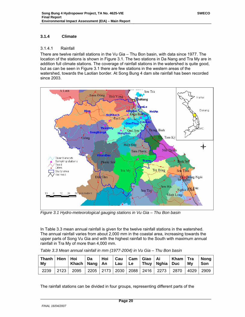
3.1.4.1 Rainfall There are twelve rainfall stations in the Vu Gia – Thu Bon basin, with data since 1977. The location of the stations is shown in Figure 3.1. The two stations in Da Nang and Tra My are in addition full climate stations. The coverage of rainfall stations in the watershed is quite good, but as can be seen in Figure 3.1 there are few stations in the western areas of the watershed, towards the Laotian border. At Song Bung 4 dam site rainfall has been recorded since 2003.
Figure 3.1 Hydro-meteorological gauging stations in Vu Gia – Thu Bon basin
In Table 3.3 mean annual rainfall is given for the twelve rainfall stations in the watershed. The annual rainfall varies from about 2,000 mm in the coastal area, increasing towards the upper parts of Song Vu Gia and with the highest rainfall to the South with maximum annual rainfall in Tra My of more than 4,000 mm.
Table 3.3 Mean annual rainfall in mm (1977-2004) in Vu Gia – Thu Bon basin
Thanh My
Hien Hoi Khach
Da Nang
Hoi An
Cau Lau
Cam Le
Giao Thuy
Ai Nghia
Kham Duc
Tra My
Nong Son
2239 2123 2095 2205 2173 2030 2088 2416 2273 2870 4029 2909 The rainfall stations can be divided in four groups, representing different parts of the
Song Bung 4 Hydropower Project, TA No. 4625-VIE Final Report Environmental Impact Assessment (EIA) – Main Report
SWECO
FINAL 16/04/2007
Page 21
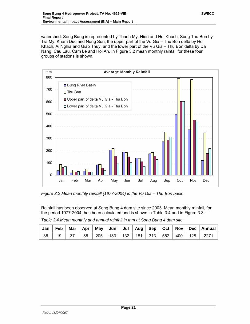
watershed. Song Bung is represented by Thanh My, Hien and Hoi Khach, Song Thu Bon by Tra My, Kham Duc and Nong Son, the upper part of the Vu Gia – Thu Bon delta by Hoi Khach, Ai Nghia and Giao Thuy, and the lower part of the Vu Gia – Thu Bon delta by Da Nang, Cau Lau, Cam Le and Hoi An. In Figure 3.2 mean monthly rainfall for these four groups of stations is shown.
0
100
200
300
400
500
600
700
800
Jan Feb Mar Apr May Jun Jul Aug Sep Oct Nov Dec
Bung River Basin
Thu Bon
Upper part of delta Vu Gia - Thu Bon
Lower part of delta Vu Gia - Thu Bon
mm Average Monthly Rainfall
Figure 3.2 Mean monthly rainfall (1977-2004) in the Vu Gia – Thu Bon basin
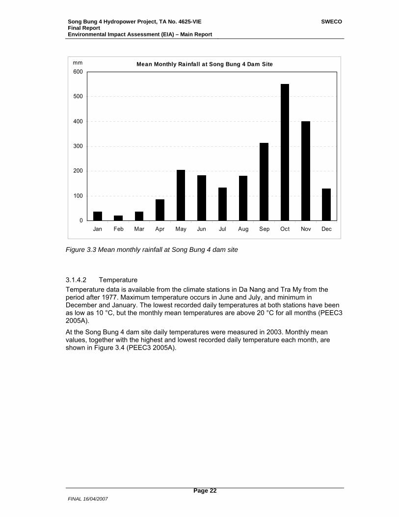
Rainfall has been observed at Song Bung 4 dam site since 2003. Mean monthly rainfall, for the period 1977-2004, has been calculated and is shown in Table 3.4 and in Figure 3.3.
Table 3.4 Mean monthly and annual rainfall in mm at Song Bung 4 dam site
Jan Feb Mar Apr May Jun Jul Aug Sep Oct Nov Dec Annual
36 19 37 86 205 183 132 181 313 552 400 128 2271
Song Bung 4 Hydropower Project, TA No. 4625-VIE Final Report Environmental Impact Assessment (EIA) – Main Report
SWECO
FINAL 16/04/2007
Page 22
0
100
200
300
400
500
600
Jan Feb Mar Apr May Jun Jul Aug Sep Oct Nov Dec
Mean Monthly Rainfall at Song Bung 4 Dam Sitemm
Figure 3.3 Mean monthly rainfall at Song Bung 4 dam site
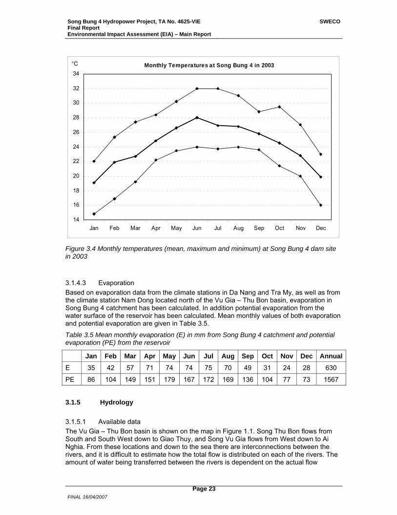
3.1.4.2 Temperature Temperature data is available from the climate stations in Da Nang and Tra My from the period after 1977. Maximum temperature occurs in June and July, and minimum in December and January. The lowest recorded daily temperatures at both stations have been as low as 10 °C, but the monthly mean temperatures are above 20 °C for all months (PEEC3 2005A).
At the Song Bung 4 dam site daily temperatures were measured in 2003. Monthly mean values, together with the highest and lowest recorded daily temperature each month, are shown in Figure 3.4 (PEEC3 2005A).
Song Bung 4 Hydropower Project, TA No. 4625-VIE Final Report Environmental Impact Assessment (EIA) – Main Report
SWECO
FINAL 16/04/2007
Page 23
14
16
18
20
22
24
26
28
30
32
34
Jan Feb Mar Apr May Jun Jul Aug Sep Oct Nov Dec
°C Monthly Temperatures at Song Bung 4 in 2003
Figure 3.4 Monthly temperatures (mean, maximum and minimum) at Song Bung 4 dam site in 2003
3.1.4.3 Evaporation Based on evaporation data from the climate stations in Da Nang and Tra My, as well as from the climate station Nam Dong located north of the Vu Gia – Thu Bon basin, evaporation in Song Bung 4 catchment has been calculated. In addition potential evaporation from the water surface of the reservoir has been calculated. Mean monthly values of both evaporation and potential evaporation are given in Table 3.5.
Table 3.5 Mean monthly evaporation (E) in mm from Song Bung 4 catchment and potential evaporation (PE) from the reservoir
Jan Feb Mar Apr May Jun Jul Aug Sep Oct Nov Dec Annual
E 35 42 57 71 74 74 75 70 49 31 24 28 630
PE 86 104 149 151 179 167 172 169 136 104 77 73 1567
3.1.5 Hydrology
3.1.5.1 Available data The Vu Gia – Thu Bon basin is shown on the map in Figure 1.1. Song Thu Bon flows from South and South West down to Giao Thuy, and Song Vu Gia flows from West down to Ai Nghia. From these locations and down to the sea there are interconnections between the rivers, and it is difficult to estimate how the total flow is distributed on each of the rivers. The amount of water being transferred between the rivers is dependent on the actual flow
Song Bung 4 Hydropower Project, TA No. 4625-VIE Final Report Environmental Impact Assessment (EIA) – Main Report
SWECO
FINAL 16/04/2007
Page 24
situation each day. The two rivers have outlet to the sea in Da Nang and Hoi An.
The catchment area to the sea is 10,209 km², with a total mean annual flow in both rivers at approximately 640 m³/s.
Song Vu Gia has several branches, the largest are Song Cai and Song Bung, and other important tributaries are Song A Vuong, Song Thanh and Song Con.
In Vu Gia – Thu Bon there are two discharge gauging stations, Thanh My in Song Cai (Song Vu Gia) and Nong Son in Song Thu Bon, with discharge data since 1977. In addition water levels have been recorded at seven locations in the same period, namely at Da Nang, Hoi An, Giao Thuy, Cau Lau, Cam Le, Ai Nghia and Hoi Khach (see Figure 3.1).
At Song Bung 4 dam site water levels have been registered daily since 2003. During that period several discharge measurements have been undertaken. Based on these a rating curve has been established, and daily flows been calculated for the period after 2003.
In Table 3.6 some data for subcatchments in the riversystem is given.
Table 3.6 Catchment areas and mean annual flows at different locations in Vu Gia – Thu Bon riversystem
Location River Area Annual mean flow km² m³/s
Song Bung 4 dam site Song Bung 1519 72
Thanh My Song Cai 2043 123
Hoi Khach Song Vu Gia 4551 263
Ai Nghia Song Vu Gia 5426 298
Nong Son Song Thu Bon 3217 273
Giao Thuy Song Thu Bon 3533 288
3.1.5.2 Model simulations From model simulations, flow series and water level series at different locations in the river were estimated. Based on input from evaporation and rainfall a rainfall-runoff model was established. Along Song Bung and Song Vu Gia river cross-sections had been established and a hydrodynamic model was calibrated against observed water levels.
Using the models natural flows from the period 1978-2004 at different locations in the river system were established, as well as water levels. The natural flow model included water users such as water supply, 20 irrigation schemes and 5 existing reservoirs for other water use than hydropower.
The models were also used to describe expected flow and water level variations in Song Bung and Song Vu Gia in the future situation with Song Bung 4 Hydropower Plant (see Chapter 5), and possible flow conditions in Song Vu Gia and Song Thu Bon with several planned hydropower developments in operation (see Chapter 6).
3.1.5.3 Calculated natural flows Based on model simulations a natural flow series at Song Bung 4 dam site was calculated. Monthly flows for each year in the period 1978-2004 are shown in Table 3.7. In Figure 3.5 mean and minimum monthly flows are shown. The wet months September to December have about 65 % of the annual flow volume. Usually a smaller rise in the flow also occurs
Song Bung 4 Hydropower Project, TA No. 4625-VIE Final Report Environmental Impact Assessment (EIA) – Main Report
SWECO
FINAL 16/04/2007
Page 25
during the months May and June. Although mean monthly flows are well above 25 m³/s in all months, the lowest monthly flows can be less than 5 m³/s.
Table 3.7 Monthly flows (m³/s) at Song Bung 4 dam site
Year Jan Feb Mar Apr May Jun Jul Aug Sep Oct Nov Dec Mean
1978 45 20 25 27 66 44 61 39 182 193 158 127 82
1979 54 41 33 24 71 185 50 60 48 93 94 44 66
1980 27 20 15 11 15 102 61 78 223 250 458 130 116
1981 97 68 49 51 63 89 57 42 53 353 335 186 120
1982 90 69 50 72 47 54 34 29 136 63 86 32 64
1983 27 17 13 10 7 48 38 28 30 222 240 88 64
1984 54 40 30 24 50 40 30 34 29 149 176 80 61
1985 40 29 22 24 32 56 27 20 60 121 175 134 62
1986 50 37 28 21 49 39 24 25 12 133 50 96 47
1987 30 22 19 12 12 39 16 29 155 39 186 52 51
1988 55 32 21 16 19 17 15 9 26 212 92 51 47
1989 44 23 19 14 62 37 42 23 26 28 45 20 32
1990 11 8 6 5 10 5 7 15 52 322 246 86 64
1991 61 47 36 31 28 17 16 21 26 170 68 82 50
1992 35 24 18 14 16 42 23 52 45 282 126 80 63
1993 47 33 25 19 68 45 42 21 73 179 84 130 64
1994 45 34 25 19 34 28 15 15 141 113 108 87 55
1995 37 27 20 15 28 25 27 29 69 307 217 118 77
1996 60 49 33 26 43 37 20 14 118 306 300 151 97
1997 90 64 46 44 54 34 26 16 138 96 104 58 64
1998 31 23 18 13 25 25 43 49 97 125 353 135 78
1999 105 75 58 62 127 92 44 49 47 142 461 256 127
2000 105 78 55 76 101 67 58 100 66 276 199 146 111
2001 86 56 59 38 49 43 22 102 45 181 105 115 75
2002 48 34 27 23 21 32 17 83 163 168 132 78 69
2003 41 31 23 19 21 38 28 43 151 147 143 102 66
2004 53 35 32 33 27 55 49 101 89 85 207 80 70
Mean 54 38 30 27 42 49 33 42 85 176 183 102 72
Min 11 8 6 5 7 5 7 9 12 28 45 20 32
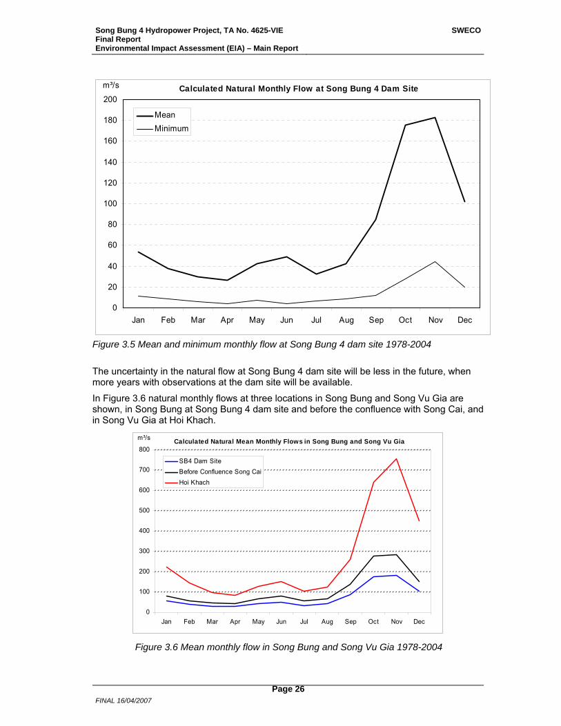
Song Bung 4 Hydropower Project, TA No. 4625-VIE Final Report Environmental Impact Assessment (EIA) – Main Report
SWECO
FINAL 16/04/2007
Page 26
0
20
40
60
80
100
120
140
160
180
200
Jan Feb Mar Apr May Jun Jul Aug Sep Oct Nov Dec
MeanMinimum
m³/s Calculated Natural Monthly Flow at Song Bung 4 Dam Site
Figure 3.5 Mean and minimum monthly flow at Song Bung 4 dam site 1978-2004
The uncertainty in the natural flow at Song Bung 4 dam site will be less in the future, when more years with observations at the dam site will be available.
In Figure 3.6 natural monthly flows at three locations in Song Bung and Song Vu Gia are shown, in Song Bung at Song Bung 4 dam site and before the confluence with Song Cai, and in Song Vu Gia at Hoi Khach.
0
100
200
300
400
500
600
700
800
Jan Feb Mar Apr May Jun Jul Aug Sep Oct Nov Dec
SB4 Dam SiteBefore Confluence Song CaiHoi Khach
m³/s Calculated Natural Mean Monthly Flows in Song Bung and Song Vu Gia
Figure 3.6 Mean monthly flow in Song Bung and Song Vu Gia 1978-2004
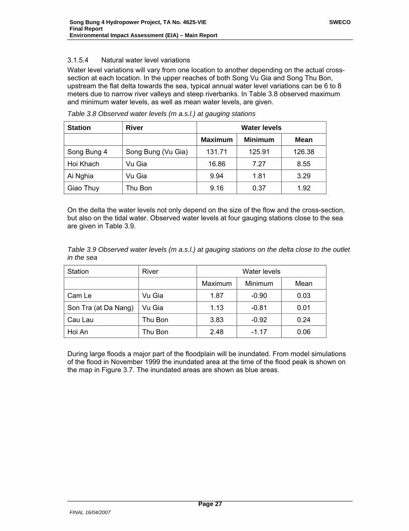
Song Bung 4 Hydropower Project, TA No. 4625-VIE Final Report Environmental Impact Assessment (EIA) – Main Report
SWECO
FINAL 16/04/2007
Page 27
3.1.5.4 Natural water level variations Water level variations will vary from one location to another depending on the actual cross-section at each location. In the upper reaches of both Song Vu Gia and Song Thu Bon, upstream the flat delta towards the sea, typical annual water level variations can be 6 to 8 meters due to narrow river valleys and steep riverbanks. In Table 3.8 observed maximum and minimum water levels, as well as mean water levels, are given.
Table 3.8 Observed water levels (m a.s.l.) at gauging stations
Station River Water levels
Maximum Minimum Mean
Song Bung 4 Song Bung (Vu Gia) 131.71 125.91 126.38
Hoi Khach Vu Gia 16.86 7.27 8.55
Ai Nghia Vu Gia 9.94 1.81 3.29
Giao Thuy Thu Bon 9.16 0.37 1.92
On the delta the water levels not only depend on the size of the flow and the cross-section, but also on the tidal water. Observed water levels at four gauging stations close to the sea are given in Table 3.9.
Table 3.9 Observed water levels (m a.s.l.) at gauging stations on the delta close to the outlet in the sea
Station River Water levels
Maximum Minimum Mean
Cam Le Vu Gia 1.87 -0.90 0.03
Son Tra (at Da Nang) Vu Gia 1.13 -0.81 0.01
Cau Lau Thu Bon 3.83 -0.92 0.24
Hoi An Thu Bon 2.48 -1.17 0.06
During large floods a major part of the floodplain will be inundated. From model simulations of the flood in November 1999 the inundated area at the time of the flood peak is shown on the map in Figure 3.7. The inundated areas are shown as blue areas.
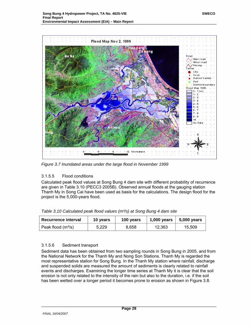
Song Bung 4 Hydropower Project, TA No. 4625-VIE Final Report Environmental Impact Assessment (EIA) – Main Report
SWECO
FINAL 16/04/2007
Page 28
Figure 3.7 Inundated areas under the large flood in November 1999
3.1.5.5 Flood conditions Calculated peak flood values at Song Bung 4 dam site with different probability of recurrence are given in Table 3.10 (PECC3 2005B). Observed annual floods at the gauging station Thanh My in Song Cai have been used as basis for the calculations. The design flood for the project is the 5,000-years flood.
Table 3.10 Calculated peak flood values (m³/s) at Song Bung 4 dam site
Recurrence interval 10 years 100 years 1,000 years 5,000 years
Peak flood (m³/s) 5,229 8,658 12,363 15,509
3.1.5.6 Sediment transport Sediment data has been obtained from two sampling rounds in Song Bung in 2005, and from the National Network for the Thanh My and Nong Son Stations. Thanh My is regarded the most representative station for Song Bung. In the Thanh My station where rainfall, discharge and suspended solids are measured the amount of sediments is clearly related to rainfall events and discharges. Examining the longer time series at Thanh My it is clear that the soil erosion is not only related to the intensity of the rain but also to the duration, i.e. if the soil has been wetted over a longer period it becomes prone to erosion as shown in Figure 3.8.
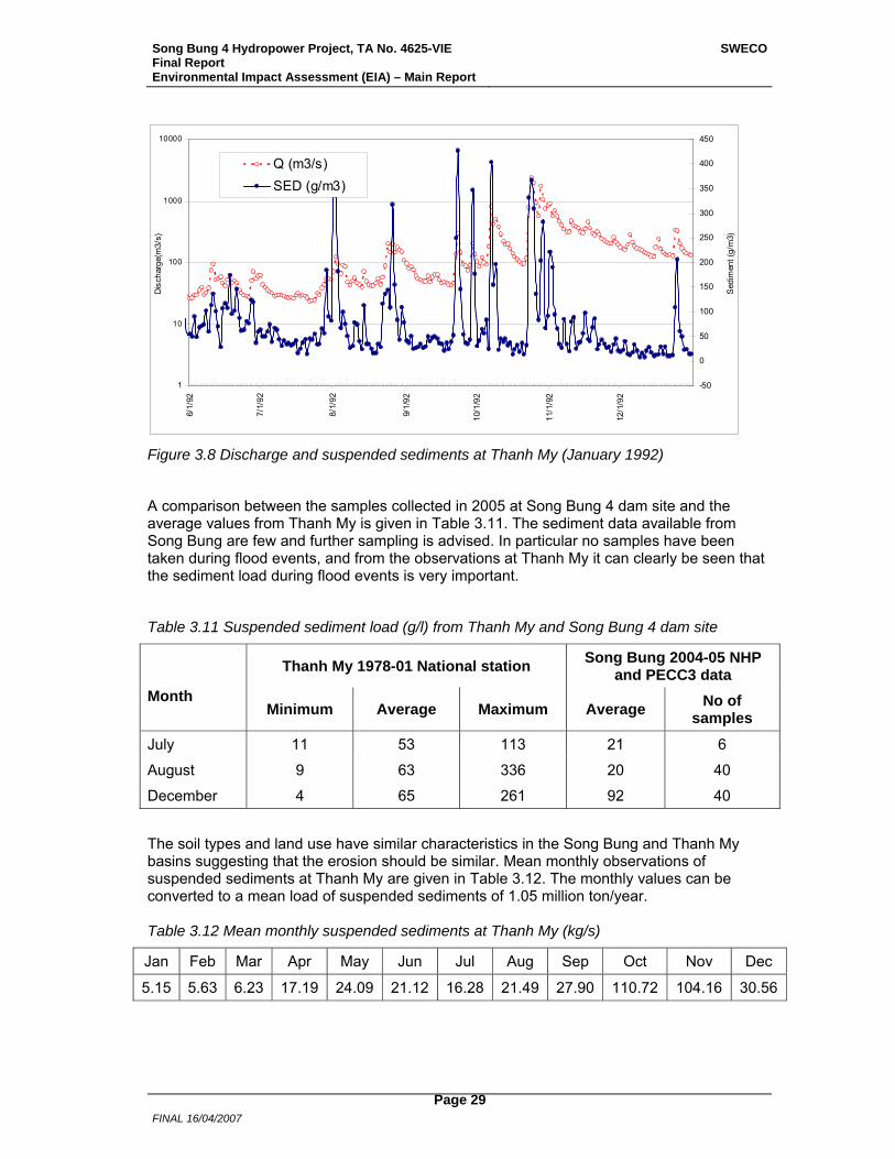
Song Bung 4 Hydropower Project, TA No. 4625-VIE Final Report Environmental Impact Assessment (EIA) – Main Report
SWECO
FINAL 16/04/2007
Page 29
1
10
100
1000
10000
6/1/
92
7/1/
92
8/1/
92
9/1/
92
10/1
/92
11/1
/92
12/1
/92
Dis
char
ge(m
3/s)
-50
0
50
100
150
200
250
300
350
400
450
Sed
imen
t (g/
m3)
Q (m3/s)SED (g/m3)
Figure 3.8 Discharge and suspended sediments at Thanh My (January 1992)
A comparison between the samples collected in 2005 at Song Bung 4 dam site and the average values from Thanh My is given in Table 3.11. The sediment data available from Song Bung are few and further sampling is advised. In particular no samples have been taken during flood events, and from the observations at Thanh My it can clearly be seen that the sediment load during flood events is very important.
Table 3.11 Suspended sediment load (g/l) from Thanh My and Song Bung 4 dam site
Thanh My 1978-01 National station Song Bung 2004-05 NHP and PECC3 data
Month Minimum Average Maximum Average No of
samples
July 11 53 113 21 6
August 9 63 336 20 40
December 4 65 261 92 40
The soil types and land use have similar characteristics in the Song Bung and Thanh My basins suggesting that the erosion should be similar. Mean monthly observations of suspended sediments at Thanh My are given in Table 3.12. The monthly values can be converted to a mean load of suspended sediments of 1.05 million ton/year. Table 3.12 Mean monthly suspended sediments at Thanh My (kg/s)
Jan Feb Mar Apr May Jun Jul Aug Sep Oct Nov Dec
5.15 5.63 6.23 17.19 24.09 21.12 16.28 21.49 27.90 110.72 104.16 30.56
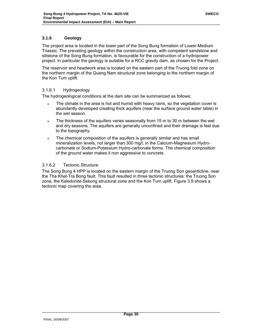
Song Bung 4 Hydropower Project, TA No. 4625-VIE Final Report Environmental Impact Assessment (EIA) – Main Report
SWECO
FINAL 16/04/2007
Page 30
3.1.6 Geology
The project area is located in the lower part of the Song Bung formation of Lower-Medium Triassic. The prevailing geology within the construction area, with competent sandstone and siltstone of the Song Bung formation, is favourable for the construction of a hydropower project. In particular the geology is suitable for a RCC gravity dam, as chosen for the Project.
The reservoir and headwork area is located on the eastern part of the Truong fold zone on the northern margin of the Quang Nam structural zone belonging to the northern margin of the Kon Tum uplift.
3.1.6.1 Hydrogeology The hydrogeological conditions at the dam site can be summarized as follows:
• The climate in the area is hot and humid with heavy rains, so the vegetation cover is abundantly developed creating thick aquifers (near the surface ground water table) in the wet season.
• The thickness of the aquifers varies seasonally from 15 m to 30 m between the wet and dry seasons. The aquifers are generally unconfined and their drainage is fast due to the topography.
• The chemical composition of the aquifers is generally similar and has small mineralization levels, not larger than 300 mg/l, in the Calcium-Magnesium Hydro-carbonate or Sodium-Potassium Hydro-carbonate forms. The chemical composition of the ground water makes it non aggressive to concrete.
3.1.6.2 Tectonic Structure The Song Bung 4 HPP is located on the eastern margin of the Truong Son geoanticline, near the Tha Khet-Tra Bong fault. This fault resulted in three tectonic structures: the Truong Son zone, the Kaledonite-Sekong structural zone and the Kon Tum uplift. Figure 3.9 shows a tectonic map covering the area.
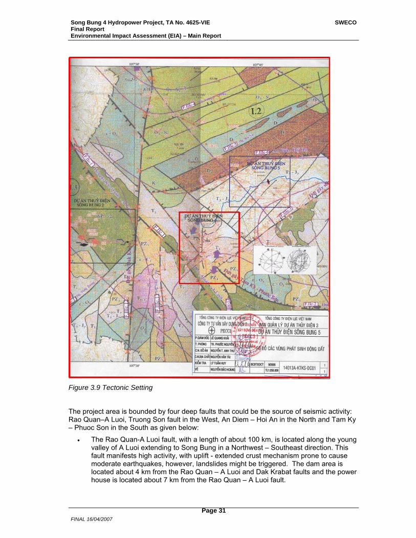
Song Bung 4 Hydropower Project, TA No. 4625-VIE Final Report Environmental Impact Assessment (EIA) – Main Report
SWECO
FINAL 16/04/2007
Page 31
Figure 3.9 Tectonic Setting
The project area is bounded by four deep faults that could be the source of seismic activity: Rao Quan–A Luoi, Truong Son fault in the West, An Diem – Hoi An in the North and Tam Ky – Phuoc Son in the South as given below:
• The Rao Quan-A Luoi fault, with a length of about 100 km, is located along the young valley of A Luoi extending to Song Bung in a Northwest – Southeast direction. This fault manifests high activity, with uplift - extended crust mechanism prone to cause moderate earthquakes, however, landslides might be triggered. The dam area is located about 4 km from the Rao Quan – A Luoi and Dak Krabat faults and the power house is located about 7 km from the Rao Quan – A Luoi fault.
Song Bung 4 Hydropower Project, TA No. 4625-VIE Final Report Environmental Impact Assessment (EIA) – Main Report
SWECO
FINAL 16/04/2007
Page 32
• The Tam Ky – Phuoc Son fault extends along a direction sub parallel to the latitude from Song Bung to Phuoc Hao, striking in a Northwest – Southeast direction and going along the Song Chang valley to the north of Tam Ky township to the Eastern Sea. The total length of the fault zone is more than 125 km. The shortest distance from Song Bung 4 Hydropower Project is about 3 km.
• The An Diem – Hoi An fault extends about 125 km and is characterized by changes in the strike direction. It has a 650 North-eastern strike going through A-So to Tam-Prang. Thereafter the fault changes direction and goes parallel to the latitude to Thanh Den. From Thanh Den to Song Vu Gia, the fault again strikes along a 300 northwestern direction, finally returns and goes parallel to the latitude from Ha Nha through Ai Nghia and out to the Eastern Sea. The depth of the fault is about 30 km.
Within the project area there are several other smaller faults and fractures.
3.1.6.3 Seismicity The earthquake activity in the project area was assessed by Institute of Geophysics in 2004. According to their report three conclusions can be stated: (i) the headworks of the Project are located at a structural zone fairly stable on tectonics and geodynamics, and all tectonic faults passing through the project area manifest low activity; (ii) the geological, tectonic and geodynamic conditions of the project area are feasible for the construction of a hydropower project; and (iii) the middle zone of the central part of Vietnam is located in the stable continental region with low earthquake activity. According to historical records since 1666, only 17 earthquake events with magnitude equal to or greater than M=4.0 (Richter) have occurred, in which the strongest was M=5.7 (Richter) occurring at a distance of about 300 km from the dam site. No earthquakes with a magnitude of M>4 (Richter) have occurred within a radius of 50 km from the Song Bung 4 dam site.
Based on this the Maximum Credible Earthquake (MCE) of this area is found to be M=5.7 (Richter). The dam structure is designed for a MDE (Maximum Design Earthquake) of 0.127g.
3.1.6.4 Reservoir area The rock formations present in the reservoir area are the Nui Vu, Song Bung, An Diem and Ben Giang-Que Son. The oldest formation within the reservoir is the Nui Vu formation consisting of quartz schist. The Song Bung formation comprises bluish grey sandstone inter-bedded with violet-like siltstone. The An Diem formation consists of quartz arkose sandstone and gritstone. The Ben Giang-Que Son formation consists of igneous rock, mainly granodiorite. No limestone formations are present within the reservoir area.
The permeability of eluvial-deluvial and eluvial soils is in the order of 3x10⁻⁶ m/s, in sandy soils 3x10⁻⁴ m/s. The permeability of the fractured rock is in the order of 2x10⁻⁶ m/s. However, some fault zones cut across the reservoir area and might cause zones of higher permeability.
On the left side of the reservoir the valley of A Vuong River is located. The distance to the water divide is between 1 and 5 km. The ground water level at the divide is located between El. 750 m and El. 770 m, thus at a considerably higher elevation than the reservoir.
The valley of Thanh River is located on the right side of the reservoir. The ground water level at the divide is located at an elevation higher than El. 1,000 m, i.e. above the reservoir level.
Leakage from the reservoir is therefore restricted to the abutments and the foundation of the dam where high gradients are present.
Preliminary calculations indicate that the leakage in this area will be in the order of 120
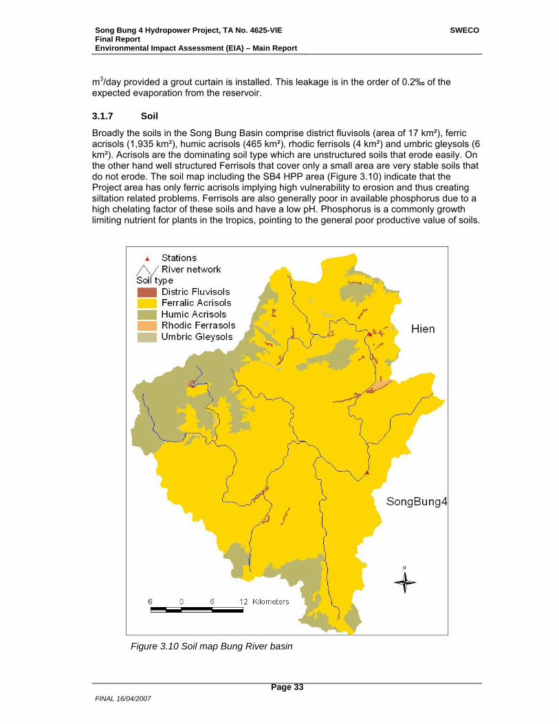
Song Bung 4 Hydropower Project, TA No. 4625-VIE Final Report Environmental Impact Assessment (EIA) – Main Report
SWECO
FINAL 16/04/2007
Page 33
m3/day provided a grout curtain is installed. This leakage is in the order of 0.2‰ of the expected evaporation from the reservoir.
3.1.7 Soil
Broadly the soils in the Song Bung Basin comprise district fluvisols (area of 17 km²), ferric acrisols (1,935 km²), humic acrisols (465 km²), rhodic ferrisols (4 km²) and umbric gleysols (6 km²). Acrisols are the dominating soil type which are unstructured soils that erode easily. On the other hand well structured Ferrisols that cover only a small area are very stable soils that do not erode. The soil map including the SB4 HPP area (Figure 3.10) indicate that the Project area has only ferric acrisols implying high vulnerability to erosion and thus creating siltation related problems. Ferrisols are also generally poor in available phosphorus due to a high chelating factor of these soils and have a low pH. Phosphorus is a commonly growth limiting nutrient for plants in the tropics, pointing to the general poor productive value of soils.
Figure 3.10 Soil map Bung River basin
Song Bung 4 Hydropower Project, TA No. 4625-VIE Final Report Environmental Impact Assessment (EIA) – Main Report
SWECO
FINAL 16/04/2007
Page 34
According to a detailed soil study in Quang Nam Province by the Institute of Planning of the Ministry of Agriculture and Rural in 1978 the following soils were said to occur (PECC3 2005A). The descriptions are based on Vietnamese systems (also used at present) and evaluations provided are also based on the priorities (especially for use) and knowledge in the 1970’s and earlier.
• Yellow red soil on paragơnal rock (Fs): Area covered by this soil is 70,079 ha, it has an ‘average’ surface structure intermixed with rock. Poor in nutrients, desultory structure, and lacks ability to reserve water. This is mostly soil on hills not used fro agriculture.
• Red soil on octagơnal rock (Fa): Area covered by this soil is 61,736 ha, distribution across the terrain, but concentrate in the southwest part of the Province. Average structure with the proportion of rock being 30 – 50 %. Desultory structure, clay level is <30 % and forms a thick layer, >10 cm. This soil has the potential for production forests and agro-forestry.
• Light yellow soil on sand rock (Fq): Area covered by this soil is 34,325 ha, mainly concentrated in the hilly areas of Thanh My town and Ca Dy commune. The soil has a ‘light’ to ‘average’ surface, forming a thick layer, >100 cm, with desultory and exposed rock. Such area is used for forestry purposes, mainly protection forest.
• Light yellow soil on granite rock (Ha): Area covered is 8,066 ha, distributed mainly at northern mountain area of Dac Pree commune.
• Gray soil occurring on sand and open rock (Xa): Area covered by this soil is 3,501 ha and occurs mainly in Dac Pring and La Dee communes. It forms a thick layer of >30 cm, low portion of desultory and exposed rock, and poor of nutrients.
Besides the above main soil types, there are also the following soils: Alluvium soil of rivers and springs (Pb, Py), 589 ha; Black soil carbonate (Rv), 94 ha; Black soil on deposit alluvia products (Rdv), 21 ha; Violet brown soil on violet schist products (Fe), 169 ha: Red brown soil on limestone (Fv), 710 ha; Yellow red humus on clayey rock and degraded areas (Hs), 1.178 ha; Light yellow humus on sand rock (Hq), 1,126 ha; Illuvial soil (D), 43 ha; and Exposed rock and gravel (E), 27 ha.
3.1.8 Mining
The catchment of Song Bung 4 HPP, a total of 1,477 km², is located within 12 communes in the two districts Nam Giang and Tay Giang. In the catchment there are 6 types of mineral resources: gold, both gold in river sediments and gold in the hard rock, copper, pyrite, iron, uranium and mineral water. 36 different localities have been identified within the whole catchment, of which 26 are localities with gold. Gold is the only mineral that, until now, has been exploited. The number of locations for each mineral and exploitation status is summarized in Table 3.13.

Song Bung 4 Hydropower Project, TA No. 4625-VIE Final Report Environmental Impact Assessment (EIA) – Main Report
SWECO
FINAL 16/04/2007
Page 35
Table 3.13 Mineral resources in the catchmnet of Song Bung 4 HPP
Mineral Resource No. of Localities Mining Status
Hard rock gold 3 Under exploitation 2 Unexploited 1
Sediment gold 23 Exploited 5
Under exploitation 10 Unexploited 7
Copper 2 Unexploited Pyrite 1 Unexploited Iron 3 Unexploited
Uranium 1 Unexploited Mineral water 3 Unexploited
Gold exists both in ores in the rock and in the river sediments. Methods to extract the gold are different. In hard rock mining the gold containing rock is taken out from the gold ore usually by blasting. The rock is then crushed and the resulting fine sand is mixed with water. The separation of gold is done using a combination of gravity washing and dissolution with cyanide. The gold in the resulting water-cyanide solution is then precipitated on metal shavings, most commonly used is zinc shavings or zinc powder. Heating separates the metals in the precipitate, as gold and zinc have different melting points. The floating dredging machines dig into the sediments in the riverbank. Gold and finer sand are separated from the riverbank-material through a step-wise process. At the end the remaining material is mixed with mercury and molded in a cloth. The mercury reacts with the gold forming amalgam. The amalgam is then heated and the mercury evaporates, leaving pure gold and some silver. This last heating process is usually not carried out in the field in the catchment of Song Bung 4.
The mineral resources are located in 7 of the 12 communes in the catchment. The localities with gold are located in the communes Lang, Zuoih, Cha Val, P’Ring and Ta B’Hing. Details on location and status of mining activity are given in the map in Figure 3.11 and in Table 3.14.
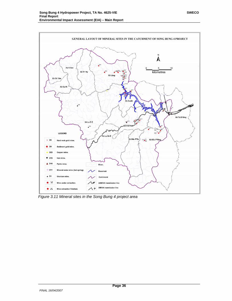
Song Bung 4 Hydropower Project, TA No. 4625-VIE Final Report Environmental Impact Assessment (EIA) – Main Report
SWECO
FINAL 16/04/2007
Page 36
Figure 3.11 Mineral sites in the Song Bung 4 project area
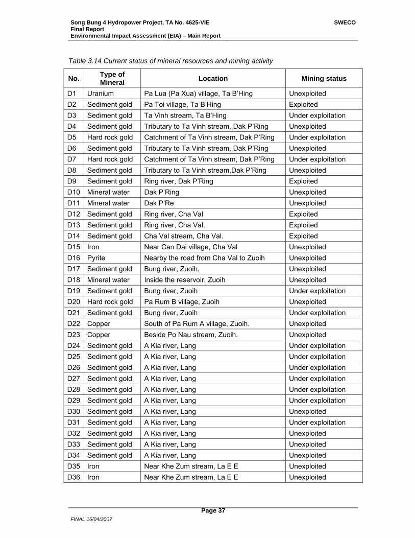
Song Bung 4 Hydropower Project, TA No. 4625-VIE Final Report Environmental Impact Assessment (EIA) – Main Report
SWECO
FINAL 16/04/2007
Page 37
Table 3.14 Current status of mineral resources and mining activity
No. Type of Mineral Location Mining status
D1 Uranium Pa Lua (Pa Xua) village, Ta B’Hing Unexploited D2 Sediment gold Pa Toi village, Ta B’Hing Exploited D3 Sediment gold Ta Vinh stream, Ta B’Hing Under exploitation D4 Sediment gold Tributary to Ta Vinh stream, Dak P’Ring Unexploited D5 Hard rock gold Catchment of Ta Vinh stream, Dak P’Ring Under exploitation D6 Sediment gold Tributary to Ta Vinh stream, Dak P’Ring Unexploited D7 Hard rock gold Catchment of Ta Vinh stream, Dak P’Ring Under exploitation D8 Sediment gold Tributary to Ta Vinh stream,Dak P’Ring Unexploited D9 Sediment gold Ring river, Dak P’Ring Exploited D10 Mineral water Dak P’Ring Unexploited D11 Mineral water Dak P’Re Unexploited D12 Sediment gold Ring river, Cha Val Exploited D13 Sediment gold Ring river, Cha Val. Exploited D14 Sediment gold Cha Val stream, Cha Val. Exploited D15 Iron Near Can Dai village, Cha Val Unexploited D16 Pyrite Nearby the road from Cha Val to Zuoih Unexploited D17 Sediment gold Bung river, Zuoih, Unexploited D18 Mineral water Inside the reservoir, Zuoih Unexploited D19 Sediment gold Bung river, Zuoih Under exploitation D20 Hard rock gold Pa Rum B village, Zuoih Unexploited D21 Sediment gold Bung river, Zuoih Under exploitation D22 Copper South of Pa Rum A village, Zuoih. Unexploited D23 Copper Beside Po Nau stream, Zuoih. Unexploited D24 Sediment gold A Kia river, Lang Under exploitation D25 Sediment gold A Kia river, Lang Under exploitation D26 Sediment gold A Kia river, Lang Under exploitation D27 Sediment gold A Kia river, Lang Under exploitation D28 Sediment gold A Kia river, Lang Under exploitation D29 Sediment gold A Kia river, Lang Under exploitation D30 Sediment gold A Kia river, Lang Unexploited D31 Sediment gold A Kia river, Lang Under exploitation D32 Sediment gold A Kia river, Lang Unexploited D33 Sediment gold A Kia river, Lang Unexploited D34 Sediment gold A Kia river, Lang Unexploited D35 Iron Near Khe Zum stream, La E E Unexploited D36 Iron Near Khe Zum stream, La E E Unexploited
Song Bung 4 Hydropower Project, TA No. 4625-VIE Final Report Environmental Impact Assessment (EIA) – Main Report
SWECO
FINAL 16/04/2007
Page 38
No permits exist for any kind of mining activity in general, and gold extraction in particular, in the catchment today. All ongoing gold mining activity is illegal, but controls of the illegal mining activity are seldom undertaken. Some of the gold mining activity takes place far away from roads and villages, which makes controlling difficult, and the control activity does not seem to have any high priority. Several floating dredging machines are operating in Bung River, near the villages in the upstream part of the planned reservoir.
In two hard rock mines (D5 and D7), located along the upper part of Ta Vinh River south of the reservoir, the number of full-time workers varies from 120 in the dry period of the year to 200 in the wet period. The workers come from other parts of the country. Even though these two mines were said to be under tight control by the border guard force, 120 people worked in the mines when visited during the field survey in February.
Eleven floating dredging machines in Bung River (D19 and D21), within the reservoir area, have a full-time worker population of 65. 80 persons work full-time on 14 floating dredging machines in the tributary A Kia River (D24-D29, D31), located upstream the reservoir, while 6 persons work full-time on one dredge located in Ta Vinh River (D3). The workers mainly come from other regions. On the 11 dredging machines in Bung River some 40 % were working for outside owners, the remaining 60 %, often family members, worked for themselves.
In addition to the organized gold mining activity on the identified localities, people from nearby villages take part in the activity during the driest months of the year. With the use of simple tools, mainly hand pans, they often come in groups of 5 to 15 people to streams with indications of gold in sediments.
The exploitation of the gold mineral resources is expected to continue in the future. For the other mineral resources identified in the catchment, the locality with uranium (D1) seems to be the resource most likely to be exploited. The locality covers about 5 km², and is located very close to Highway 14D.
3.1.9 Water Quality
3.1.9.1 Methods Water Quality and Sediment Sampling Stations Seven stations on the main stream river and 4 stations on the tributaries were sampled. Two of the tributaries were impacted by gold dredging, and some by hard rock mining in the upstream areas. The sampling stations are shown in Figure 3.12. Mercury and heavy metals are often not very soluble in water. They bind to particles and are settling to the bottom. Here they contaminate the sediments. Many of the bottom dwelling animals, like the earthworm, eat the bottom sludge and get heavy metals into their body. The fish eat bottom animals and indirectly get contaminated. Some of the metals are not excreted so easily from the body as they are taken in, and thereby tend to accumulate in the body. This results in that older and larger fish contains more metals than a young fish (called bio-accumulation). Like mercury, which is almost not excreted from the body at all, increases also up through the nutrient chain (called bio-magnification). Therefore, the most important is to look for contamination in large carnivorous fish. The carnivorous fish is often the most popular fish in the diet of people also, because they are large, and good tasting. Three types of samples were examined in respect of mercury and heavy metals: Water samples, Sediment samples and Samples of meat (filets) from large fish (also some small when we were unable to catch large ones).
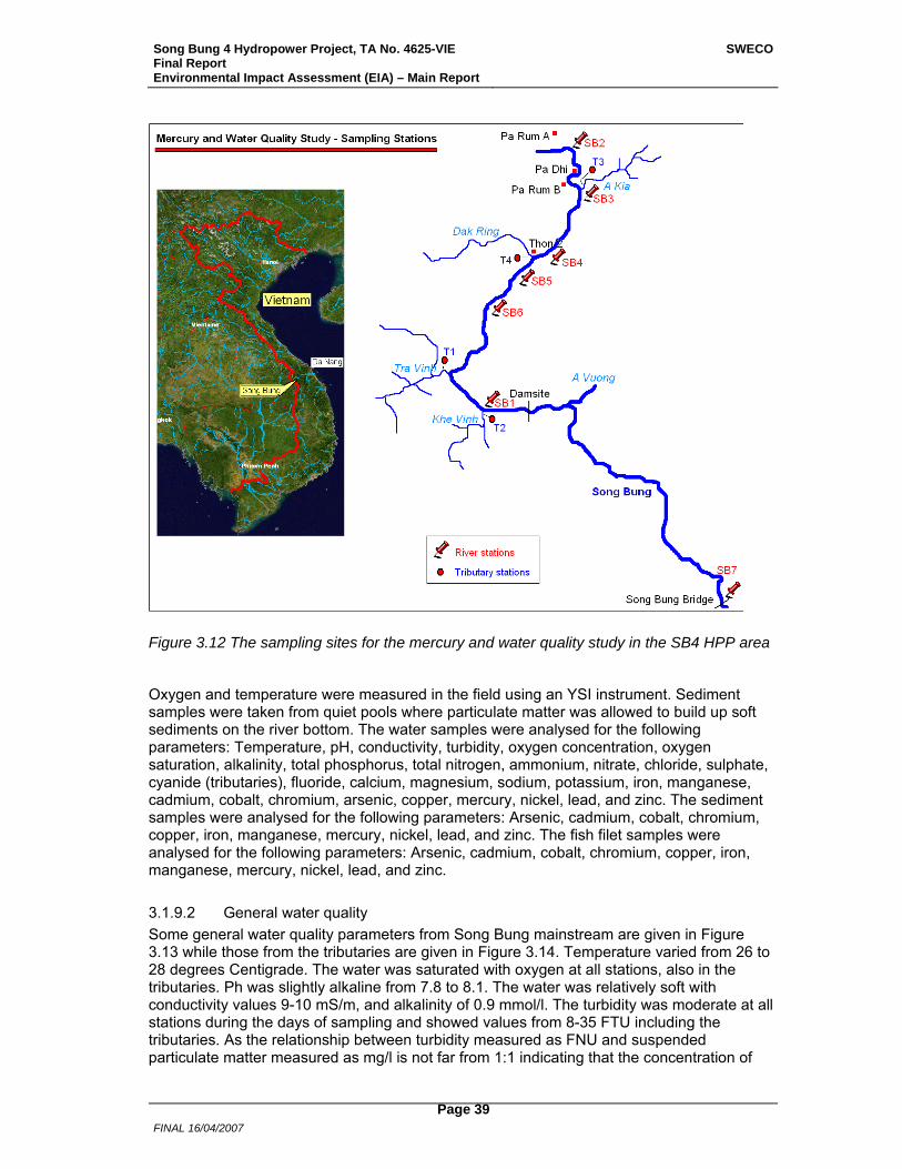
Song Bung 4 Hydropower Project, TA No. 4625-VIE Final Report Environmental Impact Assessment (EIA) – Main Report
SWECO
FINAL 16/04/2007
Page 39
Figure 3.12 The sampling sites for the mercury and water quality study in the SB4 HPP area
Oxygen and temperature were measured in the field using an YSI instrument. Sediment samples were taken from quiet pools where particulate matter was allowed to build up soft sediments on the river bottom. The water samples were analysed for the following parameters: Temperature, pH, conductivity, turbidity, oxygen concentration, oxygen saturation, alkalinity, total phosphorus, total nitrogen, ammonium, nitrate, chloride, sulphate, cyanide (tributaries), fluoride, calcium, magnesium, sodium, potassium, iron, manganese, cadmium, cobalt, chromium, arsenic, copper, mercury, nickel, lead, and zinc. The sediment samples were analysed for the following parameters: Arsenic, cadmium, cobalt, chromium, copper, iron, manganese, mercury, nickel, lead, and zinc. The fish filet samples were analysed for the following parameters: Arsenic, cadmium, cobalt, chromium, copper, iron, manganese, mercury, nickel, lead, and zinc.
3.1.9.2 General water quality Some general water quality parameters from Song Bung mainstream are given in Figure 3.13 while those from the tributaries are given in Figure 3.14. Temperature varied from 26 to 28 degrees Centigrade. The water was saturated with oxygen at all stations, also in the tributaries. Ph was slightly alkaline from 7.8 to 8.1. The water was relatively soft with conductivity values 9-10 mS/m, and alkalinity of 0.9 mmol/l. The turbidity was moderate at all stations during the days of sampling and showed values from 8-35 FTU including the tributaries. As the relationship between turbidity measured as FNU and suspended particulate matter measured as mg/l is not far from 1:1 indicating that the concentration of
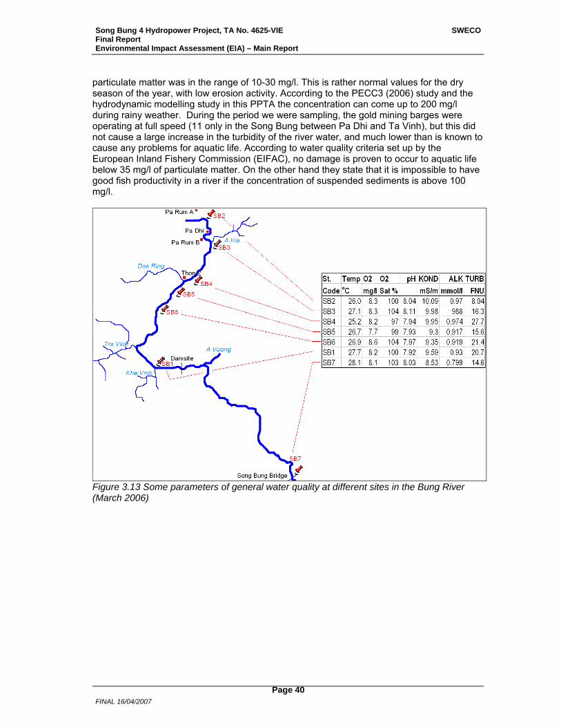
Song Bung 4 Hydropower Project, TA No. 4625-VIE Final Report Environmental Impact Assessment (EIA) – Main Report
SWECO
FINAL 16/04/2007
Page 40
particulate matter was in the range of 10-30 mg/l. This is rather normal values for the dry season of the year, with low erosion activity. According to the PECC3 (2006) study and the hydrodynamic modelling study in this PPTA the concentration can come up to 200 mg/l during rainy weather. During the period we were sampling, the gold mining barges were operating at full speed (11 only in the Song Bung between Pa Dhi and Ta Vinh), but this did not cause a large increase in the turbidity of the river water, and much lower than is known to cause any problems for aquatic life. According to water quality criteria set up by the European Inland Fishery Commission (EIFAC), no damage is proven to occur to aquatic life below 35 mg/l of particulate matter. On the other hand they state that it is impossible to have good fish productivity in a river if the concentration of suspended sediments is above 100 mg/l.
Figure 3.13 Some parameters of general water quality at different sites in the Bung River (March 2006)
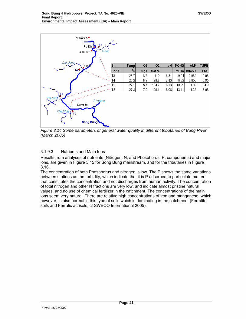
Song Bung 4 Hydropower Project, TA No. 4625-VIE Final Report Environmental Impact Assessment (EIA) – Main Report
SWECO
FINAL 16/04/2007
Page 41
Figure 3.14 Some parameters of general water quality in different tributaries of Bung River (March 2006)
3.1.9.3 Nutrients and Main Ions Results from analyses of nutrients (Nitrogen, N, and Phosphorus, P, components) and major ions, are given in Figure 3.15 for Song Bung mainstream, and for the tributaries in Figure 3.16. The concentration of both Phosphorus and nitrogen is low. The P shows the same variations between stations as the turbidity, which indicate that it is P adsorbed to particulate matter that constitutes the concentration and not discharges from human activity. The concentration of total nitrogen and other N fractions are very low, and indicate almost pristine natural values, and no use of chemical fertilizer in the catchment. The concentrations of the main ions seem very natural. There are relative high concentrations of iron and manganese, which however, is also normal in this type of soils which is dominating in the catchment (Ferralite soils and Ferralic acrisols, cf SWECO International 2005).
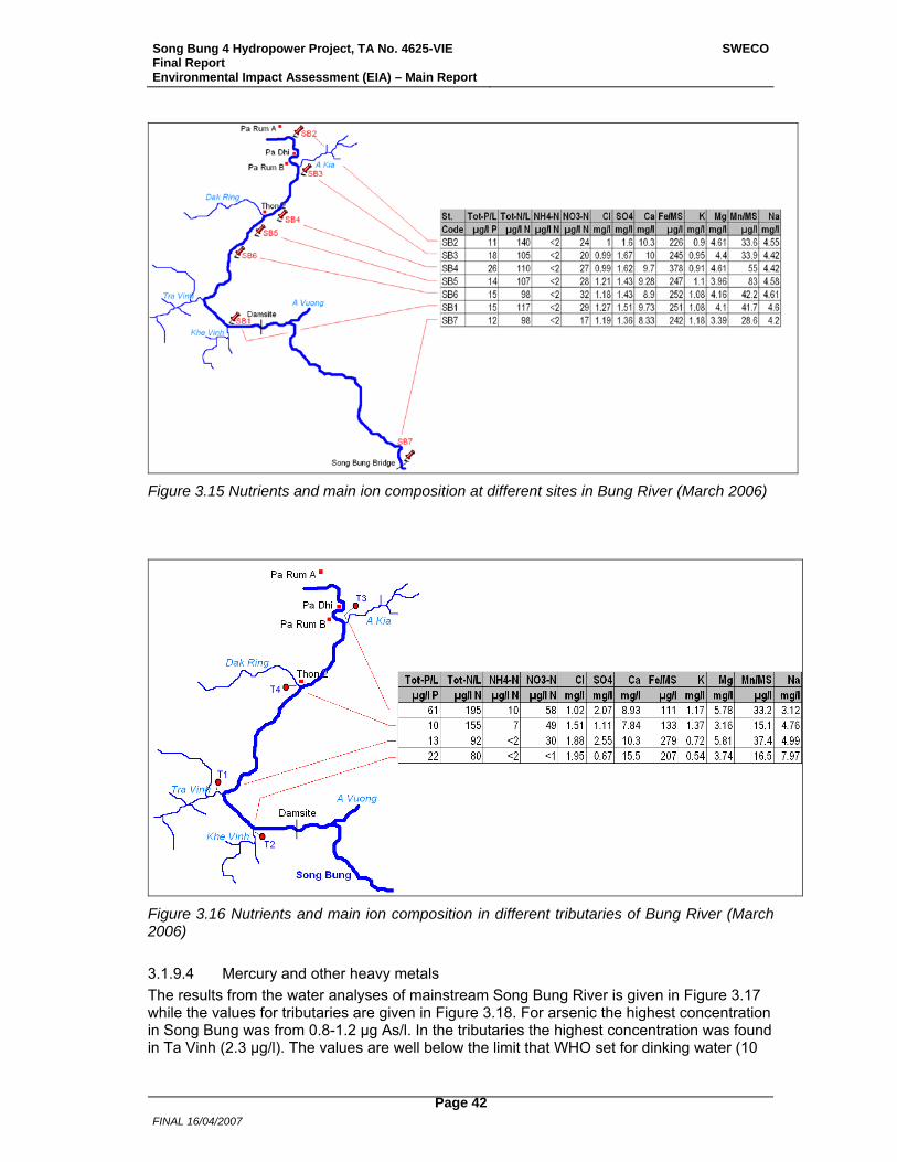
Song Bung 4 Hydropower Project, TA No. 4625-VIE Final Report Environmental Impact Assessment (EIA) – Main Report
SWECO
FINAL 16/04/2007
Page 42
Figure 3.15 Nutrients and main ion composition at different sites in Bung River (March 2006)
Figure 3.16 Nutrients and main ion composition in different tributaries of Bung River (March 2006)
3.1.9.4 Mercury and other heavy metals The results from the water analyses of mainstream Song Bung River is given in Figure 3.17 while the values for tributaries are given in Figure 3.18. For arsenic the highest concentration in Song Bung was from 0.8-1.2 µg As/l. In the tributaries the highest concentration was found in Ta Vinh (2.3 µg/l). The values are well below the limit that WHO set for dinking water (10
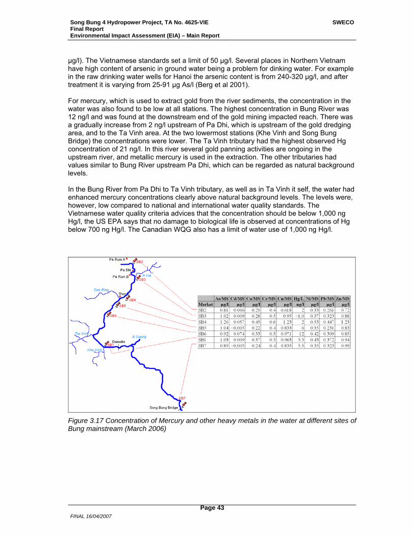
Song Bung 4 Hydropower Project, TA No. 4625-VIE Final Report Environmental Impact Assessment (EIA) – Main Report
SWECO
FINAL 16/04/2007
Page 43
µg/l). The Vietnamese standards set a limit of 50 µg/l. Several places in Northern Vietnam have high content of arsenic in ground water being a problem for dinking water. For example in the raw drinking water wells for Hanoi the arsenic content is from 240-320 µg/l, and after treatment it is varying from 25-91 µg As/l (Berg et al 2001). For mercury, which is used to extract gold from the river sediments, the concentration in the water was also found to be low at all stations. The highest concentration in Bung River was 12 ng/l and was found at the downstream end of the gold mining impacted reach. There was a gradually increase from 2 ng/l upstream of Pa Dhi, which is upstream of the gold dredging area, and to the Ta Vinh area. At the two lowermost stations (Khe Vinh and Song Bung Bridge) the concentrations were lower. The Ta Vinh tributary had the highest observed Hg concentration of 21 ng/l. In this river several gold panning activities are ongoing in the upstream river, and metallic mercury is used in the extraction. The other tributaries had values similar to Bung River upstream Pa Dhi, which can be regarded as natural background levels. In the Bung River from Pa Dhi to Ta Vinh tributary, as well as in Ta Vinh it self, the water had enhanced mercury concentrations clearly above natural background levels. The levels were, however, low compared to national and international water quality standards. The Vietnamese water quality criteria advices that the concentration should be below 1,000 ng Hg/l, the US EPA says that no damage to biological life is observed at concentrations of Hg below 700 ng Hg/l. The Canadian WQG also has a limit of water use of 1,000 ng Hg/l.
Figure 3.17 Concentration of Mercury and other heavy metals in the water at different sites of Bung mainstream (March 2006)
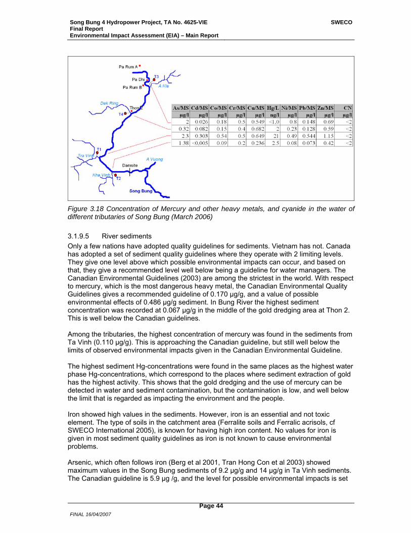
Song Bung 4 Hydropower Project, TA No. 4625-VIE Final Report Environmental Impact Assessment (EIA) – Main Report
SWECO
FINAL 16/04/2007
Page 44
Figure 3.18 Concentration of Mercury and other heavy metals, and cyanide in the water of different tributaries of Song Bung (March 2006)
3.1.9.5 River sediments Only a few nations have adopted quality guidelines for sediments. Vietnam has not. Canada has adopted a set of sediment quality guidelines where they operate with 2 limiting levels. They give one level above which possible environmental impacts can occur, and based on that, they give a recommended level well below being a guideline for water managers. The Canadian Environmental Guidelines (2003) are among the strictest in the world. With respect to mercury, which is the most dangerous heavy metal, the Canadian Environmental Quality Guidelines gives a recommended guideline of 0.170 µg/g, and a value of possible environmental effects of 0.486 µg/g sediment. In Bung River the highest sediment concentration was recorded at 0.067 µg/g in the middle of the gold dredging area at Thon 2. This is well below the Canadian guidelines. Among the tributaries, the highest concentration of mercury was found in the sediments from Ta Vinh (0.110 µg/g). This is approaching the Canadian guideline, but still well below the limits of observed environmental impacts given in the Canadian Environmental Guideline. The highest sediment Hg-concentrations were found in the same places as the highest water phase Hg-concentrations, which correspond to the places where sediment extraction of gold has the highest activity. This shows that the gold dredging and the use of mercury can be detected in water and sediment contamination, but the contamination is low, and well below the limit that is regarded as impacting the environment and the people. Iron showed high values in the sediments. However, iron is an essential and not toxic element. The type of soils in the catchment area (Ferralite soils and Ferralic acrisols, cf SWECO International 2005), is known for having high iron content. No values for iron is given in most sediment quality guidelines as iron is not known to cause environmental problems. Arsenic, which often follows iron (Berg et al 2001, Tran Hong Con et al 2003) showed maximum values in the Song Bung sediments of 9.2 µg/g and 14 µg/g in Ta Vinh sediments. The Canadian guideline is 5.9 µg /g, and the level for possible environmental impacts is set
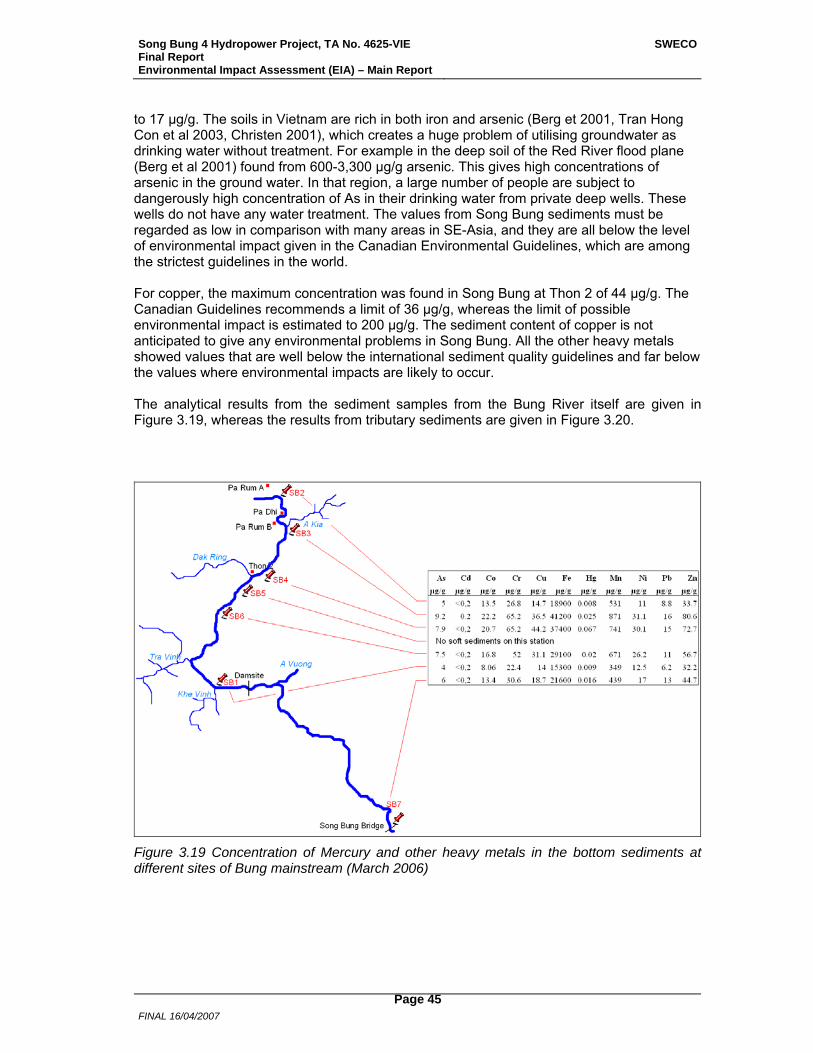
Song Bung 4 Hydropower Project, TA No. 4625-VIE Final Report Environmental Impact Assessment (EIA) – Main Report
SWECO
FINAL 16/04/2007
Page 45
to 17 µg/g. The soils in Vietnam are rich in both iron and arsenic (Berg et 2001, Tran Hong Con et al 2003, Christen 2001), which creates a huge problem of utilising groundwater as drinking water without treatment. For example in the deep soil of the Red River flood plane (Berg et al 2001) found from 600-3,300 µg/g arsenic. This gives high concentrations of arsenic in the ground water. In that region, a large number of people are subject to dangerously high concentration of As in their drinking water from private deep wells. These wells do not have any water treatment. The values from Song Bung sediments must be regarded as low in comparison with many areas in SE-Asia, and they are all below the level of environmental impact given in the Canadian Environmental Guidelines, which are among the strictest guidelines in the world. For copper, the maximum concentration was found in Song Bung at Thon 2 of 44 µg/g. The Canadian Guidelines recommends a limit of 36 µg/g, whereas the limit of possible environmental impact is estimated to 200 µg/g. The sediment content of copper is not anticipated to give any environmental problems in Song Bung. All the other heavy metals showed values that are well below the international sediment quality guidelines and far below the values where environmental impacts are likely to occur. The analytical results from the sediment samples from the Bung River itself are given in Figure 3.19, whereas the results from tributary sediments are given in Figure 3.20.
Figure 3.19 Concentration of Mercury and other heavy metals in the bottom sediments at different sites of Bung mainstream (March 2006)
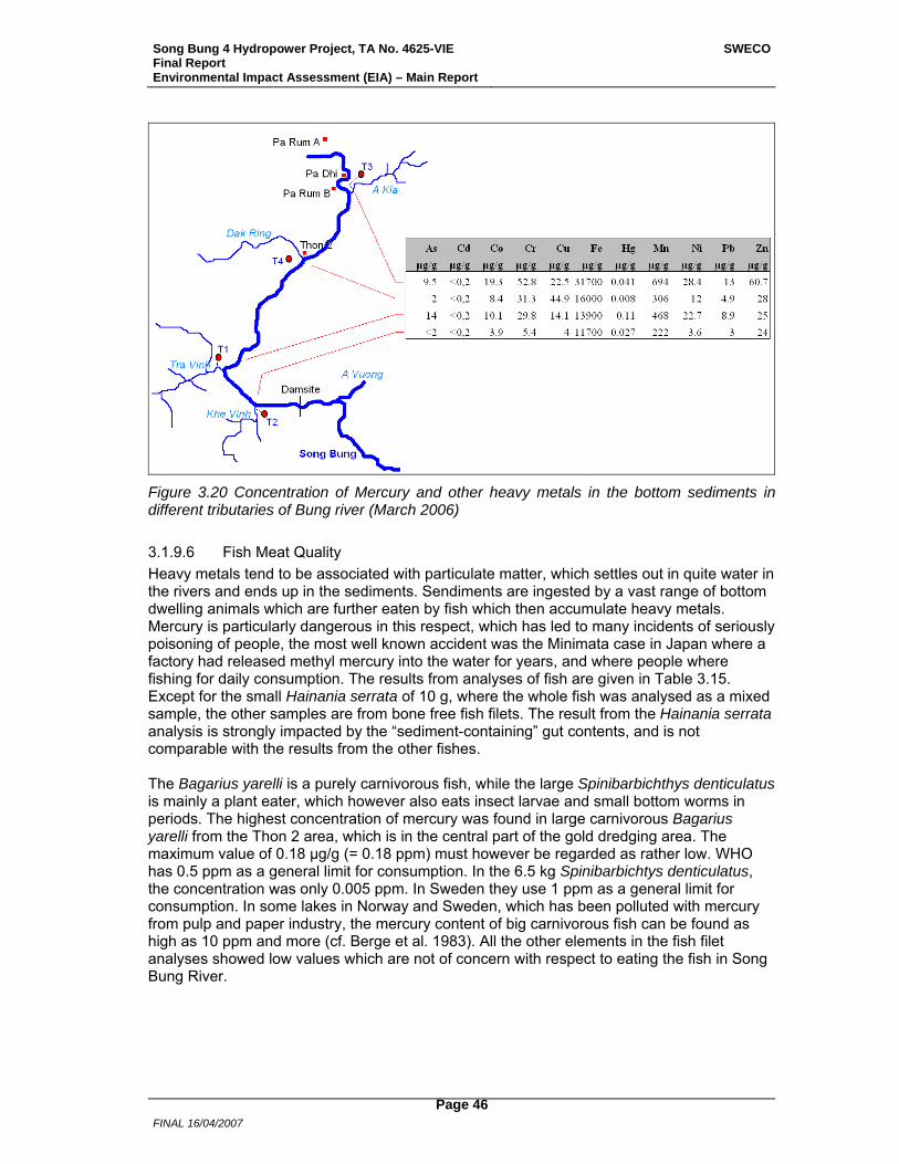
Song Bung 4 Hydropower Project, TA No. 4625-VIE Final Report Environmental Impact Assessment (EIA) – Main Report
SWECO
FINAL 16/04/2007
Page 46
Figure 3.20 Concentration of Mercury and other heavy metals in the bottom sediments in different tributaries of Bung river (March 2006)
3.1.9.6 Fish Meat Quality Heavy metals tend to be associated with particulate matter, which settles out in quite water in the rivers and ends up in the sediments. Sendiments are ingested by a vast range of bottom dwelling animals which are further eaten by fish which then accumulate heavy metals. Mercury is particularly dangerous in this respect, which has led to many incidents of seriously poisoning of people, the most well known accident was the Minimata case in Japan where a factory had released methyl mercury into the water for years, and where people where fishing for daily consumption. The results from analyses of fish are given in Table 3.15. Except for the small Hainania serrata of 10 g, where the whole fish was analysed as a mixed sample, the other samples are from bone free fish filets. The result from the Hainania serrata analysis is strongly impacted by the “sediment-containing” gut contents, and is not comparable with the results from the other fishes. The Bagarius yarelli is a purely carnivorous fish, while the large Spinibarbichthys denticulatus is mainly a plant eater, which however also eats insect larvae and small bottom worms in periods. The highest concentration of mercury was found in large carnivorous Bagarius yarelli from the Thon 2 area, which is in the central part of the gold dredging area. The maximum value of 0.18 µg/g (= 0.18 ppm) must however be regarded as rather low. WHO has 0.5 ppm as a general limit for consumption. In the 6.5 kg Spinibarbichtys denticulatus, the concentration was only 0.005 ppm. In Sweden they use 1 ppm as a general limit for consumption. In some lakes in Norway and Sweden, which has been polluted with mercury from pulp and paper industry, the mercury content of big carnivorous fish can be found as high as 10 ppm and more (cf. Berge et al. 1983). All the other elements in the fish filet analyses showed low values which are not of concern with respect to eating the fish in Song Bung River.
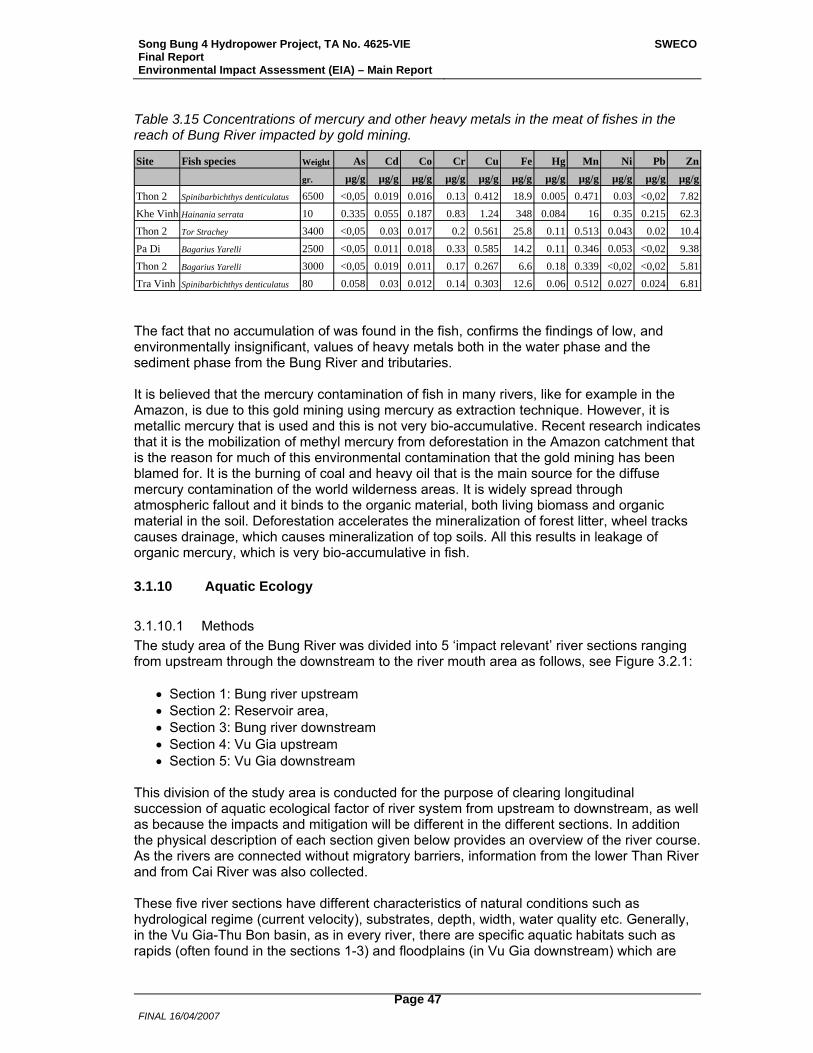
Song Bung 4 Hydropower Project, TA No. 4625-VIE Final Report Environmental Impact Assessment (EIA) – Main Report
SWECO
FINAL 16/04/2007
Page 47
Table 3.15 Concentrations of mercury and other heavy metals in the meat of fishes in the reach of Bung River impacted by gold mining.
Site Fish species Weight As Cd Co Cr Cu Fe Hg Mn Ni Pb Zn
gr. µg/g µg/g µg/g µg/g µg/g µg/g µg/g µg/g µg/g µg/g µg/gThon 2 Spinibarbichthys denticulatus 6500 <0,05 0.019 0.016 0.13 0.412 18.9 0.005 0.471 0.03 <0,02 7.82Khe Vinh Hainania serrata 10 0.335 0.055 0.187 0.83 1.24 348 0.084 16 0.35 0.215 62.3Thon 2 Tor Strachey 3400 <0,05 0.03 0.017 0.2 0.561 25.8 0.11 0.513 0.043 0.02 10.4Pa Di Bagarius Yarelli 2500 <0,05 0.011 0.018 0.33 0.585 14.2 0.11 0.346 0.053 <0,02 9.38Thon 2 Bagarius Yarelli 3000 <0,05 0.019 0.011 0.17 0.267 6.6 0.18 0.339 <0,02 <0,02 5.81Tra Vinh Spinibarbichthys denticulatus 80 0.058 0.03 0.012 0.14 0.303 12.6 0.06 0.512 0.027 0.024 6.81 The fact that no accumulation of was found in the fish, confirms the findings of low, and environmentally insignificant, values of heavy metals both in the water phase and the sediment phase from the Bung River and tributaries. It is believed that the mercury contamination of fish in many rivers, like for example in the Amazon, is due to this gold mining using mercury as extraction technique. However, it is metallic mercury that is used and this is not very bio-accumulative. Recent research indicates that it is the mobilization of methyl mercury from deforestation in the Amazon catchment that is the reason for much of this environmental contamination that the gold mining has been blamed for. It is the burning of coal and heavy oil that is the main source for the diffuse mercury contamination of the world wilderness areas. It is widely spread through atmospheric fallout and it binds to the organic material, both living biomass and organic material in the soil. Deforestation accelerates the mineralization of forest litter, wheel tracks causes drainage, which causes mineralization of top soils. All this results in leakage of organic mercury, which is very bio-accumulative in fish.
3.1.10 Aquatic Ecology
3.1.10.1 Methods The study area of the Bung River was divided into 5 ‘impact relevant’ river sections ranging from upstream through the downstream to the river mouth area as follows, see Figure 3.2.1:
• Section 1: Bung river upstream • Section 2: Reservoir area, • Section 3: Bung river downstream • Section 4: Vu Gia upstream • Section 5: Vu Gia downstream
This division of the study area is conducted for the purpose of clearing longitudinal succession of aquatic ecological factor of river system from upstream to downstream, as well as because the impacts and mitigation will be different in the different sections. In addition the physical description of each section given below provides an overview of the river course. As the rivers are connected without migratory barriers, information from the lower Than River and from Cai River was also collected. These five river sections have different characteristics of natural conditions such as hydrological regime (current velocity), substrates, depth, width, water quality etc. Generally, in the Vu Gia-Thu Bon basin, as in every river, there are specific aquatic habitats such as rapids (often found in the sections 1-3) and floodplains (in Vu Gia downstream) which are
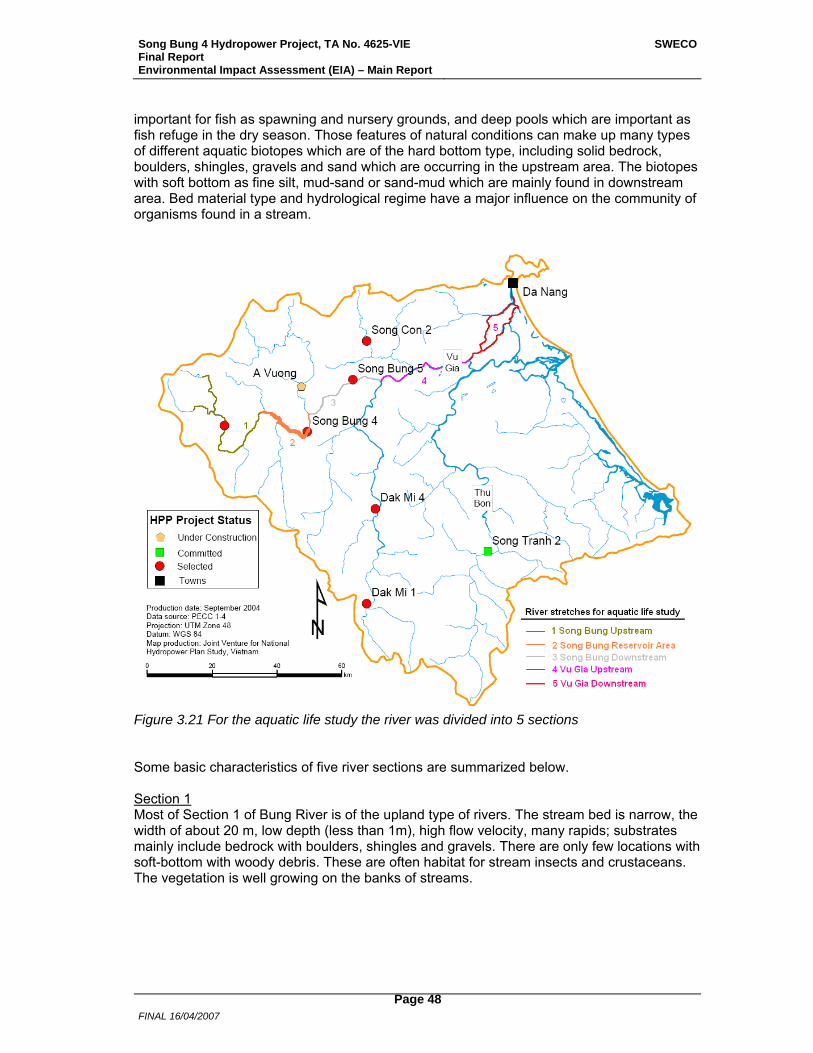
Song Bung 4 Hydropower Project, TA No. 4625-VIE Final Report Environmental Impact Assessment (EIA) – Main Report
SWECO
FINAL 16/04/2007
Page 48
important for fish as spawning and nursery grounds, and deep pools which are important as fish refuge in the dry season. Those features of natural conditions can make up many types of different aquatic biotopes which are of the hard bottom type, including solid bedrock, boulders, shingles, gravels and sand which are occurring in the upstream area. The biotopes with soft bottom as fine silt, mud-sand or sand-mud which are mainly found in downstream area. Bed material type and hydrological regime have a major influence on the community of organisms found in a stream.
Figure 3.21 For the aquatic life study the river was divided into 5 sections Some basic characteristics of five river sections are summarized below. Section 1 Most of Section 1 of Bung River is of the upland type of rivers. The stream bed is narrow, the width of about 20 m, low depth (less than 1m), high flow velocity, many rapids; substrates mainly include bedrock with boulders, shingles and gravels. There are only few locations with soft-bottom with woody debris. These are often habitat for stream insects and crustaceans. The vegetation is well growing on the banks of streams.
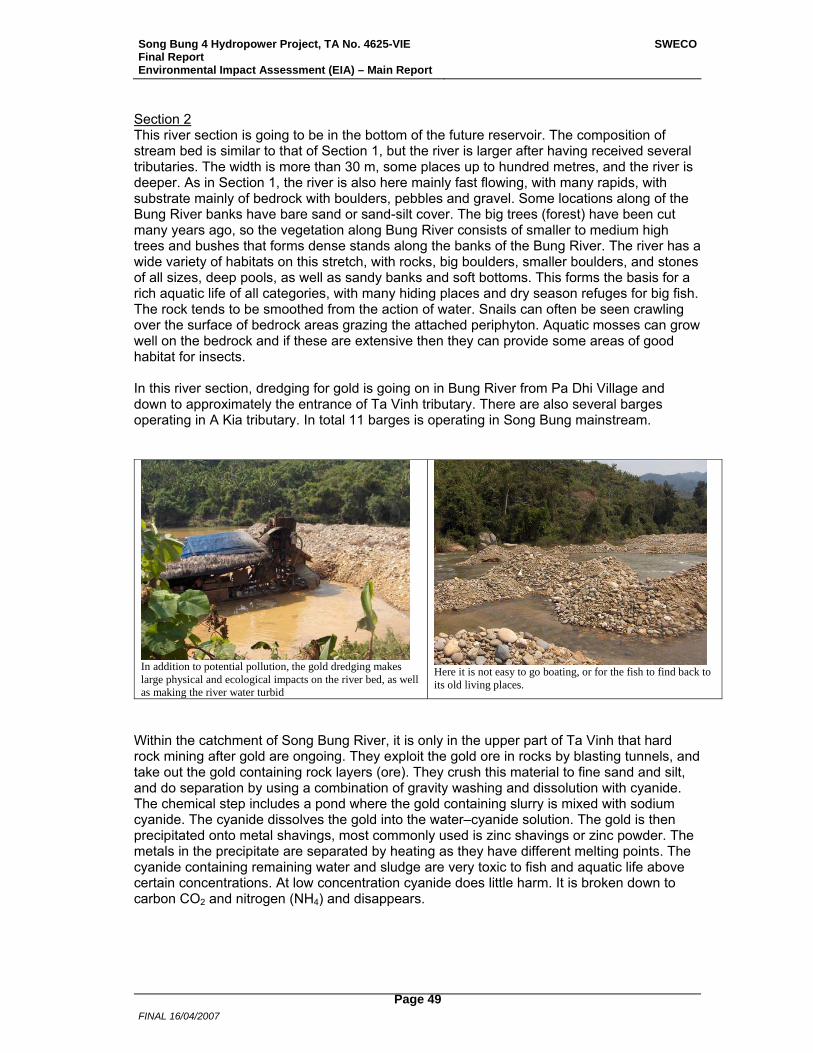
Song Bung 4 Hydropower Project, TA No. 4625-VIE Final Report Environmental Impact Assessment (EIA) – Main Report
SWECO
FINAL 16/04/2007
Page 49
Section 2 This river section is going to be in the bottom of the future reservoir. The composition of stream bed is similar to that of Section 1, but the river is larger after having received several tributaries. The width is more than 30 m, some places up to hundred metres, and the river is deeper. As in Section 1, the river is also here mainly fast flowing, with many rapids, with substrate mainly of bedrock with boulders, pebbles and gravel. Some locations along of the Bung River banks have bare sand or sand-silt cover. The big trees (forest) have been cut many years ago, so the vegetation along Bung River consists of smaller to medium high trees and bushes that forms dense stands along the banks of the Bung River. The river has a wide variety of habitats on this stretch, with rocks, big boulders, smaller boulders, and stones of all sizes, deep pools, as well as sandy banks and soft bottoms. This forms the basis for a rich aquatic life of all categories, with many hiding places and dry season refuges for big fish. The rock tends to be smoothed from the action of water. Snails can often be seen crawling over the surface of bedrock areas grazing the attached periphyton. Aquatic mosses can grow well on the bedrock and if these are extensive then they can provide some areas of good habitat for insects. In this river section, dredging for gold is going on in Bung River from Pa Dhi Village and down to approximately the entrance of Ta Vinh tributary. There are also several barges operating in A Kia tributary. In total 11 barges is operating in Song Bung mainstream.
In addition to potential pollution, the gold dredging makes large physical and ecological impacts on the river bed, as well as making the river water turbid
Here it is not easy to go boating, or for the fish to find back to its old living places.
Within the catchment of Song Bung River, it is only in the upper part of Ta Vinh that hard rock mining after gold are ongoing. They exploit the gold ore in rocks by blasting tunnels, and take out the gold containing rock layers (ore). They crush this material to fine sand and silt, and do separation by using a combination of gravity washing and dissolution with cyanide. The chemical step includes a pond where the gold containing slurry is mixed with sodium cyanide. The cyanide dissolves the gold into the water–cyanide solution. The gold is then precipitated onto metal shavings, most commonly used is zinc shavings or zinc powder. The metals in the precipitate are separated by heating as they have different melting points. The cyanide containing remaining water and sludge are very toxic to fish and aquatic life above certain concentrations. At low concentration cyanide does little harm. It is broken down to carbon CO2 and nitrogen (NH4) and disappears.
Song Bung 4 Hydropower Project, TA No. 4625-VIE Final Report Environmental Impact Assessment (EIA) – Main Report
SWECO
FINAL 16/04/2007
Page 50
Section 3 This is the section from the dam and down to the confluence with Song Cai. The stream bed of this river section is similar with that of Section 2 described above. The A Vuong tributary enters the river on this stretch. This tributary is now being developed for hydropower, so the original river will soon be dry, and the water will enter the Song Bung 7-8 km downstream of Song Bung 4 dam. Section 4 Downstream of the confluence of Song Bung and Song Cai, the river is called Vu Gia all the way to the sea. This river section comprises the reach from upstream to midstream of Vu Gia River where the river is connected with Thu Bon River via a transverse canal. The river bed is large, the width can reach more than 200 m, the river is deep and the current velocity is moderate. A range of materials make up the river bed, from small gravels, sand through to sand-mud, and mud-sand. The land bordering the river consists to a large part of lowland alluvial deposits on which there are cultivated corn-fields and rice-fields. In the junction there are flood plains which are important spawning and nursery areas for many fish species of Bung River. Section 5 Section 5 is Vu Gia downstream of the confluence with Thu Bon River and down to the outlet at the sea. The river bed is moderately large, current velocity is lower, transparency is higher, and water colour is green or dark green. Bottom substrates are made up by soft materials such as fine silt, mud-sand and sand-mud. Biology sampling stations In each section of the river described above there were several locations (sampling stations) from where biological samples were collected and fishermen interviewed. The number of sampling stations in each river section were:
• Section 1: 3 representative stations (2 stations were in tributaries to Bung River and 1 station in the main river) for collection of hydro-biological samples (aquatic primary and secondary producers);
• Section 2: 3 stations (2 stations in the Bung River itself and 1 station in a tributary); • Section 3: 2 stations; • Section 4: 3 stations • Section 5: 4 stations.
The sampling stations are shown on the map in Figure 3.22. Prior to the study associated with SB4 HPP no biological studies in Song Bung, except for a few samplings during the National Hydropower Plan, had been conducted. The knowledge of the aquatic life in the river was very poor, and almost no information existed on fish. During February 2006 a survey of aquatic ecology in Vu Gia – Song Bung was conducted as part of this EIA, which included sampling of all main biological groups, phytoplankton, periphyton, zooplankton, bottom dwelling animals (e.g., insect larvae, crustaceans, snails, bivalvia, oligochaeta) and fish. For the lower groups the survey undertook practical sampling, whereas for fish the study was mainly based on interviews with fishermen and local residents who use fish daily. A photo-album, with fish species likely to be present, was used to correctly identify species from the interviews. Some test fishing was also performed in tributary junctions to sample smaller fish species which the fishermen were not so concerned about.
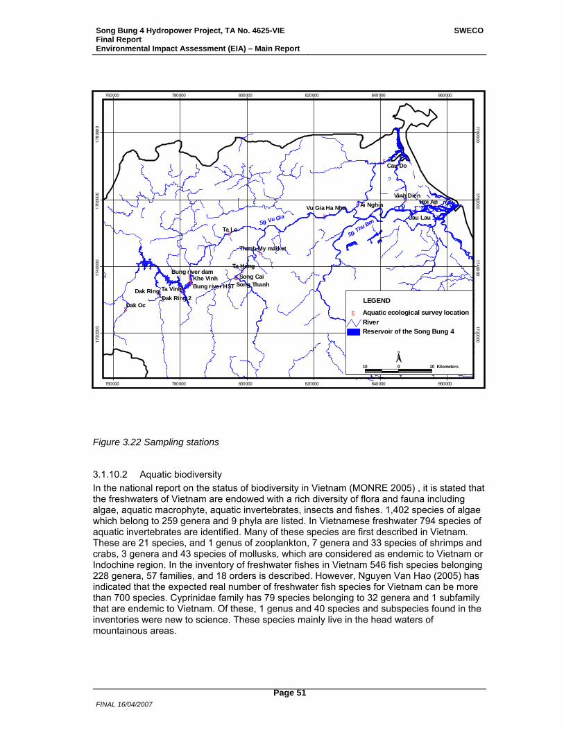
Song Bung 4 Hydropower Project, TA No. 4625-VIE Final Report Environmental Impact Assessment (EIA) – Main Report
SWECO
FINAL 16/04/2007
Page 51
$
$$ $$$$
$
$$$
$
$
$$
$
$
$
Ta Lo
Dak Oc
Hoi An
Cau Do
Ta Vinh
Ta Hong
Cau Lau
Dak Ring
Khe Vinh Song Cai
Ai NghiaVinh Dien
Dak Ring 2
Vu Gia Ha Nha
Bung river dam
Thanh My market
Song ThanhBung river HST
Sg. Vu Gia
Sg. Thu Bon
760000
760000
780000
780000
800000
800000
820000
820000
840000
840000
860000
860000
1720
000 1720000
1740
000 1740000
1760
000 1760000
1780
000 1780000
Reservoir of the Song Bung 4River
$ Aquatic ecological survey location
LEGEND
10 0 10 Kilometers
N
Figure 3.22 Sampling stations
3.1.10.2 Aquatic biodiversity In the national report on the status of biodiversity in Vietnam (MONRE 2005) , it is stated that the freshwaters of Vietnam are endowed with a rich diversity of flora and fauna including algae, aquatic macrophyte, aquatic invertebrates, insects and fishes. 1,402 species of algae which belong to 259 genera and 9 phyla are listed. In Vietnamese freshwater 794 species of aquatic invertebrates are identified. Many of these species are first described in Vietnam. These are 21 species, and 1 genus of zooplankton, 7 genera and 33 species of shrimps and crabs, 3 genera and 43 species of mollusks, which are considered as endemic to Vietnam or Indochine region. In the inventory of freshwater fishes in Vietnam 546 fish species belonging 228 genera, 57 families, and 18 orders is described. However, Nguyen Van Hao (2005) has indicated that the expected real number of freshwater fish species for Vietnam can be more than 700 species. Cyprinidae family has 79 species belonging to 32 genera and 1 subfamily that are endemic to Vietnam. Of these, 1 genus and 40 species and subspecies found in the inventories were new to science. These species mainly live in the head waters of mountainous areas.
Song Bung 4 Hydropower Project, TA No. 4625-VIE Final Report Environmental Impact Assessment (EIA) – Main Report
SWECO
FINAL 16/04/2007
Page 52
Aquatic biodiversity in the Vu Gia River system Little information existed on fish fauna in the Vu Gia River system prior to this study. Previous surveys are conducted only in some tributaries belonging to Vu Gia river system such as Thu Bon River (Nguyen Huu Duc, 1995), Tranh River (Nguyen Xuan Huan 1999) and A Vuong River (Ho Thanh Hai et al., 2003). Nguyen Huu Duc (1995) identified 85 species of fish occurring in the Thu Bon River. Kottelat (1994); H.H.Ng and J. Freyhof (2001); Freyhof and Serov (2001) identified 34 fish species in the Tranh River (tributary of Vu Gia-Thu Bon river system). In the report of the co-operative survey on fish between IEBR and the American Natural History Museum (USA) that was carried out from 29 March to 4 April 1999, Nguyen Xuan Huan et al., identified 53 species of fish belonging to 10 families occurring in the Tranh River (Tra My district). Nguyen Huu Duc (1995) in the survey on fish fauna of Central Vietnam recorded 85 species of fish in Thu Bon River. There also exists information on other trophic levels of aquatic ecology in the Vu Gia-Thu Bon river system. In the report on aquatic life of the A Vuong River, Ho Thanh Hai et al., (2003) identified 12 species of phytoplankton, 14 species of zooplankton, 10 zoobenthic species and 21 fish species. In the report on aquatic life of the Bung River conducted by Le Trinh et al., (2005), 54 species of phytoplankton, 21 species of zooplankton, 24 zoobenthic species were recorded. The fish survey conducted for this EIA involved analysis of fish samples collected from Bung River, and interviewing riparian residents along the Vu Gia river system both upstream and downstream. This survey identified 107 fish species belonging to 31 families and 9 orders occurring in the Vu Gia river system. In comparison with previous research results on freshwater fish fauna in Central Vietnam of Nguyen Huu Duc (1995) and Nguyen Thi Thu He (2000), the number of fish species of Vu Gia river system is much higher than other rivers of Central Vietnam (Ve river-34 fish species, Con river-43 species, Ba river- 50 species). The aquatic survey in this Study identified 78 phytoplankton species belonging to 26 families, 45 algal species and 4 moss species in the periphyton community; 40 species of zooplankton belonging to 15 families; 48 zoo-benthic taxa. Among them, some species of shrimps are not yet identified and may be new species to science. The actual number of aquatic species of Vu Gia-Thu Bon river system are surely larger that what has been revealed through this study. Only exhaustive surveys covering all seasons will be able to properly address the question of aquatic life diversity. Phytoplankton 78 phytoplankton species belonging to 26 families which included phyla of Bacillariophyta, Chlorophyta, Cyanobacteria, Pyrophyta, Xanthophyta and Euglenophyta were recorded. Among them, Bacillariophyta had 33 species, which dominated the species composition (42.3%) of the phytoplankton community. The density of phytoplankton in the Bung River and Vu Gia River is generally low, ranging approximately from 2,000-9,000 cell/l. The density and biomass of phytoplankton is lower in Bung upstream as compared to Vu Gia downstream. The density distribution among species is different in each river section. In Sections 1, 2, 3 and 4, several genera of Bacillariophyta phylum (Melosira, Diatoma, Fragillaria, Synedra) often dominated in density of the phytoplankton community. Chlorophyta was the dominating group in Section 5. In terms of biomass composition, multi-cell algae of genera Oscillatoria, Lyngbia (Cyanobacteria) and Spyrogyra (Chlorophyta) take the dominance in biomass of phytoplankton. However, the abundant species are always changed by time and along the river.
Song Bung 4 Hydropower Project, TA No. 4625-VIE Final Report Environmental Impact Assessment (EIA) – Main Report
SWECO
FINAL 16/04/2007
Page 53
Periphyton Species composition in periphyton In the functional ecological group called periphyton are included attached algae, mosses, fungi and bacteria that grow on the stream bottom. It was determined that there were 22 species of Bacillariophyta out of a total of 47 species of algae in the periphyton samples collected from rapids of the Bung river. This shows that benthic diatoms are the most abundant component of periphyton in Bung River. However, filamentous algae belonging to green algae (Chlorophyta phylum) such as Spirogyra ionia, S. azygospora, and S. prolifica also make up a major component of the biomass of periphyton. Sections 1, 2 and 3 The periphyton constitutes the slimy stuff growing on stream-bed rocks and stones (making the stones slippery), or sometimes as a film or filaments algae on stable sandy bottom. It ranges in colour and forms from bright green “clouds” of filaments to thin slimy films on stones. The colour of this film can be from grey-yellow to shiny black or brown-whitish. This community is a important component of the stream ecosystem as it forms the plants (primary producers) of the food chain. A tiny diatom cover was observed to occur on all stones in the rapids of all stations such as Dak Oc (Bung Upstream), Ta Vinh, and Khe Vinh (reservoir area). In small tributaries (streams) with moderate flows there were more green algae, also filamentous, on rocks, stones and boulders, which indicate more nutrient rich conditions. In streams with stagnant or slow flowing water, there were long green filaments, e.g. in Dak Ring and in Song Cai at Thanh My. The green filaments are attached to the surface of stones, boulders, and in some places, filamentous algae can cover the entire bottom area of the stream. Many algal groups can live in such algal associations, e.g. Chlorophyta, Bacillariophyta, and Cyanophyta. Sections 4 and 5 In the lower reach of the river (Sections 4 and 5) diatom cover on stones were still important, but there was a larger contribution from filamentous green algae. The moss community were observed mainly on the surface of big stones in small streams with high humidity. Mosses are small leaf-bearing plants, mostly restricted to headwaters, attached to stone. Mosses intermingled with algae are a source of food and a habitat for a wide range of aquatic insects, snails and crustaceans. Zooplankton In the samples collected from the Vu Gia river system including Bung river, Thanh River, Cai River and Vu Gia River in February 2006, it was recorded 40 species of zooplankton belonging to 15 families. Among the different groups of zooplankton, Cladocera had most species (19 species, constituting 47.5% of the total number of species). Generally, most zooplankton species are widely distributed. Typical species of freshwater zooplankton included Cladocera and Copepoda-Cyclopida which were mainly distributed in stream-river. Copepoda-calanoida (Allodiaptomus rappeportae) is a characteristic species for waters in the central area of Vietnam. In Section 5 it was found four typical brackish water species of copepoda belonging to Copepoda-Calanoida, namely Schmackeria curvilobata, S. bulbosa, Acartia pacifica, and A. clause. Sections 4 and 5 were the most diverse in species composition. Section 1 had the lowest number of species. The density of zooplankton was generally low, ranging from approximately 20 to more than 200 individuals/m3. Copepoda was dominant in density of zooplankton and constituted 56.8-89.4%. These values were of similar density as found for
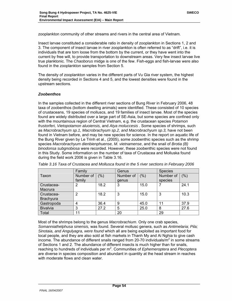
Song Bung 4 Hydropower Project, TA No. 4625-VIE Final Report Environmental Impact Assessment (EIA) – Main Report
SWECO
FINAL 16/04/2007
Page 54
zooplankton community of other streams and rivers in the central area of Vietnam. Insect larvae constituted a considerable ratio in density of zooplankton in Sections 1, 2 and 3. The component of insect larvae in river zooplankton is often referred to as “drift”, i.e. it is individuals that are torn loose from the bottom by the current, or they have went into the current by free will, to provide transportation to downstream areas. Very few insect larvae live true planktonic. The Chaoborus midge is one of the few. Fish-eggs and fish-larvae were also found in the zooplankton samples from Section 5. The density of zooplankton varies in the different parts of Vu Gia river system, the highest density being recorded in Sections 4 and 5, and the lowest densities were found in the upstream sections. Zoobenthos In the samples collected in the different river sections of Bung River in February 2006, 48 taxa of zoobenthos (bottom dwelling animals) were identified. These consisted of 10 species of crustaceans, 19 species of molluscs, and 19 families of insect larvae. Most of the species found are widely distributed over a large part of SE-Asia, but some species are confined only with the mountainous region of Central Vietnam, e.g. the crustacean species Potamon frustorferi, Vietopotamon aluoiensis, and Atya moluccesis . Some species of shrimps, such as Macrobrachyum sp.1, Macrobrachyum sp.2, and Macrobrachyum sp.3, have not been found in Vietnam before, and may be new species for science. In the report on aquatic life of the Bung River given by Le Trinh et al., (2005), some zoobenthic species such as the shrimp species Macrobrachyum dienbienphuense, M. vietnamense, and the snail of Brotia (B) binodonsa subgnobiosa were recorded. However, these zoobenthic species were not found in this Study. Some information on the number of taxa of Crustacea and Molluska found during the field work 2006 is given in Table 3.16.
Table 3.16 Taxa of Crustacea and Mollusca found in the 5 river sections in February 2006
Family Genus Species Taxon Number of
family (%) Number of
genus (%) Number of
species (%)
Crustacea-Macrura
2 18.2 3 15.0 7 24.1
Crustacea-Brachyura
2 18.2 3 15.0 3 10.3
Gastropoda 4 36.4 9 45.0 11 37.9 Bivalvia 3 27.2 5 25.0 8 27.6 Total 11 20 29
Most of the shrimps belong to the genus Macrobrachium. Only one crab species, Somanniathelphusa sinensis, was found. Several mollusc genera, such as Antimelaria; Pila; Sinotaia, and Angulyagra, were found which all are being exploited as important food for local people, and they are also sold at fish markets in Thanh My and Ai Nghia to give cash income. The abundance of different snails ranged from 20-70 individuals/m2 in some streams of Sections 1 and 2. The abundance of different insects is much higher than for snails, reaching to hundreds of individuals per m2. Communities of Ephemeroptera and Plecoptera are diverse in species composition and abundant in quantity at the head stream in reaches with moderate flows and clean water.
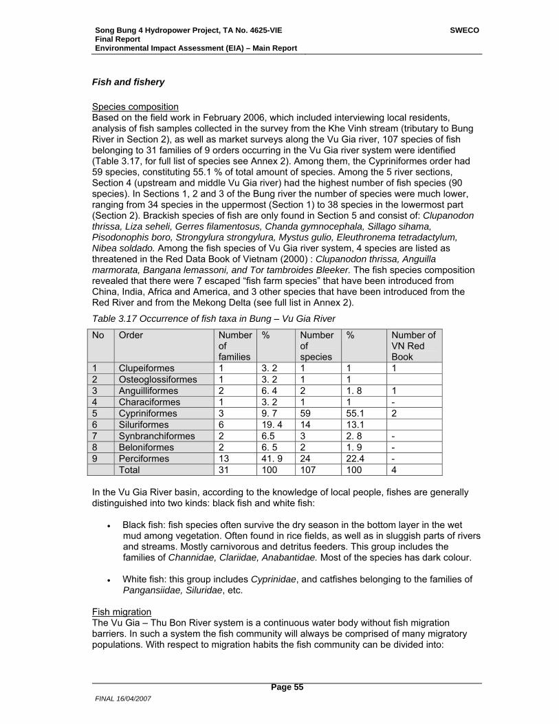
Song Bung 4 Hydropower Project, TA No. 4625-VIE Final Report Environmental Impact Assessment (EIA) – Main Report
SWECO
FINAL 16/04/2007
Page 55
Fish and fishery Species composition Based on the field work in February 2006, which included interviewing local residents, analysis of fish samples collected in the survey from the Khe Vinh stream (tributary to Bung River in Section 2), as well as market surveys along the Vu Gia river, 107 species of fish belonging to 31 families of 9 orders occurring in the Vu Gia river system were identified (Table 3.17, for full list of species see Annex 2). Among them, the Cypriniformes order had 59 species, constituting 55.1 % of total amount of species. Among the 5 river sections, Section 4 (upstream and middle Vu Gia river) had the highest number of fish species (90 species). In Sections 1, 2 and 3 of the Bung river the number of species were much lower, ranging from 34 species in the uppermost (Section 1) to 38 species in the lowermost part (Section 2). Brackish species of fish are only found in Section 5 and consist of: Clupanodon thrissa, Liza seheli, Gerres filamentosus, Chanda gymnocephala, Sillago sihama, Pisodonophis boro, Strongylura strongylura, Mystus gulio, Eleuthronema tetradactylum, Nibea soldado. Among the fish species of Vu Gia river system, 4 species are listed as threatened in the Red Data Book of Vietnam (2000) : Clupanodon thrissa, Anguilla marmorata, Bangana lemassoni, and Tor tambroides Bleeker. The fish species composition revealed that there were 7 escaped “fish farm species” that have been introduced from China, India, Africa and America, and 3 other species that have been introduced from the Red River and from the Mekong Delta (see full list in Annex 2).
Table 3.17 Occurrence of fish taxa in Bung – Vu Gia River
No Order Number of families
% Number of species
% Number of VN Red Book
1 Clupeiformes 1 3. 2 1 1 1 2 Osteoglossiformes 1 3. 2 1 1 3 Anguilliformes 2 6. 4 2 1. 8 1 4 Characiformes 1 3. 2 1 1 - 5 Cypriniformes 3 9. 7 59 55.1 2 6 Siluriformes 6 19. 4 14 13.1 7 Synbranchiformes 2 6.5 3 2. 8 - 8 Beloniformes 2 6. 5 2 1. 9 - 9 Perciformes 13 41. 9 24 22.4 - Total 31 100 107 100 4 In the Vu Gia River basin, according to the knowledge of local people, fishes are generally distinguished into two kinds: black fish and white fish:
• Black fish: fish species often survive the dry season in the bottom layer in the wet mud among vegetation. Often found in rice fields, as well as in sluggish parts of rivers and streams. Mostly carnivorous and detritus feeders. This group includes the families of Channidae, Clariidae, Anabantidae. Most of the species has dark colour.
• White fish: this group includes Cyprinidae, and catfishes belonging to the families of
Pangansiidae, Siluridae, etc. Fish migration The Vu Gia – Thu Bon River system is a continuous water body without fish migration barriers. In such a system the fish community will always be comprised of many migratory populations. With respect to migration habits the fish community can be divided into:
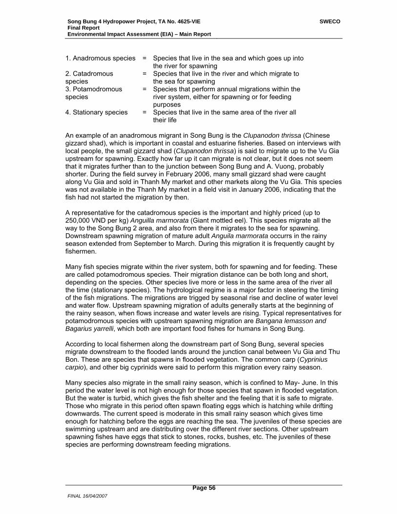
Song Bung 4 Hydropower Project, TA No. 4625-VIE Final Report Environmental Impact Assessment (EIA) – Main Report
SWECO
FINAL 16/04/2007
Page 56
1. Anadromous species = Species that live in the sea and which goes up into the river for spawning
2. Catadromous species
= Species that live in the river and which migrate to the sea for spawning
3. Potamodromous species
= Species that perform annual migrations within the river system, either for spawning or for feeding purposes
4. Stationary species = Species that live in the same area of the river all their life
An example of an anadromous migrant in Song Bung is the Clupanodon thrissa (Chinese gizzard shad), which is important in coastal and estuarine fisheries. Based on interviews with local people, the small gizzard shad (Clupanodon thrissa) is said to migrate up to the Vu Gia upstream for spawning. Exactly how far up it can migrate is not clear, but it does not seem that it migrates further than to the junction between Song Bung and A. Vuong, probably shorter. During the field survey in February 2006, many small gizzard shad were caught along Vu Gia and sold in Thanh My market and other markets along the Vu Gia. This species was not available in the Thanh My market in a field visit in January 2006, indicating that the fish had not started the migration by then. A representative for the catadromous species is the important and highly priced (up to 250,000 VND per kg) Anguilla marmorata (Giant mottled eel). This species migrate all the way to the Song Bung 2 area, and also from there it migrates to the sea for spawning. Downstream spawning migration of mature adult Anguila marmorata occurrs in the rainy season extended from September to March. During this migration it is frequently caught by fishermen. Many fish species migrate within the river system, both for spawning and for feeding. These are called potamodromous species. Their migration distance can be both long and short, depending on the species. Other species live more or less in the same area of the river all the time (stationary species). The hydrological regime is a major factor in steering the timing of the fish migrations. The migrations are trigged by seasonal rise and decline of water level and water flow. Upstream spawning migration of adults generally starts at the beginning of the rainy season, when flows increase and water levels are rising. Typical representatives for potamodromous species with upstream spawning migration are Bangana lemasson and Bagarius yarrelli, which both are important food fishes for humans in Song Bung. According to local fishermen along the downstream part of Song Bung, several species migrate downstream to the flooded lands around the junction canal between Vu Gia and Thu Bon. These are species that spawns in flooded vegetation. The common carp (Cyprinius carpio), and other big cyprinids were said to perform this migration every rainy season. Many species also migrate in the small rainy season, which is confined to May- June. In this period the water level is not high enough for those species that spawn in flooded vegetation. But the water is turbid, which gives the fish shelter and the feeling that it is safe to migrate. Those who migrate in this period often spawn floating eggs which is hatching while drifting downwards. The current speed is moderate in this small rainy season which gives time enough for hatching before the eggs are reaching the sea. The juveniles of these species are swimming upstream and are distributing over the different river sections. Other upstream spawning fishes have eggs that stick to stones, rocks, bushes, etc. The juveniles of these species are performing downstream feeding migrations.
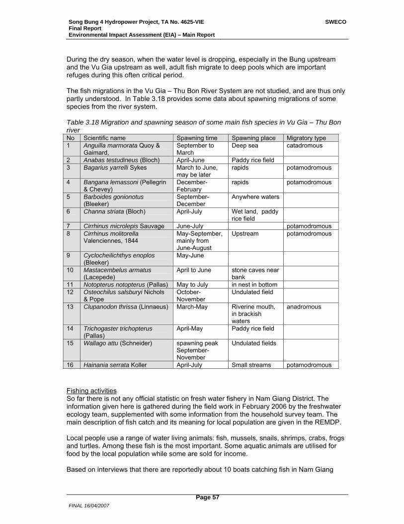
Song Bung 4 Hydropower Project, TA No. 4625-VIE Final Report Environmental Impact Assessment (EIA) – Main Report
SWECO
FINAL 16/04/2007
Page 57
During the dry season, when the water level is dropping, especially in the Bung upstream and the Vu Gia upstream as well, adult fish migrate to deep pools which are important refuges during this often critical period. The fish migrations in the Vu Gia – Thu Bon River System are not studied, and are thus only partly understood. In Table 3.18 provides some data about spawning migrations of some species from the river system. Table 3.18 Migration and spawning season of some main fish species in Vu Gia – Thu Bon river No Scientific name Spawning time Spawning place Migratory type 1 Anguilla marmorata Quoy &
Gaimard, September to March
Deep sea catadromous
2 Anabas testudineus (Bloch) April-June Paddy rice field 3 Bagarius yarrelli Sykes March to June,
may be later rapids potamodromous
4 Bangana lemassoni (Pellegrin & Chevey)
December- February
rapids potamodromous
5 Barboides gonionotus (Bleeker)
September-December
Anywhere waters
6 Channa striata (Bloch) April-July Wet land, paddy rice field
7 Cirrhinus microlepis Sauvage June-July potamodromous 8 Cirrhinus molitorella
Valenciennes, 1844 May-September, mainly from June-August
Upstream potamodromous
9 Cyclocheilichthys enoplos (Bleeker)
May-June
10 Mastacembelus armatus (Lacepede)
April to June stone caves near bank
11 Notopterus notopterus (Pallas) May to July in nest in bottom 12 Osteochilus salsburyi Nichols
& Pope October-November
Undulated field
13 Clupanodon thrissa (Linnaeus) March-May Riverine mouth, in brackish waters
anadromous
14 Trichogaster trichopterus (Pallas)
April-May Paddy rice field
15 Wallago attu (Schneider) spawning peak September-November
Undulated fields
16 Hainania serrata Koller April-July Small streams potamodromous Fishing activities So far there is not any official statistic on fresh water fishery in Nam Giang District. The information given here is gathered during the field work in February 2006 by the freshwater ecology team, supplemented with some information from the household survey team. The main description of fish catch and its meaning for local population are given in the REMDP. Local people use a range of water living animals: fish, mussels, snails, shrimps, crabs, frogs and turtles. Among these fish is the most important. Some aquatic animals are utilised for food by the local population while some are sold for income. Based on interviews that there are reportedly about 10 boats catching fish in Nam Giang
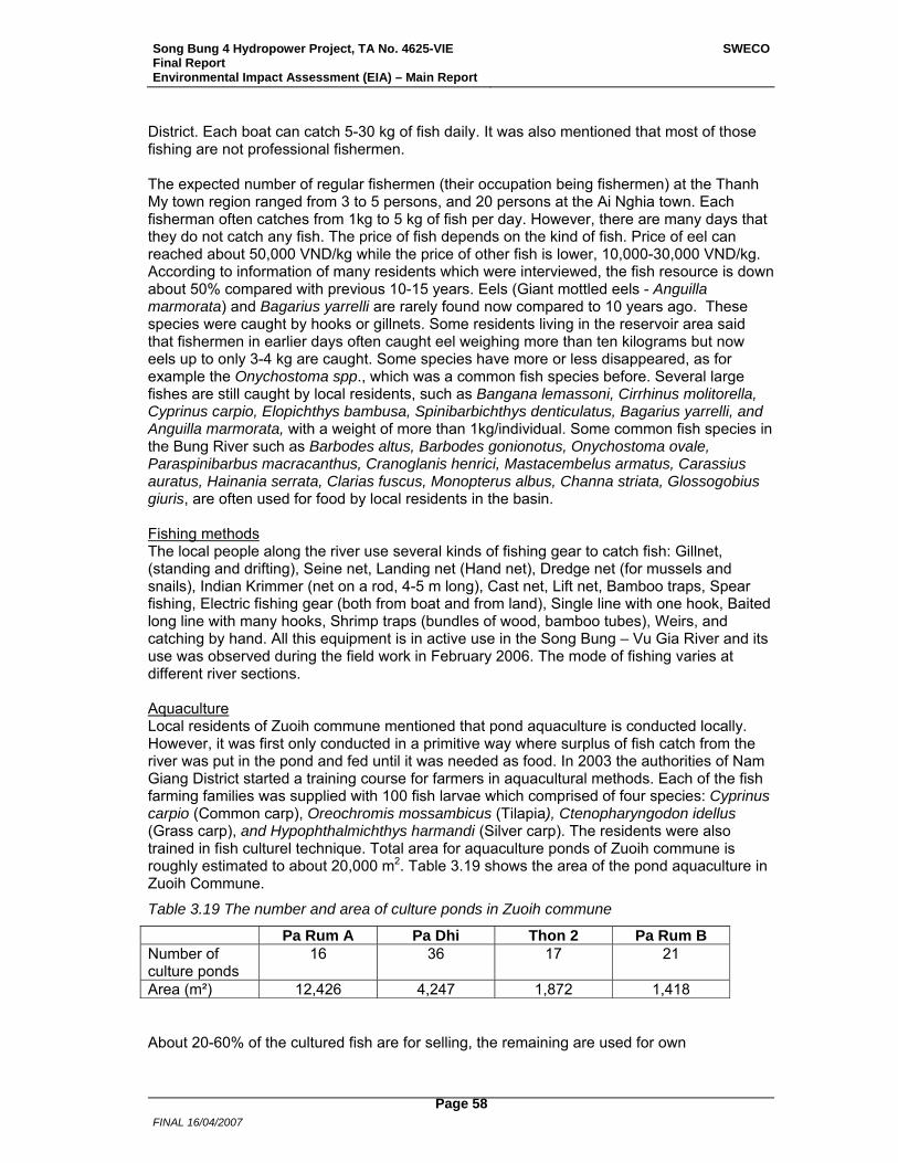
Song Bung 4 Hydropower Project, TA No. 4625-VIE Final Report Environmental Impact Assessment (EIA) – Main Report
SWECO
FINAL 16/04/2007
Page 58
District. Each boat can catch 5-30 kg of fish daily. It was also mentioned that most of those fishing are not professional fishermen. The expected number of regular fishermen (their occupation being fishermen) at the Thanh My town region ranged from 3 to 5 persons, and 20 persons at the Ai Nghia town. Each fisherman often catches from 1kg to 5 kg of fish per day. However, there are many days that they do not catch any fish. The price of fish depends on the kind of fish. Price of eel can reached about 50,000 VND/kg while the price of other fish is lower, 10,000-30,000 VND/kg. According to information of many residents which were interviewed, the fish resource is down about 50% compared with previous 10-15 years. Eels (Giant mottled eels - Anguilla marmorata) and Bagarius yarrelli are rarely found now compared to 10 years ago. These species were caught by hooks or gillnets. Some residents living in the reservoir area said that fishermen in earlier days often caught eel weighing more than ten kilograms but now eels up to only 3-4 kg are caught. Some species have more or less disappeared, as for example the Onychostoma spp., which was a common fish species before. Several large fishes are still caught by local residents, such as Bangana lemassoni, Cirrhinus molitorella, Cyprinus carpio, Elopichthys bambusa, Spinibarbichthys denticulatus, Bagarius yarrelli, and Anguilla marmorata, with a weight of more than 1kg/individual. Some common fish species in the Bung River such as Barbodes altus, Barbodes gonionotus, Onychostoma ovale, Paraspinibarbus macracanthus, Cranoglanis henrici, Mastacembelus armatus, Carassius auratus, Hainania serrata, Clarias fuscus, Monopterus albus, Channa striata, Glossogobius giuris, are often used for food by local residents in the basin. Fishing methods The local people along the river use several kinds of fishing gear to catch fish: Gillnet, (standing and drifting), Seine net, Landing net (Hand net), Dredge net (for mussels and snails), Indian Krimmer (net on a rod, 4-5 m long), Cast net, Lift net, Bamboo traps, Spear fishing, Electric fishing gear (both from boat and from land), Single line with one hook, Baited long line with many hooks, Shrimp traps (bundles of wood, bamboo tubes), Weirs, and catching by hand. All this equipment is in active use in the Song Bung – Vu Gia River and its use was observed during the field work in February 2006. The mode of fishing varies at different river sections. Aquaculture Local residents of Zuoih commune mentioned that pond aquaculture is conducted locally. However, it was first only conducted in a primitive way where surplus of fish catch from the river was put in the pond and fed until it was needed as food. In 2003 the authorities of Nam Giang District started a training course for farmers in aquacultural methods. Each of the fish farming families was supplied with 100 fish larvae which comprised of four species: Cyprinus carpio (Common carp), Oreochromis mossambicus (Tilapia), Ctenopharyngodon idellus (Grass carp), and Hypophthalmichthys harmandi (Silver carp). The residents were also trained in fish culturel technique. Total area for aquaculture ponds of Zuoih commune is roughly estimated to about 20,000 m2. Table 3.19 shows the area of the pond aquaculture in Zuoih Commune.
Table 3.19 The number and area of culture ponds in Zuoih commune
Pa Rum A Pa Dhi Thon 2 Pa Rum B Number of culture ponds
16 36 17 21
Area (m²) 12,426 4,247 1,872 1,418 About 20-60% of the cultured fish are for selling, the remaining are used for own
Song Bung 4 Hydropower Project, TA No. 4625-VIE Final Report Environmental Impact Assessment (EIA) – Main Report
SWECO
FINAL 16/04/2007
Page 59
consumption or offering their families as gifts. Among the villages in the reservoir area, the farmers of the Thon 2 have better knowledge on aqua-culture than the others. In generally, aqua-culture products constitute important food sources for the local residents, especially in the dry season when it is difficult to catch natural fish from the Bung River. However, the aquaculture initiative by the authorities has only had limited success. The main problem was to get new juveniles to stock the ponds. The villagers have to pay 1,000-2,000 VND per small fish, which often was found too expensive, as well as the fry brought in was stressed during transport and experienced high mortality. The lack of safe delivery of stocking fry, pollution problems and lack of piped water to compensate for evaporation loss in the dry season, as well as diseases, were mentioned as main constraints to aquaculture in the region. Environmental threats (other than hydropower regulation) to the aquatic life of Song Bung – Vu Gia river system as addressed by local people and fishermen in the interviews Over fishing The human population is growing and so do the fishing pressure. The use of monofilamentous nylon gillnets has increased tremendously the last 10-20 years. In addition, catching fish by electric shock has become widespread in Vu Gia river system, especially in the upstream of Bung River, where bedrock and stones make it difficult to use nets efficiently. Increased fishing pressure, including the destructive fishing practice of using electric fishing gear by fishermen of all riparian villages along the Vu Gia River, is the main reason for decreasing fish populations. Gold exploration Exploitation of mineral gold in upstream of Bung River, Than River, and several other tributaries are occurring daily. This activity increase turbidity and amount of sediment, as well as the dredging disturbs the aquatic habitats physically. Besides, some toxic chemicals such as Hg, cyanide, are used in separation of gold from mineral. The toxins can be a stress to aquatic life and fish. Sand and gravel takes Exploitation of sand and gravels for construction purposes in Thanh River near Thanh My and on Vu Gia River (Dai Loc District) causes increasing turbidity and changing flows, and structure of riverbed. This may hamper aquatic life. Destruction of riparian forest The protected forests in the headwaters of the basin are destructed and have declined both in area and quality. The first trees to be taken, are those along the river as floating on the river, is the main mean of transportation. Big overhanging trees are very important for fish and aquatic life (create shadow and nutritious litter fall).
3.1.11 Terrestrial Ecology
The SB4 HPP areas were designated into groups and areas which could be assessed in an organized fashion as presented in Table 3.20 and the maps in Figures 2.2 to 2.5 and Figure 3.23.
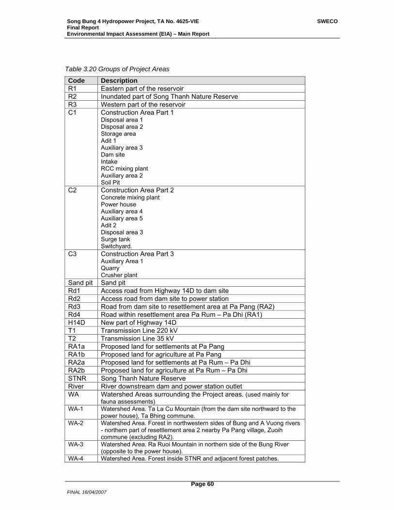
Song Bung 4 Hydropower Project, TA No. 4625-VIE Final Report Environmental Impact Assessment (EIA) – Main Report
SWECO
FINAL 16/04/2007
Page 60
Table 3.20 Groups of Project Areas
Code Description R1 Eastern part of the reservoir R2 Inundated part of Song Thanh Nature Reserve R3 Western part of the reservoir C1 Construction Area Part 1 Disposal area 1 Disposal area 2 Storage area Adit 1 Auxiliary area 3 Dam site Intake RCC mixing plant Auxiliary area 2 Soil Pit C2 Construction Area Part 2 Concrete mixing plant Power house Auxiliary area 4 Auxiliary area 5 Adit 2 Disposal area 3 Surge tank Switchyard. C3 Construction Area Part 3 Auxiliary Area 1 Quarry Crusher plant Sand pit Sand pit Rd1 Access road from Highway 14D to dam site Rd2 Access road from dam site to power station Rd3 Road from dam site to resettlement area at Pa Pang (RA2) Rd4 Road within resettlement area Pa Rum – Pa Dhi (RA1) H14D New part of Highway 14D T1 Transmission Line 220 kV T2 Transmission Line 35 kV RA1a Proposed land for settlements at Pa Pang RA1b Proposed land for agriculture at Pa Pang RA2a Proposed land for settlements at Pa Rum – Pa Dhi RA2b Proposed land for agriculture at Pa Rum – Pa Dhi STNR Song Thanh Nature Reserve River River downstream dam and power station outlet WA Watershed Areas surrounding the Project areas. (used mainly for
fauna assessments) WA-1 Watershed Area. Ta La Cu Mountain (from the dam site northward to the
power house), Ta Bhing commune. WA-2 Watershed Area. Forest in northwestern sides of Bung and A Vuong rivers
- northern part of resettlement area 2 nearby Pa Pang village, Zuoih commune (excluding RA2).
WA-3 Watershed Area. Ra Ruoi Mountain in northern side of the Bung River (opposite to the power house).
WA-4 Watershed Area. Forest inside STNR and adjacent forest patches.
Song Bung 4 Hydropower Project, TA No. 4625-VIE Final Report Environmental Impact Assessment (EIA) – Main Report
SWECO
FINAL 16/04/2007
Page 61
3.1.11.1 Land Cover and Use The specific areas that will be impacted by the Project are classified based on the existing land cover based on vegetation cover.
Much of the land area of the SB4 HPP has been influenced by humans, particularly by shifting cultivation over several generations and more recently by outsiders doing illegal logging. The project areas now have species generally associated with secondary and pioneer communities, and poor vegetation cover, and have little subsistence and economic value (timber and NTFPs). In the Project areas there is a 1.8 % forest cover of 75% and more trees, that which can be said to be closest to primary forest. Similarly in the inundated part of STNR this vegetation has a cover of only 4.6 %. Twenty-one percent of the total area of Project is covered by disturbed primary and secondary forest vegetation. Secondary vegetation types, the types which have regenerated on abandoned shifting cultivation areas, are dominant covering up to 67 % of the total area of Song Bung 4 HPP. The reservoir which makes up to 40% of the total Project area has about 73 % covered by secondary scrubs and grasslands, or bare lands with some grasses/trees.
In order to get a better understanding of the vegetation composition the vegetation of the Song Bung 4 Hydropower Project areas the land cover based on vegetation was classified into seven cover/vegetation types. This classification also was used for the study of fauna, flora and the quality of the habitat in the Project area. Cover is given as ranging from 0 to 1, i.e. from no (0) cover of trees to 100 % cover of trees. A similar range is used for shrubs, where relevant. Riparian vegetation is described under a separate category. The detailed descriptions below are further elaborated in the context of the vegetation found in the Project area.
VEG 1- Undisturbed closed forests. Cover of trees from 0.75 and more
VEG 2- Disturbed closed forests. Cover of trees from 0.5 to less than 0.75
VEG 3- Woodlands. Cover of trees from 0.2 to less than 0.5
VEG 4- Scrubs with scattered trees. Cover of trees from 0.1 to less than 0.2
VEG 5- Scrubs. Cover of trees less than 0.1
VEG 6- Grassland and annual crops. Cover of trees 0.1 or less, and /or of shrubs 0.2 or less. Annual crops here usually consist of small scattered shifting agricultural plots within the landscape. Banana clumps or single papaya trees growing within the grassy-shrub landscape are also included here.
VEG 7- Bare lands. Cover of grasses or/and shrubs 0.1 or less; no trees occur here
Specific Land Cover of the Project areas More detailed descriptions of land cover in each of the investigated areas are given below, and summarized in Table 3.21. Three land cover maps are given in the Figures 3.24 to 3.26.
Reservoir (R)
R1- Eastern part of the reservoir. This part extends from Tra Vinh (Vinh stream) to the dam site. As for the forest vegetation area (including VEG 1, 2, and 3), woodlands (open forests) dominate (11.2%). Vegetation types VEG 6, 5 and 4 are dominant representing 238 ha (70%). VEG 2 and 3 occur in some small patches on slopes near the dam site. There are some patches of VEG 1 covering a total of 2.64 ha (0.8 %) and occur on the steep foot hills of Khe Gau, near the dam site.
Song Bung 4 Hydropower Project, TA No. 4625-VIE Final Report Environmental Impact Assessment (EIA) – Main Report
SWECO
FINAL 16/04/2007
Page 62
R2- This part represents the inundated part of Song Thanh Nature Reserve. The part extends from Tra Vinh Bridge (at the elevation of 170 m a.s.l.) southwards about 6.5 km along Tra Vinh Stream (elevation of 230 m a.s.l.). Of the total area of 142.7 ha in STNR, 56 ha (39 %) is covered by forests (VEG 1-3). Non forest dominated (VEG 4-6) area comprised of about 67.5 ha (47.4 %). Dominant vegetation types range from VEG 5 and 4 near the Tra Vinh Stream; patches of VEG 3, 2 and 1 occur on slopes and very steep (partly rocky) foot hills.
R3- Western part of the reservoir. This part extends westward from the junction of the Tra Vinh Stream with Bung River. Dominant vegetation types are non-forested ones, range from VEG type 4 to type 6 (67 %), near the Bung River, along the river with few small patches of VEG type 2 and 3 on the steep rocky slopes at the foot of the hill near the stream. Vegetation types 2 and 3 occur on the slopes and ridges. A limestone hill to the west part of Thon 2 Village (at an elevation of ~ 190 m a.s.l.) is covered mainly by VEG 4 and 3.
C1 and C2. Construction Areas 1 and 2
Forested types of vegetation (Veg 1-3) are dominant in the C1 area (80 %). Forests (VEG 1-3) are dominant vegetation types in the C2 area (83 %).
Notes on Specific Project areas
Dam site area. Vegetation at and around dam site consists of the VEG 4 type near the river, VEG type 3 occurs on slope and some patches of vegetation, VEG type 2 is present on the ridge and on the steep rocky foothills.
Power house area. Auxiliary area 4 (14.2 ha) and power house (2.6 ha) located on the slope of Ta La Cu Mountain (at the elevation of ~ 130 m a.s.l.) were surveyed. VEG 4 and 3 can be found on the steep rocky slopes. VEG 2 and 1 occur only on ridges. The water tunnel of 3,046 m in length and a new service road will be built from Road 14D through the dam to the power house. On the opposite site of the power house is a large area of evergreen broad-leaved lowland forest growing on limestone forming a link to Ra Ruoi Mountain in Tay Giang district, on the northern bank of Bung River. Here VEG 3 and 2 are dominant types on the steep rocky slopes with vertical cliffs. VEG 1 can be found in scattered small patches on the ridge.
C3. Construction Area Part 3
Non-forest dominated types of vegetation are dominant here (25 % of VEG 5).
Quarry The proposed quarry area (rock pit) is situated along Road 14D, about 14 km and 5 km away from dam site and power house site, respectively, covering approximately a total area of 73.1 ha. The vegetation is a mosaic of vegetation types, ranging from VEG 1 to 6 types, but VEG 3 and 4 are dominant.
T. Transmission lines
T1- Transmission Line 220 kV. Forested areas (VEG 1-3) represent 22.9 ha or 17.9 %, found mostly from Pa Lua (Pa Xua) to the Power house. About 6 % of the forest falls in the VEG 1 type category.
T2- Transmission Lines 35 kV. Forested areas (VEG 1-3) represent 6.50 ha or 10.07 %, found mostly from dam site to the Power house. This proposed 35 KV transmission line joins Thanh My Township to be used during construction activities. The power line is about 38 km in length going for most of its length along Road 14D. The transmission line corridor has vegetation mostly of the VEG 5 & 6 types from Thanh My to the dam site. Very small patches of VEG 4, 3 and 2 can be found on the upper slopes and ridges of the mountains at some
Song Bung 4 Hydropower Project, TA No. 4625-VIE Final Report Environmental Impact Assessment (EIA) – Main Report
SWECO
FINAL 16/04/2007
Page 63
places. From the dam site to the power house the cover is mostly made up by VEG 2, rarely VEG 3 or VEG 1.
Roads. (Access roads and Highway 14D)
Forests (VEG 1 - 3) have a cover of 47 ha (or 56 %). Dominant vegetation types here are VEG 4, 5 and 6, interspaced with small scattered patches of VEG 3 and few patches of VEG 2. Only one patch at the foot of Khe Gau, near dam site, is classified as VEG 1.
Resettlement areas (RA)
Resettlement Area at Pa Pang. This area is proposed for the relocation of people from Thon 2 village. Pa Pang village is already located here and has settlements (houses), and agricultural and forest land. Predominant habitats of this area consist of scrubs with the dominance of bamboo mixed with scattered regenerated fast growing trees (VEG 5, rarely VEG 4) at the elevation of 350-500 m. The access road from the dam site to this Resettlement Area, the length of which is about 15 km, goes mainly through VEG 4 and VEG 5.
Resettlement Areas for Pa Rum A and B, and Pa Dhi. These relocation areas are proposed along the access road to Song Bung 2 Hydropower Project (Pa Rum A and B) and close to the existing site (Pa Dhi). Observations show that dominant vegetation types in the area studied in this EIA (RA1) are composed of VEG 6 and VEG 5, several small patches of forests (VEG 3, sometimes VEG 2) can be found scattered on the upper slopes and ridges of the mountains...

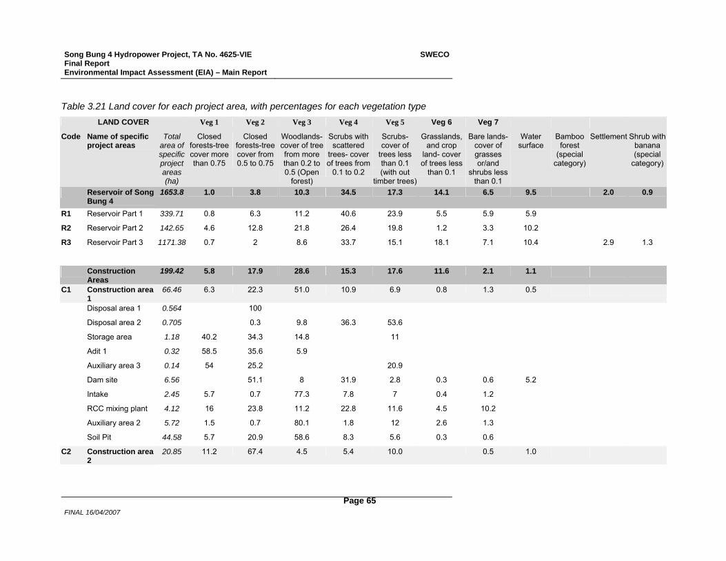
Song Bung 4 Hydropower Project, TA No. 4625-VIE Final Report Environmental Impact Assessment (EIA) – Main Report
SWECO
FINAL 16/04/2007
Page 65
Table 3.21 Land cover for each project area, with percentages for each vegetation type LAND COVER Veg 1 Veg 2 Veg 3 Veg 4 Veg 5 Veg 6 Veg 7
Code Name of specific project areas
Total area of specific project areas (ha)
Closed forests-tree cover more than 0.75
Closed forests-tree cover from 0.5 to 0.75
Woodlands-cover of tree from more than 0.2 to 0.5 (Open
forest)
Scrubs with scattered
trees- cover of trees from
0.1 to 0.2
Scrubs- cover of
trees less than 0.1 (with out
timber trees)
Grasslands, and crop
land- cover of trees less
than 0.1
Bare lands- cover of grasses or/and
shrubs less than 0.1
Water surface
Bamboo forest
(special category)
Settlement Shrub with banana (special
category)
Reservoir of Song Bung 4
1653.8 1.0 3.8 10.3 34.5 17.3 14.1 6.5 9.5 2.0 0.9
R1 Reservoir Part 1 339.71 0.8 6.3 11.2 40.6 23.9 5.5 5.9 5.9 R2 Reservoir Part 2 142.65 4.6 12.8 21.8 26.4 19.8 1.2 3.3 10.2 R3 Reservoir Part 3 1171.38 0.7 2 8.6 33.7 15.1 18.1 7.1 10.4 2.9 1.3
Construction Areas
199.42 5.8 17.9 28.6 15.3 17.6 11.6 2.1 1.1
C1 Construction area 1
66.46 6.3 22.3 51.0 10.9 6.9 0.8 1.3 0.5
Disposal area 1 0.564 100 Disposal area 2 0.705 0.3 9.8 36.3 53.6 Storage area 1.18 40.2 34.3 14.8 11 Adit 1 0.32 58.5 35.6 5.9 Auxiliary area 3 0.14 54 25.2 20.9 Dam site 6.56 51.1 8 31.9 2.8 0.3 0.6 5.2 Intake 2.45 5.7 0.7 77.3 7.8 7 0.4 1.2 RCC mixing plant 4.12 16 23.8 11.2 22.8 11.6 4.5 10.2 Auxiliary area 2 5.72 1.5 0.7 80.1 1.8 12 2.6 1.3 Soil Pit 44.58 5.7 20.9 58.6 8.3 5.6 0.3 0.6
C2 Construction area 2
20.85 11.2 67.4 4.5 5.4 10.0 0.5 1.0
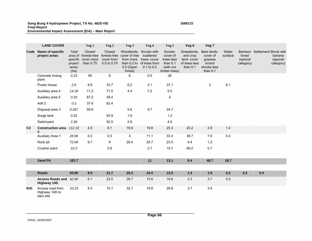
Song Bung 4 Hydropower Project, TA No. 4625-VIE Final Report Environmental Impact Assessment (EIA) – Main Report
SWECO
FINAL 16/04/2007
Page 66
LAND COVER Veg 1 Veg 2 Veg 3 Veg 4 Veg 5 Veg 6 Veg 7 Code Name of specific
project areas Total
area of specific project areas (ha)
Closed forests-tree cover more than 0.75
Closed forests-tree cover from 0.5 to 0.75
Woodlands-cover of tree from more than 0.2 to 0.5 (Open
forest)
Scrubs with scattered
trees- cover of trees from
0.1 to 0.2
Scrubs- cover of
trees less than 0.1 (with out
timber trees)
Grasslands, and crop
land- cover of trees less
than 0.1
Bare lands- cover of grasses or/and
shrubs less than 0.1
Water surface
Bamboo forest
(special category)
Settlement Shrub with banana (special
category)
Concrete mixing plant
0.23 59 8 6 0.5 26
Power house 2.6 8.8 33.7 6.2 3.1 37.1 3 8.1 Auxiliary area 4 14.18 11.2 71.5 4.4 7.2 5.5 Auxiliary area 5 0.25 67.2 28.4 4 Adit 2 0.3 37.6 62.4 Disposal area 3 0.267 59.9 5.6 9.7 24.7 Surge tank 0.52 92.9 1.9 1.2 Switchyard. 2.36 92.5 2.9 4.4
C3 Construction area 3
112.10 4.5 6.1 19.9 19.8 25.3 20.2 2.9 1.4
Auxiliary Area 1 28.96 0.3 0.5 3 11.1 33.4 38.7 7.6 5.4 Rock pit 72.69 6.7 9 29.4 25.7 23.5 4.4 1.2 Crusher plant 10.2 0.8 2.7 15.7 80.2 0.7
Sand Pit 183.7 11 13.1 8.4 48.7 18.7
Roads 83.80 8.9 21.7 25.2 24.0 13.0 1.3 1.9 0.2 3.3 0.4
Access Roads and Highway 14D
42.90 6.1 23.5 28.7 15.6 19.6 2.3 3.7 0.5
Rd1 Access road from Highway 14D to dam site
10.23 8.3 10.1 32.1 15.6 26.8 3.7 3.4
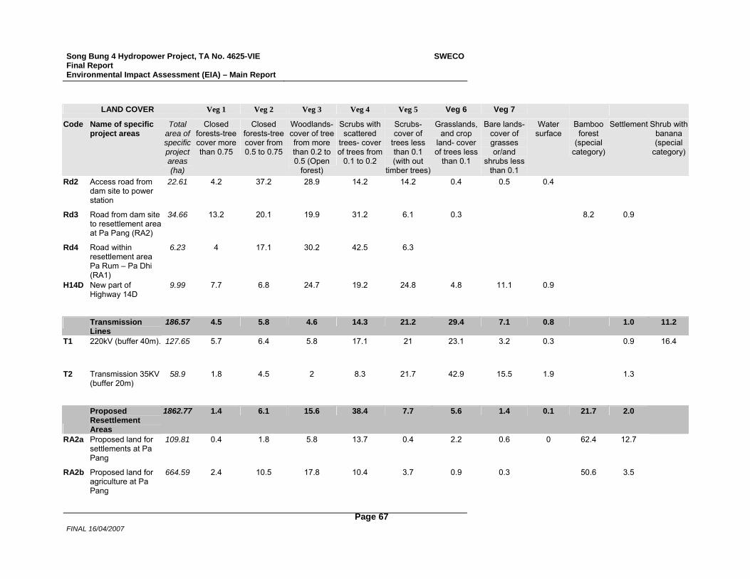
Song Bung 4 Hydropower Project, TA No. 4625-VIE Final Report Environmental Impact Assessment (EIA) – Main Report
SWECO
FINAL 16/04/2007
Page 67
LAND COVER Veg 1 Veg 2 Veg 3 Veg 4 Veg 5 Veg 6 Veg 7 Code Name of specific
project areas Total
area of specific project areas (ha)
Closed forests-tree cover more than 0.75
Closed forests-tree cover from 0.5 to 0.75
Woodlands-cover of tree from more than 0.2 to 0.5 (Open
forest)
Scrubs with scattered
trees- cover of trees from
0.1 to 0.2
Scrubs- cover of
trees less than 0.1 (with out
timber trees)
Grasslands, and crop
land- cover of trees less
than 0.1
Bare lands- cover of grasses or/and
shrubs less than 0.1
Water surface
Bamboo forest
(special category)
Settlement Shrub with banana (special
category)
Rd2 Access road from dam site to power station
22.61 4.2 37.2 28.9 14.2 14.2 0.4 0.5 0.4
Rd3 Road from dam site to resettlement area at Pa Pang (RA2)
34.66 13.2 20.1 19.9 31.2 6.1 0.3 8.2 0.9
Rd4 Road within resettlement area Pa Rum – Pa Dhi (RA1)
6.23 4 17.1 30.2 42.5 6.3
H14D New part of Highway 14D
9.99 7.7 6.8 24.7 19.2 24.8 4.8 11.1 0.9
Transmission Lines
186.57 4.5 5.8 4.6 14.3 21.2 29.4 7.1 0.8 1.0 11.2
T1 220kV (buffer 40m). 127.65 5.7 6.4 5.8 17.1 21 23.1 3.2 0.3 0.9 16.4
T2 Transmission 35KV (buffer 20m)
58.9 1.8 4.5 2 8.3 21.7 42.9 15.5 1.9 1.3
Proposed Resettlement Areas
1862.77 1.4 6.1 15.6 38.4 7.7 5.6 1.4 0.1 21.7 2.0
RA2a Proposed land for
settlements at Pa Pang
109.81 0.4 1.8 5.8 13.7 0.4 2.2 0.6 0 62.4 12.7
RA2b Proposed land for agriculture at Pa Pang
664.59 2.4 10.5 17.8 10.4 3.7 0.9 0.3 50.6 3.5
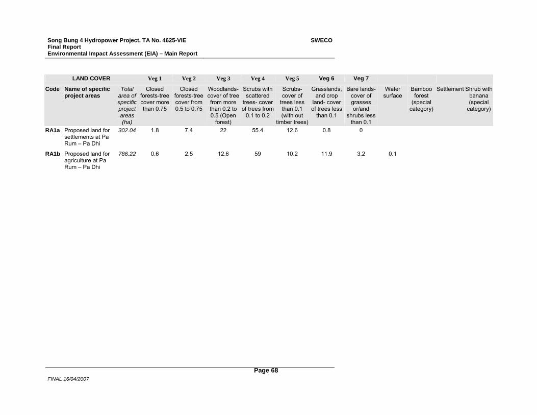
Song Bung 4 Hydropower Project, TA No. 4625-VIE Final Report Environmental Impact Assessment (EIA) – Main Report
SWECO
FINAL 16/04/2007
Page 68
LAND COVER Veg 1 Veg 2 Veg 3 Veg 4 Veg 5 Veg 6 Veg 7 Code Name of specific
project areas Total
area of specific project areas (ha)
Closed forests-tree cover more than 0.75
Closed forests-tree cover from 0.5 to 0.75
Woodlands-cover of tree from more than 0.2 to 0.5 (Open
forest)
Scrubs with scattered
trees- cover of trees from
0.1 to 0.2
Scrubs- cover of
trees less than 0.1 (with out
timber trees)
Grasslands, and crop
land- cover of trees less
than 0.1
Bare lands- cover of grasses or/and
shrubs less than 0.1
Water surface
Bamboo forest
(special category)
Settlement Shrub with banana (special
category)
RA1a Proposed land for settlements at Pa Rum – Pa Dhi
302.04 1.8 7.4 22 55.4 12.6 0.8 0
RA1b Proposed land for agriculture at Pa Rum – Pa Dhi
786.22 0.6 2.5 12.6 59 10.2 11.9 3.2 0.1
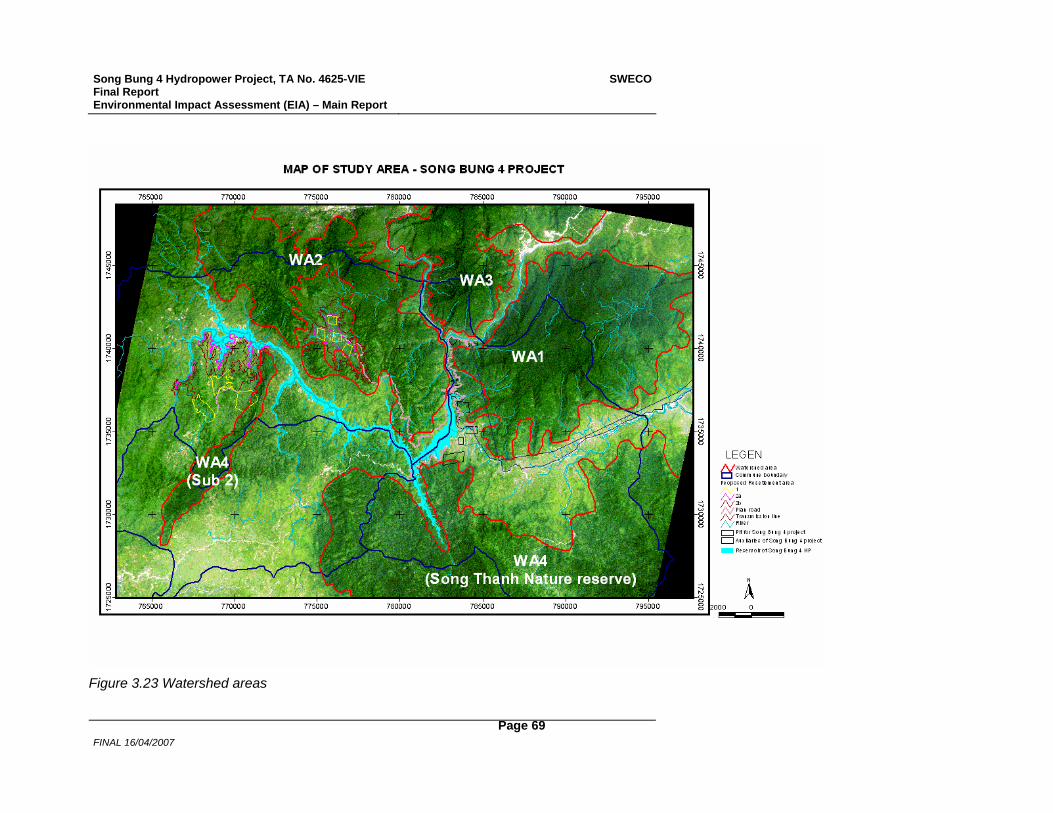
Song Bung 4 Hydropower Project, TA No. 4625-VIE Final Report Environmental Impact Assessment (EIA) – Main Report
SWECO
FINAL 16/04/2007
Page 69
Figure 3.23 Watershed areas

Song Bung 4 Hydropower Project, TA No. 4625-VIE Final Report Environmental Impact Assessment (EIA) – Main Report
SWECO
FINAL 16/04/2007
Page 70
%
%
%
%
%
%
%%
%
%
%
%
%
%
RA2b
RA1b
RA2a
RA1a
Bo Di
Ta Un
Pa Toi
Thon 2
Pa Dhi
Pa Pang
Can Dai
Zouih CommunePa Rum BPa Rum A
Cong DonThon Vinh
Cha Val Commune
Song Bung
Son g
Bun
g
Song Tra Vinh
R3
R1
R2
Khe Pran
Rd4
RA1
RA2
Rd3
Ta B'Hing Commune
H14D
C3
C1
Rd2
C2
T1
Song A Vuong
Song Bung
Rd1
T2
765000
765000
770000
770000
775000
775000
780000
780000
785000
785000
1730
000 1730000
1735
000 1735000
1740
000 1740000
N
1 0 1 Kilometers
Land cover type1. Closed forests-cover of tree layers more than 0.752. Closed forests-cover of tree layers from 0.5 to 0.75
4. Scrubs with scattered trees- cover of trees from 0.1 to 0.25. Scrubs- cover of trees less than 0.1 (with out wood tree)6. Grasslands, and crop land- cover of trees less than 0.17. Bare lands- cover of grasses or/and shrubs less than 0.18. Water surface9. Bamboo forest10. Crop land and Settlement11. Shrub with banana
River, Stream
Reservoir of Song Bung 4 Hydro power planSong Thanh nature reserve
Existing High way 14DExisting lane
LEGEND
3. Woodlands-cover of tree layers from more than 0.2 to 0.5 (Open forest)
Commune boundary
Figure 3.24 Land cover construction sites, reservoir and resettlement areas
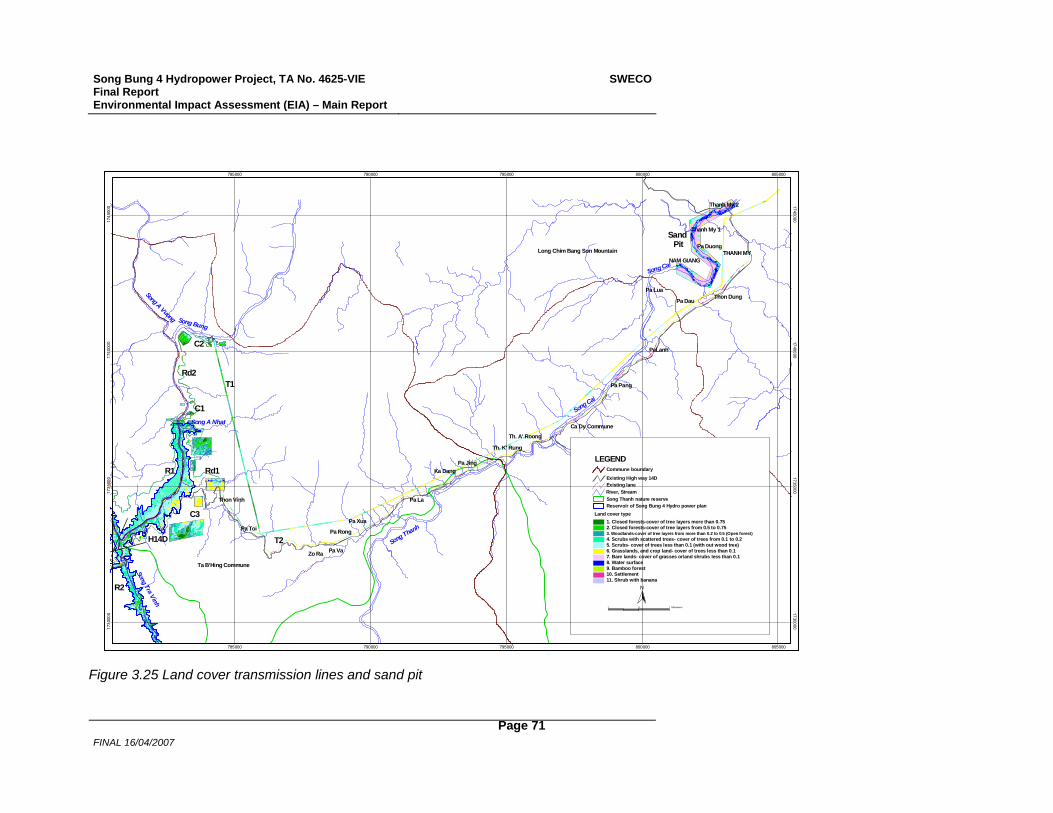
Song Bung 4 Hydropower Project, TA No. 4625-VIE Final Report Environmental Impact Assessment (EIA) – Main Report
SWECO
FINAL 16/04/2007
Page 71
%
%
%
%
%
%
%
%
%
%
%
%
%
%
%
%
%
%
%
%
%
%
%
%
%
%
%
%
Song Bung
Song A Vuong
T1
C2
Rd2
C1
C3
H14D
Ta B'Hing Commune
R2
R1
Song Tra Vinh
Long Chim Bang Son Mountain
Th. A' Roong
Th. K' Rung
Thanh My 2
Thanh My 1
NAM GIANG
Thon Dung
Thon Vinh
THANH MYPa Duong
Ca Dy Commune
Pa Pang
PaLanh
Pa Cang
Pa Rong
Ka DangPa Jing
Pa Dau
Pa Lua
Pa Don
Pa ToiPa Xua
Zo Ra Pa Va
Pa La
T2
Song A Nhat
Song Cai
Song Thanh
Song Cai
Rd1
Sand Pit
N
1 0 1 Kilometers
Land cover type1. Closed forests-cover of tree layers more than 0.752. Closed forests-cover of tree layers from 0.5 to 0.75
4. Scrubs with scattered trees- cover of trees from 0.1 to 0.25. Scrubs- cover of trees less than 0.1 (with out wood tree)6. Grasslands, and crop land- cover of trees less than 0.17. Bare lands- cover of grasses or/and shrubs less than 0.18. Water surface9. Bamboo forest10. Settlement11. Shrub with banana
River, Stream
Reservoir of Song Bung 4 Hydro power planSong Thanh nature reserve
Existing High way 14DExisting lane
LEGEND
3. Woodlands-cover of tree layers from more than 0.2 to 0.5 (Open forest)
Commune boundary
785000
785000
790000
790000
795000
795000
800000
800000
805000
805000
1730
000 1730000
1735
000 1735000
1740
000 1740000
1745
000 1745000
Figure 3.25 Land cover transmission lines and sand pit
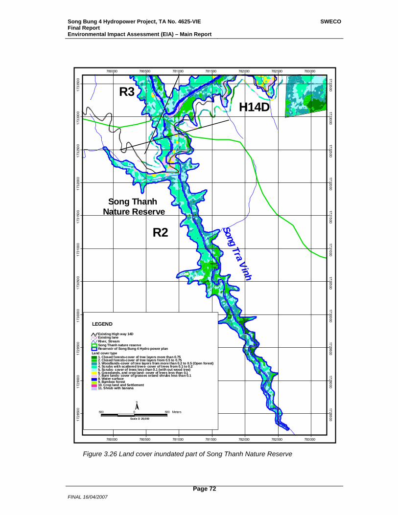
Song Bung 4 Hydropower Project, TA No. 4625-VIE Final Report Environmental Impact Assessment (EIA) – Main Report
SWECO
FINAL 16/04/2007
Page 72
R2 Song Tra Vinh
H14D
Song Thanh Nature Reserve
R3
780000
780000
780500
780500
781000
781000
781500
781500
782000
782000
782500
782500
783000
783000
1728
500 1728500
1729
000 1729000
1729
500 1729500
1730
000 1730000
1730
500 1730500
1731
000 1731000
1731
500 1731500
1732
000 1732000
1732
500 1732500
1733
000 1733000
1733
500 1733500
Land cover type1. Closed forests-cover of tree layers more than 0.752. Closed forests-cover of tree layers from 0.5 to 0.75
4. Scrubs with scattered trees- cover of trees from 0.1 to 0.25. Scrubs- cover of trees less than 0.1 (with out wood tree)6. Grasslands, and crop land- cover of trees less than 0.17. Bare lands- cover of grasses or/and shrubs less than 0.18. Water surface9. Bamboo forest10. Crop land and Settlement11. Shrub with banana
River, Stream
Reservoir of Song Bung 4 Hydro power planSong Thanh nature reserve
Existing High way 14DExisting lane
LEGEND
3. Woodlands-cover of tree layers from more than 0.2 to 0.5 (Open forest)
N
500 0 500 Meters
Scale 1/ 20,000
Figure 3.26 Land cover inundated part of Song Thanh Nature Reserve
Song Bung 4 Hydropower Project, TA No. 4625-VIE Final Report Environmental Impact Assessment (EIA) – Main Report
SWECO
FINAL 16/04/2007
Page 73
3.1.11.2 Terrestrial Flora, Forest and Fauna This section elaborates on the floral diversity, wildlife resources and forests that occur in the Reservoir (R1, R2, R3), Construction Areas (1, 2, 3), Sand pit, Access Roads, Transmission Lines, Resettlement Areas and the Protected Areas of Song Thanh Nature Reserve. These are the areas of the Project for which flora and fauna are examined. Information on wildlife species that is relevant is also drawn upon particularly the areas immediately around the Project referred to as the watershed areas (WA). A part of the Song Thanh Nature Reserve falls in the inundated area of the Project (R2, a part of the reservoir) (Figure 3.26).
Methods
Vegetation was recorded by direct observation, plot and line transect based surveys, interviews with key informants in villages and results from previous studies. District and provincial government offices were visited and respective officers were interviewed.
The field work was conducted during periods between January and March 2006.
A total of 12 transects were set up in different sites of the Song Bung 4 HPP in the Project areas. Most of the time was spent gathering plant species data based on plots (20 x 20 m) in undisturbed and disturbed forests and woodlands. Due to the large numbers of plants the size of plots for scrubs and grasslands were 4 x 4 m. Vegetation at the construction areas camps and resettlement locations were sampled using line transect methods combined with plots.
Wildlife species were recorded by direct opportunistic observation, vocalization, tracks and traces in the forest, interviews with key informants in villages and survey of results from previous studies. District and provincial government offices were also visited and respective officers were interviewed. In addition animal bones (mostly skulls and horns) kept as trophies, markets, and specialty restaurants were explored. A total of 14 transects were set up in different sites of the Song Bung 4 HPP and watershed areas around the Project areas.
Biogeography
Biogeographically the area of the Project falls into the periphery of the regional unit called Annamite Mountains (Trung Son), floristically it is falls into the Central Annamese Floristic Province (Averyanov et al. 2003). Specifically the Project area is located in the bio-geographic region between the South-Central Truong Son Ridge (in Nam Giang) and Bach Ma - Hai Van Mountains (in Tay Giang). The Annamite Mountains region has received international recognition as a region of global significance due to its unique flora and, particularly, fauna, falling into the Priority Landscape CA1 (a WWF classification, Tordoff et al., 2003). Several new species of animals have been discovered in the last decades. The prime diversity rich areas are associated with remote, sparsely populated, difficult to access and closed-canopy forested areas, both deciduous and evergreen tropical forest communities. The Song Bung 4 HPP area does not fall directly into a diversity rich area typical of the Annamite Mountains due to its vegetation cover and impact from human activity.
Previous Studies
A series of biological surveys have been conducted in the vicinity of Song Bung 4 HPP area: Feasibility study for establishment of Song Thanh Nature Reserve (STNR) prepared by Quang Nam People’s Committee in 1999; Biodiversity survey in West Quang Nam Province conducted by WWF in 1997; Biodiversity survey in Ta Bhing commune, Nam Giang District conducted by WWF and Quang Nam FPD in April, 2002; A camera trap survey with the total of 414 trap nights was also carried out in Ta Bhing commune by Barney Long of WWF in July 2002; A rapid survey was conducted in Ta Bhing commune by R. Timmins in April, 2003. Results of these surveys are also compiled in Long et al. (2006). Investigation of the dynamics and evaluation of present status of the illegal wildlife trade are also available after
Song Bung 4 Hydropower Project, TA No. 4625-VIE Final Report Environmental Impact Assessment (EIA) – Main Report
SWECO
FINAL 16/04/2007
Page 74
two phases of the survey on illegal wildlife trade in Quang Nam Province conducted by WWF-MOSAIC Project and Quang Nam FPD (Forest Protection Department) in 2003 and 2004. Most of the work has been related to the STNR.
The feasibility study of the Song Bung 4 HPP and watershed areas was undertaken in 2005 by Vietnam Environmental Sustainable Development Center, Division in Ho Chi Minh City (VESDEC) for PECC3. This study reported a total of 123 vertebrate species belonging to 56 families, 21 orders comprising 36 species of mammals (20 families, 9 orders), 57 species of birds (26 families, 9 orders), 21 species of reptiles (6 families, 2 orders) and 19 species of amphibians (4 families, 1 order). This study also recorded a total of 415 species of higher vascular plants belonging to 99 families, including 26 species of 13 families of ferns and fern allies, 2 species of 2 families of Gymnospermae, 387 species of 84 families of Angiospermae of which 313 species of 72 families are Dicotyledons and 74 species of 12 families are Monocotyledons. Among the recorded species there are 5 rare or ‘valuable’ plant species, namely Irvingia malayana, Sindora siamensis, Manglietia dandyi, Rhodoleia championi and Calamus poilanei. In this report the actual areas of the project where flora and fauna were recorded and observed is unclear.
Forest and Habitats of the Project Area
The primary vegetation of Song Bung 4 HPP is the closed evergreen broad-leaved lowland (0-700 m) forests on silicate rocks. The overwhelming majority of species of this flora are indigenous ones. Due mostly to slash and burn cultivation for generations and regularly repeated nowadays, in some areas, and logging almost all primary vegetation in the Project Area, especially in the reservoir zone, from stream banks to at least 300-350 m has disappeared, replaced by secondary plant communities, mostly scrubs and grasslands. The flora of these secondary types of vegetation has also undergone some basic changes due to humans use. Their species composition has become poorer; indigenous species were replaced by invasive and widely distributed species (species of families Compositae, Gramineae (Poaceae), Leguminosae (Fabaceae)) with much less conservation, subsistence and economic values. The natural structure of secondary communities is less complex than that of primary forest communities. The overall status of the land cover and forest in the Project area also point to poor habitats for many large mammals that abound in the south of the STNR, furthermore the disturbed nature of the areas and their frequent use by humans keeps many animals away. However it is important to mention that that there are some pockets and areas of forested areas with more than 75% tree cover.
Flora In all 189 higher vascular plant species of 163 genera and 75 families were recorded in the reservoir, the majority of which are angiosperms (169 species). There were only three threatened species recorded (Erythrophleum fordii, Pavieasia anamensis and Scaphium macropodium). These species have wide distributions and are common in the region.
According to EIA Report by PECC3 (2005A) there are 5 rare and ‘valuable’ species but none of these were recorded during the field survey. One species (Scaphium macropodium) listed earlier (Long et al., 2006) was observed, the threatened status of which is uncertain. Of the 10 species listed in Long et al. (2006, in press) in IUCN Red List Categories as threatened none were recorded in the Project area. Only one species (Erythrophleum fordii) classified with certainty as EN (endangered) in the IUCN Red List Categories was recorded. Two other species observed (Pavieasia anamensis and Scaphium macropodium) are classified as threatened without certainty.
Endemic species
Five endemic species reported from STNR in Long et al (2006, in press) were not recorded in the field survey. No endemic species were recorded in any part of the Project Area.
Song Bung 4 Hydropower Project, TA No. 4625-VIE Final Report Environmental Impact Assessment (EIA) – Main Report
SWECO
FINAL 16/04/2007
Page 75
Economically Important Plant Species
Forty-one tree species were recorded in other parts of the project of which 22 species are common. In Vietnam wood or timber species are classified into groups in descending order of economic value. There were no timber species from groups 1, 3, and 4. The species of common occurrence are Erythrophleum fordii (timber which is classified in Vietnam as in Group 2, e.g. Ironwood), Pavieasia anamensis, Dimocarpus longan and Aglaia annamensis (Group 5), Dracontomelum spp. (Group 6), Vatica odorata and Scaphium macropodium (Group 7), and Bombax malabarica (Group 8). As reported in the Feasibility Study conducted by PECC3, the quality of existing tree species in the Project areas is poor due to the illegal logging that has gone on for a long time. Rattan, the most important NTFP (fetching good prices) in the region was almost totally harvested in the Project Area by the end of the last century. Today rattan exists in higher elevations while bamboo abounds in many areas. Other NTFPs, such as Scaphium macropodium (Uoi in Vietnamese), have little monetary value but are important income sources for the local communities.
Fauna A total of 164 species belonging to 61 families, 19 orders were recorded in project and watershed areas. These included 27 species of mammals (15 families, five orders), 94 species of birds (29 families, 11 orders), 31 species of reptiles (13 families, two orders) and 12 species of amphibians (four families, one order). Among these 89 species were recorded in the Project Area and 140 species were recorded in the watershed areas.
Both Project and watershed areas were included in the survey as animals move, and even though typical habitats, and may be absent or are few in the Project Area. Different vegetation types may be used as pathways and for feeding activities. Based on current knowledge of the area, no known migration routes are expected to be blocked by the inundation. In the case of the Song Bung 4 HPP the Project Area had few faunal species and there were few signs of active wildlife areas. This may be partly due to the heavy use of the area by humans, for grazing, grass/hay collecting, shifting agriculture, and some NTFP collecting, and overall poor tree cover of the area.
Key species
A total of 43 threatened species were recorded in project and watershed areas during the survey. These include 14 species of mammals, 11 species of birds and 18 species of reptiles. Among these 30 species are listed in Decree No 32/2006/ND-CP (2006), 24 species are listed in Red Data Book of Vietnam (2000) as nationally threatened species, 18 species are listed in IUCN Red List (2004), and 27 species are listed in CITES Appendices (2005) as globally threatened species.
Distribution of threatened wildlife species
In the context of the Song Bung 4 HPP most of the threatened species were recorded in watershed area (42 species) and very few (5) species were recorded in the Project Area (all 5 species were recorded in reservoir area) (Table 3.22). While 37 threatened species were recorded inside STNR all were in the watershed area (in WA4) and none in the reservoir area. These included 11 species of mammals, 11 of birds and 15 species of reptiles. No key species were recorded in construction and resettlement areas and this may be due to the (i) low habitat quality of the resettlement areas and construction area 3, (ii) the areas of construction sites are small and patchy, and (iii) the relatively short time spent at each Project area. The records of the threatened fauna species are given below (see Figures 3.23 and 3.24 for watershed locations):
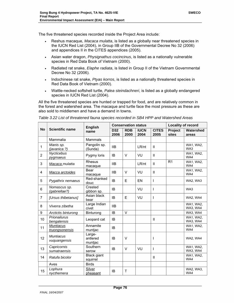
Song Bung 4 Hydropower Project, TA No. 4625-VIE Final Report Environmental Impact Assessment (EIA) – Main Report
SWECO
FINAL 16/04/2007
Page 76
The five threatened species recorded inside the Project Area include:
• Reshus macaque, Macaca mulatta, is listed as a globally near threatened species in the IUCN Red List (2004), in Group IIB of the Governmental Decree No 32 (2006) and appendices II in the CITES appendices (2005).
• Asian water dragon, Physignathus cocincinus, is listed as a nationally vulnerable species in Red Data Book of Vietnam (2000).
• Radiated rat snake, Elaphe radiata, is listed in Group II of the Vietnam Governmental Decree No 32 (2006).
• Indochinese rat snake, Ptyas korros, is listed as a nationally threatened species in Red Data Book of Vietnam (2000).
• Wattle-necked softshell turtle, Palea steindachneri, is listed as a globally endangered species in IUCN Red List (2004).
All the five threatened species are hunted or trapped for food, and are relatively common in the forest and watershed area. The macaque and turtle face the most pressure as these are also sold to middlemen and have a demand in towns.
Table 3.22 List of threatened fauna species recorded in SB4 HPP and Watershed Areas
Conservation status Locality of record No Scientific name English
name D32 2006
RDB 2000
IUCN 2004
CITES 2005
Project sites
Watershed areas
Mammalia Mammals
1 Manis sp. (javanica ?)
Pangolin sp. (Sunda) IIB LR/nt II WA1, WA2,
WA3
2 Nycticebus pygmaeus Pygmy loris IB V VU II WA1, WA2,
WA4
3 Macaca mulatta Rhesus macaque IIB LR/nt II R1 WA1, WA2,
WA4
4 Macca arctoides Bear macaque IIB V VU II WA1, WA2,
WA4
5 Pygathrix nemaeus Red-shanked douc IB E EN I WA2, WA3
6 Nomascus sp. (gabriellae?)
Crested gibbon sp. IB VU I WA3
7 [Ursus thibetanus] Asian black bear IB E VU I WA2, WA4
8 Viverra zibetha Large Indian civet IIB WA1, WA2,
WA3, WA4 9 Arctictis binturong Binturong IB V WA3, WA4
10 Prionailurus bengalensis Leopard cat IB II WA1, WA2,
WA3, WA4
11 Muntiacus truongsonensis
Annamite muntjac IB WA1, WA2,
WA4
12 Muntiacus vuquangensis
Large-antlered muntjac
IB V I
WA2, WA4
13 Capricornis sumatraensis
Southern serow IB V VU I WA1, WA2,
WA3, WA4
14 Ratufa bicolor Black giant squirrel II WA1, WA2,
WA4 Aves Birds
15 Lophura nycthemera
Silver pheasant IB T WA2, WA3,
WA4
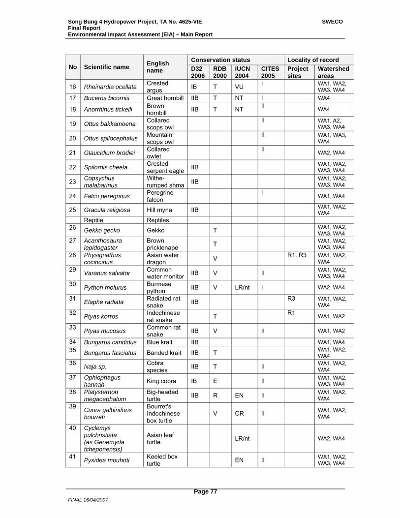
Song Bung 4 Hydropower Project, TA No. 4625-VIE Final Report Environmental Impact Assessment (EIA) – Main Report
SWECO
FINAL 16/04/2007
Page 77
Conservation status Locality of record No Scientific name English
name D32 2006
RDB 2000
IUCN 2004
CITES 2005
Project sites
Watershed areas
16 Rheinardia ocellata Crested argus IB T VU I WA1, WA2,
WA3, WA4 17 Buceros bicornis Great hornbill IIB T NT I WA4
18 Anorrhinus tickelli Brown hornbill IIB T NT II WA4
19 Ottus bakkamoena Collared scops owl II WA1, A2,
WA3, WA4
20 Ottus spilocephalus Mountain scops owl II WA1, WA3,
WA4
21 Glaucidium brodiei Collared owlet II WA2, WA4
22 Spilornis cheela Crested serpent eagle IIB WA1, WA2,
WA3, WA4
23 Copsychus malabarinus
Withe-rumped shma IIB WA1, WA2,
WA3, WA4
24 Falco peregrinus Peregrine falcon I WA1, WA4
25 Gracula religiosa Hill myna IIB WA1, WA2, WA4
Reptile Reptiles 26 Gekko gecko Gekko T WA1, WA2,
WA3, WA4 27 Acanthosaura
lepidogaster Brown pricklenape T WA1, WA2,
WA3, WA4 28 Physignathus
cocincinus Asian water dragon V R1, R3 WA1, WA2,
WA4 29 Varanus salvator Common
water monitor IIB V II WA1, WA2, WA3, WA4
30 Python molurus Burmese python IIB V LR/nt I WA2, WA4
31 Elaphe radiata Radiated rat snake IIB R3 WA1, WA2,
WA4 32 Ptyas korros Indochinese
rat snake T R1 WA1, WA2
33 Ptyas mucosus Common rat snake IIB V II WA1, WA2
34 Bungarus candidus Blue krait IIB WA1, WA4 35 Bungarus fasciatus Banded krait IIB T WA1, WA2,
WA4 36 Naja sp. Cobra
species IIB T II WA1, WA2, WA4
37 Ophiophagus hannah King cobra IB E II WA1, WA2,
WA3, WA4 38 Platysternon
megacephalum Big-headed turtle IIB R EN II WA1, WA2,
WA4 39 Cuora galbinifons
bourreti
Bourret's Indochinese box turtle
V CR II WA1, WA2,
WA4
40 Cyclemys pulchristiata (as Geoemyda tcheponensis)
Asian leaf turtle LR/nt
WA2, WA4
41 Pyxidea mouhoti Keeled box turtle EN II WA1, WA2,
WA3, WA4
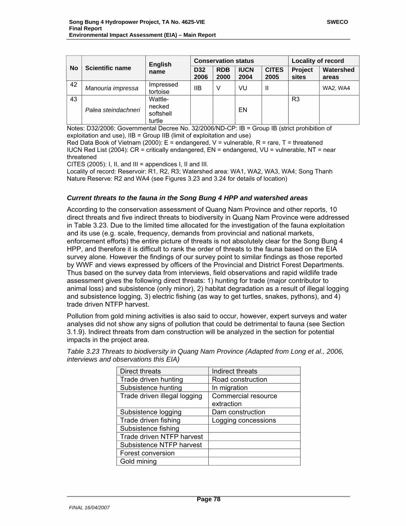
Song Bung 4 Hydropower Project, TA No. 4625-VIE Final Report Environmental Impact Assessment (EIA) – Main Report
SWECO
FINAL 16/04/2007
Page 78
Conservation status Locality of record No Scientific name English
name D32 2006
RDB 2000
IUCN 2004
CITES 2005
Project sites
Watershed areas
42 Manouria impressa Impressed tortoise IIB V VU II WA2, WA4
43
Palea steindachneri
Wattle-necked softshell turtle
EN
R3
Notes: D32/2006: Governmental Decree No. 32/2006/ND-CP: IB = Group IB (strict prohibition of exploitation and use), IIB = Group IIB (limit of exploitation and use) Red Data Book of Vietnam (2000): E = endangered, V = vulnerable, R = rare, T = threatened IUCN Red List (2004): CR = critically endangered, EN = endangered, VU = vulnerable, NT = near threatened CITES (2005): I, II, and III = appendices I, II and III. Locality of record: Reservoir: R1, R2, R3; Watershed area: WA1, WA2, WA3, WA4; Song Thanh Nature Reserve: R2 and WA4 (see Figures 3.23 and 3.24 for details of location)
Current threats to the fauna in the Song Bung 4 HPP and watershed areas According to the conservation assessment of Quang Nam Province and other reports, 10 direct threats and five indirect threats to biodiversity in Quang Nam Province were addressed in Table 3.23. Due to the limited time allocated for the investigation of the fauna exploitation and its use (e.g. scale, frequency, demands from provincial and national markets, enforcement efforts) the entire picture of threats is not absolutely clear for the Song Bung 4 HPP, and therefore it is difficult to rank the order of threats to the fauna based on the EIA survey alone. However the findings of our survey point to similar findings as those reported by WWF and views expressed by officers of the Provincial and District Forest Departments. Thus based on the survey data from interviews, field observations and rapid wildlife trade assessment gives the following direct threats: 1) hunting for trade (major contributor to animal loss) and subsistence (only minor), 2) habitat degradation as a result of illegal logging and subsistence logging, 3) electric fishing (as way to get turtles, snakes, pythons), and 4) trade driven NTFP harvest.
Pollution from gold mining activities is also said to occur, however, expert surveys and water analyses did not show any signs of pollution that could be detrimental to fauna (see Section 3.1.9). Indirect threats from dam construction will be analyzed in the section for potential impacts in the project area.
Table 3.23 Threats to biodiversity in Quang Nam Province (Adapted from Long et al., 2006, interviews and observations this EIA)
Direct threats Indirect threats Trade driven hunting Road construction Subsistence hunting In migration Trade driven illegal logging Commercial resource
extraction Subsistence logging Dam construction Trade driven fishing Logging concessions Subsistence fishing Trade driven NTFP harvest Subsistence NTFP harvest Forest conversion Gold mining
Song Bung 4 Hydropower Project, TA No. 4625-VIE Final Report Environmental Impact Assessment (EIA) – Main Report
SWECO
FINAL 16/04/2007
Page 79
Status of illegal logging
Local people in villages obtain permission from commune authorities to legally log for construction of houses. One household can log up to 6 m3 for a house. In the village of Thon Vinh (Ta Bhing commune) less than ten new houses are estimated to be built yearly while in in Zuoih commune about 50 houses are estimated yearly. The timber for Thon Vinh is cut from forests located outside of Project area but for Thon 2 village, the forest areas in the Project area is used (mainly from the reservoir area).
During the field survey illegal logging was commonly observed along Road 14D and inside STNR. The most attractive site for illegal cutting (area most vulnerable) is the confluence of A Vuong and Bung rivers. The loggers are not the local people but ‘outsiders’ from other districts and parts of the province. The sandbank near the confluence of A Vuong and Bung rivers is used to gather cut timber before transporting it downstream. All mature large trees with good to mediocre timber (In the Vietnamese timber Group 1 to group 6 or 7) in primary closed evergreen tropical broad-leaved lowland forests growing on silicate rocks are easy targets. Typical species are Aglaia spp., Dimocarpus longan, Dracontomelum duperreanum, Pometia pinnata, Duabanga grandiflora, Artocarpus rigida, Knema spp. and Peltophorum dasyrrhachis. In 2005 about 600 m3 of timber from illegal logging was confiscated, about 2/3 came from A Vuong while 1/3 came from the Bung River. The amount of illegal timber logged, transported and confiscated along 14D road is small, amounting to 30-50 m3 per year. This amount may not be reflective of the actual illegal amounts of illegally cut logs removed from the area due to poor forest guarding and controls on roads.
Shifting Agriculture.
Based on observations during the field survey it appeared that local people in villages respected shifting agricultural regulations. Shifting cultivation does however continue in the reservoir area in recently abandoned areas and not far from villages. No clearing of forested areas in the reservoir area or at higher elevation appears to be occurring. STNR officers confirmed our observations and said that it is the outsiders who clear areas as they log legally.
3.1.11.3 Protected Area Song Bung 4 HPP project impacts the Song Thanh Nature Reserve (STNR) through the inundation of an area of 142.65 ha (R2, a part of the Project reservoir), see Figures 3.26 and 3.27. STNR was established by the People’s Committee of Quang Nam province in 2000. The nature reserve is ‘proposed’ at the national level and awaits approval by MARD (2 August 2006) although it is functioning as a nature reserve with a management board, and is said to have been proposed for national park status. Located in Nam Giang and Phuoc Son districts of Quang Nam Province between 15°13’-15° 41’N and 107°21’-107°50’E, the reserve covers 13 communes. The reserve borders Kon Tum province to the south and Lao PDR to the west. The reserve’s ranges in altitude from 80 to 2,032 m a.s.l. The core zone of the reserve is 93,249 ha and the buffer zone is 108,398 ha. In Song Bung 4 HPP areas the buffer zone, except for some areas (see also land use table), is of much poorer vegetation than the core zone which is rich in species with 95% of the core area covered by broad-leaved evergreen forest. The core zone reports up to 323 faunal (including 106 butterflies) and 329 plant species from recent surveys. No comprehensive survey for STNR has been conducted yet. STNR falls in the Central Troung Son Landscape which is classified as a priority area for conservation in the region. It also falls in the corridor of the Biological Conservation Corridor Initiative (BCI) of the ADB (ADB RETA 6213) which aims to link protected areas and create forested corridors. Forty-one households live within the proposed core area of the nature reserve, and an estimated 4,598 households inhabit the buffer zone. Although the population density in the buffer zone of the proposed STNR is only 12 people

Song Bung 4 Hydropower Project, TA No. 4625-VIE Final Report Environmental Impact Assessment (EIA) – Main Report
SWECO
FINAL 16/04/2007
Page 80
per km2, it is one of the poorest areas in Quang Nam Province. Local ethnic minorities rely heavily on forest land and resources for their livelihoods. Illegal logging and wildlife trapping are major threats to biodiversity. Outsiders are responsible for most of the illegal activities while local people are used by them, as observed during the survey for this EIA.
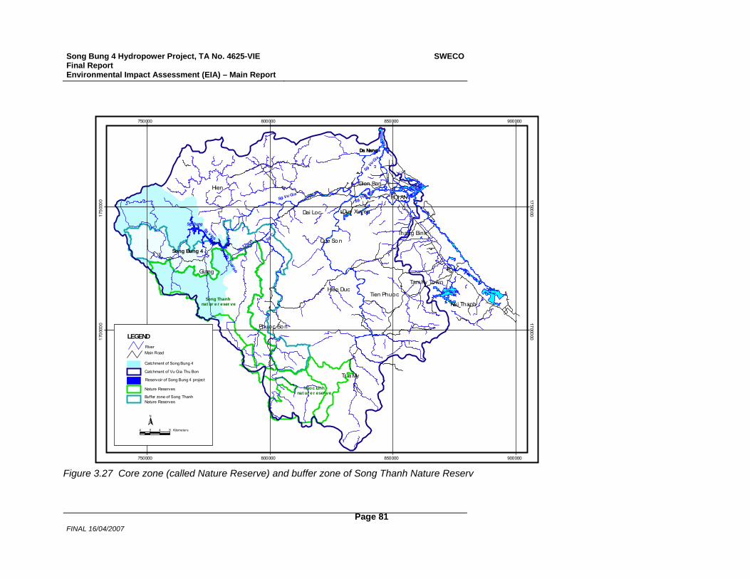
Song Bung 4 Hydropower Project, TA No. 4625-VIE Final Report Environmental Impact Assessment (EIA) – Main Report
SWECO
FINAL 16/04/2007
Page 81
Da Nang
Sg. Thu Bon
Sg. C¸ i
Sg. Vu Gia
Sg. Thanh
Sg. TraVinh
Sg. Bung
Sg. Vinh
Sg. Vu Gia
Dien Ban
Tam Ky Town
Duy Xuyen
Thang Binh
Tien PhuocHieo Duc
Nui Thanh
Dai Loc
Que So n
Phuoc So n
Tr a My
Giang
Hien
Da Nang
HOI AN
Ngoc Linhnat ur e r eser ve
Song Thanh nat ur e r eser ve
Song Bung 4
750000
750000
800000
800000
850000
850000
900000
900000
1700
000 1700000
1750
000 1750000
LEGEND
Reservoir of Song Bung 4 project
Catchment of Song Bung 4
Catchment of Vu Gia Thu Bon
Nature Reserves
RiverMain Road
N
4 0 4 8 Kilometers
Buffer zone of Song Thanh Nature Reserves
Figure 3.27 Core zone (called Nature Reserve) and buffer zone of Song Thanh Nature Reserv
Song Bung 4 Hydropower Project, TA No. 4625-VIE Final Report Environmental Impact Assessment (EIA) – Main Report
SWECO
FINAL 16/04/2007
Page 82
Status of species in the STNR Present knowledge of the flora
According to a Report on results of the study of forest vegetation in the western part of Quang Nam Province conducted by Bui Dac Tuyen et al. (1997) and submitted to MARD & WWF the standing growing stock of undisturbed forests there has an average of 400 m3 of timber per ha, at times reaching up to more than 700 m3 timber per ha, while that of disturbed forests comes to about 130-150 m3 timber per ha. The latter make the bulk of the forest types in the inundated area. At higher elevations above of the inundated area the forest is of good quality.
Vu Van Can (Long et al. 2006) conducted a study of flora mainly of undisturbed and slightly disturbed forests situated in the watershed of Tra Vinh (Vinh stream) at an elevation of 330 to 900 m, covering an area of about 240-300 km2 (the center of this area has the coordinates 15°37'28.9'' N and 107°38'32.5'' E, in the territory of STNR, and more exactly, in the Tra Vinh watershed). As noted the area studied was an area situated higher than El. 222.5 m, thus falling beyond R2- the reservoir line of the Project. This is thus not representative of the area that will be inundated and is clearly a better quality forested area, also as seen from satellite images. 355 species of higher vascular plant species in 86 families were recorded. Of these 5 species were classified in the Red Data Book of Vietnam- Plants (1996) as Vulnerable (VU), 1 species as Rare (R), 2 species as Threatened (T) and 3 species as Un-sufficiently Known (K). One species (Hopea hainanensis) is listed as Endangered (EN) in IUCN Red List Categories, one species (Sindora tonkinensis) as Vulnerable (VU) and 8 species as Rare (R). The following five species in the list, namely Semecarpus annamensis (Anacardiaceae), Polyalthia barenensis (Annonaceae), Macropanax simplicifolius and Schefflera quangtriensis (Araliaceae) and Eberhardtia krempfii (Sapotaceae) are found in the list of endemic species of the Floristic Central Annamese Province (Averyanov et al., 2003). The richest in number of species families are Euphorbiaceae (38 species), Leguminosae s.l. (25), Orchidaceae (22), Gramineae (21 species), Palmae (19) and Moraceae (16). These data show that the floral species of the studied area are typical of the flora of tropical closed evergreen broad-leaved lowland forests on silicate rocks. In the Vu Van Can’s list there are 4 globally threatened species, namely Dalbergia oliveri, Hopea hainanensis, Lithocarpus annamensis and Parashorea stellata.
During the field survey for this EIA plots, were set up in the zone to be inundated by the Project reservoir, an area at a significantly lower elevation than that of the above study (Vu Van Can in Long et al. 2006). The area is also more visibly impacted by human activities – mainly slash and burn agriculture and logging. During the field survey illegal logging was in progress in some parts of the Project Area.
Flora of the inundated part of Song Thanh Nature Reserve (R2)
96 species were recorded in the survey of which 38 species were listed in Vu Van Can's list in Long et al. (2006). Even though the forests in STNR have a larger cover, especially in its southern part than in R1 and R3 (45.35 %, 26.20 % and 14.45 %, respectively) their species composition and structure of vegetation types are very similar to each other. Most of the species recorded here were also recorded in other sites of the Project Area. Except for Erythrophleum fordii no other threatened or endemic species was found.
Present status of Fauna
According to the Management Plan of STNR 2005-2010 (Le Nho Nam et al., 2005) the fauna of STNR has been investigated in two main surveys: (i) A total of 53 species of mammals, 183 species of birds, 44 species of reptiles and 21 species of amphibians were listed in the
Song Bung 4 Hydropower Project, TA No. 4625-VIE Final Report Environmental Impact Assessment (EIA) – Main Report
SWECO
FINAL 16/04/2007
Page 83
Investment Plan for STNR (1999). A review of this list revealed that it also included species that may be expected to be present based on work done by Birdlife International and interviews (see also discussion in Barney et al. 2006). In addition the precision of the records is unclear. The actual numbers most likely differ than those listed in the report. The report was not used as a basis for this report, and (ii) Recent surveys conducted by WWF confirmed a total of 29 species of mammals, 154 species of birds, 22 species of reptiles, 12 species of amphibians and 10 species of fish.
Fauna of the inundated part of STNR (R2)
Within STNR (WA4 and R2), a total of 139 species were recorded, including 22 species of mammals, 81 species of birds, 24 species of reptiles and 12 species of amphibians. Among these, 52 species recorded in the reservoir (R2) and 116 species recorded in the watershed area (WA4).
While 37 threatened species were recorded inside STNR all were in the watershed area (in WA4) and none in the reservoir area. These included 11 species of mammals, 11 of birds and 15 species of reptiles.
Present pressure on biodiversity in STNR
Five major threats to Song Thanh Nature Reserve identified by Le Nho Nam et al. (2005) in descending order of importance are: hunting/trapping/fishing, logging, freshwater degradation, over-exploitation of forest products, and forest conversion.
3.1.12 Road Guidelines
The Song Bung 4 HPP includes about 20 km of access and service roads, a new part of Highway 14D, and about 40 km of new roads to planned resettlement areas. The access roads and roads to resettlement areas are all dead-end roads.
To minimize the negative impacts from the new roads to be constructed, especially on the reservoir, guidelines for integrating environmental considerations into constructing and maintaining roads supported by the Project have been prepared as good engineering practice. The guidelines (Annex 3) will be included in all contractor bidding documents and operating contracts. They are based on experience from road construction and maintenance in the project area, and general experience with road construction and maintenance in mountainous areas in Viet Nam. There are few relevant existing roads in the project area, apart from Highway 14D. The guidelines cover all aspects of road construction, such as (i) clearing and grubbing; (ii) roadway excavation; (iii) channel excavation; (iv) excavation and backfill of structures; (v) embankment; (vi) subbase and base; (vii) pavements; (viii) drainage, pipes, and outlets; (ix) grassed areas; (x) slope protection; and (xi) mortared stonework. In addition the guidelines describe the maintenance and environmental management required in relation to roads, including monitoring needs.
3.2 Social and Cultural Conditions
3.2.1 Administrative Areas and Population
3.2.1.1 Nam Giang District The Project Area of Song Bung 4 Hydropower Project is located in the mountainous Nam Giang District in Quang Nam Province. The total land area of the district is 1,836 km2 and the total population is approximately 20,400 people. 79% of the district population is ethnic minority people. Major ethnic minority groups are Co Tu (56% of the district population), Gie
Song Bung 4 Hydropower Project, TA No. 4625-VIE Final Report Environmental Impact Assessment (EIA) – Main Report
SWECO
FINAL 16/04/2007
Page 84
trieng (21% of the district population), Muong, Thai and Tay. Nam Giang District is located at the border area to the Lao PDR and is administratively divided into eight rural communes with totally 60 villages and to the district town of Thanh My. The majority Kinh people (21% of the district population) reside mainly in the district town and in commune centres. The Kinh are predominantly governmental officials, military, teachers, health care workers and traders.
The district administrative, population, ethnicity and poverty issues are dealt with in REMDP Volume 1 Chapter 3.
3.2.1.2 Project-affected Communes The Song Bung 4 Hydropower Project will affect three communes, Ta Bhing, Cha Val and Zuoih. The dam site and construction areas are located in Ta Bhing, and the reservoir will cover areas in all three communes. No people will be directly affected by the reservoir or the project construction in Cha Val commune. The Reservoir and Project lands affected areas are almost entirely inhabited by Co Tu ethnic minority people. The downstream areas in Dai Son Commune and further downstream in Dai Loc District locate villages with mostly Kinh majority population. Full account on the different areas and their population is given in the REMDP: for the Reservoir area in Volume 2, Chapter 1; for the Project lands area in Volume 3 Chapter 3; and for the Down/upstream areas in Volume 4.
3.2.1.2.1 Reservoir Area In Zuoih Commune inhabitants in the four villages of Thon 2, Pa Dhi, Pa Rum A and Pa Rum B will be directly affected by the reservoir inundation and will be relocated. There are totally 206 households with 971 persons in these villages. Resettlement is planned to take place in the nearby areas within Zuoih commune. Only one existing village, Pa Pang, will be host area receiving resettlees. At present 21 households with 85 persons live in that village. The other planned resettlement areas are currently uninhabited. The sixth village in Zuoih Commune, Cong Don with 404 inhabitants in 80 households lies in the vicinity of the planned resettlement sites.
3.2.1.2.2 Project Lands Area In Ta Bhing commune, two villages are located close to the dam site and are going to be affected by the construction workers and construction activities. In total, Project lands will affect areas of 15 villages in the three communes of Ta Bhing, Ca Dy and Thanh My town. In Ta Bhing, parts of all the 9 villages in the commune are located within the project lands areas. In Ca Dy, areas of four villages are affected, and in Thanh My town two villages. Baseline study on these areas is found in REMDP Volume 3 Chapter 3. Project lands will not lead to dislocation of people, however, various areas utilized for different purposes by the villagers in the 15 villages will be affected by the Project.
3.2.1.2.3 Down/Upstream Area There are no villages located in the immediate downstream area of the dam. In terms of social and livelihood impact, the downstream and upstream areas can be divided into four main zones:
DS Zone 1: between SB4 dam site and close to the confluence with Song Cai. Pa Dau 2 village with 39 Co Tu ethnic minority households;
DS Zone 2: around the confluence of Song Bung with Song Cai, after which the river is called the Vu Gia River: Dai Son Commune, with eight villages, is located here, with two villages actually on the Song Bung and the other 6 on the Vu Gia;
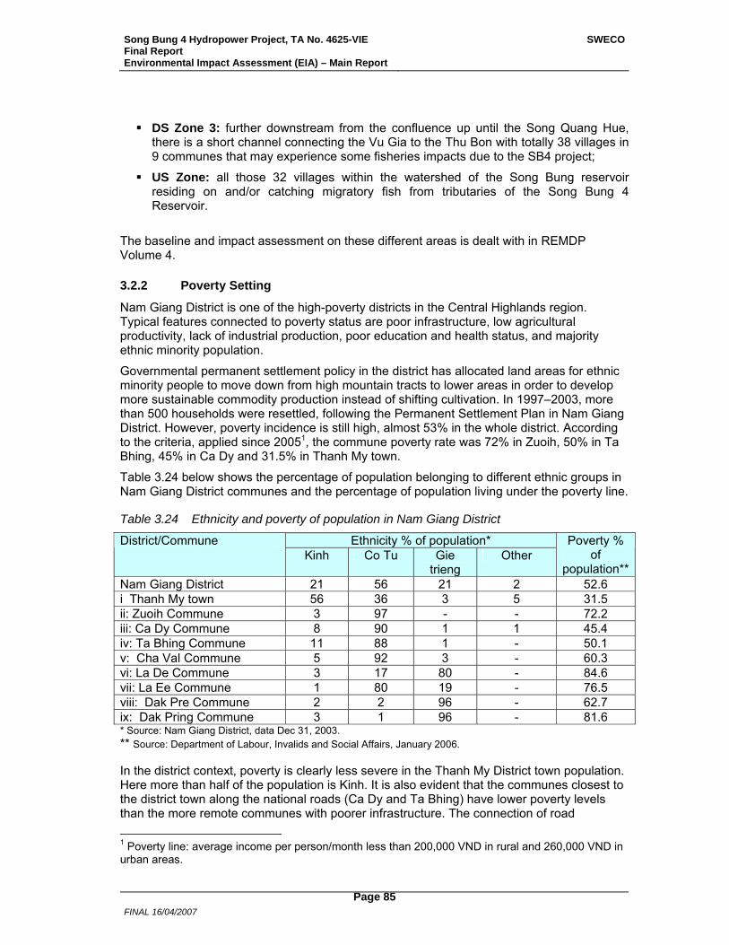
Song Bung 4 Hydropower Project, TA No. 4625-VIE Final Report Environmental Impact Assessment (EIA) – Main Report
SWECO
FINAL 16/04/2007
Page 85
DS Zone 3: further downstream from the confluence up until the Song Quang Hue, there is a short channel connecting the Vu Gia to the Thu Bon with totally 38 villages in 9 communes that may experience some fisheries impacts due to the SB4 project;
US Zone: all those 32 villages within the watershed of the Song Bung reservoir residing on and/or catching migratory fish from tributaries of the Song Bung 4 Reservoir.
The baseline and impact assessment on these different areas is dealt with in REMDP Volume 4.
3.2.2 Poverty Setting
Nam Giang District is one of the high-poverty districts in the Central Highlands region. Typical features connected to poverty status are poor infrastructure, low agricultural productivity, lack of industrial production, poor education and health status, and majority ethnic minority population.
Governmental permanent settlement policy in the district has allocated land areas for ethnic minority people to move down from high mountain tracts to lower areas in order to develop more sustainable commodity production instead of shifting cultivation. In 1997–2003, more than 500 households were resettled, following the Permanent Settlement Plan in Nam Giang District. However, poverty incidence is still high, almost 53% in the whole district. According to the criteria, applied since 20051, the commune poverty rate was 72% in Zuoih, 50% in Ta Bhing, 45% in Ca Dy and 31.5% in Thanh My town.
Table 3.24 below shows the percentage of population belonging to different ethnic groups in Nam Giang District communes and the percentage of population living under the poverty line.
Table 3.24 Ethnicity and poverty of population in Nam Giang District
Ethnicity % of population* District/Commune Kinh Co Tu Gie
trieng Other
Poverty % of
population**Nam Giang District 21 56 21 2 52.6 i Thanh My town 56 36 3 5 31.5 ii: Zuoih Commune 3 97 - - 72.2 iii: Ca Dy Commune 8 90 1 1 45.4 iv: Ta Bhing Commune 11 88 1 - 50.1 v: Cha Val Commune 5 92 3 - 60.3 vi: La De Commune 3 17 80 - 84.6 vii: La Ee Commune 1 80 19 - 76.5 viii: Dak Pre Commune 2 2 96 - 62.7 ix: Dak Pring Commune 3 1 96 - 81.6 * Source: Nam Giang District, data Dec 31, 2003. ** Source: Department of Labour, Invalids and Social Affairs, January 2006.
In the district context, poverty is clearly less severe in the Thanh My District town population. Here more than half of the population is Kinh. It is also evident that the communes closest to the district town along the national roads (Ca Dy and Ta Bhing) have lower poverty levels than the more remote communes with poorer infrastructure. The connection of road 1 Poverty line: average income per person/month less than 200,000 VND in rural and 260,000 VND in urban areas.
Song Bung 4 Hydropower Project, TA No. 4625-VIE Final Report Environmental Impact Assessment (EIA) – Main Report
SWECO
FINAL 16/04/2007
Page 86
infrastructure and the combined opportunities to that are closely connected to reducing poverty.
The Project area communes with Co Tu ethnic minority population are among the most remote and poorest communes, and one of the special target areas for poverty reduction programs. However, their remoteness combined with poor education level, isolated ethnic minority culture and language make access of the poor households to resources like loans from official sources, infrastructure such as electricity, clean water and sanitation works as well as to health care limited. The number of Co Tu households that manage to escape poverty is still low.
3.2.3 Basic Infrastructure
The National Road 14D leads from the District town of Thanh My to the border of Laos. The three communes of Ta Bhing, Ca Dy and Thanh My town in the Project lands areas are located along this road, which will also be utilized for transportations to the construction site. Communications from all the affected villages to the district town are good along the national road, facilitating access to trade and to services like health care and education in the district town. Mobile traders reach the villages on a daily basis, selling sea fish and buying agricultural and forest products. All the three commune centres are electrified. Power is mainly supplied from a 35kV transmission line. The total household electrification rate is approximately 33%, but electrification is very unevenly distributed between the villages. All the communes have a post office, and the district post office is located in Thanh My town.
In the reservoir area the three villages of Thon 2, Pa Dhi and Pa Rum B in Zuoih Commune can be accessed through the commune road, which is not vehicle accessible year-round. The distance of the commune centre, located in Pa Dhi Village, is 22 km from the national road. The villages of Pa Rum A and Pa Pang can today be reached only through a walkable track through the forest. Only Cong Don Village is reachable through a vehicle accessible road from Cha Val commune centre, but the village is connected to the Zuoih commune centre in Pa Dhi Village through a motorbike accessible track only. The Co Tu ethnic minority people living along the Bung River do not use boats for transportation, but the downstream area Kinh people regularly use boats both for transportation and fishing. Here the road access to villages is also more convenient.
In Zuoih Commune only a few households provide themselves with electricity generators. Very few households have TV, but half of the households do have radio. There is a satellite telephone available in the commune centre post office, but no mobile telephone network reach.
3.2.3.1 Housing Traditionally Co Tu houses were built on poles, protecting against wild animals. They were constructed of bamboo, thatch and leaves. Co Tu people in the Project area, however, have been influenced by the Government’s settlement policy and by Kinh people, and today most of the houses are built on the ground. House construction style and material follow the wealth level in that the wealthier villagers generally have houses on the ground, some with cement basement, walls of wood and roof of corrugated iron. The wealthiest households may have brick houses.
In Zuoih resettlement villages 56% of the houses are built on the ground. The current villages are a mixture of traditional and changing house styles. Many households have built their residential houses on the ground, but the houses for stocking rice and other foodstuff are built on poles in order to protect the goods against wild and domestic animals. 38% of all residential houses are built on short poles. Most houses, 55% in the four villages, have earthen floors. The second most popular floor type is that of bamboo, 29% of houses. 54% of
Song Bung 4 Hydropower Project, TA No. 4625-VIE Final Report Environmental Impact Assessment (EIA) – Main Report
SWECO
FINAL 16/04/2007
Page 87
houses have walls of bamboo and 44% of wood. The few most affluent households’ houses have a cement base, only 10% of all the houses. Nearly 60% of the houses in the four villages have roofs made of iron, and 30% of bamboo. However, there are differences between the villages in that Thon 2 has largest percentage of houses with iron roofs and wooden walls, indicating a higher wealth level. Bamboo is used most frequently as a construction material in Pa Dhi. The same applies to Pa Pang host village. In Pa Rum B most houses are built on the ground with earthen floor and iron roof.
In Ta Bhing villages most of the houses (83%) are wooden, 11% are of bamboo and 6% are brick houses. In the four Ca Dy villages affected by the Project, 58% of the houses are of wood, 30% of bamboo and 12% of bricks. In Thanh My Village 1 almost all the houses are wooden (97%), in Pa Dau Village 77% of the houses are of wood, 18% of bricks and the rest of bamboo. Housing and living standards are in general better in Thanh My town area than in the rural villages. In the downstream Kinh villages houses are in general wooden, with cement bases and iron roofs. The Co Tu ethnic minority village of Pa Dau 2 follows the same house construction patterns as in the other Co Tu villages according to the wealth level of households.
3.2.3.2 Water and Sanitation In all Project area villages most households use stream water, which is led to the village through pipes using a gravity flow system. Most people boil drinking water, except when working in the upland fields and utilising water directly from the mountain streams. There are no latrines and any waste is just disposed outside the houses for animals. Household toilets are dug in the ground at a small distance from the houses or people just release themselves in the nature, where free roaming pigs and dogs find their food.
3.2.4 Social Services
According to the Vietnam Government policy, every commune should have a commune health centre (CHC) and a school with grades 1-9. Accordingly every village should have a health care worker and a school with grades 1-2. Upper secondary school education should be available in the district town, where also a district health centre is available for health problems that are not treatable in CHCs. Access to education is universal, same for boys and girls and for different ethnic groups. The national Program 135 (Socio-Economic Development in Mountainous, Deep-lying and Remote Communes with Special Difficulties) is focusing on infrastructure development in remote areas like Nam Giang District, providing the communes funding for basic transportation, education and health infrastructure. The National Poverty Reduction and Hunger Elimination Program No. 133 supports families in poor communes with e.g. subsidizing the school fees for the children, and Program No. 139 provides poor families with free health care. Every commune is also expected to follow the national laws, and has police authorities to execute respect to law in all villages.
3.2.4.1 Education In the reservoir area in Zuoih Commune every village has a school with grades 1-2, except Cong Don Village with grades 1–6. The commune boarding school with grades 1-9 is located in Pa Rum B. Nearly all children continue at the commune school after grade 2 in the home village. School attendance of boys and girls is at the same level. In Project lands area all villages or clusters of villages (like Thon Vinh and Pa Toi being 1 km in-between) have a school with grades 1-5. Education above grade 5 is available for Ta Bhing and Ca Dy children in the inter-communal school in Ca Dy, where many children stay during the week and only come home over the weekend. Upper secondary education with grades 10–12 is available only in the district town.
Song Bung 4 Hydropower Project, TA No. 4625-VIE Final Report Environmental Impact Assessment (EIA) – Main Report
SWECO
FINAL 16/04/2007
Page 88
Poverty and long distance to school contribute to children not finalizing their education. According to women, families find it difficult to support children’s education in boarding schools. They have to provide the school with rice, vegetables, fruit and firewood.
Education level among the Co Tu ethnic minority people is in general low. The majority of the adult population in all villages has only elementary level or none education. Many women, especially the elderly ones are illiterate. People’s ability to communicate in the Vietnamese language is varying in the different villages and between men and women, being better in villages with proper road access, and poorest in the most isolated villages in Zuoih.
The poor ability to communicate in Vietnamese further contributes to Co Tu people’s isolation from the society outside their own community. This is case especially with women. Their ability to receive information or express their needs and concerns appears limited. The better communication skills of men contribute to gender imbalance in information flows; it is often men who both inform women and express the opinions of the local community.
3.2.4.2 Health Care Every commune in the Project area has a Commune Health Centre with an under doctor, nurse and midwife, but doctors are available only at the district hospital. There is a Village Health Worker in every village. The services available at commune level are very basic, focused on preventive and reproductive health care. Child vaccination program is implemented in all villages, and staff from the District Preventive Health Centre visit villages and provide preventives to married couples every year. Most families practice family planning, and the most common device is coil.
The most usual health disorders are respiratory infections and stomach diseases, especially diarrhoea. Men drink daily home-made alcohol, which leads to stomach problems. Most Co Tu women in the Project area villages give birth at home. Poor households have the right to free health care according to the national Program 139, but they still have to pay for the transportation costs themselves. Poor families therefore often abstain from seeking health care services, and try to treat the sick with traditional medicines.
Full account of the social services is found in the REMDP: for the Reservoir area in Volume 2 Chapter 2.7, and for the Project Lands in Volume 3 Chapter 3.3.2.
3.2.5 Socio-economic Conditions
Full account of the socio-economic conditions in the various Project areas is found in the REMDP: for the Reservoir area in Volume 2 Chapter 2.5 and Chapter 4, for the Project Lands in Volume 3 Chapter 3.3.3, and for Down/upstream areas in Volume 4 Chapter 2. An overview is provided below.
3.2.5.1 Basic Resource Utilization System Co Tu ethnic minority people live in a traditional subsistence economy system based on upland swidden cultivation and utilization of resources in forest and water, added with animal breeding. Forest actually constitutes the very basis for Co Tu life: not only is cultivation land cleared in the upland forest, but forest also provides almost all the everyday necessities: house construction material, firewood, food in the form of vegetables, fruit, mushrooms, leaves and roots, honey, wild animals, insects and birds. Income is derived from selling forest products like wild animals, rattan, bamboo shoots and wine made of Ta Vac palm. Fish is sold occasionally as well.
The basic economic unit is a family, consisting of husband, wife and their children. Land is inherited from father to sons, the youngest son receiving the largest part. If a father has not
Song Bung 4 Hydropower Project, TA No. 4625-VIE Final Report Environmental Impact Assessment (EIA) – Main Report
SWECO
FINAL 16/04/2007
Page 89
enough land to divide to his sons, the sons just clear more land in the upland forests; according to the villagers in the Project area there is plenty of upland for everybody.
3.2.5.2 Agriculture All Co Tu households have upland fields, which are cleared in the forests at a sloping level of 10–18o using slash and burn methods. Each household has several sloped hill fields in a rotational cultivation system. Each field is used from three to four or five years and then left fallow for up to ten years. The first two years the field is used for rice, the third year for cassava, banana, sugar cane and pineapple, the fourth to fifth year for beans and ground nuts. Then the field is left fallow from three to four to up to ten years. There are therefore two types of land in rotation all the time; cultivated land and fallow land. All cultivation work is done manually; no ploughs, buffaloes or fertilizers are used.
Upland rice is the staple food, added with maize and beans. Cassava is grown by all households, and considered as “pig food”, but also consumed by people in case of food insufficiency. Food insufficiency occurs commonly, partly due to wild animals, especially wild boars destroying crops in the hill fields. However, the indigenous social system builds upon sharing between households, so that households with enough rice will share with the ones that have not enough; In a local community where almost everybody is related to each other through marriage and family ties, it is natural to help neighbours in need: If a household’s harvest has failed, the other households in the village will help that household.
Wet rice fields are a supplement to upland fields. In Zuoih only a few households have wet rice fields in the villages to be resettled, but in Cong Don and in Pa Pang host village wet rice fields are more common. In the Project lands area villages many households do wet rice cultivation, but still the area per household is in general small.
The main cultivated fruit trees are banana, mango, rambutan, longan, litchi, jackfruit, loong boong (local name), plum and citrus. These trees are planted around the houses and in scattered plots in upland areas. Some fruit trees are inter-planted with forest trees and not concentrated, resulting in a difficult management situation and low yields. Fruit is grown mainly for household consumption. The most valuable fruit is loong boong, with a sell price of 3,000–5,000 VND/kg.
3.2.5.3 Forest Utilization Utilization of forest resources is important for both food and income of the Co Tu people. Both men and women collect forest products; men cut trees and they hunt wildlife, which is mostly sold in order to generate cash, while women gather fruit, vegetables, mushrooms and leaves mainly for household food and medicine, and bamboo shoots and Uoi seeds for selling.
Rattan is the economically most important collected NTFP in all Co Tu villages. Especially in Ta Bhing villages selling rattan is of great importance for household economy. Both men and women collect rattan in the forests. In Thon Vinh and Pa Toi villages an average household income from selling rattan is 1 MVND per year. Here selling palm leaves for hat making is also important for household income.
Men do hunt wild animals, especially wild boars in the forests. The economic importance appears to vary between the Project area villages. In the resettlement villages, Thon 2 villagers appear achieve large part of their income from selling wildlife and fish as well as NTFPs. Legally the villagers are not to possess guns, but use traps, dogs and bow and arrow for hunting. However, some men appear to have guns and use them for hunting.
A lot of illegal logging occurs in the forests in the Project area, but it has not been possible to assess the magnitude and the involvement of the local people in these activities. People
Song Bung 4 Hydropower Project, TA No. 4625-VIE Final Report Environmental Impact Assessment (EIA) – Main Report
SWECO
FINAL 16/04/2007
Page 90
mention that some men in Ta Bhing have been arrested and even detained for illegal logging, which has reduced involvement of the local people. The most interesting areas for loggers are close to the Song Bung 4 HPP construction area. Loggers use the Bung River for timber transportation. Intensive illegal gold mining is taking place in the river as well, but the local population is not involved in that. However, local people dig for gold in the river during the dry season. In Zuoih villages this small-scale gold digging provides income for both men and women.
3.2.5.4 Livestock Breeding All Co Tu households that can afford it keep animals. Livestock production mainly consists of raising cows and buffaloes, pigs, chicken and ducks. Most households also have dogs, which are used for hunting wildlife. Cattle are raised by more than half of the households in the reservoir area villages in Zuoih. Almost all households here have chicken, and approximately 60% of the households have pigs. In most Co Tu villages the poorest households having cows own 1–2 cows, while the more well-off ones have 7–8 cows and the richest ones up to 20 cows.
The main purpose for animal keeping is to generate cash income. Some households also keep cows and buffaloes for producing calves for sale. Another purpose for keeping valuable large ruminants is for savings. Most of the pigs and chicken are for sale in the market and those left are used for important events like village festivals, weddings, funerals or as gifts for relatives.
Cattle and buffaloes give highest cash value with up to 5–6 MVND per animal, and they are in general owned and sold by men. Men also take primary responsibility for cattle and buffaloes, even though it may be women and children that daily to a large extent take care of all the animals. Women are responsible for pigs, chicken and ducks and may decide over the income from selling them. Some women also keep goats.
The most serious constraints for livestock breeding are poor breed animals, disease occurrence and poor access to veterinary services. Veterinary services are expensive and not even available in the remote communes, and epidemic diseases sometimes wipe out most of the chickens or pigs in a whole village. Co Tu villagers treat their animals with traditional herbal medicines, but their knowledge in disease prevention and treatment is limited. Villagers’ access to extension services for production development is very poor and livestock breeding is consequently low productive. In most villages pigs and chickens roam around freely. Cows usually find their pasture on the riverside.
3.2.5.5 Fishing and Aquaculture Fish is staple food together with rice and the major protein source for all the Co Tu people in the Project area villages. Fish is caught in the Bung river and its tributaries and in many villages fish is raised in ponds as well. In general Co Tu people do not use boats, but they catch fish along the rivers and streams. Big fish in the middle of the river is caught by men, while women and children catch smaller fish with baskets in shallow waters nearer the shore and in mountain streams. Women also collect snails, shrimps and other aquatic species as well as frogs. The results of the fishery surveys and focus group meetings on fishery conducted by the PPTA Phase 2 team in February-June 2006 in the various Project area villages show that in all villages women recognized and caught many more fish and aquatic species than men. It is also women who usually take care of the daily work with breeding fish in ponds. They also catch small fish in streams for raising in ponds.
Household fishery survey made in the reservoir area villages in Zuoih shows that approximately 20% of the total fish caught and produced is sold. Villagers in the Project lands area estimate they mainly consume all the fish raised in ponds without any significance
Song Bung 4 Hydropower Project, TA No. 4625-VIE Final Report Environmental Impact Assessment (EIA) – Main Report
SWECO
FINAL 16/04/2007
Page 91
for household income. In these areas additional fish for family food is also bought from mobile traders.
3.2.5.6 Extension Services and Training Opportunities Co Tu people in the Project area have poor access to extension services. Little agricultural and livestock extension services have been provided by the District Economic Section through Farmers’ Union and by the District Ethnic Unit. Major activities have consisted of introducing new crops like cinnamon, citrus, mango, longan, rambutan, and new crop varieties like wet rice, hybrid maize and high yield cassava. However, hardly any technical training has been available, and the introduction of new species and varieties has therefore not been successful. Some crop varieties like hybrid maize is no longer cultivated in the area, and many fruit trees give a low yield. Co Tu villagers say they are very much interested in these new varieties, and would like to learn cultivation techniques in order to improve productivity.
Existing training activities have basically been participated by staff from Farmers’ Union in villages and a few representatives for Women’s Union. Very few women have had any possibility to participate in technical training. Whenever training courses are arranged by the district authorities, a male representative from each involved village has participated.
FIDR (Foundation for International Development Relief, a Japanese NGO) is the only NGO in the Project area arranging extension training for Co Tu villagers. FIDR has provided villagers in Thon Vinh and Pa Toi villages with cows and pigs and provided training in taking care of them.
3.2.5.7 Income Generation Co Tu villagers’ opportunities to generate additional income apart from selling products from agriculture, forestry and fishery are very limited. Their cash income comes mainly from selling livestock and NTFPs. In villages with good road access women mainly generate income from selling beans, rattan and bamboo shoots and men from selling rattan and wildlife. Women in the remote villages in Zuoih except in Thon 2 and Cong Don hardly have this possibility, but they sell agricultural and forest products to the local Kinh trader in exchange for necessary food items. Villagers also do gold shifting in the river during the dry season and sell gold to the local trader.
3.2.6 Co Tu Ethnic Minority Culture and Social Organization
3.2.6.1 Village organization Co Tu ethnic minority culture is rooted in the importance of the village and kinship. Co Tu are patrilineal and patrilocal, meaning that descent of children follows father’s lineage and name, and that wife moves to live in husband’s family and village. Close kin marriages are common. The children of brother and sister belong to different lineages according to the Co Tu thinking, and marriage between cross cousins is customary. In any Co Tu village different households are therefore related to each other through kinship ties.
Social organization is based on the male line. According to the patrilineal tradition only men can inherit and own property. The ultimate decision making authority in the village is the Village Elder who is chosen through voting, that can be done every year, by all the villagers. The Village elder is assisted in decision making by the group of elder men.
Since 1975 the traditional leadership structure in Co Tu villages exits side by side with the national political leadership structure, which is applied on all administrative levels in Vietnam. Accordingly, all the villages in Zuoih Commune have a party cell with the Head/Chief and the
Song Bung 4 Hydropower Project, TA No. 4625-VIE Final Report Environmental Impact Assessment (EIA) – Main Report
SWECO
FINAL 16/04/2007
Page 92
Vice Head/Chief of the village, Police officer, Chair of the Women’s Union, Chair of the Farmers’ Association, Leader of the Party’s Youth Union, Chair of the Village’s National Fatherland Front, and Secretary and Vice Secretary of the village Party cell. The persons with these positions are village inhabitants with good knowledge in local life and people. They are usually persons who are literate with good communication skills in Vietnamese.
3.2.6.2 World View Co Tu culture and subsistence system, which are based on utilization of the available natural resources, are rooted in their very world view in which everything in the universe has a spirit. The world is divided into three layers: Highest the heaven with gods, in the middle the natural world with humans, animals, trees, water etc, and lowest the underworld, which is the place for the ghosts and the dead. There are two types of souls of the dead: The good ones, died of natural causes, and the bad ones, died of unnatural causes like severe disease or accident. In the mid-world everything in the nature has a spirit, and the humans have to make offerings to these spirits in order to live in harmony with them. Spirit of rice, spirit of water, spirit of thunder, spirit of hunting, and souls of the dead are the most important spirits to be respected. Animal sacrifices take place. The spiritual view of nature greatly impacts and guides the way Co Tu utilize nature. Many calendar traditions and offerings are connected to the cultivation year and to the life cycle of Co Tu people. For the Co Tu, every human being has both a body and a soul. After the death, the body will slowly vanish, but the soul continues existing as a spirit in the underworld. If the living behaves well towards the dead, these will support the living, if not, they will cause the living misfortune. Therefore burial of the dead and right conduct towards the souls and the graves is central in the Co Tu culture.
3.2.6.3 Cultural Constructions
3.2.6.3.1 Guol House The Co Tu community house, called “Guol” house is the heart of the cultural and social life in a village. It is the meeting place for the whole village and is therefore bigger and higher than all the other houses. In the Guol house all the village meetings and elders’ meetings take place. Also visitors to the village are met in the Guol house. Everybody in the village is allowed to enter the Guol house, but only unmarried young men are allowed to sleep there.
Guol house is the spiritual and cultural centre of the village. All important calendar celebrations and offerings are carried out in the Guol house. Also occasional offerings in case of a crisis are made in the Guol house. Apart from spiritual ceremonies, popular events like folk dance and music performances take place in the Guol house as well. There is an open yard around the Guol house with buffalo pole for killing the ritual buffalo, and space for the traditional festivals as well as for sports.
Guol house is the symbol of the village, its spirit and strength. It is built on poles in a rectangular form. Walls without a door are approximately 80 cm in height. In order to enter the house, people are allowed to climb over the wall from three directions: left, right and from the front. In the middle of the house there is a main pillar through the floor up to the tortoise-formed roof. Construction material is wood and bamboo, and the roof is covered with palm leaves. The Guol houses in Zuoih are very simple and not much decorated, but in villages along Highway 14D they are richly decorated with carvings on walls and on the roof, representing moon, stars, people, birds, animals, flowers, trees and plants. Inside the Guol house there are both spirit statues and paintings of Co Tu life and of visionary figures the young men sleeping in the house have seen in their dreams.
Song Bung 4 Hydropower Project, TA No. 4625-VIE Final Report Environmental Impact Assessment (EIA) – Main Report
SWECO
FINAL 16/04/2007
Page 93
In the four villages to be resettled there is a Guol house in Pa Rum A and Pa Rum B villages, but not in Thon 2 or Pa Dhi villages.
3.2.6.3.2 Graves Graves are considered to be the place where the dead bodies lie, while the soul of the dead is living with the ancestors in another place. Co Tu believe that there are connections between the living and the dead, and the souls of the dead have the power to injure the living, if not treated well by the living. Cemeteries are located outside the village residential area in the forest, usually in the Western direction and in a higher place than the village. Many graves will be flooded in the reservoir and have to be relocated. Also some graves will be affected in the Project lands area.
A more comprehensive description of the Co Tu cultural features and social organization is included in REMDP Volume 2 Chapter 2.
3.2.6.4 Customary Land Ownership and Management Rights Traditional land ownership is based on village ownership of a specified territory, bordering to a territory owned by the next village. Usually the customary boundaries are well defined by natural borders like a river, stream or a mountain, and agreed by the traditional Village Elders. Within the village boundary, each household is allocated the land area it needs for cultivation; according to the Co Tu people in the Project area there is enough land in the hill forests for them to clear; new households (through marriages) can always clear new land. Each household marks its ownership of a land plot in the territory in a customary way with bamboo poles. According to the customary law, a household therefore owns the land plot, which then cannot be taken by any other household. According to the customary inheritance law, land ownership can then be transferred to the sons in the family but cannot be sold or transferred to anybody outside the village community. Each household has also right to utilise the forest resources like take over a beehive, hunt and fish within the village frontier.
Traditional land management system has in several occasions come into conflict with the national land laws defining land ownership to persons/organizations that have the right to transfer land they have taken over. In Government owned forests there are regulations of management that often come into conflict with the traditional land management practices. Nam Giang District has allocated some forest areas to the ethnic communities to manage and protect, but the agreements seem not to have been followed on a regular basis. According to the commune leaders in Zuoih, District authorities had confirmed the traditional utilization rights. However, the villagers have no official ownership certificates on their lands, which have made it possible for Kinh people to move into the area and build houses and shops on land that according to Co Tu customary rights belongs to a specific Co Tu family. This has naturally caused bad feelings among the local Co Tu towards the Kinh settling down in their villages.
3.2.7 Gender Situation
Gender diversification and gendered labour division among the Project affected people are assessed in various parts of the REMDP. A specific Gender Action Plan has been prepared for the Project. Below is a short summary of the central gender issues.
3.2.7.1 The Legal Position and Participation of Women in Society In Co Tu society, it is traditions and customary law that define the rights and responsibilities of women. The national Vietnamese laws are neither known nor practiced in the villages. The legal position of a woman is weak in a society that is based on patrilineal kinship and inheritance system and on patrilocal residence pattern. Women do not inherit property and
Song Bung 4 Hydropower Project, TA No. 4625-VIE Final Report Environmental Impact Assessment (EIA) – Main Report
SWECO
FINAL 16/04/2007
Page 94
they do not own property. The land a woman cultivates and the house she lives in belong to her husband. At husband’s death it is sons who inherit all the property. A female widow resides with her husband’s kin or with her grown-up son and his family.
When a girl gets married, her parents receive valuable gifts from the parents of the bridegroom. This bride price binds woman to the husband’s family and makes it difficult for her to leave a husband who is treating her in a bad way. In case of divorce a woman can only rely on her parents or on her father’s kin. Her children belong to their father, according to the customary law. However, there are exceptions to the rules in the Co Tu villages in that bride price has not been returned in every divorce case, and in that some children live with their divorced mother. There are quite many single mothers in the villages, either widows or divorced.
In the customary society leadership and decision-making is executed by men, both in the family and in the village. In the political leadership structure living side by side with the traditional one, the only position of some influence a woman can attain is through involvement in the Women’s Union. However, WU appears weak both at village, commune and district level, and the women involved in this organization have very poor comprehension of any opportunities to improve the socio-economic conditions of women.
It is very difficult for Co Tu women to improve their legal or social status. Their legal status is rooted in Co Tu culture based on the patrilineal and patrilocal system. Men consider women less intelligent with lower education and knowledge level. They do not judge women capable of learning new things that could improve the economy in agriculture or livestock breeding. Accordingly, only men participate in any training organised by district agricultural extension centre.
3.2.7.2 Women’s Position and Opportunities in the Subsistence Economy Both men and women are involved in the subsistence economy consisting of different activities connected to agriculture, forestry, fishery and livestock breeding. There is a division of the tasks between men and women, which makes the workload of women both time-wise and in responsibility heavier than that of men.
Both agriculture and livestock breeding is low productive. Cultivation methods are traditional, requiring high labour input. Livestock breeding is affected by frequent animal diseases, often due to lack of vaccines and veterinary services. Women have traditional knowledge of cultivation and livestock rearing, but they have no access to any extension training in order to learn to improve cultivation methods and livestock breeding. They rely heavily on NTFPs for family food and medicine; they collect daily forest products and carry home firewood.
Women generate cash mainly through selling products collected in the forest and selling livestock. Few women have any other income generation opportunities. Cash is for the household use, but there appears to be variation between different villages and families in women’s rights to rule over money; from husband’s rule to wife’s rule.
Women spend little cash on food items, as the households themselves produce most food. Health problems may cause an unexpected and high expenditure that can ruin a household’s economy. Clothes are a large expenditure for a family, together with wine and cigarettes, which are mainly consumed by the husband. Women try to retain money from husbands who spend both a lot of cash and a lot of time in drinking, which contributes to conflicts and domestic violence. Almost all divorces known in the villages were caused by violence from an alcoholic husband. Consequently, women’s legal position is weak, but their share in the traditional production system is large.
Song Bung 4 Hydropower Project, TA No. 4625-VIE Final Report Environmental Impact Assessment (EIA) – Main Report
SWECO
FINAL 16/04/2007
Page 95
4 Alternatives
4.1 Do-Nothing Alternative Under the do-nothing alternative, there will be no possibility to use the reservoir to secure water for irrigation in dry periods or to mitigate larger floods in the river system. Energy demand in Vietnam has in recent years grown at a rate of 13-15% per annum and will, according to the latest demand forecast, continue to grow at a steady moderate to high pace in the years to come, according to the latest demand forecast. It is estimated to grow to nearly 260 TWh by 2020. The do-nothing alternative will impact economic development and might hinder poverty alleviation efforts.
Song Bung 4 Hydropower Project will help to increase the reliability of the 500 kV transmission line connecting all load and generation centres between the northern and southern parts of the country. As the power transfer between North and South grows, Song Bung 4 Hydropower Project will contribute to the voltage stabilization of the double circuit 500 kV transmission line. Without the Project, the entire system will be more vulnerable to voltage variation.
4.2 Technical Alternatives No technical alternatives to the main alternative described in Section 2 have been assessed in this Study. However, in earlier phases different technical solutions for Song Bung 4 HPP have been identified and studied.
The Song Bung 4 Hydropower Project was first identified in a Master Plan for Vu Gia-Thu Bon River Basin carried out by PECC1 in 2002. In that plan two cascade options were studied for Song Bung 4 Hydropower Project; with and without diversion to the nearby catchment of Song Giang.
In Phase I of the NHP Study Stage 2, the two cascade options for Song Bung 4 Hydropower Project were considered, and the alternative without diversion to Song Giang was recommended, amongst others due to lesser social impacts.
A number of alternative dam sites were investigated in the Pre-feasibility Study by PECC3 from May 2004. In that study, 5 alternative dam sites were investigated, of which three (Dam Site Nos. 1, 2 and 3) were located in the vicinity of the now proposed dam site and two further upstream (Dam Site Nos. 4 and 5). Dam Site No. 1 and No. 2 were found to be the most viable and were studied further in the Feasibility Study, while Dam Site Nos. 4 and 5 were found non-viable. In terms of environmental and social concerns there would be no differences between Dam Site Nos. 1, 2 and 3.
In the Feasibility Study by PECC3 from May 2005 three alternative dam sites (Dam Site 1A, 1B and 2) within a river stretch of 650 m were further investigated. As the environmental and social concerns were identical, as well as similar energy production, the optimum dam site was based on the total construction cost only, and Dam Site 1B was selected.
In the Feasibility Study, nine alternative full supply levels between +210 m and +230 m were investigated, and based on economic analysis, where the number of resettled people were taken into consideration, a level of +222.5 m was selected. In should be noted that the difference between the number of people to resettle are fairly marginal between a full supply level of +210 m (745 people) and +230 m (1,013 people). A full supply level of +222.5 m was also confirmed in the NHP Study Stage 2 were a range between +220 m and +235 m was investigated.
Song Bung 4 Hydropower Project, TA No. 4625-VIE Final Report Environmental Impact Assessment (EIA) – Main Report
SWECO
FINAL 16/04/2007
Page 96
In the Feasibility Study, alternative minimum operating levels between +190 m and +200 m were investigated, and based on economic analysis a level of +195 m was selected. A minimum operating level of +195 m was also confirmed in the NHP Study Stage 2 were a range between +192.5 m and +220 m was investigated.
In this PPTA the dam site and the full supply level proposed in the Feasibility Study were confirmed. Different alignments of the waterway have been investigated, such as locating the power station at the foot of the dam and moving the power station further downstream in the river. Both alternatives were however found less viable compared to the alignment proposed in the Feasibility Study. With the power station located at the dam foot the environmental impacts would have been reduced, since there would have been no affected river reach with permanently reduced flow. For the impacts downstream the power station there would not have been any changes.
Song Bung 4 Hydropower Project have been compared with alternative power generation sources and import from neighbouring countries in Master Plan VI that includes (i) projection of electricity demand up to 2025 and (ii) a least cost system expansion plan up to 2025 based on the projected demand. Master Plan VI confirms that Song Bung 4 Hydropower Project is part of the least cost expansion plan for the Vietnamese power system. This was also confirmed in the NHP Study Stage 2.

Song Bung 4 Hydropower Project, TA No. 4625-VIE Final Report Environmental Impact Assessment (EIA) – Main Report
SWECO
FINAL 16/04/2007
Page 97
5 Impact Assessment, Mitigation and Enhancement Measures
5.1 Physical and Biological Environment
5.1.1 Air
Construction Period. The main impact to air quality during construction will be from increased dust levels from construction machinery, tunnel construction, rock blasting, foundation excavation, cement mixing, and road construction. The construction activity will generate airborne dust as well as NOx, SOx and particulate matter. The air quality impacts will, however, be limited and localised to the different project sites.
Road dust from transport and wind generated dust from project areas may lead to impacts on crops, animals, villages and houses located nearby. Due to the fact that few people live close to the construction sites, the impact is considered as limited.
To mitigate dust problems the main access road, from Highway 14D to the dam and further to the power station will be paved. Other sections of the service roads in the vicinity of permanent houses should also be considered paved. Water will be sprayed on the service roads and construction sites, during hot and dry periods at least twice a day.
All trucks with construction material should be covered. The traffic on access and service roads should be regulated, in order to minimise the air pollution.
Operational Period. During operation the air pollution is expected to be very limited, and the main source will be vehicle emissions and dust from traffic on unpaved roads. In addition there might be some dust from construction sites before they are properly revegetated. Traffic on new roads to the resettlement areas will give a general increase in air pollution along these roads, mainly located in areas without proper roads today.
5.1.2 Noise
Construction Period. During construction, noise will be generated from vehicular movements, sand and aggregate processing, concrete mixing, excavation machinery, construction noise and blasting. Noise levels in the construction area from machinery and vehicles are estimated to be from 80 to 95 dBA at a distance of 15 m (PECC3 2005A), which is higher than the Vietnamese Standards of 60-65 dBA (TCVN 5937:1995). Due to very few people living near the construction sites, impacts from the estimated noise levels is assessed to be at a low level.
Noise disturbance will be experienced by the people living along the main road into the Project area, due to increase in traffic from transport of goods and workers.
The main potential impact of high noise levels will be on construction workers. Mitigation measures for noise impacts on construction workers will include standard occupational health and safety practices such as ear protection and enforcement of exposure duration restrictions. Blasting activity should be limited or restricted during nighttime, if noise levels are unacceptable for people living in the vicinity and to reduce impacts on wildlife.
Operational Period. During operation, noise will mainly be generated in the power station. Noise reduction measures will be taken, where required to reduce the noise levels. Mitigation measures for noise impacts on workers will include standard occupational health and safety practices such as ear protection.
Song Bung 4 Hydropower Project, TA No. 4625-VIE Final Report Environmental Impact Assessment (EIA) – Main Report
SWECO
FINAL 16/04/2007
Page 98
5.1.3 Hydrology
5.1.3.1 Reservoir The Full Supply Level (FSL) of the reservoir will be at El. 222.5 m that will create a lake with an area of about 16 km2 and store a total volume of water of 493 million m3. The drawdown of the reservoir to the Minimum Operating Level (MOL) at El. 195 m will be 27.5 m. At the MOL the area will be 7.8 km2 and the volume of the dead storage 173 million m3. The volume of water to be used for electricity generation, between FSL and MOL, will be 320 million m3. This equals approximately 14 % of the mean annual inflow volume to the reservoir. The inundated area at FSL and MOL is shown on the map in Figure 5.1.
Mean annual sediment inflow, both suspended load and bed load, to the reservoir has been estimated as 1.15 million m³. With a trap efficiency of 0.95 (SWECO International 2005) the mean annual volume of sediments to be trapped in the reservoir will be 1.09 mill.m³. Based on this number, it will theoretically take more than 150 years to fill up the dead storage of the reservoir. However, the distribution of sediment deposition in the reservoir will not be completely even, so part of the live storage in the upper reaches of the reservoir will be filled up before all of the dead storage towards the dam is filled up.
The reservoir will be operated for seasonal regulation of the inflow, generally such that the reservoir will be filled up to the FSL during the wet season, from September to December, and be drawn down to the MOL at the end of the dry season (August). A typical variation of the reservoir water level during the year is given in Figure 5.2. An Operation Support System will be established for the power plant, and based on observations of hydrometeorological data, better knowledge of the hydrology in the river system, downstream conditions and needs, and relations to other power plants in the basin the operation rules for Song Bung 4 HPP will be adjusted.
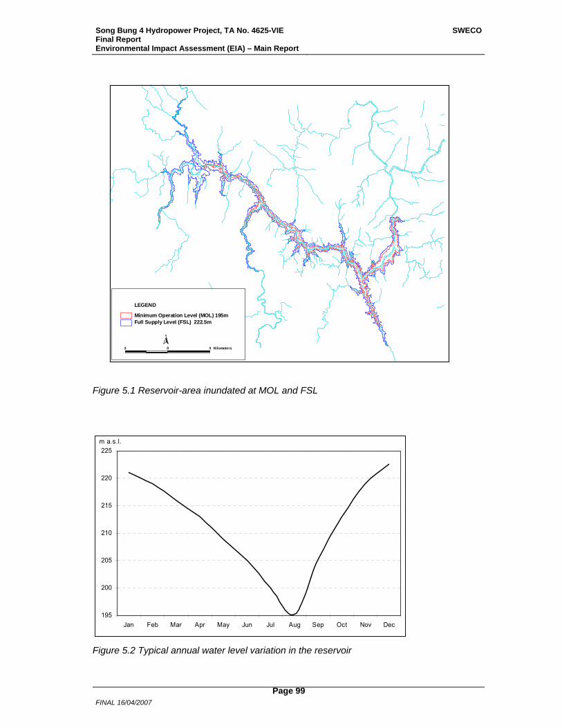
Song Bung 4 Hydropower Project, TA No. 4625-VIE Final Report Environmental Impact Assessment (EIA) – Main Report
SWECO
FINAL 16/04/2007
Page 99
3 0 3 Kilometers
N
Full Supply Level (FSL) 222.5mMinimum Operation Level (MOL) 195m
LEGEND
Figure 5.1 Reservoir-area inundated at MOL and FSL
195
200
205
210
215
220
225
Jan Feb Mar Apr May Jun Jul Aug Sep Oct Nov Dec
m a.s.l.
Figure 5.2 Typical annual water level variation in the reservoir
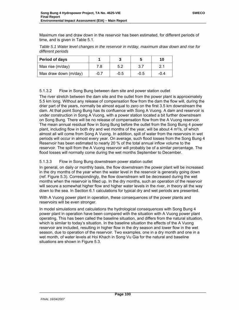
Song Bung 4 Hydropower Project, TA No. 4625-VIE Final Report Environmental Impact Assessment (EIA) – Main Report
SWECO
FINAL 16/04/2007
Page 100
Maximum rise and draw down in the reservoir has been estimated, for different periods of time, and is given in Table 5.1.
Table 5.1 Water level changes in the reservoir in m/day, maximum draw down and rise for different periods
Period of days 1 3 5 10
Max rise (m/day) 7.8 5.2 3.7 2.1
Max draw down (m/day) -0.7 -0.5 -0.5 -0.4
5.1.3.2 Flow in Song Bung between dam site and power station outlet The river stretch between the dam site and the outlet from the power plant is approximately 5.5 km long. Without any release of compensation flow from the dam the flow will, during the drier part of the years, normally be almost equal to zero on the first 3.5 km downstream the dam. At that point Song Bung has its confluence with Song A Vuong. A dam and reservoir is under construction in Song A Vuong, with a power station located a bit further downstream on Song Bung. There will be no release of compensation flow from the A Vuong reservoir. The mean annual residual flow in Song Bung before the outlet from the Song Bung 4 power plant, including flow in both dry and wet months of the year, will be about 4 m³/s, of which almost all will come from Song A Vuong. In addition, spill of water from the reservoirs in wet periods will occur in almost every year. On average, such flood losses from the Song Bung 4 Reservoir has been estimated to nearly 20 % of the total annual inflow volume to the reservoir. The spill from the A Vuong reservoir will probably be of a similar percentage. The flood losses will normally come during the wet months September to December.
5.1.3.3 Flow in Song Bung downstream power station outlet In general, on daily or monthly basis, the flow downstream the power plant will be increased in the dry months of the year when the water level in the reservoir is generally going down (ref. Figure 5.3). Correspondingly, the flow downstream will be decreased during the wet months when the reservoir is filled up. In the dry months, such an operation of the reservoir will secure a somewhat higher flow and higher water levels in the river, in theory all the way down to the sea. In Section 6.1 calculations for typical dry and wet periods are presented.
With A Vuong power plant in operation, these consequences of the power plants and reservoirs will be even stronger.
In model simulations and calculations the hydrological consequences with Song Bung 4 power plant in operation have been compared with the situation with A Vuong power plant operating. This has been called the baseline situation, and differs from the natural situation, which is similar to today’s situation. In the baseline situation the effects of the A Vuong reservoir are included, resulting in higher flow in the dry season and lower flow in the wet season, due to operation of the reservoir. Two examples, one in a dry month and one in a wet month, of water levels at Hoi Khach in Song Vu Gia for the natural and baseline situations are shown in Figure 5.3.
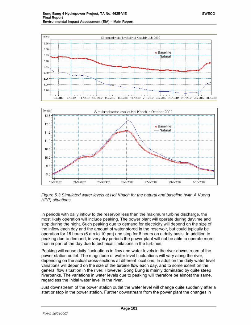
Song Bung 4 Hydropower Project, TA No. 4625-VIE Final Report Environmental Impact Assessment (EIA) – Main Report
SWECO
FINAL 16/04/2007
Page 101
Figure 5.3 Simulated water levels at Hoi Khach for the natural and baseline (with A Vuong HPP) situations
In periods with daily inflow to the reservoir less than the maximum turbine discharge, the most likely operation will include peaking. The power plant will operate during daytime and stop during the night. Such peaking due to demand for electricity will depend on the size of the inflow each day and the amount of water stored in the reservoir, but could typically be operation for 16 hours (6 am to 10 pm) and stop for 8 hours on a daily basis. In addition to peaking due to demand, in very dry periods the power plant will not be able to operate more than in part of the day due to technical limitations in the turbines.
Peaking will cause daily fluctuations in flow and water levels in the river downstream of the power station outlet. The magnitude of water level fluctuations will vary along the river, depending on the actual cross-sections at different locations. In addition the daily water level variations will depend on the size of the turbine flow each day, and to some extent on the general flow situation in the river. However, Song Bung is mainly dominated by quite steep riverbanks. The variations in water levels due to peaking will therefore be almost the same, regardless the initial water level in the river.
Just downstream of the power station outlet the water level will change quite suddenly after a start or stop in the power station. Further downstream from the power plant the changes in
Baseline ּס Natural
Baseline ּס Natural
Song Bung 4 Hydropower Project, TA No. 4625-VIE Final Report Environmental Impact Assessment (EIA) – Main Report
SWECO
FINAL 16/04/2007
Page 102
the water levels will not be so rapid.
Water level fluctuations have been simulated in Song Bung and Song Vu Gia with two alternatives for operation of A Vuong power plant. In one alternative, the A Vuong power plant is operated with constant generation for 24 hours a day, and in the other alternative also A Vuong has daily peaking. In Table 5.2 expected water level variations at some locations in the rivers are given for both operation alternatives in A Vuong, together with the time for the river to rise from minimum or maximum water level to the opposite. In the table maximum fluctuations are given, from maximum peaking in the power stations. The daily water level fluctuations over the year will for most of the time be less than these values, due to operation of the power stations with turbine discharges less than at maximum load.
Table 5.2 Maximum expected daily water level fluctuations from peaking in Song Bung 4 (alternative 1) and from peaking in both Song Bung 4 and A Vuong (alternative 2)
Location Alternative 1 Alternative 2
Water level fluctuation
(m)
Time from max to min
(hours)
Water level fluctuation
(m)
Time from max to min
(hours)
Downstream Song Bung 4 HPP 1.5 2 1.5 2
Downstream A Vuong HPP 2.0 3-6 3.2 3
At Song Bung 5 dam site 1.9 3-6 3.1 3-6
At Hoi Khach 0.6 6 1.0 6
At Ai Nghia 0.13 >6 0.20 >6
The changes in water level fluctuations down the Song Bung and Song Vu Gia from the Song Bung 4 power station to Ai Nghia, where the two rivers Song Vu Gia and Song Thu Bon have their uppermost interconnection, have been simulated for a lot of cross-sections. In Figure 5.4 profiles of maximum daily water level fluctuations are shown for both alternatives of operation of A Vuong power plant. The distance between each cross-section is not equal, and the diagram does not show correct distances between certain locations in the rivers. From the figure it can be seen how the fluctuations vary depending on the cross-sections. For some distance between A Vuong power plant and Song Bung 5 dam site the river is wider and the fluctuations smaller. After the confluence with Song Cai the river becomes wider and the fluctuations become, in general, smaller and smaller down towards Ai Nghia.
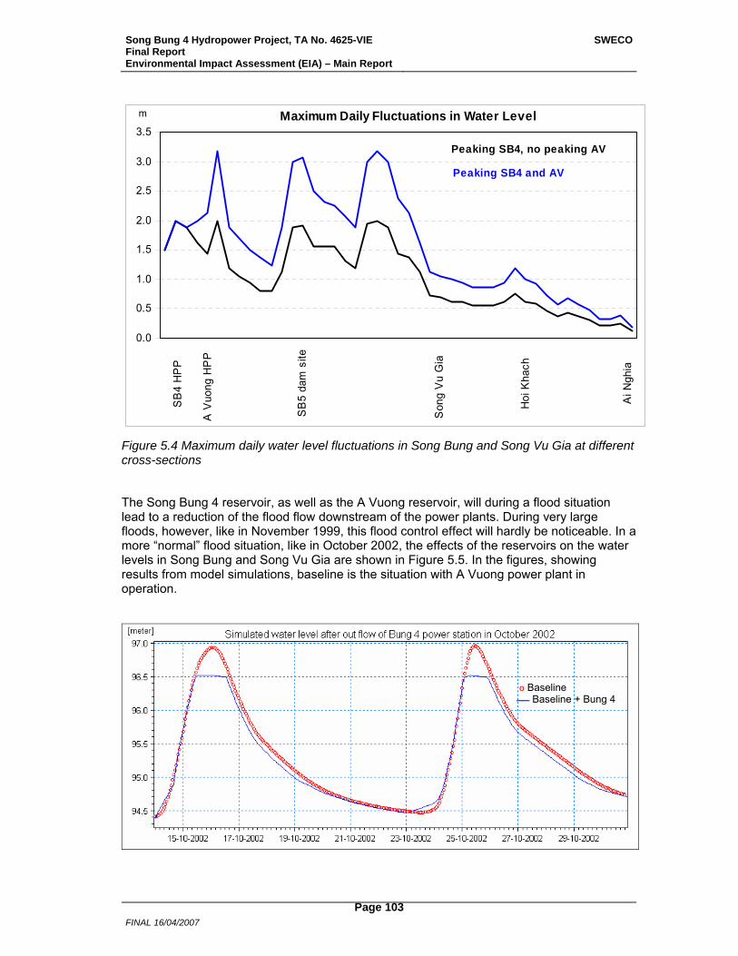
Song Bung 4 Hydropower Project, TA No. 4625-VIE Final Report Environmental Impact Assessment (EIA) – Main Report
SWECO
FINAL 16/04/2007
Page 103
0.0
0.5
1.0
1.5
2.0
2.5
3.0
3.5
Son
g V
u G
ia
Hoi
Kha
ch
Ai N
ghia
SB
5 da
m s
ite
A V
uong
HP
P
SB
4 H
PP
m Maximum Daily Fluctuations in Water Level
Peaking SB4, no peaking AV
Peaking SB4 and AV
Figure 5.4 Maximum daily water level fluctuations in Song Bung and Song Vu Gia at different cross-sections
The Song Bung 4 reservoir, as well as the A Vuong reservoir, will during a flood situation lead to a reduction of the flood flow downstream of the power plants. During very large floods, however, like in November 1999, this flood control effect will hardly be noticeable. In a more “normal” flood situation, like in October 2002, the effects of the reservoirs on the water levels in Song Bung and Song Vu Gia are shown in Figure 5.5. In the figures, showing results from model simulations, baseline is the situation with A Vuong power plant in operation.
Baseline ּס Baseline + Bung 4
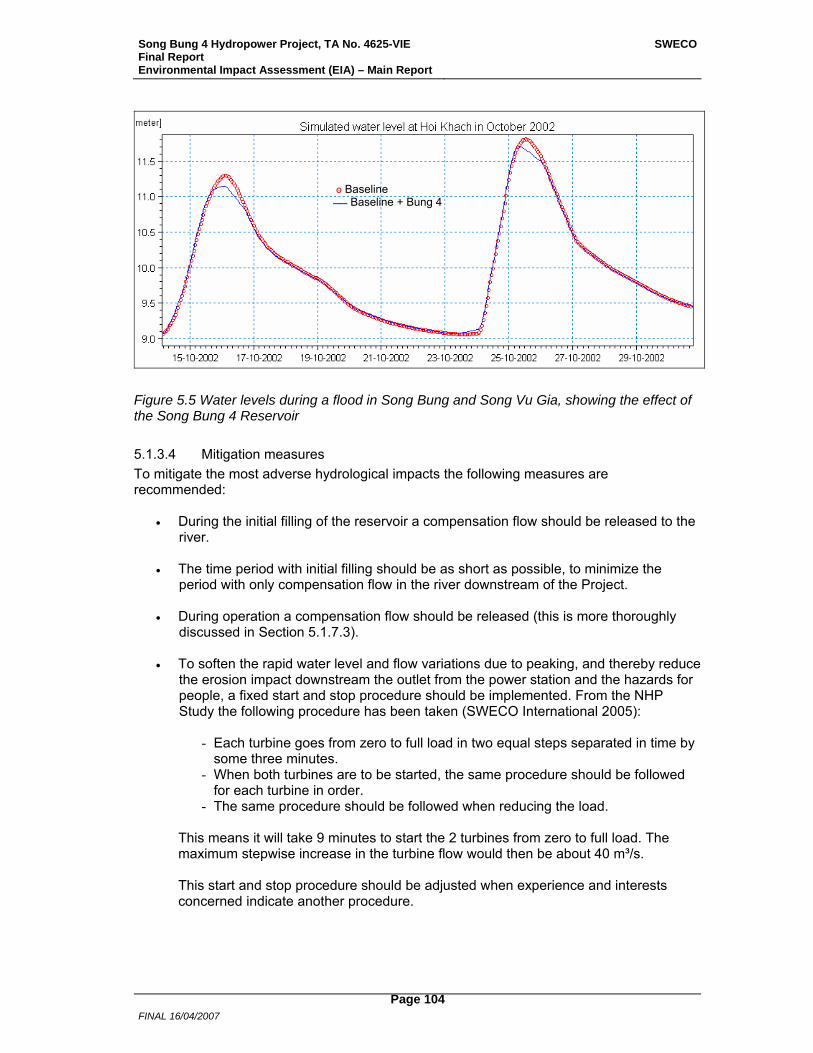
Song Bung 4 Hydropower Project, TA No. 4625-VIE Final Report Environmental Impact Assessment (EIA) – Main Report
SWECO
FINAL 16/04/2007
Page 104
Figure 5.5 Water levels during a flood in Song Bung and Song Vu Gia, showing the effect of the Song Bung 4 Reservoir
5.1.3.4 Mitigation measures To mitigate the most adverse hydrological impacts the following measures are recommended:
• During the initial filling of the reservoir a compensation flow should be released to the river.
• The time period with initial filling should be as short as possible, to minimize the
period with only compensation flow in the river downstream of the Project.
• During operation a compensation flow should be released (this is more thoroughly discussed in Section 5.1.7.3).
• To soften the rapid water level and flow variations due to peaking, and thereby reduce
the erosion impact downstream the outlet from the power station and the hazards for people, a fixed start and stop procedure should be implemented. From the NHP Study the following procedure has been taken (SWECO International 2005):
- Each turbine goes from zero to full load in two equal steps separated in time by
some three minutes. - When both turbines are to be started, the same procedure should be followed
for each turbine in order. - The same procedure should be followed when reducing the load.
This means it will take 9 minutes to start the 2 turbines from zero to full load. The maximum stepwise increase in the turbine flow would then be about 40 m³/s. This start and stop procedure should be adjusted when experience and interests concerned indicate another procedure.
Baseline ּס Baseline + Bung 4
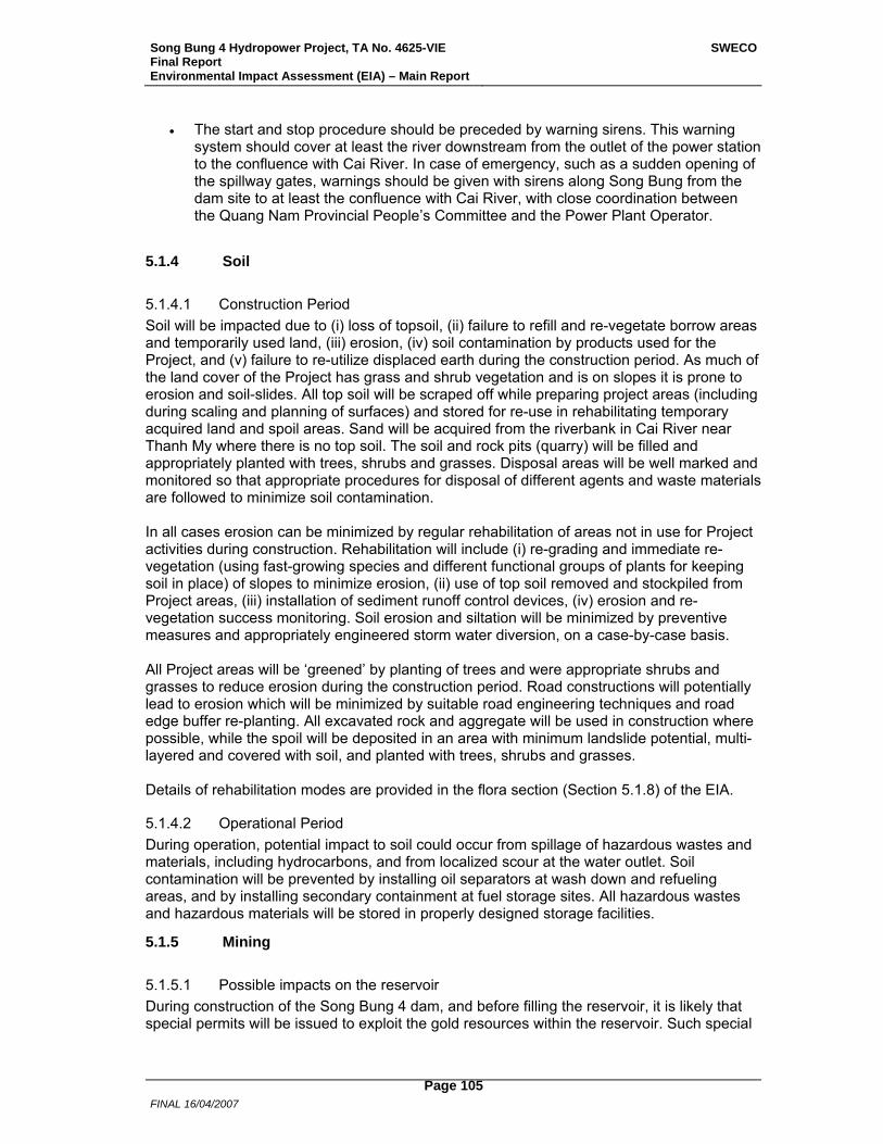
Song Bung 4 Hydropower Project, TA No. 4625-VIE Final Report Environmental Impact Assessment (EIA) – Main Report
SWECO
FINAL 16/04/2007
Page 105
• The start and stop procedure should be preceded by warning sirens. This warning system should cover at least the river downstream from the outlet of the power station to the confluence with Cai River. In case of emergency, such as a sudden opening of the spillway gates, warnings should be given with sirens along Song Bung from the dam site to at least the confluence with Cai River, with close coordination between the Quang Nam Provincial People’s Committee and the Power Plant Operator.
5.1.4 Soil
5.1.4.1 Construction Period Soil will be impacted due to (i) loss of topsoil, (ii) failure to refill and re-vegetate borrow areas and temporarily used land, (iii) erosion, (iv) soil contamination by products used for the Project, and (v) failure to re-utilize displaced earth during the construction period. As much of the land cover of the Project has grass and shrub vegetation and is on slopes it is prone to erosion and soil-slides. All top soil will be scraped off while preparing project areas (including during scaling and planning of surfaces) and stored for re-use in rehabilitating temporary acquired land and spoil areas. Sand will be acquired from the riverbank in Cai River near Thanh My where there is no top soil. The soil and rock pits (quarry) will be filled and appropriately planted with trees, shrubs and grasses. Disposal areas will be well marked and monitored so that appropriate procedures for disposal of different agents and waste materials are followed to minimize soil contamination. In all cases erosion can be minimized by regular rehabilitation of areas not in use for Project activities during construction. Rehabilitation will include (i) re-grading and immediate re-vegetation (using fast-growing species and different functional groups of plants for keeping soil in place) of slopes to minimize erosion, (ii) use of top soil removed and stockpiled from Project areas, (iii) installation of sediment runoff control devices, (iv) erosion and re-vegetation success monitoring. Soil erosion and siltation will be minimized by preventive measures and appropriately engineered storm water diversion, on a case-by-case basis. All Project areas will be ‘greened’ by planting of trees and were appropriate shrubs and grasses to reduce erosion during the construction period. Road constructions will potentially lead to erosion which will be minimized by suitable road engineering techniques and road edge buffer re-planting. All excavated rock and aggregate will be used in construction where possible, while the spoil will be deposited in an area with minimum landslide potential, multi-layered and covered with soil, and planted with trees, shrubs and grasses. Details of rehabilitation modes are provided in the flora section (Section 5.1.8) of the EIA.
5.1.4.2 Operational Period During operation, potential impact to soil could occur from spillage of hazardous wastes and materials, including hydrocarbons, and from localized scour at the water outlet. Soil contamination will be prevented by installing oil separators at wash down and refueling areas, and by installing secondary containment at fuel storage sites. All hazardous wastes and hazardous materials will be stored in properly designed storage facilities.
5.1.5 Mining
5.1.5.1 Possible impacts on the reservoir During construction of the Song Bung 4 dam, and before filling the reservoir, it is likely that special permits will be issued to exploit the gold resources within the reservoir. Such special
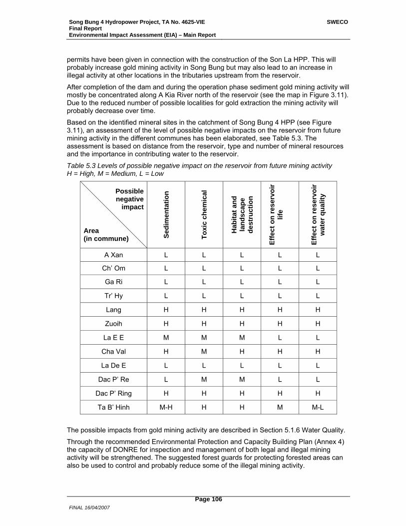
Song Bung 4 Hydropower Project, TA No. 4625-VIE Final Report Environmental Impact Assessment (EIA) – Main Report
SWECO
FINAL 16/04/2007
Page 106
permits have been given in connection with the construction of the Son La HPP. This will probably increase gold mining activity in Song Bung but may also lead to an increase in illegal activity at other locations in the tributaries upstream from the reservoir.
After completion of the dam and during the operation phase sediment gold mining activity will mostly be concentrated along A Kia River north of the reservoir (see the map in Figure 3.11). Due to the reduced number of possible localities for gold extraction the mining activity will probably decrease over time.
Based on the identified mineral sites in the catchment of Song Bung 4 HPP (see Figure 3.11), an assessment of the level of possible negative impacts on the reservoir from future mining activity in the different communes has been elaborated, see Table 5.3. The assessment is based on distance from the reservoir, type and number of mineral resources and the importance in contributing water to the reservoir.
Table 5.3 Levels of possible negative impact on the reservoir from future mining activity H = High, M = Medium, L = Low
Possible negative
impact
Area (in commune) Se
dim
enta
tion
Toxi
c ch
emic
al
Hab
itat a
nd
land
scap
e de
stru
ctio
n
Effe
ct o
n re
serv
oir
life
Ef
fect
on
rese
rvoi
r w
ater
qua
lity
A Xan L L L L L
Ch’ Om L L L L L
Ga Ri L L L L L
Tr’ Hy L L L L L
Lang H H H H H
Zuoih H H H H H
La E E M M M L L
Cha Val H M H H H
La De E L L L L L
Dac P’ Re L M M L L
Dac P’ Ring H H H H H
Ta B’ Hinh M-H H H M M-L
The possible impacts from gold mining activity are described in Section 5.1.6 Water Quality.
Through the recommended Environmental Protection and Capacity Building Plan (Annex 4) the capacity of DONRE for inspection and management of both legal and illegal mining activity will be strengthened. The suggested forest guards for protecting forested areas can also be used to control and probably reduce some of the illegal mining activity.

Song Bung 4 Hydropower Project, TA No. 4625-VIE Final Report Environmental Impact Assessment (EIA) – Main Report
SWECO
FINAL 16/04/2007
Page 107
5.1.5.2 Transmission line The uranium locality in Ta B’Hing commune (D1 on Figure 3.11) has a high potential for exploitation in the future. The proposed route for the 220 kV transmission line runs right through the locality. It is recommended to review the transmission line route in this area, and try to avoid the uranium locality, both with respect to safety for workers (possible high radiation levels) and to avoid a conflict with a future exploitation of the mineral resource.
5.1.6 Water Quality
5.1.6.1 Impacts in the Construction Phase In this phase the water flow will be approximately as it was before. As there has been no damming yet during construction, and the river is still passable for fish, there will be almost no upstream impacts during this period. During the construction phase, the following activities can affect the water quality and aquatic life negatively: • Erosion due to road building, construction work in the dam area, from the machine park
area, construction workers living area, spoil rock deposit area, soil deposits, clear logged areas, and accidental water releases
• Sedimentation in the slow flowing river stretches, with shallowing of deep pools • Reduced primary production due to siltation of periphyton producing substrates, as well
as due to reduced light penetration of the water column from increased turbidity. • Run off from crushed and ground rock material from the drilling, blasting and stone
crushing plant (quarry) • Sanitary effluents from the construction worker’s camp • Oil and chemical spills • Leaching of ammonia and nitrogen from the tunnel blasting and spoil rock deposits • Temperature effects are not expected • Dry-ups during filling the reservoirs
5.1.6.2 Impacts in the Operation Phase Upstream of the dam Impact on eutrophication Eutrophication will not be a problem in Song Bung 4 reservoir. The low soil fertility in the catchment, the low population and the low agricultural activities, will result in an oligotrophic reservoir. The reservoir will during the first 3-5 years be somewhat more productive due to release of nutrients from the inundated terrestrial catchment. Impact on bioaccumulation of mercury from the gold mining The formation of the reservoir will create low oxygen sediments in the deep waters. This will create conditions for methylation of the metallic mercury that are deposited in the sediments from the gold mining activities. The methyl mercury is much more bio-accumulative than the metallic mercury present to day. However, the studies showed that the contamination of the sediments was low, and it is therefore not anticipated that the mercury contamination will be any big problem in the future reservoir. Downstream of the dam In the first years after the damming there will be a lot of erosion taking place in the reservoir, and the silt and clay fraction of this erosion material will also impact the river downstream. This impact will disappear after 3-5 years.
Song Bung 4 Hydropower Project, TA No. 4625-VIE Final Report Environmental Impact Assessment (EIA) – Main Report
SWECO
FINAL 16/04/2007
Page 108
The diurnal flow and water level variations will be large downstream of the power plant, and even larger downstream the A Vuong Power Plant if both plants are operated in peaking mode. The diurnal variation in water level can be as high as 3 m downstream of A Vuong Power Plant. Such variations may cause erosion. The erosion from the land will also increase in general due to increased human activity in the area, more erosion prone roadsides, deforestation, agricultural land, excavating, quarries, etc. It may happen that the reservoir, in shorter periods, has to discharge large amounts of water through the spillway. Such events might cause erosion in the downstream river. In the downstream 5 km stretch between the dam and the outlet from the power plant, the flow will be very low and the water susceptible to pollution discharges on the stretch. The reservoir will retain coliform bacteria from the upstream, and will also retain sediment particles after the first initial erosion period is over. The water coming out of the reservoir will thus be clearer than the water entering the reservoir. In the first 2-3 years after the damming the water coming out of the reservoir will have low oxygen content due to decomposition of organic material from the inundated terrestrial catchment. This water will also contain high levels of bio-available nutrients for a period of 2-3 years, which will cause some eutrophication impacts downstream. These effects will last only 2-3 years. The temperature downstream the power plant will be 2-3 degrees lower than it was before, but further downstream it will reach the average air temperature relatively quick, so this is not regarded as a concern.
Global impacts
Eutrophication will not be a problem in Song Bung 4 reservoir, and it will become oligotrophic after 3-5 years. During this first period the sediment surface in the deepest waters will be anaerobic and greenhouse gases such as methane and carbon dioxide (CO2) will be produced, as well as some other gases of minor importance. Methane has an impact on climate 21–23 times stronger than CO2. The gas escapes through the turbines and the spillway, and it can bubble off through the surface (tiny bubbles) when the water level of the reservoir is lowered (bubbles released by pressure fall). Tropical reservoirs can create large amounts of greenhouse gases but very little information exists on production of greenhouse gases in reservoirs in Viet Nam and Southeast Asia. There are large variations in emissions from tropical reservoirs. Based on a rough estimate, and the fact that the Song Bung 4 reservoir will become oligotrophic so the emission of methane will be reduced after a few years, the reservoir will emit CO2 equivalents in the low end of the range from 108,000 to 1,620,000 tons or at the lower end of the range of 25–276% of the greenhouse gas emissions from an oil-fired thermal power plant producing the same amount of electricity. Only monitoring can provide a more precise estimate.
5.1.6.3 Mitigation Measures during the Construction Phase Measures against erosion During the construction phase there are large risks for heavy erosion that will create considerably stress for the river biota, as well as creating problems for human use of the water. Therefore, erosion abatement measures should be taken at all construction sites. Roadsides and other areas with denuded soils should be sowed by grass, road drainage should be strengthened with appropriate concrete/stone settings, machine parking areas and roads should be paved to the extent possible, etc.
Song Bung 4 Hydropower Project, TA No. 4625-VIE Final Report Environmental Impact Assessment (EIA) – Main Report
SWECO
FINAL 16/04/2007
Page 109
Measures against oil and chemical spills The large machine park that will be involved in the construction work will include the use of comprehensive amounts of fuels, oils, hydraulic fluid, battery acids, glycol cooling fluid, etc. In addition there will be needs for workshops and maintenance areas. The machine parking area, the workshop area, and the fuel and oil filling area should be gathered to one area that should be paved, and equipped with a controllable drainage so that all diffuse spills and accidental spills could be collected at all times. Measures against sanitary effluents from workers camp Toilet water should not be allowed to be discharged into the river, which could cause health hazards for those living downstream. The black water (toilet water) should be collected and infiltrated at a site with necessary infiltration capacity. The grey water (washing and kitchen water) could be infiltrated at the site before discharging into the river. Measures against blasting chemicals Tunnel blasting uses large amount of ammonium-nitrate, and if concrete (particularly spray concrete) is used for tunnel tightening, the runoff becomes very alkaline, and react with ammonium to create free ammonia, which is very toxic to fish and other aquatic animals. Runoff from tunnels and spoil rock deposits can thus cause fish kills in periods with low flow. The runoff from the tunnel should be monitored and passed through a sedimentation basin where neutralization could be performed if extremely high pH values are observed. Measures against greenhouse gas releases As much of the greenhouse gases release derives from anaerobic decomposition of organic matter from the inundated areas, clearance of the reservoir area for forest, trees and bushes, prior to filling the dam, is a recommended mitigation measure.
5.1.6.4 Monitoring A monitoring programme (see EMP Chapter 7) should be launched both in the construction phase, and in the operational phase. The monitoring should cover the following items:
• Water quality • Fish meat mercury content • Release of greenhouse gases from the reservoir
5.1.7 Aquatic Ecology
5.1.7.1 Upstream of the Dam Impact on aquatic habitats The inundation will accomplish a loss of river habitat of 30 km, which will be replaced by a lake with large water level fluctuation (27.5 m between Full Supply Level (FSL) and Minimum Operation Level (MOL)). All life in the littoral zone will die due to the periodical dry ups. As long as the water level fluctuations in the reservoir are larger than about 4 m, there will be no life in the littoral zone. The regulation zone will be heavily eroded rendering back a denuded, inorganic, desert like zone of sand, gravel and stones where nothing can grow. Inorganic erosion material will settle in the reservoir bottom and reduce the nutritional value of bottom sediments for the bottom dwelling animals. In the first years after the regulation the fish productivity will be relatively good because of food and nutrients from the inundated terrestrial land. Over time fish productivity will be
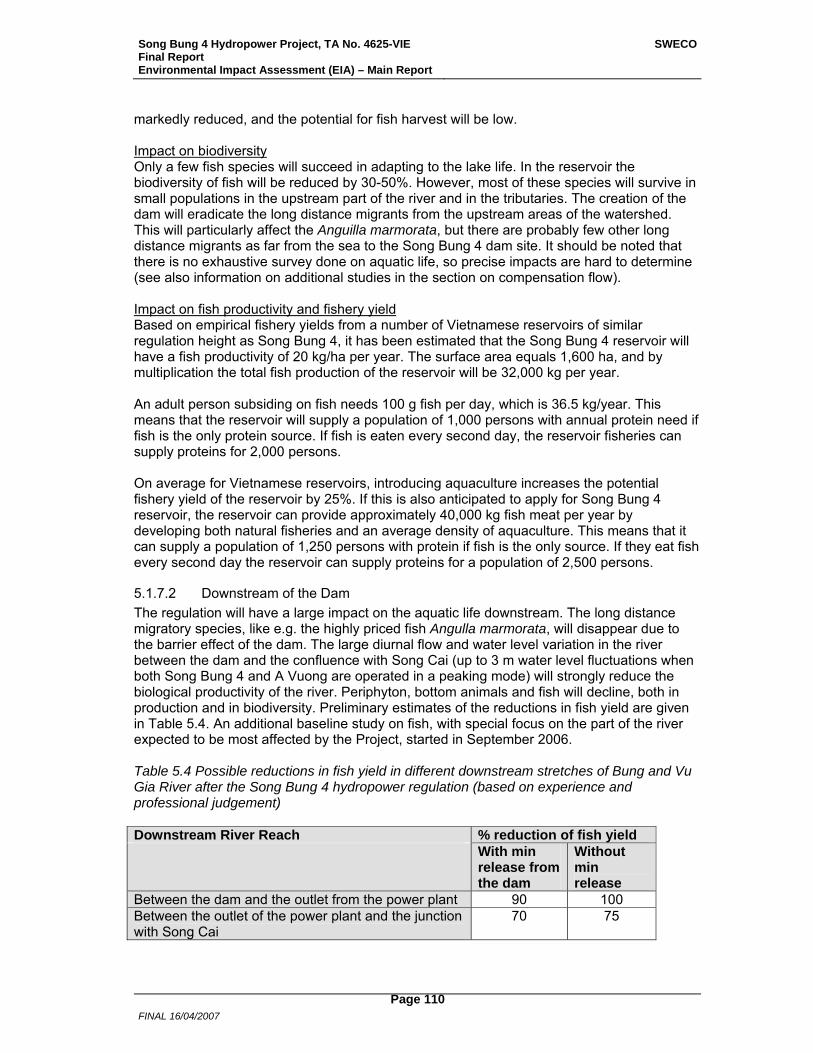
Song Bung 4 Hydropower Project, TA No. 4625-VIE Final Report Environmental Impact Assessment (EIA) – Main Report
SWECO
FINAL 16/04/2007
Page 110
markedly reduced, and the potential for fish harvest will be low. Impact on biodiversity Only a few fish species will succeed in adapting to the lake life. In the reservoir the biodiversity of fish will be reduced by 30-50%. However, most of these species will survive in small populations in the upstream part of the river and in the tributaries. The creation of the dam will eradicate the long distance migrants from the upstream areas of the watershed. This will particularly affect the Anguilla marmorata, but there are probably few other long distance migrants as far from the sea to the Song Bung 4 dam site. It should be noted that there is no exhaustive survey done on aquatic life, so precise impacts are hard to determine (see also information on additional studies in the section on compensation flow). Impact on fish productivity and fishery yield Based on empirical fishery yields from a number of Vietnamese reservoirs of similar regulation height as Song Bung 4, it has been estimated that the Song Bung 4 reservoir will have a fish productivity of 20 kg/ha per year. The surface area equals 1,600 ha, and by multiplication the total fish production of the reservoir will be 32,000 kg per year. An adult person subsiding on fish needs 100 g fish per day, which is 36.5 kg/year. This means that the reservoir will supply a population of 1,000 persons with annual protein need if fish is the only protein source. If fish is eaten every second day, the reservoir fisheries can supply proteins for 2,000 persons. On average for Vietnamese reservoirs, introducing aquaculture increases the potential fishery yield of the reservoir by 25%. If this is also anticipated to apply for Song Bung 4 reservoir, the reservoir can provide approximately 40,000 kg fish meat per year by developing both natural fisheries and an average density of aquaculture. This means that it can supply a population of 1,250 persons with protein if fish is the only source. If they eat fish every second day the reservoir can supply proteins for a population of 2,500 persons.
5.1.7.2 Downstream of the Dam The regulation will have a large impact on the aquatic life downstream. The long distance migratory species, like e.g. the highly priced fish Angulla marmorata, will disappear due to the barrier effect of the dam. The large diurnal flow and water level variation in the river between the dam and the confluence with Song Cai (up to 3 m water level fluctuations when both Song Bung 4 and A Vuong are operated in a peaking mode) will strongly reduce the biological productivity of the river. Periphyton, bottom animals and fish will decline, both in production and in biodiversity. Preliminary estimates of the reductions in fish yield are given in Table 5.4. An additional baseline study on fish, with special focus on the part of the river expected to be most affected by the Project, started in September 2006. Table 5.4 Possible reductions in fish yield in different downstream stretches of Bung and Vu Gia River after the Song Bung 4 hydropower regulation (based on experience and professional judgement) Downstream River Reach % reduction of fish yield With min
release from the dam
Without min release
Between the dam and the outlet from the power plant 90 100 Between the outlet of the power plant and the junction with Song Cai
70 75
Song Bung 4 Hydropower Project, TA No. 4625-VIE Final Report Environmental Impact Assessment (EIA) – Main Report
SWECO
FINAL 16/04/2007
Page 111
In the stretch downstream the confluence with Song Cai the impacts will be smaller, but due to lack of sufficient baseline knowledge it is difficult to estimate the reductions in fish yield further downstream in Song Vu Gia. ADB and EVN have agreed to undertake a special study on downstream fish yield after the Project is commissioned, and based on that study EVN will prepare appropriate mitigation measures if the study shows significant losses in the fish yield. This issue will be included in the loan covenant. When all the 8 planned hydropower development projects are commsioned in the Vu Gia – Thu Bon River system, the impact on the downstream stretches will be much more profound, even estuarine and coastal fisheries will be impacted.
5.1.7.3 Mitigation Measures Measures to keep a good fish productivity in the reservoir The reservoir should be self-populated by indigenous fish species that can adapt to lake life. If, after some years, it shows up that the natural recruitment of the lake is to low, a fish stocking program should be considered for the reservoir. If people choose to settle along the lake, one could consider establishing floating cage aquaculture in the lake. This should be based, preferably, on indigenous species, or species that is already present in the river system. The rights of the local people over the fish resources in the reservoir should be secured, and no contracting to outsiders must be allowed. Compensation flow The flow in Song Bung downstream of the Song Bung 4 dam will be strongly affected by the Project, and by the A Vuong HPP currently under construction. Both power stations are expected to be operated with daily peaking. A compensation flow that will, in general, maintain a continuum of the river, secure possibility for survival of aquatic life, secure drinking water for wildlife and domestic animals, and minimize adverse impacts associated with stagnant water, is recommended. However, the current level of baseline data on the riverine ecosystem makes it difficult to recommend the magnitude of a compensation flow. The affected part of Song Bung can be divided into sections, with different impacts on flow and ecology: From Song Bung 4 dam site to confluence with Song A Vuong (ca 3.5 km) Without a compensation flow this section will be dry for long periods each year. There will be a 100% loss of aquatic life, no drinking water for animals during dry season and increased risk of pollution from human activity. From confluence with Song A Vuong to Song Bung 4 power station outlet (ca 2 km) There will be no compensation flow from the A Vuong reservoir, and the residual flow in Song A Vuong will be very small in dry periods, estimated at less than 200 l/s. Without a compensation flow from the Song Bung 4 reservoir there will be a near 100% loss of aquatic life and increased risk of pollution from human activity. From Song Bung 4 power station to A Vuong power station (ca 8 km) Large daily fluctuations in water level and flow, varying from stagnant water in periods with no operation in the power station to large discharge during peaking hours. Without a compensation flow there will be adverse impacts on aquatic life, and the river section will not be available for spawning. After completion of the downstream project, Song Bung 5, no river

Song Bung 4 Hydropower Project, TA No. 4625-VIE Final Report Environmental Impact Assessment (EIA) – Main Report
SWECO
FINAL 16/04/2007
Page 112
reach upstream the Song Bung 5 reservoir will be available for short distance migratory fish species. From A Vuong power station to the confluence with Song Cai Before completion of Song Bung 5 HPP the daily fluctuations due to peaking will be increased with contribution from both power stations. Without a compensation flow the river flow is estimated at less than 500 l/s in dry periods. After completion of Song Bung 5 HPP the reservoir will act as a re-regulation reservoir for the upstream power stations. With no peaking in Song Bung 5 power station the downstream impacts from daily fluctuations will be mitigated. Vietnam has formally adopted policy principles to include the concept of compensation flows for environmental purposes into project design. Guidelines for the Environmental Impact Assessment (EIA) of Hydropower Projects, prepared by the Ministry of Science, Technology and Environment (now MoNRE) in 2001, make provision for compensation flows. The concept of ecological flows is also incorporated in the objectives of the Vietnamese National Water Resources Strategy towards year 2020 prepared by MoNRE in 2006, and promulgated by the Prime Minister in April this year. At present there is no detailed Vietnamese guidance or methodology for determining the magnitude of a compensation flow. The compensation flow should be large enough to provide spawning grounds for short distance migratory fish species and a habitat for young fish. The migration and spawning take part during the wet periods in September-November and May-June. A compensation flow regime could include varying releases, with larger flows during the spawning periods. As the current level of baseline data on the riverine environment makes it difficult to recommend the magnitude of a compensation flow, it is recommended that the knowledge base on aspects related to hydrology, aquatic and riparian ecology, livelihoods of downstream communities, technical design and economics be improved. This may be done through a study that covers, among other issues, both the wet and the dry season of the year, and in particular the two main annual fish migration periods. A ToR for such a study has been drafted (Annex 10) where “Collection of fish data” was commenced in October 2006 as part of an additional baseline study on fish that will also increase the general knowledge base.. Start/stop procedure The start/stop of the power plant should be done as smooth as possible, see Section 5.1.3.4. Especially when the power station is stopped it is very important to give the slow moving bottom animals chance to follow the retreat of the water, and prevent them from being killed by the daily dry ups of large bottom areas.
5.1.7.4 Monitoring A monitoring programme (see Annex 5) should be launched in the operational phase. That is after the reservoir is filled and the power plant has started its operation. Very shortly, the monitoring should cover both fish yield and fish species composition, and algal biomass and species composition in the reservoirs.
Song Bung 4 Hydropower Project, TA No. 4625-VIE Final Report Environmental Impact Assessment (EIA) – Main Report
SWECO
FINAL 16/04/2007
Page 113
5.1.8 Terrestrial Ecology
5.1.8.1 Flora As pointed out and shown by field surveys for this EIA the vegetation cover of the Project areas has been subject to human influence over a long period of time. Subsistence use is not the main cause of loss of primary forest as is illegal logging by outsiders. The slash and burn practice which is that of the ethnic groups has also had its toll on the forest systems. Overall the value of the forest resources in the Project are poor, and even for local use (timber) it is not of high quality and people resort to logging from higher elevations and better forested areas. Wood for fuel abounds in the area and thus forests and woodlands will be encroached upon for this resource if no alternative fuel resources are available. More specifically Project areas R1, R3, C1, C3, Rd1, Rd4, RA 1 and RA 2 (see Table 3.21) have very low forest quality and species richness. The areas which have patches of better quality forest and higher plant species numbers are R2 (STNR), especially in its southern part, C2, Rd2, Rd3, a part of T1 (220 kV) running from Pa Lua (Pa Xua) to the power house, and of T2 (35 kV) running from dam site to power house. Due to the overall plant cover status of the Project Area, which is largely open forest and grassland dominated, it is prone to erosion as the soils are not all bound solidly by vegetation. Soil will be exposed and be erosion prone in many locations due to Project activities and this impact will be common across all Project areas.
5.1.8.2 Fauna Impacts to the terrestrial fauna will either be related to the physical clearance of the reservoir and disturbance or degradation of forested ecosystems (e.g., macaque and turtle populations) resulting from increased population (mainly workers but also camp followers) and improved access. The later is seen to be more significant due to the relatively poor ecosystems directly lost to the Project and that there are forest resources in the vicinity of the Project Area which are already subject to illegal logging and wildlife hunting. Forest protection and environment awareness will have to be enhanced to reduce impacts related to an increased worker population and accessibility to forested areas. Scantions will need to be imposed and regulations enforced. Basd on the current information there appear to be no migration routes that will be blocked by project inundation. Project areas like disposal areas, power station and switchyard, and transmission lines can impact fauna species but precautions can be taken and thus risks minimized.
5.1.8.3 Potential Impacts specific to Song Bung 4 Project Area
5.1.8.3.1 Reservoir Habitat loss and fragmentation are direct effects of the dam and the reservoir that is created. However, habitats may also be lost as a result of the induced activities related to forest clearance and change, isolation of habitats, and the creation of assess. Forest clearance. Forest clearance means a loss of biodiversity, loss of area available for wildlife species for feeding and breeding, and increasing erosion vulnerability. The total area of reservoir is some 1,600 ha at the normal water level of 222.5 m. Main habitats in reservoir are of the vegetation type 6 and 5 along the river banks and spotted forested areas of vegetation type 4 and 3 on the slopes. The reservoir will flood 142.65 ha of STNR (R2) and an area mostly comprising of vegetation types 5 and 4. During the vegetation clearance activities, forest contractors will be legitimately entering the Project areas to extract economically important trees, among others, and clear vegetation up to the 222.5 m a.s.l.
Song Bung 4 Hydropower Project, TA No. 4625-VIE Final Report Environmental Impact Assessment (EIA) – Main Report
SWECO
FINAL 16/04/2007
Page 114
line. During these clearing activities there will be increased pressure on vegetation and thus the habitat above the 222.5 m line – these areas have the more intact forests and more matured and valuable trees. It will be difficult to identify logs extracted from above the 222.5 m line unless there is constant supervision of the contractor. The areas most at risk will be those where the forest is richest (e.g. forest in STNR (R2) and forest near the dam site), and particularly patches and mature trees of the economically valuable and threatened tree, Erythrophleum fordii. Noise and vibration from Project activities and exploitation activities may also disturb some wildlife species living along the river. Direct loss of some species. There is no doubt plant species will be lost due to inundation and Project activity needs. As shown by field surveys and explained in earlier sections the impact to the threatened plant species is seen as minimal due to the wide distribution and generally lower quality in the reservoir. Faunal species that are only found in the inundated areas will not be able to away from the reservoir area. However the fauna in reservoir area is not rich or unique primarily due to the quality of habitat and most of the species are common with wide distributions. In other words none of these species are restricted to areas with specific ecological conditions. Most of larger size species will be able to move out from the flooded area. A number of small animals (e.g. some rodents and small lizards) will be lost if they do not have the rapid mobility required to escape from forest clearance and flooded water. Since there are no exhaustive long term surveys completed on flora and fauna species in these areas precise species loss and impacts are not quantifiable. Habitat isolation/fragmentation. Although some main rivers will get larger than usual as a result of inundation, habitat isolation is not likely an important impact in the reservoir area because rivers and streams are already natural barriers in the project area. Flooding will change the aquatic habitat conditions from river to a lake and it also change as a result of increased humidity in the area of the dam. This may have some effect on the vegetation structure and composition of the area and indirectly impact animals dependent on these habitats, for example the macaque populations which visit the Bung River for water and turtle populations. No migration paths are known to be blocked by the inundation. Creating access to the forests. Access by water in Tra Vinh (Vinh stream), Dak Pring and Bung rivers will be created as a result of the inundation, in Ta Bhing and Zuoih communes. Since access into the forests will be easier by boat, hunters and loggers in the area may be tempted to gain access to the forest products of both STNR and watershed areas (Dak Pring River, forest near the dam site). The dam and low river stretch will make it difficult for the transport of timber downstream as is often done at present. However, forest products may be removed from the forests first by using the waterway before transferring to the road for transport. Changes in riparian and aquatic habitats. The riparian habitat will be altered in the low flow stretch. Terrestrial fauna living near rivers and stream may have to change their feeding grounds and breeding behavior (if associated to local sites) partly due to the change in vegetation riparian habitats. The creation of a lake by the filling of the reservoir usually results in increasing the bird numbers and species.
5.1.8.3.2 Construction Areas and Roads Forest Clearance and Creating access to the forests. Easy access to the forest in the watershed areas (particularly WA1, WA2 and WA3) will be created as a result of the new access roads to the power house (Ta Bhing commune) and to the Pa Pang resettlement areas, RA1 (Zuoih commune). Illegal timber logging and harvesting NTFP activities may increase if enforcement activities for forest protection are not in place. With the new access
Song Bung 4 Hydropower Project, TA No. 4625-VIE Final Report Environmental Impact Assessment (EIA) – Main Report
SWECO
FINAL 16/04/2007
Page 115
road this area and higher slopes of Ta La Cu mountain and adjacent mountains are the most vulnerable: becoming highly attractive for illegal logging, hunting and NTFP harvesting. All types of clearance of forest increases erosion vulnerability, fragmentation (in some cases, as mentioned above) and access to nearby forested areas. An area of disturbed closed forest (vegetation type 2 and 3) will be cleared around the dam site, power house, corridor for access road to construction areas and resettlement areas. Replacement of the flooded sections of 14D Highway will require a small area of vegetation type 5 and 4 near Tra Vinh Stream (9.9 ha). Illegal timber logging and hunting activities could easily increase if enforcement activities and imposing of sanctions and regulation for forest protection will not improve in these sites. The set-up of a community based management of forest may help in combacting illegal logging and hunting. Village Protection Teams can be set-up as already done in parts of STNR. Creating high demand for firewood, timber and NTFPs. The demand for firewood and timber will increase due to increased energy requirements for cooking for both workers, camp followers, and other incoming households and restaurants. Using timber for house construction both in working camps and service area may also be increased. Creating options for non-timber/wood use cooking and heating options may be important in helping reduce the pressure of firewood and timber. Exploitation of forest vegetables, fruits and medicinal plants will increase to meet the demand for NTFPs in the area during the construction period. Disturbance and Noise to Wildlife. Disturbance of wildlife communities from the increased activity resulting from the dam construction, whether it comes in the form of noise or increased access by people can be a significant form of stress upon the populations particularly if they are sensitive species. The following changes in behavior may result: avoidance of the most disturbed area, changes in feeding pattern, increased susceptibility to predation as a result of stress and loss of condition, and changes in breeding patterns. During the construction period, the general level of noise in the project area will increase considerably. The noise will be derived from following sources: 1) blasting in the quarry and construction areas; 2) earth moving equipment at the dam site itself, and earth-fill sites and quarries; 3) construction traffic along both east and west banks of the Bung river; and 4) general increase in traffic in project area. Noise in construction area and blasting in the quarry will consist of impulsive noise and vibration events that will impact fauna inhabiting the surrounding watershed areas, i.e. in WA1, WA2, WA3 and WA4. Large animals will move away from working area and may be caught by hunters while actively moving away as follows;
• Animals inhabiting WA1 will migrate eastward to the closed forests downstream of Bung River.
• Animals inhabiting WA2 will migrate towards the forest in the north-western part of Zuoih commune which borders Tay Giang District.
• Animals inhabited in WA3 will migrate northward of the forest of Ra Ruoi Mountain. However, this area is also influenced by A Vuong Hydropower in Tay Giang District.
• Animal occurring near the border of STNR will move southward inside STNR (WA4) as the result of the noise from blasting in quarry area.
Siltation. Rock mining, soil borrowing, work in auxiliary areas, dam site, power house and new road construction will result in erosion and siltation through the weakening of slopes and exposure of soil.
Song Bung 4 Hydropower Project, TA No. 4625-VIE Final Report Environmental Impact Assessment (EIA) – Main Report
SWECO
FINAL 16/04/2007
Page 116
Pollution. Hazardous material from machines and solid and liquid waste can impact soil and water quality. It will be necessary to have an appropriate sewage and waste treatment system and disposal sites for solid waste in the Project Area. Polluted water can have adverse affects on riparian vegetation and aquatic fauna. Electrocution. The powerhouse area will be exposed to heavy construction activities and also experience habitat destruction and alteration as will most of the areas under construction. Moreover, the switchyard area located close to the power house can create problems to wildlife, and to birds in particular. Switchyard and sub-station areas in general are disposed to electrocution problems like those found in connection to transmission and distribution lines.
5.1.8.3.3 Transmission lines Forest clearance. A transmission line of 220 kV with a corridor of about 40 m will connect the power station to Thanh My Substation. The impacts of the 220 kV line are related to habitat loss, fragmentation and creating access to the forest. Based on its location on the map, a straight line is designed from the switch yard through La Cu Mountain to Highway 14D (near Pa Toi village, Ta Bhing commune), then it will run along the access roads to the power station. An area of closed evergreen forest (VEG type 1) on the ridge of Ta La Cu Mountain will be lost and experience fragmentation due to the transmission line corridor. A 35 kV transmission line will join Thanh My Township to the construction site. The transmission line is about 28.7 km in length along Highway 14D and the access road. Habitat isolation. The 220 kV transmission line and its corridor through the forest in Ta La Cu Mountain will increase disturbance and fragment it into two parts: small part near the Bung River and large part on the eastern site. Habitat isolation and additional impacts from construction activities at the dam site, power house, service road, and auxiliary areas, will impact biodiversity (e.g., access, dispersal of species, pollination) in the forest from the 220 kV power line westward to the Bung River. The other transmission line (35 kV) will not have a significant impact in terms of habitat fragmentation as it is located along the road. Creating access to the forests. The maintenance of transmission lines will also create easy pathway conditions for people to enter the forest, especially in Ta La Cu mountain. Timber trees and plants yielding NTFPs will be at risk because of potential in increased illegal logging, hunting and harvesting of NTFPs. Steadily increasing environmental stress has made mortality factors to birds and animals more important than that once considered insignificant. Clear-felled power line corridors in the forested areas can have far reaching fragmentation and habitat changing effects that might affect fauna. Habitat fragmentation is identified as one of the main threats to biodiversity. It has been stressed that power-line corridors may be particularly damaging to some groups of species, both terrestrial and birds. Clear-felled areas of up to 40 meters open by forested areas while dissecting contiguous ones. The main problems associated with wildlife and transmission lines are related to (i) electrocution, (ii) bird collisions, and (iii) fragmentation (barrier) effect of the cleared areas and habitat destruction. Note that the building of roads can also have some of the similar impacts.
5.1.8.3.4 Construction Workers Camps and Administration area A number of the induced impacts of the dam will have a more lasting influence upon the populations of flora and fauna than habitat loss and disturbance. Direct mortality of individual
Song Bung 4 Hydropower Project, TA No. 4625-VIE Final Report Environmental Impact Assessment (EIA) – Main Report
SWECO
FINAL 16/04/2007
Page 117
species may not be important at a population or overall biodiversity level, providing that the populations are able to withstand the continual off-take. However, if they can not sustain these losses over a longer period the overall populations are at risk, and in this case particular threatened species may decline. Thus certain activities induced by the Project may give rise to a reduction of the overall biodiversity of the area, especially related to over-exploitation of forest and land resources. In addition in all cases exploitation of the natural resources will give rise to disturbance, so even if the animals are not killed they will still be disturbed and be increasingly wary of any humans. Creating high demands for firewood, timber and NTFPs. As with wildlife, demand for firewood and timber will increase due to increased energy requirements for cooking for both workers and other incoming households and restaurants. Using timber for house construction both in working camps and service area may also be increased. Creating options for non-timber use cooking and heating options may be important in helping reduce the pressure of firewood and timber. Exploitation of forest vegetables (e.g., bamboo shoots) will probably increase to meet the demand for NTFP in the area during the construction period. To meet the demand from markets villagers will be asked to provide forest products, while some workers may go out to collect for their own consumption or sale. Increased opportunities for additional income from NTFPs and ease of access into the area will encourage both local and outside collectors. The collection of plants or plant based NTFPs also encourages small-scale hunting and trapping. Creating high demand of wildlife use. The demand for wildlife products is high in Quang Nam Province, and hunting in the forest with traps and dogs is the principal source of supply. Recent wildlife surveys and our field observations indicate that the main customers for bushmeat restaurants are businessmen, government employees and visitors from outside areas (Roberton et al., 2005). In this light the increase in workers and visitors to Nam Giang District in relation to the Song Bung 4 HPP is likely to induce an explosion of demand for wildlife. To meet the demand from markets villagers will be asked to provide wildlife products while some workers may go out to hunt for their own consumption or sale. Increased opportunities for additional income from hunting and ease of access into the area will encourage local and outside hunters. Pollution. It will be necessary to have an appropriate sewage and waste treatment system and disposal sites for solid waste in the Project Area. It will also be necessary to monitor and control the treatment and disposal during the construction and operation phases for preventing the pollution of Bung River water. Polluted water can have adverse affects on riparian vegetation and aquatic fauna reliant on the water source.
5.1.8.3.5 Resettlement areas Forest clearance. An area of about 774.3 ha of bamboo forest and grassland near Pa Pang village (Zuoih Commune) will be cleared for resettlement and agricultural land. The resettlement areas for the other villages will also require clearance of forest land. Habitat quality in the studied resettlement areas (RA1 and RA2) is poor with mainly of vegetation type 6 and 5. The forest land located near inter-commune road from Cha Val to Zuoih and some small patches of closed forest on the slopes and ridges of hills will be lost. The impact is seen to be minimal due to the general poor quality of the area. It should be mentioned that clearing of the area will increase erosion vulnerability and thus open and unused areas should be vegetated (agricultural species) as soon as possible. These areas are not likely important habitat for wildlife populations or for key wildlife species.
Song Bung 4 Hydropower Project, TA No. 4625-VIE Final Report Environmental Impact Assessment (EIA) – Main Report
SWECO
FINAL 16/04/2007
Page 118
Habitat isolation and access creation. Mixed forest of Vegetation type 5 and 4 in the southern part resettlement area will be blocked by the road from the dam site connecting to Pa Pang village. The road will make convenient access to the forest in the area and may induce illegal activities in this area. The road itself is a barrier preventing movement of animals from both north and south directions. The current pressure of human activities from Thon 2 village in the limestone forested area in the western bank of Dak Pring River will be reduced when this village will be relocated. Firewood and NTFP collecting. Firewood and NTFP collecting activities are the main are causes of habitat degradation in the forest near Pa Dhi village (Zuoih commune). Firewood requirement for villagers may induce local people collecting trees from outside designed resettlement areas. Forest land encroachment for agricultural land and extension area for firewood collecting may be extended to the ridge of the hills. Residual rural populations after resettlement may depend on NTFPs because there may be less productive agricultural land to start with.
5.1.8.3.6 Habitat and landscape changes Previously low-lying land will be inundated. The present water height at the hydrographic point is 130 m a. s. l. The total area of inundation up to El. 222.5 m is some 1,600 ha. The lake will be very long and narrow and the aquatic habitat for about 30 km up the Bung River, for about 5 up the Dak Pring River and for about 6 km up the Ta Vinh stream will be converted from fast-moving mountain riparian/riverine habitat to a virtually stationary lake environment. This change is not a direct significant impact to the terrestrial flora and fauna. However, it may affect on the feeding behaviour of some species living near the river as result of change in the availability of food sources. Downstream of the dam, the river will be more regulated. Dry season flows will tend to be lower than average flows at present. Impacts will result in riparian vegetation composition.
5.1.8.3.7 Impacts of tourism activities After the dam has been constructed and the bulk of workers have left, the demand for NTFPs and wildlife meat may still exist. There will be continuing demands from visitors to the area who may expect and demand NTFPs. This demand is, however, expected to be low.
5.1.8.3.8 STNR – Potential Impacts and Threats The Project Area extends into the STNR in the south and a small area of forest land about 6 km along Ta Vinh stream will be flooded. The following impacts from the Project are identified: Forest clearance. About 142.65 ha of forest of STNR (R2) will be lost. Forest in the flooded area under 222.5 m a.s.l. consists of vegetation types 5 and 4. However, vegetation types 4 and 3 that occur on slopes and vegetation type 2 on the ridges may be at risk during the vegetation clearance activities because loggers may remove additional trees above the 222.5 m line. Replacement of the flooded sections of Highway 14D will also require an area covered with vegetation types 5 and 4 near Ta Vinh Stream. It is possible that workers engaged for clearing forest may be tempted to hunt illegally due their location in/near the forest: it will be thus important to ascertain that workers are made aware of regulations and sanctions that are imposed by the contractor in collaboration with the Environmental Management Unit and STNR Management Board.
Song Bung 4 Hydropower Project, TA No. 4625-VIE Final Report Environmental Impact Assessment (EIA) – Main Report
SWECO
FINAL 16/04/2007
Page 119
Changed accessibility. There are several aspects to be considered with the increased accessibility caused by people entering and living the in the watershed and Project Area during the construction period. Illegal logging, increased NTFP exploitation, mining and hunting are major concerns. Illegal loggers are usually outsiders and not the villagers. During the operation period accessibility will be related to better roads and increased population in the area. Disturbance from construction activities. The rock pit (C3) is not far from the border of STNR (about 1 km southward from the rock pit). Blasting in the rock pit, noise and vibration from explosive activities may disturb some wildlife species along the Ta Vinh Stream. According to the discussion with authorities of STNR and MOSAIC Project, primate and tiger monitoring areas are at least 15 km to the south of 1 Highway 4D. Therefore impacts from blasting, noise and vibration in the Project Area are not high but have to be minimized where possible. Forest patrolling, guards and imposing of sanctions will be necessary to control illegal activities in the Reserve. Direct mortality. Among 139 species recorded in STNR, 116 species were recorded in WA4 and 52 species were recorded in R2. All 37 threatened species were recorded in WA4. Most of the species recorded in the flooded area are common species. A number of animals (e.g. some rodents and small lizards) will be lost during the vegetation clearance phase and during reservoir filling. Direct mortality of individuals may not be important at a population or overall biodiversity level. However, populations of wildlife species within STNR may be at risk under the high pressure from wildlife demand during the construction period and also during the operational period.
5.1.8.4 Mitigation and Enhancement Measures The soils on mountain slopes and valley lands have evolved through thousands of years of soil genesis processes into a resource that provides the foundation for the production of food and fiber for the well being of the people of Vietnam. In provinces like Quang Nam the soils are rich in iron and the availability of nutrients for agricultural plants is low (due to iron compounds, ferric soils). While poor people have evolved extensive agro-systems, the reliance on forest and aquatic resources remains high. Proper management of soil and forest resources is an absolutely necessary if the goals of sustaining forestry and agriculture, and securing natural resource conservation are to be achieved. The natural topography of much of Quang Nam Province and particularly the area of the Song Bung 4 HPP lends itself to slippage and erosion even under natural conditions and is enhanced by slash and burn systems, grazing, deforestation, and the lack of wide scale revegetation along roads. However the biggest causes are usually timber pull trails, road building, and construction. In Vietnam the maintenance of roads and vulnerable areas prone to erosion is a large expense, in addition to being hazardous and a loss of land resources valuable to local people. The rehabilitation of sites in the vicinity of construction has to comprise a dual prong process of soil conservation and revegetation to reduce erosion, siltation and increase landscape stability. Specific quidlines for road construction and maintenance are also provided (Annex 3). One of the main potential impacts of the Song Bung 4 HPP is that it will increase hunting and logging activity (associated with the lost of wildlife habitat) linked to both workers and camp follower populations and outside pressure. Hunting by project employees has to be forbidden and the penalties for hunting will be imposed by the Implementing Agency, in conjunction with the STNR Management Board and Provincial Forest Protection Department. STNR has to be well informed of the number of workers and their camp sites. The mushrooming of food stalls and way-side restaurants should be checked for illegal sales of wildlife food and products. Increasing forest guards for protecting forested areas and entry to STNR can help
Song Bung 4 Hydropower Project, TA No. 4625-VIE Final Report Environmental Impact Assessment (EIA) – Main Report
SWECO
FINAL 16/04/2007
Page 120
deter both illegal logging and hunting. Setting up of check stations can also help in acting reduce illegal activities. Environmental Awareness Campaigns conducted by the Implementing Agency as part of the Environmental Management Program (EMP) will be useful in orientating workers and villages alike.
5.1.8.4.1 Flora Impacts on vegetation at the dam, construction sites and along roads are anticipated to be fewer that usual primarily because of the highly disturbed nature of the vegetation. Although rare or endangered species may exist here it is hard to argue that the nearby more intact and less human influenced forested areas (referred to as the watershed areas) serve as more congenial habitats for such species. Loss of some quality forest will occur both upstream (reservoir) and downstream of the dam site near the power station and along access roads. Thus there should be minimum infrastructure (temporary and permanent) built, and structures should be placed within as small an area as possible while re-vegetating is done as an on-going process. Construction activities will generate spoil, rock deposits and quarries which all will have to be appropriately deposited and protected. Of significance here is the placement of spoil as it can impact drinking water, often increase the occurrence of accidents, and influence water drainage and thus indirectly riparian species and aquatic life. Mitigation measures put forth if followed diligently should alleviate or reduce many of the related problems. Clearly erosion will be one of the prime impacts related to the removal of vegetation, scaling and road cuts (see also guidelines to road construction, Annex 3). This impact will be exaggerated when slopes are steep and by seasonal conditions during which construction is begun. Erosion does not only result in loss of valuable top soil but also leaching of soil nutrients and loss of organic matter. Mitigation or restoration measures can ideally be planned ahead of the beginning of the construction so that little soil is lost and the hill sides are kept viable for sustaining reasonable useful vegetation. This can be one of the first responsibilities of the Environmental Management Unit. In similar lines the treatment and removal of hazardous materials need to be appropriately handled and oils spills, for example, can be devastating to soil quality, water flowing into the water ways (rivers and tributaries), and riparian life. Rehabilitation (bio-engineering and revegetation) measures must include:
• Using fast growing species for slope stabilization and possibly soil enrichment; • Using nurse plants (grasses) which help stability in open patches and • Encourage perennial herbaceous species and slower growing tree species to
establish in parallel to fast growing species. The river stretch between the dam and the power station outlet will have a lower flow than the natural flow. The riparian vegetation and trees which rely on a shallow water table will be most vulnerable. Related to this will be impacts on bird and animal life dependent on this stretch of Bung River. An attempt should be made through releases of compensation flow to match the current pattern of water flow in the river as far as possible (see discussion in Section 5.1.7.3). In general, the closer the flow to natural levels and patterns, the fewer species will be affected. From a flora perspective, a numerical definition of flow rate is not possible as the ecological requirements of the vegetative species to be impacted are too poorly known. During this PPTA it was proposed that a detailed study would be conducted from September 2006 through August 2007 to shed light on the flow of water that may be necessary to maintain riparian and aquatic species. This is a welcome endeavour trying to get a handle on minimum flow requirements.
Song Bung 4 Hydropower Project, TA No. 4625-VIE Final Report Environmental Impact Assessment (EIA) – Main Report
SWECO
FINAL 16/04/2007
Page 121
There may be possible effects of the project on vegetation through human resettlements in the area. Shops and other entrepreneurs serving the workers in the area may be expected and these will exploit natural resources in the area adding to the erosion vulnerability. One of the largest impacts on land and forest resources will be the presence of workers during construction for a predicted period of 6 years. Not only is their impact on the use of land for leisure activity and small scale gardening significant but also their need for fuel wood. The presence of a large work force allowed freely to collect wood can easily damage large spans of jungle in a very short time. These workers will also collect fuelwood unselectively and thus escalate the damage in the area. Such activity will lead to competition for the valuable resource of fuel wood among the workers themselves and also with the locals. Furthermore, the presence of a large work force very often also leads to the opening of shops (tea, lunch and dinner stalls, basic grocery, sundry etc.) in the vicinity which again will result in the removal of fuel resources from the forested areas nearby. Potential pressure on natural resources needs to be adequately handled in order to protect natural resources and allow local inhabitants to utilize natural resources as is allowed by Vietnamese law. Competition between workers and local communities for such resources may result in unpleasant developments. The set up of proper sanitation is also of utmost importance since pollution of rivers and soil can be devastating to the flora and fauna as well as to agriculture. Both mitigation and monitoring procedures need to encompass all the above points. Revegetation and bio-engineering schemes have to be prepared for problem sites, including estimating plant number needs for emergencies. Alternative and contingency plans should be made for sites which may appear to require ‘extra’ mitigation consideration. Increasing forest protection guards, guard posts, and environment awareness and imposing sanctions can work to reduce the illegal use of forest resources and thus impacts on forests in the area, particularly the Song Thanh Nature Reserve. Based on discussions with STNR, Nam Giang FPU and Quang Nam FPD, an agreement of forest protection and forest product use will be signed between FPD and the Implementing Agency related to allowance and limits for hunting and eating meat from wildlife, possession of explosives and fish-bombing, and collecting and transporting wild products. The Environmental Awareness campaign will inform all workers and administrative staff about such agreements, regulations and sanctions. FPD staff is willing to collaborate with the police for regular spot checks of vehicles moving out of the area. Capacity building of Institutions like DONRE and SONRE will be also help in building up environmental competence and monitoring know how. The environmental awareness campaign should cover adequately both Project and adjacent areas. Regular updates and presentations need to be made to the work force, logging and harvesting NTFP groups, tourism authorities to inform of the regulations of harvesting and buying NTFPs and their protection. The species reported to be threatened have a wide distribution and the quality of the plant species in the Project sites is generally poor due to the removal of the best wood from the area in the past. No special mitigation is necessary here. The lack of special or unique habitats as reported in this study also renders that no special mitigation is required. Flora and Soil Mitigation and Enhancement Measures – Specific Detailed measures provided here are to be applied during the construction phase, surveyed through a monitoring regime, and when necessary during the operation phase. The term rehabilitation is used to represent re-vegetation modes and erosion abatement measures.
Song Bung 4 Hydropower Project, TA No. 4625-VIE Final Report Environmental Impact Assessment (EIA) – Main Report
SWECO
FINAL 16/04/2007
Page 122
Rehabilitation in the reservoir area Slopes above the cleared slopes of the reservoir which are open land or cover by largely grasses will need to be planted with tree species. This will reduce erosion and land slippage along the reservoir. Rehabilitation of area at the Dam Site, Construction areas These areas comprise all the vegetation types in the area, and much of the area in the vicinity is grassy and vulnerable to erosion and slippage due to construction activities of vegetation clearing, scalling, driving of heavy vehicles, blasting, etc. Rehabilitation measures in these areas must include:
• Specific site evaluation • Follow all revegetation techniques (especially, 3 species plantings, grass lines,
wattling) • Gully stabilization will be very important in this area due to steep areas and road cuts
- gully head plugging for long term stability, and rip-rap vegetated sills especially on lower slopes and spoil deposit area.
• Weak and erosion prone slopes. Both east and west slopes may not be fully used but will fall within the project area, or vicinity of, tree species need to be planted at the onset of the project and during construction phase
• Spoil rehabilitation – see below • Greening of camps - see below • Minimum flow considerations
Note: Vegetation with all categories of plants (grasses, shrubs and trees) needs to take place as the construction of the access road (right side of the river) takes place. Planting on both sides is necessary as slopes are weak and erosion and landslides will occur if not protected early. When the temporary camps are torn down revegetation needs to be carried out as soon as possible. The seedling and samplings need to be ready much ahead of time. Of significant importance here is that, where possible in spaces between houses and offices of the temporary camps, tree and shrub species need to be planted at the onset of the infrastructure construction. Thus part of the infrastructure plan will include a vegetation scheme implemented by the Environmental Management Unit. Rehabilitation of areas - Access Roads and Transmission Lines To mitigate the fragmentation impacts on the forest in Ta La Cu Mountain, it is recommended that the proposed 220 kV power line from power house connecting to Pa Lua (Pa Xua) village (Ta B’Hing commune) may be changed to follow the access road. This change will minimize the area of forest clearance for transmission line corridor, and it will not have fragmentation impact. This can be done during the final design phase of the Project. Some of the slopes along the roads to be constructed are steep and have sparse or only grass dominated communities. Excavation of roads in the steep valley sides in soft soils leaves large areas of denuded soils open for rain and water erosion. This problem applies to the inner side of the roads with the drain ditch, the road itself and the outward facing of the road. Even for temporary roads this will create wounds in the terrain that will slide and erode during the construction period if no stabilization is done. The construction of roads should begin at the onset of the dry season with the excavating and bulldozing. Before the wet season starts, the road sides should be sowed by easy and rapid growing grass types. The road ditch should be lined in erosion prone areas. The water in the road ditch should be released into existing brooks/streams. The road ditch should be released as often as possible, i.e. wherever there is a natural brook/flood brook. Road ditch outlets should not be
Song Bung 4 Hydropower Project, TA No. 4625-VIE Final Report Environmental Impact Assessment (EIA) – Main Report
SWECO
FINAL 16/04/2007
Page 123
allowed to be discharged into the valley sides in places where there has been no waterway before. If this is necessary in some places, relevant enforcement should be made to prevent erosion. All road construction (access roads and broadening roads) will require similar procedures adjusted to the specific sites (see guidelines for Roads, Annex 3). The team responsible for this ought to work out a strategy for structured procedures for bio-engineering and revegetation allowing for adjustment based on site specifics. Parking lots, camp areas and construction sites should be given the same mitigation measure as recommended for roads. The permanent roads and sites should be paved as soon as possible during or after the construction. Rehabilitation measures that need to taken:
• Specific site evaluation • Follow all revegetation techniques (especially, 3 species plantings, grass lines, watt-
ling) • Gully stabilization will be very important in this area due to steep areas and road cuts
- gully head plugging and rip-rap vegetated sills for long term stability, • On all slopes not used but within the project area, or vicinity of, tree species need to
be planted at the onset of the project and during the construction period • Spoil may be deposited in and adjacent to (levelled) large gullies if these appear
along roads. Note: Vegetation with all three categories of plants (grasses, shrubs and trees) needs to take place as the construction of the access road takes place. The top soil, gravel and soil from the tunnel need to be separately deposited. Upon spoil deposition top soil needs to be layered. Gully and all ravine areas should be planted with several types of fast growing species. Massive revegetation should be done at the onset of the Project on all areas (slopes) that are vulnerable. Due to the area being erosion prone and rather degraded (due to recently slash and burn practice and grazing perhaps) early revegetation is essential. Vegetation Choices Choosing of vegetation for rehabilitation and revegetation studies can be based on whether simply creating natural species rich environment is a goal or if local use has to be considered. Often long term community participation and concern declines when conservation is the sole goal. In a hydropower project there are two basic type of sites that need to be rehabilitated - one where no harvesting or resource removal can take place (includes permanent areas of the Project) and the other where upon rehabilitation local use or agro-cultural practices may be allowed. In the case of the Song Bung 4 HPP there are no designated areas to be rehabilitated for the use and thus all rehabilitation is associated with the conservation of soil to minimize erosion. The collection and suitability of the species at each site of revegetation will have to consider soil characteristics, hydrological/drainage conditions, and slope. The need to have plants (seeds, seedlings or cuttings) ready before hand is of utmost importance. Generally cleaning and sorting of seeds, germination trials, and cutting and seedling cultivation takes time. Therefore early planning is essential.
Song Bung 4 Hydropower Project, TA No. 4625-VIE Final Report Environmental Impact Assessment (EIA) – Main Report
SWECO
FINAL 16/04/2007
Page 124
Planting density and spacing. The standard spacing in Vietnam varies but common spacing is 2.5 x 2.5 meters; a total of 1600 plants per hectare. For soil conservation sites (all cases in this project) a closer spacing is required; such as 1 x 1 meter for tree and shrub species, for small shrubs and herbaceous plants it ought to be 05 x 0.5 meter; the same holds for cuttings on very vulnerable sites. The planting of trees at the toe of forest road fill slopes can be an effective method for trapping materials transported from the road. Non Agricultural and Access road edge rehabilitation. All road construction (access roads and broadening roads) will require similar procedures adjusted to the specific sites. The team responsible for this ought to work out a strategy for structured procedures for bio-engineering and revegetation allowing for adjustment based on site specifics. The techniques to be followed are those underlined in the above sections. Spoil rehabilitation - layered technique. The top soil, gravel and soil from the tunnel ideally need to be separately deposited. Upon spoil deposition top soil needs to be layered with the layering of spoil material. This will allow roots of trees to reach and proliferate into rich soil zones within the spoil thus increasing anchorage and overall stability of the spoil. Most of the top soil must be placed on top. Immediately planting of tree species needs to be done at edges and grass lines on contours. If there is a gully or ravine it needs to be seeded with fast growing species. If the slopes are steep some cuttings of rapidly rooting species can be used in addition to planting tree-lets. It is vital that the rehabilitated areas are allowed open for grazing until all vegetation is established for at least 6 years, as this will result in spoil slope weakening. Greening of camps and resettlement areas. All temporary and permanent camp sites, and project areas need to be planted with fast growing species. These areas do not need to have the most expensive and valuable species planted as these site will be more stable than open slopes near roads and other construction sites. Planting in housing areas will serve to reduce small scale soil movement, create an aesthetically pleasing environment, and reduce erosion and slippage problems when temporary infrastructure (housing) areas are torn down. The importance of keeping these areas green should be encouraged among the inhabitants via community ’worker’ participation. In the long run such activity may also help create a positive greening attitude among migrant and non-migrant workers alike. In similar lines the resettlement areas should be planted with trees and shrubs to reduce topsoil loss. This planting can be related to the creation of home gardens and agro-forestry area around homes. The situation at A Vuong should not be repeated where the houses stand on barren clayey soils where the topsoil is not held back, there is no shade for the houses and there are no vegetable or fruit gardens around any of the new homes. Use of biological resources before construction. Timber removal for fuel is set by the government at a fixed rate and permits are granted for removal of access timber. The Project areas on the whole are poor collection sites for prime timber but there is considerable fuel wood, rattan and bamboo. Local villagers or those loosing land should be allowed to remove NTFP (esp. bamboo) and timber at the project sites just before construction. Of course the contractor may choose to pile fuelwood resources etc. at a designated site for local people to pick up. This will avoid unnecessary damage to vulnerable project sites.

Song Bung 4 Hydropower Project, TA No. 4625-VIE Final Report Environmental Impact Assessment (EIA) – Main Report
SWECO
FINAL 16/04/2007
Page 125
5.1.8.4.2 Fauna Construction Phase Mitigation during the construction phase of the Song Bung 4 HPP can be connected to the following main issues which were pointed out in the potential impacts section. Hunting, Logging and Strengthening Environmental Protection. One of the main potential impacts of the Song Bung 4 HPP is that it will increase hunting and logging activity (associated with the lost of wildlife habitat) linked to both workers and camp follower populations and outside pressure. It is also possible that mining activities may increase, which will further trigger forest encroachment. Hunting by project employees has to be forbidden and the penalties for hunting will have to be imposed by the Implementing Agency, in conjunction with the STNR Management Board and Provincial Forest Protection Department. STNR has to be well informed of the number of workers and their camp sites. The mushrooming of food stalls and way-side restaurants should be checked for illegal sales of wildlife food and products. Increasing forest guards for protecting forested areas, controlling entry to STNR and setting up more check stations (guard posts) can help deter both illegal logging and hunting. Sanctions will be vital in acting to reduce illegal activities. Environmental awareness increased by the Implementing Agency as part of the Environmental Management Plan (EMP) can be useful in orientating workers and villages alike. Based on discussions with STNR, Nam Giang FPU and Quang Nam FPD, an agreement of forest protection and forest product use will be signed between FPD and Implementing Agency related to allowance and limits for hunting and eating wildlife meat, possession of explosives and fish-bombing, collecting and transporting wild products. The Environmental Awareness campaign will inform all workers and administrative staff about such agreements and regulations. FPD staff is willing to collaborate with the police for regular spot checks of vehicles moving out of the area. This is built into the EMP. The environmental awareness campaign should cover adequately both Project and adjacent areas. Regular updates and presentations need to be made to the workforce, logging and harvesting NTFP groups, tourism authorities to inform of the regulations of harvesting and buying NTFPs and their protection. An Environmental Protection and Capacity Building Plan is included in the EMP. Habitat destruction/loss, Fragmentation and corridor mitigation. Forest clearance should be avoided where possible, especially where construction activities can be kept within a confined area. Since much of the land in the Song Bung 4 HPP is open secondary forest and grassland communities there should be ample areas to use as disposal areas avoiding better forested areas. The main principals to be followed for transmission line construction and any other construction that may lead to the creation of corridors (cleared areas) and fragment forested areas are (i) minimize wire levels, (ii) minimize total length avoiding forested areas, and (iii) construct towers on ridges and in escarpments to minimize forest destruction (keeping air wires above the forest canopy). To keep wires above the forest canopy implies, however, that the collision risk for birds is increased, but that the extent of habitat destruction is reduced. Thus, a balance has to be struck between these two effects. To mitigate the fragmentation impacts on the forest in Ta La Cu Mountain, it is recommended that the proposed 220 kV power line from power house connecting to Pa Lua (Pa Xua)
Song Bung 4 Hydropower Project, TA No. 4625-VIE Final Report Environmental Impact Assessment (EIA) – Main Report
SWECO
FINAL 16/04/2007
Page 126
village (Ta B’Hing commune) should be change to follow the access road. This change will minimize the area of forest clearance for transmission line corridor, and it will not have a fragmenting impact. As well known roads can form barriers to animal movement. Factors of importance are width, the height of embankments of roads cut into slopes and lifespan. The areas of the forest cleared for the road should be no wider than necessary for the construction. It should be expected that forested sections along the road will be rendered vulnerable and more accessible to illegal activities. There could be more protection afforded to such vulnerable sites. Hazardous Material and Noise Levels. Fuel and oil storage and disposal areas, especially in connection to areas with heavy traffic, should be located away from water courses and fenced, where possible, from forested areas. Suitable safety dikes and moats should be constructed around all such facilities and emergency spill clean up procedures should be planned. The noise levels during the construction activities should be kept to the minimal especially during dusk and dawn. Rehabilitation related to construction activities. Temporary, disposal and spoil deposit sites must all be rehabilitated as soon as possible preferably during the construction if areas are not used anymore. Community Based Forest Management in Zuoih commune. A community based forest management (CBFM) plan (Annex 6) for the residents of Zuoih commune, and the two villages in Cha Val and Ta Bhing commune, can help foster positive environmental awareness and understanding of needs for environmental management and regulations. Environmental awareness can be increased among workers through orientation. Forest Rehabilitation related to Song Thanh Nature Reserve Forest rehabilitation will be done to the northwest of STNR to compensate for the land inundated in the Reserve. This rehabilitation will link the STNR to the north forest block of high conservation. According to Long et al. (2006), Highway 14D in Ta Bhing, Cha Val and Zuoih communes divides STNR from the block of forest to the north. This northern forest block has high conservation value and its continued linkage with STNR would buffer the reserve from threats, maintain ecological processes, permit dispersal of wide-ranging species and enhance watershed protection. Details on the Forest Rehabilitation plan are provided in Annex 7 and will be part of the Environmental Management Plan. Mitigation and Enhancement Measures for STNR A conservation off-set (COS) plan including rehabilitation is proposed (Annex 7). Details on mitigation and enhancement measures related to Environmental Protection and Awareness (also in relation to STNR) are given in Annex 4. Although the exact area for rehabilitation has to be decided among the different stakeholders a possible area for rehabilitation is the border of the protected area in Ta Bhing, Dak Pre and Dak Pring communes by maintaining watershed forest in upstream of Dak Pring River and Tra Vinh stream and increasing forest continuity with primary forest. In part this area will also act as a buffer between the Reserve and settlements helping to limit the forest encroachment.
Song Bung 4 Hydropower Project, TA No. 4625-VIE Final Report Environmental Impact Assessment (EIA) – Main Report
SWECO
FINAL 16/04/2007
Page 127
During the process of forest rehabilitation (whether planting or enrichment) at STNR only indigenous tree species, preferably local varieties, should be used. Monoculture are not encouraged. Oligoculture and a composition of forest species that will create a few storeys in the canopy are recommended (a combination of evergreen, average growing tree species such as Dracontomelum duperreanum, Pometia pinnata, Tarrietia javanica, Artocarpus rigida, Canarium spp., Vatica odorata, Shorea spp., Dipterocarpus sp., Aglaia spp., Dysoxylum sp., slow growing ones such as Erythrophleum fordii, and deciduous, fast growing ones such as Peltophorum dasyrrhachis, Albizia lucida, Allospondias lakonensis. Some tree species with high economic value such as Cinnamomum cassia, and Aquilaria spp. can be used. The use of introduced species such as Acacia spp., Eucalyptus spp. should be prohibited. During the enrichment of heavily logged closed forests and woodlands species can include: NTFP species (rattan and some medicinal species), woody vines such as Coscinium fenestratum and Fibraurea tinctoria, perennial herbs such as Amomum spp. and members of family Zingiberaceae, e.g, Homalomena occulta. Operation Phase Mitigation during the operation phase follows some of the mitigation started during the construction period, e.g. for hunting and logging, erosion, and revegetion checking. Whatever the compensation flow some deterioration of the riverine or riparian community is expected. Hazardous waste has to be kept protected and disposed off in an appropriate fashion. Fuel and oil spills on soil or in water can be disastrous to wildlife and soil on which plant life is to thrive. Erosion can move contaminated soil to rivers where water life can be seriously affected. Power house and switchyard areas have to well fenced to keep animals away. Transmission lines can also be marked with mock birds so that they are visible to birds. Settlements, tourism, transport and other development activities can increase pressure on wildlife Conservation Off-Sets Conservation Off-Sets. Two conservation off-set (COS) plans are designed the details of which are given in Annexes 4 and 6. Summaries of these COS plans are provided below. For STNR a forest rehabilitation plan enhancing watershed protection was requested by ADB (Annex 7). No plan for increasing the sustainable management regime for STNR is included but the STNR will benefit from the increased environmental protection (see EMP).
5.1.8.5 Monitoring
5.1.8.5.1 Flora For each site and rehabilitation action specific details need to be recorded. A check sheet needs to be created to follow up the weekly (or longer depending on rehabilitation) conditions. Some of this work can be done by forest officers or assigned individuals among workers. It is important that the responsible head keep check of all records. Of particular importance keeping a good account of tree sapling and cutting survival over time. Revegetation of specific problem sites can thus be determined after a 25% loss or death of vegetation has taken place. Erosion prone areas have to be surveyed regularly.
Song Bung 4 Hydropower Project, TA No. 4625-VIE Final Report Environmental Impact Assessment (EIA) – Main Report
SWECO
FINAL 16/04/2007
Page 128
Soil movement observations at specific site along with area around (watershed itself) are vital. Evaluation of techniques used needs to occur in consultation with experts. The earlier the evaluation is done the better the long term rehabilitation success will be, and allow for ‘adaptive rehabilitation management’. An expert should check recording regimes and final mitigation/monitoring strategies. Water flow on all slopes (especially up slope areas) and irrigation areas should be monitored at all project sites. Water flow channels created during the rainy season can be devastating to soil movement later in the season. Monitoring should include guarding against plant (also fuelwood) theft and grazing animals. Forest patrolling will be important in controlling forest resource loss and damage to rehabilitated areas. Rehabilitation of areas associated with STNR needs to be monitored. The forests in STNR are vulnerable to illegal logging and this will require patrolling by forest guards and those caught conducting illegal activities must be sanctioned. A report every 6 months should be made with the evaluation of mitigation progress. Such a report should include a copy of the raw data on check lists. A yearly summary/report of all mitigation and progress should be prepared by the EMU. If an environmental team is set up an expert ought to be brought in to do the final review of the progress to provide ample input for improvement strategies. If some or all mitigation steps are contracted out the evaluation of strategies and progress is absolutely necessary. Monitoring sensitive species. A number of species, tree and non-tree (for example orchids and many epiphytes, shade-demanding shrubs or herbs) vegetation is particularly sensitive to disturbance and habitat change. A monitoring program for these species may be conducted by guard posts located in the area of the STNR based on the guidelines from the Management board of STNR. Monitoring important habitats. Reducing the degradation and fragmentation of habitat is key to the survival of all the biodiversity in the area, forests in general. Regular observation is important here, and the records of the forest officers/guards/rangers and patrollers should be analyzed to show evidence of illegal logging, harvesting NTFP, and burning. They should be report and analyzed every three months to identify trends in the area. Particular attention should be paid to the following areas:
• Area 1: from Highway 14D and service road toward northern and eastern parts of Ta La Cu Mountain;
• Area 2: from the dam site to Pa Pang resettlement area; • Area 3: from the confluence of A Vuong and Bung river northward the border with Tay
Giang district, • Area 4: from the quarry and Tra Vinh bridge southward core zone of STNR.
Monitoring illegal activities. Preventing illegal activities such as logging, harvesting NTFP and trade etc. is the principal task of the forest officer/rangers and therefore should be recorded on a regular basis.
5.1.8.5.2 Fauna Although not exhaustive, basic baseline information is available for the the area particularly from STNR, that could be used to initiate a monitoring program which will be part of the EMP. Given the status of the Project Area, and the forest around, key species can be focused on (e.g., macaque, pangolin and turtle populations). Some of the monitoring priorities may be further determined with the Management Board of STNR and the locally active NGO, WWF.

Song Bung 4 Hydropower Project, TA No. 4625-VIE Final Report Environmental Impact Assessment (EIA) – Main Report
SWECO
FINAL 16/04/2007
Page 129
Monitoring should also include the transmission line corridors. Importantly human activities associated with logging and hunting need to be monitored and controlled where possible. The local people rely on forest resources for subsistence, rituals and additional income. Hunting can, however, be precipitated and triggered by middlemen who supply to markets in the towns and restaurants, so monitoring has to include this insight so that local people can maintain their rights over subsistence needs. Forest guards who will patrol and thus be involved in forest protection should be trained as the guards are in STNR. The EMP will need to develop a highly organized and well coordinated training and patrolling plan. It will possible to have road checks on Highway 14D to keep control of transport of timber. This can be done in conjunction with the activities of the Provincial Forest Department. Fauna, Flora and Forest related monitoring can be done concurrently.
5.2 Socio-Cultural Impacts and Mitigation Song Bung 4 Hydropower Project will have a significant impact on the lives of the people residing in the various Project affected areas. There are three zones with various impacts; the reservoir inundation area, the Project Lands area and the up- and downstream areas. Summary of the main impacts on the people living and utilizing these areas is given below. The various social impacts, compensation and mitigation measures are accounted for in detail in the REMDP: Reservoir area in Volume 2, Project Lands area in Volume 3 and Up- and downstream areas in Volume 4.
5.2.1 The Reservoir Area
The reservoir inundation will have the following impacts on the local people, their cultural and socio-economic life:
• Flood the settlements of the villages of Thon 2, Pa Rum B and Pa Dhi, and inundate partially (at peak wet season) the village of Pa Rum A. A total of 206 households in the four villages will be relocated;
• Flood the total social infrastructure in the four villages and in the Zuoih commune centre, such as two village schools and Zuoih Commune school, Commune Health Centre, and many gravity supplied water systems;
• Flood almost 200 graves in totally 13 graveyards, and three community houses (Guol) of the four villages;
• Flood all the wet rice fields and almost all riverside gardens of the four villages;
• Flood areas of upland fields of all the four villages;
• Flood the fishponds of Thon 2, Pa Rum B and Pa Dhi villages;
• Flood part of the lands currently used for cattle grazing;
• Flood part of the resource forests currently utilized by all the four villages;
• Seriously impact the riverine fisheries in the Bung River and its major tributaries, of the three villages, and part of the fourth;
• Seriously impact the riverine fisheries for other people fishing and collecting aquatic products in the Bung River area to be inundated;
• Inundate parts of the current communication ways along and across the Bung River, and between the villages in Zuoih Commune.
Song Bung 4 Hydropower Project, TA No. 4625-VIE Final Report Environmental Impact Assessment (EIA) – Main Report
SWECO
FINAL 16/04/2007
Page 130
5.2.1.1 Resettlement of the Affected Villages The four villages of Thon 2, Pa Rum A, Pa Rum B and Pa Dhi will be entirely relocated. Resettlement will take place in the nearby areas within Zuoih Commune. One existing village, Pa Pang, will be host area for the resettlement of Thon 2 Village. The three other villages will be relocated in new areas that at present are uninhabited. New villages will be constructed with houses, lands, infrastructure, social services, etc. The graves and community houses to be inundated will be moved into new areas as well. The detailed resettlement site selection and relocation plan for the four villages is given in REMDP Volume 2 Chapter 7.
5.2.1.2 Affected Livelihoods and their Mitigation The proportion of the total affected areas for various livelihoods activities in the four reservoir affected villages is compiled in Table 5.5 below. The land areas and detailed account for the effects on human livelihoods is given in REMDP Volume 2 Chapter 5.
Table 5.5 Proportion of the reservoir inundated areas of the total utilized areas for various livelihoods activities by each of the affected villages
Village No. of HH
Upland fields
Wet rice fields
Lowland gardens
Fish ponds
Grazing areas Fisheries
1 Thon 2 48 30 % 100 % 100 % 100 % 50 % 100 2 Pa Dhi 62 30 % 100 % 100 % 100 % 50 % 100 3 Pa Rum B 52 50 % 100 % 100 % 100 % 70 % 100 4 Pa Rum A 44 10 % 100 % 20 % 20 % 10 % 50-70 % Total 206 30% 100% 80% 80% 45% 90%
All local people having affected lands will be compensated with new lands. A Livelihoods restoration and development program will be implemented in order to mitigate the lost livelihoods and develop the subsistence of the affected people when they are resettled. The livelihoods restoration and development plan will have the following main components:
• Cultivation methods development, upland and wet rice cultivation;
• Livestock raising;
• Fishery development, fishponds and reservoir fishery;
• Community Forestry Management;
• Non-farm income generation.
These components will be implemented as described in the REMDP Volume 2 Chapter 9.
5.2.2 The Project Lands Areas
Project Lands include the areas that will be required for the project construction inclusive of the dam, access roads, workers camps and the land areas that will be affected by the transmission line from the power station to Thanh My Substation. People living and utilizing these areas are going to be affected in several ways. They will lose productive land, mainly upland fields and resource forests but also fishponds and wet rice fields. These losses are dealt with in the REMDP Volume 3 Chapter 4. Land compensation and livelihoods development measures are given in detail in the REMDP Volume 3 Chapter 7.
People living in the two villages of Thon Vinh and Pa Toi closest to the construction site will be affected by the great influx to the area of mainly male Kinh workers, but also of additional people seeking new labour and business opportunities. Local people will be affected by all
Song Bung 4 Hydropower Project, TA No. 4625-VIE Final Report Environmental Impact Assessment (EIA) – Main Report
SWECO
FINAL 16/04/2007
Page 131
the social and cultural changes due to the increasing population with different background, habits and values. The potential expected negative impacts and risks include:
• Exploitation of local population as cheap labour;
• STDs and HIV/AIDS increase;
• Trafficking of women and children;
• Alcohol and Drug abuse;
• Increase of traffic and related accidents;
• Uncontrolled exploitation of nature resources;
• Litter and pollution;
• Social disruption and increasing “social evils”.
These potential negative social impacts are discussed in REMDP Volume 3 Chapter 3. Mitigation methods have been developed to reduce the negative impacts from the construction activities, workers and camp followers on the local population as given in the Construction Phase Social Management Plan being part of the Social Management Plan. The suggested mitigation methods include planning and regulation of the settlements, water supply and sanitation, various information campaigns and capacity training inputs to raise the knowledge level and competence of the local population to manage the new situation.
5.2.3 The Down/Upstream Areas
The expected reduced fish resources and water level changes will have a negative impact on the lives of the people living along and utilizing the Bung River downstream the dam. Upstream fishery will be affected by reduced migratory fish. Fish is staple food for the riverside villagers, and the expected changes will seriously impact household food security. In the downstream Kinh villages many households do commercial fishing far up in the Bung River. Reduced fish and changes in access to the river will impact the economy of these households. Livelihoods development programs are developed in order to compensate for the lost food resources and livelihoods through development of fishponds, cattle breeding and improved cultivation methods. The expected impacts on down/upstream areas are dealt with in REMDP Volume 4 Chapter 5.
5.2.4 Human Impacts Management
All the villages to be relocated in the reservoir area are inhabited by Co Tu ethnic minority people. The local population that will be affected near the dam construction site and in the Project Lands areas are almost exclusively Co Tu ethnic minority people. In the downstream area the first village downstream of the dam has a Co Tu population, and majority Kinh people inhabit the rest of the affected downstream villages. It is also ethnic minority people who utilize the upstream areas for fishery. A large majority of all the people affected in various ways of the Project are therefore ethnic minority, mostly Co Tu people. Their education level, living and health standards and income generation is generally very poor. Severe poverty, poor infrastructure and lacking access to social services make the affected minority people highly exposed to negative impacts and changes caused by the hydropower project implementation. Women, children and extreme poverty households are especially vulnerable. Special measures to protect, mitigate and develop the communities of the affected people in various ways are prepared through special plans of action for the Song Bung 4 Hydropower Project. The special social documents include Gender Action Plan, Public Health Action Plan, Construction Phase Social Management Plan, and Ethnic Minority Specific Actions.
Song Bung 4 Hydropower Project, TA No. 4625-VIE Final Report Environmental Impact Assessment (EIA) – Main Report
SWECO
FINAL 16/04/2007
Page 132
6 Cumulative Impacts in Vu Gia – Thu Bon Basin
6.1 Hydrology Plans exist for several hydropower developments in the Vu Gia – Thu Bon basin (Figure 6.1). A Vuong HPP and Song Tranh 2 HPP are under construction. Most of the developments will be in Song Vu Gia, only Song Tranh 2 HPP lies in the Song Thu Bon. Dak Mi 4 HPP will, however, affect both rivers since this project will transfer water from Song Vu Gia to Song Thu Bon.
Figure 6.1 Hydropower developments in Vu Gia – Thu Bon basin (SWECO International 2005)
In Table 6.1 some data is given for the hydropower developments in Vu Gia – Thu Bon basin.
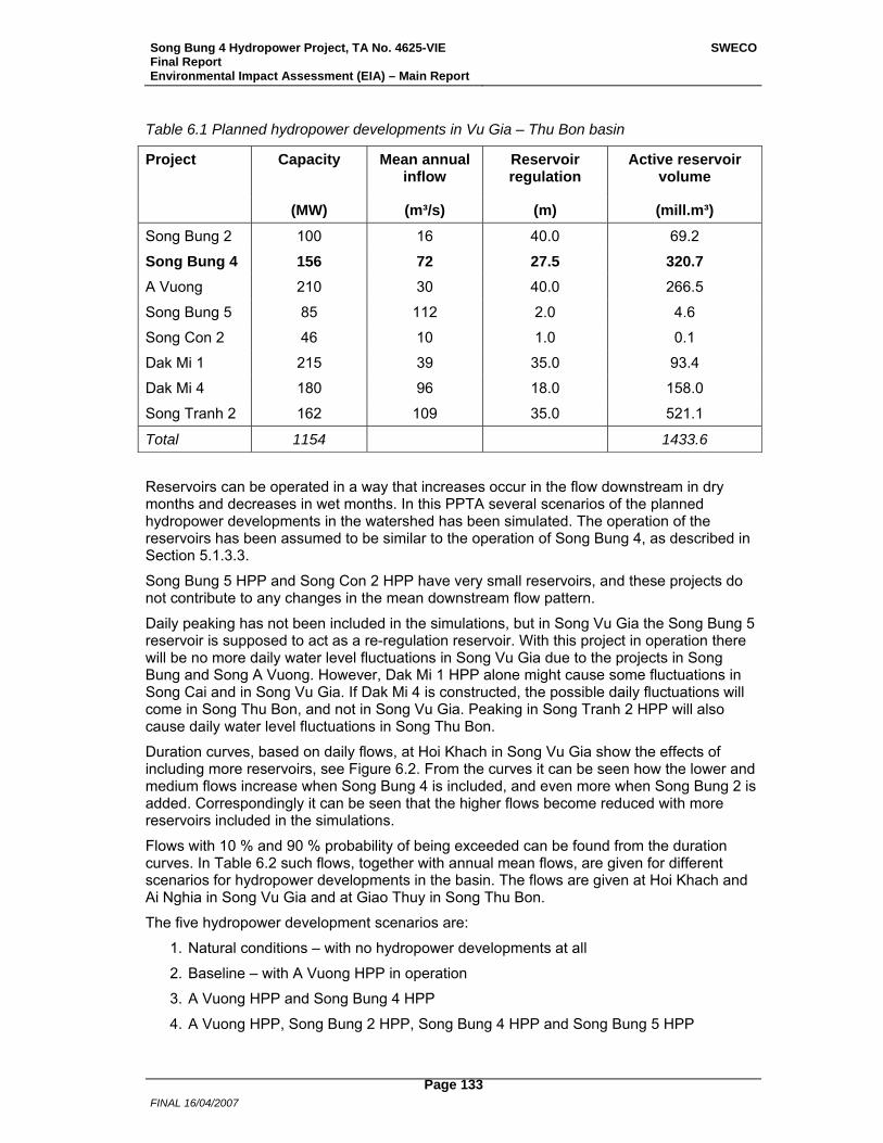
Song Bung 4 Hydropower Project, TA No. 4625-VIE Final Report Environmental Impact Assessment (EIA) – Main Report
SWECO
FINAL 16/04/2007
Page 133
Table 6.1 Planned hydropower developments in Vu Gia – Thu Bon basin
Project Capacity
Mean annual inflow
Reservoir regulation
Active reservoir volume
(MW) (m³/s) (m) (mill.m³)
Song Bung 2 100 16 40.0 69.2
Song Bung 4 156 72 27.5 320.7 A Vuong 210 30 40.0 266.5
Song Bung 5 85 112 2.0 4.6
Song Con 2 46 10 1.0 0.1
Dak Mi 1 215 39 35.0 93.4
Dak Mi 4 180 96 18.0 158.0
Song Tranh 2 162 109 35.0 521.1
Total 1154 1433.6
Reservoirs can be operated in a way that increases occur in the flow downstream in dry months and decreases in wet months. In this PPTA several scenarios of the planned hydropower developments in the watershed has been simulated. The operation of the reservoirs has been assumed to be similar to the operation of Song Bung 4, as described in Section 5.1.3.3.
Song Bung 5 HPP and Song Con 2 HPP have very small reservoirs, and these projects do not contribute to any changes in the mean downstream flow pattern.
Daily peaking has not been included in the simulations, but in Song Vu Gia the Song Bung 5 reservoir is supposed to act as a re-regulation reservoir. With this project in operation there will be no more daily water level fluctuations in Song Vu Gia due to the projects in Song Bung and Song A Vuong. However, Dak Mi 1 HPP alone might cause some fluctuations in Song Cai and in Song Vu Gia. If Dak Mi 4 is constructed, the possible daily fluctuations will come in Song Thu Bon, and not in Song Vu Gia. Peaking in Song Tranh 2 HPP will also cause daily water level fluctuations in Song Thu Bon.
Duration curves, based on daily flows, at Hoi Khach in Song Vu Gia show the effects of including more reservoirs, see Figure 6.2. From the curves it can be seen how the lower and medium flows increase when Song Bung 4 is included, and even more when Song Bung 2 is added. Correspondingly it can be seen that the higher flows become reduced with more reservoirs included in the simulations.
Flows with 10 % and 90 % probability of being exceeded can be found from the duration curves. In Table 6.2 such flows, together with annual mean flows, are given for different scenarios for hydropower developments in the basin. The flows are given at Hoi Khach and Ai Nghia in Song Vu Gia and at Giao Thuy in Song Thu Bon.
The five hydropower development scenarios are:
1. Natural conditions – with no hydropower developments at all
2. Baseline – with A Vuong HPP in operation
3. A Vuong HPP and Song Bung 4 HPP
4. A Vuong HPP, Song Bung 2 HPP, Song Bung 4 HPP and Song Bung 5 HPP
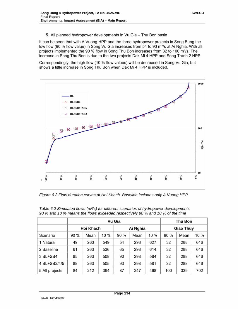
Song Bung 4 Hydropower Project, TA No. 4625-VIE Final Report Environmental Impact Assessment (EIA) – Main Report
SWECO
FINAL 16/04/2007
Page 134
5. All planned hydropower developments in Vu Gia – Thu Bon basin
It can be seen that with A Vuong HPP and the three hydropower projects in Song Bung the low flow (90 % flow value) in Song Vu Gia increases from 54 to 93 m³/s at Ai Nghia. With all projects implemented the 90 % flow in Song Thu Bon increases from 32 to 100 m³/s. The increase in Song Thu Bon is due to the two projects Dak Mi 4 HPP and Song Tranh 2 HPP.
Correspondingly, the high flow (10 % flow values) will be decreased in Song Vu Gia, but shows a little increase in Song Thu Bon when Dak Mi 4 HPP is included.
10
100
1000
0%10%
20%
30%
40%
50%
60%
70%
80%
90%
100%P
Q(m
³/s)
BL
BL+SB4
BL+SB4+SB5
BL+SB4+SB2
Figure 6.2 Flow duration curves at Hoi Khach. Baseline includes only A Vuong HPP
Table 6.2 Simulated flows (m³/s) for different scenarios of hydropower developments 90 % and 10 % means the flows exceeded respectively 90 % and 10 % of the time
Vu Gia Thu Bon
Hoi Khach Ai Nghia Giao Thuy
Scenario 90 % Mean 10 % 90 % Mean 10 % 90 % Mean 10 %
1 Natural 49 263 549 54 298 627 32 288 646
2 Baseline 61 263 536 65 298 614 32 288 646
3 BL+SB4 85 263 508 90 298 584 32 288 646
4 BL+SB2/4/5 88 263 505 93 298 581 32 288 646
5 All projects 84 212 394 87 247 468 100 339 702
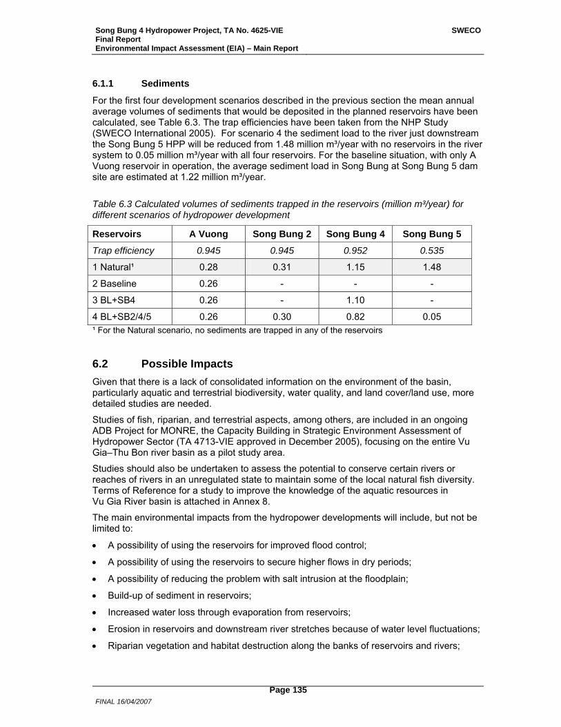
Song Bung 4 Hydropower Project, TA No. 4625-VIE Final Report Environmental Impact Assessment (EIA) – Main Report
SWECO
FINAL 16/04/2007
Page 135
6.1.1 Sediments
For the first four development scenarios described in the previous section the mean annual average volumes of sediments that would be deposited in the planned reservoirs have been calculated, see Table 6.3. The trap efficiencies have been taken from the NHP Study (SWECO International 2005). For scenario 4 the sediment load to the river just downstream the Song Bung 5 HPP will be reduced from 1.48 million m³/year with no reservoirs in the river system to 0.05 million m³/year with all four reservoirs. For the baseline situation, with only A Vuong reservoir in operation, the average sediment load in Song Bung at Song Bung 5 dam site are estimated at 1.22 million m³/year.
Table 6.3 Calculated volumes of sediments trapped in the reservoirs (million m³/year) for different scenarios of hydropower development
Reservoirs A Vuong Song Bung 2 Song Bung 4 Song Bung 5
Trap efficiency 0.945 0.945 0.952 0.535
1 Natural¹ 0.28 0.31 1.15 1.48
2 Baseline 0.26 - - -
3 BL+SB4 0.26 - 1.10 -
4 BL+SB2/4/5 0.26 0.30 0.82 0.05 ¹ For the Natural scenario, no sediments are trapped in any of the reservoirs
6.2 Possible Impacts Given that there is a lack of consolidated information on the environment of the basin, particularly aquatic and terrestrial biodiversity, water quality, and land cover/land use, more detailed studies are needed.
Studies of fish, riparian, and terrestrial aspects, among others, are included in an ongoing ADB Project for MONRE, the Capacity Building in Strategic Environment Assessment of Hydropower Sector (TA 4713-VIE approved in December 2005), focusing on the entire Vu Gia–Thu Bon river basin as a pilot study area.
Studies should also be undertaken to assess the potential to conserve certain rivers or reaches of rivers in an unregulated state to maintain some of the local natural fish diversity. Terms of Reference for a study to improve the knowledge of the aquatic resources in Vu Gia River basin is attached in Annex 8.
The main environmental impacts from the hydropower developments will include, but not be limited to:
• A possibility of using the reservoirs for improved flood control;
• A possibility of using the reservoirs to secure higher flows in dry periods;
• A possibility of reducing the problem with salt intrusion at the floodplain;
• Build-up of sediment in reservoirs;
• Increased water loss through evaporation from reservoirs;
• Erosion in reservoirs and downstream river stretches because of water level fluctuations;
• Riparian vegetation and habitat destruction along the banks of reservoirs and rivers;
Song Bung 4 Hydropower Project, TA No. 4625-VIE Final Report Environmental Impact Assessment (EIA) – Main Report
SWECO
FINAL 16/04/2007
Page 136
• Reduction in fish populations and diversity in reservoirs and affected rivers, and largely reduction in fish migration;
• Negative consequences for estuarine and coastal fisheries;
• Addition to natural fish production in the reservoirs and fish production in the rivers because of aquaculture in the reservoirs; and
• Potential loss in terrestrial biodiversity and habitats, and increase in landscape fragmentation.
Mitigation measures to minimize environmental impacts from the proposed hydropower developments in the Vu Gia–Thu Bon basin must include operational rules for the projects, taking into account environmental issues and close coordination by hydropower operators, Department of Natural Resources and the Environment (DONRE), and downstream water users to ensure coordinated resource management. The Project’s mitigation measures will minimize impacts to the environment and livelihoods. For example, mitigation for impacts on fish species and fisheries will be based on livelihood restoration plans (including aquaculture and livestock).
Hydropower development in the Vu Gia–Thu Bon river basin will also have potential cumulative impacts because of the increase in transport; irrigation development; erosion; expansion into forested lands; urban growth; tourism and tourism-related trade; illegal mining and logging; and exploitation of forest, water, and biodiversity resources and multiplier effects related to increased work force and camp followers. Policy development will be required to manage these cumulative impacts and set up best practices including, but not limited to, (i) the development of integrated water resources management for the basin, (ii) institutional arrangements for river basin organization coordination, and (iii) river basin-watershed conservation programs.
Song Bung 4 Hydropower Project, TA No. 4625-VIE Final Report Environmental Impact Assessment (EIA) – Main Report
SWECO
FINAL 16/04/2007
Page 137
7 Environmental Management Plan
7.1 Introduction This chapter provides information on organizations that will be responsible for the implementation of the mitigation and conservation off-set plans, environmental protection and capacity building plan, and monitoring of their implementation. In addition the mitigation measures and their implementation are summarized. Mitigation and monitoring of social impacts are not included in the EMP, but in the REMDP.
Since mitigation forms a vital part of the Project an Environmental Management Unit (EMU) will be established by the Implementing Agency to implement the Environmental Management Plan (EMP) for the Song Bung 4 HPP. Such a team can be headed by an individual responsible for the entire mitigation operation, plus reports on progress and the status of each rehabilitation conducted. For the rehabilitation at STNR, forest officers/guards will assist with tasks assigned by the EMU specifically with forest protection, increasing environmental awareness, day to day practical aspects and play a pivotal role in rehabilitation strategies employed. It is suggested that this team and workers be established at the onset of the Project to facilitate nursery set up, site vulnerability inspection, etc. The main rehabilitation activity is expected to occur during the 4 years of construction period of the Project, although several activities will be initiated and planned during the pre-construction period (design phase) to identify project-specific mitigation measures, thus updating the EMP.
Management should also include the education of employees and locals in environmental issues. For example, workshops on mitigation should first of all be set up for all mitigation workers with the help of experts and run by forest officers. Secondly local people should be better informed of mitigation strategies and methods so that they understand the nature of how land and soil loss problems are handled. Furthermore the importance of controlling grazing and wood collection on revegetated sites must be enforced. All these issues will be covered by an Environmental Awareness Campaign.
A monitoring programme for water quality and aquatic life for pre-construction, construction and operation phases is in Annex 5. Environmental Protection training and awareness, and capacity building of institutions are essential elements of the EMP (Annex 4). A rehabilitation plan for STNR as a conservation off-set will be implemented by the EMU (Annex 7). In similar lines a conservation off-set prepared as a community based forest management plan will be part of the EMP (Annex 6), but its implementation is included in the REMDP. Guidelines for Road Construction and Maintenance (Annex 3) are to be used for new and upgrading of roads in the Song Bung 4 HPP.
Based on discussions with EVN and ADB in August 2006 a final EMP was prepared and is presented below.
7.2 Organization and Implementation. Electricity of Vietnam (EVN) is the Executing Agency (EA) for the Project and has the overall responsibility for ensuring that all environmental standards and procedures are followed. The environmental standards are set by the Ministry of Natural Resources and Environment (MONRE). The Quang Nam provincial agency responsible for implementing and monitoring environmental procedures is the Department of Natural Resources and the Environment (DONRE). The Implementing Agency (IA) during construction will be Hydropower Project Management Board No 3 (ATD3). Prior to the project construction, the IA will set up an environmental management unit (EMU) for environmental management and operation,
Song Bung 4 Hydropower Project, TA No. 4625-VIE Final Report Environmental Impact Assessment (EIA) – Main Report
SWECO
FINAL 16/04/2007
Page 138
including environmental supervision of contractors. The EMU will ensure implementation of the environmental management plan and the environmental monitoring plan during construction of the Project. The EMU will be staffed by a project manager and with technical personnel. During operation the Power Plant Operator will be responsible for the implementation of the EMP.
The IA will ensure that the EMP with annexes (included in the EIA Report) is included in all contractor bidding documents and operating contracts. Song Bung 5 HPP, acting as a re-regulating reservoir, is regarded as a condition to some of the mitigation measures such as water quality and aquatic life.The EMU will coordinate all environmental monitoring activities as given in the EMP. The EMU will ensure that the EMP is updated periodically during the construction period. An independent environmental supervision consultant, as part of the Implementation Supervision Consultant, will supervise and monitor environmental procedures. The EMU will submit environmental monitoring reports (including physical data) to the EA, DONRE and ADB twice annually during construction and annually, to ADB for 2 years, after completion of construction.
7.2.1.1 Quang Nam DONRE currently has 66 staff, in 10 divisions. The Environmental division has 6 staff, Natural Resource and Environmental division 5 staff, and Centre for Survey and Analyzes 8 staff members. Furthermore the Section of Natural Resource and Environment in Nam Giang District has 6 staff members. The Capacity Building of Institutions will include training of personnel in DONRE and district staff related to forest protection and management, in addition to those of the EA and IA. Representatives of the local communities will also take part in training workshop on environmental protection.
7.2.2 The Environmental Management Unit
Under the IA an EMU will be responsible for the implementation and management of the EMP. The EMU will be specially designed for the Project and will include three full time staff. Regular environmental, health and safety rounds in the construction area will also be part of the responsibility of the EMU.
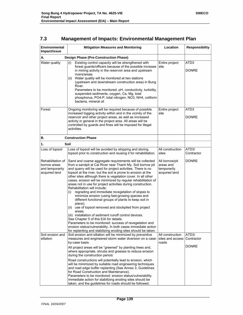
Song Bung 4 Hydropower Project, TA No. 4625-VIE Final Report Environmental Impact Assessment (EIA) – Main Report
SWECO
FINAL 16/04/2007
Page 139
7.3 Management of Impacts: Environmental Management Plan Environmental Impact/issue
Mitigation Measures and Monitoring Location Responsibility
A. Design Phase (Pre-Construction Phase)
Water quality (i) Existing control capacity will be strengthened with forest guards/officers because of the possible increase in mining activity in the reservoir area and upstream rivers/areas
(ii) Water quality will be monitored at two stations (upstream and downstream construction area) in Bung River. Parameters to be monitored: pH, conductivity, turbidity, suspended sediments, oxygen, Ca, Mg, total phosphorus, PO4-P, total nitrogen, NO3, NH4, coliform bacteria, mineral oil
Entire project site
ATD3 DONRE
Forest Ongoing monitoring will be required because of possible increased logging activity within and in the vicinity of the reservoir and other project areas, as well as increased activity in general in the project area. All areas will be controlled by guards and fines will be imposed for illegal activities.
Entire project site
ATD3 DONRE
B. Construction Phase
1. Soil
Loss of topsoil Rehabilitation of borrow areas and temporarily acquired land
Loss of topsoil will be avoided by stripping and storing topsoil prior to construction and reusing it for rehabilitation. Sand and coarse aggregate requirements will be collected from a sandpit at Cai River near Thanh My. Soil borrow pit and quarry will be used for project activities. There is no topsoil at the river, but the soil is prone to erosion at the other sites although there is vegetation cover. In all other cases, erosion will be minimized by regular rehabilitation of areas not in use for project activities during construction. Rehabilitation will include: (i) regrading and immediate revegetation of slopes to
minimize erosion (using fast-growing species and different functional groups of plants to keep soil in place);
(ii) use of topsoil removed and stockpiled from project areas;
(iii) installation of sediment runoff control devices. See Chapter 5 of this EIA for details. Parameters to be monitored: success of revegetation and erosion status/vulnerability. In both cases immediate action for replanting and stabilizing eroding sites should be taken.
All construction sites All borrow/pit areas and temporarily acquired land
ATD3/ Contractor DONRE
Soil erosion and siltation
Soil erosion and siltation will be minimized by preventive measures and engineered storm water diversion on a case-by-case basis. All project areas will be ”greened” by planting trees and, where appropriate, shrubs and grasses to reduce erosion during the construction period. Road constructions will potentially lead to erosion, which will be minimized by suitable road engineering techniques and road edge buffer replanting (See Annex 3, Guidelines for Road Construction and Maintenance). Parameters to be monitored: erosion status/vulnerability. Immediate action for stabilizing eroding sites should be taken, and the guidelines for roads should be followed.
All construction sites and access roads
ATD3/ Contractor DONRE
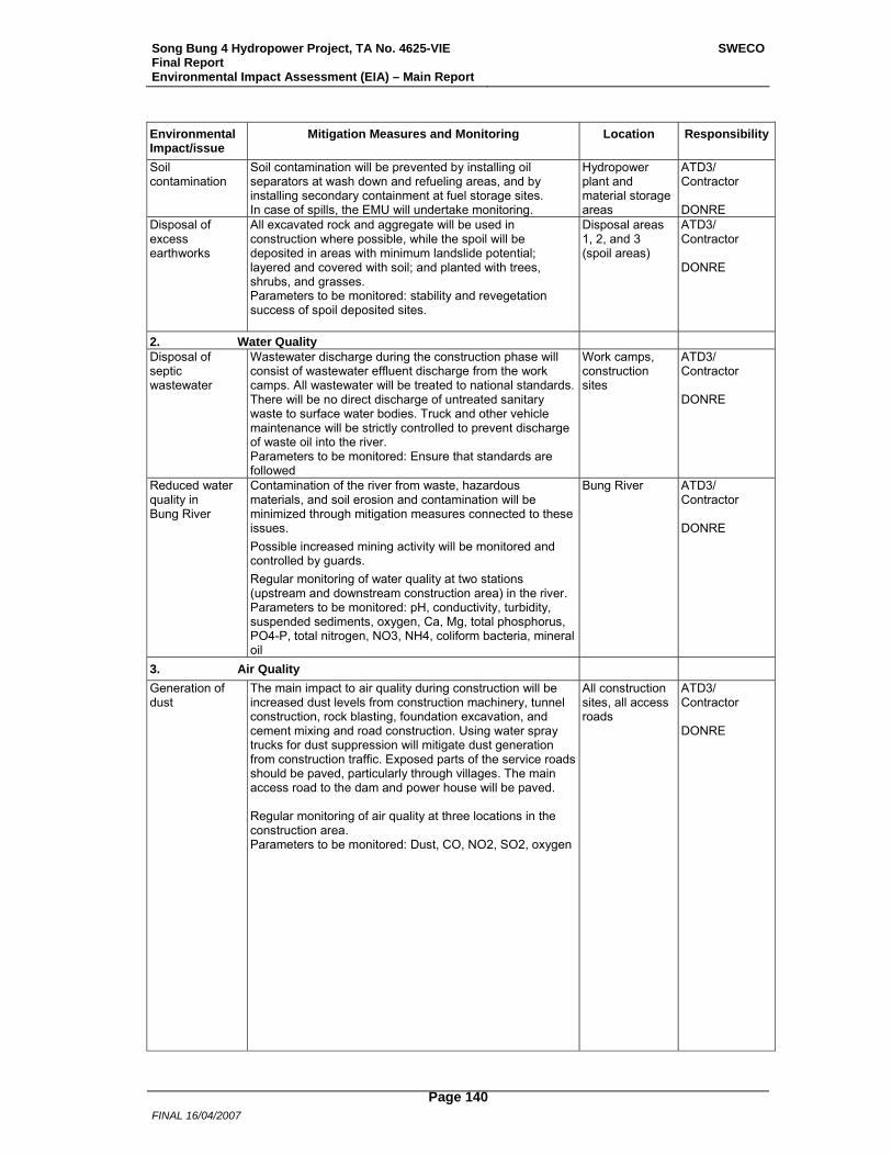
Song Bung 4 Hydropower Project, TA No. 4625-VIE Final Report Environmental Impact Assessment (EIA) – Main Report
SWECO
FINAL 16/04/2007
Page 140
Environmental Impact/issue
Mitigation Measures and Monitoring Location Responsibility
Soil contamination
Soil contamination will be prevented by installing oil separators at wash down and refueling areas, and by installing secondary containment at fuel storage sites. In case of spills, the EMU will undertake monitoring.
Hydropower plant and material storage areas
ATD3/ Contractor DONRE
Disposal of excess earthworks
All excavated rock and aggregate will be used in construction where possible, while the spoil will be deposited in areas with minimum landslide potential; layered and covered with soil; and planted with trees, shrubs, and grasses. Parameters to be monitored: stability and revegetation success of spoil deposited sites.
Disposal areas 1, 2, and 3 (spoil areas)
ATD3/ Contractor DONRE
2. Water Quality Disposal of septic wastewater
Wastewater discharge during the construction phase will consist of wastewater effluent discharge from the work camps. All wastewater will be treated to national standards. There will be no direct discharge of untreated sanitary waste to surface water bodies. Truck and other vehicle maintenance will be strictly controlled to prevent discharge of waste oil into the river. Parameters to be monitored: Ensure that standards are followed
Work camps, construction sites
ATD3/ Contractor DONRE
Reduced water quality in Bung River
Contamination of the river from waste, hazardous materials, and soil erosion and contamination will be minimized through mitigation measures connected to these issues. Possible increased mining activity will be monitored and controlled by guards. Regular monitoring of water quality at two stations (upstream and downstream construction area) in the river. Parameters to be monitored: pH, conductivity, turbidity, suspended sediments, oxygen, Ca, Mg, total phosphorus, PO4-P, total nitrogen, NO3, NH4, coliform bacteria, mineral oil
Bung River ATD3/ Contractor DONRE
3. Air Quality
Generation of dust
The main impact to air quality during construction will be increased dust levels from construction machinery, tunnel construction, rock blasting, foundation excavation, and cement mixing and road construction. Using water spray trucks for dust suppression will mitigate dust generation from construction traffic. Exposed parts of the service roads should be paved, particularly through villages. The main access road to the dam and power house will be paved. Regular monitoring of air quality at three locations in the construction area. Parameters to be monitored: Dust, CO, NO2, SO2, oxygen
All construction sites, all access roads
ATD3/ Contractor DONRE
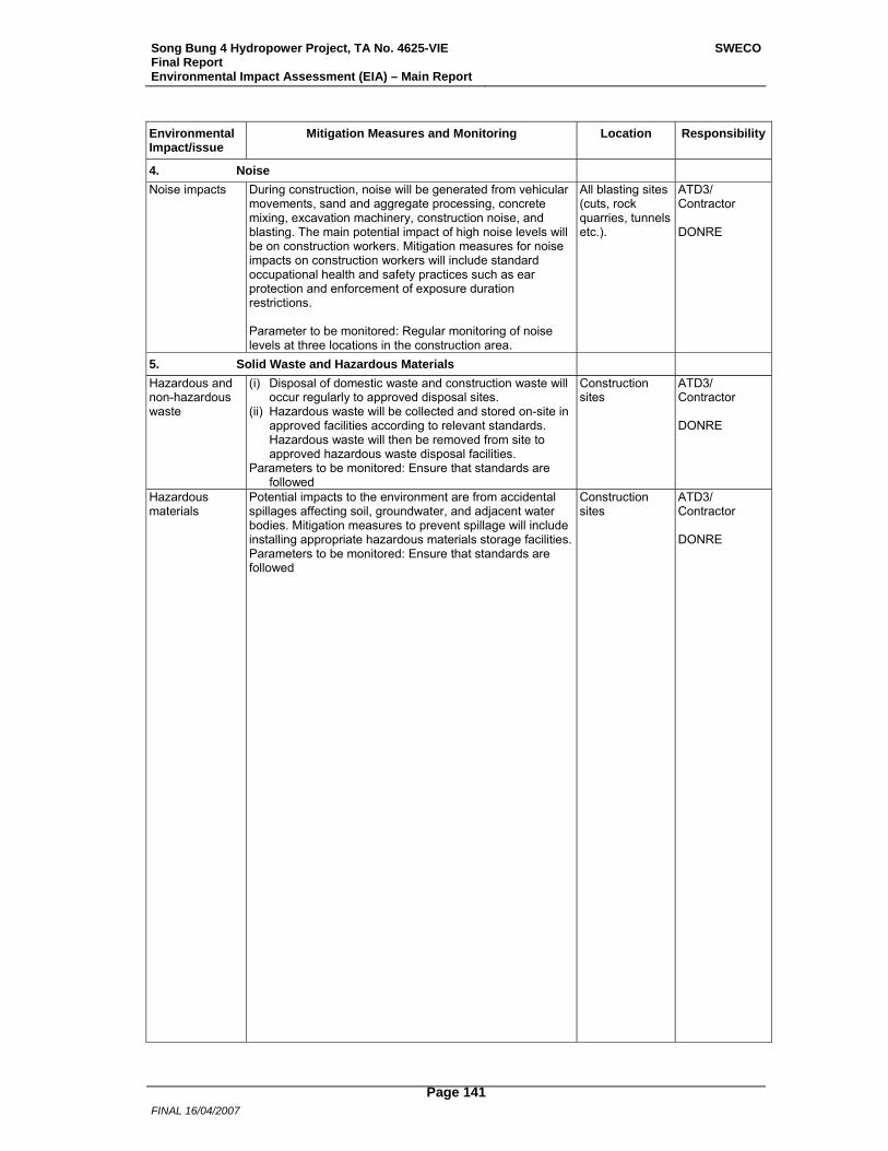
Song Bung 4 Hydropower Project, TA No. 4625-VIE Final Report Environmental Impact Assessment (EIA) – Main Report
SWECO
FINAL 16/04/2007
Page 141
Environmental Impact/issue
Mitigation Measures and Monitoring Location Responsibility
4. Noise Noise impacts During construction, noise will be generated from vehicular
movements, sand and aggregate processing, concrete mixing, excavation machinery, construction noise, and blasting. The main potential impact of high noise levels will be on construction workers. Mitigation measures for noise impacts on construction workers will include standard occupational health and safety practices such as ear protection and enforcement of exposure duration restrictions. Parameter to be monitored: Regular monitoring of noise levels at three locations in the construction area.
All blasting sites (cuts, rock quarries, tunnels etc.).
ATD3/ Contractor DONRE
5. Solid Waste and Hazardous Materials
Hazardous and non-hazardous waste
(i) Disposal of domestic waste and construction waste will occur regularly to approved disposal sites.
(ii) Hazardous waste will be collected and stored on-site in approved facilities according to relevant standards. Hazardous waste will then be removed from site to approved hazardous waste disposal facilities.
Parameters to be monitored: Ensure that standards are followed
Construction sites
ATD3/ Contractor DONRE
Hazardous materials
Potential impacts to the environment are from accidental spillages affecting soil, groundwater, and adjacent water bodies. Mitigation measures to prevent spillage will include installing appropriate hazardous materials storage facilities.Parameters to be monitored: Ensure that standards are followed
Construction sites
ATD3/ Contractor DONRE
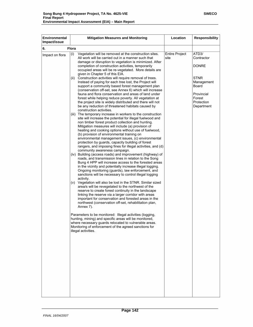
Song Bung 4 Hydropower Project, TA No. 4625-VIE Final Report Environmental Impact Assessment (EIA) – Main Report
SWECO
FINAL 16/04/2007
Page 142
Environmental Impact/issue
Mitigation Measures and Monitoring Location Responsibility
6. Flora
Impact on flora (i) Vegetation will be removed at the construction sites. All work will be carried out in a manner such that damage or disruption to vegetation is minimized. After completion of construction activities, temporarily occupied areas will be re-vegetated. More details are given in Chapter 5 of this EIA.
(ii) Construction activities will require removal of trees. Instead of paying for each tree lost, the Project will support a community based forest management plan (conservation off-set, see Annex 6) which will increase fauna and flora conservation and areas of land under forest while helping reduce poverty. All vegetation at the project site is widely distributed and there will not be any reduction of threatened habitats caused by construction activities.
(iii) The temporary increase in workers to the construction site will increase the potential for illegal fuelwood and non timber forest product collection and hunting. Mitigation measures will include (a) provision of heating and cooking options without use of fuelwood, (b) provision of environmental training on environmental management issues, (c) environmental protection by guards, capacity building of forest rangers, and imposing fines for illegal activities, and (d) community awareness campaign.
(iv) Building (access roads) and improvement (highway) of roads, and transmission lines in relation to the Song Bung 4 HPP will increase access to the forested areas in the vicinity and potentially increase illegal logging. Ongoing monitoring (guards), law enforcement, and sanctions will be necessary to control illegal logging activity.
(v) Vegetation will also be lost in the STNR. Similar sized area/s will be revegetated to the northwest of the reserve to create forest continuity in the landscape linking the reserve via a larger corridor with areas important for conservation and forested areas in the northwest (conservation off-set, rehabilitation plan, Annex 7).
Parameters to be monitored: Illegal activities (logging, hunting, mining) and specific areas will be monitored, where necessary guards relocated to vulnerable areas. Monitoring of enforcement of the agreed sanctions for illegal activities.
Entire Project site
ATD3/ Contractor DONRE STNR Management Board Provincial Forest Protection Department
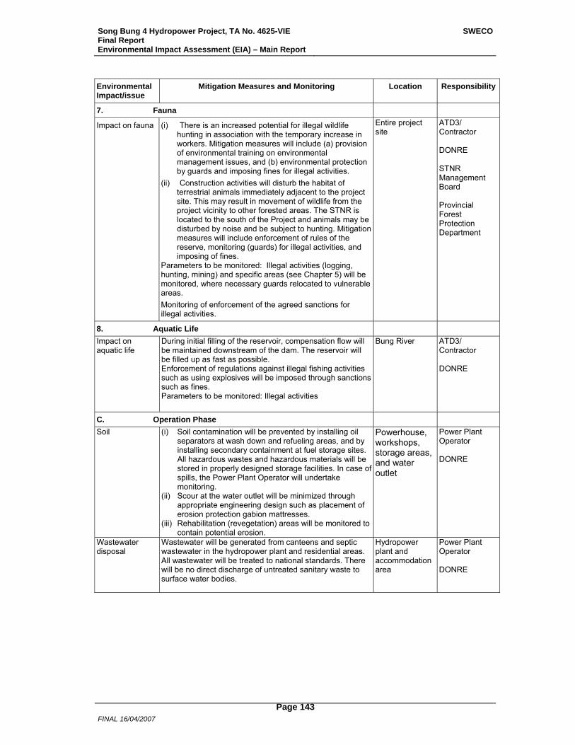
Song Bung 4 Hydropower Project, TA No. 4625-VIE Final Report Environmental Impact Assessment (EIA) – Main Report
SWECO
FINAL 16/04/2007
Page 143
Environmental Impact/issue
Mitigation Measures and Monitoring Location Responsibility
7. Fauna
Impact on fauna (i) There is an increased potential for illegal wildlife hunting in association with the temporary increase in workers. Mitigation measures will include (a) provision of environmental training on environmental management issues, and (b) environmental protection by guards and imposing fines for illegal activities.
(ii) Construction activities will disturb the habitat of terrestrial animals immediately adjacent to the project site. This may result in movement of wildlife from the project vicinity to other forested areas. The STNR is located to the south of the Project and animals may be disturbed by noise and be subject to hunting. Mitigation measures will include enforcement of rules of the reserve, monitoring (guards) for illegal activities, and imposing of fines.
Parameters to be monitored: Illegal activities (logging, hunting, mining) and specific areas (see Chapter 5) will be monitored, where necessary guards relocated to vulnerable areas. Monitoring of enforcement of the agreed sanctions for illegal activities.
Entire project site
ATD3/ Contractor DONRE STNR Management Board Provincial Forest Protection Department
8. Aquatic Life
Impact on aquatic life
During initial filling of the reservoir, compensation flow will be maintained downstream of the dam. The reservoir will be filled up as fast as possible. Enforcement of regulations against illegal fishing activities such as using explosives will be imposed through sanctions such as fines. Parameters to be monitored: Illegal activities
Bung River ATD3/ Contractor DONRE
C. Operation Phase
Soil (i) Soil contamination will be prevented by installing oil separators at wash down and refueling areas, and by installing secondary containment at fuel storage sites. All hazardous wastes and hazardous materials will be stored in properly designed storage facilities. In case of spills, the Power Plant Operator will undertake monitoring.
(ii) Scour at the water outlet will be minimized through appropriate engineering design such as placement of erosion protection gabion mattresses.
(iii) Rehabilitation (revegetation) areas will be monitored to contain potential erosion.
Powerhouse, workshops, storage areas, and water outlet
Power Plant Operator DONRE
Wastewater disposal
Wastewater will be generated from canteens and septic wastewater in the hydropower plant and residential areas. All wastewater will be treated to national standards. There will be no direct discharge of untreated sanitary waste to surface water bodies.
Hydropower plant and accommodation area
Power Plant Operator DONRE
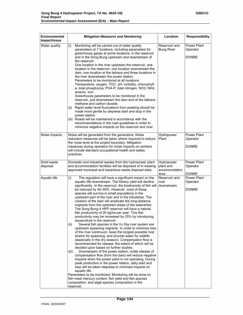
Song Bung 4 Hydropower Project, TA No. 4625-VIE Final Report Environmental Impact Assessment (EIA) – Main Report
SWECO
FINAL 16/04/2007
Page 144
Environmental Impact/issue
Mitigation Measures and Monitoring Location Responsibility
Water quality (i) Monitoring will be carried out of water quality parameters at 7 locations, including parameters for greenhouse gases at some locations, in the reservoir and in the Song Bung upstream and downstream of the reservoir. One location in the river upstream the reservoir, one location in the reservoir, one location downstream the dam, one location at the tailrace and three locations in the river downstream the power station. Parameters to be monitored at all locations: Temperature, oxygen, TOC, pH, turbidity, chlorophyll-a, total phosphorus, PO4-P, total nitrogen, NO3, NH4, arsenic, iron. Greenhouse parameters to be monitored in the reservoir, just downstream the dam and at the tailrace: methane and carbon dioxide.
(ii) Rapid water level fluctuations from peaking should be made more gentle by stepwise start and stop in the power station.
(iii) Roads will be maintained in accordance with the recommendations in the road guidelines in order to minimize negative impacts on the reservoir and river.
Reservoir and Bung River
Power Plant Operator DONRE
Noise impacts Noise will be generated from the generators. Noise reduction measures will be taken where required to reduce the noise level at the project boundary. Mitigation measures during operation for noise impacts on workers will include standard occupational health and safety practices.
Hydropower Plant
Power Plant Operator DONRE
Solid waste disposal
Domestic and industrial wastes from the hydropower plant and accommodation facilities will be disposed of in existing approved municipal and hazardous waste disposal sites.
Hydropower plant and accommodation area
Power Plant Operator DONRE
Aquatic life
(i) The regulation will have a significant impact on the aquatic life downstream. The fishery yield will decline significantly. In the reservoir, the biodiversity of fish will be reduced by 30–50%. However, most of these species will survive in small populations in the upstream part of the river and in the tributaries. The creation of the dam will eradicate the long-distance migrants from the upstream areas of the watershed. The Song Bung 4 HPP reservoir will have a natural fish productivity of 20 kg/ha per year. This fish productivity may be increased by 25% by introducing aquaculture in the reservoir.
(ii) Several fish species in the Vu Gia river system are upstream spawning migrants. In order to minimize loss of the river continuum, keep the longest possible river stretch for spawning, and provide water for wildlife (especially in the dry season). Compensation flow is recommended for release, the extent of which will be decided upon based on further studies.
(iii) Downstream of the power station, outlet release of compensation flow (from the dam) will reduce negative impacts when the power plant is not operating. During peak production in the power station, daily start and stop will be taken stepwise to minimize impacts on aquatic life.
Parameters to be monitored: Monitoring will be done on fish meat mercury content, fish yield and fish species composition, and algal species composition in the reservoir.
Reservoir and river downstream
Power Plant Operator DONRE

Song Bung 4 Hydropower Project, TA No. 4625-VIE Final Report Environmental Impact Assessment (EIA) – Main Report
SWECO
FINAL 16/04/2007
Page 145
Environmental Impact/issue
Mitigation Measures and Monitoring Location Responsibility
Reduced water flow at affected river section
A release of compensation flow is recommended. As the current level of baseline data on the riverine environment makes it difficult to recommend the magnitude of such a flow, it is recommended that the knowledge base on aspects related to hydrology, aquatic and riparian ecology, livelihoods of downstream communities, technical design and economics be improved. This may be done through a study that covers, among other issues, both the wet and the dry season of the year, and in particular the two main annual fish migration periods.
River section between dam and power station outlet, and downstream power station
ADB & EVN
Flora and fauna rehabilitated areas CBFM
Enforcement of rules of the reserve and forest exploitation must be done. Monitoring (by guards) for illegal activities in forest around project areas and the imposing of sanctions as fines will be continued. Rehabilitated areas of STNR and the CBFM plan in Zuoih commune, and Bo Di (Cha Val commune) and Pa Toi (Ta Bhing commune) villages must be monitored to ensure that community forests are not encroached, user rights are secured and maintained, locally managed lands are not exploited by outsiders.
Project Area, The Reserve, and Zuoih commune
Power Plant Operator STNR Management Board Provincial Forest Protection Department
Rapid water level fluctuations in the river
A system to warn (sirens) downstream people when the power station is to be started. Several sirens should be installed down to the confluence with Cai River. The system can also be used for emergency situations involving sudden releases of large water volumes.
River downstream power station
Power Plant Operator
7.4 Monitoring Plan Pre-Construction Phase (0.5 years) and Construction Phase (4 years) Issue Parameters Location Frequency Responsibility Water quality pH, conductivity,
turbidity, suspended sediments, oxygen, Ca, Mg, total phosphorus, PO4-P, total nitrogen, NO3, NH4, coliform bacteria, mineral oil
Two stations in Song Bung: - Upstream construction area - Downstream construction area
Duration 4,5 years One sampling at each station every month performed by the EMU
ATD3/Contractor DONRE
Disposal of septic wastewater
Ensure wastewater is treated in accordance with national standards
Work camps, offices
Duration 4 years Continuous by the EMU
ATD3/Contractor DONRE
Rehabilitation of borrow areas and temporarily acquired land
Success of revegetation and erosion status/vulnerability
All borrow/pit areas and temporarily acquired land
Duration 4 years Continuous by the EMU
ATD3/Contractor DONRE
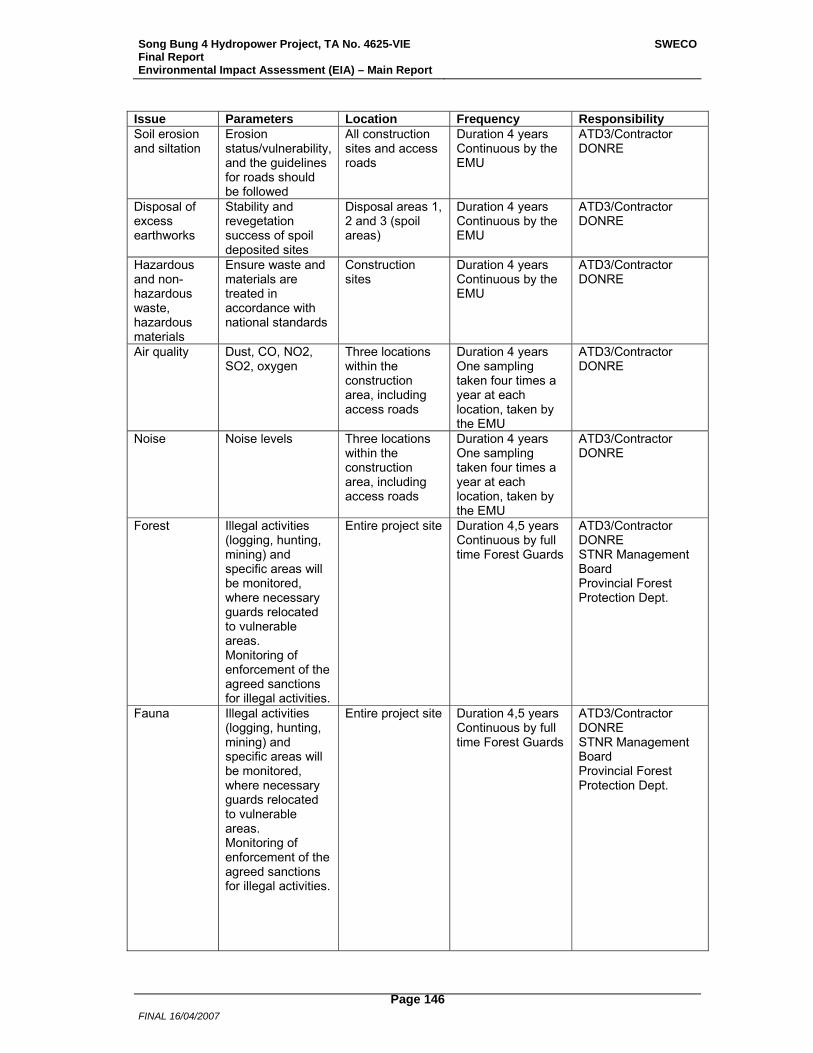
Song Bung 4 Hydropower Project, TA No. 4625-VIE Final Report Environmental Impact Assessment (EIA) – Main Report
SWECO
FINAL 16/04/2007
Page 146
Issue Parameters Location Frequency Responsibility Soil erosion and siltation
Erosion status/vulnerability,and the guidelines for roads should be followed
All construction sites and access roads
Duration 4 years Continuous by the EMU
ATD3/Contractor DONRE
Disposal of excess earthworks
Stability and revegetation success of spoil deposited sites
Disposal areas 1, 2 and 3 (spoil areas)
Duration 4 years Continuous by the EMU
ATD3/Contractor DONRE
Hazardous and non-hazardous waste, hazardous materials
Ensure waste and materials are treated in accordance with national standards
Construction sites
Duration 4 years Continuous by the EMU
ATD3/Contractor DONRE
Air quality Dust, CO, NO2, SO2, oxygen
Three locations within the construction area, including access roads
Duration 4 years One sampling taken four times a year at each location, taken by the EMU
ATD3/Contractor DONRE
Noise Noise levels Three locations within the construction area, including access roads
Duration 4 years One sampling taken four times a year at each location, taken by the EMU
ATD3/Contractor DONRE
Forest Illegal activities (logging, hunting, mining) and specific areas will be monitored, where necessary guards relocated to vulnerable areas. Monitoring of enforcement of the agreed sanctions for illegal activities.
Entire project site Duration 4,5 years Continuous by full time Forest Guards
ATD3/Contractor DONRE STNR Management Board Provincial Forest Protection Dept.
Fauna Illegal activities (logging, hunting, mining) and specific areas will be monitored, where necessary guards relocated to vulnerable areas. Monitoring of enforcement of the agreed sanctions for illegal activities.
Entire project site Duration 4,5 years Continuous by full time Forest Guards
ATD3/Contractor DONRE STNR Management Board Provincial Forest Protection Dept.
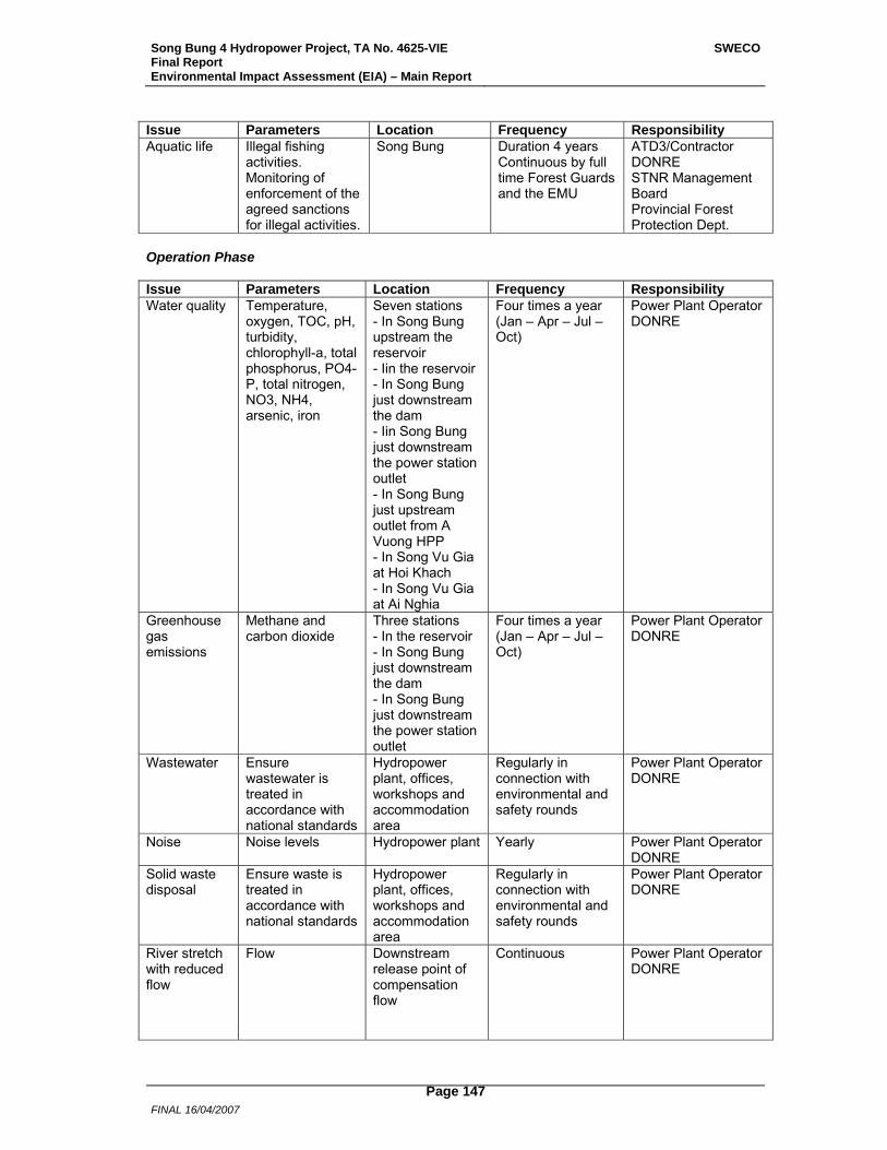
Song Bung 4 Hydropower Project, TA No. 4625-VIE Final Report Environmental Impact Assessment (EIA) – Main Report
SWECO
FINAL 16/04/2007
Page 147
Issue Parameters Location Frequency Responsibility Aquatic life Illegal fishing
activities. Monitoring of enforcement of the agreed sanctions for illegal activities.
Song Bung Duration 4 years Continuous by full time Forest Guards and the EMU
ATD3/Contractor DONRE STNR Management Board Provincial Forest Protection Dept.
Operation Phase Issue Parameters Location Frequency Responsibility Water quality Temperature,
oxygen, TOC, pH, turbidity, chlorophyll-a, total phosphorus, PO4-P, total nitrogen, NO3, NH4, arsenic, iron
Seven stations - In Song Bung upstream the reservoir - Iin the reservoir - In Song Bung just downstream the dam - Iin Song Bung just downstream the power station outlet - In Song Bung just upstream outlet from A Vuong HPP - In Song Vu Gia at Hoi Khach - In Song Vu Gia at Ai Nghia
Four times a year (Jan – Apr – Jul – Oct)
Power Plant Operator DONRE
Greenhouse gas emissions
Methane and carbon dioxide
Three stations - In the reservoir - In Song Bung just downstream the dam - In Song Bung just downstream the power station outlet
Four times a year (Jan – Apr – Jul – Oct)
Power Plant Operator DONRE
Wastewater Ensure wastewater is treated in accordance with national standards
Hydropower plant, offices, workshops and accommodation area
Regularly in connection with environmental and safety rounds
Power Plant Operator DONRE
Noise Noise levels Hydropower plant Yearly Power Plant Operator DONRE
Solid waste disposal
Ensure waste is treated in accordance with national standards
Hydropower plant, offices, workshops and accommodation area
Regularly in connection with environmental and safety rounds
Power Plant Operator DONRE
River stretch with reduced flow
Flow Downstream release point of compensation flow
Continuous Power Plant Operator DONRE
Song Bung 4 Hydropower Project, TA No. 4625-VIE Final Report Environmental Impact Assessment (EIA) – Main Report
SWECO
FINAL 16/04/2007
Page 148
Issue Parameters Location Frequency Responsibility Soil Erosion status on
revegetation/ rehabilitation areas. Riverbanks and reservoir banks erosion.
Power house, workshops, storage areas, outlet from power station and roads. Reservoir. Song Bung from dam to outlet from A Vuong HPP
Regularly in connection with environmental and safety rounds
Power Plant Operator DONRE
Aquatic life Fish meat mercury content, fish yield, fish species composition and algal species composition in the reservoir
Reservoir and river downstream
Monthly and other frequencies. For details see Annex 5
Power Plant Operator DONRE
Flora and fauna
Illegal activities (logging, hunting, mining) and specific areas will be monitored. Monitoring of enforcement of the agreed sanctions for illegal activities.
Project area, rehabilitated areas of STNR and areas covered by the CBFM Plan
Continuous by full time Forest Guards
Power Plant Operator STNR Management Board Provincial Forest Protection Dept.
7.5 Budget The budget for the recommended mitigation measures and monitoring as described in Sections 7.3 and 7.4 is shown in Table 7.1, in rounded figures. Detailed cost estimates are given in Annex 4 (Environmental Protection and Capacity Building Plan), Annex 6 (Community Based Forest Management Plan), Annex 7 (Rehabilitation for Protected Areas) and Annex 5 (Monitoring Aquatic Ecology and Water Quality). The exchange rate 1 USD = 15,000 VND has been used for the cost estimates. Costs for ordinary mitigation measures directly linked to the construction activity, such as erosion control measures at construction sites and access roads, are not included in the budget. These costs will be included in the construction costs. Details of costs for Community Based Forest Management and Watershed Protection are included in the REMDP.
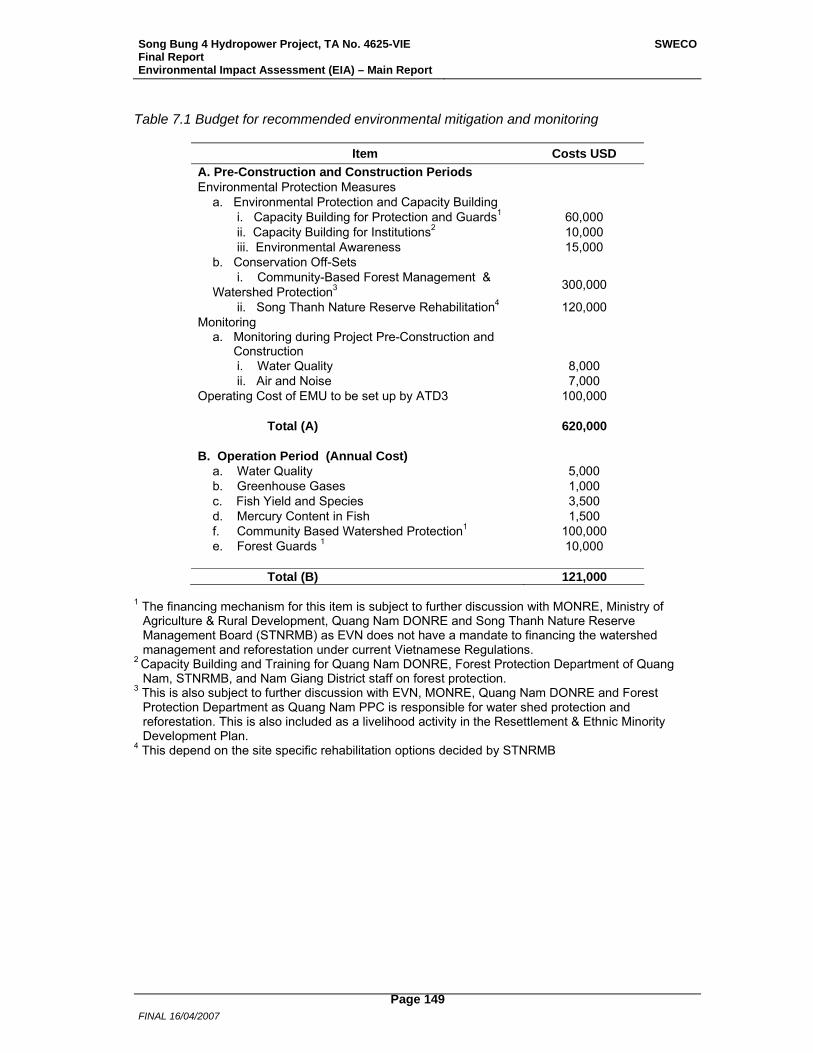
Song Bung 4 Hydropower Project, TA No. 4625-VIE Final Report Environmental Impact Assessment (EIA) – Main Report
SWECO
FINAL 16/04/2007
Page 149
Table 7.1 Budget for recommended environmental mitigation and monitoring
Item Costs USD A. Pre-Construction and Construction Periods Environmental Protection Measures a. Environmental Protection and Capacity Building i. Capacity Building for Protection and Guards1 60,000 ii. Capacity Building for Institutions2 10,000 iii. Environmental Awareness 15,000 b. Conservation Off-Sets
i. Community-Based Forest Management & Watershed Protection3 300,000
ii. Song Thanh Nature Reserve Rehabilitation4 120,000 Monitoring
a. Monitoring during Project Pre-Construction and Construction
i. Water Quality 8,000 ii. Air and Noise 7,000 Operating Cost of EMU to be set up by ATD3 100,000 Total (A) 620,000 B. Operation Period (Annual Cost)
a. Water Quality 5,000 b. Greenhouse Gases 1,000 c. Fish Yield and Species 3,500 d. Mercury Content in Fish 1,500 f. Community Based Watershed Protection1 100,000 e. Forest Guards 1 10,000 Total (B) 121,000
1 The financing mechanism for this item is subject to further discussion with MONRE, Ministry of
Agriculture & Rural Development, Quang Nam DONRE and Song Thanh Nature Reserve Management Board (STNRMB) as EVN does not have a mandate to financing the watershed management and reforestation under current Vietnamese Regulations.
2 Capacity Building and Training for Quang Nam DONRE, Forest Protection Department of Quang Nam, STNRMB, and Nam Giang District staff on forest protection.
3 This is also subject to further discussion with EVN, MONRE, Quang Nam DONRE and Forest Protection Department as Quang Nam PPC is responsible for water shed protection and reforestation. This is also included as a livelihood activity in the Resettlement & Ethnic Minority Development Plan.
4 This depend on the site specific rehabilitation options decided by STNRMB
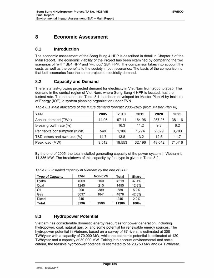
Song Bung 4 Hydropower Project, TA No. 4625-VIE Final Report Environmental Impact Assessment (EIA) – Main Report
SWECO
FINAL 16/04/2007
Page 150
8 Economic Assessment
8.1 Introduction The economic assessment of the Song Bung 4 HPP is described in detail in Chapter 7 of the Main Report. The economic viability of the Project has been examined by comparing the two scenarios of ”with” SB4 HPP and ”without” SB4 HPP. The comparison takes into account the costs as well as the benefits to the society in both scenarios. The basis of the comparison is that both scenarios face the same projected electricity demand.
8.2 Capacity and Demand There is a fast-growing projected demand for electricity in Viet Nam from 2005 to 2025. The demand in the central region of Viet Nam, where Song Bung 4 HPP is located, has the fastest rate. The demand, see Table 8.1, has been developed for Master Plan VI by Institute of Energy (IOE), a system planning organization under EVN.
Table 8.1 Main indicators of the IOE’s demand forecast 2005-2025 (from Master Plan VI)
Year 2005 2010 2015 2020 2025 Annual demand (TWh) 44.96 97.11 164.96 257.26 381.16 5-year growth rate (%) 16.3 11.2 9.3 8.2 Per capita consumption (KWh) 549 1,106 1,774 2,629 3,703 T&D losses and own-use (%) 14.7 13.8 13.2 12.5 11.7 Peak load (MW) 9,512 19,553 32,196 48,642 71,416
By the end of 2005, the total installed generating capacity of the power system in Vietnam is 11,386 MW. The breakdown of this capacity by fuel type is given in Table 8.2.
Table 8.2 Installed capacity in Vietnam by the end of 2005
Type of Capacity EVN Non-EVN Total Share Hydro 4069 150 4219 37.1% Coal 1245 210 1455 12.8% Oil 200 389 589 5.2% Gas 3037 1841 4878 42.8% Diesel 245 245 2.2% Total 8796 2590 11386 100%
8.3 Hydropower Potential Vietnam has considerable domestic energy resources for power generation, including hydropower, coal, natural gas, oil and some potential for renewable energy sources. The hydropower potential in Vietnam, based on a survey of 87 rivers, is estimated at 308 TWh/year with a capacity of 70,000 MW, while the economic potential is estimated at 120 TWh/year and a capacity of 30,000 MW. Taking into account environmental and social criteria, the feasible hydropower potential is estimated to be 20,750 MW and 84 TWh/year.
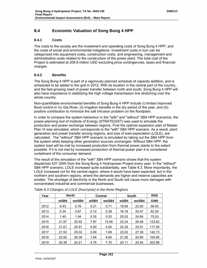
Song Bung 4 Hydropower Project, TA No. 4625-VIE Final Report Environmental Impact Assessment (EIA) – Main Report
SWECO
FINAL 16/04/2007
Page 151
8.4 Economic Valuation of Song Bung 4 HPP
8.4.1 Costs
The costs to the society are the investment and operating costs of Song Bung 4 HPP, and the costs of social and environmental mitigations. Investment costs in turn can be categorized into equipment costs, construction costs, and engineering, management and administrative costs related to the construction of the power plant. The total cost of the Project is estimated at 206.8 million USD excluding price contingencies, taxes and financial charges.
8.4.2 Benefits
The Song Bung 4 HPP is part of a vigorously planned schedule of capacity addition, and is scheduled to be added to the grid in 2012. With its location in the central part of the country, and the fast-growing need of power transfer between north and south, Song Bung 4 HPP will also have importance in stabilizing the high voltage transmission line stretching over the whole country.
Non-quantifiable environmental benefits of Song Bung 4 HPP include (i) limited improved flood control in Vu Gia River, (ii) irrigation benefits in the dry period of the year, and (iii) positive contribution to minimize the salt intrusion problem on the floodplain.
In order to compare the system behaviour in the "with" and "without" SB4 HPP scenarios, the power-planning tool of Institute of Energy (STRATEGIST) was used to simulate the production and power exchange between regions. First the optimal expansion plan of Master Plan VI was simulated, which corresponds to the "with" SB4 HPP scenario. As a result, plant generation and power transfer among regions, and loss of load expectation (LOLE), are calculated. The "without" SB4 HPP scenario is simulated by taking out the SB4 HPP from the system while keeping other generation sources unchanged. Without SB4 HPP, the system load will be met by increased production from thermal power plants to the extent possible. If it is not met by increased production of thermal power plan it is considered curtailment of the consumer demand.
The result of the simulation of the "with" SB4 HPP scenario shows that the system dispatches 537 GWh from the Song Bung 4 Hydropower Project every year. In the "without" SB4 HPP scenario, LOLE increased quite substantially, see Table 8.3. More importantly, the LOLE increased not for the central region, where it would have been expected, but in the northern and southern regions, where the demands are higher and reserve capacities are smaller. The shortage of electricity in the North and South will cause more damages with concentrated industrial and commercial businesses.
Table 8.3 Changes of LOLE (hour/year) in the three Regions
Year North Central South ENS wSB4 woSB4 wSB4 woSB4 wSB4 woSB4 GWh 2012 0.43 0.76 0.31 0.71 19.06 23.50 56.63 2013 0.34 0.87 0.12 0.39 16.18 20.47 62.29 2014 1.40 1.94 0.35 0.53 20.03 24.84 75.53 2015 21.97 25.42 7.87 15.56 23.24 26.48 123.62 2016 21.61 25.91 0.00 0.00 22.29 25.51 117.55 2017 21.53 25.02 0.09 1.69 23.02 27.39 142.73 2018 22.92 26.38 1.64 8.84 21.26 24.85 164.85 2019 20.38 24.21 4.76 7.70 20.11 25.54 203.96
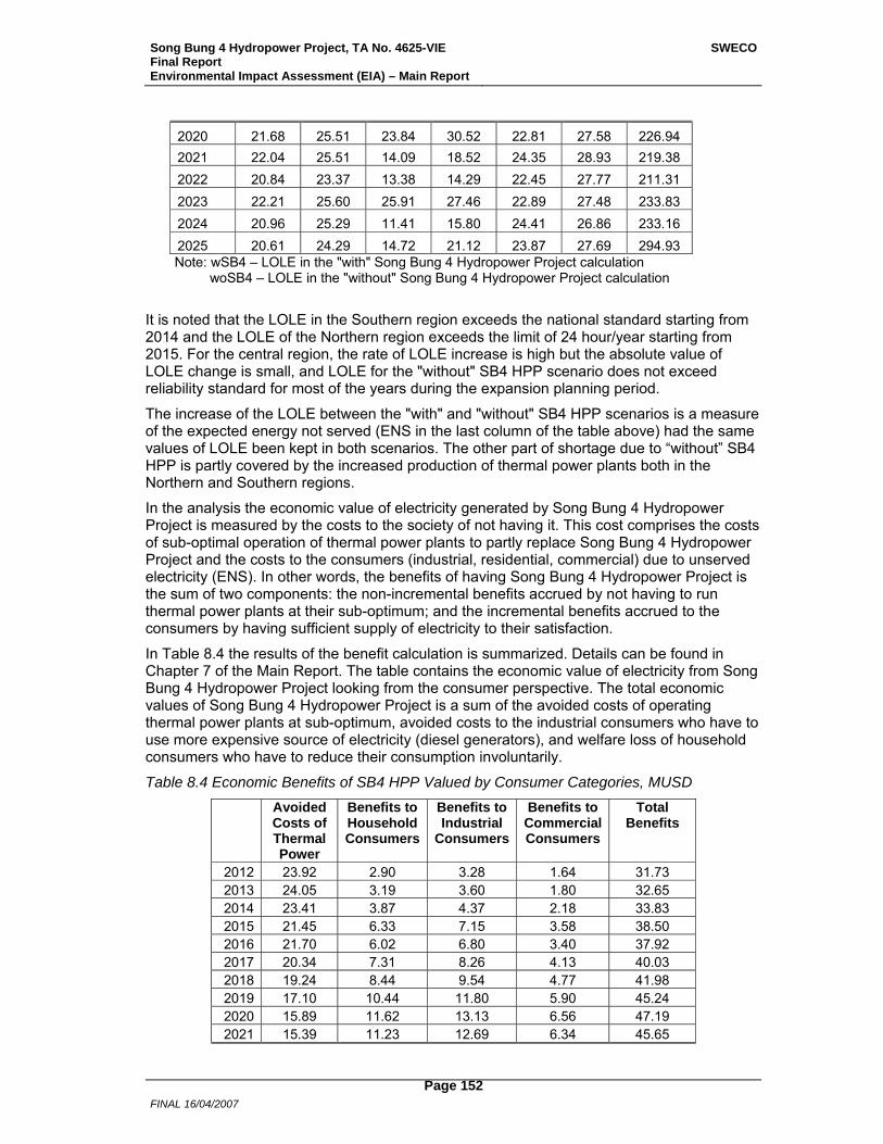
Song Bung 4 Hydropower Project, TA No. 4625-VIE Final Report Environmental Impact Assessment (EIA) – Main Report
SWECO
FINAL 16/04/2007
Page 152
2020 21.68 25.51 23.84 30.52 22.81 27.58 226.94 2021 22.04 25.51 14.09 18.52 24.35 28.93 219.38 2022 20.84 23.37 13.38 14.29 22.45 27.77 211.31 2023 22.21 25.60 25.91 27.46 22.89 27.48 233.83 2024 20.96 25.29 11.41 15.80 24.41 26.86 233.16 2025 20.61 24.29 14.72 21.12 23.87 27.69 294.93
Note: wSB4 – LOLE in the "with" Song Bung 4 Hydropower Project calculation woSB4 – LOLE in the "without" Song Bung 4 Hydropower Project calculation
It is noted that the LOLE in the Southern region exceeds the national standard starting from 2014 and the LOLE of the Northern region exceeds the limit of 24 hour/year starting from 2015. For the central region, the rate of LOLE increase is high but the absolute value of LOLE change is small, and LOLE for the "without" SB4 HPP scenario does not exceed reliability standard for most of the years during the expansion planning period.
The increase of the LOLE between the "with" and "without" SB4 HPP scenarios is a measure of the expected energy not served (ENS in the last column of the table above) had the same values of LOLE been kept in both scenarios. The other part of shortage due to “without” SB4 HPP is partly covered by the increased production of thermal power plants both in the Northern and Southern regions.
In the analysis the economic value of electricity generated by Song Bung 4 Hydropower Project is measured by the costs to the society of not having it. This cost comprises the costs of sub-optimal operation of thermal power plants to partly replace Song Bung 4 Hydropower Project and the costs to the consumers (industrial, residential, commercial) due to unserved electricity (ENS). In other words, the benefits of having Song Bung 4 Hydropower Project is the sum of two components: the non-incremental benefits accrued by not having to run thermal power plants at their sub-optimum; and the incremental benefits accrued to the consumers by having sufficient supply of electricity to their satisfaction.
In Table 8.4 the results of the benefit calculation is summarized. Details can be found in Chapter 7 of the Main Report. The table contains the economic value of electricity from Song Bung 4 Hydropower Project looking from the consumer perspective. The total economic values of Song Bung 4 Hydropower Project is a sum of the avoided costs of operating thermal power plants at sub-optimum, avoided costs to the industrial consumers who have to use more expensive source of electricity (diesel generators), and welfare loss of household consumers who have to reduce their consumption involuntarily.
Table 8.4 Economic Benefits of SB4 HPP Valued by Consumer Categories, MUSD
Avoided Costs of Thermal Power
Benefits to Household Consumers
Benefits to Industrial
Consumers
Benefits to Commercial Consumers
Total Benefits
2012 23.92 2.90 3.28 1.64 31.73 2013 24.05 3.19 3.60 1.80 32.65 2014 23.41 3.87 4.37 2.18 33.83 2015 21.45 6.33 7.15 3.58 38.50 2016 21.70 6.02 6.80 3.40 37.92 2017 20.34 7.31 8.26 4.13 40.03 2018 19.24 8.44 9.54 4.77 41.98 2019 17.10 10.44 11.80 5.90 45.24 2020 15.89 11.62 13.13 6.56 47.19 2021 15.39 11.23 12.69 6.34 45.65
Song Bung 4 Hydropower Project, TA No. 4625-VIE Final Report Environmental Impact Assessment (EIA) – Main Report
SWECO
FINAL 16/04/2007
Page 153
2022 16.51 10.82 12.22 6.11 45.66 2023 14.80 11.97 13.52 6.76 47.06 2024 15.55 11.94 13.49 6.74 47.72 2025 12.31 15.10 17.06 8.53 53.00
8.4.3 Conclusion
The economic robustness of Song Bung 4 Hydropower Project has been confirmed by economic valuation of cots and benefits of the Project with extensive sensitivity analysis. The Song Bung 4 Hydropower Project yields an EIRR of 14.95 % and a corresponding NPV of 51.06 million USD over the project lifetime of 40 years.
Song Bung 4 Hydropower Project, TA No. 4625-VIE Final Report Environmental Impact Assessment (EIA) – Main Report
SWECO
FINAL 16/04/2007
Page 154
9 Public Consultation and Information Disclosure
9.1 Previous Consultations A series of stakeholder consultations relevant to Song Bung 4 HPP has been carried out. In 2005, during the feasibility study for Song Bung 4 HPP, PECC3 conducted meetings at village and commune levels. During the NHP Study Stage 2, stakeholder participation took place at different levels (SWECO International 2006A): (i) river basin workshop in Vu Gia–Thu Bon river basin in 2005; (ii) provincial workshop in Nam Giang Province in 2004, targeting all directly affected districts and communes; and (iii) group discussions in 30 directly and indirectly affected villages in 2004. Consultations were also carried out in the local ethnic language.
9.2 Consultations in this PPTA
9.2.1 Institutional Consultations
Since November/December 2005, consultation meetings have been held with relevant governmental agencies and non-government organizations, including MONRE, DONRE in Nam Giang Province, People’s Committee in Quang Nam District, STNR administration, and World Wildlife Fund in Nam Giang Province. Meetings were also held with EVN, ATD3, and PECC3 to discuss environmental matters.
9.2.2 Social and Resettlement Consultations
The social and resettlement program of the Project has been based on consultations. Details are given in the REMDP Volume 1 Chapter 4.
At the same time as the initial baseline household surveys were undertaken in the four directly affected villages in the reservoir (February–March 2006) and the two potential host villages, consultative participatory rural appraisals were conducted to gain a better understanding of livelihoods systems, culture, and ethnicity. A second round of livelihood and ethnic consultations was undertaken (April–May 2006) to gain an understanding of resettlement livelihood requirements of APs and the potential of the resettlement sites. The ethnic consultations focused on the APs’ proposals for grave and community house (Guol) relocation, the participatory evaluation of some of the resettlement sites, and any special requests by APs in terms of the resettlement process. Following these consultations, an entitlements matrix was drafted and a final round of consultations was undertaken (June 2006) to gain a clear proposal from the APs in regard to house design, building modality, and resettlement sites. The latter issue was facilitated by support to key villagers to revisit the resettlement sites to confirm their final decisions.
Consultative participatory rural appraisals were undertaken in villages located along the river downstream of the Project to gain an understanding of the importance of riverine fisheries to these communities (April–June 2006).
9.2.3 EIA Multi Stakeholder Workshops
Public consultations for this EIA have been carried out at three occasions, as multi stakeholder workshops, see REMDP Volume 1 Chapter 4. The first workshop was just before the field surveys, both environmental and social, started in February 2006. The second workshop, with focus on downstream conditions, was undertaken in April 2006when a hydrological study covering the whole river system Vu Gia – Thu Bon was completed. The third, and last, workshop took place in late July 2006, when the work with the EIA and the
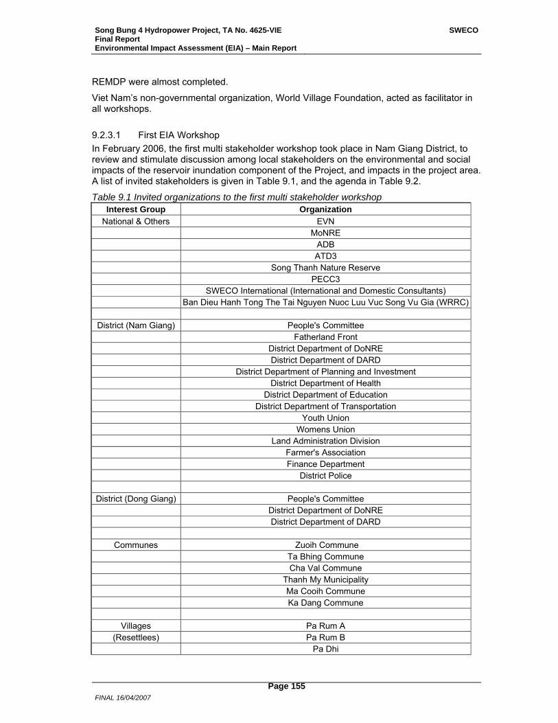
Song Bung 4 Hydropower Project, TA No. 4625-VIE Final Report Environmental Impact Assessment (EIA) – Main Report
SWECO
FINAL 16/04/2007
Page 155
REMDP were almost completed.
Viet Nam’s non-governmental organization, World Village Foundation, acted as facilitator in all workshops.
9.2.3.1 First EIA Workshop In February 2006, the first multi stakeholder workshop took place in Nam Giang District, to review and stimulate discussion among local stakeholders on the environmental and social impacts of the reservoir inundation component of the Project, and impacts in the project area. A list of invited stakeholders is given in Table 9.1, and the agenda in Table 9.2.
Table 9.1 Invited organizations to the first multi stakeholder workshop Interest Group Organization
National & Others EVN MoNRE ADB ATD3 Song Thanh Nature Reserve PECC3 SWECO International (International and Domestic Consultants) Ban Dieu Hanh Tong The Tai Nguyen Nuoc Luu Vuc Song Vu Gia (WRRC)
District (Nam Giang) People's Committee Fatherland Front District Department of DoNRE District Department of DARD District Department of Planning and Investment District Department of Health District Department of Education District Department of Transportation Youth Union Womens Union Land Administration Division Farmer's Association Finance Department District Police
District (Dong Giang) People's Committee District Department of DoNRE District Department of DARD
Communes Zuoih Commune Ta Bhing Commune Cha Val Commune Thanh My Municipality Ma Cooih Commune Ka Dang Commune
Villages Pa Rum A (Resettlees) Pa Rum B
Pa Dhi

Song Bung 4 Hydropower Project, TA No. 4625-VIE Final Report Environmental Impact Assessment (EIA) – Main Report
SWECO
FINAL 16/04/2007
Page 156
Thon No. 2 Pa Pang Vinh
Villages Pa Pang (Host Communities) Cong Don
Khe Zouih Khe Rong
A Vuong Resettlers Commune where the Resettled People used to Live Commune where the Resettled People Moved to One Village that was Resettled One Village (Host Village) where the Resettled People Moved to
NGO WWF World Vision FIDR (Foundation for International Development/Relief) BirdLife International International Rivers Network IUCN American Museum of Natural History
Table 9.2 Agenda for the first multi stakeholder workshop, Nam Giang 10th February 2006
Time Content/Activity Notes 07:30 – 08:00 Registration
08:00 – 08:15 Welcome speech District representative
08:15 – 08:30 Overview of Song Bung 4 ATD3
08:30 – 08:45 Q&A on SB4 overview Consultant
08:45 – 09:00 Overview of environmental impact issues Consultant
09:00 – 09:15 Q&A on environmental impact issues Facilitators
09:15 – 09:30 Overview of social impact issues Consultant
09:30 – 09:45 Q&A on social impact issues Facilitators
09:45 – 10:00 Coffee Break Facilitators
10:00 – 10:45 Small Focus Group Work on IMPACTS > Discussion, identification of further impacts > Ranking of impacts
Facilitators With inputs from Consultants
10:45 –11:30
Small Focus Groups report to plenary > Results and rational of ranking > International & local consultants comments > General discussion
Facilitators
11:30 – 13:00 Lunch
13:00 – 13:30 Open Q&A with A Vuong representatives (Focus: Resettlement issues)
Facilitators
13:30 – 13:45 Overview of ADB’s social safeguard and disclosure requirements Consultant
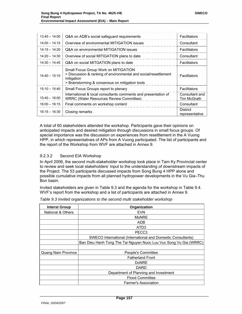
Song Bung 4 Hydropower Project, TA No. 4625-VIE Final Report Environmental Impact Assessment (EIA) – Main Report
SWECO
FINAL 16/04/2007
Page 157
13:45 – 14:00 Q&A on ADB’s social safeguard requirements Facilitators
14:00 – 14:15 Overview of environmental MITIGATION issues Consultant
14:15 – 14:20 Q&A on environmental MITIGATION issues Facilitators
14:20 – 14:30 Overview of social MITIGATION plans to date Consultant
14:30 – 14:40 Q&A on social MITGATION plans to date Facilitators
14:40 – 15:10
Small Focus Group Work on MITIGATION > Discussion & ranking of environmental and social/resettlement mitigation > Brainstorming & consensus on mitigation tools
Facilitators
15:10 – 15:40 Small Focus Groups report to plenary Facilitators 15:40 – 16:00
International & local consultants comments and presentation of WRRC (Water Resources Review Committee)
Consultant and Tim McGrath
16:00 – 16:15 Final comments on workshop content Consultant
16:15 – 16:30 Closing remarks District representative
A total of 60 stakeholders attended the workshop. Participants gave their opinions on anticipated impacts and desired mitigation through discussions in small focus groups. Of special importance was the discussion on experiences from resettlement in the A Vuong HPP, in which representatives of APs from A Vuong participated. The list of participants and the report of the Workshop from WVF are attached in Annex 9.
9.2.3.2 Second EIA Workshop In April 2006, the second multi-stakeholder workshop took place in Tam Ky Provincial center to review and seek local stakeholders’ input to the understanding of downstream impacts of the Project. The 53 participants discussed impacts from Song Bung 4 HPP alone and possible cumulative impacts from all planned hydropower developments in the Vu Gia–Thu Bon basin.
Invited stakeholders are given in Table 9.3 and the agenda for the workshop in Table 9.4. WVF’s report from the workshop and a list of participants are attached in Annex 9.
Table 9.3 Invited organizations to the second multi stakeholder workshop
Interst Group Organization National & Others EVN
MoNRE ADB ATD3 PECC3 SWECO International (International and Domestic Consultants) Ban Dieu Hanh Tong The Tai Nguyen Nuoc Luu Vuc Song Vu Gia (WRRC)
Quang Nam Province People's Committee Fatherland Front DoNRE DARD Department of Planning and Investment Flood Committee Farmer's Association
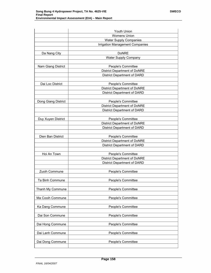
Song Bung 4 Hydropower Project, TA No. 4625-VIE Final Report Environmental Impact Assessment (EIA) – Main Report
SWECO
FINAL 16/04/2007
Page 158
Youth Union Womens Union Water Supply Companies Irrigation Management Companies
Da Nang City DoNRE Water Supply Company
Nam Giang District People's Committee District Department of DoNRE District Department of DARD
Dai Loc District People's Committee District Department of DoNRE District Department of DARD
Dong Giang District People's Committee District Department of DoNRE District Department of DARD
Duy Xuyen District People's Committee District Department of DoNRE District Department of DARD
Dien Ban District People's Committee District Department of DoNRE District Department of DARD
Hoi An Town People's Committee District Department of DoNRE District Department of DARD
Zuoih Commune People's Committee
Ta Binh Commune People's Committee Thanh My Commune People's Committee
Ma Cooih Commune People's Committee
Ka Dang Commune People's Committee
Dai Son Commune People's Committee
Dai Hong Commune People's Committee
Dai Lanh Commune People's Committee
Dai Dong Commune People's Committee
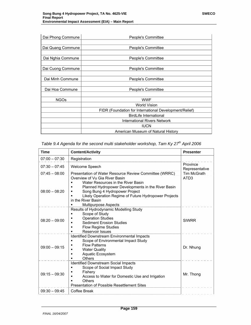
Song Bung 4 Hydropower Project, TA No. 4625-VIE Final Report Environmental Impact Assessment (EIA) – Main Report
SWECO
FINAL 16/04/2007
Page 159
Dai Phong Commune People's Committee
Dai Quang Commune People's Committee
Dai Nghia Commune People's Committee
Dai Cuong Commune People's Committee
Dai Minh Commune People's Committee
Dai Hoa Commune People's Committee
NGOs WWF World Vision FIDR (Foundation for International Development/Relief) BirdLife International International Rivers Network IUCN American Museum of Natural History
Table 9.4 Agenda for the second multi stakeholder workshop, Tam Ky 27th April 2006
Time Content/Activity Presenter
07:00 – 07:30 Registration
07:30 – 07:45 Welcome Speech Province Representative
07:45 – 08:00 Presentation of Water Resource Review Committee (WRRC) Tim McGrath
08:00 – 08:20
Overview of Vu Gia River Basin Water Resources in the River Basin Planned Hydropower Developments in the River Basin Song Bung 4 Hydropower Project Likely Operation Regime of Future Hydropower Projects
in the River Basin Multipurpose Aspects
ATD3
08:20 – 09:00
Results of Hydrodynamic Modelling Study Scope of Study Operation Studies Sediment Erosion Studies Flow Regime Studies Reservoir Issues
SIWRR
09:00 – 09:15
Identified Downstream Environmental Impacts Scope of Environmental Impact Study Flow Patterns Water Quality Aquatic Ecosystem Others
Dr. Nhung
09:15 – 09:30
Identified Downstream Social Impacts Scope of Social Impact Study Fishery Access to Water for Domestic Use and Irrigation Others
Presentation of Possible Resettlement Sites
Mr. Thong
09:30 – 09:45 Coffee Break

Song Bung 4 Hydropower Project, TA No. 4625-VIE Final Report Environmental Impact Assessment (EIA) – Main Report
SWECO
FINAL 16/04/2007
Page 160
09:45 – 11:00 Small Focus Group Work on IMPACTS Discussions on Identified Downstream Impacts Consensus on Impacts
Facilitators with input from Consultants
11:00 –11:30 Small Focus Groups Report to Plenary Presentation of Results Comments by the Consultant
Facilitators
11:30 – 13:00 Lunch
13:00 – 13:30 Overview of ADB’s Environmental and Social Safeguard Policies
Dr. Nhung & Mr. Thong
13:30 – 13:45 Anticipated Downstream Environmental Mitigation Measures Dr. Nhung
13:45 – 14:00 Anticipated Downstream Social Mitigation Measures Mr. Thong
14:00 – 14:15 Coffee Break
14:15 – 15:30 Small Focus Group Work on MITIGATION Discussions on Mitigation Measures Consensus on Mitigation Measures
Facilitators with input from Consultants
15:30 – 16:00 Small Focus Groups Report to Plenary Presentation of Results Comments by the Consultant
Facilitators
16:00 – 16:15 Summary of Workshop Consultant
16:15 – 16:30 Closing Remarks Province Representative
9.2.3.3 Third EIA Workshop In July 2006, the third and final multi-stakeholder workshop took place in Nam Giang District, A total of 49 people participated to give local stakeholders feedback in regard to the Project’s environment management plan and resettlement and ethnic minority development plan.
Invited stakeholders are given in Table 9.5 and the agenda for the workshop in Table 9.6. WVF’s report from the workshop and a list of participants are attached in Annex 9.
Table 9.5 Invited organizations to the third multi stakeholder workshop
Interst Group Organization National & Others EVN
MoNRE ADB ATD3 Song Thanh Nature Reserve PECC3 SWECO International (International and Domestic Consultants) Ban Dieu Hanh Tong The Tai Nguyen Nuoc Luu Vuc Song Vu Gia (WRRC)
Quang Nam Province People's Committee DoNRE DARD
Nam Giang District People's Committee Fatherland Front District Department of DoNRE
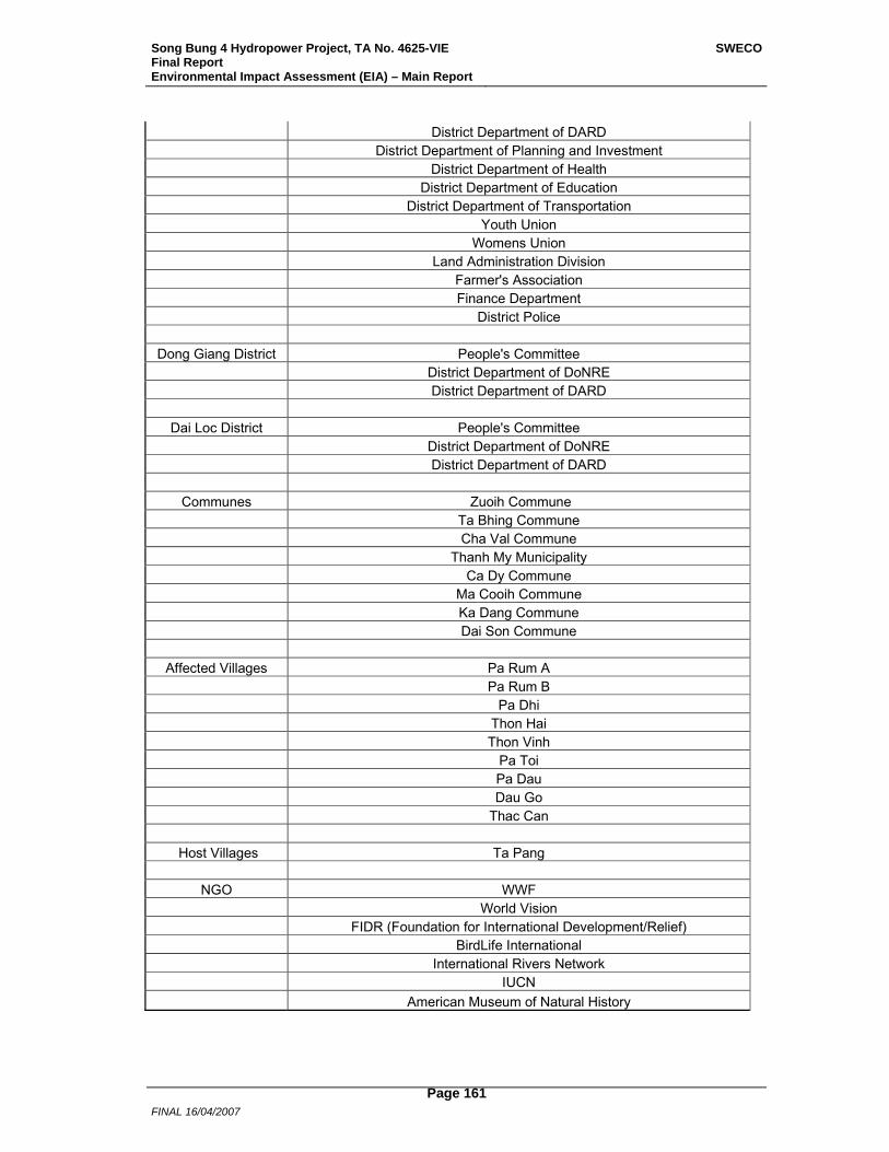
Song Bung 4 Hydropower Project, TA No. 4625-VIE Final Report Environmental Impact Assessment (EIA) – Main Report
SWECO
FINAL 16/04/2007
Page 161
District Department of DARD District Department of Planning and Investment District Department of Health District Department of Education District Department of Transportation Youth Union Womens Union Land Administration Division Farmer's Association Finance Department District Police
Dong Giang District People's Committee District Department of DoNRE District Department of DARD
Dai Loc District People's Committee District Department of DoNRE District Department of DARD
Communes Zuoih Commune Ta Bhing Commune Cha Val Commune Thanh My Municipality Ca Dy Commune Ma Cooih Commune Ka Dang Commune Dai Son Commune
Affected Villages Pa Rum A Pa Rum B Pa Dhi Thon Hai Thon Vinh Pa Toi Pa Dau Dau Go Thac Can
Host Villages Ta Pang
NGO WWF World Vision FIDR (Foundation for International Development/Relief) BirdLife International International Rivers Network IUCN American Museum of Natural History
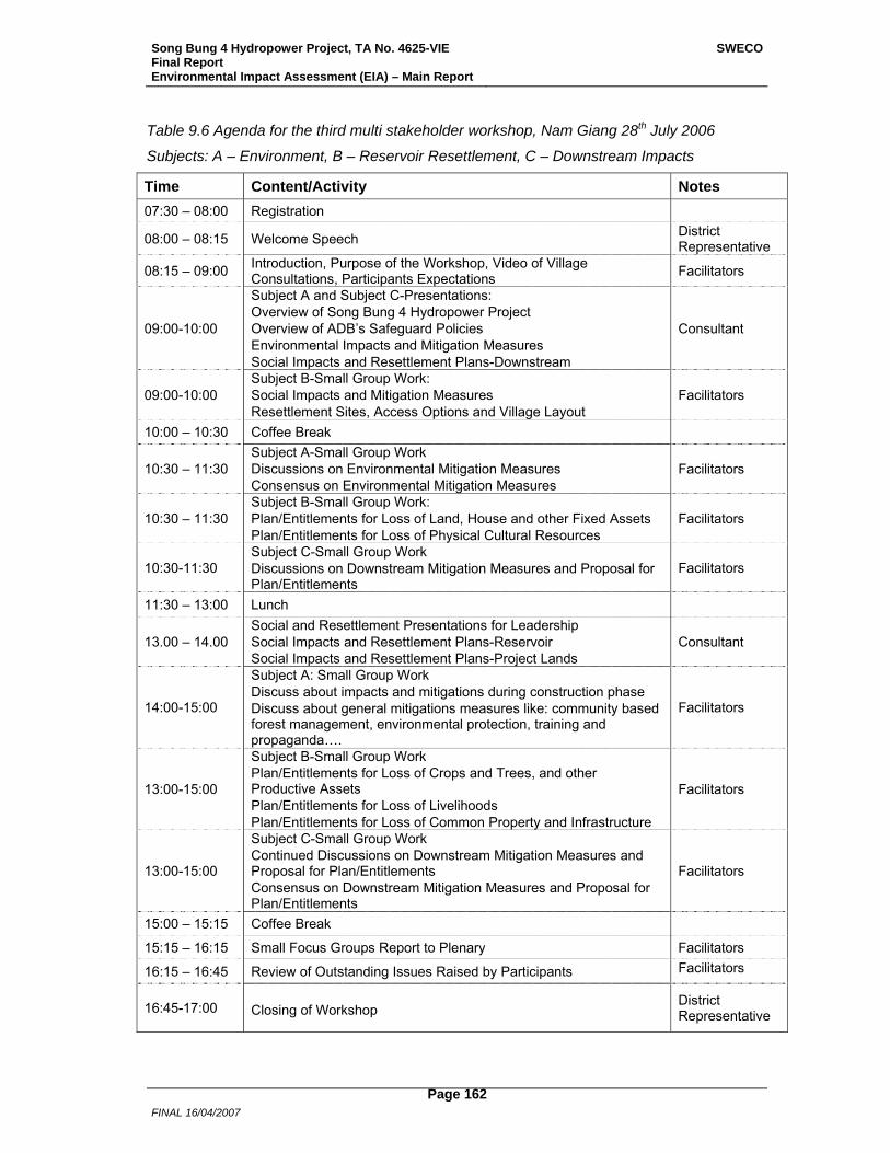
Song Bung 4 Hydropower Project, TA No. 4625-VIE Final Report Environmental Impact Assessment (EIA) – Main Report
SWECO
FINAL 16/04/2007
Page 162
Table 9.6 Agenda for the third multi stakeholder workshop, Nam Giang 28th July 2006
Subjects: A – Environment, B – Reservoir Resettlement, C – Downstream Impacts
Time Content/Activity Notes 07:30 – 08:00 Registration
08:00 – 08:15 Welcome Speech District Representative
08:15 – 09:00 Introduction, Purpose of the Workshop, Video of Village Consultations, Participants Expectations Facilitators
09:00-10:00
Subject A and Subject C-Presentations: Overview of Song Bung 4 Hydropower Project Overview of ADB’s Safeguard Policies Environmental Impacts and Mitigation Measures Social Impacts and Resettlement Plans-Downstream
Consultant
09:00-10:00 Subject B-Small Group Work: Social Impacts and Mitigation Measures Resettlement Sites, Access Options and Village Layout
Facilitators
10:00 – 10:30 Coffee Break
10:30 – 11:30 Subject A-Small Group Work Discussions on Environmental Mitigation Measures Consensus on Environmental Mitigation Measures
Facilitators
10:30 – 11:30 Subject B-Small Group Work: Plan/Entitlements for Loss of Land, House and other Fixed Assets Plan/Entitlements for Loss of Physical Cultural Resources
Facilitators
10:30-11:30 Subject C-Small Group Work Discussions on Downstream Mitigation Measures and Proposal for Plan/Entitlements
Facilitators
11:30 – 13:00 Lunch
13.00 – 14.00 Social and Resettlement Presentations for Leadership Social Impacts and Resettlement Plans-Reservoir Social Impacts and Resettlement Plans-Project Lands
Consultant
14:00-15:00
Subject A: Small Group Work Discuss about impacts and mitigations during construction phase Discuss about general mitigations measures like: community based forest management, environmental protection, training and propaganda….
Facilitators
13:00-15:00
Subject B-Small Group Work Plan/Entitlements for Loss of Crops and Trees, and other Productive Assets Plan/Entitlements for Loss of Livelihoods Plan/Entitlements for Loss of Common Property and Infrastructure
Facilitators
13:00-15:00
Subject C-Small Group Work Continued Discussions on Downstream Mitigation Measures and Proposal for Plan/Entitlements Consensus on Downstream Mitigation Measures and Proposal for Plan/Entitlements
Facilitators
15:00 – 15:15 Coffee Break
15:15 – 16:15 Small Focus Groups Report to Plenary Facilitators
16:15 – 16:45 Review of Outstanding Issues Raised by Participants Facilitators
16:45-17:00 Closing of Workshop District Representative

Song Bung 4 Hydropower Project, TA No. 4625-VIE Final Report Environmental Impact Assessment (EIA) – Main Report
SWECO
FINAL 16/04/2007
Page 163
10 Conclusion
The Song Bung 4 HPP consists of a 156 MW hydropower plant and a reservoir with an active reservoir volume of 320 million m³. The Project is located in Quang Nam Province in central Viet Nam. The estimated total investment for the Project is estimated at 206.8 million USD excluding price contingencies, taxes and financial charges, and the proposed construction period is almost 4 years. The annual energy potential is 537 million kWh. The reservoir will inundate about 1,600 ha at FSL. A total of 206 households in 4 villages will need to be resettled. In addition, about 30 households in the construction areas will be affected and some 1,500 households in downstream villages will experience impacts on riverine fisheries. Major potential environmental impacts from the Project include (i) soil erosion, (ii) loss of biodiversity, (iii) increased pressure on STNR, (iv) loss of river continuum because of the dam; (v) a river reach with strongly reduced flow, and (vi) daily water level fluctuations downstream of the power plant because of peaking. Measures have been developed to mitigate and regularly monitor the impacts. Based on the EIA and the Resettlement and Ethnic Minority Development Plan, the adverse environmental and social impacts of the Project can be minimized to acceptable levels by implementing adequately funded environmental and social management activities. Details of these activities are elaborated in the EMP, the Resettlement and Ethnic Minority Development Plan (REMDP), and the Social Management Plan.
The proposed Song Bung 4 HPP’s anticipated environmental benefits include (i) better distribution of power resources, (ii) independence of fuel price variations, (iii) less emission of greenhouse gases, (iv) a general contribution to the development of the area, (v) irrigation benefits in the dry months of the year, (vi) positive contribution to minimize the salt intrusion problem on the floodplain and (v) enhance watershed maintenance and protection. The issue of compensation flow through further studies, enhanced environmental protection and awareness plan, and COS programs are some of the salient items included in the project planning to adequately address the impacts to an acceptable level.
Song Bung 4 Hydropower Project, TA No. 4625-VIE Final Report Environmental Impact Assessment (EIA) – Main Report
SWECO
FINAL 16/04/2007
Page 164
11 References
Averyanov, L.V. et al. (2003): Phytogeographic Review of Vietnam and Adjacent Areas of Eastern Indochina. Komarovia 3: 1-83.
Baltzer, MC, Nguyen Thi Dao, RG Shore (eds) 2001. Towards a vision for biodiversity in the forest of the lower Mekong ecoregion complex – technical annex. WWF Indochina/WWF US, Hanoi and Washington D.C.
BCCI. May 2005a. Ngoc Linh –Xe Sap Biodiveristy Conservation Corridors. Vietnam. Pilot Project Profile (2005 – 2008). Greater Mekong Subregion Biodiversity Conservation Corridors Initiative. ADB
BCCI. November 2005b. Proposed Technical Assistance Core Environmental Program and Biodiversity Conservation Corridors Initiative in the Greater Mekong Subregion. 2005. Project no. 39025. ADB
Berg, M., Thi, C. N.,Tran Huong Con., Schnertenleib, R., and W Giger 2001. Arsenic contamination of groundwater and drinking water in Vietnam: A human health threat., Env. Sci. Techn. 35(13), pp: 2621-2626.
Berge, D., J. Skurdal, O. Skogheim, T. Qvenild and D. Hongve 1983: Mercury pollution and other heavy metals. Pp 124-129 in Berge (Ed.) 1983: Lake Tyrifjorden – Final report from the Lake Tyrifjord Study, SENorway 1978-1981., Tyrifjordutvalget, Drammen, Norway, ISBN 82-90356-31-5.
Bird, Jeremy, Jay Roop and Be Quynh Nga (2005): Song Bung 4 Hydropower, Vietnam: Report on water resource, environmental and social issues. 106 pp.
Bui Dac Tuyen, Vu Van Dung, Hoang Trong Tri, Nguyen Quoc Dung, Pham Mong Giao, Do Tuoc, Pham Hong Nguyen, Tran The Lien, Le Dinh Thuy, Nguyen Van Sang, Le Nguyen Ngat, and Dinh Thi Phuong Anh (1997): Survey on biodiversity in West Quang Nam Province. MARD and WWF Indochina. Vegetation chapter: 30 pp, Mammal fauna: 20 pp, Avifauna: 20 pp, Herpetofauna: 28pp.
Canadian Environmental Quality Guidelines, Summary Table December 2003, Environment Canada, http://www.ec.gc.ca/CEQG-RCQE/English/Ceqg/Water/default.cfm
Christen, K. 2001., The arsenic theath worsens., Environ. Sci. Technol., 35(13) pp: 286 A-291 A.
CITES (2005): Appendices I, II and III of CITES.
Corbet, G.B. and Hill, J.E. (1992): The Mammals of the Indomalayan Region. Natural History Museum Publications, Oxford University Press, Oxford, U.K.
Dang Huy Huynh, Dao Van Tien, Cao Van Sung, Pham Trong Anh and Hoang Minh Khien (1994): Checklist of mammals of Vietnam. Scien. Tech. Publ. House: 168 pp.
Freyhof, J. and D. V.Serov, 2001. Nemacheiline loaches from Central Vietnam with descriptions of a new genus and 14 new species (Cypriniformes: Balitoridae). Ichthyol. Explor. Freshwaters, Vol.12, No.2, pp. 133 – 191, 57 figs, 8 tabs., July 2001.
H.H.Ng and J. Freyhof, 2001. A review of the catfish genus Pterocryptis (Siluridae) in Vietnam, with the description of two new species. Journal of Fish Biology (2001) 59, 624 – 644.
Ho Thanh Hai et al., 2003. Some features of aquatic community of A vuong river and environmental impact assessment of the A Vuong 1 project on aquatic life and fishery. Document of IEBR. (in Vietnamese).

Song Bung 4 Hydropower Project, TA No. 4625-VIE Final Report Environmental Impact Assessment (EIA) – Main Report
SWECO
FINAL 16/04/2007
Page 165
IUCN (2004): 2004 IUCN Red List of Threatened Species. <www.redlist.org>.
Kottelat M., 1994. Rediscovery of Sewellia lineolata in Annam, Vietnam (Teleostei: Balitoridae). Zool. Med.Leiden 68(11), 15. vii. 1994: 109-112,figs1-3- ISSN 0024-0672.
Le Nho Nam, Tran Van Thu, Le Truong Tho, Le Van Duc, Dinh Van Hong, Ngo Dinh Khoi, Pham Duc Khuong, Le Cong Be, Tran Van Hoang, Ngo Hoang Hai Son, Nguyen Dinh Tuan, Nguyen Van Len (2005): Song Thanh Nature Reserve: Management plan. 70 pp.
Le Trinh et al., 2005. Environmental Impact Assessment of Song Bung 4 project on biological resources. Document of EVN. PECC 3. (in Vietnamese).
Le Vu Khoi (2000): Name list of mammals in Vietnam. Agri. Publ. House.: 139 pp.
Long, Barney, Minh Hoang and Thai Truyen (2006, in press): A conservation assessment of Quang Nam Province, Central Vietnam. 130 pp.
MacKinnon, J. 1997. Protected areas systems review of the Indo-Malayan realm. Canterbury, UK: The Asian Bureau for Conservation (ABC) and The World Conservation Monitoring Center (WCMC)/ World Bank Publication.
MONRE 2005. National report on state of Environment-Social subject on Biodiversity. (In Vietnamese)
Nguyen Cu, Le Trong Trai and Karen Phillipps (2000): Birds of Vietnam. Labour and Society Publ. House: 250 pp.
Nguyen Huu Duc, 1995. Contribution on study of freshwater fish fauna of central Vietnam. Thesis of PhD. in Biology. (in Vietnamese).
Nguyen Van Hao, 2005. Freshwater fish of Vietnam. Volume 3. Agriculture Publishing House, (in Vietnamese).
Nguyen Thi Thu He 2000. research results on freshwater Ichthyology of rivers and streams at Tay Nguyen Highland. Thesis in Biology PhD. Hanoi University. (in Vietnamese)
Nguyen Van Sang, Ho Thu Cuc and Nguyen Quang Truong (2005): A checklist of amphibians and reptiles of Vietnam. Agri. Publ. House: 180 pp.
Nguyen Xuan Huan 1999 in Khuat Dang Long et al 1999. Final report on biodiversity in Tra My (Quang Nam). Document of IEBR. (in Vietnamese)
Olson & Dinerstein. 1998. The Global 200: a representation approach to conserving the Earth's most biologically valuable ecoregions. Cons. Biol. 12:502.
PECC3 2005A. Feasibility Study Song Bung 4 Hydropower Project. Vol. 1.2 Environmental Impact Assessment. December 2005.
PECC3 2005B. Feasibility Study Song Bung 4 Hydropower Project. Vol. 2 Book 1 Hydrometeorological Conditions. December 2005.
PECC3 2006. Hydrodynamics and Water quality Study of Bung River. TA 4475-VIE: Song Bung 4 Hydropower Project (Phase 1). Draft Final Report. January 2006.
Phan Ke Loc (1998): On the systematic structure of the Vietnamese flora. Proc. IFCD. "Floristic Characteristics and Diversity of East Asian Plants": 120-129, CHEP & Springer.
Quang Nam Biodiversity and Natural Resource Conservation Strategy, 2005-2020. (undated draft)
Quang Nam People’s Committee (1999): Investment Plan for establishment of Song Thanh Nature Reserve. 69pp. (in Vietnamese).
Song Bung 4 Hydropower Project, TA No. 4625-VIE Final Report Environmental Impact Assessment (EIA) – Main Report
SWECO
FINAL 16/04/2007
Page 166
Red Data Book of Vietnam. (1996). Ministry of Science Technology and Environment: Sci. Tech. Publ. House, Hanoi
Red Data Book of Vietnam. (2000). Ministry of Science Technology and Environment: Sci. Tech. Publ. House, Hanoi. 408 pp.
Roberton, Scott, Huynh Van Thuong, Nguyen Ngoc Nguyen, Ho Loi, Le Hoang Son, Nguyen Quyen, Vu Ngoc Anh, Le Van Di, Hoang Xuan Thuy, Vu Ngoc Thanh and Barney Long (2005): Illegal Wildlife Trade in Quang Nam Province. Report No 4: 29 pp.
Song Thanh Nature Reserve Management Plan (2005-2010). Song Thanh Nature Research Management Board, Quang Nam Forest Protection Department and WWF.
SWECO International 2005. National Hydropower Plan Study, Vietnam. Draft Final Report.
The Central Truong Son Biodiversity Conservation Initiative, 2004 – 2020. 2004. Ministry of Agriculture and Rural Development, Vietnam. No: 06/2004/QD-BNN. Hanoi.
Tordoff, A.W., Timmins, R.J., Smith R.J. and Mai Ky Vinh (2003): Central Annamites Biological Assessment. WWF Indochina/WWF US, Hanoi and Washington D.C: 133 pp.
Tordoff, AW, RJ Timmins, RJ Smith and Mai Ky Vinh. 2001. Central Truong Son Biological Assesment. Draft Report to WWf/Vietnam, Hanoi.
Tran Hong Con, Nguyen Thi Hahn, M. Berg and Pham Viet Huong 2003. Investigation of Release of Arsenic from Minerals to the Water Phase. Paper prepared for the Fifth International Conference on Arsenic Exposure and Health Effects, July 14-18, 2002, San Diego, California. Chapt. 7 (pp. 93-101) in Chappel, W.R. et al (Eds): Arsenic Exposure and Health Effects. V. Elsevier Science 2003.
Additional Literature of Relevance BCCI. Greater Mekong Subregion. Core Environment Program and Biodiversity
Conservation Corridors Initiative. February 2006. Program Technical Paper. ADB
BirdLife International and the Forest Inventory and Planning Institute. 2001. Sourcebook of existing and proposed protected areas in Vietnam. BirdLife International and the Forest Inventory and Planning institute. Hanoi, Vietnam. Hanoi, Vietnam.
Bui Dac Tuyen et al. (1997): Survey on biodiversity in West Quang Nam Province. MARD and WWF Indochina. Vegetation chapter: 30 pp.
Long, B., Huynh Van Thuong and Thai Truyen (2005): Developing strengthened natural resource law enforcement in Quang Nam Province. WWF Indochina: 74 pp.
Long, B., M. Hoang and T. Truyen. 2004. A conservation assessment of Quang Nam Province, Central Vietnam. WWF, Vietnam (draft)
Long, Barney, Huynh Van Thuong and Thai Truyen (2005): Developing strengthened natural resource law enforcement in Quang Nam Province. WWF Indochina: 74 pp.
Pham Hoang Ho (1991-1993): Illustrated Flora of Vietnam I, II and III. Montreal.
Quang Nam People’s Committee (2005): Biodiversity and natural resource law enforcement action plan. WWF Indochina: 32 pp.
Quang Nam People’s Committee (2005): Conservation education 2005-2010. WWF Indochina: 36 pp.
Socialist Republic of Vietnam (2003): Management strategy for a protected areas system in Vietnam to 2010. Hanoi.

Song Bung 4 Hydropower Project, TA No. 4625-VIE Final Report Environmental Impact Assessment (EIA) – Main Report
SWECO
FINAL 16/04/2007
Page 167
Socialist Republic of Vietnam (2006): Decision 32/2006/ND-CP of the Government of Vietnam on the rare and precious plants and animals to be protected. Hanoi.
The Government of Vietnam (2003): Instruction No 12/2003/CT-TTg of Prime Minister dated on 16 May 2003, Improvement of urgent measures for forest protection and development.
The Government of Vietnam (2005): Decision No 34/2005/QD-TTg of Prime Minister dated on 22 February 2005, Action Plan of the Government for improvement of environmental protection in the industrializational and modernizational period.
The Government of Vietnam (2006): Governmental Decree No 32/2006/ND-CP for management of threatened wild plants and animals, dated on 30 March 2006. pp: 8-13.
The National Assembly of SR of Vietnam (2004): Forest protection and development law, dated on 3 December 2004.
Thuong, H. V., H. T. M. Thu and B. Long. (Undated, like in 2005) Community Forest Management and Protection in Quang Nam Province, Viet Nam. WWF MOSAIC Project
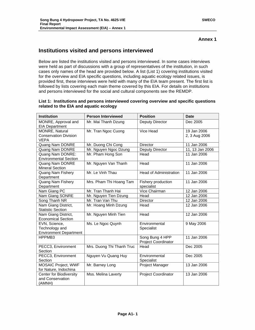
Song Bung 4 Hydropower Project, TA No. 4625-VIE Final Report Environmental Impact Assessment (EIA) – Annex 1
SWECO
Page A1- 1
Annex 1 Institutions visited and persons interviewed Below are listed the institutions visited and persons interviewed. In some cases interviews were held as part of discussions with a group of representatives of the institution, in such cases only names of the head are provided below. A list (List 1) covering institutions visited for the overview and EIA specific questions, including aquatic ecology related issues, is provided first, these interviews were held with many of the EIA team present. The first list is followed by lists covering each main theme covered by this EIA. For details on institutions and persons interviewed for the social and cultural components see the REMDP. List 1: Institutions and persons interviewed covering overview and specific questions related to the EIA and aquatic ecology Institution Person Interviewed Position Date MONRE, Approval and EIA Department
Mr. Mai Thanh Dzung Deputy Director Dec 2005
MONRE, Natural Conservation Division VEPA
Mr. Tran Ngoc Cuong Vice Head 19 Jan 2006 2, 3 Aug 2006
Quang Nam DONRE Mr. Duong Chi Cong Director 11 Jan 2006 Quang Nam DONRE Mr. Nguyen Ngoc Dzung Deputy Director 11, 13 Jan 2006 Quang Nam DONRE: Environmental Section
Mr. Pham Hong Son Head 11 Jan 2006
Quang Nam DONRE Mineral Section
Mr. Nguyen Van Thanh Head 11 Jan 2006
Quang Nam Fishery Department
Mr. Le Vinh Thau Head of Administration 11 Jan 2006
Quang Nam Fishery Department
Mrs. Pham Thi Hoang Tam Fishery production specialist
11 Jan 2006
Nam Giang PC Mr. Tran Thanh Hai Vice Chairman 12 Jan 2006 Nam Giang SONRE Mr. Nguyen Tien Dzung Head 12 Jan 2006 Song Thanh NR Mr. Tran Van Thu Director 12 Jan 2006 Nam Giang District, Statistic Section
Mr. Hoang Minh Dzung Head 12 Jan 2006
Nam Giang District, Economical Section
Mr. Nguyen Minh Tien Head 12 Jan 2006
EVN, Science, Technology and Environment Department
Ms. Le Ngoc Quynh Environmental Specialist
9 May 2006
HPPMB3 Song Bung 4 HPP Project Coordinator
11 Jan 2006
PECC3, Environment Section
Mrs. Duong Thi Thanh Truc Head Dec 2005
PECC3, Environment Section
Nguyen Vu Quang Huy Environmental Specialist
Dec 2005
MOSAIC Project, WWF for Nature, Indochina
Mr. Barney Long Project Manager 13 Jan 2006
Center for Biodiversity and Conservation (AMNH)
Mss. Melina Laverty Project Coordinator 13 Jan 2006
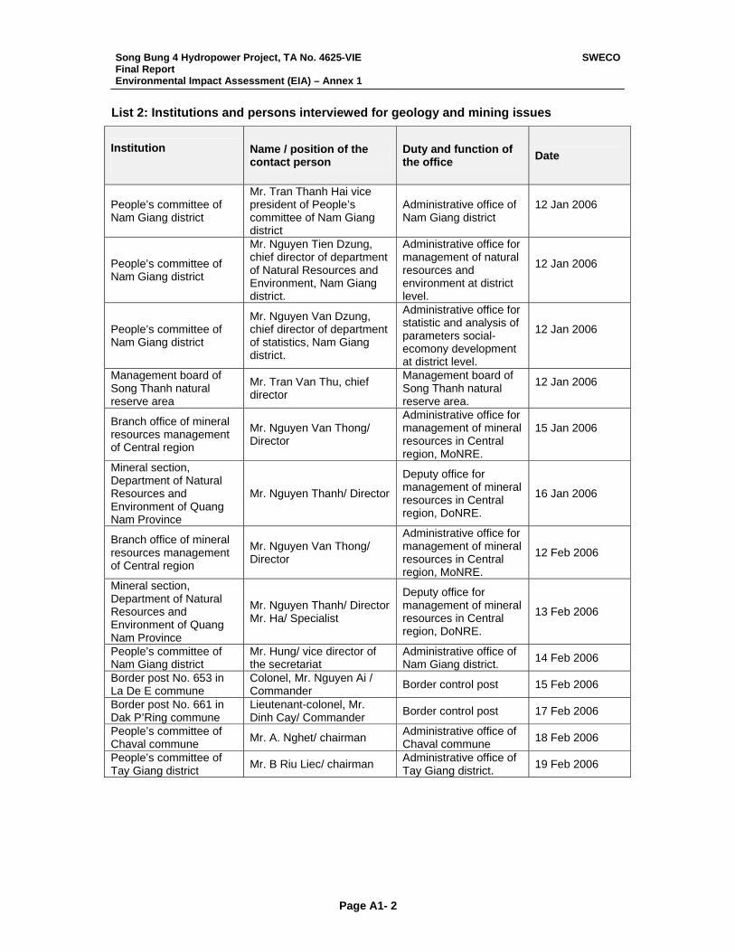
Song Bung 4 Hydropower Project, TA No. 4625-VIE Final Report Environmental Impact Assessment (EIA) – Annex 1
SWECO
Page A1- 2
List 2: Institutions and persons interviewed for geology and mining issues
Institution
Name / position of the contact person
Duty and function of the office Date
People’s committee of Nam Giang district
Mr. Tran Thanh Hai vice president of People’s committee of Nam Giang district
Administrative office of Nam Giang district
12 Jan 2006
People’s committee of Nam Giang district
Mr. Nguyen Tien Dzung, chief director of department of Natural Resources and Environment, Nam Giang district.
Administrative office for management of natural resources and environment at district level.
12 Jan 2006
People’s committee of Nam Giang district
Mr. Nguyen Van Dzung, chief director of department of statistics, Nam Giang district.
Administrative office for statistic and analysis of parameters social-ecomony development at district level.
12 Jan 2006
Management board of Song Thanh natural reserve area
Mr. Tran Van Thu, chief director
Management board of Song Thanh natural reserve area.
12 Jan 2006
Branch office of mineral resources management of Central region
Mr. Nguyen Van Thong/ Director
Administrative office for management of mineral resources in Central region, MoNRE.
15 Jan 2006
Mineral section, Department of Natural Resources and Environment of Quang Nam Province
Mr. Nguyen Thanh/ Director
Deputy office for management of mineral resources in Central region, DoNRE.
16 Jan 2006
Branch office of mineral resources management of Central region
Mr. Nguyen Van Thong/ Director
Administrative office for management of mineral resources in Central region, MoNRE.
12 Feb 2006
Mineral section, Department of Natural Resources and Environment of Quang Nam Province
Mr. Nguyen Thanh/ Director Mr. Ha/ Specialist
Deputy office for management of mineral resources in Central region, DoNRE.
13 Feb 2006
People’s committee of Nam Giang district
Mr. Hung/ vice director of the secretariat
Administrative office of Nam Giang district. 14 Feb 2006
Border post No. 653 in La De E commune
Colonel, Mr. Nguyen Ai / Commander Border control post 15 Feb 2006
Border post No. 661 in Dak P’Ring commune
Lieutenant-colonel, Mr. Dinh Cay/ Commander Border control post 17 Feb 2006
People’s committee of Chaval commune Mr. A. Nghet/ chairman Administrative office of
Chaval commune 18 Feb 2006
People’s committee of Tay Giang district Mr. B Riu Liec/ chairman Administrative office of
Tay Giang district. 19 Feb 2006
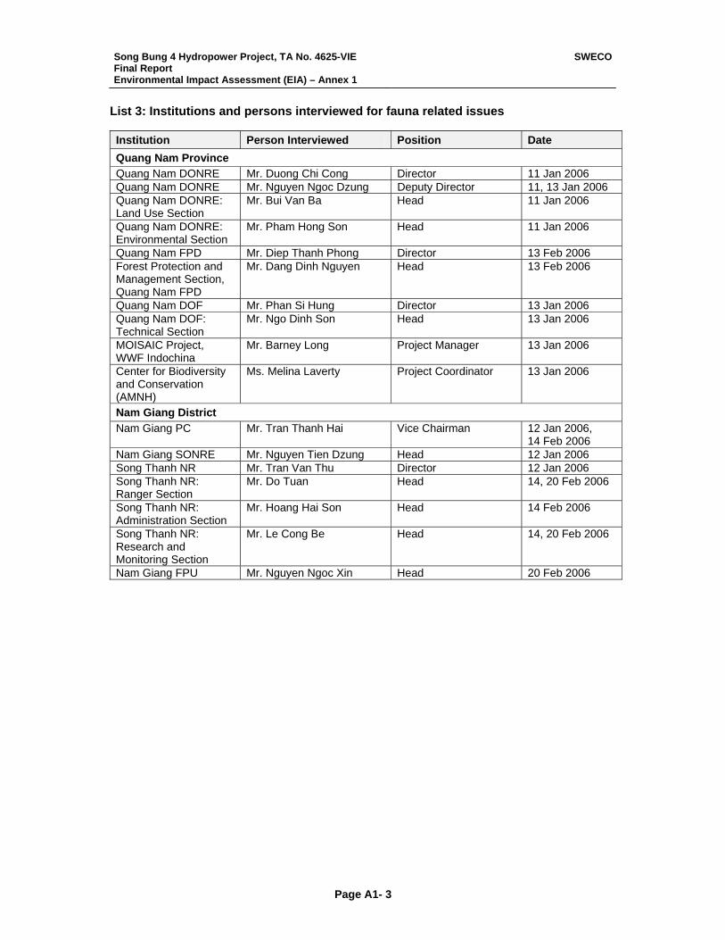
Song Bung 4 Hydropower Project, TA No. 4625-VIE Final Report Environmental Impact Assessment (EIA) – Annex 1
SWECO
Page A1- 3
List 3: Institutions and persons interviewed for fauna related issues Institution Person Interviewed Position Date Quang Nam Province Quang Nam DONRE Mr. Duong Chi Cong Director 11 Jan 2006 Quang Nam DONRE Mr. Nguyen Ngoc Dzung Deputy Director 11, 13 Jan 2006 Quang Nam DONRE: Land Use Section
Mr. Bui Van Ba Head 11 Jan 2006
Quang Nam DONRE: Environmental Section
Mr. Pham Hong Son Head 11 Jan 2006
Quang Nam FPD Mr. Diep Thanh Phong Director 13 Feb 2006 Forest Protection and Management Section, Quang Nam FPD
Mr. Dang Dinh Nguyen Head 13 Feb 2006
Quang Nam DOF Mr. Phan Si Hung Director 13 Jan 2006 Quang Nam DOF: Technical Section
Mr. Ngo Dinh Son Head 13 Jan 2006
MOISAIC Project, WWF Indochina
Mr. Barney Long Project Manager 13 Jan 2006
Center for Biodiversity and Conservation (AMNH)
Ms. Melina Laverty Project Coordinator 13 Jan 2006
Nam Giang District Nam Giang PC Mr. Tran Thanh Hai Vice Chairman 12 Jan 2006,
14 Feb 2006 Nam Giang SONRE Mr. Nguyen Tien Dzung Head 12 Jan 2006 Song Thanh NR Mr. Tran Van Thu Director 12 Jan 2006 Song Thanh NR: Ranger Section
Mr. Do Tuan Head 14, 20 Feb 2006
Song Thanh NR: Administration Section
Mr. Hoang Hai Son Head 14 Feb 2006
Song Thanh NR: Research and Monitoring Section
Mr. Le Cong Be Head 14, 20 Feb 2006
Nam Giang FPU Mr. Nguyen Ngoc Xin Head 20 Feb 2006
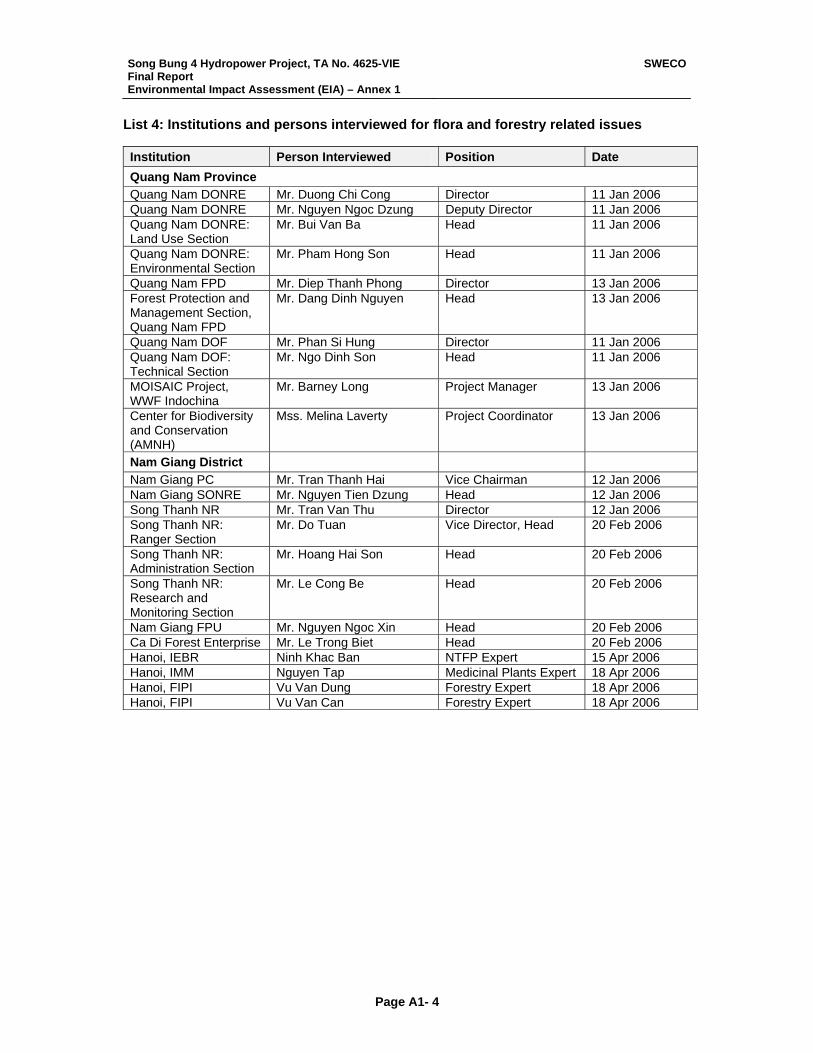
Song Bung 4 Hydropower Project, TA No. 4625-VIE Final Report Environmental Impact Assessment (EIA) – Annex 1
SWECO
Page A1- 4
List 4: Institutions and persons interviewed for flora and forestry related issues Institution Person Interviewed Position Date Quang Nam Province Quang Nam DONRE Mr. Duong Chi Cong Director 11 Jan 2006 Quang Nam DONRE Mr. Nguyen Ngoc Dzung Deputy Director 11 Jan 2006 Quang Nam DONRE: Land Use Section
Mr. Bui Van Ba Head 11 Jan 2006
Quang Nam DONRE: Environmental Section
Mr. Pham Hong Son Head 11 Jan 2006
Quang Nam FPD Mr. Diep Thanh Phong Director 13 Jan 2006 Forest Protection and Management Section, Quang Nam FPD
Mr. Dang Dinh Nguyen Head 13 Jan 2006
Quang Nam DOF Mr. Phan Si Hung Director 11 Jan 2006 Quang Nam DOF: Technical Section
Mr. Ngo Dinh Son Head 11 Jan 2006
MOISAIC Project, WWF Indochina
Mr. Barney Long Project Manager 13 Jan 2006
Center for Biodiversity and Conservation (AMNH)
Mss. Melina Laverty Project Coordinator 13 Jan 2006
Nam Giang District Nam Giang PC Mr. Tran Thanh Hai Vice Chairman 12 Jan 2006 Nam Giang SONRE Mr. Nguyen Tien Dzung Head 12 Jan 2006 Song Thanh NR Mr. Tran Van Thu Director 12 Jan 2006 Song Thanh NR: Ranger Section
Mr. Do Tuan Vice Director, Head 20 Feb 2006
Song Thanh NR: Administration Section
Mr. Hoang Hai Son Head 20 Feb 2006
Song Thanh NR: Research and Monitoring Section
Mr. Le Cong Be Head 20 Feb 2006
Nam Giang FPU Mr. Nguyen Ngoc Xin Head 20 Feb 2006 Ca Di Forest Enterprise Mr. Le Trong Biet Head 20 Feb 2006 Hanoi, IEBR Ninh Khac Ban NTFP Expert 15 Apr 2006 Hanoi, IMM Nguyen Tap Medicinal Plants Expert 18 Apr 2006 Hanoi, FIPI Vu Van Dung Forestry Expert 18 Apr 2006 Hanoi, FIPI Vu Van Can Forestry Expert 18 Apr 2006
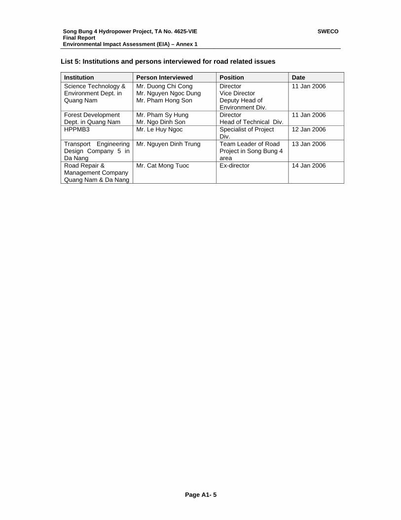
Song Bung 4 Hydropower Project, TA No. 4625-VIE Final Report Environmental Impact Assessment (EIA) – Annex 1
SWECO
Page A1- 5
List 5: Institutions and persons interviewed for road related issues Institution Person Interviewed Position Date Science Technology & Environment Dept. in Quang Nam
Mr. Duong Chi Cong Mr. Nguyen Ngoc Dung Mr. Pham Hong Son
Director Vice Director Deputy Head of Environment Div.
11 Jan 2006
Forest Development Dept. in Quang Nam
Mr. Pham Sy Hung Mr. Ngo Dinh Son
Director Head of Technical Div.
11 Jan 2006
HPPMB3 Mr. Le Huy Ngoc Specialist of Project Div.
12 Jan 2006
Transport Engineering Design Company 5 in Da Nang
Mr. Nguyen Dinh Trung Team Leader of Road Project in Song Bung 4 area
13 Jan 2006
Road Repair & Management Company Quang Nam & Da Nang
Mr. Cat Mong Tuoc Ex-director 14 Jan 2006
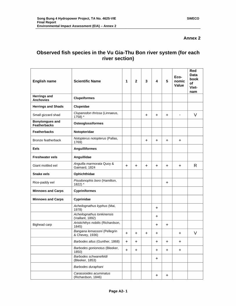
Song Bung 4 Hydropower Project, TA No. 4625-VIE Final Report Environmental Impact Assessment (EIA) – Annex 2
SWECO
Page A2- 1
Annex 2
Observed fish species in the Vu Gia-Thu Bon river system (for each river section)
English name Scientific Name 1 2 3 4 5 Eco-nomicValue
Red Data book of Viet- nam
Herrings and Anchovies Clupeiformes
Herrings and Shads Clupeidae
Small gizzard shad Clupanodon thrissa (Linnaeus, 1758) * + + + + V
Bonytongues and Featherbacks Osteoglossiformes
Featherbacks Notopteridae
Bronze featherback Notopterus notopterus (Pallas, 1769) + + + +
Eels Anguilliformes
Freshwater eels Anguillidae
Giant mottled eel Anguilla marmorata Quoy & Gaimard, 1824 + + + + + + R
Snake eels Ophichthidae
Rice-paddy eel Pisodonophis boro (Hamilton, 1822) * +
Minnows and Carps Cypriniformes
Minnows and Carps Cyprinidae
Acheilognathus kyphus (Mai, 1978) +
Acheilognathus tonkinensis (Vaillant, 1892) +
Bighead carp Aristichthys nobilis (Richardson, 1845) + +
Bangana lemassoni (Pellegrin & Chevey, 1936) + + + + + V
Barbodes altus (Gunther, 1868) + + + + +
Barbodes gonionotus (Bleeker, 1850) + + + + +
Barbodes schwanefeldi (Bleeker, 1853) +
Barbodes duraphani
Carassioides acuminatus (Richardson, 1846) + +
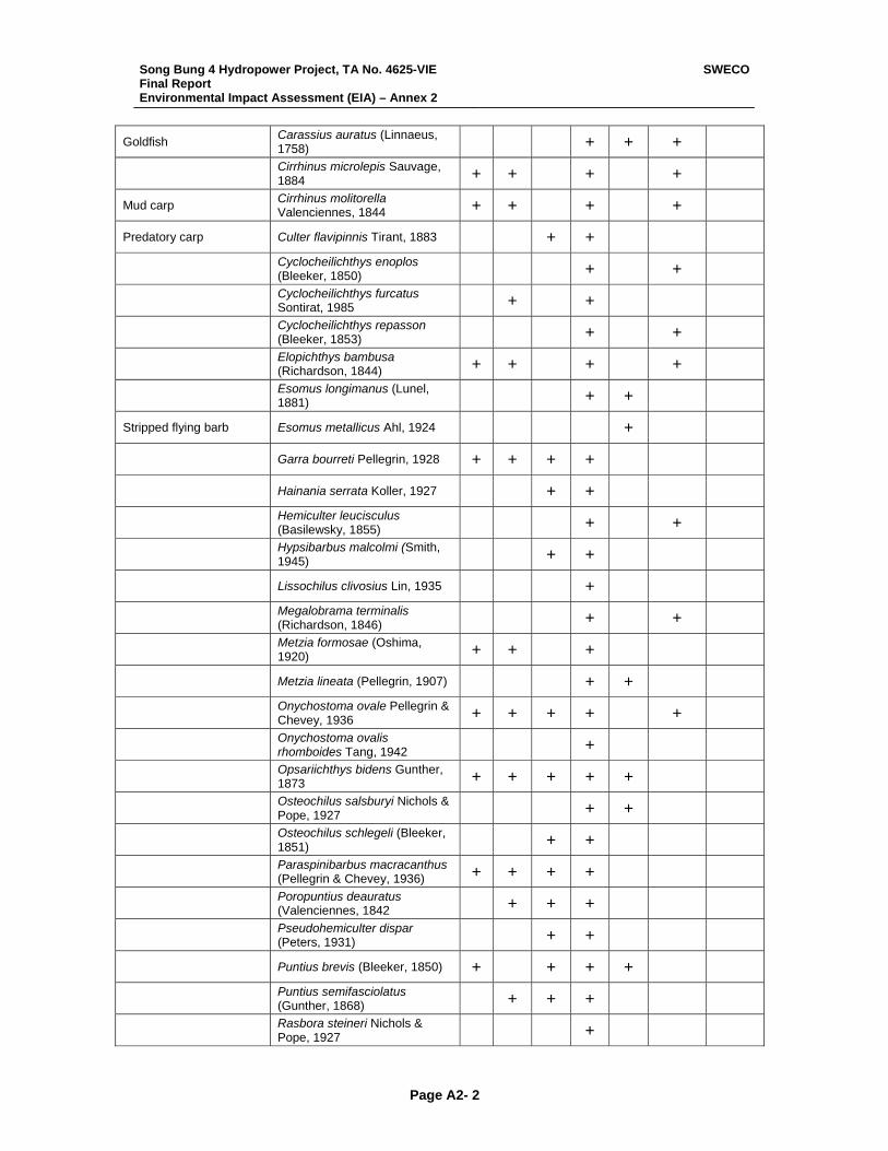
Song Bung 4 Hydropower Project, TA No. 4625-VIE Final Report Environmental Impact Assessment (EIA) – Annex 2
SWECO
Page A2- 2
Goldfish Carassius auratus (Linnaeus, 1758) + + +
Cirrhinus microlepis Sauvage, 1884 + + + +
Mud carp Cirrhinus molitorella Valenciennes, 1844 + + + +
Predatory carp Culter flavipinnis Tirant, 1883 + +
Cyclocheilichthys enoplos (Bleeker, 1850) + +
Cyclocheilichthys furcatus Sontirat, 1985 + +
Cyclocheilichthys repasson (Bleeker, 1853) + +
Elopichthys bambusa (Richardson, 1844) + + + +
Esomus longimanus (Lunel, 1881) + +
Stripped flying barb Esomus metallicus Ahl, 1924 +
Garra bourreti Pellegrin, 1928 + + + +
Hainania serrata Koller, 1927 + +
Hemiculter leucisculus (Basilewsky, 1855) + +
Hypsibarbus malcolmi (Smith, 1945) + +
Lissochilus clivosius Lin, 1935 +
Megalobrama terminalis (Richardson, 1846) + +
Metzia formosae (Oshima, 1920) + + +
Metzia lineata (Pellegrin, 1907) + +
Onychostoma ovale Pellegrin & Chevey, 1936 + + + + +
Onychostoma ovalis rhomboides Tang, 1942 +
Opsariichthys bidens Gunther, 1873 + + + + +
Osteochilus salsburyi Nichols & Pope, 1927 + +
Osteochilus schlegeli (Bleeker, 1851) + +
Paraspinibarbus macracanthus (Pellegrin & Chevey, 1936) + + + +
Poropuntius deauratus (Valenciennes, 1842 + + +
Pseudohemiculter dispar (Peters, 1931) + +
Puntius brevis (Bleeker, 1850) + + + +
Puntius semifasciolatus (Gunther, 1868) + + +
Rasbora steineri Nichols & Pope, 1927 +

Song Bung 4 Hydropower Project, TA No. 4625-VIE Final Report Environmental Impact Assessment (EIA) – Annex 2
SWECO
Page A2- 3
Rasbora sumatrana (Bleeker, 1852) + + + +
Rhodeus vietnamensis Mai, 1978 + + +
Sinibrama affinis (Vaillant, 1892) + + + + +
Spinibarbichthys denticulatus (Oshima, 1926) + + + +
Squalibarbus curriculus (Richardson, 1846) + +
Squalidus argentatus (Sauvage & Dabry, 1874) +
Squalidus atromaculatus Nichols & Pope, 1927 +
Toxabramis houdemeri Pellegrin, 1932 +
Tor stracheyi (Day, 1871) + +
Tor tambroides Bleeker, 1854 + + V
River Loaches Balitoridae
Annamia normani (Hora, 1930) + + +
Schistura carbonaria +
Schistura caudofurca (Mai, 1978) + + + +
Schistura finis Kottelat, 2000 + + + +
Schistura namboensis + + + +
Sewellia lineolata Valenciennes, 1842 + + +
Loaches Cobitidae
Misgurnus anguillicaudatus (Cantor, 1842) + +
Catfishes Siluriformes
Bagrid catfishes Bagridae
Mystus gulio (Hamilton, 1822) * +
Breathing catfishes Clariidae
Walking catfish Clarias batrachus (Linnaeus, 1758) + + +
Clarias fuscus (Lacepede) + + + + +
Clarias macrocephalus Gunther, 1864 + + +
Cranoglanids Cranoglanididae
Cranoglanis henrici (Vaillant, 1893) + + + + +
Cranoglanis bouderius (Richardson, 1896) +
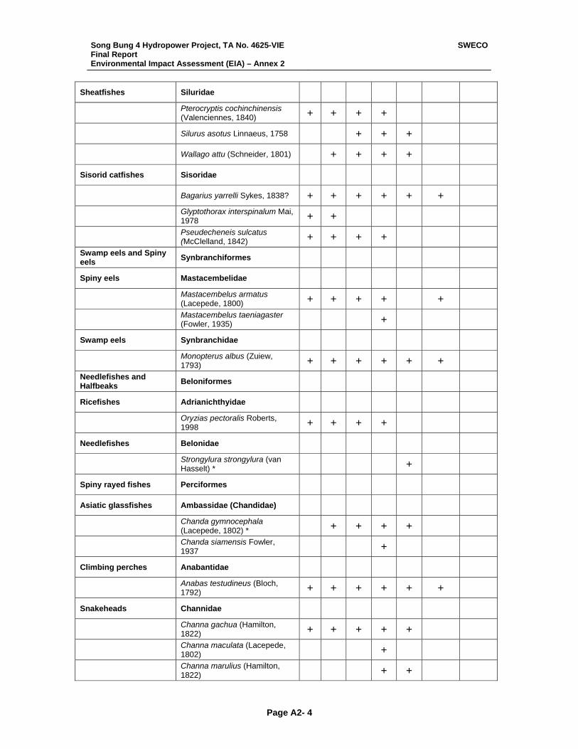
Song Bung 4 Hydropower Project, TA No. 4625-VIE Final Report Environmental Impact Assessment (EIA) – Annex 2
SWECO
Page A2- 4
Sheatfishes Siluridae
Pterocryptis cochinchinensis (Valenciennes, 1840) + + + +
Silurus asotus Linnaeus, 1758 + + +
Wallago attu (Schneider, 1801) + + + +
Sisorid catfishes Sisoridae
Bagarius yarrelli Sykes, 1838? + + + + + +
Glyptothorax interspinalum Mai, 1978 + +
Pseudecheneis sulcatus (McClelland, 1842) + + + +
Swamp eels and Spiny eels Synbranchiformes
Spiny eels Mastacembelidae
Mastacembelus armatus (Lacepede, 1800) + + + + +
Mastacembelus taeniagaster (Fowler, 1935) +
Swamp eels Synbranchidae
Monopterus albus (Zuiew, 1793) + + + + + +
Needlefishes and Halfbeaks Beloniformes
Ricefishes Adrianichthyidae
Oryzias pectoralis Roberts, 1998 + + + +
Needlefishes Belonidae
Strongylura strongylura (van Hasselt) * +
Spiny rayed fishes Perciformes
Asiatic glassfishes Ambassidae (Chandidae)
Chanda gymnocephala (Lacepede, 1802) * + + + +
Chanda siamensis Fowler, 1937 +
Climbing perches Anabantidae
Anabas testudineus (Bloch, 1792) + + + + + +
Snakeheads Channidae
Channa gachua (Hamilton, 1822) + + + + +
Channa maculata (Lacepede, 1802) +
Channa marulius (Hamilton, 1822) + +
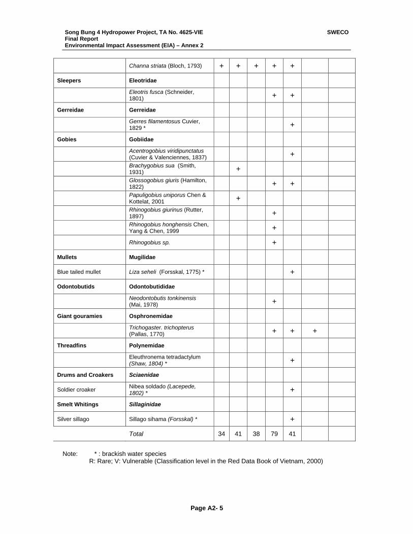
Song Bung 4 Hydropower Project, TA No. 4625-VIE Final Report Environmental Impact Assessment (EIA) – Annex 2
SWECO
Page A2- 5
Channa striata (Bloch, 1793) + + + + +
Sleepers Eleotridae
Eleotris fusca (Schneider, 1801) + +
Gerreidae Gerreidae
Gerres filamentosus Cuvier, 1829 * +
Gobies Gobiidae
Acentrogobius viridipunctatus (Cuvier & Valenciennes, 1837) +
Brachygobius sua (Smith, 1931) +
Glossogobius giuris (Hamilton, 1822) + +
Papuligobius uniporus Chen & Kottelat, 2001 +
Rhinogobius giurinus (Rutter, 1897) +
Rhinogobius honghensis Chen, Yang & Chen, 1999 +
Rhinogobius sp. +
Mullets Mugilidae
Blue tailed mullet Liza seheli (Forsskal, 1775) * +
Odontobutids Odontobutididae
Neodontobutis tonkinensis (Mai, 1978) +
Giant gouramies Osphronemidae
Trichogaster. trichopterus (Pallas, 1770) + + +
Threadfins Polynemidae
Eleuthronema tetradactylum (Shaw, 1804) * +
Drums and Croakers Sciaenidae
Soldier croaker Nibea soldado (Lacepede, 1802) * +
Smelt Whitings Sillaginidae
Silver sillago Sillago sihama (Forsskal) * +
Total 34 41 38 79 41 Note: * : brackish water species R: Rare; V: Vulnerable (Classification level in the Red Data Book of Vietnam, 2000)
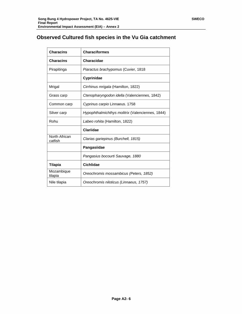
Song Bung 4 Hydropower Project, TA No. 4625-VIE Final Report Environmental Impact Assessment (EIA) – Annex 2
SWECO
Page A2- 6
Observed Cultured fish species in the Vu Gia catchment
Characins Characiformes
Characins Characidae
Pirapitinga Piaractus brachypomus (Cuvier, 1818
Cyprinidae
Mrigal Cirrhinus mrigala (Hamilton, 1822)
Grass carp Ctenopharyngodon idella (Valenciennes, 1842)
Common carp Cyprinus carpio Linnaeus. 1758
Silver carp Hypophthalmichthys molitrix (Valenciennes, 1844)
Rohu Labeo rohita (Hamilton, 1822)
Clariidae
North African catfish Clarias gariepinus (Burchell, 1815)
Pangasiidae
Pangasius bocourti Sauvage, 1880
Tilapia Cichlidae
Mozambique tilapia Oreochromis mossambicus (Peters, 1852)
Nile tilapia Oreochromis niloticus (Linnaeus, 1757)
Song Bung 4 Hydropower Project, TA No. 4625-VIE Final Report Environmental Impact Assessment (EIA) – Annex 3
SWECO
Page A3-i
Annex 3
Guidelines for Road Construction and Maintenance
Song Bung 4 Hydropower Project
Song Bung 4 Hydropower Project, TA No. 4625-VIE Final Report Environmental Impact Assessment (EIA) – Annex 3
SWECO
Page A3-ii
TABLE OF CONTENTS
Page
GUIDELINES FOR ROAD CONSTRUCTION AND MAINTENANCE ..................................... 1 Source of Reference ........................................................................................................... 1 Objective ............................................................................................................................. 1
Section 1: Clearing & Grubbing......................................................................................... 2 1.1 Description ............................................................................................................... 2 1.2 Preservation of Property .......................................................................................... 2 1.3 Construction Methods .............................................................................................. 2
Section 2: Roadway excavation ........................................................................................ 4 2.1 Description ............................................................................................................... 4 2.2 Materials – Classification and Selection .................................................................. 4 2.3 Construction Methods .............................................................................................. 5
Section 3: Channel excavation.......................................................................................... 7 3.1 Description ............................................................................................................... 7 3.2 Materials .................................................................................................................. 7 3.3 Construction Methods .............................................................................................. 7
Section 4: Excavation and backfill for structures............................................................... 8 4.1 Description ............................................................................................................... 8 4.2 Materials .................................................................................................................. 8 4.3 Construction Methods .............................................................................................. 8
Section 5: Embankment .................................................................................................. 13 5.1 Description ............................................................................................................. 13 5.2 Materials ................................................................................................................ 13 5.3 Construction Methods ............................................................................................ 13
Section 6: Sub-base and Bases...................................................................................... 16 6.1 Description ............................................................................................................. 16 6.2 Sub-base................................................................................................................ 16
6.2.1 Materials Requirements ................................................................................. 16 6.2.2 Construction ................................................................................................... 16
6.3 Base Course .......................................................................................................... 17 6.3.1 Material Requirements ................................................................................... 17 6.3.2 Preparation of Sub-base Surface................................................................... 18 6.3.3 Placing of Base Course.................................................................................. 18
Section 7: Pavements ..................................................................................................... 19 7.1. Seal Coat ............................................................................................................... 19
7.1.1 Description ..................................................................................................... 19 7.1.2 Cover Coat Material ....................................................................................... 19 7.1.3 Construction ................................................................................................... 19
7.2. Asphalt Concrete (For Highway)............................................................................ 20 7.2.1 Description ..................................................................................................... 20 7.2.2 Construction ................................................................................................... 20
Section 8: Drainage, Pipes and Outlets .......................................................................... 24 8.1 Scope..................................................................................................................... 24 8.2 Description ............................................................................................................. 24 8.3 Materials ................................................................................................................ 24 8.4 Construction........................................................................................................... 24
Section 9: Miscellaneous ................................................................................................ 26 9.1. Grassed Areas ....................................................................................................... 26
9.1.1 Description ..................................................................................................... 26 9.1.2 Material .......................................................................................................... 26
Song Bung 4 Hydropower Project, TA No. 4625-VIE Final Report Environmental Impact Assessment (EIA) – Annex 3
SWECO
Page A3-iii
9.1.3 Construction ................................................................................................... 26 9.2. Slope Protection..................................................................................................... 27
9.2.1 Description ..................................................................................................... 27 9.2.2 Materials......................................................................................................... 28 9.2.3 Construction ................................................................................................... 28
9.3. Mortared Stonework............................................................................................... 29 9.3.1 Description ..................................................................................................... 29 9.3.2 Materials......................................................................................................... 29 9.3.3 Construction ................................................................................................... 29
Section 10: Maintenance................................................................................................... 31 10.1 Introduction ............................................................................................................ 31 10.2 Works of Road Maintenance.................................................................................. 31 10.3 Routine maintenance of the road resettlement ...................................................... 32 10.4 Activities of Road Maintenance to minimize the negative impacts on the reservoir36
Section 11: Environmental Management .......................................................................... 38 11.1 General .................................................................................................................. 38 11.2 EMP layout............................................................................................................. 38
11.2.1 Contractor’s Organization .............................................................................. 38 11.2.2 Environmental Management Approach............................................................... 38 11.2.3 Environmental Record.................................................................................... 42
11.3 Environmental Monitoring ...................................................................................... 42 11.3.1 Description ..................................................................................................... 42 11.3.2 General .......................................................................................................... 42
Song Bung 4 Hydropower Project, TA No. 4625-VIE Final Report Environmental Impact Assessment (EIA) – Annex 3
SWECO
Page A3-1
GUIDELINES FOR ROAD CONSTRUCTION AND MAINTENANCE Source of Reference Multistage environmental and social impact assessment of Road Project by UN ESCAP. Specification - Red River bridge (Thanh Tri bridge) construction Project (funded by JBIC)
(2004). Specification for Highway No.1 Rehabilitation Project (funded by WB) (1997). Specification for Highway construction by Ministry of communication in Thailand (1983). Rural Road Maintenance – Pocket Guide. Rural Transport Project 2 (funded by DFID & WB)
(2001). Study of Investment and Maintenance Strategy for National & Provincial Roads: Viet Nam
(funded by ODA-UK) (1996). Specification (funded by ADB) Highway No 1 Rehabilitation Project (Quang Ngai- Nha Trang
section) (2001). Specification (funded by JBIC) Highway No18 Improvement Project (2003). Specification (funded by JICA) Highway No14 Improvement Project (1997). Specification (funded by WB) Highway No1 Rehabilitation Project (Hanoi- Cau Gie Section)
(2003). Specification (funded by JBIC) Highway No10 Improvement Project (2003). Objective Using suitable technical measures on road construction which aims at:
• Protecting vegetation and limit the extent of clearing vegetable.
• Not leaving surplus soil of excavation construction to influence reservoir area.
• Restricting cut and fill slopes and culverts erosion and collapse.
• Preventing and minimizing environmental impact on road construction.

Song Bung 4 Hydropower Project, TA No. 4625-VIE Final Report Environmental Impact Assessment (EIA) – Annex 3
SWECO
Page A3-2
SECTION 1: CLEARING & GRUBBING 1.1 Description This work shall consist of all clearing and grubbing necessary for the performance of the work covered by the Contract in accordance with the Guideline. The areas to be cleared or cleared and grubbed shall be the areas designated by staking or designated on the Drawings or designated in the Contract Documents. The clearing and grubbing shall consist of clearing the designated areas of all trees, down timber, snags, vegetation, rubbish and objectionable material and shall include grubbing stumps and roots and disposing of all material resulting from the clearing or grubbing. It shall also include the demolition removal and disposal of structures that obtrude into or encroach upon or obstruct the work except where provided for otherwise. 1.2 Preservation of Property Attention is directed to the Contractor’s obligations under law and under this Contract with regard to damage, particularly with regard to protection of property, forest, and landscape and to responsibility for damage claims. Existing highways, improvements, facilities, adjacent property, utilities, services, and trees and plants designated for preservation shall be protected from injury or damage which could result from the Contractors’ operations. 1.3 Construction Methods a. Clearing or clearing and grubbing shall be performed on the areas designated by staking or on the Drawings or in the Special Provisions. If no areas are designated in the Special Provisions or on the Drawings the areas shall be as follows: Clearing shall be carried out over the entire right of way Grubbing shall be carried out on the area of embankment foundations where the embankment is less than 1.5 meters high.
b. Clearing Clearing shall consist of the removal and disposal of everything above ground level including overhanging branches except those things the Engineer directs are to be left undisturbed. The material to be cleared shall include but not necessarily be limited to trees, stumps, logs, brush, undergrowth, grass crops, loose vegetable matter, structures (other than those structures where removal or clearance is separately specified and measured). Outside the limits of the earth works, and under embankments more than 1.5 meters in height trees and stumps shall be cut to a level not more than 30 cm above ground level and not less than 45 cm below the embankment slopes and everything else to ground level. In cut areas clearing shall include the removal of stumps and roots exceeding 8 cm in diameter, to a depth of 45 cm below the finished surface except that in rounding areas at the tops of cut slopes they may be cut flush. c. Grubbing Grubbing shall consist of the removal and disposal of topsoil, stumps, and roots to a depth of at least 15 cm below ground level and at least 45 cm below the bottom of the lowest sub-base or base course of the road pavement.
Song Bung 4 Hydropower Project, TA No. 4625-VIE Final Report Environmental Impact Assessment (EIA) – Annex 3
SWECO
Page A3-3
Clearing and grubbing of pits, channel changes, and ditches will be required only to the depth necessitated by the excavation within those areas. d. Ownership of Timber The Contractor shall have the right to use unsaleable timber (or saleable timber when permission is granted in writing by the appropriate Government agency or authority) for his own purposes in connection with the Contract always provided that he has ascertained and complied with the requirements of the appropriate Government agencies or authority. e. Disposal of Cleared Material Saleable timber shall be neatly stored in an approved accessible place within or near the right of way as directed and shall be trimmed and stacked in accordance with the requirements of the appropriate Government agency. All other timber except timber to be used and all brush, stumps, roots, logs, and other refuse from the clearing and from the grubbing operations shall be burned, provided that, when permitted in writing by the authority having jurisdiction over the area through which the highway is being constructed, large stumps may be disposed of without burning at locations out of sight of the roadway. Likewise, large stumps may, with the Engineer’s approval, be disposed of without burning out of sight of the roadway on private land. In such cases the Contractor will be solely responsible for making the necessary agreements and paying expenses and claims arising from the use of private land. Piles of material for burning shall be placed either at or near the centre of the cleared area, or in adjacent open spaces where no damage to trees or other vegetation shall occur. Should the burning precede the construction operations, the material piles may be placed in the centre of the right of way; otherwise the material piles shall be placed in the most convenient location at the side of the right of way and beyond slope lines where they may be burned without damage to the surrounding trees or adjacent property. All burning shall be done in conformance with regulations and at such times and in such manner as to prevent the fire from spreading to areas adjoining the right of way. Should the clearing and grubbing be done at a time when burning is not permitted, the Contractor shall pile all material which is to be burned outside the slope lines and at a time when burning is permitted he shall return such material to the grade and burn it. All fences, buildings, structures, and encumbrances of any character, except those to be removed by others, upon or within the limits of the right of way, shall be removed by the Contractor and carefully placed on the abutting property or otherwise disposed of as indicated on the drawings or as directed by the Engineer. Materials so removed, including any existing drain or culvert pipes which the Engineer may order salvage, shall be carefully removed and shall be the property of the Government. The roadway and adjacent areas shall be left with a neat and finished appearance. No accumulation of inflammable material shall remain on or adjacent or the right of way.
Song Bung 4 Hydropower Project, TA No. 4625-VIE Final Report Environmental Impact Assessment (EIA) – Annex 3
SWECO
Page A3-4
SECTION 2: ROADWAY EXCAVATION 2.1 Description The work shall consist of all the required excavation within the limits of the right of way except excavation otherwise classified; the removal, hauling and proper utilization or disposal of all excavated materials and shaping of excavation and preparation of exposed surfaces of excavation on the entire length of the roadway and approaches, in accordance with these Guidelines and the lines, levels, grades, dimensions and cross sections shown on the Drawings and as required by the Engineer. Roadway excavation shall include the following: a. All excavated material indicated on the Drawings within the faces of the cross
sections, excavation of all materials for approach roads, streets, inter-sections, gutters, ditches, berm ditches, drains and flumes.
b. All top soil required to be salvaged within the limits of the highway in accordance with
Technical Standard Specification: Topsoil except under embankment, which is included under Section 1: Clearing and Grubbing.
c. The removal and disposal of existing surfacing, side walks, curb or curb and gutter
within the limits of construction. d. The demolition removal and disposal of all foundations, foundation walls, basement
or ground level floors, timber, rubble, masonry pipe, pipe structures and pip culverts within the limits of construction and not otherwise provided for in the Contract.
e. Excavation for removal of slides, breakages and cave-ins f. Excavation for stream and channel changes except where covered under Section 3:
Channel Excavation. g. Excavation required in cuts or under embankments below the lowest normal limit of
excavation indicated on the Drawings or below ground lines, for the removal of unsuitable material, and below the ground line under embankments where benching is required, or as otherwise directed.
2.2 Materials – Classification and Selection a. Excavation shall be either unclassified or classified according to the definitions given below for hard rock, soft rock and earth. b. Unclassified Excavation Unclassified Excavation shall include all materials to be excavated in accordance with this Guideline. c. Classified Excavation Roadway Excavation –classified Earth shall include all roadway excavation except that classified as hard rock or soft rock. Roadway Excavation – Classified Soft Rock shall include all roadway excavation except that classified as hard rock or earth which in the judgment of the Engineer requires the use of tractor mounted and drawn rippers to loosen the material sufficiently to permit a bulldozer to remove the material. Soft rock shall be residual rock altered by physical and chemical
Song Bung 4 Hydropower Project, TA No. 4625-VIE Final Report Environmental Impact Assessment (EIA) – Annex 3
SWECO
Page A3-5
processes to the extent that it is decomposed or dis-integrated or fractured or loosely laminated or jointed, but retains sufficient strength to necessitate ripping. No alluvial or wind blown or transported soils, nor gravels, nor clays which soften when wet shall be classified as soft rock. Roadway Excavation- Classified Hard Rock shall include only roadway excavation which in the judgment of the Engineer, is not practicable to excavate without the use of pneumatic tools or drilling and blasting. Hard rock shall not include material which, in the judgment of the Engineer, can be loosened with a tractor mounted and drawn ripper of the following description: Tractor Unit Equipment with a minimum weight of 17 metric tons and net horse power rating of 150 H.P. or more. The tractor unit is to be in good condition and operated by experienced personnel skilled in the use of ripping equipment. Ripping Unit The ripper to be attached to the tractor shall be the most efficient parallelogram type recommended by the tractor or ripper manufacturer. The ripper shall have a single shank in first class condition with sharpened cutting point. d. Unsuitable Materials Material encountered in cut areas and in the foundation of the embankment that is unsuitable for the planned use shall be excavated and disposed of as directed by the Engineer. Backfill as necessary shall be with approved material. Normally, highly organic clays and silts, peat, soils containing large amounts of roots, grass and other vegetable matter are considered to be unsuitable. Materials that are soft or unstable merely because they are too wet or dry are not to be classified as unsuitable unless otherwise directed by the Engineer. 2.3 Construction Methods a. All roadway excavation and embankment construction shall be performed as specified here in and in Section 5: Embankment, and the completed roadway shall conform to the required alignment, levels, grades, and cross sections. Unless otherwise indicated on plans, excavation in solid rock shall extend 20 cm below the required subgrade elevation for the entire roadway width and shall be backfilled with suitable materials as indicated on the Drawings or as directed by the Engineer. Where provided for on the Drawings topsoil encountered in excavation shall be removed to such a depth as the Engineer may direct. The topsoil shall be removed and stored in piles at locations designated by the Engineer in accordance with the requirement of Technical Standard Specification: Topsoil. b. All suitable excavated materials shall be used in so far as practicable in constructing the roadway. Unsuitable material and required roadway excavation in excess of that needed for construction shall be known as waste. Waste shall be removed and disposed of at designated areas in such manner as to present a neat appearance and not to obstruct drainage to any road nor to cause injury to road works or property. c. Unsuitable material shall be excavated below subgrade level in cut and below embankment foundation level to the depth shown on the Drawings or directed by the Engineer. Where unsuitable material is excavated below the normal subgrade level or below embankment foundations or for benching under embankments the excavation shall be back filled with material and in a manner that conforms with the Section 5: Embankment.
Song Bung 4 Hydropower Project, TA No. 4625-VIE Final Report Environmental Impact Assessment (EIA) – Annex 3
SWECO
Page A3-6
d. All slopes shall be finished in a neat and workmanlike manner and to an accuracy appropriate to the material, and care shall be taken that no material is loosened below the required slopes. Breakages and slides shall be removed and disposed of as directed. e. In cut areas. the top of the subgrade on which base or subbase or shoulder is to be placed shall be processed as necessary and compacted to a minimum depth of 15 cm to not less than 95% of the maximum dry density of the material as determined by A.A.S.H.T.O. test method T180. NOTE In projects where a compaction of 95% of the maximum dry density determined by A.A.S.H.T.O. method T180. f. The surface of the finished subgrade shall be neat and workmanlike and shall have the required form, super elevation, levels, grades and cross-section. The surface shall be constructed to sufficient accuracy to permit the construction of subsequent layers of material to the thickness, cross-section, surface tolerance, and compaction specified. g. If the Contractor elects to obtain material by widening cuts he shall first request permission in writing from the Engineer and if written permission is granted widening of cuts will be permitted within the limits indicated, but not beyond the limits of the right of way. Such material shall be classified as borrow and will not be paid for. If widening of cuts is carried out on a written order of the Engineer the cut shall be measured and paid for as Roadway Excavation.
Song Bung 4 Hydropower Project, TA No. 4625-VIE Final Report Environmental Impact Assessment (EIA) – Annex 3
SWECO
Page A3-7
SECTION 3: CHANNEL EXCAVATION 3.1 Description This work shall consist of excavation for channels both inside and outside the right of way where shown on the Drawings or specified in the Special Provisions or directed by the Engineer. The work shall include the proper utilization and hauling or disposal of all excavated materials, constructing, shaping and finishing all earthwork involved in conformity with the required alignment, levels, grades and cross section. 3.2 Materials Materials excavated shall be either classified or unclassified. If the Contact documents indicate classified material the classification shall be as laid down in Section 2 Roadway Excavation. 3.3 Construction Methods All suitable materials removed from the excavation shall be used as far as practicable in the formation of embankments as specified under the items for embankment or shall be otherwise properly utilized or disposed of as required on the Drawings, or in the Special Provisions, or by the Engineer.] During construction the channel shall be kept drained as far as practicable and the work shall be constructed in a neat and workmanlike manner. The channel shall be excavated to the alignment, levels, grades and cross sections required on the Drawings, in the Special Provisions, or by the Engineer. Excavation beyond the limits required shall not be paid for.
Song Bung 4 Hydropower Project, TA No. 4625-VIE Final Report Environmental Impact Assessment (EIA) – Annex 3
SWECO
Page A3-8
SECTION 4: EXCAVATION AND BACKFILL FOR STRUCTURES 4.1 Description This work shall consist of excavation for the foundation of under drains and structures, other than pipe culverts, not otherwise provided for by the Guidelines; constructing and removing cofferdams and sheeting; pumping, dewatering and bailing, backfilling of completed structures; disposal of excavated material. Storm sewers and pipes shall be excavated and backfilled in accordance with Technical Standard Specification, Reinforced Concrete Culvert Pipe, and measurement and payment will be in accordance with that section. 4.2 Materials a. Foundation fill material Material for foundation fill shall consist of suitably graded sand, gravel, or stone as shown on the Drawings or required by the Engineer, or concrete as described below. b. Concrete for foundation fill Concrete shall conform to the general requirements of Technical Standard Specification. Concrete to be placed under water shall conform to the requirements of Technical Standard Specification / Concrete to be used as foundation fill in dry excavation shall be made with an aggregate and cement conforming to the requirements of Technical Standard Specification and shall be mixed and placed in accordance with Technical Standard Specification, except that minimum cement content may be 250 kilograms per cubic meter. c. Backfill material Backfill shall be approved compatible material. It shall be obtained from the structure excavation if such material is approved by the Engineer as suitable. Any additional material needed shall be obtained from roadway or borrow excavation unless otherwise directed by the Engineer. 4.3 Construction Methods a. Clearing Prior to starting excavation operations in any area, all necessary clearing and grubbing shall have been performed. b. Excavation The Contractor shall notify the Engineer sufficiently in advance of the beginning of any excavation so that cross section elevations and measurement may be taken of the undisturbed ground. The natural ground adjacent to the structure shall not be disturbed without permission of the Engineer. Trenches and foundation pits for structures and structure footings and under-drains shall be excavated to the lines, grades and elevations shown on the Drawings or as staked by the Engineer. The elevations of the bottoms of footings shown on the Drawings are approximate only and the Engineer may order in writing such changes in the dimension or elevations of footings as may be deemed necessary to secure a satisfactory foundation.
Song Bung 4 Hydropower Project, TA No. 4625-VIE Final Report Environmental Impact Assessment (EIA) – Annex 3
SWECO
Page A3-9
Boulders, logs and other objectionable material encountered in excavation shall be removed. After each excavation is completed the Contractor shall notify the Engineer to that effect and no footing, bedding material or structure shall be placed until the Engineer has approved the depth of excavation and the character of the foundation material. Rock and other hard foundation material shall be cleared of all loose material and cut to a firm surface, either level or stepped or serrated, as specified or shown on the Drawings or directed by the Engineer. All seams and crevices shall be cleared out and grouted with Portland cement grout at the time the footing is placed. All loose and disintegrated rock and then strata shall be removed. When the footing is to rest on material other than rock, special care shall be taken into to disturb the bottom of the excavation, and excavation to final grade shall be deferred until just before the footing is to be placed. When, in the opinion of the Engineer, the foundation material is soft or mucky or otherwise unsuitable, the Contractor shall remove the unsuitable material and insert foundation fill material or concrete as specified or shown on the Drawings or directed by the Engineer. If foundation fill material is required it shall be placed and compacted in layers not more than 15 cm thick or as directed by the Engineer. The degree of compaction shall be equivalent or that of the surrounding foundations. All excavation surfaces and surfaces of backfill material against which concrete is to be placed shall be smooth and firm and true to line and level. c. Disposal of Excavated material All excavated material so far as suitable, shall be utilized as backfill or embankment. The surplus material, whether or not temporarily allowed to be placed within a stream area, shall be finally disposed of in such a manner as not to obstruct the stream nor otherwise impair the efficiency or appearance of the works nor is it to endanger the partly finished structure. Excavated material suitable for use as backfill may be deposited by the Contractor in storage piles at points convenient for rehandling of the material during the backfilling operation. Excavated material shall be deposited in such places and in such a manner as not to cause damage to highway, services or property either within or outside the right of way and so as to cause no impediment to the drainage of the site or surrounding area. The location of storage piles shall be subject to the approval of the Engineer who may require that the survey center line and the transverse or hub line of any part of the structure be kept free of obstruction. d. Cofferdam and Caisson (i) The term “cofferdam” denotes any temporary or removable structure, constructed to hold the surrounding earth, water, or both, out of the excavation, whether such structure is constructed of earth, timber, steel, concrete or any combination of these. The term includes earth dikes, timber cribs, sheet piling, removable steel shells and all bracing; and it shall be understood to include excavation enclosed by pumping wells and well points. The cost of cofferdams is always to be included as part of the bid price for the structure. (ii) The term “caisson” denotes a permanent part of the substructure so constructed as to sink gradually into place as material is excavated within the area protected by its side walls.

Song Bung 4 Hydropower Project, TA No. 4625-VIE Final Report Environmental Impact Assessment (EIA) – Annex 3
SWECO
Page A3-10
(iii) When no provision for Caisson is shown in the Drawings it shall be the intent of the Contract that suitable cofferdams shall be provided for all excavations where cofferdams may be necessary in order to control water or to preclude sliding and caving of the walls of the excavation. (iv) The contractor shall submit upon request Drawings showing his proposed method of cofferdam and caisson construction. Approval of the Drawings by the Engineer will not in any way relieve the Contractor of the responsibility for the adequacy of the design for strength and stability or for the safety of the people working therein. (v) The interior dimensions of cofferdams shall be such as to give sufficient clearance for the construction and removal of any required forms and the inspection of the interior and to permit pumping outside the forms. (vi) If practicable cofferdams shall be so designed that no cross bracing shall be left in place. If this is not practicable bracing left in place shall be of structural steel. The end of such structural members that would be exposed when the structure is completed shall be boxed back at least 15 cm behind the concrete face. The resulting holes shall be completely filled with concrete. (vii) In general, sheet piling cofferdams shall extend well below the bottom of the footing and shall be well braced and as watertight as practicable. (viii) When foundation piles are to be driven inside a cofferdam and it is judged impracticable to dewater the cofferdam before placing a concrete seal, the excavation may be extended below the designed level to a depth sufficient to allow for swell for the material during pile driving operations. Any material that rises to a level above the design level shall be removed. (ix) Where it is possible to dewater the cofferdam the foundation material shall be removed to exact grade after the foundation piles are driven. (x) Backfilling in a foundation to compensate for excavation which has been extended below the required grade shall be at the expense of the Contractor. Backfilling shall be with concrete or foundation fills material as indicated on the Drawings or in the Special Provisions or as directed by the Engineer. If no material is indicated, backfilling shall be concrete of the same kind as required for the structure to be constructed in the excavation. Unless otherwise permitted no excavation shall be made outside of caissons or cribs or cofferdams or sheet piling and the natural stream bed adjacent to the structure shall not be disturbed without permission from the Engineer. If any excavation or dredging is made at the site of the structure before caissons, cribs, or cofferdams are in place the Contractor shall, after the foundation is in place, backfill all such excavation to the original ground surface or stream bed with material satisfactory to the Engineer. Material deposited within the stream area from foundations or other excavations or from the filling or cofferdams shall be removed and the stream area freed from obstruction. (xi) Caisson and cofferdams which tilt or move laterally during construction shall be corrected as necessary at the expense of the Contractor.
Song Bung 4 Hydropower Project, TA No. 4625-VIE Final Report Environmental Impact Assessment (EIA) – Annex 3
SWECO
Page A3-11
(xii) Unless otherwise provided cofferdams shall be removed after the completion of the sub-structure. The removal shall be effected in such a manner as not to disturb or mar the finished work. The Engineer may order the Contractor to leave any part or the whole of the cofferdam in place. (xiii) When conditions are encountered which, in the opinion of the Engineer, render it impracticable to dewater the foundation before placing the footing, the Engineer may require the construction of a concrete foundation or seal of such dimensions as he may consider necessary, and of such thickness as to resist any possible uplift. The concrete for such seal shall be placed as shown in the Drawings or required by the Engineer. The foundation shall then be dewatered and the footing placed. When weighted cribs are used and the weight is used to overcome partially the hydrostatic pressure acting against the bottom of the foundation seal. Special anchorages such as dowels or keys shall be provided to transfer the entire weight of the crib to the foundation seal. When a foundation seal is placed under water the cofferdam shall be vented at low water as directed. Cofferdams shall be constructed so as to protect newly-cast concrete from sudden rising of the water and to prevent damage to the foundation by erosion. (n) Caissons shall be constructed as provided in the Special Provisions and on the Drawings. Caissons shall be included in the lump sum payment for the structure if a lump sum appears in the bid items, or as otherwise provided in the Special Provisions. e. Pumping and Bailing Pumping and bailing from the interior of any foundation enclosure shall be done in such a manner as to preclude the possibility of the movement of water through or alongside any concrete being placed. No pumping or bailing will be permitted during the placing of concrete or for a period of at least 24 hours thereafter unless it is done from a suitable sump separated from the concrete work by a water-tight wall. Excavations shall be as dry as possible prior to and during placing concrete. Placing concrete under water will only be permitted if indicated on the Drawings or permitted by the Engineer. f. Backfilling All spaces excavated under this Guideline and not occupied by the permanent structure shall be backfilled. Backfilled material shall be free from large lumps, wood and other extraneous material. Backfill not within the embankment area shall be placed in layers not more than 25 cm in depth (loose measurement) and shall be compacted to a density comparable with the adjacent undisturbed material. Backfill within the embankment areas shall be made with approved material placed in uniform layers not to exceed 15 cm in depth (loose measurement) and each layer shall be constructed in accordance with Section 5: Embankment except that mechanical tampers may be used for compaction. Each layer of backfill shall be wetted uniformly as necessary to obtain the specified dry density. Unless otherwise specified hand tamping will not be accepted. In placing back fill and embankment the material shall be placed insofar as possible to approximately the same height on both sides of the structure. If conditions require backfilling
Song Bung 4 Hydropower Project, TA No. 4625-VIE Final Report Environmental Impact Assessment (EIA) – Annex 3
SWECO
Page A3-12
appreciably higher on one side, the additional material on the higher side shall not be placed until permission is given by the Engineer nor until the Engineer is satisfied that the structure has enough strength to withstand any pressure created. Backfill for embankment shall not be placed behind the walls of bridges or box culverts until the top slab is placed for the required time and not less than three days. Backfill and embankment behind abutments held at the top by superstructure shall be carried up simultaneously behind opposite abutments and side walls. No backfilling shall be placed against any structure until permission shall have been given by the Engineer. Jetting of fill or other hydraulic methods involving, or likely to involve, liquid or semi liquid pressure shall be prohibited. Special care shall be taken to prevent any unduly high pressures against the structures. The placing of embankment and the benching of slopes shall continue in such a manner that at all times there will be a horizontal berm of thoroughly compacted material for a distance at least equal to the height of the abutment or wall to be backfilled. Adequate provision shall be made for drainage and to allow for porous backfill material to be placed in accordance with Technical Standard Specification.
Song Bung 4 Hydropower Project, TA No. 4625-VIE Final Report Environmental Impact Assessment (EIA) – Annex 3
SWECO
Page A3-13
SECTION 5: EMBANKMENT
5.1 Description This work shall consist of the construction of embankment and backfill not specified elsewhere by furnishing, placing, compacting and shaping suitable material of acceptable quality obtained from approved sources in accordance with these Guideline, and to the lines, levels, grades, dimensions, and cross sections shown on the Drawings and as required by the Engineer. 5.2 Materials Embankment shall be constructed of suitable materials as defined in Section 2 Roadway Excavation. 5.3 Construction Methods a. Preparation of Foundation for Embankment (i) Prior to placing any embankment upon any area all clearing and grubbing operations shall have been completed in accordance with Section 1. Where the height of embankment is 1 meter or less all sod, grass and vegetable matter shall be removed from the ground surface and the top 15 cm shall processed as necessary and compacted to 90% of the maximum dry density as determined by A.A.S.H.T.O. test method T180. (ii) Where embankments are to be constructed on hillsides or slopes, the existing slopes (other than rock) shall be loosened by scarifying or ploughing to a depth of not less than 10 cm, to ensure a good bond between the embankment and the embankment foundation, or where this is impracticable, steps in vertical and horizontal faces shall be cut in the existing slope (including rock) and the embankment built up in successive layers. Material which has been loosened shall be recompacted simultaneously with the first layer of embankment material placed.
(iii) Where existing embankments are to be widened or included in new embankment, the slopes of the existing embankment shall be ploughed or scarified to a depth of not less than 10 cm or, where this is impracticable, steps in horizontal and vertical faces shall be cut in existing slopes and the embankment built up in successive layers to the level of the old road, before its height is increased. (iv) Unless otherwise shown on the Drawings, where existing unpaved roads are to be covered with less than 30 cm of fill, excluding pavement, the top of the old road bed shall be scarified and recompacted with the next layer of the new embankment. The total depth of the scarified and added material shall not exceed the permissible depth of the scarified and added material shall not exceed the permissible depth of layer. (iv) Embankments in swamps or water shall be constructed as indicated on the plans and as specified in the Special Provisions. The contractor shall, when ordered by the Engineer, excavate or displace swamp ground and backfill with suitable material. Backfill will be in accordance with the same provisions as for embankment unless otherwise directed by the Engineer.

Song Bung 4 Hydropower Project, TA No. 4625-VIE Final Report Environmental Impact Assessment (EIA) – Annex 3
SWECO
Page A3-14
b. Placing embankment Embankment shall be placed in accordance with the following requirements: (i) General: Except as otherwise required all embankments shall be constructed in layers approximately parallel to the finished grade of the road bed. During construction of embankment, a smooth grade having an adequate crown or superelevation shall be maintained to provide drainage. Embankments shall be constructed to the required grade, and completed embankments shall correspond to the shape of the typical sections shown on the Drawings. (ii) Earth Embankment: Earth embankments shall be defined as those principally of material other than rock, and shall be constructed of approved material from designated or other approved sources. Except as specified for embankment in swamps, earth embankments shall be constructed in successive layers, for the full width of the cross section and in such lengths as are suited to the compaction and watering methods used. Prior to compaction the layers shall not exceed 20 cm in depth unless permission is granted by the Engineer. (iii) Placing over swamp ground: Embankment in or over swamps or in water shall be placed as indicated on the Drawings and as specified in the special Provisions, and as required by the Engineer. (iv) Rock Embankment: Rock embankment shall be defined as those principally of rock, and shall be constructed of approved material from designated or other approved sources. Except as otherwise specified rock embankment shall be constructed in successive layers for the full width of the cross section and of 75 cm or less in depth. When in the opinion of the Engineer, the rock sizes necessitate a greater depth of layer and the height of fill will permit, the layer depth may be increased as necessary, but in no case shall the depth of layer exceed one meter. Each layer shall be constructed by starting at one end of the section of embankment under construction and dumping the rock on top of the layer being constructed them pushing ahead with an approved bull dozer in such a manner that the larger rock will be placed on the ground or preceding layer and the interstices between the larger stones will be filled with small stones and spalls by this operation and by the placing of succeeding layers of embankment. The maximum dimension of any rock shall be less than the depth of the embankment layer. All oversized rock which is otherwise suitable for construction shall be broken to the required dimension and used in embankment construction or placed at the points in the embankment where the layer is of greater depth. Compensation for additional haul involved in such alternate manipulation will not be allowed. Where excavated rock is wasted the Contractor shall, at his own expense, replace the rock wasted with other suitable materials. Except as otherwise specified, all rock fills will be covered with one or more 20 cm layers of well graded material containing no stones larger than 10 cm and the material shall be sufficient to fill all the interstices in the top of the rock fill. These layers will be constructed to the requirements for earth embankment. Each layer or embankment shall be compacted as herein-after specified.

Song Bung 4 Hydropower Project, TA No. 4625-VIE Final Report Environmental Impact Assessment (EIA) – Annex 3
SWECO
Page A3-15
(v) Adjacent to culverts and bridges: Embankments adjacent to culverts and bridges which cannot be compacted by use of equipment used in compacting the adjoining section of embankment shall be compacted in the manner prescribed under the Section 2.5 – Excavation and Backfill for Structures. Embankments placed round spill through type abutments shall be compacted in 15 cm layers (measured before compaction) of uniform suitable material placed in such a manner as to maintain approximately the same elevation on each side of the abutment and each layer of material shall be mixed, wetted and compacted as specified herein. Material placed adjacent to any portion of any structure shall be material free of any appreciable amount of gravel or stone particles more than 10 cm in greatest dimension and of such gradation as to permit thorough compaction. (vi) Preparation of subgrade: The surface of the finished subgrade shall be neat and workmanlike and shall have the required form, super elevation, levels grades, and cross section. The surface shall be constructed to sufficient accuracy to permit the construction of subsequent layers of material to the thickness, surface tolerance, and compaction specified. c. Compaction of embankments other than rock embankments (i) When necessary each layer, before being compacted, shall be processed as required to bring the moisture content sufficiently close to optimum to make possible its compaction to the required density. The material shall be so worked as to have an uniform moisture content through the entire layer. (ii) Each layer of material shall be compacted uniformly by use of adequate and appropriate compaction equipment. The compaction shall be done in a longitudinal direction along the embankment and shall generally begin at the outer edges and progress toward the centre in such a manner that each section receives equal compactive effort. Hauling equipment shall be operated over the full width of each layer in so far as practicable. (iii) Embankment compaction shall carried out in one of the following 2 ways dependent on whether a compaction of 95% of the maximum dry density determined by A.A.S.H.T.O. test method T180 is considered practicable. EITHER The top 15 cm of the finished embankment shall be compacted to a dry density equal to at least 95% of the maximum dry density as determined by A.A.S.H.T.O. test method T180. Other embankment layers more than 15 cm below the underside of the lowest layer of base, subbase and shoulder shall be compacted to a dry density equal to at least 90% (iv) In cases where the embankment material is such that the field density cannot be accurately determined as stated above, the type of compacting equipment to be used shall be subject to the approval of the Engineer. d. Compaction of rock embankment Rock embankment shall be compacted by the passage of approved heavy equipment until there is no visible movement of the rock fill under equipment. Compaction shall be done in a longitudinal direction along the embankment and shall begin at the outer edge and progress towards the centre.
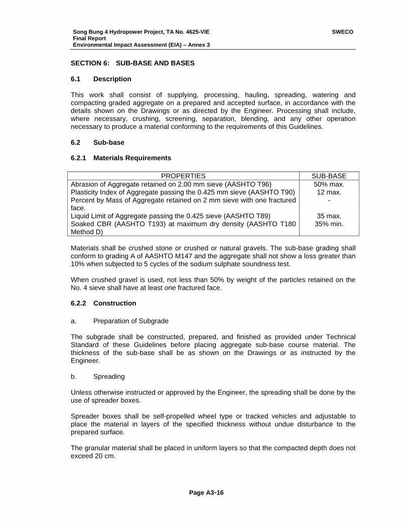
Song Bung 4 Hydropower Project, TA No. 4625-VIE Final Report Environmental Impact Assessment (EIA) – Annex 3
SWECO
Page A3-16
SECTION 6: SUB-BASE AND BASES 6.1 Description This work shall consist of supplying, processing, hauling, spreading, watering and compacting graded aggregate on a prepared and accepted surface, in accordance with the details shown on the Drawings or as directed by the Engineer. Processing shall include, where necessary, crushing, screening, separation, blending, and any other operation necessary to produce a material conforming to the requirements of this Guidelines. 6.2 Sub-base
6.2.1 Materials Requirements
PROPERTIES SUB-BASE Abrasion of Aggregate retained on 2.00 mm sieve (AASHTO T96) 50% max. Plasticity Index of Aggregate passing the 0.425 mm sieve (AASHTO T90) 12 max. Percent by Mass of Aggregate retained on 2 mm sieve with one fractured face.
-
Liquid Limit of Aggregate passing the 0.425 sieve (AASHTO T89) 35 max. Soaked CBR (AASHTO T193) at maximum dry density (AASHTO T180 Method D)
35% min.
Materials shall be crushed stone or crushed or natural gravels. The sub-base grading shall conform to grading A of AASHTO M147 and the aggregate shall not show a loss greater than 10% when subjected to 5 cycles of the sodium sulphate soundness test. When crushed gravel is used, not less than 50% by weight of the particles retained on the No. 4 sieve shall have at least one fractured face.
6.2.2 Construction a. Preparation of Subgrade The subgrade shall be constructed, prepared, and finished as provided under Technical Standard of these Guidelines before placing aggregate sub-base course material. The thickness of the sub-base shall be as shown on the Drawings or as instructed by the Engineer. b. Spreading Unless otherwise instructed or approved by the Engineer, the spreading shall be done by the use of spreader boxes. Spreader boxes shall be self-propelled wheel type or tracked vehicles and adjustable to place the material in layers of the specified thickness without undue disturbance to the prepared surface. The granular material shall be placed in uniform layers so that the compacted depth does not exceed 20 cm.
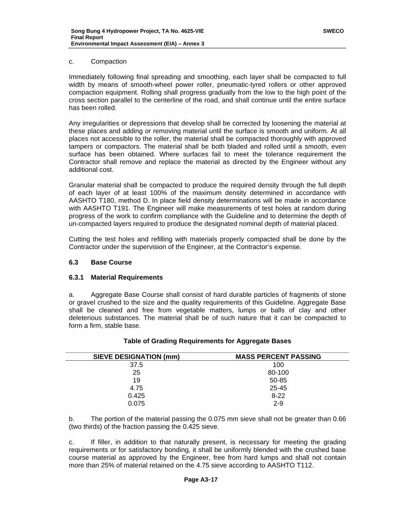
Song Bung 4 Hydropower Project, TA No. 4625-VIE Final Report Environmental Impact Assessment (EIA) – Annex 3
SWECO
Page A3-17
c. Compaction Immediately following final spreading and smoothing, each layer shall be compacted to full width by means of smooth-wheel power roller, pneumatic-tyred rollers or other approved compaction equipment. Rolling shall progress gradually from the low to the high point of the cross section parallel to the centerline of the road, and shall continue until the entire surface has been rolled. Any irregularities or depressions that develop shall be corrected by loosening the material at these places and adding or removing material until the surface is smooth and uniform. At all places not accessible to the roller, the material shall be compacted thoroughly with approved tampers or compactors. The material shall be both bladed and rolled until a smooth, even surface has been obtained. Where surfaces fail to meet the tolerance requirement the Contractor shall remove and replace the material as directed by the Engineer without any additional cost. Granular material shall be compacted to produce the required density through the full depth of each layer of at least 100% of the maximum density determined in accordance with AASHTO T180, method D. In place field density determinations will be made in accordance with AASHTO T191. The Engineer will make measurements of test holes at random during progress of the work to confirm compliance with the Guideline and to determine the depth of un-compacted layers required to produce the designated nominal depth of material placed. Cutting the test holes and refilling with materials properly compacted shall be done by the Contractor under the supervision of the Engineer, at the Contractor’s expense. 6.3 Base Course
6.3.1 Material Requirements a. Aggregate Base Course shall consist of hard durable particles of fragments of stone or gravel crushed to the size and the quality requirements of this Guideline. Aggregate Base shall be cleaned and free from vegetable matters, lumps or balls of clay and other deleterious substances. The material shall be of such nature that it can be compacted to form a firm, stable base.
Table of Grading Requirements for Aggregate Bases
SIEVE DESIGNATION (mm) MASS PERCENT PASSING 37.5 100 25 80-100 19 50-85
4.75 25-45 0.425 8-22 0.075 2-9
b. The portion of the material passing the 0.075 mm sieve shall not be greater than 0.66 (two thirds) of the fraction passing the 0.425 sieve. c. If filler, in addition to that naturally present, is necessary for meeting the grading requirements or for satisfactory bonding, it shall be uniformly blended with the crushed base course material as approved by the Engineer, free from hard lumps and shall not contain more than 25% of material retained on the 4.75 sieve according to AASHTO T112.
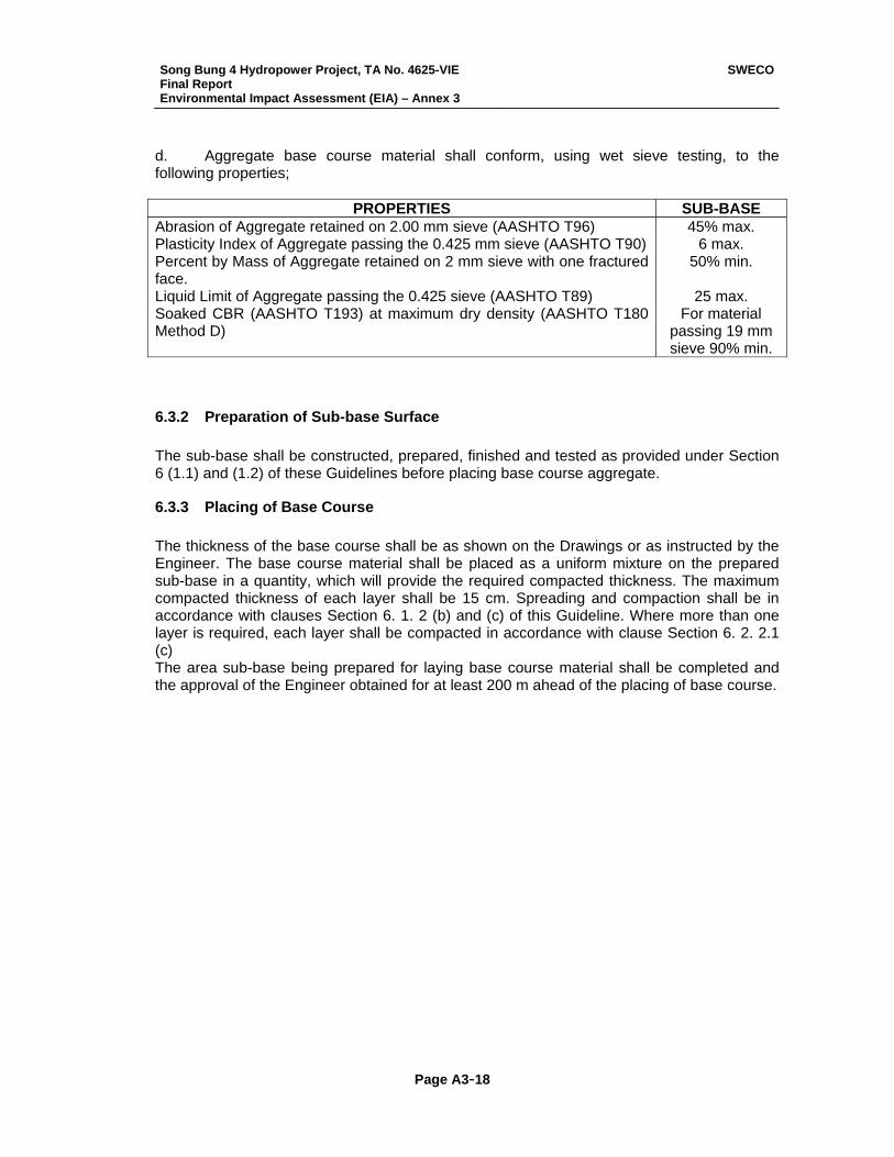
Song Bung 4 Hydropower Project, TA No. 4625-VIE Final Report Environmental Impact Assessment (EIA) – Annex 3
SWECO
Page A3-18
d. Aggregate base course material shall conform, using wet sieve testing, to the following properties;
PROPERTIES SUB-BASE Abrasion of Aggregate retained on 2.00 mm sieve (AASHTO T96) 45% max. Plasticity Index of Aggregate passing the 0.425 mm sieve (AASHTO T90) 6 max. Percent by Mass of Aggregate retained on 2 mm sieve with one fractured face.
50% min.
Liquid Limit of Aggregate passing the 0.425 sieve (AASHTO T89) 25 max. Soaked CBR (AASHTO T193) at maximum dry density (AASHTO T180 Method D)
For material passing 19 mm sieve 90% min.
6.3.2 Preparation of Sub-base Surface The sub-base shall be constructed, prepared, finished and tested as provided under Section 6 (1.1) and (1.2) of these Guidelines before placing base course aggregate.
6.3.3 Placing of Base Course The thickness of the base course shall be as shown on the Drawings or as instructed by the Engineer. The base course material shall be placed as a uniform mixture on the prepared sub-base in a quantity, which will provide the required compacted thickness. The maximum compacted thickness of each layer shall be 15 cm. Spreading and compaction shall be in accordance with clauses Section 6. 1. 2 (b) and (c) of this Guideline. Where more than one layer is required, each layer shall be compacted in accordance with clause Section 6. 2. 2.1 (c) The area sub-base being prepared for laying base course material shall be completed and the approval of the Engineer obtained for at least 200 m ahead of the placing of base course.
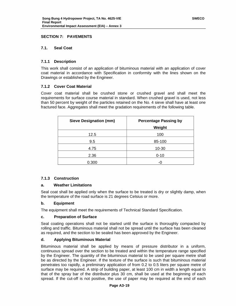
Song Bung 4 Hydropower Project, TA No. 4625-VIE Final Report Environmental Impact Assessment (EIA) – Annex 3
SWECO
Page A3-19
SECTION 7: PAVEMENTS 7.1. Seal Coat
7.1.1 Description This work shall consist of an application of bituminous material with an application of cover coat material in accordance with Specification in conformity with the lines shown on the Drawings or established by the Engineer.
7.1.2 Cover Coat Material Cover coat material shall be crushed stone or crushed gravel and shall meet the requirements for surface course material in standard. When crushed gravel is used, not less than 50 percent by weight of the particles retained on the No. 4 sieve shall have at least one fractured face. Aggregates shall meet the gradation requirements of the following table.
Sieve Designation (mm) Percentage Passing by Weight
12.5 100
9.5 85-100
4.75 10-30
2.36 0-10
0.300 -0
7.1.3 Construction a. Weather Limitations Seal coat shall be applied only when the surface to be treated is dry or slightly damp, when the temperature of the road surface is 21 degrees Celsius or more.
b. Equipment The equipment shall meet the requirements of Technical Standard Specification.
c. Preparation of Surface Seal coating operations shall not be started until the surface is thoroughly compacted by rolling and traffic. Bituminous material shall not be spread until the surface has been cleaned as required, and the section to be sealed has been approved by the Engineer.
d. Applying Bituminous Material Bituminous material shall be applied by means of pressure distributor in a uniform, continuous spread over the section to be treated and within the temperature range specified by the Engineer. The quantity of the bituminous material to be used per square metre shall be as directed by the Engineer. If the texture of the surface is such that bituminous material penetrates too rapidly, a preliminary application of from 0.2 to 0.5 liters per square metre of surface may be required. A strip of building paper, at least 100 cm in width a length equal to that of the spray bar of the distributor plus 30 cm, shall be used at the beginning of each spread. If the cut-off is not positive, the use of paper may be required at the end of each
Song Bung 4 Hydropower Project, TA No. 4625-VIE Final Report Environmental Impact Assessment (EIA) – Annex 3
SWECO
Page A3-20
spread. The paper shall be removed and disposed of in a satisfactory manner. The distributor shall be moving forward at proper application speed at the time the spray bar is opened. Any skipped arrears of deficiencies shall be corrected. Junction of spreads shall be carefully made to assure a smooth riding surface. The length of bituminous material shall not be in excess o that which approved spreading equipment can immediately cover with approved material.
The spread of bituminous material shall not be more than 15 cm wider than the width covered by the cover coat material from the spreading device. Under no circumstances shall operation proceed in such manner that bituminous material will be allowed to chill, set up, or otherwise impair retention of the cover coat.
The distributor, when not spreading, shall be parked so that the spray bar of mechanism will not drip bituminous material on the surface of the traveled way.
e. Application of Cover Coat Material Immediately following the application of the bituminous material, cover coat for seal shall be spread in quantities as designated. Spreading shall be accomplished in such a manner that the tyres of the approved aggregate spreader at no time contact the uncovered and newly applied bituminous material.
If directed, the cover coat material shall be moistened with water to eliminate or reduce the dust coating of the aggregate. Moistening shall be done the day before the used of the aggregate.
Immediately after the cover coat material is spread, any deficient areas shall be covered by additional material. Initial rolling shall begin immediately behind the spreader and shall consist of one complete coverage with a power roller. Pneumatic tyre rolling shall begin immediately after completion of the initial rolling and shall be completed the same day the bituminous material and cover coat material are applied.
After the application of the cover coat material, the surface shall be lightly broomed or otherwise maintained as directed for a period of 4 days or as directed by the Engineer. Maintenance of the surface shall include the distribution of cover coat material over the surface to absorb any free bituminous material and to cover any area deficient in cover coat material. The maintenance shall be conducted so as not to displace embedded material. Excess material shall be swept at the time determined by the Engineer.
7.2. Asphalt Concrete (For Highway)
7.2.1 Description This work shall consist of aggregate and bituminous material mixed in a central plant and spread and compacted on a prepared surface in accordance with these Guideline and in close conformity with the lines, grades, thickness and typical cross sections shown on the Drawing of established by the Engineer.
7.2.2 Construction a. Equipment
The mixing plant and all equipment used for hauling and laying the bituminous mixture shall comply with requirements of Specifications. The Contractor shall provide suitable means of keeping all small tools clean and free from accumulation of bituminous material. He shall provide and have ready for use at all times enough tarpaulins or covers, as may be directed by the Engineer, for in any emergency such as rain, chilling wind, or unavoidable delay, for
Song Bung 4 Hydropower Project, TA No. 4625-VIE Final Report Environmental Impact Assessment (EIA) – Annex 3
SWECO
Page A3-21
the purpose of covering or protecting nay material that may have been dumped, or spread but not compacted.
b. Preparation of bituminous material
The bituminous material shall be heated to the specified temperature in a manner that will avoid local overheating and provide a continuous supply of the bituminous material to the mixer at a uniform temperature at all times, The maximum temperature of asphalt cement delivered to the mixed shall not be more than 2 degrees Celsius above the temperature as specified in (c) hereof for aggregate. Asphalt cement shall not be used while it is foaming nor shall it be heated above 175 degrees Celsius at any time.
c. Preparation of Aggregates
The aggregates for the mixture shall be dried and heated to the required temperature. Flames used for drying and heating shall be properly adjusted to avoid damage to the aggregate and to avoid soot on the aggregate. Immediately after heating an drying, the aggregates shall be screened into three or more fractions as specified and conveyed into separate compartments ready for batching and mixing with bituminous material. When asphalt cement is used, the temperature of the aggregates as introduced into the mixer, including the tolerance permitted by the job-mix formula, shall not exceed that at which the asphalt cement has a Saybolt Furol viscosity of 100 seconds, determined by AASHTO T72. It shall not be lower than is required to obtain complete coating and uniform distribution of the aggregate particles and to provide a mixture of satisfactory workability.
d. Mixing
The dried aggregate shall be combined in the mixer in the amount of each fraction of aggregates required to meet the job-mix formula. The bituminous material shall be measured or gauged and introduced into the mixer in the amount specified by the job-mix formula.
After the required amounts of aggregate and bituminous material have been introduced into the mixer, unless otherwise specified, the material shall be mixed until a complete and uniform coating of the particles and a thorough distribution of the bituminous material throughout the aggregate is secured. Wet mixing time will be determined by the Engineer for each plant and for each type of aggregate used.
For plant mix bituminous pavement, the mixture shall be produced as closely as practicable to the lowest temperature that will produce a workable mix within the specified temperature range.
e. Transporting, Spreading and Finishing
The mixture shall be transported from the mixing plant to the point of use in vehicles conforming to the requirements of Technical Specification. No loads shall be sent out so late in the day as to prevent completion of the spreading and compaction of the mixture during daylight hours unless with the Engineers approval and satisfactory illumination is provided.
Each vehicle shall be weighed after each loading at the mixer and a record shall be kept of the gross weight, tare, net weight, and time of day of each load operation. The mixture shall be delivered at a temperature between 125 degrees Celsius and 160 degrees Celsius of asphalt mix.
The mixture shall be laid upon an approved surface, spread and struck off to the grade and elevation established. Bituminous pavers shall be used to distribute the mixture either over the entire width or over such partial width as may be practical.
The longitudinal joint in own layer shall offset that in the layer immediately below by approximately 15 cm; however, the joint in the top layer shall be at the center line of the
Song Bung 4 Hydropower Project, TA No. 4625-VIE Final Report Environmental Impact Assessment (EIA) – Annex 3
SWECO
Page A3-22
pavement if the roadway comprises two lanes in width, or at lane lines if the roadway is more than 2 lanes in width, unless otherwise directed.
On areas where irregularities or unavoidable obstacles make the use of mechanical spreading and finishing equipment impracticable, the mixture shall be spread, raked and leveled by hand tools. For such areas the mixture shall be dumped, spread and screeded to give the required compacted thickness.
When production of the mixture can be maintained and when practical, pavers shall be used in echelon to place the wearing course in adjacent lanes.
The Contractor shall carry out such tests as are necessary to determine the uncompacted thickness of mixture to be laid for compaction to conform to the required finished depths. The uncompacted material immediately behind the paver shall then be measured at frequent intervals and adjustments made to ensure conformity with nominal depths.
f. Compaction
After the bituminous mixture has been spread, struck off and surface irregularities adjusted, it shall be thoroughly and uniformly compacted by rolling. The specific gravity of the consolidated mixture, as determined by AASHTO T230 shall be not less than 95 percent of the specific gravity of laboratory compacted specimens composed pf the same materials in like proportion.
Laboratory specimens will consist of cylinders of the mixture compacted by the procedures of AASHTO T167. For aggregates containing particles with diameters of T 167 modified to employ 10 repetitions of a moulding load of 85 kg per square cm with no appreciable holding time after each application of the full load.
The surface shall be rolled when the mixture is in proper condition and when the rolling does not caused undue displacement, cracking or shoving.
The number, weight and type of rollers furnished shall be sufficient to obtain the required compaction while the mixture is in a workable condition. The sequence of rolling operations and the selection of roller types shall provide the specified pavement density.
Unless otherwise directed, rolling shall begin at the sides and proceed longitudinally parallel to the road center line, each trip overlapping one-half the roller width, gradually progressing to the crown of the road. When paving in echelon or abutting a previously placed lane, the longitudinal joint should be rolled first followed by the regular rolling procedure. On super-elevated curves the rolling shall begin at the low side and progress to the high side by overlapping of longitudinal trips parallel to the center line.
Rollers shall move at a slow but uniform speed with the drive roll of wheels nearest the paver. Rolling shall be continued until all roller marks are eliminated and at least the minimum density indicated above has been attained. Care shall be exercised in rolling not to displace the line and grade of the edges of the bituminous mixture.
To prevent adhesion of the mixture to the rollers, the wheels shall not be kept properly moistened with water or water mixed with very small quantities of detergent or other approved material. Excess liquid will not be permitted. Along forms, headers, walls and other places not accessible to the rollers, the mixture shall be thoroughly compacted with hot hand tampers, smoothing irons or with mechanical tampers. On depressed areas, a trench roller may be used or cleared compression strips may be used under the roller to transmit compression to the depressed area.
Any mixture that becomes loose and broken, mixed with dirt, or is in any way defective shall be removed and replaced with a fresh hot mixture, which shall be compacted to conform to the surrounding area. Any area showing an excess or deficiency of bituminous material shall
Song Bung 4 Hydropower Project, TA No. 4625-VIE Final Report Environmental Impact Assessment (EIA) – Annex 3
SWECO
Page A3-23
be removed and replaced. No traffic shall be permitted on the final course in less than 12 hours after completion unless authorized by the Engineer.
g. Joint, Trimming Edges and Clean-up
Placing of the bituminous paving shall be as continuous as possible. Rollers shall not pass over the unprotected end of a freshly laid mixture unless authorized by the Engineer. Transverse joints shall be formed by cutting back on the previous run to expose the full depth of the course. Where pavers are not used in echelon to place the wearing course in adjacent lanes and where the edges of the previously laid wearing course are, in the opinion of the Engineer, in such condition that the quality of the completed joint will be affected, longitudinal joints shall be trimmed to a vertical face and to a neat line. The exposed edges of the completed mat shall be cut off true to the required lines. Material trimmed from the edges and any other discarded or rejected bituminous mixture shall be removed from the roadway and disposed of by the Contractor as instructed by the Engineer. When directed by the Engineer, a brush coat of bituminous material shall be used on contact surfaces of joints just before additional mixture is placed against the previously rolled material.
h. Surface Tolerance
The variation of the surface from the testing edge of a straightedge between any two contacts with the surface shall not exceed the allowable tolerances. For base course and binder course, the test for conformity shall be made immediately after initial rolling and variation shall be corrected by removing or adding materials as may be necessary. Rolling shall then be continued as specified. Removal or addition of material to the surface course will not be permitted after rolling has commenced. Work on surface course shall be carefully controlled to ensure that material as laid conform to the allowable tolerance.
i. Overlay and Regulating
Where the contract requires the overlay of an existing pavement this shall be carried out strictly in accordance with the Engineer’s instructions. The Engineer may instruct that a layer of the pavement be laid over a partial width or to a restricted length if this is necessary to facilitate the regulation of levels.
k. Frequency of Tests
Control of bituminous mixture and acceptance sampling and testing shall be carried out in accordance with applicable Vietnamese Standard (TCVN) or the Engineer’s instructions.
Song Bung 4 Hydropower Project, TA No. 4625-VIE Final Report Environmental Impact Assessment (EIA) – Annex 3
SWECO
Page A3-24
SECTION 8: DRAINAGE, PIPES AND OUTLETS 8.1 Scope This work shall consist of the construction of drainage pipes and culverts, box culverts and other drainage facilities in accordance with these Guidelines and the specifications for other work items involved, all in conformity with the lines, grades and dimensions instructed by the Engineer. 8.2 Description The work shall consist of reinforced concrete drainage pipes furnished and installed in accordance with these Guidelines and in conformity with the lines, levels and other details decided by the Engineer as a result of the Contractor’s survey mentioned in Technical Specification. 8.3 Materials All drainage pipes shall be factory manufactured and before the Contractor places any orders for the supply of pipes, the factory must be inspected and approved in writing by the Engineer. In cases where the supply of factory made pipes is not possible then pipe details shall be as shown on the Drawings and the Contractor shall submit for the Engineer’s approval, full details of his proposed arrangements for the manufacture, curing and handling of reinforced concrete pipes. Formwork used in the manufacture shall be steel and of rigid construction. All details shall comply with the relevant requirements of Technical Standard of these Guidelines. 8.4 Construction a. Excavation Prior to starting excavation the Contractor shall take all necessary measures to keep the excavation free from free-surface water or surface water run-off. Except as otherwise instructed by the Engineer, in areas of fill, filling shall be completed at least to a depth of one pipe diameter above the top of the pipe, before excavation begins. All excavation shall be carried out so as to minimize damage to existing surfaces. The sides of pits and trenches shall be adequately supported at all times. Except where otherwise described in the Contract, they shall not be battered. The supports shall be left in pits or trenches only where described in the Contract. Excavated material not required for back filling shall be dealt with in accordance with Technical Specification of these Guidelines. Soft spots in the bottom of drainage excavation shall be removed and the resulting void immediately back-filled with Granular Backfill to Technical Specification. When the Engineer instructs this additional treatment it will be paid for under the relevant clauses of this Guideline. Where the Engineer considers that soft spots are due to the Contractor’s failure to fulfill his obligations under any clause of these Guidelines then the Contractor shall at his own expense, undertake the additional excavation and replacement with Granular Backfill to the satisfaction of the Engineer.
Song Bung 4 Hydropower Project, TA No. 4625-VIE Final Report Environmental Impact Assessment (EIA) – Annex 3
SWECO
Page A3-25
Any suitable material below the level of the concrete pipe bed, which is removed unnecessarily, shall be replaced at the Contractor’s expense with Granular Backfill in accordance with Technical Specification of these Guidelines. b. Bedding, Laying and Surrounding of Pipes All pipes shall be laid, using cradles if necessary, to the true line and level as directed by the Engineer. Joints shall be sealed with 1:2 cement mortar, except where otherwise specified, so that water will not leak. The inside of the joint shall be wiped and finished smooth and the outside shall be protected for two days or as otherwise directed by the Engineer to prevent cracking. The external face of the joint shall then be treated/ sealed as shown on the Drawings. After the Engineer has checked and approved the pipes and joints, the Contractor will complete the concrete bedding and haunching or surrounding as instructed by the Engineer. Concrete shall be thoroughly compacted to the dimensions shown on the Drawings, but special care should be taken to avoid dislodging the pipes or damaging the joints. c. Backfilling and Reinstatement Back filling shall not commence until in the opinion of the Engineer, the concrete has achieved sufficient strength. Backfilling shall be carried out in accordance with the requirements of Technical Specification, except that the material used for backfill around piles for a minimum distance of 50 cm shall be sand in place of excavated material. Where insufficient suitable material is available from any particular pipe excavation, surplus material from any other excavation shall be used. On completion of backfilling, the area excavated shall be reinstated to its original condition but the Engineer may waive or modify this requirement if the area is to be overlaid or reconstructed under other Clauses of this Contract.
Song Bung 4 Hydropower Project, TA No. 4625-VIE Final Report Environmental Impact Assessment (EIA) – Annex 3
SWECO
Page A3-26
SECTION 9: MISCELLANEOUS 9.1. Grassed Areas
9.1.1 Description This work shall consist of providing topsoil and a grass cover to areas as shown on the drawings by furnishing and planting either a) prepared grass sods, or b) sprigs of living grass plants. The work with grass sods will be divided into solid sodding and strip sodding as described further below.
9.1.2 Material a. Sodding The species of grass selected shall be rapid spreading, free of disease and noxious weeds and shall be deep rooted. The source of sods will be approved by the Engineer before cutting and delivery to the Project and the Contractor shall notify the Engineer not less than 3 days before cutting of sods begins. Sods shall be planted with their root system substantially undamaged and cut into blocks with moist earth in which they have grown. Sods shall be laid within 5 days of cutting. Sod blocks shall be hauled and stored in such manner that they will be protected from direct sun rays, provided with air circulation, and prevented against drying. b. Sprigs These shall be healthy ling stems (stolons or rhizomes) with attached roots or perennial turf forming grasses harvested without adhering soil. They shall be obtained from approved sources which are quick spreading and capable of forming a thickly matted growth.
9.1.3 Construction a. General Works in any area shall not take place until completion of the work of landscape filling and tree planting under Technical Standard Specification. Surfaces shall be scarified and shaped after removing debris, gravel and weeds. All stones of more than 3 cm diameter shall be removed. The surfaces shall be made up as necessary with good quality topsoil so as to ensure that the finished thickness of the work (including any sod or top dressing) is not less than 20 cm. The Contractor will be responsible for ensuring a healthy growth in sodded/ sprigged areas and necessary treatments before or after sodding will be at the Contractor’s own expense. This may include lime to neutralize any existing sour condition of the soil and subsequently Urea or NPK fertilizer, to promote growth. b. Sodding Sod blocks shall be placed so as to cover 50% of the surface by forming sod strips at the interval of 30 cm (this will be called “Strip Sodding”), or to cover entire surfaces (which shall be called “Solid Sodding”), as noted in the Drawings or directed by the Engineer. In strip sodding joints shall be staggered to form a broken bond. Joints between adjacent sod blocks shall not exceed 0.5 cm. Sod blocks shall be placed in smooth finish and compacted by a
Song Bung 4 Hydropower Project, TA No. 4625-VIE Final Report Environmental Impact Assessment (EIA) – Annex 3
SWECO
Page A3-27
roller of 100 kg weight or by tamper plate. Sand shall be spread over the grass sods already laid and into the joints and the whole area shall be watered twice daily until the grass has taken firm root. Sufficient bamboo stakes shall be used to prevent the sod blocks slipping when sodding is provided on slopes. c. Sprigging Before harvesting of the sprigs, the grass shall be mowed to a height of 50 to 75 mm and all clippings and waste materials removed. Sprigs shall then be loosened by cross disking shallow ploughing or other acceptable methods. After loosening the sprigs from the soil they shall be promptly gathered into small piles or windrows, watered and kept moist until they are planted. The time between harvesting and planting shall not exceed 24 hours. Sprigs that have been heated in stockpiles, permitted to dry out or otherwise damaged shall be rejected. Sprigging shall not be done during windy weather, or when the ground is dry, excessively wet, or otherwise untillable. The method shall be approved by the Engineer considering the location and condition of the area to be treated, but will generally be one, or more, of the following:
(i) Broadcast Sprigging Sprigs shall be broadcast by hand or by suitable equipment in a uniform layer with spacing between sprigs not to exceed 150 mm. The sprigs shall then be forced into the soil to a depth of 50 to 100 mm with a straight spade or similar tool, or with a disk harrow or other equipment set to cover the sprigs to the required depth. (ii) Row Sprigging Furrows shall be opened along the approximate contours of the slopes at a spacing and depth approved by the Engineer. Sprigs shall be placed without delay in continuous rows along the open furrow with successive sprigs touching. The sprigs shall then be covered immediately. (iii) Spot Sprigging Spot sprigging shall be performed as specified under row sprigging except that instead of planting in continuous row, groups of four sprigs or more shall be spaced 450 mm apart in the rows. Within 24 hours of sprigging the area shall be lightly rolled or tamped but this work shall not be done if the soil condition is such that it is picked up by the equipment.
d. Maintenance The Contractor shall protect the newly grassed areas by means of barriers or warning signs. The Contractor shall maintain watering and other incidental operations and all treated areas will be subject to special checks, 2 and 12 months after they have been laid. Any areas in which grass is not maintaining a healthy growth shall be repaired or re-furnished by the Contractor at his own expense. The Contractor will be responsible for cutting and keeping clean any grassed areas until completion of the Period of Warranty. 9.2. Slope Protection
9.2.1 Description This work shall consist of slope protection by means of dry placing of stone riprap, or concrete blocks, or rock filled gabion baskets. Slope protection shall be furnished and constructed in accordance with these Specifications and in conformity with the lines, grades and dimensions shown on the Drawings or required by the Engineer.
Song Bung 4 Hydropower Project, TA No. 4625-VIE Final Report Environmental Impact Assessment (EIA) – Annex 3
SWECO
Page A3-28
9.2.2 Materials Stone for riprap shall consist of field stone or unhewn quarry stone as nearly rectangular in section as is practical. The stone shall be sound, tough, durable, dense, resistant to the action of air and water, and suitable in all respects for the purpose intended. Adobe blocks shall not be used for riprap work. Stone pieces for protecting slopes shall range in weight from a minimum of 2 kg to a maximum of 20 kg with not les than 60 percent of the stones weighing more than 12kg. Concrete blocks shall be solid plain rectangular blocks of the dimensions shown on the drawings. Representative sample blocks shall be submitted to the Engineer for approval before orders are given to the suppliers or manufacturers. Gabion baskets shall be formed of galvanized wire mesh of minimum diameter of 3.05 mm and tensile strength of 4,200 - 5,980 kg/ cm2 . The minimum zinc coating of the wire shall be 0.24 kg/ m2 of wire surface as determined by AASHTO T65. The rock fill for the gabions shall consist of hard durable rock pieces that will not deteriorate when submerged under water or exposed to severe weather conditions. The rock shall meet the requirements of AASHTO M63 except that the sodium sulphate loss shall not exceed 9% after 5 cycles. Rock pieces shall generally be from 100 mm to 200 mm. in size. The gabions shall be evenly filled and when completed, shall have a minimum density of 1,400 kg/m3.
9.2.3 Construction a. Preparation Slope surface on which slope protection is to be placed shall be compacted and properly smoothed after removing all vegetation. Works shall not begin until the finishing stakes are set according to the Drawings and have been inspected and approved by the Engineer. b. Riprap Stone shall be distributed and compacted so that the thickness of riprap is not less than that specified or shown on the Drawings. Stone shall be laid with close, broken joints and shall be firmly bedded into the slope and against the adjoining stones. The stones shall be laid perpendicular to the slope with ends in contact. Smaller stones shall be first laid on the slope and larger stones shall be used as surface cover. The riprap shall be thoroughly compacted as construction progresses and the finished surface shall present an even, tight surface. Interstices between stones shall be chinked with spalls firmly rammed into place. Unless otherwise provided, riprap shall be at least 60 cm in thickness, measured perpendicular to the slope. The surface of riprap shall not vary from the theoretical surface by more than 8 cm at any point. If the Engineer permits or instructs that stone is placed below the water line then the appropriate working method will be instructed at that time. c. Concrete Blocks The concrete blocks shall be filled with mortar. The finished surface shall be such that it will not exceed more than 6 mm from the testing edge between any two contacts of a 3 meters straight edge applied anywhere on the paved area. Blocks shall be neatly cut as necessary to completely fill the area to be covered to the depth shown on the drawings. In hot or dry weather the paved area shall be satisfactorily protected from the sun and shall be kept wet for a period of at least three days after completion.
Song Bung 4 Hydropower Project, TA No. 4625-VIE Final Report Environmental Impact Assessment (EIA) – Annex 3
SWECO
Page A3-29
d. Gabion Baskets The wire mesh shall be twisted to form hexagonal openings of uniform sizes. The maximum linear dimension of the mesh openings shall not exceed 100 mm and the mesh shall be fabricated in such a way as to be non-ravelling. Gabions shall be of a single unit or one edge of those members shall be connected to the base unit of the gabions in such a manner that the strength and flexibility at the point of connection is at least equal to that of the mesh. The gabion shall be equally divided by diaphragms, of the same mesh and gauge as the body of the gabion, into divided into cells the length of which does not exceed the horizontal width. The gabions shall be furnished with the necessary diaphragms secured in proper position on the base in such a manner that no additional tying at this junction is necessary. Perimeter edges shall be selvedged using 3.76 mm galvanized wire of the same tensile strength as the basket wire. Tie and connection wires shall be supplied in sufficient quantities to allow secure fastenings of all edges and diaphragms and to provide for four cross-connection wires in each cell. Tie and connection wire shall meet the same specifications as the wire used in the mesh. Empty baskets shall be set to the line and grade as shown on the Drawings or as directed by the Engineer and a standard fence stretcher or iron bar at each corner shall be used to stretch the baskets and hold their alignment. The baskets shall then be carefully hand filled with stone so as to avoid bulges and minimize voids. After filling the lid shall be bent over and secured to the ends sides and diaphragms with tie wires. 9.3. Mortared Stonework
9.3.1 Description This work shall consist of mortared stonework to be used for slope protection and channel all to be furnished and constructed in accordance with these Specifications and in conformity with lines, grades, and dimensions shown on the Drawings or as required by the Engineer.
9.3.2 Materials a. Stone shall consist of field stone or rough unhewn quarry stone, as nearly rectangular in section as is practical. The stone shall be sound, tough, durable, dense, resistant to the action of air and water, and suitable in all respects for the purpose intended. Quality and dimensions of stone shall be approved by the Engineer prior to use. Unless otherwise provided by the Drawings or Specifications, all stone shall be more than 0.008 cu. m in volume. b. Mortar shall conform to the requirements of Specifications.
9.3.3 Construction a. The earthworks shall be completed and the foundation tamped prior to placing a blinding stone base under the mortared stonework. Stone shall be securely placed by hand, and voids shall be avoided. Concrete for the footings of the slope protection shall be in accordance with the requirements of Technical Standard of these Guidelines. b. Where the design requires the placing of a concrete backing layer this shall be placed just in advance of the stone work and incorporated into the stone setting to form a composite structure.
Song Bung 4 Hydropower Project, TA No. 4625-VIE Final Report Environmental Impact Assessment (EIA) – Annex 3
SWECO
Page A3-30
c. The face surfaces of all stones shall form a smooth regular surface conforming to the shape of the channel, slope of the embankment, apron or invert being protected. No stone surface shall extend more than 15 mm above or below the general level of the channel. d. All voids between stones shall be filled and flushed with mortar but the face surface of the stone shall be left exposed. Mortar shall be placed from bottom to top and the surface shall be finished in accordance with the use purpose of the works as directed by the Engineer. The surface shall be cured as specified in Technical Standard for a period of at least three days. e. Copings shall be as shown on the Drawings. Where copings are not called for the upper surface of the mortared rubble shall be mortared and finished smooth by wooden float. f. Unless otherwise shown on the Drawings or directed by the Engineer, Mortared Stonework shall be provided with weep holes. These shall be spaced not more than 2 meters centre to centre and shall be 50 mm in diameter.
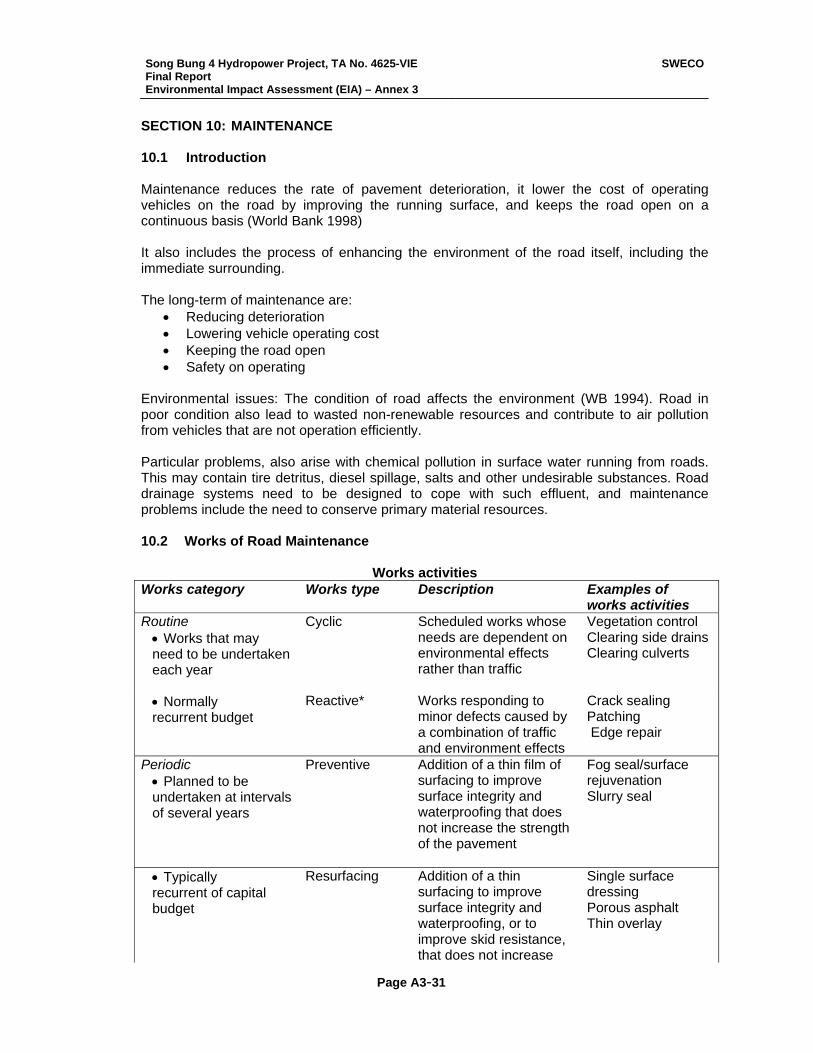
Song Bung 4 Hydropower Project, TA No. 4625-VIE Final Report Environmental Impact Assessment (EIA) – Annex 3
SWECO
Page A3-31
SECTION 10: MAINTENANCE 10.1 Introduction Maintenance reduces the rate of pavement deterioration, it lower the cost of operating vehicles on the road by improving the running surface, and keeps the road open on a continuous basis (World Bank 1998) It also includes the process of enhancing the environment of the road itself, including the immediate surrounding. The long-term of maintenance are:
• Reducing deterioration • Lowering vehicle operating cost • Keeping the road open • Safety on operating
Environmental issues: The condition of road affects the environment (WB 1994). Road in poor condition also lead to wasted non-renewable resources and contribute to air pollution from vehicles that are not operation efficiently. Particular problems, also arise with chemical pollution in surface water running from roads. This may contain tire detritus, diesel spillage, salts and other undesirable substances. Road drainage systems need to be designed to cope with such effluent, and maintenance problems include the need to conserve primary material resources. 10.2 Works of Road Maintenance
Works activities
Works category Works type Description Examples of works activities
Routine • Works that may need to be undertaken each year
Cyclic Scheduled works whose needs are dependent on environmental effects rather than traffic
Vegetation control Clearing side drains Clearing culverts
• Normally recurrent budget
Reactive* Works responding to minor defects caused by a combination of traffic and environment effects
Crack sealing Patching Edge repair
Periodic • Planned to be undertaken at intervals of several years
Preventive Addition of a thin film of surfacing to improve surface integrity and waterproofing that does not increase the strength of the pavement
Fog seal/surface rejuvenation Slurry seal
• Typically recurrent of capital budget
Resurfacing Addition of a thin surfacing to improve surface integrity and waterproofing, or to improve skid resistance, that does not increase
Single surface dressing Porous asphalt Thin overlay
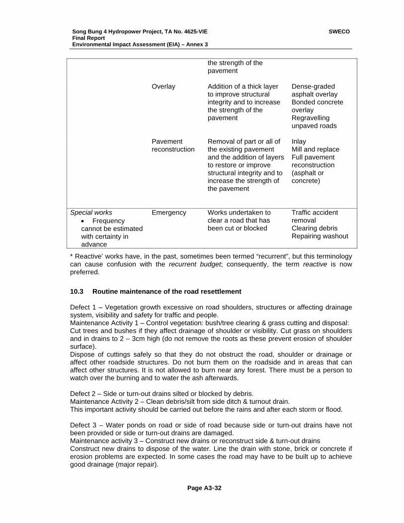
Song Bung 4 Hydropower Project, TA No. 4625-VIE Final Report Environmental Impact Assessment (EIA) – Annex 3
SWECO
Page A3-32
the strength of the pavement
Overlay Addition of a thick layer to improve structural integrity and to increase the strength of the pavement
Dense-graded asphalt overlay Bonded concrete overlay Regravelling unpaved roads
Pavement reconstruction
Removal of part or all of the existing pavement and the addition of layers to restore or improve structural integrity and to increase the strength of the pavement
Inlay Mill and replace Full pavement reconstruction (asphalt or concrete)
Special works • Frequency cannot be estimated with certainty in advance
Emergency Works undertaken to clear a road that has been cut or blocked
Traffic accident removal Clearing debris Repairing washout
* Reactive’ works have, in the past, sometimes been termed “recurrent”, but this terminology can cause confusion with the recurrent budget; consequently, the term reactive is now preferred.
10.3 Routine maintenance of the road resettlement Defect 1 – Vegetation growth excessive on road shoulders, structures or affecting drainage system, visibility and safety for traffic and people. Maintenance Activity 1 – Control vegetation: bush/tree clearing & grass cutting and disposal: Cut trees and bushes if they affect drainage of shoulder or visibility. Cut grass on shoulders and in drains to 2 – 3cm high (do not remove the roots as these prevent erosion of shoulder surface). Dispose of cuttings safely so that they do not obstruct the road, shoulder or drainage or affect other roadside structures. Do not burn them on the roadside and in areas that can affect other structures. It is not allowed to burn near any forest. There must be a person to watch over the burning and to water the ash afterwards. Defect 2 – Side or turn-out drains silted or blocked by debris. Maintenance Activity 2 – Clean debris/silt from side ditch & turnout drain. This important activity should be carried out before the rains and after each storm or flood. Defect 3 – Water ponds on road or side of road because side or turn-out drains have not been provided or side or turn-out drains are damaged. Maintenance activity 3 – Construct new drains or reconstruct side & turn-out drains Construct new drains to dispose of the water. Line the drain with stone, brick or concrete if erosion problems are expected. In some cases the road may have to be built up to achieve good drainage (major repair).
Song Bung 4 Hydropower Project, TA No. 4625-VIE Final Report Environmental Impact Assessment (EIA) – Annex 3
SWECO
Page A3-33
Defect 4 – Drains damaged or eroded Maintenance activity 4 – Repair damaged drains. Erosion from side ditch will cause silting at ditch end, affecting water drainage. Clean silt from ditch end and rebuild scour checks from bamboo, wood, stone, brick or masonry on steep section to prevent further erosion. Defect 5 – Debris or silt in or close to culvert outlet Maintenance activity 5 – Clean debris/silt from culverts. Dispose of the debris clear of the structure so that it does not cause a repeat of the problem. Try to find out where the debris comes from so that the problem can be prevented in future. Defect 6 – Slip on embankment Maintenance activity 6 – Refill embankment Slip
- Use hoes and spades to carefully remove the slip and take the waste material to a safe place.
- Clean out wet or loose material. Drain away any standing water. If the foundation is soft, lay a 10 -20 cm layer of sand to help drainage.
- If a spring is discovered, lay a pipe(s) to drain the water away. - Use soil of the same type as the embankment to fill by layers of not more than 30 cm
loose thickness. Compact each before placing the next. If the slip material already has suitable moisture content it can be used for filling (see Terminology Item 4 on Appropriate Moister Content).
- Trim the embankment to the correct slope. Plant or turf the area of repaired embankment; watering as necessary to re-establish the vegetation. Trees may be planted at the bottom of the embankment to help to stabilize the new earth works.
Defect 7 – Erosion on fill or cut slope Maintenance activity 7 – Refill slope gully Fill slope erosion due to rain water
- Firstly, cut the gully into a shape which is easy for working on (see the sketch), cut the gully edges to straight lines and make gully bottom flat.
- Fill the gully with good soil and compact with a hand rammer and then plant or turf the area.
- If there are may gullies next to each other, combine all of them into the repair. Erosion on cut slope
- If the cut slope is gentle and it is possible to fill gullies and plant or turf then repair it as mentioned above
- If the slope is steep and erosion is serious affecting stability of the slope then it must be reported to the District personnel for advice on permanent repair.
Defect 8 – Embankment toe scoured by waterway or water traffic. This defect is a common occurrence in Mekong delta and in low-lying land in Red River delta Maintenance activity 8 – Repair waterway scour
- Firstly check the depth of erosion at embankment toe to prepare soil for filling. Filling soil is soft clay or sand-clay mix. That means it can be cut into pieces by spades.
- Prepare bamboo piles. In Red River delta, it is best to use thick-flesh bamboo. Pile length is 2 to 3m. In Mekong delta, piles should be of cazeput of thickness greater than the wrist (i.e. the diameter is 7 to 10cm) and the pile length is 2-3m.
- Piles should be driven into place side by side if river waves are strong. Piles can be driven 20cm away from each other if the waves are not strong. Pile tops should be 30 to 50 cm above normal water level to reduce river traffic action.
- Place fill material behind the driven piles
Song Bung 4 Hydropower Project, TA No. 4625-VIE Final Report Environmental Impact Assessment (EIA) – Annex 3
SWECO
Page A3-34
Defect 9 – Minor landslide on to the road Maintenance activity 9 – Remove small landslide
- Extreme care must be taken to avoid further slips and injury to workers. - Carefully remove the slip material and dispose of safely so that it does not wash into
drains or farm fields. - Consult the district authorities about major landslides, or if advice is required on
dealing with small landslides. Defect 10 – Shoulder does not drain water away from road surface, or is eroded Maintenance activity 10 – Reshape/replenish shoulder surface material
- Reshape the shoulder so that it slopes away from the road at about 5% (1:20), allowing water to drain off the road surface. Use cross fall template to check the slope.
- Shoulder erosion: cut back to a sound, dry foundation. Clean out loose material. Repair shoulders with laterite or other good material in 10cm (maximum) layers. Water and compact the new material to the final crossfall slope (5%).
- Note that the inner edge of shoulder must be level with outer edge of road surface. Defect 11 – Dry and dusty surface Dust is traffic hazard. It is also a nuisance to road users and people living nearby particularly on sections going through settlements. Maintenance activity 11 – Spray water Spray water to dampen the road surface. Defect 12 – Potholes (earth/gravel/stone macadam/ brick road) Maintenance activity 12 – Fill potholes (earth or gravel or stone macadam road)
- Potholes can take any shape. Dig the pothole into multisided shape as shown in the sketch and the bottom of the new shape must be 3cm deeper than bottom of pothole. Cut sides of pothole into vertical edges. For stone macadam surfaces the pothole repair should extend down to the base of the layer.
- Use material of the same type with existing material to fill in pothole in layers of not more than 10cm. Compact each layer before placing the next. Use hand rammer, vibrating plate or jumping compactor to compact. Filled material must have suitable moisture content.
- Final layer should be filled loose 1 to 2cm higher than surrounding level and then well compacted and trimmed level with the exiting surface.
- When repairing deep potholes, the finished repair may be left a little above the surrounding surface to allow for slight settlement under traffic.
- Overfill recommendations. For stone block or brick paving,
- Cut out the damaged area with hammers and chisels or crowbars. Use goggles to protect the eyes. Trim the size of the pothole suitable to fit the replacement paving materials.
- Excavate and replace any weak or wet material under the pothole. - If the base of the excavation is wet, dig a channel and fill with stone chippings to drain
the excavation to the side of the road. - Compact the base of the excavation with a hand rammer. - Fill the pothole and compact each layer as necessary to match the existing pavement
construction. Defect 13 – Soft spots or local depression on gravel or stone macadam road. Maintenance activity 13 – Repair ponding or soft spot
Song Bung 4 Hydropower Project, TA No. 4625-VIE Final Report Environmental Impact Assessment (EIA) – Annex 3
SWECO
Page A3-35
- This is caused by waterlogged foundation. Therefore, the area should be checked to see how water can penetrate (rain water, ponding water or spring). Drain off any standing water by providing drains, providing sand layer, re-excavating side ditch etc. If the problem is caused by ponding water or spring then it should be reported to the district for advice.
- Remove the surface and all soft material, dispose of unsuitable material safely so that it does not wash back into drains.
- Build up the roadway with suitable material with appropriate moisture content. Build up in 10cm layers, compact each layer before laying the next.
- Resurface the road and compact. Defect 14 – Road surface corrugated – unpaved road Maintenance activity 14 – Remove corrugations
- Corrugations are caused by traffic action and often occur on the surface of unbound material.
- Repair corrugations: According to international experience, drags can be made from old tires or steel beam, e.g. an “I” steel beam. The drag is towed along the road with a vehicle e.g. cong nong, tractor or bulldozer.
- A 400 mm steel I beam, 2m long, of approximately 180kg weight has been successfully used in Vietnam.
- In dry weather it may be advisable to dampen the road surface before dragging to avoid dust.
- Dragging does not alter the camber or crossfall of the surface. If reshaping is required this should be carried out as separate activity
Defect 15 – Road surface does not drain to the edge of the road If the water does not drain off the road surface, it will quickly become damaged, and require expensive repairs. Maintenance activity 15 – Reshape road camber (by labour):
- Use picks, hoes, rakes or shovels to redistribute the surface material to create a camber so that it slopes and drains away from the centre of the road at about 5%. Use wooden or bamboo pegs to set out the correct surface levels and cross fall with the aid of a camber template, or straight edge, spirit level and measuring tape. If additional material is required to fill depressions, low areas or ruts, the use material of the same type. Loosen the low areas with picks before filling to create a rough surface to increase cohesion between filling material and the repaired surface. Material should be at an appropriate moisture content before compacting. The first compaction should be done from road edge to road center. Rut fill material should be well compacted in layers. Compaction may be carried out by using hand rammers, jumping compactor, vibrating plate compactor or roller.
- This activity may also be carried out by mechanized methods (towed or motorized grader) in areas of low population or where funds and resources are available – see Maintenance activity 16.
Defect 16 – Road surface corrugated or poor camber – unpaved road Maintenance activity 16 – Reshape road camber (by equipment):
- This activity must be carefully carried out on an earth gravel, laterite or stone macadam surface as more damage then good may be caused if incorrectly carried out. Large motor graders are not suitable for this activity on narrow commune roads as they and their blades are too large. The work should be carried out by a small motor grader (<100hp or 75kW), or by tractor towed grader.
Song Bung 4 Hydropower Project, TA No. 4625-VIE Final Report Environmental Impact Assessment (EIA) – Annex 3
SWECO
Page A3-36
- The objective of grading is to remove corrugations and restore the camber by returning material from the sides of the road to the centre of the road to form a cross fall of about 5%.
- Work is best scheduled to follow a period of rain, as the moisture in the material will greatly assist compaction by rollers of traffic.
- Patching of large potholes of depressions should be carried out as a separate activity prior to grading. Areas of standing water should be drained. It may be necessary to scarify the exiting surface to cut to the bottom of any defects and loosen the material for reshaping.
- The grader will work on one side of the road at a time, making passes to cut and move material across the road surface. Each pass should be about 200 meters or to a convenient turning point.
- Normally initial cutting passes are required to bring material from the edges of the road surface. Spreading passes redistribute the material away from the centre of the road. An even number of passes should be used to avoid a flat crown to the road.
- Light grading will require about 4 passes to bring material to the centre and spread it out to the correct camber.
- Heavy grading will be required on a poor, uneven surface. Additional passes will be required to reshape e the camber.
- The finished camber should be 5%, checked with a camber board every 100 meters. - Compaction after grading at an appropriate moisture content will make the surface
more durable, reduce gravel loss and extend the period of time until the next grading.
10.4 Activities of Road Maintenance to minimize the negative impacts on the
reservoir
Resource requirements Activity
Equipment Materials Output unit
Grass cutting by hand Cutlasses — m3/worker-day
Clearing side drains by hand
Shovels, cutlasses, picks
— m/worker-day
Clearing culverts Shovels, head-pans/wheel barrows
— no/worker-week
Minor repair to culverts
Masons’ tools Cement, aggregate, sand
no/worker-week
Major repairs to culverts
To be assessed for each job
worker-day
Grading unpaved surface
Grader, camber board, spirit level
— pass-km/day (1)
Dragging unpaved surfaces
Tractor and drag — pass-km/day (1)`
Patching bituminous surfacing
Pedestrian roller or hand rammers, brushes, picks, shovels, watering cans
Premix or gravel, bitumen, bitumen emulsion, chippings or washed gravel
m3/worker-day
Filling gravel surfaces Pedestrian roller or hand rammers, brushes, picks, shovels,
Gravel m3/worker-day
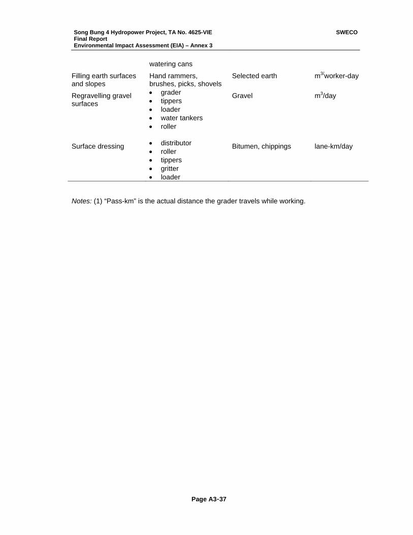
Song Bung 4 Hydropower Project, TA No. 4625-VIE Final Report Environmental Impact Assessment (EIA) – Annex 3
SWECO
Page A3-37
watering cans
Filling earth surfaces and slopes
Hand rammers, brushes, picks, shovels
Selected earth m3/worker-day
Regravelling gravel surfaces
• grader • tippers • loader • water tankers • roller
Gravel m3/day
Surface dressing • distributor • roller • tippers • gritter • loader
Bitumen, chippings lane-km/day
Notes: (1) “Pass-km” is the actual distance the grader travels while working.
Song Bung 4 Hydropower Project, TA No. 4625-VIE Final Report Environmental Impact Assessment (EIA) – Annex 3
SWECO
Page A3-38
SECTION 11: ENVIRONMENTAL MANAGEMENT
11.1 General a. Before the start of site works, the Contractor shall submit his Environmental Management Plan (EMP) for the Engineer’s approval. The EMP shall address all the potential impacts and all recommended mitigation measures. b. If the Contractor proposes to change, he shall notify the Engineer in writing at least seven (7) calendar days prior to any proposed change. Proposed changes are subject to the Engineer’s approval. If the Engineer makes any subsequent recommendation or instructions on the EMP in writing, the Contractor shall revise the EMP accordingly. c. The Contractor shall carry out the work in full compliance with Vietnamese Standards (TCVN), law, ordinance, and other regulations on environment, and in full compliance with the approved Environmental Management Plan and the Engineer’s instructions. d. The work of Environmental Monitoring will be carried out by a nominated Subcontractor as described in Sub-clause 3. 11.2 EMP layout The EMP shall include the following sections:
11.2.1 Contractor’s Organization a. Organizational Chart showing position of persons with environmental responsibilities (including sub-contractors). b. Identify persons responsible for environmental matters, level of authority, reporting lines and contact details; state whether other responsibilities are held and the percentage of time given over to environmental matters. c. Environmental lines of communications (Employer/ Engineer/ Contractor/ Sub-contractors/ Authorities/ Public) and means by which reporting and training can be confirmed.
11.2.2 Environmental Management Approach General a. Environmental Policy Statement signed by the Chairman or other senior officer of the Contractor declaring the commitment to achieving the environmental requirements. b. Method of promoting environmental awareness both amongst on site staff and to the surrounding community such that an awareness of the measures implemented to minimize impacts is promoted. d. Specific procedures for achieving the environmental performance requirements
specified in the relevant legislation. Air a. Related Regulations:
• TCVN 5937-1995 Air Quality – Ambient Air Quality Standards
Song Bung 4 Hydropower Project, TA No. 4625-VIE Final Report Environmental Impact Assessment (EIA) – Annex 3
SWECO
Page A3-39
• TCVN 5938-1995 Air Quality – Maximum Allowable Concentration of Hazardous Substances in Ambient Air
b. Mitigation Measures
(i) Environmental Conservation Criteria (Statutory requirements and proposed
conservation targets) (ii) Proposed mitigation measures to achieve environmental conservation criteria
(e.g., Filters, water spraying) (iii) On-site procedures for implementation of mitigation measures
c. Corrective Action
(i) Proposed corrective action in case of non-conformance (ii) Communications in case of non-conformance
d. Preventive Action
(i) Proposed preventive action (e.g., Regular maintenance of pollution prevention equipment, regular site inspections, good housekeeping, etc.)
(ii) Air Quality Monitoring
Water a. Related Regulations:
• TCVN 5942-1995 Water Quality – Surface Water Quality Standard b. Mitigation Measures
(i) Environmental Conservation Criteria (Statutory requirements and proposed
conservation targets) (ii) Proposed mitigation measures to achieve environmental conservation criteria
(e.g., Sedimentation tanks, chemical toilets, conservation, re-use, recycle, etc.) c. Corrective Action
(i) Proposed corrective action in case of non-conformance (ii) Communications in case of non-conformance
d. Preventive Action
(i) Proposed preventive action (e.g., Regular maintenance of pollution prevention equipment, regular site inspections, good housekeeping, etc.)
(ii) Water Quality Monitoring Noise a. Related Regulations:
• TCVN 5948-1999 Acoustics – Noise Emitted by Accelerating Road Vehicles – Maximum Permitted Noise Level
Song Bung 4 Hydropower Project, TA No. 4625-VIE Final Report Environmental Impact Assessment (EIA) – Annex 3
SWECO
Page A3-40
• TCVN 5949 – 1998 Acoustics – Noise in Public and Residential Areas – Maximum Permitted Noise Level
b. Mitigation Measures
(i) Environmental Conservation Criteria (Statutory requirements and proposed
conservation targets) (ii) Proposed mitigation measures to achieve environmental conservation criteria
(e.g., Low noise equipment, etc.) c. Corrective Action
(i) Proposed corrective action in case of non-conformance (ii) Communications in case of non-conformance
d. Preventive Action
(i) Proposed preventive action (e.g., Regular maintenance of pollution prevention
equipment, regular site inspections, etc.) (ii) Noise Monitoring
Waste a. Related Regulations:
• Government Decree No. 175/CP, Government Decree on providing Guidance for the Implementation of the Law on Environmental Protection, 1994.
b. Mitigation Measures
(i) Environmental Conservation Criteria (Statutory requirements and proposed
conservation targets) (ii) Waste Management Plan including proposed mitigation measures (e.g., Waste
minimization, waste segregation, etc.) (iii) Storage provision (iv) Procedure for disposal of chemical wastes (v) On-site procedures for implementation of mitigation measures
c. Corrective Action
(i) Proposed corrective in case of non-conformance (ii) Communication in case of non-conformance
d. Preventive Action
(i) Proposed preventive action (e.g., Regular site inspections, good housekeeping, etc.)
Hazardous Substances a. Related Regulations:
Song Bung 4 Hydropower Project, TA No. 4625-VIE Final Report Environmental Impact Assessment (EIA) – Annex 3
SWECO
Page A3-41
• TCVN 5938-1995 Air Quality Maximum Allowable Concentration of Hazardous Substances in Ambient Air
• Decision No. 2242 QD/KHKT-DC on Regulations of Environmental Protection in Transport Sector, Ministry of Transport, 1997
b. Storage
(i) Proposed locations of hazardous substances sore (ii) Design of hazardous substances stores
c. Handling Procedures
(i) Proposed handling procedures of hazardous substances (e.g., HS stores to be
locked at night, etc.) Chemical Management a. Chemical Inventory
(i) An inventory of chemical and its Material Safety Data Sheet to be used for
construction activities (e.g., Solvents, lube oil, etc.) (ii) Proposed intervals for updating the inventory
b. Handling Procedures
(i) Proposed handling procedures of chemicals (ii) Spill control procedures
c. Storage
(i) Proposed locations of chemical stores (ii) Design of chemical stores
A similar approach will need to be adopted for the presentation of procedures and provisions to be followed to mange the construction process, as it relates to:
• Ecological Resources; • Landscape Preservation; • Archaeological and Historical Resources, etc.
Environmental Emergency Procedures Emergency procedures for dealing with emergency environmental situations shall be covered by the specific requirements and provisions of the plan. These may include Spillage control procedures and provisions for reacting to the release of chemicals to the environment. General House Keeping a. Site inspections b. Pest control c. General waste disposal d. Site cleanliness
Song Bung 4 Hydropower Project, TA No. 4625-VIE Final Report Environmental Impact Assessment (EIA) – Annex 3
SWECO
Page A3-42
11.2.3 Environmental Record Records to be kept a. Waste Disposal b. Licenses c. Staff training records d. Correspondences with authorities e. Environmental complaints f. Person(s) responsible for the records and locations of the records 11.3 Environmental Monitoring
11.3.1 Description This work shall comprise the monitoring to record the possible adverse environmental impact during the contract period as required under the relevant laws and regulations of the Socialist Republic of Vietnam.
11.3.2 General As a requirement for obtaining the Environmental Impact Clearance for the project, the Employer and Contractor are required to monitor and maintain records of the levels of various environmental factors before, during and after the project construction. This work will be carried out by a nominated Subcontractor appointed –by the Employer in accordance with of the General Conditions of Contract. The works will be carried out on one or two days per month at specified locations as given in the attached sheet. All labor, materials and equipment required for the monitoring will be supplied by the nominated sub-contractor and the main Contractor’s obligations under this Sub-clause 3 will be limited to: a. entering into a sub-contract with the specialist company nominated by the Employer under the terms and conditions as instructed by the Employer. b. processing payments to the nominated sub-contractor in accordance with the invoices to be submitted to the Contractor by the sub-contractor. Such payments will be included in the main Contractor’s monthly certificates and payments to the nominated sub-contractor will be due within 7 working days after payment has been received by the main Contractor. c. permit the nominated sub-contractor to carry out his survey works at any locations which are within the Contract site.
Song Bung 4 Hydropower Project, TA No. 4625-VIE Final Report Environmental Impact Assessment (EIA) – Annex 4
SWECO
Page A4- 1
Annex 4 Environmental Protection and Capacity Building Plan Summary The construction of a hydropower project increases accessibility to natural resources and can result in increasing illegal exploitation of forest resources. In addition new or reallocated forest and water resources (fisheries) to local communities may also be threatened. Increasing the protection of the environment through the employment and training of guards/forest officers, and increasing environmental awareness and the capacity of institutions can deter illegal activity and enhance environmental protection. Forest officers and guards associated with the SB4 HPP and STNR will require training on the implementation of forest regulations, enforcing laws, patrolling and reporting. The Project will further assist in building capacity through providing training in specific needs that DONRE, Forest Protection Department of Quang Nam province, Nam Giang District staff on forest protection (SONRE) and HPPB3/EVN have in relation to the project. The training will include training in environmental aspects covering water quality, soil (rehabilitation, erosion), flora and fauna (forest resources). Environmental awareness will include Project workers, villagers and guards. Main Issues and Needs for Environmental Protection and Capacity Building One of the main potential impacts of the SB4 HPP project is that will increase in hunting and logging activity (associated with the lost of wildlife habitat) linked to both to high worker population and outside pressure. Hunting by project employees has to be forbidden and penalties for hunting and logging will be enforced by the Implementing Agency in conjunction with the STNR management board. STNR has to be well informed of the number of workers and their camp sites. The mushrooming of food stalls and way-side restaurants should be checked for illegal sales of wildlife food and products. There is also a possibility of increase in illegal mining activity in the area, which will indirectly impact the flora and fauna. Illegal fishing by workers and the use of explosives and poisons for fishing will also be kept checked and offenders will be sanctioned (fines). Capacity building by increasing forest guards for protecting forested areas and entry to STNR can help deter illegal logging, hunting and mining. Setting up of check stations can also help in acting reduce illegal activities. Furthermore training key persons from the local communities with forest guards will increase local capacity and strengthen the village protection teams (see also Community Based Forest Management Plan). Increasing environmental awareness by the Implementing Agency as part of the Environmental Management Program (EMP) can be useful in orientating workers and villages alike. Based on discussions with STNR management board, Nam Giang district FPU (Forest Protection Unit) and Quang Nam province FPD (Forest Protection Department), an agreement of forest protection and forest product use will be signed between FPD and Implementing Agency related to allowance and limits for hunting and eating wildlife meat, possession of explosives and fish-bombing, collecting and
Song Bung 4 Hydropower Project, TA No. 4625-VIE Final Report Environmental Impact Assessment (EIA) – Annex 4
SWECO
Page A4- 2
transporting wild products, and sanctions (fines) to be imposed. Special attention will be paid to the regulations for STNR. Environmental awareness plan will inform all workers and administrative staff about such agreements and regulations. FPD staff is willing to collaborate with the police for regular spot checks of vehicles moving out of the area. In addition rights of local communities to allocated resources (forest and fishing) must be protected so that outsiders and workers do not illegally remove resources. Environmental awareness should cover adequately both Project and adjacent areas. Regular updates and flyers need to be made for the workforce, logging and harvesting NTFP groups, tourism authorities to inform of the regulations of harvesting and buying NTFPs and their protection. Today forest protection in the area of the Project is under the management responsibility of Nam Giang FPU. Only one guard post was established in Ta Lo - downstream of the Bung River to check forest products transport on Ho Chi Minh Highway and also on the Bung River. Most of forest protection activities in project area are currently implemented by staff of STNR and village patrollers (part of the village protection team) in Vinh village (Ta B’Hing commune). The present number of FPD staff of this Nam Giang FPU is 24 and of the STNR is 31. The national recommended land coverage for rangers is 1: 1,000 ha, whilst the STNR covers 93,249 ha. Thus the present coverage is low. It is recommended that for the duration of the dam construction phase that additional forest rangers be recruited to implement forest protection activities in project area. It is suggested that 10 more staff be recruited for five new guard posts and forest guards/rangers for patrolling. The decision of how many guards are used per post and for patrolling is to be decided by the STNR Management Board and DONRE. These staff will require training on the implementation of forest regulations, enforcing laws, patrolling and reporting. Recommendations for where forest areas or entry points need to be patrolled and guarded are given below. The exact locations are to be decided between the EMU and STNR management board.
• STNR. Three guard posts are to be associated with STNR. One must be located near Tra Vinh to protect forest inside STNR and to cooperate with police force for point checking on Road 14D. The guards at this guard post also require to work together with current village patrollers from Vinh village to control all access from Road 14D into protected area.
• Nam Giang FPU. Forest guards for a guard post located near confluence of Bung and A Vuong rivers to protected forests and to control the access from road and river into natural forest.
• Nam Giang FPU. Forest guards for guard post located near Pa Dhi village (Zuoih commune) to supervise resettlement implementation and watershed forest nearby resettlement areas. This guard post is required to close cooperate with the guard post near river confluence. During the resettlement implementation, this guard post will be needed to ensure that villagers do not take illegally logged trees with them when they move and hunting does not
Song Bung 4 Hydropower Project, TA No. 4625-VIE Final Report Environmental Impact Assessment (EIA) – Annex 4
SWECO
Page A4- 3
take place – agreements should be made in relation to what is allowed for logging.
During the vegetation clearance activities, supervision of the contractors will be necessary to ensure that they do not cut the tree from above 222.5 m a.s.l. line, especially in the STNR. Fire must be controlled during vegetation clearance phase. Village patrollers should be established to protect current forest area both in northeast and northwest Pa Pang. A narrow stretch of limestone forest from river bank (near Thon 2 village, Zuoih commune) southward the border with Cha Val commune may contain a number of important plant species. It is necessary to protect this habitat for both purposes: 1) to conserve remaining biodiversity value and 2) to maintain watershed forest for Dak Pring and Bung rivers. During resettlement implementation and construction period, the area should be patrolled. Facilities and equipment. These may include guard posts, motorbikes, communication systems, boats, and binoculars. Quang Nam DONRE currently has 66 staff, in 10 divisions. The Environmental division has 6 staff, Natural Resource and Environmental division 5 staff, and Centre for Survey and Analyzes 8 staff members. Furthermore the Section of Natural Resource and Environment (SONRE) in Nam Giang District has 6 staff members. DONRE has staff with environmental monitoring competence. The SB4 HPP Project will further assist in building capacity through providing training in specific needs that DONRE, SONRE and HPPB3/EVN have in relation to the project. The training will include training in environmental aspects covering soil (rehabilitation, erosion), water quality, and forest.
Responsibility
This plan will need to be implemented by the implementing agency for SB4 HPP in collaboration with STNR Management Board, and Provincial and District Forest Protection Department.
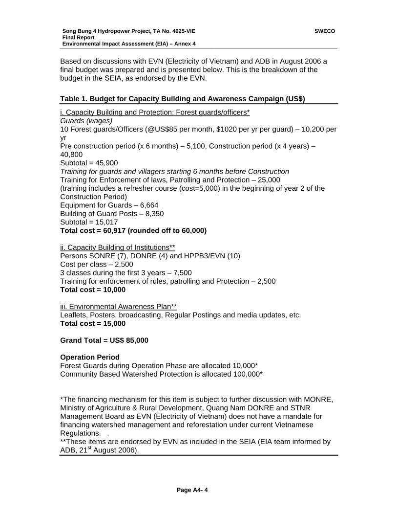
Song Bung 4 Hydropower Project, TA No. 4625-VIE Final Report Environmental Impact Assessment (EIA) – Annex 4
SWECO
Page A4- 4
Based on discussions with EVN (Electricity of Vietnam) and ADB in August 2006 a final budget was prepared and is presented below. This is the breakdown of the budget in the SEIA, as endorsed by the EVN. Table 1. Budget for Capacity Building and Awareness Campaign (US$)
i. Capacity Building and Protection: Forest guards/officers* Guards (wages) 10 Forest guards/Officers (@US$85 per month, $1020 per yr per guard) – 10,200 per yr Pre construction period (x 6 months) – 5,100, Construction period (x 4 years) – 40,800 Subtotal = 45,900 Training for guards and villagers starting 6 months before Construction Training for Enforcement of laws, Patrolling and Protection – 25,000 (training includes a refresher course (cost=5,000) in the beginning of year 2 of the Construction Period) Equipment for Guards – 6,664 Building of Guard Posts – 8,350 Subtotal = 15,017 Total cost = 60,917 (rounded off to 60,000) ii. Capacity Building of Institutions** Persons SONRE (7), DONRE (4) and HPPB3/EVN (10) Cost per class – 2,500 3 classes during the first 3 years – 7,500 Training for enforcement of rules, patrolling and Protection – 2,500 Total cost = 10,000 iii. Environmental Awareness Plan** Leaflets, Posters, broadcasting, Regular Postings and media updates, etc. Total cost = 15,000 Grand Total = US$ 85,000 Operation Period Forest Guards during Operation Phase are allocated 10,000* Community Based Watershed Protection is allocated 100,000* *The financing mechanism for this item is subject to further discussion with MONRE, Ministry of Agriculture & Rural Development, Quang Nam DONRE and STNR Management Board as EVN (Electricity of Vietnam) does not have a mandate for financing watershed management and reforestation under current Vietnamese Regulations. . **These items are endorsed by EVN as included in the SEIA (EIA team informed by ADB, 21st August 2006).
Song Bung 4 Hydropower Project, TA No. 4625-VIE Final Report Environmental Impact Assessment (EIA) – Annex 5
SWECO
Page A5- 1
Annex 5 MONITORING AQUATIC ECOLOGY AND WATER QUALITY Monitoring in the Construction Phase The monitoring programme in the construction phase should be aimed at controlling that the work is complying with the regulations set (so called Compliance Monitoring), which is not part of the aquatic life study. For our part it is relevant to monitor the water quality upstream and downstream of the construction area. That means 2 monitoring stations with location:
1. Upstream the dam site 2. Downstream the planned tail-race entrance
The sampling frequency should be once a month. The parameters should be:
• Water flow downstream • pH • Conductivity • Turbidity • Suspended sediments • Oxygen • Ca • Mg • Total Phosphorus • PO4-P • Total Nitrogen • NO3 • NH4 • Coliform bacteria • Mineral Oil
If the recommendations on measures given in the mitigation chapter are followed during the construction work, it is not anticipated any damage to the river life downstream. Therefore it is not relevant with any biological monitoring in the construction period. However, there should be established some control, combined with awareness programme, to prevent the construction workers go fishing with dynamite, as this often is the most damaging impact on river life in a construction period.
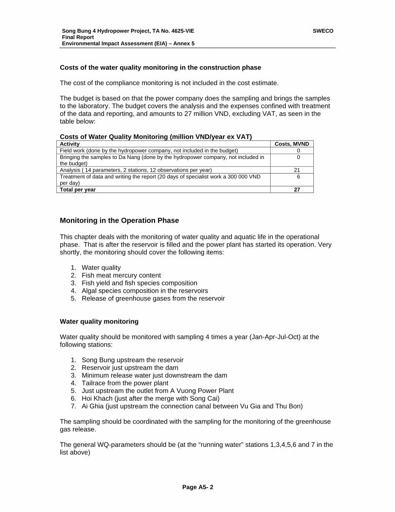
Song Bung 4 Hydropower Project, TA No. 4625-VIE Final Report Environmental Impact Assessment (EIA) – Annex 5
SWECO
Page A5- 2
Costs of the water quality monitoring in the construction phase The cost of the compliance monitoring is not included in the cost estimate. The budget is based on that the power company does the sampling and brings the samples to the laboratory. The budget covers the analysis and the expenses confined with treatment of the data and reporting, and amounts to 27 million VND, excluding VAT, as seen in the table below: Costs of Water Quality Monitoring (million VND/year ex VAT) Activity Costs, MVND Field work (done by the hydropower company, not included in the budget) 0 Bringing the samples to Da Nang (done by the hydropower company, not included in the budget)
0
Analysis ( 14 parameters, 2 stations, 12 observations per year) 21 Treatment of data and writing the report (20 days of specialist work a 300 000 VND per day)
6
Total per year 27 Monitoring in the Operation Phase This chapter deals with the monitoring of water quality and aquatic life in the operational phase. That is after the reservoir is filled and the power plant has started its operation. Very shortly, the monitoring should cover the following items:
1. Water quality 2. Fish meat mercury content 3. Fish yield and fish species composition 4. Algal species composition in the reservoirs 5. Release of greenhouse gases from the reservoir
Water quality monitoring Water quality should be monitored with sampling 4 times a year (Jan-Apr-Jul-Oct) at the following stations:
1. Song Bung upstream the reservoir 2. Reservoir just upstream the dam 3. Minimum release water just downstream the dam 4. Tailrace from the power plant 5. Just upstream the outlet from A Vuong Power Plant 6. Hoi Khach (just after the merge with Song Cai) 7. Ai Ghia (just upstream the connection canal between Vu Gia and Thu Bon)
The sampling should be coordinated with the sampling for the monitoring of the greenhouse gas release. The general WQ-parameters should be (at the “running water” stations 1,3,4,5,6 and 7 in the list above)
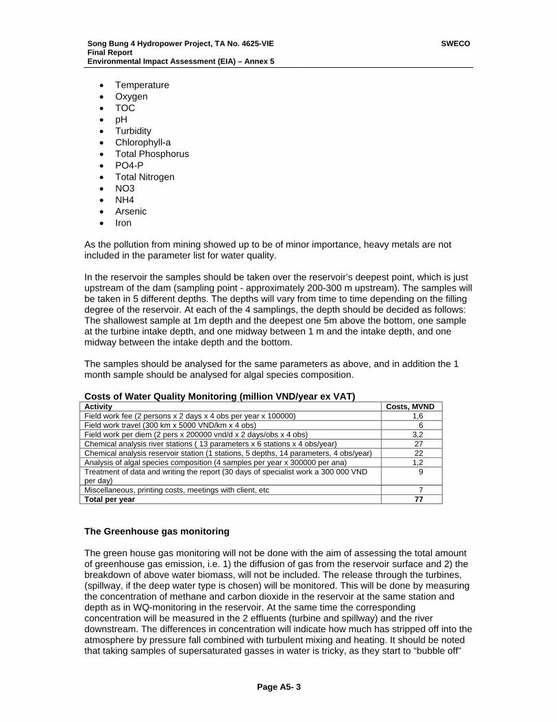
Song Bung 4 Hydropower Project, TA No. 4625-VIE Final Report Environmental Impact Assessment (EIA) – Annex 5
SWECO
Page A5- 3
• Temperature • Oxygen • TOC • pH • Turbidity • Chlorophyll-a • Total Phosphorus • PO4-P • Total Nitrogen • NO3 • NH4 • Arsenic • Iron
As the pollution from mining showed up to be of minor importance, heavy metals are not included in the parameter list for water quality. In the reservoir the samples should be taken over the reservoir’s deepest point, which is just upstream of the dam (sampling point - approximately 200-300 m upstream). The samples will be taken in 5 different depths. The depths will vary from time to time depending on the filling degree of the reservoir. At each of the 4 samplings, the depth should be decided as follows: The shallowest sample at 1m depth and the deepest one 5m above the bottom, one sample at the turbine intake depth, and one midway between 1 m and the intake depth, and one midway between the intake depth and the bottom. The samples should be analysed for the same parameters as above, and in addition the 1 month sample should be analysed for algal species composition. Costs of Water Quality Monitoring (million VND/year ex VAT) Activity Costs, MVND Field work fee (2 persons x 2 days x 4 obs per year x 100000) 1,6 Field work travel (300 km x 5000 VND/km x 4 obs) 6 Field work per diem (2 pers x 200000 vnd/d x 2 days/obs x 4 obs) 3,2 Chemical analysis river stations ( 13 parameters x 6 stations x 4 obs/year) 27 Chemical analysis reservoir station (1 stations, 5 depths, 14 parameters, 4 obs/year) 22 Analysis of algal species composition (4 samples per year x 300000 per ana) 1,2 Treatment of data and writing the report (30 days of specialist work a 300 000 VND per day)
9
Miscellaneous, printing costs, meetings with client, etc 7 Total per year 77 The Greenhouse gas monitoring The green house gas monitoring will not be done with the aim of assessing the total amount of greenhouse gas emission, i.e. 1) the diffusion of gas from the reservoir surface and 2) the breakdown of above water biomass, will not be included. The release through the turbines, (spillway, if the deep water type is chosen) will be monitored. This will be done by measuring the concentration of methane and carbon dioxide in the reservoir at the same station and depth as in WQ-monitoring in the reservoir. At the same time the corresponding concentration will be measured in the 2 effluents (turbine and spillway) and the river downstream. The differences in concentration will indicate how much has stripped off into the atmosphere by pressure fall combined with turbulent mixing and heating. It should be noted that taking samples of supersaturated gasses in water is tricky, as they start to “bubble off”
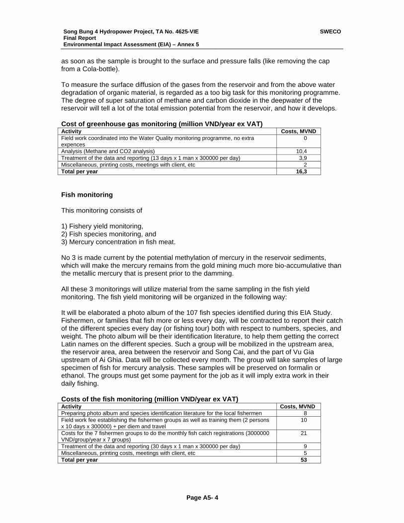
Song Bung 4 Hydropower Project, TA No. 4625-VIE Final Report Environmental Impact Assessment (EIA) – Annex 5
SWECO
Page A5- 4
as soon as the sample is brought to the surface and pressure falls (like removing the cap from a Cola-bottle). To measure the surface diffusion of the gases from the reservoir and from the above water degradation of organic material, is regarded as a too big task for this monitoring programme. The degree of super saturation of methane and carbon dioxide in the deepwater of the reservoir will tell a lot of the total emission potential from the reservoir, and how it develops. Cost of greenhouse gas monitoring (million VND/year ex VAT) Activity Costs, MVND Field work coordinated into the Water Quality monitoring programme, no extra expences
0
Analysis (Methane and CO2 analysis) 10,4 Treatment of the data and reporting (13 days x 1 man x 300000 per day) 3,9 Miscellaneous, printing costs, meetings with client, etc 2 Total per year 16,3 Fish monitoring This monitoring consists of 1) Fishery yield monitoring, 2) Fish species monitoring, and 3) Mercury concentration in fish meat. No 3 is made current by the potential methylation of mercury in the reservoir sediments, which will make the mercury remains from the gold mining much more bio-accumulative than the metallic mercury that is present prior to the damming. All these 3 monitorings will utilize material from the same sampling in the fish yield monitoring. The fish yield monitoring will be organized in the following way: It will be elaborated a photo album of the 107 fish species identified during this EIA Study. Fishermen, or families that fish more or less every day, will be contracted to report their catch of the different species every day (or fishing tour) both with respect to numbers, species, and weight. The photo album will be their identification literature, to help them getting the correct Latin names on the different species. Such a group will be mobilized in the upstream area, the reservoir area, area between the reservoir and Song Cai, and the part of Vu Gia upstream of Ai Ghia. Data will be collected every month. The group will take samples of large specimen of fish for mercury analysis. These samples will be preserved on formalin or ethanol. The groups must get some payment for the job as it will imply extra work in their daily fishing. Costs of the fish monitoring (million VND/year ex VAT) Activity Costs, MVND Preparing photo album and species identification literature for the local fishermen 8 Field work fee establishing the fishermen groups as well as training them (2 persons x 10 days x 300000) + per diem and travel
10
Costs for the 7 fishermen groups to do the monthly fish catch registrations (3000000 VND/group/year x 7 groups)
21
Treatment of the data and reporting (30 days x 1 man x 300000 per day) 9 Miscellaneous, printing costs, meetings with client, etc 5 Total per year 53
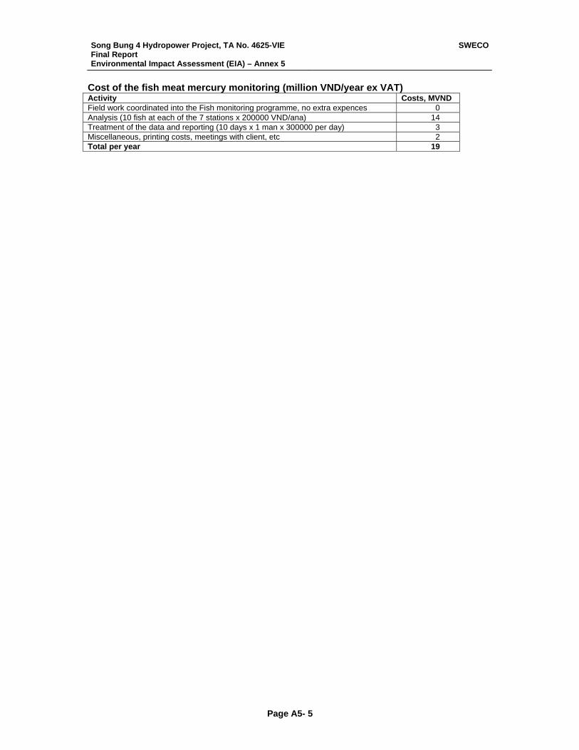
Song Bung 4 Hydropower Project, TA No. 4625-VIE Final Report Environmental Impact Assessment (EIA) – Annex 5
SWECO
Page A5- 5
Cost of the fish meat mercury monitoring (million VND/year ex VAT) Activity Costs, MVND Field work coordinated into the Fish monitoring programme, no extra expences 0 Analysis (10 fish at each of the 7 stations x 200000 VND/ana) 14 Treatment of the data and reporting (10 days x 1 man x 300000 per day) 3 Miscellaneous, printing costs, meetings with client, etc 2 Total per year 19
Song Bung 4 Hydropower Project, TA No. 4625-VIE Final Report Environmental Impact Assessment (EIA) – Annex 6
SWECO
Page A6-1
Annex 6
Community Based Forest Management Plan
Conservation Off-Set
Song Bung 4 Hydropower Project
Song Bung 4 Hydropower Project, TA No. 4625-VIE Final Report Environmental Impact Assessment (EIA) – Annex 6
SWECO
Page A6-2
SUMMARY A community based forest management (CBFM) plan is prepared as a Conservation Off-Set (COS) instead of the ADB Forest Policy of monetary compensation for ‘tree for tree’ when a project contributes to depletion of forest. In the case of the Song Bung 4 Hydropower Project (SB4 HPP) the COS addresses the three imperatives that the Bank’s policy is founded upon, namely, Protection, Production and Participation. The CBFM plan also takes into account several Vietnamese laws and decrees allowing for allocation of land to local communities for both enhancement of livelihoods and environmental protection. The COS plan enhances forest quality and soil conservation through enrichment planting, protecting protection forests, and the establishment of sustainable harvest regimes both for timber and non-timber forest products through local community participation and use of non-forest areas (or poor tree cover, below 20%) for agro-forestry (including all agricultural activities) – thus enhancing watershed protection. The official establishment of land allocation within the COS will secure ownership of land for both forest protection and food production. Local communities will have a role in forest management. The COS as designed here instead of the ‘tree for tree’ compensation is seen as a more significant contribution to increasing ecosystem functioning and landscape continuity, and enhancing livelihoods. Furthermore the COS will directly contribute to the Biological Conservation Corridor Initiative (BCCI) of ADB. Poverty levels in communes have remained high despite government efforts and interventions. The situation is particularly serious for ethnic minorities in remote areas and where livelihoods are often based at the subsistence level, relying on forest and aquatic resources. The links to the forest are not only resource extraction related but are also of profound cultural and traditional value to ethnic peoples. Forest and related vegetations remain important sources of livelihoods however illegal logging pressure resulting in habitat changes, increasing local populations and carrying capacity, unregulated extractions of forest resources, and forest clearing for small to medium scale agriculture and settlements have contributed to gradually declining predictable reliance on forest as well as the deterioration of the forest environment. Pressure on forest has led to many forests to be classified as close for use limiting access to these forest areas, affecting not only livelihoods but also cultural traditions. The closing of forest lands has resulted in weakening the association and care-taking role with forests that people play, and has added to the increased pressure of illegal logging by external actors and unsustainable harvesting of some non-forest timber products (NTFPs). As such for many there are no incentives to participate actively in the forest management. The CBFM plan proposed here takes into account the issues raised above. A land allocation plan is proposed but this will be finalized during implementation of the Project and will community participation. Using participatory approaches a land use and allocation plan will be proposed based on community and commune priorities. Based on the land allocation
Song Bung 4 Hydropower Project, TA No. 4625-VIE Final Report Environmental Impact Assessment (EIA) – Annex 6
SWECO
Page A6-3
different forest land management options will be explored and decided upon. The CBFM plan will include forest protection, forest allocated for NTFP, and agro-forestry. Through extension services including, but not limited to, training in planting, setting harvest limits, harvesting and processing, and management, the communities will be able to establish CBFM. The aim will be that the communities will be able to receive benefits and sustainable amounts of non-timber products through forest land allocation, establishment of sustainable forest management practices, and investments in community forestry, and agroforestry. The Budget for the land allocation and CBFM plan is provided in the Resettlement and Ethnic Minority Development Plan (REMDP). The budget is contingent on revision during implementation as the actual areas of land allocated to the community will be based on the participatory land allocation processes. Communities of Zuoih commune (Protection forest management and agro-forestry) and villagers of Pa Toi (Ta Bhing commune) and Bo Di (Cha Val commune) villages (Protection forest management) will be the main beneficiaries of the CBFM. INTRODUCTION Policy Relevance – ADB and Vietnam ADB. A community based forest management (CBFM) plan is prepared as a Conservation Off-Set (COS) instead of the ADB Forest Policy of monetary compensation for ‘tree for tree’ when a project contributes to depletion of forest. The Bank’s policy in the Forestry Sector (1995, B.1 Strategic Approach, page 12) states that the ‘Bank’s strategic emphasis in these forest-rich DMCs (Developing Member Countries) will be to maximize the area kept as functioning forests and press for adequate areas to be set aside for harvesting, habitat and catchment protection, plantations, and for forest-dwelling communities’. In the case of the Song Bung 4 Hydropower Project (SB4 HPP) the COS addresses the three imperatives that the Bank’s policy is founded upon, namely, Protection, Production and Participation. The COS here is included in the category of both environmental protective and production-related forestry projects covered by Bank assistance in the forestry sector (see Bank’s Policy of Forestry, 1995). The implementation of CBFM plan will enhance forest quality and soil conservation through enrichment planting, creating more production forests, protecting protection forests, and the establishment of sustainable harvest regimes both for timber and non-timber forest products through local community participation. These are all aspects addressed by the Bank’s Forest Policy (1995, B.5. Investment Strategies: a. Sustainable Management of Natural Forests, c. Rehabilitation of Degradation Forest Areas by Tree Plantations, and d. Conservation of Biodiversity, Endangered Species, and
Song Bung 4 Hydropower Project, TA No. 4625-VIE Final Report Environmental Impact Assessment (EIA) – Annex 6
SWECO
Page A6-4
Ecosystem, pages 15 - 17). The official establishment of land allocation with consultation with local communities and other stakeholders within the CBFM plan will secure ownership and role of local people in forest management – a tenant in the Bank’s Forest Policy (B.4 Promoting Public Consultation in Forestry Development, page 14). The COS as designed here is seen as a more significant contribution to increasing ecosystem functioning and landscape continuity, and enhancing livelihoods than the ‘tree for tree’ alternative. In this respect the CBFM plan as a COS also meets the ADB’s Environmental Policy (working paper, October 2001) in ‘Promoting directing interventions to reduce poverty’ (II. The Policy, A.1, page 11) and ‘Protection, conservation, and sustainable use of natural resources’ (II. The Policy. B.1, page 12). This CBFM plan will in addition directly contribute to the Biological Conservation Corridors Initiative (BCCI) of the ADB. Vietnam. Vietnam has various Laws and Decrees that call for the protection of the environment both through direct protection by the State and through the involvement of local communities. To facilitate the latter the laws allow for land allocation to local communities for both cultural and use (economic) purposes. The type of land allowed for allocation can span from protected forests (including those in National Parks and Reserves), production forest lands, and to those requiring rehabilitation. The use of land can also be broad covering agriculture use, production forest cultivation, selected wood species use, enrichment/rehabilitation of forests, and non-timber forest product extraction (NTFP). The aim of forest land allocation in the laws and decrees is two-fold providing livelihood enhancement to local people and at the same time increasing environmental protection. In the case of the SB4 HPP the CBPM will enhance watershed protection is reducing erosion through increasing plant cover by allocating land for a range of uses to the local communities. The Law on Environmental Protection (LEP) of Vietnam was passed by the Vietnam National Assembly on 12th December1993 and came into force from 10th January 1994, under the authority of the former Ministry of Science, Technology and Environment (MOSTE). In 2002, MOSTE was dispersed, and two new ministries were established: Ministry of Science and Technology (MOST) and Ministry of Natural Resources and Environment (MONRE), of which the latter is now responsible for environmental issues. A new updated and refined LEP was approved in June 2006. The Law provides for the protection of the environment with a view to protecting the health of the people, serving the cause of sustainable development of the country and contributing to the protection of the regional and global environment. The Law of Forest Protection and Development, promulgated on 3 December 2004 has several articles which address and allow for the protection of forest by local communities through various forms of use both traditional and non-traditional. For example, Article 29. Forest allocation for local communities; Article 30. Rights and duties of local communities; Article 47. Forest exploitation in protected forests; Article 59. General rights of the forest owners; Article 60. General duties of the forest owners and; Article 69. The rights and the duties
Song Bung 4 Hydropower Project, TA No. 4625-VIE Final Report Environmental Impact Assessment (EIA) – Annex 6
SWECO
Page A6-5
of households and individuals who have allocated protected forests. The Decree of implementation of the Law of Forest Protection and Development (3 March 2006) through various articles spells out the bases of forest allocation, allocation mechanisms and management of different forest types particularly Protective forest and forest development (investment and economic) options. Relevant laws and decrees are provided below.
• Law on Environmental Protection (19 August 1993) • Law on Forest Protection and Development (03 December 2004) • Law on Environmental Protection (19 August 1993) • Decree No. 163/1999/ND-CP of November 16, 1999 on assigning and
leasing forestry land to organizations, households and individuals for stable and long-term use for forestrial purposes.
• Decree No.23/2006/ND-CP of March 3, 2006, on the implementation of the law on forest protection and development.
• Decision No. 186/2006/QD-TTg dated 14 August 2006 on the issuance of the regulation on Forest Management
• Decision no. 08/2001/QD-TTg of January 11, 2001 issuing the regulation on Management of Special-Use Forest, Protection Forests and Production Forests, which are natural forests.
Contribution to the ADB Biological Conservation Initiative Under the Greater Mekong Subregion (GMS) the Biodiversity Conservation Corridors Initiative (BCCI) is being implemented as an ADB regional technical assistance. The purpose of the BCCI is to establish sustainable management regimes for restoring ecological connectivity and integrity in a selected set of important biodiversity areas. This is to be combined with provision of natural resource goods and services that contribute to improving livelihoods of peoples living in and around the biodiversity conservation corridors, and protect the physical infrastructure investments deemed central to economic integration and sustainable development in the subregion. In Viet Nam, the pilot site is in Quang Nam Province of the Central Annamites and bordering areas of Thua Thien Hue and Kon Tum provinces and Sekong and Attapeu in the Lao PDR. The Central Annamites in Vietnam is ranked as a critically important landscape (Tordoff et al. 2003) because of its unique assemblages of species representing one of the world’s most important areas of biodiversity, having high levels of endemism in a continental setting. To ensure the continuity of the Central Truong Son landscape the BCCI project aims to mitigate habitat fragmentation and enhance forest connectivity. Activities in the three planned BCCI phases are designed in sequence to tackle the areas of highest risk first without losing sight of the long-term goal of establishing a continuous forest landscape throughout the Central Annamite Mountains. Phase 1 of this initiative focuses on the links between three nature reserves, Ngoc Linh, Song Thanh, and Ba Na in Quang Nam Province, and Xe Sap NBCA in the Lao PDR. The CBFM plan as a COS for
Song Bung 4 Hydropower Project, TA No. 4625-VIE Final Report Environmental Impact Assessment (EIA) – Annex 6
SWECO
Page A6-6
Zuoih commune directly contributes to ensuring continuity in Central Truong Son landscape. The CBFM program will address the following issues that are consistent with the GMS-BCCI.
i. Establish forest management areas which will protect forest from illegal activities
ii. Community Management of forest will contribute to increase landscape integrity in the region, and will add to the long term goal of establishing a continuous forest landscape in the Central Annamite Mountains.
iii. The CBFM plan will contribute to secure ecosystem services in the region
iv. Agro-forestry zones will increase cover on areas with poor vegetation cover and work to provide for livelihood security.
International Experience and Trends in CBFM The developing world has in recent years been experiencing a devolution of management. In many nations, resources such as forests are no longer being managed by the national governments, but control has moved to state and local authorities. People at the provincial, municipal and community levels are making decisions about the fate of forests and are intimately involved in managing them. In parallel, an effort is being mounted in many tropical countries to strengthen those forest management systems that are considered ‘traditional’ and ‘innate’. Forest management here need not only encompass establishing sustainable harvestable levels of forest resources but can also include enrichment planting to enhance biodiversity and accelerate (or ecologically ‘jump start’) secondary forest regeneration (often poor in species due to illegal logging), in addition to securing of the cultural values of forest to people. Changes in forest management regimes affect millions of people. Yet the institutions, policies and incentives necessary to reconcile their needs with other demands for use or conservation of forests often remain unclear and often approaches lack the refinement that give local people ample management allowance to develop sustainable harvestable forest systems. Critical to successful implementation of sustainable CBFM is that the all members of the community understand and accept the objectives and implementation mechanisms based on precise stakeholder equality, user group identity and user rights, community support for the implementation framework, consensus on roles, responsibilities and regulatory regimes, and conflict resolution mechanisms. The CBFM plan in the SB4 HPP takes into account the needs for successful implementation of a CBFM plan through participatory land allocation, establishing agreements (use/ownership) among stakeholders, and setting of community based management plans. AIMS AND APPROACH A Community Based Forest Management (CBFM) component in the Environmental Management Plan (EMP) is meant to serve as a conservation off-set in the SB4 HPP. It is prepared so that it is consistent with the GMS BCI
Song Bung 4 Hydropower Project, TA No. 4625-VIE Final Report Environmental Impact Assessment (EIA) – Annex 6
SWECO
Page A6-7
program, and activities of stakeholders in the province (Quang Nam) and provincial government departments. The aim of the CBFM component here is to fund the design, training for, and implementation of a CBFM program for Zuoih commune focused on the forest resources in Zuoih commune. As part of the Song Bung 4 PPTA (Resettlement and Ethnic Minority Development Plan, REMDP) a survey of the area in Zuoih commune was done and zones for community management as protection forest, in the forested area along the reservoir, and agro-forestry were tentatively designated (see details in REMDP), pending on formal agreements with Provincial Forest Department and local communities. Note that agro-forestry encompasses all agricultural activity including the growing of upland rice, fruit trees and trees for NTFPs and wood. This classification is flexible in that the villagers can decide on how they prefer to use the land, a part of the participatory approach presented below. Protection forest will be used for protected by the villages and used for NTFPs. If enrichment planting is required the villagers may be contracted to do it by the Forest Department: this may be the case as a large are in the commune does not have high forest cover (Table 1). The above proposed zoning, participation of villagers in deciding use of agroforestry land, and formal allocation of both land for protection management and agro-forestry were in principle agreed upon with the provincial Forest Department. The Forest Department supported the concept and proposed plans, but would require formal notification for providing further support. This will essentially be done during the implementation of the plan. The first step (Section 1, below) will to do conduct a Participatory Land Use Planning exercise (PLUP) followed by land Allocation (LA) done based on stakeholder input. The process is called a PLUPLA. Essentially this process takes into account the realities on the ground in terms of land cover, topography, soil type, local information regarding sources of livelihoods and subsistence (NTFPs etc.) (Confirmed by the provincial forest Department ADB and PPTA consultants, meeting 4th August 2006, Da Nang). Given that the much of the forested land in Zuioh commune is officially designated by DONRE (Provincial Department of Natural Resource Management) as protection forest a ‘ground truthing’ exercise is essential and participatory land allocation, so that a proposal can be submitted to the Provincial Peoples’ Committee for approval of land allocation. There is ample forested land of different types in Zuoih commune for allocation (Table 1) among the resettled households in Zuoih commune (see details in REMDP).
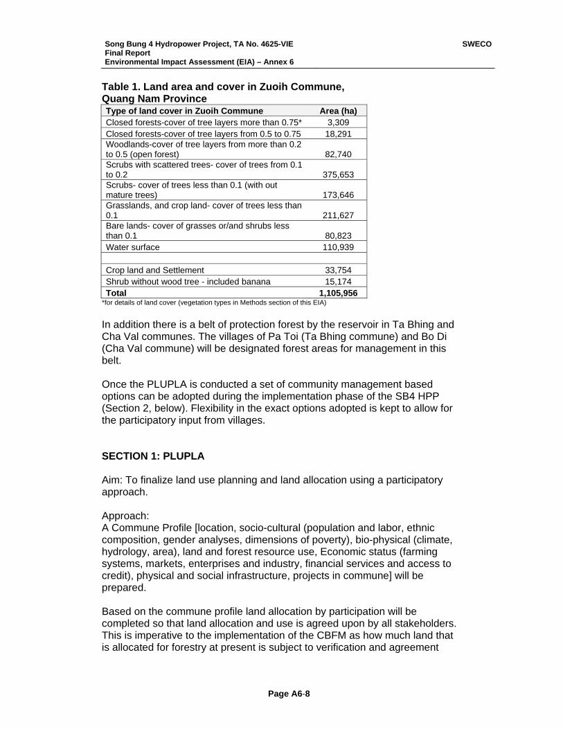
Song Bung 4 Hydropower Project, TA No. 4625-VIE Final Report Environmental Impact Assessment (EIA) – Annex 6
SWECO
Page A6-8
Table 1. Land area and cover in Zuoih Commune, Quang Nam Province Type of land cover in Zuoih Commune Area (ha) Closed forests-cover of tree layers more than 0.75* 3,309 Closed forests-cover of tree layers from 0.5 to 0.75 18,291 Woodlands-cover of tree layers from more than 0.2 to 0.5 (open forest) 82,740 Scrubs with scattered trees- cover of trees from 0.1 to 0.2 375,653 Scrubs- cover of trees less than 0.1 (with out mature trees) 173,646 Grasslands, and crop land- cover of trees less than 0.1 211,627 Bare lands- cover of grasses or/and shrubs less than 0.1 80,823 Water surface 110,939 Crop land and Settlement 33,754 Shrub without wood tree - included banana 15,174 Total 1,105,956
*for details of land cover (vegetation types in Methods section of this EIA) In addition there is a belt of protection forest by the reservoir in Ta Bhing and Cha Val communes. The villages of Pa Toi (Ta Bhing commune) and Bo Di (Cha Val commune) will be designated forest areas for management in this belt. Once the PLUPLA is conducted a set of community management based options can be adopted during the implementation phase of the SB4 HPP (Section 2, below). Flexibility in the exact options adopted is kept to allow for the participatory input from villages. SECTION 1: PLUPLA Aim: To finalize land use planning and land allocation using a participatory approach. Approach: A Commune Profile [location, socio-cultural (population and labor, ethnic composition, gender analyses, dimensions of poverty), bio-physical (climate, hydrology, area), land and forest resource use, Economic status (farming systems, markets, enterprises and industry, financial services and access to credit), physical and social infrastructure, projects in commune] will be prepared. Based on the commune profile land allocation by participation will be completed so that land allocation and use is agreed upon by all stakeholders. This is imperative to the implementation of the CBFM as how much land that is allocated for forestry at present is subject to verification and agreement
Song Bung 4 Hydropower Project, TA No. 4625-VIE Final Report Environmental Impact Assessment (EIA) – Annex 6
SWECO
Page A6-9
(through a participatory process) before any successful implementation of a CBFM can take place. SECTION 2: Forest Management by Communities Aim: To design and train local communities for a CBFM plan based on a participatory process, extension services and capacity building. Approach: In the preparation of the PLUPLA a set of forest management options will be explored and agreed upon by stakeholders that will include both the consideration of peoples and commune priorities. The aim will be that the communities will be able to receive benefits and sustainable amounts of non-timber products through the reallocation of protected forest land allocation, establishment of sustainable forest management practices and investments in community forestry. Thus in Zuoih commune the PLUPLA will assist in tailoring a plan based on the priorities of the commune and its residence. Similarly the villagers of Pa Toi (Ta Bhing commune) and Bo Di (Cha Val commune) will be designated forest areas for management in the belt of protected forest by the reservoir. As seen at present the potential areas of investment options are listed below but a final choice will be based on those agreed by villages, commune and district officials. Areas of Investment i) Forest development:
Forestry (Forest protection and enrichment) NTFP activity
ii) Support for management Extension and training Capacity Building
A budget for this investment is provided in the REMDP. SECTION 3: Agro-forestry Details of agro-forestry are provided in the Resettlement and Ethnic Minority Development Plan (REMDP) and is part of the livelihood restoration plan. PLANNED ACTIVITIES Planned Activities for Zuoih commune will include a land allocation proposal and targeted forestry investments. For the villages of Bo Di (Cha Val commune) and Pa Toi (Ta Bhing commune) the provincial forest department will allocate areas for forest protection management in the belt of forest along the reservoir.
Song Bung 4 Hydropower Project, TA No. 4625-VIE Final Report Environmental Impact Assessment (EIA) – Annex 6
SWECO
Page A6-10
1. Land allocation proposal will be first completed and submitted to the Provincial Peoples Committee for approval. This will take 2 months. It has to be noted that there is no ‘exclusive plan’ for any communes yet, although the development (as mentioned above) of such a framework for local adaptation and implementation is occurring. Each commune will need to have a locally adapted CBFM plan, due to local user rights and ownerships, customs, provincial land allocation and forest quality. The Quy Uocs (or Huong Uoc) are forest management agreements that have been developed out of existing village level policy options (including customary laws) which focus on the maintenance of village traditions, thus they are adapted within the legal framework to focus on natural resources management. These are written by the village, signed by the commune and endorsed by the Districts People’s Committee. Thus VPTs and Quy Uocs are not identical across communes and have to be locally developed. These have not been development in the Zuoih commune and will need to be done. Detail on land ownership and allocation are provided in the REMDP.
2. Once the land allocation is formalized Forestry Development and Extension activities will begun.
INVESTMENT TARGETS A. Forestry Development Forestry Forest Protection of Existing Protection Forest Village Protection Teams will be set up and trained in the commune. This has already been done in several communes in Quang Nam Province. Protection Forest that will be under the jurisdiction of the communities would have been agreed on in the land allocation proposal. Forest enrichment (additional planting) Poor areas of the protection forest can be further enriched with selected species to increase the area of protection forest through increasing tree cover. This is a regular approached used by the forest department to increase cover of protection forest area. Non-timber forest products (NTFP) In the land allocation proposal which would have priorities of the communities taken into account there will be agreement on land allocated for NTFP collection. Although NTFPs can be collected from different vegetation
Song Bung 4 Hydropower Project, TA No. 4625-VIE Final Report Environmental Impact Assessment (EIA) – Annex 6
SWECO
Page A6-11
communities the vast number are collected from forested areas which are of good quality – generally the protection forest. These include vegetables, fruits and flowers, and ceremonial and medicinal plants, among other species users. Land allocation as sacred land has to be included here also. Sustainable harvesting regimes may be established for the main collected NTFPs. Generally when local communities are made responsible for managing forest resources based on a agreed on sustainable management regime resources are not over-exploited (good examples of this can be found in Nepal, India and Thailand). Although the local communities have sound information on the forest resources, it is important to establish harvesting regimes for the main resources this can be done through assessment of the amount of the resource and thereafter establishing a harvesting system that is sustainable. Agroforestry See REMDP. B. Support for Management: Extension, training and capacity building Extension Activities can include (NOTE: Agricultural activities will be included from the agro-forestry component in the REMDP) Nursery production techniques Forest planting, tending and protection techniques Study tour on forest seedling production Visit to forest planting and protection models Techniques for assessment of forest timber resources Harvesting of timber and sustainable limits Village Forest Protection preparation Techniques for assessment of NTFPs Techniques for establishment of harvesting limits of NTFPs Capacity building in Management skills Skills for planning of forest management Training in planning for sustainable harvesting plans for timber and NTFPs INSTITUTIONAL RESPONSIBILITY The institutional responsibility for the CBFM plan will be with the Nam Giang District PC, which is responsible for implementing the REMDP. Organizations involved in the implementation will include DONRE (including Provincial Forest Protection Department), SB4 HPP construction period implementing agency (Hydropower Project Management Board No. 3, HPPMB3) and the HPP operator during the operation period. The Department of Natural Resources and Environment (DONRE) - Forest Department and Forest
Song Bung 4 Hydropower Project, TA No. 4625-VIE Final Report Environmental Impact Assessment (EIA) – Annex 6
SWECO
Page A6-12
Protection Department has the experience to develop several of the components of the CBFM plan but with assistance from International experts for some components, NGOs (e.g. WWF-MOSAIC program in the province and Song Thang Nature Reserve) and other stakeholders already working in the region. It is important to determine the actual ability and competence of experts in working on sustainable harvesting techniques for both major and minor NTFPs. Selected Relevant References Long, B., M. Hoang and T. Truyen. 2004. A conservation assessment of
Quang Nam Province, Central Vietnam. WWF, Vietnam (draft) Ngoc Linh –Xe Sap Biodiveristy Conservation Corridors. Vietnam. May 2005.
Pilot Project Profile (2005 – 2008). Greater Mekong Subregion Biodiversity Conservation Corridors Initiative. ADB
Proposed Technical Assistance Core Environmental Program and Biodiversity Conservation Corridors Initiative in the Greater Mekong Subregion. November 2005. Project no. 39025. ADB
Quang Nam Biodiversity and Natural Resource Conservation Strategy, 2005-2020. (undated draft)
The Central Truong Son Biodiversity Conservation Initiative, 2004 – 2020. 2004. Ministry of Agriculture and Rural Development, Vietnam. No: 06/2004/QD-BNN. Hanoi.
Thuong, H. V., H. T. M. Thu and B. Long. (Undated, 2005?) Community Forest Management and Protection in Quang Nam Province, Viet Nam. WWF MOSAIC Project
Tordoff, A.W., Timmins, R.J., Smith R.J. and Mai Ky Vinh (2003): Central Annamites Biological Assessment. WWF Indochina/WWF US, Hanoi and Washington D.C: 133 pp.
BUDGET Estimation of costs for the Community Based Forest Management Plan as the Conservation Off-set in Song Bung 4 Hydropower Project are provided in the REMDP as part of the livelihood restoration plan. In the SEIA an amount of US$300,000 is endorsed by Electricity of Vietnam (EVN).
Song Bung 4 Hydropower Project, TA No. 4625-VIE Final Report Environmental Impact Assessment (EIA) – Annex 7
SWECO
Page A7- 1
Annex 7
Rehabilitation for Protected Areas Song Thanh Nature Reserve
Conservation Off-Set
Song Bung 4 Hydropower Project
Song Bung 4 Hydropower Project, TA No. 4625-VIE Final Report Environmental Impact Assessment (EIA) – Annex 7
SWECO
Page A7- 2
SUMMARY The Song Bung 4 Hydropower Project impacts the Song Thanh Nature Reserve by inundating an area of 143 ha. Rehabilitation of areas by planting and enriching with forest species will be done as a Conservation Off-Set (COS) instead of the ADB Forest Policy of monetary compensation for ‘tree for tree’ when a project contributes to depletion of forest. The Bank’s policy in the Forestry Sector (1995, B.1 Strategic Approach, page 12) states that the ‘Bank’s strategic emphasis in these forest-rich DMCs (Developing Member Countries) will be to maximize the area kept as functioning forests and press for adequate areas to be set aside for harvesting, habitat and catchment protection, plantations, and for forest-dwelling communities’. It also addresses the Bank’s Forest Policy (1995, B.5., pages 15 - 17) and Environmental Policy (working paper, October 2001, II. The Policy. B.1, page 12). The implementation of rehabilitation plan will enhance forest quality and soil conservation through plant and enriching forests, and thus increase watershed protection. Importantly it will act to link the Song Thanh Nature Reserve to the forested areas to the northeast of the Reserve creating forest continuity in the landscape and securing ecosystem functioning in a one of the largest conservation corridors in the Indochina region. The COS as designed here is seen as a more significant contribution to increasing ecosystem functioning and landscape continuity than the ‘tree for tree’ alternative. The official establishment of land allocation for rehabilitation, whether inside of outside the Reserve will be negotiated with the Management Board of Song Thanh and provincial authorities. This rehabilitation will in addition directly contribute to the Biological Conservation Corridors Initiative (BCCI) of the ADB, which aims to link protected areas and increase forest cover in the region, and the conservation goals of the Quang Nam Province. The Budget for the Rehabilitation plan is estimated at US$ 120,000 (rounded off from 122,039, see budget).

Song Bung 4 Hydropower Project, TA No. 4625-VIE Final Report Environmental Impact Assessment (EIA) – Annex 7
SWECO
Page A7- 3
INTRODUCTION
Policy Relevance.
The Song Bung 4 Hydropower Project impacts the Song Thanh Nature Reserve by inundating an area of 143 ha. Rehabilitation of areas by planting and enriching with forest species will be done as a Conservation Off-Set (COS) instead of the ADB Forest Policy of monetary compensation for ‘tree for tree’ when a project contributes to depletion of forest. The Bank’s policy in the Forestry Sector (1995, B.1 Strategic Approach, page 12) states that the ‘Bank’s strategic emphasis in these forest-rich DMCs (Developing Member Countries) will be to maximize the area kept as functioning forests and press for adequate areas to be set aside for harvesting, habitat and catchment protection, plantations, and for forest-dwelling communities’. The COS here is included in the category of environmental protective forestry projects covered by Bank assistance in the forestry sector (see Bank’s Policy of Forestry, 1995). The implementation of rehabilitation plan will enhance forest quality and soil conservation through plant and enriching forests. Importantly it will act to link the Song Thanh Nature Reserve to the forested areas to the northeast of the Reserve creating forest continuity in the landscape and securing ecosystem functioning in a one of the largest green corridors in the Indochina region. These are all aspects addressed by the Bank’s Forest Policy (1995, B.5. Investment Strategies: a. Sustainable Management of Natural Forests, c. Rehabilitation of Degradation Forest Areas by Tree Plantations, and d. Conservation of Biodiversity, Endangered Species, and Ecosystem, pages 15 - 17). The official establishment of land allocation for rehabilitation, weather inside of outside the Reserve will be negotiated with the Management Board of Song Thanh and provincial authorities. The COS as designed here is seen as a more significant contribution to increasing ecosystem functioning and landscape continuity than the ‘tree for tree’ alternative. In this respect the Rehabilitation plan as a COS also meets the ADB’s Environmental Policy (working paper, October 2001) in the ‘Protection, conservation, and sustainable use of natural resources’ (II. The Policy. B.1, page 12). This rehabilitation will in addition directly contribute to the Biological Conservation Corridors Initiative (BCCI) of the ADB, and the Conservation Goals in Quang Nam Province.
The Protected Area.
Song Thanh Nature Reserve was established by the People’s Committee of Quang Nam province in 2000. The nature reserve is ‘proposed’ at the national level and awaits approval by Ministry of Agriculture and Rural Development, MARD (02 August 2006) although it is functioning as a nature reserve with a management board, and has also been proposed for national park status. Located in Nam Giang and Phuoc Son districts of Quang Nam province between 15°13’-15° 41’N and 107°21’-107°50’E, the reserve covers 13 communes. The reserve borders Kon Tum province to the south and Lao PDR to the west. The reserve’s ranges in altitude from 80 to 2,032 m.a.s.l. The forests of STNR are critical to the watershed for the rivers Song Thanh, Dak Pring and Nuoc My. These large rivers themselves are tributaries of the Cai and Bung Rivers which converge to form the Vu Gia River, which itself joins the Thu Bon River in the lowlands of Quang Nam.
STNR falls in the Central Troung Son Landscape which is classified as priority area for conservation in the region. It also falls in the corridor of the Biological Conservation Corridor
Song Bung 4 Hydropower Project, TA No. 4625-VIE Final Report Environmental Impact Assessment (EIA) – Annex 7
SWECO
Page A7- 4
Initiative (BCCI) of the ADB which aims to link protected areas and increase forest cover in the region. The rehabilitation proposed as a COS here will directly contribute to the ‘greening’ of the region and increasing vegetation cover in the watershed.
The core zone of the reserve is 93,249 ha and the buffer zone is 108,398 ha. The buffer zone, except for some areas, is of much poorer vegetation than the core zone, which is rich in species with 95% of the core area covered by broad-leaved evergreen forest. The core zone reports up to 323 faunal (including 106 butterflies) and 329 plant species from recent surveys. No comprehensive survey for STNR has been conducted yet. Forty-one households live within the proposed nature reserve, and an estimated 4,598 households inhabit the buffer zone. Although the population density in the buffer zone of proposed STNR is only 12 people per km2, it is one of the poorest areas in Quang Nam province. Local ethnic minorities rely heavily on forest land and resources for their livelihoods. Illegal logging and wildlife trapping are major threats to biodiversity. Local people are involved in these activities which are mainly steered by outsiders.
A part of the reservoir of the SB4 HPP project will inundate 142.6 ha of the STNR up to the elevation of 222.5 m.a.s.l. The inundated area lies at the border of the buffer and core zone of STNR, at present exposed to entry due to the 14D Highway road cutting over Ta Vinh River into the reserve. Rehabilitation in adjoining areas will help increase ecosystem integrity of the area. Contribution to the ADB Biological Conservation Initiative Under the Greater Mekong Subregion (GMS) the Biodiversity Conservation Corridors Initiative (BCCI) is being implemented as an ADB regional technical assistance. The purpose of the BCCI is to establish sustainable management regimes for restoring ecological connectivity and integrity in a selected set of important biodiversity areas. In Viet Nam, the pilot site is in Quang Nam Province of the Central Annamites and bordering areas of Thua Thien Hue and Kon Tum provinces and Sekong and Attapeu in the Lao PDR. The Central Annamites in Vietnam is ranked as a critically important landscape (Tordoff et al. 2003) because of its unique assemblages of species representing one of the world’s most important areas of biodiversity, having high levels of endemism in a continental setting. To ensure the continuity of the Central Truong Son landscape the BCCI project aims to mitigate habitat fragmentation and enhance forest connectivity. Activities in the three planned BCCI phases are designed in sequence to tackle the areas of highest risk first without losing sight of the long-term goal of establishing a continuous forest landscape throughout the Central Annamite Mountains. Phase 1 of this initiative focuses on the links between three nature reserves, Ngoc Linh, Song Thanh, and Ba Na in Quang Nam Province, and Xe Sap NBCA in the Lao PDR. The Rehabilitation plan as a COS for land taken for the SB4 HPP directly contributes to ensuring continuity in Central Truong Son landscape. The CBFM program will address the following issues that are consistent with the GMS-BCCI.
i. Enrichment planting of secondary forest will add to the long term goal of establishing a continuous forest landscape in the Central Annamite Mountains.
ii. Contribute to secure ecosystem services in the region and thus watershed maintenance.
Song Bung 4 Hydropower Project, TA No. 4625-VIE Final Report Environmental Impact Assessment (EIA) – Annex 7
SWECO
Page A7- 5
AIMS, APPROACH AND ACTIVITIES A rehabilitation component in the Environmental Management Plan (EMP) is meant to serve as a conservation off-set for the land inundated in the STNR for the SB4 HPP. It is prepared so that it is consistent with the ADB policy, ADB GMS BCI program, and Conservation goals for Quang Nam. The aim of the Rehabilitation Plan for is plant and/or enrich areas with forest species either in or adjacent to the STNR as to increase landscape forest continuity and contribute toward linking STNR to the forested areas to the north of Quang Nam (the area in the northwest is recommended, where there are also on-going rehabilitation activities). Based on in formal discussions with DONRE the Nam Giang district sections on forestry and environmental protection the areas selected may be in the buffer zone of the Reserve. Step I. The first step (I in Table 1) will comprise land allocation and designation (planting and/or enrichment) for rehabilitation and the nature of the species to be selected. The land allocation and designation will be decided by Management Board of STNR and DONRE. This process can be completed within the first month of the SB4 HPP project with a report submitted with a land allocation map, copies of agreements (if these were required), designation of planting and enrichment areas, species, methods and a detailed work plan. Step II. The second step includes the implementation of rehabilitation (II in Table 1) of the allocated land comprising 143 ha will be begun in the second month of the Project. To guide the work in the field one forest extension officer and 2 assistants will be employed for the 4 years of the construction period of the SB4 HPP. Note that local people can be employed to do the rehabilitation which will also enhance local incomes. The budget is provided in Table 1. Year 1 costs for rehabilitation include Land Preparation Year 2 costs for rehabilitation include Planting Material. Years 3 and 4 for rehabilitation include Forest land maintenance and Protection. Most planting will occur during Years 1 and 2. INSTITUTIONAL RESPONSIBILITY AND REPORTING The overall responsibility for the Rehabilitation plan will in the hand of the Executing Agency (EVN) and implementation will be done the Implementing Agency. The Management Board of STNR can conduct the rehabilitation and the forest extension officers be housed at STNR. The Department of Natural Resources and Environment (DONRE) also has the experience to conduct the rehabilitation and they can provide assistance to STNR. If the land allocated for rehabilitation is outside the STNR then it may not be appropriate for the Management board to conduct the rehabilitation solely and a joint effort of both STNR and DONRE may be appropriate. This will be decided upon during the inception of the SB4 HPP. The Implementing Agency will submit reports to EVN and ADB twice annually, including a report on the land allocation and designation by the end of the first month of the Project. The reports should include data on the monitoring of the success of rehabilitation (planting success), and where possible be species- and site-specific.
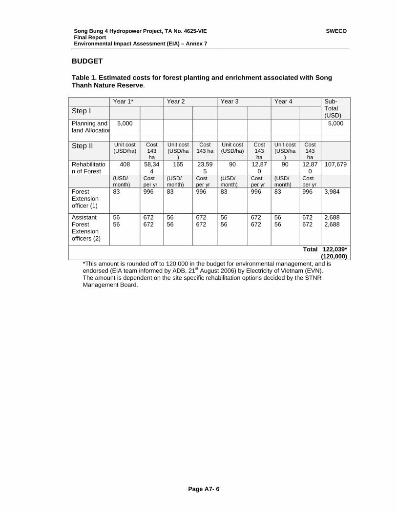
Song Bung 4 Hydropower Project, TA No. 4625-VIE Final Report Environmental Impact Assessment (EIA) – Annex 7
SWECO
Page A7- 6
BUDGET Table 1. Estimated costs for forest planting and enrichment associated with Song Thanh Nature Reserve. Year 1* Year 2 Year 3 Year 4 Step I
Sub-Total (USD)
Planning and land Allocation
5,000 5,000
Step II Unit cost
(USD/ha) Cost 143 ha
Unit cost (USD/ha
)
Cost 143 ha
Unit cost (USD/ha)
Cost 143 ha
Unit cost (USD/ha
)
Cost 143 ha
Rehabilitation of Forest
408 58,344
165 23,595
90 12,870
90 12,870
107,679
(USD/ month)
Cost per yr
(USD/ month)
Cost per yr
(USD/ month)
Cost per yr
(USD/ month)
Cost per yr
Forest Extension officer (1)
83 996 83 996 83 996 83 996 3,984
Assistant Forest Extension officers (2)
56 56
672 672
56 56
672 672
56 56
672 672
56 56
672 672
2,688 2,688
Total 122,039*(120,000)
*This amount is rounded off to 120,000 in the budget for environmental management, and is endorsed (EIA team informed by ADB, 21st August 2006) by Electricity of Vietnam (EVN). The amount is dependent on the site specific rehabilitation options decided by the STNR Management Board.
Song Bung 4 Hydropower Project, TA No. 4625-VIE Final Report Environmental Impact Assessment (EIA) – Annex 8
SWECO
Page A8-1
Annex 8
A study to improve the knowledge of the aquatic resources
in Vu Gia River basin
Terms of Reference
1 Introduction During the Phase 1 scoping study for the Song Bung 4 Hydropower Project, the scoping team felt that a project by project approach will have a limited ability to assessing the cumulative impacts on aquatic life and fish resources in the whole Vu Gia River system (basin level). One important reason is because the fish fauna consist of many migratory species (long distance and short distance migrants). Not only will migration routes be blocked by dams, but living and spawning habitats will easily be destroyed for many species in parts of the rivers. Such a study will be necessary to enable sound recommendations for future protection and management of aquatic habitats of locally important species. The elaboration of the TOR for such a study was included in the terms of reference for the aquatic ecologist in the Song Bung 4 Phase 2 study.
2 Scope of Work
2.1 Work done in the Song Bung 4 EIA The Song Bung 4 Phase 2 study has identified 78 phytoplankton species belonging to 26 families; 45 algal species and 4 moss species in the periphyton community; 40 species of zooplankton belonging to 15 families; 48 zoo-benthic taxa. Among them, some species of shrimp are not yet identified and may be new species to science. The survey identified 107 fish species belonging to 31 families and 9 orders occurring in the Vu Gia – Song Bung River system. The true of number of aquatic species of Vu Gia-Thu Bon river system are larger than what has been revealed through this rapid study. Several species are listed in the Vietnamese Red List Book, but not so many are on the IUCN red list.
2.2 Items in the new study Most species in the lower systematic groups, Phytoplankton, Periphyton, Zooplankton, Insectlarvae, etc. do not have migratory barriers within this restricted area. They are spread by spores, resting eggs, by birds, by flying upstream (insects), etc. The Song Bung 4 study contained also a few sampling stations in Song Cai / Song Than. Therefore, it is not necessary for the new study to comprise all the systematic groups that normally is included in an EIA. However, there is a great need for more information on fish, and other organisms that people utilise for there livelihood in the basin. The study should comprise the following organism groups (or communities):
• Fish • Shrimps • Crabs • Mussels
Song Bung 4 Hydropower Project, TA No. 4625-VIE Final Report Environmental Impact Assessment (EIA) – Annex 8
SWECO
Page A8-2
To be able to assess the importance of the communities, as well as to assess the impacts, design mitigation measures, protection of special habitats, elaborate efficient management plans, etc., the following information (item list) is important for these 4 organism communities: “Item list”
1) Abundance of the different populations 2) Species composition in each of the four communities 3) Size structure of the specimen in the different populations 4) Living habitat of the different populations 5) Food and feeding habits of the different populations 6) Migration behaviour of the different populations 7) Spawning habitat of the different populations 8) Identify rare and endangered species (red-list status) 9) Human use of the different populations 10) Identify natural and existing man-made migratory barriers 11) Identify ongoing human activity which can harm the different populations
2.3 Study area (river sections) The study shall be restricted to the Vu Gia River system. That means that Thu Bon River shall not be included, even though the two rivers are interconnected in the lower parts. Figure 1 shows an outline of the Vu Gia River system with main tributaries. Thu Bon River system is located to the south of Vu Gia.
Figure 1. Vu Gia River system with planned hydropower regulations (red colour)
Song Bung 4 Hydropower Project, TA No. 4625-VIE Final Report Environmental Impact Assessment (EIA) – Annex 8
SWECO
Page A8-3
In the following river stretches representative data on the aforementioned items should be collected:
1) Vu Gia from Da Nang up to the upper connection to Thu Bon River 2) The upper connection canal to Thu Bon River and the surrounding flooded area
(important spawning area) 3) Vu Gia from the connection canal up to the entrance of Song Bung 4) Song Con 5) Song Cai up to the entrance of Song Than 6) Song Than 7) Song Cai from the entrance of Song Than and up to where it changes name to Dak
Mi (just downstream of Dak Mi 4 on the map in Figure 1) 8) Dak Mi 9) Song Bung from the junction with Vu Gia and up to the entrance of A Vuong 10) A Vuong 11) Song Bung from the junction with A Vuong and up to the entrance of Dak Ring 12) Dak Ring 13) Song Bung from the junction with Dak Ring and up to the Song Bung 2 dam site 14) Song Bung upstream Song Bung 2 dam site
2.4 Sampling methods and sampling frequency The Vu Gia River system has few natural migratory barriers for fish and other organisms. Therefore many species have a life cycle that includes migrations, e.g. for spawning, or for feeding, or for refuge seeking in dry season. Therefore it is necessary to perform the sampling over the annual cycle.
1) Sampling should be performed in every river section every month over one year With respect to methodology it will be too laborious and expensive to conduct representative scientific test fishing in all these localities every month. This would have required purchase of a large electro-fishing devise of 11 kW which seems to be European Standard for test-fishing of rivers (see EU-project FAME on http://fame.boku.ac.at). The equipment is cumbersome and difficult to transport to remote areas with the poor road standard found in many places in this project area, see Figure 2.
Figure 2. Electro-fishing (11 kW, 4 anodes, 30 Hp gasoline el-generator) devise for test-fishing in large rivers. Likely to become EU-standard, and subsequent International-standard.
Song Bung 4 Hydropower Project, TA No. 4625-VIE Final Report Environmental Impact Assessment (EIA) – Annex 8
SWECO
Page A8-4
Therefore
2) Sampling should be done through organising catch report from local fishermen every month, combined with one night test-fishing with multi-mesh size nets in river junction areas in the rainy season (September-November), dry season (March), and small rainy season (May-June). Shrimps, crabs, and mussels should be sampled by suitable hand net and bottom grab.
How this can be organized in practical terms is up to the different bidders to describe.
2.5 Treatment of the data In this section the list of “items to be studied” (see above) is explained a little more in detail.
2.5.1 Species composition All organisms should be identified to species level, at least for the adult stages. Pre-adult stages of shrimps are sufficient to identify to genus level. The material should be organised according to species-genus-family-order and presented in tables.
2.5.2 Abundance The abundance should be given in numbers which allows for using the results as a basis for future monitoring, i.e. to see if it becomes more fish or less fish in the river. As the collection methodology does not allow for biomass estimates, abundance should be given as catch per unit effort (CPUE). The material collected from the local fishermen has to be divided into what they have caught by the different gear types, and per unit time. The unit time used by gill-netting is often one night, but for other gear types e.g. handhold line with baited hook, the unit time is often hours. The unit time should therefore be hours to allow comparison of the different methods. The bidders should figure out how they will organise this in practical terms.
2.5.3 Size structure of the different populations If the livelihood becomes poorer for a certain fish type, it starts to grow slower. Growth rate is therefore a good measure of fish thriving or not. However, age determination is regarded to be too laborious for this study. Therefore, it will be sufficient to measure the length and weight of every fish in the catch of the 25 most important species. For small fish used to for example making “prohoc” (fermented fish), it is necessary to give the average size. In the report, average size and maximum size of the different species should be used.
2.5.4 Living habitat of the different populations The living habitat of the different species must be described, both the habitat where they live in each of the studied river sections, but also preferences given in the literature should be described. It is important to understand how this habitat will be altered due to future river regulations, and to what extent this will create problems for the species.
2.5.5 Food and feeding habits of the different populations The food and feeding habits of the different species must be described, and how the food production will be impacted by the regulations, and how this can be mitigated.
Song Bung 4 Hydropower Project, TA No. 4625-VIE Final Report Environmental Impact Assessment (EIA) – Annex 8
SWECO
Page A8-5
2.5.6 Migration behaviour of the different populations This should be described for the different fish populations. The catch data will reveal some of this information (where they catch the different species at different times), but most likely it must be supplemented by literature information. A distinction should be made between anadromous, catadromous, potamodromous, and stationary species, and it should be differed between spawning migrations and feeding migrations. Information on what triggers the migrations (time, water flow, water level, etc) are important, and also the description of other important conditions for successful migrations.
2.5.7 Spawning and nursery habitat of the different populations In species rich tropical rivers the different species have developed many different ways of spawning and nursery behaviour. This is both to avoid competition from each other, as well as to reduce vulnerability to predators. Some spawn among the vegetation in flooded forest, some in wetlands and rice fields, some swim upstream and spawn floating eggs which will hatch when the eggs pass the living area for that species, some dig the eggs into the sediments in rapids, some keep the eggs in their mouth, etc. This has to be described for the 25 most important species. It should be analysed how regulation encroachments will impact the spawning and nursery conditions for the different species, and how negative impacts can be mitigated.
2.5.8 Identify rare and endangered species (red-list status) The sampling during the SB4 project has revealed that there are several rare (some likely new to science) species in the river system. These should be identified, and verified. If some species are new to science they should be registered and given names. Their uniqueness and need of protecting should be evaluated. All rare species should be evaluated according to Vietnamese Red List and IUCN red list. Impacts of regulation should be described and proposals for protective/mitigation measures should be given.
2.5.9 Human use of the different populations The human use of the different populations of aquatic organisms should be described. Data should be provided on the catch, how they catch the fish, how often they eat fish, if they sell the fish, if they have any alternative protein source if the fish disappears.
2.5.10 Identify natural or human made migratory barriers Assess how far upstream the different species are found, and evaluate if there are some natural or man made barriers that are responsible for the restrictions in living area. This is for example falls, strong rapids, periodically dry-ups, etc., or dams created by man.
2.5.11 Identify ongoing human activity which can harm the different populations Make a rapid assessment of the human activities in the catchment and evaluate if any of these activities can have negative impacts on the river life today, for example pollution discharges, irrigation dams, gold mining in the river bed, etc. Evaluate how these impacts will be altered (stronger or weaker) by the planned regulation scheme. Describe how the impacts can be mitigated.
2.6 Impact assessment of the overall planned regulation scheme in the Vu Gia River basin
Based on the data collection, and data from EVN on the most likely operation mode of the different hydropower stations in the basin, the consultant shall give an overview of the cumulative impacts on the biological resources in the Vu Gia River system. Even though it will be imprecise, an estimate of the change in fish production due to the regulation scheme
Song Bung 4 Hydropower Project, TA No. 4625-VIE Final Report Environmental Impact Assessment (EIA) – Annex 8
SWECO
Page A8-6
should be given in percent of the to-day situation. Such estimates should be given without and with mitigation. The impacts should relate to the items in the “item list”, and the impacts should be ranked according to seriousness (read: important to mitigate).
2.7 Mitigation – protection – management plan The consultant shall, based on the evaluation of the impacts (the ranking), as well as on the importance of the aquatic resources from a protection view point and from how important they are for the local people, propose the framework for
1. Mitigation measures 2. Protection of certain habitats 3. A management plan taking best care of the aquatic resources within the constraints
of the hydropower development scheme It should be a holistic approach for the whole Vu Gia River basin. No detailed mitigations for each of the Hydropower projects should be given, but general descriptions of realistic measures and regulations, proposal of protection of certain habitats, that can help to avoid severe environmental impacts from the planned hydropower development scheme in the river basin. With respect to protection of certain habitats, one should particularly evaluate if certain whole tributaries should be protected, e.g. Song Than, Dak Ring, which are both without regulation plans. Song Than is heavily impacted by erosion material, while Dak Ring is more untouched. Several other tributaries are also important as refuges and nursery of main river biota. Other areas that should get special attention are important spawning areas. The large annually flooded wetland around the junction canal to Thu Bon (see Figure 3) is such an area. Important spawning areas should be identified and given proposal for protective regulations.
Song Bung 4 Hydropower Project, TA No. 4625-VIE Final Report Environmental Impact Assessment (EIA) – Annex 8
SWECO
Page A8-7
Figure 3. The lowland area of the Vu Gia – Thu Bon River System where there is flooded areas every rainy season is an important spawning area of many fish species, also down-migrating from Song Bung In the framework for a water management plan, all human use interests (including the hydropower development plans) should be taken as basis. The plan should also address the water environment’s need for water flow, water quality, and water levels, as well as the local inhabitants need for ecological services from the river, and try to adjust river use requirements to the water environment requirements in a balanced way. The goal should be to take maximum benefits out of the river system with minimum loss of environmental values, and ecological services to the local people. The plan should include the recommended mitigations and protection proposals given in the previous paragraph. A monitoring programme for aquatic resources should be part of the management plan. It should be noted that this is not a full and comprehensive water management plan as a political document to be treated and passed by the Vietnamese authorities. It should be given mainly for the purpose of overview, and example, on how human use interests and the requirements of a healthy water environment can be treated and adjusted in a balanced way (give and take to get an optimum result).
3 Time schedule It is estimated that will take one month to organise the field work of the study, to mobilise the local fishermen team, to teach them, give them necessary equipment, etc. The sampling should be carried out over one year. The analyses of the data plus report will take half a year. Altogether the study will take one year and seven months.
4 Staff International team Project leader (freshwater biologist/limnologist) (5 man-months) The project should be lead by an international consultant (freshwater biologist/limnologist) with broad experience from impact assessment and mitigations of hydropower regulations in tropical rivers, preferably in Vietnam. The project leader should also have some experience in integrated water resources management planning. Hydrologist (modeller) (1.5 man-months) The hydrological modeller will be important for assessing the water flow and water level in the different sections of the river system given the operating mode of the different hydropower plants in the basin. Domestic team The project will need a Freshwater biologist (bottom animals) (5 man-months) as well as a fish biologist (5 man-months) with good knowledge of the fish fauna in the region to be able to identify the correct species, as well as to organise the fishermen catch reporting programme, and to assist in the data treatment and reporting. In addition one domestic socio-expert (3 man-months) is needed with experience in collecting data and evaluating how local residents depend on aquatic resources. Man months Altogether this will require 6.5 man-months of international experts, and 13 man-months of domestic experts.
Song Bung 4 Hydropower Project, TA No. 4625-VIE Final Report Environmental Impact Assessment (EIA) – Annex 9
SWECO
Page A9- 1
Annex 9
Reports by WVF and list of participants from
EIA Multi Stakeholder Workshops
First Workshop: 10th February 2006 in Nam Giang
Second Workshop: 27th April 2006 inTam Ky
Third Workshop: 28th July 2006 in Nam Giang
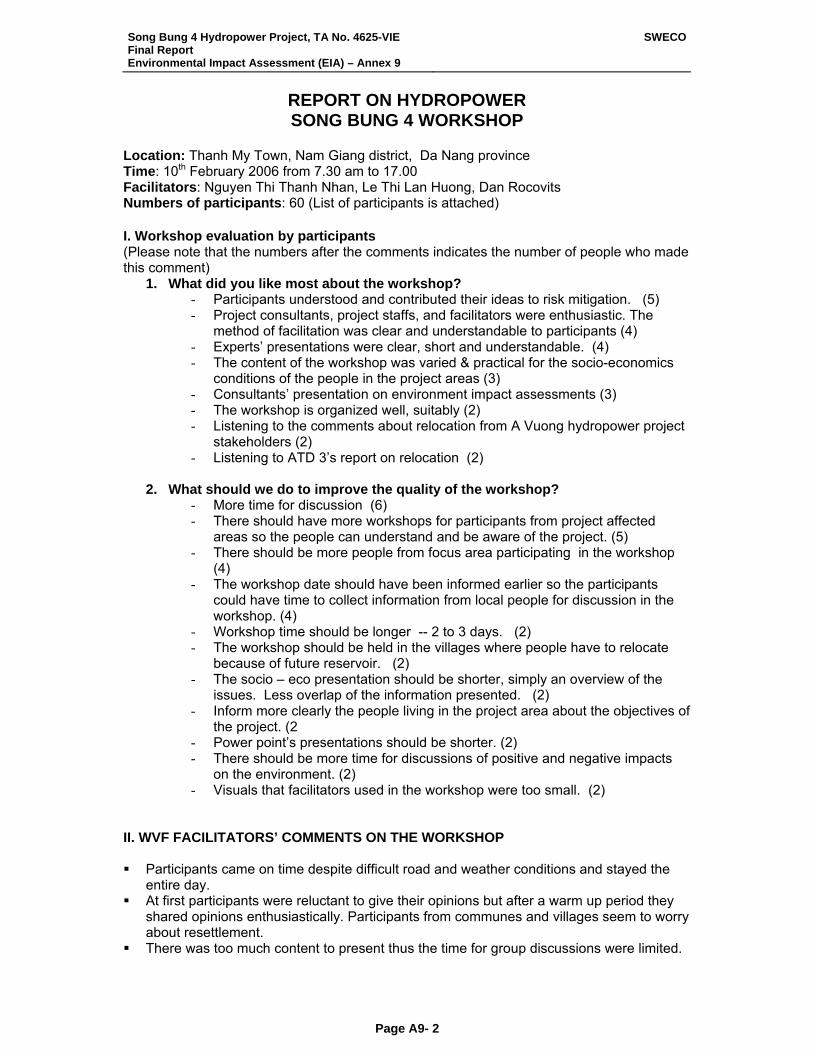
Song Bung 4 Hydropower Project, TA No. 4625-VIE Final Report Environmental Impact Assessment (EIA) – Annex 9
SWECO
Page A9- 2
REPORT ON HYDROPOWER SONG BUNG 4 WORKSHOP
Location: Thanh My Town, Nam Giang district, Da Nang province Time: 10th February 2006 from 7.30 am to 17.00 Facilitators: Nguyen Thi Thanh Nhan, Le Thi Lan Huong, Dan Rocovits Numbers of participants: 60 (List of participants is attached) I. Workshop evaluation by participants (Please note that the numbers after the comments indicates the number of people who made this comment)
1. What did you like most about the workshop? - Participants understood and contributed their ideas to risk mitigation. (5) - Project consultants, project staffs, and facilitators were enthusiastic. The
method of facilitation was clear and understandable to participants (4) - Experts’ presentations were clear, short and understandable. (4) - The content of the workshop was varied & practical for the socio-economics
conditions of the people in the project areas (3) - Consultants’ presentation on environment impact assessments (3) - The workshop is organized well, suitably (2) - Listening to the comments about relocation from A Vuong hydropower project
stakeholders (2) - Listening to ATD 3’s report on relocation (2)
2. What should we do to improve the quality of the workshop? - More time for discussion (6) - There should have more workshops for participants from project affected
areas so the people can understand and be aware of the project. (5) - There should be more people from focus area participating in the workshop
(4) - The workshop date should have been informed earlier so the participants
could have time to collect information from local people for discussion in the workshop. (4)
- Workshop time should be longer -- 2 to 3 days. (2) - The workshop should be held in the villages where people have to relocate
because of future reservoir. (2) - The socio – eco presentation should be shorter, simply an overview of the
issues. Less overlap of the information presented. (2) - Inform more clearly the people living in the project area about the objectives of
the project. (2 - Power point’s presentations should be shorter. (2) - There should be more time for discussions of positive and negative impacts
on the environment. (2) - Visuals that facilitators used in the workshop were too small. (2)
II. WVF FACILITATORS’ COMMENTS ON THE WORKSHOP Participants came on time despite difficult road and weather conditions and stayed the
entire day. At first participants were reluctant to give their opinions but after a warm up period they
shared opinions enthusiastically. Participants from communes and villages seem to worry about resettlement.
There was too much content to present thus the time for group discussions were limited.
Song Bung 4 Hydropower Project, TA No. 4625-VIE Final Report Environmental Impact Assessment (EIA) – Annex 9
SWECO
Page A9- 3
Participants could not answer the questions related to the consultants’ presentations during question and answer periods immediately following those presentations. Perhaps the material was to technical or the plenary group to large to encourage participation.
III. Morning Small Group Discussions Group 1: Social & Environmental Impacts
Village participants Facilitator: Nguyen Thi Thanh Nhan Domestic consultant: Dao Huy Khue
At first, participants were reluctant to contribute. After about 30 minutes with encouragement from the facilitator, participants made the following comments. (Please note that the numbers following comments represent the ranking made by participants after all ideas were presented, discussed, and listed on poster paper. Each participant had three votes.) 1. Loss of domestic water supply: 5 points
2 wells and 4 river wharves and 4 natural water supplies, including: Pa Dhi: 2 clean water supplies to the village Number 2 village: 2 clean water supplies to the village Pa Rum A: 3 clean water supplies All 4 villages lost all gravity water pipes to the households
2. Loss of some other infrastructures: 4 points Pa Rum B: Loss all of classrooms and the commune centre 1 cutural house 31 classrooms 4 rooms of the communal health station 8 rooms of the commune people’s committee 1 footbridge 1 underground bridge 29 small-scale irrigation works
3. Loss of 196 houses: 3points 196 houses including Pa Dhi 58 houses Pa Rum 40 houses Pa Rum B: 57 houses Number 2 village: 76 houses + kitchen + stores and cattle’s shelf
4. Loss of agricultural land: 3 points 5. Loss access to the forests and forest products: 2 points
Forest vegetable Wood for building Wild animals such as mice, wild boar, etc. Loss of 100% small black pepper and perennial trees such as cinnamon trees (from
1990), mango. Loss of herbal trees around houses and in the forest
6. Health impacts: 2 points Stress due to moving houses and furniture and do not know where to find herbal
trees 7. Social Stress: 1 point
People worry about their agricultural land and family economy because they are not familiar with the new areas.
They also worry about losing graves (Number 2 village: if moving households there should move their graves too. But in pa Dhi and Pa Rum A & B, people do not need to move graves but worship ceremony
8. Social disruption: 1 point If the people know how to protect themselves, it would be no problems
Song Bung 4 Hydropower Project, TA No. 4625-VIE Final Report Environmental Impact Assessment (EIA) – Annex 9
SWECO
Page A9- 4
9. Partial loss of area and food sources for livestock 1 point 10. Loss of spiritual sites: 1 point
All 4 villages lose cemeteries and Guoi houses 11. Women and children trafficking: 1 point
Our area is not near the border so it would be less risk but because of the presence of lots of strangers it could be a risk.
12. Disruption caused by strangers from other places: No point Strangers would be a security risk due to theft of property, cattle and chicken.
13. Traffic safety: No point Roads will be flooded
14. Loss of access to fishing from the river: No points It affects the food sources of the people with fish ponds and some households living
on marine products 15. Disruption to host communities from immigration: No point
Do not know the relocation areas yet 16. Diseases caused by lack of water supplies: No point
It could be a problem because people would lose access to herbal medicine around the houses and in the forest
Group 2: Environment impacts
9 technical participants from provinces, districts and some other organizations (NGO’s)
Facilitator: Nguyen Thi Bich Ngoc Domestic consultant: Nguyen Kim Nhung (Institute of Geography)
1. Impact on Song Thanh Nature Reserve: 9 points
- Noise from construction makes animals migrate - Lose about 78 ha forest land and 144 ha buffer zone (in the lake bottom) causing
impact on management - Disruption to the regulatory functions of natural ecosystems (change to aquatic
ecosystem) - Flooded part of the upstream and loss of transmission line corridor to sensitive
areas - Management is difficult because of the loss of 14 D road (official road) - Increase access to reserved area (by waterway) resulting in poaching - Constructing branch of 14D road causes loss of forest and increases more access
ways to the forest 2. Social disruption: 8 points
- Prostitution - Drug - Robbery - Fighting - Alcoholism - Relationship (children without marriage), loss of husband or wife
3. Disruption to biodiversity and natural ecosystems: 7 points
- Impact on fish stocks and people’s lives - Loss of 1000 ha agricultural land that is replaced with forest land - Loss of some animals, especially animals in the reserve area like tiger, turtle,
tortoise, bird and fox 4. Bank erosion and landslide: 1 point.
- Erosion during construction - Water level in the lake fluctuating would cause erosion on the lake bottom
Song Bung 4 Hydropower Project, TA No. 4625-VIE Final Report Environmental Impact Assessment (EIA) – Annex 9
SWECO
Page A9- 5
- Constructing 14D road affects forest around the newly opened road 5. Environmental pollution: 1 point
- The number of vehicles and stone exploitation causes air and noise pollution - Solid and household waste pollution during constructing - Water and ecosystem pollution due to release of toxic chemicals - Mrs. Quynh of EVN commented that EVN hired an organization specializing in
bombs disposal and toxic chemicals for the reservoir bottom. However, an officer from district people committee said there would hardly have any bombs or dynamite in the reservoir bottom.
6. Siltation and pollution of lake bottom: 1 point - Loss of downstream alluvium - Water pollution caused by flooded fauna and flora
7. Change of hydrology: 1point - Limit flood in the downstream
8. Water quality: No point - Siltation: change of water quality - Provide stable domestic water supply to people living around the lake - There is negative impact to agricultural water supply
9. Impact on navigation: No point - There will be no impact if there’s a bridge across 14D road
10. Impact on other water use downstream: No point - Regulating reservoir can affect natural ecosystem during dry season and
result in salt water. Group 3: Social Impacts 17 non technical participants from commune and district administrative organizations Facilitator: Le Thi Lan Huong Domestic consultants: Bui Minh Dao
WVF facilitator’s notes: Participants mentioned that there was no data provided on Vinh village & Ta Bhing Commune during the consultants’ presentations. Participants took part enthusiastically, especially the chairmen and commune secretaries of Zuoih and Ta Bhing communes. Participants added more detailed information on social impacts and ranked as follows: 1. Loss of houses: 8 points
- 196 houses in 4 villages in Zuoih commune including: - No. 2 village, - Pa Rum A village, - Pa Rum B village - Pa Dhi village. The number of houses lost would increase to about 10 houses
more. 2.Loss of agricultural land: 8 points
- In all 4 villages in Zuoih commune including mountain field land and delta land - Vinh village in Ta Bhing: lost mountain field land, garden land and along river
valley - Losing agricultural land could result in deforesting and land conflicting
3.Social stress: 8 points - People worry to be relocated. They are worried because they can’t imagine
how the new places will be and how to go there. - No one wants to relocate.
4.Loss of some other infrastructures: 6 points - 31 classrooms
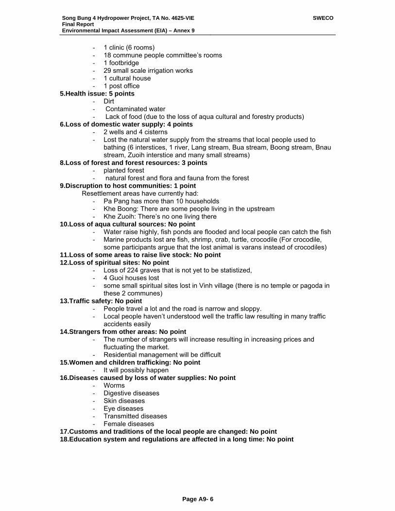
Song Bung 4 Hydropower Project, TA No. 4625-VIE Final Report Environmental Impact Assessment (EIA) – Annex 9
SWECO
Page A9- 6
- 1 clinic (6 rooms) - 18 commune people committee’s rooms - 1 footbridge - 29 small scale irrigation works - 1 cultural house - 1 post office
5.Health issue: 5 points - Dirt - Contaminated water - Lack of food (due to the loss of aqua cultural and forestry products)
6.Loss of domestic water supply: 4 points - 2 wells and 4 cisterns - Lost the natural water supply from the streams that local people used to
bathing (6 interstices, 1 river, Lang stream, Bua stream, Boong stream, Bnau stream, Zuoih interstice and many small streams)
8.Loss of forest and forest resources: 3 points - planted forest - natural forest and flora and fauna from the forest
9.Discruption to host communities: 1 point Resettlement areas have currently had:
- Pa Pang has more than 10 households - Khe Boong: There are some people living in the upstream - Khe Zuoih: There’s no one living there
10.Loss of aqua cultural sources: No point - Water raise highly, fish ponds are flooded and local people can catch the fish - Marine products lost are fish, shrimp, crab, turtle, crocodile (For crocodile,
some participants argue that the lost animal is varans instead of crocodiles) 11.Loss of some areas to raise live stock: No point 12.Loss of spiritual sites: No point
- Loss of 224 graves that is not yet to be statistized, - 4 Guoi houses lost - some small spiritual sites lost in Vinh village (there is no temple or pagoda in
these 2 communes) 13.Traffic safety: No point
- People travel a lot and the road is narrow and sloppy. - Local people haven’t understood well the traffic law resulting in many traffic
accidents easily 14.Strangers from other areas: No point
- The number of strangers will increase resulting in increasing prices and fluctuating the market.
- Residential management will be difficult 15.Women and children trafficking: No point
- It will possibly happen 16.Diseases caused by loss of water supplies: No point
- Worms - Digestive diseases - Skin diseases - Eye diseases - Transmitted diseases - Female diseases
17.Customs and traditions of the local people are changed: No point 18.Education system and regulations are affected in a long time: No point
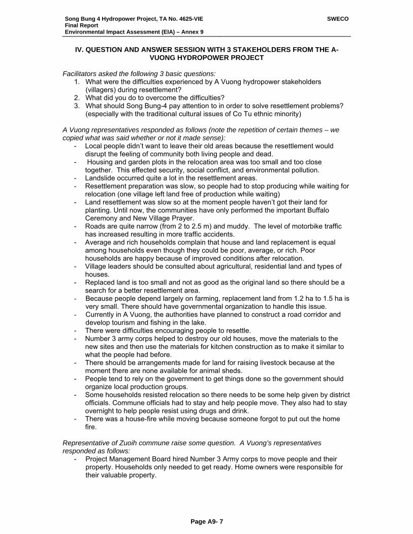
Song Bung 4 Hydropower Project, TA No. 4625-VIE Final Report Environmental Impact Assessment (EIA) – Annex 9
SWECO
Page A9- 7
IV. QUESTION AND ANSWER SESSION WITH 3 STAKEHOLDERS FROM THE A-VUONG HYDROPOWER PROJECT
Facilitators asked the following 3 basic questions:
1. What were the difficulties experienced by A Vuong hydropower stakeholders (villagers) during resettlement?
2. What did you do to overcome the difficulties? 3. What should Song Bung-4 pay attention to in order to solve resettlement problems?
(especially with the traditional cultural issues of Co Tu ethnic minority) A Vuong representatives responded as follows (note the repetition of certain themes – we copied what was said whether or not it made sense):
- Local people didn’t want to leave their old areas because the resettlement would disrupt the feeling of community both living people and dead.
- Housing and garden plots in the relocation area was too small and too close together. This effected security, social conflict, and environmental pollution.
- Landslide occurred quite a lot in the resettlement areas. - Resettlement preparation was slow, so people had to stop producing while waiting for
relocation (one village left land free of production while waiting) - Land resettlement was slow so at the moment people haven’t got their land for
planting. Until now, the communities have only performed the important Buffalo Ceremony and New Village Prayer.
- Roads are quite narrow (from 2 to 2.5 m) and muddy. The level of motorbike traffic has increased resulting in more traffic accidents.
- Average and rich households complain that house and land replacement is equal among households even though they could be poor, average, or rich. Poor households are happy because of improved conditions after relocation.
- Village leaders should be consulted about agricultural, residential land and types of houses.
- Replaced land is too small and not as good as the original land so there should be a search for a better resettlement area.
- Because people depend largely on farming, replacement land from 1.2 ha to 1.5 ha is very small. There should have governmental organization to handle this issue.
- Currently in A Vuong, the authorities have planned to construct a road corridor and develop tourism and fishing in the lake.
- There were difficulties encouraging people to resettle. - Number 3 army corps helped to destroy our old houses, move the materials to the
new sites and then use the materials for kitchen construction as to make it similar to what the people had before.
- There should be arrangements made for land for raising livestock because at the moment there are none available for animal sheds.
- People tend to rely on the government to get things done so the government should organize local production groups.
- Some households resisted relocation so there needs to be some help given by district officials. Commune officials had to stay and help people move. They also had to stay overnight to help people resist using drugs and drink.
- There was a house-fire while moving because someone forgot to put out the home fire.
Representative of Zuoih commune raise some question. A Vuong’s representatives responded as follows:
- Project Management Board hired Number 3 Army corps to move people and their property. Households only needed to get ready. Home owners were responsible for their valuable property.
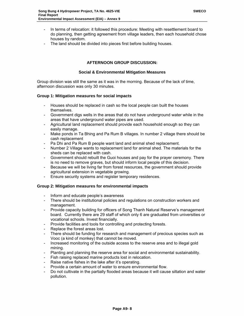
Song Bung 4 Hydropower Project, TA No. 4625-VIE Final Report Environmental Impact Assessment (EIA) – Annex 9
SWECO
Page A9- 8
- In terms of relocation: it followed this procedure: Meeting with resettlement board to do planning, then getting agreement from village leaders, then each household chose houses by random.
- The land should be divided into pieces first before building houses.
AFTERNOON GROUP DISCUSSION:
Social & Environmental Mitigation Measures Group division was still the same as it was in the morning. Because of the lack of time, afternoon discussion was only 30 minutes. Group 1: Mitigation measures for social impacts
- Houses should be replaced in cash so the local people can built the houses themselves.
- Government digs wells in the areas that do not have underground water while in the areas that have underground water pipes are used.
- Agricultural land replacement should provide each household enough so they can easily manage.
- Make ponds in Ta Bhing and Pa Rum B villages. In number 2 village there should be cash replacement
- Pa Dhi and Pa Rum B people want land and animal shed replacement. - Number 2 Village wants to replacement land for animal shed. The materials for the
sheds can be replaced with cash. - Government should rebuilt the Guoi houses and pay for the prayer ceremony. There
is no need to remove graves, but should inform local people of this decision. - Because we will be living far from forest resources, the government should provide
agricultural extension in vegetable growing. - Ensure security systems and register temporary residences.
Group 2: Mitigation measures for environmental impacts - Inform and educate people’s awareness - There should be institutional policies and regulations on construction workers and
management. - Provide capacity building for officers of Song Thanh Natural Reserve’s management
board. Currently there are 29 staff of which only 6 are graduated from universities or vocational schools. Invest financially.
- Provide facilities and tools for controlling and protecting forests. - Replace the forest areas lost. - There should be funding for research and management of precious species such as
Vooc (a kind of monkey) that cannot be moved. - Increased monitoring of the outside access to the reserve area and to illegal gold
mining. - Planting and planning the reserve area for social and environmental sustainability. - Fish raising replaced marine products lost in relocation. - Raise native fishes in the lake after it’s operating. - Provide a certain amount of water to ensure environmental flow. - Do not cultivate in the partially flooded areas because it will cause siltation and water
pollution.
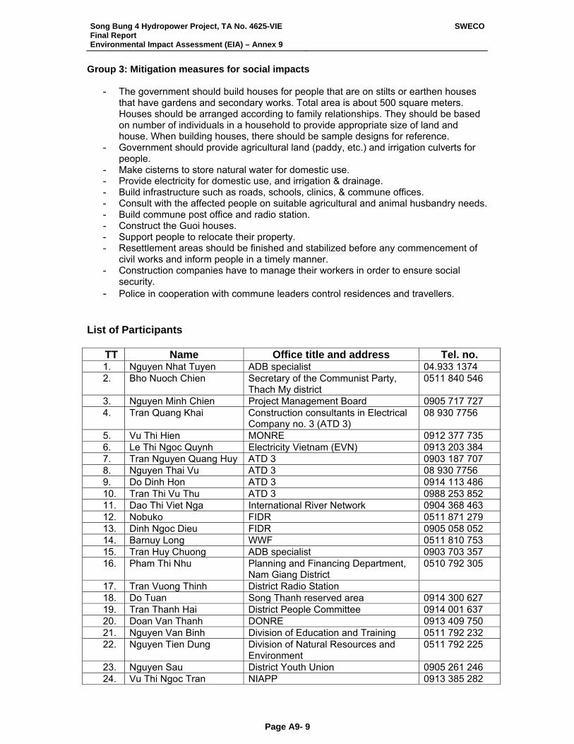
Song Bung 4 Hydropower Project, TA No. 4625-VIE Final Report Environmental Impact Assessment (EIA) – Annex 9
SWECO
Page A9- 9
Group 3: Mitigation measures for social impacts
- The government should build houses for people that are on stilts or earthen houses that have gardens and secondary works. Total area is about 500 square meters. Houses should be arranged according to family relationships. They should be based on number of individuals in a household to provide appropriate size of land and house. When building houses, there should be sample designs for reference.
- Government should provide agricultural land (paddy, etc.) and irrigation culverts for people.
- Make cisterns to store natural water for domestic use. - Provide electricity for domestic use, and irrigation & drainage. - Build infrastructure such as roads, schools, clinics, & commune offices. - Consult with the affected people on suitable agricultural and animal husbandry needs. - Build commune post office and radio station. - Construct the Guoi houses. - Support people to relocate their property. - Resettlement areas should be finished and stabilized before any commencement of
civil works and inform people in a timely manner. - Construction companies have to manage their workers in order to ensure social
security. - Police in cooperation with commune leaders control residences and travellers.
List of Participants
TT Name Office title and address Tel. no. 1. Nguyen Nhat Tuyen ADB specialist 04.933 1374 2. Bho Nuoch Chien Secretary of the Communist Party,
Thach My district 0511 840 546
3. Nguyen Minh Chien Project Management Board 0905 717 727 4. Tran Quang Khai Construction consultants in Electrical
Company no. 3 (ATD 3) 08 930 7756
5. Vu Thi Hien MONRE 0912 377 735 6. Le Thi Ngoc Quynh Electricity Vietnam (EVN) 0913 203 384 7. Tran Nguyen Quang Huy ATD 3 0903 187 707 8. Nguyen Thai Vu ATD 3 08 930 7756 9. Do Dinh Hon ATD 3 0914 113 486 10. Tran Thi Vu Thu ATD 3 0988 253 852 11. Dao Thi Viet Nga International River Network 0904 368 463 12. Nobuko FIDR 0511 871 279 13. Dinh Ngoc Dieu FIDR 0905 058 052 14. Barnuy Long WWF 0511 810 753 15. Tran Huy Chuong ADB specialist 0903 703 357 16. Pham Thi Nhu Planning and Financing Department,
Nam Giang District 0510 792 305
17. Tran Vuong Thinh District Radio Station 18. Do Tuan Song Thanh reserved area 0914 300 627 19. Tran Thanh Hai District People Committee 0914 001 637 20. Doan Van Thanh DONRE 0913 409 750 21. Nguyen Van Binh Division of Education and Training 0511 792 232 22. Nguyen Tien Dung Division of Natural Resources and
Environment 0511 792 225
23. Nguyen Sau District Youth Union 0905 261 246 24. Vu Thi Ngoc Tran NIAPP 0913 385 282
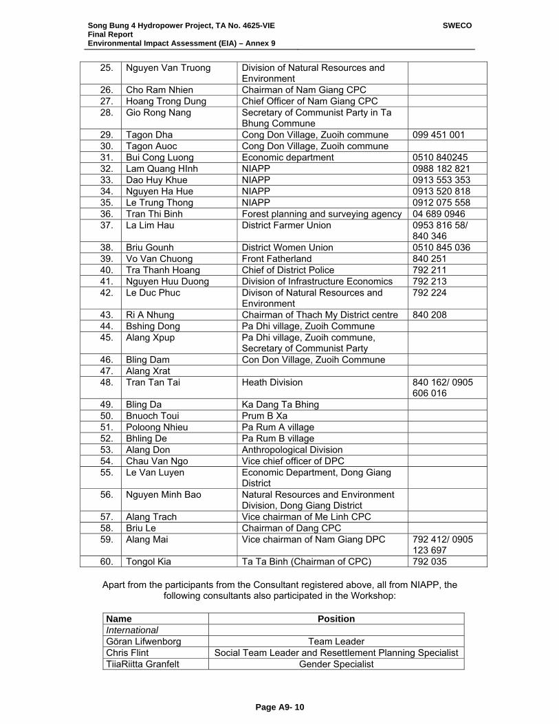
Song Bung 4 Hydropower Project, TA No. 4625-VIE Final Report Environmental Impact Assessment (EIA) – Annex 9
SWECO
Page A9- 10
25. Nguyen Van Truong Division of Natural Resources and Environment
26. Cho Ram Nhien Chairman of Nam Giang CPC 27. Hoang Trong Dung Chief Officer of Nam Giang CPC 28. Gio Rong Nang Secretary of Communist Party in Ta
Bhung Commune
29. Tagon Dha Cong Don Village, Zuoih commune 099 451 001 30. Tagon Auoc Cong Don Village, Zuoih commune 31. Bui Cong Luong Economic department 0510 840245 32. Lam Quang HInh NIAPP 0988 182 821 33. Dao Huy Khue NIAPP 0913 553 353 34. Nguyen Ha Hue NIAPP 0913 520 818 35. Le Trung Thong NIAPP 0912 075 558 36. Tran Thi Binh Forest planning and surveying agency 04 689 0946 37. La Lim Hau District Farmer Union 0953 816 58/
840 346 38. Briu Gounh District Women Union 0510 845 036 39. Vo Van Chuong Front Fatherland 840 251 40. Tra Thanh Hoang Chief of District Police 792 211 41. Nguyen Huu Duong Division of Infrastructure Economics 792 213 42. Le Duc Phuc Divison of Natural Resources and
Environment 792 224
43. Ri A Nhung Chairman of Thach My District centre 840 208 44. Bshing Dong Pa Dhi village, Zuoih Commune 45. Alang Xpup Pa Dhi village, Zuoih commune,
Secretary of Communist Party
46. Bling Dam Con Don Village, Zuoih Commune 47. Alang Xrat 48. Tran Tan Tai Heath Division 840 162/ 0905
606 016 49. Bling Da Ka Dang Ta Bhing 50. Bnuoch Toui Prum B Xa 51. Poloong Nhieu Pa Rum A village 52. Bhling De Pa Rum B village 53. Alang Don Anthropological Division 54. Chau Van Ngo Vice chief officer of DPC 55. Le Van Luyen Economic Department, Dong Giang
District
56. Nguyen Minh Bao Natural Resources and Environment Division, Dong Giang District
57. Alang Trach Vice chairman of Me Linh CPC 58. Briu Le Chairman of Dang CPC 59. Alang Mai Vice chairman of Nam Giang DPC 792 412/ 0905
123 697 60. Tongol Kia Ta Ta Binh (Chairman of CPC) 792 035
Apart from the participants from the Consultant registered above, all from NIAPP, the
following consultants also participated in the Workshop:
Name Position International Göran Lifwenborg Team Leader Chris Flint Social Team Leader and Resettlement Planning Specialist TiiaRiitta Granfelt Gender Specialist
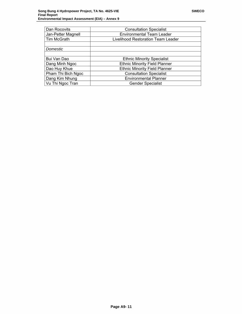
Song Bung 4 Hydropower Project, TA No. 4625-VIE Final Report Environmental Impact Assessment (EIA) – Annex 9
SWECO
Page A9- 11
Dan Rocovits Consultation Specialist Jan-Petter Magnell Environmental Team Leader Tim McGrath Livelihood Restoration Team Leader Domestic Bui Van Dao Ethnic Minority Specialist Dang Minh Ngoc Ethnic Minority Field Planner Dao Huy Khue Ethnic Minority Field Planner Pham Thi Bich Ngoc Consultation Specialist Dang Kim Nhung Environmental Planner Vu Thi Ngoc Tran Gender Specialist
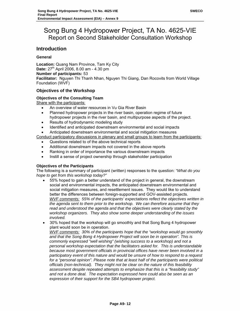
Song Bung 4 Hydropower Project, TA No. 4625-VIE Final Report Environmental Impact Assessment (EIA) – Annex 9
SWECO
Page A9- 12
Song Bung 4 Hydropower Project, TA No. 4625-VIE Report on Second Stakeholder Consultation Workshop
Introduction General
Location: Quang Nam Province, Tam Ky City Date: 27th April 2006, 8.00 am - 4.30 pm Number of participants: 53 Facilitator: Nguyen Thi Thanh Nhan, Nguyen Thi Giang, Dan Rocovits from World Village Foundation (WVF)
Objectives of the Workshop Objectives of the Consulting Team Share with the participants:
• An overview of water resources in Vu Gia River Basin • Planned hydropower projects in the river basin, operation regime of future
hydropower projects in the river basin, and multipurpose aspects of the project. • Results of hydrodynamic modeling study • Identified and anticipated downstream environmental and social impacts • Anticipated downstream environmental and social mitigation measures
Conduct participatory discussions in plenary and small groups to learn from the participants: • Questions related to of the above technical reports • Additional downstream impacts not covered in the above reports • Ranking in order of importance the various downstream impacts • Instill a sense of project ownership through stakeholder participation
Objectives of the Participants The following is a summary of participant (written) responses to the question: “What do you hope to get from this workshop today?”
• 55% hoped to gain a better understand of the project in general, the downstream social and environmental impacts, the anticipated downstream environmental and social mitigation measures, and resettlement issues. They would like to understand better the differences between foreign-supported and GOV-assisted projects. WVF comments: 55% of the participants’ expectations reflect the objectives written in the agenda sent to them prior to the workshop. We can therefore assume that they read and understood the agenda and that the objectives were clearly stated by the workshop organizers. They also show some deeper understanding of the issues involved.
• 30% hoped that the workshop will go smoothly and that Song Bung 4 hydropower plant would soon be in operation. WVF comments: 30% of the participants hope that the “workshop would go smoothly and that the Song Bong 4 Hydropower Project will soon be in operation”. This is commonly expressed ”well wishing” (wishing success to a workshop) and not a personal workshop expectation that the facilitators asked for. This is understandable because most government officials in provincial offices have never been involved in a participatory event of this nature and would be unsure of how to respond to a request for a “personal opinion”. Please note that at least half of the participants were political officials (non-technical). They might not be clear on the nature of this feasibility assessment despite repeated attempts to emphasize that this is a “feasibility study” and not a done deal. The expectation expressed here could also be seen as an expression of their support for the SB4 hydropower project.
Song Bung 4 Hydropower Project, TA No. 4625-VIE Final Report Environmental Impact Assessment (EIA) – Annex 9
SWECO
Page A9- 13
• 15% feel that hydropower projects in Vu Gia-Thu Bon Basin are practical solutions to aid Vietnam’s development, will stabilize the ecology and provide more electricity for downstream stakeholders. WVF comments: 15% agree with the government policy on hydropower development in Quang Nam.
Evaluation of the Workshop Evaluation by the Participants
Reply by Participants There was a written evaluation at the end of the workshop, and participants were asked to answer the following two questions (Participants were asked to NOT sign the sheets so that they could choose to be as critical is they wish):
• What could be done to improve the workshop? • What did you like most about the workshop?
The following is a summary of their responses. The numbers in (#) indicate the number of persons writing this response. What could be done to improve the workshop?
• (8) The workshop content was hard to understand. • (7) Allot more time to discuss and read documents (i.e. workshop handouts should be
sent to participants before the workshop) • (3) Experts’ answers should be more direct and clear. • (2) It would be better to hold Q&A immediately after the technical presentation rather
than asking the participants to write their questions down for discussion later. • (2) More practical research on social impacts. The presentation by Mr. Ha Hue
lacked sufficient information. • (2) Accommodations for participants should be arranged • (1) Spend less time on registration and the welcoming speech (the speech by the
provincial vice chairman was to long) • (1) After each expert presentation, participants should be tested for understanding • (1) Some of the statistics / recommendations of the experts is conflicting. There
should be better coordination. • (1) Discussion groups should be smaller • (1) Improving the way to facilitate discussion. Perhaps a technical person should be
facilitator • (1) Divide the discussion groups based on participant interest. For example
technical participants (DARD, MONRE) could discuss technical issues and social issues could be discussed by political authorities (provincial People’s Committee, Women’s Union, etc.)
What did you like most about the workshop?
• (8) There was a comfortable working atmosphere. • (7) Workshop logistics and content were carefully prepared by the organizing
committee, consultants and facilitators. • (6) It improved my understanding of downstream environmental and social impacts
and there assessment in hydropower projects. • (3) I now have a general understanding of the SB4 hydropower project. • (3) The facilitation techniques helped participants understand more the contents of
experts’ presentations. • (2) I now understand ADB’s environment protection policies, environmental
management plans, and public information & participation guidelines. • (2) The workshop content was clear enough to stimulate participant interest.
Song Bung 4 Hydropower Project, TA No. 4625-VIE Final Report Environmental Impact Assessment (EIA) – Annex 9
SWECO
Page A9- 14
• (2) The facilitators were professional active and created an open environment for participant interaction.
• (1) I learned some new discussion methodologies • (1) I was able to get acquainted with the Project Implementation Unit
WVF’s Comments on the Evaluation of the Participants
• Highly Technical Content: Please note that 73% of the participant suggestions for improving the workshop related to highly technical content. Expert reports are, by nature, highly technical and were therefore difficult to understand for about half of the participants (who were non-technical political officials). The other half were technical and could easily participates in discussions. Participants suggested that the handouts be sent to them prior to the workshop instead of during registration. This would be useful for the technical participants who could understand the scientific language, graphs and maps, but would still not be very helpful for non-technical participants. Most university educated Vietnamese are not familiar with reading maps (even city street maps in their own town). Participants suggested that more time be spent in discussion groups. Plenary sessions are more formal and stressful. Participants find it easier to share in groups no larger than 15 persons. This would necessitate one or more of the following changes: o Extending the workshop time from one day to 1.5 days o Shortening the technical reports & welcoming speeches by provincial (political)
hosts o Encourage participants to arrive on time
• 69% of the participants felt that following the workshop they had a much better understanding of Song Bung 4 and downstream impacts.
• 66% appreciated the participatory style.
Conclusions Drawn from Participant’s Evaluation
73% of participants felt the workshop content was very technical and 69% felt they had a much better understanding of Song Bung 4 following the workshop. This tells us that although it was a difficult workshop ‘content wise’, it did serve to inform the vast majority of stakeholders. “People Vote with their Feet”: A large number of participants both attended the workshop and stayed through till the end. This is not always the case when high-level officials are invited because they are busy with daily duties. Commonly they will come to the workshop, register, and stay at least for the welcoming address of the host. If there is moderate interest, they will stay through lunch and then return to their offices. Over 90% of the participants who registered in the morning stayed through until the end of the workshop, despite the fact that it was difficult content for at least 50% of them. The participation during small group sessions was enthusiastic and their questions and comments relevant. This tells us that the Song Bung 4 Project is important to the leadership of Quang Nam Province. Workshop Methodology Workshop Posters
Eleven colorful posters and maps were hung around the registration area to stimulate participant interest in the workshop content. It set the stage for the day by providing a graphic (and entertaining) representation of the project area & issues. It further gave the early arrivals something to focus on and discuss with the project consultants and fellow participants while waiting for the workshop to begin. A facilitator was available to help participants understand the posters that included, see Figure 2 for pictures of the posters:
• 1-- 3D Map: Overview of Song Bung 4 Hydropower Project • 2 posters of possible social and environmental impacts • 2 Maps of anticipated resettlement areas
Song Bung 4 Hydropower Project, TA No. 4625-VIE Final Report Environmental Impact Assessment (EIA) – Annex 9
SWECO
Page A9- 15
• 1 Map of Vu Gia-Thu Bon River Basin • 1 Map of area affected by Song Bung 4 Hydropower Project • 4 Posers of ADB’s policy on environmental protection
Posters used during the small group discussions were as follows: • 2 Posters showing 4 scenarios for daily changes in water level • 4 Posters identifying possible environmental down stream impacts • 2 Posters of downstream social impacts
Ice Breakers
Following the traditional welcoming speech from provincial political authorities, a warm up exercise was done to help acquaint the participants with each other and to introduce the participatory model which would be subsequently used. Each participant was asked to:
• Stand • Introduce him/her self & profession / role • Share something of a personal nature that others might not know.
The purpose of an exercise of this nature is to bring the participants together as a team. Each person is invited to stand, speak, and share. This is a model of a participatory event. It should be noted that the consultants and observers were not invited to participate in this exercise. It was explained that there presence here was of a technical / consultative nature. They (the participants) were the stakeholders in the Song Bung 4 Hydropower Project, and the purpose of the workshop was to inform them of the research done thus far and then ask their opinions.
Participant’s Expectations
Participants were asked to write their expectations for the workshop on pieces of color paper, but not to write their names. It was explained (by the facilitator) that this workshop was being conducted for them, as down stream stakeholders and that the consultant team wants to know what they hope to accomplish today. The expectation were collected and read aloud. They were then taped on to a poster, and hung on the wall beside the table containing coffee and snacks. This put them in clear view of all participants and consultants. This was a demonstration of the importance, which the workshop organizers place on the stakeholder opinions and wishes. It encouraged the participants to focus on personal hopes and wants related to the workshop content. And secondly gave the facilitators a quick picture of the participants understanding of the content and purpose of the workshop. It is not uncommon to have a sizable gap between what the participants and the conveners hope to accomplish at a workshop. For most provincial officials, workshops coming from the national level would be “information dissemination” in nature (sharing with them the presenter’s interpretation of national policy). It was also explained at this point that consultant specialists and observers were present and that their role was only to provide information and observe the proceedings.
Participant’s Questions
Participants were asked to write down any questions arising during the consultant reports. It was explained that because of time limitations we were unable to hold open discussion immediately following all the presentations, but that there would be small group discussions in before and after lunch when their questions would be addressed.
Small Group Discussions
General Following consultant reports, participants were divided at random into two groups. Group A: 14 participants & Group B 15 participants (not including observers and consultants).
Song Bung 4 Hydropower Project, TA No. 4625-VIE Final Report Environmental Impact Assessment (EIA) – Annex 9
SWECO
Page A9- 16
Each group was asked to select a reporter (from among the participant group) who would present the group’s findings in plenary. Several persons from the Consultant assisted the WVF facilitators in recording participant discussion points. The facilitator presented questions / issues for discussion (on poster paper) and recorded what was said / decided (in clear view of all participants on that poster paper). Morning Session To be sure the participants understood the issues and to stimulate discussion, the facilitators ask the following questions during the morning:
• Identified downstream environmental impacts: o How would daily changes in water level impact people living in your area? o In your opinion, is this impact really serious to people living in the area? o Please explain more about your ideas. o These are impacts given out by experts. In your opinion, are there any serious
impacts that experts didn’t mention? • Possible downstream environmental impacts:
o Do you agree with the impacts suggested by the consultants (Yes-No/why)? o Is this possible to happen in your area? o How does this impact have influence on people? o At the present, what do people in your area use water for (question used for
impact No. 3) o Besides these impacts, what are the others sticking in your mind?
• Possible downstream environmental impacts during the construction period: o Do you understand clearly what this means? o Do you agree with this impact? Yes – No /why? o What do you want to add more in this impact? o What do people in your area use water for? o How are fresh water and irrigation impacted? o Besides these impacts what are the others likely to happen in your area?
Afternoon Session To be sure the participants understood the issues related to social impacts and to stimulate discussion the facilitators ask the following general questions during discussion of each focus topic / issue in the afternoon:
• At present how many people in your area depend on fishing for their livelihood? • According to you, how will fish and animals be impacted? • How local people’s lives are will be influenced? • How will the daily change of water flow in Vu Gia and Thu Bon river affect irrigated
agriculture? • How about water for home use? • How will local people’s lives be affected? •
The issues for small group discussion were provided the Consultant. The facilitators asked the participants to suggest additional issues related to the focus topics. These participant-provided issues were also written on poster paper and included in the discussion and subsequent ranking. At the end of the discussions, participants were handed three voting dots each and asked stick the dots on the poster paper beside the issue or issues that they felt would be the biggest impact in their down stream area. (Please note that they could place all three dots on one issue if they felt it was overwhelmingly more important than the others or spread their three votes as they saw fit.) This provided the ranked list of down stream impacts included in this report. Please note that SWECO consultants and other observers (ADB, NGO’s) participated in the small groups to answer technical questions. They had no voting rights, nor were allowed to dominate to discussion.
Song Bung 4 Hydropower Project, TA No. 4625-VIE Final Report Environmental Impact Assessment (EIA) – Annex 9
SWECO
Page A9- 17
Participant’s Written Evaluations
Written evaluations were done at the end of the workshop, and participants were asked to answer the following two questions (Participants were asked to NOT sign the sheets so that they could choose to be as critical is they wish):
• What could be done to improve the workshop? • What did you like most about the workshop?
The questions were designed to be simple and open-ended. This encourages participants to think creatively and reduces the tendency to be prejudiced by the questionnaire. Summary of Consultant’s Presentation Presentation of Water Resource Review Committee (WRRC) by Mr. Tim McGrath.
Overview of Vu Gia River Basin
Mr. Le, representative of Hydropower Project Management Board 3 (HPPMB3) presented the following main points:
• Floor control & irrigation and drainage • Location & status of the 8 hydropower projects in Quang Nam • Technical data base related to: water levels, dead water level, water level fluctuation,
statistics on reservoir area, power generation potential, yearly power outputs, and operation mechanism of the 8 projects
• Map of proposed Song Bung 4 project area: dam height, power station location, reservoir area, active storage, and regulation zone
• Expert assessment of the operation mechanism
Results of the Hydrodynamic Modeling Study
Mr. Thien from SIWRR (Southern Institute of Water Resource Research) presented the following main points:
• Results of hydrological and hydrodynamic studies in Song Bung 4 Area. • Study tools, data resource, and analysis results related topography, rain level,
temperature, hydraulic power, water quality, area erosion studies, water flow, sedimentation, MIKE & NAM modeling (to do assessment), study on reservoir operation mechanism, development options for the Vu-Gia basin.
• Mitigation of negative impacts • Recommendations for development of Song Bung 4 Hydropower Project.
After the presentation the participants had the following questions: • Mr. Ha (vice chairman of provincial forestry department): According to calculations
on erosion of Vietnam Geography Institute: Average accumulation in Vu Gia river basin is 25 tons/ha/year, in Song Bung River is 3.7tons/ha/year. However, based on your report the accumulation in Song Bung River is 14.7tons/ha/year. In your opinion, which calculation is most reliable? Mr. Thien answer: These differences are caused by the way experts calculate. Each expert has its own formula. Therefore, the results are different. At the present Vietnam does little data collection on sediment erosion. We just base our calculations on available data.
• Mr. Nong (Quang Nam Water Construction Co.): Song Bung River is a branch of Vu Gia River. The water level in Vu Gia changes and affects the water level in Song Bung River. What is your solution to stabilize the water level in Song Bung? How would the power station operate to lower impacts to the Vu Gia River? When we have power station, the water flow out is less than before. So, what are the solutions for saline water intrusion downstream during the dry season? If the water level in Vu Gia River is limited, how does the dam operate to avoid affecting the other activities downstream?
Song Bung 4 Hydropower Project, TA No. 4625-VIE Final Report Environmental Impact Assessment (EIA) – Annex 9
SWECO
Page A9- 18
What are consultants’ calculations to make sure all the dams operating properly and stably? Mr. Thien answer: The information we just presented meets only part of our requirements. We need to do more studies and calculations to get more exact data and information. As you know, the operation of the power station will affect downstream. Therefore, the operation must well managed to be of a higher water level in dry season and reduce the high level of water in rainy season.
• Ms. Trúc (PECC3.): We participants at present agree with the consultant’s results. According to you, the annual water level in river basin is quite stable even in rainy and dry season. The water level changes 1m, more or less. However during flooding, the over-flow water level and daily water level will make the flood level higher. Will this be a huge impact downstream? Mr. Thien answer: If your information is accurate that the water level changes more or less 1m, I would say that it is not a big impact.
Identified Downstream Environmental Impacts
Ms. Kim Nhung from Institute of Geography presented the following main points: • Identification of downstream environmental impacts • Possible downstream environmental impacts • Possible downstream environmental impacts during the construction period
Identified Downstream Social Impacts
Mr. Ha Hue from NIAPP presented the following main points: • Scope of the social impact study: survey of fish and aquatic products, populations in
Thon Ba Dau (village) and Xa Dai Son (commune), & water use in the Song Bung • Explanation of the PRA to be conducted in one village in Than My town, 8 villages in
Xa Dai Son (commune) and one village per commune in the confluence of the Vu Xa and Thu Bon Rivers
• Results of the house hold survey in Ba Dao village, and two Song bung villages in Dai Son & 20% of the households in 6 villages in Dai Son
• Downstream social effects created by impacts on fish, aquaculture productivity, fresh water supply and water for irrigation.
Overview of ADB’s Environmental and Social Safeguard Policies
Ms. Kim Nhung from Institute of Geography and Mr. Ha Hue from NIAPP presented the following main points:
• ADB’s guidelines on environmental protection and management are available • Environmental protection and poverty reduction (trade off) • Various important activities related to environmental protection: stakeholder
participation, objectivity in assessment, compensation policy, and monitoring protocol. • Compensation for impacted people, supervision activities, expenditures • Anticipated social mitigation measures mainly focused on economy recovery,
aquaculture solutions in order to prevent fish productivity slowing down, and the other solutions such as: raising cattle, forestry allocation, and forest products.
Small Group Discussions General
The participants would, during the small group discussions: • Understand clearly environmental impacts presented by experts • Discuss environmental impacts on people living downstream • Suggest additional impacts not mentioned by the experts • Rank the impacts according to degree of importance
Song Bung 4 Hydropower Project, TA No. 4625-VIE Final Report Environmental Impact Assessment (EIA) – Annex 9
SWECO
Page A9- 19
The key issues for discussion and ranking (morning session) were as follows: • Identified downstream environmental impacts • Possible downstream environmental impacts • Impacts due to the construction period
Results of the Morning Session on Environmental Impacts
Overall Results • 20% feel that the safety of people downstream from the power station outlet would be
negatively impacted by rapidly changing water levels. If the dam broke or eroded there would be loss of life and property. There is concern about the proper management of water released from the dam.
• 20% feel that there will be positive impact on irrigation, fishing and water supply downstream. Increased water flow during the dry season is positive for agriculture. They believe though that the river will be dry from the dam to the power station.
• 17% feel that reduced transport of suspended sediments and bed load in Song Bung would cause a big impact to the area because local people would have to use more fertilizer due to loss of sediment causing low land fertility.
• 14% feel that water pollution during construction is a serious problem. • 9% feel that there will be negative changes in water quality especially during the
construction phase. • 5.7% believe that the dam will block navigation. But other here also feel that blocked
navigation will help reduce deforestation. • 4% feel that increased water flow during the dry season will improve irrigation. • 2.8% feel that increased riverbank erosion due to the dam is a problem. • 2.8% feel daily fluctuations in flow and water level downstream from the power station
outlet is a problem
Voting from Group A Facilitators: Nguyen Thi Giang Social expert: Ha Hue Community Consultant: Bich Ngoc The participants voted on the importance of each issue with the following results, in decreasing order, and comments by the participants:
• The safety of people downstream from the power station outlet would negatively impacted by rapidly changing water levels (13 points): o Most participants agree that this would definitely happen in their areas. o In case a dam broke or eroded, the lives and property of local people would be
lost. • Impact on fishing, water supply and irrigation downstream (7 points) • Increased flow in low flow-period (dry season) (3 points)
o Increased flow from the power station during the dry season will help avoid lack of water.
• Increased river bank erosion due to fluctuation in water level and flow (2 points) o This is a big impact in this area o Fluctuations in the water level can increase or decrease river-bank erosion
depending on the frequency of floods. o When flood frequency increases, local people’s lives will be impacted.
• The dam will act as a barrier for navigation (2 points). o Dam construction would cause difficulties for boats and ships moving on river.
• Daily fluctuations in flow and water level downstream from the power station outlet (2 points) o The daily flow fluctuation cause negative impacts to local people’s lives.
• Reduced transport of suspended sediments and bed load in the Song Bung River (1 point) o Dam barrier causes downstream sediments and bed load decrease.
Song Bung 4 Hydropower Project, TA No. 4625-VIE Final Report Environmental Impact Assessment (EIA) – Annex 9
SWECO
Page A9- 20
• Extremely reduced flow downstream from the dam to the power station outlet (1 point) o Most participants did not understand what experts meant here. o The decreasing flow lasts about 4km.
• Changed annual flow pattern downstream from the power station outlet (1 point) o Annual flows are changed
• Changes in water quality (1 point) o Decreased water quality would seriously impact the lives of people. o Sudden rises in water level could drowned animals and thus pollute the water.
• Impacts on water quality from construction camps and construction activities during the construction period (1 point) o Worker camps and construction decrease water quality. o Construction materials are thrown into water causing pollution. At present, river
water is the only source of water for irrigation by the local people. • The dam will act as a barrier to fish movement and migration and impact on their
productivity: o The fish productivity and reproductive circle is impacted by the high water level
(about 40% fish productivity lost, some kinds of fish will become extinct) • On river reaches with large and rapid daily water level fluctuations there would be a
loss of aquatic life, with negative impacts on fish productivity: o Participants say this will cause a major negative impact on fish productivity.
• Changes in aquatic life: o Some types of aquatic life would be lost and some created by changes in water
level. • Impacts on riparian fauna:
o Riparian fauna such as buffalo and cattle and some kinds of riparian birds would be impacted.
• Increased amount of suspended sediments during the construction period: o Participants say that this impact will happen in their area.
Additional impacts added by participants: • Saline intrusion is likely be a problem when the water level is low. • During the construction period the following impacts will likely occur: noise pollution,
decrease in floral cover, and deforestation will cause mountain erosion and therefore large floods.
Voting from Group B Facilitator: Nguyen Thanh Nhan Environmental specialist: Nguyen Thi Kim Nhung Social specialist: Ms Diep The participants voted on the importance of each issue with the following results, in decreasing order, and comments by the participants:
• Reduced transport of suspended sediments and bed load in Song Bung. This would cause a big impact to the area because local people would have to use more fertilizer due to loss of sediment causing low land fertility (11 points).
• Increased amount of suspended sediments during the construction period. It will definitely happen in our area (7 points).
• Changes in water quality. The water quality is changed due to reduction in sediment (5 points). o If the reservoir is not treated properly before releasing water, water quality will be
changed negatively. • Impact on other water use downstream, e.g. fishing, water supply and irrigation. If
water flow is increased in dry season, it would benefit irrigation in downstream areas (5 points) o The river will be dry from the dam to power station. There needs to be a solution
to this problem.
Song Bung 4 Hydropower Project, TA No. 4625-VIE Final Report Environmental Impact Assessment (EIA) – Annex 9
SWECO
Page A9- 21
• Impacts on water quality from workers camp and construction activities during the construction period. It will definitely happen in the area during construction period (2 points)
• The dam will act as a barrier for navigation. It’s a small impact because of poorly developed navigation in this area (2 points). o To some extend inconvenience to navigation would help reduce deforestation.
• The dam will act as a barrier to fish movement and migration, with impact on their productivity. Impacts would be felt in agriculture and aquaculture in the area from Thac Can to Hoi Khanh (1 point).
• Extremely reduced flow downstream from the dam to the power station outlet. The distance could be more than 3km from the dam to the power station (1 point).
• Changes in aquatic biodiversity. Participants feel that there will be only a small impact and it will happen in the early stage only (1 point)Safety of people downstream from the power station outlet due to rapidly changing water levels. It’s possible that it will happen if flood releasing is not done well (1 point)
• Changed annual flow pattern downstream from the power station outlet. This would create a positive impact on the area because it can reduce flood riskDaily fluctuations in flow and water level downstream power station outlet. This would cause small impact because it will be taken in to account during the power generation process.
• Impacts on riparian fauna. Yes, there will be an impact on riparian fauna and biodiversityIncreased riverbank erosion due to fluctuations in water level and flow. Participants don’t agree with the specialist’s assessment. o Increased riverbank erosion is due to low amount of sediment
• Increased flow in low-flow periods. This is a positive impact on the area • On river reaches with large and rapid daily water level fluctuations loss of aquatic life,
which impacts on fish productivity? Participants don’t agree with the specialist’s assessment. They feel that there will be low and infrequent fluctuations (not daily).
Results of the Afternoon Session on Social Impacts
Overall Results • 50% feel water for irrigation and daily use would be most impacted by the dam. • 12% feel that fish and other aquatic life in the Song Bung would be affected. • 11.8% feel that the area for cultivation will be increased by the dam because of
greater irrigation potential. • 10% feel the decrease in river sediment would negatively effect down stream
agriculture • 5% feel that fish and aquatic life in the Vu Gia River would be negatively impacted
due to changes in the ecosystem and pollution. • 3.3% are fearful of the possible social evils introduced by the construction phase. • 3.3% feel that the dam would give the local community more faith in the government
because it would raise their standard of living. • 3.3% feel the hydrological surveys would have to be constantly updated due to
frequent water fluctuations.
Voting from Group A The participants voted on the importance of each issue with the following results, in decreasing order, and comments by the participants:
• Water for irrigation and daily use (19 points): o This will be a big impact on irrigation and water supply because the amount of
water supply depends on the power station management. o The dam also affects underground water. The fluctuation of the water level will
influence water quality. Water resource could be salty and concentrated.
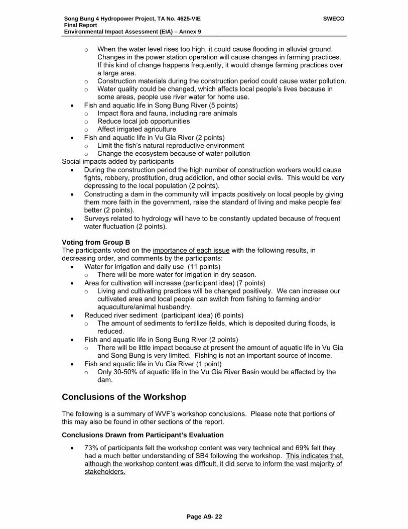
Song Bung 4 Hydropower Project, TA No. 4625-VIE Final Report Environmental Impact Assessment (EIA) – Annex 9
SWECO
Page A9- 22
o When the water level rises too high, it could cause flooding in alluvial ground. Changes in the power station operation will cause changes in farming practices. If this kind of change happens frequently, it would change farming practices over a large area.
o Construction materials during the construction period could cause water pollution. o Water quality could be changed, which affects local people’s lives because in
some areas, people use river water for home use. • Fish and aquatic life in Song Bung River (5 points)
o Impact flora and fauna, including rare animals o Reduce local job opportunities o Affect irrigated agriculture
• Fish and aquatic life in Vu Gia River (2 points) o Limit the fish’s natural reproductive environment o Change the ecosystem because of water pollution
Social impacts added by participants • During the construction period the high number of construction workers would cause
fights, robbery, prostitution, drug addiction, and other social evils. This would be very depressing to the local population (2 points).
• Constructing a dam in the community will impacts positively on local people by giving them more faith in the government, raise the standard of living and make people feel better (2 points).
• Surveys related to hydrology will have to be constantly updated because of frequent water fluctuation (2 points).
Voting from Group B The participants voted on the importance of each issue with the following results, in decreasing order, and comments by the participants:
• Water for irrigation and daily use (11 points) o There will be more water for irrigation in dry season.
• Area for cultivation will increase (participant idea) (7 points) o Living and cultivating practices will be changed positively. We can increase our
cultivated area and local people can switch from fishing to farming and/or aquaculture/animal husbandry.
• Reduced river sediment (participant idea) (6 points) o The amount of sediments to fertilize fields, which is deposited during floods, is
reduced. • Fish and aquatic life in Song Bung River (2 points)
o There will be little impact because at present the amount of aquatic life in Vu Gia and Song Bung is very limited. Fishing is not an important source of income.
• Fish and aquatic life in Vu Gia River (1 point) o Only 30-50% of aquatic life in the Vu Gia River Basin would be affected by the
dam. Conclusions of the Workshop The following is a summary of WVF’s workshop conclusions. Please note that portions of this may also be found in other sections of the report.
Conclusions Drawn from Participant’s Evaluation
• 73% of participants felt the workshop content was very technical and 69% felt they had a much better understanding of SB4 following the workshop. This indicates that, although the workshop content was difficult, it did serve to inform the vast majority of stakeholders.
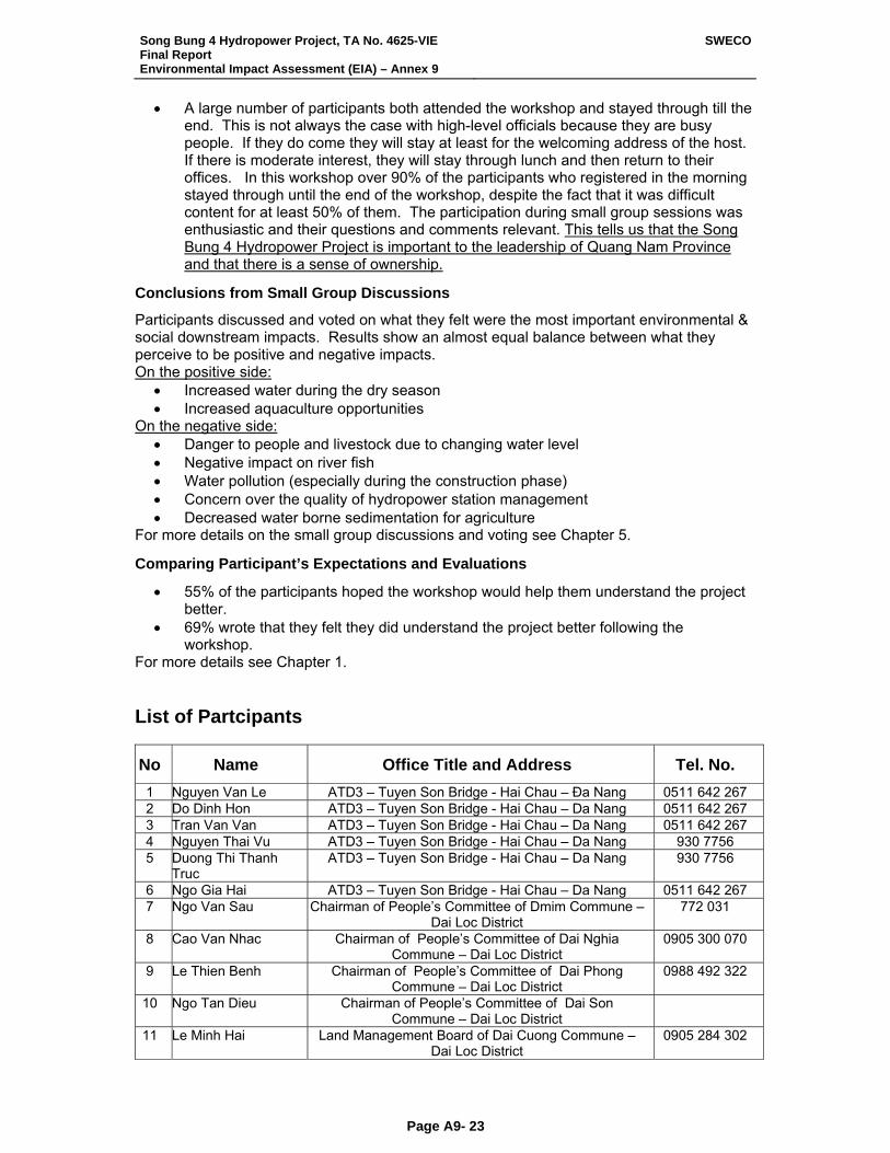
Song Bung 4 Hydropower Project, TA No. 4625-VIE Final Report Environmental Impact Assessment (EIA) – Annex 9
SWECO
Page A9- 23
• A large number of participants both attended the workshop and stayed through till the end. This is not always the case with high-level officials because they are busy people. If they do come they will stay at least for the welcoming address of the host. If there is moderate interest, they will stay through lunch and then return to their offices. In this workshop over 90% of the participants who registered in the morning stayed through until the end of the workshop, despite the fact that it was difficult content for at least 50% of them. The participation during small group sessions was enthusiastic and their questions and comments relevant. This tells us that the Song Bung 4 Hydropower Project is important to the leadership of Quang Nam Province and that there is a sense of ownership.
Conclusions from Small Group Discussions
Participants discussed and voted on what they felt were the most important environmental & social downstream impacts. Results show an almost equal balance between what they perceive to be positive and negative impacts. On the positive side:
• Increased water during the dry season • Increased aquaculture opportunities
On the negative side: • Danger to people and livestock due to changing water level • Negative impact on river fish • Water pollution (especially during the construction phase) • Concern over the quality of hydropower station management • Decreased water borne sedimentation for agriculture
For more details on the small group discussions and voting see Chapter 5.
Comparing Participant’s Expectations and Evaluations
• 55% of the participants hoped the workshop would help them understand the project better.
• 69% wrote that they felt they did understand the project better following the workshop.
For more details see Chapter 1. List of Partcipants
No Name Office Title and Address Tel. No. 1 Nguyen Van Le ATD3 – Tuyen Son Bridge - Hai Chau – Đa Nang 0511 642 267 2 Do Dinh Hon ATD3 – Tuyen Son Bridge - Hai Chau – Da Nang 0511 642 267 3 Tran Van Van ATD3 – Tuyen Son Bridge - Hai Chau – Da Nang 0511 642 267 4 Nguyen Thai Vu ATD3 – Tuyen Son Bridge - Hai Chau – Da Nang 930 7756 5 Duong Thi Thanh
Truc ATD3 – Tuyen Son Bridge - Hai Chau – Da Nang 930 7756
6 Ngo Gia Hai ATD3 – Tuyen Son Bridge - Hai Chau – Da Nang 0511 642 267 7 Ngo Van Sau Chairman of People’s Committee of Dmim Commune –
Dai Loc District 772 031
8 Cao Van Nhac Chairman of People’s Committee of Dai Nghia Commune – Dai Loc District
0905 300 070
9 Le Thien Benh Chairman of People’s Committee of Dai Phong Commune – Dai Loc District
0988 492 322
10 Ngo Tan Dieu Chairman of People’s Committee of Dai Son Commune – Dai Loc District
11 Le Minh Hai Land Management Board of Dai Cuong Commune – Dai Loc District
0905 284 302
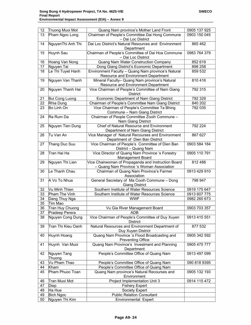
Song Bung 4 Hydropower Project, TA No. 4625-VIE Final Report Environmental Impact Assessment (EIA) – Annex 9
SWECO
Page A9- 24
12 Truong Muoi Mot Quang Nam province’s Mother Land Front 0905 137 925 13 Pham Ngoc Long Chairman of People’s Committee Dai Hong Commune
– Dai Loc District 0903 150 045
14 NguyenThi Anh Thi Dai Loc District’s Natural Resources and Environment Department
865 462
15 Huynh Sau Chairman of People’s Committee of Dai Hoa Commune – Dai Loc District
0983 764 379
16 Hoang Van Nong Quang Nam Water Construction Company 852 619 17 Nguyen Tai Dong Giang District’s Economic Department 898 258 18 Le Thi Tuyet Hanh Environment Faculty – Quang Nam province’s Natural
Resource and Environment Department 859 532
19 Nguyen Van Thanh Mineral Faculty– Quang Nam province’s Natural Resource and Environment Department
810 416
20 Nguyen Thanh Hai Vice Chairman of People’s Committee of Nam Giang District
792 315
21 Bui Cong Luong Economic Department of Nam Giang District 792 329 22 Rhia Dung Chairman of People’s Committee Nam Giang District 840 202 23 Bo Linh On Vice Chairman of People’s Committee Ta Bhing
Commune – Nam Giang District 792 035
24 Ra Rum Da Chairman of People Committee Zooih Commune – Nam Giang District
25 Nguyen Tien Dung Chief of Natural Resource and Environment Department of Nam Giang District
792 224
26 Tu Van An Vice Manager of Natural Recourses and Environment Department of Dien Ban District
867 627
27 Thang Duc Suu Vice Chairman of People’s Committee of Dien Ban District – Quang Nam
0903 584 184
28 Tran Hai Ha Vice Director of Quang Nam Province ‘s Forestry Management Board
0905 110 791
29 Nguyen Thi Lien Vice Chairwoman of Propaganda and Instruction Board – Quang Nam Province ‘s Woman Association
812 488
30 Le Thanh Chau Chairman of Quang Nam Province’s Farmer Association
0913 429 910
31 A Vo To Nhua General Secretary of Ma Cooih Commune – Dong Giang District
798 947
32 Vu Minh Thien Southern Institute of Water Resources Science 0919 175 647 33 Pham The Vinh Southern Institute of Water Resources Science 0913 607 775 34 Dang Thuy Nga WWF 0982 260 673 35 Tim Mao 36 Tran Huy Chuong Vu Gia River Management Board 0903 703 357 37 Pradeep Perera ADB 38 Nguyen Cong Dung Vice Chairman of People’s Committee of Duy Xuyen
District 0913 415 551
39 Tran Thi Kieu Oanh Natural Resources and Environment Department of Duy Xuyen District
877 532
40 Huynh Hoang Quang Nam Province ‘s Flood Broadcasting and Preventing Office
0905 342 592
41 Huynh Van Muoi Quang Nam Province’s Investment and Planning Department
0905 475 777
42 Nguyen Tang Thuong
People’s Committee Office of Quang Nam 0913 497 099
43 Vu Pham Thao People’s Committee Office of Quang Nam 090 818 9395 44 Kham People’s Committee Office of Quang Nam 45 Pham Phuoc Toan Quang Nam province’s Natural Recourses and
Environment 0905 132 193
46 Tran Muoi Mot Project Implementation Unit 3 0914 115 472 47 Diep Fishery Expert 48 Ha Hue Society Expert 49 Bich Ngoc Public Relation Consultant 50 Nguyen Thi Kim Environmental Expert
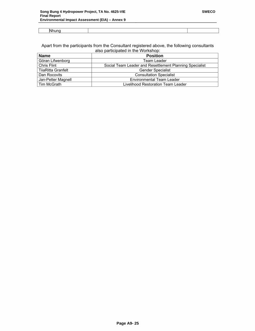
Song Bung 4 Hydropower Project, TA No. 4625-VIE Final Report Environmental Impact Assessment (EIA) – Annex 9
SWECO
Page A9- 25
Nhung
Apart from the participants from the Consultant registered above, the following consultants also participated in the Workshop:
Name Position Göran Lifwenborg Team Leader Chris Flint Social Team Leader and Resettlement Planning Specialist TiiaRitta Granfelt Gender Specialist Dan Rocovits Consultation Specialist Jan-Petter Magnell Environmental Team Leader Tim McGrath Livelihood Restoration Team Leader
Song Bung 4 Hydropower Project, TA No. 4625-VIE Final Report Environmental Impact Assessment (EIA) – Annex 9
SWECO
Page A9- 26
3rd multi-stakeholder workshop, Thanh My District town, Quang Nam Province
The third Multi-Stakeholder Workshop under the PPTA took place 28th July, 06 in Thanh My District town, Quang Nam Province. Objectives: The objective of the 3rd and last (for PPTA) multi stakeholder workshop were to
(a) Provide an overview of the expected environmental and social impacts of the Song Bung 4 project to all participants;
(b) Present the environmental & social mitigation measures, and any changes in project design due to environmental considerations, and seek participant comment;
(c) Present the Resettlement and Ethnic Minority Development Plan, including key AP entitlement, and seek participants comment on the same.
To conduct participatory discussions in plenary and small groups to learn from the participants: • Questions related to of the above technical reports • Additional downstream impacts and mitigations (focusing on mitigations) not covered in
the above reports • Forming consensus on specific mitigations • Install a sense of project ownership through stakeholder participation
Objectives of the Participants
The following is a summary of participant (written) responses to the question: “What do you hope to get from this workshop today?”
• 44% want to learn more about the Resettlement Plan • 29% want to learn more about Environmental Impacts and Mitigations • 13% want to learn more about Social Impacts & Mitigations • 5% want to learn more about how social impacts and mitigations will effect villagers
during construction phase • 4% Want to share ideas with other stakeholders and consultants • 2% hope SB4 will soon be completed • 2% want more Information on fishery in two downstream sites of Dai Son commune
and Dai Loc commune SOME WORKSHOP METHODOLOGIES Workshop Posters Twenty-two colourful posters and maps were hung around the registration area to stimulate participant interest in the workshop content, and provide a graphic representation of the project area & issues. It further gave the early arrivals something to focus on and discuss with the project consultants and fellow participants while waiting for the workshop to begin.
Pictures are included at the end of this report and included:
• Special Aid To the Very Poor • Land Impacts During the Construction Phase + Mitigation Measures • Co Tu (ethnic minority) House Model
Song Bung 4 Hydropower Project, TA No. 4625-VIE Final Report Environmental Impact Assessment (EIA) – Annex 9
SWECO
Page A9- 27
• Proposed Resettlement Area Map for Pa Rum A Village • Land Impacts During the Construction Phase (less than one year) Measures • One and ½ storey model house • Implementation Plan 2008-2012 • Vietnam Traditional House Model • Water Level Changes Downstream • Questions for Environmental Subject Group • Proposed Resettlement Area Map for Pa Rum A&B Village • Proposed Resettlement Area Map for Pa Dhi Village • Proposed Resettlement Area Map for Pa Pang Village • Example of Village Layout Proposed for Pa Rum A&B • Resettlement Map for Zuoih Commune • 3D Resettlement Map for Zuoih Commune • Land Use Plan for Resettlement Area for Pa Pang Village • Land Use Plan for Resettlement Area for Pa Dhi Village • Social impacts and Mitigations Poster (written) • Environmental Impacts • Agenda Poster • Welcome Poster • Ice Breakers
Ice Breakers Following the traditional welcoming speech from provincial political authorities, a warm up exercise was done to help acquaint the participants with each other and to introduce the participatory model which would be subsequently used. The purpose of an exercise of this nature is to bring the participants together as a team. Each person is invited to stand, speak, and share. It should be noted that the consultants and observers were not invited to participate in this exercise. It was explained that there presence here was of a technical / consultative nature. They (the participants) were the stakeholders in the Song Bung 4 Hydropower Project, and the purpose of the workshop was to inform them of the research done thus far and then ask their opinions. Canvassing Participant’s Expectations Participants were asked to write their expectations for the workshop on pieces of color paper, but not to write their names. It was explained (by the facilitator) that this workshop was being conducted for them, as down stream stakeholders and that the consultant team wants to know what they hope to accomplish today. The expectations were collected and read aloud. They were then taped on to a poster, and hung on the wall beside the table containing coffee and snacks. This put them in clear view of all participants and consultants. This was a demonstration of the importance, which the workshop organizers place on the stakeholder opinions and wishes. It encouraged the participants to focus on personal hopes and wants related to the workshop content. And secondly gave the facilitators a quick picture of the participants understanding of the content and purpose of the workshop. It is not uncommon to have a sizable gap between what the participants and the conveners hope to accomplish at a workshop. For most provincial officials, workshops coming from the national level would be “information dissemination” in nature (sharing with them the presenter’s interpretation of national policy). It was also explained at this point that consultant specialists and observers were present and that their role was only to provide information and observe the proceedings.
Song Bung 4 Hydropower Project, TA No. 4625-VIE Final Report Environmental Impact Assessment (EIA) – Annex 9
SWECO
Page A9- 28
Participant’s Questions Participants were asked to write down any questions arising during the consultant reports. It was explained that because of time limitations we were unable to hold open discussion immediately following all the presentations, but that there would be small group discussions in before and after lunch when their questions would be addressed. Small Group Discussions General The stakeholders were divided into three subject areas: • Subject A (17 participants) Environmental & Social Impacts and Mitigations &
Environmental & Social Impacts and Mitigations during the Construction Phase 14 participants -- The participants were political and technical GOVN officials.
• Subject B (10 participants) Resettlement Planning • Subject C (8 participants) Downstream Impacts & Mitigations (not including observers
and consultants). The participants were political and technical GOVN officials from downstream affected areas.
Each group was asked to select a reporter (from among the participant group) who would present the group’s findings in plenary. Several persons from the Consultant assisted the WVF facilitators in recording participant discussion points. The facilitator presented questions / issues for discussion (on poster paper) and recorded what was said / decided (in clear view of all participants on that poster paper). Subject Groups A&C participants listened to the following consultant reports: • An overview of ADB’s safeguards policies • Environmental Impacts and Mitigation Measures • Social Impacts and Resettlement Plans • Downstream Impacts and Mitigations Following the reports Subject A group discussed & reached consensus on environmental mitigation measures. Subject C participants discussed and reach consensus on downstream mitigation measures and proposals for entitlements. Subject Group B participants went directly into small group meetings at 900AM to discuss entitlements related to resettlement. In past workshops with the affected villagers it was noted that they are reluctant to express opinions when in the presence of district leaders and other government officials (group A&C participants). Furthermore there was a raft of material related to resettlement that they wanted to discuss. Discussions with villagers take more time than similar discussions with participants in Subjects Areas A&C. Therefore the villagers did not participated in Subject A&C activities until at 15:15PM when the small groups all reported to each other in plenary. Discussion’s method: Before presenting any new information or summary of the past village consultations, the facilitator ask: • What did you discuss about this subject during the village consultation (two weeks ago)? • What details do you remember? • How did the villagers feel about this?
Song Bung 4 Hydropower Project, TA No. 4625-VIE Final Report Environmental Impact Assessment (EIA) – Annex 9
SWECO
Page A9- 29
The purpose of this was to provide an opportunity for each village leader to stand and share advantages and disadvantages of the resettlement area which they chose. They also expressed the feeling of their fellow villagers. 13 information posters related to the Resettlement Plan where hung up (one at a time). • Participants were asked to read each item of the poster • They were asked to clarify the meaning • If they had any questions, they were invited to ask the ATD3 representative, Mr. Hon for
clarification. • Then they were asked if they agreed with the plan as written on the poster and if not what
changes would they like. Participant’s Written Evaluations Written evaluations were done at the end of the workshop, and participants were asked to answer the following two questions (Participants were asked to not sign the sheets so that they could choose to be as critical is they wish):
• What could be done to improve the workshop? • What did you like most about the workshop?
The questions were designed to be simple and open-ended. This encourages participants to think creatively and reduces the tendency to be prejudiced by the questionnaire. Summary of Consultant’s Presentation ADB’ safeguard policies by Mr. Thong, which covers:
• Resettlement plan for people affected including entitlement for loss of land, house, other fixed assets; loss of physical cultural resources; loss of crops and trees; loss of common property and infrastructure; loss of livelihood and other productive assets.
• How social and environmental impacts are identified and mitigated
Identified impacts and mitigations in downstream by Ms. Diep
• Why downstream is affected • Impacts on downstream and some suggested mitigations • Some statistic showing how is river fishery affected in downstream • Draft plan for downstream study and implementation
Identified environmental impacts and mitigations measures by Mrs. Nhung
• Big picture of SB4 project • Impacts and mitigations during construction period • Flow conditions in Bung river/ Song Vu Gia downstream the power station • Water quality in the reservoir, in the river downstream • Impacts on Floral and terrestrial Fauna and mitigations • Impacts on aquatic lives and mitigations (in upstream the reservoir, in the
reservoir and downstream) • Compensation flow/environmental flow • General mitigations measures such as: community based forest • Management in Zuoih commune, rehabilitating and enriching Song Thanh natural
Reserve, environmental protection measures, monitoring…
Song Bung 4 Hydropower Project, TA No. 4625-VIE Final Report Environmental Impact Assessment (EIA) – Annex 9
SWECO
Page A9- 30
Social impacts and mitigations; resettlement by Mr. Thong
• What are constructions works and location • Estimated loss of land and number of affected people in the area • Agriculture land affected temporally and permanently • Residential land and land for other purposes affected temporally and permanently • Entitlement plan • The combination between resettlement plan and ethnic minority development plan
RESULTS OF THE 3 SUBJECT AREA (SMALL GROUP) DISCUSSIONS General The participants divide into 3 subject areas as follows:
• Subject A: Environmental Impacts and Mitigations & Social Impacts and Mitigations during Construction Period
• Subject B: Resettlement Planning • Subject C: Downstream Impacts & Mitigations
The process:
• Review and discuss the impacts and mitigations presented by consultants thus far • Come to consensus on mitigation measures • Make suggestions on implementing mitigation measures (when time permitted)
Results of the Morning Session on Environmental Impacts Overall Results
• Subject A: Environmental Impacts and Mitigations & Social Impacts and Mitigations during Construction Period – Participant had very little new inputs related to environmental mitigation. Most of them had discussed these issues in previous workshops. They agreed with the consultants’ suggested mitigation measures.
• Subject B: Resettlement Planning – Only 30% of the invited participants from the affected villages and communes attended. We were not able to discover any reason for this by questioning the participants who did come. Village level consultations were conducted several weeks earlier and they may have felt satisfied with the resettlement process and entitlements that were presented (see the report on Village Consultation). It is also a long difficult trip to make to the workshop site over roads that were made worse due to the rainy season. Never the less, the participants who attended agreed with the majority of entitlements (mitigations) in the Resettlement Plan. Any disagreement was minor and related to details and interpretation.
• Subject C: Impacts & Downstream Mitigations -- Stakeholders unanimously agreed with all the positive & negative impacts that consultants noted during their presentations. Stakeholder comments focused mainly on suggested mitigation measures and their implementation. Impacts were created by changes in water levels, flow, and quality downstream.
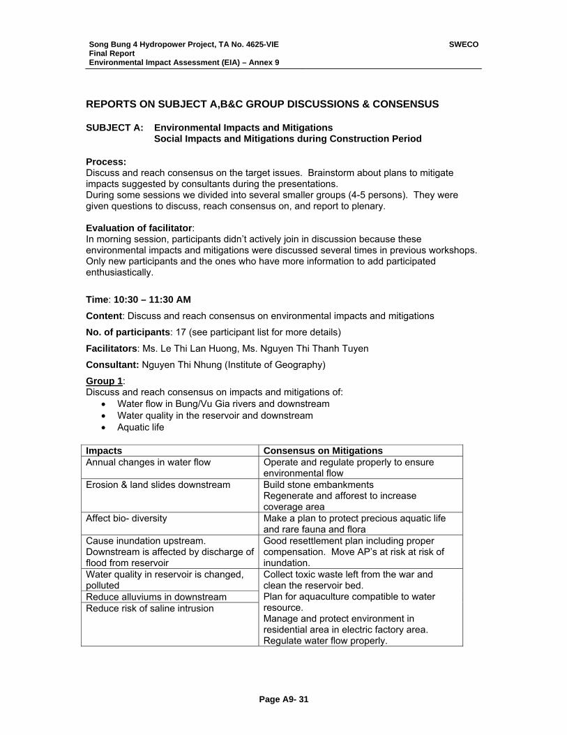
Song Bung 4 Hydropower Project, TA No. 4625-VIE Final Report Environmental Impact Assessment (EIA) – Annex 9
SWECO
Page A9- 31
REPORTS ON SUBJECT A,B&C GROUP DISCUSSIONS & CONSENSUS SUBJECT A: Environmental Impacts and Mitigations
Social Impacts and Mitigations during Construction Period Process: Discuss and reach consensus on the target issues. Brainstorm about plans to mitigate impacts suggested by consultants during the presentations. During some sessions we divided into several smaller groups (4-5 persons). They were given questions to discuss, reach consensus on, and report to plenary. Evaluation of facilitator: In morning session, participants didn’t actively join in discussion because these environmental impacts and mitigations were discussed several times in previous workshops. Only new participants and the ones who have more information to add participated enthusiastically.
Time: 10:30 – 11:30 AM
Content: Discuss and reach consensus on environmental impacts and mitigations
No. of participants: 17 (see participant list for more details)
Facilitators: Ms. Le Thi Lan Huong, Ms. Nguyen Thi Thanh Tuyen
Consultant: Nguyen Thi Nhung (Institute of Geography)
Group 1: Discuss and reach consensus on impacts and mitigations of:
• Water flow in Bung/Vu Gia rivers and downstream • Water quality in the reservoir and downstream • Aquatic life
Impacts Consensus on Mitigations Annual changes in water flow Operate and regulate properly to ensure
environmental flow Erosion & land slides downstream Build stone embankments
Regenerate and afforest to increase coverage area
Affect bio- diversity Make a plan to protect precious aquatic life and rare fauna and flora
Cause inundation upstream. Downstream is affected by discharge of flood from reservoir
Good resettlement plan including proper compensation. Move AP’s at risk at risk of inundation.
Water quality in reservoir is changed, polluted Reduce alluviums in downstream Reduce risk of saline intrusion
Collect toxic waste left from the war and clean the reservoir bed. Plan for aquaculture compatible to water resource. Manage and protect environment in residential area in electric factory area. Regulate water flow properly.
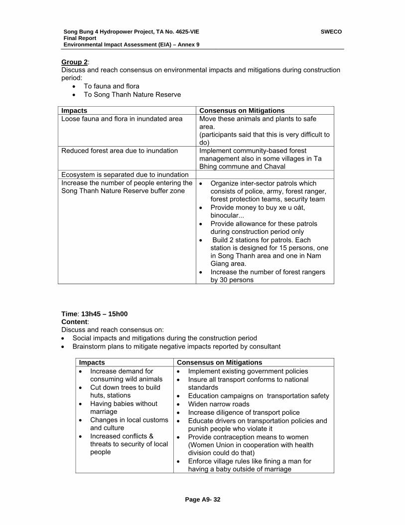
Song Bung 4 Hydropower Project, TA No. 4625-VIE Final Report Environmental Impact Assessment (EIA) – Annex 9
SWECO
Page A9- 32
Group 2: Discuss and reach consensus on environmental impacts and mitigations during construction period:
• To fauna and flora • To Song Thanh Nature Reserve
Impacts Consensus on Mitigations Loose fauna and flora in inundated area Move these animals and plants to safe
area. (participants said that this is very difficult to do)
Reduced forest area due to inundation Implement community-based forest management also in some villages in Ta Bhing commune and Chaval
Ecosystem is separated due to inundation Increase the number of people entering the Song Thanh Nature Reserve buffer zone
• Organize inter-sector patrols which consists of police, army, forest ranger, forest protection teams, security team
• Provide money to buy xe u oát, binocular...
• Provide allowance for these patrols during construction period only
• Build 2 stations for patrols. Each station is designed for 15 persons, one in Song Thanh area and one in Nam Giang area.
• Increase the number of forest rangers by 30 persons
Time: 13h45 – 15h00 Content: Discuss and reach consensus on: • Social impacts and mitigations during the construction period • Brainstorm plans to mitigate negative impacts reported by consultant
Impacts Consensus on Mitigations • Increase demand for
consuming wild animals • Cut down trees to build
huts, stations • Having babies without
marriage • Changes in local customs
and culture • Increased conflicts &
threats to security of local people
• Implement existing government policies • Insure all transport conforms to national
standards • Education campaigns on transportation safety • Widen narrow roads • Increase diligence of transport police • Educate drivers on transportation policies and
punish people who violate it • Provide contraception means to women
(Women Union in cooperation with health division could do that)
• Enforce village rules like fining a man for having a baby outside of marriage
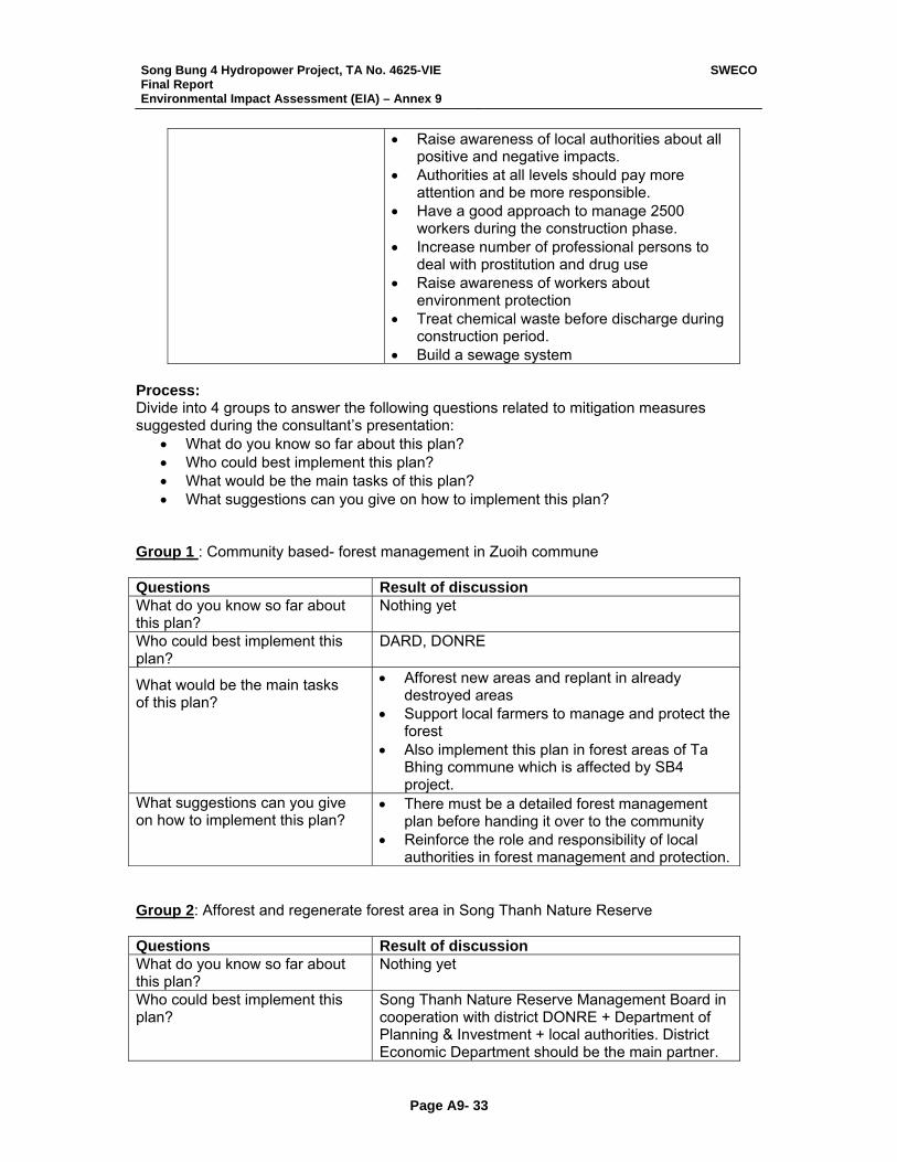
Song Bung 4 Hydropower Project, TA No. 4625-VIE Final Report Environmental Impact Assessment (EIA) – Annex 9
SWECO
Page A9- 33
• Raise awareness of local authorities about all positive and negative impacts.
• Authorities at all levels should pay more attention and be more responsible.
• Have a good approach to manage 2500 workers during the construction phase.
• Increase number of professional persons to deal with prostitution and drug use
• Raise awareness of workers about environment protection
• Treat chemical waste before discharge during construction period.
• Build a sewage system Process: Divide into 4 groups to answer the following questions related to mitigation measures suggested during the consultant’s presentation:
• What do you know so far about this plan? • Who could best implement this plan? • What would be the main tasks of this plan? • What suggestions can you give on how to implement this plan?
Group 1 : Community based- forest management in Zuoih commune Questions Result of discussion What do you know so far about this plan?
Nothing yet
Who could best implement this plan?
DARD, DONRE
What would be the main tasks of this plan?
• Afforest new areas and replant in already destroyed areas
• Support local farmers to manage and protect the forest
• Also implement this plan in forest areas of Ta Bhing commune which is affected by SB4 project.
What suggestions can you give on how to implement this plan?
• There must be a detailed forest management plan before handing it over to the community
• Reinforce the role and responsibility of local authorities in forest management and protection.
Group 2: Afforest and regenerate forest area in Song Thanh Nature Reserve Questions Result of discussion What do you know so far about this plan?
Nothing yet
Who could best implement this plan?
Song Thanh Nature Reserve Management Board in cooperation with district DONRE + Department of Planning & Investment + local authorities. District Economic Department should be the main partner.

Song Bung 4 Hydropower Project, TA No. 4625-VIE Final Report Environmental Impact Assessment (EIA) – Annex 9
SWECO
Page A9- 34
What would be the main tasks of this plan?
The project should include: - Implementation timetable - Land use master plan - Selected trees ( priority is given to local original trees) - Detail implementing plan for each year - Budget
What suggestions can you give on how to implement this plan?
- Song Thanh and local community identify which kind of tree and where to plant - DONRE makes a land use master plan - District economic division is the implementing agency - Monitor and evaluate the project in phases
Group 3: • Organize environment protection training courses • Capacity buildings for environment protection agencies Questions Result of discussion What do you know so far about this plan?
Nothing yet
Who could best implement this plan?
DONRE, Ethnicity Division, Health Division, Economic Division and Farmers Association
What would be the main tasks of this plan?
• Environmental awareness campaign • Technical trainings • Management technique/method training • Provide money for necessary tools/ equipment
What suggestions can you give on how to implement this plan?
• Train facilitators and technical persons • Establish a steering committee to implement the
plan • Provide enough money and equipment • Do a pilot to learn from, then replicate it. • Reinforce evaluation activities + a reward policy
Group 4: Social management plan and action plan for public health Questions Result of discussion What do you know so far about this plan?
Nothing yet
Who could best implement this plan?
Police, Health, Ethnicity Division, DONRE, forest ranger and others …
What would be the main tasks of this plan?
• Education programs + propaganda to raise public awareness
• Detail and appropriate action plan for each agency
What suggestions can you give on how to implement this plan?
• Master plan, timetable and detailed tasks assigned for each person in project
• Clarifed role and responsibility of each person. • Monitoring, evaluating result of each phase
Song Bung 4 Hydropower Project, TA No. 4625-VIE Final Report Environmental Impact Assessment (EIA) – Annex 9
SWECO
Page A9- 35
SUBJECT B: Resettlement Plan Time: 4.5 hours Facilitator: Ms. Nguyen Thi Thanh Nhan Consultant: Mr. Le Trung Thong Observer: Ms. TaoThi Viet Nga – International River Network Participants: 6 villagers from affected villages (see participant list for details) Mr. Phuc- Department of Natural Resources and Environment Mr. Dong - District Department of Planning and Investment. Output:
• Share the latest village consultation meeting’s result among themselves • Discuss in detail the resettlement plan proposed by consultant team • Reach consensus on entitlements
Facilitator’s evaluation 20 village and commune representatives were in invited and 6 came. We asked Mr. Da, the Zuoih Commune People’s Committee Chairman about this. He said he received the invitation from the District Peoples Committee and sent it on to all the village representatives on the list. Other people we questioned had no idea for the absence of 14 village and commune representatives. We had hoped for more sharing among the 4 village headmen and the head of Pa Pang (the host village). Never-the-less, the sharing among the 6 villagers was enthusiastic. Much of the discussion was among themselves so a deeper understanding of the mutual efforts involved was effected. Discussion result Reviewing the Resettlement Areas and Village Layouts • The village representatives from Pa Di and Pa Rum A both agreed on the advantages
and disadvantages mention in the resettlement plan related to the resettlement area they chose during the village consultations
• Pa Rum A’s village representatives said that they were happy with their option and looking forward to moving there soon.
• But the feeling of Pa Dhi’s villagers was not the same. They are very worried because they don’t know what their life will be like in the new location (Khe Zuoih).
• Question raised by Ms. Nga (International River Network). In Khe Canh, there is not much land for agriculture so how can one ensure the food resource? Did villagers discuss this issue?
• Answer: Pa Dhi’ village representative: We already discussed this difficulty and we ourselves don’t have the answer.
• During PaDhi village representatives’ presentation on advantages and disadvantages of Khe Zuoih, he mentioned that if the land in Khe Zuoih is not enough for all Pa Dhi households, 10 households would move to Khe Tua.
• Mr Phuc from Nam Giang district DONRE said that these 10 households should consider carefully this option because Khe Tua doesn’t have enough sun light, so that villagers can get sick easily.
• When the participants looked at the Pa Rum A village layout, some of the commune representatives said that Pa Rum should reconsider the current village layout to allow for future expansion at the village center.
Song Bung 4 Hydropower Project, TA No. 4625-VIE Final Report Environmental Impact Assessment (EIA) – Annex 9
SWECO
Page A9- 36
Reviewing the Resettlement Plan Facilitator Note: This took lots of time because of the limited literacy of the village representatives. The facilitator had to spend quite a lot of time clarifying the meaning of each point and testing participant’s understanding, giving examples and explaining some new terms such as: agriculture extension program, fertilizer type A and B, etc. Entitlements for loss of land • All participants agreed with the resettlement plan except sub idem “ loss of residential
land” • The resettlement plan said: “Residential land equivalent to or greater than (1) 500m≤
(indicatively 20m x 25m) plot for the construction of new house (not including garden land), or (2) the area of housing land lost”
• They discussed very long and agreed on deleting option 2: “or the area of housing land
lost”, because they assume that some households have only 100m2 of residential land now. That is too small. If the project can not give them 500m2 as proposed, then as little as 300 might be acceptable.
• Comment from Ms. Nga: The resettlement plan states that land will be surveyed and
villagers will have land title. Does SB-4 project plan to allocate land for villagers before they moved to new place? Because there are some lessons learned from other hydropower projects. After moving to the resettlement areas, villagers had to wait for land allocation for 2 years or even more. This can cause many social evils.
• Response from ADT3 representative: Villagers will receive rice and foodstuff for about 1 year so they can do agriculture land clearance and development.
• Question from Ms. Nga: Does the project have a method to allocate land to avoid grievance?
• Answer from ADT3 representative:: District’s leaders will be in charge of this issue. • Pa Dhi village’s head said that the project should allocate land for villagers before their
moving otherwise there will be fight among villagers because of land quality in new place. • Question from Pa Dhi: If the villagers do land clearance themselves, how will labor be
paid? Will it be based on government policy or project policy? • Answer (ADT3 representative). The labor will be paid based on government policy. Question (raised by Da Bhinh commune head) When moving to the resettlement site, if villagers find that there is surrounding land that can be cleared and used. Will they be paid for their labor? Answer (ADT3 representative): We can not answer this question at this point. Loss of House and other Fixed Assets • All participants agreed with the proposed plan. But they request that the roofing should
include a ceiling made of lafong material. • In the case that the AP builds, or organizes to build the house themselves. Funds should
be paid out depending on rate of progress of each household—rather than in fixed lots of 3 or 4 as is written in the plan now.
• Question: A family who doesn’t want to move to the resettlement area with other villagers. If they move to another commune or district instead, can the funds be provided to them in 1 lot?
• Answer ( ATD3): It can be provided in 1 lot but that family must have a legal paper from the host commune
Song Bung 4 Hydropower Project, TA No. 4625-VIE Final Report Environmental Impact Assessment (EIA) – Annex 9
SWECO
Page A9- 37
• For building of outbuildings such as husbandry facilities, participant agreed with the proposed plan but only the household who already have outbuildings in current village be compensated.
• Do all AP’s have the same compensation rate for house loss or does the compensation rate depend on the actual condition of the house in the current place?
• Answer (ATD3): entitlement for house loss will based equally (not based on the condition of their present house).
Entitlement for Loss of Physical Cultural Resources Participant agreed with proposed plan Entitlement for Loss of standing crops or trees, other productive assets • The participants agreed with the proposed plan except the sub - item entitlement for
“trees that have already started bearing fruit” • According to some of the participants, it is very difficult to calculate what a tree will be
producing in 5 years. Especially if you are trying to calculate for many families and many trees.
• It should be based on the compensation rate issued by provincial people committee. Loss of Livelihoods Participant agreed with the proposed plan. They want to have their own village and commune vet as well. Loss of common property infrastructure Participant agreed with the proposed plan. Market place: They have no need for a market but want a grocery store in the commune centre. Village store: They have no need for it. Question: Who is responsible in the case of degradation of common property infrastructure in the future? Answer: If the common property infrastructure is degraded while still under warrantee, the project will be responsible. After that time the district PPC is responsible. Loss of common property resources Agreed with the proposed plan. Educational entitlement: The nursery school and primary school should not be together but close to each other. Allowances and Special Transitional Measures Agreed with the proposed plan Question: How long the food security time last? Answer (ATD3): 12 months. Grievance Procedure (see workshop posters) Participant laughed when they saw the poster describe grievance procedure because it was depicted in cartoon figures. They commented that they could never have imagined such a procedure. They agreed with the proposed plan and had no other comments related to it.
Song Bung 4 Hydropower Project, TA No. 4625-VIE Final Report Environmental Impact Assessment (EIA) – Annex 9
SWECO
Page A9- 38
SUBJECT C: Downstream Impacts & Mitigations Following are the results of focus group discussion with downstream stakeholders. It includes suggested mitigation measures and some preliminary plans for implementation of income generating activities. Time: 1030 to 1130 No. of participants: 8 (see participant list for details) Facilitator: Ms. Le Thi Lan Huong Consultant: Ms. Nguyen Ngoc Diep Facilitator comments: • Downstream stakeholders were very concerned because impacts affect them directly.
Participation was enthusiastic. • Stakeholders unanimously agreed with all the positive impacts that consultants noted
during their presentations. Following are mitigation measures suggested by downstream stakeholders and details related to their implementation.
Negative impacts down stream
(reported by consultants) Mitigation measures (stakeholder suggested options)
Stakeholder comment on these mitigation options
Lower water level leads to no water available in wells in Dai Son commune and some hhs in Pa Dau village. Time: About year while the reservoir is being filled.
• Drill one well per 10- 15 hhs • Use electric generators (for drilling
& pumps) in villages where there is no electricity.
• Build water containers
Easy to do
Dramatically reduced river fish resource
Money & training for other professions • industrial forests • plant grass to raise cattle, cotton,
or mulberries • fish ponds
These livelihood activities are already being practiced in these com-munes with very good results.
Huge erosion/land slides in Dong Cham, Thac Can, Dau Go villages due to water discharge
• Build stone embankments to prevent erosion.
• OR, if not possible, a resettlement plan for villages.
Embankments require big investment
Loss of cultivation land for annual crops like: corn, beans, etc.
• Build stone embankment to prevent erosion, or provide money & training for other professions
Embankments require big investment
Loss of income from selling sand & gravel to construction companies.
Trainings for employment in industries already operating in Dai Loc District. For example: carpentry, textile, animal food processing, construction materials
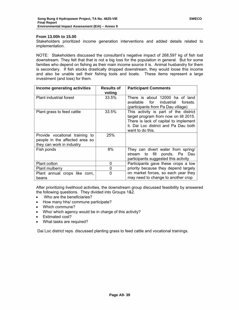
Song Bung 4 Hydropower Project, TA No. 4625-VIE Final Report Environmental Impact Assessment (EIA) – Annex 9
SWECO
Page A9- 39
From 13.00h to 15.00 Stakeholders prioritized income generation interventions and added details related to implementation. NOTE: Stakeholders discussed the consultant’s negative impact of 268,597 kg of fish lost downstream. They felt that that is not a big loss for the population in general. But for some families who depend on fishing as their main income source it is. Animal husbandry for them is secondary. If fish stocks drastically dropped downstream, they would loose this income and also be unable sell their fishing tools and boats. These items represent a large investment (and loss) for them. Income generating activities Results of
voting Participant Comments
Plant industrial forest 33.5% There is about 12000 ha of land available for industrial forests. (participants from Pa Dau village)
Plant grass to feed cattle 33.5% This activity is part of the district target program from now on till 2015. There is lack of capital to implement it. Dai Loc district and Pa Dau both want to do this.
Provide vocational training to people in the affected area so they can work in industry
25%
Fish ponds 8% They can divert water from spring/ stream to fill ponds. Pa Dau participants suggested this activity
Plant cotton 0 Plant mulberry 0 Plant annual crops like corn, beans
0
Participants gave these crops a low priority because they depend largely on market forces, so each year they may need to change to another crop
After prioritizing livelihood activities, the downstream group discussed feasibility by answered the following questions. They divided into Groups 1&2. • Who are the beneficiaries? • How many hhs/ commune participate? • Which commune? • Who/ which agency would be in charge of this activity? • Estimated cost? • What tasks are required? Dai Loc district reps. discussed planting grass to feed cattle and vocational trainings.
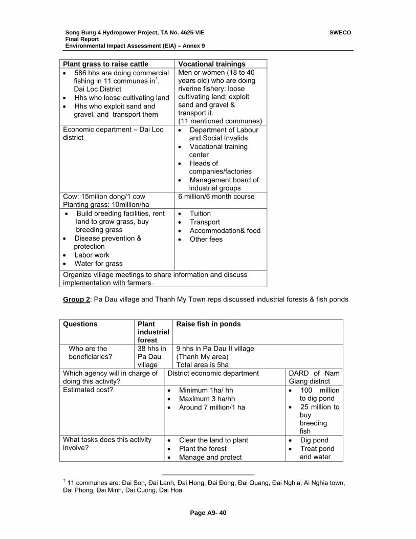
Song Bung 4 Hydropower Project, TA No. 4625-VIE Final Report Environmental Impact Assessment (EIA) – Annex 9
SWECO
Page A9- 40
Plant grass to raise cattle Vocational trainings • 586 hhs are doing commercial
fishing in 11 communes in1, Dai Loc District
• Hhs who loose cultivating land • Hhs who exploit sand and
gravel, and transport them
Men or women (18 to 40 years old) who are doing riverine fishery; loose cultivating land; exploit sand and gravel & transport it. (11 mentioned communes)
Economic department – Dai Loc district
• Department of Labour and Social Invalids
• Vocational training center
• Heads of companies/factories
• Management board of industrial groups
Cow: 15milion dong/1 cow Planting grass: 10million/ha
6 million/6 month course
• Build breeding facilities, rent land to grow grass, buy breeding grass
• Disease prevention & protection
• Labor work • Water for grass
• Tuition • Transport • Accommodation& food • Other fees
Organize village meetings to share information and discuss implementation with farmers. Group 2: Pa Dau village and Thanh My Town reps discussed industrial forests & fish ponds Questions Plant
industrial forest
Raise fish in ponds
Who are the beneficiaries?
38 hhs in Pa Dau village
9 hhs in Pa Dau II village (Thanh My area) Total area is 5ha
Which agency will in charge of doing this activity?
District economic department DARD of Nam Giang district
Estimated cost? • Minimum 1ha/ hh • Maximum 3 ha/hh • Around 7 million/1 ha
• 100 million to dig pond
• 25 million to buy breeding fish
What tasks does this activity involve?
• Clear the land to plant • Plant the forest • Manage and protect
• Dig pond • Treat pond
and water
1 11 communes are: Đai Son, Đai Lanh, Đai Hong, Đai Đong, Đai Quang, Đai Nghia, Ai Nghia town, Đai Phong, Đai Minh, Đai Cuong, Đai Hoa
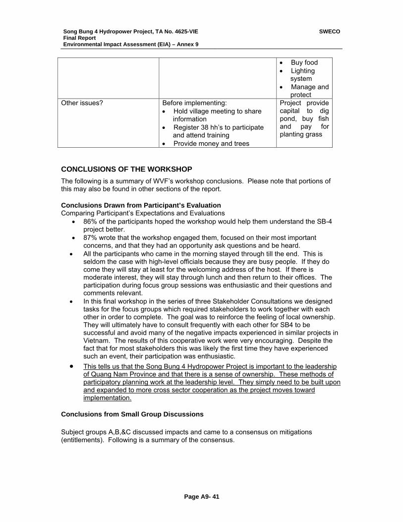
Song Bung 4 Hydropower Project, TA No. 4625-VIE Final Report Environmental Impact Assessment (EIA) – Annex 9
SWECO
Page A9- 41
• Buy food • Lighting
system • Manage and
protect Other issues? Before implementing:
• Hold village meeting to share information
• Register 38 hh’s to participate and attend training
• Provide money and trees
Project provide capital to dig pond, buy fish and pay for planting grass
CONCLUSIONS OF THE WORKSHOP The following is a summary of WVF’s workshop conclusions. Please note that portions of this may also be found in other sections of the report. Conclusions Drawn from Participant’s Evaluation Comparing Participant’s Expectations and Evaluations
• 86% of the participants hoped the workshop would help them understand the SB-4 project better.
• 87% wrote that the workshop engaged them, focused on their most important concerns, and that they had an opportunity ask questions and be heard.
• All the participants who came in the morning stayed through till the end. This is seldom the case with high-level officials because they are busy people. If they do come they will stay at least for the welcoming address of the host. If there is moderate interest, they will stay through lunch and then return to their offices. The participation during focus group sessions was enthusiastic and their questions and comments relevant.
• In this final workshop in the series of three Stakeholder Consultations we designed tasks for the focus groups which required stakeholders to work together with each other in order to complete. The goal was to reinforce the feeling of local ownership. They will ultimately have to consult frequently with each other for SB4 to be successful and avoid many of the negative impacts experienced in similar projects in Vietnam. The results of this cooperative work were very encouraging. Despite the fact that for most stakeholders this was likely the first time they have experienced such an event, their participation was enthusiastic.
• This tells us that the Song Bung 4 Hydropower Project is important to the leadership of Quang Nam Province and that there is a sense of ownership. These methods of participatory planning work at the leadership level. They simply need to be built upon and expanded to more cross sector cooperation as the project moves toward implementation.
Conclusions from Small Group Discussions
Subject groups A,B,&C discussed impacts and came to a consensus on mitigations (entitlements). Following is a summary of the consensus.
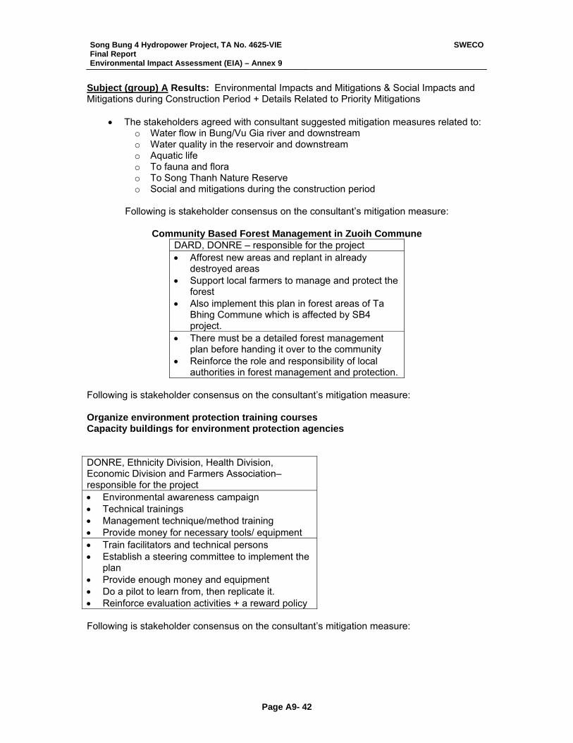
Song Bung 4 Hydropower Project, TA No. 4625-VIE Final Report Environmental Impact Assessment (EIA) – Annex 9
SWECO
Page A9- 42
Subject (group) A Results: Environmental Impacts and Mitigations & Social Impacts and Mitigations during Construction Period + Details Related to Priority Mitigations
• The stakeholders agreed with consultant suggested mitigation measures related to: o Water flow in Bung/Vu Gia river and downstream o Water quality in the reservoir and downstream o Aquatic life o To fauna and flora o To Song Thanh Nature Reserve o Social and mitigations during the construction period
Following is stakeholder consensus on the consultant’s mitigation measure:
Community Based Forest Management in Zuoih Commune
DARD, DONRE – responsible for the project • Afforest new areas and replant in already
destroyed areas • Support local farmers to manage and protect the
forest • Also implement this plan in forest areas of Ta
Bhing Commune which is affected by SB4 project.
• There must be a detailed forest management plan before handing it over to the community
• Reinforce the role and responsibility of local authorities in forest management and protection.
Following is stakeholder consensus on the consultant’s mitigation measure: Organize environment protection training courses Capacity buildings for environment protection agencies DONRE, Ethnicity Division, Health Division, Economic Division and Farmers Association– responsible for the project • Environmental awareness campaign • Technical trainings • Management technique/method training • Provide money for necessary tools/ equipment • Train facilitators and technical persons • Establish a steering committee to implement the
plan • Provide enough money and equipment • Do a pilot to learn from, then replicate it. • Reinforce evaluation activities + a reward policy Following is stakeholder consensus on the consultant’s mitigation measure:
Song Bung 4 Hydropower Project, TA No. 4625-VIE Final Report Environmental Impact Assessment (EIA) – Annex 9
SWECO
Page A9- 43
Social management plan and action plan for public health Police, Health, Ethnicity Division, DONRE, forest ranger and others … • Education programs + propaganda to raise
public awareness • Detail and appropriate action plan for each
agency • Master plan, timetable and detailed tasks
assigned for each person in project • Clarifed role and responsibility of each person. • Monitoring, evaluating result of each phase Subject (group) B Results: Resettlement Plan Consensus was reached on the following: • Resettlement areas • Entitlements for loss of land
o All participants agreed with the Entitlement for loss of land except sub-item “ loss of residential land”
o The resettlement plan said: “Residential land equivalent to or greater of (1) at least 500m≤ (indicatively 20m x 25m) plot for the construction of new house (not including garden land), or (2) the area of housing land lost”
o They discussed very long and agreed on deleing option 2: “or the area of housing land lost”, because they assume that some households have only 100m2 of residential land now. That is too small. If the project can not give them 500m2 as proposed, then as little as 300 might be acceptable.
o Pa Dhi village’s head said that the project should allocate land for villagers before their moving otherwise there will be fight among villagers because of land quality in new place.
• Entitlements for labor o Question from Pa Dhi: If the villagers do land clearance themselves, how will
labor be paid? Will it be based on government policy or project policy? o Answer (ADT3 representative). The labor will be paid based on government
policy. o Question ( raised by Da Bhinh commune head) When moving to the resettlement
site, if villagers find that there is surrounding land that can be cleared and used. Will they be paid for their labor?
o Answer (ADT3 representative): We can not answer this question at this point.
• Loss of House and other Fixed Assets o All participants agreed with the proposed plan. But they request that the roofing
should include a ceiling made of lafong material. o In the case that the AP builds, or organizes to build the house themselves. Funds
should be paid out depending on rate of progress of each household—rather than in fixed lots of 3 or 4 as is written in the plan now.
o Question: A family who doesn’t want to move to the resettlement area with other villagers. If they move to another commune or district instead, can the funds be provided to them in 1 lot?
Song Bung 4 Hydropower Project, TA No. 4625-VIE Final Report Environmental Impact Assessment (EIA) – Annex 9
SWECO
Page A9- 44
o Answer ( ATD3): It can be provided in 1 lot but that family must have a legal paper from the host commune
o For building of outbuildings such as husbandry facilities, participant agreed with the proposed plan but only the household who already have outbuildings in current village be compensated.
o Do all AP’s have the same compensation rate for house loss or does the compensation rate depend on the actual condition of the house in the current place?
o Answer (ATD3): entitlement for house loss will based equally (not based on the condition of their present house).
• Entitlement for Loss of Physical Cultural Resources
o Participant agreed with proposed plan. • Entitlement for Loss of standing crops or trees, other productive assets
o The participants agreed with the proposed plan except the sub - item entitlement for “trees that have already started bearing fruit” . They felt it would be very difficult to calculate what a tree will be producing in 5 years. Especially if you are trying to calculate for many families and many trees. Therefore the compensation should be based on the compensation rate issued by provincial people committee.
• Loss of Livelihoods
o Participant agreed with proposed plan. • Loss of common property infrastructure
o Participant agreed with the proposed plan. o Market place: They have no need for a market but want a grocery store in the
commune centre. o Village store: They have no need for it.
• Loss of common property resources
o Participant agreed with the proposed plan. • Educational entitlement
o Participant agreed with the proposed plan. o The nursery school and primary school should not be together but close to each
other. • Allowances and Special Transitional Measures
o Participant agreed with the proposed plan. o Question: How long the food security time last? o Answer (ATD3): 12 months.
• Grievance Procedure (see workshop posters)
o Participant agreed with the proposed plan. For more details refer to the 8.4: Results of the 3 Subject Area (small group) Discussions
Song Bung 4 Hydropower Project, TA No. 4625-VIE Final Report Environmental Impact Assessment (EIA) – Annex 9
SWECO
Page A9- 45
Subject (group) C Results: Downstream Impacts & Mitigations
• The stakeholders agreed with consultant suggested mitigation measures related to impacts in the following areas:
o Water flow in Bung/Vu Gia river and downstream o Water quality in the reservoir and downstream
• Following are stakeholder suggestions related to mitigation measures and some preliminary plans for implementation of income generating activities.
Negative impacts down stream
(reported by consultants) Mitigation measures (stakeholder suggested options)
Stakeholder comment on these mitigation options
Lower water level leads to no water available in wells in Dai Son commune and some hhs in Pa Dau village. Time: About year while the reservoir is being filled.
• Drill one well per 10- 15 hhs • Use electric generators (for drilling
& pumps) in villages where there is no electricity.
• Build water containers
Easy to do
Dramatically reduced river fish resource
Money & training for other professions • industrial forests • plant grass to raise cattle, cotton,
or mulberries • fish ponds
These livelihood activities are already being practiced in these com-munes with very good results.
Huge erosion/land slides in Dong Cham, Thac Can, Dau Go villages due to water discharge
• Build stone embankments to prevent erosion.
• OR, if not possible, a resettlement plan for villages.
Embankments require big investment
Loss of cultivation land for annual crops like: corn, beans, etc.
• Build stone embankment to prevent erosion, or provide money & training for other professions
Embankments require big investment
Loss of income from selling sand & gravel to construction companies.
Trainings for employment in industries already operating in Dai Loc District. For example: carpentry, textile, animal food processing, construction materials
Blocked navigation Stakeholders voted to prioritize income generation interventions and added details related to implementation.
Song Bung 4 Hydropower Project, TA No. 4625-VIE Final Report Environmental Impact Assessment (EIA) – Annex 9
SWECO
Page A9- 46
Income generating activities Results of voting
Participant Comments
Plant industrial forest 33.5% There is about 12000 ha of land available for industrial forests. (participants from Pa Dau village)
Plant grass to feed cattle 33.5% This activity is part of the district target program from now on till 2015. There is lack of capital to implement it. Dai Loc district and Pa Dau both want to do this.
Provide vocational training to people in the affected area so they can work in industry
25%
Fish ponds 8% They can divert water from spring/ stream to fill ponds. Pa Dau participants suggested this activity
Plant cotton 0 Plant mulberry 0 Plant annual crops like corn, beans
0
Participants gave these crops a low priority because they depend largely on market forces, so each year they may need to change to another crop
Dai Loc district reps. discussed planting grass to feed cattle and vocational trainings Plant grass to raise cattle Vocational trainings • 586 hhs are doing commercial
fishing in 11 communes in2, Dai Loc District
• Hhs who loose cultivating land • Hhs who exploit sand and
gravel, and transport them
Men or women (18 to 40 years old) who are doing riverine fishery; loose cultivating land; exploit sand and gravel & transport it. (11 mentioned communes)
Economic department – Dai Loc district
• Department of Labour and Social Invalids
• Vocational training center
• Heads of companies/factories
• Management board of industrial groups
Cow: 15milion dong/1 cow Planting grass: 10million/ha
6 million/6 month course
• Build breeding facilities, rent land to grow grass, buy breeding grass
• Disease prevention & protection
• Labor work • Water for grass
• Tuition • Transport • Accommodation& food • Other fees
2 11 communes are: Đai Son, Đai Lanh, Đai Hong, Đai Đong, Đai Quang, Đai Nghia, Ai Nghia town, Đai Phong, Đai Minh, Đai Cuong, Đai Hoa
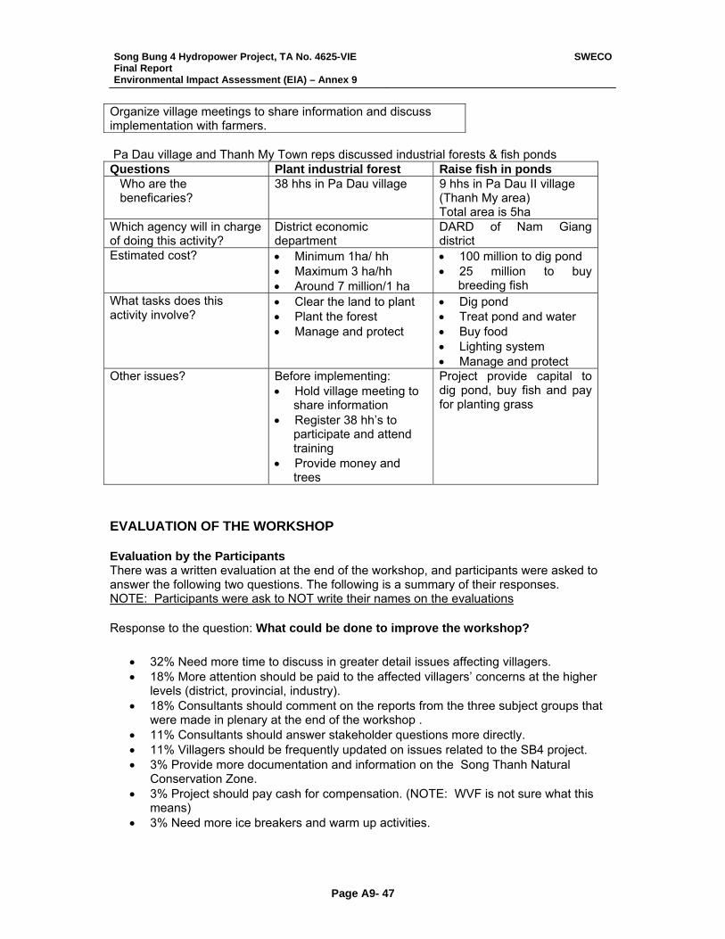
Song Bung 4 Hydropower Project, TA No. 4625-VIE Final Report Environmental Impact Assessment (EIA) – Annex 9
SWECO
Page A9- 47
Organize village meetings to share information and discuss implementation with farmers. Pa Dau village and Thanh My Town reps discussed industrial forests & fish ponds Questions Plant industrial forest Raise fish in ponds
Who are the beneficaries?
38 hhs in Pa Dau village 9 hhs in Pa Dau II village (Thanh My area) Total area is 5ha
Which agency will in charge of doing this activity?
District economic department
DARD of Nam Giang district
Estimated cost? • Minimum 1ha/ hh • Maximum 3 ha/hh • Around 7 million/1 ha
• 100 million to dig pond • 25 million to buy
breeding fish What tasks does this activity involve?
• Clear the land to plant • Plant the forest • Manage and protect
• Dig pond • Treat pond and water • Buy food • Lighting system • Manage and protect
Other issues? Before implementing: • Hold village meeting to
share information • Register 38 hh’s to
participate and attend training
• Provide money and trees
Project provide capital to dig pond, buy fish and pay for planting grass
EVALUATION OF THE WORKSHOP Evaluation by the Participants There was a written evaluation at the end of the workshop, and participants were asked to answer the following two questions. The following is a summary of their responses. NOTE: Participants were ask to NOT write their names on the evaluations Response to the question: What could be done to improve the workshop?
• 32% Need more time to discuss in greater detail issues affecting villagers. • 18% More attention should be paid to the affected villagers’ concerns at the higher
levels (district, provincial, industry). • 18% Consultants should comment on the reports from the three subject groups that
were made in plenary at the end of the workshop . • 11% Consultants should answer stakeholder questions more directly. • 11% Villagers should be frequently updated on issues related to the SB4 project. • 3% Provide more documentation and information on the Song Thanh Natural
Conservation Zone. • 3% Project should pay cash for compensation. (NOTE: WVF is not sure what this
means) • 3% Need more ice breakers and warm up activities.

Song Bung 4 Hydropower Project, TA No. 4625-VIE Final Report Environmental Impact Assessment (EIA) – Annex 9
SWECO
Page A9- 48
Response to the question: What I liked most about the workshop was:
• 33%: Workshop content focused on the most important concerns. • 28%: All stakeholders had an opportunity to ask questions and express opinions. • 24%: Workshop activities were interesting and stimulated participation from everyone.
We had to think a lot about the issues to complete the small group assignments. Open discussions were effective.
• 18%: Facilitators were open, enthusiastic, and relaxed. • 18%: I now have a better understanding of social and environmental impacts &
mitigation measures during the construction phase, and resettlement plans & entitlements.
• 14%: It was meaningful the way we village representatives reviewed our entitlements. Our opinions were ask on every issue and we all had an opportunity to speak.
• 14%: The overviews gave me a better understand of SB-4 – for example the design, policies, impacts and mitigation measures.
WVF’s Comments on the Evaluation of the Participants
• 61% felt that more attention is needed to focus on issues affecting villagers / resettlement. And that this attention be at higher government levels. This is likely not a comment related to the workshop itself but the SB4 project in general.
• 75% of the stakeholders felt the workshop content spoke to their greatest concerns and that they had to opportunity to express themselves freely about those concerns.
• Resettlement is the major area of concern now and likely will continue to be into the future of SB4. The leadership, commune, district, and village is capable of participatory planning and implementation. They will need help initially in establishing a system which is tailored to the special requirements of the CoTu community as it interacts more actively in decision making with the dominant Kinh leadership. WVF feels that both communities have the will to interact on a more equal footing. This is National Policy. SB4 could be the engine that moves them into a new era of openness and sharing.
List of Participants
No. Name Office title and address Telephone no. 1. Alang Don Anthropological Division 2. Arat Crum Pa Dau 2 village 3. Barnuy Long WWF 0511 810 753 4. Bhat Chau District Farmer Union 5. Bho Nuoch Chien Secretary of the communist party,
Thach My district 0511 840 546
6. Bling Da Ka Dang Ta Bhinh 7. Bling Dong Pa Dhi village, Zuoih commune 8. Briu Gounh District Women Union 0510 845 036 9. Bui Anh Dai Son commune 10. Bui Duc Loi Chief of Divison of Natural
Resources and Environment
11. Cao Tien Dai Pa Dhi village 12. Chau Van Ngo Vice chief officer of DPC
Song Bung 4 Hydropower Project, TA No. 4625-VIE Final Report Environmental Impact Assessment (EIA) – Annex 9
SWECO
Page A9- 49
13. Cho Ram Nhien Chairman of Nam Giang CPC 14. Cuong ATD 3 15. Dao Thi Viet Nga International River Network 0904 368 463 16. Dinh Ngoc Phuong Division of Infrastructure
economics
17. Do Dinh Hon ATD 3 0914 113 486 18. Gap Division of Agriculture 19. Hoang Trong Dung Chief Officer of Nam Giang CPC 20. Huynh Van Thuong Mosaid Plan 21. Lang Uon Pa Dau 2 village 22. Le Cong Be Song Thanh Natural Preserver 23. Le Duc Phuc Divison of Natural Resources and
Environment 792 224
24. Le Van Loi Dai Son commune 25. Ngo Cong Thanh Vietnam International
Development and Support Organization
26. Nguyen Huu Phuoc Kcady commune 27. Nguyen Ngoc Dung Department of Natural Resources
and Environment
28. Nguyen Sau District Youth Union 0905 261 246 29. Nguyen Tan Đieu Dai Son commune 30. Nguyen Thai Vu ATD 3 08 930 7756 31. Nguyen Tien Dung Division of Natural Resources
and Environment 0511 792 225
32. Nguyen Van Binh Division of education and training 0511 792 232 33. Nguyen Van Hong Front Fatherland (0510).840-251 34. Nguyen Van Phuong Vice chairman of Nam Giang
DPC
35. Nhan Officer of DPC 36. Nhung Institute of Environment 37. Pham Phu Phi Vietnam International
Development and Support Organization
38. Pham Thi Nhu Planning and Financing Department, Nam Giang district
0510 792 305
39. Phan Minh Tien Economic Department 40. Phan Xuan Đong Economic Department 41. Poloong Nhieu Pa Rum A village 42. Tagon Auoc Cong Don village, Zuoih
commune
43. Tagon Dha Cong Don village, Zuoih commune
099 451 001
44. Tongol Kia Ta Thinh (Chairman of CPC) 792 035 45. Tra Thanh Hoang Chief of district Police 792 211 46. Tran Quang Khai Construction consultants in
Electrical Company no. 3 (ATD 3) 08 930 7756
Song Bung 4 Hydropower Project, TA No. 4625-VIE Final Report Environmental Impact Assessment (EIA) – Annex 9
SWECO
Page A9- 50
47. Tran Tan Tai Heath Division 840 162/ 0905 606 016
48. Tran Thanh Hai District People Committee 0914 001 637 49. Truong Cong Kich Chief of Dai Loc Commune 0913480024
Apart from the participants from the Consultant registered above, the following consultants also participated in the Workshop:
Name Position Göran Lifwenborg Team Leader Dan Rocovits Consultation Specialist
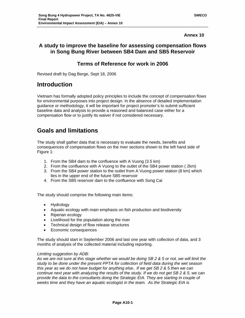
Song Bung 4 Hydropower Project, TA No. 4625-VIE Final Report Environmental Impact Assessment (EIA) – Annex 10
SWECO
Page A10-1
Annex 10 A study to improve the baseline for assessing compensation flows
in Song Bung River between SB4 Dam and SB5 Reservoir
Terms of Reference for work in 2006 Revised draft by Dag Berge, Sept 18, 2006
Introduction Vietnam has formally adopted policy principles to include the concept of compensation flows for environmental purposes into project design. In the absence of detailed implementation guidance or methodology, it will be important for project promoter’s to submit sufficient baseline data and analysis to provide a reasoned and balanced case either for a compensation flow or to justify its waiver if not considered necessary.
Goals and limitations The study shall gather data that is necessary to evaluate the needs, benefits and consequences of compensation flows on the river sections shown to the left hand side of Figure 1:
1. From the SB4 dam to the confluence with A Vuong (3.5 km) 2. From the confluence with A Vuong to the outlet of the SB4 power station ( 2km) 3. From the SB4 power station to the outlet from A Vuong power station (8 km) which
lies in the upper end of the future SB5 reservoir 4. From the SB5 reservoir dam to the confluence with Song Cai
The study should comprise the following main items:
• Hydrology • Aquatic ecology with main emphasis on fish production and biodiversity • Riperian ecology • Livelihood for the population along the river • Technical design of flow release structures • Economic consequences
The study should start in September 2006 and last one year with collection of data, and 3 months of analysis of the collected material including reporting. Limiting suggestion by ADB: As we are not sure at this stage whether we would be doing SB 2 & 5 or not, we will limit the study to be done under the present PPTA for collection of field data during the wet season this year as we do not have budget for anything else.. If we get SB 2 & 5 then we can continue next year with analyzing the results of the study. If we do not get SB 2 & 5, we can provide the data to the consultants doing the Strategic EIA. They are starting in couple of weeks time and they have an aquatic ecologist in the team. As the Strategic EIA is
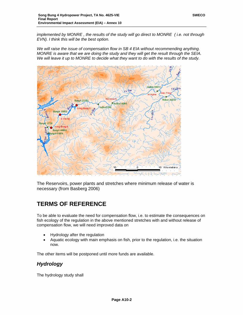
Song Bung 4 Hydropower Project, TA No. 4625-VIE Final Report Environmental Impact Assessment (EIA) – Annex 10
SWECO
Page A10-2
implemented by MONRE , the results of the study will go direct to MONRE ( i.e. not through EVN). I think this will be the best option. We will raise the issue of compensation flow in SB 4 EIA without recommending anything. MONRE is aware that we are doing the study and they will get the result through the SEIA. We will leave it up to MONRE to decide what they want to do with the results of the study.
The Reservoirs, power plants and stretches where minimum release of water is necessary (from Basberg 2006)
TERMS OF REFERENCE To be able to evaluate the need for compensation flow, i.e. to estimate the consequences on fish ecology of the regulation in the above mentioned stretches with and without release of compensation flow, we will need improved data on
• Hydrology after the regulation • Aquatic ecology with main emphasis on fish, prior to the regulation, i.e. the situation
now. The other items will be postponed until more funds are available.
Hydrology The hydrology study shall
Song Bung 4 Hydropower Project, TA No. 4625-VIE Final Report Environmental Impact Assessment (EIA) – Annex 10
SWECO
Page A10-3
• Clarify the flow at the different sections for different times of the year at the most likely way of running the power stations.
• Estimate the runoff from the local catchment of the different sections at different times of the year
• Estimate the percentage of the river bottom that will be totally dry in the different stretches during the different times of the year, including peaking production.
• Perform the same estimates as the point above under different releases of compensation flow
Aquatic ecology with main emphasis on fish production and biodiversity
1. The aquatic ecology study shall provide data that is necessary for analysing the consequences on the given river stretches of the most likely running of the hydropower plants
2. Analysing and attempting to quantify the benefits of different environmental flows at the different stretches.
Central item will be to
• Clarify the migratory pattern to the different fish species • Clarify the implications for fish food production (periphyton, bottom animals)
through destruction of productive river bottom (see hydrology section) • Clarify implications for other water creatures that are utilised by the local
human population (shrimps, crabs, turtles, etc) • Clarify, or anticipate, which fish species will likely inhabit the Song Bung 5
reservoir, and to what extent these will be depending on the incoming river for spawning.
• Clarify to what degree a compensation flow will sustain fish stocks in the different sections
• Clarify the implications for river biodiversity with and without compensation flow
• Clarify Song Bungs importance for the fish in other parts of the Vu Ghia – Thu Bon river system.
The results from the hydrological study will be very important for the analysis of the items of aquatic ecology.
Collection of fish data For fish and other aquatic products, however, there is a need for collecting new data by help of local fishermen. This should be done around the year. However, due to lack of funds, this first phase of the fish data collection will be restricted to the wet season: September, October and November this year. This collection should comprise: 1) Fish catch (number and weight) 2) Fish species in the catch 3) Fish size (average and maximum weight of each species) 4) Shrimp catch (weight) Shrimp species in the catch
Song Bung 4 Hydropower Project, TA No. 4625-VIE Final Report Environmental Impact Assessment (EIA) – Annex 10
SWECO
Page A10-4
5) Crab catch (weight) Crab species 6) Snail catch (weight) Snail species 7) Shellfish catch (weight) Shellfish species The fish yield data collection should be organized in the following way: A photo album of the 107 fish species, and other utilised species, identified during the EIA study should be prepared. Fishermen, or families that fish more or less every day, should be contracted to report their catch of the different species every day (or fishing tour) both with respect to numbers, species, weight and where the catch was taken, and by which method. The photo album will be their identification literature, to help them getting the correct Latin names on the different species. In the field manual (Photoalbum, etc) it will be used numbers instead of Latin names, which is often long and complicated. As one of the main goal is to understand better the migratory behaviour of the different fish populations in Bung River, such groups has to be mobilized along the whole river: A minimum of 4 fishermen groups must be mobilized.
1. Fishing in the upstream area (Pha Di area) 2. Fishing in the reservoir area (Ton 2), 3. Fishing in the area between the reservoir and Song Cai, 4. Fishing in the part of Vu Gia upstream of Ai Ghia
Within these 4 fishermen groups at least 5 fishermen (single person or boat team) must report their catch from every fishing tour. In total this will give 20 data set of fish catch from the river. Data will be collected from the groups every month by the domestic scientific team. The contracted fishermen must also give the information they have with respect to the
• spawning grounds • migration patterns • fish catch before
of the different fish populations. The fishermen must get some payment for the job as it will imply extra work in their daily fishing. If such data is collected around the year at different sites of the river, one will also have data that can be used to clarify the migratory pattern of the different species, i.e. through the knowledge of where and when they are caught over the annual cycle. It must be elaborated a detailed field work instruction (Manual) for the fishermen in their language (or Vietnamese if appropriate) including the photo-album as well as forms to be filled in with results of each fishing tour. These forms should be made on plastic paper which can be written on with pencil even in rainy weather. The fishermen must be equipped with spring scale weights of different sensitivity, from 0-0.5 kg, 0-5 kg, 0-30 kg, etc., and a measuring ruler (e.g. a folding ruler), so the fish can be measured and weighted properly.
Song Bung 4 Hydropower Project, TA No. 4625-VIE Final Report Environmental Impact Assessment (EIA) – Annex 10
SWECO
Page A10-5
The form should contain information on what kind of fishing gear that is used, so it is possible to calculate the catch by different gears. For gillnets the mesh size should be given, for long line the number of hooks, etc. The number of hours of fishing each tour should also be noted as to be able to calculate “catch per unit effort” CPUE. The total number of fishermen should be registered. Then, by proportioning the total catch of the different species in Song Bung can be calculated for each month. The domestic consultant must participate in the first fishing tour and teach the fishermen (teams) how to use the photo-album and how to perform the weighing and the measuring of the catch, as well as how to fill in the forms. Every month the domestic consultants must visit the fishermen, collect their data, and to pay the salary.


![HOG BUNG DROPPER - Kentmaster · rev b: 08/10 operator’s manual [english]: hog bung dropper including: operation, instruction, installation and maintenance important: read this](https://static.fdocuments.in/doc/165x107/5b4789b27f8b9a5e5f8c2eeb/hog-bung-dropper-rev-b-0810-operators-manual-english-hog-bung-dropper.jpg)