ENVIRONMENTAL IMPACT ASSESSMENT REPORTS VOLUME- 1 ...
36
i “CAPACITY AUGMENTATION OF NATIONAL WATERWAY -1” (Jal Marg Vikas Project) ENVIRONMENTAL IMPACT ASSESSMENT REPORTS VOLUME- 1: EXECUTIVE SUMMARY May2016 (Revised September 2016; Copy Edited November 2016) IRG Systems South AsiaPvt. Ltd. Abnaki Infrastructure Applications & Integrated Development Pvt. Ltd. INLAND WATERWAYS AUTHORITY OF INDIA Ministry of Shipping, Government of India EQMS India Pvt. Ltd. In JV with
Transcript of ENVIRONMENTAL IMPACT ASSESSMENT REPORTS VOLUME- 1 ...

i
“CAPACITY AUGMENTATION OF NATIONAL WATERWAY -1”
(Jal Marg Vikas Project)
ENVIRONMENTAL IMPACT ASSESSMENT REPORTS
VOLUME- 1: EXECUTIVE SUMMARY
May2016 (Revised September 2016; Copy Edited November 2016)
IRG Systems South AsiaPvt. Ltd. Abnaki Infrastructure Applications &
Integrated Development Pvt. Ltd.
INLAND WATERWAYS AUTHORITY OF INDIA
Ministry of Shipping, Government of India
INLAND WATERWAYS AUTHORITY OF INDIA
Ministry of Shipping, Government of India
INLAND WATERWAYS AUTHORITY OF INDIA
Ministry of Shipping, Government of India
INLAND WATERWAYS AUTHORITY OF INDIA
Ministry of Shipping, Government of India
EQMS India Pvt. Ltd. In JV with
ii
Table of Contents
1. Summary Project Description ......................................................................................... 1 2. Environmental Impact Assessment Process .................................................................. 6 3. Environmental Sustainability & Climate Resilience in the Project ................................... 8 4. Applicability of Legal and Regulatory Framework in India .............................................. 9 5. Analysis of Alternatives ................................................................................................ 11 6. Public Consultation and Disclosure .............................................................................. 13 7. Salient Environmental Features of NW-1 ..................................................................... 15 8. Anticipated Environmental Impacts and Mitigation Measures....................................... 17 9. Environmental Management Plan ................................................................................ 27
Abbreviations
µg/m3 Microgram per cubic metre A Ampere
AAQ Ambient Air Quality AD Amphibian Dredger
Amsl above mean sea level APHA American Public Health Association
AWPCPL Allahabad Waste Processing Company Pvt.
Ltd BCM Billion Cubic Microns
BDU Below Detection Unit BDU Best Designated Unit
BHDs Backhoe Dredgers BHU Banaras Hindu University
BOD Biochemical Oxygen Demand BOQ Bill of Quantity
BTKM Billion Tonne Kilometres BUIDCO Bihar Urban infrastructure development
Corporation Ltd.
BWE Ballast Water Exchange BWMP Ballast Water Management Plan
BWP Ballast Water Performance CBWTF Common Bio Medical Waste Treatment
Facility
CEC Cation Exchange Capacity CERs Critical Environmental Resources
CGWA Central Ground Water Authority CGWB Central Ground Water Board
CIFRI Central Inland Fisheries Research Institute CIWTC Central Inland Water Corporation
Limited
Cm Centimetre CNG Compressed Natural Gas
CO Carbon Monoxide COD Chemical Oxygen Demand
CPCB Central Pollution Control Board Cr Crore
CRZ Coastal Regulation Zone CSD Cutter Section Dredgers
CTE Consent to Establish CTO Consent to Operate
Cum cubic metre dBs Decibels
DEAC District Environmental Impact Assessment
Committee DEIAA
District Environmental Impact
Assessment Authority
DEM Digital Elevation Model DFCCIL Dedicated Freight Corridor Corporation
of India Limited
DFO District Forests Officer DFR Detailed Feasibility Report
DG Diesel Generators DGPS Differential Global Positioning System
DO Dissolved Oxygen DWT Dry Weight Tonnage
DWT Dead Weight Tonnage E East
EC Electrical Conductivity EDFC Eastern Dedicated Freight Corridor
EHS Environment, Occupational Health and
Safety EIA Environmental Impact Assessment
EMoP Environmental Monitoring Plan EMP Environment Management Plan
EPC Engineering Procurement Contractor ESAs Ecologically Sensitive Areas
iii
Abbreviations
ESC Environment and Social Cell ESS Electrical Sub stations
FBP Farakka Barrage Project GHG Green House Gases
GRIHA Green Rating for Integrated Habitat
Assessment GIS Geographical Information Systems
Gm Gram GoI Government of India
GPS Global Positioning System GRB Ganga River Basin
GW Ground Water ha Hectare
HAD Haldia Development Authority HC Horizontal Clearance
HDC Haldia Dock Complex HDPE High Density Poly Ethylene
HFL Highest Flood Level hpa Hectopascal
HPC Name of a Consultant hrs hours
HSD Hydraulic Surface Dredger IARI Indian Agricultural Research Institute
IBA Important Bird Areas IESWM Institute of Environmental Studies &
Wetland Management
IITs Indian Institute of Technology IMD India Meteorological Department
IMDG-code International Maritime Dangerous Goods
Code IMO International Maritime Organization
INTACH Indian National Trust for Art and Cultural
Heritage IRS Indian Remote Sensing Satellite
IS Indian Standards Published by Bureau of
Indian Standards ISRO Indian Space Research Organization
IUCN International Union for Conservation of
Nature IWAI Inland Waterways Authority of India
IWC International Whaling Commission IWT Inland Waterway Transport
JNNURM Jawaharlal Nehru National Urban Renewal
Mission kgs Kilograms
KLD Kilolitre per Day km kilometre
KMC Kolkata Municipal Corporation kmph Kilometre per Hour
KoPT Kolkata Port Trust KW Kilo watt
LAD Least Available Draft LC Level Crossing
Leq Equivalent continuous sound pressure level
in dB LPG Liquid Petroleum Gas
M Metre M Million
MARPOL International Convention for the Prevention
of Pollution from Ships meq Milli equivalent
mg/l Milligram per litre mg/l Milligram per litre
mL Millilitre MLD Millions of Litres Per Day
mmhos/cm Mili mho/ centimetre MoEF&CC Ministry of Environment, Forests &
Climate Change
mpn/100 ml Most Probable Number/100 millilitre MSIHC Manufacture Storage import of
Hazardous Chemicals
MSW Municipal Solid Waste MT Metric Tonnes
MT Metric Tonnes MTPA Million Tonne Per Annum
N North NAAQS National Ambient Air Quality Standards
NAAQS National Ambient Air Quality Standards NABL National Accreditation Board for Testing
and Calibration Laboratories
NCAER National Council of Applied Economic
Research NGBRA National Ganga Basin River Authority
NGO Non-Government Organization NH National Highway
NMCG National Mission for Clean Ganga NOC No Objection Certificate
Nox Oxides of Nitrogen NRCD National River Conservation Directorate
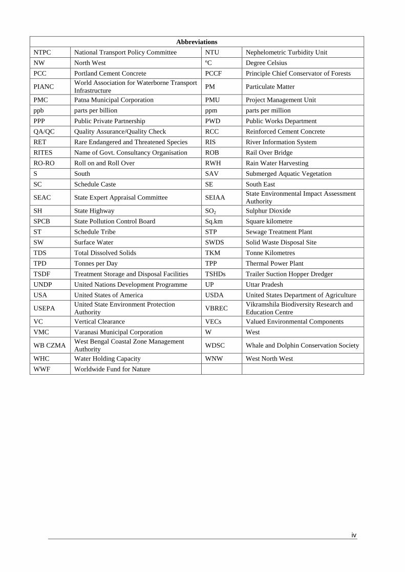
iv
Abbreviations
NTPC National Transport Policy Committee NTU Nephelometric Turbidity Unit
NW North West ºC Degree Celsius
PCC Portland Cement Concrete PCCF Principle Chief Conservator of Forests
PIANC World Association for Waterborne Transport
Infrastructure PM Particulate Matter
PMC Patna Municipal Corporation PMU Project Management Unit
ppb parts per billion ppm parts per million
PPP Public Private Partnership PWD Public Works Department
QA/QC Quality Assurance/Quality Check RCC Reinforced Cement Concrete
RET Rare Endangered and Threatened Species RIS River Information System
RITES Name of Govt. Consultancy Organisation ROB Rail Over Bridge
RO-RO Roll on and Roll Over RWH Rain Water Harvesting
S South SAV Submerged Aquatic Vegetation
SC Schedule Caste SE South East
SEAC State Expert Appraisal Committee SEIAA State Environmental Impact Assessment
Authority
SH State Highway SO2 Sulphur Dioxide
SPCB State Pollution Control Board Sq.km Square kilometre
ST Schedule Tribe STP Sewage Treatment Plant
SW Surface Water SWDS Solid Waste Disposal Site
TDS Total Dissolved Solids TKM Tonne Kilometres
TPD Tonnes per Day TPP Thermal Power Plant
TSDF Treatment Storage and Disposal Facilities TSHDs Trailer Suction Hopper Dredger
UNDP United Nations Development Programme UP Uttar Pradesh
USA United States of America USDA United States Department of Agriculture
USEPA United State Environment Protection
Authority VBREC
Vikramshila Biodiversity Research and
Education Centre
VC Vertical Clearance VECs Valued Environmental Components
VMC Varanasi Municipal Corporation W West
WB CZMA West Bengal Coastal Zone Management
Authority WDSC Whale and Dolphin Conservation Society
WHC Water Holding Capacity WNW West North West
WWF Worldwide Fund for Nature
v
Disclaimer:
The report has been prepared by EQMS India Pvt. Ltd. in JV with IRGSSA & AIAID for
Inland Waterways Authority of India (IWAI). EQMS JV has undertaken detailed
environmental and social assessment complying with terms of reference issued by IWAI.
Any third party should obtain prior consent of IWAIbefore copying or reproducing in whole or
in part the contents of this report. EQMS JV disclaims any responsibility for any damage
suffered by any third party arising out of use of this report or part thereof without proper
context and consent. Furthermore, EQMS JVwill not be bound to discuss, explain or reply
to queries raised by any agency other than IWAI and other intended recipients of this report.
This report is the intellectual property of IWAI/EQMS JV.
The facts and figures and assessments presented in the report are based on the information
provided,collected and primary surveys undertaken during the study. The analysis and
conclusions are based on these sets of information available. EQMS JV is not responsible
for accuracy, reasonableness or completeness of either the information provided or
information collected from secondary sources. Information contained in the report could be
selective and is subject to updating, expansion, revision and amendments. The report does
not purport to contain all the information that a reader (other than IWAI or the
intendedrecipient) may require.
1
1. SUMMARY PROJECT DESCRIPTION
a. Need and Rationale for the Project
Inland waterways transport (IWT) is a competitive alternative to road and rail transport, offering an
economical, sustainable and environment friendly mode in terms of energy consumption, noise and
greenhouse gas emissions. However, IWT in India is underutilised and suffers from unreliability and
lack of infrastructure as compared to other large countries and geographic areas like the United
States, China and the European Union. This is partly due to investment dedicated exclusively to
road and railway development and the weakness in infrastructure, service and market development
in making IWT a competitive alternative.
One of the key challenges for India in accelerating economic growth and trade competitiveness
remains the congested road and rail systems and the virtual absence of multi-modalism to provide
more efficient and flexible supply chains. In order to reverse the decline and build a logistics
infrastructure capable of efficient handling of rapidly growing freight traffic, India would need to
pursue an integrated and coordinated approach and optimal utilization of all transport modes.
The total cargo moved by the inland waterways was just 0.34% of the total inland traffic in India in
2003-04. However, IWT has shown gradual growth in the last decade, and IWAI aims to capture 2%
of total inland cargo by 2025. Through GoI‟s Twelfth Five Year Plan, and introduction of the
National Waterways Bill (2015), there has been increasing commitment to development of IWT,
which will increase from nearly 4,400 km to over 18,000 km of India‟s declared National Waterways,
and an eventual ten-fold increase in the share of freight transported through this mode. There are
potential economic, environmental and social benefits in using India‟s inland waterways for
transport.
National Waterway 1 (NW-1), located in one of its busiest freight transport corridors, is the longest
(1,620 km) of the six existing National Waterways and is a natural river system linking the seaport
gateway at Haldia/Kolkata to Allahabad, via the Hooghly/Bhagirathi and Ganga. NW-1 in particular
is of enormous national importance, and would play vital role in regional connectivity and bulk cargo
movement in a cost effective and environment-friendly manner.
The Jal Marg Vikas Project, with support from the World Bank, is aimed at creating the required
infrastructure, connectivity and institutional support for market development on NW-1 focusing on
the stretch between Haldia and Varanasi. The project will also contribute to (i) reducing the growth
of transport-related greenhouse gas emissions by rebalancing the freight mode shares and by
promoting a new and complementary mode of transportation; (ii) national as well as international
trade, and regional integration which allows goods to move by coastal shipping from Chittagong
Port in Bangladeshand Haldia/Kolkata, and thereafter by inland waterways or road transport to the
Nepal, Bhutan, and north-eastern Indian states; (iii) economic integration of four low income states
(West Bengal, Jharkhand, Bihar and Uttar Pradesh) and augmentation with Eastern Dedicated
Freight Corridor; and (iv) improved safety and environmental protection in IWT minimizing the
negative effects of water transport on the river environment.
As stated above, IWT is an environment-friendly mode of transport, and accelerated development
of the waterway will be beneficial in a number of ways, particularly in the densely populated and
traffic congested region on either bank of the Ganga River. A prominent benefit is the net reduction
in GHG emission (estimated at 4.54 million T CO2e) from the project compared to the business as
usual scenario (which is dependent on road transport where augmentation capacity is limited which
may result in additional GHG emission in the medium term). Other benefits include avoided

2
acquisition of forest land and wetlands (for expanding road networks), reduced air pollution (from
traffic), improved water quality given that a developed and established IWT would need and secure
improved flow regime and prevent further diversion of water from the river Ganga.
b. Project Objective
The Project Development Objective is to enhance transport efficiency and reliability of National
Waterway 1 and augment institutional capacity for the development and management of India‟s
inland waterway transport system in an environmentally sustainable manner.
The Project aims at improvement of navigation in the entire stretch of NW-1 and proposes to
augment the capacity of entire stretch and continue to maintain the waterways of entire stretch
between Haldia to Varanasi. The capacity augmentation would aim for development of all required
infrastructure like terminals and ship lock for effective and sustainable navigation throughout the
year.
c. Description of the Project
The project area includes the entire reach of the River Ganga from Haldia to Varanasi including the
areas proposed for development of project related facilities and infrastructure, i.e. Terminals,
Navigation Ship Lock, Ro-Ro jetty and other planned developments. Map showing location of NW-1
stretch from Haldia to Allahabad is depicted in Figure 1 below.
Figure 1: Location Map of NW-1
Environmental sustainability has been weaved into the project design and its components. The
design is based on a balanced maintenance and operational strategy to minimize damage to the
ecosystem, aligned with the principle of „working with nature‟. No barrages or storage reservoirs will
be constructed in the main river and tributaries to maintain water depth and reduce silt charge even
though it could have been a more economical option to dredging. Adopting an assured depth
dredging contract regime would reduce unnecessary dredging and improve ecological stability with
respect to water flow and quality. The design least available depth (LAD) required for sustainable
navigation was also reduced by the introduction of shallow draft vessels, avoidance of any
constrictions of the river flow, use of low intrusive dredging technology, and restricted operational
framework in the eco sensitive zones–, which all lead to environmental sustainability.

3
The River Ganga has a huge cultural significance and requires sensitive public management of its
development. For this purpose, the physical interventions had been kept to a minimum (and
noticeably, construction of barrages, diversion structures, and groins has been avoided). The
smaller physical interventions – such as vessel berthing platforms at the terminals have been
carefully designed not to alter local hydro-dynamics. To meet the objective of project, the project
has optimized the dredging requirement for different stretches: Haldia to Farakka (3m, where there
is naturally available LAD); Farakka to Barh (3m); Barh to Buxer (2.5m); Buxer to Varanasi (2.2m).
The design volume is absolutely minimized, being restricted to a channel of width of 45m in a river
where the flow zone is 500m to 1km wide. The overall annual dredging quantity would be less than
1.5% of the overall sedimentation load in the river, would have highly insignificant impact on river
morphology and would gradually decline due to introduction of low draft vessels in the waterway.
Opportunities for environmental enhancement were also incorporated in the project design, such as
(i) supporting introduction of „cleaner‟ vessels which will follow international standards for discharge
of ballast, waste water, and use of cleaner more efficient fuel (ii) building energy-efficient, (GRIHA
certified green building design) terminals and “zero-discharge” infrastructure; (iii) reduction in air
pollution in major cities by careful citing of multimodal terminals and thereby reducing potential
traffic congestion; (iv) conservation of protected aquatic areas; (v) ) the highest health and safety
standards for operation of terminal facilities and navigation operations and (vi) and state-of-art river
information systems which will decrease the chances of accidents and also provide available LAD
to ensure no collisions occur.
The project consists of two main components: (A) Improving the navigability of NW-1 between
Haldia and Varanasi at an estimated cost of US$770 million; and (B) Improving the investment
climate, vessel design and construction framework and institutional strengthening at an estimated
cost of US$30 million.
a) Component A: Improving the navigability of NW-1 (Haldia to Varanasi).
Improvement of river fairway through dredging and river conservancy works. These works will be
undertaken to provide the target LAD in the various reaches. The works will be executed through a
combination of three performance-based „assured depth‟ contracts and one input based dredging
contract (already in place) on the Farakka to Varanasi stretch. IWAI‟s internal resources will be
used to carry out marginal maintenance dredging in the Haldia to Farakka stretch. Procurement of
one assured depth dredging contract (Farakka to Bhagalpur stretch) is currently in progress.
Construction of permanent protection works for erosion prone banks in selected locations, totalling
up to 48.168 km. The works will be executed through EPC contracts.
Rehabilitation of the existing ship-lock in Farakka and construction of a new parallel lock to allow
concurrent two-way working. The works will be implemented through an EPC contract and
procurement is currently in progress.
Multi-modal freight terminals and other facilities: (i) construction of six multi-modal freight terminals
with future provision to allow evolution as market clusters ; (ii) one vessel repair and maintenance
facility; and (iii) five RO-RO crossings. IWAI would provide land and road access for the RO-RO
terminals, while the private sector would build and operate RO-RO facilities. All other works will be
executed through EPC contracts. Construction of a multi-modal terminal in Varanasi has been
initiated and procurement is currently ongoing for Sahibgunj and Haldia multi-modal terminals. Land
acquisition and resettlement, environmental management, utility relocation and independent
monitoring and quality assurance are included.
Navigational aids and river information systems: (i) navigational aids in the form of night
navigation facilities and channel marking; (ii) enhancement of existing river information system
through addition of app-based systems, improved communication platform and expanded user

4
reach; and (iii) provision of other support services e.g. search and rescue, distress response and
casualty incident management, and upgrading vessel and river monitoring systems. These activities
will be implemented through a combination of small civil works, services and goods contracts.
b) Component B: Institutional Strengthening and improving the investment climate, vessel design and construction framework
Institutional strengthening of sector institutions and capacity building of the sector is envisaged
through: (i) undertaking a review of current IWAI staffing, future institutional options and enhanced
staffing/skill needs including in areas such as logistics and marketing, social development,
grievance redressal, health, safety and environmental (HSE) management; (ii) undertaking review
and alignment of laws and regulations in respect to IWT vessel design, construction, manning,
operation, maintenance, insurance and multi-modal transport; and (iii) exploring the option of
developing sector institutions including a Research and Development Unit/Centre for IWAI and
enhancement of training institutions (NINI). Adequate training, exposure visits and international
benchmarking will be supported through this component. The procurement process for activity (i)
has been initiated and IWAI has also commenced activity (ii) through the recent initiative in
amending the Inland Waterways Act.
The overall investment climate will be improved through (i) undertaking market development studies
and preparation of business cases (by location, industry and cargo type); and (ii) investigating
arrangements for private sector participation in the construction and operation of terminals. Both of
these activities would be executed through service contracts. IFC has been engaged as a
transaction adviser to support activity (ii) which is well underway. Activity (i) is also in progress.
Fleet modernization will be undertaken through: (i) vessel design and standardization with a focus
on low draft and efficient and clean fuel (LNG) vessels; (ii) public/private stakeholder consultations
to encourage investment in modern vessel technology through review of fiscal and other barriers
hindering vessel construction; and (iii) leasing of ten low draft vessels to kick-start the use of
modern vessels in NW-1. Activities (i) and (ii) would be implemented through service contracts,
while activity (iii) will be implemented through goods contracts. Procurement for activity (i) is already
underway.
Table 1: Salient Features of Jal Marg Vikas Project
Salient Features Capacity/Quantity/Nos.
Facilities Planned 3 Multi-modal terminal sites (Sahibganj, Varanasi &Haldia)
1 new Navigation lock- Farakka
River bank protection works at planned terminal sites and along
Feeder canal
Facilities under Planning
Stage
3 additional terminal sites (at Ghazipur & Kalughat-site finalized and
at Tribeni-under consideration)
5 ro-ro crossings
Barge repair and maintenance facilities
River training works
River bank protection works at the proposed civil intervention sites
Designed capacity of
Terminals
Infrastructural
Facility
Projected
Cargo-2015
(MTPA)
Projected
Cargo-2030
(MTPA)
Projected
Cargo-2045
(MTPA)
Sahibganj
Terminal
2.24 4.39 9.00
Varanasi Terminal 0.54 1.22 1.22

5
Salient Features Capacity/Quantity/Nos.
(with current land)
Haldia Terminal 3.18 MTPA
Navigation Channel
Channel Width-45 m
LAD-3 m from Haldia (0 Km) to Barh ( 980 Km) , 2.5 m from Barh to
Ghazipur ( 1250 Km) and 2.2 m from Ghazipur to Varanasi ( 1360
Km) at present
Design Vessel
Specifications
Vessels of maximum length of 110 m, beam of 11.4 m, draught of
2.5 m-2.8 m and air draught of 9 m will be required in NW-1.
Size of Vessels 1500-2000 dWT
River Slope Haldia to Farakka-1 in 11000
Farakka downstream-1 in 18000
Farakka to Allahabad-1 in 17,000
Maintenance Dredging Within Navigation Channel-14,850,000 cum/year*
Type of Dredgers Cutter Suction dredgers (CSD), Water Injection dredgers,
Agitation/Plough dredgers and Back-hoe dredgers
Dredge disposal Preferably off-shore, onshore only if sediments are found to be
contaminated
* Quantities are tentative and subject to change with revision in planning
c) Cargo Details
Cargo proposed to be transported in NW-1 includes cement, fly ash, iron ore, iron ore fines, coal,
steel shed, tyres, iron fines, iron ingots, galvanized steel plain sheets, stone chips, furnace oil, high
speed diesel (HSD), lube oil, boulders, pulses, aluminium block, sand, chips, ship blocks, food
grains, manganese ore, petroleum products, coke, cooking coal, rock phosphate, timber, peas, slag
oil, and non-cooking coal. As per the survey traffic, current traffic transported via rail & road
between Haldia & Varanasi is 121426130 tonne. Traffic projection studies are carried out and as
per the study, projected traffic for year 2045 is 4,80,11,367 tonne. Under NW-1, 6 nos of terminals
are proposed out of which planning for three nos. terminals are completed. As per the planning, the
cargo handling capacity for base year and year 2045 is given at Table 2.
Table 2: Traffic Forecast for Planned Navigational Infrastructural Facilities
S. No. Infrastructural Facility
Projected Cargo-2015 (MTPA)
Projected Cargo-2030 (MTPA)
Projected Cargo-2045 (MTPA)
1 Sahibganj Terminal 2.24 4.39 9.00
2 Varanasi Terminal (with current land)
0.54 1.22 1.22
3 Haldia Terminal 3.18MTPA Source: HOWE Engineering Projects (India) Pvt. Ltd. (Design Consultant)
d. Project Implementation Schedule and Implementation Responsibilities
The project being spatially large will be developed in phases. The implementation period of 3 years
is anticipated for completion of Phase 1 components of the Project (6 terminal sites, maintenance
dredging, vessel management system, shore protection works and river training works). The Project
Director and officer of the rank of Vice Chairman of IWAI will be in charge of the implementation
programme who will be assisted by Project Management Unit and Regional Directors.
6
2. ENVIRONMENTAL IMPACT ASSESSMENT PROCESS
This project is classified as Category „A‟ operations under the World Bank environmental screening
procedures specified under its operation policy (OP) 4.01. The project triggers six of the World Bank
safeguard policies and requires comprehensive environmental assessment. Detailed environmental
assessment has been undertaken for all the proposed components to identify the environmental
issues associated with the project. The environmental impact assessment was carried out in line
with World Bank Operational Policies, IFC EHS Guidelines for Ports, Harbours and Terminals, IFC
General Guidelines for EHS, and MoEFCC EIA Guidelines for Ports and Harbours.
a. Project Categorisation and Applicable Safeguard Policies
The project is classified as an „Environmental Category A‟ project in accordance with OP4.01 due to
the nature and scale of the planned civil works, the complexity of environmental issues associated
with the river dredging, and the ecological sensitivity of river Ganga. Of the environmental
safeguard policies, the project triggers: (i) OP/BP 4.01 - Environmental Assessment, (ii) OP/BP 4.04
- Natural Habitats, and (iii) OP/BP 4.11 – Physical &Cultural Resources. In addition, the
Environmental, Health, and Safety (EHS) Guidelines of the World Bank is applicable to the project.
The project also triggers the OP/BP 4.20 Involuntary resettlement.
b. Other Safeguard Policies
Projects on International Waterways (OP/BP7.50): The Bank‟s Operational Policy OP 7.50 that
pertains to Projects on International Waterways is triggered since project activities will take place on
the Ganga which is a trans-boundary river flowing through the nations of India, Nepal and
Bangladesh. The Bank, on behalf of India, notified the riparian countries - China, Nepal and
Bangladesh in June 2016. China issued its no objection to the project on July 27, 2016. Bangladesh
Government asked for additional information on July 18, 2016, which was responded by the Bank
on August 12, 2016. No communication has been received from Nepal.
All planning and design considerations for proposed infrastructure along NW-1 have been aimed at
fully avoiding (or absolutely minimizing) any potential adverse transboundary affects (which could
have impacts such as reduction and/or modification of flow of water or sediments; and increased
water pollution). The avoidance of any obstruction to or modification of flow, the designs that ensure
no pollution of the river, and the limits placed on dredging and disposal of dredged materials mean
that there will be no impact on the quality and quantity of flow in the transboundary river.
c. EA Documents: preparation, consultation and disclosure
The following EA documents have been prepared for the Project:
1) An executive summary of the entire EA process and documents (Volume 1 of EA Documents)
2) A cumulative impact analysis (CIA) report for the Project and other major developments currently implemented or planned along the river Ganga (see Volumes 2 and 2A)
a. This CIA includes a study on the critical environmental resources of the Ganges basin in India, to provide guidelines to avoid impacts on these as far as possible, and recommends strategies to manage direct, indirect and induced impacts (which include specific guidance for the Project and its EIA).
3) A consolidated environmental impact assessment (EIA) for the Project (see Volumes, 3A, 3B, 3C and 3D)
a. This is aimed to avoid, mitigate and/or manage overall potential environmental, health and safety impacts from the Project;
7
b. Note that the consolidated EIA was not limited to summation of individual sub-projects (interventions), but is an overall assessment covering all aspects of operation of the waterway.
c. The EIA includes specific environmental assessment of all major interventions currently planned in the project (barge operations, maintenance dredging, navigational lock at Farakka, multimodal cargo terminals at Varanasi, Sahibganj and Haldia);
d. The EIA includes an environmental management framework (anticipated potential issues and risks, terms of reference including scope of work for the EA to be undertaken) for major civil works interventions that may come up in near future, such as RO-RO jetties, additional multimodal cargo terminals, and vessel repair and maintenance facilities;
e. A summary of concerns raised during consultation has been included as a standalone document highlighting the different stakeholder consultations conducted, issues raised and how they have been incorporated in the project‟s plans and designs.
4) Environmental Management Plans (EMPs) suitable for incorporation in the works (or design-build-operate contracts) of planned interventions in the project. (See Volumes 4, 5, 6, 7, 8 and 9). These were prepared for the following:
a. Multi-modal cargo terminals at Varanasi, Sahibganj and Haldia. b. Navigation lock at Farraka
c. Maintenance dredging for the entire waterway (Haldia to Varanasi) d. Barge operations for the entire waterway (Haldia to Varanasi)
Baseline surveys: The baseline surveys were planned considering the requirement of the project
level EIA, larger CIA and the basin-level study of critical environmental resources. The baseline
surveys were carried out between September 15, 2015 and February 28, 2016. In addition to air,
water, noise, soil quality, terrestrial flora and fauna, aquatic flora and fauna, baseline surveys
included sampling and testing for riverbed sediments quality and contamination. Baseline studies
identified all existing infrastructure on NW-1 (such as existing RO-RO jetties, existing passenger
ferries, pontoons, bridges, etc.), the likely intervention places, likely maintenance dredging
stretches, and all environmentally sensitive areas. Baseline studies covered project‟s influence area
different for each valued environmental components (VECs) determined by potential pathways and
extent of impacts on the specific VECs.
Analysis of alternatives and their incorporation in design of the project: The assessments were
carried out in tandem with preparation of detailed engineering feasibility report. This helped to
analyse the suggested alternatives from an environmental perspective and in turn allowed
incorporation of the environmentally suitable alternative in the project‟s design. Further, various
project proposals were modified during the design stage to mainstream environmental
considerations. Examples include incorporation of mechanical conveyance system at Sahibganj,
mandatory green plantation all around the periphery of terminals and along the roads, dust
suppression system at storage and barge loading areas, and provision of storm water management
system separate for buildings and for surface. The basin level study of critical environmental
resources identified “No-Go” areas, and other characteristically sensitive locations where
construction and dredging is strictly prohibited.
The impact assessment covers all three stages of the project viz. design, construction and
operation stages. The impacts are identified from all components and activities of the project on
physical, biological (terrestrial and aquatic ecology) and socio–economic environment. The project
has the potential, unless managed, to have unintended impacts both in the short and long term.
Potential major environmental issues that were examined included: (i) modifications to the riverbed,
riverbanks and the flood plains, and the consequent impacts; (ii) potential modifications to the river
8
and sediment flow, especially during the lean season and the associated impacts; (iii) potential
damage to the aquatic fauna including dolphins, turtles, fishes, and to the nesting and breeding
grounds and sanctuaries on and along the river bed; (iv) construction related impacts including
impacts from dredging, disposal of dredged materials, siting of terminals, logistics parks, bank
protection works and jetties, and (v) potential pollution of the waterway, and safety and health
issues arising during operation from regular operations or by accidental spills.
Because of the Environmental Assessment, and subsequent incorporation in plans and designs, the
project has reduced the risks (by avoiding specific interventions, such as dredging in the critical
stretches of protected areas; or by minimizing the interventions). Consequently, no potential large
scale, significant and/or irreversible impacts envisaged from the project. The plan for mitigating and
managing the residual risks is reasonable and implementable. In addition, the project is aiming at
very substantial environmental enhancements (by switching to liquefied natural gas as vessel fuel,
by facilitating introduction of "cleaner" vessels, by adopting low-draft vessels, by augmenting
riverine fishery or by supporting conservation of protected aquatic areas), and contributing to
curbing GHG emission of an order of 4.54 million tCO2e.
Consultation and Disclosure: The environmental assessments were carried out in substantial
consultation with stakeholders, to ensure that the environmental assessment and other compliance
requirements are in alignment with the policies and procedures as specified by the Government of
India and the World Bank Group safeguard policies. The draft EA documents (the CIA, the
Consolidated EA containing the EMPs for maintenance dredging and barge operations; the stand-
alone EMPs for Farraka Lock, Sahebganj, Varanasi and Haldia Terminals; and the Executive
Summary) were submitted to the Bank‟s Infoshop on June 2, 2016. All these EA documents along
with an Executive Summary in vernacular Hindi and Bengali were disclosed in country (on the IWAI
website) on May 22, 2016. The consultation process will continue throughout implementation of the
project.
Following disclosure, IWAI has invited stakeholder comments. Based on the comments from
stakeholders, the EA documents were revised in September 2016. These revised versions of the
EA documents will be redisclosed in country and in the Bank‟s Infoshop, with stakeholder
comments incorporated.
Any new investments in future that require use of a safeguard instrument such as an EA will also
follow Bank operational policies for public consultation and for disclosure.
3. ENVIRONMENTAL SUSTAINABILITY& CLIMATERESILIENCE IN THE PROJECT
Sustainable development and climate resilience were integrated in the project from the project
planning stage. The project design was based on a balanced maintenance and operational strategy
to minimize damage to the ecosystem, aligned with the principle of „working with nature‟. Adopting
an assured depth dredging contract regime would reduce unnecessary dredging and improve
ecological stability with respect to water flow and quality. Water Injection dredging/CSD is proposed
instead of the traditional dredging techniques. Here the dredged material is transported horizontally
along the waterbed and retains the dredged sediments within the ecosystem, which is an important
advantage for preserving the water ecology.
The project has adopted a practical approach by planning for potential impacts of climate-induced
events. The vulnerability to these potential impacts and the possible risks to both the assets and the
services provided were considered. With a view to build climate resilience, selected initiatives were
identified for design and implementation to be executed as a part of the project. Taking into account
possible climate-induced events such as drought or low water situations, low draft vessels were
chosen. These would help continuity of operation in drought or low water situations and help extend
9
the overall operational window in summer months. Further, the construction of jetties adjustable at
variable heights to deal with abnormal changes would help continuity of terminal operations in high
and low flow periods. The provision of storm shelters in ship repair facilities and other anchor points
/ floating jetties has also been included as a community adaptation measure.
Significant enhancement of disaster management services, i.e. rescue boat, patrol boat and oil
recovery vessel / attachment and service leasing of salvage tugs, has been planned. Erosion
protection for a 40km stretch is being done. This will bring climate adaptation benefits to the
community apart from serving the waterway itself. In building software, specific enhancement to the
River Information Systems to alert users on climate change events has been planned. The overall
strengthening of the assets and information systems will contribute towards building climate
resilience for communities near the waterways.
Inland waterways transport has the potential improve the freight transportation efficiency. Using this
efficiency in NW-1, the project will substantially reduce the GHG emissions to the tune of 4.54
million tons tCO2e in part fulfilling India's Nationally Determined Commitments by 2030. This net
reduction in GHG emission is expected to be higher with the incorporation of high capacity vessels
that will run on LNG and move in low draft.
Another key benefit is the reduction in pressure on land acquisition in the case of agriculture and
forestland. IWT is less likely than other transport forms to compete for land area (land is only
required for terminal construction, and access to the navigation channel), an important
consideration especially in the densely populated areas/cities along NW-1. It is also likely that in the
long term, the land use changes will be about agricultural areas or fallow lands (where terminals
could be easily located) being converted to commercial transport infrastructure land uses, rather
than natural forests or protected terrestrial areas.
Navigation is an ally to enhance environmental flows in the river and consequently improve wetland
connectivity. In the main stem of Ganga (until it joins tributaries in Bihar), lack of the needed
environmental flow has been a concern for a long time. In part, the water of the Ganges was
diverted to irrigation canals, as there was no strong stakeholder for maintaining adequate flow in the
river. Development of the project will ensure continuous water flow in the river.
At the project level, through the recommendations of the EA process, a number of measures
enhancing environmental benefits have been adopted. These include:
(i) The promotion of clean fuel (including LNG) vessels and construction of zero discharge
terminals and other riverside facilities would reduce the risk of environmental pollution;
(ii) Introduction of energy efficient (GRIHA certified terminals) to reduce overall energy
consumption;
(iii) Reduction in air pollution in major cities by careful citing of multi-modal terminals and
thereby reducing potential traffic congestion;
(iv) Conservation of protected aquatic areas;
(v) Supporting introduction of „cleaner‟ vessels;
(vi) Integrating NW-1 with passenger services: a safe and environmentally friendly transport
service can also provide effective support to growth of tourism.
4. APPLICABILITY OF LEGAL AND REGULATORY FRAMEWORK IN INDIA
The project has been evaluated for applicability of all National, State Laws, Rules and Regulations.
The Acts, rules and guidelines applicable for the project are critically analysed to list out the
permits/NOC required to be obtained by IWAI/contractor prior and during the development of the
project. Environmental legislations applicable for the project are:

10
(1) Environmental Protection Act, 1986 (2) EIA Notification, 2006 as amended till date (3) Forest Conservation Act, 1980 (4) Wildlife Protection Act, 1972 (5) Coastal Regulation Zone Notification, 2011 (6) Air (Prevention and Control) of Pollution Act 1981/1987 (7) Water (Prevention and Control of Pollution) Act, 1974/1988 (8) Hazardous and Other Wastes (Management &Transboundary Movement)
Rules, 2016 (9) Construction and Demolition Waste Management Rules 2016 (10) E-Waste Management Rules, 2016 (11) Plastic Waste Management Rules, 2016 (12) The Battery Management and Handling Rules, 2001 (13) Ancient Monument and Archaeological Site and Remains Act, 1958.
As per EIA Notification, 2006 as amended at present the project components like development of
terminals & jetties does not require environment clearance. However, environmental clearance will
need to be obtained for any project component wherever found applicable due to any amendment
to the above notification. The environmental clearance under minor mineral category of EIA
notification 2006 should be taken by the contractors as applicable before borrowing the earth and
for setting up new quarry site. Consent to establish under Air and Water Acts for setting up batching
plant, hot mix plant, DG sets, soak pit & septic tank/STP should be obtained by the contractor from
State Pollution Control Boards before setting up these facilities. The contractors / IWAI will ensure
compliance to the conditions of these permissions and should abide by the monitoring requirement
to be imposed by the permission granting agencies. No diversion of forest land is involved in the
project; however cutting of trees will be carried out for construction of terminals and other
interventions and permission will be required from concerned authorities or forests departments as
per law of respective states. Waste/used oil is the only hazardous waste likely to be generated
during construction and operation stage, which should be managed as per Hazardous & Other
Waste Management Rules, 2016. Other waste related regulations should also be followed
depending on the nature of waste generation during construction and operation stages as defined
above.
Permission under CRZ Notification, 2011 is required from West Bengal Coastal Zone Management
Authority to establish Haldia Terminal. The process for this permission has already been initiated.
Permission for movement of vessel through Kashi Turtle sanctuary and Vikramshila Gangetic
Dolphin Sanctuary (VGDS) located under Wildlife Protection Act, 19721 will be required. Process
has already been initiated for obtaining these permissions. There are nine archaeological sites
located within 300m area of river bank on NW-1. No construction activities are proposed close to
these sites. Permissions should be obtained from archaeological department if any construction is
planned in near future within 300 m of these sites.
Additional international conventions/treaties applicable for the project have been analysed. India as
a signatory of International Maritime Organization (IMO), is obligated to follow the environmental
and safety guidelines prescribed under various conventions. Some of the regulation and guidelines
applicable to vessels plying in Indian inland waterways as per IWAI includes (i) Prevention of
Collision on National Waterways Regulations, 2002 (ii) National Waterways, Safety of Navigation
1As per notification, restrictions are imposed for fishing (larvae of Hilsha& during breeding & spawning season) only in Hislha Sanctuary
11
and Shipping Regulations, 2002 (iii) The National Waterway-1 Act, 1982 (iv) New Inland Vessel Act,
2015 & Rules Under IV Act; and (v) other relevant International Environmental Conventions.
5. ANALYSIS OF ALTERNATIVES
Analysis of alternatives is an analytical comparison of the operational effectiveness, costs and
environmental and social risks of proposed development options. This helps to analyse the options
critically in relation to its impacts on all physical, social and biological environments. For this project,
alternative analysis has been made for three considerations, i.e. strategic, planning and technology
consideration. The summary of these analyses is presented below:
a. Strategic Consideration (“with” or “without”project)
A comparison is made for “With” & “Without” project scenario for the physical, social and biological
environments and status of cargo transport scenario. “With Project Scenario” is considered better
for all physical, biological, social environmental and cargo transport scenario compared to “Without
Project Scenario”. With Project Scenario will improve the freight transportation efficiency, reduce
the GHG emissions, fuel requirement, air emissions, land acquisition, and tree cutting for
maintaining and expanding cargo movement requirement. However, impacts are anticipated more
on water and aquatic ecology in “With Project” scenario as compared to rail and road modes, for
which mitigation and management plans have been prepared to minimize the impacts.
b. Planning Consideration
This involves the consideration of options for location of the proposed interventions, suitability of
intervention sites, design of the project layout and dredging extent. Locations are selected for
proposed civil interventions (terminals/jetties) based on potential of freight/cargo movement in the
area and its connectivity with other modes of transport (Rail and Road). Ten such locations were
selected for development of six terminals and one navigational lock. One of the probable locations
at Bhagalpur was ruled out due to presence of Vikramshila Gangetic Dolphin Sanctuary and based
on “No-Go” areas identified in Basin Level Critical Resources Assessment study. Two sites at
Varanasi and Sahibganj were identified few years back where land acquisition process was either
completed or nearing completion and thus were not included in the locational alternative analysis.
However, acceptability of these sites from environmental aspects was assessed and the sites were
found acceptable. The terminal sites at Haldia, proposed to be located on Government land
(Kolkata Port Trust Land), which is already being used for shipping and industrial purposes, were
considered acceptable from environmental and social aspects. The location of navigational lock at
Farakka already exists and navigation lock parallel to existing lock is proposed. The remaining
seven sites were analysed from environmental and social design considerations. Based on
alternative analysis three terminal sites at Ghazipur, Tribeni (Kalyani), and Kalughat near Doraiganj
were considered as preferred sites for these interventions. The other three terminal sites at Barh,
Kahalgaon and Balia were not considered feasible due to (i) various environmental considerations
including proximity to Vikramshila Dolphin sanctuary and important bird areas, (ii) design issues
such as unstable river, presence of navigational hazards and high sedimentation rate, (iii) social
issues concerning acquisition of land and (iv) connectivity issues.
Further alternative analysis was carried out for probable two sites at each of the above identified
three terminal locations and Farakka lock, based on environmental, social and design
consideration. As per this analysis, the preferred sites for these intervention locations were
considered for design and environmental impact assessment.
12
At the time of impact assessment, terminal designs were ready for Varanasi, Sahibganj, and Haldia
terminals only. Considering technical feasibility, multiple layout options were available only for
Sahibganj terminal and Farakka lock. These layout options were analysed for identification of most
suitable design options. In case of Sahibganj terminal, Alternative 1 involves construction of U
shaped jetty (25 m), aligned parallel to the river bank and connected to bank by approach trestle of
50 m and Alternative 2 involves construction of jetty at the river bank aligned parallel to it. Both the
alternatives were compared on multiple criteria, i.e. Operational considerations, navigational
aspects, ease of construction & maintenance, flexibility of expansion, construction cost and
environmental considerations. Both the layouts have certain advantages as well as disadvantages.
It could be observed that in terms of available required depth throughout the year and marginal cost
difference between two alternatives and environmental consideration, Alternative-I is found
preferred alternative for development of IWT Terminal at Sahibganj. In case of Farakka lock,
Alternative 1 involves construction of lock parallel to the existing lock and in Alternative 2, lock will
be constructed D/S of the existing lock. Considering the design, requirement of land, length of
embankment, availability of depth, dredging requirement etc, it is found that Alternative 1 is better
than Alternative 2.
To maintain the river navigability, maintenance dredging is required to be planned to maintain the
length and width of the channel and maintain LAD near the berths/jetty. IWAI proposed either
maintaining 3m LAD throughout the NW-1 stretch or different LAD in different stretches (3 m Haldia
to Barh, 2.5 m from Barh to Ghazipur and 2.2 m from Ghazipur to Varanasi). Width of 45m will be
maintained throughout the navigation channel with side slope of 1:5. Alternative analysis was
carried out for both these options considering environmental (dredge quality, impact on aquatic
ecology and water quality); social (cultural and aesthetic value, employment and socio-economic
consideration) and technical feasibility (dredge quantity, navigation feasibility, economic aspects,
dredgers and other infrastructure requirements). As per analysis, the option of maintaining different
LAD at different stretches was found the most preferred option.
c. Technological Consideration:
The technological aspects were analysed in terms of dredging technology. Five types of dredgers
namely cutter suction dredgers (CSD), hopper dredgers, grab/bucket dredgers and backhoe
dredgers were analysed. These were analysed based on safety, accuracy, turbidity, spills and noise
criteria as well as operational feasibility. The CSD was considered as most preferred option due to
least associated environmental impact and operational feasibility. Typically, CSDs have least effect
on turbidity at the dredging site. Grab dredgers and TSGDs when used with overflow; produce
significantly high turbidity throughout the water column near the dredging site than do CSDs.
Underwater noise generation in CDSs is comparatively lesser than other dredgers. As per
experience of KoPT and IWT also, CSD has proven to be the best option and is considered for
maintenance dredging planning and environmental impact assessment. Additionally, to reduce
disturbance to the riverbed sediments, water injection dredgers would be used in the project.
d. Integration of Analysis of Alternatives into Project Design
Since studies were being carried out along with the feasibility report preparation, the output of
alternative analysis and design consideration was discussed with the design team and incorporated
in the project design. Some of the design changes include provision of mechanical material
handling system at Sahibganj Terminal, dust suppression system at each terminal, provision of
green belt all along the terminal boundary, integration of green building concept in terminal
buildings, adoption of zero discharge concept at terminals and barges, rain water harvesting,
emergency response planning, exploring feasibility of using low draft vessel and alternative fuels for
13
barge operations. The project description details presented below includes the above
considerations.
6. PUBLIC CONSULTATION AND DISCLOSURE
Stakeholder‟s view and perception was assessed through informal and formal public consultation
meetings. The different stakeholder‟s viz. government officials, NGOs, village panchayats (village
administration), people (male, female) were contacted and consulted during the course of the study.
Stakeholders were informed about the project components and likely environmental impacts before
seeking their views. In each consultation, all efforts were made to have adequate participation from
women as well. Consultations have been carried out for the project in two stages. First stage
consultation was undertaken during impact assessment process to identify the concerns of people,
which were duly addressed through appropriate mitigation measures. Second stage consultation
was undertaken after preparation of EIA report to assess the adequacy and acceptability of the
proposed mitigation measures and management plan. Public consultations ensured involvement of
public, NGO, experts in the project‟s pre-planning stage itself and addressal of their concerns and
expectations from the project.
The community members, government officials and NGO members opined that the proposed
project would contribute to social and economic development of the region. The proposed project
would contribute to increased employment opportunities for the local people during and after project
implementation. The communities welcomed the project and all were in favour of the project.
However, some of the fishermen and land holders have raised some concerns about the fishing
activities/yield and the compensation to be given. Major issues highlighted during consultations
were adequate compensation against the land, loss of livelihood, provision of alternate
employment, river water pollution, fish yield and disruption of fishing activities. Each of the issues
raised by stakeholders was analysed for practical and scientific basis, and for developing an
appropriate mitigation, management and monitoring plan, depending on its importance and
practicality.
An executive summary of consolidated EA report is available for public scrutiny in local language
(Hindi and Bengali) versions at IWAI website. EIA report for entire Jal Marg Vikas Project and its
executive summary is also disclosed at IWAI website and as per provisions of World Bank
disclosure policies. A brief table illustrating the key concerns of the informal stakeholders is given
below in Table 3.
Table 3: Summary of Key Concerns rose by stakeholders and its redressal
S. Key Concerns Redressal
1 Fishing community raised concern regarding effect on fish productivity and demanded support from project for the same.
Such impacts are unlikely from this project. However, mitigation, enhancement measures are proposed under EMP for reduction of impacts if any due to construction & operation of NW-1 and its components. Some of the measures include:
Technical support for enhancing fish productivity by setting up demonstration nurseries and training centre through institute of repute like CIFRI
Regulated/slow speed of vessel at select locations and Zero Pollution approach from vessel and terminals
Intimation of dredging/piling plan to fishermen community prior to carrying out any activity

14
S. Key Concerns Redressal
Provision of sirens and strong searchlights in vessels/barges to pre-warn the fishermen.
2 Provision should be made for adequate compensation for land acquisition wherever applicable.
SIA and RAP has been prepared for Sahibganj and consolidate SIA/RAP for NW-1. Provision of due compensation has been made as per these plans which are prepared as per applicable R&R policies.
3 People desired to have the relocation site for the people likely to be displaced near river Ganga.
Relocation site is proposed to be selected by the concerned authorities responsible for land acquisition in consultation with people concerned.
4 People demanded support for the improvement in and around local immersion Ghats at Durgachak (near Haldia terminal in West Bengal) to reduce congestion, especially during the local festival.
Budgetary provision is made under EMP for improvement of Ghats as an enhancement measure. Additional enhancement measure has been proposed for small-enclosed areas dedicated for female bathing in every village along the NW-1 to allow females maintain their privacy while fulfilling their religious belief of bathing in river Ganga.
5 People raised concern that the terminal development may lead to increased traffic on the connecting roads, which are not suitable for such an increased load, and needs to be upgraded.
Project design has considered this aspect and adequate provision is made for developing access road to the terminals to avoid any kind of congestion at each terminal site.
6 Turtles will be affected due to regular movement of vessels in river in Kashi Turtle Sanctuary.
Maximum of 1-2 vessels per hour are expected to move in the sanctuary area. Speed of vessels shall be maintained to 5 kmph/2.7 knots in turtle sanctuary area. Barge movement at this speed generates noise in order of 110-140 dB. Threshold noise level of turtles for change in behavioural response is 150 dB which is above the noise expected to be generated by moving barges and the impact on turtles behaviour responses is anticipated to be insignificant. Other measures are also being proposed in the EMP to minimize impact of barge movement on turtles.
7 Dolphins will be affected due to barge movement during the operation phase of the project.
Adequate mitigative measures have been proposed in the project design which includes provision of propeller guards to prevent entangling of dolphins and other mammals, speed restriction in the sanctuary area and a restrictive buffer zone of 100m horizontally and 500m longitudinally on either side of the river confluence areas for any dredging activity. Other measures are also proposed in the management plan to reduce the impact on dolphins and other aquatic fauna.
8 Oil spillage from ships during accident may impact the aquatic flora, fauna, water quality and anti-bacterial properties of river Ganga.
Such situations are remote. Safety measures are proposed in the EMP for vessels as well. No vessels are expected to discharge any of its liquid or oily waste in the river. Emergency response plan would deal with emergency situations to minimize the impact of such situations. It is also proposedthat each vessel would have appropriate sewage treatment, treated sewage storage and waste management facilities to prevent water pollution.

15
S. Key Concerns Redressal
9 People raised concerns regarding the likely impact on water quality due to construction and operation of terminal facility and cargo movement.
Environment management plan has incorporated the measures for prevention of water pollution from terminals, and barge operations. Zero discharge approach is proposed for terminals development and barge operations.
10 People raised concern about cutting of large no. of trees at Sahibganj site.
Compensatory tree plantation (1:7 basis) at Sahibganj and additional plantation is proposed to be undertaken. At all the terminals/jetty sites green belt will be developed to the extent possible. This will help in minimizing the impact and will lead to reduced impact of CO2.
11 The varying LAD may lead to grounding of vessels.
LAD is proposed to be maintained in the stretch between Haldia to Varanasi during entire lean period
12 Dredging may have significant impact on breeding and spawning season of fishes.
Dredging is proposed to be regulated during breeding and spawning season of the fishes.
13 People have pointed outtheexisting erosion problem in the Farakka feeder canal and voiced the apprehension that the NW-1 development and barge movement may escalate this problem.
Provision has been made in the project design for bank protection work of 9.438 km; it is proposed to be undertaken on banks of feeder canal to prevent the erosion.
14 People have suggested that appropriate parking facilities be made inside the proposed terminals for better management of goods carriers and to reduce traffic on existing road due to inappropriate parking on the public roads.
Adequate parking provisions areproposed in each terminal site design.
15 People have proposed adequate provisions for prevention of water logging in and around the terminals, and for firefighting.
Adequate drainage provision is made for channelizing the rain water at each terminal site. Fire-fighting facility is also proposed at each terminal site.
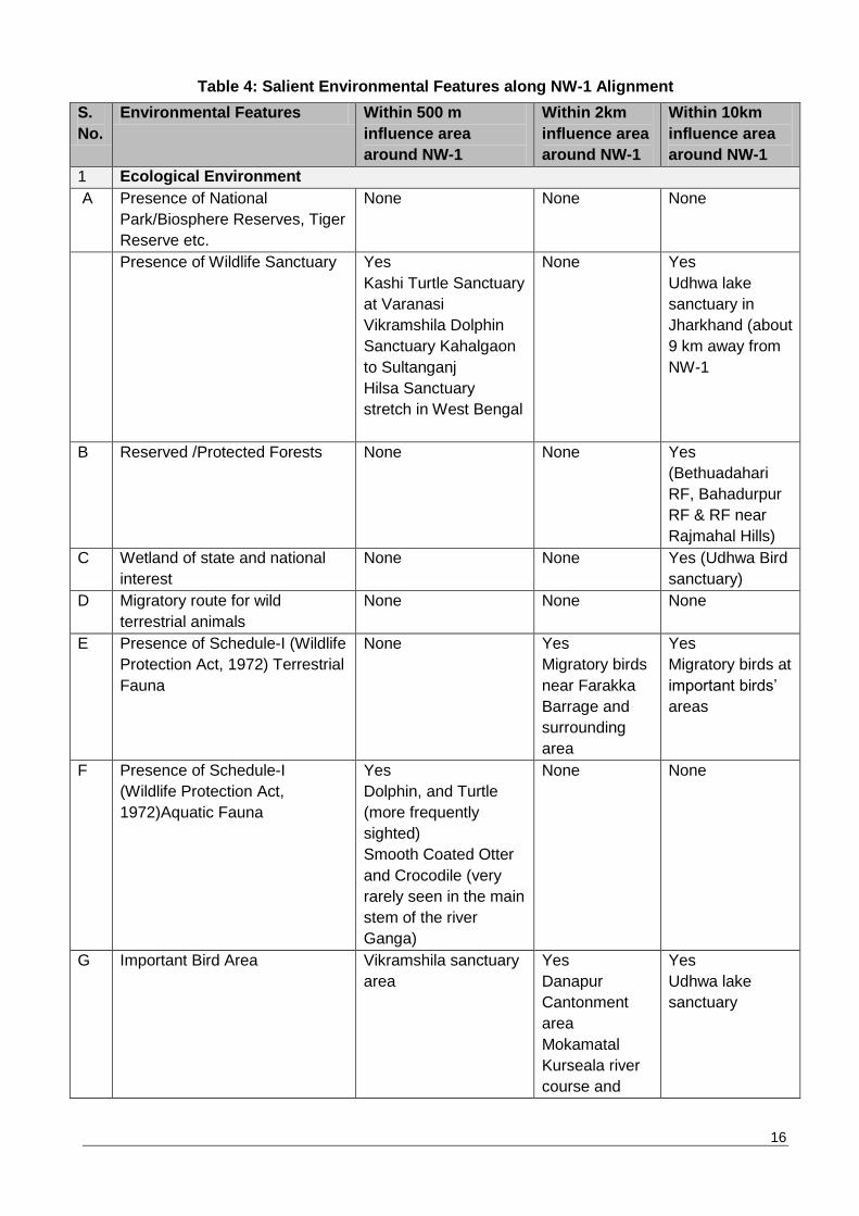
7. SALIENT ENVIRONMENTAL FEATURES OF NW-1
The salient features of environmental resources within influence area (10 Km) of NW-1, are
presented at Table 4. Topography of the whole of NW-1 (Allahabad to Haldia) falls within a
relatively flat terrain of the Indo-Gangetic plain. The elevation within the influence area of the NW-1
stretch, ranges between 1 m amsl (meter above sea level) and 321 m amsl. Highest elevation
levels were observed at Sahibganj area (Jharkhand) due to presence of small hillocks. Land use
within influence area of the NW-1 is majorly dominated by agricultural land. About 78.9 % of the
land is under cultivation; about 7.18% land is under settlement; 7.21% of the land is under water
bodies; about 3.59% land is under vegetation; 2.82% land is under dry river bed and rest of the land
falls under other uses.
16
Table 4: Salient Environmental Features along NW-1 Alignment
S.
No.
Environmental Features Within 500 m
influence area
around NW-1
Within 2km
influence area
around NW-1
Within 10km
influence area
around NW-1
1 Ecological Environment
A Presence of National
Park/Biosphere Reserves, Tiger
Reserve etc.
None
None None
Presence of Wildlife Sanctuary Yes
1. Kashi Turtle Sanctuary
at Varanasi
2. Vikramshila Dolphin
Sanctuary Kahalgaon
to Sultanganj
3. Hilsa Sanctuary
stretch in West Bengal
None Yes
Udhwa lake
sanctuary in
Jharkhand (about
9 km away from
NW-1
B Reserved /Protected Forests None None Yes
(Bethuadahari
RF, Bahadurpur
RF & RF near
Rajmahal Hills)
C Wetland of state and national
interest
None None Yes (Udhwa Bird
sanctuary)
D Migratory route for wild
terrestrial animals
None None None
E Presence of Schedule-I (Wildlife
Protection Act, 1972) Terrestrial
Fauna
None Yes
Migratory birds
near Farakka
Barrage and
surrounding
area
Yes
Migratory birds at
important birds‟
areas
F
Presence of Schedule-I
(Wildlife Protection Act,
1972)Aquatic Fauna
Yes
Dolphin, and Turtle
(more frequently
sighted)
Smooth Coated Otter
and Crocodile (very
rarely seen in the main
stem of the river
Ganga)
None None
G Important Bird Area Vikramshila sanctuary
area
Yes
1. Danapur
Cantonment
area
2. Mokamatal
3. Kurseala river
course and
Yes
Udhwa lake
sanctuary
17
S.
No.
Environmental Features Within 500 m
influence area
around NW-1
Within 2km
influence area
around NW-1
Within 10km
influence area
around NW-1
diyara flood
plain.
4. Farakka
Barrage and
surrounding
areas
H Seismicity NW-1 falls in Zone-III (moderate risk) and zone IV (high
damage risk zone) as per Seismic Zonal Map of India
B. Social Environment
I Physical Setting Rural, Industrial and Urban
J Densely populated area Allahabad, Sirsa, Mirzapur, Chunar, Varanasi, Zamania,
Ghazipur, Gahmar, Buxar, Ballia, Chappra, Patna, Barh,
Bihat, Munger, Bhgalpur, Kahalgaon, Sahibganj, Farakka,
Berhampore, Katwa, Kalna, Kolkata and Haldia are densely
populated areas.
K Physical Sensitive Receptors Yes
Ghats at Varanasi, Patna, Temples, Schools, College and
Hospital. Details are provided at section 4.7
L Archaeological Monuments Yes
There are 9 archaeological sites located within 300 m area
of the NW-1 and these are KardmeshwarMahadevaMandir,
Ramnagar fort, archaeological excavation site, Varanasi,
Manmahal and observatory, St. John's Church, Temple of
Gour Chandra and Krishnachandra at Chatra (Gaur Chandra
Ghat), Hazardwari Palace, SinghiDalan and Jami Masjid
Details provided in section 4.7, Chapter-4 of EIA report.
8. ANTICIPATED ENVIRONMENTAL IMPACTS AND MITIGATION MEASURES
Environmental impacts have been assessed considering present environmental setting of the
project area, nature, and extent of the proposed activities. Suitable qualitative and quantitative
approach was followed for identification of likely impact on each value components of environment
for design, construction and operation stage. The impacts were analysed under three broad
categories, namely (i) Impacts due to dredging operations (ii) Impacts due to barge operations (iii)
Impacts due to civil interventions. Additionally, impact was analysed for climate change and riparian
issues. Impacts due to land acquisition are covered under separate Social impact assessment and
Rehabilitation Action Plan report and not included under this summary.
Maintenance dredging & dredge disposal will be carried out during the operational phase of the
project to maintain continued navigability throughout the year from Haldia to Varanasi in NW-1.
Dredging of 14.85 million cubic meter will be undertaken from Haldia to Varanasi to maintain LAD of
3 m upto Barh, 2.5m upto Ghazipur and 2.2 m upto Varanasi. Impacts of the dredging are analysed
for Physical Environment: on water quality and land, Ecological Environment: on aquatic ecology
and avi-fauna (6 Important bird areas, VGDS, Kashi turtle sanctuary and Hilsa sanctuary), and
Socio-Economic Environment: cultural (Ghats at Patna andVaranasi), archaeological (9 sites) and
livelihood of fishing community
18
IWT mode, though the safest and most environmental friendly mode of transportation, may have
impacts on valued/critical environmental components. Barge movement may impact the water
quality, river bank and bank structures, air quality, noise level, aquatic ecology, health & safety,
livelihood of fishermen and socio-cultural aspects.
The civil interventions will have largely construction and operation related impacts. Impacts are
summarizedbased on the impact assessment carried out for Varanasi, Sahibganj and Haldia
terminals and Farakka navigational lock. The impacts identified for these four sites are likely to be
the similar for other intervention sites barring a few site-specific issues related to tree cutting, land
acquisition, muck disposal and construction material sourcing.
The impacts are summarized below for valued/critical environmental components in two
categories(a) impacts due to dredging and barge operations and (b) impacts due to civil
interventions. The baseline conditions are summarized under first categoryitself. The impacts on
climate change and riparian issues are summarizedand discussed briefly thereafter.
(a) Impacts Due to Maintenance Dredging and Barge Operations
Baseline Soil and River Bed Sediment Quality: Soil quality monitoring was carried outas per
CPCB guidelines along NW-1 and within the critical impact zones considered for planned civil
interventions. Soil type ininfluence area is dominated by alluvial soil. Soil texture varies from sandy
clay to clayey loam type and soils are marginally acidic to slightly alkaline with pH ranging from 6.62
to 7.86. Electrical conductivity ranges between 135.4 & 360.5 µmhos/cm. Soils in the influence area
are moderately fertile.
The concentration of heavy metal andpesticides in river bed sediments was found low in
concentration at each sampling location and are within acceptable limit for off-shore disposal as per
“Criteria for Off-Shore Dumping of Dredged Material”, USA except for cadmium which is slightly
above the prescribed limit in the UP stretch. Cadmium levels are high perhaps due to industrial
effluent discharge in this section.
Baseline Ground and Surface Water Quality: Ground water quality monitoring wascarried outas
per CPCB guidelines along NW-1 and within the critical impact zones considered for planned civil
interventions. TDS, total hardness and chloride values at Haldia and Sahibganj, Howrah and
Kolkata are slightly above the desirable limit but are within the permissible limits specified of IS:
10500. Fe and Zn were detected in water samples but in lower concentration. Arsenic was detected
in samples collected from Bhagalpur and Munger but in lower concentration.
River water quality monitoring was carried out along NW-1 and u/s & d/s of planned civil
interventions as per CPCB guidelines. River water qualities meets BDU Class „D‟ Criteria of CPCB
barring few parameters pH & DO which meets class „A‟ criteria, i.e. for propagation of Wild life and
fisheries
Impactson water quality and land due to dredging operations: Impacts of dredging on water
quality are increase in turbidity; reduced light transmittance; reduced DO; changes in salinity,
temperature, pH & concentration of nutrients and release of heavy metals/chemicals. As per
onestudy, DO level comes down suddenly by 2 to 2.5 mg/l for maximum of twominutes only at the
dredge plume arrival point which is regained within 3-4 minutes as the plume passes. As per
baseline study, river bed sediments are non-toxic except in Allahabad to Buxar stretch where
cadmium level is found marginally higher compared to US standard for off-shore sediment disposal.
However, this higher level is unlikely to have a toxic effect on aquatic life considering the sensitivity
level to cadmium exposure (short terms at LC50 level) of aquatic life as per Canadian Guidelines
(Canadian Environmental Quality Guidelines, Canadian Council of Ministers of the Environment,
2014). Pesticides are present in traces but much below the safe limit for off-shore disposal.
Turbidity of water also increases substantially close to dredging point but it reduces with distance

19
and almost gets normal at a distance of 700m from dredging point. Coarser sediments settle much
faster and at shorter distance. Presence of iron in sediments enhances settling of fine sediments as
it acts as coagulant. Land disposal of sediments is anticipated only when sediments are
contaminated and in the case of Haldia terminal dredging. When the dredged material is disposed
on land in form of slurry, excess water drains back to the water body which can affect the water
quality.
Key Mitigation Measures: Key mitigation involves reduction in dredging quantity by
studying thalweg profiles, bandalling and usage of low draught vessels. Sediment loss can
be minimized by wise selection of dredger depending on strata and depth and use of Cutter
Section Dredgers (CSDs) are proposed accordingly. Selection of size of cutter head and
other technical specifications can further help to reducedredged sediment loss.
Impactson water quality due to barge operations: Vessels generate garbage, oily waste,
sewage, bilge water & ballast water which can affect the water quality of the river. Usage of anti-
fouling paints may also impact the water quality as the paints may contains toxins. Settling of the
dust of the material transported on river surface again can impact the river water quality. Ship
accidents/collision may lead to spillage of the commodities transported including oil which may
impact the water quality of the river.
Key Mitigation Measures: Management of wastewater, oily waste, bilge water, noxious
waste (if any), air emissions andgarbage from vessels as per MARPOL can prevent the
water quality pollution. All maintenance & repair works should be carried out at designated
locations only. Only toxin-free paints should be used for anti-fouling purpose. Experienced
crew should be hired to minimize the possibility of accidents.. Information of available LAD
in the form of electronic charts should be made available to navigators and intimation of
navigational hazards in the form of cautionary signage should be displayed at required
locations to minimize accidents and spillage of material in river. Oil carrying ships (>5000
dwT) should be double hulled as prevention against oil spills.
Impactsonriver bank& river bank structures due to barge operations: Wave generated due to
vessel movement may lead to bank erosion. Impacts are anticipated to be minimal except at the
feeder canal near Farakkawhich is narrow and haserodible banks.
Key Mitigation Measures: Restricting speed of vessels in narrow stretches andalong sharp
bends may minimize the erosion. Bank protection and bend straightening works can protect
banks from erosion.
Impact on Air Quality and Noise Level.
Baseline Meteorology: The predominant wind direction in all IMD stations located along NW-1 is
from North and Northwest direction in winters and South and Southeast direction during rest of the
season. The wind speed in the area ranges between 1.9 kmph (Patna) and 8.7 kmph (Kolkata).
December and January constitutes winter months with daily mean minimum temperature of around
9.1oC at Patna and daily mean maximum temperature of around 26.9oC at Kolkata. April and May
are the hottest months with daily mean minimum temperature of 24oC at Malda and daily mean
maximum temperature of 40.4oC at Varanasi. Relative humidity ranges between 25%and 84%. The
annual rainfall in the project area ranges between 1000.3 mm (Varanasi) and 1728.5 mm (Kolkata).
Baseline Air Quality: Ambient air quality monitoring (PM2.5, PM10, SO2, NO2 and CO) was carried
outas per CPCB guidelines along NW-1 and within the critical impact zones considered for planned
civil interventions. PM10 level varies from 39 to 145 µg/m3. PM10 levels are within 100 µg/m3 at all

20
the locations except Varanasi (near bridge), Patna and Howrah. PM2.5 levels ranges from 16 to
58µg/m3 and are within the CPCB limit of 60 g/m3. Level of SO2andNOx ranges from 4.4 to
35.6µg/m3 and 9.0 to 48µg/m3 respectively and are within the prescribed limits of NAAQs, 2009. CO
is detected at Haldia, Howrah, Patna and Varanasi only. The 8hrs CO level at these locations
ranges from 0.18 to 1.2 mg/m3 and are within limits of NAAQs, 2009.
Baseline Noise: Noise level monitoring wascarried out along NW-1 and within the critical impact
zones considered for planned civil interventions as per CPCB guidelines. Ambient noise levels at all
monitored locations werefound within the prescribed standards of CPCB as per land use except at
Kashi turtle sanctuary because of anthropogenic activities like worship, bathing, etc.
Impacts on Air Quality due to dredging and barge movement: Barges also generate emissions
but this is far less as compared to road and rail for transportation of same quantity of cargo for the
same distance. Thus impacts on air quality are anticipated to be positive. As per analysis there is
reduction in emission generation of all the pollutants. Emission savings in “With project” scenario is
given in Table 5.
Key Mitigation Measures: Material generating dust should be transported in covered
conditions. Regular maintenance of vessels engine and propellers may significantly cut
down air emissions. Adaptation of cleaner fuels like LNG can be explored.
Table 5: Emission Savings Due to Shift of Freight from Road & Rail to IWT Mode
Year SO2 emissions (Tonne/Yr.)
NOx
emissions (Tonne/Yr.)
CO emissions (Tonne/Yr.)
HC emissions (Tonne/Yr.)
PM Emissions (Tonne/Yr)
2016 0 0 0 0 0
2025 176.547 1305.17 511.9684 365.981 215.8993
2035 242.8597 1772.377 695.3507 495.2122 292.4799
2045 365.2669 2508.429 986.5775 684.3006 404.4284
Net Savings Estimated
(Tonnes) from 2016-2045
5874.205 42201.2 16575.06 11700.31 6901.329
Impact on Noise Levels due to dredging and barge movement: Impact on noise quality due to
barge movement will be negligible and will be far less when compared to road andrailways.
Intermittent noise of high level may be generated only when hooters are used as warning during
navigation. Noise levels with regard to air generated due to dredging operations at source will vary
from 80-90 dB(A). Noise levels reduces to 70 dB(A) at distance of 100 m, 64 dB(A) at distance of
200 m and to 56 dB(A) at distance of 500 m from source. Dredging will be carried out within the
navigation channel only;thereforethe impacts of the dredging noise on the nearby settlements are
insignificant only. Also dredging operations will not be carried out after 10:00 pm. Several measures
are proposed to manage the noise environment of the area.
Apart from noise levels, high level underwater noise is generated due to dredging and barge
movement. This noise has impact majorly on aquatic flora and fauna and underwater noise impacts
are discussed in detail in the section on impact on aquatic ecology
Key Mitigation Measures: Apart from regulation of the dredging operations between 6:00
am to 10:00 pm only, dredgers will be regularly servicedto prevent noise generation due to
friction. Dredgers will be fitted with noise masking equipment to reduce the noise levels,
barges would use hooters as and when required, i.e. for safety of fishermen and other ships.
21
Noise from dredgers can be reduced at source (dredger) by various measures such as
isolation of exhaust system, keeping engine room doors shut, and by shielding.
Impact on terrestrial and aquatic ecology
Biological Critical Environmental Resources: Thewildlife sanctuaries namely Kashi Turtle
Sanctuary (Varanasi, U.P.), and Vikramshila Gangetic Dolphin Sanctuary (Bihar) are located within
the NW-1 stretch. Hilsa Sanctuary notified under Fisheries Act with the aim of increasing
productivity of Hilsa fishes are located at fourlocations in West Bengal Stretch. Apart from this there
are siximportant bird areas including Udhwa bird sanctuary located within influence area (10 km) of
the NW-1 stretch. RET species like Gangetic dolphin (Schedule-1) fresh water turtle species
(frequently sighted), The Smooth coated Otter and crocodile (very rarely sighted) are present in the
river stretch of the NW-1.
Terrestrial Flora: There is no major forests area present along the NW-1. The riparian flora
consists of commonly found trees, shrub and herb species. No rare and endangered plant species
have been observed in the riparian area of the NW-1.
Terrestrial Fauna: As no major forest area is present along the NW-1 stretch the terrestrial fauna is
restricted to commonly found terrestrial faunal species. No Schedule-I terrestrial mammals‟ species
observed along the NW-1 stretch. However, sixIBA located within influence area of NW-1 are the
major wintering site for many of migratory water birds. Some of the rarer/endangered/vulnerable
avifauna has been reported in these IBAs.
Aquatic Flora & Fauna: The aquatic floral and faunal diversity of NW-1 stretch comprise
phytoplankton, zooplankton, zoo-benthos, fish and higher vertebrates. Phytoplankton is represented
by Chlorophyceae, Bacillariophyceae, Cyanophyceae, Euglenophyceae, Xanthophyceae and
Rhodophyceae groups. Dominance of Bacillariophyceae members followed by Chrophyceae and
Cyanophyceaewas observed in NW-1 stretch. Zooplankton comprises of Protozoans, Rotifers and
Crustaceans. Phytoplankton and zooplankton diversity is a little higher in Farakka to Haldia stretch
in comparison toAllahabad to Farakka stretch. Macro benthos and Macro-invertebrates constitute
Annelida, Arthropoda insects and Mollusca. Fish in the NW-1 stretch is represented by total of 106
species. The higher aquatic vertebrates‟ mammalian fauna present in NW-1 stretch (Allahabad to
Haldia area are Gangetic dolphin (Platanistagangeticagangetica) and the Smooth Coated Otter
(Lutrogaleperspicillata) which are categorized as endangered species (Schedule-I). Dolphin is
found routinely moving between Allahabad to Farakka and post Farakka region of NW-1. However,
these mammals are rarely sighted in Allahabad and Varanasi region. The Smooth Coated Otter is
found throughout the length of the Gangetic system but in very poor numbers and it is one of the
endangered category animals as per IUCN list. Though it wasnot sighted during our study period
but fishermen at Bhagalpur and Sultanpurreported its sighting. Its number has depleted fast due to
it being one of the most hunted animals because of its precious skin. The reptile fauna found in
Gangetic system are variety of fresh water turtle species, water snake (Xenochrophispistator),
Mugger Crocodile (CrocodilusPaluspris), estuarine (East Coast) Crocodile (C. porosus) and Indian
Gharial (GavilialisGangeticus). The Mugger, Crocodile and Indian Gharial are very rarely seen in
NW-1 stretch. Its presence is more reported in tributaries (Chambal river) of the Ganges. The turtle
and water snake are found more commonly in the NW-1. Other than water snake, other reptile
faunal species are classified as endangered species. There are unconfirmed presence of Ganges
Shark (GlyphisGangeticus) in the Hoogly river region; however, this species has not been
reportedin river Ganga (including in the Hooghlyriver region) in last about 50 years.
22
Impacton Aquatic Ecology due to maintenance dredging: Impact of dredging on aquatic
ecology includechange in diversity of benthic habitat, impact on behavioural response andtissue
injury of aquatic organism due to increased noise levels, blocking of fish gills due to increased
sediments, intake of toxic pollutants by aquatic fauna as released during dredging, smothering of
benthic flora & fauna due to dredge disposal and loss of Submerged Aquatic Vegetation (SAV).
Noise generation from CSD is 160-180 d(B) and behavioural disturbance criteria for dolphins,
turtles, fishes (>2 gm) andfishes (<2 gm) from any continuous noise exposures are 177 dB, 150 dB,
186 dB & 183 dB respectively. Noise sensitivity reference are not available for other crocodile and
Smooth Coated Ottor but these animals are rarely sighted. It is assumed that these animals will
also have similar sensitivity range. In any case these animals prefer to stay more on banks or on
wet land near banks and are unlikely to be impacteddue to dredging which is most likely to be
undertaken in the deep stream of river. In addition, no dredging operations are proposed within or in
the vicinity of Kashi Turtle Sanctuary and VikramshilaGangetic Dolphin Sanctuary (VGDS) that
minimize the possibility of the impact of dredging on such vital sensitive organisms. Thus the
dredging operations noise will not lead to any significant impact on aquatic organisms.
Key Mitigation Measures: Restricting dredging in biological sensitive locations like VGDS
& Kashi Turtle Sanctuary; confluence zone of major rivers (100 m horizontally and 500m
either side of major river confluence location) and during breeding and spawning season of
fishes and migratory bird season may minimize the impact on aquatic fauna significantly.
Reduction in dredging noise through regular servicing andmaintenance of dredgers and
useof bubble curtains can significantly reduce underwater noise. Useof bubble curtains can
reduce underwater noise by approx. 10 dB.
Impacton aquatic ecology due to barge operations: Impact of barge movement on aquatic
ecology can be due to speeding vessels, spillage of material transported (oil majorly) and
generation of high level underwater noise. Vessels if moving in high speed can collide with aquatic
organisms leading to mortality and injury to aquatic organisms. Spillage of material transported can
impact the habitat of the aquatic species. Oil spills are most significant among all spills as oil can
form a layer breaking contact between water andair and reducing DO level, block gills and skin
pores of aquatic organisms leading to mortality. Barge of size 1500-2000 dWT are expected to
move in the waterways which generate noise levels of 110-180 dB as per speed. Speed is however
restricted in sanctuary area to 5 kmph and noise levels will be maximum 140 dB. Tolerance level for
behavioural response of turtles and fishes are 150 dB and177 dB.Thus impact of vessel movement
on dolphins and turtles is not anticipated. However underwater noise modelling, considering noise
generation of 160 dB was carried out and it was found that noise levels will attenuate to 150 dB at
distance of 4.6 m from vessel. Smooth Coated Otters and crocodiles are rarely sighted as
theyprefer to rest on wet lands of river banks; noise impacts are are likely to benegligible due to its
fast attenuation. Accidental impact cannot be ruled out; however,same precautions as for dolphin
will apply for these animals as well. Another impact on aquatic species is masking of biologically
important sounds. Echoclation clicks of dolphins have dominant energy around 65 kHz and are
beyond the man-made frequency range and thus impact is not significant. However, when
communication signals lie in same frequency range as of man-made noise it can be masked but
they are anywaymasked often by the natural noise environment of water.
Key Mitigation Measures: Restricting speed of vessels in sanctuary area can maintain
noise levels lower than 140 dB which are lower than tolerance levels of turtle and dolphins
thus minimizing impact of noise on turtles and dolphins. Vessels should be fitted with
propeller guards and dolphin deflectors to minimize dolphin accidents.
23
Impacton Avifauna due to maintenance dredging: Impact on avifauna is anticipated due to
disturbance of the habitat due to dredging anddisposal of dredged material on banks/shallow waters
and increased ambient noise levels due to dredging operations. Noise level of 85 dB(A) are
generated during dredging which dissipates within 500 m distance making impact localized.
Key Mitigation Measures: Restricting dredging operations during day time (6:00 am-10:00
pm) andduring migratory season of birds near locations of IBAs will minimize the
disturbance to resting avifauna during night time. Regular maintenance and servicing and
usage of noise mufflers with dredgers can significantly reduce noise levels. By Isolation of
exhaust system,by keeping engine room doors shut and by shielding dredging, noise can be
reduced further. Onshore disposal, if required,should be undertaken only at TSDF.
Impact on Socio economic and cultural aspects
Baseline conditions: NW-1 traverses through four states: Uttar Pradesh, Bihar, Jharkhand, and
West Bengal. There are various densely populated areas located along NW-1 such as Allahabad,
Farakka, Sahibganj, Berhampur etc. As per the Census, 2011, population of the major cities
andtowns along NW-1 is 1,28,75,343 (67,82,150 male & 60,93,193 females) and the total numbers
of households are 2562165, population between 0-6-year age is recorded as 13,08,682. Being a
project of such large spatial dimension, NW-1 interfaces with various archaeological, social and
cultural sensitive and important locations. There are ninearchaeologically important sites along NW-
1 but no activity at present is proposed to be undertaken within 300 m of these sites. Ghats at
Patna and Varanasi are another socially important feature which will be impacted due to project.
However, measures are proposed to minimize such impacts. Several festivals are celebrated on a
large scale on the banks of river Ganges at different locations and time periods of the year along
NW-1. These locations and period of celebrations are KumbhMela at Allahabad (between Jan-Feb),
Ganga Mahotsav at Varanasi (between Oct-Nov), Dhrupad Mela at TulsiGhat of Varanasi (between
Feb to March), Chatt Pooja at various locations all along the river stretch passing through Bihar
andJharkhand state (between Oct-Nov) and Ganga Sagar Mela at Sagar (in January). Due to
barge operation and dredging activities there could be interference in these celebrations. Mitigation
measures are proposed to be undertaken to minimize such impacts. There are only a few
archeologically protected monuments located along the NW-1 (See Table 4).
Impact socio-economic and cultural aspects due to maintenance dredging: Impact of dredging
& disposal of dredged material are anticipated on cultural andarchaeologically important locations
and on livelihood of fishing community. Dredging operations may impact socio-economy by
disrupting fishing andboat movement, generating high noise levels near dredging location,
increased river water pollution, by disturbing the pleasant view and increased air pollution. These
impacts are however short term and localized andwill be restricted to dredging locations only.
Dredging activity also pose threat to health andsafety of the workers and other waterway users. No
construction or interventions are planned within 300m of any of archeologically protected
monuments. The RamnagarFort is one of the protected monuments. IWAI has undertaken a study
with the help of Indian Institute of Technology (IIT) Roorkee to establish the effect of development
of Varanasi terminal and NW-1 development. IIT in its study has established that these
developments will have no impact on this protected monument. No direct impact is anticipated on
any such protected monuments or other culturally important structures due to dredging activity.
Key Mitigation Measures: Dredging will be restricted in biological andsocially sensitive
locations and at time of importantreligious and culturalfestivals, during breeding & spawning
season of fishes and during migratory bird season to minimize impact on socio-cultural life.
A minimum of 100 m buffer zone from the religious Ghats at Varanasi and Patna (the
24
cultural heritage locations) is proposed to be maintained as restricted area for dredging for
the protection of Ghats. Precautions followed for archeologically protected
monumentsshould also be followed for any intervention near any culturally important
heritage structures. It is also proposed to report to IWAI and ASI for any chance finding of
valuable artifactsduring excavation and construction stage. Timely intimation about dredging
operation and location can minimize the disturbance to fishermen. As enhancement
fishermen can be provided with training by institutions like CIFRI to learn better fishing
practices and available aids for fishing which will help them to improvetheir livelihood.
Measures to reduceaccident risks during dredging will be taken and arrangement of first-
aidwouldbe available at dredging locations at all times.
Impact onSocio-economic and Cultural Aspects due to barge operations: Vessel movement
are vulnerable to accidents related to natural disasters like flood or cyclonic and operational
hazards like Collison, fires and spillages. However, these accidents and accident intensity can be
minimized with appropriate preventive measures.
Key Mitigation Measures: Provision of night time navigation system, maintenance
dredging, adequate and efficient river information system, vessel tracking system, and
Electronic Charts Display Information System - ECDIS, and Automatic Information System –
AIS can minimize the accidents. Most of these measures are already under implementation
by IWAI in some stretches of the NW-1 and there is a proposal forextending these facilities
to the entire NW-1. All safety regulations as per SOLAS should be followed to maintain
safety during navigation and minimize accidents. Barge operations should be regulated in
consultation with local bodies during religious and culturally important festivals.
Enhancement Measures: Support for promoting fish productivity through setting up or
supporting existing fish nurseries. Alsotraining and awareness support through reputed
institutes or experts like CIFRI for better fishing techniques and provision forsupporting
studies for Dolphin conservation and other sensitive studies should be made.
(b) Impact Due to Civil Interventions, and Mitigation
Impacts due to civil interventions are expected to occur during the design, construction and
operation stage of the project. These impacts during different phases are discussed below
Impact during design phase:Activities to be carried out during design phase which can impact the
physical, biological and social environment are site clearance & preparation, acquisition of land
andchange in land use and land cover. Major impacts anticipated are removal of vegetation andtree
cutting, anunpleasant view, increasing GHG emissions due to operation of construction
vehicle/machinery andremoval of trees, impact on regular day-to-day activities in area of
development due to shifting of utilities, impact due to change in land use, impact on drainage, loss
of households, land and assets and loss of income source and impact on overall quality of life
Key Mitigation Measures: Tree cutting should be minimized by efficient planning of the
interventions. Permission from forest department is essential prior to cutting of trees
besides, compensatory plantation is to be carried out as per respective state forest policy.
Restoration and rehabilitation of locations occupied or used for construction purposes
immediately after the given task(s) is over. Dedicated approach roads and improvement of
haul roads should be considered to minimize the traffic congestion and air emissions. Traffic
management should be undertaken to avoid peak hour congestion. Utility shifting should be
carried out during or prior construction phase but without disrupting common publicservices .
Necessary permissions from the area development authorities and local bodies should be
obtained prior to development of proposed interventions. Natural drainage pattern should be

25
maintained by provision of adequate drainage. Compensation should be given to affected
households as per R & R Act, 2013.
Impact during construction phase: Activities to be carried out during design phase which can
impact the physical, biological and social environment are construction activities, material
transportation and operation of machinery & construction equipment. Major impacts due to these
activities are loss of top soil, soil contamination due to spillage of material, bank erosion/bed
scouring, surface water contamination due to increased run-off from construction site, high noise
levels and disturbance to nearby habitation, traffic jams, wear andtear of existing roads, increased
accidents and air pollution, unpleasant view due to construction activities, construction material
storage and waste storage, health & safety of workers and people in nearby areas, impact on
quality of life, mortality, disturbance to habitat and change in behavioural response of aquatic fauna
and tree cutting and vegetation removal.
Key Mitigation Measures: The top soil should be preserved and used for landscaping
purpose and should be given to farmers in nearby areas, if they so desire. Clean up
operations should be taken up immediately after spillage of any material. Debris and
excavated earth should be disposed-off as per defined plan. Provision should be made for
Septic tank andsoak pit/STP, maintenance waste collection and treatment before reuse.
Concreted floor for storage of fuel and oils should be considered. Excavated earth should be
reutilized to the extent possible in the construction activity and balance maybe used for road
construction or disposed of atdesignated places like mines in case of Sahibganj. Bank/scour
protection works are required at planned and under planning civil intervention locations.
Adequate shore & scour protection measures should be taken up at Sahibganj terminal,
Varanasi terminal and Farakka Lock site. Provision of acoustic enclosures for DG sets
should be constructed to reduce noise levels. Noise causing activities should not be carried
out close to settlement areas and during night hours. Haulage roads/approach roads to be
used should be maintained regularly. Restoration and rehabilitation will be done of the areas
occupied or used for construction purpose immediately after use is over. Preparation and
implementation of emergency preparedness and response plan and contingency plan
should be prepared by the contractor. Implementation of proposed environment
management plant should be taken upto minimize the environmental pollution and stress on
existing infrastructure resources. There is need to manage surface run-off to prevent from
mixing with contaminant, apart from provision of storm water management system, provision
of sediment traps, oil interceptors with storm water drains in parking areas etc. Impact of
piling andconstruction dredging should be managed by adoption of vibratory piling and
usage of bubble curtains to disperse the fauna and reduce the noise level.
Impact during operation phase at intervention sites: Activities to be carried out during design
phase which can impact the physical, biological and social environment are barge mooring &
berthing, operational activities at terminal sites and discharge of waste/waste water from
intervention sites. Major impacts anticipated are increased GHG emissions near the terminal/jetty
locations due to increased material transportation and dredgers operation, increased pollutant
emissions near the terminal/jetty locations due to material transportation and dredgers operation,
increased run-off from site, increased noise levels and disturbance to nearby residents and water
pollution. Positive impacts would include employment generation and infrastructure development.
Key Mitigation Measures: Development of thick green belt area and avenue plantation at
all proposed intervention sites would be very helpful. Provision of sprinklers and dust
suppressors at terminal sites for dust suppression should be made.. Employment should be
given to local people preferably. Skill development trainingcan be undertaken for locals to
train them for jobs. Storm water drainage should be collected and reused for dust
26
suppression. Sewage should be treated in STP constructed at site and treated water should
be used for dust suppression and horticulture.
(c) Impact related to Climate Change:
IWT mode is the most efficient and environmental friendly mode of transportation, involving least
CO2 generation when compared to rail androad transport. Analysis was made to estimate the CO2
emissions from different modes of transportation for transportation of same quantum of cargo for
similar distance. From the analysis, it is learned that the IWT mode generates the least GHG
emissions and the net GHG savings in With Project scenario will be for 4544037.4 tonnes (4.54
million tonnes). Thus positive impacts are anticipated on the climate due to reduction of GHG
emissions. A further reduction in GHG emissions is anticipated with the adoption of cleaner fuel for
vessels, as well as energy efficiency in terminal design.
(d) Impact on Indo-Bangladesh Water Sharing Treaty (Riparian Treaty)
In recognition that the Ganga (NW-1) is an international waterway, all requisite planning and design
considerations were aimed at fully avoiding (or absolutely minimizing) any potential adverse
transboundary affects. These transboundary impacts could be impacts such as reduction and/or
modification of flow of water or sediments apart increased water pollution. There is nochance of
flow modification as the project (i) will not have any barrages, dams or any other water retention
structures, (ii) does not include any water diversion, or consumptive use, and (iii) does not involve
any construction on the flood/flow zones of the entire river so as to impede any flood flow. The
project includes annual/regular maintenance dredging in selected locations (mainly across the
shoals that are formed intermittently along the river) to maintain the least available draft during the
lean flow season for a navigable channel of 45m width with side slopes of 1:10. To minimize volume
of maintenance dredging, options for drafts lower than 3m were considered, and the project opted
for the choice of low-draft vessels. The maximum volume of annual dredging is expected to be 11
million m3 (which is lower than 1.5 percent of the 750 million m3 average annual sediment volume in
the project stretch). Further, closer to Farakka barrage (both upstream and downstream), the
naturally available draft is already near 3m, and the maintenance dredging requirement is
comparatively much lower. In fact, upstream of Farakka, and up to Barh, in a stretch of 347km, the
annual maintenance dredging requirement has been minimized at about 3.5 million m3. No disposal
of sediment away from the river is planned. Dredging will be done using cutter section dredgers
which will dispose the dredged volume sideways (maximum 200m away from the 45m wide
navigation channel within the wide flow zone of the river, (which for example is 2.24km wide at
Farakka) not exceeding 20m downstream. As a result, no longitudinal change in current/natural
sediment flow is expected at any stretch of the river.
Careful examination of the possibility of increased pollution due to downstream dispersal of dredged
material plumes was undertaken in the project. Dredging may result in reduction of dissolved
oxygen levels 2-2.5 mg/l at the dredging plume points, but the levels become normal 4 minutes
after the plume passes. To examine the issue of release and dispersal of heavy metals, pesticide
residues and other hazardous chemicals, 110 river bed samples, fromup to 3m depth, were
collected and analyzed for the stretch between Varanasi and Farakka. Except for cadmium in the
stretches between Allahabad-Varanasi and Varanasi-Buxar stretches (more than 600km upstream
of the international border), all other heavy metals, chemicals and pesticide content werefound to
be within safe limits. Additional primary surveys and investigations were conducted to understand
27
the increase of turbidity resulting from dredging and disposal. These investigations suggest that
turbidity of water will increase substantially close to dredging point but is reduced with distance from
the dredging point, and becomes normal at a distance of 700m downstream from dredging point.
These results are comparable to other such examinations elsewhere in the world, where the
expectation is that the effects of suspended sediments and turbidity from dredging are generally
short term (less than one week after activity) and near field (less than 1km from activity). No
dredging is expected to occur immediately upstream of Farakka Barrage (which itself is 16.5km
upstream of the international border; and the route of the NW-1 is the feeder which is further
upstream of the barrage), and in no case, the temporarily increased turbidity is expected to disperse
across the international border.
9. ENVIRONMENTAL MANAGEMENT PLAN
The Environmental Management Plan (EMP) is a plan of action for avoidance, mitigation and
management of the negative impacts of the project and enhancement of positive impacts. The
detailed intervention and activity specific plans for maintenance dredging, barge operations, civil
interventions are given at Chapter 6 in EIA Report. EMP includes the environmental monitoring
plan (specifying the parameters, frequency and responsibilities of monitoring), institutional
framework, reporting requirements, auditing requirements, training awareness and capacity building
programme, grievance redress mechanism and environmental budget. Consolidated EIA provides
institutional mechanism, budgetary provisions and other systems and plans which are commonly
applicable to all interventions and operations of NW-1. The EMPs prepared for dredging and barge
operations are commonly applicable to the terminal development and operation and other
intervention sites. Consolidated EIA also provide generic EMP for the interventions such as RO-RO
Jetties, embankment protection. Additionally, standalone EMPs have been prepared based on site
specific terminal developments at Varanasi, Sahibganj and Haldia and Navigational Lock at
Farakka.
Recommendations flowing from the cumulative impact assessment. IWAI has carried out a
Cumulative Impact Assessment (CIA) covering the full project area of influence of NW-1
encompassing the effects of the broader programme of investments within the Ganga Basin over a
longer period of time. The main recommendations of the CIA include measures for planning, and
management/mitigation of all such impacts, besides sustainable development considerations.
Recommendations proposed include (i) No barrages or storage reservoirs in the main river and
tributaries to maintain water depth and reduce silt charge even though it is a more economical
option to dredging (ii) critical environmental resources and natural habitats have been identified as
no-go zones for dredging (iii) all terminals will be built keeping world class infrastructure standards;
viz. GRIHA certification, zero liquid discharge technologies, installation of dust suppressors,
development of green belt development along periphery & roads and waste management through
best management practices. In addition to this, the project will introduce (i) the highest health and
safety standards for operation of terminal facilities and navigation operations (ii) the vessel fleet
proposed will follow international standards for discharge of ballast, waste water, and use of
cleaner, more efficient fuel. Locations for terminals will be based on proximity to inter-modal
connectivity, at the same time reducing air pollution and congestion impacts within cities, and
integrating passenger services wherever possible. It is also proposed through CIA that IWT will
incorporate high capacity vessels that will run on LNG and will move in low draft so as to reduce the
dredging requirement and further reduce GHG emissions. Impacts on adjacent bird areas and fish
habitats in the floodplains which include habitat disturbances and human interferences (air and
noise pollution) will be minimized and prevented wherever possible. These habitats will be mapped
28
and integrated in the overall information system to avoid further impacts due to increase in
navigation volume, and structural modifications to NW-1 and to respond to any observed negative
impacts on aquatic or avifauna species. The environmental objectives of NW-1 augmentation
should be aligned and integrated with the National Ganga River Basin Authority, and institutions
should interact cooperatively. Provision ofa safe and environmentally friendly transport service can
also support growth of tourism.
Environment Health & Safety (EHS) Policy and Management System: An effective
environmental health and safety policy is essentially to demonstrate top management‟s commitment
toenvironmental protection and occupational health and safety. The policy should be communicated
to all stakeholders including workers and should be freely available to them on demand.
For effective and systematic implementation of the project, it is suggestedthat IWAI (The EA)
develops its Environmental and Social management systems whichareauditable and effectively
enforceable. Parallels can be drawn from the experiences of National Highway Authority of India or
Delhi Metro Rail Corporation and anEHS system similar lines should be adopted. Each contractor
should be contractually bound to follow such system and must have EHS management system in
line with EA‟s management system. IWAI should also develop its standard technical guidelines for
Environmental Assessment, Management and Reporting. Training and awareness will be an
essential component of the EMP and EHS management system. It should include use of posters,
bill boards/glow boards around the project site and barge NW-1 alignment in Hindi, English
andregional language so as it can be understood by the workforce and community as well.
Celebration of some of the important days such as Environment Day (June 5), Red Cross Month
(March), Emergency Preparedness Week (May 1-7), National Safety Day (4th April), National
Health Day (7th April), Fire Safety Day (14th April), 20th April (Earth Day) can be planned for
spreading awareness onenvironment protection, cleanliness and safety among work force and
community through campaigning.
Emergency Response and Preparedness Plan and Contingency Response Plan:
Risks and hazards are associated with every construction site as it involves useof heavy machinery
and equipment. Similarly, risks are also associated with the operation phase.These are listed
below:
Vessel accidents and spillage of commodities (especially oil)
Leakage or spillage of oil from ships and barges at terminal/jetty
Drowning in river during material handling and vessel movement
Hazard to fishing vessels/gears
IWAI will (and must) equip itself with guidelines and equipment for handling the emergencies. PMU
should evolve its environmental, occupational health and safety guidelines and performance
protocol. Budgetary provision has been made under environmental budget. The same should be
developed with the help of reputed institutions.. It should also follow the system of emergency
response; suggested emergency response and management plan.
Responsible Carrier Programme of IWAI2: It is proposed that IWAI develops Indian Waterways
Operations Responsible Carrier Programme which should be developed as part of its EHS
Management Systems and Emergency Response Plan and Protocols Development. The
programme should have the following components as well:
2Reference is drawn to the successful similar programme of American Waterways Organization‟s Responsible Carrier Programme.
http://www.americanwaterways.com/rcp-2016.

29
Protocol for speed control, monitoring, and vessel tracking
Protocol of waste management for barge operations and terminals management. (including zero discharges and waste disposal to river by barges and terminals. This protocol should also define about waste handling facilities at barges and waste disposal facilities at terminals tomaintain zero discharge.
Biodiversity protection including accident reporting with aquatic mammals (dolphin)
Oil spills reporting and control and remediation
Near-miss reporting/lessons learned and corrective actions programme
Risk assessment procedures to assess and manage risks to personnel, vessels and the environment
Identification of critical or essential equipment/systems
Authority of the master, crew and shore side personnel
Addition of document control procedures
Tracking of number and volume of spills in performance measurement requirements
Internal and external audit procedures and frequency.
Institutional Framework of IWAI: IWAI has set up a project management unit (PMU) which is
staffed with Environmental and Social specialists. These specialists would work as an environment
and social cell (ESC) within the PMU. It is proposed that each field unit have one designated officer
responsible for environment and social aspects who will also coordinate with ESC. The
responsibility of ESC will be (i) development of mechanism to ensure implementation of suggestive
management plans and to integrate this at policy level so that the measures can be mandatedfor
compliance during respective project stage (ii) to review, monitor and inspect implementation of the
EMP during design, construction and operation stages; (iv) implementation of the environmental
capacity building and awareness programme; (v) coordinating with field units (iv) reviewing and
ensuring effective implementation of EMP and regulatory compliance by contractor, and IWAI, and
(v) managing the environmental reporting, and audit process. Contractor will be responsible for
implementation of Environmental Management Plan and ensuring health and safety of the
construction workers at site during pre-construction & construction phase of the project
Environment & Safety Compliance and Monitoring Responsibility : Project design and
implementation stage: The respective contractors willbe liable for implementation of suggestive
EMPs and IWAI will be responsible formonitoring the contractor‟s performance and adequacy of
implementation of EMPs directly or through third party (PMC).
Environment & Safety Compliance and Monitoring Responsibility: During Operation Phase
and Emergency Situations: IWAI should be solely responsible for implementation of the EMP and
emergency response. IWAI will ensure that mitigation measures are taken up by the shippers,
dredgers and other stakeholders in time and adequately. IWAI should develop the mechanism so
as to ensure the adherence and compliance of the EMP. It is proposed that IWAI will have a
dedicated department adequately staffed and equipped with speed monitoring, vessel positioning,
and emergency response equipment like oil spills control and remediation systems. IWAI may also
adopt a mechanism forinvolving barge operators on the line of Responsible Carrier Programme of
American Waterways Operators.
Reporting Requirements: Contractor would be required to submit monthly and six monthly reports
containing the status of environment, health & safety at site to the PMC (Project management
consultant) & PMU of IWAI. PMC will be responsible for construction supervision and ensuring
effective implementation of EMP by the contractor. PMC should report to PMU monthly about the
performance and effectiveness of the EMP implemented by contractor on site and coordinate with
field units and PMU for necessary corrective actions as may be required. IWAI will also organize an
independent Environment Audit which will be submitted to The World Bankwithin 3 months of
completion of the second and fourth year of implementation period.

30
Training & Capacity Building Programme: IWAI has already taken actions to augment the
capacity of project management unit (PMU). A capacity building and training programme has been
prepared which includes training of staff of Environmental and Social cell of PMU, contractor‟s staff
(labour& engineers), PMC staff and IWAI staff on environmental management, regulatory
compliance and safety aspects.
Environmental Budget: Adequate environmental budget provision has been made for the
implementation of the EMP. The EMP budget is proposed for environmental management for all of
the proposed activitiesunder the project. The overall budget is INR 49.91 Crore. Summary of the
environmental budget is given in Table 7. Detailed environmental budget component-wise for civil
interventions is given in the respective EIA reports. Lump sum budget for each of the planned civil
intervention areasis givenin Table 8 below. For detailed budget of each component, the individual
EIAs prepared for each of the proposed civil interventionsmay be referred to.
Table 7: Summary of Environmental Budget for NW-1
S.
No.
Description Amount (INR)
1. DESIGN AND CONSTRUCTION STAGE
Technical Support forpreparation of guidelines, bio-diversity
conservation plan for turtle and dolphin sanctuary and performance
indicators
9,000,000
Compensatory tree plantation (7000 trees) including after care and
monitoring
Additional tree plantation for GHG sink (18000) including after care and
monitoring
15,000,000
Measures to Reduce GHGs by Green buildings certification & additional
tree plantation under plantation head
9,000,000
Storm-water and wastewater management/ Construction of soak pits/
clean drinking & domestic water facility/ STP construction, Zero
Discharge management
44,000,000
Provision of training and PPE to workers 17,200,000
Health check-up camps for construction workers 32,000,000
Enhancement Measures
Institutional Support for Vikramshila Wild Life Sanctuary through
reputed institutions
Support Fish productivity enhancement through fish nursery
development and training fishermen
Bath shelter for women along NW-1 for maintaining privacy from vessel
movement
Support for cleanliness at Ghats and improvement of Ghats
126,000,000
Environmental Monitoring in the construction phase: Terrestrial and
Aquatic Fauna, Ambient Air Quality, Surface Water Quality, Drinking
Water Quality, Noise & Vibration, Soil Quality, Erosion & Siltation and
River Bed Sediment
58,080,000
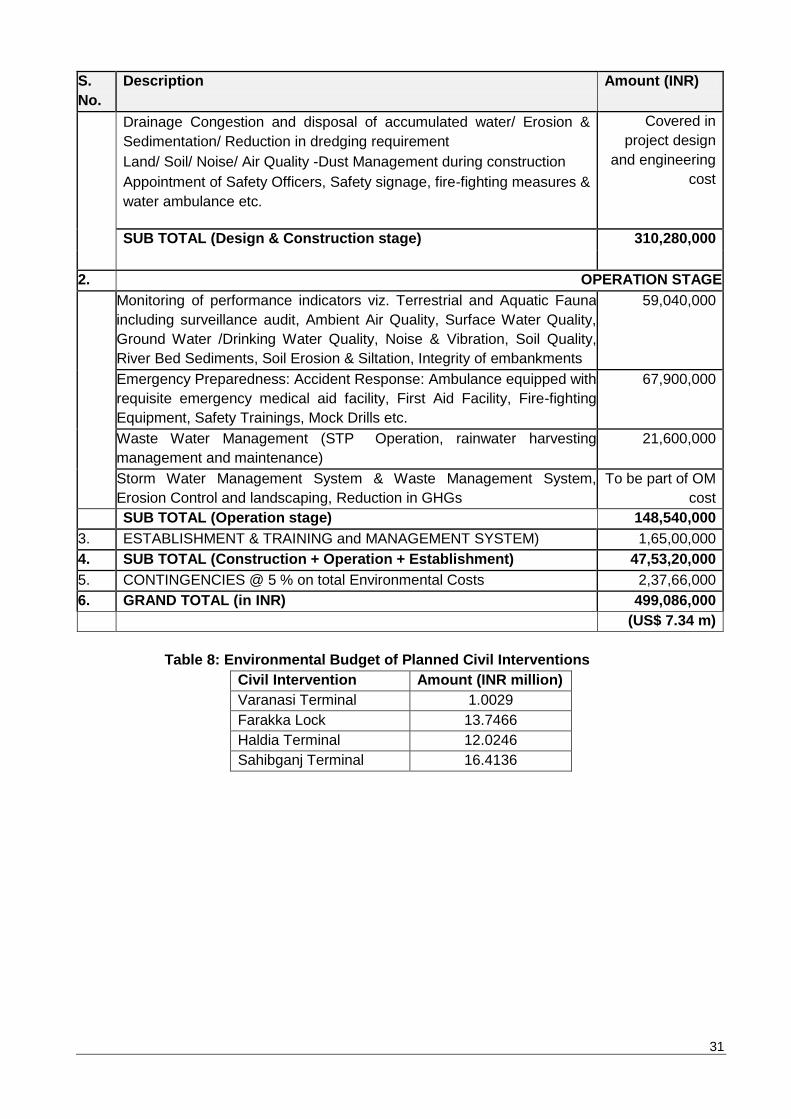
31
S.
No.
Description Amount (INR)
Drainage Congestion and disposal of accumulated water/ Erosion &
Sedimentation/ Reduction in dredging requirement
Land/ Soil/ Noise/ Air Quality -Dust Management during construction
Appointment of Safety Officers, Safety signage, fire-fighting measures &
water ambulance etc.
Covered in
project design
and engineering
cost
SUB TOTAL (Design & Construction stage) 310,280,000
2. OPERATION STAGE
Monitoring of performance indicators viz. Terrestrial and Aquatic Fauna
including surveillance audit, Ambient Air Quality, Surface Water Quality,
Ground Water /Drinking Water Quality, Noise & Vibration, Soil Quality,
River Bed Sediments, Soil Erosion & Siltation, Integrity of embankments
59,040,000
Emergency Preparedness: Accident Response: Ambulance equipped with
requisite emergency medical aid facility, First Aid Facility, Fire-fighting
Equipment, Safety Trainings, Mock Drills etc.
67,900,000
Waste Water Management (STP Operation, rainwater harvesting
management and maintenance)
21,600,000
Storm Water Management System & Waste Management System,
Erosion Control and landscaping, Reduction in GHGs
To be part of OM
cost
SUB TOTAL (Operation stage) 148,540,000
3. ESTABLISHMENT & TRAINING and MANAGEMENT SYSTEM) 1,65,00,000
4. SUB TOTAL (Construction + Operation + Establishment) 47,53,20,000
5. CONTINGENCIES @ 5 % on total Environmental Costs 2,37,66,000
6. GRAND TOTAL (in INR) 499,086,000
(US$ 7.34 m)
Table 8: Environmental Budget of Planned Civil Interventions
Civil Intervention Amount (INR million)
Varanasi Terminal 1.0029
Farakka Lock 13.7466
Haldia Terminal 12.0246
Sahibganj Terminal 16.4136