
ENVIRONMENTAL IMPACT ASSESSMENT OF KRISHNAPATNAM ...
71
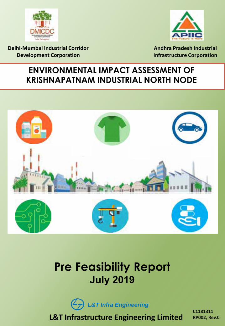
Delhi-Mumbai Industrial Corridor Development Corporation ENVIRONMENTAL IMPACT ASSESSMENT OF KRISHNAPATNAM INDUSTRIAL NORTH NODE Pre Feasibility Report July 2019 L&T Infra Engineering L&T Infrastructure Engineering Limited C1181311 RP002, Rev.C Andhra Pradesh Industrial Infrastructure Corporation
Transcript of ENVIRONMENTAL IMPACT ASSESSMENT OF KRISHNAPATNAM ...
Delhi-Mumbai Industrial Corridor Development Corporation
ENVIRONMENTAL IMPACT ASSESSMENT OF KRISHNAPATNAM INDUSTRIAL NORTH NODE
Pre Feasibility Report July 2019
L&T Infra Engineering
L&T Infrastructure Engineering Limited C1181311 RP002, Rev.C
Andhra Pradesh Industrial Infrastructure Corporation
L&T Infrastructure Engineering Ltd.
Client: Delhi Mumbai Industrial Corridor Development Corporation DMICDC
Project: EIA for Krishnapatnam North Node
Project No.:
C1181311 Title:
Pre-feasibility Report Document No.:
RP002 Rev.:
C This document is the property of L&T Infrastructure Engineering Ltd. and must not be passed on to any person or body not authorised by us to receive it nor be copied or otherwise made use of either in full or in part by such person or body without our prior permission in writing.
File path: l:\ports\2018\c1181311 - eia krishnapatnam node\working\reports\rp002-form-1, tor & pfr\third submission\pfr 16.07.2019 r3.docx
Notes:
1. CONCEPT OF NODE DEVELOPMENT IS SIMILAR TO INDUSTRIAL PARK, THEREFORE THIS PROJECT WILL FALL UNDER CATEGORY 7(C) of Schedule of EIA NOTIFICATION, 2006 (as amended)
Revision Details:
C 28-06-2019 Fourth Submission VHR SAP BRT
TKSS
B 30-05-2019 Third Submission VHR SAP BRT
CVS
A 23-05-2019 Second Submission GNT VHR
SAP BRT
CVS
0 23-04-2019 First Submission SNV VHR
SAP BRT
CVS
Rev. Date Details Init. Sign. Init. Sign. Init. Sign.
Prepared Checked Approved

EIA for Krishnapatnam North Node C1181311 Pre-feasibility Report RP002 rev.C
Table of Contents Page i
TABLE OF CONTENTS 1 Preface ......................................................................................................................................... 1-1
2 Executive Summary.................................................................................................................... 2-1
3 Project Introduction/ Background Information ....................................................................... 3-1
3.1 Project Developer ................................................................................................................. 3-1 3.2 Project Site Location ............................................................................................................. 3-1 3.3 Need for the Project .............................................................................................................. 3-2 3.4 Brief Description of Nature of Project ................................................................................... 3-3
3.4.1 Industrial Sector Categorisation as per EIA Notification ............................................. 3-4 3.5 Economic Impact of the Project ............................................................................................ 3-7 3.6 Location Advantage/Justification .......................................................................................... 3-7
3.6.1 Salient Features of the Project Site ............................................................................ 3-7 3.7 Employment Generation ....................................................................................................... 3-8
4 Project Description ..................................................................................................................... 4-1
4.1 Type of Project ...................................................................................................................... 4-1 4.2 Site Location ......................................................................................................................... 4-1 4.3 Details of Alternative Sites .................................................................................................... 4-1 4.4 Size or Magnitude ................................................................................................................. 4-2 4.5 Resources Availability and Optimisation ............................................................................... 4-2
4.5.1 Water Availability & Source ........................................................................................ 4-2 4.5.2 Energy/Power & Source ............................................................................................. 4-3 4.5.3 Wastewater Treatment and Reuse ............................................................................. 4-3 4.5.4 Solid Waste Management........................................................................................... 4-4
4.6 Site Information ..................................................................................................................... 4-4 4.6.1 Topography ................................................................................................................. 4-6 4.6.2 Climate ........................................................................................................................ 4-6 4.6.3 Ecological Sensitive Areas and Other Marine Protected Area ................................... 4-7 4.6.4 CRZ Applicability ........................................................................................................ 4-9 4.6.5 Existing Connectivity ................................................................................................. 4-11 4.6.6 Land Ownership ........................................................................................................ 4-11 4.6.7 Existing Land use Pattern ......................................................................................... 4-13 4.6.8 Social Infrastructure .................................................................................................. 4-15
5 Planning Brief ............................................................................................................................. 5-1
5.1 Planning Concept .................................................................................................................. 5-1 5.2 Planning Considerations ....................................................................................................... 5-2 5.3 Land use Planning ................................................................................................................ 5-2
5.3.1 Industrial Area ............................................................................................................. 5-5 5.3.2 Technical Infrastructure .............................................................................................. 5-5 5.3.3 Amenities .................................................................................................................... 5-5 5.3.4 Utilities ........................................................................................................................ 5-6 5.3.5 Housing ....................................................................................................................... 5-7 5.3.6 Logistics Zone ............................................................................................................. 5-7 5.3.7 CRZ Area .................................................................................................................... 5-7 5.3.8 Green Areas ............................................................................................................... 5-7 5.3.9 Entry/Exit .................................................................................................................... 5-9 5.3.10 Internal Roads Network ............................................................................................ 5-11
6 Proposed Infrastructure ............................................................................................................. 6-1
6.1 Connectivity........................................................................................................................... 6-1 6.1.1 Approach Road ........................................................................................................... 6-2
6.2 Physical Infrastructure .......................................................................................................... 6-3 6.2.1 Water Supply .............................................................................................................. 6-3 6.2.2 Power Supply .............................................................................................................. 6-4 6.2.3 Wastewater Management ........................................................................................... 6-7 6.2.4 Storm Water Management.......................................................................................... 6-7 6.2.5 Solid Waste Management........................................................................................... 6-8

C1181311 EIA for Krishnapatnam North Node RP002 rev.C Pre-feasibility Report
Table of Contents Page ii
6.2.6 Housing ....................................................................................................................... 6-8 6.2.7 Logistics Zone ........................................................................................................... 6-10 6.2.8 Social Infrastructure .................................................................................................. 6-12
7 Rehabilitation and Resettlement Plan ...................................................................................... 7-1
8 Project Schedule and Cost Estimates ...................................................................................... 8-1
9 Analysis of Proposal .................................................................................................................. 9-1
LIST OF FIGURES Figure 1-1: Location of Project ............................................................................................................. 1-1 Figure 3-1 List of Industries for evaluation as per existing scenario .................................................... 3-3 Figure 3-2: Key Sectors Proposed for Krishnapatnam Node ............................................................... 3-4 Figure 4-1 Proposed alignment of water supply from Kandaleru dam to project site .......................... 4-3 Figure 4-2 Environmental Sensitive Areas around Krishnapatnam Node ............................................ 4-7 Figure 4-3 Pulicat Bird Sanctuary distance from the project boundary ................................................ 4-8 Figure 4-4 Project Site Boundary on CZMP ....................................................................................... 4-10 Figure 4-5: North Node Land ownership details ................................................................................. 4-12 Figure 4-6: Land use of Project Site ................................................................................................... 4-13 Figure 4-7: Land use in 10 km radius of Project Site ......................................................................... 4-14 Figure 5-1: Spatial Planning Framework for achieving the vision for Krishnapatnam .......................... 5-1 Figure 5-2 Krishnapatnam North Node Phase Plan ............................................................................. 5-3 Figure 5-3 Krishnapatnam North Node- Industrial Zoning Plan ........................................................... 5-4 Figure 5-4: Commercial and Social Amenities ..................................................................................... 5-6 Figure 5-5: Passive Recreation in CRZ areas ...................................................................................... 5-8 Figure 5-6: Green Areas of the Krishnapatnam North Node ................................................................ 5-9 Figure 5-7: Road Right of Ways with Type of Avenues and Intersections ......................................... 5-10 Figure 5-8: Krishnapatnam North Node Road Network ...................................................................... 5-12 Figure 6-1: Krishnapatnam North Node Major External Connectivity .................................................. 6-1 Figure 6-2: Road Connectivity to the Krishnapatnam North Node ....................................................... 6-3 Figure 6-3 Water balance of the Krishnapatnam North Node .............................................................. 6-5 Figure 6-4: North Node Power Distribution Network ............................................................................ 6-6 Figure 6-5: Waste Generating Components in Construction and Operation Phase ............................ 6-8 Figure 6-6: Residential Land Use ....................................................................................................... 6-10 Figure 6-7 Industrial and Logistics Land Use ..................................................................................... 6-11 Figure 6-8: North Node Utilities Location ............................................................................................ 6-14 Figure 7-1: Existing Village Settlements ............................................................................................... 7-1 Figure FD0101: Site Master Plan Appendix I: Email dated May 28, 2019 from National Board for Wild Life, MoEF&CC
LIST OF TABLES Table 3-1: Focus Sectors, Sub-sectors and type of industrial Investment Envisaged for Krishnapatnam Node Area ............................................................................................................................................. 3-4 Table 4-1: Site Information Summary ................................................................................................... 4-4 Table 4-2 LULC Statistics of Krishnapatnam North Node (10km Buffer) ........................................... 4-14 Table 4-3: Mandal Wise List of Amenities .......................................................................................... 4-15 Table 5-1: Proposed Land use Breakup ............................................................................................... 5-5 Table 6-1 Local Connectivity ................................................................................................................ 6-2 Table 6-2: Land use wise Gross Water Demand - North Node ............................................................ 6-4 Table 6-3: Land use wise Net Water Demand - North Node ................................................................ 6-4 Table 6-4: Power Demand/ Load Estimation ........................................................................................ 6-5 Table 6-5: Housing Typology ................................................................................................................ 6-9 Table 8-1 Project Cost .......................................................................................................................... 8-1 Table 8-2: Cost for CER as per OM dated May 01, 2018 .................................................................... 8-2
EIA for Krishnapatnam North Node C1181311 Pre-feasibility Report RP002 rev.C
Table of Contents Page iii


EIA for Krishnapatnam North Node C1181311 Pre-feasibility Report RP002 rev.C
1 Preface Page 1-1
1 Preface
Government of India (GoI) has recently come up with a national programme, “Make-In-India” to promote manufacturing sector in a comprehensive manner. The program aims to facilitate investment, foster innovation, enhance skill development, protect intellectual property, and build best-in-class manufacturing infrastructure. On the other hand, contribution of manufacturing sector to overall GDP in India is still lower as compared to that of fast developing economies in the region like Thailand, China, Indonesia and Malaysia.
The Government of India is developing Chennai Bengaluru Industrial Corridor (CBIC) between Chennai, Bengaluru and Chitradurga across an overall length of about 560 km to achieve accelerated development and regional industry agglomeration in the states of Tamil Nadu, Karnataka and Andhra Pradesh. Three industrial nodes are proposed along this corridor, namely Krishnapatnam Industrial Node in Andhra Pradesh, Ponneri Industrial Node in Tamil Nadu, and Tumakuru Industrial Node in Karnataka. The location of project site is shown in Figure 1-1.
Figure 1-1: Location of Project
As a first step towards implementation, DMICDC intends to seek environmental clearance conforming to rules and regulations of Ministry of Environment, Forest and Climate Change
C1181311 EIA for Krishnapatnam North Node RP002 rev.C Pre-feasibility Report
1 Preface Page 1-2
(MoEF&CC). The current document forms the Pre-Feasibility Report which is prepared as per the Guidelines issued MoEF&CC (Guidelines for preparation of Pre-Feasibility report
for obtaining prior environmental clearance in terms of the provisions of EIA
notification, 2006) dated December 30, 2010. In accordance with the guidelines, this report is structured into the following sections1:
Executive Summary Project Introduction/ Background Information Project Description Site Information Planning Brief Proposed Infrastructure Rehabilitation and Resettlement Plan Project Schedule and Cost Estimates Analysis of Proposal
1 The subsections under each section have also been structured as per the Guidelines as applicable to the current project

EIA for Krishnapatnam North Node C1181311 Pre-feasibility Report RP002 rev.C
2 Executive Summary Page 2-1
2 Executive Summary
The strategy to develop the Chennai-Bengaluru Industrial Corridor (CBIC) is part of the plan to achieve accelerated development and regional industry agglomeration. DMICDC proposed to establish Krishnapatnam Industrial Node in an Area of about 12,315.9 acres (4,984.1 Ha) in Sri Potti Sriramulu (SPSR) Nellore District, located ~3.5 km from Krishnapatnam Port.
Krishnapatnam node is well connected with three major cities namely, Chennai, Bengaluru and Vijayawada/Amaravati, also connecting significant parts of CBIC and VCIC (Vishakhapatnam Chennai Industrial Corridor) Corridors through various National Highways. Presently the Krishnapatnam Node project site is accessible through NH16 which is at a distance of ~14.5 km connecting Visakhapatnam – Chennai through Krishnapatnam. Bengaluru and Krishnapatnam are also connected by various National Highways which are also under development as part of the VCIC development.
Krishnapatnam North Node is ~7 km away from Krishnapatnam Railway Station, ~3.5 km from Krishnapatnam Port and ~10 km from proposed Dugarajapatnam Port. Buckingham canal which is recognized as National Waterway (NW4) is passing through the North Node. Tirupati International Airport, Renigunta is at a distance of ~72 km and Anna International Airport, Chennai is at a distance of ~120 km. The upcoming Greenfield Airport at Dagadarthi which is 75 km to the North of the Site would strengthen the air connectivity.
The infrastructure development proposed at Krishnapatnam North node includes water supply, water distribution, internal roads, storm water drains, electrical distribution network, internal street lighting, wastewater and waste management facilities, technical and support buildings, housing along with allied facilities. The project will be developed in three (03) phases.
The total area of the proposed Krishnapatnam North Node is 12,315.9 acres. Of this 5,285.4 acres (42.9 %) is proposed for Industrial areas for various manufacturing industrial sectors. The processing area includes manufacturing zone for different manufacturing industries and service industry selected based on the market and demand assessment study undertaken. Identified sectors are Food Products, Textile and Apparels manufacturing, Electronics & Communication Equipment, Auto & Auto Components, Pharmaceuticals, Other Industries including Non-metallic mineral products.
Apart from industrial area, land allocation is proposed for infrastructure facilities such as 262.2 ac. (2.1%) for Logistics, 1379.1 ac. (11.2%) for Residential, 90.3 ac. (0.7%) for Commercial, 263.9 ac. (2.1%) for Social Amenity, 115.9 ac. (0.9%) for Utility, 38.6 ac. (0.3%) for Transportation Facility, 1681.2 ac. (13.7%) for Roads, 152.9 ac. (1.2%) for Existing Settlement, 94.5 ac. (0.8%) for Village Expansion, 1589.1 ac. (12.9%) for Green areas and Conservation , 653.4 ac. (5.3%) for Water Body and 709.5 ac. (5.8%) for Aqua Culture.
Land area of about 6,833.3 acres is in possession of APIIC.
Gross water demand for Krishnapatnam North Node is ~111.2 MLD out of which 94.5 MLD is potable water demand and 37.9 MLD is non-potable water demand. Potable water shall be met from Kandeleru Dam. There are two (02) Water Treatment Plants (WTP) proposed to be constructed in Krishnapatnam North node for meeting the Potable Water Demand with ultimate capacity of 94.5 MLD in multiple phases. Each WTP shall be built in modular approach based on the area development and treatment demand.

C1181311 EIA for Krishnapatnam North Node RP002 rev.C Pre-feasibility Report
2 Executive Summary Page 2-2
Total power demand estimated for the proposed Krishnapatnam North Node is 715 MWA. The power will be received in 220/33kV Main Receiving Substation (MRSS). The transmission of power will be done through 220kV.
The sewage generated in residential, amenities and commercial areas will be treated in proposed STP with a capacity of 44.6 MLD. Treated wastewater in the order of 40.15 MLD will be recycled in the system to meet non-potable water demand.
The sewage and industrial effluent generated in the industrial areas will be combined and treated in proposed CETP of 60.3 MLD capacity, CETP will be developed in phases based on the industrial demand. From CETP, partially recovered treated wastewater in the order of 4.42 MLD will be recycled in the system to meet non-potable water demand. Gross non potable water demand is 44.57 MLD, by considering 15% losses in distribution; this will meet the non-potable water demand of 37.9 MLD. Treated wastewater of 53.97 MLD from CETP will be discharged into the nearby water bodies.
But however, in order to prevent discharges into the water bodies, it is proposed to adopt that large scale and medium scale industries to maintain their own ZLD facility for treatment of Effuent in their premises. Small scale industries will be utilizing the CETP and the treated water will be discharged to the nearby surface water bodies.
Once the Krishnapatnam North Node is completely operational, total municipal solid waste generation is estimated as 379.3 TPD which includes MSW generation from the existing settlements. The generated waste will comprise of Biodegradable waste, recyclables and inert waste. Integrated solid waste management facility is proposed for handling of MSW generated. Industrial solid waste is estimated as 665.6 TPD which includes 99.8 TPD of hazardous waste and 566 TPD of non-hazardous waste. It has been estimated that about 12.6 tonnes of sludge will be generated daily (@300kg/ MLD) from the planned STPs and about 19.2 tonnes/ day of sludge from the CETPs from North Node of Krishnapatnam site. Hazardous waste shall be disposed by individual industry to nearby TSDF located at Raviguntapalli, SPSR Nellore District located at a distance 47.96 km from project site.
In Krishnapatnam it has been planned to develop nursing homes (25 beds), Intermediate hospitals (100 beds) and General Hospitals (200 beds). The quantity of biomedical waste generated for north Node is estimated approx. 1400 kg/day including both biomedical infectious and non-infectious wastes. All such waste will be handled and managed as per the requirements of the said Bio-medical Waste Management Rules, 2016. Individual hospitals will install in-situ treatment facilities such as autoclaves/microwaves/incinerator based on the number of patient beds.
Proposed Krishnapatnam Node is likely to generate employment close to 3,25,400 (Direct employment) and 1,90,500 (Indirect employment). The proposed project is estimated to bring investment of Rs.37,500 Crores. Estimated project cost for infrastructure development is Rs.7428.8 Crores.
EIA for Krishnapatnam North Node C1181311 Pre-feasibility Report RP002 rev.C
3 Project Introduction/ Background Information Page 3-1
3 Project Introduction/ Background Information
The strategy to develop the Chennai-Bengaluru Industrial Corridor (CBIC) is part of the plan to achieve accelerated development and regional industry agglomeration. With its influence area spread across three states Tamil Nadu, Karnataka, and Andhra Pradesh, the envisioned development along the corridor is expected to boost commerce by enabling quicker movement of goods from the ports in South India to East Asia. The CBIC is set to have a direct impact on 47.5 million population thereby creating competencies with other Asian economies.
The CBIC proposes to address the infrastructure bottlenecks through a holistic approach while benefiting from the inherent strengths and competitiveness of each of the CBIC states. Accordingly high impact/ market driven nodes are proposed to be developed, at strategic locations, within the corridor to provide transparent and investment friendly facility regimes. These regions are proposed to be self-sustained nodes with world-class infrastructure, road and rail connectivity for freight movement to and from ports and logistics hubs, served by reliable power, quality social infrastructure, and provide a globally competitive environment conducive for setting up businesses. An Investment Region (IR) would be a specifically delineated industrial region with a minimum area through discussion among nodal agencies.
The Krishnapatnam Node will spread across two sites located about 60 km apart. North Node area is of about 12,315.9 acres in SPSR Nellore District and South Node area is of about 1,567 acres in Chittoor District. The present proposal is for development of Krishnapatnam North Node in an area of 12315.9 acres.
3.1 Project Developer
The Government of India formed Delhi Mumbai Industrial Corridor Development Corporation Limited (DMICDC), a special purpose company entrusted for the project development activities for the CBIC Project. A Special Purpose Vehicle (SPV) “NICDIT Krishnapatnam Industrial City Development Limited” has been formed to jointly develop the project. The SPV partnership is between the National Industrial Corridor Development and Implementation Trust (NICDIT) represented by DMICDC, and the State Government of Andhra Pradesh represented by Andhra Pradesh Industrial Infrastructure Corporation Limited (APIIC).
APIIC shall develop the infrastructure required for the Krishnapatnam north industrial node project, whereas DMICDC will be acting like a knowledge partner to prepare the technical reports for project implementation.
3.2 Project Site Location
The Krishnapatnam Node will spread across two sites located about 60 km apart. North Node: Area of about 12,315.9 acres in SPSR Nellore District, located 10 km from Krishnapatnam Port. South Node: Area of about 1,567 acres in Chittoor District located about 60 km south-west of Krishnapatnam Port. Present project proposal is for development of Krishnapatnam North industrial node in an area of 12,315.9 acres and project location is shown in Figure 1-1
The site for North Node near Krishnapatnam covers eight villages from two mandals of SPSR Nellore District: Thammipatnam, Ballavolu, Vellapalem, and Momidi from Chillakur Mandal, and Karlapudi, East Kanupur, Kotapatnam, and Siddavaram from Kota Mandal.

C1181311 EIA for Krishnapatnam North Node RP002 rev.C Pre-feasibility Report
3 Project Introduction/ Background Information Page 3-2
The site is located at a distance of about ~257 km of the state capital, Vijayawada/ Amaravathi; ~28 km to the SPSR Nellore district headquarters. The project site photographs are shown in Exhibit 3-1 to Exhibit 3-4.
Exhibit 3-1: Borassus flabellifer, Anacardium
occidentale, & Maytenus emarginata in the project site
Exhibit 3-2: Groundnut cultivation in the project site
Exhibit 3-3: Aquaculture practice in the project site
Exhibit 3-4: Buckingham canal passing parallel to the project site
3.3 Need for the Project
In the south-eastern manufacturing region comprising of Andhra Pradesh, Telangana and Tamil Nadu, the following sectors food products, motor vehicles, basic metals, textiles, coke and refined petroleum products are identified as the key sectors.
Andhra Pradesh’s strength lies in its fully diversified industrial base, with the thrust on high-tech sectors including information technology, pharmaceuticals and biotechnology. Traditional sectors such as textiles, leather, minerals, and food processing are also being further developed for high value addition. The state also has a host of natural resources, which has aided it to become a strong industrial region.
EIA for Krishnapatnam North Node C1181311 Pre-feasibility Report RP002 rev.C
3 Project Introduction/ Background Information Page 3-3
The state government also introduced various policies for the growth of the manufacturing sector, including the MSME policy, Automobile & Automobile Components Policy, Industrial Development Policy, Food Processing Policy, Retail Trade Policy, etc.
The state has been attracting a large number of investors in the food processing industry. A market leader in the production of rice, citrus, chillies, oil, prawn, egg and meat, the region has distinguished itself as a hub for investors in this economic sector.
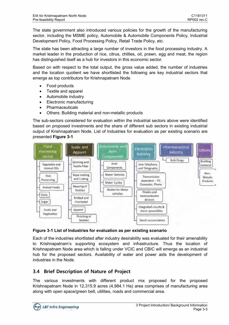
Based on with respect to the total output, the gross value added, the number of industries and the location quotient we have shortlisted the following are key industrial sectors that emerge as top contributors for Krishnapatnam Node
Food products Textile and apparel Automobile industry Electronic manufacturing Pharmaceuticals Others: Building material and non-metallic products
The sub-sectors considered for evaluation within the industrial sectors above were identified based on proposed investments and the share of different sub sectors in existing industrial output of Krishnapatnam Node. List of Industries for evaluation as per existing scenario are presented Figure 3-1
Figure 3-1 List of Industries for evaluation as per existing scenario
Each of the industries shortlisted after industry desirability was evaluated for their amenability to Krishnapatnam’s supporting ecosystem and infrastructure. Thus the location of Krishnapatnam Node area which is falling under VCIC and CBIC will emerge as an industrial hub for the proposed sectors. Availability of water and power aids the development of industries in the Node.
3.4 Brief Description of Nature of Project
The various investments with different product mix proposed for the proposed Krishnapatnam Node in 12,315.9 acres (4,984.1 Ha) area comprises of manufacturing area along with open space/green belt, utilities, roads and commercial area.

C1181311 EIA for Krishnapatnam North Node RP002 rev.C Pre-feasibility Report
3 Project Introduction/ Background Information Page 3-4
Apart from the manufacturing zones, total area is planned for green/open areas, amenities and utility space, technical and commercial infrastructure to accommodate training centre, R&D centre, commercial buildings like bank and ATMs, offices, traders, shopping, etc. and residential zone.
Utilities are planned and zoned across the project site. It will include water supply system, sewage network and wastewater treatment facility, waste management facilities, power substation and distribution network, fire station. Based on the requirement, these facilities are spread across the project site. Logistic hub will include warehousing, storage facility, container terminal, truck parking facility, workshops, railway siding infrastructure, weigh bridge, etc.
For residential zone, housing and allied infrastructure like educational facility, health care facility, crèche, recreational facilities, cultural facilities, playgrounds and community facilities, etc. are proposed.
Key sectors and subsectors proposed for Krishnapatnam Node are shown in Figure 3-2.
Figure 3-2: Key Sectors Proposed for Krishnapatnam Node
3.4.1 Industrial Sector Categorisation as per EIA Notification
The manufacturing area comprise of multi-sector industries. Focus Sectors for Investment Envisaged for Krishnapatnam Node area along with the use of raw materials and its pollution potential with respect to EIA Notification 2006 (As amended) and CPCB Categorization of Industries is given in Table 3-1.
Table 3-1: Focus Sectors, Sub-sectors and type of industrial Investment Envisaged for Krishnapatnam Node Area
# Focus Sector Anticipated Types of industries/activities
Categorisation of Industry as per EIA notification, 2006
Categorization as per
CPCB
Pollution Potential
1 Food and Agro Processing
Processing and preserving of fruits, vegetables and aqua food related processing (fish and prawns etc.)
Category B, in case of Sugar Industry, others doesn’t attract EIA notification
Red
W12,W2
Manufacture of dairy products (includes manufacturing of milk, milk
Red
A1C, A2F2, W13 & W2

EIA for Krishnapatnam North Node C1181311 Pre-feasibility Report RP002 rev.C
3 Project Introduction/ Background Information Page 3-5
# Focus Sector Anticipated Types of industries/activities
Categorisation of Industry as per EIA notification, 2006
Categorization as per
CPCB
Pollution Potential
powder, ice cream etc.)
Manufacture of grain mill products, starches and starch products sugar confectionery, Manufacture of macaroni, noodles, couscous and similar farinaceous products, Manufacture of prepared meals and dishes, Manufacture of other food products
Orange and Green, White
W12, A1C, D, E, F & G
Manufacture of other food products (includes manufacture of bakery products, Processing of edible nuts etc.)
Orange
W13 & A1D
Manufacture of prepared animal feeds (manufacture of cattle feed, poultry feed, feed for pets etc.)
Orange
A1C
2 Apparels and Textile Industry
Ginning/ Weaving, Spinning mills, Weaving and Knitting Mills cotton and manmade fabrics and apparels manufacturing; technical textiles (Mainly textile based) and handloom. No Yarn / Textile processing involving any effluent/emission generating processes including bleaching, dyeing, printing and colouring is proposed
Category A and B for manmade Fibres manufacturing
Red, Orange, Green and White
W11, W2, W17, A1B, A2F1, A1D, HW4, A1F
3 Automobile
Manufacture of motor vehicles (such as manufacturing of Tractors, Buses etc.)
Not Applicable
Red
A1C; W11; HW3 & HW4
Manufacture of parts and accessories for motor vehicles (includes parts such as brakes, gearboxes, axles, seats, tyres, rubber products etc.)
Orange and Green
W17, A1C,E,F,G
4 Pharmaceuticals Formulation, Bulk Drugs, Intermediates, Herbal medicines, bio pharmaceuticals.
Category A & B Red and Orange
W11, W13, Group A1B, Group A2F1 & HW1
5 Electronics
Manufacture of domestic appliances (includes consumer electronics such as refrigerators, washing machines, ovens, fans etc.)
Not Applicable
Orange A1C, HW3 & HW 4
Manufacture of communication devices (Telephone sets, incl. telephones for cellular networks or for other wireless networks; others)
Red and Orange
A1E,F,G, W12, HW3 & HW 4 W11, A1D, HW3 & HW 4
Manufacture of instruments used for medicinal purposes (includes Instruments and appliances used in medical, surgical, dental or veterinary sciences)
Orange W13
6 Other Industries Non-metallic minerals
Manufacture of non-metallic mineral products etc. (Includes manufacture of refractory products, clay building materials-bricks, tiles, ceramic products, AAC blocks, kerb stones, etc.)
Not Applicable Orange and Green
A1C, E, F & G
C1181311 EIA for Krishnapatnam North Node RP002 rev.C Pre-feasibility Report
3 Project Introduction/ Background Information Page 3-6
Source: As per CPCB classification of industries dated February 29, 2016
Water Pollution
W2 – Industry having overall liquid waste generation of 100 KLD or more including industrial & domestic waste-water.
W11 - Waste-water which is polluted and the pollutants are -
not easily biodegradable ( very high strength waste waters having BOD > 5000 mg/l ); or
toxic; or
both toxic and not easily biodegradable.
(Presence of criteria water pollutants having prescribed standard limits up-to 10 mg/l or having BOD > 5000 mg/l). For details
appendix 1 may be referred)
W12 - Non-toxic high strength polluted waste-water having BOD in the range of 1000-5000 mg/l and the pollutants are
biodegradable.
(Presence of criteria water pollutants having prescribed standard limits from 11 mg/l to 250 mg/l and having BOD strength in
the range of 1000-5000 mg/l) . For details appendix 1 may be referred)
W13 – Non-toxic- polluted waste-water having BOD below 1000 mg/l and the pollutants are easily biodegradable. (Presence
of criteria water pollutants having prescribed standard limits from 11mg/l to 250 mg/l and having BOD strength below 1000
mg/l). For details appendix 1 may be referred)
W14 – Waste-water generated from the chemical processes and which is polluted due to presence of high TDS ( total
dissolved solids) of inorganic nature. (Presence of criteria water pollutants having prescribed standard limits more than 250
mg/l. For details appendix 1 may be referred)
W15 – Waste-water generated from the physical unit operations / processes and which is polluted due to presence of TDS
(total dissolved solids) of inorganic nature and of natural origin like fresh-water RO rejects, boiler blow-downs, brine solution
rejects etc. (Presence of criteria water pollutants having prescribed standard limits more than 250 mg/l. For details appendix
1 may be referred)
W16 – Non-toxic polluted waste-water from those units which are:
Having the overall waste-water generation less than 10 KLD and
The pollutants are easily bio-degradable having BOD below 200 mg/l which can be easily treated in a single stage ASP
(activated sludge process) based Effluent Treatment Plant.
Note: This is a special category and is applicable to only those units having over-all liquid waste generation less than 10 KLD
with low strength organic load.
W17 – Waste-water from cooling towers and cooling-re-circulation processes
Air Pollution
A1A – Presence of cri teria air pollutants having prescribed standard limits up - to 2 mg/Nm3
A1B – Presence of criteria air pollutants having prescribed standard from 3to10 mg/Nm3
A1C – Presence of criteria air pollutants having prescribed standard from 11 to 50 mg/Nm3
A1D – Presence of criteria air pollutants having prescribed standard from 51 to 250 mg/Nm3
A1E – Presence of criteria air pollutants having prescribed standard from 251mg/Nm3 & above.
A1F – Generation of fugitive emissions of Particulate Matters which are:
Not generated as a result of combustion of any kind of fossil-fuel.
Generated due to handling / processing of materials without involving the use of any kind of chemicals.
Which can be easily contained /controlled with simple conventional methods
A1G – Generation of Odours which are:
Generated due to application of binding gums / cements /adhesives /enamels
Which can be easily contained /controlled with simple conventional methods
A2F1 – All such industries in which the daily consumption of coal/fuel is more than 24 MT/day and the particular
(Particulate/gaseous/process) emissions from which can be controlled only with high level equipment’s / technology like
ESPs, Bag House Filters, High Efficiency chemical wet scrubbers etc.
A2F2 – All such industries in which the daily consumption of coal/fuel is from 12 MT/day to 24 MT/day and the particular
(Particulate/gaseous/process) emissions from which can be controlled with suitable proven technology.
Hazardous waste
EIA for Krishnapatnam North Node C1181311 Pre-feasibility Report RP002 rev.C
3 Project Introduction/ Background Information Page 3-7
HW1 – Land disposable HW which requires special care & treatment for stabilization before disposal.
HW2 – Incinerable HW
HW3 – Land disposable HW which doesn’t require treatment & stabilization before disposal. High volume low effect wastes
such as fly-ash, phosphogypsum, red-mud, slags from pyro-metallurgical operations, mine tailings and ore beneficiation
rejects)
HW4 – Recyclable HW, which are easily recyclable with proven technologies.
3.5 Economic Impact of the Project
The proposed project is estimated to bring investment of Rs.37,500 Crores in the Krishnapatnam North Node. The total estimated manufacturing industry output in 20 years after the complete industrial plotted land is absorbed and all the industrial units commence production, is about Rs. 13,1300 Crores. It is likely to generate direct employment of about 3.25 lakh which includes 1.26 lakhs of resident jobs and 1.9 lakh of indirect employment.
3.6 Location Advantage/Justification
The site is located at a distance of about ~257 km southwest of the state capital, Vijayawada; ~28 km to SPSR Nellore district headquarters.
Andhra Pradesh is strategically located on the south eastern coast of India and is regarded as one of the largest producer of marine products in the country. The prominent industries in the state include Agro & Food–based, petroleum products, pharmaceuticals, textile, basic metals, non–metallic mineral products, etc.
The Krishnapatnam Node is uniquely positioned among all other industrial nodes being conceived under the industrial corridors program in the Country. Its location provides an advantage of being on not just the CBIC but also the VCIC. This offers the Node a distinct potential thereby being positioned as an attractive investment destination.
The Krishnapatnam Node thus has several advantages as listed below:
Proximity to an existing Port Good existing regional connectivity Amicable State Policies Availability of water for urban development Dedicated power allocation proposed by Government of AP Closer access to growing trade markets in South-east Asia and China
3.6.1 Salient Features of the Project Site
Some of the key investments in the state are mentioned below:
Some of the important features of the Site making it suitable for industrial development are presented.
The project site is strategically placed in terms of connectivity to the hinterland markets. Road Connectivity: The project site is strategically placed in terms of connectivity to
National Highway (NH). NH16 (AH-45) is located ~ 14.5 km west of the site. Railway Station: The nearest railway station is at a distance of ~7 km at Krishnapatnam
Road from the site. Seaport: The nearest port to the proposed industrial area is Krishnapatnam Port is at
~3.5 km in the north and proposed Dugarajapatnam Port is at a distance of ~10 km in the south direction.

C1181311 EIA for Krishnapatnam North Node RP002 rev.C Pre-feasibility Report
3 Project Introduction/ Background Information Page 3-8
Water ways: Buckingham canal which is recognized as National Waterway (NW4) is passing through the Node.
Airport Connectivity: The nearest airport is in Tirupati International Airport, Renigunta is at a distance of ~72 km and Anna International Airport, Chennai is at a distance of ~120 km. The upcoming Greenfield Airport at Dagadarthi which is 75 km to the North of the Site would strengthen the air connectivity.
Water Source: Nearest water source is Kandeleru Dam located at a distance of ~48 km to west of the site.
Power Supply Source: The intake 220/33kV Main Receiving Substation (MRSS) from the nearest 220kV lines and step down for distribution to industries using underground cables.
The site meets the requirement of all critical factors that are important for success of development of an industrial project in the state and could be a pre-eminent location.
3.7 Employment Generation
The total employment generation due to the proposed project is expected to generate employment of approximately 5.15 lakhs (direct and indirect) respectively.

EIA for Krishnapatnam North Node C1181311 Pre-feasibility Report RP002 rev.C
4 Project Description Page 4-1
4 Project Description
4.1 Type of Project
The proposed development of Krishnapatnam north industrial node project attracts activity 7 (c) i.e. Industrial Estates/Parks/Complexes/Areas of EIA Notification, 2006 (as amended). Proposed development is planned in an area of ~12,315.9 acres (~4,984 Ha) and falling under Category A of EIA Notification.
4.2 Site Location
Site location has been discussed in Section 3.2. The general project location in the state with regard to the major connectivity features is shown in preface
4.3 Details of Alternative Sites
Government of India (GoI) has recently come up with a national programme, “Make-In-India” to promote manufacturing sector in a comprehensive manner. The strategy to develop the CBIC is part of the plan to achieve accelerated development and regional industry agglomeration. With its influence area spread across three states Tamil Nadu, Karnataka, and Andhra Pradesh. Three industrial nodes are proposed along this corridor, namely Krishnapatnam Node in Andhra Pradesh, Ponneri in Tamil Nadu, and Tumakuru in Karnataka. Krishnapatnam Node will be the central hub for various sunrise sectors in an endeavour to attract investments from National and International Players across the globe.
APIIC has identified land parcel in Krishnapatanm node at Thammipatnam, Ballavolu, Vellapalem, and Momidi from Chillakur Mandal, and Karlapudi, East Kanupur, Kotapatnam, and Siddavaram from Kota Mandal which are under the possession of APIIC and Govt. of Andhra Pradesh.
Some of the important features of the Site making it suitable for Industrial area are presented
The Krishnapatnam Node is uniquely positioned among all other industrial nodes being conceived under the industrial corridors program in the Country. Its location provides an advantage of being on not just the CBIC but also the VCIC (Vishakhapatnam Chennai Industrial Corridor).
Strategically located near to two major ports namely Krishnapatnam (existing) and Dugarajapatnam (under development), located close to it enabling water connectivity.
Buckingham Canal passing through the North Node helps in improving its connectivity to Vijayawada on the northern side and Chennai on the southern side of Krishnapatnam. Buckingham canal is also recognized as National Waterway (NW4) which is under development for cargo transportation among various parts on eastern coast of India.
Developments under various infra projects like Sagarmala, Bharathmala, VCIC and CBIC gives a major advantage to both North and South Nodes of Proposed site.
Proximity to east Asian markets The site is located around ~28 km from City of SPSR Nellore with well-endowed Social
and educational infrastructure. The site has good access to logistic facilities. The site is well connected to the Road
network in the region from Chennai - Kolkata National Highway 16 which is at a distance of ~14.5 km on west side of the site.
C1181311 EIA for Krishnapatnam North Node RP002 rev.C Pre-feasibility Report
4 Project Description Page 4-2
The nearest Railway station to the project site is at Krishnapatnam Road located at ~7 km from the site towards NW.
The nearest airport is in Tirupati International Airport, Renigunta is at a distance of ~72 km and Anna International Airport, Chennai is at a distance of ~120 km.
Water and Power supply can be assured for the proposed IP will be met from the Kandeleru Dam located at a distance of ~48 km to west of the site.
APSPDCL is responsible for undertaking distribution of Power in SPSR Nellore District.
The site meets the requirement of all critical factors that are important for success of development of Industrial area in the state and could be a pre-eminent location. This offers the Node a distinct potential thereby being positioned as an attractive investment destination.
4.4 Size or Magnitude
The proposed development of Krishnapatnam Industrial Node is spread over an area of 12,315.9 acres (4,984.1 Ha). Total cost estimated for development of infrastructure in the project site is Rs. ~7,428.8 Crores. Projected output share of the node in for the year 2040 is about Rs.1,31,300 Crores and direct & indirect employment potential when fully operational will be close to 5.15 lakhs.
4.5 Resources Availability and Optimisation
4.5.1 Water Availability & Source
Gross water demand for Krishnapatnam North Node is ~111.2 MLD out of which 94.5 MLD is potable water demand and 37.9 MLD is non-potable water demand. Potable water shall be met from Kandeleru Dam. There are two (02) Water Treatment Plants (WTP) proposed to be constructed in Krishnapatnam North node for meeting the Potable Water Demand with ultimate capacity of 94.5 MLD in multiple phases. Each WTP shall be built in modular approach based on the area development and treatment demand.
Tapping point showing proposed alignment and flow of water supply from Kandaleru dam to project site is shown in Figure 4-1. Recycling the sewage being generated from the node is considered as a possible source for fulfilling the Non-Potable Water Demand. The sewage and industrial effluent generated in the project area will be treated in the sewage treatment plant (STP) and Common effluent treatment plant (CETP) respectively. The treated water will be distributed in the project area through recycle/reuse water supply network.

EIA for Krishnapatnam North Node C1181311 Pre-feasibility Report RP002 rev.C
4 Project Description Page 4-3
Figure 4-1 Proposed alignment of water supply from Kandaleru dam to project site
4.5.2 Energy/Power & Source
The estimated power demand for CBIC Krishnapatnam Node is approximately 715 MVA. The power will be received in 220/33kV Main Receiving Substation (MRSS). The transmission of power will be done through 220kV.
All the connections of power line from MRSS to the distribution network will be through underground cables which may be laid along the major and minor roads of CBIC Krishnapatnam Node. All substations will be GIS type. All the distribution of power will be through 33kV Electrical Sub Stations & 33kV RMUs. 33kV RMUs are interconnected to form Ring Main or Loop. Similarly, on Low Voltage system, distribution network will be in ring formation for making system more reliable. This will ensure high level of continuity and reliability of power system in CBIC Krishnapatnam Node.
4.5.3 Wastewater Treatment and Reuse
The sewage generated in residential, amenities and commercial areas will be treated in proposed STP with a capacity of 44.6 MLD. Treated wastewater in the order of 40.15 MLD will be recycled in the system to meet non-potable water demand.
The sewage and industrial effluent generated in the industrial areas will be combined and treated in proposed CETP of 60.3 MLD capacity, CETP will be developed in phases based on the industrial demand. From CETP, partially recovered treated wastewater in the order of 4.42 MLD will be recycled in the system to meet non-potable water demand. Gross non potable water demand is 44.57 MLD, by considering 15% losses in distribution; this will meet the non-potable water demand of 37.9 MLD. Treated wastewater of 53.97 MLD from CETP will be discharged into the nearby water bodies. But however, in order to prevent discharges into the water bodies, it is proposed to adopt that large scale and medium scale industries to maintain their own ZLD facility for treatment of Effuent in their premises. Small scale industries will be utilizing the CETP and the treated water will be discharged to the nearby surface water bodies.
C1181311 EIA for Krishnapatnam North Node RP002 rev.C Pre-feasibility Report
4 Project Description Page 4-4
The Membrane Bio-Reactor (MBR) is proposed for the STP with Modular approach for electro-mechanical units. The CETP consists of preliminary, primary, secondary and tertiary treatment section. The preliminary treatment section consists of collection sump (wet well), followed screening and equalization tank.
The equalized and homogenized influent shall be pumped to coagulation tank (flash mixer) followed by flocculation tank and primary clarifier. Necessary chemicals like PAC/FeCl3, lime, polymer shall be dosed appropriately to control the inlet TSS to secondary treatment. Along with TSS removal in the primary clarifier, COD/BOD is also removed in form of sludge.
The treated wastewater from STP and partially from CETP will be distributed in the project area through recycle/reuse water supply network.
Reuse of treated wastewater in the order of 40.15 MLD from STP and about 4.42 MLD from CETP will be reused in the system for non-potable water demand.
4.5.4 Solid Waste Management
Once the Krishnapatnam North Node is completely operational, total municipal solid waste generation is estimated as 379.3 TPD which includes MSW generation from the existing settlements. The generated waste will comprise of Biodegradable waste, recyclables and inert waste. Integrated solid waste management facility is proposed for handling of MSW generated.
Industrial solid waste is estimated as 665.6 TPD which includes 99.8 TPD of hazardous waste and 566 TPD of non-hazardous waste. It has been estimated that about 12.6 tonnes of sludge will be generated daily (@300kg/ MLD) from the planned STPs and about 19.2 tonnes/ day of sludge from the CETPs from North Node of Krishnapatnam site. Hazardous waste shall be disposed by individual industry to nearby TSDF located at Raviguntapalli, SPSR Nellore District located at a distance 47.96 km from project site.
In Krishnapatnam it has been planned to develop nursing homes (25 beds), Intermediate hospitals (100 beds) and General Hospitals (200 beds). The quantity of biomedical waste generated for north Node is estimated approx. 1400 kg/day including both biomedical infectious and non-infectious wastes. All such waste will be handled and managed as per the requirements of the said Bio-medical Waste Management Rules, 2016. Individual hospitals will install in-situ treatment facilities such as autoclaves/microwaves/incinerator based on the number of patient beds.
4.6 Site Information
The project site location is discussed in Section 3.2. The site analysis is summarised in the following and explained in the following subsections.
Table 4-1: Site Information Summary
S. No Details Description
1. Location Chillakur Mandal, and Kota Mandals
2. District SPSR Nellore
3. State Andhra Pradesh
4.
Topography Flat slope terrain with levels varying from 0 m to 16 m. The master slope of
the area is from west to east towards the Bay of Bengal. The sandy coastal
plain extends upto a distance of 5 to 6 km from sea coast.
5. Temperature Mean Daily Maximum: 39.80 C
EIA for Krishnapatnam North Node C1181311 Pre-feasibility Report RP002 rev.C
4 Project Description Page 4-5
S. No Details Description
Mean Daily Minimum: 20.30 C
6.
Wind Speed The predominant wind direction is south-west
Maximum Mean wind speed is 10.1 kmph (2.8 m/s) and
Minimum Mean wind speed is and 5.0 kmph (1.38 m/s)
7. Rainfall Annual rainfall: 1022.3 mm
8. Relative Humidity Maximum 87% during December
Minimum 51% during June
9.
Present Land use Majority of the land is barren uncultivable barren lands, scrub lands, coastal
vegetation like casuarina plantations, agricultural crop like groundnut, built-
up areas and water bodies bordered by River Swarnamukhi along its south-
east boundary. The Buckingham Canal runs through the site along the north
south direction dividing the site into two parts. Three Reserve Forests adjoin
the site on the west and parts of the eastern boundary. Settlements are
located within the site.
10. Seismicity Zone-III (medium risk zone)
11. Nearest Road
Connectivity
NH16 (AH-45) is located at ~ 14.5 km west of the site
12. Nearest Rail
Connectivity
Krishnapatnam Road at ~7 km NW
13. Nearest Seaport Krishnapatnam Port at ~3.5 km N
Proposed Dugarajapatnam Port at ~10 km S
14.
Nearest Airport Tirupati International Airport, Renigunta at ~72 km SW
Anna International Airport, Chennai at ~120 km S
The upcoming Greenfield Airport at Dagadarthi is 75 km away from the
North of the Site.
15.
Nearest Town/ Village The following villages are within the site
Chillakur Mandal:
Thamminapatnam,
Ballavolu,
Vellapalem, and
Momidi
Kota Mandal:
Karlapudi,
East Kanupur,
Kothapatanam, and
Siddavaram Ecological Features within 15 km radius
16. Hills/Valleys Nil
17.
Areas protected under
international
conventions, national
or local legislation for
their ecological,
landscape, cultural or
other related value
Pulicat Wildlife Sanctuary: 6.2 South
18. National Parks/ Wild
Life Sanctuaries Pulicat Wildlife Sanctuary: 6.2 South
19. Areas which are Buckingham Canal - Adjacent
C1181311 EIA for Krishnapatnam North Node RP002 rev.C Pre-feasibility Report
4 Project Description Page 4-6
S. No Details Description
important or sensitive
for ecological reasons
- Wetlands,
watercourses or other
water bodies, coastal
zone, biospheres,
mountains, forests
Kandaleru creek - 1.7 km NNW
Swarnamukhi River - Abutting S
Pennaki lake - 1.2 km SW
Tamminapatnam R.F - Abutting N
Kottapatnam R.F - Abutting NE
Momidi R.F - Abutting W
Vallipedu R.F- 1.8 km SW
Kesavaram R.F- 8.4 km SW
Kadivedu R.F- 8.5 km SW
Pidatalapudi R.F- 8.0 km SW
Ipuru R.F- 2.1 km S
Puli Kalva – 15.5 SW
Sarvepalli Chervu – 14.5 km NW
20. Defence Installations Nil
21. State, National
boundaries
Nil
22.
Areas occupied by
sensitive man-made
land uses (hospitals,
schools, places of
worship, community
facilities)
Muttukuru – 7.6 km NW
Krishnapatnam 7.0 km, N Direction
4.6.1 Topography
Most of the site area has flat slopes. Heights points on site are at elevation of 11 to 16m where as low points are at elevation 0 to 3.5m. The typical drainage outfalls include natural stream flowing through the site, existing water bodies, natural creeks and sea outfalls. Canals run along ridge line to feed the water in to adjacent plots, farm lands, and agricultural land. Village areas of Karlapadu, Siddavaram and Kothapatanam that area is in the estuarine areas flood prone and poor soils. Buckingham Canal runs through the site along the north south direction.
4.6.2 Climate
SPSR Nellore have typical tropical maritime climate, with hot, humid summers and mild winters. April and May are the hottest months and the hot conditions generally last until the end of the June, December, January and February are the coolest months. Humidity level in the city is high due to its proximity to the coast. Nellore does not receive the south-west monsoon. Rainfall in Nellore occurs between the months of October and December due to the north-east monsoon. This period gives about 60 percent of the city’s annual rainfall. During this period of the year occurrence of cyclones are common in the region.
Krishnapatnam is along the Bay of Bengal and the sea breeze contributes to moderation of climate both in winter and summer. The maximum temperature is 36 to 460 C during summer and the minimum temperature is 23 to 250 C during winter. The humidity level in the region is high due to its proximity to the coast. The average rainy days range between 40 to 44 days in a year. The average annual rainfall in the study area varies from 1,000 to 1,200 mm. The maximum annual rainfall of 1,100 mm and above is recorded within the study area. The
EIA for Krishnapatnam North Node C1181311 Pre-feasibility Report RP002 rev.C
4 Project Description Page 4-7
rainfall ranges from 700 to 1,000 mm and about 60 percent of the annual rainfall occurs during that season.
Cyclones are a common occurrence in this region during the Southwest Monsoon period and cause heavy rainstorm events posing threat to collateral damage.
During the south-west monsoon period winds are predominantly from the south-western direction. During the post monsoon seasons winds are mainly north-western to north in the mornings and north-eastern to east in the afternoons. During the rest of the periods winds are mainly from directions between east and south. During summer and monsoon seasons wind speed is about 9km/hr while it is about 5 km/hr during the rest of the period. During northeast monsoon, wind velocity may go upto 50 km/hr and during cyclonic periods the wind speeds may go up to 105 km/hr. The average wind speed in the project site is between 12 to 19 kmph.
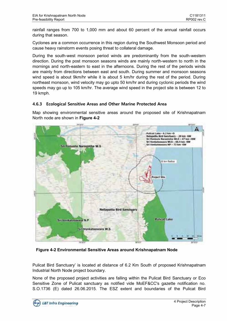
4.6.3 Ecological Sensitive Areas and Other Marine Protected Area
Map showing environmental sensitive areas around the proposed site of Krishnapatnam North node are shown in Figure 4-2
Figure 4-2 Environmental Sensitive Areas around Krishnapatnam Node
Pulicat Bird Sanctuary’ is located at distance of 6.2 Km South of proposed Krishnapatnam Industrial North Node project boundary.
None of the proposed project activities are falling within the Pulicat Bird Sanctuary or Eco Sensitive Zone of Pulicat sanctuary as notified vide MoEF&CC's gazette notification no. S.O.1736 (E) dated 26.06.2015. The ESZ extent and boundaries of the Pulicat Bird
C1181311 EIA for Krishnapatnam North Node RP002 rev.C Pre-feasibility Report
4 Project Description Page 4-8
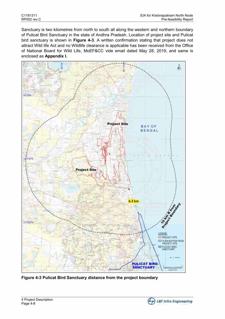
Sanctuary is two kilometres from north to south all along the western and northern boundary of Pulicat Bird Sanctuary in the state of Andhra Pradesh. Location of project site and Pulicat bird sanctuary is shown in Figure 4-3. A written confirmation stating that project does not attract Wild life Act and no Wildlife clearance is applicable has been received from the Office of National Board for Wild Life, MoEF&CC vide email dated May 28, 2019, and same is enclosed as Appendix I.
Figure 4-3 Pulicat Bird Sanctuary distance from the project boundary

EIA for Krishnapatnam North Node C1181311 Pre-feasibility Report RP002 rev.C
4 Project Description Page 4-9
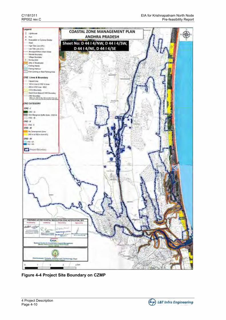
4.6.4 CRZ Applicability
Project site is located on coastal front of Thammipatnam, Kottapatnam,Siddavaram villages of SPSR Nellore district. The Buckingham Canal, a navigation channel, passes through the Industrial node form north to south direction. The canal connects most of the natural backwaters along the coast up to Chennai port. As of now, 500m from HTL is kept as green conservation area and no industrial activity is proposed in CRZ area and in future any industry proposed for marine side facilities, such industry will take appropriate CRZ clearance as per prevailing statutory requirements. Project boundary superimposed on CZMP is shown in Figure 4-4.
C1181311 EIA for Krishnapatnam North Node RP002 rev.C Pre-feasibility Report
4 Project Description Page 4-10
Figure 4-4 Project Site Boundary on CZMP

EIA for Krishnapatnam North Node C1181311 Pre-feasibility Report RP002 rev.C
4 Project Description Page 4-11
4.6.5 Existing Connectivity
Krishnapatnam node is well connected with three major cities namely, Chennai, Bengaluru and Vijayawada/Amaravati, also connecting significant parts of CBIC and VCIC Corridors through various National Highways.
The project site is strategically placed in terms of connectivity to National Highway (NH). NH16 (AH-45) is located ~ 14.5 km west of the site.
The nearest railway station is at a distance of ~7 km at Krishnapatnam Road from the site.
The nearest port to the proposed industrial area is Krishnapatnam Port is at ~3.5 km in the north and proposed Dugarajapatnam Port is at a distance of ~10 km in the south direction.
Buckingham canal which is recognized as National Waterway (NW4) is passing through the Node.
The nearest airport is in Tirupati International Airport, Renigunta is at a distance of ~72 km and Anna International Airport, Chennai is at a distance of ~120 km.
4.6.6 Land Ownership
APIIC is in possession of 6,8833.3 acres and remaining land is under acquisition. The following Figure 4-5 provides the status of land acquisition.

C1181311 EIA for Krishnapatnam North Node RP002 rev.C Pre-feasibility Report
4 Project Description Page 4-12
Figure 4-5: North Node Land ownership details * Data Interpolation is a difference in drone & cadastral datasets. This is attributed due to change in source information between cadastral data (prepared several decades ago with basic equipment) and boundary defined by drone survey (prepared using modern sophisticated software and tools). The master plan is prepared on the drone survey boundary.
EIA for Krishnapatnam North Node C1181311 Pre-feasibility Report RP002 rev.C
4 Project Description Page 4-13
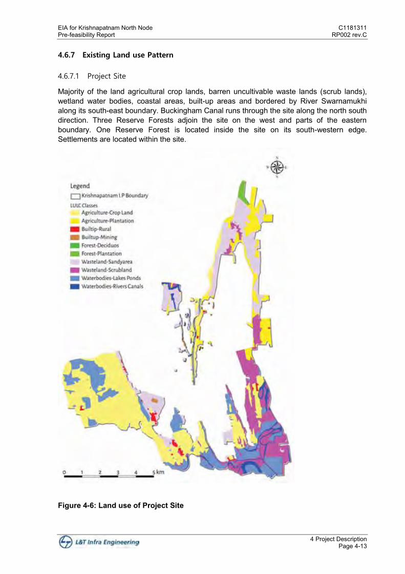
4.6.7 Existing Land use Pattern
4.6.7.1 Project Site
Majority of the land agricultural crop lands, barren uncultivable waste lands (scrub lands), wetland water bodies, coastal areas, built-up areas and bordered by River Swarnamukhi along its south-east boundary. Buckingham Canal runs through the site along the north south direction. Three Reserve Forests adjoin the site on the west and parts of the eastern boundary. One Reserve Forest is located inside the site on its south-western edge. Settlements are located within the site.
Figure 4-6: Land use of Project Site
C1181311 EIA for Krishnapatnam North Node RP002 rev.C Pre-feasibility Report
4 Project Description Page 4-14
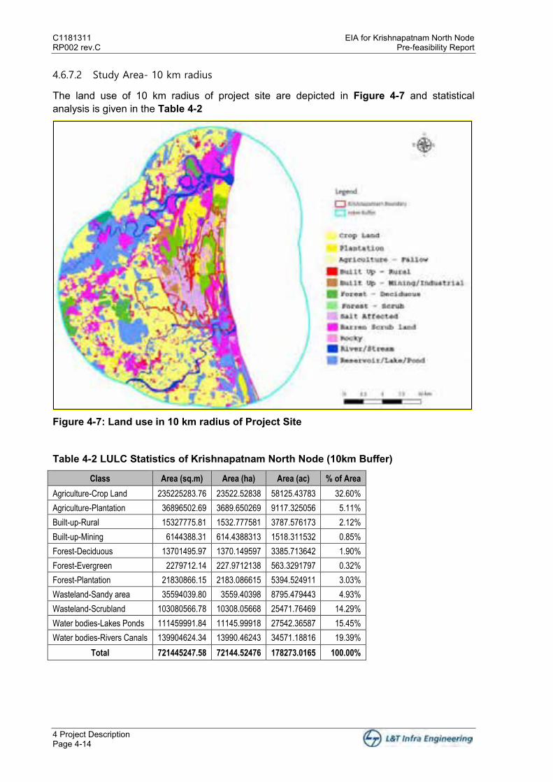
4.6.7.2 Study Area- 10 km radius
The land use of 10 km radius of project site are depicted in Figure 4-7 and statistical analysis is given in the Table 4-2
Figure 4-7: Land use in 10 km radius of Project Site
Table 4-2 LULC Statistics of Krishnapatnam North Node (10km Buffer)
Class Area (sq.m) Area (ha) Area (ac) % of Area
Agriculture-Crop Land 235225283.76 23522.52838 58125.43783 32.60%
Agriculture-Plantation 36896502.69 3689.650269 9117.325056 5.11%
Built-up-Rural 15327775.81 1532.777581 3787.576173 2.12%
Built-up-Mining 6144388.31 614.4388313 1518.311532 0.85%
Forest-Deciduous 13701495.97 1370.149597 3385.713642 1.90%
Forest-Evergreen 2279712.14 227.9712138 563.3291797 0.32%
Forest-Plantation 21830866.15 2183.086615 5394.524911 3.03%
Wasteland-Sandy area 35594039.80 3559.40398 8795.479443 4.93%
Wasteland-Scrubland 103080566.78 10308.05668 25471.76469 14.29%
Water bodies-Lakes Ponds 111459991.84 11145.99918 27542.36587 15.45%
Water bodies-Rivers Canals 139904624.34 13990.46243 34571.18816 19.39%
Total 721445247.58 72144.52476 178273.0165 100.00%
EIA for Krishnapatnam North Node C1181311 Pre-feasibility Report RP002 rev.C
4 Project Description Page 4-15
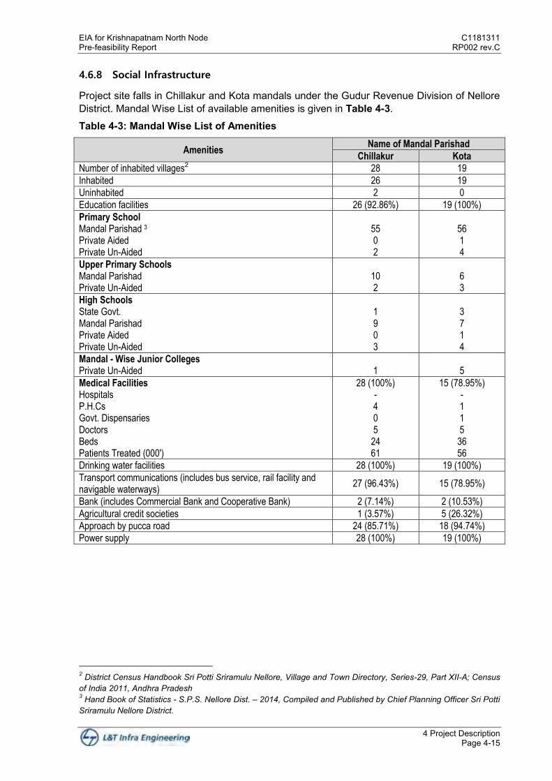
4.6.8 Social Infrastructure
Project site falls in Chillakur and Kota mandals under the Gudur Revenue Division of Nellore District. Mandal Wise List of available amenities is given in Table 4-3.
Table 4-3: Mandal Wise List of Amenities
Amenities Name of Mandal Parishad
Chillakur Kota
Number of inhabited villages2 28 19
Inhabited 26 19
Uninhabited 2 0
Education facilities 26 (92.86%) 19 (100%)
Primary School Mandal Parishad 3 Private Aided Private Un-Aided
55 0 2
56 1 4
Upper Primary Schools Mandal Parishad Private Un-Aided
10 2
6 3
High Schools State Govt. Mandal Parishad Private Aided Private Un-Aided
1 9 0 3
3 7 1 4
Mandal - Wise Junior Colleges Private Un-Aided
1
5
Medical Facilities Hospitals P.H.Cs Govt. Dispensaries Doctors Beds Patients Treated (000')
28 (100%) - 4 0 5
24 61
15 (78.95%) - 1 1 5
36 56
Drinking water facilities 28 (100%) 19 (100%)
Transport communications (includes bus service, rail facility and navigable waterways)
27 (96.43%) 15 (78.95%)
Bank (includes Commercial Bank and Cooperative Bank) 2 (7.14%) 2 (10.53%)
Agricultural credit societies 1 (3.57%) 5 (26.32%)
Approach by pucca road 24 (85.71%) 18 (94.74%)
Power supply 28 (100%) 19 (100%)
2 District Census Handbook Sri Potti Sriramulu Nellore, Village and Town Directory, Series-29, Part XII-A; Census of India 2011, Andhra Pradesh 3 Hand Book of Statistics - S.P.S. Nellore Dist. – 2014, Compiled and Published by Chief Planning Officer Sri Potti Sriramulu Nellore District.


EIA for Krishnapatnam North Node C1181311 Pre-feasibility Report RP002 rev.C
5 Planning Brief Page 5-1
5 Planning Brief
Vision for Krishnapatnam Node:
Krishnapatnam Node under CBIC is vibrant economic hub upholding context sensitive development that:
Is people-centric: A community built for pedestrian scale that priorities ease of living for its future residents and workers, and the local inhabitants
Promotes Low Carbon Future: Urban systems that integrate with and enhance existing natural systems to build resilient and cost-effective infrastructure
Enables Innovation: An industrial eco-system that enables adoption of latest technological developments to help units compete with the best global benchmarks
5.1 Planning Concept
Key ideas for innovation that have the potential for steering the future development in Krishnapatnam to set a new benchmark for industrial-economic centres:
Advancing a Circular Economy Enabling Adoption of Industry Towards Carbon Neutrality Pervious City Ease of Living Urban Farming
The spatial principles supporting the vision are indicated in the Figure 5-1.
Figure 5-1: Spatial Planning Framework for achieving the vision for Krishnapatnam
C1181311 EIA for Krishnapatnam North Node RP002 rev.C Pre-feasibility Report
5 Planning Brief Page 5-2
5.2 Planning Considerations
Surrounding land use and meteorological conditions taken into consideration for the land use plan proposed within the site
Connectivity to Hinterland Urban Structure and Form Connectivity and Walkability Efficiency for Public Transit Systems Development Flexibility Socio-Economic Profile of Region Integration of Natural Features – Creeks/ Backwater, Lakes, Hillocks Compatibility with CRZ guidelines
5.3 Land use Planning
The proposed Master Plan for Krishnapatnam North Node is based upon the market demand estimates for industry sectors and supporting land uses. The vision for the development along with an assessment of the physical constraints and opportunities for the site drives the land use and infrastructure allocations in the master plan. The Plan allocates development of land sufficient to accommodate a population of about 5.15 lakh workers and 3.12 lakh residents over a 20-year time horizon.
With a view to create vibrant, activity oriented, walkable and sustainable communities, each of broad urban land use categories will allow a mix of compatible uses.
The key features of the land use plan are as below:
Land for industrial purposes are in accord with demand studies Land for non-industrial employment uses such as education, skill-development and R&D
or knowledge based activities Land areas reserved for residential uses, commercial and community land uses Adequate provision for road rights of way, with the emphasis on public transport provision
and landscaped boulevards and pedestrian areas, and Land areas for open space and waterways
The Plan presents a framework of how the envisioned investment and employment potential can be realized through the outlined design principles for creation of a vibrant Greenfield economic hub that encourages innovation across all sectors.
The development hinges on construction of good quality infrastructure ensuring transportation, energy, water, and other utility services meet the needs of industries, businesses and residents. The new city will be built in three phases (03), with each phase being self-sufficient in terms of mix of industrial land, supporting residential areas, social amenities, open spaces and utilities.
Apart from industrial land allocations for other economic sectors - knowledge and education, skill development and research, tourism and recreation form key provisions of the Plan. Krishnapatnam Node provides housing for all income groups supported by open spaces, community amenities, and essential facilities that will enable growth of a socially integrated, attractive, sustainable and affordable city in which to live, work, and play.
The Master Plan incorporates sustainable approach in various aspects of development protection of the environmentally sensitive areas along the coast, in particular the estuarine
EIA for Krishnapatnam North Node C1181311 Pre-feasibility Report RP002 rev.C
5 Planning Brief Page 5-3
ecology; integrating the existing local inhabitants with the new development, conception of an urban form that enables provision of efficient public transportation system; and maximizing opportunities to offset carbon emissions through reforestation/creation of adjoining forest lands.
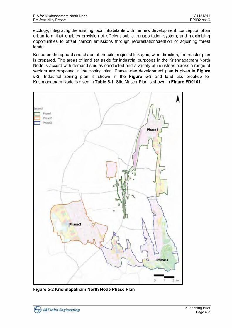
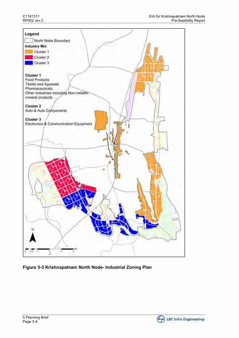
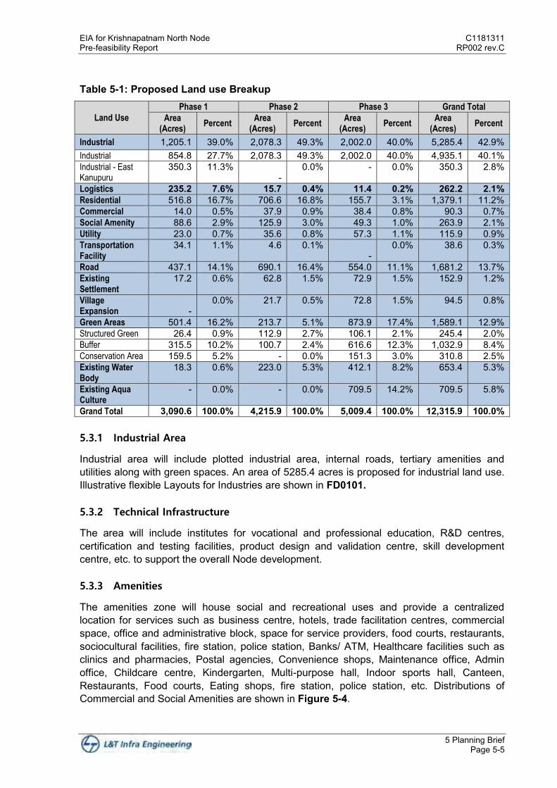
Based on the spread and shape of the site, regional linkages, wind direction, the master plan is prepared. The areas of land set aside for industrial purposes in the Krishnapatnam North Node is accord with demand studies conducted and a variety of industries across a range of sectors are proposed in the zoning plan. Phase wise development plan is given in Figure 5-2. Industrial zoning plan is shown in the Figure 5-3 and land use breakup for Krishnapatnam Node is given in Table 5-1. Site Master Plan is shown in Figure FD0101.
Figure 5-2 Krishnapatnam North Node Phase Plan
C1181311 EIA for Krishnapatnam North Node RP002 rev.C Pre-feasibility Report
5 Planning Brief Page 5-4
Figure 5-3 Krishnapatnam North Node- Industrial Zoning Plan
EIA for Krishnapatnam North Node C1181311 Pre-feasibility Report RP002 rev.C
5 Planning Brief Page 5-5
Table 5-1: Proposed Land use Breakup
Land Use
Phase 1 Phase 2 Phase 3 Grand Total
Area (Acres)
Percent Area
(Acres) Percent
Area (Acres)
Percent Area
(Acres) Percent
Industrial 1,205.1 39.0% 2,078.3 49.3% 2,002.0 40.0% 5,285.4 42.9% Industrial 854.8 27.7% 2,078.3 49.3% 2,002.0 40.0% 4,935.1 40.1% Industrial - East Kanupuru
350.3 11.3% -
0.0% - 0.0% 350.3 2.8%
Logistics 235.2 7.6% 15.7 0.4% 11.4 0.2% 262.2 2.1% Residential 516.8 16.7% 706.6 16.8% 155.7 3.1% 1,379.1 11.2% Commercial 14.0 0.5% 37.9 0.9% 38.4 0.8% 90.3 0.7% Social Amenity 88.6 2.9% 125.9 3.0% 49.3 1.0% 263.9 2.1% Utility 23.0 0.7% 35.6 0.8% 57.3 1.1% 115.9 0.9% Transportation Facility
34.1 1.1% 4.6 0.1% -
0.0% 38.6 0.3%
Road 437.1 14.1% 690.1 16.4% 554.0 11.1% 1,681.2 13.7% Existing Settlement
17.2 0.6% 62.8 1.5% 72.9 1.5% 152.9 1.2%
Village Expansion
-
0.0% 21.7 0.5% 72.8 1.5% 94.5 0.8%
Green Areas 501.4 16.2% 213.7 5.1% 873.9 17.4% 1,589.1 12.9% Structured Green 26.4 0.9% 112.9 2.7% 106.1 2.1% 245.4 2.0% Buffer 315.5 10.2% 100.7 2.4% 616.6 12.3% 1,032.9 8.4% Conservation Area 159.5 5.2% - 0.0% 151.3 3.0% 310.8 2.5% Existing Water Body
18.3 0.6% 223.0 5.3% 412.1 8.2% 653.4 5.3%
Existing Aqua Culture
- 0.0% - 0.0% 709.5 14.2% 709.5 5.8%
Grand Total 3,090.6 100.0% 4,215.9 100.0% 5,009.4 100.0% 12,315.9 100.0%
5.3.1 Industrial Area
Industrial area will include plotted industrial area, internal roads, tertiary amenities and utilities along with green spaces. An area of 5285.4 acres is proposed for industrial land use. Illustrative flexible Layouts for Industries are shown in FD0101.
5.3.2 Technical Infrastructure
The area will include institutes for vocational and professional education, R&D centres, certification and testing facilities, product design and validation centre, skill development centre, etc. to support the overall Node development.
5.3.3 Amenities
The amenities zone will house social and recreational uses and provide a centralized location for services such as business centre, hotels, trade facilitation centres, commercial space, office and administrative block, space for service providers, food courts, restaurants, sociocultural facilities, fire station, police station, Banks/ ATM, Healthcare facilities such as clinics and pharmacies, Postal agencies, Convenience shops, Maintenance office, Admin office, Childcare centre, Kindergarten, Multi-purpose hall, Indoor sports hall, Canteen, Restaurants, Food courts, Eating shops, fire station, police station, etc. Distributions of Commercial and Social Amenities are shown in Figure 5-4.

C1181311 EIA for Krishnapatnam North Node RP002 rev.C Pre-feasibility Report
5 Planning Brief Page 5-6
Figure 5-4: Commercial and Social Amenities
5.3.4 Utilities
Utilities include power sub-station, water supply facilities, wastewater treatment facilities, waste management facilities, cold storage, raw material bank, etc.

EIA for Krishnapatnam North Node C1181311 Pre-feasibility Report RP002 rev.C
5 Planning Brief Page 5-7
5.3.5 Housing
The Housing Zone is envisaged to have well planned residential complexes with ample open spaces. This is to facilitate the creation of a well-planned residential neighbourhood with green character with Low, medium and high-rise apartments and Clubhouse within apartment complex. Allied infrastructure to include educational and health care facilities, recreational facilities, commercial and shopping, internal roads, green /open spaces, general distribution services to support the population.
5.3.6 Logistics Zone
Predominant activities are related to transport, logistics, goods distribution and storage for regional, national and international transit. Generally, these developments consist of warehouses, loading & unloading bays, open storage facilities and supporting ancillary services with efficient internal vehicular circulation and external multi-modal transport links, auto workshops, Weigh Bridge, railway siding infrastructure, office space for service providers, food courts, fuel station, etc.. The total area for logistics proposed is 262.2 acres.
5.3.7 CRZ Area
Passive recreation in CRZ influences areas and backwater/stream flowing within the site and a buffer of 100 m or width of the creek as per CRZ regulation is proposed. Buffer areas will be developed in equal to the width of the streams is proposed. As of now, 500m from HTL is kept as conservation area and no industrial activity is proposed in CRZ area and in future any industry proposed for marine side facilities, such industry will take appropriate CRZ clearance as per prevailing statutory requirements. Passive Recreation in CRZ areas are shown in Figure 5-5.
5.3.8 Green Areas
Adequate green peripheral buffers are provided all along the proposed green field industrial boundary and along the roads. An adequate buffer is provided near settlements, water bodies, etc. landscaped green spaces will be provided to serve as lung space for the Node. In overall Krishnapatnam Node area, an area of 1589.1 acres (12.9%) is proposed under green areas as shown in Figure 5-6. In order to meet the 33% green areas, remaining 20.1% of green areas will be maintained at Individual industrial plots, Logistics, Residential, and Commercial areas.
The proposed plant species will be carefully selected from a range of trees known to be local, reliable forms, drought resistant, wind resistant and suited to the Coastal Andhra Region. Strand Vegetation is characterized with open, mat forming pioneer species followed by scattered herbs, shrubs and trees dispersed beyond the high tide limit or the backshore region. The planting palate will be based on use of native species, hence shall enhance the remnant ecology.

C1181311 EIA for Krishnapatnam North Node RP002 rev.C Pre-feasibility Report
5 Planning Brief Page 5-8
Figure 5-5: Passive Recreation in CRZ areas
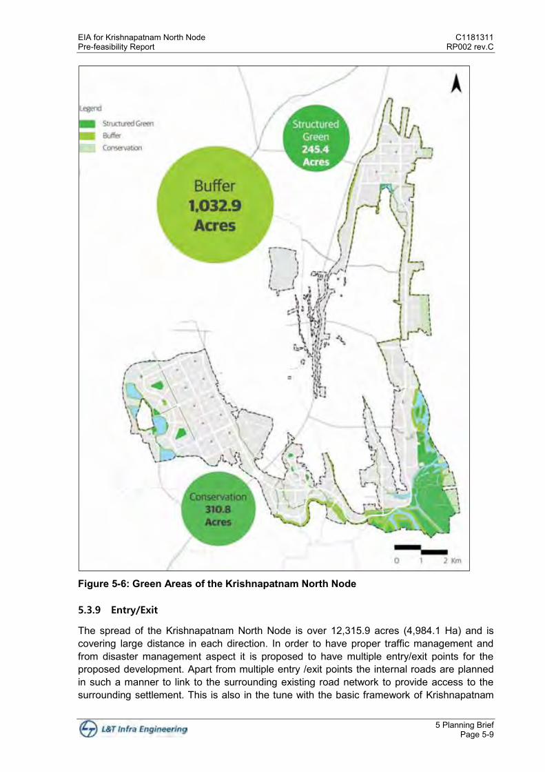
EIA for Krishnapatnam North Node C1181311 Pre-feasibility Report RP002 rev.C
5 Planning Brief Page 5-9
Figure 5-6: Green Areas of the Krishnapatnam North Node
5.3.9 Entry/Exit
The spread of the Krishnapatnam North Node is over 12,315.9 acres (4,984.1 Ha) and is covering large distance in each direction. In order to have proper traffic management and from disaster management aspect it is proposed to have multiple entry/exit points for the proposed development. Apart from multiple entry /exit points the internal roads are planned in such a manner to link to the surrounding existing road network to provide access to the surrounding settlement. This is also in the tune with the basic framework of Krishnapatnam

C1181311 EIA for Krishnapatnam North Node RP002 rev.C Pre-feasibility Report
5 Planning Brief Page 5-10
Node to have inclusive development. Type of Avenues and Intersections are shown in Figure 5-7.
Figure 5-7: Road Right of Ways with Type of Avenues and Intersections

EIA for Krishnapatnam North Node C1181311 Pre-feasibility Report RP002 rev.C
5 Planning Brief Page 5-11
5.3.10 Internal Roads Network
According to the zoning concept, broad road network was prepared while taking the surrounding developments and NH 16, proposed logistics corridor, existing village road, access roads to existing settlements, into consideration to create seamless road connectivity in and around Krishnapatnam Node industrial development.
All planned roads in the Krishnapatnam node are classified in order, that the network will work efficiently. Classification is based on the avoidance of any conflict, by separating roads serving different purposes from each other and from non-road uses.
The system comprises five classes of roads
Industrial Priority Arterial roads Arterial roads Sub–arterial roads Collector roads Local roads
Arterial Road
Arterial roads are provided for the efficient movement of traffic within the city and have a right of way of 60m. They are dual carriageway roads that will facilitate the movement of high traffic volumes and provide links between different districts within the city. Access to land uses on one or both sides of the arterial roads shall be provided through a service road. On certain arterial roads there will also be provision for public transport.
Sub-arterial Road
Sub-arterial roads are designed to deal with lower traffic volumes than Arterial roads and have reduced right of way of 45m and no provision for service roads.
Collector Roads
The collector road network intercepts traffic from inside the city districts and feed it into the arterial roads with a right-of-way of 30m a divided dual 2-lane carriageway with a lane width of 3.5m and separate cycle-tracks and pedestrian footpaths and a narrow median. All these roads are non-continuous since their primary function is the service of districts and their design is to connect with local roads.
Local Roads
Local roads provide services at the destination of the vehicular trips. They are the lowest classification of the city road hierarchy and will have low traffic volumes. The proposed right-of-way is 20m. Local roads are a single 2-lane carriageway with a lane width 3.65m, provided with parallel on-street parking on each side of the road. Krishnapatnam North Node Road Network is shown in Figure 5-8.
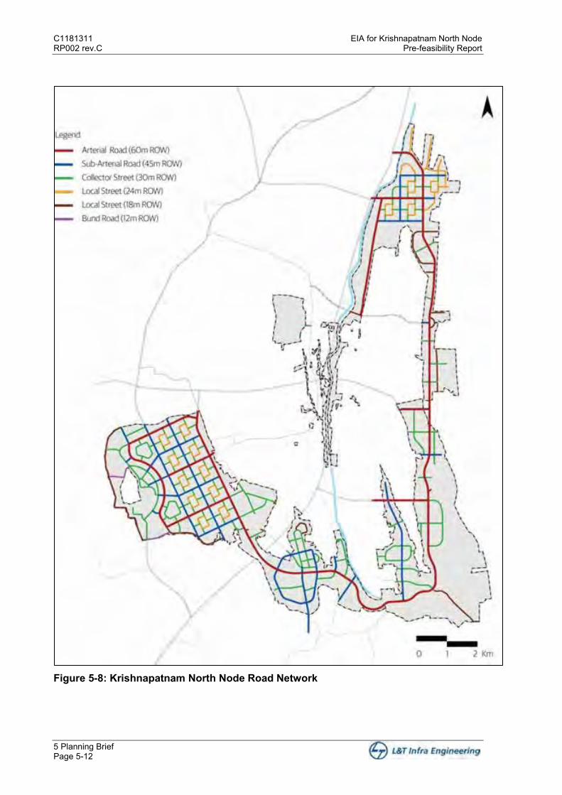
C1181311 EIA for Krishnapatnam North Node RP002 rev.C Pre-feasibility Report
5 Planning Brief Page 5-12
Figure 5-8: Krishnapatnam North Node Road Network
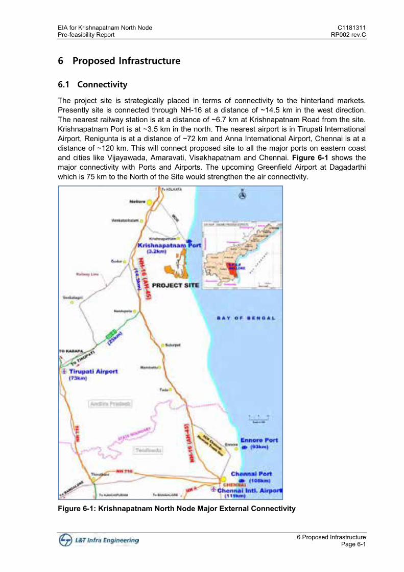
EIA for Krishnapatnam North Node C1181311 Pre-feasibility Report RP002 rev.C
6 Proposed Infrastructure Page 6-1
6 Proposed Infrastructure
6.1 Connectivity
The project site is strategically placed in terms of connectivity to the hinterland markets. Presently site is connected through NH-16 at a distance of ~14.5 km in the west direction. The nearest railway station is at a distance of ~6.7 km at Krishnapatnam Road from the site. Krishnapatnam Port is at ~3.5 km in the north. The nearest airport is in Tirupati International Airport, Renigunta is at a distance of ~72 km and Anna International Airport, Chennai is at a distance of ~120 km. This will connect proposed site to all the major ports on eastern coast and cities like Vijayawada, Amaravati, Visakhapatnam and Chennai. Figure 6-1 shows the major connectivity with Ports and Airports. The upcoming Greenfield Airport at Dagadarthi which is 75 km to the North of the Site would strengthen the air connectivity.
Figure 6-1: Krishnapatnam North Node Major External Connectivity

C1181311 EIA for Krishnapatnam North Node RP002 rev.C Pre-feasibility Report
6 Proposed Infrastructure Page 6-2
6.1.1 Approach Road
North Node is well connected to NH16 through three different routes consisting of mainly state highways having undivided two lane configuration (with a distance of 30 to 40 kms approximately). Ongoing developments under various projects like Sagarmala, Bharathmala, VCIC and CBIC give a major advantage to the proposed site.
Activities like widening and upgradation of Renigunta-Vayalpad-Bengaluru section of NH71, SH 82 to 4/6 lane carriageway as part of Krishnapatnam Bengaluru corridor development under Sagarmala Project.
Widening and upgradation of Chittoor-Bengaluru section of NH75 to 4/6 lane carriageway as part of Krishnapatnam Bengaluru corridor development under Sagarmala Project.
Development of Greenfield National expressway from Chennai to Bengaluru under NHDP.
Local Connectivity:
The local connectivity are intended to align with the road network developments within nodes to provide better accessibility to North Node during different phases of Krishnapatnam node to improve the access to the site which will ease freight and Passenger connectivity leveraging the development process. Connecting roads with respect to master plan phasing is given in Table 6-1.
The proposed development under widening or Greenfield roads will be developed by NHAI and State authorities under the Sagarmala project. Local connectivity development is not in scope of “NICDIT Krishnapatnam Industrial City Development Limited”.
Table 6-1 Local Connectivity Sl. No
Proposed Corridor Approx. Length
Description Proposed
Development
1
Widening of Intermediate lane
configuration Road to 2 lanes from
Momidi to Srinivasa Satravaram
11.0 km
This road will provide the exclusive
connectivity to residential area in Phase
1.
Phase 1
2
Widening and upgradation of existing
R&B road from Chintavaram to
Krishnapatnam Port via Varagali
15.0 km
This road will give direct access and
short access to western part of North
Node from Chillakur-KP Port road
already proposed for development.
Phase 2
3
Upgrading existing connectivity from
Naidupeta Krishnapatnam Road to
Ballavollu.
3.0 km
This road will give direct access and
short access to western part of North
Node from Naidupeta-KP Port road
already proposed for development.
Phase 2
4
Construction of Greenfield Road from
Chintavaram to Phase 2 of North Node
(Residential Access)
1.3 km
This road will provide direct connectivity
for commercial traffic to Phase 2 via
Chillakur – KP road
Phase 2
5
Construction of Greenfield Road from
Chintavaram to Phase 2 of North Node
(Industrial Access)
1.0 km
This road will provide direct exclusive
connectivity for residential traffic to
Phase 2 via Chillakur – KP road
Phase 2
6
Construction of Greenfield Road to
provide Connectivity from Siddavaram to
Naidupeta - Krishnapatnam Road,
4.0 km
This road will enhance the connectivity of
central part to Western part of North
Node.
Phase 3
7
Construction of Greenfield Road to
provide Connectivity from Phase 3 to
Naidupeta - Krishnapatnam Road
4.0 km
This road will enhance the connectivity of
central North Node to Naidupeta-KP road
for south bound traffic.
Phase 3

EIA for Krishnapatnam North Node C1181311 Pre-feasibility Report RP002 rev.C
6 Proposed Infrastructure Page 6-3
8
Construction of Greenfield Road to
provide Connectivity from Momidi Parcel
of Phase 1 to Chillakur East Kanupur
Road.
1.2 km
This road will provide an exclusive
access to Momidi parcel of Phase 1 to
west bound traffic.
Phase 1
Various options enables for access to the project site are shown in the Figure 6-2.
Figure 6-2: Road Connectivity to the Krishnapatnam North Node
6.2 Physical Infrastructure
6.2.1 Water Supply
Provision of safe, adequate drinking water is a basic necessity for healthy living. Water demand for CBIC Krishnapatnam Node is divided into Potable and Non-Potable Water System. Potable water demand will be fulfilled through fresh water sources.
Water demand has been estimated based on the unit demand norms adopted from CPHEEO manual and National Building Code 2016, land use master plan and projected population for north node.
Gross water demand for Krishnapatnam North Node is approximately 111.2 MLD out of which 94.5 MLD is potable water demand and 37.9 MLD is non-potable water demand. Potable water shall be sourced from Kandaleru Dam. Non-Potable water supply system shall be used for process water requirement of industries, landscaping requirements of project area, road side irrigation and other reuse purposes. Recycling the sewage and partly effluent being generated from the node is considered as a possible source for fulfilling the Non-Potable Water Demand. Other possible options are rain water storages/ponds in combination with minimal ground water extraction.

C1181311 EIA for Krishnapatnam North Node RP002 rev.C Pre-feasibility Report
6 Proposed Infrastructure Page 6-4
A water supply scheme has been proposed by the State Nodal Agency for the project area. Under the scheme raw water shall be supplied to Krishnapatnam node. The raw water shall be conveyed to the proposed WTP through raw water transmission main; treated and distributed using the proposed water distribution system.
Water Treatment Plants (WTP) are proposed to be constructed in Krishnapatnam North node for meeting the Municipal and Industrial Potable Water Demand with ultimate capacity of 111.2 MLD. Each WTP shall be built in modular approach based on the area development and treatment demand.
Table 6-2 presents gross water demand and Table 6-3 presents net water demand. Net water demand is the water demand at the consumer end. There are various losses in the system like leakage in transmission and distribution network, water loss at pump station and water loss in treatment, the total has been taken as 15% as per CPHEEO manual. Gross water demand is the total water that has to be supplied in order to meet the consumer demand, i.e. Gross Water Demand = Net Water Demand + Systems Loss (NRW)
Table 6-2: Land use wise Gross Water Demand - North Node
North Node - Phase 1 North Node - Phase 2 North Node - Phase 3 North Node - Total
Potable
Non-
Potable Potable
Non-
Potable Potable
Non-
Potable Potable
Non-
Potable
Residential 18.40 - 25.29 - 5.90 - 49.59 -
Industrial 11.90 6.25 22.18 11.68 22.45 11.81 56.52 29.73
Commercial 0.30 0.36 0.63 0.51 0.73 0.59 1.66 1.46
Amenity Based 1.71 1.37 1.30 1.06 0.39 0.31 3.41 2.75
Horticulture - 2.21 - 4.55 - 3.87 - 10.63
Total 32.31 10.19 49.39 17.80 29.47 16.58 111.17 44.57
Table 6-3: Land use wise Net Water Demand - North Node
North Node - Phase 1 North Node - Phase 2 North Node - Phase 3 North Node - Total
Potable Non-Potable Potable Non-Potable Potable Non-Potable Potable Non-Potable
Residential 15.64 - 21.49 - 5.02 - 42.15 -
Industrial 10.11 5.31 18.85 9.93 19.08 10.04 48.04 25.27
Commercial 0.26 0.30 0.53 0.44 0.62 0.50 1.41 1.24
Amenity Based 1.46 1.17 1.11 0.90 0.33 0.26 2.90 2.33
Horticulture - 1.88 - 3.87 - 3.29 - 9.04
Total 27.46 8.66 41.98 15.13 25.05 14.09 94.49 37.88
Detailed water balance diagram of the Krishnapatnam north node is shown in Figure 6-3

EIA for Krishnapatnam North Node C1181311 Pre-feasibility Report RP002 rev.C
6 Proposed Infrastructure Page 6-5
Figure 6-3 Water balance of the Krishnapatnam North Node
6.2.2 Power Supply
The estimated power demand for CBIC Krishnapatnam Node is ~ 715 MVA. Phase wise power demand/load estimations are given in Table 6-4. Table 6-4: Power Demand/ Load Estimation
Phase Capacity in MVA
Phase I 200.26
Phase II 291.26
Phase III 223.35
Total 714.87
Major Transmission source or tapping point to Krishnapatnam Industrial Node is 220kV voltage level near Krishnapatnam Industrial North Node & South Node:
A. Proposed 220kV/132kV/33kV East Kanupur Substation near Chittoor, Andhra Pradesh with Line In Line Out Arrangement
B. 220kV/132kV/33kV Sullurpeta Substation Power distribution in the node was shown in Figure 6-4.

C1181311 EIA for Krishnapatnam North Node RP002 rev.C Pre-feasibility Report
6 Proposed Infrastructure Page 6-6
Figure 6-4: North Node Power Distribution Network Phase I, North Node of Krishnapatnam Industrial Area is proposed to design at 33kV & 11kV Voltage level and 33kV incoming supply to new 33kV Electrical Substations will be arranged from proposed East Kanupur Substations Phase II, North Node & Phase III, North Node of Krishnapatnam Industrial Area is proposed for 3 Nos.220kV Power Substations which will further step down to 132kV and 33kV Voltage levels as per requirement.
EIA for Krishnapatnam North Node C1181311 Pre-feasibility Report RP002 rev.C
6 Proposed Infrastructure Page 6-7
The power will be received in 220/33kV Main Receiving Substation (MRSS) planned for phase II & Phase III. The transmission of power will be done through 220kV.
All the connections of power line from MRSS to the distribution network will be through underground cables which may be laid along the major and minor roads of CBIC Krishnapatnam Node. All substations will be GIS type. All the distribution of power will be through 33kV Electrical Sub Stations & 33kV RMUs.
33kV RMUs are interconnected to form Ring Main or Loop. Similarly, on Low Voltage system, distribution network will be in ring formation for making system more reliable. This will ensure high level of continuity and reliability of power system in CBIC Krishnapatnam Node.
6.2.3 Wastewater Management
A gravity sewerage system for the project site to convey the domestic sewage to sewage treatment plant shall be proposed. The effluent from industries within the project area shall be conveyed to the Common effluent treatment plant (CETP) through a separate effluent network.
Total sewage generated within the project site is targeted to be treated to required standards and then recycled into the system to meet the non-potable water demand.
The sewage generated in residential, amenities and commercial areas will be treated in proposed STP with a capacity of 44.6 MLD. Treated wastewater in the order of 40.15 MLD will be recycled in the system to meet non-potable water demand.
The sewage and industrial effluent generated in the industrial areas will be combined and treated in proposed CETP of 60.3 MLD capacity, CETP will be developed in phases based on the industrial demand. From CETP, partially recovered treated wastewater in the order of 4.42 MLD will be recycled in the system to meet non-potable water demand. Gross non potable water demand is 44.57 MLD, by considering 15% losses in distribution, this will meet the non-potable water demand of 37.9 MLD. Treated wastewater of 53.97 MLD from CETP will be discharged into the nearby water bodies.
But however, in order to prevent discharges into the water bodies, it is proposed to adopt that large scale and medium scale industries to maintain their own ZLD facility for treatment of Effuent in their premises. Small scale industries will be utilizing the CETP and the treated water will be discharged to the nearby surface water bodies.
6.2.4 Storm Water Management
Storm water drainage system is one of the key components of any infrastructure development projects. Improper management of storm water can lead to a) Flooding of transportation corridors, b) Damage to properties, c) changes into existing drainage streams, and d) pollution entering into drainage system. Therefore, to avoid these problems planning and designing of storm water drainage system during the start of the project becomes very crucial.
The ground level is varying between 11 to 16 m where as low points are at elevation 0 to 3.5 m as per the site contour map. Most of the site area has flat slopes approximately falling within a range of 2%. Site area falls in this region comprise coastal plains, a few ephemeral creeks, channels, Swaranmukhi River and the defunct Buckingham Canal. Rain water harvesting structures will be provided at individual levels to meet part of water demand for
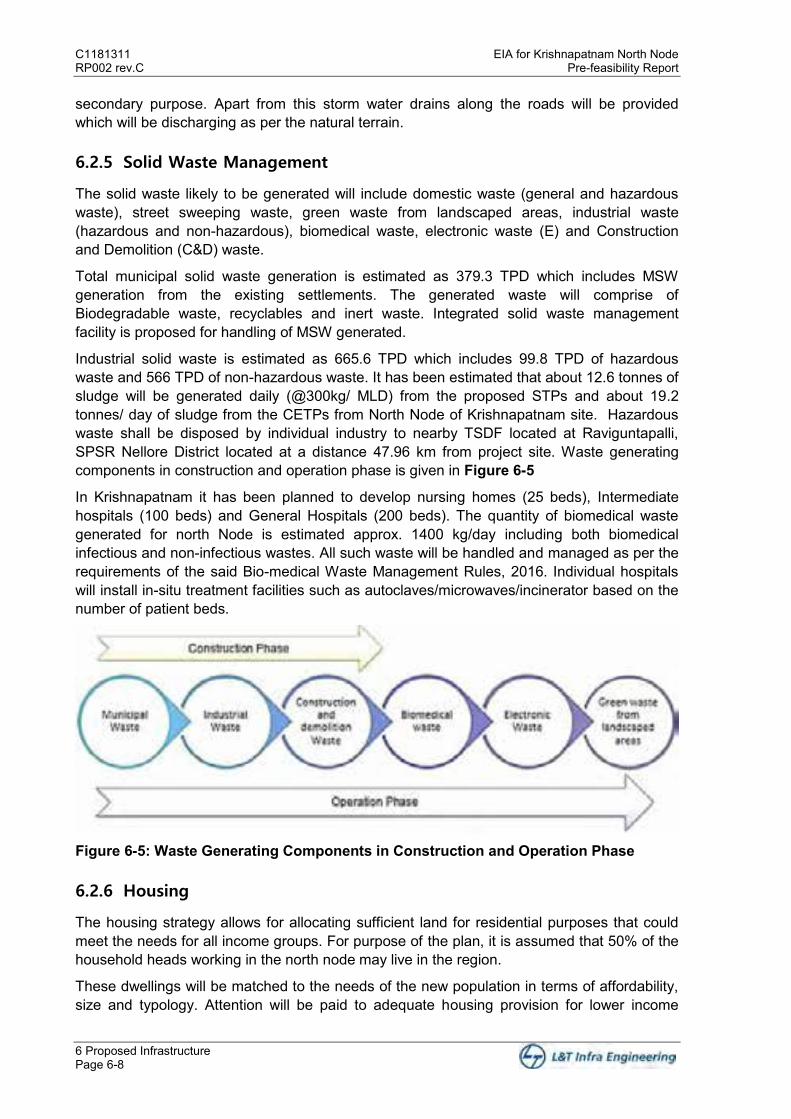
C1181311 EIA for Krishnapatnam North Node RP002 rev.C Pre-feasibility Report
6 Proposed Infrastructure Page 6-8
secondary purpose. Apart from this storm water drains along the roads will be provided which will be discharging as per the natural terrain.
6.2.5 Solid Waste Management
The solid waste likely to be generated will include domestic waste (general and hazardous waste), street sweeping waste, green waste from landscaped areas, industrial waste (hazardous and non-hazardous), biomedical waste, electronic waste (E) and Construction and Demolition (C&D) waste.
Total municipal solid waste generation is estimated as 379.3 TPD which includes MSW generation from the existing settlements. The generated waste will comprise of Biodegradable waste, recyclables and inert waste. Integrated solid waste management facility is proposed for handling of MSW generated.
Industrial solid waste is estimated as 665.6 TPD which includes 99.8 TPD of hazardous waste and 566 TPD of non-hazardous waste. It has been estimated that about 12.6 tonnes of sludge will be generated daily (@300kg/ MLD) from the proposed STPs and about 19.2 tonnes/ day of sludge from the CETPs from North Node of Krishnapatnam site. Hazardous waste shall be disposed by individual industry to nearby TSDF located at Raviguntapalli, SPSR Nellore District located at a distance 47.96 km from project site. Waste generating components in construction and operation phase is given in Figure 6-5
In Krishnapatnam it has been planned to develop nursing homes (25 beds), Intermediate hospitals (100 beds) and General Hospitals (200 beds). The quantity of biomedical waste generated for north Node is estimated approx. 1400 kg/day including both biomedical infectious and non-infectious wastes. All such waste will be handled and managed as per the requirements of the said Bio-medical Waste Management Rules, 2016. Individual hospitals will install in-situ treatment facilities such as autoclaves/microwaves/incinerator based on the number of patient beds.
Figure 6-5: Waste Generating Components in Construction and Operation Phase
6.2.6 Housing
The housing strategy allows for allocating sufficient land for residential purposes that could meet the needs for all income groups. For purpose of the plan, it is assumed that 50% of the household heads working in the north node may live in the region.
These dwellings will be matched to the needs of the new population in terms of affordability, size and typology. Attention will be paid to adequate housing provision for lower income
EIA for Krishnapatnam North Node C1181311 Pre-feasibility Report RP002 rev.C
6 Proposed Infrastructure Page 6-9
groups (LIG) and economically weaker sections (EWS) in order to prevent the formation of slums. The release of land for housing is proposed to be phased in order to ensure an orderly housing market and to prevent price speculation.
The demand for housing is derived from the market assessment and detailed employment forecasts and the analysis of market for housing. The market assessment examined the likely employment structure in the region over a 20 year horizon along with income levels of the employees both for those directly employed in the base industries of the industrial parks and other sectors.
About 99,400 dwellings are required to meet the housing requirement of the North node for a 20 year plan period. This number is based upon a target population of 312,100 inhabitants living at an average household size of four persons sharing a single dwelling.
Residential district has been strategically located at various locations in Ballavolu, Vellapalem, Karlapudi and Kothapatanam villages. The residential districts are proposed near the industrial areas to provide for an integrated land use. The strategy reduces the overall commute time to work in turn reducing the overall carbon footprint. The total area identified for residential use is 1,379.1 acres.
Zoning within the neighbourhood is primarily broken down into High Income Group Housing, Medium Income Group Housing, Low Income Group Housing and Rental Worker Housing. Housing is proposed in the form of high density multi-storey units providing for a compact development.
The development strategy allows for development or neighbourhood level facilities to be developed within the residential areas. Housing typology and residential land use was given in Table 6-5 and Figure 6-6.
Table 6-5: Housing Typology
Housing Type
Resident Workforce
Percentage Dependency
Ratio
Total Resident
Population
Household Size
No of Households
HIG 11,400 9.0% 2.50 39,900 4.02 9,900
MIG 43,000 34.0% 2.50 150,400 4.02 37,500
LIG Total 72,200 57.0%
LIG 43,300 60.0% 1.15 92,900 4.02 23,100
LIG Rental 28,900 40.0% 0.0 28,900 1.00 28,900
Total 126,600 312,100 99,400

C1181311 EIA for Krishnapatnam North Node RP002 rev.C Pre-feasibility Report
6 Proposed Infrastructure Page 6-10
Figure 6-6: Residential Land Use
6.2.7 Logistics Zone
Industrial activities and overall development of industry is based on a detailed study undertaken on the market assessment and demand for industrial land. Major portion of the industrial area is allocated on the western and the northern side of the site along with a mix of other uses. The total industrial area proposed is 5285.4 acres which is about 43% of the
EIA for Krishnapatnam North Node C1181311 Pre-feasibility Report RP002 rev.C
6 Proposed Infrastructure Page 6-11
total area. The key sectors determined by detailed market study and analysis are automobile industries, textile, pharmaceuticals, food processing and electronics along with provisions for other manufacturing. The industrial and logistics areas are shown in Figure 6-7
Figure 6-7 Industrial and Logistics Land Use
The industrial mega parks are all accessed from the arterial roads originating from the central express way and are well connected with each other by a network of main roads. The logistics zone is centrally located so that it can serve all industrial activities equally well and

C1181311 EIA for Krishnapatnam North Node RP002 rev.C Pre-feasibility Report
6 Proposed Infrastructure Page 6-12
is connected to both the rail and main road networks. Smaller areas are also required to be set aside for the development of small workshops and businesses. These can be located either on the edge of the main industrial areas or within the mixed use zones.
One of the key areas identified within the master plan is the logistics district in the northern part in Thamminapatnam village. The area proposed is located in close proximity to the Krishnapatnam Port and will help in bolstering the logistics for the port. The total area for logistics proposed is 262.2 acres. The logistics will support dry warehouses, cold stores/warehouses and specialized warehouses.
6.2.8 Social Infrastructure
Smaller areas may be required to be set aside for development of small workshops and businesses. The logistics area can be accessed from a 60 m central arterial road connecting the entire length of the site extending it to the port. The logistics area will support the warehousing facilities requirement for the industrial area.
6.2.8.1 Information, Communication & Technology
ICT System Integrator: The system integrator shall be responsible for carrying out all design, supply, erection, commissioning, testing of all ICA equipment. The system integrator shall also be responsible for setting the command and control center and ensuring communication with all the communication systems that are required to be integrated
City Communication Network: The route of this network shall be designed in such a way that it reaches all land parcels, all CCTV locations, all smart bus stops, IOT sensors, public Wi-fi spots, Display signage, Traffic lights, Solid Waste management infrastructure, WTP, STP, CETP, all substations, all network operation centers (NOC) and all Points of Presence (POP).
Command and Control Center: The command and control center shall be the nerve center of City surveillance, traffic management and enforcement system, and all other ICT based smart city components like Solid waste management system, smart street lighting control system, Wi-Fi, Smart transport, Smart bus stops, toll plaza’s, CCTV surveillance, Digital signages, IOT sensors, Passenger information system(PIS). SCADA of all WTP, STP, CETP, POP, NOC & substations shall also be designed in such a way that it is possible to integrate the same with CCC. The CCC shall be ergonomically designed with area for video wall, operators, offices, conference room, all other amenities etc.
Intelligent Transportation System: The system integrator shall integrate the GPS vehicle tracking system, fleet management, Passenger Information System for Public Transport Buses/Vehicles on board CCTV based surveillance system. The use is not just limited to traffic congestion control and information, but also for road safety and efficient infrastructure usage.
Integration with Multi-modal Transport Schedules: Smart cards shall be provided which shall be used for different modes of transport including taxi’s, buses, auto rickshaws and railways.
Provision for Integrated Billing & Cash-less Transactions: A citizen mobile application would be developed which shall serve as an integrated billing platform for all the utilities like power, water, property bills, telecom, gas etc. This would be a one stop bill payment platform.

EIA for Krishnapatnam North Node C1181311 Pre-feasibility Report RP002 rev.C
6 Proposed Infrastructure Page 6-13
Smart Metering System: All power meters would be prepaid. It shall be possible to recharge the same using the citizen mobile application. The same would be integrated with command and control center.
City Wi-fi spots: The system integrator shall install Wi-Fi access points at identified locations in the city and at smart bus stops
Emergency Notifications: Panic buttons would be provided inside buses, taxi’s and auto-rickshaws. The same message shall be conveyed to command and control center which shall trigger alerts to the police.
Digital Display Signage: The system integrator shall install outdoor digital display signage in public places like railway station, airport, mall, tourist places, bus stops etc. to display city information, tourist place video or live streaming of city event or broadcast from CCC.
ICT enabled Solid Waste Management: The system integrator shall install GIS/GPS enabled Solid Waste Management System to provide end to end management & monitoring of garbage collection. This shall include bin level detectors for alarm, weighing bridges for garbage disposal vehicles and all of these should be integrated with CCC. Utility location of CETP, SWM was shown in Figure 6-8.
C1181311 EIA for Krishnapatnam North Node RP002 rev.C Pre-feasibility Report
6 Proposed Infrastructure Page 6-14
Figure 6-8: North Node Utilities Location

EIA for Krishnapatnam North Node C1181311 Pre-feasibility Report RP002 rev.C
7 Rehabilitation and Resettlement Plan Page 7-1
7 Rehabilitation and Resettlement Plan
The project site identified for Krishnapatnam North Node falls in eight villages from two mandals viz. Thamminapatnam, Ballavolu, Vellapalem, and Momidi from Chillakur Mandal, and Karlapudi, East Kanupur, Kothapatanam, and Siddavaram from Kota Mandal, with an overall area of 12,315.9 acres. There are some village settlements existing within the identified project site.
The primary strategy adopted in the master plan for integration of villages is to design new residential zones around existing settlements. Most of the existing settlements are integrated with the residential land uses, allowing a cohesive transition between existing and future development. In areas where residential zoning around settlements was not feasible, an appropriate buffer is provided around the settlement. Additionally planned social amenities are strategically located near existing settlements to facilitate easy access. Thus, as the Master Plan retains and integrates all existing settlements with the new planned development rehabilitation and resettlement efforts will not be required for Krishnapatnam North Node. Existing Village Settlements are shown in Figure 7-1
Figure 7-1: Existing Village Settlements


EIA for Krishnapatnam North Node C1181311 Pre-feasibility Report RP002 rev.C
8 Project Schedule and Cost Estimates Page 8-1
8 Project Schedule and Cost Estimates
The cost of internal infrastructure development is provided below. This cost would include site development, internal road network, internal water supply system (storage and distribution), internal power supply network (transformers and cabling), wastewater conveyance network, storm water drainage network, firefighting system, development of green belt and green areas, street lighting and common buildings (common amenity, utility and services). It is proposed to develop the project in various phases commensurate to the market demand. The infrastructure development will be initiated after obtaining necessary approvals. The development may likely to complete by 2040. Project Schedule and Cost Estimates as prepared at master plan stage has been represented as below in Table 8-1. The numbers shall be further optimized during detailing stage of project.
Table 8-1 Project Cost S. No.
Description Unit Overall Quantity
Total (INR Crore)
Phase 1
Phase 2
Phase 3
A. Roads, Utilities and Area Landscaping
Roads networks including Landscaping km 70 1806.4 433.2 779.7 593.5
Bridges No. 17 29.2 14.4 5.5 9.3
Potable water supply network including ESR and Firefighting System
km 275 225.3 66.9 98.7 59.6
Recycle Water Supply network km 330 76.8 15.2 28.9 32.7
Storm water drainage Km 317 574.7 137.1 247.5 190.2
Residential Sewage Network km 76 24.8 7.4 9.8 7.7
Industrial Effluent collection network Km 151 49.5 11.1 15.3 23.1
Power including GIS and compact Substation, RMU
No. 751 1345.7 336.2 597.4 412.1
Sewage/ Effluent Pumping Stations and Rising Main
No. 13 64.1 11.2 16.6 36.4
Sub Total (A) 4196.7 1032.7 1799.5 1364.4
B. Water Treatment Plant
2 Water Treatment Plant MLD 113 99.8 10.6 55.2 34
Sub Total (B) 99.8 10.6 55.2 34
C STP, CETP and Solid Waste Management
Common Effluent Treatment Plant MLD 61 231.8 29 124.8 78
Sewage Treatment Plant MLD 43 142.1 24.9 78.3 39
Solid Waste Management TPD 379 70.5 17.9 26.3 26.3
Sub Total (C) 444.4 71.8 229.4 143.3
D Information, Communication & Technology
Information, Communication & Technology 0 473.9 147.9 170 156
Sub Total (D) 473.9 147.9 170 156
E Sub-Total (A+B+C+D) Construction Cost*
Sub Total (E) 5214.7 1263 2254.1 1697.7
F Goods and Service Tax (GST)
GST @ 18% of [(E) -CETP] 896.9 222.1 383.3 291.5
GST @ 12% of [CETP] 27.8 3.5 15 9.4
Sub Total (F) 924.7 225.6 398.2 300.9
Sub-Total (E+F) Project Construction Cost* 6139.5 1488.6 2652.3 1998.6
G O&M Costs
O&M cost (4 years) for civil, pipeline and roads works @2.5%for each year
613.9 148.9 265.2 199.9
Sub-Total 6753.4 1637.4 2917.5 2198.5
Other Costs
Contingencies @ 2.5% of Project Construction Cost above
168.8 40.9 72.9 55
C1181311 EIA for Krishnapatnam North Node RP002 rev.C Pre-feasibility Report
8 Project Schedule and Cost Estimates Page 8-2
S. No.
Description Unit Overall Quantity
Total (INR Crore)
Phase 1
Phase 2
Phase 3
Escalation @ 3% of Project Construction Cost above
202.6 49.1 87.5 66
Construction supervision charges @ 2% of Project Construction Cost above
135.1 32.7 58.4 44
Administrative charges @ 2% of Project Construction Cost above
135.1 32.7 58.4 44
Quality control charges @ 0.25% of Project Construction Cost above
16.9 4.1 7.3 5.5
Construction safety cost @ 0.25% of Project Construction Cost above
16.9 4.1 7.3 5.5
Sub-Total Other Costs (1 to 6) 675.3 163.7 291.8 219.8
Total (Project Construction Cost + Other Costs)
7428.8 1801.2 3209.3 2418.3
8.1 Corporate Environment Responsibility
As per the OM F. No. 22-65/2017-IA.III dated May 01, 2018, Impact Assessment division, MoEF&CC, GoI, on Corporate Environment Responsibility (CER), the project of Greenfield or brownfield have to invest in the CER with the investment fund. Table 8-2 shows the cost to be incurred for Corporate Environment Responsibility as per the OM F. No. 22-65/2017-IA.III dated May 01, 2018.
Table 8-2: Cost for CER as per OM dated May 01, 2018 Sl. No
Capital Investment/ Additional Capital Investment (in INR)
Greenfield Project -% of Capital Investment
Brownfield Project- % of Additional Capital Investment
1. Less than or equal to INR 100 crores 2.0% 1.0%
2. Greater than 100 crores to less than or equal to INR 500 Crores
1.5% 0.75%
3. >500 to < 1000 Crores 1% 0.50%
4. Greater than INR 1000 Crores to Less than or equal to 10000 Crores
0.5% 0.25%
5. Greater than 10000 Crore 0.25% 0.125%
The CER for the proposed project will fall under the CER category of serial no.3. The budget for the CER will be 1% of the project cost as it is a Greenfield project.

EIA for Krishnapatnam North Node C1181311 Pre-feasibility Report RP002 rev.C
9 Analysis of Proposal Page 9-1
9 Analysis of Proposal
Master Plan for the project has been conceptualized in such a manner so as to reduce environmental impacts of the project on the surrounding settlements.
The project shall bring in major investments to the region covering a wide range of sectors - connectivity, industry, social infrastructure.
The project when fully operational also brings in direct employment potential of about 3,25,400. Additionally, the induced development due to the proposed industrial development at Krishnapatnam Node is definitely bound to bring in more benefits to the local population and the overall region. The proposed project will therefore immensely add to the social economic value of the region. The establishment of Krishnapatnam Node and their strategic positioning will benefit not only CBIC but also the VCIC in long term in the following ways:
to create a pro-business industrial corridor eco-system to drive up employment growth & to upgrade skills to increase and diversify value added economic activities to improve productivity levels to facilitate the commercialization of concepts originated in Technological/R&D facilities

FIGURES
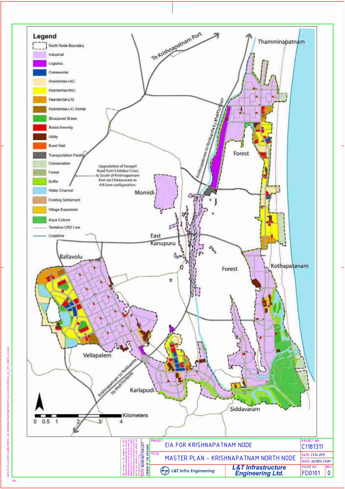
L&T Infrastructure
Engineering Ltd.
L&
T
In
frastru
ctu
re
E
ng
in
eerin
g L
td
.
L&T Infra Engineering
AutoCAD SHX Text
PATH:
AutoCAD SHX Text
TITLE:
AutoCAD SHX Text
PROJECT:
AutoCAD SHX Text
PROJECT NO:
AutoCAD SHX Text
DATE:
AutoCAD SHX Text
MADE:
AutoCAD SHX Text
FIGURE NO:
AutoCAD SHX Text
REV:
AutoCAD SHX Text
TBA
AutoCAD SHX Text
This drawing is the property of L&T drawing is the property of L&T drawing is the property of L&T is the property of L&T is the property of L&T the property of L&T the property of L&T property of L&T property of L&T of L&T of L&T L&T and must and must must must not be passed on to any person or body not be passed on to any person or body not be passed on to any person or body not passed on to any person or body not passed on to any person or body not on to any person or body not on to any person or body not to any person or body not to any person or body not any person or body not any person or body not person or body not person or body not or body not or body not body not body not not not authorised by us to receive it nor be copied by us to receive it nor be copied by us to receive it nor be copied us to receive it nor be copied us to receive it nor be copied to receive it nor be copied to receive it nor be copied receive it nor be copied receive it nor be copied it nor be copied it nor be copied nor be copied nor be copied be copied be copied copied copied or otherwise made use of either in full or in otherwise made use of either in full or in otherwise made use of either in full or in made use of either in full or in made use of either in full or in use of either in full or in use of either in full or in of either in full or in of either in full or in either in full or in either in full or in in full or in in full or in full or in full or in or in or in in in part by such person or body without our by such person or body without our by such person or body without our such person or body without our such person or body without our person or body without our person or body without our or body without our or body without our body without our body without our without our without our our our prior permission in writing.
AutoCAD SHX Text
EIA FOR KRISHNAPATNAM NODE
AutoCAD SHX Text
C1181311
AutoCAD SHX Text
CORNER OF THE DRAWING
AutoCAD SHX Text
REFER BOTTOM LEFT
AutoCAD SHX Text
JACOBS-CH2M
AutoCAD SHX Text
23.04.2019
AutoCAD SHX Text
MASTER PLAN - KRISHNAPATNAM NORTH NODE
AutoCAD SHX Text
0
AutoCAD SHX Text
FD0101

Appendix I
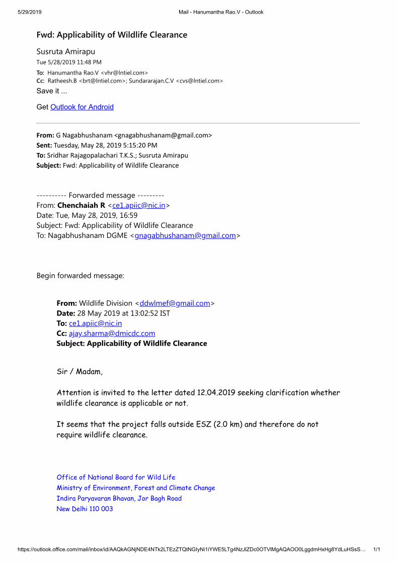
5/29/2019 Mail - Hanumantha Rao.V - Outlook
https://outlook.office.com/mail/inbox/id/AAQkAGNjNDE4NTk2LTEzZTQtNGIyNi1iYWE5LTg4NzJlZDc0OTVlMgAQAOO0LggdmHxHg8YdLuHSsS… 1/1
Fwd: Applicability of Wildlife Clearance
Susruta AmirapuTue 5/28/2019 11:48 PM
To: Hanumantha Rao.V <[email protected]>Cc: Ratheesh.B <[email protected]>; Sundararajan.C.V <[email protected]>
Save it ... Get Outlook for Android
From: G Nagabhushanam <[email protected]> Sent: Tuesday, May 28, 2019 5:15:20 PM To: Sridhar Rajagopalachari T.K.S.; Susruta Amirapu Subject: Fwd: Applicability of Wildlife Clearance ---------- Forwarded message --------- From: Chenchaiah R <[email protected]> Date: Tue, May 28, 2019, 16:59 Subject: Fwd: Applicability of Wildlife Clearance To: Nagabhushanam DGME <[email protected]> Begin forwarded message:
From: Wildlife Division <[email protected]> Date: 28 May 2019 at 13:02:52 IST To: [email protected] Cc: [email protected] Subject: Applicability of Wildlife Clearance
Sir / Madam, Attention is invited to the letter dated 12.04.2019 seeking clarification whetherwildlife clearance is applicable or not. It seems that the project falls outside ESZ (2.0 km) and therefore do notrequire wildlife clearance. Office of National Board for Wild LifeMinistry of Environment, Forest and Climate Change Indira Paryavaran Bhavan, Jor Bagh Road New Delhi 110 003

L&T INFRASTRUCTURE ENGINEERING LIMITED
6-3-1192/1/1, 5th Floor, Block No.3, White House, Kundan Bagh, Begumpet, Hyderabad – 500 016
Ph: 91 -040 – 40354444 ; Fax: 91-040-40354430