Environmental Impact Assessment NASSAU …best.gov.bs/Webdocs/EIA Draft 08 Nov 20.pdfEnvironmental...
53
Environmental Impact Assessment NASSAU HARBOUR PORT IMPROVEMENT PROJECT, NASSAU, BAHAMAS. DRAFT 20 November 2008 Prepared for Cox & SHAL Consultants and the Government of the Bahamas Prepared by Blue Engineering Ltd. For further information please contact Michelle Lakin at (242) 324-7850 650 East Bay Street, P. O. Box SS6328 Nassau, BahamasI
Transcript of Environmental Impact Assessment NASSAU …best.gov.bs/Webdocs/EIA Draft 08 Nov 20.pdfEnvironmental...

Environmental Impact Assessment NASSAU HARBOUR PORT IMPROVEMENT PROJECT, NASSAU, BAHAMAS. DRAFT 20 November 2008 Prepared for Cox & SHAL Consultants and the Government of the Bahamas Prepared by
Blue Engineering Ltd. For further information please contact Michelle Lakin at (242) 324-7850 650 East Bay Street, P. O. Box SS6328
Nassau, BahamasI

Environmental Impact Assessment, Nassau Harbour Port Improvement Project, Nassau, Bahamas
DRAFT 00, November 20, 2008 1
TABLE OF CONTENTS TABLE OF CONTENTS 1 EXECUTIVE SUMMARY 4 1. INTRODUCTION
1.1 Introduction and objectives 5 1.2 Harbour Dredging and Environmental Impact Assessment 6 1.3 Project Rationale 6 1.4 Terms of Reference 6 1.5 Methodology 6 1.5.1 Sediment and marine benthic survey 6 1.5.2 Water quality 7
2. PROPOSED DREDGING PROJECT
2.1 Dredging Plan 7 2.1.1 Channel (Dredge Area 3) 7 2.1.2 Turning basin (Dredge Areas 1 and 2) 7 2.1.3 Prince George Wharf (Dredge Areas 4 and 5) 7 2.2 Volumes and Types of Sediments to be Dredged 8 2.2.1 Channel (Dredge Area 3) 8 2.2.2 Turning Basin (Dredge Areas 1 and 2) 8 2.2.3 Prince George Wharf (Dredge Areas 4 and 5) 8 2.3 Sediment contamination 8 2.4 Dredging equipment and methodology 8 2.4.1 Hydraulic cutter suction dredge (HCSD) 9 2.4.2 Trailing suction hopper dredge (TSHD) 9 2.4.3 Environmental factors related to dredge type 9 2.5 Disposal of Dredged Materials 9 2.5.1 Disposal of fine sediments 9 2.5.2 Disposal of coarse materials 9 2.6 Duration of dredging works 10
3. PROJECT SETTING
3.1 Physical Environment 11 3.1.1 Geomorphology and Bathymetry 11 3.1.2 Marine Substrates 13 3.1.3 Climate 13 3.1.4 Wind 15 3.1.5 Storms 15 3.1.6 Waves 15 3.1.6.1 Offshore Deep-water Waves 15 3.1.6.2 Inshore Coastal Waves 15 3.1.7 Tides 16 3.1.8 Currents 16 3.1.8.1 Offshore Deep-water Currents 16 3.1.8.2 Inshore Coastal Currents 17 3.1.9 Surface drainage 17 3.1.10 Marine water quality 17 3.2 Biological Environment 19 3.2.1 Terrestrial ecology 19 3.2.2 Marine Ecology 19 3.2.3 Protected areas 21

Environmental Impact Assessment, Nassau Harbour Port Improvement Project, Nassau, Bahamas
DRAFT 00, November 20, 2008 2
3.3 Socio-economic Environment 21 3.3.1 Demography 21 3.3.2 Land use 21 3.3.3 Education 21 3.3.4 Employment 21 3.3.5 Economic Activities 21
3.3.5.1 Tourism 23 3.3.5.2 Commerce 23 3.3.5.3 Shipping 23 3.3.5.4 Fishing 25 3.3.5.5 Diving/Snorkeling 25
3.3.6 Natural and technological hazard vulnerability 25 4. ENVIRONMENTAL POLICY, LEGISLATION AND REGULATORY FRAMEWORK 27 5. POTENTIAL ENVIRONMENTAL IMPACTS 27
5.1 Dredging 27 5.1.1 Excavation 27 5.1.1.1 Loss of seagrass and coral communities 27 5.1.1.2 Modification of wave and current pattern inside harbour 28 5.1.1.3 Modifications to Beach stability within Nassau Harbour 29 5.1.1.4 Sediment dispersal 29 5.1.1.5 Water turbidity 30 5.1.1.6 Shipping hindrance 33 5.1.2 Hopper dredge spillage and leakage 33 5.1.2.1 Deliberate spillages 33 5.1.2.2 Accidental spillages 33 5.1.3 Noise 33 5.1.4 Visual/seascape impacts 34 5.1.5 Impairment of fishing activities 34 5.2 Spoil disposal 35 5.2.1 On Land disposal 35 5.2.2 Inshore sea disposal 35 5.2.3 Deep-sea disposal 35 5.3 East Breakwater 36 5.4 Mooring Dolphins 36 5.5 Summary of Potential Impacts 36
6. PROJECT ALTERNATIVES 37
6.1 ‘No Dredging Project’ Scenario 37 6.2 Dredge Type and Area 37 6.2.1 Dredge Type 37 6.2.2 Dredge Area 37 6.3 Disposal Options 37 6.3.1 On-land disposal 37 6.3.2 Shallow sea disposal 38 6.3.2.1 Inshore disposal 38 6.3.2.2 Deep- sea disposal 38 6.3.3 East Breakwater 38 6.3.4 Mooring Dolphins 38
7. IMPACT MITIGATION MEASURES AND COSTS 39
7.1 Mitigation Measures 39 7.2 Mitigation Costs 41

Environmental Impact Assessment, Nassau Harbour Port Improvement Project, Nassau, Bahamas
DRAFT 00, November 20, 2008 3
8. IMPACT MONITORING PLAN 41 9. EMERGENCY CONTINGENCY PLAN 43 10. CONCLUSIONS AND RECOMMENDATIONS 44
10.1 Conclusions 45 10.2 Recommendations 45
FIGURES 2.1 Proposed extension to Arawak Cay 3.1 Nassau Harbour 3.2 The Florida Current. 3.3 Map of the Commonwealth of the Bahamas indicating the Tongue of the Ocean 5.1 Turbidity standards 5.2 Turbidity monitoring measurement locations APPENDICES Appendix A. Request for Proposals – For planning, design, engineering and construction management
services for the dredging of Nassau Harbour and the installation of mooring dolphins and Addendum No. 3.
Appendix B. Figures indicating Dredge Areas Appendix C. Photographs Appendix D. Environmental Management Plan Outline. Appendix E Turbidity Monitoring Summary Spreadsheet Examples

Environmental Impact Assessment, Nassau Harbour Port Improvement Project, Nassau, Bahamas
DRAFT 00, November 20, 2008 4
EXECUTIVE SUMMARY
The Government of the Bahamas through the Ministry of Works & Transportation (MOW) and Cox & SHAL Consultants has requested the services of Blue Engineering to provide an Environmental Impact Study (EIA) for the dredging of the Nassau Harbour, the installation of mooring dolphins at Prince George Wharf, and the repair of the east breakwater to the harbour entrance in order to accommodate the larger cruise ships and address the damaged breakwater which has protected the harbour for a number of years. The assessment addresses specific key issues as agreed between MOW and Cox & SHAL Consultants following the Request for Proposal (RFP) and subsequent addenda and Terms of Reference (TOR). The study investigates dredging Nassau Harbour to increase the length of the Turning Basin and widen the outer portion of the approach channel. The extent of the proposed dredging area, located in western Nassau Harbour, totals approximately 2 million cubic yards of material. Consideration has been given to the use of this material for the extension of Arawak Cay, a man made island located west of the proposed dredging area however this is not part of this study and will be covered under a separate study. In support of this EIA, the following studies have been carried out;
• A geotechnical study to determine the type and quality of the material to be dredged. • An inventory and mapping of the marine species and habitats in the areas to be dredged and
surrounding impact areas. • A hydrodynamic model to evaluate the potential for the proposed dredging of the harbour to
impact waves in the channel. • A wave and shoreline assessment study to evaluate the potential for the proposed dredging to
impact adjacent shorelines, specifically the Esplanade Beaches. • Sediment sampling and laboratory testing to determine the quality of the potential for release of
contaminants during dredging. • Water quality sampling in the harbour to provide baseline water quality conditions.
Based upon the completion of the studies, specific environmental design components, potential benefits, and findings from the environmental studies are summarized as follows;
• The dredging of the harbour will provide improved navigation and accessibility for larger cruise ships.
• Outside the harbour the material to be dredged is solely bedrock, within the harbour there is a layer of sand from 0 – 14 feet deep above the bedrock.
• The preferred method for excavation utilizes a hydraulic rock cutter suction method (HCSD). A pipeline will need to be laid through the harbour to transport the material.
• The dredging of the shallow areas adjacent to the channel will create a direct loss of seagrasses. Included in the loss of this seagrass area are losses of benthic organisms presently inhabiting these areas. The general existing quality of these seagrass areas is fair.
• The dredging will alter the local wave directions and heights. The wave height increases are predicted to be in the order of 2 to 5% of the offshore wave height.
• The dredging will alter the local currents within the harbour with the general result being a reduction in the magnitude of currents in the harbour.
• Blasting within the dredge area may be necessary. Blasting is not recommended as it has the potential to create significant impacts to marine life within the harbour with specific concern relative to the dolphin holding pens located near the dredging areas.
• Sediment sampling and laboratory testing shows that contaminants are well below levels for concern (EPA criteria) therefore the potential for release of contaminants during dredging is not of concern.

Environmental Impact Assessment, Nassau Harbour Port Improvement Project, Nassau, Bahamas
DRAFT 00, November 20, 2008 5
• Water quality sampling indicates that water quality conditions in the harbour are such that the water samples have elevated Total Plate Counts and Total Coliform Counts. This condition is not unusual for water that is of salt water origin. Fecal coliform was undetected in all samples.
• The installation of mooring dolphins will extend the effective length of the central and northern piers at Prince George Wharf, otherwise these will have an insignificant environmental impact.
• The impact of the repair of the east breakwater is dependant on the design solution to be utilised. Further consideration should be given to the feasibility of the possible design solutions.
1. INTRODUCTION 1.1 Introduction and objectives This Environmental Impact Assessment (EIA) addresses the dredging of Nassau Harbour, the installation of mooring dolphins, and the repair of the east breakwater to the harbour. Blue Engineering prepared this document in accordance with the guidelines of the Bahamas Environment Science and Technology Commission (BEST). This EIA provides a focused assessment of the proposed dredging in terms of existing environmental conditions and potential environmental impacts to the surrounding near shore marine environment and shorelines as agreed with MOW. The assessment addresses specific key issues as agreed between MOW and Cox & SHAL Consultants following the Request for Proposal (RFP) and subsequent addenda and Terms of Reference (TOR). The RFP, subsequent addenda and TOR are included in Appendix A. Studies conducted to evaluate the efficacy of the harbour dredging include an inventory and mapping survey of the marine habitat and species existing in the harbour, sediment and water quality sampling and laboratory analysis, hydrodynamic modeling of the harbour, sediment transport modeling of the harbour, wave and shoreline impact assessment studies and geotechnical studies. The hydrodynamic modeling of the harbour, sediment transport modeling of the harbour, wave and shoreline impact assessment studies were carried out by Baird & Associates. Refer to their report ‘Wave Climate and Dredging Impacts, Nassau Harbour Port Improvement Project’ for details thereof. The geotechnical studies were carried out by Trow International Inc., refer to their report ‘Geotechnical Investigation, Part 1, Dredging, Nassau Harbour Port Improvement Project’ for details thereof. Nassau Harbour is situated in northern New Providence, south of Paradise Island. The harbour is utilised by many ships for shelter and storage as well as a navigation channel and is most notably visited on a regular basis by numerous cruise ships bringing a large number of visitors to the island. The harbour has been dredged a number of times including in the mid 30s, 1967 when the entrance channel was enlarged and 1989 when minor changes were made to the approach channel and the turning basin was enlarged to a depth of 37 feet, however due to developments in the cruise line industry there are now larger liners which would require the widening and dredging of the harbour to 40 feet in the approach to the harbour and 38 feet within the harbour in order to access the harbour. The MOW intends to increase the capacity of the deep-water harbour at Nassau Harbour, so as to allow for safer maneuvering of ships and to accommodate slightly longer cruise ships at the Prince George Wharf. To do so it proposes to carry out the minimal amount of dredging required along the approach channel and within the harbour to improve navigational safety. The areas to be dredged are indicated in Appendix B. These areas differ to those in the TOR after further studies found that these areas could be better defined. This has resulted in an overall reduction in the dredge areas. It is also proposed to install mooring dolphins to effectively increase the length of the centre and north piers at Prince George Wharf, and repair the east breakwater to the harbour to reduce the entry of wave energy.

Environmental Impact Assessment, Nassau Harbour Port Improvement Project, Nassau, Bahamas
DRAFT 00, November 20, 2008 6
1.2.1 Harbour Works and Environmental Impact Assessment The Ministry of Works (MOW) intends to increase the capacity of the deep-water harbour at Nassau Harbour, so as to allow for safer maneuvering of ships and to accommodate slightly longer cruise ships at the Prince George Wharf. To do so it proposes to carry out the minimal amount of dredging required along the entrance channel and within the harbour to improve navigational safety. Dredging would seek to achieve depths of up to 40 feet in the approach channel and 38 feet within the harbour. Dredging can be defined as the process of removal of submerged material from the seabed or from other water bodies by use of various types of excavation machinery. The MOW also wish to install mooring dolphins and repair the damaged portion of the east breakwater at the entrance to the harbour as part of this project. Given the potentially significant adverse environmental impacts associated with dredging and the other works in the marine environment in Nassau harbour, the MOW has requested the preparation and submission of an Environmental Impact Assessment (EIA) report to inform the permit application review process. 1.3 Project Rationale Worldwide, cruise shipping is currently experiencing a period of substantial growth and the Caribbean has emerged as the world’s most popular cruising area. Within this context, due to its inherent natural beauty and strategic geographic location, The Bahamas is a favoured destination. However, Nassau, the cradle of tourism and cruise shipping in The Bahamas, cannot accommodate the large mega-liners now entering the market owing to its physiographic constraints. In addition, the Bahamas Government is presently completing a major port and waterfront development project for Nassau Harbour. Cruise ship arrivals in the Bahamas have been in decline in recent years and will continue to decline without this project. 1.4 Terms of Reference The Request for Proposal (RFP) for the Supplemental EIA for the proposed dredging works is provided at Appendix A. An addendum which requested a full EIA was later issued. This is Addendum No. 3 which is also included in Appendix A. Following the issuing of these documents a meeting was held with Cox & SHAL Consultants and the MOW to further determine the requirements of this document. The level of detail contained within this document is based on that agreed at this meeting and the documents contained within Appendix A used as a guideline. It is to be noted that this EIA is solely concerned with the proposed dredging works and other improvements through the installation of mooring dolphins and the repair of the east breakwater at Nassau Harbour. It is the intention of the MOW to carry out a separate EIA, if required, of any plans for improvements of the Arawak Cay and Nassau Harbour when these have been completed. 1.5 Methodology 1.5.1 Sediment and marine benthic survey The drilling and soil sampling was carried out under the direction of Trow International Inc. between May 22 and June 9, 2008. The drilling was undertaken in hollow stem augers from a jack up barge using a CME 55 drill rig. The sediments at fourteen stations (BH1 – BH3, BH6 – BH17 excluding BH15) were sampled at a depth of 3 feet other than BH18 for which no sample was taken due to there being bedrock only and BH13 whose sample was taken at 0-1.5 feet. These borehole locations are shown in Appendix B. The sediment was collected within plastic bags and a simple qualitative examination of the samples was subsequently conducted. Soil sampling was carried out in accordance with United States Environmental Protection Agency (EPA) Field Sampling Guidance Document #1205 – Soil Sampling. Further geotechnical investigations of borehole samples were carried out and are reported by Trow International Inc. in their report ‘Geotechnical Investigation, Part 1, Dredging Nassau Harbour Port Improvement Project’.

Environmental Impact Assessment, Nassau Harbour Port Improvement Project, Nassau, Bahamas
DRAFT 00, November 20, 2008 7
Soil analysis was carried out in accordance with EPA 6010B other than for mercury which was as per EPA 7471. The soil analysis results presented in Section 3 is a summary for the samples collected between May 22 and June 9. Seagrass communities and coral reefs at the entrance of the approach channel and within Nassau Harbour were assessed by a combination of boat patrolling, exploratory grab sampling and underwater visual observations. 1.5.2 Water quality Water was sampled at eleven stations (BH1 – BH3, BH6 – BH9 and BH15 – BH18 inclusive). Water analysis was carried out in accordance with the Standard Methods 18
th Edition. The water quality results
presented in Section 3 is a summary for the samples collected between May 22 and June 9. The parameters measured are: residua chlorine, total and faecal coliform bacteria and total plate count. All samples were collected in either sterilized glass jars or plastic sample bags, placed on ice and analysed within 24 hours. Laboratory analyses used certified methodology, primarily from the text ‘Standard Methods for Examining Water and Wastewater’. We are aware that other data has and continues to be collected for the 2008 WSSS Practicum/UEP Field Project ‘Integrated Assessment of Impacts of Stormwater in Coastal Zone of Nassau, New Providence, The Bahamas’. To date this information has not been made available to us, reference should be made to this information once available.
2. PROPOSED DREDGING PROJECT
Available records show that the channel into Nassau Harbour was last dredged in 1967. This was reportedly done using a bucket dredge. It is reported that at that time the channel was dredged to a minimum depth of -40.3 feet and -38.3 feet closer to Prince George Wharf. 2.1 Dredging Plan The original project brief provided by MOW for the EIA is shown at Appendix A. These initial design considerations have since been refined by the consulting engineers and the proposed dredging works are shown at Appendix B. This difference is a result of further studies of the required dredging area which have resulted on an overall reduction in the dredge area and subsequent volumes. 2.1.1 Channel (Dredge Area 3) The proposed dredging project intends to excavate the approach channel to give a wider angle of approach, and minimum depth of 40 feet. This will require dredging immediately outside the harbour, south of the existing channel, a total area of approximately 313,000 square feet. 2.1.2 Turning basin (Dredge Areas 1 and 2) The proposed dredging project intends to excavate for a 1700 foot wide by 3000 foot long turning basin in the harbour. This will require the excavation of both north and south edges of the existing harbour (areas 1 and 2 respectively) which are approximately 812,000 and 727,000 square feet respectively. 2.1.3 Prince George Wharf (Dredge Areas 4 and 5) An amount of dredging will be carried out off the end of Prince George Wharf, extending 460 feet north of the end of the wharf, in order to safely accommodate the larger cruise ships. This is a total area of approximately 446,000 square feet.

Environmental Impact Assessment, Nassau Harbour Port Improvement Project, Nassau, Bahamas
DRAFT 00, November 20, 2008 8
2.2 Volumes and Types of Sediments to be Dredged From existing depth information for Nassau Harbour it has been estimated that a total of 2 million cubic yards of dredged material will be generated by the proposed works. Refer to borehole data available to definitively characterize the substrates to be dredged in the harbour. 2.2.1 Channel (Dredge Area 3) The substrate to be dredged at the mouth of the approach channel is weak calcareous limestone (bedrock) occurring at depths between 15 – 25 feet with no sand cover. It is likely that this will require use of a cutter suction dredge for its removal. 2.2.2 Turning Basin (Dredge Areas 1 and 2) The material to be dredged to increase the size of the turning basin for area 2 (the southern portion) is bedrock occurring at depths between 15 – 25 feet above which there is a layer of 0-14 feet of loose sand (the amount of sand increasing in an easterly direction). The material to be dredged at area 1 (the northern portion) is bedrock occurring at depths between 6 – 7 feet above which there is a layer of 1-4 feet of loose sand. A cutter suction dredge is likely to be required for the removal of the bedrock however consideration may be given to the use of a Trailing Suction Hopper Dredger (TSHD) to dredge the sand. 2.2.3 Prince George Wharf (Dredge Area 5) The material to be dredged at Area 5 (the northern portion) is bedrock occurring at depths between 10 – 20 feet above which there is a layer of 0.5-5.5 feet of loose sand. The dredging method at this location would be similar to that for areas 1 and 2 above. 2.3 Sediment contamination Dredging and spoil disposal has the potential to reintroduce and redistribute toxic chemicals deposited in the sediments into the water column, owing to the presence of various operations in the vicinity of Nassau Harbour, it was decided at the outset of the EIA study to carry out chemical determinations for potential contaminants in the harbour sediments. These contaminants included the following;
a) Arsenic b) Copper c) Cadmium d) Lead e) Mercury f) Zinc g) Nickel
2.4 Dredging equipment and methodology Excavation of the harbour area and relocation of the dredged material to a location where it may be used would most economically be accomplished by using a hydraulic cutter suction dredge (HCSD) for the excavation and suction-pipeline methodology for transport of the dredged material. The use of a Trailing suction hopper dredge (TSHD) is also considered for use for dredging the loose sand layer where present. A pipeline corridor would be established at least 3 feet deeper than the navigation design depth when the pipeline must go through a navigation channel. Transporting the material by barge is also an option however this is not recommended. Disadvantages of transporting material by barge include the following;
• Longer time to complete the transfer (10,000 cubic yards can be transported by pipeline whereas 6,000 to 8,000 cubic yards can be transported by barge).
• Additional equipment required in the harbour area obstructing other vessels and the dredging equipment.
• Typically 50 to 100 percent higher cost than by transporting by pipeline

Environmental Impact Assessment, Nassau Harbour Port Improvement Project, Nassau, Bahamas
DRAFT 00, November 20, 2008 9
• Potentially further increased costs due to the draw required by the barge (usually 18 to 22 feet of water), which may make it difficult or impossible for the barge to get close to the offloading location necessitating the use of alternative methods to offload the material.
2.4.1 Hydraulic cutter suction dredge (HCSD) An HSCD is likely the most suitable type of equipment for dealing with the firm stony materials such as that which will be encountered in carrying out the proposed capital dredging however it will be at the Contractors discretion to determine the most suitable equipment to use for the dredging. Hydraulic dredgers use centrifugal pumps to provide the digging and lifting force to “suck up” excavated seabed material in slurry form. HCSDs have “cutter heads”, fitted with tough metal teeth, which rotate and bore into the seabed material, thereby enhancing the effectiveness of the suction force. HCSDs remain stationary while excavating, supported on legs called “spuds” which anchor them in position. The cutter head does its digging supported at the tip of the dredge’s “ladder”, at the end of the suction pipeline. The ladder is swung from side to side in small arcs while digging, leaving a characteristic scalloped pattern to the edges of the dug out areas. 2.4.2 Trailing suction hopper dredge (TSHD) TSHDs are very frequently used to carry out dredging of loose materials. TSHDs are self-propelled ships that can have either one or two tubular “drag-arms” extending from the side(s) of the vessel down into the water, with the tips of the tubes kept close to the sea floor of the area to be dredged. By hydraulic suction, the sediments are sucked up from the bottom of the sea floor through the drag arms and placed in the hold or hopper on the vessel. The TSHD slowly traverses the area to be dredged, trailing its drag-arm and sucking up loose sediments until the hold of the ship is filled to capacity. The vessel then sails to the disposal site and deposits the sediments by opening the bottom-opening gates of the hold. 2.4.3 Environmental factors related to dredge type Table 2.1 lists the relevant environmental considerations related to the types of dredge vessel currently available to implement the proposed dredging at Nassau Harbour. 2.5 Disposal of Dredged Materials 2.5.1 Disposal of fine sediments There are two options available for the disposal of fine sediments. These will be in the form of silty sand to sandy silt which can be settled out in stilling ponds until the water reaches an acceptable turbidity for disposal offshore. Alternatively these fine sediments could be disposed of at a depth of 500m. It is expected that the flowing currents would effectively disperse the sediments with very little likelihood of them being washed ashore in any appreciable or unacceptable quantities. 2.5.2 Disposal of coarse materials It is preferred to locate the stockpile within one mile of the dredge location to maintain dredge efficiency and keep the dredging costs down. The logical stockpile location is the unused space on Arawak Cay. This space is estimated to be able to accommodate 600,000 cubic yards of dredged material. Various options to reclaim land to provide for storage of the remaining material at Arawak Cay have been considered. The preferred option which has been accepted by the Government is the westward extension to Arawak Cay (see Figure 2.1) which would utilise 900,000 cubic yards of the remaining dredge material and would enable the stockpiling of a further 500,000 cubic yards (i.e utilise all 2 million cubic yards). This material would not be re-suspended by wave action, including that during normal storm activity due to the proposed construction of steel sheet piles to protect the material. Again it should be noted that the proposed extension is not covered by this document but will be covered under a separate EIA.

Figure 2.1 Proposed extension to Arawak Cay

Table 2.1 Comparison of environmental factors related to type of dredge vessel (based on Smits (1998))
Environmental Effects Criteria
Cutter Suction Dredge Trailing Suction Hopper Dredge
Accuracy of excavated profile
Good (about 10 inches) Low (1.5 – 3 feet vertically, 9-33 ft horizontally)
Increase of suspended sediments
Variable depending on ladder swing speed and cutter head rotation speed).
Low at draghead. Can be high at dredge site if loading continuous with overflow of excess water. Pronounced in case of fine sediments.
Mixing of different soil layers
Depth of sediment should be greater than size of cutter head
Accurate control achievable.
Creation of loose (mobile) spill layers
Tendency to leave thick spill layer in soft sediments.
Little residual spill layer at draghead. Larger spill layer if large quantities of overflow allowed.
Dilution Variable amounts of water added depending on sediment type.
Significant amounts of water added during suction process.
Noise operation High (100-115 dB in immediate vicinity, 50 – 70 dB at few hundred feet).
High (100-115 dB in immediate vicinity, 50 – 70 dB at few hundred feet).
Normal output rate 1,650 – 252,500 cubic feet per hour
1,650 – 330,000 cubic feet per hour
2.5 Duration of dredging works The amount of dredging to be carried at Nassau Harbour is considered to be a major operation. Allowing for maintenance, downtime and pipeline work it is expected that the work will be carried out at an average rate of 10,000 cubic yards per day for a total duration of seven months. Completion of the dredging works should be signaled by conduct of a post dredging hydrographic survey to confirm conformance to the dredging design.
3. PROJECT SETTING 3.1 Physical Environment 3.1.1 Geomorphology and Bathymetry Nassau Harbour is well protected, enclosed as it is by Paradise Island to the North, New Providence to the South and Arawak Cay and breakwaters to the West. The western approach to the harbour is, partially protected by breakwaters, the most eastern one of which has suffered some damage, reportedly mainly from the 1991 ‘Halloween’ Storm. Cruise ships, cargo vessels and yachts use this eastern approach to enter the harbour. The eastern entrance to Nassau Harbour is located directly to the east; smaller vessels use this entrance due to the shallower nature of this approach as well as the presence of two bridges limiting accessibility. Refer to Figure 3.1 which shows the approaches and Appendix B which indicates the depths within the harbour. The depths within the harbour are generally 40 feet. The

Copyright: This map is reproduced with permission of the Owner.
Figure 3.1 Nassau Harbour

Environmental Impact Assessment, Nassau Harbour Port Improvement Project, Nassau, Bahamas
DRAFT 00, November 20, 2008 13
transition from the harbour area to the adjacent shallow areas is abrupt, with near vertical walls at the edge of the channel. The transition or connection section of the east breakwater and Paradise Island have been severely damaged (a complete breach over a 330 foot length). The remnants of the breakwater are now south of the original breakwater and consist of broken tribar armour units and stone. It is reported that this damage was caused by a storm in 1991 which was characterized by very long period waves. W. F. Baird & Associates have suggested wave heights of the order of 16 feet at the breakwater during this storm. 3.1.2 Marine Substrates The following is an excerpt from Trow International Inc.’s Geotechnical Report
‘In the areas to be dredged, there are insignificant thicknesses of overburden outside the harbour and zero to 14 feet of very loose to loose calcarereous sand over the bedrock elsewhere. Immediately below the overburden, calcareous limestone bedrock was encountered at Elevations -7.5 to -25.1 feet MLWS except where it had been previously dredged deeper. Corable bedrock was not observed above the proposed dredge grades in six boreholes and it was encountered at Els. -12.0 to -24.0 feet in the other 10 boreholes.’
Drilling and soil sampling for metal analysis was carried out under the direction of Trow International Inc. between May 22 and June 9, 2008. These borehole locations are shown in Appendix B. Several metals were measured including arsenic, copper, cadmium, lead, mercury, zinc, and nickel. The soil analysis results are summarised in Table 3.1. Cadmium was not detected in any of the sediment samples. Borehole 7 had the highest levels of copper, lead, zinc and mercury of the 14 boreholes. The majority of metals found in the sediments were below sediment quality guidelines found in literature. The mercury level at borehole 7 exceeds the USEPA criteria value. This borehole along with borehole 8 were the only boreholes where mercury was detected. The fact that mercury was not detected in nearby boreholes 9 and 6 indicates that the area of heightened mercury content is restricted to a relatively small area. It is considered likely that these heightened measurements are a result of the proximity of borehole 7 and 8 to a drainage outfall. It is believed that this is the West Bay Street Jetty Drain which we understand is to be improved as part of a separate project. 3.1.3 Climate The Bahamas has a tropical maritime climate, which makes for generally year-round good weather. The Bahamas does not experience extremes of temperatures. There are two seasons: summer which is from May thru September and winter which is from October thru April. In centrally situated New Providence, winter temperatures seldom fall much below 60F degrees and usually reach about 75F degrees in the day. In summer, temperatures usually fall to 78F degrees or less at night and seldom rise above 90F degrees during the day. Relative humidity is fairly high averaging 65% yearly. The rainy season last from May thru October with most of the precipitation occurring during brief summer showers. The hurricane season spans from the 1
st June through to 30
th November when the islands may occasionally be
interrupted by the threat of a tropical storm or hurricane. However, most of the better homes are built out of concrete block which is more then enough protection from the worst hurricanes.

Environmental Impact Assessment, Nassau Harbour Port Improvement Project, Nassau, Bahamas
DRAFT 00, November 20, 2008
14
Table 3.1 Nassau Harbour soil analysis – values for samples taken between May 22 2008 and June 9 2008
Environmental Impact Assessment, Nassau Harbour Port Improvement Project, Nassau, Bahamas
DRAFT 00, November 20, 2008 15
3.1.4 Wind The wind conditions for the Caribbean Islands are dominated by trade winds which blow across the southern part of the North Atlantic Ocean (south of the Azores high pressure area). These winds approach with great constancy, primarily from the northeast and southeast directions. Some seasonal changes occur within this pattern, as a result of the relative position of the sun and the earth’s surface. In general, these seasonal changes in the annual wind regime may be described as follows: a. December to February: Winds are primarily from the NE to ENE. b. March to May: Winds are mainly from the East. c. June to August: Winds are primarily from the E to ESE. d. September to November: Winds are mainly from the E to SE. Wind speeds are influenced by the location of the Inter-tropical Convergence Zone, or ITCZ. The ITCZ is formed as a result of the convergence of north-east and south-east winds in a belt around the equator. This belt migrates north and south of the equator, in tandem with the suns motion. Since the ITCZ is characterised by wind uplift (as a result of convergence), surface wind speeds tend to be low in the vicinity of this feature. The ITCZ is closest to the Caribbean Islands between June and November. These months, therefore, have the lowest average wind speeds, compared with the rest of the year. Specific to Nassau Harbour, based upon local knowledge and observations prevailing winds at the site occur from the easterly trade winds. Mean wind speed in Nassau are typically 8.1 mph (7 knots) with maximum winds speeds averaging 9.3mph (8 knots) for March. Maximum wind velocities are experienced during hurricanes which are further discussed below. 3.1.5 Storms Nassau Harbour is located within the Atlantic Tropical Cyclone basin. The number of storms per year is variable in both the short and long term. Table 3.2 shows the number of storms per year passing within 200 miles of Nassau Harbour. The average number of storms is 0.82 storms per year (based on the data from 1900 to present). Storm surge occurs due to the onshore movement of water from onshore wind, and from the rise in the mean sea level as a result of low pressures in the centre of a storm. In Nassau, storm surge is typically related to the passing of a tropical storm or hurricane. Storms near Nassau (deepwater) have had a characteristic wave height of as much as 10.5 m. This is approximately equal to the significant wave height (average of the highest one-third of the waves) in deep water. These storms or hurricanes usually bring the extreme wind conditions with winds as great as a category 5 hurricane (135 knots/155.4 mph/250.0 km/h) having been measured in the Bahamas in the past (such as the hurricanes named ‘the Bahamas’ and ‘Fort Lauderdale’ in 1932 and 1947 respectively). 3.1.6 Waves 3.1.6.1 Offshore Deep-water Waves From wave data from the Bahamas grid between 1983 and 2008 it is clear that for conditions in water approximately 1600 feet deep north of the harbour the majority of waves are from the NNE through the NE. Waves are usually below 3 feet in height however waves as high as 14 feet have been recorded such as during the storm during which the East breakwater was damaged. These maximum wave conditions also generally occur from the NNE or the NNW due to a longer fetch. 3.1.6.2 Inshore Coastal Waves Given the extremely well protected nature of Nassau Harbour, the prevailing wave and swell wave climate does not result in waves greater than 5-10% of the offshore wave height in Nassau Harbour. Waves coming through the harbour entrance are refracted towards the southern beaches, while the berthing area is well sheltered by Paradise Island against the waves.

Environmental Impact Assessment, Nassau Harbour Port Improvement Project, Nassau, Bahamas
DRAFT 00, November 20, 2008 16
Table 3.2 Number of Tropical Storms and Hurricanes passing within 200 miles of Nassau Harbour
Year
Number of Storms
1980 1981 1982 1983 1984 1985 1986 1987 1988 1989 1990 1991 1992 1993 1994 1995 1996 1997 1998 1999 2000 2001 2002 2003 2004 2005 2006 2007
0 4 0 1 2 5 0 1 2 1 1 2 1 0 1 2 3 0 4 3 0 1 0 0 3 4 1 1
3.1.7 Tides The tides in the harbour are semi-diurnal (12.42 hour periods). The mean spring tide range is 3.5 feet, and the maximum spring tide range is 4.4 feet. In the area near the proposed harbour dredging site, the flood currents move from west to east and the ebb current vice versa. 3.1.8 Currents 3.1.8.1 Offshore Deep-water Currents The deep-water currents offshore of the northwestern coastline of The Bahamas are influenced by the Gulf Stream System. The Florida current (see Figure 3.2) can be considered the "official" beginning of the Gulf Stream System. The Florida Current receives its water from two main sources, the Loop Current and the Antilles Current. The Loop current is the most significant of these sources and can be considered the upstream extension of the Gulf Stream System.

Environmental Impact Assessment, Nassau Harbour Port Improvement Project, Nassau, Bahamas
DRAFT 00, November 20, 2008 17
Figure 3.2 The Florida Current.
3.1.8.2 Inshore Coastal Currents No drogue tracking was conducted in Nassau Harbour however observations indicated that the flood and ebb flows through the harbour entrance are noticeably greater than elsewhere, diminishing substantially north and south of this deeper channel area. It is estimated that the maximum current velocity is on average 1.25 knots. No long-term measured (e.g. current meter) data exists for Nassau Harbour that we are aware of. As indicated by W. F. Baird & Associates; longshore currents are dependant on the wave direction outside the harbour. Corresponding to a storm with a 10 foot wave height, 8s period and NW direction (though rare this is the worse case), longshore currents are towards the east along the beaches less than 4 inch/s (0.2 knots). Inside the harbour and along the southern beaches, nearshore current patterns stay similar to those described for the NW waves but with smaller magnitudes. 3.1.9 Surface drainage Various drains empty into Nassau Harbour. These are contaminated with various wastes, including sediments, from the surrounding watersheds and urban areas. The extent to which these drains impact the water quality in the harbour is not fully understood. A study is currently being carried out for the 2008 WSSS Practicum/UEP Field Project ‘Integrated Assessment of Impacts of Stormwater in Coastal Zone of Nassau, New Providence, The Bahamas’. It is understood that it is the Governments intention to improve stormwater drainage on the island and that various projects are underway to do so. 3.1.10 Marine water quality The values of the data generated by the water quality monitoring exercises conducted in Nassau Harbour between May 22
nd and June 9
th are presented in Table 3.3. Data for the following critical pollution
indicators are tabulated and discussed for the purposes of this document;

Environmental Impact Assessment, Nassau Harbour Port Improvement Project, Nassau, Bahamas
DRAFT 00, November 20, 2008 18
a) Residual Chlorine b) Total Coliforms c) Fecal Coliforms d) Total Plate Count
a) Residual Chlorine Residual chlorine is chlorine that is present in the form of hypochlorous acid, hypochlorite ions or as dissolved elemental chlorine. Chlorine is extremely toxic to aquatic life in both freshwater and saltwater. Thus, every discharger that uses chlorine has the potential to cause acute toxicity. Although a chlorination-dechlorination process can be used and maintained, it can be incomplete, leaving total residual chlorine (TRC). No residual chlorine was detected in the samples taken suggesting that the level of treated water is minimal or that the process is complete. b) Total Coliforms The elevated total coliforms that are present in the source water indicate that the general quality of the water is poor and that it is likely that the water is fecally contaminated however this is not the case. Refer to fecal coliform results discussed below. c) Fecal Coliforms The lack of presence of fecal coliform bacteria indicates that the water has not been contaminated with the fecal material of man or other animals. Fecal coliform bacteria can enter waters through direct discharge of waste from mammals and birds, from agricultural and storm runoff, and from untreated human sewage. Large quantities of fecal coliform bacteria in water may indicate a higher risk of pathogens being present in the water.
Untreated organic matter that contains fecal coliform can be harmful to the environment. Aerobic decomposition of this material can reduce dissolved oxygen levels if discharged into rivers or waterways. This may reduce the oxygen level enough to kill fish and other aquatic life. Reduction of fecal coliform in wastewater may require the use of chlorine and other disinfectant chemicals. Such materials may kill the fecal coliform and disease bacteria. They also kill bacteria essential to the proper balance of the aquatic environment, endangering the survival of species dependent on those bacteria. So, higher levels of fecal coliform require higher levels of chlorine, threatening those aquatic organisms.
The current EPA recommendations for fecal coliform levels in body-contact recreation is fewer than 100 colonies/100 ml; for fishing and boating, fewer than 1000 colonies/100 ml; and for domestic water supply, for treatment, fewer than 2000 colonies/100 ml. The drinking water standard is less than 1 colony/ 100 ml. d) Total Plate Count Total Plate Count is a bacterial enumeration procedure used to estimate bacterial density in an environmental sample. This test does not differentiate between the many different types of bacteria and is thought of as giving index to the general "housekeeping" practices. A "high" count indicates that some type of contamination is present and is undesirable. In summary, this analysis shows that the water samples have elevated Total Plate Counts and Total Coliform Counts. This condition is not unusual for water that is of salt water origin. It should also be noted that the fecal coliform was undetected. Whilst the tests carried out are very limited, in general these indicate that the water quality is in good condition. The harbour does however experience times of high turbidity as indicated by turbidity measurements carried out in May 2008 as part of the 2008 WSSS Practicum/UEP Field Project ‘Integrated Assessment of Impacts of Stormwater in Coastal Zone of Nassau, New Providence, The Bahamas’ measured turbidity with the secchi disk as well as a hydrolab. These preliminary results have found turbidity levels to be as high as 9 feet (secchi disk) with a median measurement of 33.70 feet during high tide and 23.17 feet

Environmental Impact Assessment, Nassau Harbour Port Improvement Project, Nassau, Bahamas
DRAFT 00, November 20, 2008 19
during low tide during the dry season. Measurements with the hydrolab recorded 0 NTU a majority of the time however a maximum turbidity level of 158.2 NTU was also recorded. It is likely that these maximums were recorded during times of high winds or the arrival or departure of a cruise ship (as a result of the cruise ship propellers disturbing sediments). At present these results are still to be published. 3.2 Biological Environment 3.2.1 Terrestrial ecology A description of the terrestrial flora and fauna around the harbour is not relevant to the purposes of this EIA since land-based sites for dredged material disposal are not being considered in this report. Suffice it to note that the terrestrial environment surrounding Nassau Harbour is highly urbanised and modified. 3.2.2 Marine Ecology The marine water column is defined as the open water (ocean) environment. It extends vertically from the ocean bottom to the water surface. The water column provides habitat for phytoplanknotson to carry out the processes of primary production. Zooplanknotson also utilise the water column as habitat thus creating the foundation of the ocean food web and ecosystem. Some benthic invertebrates filter the surrounding water to collect food particles that are suspended within the water column. Higher vertebrates, such as fishes, marine mammals, and sea turtles use the water column for foraging, migration as well as spawning and breeding. Generally, the seagrass bed communities tended to be restricted to the shallower regions of the harbour. In addition to seagrasses, several species of opportunistic attached green algae and coral species were intermixed. The most common of these were Halimeda Incrassata and Penicillus capitus, followed by Udontea flabellum and Avrainvilla nigricans. Solitary individuals of sponges and corals were occasionally noted within the Ttestudinum beds as well as in rocky outcrops and on the concrete members of the breakwater. The above provide the benthic community for various species. The fish observed included Nassau grouper, butterfly fish, surgeon fish, blue headed wrasse, squirrel fish and sergeant majors. The edge of the channel has some rocky bottom with very little hard coral. Healthy porites is present as well as 5 or 6 different species of sponges. Sea anenomies as well as blue headed wrasse and squirrel fish were also observed. Dredge Area 3 This is a typical soft bottom. Sea rods are prominent whilst there is also Penicillus capitus. Sargassum is present as well as the odd very young sponge. Star coral was also found to be present as well as branching fire coral. Dredge Areas 1 & 5 These areas are considered to be typical sea grass beds. The primary seagrass species comprising these beds was Thalassia testudinum. There are also some Syringodium filiforme and occasional Halodule wrightii. There is also penicillus and two types of sponge namely laurencia and halimeda. Less common were porites, hydroids, mollusks, crabs, butterfly fish and octocoral most of which were healthy. Dredge Areas 2 & 4 These areas are considered to be typical sea grass beds. The primary seagrass species comprising these beds was Thalassia testudinum. There are also some Syringodium filiforme and occasional Halodule wrightii. There is also penicillus and two types of sponge namely laurencia and halimeda. Less common were sea cucumbers, young conch, and a gold spotted eel which is considered rare to uncommon in the Bahamas.

Environmental Impact Assessment, Nassau Harbour Port Improvement Project, Nassau, Bahamas
DRAFT 00, November 20, 2008 20 20
Table 3.3 Nassau Harbour water quality data – values for samples taken between May 22 2008 and June 9 2008

Environmental Impact Assessment, Nassau Harbour Port Improvement Project, Nassau, Bahamas
DRAFT 00, November 20, 2008 21
Also, at present there are dolphin holding pens located in the harbour 2000 feet east of Prince George Wharf near the dredge area where sea lions and dolphins are kept. 3.2.3 Protected areas Established by an Act of Parliament in 1959, the Bahamas National Trust is mandated with the conservation of natural and historic resources of The Bahamas. This responsibility is achieved primarily through in-situ protection. Most of these protected areas are outside the influence of this project. The closest area of protected interest is the Sea Gardens located on the South side of Athol Island located East of Paradise Island and North of New Providence approximately 5 miles east of the proposed dredging area. This area is considered the world's oldest protected reef area namely the ‘Sea Gardens’. The Sea Gardens were created in 1892, and rescinded in 1986, from which time the Sea Gardens were said to no longer exist. However, according to Marine Resources Director, Michael Braynen, "the Sea Gardens still exist in the minds of people." Recent interest in the further development of Athol Island by Kerzner’s Atlantis Resort who proposed to build a golf course has raised interest in making this area a national park. 3.3 Socio-economic Environment 3.3.1 Demography Nassau is the capital, largest city, and commercial centre of the Commonwealth of the Bahamas. The city has a population of 210,832 (2000 census), nearly 70 percent of the entire population of the Bahamas (303,611) with an annual growth rate of 1.41% (1997 est.). Each year, visitors and overnight guests bring in excess of 1.5 billion dollars to the local economy. From January to October 2007, there were 2.3 million foreign visitors to New Providence. It is estimated that there are 3.6 million visitors to the Bahamas each year. 3.3.2 Land use The harbour area is used for commerce, recreation, housing, tourism, administration and transport, and includes a cruise ship pier, marinas, restaurants, various docks, residences and bathing beaches. Most of these areas are unlikely to be affected by the dredging activities as they are well protected however the beaches are likely to be impacted. These five beaches are located to the west of Prince George Wharf. The British Colonial hotel beach (Beach E) is 600 feet east of the Wharf and extends 350 feet in length, 580 feet west from this beach is Beach D, one in a series of beaches extending 3050 feet to the west separated by 3 groynes. Refer to Figure 5.2 which identifies these areas. 3.3.3 Education Education in the Bahamas is compulsory between the ages of 5 and 16. As of 2003, the school attendance rate was 92% and the literacy rate was 95.5%. The government fully operates 158 of the 210 primary and secondary schools in The Bahamas. The other 52 schools are privately operated. Enrollment for state primary and secondary schools is 50,332, with more than 16,000 students attending private schools. Some public schools lack basic educational materials and are overcrowded. The College of The Bahamas, established in Nassau in 1974, provides programs leading to bachelors and associates degrees. Several non-Bahamian colleges also offer higher education programs in The Bahamas. 3.3.4 Employment About half the working population is employed in the tourist trade assisting the 3.6 million visitors who arrive in the Bahamas each year. The other major employers are in the financial and business services. The direct employment content of the proposed dredging project is negligible. 3.3.5 Economic Activities The Bahamas is one of the wealthiest Caribbean countries with an economy heavily dependent on tourism and offshore banking. Tourism together with tourism-driven construction and manufacturing accounts for approximately 60% of GDP and directly or indirectly employs half of the archipelago's labor force. Steady growth in tourism receipts and a boom in construction of new hotels, resorts, and residences had led to solid GDP growth in recent years, but tourist arrivals have been on the decline since 2006. Financial services constitute the second-most important sector of the Bahamian economy and, when combined with business services, account for about 36% of GDP. However, since December 2000, when the government enacted new regulations on the financial sector, many international businesses have left The Bahamas. Manufacturing and agriculture combined contribute approximately a tenth of GDP and show little growth, despite governmen

Figure 5.2 Turbidity monitoring measurement locations

Environmental Impact Assessment, Nassau Harbour Port Improvement Project, Nassau, Bahamas
DRAFT 00, November 20, 2008 23
incentives aimed at those sectors. Overall growth prospects in the short run rest heavily on the fortunes of the tourism sector. Tourism, in turn, depends on growth in the US, the source of more than 80% of the visitors. 3.3.5.1 Tourism Tourism dominates the Bahamian economy. In 1999, 3.65 million people visited the islands, with 2.2 million of them arriving by cruise ship. Revenue from tourism made up 60 percent of the nation's GDP. The average tourist spent US$958 while vacationing in the Bahamas, and tourist spending overall amounted to US$1.5 billion. In 2000, there were about 81,700 people employed in the tourist industry. Most visitors are from the United States (83 percent in 1999). The largest resort in the island is the 2,340 room mega-resort Atlantis, which is owned by Sun International. It employs 5,500 people and is the second largest employer in the nation after the government.
All major cruise lines operate services to the Bahamas. To extend the stay of passengers, the government has enacted legislation that allows ships to open their casinos and stores only if they remain in port for more than 18 hours.
3.3.5.2 Commerce Nassau Harbour is the hub of commercial activity for much of the country. It is under the umbrella development of Nassau Harbour that the proposed dredging project will be contributory to the anticipated economic benefits referred to throughout. 3.3.5.3 Shipping Shipping and port facilities constitute a major land use for Nassau Harbour and therefore shipping schedules need to be considered with respect to potential short-term dislocation from dredging works. There can be as many as twelve or more ship movements (arrivals and departures) in Nassau Harbour in a single day and a number of visiting yachts. The shipping schedule for July 2009 is shown at Table 3.4 as an example of a typical month. It should be noted that the period within which dredging is planned to take place is from April 2009 to November 2009.

Environmental Impact Assessment, Nassau Harbour Port Improvement Project, Nassau, Bahamas
DRAFT 00, November 20, 2008 24
Table 3.4 Schedule of vessels docking at Prince George Wharf – July 2009.
D
AT
E
A
RR
IVA
L
D
EP
AR
TU
RE
D
AT
E
A
RR
IVA
L
D
EP
AR
TU
RE
D
AT
E
A
RR
IVA
L
D
EP
AR
TU
RE
1 0800 1800 13 0800 1800 24 0800 2300
0630 0030 0800 2300 0830
0700 0800 1700 0700 1800
1200 2330 14 0630 25 0800 1800
0800 1800 0800 1700 1100 0130
2 1100 2200 0100 2200 0700
3 0800 1800 0800 1800 0615
0800 2300 15 0800 1800 1200 2300
0830 0630 0030 0800 1800
4 1130 0130 0700 26 0800 1700
0700 0700 2330 0800
0615 0800 1800 27 0800 1800
0700 1400 16 0700 1700 0800 2300
0800 2200 1100 2300 0800 1700
1200 2330 0700 1800 28 0530
0800 1800 17 0800 1800 0800 1700
5 0800 1800 0800 2300 0700 2200
0800 0830 0800 1800
0800 1700 18 1130 0130 29 0800 1800
6 0800 2300 0700 0630 0030
7 0800 1800 0615 0700
0630 0700 1400 0700 2359
0800 1800 1200 2330 0800 1800
8 0630 0130 0500 1800 30 1100 2200
0900 19 0800 1800 31 0800 1800
0700 1800 0700 0800 2300
1200 2330 0800 1700 0830
0800 1800 20 0800 2300
9 0800 1800 21 0800 1800
0800 2200 0830
10 0800 2300 0800 1700
0830 22 0630 0030
11 0800 1800 0700
1130 0130 0700 2359
0900 0800 1800
0615 23 0800 1800
1200 2330 1100 2200
0800 1800 1100 2200
12 0800
0800 1700

Environmental Impact Assessment, Nassau Harbour Port Improvement Project, Nassau, Bahamas
DRAFT 00, November 20, 2008 25
3.3.5.4 Fishing Fishing is important to the economy of Nassau although its importance has not been quantified. There is a ready market for fish, which is sold mainly in Nassau but also abroad. This industry, is suffering from over fishing and declining yields. This project will not of itself alter the contribution of this sector, however in the wider context of the development of Nassau Harbour, the industry would benefit from both direct and indirect spin-offs associated with increased tourism and trade. It should also be noted that fishermen often bring their conch catch to Potters Cay to sell where they keep it in the water until sold to keep them fresh. 3.3.5.5 Diving/Snorkeling The following is an excerpt from the ‘Scuba Diving’ magazine;
‘Since the early days of scuba, New Providence and Grand Bahama have been on the A-list of dive destinations. Nothing compares to this island chain for sheer diversity, from outrageous walls to high-octane animal encounters. The Tongue of the Ocean, a deep oceanic trench that drops to 6,000 feet and extends to the south for more than 100 miles, wraps around the western side of New Providence, providing mile after mile of stunning wall dives. The island also offers easily accessible shallow reefs and an armada of wrecks on both its northern and southwestern sides’.
Whilst there are many diving locations around Nassau one diving location at which dive boats take divers on a regular occurrence is located on the north side of the east breakwater at the location of the damage to the breakwater. These boats anchor at this location where divers enter the water to visit and dive a nearby wreck and a man made reef at approximately 25-30 foot depth. Other dives as mentioned above are the wall dives which are done along the edge of the Tongue-Of-The Ocean, approximately 7 or 8 miles north of the proposed dredge location. Divers are usually limited to diving to a depth of 85 feet. Here different sea creatures can be seen on descent of this nearly vertical wall where there are large corals, sponges and a vast assortment of exotic fish. The nearest snorkeling tours visited on a regular basis are at the East end of Athol Island approximately 5 miles east of the proposed dredge location. 3.3.6 Natural and technological hazard vulnerability Storm surge as a result of hurricanes, and storm waves are the major natural hazards affecting the harbour area. Dredging activities could be affected if they are carried out during the hurricane season and a tropical storm or hurricane passes over or in close proximity to Nassau. There are no records of earthquake activity or tsunamis for the area. Technological hazards associated with the area include oil spills, fires, accidents, and polluted discharges from vessels.

Environmental Impact Assessment, Nassau Harbour Port Improvement Project, Nassau, Bahamas
DRAFT 00, November 20, 2008 26
Figure 3.3 Map of the Commonwealth of the Bahamas indicating the Tongue of the Ocean
4. ENVIRONMENTAL ORGANISATIONS, POLICY, LEGISLATION AND REGULATORY FRAMEWORK
The Bahamas Environment, Science, and Technology Commission (BEST) is mandated to manage a number of environmental responsibilities, including coordinating international agreements pertaining to the environment, formulating environmental policy, coordinating preservation and management of the environment throughout The Bahamas, and carrying out Environmental Impact Assessments (EIAs) for proposed development (BEST, 2008). BEST is the first government entity to be established for the purpose of protecting and preserving the environment as opposed to managing the environment with respect to human health issues. However, BEST does not have regulatory authority. As an advisory commission, it can only advise the Prime Minister or other Ministers on issues pertaining to the environment, but it does not have any capabilities of investigating environmental problems or enforcing their proposed standards (Cox, 2008). Other agencies that have responsibilities regarding the environment include the Ministry of Health and Social Services and the Department of Environmental Health Services, which are concerned with environmental threats to public health; the Department of Lands and Surveys, responsible for advising the Prime Minister on matters that involve the use of land and natural resources within The Bahamas; the Ministry of Works and Transport, along with the Department of Public Works, constructs and maintains public infrastructure and drainage, including the storm drainage system in Nassau; and finally, the Water and Sewerage Corporation is a government mandated private entity that provides water and wastewater removal for the island of New Providence.

Environmental Impact Assessment, Nassau Harbour Port Improvement Project, Nassau, Bahamas
DRAFT 00, November 20, 2008 27
The decentralized responsibility of environmental affairs has complicated coordination, accountability, and responsible use of monetary and human capacity resources. In 2005-2006 there were efforts to address these issues. The National Environmental Management Action Plan was developed to place all agencies on the same page in regards to environmental management issues. The Capacity Self-Assessment publication fed into this larger proposal, specifically outlining standards and guidelines for environmental management. The Non-governmental organizations (NGOs) of relevance in existence at present include the Bahamas National Trust (BNT), The Nature Conservancy, BREEF, Friends of the Environment, Living Jewels, reEarth, and National Hope for Andros. Governmental organisations include the Department of Lands and Surveys, the Ministry of Public Works, and the Port Authority. The proposed project will comply with all applicable Bahamian environmental standards and requirements, relevant legislation, and legal and regulatory statutes. Blue Engineering will work with the Port Authority, the BEST Commission and designated agencies during the EIA process to meet these requirements.
5. POTENTIAL ENVIRONMENTAL IMPACTS
The proposed dredging project will entail dredging of hard substrate in and on the approach channel at Nassau Harbour so as to increase the length of the turning basin and widen the approach channel. This section of the report identifies the potential environmental impacts and possible issues that could arise from implementation of the dredging works using both the cutter suction dredge and a trailing head hopper dredge. Their inclusion does not mean that they would necessarily occur or that they could not be successfully mitigated. The proposed other works include the installation of mooring dolphins at Prince George Wharf and the repair of the east breakwater both of which are also mentioned below but would have minimal impact as compared with the dredging aspect of this project. 5.1 Dredging 5.1.1 Excavation 5.1.1.1 Loss of seagrass and coral communities Dredging of the areas in the harbour will result in the short-term irreversible loss of the existing seagrass and coral communities living on the affected area. It should be borne in mind that at least 50% of the corals are presently comprised of dead individuals. The potentially negative impacts on the associated fish species are thought to be less severe given that that there are adequate reef and seagrass bed ecosystems within less than a seven mile radius of the site to which they may retreat. Over time, recruits of the same coral species are likely to recolonise the fresh rock face of the now deepened plateau and a similar ecosystem would become established. Thus, the immediate negative impact of deepening the approach channel would be reversed over the long-term period (say 10 to 30 years) for that established on the ledge. The seagrass areas (predominantly Thalassia testudinum) may recolonise on the deeper seabed as it is known to grow at depths of 100 feet however it is usually found at depths up to 30 feet due to its narrow range of adaptation to light, temperature and salinity. Without turbidity barriers the fast (1.25 knots) currents in the harbour would promote rapid sediment transport of turbid waters away from the immediate area and into the downstream areas. This will tend to reduce the time period over which undisturbed coral and seagrass species would have to endure deteriorated water clarity however it will cause the extent of the area affected to be greater than if currents were less severe. The repair of the east breakwater will have an impact on seagrasses and or corals, the extent to which will be dependant on the design solution to be utilized. The repair would kill some of the coral that have grown on the existing concrete armour units, whichever repair option is used, however the installation of new armour units will create new hard substrate suitable for new coral growth.

Environmental Impact Assessment, Nassau Harbour Port Improvement Project, Nassau, Bahamas
DRAFT 00, November 20, 2008 28
The installation of mooring dolphins will have an insignificant impact on seagrass and coral communities due to the location and extent of work involved. 5.1.1.2 Modification of wave and current pattern inside harbour As discussed in detail in W. F. Baird & Associates report dredging the harbour as proposed will in general increase wave heights and reduces currents in and near the proposed dredged area. The following identifies these changes more specifically to their areas;
• Dredging of the channel approach (Dredge Area 3) will have a limited impact on the wave conditions in the harbour. The refraction of the rare NW waves (worse case as discussed earlier) will be slightly reduced, however the constriction point at the head of the west breakwater remains, and therefore the influence is expected to be minimal. The dredging will not affect the penetration of the more common NE swells.
• Dredging along the north side of the channel (Dredge Area 1) will lessen the amount that wave energy
is expended on the north shore, resulting in a slight increase in the amount of wave energy reaching the cruise ship berths. This increase may be in the order of 5% which is considered minor and is not expected to affect the beaches.
• Dredging along the south side of the channel is not expected to cause instability to the toe of the beach.
The alignment of the edge of the dredged area will however control the wave refraction and hence redirect waves as they enter the shallow waters.
According to the report by Baird & Associates, corresponding to the storm with 3m wave height, 8s period, and 320 degree or NW direction waves (it should be mentioned again that waves from NW direction do not occur frequently, at 2% of the time, but can penetrate into the harbour more than other directions and therefore represent the worst case scenario); The following is an excerpt from Baird & Associate’s Wave Climate and Dredging Report;
‘The longshore currents are towards the east along Beaches C to E and slightly stronger than those under existing conditions. Longshore currents along Beach B, however are towards the west (there is a divergence point at Groyne 3). This means that the alignment of Beach B is likely to change somewhat once the channel is dredged. Wave heights after dredging will increase through the harbour entrance and from there along the new channel edge towards Beaches D and E for this wave condition. The increase in wave height is less than 0.5m. A corresponding decrease in wave height is observed in front of the Esplanade Beach (Beach A). A slight increase In wave height across the harbour entrance and in front of Beach B to E and a reduction of wave height in front of the Esplanade Beach is also predicted. Hurricane wave heights arriving at Beaches B to E are about 0.2 to 0.5m larger for the dredged bathymetry depending on offshore wave direction’.
‘For similar sized waves as those above, from the predominant wave direction wave heights at the harbour entrance show only minor changes after dredging. Inside the harbour however there is a slight (less than 15 cm) increase in wave height over the east half of the harbour area. Again, a corresponding decrease in wave height is observed in front of the Esplanade Beach’. Wave conditions near the cruise ship berths will increase in the order of two to five percent of the offshore wave height as a result of the dredging. The harbour presently has protection that results in waves of only 5 to 10% of the offshore wave height, so this small increase is significant compared to the presently existing wave conditions. If the harbour rarely if ever has downtime due to waves, then this increase may not be a problem. However, if the harbour does have occasional problems, then the frequency and severity of these problems may increase’.

Environmental Impact Assessment, Nassau Harbour Port Improvement Project, Nassau, Bahamas
DRAFT 00, November 20, 2008 29
5.1.1.3 Modifications to Beach stability within Nassau Harbour The wave direction, wave height and current changes as discussed above are expected to change the beach slightly under non-hurricane conditions. The effects are discussed in greater detail in the report by W. F. Baird & Associates. By preventing movement of sand along the shore the groynes will continue to anchor the beaches. Smaller waves at Beach A are likely to reduce the erosion of the beach that is currently taking place and Beach B may re-align slightly to face more westerly. No significant changes are expected in the alignment of Beaches C to E. Under hurricane conditions the beaches are expected to see 0.5m more erosion under dredged conditions to the 1.5m erosion likely to take place under existing conditions. In both cases the eroded material is expected to stay near the shoreline to come back under the action of long-period swells. The following is an excerpt from Baird & Associate’s Wave Climate and Dredging Report,,
‘In summary, beaches in Nassau Harbour are dynamic as they respond to different swell events and tropical storm events. The changes that are expected to occur due to the dredging will likely remain within the natural variation that occurs along these beaches’.
5.1.1.4 Sediment dispersal The rotary action of the cutter head in the case of a cutter suction dredge, and the dragging of the suction pipe along the bottom in the case of a hopper dredge, will disturb the substrate and place sediments into suspension. These suspended sediments may then smother nearby bottom-living flora and fauna as and when they settle. The effect will be greatest in those areas with fine sediments, which are more easily placed into suspension. The suspension of sediments would be minimised to the extent that the powerful suction pumps on the dredgers are able to suck up these materials out of the water column. The potential impacts of sediment dispersal are considered to be of moderately high significance due to the volume of material to be dredged and the high velocity of currents through the harbour. These currents could carry suspended sediments over corals living down stream as well as into the dolphin pen. The direct impacts of sedimentation, could be moderate to severe on those communities close to the dredging site. It is very unlikely that the coarse sediments brought into suspension in the channel would be carried very far to adversely impact reef as these would be expected to settle fairly rapidly. In determining the likely distance that sediment would travel we consider the worse case which would be the sands which have a settling velocity of 1 to 0.01 ft/s, a maximum current speed of 1.25 knots (2.1 ft/s) and a depth of 35 feet. Using the worse case settling velocity of 0.01 ft/s these sediment can be estimated to settle within 7,350 feet (1.4 miles). It should be noted that this does not allow for upward or turbulent currents. It should also be noted that he current velocity and hence extent of turbidity will be less than the maximum current speed of 1.25 knots between peak ebb and flood tides (i.e. for the majority of the tidal cycle). Whilst the majority of metals detected were at safe levels the mercury level at borehole 7 exceeds the USEPA criteria value. This borehole along with borehole 8 were the only boreholes where mercury was detected. The fact that mercury was not detected in nearby boreholes 9 and 6 indicates that the area of heightened mercury content is restricted to a relatively small area however the mercury is likely to enter or re-enter the water system of the harbour during dredging operations. It is considered likely that these heightened measurements are a result of the proximity of borehole 7 and 8 to a drainage outfall. It is believed that this is the West Bay Street Jetty Drain which we understand is to be improved as part of a separate project the details of which are unknown. Mercury finds its way into water primarily through air pollution from coal-fired power plants and some other industrial processes. Sources of mercury in sediment include urban and industrial runoff, and spills. Mercury may occur on the land surface in various forms. Natural (i.e. volcanoes) and anthropogenic (i.e. coal-fired power plants) emissions are sources of mercury to the atmosphere that can reach the land surface via wet and dry deposition. In urban environments, common sources include batteries, discarded laboratory chemicals, broken thermometers, hospital waste, lawn products, and pharmaceutical products. In the water, the elemental mercury is converted to methylmercury by certain bacteria, after which it moves up the food chain of fish eating one another. Young children and fetuses are most at risk because their systems

Environmental Impact Assessment, Nassau Harbour Port Improvement Project, Nassau, Bahamas
DRAFT 00, November 20, 2008 30
are still developing. Exposure to mercury in the womb can cause neurological problems, including slower reflexes, learning deficits, delayed or incomplete mental development, autism, and brain damage. Mercury in adults is also a problem, causing:
• central nervous system effects like Parkinson's disease, multiple sclerosis, and Alzheimer's disease; • heart disease; • and, in severe cases, causing death or irreversibly damaging areas of the brain.
Animals in any part of the food chain affected by the bioaccumulation of mercury can also suffer the effects of mercury pollution. Possible effects include death, reduced reproduction, slower growth and development, and abnormal behavior. Mercury is likely to enter the harbour waters as a result of the dredging however it is unlikely that the amount of mercury to enter the harbour will be noticeable, rather it will have a long-term slight effect. Further use of the material dredged between boreholes 6 and 9 should be limited to on land use where it will have least impact on the marine environment and drinking waters. 5.1.1.5 Water turbidity The suspension of fine sediments in the water column creates turbidity, which scatters and attenuates light levels and potentially affects the growth of plants and corals indirectly by reducing the availability of light and consequently the photosynthetic process in plants and coral symbionts. High levels of localised turbidity can be expected during dredging. Due to the water currents in this part of the harbour (which reach approximately 1.25 knots/2.1 ft/s), the turbidity may potentially move quite far. Most of the turbidity generated by a cutterhead dredging operation is usually found in the vicinity of the cutter. The levels of turbidity are directly related to the type and quantity of material cut, but not picked up, by the suction. The ability of the dredge's suction to pick up bottom material determines the amount of cut material that remains on the bottom or suspended in the water column. In addition to the dredging equipment used and its mode of operation, turbidity may be caused by sloughing of material from the sides of vertical cuts; inefficient operational techniques; and the prop wash from the tenders (tugboats) used to move pipeline, anchors, etc., in the shallow water areas outside the channel. Under low current conditions, elevated levels of suspended material are localised in the immediate vicinity of the cutter as the dredge swings back and forth across the dredging site. Within 10 ft of the cutter, suspended solids concentrations are highly variable but may be as high as a few tens of parts per thousand; these concentrations decrease exponentially from the cutter to the water surface. Near-bottom suspended solids concentrations may be elevated to levels of a few tenths of a part per thousand at distances of less than 1000 ft from the cutter. The use of Arawak Cay for stockpiling and a westward extension to Arawak Cay for disposal and stockpiling is considered acceptable, however, due to the design and location of the westward extension to Arawak Cay disposal area, the potential for elevated turbidity exists at this location. Disposal area management will be a significant cost for the dredging contractor and the contractor may need to construct baffle dikes or containment berms to slow the flow within the disposal area in order to maintain water quality at the outflow. Diking and/or stockpiling within the disposal area to create additional space is acceptable and turbidity curtains may be used within the disposal area. At present it is proposed that the material dredged will be piped to the disposal or stockpile area. Generally the pipeline conveys 10 percent solids and 90 percent water. The pipe will discharge to a 10 to 20 foot deep stilling pond where deposition of the solids is dependant on their weight. It is estimated that the water will meet turbidity criteria for disposal offshore in two days. Turbidity curtains should also be used where waters are disposed of to sea after containment. If criteria are not met it is suggested that filtering through geotextile and flocculation of the effluent be considered. Flocculation, a method specifically for reducing the levels of fine-grained (clay-sized) suspended solids levels in the effluent involves treating the containment area effluent or the dredged material slurry with chemical flocculants to encourage the formation of flocs (i.e., particle agglomerates) that settle more rapidly than individual particles. This agglomeration or coagulation process is accomplished by an alteration of the electrochemical properties of the particles and the bridging of particles and small flocs by long polymer chains.

Environmental Impact Assessment, Nassau Harbour Port Improvement Project, Nassau, Bahamas
DRAFT 00, November 20, 2008 31
Because of the large number of manufacturers of polyelectrolytes and the types available, preliminary screening of flocculants is necessary. Evaluation and determination of the optimum dose of several nontoxic polymers may be accomplished using jartesting procedures. These procedures will indicate the most cost-effective polymer and the optimum dosage of the polymer solution for treating the suspended solids levels, as well as the optimum mixing intensities and durations for both rapid- and slow-mixing stages. Optimum detention times and surface overflow rates for clarifying the flocced suspensions and a general indication of the volume of flocced material that must be stored or rehandled can be determined from settling tests. In order to measure turbidity levels at appropriate locations during monitoring of turbidity levels two 3,000 foot long mixing zones, in the vicinity of the dredge and the discharge point, have been defined (Figure 5.2). Mixing zones shift from one side of the operation to the other, depending on the current direction (generally easterly and westerly). The mixing zones also extend 1,000 feet offshore. Background and compliance measurements are to be taken for both the dredging and disposal site mixing zones. The background measurements are to be taken at least 2,000 feet upcurrent from the dredge and the point where discharge water is returning, clearly outside the influence of any artificially generated turbidity. Two compliance stations are to be utilized for both the dredging and disposal site mixing zones. The samples are to be taken within the densest portion of any visible turbidity plume. Examples of the limits of the dredge mixing zone, as it moves with the location of the dredge, are illustrated on Figure 5. 2. That of the dredge mixing zone is indicated in red and that of the disposal site in green. The western compliance station for the dredging mixing zone shall be no more than 1,000 feet offshore from the mouth of the deep-water entrance to the harbor. This compliance station (see hypothetical dredge location 1 on figure 5.2) shall be stationary at this location while dredging is ongoing within the harbor. When dredging proceeds offshore, The compliance station shall continuously move with the dredging to always be 1,000 feet offshore from the dredge. The western compliance station for the dredging mixing zone shall be no more than 3,000 feet down current from the dredge and shall continuously move with the dredging. The northern compliance station for the disposal site mixing zone shall be no more than 1,000 feet offshore from the mouth of the inlet between Silver Cay and Long Cay. This compliance station is to remain stationary throughout the project. The second compliance station at the disposal site shall be no more than 3,000 feet down current from the point where discharge water is returning, within the densest portion of any visible turbidity plume. This compliance station moves when the outfall location changes. All sampling is to be taken at a depth of three feet from the surface at each station and at a frequency of every six daytime hours during initial operations (no more than 10 days) and once per day thereafter.
In the absence of legislation with regards to permitted levels of turbidity in the Bahamas it is considered appropriate to refer to those of nearby Florida which of all the states and commonwealths within the United States possessing coral reef resources (e.g., Guam, Puerto Rico, the Virgin Islands, Hawaii and others) Florida stands alone with a standard that is 6 or more times higher than the others. The Florida Department of Environmental Regulation requires turbidity monitoring using the Nephelometric Turbidity Units or NTU's so that during construction, the permitee "shall not exceed 29 NTU's above the associated background turbidity levels as prescribed in the 'Monitoring Required' section pursuant to Rule 62-302, of the Florida Administrative Code".
At present the harbour experiences large variations in turbidity as a result of high winds or the arrival or departure of cruise ships. Measurements have indicated that the increase in turbidity as a result of these occurrences may be as great as 160 NTU. Due to the long term nature of the dredging project and the affects of high turbidity on the marine life it is considered important that the turbidity level during times of high turbidity is not increased. However this would necessitate dredging to cease at these times. It is unknown how often and by how much the weather affects the turbidity of the harbour. There are ship movements generally every day at approximately 0800, 1800 and 2300 hours and less frequently at 1130 hours. On average there are approximately six cruise ship movements per day in the harbour with as many as twelve or more on some days. Due to the frequency of these occurrences it is not considered feasible to cease dredging at these times. It is considered necessary therefore to use a background turbidity level that reflects turbidity levels whilst turbidity is affected by cruise ship movements. Measurements have been taken prior to commencing dredging in order to

Environmental Impact Assessment, Nassau Harbour Port Improvement Project, Nassau, Bahamas
DRAFT 00, November 20, 2008 32
determine the background turbidity level whilst turbidity is affected by cruise ships. These measurements were taken over a two day period whilst turbidity was affected by cruise ship movements and averaged to determine a background turbidity level of XXX NTU against which the 29 NTU rule is to be applied during dredging. The pre-determined limit of turbidity levels at the compliance stations will therefore be XXX + 29 = YYY NTUs. However, if background measurements exceed the pre-determined limit of YYY NTUs, the background measurement shall be used for comparison of compliance measurements. In other words, compliance measurements shall be compared with the daily background measurement or the pre-determined limit of YYY NTUs, whichever is higher. If monitoring reveals turbidity levels at the compliance sites in excess of the limit of YYY NTUs or the background measurements, whichever is higher, construction activities shall cease immediately and not resume until corrective measures have been taken and turbidity has returned to an acceptable level. Any such occurrence shall also be immediately reported to the Project Manager.
It must be clear that 29 NTU above background is the absolute maximum we recommend and any exceedance of this value must result in the suspension of dredging/disposal operations. In an attempt to prevent instituting serious mitigatory measures (cessation of activities) due to the 29 NTU (above background) maximum being exceeded, a graded system of turbidity concentrations is recommended. Instead of relying on a single turbidity concentration, a maximum at the monitoring sites of 20 NTU (above background) should be used as an early warning indicator. The contractor would thus be in more of a position to initiate mitigatory measures to avert exceeding the 29 NTU (above background) threshold if he has sufficient warning that this level is being approached. Once the 20 NTU (above background) level is attained or exceeded, the contractor should ensure that the necessary mitigatory steps are taken and documented to prevent a further increase in suspended solids
concentration, which could lead to suspension of the operation when 29 NTU (above background) is exceeded. Mitigatory steps would normally involve a slower rate of progress for both the HCSD and the TSHD (i.e. a slower rotational speed of the HCSD or a slower drag rate of suction head along the bottom of the TSHD), and a slower rate of hopper loading to control the overflow for the TSHD. It should be noted that these mitigation measures will add to the cost of dredging. If 29 NTU (above background) is attained or exceeded there should be no debate and dredging operations must be immediately suspended until levels are reduced to below the threshold mark. A report on the exceedance incident should be prepared and only after the environmental officer is satisfied that the situation has been rectified should the operation be resumed. Turbidity barriers or silt curtains are often used to limit the impact of turbidity. In some cases where relatively quiescent current conditions (0.2 ft/sec or less) are present, turbidity levels in the water column outside the curtain can be 80 to 90 percent lower than the levels inside or upstream of the curtain. While there may be a turbid layer flowing under the curtain, the amount of suspended material in the upper part of the water column, as a whole, is substantially reduced. However, the effectiveness of turbidity barriers can be significantly reduced in high energy regimes characterised by currents and turbulence. High currents cause turbidity barriers to flair, thus reducing the curtain’s effective depth; in fact, in a current of 1 knots the effective skirt depth of a 5 ft curtain is approximately 3 ft. Increased water turbulence around the curtain also tends to resuspend the fluid material layer and may cause the turbid layer flowing under the curtain to resurface just beyond the curtain. However, even under moderate currents (up to 0.5 knots), a properly deployed and maintained center tension curtain can effectively control the flow of turbid water (under the curtain). In other cases, where anchoring is inadequate and particularly at sites where tidal currents dominate the hydrodynamic regime and may cause resuspension of the fluid material as the curtain sweeps back and forth (over the fluid material) with changes in the direction of the current, the turbidity levels outside the curtain can be as much as 10 times higher than the levels inside the curtain. With respect to overall effectiveness and deployment considerations a current velocity of approximately 1.5 ft/sec appears to be a practical limiting condition for turbidity curtain use. The statistical reliability of the monitoring data set is improved with increased monitoring frequency. To determine if guidelines have been exceeded during dredging, ideally, for long-term exposures, initially, measurements should be taken every six daytime hours during initial operations (no more than 10 days), less frequent monitoring may commence once the likely levels of turbidity during operations have been established
Figure 5.1 Turbidity standards
of 5, 50, and 500 NTU

Environmental Impact Assessment, Nassau Harbour Port Improvement Project, Nassau, Bahamas
DRAFT 00, November 20, 2008 33
and found to be within the guidelines. Measurements can then be taken on a gradually less frequent period though never to be less than once daily during operations. All turbidity measurements are to be compliant with the USEPA Method 180.1. Turbidity monitoring samples shall be taken using a 12 volt DC low velocity sampling pump. The pump shall be thoroughly flushed during each sample taken. Sample shall be placed in a clean collection bottle and placed in a closed container for transport to a controlled location. Each vial shall be clearly marked and labeled. Samples shall then be transferred into the appropriate vial specifically designed for use with the LaMotte 2020 (or similar) turbidity meter. The samples shall then be analyzed. The degree of accuracy shall be less than ±2%. Control depth for extraction of the samples from the water column will be accomplished using a calibrated grade rod indicating water depth at that location. Daily monitoring reports will include the following information for each sample: a) time of day; b) antecedent weather conditions; c) tidal stage and direction of flow; and d) wind direction and velocity. Reports shall be complied daily even when no sampling is conducted. When sampling is not conducted, a brief statement shall be given to explain the rationale, such as “dredge not working” or “no sampling due to high seas”. Weekly summaries of the daily turbidity monitoring data will be submitted to the Project Manager within one week of analysis with documents containing the following information: 1) dates and times of sampling and analysis; 2) state plane coordinates (X and Y) of the sampling stations and the dredge and discharge locations, and the distance between the sampling stations and the dredge/discharge for each sample to demonstrate compliance with the above required distances; 3) a statement describing the methods used in collection, handling, storage, and analysis of the samples, as well as the authenticity, precision, limits of detection, and accuracy of the data; 4) results of the analysis; and 5) a description of any factors influencing the dredging or disposal operation or the sampling program. The summaries shall be submitted in Excel Spreadsheet (*.xls) format and follow the example in Appendix E. 5.1.1.6 Shipping hindrance The dredging will not hinder shipping as it will not be carried out in the existing channel but either side of the channel. Where a pipeline is to be utilised to transport material this pipeline is to be placed so as to cause minimal disruption to traffic in the harbour. Adequate lighting, sufficient for night time vessel operations, will be required to mark the dredge and all floating pipeline. A section of the submerged pipeline where there is sufficient water depth for safe vessel crossing is to be designated and marked. The extents of the new dredged access harbour should be well identified by buoys. The installation of the mooring dolphins will be carried out at a time so as not to hinder shipping traffic. The proposed mooring dolphins are to provide adequate lighting to be identifiable well in advance . All users of the harbour should be advised of the details of the operations, submerged pipeline and alterations made as part of the project by notification in the newspapers and radio as well as letters to the usual ships that enter the harbour well in advance of any work. At present the break in the east breakwater is somewhat confusing to persons entering the harbour. People have found it difficult to determine which opening in the breakwater is the entrance to the harbour. The repair of the breakwater would therefore eliminate this problem. 5.1.2 Hopper dredge spillage and leakage 5.1.2.1 Deliberate spillages It is a practice in some dredging operations to maximise the amount of solid material in the hopper hold by allowing the slurry water mixed with the dredged material to overflow from the vessel. In the case where fine sediments are being dredged, this results in high turbidity of the water surrounding the vessel, which could then be transported by surface water currents over sensitive habitats. A second means of deliberate spillage occurs when the bottom gates of the hopper hold are opened slightly so as to release sediments while the vessel is on route to the disposal site. Where appropriate controls and disposal site records are not in place, this practice can shorten the turn-around period for the trip with obvious financial benefits. The resulting impacts of turbidity and sedimentation would be most severe in the vicinity of any nearby reefs that may be affected dependant on the present current anytime this occurs. It should be noted that the dredging contractors engaged by MOW for

Environmental Impact Assessment, Nassau Harbour Port Improvement Project, Nassau, Bahamas
DRAFT 00, November 20, 2008 34
the proposed dredging works at Nassau Harbour should be required to keep careful logs of dredged material disposal trips so that this potential impact is not expected to occur. 5.1.2.2 Accidental spillages The amount of material leaking from the bottom gates of a hopper dredge (or hopper barge) would normally be insignificant. However, if a hard object or rock becomes lodged between the gates, then material will steadily spill out of the ship’s hold into the water column. 5.1.3 Noise Given the proximity of the 24/7 dredging operation to residential areas, marinas and yachts, the noise generated by the dredging vessels may cause a level of auditory discomfort, especially at night, which is difficult to evaluate in the absence of any noise measurements for dredging operations. However, given the close proximity of hotels to the proposed dredging works and the duration of the dredging works, it is possible that these sounds would be inconvenient. Furthermore, the dredging vessels being employed to carry out the dredging works should be modern vessels fitted out with noise abatement equipment. 5.1.4 Visual/seascape impacts Nassau Harbour already services a high load of ship traffic, and it is unlikely that the mere sight of another vessel, though large is going to make much of an impression. The turbidity associated with the CSD will probably be restricted largely to the bottom, and below the surface with the TSHD. A plume will still be visible around the dredging operation. It is possible that the visual impact will be moderately severe and localised. The overall significance of this impact will vary from person to person, but on a precautionary basis is regarded as being moderate. Whilst there is a lack of residential housing near the dredging site and the view from the main road is limited, there are a number of hotels and restaurants as well as the beaches and cruise ships and other vessels from which people will be able to see the equipment and the dredging area and associated plume could be visible to large numbers of people. It should also be noted that the view from the beaches is signed as a viewpoint.
Photo of signed viewpoint (from southern beaches looking north toward the east breakwater)

Environmental Impact Assessment, Nassau Harbour Port Improvement Project, Nassau, Bahamas
DRAFT 00, November 20, 2008 35
5.1.5 Impairment of fishing activities Apart from incidental recreational-type hand fishing done from the shoreline, no commercial fishing activities normally take place in the Nassau Harbour, except perhaps, during periods of bad weather. In that case, dredging operations could have an impact on local fishery activities through the generation of turbidity and dispersed sediments which prevent fishermen being able to see and find their fish pots and cause suffocation of fish caught in traps. It should be noted that spear fishing is prohibited within one mile of New Providence and should therefore not be affected. 5.2 Spoil disposal It is proposed to pipe the dredged material to stilling ponds for water disposal at sea after adequate settlement of materials and stockpiling on Arawak Cay. It is also proposed to use the material for the extension of Arawak Cay where further stock piling would be provided. Deep sea disposal is also an option for disposal of the dredged material. One of the main concerns with regards to the dredged material disposal is the impacts on water quality, which include those associated with increased turbidity, decreased dissolved oxygen levels, and the release of sediment-bound contaminants. Dredged material disposal typically has a short term (several hours to days) impact on the water column following discharges of solids and solutes from a barge. The greatest proportion of dredged material consists of negatively buoyant solids that sink as a turbid suspension through the water column to the sea floor. Dissolved constituents of dredged material are entrained in the turbulent water associated with the convective descent. For this reason deep sea disposal is not recommended. 5.2.1 On-land disposal It is proposed to pipe the dredged material for stockpiling on Arawak Cay. This space is estimated to be able to accommodate 600,000 cubic yards of dredged material. The remaining material would then be used to extend Arawak Cay to the west where further stock piling would be provided to accommodate all of the 2 million cubic yards to be dredged. Arawak Cay is a small Cay where there is currently a dilapidated warehouse, container handling area, water reservoir area, aggregate storage area, asphalt plant and bridge access to Silver Cay. Stockpiling on the existing area available and currently unused on Arawak Cay would have an insignificant environmental impact. There is also currently adequate space available for accommodating future traffic that may be utilized to move the material. Consideration will need to be given to the traffic impact should this material be trucked in future from the site. This would be part of a separate study. A separate set of investigations will also be required in connection with the extension of Arawak Cay. 5.2.2 Inshore sea disposal The sea floor at the proposed disposal site for material to extend Arawak Cay has not been investigated. It is likely that this area is comprised of open sand, perhaps with growths of sea grasses and sponges. The proposal to spread the sediments will smother any existing biota on the sea floor in the area to be covered and will alter the existing wave and current conditions. These will be further studied as part of a separate study. It is also suggested in W. F. Baird & Associates Report that Beach A, which is presently a narrow beach suffering erosion, with the dredging may be helpful for the beach if sand is supplied to the site. If this is to be carried out this will be by truck by land as a separate project. 5.2.3 Deep-sea disposal Impacts related to the ocean disposal of dredged material are confined mainly to temporary water column impacts and longer term benthic impacts. The disposal of fine dredged materials at sea will cause turbidity in the water column and settlement of the material over deep-water benthic communities. This is not likely to be significant at great depth since the sediments are fine grained and will therefore become quickly and widely dispersed and there is less to be impacted at greater depth. The potential severity of the impact would be dependent on the location of the disposal site relative to valuable shallow water ecosystems (e.g. coral reefs, recreational bathing waters and the ocean wall where there are many corals and other sea life). A possible proposed disposal site location is in deep water at a the 500m contour where prevailing currents will not bring the settling material back inshore. Little is known of the currents at the ocean wall. If this option is to be further considered and the disposal site proposed near the ocean wall further current studies will be necessary to

Environmental Impact Assessment, Nassau Harbour Port Improvement Project, Nassau, Bahamas
DRAFT 00, November 20, 2008 36
determine the likely impact of this method on the life on the wall. The above is not to suggest that the deep-water benthos does not contain valuable biological resources but these are, presumably, not as vulnerable to diffused sedimentation as would be shallow water coastal ecosystems. This option precludes any re-use of the dumped materials but avoids the potential impacts associated with on-land disposal and de-watering. As pointed out above, leakage of materials to be dumped while the hopper vessel is in transit through inshore waters, could have an adverse short-term impact on inshore biological resources. It is therefore suggested that a pipeline be utilised to dispose of the material by pumping from the dredger to the disposal site. 5.3 East Breakwater W.F. Baird & Associates identified four conceptual alternatives for the repair/rehabilitation of the damaged East breakwater. In summary these are as follows;
1. A more robust version of the original design. This could be of either larger concrete armour units or stone.
2. A large reinforced concrete structure 3. Construction of a breakwater along a revised alignment to the North of the existing breakwater. 4. Construction of a breakwater along a revised alignment to the South of the existing breakwater.
The main difference in the impacts of these different alternatives is the footprint upon which they impact. Construction of a solution will be costly and will only reduce the wave energy in the harbour slightly. It is recommended that further studies be carried out and this portion of the project deferred until the best solution is identified. 5.4 Mooring Dolphins The impact of the mooring dolphins to be installed is considered insignificant. 5.5 Summary of Potential Impacts The potential impacts of the project are summarised below. In some cases measures can be taken to avoid or reduce the severity of the impact, and the appropriate mitigation measures are identified below in Section 7. In other cases the impacts cannot be avoided or successfully mitigated if the project is implemented and these represent irreversible impacts. Those potential impacts relevant to the proposed project are:
Positive 1. Improved capacity of entrance channel and harbour to accept larger vessels. 2. Improved navigational safety in entrance channel. 3. Improved ship mooring space at Prince George Wharf. 4. Increased foreign exchange earnings and economic activity related to sustained/increased cruise
ship visits and tourism services. 5. Improved protection to the harbour to reduce the entry of wave energy. Negative 7. Loss of < 2,300,000 sq.ft. of seagrass community, the rare small coral head and benthic biota at the
harbour and its approach. 8. Sedimentation and turbidity over coral and seagrass communities along harbour due to suspension
and dispersal of fine sediments. 9. Possible loss of biota at disposal site for dredged material at extension to Arawak Cay. 10. Possible impacts on pelagic environment due to suspended sediments and turbidity arising from
deep-sea disposal of dredged material if this option is to be utilised. 11. Impaired visual/seascape impacts from the presence of the dredging equipment 12. Increased noise levels in the harbour due to dredging operations carried out 24 hours a day.
Environmental Impact Assessment, Nassau Harbour Port Improvement Project, Nassau, Bahamas
DRAFT 00, November 20, 2008 37
6. PROJECT ALTERNATIVES 6.1 ‘No Dredging Project’ Scenario The approach channel leading to Nassau Harbour and the harbour itself have been dredged multiple times. It was dredged in the mid 1930s, re-dredged in 1967 and again in 1989. Not implementing the required channel and basin dredging implies that The Bahamas will not be able to attract larger cruise vessels to Nassau Harbour and this opportunity for sustaining/increasing the tourism market will not be realised. There is no alternative to achieving the project objective apart from dredging or relocating the cruise ship terminal. 6.2 Dredge Type and Area 6.2.1 Dredge Type The HCSD is especially suited for the cutting and maceration of the rocky outcrops occurring in the harbour and its approach, which the THSD would not be able to do. The THSD is better able to remove the soft sediments found above the rock in places in a manner that would least disturb and place the sediments into suspension. The equipment to be used is to be determined by the Contractor. The expense of using two different types of equipment to dredge is not considered feasible due to the amount of sand to be dredged and the expense of providing an additional rig. Utilising two HCSDs is also not considered feasible due to the heightened turbidity levels that would result as well as the additional expense although this would reduce the duration of the dredging exercise. Because rock removal is required, dredging will require the use of a HCSD and it is highly unlikely that a TSHD will be used. 6.2.2 Dredge Area The original areas to be dredged were per the TOR. Further studies found that these areas could be better defined and have been altered to those as indicated in Appendix B This has resulted in an overall reduction in the dredge areas in order to provide a solution that would require the least amount of dredging whilst accommodating cruise ships as required. As such this is considered the best solution. 6.3 Disposal Options The dredged material disposal options proposed for this project have been discussed above at Sections 2.5 and 5.2. The Government of the Bahamas recognise that the dredged material is a valuable resource and wish to stockpile as much of this material as possible for use elsewhere. It is therefore intended to pump the dredged material to a stockpile location. 6.3.1 On-land disposal It is preferred to locate the stockpile within one mile of the dredge location to maintain dredge efficiency and keep the dredging costs down. The logical stockpile location is the unused space on Arawak Cay. This space is estimated to be able to accommodate 600,000 cubic yards of dredged material. Consideration was given to trucking the remaining 1.4 million cubic yards to be dredged however this is not considered feasible due to the wet nature of the material and the rate of 10,000 cubic yards of material per day proposed. No other appropriate sites for on-land disposal were found in proximity to the proposed dredging operations other than at Arawak Cay, primarily due to the need to relocate the Bay Street shipping before the planned redevelopment of Nassau Harbour can proceed and physiographic constraints and intensive land use in the coastal area. Cox & SHAL Consulting presented the Government with a number of options to reclaim land to provide for storage of the remaining material. The preferred option which has been accepted by the Government is the westward extension to Arawak Cay (see Figure 2.1) which would utilise 900,000 cubic yards of the remaining dredge material and would enable the stockpiling of a further 500,000 cubic yards (i.e utilise all 2 million cubic yards). A separate set of investigations will be required in connection with the extension of Arawak Cay.

Environmental Impact Assessment, Nassau Harbour Port Improvement Project, Nassau, Bahamas
DRAFT 00, November 20, 2008 38
6.3.2 Sea disposal Sea disposal is the only option considered for the water that will be pumped to the stilling ponds. Disposal of sediments at sea is not desirable due to the undesirable impact this has on the marine environment and the high value of this material (the nature of the Bahamas, being low lying islands means that available materials for earthworks are scarce). If necessary sea disposal is preferred for the fine dredged materials rather than the coarse materials arising from Nassau Harbour since they would be more difficult to treat and de-water on land. 6.3.2.1 Inshore disposal The disposal of fine dredged materials in shallow inshore waters is problematic in that it can lead to the re-suspension of the materials in the water column and the generation of turbidity, both with attendant adverse consequences for marine biota. It also causes the direct smothering of any sedentary biota at the disposal site. The issues related to suspended solids and turbidity are lessened in the case of coarser materials since these tend to settle relatively quickly, especially where there are no strong water currents to disperse them as they settle. It is presently proposed to use the coarse dredged materials for the extension of Arawak Cay. However, an EIA will be carried out before commencement of dredging to determine the nature of the biota and the potential impacts before an option is selected. As suggested by W. F. Baird & Associates it would be possible to use the fine material to nourish beaches in particular Beach A It is recommended that W. F. Baird & Associates provide further recommendation with respect to the extent of beach nourishment if this option is to be further considered. 6.3.2.2 Deep- sea disposal Deep sea disposal is not desirable due to the value of the material that would be disposed of as well as the marine life that could be affected and the unknown nature of currents at such a location. It is suggested that if this option is to be further considered that further current studies be carried out to better determine effects as a result of the currents on the marine environment. 6.3.3 East Breakwater W.F. Baird & Associates identified four conceptual alternatives for the repair/rehabilitation of the damaged East breakwater. In summary these are as follows;
1. A more robust version of the original design. This could be of either larger concrete armour units or stone.
2. A large reinforced concrete structure 3. Construction of a breakwater along a revised alignment to the North of the existing breakwater. 4. Construction of a breakwater along a revised alignment to the South of the existing breakwater.
For the breakwater alternatives (1, 3 & 4 above) it may be possible to develop designs using either stone or concrete armour units. The preferred option (including the type of concrete armour unit) will mainly be determined by the differences in cost. Construction of a solution will be costly and will only reduce the wave energy in the harbour slightly. 6.3.4 Mooring Dolphins The installation of mooring dolphins is considered the only option. Extending the piers to serve the same purpose as the mooring dolphins would be unfeasible.

Environmental Impact Assessment, Nassau Harbour Port Improvement Project, Nassau, Bahamas
DRAFT 00, November 20, 2008 39
7. IMPACT MITIGATION MEASURES AND COSTS 7.1 Mitigation Measures Table 7.1 below lists the potential impacts identified above in Section 5 and describes the corresponding mitigation measures that should be put in place during implementation of the proposed dredging works at Nassau Harbour. In summary the impact mitigation measures proposed should entail:
1. Good dredging practice to minimise sediment suspension and dispersal at the dredging Sites.
2. Deployment of a turbidity barrier across the beaches and the work site as appropriate depending on location and currents.
3. Independent environmental monitoring of the project to ensure use of turbidity barriers, disposal of
dredged material only at approved sites, and compliance with turbidity standard. (Monitoring should include aerial overflight of first deep sea disposal trip to confirm acceptable sediment dispersion at disposal area if this option is to be utilised).
4. In consultation with the Port Authority, schedule dredging operations so as to avoid or minimise
disruption of regular shipping.
5. Advise local residents and yacht persons, prior to commencement, of the intended dredging operations, associated noises, and the duration of nuisances.
6. It is recommended that appropriate turbidity barriers be deployed at all times during dredging, disposal
and construction to ring each and all of the dredging, construction and water disposal activities where currents are less than 1.5 knots. The type of barriers selected should take into consideration the shallowness of the area and the prevailing wave and current conditions. The extent of each area ringed should also be carefully determined in order to maximise the effectiveness of the barrier, especially during the proposed dredging activities.
7. Monitoring of the turbidity prior to, during and for a short period after the dredging, construction and
water disposal activities. Prior to these activities, measurements should be taken at the proposed monitoring locations whilst turbidity is affected by cruise ship movements. These measurements will be used to establish the background or baseline turbidity values at these locations. During and after these activities the turbidity levels are to be monitored. Should turbidity readings during or after dredging exceed the prescribed limits, then remedial actions such as redeployment of the turbidity control devices, should be taken. Should this reading exceed the prescribed limits in the vicinity of a significant resource (i.e. a coral head), then operations should be temporarily halted.
8. Blasting is not recommended.
9. Further studies are to be carried out to determine the impacts and mitigation measures to be associated
with the use of the dredged material for the extension of Arawak Cay.
10. During the project activities and operational phases, all efforts should be made to prevent the production and use of toxic substances which could lead to further damage to the marine environment.
11. Fishermen to be notified not to store their catch in nearby waters during dredging and for a one month
period following completion of dredging.
12. Dredge the edges of the channel at an angle to provide a stable slope where marine growth can establish itself.

Environmental Impact Assessment, Nassau Harbour Port Improvement Project, Nassau, Bahamas
DRAFT 00, November 20, 2008 40
13. Construct reef balls to provide new habitat to account for any loss of habitat as a result of the dredging impact on local reef. This should be carried out as a separate project following the monitoring of the dredging which should indicate the extent of the dredging impact.
14. During dredging recommend that the operator temporarily move the dolphin pen to another location and
place turbidity barriers at the perimeter of the pen to limit sedimentation within this area.
15. Repair the east breakwater to further protect the harbour from wave energy and create new hard substrate suitable for new coral growth.
16. Management should take steps to ensure that there is no dumping of oily waste from yachts or land-
based facilities within the project site. Careful consideration should be given to the requirements for storage and appropriate off-site disposal of waste oil. An Oil Spill Contingency Plan is recommended to be developed and implemented by the Contractor. Suitable equipment and materials for the clean-up of small oil spills should be available for use at all times.
17. Close attention should be paid to the location and design of fuel storage and dispensing facilities.
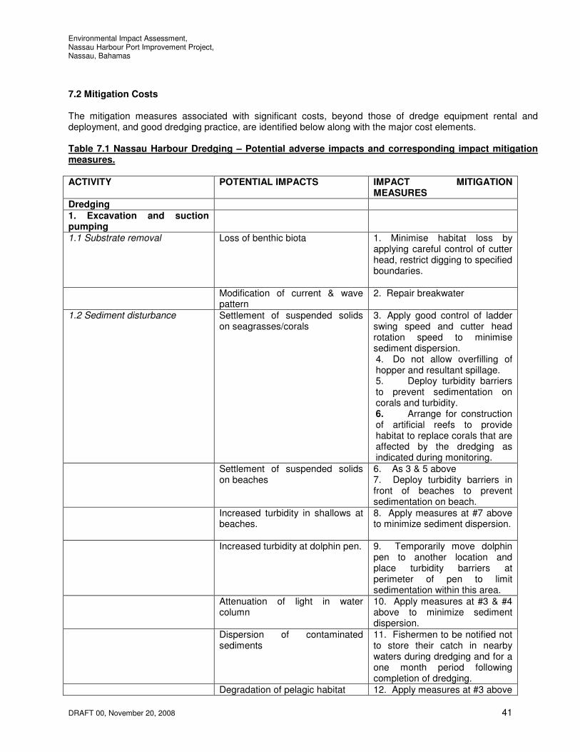
Environmental Impact Assessment, Nassau Harbour Port Improvement Project, Nassau, Bahamas
DRAFT 00, November 20, 2008 41
7.2 Mitigation Costs The mitigation measures associated with significant costs, beyond those of dredge equipment rental and deployment, and good dredging practice, are identified below along with the major cost elements. Table 7.1 Nassau Harbour Dredging – Potential adverse impacts and corresponding impact mitigation measures.
ACTIVITY POTENTIAL IMPACTS IMPACT MITIGATION MEASURES
Dredging
1. Excavation and suction pumping
1.1 Substrate removal Loss of benthic biota 1. Minimise habitat loss by applying careful control of cutter head, restrict digging to specified boundaries.
Modification of current & wave pattern
2. Repair breakwater
1.2 Sediment disturbance
Settlement of suspended solids on seagrasses/corals
3. Apply good control of ladder swing speed and cutter head rotation speed to minimise sediment dispersion. 4. Do not allow overfilling of hopper and resultant spillage. 5. Deploy turbidity barriers to prevent sedimentation on corals and turbidity. 6. Arrange for construction of artificial reefs to provide habitat to replace corals that are affected by the dredging as indicated during monitoring.
Settlement of suspended solids on beaches
6. As 3 & 5 above 7. Deploy turbidity barriers in front of beaches to prevent sedimentation on beach.
Increased turbidity in shallows at beaches.
8. Apply measures at #7 above to minimize sediment dispersion.
Increased turbidity at dolphin pen.
9. Temporarily move dolphin pen to another location and place turbidity barriers at perimeter of pen to limit sedimentation within this area.
Attenuation of light in water column
10. Apply measures at #3 & #4 above to minimize sediment dispersion.
Dispersion of contaminated sediments
11. Fishermen to be notified not to store their catch in nearby waters during dredging and for a one month period following completion of dredging.
Degradation of pelagic habitat 12. Apply measures at #3 above

Environmental Impact Assessment, Nassau Harbour Port Improvement Project, Nassau, Bahamas
DRAFT 00, November 20, 2008 42
to minimize sediment dispersion. Potentially unstable edges to
dredged channel 13.Dredge sides of channel at an angle to be determined by geotechnical engineer that will prove stable.
1.3 Presence/location of dredger Increased ambient noise level 14. Advise local residents before commencement of dredging works.
Impaired visual aesthetics/landscape
15. N/A
Hindrance of other of ship traffic 16. Coordinate location of dredging activity with Port Authority to eliminate shipping delays.
Dredged material disposal 2. Deep-sea disposal
2.1 Leakage of sediments during transport to disposal site
Increased turbidity over sensitive inshore habitats
17. Independently monitor vessel logs and records for each disposal trip. Employ appropriate electronic monitoring equipment.
2.2 Sediment disposal Sedimentation of deep-water benthic habitat
18. N/A
Degradation of pelagic habitat 19. N/A 3. Land reclamation Not covered within this study Major costs associated with mitigation measures are as follows; 1. Control of suspended sediment dispersal • Turbidity barrier purchase and repairs • Deployment of turbidity meters • Relocation of dolphin pen 2. Monitoring of deep sea disposal • Employment of environmental persons to monitor deep sea dredged material disposal • Aerial monitoring flight (1 hour) 3. Land reclamation •Construction costs associated with reclaiming land
8. ENVIROMENTAL MONITORING PLAN
The environmental monitoring plan (EMP) is presented in Appendix C in outline form. It should be detailed and completed when the final dredging action plan has been determined. The purpose of the EMP is to monitor or control the environmental effects of the dredging process. It should be based on compliance, verification, feedback, and know-how. It is therefore suggested that the Contractor carries out the EMP. The EMP should be able to provide responses to the following three questions:
i) Why is monitoring being conducted? ii) What specifically is being carried out? iii) How are the data and information to be used in planning and decision-making?

Environmental Impact Assessment, Nassau Harbour Port Improvement Project, Nassau, Bahamas
DRAFT 00, November 20, 2008 43
In the case of the proposed dredging works, environmental monitoring is particularly necessary to ensure that suspended sediments generated during excavation and during disposal of the dredged materials, do not adversely affect the health of the coastal ecosystems within Nassau Harbour and elsewhere along the coast. This could be achieved by:
1. ensuring that the deliberate disturbance and removal of bottom sediments during dredging are done technically in a manner (i.e. appropriate dredge type and operational procedures) that minimises the degree and extent of fugitive sediment suspension;
2. ensuring that the fine sediments generated are only released at the containment locations and the water disposed of after adequate settlement into waters further protected by turbidity barriers.
The monitoring programme should therefore focus on;
1. use of appropriate dredging equipment for the dredging; 2. confinement of dredging to the specified dredging areas; 3. frequent measurements of water turbidity at the active dredging areas, and monitoring stations; 4. surveillance of the operations of the HCSD during deposition of coarse dredged materials. 5. if deep sea disposal is necessary constant surveillance of the operations of the transit to and from
sediment release at the deep sea disposal site; 6. monitoring of the beach profiles.
The turbidity compliance standards are set out above. The standards set take into account normal prevailing water quality conditions and the duration of the dredging works. The results of the turbidity measurements, which should be taken independently, should immediately be recorded formally and made available to the dredging supervisor so that any corrections and adjustments to dredging operations can be made quickly. We are aware that other data has and continues to be collected for the 2008 WSSS Practicum/UEP Field Project ‘Integrated Assessment of Impacts of Stormwater in Coastal Zone of Nassau, New Providence, The Bahamas’ by the College of the Bahamas and other entities. It is recommended that monitoring be carried out in tandem with this work being carried out where relevant. The environmental monitor must have the authority to halt dredging and/or sediment disposal operations should this become necessary to protect the reef ecosystems at risk.
9. EMERGENCY CONTINGENCY PLAN In an environmental context, the critical emergency situation that could arise during the proposed dredging works is the collision between one or other of the dredge vessels and another ship in the harbour, resulting in the significant release of oil. In that event, reference should be made to the national oil spill response procedures. Adequate oil spill containment equipment should be available for immediate deployment at or near the project site during the dredging works. Major spills should immediately be reported to the Bahamas Defense Force if in Country and Port Authority. An emergency contingency plan for severe weather conditions such as storms and hurricanes will also be necessary to ensure equipment and material are adequately secured. Emergency contact numbers should be made available to the dredging contractor.

Environmental Impact Assessment, Nassau Harbour Port Improvement Project, Nassau, Bahamas
DRAFT 00, November 20, 2008 44
10. CONCLUSIONS AND RECOMMENDATIONS
This EIA has been carried out on the basis that it is necessary to carry out dredging at Nassau Harbour and install mooring dolphins at Prince George Wharf to increase the capacity of the approach channel to accommodate larger cruise ship vessels and to extend the berth space at Prince George Wharf. 10.1 Conclusions The main conclusions arising from the EIA study are:
1. The total amount of dredged material to be removed by the proposed dredging works is estimated at 2.0 million cubic yards.
2. The substrate to be removed at Nassau Harbour is predominantly hard limestone material with some overlay of sands.
3. Removal of the above substrate will result in the loss of seagrass communities established in the area of the dredging.
4. The dredged material does not contain any significant levels of metal contaminants. 5. The main potential impacts of the proposed dredging works that have been identified
are: a. suspension of fine sediments in the water column during dredging, construction and water
disposal will result in deleterious turbidity and sedimentation over seagrass communities and corals causing impacts on some of the biota.
b. modified wave and current magnitudes and patterns (generally waves increase and currents decrease with slight shifts in direction). There are expected to be minor changes to the beach profile. These are not considered to be significant.
c. increased ambient noise level over a seven month period. d. Impaired aesthetics/landscape over a seven month period. e. fishing areas currently used by fishermen will not be adversely affected by dredging since
the works will not be carried out in traditional fishing grounds, and any dispersal of suspended sediments should not extend to traditional fishing grounds. The dredging works may however affect water quality at locations where fishermen store their catches prior to sale.
6. Satisfactory mitigation of these impacts identified at #5 above can be achieved by: a. properly controlled dredging operations and restriction to designated dredging sites to
minimise sediment suspension; b. deployment of turbidity barriers around the dredging area where currents are less than 1.5
knots as well as along the shallows of the nearby beaches to prevent movement of any suspended sediments near or on the beach.
c. the temporary relocation of the dolphin pens. d. the construction of artificial reef (i.e. reef balls) following dredging details of which to be
determined by the monitoring team. e. planting of seagrasses (location and method to be determined) f. repair of the east breakwater to reduce the wave energy entering the harbour. g. co-ordinate dredging activities with the Port Authority. h. The edges of the channel to be dredged at an angle as determined by the geotechnical
engineer that will provide a stable edge. i. employ appropriate water quality and beach monitoring techniques from before dredging
activities.
Further possible impacts that have been identified include the following; a. suspension of fine sediments in the water column during disposal of the fine sediments at
the deep sea disposal site; and at the beaches to be nourished if these options are to be utilised, and

Environmental Impact Assessment, Nassau Harbour Port Improvement Project, Nassau, Bahamas
DRAFT 00, November 20, 2008 45
b. various impacts associated with land reclamation at the west end of Arawak Cay (including modifications to waves and currents, navigation and smothering of any biota on the sea floor by the dredged materials) to be further studied.
The construction of the two mooring dolphins will have similar impacts to those for the dredging however to a much lesser degree although shipping hindrance (as additional objects in/on the water) would be long-term. These should be easily identifiable to all vessels during light and dark hours. The repair of the east breakwater should be deferred and further considered under a separate project. 10.2 Recommendations
1. An investigation of a proposed inshore disposal site near Arawak Cay for coarse materials is to be carried out to determine the nature of the benthic biota in that area and its suitability for dredged material disposal. The findings of the further studies will be presented to the Bahamas Environment, Science and Technology Commission (BEST) and the Department of Environmental Health Services (EHS) once the studies have been approved by the Government.
2. Implementation of the dredging works should conform to the mitigation methods and procedures
outlined at Section 7.1. 3. Hold co-ordination meetings with the consulting engineers, the dredging contractors, MOW, BEST
and EHS before and during the dredging operations. 4. We are aware that other data has and continues to be collected for the 2008 WSSS Practicum/UEP
Field Project ‘Integrated Assessment of Impacts of Stormwater in Coastal Zone of Nassau, New Providence, The Bahamas’. It is recommended that monitoring be carried out in tandem with this work being carried out where relevant.
5. Beach profiling as per the wave climate and dredging impacts report by W. F. Baird & Associates. 6. A feasibility study be carried out for the feasibility of repairing the east breakwater. 7. For the dredging and disposal process predictive modeling is recommended to determine the extent
of suspended sediment levels and amount of sediment deposition at both the dredge and disposal areas. It is suggested that this be carried out by the same independent team that does the monitoring.
8. The repair of the east breakwater should be deferred and further considered under a separate
project.

Environmental Impact Assessment, Nassau Harbour Port Improvement Project, Nassau, Bahamas
DRAFT 00, November 20, 2008 46
11. REFERENCES Draft Wave Climate and Dredging Impacts, Nassau Harbour Port Improvement Project, August 7, 2008, W. F.
Baird & Associates Ltd. Geotechnical Investigation, Part 1, Dredging Nassau Harbour Port Improvement Project, August 7, 2008, Trow
International Inc. Rule 62-302, of the Florida Administrative Code". ERDC TN-DOER-E21 September 2005 Turbidity barriers as a Dredging Project Management Practice Hluchan, T. 2008. Personal communication. Allens, Capt. A.. 2008. Personal communication. Cant, S.. 2008. Personal communication. Sealey, Dr. K.. 2008. Personal communication.
12. APPENDICES Appendix A. Request for Proposals – For planning, design, engineering and construction management
services for the dredging of Nassau Harbour and the installation of mooring dolphins and Addendum No. 3.
Appendix B. Figures indicating Dredge Areas Appendix C. Photographs Appendix D. Environmental Management Plan Outline.

Environmental Impact Assessment, Nassau Harbour Port Improvement Project, Nassau, Bahamas
Appendix A.
Request for Proposals – For planning, design, engineering and construction management services for the dredging of Nassau Harbour and the installation of mooring dolphins and Addendum No. 3.

Environmental Impact Assessment, Nassau Harbour Port Improvement Project, Nassau, Bahamas
Appendix B.
Figures indicating Dredge Areas

Environmental Impact Assessment, Nassau Harbour Port Improvement Project, Nassau, Bahamas
Appendix C.
Photographs

Environmental Impact Assessment, Nassau Harbour Port Improvement Project, Nassau, Bahamas
Appendix D.
Environmental Management Plan Outline

Environmental Impact Assessment, Nassau Harbour Port Improvement Project, Nassau, Bahamas
DRAFT 00, October 3, 2008
Environmental Management Plan (EMP) Outline
The following provides an outline of the Environmental Management Plan (EMP) to be provided following the award of the contract.
1. PURPOSE SCOPE AND CONTENT
2. PROJECT PLANNING
2.1 Preconstruction – Specific Topics
2.2 Best Management Practices and Pollution Prevention
2.3 Project Sequencing
3. PROJECT SAFETY PLANS
4. HARBOUR DREDGING AND MATERIAL TRANSPORT
4.1 Dredging Operations and Methods
4.1.1 Methodologies
4.1.2 Vessels and Equipment
4.1.3 Blasting Operations and Safety
4.2 Material Transport Methods
4.2.1 Piping and Pipe Corridor
4.2.2 Barge Transport
4.3 Limits of Dredge Area
4.4 Dredge Material Containment Area and Methods
5. ENVIRONMENTAL OPERATIONS AND MONITORING PROGRAM
5.1 Monitoring Plan
5.2 Responsibility and Reporting Procedures
5.3 Training and Certification
5.4 Turbidity Control During Dredging
5.5 Noise Control

Environmental Impact Assessment, Nassau Harbour Port Improvement Project, Nassau, Bahamas
Appendix E
Turbidity Monitoring Summary Spreadsheet Examples