Environmental Assessment Statement - NYC
49
Transcript of Environmental Assessment Statement - NYC

TOMPKINS
SQUARE
E. 23RD ST.
E. 14TH ST.
SE
CO
ND
AV
E.
FIR
ST
AV
E.
AV
E. A AV
E. B
AV
E. C
AV
E. D
LEW
IS S
T.
JACKSO
N ST.
RU
TGER
S ST.
GRAND ST.
EAST BROADWAY
MONROE ST.
WATER S
T.
E. 2ND ST.
CH
RY
ST
IE S
T.
CO
LUM
BIA
ST
.
DELANCEY ST.
E. HOUSTON ST.
W. 23RD ST.
W. 14TH ST.
HU
DS
ON
ST.
BEACH ST.
CANAL ST.
WHITE ST.
W. HOUSTON ST.
BLEECKER ST.
W. 3RD ST.
SPRING ST.
W. HOUSTON ST.
BEDFORD ST.
W. 1
0TH ST.
BLEEKER ST.
GREENWICH AVE.
W. 10TH ST.
W. 8TH ST.
SIX
TH
AV
E.
WE
ST
BR
OA
DW
AY
ME
RC
ER
ST
.
LAG
UA
RD
IA P
L.
WA
SH
ING
TON
ST.
WE
ST S
T.
BR
OA
DW
AY
BO
WE
RY
WE
ST
BR
OA
DW
AY
HESTER ST.
PARK ROW
GO
LD S
T.
CH
UR
CH
ST
.
CORTLANDT ST.
CE
NT
RE
ST
.
FULTON ST.
VA
RIC
K S
T.
HU
DS
ON
ST.
NIN
TH
AV
E.
TE
NT
H A
VE
.
EIG
HT
H A
VE
.
SE
VE
NT
H A
VE
.
SIX
TH
AV
E.
W. 23RD ST.
FIF
TH
AV
E. LE
XIN
GT
ON
AV
E.
TH
IRD
AV
E.
SE
CO
ND
AV
E.
FIR
ST
AV
E.
FRO
NT
ST.
UNIONSQUARE
CITY HALLPARK
WTCSITE
FEDERALPLAZA
East Village
Gramercy
Chinatown
Financial District
Greenwich Village
Tribeca
SoHo
Chelsea
Lower East Side
4.11
.11
N
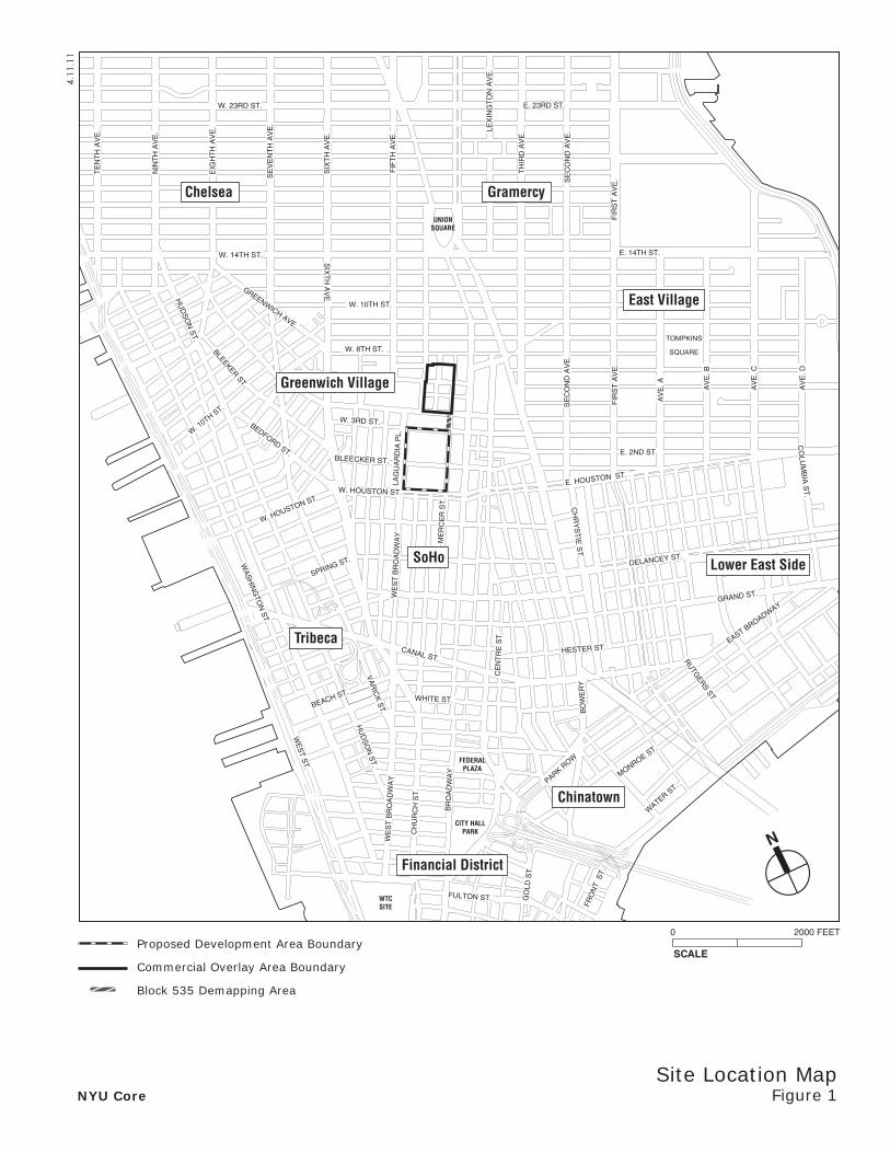
Site Location MapFigure 1
SCALE
0 2000 FEET
NYU Core
Proposed Development Area Boundary
Commercial Overlay Area Boundary
Block 535 Demapping Area

EAS FULL FORM PAGE 1a
4. Project Description:
INTRODUCTION
New York University (NYU) is seeking a number of discretionary actions (the “Proposed Actions”) in connection with the proposed expansion of NYU facilities at its academic core near Washington Square. As illustrated in Figure 1, the project site for the Proposed Actions includes: a “Proposed Development Area” (PDA) bounded by LaGuardia Place to the west, Mercer Street to the east, West Houston Street to the south, and West Third Street to the north,1 where substantial new development is proposed on two superblocks; a “Commercial Overlay Area” (COA ) bounded by Washington Square East and University Place to the west, Mercer Street to the east, West Fourth Street to the south, and the northern boundary of the existing R7-2 zoning district near East 8th Street to the north,2 where the proposed rezoning would allow for greater flexibility in ground-floor retail uses and are expected to result in limited conversion of ground-floor uses in existing buildings to a retail use; and a “Block 535 Demapping Area,” where no new development is proposed, but where NYU seeks to acquire the property that contains its 251 Mercer Street cogeneration facility below-grade. As shown in Tables 3 and 4 on pages 1c and 1d, NYU owns all of the properties within the PDA (except certain land mapped as City streets, which are owned by the City), and owns a majority of the properties within the COA. The following summarizes development expected to result from the Proposed Actions in both areas of the project site. Overall, the surface area affected by the Proposed Actions totals an estimated 823,448 square feet, or approximately 18.9 acres.
PROPOSED DEVELOPMENT AREA
The PDA is comprised of two superblocks separated by Bleecker Street. The superblock north of Bleecker Street in the PDA is referred to in this document as the “North Block,” while the superblock south of Bleecker is referred to as the “South Block.” Collectively, the North and South Blocks are largely residential in character, with mid- to high-rise apartment buildings, a number of private and public open spaces, and the Coles Sports and Recreation Center, which is a gymnasium/recreational facility for NYU students, faculty, and alumni (see Figure 2). The PDA also contains a number of retail uses located along LaGuardia Place. In total, the PDA contains 10 buildings, as well as a variety of public and private open spaces and landscaped areas.
Over a period of approximately 19 years, NYU is proposing to construct within the PDA: four new NYU buildings (including academic uses, residential units for NYU faculty and students, a new athletic facility, a University-affiliated hotel, and retail uses); below-grade academic uses; approximately four acres of publicly-accessible open space; and below-grade accessory parking (approximately 389 replacement spaces). NYU also anticipates making space available to the New York City School Construction Authority (SCA) for the provision of an approximately 100,000-square-foot public school. Table 1 shows the minimum and maximum density by use expected to occur in the PDA by 2031. Within the PDA by 2031, the Proposed Actions would result in the development of approximately 2.5 million gross square feet (gsf) of new uses. See Figure 3 illustrates the proposed site plan for the PDA.
The new uses are presented as a range for the PDA in order to allow NYU a degree of flexibility in meeting its future programming needs. Within this range, Table 2 presents an illustrative program reflecting the scale and uses currently anticipated for the new project buildings.
The above-described development would require the demolition of three NYU-owned buildings within the PDA: 1) the Coles Sports and Recreation Center; 2) a retail building containing the Morton Williams Associated Supermarket; and 3) a retail building with six storefronts (LaGuardia Retail).3 The proposed below-grade academic space on the North Block would require the displacement of the existing, approximately 670-space below-grade parking garage on the North Block. The project would develop new below-grade parking to accommodate the relocation of the existing 389 required accessory spaces, resulting in a net reduction of approximately 281 parking spaces within the PDA. The demolition of the three NYU buildings would result in the loss of approximately 200,000 gsf of space.
1 The Proposed Development Area includes: Block 524, Lots 1, 9, and 66; and Block 533, Lots 1 and 10; and portions of Mercer Street and LaGuardia Place that are proposed
to be demapped. 2 The Commercial Overlay Area includes: Block 546, Lots 1, 5, 8, 10, 11, 15, 20, 21, 26, 30; Block 547, Lots 1, 4, 5, 8, 14, 15, 18, 19, 20, and 25; and Block 548, Lots 1, 4, 21, 24,
40, and 45. 3 The LaGuardia Retail building is occupied by Citibank; NYU Mail Services and Copy Central; Wine Barrel; Favela Cubana; and Bare Burger. It contains two vacant retail
spaces.

4.13
.11
SCALE
0 64 128 FEET
N
Existing Site Plan in Proposed Development AreaFigure 2NYU Core
WEST 3RD STREET
BLEECKER STREET
COLESSPORTS ANDRECREATION
CENTER
SILVERTOWER
1
SILVERTOWER
2
505LAGUARDIA
PLACE
MORTON-WILLIAMSSUPERMARKET
LAGUARDIARETAIL
WASHINGTON SQUARE VILLAGE 3&4
WASHINGTON SQUARE VILLAGE 1&2
MER
CER
ST
REE
T
WEST HOUSTON STREET
LAG
UA
RD
IA P
LAC
E

PROPOSEDZIPPER
BUILDING
PROPOSEDLAGUARDIABUILDING
PROPOSEDMERCERBUILDING
PROPOSEDBLEECKERBUILDING
SCALE
0 64 128 FEET
N
2031 Site Plan for Proposed Development AreaFigure 3NYU Core
4.11
.11

EAS FULL FORM PAGE 1b
Table 1Minimum and Maximum Density of New Development
in the Proposed Development AreaUse Minimum Amount1 (gsf) Maximum Amount1 (gsf)
Academic 963,000 1,532,000 Student Housing (Dormitories) 180,000 525,000
Faculty Housing 0 220,000 Athletic Center 146,000 200,000
Retail 40,000 100,000
Hotel 0 180,000 Academic/Conference Space 0 85,000
Public School (PS/IS) 100,000 100,000 Parking 76,000 115,000
Mechanical/Service Areas 371,000 371,000 Notes:
1. The minimum and maximum gsf of new development anticipated for the Proposed Development Area are not calculated by summing the minimum and maximum gsf for each use, as maximizing certain uses would require minimizing other uses. Therefore, the approximately 2.5 million gsf of total development planned under all development scenarios is less than the total of maximum amounts by use, because the overall square footage would not allow for maximizing all proposed uses.
Source: New York University
Table 2Illustrative Program for New Development in the Proposed Development Area
Use (gsf) Zipper
Building Bleecker Corner
Building North Block Below-Grade
Mercer Building
LaGuardia Building
TOTAL GSF
Academic 135,000 38,000 484,000 250,000 160,000 1,067,000 Student Housing (Dormitories) 315,000 55,000 0 0 0 370,000
Faculty Housing 105,000 0 0 0 0 105,000 Athletic Center 146,000 0 0 0 0 146,000
Retail 55,000 0 0 0 0 55,000 Hotel 115,000 0 0 0 0 115,000
Academic/Conference Space 50,000 0 0 0 0 50,000 Public School (PS/IS) 0 100,000 0 0 0 100,000
Parking 0 0 76,000 0 0 76,000 Mechanical/Service Areas 129,000 32,000 210,000 0 0 371,000
TOTAL GSF 1,050,000 225,000 770,000 250,000 160,000 2,455,000 Source: New York University
One of the goals of the proposed project is to enhance public recreational opportunities in the Proposed Development Area by providing new and replacement publicly accessible open spaces in place of the private and publicly accessible open spaces to be removed. Overall, by 2031 the proposed project would provide an improvement in the quality, and a net increase in the quantity, of publicly accessible open spaces on the project site.
The proposed project also intends to incorporate a number of sustainable design measures that would reduce energy consumption, and GHG emissions, including measures to be incorporated in order to achieve the LEED Silver certification required by the NYU Sustainable Design Standards and Guidelines. In addition, NYU plans to utilize energy produced by the existing cogeneration facility operating at 251 Mercer Street, which would service the heating and cooling needs of several project buildings.
NYU’s proposal within the Proposed Development Area also includes the re-cladding of the ground floor and second floor of the Washington Square Village apartment buildings. This would add transparency intended to complement the new publicly accessible landscaping on the North Block adjacent to these buildings. Proposed improvements to West Third Street immediately north of the Washington Square Village buildings include enhanced pedestrian crossings between LaGuardia and Mercer Streets.

EAS FULL FORM PAGE 1c
COMMERCIAL OVERLAY AREA
As detailed below, the COA contains some non-complying ground-floor retail uses, and new retail uses are not allowed as-of-right. The Proposed Actions would serve to bring existing retail uses into compliance (with the proposed C1-5 commercial overlay zoning), and would allow for the development of some additional ground-floor retail uses. The maximum amount of additional retail space expected to be developed in the COA would be 23,236 sf, and would be comprised of neighborhood retail uses at five locations within existing buildings.
BLOCK 535 DEMAPPING AREA
The Block 535 Demapping Area—bounded by the western sidewalk of Mercer Street to the east, the existing NYU property line east of Weaver Hall to the west, West Third Street to the south, and West Fourth Street to the north—contains a renovated public space above-grade and NYU’s 251 Mercer Street cogeneration facility below-grade. There is no proposed development within this approximately 4,000-sf area.
PROPOSED ACTIONS
The Proposed Actions required to facilitate the proposed project are as follows:
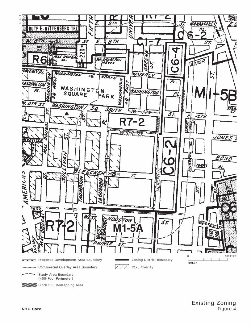
Zoning map change: The entire project area is currently zoned R7-2 (see Figure 4). There is a C1-5 overlay along LaGuardia Street on the two superblocks in the Proposed Development Area, but this is the only location where retail is allowed in the project area (this overlay area contains the Morton Williams Associated Supermarket and the LaGuardia Retail building). As shown in Figure 5, NYU proposes to rezone the Proposed Development Area from R7-2 to C1-7, and proposes to rezone the Commercial Overlay Area from R7-2 to R7-2/C1-5.
Large-Scale General Development (LSGD) Special Permit:
- Pursuit of waivers within a proposed LSGD to include the North and South Blocks. The precise boundaries of the LSGD on the South Block are subject to adjustment in order to conform to the scope of the Proposed Actions. As a consequence of this Proposed Action, the existing Large Scale Residential Development (LSRD) would be dissolved, with the existing waiver(s) incorporated into the new LSGD special permit.
- Additional waivers and/or text amendments (may include height and setback waivers and potentially floor area and open space redistribution across zoning lot boundary lines, and court and location of use regulations).
Demapping and City disposition of portions of the following City streets:
- LaGuardia Place between Bleecker and West Third Streets;
- Mercer Street between Houston and Bleecker Streets;
- Mercer Street between Bleecker and West Third Streets; and
- Mercer Street between West Third and West Fourth Streets.
Elimination of New York City Department of Housing Preservation and Development (HPD) Deed Restrictions on Blocks 524 and 533
Potential funding or financing approvals from the Dormitory Authority of the State of New York (DASNY)
Public Authorities Law Site Selection by the New York City School Construction Authority (SCA)
New York City Department of Transportation (NYCDOT) revocable consent for utility lines beneath City streets
In addition to the above-described Proposed Actions, on March 3, 2011 NYU submitted an application to the New York City Landmark Preservation Commission (LPC) for a Certificate of Appropriateness (CofA) for proposed changes to landscaping at University Village, which is a New York City Landmark (NYCL). At a public hearing on April 5, 2011, LPC approved the proposed landscape changes.
ST.
W. 3RD ST.
ME
RC
ER
ST.
BR
OA
DW
AY
4.11
.11
SCALE
0 500 FEET
N
Existing ZoningFigure 4NYU Core
M1-5A
Proposed Development Area Boundary
Commercial Overlay Area Boundary
Study Area Boundary (400-Foot Perimeter)
Block 535 Demapping Area
Zoning District Boundary
C1-5 Overlay

ST.
W. 3RD ST.
ME
RC
ER
ST.
BR
OA
DW
AY
C1-7
N
Proposed ZoningFigure 5NYU Core
4.14
.11
SCALE
0 500 FEET
M1-5A
R7-2
Proposed Development Area Boundary
Commercial Overlay Area Boundary
Block 535 Demapping Area
Zoning District Boundary
C1-5 Overlay
Area Boundary of Proposed Rezoning
Area of Proposed C1-5 Overlay
EAS FULL FORM PAGE 1d
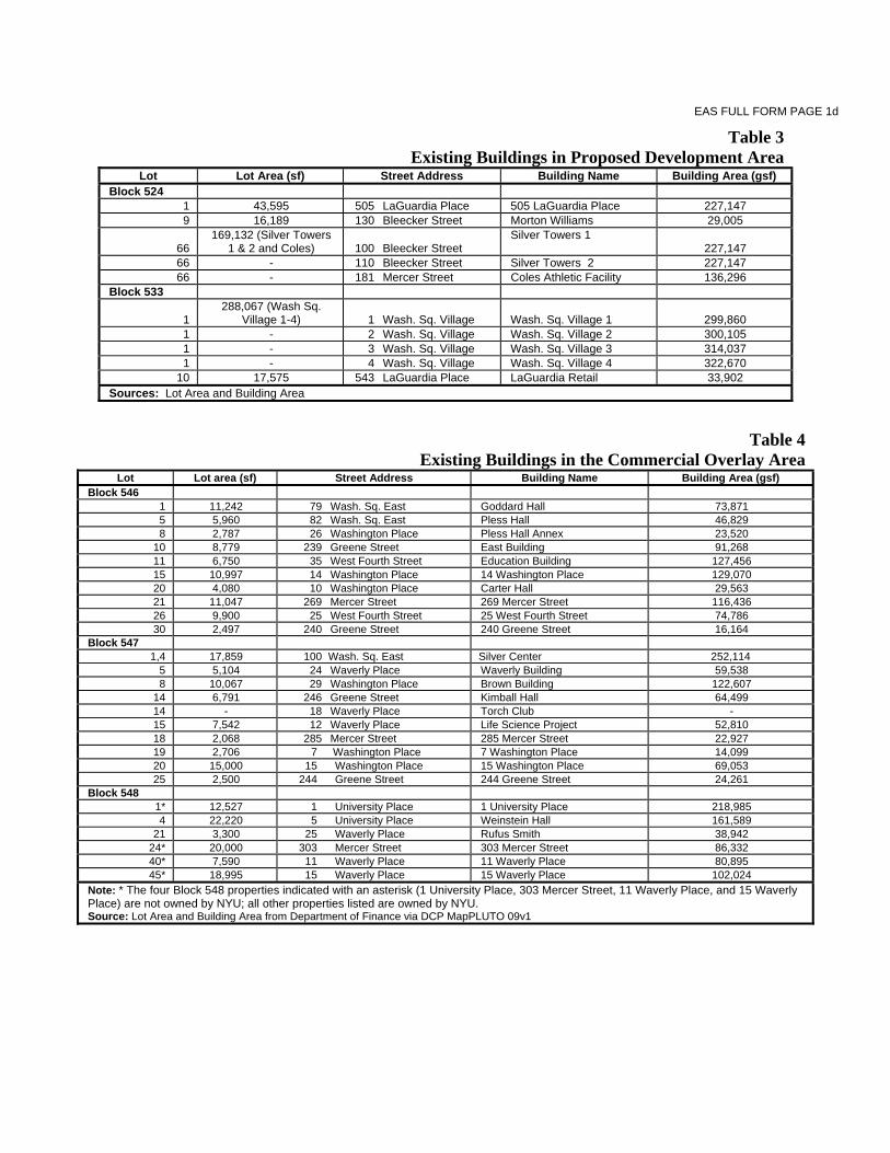
Table 3Existing Buildings in Proposed Development Area
Lot Lot Area (sf) Street Address Building Name Building Area (gsf) Block 524
1 43,595 505 LaGuardia Place 505 LaGuardia Place 227,147 9 16,189 130 Bleecker Street Morton Williams 29,005
66 169,132 (Silver Towers
1 & 2 and Coles) 100 Bleecker Street Silver Towers 1
227,147 66 - 110 Bleecker Street Silver Towers 2 227,147 66 - 181 Mercer Street Coles Athletic Facility 136,296
Block 533
1 288,067 (Wash Sq.
Village 1-4) 1 Wash. Sq. Village Wash. Sq. Village 1 299,860 1 - 2 Wash. Sq. Village Wash. Sq. Village 2 300,105 1 - 3 Wash. Sq. Village Wash. Sq. Village 3 314,037 1 - 4 Wash. Sq. Village Wash. Sq. Village 4 322,670
10 17,575 543 LaGuardia Place LaGuardia Retail 33,902 Sources: Lot Area and Building Area
Table 4Existing Buildings in the Commercial Overlay Area
Lot Lot area (sf) Street Address Building Name Building Area (gsf)Block 546
1 11,242 79 Wash. Sq. East Goddard Hall 73,871 5 5,960 82 Wash. Sq. East Pless Hall 46,829 8 2,787 26 Washington Place Pless Hall Annex 23,520
10 8,779 239 Greene Street East Building 91,268 11 6,750 35 West Fourth Street Education Building 127,456 15 10,997 14 Washington Place 14 Washington Place 129,070 20 4,080 10 Washington Place Carter Hall 29,563 21 11,047 269 Mercer Street 269 Mercer Street 116,436 26 9,900 25 West Fourth Street 25 West Fourth Street 74,786 30 2,497 240 Greene Street 240 Greene Street 16,164
Block 547 1,4 17,859 100 Wash. Sq. East Silver Center 252,114
5 5,104 24 Waverly Place Waverly Building 59,538 8 10,067 29 Washington Place Brown Building 122,607
14 6,791 246 Greene Street Kimball Hall 64,499 14 - 18 Waverly Place Torch Club - 15 7,542 12 Waverly Place Life Science Project 52,810 18 2,068 285 Mercer Street 285 Mercer Street 22,927 19 2,706 7 Washington Place 7 Washington Place 14,099 20 15,000 15 Washington Place 15 Washington Place 69,053 25 2,500 244 Greene Street 244 Greene Street 24,261
Block 548 1* 12,527 1 University Place 1 University Place 218,985 4 22,220 5 University Place Weinstein Hall 161,589
21 3,300 25 Waverly Place Rufus Smith 38,942 24* 20,000 303 Mercer Street 303 Mercer Street 86,332 40* 7,590 11 Waverly Place 11 Waverly Place 80,895 45* 18,995 15 Waverly Place 15 Waverly Place 102,024
Note: * The four Block 548 properties indicated with an asterisk (1 University Place, 303 Mercer Street, 11 Waverly Place, and 15 Waverly Place) are not owned by NYU; all other properties listed are owned by NYU. Source: Lot Area and Building Area from Department of Finance via DCP MapPLUTO 09v1

EAS FULL FORM PAGE 2
Department of Environmental Protection: YES NO Other City Approvals: YES NO
LEGISLATION RULEMAKING
FUNDING OF CONSTRUCTION; SPECIFY CONSTRUCTION OF PUBLIC FACILITIES
POLICY OR PLAN; SPECIFY FUNDING OR PROGRAMS; SPECIFY
LANDMARKS PRESERVATION COMMISSION APPROVAL (not subject to CEQR) PERMITS; SPECIFY
384(B)(4) APPROVAL
OTHER; EXPLAIN Elimination of HPD Deed Restrictions; NYCDOT revocable consent for utility lines beneath City streets
PERMITS FROM DOT’S OFFICE OF CONSTRUCTION MITIGATION AND COORDINATION (OCMD) (not subject to CEQR)
6. State or Federal Actions/Approvals/Funding: YES NO IF “YES,” IDENTIFY
Potential Dormitory Authority of the State of New York (DASNY) funding Public Authorities Law Site Selection from New York City School Construction Authority (NYCSCA)
7. Site Description: Except where otherwise indicated, provide the following information with regard to the directly affected area. The directly affected area consists of the project site and the area subject to any change in regulatory controls.
GRAPHICS The following graphics must be attached and each box must be checked off before the EAS is complete. Each map must clearly depict the boundaries of the directly affected area or areas, and indicate a 400-foot radius drawn from the outer boundaries of the project site. Maps may not exceed 11x17 inches in size and must be folded to 8.5x11 inches for submission.
Site location map See Figure 1. Zoning map See Figure 4.
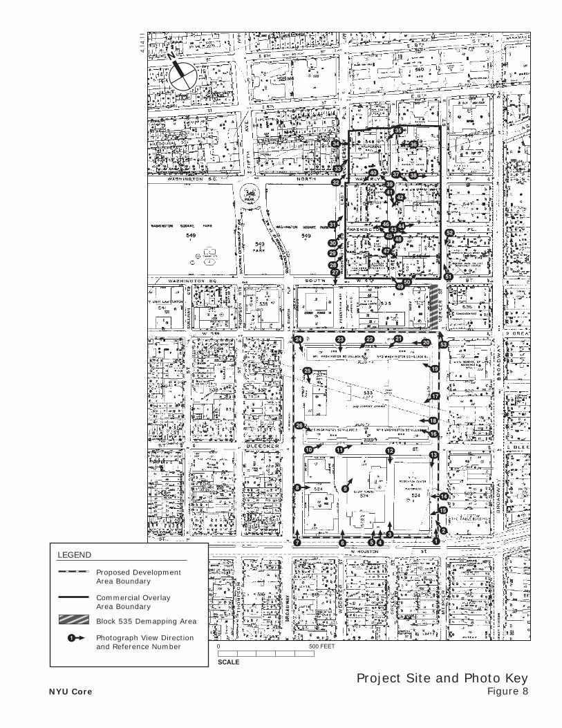
Photographs of the project site taken within 6 months of EAS submission and keyed to the site location map See Figures 8 to 8n (photographs were taken in July 2010 and December 2010).
Sanborn or other land use map See Figure 6. Tax map See Figures 7a to 7e.
For large areas or multiple sites, a GIS shape file that defines the project sites (Not Applicable)
PHYSICAL SETTING (both developed and undeveloped areas) Total directly affected area (sq. ft.):
PDA: ±591,124 sf; COA: ±228,308 sf Block 535 Demapping Area: ±4,016 sf
Type of waterbody and surface area (sq. ft.):
0 Roads, building and other paved surfaces (sq. ft.):
PDA: ±316,735 sf; COA: ±228,308 sf
Other, describe (sq. ft.): PDA: ±274,389 sf of programmed and unprogrammed open areas; COA: 0; Block 535 Demapping Area: ±4,016 sf of programmed open area and sidewalk
8. Physical Dimensions and Scale of Project (if the project affects multiple sites, provide the total development below facilitated by the action) Size of project to be developed: PDA: 2,455,000 gsf1; COA: 23,236 gsf; Block 535 Demapping Area: 0 gsf (gross sq. ft.)
Does the proposed project involve changes in zoning on one or more sites? YES NO If ‘Yes,’ identify the total square feet owned or controlled by the applicant: PDA: ±534,558 sf
COA: ±169,196 sf Lot area
Total square feet of non-applicant owned development:
PDA: ±60,582 sf COA: ±59,112 sf Lot area
Does the proposed project involve in-ground excavation or subsurface disturbance, including but not limited to foundation work, pilings, utility lines, or grading? YES NO If ‘Yes,’ indicate the estimated area and volume dimensions of subsurface disturbance (if known): Area: PDA: TBD; COA: 0;
Block 535: 0 Sq. ft. (width x length) Volume: PDA: TBD; COA: 0;
Block 535: 0 cubic feet (width x length x depth)
Does the proposed project increase the population of residents and/or on-site workers? YES NO
Number of additional residents? ±1,4482
Number of additional workers?
±2,6822
Provide a brief explanation of how these numbers were determined: Estimate of future residents assumes: for faculty residents, 850 gsf per faculty unit and an average household size of 1.74 persons per unit (from 2000 Census) for proposed faculty units; for student residents, 300 gsf per dorm bed.
Estimate of future employment are based on the following employment density ratios: academic = 2.04 workers per 1,000 gsf; housing = 0.17 workers per 1,000 gsf; athletic center = 0.57 workers per 1,000 gsf; retail = 3 workers per 1,000 gsf; hotel = 600 gsf per room and 1 worker per 2.67 rooms; conference center = 1 employee per 2,000 gsf; public school = 1 seat per 130 gsf and 1 worker per 11 seats; parking = 1 worker per 40 parking spaces.
Does the project create new open space? YES NO If Yes: PDA: ± 211,625 COA: 0 (sq. ft)
Using Table 14-1, estimate the project’s projected operation solid waste generation, if applicable: ±65,0112 (pounds per week)
Using energy modeling or Table 15-1, estimate the project’s projected energy use: Approximately 530 billion2 (annual BTUs)
9. Analysis Year CEQR Technical Manual, Chapter 2 ANTICIPATED BUILD YEAR (DATE THE PROJECT WOULD BE COMPLETED AND OPERATIONAL):
2031 ANTICIPATED PERIOD OF CONSTRUCTION IN MONTHS:
228 WOULD THE PROJECT BE IMPLEMENTED IN A SINGLE PHASE? YES NO IF MULTIPLE PHASES, HOW MANY PHASES: 2
BRIEFLY DESCRIBE PHASES AND CONSTRUCTION SCHEDULE:
Phase 1 (South Block of PDA and COA): 01/2013-12/2021; Phase 2 (North Block of PDA): 1/2022-12/2031
10. What is the Predominant Land Use in Vicinity of Project? (Check all that apply)
RESIDENTIAL MANUFACTURING COMMERCIAL PARK/FOREST/OPEN SPACE OTHER, Describe: Institutional (academic)
1 During Phase 1 there would also be construction of an approximately 30,000-gsf temporary gymnasium on the North Block. 2 Based on Illustrative Program shown in Table 2 on page 1b.

E 8 ST
ME
RC
ER
ST
W 3 ST
LAF
AY
ET
TE
ST
E 9 ST
BR
OA
DW
AY
E 4 ST
SU
LLIV
AN
ST
BLEECKER ST
W HOUSTON ST
W 8 ST
W 9 ST
TH
OM
PS
ON
ST
FIF
TH
AV
MO
TT
ST
MA
C D
OU
GA
L S
T
BOND ST
CR
OS
BY
ST
LA G
UA
RD
IA P
L
FOU
RTH
AV
ASTOR PL
GREAT JONES ST
GR
EE
NE
ST
W 4 ST
E 7 ST
WASHINGTON SQ N
KING ST
UN
IVE
RS
ITY
PL
MU
LBE
RR
Y S
T
WO
OS
TE
R S
T
WASHINGTON PL
AV
OF
TH
E A
ME
RIC
AS
JONES AL
W B
RO
AD
WA
Y
JERSEY ST
MIN
ETTA
ST
SH
INB
ON
E A
L
MINETTA LA
TH
IRD
AV
WAVERLY PL
STABLE CT
PE
DE
ST
RIA
N P
AT
HW
AS
HIN
GT
ON
SQ
E
WASHINGTON SQ S
WA
SH
ING
TO
N S
Q W
CO
OP
ER
SQ
WASHINGTON MEWS
W WASHINGTON PL
MAC DOUGAL AL
ELIZ
AB
ET
H S
T
STUYVESANT ST
GR
EA
T J
ON
ES
AL
E 9 ST
W 4 ST
MA
C D
OU
GA
L S
T
GR
EE
NE
ST
E HOUSTON ST
WAVERLY PL
4.14
.11
Land UseFigure 6
N
SCALE
0 200 500 FEET
NYU Core
Proposed Development Area Boundary
Commercial Overlay Area Boundary
Block 535 Demapping Area
Study Area Boundary(400-Foot Perimeter)
Residential
Residential with Commercial Below
Hotels
Commercial and Office Buildings
Industrial and Manufacturing
Transportation and Utility
Public Facilities and Institutions
Open Space and Outdoor Recreation
Parking Facilities
Vacant Land
Vacant Building
Under Construction
Note: Each color indicates the dominant land use on each lot

533
524
605.8
605.89
476.
7
132
126.
11
216.
17
216.
1721
6.17
103
103
103
103
1
10
W. 3RD ST.
LA G
UAR
DIA
PL.TH
OM
PSO
N S
T.
BRO
ADW
AYW. HOUSTON ST.
459.67248
439.84
377.
21
197.
4
197.
4
166.1
130.
44
130.
17
130.
18
130.
18
124.47
54.8
3
54.8
3
21.75
124124
130.
17
66
1
9
MER
CER
ST.
BLEECKER ST.
ALL
EY
1.13
.11
NYU CoreTax MapFigure 7a
N

2
96
192.
5
80
NA
90.5
97.0
8
102.9
96.2
5
96.2
9
95.3
3
112.
56
112.
42
114.25
79.8
7
62.5
74.62
71.42
25
43.37
42.37
16
34.87
25.92
3
96.2
5
2579
.87
379
.87
96.2
5
112.
56
96.2
5
NA
42.37
96.2
5
NA
100
96.2
5
100
114.25
74.62
NA
96.2
5
62.5
96.2
5
96.2
9
100
1
21
5
11 15
26
10
8
20
30
W. 4TH ST.
MER
CER
ST.
WASHINGTON PL.
GR
EEN
E ST
.
WAS
HIN
GTO
N S
Q. E
.
546
546
N
Tax MapFigure 7b
3.1.11
NYU Core

150
180.
5
82
NA
100
180.
08
80.5
99.17
91.67
83.33
81.7
5
100.67
81.3
3
80.8
1
82.5
8
82.7
5
62.79
25
37.79
25
NA
2510
010
0
150
100
82.5
8
25
100
100.67
100
25
100
NA
83.33
99.17
82
100
80.8
1
25
1
8
20
5
15
14
4
19
25
18
WAVERLY PL.
GR
EEN
E ST
.
WASHINGTON PL.
WAS
HIN
GTO
N S
Q. E
.
547
547
N
Tax MapFigure 7c
3.1.11
NYU Core
Cogeneration Facility Boundary
Study Area Boundary (400-Foot Perimeter)
Photograph View Directionand Reference Number

200
143
200.5111
125
100
142.5
57
124.
5NA
87.5
141.46
132.
92
132.
67
118.
33
100.5
74.5
114.
92
76.5
108.
09
107.
92
100.21
100.
67
77.8
3
57.5
75.19
25
33.54
11 17.5
12.5
200
25
NA
NA
108.
09
76.5
100
200
33.54
100
107.
92
132.
92
74.510
0.67
100.
67
11
4
28
124
45
9
12
40
21
E. 8TH ST.
GR
EEN
E ST
.
MER
CER
ST.
UN
IVER
SITY
PL.
WAVERLY PL.
548
548
3.1.11
N
NYU CoreTax MapFigure 7d
Cogeneration Facility Boundary
Study Area Boundary (400-Foot Perimeter)
Photograph View Directionand Reference Number

305.6
305.61
209.
2
209.
37
209.
23
209.
33
195.16
195.23
105
50
10
209.
23
209.
33
105
209.
2
209.
2
50
10
1
8
36
33M
ERC
ER S
T.
W. 3RD ST.
WASHINGTON PL.GR
EEN
E ST
.
LA G
UAR
DIA
PL.
WO
OS
TER
ST
EX
W. 4TH ST.
535
N
Tax MapFigure 7e
4.13.11
NYU Core
4.14
.11
N
Project Site and Photo KeyFigure 8NYU Core
2122
6 4
31
2
14
13121110
26
25
24 23 20 53
19
17
18
16
8 9
31
2827
32
29
30
31
33
34
35
36
40 37 38
4139
42
51
4443
45
46
48
47
50
52
49
7
15
5
SCALE
0 500 FEET
Proposed DevelopmentArea Boundary
Commercial OverlayArea Boundary
Block 535 Demapping Area
Photograph View Directionand Reference Number
LEGEND
1

1
NYU Core Figure 8aPhotographs
4.13.11
View northwest from West Houston Street to University Village’s children’s playgroundView north from West Houston Street to Silver Tower 1
View northwest on Mercer Street to the Coles Sports and Recreation CenterView northwest from West Houston and Mercer Streets to the dog run east of the Coles Sports and Recreation Center
43
2
NYU Core Figure 8bPhotographs
4.13.11
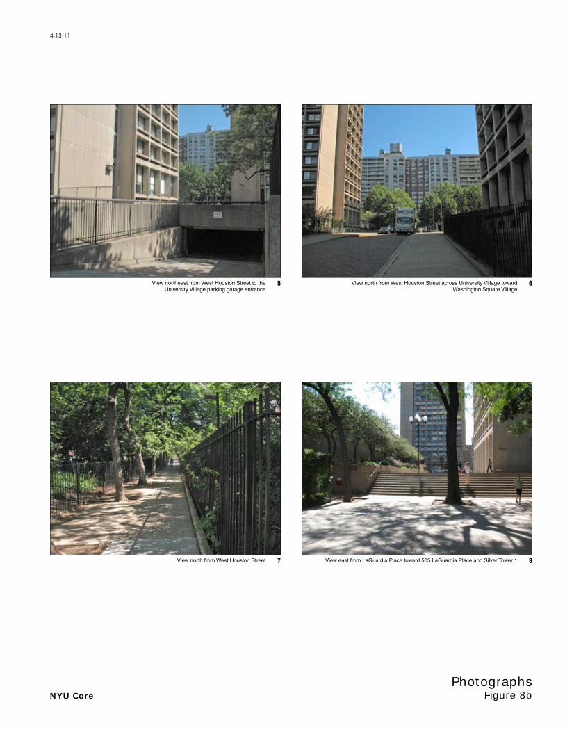
View east from LaGuardia Place toward 505 LaGuardia Place and Silver Tower 1View north from West Houston Street
View north from West Houston Street across University Village toward Washington Square Village
View northeast from West Houston Street to the University Village parking garage entrance
87
65

NYU Core Figure 8cPhotographs
4.13.11
View south from Bleecker Street to walkway between University Village and Coles Sports and Recreation Center
View northeast on Bleecker Street toward Washington Square Village 3 and 4
View northeast on Bleecker Street toward Washington Square Village 3 and 4View northeast across University Village
1211
109

NYU Core Figure 8dPhotographs
4.13.11
View northwest from Mercer and Bleecker Streets to the Mercer Street PlaygroundView southwest from Mercer Street to the dog run east of the Coles Sports and Recreation Center
View west from Mercer Street to the Coles Sports and Recreation Center with Silver Towers 1 and 2 in the background
View southwest from Mercer Street to the Coles Sports and Recreation Center
1615
1413

NYU Core Figure 8ePhotographs
4.13.11
View west on West 3rd Street to Washington Square Village 1 and 2View northwest from the Mercer Street Playground to Washington Square Village 1 and 2
View west from the Mercer Street Playground to Washington Square Village 3 and 4View west from the Mercer Street Playground to Washington Square Village
2019
1817

NYU Core Figure 8fPhotographs
4.13.11
View west on West 3rd Street to Washington Square Village 1 View southeast on LaGuardia Place to Washington Square Village 1 and the Commercial Strip
View west on West 3rd Street to Washington Square Village 1View southwest on West 3rd Street to Washington Square Village 2
2423
2221

NYU Core Figure 8gPhotographs
4.13.11
View northeast on Washington Square East between West 4th Street and Washington Place
View south from West 4th Street toward Washington Square Village
View southeast on LaGuardia Place to Washington Square Village 3View southeast on LaGuardia Place to the Commercial Strip
2827
2625

NYU Core Figure 8hPhotographs
4.13.11
View northeast on Washington Square Village East between Waverly Place and East 8th Street
View northeast on Washington Square East to Hemmerdinger Hall (the former Main Building) at 100 Washington Square East
View northeast on Washington Square East between West 4th Street and Washington Place
View northeast on Washington Square East between West 4th Street and Washington Place
3231
3029

NYU Core Figure 8iPhotographs
4.13.11
View south along the east side of Greene Street between Waverly Place and East 8th Street
View southwest on Greene Street between Waverly Place and East 8th Street
View east on Washington Square Village East between Waverly Place and East 8th StreetView northeast on Washington Square Village East between Waverly Place and East 8th Street
3635
3433
NYU Core Figure 8jPhotographs
4.13.11
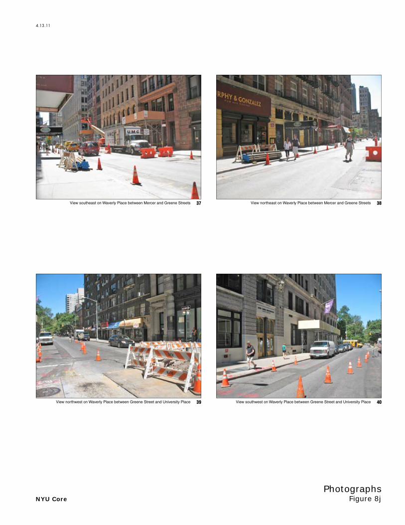
View northwest on Waverly Place between Greene Street and University Place View southwest on Waverly Place between Greene Street and University Place
View northeast on Waverly Place between Mercer and Greene StreetsView southeast on Waverly Place between Mercer and Greene Streets
4039
3837

NYU Core Figure 8kPhotographs
4.13.11
View northeast on Washington Place between Mercer and Greene StreetsView southeast to south side of Washington Place between Mercer and Greene Streets
View southwest on Greene Street between Waverly and Washington PlacesView southeast on Greene Street between Waverly and Washington Places
4443
4241
NYU Core Figure 8lPhotographs
4.13.11
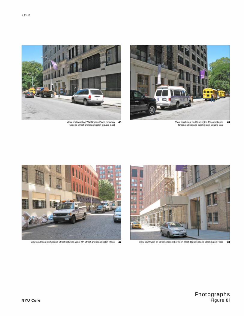
View southwest on Greene Street between West 4th Street and Washington PlaceView southeast on Greene Street between West 4th Street and Washington Place
View northwest on Washington Place between Greene Street and Washington Square East
4847
46View southwest on Washington Place between Greene Street and Washington Square East
45
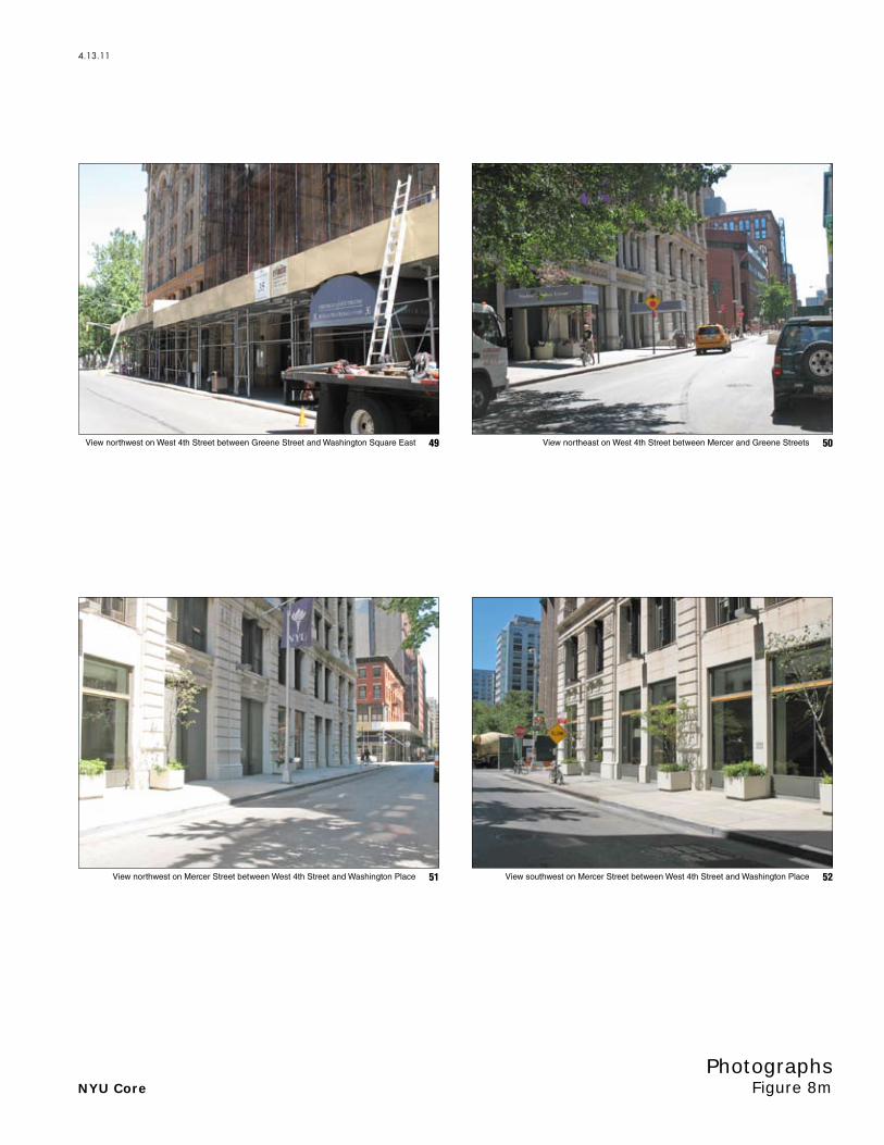
NYU Core Figure 8mPhotographs
4.13.11
View southwest on Mercer Street between West 4th Street and Washington PlaceView northwest on Mercer Street between West 4th Street and Washington Place
View northeast on West 4th Street between Mercer and Greene StreetsView northwest on West 4th Street between Greene Street and Washington Square East
5251
5049

NYU Core Figure 8nPhotographs
4.13.11
53View northwest from Mercer and West 3rd Streets

EAS FULL FORM PAGE 3
DESCRIPTION OF EXISTING AND PROPOSED CONDITIONS The information requested in this table applies to the directly affected area. The directly affected area consists of the project site and the area subject to any change in regulatory control. The increment is the difference between the No-Action and the With-Action conditions.
EXISTING
CONDITION NO-ACTION CONDITION
WITH-ACTION CONDITION INCREMENT
Land Use
Residential Yes No Yes No Yes No
If yes, specify the following
No. of dwelling units
PDA: ±1,636 dwelling units
COA: ±964 dwelling units
PDA: ±1,636 dwelling units
COA: ±886 dwelling units
PDA: ±2,993 dwelling units1
COA: ±886 dwelling units
PDA: ±1,357 dwelling units (124 faculty housing units and
1,233 dormitory beds)1
COA: 0
No. of low- to moderate-income units PDA: 415 COA: 49
PDA: 415 COA: 49
PDA: 415 COA: 49
PDA: 0 COA: 0
No. of stories PDA: 15 to 30 COA: 6 to 21
PDA: 15 to 30 COA: 6 to 21
PDA: 8 to 30 COA: 6 to 21
PDA: 0 COA: 0
Gross Floor Area (sq. ft.) PDA: ±2,113,917 COA: ±663,110
PDA: ±2,113,917 COA: ±591,840
PDA: ±2,588,917 COA: ±591,840
PDA: ±475,0001
COA: 0
Describe Type of Residential Structures Mid- and high-rise apartment
buildings, including dormitory rooms.
Mid- and high-rise apartment buildings,
including dormitory rooms.
Mid- and high-rise apartment buildings, including
dormitory rooms.
Commercial Yes No Yes No Yes No
If yes, specify the following: Describe type (retail, office, other) Retail and office Retail and office Retail, office, and hotel Retail and hotelNo. of bldgs PDA: 2; COA: 7 PDA: 2; COA: 8 PDA: 3; COA: 13 PDA: 3; COA: 5
GFA of each bldg (sq. ft.) PDA: ±62,907COA: ±68,025
PDA: ±57,907COA: ±70,025
PDA: ±170,000 COA: ±93,261
PDA: ±112,093COA: ±23,236
Manufacturing/Industrial Yes No Yes No Yes No
If yes, specify the following: Type of use No. of bldgs GFA of each bldg (sq. ft.) No. of stories of each bldg. Height of each bldg Open storage area (sq. ft.) If any unenclosed activities, specify
Community Facility Yes No Yes No Yes No
If yes, specify the following Type Public elementary school No. of bldgs 1 GFA of each bldg (sq. ft.) PDA: 100,000 No. of stories of each bldg TBD Height of each bldg TBD
Vacant Land Yes No Yes No Yes No
If yes, describe Yes No Yes No Yes No
If yes, specify type (mapped City, State, or Federal Parkland, wetland—mapped or otherwise known, other)
PDA: ±82,800 sf of mapped City and privately owned, publicly accessible open space
PDA: ±82,800 sf of mapped City and privately owned, publicly
accessible open space
PDA: ±205,705 sf of mapped City and privately owned, publicly
accessible open space
PDA: ±122,905 sf of privately owned,
publicly accessible open space
Other Land Use Yes No Yes No Yes No
If yes, describe PDA: ±136,296 gsf of NYU
athletic facility COA: ±1.18 million gsf of
academic buildings
PDA: ±136,296 gsf of NYU athletic facility
COA: ±1.31 million gsf of academic buildings
PDA: ±1.26 million gsf of NYU academic and NYU
recreational facilities COA: ±1.31 million gsf of NYU
academic buildings
PDA: ±1.13 million gsf of academic and
NYU recreational facilities COA: 0
1 Based on Illustrative Program shown in Table 2 on page 1b.

EAS FULL FORM PAGE 4
EXISTING
CONDITION NO-ACTION CONDITION
WITH-ACTION CONDITION INCREMENT
Parking
Garages Yes No Yes No Yes No
If yes, specify the following: No. of public spaces PDA: 149; COA: 0 PDA: 149; COA: 0 PDA: 0; COA: 0 PDA: -149; COA: 0 No. of accessory spaces PDA: 782; COA: 0 PDA: 782; COA: 0 PDA: 650; COA: 0 PDA: -132; COA: 0 Operating hours 24 hours/day 24 hours/day 24 hours/day None Attended or non-attended Both1 Both12 Both2
Lots Yes No Yes No Yes No
If yes, specify the following: No. of public spaces No. of accessory spaces Operating hours
Other (includes street parking) Yes No Yes No Yes No
If yes, describe Misc. curbside parking Misc. curbside parking Misc. curbside parking None
Storage Tanks
Storage Tanks Yes No Yes No Yes No
If yes, specify the following: Gas/Service stations: Yes No Yes No Yes No
Oil storage facility: Yes No Yes No Yes No
Other; identify: Yes No Yes No Yes No
If yes to any of the above, describe: Number of tanks See page 4a See page 4a TBD TBD Size of tanks See page 4a See page 4a TBD TBD Location of tanks See page 4a See page 4a TBD TBD Depth of tanks Unknown Unknown TBD TBD Most recent FDNY inspection date Unknown Unknown TBD TBD
Population
Residents Yes No Yes No Yes No
If any, specify number PDA: ±2,843*; COA: 1,723**
PDA: ±2,843*; COA: 1,723**
PDA: ±4,291* COA: 1,723**
PDA: ±1,448; COA: 0
Briefly explain how the number of residents was calculated
* PDA: Estimates apply average household size from 2000 Census (1.74 persons per unit) to the existing non-dormitory units in the PDA. With-Action Condition and Increment estimates assume: 850 gsf per faculty unit, and 1.74 persons per faculty unit; 300 gsf per dorm bed/resident. Estimates based on Illustrative Program shown in Table 2 on page 1b.
** COA: Estimate applies average household size from 2000 Census to the 837 units in the Commercial Overlay Area, and assumes 300 gsf per dorm bed/resident.
Businesses Yes No Yes No Yes No
If any, specify the following:
No. and type
PDA: 8 (Retail, restaurant, supermarket, bank, parking garage)
COA: ±16 (Includes cafés, delis, restaurants, pub, computer store,
photo shop, printing shop)
PDA: 8 (Retail, restaurant, supermarket, bank, parking
garage) COA: ±16 (Includes cafés, delis,
restaurants, pub, computer store, photo shop, printing shop)
PDA: 12 neighborhood retail businesses***, a parking
garage and 1 hotel; COA: ±21(Includes cafés, delis,
restaurants, pub, computer store, photo shop, printing shop)
PDA: 4 neighborhood retail businesses***
and 1 hotel; COA: 5 neighborhood
retail businesses
No. and type of workers by business PDA: ±134 retail workers****; COA: ±80 retail workers****
PDA: ±134 retail workers****;COA: ±80 retail workers****
PDA: ±165 retail workers and ±72 hotel workers****;
COA: ± 150 retail workers****
PDA: ±31 retail workers; ±72 hotel
workers; COA: 70 retail workers
No. and type of non-residents who are not workers
PDA: TBD in DEIS analysis COA: TBD in DEIS analysis
PDA: TBD in DEIS analysis COA: TBD in DEIS analysis
PDA: TBD in DEIS analysis COA: TBD in DEIS analysis TBD in DEIS analysis
Briefly explain how the number of businesses was calculated
*** Number of businesses assumes 1 business per 5,000 gsf of retail space **** Number of retail workers assumes 3 workers per 1,000 sf of retail space; number of hotel workers assumes 600sf per room and 1 worker per 2.67 rooms.
1 The 261 accessory spaces located on the South Block are not attended, while the 670-space garage on the North Block is attended. 2 The 261 accessory spaces located on the South Block are not attended, while the 389 accessory spaces to be located on the North Block would be attended.
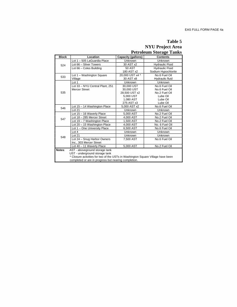
EAS FULL FORM PAGE 4a
Table 5
NYU Project Area Petroleum Storage Tanks
Block Location Capacity (gallons) Contents
524
Lot 1 – 505 LaGuardia Place Unknown Unknown Lot 66 – Silver Towers 30 AST x2 Hydraulic Fluid Lot 66 – Coles Building 50 AST
180 AST x2 Hydraulic Fluid
Sodium Hypochlorite
533 Lot 1 – Washington Square Village
20,000 UST x4 * 30 AST x8
No.6 Fuel Oil Hydraulic fluid
535
Lot 1 Unknown Unknown Lot 33 – NYU Central Plant, 251 Mercer Street
30,000 UST 30,000 UST
28,500 UST x2 5,000 UST 1,080 AST 275 AST x3
No.6 Fuel Oil No.6 Fuel Oil No.2 Fuel Oil
Lube Oil Lube Oil Lube Oil
546 Lot 15 – 14 Washington Place 5,000 AST x2 No.6 Fuel Oil Lot 21 Unknown Unknown
547
Lot 15 – 16 Waverly Place 5,000 AST No.2 Fuel Oil Lot 18 – 285 Mercer Street 4,000 AST No.2 Fuel Oil Lot 19 – 7 Washington Place 1,500 AST No.2 Fuel Oil Lot 20 – 15 Washington Place 4,000 AST No. 6 Fuel Oil
548
Lot 1 – One University Place 6,500 AST No.6 Fuel Oil Lot 4 Unknown Unknown Lot 21 Unknown Unknown Lot 24 – Snug Harbor Owners Inc., 303 Mercer Street
7,500 AST No.6 Fuel Oil
Lot 40 – 11 Waverly Place 5,000 AST No.2 Fuel Oil Notes: AST - aboveground storage tank UST - underground storage tank
* Closure activities for two of the USTs in Washington Square Village have been completed or are in progress but nearing completion.

EAS FULL FORM PAGE 5
Zoning*
Zoning classification PDA: R7-2/C1-5 overlay COA: R7-2
PDA: R7-2/C1-5 overlay COA: R7-2
PDA: C1-7 COA: R7-2/C1-5
overlay N/A Maximum amount of floor area that can be developed (in terms of bulk) See footnote 1 1 See footnote 1 1 See footnote 2 2 See footnote 3 3 Predominant land use and zoning classification within a 0.25-radius of proposed project See footnote 4 4 See footnote 4 3 See footnote 4 3 N/A Attach any additional information as may be needed to describe the project. If your project involves changes in regulatory controls that affect one or more sites not associated with a specific development, it is generally appropriate to include the total development projections in the above table and attach separate tables outlining the reasonable development scenarios for each site. *This section should be completed for all projects, except for such projects that would apply to the entire city or to areas that are so extensive that site-specific zoning information is not appropriate or practicable.
1 PDA:
Residential = 1,778,421 zsf Community Facility = 3,474,628 zsf Commercial = 67,528 zsf
COA: Residential: ±228,308 x 3.44 = 785,380 zsf Community Facility: ±228,308 x 6.5 = 1,484,002 zsf
2 PDA: Residential: ±591,124 x 6.02 = 3,558,566 zsf Community Facility: ±591,124 x 6.5 = 3,842,306 zsf Commercial: ±591,124 x 2.0 = 1,182,248 zsf
COA: Residential: 228,308 x 3.44 = 785,380 zsf Community Facility: ±228,308 x 6.5 =1,484,002 zsf Commercial: ±228,308 x 2.0 = 456,616 zsf
3 PDA: Residential: 3,558,566 zsf - 1,778,421 zsf = 1,780,145 zsf Community Facility: 3,842,306 zsf - 3,474,628 zsf = 367,678 zsf Commercial: 1,182,248 zsf - 67,528 zsf = 1,114,720 zsf
COA: Residential: 785,380 zsf - 785,380 zsf = 0 zsf Community Facility: 1,484,002 zsf - 1,484,002 zsf = 0 zsf Commercial: 456,616 zsf – 0 zsf = 456,616 zsf
4 Land uses within ¼-mile of the proposed project include university and other institutional uses; residential (with and without ground floor commercial uses); commercial; open space; parking; industrial; hotel; vacant lots; and lots under construction. Zoning classifications within ¼-mile of the proposed project include: R6, R7-2, R10, C1-5, C1-7, C6-1, C6-2, M1-5A, and M1-5B.

EAS FULL FORM PAGE 6
PART II: TECHNICAL ANALYSES
INSTRUCTIONS: For each of the analysis categories listed in this section, assess the proposed project’s impacts based on the thresholds and criteria presented in the CEQR Technical Manual. Check each box that applies.
If the proposed project can be demonstrated not to meet or exceed the threshold, check the ‘NO’ box.
If the proposed project will meet or exceed the threshold, or if this cannot be determined, check the ‘YES’ box.
For each ‘Yes’ response, answer the subsequent questions for that technical area and consult the relevant chapter of the CEQR Technical Manual for guidance on providing additional analyses (and attach supporting information, if needed) to determine whether the potential for significant impacts exists. Please note that a ‘Yes’ answer does not mean that EIS must be prepared—it often only means that more information is required for the lead agency to make a determination of significance.
The lead agency, upon reviewing Part II, may require an applicant to either provide additional information to support the Full EAS Form. For example, if a question is answered ‘No,’ an agency may request may request a short explanation for this response.
YES NO 1. LAND USE, ZONING AND PUBLIC POLICY: CEQR Technical Manual, Chapter 4
(a) Would the proposed project result in a change in land use or zoning that is different from surrounding land uses and/or zoning? Is there the potential to affect an applicable public policy? If ’Yes,’ complete a preliminary assessment and attach.
(b) Is the project a large, publicly sponsored project? If ‘Yes,’ complete a PlaNYC assessment and attach.
(c) Is any part of the directly affected area within the City’s Waterfront Revitalization Program boundaries? If ‘Yes,’ complete the Consistency Assessment Form.
2. SOCIOECONOMIC CONDITIONS: CEQR Technical Manual, Chapter 5
(a) Would the proposed project:
Generate a net increase of 200 or more residential units?
Generate a net increase of 200,000 or more square feet of commercial space?
Directly displace more than 500 residents?
Directly displace more than 100 employees?
Affect conditions in a specific industry?
(b) If ‘Yes’ to any of the above, attach supporting information to answer the following questions, as appropriate. If ‘No’ was checked for each category above, the remaining questions in this technical area do not need to be answered. See page 10a
(1) Direct Residential Displacement
If more than 500 residents would be displaced, would these displaced represent more than 5% of the primary study area population?
If ‘Yes,’ is the average income of the directly displaced population markedly lower than the average income of the rest of the study area population?
(2) Indirect Residential Displacement
Would the expected average incomes of the new population exceed the average incomes of the study area populations? TBD1
If ‘Yes,’ would the population increase represent more than 5% of the primary study area population or otherwise potentially affect real estate market conditions? TBD1
If ‘Yes,’ would the study area have a significant number of unprotected rental units? TBD1
Would more than 10 percent of all the housing units be renter-occupied and unprotected? TBD1
Or, would more than 5 percent of all the housing units be renter-occupied and unprotected where no readily observable trend toward increasing rents and new market rate development exists within the study area? TBD1
1 TBD = To be determined as part of DEIS analysis; see page 10a.

EAS FULL FORM PAGE 7
YES NO (3) Direct Business Displacement
Do any of the displaced businesses provide goods or service that otherwise could not be found within the trade area, either under existing conditions or in the future with the proposed project?
Do any of the displaced businesses provide goods or services that otherwise could not be found within the trade area, either under existing conditions or in the future with the proposed project?
Or is any category of business to be displaced the subject of other regulations or publicly adopted plans to preserve, enhance, or otherwise protect it?
(4) Indirect Business Displacement
Would the project potentially introduce trends that make it difficult for businesses to remain in the area? TBD1
Would the project capture the retail sales in a particular category of goods to the extent that the market for such goods would become saturated as a result, potential resulting in vacancies and disinvestment on neighborhood commercial streets?
(5) Effects on Industry
Would the project significantly affect business conditions in any industry or any category of businesses within or outside the study area?
Would the project indirectly substantially reduce employment or impair the economic viability in the industry or category of businesses? 3. COMMUNITY FACILITIES: CEQR Technical Manual, Chapter 6
(a) Would the project directly eliminate, displace, or alter public or publicly funded community facilities such as educational facilities, libraries, hospitals and other health care facilities, day care centers, police stations, or fire stations?
(b) Would the project exceed any of the thresholds outlined in Table 6-1 in Chapter 6?
(c) If ‘No’ was checked above, the remaining questions in this technical area do not need to be answered. If ‘Yes’ was checked, attach supporting information to answer the following, if applicable. See page 10b.
(1) Child Care Centers
Would the project result in a collected utilization rate of the group child care/Head Start centers in the study area that is greater than 100 percent? Not applicable; see page 10b.
If ‘Yes,’ would the project increase the collective utilization rate by 5 percent from the No-Action scenario? (2) Libraries
Would the project increase the study area population by 5 percent from the No-Action levels? TBD as part of DEIS analysis TBD2
If ‘Yes,’ would the additional population impair the delivery of library services in the study area? TBD as part of DEIS analysis TBD2 (3) Public Schools
Would the project result in a collective utilization rate of the elementary and/or intermediate schools in the study area that is equal to or greater than 105 percent? Not applicable; see page 10b.
If ‘Yes,’ would the project increase this collective utilization rate by 5 percent from the No-Action scenario? (4) Health Care Facilities
Would the project affect the operation of health care facilities in the area? Not applicable; see page 10b. (5) Fire and Police Protection
Would the project affect the operation of fire or police protection in the area? Not applicable; see page 10b. 4. OPEN SPACE: CEQR Technical Manual, Chapter 7
(a) Would the project change or eliminate existing open space? (b) Is the project located within an underserved area in the Bronx, Brooklyn, Manhattan, Queens, or Staten Island? (c) If ‘Yes,’ would the proposed project generate more than 50 additional residents or 125 additional employees? (d) Is the project located within a well-served area in the Bronx, Brooklyn, Manhattan, Queens, or Staten Island? (e) If ‘Yes,’ would the project generate more than 350 additional residents or 750 additional employees?
(f) If the project is not located within an underserved or well-served area, would it generate more than 200 additional residents or 500 additional employees?
(g) If ‘Yes’ to any of the above questions, attach supporting information to answer the following: Does the project result in a decrease in the open space ratio of more than 5%? TBD3
If the project site is within an underserved area, is the decrease in open space between 1% and 5%? TBD3 If ‘Yes,’ are there qualitative considerations, such as the quality of open space, that need to be considered? TBD3
1 TBD = To be determined as part of DEIS analysis; see page 10a. 2 TBD = To be determined as part of DEIS analysis; see page 10b. 3 TBD = To be determined as part of DEIS analysis; see page 10b.

EAS FULL FORM PAGE 8
YES NO 5. SHADOWS: CEQR Technical Manual, Chapter 8. (a) Would the proposed project result in a net height increase of any structure of 50 feet or more?
(b) Would the proposed project result in any increase in structure height and be located adjacent to or across the street from a sunlight-sensitive resource?
(c) If ‘Yes’ to either of the above questions, attach supporting information explaining whether the project’s shadow reach any sunlight-sensitive resource at any time of the year. See page 10c.
6. HISTORIC AND CULTURAL RESOURCES: CEQR Technical Manual, Chapter 9
(a)
Does the proposed project site or an adjacent site contain any architectural and/or archaeological resource that is eligible for, or has been designated (or is calendared for consideration) as a New York City Landmark, Interior Landmark or Scenic Landmark; is listed or eligible for listing on the New York State or National Register of Historic Places; or is within a designated or eligible New York City, New York State, or National Register Historic District? If “Yes,” list the resources and attach supporting information on whether the proposed project would affect any of these resources. See page 10c
7. URBAN DESIGN AND VISUAL RESOURCES: CEQR Technical Manual, Chapter 10
(a) Would the proposed project introduce a new building, a new building height, or result in any substantial physical alteration to the streetscape or public space in the vicinity of the proposed project that is not currently allowed by existing zoning?
(b) Would the proposed project result in obstruction of publicly accessible views to visual resources that is not currently allowed by existing zoning?
(c) If “Yes” to either of the questions above, please provide the information requested in Chapter 10. See page 10c 8. NATURAL RESOURCES: CEQR Technical Manual, Chapter 11 (a) Is any part of the directly affected area within the Jamaica Bay Watershed? If “Yes,” complete the Jamaica Bay Watershed Form.
(b) Does the proposed project site or a site adjacent to the project contain natural resources as defined in Section 100 of Chapter 11? If “Yes,” list the resources: Attach supporting information on whether the proposed project would affect any of these resources. See page 10c
9. HAZARDOUS MATERIALS: CEQR Technical Manual, Chapter 12
(a) Would the proposed project allow commercial or residential use in an area that is currently, or was historically, a manufacturing area that involved hazardous materials?
(b) Does the proposed project site have existing institutional controls (e.g., (E) designations or a Restrictive Declaration) relating to hazardous materials that preclude the potential for significant adverse impacts?
(c) Does the project require soil disturbance in a manufacturing zone or any development on or near a manufacturing zone or existing/historic facilities listed in Appendix 1 (including nonconforming uses)?
(d) Does the project result in the development of a site where there is reason to suspect the presence of hazardous materials, contamination, illegal dumping or fill, or fill material of unknown origin?
(e) Does the project result in development where underground and/or aboveground storage tanks (e.g., gas stations) are or were on or near the site?
(f) Does the project result in renovation of interior existing space on a site with potential compromised air quality, vapor intrusion from on-site or off-site sources, asbestos, PCBs or lead-based paint?
(g) Does the project result in development on or near a government-listed voluntary cleanup/brownfield site, current or former power generation/transmission facilities, municipal incinerators, coal gasification or gas storage sites, or railroad tracks and rights-of-way?
(h)
Has a Phase I Environmental Site Assessment been performed for the site? If ‘Yes,’ were RECs identified? Briefly identify: Historical uses of the site including manufacturing, auto repair, a Consolidated Edison substation and properties with buried gasoline tanks; existing underground fuel oil storage tanks; urban fill beneath the site; and off-site dry cleaners and active petroleum spills reported in close proximity to the site.
(i) Based on a Phase I Assessment, is a Phase II Assessment needed? TBD1 10. WATER AND SEWER INFRASTURCUTRE: CEQR Technical Manual, Chapter 13 (a) Would the project result in water demand of more than one million gallons per day?
(b) Is the proposed project located in a combined sewer area and result in at least 1,000 residential units or 250,000 sq. ft. or more of commercial space in Manhattan or at least 400 residential units or 150,000 sq. ft. or more of commercial space in the Bronx, Brooklyn, Staten Island or Queens?
(c) Is the proposed project located in a separately sewered area and result in the same or greater development than that listed in Table 13-1 in Chapter 13?
(d) Does the proposed project involve development on a site five acres or larger where the amount of impervious surface would increase? To be determined based on DEIS analysis.
(e) Would the proposed project involve development on a site one acre or larger where the amount of impervious surface would increase and is located within the Jamaica Bay Watershed or in certain specific drainage areas including: Bronx River, Coney Island Creek, Flushing Bay and Creek, Gowanus Canal, Hutchinson River, Newtown Creek, or Westchester Creek?
(f) Would the proposed project be located in an area that is partially sewered or currently unsewered?
(g) Is the project proposing an industrial facility or activity that would contribute industrial discharges to a WWTP and/or generate contaminated stormwater in a separate storm sewer system?
(h) Would the project involve construction of a new stormwater outfall that requires federal and/or state permits? (i) If “Yes” to any of the above, conduct the appropriate preliminary analyses and attached supporting documentation. See page 10d.
1 TBD = To be determined based on consultation with NYCDEP.
EAS FULL FORM PAGE 9
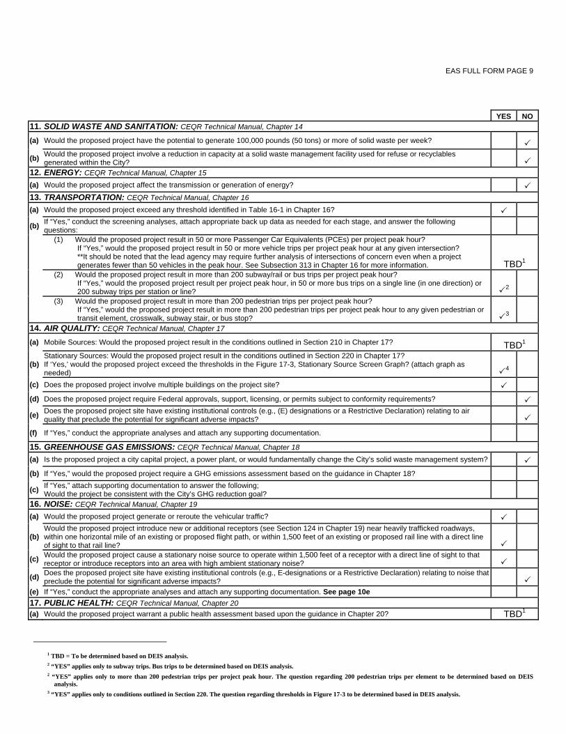
YES NO
11. SOLID WASTE AND SANITATION: CEQR Technical Manual, Chapter 14
(a) Would the proposed project have the potential to generate 100,000 pounds (50 tons) or more of solid waste per week?
(b) Would the proposed project involve a reduction in capacity at a solid waste management facility used for refuse or recyclables generated within the City?
12. ENERGY: CEQR Technical Manual, Chapter 15
(a) Would the proposed project affect the transmission or generation of energy? 13. TRANSPORTATION: CEQR Technical Manual, Chapter 16
(a) Would the proposed project exceed any threshold identified in Table 16-1 in Chapter 16?
(b) If “Yes,” conduct the screening analyses, attach appropriate back up data as needed for each stage, and answer the following questions:
(1) Would the proposed project result in 50 or more Passenger Car Equivalents (PCEs) per project peak hour? If “Yes,” would the proposed project result in 50 or more vehicle trips per project peak hour at any given intersection? **It should be noted that the lead agency may require further analysis of intersections of concern even when a project generates fewer than 50 vehicles in the peak hour. See Subsection 313 in Chapter 16 for more information. TBD1
(2) Would the proposed project result in more than 200 subway/rail or bus trips per project peak hour?
If “Yes,” would the proposed project result per project peak hour, in 50 or more bus trips on a single line (in one direction) or 200 subway trips per station or line? 2
(3) Would the proposed project result in more than 200 pedestrian trips per project peak hour?
If “Yes,” would the proposed project result in more than 200 pedestrian trips per project peak hour to any given pedestrian or transit element, crosswalk, subway stair, or bus stop? 3
14. AIR QUALITY: CEQR Technical Manual, Chapter 17
(a) Mobile Sources: Would the proposed project result in the conditions outlined in Section 210 in Chapter 17? TBD1
(b) Stationary Sources: Would the proposed project result in the conditions outlined in Section 220 in Chapter 17? If ‘Yes,’ would the proposed project exceed the thresholds in the Figure 17-3, Stationary Source Screen Graph? (attach graph as needed) 4
(c) Does the proposed project involve multiple buildings on the project site? (d) Does the proposed project require Federal approvals, support, licensing, or permits subject to conformity requirements?
(e) Does the proposed project site have existing institutional controls (e.g., (E) designations or a Restrictive Declaration) relating to air quality that preclude the potential for significant adverse impacts?
(f) If “Yes,” conduct the appropriate analyses and attach any supporting documentation. 15. GREENHOUSE GAS EMISSIONS: CEQR Technical Manual, Chapter 18
(a) Is the proposed project a city capital project, a power plant, or would fundamentally change the City’s solid waste management system? (b) If “Yes,” would the proposed project require a GHG emissions assessment based on the guidance in Chapter 18?
(c) If “Yes,” attach supporting documentation to answer the following; Would the project be consistent with the City’s GHG reduction goal?
16. NOISE: CEQR Technical Manual, Chapter 19
(a) Would the proposed project generate or reroute the vehicular traffic?
(b) Would the proposed project introduce new or additional receptors (see Section 124 in Chapter 19) near heavily trafficked roadways, within one horizontal mile of an existing or proposed flight path, or within 1,500 feet of an existing or proposed rail line with a direct line of sight to that rail line?
(c) Would the proposed project cause a stationary noise source to operate within 1,500 feet of a receptor with a direct line of sight to that receptor or introduce receptors into an area with high ambient stationary noise?
(d) Does the proposed project site have existing institutional controls (e.g., E-designations or a Restrictive Declaration) relating to noise that preclude the potential for significant adverse impacts?
(e) If “Yes,” conduct the appropriate analyses and attach any supporting documentation. See page 10e 17. PUBLIC HEALTH: CEQR Technical Manual, Chapter 20 (a) Would the proposed project warrant a public health assessment based upon the guidance in Chapter 20? TBD1
1 TBD = To be determined based on DEIS analysis. 2 “YES” applies only to subway trips. Bus trips to be determined based on DEIS analysis. 2 “YES” applies only to more than 200 pedestrian trips per project peak hour. The question regarding 200 pedestrian trips per element to be determined based on DEIS
analysis. 3 “YES” applies only to conditions outlined in Section 220. The question regarding thresholds in Figure 17-3 to be determined based in DEIS analysis.

EAS FULL FORM PAGE 10a
Additional Technical Information for EAS Part II
A. LAND USE, ZONING, AND PUBLIC POLICY
The proposed project would increase development and introduce new land uses to portions of the project site and would require discretionary actions related to eliminating deed restrictions within an Urban Renewal Area; zoning map changes; a Large-Scale General Development (LSGD) special permit; the demapping of City streets; the disposition of City-owned property; and potentially amendments to the text of the Zoning Resolution. Therefore, the Draft EIS (DEIS) will include a full analysis of potential land use, zoning, and public policy impacts as described in the Draft Scope of Work.
B. SOCIOECONOMIC CONDITIONS
According to the CEQR Technical Manual, a socioeconomic assessment should be conducted if an action may reasonably be expected to create substantial socioeconomic changes in an area. This can occur if an action would directly displace a residential population, substantial numbers of businesses or employees, or eliminate a business or institution that is unusually important to the community. It can also occur if an action would bring substantial new development that is markedly different from existing uses and activities in the neighborhood, and therefore would have the potential to lead to indirect displacement of businesses or residents from the area.
As detailed in the Draft Scope of Work, the following describes the level of assessment that is warranted and the scope of analysis for the five principal socioeconomic issues of concern:
DIRECT RESIDENTIAL DISPLACEMENT
The Proposed Actions would not directly displace any residents from the project site. Therefore, the Proposed Actions would not result in significant adverse impacts due to direct residential displacement, and no further analysis of this issue is required.
DIRECT BUSINESS DISPLACEMENT
The Proposed Actions would result in the direct displacement of up to seven businesses from the project site—the Morton Williams Supermarket and up to six retail stores within the LaGuardia Retail building. Collectively, the employment displaced from the project site would be well below the 100-employee CEQR threshold warranting analysis. Therefore, the Proposed Actions would not result in significant adverse impacts due to direct business displacement, and no further analysis of this issue is required.
INDIRECT RESIDENTIAL DISPLACEMENT
The project would provide more than 200 new residential units, which is a CEQR Technical Manual threshold for assessing the potential indirect effects of an action. Therefore, an assessment of indirect residential displacement will be conducted as described in the Draft Scope of Work.
INDIRECT BUSINESS DISPLACEMENT
The concern with respect to indirect business and institutional displacement is whether a proposed project could lead to increases in property values, and thus rents, making it difficult for some businesses or institutions to remain in the area. The Proposed Actions could introduce over 200,000 square feet of new commercial uses to the project area, which is the CEQR threshold for “substantial” new development warranting assessment. Therefore, as described in the Draft Scope of Work an assessment of indirect business and institutional displacement will be conducted.

EAS FULL FORM PAGE 10b
ADVERSE EFFECTS ON SPECIFIC INDUSTRIES
Based on the guidelines in the CEQR Technical Manual, a preliminary assessment of effects on specific industries will be conducted to determine whether the Proposed Actions would significantly affect business conditions in any industry or category of businesses within or outside the study area, or whether the Proposed Actions would substantially reduce employment or impair viability in a specific industry or category of businesses.
C. COMMUNITY FACILITIES AND SERVICES
As defined for CEQR analysis, community facilities are public or publicly funded schools, libraries, child care centers, health care facilities and fire and police protection. A project can affect facility services directly, when it physically displaces or alters a community facility; or indirectly, when it causes a change in population that may affect the services delivered by a community facility.
The proposed project would not have direct effects on community facilities, because the proposed project would not physically displace or alter any community facilities. And as detailed below, the proposed project would not introduce new uses at a scale that would result in significant adverse indirect impacts to community facilities. As per the CEQR Technical Manual, depending on the size, income characteristics, and age distribution of the new population, a project may have indirect effects on public schools, libraries, or child care centers. Indirect effects on police, fire, and health care services occur only when a “sizeable new neighborhood” is introduced by a project. The proposed project would not introduce a new neighborhood, and therefore, analyses of police, fire, and health care services are not warranted.
PUBLIC SCHOOLS
An analysis of public schools is required if a project introduces more than 50 elementary/middle school or 150 high school students. According to CEQR Technical Manual guidelines, in Manhattan the 50-student threshold for analysis of elementary/middle school capacity is achieved if a project introduces at least 310 residential units (not including dormitory rooms); the threshold for analysis of high school capacity is 2,492 residential units. The proposed project is not expected to result in the addition of 310 residential units (not including dormitory rooms), and therefore, a detailed analysis of public schools is not required. A preliminary assessment of public schools will be conducted, which is expected to screen out the potential for significant adverse impact, and note the additional capacity that would be provided by the on-site public school.
LIBRARIES
An analysis of libraries is undertaken if the project would result in more than a 5 percent increase in the ratio of residential units to libraries in the borough. In Manhattan, the CEQR threshold for this increase is 901 residential units. Since the proposed project could include a combination of faculty housing and dormitory uses in excess of 901 units, a preliminary assessment of the potential impacts on public libraries will be conducted. The analysis will focus on the potential effects of the project-generated population on branch libraries, accounting for the fact that university students and faculty living in the proposed housing would utilize the extensive NYU library facilities available to NYU students and faculty.
DAY CARE CENTERS
An analysis of day care centers is necessary when a project would introduce more than 50 eligible children (170 low- to moderate-income housing units in Manhattan, as identified in Table 6-1b of the 2010 CEQR Technical Manual). Based on this criterion, the proposed project would not trigger the threshold for an analysis of day care centers. Accordingly, the DEIS will not analyze indirect impacts on day care centers.
D. OPEN SPACE
Based on the CEQR Technical Manual, an open space assessment is typically conducted if the proposed action would directly affect an open space or if the action is located in an underserved area and would increase the population by more than 50 residents or by more than 125 workers. Since the proposed project would directly displace publicly accessible open spaces, and would result in an increase in residents and workers above the CEQR Technical Manual threshold, an open space analysis will be provided in the DEIS, as described in the Draft Scope of Work.

EAS FULL FORM PAGE 10c
E. SHADOWS
A CEQR shadows assessment is warranted when new project shadows are long enough to reach a publicly accessible open space (except within an hour and a half of sunrise and sunset), a historic landscape, a historic resource with sunlight dependent features, or an important natural feature. The tallest proposed building on the project site would reach approximately 275 feet in height (up to 305 feet, including mechanicals), and would have the potential to cast new shadows on nearby open spaces. An analysis of the new buildings’ potential to result in shadow impacts in the area will be included in the DEIS, as described in the Draft Scope of Work.
F. HISTORIC AND CULTURAL RESOURCES
According to the CEQR Technical Manual, a historic and cultural resources assessment is required if there is the potential to affect either archaeological or architectural resources. University Village (aka Silver Towers and 505 LaGuardia Place) is State/National Register-eligible (S/NR-eligible) and is a NYCL. Washington Square Village is S/NR-eligible. In addition, the Proposed Development Area is across streets from three historic districts: the NoHo Historic District (S/NR-eligible, NYCL) is located east of Mercer Street, the South Village Historic District (S/NR-eligible, NYCL-eligible) is located west of La Guardia Place, and the SoHo Cast-Iron Historic District (National Historic Landmark [NHL], S/NR, NYCL) is located south of West Houston Street. The Greenwich Village Historic District (S/NR, NYCL) is located north of West Fourth Street, and incorporates Washington Square Park and areas to the north and west of this park.
The Commercial Overlay Area contains a number of designated and eligible historic and cultural resources. These include: the Brown Building at 23-29 Washington Place (NHL, S/NR, NYCL); Silver Center/Hemmerdinger Hall at 100 Washington Square East (NR-eligible); and the 20-story apartment building at One University Place/27 Waverly Place (NR-eligible). A potential NoHo Historic District Expansion has been determined S/NR-eligible by the New York State Office of Parks, Recreation and Historic Preservation (OPRHP). The NoHo Historic District Expansion is bounded by West Fourth Street, Washington Square East/University Place, mid-block between Waverly Place and East 8th Street; and Mercer Street. In addition, the Commercial Overlay Area is located adjacent to 13-19 University Place (NR-eligible), across Washington Square East/University Place from the Greenwich Village Historic District, and across Mercer Street from the NoHo Historic District.
Therefore, it is necessary to analyze the potential impacts of the proposed project on historic and cultural resources.
Since redevelopment of the Proposed Development Area would entail in-ground disturbance, it is necessary to analyze the potential impacts of the proposed project on archaeological resources.
The work proposed to be undertaken in the DEIS is described in the Draft Scope of Work.
G. URBAN DESIGN AND VISUAL RESOURCES
The proposed project would result in physical changes to the project site beyond the bulk and form permitted as-of-right. These changes would affect a pedestrian’s experience of public space, requiring an urban design assessment. Since the overall change to the pedestrian experience is likely to be substantial, a detailed analysis will be conducted, as described in the Draft Scope of Work.
H. NATURAL RESOURCES
A natural resources assessment is conducted when a natural resource is present on or near the project site and when an action involves the disturbance of that resource. The CEQR Technical Manual defines natural resources as: water resources, including surface water bodies and groundwater; wetland resources (freshwater and tidal); surface water hydrology; upland resources, including beaches, maritime dunes, erosional slopes and bluffs; shrublands, grasslands, meadows and old fields; upland forests, woodlands and barrens; and built resources, including piers and other waterfront structures, old piers, pile fields and other ruins, beach protection structures, flood protection structures; and significant, sensitive, or designated resources, as indicated by the New York Natural Heritage Program. The project site is located in a fully developed area in Manhattan and has limited potential to provide unique habitat for noteworthy wildlife. As described in the Draft Scope of Work, a screening analysis will be presented in the DEIS identifying whether the proposed project would result in significant impacts on natural resources.
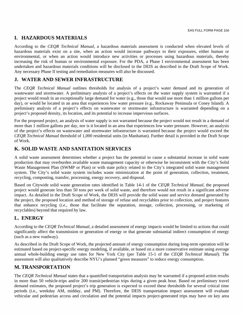
EAS FULL FORM PAGE 10d
I. HAZARDOUS MATERIALS
According to the CEQR Technical Manual, a hazardous materials assessment is conducted when elevated levels of hazardous materials exist on a site, when an action would increase pathways to their exposures, either human or environmental, or when an action would introduce new activities or processes using hazardous materials, thereby increasing the risk of human or environmental exposure. For the PDA, a Phase I environmental assessment has been undertaken and hazardous materials conditions will be disclosed in the DEIS as described in the Draft Scope of Work. Any necessary Phase II testing and remediation measures will also be discussed.
J. WATER AND SEWER INFRASTRUCTURE
The CEQR Technical Manual outlines thresholds for analysis of a project’s water demand and its generation of wastewater and stormwater. A preliminary analysis of a project’s effects on the water supply system is warranted if a project would result in an exceptionally large demand for water (e.g., those that would use more than 1 million gallons per day), or would be located in an area that experiences low water pressure (e.g., Rockaway Peninsula or Coney Island). A preliminary analysis of a project’s effects on wastewater or stormwater infrastructure is warranted depending on a project’s proposed density, its location, and its potential to increase impervious surfaces.
For the proposed project, an analysis of water supply is not warranted because the project would not result in a demand of more than 1 million gallons per day, nor is it located in an area that experiences low water pressure. However, an analysis of the project’s effects on wastewater and stormwater infrastructure is warranted because the project would exceed the CEQR Technical Manual threshold of 1,000 residential units (in Manhattan). Further detail is provided in the Draft Scope of Work.
K. SOLID WASTE AND SANITATION SERVICES
A solid waste assessment determines whether a project has the potential to cause a substantial increase in solid waste production that may overburden available waste management capacity or otherwise be inconsistent with the City’s Solid Waste Management Plan (SWMP or Plan) or with state policy related to the City’s integrated solid waste management system. The City’s solid waste system includes waste minimization at the point of generation, collection, treatment, recycling, composting, transfer, processing, energy recovery, and disposal.
Based on Citywide solid waste generation rates identified in Table 14-1 of the CEQR Technical Manual, the proposed project would generate less than 50 tons per week of solid waste, and therefore would not result in a significant adverse impact. As detailed in the Draft Scope of Work, the DEIS will provide the solid waste and service demand generated by the project, the proposed location and method of storage of refuse and recyclables prior to collection, and project features that enhance recycling (i.e., those that facilitate the separation, storage, collection, processing, or marketing of recyclables) beyond that required by law.
L. ENERGY
According to the CEQR Technical Manual, a detailed assessment of energy impacts would be limited to actions that could significantly affect the transmission or generation of energy or that generate substantial indirect consumption of energy (such as a new roadway).
As described in the Draft Scope of Work, the projected amount of energy consumption during long-term operation will be estimated based on project-specific energy modeling, if available, or based on a more conservative estimate using average annual whole-building energy use rates for New York City (per Table 15-1 of the CEQR Technical Manual). The assessment will also qualitatively describe NYU’s planned “green measures” to reduce energy consumption.
M. TRANSPORTATION
The CEQR Technical Manual states that a quantified transportation analysis may be warranted if a proposed action results in more than 50 vehicle-trips and/or 200 transit/pedestrian trips during a given peak hour. Based on preliminary travel demand estimates, the proposed project’s trip generation is expected to exceed these thresholds for several critical time periods (i.e., weekday AM, midday, and PM). Therefore, the DEIS transportation impact assessment will evaluate vehicular and pedestrian access and circulation and the potential impacts project-generated trips may have on key area

EAS FULL FORM PAGE 10e
intersections and nearby transit services. As part of the operational analyses, an assessment of traffic and pedestrian safety based on recent accident data will also be prepared. The Draft Scope of Work provides additional detail on the traffic, parking, and transit and pedestrian analyses that will be performed for the DEIS.
N. AIR QUALITY
The air quality studies for the proposed project will include a stationary source analysis and an analysis of emissions from the proposed relocation of the Washington Square Village parking garage. The stationary source air quality impact analysis will include an assessment of the project’s fossil fuel-fired heating, ventilation, and air conditioning (HVAC) systems’ emissions, as well as potential effects on the development sites from existing HVAC sources. The Draft Scope of Work describes the studies to be undertaken.
O. GREENHOUSE GAS EMISSIONS
In accordance with the CEQR Technical Manual threshold requiring a greenhouse gas (GHG) assessment for projects over 350,000 sf, GHG emissions generated by the proposed project will be quantified and an assessment of consistency with the City’s established GHG reduction goal will be performed. The Draft Scope of Work provides more details on the analysis to be performed for the DEIS.
P. NOISE
According to the CEQR Technical Manual, a noise analysis is appropriate if an action would generate any mobile or stationary sources of noise or would be located in an area with high ambient noise levels. Specifically, an analysis would be required if an action generates or reroutes vehicular traffic, if an action is located near a heavily trafficked thoroughfare, if an action would be within 1 mile of an existing flight path or within 1,500 feet of existing rail activity (and with a direct line of sight to that rail facility). A noise assessment would also be appropriate if the action would result in a playground or would cause a stationary source to be operating within 1,500 feet of a receptor (with a direct line of sight to that receptor), or if the action would include unenclosed mechanical equipment for manufacturing or building ventilation purposes, or if the action would be located in an area with high ambient noise levels resulting from stationary sources. As detailed in the Draft Scope of Work, the noise analysis will examine the level of building attenuation necessary to meet CEQR interior noise levels requirements. The building attenuation study will be an assessment of noise levels in the surrounding area associated primarily with traffic and nearby uses and their potential effect on the proposed project.
Q. PUBLIC HEALTH
According to the CEQR Technical Manual, public health is the organized effort of society to protect and improve the health and well‐being of the population through monitoring; assessment and surveillance; health promotion; prevention of disease, injury, disorder, disability and premature death; and reducing inequalities in health status. The goal of CEQR with respect to public health is to determine whether adverse impacts on public health may occur as a result of a proposed project, and if so, to identify measures to mitigate such effects.
According to the guidelines of the CEQR Technical Manual, a public health assessment may be warranted if an unmitigated significant adverse impact is identified in other CEQR analysis areas, such as air quality, water quality, hazardous materials, or noise. If unmitigated significant adverse impacts are identified in any one of these technical areas and the lead agency determines that a public health assessment is warranted, an analysis will be provided for that specific technical area.
R. NEIGHBORHOOD CHARACTER
The character of a neighborhood is established by numerous factors, including land use patterns, the characteristics of its population and economic activities, the scale of its development, the design of its buildings, the presence of notable landmarks, and a variety of other physical features that include noise levels, traffic, and pedestrian patterns. The proposed project represents a change that could affect the character of the surrounding area. Therefore, as described in the Draft Scope of Work, the EIS will analyze the project’s impact on neighborhood character.

EAS FULL FORM PAGE 10f
S. CONSTRUCTION IMPACTS
The CEQR Technical Manual calls for an assessment of construction-related impacts, with a focus on transportation, air quality, and noise, as well as consideration of other technical areas such as historic and cultural resources, hazardous materials, and natural resources. The likely construction schedule for development at the sites and an estimate of activities will be described. As discussed in the Draft Scope of Work, an analysis of construction impacts with a focus on traffic, air quality, historic resources, and noise will be included in the DEIS.