Environmental Assessment Determinations and Compliance ... · Environmental Assessment ....
70
Environmental Assessment Determinations and Compliance Findings for Oil and Gas Operations Permit (Drilling Operations) Date: April 6, 2017 Permit Application Information Applicant Name: Texas Petroleum Investment Company (TPIC) Company Contact: Chris Sanfilippo 207 Town Center Parkway, Suite 150, Lafayette, LA 70506 Operations Location: Delta NWR Preparer: Delta National Wildlife Refuge & US Fish & Wildlife Service National Energy Team Consultant (if applicable): N/A Direct Comments to: Delta National Wildlife Refuge, 61389 LA Hwy 434, Lacombe, LA, c/o Refuge Manager Shelley Stiaes Purpose and Need for the Proposed Action: The purpose for the proposed action is to respond to a request by Texas Petroleum Investment Company (Applicant) for an Operations Permit (Permit) for Applicant’s proposed activities of drilling the Delta Duck Club No. 130 well. As required by 50 CFR §29.94(b), the Applicant has filed with Delta NWR documentation demonstrating that it holds the legal right to conduct the proposed operations. This proposed action is needed in order to ensure that mineral rights holders have reasonable access to develop their non-Federal oil and gas interests and minimize impacts to Refuge resources to the extent practicable under the Service’s 50 CFR Part 29, Subpart D regulations (29D Regulations) for managing non-Federal oil and gas on Service-administered lands and waters. The purposes of implementing these regulations are: 1. Protecting Service-administered lands and waters, and resources of the Refuge; 2. Protecting Refuge wildlife-dependent recreational uses and experiences, and visitor and employee health and safety; 3. Conserving the Refuge for the benefit of present and future generations of Americans; and 4. Implementing technologically feasible and least damaging methods for oil and gas activities on the Refuge. These methods are those that we determine, on a case-by-case basis, to be most protective of Refuge resources and uses while ensuring human health and safety, taking into consideration all relevant factors, including environmental, economic, and technological factors and the requirements of applicable law.
Transcript of Environmental Assessment Determinations and Compliance ... · Environmental Assessment ....
Environmental Assessment
Determinations and Compliance Findings for Oil and Gas Operations Permit (Drilling Operations)
Date: April 6, 2017 Permit Application Information Applicant Name: Texas Petroleum Investment Company (TPIC) Company Contact: Chris Sanfilippo
207 Town Center Parkway, Suite 150, Lafayette, LA 70506 Operations Location: Delta NWR Preparer: Delta National Wildlife Refuge & US Fish & Wildlife Service National Energy Team Consultant (if applicable): N/A Direct Comments to: Delta National Wildlife Refuge, 61389 LA Hwy 434, Lacombe, LA, c/o Refuge Manager Shelley Stiaes Purpose and Need for the Proposed Action: The purpose for the proposed action is to respond to a request by Texas Petroleum Investment Company (Applicant) for an Operations Permit (Permit) for Applicant’s proposed activities of drilling the Delta Duck Club No. 130 well. As required by 50 CFR §29.94(b), the Applicant has filed with Delta NWR documentation demonstrating that it holds the legal right to conduct the proposed operations. This proposed action is needed in order to ensure that mineral rights holders have reasonable access to develop their non-Federal oil and gas interests and minimize impacts to Refuge resources to the extent practicable under the Service’s 50 CFR Part 29, Subpart D regulations (29D Regulations) for managing non-Federal oil and gas on Service-administered lands and waters. The purposes of implementing these regulations are:
1. Protecting Service-administered lands and waters, and resources of the Refuge; 2. Protecting Refuge wildlife-dependent recreational uses and experiences, and visitor and employee health
and safety; 3. Conserving the Refuge for the benefit of present and future generations of Americans; and 4. Implementing technologically feasible and least damaging methods for oil and gas activities on the
Refuge. These methods are those that we determine, on a case-by-case basis, to be most protective of Refuge resources and uses while ensuring human health and safety, taking into consideration all relevant factors, including environmental, economic, and technological factors and the requirements of applicable law.
2
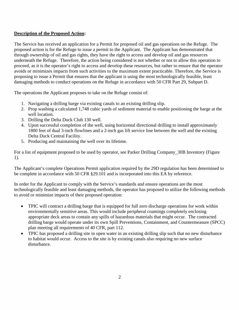
Description of the Proposed Action: The Service has received an application for a Permit for proposed oil and gas operations on the Refuge. The proposed action is for the Refuge to issue a permit to the Applicant. The Applicant has demonstrated that through ownership of oil and gas rights, they have the right to access and develop oil and gas resources underneath the Refuge. Therefore, the action being considered is not whether or not to allow this operation to proceed, as it is the operator’s right to access and develop these resources, but rather to ensure that the operator avoids or minimizes impacts from such activities to the maximum extent practicable. Therefore, the Service is proposing to issue a Permit that ensures that the applicant is using the most technologically feasible, least damaging methods to conduct operations on the Refuge in accordance with 50 CFR Part 29, Subpart D. The operations the Applicant proposes to take on the Refuge consist of:
1. Navigating a drilling barge via existing canals to an existing drilling slip. 2. Prop washing a calculated 1,748 cubic yards of sediment material to enable positioning the barge at the
well location. 3. Drilling the Delta Duck Club 130 well. 4. Upon successful completion of the well, using horizontal directional drilling to install approximately
1800 feet of dual 3-inch flowlines and a 2-inch gas lift service line between the well and the existing Delta Duck Central Facility.
5. Producing and maintaining the well over its lifetime. For a list of equipment proposed to be used by operator, see Parker Drilling Company_30B Inventory (Figure 1).
The Applicant’s complete Operations Permit application required by the 29D regulation has been determined to be complete in accordance with 50 CFR §29.101 and is incorporated into this EA by reference. In order for the Applicant to comply with the Service’s standards and ensure operations are the most technologically feasible and least damaging methods, the operator has proposed to utilize the following methods to avoid or minimize impacts of their proposed operation:
• TPIC will contract a drilling barge that is equipped for full zero discharge operations for work within environmentally sensitive areas. This would include peripheral coamings completely enclosing appropriate deck areas to contain any spills of hazardous materials that might occur. The contracted drilling barge would operate under its own Spill Preventions, Containment, and Countermeasure (SPCC) plan meeting all requirements of 40 CFR, part 112.
• TPIC has proposed a drilling site in open water in an existing drilling slip such that no new disturbance to habitat would occur. Access to the site is by existing canals also requiring no new surface disturbance.
3
In order for the Applicant to comply with the Service’s standards and ensure operations are the most technologically feasible and least damaging methods, the Service has also conditioned the Permit as follows:
1. All work must be completed in accordance with the attached work plan, map and these special use permit conditions.
2. Work plan and map must be attached to this operations permit at all times and a copy must be aboard each vessel used to complete the work.
3. Access to perform work is only permitted on the routes indicated on the field plat.
Once issued, the permit will be valid through October 31, 2017. A permit extension may be requested by the applicant if deemed necessary. The permittee shall notify the Oil and Gas Specialist and/or Refuge Manager 48 hours prior to entering the refuge to obtain approval for specific dates of operation.
4. Failure to notify refuge staff, or any deviation from the work plan or specified access routes, may subject the operator to monetary fines and/or void this permit.
5. Personnel and equipment may remain on refuge overnight and conduct operations 24 hours per day.
6. When performing oil and gas related work the permittee shall comply with applicable General Terms and Conditions of 50 CFR, 29.120 and 121 and all applicable state and federal laws and regulations.
7. Permittee will use engines that adhere to applicable Federal and State emission standards.
8. Vessels and work zones are required to have refuse containers for the disposal of daily trash. All refuse and equipment shall be removed from the refuge at the end of this permitted operation.
9. The littering, disposing, or dumping in any manner of garbage, refuse, sewage, sludge, earth, rocks, or other debris on any national wildlife refuge, except at locations designated by the refuge manager, is prohibited. Furthermore, the draining or dumping of oil, acids, pesticide wastes, poisons, or any other types of chemical wastes; or otherwise polluting any waters or other areas within any national wildlife refuge is prohibited.
10. Persons possessing, transporting or carrying firearms on national wildlife refuges must comply with all
provisions of state and local law. Discharging firearms is prohibited on the refuge except within permitted hunting zones and seasons, and in accordance with refuge regulations. (50 CFR 27.42 and specific refuge regulations in 50 CFR Part 32).
4
11. Killing, harassing, disturbing, injuring, spearing, poisoning , destroying, collecting or attempting to kill, harass, disturb, injure, spear, poison, destroy or collect any plant or animal on any national wildlife refuge is prohibited.
12. The permittee will keep disturbance to fish, wildlife, vegetation, and the environment to an absolute minimum. Feeding wildlife is prohibited.
13. Permittee will meet all federal and state requirements for noise suppression while operating on the refuge.
14. Drill rig will have inward facing lighting, pointing down; minimizing negative effects of spill lighting on night sky or surrounding habitat.
15. Permittee will post “warning/safety” signs at public access points (canals) surrounding drill rig. Warning public of increased boat traffic and operations.
16. This permit does not include surface impacts to refuge lands. Permittee is subject to mitigation costs if surface impacts are made during this operation.
17. The failure of the United States or the Service to require strict performance of the terms, conditions, covenants, agreements, or stipulations of this permit, in the exercise of the permittee’s mineral rights on National Wildlife Refuge lands will not constitute a waiver or relinquishment of the right of the United States to strictly enforce thereafter such terms, conditions, covenants, agreements or stipulations which shall, at all times, continue in full force and effect.
18. The permittee will save, hold harmless, defend, and indemnify the United States of America, its agents and employees for loses, damages, or judgements, and expenses on a bodily injury, death, or property of any nature whatsoever, and by whomsoever made, arising out of the actions, or failure to act, by the permittee, its employees, contractors, subcontractors or agents with respect to the exercise of permittee’s mineral rights on the refuge.
19. All refuge regulations will be enforced, and the permittee shall follow all applicable laws and regulations. The permittee is responsible for the actions of all employees, contractors, and support personnel. A complete list of regulations can be found in the “Code Of Federal Regulations, Title 50 – Wildlife and Fisheries” at: http://www.ecfr.gov/cgi-bin/text-idx?SID=d9d36ddafb7f99bcf8519c88286bb5ed&mc=true&tpl=/ecfrbrowse/Title50/50tab_02.tpl
5
Alternatives Considered As the operator is seeking to drill a new well from a previously drilled location with no additional surface disturbance on the refuge, coupled with the fact that the proposed location is not in sensitive habitat but rather in an area already highly impacted by non-Federal oil and gas activity, there is no conflict with a respect to the proposed alternative, so the EA does not need to consider additional alternatives. (43 CFR 46.310 (b)) No Action Alternative: Under the No Action Alternative, the Service would not engage with the Applicant in a permitting process resulting in the Applicant accessing their minerals without being required to comply with the 29D Regulations, and therefore there will be no assurance that the Applicant would use technologically feasible and least damaging methods. Throughout the impact evaluation below, we have contrasted the impacts of the proposed permitting action of the Service with the current condition and expected future condition under the No Action Alternative.
Affected Environment This section describes the existing environmental and socioeconomic setting in the action area. Delta Migratory Waterfowl Refuge was established by Executive Order No. 7229 on November 19, 1935, under the authority of the Migratory Bird Conservation Act. The initial acres forming Delta NWR were purchased from Joseph Leiter and the Delta Duck Club in 1935 to provide sanctuary and habitat for wintering and migrating waterfowl. The name was changed from Delta Migratory Waterfowl Refuge to Delta National Wildlife Refuge in 1940. Subsequent land purchases enlarged the Refuge to its current acreage of 48,799. (See map at Figure 2). Delta NWR is located on the east bank of the Mississippi River about 70 miles southeast of New Orleans in Plaquemines Parish, Louisiana (Figure 3). The refuge encompasses a variety of habitats from freshwater marsh to sandy beach and marine environments. It lies at the southern terminus of the Mississippi Flyway and provides important breeding, stopover, wintering, and year-round habitat for a variety of birds and other species of conservation concern. Delta NWR has experienced oil and gas activities since the 1940’s. These include the full gamut of activities including exploration, development, production, and transportation pipelines. Over 400 oil/gas wells, 3 production facilities, countless miles of flowlines, miles of dredged canals, and over 50 miles of pipeline ROW have been constructed/placed on refuge lands. Delta NWR is not located near any urban centers; the closest town is Venice, which is across the Mississippi River from actual refuge lands. The refuge is in Plaquemines Parish, Louisiana’s most southern parish, where the Mississippi River meets the Gulf of Mexico. There are no incorporated communities anywhere within the parish. The parish is bisected by the Mississippi River. Most of the population is distributed along a narrow band of land on each bank of the river. Sources of income are the seafood industry, the off-shore oil industry,
6
shipping, and citrus groves. Millions of pounds of shrimp, oysters, crab, and fish are produced annually by the commercial fishing industry. The parish is also considered a “sportsman’s paradise” for sports fishing. Encompassing seventy miles of the Mississippi River, Plaquemines Parish is the eighth largest port in the United States and is noted for exporting coal, petro-chemicals, and grain. In 2005, the parish population was 28,995 and the 2003 median income was $38,173 for a household. In August 2005, the entire parish was devastated by Hurricane Katrina which caused extensive structural damages and flooding, major losses to the commercial fishing industry, and a substantial decrease in population. The decrease is not from hurricane-related deaths so much as from people not returning to the area after evacuating. Residents are trickling back as housing and other infrastructure are repaired or replaced, but major questions remain about levee protection and the viability of local communities. The requested area of operations is located in the Delta Duck Field in an open water location canal. The Delta Duck Field is located between Main Pass and Raphael Pass on Delta NWR and primarily consists of fresh to intermediate marsh. (See map of area of operations on the Refuge at Figure 2). The tables below provide additional, brief descriptions of each affected resource. For more information regarding the affected environment, please see Delta and Breton National Wildlife Refuge’s Comprehensive Conservation Plan and Environmental Assessment (https://www.fws.gov/southeast/planning/PDFdocuments/Delta%20Breton%20Final/DeltaBretonFinalCCPdoc.pdf) , as well as the Habitat Management Plan for Delta and Breton National Wildlife Refuges (https://catalog.data.gov/dataset/habitat-management-plan-for-delta-and-breton-national-wildlife-refuges). Environmental Consequences of the Action This section analyzes the environmental consequences of the action on each affected resource, including direct and indirect effects. Direct effects are those which are caused by the action and occur at the same time and place. Indirect effects are those which are caused by the action and are later in time or farther removed in distance, but are still reasonably foreseeable. Effects include ecological (such as the effects on natural resources and on the components, structures, and functioning of affected ecosystems), aesthetic, historic, cultural, economic, social, or health, whether direct, indirect, or cumulative. Effects may also include those resulting from actions which may have both beneficial and detrimental effects, even if on balance the agency believes that the effect will be beneficial. The tables below provide the following:
1. A brief description of the affected resources in the area of operations; 2. Typical impacts of oil and gas extraction and development on those resources; and 3. Site-specific impacts of the Service’s permitting action on those resources, including direct and
indirect effects.
7
For more information on the Typical Impacts of Well Drilling & Production Operations on National Wildlife Refuge System (NWRS) lands, see the Service’s “National Wildlife Refuge System Revision of Regulations Governing Non-Federal Oil and Gas Activities Environmental Impact Analysis” (Programmatic EIS). The Programmatic EIS (https://www.fws.gov/refuges/oil-and-gas/pdfs/FEIS-National-Wildlife-Refuge-System-Revision-of-Regulations-Governing-Non-Federal-Oil-and-Gas-Rights.pdf) provides a framework for taking a range of actions under the 29D Regulations, including the requirement that all new operators obtain an Operations Permit for new drilling and production operations to ensure those operations meet the various operating standards outlined in the regulations. The Programmatic EIS acknowledged that actions relating to new non-Federal oil and gas development would require more site-specific analyses before they could be permitted. Therefore, this EA tiers from the programmatic EIS and provides additional site-specific analysis.
NATURAL RESOURCES
AFFECTED ENVIRONMENT
IMPACT EVALUATION
Geology & Soils Soils on Delta NWR are all formed in recent Mississippi River alluvium, and range from fine sand to clay in texture. Imperfect to poor drainage is the rule, and flooding is frequent.
The primary impact on soils from oil and gas wells in open water is a direct loss of submerged soil productivity in the footprint of the site and through installation of pipelines, gathering lines, or service lines. During site preparation, impacts on geology and soils occur as a result of temporarily removing acreage from natural conditions and transferring that area to an industrial use to accommodate the drilling rig and associated equipment. In addition to construction-related impacts, there is a risk of impact on soils from releases of hazardous or contaminating substances during drilling or production operations, including well workovers and servicing. These releases could occur from leaking equipment. In most cases, however, primary and secondary containment, of hazardous and contaminating substances, if implemented, should prevent the release of drilling muds, diesel fuel, oil and gas, and other substances beyond the drilling barge. TPIC has proposed its drilling location and access to it in open water, existing canals and drilling slip. Therefore, direct impacts on soils and geology are limited. Approximately 1,750 cubic yards of submerged sediments will be disturbed and dispersed locally by prop washing to provide sufficient draft for the drilling barge. If the well is successful, boring the flowlines and gas lift service line will involve additional disturbance and dispersal of submerged sediments at the entry and exit points of the lines. Short runs to connect the lines from there to the Delta Duck facility and the well will be jetted in for installation below the mud line. Given the dynamic nature of the submerged soil sediments, the
8
additional one-time disturbance is expected to have negligible impacts on the sediments themselves or the habitat they provide. No reclamation will be necessary. Additionally, the operator is proposing to use a zero discharge, self-contained drilling barge that will ensure that leaks and spills of hazardous or contaminating substances entering the environment will be avoided to the maximum extent practicable. The operator has submitted the drilling contractor’s SPCC plan for drilling operations and its own Facility Response Plan (FRP) as required under 40 CFR, part 112. Adherence to these plans will help ensure that risks of spills are minimized and any spills or leaks that do occur will be reported to the refuge and responded to in a timely manner. As a result, risks of these indirect impacts to marshlands/wetlands will be minimized or avoided to the maximum extent possible. Additionally, the operator is responsible for any damage to marshlands or wetlands as a result of such a spill or leak and must restore habitat to the Service’s standards (50 CFR 29.117(a), 120(g) and 29.151(a)). Therefore, the Service has determined that the operator has proposed the most technologically feasible, least damaging methods in this instance, and has not added any additional stipulations to the Operations Permit.
Air Quality: Delta NWR is a designated Class II Clean Air Areas, as are most National Wildlife refuges, by the Clean Air Act. This means that limited development (i.e. sources of pollution) can be permitted near the refuge as long as the levels of particulate, matter, sulfur dioxide, and nitrogen dioxide do not exceed the class II increments. Air quality on the refuge is influenced by off-site sources including petrochemical industrial facilities along the Mississippi River north and west of Delta NWR. Prevailing southeast winds transport relatively clean air to the refuge for most of the year.
The primary impacts on air quality from well drilling and production include emissions from the barge and heavy equipment during drilling of the well, as well as, emissions released during well maintenance and production activities. The barge and heavy equipment used for the construction and maintenance of the well, flowlines, and pipelines, and well drilling could introduce NOx ,VOCs, CO, SO2, PM10, PM2.5, and odors from operating large engines, pumps and auxiliary equipment. This can result in short-term (drilling operations) to long-term (production operations) impacts on air quality. Drilling activities can involve continuous operation of combustion engines over a 15- to 120-day period depending on the depth and complexity of the well drilled. This activity would introduce emissions of NOx, CO, and SO2. Large diesel engines, which are used to power the drill, rigs, pumps, and auxiliary equipment emit NOx as primary pollutants of concern. Nitrogen oxides are formed in the high temperature, pressure, and excess-air environment of combustion diesel engines. Smaller amounts of CO and hydrocarbons would also be emitted. Some SO2 would be emitted due to the burning of gasoline and diesel (which contain minor amounts of sulfur). The amount of engine emissions depends on the drilling rig size (horsepower), percent sulfur in the fuel burned, gallons of diesel fuel burned per hour, the hours per day, number of days the diesel rigs operate, and the use of
9
any emission control devices. Hazardous air pollutants that can be released during oil and gas operations are benzene, toluene, ethylbenzene, and xylene (known as the “BTEX” chemicals); hydrogen sulfide (H2S); arsenic (As); and mercury (Hg). These pollutants demonstrate a high toxicity and can lead to increased rates of cancer and respiratory disease in humans either acutely or chronically exposed to high concentrations in the environment. Existing concentrations of and potential exposures to these pollutants vary widely depending upon the physical characteristics of the site, the proximity of human populations, the level of oil and gas production, and the type of production equipment employed (Mall et al. 2007). Odors from drilling and production operations could affect visitors and refuge employees. The possibility and extent for odor would depend on wind speed and direction and the nature of the drilling equipment and material encountered during drilling operations (particularly the presence of H2S -bearing zones). Odor would be more noticeable during light breezes and less evident during periods of stronger winds. For both existing and future operations, hydrocarbons could volatize and enter the atmosphere as the result of a leak or spill. In the vicinity of the leak or spill, concentrations of gas and other constituents could present health hazards to animal and plant life. In addition, a leak or spill could provide a source for explosion or fire. These impacts could be serious on a very local level; however, with mitigation, and prompt response in the event of a spill, impacts would be short-term. These impacts could be localized event but can contribute to regional air quality impacts. Photochemical reactions between hydrocarbons and NOx produce ozone (Bradbury et al. 2013). Although the concentration of all these pollutants would increase as the fields are developed, the levels are expected to be low and are required to comply with Federal and State standards and conform to all local air quality State implementation plans (SIPs). The extent of impacts caused by increases in pollutants may range from areas near each well to longer ranges with low-level contributions to regional impacts, like ozone and haze formation. NOx and Sox in the air can damage the leaves of plants, decreasing their ability to produce food – photosynthesis- and decrease their growth. In addition to directly affecting plants, atmospheric nitrogen deposition acts as fertilizer, favoring some plants, including invasive species, and leaving others at a competitive disadvantage. Sulfur oxides can acidify sensitive ecosystems resulting in a range of harmful deposition-related effects on plants, soils, water quality and fish and wildlife. This creates an imbalance in natural ecosystems, and over time may lead to shifts in the types of plant and animal species present, increases in insect and disease outbreaks, disruption of ecosystem
10
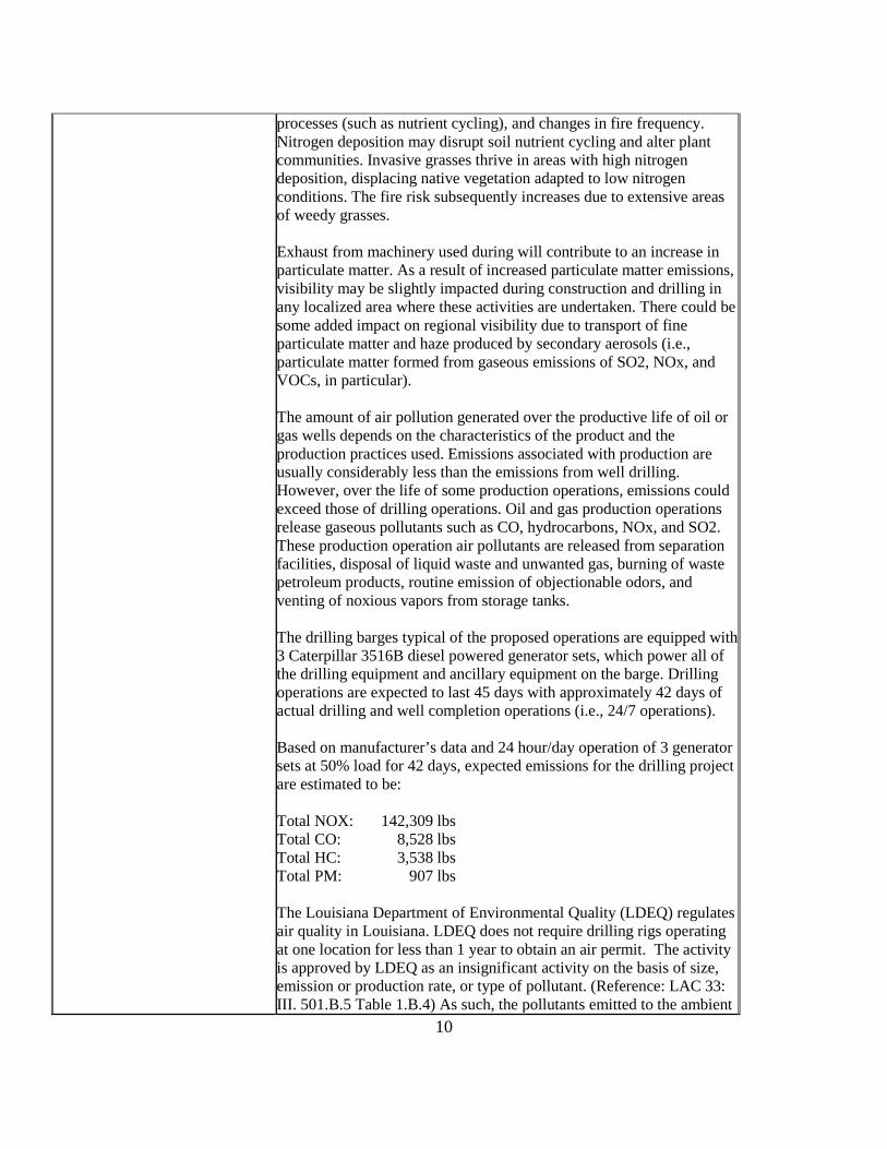
processes (such as nutrient cycling), and changes in fire frequency. Nitrogen deposition may disrupt soil nutrient cycling and alter plant communities. Invasive grasses thrive in areas with high nitrogen deposition, displacing native vegetation adapted to low nitrogen conditions. The fire risk subsequently increases due to extensive areas of weedy grasses. Exhaust from machinery used during will contribute to an increase in particulate matter. As a result of increased particulate matter emissions, visibility may be slightly impacted during construction and drilling in any localized area where these activities are undertaken. There could be some added impact on regional visibility due to transport of fine particulate matter and haze produced by secondary aerosols (i.e., particulate matter formed from gaseous emissions of SO2, NOx, and VOCs, in particular). The amount of air pollution generated over the productive life of oil or gas wells depends on the characteristics of the product and the production practices used. Emissions associated with production are usually considerably less than the emissions from well drilling. However, over the life of some production operations, emissions could exceed those of drilling operations. Oil and gas production operations release gaseous pollutants such as CO, hydrocarbons, NOx, and SO2. These production operation air pollutants are released from separation facilities, disposal of liquid waste and unwanted gas, burning of waste petroleum products, routine emission of objectionable odors, and venting of noxious vapors from storage tanks. The drilling barges typical of the proposed operations are equipped with 3 Caterpillar 3516B diesel powered generator sets, which power all of the drilling equipment and ancillary equipment on the barge. Drilling operations are expected to last 45 days with approximately 42 days of actual drilling and well completion operations (i.e., 24/7 operations). Based on manufacturer’s data and 24 hour/day operation of 3 generator sets at 50% load for 42 days, expected emissions for the drilling project are estimated to be: Total NOX: 142,309 lbs Total CO: 8,528 lbs Total HC: 3,538 lbs Total PM: 907 lbs The Louisiana Department of Environmental Quality (LDEQ) regulates air quality in Louisiana. LDEQ does not require drilling rigs operating at one location for less than 1 year to obtain an air permit. The activity is approved by LDEQ as an insignificant activity on the basis of size, emission or production rate, or type of pollutant. (Reference: LAC 33: III. 501.B.5 Table 1.B.4) As such, the pollutants emitted to the ambient
11
air directly or indirectly from the proposed construction activities would not significantly impact the ambient air quality of the region, and would not jeopardize compliance with state and federal ambient air quality standards. Operation of small boats and work boats is expected to be the primary mode of transportation to and from the well site. While vessels associated with the operation would generate emissions such as CO and NOx, they are anticipated to have no significant impact on regional air quality since these vehicles are already part of the existing traffic mix in the area. Since these exhaust emissions are expected to be of relatively small quantities, and deterioration of air quality would be short-term and localized, and would not jeopardize compliance with state and federal ambient air quality standards, the Service has not identified additional mitigation measures as conditions of approval to this permit.
Water Resources: Hydrologically, Delta NWR is dominated by the Mississippi River. The constant flow of river water through the refuge to Breton Sound creates a salinity gradient from fresh water on the western side to brackish along the shoreline. The marshes and ponds of Delta NWR range from fresh where influenced by the Mississippi River to brackish closer to the shoreline with the Gulf of Mexico and Breton Sound. The system is open and not managed by any control structures on the Refuge. In the operations area, water quality is good and generally considered ‘fresh’ during higher water periods. As water levels in the river decrease the salinity increases more towards a brackish water environment. During the spring time a much heavier sediment load is observed in most waterways on Delta NWR. During the
Water resources could become contaminated if hazardous substances are released into them during drilling, production, servicing, or transport. Blowouts could occur during drilling and release hydrocarbons, water, and drilling mud. The Service recognizes that unplanned incidents associated with oil and gas operations such as well blowouts present a risk of release of contaminants that can adversely impact water resources. However, the rates for such incidents are low and are not an expectation of project implementation. In the event that the refuge’s resources or values are damaged, the Service would seek remedy both in the form of reclamation and monetary compensation. There could also be accidental spills of drilling mud, diesel fuel, and other chemicals during drilling operations, or leaks from containers or flow lines. If drilling mud, fuels, or other chemicals are spilled in the water, the fluids could result in changes in water quality and possible violations of water quality standards if these are not detected and remediated. Contamination from the release of produced waters that contain salts and other well drilling fluids and chemicals could also impact surface and ground water. For example, such instances of leaks from salt-water disposal wells and flowlines conveying oilfield brine, subsequent contamination from mechanical problems and improper operating practices have been documented at Hagerman and Aransas National Wildlife Refuges in Texas and the Anderson Waterfowl Production Area in northeastern Montana (M. Maddux and M. Borgreen pers. comm.). Because production could continue for 20 years or longer, the potential for leaks and spills of hazardous substances from production operations (including flowlines and pipelines) is greater than for any other phase of oil and gas operations. Adverse impacts on water quality could occur from accidental leaks and spills of drilling fluids or waste waters,
12
proposed operational period the sediment load is expected to be fairly high. The sediment load is dependent on the river stage. By late Summer/Early Fall the river stage generally decreases which reduces sediment load and increases salinity.
hazardous waste spills (including diesel fuel), well blowouts, ruptures of flowlines and pipelines, and spills from tanker trucks. Chronic small leaks and spills could spread through various pathways, and over an extended period of time could become substantial and costly to remediate. The chances of undetected spills are greater if routine inspections are not performed. Faulty installation or corrosion of production casing might go undetected and could adversely impact groundwater, if hydrocarbons and/or produced waters migrate into an aquifer and contaminate groundwater. The severity of the impact would depend on the type of substance spilled (hydrocarbons, produced waters, chemicals, solvents, and fuels) and the size of area impacted, but impacts could be substantial. Oilfield brine spills can increase the bioavailability of some heavy metals as well as destroy the soil structure resulting in the significant reduction of infiltration rates (Vavrek et al. 2004). These brine impacted soils are usually devoid of vegetation and are susceptible to erosion. The loss of infiltration will result in increased runoff with impacts to nearby surface water in terms of salinity, and siltation. Impacts to the soils from oilfield brine spills remain for years (Vavrek et al. 2004). Brine spills can produce impacts, even in saltwater habitats. Seawater is considered 35, 000 ppm whereas Brine can potentially be as high as ~450,000 ppm. As described under geology and soils, all surface operations will be conducted in open water. Direct impacts to water quality from the proposed are expected to be very limited. Prop washing at the drill site to accommodate the drilling barge with temporarily redistribute approximately 1750 cubic yards of sediment through water to immediately adjacent areas. The increase in turbidity is expected to be short-term and return to natural conditions within hours. Should the well be successful, installation of the dual flowlines and a the gas lift service line using horizontal directional drilling will involve jetting approximately 20 cubic yards of sediment at both the entry and exit points. Additionally, as discussed above, the operator is proposing to use a zero discharge, self-contained drilling barge that will ensure that leaks and spills of hazardous or contaminating substances entering the environment will be avoided to the maximum extent practicable. The operator has submitted the drilling contractor’s SPCC plan for drilling operations and its own FRP as required under 40 CFR, part 112. Adherence to these plans will help ensure that risks of spills are minimized and any spills or leaks that do occur will be reported to the refuge and responded to in a timely manner. As a result, risks of these indirect impacts to water resources will be minimized or avoided to the maximum extent possible. Additionally, the operator is responsible for any damage to water resources as a result of such a spill or leak and must restore habitat to the Service’s standards (50 CFR 29.117(a), 120(g) and 29.151(a)).
13
Therefore, the Service has determined that the operator has proposed the most technologically feasible, least damaging methods in this instance, and has not added any additional stipulations specific to water quality to the Operations Permit.
Marshlands/Wetlands Two basic marsh zones occur within the marsh habitat - fresh marsh nearest the main tributaries and the brackish marsh zone nearest the Gulf of Mexico. Approximately 60% of the Refuge consists of the fresh marsh zone. The predominant plants in the fresh marsh zone are delta duck potato, elephant ear, wild millet, and three-square. The marsh is tidally flooded in depths ranging from a few inches to 2-3 feet. The fertile soil, vegetative composition, and shallow water environment result in a highly productive habitat for fish and wildlife.
There is a risk of indirect impacts on wetlands from releases of hazardous or contaminating substances during drilling or production operations. These releases could occur from leaking equipment. As described in Geology and Soils, the unintentional or accidental release of hazardous or contaminated materials also includes the risk of release of drilling mud, and contamination from the release of produced waters containing salts, NORM, hydrocarbons and other well drilling fluids could also impact wetland vegetation in the refuge units. These substances may contain relatively large concentrations of dissolved salts, particularly sodium chloride, and can have salt concentrations greater than ocean water (Vavrek et al. 2004). Salt stress is the major environmental factor that affects all vital plant processes such as growth, photosynthesis, protein synthesis, energy and lipid metabolism, and productivity (Parida and Das 2005). Instances of leaks from salt-water disposal wells and subsequent contamination occurring as the result of mechanical problems and improper operating practices have been documented at Hagerman and Aransas NWRs and the Anderson WPA (M. Maddux and M. Borgreen, pers. comm.). Oilfield brine spills can increase the bioavailability of some heavy metals as well as destroy the soil structure resulting in the significant reduction of infiltration rates (Vavrek et al. 2004). These brine impacted soils are usually devoid of vegetation and are susceptible to erosion. The loss of infiltration will result in increased runoff with impacts to nearby wetlands in terms of salinity, and siltation. Impacts to the soils and wetlands from oilfield brine spills remain for years (Vavrek et al. 2004). There will be no loss of marshland/wetlands as a result of proposed operations. The drilling operations are proposed to be conducted on a self-contained barge that will be on location for approximately 45 days, and will be located outside of any marshlands/wetlands there will be no impact to marshland/wetlands as a result of drilling and production from the proposed well. The location of the proposed well site is also outside of any marshland/wetland habitat, so there will be no destruction of vegetation or long term impacts to the habitat. Additionally, the proposed gathering lines and service line will be bored underneath the marshlands/wetlands, so there will be no direct impacts from installation. The only impacts to marshland/wetlands
14
would be in the instances of a spill or leak. As discussed above, the operator is proposing to use a zero discharge, self-contained drilling barge that will ensure that leaks and spills of hazardous or contaminating substances entering the environment will be avoided to the maximum extent practicable. The operator has submitted the drilling contractor’s SPCC plan for drilling operations and its own FRP as required under 40 CFR, part 112. Adherence to these plans will help ensure that risks of spills are minimized and any spills or leaks that do occur will be reported to the refuge and responded to in a timely manner. As a result, risks of these indirect impacts to water resources will be minimized or avoided to the maximum extent possible. Additionally, the operator is responsible for any damage to water resources as a result of such a spill or leak and must restore habitat to the Service’s standards (50 CFR 29.117(a), 120(g) and 29.151(a)). Therefore, the Service has determined that the operator has proposed the most technologically feasible, least damaging methods in this instance, and has not added any additional stipulations specific to marshes/wetlands to the Operations Permit.
Vegetation (including species of special management concern): The predominant plants in the fresh marsh zone are delta duck potato, elephant ear, wild millet, and three-square. Low shrubs include groundsel, wax myrtle, and marsh elder. Scattered throughout the understory where sunlight reaches the forest floor is a herbaceous community of elephant ear and sedges. This habitat is valuable for cover for deer and small mammals. The trees provide an important staging area for migratory birds because of the proximity to the Gulf of Mexico. Predominant trees are black willow (along remnant spoil banks) and red maple.
The proposed operations occur in open water and are not expected to impact vegetation, however, there is a risk of indirect impacts on vegetation from releases of hazardous or contaminating substances during drilling or production operations, including well workovers and servicing. The presence of oils and other well development chemicals in the water could kill vegetation or adversely impact overall plant health. Contamination from the release of produced waters containing salts and other well drilling fluids could also impact vegetation in the refuge units. These substances may contain relatively large concentrations of dissolved salts, particularly sodium chloride, and can reach salinity levels as high as 450,000 ppm, which is more than 12x the salinity of seawater (~35,000 ppm). Salt stress is the major environmental factor that affects all vital plant processes such as growth, photosynthesis, protein synthesis, energy and lipid metabolism, and productivity (Parida and Das 2005). Accidental release of produced waters would likely damage or kill vegetation in the immediate area and possibly adjacent areas in the short-term. Immediate adverse impacts on vegetation could occur through direct contact of aquatic vegetation with the released material. Long-term, systemic impacts could also occur through uptake of the material from the soil by plant roots, thereby reducing the species’
15
The proposed work area is located in an ‘intermediate marsh’ area which falls between the predominant fresh marsh and brackish marsh. These areas may contain fresh and more salt tolerant plant species. The predominant vegetation adjacent to the drill site is Phragmites (Roseau Cane).
ability to recover and re-establish (Adams et al. 2011). However, because the area of operations is a dynamic and “heavily flushed” system, dilution will likely lessen long-term impacts. Use of barges and ships for construction and maintenance of the well, pipelines, gathering lines, and service lines could lead to an increase in the introduction of nonnative plant species. Invasive species actively outcompete and replace native species and are a threat to the overall ecological health of the refuge unit. Such introductions could negatively affect native plant communities, reduce diversity, reduce forest health and productivity, and degrade native wildlife habitat (Vila 2011; Tylianakis 2008). The area of the proposed operation is already highly impacted by the introduction of non-native and invasive species from so many potential sources that any mitigation measures placed on an operator to control invasive or nonnative species would lead to no notable benefits in reducing the spread of these species in the area of operation or on the refuge. Therefore, the Service has not identified any alternative technologically feasible, least damaging methods to require of operators that would mitigate or avoid impacts to the environment as related to control of nonnative and invasive species, and thus the permitting action has had no impact on nonnative or invasive species in the area of operations or on the refuge Additionally, as discussed above, the operator is proposing to use a zero discharge, self-contained drilling barge that will ensure that leaks and spills of hazardous or contaminating substances entering the environment will be avoided to the maximum extent practicable. The operator has submitted the drilling contractor’s SPCC plan for drilling operations and its own FRP as required under 40 CFR, part 112. Adherence to these plans will help ensure that risks of spills are minimized and any spills or leaks that do occur will be reported to the refuge and responded to in a timely manner. As a result, risks of indirect impacts to vegetation from spills and leaks will be minimized or avoided to the maximum extent possible. Additionally, the operator is responsible for any damage vegetation as a result of such a spill or leak and must restore habitat to the Service’s standards (50 CFR 29.117(a), 120(g) and 29.151(a)). Therefore, the Service has determined that the operator has proposed the most technologically feasible, least damaging methods in this instance, and has not added any additional stipulations to the Operations Permit.
16
Wildlife (including species of special management concern): Delta NWR is located in an extremely rich estuary system that is important to wading, sea, and shore birds, migratory waterfowl and songbirds, crabs, shrimp, and both fresh and saltwater fish. Wintering waterfowl populations begin building on Delta NWR in the fall and peak in mid-December and January. Recent surveys document 20,000 to 30,000 snow geese and 80,000 to 150,000 ducks. The most common species observed are gadwall, northern pintail, American wigeon, blue-winged teal, green-winged teal, and snow geese. The most common resident marsh and waterbirds are great blue heron, little blue heron, white ibis, glossy /white-faced ibis, great egrets, snowy egrets, tricolored herons, yellow-crowned night-herons, and black-crowned night-herons. The refuge serves as a staging area for many passerine birds during migration, and large concentrations of shorebirds are sometimes observed feeding in the mudflats. Because of the lack of high ground, no large numbers of mammals exist on Delta, but a few white-tailed deer, rabbits, and raccoons survive in this environment. The invasive non-native Nutria is probably the most abundant mammal on the refuge. Invasive Feral Swine are also very prevalent on the refuge.
Submerged aquatic vegetation removal and soil disturbance associated with the construction and installation of the well and associated pipelines would affect wildlife both directly and indirectly. Indirect effects would include short term loss of habitat through removal of vegetation (though this is expected to be very minimal in the existing location canal). This activity may also affect habitat structure, species composition, and the extent of vegetation available to wildlife. Other indirect impacts may include changes in distribution, stress, or activity caused by increased human disturbances associated with energy development (e.g., traffic, noise, human use) (Sawyer et al. 2002). The degree of impact would depend on the type and amount of habitat affected, the rate at which the site would regenerate after construction, and the frequency of maintenance conducted during operation. Fragmentation of existing wildlife habitats, which can occur from oil and gas well development, can also decrease an area’s functional capacity to support wildlife populations at non-impacted levels (Trombulak and Frissell 2000). Fragmentation refers to breaking up contiguous areas of vegetation/habitat into smaller patches that become progressively smaller and isolated over time Direct impacts to wildlife include increased mortality that could result from ships, construction activities, and increased activity associate with construction and maintenance. Aquatic species that cannot escape an area during construction, could be killed. Such changes in water use may result in severe and persistent adverse effects on wildlife and wildlife habitat in the refuge units. The refuge unit management, however, can close or restrict motorized public access in the area of operations, if necessary. With this authority, the Service can mitigate the effects of increased access via oil and gas activities. Species that inhabit or frequent areas with sites that have had releases of oil or other chemicals could be harmed or killed through direct exposure with the released materials or indirectly through degraded water quality (e.g., low pH, reduced dissolved oxygen, or sediment toxicity). If there are releases are into waterways, wildlife and aquatic species occupying or using the water could be directly impacted. The severity of impacts would depend on the type and amount of pollutant released, physical and environmental factors of the site, the method and speed with which cleanup occurs, and the sensitivity of wildlife and aquatic species to these impacts during different stages of their life cycle. The Service recognizes that unplanned incidents associated with oil and gas operations such as well blowouts, fires, and major spills within the boundaries of the refuge present a risk of release of contaminants that can adversely impact wildlife and aquatic species.
17
In the immediate vicinity of the proposed operation the most common wildlife are marsh, wading, and sea birds (e.g. rails, herons, egrets, and terns/gulls) along with resident fishes and invertebrates (e.g. bass, gar, red drum, shrimp, and blue crab). Federally Listed: Although an extremely rare visitor, the West Indian Manatee can occur at Delta NWR, especially during the summer months when water temperatures rise; and Gulf Sturgeon have been recorded in the Delta waters. Although both species can be found at Delta NWR, both would be considered infrequent visitors and neither have critical habitat designated within the refuge. Piping plovers are also found along adjacent barrier beaches but occurrence is not expected in the near vicinity of the area of operation due to habitat type.
Contamination from the release of produced waters containing salts and other well drilling fluids could impact wildlife resources in the refuge units. These substances may contain relatively large concentrations of dissolved salts, particularly sodium chloride, and can have salt concentrations greater than ocean water. Releases of produced waters (brine) can create salt licks, which may affect the behavior of large mammals and ungulates (Wiles and Weeks 1986). Oilfield brine spills can increase the bioavailability of some heavy metals as well as destroy the soil structure resulting in the significant reduction of infiltration rates (Vavrek et al. 2004). Due to the extremely high salinity of produced water, even in saltwater habitats these brine impacted soils are usually devoid of vegetation and are susceptible to erosion. Releases of produced water with high salinity levels may cause mortality of aquatic organisms such as invertebrates, freshwater mussels, and fish sensitive to increased levels of salinity (Brittingham et al. 2014). There may be aquatic species habitat degradation from placement of pipelines in areas where these species occur. These effects could decrease the long-term viability of populations as a result of long-term use. Some risk of direct mortality of aquatic species could occur if a pipeline ruptures or if toxic materials (such as diesel fuel or produced waste water) are spilled into the water. Noise from drilling or well servicing operations would also impact wildlife. Potential adverse effects from well drilling and production could include changes in species distribution and use of the area, increased energy expenditure, decreased reproductive success (breeding and nesting success), deafness in species with specialized hearing, and increased stress levels from the noise and disturbance associated with these activities (Sawyer et al. 2002). Increased noise levels during the breeding season can create acoustic masking for species, such as birds, that communicate by sound (Bayne et al. 2008, Francis et al. 2009, Brittingham 2014). Drilling operations introduce noise with the highest measurements in the 90 dBA (A-weighted decibel) range for a period of a week or two up to a few months, with noise coming mostly from multiple diesel engines. Therefore, noise impacts could be severe, but limited to a localized area and of relatively short duration. Some facilities associated with production operations (i.e., heater treater units, separator units) kill bats, migratory birds, and raptors through asphyxiation or incineration. Drilling operations would be conducted when wintering waterfowl populations are not present. Noise, odors, and human presence during drilling and flowline installations may cause resident species of birds to move away from the immediate area to nearby areas of much the same
18
habitat. Therefore, impacts to birds and other wildlife are expected to be adverse, but short-term, and minimal. The temporary increase in turbidity from prop washing or jetting bottom sediments will also temporarily disturb aquatic species. Fish and other aquatic species are well adapted for rapid increases in turbidity that occur naturally and are expected to not be adversely impacted. Additionally, as discussed above, the operator is proposing to use a zero discharge, self-contained drilling barge that will ensure that leaks and spills of hazardous or contaminating substances entering the environment will be avoided to the maximum extent practicable. The operator has submitted the drilling contractor’s SPCC plan for drilling operations and its own FRP as required under 40 CFR, part 112. Adherence to these plans will help ensure that risks of spills are minimized and any spills or leaks that do occur will be reported to the refuge and responded to in a timely manner. As a result, risks of impacts to wildlife from leaks and spills will be minimized or avoided to the maximum extent possible. Additionally, the operator is responsible for any damage to wildlife as a result of such a spill or leak and must restore habitat to the Service’s standards (50 CFR 29.117(a), 120(g) and 29.151(a)). As stated in the special conditions of the Special Use Permit the permittee will keep disturbance to fish, wildlife, vegetation, and the environment to an absolute minimum. Feeding, killing, harassing, and injuring wildlife is prohibited as outlined in the permit. Direct impacts pertaining to the remaining infrastructure, following the completion of the drilling operation, are expected to be minimal as the Delta Duck facility has been operational in the same location for decades and so species sensitive to these impacts to the environment are not present in the area of operation. The remaining wellhead structure (above water surface) will not cause substantial impacts. In fact, bird species may use this structure as a perch while hunting or loafing.
Climate Change: Among the most serious consequences of forecast climate change are sea level rise and the likely increase in hurricane intensity and associated storm surge (U.S. Global Change Research Program 2009). Global sea level is projected to rise during the 21st century at a greater rate than during 1961 to 2003
The Council on Environmental Quality (CEQ) released its Final Guidance for Federal Departments and Agencies on Consideration of Greenhouse Gas Emissions and the Effects of Climate Change in National Environmental Policy Act Reviews. The guidance provides a framework for agencies to consider both the effects of a proposed action on climate change, as indicated by its estimated greenhouse gas emissions, and the effects of climate change on a proposed action. The guidance instructs agencies to discuss these impacts in proportion to their significance. [40 CFR 1502.2(b) (Impacts shall be discussed in proportion to their significance); 40 CFR 1502.15 (Data and analyses in a statement shall be commensurate with the importance of the impact…)].
19
(Intergovernmental Panel on Climate change 2007). Subsidence, or land sinking, also contributes heavily to coastal erosion and land loss in Louisiana and the surrounding Gulf states. Geological modeling has suggested that the weight of Pleistocene sediments on the coast of Louisiana can explain between 0.1 and 0.8 cm (0.04 and 0.3 inches) of sinking per year (NASA 2008). Predicted global sea level rise of 1-2 m, coupled with local subsidence, which the NASA (2008) model predicts would be about 36 cm over the next 90 years in the vicinity of Breton NWR and 50 cm near Delta NWR, could add up to more than 2 m of relative sea level rise by the end of the 21st Century. The result will be shoreline retreat and inundation of most of both refuges, absent continued efforts at beach nutrition on Breton and sediment capture on Delta. Predicted impacts of sea level rise include increased risks of coastal erosion, conversion of wetlands to open water, increase in salinity of estuaries and freshwater aquifers and flooding for coastal communities (Climate Change Science Program 2009). Rising sea temperatures are expected to increase the frequency and strength of hurricanes (Emanuel 2005). Stronger storms with higher wind speeds, more intense rainfall, and more powerful surges are expected to cause more severe damage (Knutson and Tuleya 2004). As sea level rises and salinities increase, vegetation zones will
Drilling and flowline installation are estimated to consume approximately 170,000 gallons of diesel fuel which results in direct greenhouse gas (GHG) emissions of 1,725 metric tons of CO2 equivalent. Hydrocarbon ultimate recovery from the proposed well is unknown, but could range from zero for a dry hole to 500,000 barrels of oil and 500,000,000 cubic feet of natural gas for a prolific Delta Duck Club Field well over a productive life of up to 30 years. Consumption of the produced hydrocarbons could result in indirect GHG emissions ranging from zero to 250,000 metric tons of CO2 equivalent. Fugitive methane emissions and flash gas from oil would be insignificant contributors to GHG emissions compared to the actual consumption of products. As noted, the action being considered is not whether or not to issue a permit to allow this operation to proceed, as it is the operator’s right to access and develop these resources, but rather to ensure that the operator avoids or minimizes impacts from such activities to the maximum extent practicable. The Service acknowledges that compliance with State and Federal law for greenhouse gas emissions should provide the technologically feasible, least damaging methods to avoid or minimize impacts to climate change. Therefore, the Service has not put any further stipulations on the operator to reduce the indirect or direct impact of the operation on climate change. The Service’s management and oversight of this proposed non-Federal oil and gas operation (proposed action) is therefore essentially the same as the no action alternative relative to GHG emissions. However, the proposed action could result in very small, beneficial effects on greenhouse gas emissions, because it gives the Service the authority to ensure that operators are complying with Federal and State laws applicable to reduction of greenhouse gas emissions. Finally, given the relatively short life-span of the well of up to 30 years and its location in open water, climate change, including sea level rise, is not expected to have any notable effect on operations. In regards to GHG and emissions, the operator has to submit a GHG report annually to the Environmental Protection Agency (EPA). This report includes the run time hours of drilling rigs, which are used in the calculations for emissions. The drilling rigs runtime hours for each engine will be documented and reported under the rule.
20
migrate inland; present salt marsh will convert to open water, brackish marsh will become saline, freshwater marsh will become brackish, and freshwater swamps and shrub communities will convert to herbaceous systems as episodes of salt water intrusion become more frequent and occur further inland. Also predicted for south-central Louisiana by Karl et al. (2009) are changes in overall precipitation and in seasonal distribution of precipitation, and temperature averages and extremes. Current trends measured over the past century suggest that in southeast Louisiana, warming will continue, with more days over 90°F, fewer freezes, and longer frost-free periods, and precipitation will continue to decrease and to change distribution, with more fall precipitation and less precipitation during spring, summer, and winter. The likely extent of changes to the habitats of Delta and Breton NWRs is unclear. Wilderness: There is no wilderness on Delta NWR.
Typical Impacts of Well Drilling & Production Operations: While Breton NWR is close in proximity to Delta NWR and is designated wilderness, there are no anticipated impacts from this proposed operation on Breton NWR.
21
VISITOR USE AND EXPERIENCE
AFFECTED ENVIRONMENT
IMPACT EVALUATION
Delta NWR is accessible by boat only. Hunting and fishing are the primary public uses on the refuge. It is open to waterfowl, archery deer, and rabbit hunting. Sport fishing is permitted year-round during day-light hours, and only after 12:00 pm in the waterfowl hunting areas during the state waterfowl hunting season. Species caught most are freshwater catfish, largemouth bass, and sunfish during the spring and speckled seatrout and redfish in the summer/fall. Because of the remoteness and difficulty of access to the main portion of Delta, most other public use activities rarely occur.
Health and Human Safety - The primary source of impacts would be from drilling or production operations, especially if spills or leaks occurred and oil or other chemicals were not quickly cleaned up and removed from the site. Drilling and production have the potential for well blowouts and releases of hydrocarbons or other hazardous substances, including drilling muds and gases such as hydrogen sulfide (H2S). Visitors could also be drawn to well platforms out of curiosity, resulting in potential exposure to high pressured equipment or stored chemicals. Hunters, in particular, need to keep a safe distance from oil and gas operations; there is an inherent hazard of shooting near drilling rigs and production facilities (i.e., storage tanks, wellheads, and pump jacks) where bullets could penetrate equipment or cause ignition of flammables. Delta NWR regulations prohibit the use of rifled rounds or shotgun slugs and hunting within 250 yards from any oil and gas infrastructure. There is the possibility of storm damage to drilling and production operations, which could spread hazardous and contaminating substances. Perforating or rupturing a storage tank containing oil or treatment chemicals at a production facility would increase the threat of spills and subsequent harm to the public if they were to venture onto the site. A potential impact on human health and safety is the possible exposure to hazardous substances. Materials stored at well sites include oils, chemicals, and lubricants. Also, oil and gas wells can release hydrogen sulfide gas. If well sites are not fenced and are open to the public, there is a chance of visitor exposure to these substances if visitors enter the unsecured site. Most wells would operate under an emergency response plan that would address hydrogen sulfide releases and other possible scenarios. For those wells that may emit hydrogen sulfide, a radius-of-exposure analysis would likely be performed prior to site selection. However, the Service recognizes that unplanned incidents associated with oil and gas operations such as well blowouts, fires, and major spills within the boundaries of the refuge present a risk of release of contaminants that can adversely impact visitor use and experience by actual exposure to chemicals or from lack of access following an incident, depending on the location of the release. Drilling would occur outside the hunting season. Fishing opportunities are plentiful outside the immediate area of operations. However, the Service has stipulated that TPIC post signs at the drilling site warning the public to stay away from the immediate area of operations. Therefore, the Service’s proposed action will have minor, beneficial impacts to human health and safety.
22
If the well is successful, there would be the long-term presence of a well and platform during the production phase. The height of the well itself would be approximately 10 feet above water line and would only be visible in the immediate area. A navigation light will be installed and is necessary for safety purposes, and would minimize the risk of human collisions with the well. Additionally, as discussed above, the operator is proposing to use a zero discharge, self-contained drilling barge that will ensure that leaks and spills of hazardous or contaminating substances entering the environment will be avoided to the maximum extent practicable. The operator has submitted the drilling contractor’s SPCC plan for drilling operations and its own FRP as required under 40 CFR, part 112. Adherence to these plans will help ensure that risks of spills are minimized and any spills or leaks that do occur will be reported to the refuge and responded to in a timely manner. As a result, risks of indirect impacts to human health and safety will be minimized or avoided to the maximum extent possible. Access—the primary effect of well drilling and production is a reduction in access to any well sites and associated production facilities. All drilling and production operations would be closed to visitor access. Due to safety concerns, there may be additional restrictions to visitor access immediately adjacent to these sites. Indirect impacts, such as increased traffic, noise, odors, night lighting, and human activity, would not necessarily preclude recreational access, but would decrease the quality of the visitor experience in the vicinity of the operation, especially in more remote portions of the refuges. Workovers and servicing of existing operations could also cause access delays or restrictions. Therefore, the proposed operation may have some minor, adverse impacts on fishing opportunities on the refuge. Drilling would occur outside the hunting season. Fishing opportunities are plentiful outside the immediate area of operations. Visual Impacts—visual impacts on visitor experience from drilling and production operations could be more substantial than other types of impacts on visitors, especially if well sites were placed in relatively undisturbed or popular settings where visitors would be readily able to see the operation and all associated equipment and tanks, and visitors to that area were expecting or desiring a more natural experience. Drill rigs can reach heights of 180 feet, which would most likely be visible from several locations within the refuges. The operations, especially drilling, would increase the presence of work crews and equipment. Since drilling is a 24-hour, 7-day a week operation, these impacts would be continuous, and could last a week or two up to a few months. Production operations, although having a less intrusive human presence compared to drilling, could be visible for 30 years or longer. Please see the scenic
23
views and night sky resources topic for more details on this aspect of visitor experience. Coming across an oil drilling rig or production site could be an unpleasant experience for visitors seeking a natural, outdoor experience. The visual presence of oil and gas operations in a natural setting could adversely impact the areas by displacing the visitor or lessening the quality of the visitor experience. The impacts would be less for those visitors who are less concerned with the presence of such operations, and where operations are naturally screened from view. Oil and gas operations are a very common site for recreational users at Delta NWR and do not represent a notable conflict. Scenic Views – Visual impacts from drilling and production operations would be more substantial than other types of impacts, especially if well pads were placed in relatively undisturbed settings where visitors would be readily able to see the operation and all associated equipment and tanks. Although the type of rig used is highly variable, dependent on location and site-specific use requirements drill rigs can reach heights of 180 feet, which would be visible from multiple locations at greater distances and could intrude on a number of different viewsheds within different refuge units. Site clearing for well pad and access road construction could result in visible removal of refuge vegetation, creation of a pathway and an overall change in the natural scenery of the area, depending on the amount of clearing, location of the clearing and the refuge unit. Lighting of drilling operations, which is typically provided using fluorescent high pressure sodium or metal halide lamps, could interfere with night sky resources. Depending on where the operations are sited, the design and installation of lighting, and the amount of activity and type of equipment used during the night, impacts include disturbance of night-sky views, increase in overall sky glow and anthropogenic light rations, and disruption of wildlife behaviors like migration, predation and mating. The operations, especially drilling, would increase the presence of work crews and equipment. Since drilling is a 24-hour, 7-day a week operation, these impacts would be continuous, and could last a week or two up to a few months. Coming across an oil production rig could be an unpleasant experience for visitors seeking a natural, outdoor experience at the refuge unit. The visual presence of oil and gas operations in a natural setting would adversely impact the areas by intruding on scenic qualities and viewsheds and overall adversely impacting refuge unit scenic qualities in the area of the rig. Oil and gas facilities, pads, and roads introduce forms, lines colors, and textures that contrast with the natural visual setting. In circumstances where visitors are passing through refuges and not focused on the natural setting or in areas already highly impacted by oil and gas development, these impacts would not be as pronounced. The
24
impacts would be less for those visitors who are less concerned with the presence of such operations. Most of the visual impacts to the proposed area of operations would be temporary and would occur during the drilling of the well and installation of the gathering and service lines when there would be an increase in ship and barge lights and traffic. The lights of the drilling rig would be visible for miles, but would not be a singular or uncommon site. The drilling barge is expected to be on location for approximately two months. If the well is successful, there would be the long-term presence of a well and platform during the production phase. The height of the well itself would be approximately 10 feet above water line and would only be visible in the immediate area. A navigation light is necessary for safety purposes, and also would not be visible outside the immediate area. Impacts to scenic views and night sky resources during the production phase would result during well maintenance that necessitate a workover barge. Impacts would be similar, but less in intensity and duration, than described for drilling operations. The proposed area of operation is located in an isolated location away from any local populations. Because it is located so far from local populations, there will be no impacts to scenic views or night sky resources for most of the public, as it will not be visible. The only visitors to this area of operations are hunters and fishers. The proposed operations would have little additional impact on enjoyment of visitors to the refuge, because the natural visual setting is already highly impacted by existing oil and gas infrastructure. The Service has added one stipulation to the permit regarding scenic views/night sky resources. The drilling rig will have inward facing lighting, pointing down; minimizing negative effects of spill lighting on night sky or surrounding habitat. Noise—There would be increased noise from construction activities barges and ships, drilling equipment, and the drilling or workover crew that could adversely affect human health, visitor use and experience, wildlife, and the overall acoustic environment. These noises would be different from the types of noises common in the visitor use areas, or general background noises elsewhere in the refuge. Most of the adverse impacts associated with oil and gas operations within refuge units would result from the drilling and production phase, because construction of the well necessitates the majority of the heavy construction equipment that have considerable sound levels, and production has a long duration. Potential sources of noise associated with drilling and production include preparation of the drill site, drilling operations, cement work, well servicing, and workover operations. Barge and ship traffic would also add to noise. Predicted levels are representative of noise attenuation at a rate of 6 dBA per doubling of distance from the sound source (the noise level drop-off rate from a stationary point source purely due to the geometry of the
25
source). Though additional attenuation could be realized due to vegetation cover, intervening topography and meteorological conditions, low frequency sounds commonly produced by mechanized equipment (like vehicles, pumps, and drill rigs) travel great distances. Vegetation, certain meteorological conditions, and topography could reduce the distance at which noise levels from heavy construction equipment would attenuate to the natural ambient level. If the drilled wells are advanced to the production stage, the use of heavy construction equipment to lay pipelines would result in elevated sound levels similar to those described above for the site access, preparation, and drilling. The production phase would necessitate the use of some equipment that produces considerable amounts of noise, including gas compressors and jack pumps. These impacts would be continuous and long term, as pumping or gas compression would occur continuously over the life of the well. Additionally, over the course of time that the well is in production, well servicing and workover operations may be necessary. Depending on the maintenance necessary, well servicing may last only 1 or 2 days, requiring minor equipment and a workover rig (a scaled-down drilling rig). Major workover operations may last more than a month and could require some limited drilling operations. Where proposed operations are located close to active recreation (e.g., motor boating), as it is with Delta NWR, the noise associated with the oil and gas operations would not be as noticeable. Noise from exploration, development, and extraction activities can be mitigated through a variety of ways including, but not limited to, use of quieter engines, quieter machinery, noise barriers, noise enclosures, and timing of operations to avoid the quietest times of day or certain seasons for which impacts would be greater (i.e., wintering waterfowl populations). Production operations would also cause impacts because of the noise associated with production equipment and the short-term use of loud machinery and workover rigs onsite. These impacts would result from high sound levels while being temporary in nature. However, most noise levels associated with production would have lower sound levels than those generated by a drilling operation, yet would be continuous and could have other impacts to the soundscape, acoustic environment or the wildlife that rely on natural acoustic conditions. The greatest impacts from noise due to proposed operations would be temporary, with the most noise occurring during the drilling of the well and installation of the gathering lines and service lines due to increase in ship and barge traffic and the operating of heavy equipment for
26
construction and installation during this time. However, there would also be continuing noise impacts during the production phase due to some ship and barge traffic during minor maintenance or operation of heavy equipment during any workover operations. However, the proposed area of operation is located in an isolated location away from any local populations, so any noise from proposed operations will not affect a majority of the public. The only visitors to this area of operations are hunters and fishers. The proposed operations would have little additional impact on enjoyment of these visitors to the refuge, because the natural setting of the area is already highly impacted by noise from existing oil and gas infrastructure. The adverse impacts to the enjoyment of visitors from the additional noise impacts would not be notable. Therefore, the Service has added no stipulations to the permit regarding noise.
27
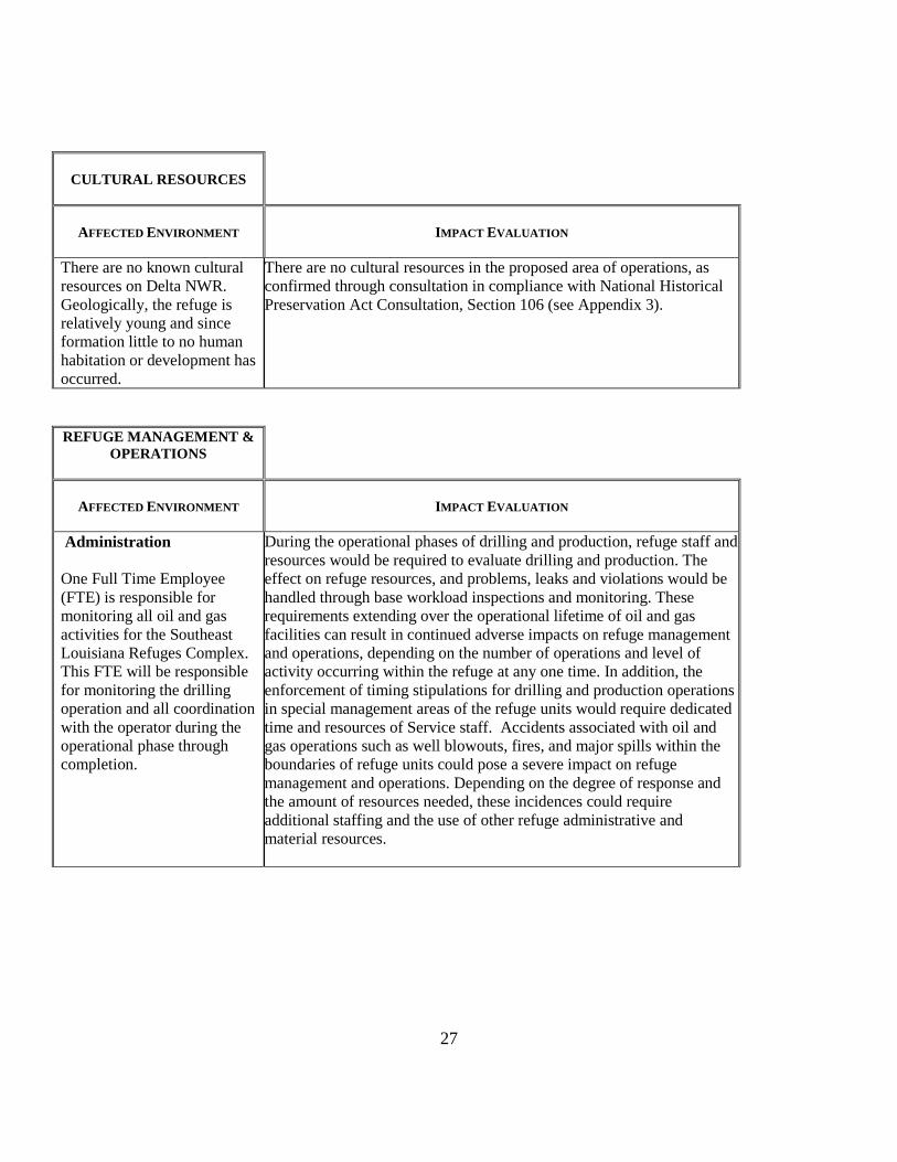
CULTURAL RESOURCES
AFFECTED ENVIRONMENT
IMPACT EVALUATION
There are no known cultural resources on Delta NWR. Geologically, the refuge is relatively young and since formation little to no human habitation or development has occurred.
There are no cultural resources in the proposed area of operations, as confirmed through consultation in compliance with National Historical Preservation Act Consultation, Section 106 (see Appendix 3).
REFUGE MANAGEMENT & OPERATIONS
AFFECTED ENVIRONMENT
IMPACT EVALUATION
Administration One Full Time Employee (FTE) is responsible for monitoring all oil and gas activities for the Southeast Louisiana Refuges Complex. This FTE will be responsible for monitoring the drilling operation and all coordination with the operator during the operational phase through completion.
During the operational phases of drilling and production, refuge staff and resources would be required to evaluate drilling and production. The effect on refuge resources, and problems, leaks and violations would be handled through base workload inspections and monitoring. These requirements extending over the operational lifetime of oil and gas facilities can result in continued adverse impacts on refuge management and operations, depending on the number of operations and level of activity occurring within the refuge at any one time. In addition, the enforcement of timing stipulations for drilling and production operations in special management areas of the refuge units would require dedicated time and resources of Service staff. Accidents associated with oil and gas operations such as well blowouts, fires, and major spills within the boundaries of refuge units could pose a severe impact on refuge management and operations. Depending on the degree of response and the amount of resources needed, these incidences could require additional staffing and the use of other refuge administrative and material resources.
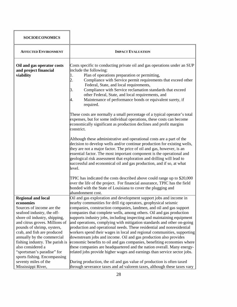
28
SOCIOECONOMICS
AFFECTED ENVIRONMENT
IMPACT EVALUATION
Oil and gas operator costs and project financial viability
Costs specific to conducting private oil and gas operations under an SUP include the following: 1. Plan of operations preparation or permitting, 2. Compliance with Service permit requirements that exceed other Federal, State, and local requirements, 3. Compliance with Service reclamation standards that exceed other Federal, State, and local requirements, and 4. Maintenance of performance bonds or equivalent surety, if required. These costs are normally a small percentage of a typical operator’s total expenses, but for some individual operations, these costs can become economically significant as production declines and profit margins constrict. Although these administrative and operational costs are a part of the decision to develop wells and/or continue production for existing wells, they are not a major factor. The price of oil and gas, however, is an essential factor. The most important component is the operational and geological risk assessment that exploration and drilling will lead to successful and economical oil and gas production, and if so, at what level. TPIC has indicated the costs described above could range up to $20,000 over the life of the project. For financial assurance, TPIC has the field bonded with the State of Louisiana to cover the plugging and abandonment cost.
Regional and local economies Sources of income are the seafood industry, the off-shore oil industry, shipping, and citrus groves. Millions of pounds of shrimp, oysters, crab, and fish are produced annually by the commercial fishing industry. The parish is also considered a “sportsman’s paradise” for sports fishing. Encompassing seventy miles of the Mississippi River,
Oil and gas exploration and development support jobs and income in nearby communities for drill rig operators, geophysical seismic companies, construction companies, landmen, and oil and gas support companies that complete wells, among others. Oil and gas production supports industry jobs, including inspecting and maintaining equipment and operations, complying with mitigation standards and other on-going production and operational needs. These residential and nonresidential workers spend their wages in local and regional communities, supporting downstream jobs and income. Oil and gas production also provides economic benefits to oil and gas companies, benefiting economies where these companies are headquartered and the nation overall. Many energy-related jobs provide higher wages and earnings than service sector jobs. During production, the oil and gas value of production is often taxed through severance taxes and ad valorem taxes, although these taxes vary
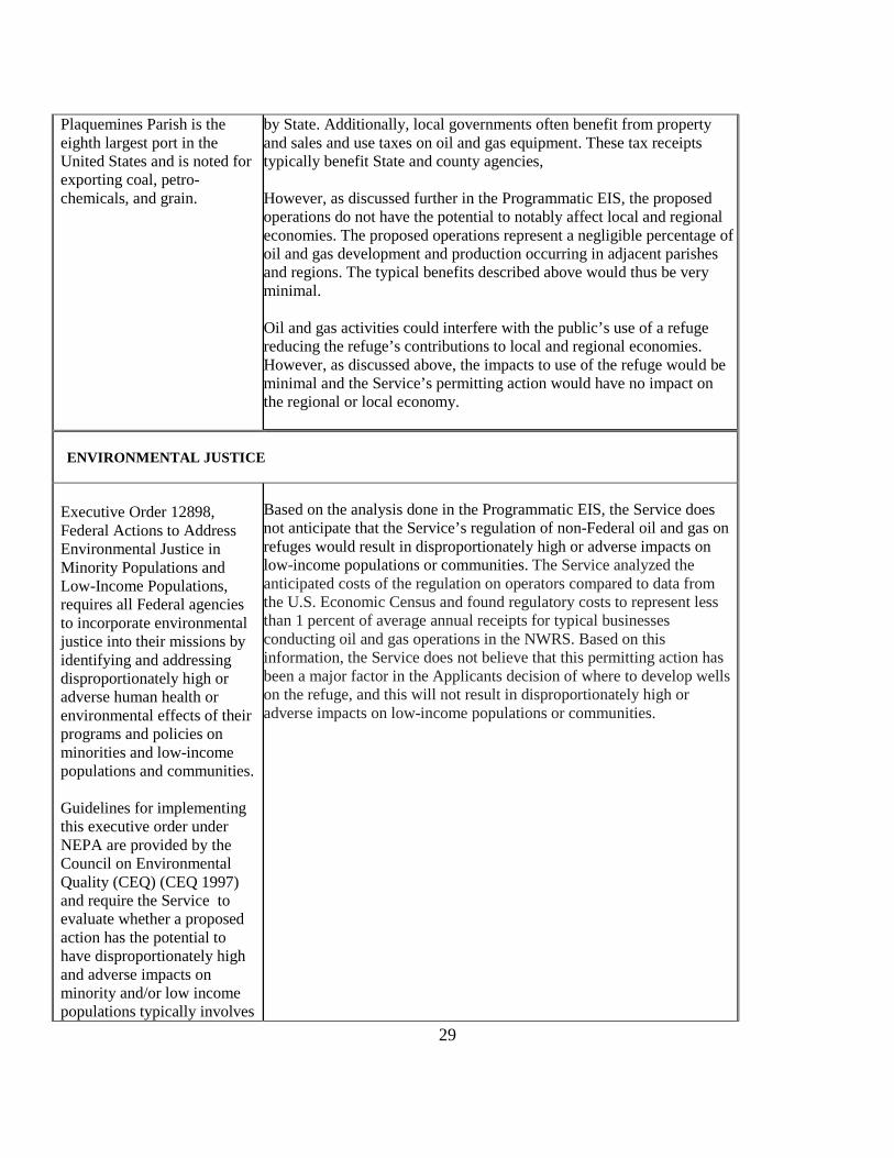
29
Plaquemines Parish is the eighth largest port in the United States and is noted for exporting coal, petro-chemicals, and grain.
by State. Additionally, local governments often benefit from property and sales and use taxes on oil and gas equipment. These tax receipts typically benefit State and county agencies, However, as discussed further in the Programmatic EIS, the proposed operations do not have the potential to notably affect local and regional economies. The proposed operations represent a negligible percentage of oil and gas development and production occurring in adjacent parishes and regions. The typical benefits described above would thus be very minimal. Oil and gas activities could interfere with the public’s use of a refuge reducing the refuge’s contributions to local and regional economies. However, as discussed above, the impacts to use of the refuge would be minimal and the Service’s permitting action would have no impact on the regional or local economy.
ENVIRONMENTAL JUSTICE
Executive Order 12898, Federal Actions to Address Environmental Justice in Minority Populations and Low-Income Populations, requires all Federal agencies to incorporate environmental justice into their missions by identifying and addressing disproportionately high or adverse human health or environmental effects of their programs and policies on minorities and low-income populations and communities. Guidelines for implementing this executive order under NEPA are provided by the Council on Environmental Quality (CEQ) (CEQ 1997) and require the Service to evaluate whether a proposed action has the potential to have disproportionately high and adverse impacts on minority and/or low income populations typically involves
Based on the analysis done in the Programmatic EIS, the Service does not anticipate that the Service’s regulation of non-Federal oil and gas on refuges would result in disproportionately high or adverse impacts on low-income populations or communities. The Service analyzed the anticipated costs of the regulation on operators compared to data from the U.S. Economic Census and found regulatory costs to represent less than 1 percent of average annual receipts for typical businesses conducting oil and gas operations in the NWRS. Based on this information, the Service does not believe that this permitting action has been a major factor in the Applicants decision of where to develop wells on the refuge, and this will not result in disproportionately high or adverse impacts on low-income populations or communities.
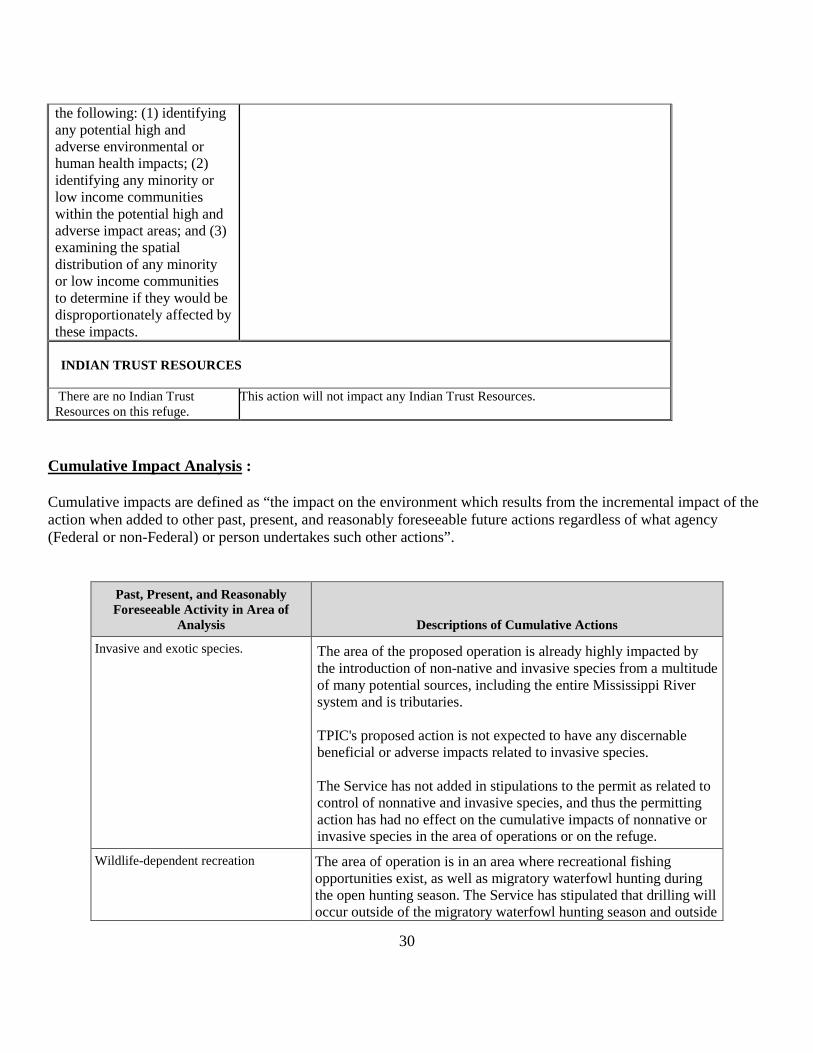
30
the following: (1) identifying any potential high and adverse environmental or human health impacts; (2) identifying any minority or low income communities within the potential high and adverse impact areas; and (3) examining the spatial distribution of any minority or low income communities to determine if they would be disproportionately affected by these impacts. INDIAN TRUST RESOURCES
There are no Indian Trust Resources on this refuge.
This action will not impact any Indian Trust Resources.
Cumulative Impact Analysis : Cumulative impacts are defined as “the impact on the environment which results from the incremental impact of the action when added to other past, present, and reasonably foreseeable future actions regardless of what agency (Federal or non-Federal) or person undertakes such other actions”.
Past, Present, and Reasonably Foreseeable Activity in Area of
Analysis Descriptions of Cumulative Actions
Invasive and exotic species. The area of the proposed operation is already highly impacted by the introduction of non-native and invasive species from a multitude of many potential sources, including the entire Mississippi River system and is tributaries. TPIC's proposed action is not expected to have any discernable beneficial or adverse impacts related to invasive species. The Service has not added in stipulations to the permit as related to control of nonnative and invasive species, and thus the permitting action has had no effect on the cumulative impacts of nonnative or invasive species in the area of operations or on the refuge.
Wildlife-dependent recreation The area of operation is in an area where recreational fishing opportunities exist, as well as migratory waterfowl hunting during the open hunting season. The Service has stipulated that drilling will occur outside of the migratory waterfowl hunting season and outside
31
of the open waterfowl hunting area, so will not contribute to the cumulative impacts on hunting opportunities. The potential conflicts with hunting of drilling the well will be temporary and very localized, and will not cause any long term impairment to the habitat, vegetation, or water quality, so the Service’s permitting of the proposed operation will not add to the cumulative impacts of wildlife-dependent recreation in the area.
Past and Future oil and gas development on refuge and adjacent lands
The proposed operation is in an area that has a long history of oil and gas exploration and development which has resulted in a highly impacted marsh in the areas where drilling and production have been concentrated. There are 29 oil and gas wells currently active on the refuge currently, 70 inactive wells, and 77 historic wells that have been plugged and abandoned. The matrix of canals and drilling slips are a legacy of past technologies that highly favored straight holes directly above their bottomhole targets. Existing oil and gas fields could readily be further developed using directional drilling as exemplified by the proposed well. Further, the number of actively producing wells is declining in Plaquemines Parish as new drilling has been out paced by well plugging and abandonment. Plaquemines Parish still has over 7,000 active producing oil and gas wells today. Therefore, one adverse impact associated with one additional well is insignificant in this context at both a refuge and local level, as are the beneficial impacts on the human environment from the Service’s action, stipulating conditions on the Operations Permit for operator to meet technologically feasible, least damaging methods as required by 50 CFR part 29 subpart D. Therefore the Service’s permitting of this facility in proposed location will not lead to additional habitat fragmentation and thus not contribute to cumulative impacts. Impacts to natural resources and visitor use due to construction activities, such as soils, habitat, noise, air quality, and erosion would not contribute substantially to cumulative impacts since they are typically localized and temporary. No impairment to these resources and uses would result from the proposed operations or the Service’s permitting of that operation. Furthermore, the Service has put stipulations on operations that will result in beneficial impacts to human health and safety, such as requiring additional signage to inform visitors to the refuge of the potential hazards of the operation. These signs will help educate visitors about the hazards of present and future development, leading to some minor beneficial cumulative impacts to human health and safety from the Service’s permitting action. It is reasonably foreseeable that the operator or other operators with non-Federal oil and gas rights may propose other operations to
32
develop minerals on the refuge and in the local area. The impacts of such activities would be similar to those analyzed above. The largest impacts to the environment from oil and gas development have already happened due to the large scale development of oil and gas infrastructure that has already occurred. The extent of historical exploration in the area (seismic and drilling) reduces the probability that large undiscovered resources will be found and create extensive new development. Rather, economics will likely be the driver of continued low rate of new well drilling. Continued development of oil and gas resources combined with plugging and reclamation activities yield an overall trend of environmental improvements related to oil and gas activities in the area.
Commercial Navigation The Port of South Louisiana is the largest tonnage port in the western hemisphere. The lower river adjacent to the refuge maintains a steady flow of marine traffic 24 hours of the day. The additional marine traffic related to this drilling operation will have negligible impacts to the commercial navigation of the lower Mississippi River.
Summary of Findings and Conclusions: The purpose of this EA is to briefly provide sufficient evidence and analysis for determining whether to prepare an environmental impact statement or a Finding of No Significant Impact (FONSI). The term “significantly” as used in NEPA requires consideration of the context of the action and the intensity of effects of the action. This section analyzes the action in terms of context and intensity to determine the significance of the effects. The proposed operation is in an area that is already highly impacted by oil and gas development. There are 29 oil and gas wells currently active on the refuge currently, 70 inactive wells, and 77 historic wells that have been plugged and abandoned. Plaquemines Parish has over 7,000 active producing oil and gas wells. Therefore, one additional well is insignificant in this context at both a refuge and local level, as are the beneficial impacts on the human environment from the Service’s action, stipulating conditions on the Operations Permit for operator to meet technologically feasible, least damaging methods as required by 50 CFR part 29 subpart D. The intensity of the effects from the proposed operation is low, with the highest level of intensity occurring for a relatively short duration of 45 days during drilling of the well and installation of the gathering lines and service. Even during the time of highest intensity, the effects on the affected environment are still minimal and have been avoided or mitigated to the maximum extent practicable. While refuges, by their nature, are unique areas protected for conservation of fish, wildlife and habitat, the proposed operation will not have a significant impact on refuge resources and uses for several reasons:
• The proposed area of operation is not in an ecologically sensitive area; • The proposed area of operations will not impact any threatened or endangered species;
33
• The proposed area of operations will not impact any cultural or historical resources; • The proposed area of operations will not impact any wilderness areas; • The proposed area of operations is an area that has already been highly impacted by oil and gas activity; • The operator’s use of existing waterways, prop washing, and the zero-discharge barge, ensures no new
surface disturbance and minimal impacts to the affected environment; and • The operator is proposing to use a barge for drilling operations which results in the greatest intensity of
effects during drilling being temporary with minimal long-term direct impacts (the physical presence of the well pad and continued temporary direct impacts from monitoring and maintenance of the well);
• The use of the zero-discharge barge ensures that the risk of indirect impacts due to leaks or spills is low. • The proposed operation will occur prior to hunting season and avoid peak migratory waterfowl use
periods. Due to the nature of oil and gas activities, there is always a risk to public health or safety, as well as wildlife and habitat, from leaks, spills or emergencies; however, the risk of these incidents occurring is very low, especially when the operator has in place proper procedures for avoiding, mitigating, and responding to such incidence, as does this operator with their SPCC plan, as well as their Facility Response Plan. The proposed operation, with mitigation proposed by operator would result in no more than minimal individual and cumulative adverse environmental impacts. The operator has demonstrated that they have a right to develop these non-Federal oil and gas rights on the refuge, therefore, the Service’s action is to issue the operator an Operations Permit that ensures that the operator is using technologically feasible, least damaging methods to do so, as required by 50 CFR part 29 subpart D. This action, which will result in several stipulations placed on the operator in the proposed Operations Permit as well as continued monitoring and enforcement by the Service for the life of the operation, as analyzed in this Environmental Assessment, will result in minimal individual and cumulative beneficial environmental impacts. List of Sources, Agencies and Persons Consulted:
1. Richard Kanaski - USFWS Regional Historic Preservation Officer & Regional Archaeologist 2. Amy Trahan – USFWS Fish & Wildlife Biologist – Ecological Services – Lafayette ES Office 3. Lindsey D. Bilyeu - Choctaw Nation of Oklahoma - Senior Compliance Review Officer 4. Chip McGimpsey – State of Louisiana – State Historic Preservation Officer 5. Catherine Collins, Tim Allen, - USFWS Air Quality Branch
References: Adams, M.B., P.J. Edwards, W.M. Ford, J.B. Johnson, T.M. Schuler, M. Thomas-Van Gundy, F. Wood.
2011. Effects of development of a natural gas well and associated pipeline on the natural and scientific resources of the Fernow Experimental Forest. Gen. Tech. Rep. NRS-76. Newtown Square, PA: U.S. Department of Agriculture, Forest Service, Northern Research Station. 24 p. Available at: http://www.fs.fed.us/nrs/pubs/gtr/gtr_nrs76.pdf. Accessed January 14, 2015.
34
Bayne, E.M, L. Habib, and S. Boutin. 2008. Impacts of chronic anthropogenic noise from energy-sector activity on abundance of songbirds in the boreal forest. Conservation Biology 22(5): 1186-1193.
Bradbury, J., M. Obeiter, L. Draucker, W. Wang, and A. Stevens. 2013. “Clearing the Air: Reducing
Upstream Greenhouse Gas Emissions from U.S. Natural Gas Systems.” Working Paper. Washington, DC: World Resources Institute. Available at: http://www.wri.org/publication/clearing-the-air.
Brittingham, M.C., K.O. Maloney, A.M. Farag, D.D. Harper, and Z.H. Bowen. 2014. Ecological risks of
shale oil and gas development to wildlife, aquatic resources and their habitats. Environmental Science and Technology. 48(19): 11034-47.
Francis, C.D., C.P. Ortega, and A. Cruz. 2009. Noise pollution changes avian communities and species
interactions. Current Biology 19: 1-9. Karl, T. et al. 2009. “Global Climate Change Impacts in the United State” Author: U.S. Global Change
Research Program. Publisher: Cambridge University Press” Knutson, T and R. Tuleya 2004. Impact of CO2-Induced Warming on Simulated Hurricane Intensity and
Precipitation: Sensitivity to the Choice of Climate Model and Convective Parameterization. Mall, A., S. Buccino, and J. Nichols. 2007. Drilling Down: Protecting Western Communities from the
Health and Environmental Effects of Oil and Gas Production. October, 2007. Natural Resource Defense Council, New York, New York. Available at: http://www.nrdc.org/land/use/down/down.pdf. Accessed January 7, 2015.
NASA. 2008. https://www.nasa.gov/topics/earth/features/coast-20080131.html Parida, .K. and A.B. Das. 2005. Salt tolerance and salinity effects on plants: a review.
Ecotoxicology and Environmental Safety, Volume 60, Issue 3: pp 324–349. Sawyer, H., F. Lindzey, D. McWhirter, and K. Andrews. 2002. Potential Effects of Oil and Gas
Development on Mule Deer and Pronghorn Populations in Western Wyoming. Transactions of the North American Wildlife and Natural Resources Conference. 67: 350-365.
Trombulak, S C. and C.A. Frissell. 2000. Review of Ecological Effects of Roads on Terrestrial and
Aquatic Communities. Conservation Biology 14: 18–30. Tylianakis, J.M., R.K. Didham, J. Bascompte, and D.A. Wardle. 2008. Global Change and Species
Interactions in Terrestrial Ecosystems. Ecology Letters 11: 1351–1363. doi: 10.1111/j.1461 U.S. Global Change Research Program. 2009. Melillo, Jerry M., Terese (T.C.) Richmond, and Gary W.
Yohe, Eds., 2014: Climate Change Impacts in the United States: The Third National Climate Assessment. Vavrek, M.C., H. Hunt, W. Colgan III, and D.L. Vavrek. 2004. Status of oil brine spill site
remediation. Paper presented at the 11th Annual International Petroleum Environmental Conference, Albuquerque, NM, Oct. Available at: http://ipec.utulsa.edu/Conf2004/Papers/vavrek_hunt_colgan_vavrek.pdf
35
Vilà, M., J.L. Espinar, M. Hejda, P.E. Hulme, V. Jarošík, J.L. Maron, J. Pergl, U. Schaffner, Y. Sun, and
P. Pyšek. 2011. Ecological Impacts of Invasive Alien Plants: A Meta-Analysis of Their Effects on Species, Communities and Ecosystems. Ecology Letters, 14: 702–708.
Wiles, G.J. and H.P. Weeks, Jr. 1986. Movements and Use Patterns of White-Tailed Deer Visiting
Natural Licks. Journal of Wildlife Management 50 (3): pp. 487-496. This analysis also incorporated information from sources referenced in the Delta and Breton National Wildlife Refuge’s Comprehensive Conservation Plan and Environmental Assessment (https://www.fws.gov/southeast/planning/PDFdocuments/Delta%20Breton%20Final/DeltaBretonFinalCCPdoc.pdf); the Habitat Management Plan for Delta and Brenton National Wildlife Refuges (https://catalog.data.gov/dataset/habitat-management-plan-for-delta-and-breton-national-wildlife-refuges); and the Programmatic EIS for National Wildlife Refuge System Revision of Regulations Governing Non-Federal Oil and Gas Activities (https://www.fws.gov/refuges/oil-and-gas/pdfs/FEIS-National-Wildlife-Refuge-System-Revision-of-Regulations-Governing-Non-Federal-Oil-and-Gas-Rights.pdf). List of Preparers: Barret Fortier – Regional Energy Coordinator – Southeast Region – USFWS Pat O’Dell – Petroleum Engineer – National Energy Team – USFWS James Panaccione – Oil & Gas Specialist – Southeast Louisiana Refuge Complex – USFWS Ella Wagener – Policy Advisor - National Energy Team – USFWS Public Outreach: This Environmental Assessment will be available for public review and comment for 30 calendar days on the Southeast Louisiana Refuges Complex website: (https://www.fws.gov/southeastlouisiana/) A paper copy will be available at the Southeast Louisiana Refuges Complex Headquarters, located at : 61389 Hwy 434, Lacombe, LA 70445 Determination:
The Service’s action on this permit application will not result in a significant impact on the quality of the human environment. See the attached “Finding of No Significant Impact”.
The Service’s action on this permit application may significantly affect the quality of the human environment
and the Service will prepare an Environmental Impact Statement. Preparer Signature: __________________________________________Date:________ Name/Title/Organization: __________________________________________________ Certifying Officer Signature: ___________________________________Date:________ Name/Title/Organization: __________________________________________________
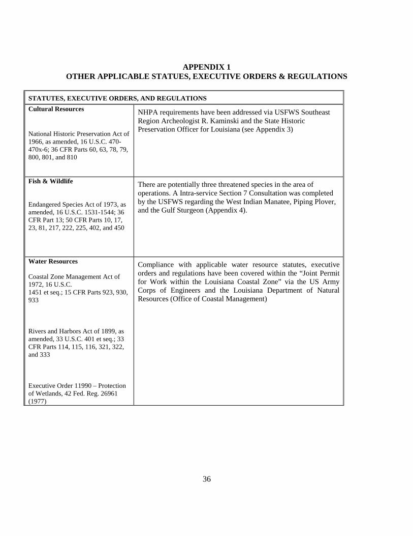
36
APPENDIX 1
OTHER APPLICABLE STATUES, EXECUTIVE ORDERS & REGULATIONS
STATUTES, EXECUTIVE ORDERS, AND REGULATIONS Cultural Resources
National Historic Preservation Act of 1966, as amended, 16 U.S.C. 470-470x-6; 36 CFR Parts 60, 63, 78, 79, 800, 801, and 810
NHPA requirements have been addressed via USFWS Southeast Region Archeologist R. Kaminski and the State Historic Preservation Officer for Louisiana (see Appendix 3)
Fish & Wildlife Endangered Species Act of 1973, as amended, 16 U.S.C. 1531-1544; 36 CFR Part 13; 50 CFR Parts 10, 17, 23, 81, 217, 222, 225, 402, and 450
There are potentially three threatened species in the area of operations. A Intra-service Section 7 Consultation was completed by the USFWS regarding the West Indian Manatee, Piping Plover, and the Gulf Sturgeon (Appendix 4).
Water Resources Coastal Zone Management Act of 1972, 16 U.S.C. 1451 et seq.; 15 CFR Parts 923, 930, 933 Rivers and Harbors Act of 1899, as amended, 33 U.S.C. 401 et seq.; 33 CFR Parts 114, 115, 116, 321, 322, and 333 Executive Order 11990 – Protection of Wetlands, 42 Fed. Reg. 26961 (1977)
Compliance with applicable water resource statutes, executive orders and regulations have been covered within the “Joint Permit for Work within the Louisiana Coastal Zone” via the US Army Corps of Engineers and the Louisiana Department of Natural Resources (Office of Coastal Management)
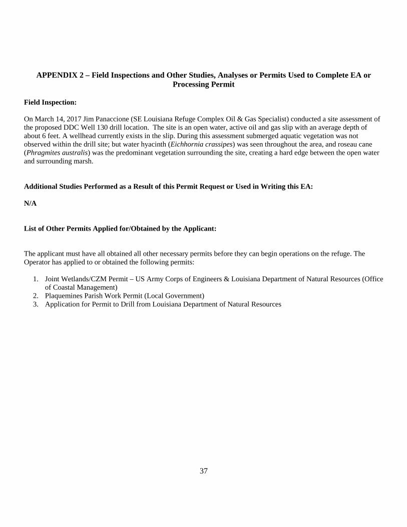
37
APPENDIX 2 – Field Inspections and Other Studies, Analyses or Permits Used to Complete EA or Processing Permit
Field Inspection: On March 14, 2017 Jim Panaccione (SE Louisiana Refuge Complex Oil & Gas Specialist) conducted a site assessment of the proposed DDC Well 130 drill location. The site is an open water, active oil and gas slip with an average depth of about 6 feet. A wellhead currently exists in the slip. During this assessment submerged aquatic vegetation was not observed within the drill site; but water hyacinth (Eichhornia crassipes) was seen throughout the area, and roseau cane (Phragmites australis) was the predominant vegetation surrounding the site, creating a hard edge between the open water and surrounding marsh. Additional Studies Performed as a Result of this Permit Request or Used in Writing this EA: N/A List of Other Permits Applied for/Obtained by the Applicant: The applicant must have all obtained all other necessary permits before they can begin operations on the refuge. The Operator has applied to or obtained the following permits:
1. Joint Wetlands/CZM Permit – US Army Corps of Engineers & Louisiana Department of Natural Resources (Office of Coastal Management)
2. Plaquemines Parish Work Permit (Local Government) 3. Application for Permit to Drill from Louisiana Department of Natural Resources
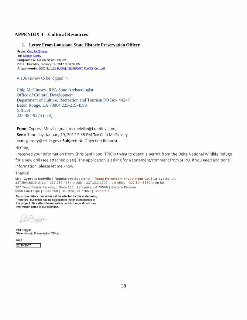
38
APPENDIX 3 – Cultural Resources
1. Letter From Louisiana State Historic Preservation Officer From: Chip McGimsey To: Megan Kenny Subject: FW: No Objection Request Date: Thursday, January 19, 2017 3:06:32 PM Attachments: DDC No. 130 FLOWLINE PERMIT PLANS_Cert.pdf
A 106 review to be logged in.
Chip McGimsey, RPA State Archaeologist Office of Cultural Development Department of Culture, Recreation and Tourism PO Box 44247 Baton Rouge, LA 70804 225-219-4598 (office) 225-454-9274 (cell)
From: Cypress Melville [mailto:[email protected]] Sent: Thursday, January 19, 2017 2:58 PM To: Chip McGimsey <[email protected]> Subject: No Objection Request
Hi Chip, I received your information from Chris Sanfilippo. TPIC is trying to obtain a permit from the Delta National Wildlife Refuge for a new drill (see attached plats). The application is asking for a statement/comment from SHPO. If you need additional information, please let me know.
Thanks! Mrs. Cypress Melville | Regulatory Specialist | Texas Petroleum Investment Co. | Lafayette, LA 337.504.5019 direct | 337.789.4784 mobile | 337.232.1702 main office | 337.504.5879 main fax 207 Town Center Parkway | Suite 150 | Lafayette, LA 70506 | Eastern Division 5850 San Felipe | Suite 250 | Houston, TX 77057 | Corporate
39
2. Letter from Choctaw Nation of Oklahoma ---------- Forwarded message ---------- From: Lindsey Bilyeu <[email protected]> Date: Fri, Mar 17, 2017 at 5:04 PM Subject: RE: Gas and Oil Project, Delta NWR, Plaquemines Parish, LA To: "[email protected]" <[email protected]> Mr. Brant, The Choctaw Nation of Oklahoma thanks the FWS for the correspondence regarding the above referenced project. Plaquemines Parish lies in the Choctaw Nation’s area of historic interest. The Choctaw Nation is unaware of any cultural or sacred sites located in the immediate project area. The Choctaw Nation Historic Preservation Department concurs with the finding of “no effect”. However, we ask that work be stopped and our office contacted immediately in the event that Native American artifacts or human remains are encountered. If you have any questions, please contact me. Thank you, Lindsey D. Bilyeu Senior Compliance Review Officer Historic Preservation Department Choctaw Nation of Oklahoma P.O. Box 1210 Durant, OK 74702 580-924-8280 ext. 2631
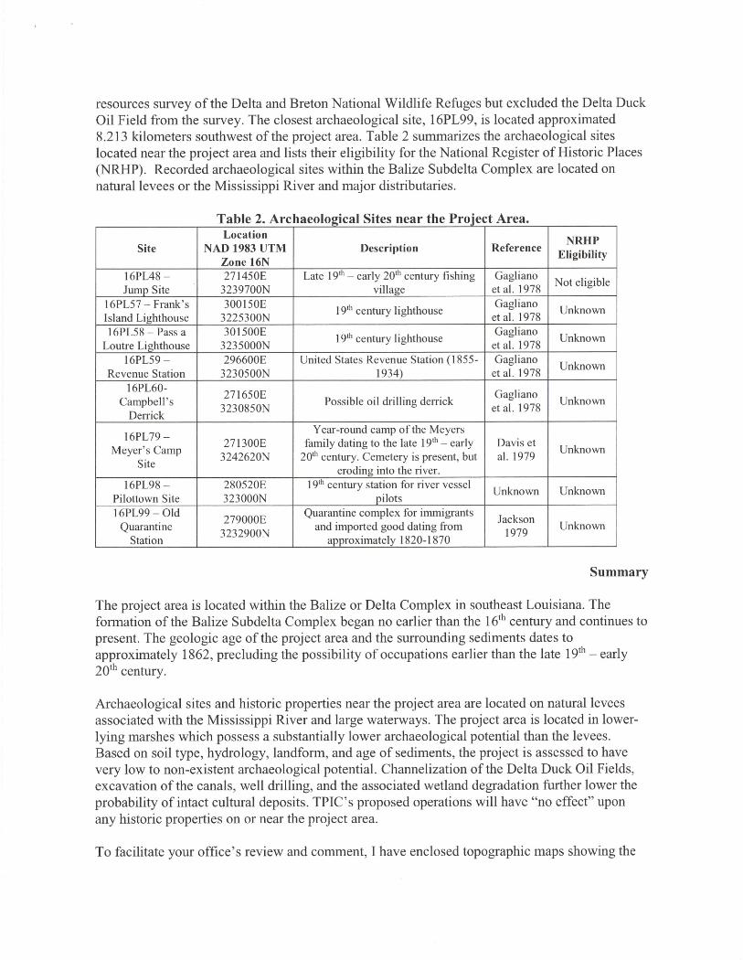
40
APPENDIX 4 –Intra-Service Section 7 Consultation
Intra-Service Section 7 Biological Evaluations Originating Person: Barret Fortier Telephone Number: 985-882-2011 E-Mail: barrel fo11ier@fw .gov Date: March 15, 2017
PROJECT NAME: Delta National Wildlife Refuge Oil and Gas Special Use Permit - Drilling Operations
I. Service Program: _ Ecological Services
Federal Aid Clean Vessel Act Coastal Wetlands
_ Endangered Species Section 6 Partners for Fish and Wildlife
_ Sport Fish Restoration Wildlife Restoration Fisheries
,.X_Refuges/Wildlife
II. State/Agency: Louisiana, U.S. Fish and Wildlife Service
Iii. Station Name: Delta National Wildlife Refuge
IV. Description of Proposed Action
The proposed action is to respond to a request by Texas Petroleum Investment Company (Applicant) for an Operations Permit (Permit) for the Applicant's proposed activities of drilling the Delta Duck Club No. 130 well. This proposed action is needed in order to ensure that mineral rights holders have reasonable access to develop their non-Federal oil and gas interests and minimize impacts to Refuge resources to the extent practicable under the Service's 50 CFR Part 29, Subpart D regulations (29D Regulations) for managing non-Federal oil and gas on Service-administered lands and waters
The Service has received an application for a Permit for proposed oil and gas operations on the Refuge. The proposed action is for the Refuge to issue a permit to the Applicant. The Applicant has demonstrated that through ownership of oil and gas rights, they have the right to access and develop oil and gas resources underneath the Refuge. Therefore, the action being considered is not whether or not to issue a permit to allow this operation to proceed, as it is the operator's right to access and develop these resources, but rather to ensure that the operator avoids or minimizes impacts from such activities to the maximum extent practicable. Therefore, the Service is proposing to issue a Permit that ensures that the applicant is using the most technologically feasible, least damaging methods to conduct operations on the Refuge in accordance with 50 CFR Part 29, Subpart D.
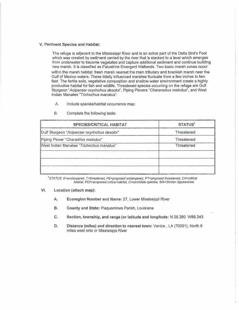
V. Pertinent Species and Habitat:
The refuge is adjacent to the Mississippi River and is an active part of the Delta Bird's Foot which was created by sediment carried by the river that is stacked to a level which emerges from underwater to become vegetated and capture additional sediment and continue building new marsh. It is classified as Palustrine Emergent Wetlands. Two basic marsh zones occur within the marsh habitat: fresh marsh nearest the main tributary and brackish marsh near the Guff of Mexico waters. These tidally influenced marshes fluctuate from a few inches to two feet. The fertile soils, vegetative composition and shallow water environment create a highly productive habitat for fish and wildlife. Threatened species occurring on the refuge are Gulf Sturgeon ''Acipenser oxyrinchus desotof', Piping Plovers "Chara radius melodus", and West Indian Manatee "Trichechus manatus".
A. Include species/habitat occurrence map:
B. Complete the following table:
SPECIES/CRITICAL HABIT AT STATUS1
Gulf Sturgeon "Acipenser oxyrinchus desotoi" Threatened
Piping Plover "Charadrius melodus" Threatened
West Indian Manatee "Trichechus manatus" Threatened
1 STATUS: E=endangered, T=threatened, PE=proposed endangered, PT=proposed threatened, CH=critical habitat, PCH=proposed critical habitat, C=candidate species, SIA=Similar Appearance
VI. Location (attach map):
A. Ecoregion Number and Name: 27, Lower Mississippi River
B. County and State: Plaquemines Parish, Louisiana
C. Section, township, and range (or latitude and longitude: N 29.280 W89.243
D. Distance (miles) and direction to nearest town: Venice. LA (70091); North 8 miles west side or Mississippi River
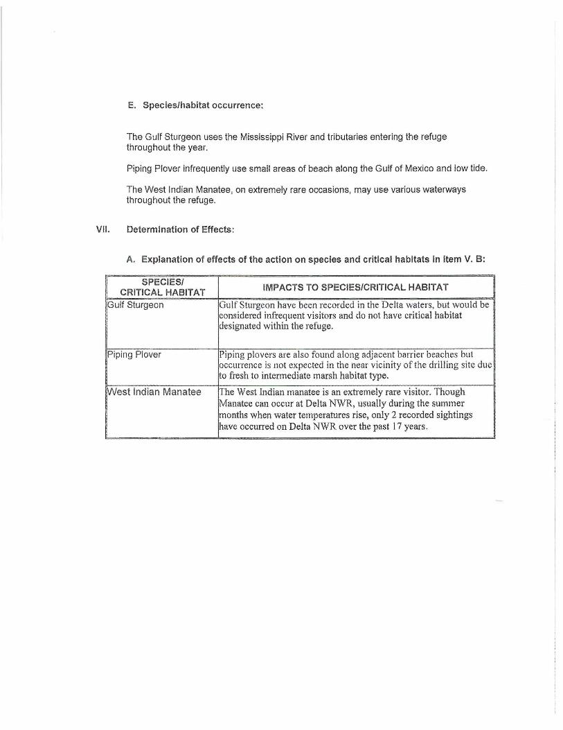
E. Species/habitat occurrence:
The Gulf Sturgeon uses the Mississippi River and tributaries entering the refuge throughout the year.
Piping Plover infrequently use small areas of beach along the Gulf of Mexico and low tide.
The West Indian Manatee, on extremely rare occasions, may use various waterways throughout the refuge.
VII. Determination of Effects:
A. Explanation of effects of the action on species and critical habitats In Item V. B:
SPECIES/ IMPACTS TO SPECIES/CRITICAL HABITAT CRITICAL HABITAT
Gulf Sturgeon Gulf Sturgeon have been recorded in the Delta waters, but would be
I considered infrequent visitors and do not have critical habitat designated within the refuge.
Piping Plover Piping plovers are also found along adjacent barrier beaches but occurrence is not expected in the near vicinity of the drilling site due to fresh to intermediate marsh habitat type.
West Indian Manatee The West Indian manatee is an extremely rare visitor. Though Manatee can occur at Delta NWR, usually during the summer months when water temperatures rise, only 2 recorded sightings have occurred on Delta NWR over the past 17 years.
-
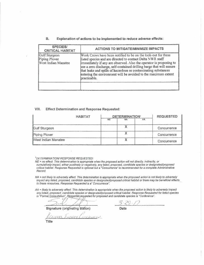
B. Explanation of actions to be implemented to reduce adverse effects:
.. SPECIES/
ACTIONS TO MITIGATE/MINIMIZE IMPACTS CRITICAL HABITAT Gulf Sturgeon Work Crews have been notified to be on the look-out for these Piping Plover listed species and are directed to contact Delta NWR staff West Indian Manatee immediately if any are observed. Also the operator is proposing to
use a zero discharge, self-contained drilling barge that will ensure hat leaks and spills of hazardous or contaminating substances
entering the environment will be avoided to the maximum extent practicable.
VIII. Effect Determination and Response Requested:
HABITAT DETERMINATION1 REQUESTED NE NA AA
Gulf Sturgeon X Concurrence
Piping Plover X Concurrence
West Indian Manatee X Concurrence ..
1 DETERMINA T/ONI RESPONSE REQUESTED: NE = no effect. This determination is appropriate when the proposed action will not directly, indirectly, or cumulatively impact, either positively or negatively, any listed, proposed, candidate species or designated/proposed critical habitat. Response Requested is optional but a ·concurrence" is recommended tor a complete Administrative Record.
NA = not likely to adversely affect. This determination is appropriate when the proposed action is not likely to adversely impact any listed, proposed, candidate species or designated/proposed critical habitat or there may be beneficial effects_ to these resources. Response Requested is a" Concurrence".
AA = likely to adversely affect. This determination is appropriate when the proposed action is likely to adversely impact any listed, proposed, candidate species or designated/proposed critical habitat. Response Requested for listed species is "Fonnal ConsL!.f!!tion". es ens equ sled for proposed and candidate species is ' Conference".
~ - ,, .: rr--.-- · 5 z~ .;· ----~---- - - --
Signature (ori mating station) Date ' l f tt/ , ,1 l / ,. ( ;!/-•/ / • .,. { V,t.-½"r • -....!._
)
Title
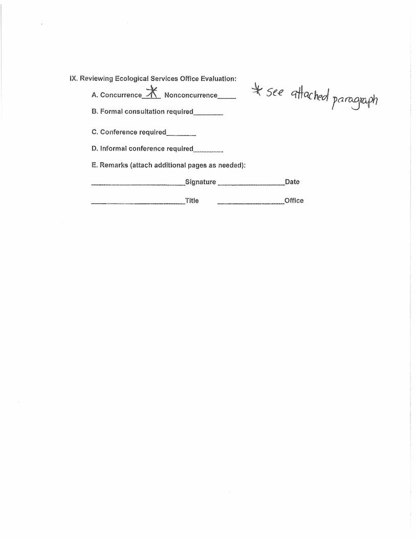
IX. Reviewing Ecological Services Office Evaluation:
A. Concurrence :t Nonconcurrence __
B. Formal consultation required __ _
C. Conference required __ _
D. Informal conference required __ _
E. Remarks (attach additional pages as needed):
__________ _ Signature ________ Date
___________ Title ________ Office
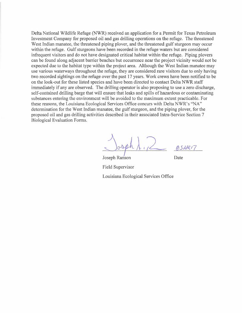
Delta National Wildlife Refuge (NWR) received an application for a Permit for Texas Petroleum Investment Company for proposed oil and gas drilling operations on the refuge. The threatened West Indian manatee, the threatened piping plover, and the threatened gulf sturgeon may occur within the refuge. Gulf sturgeons have been recorded in the refuge waters but are considered infrequent visitors and do not have designated critical habitat within the refuge. Piping plovers can be found along adjacent barrier beaches but occurrence near the project vicinity would not be expected due to the habitat type within the project area. Although the West Indian manatee may use various waterways throughout the refuge, they are considered rare visitors due to only having two recorded sightings on the refuge over the past 17 years. Work crews have been notified to be on the look-out for these listed species and have been directed to contact Delta NWR staff immediately if any are observed. The drilling operator is also proposing to use a zero discharge, self-contained drilling barge that will ensure that leaks and spills of hazardous or contaminating substances entering the environment will be avoided to the maximum extent practicable. For these reasons, the Louisiana Ecological Services Office concurs with Delta NWR's "NA" determination for the West Indian manatee, the gulf sturgeon, and the piping plover, for the proposed oil and gas drilling activities described in their associated Intra-Service Section 7 Biological Evaluation Forms.
3-~~ L2-Joseph Ranson Date
Field Supervisor
Louisiana Ecological Services Office
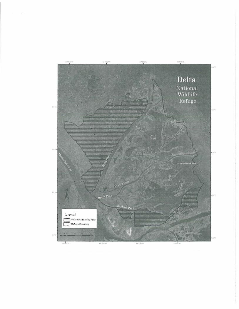
41
APPENDIX 5- Special Use Permit Application
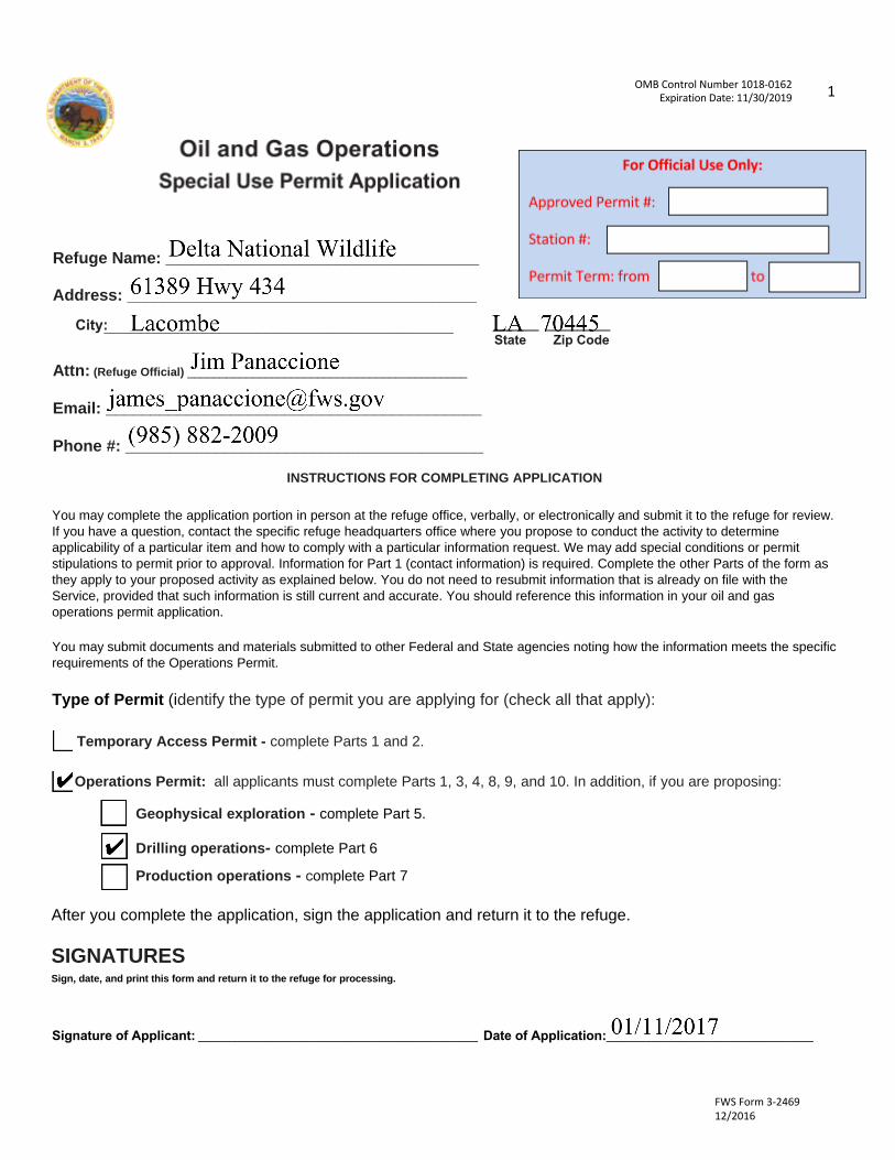
OMB Control Number 1018-0162Expiration Date: 11/30/2019 1
FWS Form 3-246912/2016
dfddfddf
INSTRUCTIONS FOR COMPLETING APPLICATION
You may complete the application portion in person at the refuge office, verbally, or electronically and submit it to the refuge for review. If you have a question, contact the specific refuge headquarters office where you propose to conduct the activity to determine applicability of a particular item and how to comply with a particular information request. We may add special conditions or permit stipulations to permit prior to approval. Information for Part 1 (contact information) is required. Complete the other Parts of the form as they apply to your proposed activity as explained below. You do not need to resubmit information that is already on file with the Service, provided that such information is still current and accurate. You should reference this information in your oil and gas operations permit application.
You may submit documents and materials submitted to other Federal and State agencies noting how the information meets the specific requirements of the Operations Permit.
Type of Permit (identify the type of permit you are applying for (check all that apply):
Temporary Access Permit - complete Parts 1 and 2.
Operations Permit: all applicants must complete Parts 1, 3, 4, 8, 9, and 10. In addition, if you are proposing:
Geophysical exploration - complete Part 5.
Drilling operations- complete Part 6 Production operations - complete Part 7
Refuge Name: ___________________________________
Address: _______________________________________
City: _______________________________________
Attn: (Refuge Official) ___________________________________________
Email: __________________________________________
Phone #: ________________________________________
After you complete the application, sign the application and return it to the refuge.
SIGNATURESSign, date, and print this form and return it to the refuge for processing.
Signature of Applicant: __________________________________________________ Date of Application:_____________________________________
_______ __________ State Zip Code
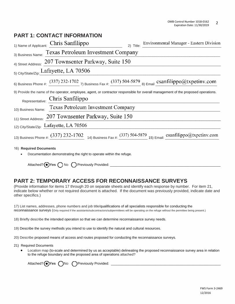
OMB Control Number 1018-0162Expiration Date: 11/30/2019 2
FWS Form 3-246912/2016
PART 1: CONTACT INFORMATION
1) Name of Applicant: ______________________________________ 2) Title: _________________________________________
3) Business Name: ___________________________________________________________________________________________
4) Street Address: ____________________________________________________________________________________________
5) City/State/Zip:______________________________________________________________________________________________
6) Business Phone #: ________________ 7) Business Fax #: ________________ 8) Email ________________________________
9) Provide the name of the operator, employee, agent, or contractor responsible for overall management of the proposed operations.
Representative: _________________________________________________________________________________________
10) Business Name: _________________________________________________________________________________________
11) Street Address: ___________________________________________________________________________________________
12) City/State/Zip: ____________________________________________________________________________________________
13) Business Phone #: __________________ 14) Business Fax #: _______________ 15) Email: ____________________________
16) Required Documents• Documentation demonstrating the right to operate within the refuge.
Attached? Yes No Previously Provided: _________________________________________________________
PART 2: TEMPORARY ACCESS FOR RECONNAISSANCE SURVEYS(Provide information for items 17 through 20 on separate sheets and identify each response by number. For item 21, indicate below whether or not required document is attached. If the document was previously provided, indicate date and other specifics.)
17) List names, addresses, phone numbers and job title/qualifications of all specialists responsible for conducting thereconnaissance surveys (Only required if the assistants/subcontractors/subpermittees will be operating on the refuge without the permittee being present.)
18) Briefly describe the intended operation so that we can determine reconnaissance survey needs.
19) Describe the survey methods you intend to use to identify the natural and cultural resources.
20) Describe proposed means of access and routes proposed for conducting the reconnaissance surveys.
21) Required Documents• Location map (to-scale and determined by us as acceptable) delineating the proposed reconnaissance survey area in relation
to the refuge boundary and the proposed area of operations attached?
Attached? Yes No Previously Provided: _________________________________________________________
OMB Control Number 1018-0162Expiration Date: 11/30/2019 3
FWS Form 3-246912/2016
PART 3: EXISTING CONDITIONS FOR YOUR AREA OF OPERATIONS (All applicants applying for an operations permit must complete this part. Provide information for items 22 through 25 on separate sheets and identify each response by number.)
22) Describe the natural features including streams, lakes, ponds, wetlands, topographic relief, and areas the Service has indicated toyou are sensitive.
23) Describe the locations of existing roads, trails, railroad tracks, pipeline right-of-ways, pads, and other disturbed areas.
24) Describe the locations of existing structures that your operations could affect, including buildings, pipelines, producing oil and gaswells, freshwater wells, underground and overhead electrical lines, and other utility lines.
25) Describe the natural resource and cultural resource survey reports for your proposed area of operations.
PART 4: PROPOSED NEW SURFACE USES(All applicants applying for an operations permit must complete this part. Provide information for items 26 through 32 on separate sheets and identify each response by number. For item 33, indicate below whether or not required documents are attached. If a document was previously provided, indicate date and other specifics.)
26) Describe and show the method and diagrams, including cross-sections, of any proposed pad construction, road construction, cut-and-fill areas, erosion control, and surface maintenance.
27) Describe the number and types of equipment and vehicles, including an estimate of vehicular round trips associated with eachphase of operation.
28) Describe the estimated timetable for each phase of the proposed operations, including any operational timing constraints.
29) Describe the type and extent of security measures proposed at your area of operation.
30) Describe the power sources and their transmission systems for the proposed operations.
31) Describe the types and quantities of all solid and liquid waste generated and the proposed methods of storage, handling, anddisposal.
32) Describe the source, quantity, access route, and transportation/conveyance method for all water to be used in operations; andestimations of any anticipated waste water volumes generated and how they will be managed and disposed of.
33) Required Documents:• Location map (to-scale and determined by us as acceptable) identifying the proposed area of operations, existing conditions
(as described in Part 3), and proposed new surface uses that clearly identifies the boundaries of each of your mineral tract(s)in relation to your proposed operations and the relevant refuge boundary.
Attached? Yes No Previously Provided: _________________________________________________________
• Location map (to-scale and determined by us as acceptable) showing proposed access routes of new surface disturbances asdetermined by a location survey.
Attached? Yes No Previously Provided: _________________________________________________________
• Location map (to-scale and determined by us as acceptable) showing the proposed location of all support facilities, includingthose for transportation (e.g., vehicle parking areas, helicopter pads), sanitation, occupation, staging areas, fuel storage areas,refueling areas, loading docks, water supplies, and disposal facilities).
Attached? Yes No Previously Provided: _________________________________________________________
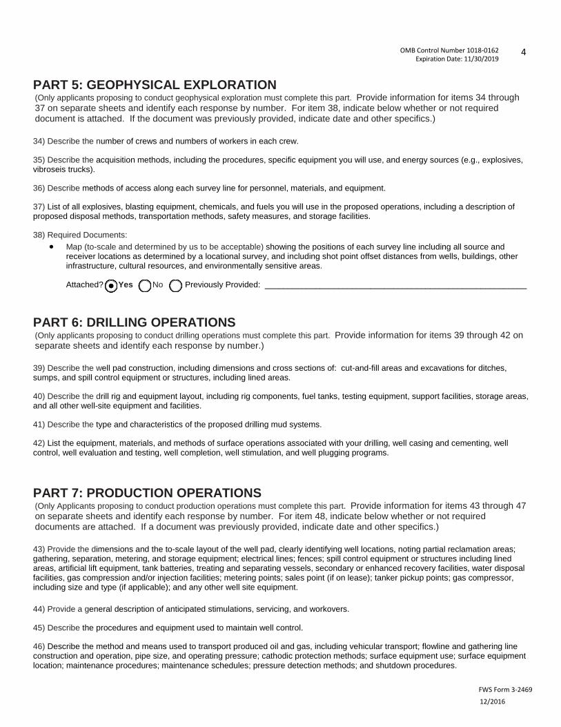
OMB Control Number 1018-0162Expiration Date: 11/30/2019
4
FWS Form 3-2469
12/2016
PART 5: GEOPHYSICAL EXPLORATION(Only applicants proposing to conduct geophysical exploration must complete this part. Provide information for items 34 through 37 on separate sheets and identify each response by number. For item 38, indicate below whether or not required document is attached. If the document was previously provided, indicate date and other specifics.)
34) Describe the number of crews and numbers of workers in each crew.
35) Describe the acquisition methods, including the procedures, specific equipment you will use, and energy sources (e.g., explosives,vibroseis trucks).
36) Describe methods of access along each survey line for personnel, materials, and equipment.
37) List of all explosives, blasting equipment, chemicals, and fuels you will use in the proposed operations, including a description ofproposed disposal methods, transportation methods, safety measures, and storage facilities.
38) Required Documents:• Map (to-scale and determined by us to be acceptable) showing the positions of each survey line including all source and
receiver locations as determined by a locational survey, and including shot point offset distances from wells, buildings, otherinfrastructure, cultural resources, and environmentally sensitive areas.
Attached? Yes No Previously Provided: _________________________________________________________
PART 6: DRILLING OPERATIONS(Only applicants proposing to conduct drilling operations must complete this part. Provide information for items 39 through 42 on separate sheets and identify each response by number.)
39) Describe the well pad construction, including dimensions and cross sections of: cut-and-fill areas and excavations for ditches,sumps, and spill control equipment or structures, including lined areas.
40) Describe the drill rig and equipment layout, including rig components, fuel tanks, testing equipment, support facilities, storage areas,and all other well-site equipment and facilities.
41) Describe the type and characteristics of the proposed drilling mud systems.
42) List the equipment, materials, and methods of surface operations associated with your drilling, well casing and cementing, wellcontrol, well evaluation and testing, well completion, well stimulation, and well plugging programs.
PART 7: PRODUCTION OPERATIONS(Only Applicants proposing to conduct production operations must complete this part. Provide information for items 43 through 47 on separate sheets and identify each response by number. For item 48, indicate below whether or not required documents are attached. If a document was previously provided, indicate date and other specifics.)
43) Provide the dimensions and the to-scale layout of the well pad, clearly identifying well locations, noting partial reclamation areas;gathering, separation, metering, and storage equipment; electrical lines; fences; spill control equipment or structures including linedareas, artificial lift equipment, tank batteries, treating and separating vessels, secondary or enhanced recovery facilities, water disposalfacilities, gas compression and/or injection facilities; metering points; sales point (if on lease); tanker pickup points; gas compressor,including size and type (if applicable); and any other well site equipment.
44) Provide a general description of anticipated stimulations, servicing, and workovers.
45) Describe the procedures and equipment used to maintain well control.
46) Describe the method and means used to transport produced oil and gas, including vehicular transport; flowline and gathering lineconstruction and operation, pipe size, and operating pressure; cathodic protection methods; surface equipment use; surface equipmentlocation; maintenance procedures; maintenance schedules; pressure detection methods; and shutdown procedures.
OMB Control Number 1018-0162Expiration Date: 11/30/2019
5
FWS Form 3-246912/2016
47) Describe the equipment, materials, and procedures proposed for well plugging.
48) Required Documents:• Road and well pad maintenance plan, including equipment and materials to maintain the road surface and control erosion.
Attached? Yes No Previously Provided: ________________________________________________________
• Vegetation management plan on well sites, roads, pipeline corridors, and other disturbed surface areas, including control ofnoxious or invasive species.
Attached? Yes No Previously Provided: ________________________________________________________
• Stormwater management plan for the well site
Attached? Yes No Previously Provided: _________________________________________________________
• Produced water storage and disposal plan.
Attached? Yes No Previously Provided: _______________________________________________________
PART 8: MITIGATION ACTIONS AND ALTERNATIVES CONSIDERED(All applicants applying for an operations permit must complete this part. Provide information for items 49 through 51 on separate sheets and identify each response by number.)
49) Describe the steps you propose to take to mitigate anticipated adverse environmental impacts on refuge resources and uses,including but not limited to, the refuge’s land features, land uses, fish and wildlife, vegetation, soils, surface and subsurface waterresources, air quality, noise, lightscapes, viewsheds, cultural resources, and economic environment.
50) Describe any anticipated impacts that you cannot mitigate.
51) List alternatives considered that met the criteria of technologically feasible, least damaging methods of operations, as well asthe costs and environmental effects of those alternatives.
PART 9: SPILL CONTROL AND EMERGENCY PREPAREDNESS PLAN(All applicants applying for an operations permit must complete this part. If you have a spill prevention control and countermeasure (SPCC) plan prepared under 40 CFR Part 112 that includes all the information required by this section, you may attach that plan to this application. Provide information for items 59 through 70 on separate sheets and identify each response by number.)
52) Spill, Fire, or Accident Company Representative:________________________________________________________________
53) Business Name: _________________________________________________________________________________________
54) Street Address: ___________________________________________________________________________________________
55) City/State/Zip: ___________________________________________________________________________________________
56) Emergency Contact Phone #: _________________ 57) Business Fax #: _____________ 58) Email:____________________
59) Describe the notification procedures and steps taken to minimize damage in event of spill, fire, or accident.
60) Identify contaminating or toxic substances used within your area of operations or expected to be encountered during operations.
61) Provide a trajectory analysis for for potential spills not contained on location.
OMB Control Number 1018-0162Expiration Date: 11/30/2019
6
FWS Form 3-246912/2016
62) Identify abnormal pressure, temperature, toxic gases or substances, or other hazardous conditions at your area of operations orexpected to be encountered during operations.
63) Describe your measures (e.g., procedures, facility design, equipment, etc.) to minimize risks to human health, safety, and theenvironment.
64) Describe the steps to prevent accumulations of oil or other materials deemed to be fire hazards from occurring in the vicinity of welllocations and lease tanks.
65) Describe the equipment and methods for containment and cleanup of contaminating substances, including a description of theequipment available at your area of operations and equipment available from local contractors.
66) Provide the storm water drainage plan and actions intended to mitigate stormwater runoff.
67) Provide the material safety data sheets for each material you will use/encounter during operations, including expected quantitiesmaintained at your area of operations.
68) Describe the emergency actions you will take in the event of injury or death to fish and wildlife or vegetation.
69) Describe emergency actions you will take in the event of accidents causing human injury.
70) Provide the contingency plans for conditions and emergencies other than spills, such as if your area of operations is located inareas prone to hurricanes, flooding, tornados, fires, or earthquakes.
PART 10: RECLAMATION(All applicants applying for an operations permit must complete this part. Provide information for items 71 and 72 on separate sheets and identify each response by number.)
71) List the specific equipment, materials, methods, and schedule used to meet the operating standards for reclamation.
72) Provide an itemized list of the estimated costs that a third party would charge to complete reclamation.
Notice
In accordance with the Privacy Act (5 U.S.C. 552a) and the Paperwork Reduction Act (44 U.S.C. 3501), please note the following information:
The issuance of a permit and collection of fees on lands of the National Wildlife Refuge System are authorized by the National Wildlife Refuge System Administration Act (16 U.S.C. 668dd-ee) as amended, and the Refuge Recreation Act (16 U.S.C. 460k-460k-4).
The information that you provide is required to obtain or retain a benefit. We use the requested information to evaluate the qualifications, determine eligibility, and document permit applicants under the above Acts. It is our policy not to use your name for any other purpose. We maintain the information in accordance with the Privacy Act. We will consider all information you provide in reviewing this application. False, fictitious, or fraudulent statements or representations made in the application may be grounds for revocation of the Special Use Permit and may be punishable by fine or imprisonment (18 U.S.C. 1001). Failure to provide all required information is sufficient cause for the U.S. Fish and Wildlife Service to deny a permit.
We also may make routine use disclosures: (a) to the U.S. Department of Justice when related to litigation or anticipated litigation; (b) of information indicating a violation or potential violation of a statute, rule, order, or license to appropriate Federal, State, local, or foreign agencies responsible for investigating or prosecuting the violation or for enforcing or implementing the statute, rule, regulations, order, or license; (c) from the record of the individual in response to an inquiry from a Congressional office made at the request of the individual (42 FR 19083; April 11,1977); and (d) to provide addresses obtained from the Internal Revenue Service to debt collection agencies for purposes of locating a debtor to collect or compromise a Federal Claim against the debtor, or to consumer reporting agencies to prepare a commercial credit report for use by the Department of Justice (48 FR 54716; December 6, 1983).
An agency may not conduct or sponsor and a person is not required to respond to a collection of information unless it displays a currently valid OMB control number. OMB has approved this information collection and assigned control number 1018-0162. The public reporting burden for this information collection varies based on the requested use. We estimate the relevant public reporting burden for the application for Temporary Access to average 17 hours per response. We estimate the time to complete an application for an Operations Permit will average 140 hours per response.
OMB Control Number 1018-0162Expiration Date: 11/30/2019 7
FWS Form 3-246912/2016
These estimates include time for reviewing instructions, gathering and maintaining data, and completing and reviewing the form. You may send comments on this form or any aspect of this information collection to the Information Collection Clearance Officer, U.S. Fish and Wildlife Service, 5275 Leesburg Pike, MS: BPHC, Falls Church, Virginia, 22041.
PERMIT CONDITIONS
The following terms will be a part of your permit.
General Terms and Conditions
1) You must comply with all operating standards in §§ 29.111 through 29.117, as well as with the standards in §§ 29.118 and 29.119, if applicable.These operating standards will be incorporated into the terms and conditions of your operations permit. Violation of these operating standards unlessapproved in your operations permit will subject you to the PROHIBITED ACTS AND PENALTIES provisions of §§ 29.190 through 29.192.
2) You are responsible for ensuring that all of your contractors and subcontractors comply fully with the requirements of this subpart.
3) You may be required to reimburse the Service for the costs of processing and administering temporary access permits and operations permits.
4) You may not use any surface water or groundwater from a source located on a refuge unless you have demonstrated a right to use that water or theuse has been approved by the Service.
5) You must provide the refuge an affidavit, signed by an official who is authorized to legally bind the company, stating that proposed operations are incompliance with all applicable Federal, State, and local laws and regulations and that all information submitted to the Service is true and correct.
6) You agree to indemnify and hold harmless the United States and its officers and employees from and against any and all liability of any kindwhatsoever arising out of or resulting from the acts or omissions of you and your employees, agents, representatives, contractors, and subcontractorsin the conduct of activities under the operations permit.
7) You will be required to take all reasonable precautions to avoid, minimize, rectify, or reduce the overall impacts of your proposed oil and gas activitiesto the refuge. You may be required to mitigate for surface impacts and lost uses by providing for habitat creation, habitat restoration, land purchase,or other compensation agreed to by the Service.
8) You will be responsible for unanticipated and unauthorized damages as a direct or indirect result of your operations. You will be responsible for theactions and consequences of your employees and subcontractors. You will also be responsible for any reclamation of damages to refuge resourcescaused by your operations as a result of severe weather, fire, earthquakes, or the like thereof.
Other General Conditions and Requirements
1) Responsibility of Permittee: The permittee, by operating on the premises, shall be considered to have accepted these premises with all facilities,fixtures, or improvements in their existing condition as of the date of this permit. At the end of the period specified or upon earlier termination, thepermittee shall give up the premises in as good order and condition as when received except for reasonable wear, tear, or damage occurring withoutfault or negligence. The permittee will fully repay the Service for any and all damage directly or indirectly resulting from negligence or failure on his/herpart, and/or the part of anyone of his/her associates, to use reasonable care.
2) Operating Rules and Laws: The permittee shall keep the premises in a neat and orderly condition at all times, and shall comply with all municipal,county, and State laws applicable to the operations under the permit as well as all Federal laws, rules, and regulations governing national wildliferefuges and the area described in this permit. The permittee shall comply with all instructions applicable to this permit issued by the refuge official incharge. The permittee shall take all reasonable precautions to prevent the escape of fires and to suppress fires and shall render all reasonableassistance in the suppression of refuge fires.
3) Use Limitations: The permittee’s use of the described premises is limited to the purposes herein specified and does not, unless provided for in thispermit, allow him/her to restrict other authorized entry onto his/her area; and allows the U.S. Fish and Wildlife Service to carry on whatever activitiesare necessary for: (1) protection and maintenance of the premises and adjacent lands administered by the U.S. Fish and Wildlife Service; and (2) themanagement of wildlife and fish using the premises and other U.S. Fish and Wildlife Service lands.
4) Transfer of Privileges: This permit is not transferable, and no privileges herein mentioned may be sublet or made available to any person or interestnot mentioned in this permit. No interest hereunder may accrue through lien or be transferred to a third party without the approval of the U.S. Fish andWildlife Service and the permit shall not be used for speculative purposes.
OMB Control Number 1018-0162Expiration Date: 11/30/2019 8
FWS Form 3-246912/2016
5) Compliance: The U.S. Fish and Wildlife Service’s failure to require strict compliance with any of this permit’s terms, conditions, and requirementsshall not constitute a waiver or be considered as a giving up of the U.S. Fish and Wildlife Service’s right to thereafter enforce any of the permit’s termsor conditions.
6) Conditions of Permit not Fulfilled: If the permittee fails to fulfill any of the conditions and requirements set forth herein, the U.S. Fish and WildlifeService shall retain all money posted under this permit to be used to satisfy as much of the permittee’s obligation as possible.
7) Permit Payments: All payment shall be made on or before the due date to the local representative of the U.S. Fish and Wildlife Service by a postalmoney order or check made payable to the U.S. Fish and Wildlife Service.
8) Termination Policy: At the termination of this permit the permittee shall immediately give up possession to the U.S. Fish and Wildlife Servicerepresentative, reserving, however, the rights specified in paragraph 11 below. If he/she fails to do so, he/she will pay the U.S. Fish and WildlifeService, as liquidated damages, an amount double the rate specified in this permit for the entire time possession is withheld. Upon yielding possession,the permittee will still be allowed to reenter as needed to remove his/her property as stated in paragraph 11 below. The acceptance of any fee for theliquidated damages or any other act of administration relating to the continued tenancy is not to be considered as an affirmation of the permittee’saction nor shall it operate as a waiver of the U.S. Fish and Wildlife Service’s right to terminate or cancel the permit for the breach of any specifiedcondition or requirement.
9) Revocation Policy: The U.S. Fish and Wildlife Service may revoke this permit without notice for noncompliance with the terms hereof, or for violationof general and/or specific laws or regulations governing national wildlife refuges or other applicable laws, namely the Endangered Species Act.
10) Damages: The U.S. Fish and Wildlife Service shall not be responsible for: any loss or damage to property including but not limited to crops,animals, and machinery; injury to the permittee or his/her relatives or to the officers, agents, employees, or any other(s) who are instructed to be on thepremises; the sufferance from wildlife or employees or representatives of the U.S. Fish and Wildlife Service carrying out their official responsibilities.The permittee agrees to hold the U.S. Fish and Wildlife Service harmless from any and all claims for damages or losses that may arise to be incidentto the flooding of the premises resulting from any associated government river and harbor, flood control, reclamation, or Tennessee Valley Authorityactivity.
11) Removal of Permittee’s Property: Upon the expiration or termination of this permit, if all rental charges and/or damage claims due to the U.S. Fishand Wildlife Service have been paid, the permittee may, within a reasonable period as stated in the permit or as determined by the U.S. Fish andWildlife Service official in charge, but not to exceed 60 days, remove all structures, machinery, and/or equipment, etc., from the premises for whichhe/she is responsible. Within this period the permittee also must remove any other of his/her property. Upon failure to remove any of the above itemswithin the aforesaid period, they shall become the property of the U.S. Fish and Wildlife Service.
This application form is not valid as a permit but may be used as a reference document attached to the official permit.
Only official refuge personnel may assign a valid permit number and permit term to this application form after the permit has been approved.
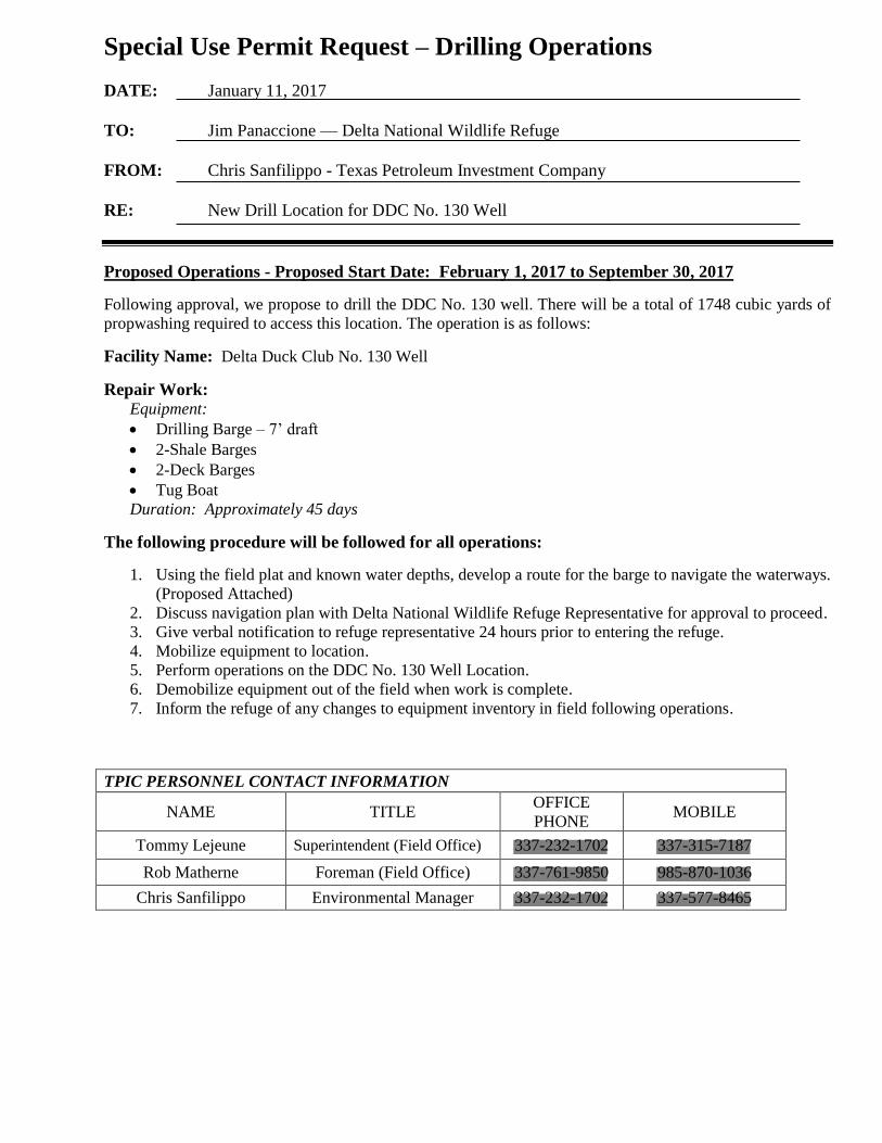
Special Use Permit Request – Drilling Operations
DATE: January 11, 2017
TO: Jim Panaccione — Delta National Wildlife Refuge
FROM: Chris Sanfilippo - Texas Petroleum Investment Company
RE: New Drill Location for DDC No. 130 Well
Proposed Operations - Proposed Start Date: February 1, 2017 to September 30, 2017
Following approval, we propose to drill the DDC No. 130 well. There will be a total of 1748 cubic yards of
propwashing required to access this location. The operation is as follows:
Facility Name: Delta Duck Club No. 130 Well
Repair Work: Equipment:
Drilling Barge – 7’ draft
2-Shale Barges
2-Deck Barges
Tug Boat
Duration: Approximately 45 days
The following procedure will be followed for all operations:
1. Using the field plat and known water depths, develop a route for the barge to navigate the waterways.
(Proposed Attached)
2. Discuss navigation plan with Delta National Wildlife Refuge Representative for approval to proceed.
3. Give verbal notification to refuge representative 24 hours prior to entering the refuge.
4. Mobilize equipment to location.
5. Perform operations on the DDC No. 130 Well Location.
6. Demobilize equipment out of the field when work is complete.
7. Inform the refuge of any changes to equipment inventory in field following operations.
TPIC PERSONNEL CONTACT INFORMATION
NAME TITLE OFFICE
PHONE MOBILE
Tommy Lejeune Superintendent (Field Office) 337-232-1702 337-315-7187
Rob Matherne Foreman (Field Office) 337-761-9850 985-870-1036
Chris Sanfilippo Environmental Manager 337-232-1702 337-577-8465
bafortier
Highlight
bafortier
Highlight
bafortier
Highlight
bafortier
Highlight
bafortier
Highlight
bafortier
Highlight
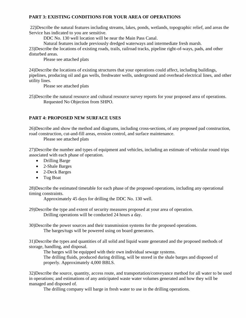
PART 3: EXISTING CONDITIONS FOR YOUR AREA OF OPERATIONS
22)Describe the natural features including streams, lakes, ponds, wetlands, topographic relief, and areas the
Service has indicated to you are sensitive.
DDC No. 130 well location will be near the Main Pass Canal.
Natural features include previously dredged waterways and intermediate fresh marsh.
23)Describe the locations of existing roads, trails, railroad tracks, pipeline right-of-ways, pads, and other
disturbed areas.
Please see attached plats
24)Describe the locations of existing structures that your operations could affect, including buildings,
pipelines, producing oil and gas wells, freshwater wells, underground and overhead electrical lines, and other
utility lines.
Please see attached plats
25)Describe the natural resource and cultural resource survey reports for your proposed area of operations.
Requested No Objection from SHPO.
PART 4: PROPOSED NEW SURFACE USES
26)Describe and show the method and diagrams, including cross-sections, of any proposed pad construction,
road construction, cut-and-fill areas, erosion control, and surface maintenance.
Please see attached plats
27)Describe the number and types of equipment and vehicles, including an estimate of vehicular round trips
associated with each phase of operation.
Drilling Barge
2-Shale Barges
2-Deck Barges
Tug Boat
28)Describe the estimated timetable for each phase of the proposed operations, including any operational
timing constraints.
Approximately 45 days for drilling the DDC No. 130 well.
29)Describe the type and extent of security measures proposed at your area of operation.
Drilling operations will be conducted 24 hours a day.
30)Describe the power sources and their transmission systems for the proposed operations.
The barges/tugs will be powered using on board generators.
31)Describe the types and quantities of all solid and liquid waste generated and the proposed methods of
storage, handling, and disposal.
The barges will be equipped with their own individual sewage systems.
The drilling fluids, produced during drilling, will be stored in the shale barges and disposed of
properly. Approximately 4,000 BBLS.
32)Describe the source, quantity, access route, and transportation/conveyance method for all water to be used
in operations; and estimations of any anticipated waste water volumes generated and how they will be
managed and disposed of.
The drilling company will barge in fresh water to use in the drilling operations.
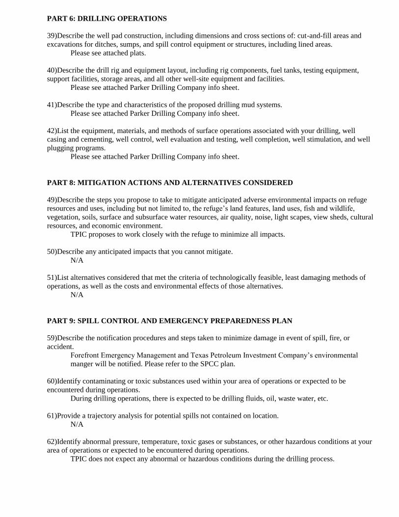
PART 6: DRILLING OPERATIONS
39)Describe the well pad construction, including dimensions and cross sections of: cut-and-fill areas and
excavations for ditches, sumps, and spill control equipment or structures, including lined areas.
Please see attached plats.
40)Describe the drill rig and equipment layout, including rig components, fuel tanks, testing equipment,
support facilities, storage areas, and all other well-site equipment and facilities.
Please see attached Parker Drilling Company info sheet.
41)Describe the type and characteristics of the proposed drilling mud systems.
Please see attached Parker Drilling Company info sheet.
42)List the equipment, materials, and methods of surface operations associated with your drilling, well
casing and cementing, well control, well evaluation and testing, well completion, well stimulation, and well
plugging programs.
Please see attached Parker Drilling Company info sheet.
PART 8: MITIGATION ACTIONS AND ALTERNATIVES CONSIDERED
49)Describe the steps you propose to take to mitigate anticipated adverse environmental impacts on refuge
resources and uses, including but not limited to, the refuge’s land features, land uses, fish and wildlife,
vegetation, soils, surface and subsurface water resources, air quality, noise, light scapes, view sheds, cultural
resources, and economic environment.
TPIC proposes to work closely with the refuge to minimize all impacts.
50)Describe any anticipated impacts that you cannot mitigate.
N/A
51)List alternatives considered that met the criteria of technologically feasible, least damaging methods of
operations, as well as the costs and environmental effects of those alternatives.
N/A
PART 9: SPILL CONTROL AND EMERGENCY PREPAREDNESS PLAN
59)Describe the notification procedures and steps taken to minimize damage in event of spill, fire, or
accident.
Forefront Emergency Management and Texas Petroleum Investment Company’s environmental
manger will be notified. Please refer to the SPCC plan.
60)Identify contaminating or toxic substances used within your area of operations or expected to be
encountered during operations.
During drilling operations, there is expected to be drilling fluids, oil, waste water, etc.
61)Provide a trajectory analysis for potential spills not contained on location.
N/A
62)Identify abnormal pressure, temperature, toxic gases or substances, or other hazardous conditions at your
area of operations or expected to be encountered during operations.
TPIC does not expect any abnormal or hazardous conditions during the drilling process.
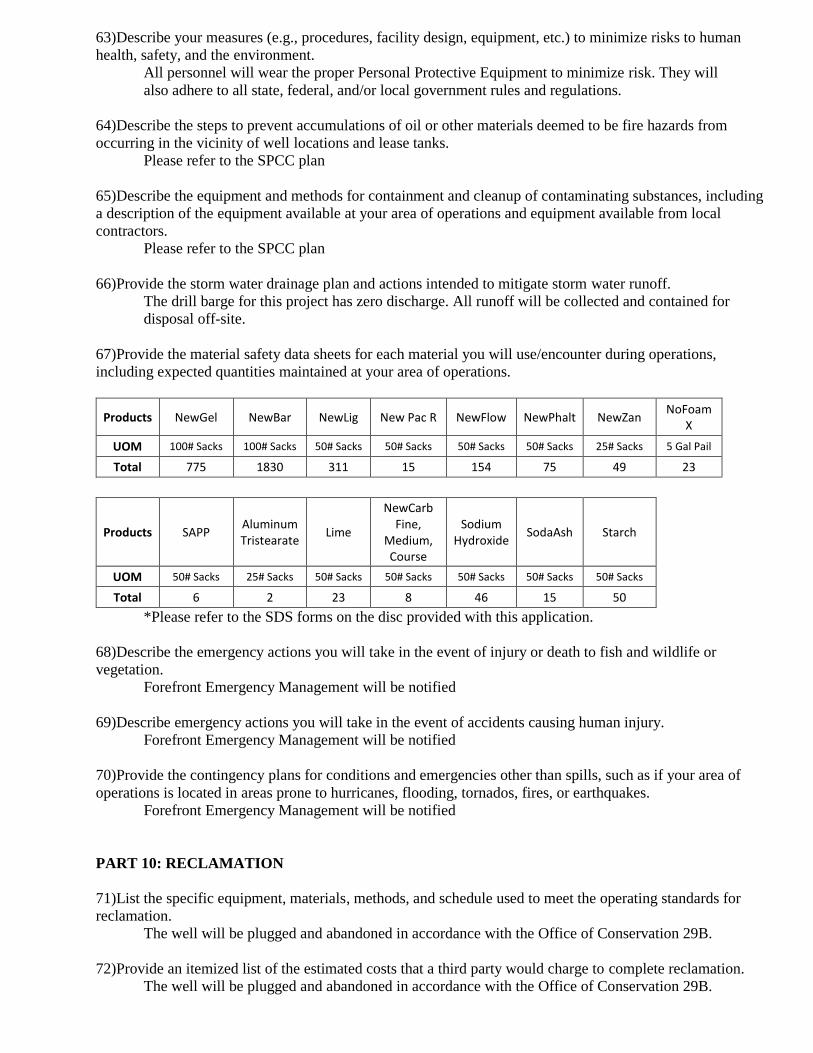
63)Describe your measures (e.g., procedures, facility design, equipment, etc.) to minimize risks to human
health, safety, and the environment.
All personnel will wear the proper Personal Protective Equipment to minimize risk. They will
also adhere to all state, federal, and/or local government rules and regulations.
64)Describe the steps to prevent accumulations of oil or other materials deemed to be fire hazards from
occurring in the vicinity of well locations and lease tanks.
Please refer to the SPCC plan
65)Describe the equipment and methods for containment and cleanup of contaminating substances, including
a description of the equipment available at your area of operations and equipment available from local
contractors.
Please refer to the SPCC plan
66)Provide the storm water drainage plan and actions intended to mitigate storm water runoff.
The drill barge for this project has zero discharge. All runoff will be collected and contained for
disposal off-site.
67)Provide the material safety data sheets for each material you will use/encounter during operations,
including expected quantities maintained at your area of operations.
Products NewGel NewBar NewLig New Pac R NewFlow NewPhalt NewZan NoFoam
X
UOM 100# Sacks 100# Sacks 50# Sacks 50# Sacks 50# Sacks 50# Sacks 25# Sacks 5 Gal Pail
Total 775 1830 311 15 154 75 49 23
Products SAPP Aluminum Tristearate
Lime
NewCarb Fine,
Medium, Course
Sodium Hydroxide
SodaAsh Starch
UOM 50# Sacks 25# Sacks 50# Sacks 50# Sacks 50# Sacks 50# Sacks 50# Sacks
Total 6 2 23 8 46 15 50
*Please refer to the SDS forms on the disc provided with this application.
68)Describe the emergency actions you will take in the event of injury or death to fish and wildlife or
vegetation.
Forefront Emergency Management will be notified
69)Describe emergency actions you will take in the event of accidents causing human injury.
Forefront Emergency Management will be notified
70)Provide the contingency plans for conditions and emergencies other than spills, such as if your area of
operations is located in areas prone to hurricanes, flooding, tornados, fires, or earthquakes.
Forefront Emergency Management will be notified
PART 10: RECLAMATION
71)List the specific equipment, materials, methods, and schedule used to meet the operating standards for
reclamation.
The well will be plugged and abandoned in accordance with the Office of Conservation 29B.
72)Provide an itemized list of the estimated costs that a third party would charge to complete reclamation.
The well will be plugged and abandoned in accordance with the Office of Conservation 29B.
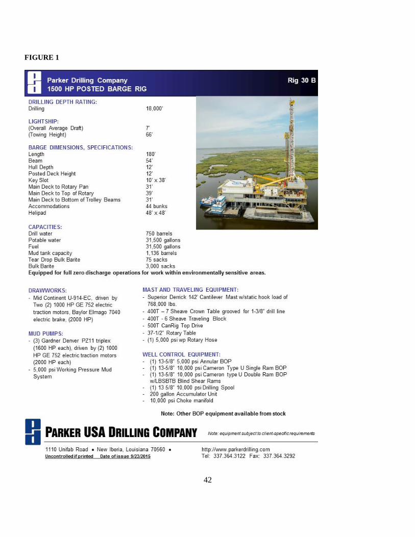
42
FIGURE 1
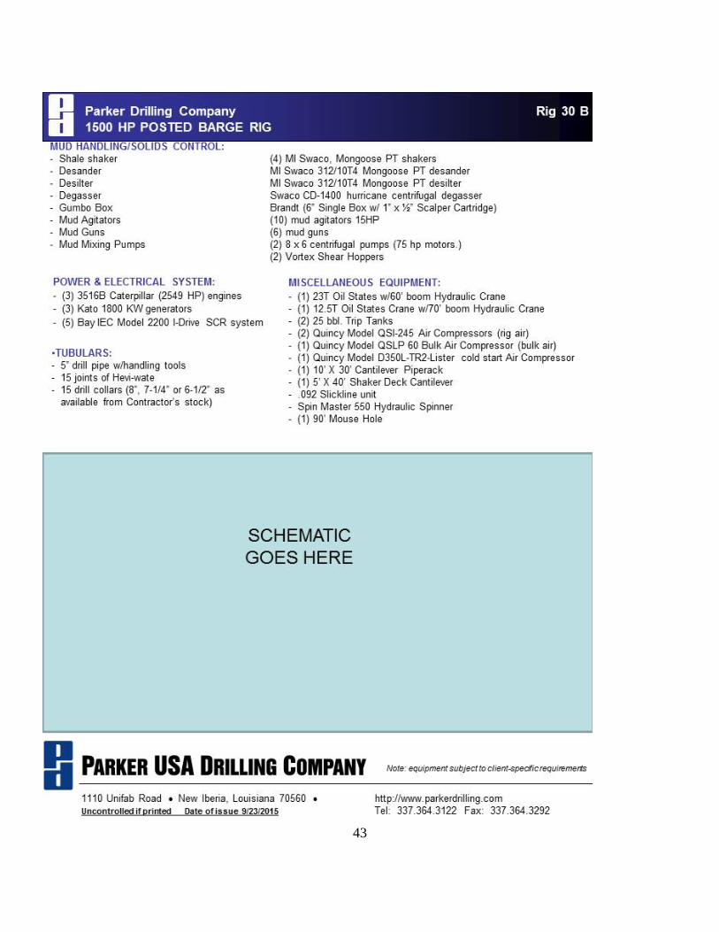
43
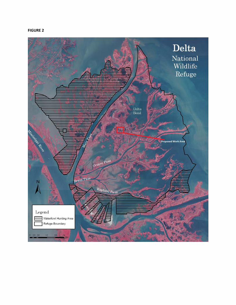
FIGURE 2
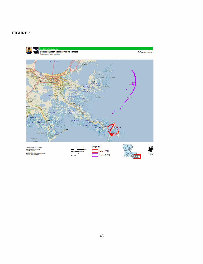
45
FIGURE 3