Environment Construction Method Statement 05 Access Track ... · Construction Method Statement #5...
30
Environment Construction Method Statement #5 Access Track Widening and Upgrade HEA-CMS-GL-ENV-005-00-01 Scope This Environmental Construction Method Statement describes the environmental management measures to be applied to the upgrade of existing access tracks and construction of new access roads to the construction corridor and site compound. Location/s Access track locations are designated as: F3 interchange, Minmi, Viaducts 1-3, Skyline Ridge, Buchannan Interchange, rest areas and site compound. Timing Pre-construction, construction Minister’s COAs MCoA30
Transcript of Environment Construction Method Statement 05 Access Track ... · Construction Method Statement #5...

EnvironmentConstruction Method Statement #5
Access Track Widening and UpgradeHEA-CMS-GL-ENV-005-00-01
ScopeThis Environmental Construction Method Statement describes the environmentalmanagement measures to be applied to the upgrade of existing access tracks andconstruction of new access roads to the construction corridor and site compound.
Location/s Access track locations are designated as: F3 interchange, Minmi, Viaducts 1-3,Skyline Ridge, Buchannan Interchange, rest areas and site compound.
Timing Pre-construction, construction
Minister’s COAs MCoA30

Hunter Expressway Alliance
ECMS – Access Track Widening and Upgrade
HEA-CMS-GL-ENV-005-00-01_AccessTracks.doc Page ii
DOCUMENT CONTROL
Document Type: Document No/Ref:HEA-CMS-GL-ENV-005-00-01
Title: Access Track Widening and Upgrade
GeneralDescription:
This ECMS covers the activities and management measures for tracks required to accessthe viaducts and mine void treatment sites for the construction of a 13 km expressway fromthe Newcastle Link Road interchange with the F3, through to Buchanan.
Document Path: \\10.10.25.35\data\HEA\01Environment\01_09_ECMS\05_AccessTracks\HEA_ECMS_Access Tracks_Rev2[1].doc
Approval Name Position Signed/Approved Date
DocumentEditor / Author
Chris Cooper Environmental Officer
Review Howard Chemney Environment Manager
Final approval Peter Chatburn Alliance ProjectManager
DOCUMENT REVISIONS
Rev No Date Prepared by Approved by Remarks
1 22.7.10 C. Cooper H. Chemney
EMR Certification
I have reviewed this ECMS and find it to be in accordance with the relevant Conditions of Approvaland all relevant undertakings made in the EIS, Representations Report and the approved CEMP.
Signed:
Environmental Management Representative
Date:

Hunter Expressway Alliance
ECMS – Access Track Widening and Upgrade
HEA-CMS-GL-ENV-005-00-01_AccessTracks.doc Page iii
Table of Contents
1 Introduction .................................................................................................................................1
1.1 ECMS attachments ..............................................................................................................2
1.2 Key reference documents to ECMS .....................................................................................2
2 Scope of works............................................................................................................................4
2.1 Pre-construction activities ....................................................................................................4
2.1.1 Survey and fencing off sensitive environment ...............................................................4
2.1.2 Site inductions .............................................................................................................4
2.1.3 Community notification .................................................................................................4
2.2 Staging of works ..................................................................................................................4
2.2.1 Existing tracks upgraded without widening ...................................................................4
2.2.2 Track widening to achieve haul road status ..................................................................5
2.2.3 Construction of new link roads......................................................................................6
2.3 Construction activities ..........................................................................................................6
2.4 Hours of operation ............................................................................................................. 10
2.5 Site rehabilitation and restoration ....................................................................................... 10
3 Key roles and responsibilities .................................................................................................... 11
4 Statutory requirements and approvals ....................................................................................... 12
4.1 Revision of ECMS to reflect licence conditions ................................................................... 12
4.2 ECMS consultation process ............................................................................................... 12
4.3 Minister’s conditions of approval ........................................................................................ 13
5 Site induction and training ......................................................................................................... 15
6 Monitoring and inspection .......................................................................................................... 15
7 Revisions .................................................................................................................................. 15
8 Document control ...................................................................................................................... 15
9 Attachments .............................................................................................................................. 15
LIST OF TABLES
Table 1.1: Relevant sub-plans to the ECMS ..................................................................................2Table 2.1: Construction activities summary ...................................................................................7Table 4.1: Statutory requirements for the ECMS ......................................................................... 12Table 4.2: Matrix of Minister’s Condition of Approval 30 .............................................................. 13

HEA-CMS-GL-ENV-005-00-01_AccessTracks.doc Page 1
1 IntroductionThis Environmental Construction Method Statement (ECMS) documents the requirements for worksassociated with widening and upgrading of existing access tracks to the construction corridor. Thisdocument:
addresses the requirements of the Minister’s Conditions of Approval 30 for the Hunter Expresswayproject,
reflects the requirements of the Hunter Expressway Alliance (HEA) environmental managementsystem (as detailed in the Construction Framework Environmental Management Plan),
incorporates the management measures from the relevant CEMP sub-plans and
describes the environmental management measures relating specifically to the constructionactivities and potential environmental issues.
This ECMS has been prepared as a practical environmental management tool for use by all HEApersonnel and subcontractors and incorporates the assessment of the environmental and communityrisks for these works. The specific environmental and community management controls developedand detailed in the ECMS, include the following key information:
Key site and management personnel - responsibilities and contact details.
Operating hours.
Construction details – activities, staging and schedule.
Objectives and targets – monitoring requirements, criteria and procedures.
Action tables/plans – inspection and test plans with actions, responsibilities, training, timing,reporting, and monitoring/auditing and checklists.
Site Drawings - Site layout, monitoring locations, erosion controls, noise barriers, discharge pointsand limits of clearing.
A number of access routes will be required into the Hunter Expressway Project alignment throughoutconstruction. It is anticipated that there will be at least four (4) stages of development executed on thecurrent access avenues into the alignment:
1. Immediate enabling works to the existing access tracks without vegetation removal for pre-construction geotechnical and mine void investigation drill rigs and support vehicles and lightconstruction vehicles,
2. Immediate enabling works to the existing access tracks with conditional vegetation removal forvehicles as per above;
3. Track widening to eight (8) meters, to achieve haul road status; and4. Constructions of new link roads as the alignment clearing works proceed.

HEA-CMS-GL-ENV-005-00-01_AccessTracks.doc Page 2
1.1 ECMS attachmentsThe General Construction ECMS 1 will be required for all construction sites.
This activity specific ECMS provides only specific requirements for access tracks. When undertakingaccess track work, this ECMS will need to be used in conjunction with ECMS 1: General Constructionwhich will apply for the non-specific requirements for the site.
The Site Supervisor in consultation with the QA Manager will determine which ECMSs are required foreach work sites. Refer to the overview map contained in Attachment B of ECMS 1 for an overview ofall ECMSs. Specific environmental constraints are further identified in the maps contained inAttachment A.
Attachment A – ECMS Environmental Control Plans
Attachment B – Construction Access Roads General Arrangement; provides sketches of accesstrack locations and classification (ie: use as is, upgrade without widening, upgrade and widen to8 m, construct new link road)
The ECMS site-specific Environmental Control Plans (ECPs) include site-specific drawings on acadastral and air photo base with site boundary overlain, general traffic controls and site-specificenvironmental management action tables. ECPs are to be read/ implemented in conjunction with theECMS document and relevant reference documents and are a day-to-day reference for managingactivities on the individual sites. The ECPs have been designed as A1 drawings for attachment to siteshed walls. This ECMS includes the following ECPs:
Flora and Fauna Management Hours of Operation Noise and Vibration Soil and Surface Water Management Construction Air Quality Management.
1.2 Key reference documents to ECMSThe following detailed management plans and reports have been prepared in conjunction with theECMS to assist in the mitigation of specific environmental issues for the works. This ECMS providesthe required detail for day-to-day worksite activities and the management plans and reports will bereferred as needed for specific information requirements:
Table 1.1: Relevant sub-plans to the ECMS
Issue Relevant Plan(s) Details
Noise & vibration (incl.blast management)
Construction Noise & Vibration SubPlan (incl. Blast ManagementStrategy) (HEA-PL-GL-NVP-001-00-02-CNVSP)
Provides a comparison of measuredbackground noise levels at sensitivereceivers vs. predicted noise impacts,duration of impacts from site works andtraffic, physical and site managementmeasures to minimise impacts andcompliance monitoring program.
Flora & Fauna Flora and Fauna Management Sub Provides details of the location of sensitive

HEA-CMS-GL-ENV-005-00-01_AccessTracks.doc Page 3
Issue Relevant Plan(s) Details
Plan (HEA-PL-GL-FFP-001) environment, including EECs andmanagement measures to preventconstruction encroachment.
Soil and water quality Soil & Water Management SubPlan (HEA-PL-GL-SWP-001)
Spoil Management Sub Plan (HEA-PL-GL-SMP-001)
Provides details of the physical andmanagement controls for surface runoff,erosion and sedimentation control, incidentresponse and details of the compliancemonitoring program.
Land contamination Hazard & Risk Management Plan(HEA-PL-GL-HRP-001)
Provides details of the assessment ofcontamination
Heritage Indigenous Cultural HeritageManagement Sub Plan (HEA-PL-GL-IHP-001)
Historical Heritage ManagementSub Plan (HEA-PL-GL-HHP-001)
Details Aboriginal and European Heritageitems and locations, as well as measures tomanage potential archaeological finds andprevent damage to known artifacts andlocations.
Air Quality Construction Air QualityManagement Plan (HEA-PL-GL-AQP-001)
Water Management /Re-Use
Waste Management & Re-Use SubPlan (HEA-PL-GL-WMP-001)

HEA-CMS-GL-ENV-005-00-01_AccessTracks.doc Page 4
2 Scope of worksThis ECMS covers works associated with:
Repairs to existing access tracks that do not require any widening or vegetation removal
Upgrading existing access tracks to haul road status, including widening and associatedvegetation removal,
Construction of new access tracks to provide linkages for complete circuits
This ECMS covers all access tracks required for the project. Construction methodology is providedbelow. The Construction Activities Table (Table 2.1) provides a summary of construction activities tobe undertaken on the worksites, indicative timing, equipment/plant and an indication of key issuesrelated to the activities.
2.1 Pre-construction activities
2.1.1 Survey and fencing off sensitive environment
An Aboriginal Archaeological Survey and Flora and Fauna Survey will be conducted alongaccess tracks where tracks are located outside the extent of the previous surveys. Allidentified issues will be managed in accordance with the Indigenous Cultural HeritageManagement Sub Plan (HEA-PL-GL-IHP-001) and Flora and Fauna Management Sub Plan(HEA-PL-GL-FFP-001). Any sensitive areas identified in the reports will be fenced prior totrack upgrading.
Areas identified as having threatened species in the vicinity of track upgrade works will beinspected by a qualified ecologist who will locate and mark (with tape or similar) thethreatened flora. Any marked flora will be fenced and signs erected prior to any works beingundertaken so that trimming or clearing of threatened flora is prevented. The location ofthreatened flora will be clearly communicated to relevant work teams via the GroundDisturbance Permit (GDP) system.
2.1.2 Site inductions
All HEA personnel/contractors associated with the access track works will be inducted to thesite. The induction will include relevant information on all environmental and communityissues.
2.1.3 Community notification
Relevant community groups that utilise the Sugarloaf Ranges track network for recreationalactivities will be informed of the commencement of construction and changes to access in thevicinity of the works. Signage will be placed at intersections of access tracks advising ofconstruction before works commence.
2.2 Staging of works
2.2.1 Existing tracks upgraded without widening
Tracks identified in the Construction Access Tracks General Arrangement (Attachment B) as‘existing tracks, upgrade without widening’ will not be widened beyond their current boundary,which will be defined by the growth of any vegetation at the edge of any track. There will be no

HEA-CMS-GL-ENV-005-00-01_AccessTracks.doc Page 5
vegetation clearing to repair these tracks, however in some instances minor trimming ofoverhanging branches may be required.
1. Immediate enabling works without vegetation removal
Tracks will be inspected by the Project Engineer and/or Project Foreman for suitability for use.Tracks which have erosion features and rutting that prevent safe passing will have all or someof the following improvement works:
Removal of high points Infill of scours using aggregates and road base; Blade leveling of sections of tracks featuring rutting; Removal/leveling of redundant stockpiles impeding access; Compaction of the surface by track rolling.
Suitable erosion and sediment controls will be developed and submitted to the EnvironmentManager (EM) and approved for use prior to works commencing. Once implemented, theEnvironmental Officer (EO) will inspect the work for suitability.
Once works are complete and tracks are subject to construction traffic, they will be monitoredfor erosion on an ongoing basis by the construction environmental officer and/or the foreman.
2. Immediate enabling works with conditional vegetation removal
Where vehicular movements are impeded by overhanging limbs, some vegetation may requireremoval; however this will be restricted to trimming only and will not result in significantdamage to trees.
In areas identified as containing both EEC and non-EEC, and thus included within theconstruction clearing limit, only branches of trees that measure less than 75mm will beremoved. Under no circumstances will individual trees be removed, as per the EnvironmentalWork Method Statement – Surveying.
2.2.2 Track widening to achieve haul road status
A survey pick-up of all tracks in the vicinity of the project alignment will be executed. Surveydata will be analysed to determine those tracks that will be upgraded to allow the safe haulingof materials throughout the project alignment. In all cases, a minimal disturbance footprintapproach will be adopted.
Surveyed track widths will allow the calculation of accurate clearing areas required to widenspecific routes.
Prior to any widening works commencing, routes will be reviewed and approved by theConstruction Manager or his delegate.
Upon approval, the following sequence of events shall occur:
1. Develop and approve An Inspection and Test Plan (ITP) for the “Construction of HaulRoads”. The GDP shall be opened and process of sign off by relevant managers,including Safety, Utilities and Environment commenced.
2. Where threatened flora and EEC have been identified in the vicinity of track works, anecologist shall locate and mark (red & white hazard tape) the location prior to any worksbeing undertaken to prevent accidental trimming or clearing of threatened flora. Thelocation of threatened flora and EEC shall be clearly communicated to the work team viaGDPs.
HEA-CMS-GL-ENV-005-00-01_AccessTracks.doc Page 6
3. Survey team to peg the clearing limits of the haul road at ten (10) meter centers inaccordance with Flora and Fauna Management Sub-Plan Measure 29 – Section 5.2.3.1.
4. Survey team to individually mark the trees on the clearing limit5. Environmental officer and Site Engineer to verify the individually marked trees “limit
vegetation” on the limits of the haul road clearing6. Stocking tracks (tracks that will be ultimately closed) to be identified and clearly marked
on a plan for storage of mulch and unsuitable material7. Hold points on the ITP for the commencement of clearing to be released8. Clear and grub works commence9. Placement of suitable material to commence10. Final survey as constructed pick-up to be completed.
Refer to ECMS #2: Clearing and Topsoil Management.
Cleared vegetation will be recovered and/or mulched for future reuse or recycling as perMCoA64.
2.2.3 Construction of new link roads
As the alignment clearing works proceed, there may be an opportunity to construct moreefficient haul roads by constructing link roads to complete haul road circuits. In this instance,the sequence of events will be as per 2.2.2.
Particular attention must be paid to ensure no effects on the over-all project clearing limit areincurred.
2.3 Construction activitiesTable 2.1 provides a summary of the proposed construction activities to be undertaken on theworksite, indicative timing, equipment and plant, and an indication of key issues related to theactivities.

HEA-CMS-GL-ENV-005-00-01_AccessTracks.doc Page 7
Table 2.1: Construction activities summary
Activity Description Key environmental issues Nominated controls Personresponsible
Pre-construction
Consultation Notify relevant communitystakeholders of intention tocommence works and keyenvironmental issues andactivities
Meet community expectations. One-on-one meetings with recreational clubs (trail-bike, mountain bikeand 4WD)
CRM
Opening sensitive areas topotential impacts by the public
All sensitive areas including Aboriginal and European heritage,threatened flora and EEC will be signposted or fenced off to preventaccess by the public.
Public safety Install 'construction ahead' signage at access track intersections prior toworks commencing.
SS
HEA personnel /contractorTraining
Provide all HEApersonnel/contractors withinduction on environmentaland community issues.
Community relationships
Aboriginal and EuropeanHeritage Soil and Waterimpacts.
Native flora and fauna impacts.
All HEA personnel/contractors inducted before commencing onsite PEM/ CM
During construction
Track upgrades – no widening
Site Preparation Establish and executeProgressive ESCPs
Erosion and sedimentation Construct windrows, drainage chutes and jersey curbs as perapproved design and PESCPs
PEM/SE
Filling Hollowsand Ruts
Materials delivery Run off from stockpiles Only dedicated & approved stockpile locations to be used. SE

HEA-CMS-GL-ENV-005-00-01_AccessTracks.doc Page 8
Activity Description Key environmental issues Nominated controls Personresponsible
Dewatering Sediment laden water pumpedinto natural surroundingvegetation
Obtain approval from Project Environmental Manager prior to alldewatering. All dewatering to be undertaken as per the Soil and WaterManagement Sub Plan and a dewatering permit is obtained andapproved by the PEM.
SE
Removing highpoints
Using excavator/machine toremoved high points
Material surplus Plan for materials to be incorporated into access track construction
Net excess material to be removed and stored at designate materialstorage pad
SE
SS
New tracks and tracks requiring widening
Site Preparation Establish and executePESCPs
Sediment laden discharge intowatercourses
Construct erosion and sediment controls including windrows,drainage chutes and jersey curbs as per approved design
PEM / SE
Clearing Injury to Fauna All injured fauna will be given into the care of WIRES officers PEM / CM
Spread of noxious weeds orintroduction of new weeds intoan area
Areas of noxious weeds will be identified by the Ecologist during pre-clearing inspections. These shall be communicated to ground staff viaPESCPs or GDPs
In areas of noxious weeds the Noxious Weeds Management Strategy(refer to Flora and Fauna Management Sub Plan) shall beimplemented. The potential requirement for plant wash-down andwheel wash areas will be investigated to minimise seed spread.
PEM / CM
Loss of threatened species andhabitat trees
Complete Pre-clearing Checklist including any pre-clearing surveys
Complete a Ground Disturbance Permit
Clearing outside approvedclearing limits
Delineate clearance limits prior to clearing
Complete Pre-clearing Checklist including any pre-clearing surveys
Complete a Ground Disturbance Permit
Construction of Import material, place and Batter stability Early topsoil placement and establishment of seed on batters SE

HEA-CMS-GL-ENV-005-00-01_AccessTracks.doc Page 9
Activity Description Key environmental issues Nominated controls Personresponsible
Formation compact Stockpiling Any stockpiles which are to remain for any period longer than 2 weekswill be temporarily seeded with a cover crop to prevent weed growth.
No stockpiles will be placed within 20 meters of a drainage line.
Noise and vibration Ensure works comply with area specific emission limits as defined inConstruction Noise and Vibration Sub Plan (HEA-PL-GL-NVP-001-00-02)
CM
Creek Crossings Ensure PESCPs are prepared for all creek crossings.
Creek crossings must meet the design requirements listed in Floraand Fauna Management Sub-Plan 5.1.2.2 Culvert fauna underpassdesign and the "Why do fish need to cross the road? PassageRequirements for Waterway Crossings" Guideline (NSW Fisheries,January 2003)
Creek crossings over Class 1 and 2 creeks must be designed inconsultation with NSW DPI-Fisheries
Post track construction
Constructiontraffic
Suppress dust emissions fromhaul roads
Construction traffic generatingdust
Utilise water cart circuits to dampen haul roads
Monitor wind speeds and cease dust generating activities whenpredetermined wind speed limits exceeded
Impose speed limits supported by signage
SS
CM
CM
HEA-CMS-GL-ENV-005-00-01_AccessTracks.doc Page 10
2.4 Hours of operation Normal hours of operation will apply in accordance with MCoA 73. Construction hours are:
7am – 6pm Monday to Friday 8am to 1pm Saturday and at no time on Sundays or public holidays.
Approved hours of operation for specific activities such as impulsive tonal noise generating activitiesare detailed in Appendix A – ECMS Environmental Control Plans.
2.5 Site rehabilitation and restorationThe future use of access tracks will be determined after further discussion with the NSW NationalParks and Wildlife Service (NPWS) and relevant utilities.

HEA-CMS-GL-ENV-005-00-01_AccessTracks.doc Page 11
3 Key roles and responsibilitiesRefer to the General Construction ECMS#1 for roles and responsibilities of key personnel.

HEA-CMS-GL-ENV-005-00-01_AccessTracks.doc Page 12
4 Statutory requirements and approvalsA summary of the key statutory requirements and approvals for the works are detailed below.
Table 4.1: Statutory requirements for the ECMS
Relevant legislation Licence/Approval etc Authority
Environment Protection andBiodiversity Conservation Act 1999(Cth) (EPBC Act)
None known, however will bereviewed if ecological/heritagesurveys identify matters of NationalEnvironmental Significance
DEWHA
Protection of the EnvironmentOperations Act 1997 (NSW) (PoEOAct)
Environmental Protection Licence DECCW
Threatened Species ConservationAct 1995 (NSW) (TSC Act)
License to harm or pick threatenedspecies, populations or ecologicalcommunities, or damage habitat.
DECCW
Fisheries Management Act 1994(NSW) (FM Act)
Approval required for creekcrossings
DECCW
Heritage Act 1977 (NSW) s139 excavation permits146 notice of relic discovery
NSW Heritage Council
National Parks and Wildlife Act1974 (NSW) (NPW Act)
s87 / s90 permits DECCW
4.1 Revision of ECMS to reflect licence conditionsUp-to-date copies of each licence will be made available to all site personnel.
4.2 ECMS consultation process
Consultation for the project has been undertaken with agencies and stakeholders including:
Department of Planning (DoP)
Department of Environment, Climate Change and Water (DECCW)
Lake Macquarie City Council
Maitland City Council
Cessnock City Council
Industries and Investment NSW
Utility providers
Local Aboriginal Land Councils
Ongoing consultation during the works covered under this ECMS will be undertaken with relevantstakeholders where changes to works occur under this ECMS. Specifically DoP and DECCW will benotified where necessary.
Any further updates to the ECMS requires Environmental Management Representative (EMR)endorsement and a summary of changes and updates will be provided to the public for their
HEA-CMS-GL-ENV-005-00-01_AccessTracks.doc Page 13
information, and a full copy of the ECMS be made available on the internet, following EMRendorsement.
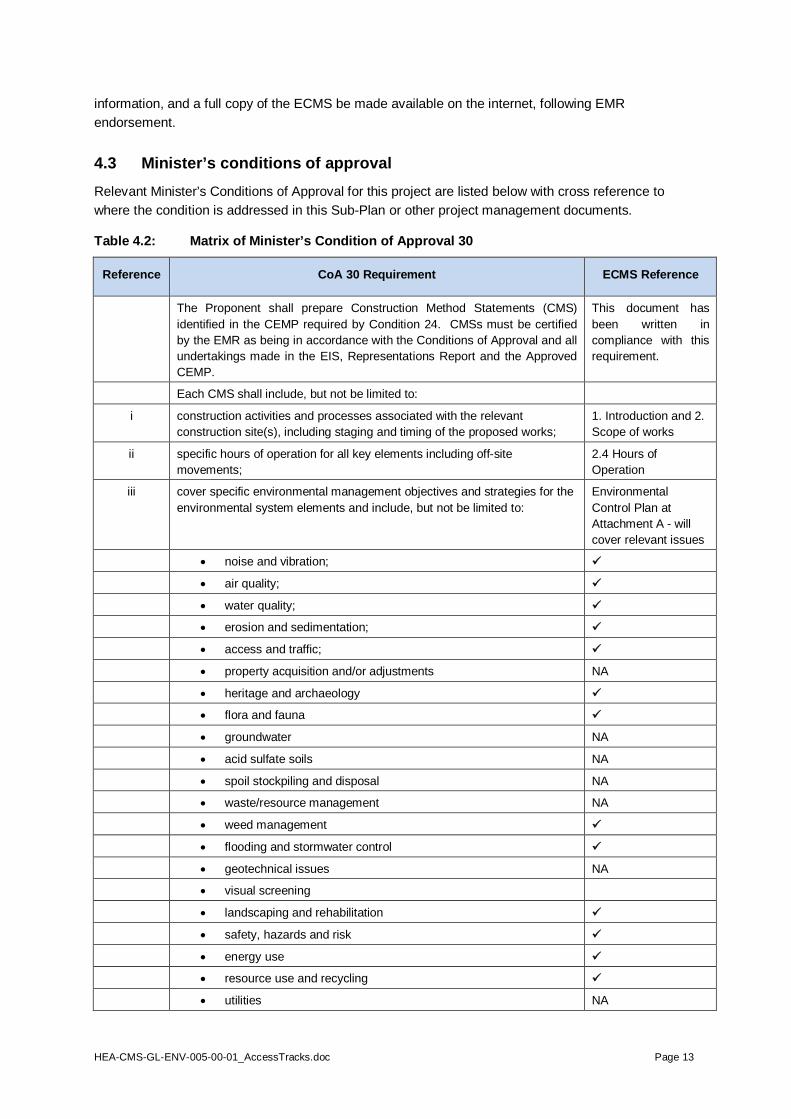
4.3 Minister’s conditions of approvalRelevant Minister’s Conditions of Approval for this project are listed below with cross reference towhere the condition is addressed in this Sub-Plan or other project management documents.
Table 4.2: Matrix of Minister’s Condition of Approval 30
Reference CoA 30 Requirement ECMS Reference
The Proponent shall prepare Construction Method Statements (CMS)identified in the CEMP required by Condition 24. CMSs must be certifiedby the EMR as being in accordance with the Conditions of Approval and allundertakings made in the EIS, Representations Report and the ApprovedCEMP.
This document hasbeen written incompliance with thisrequirement.
Each CMS shall include, but not be limited to:
i construction activities and processes associated with the relevantconstruction site(s), including staging and timing of the proposed works;
1. Introduction and 2.Scope of works
ii specific hours of operation for all key elements including off-sitemovements;
2.4 Hours ofOperation
iii cover specific environmental management objectives and strategies for theenvironmental system elements and include, but not be limited to:
EnvironmentalControl Plan atAttachment A - willcover relevant issues
noise and vibration;
air quality;
water quality;
erosion and sedimentation;
access and traffic;
property acquisition and/or adjustments NA
heritage and archaeology
flora and fauna
groundwater NA
acid sulfate soils NA
spoil stockpiling and disposal NA
waste/resource management NA
weed management
flooding and stormwater control
geotechnical issues NA
visual screening
landscaping and rehabilitation
safety, hazards and risk
energy use
resource use and recycling
utilities NA

HEA-CMS-GL-ENV-005-00-01_AccessTracks.doc Page 14
Reference CoA 30 Requirement ECMS Reference
iv address, but not be limited to:
a. identification of the statutory and other obligations which theProponent is required to fulfill during project construction,including all approvals and consultations/agreements requiredfrom other authorities and stakeholders, and key legislation andpolicies which control the Proponent’s construction of the project;
5. Statutoryrequirements andapprovals
b. measures to avoid and/or control the occurrence of environmentalimpacts;
EnvironmentalControl Plan -Attachment A
c. measures (where practicable and cost effective) to providepositive environmental offsets to unavoidable environmentalimpacts;
No unavoidableenvironmentalimpacts are expected.
d. definition of the role, responsibility, authority, accountability andreporting of personnel relevant to compliance with the CMS;
3. Key roles andresponsibilities &ECP (Attachment A)
e. site specific environmental management techniques andprocesses for all construction processes which are important forthe quality of the environment in respect of permanent and/ortemporary works;
ECP (Attachment A)
f. site specific monitoring, inspection and test plans for all activitiesand environmental qualities which are important to theenvironmental management of the project, including performancecriteria, tests, and protocols (eg. frequency and location);
6. Monitoring andinspections
g. locational details of important elements such as temporary noisebarriers; portable offices and amenities; truck, plant and materialsstorage; access locations; provision of site hoardings etc;
ECP in Attachment A
h. environmental management instructions for all complexenvironmental control processes which do not follow commonpractice or where the absence of such instructions could bepotentially detrimental to the environment;
EmergencyProcedure
i. steps the Proponent intends to take to ensure that all Plans andSub Plans are being complied with;
ECP in Attachment A
j. consultation requirements with relevant government agencies andutility/ service providers; and,
ECP in Attachment A
k. community consultation and notification strategy (including localcommunity, businesses, relevant government agencies, and allrelevant Councils), and complaint handling procedures.
ECP in Attachment A
Specific requirements of the main environmental system elements referredto in (iii) shall be as required under the conditions of this approval and/or asrequired under any licence or approval. All CMS shall be made publiclyavailable
All licences and/orCoAs relevant to thisECMS will beadhered to.This CMS shall bepublicly available atthe HEA ProjectDisplay Office

HEA-CMS-GL-ENV-005-00-01_AccessTracks.doc Page 15
5 Site induction and trainingRefer to the General Construction ECMS #1 for induction and training details.
6 Monitoring and inspectionRegular monitoring and inspection will be undertaken for the following key issues:
Erosion and sediment controls: undertaken as per the Soil and Water Management Sub PlanSchedule and carried out daily during periods of rainfall.
Creek crossings: as part of standard weekly inspections. Water quality: a Water Quality Monitoring program will be established to monitor the creeks. Impacts to any identified heritage items and threatened flora in the vicinity of works: Weekly as
part of standard inspection and additionally at the request of LALCs
7 RevisionsRevisions to the ECMS will be made as required and changes will be endorsed by the EMR asrequired.
The current copy of this ECMS is kept at the worksite and at the HEA Project Display Office followingEMR endorsement (where they may be viewed on request) and a summary of all updates provided tocommunity members for their information via the HEA Project Display Office.
8 Document controlProject document control is detailed in the project management plan and project filing and numberingis defined in procedure HEA-MP-GL-OPS-002-00. When the document is reviewed a new revisionnumber is assigned by the Environmental Manager.
The current revision of the ECMS will be available and displayed in site offices for ongoingimplementation and amendment as conditions or approval change. The documents will be saved inKeystone.
9 AttachmentsAttachment A – Environmental Construction Method Statement Environmental Control Plans
Attachment B - HEA Construction Access Roads General Arrangement (Sketches 1 – 4) detailinglocation and category of track works.

HEA-CMS-GL-ENV-005-00-01_AccessTracks.doc Page 16
Attachment A
Environmental Construction Method StatementEnvironmental Control Plans

HEA-CMS-GL-ENV-005-00-01_AccessTracks.doc Page 17
Flora & Fauna Management
Sub-Plan Ref: HEA Flora and Fauna Management Sub Plan (HEA-PL-GL-FFP-001-00-00)
Objectives: To manage vegetation clearance and control weed infestation in worksite disturbed areas,and manage any fauna encountered during construction works.
Performance Criteria: No disturbance to flora or fauna outside the access track clearing limits No increase in weed distribution or introduction of new weeds Rehabilitation of access tracks at end of life is consistent with Flora and Fauna Management
Sub Plan Section 3 (Rehabilitation performance criteria)
Mitigation Measures Responsibility
Vegetation protection and management
Restrict access to riparian areas, except for works directly related to construction ofdrainage line crossings, and construction & maintenance of water discharge points
CM
Maintain erosion/sediment controls during access track works to protect adjacentvegetation and the water quality of watercourses.
PM
Vegetation clearing
Complete daily pre-clearing checklist. EO
Complete GDPs for each area of vegetation to be cleared in accordance with Floraand Fauna Management Sub-Plan Section 7.
SS with ProjectEcologist andUtilitiesManager
Undertake all clearing and grubbing works in accordance with ECMS #2 Clearingand Topsoil Management and RTA QA Specification G40 - Clearing and Grubbing.
PM
Do not undertake clearing works without the supervision of the Project Ecologist. PM
Fauna management
Ensure that contact details for the Project Ecologist and appropriate fauna rescueorganisations are on-hand within the construction site.Contact numbers for fauna rescue organisations include: Wires - 1300 094 737 Wildlife Aid Rescue – Hunter Valley - 04 4766 7737
Native Animal Trust Fund – Wildlife Rescue Service – 0418 628 483
PEM
Report any injured native fauna found on site to appropriate fauna rescueorganisations and environmental staff.
All
Include fish passage design requirements for crossings over Class 2 creeks as listedin Flora and Fauna Management Sub-Plan 5.1.2.2 Culvert fauna underpassdesign and the "Why do fish need to cross the road? Passage Requirements forWaterway Crossings" Guideline (NSW Fisheries, January 2003), in consultation withNSW Fisheries.
PM
Threatened vegetation management

HEA-CMS-GL-ENV-005-00-01_AccessTracks.doc Page 18
Flora & Fauna Management
Halt construction activities immediately if, during the course of construction (includingvegetation clearing), any threatened flora and fauna species are identified. No work isto recommence until clearance has been given by the Environmental Manager.
All
Report the discovery of threatened species which have NOT been identified inprevious studies to the DG-DECCW.
PEM
Monitoring of flora & fauna
Report all instances of the identification of Squirrel Gliders in a new location duringaccess road construction to the Director General of DECCW (refer to Flora andFauna Management Sub-Plan Figure 1 – Sheets 1-9, Appendix A).
PEM
Report any risks to flora and fauna (including aquatic species in Surveyors Creek) onWeekly Environmental Inspection Checklists.
EO
Monitor health of trees close to construction work activities monthly duringconstruction period for signs of stress/damage. An appropriately qualified person shallimplement actions required to ensure the survival of the tree (s), as required.
EO
Hours of Work
Sub-Plan Refs: Construction Noise and Vibration Sub Plan (HEA-PL-GL-NVP-001-00-02)
Objectives: To meet the requirements of the MCoA regarding general construction hours of work, andspecific noise, vibration and blasting time restrictions.
Mitigation Measures Responsibility
General construction works
Comply with approved hours for construction activities as defined in MCoA 73: Monday to Friday: 7.00am - 6.00pm Saturday: 8.00am - 1.00pm Sunday and Public Holidays: No works are permitted
PM
Rock breaking
Comply with approved hours for activities that result in impulsive tonal noisegeneration (such as rock breaking and rock hammering) as per MCoA 72:
Monday - Friday: 8.00am - 12.00pm and 2.00pm - 5.00pm Saturday: 8.00am - 12.00pm
NB: where these activities are undertaken for a continuous three hour period, arespite of at least one hour must be scheduled.
PM
Out of hours operations
Obtain approval from the EMR for all construction works outside of standard hours.Works outside construction hours that may be permitted include:
i. Any works that is inaudible at nearby residential propertyii. Delivery of materials outside construction hours at the request of police or
other authorities for safety reasonsiii. Dust suppression worksiv. Emergency work to avoid the loss of lives, property or prevent environmental
harmv. Any other work as agreed by the EPA through the NVMSP process.
PM/PEM

HEA-CMS-GL-ENV-005-00-01_AccessTracks.doc Page 19
Soil and Surface Water Management
Sub-Plan Ref: Soil and Water Management Sub Plan (HEA-PL-GL-SWP-001-00-02)Regulations and procedures:
Managing Urban Stormwater - Soils and Construction, 3rd ed, 1998 NSW DECCW Managing Urban Stormwater - Soil and Construction, Volume 2C - Unsealed Roads,
2008,NSW DECCW Aust & NZ Guidelines for Fresh and Marine Water Quality, 2000, ANZECC HEA Refuelling and Liquid Storage Protocol (HEA-WP-GL-ENV-003-00-00)
Objective: Minimise erosion and sediment loss from the worksite and comply with water qualitystandards for discharge from worksite.
Performance criteria:1. Ensure there are no pollution incidents causing environmental harm2. Avoid pollution and/or erosion and sedimentation in key sensitive sites such as EEC's3. Maintain background water quality levels in surrounding waterways4. Prevent pollution by containing and controlling all fuel and chemical spills5. Comply with all statutory requirements to control environmental impacts and prevent pollution.
Mitigation Measures Responsibility
Progressive Erosion and Sediment Control Plans
Develop and implement Progressive Erosion and Sediment Control Plans(PESCPs) prior to any land disturbing activities, and works that:
1. require watercourse crossings2. are in the vicinity of environmentally sensitive areas3. in areas with a high erosion hazard
PM / SoilConservationist
Acid Sulfate Soils
Manage any ASS which may be uncovered in accordance with the as per Soil andWater Management Sub Plan (SWSMP) Acid Sulfate Management Strategy(Appendix C)
PEM
Surface runoff management
Establish localised controls on site to control sediment movement from stockpiles,equipment and materials storage areas including as per SWMP PM
Implement erosion and sediment controls prior to construction activities as perSWMP. PM
De-silt erosion control devices following all major rainfall events. Dispose of silt inaccordance with Waste Management & Re-Use Sub Plan (HEA-PL-GL-WMP-001) PM
Discharge sediment basin water only when EPL water quality criteria are satisfied.. PM
Watercourse crossings
Construct watercourse crossings in accordance with NSW DECC Fish passagerequirements for waterway crossings "Why do fish need to cross the road" (NSWFisheries, 2003) and ECMS #8 Temporary Waterway Crossings.
PM
Fuel and chemical spill management
Establish designated refuelling areas for refuelling mobile plant onsite. PM

HEA-CMS-GL-ENV-005-00-01_AccessTracks.doc Page 20
Soil and Surface Water Management
Conduct fuel storage and plant refuelling in accordance with the HEA Refuellingand Liquid Storage Protocol (HEA-WP-GL-ENV-003-00-00). PM
Supply spill kits at each fuel and chemical storage area and at areas of theworksite where handling and use of dangerous goods occur. PM
Monitoring and reporting
Conduct daily inspections of erosion and sediment controls as per SWMPschedule and after rainfall events
SS
Conduct weekly and monthly inspections of erosion and sediment controls as perSWMP schedule and after rainfall events.
PE / PEM/ SoilConservationist/PM
Monitor water quality during construction to determine effectiveness of controls.Review and modify controls and procedures if water quality levels are exceeded.
PEM
Noise and Vibration Management
Sub-Plan Ref: Construction Noise and Vibration Management Sub Plan (HEA-PL-GL-NVP-001-00-02)
Objective: To minimise the impacts of noise and vibration from construction activities onsurrounding receivers.
Performance Criteria: Ensure noise exceedances are avoided by monitoring at sensitive receiversand where exceedances impact on residents, apply mitigation strategies.
Sensitive receivers noise monitoring locations and criteria
RBL LA90 dB(A) Criteria LAeq, 15min dB(A)
Location Day Evening Night Day Evening Night
“Frogella” 21 Brooks Street, Kurri Kurri 37 39 32 47 44 37
77 Clift Street, Heddon Greta 36 34 30 46 39 35
14 Anvil Street, Stanford Merthyr 36 39 31 46 44 36
Lot 83 Averys Lane, Buchanan 43 39 33 53 44 38
263 John Renshaw Drive, Buchanan 45 44 33 55 49 38
“Grandview” John Renshaw Drive, Buchanan 44 39 30 54 44 35
48 Fifth Street, Seahampton 38 39 37 48 44 42
Note: Daytime (7.00am-6.00pm); Evening (6.00pm-10.00pm); Night time (10.00pm-7.00am)
Note: Add 5 dB(A) to the measured construction noise level for tonal or impulsive construction activity.
Construction Traffic Noise: Less than 60 dB(A) LAeq,1hr during working hours; 55 dB(A) LAeq,1hr outside of working hours Not to increase existing noise at any receiver > 2 dB(A).
Mitigation Measures Responsibility
Provide site personnel with induction/instruction on key noise issues andmitigation measures, approved construction hours and community concerns.
PEM
Install signage is installed on site to inform workers of approved hours for noisyactivities.
PEM

HEA-CMS-GL-ENV-005-00-01_AccessTracks.doc Page 21
Noise and Vibration Management
Investigate and report all noise or vibration complaints in accordance with theHEA Community Engagement Strategy.
PEM/CRM
Switch off plant and equipment when not in use. All
Schedule activities to minimise co-incidence of noisy plant working simultaneouslywhere practicable.
SE
Ensure noisy plant items are not located in the vicinity of sensitive receivers(where practicable).
SE
Ensure that where practicable, rock excavation is conducted by means of rippingrather than rock breaking.
SE
Where delivery of oversize items of plant/ equipment to the worksite outside ofstandard work hours is required, this must be in accordance with RTArequirements and approval of EMR/DECCW.
CM
Check that heavy vehicle movements related to worksite activities are inaccordance with the traffic management plan and do not pass through residentialareas.
CM
Fit all plant and equipment with properly functioning noise attenuation devices (egmufflers). Test all plant and equipment on delivery to site to ensure it complieswith noise and vibration output as described in the Noise and VibrationManagement sub-plan.
CM/PEM
Construction Air Quality Management
Sub Plan ref: Construction Air Quality Management Plan (HEA-PL-GL-AQP-001-001-00-02)
Objective: To minimise dust generation and manage emissions from construction activities to preventimpacts on surrounding receivers.Performance Criteria:
Depositional dust goals of max 4 g/m2 per month, subject to monthly background levels,as per DECCW guidelines.
No complaints received from nearby residents or local road users.
Monitoring sites/sensitive receivers:Location 1: F3 Freeway, North-bound on-Ramp, Seahampton, located at the southern end of works(100m -500m)Location 2: John Renshaw Drive, Buchanan, near the southern end of works. (70km SW of nearestresidence)
Mitigation Measures Responsibility
Pre-construction
Consult with local residents before works begin (i.e. site clearing and major earthworksnearby) and notify of the nature and timing of the work.
CRM
Dust suppression activities
Regularly control dust emissions using water sprays on water carts over unsealedtrafficable areas, earthworks and stockpiles, and other surfaces as necessary. Ensurecarts are available and maintained at all times.
SS, SE,CM
Water can only be extracted for dust management or other construction related activities CM

HEA-CMS-GL-ENV-005-00-01_AccessTracks.doc Page 22
Construction Air Quality Managementfrom sources approved by the Environment Manager. For example, sediment basins,local creeks where allowed. All water movements are to be covered by a watermovement permit1.
Clean any dirt tracked onto public roadways from construction vehicles using brooms ora street sweeper. SS, SE
Suspend work if excessive dust generation from surface dirt accumulation occurs untildust emissions are controlled.
SE,CM,PEM
Enclose storage / weigh bin tops to minimise wind-generated dust emissions. SS
Ensure no open burning or incineration on site unless otherwise approved by the EPA. SS
Minimise clearing at any one time by leaving vegetation within work sites and within thecorridor unless clearing is absolutely necessary. Commence revegetation of clearedareas as soon as practicable to prevent or minimise wind blown dust.
SS, SE
Vehicle, plant and equipment
Cover loads and secure tailgates from construction vehicles prior to leaving worksite toprevent loss of load on public roads and areas accessible to the public. Any spillage isrequired to be removed within 24 hours.
SS
Restrict and monitor construction traffic using local unsealed roads to 40 km/h. Installsignage. Control access to all construction areas to specific entry/exit points and confinevehicle movements to designated construction areas.
SS, SE
Provide facilities, such as rumble grids at site exit points to minimise tracking mud, dirtor other material onto a public road or footpath. Ensure wheels and undercarriage oftrucks are clean prior to the exiting the worksite. (See the flora and fauna section formore detail on these measures).
SE, CM
Service construction plant, vehicles and equipment regularly and maintain in topcondition so that existing exhaust emissions standards are met or surpassed.
SS, SE
In the event of visible smoke emissions from equipment lasting longer than 10 secondsduration, have equipment taken out of service and adequately repaired or tuned so thatsmoke is no longer visible for periods exceeding 10 seconds.
SS
Ensure plant or equipment is not left idling for longer than 15 minutes. SS
Stockpiling
Revegetate temporary stockpiles to stabilise the soil and minimise wind erosion. SS, SE
Establish quick growth cover crops to protect long-term topsoil stockpiles and clearedareas as soon as possible after completion. (See soil and water section for more detailon stockpiling).
SS, SE
Extreme conditions
On high wind days, either reprogram construction activities work that could cause anuisance or danger to people or property, or relocate to areas removed from sensitivereceptors.
SE, CM
No spark generating activities (such as welding) on days with a Total Fire Ban. CM
Avoid use of lime for stabilisation activities during windy days. SS, SE
Instigate a call out system to respond to dust suppression requirements out of hours andon weekends.
CM
1 The water movement permit system is an onsite system designed to track and check use of water across thesite.

HEA-CMS-GL-ENV-005-00-01_AccessTracks.doc Page 23
Construction Air Quality Management
Monitoring
Monitor dust deposition monthly throughout construction to determine effectiveness ofdust suppression measures. Review and modify dust control and operational proceduresif dust deposition levels are exceeded.
PEM
Monitor and record weather conditions, including rainfall, wind speed, wind direction andhumidity on a 24 hour basis.
CM
On high wind days where on site controls cannot prevent transport of dust, make arecord of: date, time, location, wind, direction, wind speed, pre-existing dust controls,additional controls implemented; and modifications to work implemented.
CM
Monitor and record any complaints received in relation to air quality. CRM, PEM
Visually monitor dust during daily inspections during pre-construction and constructionphase.
SE, PEM
Undertake periodic visual checks of exhaust systems from construction plant, vehiclesand machinery. PEM

GENHEA GIS
HUNTER EXPRESSWAY ALLIANCEStatus
Original Size
Coordinate System
Height Datum
Drawn
Designed
Date Printed
A3MGA ZONE 56
AHD
NOT USED FOR CONSTRUCTION
Company Zone Type Figure No. Issue
DescriptionIssue Date Approved
-800
-700
-600
-500
-400
-300
-200
-100
0
100
200
300
400
500
600
700
800
900
1000
1100
1200
1300
1400
1500
1600
1700180
01900200
02100220
0230024
002500260
02700280
02900300
03100320
0
3300
3400
3500
3600
3700
3800
3900
4000
4100
4200
4300
4400
4500
4600
4700
4800
4900
5000
5100
5200
5300
5400
5500
5600
5700
5800
5900
6000
6100
6200
6300
6400
6500
6600
6700
6800
6900
7000
7100
7200
7300
7400
7500
7600
7700
7800
7900
8000
8100
8200
8300
8400
8500
8600
8700
8800
8900
9000
9100
9200
9300
9400
9500
9600
9700
9800
9900
10000
10100
10200103
0010400105
0010600107
0010800109
0011000111
0011200113
0011400115
0011600
11700
11800
11900
12000
12100
12200
12300
12400
12500
12600
12700
12800
12900
0
100
200
300400
500
BW04
BW01BW02
BW06
BW03
BW08
BW07
BW07
BW05
Isolated Find 5 European Brick Weir
Minmi Creek Stone Wall
European Stone and Brick Weir
Sugarloaf 1 Artefact Scatter & PAD
Aboriginal pathway (impact minimisation)
38-4-0394 Seahampton 1 Grinding Groove Site
38-4-0393 Seahampton 2 Grinding Groove Site
38-4-0392 Seahampton 3 Grinding Groove Site
Minmi Creek Stone Arrangements 1
Minmi Creek Stone Arrangements 2 & 3Weir 1
Remains of a metal pipeWeir 2 Fan Shaft (Mining shaft)
Sandstone slab with slotsRemains of a cast iron pipe/joint
AHM zone 1
AHM zone 5
AHM zone 6
AHM zone 2
AHM zone 3
AHM zone 4
FIFTH STREET
F3 FRE
EWAY
NEWCASTLE LINK ROAD
F3 FRE
EWAY
MINMI C
REEK
Scales BERESFIELD
Viaducts
Rest areaBuchanan interchange
Newcastle interchange
Kurri Kurri interchange
Skyline Ridge cut
JOHN RENSHA W DRIVE
GEORGE BOOTH DRIVE
BLA CKHILL ROAD
MINMI ROAD
LEGGE
TTS
DRIVE
SYDN
EY NE
WCAS
TLE F
REEW
AYBUCH
ANAN
RO
AD
NEWCASTLE LINK ROAD
KURRI KURRI
NEWCASTLE1:5000
0 200 m
Construction boundaryConstruction boundaryRoad design (DES HEA 007)F3 interchange design (Option 2A)Bridge footprint
Construction accessExisting trackExisting road utilised as isExisting track upgraded without wideningExisting road widened to 8 m for accessNew minor access roadNew 8 m wide access roadNew grouting access track
RoadsMotorwayPrimary roadArterial roadSub-arterial roadDistributor roadLocal roadVehicular track
Flora and faunaThreatened flora locationThreatened fauna location
HeritageEuropean heritage locationIndigenous heritage location
Vegetation (combined CK2009)Vegetation community (EEC)Vegetation community (non-EEC)
HydrographicWatercourseWater body
EN144 A
ENVIRONMENTAL CONSTRUCTION METHOD STATEMENT
ACCESS TRACKS FOR MINE VOID TREATMENT AND VIADUCTS
A FOR INFORMATION 15 JUL 10
PRELIMINARY
CCDB
Draft date: Friday, July 16, 2010 1:14:04 PMFile name: \\10.10.25.35\Data\HEA\L-GIS\A_Current\B_Maps\HEA-GEN-GIS-EN144-Environmental construction method statement-Access tracks-A.mxd
000150 mm on Original
16 JUL 10
Aboriginal Heritage Management (AHM) Zones
Conservation/partial conservation
High level of aboriginal cultural heritage and archaeological sensitivity.
Area of site outside road corridor to be protected
Variable levels of aboriginal cultural heritage and archaeological sensitivity.
Significant sites in close proximity to road corridor
Variable levels of aboriginal cultural heritage and archaeological sensitivity.
Impact minimisation
Moderate aboriginal cultural heritage and archaeological sensitivity.
Cleared under s.90 consent
Low aboriginal cultural heritage and archaeological sensitivity.
See the IHMSP for details of management requirements foreach zone.

GENHEA GIS
HUNTER EXPRESSWAY ALLIANCEStatus
Original Size
Coordinate System
Height Datum
Drawn
Designed
Date Printed
A3MGA ZONE 56
AHD
NOT USED FOR CONSTRUCTION
Company Zone Type Figure No. Issue
DescriptionIssue Date Approved
-800
-700
-600
-500
-400
-300
-200
-100
0
100
200
300
400
500
600
700
800
900
1000
1100
1200
1300
1400
1500
1600
1700180
01900200
02100220
0230024
002500260
02700280
02900300
03100320
0
3300
3400
3500
3600
3700
3800
3900
4000
4100
4200
4300
4400
4500
4600
4700
4800
4900
5000
5100
5200
5300
5400
5500
5600
5700
5800
5900
6000
6100
6200
6300
6400
6500
6600
6700
6800
6900
7000
7100
7200
7300
7400
7500
7600
7700
7800
7900
8000
8100
8200
8300
8400
8500
8600
8700
8800
8900
9000
9100
9200
9300
9400
9500
9600
9700
9800
9900
10000
10100
10200103
0010400105
0010600107
0010800109
0011000111
0011200113
0011400115
0011600
11700
11800
11900
12000
12100
12200
12300
12400
12500
12600
12700
12800
12900
BW09BW09
BW10BW10
BW11BW11
BW08
Blue Gum Creek 1Blue Gum Creek 2
Blue Gum Creek 4 & PAD
PAD 10 Rock shelter on Burnt Creek
Area of High Cultural Heritage Value
Aboriginal pathway (impact minimisation)
38-4-0392 Seahampton 3 Grinding Groove Site
Burrenjim Dam
Jewboy Bushrangers Cave
End of southwest cutting and Rail Tunnel 134
AHM zone 7
AHM zone 6
AHM zone 8
STOC
KRING
TON
ROAD
GEORGE
BOOTH DRIVE
BLUE G
UM CRE
EKBU
RNT C
REEK
MINMI CREEK
Scales BERESFIELD
Viaducts
Rest areaBuchanan interchange
Newcastle interchange
Kurri Kurri interchange
Skyline Ridge cut
JOHN RENSHA W DRIVE
GEORGE BOOTH DRIVE
BLA CKHILL ROAD
MINMI ROAD
LEGGE
TTS
DRIVE
SYDN
EY NE
WCAS
TLE F
REEW
AYBUCH
ANAN
RO
AD
NEWCASTLE LINK ROAD
KURRI KURRI
NEWCASTLE1:5000
0 200 m
Construction boundaryConstruction boundaryRoad design (DES HEA 007)F3 interchange design (Option 2A)Bridge footprint
Construction accessExisting trackExisting road utilised as isExisting track upgraded without wideningExisting road widened to 8 m for accessNew minor access roadNew 8 m wide access roadNew grouting access track
RoadsMotorwayPrimary roadArterial roadSub-arterial roadDistributor roadLocal roadVehicular track
Flora and faunaThreatened flora locationThreatened fauna location
HeritageEuropean heritage locationIndigenous heritage location
Vegetation (combined CK2009)Vegetation community (EEC)Vegetation community (non-EEC)
HydrographicWatercourseWater body
EN144 A
ENVIRONMENTAL CONSTRUCTION METHOD STATEMENT
ACCESS TRACKS FOR MINE VOID TREATMENT AND VIADUCTS
A FOR INFORMATION 15 JUL 10
PRELIMINARY
CCDB
Draft date: Friday, July 16, 2010 1:14:04 PMFile name: \\10.10.25.35\Data\HEA\L-GIS\A_Current\B_Maps\HEA-GEN-GIS-EN144-Environmental construction method statement-Access tracks-A.mxd
000250 mm on Original
16 JUL 10
Aboriginal Heritage Management (AHM) Zones
Conservation/partial conservation
High level of aboriginal cultural heritage and archaeological sensitivity.
Area of site outside road corridor to be protected
Variable levels of aboriginal cultural heritage and archaeological sensitivity.
Significant sites in close proximity to road corridor
Variable levels of aboriginal cultural heritage and archaeological sensitivity.
Impact minimisation
Moderate aboriginal cultural heritage and archaeological sensitivity.
Cleared under s.90 consent
Low aboriginal cultural heritage and archaeological sensitivity.
See the IHMSP for details of management requirements foreach zone.

GENHEA GIS
HUNTER EXPRESSWAY ALLIANCEStatus
Original Size
Coordinate System
Height Datum
Drawn
Designed
Date Printed
A3MGA ZONE 56
AHD
NOT USED FOR CONSTRUCTION
Company Zone Type Figure No. Issue
DescriptionIssue Date Approved
-800
-700
-600
-500
-400
-300
-200
-100
0
100
200
300
400
500
600
700
800
900
1000
1100
1200
1300
1400
1500
1600
1700180
01900200
02100220
0230024
002500260
02700280
02900300
03100320
0
3300
3400
3500
3600
3700
3800
3900
4000
4100
4200
4300
4400
4500
4600
4700
4800
4900
5000
5100
5200
5300
5400
5500
5600
5700
5800
5900
6000
6100
6200
6300
6400
6500
6600
6700
6800
6900
7000
7100
7200
7300
7400
7500
7600
7700
7800
7900
8000
8100
8200
8300
8400
8500
8600
8700
8800
8900
9000
9100
9200
9300
9400
9500
9600
9700
9800
9900
10000
10100
10200103
0010400105
0010600107
0010800109
0011000111
0011200113
0011400115
0011600
11700
11800
11900
12000
12100
12200
12300
12400
12500
12600
12700
12800
12900
BW09BW09
BW10BW10
BW11BW11
Blue Gum Creek 1Blue Gum Creek 2
PAD 10 Rock shelter on Burnt Creek
Aboriginal pathway (impact minimisation)
Burrenjim Dam
End of southwest cutting and Rail Tunnel 134
AHM zone 7
AHM zone 6
STOCKR
INGTON
ROAD
BLUE G
UM CR
EEK
Scales BERESFIELD
Viaducts
Rest areaBuchanan interchange
Newcastle interchange
Kurri Kurri interchange
Skyline Ridge cut
JOHN RENSHA W DRIVE
GEORGE BOOTH DRIVE
BLA CKHILL ROAD
MINMI ROAD
LEGGE
TTS
DRIVE
SYDN
EY NE
WCAS
TLE F
REEW
AYBUCH
ANAN
RO
AD
NEWCASTLE LINK ROAD
KURRI KURRI
NEWCASTLE1:5000
0 200 m
Construction boundaryConstruction boundaryRoad design (DES HEA 007)F3 interchange design (Option 2A)Bridge footprint
Construction accessExisting trackExisting road utilised as isExisting track upgraded without wideningExisting road widened to 8 m for accessNew minor access roadNew 8 m wide access roadNew grouting access track
RoadsMotorwayPrimary roadArterial roadSub-arterial roadDistributor roadLocal roadVehicular track
Flora and faunaThreatened flora locationThreatened fauna location
HeritageEuropean heritage locationIndigenous heritage location
Vegetation (combined CK2009)Vegetation community (EEC)Vegetation community (non-EEC)
HydrographicWatercourseWater body
EN144 A
ENVIRONMENTAL CONSTRUCTION METHOD STATEMENT
ACCESS TRACKS FOR MINE VOID TREATMENT AND VIADUCTS
A FOR INFORMATION 15 JUL 10
PRELIMINARY
CCDB
Draft date: Friday, July 16, 2010 1:14:04 PMFile name: \\10.10.25.35\Data\HEA\L-GIS\A_Current\B_Maps\HEA-GEN-GIS-EN144-Environmental construction method statement-Access tracks-A.mxd
000350 mm on Original
16 JUL 10
Aboriginal Heritage Management (AHM) Zones
Conservation/partial conservation
High level of aboriginal cultural heritage and archaeological sensitivity.
Area of site outside road corridor to be protected
Variable levels of aboriginal cultural heritage and archaeological sensitivity.
Significant sites in close proximity to road corridor
Variable levels of aboriginal cultural heritage and archaeological sensitivity.
Impact minimisation
Moderate aboriginal cultural heritage and archaeological sensitivity.
Cleared under s.90 consent
Low aboriginal cultural heritage and archaeological sensitivity.
See the IHMSP for details of management requirements foreach zone.

GENHEA GIS
HUNTER EXPRESSWAY ALLIANCEStatus
Original Size
Coordinate System
Height Datum
Drawn
Designed
Date Printed
A3MGA ZONE 56
AHD
NOT USED FOR CONSTRUCTION
Company Zone Type Figure No. Issue
DescriptionIssue Date Approved
-800
-700
-600
-500
-400
-300
-200
-100
0
100
200
300
400
500
600
700
800
900
1000
1100
1200
1300
1400
1500
1600
1700180
01900200
02100220
0230024
002500260
02700280
02900300
03100320
0
3300
3400
3500
3600
3700
3800
3900
4000
4100
4200
4300
4400
4500
4600
4700
4800
4900
5000
5100
5200
5300
5400
5500
5600
5700
5800
5900
6000
6100
6200
6300
6400
6500
6600
6700
6800
6900
7000
7100
7200
7300
7400
7500
7600
7700
7800
7900
8000
8100
8200
8300
8400
8500
8600
8700
8800
8900
9000
9100
9200
9300
9400
9500
9600
9700
9800
9900
10000
10100
10200103
0010400105
0010600107
0010800109
0011000111
0011200113
0011400115
0011600
11700
11800
11900
12000
12100
12200
12300
12400
12500
12600
12700
12800
12900
BW11BW11
BW12
Rail Tunnel 139
Blue Gum Creek 3
Blue Gum Creek 4 & PAD
PAD 10 Rock shelter on Burnt Creek
Area of High Cultural Heritage Value
Blue Gum Creek 5 Grinding Groove Site
38-4-0236 Blue Gum Creek Grinding Grooves38-4-0235 Blue Gum Creek Grinding Grooves
Burrenjim Dam
Jewboy Bushrangers Cave
End of southwest cutting and Rail Tunnel 134
AHM zone 11
AHM zone 10
AHM zone 9
AHM zone 8
GEORGE BOOTH DRIVE
BLUE GUM
CREEK
SURVEYORS
CREEK
BURN
T CRE
EK
Scales BERESFIELD
Viaducts
Rest areaBuchanan interchange
Newcastle interchange
Kurri Kurri interchange
Skyline Ridge cut
JOHN RENSHA W DRIVE
GEORGE BOOTH DRIVE
BLA CKHILL ROAD
MINMI ROAD
LEGGE
TTS
DRIVE
SYDN
EY NE
WCAS
TLE F
REEW
AYBUCH
ANAN
RO
AD
NEWCASTLE LINK ROAD
KURRI KURRI
NEWCASTLE1:5000
0 200 m
Construction boundaryConstruction boundaryRoad design (DES HEA 007)F3 interchange design (Option 2A)Bridge footprint
Construction accessExisting trackExisting road utilised as isExisting track upgraded without wideningExisting road widened to 8 m for accessNew minor access roadNew 8 m wide access roadNew grouting access track
RoadsMotorwayPrimary roadArterial roadSub-arterial roadDistributor roadLocal roadVehicular track
Flora and faunaThreatened flora locationThreatened fauna location
HeritageEuropean heritage locationIndigenous heritage location
Vegetation (combined CK2009)Vegetation community (EEC)Vegetation community (non-EEC)
HydrographicWatercourseWater body
EN144 A
ENVIRONMENTAL CONSTRUCTION METHOD STATEMENT
ACCESS TRACKS FOR MINE VOID TREATMENT AND VIADUCTS
A FOR INFORMATION 15 JUL 10
PRELIMINARY
CCDB
Draft date: Friday, July 16, 2010 1:14:04 PMFile name: \\10.10.25.35\Data\HEA\L-GIS\A_Current\B_Maps\HEA-GEN-GIS-EN144-Environmental construction method statement-Access tracks-A.mxd
000450 mm on Original
16 JUL 10
Aboriginal Heritage Management (AHM) Zones
Conservation/partial conservation
High level of aboriginal cultural heritage and archaeological sensitivity.
Area of site outside road corridor to be protected
Variable levels of aboriginal cultural heritage and archaeological sensitivity.
Significant sites in close proximity to road corridor
Variable levels of aboriginal cultural heritage and archaeological sensitivity.
Impact minimisation
Moderate aboriginal cultural heritage and archaeological sensitivity.
Cleared under s.90 consent
Low aboriginal cultural heritage and archaeological sensitivity.
See the IHMSP for details of management requirements foreach zone.