Environment and Communities Scrutiny Committeeglostext.gloucestershire.gov.uk/documents/s42361/Local...
25
Environment and Communities Scrutiny Committee Report Title: Local Flood Risk Management Strategy Annual Progress and Implementation Plan 2017/18 Meeting Date: 22 nd November 2017 Chairman: Presenting Officer: David Parish Peter Siret Purpose of Report: To consider and comment prior to being made public Planned Dates Background documents: Local Flood Risk Management Strategy Annual Progress and Implementation Plan – 2015/16 Annual Progress and Implementation Plan – 2016/17 Appendices If any Recommendations To note the report
Transcript of Environment and Communities Scrutiny Committeeglostext.gloucestershire.gov.uk/documents/s42361/Local...

Environment and Communities Scrutiny Committee
Report Title: Local Flood Risk Management Strategy
Annual Progress and Implementation Plan2017/18
Meeting Date: 22nd November 2017
Chairman:
Presenting Officer: David ParishPeter Siret
Purpose of Report: To consider and comment prior to being made public
Planned Dates
Background documents:
Local Flood Risk Management StrategyAnnual Progress and Implementation Plan – 2015/16Annual Progress and Implementation Plan – 2016/17
Appendices If any
Recommendations To note the report

Gloucestershire County CouncilEnvironment and Communities Scrutiny Committee22nd November 2017Subject: Draft Local Flood Risk Management Strategy Annual Progress and Implementation Plan BackgroundIn 2010, following the enactment of the Flood and Water Management Act, Gloucestershire County Council (GCC) was made the Lead Local Flood Authority (LLFA) for Gloucestershire and given a leadership and coordinating role for flood risk management in the county. The Council was also given an operational role for managing flood risk from surface water runoff, ordinary watercourses and groundwater, on top of the existing responsibilities we had for managing flooding and drainage from the highway network.The Council adopted its Local Flood Risk Management Strategy in 2014, which sets out proposals to fulfil the new role over the subsequent 10 years, a full copy is available on the Flood Risk related pages on the Council’s website; www.gloucestershire.gov.uk/your-community/emergencies-and-your-safety/flooding-and-drainage/gloucestershire-county-councils-local-flood-risk-management-strategy-lfrms/. The Strategy sets out objectives for managing flood risk, the current understanding of flood risk, how this will improve in the future, how the Council will work with stakeholders and local communities and how it will prioritise investment and seek partnership funding. It is necessary to produce an Annual Progress and Implementation Plan to enable the Council to respond to any legislative, regulatory and financial changes that might occur during the delivery period of the Local Strategy. This will provide specific details on the progress against the Local Strategy, the changes which will impact on the delivery of the Strategy and the priorities for investment for the forthcoming year.Please refer to the appended draft Annual Progress and Implementation Plan 2017/18. Summary of this year’s Implementation PlanMarking the 10 year anniversary of the 2007 floods, the Council contributed to the Gloucester Cathedral service leaflet for remembering the efforts and response of the emergency services. Officers attended events at Gloucester Carnival and the Police Open Day in partnership with the Environment Agency and the Flood Advisory Service to raise public awareness of flooding and the measures they can take to protect their property.Over the coming year it is proposed to replace our current flood reporting system to provide a much improved service which will allow members of the public to report flooding online. This should ensure we build a much more comprehensive picture of flooding in Gloucestershire and develop our understanding of flood risk.

In the last 12 months a number of flood alleviation schemes have been completed by the District Councils with financial contributions from GCC including Moreton in Marsh, Lakeside Avenue in Lydney, Southfield Manor Estate in Cheltenham and Stroud Road in Gloucester.A scheme benefitting approximately 179 properties in Cheltenham has commenced at Priors/Oakley involving the construction of two large attenuation basins which will restrict the amount of water entering the town from the Wymans Brook and Noverton Brook. The work undertaken to date has been archaeological mitigation required to discharge pre commencement planning conditions. The main civil engineering work is expected to commence early in 2018 and will take approximately 6 months to complete.Design and planning work is in progress to develop flood alleviation or protection schemes at Brockworth, Churchdown, Bishop’s Cleeve, Cirencester, Nailsworth, Podsmead and Hucclecote.Action RequiredMembers are requested to consider the plan and provide comments. A final version of the Plan, after taking into consideration any feedback, will then be added to the Flood Risk related pages on the Council’s website.

Gloucestershire County Council
Local Flood Risk Management Strategy
Annual Progress and Implementation Plan2017/18

Gloucestershire County Council Local Flood Risk Management Strategy
i
Document StatusThis annual progress and implementation plan has been produced to consider progress against actions in the adopted Local Flood Risk Management Strategy, and to identify proposed measures to manage flood risk in the county for the forthcoming year.
Amendment Record:
Revision Description Date Signed
1 First Draft August PS
2 Second Draft October DP
3 Third Draft November SE

Gloucestershire County Council Local Flood Risk Management Strategy
ii
Contents
1. Introduction ...............................................................................................................................................1
2. Actions we propose to take across Gloucestershire..................................................................................3
3. Location-specific actions............................................................................................................................5
3.1. Parish prioritisation......................................................................................................................5
3.2. Gloucestershire County Council Lead Schemes .........................................................................11
3.3. Flood Alleviation Schemes with Gloucestershire County Council Contributions.......................11
3.4. Potential Future Schemes..........................................................................................................13
4. Preliminary Flood Risk Assessment Review .............................................................................................17
5. Appendix..................................................................................................................................................18
5.1. Table of definitions ....................................................................................................................18
5.2. Updates to Prioritisation Flood Alleviation Scheme List ............................................................19
Table 1-1 Documents generated as part of Local Strategy................................................................................1
Table 2-1 Progress against proposed action across Gloucestershire ................................................................3
Table 3-1 Prioritised Parishes and Wards..........................................................................................................6
Table 3-2 Completed flood alleviation schemes with Gloucestershire County Council contributions............12
Table 3-3 Current flood alleviation schemes with Gloucestershire County Council contributions .................12
Table 3-4 Prioritised Flood Alleviation Scheme List.........................................................................................14
Table 5-1 Table of definitions ..........................................................................................................................18
Table 5-2 PFAS list partnership scoring ...........................................................................................................19

Gloucestershire County Council Local Flood Risk Management Strategy
1
1. Introduction1. Gloucestershire County Council’s Local Flood Risk Management Strategy was adopted in 2014. It identified the extent of flooding in Gloucestershire, established priorities for managing flooding, and identified how GCC will work together with Risk Management Authorities (RMAs)1, other stakeholders, and local communities to manage flood risk. It is important to note, that in keeping with our statutory duties, the Strategy focused on flooding from surface runoff, groundwater and ordinary watercourses, whilst considering the linkages with other sources of flooding. However, as part of our leadership role, we identified flood risk which is the operational responsibility of other organisations and will continue to work closely in partnership to support reduction in flood risk across the county irrespective of source. The Strategy was made up of several documents, which are outlined in Table 1-1 below.
Table 1-1 Documents generated as part of the Local Strategy
Name of Document Purpose of document and summary of contentsMain Document This is the main strategy document which details the objectives of the Local Strategy
and our approach to working in partnership. It also sets out our understanding of flood risk and how we’ll prioritise investment in specific locations. It considers broad actions we will take with our partners across the county to manage flood risk. This is supported by a series of Annexes which deal with some of the key issues in detail.
Summary Document This provides an overview of the Local Strategy, including the background, key roles and responsibilities, and actions to manage flood risk.
Annual progress and implementation plan
Because there will inevitably be legislative, regulatory and financial changes over this period, GCC will need to maintain some flexibility over the delivery period of the Local Strategy. To reflect future uncertainty and maintain flexibility, GCC will develop and maintain an ‘annual progress and implementation plan’. The annual progress and implementation plan will provide more specific details on: progress against the Local Strategy objectives; changes which impact the delivery of the Local Strategy (e.g. funding opportunities or legislative changes), and the priorities for investment for the forthcoming year.
Strategic Environmental Assessment (SEA)
Environmental Report
The SEA is a process for considering the potential environmental impacts of addressing flood risk.
1 Risk Management Authorities are defined in the Flood and Water Management Act as the LLFA, district/borough councils, the Environment Agency, water and sewerage companies, the highway authorities and Internal Drainage Boards. Their roles are discussed in Section 2 of the Local Strategy.

Gloucestershire County Council Local Flood Risk Management Strategy
2
2. The Main Document and Summary document provided an overview of the objectives for managing flood risk, set out the key roles and responsibilities, identified the extent of flood risk, and identified actions we will take in partnership with others to reduce flood risk. The actions we proposed were divided into those we will take across Gloucestershire and those we will take in specific locations prioritised by the level of flood risk and cost benefits.
3. As part of the Strategy we outlined the need for an ‘annual progress and implementation plan’ which would set out:
a summary of progress since the previous annual progress and implementation plan was published; an up to date prioritisation list based on most vulnerable locations2 for the forthcoming year, and; an up to date list of the actions carried out in each parish.
4. This document is the annual progress and implementation plan. It sets out the actions we intend to take subject to available resource and funding. It considers those actions we propose to take across Gloucestershire and those we will take in specific locations prioritised by the level of flood risk.
2 This could be based on new information being available due to better modelling and mapping, or a flood incident within a parish or ward.

Gloucestershire County Council Local Flood Risk Management Strategy
3
2. Actions we propose to take across Gloucestershire5. The Main Document of the Strategy identified actions we will take across Gloucestershire to manage and reduce flood risk, and ensure we have appropriate processes and procedures in place. Table 2-1 summarises the agreed actions, the progress to date, and the proposed activities for the forthcoming year to meet these actions. Since the publication of the Main Document, these actions have been altered to take in to account legislative and policy changes by Government, and progress made by the LLFA.
Table 2-1 Progress against proposed action across Gloucestershire
Measures Responsibility How will we measure success Timescale for action Progress (from Summer 2016) Planned activities 2017/2018Undertake further studies to improve our understanding of local flood risk, and in response to flooding incidents
GCC in partnership with RMAs
Completion of studies which identify potential mitigation measures to alleviate flooding. Further hydraulic modelling to understand future risks due to climate change
Ongoing with annual progress updates to assess whether objective is being delivered.
The second phase of a study into possible flood alleviation schemes in Cirencester was completed in July 2017. GCC will work with partners to decide and fund the most appropriate schemes from the report.
Continuing investigations into reports of flooding and potential flood schemes.
Undertake S.19 Investigations (of flooding incidents) where criteria are met. The purpose of these investigations is to establish the relevant RMA and whether they have responded appropriately. The criteria for a S.19 investigation is 5 or more properties flooded, 2 or more businesses flooded, 1 critical service flooded, whether there are safety concerns or a transport link is impassable for a significant period.
GCC in partnership with RMAs
Completion and publication of S.19 Investigations
Ongoing GCC carried out one Section 19 investigation in Leckhampton Ward, Cheltenham following severe rainfall in June 2016. See website for details: http://www.gloucestershire.gov.uk/your-community/emergencies-and-your-safety/flooding-and-drainage/
Undertake S.19 Investigations when appropriate within 3 months of flooding which meet the criteria.
Deliver consenting and enforcement role in relation to the Land Drainage Act 1991 and the Flood and Water Management Act 2010. This responsibility has been delegated to the district and borough councils except for Gloucester City which GCC still hold.
GCC in partnership with RMAs
Consent applications will be subject to rigorous scrutiny prior to approval / rejectionEnforcement action will be undertaken when necessary and must comply with protocol
Ongoing No changes made to the consenting and enforcement procedure since the previous Annual Progress and Implementation Plan.
GCC in continuous discussion with the district councils regarding the procedure and any issues that arise.
Continue to work with the district councils to monitor consenting and enforcement activities.
Develop consistent approach for designating structures
GCC in partnership with RMAs
Agreed protocol between designating authorities
Ongoing To date, GCC have not designated any structures so no clear procedure has been developed.
Draft designation procedure.
Collate flood data from parish councils and other RMAs onto the Flood Data Register (FDR)
GCC in partnership with RMAs
Establishment of process to collate additional data. Collection of additional flood data
Ongoing The district councils are in agreement to update the FDR when a report of a flood is made and when an asset is identified.
GCC is upgrading the FDR. It is working towards an online flood data collection service called SWIM (Severe Weather Information Management System). It has been developed by Dorset County Council in partnership with the Environment Agency and allows members of the public, as well as officers, to record instances of flooding and will hopefully, over time, give a more comprehensive picture of the highest risk areas in the county.
Seek to increase funding from external sources
GCC in partnership with RMAs
Seek to increase in external contributions towards funding applications over the next 5 years
Ongoing We continue to work with the Environment Agency and other organisations to encourage partnership working and funding.
Successful applications for contributions from the Regional Flood and Coastal Committee Local Levy
Continue to seek to secure external sources of funding for all schemes, projects, investigations and studies.

Gloucestershire County Council Local Flood Risk Management Strategy
4
include the Priors/Oakley scheme.
Populate S.21 Asset Register GCC in partnership with RMAs
S.21 Asset Register populated and available for public inspection
Ongoing There are currently 177 registered assets in Gloucestershire.
The asset register (in spreadsheet format) is available for public inspection upon request.
Continue to work with RMAs to add further records to the asset register where appropriate.
Undertake ditch mapping and clearance with parish councils
GCC in partnership with district and parish councils
Targeted parishes and wards have more comprehensive mapping of location and condition of drainage ditches, including pinch points.
More drainage ditches across the county being cleared by riparian owners
Ongoing In 2017 11 parishes have been engaged with and have been provided maps to aid in watercourse maintenance.
Continue to raise awareness of the importance of watercourse maintenance with parish councils.
Explore potential in partnership work with Gloucestershire Rural Community Council.
Statutory consultee to all Local Planning Authorities for major developments
GCC Provide statutory consultee comments on surface water management and surface water flood risk for all major planning applications in Gloucestershire to the relevant Local Planning Authority (LPA)
Ongoing A Gloucestershire SuDS Design and Maintenance Guide has been produced and is available at: http://www.gloucestershire.gov.uk/extra/CHttpHandler.ashx?id=63334&p=0
Continue with statutory consultee role. Continue to provide pre-application advice within
resources available.
Raise awareness of flood risk management
GCC in partnership with district councils and the Environment Agency
Increase in amount of media activity related to flood risk management
Ongoing GCC in partnership with the Flood Advisory Service (FAS) and the EA attended two public events to raise awareness of flooding; Gloucester Carnival on 22nd July 2017 and the Police Open Day on 16th September 2017. This was to mark the 10 year anniversary of the 2007 floods and raise awareness of the continued risk of flooding. The Police Open Day was more focused on what protective measures people could make to their property to protect against flooding. We also contributed to the leaflet for the service at Gloucester Cathedral.
An “Ask-an-Expert” campaign is taking place at the start of December 2017. This will allow members of the public the opportunity to ask questions about flood risk to a member of our staff. The campaign will be carried out over social media and will be assisted by the Civil Protection Team and the EA.
This campaign will be accompanied by a press release on being flood prepared and watercourse maintenance including a video by Cllr Vernon Smith.
When SWIM has been introduced (see collating flood data section above) there will be promotional material released to ensure the public are aware of it.
Meet regularly with Risk Management Authorities and ensure good lines of communication between organisations
GCC in partnership with RMAs
By the frequency and attendance of the meetings
Ongoing These meetings have been carrying on throughout the year and have been a useful way to update the RMAs on the work that is ongoing.
Hold 4 monthly LLFA liaisons meeting with all district councils and relevant parties present.
Hold 6 to 8 week meeting with all district and borough council drainage engineers.
Work with Civil Protection Team (CPT) to raise awareness of flooding and ensure joined up approach
GCC Evidence of local communities becoming more prepared for flooding (e.g. preparation of community flood plans). Civil Protection Team have access to latest mapping to inform planning
Ongoing Members of the Flood Risk Management Team and the CPT attended an away day to test the government mapping system, which is being developed.
Continue to work alongside CPT and attend any of their promotional events throughout the year.
Apply a robust scoring matrix for prioritising a rolling programme of works
GCC Schemes are developed and funded based on most at risk and cost effectiveness
Ongoing To encourage partnership working, an extra parameter has been incorporated into the PFAS list that gives schemes with more external funding a higher score. Details can be found in Table 5-2 PFAS list partnership scoring below.
Continue to the monitor and adjust the scoring matrix as appropriate.
Keep parish prioritisation up to date
GCC Ranked parishes based on flood risk that reflects known flood issues and most recent flood maps
Ongoing The parish prioritisation is regularly updated to reflect additions of flood reports to the Flood Data Register as well as progress to flood alleviation schemes.
The modelled data will be updated following any significant upgrades to flood models.
Continue to update the prioritisation list as before The new data from SWIM will need to be incorporated
into the prioritisation and may require some changes being made.

Gloucestershire County Council Local Flood Risk Management Strategy
5
3. Location-specific actions3.1. Parish prioritisation
6. Parish prioritisation is a method used to help understand and investigate flood risk in Gloucestershire. It uses the flood reports from the FDR, modelled flood risk and previous flood alleviation work to rank parishes based on their relative risk3. It is regularly updated to include new information and the latest table is shown in Table 3-1.
7. Once a flood alleviation scheme has been completed in a parish, the risk is revised and shown as “-“. This helps keep track of which areas have had flood alleviation work and which still require investigating. It doesn’t mean the risk in the whole parish has been resolved.
3 Details of the scoring system can be found in the Annual Progress and Implementation Plan 2016-17: http://www.gloucestershire.gov.uk/your-community/emergencies-and-your-safety/flooding-and-drainage/gloucestershire-county-councils-local-flood-risk-management-strategy-lfrms/

Gloucestershire County Council Local Flood Risk Management Strategy
*The “Calculated Risk” remains the same for parishes or wards where a flood alleviation scheme has not been completed. A “Revised Calculated Risk” takes into account where schemes have been completed to address known flood risk issues, this is signified by a “-“. The remainder of the parishes and wards are reprioritised accordingly.
Table 3-1 Prioritised Parishes and Wards
Parish or Ward District
FDR number of reports of internal flooding
FDR number of properties affected
RoFfSW number of high risk properties (1 in 30 year)
Initial calculated
risk
Revised calculated
riskActions
Abbeydale Ward Gloucester Less than 5 Less than 5 Less than 5 Medium-Low Medium-High Scheme in progressAdlestrop CP Cotswold Less than 5 Less than 5 5 - 25 Low - Scheme CompleteAlderley CP Stroud Less than 5 Less than 5 50 - 75 Low Low -Alderton CP Tewkesbury Less than 5 Less than 5 50 - 75 Low Low -Aldsworth CP Cotswold Less than 5 Less than 5 Less than 5 Low Low -Alkington CP Stroud 5 - 25 5 - 25 50 - 75 Medium-Low Medium-Low -All Saints Ward Cheltenham Less than 5 Less than 5 Less than 5 Medium-Low Medium-Low -Alvington CP Forest Less than 5 Less than 5 5 - 25 Low Low -Ampney Crucis CP Cotswold Less than 5 Less than 5 5 - 25 Low Low -Ampney St. Mary CP Cotswold Less than 5 Less than 5 Less than 5 Low Low -Ampney St. Peter CP Cotswold Less than 5 Less than 5 Less than 5 Low Low -Andoversford CP Cotswold Less than 5 5 - 25 50 - 75 Medium-Low Medium-Low Study completeArlingham CP Stroud Less than 5 Less than 5 50 - 75 Medium-Low Medium-High -Ashchurch Rural CP Tewkesbury Less than 5 Less than 5 75 - 100 Medium-Low Medium-Low Study completeAshleworth CP Tewkesbury Less than 5 Less than 5 5 - 25 Low Medium-Low -Ashley CP Cotswold Less than 5 Less than 5 5 - 25 Low Low -Aston Subedge CP Cotswold Less than 5 Less than 5 Less than 5 Low Low -Avening CP Cotswold Less than 5 Less than 5 50 - 75 Low Medium-Low -Awre CP Forest Less than 5 5 - 25 75 - 100 Medium-High High Study completeAylburton CP Forest Less than 5 Less than 5 5 - 25 Low Low -Badgeworth CP Tewkesbury Less than 5 Less than 5 Greater than 100 Medium-Low Medium-High SWMP completeBagendon CP Cotswold Less than 5 Less than 5 5 - 25 Low Low -Barnsley CP Cotswold Less than 5 5 - 25 Less than 5 Low Low -Barnwood Ward Gloucester Less than 5 5 - 25 5 - 25 Medium-High High Scheme in progressBarrington CP Cotswold Less than 5 Less than 5 Less than 5 Low Low -Barton and Tredworth Ward Gloucester Less than 5 Less than 5 Greater than 100 High High SWMP completeBatsford CP Cotswold Less than 5 Less than 5 5 - 25 Low Low -Battledown Ward Cheltenham Less than 5 50 - 75 Less than 5 Medium-Low Medium-Low -Baunton CP Cotswold Less than 5 Less than 5 Less than 5 Low Low -Benhall and the Reddings Ward Cheltenham Less than 5 Less than 5 Less than 5 Low Low -Berkeley CP Stroud Less than 5 Less than 5 5 - 25 Low Medium-Low -Beverston CP Cotswold Less than 5 Less than 5 5 - 25 Low Low -Bibury CP Cotswold Less than 5 5 - 25 5 - 25 Low Low -Bishop's Cleeve CP Tewkesbury Less than 5 Less than 5 Greater than 100 Medium-High - Scheme completeBisley-with-Lypiatt CP Stroud 5 - 25 5 - 25 50 - 75 Medium-Low Medium-Low -Blaisdon CP Forest Less than 5 Less than 5 5 - 25 Low Low -Bledington CP Cotswold Less than 5 5 - 25 75 - 100 Medium-Low - Scheme completeBlockley CP Cotswold Less than 5 Less than 5 Greater than 100 Medium-High - Scheme completeBoddington CP Tewkesbury Less than 5 Less than 5 5 - 25 Low Medium-Low -Bourton-on-the-Hill CP Cotswold Less than 5 Less than 5 5 - 25 Low Low -Bourton-on-the-Water CP Cotswold Less than 5 Greater than 100 Greater than 100 High - Scheme completeBoxwell with Leighterton CP Cotswold Less than 5 Less than 5 Less than 5 Low Low -Brimpsfield CP Cotswold Less than 5 Less than 5 5 - 25 Low Low -Brimscombe and Thrupp CP Stroud Less than 5 Less than 5 Greater than 100 Medium-High Medium-High -Broadwell CP Cotswold Less than 5 Less than 5 5 - 25 Low Low -Brockworth CP Tewkesbury Less than 5 Less than 5 Greater than 100 Medium-Low Medium-High Scheme in progressBromesberrow CP Forest Less than 5 Less than 5 5 - 25 Low Low -Brookthorpe-with-Whaddon CP Stroud Less than 5 Less than 5 50 - 75 Low Low SWMP completeBuckland CP Tewkesbury Less than 5 Less than 5 50 - 75 Low Low -Cainscross CP Stroud 5 - 25 50 - 75 Greater than 100 High High Scheme in progressCam CP Stroud 5 - 25 5 - 25 Greater than 100 Medium-High Medium-High Study completeChaceley CP Tewkesbury Less than 5 5 - 25 5 - 25 Low - Scheme completeChalford CP Stroud 5 - 25 5 - 25 Greater than 100 Medium-High High -Charlton Kings Ward Cheltenham Less than 5 Less than 5 50 - 75 Medium-High - Scheme completeCharlton Park Ward Cheltenham Less than 5 Less than 5 5 - 25 Medium-High Medium-High -Chedworth CP Cotswold Less than 5 Less than 5 Less than 5 Low Low -Cherington CP Cotswold Less than 5 Less than 5 5 - 25 Low Low -Chipping Campden CP Cotswold Less than 5 Greater than 100 Greater than 100 High - Scheme completeChurcham CP Forest Less than 5 Less than 5 50 - 75 Low Low -Churchdown CP Tewkesbury Less than 5 Less than 5 Greater than 100 Medium-High Medium-High Scheme in progress

Gloucestershire County Council Local Flood Risk Management Strategy
*The “Calculated Risk” remains the same for parishes or wards where a flood alleviation scheme has not been completed. A “Revised Calculated Risk” takes into account where schemes have been completed to address known flood risk issues, this is signified by a “-“. The remainder of the parishes and wards are reprioritised accordingly.
Parish or Ward District
FDR number of reports of internal flooding
FDR number of properties affected
RoFfSW number of high risk properties (1 in 30 year)
Initial calculated
risk
Revised calculated
riskActions
Cinderford CP Forest Less than 5 5 - 25 Greater than 100 Medium-High - Scheme completeCirencester CP Cotswold 5 - 25 Greater than 100 Greater than 100 High High Scheme in progressClapton CP Cotswold Less than 5 Less than 5 Less than 5 Low Low -Coaley CP Stroud Less than 5 Less than 5 50 - 75 Low Medium-Low -Coates CP Cotswold Less than 5 Less than 5 Less than 5 Low Low -Coberley CP Cotswold Less than 5 Less than 5 5 - 25 Low Low -Cold Aston CP Cotswold Less than 5 Less than 5 Less than 5 Low Low -Coleford CP Forest Less than 5 Less than 5 Greater than 100 High - Scheme completeColesbourne CP Cotswold Less than 5 Less than 5 5 - 25 Low Low -College Ward Cheltenham Less than 5 Greater than 100 50 - 75 High - Scheme completeColn St. Aldwyns CP Cotswold Less than 5 Less than 5 5 - 25 Low Low -Coln St. Dennis CP Cotswold Less than 5 Less than 5 Less than 5 Low Low -Compton Abdale CP Cotswold Less than 5 Less than 5 5 - 25 Low Low -Condicote CP Cotswold Less than 5 Less than 5 Less than 5 Low Low -Corse CP Forest Less than 5 Less than 5 50 - 75 Low Low -Cowley CP Cotswold Less than 5 Less than 5 5 - 25 Low Low -Cranham CP Stroud Less than 5 Less than 5 Less than 5 Low Low -Cutsdean CP Cotswold Less than 5 Less than 5 Less than 5 Low Low -Daglingworth CP Cotswold Less than 5 Less than 5 Less than 5 Low Low -Deerhurst CP Tewkesbury Less than 5 Less than 5 5 - 25 Low - Scheme completeDidmarton CP Cotswold Less than 5 Less than 5 Less than 5 Low Low -Donnington CP Cotswold Less than 5 Less than 5 5 - 25 Low Low -Dowdeswell CP Cotswold Less than 5 Less than 5 5 - 25 Low Low -Down Ampney CP Cotswold Less than 5 Less than 5 Less than 5 Low Low -Down Hatherley CP Tewkesbury Less than 5 Less than 5 5 - 25 Low Low SWMP completeDriffield CP Cotswold Less than 5 Less than 5 5 - 25 Low Low -Drybrook CP Forest Less than 5 Less than 5 Greater than 100 Medium-Low Medium-Low -Dumbleton CP Tewkesbury Less than 5 Less than 5 50 - 75 Low Low -Duntisbourne Abbots CP Cotswold Less than 5 Less than 5 Less than 5 Low Low -Duntisbourne Rouse CP Cotswold Less than 5 Less than 5 5 - 25 Low Low -Dursley CP Stroud 5 - 25 5 - 25 Greater than 100 Medium-High High -Dymock CP Forest Less than 5 Less than 5 50 - 75 Low Medium-Low -Eastington CP Stroud 5 - 25 5 - 25 50 - 75 Medium-Low Medium-High -Eastleach CP Cotswold Less than 5 5 - 25 5 - 25 Low Low -Ebrington CP Cotswold Less than 5 Less than 5 5 - 25 Low Low -Edgeworth CP Cotswold Less than 5 Less than 5 Less than 5 Low Low -Elkstone CP Cotswold Less than 5 Less than 5 Less than 5 Low Low -Elmbridge Ward Gloucester Less than 5 Greater than 100 5 - 25 Medium-High - Scheme completeElmore CP Stroud Less than 5 Less than 5 Less than 5 Low Medium-Low -Elmstone Hardwicke CP Tewkesbury Less than 5 Less than 5 5 - 25 Low Low -English Bicknor CP Forest Less than 5 Less than 5 Less than 5 Low Low -Evenlode CP Cotswold Less than 5 Less than 5 5 - 25 Low Low -Fairford CP Cotswold Less than 5 Greater than 100 50 - 75 High - Scheme completeFarmington CP Cotswold Less than 5 Less than 5 Less than 5 Low Low -Forthampton CP Tewkesbury Less than 5 Less than 5 5 - 25 Low Low -Frampton on Severn CP Stroud 5 - 25 5 - 25 5 - 25 Medium-High - Scheme completeFretherne with Saul CP Stroud Less than 5 Less than 5 5 - 25 Medium-High Medium-High -Frocester CP Stroud 5 - 25 50 - 75 5 - 25 Low Medium-Low -Gorsley and Kilcot CP Forest Less than 5 Less than 5 Less than 5 Low Low -Gotherington CP Tewkesbury Less than 5 Less than 5 5 - 25 Low Low -Grange Ward Gloucester Less than 5 Greater than 100 5 - 25 Medium-High Medium-High SWMP completeGreat Rissington CP Cotswold Less than 5 Less than 5 5 - 25 Low Low -Great Witcombe CP Tewkesbury Less than 5 Less than 5 5 - 25 Low Low SWMP completeGretton CP Tewkesbury Less than 5 Less than 5 5 - 25 Low Low -Guiting Power CP Cotswold Less than 5 Less than 5 Less than 5 Low Low -Ham and Stone CP Stroud Less than 5 Less than 5 50 - 75 Medium-Low Medium-Low -Hamfallow CP Stroud 5 - 25 5 - 25 50 - 75 Medium-Low Medium-Low -Hampnett CP Cotswold Less than 5 Less than 5 Less than 5 Low Low -Hardwicke CP Stroud Less than 5 5 - 25 50 - 75 Medium-Low Medium-Low SWMP completeHarescombe CP Stroud Less than 5 Less than 5 5 - 25 Low Low -Haresfield CP Stroud 5 - 25 5 - 25 50 - 75 Low Low -Hartpury CP Forest Less than 5 Less than 5 50 - 75 Low Low -Hasfield CP Tewkesbury Less than 5 Less than 5 5 - 25 Low Low -

Gloucestershire County Council Local Flood Risk Management Strategy
*The “Calculated Risk” remains the same for parishes or wards where a flood alleviation scheme has not been completed. A “Revised Calculated Risk” takes into account where schemes have been completed to address known flood risk issues, this is signified by a “-“. The remainder of the parishes and wards are reprioritised accordingly.
Parish or Ward District
FDR number of reports of internal flooding
FDR number of properties affected
RoFfSW number of high risk properties (1 in 30 year)
Initial calculated
risk
Revised calculated
riskActions
Hatherop CP Cotswold Less than 5 Less than 5 Less than 5 Low Low -Hawling CP Tewkesbury Less than 5 Less than 5 5 - 25 Low Low -Hazleton CP Cotswold Less than 5 Less than 5 5 - 25 Low Low -Hesters Way Ward Cheltenham Less than 5 Less than 5 Less than 5 Low Medium-Low -Hewelsfield and Brockweir CP Forest Less than 5 Less than 5 5 - 25 Low Low -Highnam CP Tewkesbury Less than 5 Less than 5 5 - 25 Low Medium-Low -Hillesley and Tresham CP Stroud Less than 5 Less than 5 50 - 75 Low Low -Hinton CP Stroud Less than 5 Less than 5 50 - 75 Low Medium-Low -Horsley CP Stroud Less than 5 Less than 5 5 - 25 Low Low -Hucclecote CP Tewkesbury Less than 5 Less than 5 Less than 5 Low Low -Hucclecote Ward Gloucester Less than 5 50 - 75 5 - 25 Medium-High Medium-High Scheme in progressHuntley CP Forest Less than 5 Less than 5 5 - 25 Low Low -Icomb CP Cotswold Less than 5 Less than 5 5 - 25 Low Low -Innsworth CP Tewkesbury Less than 5 Less than 5 5 - 25 Low Medium-Low SWMP completeKemble CP Cotswold Less than 5 Less than 5 5 - 25 Low Low -Kempley CP Forest Less than 5 Less than 5 5 - 25 Low Low -Kempsford CP Cotswold Less than 5 50 - 75 50 - 75 Medium-Low - Scheme completeKing's Stanley CP Stroud 5 - 25 5 - 25 5 - 25 Medium-Low Medium-Low -Kingscote CP Cotswold Less than 5 Less than 5 5 - 25 Low Low -Kingsholm and Wotton Ward Gloucester 5 - 25 Greater than 100 5 - 25 High High -Kingswood CP Stroud Less than 5 5 - 25 75 - 100 Medium-Low Medium-High -Lansdown Ward Cheltenham Less than 5 Less than 5 5 - 25 Medium-High High SWMP completeLechlade CP Cotswold Less than 5 Greater than 100 5 - 25 High - Scheme completeLeckhampton Ward Cheltenham Less than 5 5 - 25 Less than 5 Medium-Low Medium-Low -Leigh CP Tewkesbury Less than 5 Less than 5 5 - 25 Low - Scheme completeLeonard Stanley CP Stroud 5 - 25 5 - 25 5 - 25 Medium-Low Medium-Low -Little Rissington CP Cotswold Less than 5 Less than 5 5 - 25 Low Low -Littledean CP Forest Less than 5 Less than 5 5 - 25 Low Low -Long Newnton CP Cotswold Less than 5 Less than 5 5 - 25 Low Low -Longborough CP Cotswold Less than 5 Less than 5 5 - 25 Low Low -Longford CP Tewkesbury 5 - 25 5 - 25 Less than 5 Medium-High Medium-High SWMP completeLonghope CP Forest Less than 5 5 - 25 75 - 100 Medium-Low Medium-Low -Longlevens Ward Gloucester Less than 5 Greater than 100 Less than 5 High High SWMP completeLongney and Epney CP Stroud Less than 5 Less than 5 Less than 5 Medium-Low Medium-Low -Lower Slaughter CP Cotswold Less than 5 5 - 25 5 - 25 Low - Scheme completeLydbrook CP Forest 5 - 25 5 - 25 Greater than 100 Medium-High - Scheme completeLydney CP Forest Less than 5 5 - 25 Greater than 100 High - Scheme completeMaisemore CP Tewkesbury Less than 5 Less than 5 5 - 25 Low Low -Maiseyhampton CP Cotswold Less than 5 Less than 5 Less than 5 Low Low -Matson and Robinswood Ward Gloucester Less than 5 Greater than 100 5 - 25 Medium-High High -Maugersbury CP Cotswold Less than 5 Less than 5 5 - 25 Low Low -Mickleton CP Cotswold Less than 5 Less than 5 75 - 100 Medium-Low Medium-Low -Minchinhampton CP Stroud 5 - 25 5 - 25 Greater than 100 Medium-High High -Minsterworth CP Tewkesbury Less than 5 Less than 5 5 - 25 Medium-Low Medium-Low -Miserden CP Stroud Less than 5 Less than 5 5 - 25 Low Low -Mitcheldean CP Forest Less than 5 Less than 5 Greater than 100 Low Medium-Low Study completeMoreland Ward Gloucester 5 - 25 Greater than 100 5 - 25 High High Study completeMoreton Valence CP Stroud Less than 5 Greater than 100 5 - 25 Medium-Low Medium-Low -Moreton-in-Marsh CP Cotswold Less than 5 Less than 5 Greater than 100 High - Scheme completeNailsworth CP Stroud 5 - 25 5 - 25 Greater than 100 High High Scheme in progressNaunton CP Cotswold Less than 5 5 - 25 50 - 75 Low Low -Newent CP Forest Less than 5 Less than 5 Greater than 100 Medium-High Medium-High Scheme in progressNewland CP Forest Less than 5 Less than 5 50 - 75 Medium-Low Medium-High Study completeNewnham CP Forest Less than 5 Less than 5 5 - 25 Low Low -North Cerney CP Cotswold Less than 5 Less than 5 Less than 5 Low Low -North Nibley CP Stroud Less than 5 Less than 5 5 - 25 Low Low -Northleach with Eastington CP Cotswold Less than 5 5 - 25 50 - 75 Medium-Low Medium-High -Northway CP Tewkesbury Less than 5 Less than 5 50 - 75 Medium-Low Medium-Low SWMP completeNorton CP Tewkesbury Less than 5 Less than 5 5 - 25 Low Low SWMP completeNotgrove CP Cotswold Less than 5 Less than 5 Less than 5 Low Low -Nympsfield CP Stroud Less than 5 Less than 5 5 - 25 Low Low -Oakley Ward Cheltenham Less than 5 Greater than 100 Less than 5 Medium-High Medium-High Scheme in progressOddington CP Cotswold Less than 5 Less than 5 5 - 25 Low Low -

Gloucestershire County Council Local Flood Risk Management Strategy
*The “Calculated Risk” remains the same for parishes or wards where a flood alleviation scheme has not been completed. A “Revised Calculated Risk” takes into account where schemes have been completed to address known flood risk issues, this is signified by a “-“. The remainder of the parishes and wards are reprioritised accordingly.
Parish or Ward District
FDR number of reports of internal flooding
FDR number of properties affected
RoFfSW number of high risk properties (1 in 30 year)
Initial calculated
risk
Revised calculated
riskActions
Owlpen CP Stroud Less than 5 Less than 5 Less than 5 Low Low -Oxenhall CP Forest Less than 5 Less than 5 Less than 5 Low Low -Oxenton CP Tewkesbury Less than 5 Less than 5 50 - 75 Low Low -Ozleworth CP Cotswold Less than 5 Less than 5 Less than 5 Low Low -Painswick CP Stroud 5 - 25 5 - 25 50 - 75 Medium-Low Medium-Low -Park Ward Cheltenham Less than 5 Less than 5 5 - 25 Medium-Low Medium-Low -Pauntley CP Forest Less than 5 Less than 5 Less than 5 Low Low -Pitchcombe CP Stroud Less than 5 Less than 5 Less than 5 Low Low -Pittville Ward Cheltenham Less than 5 Less than 5 50 - 75 Medium-Low Medium-High Study completePodsmead Ward Gloucester Less than 5 Greater than 100 5 - 25 Medium-Low Medium-High Scheme in progressPoole Keynes CP Cotswold Less than 5 Less than 5 5 - 25 Low Low -Poulton CP Cotswold Less than 5 5 - 25 5 - 25 Low Low -Prescott CP Tewkesbury Less than 5 Less than 5 5 - 25 Low Low -Prestbury Ward Cheltenham Less than 5 5 - 25 Less than 5 Medium-Low Medium-Low -Preston CP Cotswold Less than 5 Less than 5 Less than 5 Low Low -Quedgeley Fieldcourt Ward Gloucester 5 - 25 5 - 25 Less than 5 Medium-Low Medium-High SWMP completeQuedgeley Severn Vale Ward Gloucester Less than 5 Less than 5 Less than 5 Medium-Low - Scheme completeQuenington CP Cotswold Less than 5 Less than 5 Less than 5 Low Low -Randwick CP Stroud 5 - 25 5 - 25 5 - 25 Low Low -Redmarley D'abitot CP Forest Less than 5 5 - 25 50 - 75 Low Medium-Low -Rendcomb CP Cotswold Less than 5 Less than 5 Less than 5 Low Low -Rodborough CP Stroud Less than 5 Less than 5 50 - 75 Medium-High Medium-High -Rodmarton CP Cotswold Less than 5 Less than 5 Less than 5 Low Low -Ruardean CP Forest Less than 5 Less than 5 Less than 5 Low Low -Rudford and Highleadon CP Forest Less than 5 Less than 5 50 - 75 Low Low -Ruspidge and Soudley CP Forest Less than 5 Less than 5 75 - 100 Medium-Low Medium-High -Saintbury CP Cotswold Less than 5 Less than 5 5 - 25 Low Low -Sandhurst CP Tewkesbury Less than 5 Less than 5 50 - 75 Medium-Low Medium-Low SWMP completeSapperton CP Cotswold Less than 5 Less than 5 5 - 25 Low Low -Sevenhampton CP Cotswold Less than 5 Less than 5 5 - 25 Low Low -Sezincote CP Cotswold Less than 5 Less than 5 Less than 5 Low Low -Sherborne CP Cotswold Less than 5 Less than 5 Less than 5 Low Low -Shipton CP Cotswold Less than 5 Less than 5 5 - 25 Low Low -Shipton Moyne CP Cotswold Less than 5 Less than 5 50 - 75 Low Low -Shurdington CP Tewkesbury Less than 5 Less than 5 5 - 25 Low Medium-Low SWMP completeSiddington CP Cotswold Less than 5 Less than 5 5 - 25 Medium-Low Medium-High -Slimbridge CP Stroud Less than 5 5 - 25 5 - 25 Medium-Low Medium-High Scheme in progressSnowshill CP Tewkesbury Less than 5 Less than 5 Less than 5 Low Low -Somerford Keynes CP Cotswold Less than 5 Less than 5 5 - 25 Low Medium-Low -South Cerney CP Cotswold 5 - 25 5 - 25 5 - 25 High - Scheme completeSoutham CP Tewkesbury Less than 5 Less than 5 50 - 75 Low Low SWMP completeSouthrop CP Cotswold Less than 5 5 - 25 5 - 25 Low Low -Springbank Ward Cheltenham Less than 5 Greater than 100 Less than 5 High High -St. Briavels CP Forest Less than 5 Less than 5 5 - 25 Low Low -St. Mark's Ward Cheltenham Less than 5 Less than 5 Less than 5 Low Medium-Low -St. Paul's Ward Cheltenham Less than 5 Less than 5 Less than 5 Low Low -St. Peter's Ward Cheltenham Less than 5 Less than 5 Less than 5 Medium-Low Medium-High -Standish CP Stroud Less than 5 5 - 25 50 - 75 Low Low -Stanton CP Tewkesbury Less than 5 Less than 5 5 - 25 Low Low -Stanway CP Tewkesbury Less than 5 Less than 5 50 - 75 Low Medium-Low Study completeStaunton Coleford CP Forest Less than 5 Less than 5 5 - 25 Low Low -Staunton CP Forest Less than 5 Less than 5 50 - 75 Low Low -Staverton CP Tewkesbury Less than 5 Less than 5 50 - 75 Low Low -Stinchcombe CP Stroud Less than 5 Less than 5 5 - 25 Low Low -Stoke Orchard CP Tewkesbury Less than 5 Less than 5 50 - 75 Low Low SWMP completeStonehouse CP Stroud 5 - 25 75 - 100 75 - 100 Medium-High High -Stow-on-the-Wold CP Cotswold Less than 5 Less than 5 Less than 5 Low Low -Stroud CP Stroud 5 - 25 50 - 75 Greater than 100 High High Study completeSudeley CP Tewkesbury Less than 5 Less than 5 5 - 25 Low Low -Swell CP Cotswold Less than 5 Less than 5 5 - 25 Low Low -Swindon Village Ward Cheltenham Less than 5 Less than 5 Less than 5 Medium-Low - Scheme completeSyde CP Cotswold Less than 5 Less than 5 Less than 5 Low Low -Taynton CP Forest Less than 5 Less than 5 50 - 75 Low Low -

Gloucestershire County Council Local Flood Risk Management Strategy
*The “Calculated Risk” remains the same for parishes or wards where a flood alleviation scheme has not been completed. A “Revised Calculated Risk” takes into account where schemes have been completed to address known flood risk issues, this is signified by a “-“. The remainder of the parishes and wards are reprioritised accordingly.
Parish or Ward District
FDR number of reports of internal flooding
FDR number of properties affected
RoFfSW number of high risk properties (1 in 30 year)
Initial calculated
risk
Revised calculated
riskActions
Teddington CP Tewkesbury Less than 5 Less than 5 5 - 25 Low Low -Temple Guiting CP Cotswold Less than 5 Less than 5 5 - 25 Low Low -Tetbury CP Cotswold Less than 5 Less than 5 75 - 100 Medium-Low Medium-High Study completeTetbury Upton CP Cotswold Less than 5 Less than 5 5 - 25 Low Low -Tewkesbury CP Tewkesbury 5 - 25 5 - 25 50 - 75 Medium-High High Scheme in progressTibberton CP Forest Less than 5 Less than 5 50 - 75 Low Low -Tidenham CP Forest Less than 5 Less than 5 75 - 100 Medium-Low Medium-Low Study completeTirley CP Tewkesbury 5 - 25 5 - 25 50 - 75 Medium-Low - Scheme completeToddington CP Tewkesbury Less than 5 Less than 5 50 - 75 Low Low -Todenham CP Cotswold Less than 5 Less than 5 5 - 25 Low Low -Tuffley Ward Gloucester Less than 5 50 - 75 5 - 25 Medium-Low Medium-Low Scheme in progressTurkdean CP Cotswold Less than 5 Less than 5 Less than 5 Low Low -Twigworth CP Tewkesbury Less than 5 Less than 5 5 - 25 Low Low SWMP completeTwyning CP Tewkesbury Less than 5 Less than 5 5 - 25 Low Medium-Low -Uckington CP Tewkesbury Less than 5 Less than 5 5 - 25 Low Medium-Low -Uley CP Stroud 5 - 25 5 - 25 5 - 25 Low Low -Up Hatherley Ward Cheltenham Less than 5 Less than 5 Less than 5 Low Low -Upleadon CP Forest Less than 5 Less than 5 50 - 75 Low Low -Upper Rissington CP Cotswold Less than 5 Less than 5 Less than 5 Low Low -Upper Slaughter CP Cotswold Less than 5 Less than 5 5 - 25 Low Low -Upton St. Leonards CP Stroud Less than 5 Less than 5 75 - 100 Medium-Low Medium-Low -Warden Hill Ward Cheltenham Less than 5 Greater than 100 Less than 5 Medium-Low Medium-High -West Dean CP Forest Less than 5 Less than 5 Greater than 100 Medium-Low Medium-High Study completeWestbury-on-Severn CP Forest Less than 5 Less than 5 Greater than 100 High High Scheme in progressWestcote CP Cotswold Less than 5 Less than 5 Less than 5 Low Low -Westgate Ward Gloucester Less than 5 Greater than 100 5 - 25 High - Scheme completeWeston Subedge CP Cotswold Less than 5 5 - 25 75 - 100 Medium-Low - Scheme completeWeston Subedge CP (DET) Cotswold Less than 5 Less than 5 5 - 25 Low Low -Westonbirt with Lasborough CP Cotswold Less than 5 Less than 5 50 - 75 Low Low -Wheatpieces CP Tewkesbury Less than 5 Less than 5 5 - 25 Low Medium-Low SWMP completeWhiteshill and Ruscombe CP Stroud Less than 5 Less than 5 Less than 5 Low Low -Whitminster CP Stroud Less than 5 5 - 25 5 - 25 Low Medium-Low -Whittington CP Cotswold Less than 5 Less than 5 5 - 25 Low Low -Wick Rissington CP Cotswold Less than 5 Less than 5 5 - 25 Low Low -Willersey CP Cotswold Less than 5 50 - 75 50 - 75 Low Low Study completeWinchcombe CP Tewkesbury Less than 5 Less than 5 Greater than 100 Medium-High - Scheme completeWindrush CP Cotswold Less than 5 Less than 5 Less than 5 Low Low -Winson CP Cotswold Less than 5 Less than 5 Less than 5 Low - Scheme completeWinstone CP Cotswold Less than 5 Less than 5 Less than 5 Low Low -Withington CP Cotswold Less than 5 Less than 5 Less than 5 Low Low -Woodchester CP Stroud Less than 5 5 - 25 5 - 25 Low Medium-Low -Woodmancote CP Tewkesbury Less than 5 Less than 5 75 - 100 Medium-Low Medium-Low SWMP completeWoolaston CP Forest Less than 5 Less than 5 5 - 25 Low Low -Wotton-under-Edge CP Stroud Less than 5 5 - 25 Greater than 100 Medium-High High Study completeYanworth CP Cotswold Less than 5 Less than 5 Less than 5 Low Low -

Gloucestershire County Council Local Flood Risk Management Strategy
11
3.2. Gloucestershire County Council Lead Schemes8. The notable update to Gloucestershire County Council lead schemes is the two flood storage areas to the east of Cheltenham which will capture excess surface water from the Wymans Brook and Noverton Brook and restrict the amount of water entering the town to a safe volume. The scheme, which was developed from the Surface Water Management Plans, has been granted planning permission and work is being carried out to discharge the specified conditions. These conditions have produced unforeseen costs to the scheme, pushing it from £1.9M to approximately £2.6M. Construction of the scheme is currently scheduled to commence in January 2018.
9. Several other schemes from the Surface Water Management Plans are beginning to be implemented. In Bishops Cleeve, there will be a number of flood alleviation measures within the town centre to help mitigate surface water runoff from Cleeve Hill. Property Level Resilience measures are being considered for areas in Churchdown and Brockworth.
10. A scheme in Slimbridge to replace a culvert, which is causing flooding to a number of residents, with a new surface water pipe in the highway begain on 11th September 2017. The scheme is being jointly funded by the Flood Risk Management Team, Gloucestershire County Council Highways, Severn Trent Water and the Environment Agency. It is due to be completed on 17th November 2017.
11. Finally, there are plans for a flood alleviation scheme to be incorporated into the redevelopment of the sports field at Blackbridge, Podsmead. The scheme will serve to protect properties at risk of surface water flooding downstream of the field as well as creating a community space with enhanced biodiversity aspects.
3.3. Flood Alleviation Schemes with Gloucestershire County Council Contributions
12. A number of flood alleviation schemes have been completed by the District and Borough Councils using contributions from GCC since last year’s Annual Progress and Implementation Plan.
13. Forest of Dean District Council has completed a scheme to reduce flooding at Lakeside Avenue in Lydney. The scheme involved a number of measures including installing a flood relief culvert and the redesigning of a trash screen.
14. Cheltenham Borough Council has installed a flood defence bund and formed a flood storage area to protect properties in the Southfield Manor Estate in Charlton Kings Ward. The bunds will prevent surface water from entering the estate from adjacent fields and the storage area will hold excess water from the Southfield Brook.
15. A new trash screen was installed by Gloucester City Council on the Whaddon Brook at the entrance to the culvert as it passes underneath Stroud Road in Tuffley. The upgraded design will reduce the risk of the culvert blocking and has given easier access to clear the screen of debris. This is part of a larger scheme which is currently ongoing in the Stroud Road, Grange Road and Bybrook Road area.
16. A list of some of the completed schemes GCC has contributed to in the year can be found in Table 3-2 while Table 3-3 has a list of schemes GCC is contributing to that are currently ongoing.

Gloucestershire County Council Local Flood Risk Management Strategy
12
Table 3-2 Completed flood alleviation schemes with Gloucestershire County Council contributions
Project Lead Parish Location Scheme/Works description
Cheltenham Borough Council Charlton Kings Ward Southfield Brook, Charlton Kings Southfield Brook flood alleviation scheme - flood bund and storage area.
Cotswold District Council Moreton-in-Marsh CP Moreton Flood relief culvert & ditch improvements on Batsford Estate
Forest of Dean District Council Lydney CP Lakeside Avenue, Lydney
Upstream attenuation/flow reduction via rural SuDS, re-design of trash screen, reconnect downstream culvert pathway
Gloucestershire County Council Hucclecote Ward Trevor Road Watercourse Clearance. Removal of vegetation and debris to improve flow.
Quedgeley Severn Vale Ward Quedgeley various sites
Watercourse clearance in 3 stretches in Quedgeley. Vegetation, culvert and debris removal to improve flow.
Lower Severn Internal Drainage Board Slimbridge CP Slimbridge Watercourse clearing by IDB
Tewkesbury Borough Council Chaceley CP Chaceley Watercourse diversion and clearing
Table 3-3 Current flood alleviation schemes with Gloucestershire County Council contributions
Project Lead Parish Location Scheme/Works description
Gloucestershire County Council Bishops Cleeve CP Bishops Cleeve, Tewks Surface Water Management Plan Scheme - a number of measures
across the town centre
Brockworth CP Medway Crescent, Brockworth Surface Water Management Plan Scheme - Property Level Resilience
Churchdown CP Anne Hatahway Drive, Churchdown
Surface Water Management Plan Scheme - Property Level Resilience
Cirencester CP Cirencester Upstream catchment natural attenuation measures
Hucclecote Ward Appleton Way, HucclecoteOptimising the flood storage at Appleton Way Lagoon as well as improving the conveyance of flood water over highway culverts on Green Lane, Brookfield Road and Millbridge Road.
Nailsworth CP George Street, Nailsworth Investigation into flooding to properties from highway as a result of runoff from steep escarpment.
Oakley Ward Priors/Oakley SWMP Scheme - Two large flood attenuation areas
Podsmead Ward Sports Complex SuDS, Podsmead
Incorporate SuDS into the drainage plan for the proposed sports complex development in order to hold enough flood water to alleviate risk downstream.
Slimbridge CP Slimbridge Culvert remediation/improvement
Westbury-On-Severn CP Elton, Westbury-On-Severn Improve existing culvert, install additional pipe culverts and
improve channel
Forest of Dean District Council Newent CP Newent - Peacock Brook Upstream attenuation/flow reduction via rural SuDS, redesign culvert
Gloucester City Council Abbeydale WardAbbeydale downstream of Community Centre, River Twyver
Renaturalise channel. Removing concrete channel and replacing with a two stage channel with wetland plants.
Barnwood Ward Barnwood Park, Barnwood Barnwood Park Balancing Pond improvement works
Hucclecote Ward Porchester Road, Hucclecote Additional funding for Individual Property Protection for 9 properties.
Tuffley Ward Stroud Rd, Grange Rd, Bybrook Rd and Harwell Close, Tuffley
Earth bund extension, trash screen replacement and access path, and watercourse diversion.
Stroud District Council Cainscross CP Devereaux Crescent Rural SuDS in upper catchment
Nailsworth CP Nailsworth Rural SuDS Rural SuDS work to be continued in the Nailsworth Catchment.

Gloucestershire County Council Local Flood Risk Management Strategy
13
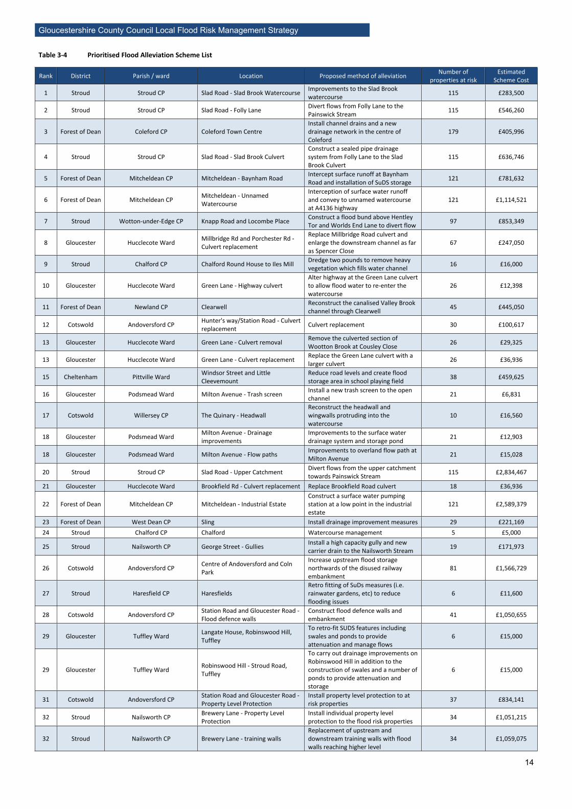
3.4. Potential Future Schemes17. The updated prioritised flood alleviations schemes list (PFAS) can be seen below. It is an ongoing task for the GCC Flood Risk Team to investigate the viability of the schemes on the list and either recommend them for future funding or remove them from the list. New schemes will be added to the list when requests for funding are made to GCC or when new schemes come to light. This means the list will continue to be altered and updated.
18. An extra parameter has been added to the scoring system to encourage partnership funding. Details of this can be found in section 5.2 Updates to Prioritisation Flood Alleviation Scheme List. For details of how the list was developed see the Annual Progress and Implementation Plan 2016-17: http://www.gloucestershire.gov.uk/your-community/emergencies-and-your-safety/flooding-and-drainage/gloucestershire-county-councils-local-flood-risk-management-strategy-lfrms/.
Gloucestershire County Council Local Flood Risk Management Strategy
14
Table 3-4 Prioritised Flood Alleviation Scheme List
Rank District Parish / ward Location Proposed method of alleviation Number of properties at risk
Estimated Scheme Cost
1 Stroud Stroud CP Slad Road - Slad Brook Watercourse Improvements to the Slad Brook watercourse 115 £283,500
2 Stroud Stroud CP Slad Road - Folly Lane Divert flows from Folly Lane to the Painswick Stream 115 £546,260
3 Forest of Dean Coleford CP Coleford Town CentreInstall channel drains and a new drainage network in the centre of Coleford
179 £405,996
4 Stroud Stroud CP Slad Road - Slad Brook CulvertConstruct a sealed pipe drainage system from Folly Lane to the Slad Brook Culvert
115 £636,746
5 Forest of Dean Mitcheldean CP Mitcheldean - Baynham Road Intercept surface runoff at Baynham Road and installation of SuDS storage 121 £781,632
6 Forest of Dean Mitcheldean CP Mitcheldean - Unnamed Watercourse
Interception of surface water runoff and convey to unnamed watercourse at A4136 highway
121 £1,114,521
7 Stroud Wotton-under-Edge CP Knapp Road and Locombe Place Construct a flood bund above Hentley Tor and Worlds End Lane to divert flow 97 £853,349
8 Gloucester Hucclecote Ward Millbridge Rd and Porchester Rd - Culvert replacement
Replace Millbridge Road culvert and enlarge the downstream channel as far as Spencer Close
67 £247,050
9 Stroud Chalford CP Chalford Round House to Iles Mill Dredge two pounds to remove heavy vegetation which fills water channel 16 £16,000
10 Gloucester Hucclecote Ward Green Lane - Highway culvertAlter highway at the Green Lane culvert to allow flood water to re-enter the watercourse
26 £12,398
11 Forest of Dean Newland CP Clearwell Reconstruct the canalised Valley Brook channel through Clearwell 45 £445,050
12 Cotswold Andoversford CP Hunter's way/Station Road - Culvert replacement Culvert replacement 30 £100,617
13 Gloucester Hucclecote Ward Green Lane - Culvert removal Remove the culverted section of Wootton Brook at Cousley Close 26 £29,325
13 Gloucester Hucclecote Ward Green Lane - Culvert replacement Replace the Green Lane culvert with a larger culvert 26 £36,936
15 Cheltenham Pittville Ward Windsor Street and Little Cleevemount
Reduce road levels and create flood storage area in school playing field 38 £459,625
16 Gloucester Podsmead Ward Milton Avenue - Trash screen Install a new trash screen to the open channel 21 £6,831
17 Cotswold Willersey CP The Quinary - HeadwallReconstruct the headwall and wingwalls protruding into the watercourse
10 £16,560
18 Gloucester Podsmead Ward Milton Avenue - Drainage improvements
Improvements to the surface water drainage system and storage pond 21 £12,903
18 Gloucester Podsmead Ward Milton Avenue - Flow paths Improvements to overland flow path at Milton Avenue 21 £15,028
20 Stroud Stroud CP Slad Road - Upper Catchment Divert flows from the upper catchment towards Painswick Stream 115 £2,834,467
21 Gloucester Hucclecote Ward Brookfield Rd - Culvert replacement Replace Brookfield Road culvert 18 £36,936
22 Forest of Dean Mitcheldean CP Mitcheldean - Industrial EstateConstruct a surface water pumping station at a low point in the industrial estate
121 £2,589,379
23 Forest of Dean West Dean CP Sling Install drainage improvement measures 29 £221,16924 Stroud Chalford CP Chalford Watercourse management 5 £5,000
25 Stroud Nailsworth CP George Street - Gullies Install a high capacity gully and new carrier drain to the Nailsworth Stream 19 £171,973
26 Cotswold Andoversford CP Centre of Andoversford and Coln Park
Increase upstream flood storage northwards of the disused railway embankment
81 £1,566,729
27 Stroud Haresfield CP HaresfieldsRetro fitting of SuDs measures (i.e. rainwater gardens, etc) to reduce flooding issues
6 £11,600
28 Cotswold Andoversford CP Station Road and Gloucester Road - Flood defence walls
Construct flood defence walls and embankment 41 £1,050,655
29 Gloucester Tuffley Ward Langate House, Robinswood Hill, Tuffley
To retro-fit SUDS features including swales and ponds to provide attenuation and manage flows
6 £15,000
29 Gloucester Tuffley Ward Robinswood Hill - Stroud Road, Tuffley
To carry out drainage improvements on Robinswood Hill in addition to the construction of swales and a number of ponds to provide attenuation and storage
6 £15,000
31 Cotswold Andoversford CP Station Road and Gloucester Road - Property Level Protection
Install property level protection to at risk properties 37 £834,141
32 Stroud Nailsworth CP Brewery Lane - Property Level Protection
Install individual property level protection to the flood risk properties 34 £1,051,215
32 Stroud Nailsworth CP Brewery Lane - training wallsReplacement of upstream and downstream training walls with flood walls reaching higher level
34 £1,059,075

Gloucestershire County Council Local Flood Risk Management Strategy
15
Rank District Parish / ward Location Proposed method of alleviation Number of properties at risk
Estimated Scheme Cost
34 Cheltenham Pittville Ward Prestbury Road - light industrial units Raised vehicle thresholds 36 £276,044
35 Tewkesbury Ashchurch Rural CP Aston-on-Carrant Install high capacity gullies and drains to Carrant Brook 17 £223,788
36 Gloucester Tuffley Ward Forest View Road Reinstating ditch which runs to the rear of properties 6 £20,000
37 Stroud Wotton-under-Edge CP Wortley Road - Commercial property
Replace the downstream culvert parapet wall with a guardrail and re-profile the highway
8 £70,780
38 Stroud Nailsworth CP Fountain Street and Tabrams Pitch - kerb re-setting
Re-set the kerb line along Fountains Road and install individual property protection
24 £344,735
38 Stroud Nailsworth CP Old Market and Spring Hill - Flood Walls
Construction of flood walls around the open channel section of the Nailsworth Stream
18 £265,275
38 Stroud Nailsworth CP Old Market and Spring Hill - Property Level Protection
Installation of individual property protection to the rear of the properties next to the bus terminus
18 £239,844
41 Stroud Wotton-under-Edge CP Holywell Road Repair the existing masonry culvert 4 £14,400
42 Forest of Dean Westbury-on-Severn CP EltonImprove existing culvert, install additional pipe culverts and improve channel
14 £158,355
43 Forest of Dean Awre CP Blakeney - Bridge Street Remove the weir in Blackpool Brook located off Bridge Street 10 £1,065,188
43 Forest of Dean Awre CP Blakeney - Moorfield AvenueConstruct a flow control structure and flood defence embankment upstream of the old mill
10 £647,041
45 Gloucester Hucclecote Ward Millbridge Rd and Porchester Rd - Property Level Protection
Install property level protection to at risk properties 58 £1,099,032
46 Forest of Dean Westbury-on-Severn CP Broadoak - Pumping Station Install a package pumping station and construct a flood storage area 21 £391,072
47 Forest of Dean West Dean CP Phipps Bottom and Whitecroft - Property Level Protection
Install flood protection measures to flood risk properties 9 £227,700
48 Forest of Dean Newland CP Redbrook - Property Level Protection
Install individual property level protection to the flood risk properties on Newland road
16 £471,339
49 Forest of Dean West Dean CP Parkend Use the recreation ground for flood storage 39 £598,973
50 Tewkesbury Ashchurch Rural CP Natton - railway embankment Construct a new culvert through the railway embankment 21 £259,586
51 Tewkesbury Ashchurch Rural CP Aston-on-Carrant West end of village
Construct a flood defence embankment at the western end of the village 17 £280,361
51 Tewkesbury Ashchurch Rural CP DSDC Ashchurch Construct a new drainage system at the MoD site 62 £3,839,319
53 Forest of Dean Westbury-on-Severn CP Broadoak - Property Level Protection
Install property level protection to flood risk properties 11 £378,422
54 Cheltenham Pittville Ward Wellington Square Package pumping station 7 £67,620
55 Cotswold Andoversford CP Hunter's Way - Flood defence embankment
Construct flood defence embankment upstream 30 £710,156
55 Cotswold Andoversford CP Hunter's way - Property Level Protection
Install property level protection to at risk properties 30 £702,075
57 Forest of Dean West Dean CP Phipps Bottom and Whitecroft - Whitecroft industrial units
Construct flood defence wall adjacent to the industrial units at Whitecroft 10 £310,824
58 Gloucester Barton and Tredworth Ward 63 Jersey Road The installation of individual property level protection measures 1 £5,000
59 Gloucester Hucclecote Ward Green Lane - Upstream flood storage
Increase upstream flood storage near Hathorn Road 26 £562,500
60 Forest of Dean Westbury-on-Severn CP Upper Ley - Embankment Construct a flood defence embankment around the village 18 £545,695
61 Forest of Dean Tidenham CP Sedbury and Tidenham - Wyedean School
Interception and diversion of surface water flows from Wyedean School 17 £648,520
62 Gloucester Podsmead Ward Shelly Avenue, Tennyson Avenue and Shakespeare Avenue
Install individual property protection to the flood risk properties 38 £736,230
63 Gloucester Hucclecote CP 57 & 59 Churchdown Lane, Hucclecote
The installation of individual property level protection measures 2 £10,000
64 Gloucester Kingsholm and Wotton Ward Castlevilla, Sandhurst Lane The installation of an earth bund, flood barriers and pump. 2 £15,000
64 Stroud Stroud CP WallbridgeInstall high capacity gullies on Bath Road and install new kerbs at upper section of Wallbridge
6 £147,817
64 Stroud Nailsworth CP George Street - Property Level Protection
Individual property protection to the flood risk properties and package pumping station
13 £313,578
67 Gloucester Hucclecote Ward Green Lane - Property Level Protection
Install individual property protection to the flood risk properties 14 £286,143
68 Stroud Cam CP Alexandra Close Excavate a deeper ditch and construct a new inlet headwall on the existing culvert
1 £5,063

Gloucestershire County Council Local Flood Risk Management Strategy
16
Rank District Parish / ward Location Proposed method of alleviation Number of properties at risk
Estimated Scheme Cost
69 Forest of Dean Westbury-on-Severn CP Upper Ley - Property Level Protection
Install property level protection to flood risk properties 9 £246,675
70 Cotswold Willersey CP The Quinary - Property Level Protection
Install individual property protection to the flood risk properties 10 £166,980
71 Forest of Dean Tidenham CP Sedbury and Tidenham - Day House Farm
Construct flood defence bund around Day House Farm 9 £506,394
72 Gloucester Barton and Tredworth Ward Tredworth SchoolRetro fitting of SuDs measures (i.e. rainwater gardens, etc) to reduce flooding issues.
2 £20,000
72 Gloucester Matson and Robinswood Ward Finlay Community School, Finlay Road
Retro fitting of SuDs measures (i.e. rainwater gardens, etc) to reduce flooding issues.
2 £20,000
72 Stroud Wotton-under-Edge CP Wortley Road - Dyers Brook Replace the existing culvert and raise the downstream channel walls 8 £396,035
75 Gloucester Hucclecote Ward Brookfield Rd - Property Level Protection
Install property level protection to at risk properties 16 £368,115
76 Forest of Dean West Dean CP Bream Install flood protection measures to flood risk properties 9 £227,700
77 Cotswold Andoversford CP Coln Park - Drain and pumping station
Install improved drainage and pumping station 24 £732,499
77 Cotswold Andoversford CP Coln Park - Property Level Protection
Install property level protection to properties at a risk of flooding 24 £527,505
77 Cotswold Andoversford CP Coln Park - Raise thresholds Raise the thresholds of flood risk properties 24 £1,184,274
80 Cotswold Willersey CP Campden Lane - Property Level Protection
Install individual property protection to the flood risk properties 8 £242,880
80 Cotswold Willersey CP Campden Lane - Land drain Install land drain, high capacity gullies and new drainage ditch 8 £185,742
82 Forest of Dean Awre CP Blakeney - NibleyConstruct a flood defence embankment to protect low lying properties at Nibley
6 £365,359
83 Tewkesbury Ashchurch Rural CP Natton Construct a flood defence earthwork around the flood risk properties 21 £530,681
84 Stroud Wotton-under-Edge CP Wortley Road - Property Level Protection
Individual property protection to the flood risk properties 5 £140,415
85 Forest of Dean Newland CP Newland - Culvert Excavate new channel and replace existing highway culvert 6 £177,758
85 Forest of Dean Newland CP Newland - Property Level Protection
Install individual property level protection to the flood risk properties 6 £151,800
87 Forest of Dean Coleford CP Crucible Close and Stepbridge Road Improve drainage infrastructure at the Industrial estate 26 £661,644
88 Tewkesbury Ashchurch Rural CP Walton Cardiff - Brook Cottage Install property level protection at Brook Cottage 1 £10,419
89 Tewkesbury Stanway CP Hailes Construct a flood defence embankment around the flood risk property 17 £623,641
90 Forest of Dean Westbury-on-Severn CP Westbury-on-Severn - A48 Construct a new culvert under the A48 highway 5 £69,377
91 Stroud Dursley CP Caswell Mews Watercourse realignment 1 £5,000
92 Cotswold Willersey CP Willersey Industrial Estate - Flood relief culvert
Install a flood relief culvert through the railway embankment 6 £283,378
92 Cotswold Willersey CP Willersey Industrial Estate - Property Level Protection
Install property level protection measures to the industrial units 6 £220,110
94 Forest of Dean West Dean CP Berry Hill Construct flood bund, new culvert and outfall at The Gamekeeper's Inn 4 £245,811
94 Forest of Dean Awre CP Blakeney - Doctor's Surgery Flood protection to the Doctor's surgery off Millend 1 £36,514
94 Stroud Cam CP Alexandra Close - Kingshill Lane Improve surface water drainage along Kingshill Lane 1 £103,170
97 Cotswold Andoversford CP STW asset Construct flood defence wall and embankment 1 £307,484
97 Tewkesbury Ashchurch Rural CP Walton Cardiff - M5 Restrict the volume of flow through the M5 culvert 1 £43,828
99 Forest of Dean Westbury-on-Severn CP Westbury-on-Severn - Railway Embankment
Constrict flows through the upstream culverts passing through the railway embankment
5 £77,625
99 Forest of Dean Westbury-on-Severn CP Westbury-on-Severn - Upstream of A48
Construct a flow control structure and flood defence embankment upstream of the A48 highway
5 £466,121

Gloucestershire County Council Local Flood Risk Management Strategy
17
4. Preliminary Flood Risk Assessment Review19. Under the Flood Risk Regulations 20094, Gloucestershire County Council, as the LLFA, was required to undertake a Preliminary Flood Risk Assessment (PFRA) to identify the areas in Gloucestershire at significant flood risk. The first PFRA was completed in 20115 and should be reviewed every 6 years. Phase 1 of the PFRA review was completed and submitted to the Environment Agency by 22nd June 2017 for their evaluation by 22nd December 2017.
20. By using the latest surface water flood risk model “Risk of Flooding from Surface Water” (previously known as the “updated Flood Maps for Surface Water”), which was released in 2013, after the first PFRA, the review has shown that Gloucestershire now has an area at significant flood risk or a “Flood Risk Area” (FRA)6. The FRA is in Cheltenham town centre and covers the Wards of Lansdown, College, All Saints, Oakley and Charlton Park among others.
21. The FRA will be reviewed by the Environment Agency and, if it is decided the FRA should remain, GCC may be required to produce a Flood Hazard Map and a Flood Risk Map of the area. This will be made public either by GCC and/or by the Environment Agency.
4 Flood Risk Regulations 2009: http://www.legislation.gov.uk/uksi/2009/3042/made.5 The first PFRA report can be found at: http://www.gloucestershire.gov.uk/roads-parking-and-rights-of-way/plans-policies-procedures-manuals/surface-water-management-plans/.6 These are defined by 5 or more “blue squares” (a 1km square with either 200 or more people [number of residential properties x2.34 people], 20 or more non-residential properties or 1 or more key services [e.g. emergency services, hospitals, schools, utilities] at risk of flooding) are found within a 3x3 km grid.

Gloucestershire County Council Local Flood Risk Management Strategy
18
5. Appendix 5.1. Table of definitionsTable 5-1 Table of definitions
Definition
CPT Civil Protection TeamEA Environment AgencyFAS Flood Advisory Service – a not for profit organisation who promote flood awareness.FDR Flood Data Register – n application used by the LLFA to record property flooding.FRA Flood Risk Area - an area which has 5 or more “blue squares” (a 1km square with either 200 or more
people [number of residential properties x2.34 people], 20 or more non-residential properties or 1 or more key services [e.g. emergency services, hospitals, schools, utilities] at risk of flooding) are found within a 3x3 km grid.
GCC Gloucestershire County CouncilLLFA Lead Local Flood Authority – Gloucestershire County Council was made the LLFA for Gloucestershire
following the Flood and Water Management Act 2010.PFRA Preliminary Flood Risk Assessment - a countywide assessment of flood risk identifying high risk areas.
This is to be reviewed every 6 years.RMA Risk Management Authority - are defined in the Flood and Water Management Act as the LLFA,
district/borough councils, the Environment Agency, water and sewerage companies, the highway authorities and Internal Drainage Boards. Their roles are discussed in Section 2 of the Local Strategy.
RoFfSW Risk of Flooding from Surface Water – formally the updated Flood Maps for Surface Water (uFMfSW), it is a national computer model demonstrating the risk of flooding from surface water across the country.
SEA Strategic Environmental Assessment - a process for considering the potential environmental impacts of addressing flood risk.
SuDS Sustainable Drainage System – a form of surface water drainage which tries to mimic the natural environment.
SWIM Severe Weather Information Management – an online flood reporting system which allows members of the public to report flooding directly to the website.
SWMP Surface Water Management Plan – a report completed in 2011 for several areas around Gloucestershire which investigates the surface water flooding in 2007 and with recommended alleviation measures.

Gloucestershire County Council Local Flood Risk Management Strategy
19
5.2. Updates to Prioritisation Flood Alleviation Scheme List22. To encourage partnership working and exploring external funding opportunities, an extra stage in the scoring matrix of the PFAS list has been added. This means schemes with external funding secured, i.e. GCC is not funding 100% of the scheme, will have a higher score than those being funding solely by GCC. This score is multiplied with the other parameters as detailed in the Annual Progress and Implementation Plan 2016-17. Table 5-2 outlines the details of this update.
Table 5-2 PFAS list partnership scoring
GCC’s Contribution (%)
Partnership Score
0-10 0.5511-20 0.521-30 0.4531-40 0.441-50 0.3551-60 0.361-70 0.2571-80 0.281-90 0.15
91-100 0.1