EnviroInsite training workshop - Overview of EnviroInsite Features
38
What is EnviroInsite? EnvroInsite Training Workshop March 2013
-
Upload
bruce-jacobs -
Category
Technology
-
view
191 -
download
0
Transcript of EnviroInsite training workshop - Overview of EnviroInsite Features

What is EnviroInsite?
EnvroInsite Training Workshop
March 2013

Introduction
What is EnviroInsite?
Bruce Jacobs
HydroAnalysis, Inc.
Civil Engineer, PE
EI Software Architect / Developer
617-879-0253

What is EnviroInsite?
What can I do With EnviroInsite?
Tool for converting data to understanding
Database:
• Access
• Excel
EnviroInsite

What is EnviroInsite?
What can I do With EnviroInsite?
Tool for converting data to understanding
Database:
• Access
• Excel
EnviroInsite

What is EnviroInsite?
What can I do With EnviroInsite?
Tool for converting data to understanding
Database:
• Access
• Excel
EnviroInsite

What is EnviroInsite?
What can I do With EnviroInsite?
Tool for converting data to understanding
Database:
• Access
• Excel
EnviroInsite

What is EnviroInsite?
What can I do With EnviroInsite?
Tool for converting data to understanding
Database:
• Access
• Excel
EnviroInsite

What is EnviroInsite?
What can I do With EnviroInsite?
Tool for converting data to understanding
Database:
• Access
• Excel
EnviroInsite

What is EnviroInsite?
What can I do With EnviroInsite?
Tool for converting data to understanding
Database:
• Access
• Excel
EnviroInsite

What is EnviroInsite?
What can I do With EnviroInsite?
1. Mapping
2. Create Hydrogeologic Conceptual Model
3. Analyze Contaminant Fate and Transport
4. Communicate with Regulators and Public
Let’s see some examples…

What is EnviroInsite?
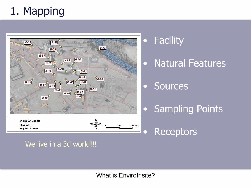
1. Mapping
• Facility
• Natural Features
• Sources
• Sampling Points
• ReceptorsWe live in a 3d world!!!

What is EnviroInsite?
1. Mapping
• Facility
• Natural Features
• Sources
• Sampling Points
• ReceptorsWe live in a 3d world!!!
What is EnviroInsite?
1. Mapping
• Facility
• Natural Features
• Sources
• Sampling Points
• ReceptorsWe live in a 3d world!!!

What is EnviroInsite?
1. Mapping
• Facility
• Natural Features
• Sources
• Sampling Points
• ReceptorsWe live in a 3d world!!!

What is EnviroInsite?
1. Mapping
Shapefiles
CAD
Web Mapping Service (WMS)
JPG/PNG
TIF/BMP
Map data sources?Bing Maps

What is EnviroInsite?
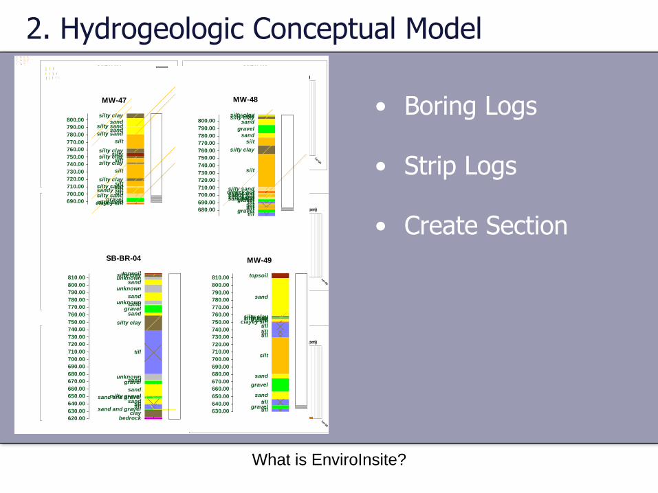
2. Hydrogeologic Conceptual Model
• Boring Logs
• Strip Logs
• Create Section
550
600
650
700
750
800
850
900
Ele
va
tio
n (
fee
t)
A A'BR-1
BR-1
RA
BR-2
BR-3
GM
X-1
GM
X-1
0
GM
X-1
1GM
X-1
2
GM
X-1
3
GM
X-1
4
GM
X-1
5
GM
X-1
6
GM
X-1
6R
GM
X-2
GM
X-3
GM
X-4
GM
X-7
GM
X-8
GM
X-9
HP-1
0C HP-1
1-5
HP-3
C
HP-4
-4HP-5
C
HP-6
-3
HP-7
C
HP-8
C
HP-9
C
MW
-1
MW
-10
MW
-11
MW
-12
MW
-14
MW
-26
MW
-27
MW
-28
MW
-33
MW
-34
MW
-35
MW
-36
MW
-37
MW
-38
MW
-3D
MW
-42
MW
-43
MW
-44
MW
-4D
MW
-5D
MW
-8D
MW
-9D
WW
-3
WW
-4
WW
-8
topsoil
peat
gravel
sand and gravel
sand
silty sand
sandy silt
silt
silty/sandy clay
clayey silt with sand
silty clay
sandy clay
clayey silt
clay
till
bedrock
unknown
clay and sand
clayey silt/silty clay
silty sand and gravel
Within 100 feet of sectionBorings
BR-1
BR-1
RA
BR-2
BR-3
EW-1 EW
-2
GM
-1
GM
X-1
GM
X-10
GM
X-11
GM
X-12
GM
X-13
GM
X-14
GM
X-15
GM
X-16
GM
X-16R
GM
X-2GM
X-3
GM
X-4
GM
X-7GM
X-8GM
X-9
HP-1
0-1
HP-1
0-2
HP-1
0-3
HP-1
0-4
HP-1
0-5
HP-1
0-6
HP-1
0A
HP-1
0B
HP-1
0C
HP-1
1-1
HP-1
1-2
HP-1
1-3
HP-1
1-4
HP-1
1-5
HP-3
-1
HP-3
-2
HP-3
B
HP-3
C
HP-4
-1
HP-4
-2
HP-4
-3
HP-4
-4
HP-5
-1HP-5
-2
HP-5
-3HP-5
AHP-5
BHP-5
C
HP-6
-1
HP-6
-2
HP-6
-3
HP-7
-1HP-7
-2HP-7
-3
HP-7
AHP-7
BHP-7
C
HP-8
-1
HP-8
-2
HP-8
-3
HP-8
-4HP-8
AHP-8
BHP-8
C
HP-9
-1HP-9
-2
HP-9
-3
HP-9
-4
HP-9
A
HP-9
B
HP-9
CM
D-M
W-1
2
MD-M
W-1
3
MD-M
W-1
4
MM-1
MM-2M
M-3
MM-4M
W-1
MW
-10
MW
-11
MW
-12M
W-1
3
MW
-14
MW
-15
MW
-16
MW
-26
MW
-27
MW
-28
MW
-3
MW
-33
MW
-34
MW
-35
MW
-36
MW
-37
MW
-38
MW
-3D
MW
-4
MW
-42
MW
-43
MW
-44
MW
-4D
MW
-5
MW
-5DM
W-7
MW
-8
MW
-8D
MW
-9
MW
-9D
R-1
R-2
R-3
WW
-3
WW
-4
WW
-8
Casing
Screen
Within 100 feet of sectionWells
0 2000 4000 feet
817.1 817.0
817.0
796.5
802.5
817.4
795.4
785.8
760.7
766.8
766.8
760.6
762.7
762.3
799.0801.9
801.8
792.5
785.7
792.5
793.3
793.6
793.6
830.7
826.6
826.5
798.3
798.0
799.1
773.2
773.3
760.8
791.7
793.7
793.6
811.3
819.6826.8
824.5819.5
829.3
805.8
814.4
812.2
818.0
794.3
794.7
790.3
819.7
815.8
820.7
820.3
817.2
816.5820.0
816.7
814.9
815.9
815.9
817.1817.1
Within 100 feet of section
water level (feet)

What is EnviroInsite?
2. Hydrogeologic Conceptual Model
• Boring Logs
• Strip Logs
• Create Section

What is EnviroInsite?
2. Hydrogeologic Conceptual Model
• Boring Logs
• Strip Logs
• Create Section
CH
CH
CH
CH
LM0
4
Sample
1e+00
1e+04
PID Screening (ppm)0
5
10
15
20
Dep
th (
fee
t)
SCIBH-101
CH
CH/CL
CH
LMCH
CL
LM 0
4
Sample
1e+00
1e+04
PID Screening (ppm)0
5
10
15
Dep
th (
fee
t)
SCIBH-102
CH
LM
CL/CH
CL
CL/CH
CHLM 0
4
Sample
1e+00
1e+04
PID Screening (ppm)0
5
10
15
20
Dep
th (
fee
t)
SCIBH-103
CH/CL
LM 0
4
Sample
1e+00
1e+04
PID Screening (ppm)0
5
10
15
Dep
th (
fee
t)
SCIBH-104
CH/CL
LM 0
4
Sample
1e+00
1e+04
PID Screening (ppm)0
5
10
15
20
Dep
th (
fee
t)
SCIBH-105
CH/CL
LM 0
4
Sample
1e+00
1e+04
PID Screening (ppm)0
5
10
15
Dep
th (
fee
t)SCIBH-106
CH/CL
LM 0
4
Sample
1e+00
1e+04
PID Screening (ppm)0
5
10
15
20
Dep
th (
fee
t)
SCIBH-107
CH/CL
0
4
Sample
1e+00
1e+04
PID Screening (ppm)0
5
10
15
20
Dep
th (
fee
t)
SCIBH-108
CH/CL
LM 0
4
Sample
1e+00
1e+04
PID Screening (ppm)0
5
10
15
Dep
th (
fee
t)
SCIBH-109
CH/CL
CL
LM 0
4
Sample
1e+00
1e+04
PID Screening (ppm)0
5
10
15
Dep
th (
fee
t)
SCIBH-110
CH/CL
LM 0
4
Sample
1e+00
1e+04
PID Screening (ppm)0
5
10Dep
th (
fee
t)
SCIBH-111
CH/CL0
4
Sample
1e+00
1e+04
PID Screening (ppm)0
Dep
th (
fee
t)
SCIBH-112
topsoilsand
silty sand
sand
clayey siltsand
clayey silt
sand
gravel
silty sandsand
clayey siltgravel
clayey siltclay and sand
clayey siltsandy silt
bedrock
810.00
800.00
790.00
780.00
770.00
760.00
750.00
740.00
730.00
720.00
710.00
700.00
690.00
680.00
670.00
660.00
650.00
640.00
630.00
620.00
610.00
600.00
BR-4
silty clayclay and sand
clayey siltsilty sand
silt
siltsand
till
sand
till
gravel
clayey silt
sandsiltsandsilt
bedrock
770.00
760.00
750.00
740.00
730.00
720.00
710.00
700.00
690.00
680.00
670.00
660.00
650.00
640.00
630.00
BR-5
topsoilsand
sand and gravelsand
silt
till
silty sandsand
gravelsandsiltsandsiltsand and gravelsiltsand and gravel
till
sand
till
bedrock
800.00
790.00
780.00
770.00
760.00
750.00
740.00
730.00
720.00
710.00
700.00
690.00
680.00
670.00
660.00
650.00
640.00
630.00
620.00
610.00
BR-6
silty clayclayey sand
sandy clayclayey siltsilty sand
siltsandsiltsand
till
sandsiltsandsiltsand
till
gravelsandsand
till
sandsilt
770.00
760.00
750.00
740.00
730.00
720.00
710.00
700.00
690.00
680.00
670.00
660.00
650.00
640.00
MW-45
topsoilsilty sandclayey siltsandclayey siltsilty sandgravelsandsilty sand
silt
sandsiltgravelsiltsandy siltsandsiltclayey silt
siltclayey siltsilty sand
silt
gravelclayey siltsandy silt
770.00
760.00
750.00
740.00
730.00
720.00
710.00
700.00
690.00
680.00
MW-46
silty claysand
silty sandsand
silty sand
silt
silty claysiltysilty clay
siltsilty clay
silt
silty claysilt
silty sandsiltsandy silt
siltsilty sand
gravelsilty sandclayey silt
800.00
790.00
780.00
770.00
760.00
750.00
740.00
730.00
720.00
710.00
700.00
690.00
MW-47
silty claysandsilty claysand
gravelsand
silt
silty clay
silt
silty sandclayey siltsilty sandsandy siltsilty sandsandsandy siltgraveltill
silttillsiltgravel
till
800.00
790.00
780.00
770.00
760.00
750.00
740.00
730.00
720.00
710.00
700.00
690.00
680.00
MW-48
topsoil
sand
silty claygravelsilty claysandclayey silttilltilltill
silt
sand
gravel
sand
tillgravel
till
810.00
800.00
790.00
780.00
770.00
760.00
750.00
740.00
730.00
720.00
710.00
700.00
690.00
680.00
670.00
660.00
650.00
640.00
630.00
MW-49
silty claysilty sandsandsand
clayey silt
sand
silt
clayey silt
sand
silty sand
770.00
760.00
750.00
740.00
730.00
720.00
710.00
700.00
690.00
680.00
670.00
660.00
650.00
MW-4-99
unknown
clay
silt
clay
siltclay sand and gravelclay
silt
claysilty clayclay and sandsiltclay sand and gravelsiltclay and sandclaysilty clay
sand and gravelclay and sand
silt
clay
clay sand and gravelbedrock
780.00
770.00
760.00
750.00
740.00
730.00
720.00
710.00
700.00
690.00
680.00
670.00
660.00
650.00
640.00
630.00
MW-50
topsoilsandy siltsilty claysiltsandy claysandy siltunknown
silty sandsilty sand and gravelsandy siltsilty sand and gravelsilty sand
clayey silt
clay
sandsilt
silty sandsandsiltsand and gravelsilty sandsiltclay
sand and gravelunknownsand and gravel
clay and sandunknown
sand and gravelclaysilt
clay sand and gravelsandclaysand
bedrock
770.00
760.00
750.00
740.00
730.00
720.00
710.00
700.00
690.00
680.00
670.00
660.00
650.00
640.00
630.00
MW-51
silty sandunknown
silty sandsand and gravel
silty sand
silty clay
silty claysand
silty clay
sand and gravelsilty clay
770.00
760.00
750.00
740.00
730.00
720.00
710.00
700.00
690.00
680.00
670.00
MW-52
topsoilsilty clayunknown
sandunknown
sandunknownsand
gravelsand
silty clay
till
unknownsandgravel
sandsilty gravelsand and gravel
sandtilltill
sand and gravelclay
bedrock
810.00
800.00
790.00
780.00
770.00
760.00
750.00
740.00
730.00
720.00
710.00
700.00
690.00
680.00
670.00
660.00
650.00
640.00
630.00
620.00
SB-BR-04
claysandsand
sand and gravel
silt
sandsand and gravel
silt
silty sandsandy clay and siltsilty claysilt
sandy siltsilty sandsiltsilt
silty sandsilt
sand and gravelsandsand and gravel
silt
clay and sandclaysilt
clay and sandsilty claybedrock
800.00
790.00
780.00
770.00
760.00
750.00
740.00
730.00
720.00
710.00
700.00
690.00
680.00
670.00
660.00
650.00
640.00
630.00
SB-BR-06

What is EnviroInsite?
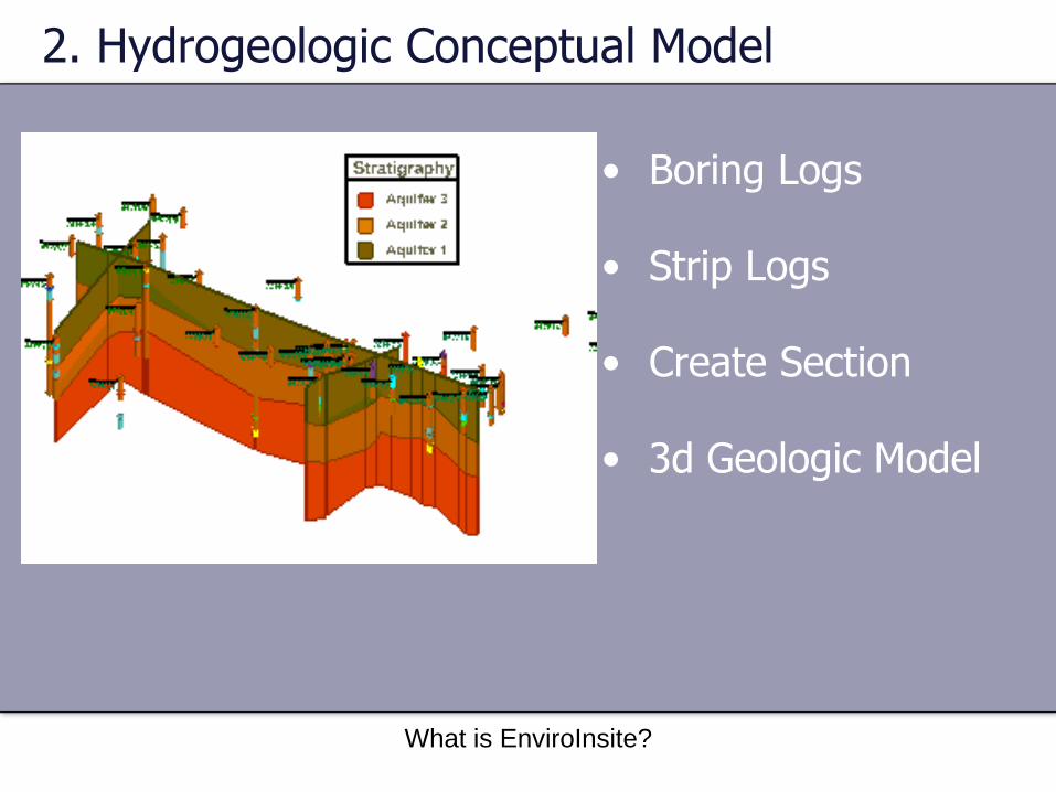
2. Hydrogeologic Conceptual Model
• Boring Logs
• Strip Logs
• Create Section
• 3d Geologic Model
What is EnviroInsite?
2. Hydrogeologic Conceptual Model
• Boring Logs
• Strip Logs
• Create Section
• 3d Geologic Model

What is EnviroInsite?
2. Hydrogeologic Conceptual Model
• Boring Logs
• Strip Logs
• Create Section
• 3d Geologic Model

What is EnviroInsite?
2. Hydrogeologic Conceptual Model
• On Section
• 3d Surface
• Contour
• Particle Tracking
How about the “hydro” portion of the model

What is EnviroInsite?
2. Hydrogeologic Conceptual Model
• On Section
• 3d Surface
• Contour
• Particle Tracking
How about the “hydro” portion of the model

What is EnviroInsite?
2. Hydrogeologic Conceptual Model
• On Section
• 3d Surface
• Contour
• Particle Tracking
How about the “hydro” portion of the model
16-1
4
BR-5B
R-6
MW
-45
MW
-46
MW
-47
MW
-48
RW
1470
0
RW
2170
0
RW
3070
0
RW
5020
0
SB-B
R-0
5
SB-B
R-0
6
762.25
774.88
762.56
762.55
812.00FLOW
815.73

What is EnviroInsite?
2. Hydrogeologic Conceptual Model
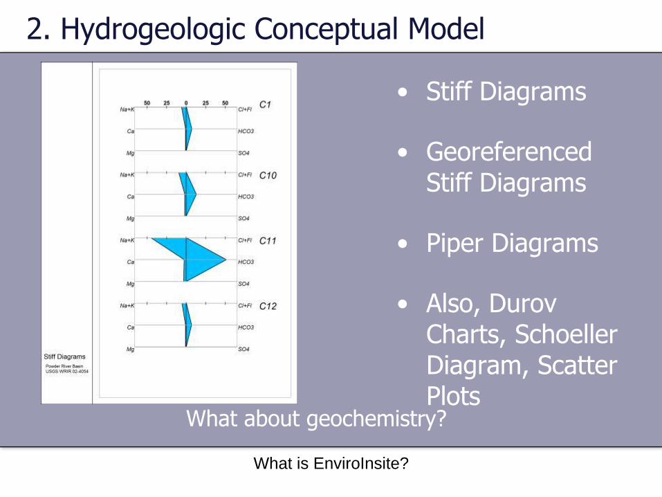
• Stiff Diagrams
• GeoreferencedStiff Diagrams
• Piper Diagrams
• Also, DurovCharts, SchoellerDiagram, Scatter Plots
What about geochemistry?

What is EnviroInsite?
2. Hydrogeologic Conceptual Model
• Stiff Diagrams
• GeoreferencedStiff Diagrams
• Piper Diagrams
• Also, DurovCharts, SchoellerDiagram, Scatter Plots
What about geochemistry?
What is EnviroInsite?
2. Hydrogeologic Conceptual Model
• Stiff Diagrams
• GeoreferencedStiff Diagrams
• Piper Diagrams
• Also, DurovCharts, SchoellerDiagram, Scatter Plots
What about geochemistry?

What is EnviroInsite?
3. Contaminant Fate and Transport
• Contour
• Post Values
• Classed Post
• 3d Contours
Single Analytes

What is EnviroInsite?
3. Contaminant Fate and Transport
• Contour
• Post Values
• Classed Post
• 3d Contours
Single Analytes

What is EnviroInsite?
3. Contaminant Fate and Transport
• Contour
• Post Values
• Classed Post
• 3d Contours
Single Analytes

What is EnviroInsite?
3. Contaminant Fate and Transport
• Contour
• Post Values
• Classed Post
• 3d Contours
Single Analytes

What is EnviroInsite?
3. Contaminant Fate and Transport
• Data Tables (spider diagrams)
• Pie Charts
• Radial Diagrams
• Charts
Multiple Analytes

What is EnviroInsite?
3. Contaminant Fate and Transport
• Data Tables (spider diagrams)
• Pie Charts
• Radial Diagrams
• Charts
Multiple Analytes

What is EnviroInsite?
3. Contaminant Fate and Transport
• Data Tables (spider diagrams)
• Pie Charts
• Radial Diagrams
• Charts
Multiple Analytes

What is EnviroInsite?
3. Contaminant Fate and Transport
• Data Tables (spider diagrams)
• Pie Charts
• Radial Diagrams
• Charts
Multiple Analytes

What is EnviroInsite?
Hands-on Exercise

Hands-on Exercise
• Copy USB drive contents to Documents\My EnviroInsite Work
• Setup files
• Training Videos
• Site Data
• Exercise
• Connecting to Data Source
• Interface Components
• Loading / Saving EI Documents
EnviroInsite Training