ENR 5 NAVIGATION WARNINGS - CIVIL AVIATIONaip.dca.gov.my/aip pdf/ENR/ENR 5/ENR 5.1/Prohibited,...
24
AIP MALAYSIA DEPARTMENT OF CIVIL AVIATION MALAYSIA ENR 5.1 - 1 ENR 5 NAVIGATION WARNINGS ENR 5.1 PROHIBITED, RESTRICTED AND DANGER AREAS 1. INTRODUCTION 1.1 All airspace in which a potential hazard to aircraft operations may exist and all areas over which the operation of civil aircraft may, for one reason or another be restricted temporarily or permanently, are classified according to the following three types of areas as defined by ICAO. 2. DANGER AREA 2.1 An airspace of defined dimensions within which activities dangerous to aircraft may exist at specified times. This term is used only when the potential danger to aircraft has not led to the designation of the airspace as restricted or prohibited. The effect of the creation of the danger area is to caution operators or pilots of aircraft that it is necessary for them to assess the dangers in relation to their responsibility for the safety of the aircraft. 3. PROHIBITED AREA 3.1 An airspace of defined dimensions, above the land areas or territorial waters of a State, within which the flight of aircraft is prohibited. This term is used only when the flight of an aircraft within the designated airspace is not permitted at any time under any circumstances. 4. RESTRICTED AREA 4.1 An airspace of defined dimensions, above the land areas or territorial waters of a State, within which the flight of aircraft is restricted in accordance with certain specified conditions. This term is used whenever the flight of an aircraft within the designated airspace is not absolutely prohibited but may be made only specified condition are complied with. Thus, prohibition of flight except at certain specified times leads to the designation of the airspace a ‘restricted area’ as would prohibited except in certain meteorological conditions. Similarly, prohibition of flight unless special permission had been obtained, leads to the designation of a restricted area. However, conditions of flight imposed as a result of application of rules of the air or air traffic service practices or procedures (for example, compliance with minimum safe heights or with rules stemming from the establishment of controlled airspace) do not constitute conditions calling for designation as a restricted area. 5. AREA NUMBERING 5.1 Each area is numbered and a single series of numbers is used for all areas, regardless of type to ensure that a number is never duplicated. 5.2 The type of area involved is indicated by the letter ‘P’ for Prohibited, ‘R’ for Restricted and ‘D’ for Danger, and preceeded by the FIR identifier ‘WM’ for Kuala Lumpur FIR and ‘WB’ for Kota Kinabalu FIR. For example, areas are assigned numbers and letters in the following manner - WMD 224, WMR 226, WMP 228, WBD 518, WBP 506 WBR 501 etc. 5.3 In Kuala Lumpur FIR, the designated areas (P, D & R) will be numbered as follows: i) From ARP SAAS Subang Airport, bearing 000° to 090° - number 101 to 199 ii) From ARP SAAS Subang Airport, bearing 090° to 180° - number 201 to 299 iii) From ARP SAAS Subang Airport, bearing 180° to 270° - number 301 to 399 iv) From ARP SAAS Subang Airport, bearing 270° to 360° - number 401 to 499 5.4 In Kota Kinabalu FIR, the designated areas (P, D & R) East of Longitude 114° shall be numbered from 500 to 599 and the designated areas (P, D & R) West of Longitude 114° shall be numbered from 600 to 699. 6. AREA DESCRIPTION 6.1 Each area is described in the tabulation found in ENR 5.1 - 2 to ENR 5.1 - 16 which indicates its lateral and vertical limits, the type of restriction or hazard involved, the times at which it applies and other pertinent information. 17 JUN 1999
Transcript of ENR 5 NAVIGATION WARNINGS - CIVIL AVIATIONaip.dca.gov.my/aip pdf/ENR/ENR 5/ENR 5.1/Prohibited,...
AIP MALAYSIA
DEPARTMENT OF CIVIL AVIATION MALAYSIA
ENR 5.1 - 1
ENR 5 NAVIGATION WARNINGS
ENR 5.1 PROHIBITED, RESTRICTED AND DANGER AREAS
1. INTRODUCTION
1.1 All airspace in which a potential hazard to aircraft operations may exist and all areas over which the operation ofcivil aircraft may, for one reason or another be restricted temporarily or permanently, are classified according tothe following three types of areas as defined by ICAO.
2. DANGER AREA
2.1 An airspace of defined dimensions within which activities dangerous to aircraft may exist at specified times. Thisterm is used only when the potential danger to aircraft has not led to the designation of the airspace as restrictedor prohibited. The effect of the creation of the danger area is to caution operators or pilots of aircraft that it isnecessary for them to assess the dangers in relation to their responsibility for the safety of the aircraft.
3. PROHIBITED AREA
3.1 An airspace of defined dimensions, above the land areas or territorial waters of a State, within which the flight ofaircraft is prohibited. This term is used only when the flight of an aircraft within the designated airspace is notpermitted at any time under any circumstances.
4. RESTRICTED AREA
4.1 An airspace of defined dimensions, above the land areas or territorial waters of a State, within which the flight ofaircraft is restricted in accordance with certain specified conditions. This term is used whenever the flight of anaircraft within the designated airspace is not absolutely prohibited but may be made only specified condition arecomplied with. Thus, prohibition of flight except at certain specified times leads to the designation of the airspacea ‘restricted area’ as would prohibited except in certain meteorological conditions. Similarly, prohibition of flightunless special permission had been obtained, leads to the designation of a restricted area. However, conditionsof flight imposed as a result of application of rules of the air or air traffic service practices or procedures (forexample, compliance with minimum safe heights or with rules stemming from the establishment of controlledairspace) do not constitute conditions calling for designation as a restricted area.
5. AREA NUMBERING
5.1 Each area is numbered and a single series of numbers is used for all areas, regardless of type to ensure that anumber is never duplicated.
5.2 The type of area involved is indicated by the letter ‘P’ for Prohibited, ‘R’ for Restricted and ‘D’ for Danger, andpreceeded by the FIR identifier ‘WM’ for Kuala Lumpur FIR and ‘WB’ for Kota Kinabalu FIR.For example, areas are assigned numbers and letters in the following manner - WMD 224, WMR 226, WMP 228,WBD 518, WBP 506 WBR 501 etc.
5.3 In Kuala Lumpur FIR, the designated areas (P, D & R) will be numbered as follows:i) From ARP SAAS Subang Airport, bearing 000° to 090° - number 101 to 199ii) From ARP SAAS Subang Airport, bearing 090° to 180° - number 201 to 299iii) From ARP SAAS Subang Airport, bearing 180° to 270° - number 301 to 399iv) From ARP SAAS Subang Airport, bearing 270° to 360° - number 401 to 499
5.4 In Kota Kinabalu FIR, the designated areas (P, D & R) East of Longitude 114° shall be numbered from 500 to 599and the designated areas (P, D & R) West of Longitude 114° shall be numbered from 600 to 699.
6. AREA DESCRIPTION
6.1 Each area is described in the tabulation found in ENR 5.1 - 2 to ENR 5.1 - 16 which indicates its lateral andvertical limits, the type of restriction or hazard involved, the times at which it applies and other pertinentinformation.
17 JUN 1999
AIP MALAYSIA
DEPARTMENT OF CIVIL AVIATION MALAYSIA
ENR 5.1 - 2
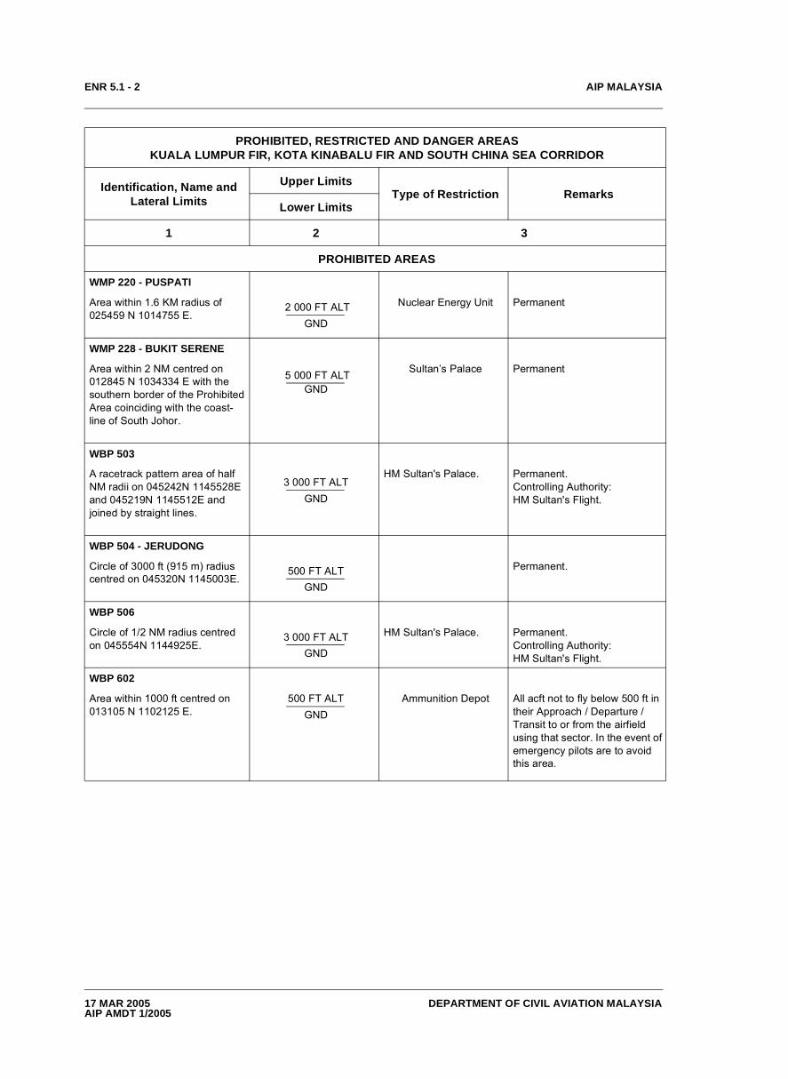
PROHIBITED, RESTRICTED AND DANGER AREAS KUALA LUMPUR FIR, KOTA KINABALU FIR AND SOUTH CHINA SEA CORRIDOR
Identification, Name and Lateral Limits
Upper LimitsType of Restriction Remarks
Lower Limits
1 2 3
PROHIBITED AREAS
WMP 220 - PUSPATI
Area within 1.6 KM radius of 025459 N 1014755 E.
2 000 FT ALT GND
Nuclear Energy Unit Permanent
WMP 228 - BUKIT SERENE
Area within 2 NM centred on 012845 N 1034334 E with the southern border of the Prohibited Area coinciding with the coast- line of South Johor.
5 000 FT ALT GND
Sultan’s Palace Permanent
WBP 503
A racetrack pattern area of half NM radii on 045242N 1145528E and 045219N 1145512E and joined by straight lines.
3 000 FT ALT GND
HM Sultan's Palace. Permanent.Controlling Authority: HM Sultan's Flight.
WBP 504 - JERUDONG
Circle of 3000 ft (915 m) radius centred on 045320N 1145003E.
500 FT ALT GND
Permanent.
WBP 506
Circle of 1/2 NM radius centred on 045554N 1144925E.
3 000 FT ALT GND
HM Sultan's Palace. Permanent.Controlling Authority: HM Sultan's Flight.
WBP 602
Area within 1000 ft centred on 013105 N 1102125 E.
500 FT ALT GND
Ammunition Depot All acft not to fly below 500 ft in their Approach / Departure / Transit to or from the airfield using that sector. In the event of emergency pilots are to avoid this area.
17 MAR 2005AIP AMDT 1/2005
AIP MALAYSIA
DEPARTMENT OF CIVIL AVIATION MALAYSIA
ENR 5.1 - 3
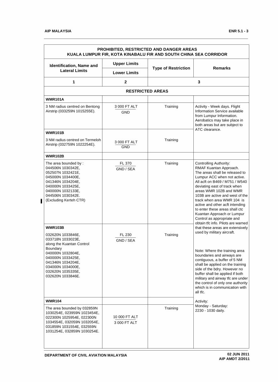
RESTRICTED AREAS
WMR101A
3 NM radius centred on Bentong Airstrip (033259N 1015255E).
3 000 FT ALT GND
Training Activity - Week days. Flight Information Service available from Lumpur Information. Aerobatics may take place in both areas but are subject to ATC clearance.
WMR101B
3 NM radius centred on Termeloh Airstrip (032759N 1022254E). 3 000 FT ALT
GND
Training
WMR102B
The area bounded by :044506N 1030342E, 052507N 1032421E, 045000N 1034400E, 041346N 1034204E, 040000N 1033425E, 040000N 1032133E, 044506N 1030342E.(Excluding Kerteh CTR)
FL 370GND / SEA
Training Controlling Authority: RMAF Kuantan Approach. The areas shall be released to Lumpur ACC when not active. All acft on B469 / M751 / W540 deviating east of track when areas WMR 102B and WMR 103B are active and west of the track when area WMR 104 is active and other acft intending to enter these areas shall ctc Kuantan Approach or Lumpur Control as appropriate and obtain tfc info. Pilots are warned that these areas are extensively used by military aircraft.
Note: Where the training area boundaries and airways are contiguous, a buffer of 5 NM shall be applied on the training side of the bdry. However no buffer shall be applied if both military and airway tfc are under the control of only one authority which is in communication with all tfc.
Activity:Monday - Saturday:2230 - 1030 daily.
WMR103B
032620N 1033846E,033718N 1033023E,along the Kuantan Control Boundary040000N 1032804E,040000N 1033425E,041346N 1034204E,034000N 1034000E,032620N 1035335E,032620N 1033846E.
FL 230GND / SEA
Training
WMR104
The area bounded by 032859N 1030254E, 023959N 1023454E, 022300N 1025954E, 022300N 1034554E, 032059N 1032054E, 031859N 1031554E, 032559N 1031254E, 032859N 1030254E.
10 000 FT ALT 3 000 FT ALT
Training
PROHIBITED, RESTRICTED AND DANGER AREAS KUALA LUMPUR FIR, KOTA KINABALU FIR AND SOUTH CHINA SEA CORRIDOR
Identification, Name and Lateral Limits
Upper LimitsType of Restriction Remarks
Lower Limits
1 2 3
02 JUN 2011AIP AMDT 2/2011

AIP MALAYSIA
DEPARTMENT OF CIVIL AVIATION MALAYSIA
ENR 5.1 - 4
WMR105
Line joining from 061948N 1025340E to 061110N 1023956E thence 061709N 1023732E thence along arc 20 NM from VKB VOR/DME to 062804N 1022721E thence 064147N 1024147E thence 061948N 1025340E.
FL 2355 500 FT ALT
RMAF Flying Training Controlling Authority:Lumpur ControlDelegated to Gong Kedak Approach when area is active.Operation Restriction: Traffic while operating within the Restricted Areas shall confine flying to within 5 NM from the boundries.
WMR106
From 061110N 1023956E to 061948N 1025340E to 055622N 1030620E to 053248N 1025400E to 053940N 1024528E then along an arc 40NM centered from VKB VOR to 054500N 1025025E then to 061110N 1023956E.
FL 5505 500 FT ALT
RMAF FlyingTraining Controlling Authority:Lumpur ControlDelegated to Gong Kedak Approach when area is active.Operation Restriction:Traffic while operating within the Restricted Areas shall confine flying to within 5 NM from the boundries.
LINK CORRIDOR
Area bounded by coordinates:053702N 1030004E, 053414N 1025558E, 050550N 1031434E, 051056N 1031713E and 053702N 1030004E.
FL 200FL 130
Controlling Authority:Lumpur Control.
Link Corridor transiting above Kuala Terengganu CTR between WMR 106 and WMR 102B is established to facilitate the activity between restricted training areas.
WMR107
From 052958N 1022349E thence along 40 Nm arc from VKB VOR to 053940N 1024528E then straight line to 053234N 1025426E then along K. Terengganu CTR Bdry to 051556N 1024533E then along an arc 60 Nm from VKB VOR to 051049N 1023100E the a straight line to 052958N 1022349E.
7 000 FT ALTGND
RMAF Flying Training Controlling Authority:Gong Kedak Approach.Released to Lumpur Control when area not activeOperation Restrictions:Traffic while operating within the Restricted Areas shall confine flying to within 5 NM from the boundries.
PROHIBITED, RESTRICTED AND DANGER AREAS KUALA LUMPUR FIR, KOTA KINABALU FIR AND SOUTH CHINA SEA CORRIDOR
Identification, Name and Lateral Limits
Upper LimitsType of Restriction Remarks
Lower Limits
1 2 3
19 NOV 2009AIP AMDT 4/2009
AIP MALAYSIA
DEPARTMENT OF CIVIL AVIATION MALAYSIA
ENR 5.1 - 5
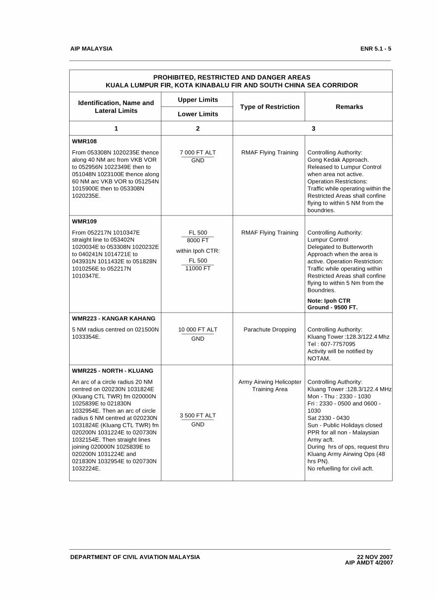
WMR108
From 053308N 1020235E thence along 40 NM arc from VKB VOR to 052956N 1022349E then to 051048N 1023100E thence along 60 NM arc VKB VOR to 051254N 1015900E then to 053308N 1020235E.
7 000 FT ALTGND
RMAF Flying Training Controlling Authority:Gong Kedak Approach.Released to Lumpur Control when area not active.Operation Restrictions:Traffic while operating within the Restricted Areas shall confine flying to within 5 NM from the boundries.
WMR109
From 052217N 1010347E straight line to 053402N 1020034E to 053308N 1020232E to 040241N 1014721E to 043931N 1011432E to 051828N 1010256E to 052217N 1010347E.
FL 5008000 FT
within Ipoh CTR:
FL 50011000 FT
RMAF Flying Training Controlling Authority:Lumpur ControlDelegated to Butterworth Approach when the area is active. Operation Restriction:Traffic while operating within Restricted Areas shall confine flying to within 5 Nm from the Boundries.
Note: Ipoh CTR Ground - 9500 FT.
WMR223 - KANGAR KAHANG
5 NM radius centred on 021500N 1033354E.
10 000 FT ALTGND
Parachute Dropping Controlling Authority:Kluang Tower :128.3/122.4 Mhz Tel : 607-7757095Activity will be notified by NOTAM.
WMR225 - NORTH - KLUANG
An arc of a circle radius 20 NM centred on 020230N 1031824E (Kluang CTL TWR) fm 020000N 1025839E to 021830N 1032954E. Then an arc of circle radius 6 NM centred at 020230N 1031824E (Kluang CTL TWR) fm 020200N 1031224E to 020730N 1032154E. Then straight lines joining 020000N 1025839E to 020200N 1031224E and 021830N 1032954E to 020730N 1032224E.
3 500 FT ALTGND
Army Airwing HelicopterTraining Area
Controlling Authority: Kluang Tower :128.3/122.4 MHzMon - Thu : 2330 - 1030Fri : 2330 - 0500 and 0600 - 1030Sat 2330 - 0430Sun - Public Holidays closedPPR for all non - Malaysian Army acft.During hrs of ops, request thru Kluang Army Airwing Ops (48 hrs PN).No refuelling for civil acft.
PROHIBITED, RESTRICTED AND DANGER AREAS KUALA LUMPUR FIR, KOTA KINABALU FIR AND SOUTH CHINA SEA CORRIDOR
Identification, Name and Lateral Limits
Upper LimitsType of Restriction Remarks
Lower Limits
1 2 3
22 NOV 2007AIP AMDT 4/2007
AIP MALAYSIA
DEPARTMENT OF CIVIL AVIATION MALAYSIA
ENR 5.1 - 6
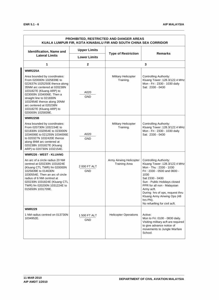
WMR225A
Area bounded by coordinates: From 020000N 1025839E to 022637N 1025250E thence along 35NM arc centered at 020238N 1031827E (Kluang ARP) to 023000N 1034006E. Then a straight line to 021830N 1032954E thence along 20NM arc centered at 020238N 1031827E (Kluang ARP) to 020000N 1025839E.
A020GND
Military Helicopter Training.
Controlling Authority: Kluang Tower :128.3/122.4 MHzMon - Fri : 2330 - 1030 dailySat: 2330 - 0430
WMR225B
Area bounded by coordinates: From 020730N 1032154E to 021830N 1032954E to 023000N 1034006E to 021255N 1034006E to 020327N 1032420E thence along 6NM arc centered at 020238N 1031827E (Kluang ARP) to 020730N 1032154E.
A020 GND
Military Helicopter Training.
Controlling Authority: Kluang Tower :128.3/122.4 MHzMon - Fri : 2330 - 1030 dailySat: 2330 - 0430
WMR226 - WEST - KLUANG
An arc of a circle radius 20 NM centred at 020230N 1031824E (Kluang CTL TWR) fm 020000N 1025839E to 014630N 1030554E. Then an arc of circle radius of 6 NM centred at 020230N 1031824E (Kluang CTL TWR) fm 020200N 1031224E to 015650N 1031709E.
2 000 FT ALTGND
Army Airwing HelicopterTraining Area
Controlling Authority: Kluang Tower :128.3/122.4 MHzMon - Thu : 2330 - 1030Fri : 2330 - 0500 and 0600 - 1030Sat 2330 - 0430Sun - Public Holidays closedPPR for all non - Malaysian Army acft.During hrs of ops, request thru Kluang Army Airwing Ops (48 hrs PN).No refuelling for civil acft.
WMR229
1 NM radius centred on 013730N 1034952E.
1 500 FT ALTGND
Helicopter Operations Active:Mon to Fri: 0100 - 0830 daily.Visiting military acft are required to give advance notice of movements to Jungle Warfare School.
PROHIBITED, RESTRICTED AND DANGER AREAS KUALA LUMPUR FIR, KOTA KINABALU FIR AND SOUTH CHINA SEA CORRIDOR
Identification, Name and Lateral Limits
Upper LimitsType of Restriction Remarks
Lower Limits
1 2 3
11 MAR 2010AIP AMDT 1/2010

AIP MALAYSIA
DEPARTMENT OF CIVIL AVIATION MALAYSIA
ENR 5.1 - 7
WMR236
Straight line fm 030635N 1014643E to 030959N 1015055E to 030959N 1020555E to 025559N 1020455E to025659N 1015041E to 030417N 1014619E to030636N 1014648E.
2 000 FT ALTGND
Flying Training Controlling Authority:Lumpur Approach North - 124.2 MHz.Hours of Operation: HJ.in VMC only.
WMR237
Straight line fm 023659N 1020325E (Kg. Gam) to 022800N 1021355E (Simpang Ampat) to 021442N 1015625E to 022530N 1014355E to start.
2 000 FT ALTGND / SEA
Flying TrainingControlling Authority:Malacca Tower - 118.0 MHzHours of Operation: HJ.in VMC only.
WMR238
Area bounded by coordinates 030307N 1014117E, 030307N 1014237E, 030228N 1014237E and 030228N 1014117E.
3 000 FT ALTGND
Satellite Transmission Hub
Controlling Authority:Lumpur Approach North - 124.2 MHz.
WMR239A
Area bounded by coordinates 020900N 1022100E to 021715.30N 1022913.30E to 020900N 1024612E to 015500N 1023900E thence along the coastline to 020900N 1022100E
5 000 FT ALTGND/SEA
Flying TrainingControlling Authority:Malacca TWR - 118.0 MHz. Hours of Operation: HJ. In VMC only.
WMR239B
Area bounded by coordinates 020900N 1022100E thence along the coastline to 015500N 1023900E, 014700N 1023500E, 020000N 1021700E, 020700N 1022000E to 020900N 1022100E.
5 000 FT ALTGND
Flying Training Controlling Authority:Malacca TWR - 118.0 MHz. Hours of Operation: HJ. In VMC only.
WMR302A
Straight line fm 030459N 1004139E, 024405N 1012847E, 022206N 1012834E to start.
FL 4606 500 FT ALT
Flying Training Controlling Authority:Lumpur Approach and Lumpur ControlH24.
WMR302B
Straight line fm 030459N 1004139E, 024405N 1012847E, 024811N 1012850E, 031534N 1005407E, 031714N 1002815E to start.
FL 4606 500 FT ALT
Flying Training Controlling Authority:Lumpur Approach and Lumpur ControlH24.
PROHIBITED, RESTRICTED AND DANGER AREAS KUALA LUMPUR FIR, KOTA KINABALU FIR AND SOUTH CHINA SEA CORRIDOR
Identification, Name and Lateral Limits
Upper LimitsType of Restriction Remarks
Lower Limits
1 2 3
25 AUG 2011AIP AMDT 3/2011

AIP MALAYSIA
DEPARTMENT OF CIVIL AVIATION MALAYSIA
ENR 5.1 - 8
WMR403
Area contained within 055759N 1002055E then along the coast to Alor Star Control Zone BDRY west at PSN 062358N 1000755E then along the Alor Star CTL Zone west to PSN 060959N 1000355E then along the Butterworth Control Zone to PSN 055759N 1001655E.
10 000 FT ALTSEA
Military Flying Controlling Authority:Alor Star TWR - 122.3 MHz.Hours of Operation: HJ.In VMC only.
WMR404
Area contained within Kuala Perlis PSN 062358N 1000755E, thence a straight line joining the permanent danger area at the Malaysia / Thai border at PSN 063023N 1001155E, thence along the border of the permanent danger area to PSN 062558N 1001555E, thence along the railway line to PSN 061538N 1002125E, following an arc of 5 NM radius from centre of runway joining Sg. Korak, Changlieh thence along this canal joining the coast at PSN 061259N 1001425E, thence along the coast to Kuala Perlis.
10 000 FT ALTGND
Military Flying Controlling Authority:Alor Star TWR - 122.3 MHzHours of Operation: HJ.In VMC only.
WMR405
Area contained within 063023N 1001155E, thence along the southern border of the permanent danger area to Kuala Nerang PSN 061558N 1003655E, thence a straight line joining Bukit Koh Mai at the Malaysian / Thai border PSN 062638N 1003855E, thence along the Malaysia / Thai border PSN 063143N 1002155E, thence a straight line to Mata Ayer PSN 064008N 1001655E, thence a straight line joining the permanent border danger area at 063023N 1001155E.
10 000 FT ALTGND
Military Flying Controlling Authority:Alor Star TWR - 122.3 MHzHours of Operation: HJ.In VMC only.FIS will be provided by Lumpur.Also see AD
PROHIBITED, RESTRICTED AND DANGER AREAS KUALA LUMPUR FIR, KOTA KINABALU FIR AND SOUTH CHINA SEA CORRIDOR
Identification, Name and Lateral Limits
Upper LimitsType of Restriction Remarks
Lower Limits
1 2 3
11 MAR 2010AIP AMDT 1/2010

AIP MALAYSIA
DEPARTMENT OF CIVIL AVIATION MALAYSIA
ENR 5.1 - 9
WMR406
Area contained within Kuala Nerang PSN 061558N 1003655E, thence a straight line to Bukit Koh Mai PSN 062638N 1003855E, thence at along the Malaysia/Thai border to PSN 061538N 1005220E, thence a straight line joining PSN 055759N 1010155E, thence along Butterworth TMA BDRY North to the border of the Permanent Danger Area at PSN 055759N 1004330E, thence along the Permanent Danger Area to Kuala Nerang PSN 061558N 1003655E.
FL 200GND
Military Flying Controlling Authority:Alor Star TWR - 122.3 MHzHours of Operation: HJ.In VMC only.Subject to prior coordination with the relevant authorities.
WMR407
Area contained within 061538N 1005220E, thence along the Malaysia / Thai border to PSN 055759N 1010705E, thence a straight line joining PSN 055759N 1010155E, thence a straight line joining PSN 061538N 1005220E.
FL 200GND
Military Flying Controlling Authority:Alor Star TWR - 122.3 MHzHours of Operation: HJ. In VMC only.Subject to prior coordination with the relevant authorities.
WMR408
Area contained within Pokok Sena PSN 060959N 1003105E, thence a straight line joining Kampong Titi Hj Idris PSN 060419N 1002745E, thence along the Langgar/Pendang Road to Butterworth TMA BDRY North at 055759N 1002830E, thence along the Butterworth CTL BDRY North to PSN 055759N 1003845E, thence along the Alor Star CTR BDRY East to the border of the Permanent Danger Area at 060229N 1004205E, thence along the border of the Permanent Danger Area to Naka 060829N 1003945E, thence along the Naka / Pokok Sena Road to Pokok Sena PSN 060959N 1003105E.
10 000 FT ALTGND
Military Flying Controlling Authority: Alor Star TWR - 122.3 MhzHours of Operation: HJ. In VMC only.
PROHIBITED, RESTRICTED AND DANGER AREAS KUALA LUMPUR FIR, KOTA KINABALU FIR AND SOUTH CHINA SEA CORRIDOR
Identification, Name and Lateral Limits
Upper LimitsType of Restriction Remarks
Lower Limits
1 2 3
11 MAR 2010AIP AMDT 1/2010
AIP MALAYSIA
DEPARTMENT OF CIVIL AVIATION MALAYSIA
ENR 5.1 - 10
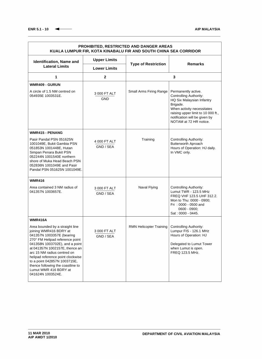
WMR409 - GURUN
A circle of 1.5 NM centred on 054935E 1003531E. 3 000 FT ALT
GND
Small Arms Firing Range Permanently active.Controlling Authority: HQ Six Malaysian Infantry Brigade.When activity necessitates raising upper limit to 10 000 ft., notification will be given by NOTAM at 72 HR notice.
WMR415 - PENANG
Pasir Pandal PSN 051625N 1001049E, Bukit Gambia PSN 051853N 1001448E, Hutan Simpan Penara Bukit PSN 052244N 1001540E northern shore of Muka Head Beach PSN 052836N 1001049E and Pasir Pandal PSN 051625N 1001049E.
4 000 FT ALTGND / SEA
Training Controlling Authority:Butterworth AproachHours of Operation: HJ daily.In VMC only.
WMR416
Area contained 3 NM radius of 041357N 1003657E.
3 000 FT ALTGND / SEA
Naval Flying Controlling Authority:Lumut TWR - 123.5 MHzFREQ VHF 123.5 UHF 312.2. Mon to Thu: 0000 - 0900;Fri : 0000 - 0500 and 0600 - 0900;Sat : 0000 - 0445.
WMR416A
Area bounded by a straight line joining WMR416 BDRY at 041357N 1003357E (bearing 270° FM Helipad reference point 041358N 1003702E), and a point at 041357N 1002157E, thence an arc 15 NM radius centred on helipad reference point clockwise to a point 042857N 1003715E, thence following the coastline to Lumut WMR 416 BDRY at 041624N 1003524E.
3 000 FT ALTGND / SEA
RMN Helicopter Training Controlling Authority:Lumpur FIS - 126.1 MHzHours of Operation: HJ
Delegated to Lumut Tower when Lumut is open.FREQ 123.5 MHz.
PROHIBITED, RESTRICTED AND DANGER AREAS KUALA LUMPUR FIR, KOTA KINABALU FIR AND SOUTH CHINA SEA CORRIDOR
Identification, Name and Lateral Limits
Upper LimitsType of Restriction Remarks
Lower Limits
1 2 3
11 MAR 2010AIP AMDT 1/2010

AIP MALAYSIA
DEPARTMENT OF CIVIL AVIATION MALAYSIA
ENR 5.1 - 11
WMR416B
Area bounded by a straight line joining Lumut WMR 416 BDRY at 041614N 1003900E (bearing 042° FM Helipad reference point 041357N 1003657E), to a point at 042247N 1004543E, thence to 042747N 1004325E, then an arc of 15 NM radius centred on helipad reference point anti- clockwise to a point 042857N 1003715E, thence following the coastline to Lumut WMR 416 BDRY at 041624N 1003523E.
3 000 FT ALTGND / SEA
RMN Helicopter Training Controlling Authority:Lumpur FIS.FREQ 126.1 MHz.HR of OPR: HJ
Delegated to Lumut Tower when Lumut is open.FREQ 123.5 MHz.
WMR416C
Area bounded by a straight line joining Lumut WMR 416 BDRY at 041357N 1003357E (bearing 270° FM Helipad reference point 041357N 1003657E), thence an arc of 15 NM radius centred on helipad reference point anti- clockwise to a point 040157N 1004455E, thence following the coastline to Lumut Restricted Area BDRY at 041057N 1003653E, thence clockwise around the BDRY of Lumut WMR 416 to 041357N 1003357E.
3 000 FT ALTGND / SEA
RMN HelicopterTraining.
Controlling Authority:Lumpur FIS.FREQ 126.1 MHz.HR of OPR: HJ Active daily during daylight HR and in VMC.
Delegated to Lumut Tower when Lumut is open.FREQ 123.5 MHz.
WMR417
Straight line fm 034459N 1004455E to 034659N 1004855E to034705N 1011331E to032429N 1012007E to 031959N 1011455E to 031959N 1005955E to start.
5 000 FT ALTGND / SEA
Flying Training Controlling Authority:Lumpur Approach North - 124.2 MHz.Hours of Operation: HJIn VMC only.
WMR418
Straight line fm 034705N 1011331E to 033437N 1012825E to032159N 1013613E to032459N 1012619E to 032429N 1012007E to 034706N 1011336E to start.
2 000 FT ALTGND / SEA
Flying Training Controlling Authority:Lumpur Approach North -124.2 MHzHours of Operation: HJIn VMC only.
PROHIBITED, RESTRICTED AND DANGER AREAS KUALA LUMPUR FIR, KOTA KINABALU FIR AND SOUTH CHINA SEA CORRIDOR
Identification, Name and Lateral Limits
Upper LimitsType of Restriction Remarks
Lower Limits
1 2 3
11 MAR 2010AIP AMDT 1/2010
AIP MALAYSIA
DEPARTMENT OF CIVIL AVIATION MALAYSIA
ENR 5.1 - 12
WMR419
From 041103N 1002216E along the western boundary of WMR 416C to 040135N 1004531E thence along the coast line to 034840N 1004623E to 032400N 1001705E (PUGER) to 041705N 0992000E (GOTLA) TO 041103N 1002216E.
5 000 FT ALTSEA
Royal Malaysian Navy (RMN) Helicopter Training
Controlling Authority:Lumpur ControlDelegated to Lumut Tower when the area is active.Hours of Operation: H24
WSR2 - TENGAH CORRIDOR
Area within 2 circles, 2 NM radius centred at Tengah and 4 NM radius centred at a PSN 011000N 1033324E and the tangents joining these circles but excluding WSD 11 (Pasir Laba Range) when notified as ACT.
FL 3003 000 FT ALT
Jet Let-Down Sector. Controlling Authority: Tengah Approach -130.0/263.4 MHz (During ops hr).Singapore ATCC - 123.4/288.2 MHz (outside Tengah ops hr)Activity:Sun/Mon to Thu/Fri :2300 - 1100. Fri/Sat : 2300 - 0500.
WBR501 - LABUAN
Area bounded by 051459N 1151848E, 053127N 1154040E, 054729N 1154018E, 052559N 1151848E and 051459N 1151848E.
2 000 FT ALTGND / WATER
RMAF HelicopterTraining Area.
Controlling Authority: Labuan Tower.Hours of Operation: HJIn VMC only.
WBR517
Area bounded by line joining successively the following points - 054259N 1125949E, 063259N 1140449E, 061259N 1141949E, 055259N 1140149E and 054259N 1125949E.
FL 4005 000 FT ALT
Military Flying
ACT will be notified by the issuance of NOTAM.Controlling Authority: Kota Kinabalu ACC.Activity will be notified by NOTAM.
AIR CORRIDOR ASSOCIATED WITH WBR 517
Area bounded by line joining successively the following points - 051159N 1143607E, 050559N 1140249E, 054259N 1125949E, 055259N 1140149E and 051159N 1143607E.
12 500 FT ALTSEA
For acft transitting fromLabuan and Brunei to
WBR 517 and vice versa.
PROHIBITED, RESTRICTED AND DANGER AREAS KUALA LUMPUR FIR, KOTA KINABALU FIR AND SOUTH CHINA SEA CORRIDOR
Identification, Name and Lateral Limits
Upper LimitsType of Restriction Remarks
Lower Limits
1 2 3
11 MAR 2010AIP AMDT 1/2010
AIP MALAYSIA
DEPARTMENT OF CIVIL AVIATION MALAYSIA
ENR 5.1 - 13
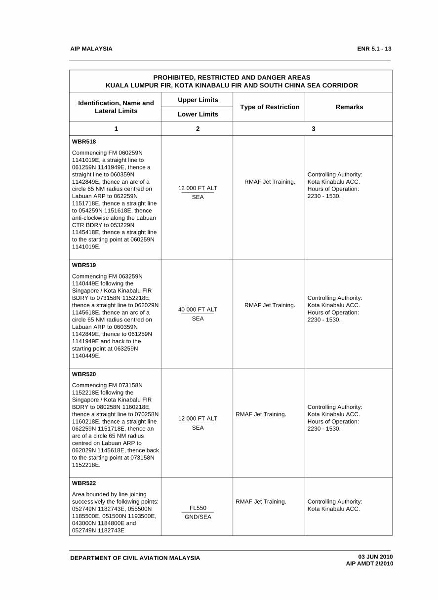
WBR518
Commencing FM 060259N 1141019E, a straight line to 061259N 1141949E, thence a straight line to 060359N 1142849E, thence an arc of a circle 65 NM radius centred on Labuan ARP to 062259N 1151718E, thence a straight line to 054259N 1151618E, thence anti-clockwise along the Labuan CTR BDRY to 053229N 1145418E, thence a straight line to the starting point at 060259N 1141019E.
12 000 FT ALTSEA
RMAF Jet Training.Controlling Authority: Kota Kinabalu ACC.Hours of Operation: 2230 - 1530.
WBR519
Commencing FM 063259N 1140449E following the Singapore / Kota Kinabalu FIR BDRY to 073158N 1152218E, thence a straight line to 062029N 1145618E, thence an arc of a circle 65 NM radius centred on Labuan ARP to 060359N 1142849E, thence to 061259N 1141949E and back to the starting point at 063259N 1140449E.
40 000 FT ALTSEA
RMAF Jet Training.Controlling Authority: Kota Kinabalu ACC.Hours of Operation: 2230 - 1530.
WBR520
Commencing FM 073158N 1152218E following the Singapore / Kota Kinabalu FIR BDRY to 080258N 1160218E, thence a straight line to 070258N 1160218E, thence a straight line 062259N 1151718E, thence an arc of a circle 65 NM radius centred on Labuan ARP to 062029N 1145618E, thence back to the starting point at 073158N 1152218E.
12 000 FT ALTSEA
RMAF Jet Training.Controlling Authority: Kota Kinabalu ACC.Hours of Operation: 2230 - 1530.
WBR522
Area bounded by line joining successively the following points: 052749N 1182743E, 055500N 1185500E, 051500N 1193500E, 043000N 1184800E and 052749N 1182743E
FL550GND/SEA
RMAF Jet Training. Controlling Authority: Kota Kinabalu ACC.
PROHIBITED, RESTRICTED AND DANGER AREAS KUALA LUMPUR FIR, KOTA KINABALU FIR AND SOUTH CHINA SEA CORRIDOR
Identification, Name and Lateral Limits
Upper LimitsType of Restriction Remarks
Lower Limits
1 2 3
03 JUN 2010 AIP AMDT 2/2010

AIP MALAYSIA
DEPARTMENT OF CIVIL AVIATION MALAYSIA
ENR 5.1 - 14
WBR560 / 502
Lumut Gas Plant Area bounded by lines joining successively the following points:043950N 1142743E, 044009N 1142820E 044309N 1142648E 044250N 1142620E.
1 500 FT ALTSEA
Gas Plant JettyLoading Crane And Tanker.
Controlling Authority: Brunei Shell Petroleum Co. Sdn. Bhd.Hours of Operation : H24
Highest obstacle are: - The land flare structure 396 ft .- The loading Crane adjustable to maximum hgt of 204 ft.
WBR523
An arc of a circle radius 40NM centered at 055400N 1160200E (VJN/DVOR) from 055400N 1152200E to 063400N 1160200E then an arc of a circle radius 20NM centered at 055400N 1160200E (VJN/DVOR) from 055400N 1154200E to 061400N 1160200E then straight line joining 055400N 1154200E to 055400N 1152200E and 061400N 1160200E to 063400N 1160200E
2000 FT ALT SEA
Controlling Authority:Kinabalu Approach
Operation Hours:Mon - Fri : 0001 - 0900Sat: 0001 - 0445Fri: closed between 0500 - 0600
Remark: Traffic operating in the vicinity of Sepanggar Bay and transiting training areas are subject to normal Air Traffic service/Holding/Passing of traffic information.
WBR524
An arc of a circle radius 40NM, centered at 055400N 1160200E (VJN/DVOR) from 063400N 1160200E to 062742N 1162524E then an arc of a circle radius 20NM centered at 055400N 1160200E (VJN/DVOR) from 061400N 1160200E to 061230N 1161030E then straight line joining 061400N 1160200E to 063400N 1160200E and coastline joining 061230N 1161030E to 062742N 1162524E.
1000 FT ALT SEA
Controlling Authority:Kinabalu Approach
Operation Hours:Mon - Fri : 0001 - 0900Sat: 0001 - 0445Fri: closed between 0500 - 0600
Remark: Traffic operating in the vicinity of Sepanggar Bay and transiting training areas are subject to normal Air Traffic service/Holding/Passing of traffic information.
PROHIBITED, RESTRICTED AND DANGER AREAS KUALA LUMPUR FIR, KOTA KINABALU FIR AND SOUTH CHINA SEA CORRIDOR
Identification, Name and Lateral Limits
Upper LimitsType of Restriction Remarks
Lower Limits
1 2 3
25 AUG 2011 AIP AMDT 3/2011
AIP MALAYSIA
DEPARTMENT OF CIVIL AVIATION MALAYSIA
ENR 5.1 - 15
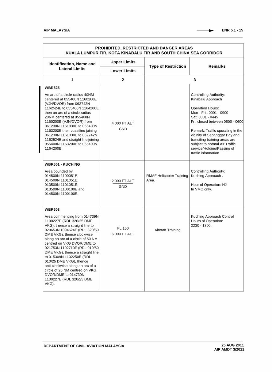
WBR525
An arc of a circle radius 40NM centered at 055400N 1160200E (VJN/DVOR) from 062742N 1162524E to 055400N 1164200E then an arc of a circle radius 20NM centered at 055400N 1160200E (VJN/DVOR) from 061230N 1161030E to 055400N 1163200E then coastline joining 061230N 1161030E to 062742N 1162524E and straight line joining 055400N 1163200E to 055400N 1164200E.
4 000 FT ALT GND
Controlling Authority:Kinabalu Approach
Operation Hours:Mon - Fri : 0001 - 0900Sat: 0001 - 0445Fri: closed between 0500 - 0600
Remark: Traffic operating in the vicinity of Sepanggar Bay and transiting training areas are subject to normal Air Traffic service/Holding/Passing of traffic information.
WBR601 - KUCHING
Area bounded by 014500N 1100051E, 014500N 1101051E,013500N 1101051E, 013500N 1100100E and 014500N 1100100E.
2 000 FT ALTGND
RMAF Helicopter Training Area.
Controlling Authority:Kuching Approach .
Hour of Operation: HJIn VMC only.
WBR603
Area commencing from 014739N 1100227E (RDL 320/25 DME VKG), thence a straight line to 020653N 1094624E (RDL 320/50 DME VKG), thence clockwise along an arc of a circle of 50 NM centred on VKG DVOR/DME to 021753N 1102710E (RDL 010/50 DME VKG), thence a straight line to 015309N 1102250E (RDL 010/25 DME VKG), thence anti-clockwise along an arc of a circle of 25 NM centred on VKG DVOR/DME to 014739N 1100227E (RDL 320/25 DME VKG).
FL 1506 000 FT ALT
Aircraft Training
Kuching Approach ControlHours of Operation: 2230 - 1300.
PROHIBITED, RESTRICTED AND DANGER AREAS KUALA LUMPUR FIR, KOTA KINABALU FIR AND SOUTH CHINA SEA CORRIDOR
Identification, Name and Lateral Limits
Upper LimitsType of Restriction Remarks
Lower Limits
1 2 3
25 AUG 2011AIP AMDT 3/2011
AIP MALAYSIA
DEPARTMENT OF CIVIL AVIATION MALAYSIA
ENR 5.1 - 16
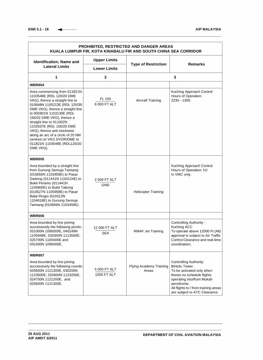
WBR604
Area commencing from 011821N 1103548E (RDL 120/20 DME VKG), thence a straight line to 010848N 1105213E (RDL 120/39 DME VKG), thence a straight line to 005901N 1103130E (RDL 156/32 DME VKG), thence a straight line to 011002N 1102637E (RDL 156/20 DME VKG), thence anti-clockwise along an arc of a circle of 20 NM centred on VKG DVOR/DME to 011821N 1103548E (RDL120/20 DME VKG).
FL 1506 000 FT ALT
Aircraft Training
Kuching Approach ControlHours of Operation: 2230 - 1300.
WBR605
Area bounded by a straight line from Gunung Semuja Tamiang (010656N 1103459E) to Pasar Gedong (011441N 1104124E) to Bukit Peramu (011441N 1105800E) to Bukit Tabong (010527N 1105958E) to Pasar Balai Ringin (010313N 1104618E) to Gunung Semuja Tamiang (010656N 1103459E).
2 500 FT ALTGND
Helicopter Training
Kuching Approach ControlHours of Operation: HJIn VMC only.
WBR606
Area bounded by line joining successively the following points: 031000N 1095000E, 040249N 1105848E, 032000N 1113500E, 025700N 1100400E and 031000N 1095000E.
12 000 FT ALTSEA RMAF Jet Training
Controlling Authority :Kuching ACCTo operate above 12000 Ft (Alt) approval is subject to Air Traffic Control Clearance and real-time coordination.
WBR607
Area bounded by line joining successively the following coords:025600N 1121300E, 030200N 1123500E, 025600N 1123200E, 024700N 1121200E, and 025600N 1121300E.
5 000 FT ALT1500 FT ALT
Flying Academy Training Areas
Controlling Authority: Bintulu Tower.To be activated only when theres no schedule flights operating into/from Mukah aerodrome.All flights to / from training areas are subject to ATC Clearance.
PROHIBITED, RESTRICTED AND DANGER AREAS KUALA LUMPUR FIR, KOTA KINABALU FIR AND SOUTH CHINA SEA CORRIDOR
Identification, Name and Lateral Limits
Upper LimitsType of Restriction Remarks
Lower Limits
1 2 3
25 AUG 2011AIP AMDT 3/2011

AIP MALAYSIA
DEPARTMENT OF CIVIL AVIATION MALAYSIA
ENR 5.1 - 17
WBR608
Area bounded by line joining successively the following coords:024500N 1112700E, 025500N 1115200E, 025300N 1115200E, 024300N 1112800E, and 024500N 1112700E.
5000 FT ALT1500 FT ALT
Flying Academy Training Areas
Controlling Authority: Sibu Tower
All flights to / from training areas are subject to ATC Clearance.
WBR609
Area bounded by line joining successively the following coords:024800N 1111700E, 024800N 1112700E, 022700N 1112300E 022700N 1111700E and 024800N 1111700E
6000 FT ALT1500 FT ALT
Flying Academy Training Areas
Controlling Authority: Sibu Tower.
All flights to / from training areas are subject to ATC Clearance.
WBR610
Area bounded by line joining successively the following coords:022700N 1111100E, 022700N 1111600E, 021400N 1111600E, 021400N 1111100E and 022700N 1111100E.
6000 FT ALT 1500 FT ALT
Flying Academy Training Areas
Controlling Authority: Sibu Tower.
All flights to / from training areas are subject to ATC Clearance.
WBR611
Area bounded by coordinates: 030600N 1124900E, 030000N 1125600E, 024500N 1124000E, 025400N 1123000E and 030600N 1124900E.
A025 Ground
Flight Training AreaControlling Authority: Bintulu Tower.
All flights to / from training areas are subject to ATC Clearance.
PROHIBITED, RESTRICTED AND DANGER AREAS KUALA LUMPUR FIR, KOTA KINABALU FIR AND SOUTH CHINA SEA CORRIDOR
Identification, Name and Lateral Limits
Upper LimitsType of Restriction Remarks
Lower Limits
1 2 3
25 AUG 2011AIP AMDT 3/2011
AIP MALAYSIA
DEPARTMENT OF CIVIL AVIATION MALAYSIA
ENR 5.1 - 18
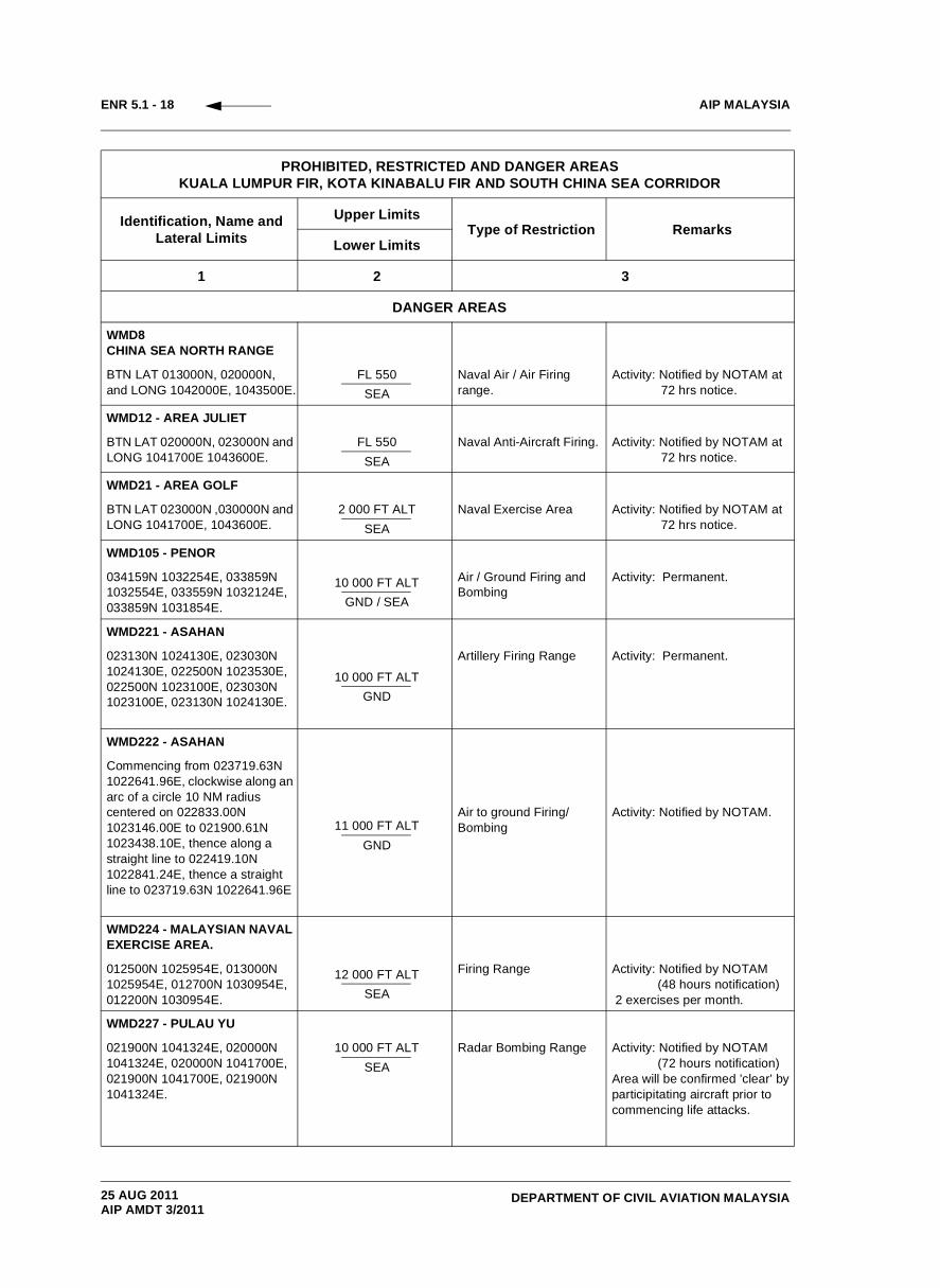
DANGER AREAS
WMD8CHINA SEA NORTH RANGE
BTN LAT 013000N, 020000N, and LONG 1042000E, 1043500E.
FL 550SEA
Naval Air / Air Firing range.
Activity: Notified by NOTAM at 72 hrs notice.
WMD12 - AREA JULIET
BTN LAT 020000N, 023000N and LONG 1041700E 1043600E.
FL 550SEA
Naval Anti-Aircraft Firing. Activity: Notified by NOTAM at 72 hrs notice.
WMD21 - AREA GOLF
BTN LAT 023000N ,030000N and LONG 1041700E, 1043600E.
2 000 FT ALT SEA
Naval Exercise Area Activity: Notified by NOTAM at 72 hrs notice.
WMD105 - PENOR
034159N 1032254E, 033859N 1032554E, 033559N 1032124E, 033859N 1031854E.
10 000 FT ALTGND / SEA
Air / Ground Firing and Bombing
Activity: Permanent.
WMD221 - ASAHAN
023130N 1024130E, 023030N 1024130E, 022500N 1023530E, 022500N 1023100E, 023030N 1023100E, 023130N 1024130E.
10 000 FT ALTGND
Artillery Firing Range Activity: Permanent.
WMD222 - ASAHAN
Commencing from 023719.63N 1022641.96E, clockwise along an arc of a circle 10 NM radius centered on 022833.00N 1023146.00E to 021900.61N 1023438.10E, thence along a straight line to 022419.10N 1022841.24E, thence a straight line to 023719.63N 1022641.96E
11 000 FT ALTGND
Air to ground Firing/ Bombing
Activity: Notified by NOTAM.
WMD224 - MALAYSIAN NAVAL EXERCISE AREA.
012500N 1025954E, 013000N 1025954E, 012700N 1030954E, 012200N 1030954E.
12 000 FT ALTSEA
Firing Range Activity: Notified by NOTAM (48 hours notification) 2 exercises per month.
WMD227 - PULAU YU
021900N 1041324E, 020000N 1041324E, 020000N 1041700E, 021900N 1041700E, 021900N 1041324E.
10 000 FT ALTSEA
Radar Bombing Range Activity: Notified by NOTAM (72 hours notification)Area will be confirmed ’clear’ by participitating aircraft prior to commencing life attacks.
PROHIBITED, RESTRICTED AND DANGER AREAS KUALA LUMPUR FIR, KOTA KINABALU FIR AND SOUTH CHINA SEA CORRIDOR
Identification, Name and Lateral Limits
Upper LimitsType of Restriction Remarks
Lower Limits
1 2 3
25 AUG 2011AIP AMDT 3/2011

AIP MALAYSIA
DEPARTMENT OF CIVIL AVIATION MALAYSIA
ENR 5.1 - 19
WMD230 - ULU TIRAM (SOUTH)
Activity: Permanent.
*When activity necessitates raising upper limit to 9 500 ft - notification by NOTAM (48hrs notice).
Area within 013720N 1035324E, 013840N 1035135E, 013704N 1034954E and 013530N 1035140E.
*2 000 FT ALTGND
Artillery Firing Range
WMD231 - ULU TIRAM (NORTH)
Area within 013815N 1034950E, 013927N 1035028E, 014238N 1034929E, 014239N 1034822E, 014133N 1034627E, 013840N 1034627E and 013858N 1034840E.
WMD411 - BUTTERWORTH
054259N 1001004E, 054259N 1001455E, 055659N 1000155E, 060159N 1000155E, 060359N 1000355E 060359N 1000855E and 055259N 1002055E.
FL 400SEA
Air / Weapons Range .Bombing and air firing.
Activity: PermanentHours of Operation: HJ.
WMD412A - BUTTERWORTHControlling Authority:Butterworth Approach.
Activity : Notified by NOTAM at 48 HR notice.
054846N 0990000E, 054846N 0994912E, along the Butterworth TMA boundary, 051238N 0994700E, 050043N 0994700E, 050043N 0991140E, 051044N 0990000E and 054846N 0990000E.
FL 500SEA
Air / Air Live FiringRange.
WMD413A Controlling Authority:Butterworth Approach.Hours of Operation: 2330 - 1430 daily.
i. Aircraft on B466 between VBA and TOSOK, and on R467/N571 between VKL and VAMPI deviating north of track shall obtain clearance from Lumpur Control on 132.8 MHz or Butterworth Approach 125.8 MHz.
ii. Aircraft on P628 between VPL and GIVAL, deviating south of track shall obtain clearance from Lumpur Control on 132.8 MHz or Butterworth Approach 125.8 MHz.
064824N 0980000E, 061320N 0993735E, 054846N 0994912E, along the Butterworth TMA boundary 045210N 1000643E, 041430N 1001619E, 043741N 0993817E, 060226N 0980000E, 064824N 0980000E.
UNLSEA
Except for airspace above WMKL CTR Lower Limit is
10,500 FT
Training(Supersonic ACFT ALT)
PROHIBITED, RESTRICTED AND DANGER AREAS KUALA LUMPUR FIR, KOTA KINABALU FIR AND SOUTH CHINA SEA CORRIDOR
Identification, Name and Lateral Limits
Upper LimitsType of Restriction Remarks
Lower Limits
1 2 3
25 AUG 2011AIP AMDT 3/2011

AIP MALAYSIA
DEPARTMENT OF CIVIL AVIATION MALAYSIA
ENR 5.1 - 20
WMD414 - SONG SONG
054907N 1001700E, 054918N 1001815E, 054809N 1001940E, 054651N 1002105E, 054539N 1001920E, 054524N 1001727E, 054704N 1001705E and 054907N 1001700E.
UNLGND / SEA
Air / Ground Firing.Activity: Periodically.Release of photo flashes and flares.Max HGT 3000 ft.Mon to Fri: Dawn - 1630.
WMD419
Commencing from 055800N 1010659E a straight line to 055800N 1005700E, 054530N 1004820E, 053750N 1005100E, 052600N 1010730E, 052700N 1011240E, 053040N 1012030E, 053910N 1015254E thence clockwise along an arc 40 NM centred from VKB VOR/DME to 054450N 1014729E thence along Malaysia/Thai border to 055800N 1010659E.
10 000 FT ALTGND
Artillery And MortarShells Firing.
Activity: Notify by NOTAM
WSD11 - PASIR LABA
012550N 1034024E, 012333N 1033904E, 012303N 1033909E, 012058N 1033759E, 011933N 1034009E, 012142N 1034104E 012245N 1034104E and 012440N 1034124E (General Area).
1 300 FT ALTGND
Small Arm Firing. Activity: Permanent.
WSD13 - AREA KILO
BTN LAT 020000N, 023000N and LONG 1043600E 1045500E.
FL 550SEA
Naval Anti-Aircraft Firing. Activity: Notified by NOTAM at 72 hrs notice.
WSD14 - AREA LIMA
BTN LAT 013000N 020000N andLONG 1043600E 1045500E.
FL550SEA
Naval Anti-Aircraft Firing and Live Air to Air Frng.
Activity: Notified by NOTAM at 72 hrs notice.
WSD15 - AREA MIKE
BTN LAT 013000N 020000N andLONG 1045500E 1053000E.
FL550SEA
Naval Carrier Opr Area Activity: Notified by NOTAM at 72 hrs notice.
WSD20 - AREA HOTEL
BTN LAT 023000N, 030000N and LONG 1043600E 1045500E.
2 000 FT ALT SEA
Naval Exercise Area. Activity: Notified by NOTAM at 72 hrs notice.
WSD 44
BTN LAT 020000N, 023000N and LONG 1045500E ,1051230E.
FL 550SEA
Naval Exercise Area Activity: Notified by NOTAM at 72 hrs notice.
PROHIBITED, RESTRICTED AND DANGER AREAS KUALA LUMPUR FIR, KOTA KINABALU FIR AND SOUTH CHINA SEA CORRIDOR
Identification, Name and Lateral Limits
Upper LimitsType of Restriction Remarks
Lower Limits
1 2 3
25 AUG 2011AIP AMDT 3/2011

AIP MALAYSIA
DEPARTMENT OF CIVIL AVIATION MALAYSIA
ENR 5.1 - 21
WSD45
BTN LAT 020000N, 023000N and LONG 1051230E, 1053000E.
FL 550SEA
Naval Exercise Area Activity: Notified by NOTAM at 72 hrs notice.
WBD505 - BALAMBANGAN
Live Air Firing/Bombing12 NM radius centred on 071826N 1165922E. FL 150
GND
Hours of Operation: 2230 - 1530.Activity: Notified by NOTAM
LINK ROUTE ECHO 1 TRANSITING CORRIDOR FOR WBD 505
Live Air Firing/Bombing
Bounded by straight lines as follows:074858N 1160248E, 072958N 1165717E, 073858N 1160248E and 072356N 1164904E.
12 000 FT ALTSEA
Link Route ECHO 1 and ECHO 2 will be active whenever WBD 505 is activated.
LINK ROUTE ECHO 2 TRANSITING CORRIDOR FOR WBD 505
Bounded by straight lines as follows:071058N 1160248E, 071458N 1164747E 070258N 1160218E and 070556N 1165710E.
12 000 FT ALTSEA
Live Air Firing/Bombing Link Route ECHO 1 and ECHO 2 will be active whenever WBD 505 is activated.
WBD507
Police Training Centre. Circle of 440 m radius centred on 045644N 1145814E.
1 000 FT ALTGND
Pistol And Small Arms Firing.
Controlling Authority: DCA Brunei.Activity: 0001 - 0900 daily.
WBD508
Circle of 220 m radius centred on 044242N 1150455E.
500 FT ALTGND
Small Arms Firing. Activity : Permanent.
WBD509 - BINTURAN RANGE
Area bounded by line joining successively by the following points: 045449N 1144704E, 045417N 1144740E, 045041N 1144602E, 045000N 1144351E, 045311N 1144032E, 045603N 1144511E and 045452N 1144654E.
1 000 FT ALTGND
Live Firing Activity : Permanent.When activity necessitates raising upper tlimit to 20 000 ft - notification by NOTAM.
PROHIBITED, RESTRICTED AND DANGER AREAS KUALA LUMPUR FIR, KOTA KINABALU FIR AND SOUTH CHINA SEA CORRIDOR
Identification, Name and Lateral Limits
Upper LimitsType of Restriction Remarks
Lower Limits
1 2 3
25 AUG 2011AIP AMDT 3/2011

AIP MALAYSIA
DEPARTMENT OF CIVIL AVIATION MALAYSIA
ENR 5.1 - 22
WBD509A - BUKIT AGOK FIRING COMPLEX
Area bounded by lines joining the following points:045407N 1144730E, 045157N 1144230E, 045807N 1153810E, 050432N 1144700E, 045842N 1145055E and back to start 045410N 1144720E.
10 000 FT ALTGND
Live FiringShell-duck Flying
Activity : Notification by NOTAM
WBD510 - LUMUT RANGE
Area bounded by line joining successively by the following points: 043857N 1142710E, 043952N 1143610E, 043652N 1143010E, 043652N 1142620E and 043900N 1142700E.
1 000 FT ALTGND Firing Range. Activity : Permanent.
WBD511 - BERAKAS RANGE
Area bounded by line joining successively by the following points: 050033N 1145731E, 050104N 1145911E, 050021N 1145917E, 050025N 1145904E, 050009N 1145747E, 050018N 1145731E and 050036N 1145721E.
1000 FT ALTGND
Small Arms Firing Activity :Permanent.
WBD512 - BERAKAS RANGE
Area bounded by line joining successively by the following points: 050018N 1145731E, 050009N 1145747E, 050025N 1145904E, 045950N 1145834E, 045944N 1145731E and 050021N 1145721E.
a) 750 FT ALTGND
Small Arms Firing a) Activity : Permanent.
b) 1 250 FT ALTGND
b) Activity : 2300 - 1100 ( will be notified by NOTAM)
WBD513 - TUTONG RANGE
Area bounded by line joining successively by the following points: 044727N 1143710E, 044727N 1143840E, 044627N 1143710E, 044627N 1143840E and 044730N 1143700E.
500 FT ALTGND
Small Arms Firing Activity : Permanent.
WBD514
Circle of 200 m radius centred on 043207N 1150850E.
500 FT ALTGND
Small Arms Firing Activity : Permanent.
PROHIBITED, RESTRICTED AND DANGER AREAS KUALA LUMPUR FIR, KOTA KINABALU FIR AND SOUTH CHINA SEA CORRIDOR
Identification, Name and Lateral Limits
Upper LimitsType of Restriction Remarks
Lower Limits
1 2 3
25 AUG 2011AIP AMDT 3/2011

AIP MALAYSIA
DEPARTMENT OF CIVIL AVIATION MALAYSIA
ENR 5.1 - 23
WBD515
Area bounded by line joining successively by the following points: 043545N 1141807E, 043612N 1141922E, 043447N 1141957E, 043437N 1141842E and 043545N 1141807E.
500 FT ALTGND
Small Arms Firing Activity : Permanent.
WBD516 - KOTA BELUD
061959N 1162948E, 062459N 1163448E 061959N 1163448E and 062459N 1162948E. 10 000 FT ALT
GND
Artillery/Mortar Range Activity : Will be notified by NOTAM.
WBD521
Area within 064200N 1141700E,062000N 1144700E, 070000N 1151800E, 074400N 1153600E AND 064200N 1141700E.
FL400Sea Level
Surface to Air Missiles Naval Firing / Aircraft training
Activity: Notify by NOTAM at 7 days notice
PROHIBITED, RESTRICTED AND DANGER AREAS KUALA LUMPUR FIR, KOTA KINABALU FIR AND SOUTH CHINA SEA CORRIDOR
Identification, Name and Lateral Limits
Upper LimitsType of Restriction Remarks
Lower Limits
1 2 3
25 AUG 2011AIP AMDT 3/2011

THIS PAGE INTENTIONALLY LEFT