ENR 1. GENERAL RULES AND PROCEDURES ENR …ENR 1.2 Visual Flight Rules For information on the visual...
17
AIP CANADA (ICAO) PART 2 – ENROUTE (ENR) Publication Date: 26 MAR 20 ENR 1–1 ENR 1. GENERAL RULES AND PROCEDURES ENR 1.1 General Rules For information on the general rules applied within Canada, refer to Part VI – General Operating and Flight Rules of the Canadian Aviation Regulations (CARs) available at: <http://www.tc.gc.ca/eng/acts-regulations/regulations-sor96-433.htm> ENR 1.2 Visual Flight Rules For information on the visual flight rules (VFR) applied within Canadian Domestic Airspace, refer to the following sections of the Canadian Aviation Regulations (CARs) that are listed in Table 1.2, “Visual Flight Rules.” Table 1.2, Visual Flight Rules Section Title 602.114 Minimum Visual Meteorological Conditions for VFR Flight in Controlled Airspace 602.115 Minimum Visual Meteorological Conditions for VFR Flight in Uncontrolled Airspace 602.116 VFR Over the Top 602.117 Special VFR Flight ENR 1.3 Instrument Flight Rules For information on the instrument flight rules (IFR) applied within Canadian Domestic Airspace, refer to the following sections of the Canadian Aviation Regulations (CARs) that are listed in Table 1.3, “Instrument Flight Rules.” Table 1.3, Instrument Flight Rules Section Title 602.121 General Requirements 602.122 Alternate Aerodrome Requirements 602.123 Alternate Aerodrome Weather Minima 602.124 Minimum Altitudes to Ensure Obstacle Clearance 602.125 Enroute IFR Position Reports 602.126 Takeoff Minima 602.127 Instrument Approaches 602.128 Landing Minima 602.129 700.10 Approach Ban – General Approach Bans – Non Precision, APV and CAT I Precision 602.130 700.11 Approach Ban – CAT III Precision Approach Bans – CAT II and CAT III Precision
Transcript of ENR 1. GENERAL RULES AND PROCEDURES ENR …ENR 1.2 Visual Flight Rules For information on the visual...

AIP CANADA (ICAO) PART 2 – ENROUTE (ENR)
Publication Date: 26 MAR 20 ENR 1–1
ENR 1. GENERAL RULES AND PROCEDURES
ENR 1.1 General Rules
For information on the general rules applied within Canada, refer to Part VI – General Operating and Flight Rules of the Canadian Aviation Regulations (CARs) available at:
<http://www.tc.gc.ca/eng/acts-regulations/regulations-sor96-433.htm>
ENR 1.2 Visual Flight Rules
For information on the visual flight rules (VFR) applied within Canadian Domestic Airspace, refer to the following sections of the Canadian Aviation Regulations (CARs) that are listed in Table 1.2, “Visual Flight Rules.”
Table 1.2, Visual Flight Rules
Section Title
602.114 Minimum Visual Meteorological Conditions for VFR Flight in Controlled Airspace 602.115 Minimum Visual Meteorological Conditions for VFR Flight in Uncontrolled Airspace 602.116 VFR Over the Top 602.117 Special VFR Flight
ENR 1.3 Instrument Flight Rules
For information on the instrument flight rules (IFR) applied within Canadian Domestic Airspace, refer to the following sections of the Canadian Aviation Regulations (CARs) that are listed in Table 1.3, “Instrument Flight Rules.”
Table 1.3, Instrument Flight Rules
Section Title
602.121 General Requirements 602.122 Alternate Aerodrome Requirements 602.123 Alternate Aerodrome Weather Minima 602.124 Minimum Altitudes to Ensure Obstacle Clearance 602.125 Enroute IFR Position Reports 602.126 Takeoff Minima 602.127 Instrument Approaches 602.128 Landing Minima 602.129 700.10
Approach Ban – General Approach Bans – Non Precision, APV and CAT I Precision
602.130 700.11
Approach Ban – CAT III Precision Approach Bans – CAT II and CAT III Precision

PART 2 – ENROUTE (ENR) NAV CANADA
ENR 1–2 Publication Date: 26 MAR 20
ENR 1.4 Air Traffic Services (ATS) Airspace Classification and Description
1.4.1 ATS Airspace Classification
For information on the airspace structure in Canada, refer to “Part VI – General Operating and Flight Rules” of the Canadian Aviation Regulations (CARs), Section 601.01, “Division I – Airspace Structure, Classification and Use” available at:
<https://lois-laws.justice.gc.ca/eng/regulations/SOR-96-433/FullText.html#s-601.01>
1.4.2 ATS Airspace Description
For more detail on the description of Canadian Domestic airspace, refer to the Designated Airspace Handbook (TP 1820E), available in PDF on the Aeronautical Information Products section of the NAV CANADA website:
<www.navcanada.ca> Products & Services Aeronautical Information Products Designated Airspace Handbook Current Issue
To download a chart depicting Canada’s airspace classification, refer to Transport Canada’s publication Canada’s Airspace: Information on Airspace Classification and Structure (TP 6010), available at:
<https://www.tc.gc.ca/Publications/BIL/TP6010/PDF/HR/TP6010B.PDF>
ENR 1.5 Holding, Approach and Departure Procedures
1.5.1 General
For general information on holding, approach and departure procedures, refer to the Canada Air Pilot, General (CAP GEN).
The instrument procedures published in the Canada Air Pilot (CAP), Volumes 1–7, and Restricted Canada Air Pilot (RCAP) are considered to be public procedures. However, the instrument procedures contained in the RCAP do not meet Transport Canada Civil Aviation design criteria. Accordingly, the use of RCAP procedures is restricted to pilots-in-command operating aircraft under an air operator certificate or a private operator certificate, including the appropriate RCAP special authorization. Authorization is required from Transport Canada Civil Aviation prior to the use of any Restricted Canada Air Pilot procedure.
These publications are available for purchase from NAV CANADA’s e-commerce store at:
<www.navcanada.ca> Products & Services Aeronautical Information Products Online Store

AIP CANADA (ICAO) PART 2 – ENROUTE (ENR)
Publication Date: 16 JUL 20 ENR 1–3
1.5.2 Arriving Flights
For information on the procedures for arriving flights, refer to the Transport Canada Aeronautical Information Manual (TC AIM) (TP14371E) Section RAC 9.0, “Instrument Flight Rules (IFR) — Arrival Procedures.” This publication can be found on the Transport Canada website at:
<https://www.tc.gc.ca/en/services/aviation/publications/tc-aim.html>
For arrival procedures for VFR Traffic by aerodrome, refer to the PRO section in the Canada Flight Supplement (CFS), Section B, “Aerodrome/Facility Directory” or Canada Water Aerodrome Supplement (CWAS) Section B, “Aerodrome/Facility Directory.”
Specific STAR procedures are depicted by aerodrome in the respective Canada Air Pilot (CAP).
These publications are available for purchase from NAV CANADA’s e-commerce store at:
<www.navcanada.ca> Products & Services Aeronautical Information Products Online Store
1.5.3 Departing Flights
For information on the procedures for departing flights, refer to the Transport Canada Aeronautical Information Manual (TC AIM) (TP14371E) Section RAC 7.0, “Instrument Flight Rules – Departure Procedures.” This publication can be found on the Transport Canada website at:
<https://www.tc.gc.ca/en/services/aviation/publications/tc-aim.html>
For departure procedures for VFR Traffic by aerodrome, refer to the VFR Terminal Procedures Chart (VTPC) in the Canada Flight Supplement (CFS), Section B, “Aerodrome/Facility Directory” or Canada Water Aerodrome Supplement (CWAS) Section B, “Aerodrome/Facility Directory.”
Specific SID procedures are depicted by aerodrome in the respective Canada Air Pilot (CAP).
These publications are available for purchase from NAV CANADA’s e-commerce store at:
<www.navcanada.ca> Products & Services Aeronautical Information Products Online Store
1.5.4 Other Relevant Information and Procedures
Nil
ENR 1.6 ATS Surveillance Services and Procedures
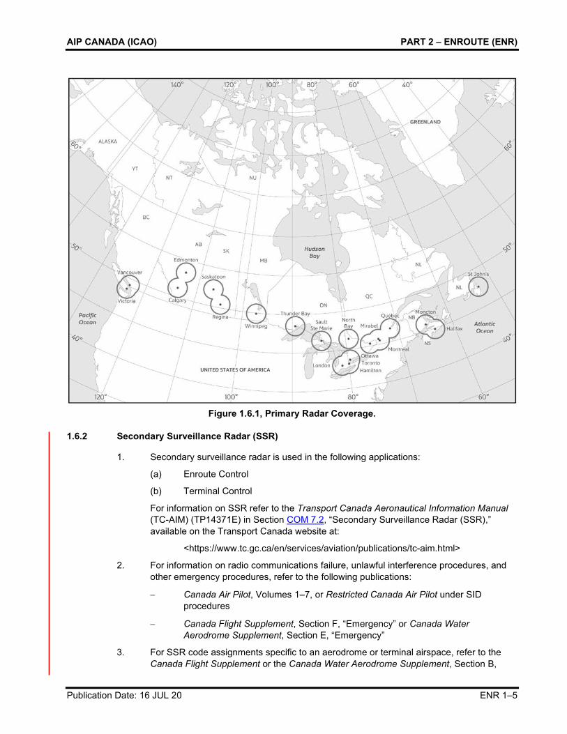
1.6.1 Primary Radar
1. Primary surveillance radar (PSR) is used in the following applications:
(a) Terminal Surveillance Radar
(b) Precision Approach Radar
(c) Airport Surface Detection Equipment

PART 2 – ENROUTE (ENR) NAV CANADA
ENR 1–4 Publication Date: 26 MAR 20
2. For information on PSR, refer to the Transport Canada Aeronautical Information Manual (TC AIM) (TP14371E) Section COM 7.1, “Primary Surveillance Radar (PSR),” available on the Transport Canada website at:
<https://www.tc.gc.ca/en/services/aviation/publications/tc-aim.html>
3. For information on radar and radio failure procedures, refer to the following publications:
− Canada Air Pilot, Volumes 1–7, or Restricted Canada Air Pilot
− Canada Flight Supplement, Section F, “Emergency” or Canada Water Aerodrome Supplement, Section E, “Emergency”
4. For information on voice position reporting requirements, refer to the CFS, Section B “Aerodrome/Facility Directory” under procedures for each aerodrome, CFS, Section C, “Planning” and CFS, Section E, “Military Flight Data and Procedures.” To determine the location of compulsory and on-request reporting points In Canadian domestic airspace, refer to the VFR navigation charts (VNC), VFR terminal area charts (VTA) and Enroute Charts (LO and HI).
These publications are available for purchase from NAV CANADA’s e-commerce store at:
<www.navcanada.ca> Products & Services Aeronautical Information Products Online Store
5. For a map of primary radar coverage in Canada, see Figure 1.6.1, “Primary Radar Coverage.”
AIP CANADA (ICAO) PART 2 – ENROUTE (ENR)
Publication Date: 16 JUL 20 ENR 1–5
Figure 1.6.1, Primary Radar Coverage.
1.6.2 Secondary Surveillance Radar (SSR)
1. Secondary surveillance radar is used in the following applications:
(a) Enroute Control
(b) Terminal Control
For information on SSR refer to the Transport Canada Aeronautical Information Manual (TC-AIM) (TP14371E) in Section COM 7.2, “Secondary Surveillance Radar (SSR),” available on the Transport Canada website at:
<https://www.tc.gc.ca/en/services/aviation/publications/tc-aim.html>
2. For information on radio communications failure, unlawful interference procedures, and other emergency procedures, refer to the following publications:
− Canada Air Pilot, Volumes 1–7, or Restricted Canada Air Pilot under SID procedures
− Canada Flight Supplement, Section F, “Emergency” or Canada Water Aerodrome Supplement, Section E, “Emergency”
3. For SSR code assignments specific to an aerodrome or terminal airspace, refer to the Canada Flight Supplement or the Canada Water Aerodrome Supplement, Section B,

PART 2 – ENROUTE (ENR) NAV CANADA
ENR 1–6 Publication Date: 16 JUL 20
“Aerodrome/Facility Directory,” the PRO section. For general SSR code assignments refer to the Canada Flight Supplement or Canada Water Aerodrome Supplement, Section C “Planning” under the paragraph entitled “Use of Transponder Codes.”
These publications are available for purchase from NAV CANADA’s e-commerce store at:
<www.navcanada.ca> Products & Services Aeronautical Information Products Online Store
4. For information on CPDLC position reporting requirements, refer to GEN 3.4.4, “Requirements and Conditions” in the AIP under subsection 3.4.4.2, “Data Link Services.”
5. For a map of SSR coverage in Canada, see Figure 1.6.2, “Secondary Surveillance Radar Coverage.”
Figure 1.6.2, Secondary Surveillance Radar Coverage.
1.6.3 Automatic Dependent Surveillance–Broadcast
Automatic dependent surveillance-broadcast (ADS-B) utilizes global navigation satellite system (GNSS) and aircraft avionics to accurately relay flight information to air traffic services.
All aircraft that emit position information using a 1090 MHz extended squitter (1090ES) may be provided surveillance separation services, provided they meet the airworthiness compliance requirements defined in:

AIP CANADA (ICAO) PART 2 – ENROUTE (ENR)
Publication Date: 30 JAN 20 ENR 1–7
1. European Aviation Safety Agency (EASA) AMC 20-24; or
2. European Aviation Safety Agency (EASA) CS ACNS; or
3. Federal Aviation Administration (FAA) Title 14 Code of Federal Regulations (14 CFR) section 91.227 or AC No. 20-165A (or replacement) – Airworthiness Approval of ADS-B; or
4. Configuration standards reflected in Appendix XI of Civil Aviation Order 20.18 of the Civil Aviation Safety Authority of Australia.
ADS-B Out systems that are unable to meet the above requirements must disable ADS-B transmission unless:
1. the aircraft always transmits a value of 0 (zero) for one or more of the position quality indicators (NUCp, NIC, NAC or SIL); or
2. the operator has received an exemption from NAV CANADA.
For information on radio communications failure, unlawful interference procedures, and other emergency procedures, refer to the following publications:
• Canada Air Pilot, Volumes 1–7, or Restricted Canada Air Pilot
• Canada Flight Supplement, Section F, “Emergency” or Canada Water Aerodrome Supplement, Section E, “Emergency”
A Flight ID that is an exact replica of the Aircraft Identification entered in field 7 of the ICAO Flight Plan must be programmed into the transponder or flight management system (FMS) in order to receive surveillance services. Airline aircraft will use the three-letter ICAO airline code, not the two-letter IATA code. In addition, field 10 should indicate ADS-B capability on the ICAO Flight Plan.
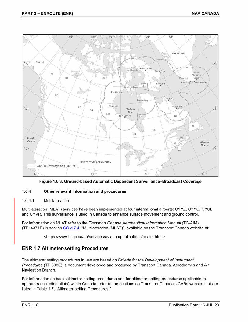
For a map of ADS-B coverage in Canada, see Figure 1.6.3, “Ground-based Automatic Dependent Surveillance–Broadcast Coverage.”
PART 2 – ENROUTE (ENR) NAV CANADA
ENR 1–8 Publication Date: 16 JUL 20
Figure 1.6.3, Ground-based Automatic Dependent Surveillance–Broadcast Coverage
1.6.4 Other relevant information and procedures
1.6.4.1 Multilateration
Multilateration (MLAT) services have been implemented at four international airports: CYYZ, CYYC, CYUL and CYVR. This surveillance is used in Canada to enhance surface movement and ground control.
For information on MLAT refer to the Transport Canada Aeronautical Information Manual (TC-AIM) (TP14371E) in section COM 7.4, “Multilateration (MLAT)”, available on the Transport Canada website at:
<https://www.tc.gc.ca/en/services/aviation/publications/tc-aim.html>
ENR 1.7 Altimeter-setting Procedures
The altimeter setting procedures in use are based on Criteria for the Development of Instrument Procedures (TP 308E), a document developed and produced by Transport Canada, Aerodromes and Air Navigation Branch.
For information on basic altimeter-setting procedures and for altimeter-setting procedures applicable to operators (including pilots) within Canada, refer to the sections on Transport Canada’s CARs website that are listed in Table 1.7, “Altimeter-setting Procedures.”

AIP CANADA (ICAO) PART 2 – ENROUTE (ENR)
Publication Date: 25 JUN 15 ENR 1–9
Table 1.7, Altimeter-setting Procedures
Section Title
602.35 Altimeter-setting and Operating Procedures in the Altimeter-Setting Region 602.36 Altimeter-setting and Operating Procedures in the Standard Pressure Region 602.37 Altimeter-setting and Operating Procedures in Transition between Regions
<http://www.tc.gc.ca/eng/acts-regulations/regulations-sor96-433.htm> Part VI – General Operating and Flight Rules Subpart 2 – Operating and Flight Rules Division I – General
The altimeter setting region is an airspace of defined dimensions below 18 000 feet above sea level (ASL). For a map of the altimeter-setting region, refer to the following publications:
• Canada Flight Supplement or Canada Water Aerodrome Supplement, Section C, “Planning – Altimeter Setting and Designated Mountainous Regions”
For a table of cruising levels, refer to the following publications:
• Canada Flight Supplement or Canada Water Aerodrome Supplement, Section C, “Planning – Characteristics of Airspace – Cruising Altitudes and Flight Levels Appropriate to Aircraft Track”
Cold dry air masses can produce barometric pressures in excess of 31.00 inches of mercury. Because barometric readings of 31.00 inches of mercury or higher rarely occur, most standard altimeters do not permit the setting of barometric pressures above that level and are not calibrated to indicate accurate aircraft altitude above 31.00 inches of mercury. As a result, most altimeters cannot be set to provide accurate altitude readouts to the pilot in these situations.
ATC will issue actual altimeter settings and will confirm with the pilot that 31.00 inches of mercury is set on the pilot’s altimeters for enroute operations below 18 000 feet ASL in the affected areas.
Aerodromes that are unable to accurately measure barometric pressures above 31.00 inches of mercury will report the barometric pressure as “in excess of 31.00 inches of mercury”. Flight operations to and from those aerodromes are restricted to VFR weather conditions.
When the barometric pressure exceeds 31.00 inches of mercury, the following procedures take effect:
Altimeters of all IFR, controlled VFR flight (CVFR) and VFR aircraft are to be set to 31.00 inches of mercury for enroute operations below 18 000 feet ASL. All pilots are to maintain this setting until beyond the area affected by the extreme high pressure or until reaching the final approach segment of an instrument approach for IFR aircraft or the final approach for VFR aircraft. At the beginning of the final approach segment, the current altimeter setting will be set by those aircraft capable of such a setting. Aircraft that are unable to set altimeter settings above 31.00 inches of mercury will retain a 31.00 inches of mercury setting throughout the entire approach. Aircraft on departure or missed approach will set 31.00 inches of mercury prior to reaching any mandatory or fix crossing altitude, or 1 500 feet above ground level (AGL), whichever is lower.

PART 2 – ENROUTE (ENR) NAV CANADA
ENR 1–10 Publication Date: 21 MAY 20
For aircraft operating IFR that are unable to set the current altimeter setting, the following restrictions apply:
To determine the suitability of departure alternate aerodromes, destination aerodromes and destination alternate aerodromes, increase the ceiling requirements by 100 feet and visibility requirements by 1/4 statute mile (SM) for each 1/10 inch of mercury, or any portion thereof, over 31.00 inches of mercury. These adjusted values are then applied in accordance with the requirements of the applicable operating regulations and operations specifications.
Example: Destination altimeter setting is 31.28 inches, instrument landing system (ILS) decision height (DH) is 250 feet (200-1/2). When flight planning, add 300-3/4 to the weather requirements, which would now become 500-1 1/4.
During the instrument approach, 31.00 inches of mercury will remain set. DH or Minimum Descent Altitude (MDA) will be deemed to have been reached when the published altitude is displayed on the altimeter.
Note: Although visibility is normally the limiting factor on an approach, pilots should be aware that when reaching DH, the aircraft will be higher than indicated by the altimeter, which in some cases could be as much as 300 feet higher.
Authorized CAT II and III ILS operations are not affected by the above restrictions.
Night VFR pilots are advised that under conditions of altimeter settings above 31.00 inches of mercury and aircraft altimeters not capable of setting above 31.00 inches of mercury, the aircraft’s true altitude will be higher than the indicated altitude; this must be taken into consideration. If an instrument approach procedure is to be flown, the night VFR pilot should follow the procedures described above for aircraft operating IFR.
For aircraft with the capability of setting the current altimeter setting and operating into aerodromes with the capability of measuring the current altimeter setting, no additional restrictions apply.
For aircraft operating VFR, no additional restrictions apply; however, extra diligence in flight planning and in operating in these conditions is essential.
ENR 1.8 Regional Supplementary Procedures
For information on regional supplementary procedures affecting the entire area of responsibility, refer to the following publications:
• Canada Air Pilot, General (CAP GEN)
• Canada Air Pilot (CAP) Volumes 1–7
• Restricted Canada Air Pilot (RCAP)
• Canada Flight Supplement (CFS) Section B, “Aerodrome/Facility Directory”
• Canada Water Aerodrome Supplement (CWAS), Section B, “Aerodrome/Facility Directory”
Note: In the Canada Flight Supplement (CFS) and the Canada Water Aerodrome Supplement (CWAS), the table for an aerodrome may have a VFR Terminal Procedures Chart or a subheading PRO, or both, and these may contain information on the procedures affecting the entire area of responsibility.

AIP CANADA (ICAO) PART 2 – ENROUTE (ENR)
Publication Date: 26 MAR 20 ENR 1–11
These publications are available for purchase from NAV CANADA’s e-commerce store at:
<www.navcanada.ca> Products & Services Aeronautical Information Products Online Store
ENR 1.9 Air Traffic Flow Management
Air traffic flow management (ATFM) programs have been developed to ensure that national ATC systems are used to maximum capacity and that the need for excessive enroute airborne holding, especially at low altitude, is minimized. ATFM also distributes required delays more equitably among users.
ATFM initiatives in Canada include:
• the publication in the Canada Air Pilot and the Restricted Canada Air Pilot of standard instrument departure (SID) and standard terminal arrival (STAR) procedures;
• the rerouting of aircraft because of sector overloading and weather avoidance;
• flow-control metering of arriving aircraft into terminal control areas (TCAs); and
• the implementation of flow-control restrictions whereby aircraft are more economically held on the ground at departure airports to partially absorb calculated arrival delays at a destination airport.
In the Canada Flight Supplement and the Canada Water Aerodrome Supplement, Section B, “Aerodrome/Facility Directory,” the table for an aerodrome may have a subheading RESTRICTIONS that contains information affecting the flow of traffic at the aerodrome.
Additional information can be obtained by contacting NAV CANADA, National Operations Centre, at 1 866-651-9053 (Canada) or 1 866-651-9056 (US), or the shift manager or ATFM unit of the applicable area control center (ACC) through the telephone numbers provided in Table 1.9, “ACC Contact Numbers.”
Table 1.9, ACC Contact Numbers
ACC Telephone Number
Gander ACC +1 709-651-5207 Moncton ACC +1 506-867-7173 Montréal ACC +1 514-633-3028 or 3365 Toronto ACC 1-800-268-4831 (Canada)
1-800-387-3801 (US) +1 905-676-3528 or 4509
Winnipeg ACC +1 204-983-8338 Edmonton ACC +1 780-890-4714 Vancouver ACC +1 604-586-4510 or 4500
1.9.1 Flow Control Procedures
To minimize delays, air traffic management will use the least restrictive methods:
• Altitude

PART 2 – ENROUTE (ENR) NAV CANADA
ENR 1–12 Publication Date: 26 MAR 20
• Miles-in-trail/Minutes-in-trail
• Speed control
• Fix balancing
• Airborne holding
• Sequencing programs
Departure sequencing program assigns a departure time to achieve a constant flow of traffic over a common point. Runway and departure procedures are considered for accurate projections.
Enroute sequencing program assigns a departure time that will facilitate integration into an enroute stream. Runway configuration and departure procedures will be considered for accurate projections.
Arrival sequencing program assigns meter fix times to aircraft destined to the same airport.
Ground delay program is an air traffic management process administered by the flow manager whereby aircraft are held on the ground. The purpose of the program is to support the air traffic management mission and limit airborne holding. It is a flexible program and may be implemented in various forms depending on the needs of the air traffic system. Ground delay programs provide for equitable assignment of delays to all system users.
Ground stop is a process whereby an immediate constraint can be placed on system demand. The constraint can be total or partial. The ground stop may be used when an area, centre, sector, or airport experiences a significant reduction in capacity. The reduced capacity may be the result of weather, runway closures, major component failures, or any other event that would render a facility unable to continue providing ATS.
This list is not inclusive and does not preclude the innovation and application of other procedures that result in improved customer service.
ENR 1.10 Flight Planning
The flight plan format used in Canada is in accordance with the ICAO Flight Plan 2012 format and Annex 2 of the Convention on International Civil Aviation, “Rules of the Air”, Chapter 3.
The rules associated with filing a flight plan in Canada are found in the Canadian Aviation Regulations (CARs) Part VI, “General Operating and Flight Rules,” Subpart 2, “Operating and Flight Rules,” Division III “Flight Preparation, Flight Plans and Flight Itineraries” as listed in Table 1.10, “Flight Planning.”
Table 1.10, Flight Planning
Section Title
602.70 Interpretation 602.73 Requirement to File a Flight Plan or a Flight Itinerary 602.74 Contents of a Flight Plan or a Flight Itinerary 602.75 Filing of a Flight Plan or a Flight Itinerary 602.76 Changes in the Flight Plan
For more information on flight planning procedures, refer to the Transport Canada Aeronautical Information Manual (TC AIM) (TP14371E) Section RAC 3.0, “Flight Planning”. This publication can be found on the Transport Canada website at:
<https://www.tc.gc.ca/en/services/aviation/publications/tc-aim.html>

AIP CANADA (ICAO) PART 2 – ENROUTE (ENR)
Publication Date: 26 MAR 20 ENR 1–13
ENR 1.11 Addressing of Flight Plan Messages
Flight plans for aircraft flying under IFR in Canada are allocated according to flight information region (FIR) to the message addresses provided in GEN 3.4.4.2, “Data Link Services.”
Flight plans for aircraft flying under VFR are accepted and processed by flight information centres (FICs) in Canada. In the Canada Flight Supplement (CFS) and the Canada Water Aerodrome Supplement (CWAS), Section B, “Aerodrome/Facility Directory,” the table for each aerodrome has a subheading FLT PLN (Flight Planning) that may contain the appropriate FIC contact information under the entry FIC.
For more information about Canada’s FICs, refer to Airport Advisory and Flight Information Services on NAV CANADA’s website:
<www.navcanada.ca> About Us What We Do Airport Advisory and Flight Information
ENR 1.12 Interception of Civil Aircraft
For information on interception procedures and visual signals, refer to the following publications:
• Canada Flight Supplement, Section F, “Emergency – Interception of Civil Aircraft,” and “Interception Signals;”
• Canada Water Aerodrome Supplement, Section E, “Emergency – Interception of Civil Aircraft,” and “Interception Signals;” or
• Transport Canada Aeronautical Information Manual (TC AIM) (TP14371E) SAR, Section 4.7, “Interception Procedures (Canadian Aviation Regulation (CAR) 602.144).”
<https://www.tc.gc.ca/en/services/aviation/publications/tc-aim.html>
ENR 1.13 Unlawful Interference
For information on unlawful interference, refer to the following publications:
• Canada Flight Supplement, Section F, “Emergency – Interception of Civil Aircraft,” and “Unlawful Interference (HIJACK);”
• Canada Water Aerodrome Supplement, Section E, “Emergency – Interception of Civil Aircraft,” and “Unlawful Interference (HIJACK);” or
• Transport Canada Aeronautical Information Manual (TC AIM) (TP14371E) COM, Section 8.8, “Unlawful Interference.”
<https://www.tc.gc.ca/en/services/aviation/publications/tc-aim.html>
ENR 1.14 Air Traffic Incidents
The Aviation Operations Centre (AOC) is part of the Transport Canada Situation Centre, Emergency Management Branch. It is the focal point for providing services in the areas of operational response in support of the Civil Aviation emergency response mandate. In addition, the AOC participates in, or provides support to, the aviation-related activities of the North American Aerospace Defense Command (NORAD), the International Civil Aviation Organization (ICAO), the Federal Aviation Administration (FAA), and other foreign entities.

PART 2 – ENROUTE (ENR) NAV CANADA
ENR 1–14 Publication Date: 26 MAR 20
The AOC monitors the national civil air transportation system (NCATS) 24 hours a day, and responds to emergencies that require the attention or co-ordination of concerned functional branches of government, including regional offices and other government departments or agencies, as per contingency plans.
The AOC is the initial point of contact for all aviation-related occurrences. The AOC receives reports on accidents and any incidents that occur within the NCATS from various sources, including NAV CANADA, airport authorities, Public Safety Canada (PSC), law enforcement agencies, other government departments, foreign governments, and the general public. These reports are continuously monitored and then distributed to the appropriate functional areas of Transport Canada Civil Aviation for review, investigation (if necessary), and final inclusion in the Civil Aviation Daily Occurrence Reporting System (CADORS).
Reports requiring regional, modal, multi-modal, inter-departmental, or an outside agency’s attention are immediately forwarded to that agency for further action.
An aircraft incident, as defined in the CADORS manual (TP 4044), is any occurrence involving an aircraft where
1. An engine fails;
2. Smoke or fire occurs, other than an engine fire that is contained within the engine and does not result in engine failure or damage to other component parts of the aircraft;
3. Difficulties in controlling the aircraft in flight are encountered due to any aircraft system malfunction, weather phenomena, wake turbulence, operations outside the approved flight envelope or uncontrolled vibrations;
4. The aircraft fails to remain within the landing or takeoff area, lands with one or more landing gear retracted or drags a wing tip or engine pod;
5. Any crew member is unable to perform his or her flight duties as a result of incapacitation;
6. Decompression, explosive or otherwise, occurs that necessitates an emergency descent;
7. A fuel shortage occurs that necessitates a diversion or requires approach and landing priority at the destination of the aircraft;
8. The aircraft is refueled with the incorrect type of fuel or contaminated fuel;
9. A collision or risk of collision with any other aircraft or with any vehicle, terrain or obstacle occurs, including a collision or risk of collision that may be related to air traffic control procedures or equipment failures;
10. The aircraft receives a Traffic Alert and Collision Avoidance System (TCAS) Resolution Advisory;
11. A flight crew member declares an emergency or indicates any degree of emergency that requires priority handling by an air traffic control unit or the standing by of crash, firefighting or rescue services;
12. Toxic gases or corrosive materials leak from any area aboard the aircraft;
13. Unauthorized Incursion or operating irregularity involving vehicles, pedestrians or animals;
14. Failure of a navigational aid, approach aid, communications system, airport lighting, power failure or any other system breakdown which has an adverse effect upon flight safety or a major impact upon operations;
15. Criminal action – hijacking bomb threat, riot, sabotage, or a breach of aviation/airport security;

AIP CANADA (ICAO) PART 2 – ENROUTE (ENR)
Publication Date: 16 JUL 20 ENR 1–15
16. Unavailability of a runway due to snow, ice, flood, obstruction or foreign object that results in a major impact on airport operations;
17. Bird strikes, which result in aircraft damage or other operational impact;
18. Missing aircraft reports, Search and Rescue action (RCC launch and ELT activations);
19. Significant building and equipment fire or other major damage on airport property or TC remote sites;
20. Labour action affecting operational capability;
21. Item dropped from aircraft;
22. Regulatory infractions which have immediate safety implications, involve commercial carriers or may generate media attention;
23. Environment emergencies such as significant fuel spill, hazardous chemical or radioactive spill on airport property;
24. Accidental death or serious injury to employees or members of the public while on airport or TC property; or
25. Any occurrence which may generate a high degree of public interest or concern or could be of direct interest to specific foreign air authorities.
The Aviation Incident Report form is available on Transport Canada’s website at:
<https://www.tc.gc.ca/eng/civilaviation/opssvs/emergencies-incidentreporting-menu.htm>
A pilot should proceed as follows regarding an incident in which they have been involved:
1. During flight, use the appropriate air-ground frequency for reporting an incident of major significance, particularly if it involves other aircraft, so as to permit the facts to be ascertained immediately; and
2. As promptly as possible after landing submit an Aviation Incident Report.
Aviation Incident Reports are used to provide initial information on occurrences involving any Canadian-registered aircraft, as well as events that occur at Canadian airports, in Canadian sovereign airspace, or international airspace for which Canada has accepted responsibility that includes events involving foreign registered aircraft.
To report an aircraft accident or incident, individuals can contact the AOC 24 hours a day using one of the options in Table 1.14, “Contact List for the AOC.”
Table 1.14, Contact List for the AOC
Tel.: 1-877-992-6853 (toll-free) or 613-992-6853
Fax: 1-866-993-7768 (toll-free) or 613 993 7768
Emergencies and Incident Reporting – Report an aviation incident (AVOPS) section of the Transport Canada website:
<https://www.tc.gc.ca/eng/civilaviation/opssvs/emergencies-incidentreporting-menu.htm>
1.14.1 ATS Reports
Under current regulation, ATS units are required to report to the Minister of Transport any aviation occurrence that may contravene the CARs.

PART 2 – ENROUTE (ENR) NAV CANADA
ENR 1–16 Publication Date: 26 MAR 20
Any investigation of the circumstances or subsequent decision on whether a breach has taken place is the responsibility of Transport Canada. Any necessary follow-up action will be conducted by Transport Canada Civil Aviation regulatory authorities.
1.14.2 Pilot Reports
Pilots are requested to make the following reports in the interests of national security, meteorite research and forest fire and pollution control.
1.14.2.1 CIRVIS Reports – Vital Intelligence Sightings
Communication Instructions for Reporting Vital Intelligence Sightings (CIRVIS) reports should be made immediately upon a vital intelligence sighting of any airborne and ground objects or activities that appear to be hostile, suspicious, unidentified or engaged in possible illegal smuggling activity. Examples of events requiring CIRVIS reports are: unidentified flying objects, submarines, or surface warships identified as being non-Canadian or non-American; violent explosions; unexplained or unusual activity, including the presence of unidentified or suspicious ground parties in Polar regions, at abandoned airstrips or other remote, sparsely populated areas.
These reports should be made to the nearest Canadian or U.S. ATS unit.
A report via air/ground communications should include the words “CIRVIS CIRVIS CIRVIS”, followed by:
• the identification of the reporting aircraft;
• a brief description of the sighting (number, size, shape, etc.);
• the position of the sighted object or activity;
• the date and time of sighting in UTC;
• the altitude of the object;
• the direction of movement of the object;
• the speed of the object; and
• any identification.
1.14.2.2 Fire Detection – Northern Areas
Indigenous and Northern Affairs Canada (INAC) has requested the co-operation of all persons connected with aviation in the prevention, detection and suppression of fires in the northern areas of Canada.
Reports should be made to the nearest ATS Unit immediately upon sighting and include:
• location of the fire;
• approximate size of the fire;
• colour of the smoke; and
• direction of the smoke.
This information will assist fire crews in getting to fires with minimum delay and with the right type of equipment.
1.14.2.3 Pollution Reports
Any aircraft, upon sighting any vessel discharging pollutants (oil) in Canadian waters, Fishing Zones or Arctic Shipping Control Zones, should inform the nearest ATS unit.
AIP CANADA (ICAO) PART 2 – ENROUTE (ENR)
Publication Date: 26 MAR 20 ENR 1–17
The pollution report should include the following information:
• Name of air operator or aircraft owner
• Pilot’s name
• Destination of aircraft
• Aircraft’s identification
• Date and time of sighting
• Heading of vessel and name, port of registry and type (if possible)
• Latitude and longitude of sighting
• Type and extent of pollution
• Current and wind direction (if possible)
• Sea state (height of waves, if possible)
The ATS unit will forward any pollution reports to the Coast Guard Marine Communications and Traffic Services (MCTS) Centre. For more information refer to their website:
<https://www.ccg-gcc.gc.ca/contact/emergency-urgence/marine-pollution-marine-eng.html>