Enjoy Walking, cycling, fishing, running, relaxing ... Lying within the confines of the reservoir...
4
You can download larger versions of these maps, including all of the walk features, at yorkshirewater.com/walks Only available in Yorkshire Our walk difficulty ratings In this pack you’ll find directions to each location, a summary of the walk, a list of facilities available, a detailed route map and route instructions. A few things to look out for These walks are easy to complete and do not require special footwear. Most of the walks are suitable for wheelchairs and pushchairs. These walks are mainly flat and on surfaced paths, however they can become muddy in wet weather. These walks include rough terrain and steeper gradients, making them unsuitable for young children and the infirm. These walks are for the experienced rambler, are at high altitudes and require good compass reading skills. Walking boots, food and drink and appropriate clothing and waterproofs are essential. Walking, cycling, fishing, running, relaxing, exploring As one of Yorkshire’s biggest landowners, we take care of 72,000 acres of stunning countryside and we invite you to come and explore it. Whether you fancy a gentle stroll around a reservoir, a bike ride with the family, a bit of pony trekking or an afternoon’s fishing or sailing, there’s plenty to choose from. Opening up the land for you is part of our Blueprint for Yorkshire; our plan to take even better care of our little part of the world. Find out more about our plans for the future at yorkshirewater.com/blueprint Podcasts Easy access For our easy access guide go to the Yorkshire Water website recreation section, and click on the wheelchair and easy access symbol to find all of the activities which are suitable for wheelchairs and pushchairs across Yorkshire. Podcasts are available for walks featuring this symbol, just visit the recreation section on the Yorkshire Water website and click on the podcast link. Great care has been taken to ensure that the information in our activity packs (or other information made available) is accurate. However, we accept no liability for any claim, loss, damage or injury (howsoever arising) incurred by those using the information provided in activity packs or by Yorkshire Water generally. Your guide to six beautiful reservoirs in North Yorkshire & East Riding Walking, cycling, fishing, running, relaxing, exploring Opening up our land and reservoirs: It’s part of our Blueprint for Yorkshire Enjoy
-
Upload
trinhduong -
Category
Documents
-
view
217 -
download
4
Transcript of Enjoy Walking, cycling, fishing, running, relaxing ... Lying within the confines of the reservoir...

You can download larger versions of these maps, including all of the walk features, at yorkshirewater.com/walks
Only available in Yorkshire
Our walk difficulty ratings
In this pack you’ll find directions to each location, a summary of the walk, a list of facilities available, a detailed route map and route instructions.
A few things to look out for
These walks are easy to complete and do not require special footwear. Most of the walks are suitable for wheelchairs and pushchairs.
These walks are mainly flat and on surfaced paths, however they can become muddy in wet weather.
These walks include rough terrain and steeper gradients, making them unsuitable for young children and the infirm.
These walks are for the experienced rambler, are at high altitudes and require good compass reading skills. Walking boots, food and drink and appropriate clothing and waterproofs are essential.
Walking, cycling, fishing, running, relaxing, exploring
As one of Yorkshire’s biggest landowners, we take care of 72,000 acres of stunning countryside and we invite you to come and explore it.
Whether you fancy a gentle stroll around a reservoir, a bike ride with the family, a bit of pony trekking or an afternoon’s fishing or sailing, there’s plenty to choose from.
Opening up the land for you is part of our Blueprint for Yorkshire; our plan to take even better care of our little part of the world. Find out more about our plans for the future at yorkshirewater.com/blueprint
Podcasts
Easy access For our easy access guide go to the Yorkshire Water website recreation section, and click on the wheelchair and easy access symbol to find all of the activities which are suitable for wheelchairs and pushchairs across Yorkshire.
Podcasts are available for walks featuring this symbol, just visit the recreation section on the Yorkshire Water website and click on the podcast link.
Great care has been taken to ensure that the information in our activity packs (or other information made available) is accurate. However, we accept no liability for any claim, loss, damage or injury (howsoever arising) incurred by those using the information provided in activity packs or by Yorkshire Water generally.
Your guide to six beautiful reservoirs in North Yorkshire & East Riding
Walking, cycling, fishing, running, relaxing, exploring
Opening up our land and reservoirs: It’s part of our Blueprint for Yorkshire
Enjoy

Enjoy a free day out on us
1 Scar House & Angram (4 miles) (Easy access 3.7 miles) Near Middlesmoor in Nidderdale, north of Pateley Bridge.
2 Swinsty (3 miles) (Easy access)Near Fewston, off the A59 Harrogate/Skipton Road at Blubberhouses.
3 Grimwith (4.5 miles)Off the B6265 Pateley Bridge/Grassington Road near Dibbles Bridge.
4 Tophill Low (3 miles) (Easy access) In the parish of Watton, east of Hutton, Cranswick.
5 Thruscross (4.5 Miles)North of Blubberhouses which is situated on the A59 Harrogate/Skipton Road.
6 Embsay (1 mile)Embsay Moor, 1 mile north of Skipton.
York
SelbyHull
Harrogate
5
1
63 4
2
You can try all kinds of outdoor activities on our land including some of Yorkshire’s finest walks and cycle routes. Here are just a few of the walks available for you to enjoy…
1
2 3
4 5
6
You can download larger versions of these maps, including all of the walk features, at yorkshirewater.com/walks
DescriptionSituated at the head of Nidderdale, this often wild yet beautiful area can be explored using the circular route of Scar House Reservoir or for the more adventurous be extended to include a more challenging walk around Angram Reservoir. Both routes include a mixture of tarmac roads, rough tracks and moorland paths with stiles, steps and steep climbs. Boots are recommended and appropriate clothing should be worn as the weather can change quite quickly. The walk is 4 miles long, plus an option to extend to 6.2 miles.
LocationNear Middlesmoor in Nidderdale, north of Pateley Bridge.
OS MapExplorer OL30 – Yorkshire Dales North and central.
AccessFrom our car park near the end of Scar House Dam (point 1). This is reached in 3.75 miles by taking our private tarmac access road from the Lofthouse to Middlesmoor Road approximately 100m on the right after Lofthouse village.
Facilities
Difficulty
1 Scar House & Angram
Harrogate York
Selby Hull
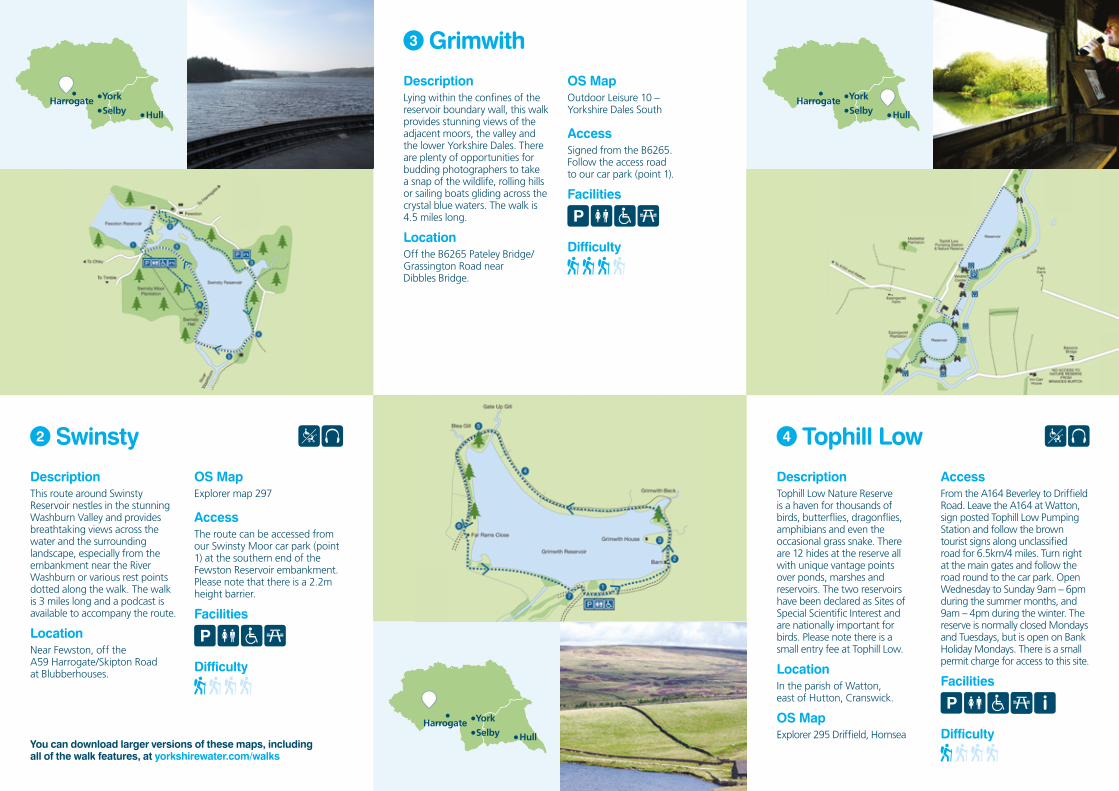
DescriptionLying within the confines of the reservoir boundary wall, this walk provides stunning views of the adjacent moors, the valley and the lower Yorkshire Dales. There are plenty of opportunities for budding photographers to take a snap of the wildlife, rolling hills or sailing boats gliding across the crystal blue waters. The walk is 4.5 miles long.
LocationOff the B6265 Pateley Bridge/Grassington Road near Dibbles Bridge.
OS MapOutdoor Leisure 10 – Yorkshire Dales South
AccessSigned from the B6265. Follow the access road to our car park (point 1).
Facilities
Difficulty
3 Grimwith
Harrogate York
Selby Hull
Harrogate York
Selby Hull
DescriptionTophill Low Nature Reserve is a haven for thousands of birds, butterflies, dragonflies, amphibians and even the occasional grass snake. There are 12 hides at the reserve all with unique vantage points over ponds, marshes and reservoirs. The two reservoirs have been declared as Sites of Special Scientific Interest and are nationally important for birds. Please note there is a small entry fee at Tophill Low.
LocationIn the parish of Watton, east of Hutton, Cranswick.
OS Map Explorer 295 Driffield, Hornsea
AccessFrom the A164 Beverley to Driffield Road. Leave the A164 at Watton, sign posted Tophill Low Pumping Station and follow the brown tourist signs along unclassified road for 6.5km/4 miles. Turn right at the main gates and follow the road round to the car park. Open Wednesday to Sunday 9am – 6pm during the summer months, and 9am – 4pm during the winter. The reserve is normally closed Mondays and Tuesdays, but is open on Bank Holiday Mondays. There is a small permit charge for access to this site.
Facilities
Difficulty
4 Tophill Low
You can download larger versions of these maps, including all of the walk features, at yorkshirewater.com/walks
2 Swinsty
DescriptionThis route around Swinsty Reservoir nestles in the stunning Washburn Valley and provides breathtaking views across the water and the surrounding landscape, especially from the embankment near the River Washburn or various rest points dotted along the walk. The walk is 3 miles long and a podcast is available to accompany the route.
LocationNear Fewston, off the A59 Harrogate/Skipton Road at Blubberhouses.
OS MapExplorer map 297
AccessThe route can be accessed from our Swinsty Moor car park (point 1) at the southern end of the Fewston Reservoir embankment. Please note that there is a 2.2m height barrier.
Facilities
Difficulty
Harrogate York
Selby Hull

You can download larger versions of these maps, including all of the walk features, at yorkshirewater.com/walks
DescriptionNear the market town of Skipton, on the outskirts of the village of Embsay this short circular walk around the Embsay Moor Reservoir gives wide views over the surrounding fields and moorland edge including Embsay Crag. The walk is 1 mile long.
LocationEmbsay Moor, 1 mile north of Skipton, North Yorkshire.
OS MapExplorer 290 York – Selby.
AccessAccess to the reservoir is via Pasture Road from the village of Embsay. This is the only road to the reservoir out of the village and it’s narrow, so be careful. From the village square (Elm Tree Square) turn off Main Street and onto Pasture Road by the Elm Tree Pub. Follow the road uphill into our car park at the reservoir (approximately 1 mile from the village).
Facilities
Difficulty
6 Embsay
Harrogate York
Selby Hull
DescriptionA more challenging walk, this route runs from the car park at Thruscross through woodland, rough pastures and moorland alongside the edge of the reservoir. The surrounding scenery is beautiful with an array of interesting geographical features including crags, ghylls, streams and the River Washburn. Some parts of the route are rocky and muddy so boots are recommended. Yorkshire writer Peter Robinson is renowned for lacing his work with Dales settings and our land and reservoirs have played a significant role in his stories, including In A Dry Season – a story inspired by the summer when the waters of Thruscross receded enough for the ruins of the sunken village of West End to emerge from the deep for the first time in decades.
LocationNorth of Blubberhouses which is situated on the A59 Harrogate/Skipton Road.
OS MapExplorer map 297
AccessFrom our car park at the western end of Thruscross Dam (point 1), where there is a 2.2 metre height barrier.
Facilities
Difficulty
5 Thruscross
Harrogate York
Selby Hull
To discover walks, cycle rides, easy access paths, places to go fishing or try watersports visit:yorkshirewater.com/walks