Engineering Analysis Of Slope Failure Of A Kaolin Quarry ...
8
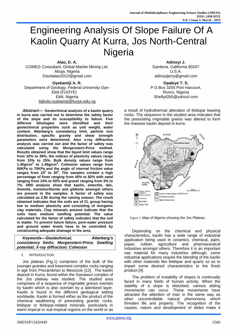
Journal of Multidisciplinary Engineering Science Studies (JMESS) ISSN: 2458-925X Vol. 5 Issue 3, March - 2019 www.jmess.org JMESSP13420449 2560 Engineering Analysis Of Slope Failure Of A Kaolin Quarry At Kurra, Jos North-Central Nigeria Alao, D. A. COMEG Consultant, Global Marble Mining Ltd. Abuja, Nigeria [email protected] Oyebamiji A. R. Department of Geology, Federal University Oye- Ekiti (FUOYE) Ekiti, Nigeria [email protected] Adinoyi J. Gardena, California 90247 U.S.A. [email protected] Opaleye T. S. P.O.Box 3255 Port Harcourt, Rivers, Nigeria [email protected] Abstract— Geotechnical analysis of a kaolin quarry in kurra was carried out to determine the safety factor of the slope and its susceptibility to failure. Five different lithologies were identified and their geotechnical properties such as unit weight, water content, Atterberg’s consistency limit, particle size distribution, specific gravity and shear strength parameters were determined. Also x-ray diffraction analysis was carried out and the factor of safety was calculated using the Morgenstern-Price method. Results obtained show that the liquid limit values range from 32% to 39%, the indices of plasticity values range from 15% to 25%. Bulk density values range from 1.40g/cm 3 to 1.49g/cm 3 . Cohesion values range from 60KPa to 70KPa and the angle of internal friction value ranges from 23 0 to 30 0 . The samples contain a high percentage of fines ranging from 45% to 82% with sand ranging from 14% to 50% and gravel ranging from 3% to 7%. XRD analysis show that kaolin, smectite, talc, ilmenite, montmorillonite and gibbsite amongst others are present in the samples. A factor of safety was calculated as 2.85 during the raining season. The result obtained indicates that the soils are of CL group having low to medium plasticity and consisting of inorganic clay materials. Clay minerals present indicate that the soils have medium swelling potential. The value calculated for the factor of safety indicates that the soil is stable. To prevent future failure, pore-water pressure and ground water levels have to be controlled by constructing adequate drainage in the area. Keywords—Geotechnical; Atterberg’s consistency limits; Morgenstern-Price; Swelling potential; X-ray diffraction; Cohesion I. INTRODUCTION Jos plateau (Fig.1) comprises of the bulk of the younger granites and basement complex rocks ranging in age from Precambrian to Mesozoic [12]. The kaolin deposit in Kurra, found within the Ganawuri complex of the Jos plateau was studied. The studied area comprises of a sequence of migmatite gneiss overlain by kaolin which is also overlain by a lateritized layer. Kaolin is found in the different geological setting worldwide. Kaolin is formed either as the product of the chemical weathering of preexisting granitic rocks, feldspar or feldspar-related minerals, particularly in warm tropical or sub-tropical regions on the world or as a result of hydrothermal alteration of feldspar bearing rocks. The sequence in the studied area indicates that the preexisting migmatite gneiss was altered to form the massive kaolin deposit in kurra. Figure 1: Map of Nigeria showing the Jos Plateau. Depending on the chemical and physical characteristics, kaolin has a wide range of industrial application being used in ceramics, chemical, paint, paper, rubber, agriculture and pharmaceutical industries amongst others. Therefore it is an important raw material for many industries although, some industrial applications require the blending of the kaolin with other materials like feldspar and quartz so as to impart some desired characteristics to the finish product [4]. The problem of instability of slopes is continually faced in many fields of human activity. When the stability of a slope is disturbed, various sliding movements can occur. These movements have attracted the attention of man in the same way as other uncontrollable natural phenomena which threaten life and property. The recognition of the causes, nature and development of slides make it
Transcript of Engineering Analysis Of Slope Failure Of A Kaolin Quarry ...
Journal of Multidisciplinary Engineering Science Studies (JMESS)
ISSN: 2458-925X
Vol. 5 Issue 3, March - 2019
www.jmess.org
JMESSP13420449 2560
Engineering Analysis Of Slope Failure Of A Kaolin Quarry At Kurra, Jos North-Central
Nigeria Alao, D. A.
COMEG Consultant, Global Marble Mining Ltd. Abuja, Nigeria
Oyebamiji A. R. Department of Geology, Federal University Oye-
Ekiti (FUOYE) Ekiti, Nigeria
Adinoyi J. Gardena, California 90247
U.S.A. [email protected]
Opaleye T. S. P.O.Box 3255 Port Harcourt,
Rivers, Nigeria [email protected]
Abstract— Geotechnical analysis of a kaolin quarry in kurra was carried out to determine the safety factor of the slope and its susceptibility to failure. Five different lithologies were identified and their geotechnical properties such as unit weight, water content, Atterberg’s consistency limit, particle size distribution, specific gravity and shear strength parameters were determined. Also x-ray diffraction analysis was carried out and the factor of safety was calculated using the Morgenstern-Price method. Results obtained show that the liquid limit values range from 32% to 39%, the indices of plasticity values range from 15% to 25%. Bulk density values range from 1.40g/cm
3 to 1.49g/cm
3. Cohesion values range from
60KPa to 70KPa and the angle of internal friction value ranges from 23
0 to 30
0. The samples contain a high
percentage of fines ranging from 45% to 82% with sand ranging from 14% to 50% and gravel ranging from 3% to 7%. XRD analysis show that kaolin, smectite, talc, ilmenite, montmorillonite and gibbsite amongst others are present in the samples. A factor of safety was calculated as 2.85 during the raining season. The result obtained indicates that the soils are of CL group having low to medium plasticity and consisting of inorganic clay materials. Clay minerals present indicate that the soils have medium swelling potential. The value calculated for the factor of safety indicates that the soil is stable. To prevent future failure, pore-water pressure and ground water levels have to be controlled by constructing adequate drainage in the area.
Keywords—Geotechnical; Atterberg’s consistency limits; Morgenstern-Price; Swelling potential; X-ray diffraction; Cohesion
I. INTRODUCTION
Jos plateau (Fig.1) comprises of the bulk of the younger granites and basement complex rocks ranging in age from Precambrian to Mesozoic [12]. The kaolin deposit in Kurra, found within the Ganawuri complex of the Jos plateau was studied. The studied area comprises of a sequence of migmatite gneiss overlain by kaolin which is also overlain by a lateritized layer. Kaolin is found in the different geological setting worldwide. Kaolin is formed either as the product of the chemical weathering of preexisting granitic rocks, feldspar or feldspar-related minerals, particularly in warm tropical or sub-tropical regions on the world or as
a result of hydrothermal alteration of feldspar bearing rocks. The sequence in the studied area indicates that the preexisting migmatite gneiss was altered to form the massive kaolin deposit in kurra.
Figure 1: Map of Nigeria showing the Jos Plateau.
Depending on the chemical and physical characteristics, kaolin has a wide range of industrial application being used in ceramics, chemical, paint, paper, rubber, agriculture and pharmaceutical industries amongst others. Therefore it is an important raw material for many industries although, some industrial applications require the blending of the kaolin with other materials like feldspar and quartz so as to impart some desired characteristics to the finish product [4].
The problem of instability of slopes is continually faced in many fields of human activity. When the stability of a slope is disturbed, various sliding movements can occur. These movements have attracted the attention of man in the same way as other uncontrollable natural phenomena which threaten life and property. The recognition of the causes, nature and development of slides make it
Journal of Multidisciplinary Engineering Science Studies (JMESS)
ISSN: 2458-925X
Vol. 5 Issue 3, March - 2019
www.jmess.org
JMESSP13420449 2561
possible to appreciate the extent of any danger and find an adequate solution to the control and correction of the problem. Stability analysis determines the conditions for which a proposed slope will remain stable. This stability is usually expressed in terms of factor of safety with the design of potential stability increasing as the value of the safety factor increases above unity [1].
In this study, engineering tests were carried out to determine soil properties such as moisture content, unit weight, shear strength parameters, Atterberg’s consistency limits and particle size distribution. Also, the mineralogical components of the soils are determined by X-ray diffraction analysis. All this aided in the calculation of the safety factor employing the Morgenstern-Price method of slices with the SLOPE/W Geostudio software.
II. METHODOLOGY
A. Geology
The Jos plateau is located between longitudes 80032’ and100038’E and latitude 80024’N. Its altitude ranges from 1200metres to 1829metres above sea level in the Shere hill range. This area has a near temperate climate with an average temperature of 180 and 220C and mean annual rainfall of 131.75mm in the south to146mm on the plateau. Longitudinal and latitudinal readings of the studied area are given as 008051’15E and 09029’18N. The elevation of the studied sequence is given as 1382metres high extending for about two hundred meters. The vertical thickness of the kaolin deposit is approximately thirty meters.
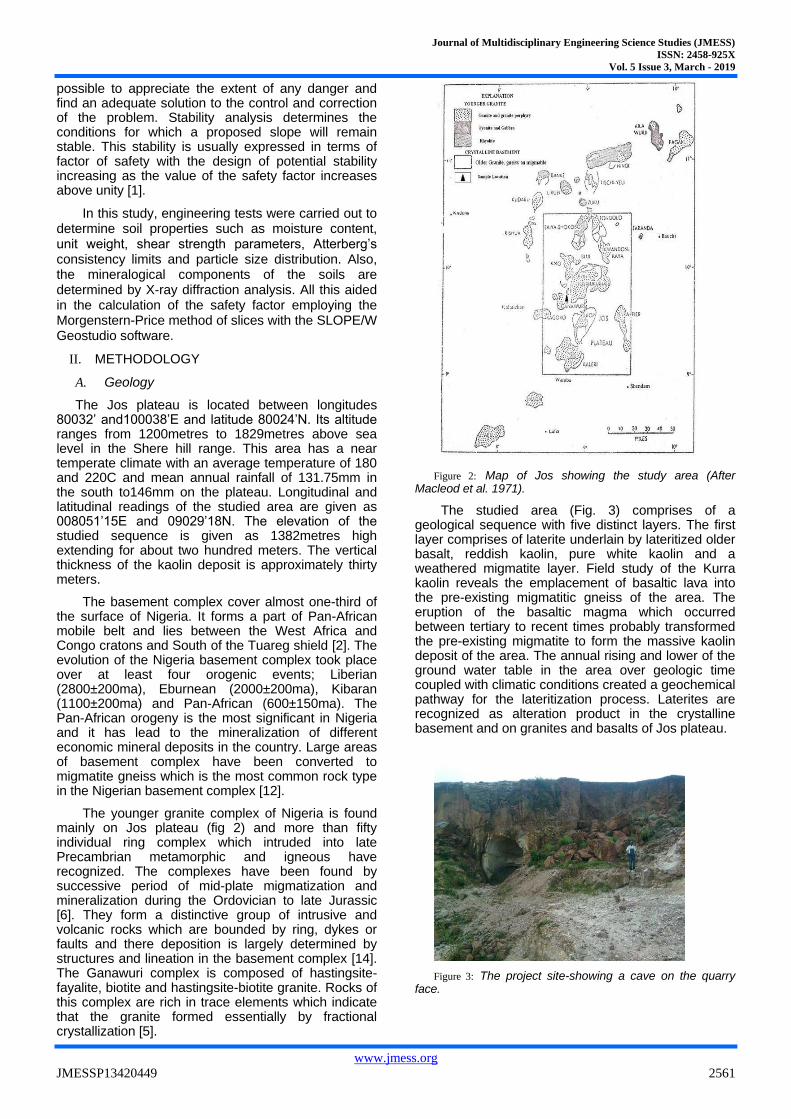
The basement complex cover almost one-third of the surface of Nigeria. It forms a part of Pan-African mobile belt and lies between the West Africa and Congo cratons and South of the Tuareg shield [2]. The evolution of the Nigeria basement complex took place over at least four orogenic events; Liberian (2800±200ma), Eburnean (2000±200ma), Kibaran (1100±200ma) and Pan-African (600±150ma). The Pan-African orogeny is the most significant in Nigeria and it has lead to the mineralization of different economic mineral deposits in the country. Large areas of basement complex have been converted to migmatite gneiss which is the most common rock type in the Nigerian basement complex [12].
The younger granite complex of Nigeria is found mainly on Jos plateau (fig 2) and more than fifty individual ring complex which intruded into late Precambrian metamorphic and igneous have recognized. The complexes have been found by successive period of mid-plate migmatization and mineralization during the Ordovician to late Jurassic [6]. They form a distinctive group of intrusive and volcanic rocks which are bounded by ring, dykes or faults and there deposition is largely determined by structures and lineation in the basement complex [14]. The Ganawuri complex is composed of hastingsite-fayalite, biotite and hastingsite-biotite granite. Rocks of this complex are rich in trace elements which indicate that the granite formed essentially by fractional crystallization [5].
Figure 2: Map of Jos showing the study area (After Macleod et al. 1971).
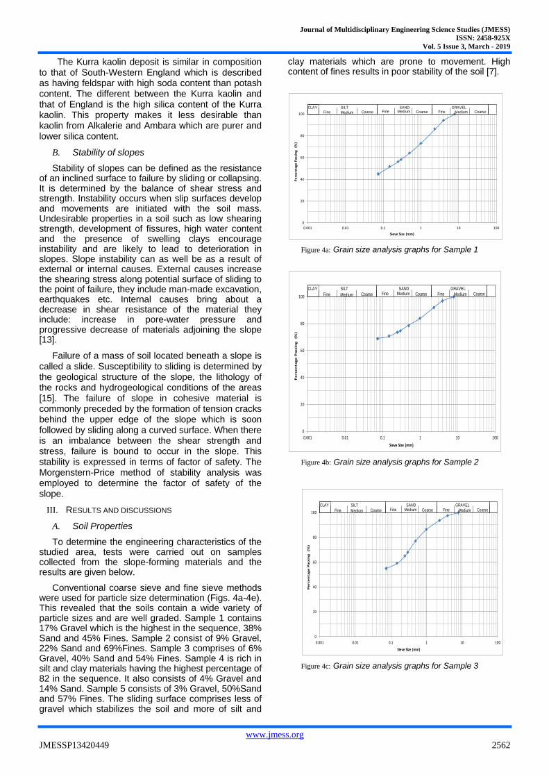
The studied area (Fig. 3) comprises of a geological sequence with five distinct layers. The first layer comprises of laterite underlain by lateritized older basalt, reddish kaolin, pure white kaolin and a weathered migmatite layer. Field study of the Kurra kaolin reveals the emplacement of basaltic lava into the pre-existing migmatitic gneiss of the area. The eruption of the basaltic magma which occurred between tertiary to recent times probably transformed the pre-existing migmatite to form the massive kaolin deposit of the area. The annual rising and lower of the ground water table in the area over geologic time coupled with climatic conditions created a geochemical pathway for the lateritization process. Laterites are recognized as alteration product in the crystalline basement and on granites and basalts of Jos plateau.
Figure 3: The project site-showing a cave on the quarry face.
Journal of Multidisciplinary Engineering Science Studies (JMESS)
ISSN: 2458-925X
Vol. 5 Issue 3, March - 2019
www.jmess.org
JMESSP13420449 2562
The Kurra kaolin deposit is similar in composition to that of South-Western England which is described as having feldspar with high soda content than potash content. The different between the Kurra kaolin and that of England is the high silica content of the Kurra kaolin. This property makes it less desirable than kaolin from Alkalerie and Ambara which are purer and lower silica content.
B. Stability of slopes
Stability of slopes can be defined as the resistance of an inclined surface to failure by sliding or collapsing. It is determined by the balance of shear stress and strength. Instability occurs when slip surfaces develop and movements are initiated with the soil mass. Undesirable properties in a soil such as low shearing strength, development of fissures, high water content and the presence of swelling clays encourage instability and are likely to lead to deterioration in slopes. Slope instability can as well be as a result of external or internal causes. External causes increase the shearing stress along potential surface of sliding to the point of failure, they include man-made excavation, earthquakes etc. Internal causes bring about a decrease in shear resistance of the material they include: increase in pore-water pressure and progressive decrease of materials adjoining the slope [13].
Failure of a mass of soil located beneath a slope is called a slide. Susceptibility to sliding is determined by the geological structure of the slope, the lithology of the rocks and hydrogeological conditions of the areas [15]. The failure of slope in cohesive material is commonly preceded by the formation of tension cracks behind the upper edge of the slope which is soon followed by sliding along a curved surface. When there is an imbalance between the shear strength and stress, failure is bound to occur in the slope. This stability is expressed in terms of factor of safety. The Morgenstern-Price method of stability analysis was employed to determine the factor of safety of the slope.
III. RESULTS AND DISCUSSIONS
A. Soil Properties
To determine the engineering characteristics of the studied area, tests were carried out on samples collected from the slope-forming materials and the results are given below.
Conventional coarse sieve and fine sieve methods were used for particle size determination (Figs. 4a-4e). This revealed that the soils contain a wide variety of particle sizes and are well graded. Sample 1 contains 17% Gravel which is the highest in the sequence, 38% Sand and 45% Fines. Sample 2 consist of 9% Gravel, 22% Sand and 69%Fines. Sample 3 comprises of 6% Gravel, 40% Sand and 54% Fines. Sample 4 is rich in silt and clay materials having the highest percentage of 82 in the sequence. It also consists of 4% Gravel and 14% Sand. Sample 5 consists of 3% Gravel, 50%Sand and 57% Fines. The sliding surface comprises less of gravel which stabilizes the soil and more of silt and
clay materials which are prone to movement. High content of fines results in poor stability of the soil [7].
Figure 4a: Grain size analysis graphs for Sample 1
Figure 4b: Grain size analysis graphs for Sample 2
Figure 4c: Grain size analysis graphs for Sample 3
0
20
40
60
80
100
0.001 0.01 0.1 1 10 100
Pe
rce
nta
ge P
assi
ng
(%
)
Sieve Size (mm)
CLAY
Fine Medium Coarse Fine Medium Coarse Fine Medium Coarse SILT SAND GRAVEL
0
20
40
60
80
100
0.001 0.01 0.1 1 10 100
Pe
rce
nta
ge
Pa
ssin
g (
%)
Sieve Size (mm)
CLAY
Fine Medium Coarse Fine Medium Coarse Fine Medium Coarse SILT SAND GRAVEL
0
20
40
60
80
100
0.001 0.01 0.1 1 10 100
Pe
rce
nta
ge
Pa
ssin
g
(%)
Sieve Size (mm)
CLAY
Fine Medium Coarse Fine Medium Coarse Fine Medium Coarse SILT SAND GRAVEL

Journal of Multidisciplinary Engineering Science Studies (JMESS)
ISSN: 2458-925X
Vol. 5 Issue 3, March - 2019
www.jmess.org
JMESSP13420449 2563
Figure 4d: Grain size analysis graphs for Sample 4
Figure 4e: Grain size analysis graphs for Sample 5
Moisture content of the soils range from 2.9% to 5.6% with an average value of 4.2%. The layer consisting of pure white kaolin, records the lowest moisture content value. Bulk density value ranges from 1.40g/cm3 to 1.49g/cm3 with an average of 1.46g/cm3. The dry density value ranges from 1.36g/cm3 to 1.42g/cm3 with a mean value of 1.39g/cm3. The specific gravity of particles in the material is approximately 2.55. The low value indicate that the soil consist of inorganic clay materials.
TABLE 1: GEOTECHNICAL PARAMETERS OF THE SLOPE-FORMING
MATERIALS
Parameters LAYER 1
LAYER 2
LAYER 3
LAYER 4
LAYER 5
Liquid limit %
33.0 37.0 34.0 39.0 32.0
Plastic limit %
14.7 18.11 13.63 17.6 15.24
Plasticity index %
18.3 18.9 20.4 21.4 16.76
Angle of internal friction °
23 24 26 28 30
Cohesion KPa
60 65 62 70 70
Unit weight KN
13.73 13.64 13.93 13.34 13.83
The soils are of medium plasticity, having plasticity indices ranging from 15 to 20 [3]. On the plasticity chart, the soil falls above the “A” line in the CL group. This group consists of inorganic clays of low to medium plasticity which are practically impervious with fair shearing strength and compressibility when compacted and saturated [8].
Figure 5: Soil classification chart for the samples
The plasticity index can also be related to the swelling potential of the soil.
TABLE II. RELATIONSHIP BETWEEN PLASTICITY INDEX AND SWELLING
POTENTIAL [11].
Plasticity Index Swelling Potential
0 -15 Low
15 – 25 Medium
25 – 35 High
Greater than 35 Very high
0
20
40
60
80
100
0.001 0.01 0.1 1 10 100
Pe
rce
nta
ge
Pa
ssin
g
(%)
Sieve Size (mm)
CLAY
Fine Medium Coarse Fine Medium Coarse Fine Medium Coarse SILT SAND GRAVEL
0
20
40
60
80
100
0.001 0.01 0.1 1 10 100
Pe
rce
nta
ge
Pa
ssin
g
(%)
Sieve Size (mm)
CLAY
Fine Medium Coarse Fine Medium Coarse Fine Medium Coarse SILT SAND GRAVEL

Journal of Multidisciplinary Engineering Science Studies (JMESS)
ISSN: 2458-925X
Vol. 5 Issue 3, March - 2019
www.jmess.org
JMESSP13420449 2564
The shear box test (Figs. 6a-6e) reveals that the soils are of high strength having cohesion values ranging from 60KPa to 70KPa with an average of 65KPa. Also the angle of internal friction (Figs. 7a-7e) ranges from 23
0 to 30
0 with a mean of 26
0. These
values indicate that the soil have high bearing capacity as a result of its high cohesion and angle of internal friction values.
Figure 6a: Graph of shear stress vs. shear strain for the sample 1.
Figure 6b: Graph of shear stress vs. shear strain for the sample 2.
Figure 6c: Graph of shear stress vs. shear strain for the sample 3.
Figure 6d: Graph of shear stress vs. shear strain for the sample 4.

Journal of Multidisciplinary Engineering Science Studies (JMESS)
ISSN: 2458-925X
Vol. 5 Issue 3, March - 2019
www.jmess.org
JMESSP13420449 2565
Figure 6e: Graph of shear stress vs. shear strain for the sample 5.
Figure 7a: Graph of shear stress vs. normal stress for the sample 1
Figure 7b: Graph of shear stress vs. normal stress for the sample 2
Figure 7c: Graph of shear stress vs. normal stress for the sample 3
Figure 7d: Graph of shear stress vs. normal stress for the sample 4
Figure 7e: Graph of shear stress vs. normal stress for the sample 5
X-ray diffraction analysis show predominantly kaolinite, chlorite, vermiculite, illite and considerable amount of talc. Also tridymite, montmorillonite, geothite, ilmenite, gibbsite, hematite and rutile are present in the samples. The present minerals indicate

Journal of Multidisciplinary Engineering Science Studies (JMESS)
ISSN: 2458-925X
Vol. 5 Issue 3, March - 2019
www.jmess.org
JMESSP13420449 2566
that the tested soils have moderate swelling potential and considerable iron content [10].
B. Slope Stability Analysis
Results obtained from engineering tests carried out were used to determine the stability of the slope by employing the Morgenstern-Price method of slices. Based on field observation at the slide area, the mode of failure has been categorized as a rotational slide. A number of slide circles (Fig. 8) were investigated in order to find the lowest critical slip surface which is the surface that gives the lowest factor of safety value. The lowest value yielded is given as 2.85 while the highest value is 4.45. Fig. 9 displays the region that is more stable for mining to be carried out.
Figure 8: Critical Slip with Alternate slip surfaces
Figure 9: Safety Map showing area safe for mining operation in red.
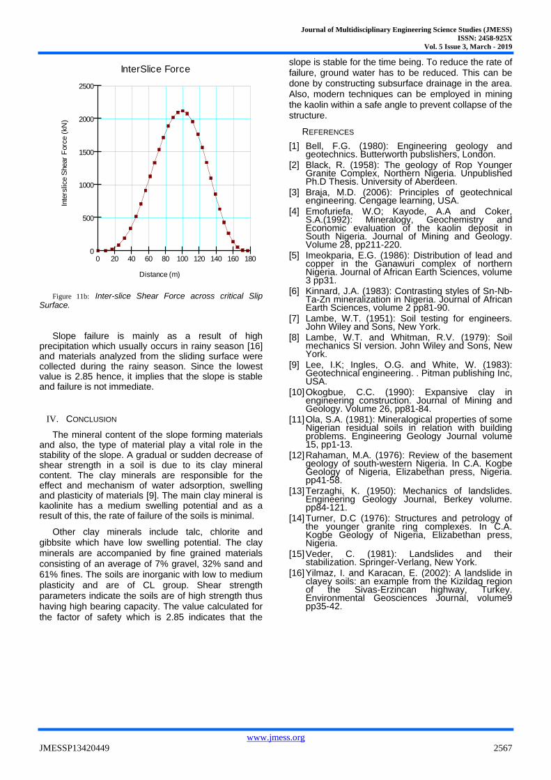
Rainfall and a rise in piezometric surface drive an increase in pore-water pressure. The variation in pore-water pressure along the slip surface (Fig. 10) was determined from the piezometric level showing a change from negative to positive pore pressure. Under negative pore-water pressure conditions, the shear strength does not change at the same rate as for positive pore-water pressure [15]. The inter-slice normal and shear forces (Figs. 11a and 11b respectively) vary across the slip surface as a result of the difference in the mass of each slide, the piezometric water level and percolating water.
Figure 10: Pore-Water Pressure across the Critical Slip Surface
Figure 11a: Inter-slice Normal Force across critical Slip Surface
Pore Water
Por
e-W
ater
Pre
ssur
e (k
Pa)
Distance (m)
-100
-200
-300
-400
0
100
0 20 40 60 80 100 120 140 160 180
InterSlice Force
Inte
rslice N
orm
al F
orc
e (
kN
)
Distance (m)
0
1000
2000
3000
4000
5000
6000
7000
0 20 40 60 80 100 120 140 160 180
Journal of Multidisciplinary Engineering Science Studies (JMESS)
ISSN: 2458-925X
Vol. 5 Issue 3, March - 2019
www.jmess.org
JMESSP13420449 2567
Figure 11b: Inter-slice Shear Force across critical Slip Surface.
Slope failure is mainly as a result of high precipitation which usually occurs in rainy season [16] and materials analyzed from the sliding surface were collected during the rainy season. Since the lowest value is 2.85 hence, it implies that the slope is stable and failure is not immediate.
IV. CONCLUSION
The mineral content of the slope forming materials and also, the type of material play a vital role in the stability of the slope. A gradual or sudden decrease of shear strength in a soil is due to its clay mineral content. The clay minerals are responsible for the effect and mechanism of water adsorption, swelling and plasticity of materials [9]. The main clay mineral is kaolinite has a medium swelling potential and as a result of this, the rate of failure of the soils is minimal.
Other clay minerals include talc, chlorite and gibbsite which have low swelling potential. The clay minerals are accompanied by fine grained materials consisting of an average of 7% gravel, 32% sand and 61% fines. The soils are inorganic with low to medium plasticity and are of CL group. Shear strength parameters indicate the soils are of high strength thus having high bearing capacity. The value calculated for the factor of safety which is 2.85 indicates that the
slope is stable for the time being. To reduce the rate of failure, ground water has to be reduced. This can be done by constructing subsurface drainage in the area. Also, modern techniques can be employed in mining the kaolin within a safe angle to prevent collapse of the structure.
REFERENCES
[1] Bell, F.G. (1980): Engineering geology and geotechnics. Butterworth pubslishers, London.
[2] Black, R. (1958): The geology of Rop Younger Granite Complex, Northern Nigeria. Unpublished Ph.D Thesis. University of Aberdeen.
[3] Braja, M.D. (2006): Principles of geotechnical engineering. Cengage learning, USA.
[4] Emofuriefa, W.O; Kayode, A.A and Coker, S.A.(1992): Mineralogy, Geochemistry and Economic evaluation of the kaolin deposit in South Nigeria. Journal of Mining and Geology. Volume 28, pp211-220.
[5] Imeokparia, E.G. (1986): Distribution of lead and copper in the Ganawuri complex of northern Nigeria. Journal of African Earth Sciences, volume 3 pp31.
[6] Kinnard, J.A. (1983): Contrasting styles of Sn-Nb-Ta-Zn mineralization in Nigeria. Journal of African Earth Sciences, volume 2 pp81-90.
[7] Lambe, W.T. (1951): Soil testing for engineers. John Wiley and Sons, New York.
[8] Lambe, W.T. and Whitman, R.V. (1979): Soil mechanics SI version. John Wiley and Sons, New York.
[9] Lee, I.K; Ingles, O.G. and White, W. (1983): Geotechnical engineering. . Pitman publishing Inc, USA.
[10] Okogbue, C.C. (1990): Expansive clay in engineering construction. Journal of Mining and Geology. Volume 26, pp81-84.
[11] Ola, S.A. (1981): Mineralogical properties of some Nigerian residual soils in relation with building problems. Engineering Geology Journal volume 15, pp1-13.
[12] Rahaman, M.A. (1976): Review of the basement geology of south-western Nigeria. In C.A. Kogbe Geology of Nigeria, Elizabethan press, Nigeria. pp41-58.
[13] Terzaghi, K. (1950): Mechanics of landslides. Engineering Geology Journal, Berkey volume. pp84-121.
[14] Turner, D.C (1976): Structures and petrology of the younger granite ring complexes. In C.A. Kogbe Geology of Nigeria, Elizabethan press, Nigeria.
[15] Veder, C. (1981): Landslides and their stabilization. Springer-Verlang, New York.
[16] Yilmaz, I. and Karacan, E. (2002): A landslide in clayey soils: an example from the Kizildag region of the Sivas-Erzincan highway, Turkey. Environmental Geosciences Journal, volume9 pp35-42.
InterSlice ForceIn
ters
lice S
hear
Forc
e (
kN
)
Distance (m)
0
500
1000
1500
2000
2500
0 20 40 60 80 100 120 140 160 180