ENDANGERED TRAILS 2008 - Washington Trails Association · Water: Treat all water with iodine...
34
1 ENDANGERED TRAILS 2008 A Publication of the Washington Trails Association
Transcript of ENDANGERED TRAILS 2008 - Washington Trails Association · Water: Treat all water with iodine...

1
ENDANGERED TRAILS 2008
A Publication of the Washington Trails Association
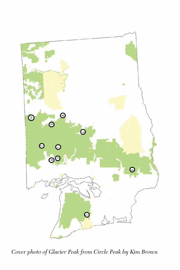
Cover photo of Glacier Peak from Circle Peak by Kim Brown
81
2
3
5
4
6
10
9
7

Table of Contents
About Washington Trails Association .................................4Introduction .........................................................................5Before You Hit the Trail ......................................................6Leave No Trace 101 ............................................................7
The Hikes1. Circle Peak-Crystal Lake .......................................... 8-92. Icicle Gorge Loop ................................................. 10-11 3. Headlee Pass ......................................................... 12-13 4. Gee Point ............................................................... 14-15 5. Colonel Bob ........................................................... 16-17 6. Loowit Trail ........................................................... 18-19 7. Middle and South Fork Cascade River ................ 20-21 8. Miners Ridge ......................................................... 22-23 9. Foggy Dew Ridge .................................................. 24-25 10. Boundary Trail ....................................................... 26-27
Acknowledgements ...........................................................28Where are They Now? ......................................................29Speaking Out for Washington Hikers ...............................30Volunteer Trail Maintenance ............................................31Important Contacts ...........................................................32

4
About Washington Trails AssociationWashington Trails Association (WTA) is the voice for hikers in Washington state. We advocate protection of hiking trails and wildlands, take volunteers out to maintain trails, and promote hiking as a healthy, fun way to explore the outdoors.
Washington Trails Association was founded by Louise B. Marshall. Ira Spring was its primary supporter. Greg Ball founded the volunteer trail maintenance program. Their spirit continues today through contributions from thousands of WTA members and volunteers.
WTA is now the largest state-based hiker advocacy organization in the country, with over 7,000 members and more than 2,100 volunteers.
Maintaining Washington’s TrailsIn the past decade, WTA has conducted more than 600,000 hours of volunteer maintenance on public lands in Washington. That’s an in-kind donation of more than $6 million to parks and forests statewide. Fun trail work parties let volunteers give back to the trails they love.
Advocating for Hiking TrailsWTA protects trails through lobbying and grassroots advocacy on issues that impact hikers, like trail funding and wilderness protection. We work closely with federal and state policymakers to advance hikers’ interests in forest planning and new recreation projects. We engage hikers in trail protection through our trail reports, potlucks with forest service personnel, and email advocacy network.
Getting People OutdoorsWTA promotes hiking as a fun, healthy way to explore Washington. Events like TrailsFest (www.trailsfest.org) and our Wildland Discovery Hikes series offer an enjoyable and safe environment for families and urban dwellers to explore the outdoors. Washington Trails magazine is packed with backcountry advocacy opportunities, gear reviews, hiking tips, and feature stories. Our website, www.wta.org, is a dynamic and interactive resource for hikers to stay informed on the latest trail conditions and backcountry news.
You can help Washington Trails Association protect and maintain your hiking trails by becoming a member today. Join online at www.wta.org.

5
IntroductionThank you for your interest in the 2008 Endangered Trails Guide. In this year’s guide, you’ll find lovely rainforest trails, high country routes through granite and heather and little known short hikes into places rarely visited by hikers. We hope that you’ll have a chance to hike all of them soon. But if you want to do so, some action is in order. Many of these trails need more than a little work.
Last January, when the Bush Administration released its annual budget rec-ommendation to Congress, we were shocked. The administration requested a 35% cut in Forest Service trail maintenance operations. Washington hikers know that razoring the Forest Service budget so sharply is a recipe for disaster on trails already stressed by a series of winter storms and eastern fires. Trail maintenance costs money, and as we have seen, when we neglect our national forest trails and roads, they lash back by slumping, growing over, sliding down hillsides and washing out.
Volunteers can only do so much in a situation like this one. Last year, when heavy rains washed out major roads and trails in Mount Rainier National Park, it took an unprecedented and heroic effort on the part of many to get the park back in shape for visitors. Park service employees worked around the clock repairing damage. Supporters in Congress made money available immediately. With these important pieces in place, a coalition of nonprofit groups including Washington Trails Association, Student Conservation Association, National Parks and Conservation Association and The Mountaineers was able to then come in and field some 1,700 volunteers over the course of the summer. We got an awful lot of work done.
Imagine if the same momentum could be applied across the state. It would take money and agency staff. However, the administration-proposed cuts would mean the loss of 1,200 staff positions on forest service lands nationally. We’re talking about line officers, trail staff, recreation planners and trail maintenance crews. This is the backbone staff that WTA and all hikers rely on to manage our trails from day to day and to support volunteer programs like WTA’s.
Fortunately, Washington’s Congressional delegation cares about trails, as they’ve proven with their efforts to recover Mount Rainier National Park and the Pacific Crest Trail. In this guide, you’ll find numerous pleas to contact your member of Congress, or the member in whose district a trail runs. Please do so, but make sure you first thank them for the work they’ve done to date. We need their continued support to restore parks and forests across Washington.
Enjoy hiking this summer. We hope that when we see you next on the trail we can congratulate each other on work well done to preserve trails and wildlands.

6
Before You Hit the Trail
As always, you should exercise caution when exploring the backcountry. Neither the outing descriptions nor the maps contained in this guide should be considered definitive. Please contact the land management agencies cited in the guide for complete and up-to-date information, trail conditions, road quality, etc. The maps provided are for reference only. WTA’s trail damage database is a great resource for finding the status of your desired hike. Go to www.wta.org/traildamage.
Before you leave for any hike, no matter how short or simple it seems, stock your pack with the Ten Essentials:
Extra Clothing: Prepare for the worst possible climatic conditionsby packing insulating layers and wind and rain protection.Extra Food: Take more food than you think you’ll need, so that if you’re stuck out overnight, your supplies will see you through.Knife: Good for first aid or cutting wood.Firestarter: Candle or chemical fuel for lighting wet wood.First-Aid Kit: At a minimum, take Band-aids, aspirin and disinfectant.Matches: Keep them dry with a plastic bag or other waterproof container.Flashlight: In case you’re unexpectedly on the trail after dark, pack an extra bulb and batteries.Map: Green Trails, TOPO! or USGS Topographical maps are acceptable. The maps in this book are not.Compass: Know how to at least find north.Sunglasses: They will protect your eyes on sunny days or when you encounter snow.

7
Leave No Trace 101
Since the 1970s, the sport of backpacking has boomed. Hikers streamed onto trails all over the country to find quiet and a connection with nature. All that use has had its impacts. People who have been hiking for decades lament the loss of microbe-free mountain water, and government agencies responsible for our wild places have had to limit access to areas like the Enchantments and the Seven Lakes Basin because of environmental damage. For all these reasons and more, it is important to practice leave-no-trace (LNT) principles no matter where you hike.
Water: Treat all water with iodine tablets or use a mechanical water purifier. Parasites such as giardia, found in backcountry water worldwide, can cause serious illness. Camp, cook, and wash dishes at least 100 feet from lakes and streams. Only use soap for personal sanitation—when washing dishes, warm water is usually sufficient.
Campsites: Take care to camp in areas that have seen previous heavy use. Pristine campsites should stay that way. Lightly used ones should be allowed to rebound. High country plants take decades to grow; don’t camp on them. Instead, look for bare rock.
Wildlife: Animals are attracted by food smells; prepare meals at least 100 feet from camp, downwind. Either hang all food 12 feet up in a tree, 12 feet from the trunk, or use a bear-resistant container, such as Garcia Machine’s product.
Waste: Urine is sterile—but salty! In the mountains, pee on rocks rather than heather to protect plants from salt-loving mountain goats. Bury solid human waste in holes six inches deep. Tampons should be packed out in a double-sealed ziploc bag. Hang the bag as you would hang your food, as the blood smell can attract smaller animals.
Demeanor: Except during hunting season, choose earth-toned gear, so that you blend in with your surroundings. Respect others’ need for quiet; don’t make excess noise. If you must bring your cell phone, please keep it turned off, unless it is needed for an emergency. When in the wilderness, don’t camp too close to other hikers—one reason we go into the woods is to enjoy the expansive solitude of the outdoors.
8
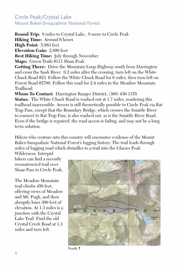
Circle Peak/Crystal LakeMount Baker-Snoqualmie National Forest
Round Trip: 8 miles to Crystal Lake, 8 more to Circle PeakHiking Time: Around 6 hoursHigh Point: 5,983 feetElevation Gain: 2,800 feetBest Hiking Time: July through NovemberMaps: Green Trails #111 Sloan PeakGetting There: Drive the Mountain Loop Highway south from Darrington and cross the Sauk River. 0.2 miles after the crossing, turn left on the White Chuck Road #23. Follow the White Chuck Road for 6 miles, then turn left on Forest Road #2700. Follow this road for 2.4 miles to the Meadow Mountain Trailhead. Whom To Contact: Darrington Ranger District, (360) 436-1155Status: The White Chuck Road is washed out at 1.7 miles, rendering this trailhead inaccessible. Access is still theoretically possible to Circle Peak via Rat Trap Pass, except that the Boundary Bridge, which crosses the Suiattle River to connect to Rat Trap Pass, is also washed out, as is the Suiattle River Road. Even if the bridge is repaired, the road access is failing, and may not be a long term solution. Hikers who venture into this country will encounter evidence of the Mount Baker-Snoqualmie National Forest’s logging history. The trail leads through miles of logging road which dwindles to a trail into the Glacier Peak Wilderness. Intrepid hikers can find a recently reconstructed trail over Skaar Pass to Circle Peak.
The Meadow Mountain trail climbs 450 feet, offering views of Meadow and Mt. Pugh, and then abruptly loses 300 feet of elevation. At 1.3 miles is a junction with the Crystal Lake Trail. Find the old Crystal Creek Road at 1.3 miles and turn left.
North

9North
Far-Reaching Decisions Affect a Threatened TrailWe highlighted this trail in 2002 in our very first Endangered Trails Guide. At the time, we were concerned about the fact that the trail was poorly located on old logging roads, was difficult to find, and was falling apart. The Forest Service got significant Capital Improvement Project (CIP) funding to repair this trail, and has apparently made much progress. Unfortunately, the October 2003 storms caused five road washouts along the White Chuck, two of them enormous.
The Mount Baker-Snoqualmie is analyzing what they want to do with the White Chuck Road in the long term. We note with concern that the road sticks a finger into the Glacier Peak Wilderness. That said, it is possible to repair the road to allow access to the Circle Peak/Crystal Lake trail complex without reopening the road all the way into the Wilderness. If you would like to comment on this project, please send them to [email protected]. While the initial comment period of this project will be over by the time you read this, the Darrington Ranger District will be releasing an Environmental Assessment with an additional comment period later.
Circle Peak has seen several seasons of steady work by the Forest Service, but with access cut off, hikers cannot benefit. Photo by Kim Brown.
The road continues climbing and passes a nice campsite. The trail enters an old clear cut at 3.5 miles from the trailhead and deteriorates further. At the east end of the clearcut, the trail ascends 500 feet along an old fireline. The trail levels off and enters the Glacier Peak Wilderness and ends at the untouched forest on the shore of Crystal Lake. To find the currently unsigned trail from Crystal Lake to Circle Peak go straight up-hill at the Glacier Peak Wilderness sign 0.25 mile west of Crystal Lake. You will come across the trail within 200 yards. You can follow the trail for approximately four miles to an old lookout site at the summit of Circle Peak. The trail contours for about one mile before dropping about 300 feet to Skaar Pass, crossing into the Circle Creek drainage and climbing for about 1.5 miles to reach the first of several meadows. Follow switchbacks up through forest and meadow another 1.75 miles to the summit ridge of Circle Peak. Don’t bother scrambling the final 200 yards, as the trail is sketchy and somewhat dangerous. Do linger below the lookout, soaking in views that include White Chuck, Glacier, Sloan and Pugh.
10
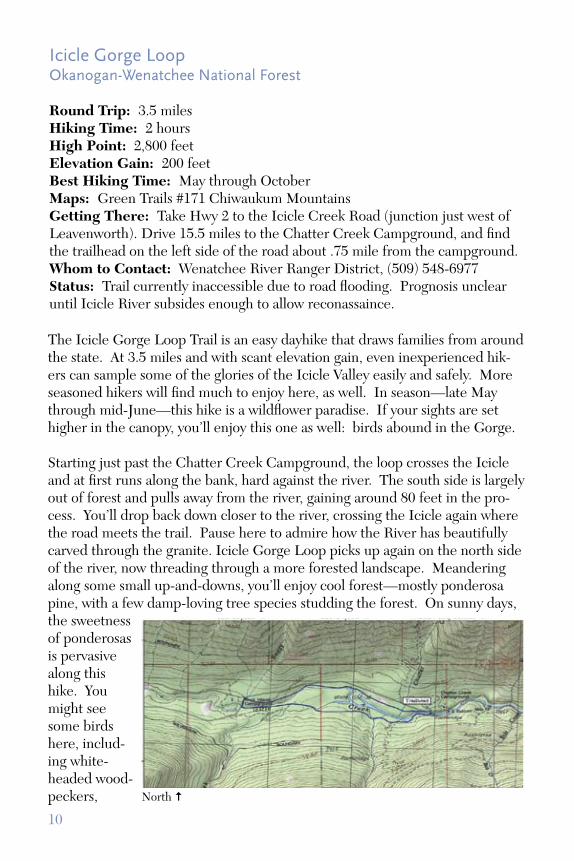
Icicle Gorge LoopOkanogan-Wenatchee National Forest
Round Trip: 3.5 milesHiking Time: 2 hoursHigh Point: 2,800 feetElevation Gain: 200 feetBest Hiking Time: May through OctoberMaps: Green Trails #171 Chiwaukum MountainsGetting There: Take Hwy 2 to the Icicle Creek Road (junction just west of Leavenworth). Drive 15.5 miles to the Chatter Creek Campground, and find the trailhead on the left side of the road about .75 mile from the campground.Whom to Contact: Wenatchee River Ranger District, (509) 548-6977Status: Trail currently inaccessible due to road flooding. Prognosis unclear until Icicle River subsides enough to allow reconassaince.
North
The Icicle Gorge Loop Trail is an easy dayhike that draws families from around the state. At 3.5 miles and with scant elevation gain, even inexperienced hik-ers can sample some of the glories of the Icicle Valley easily and safely. More seasoned hikers will find much to enjoy here, as well. In season—late May through mid-June—this hike is a wildflower paradise. If your sights are set higher in the canopy, you’ll enjoy this one as well: birds abound in the Gorge.
Starting just past the Chatter Creek Campground, the loop crosses the Icicle and at first runs along the bank, hard against the river. The south side is largely out of forest and pulls away from the river, gaining around 80 feet in the pro-cess. You’ll drop back down closer to the river, crossing the Icicle again where the road meets the trail. Pause here to admire how the River has beautifully carved through the granite. Icicle Gorge Loop picks up again on the north side of the river, now threading through a more forested landscape. Meandering along some small up-and-downs, you’ll enjoy cool forest—mostly ponderosa pine, with a few damp-loving tree species studding the forest. On sunny days, the sweetness of ponderosas is pervasive along this hike. You might see some birds here, includ-ing white-headed wood-peckers,

11
Icicle Creek flows through a gorge rimmed by peaks and cliffs. Large amounts of meltwater have flooded the road, rendering it impassable for the near term. Photo by Tom Lynch.
A Classic Entry to the Alpine Lakes, DamagedIn mid-May of this year, spiking temperatures collided with heavy snow pack to cause a massive snow and debris slide in the upper reaches of the Icicle River. Enormous boulders and other debris washed into the river, raising already swollen river levels even higher and flooding the Icicle River Road at the Ida Creek Campground. The flooding renders the Icicle Gorge Loop, Chatter Creek and Icicle Creek trails—along with many others—inac-cessible at least until waters fall in late June.
At this point, it is too early to gauge the extent of the damage to the Icicle Road. We hope it won’t be too extensive, but we have grave concerns about the road being underwater for such an extended period of time. We’re also concerned about what might be under those high waters. While we’re not certain, we’re able to make a well-educated deduction that the road sus-tained significant damage and might be closed for at least a season.
The Icicle River Road carries 500,000 visitors to campgrounds along the river and trails into the Alpine Lakes Wilderness each year. It is one of the premiere entry points to the Wilderness, so it is very likely that the Okano-gan-Wenatchee will expedite repairs to this road, if at all possible. But each time an agency has to repair a road like this, it represents a lost oppor-tunity to work elsewhere. For financially-strapped ranger districts, severe flood and weather events only make it harder to do the day-to-day work needed to maintain other opportunities on national forest lands. With ap-propriate budgeting from Congress, these events could become hiccups—challenging hiccups, but not the kind that force gut-wrenching decisions about what to leave behind. That’s why we’d like you to call Congressman Doc Hastings and urge him to work with Congressman Dicks to make sure our National Forest lands are properly funded.
lazuli buntings and Cassin’s finches.
Wildflower lovers on both sides of the river can revel in lupine, sal-monberry, tiger lily and columbine, among many, many others. Fi-nally, this is a great hike for children. There’s a lot to enjoy at ground level, and it is easy and short.

12
Headlee PassMount Baker-Snoqualmie National Forest
Round Trip: 7 milesHiking Time: 5 hours High Point: 4,950 feetElevation Gain: 2,600 feetBest Hiking Time: August through OctoberMaps: Green Trails #111 Sloan PeakGetting There: From Granite Falls, take the Mountain Loop Highway east for 29 miles. About 3 miles past the Big Four Picnic Area, turn right onto FR 4065. Continue for 2.3 miles to the road end and trailhead. Whom to Contact: Darrington Ranger District, (360) 436-1155Status: Trail easy to lose in the lower reaches. Trail can be dangerous due to falling rocks in the higher-elevation chute to the Pass.
Tracing steep switchbacks up through rocky, loose soil toward a high notch—namesake Headlee Pass—this trail offers a quick-but-not-easy excursion into the stony redoubt of picas, marmots and mountain goats. To get there, you’ll traverse some rough tread and enjoy a relatively easy stream crossing. As you pick your way up, you’ll encounter rougher country.
Starting out from the trailhead, you’ll head through second-growth forest dotted with the ghostly stumps of old cedars and Douglas firs among the newer growth. The trail is rooty and often in shadow, so watch for slick twists in the tread. In .5 mile, you’ll cross the South Fork Stillaguamish, which thunders along through a narrow slot. This is the toughest crossing of the day, but only one of many.
Breaking out of forest, the route continues through a rocky slope splashed with huckleberry fields and brush, the rank thickness of which means you must choose your steps carefully. This is tremendously pretty country, though, rocky and scenic with an enormous gully washed out by landslides. Morningstar Peak looms over this clearing.
North

13North
Staggering Views, Deteriorating TreadThe Headlee Pass trail starts on forest service land and enters Department of Natural Resources (DNR) country as it begins to head up into the rocky slot. Hikers here have an opportunity to venture quickly into some of the state’s finest high country. While the trail is slippery and rocky in the chute, the solvable problems are at the lower elevations. Hairy stream crossings combined with a trail that appears and disappears among brush and granite make this one of the more challenging hikes in the Darrington District.
As is too often the case, the Mount Baker-Snoqualmie National Forest and Department of Natural Resources do not have the funds needed to repair or relocate this trail. As it is, even when it is not dangerous, it is hard to follow. That’s why we’re urging people to contact their senators and Congressman Rick Larsen, prevailing upon them to work to preserve this trail and others in the 2nd Congressional District. With its proximity to Seattle, the Darrington Ranger District serves a great many hikers, and the recreation resource it provides to the Puget Sound region needs to be protected and maintained.
Magnificent high country scenery is your reward on the very challeng-ing Headlee Pass Trail. While it will always be challenging, work in the lower reaches will make it more hike-able. Photo by Paul Bestock.
Shortly, the trail starts tacking upward into a steep gully under Headlee Pass. The tread is undershot with rocks and loose with pumice. Be certain to call out if you dislodge a rock as those hiking below you could be endangered. Turning even more steeply upward into a tight chute, the trail travels another .25 mile, finally reaching Headlee Pass at 2.7 miles, 4,600 feet. While this is the pass, it’s not the end. Drop a little past the pass, and traverse a huge scree slope. Soon, you’ll see the outlet stream of Vesper Lake, and if you boulder hop into the basin, you’ll soon come to a tiny blue gem surrounded by heather and granite. Relax here and enjoy lunch by the breezy lake, listening to marmots and pikas call from the tumulus and revel in amazing views of Alpine Lakes Wilderness peaks.

14
Gee PointMount Baker-Snoqualmie National Forest
Round Trip: 3 milesHiking Time: 3 hoursHigh Point: 4,974 feetElevation Gain: 700 feetBest Hiking Time: July through OctoberMaps: Green Trails #77 OsoGetting There: From Burlington, take State Route (SR) 20 (North Cascades Highway) east. Just past Concrete and milepost (MP) 88, turn right on the Concrete-Sauk Road. Cross the Skagit River in one mile and bear left. Go for around 8.8 miles and turn right onto forest road (FR) 17. Go 10.5 miles and turn right on FR 1720. Follow 1720 for 2.1 miles and bear right onto FR 1722. Go 5.4 miles to the road end where the trail starts on a decommissioned road.Whom To Contact: Mount Baker Ranger District, (360) 856-5700Status: Hikeable.
A mix of light bushwhacking and free-and-easy rambling, Gee Point is a quick hike into some of the prettiest—and least-known—country anywhere in the Cascade Range.
You’ll start by walking the decommissioned road for .25 miles. Plant your feet carefully here, as the road is nearly overgrown with willows and other brush. Keep your eyes peeled as you continue, because after that .25 miles you’ll find a rough trail cutting off to the right through an old timber operation. Scout for cairns as the tread is difficult to follow without them. At just shy of .5 miles, the trail suddenly becomes infinitely better, with solid, followable tread.
This part of the trail is characterized by old forest—stands of ancient fir and hemlock throng the trailside. Before long, you’ll stroll into a perfect, flat and grassy
North
15
North
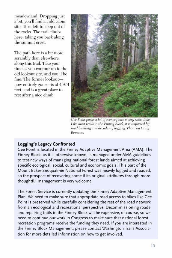
Gee Point packs a lot of scenery into a very short hike. Like most trails in the Finney Block, it is impacted by road building and decades of logging. Photo by Craig Romano.
meadowland. Dropping just a bit, you’ll find an old cabin site. Turn left to keep out of the rocks. The trail climbs here, taking you back along the summit crest.
The path here is a bit more scrambly than elsewhere along this trail. Take your time as you contour up to the old lookout site, and you’ll be fine. The former lookout—now entirely gone—is at 4,974 feet, and is a great place to rest after a nice climb.
Logging’s Legacy ConfrontedGee Point is located in the Finney Adaptive Management Area (AMA). The Finney Block, as it is otherwise known, is managed under AMA guidelines to test new ways of managing national forest lands aimed at achieving specific ecological, social, cultural and economic goals. This part of the Mount Baker-Snoqualmie National Forest was heavily logged and roaded, so the prospect of recovering some if its original attributes through more thoughtful management is very welcome.
The Forest Service is currently updating the Finney Adaptive Management Plan. We need to make sure that appropriate road access to hikes like Gee Point is preserved while carefully considering the rest of the road network from an ecological and recreational perspective. Decommissioning roads and repairing trails in the Finney Block will be expensive, of course, so we need to continue our work in Congress to make sure that national forest recreation programs receive the funding they need. If you are interested in the Finney Block Management, please contact Washington Trails Associa-tion for more detailed information on how to get involved.

16
Colonel BobOlympic National Forest
Round Trip: 14.5 milesHiking Time: 9 hours or backpackHigh Point: 4,492 feetElevation Gain: 4,200 feetBest Hiking Time: July through OctoberMaps: Green Trails #197 Quinault Lake, #198 Grisdale Getting There: Drive US 101 to the South Shore Lake Quinault Road. Turn east and drive 6 miles to a sign reading “Colonel Bob Trail.” Turn onto a narrow road and follow it a very short distance to a parking lot and the trailhead.Whom to Contact: Quinault Ranger Station, (360) 288-2525Status: Impassable due to abundant blowdown.
Fringing Olympic National Park, Olympic National Forest is a warren of old roads and defunct timber operations with five small Wilderness areas scattered among them. The Colonel Bob Wilderness, at just shy of 12,000 acres, is one of them: a tiny gem situated in a patchwork landscape.
The trail starts at 270 feet—not too far above sea level, and not uncommon for Olympic Peninsula trails. The Colonel Bob Trail begins in some really lovely old growth, crowded with cedar, spruce, hemlock and Douglas fir. It climbs through all this lushness in a series of long switchbacks, then follows a sidehill below Wooded Peak, continuing to gain elevation as it spools out under your boots. Three miles in you’ll cross Ewells Creek, and one mile later you’ll reach Mulkey Shelter, at 2,550 feet. Pitch your tent here if you’re spending the night.
The trail continues along a series of steep switchbacks, reaching an unnamed pass at 3,250 feet. Lose around 300 feet of elevation gain to the junction with the summit trail at 2,900 feet. One mile from the junction, you’ll reach Moonshine
North
17
North
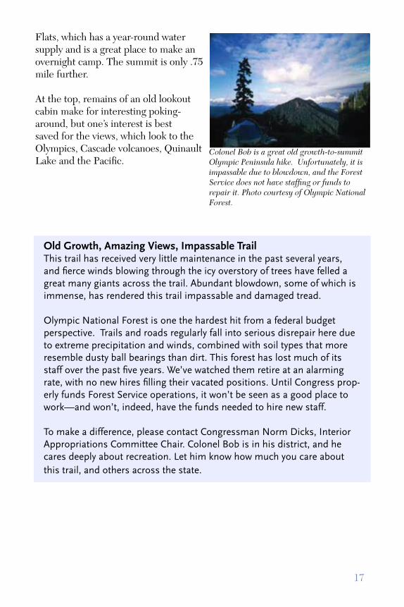
Colonel Bob is a great old growth-to-summit Olympic Peninsula hike. Unfortunately, it is impassable due to blowdown, and the Forest Service does not have staffing or funds to repair it. Photo courtesy of Olympic National Forest.
Flats, which has a year-round water supply and is a great place to make an overnight camp. The summit is only .75 mile further.
At the top, remains of an old lookout cabin make for interesting poking-around, but one’s interest is best saved for the views, which look to the Olympics, Cascade volcanoes, Quinault Lake and the Pacific.
Old Growth, Amazing Views, Impassable TrailThis trail has received very little maintenance in the past several years, and fierce winds blowing through the icy overstory of trees have felled a great many giants across the trail. Abundant blowdown, some of which is immense, has rendered this trail impassable and damaged tread.
Olympic National Forest is one the hardest hit from a federal budget perspective. Trails and roads regularly fall into serious disrepair here due to extreme precipitation and winds, combined with soil types that more resemble dusty ball bearings than dirt. This forest has lost much of its staff over the past five years. We’ve watched them retire at an alarming rate, with no new hires filling their vacated positions. Until Congress prop-erly funds Forest Service operations, it won’t be seen as a good place to work—and won’t, indeed, have the funds needed to hire new staff.
To make a difference, please contact Congressman Norm Dicks, Interior Appropriations Committee Chair. Colonel Bob is in his district, and he cares deeply about recreation. Let him know how much you care about this trail, and others across the state.

18
Loowit TrailGifford Pinchot National Forest
Round Trip: 28 milesHiking Time: 3 daysHigh Point: 4,800 feetElevation Gain: 4,100 feetBest Hiking Time: Mid-July through September Maps: Green Trails Mount St. Helens #364 and #364SGetting There: Take FR 25 just outside of Randle, take FR 99 16 miles to its end at Windy Point. Walk the gated service road signed “Truman Trail No. 207” toward Mount St. Helens for two miles until you descend into a dry arroyo. From here, take the Windy trail #216E until you reach the Loowit at about 4,500 feet.Whom to Contact: Mount St. Helens National Volcanic Monument Headquarters (360) 247-5473Status: Impassable due to a gully 2.5 miles from the intersection of the Loowit and Butte Camp Trails.
The Loowit Trail circumambulates Mount St. Helens, dropping into and climbing out of deep gullies left by the eruption of St. Helens and its subsequent debris flows. This hike is very challenging, with sparse camps, little water and some sketchy sections of loose pumice. Since the eruption denuded the slopes of the mountain, you’re almost always in sun, so make sure you wear your hat and bring sunscreen. It is all too easy to get a severe sunburn on these slopes.
With those cautions in mind, you’ll fully appreciate the stark, otherworldly beauty of the blast zone. Vast fields of pumice gouged with deep gullies frame the gaping immensity of the mountain. Your first seven miles will afford near constant views of denuded slopes. Here, you’ll find Castle Ridge and join the Toutle Trail #238. Stay to the left, drop into the Pumice Bowl, and cross the South Fork Toutle River.
North

19North
Heavy Weather Results in Lost OpportunityHeavy rains in December 2006 created an enormous gully 2.5 miles from the intersection of the Butte Camp and Loowit Trails. The gully is impassably steep on both sides, rendering the trail unhikeable along its full length. The Loowit is extraordinarily valuable for a number of reasons. Losing the ability to hike around St. Helens in its entirety is not just a lost recreation opportunity but a piece of Northwest history, a bit of the extreme conditions that have made our state so beautiful.
Currently, the Gifford Pinchot National Forest, which manages Mount St. Helens National Volcanic Monument, does not have the funds needed to repair the Loowit Trail, so we’re very concerned about the future of this hike. Particularly in geologically unstable areas, trails can disappear quickly, and impassable sections only speed the decay. Mount St. Helens provides opportunities to learn about Washington’s natural history and nature’s ability to heal itself. Please contact Congressman Brian Baird, in whose district lies the monument. Urge him to make sure that this natural laboratory is funded and preserved for generations to come.
The Loowit Trail is a unique hike around Mount St. Helens, cut off by a major wash-out. Photo by Susan Saul.
Continuing on the Loowit, the trail climbs up into remnant old growth forest on Crescent Ridge, and then enters a zone of burned trees and flower-rife meadows. The high point is here, 4,700 feet. You’ll enter subalpine forest, the trail climbing and falling until it again ascends to timberline. In around 5 miles, you’ll reach the junction with the Butte Camp Trail #238A. You can drop steeply along this trail—roughly 800 feet—to Butte Camp, if you need to make camp.
Most of the trail from here on in is tricky as it runs along lava beds to the June Lake Trail. You’ll traverse more lava on the 4.75 miles to the Ape Canyon Trail, and finally have four miles of excellent trail back to the intersection of the Windy Trail and the route back to your car.

20
Middle and South Fork Cascade RiverMount Baker-Snoqualmie National Forest
Round Trip: Middle Fork, 10 miles. South Fork, 9 milesHiking Time: 8 hours or overnight backpackHigh Point: Middle Fork, 3,200 feet. South Fork, 2,200 feetElevation Gain: Middle Fork, 1,500 feet. South Fork, 500 feetBest Hiking Time: August through OctoberMaps: Green Trails #80 Cascade PassGetting There: Head east from Marblemount on the Cascade River Road. In 16 miles, you’ll reach the Mineral Park Campground. In just shy of one mile, the road turns sharply left at the FR 1590 (gated). Park at the gate.Whom To Contact: Mount Baker Ranger District, (360) 859-5700Status: Tread damaged and made difficult by fire.
This hike starts with 1.5 miles of road-walking. The official trail starts in old cedars high above the Cascade River and then enters the burn zone from the 2003 fires that damaged the tread. As is typical of trails that have seen significant fire damage, you’ll run into lots of blowdown and trail tread that is starting to slump.
Where the river forks into its middle and south meanders, the trail dips to the banks and forks. The left fork climbs up into the burn and follows the Middle Fork. This route is very difficult, with disappearing tread that demands routefinding skills. Once back in ancient forest, the trail is much easier to follow, continuing for a brushy three miles until it reaches the base of Cascade Peak.
If you’re not in the mood for a brush-bash, continue straight at the junction to follow the South Fork. The major impediment
North

21
Fire, Lack of Funding and a Trail all but LostAs you’ll note from the description, fire raced through this area in 2003, downing trees and destroying tread—the reason that we highlighted this hike in the 2004 Endangered Trails Guide. Since then, the situation on this trail has not gotten better. Even before fire hit the valley, it had not seen adequate regular maintenance for far too long. The Middle and South Fork Cascade River trails are just two more victims of many years of budget neglect on the part of Congress.
Add fire to the mix, and problems only proliferate. As we’ve pointed out before—see Andrews Creek in the 2004 Endangered Trails Guide—money to restore burned areas cannot be spent on rehabilitating trails unless the Forest Service can make the case that the damaged trail poses a threat to aquatic resources. This isn’t always the case, so fire-damaged trails frequently languish. To help remedy this situation and argue for the rehabilitation of trail in fire-scourged areas, contact Congressman Larsen, in whose district is the Cascade River Trail Complex. Let him know how much you care about these trails, and urge him to work with Congressman Dicks to allocate adequate funds in the FY 09 budget to repair this trail and others in the Mount Baker-Snoqualmie.
Fire may not be common on Mount Baker-Snoqualmie trails. But it is just as devastating, and combined with neglect by Congressional budget writers, just as threatening to the trail’s long-term survival.Photo by Craig Romano.
here is a ford of the Middle Fork, which is dangerous in high water—don’t do it, unless you can find a down tree that spans the river. If you make it across, though, you’ll have 2.5 miles of walking through stunning old growth, with occasional peek-a-boo views. At 2.5 miles, a six-mile way trail—virtually nonexistent—goes to South Cascade Lake.

22
Miners RidgeOkanogan-Wenatchee National Forest
Round Trip: 4 milesHiking Time: 2-3 hoursHigh Point: 5,750 feetElevation Gain: 800 feetBest Hiking Time: July through OctoberMaps: Green Trails #146 PlainGetting There: Take the Chumstick Highway from Leavenworth two miles and turn on Eagle Creek Road. Follow for six miles then turn left onto FR 7520. In 5.8 miles reach a junction. Go left on FR 5200 and follow for 8.0 miles. Look for a post just south of a creek crossing. Whom to Contact: Entiat Ranger District, (509) 784-1511Status: Extremely difficult to hike for the first .75 mile due to abundant blowdown.
This fine ridge trail in the Entiat district is a great alternative to the Mad River Valley, tacking upward quickly into a high ridge ramble with great views and meadows. The ridge is dry, so make sure you have ample water.
Starting from the northernmost trailhead, head upward on good tread littered with hundreds of down trees. Soon you’ll encounter country burned heavily by the Tyee Fire in 1994. The fire reduced a great deal of the surrounding forest to silver snags, through which you’ll get views of the Entiat Mountains and Lake Wenatchee.
You’ll ramble the ridge for roughly two miles. The fire did virtually nothing to the tread, other than to bring down a lot of trees over it. Give yourself time to clamber over blowdown. The snags give way to small patches of old growth and then breaks out into meadows at the high point. The meadows are flowery, which is fairly common in
North

23
A Fine Ridge Hike in Danger of Falling off the MapThe Forest Service has done virtually no maintenance on this trail since the Tyee Fire swept across it in 1994. It is virtually abandoned, although it is still on the system of official trails. On the east side of the mountains, that means lots of blowdown, which truly litters this trail. Getting up and over all those downed trees can be exhausting, and since these are firefall, they can render you black with soot.
This is another classic case of a trail that could use a few maintenance dollars, but is managed by an agency that is on the thin edge of losing its ability to manage even its most popular routes. The Okanogan-Wenatchee is working through several long land management processes right now—forest-wide planning, deciding how to manage recreation facilities and ORV routes are expensive, long-term challenges that, while important, drain staff time and funds. Planning should not take place at the expense of routine maintenance. Both need to be properly funded. That’s why it is particularly important to contact Congressman Doc Hastings and let him know you care about this trail and other great routes in the Okanogan-Wenatchee. He and Congressman Dicks should work together to preserve these classic hiking trails.
As the trail turns south, it disappears entirely. Tread here has been obliterated and cannot be followed, so enjoy the wide open meadow rambling for a bit and then turn back the way you came.
Miners Ridge is a great alternative to the nearby Mad River Valley, but many years with no maintenance has made it difficult to follow and piled up with blowdown. Photo by Craig Romano.
North

24
Foggy Dew RidgeOkanogan-Wenatchee National Forest
Round Trip: 14 milesHiking Time: 12 hours or overnightHigh Point: 7,300 feetElevation Gain: 4,700 feetBest Hiking Time: Mid-July through SeptemberMaps: Green Trails Prince Creek, Methow.Getting There: From Twisp take State Route 20 east for 3 miles, then at the junction with State Route 153 take Okanogan County Road 1029 to County Road 1034, which joins with Forest Service Road 4340. Travel FS Road 4340, and then take FS Road 4340-200 to the trailhead, which is about 1 mile below the Foggy Dew Creek Trailhead. Keep a sharp eye out, since it is easy to miss the trailhead.Whom to Contact: Methow Valley Ranger District, (509) 996-4003Status: Trailhead obscured, beginning of trail difficult to follow due to illegal motorized incursions. The vague, unmaintained route across the ridge is often difficult to follow.
The Foggy Dew Ridge Trail runs the ridge that looms over Foggy Dew Creek in the Chelan-Sawtooth backcountry. When you get close, per the directions above, keep your eyes peeled for the trailhead. It’s easy to miss, since the parking area is a wide spot in the road, and it takes off unsigned. Once you’ve found the trailhead, you’ll be treated to lots of elevation gain in thick dust loosened and churned by illegal motorized incursions on this trail. Foggy Dew Ridge is one of a few non-motorized trails in this corner of the Okanogan-Wenatchee, but its proximity to the Foggy Dew Creek Trail has apparently rendered it irresistible to motorized users.
Be careful in this section of forest—due to motorized use, the trail is braided and hard to find. Your routefinding skills will have to be top notch to gain the ridge. Once you’ve come to the top of the ridge, the ramble is pretty wide open, so you’ll be able to gauge your direction of travel easier than you were North

25
One of the few non-motorized trails in the Sawtooth backcoun-try, Foggy Dew Ridge is nevertheless suffering illegal motorized incursions. Combined with no maintenance, this trail is rapidly losing ground. Photo courtesy of NWHikers.net
when going up through forest. Just be extremely careful to find your way. It’s difficult to do that when your eyes keep wandering toward the splendor arrayed around you. The Foggy Dew Ridge trail has amazing views of the Chelan-Sawtooth Backcountry.
Unauthorized Motorized Use Jeapordizes a TrailThe Foggy Dew Ridge Trail, as noted above, is one of the very few non-motorized trails in this area. Nonetheless, motorcycles users apparently feel compelled to use it, which has rendered this an extremely difficult hike. The Forest Service is undergoing a process to set aside a specific set of routes for motorized recreationists, known as OHV Travel Management. This process, intended to develop a system of sanctioned routes, has created problems for hikers in too many cases.
Foggy Dew Ridge is one of those problems. The initial maps released by the Okanogan-Wenatchee National Forest to comply with OHV Travel Management recommend converting this lonely non-motorized trail into a dirtbike trail, on the advice of one motorized user who regularly rode in this area. That’s frankly unacceptable, and we hope that the Forest Service changes its tune in upcoming iterations of the maps. Rather than converting this to a motorized trail, the forest service should invest in it as a primary hiker route into the southern part of the Chelan-Sawtooth area. The trail needs to repaired, braids eliminated and signage restored in the upper reaches.
If you would like more information on OHV Travel Management, go to WTA’s website, www.wta.org, or check out the Okanogan-Wenatchee’s page on this process at http://www.fs.fed.us/r6/wenatchee/travel-management.

26
Boundary Trail to Cathedral LakesOkanogan-Wenatchee National Forest
Round Trip: 44 milesHiking Time: 10 daysHigh Point: 7,600 feetElevation Gain: 4,300 feetBest Hiking Time: July through SeptemberMaps: Green Trails #16 Ross Lake, #17 Jack Mountain, #18 Pasayten Peak, # 10 Billy Goat Mountain, #20 Coleman Peak, #21 Horseshoe Basin, #50 Washington PassGetting There: From Loomis, follow the Loomis-Oroville Road north for 1.5 miles, until you reach the Toats Coulee Road. Turn left and cross the Sinlahekin Creek Valley. The road climbs steeply up Toats Coulee on road #39. In 16 miles, five miles past the North Fork Campground, reach the junction of FR (3900)500, signed Iron Gate and turn right. Follow this road seven miles to the road end and trailhead.Whom To Contact: Methow Valley Ranger District, (509) 996-4003Status: This trail is impassable at the 14.5 mile point due to a 4.5 mile swath of down trees that number more than 1,000. This enormous patch of blowdown is a result of the Tatoosh Fire of 2006, which caused the temporary closure of the entire Pasayten Wilderness.
This Pasayten Wilderness backpack affords hardy hikers with routefinding skills an opportunity to experience the best of this far-north wild country. The Pasayten comprises mile upon mile of rolling tundra interspersed with crystalline lakes, meadows and wide-open ridge hiking. This is very big country, in every sense of the word.
Starting from the Iron Gate Trailhead, you’ll drop briefly and then ascend through relatively young lodgepole pine—fire survivors, for the most part. The
North
27
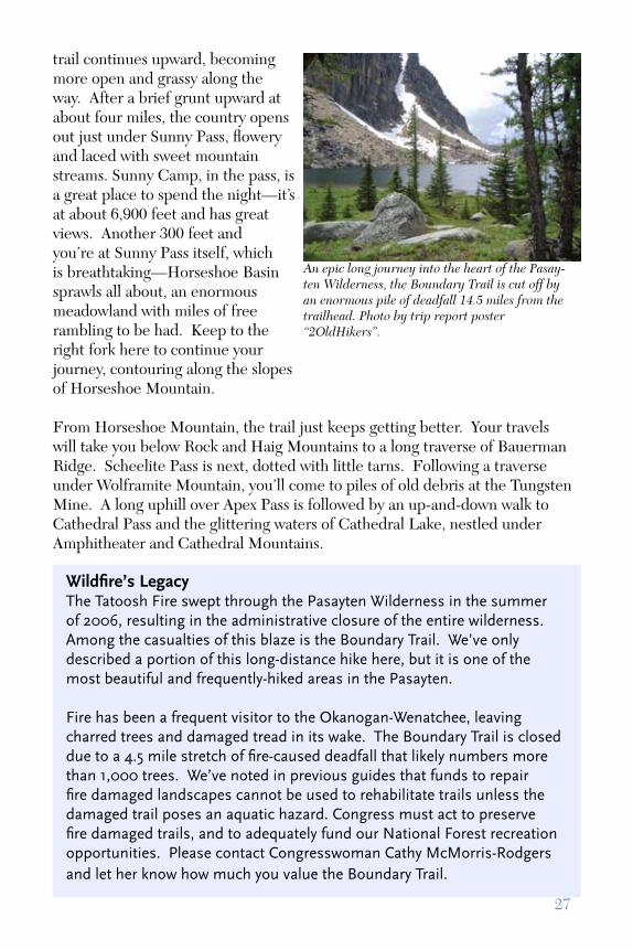
Wildfire’s LegacyThe Tatoosh Fire swept through the Pasayten Wilderness in the summer of 2006, resulting in the administrative closure of the entire wilderness. Among the casualties of this blaze is the Boundary Trail. We’ve only described a portion of this long-distance hike here, but it is one of the most beautiful and frequently-hiked areas in the Pasayten.
Fire has been a frequent visitor to the Okanogan-Wenatchee, leaving charred trees and damaged tread in its wake. The Boundary Trail is closed due to a 4.5 mile stretch of fire-caused deadfall that likely numbers more than 1,000 trees. We’ve noted in previous guides that funds to repair fire damaged landscapes cannot be used to rehabilitate trails unless the damaged trail poses an aquatic hazard. Congress must act to preserve fire damaged trails, and to adequately fund our National Forest recreation opportunities. Please contact Congresswoman Cathy McMorris-Rodgers and let her know how much you value the Boundary Trail.
An epic long journey into the heart of the Pasay-ten Wilderness, the Boundary Trail is cut off by an enormous pile of deadfall 14.5 miles from the trailhead. Photo by trip report poster “2OldHikers”.
trail continues upward, becoming more open and grassy along the way. After a brief grunt upward at about four miles, the country opens out just under Sunny Pass, flowery and laced with sweet mountain streams. Sunny Camp, in the pass, is a great place to spend the night—it’s at about 6,900 feet and has great views. Another 300 feet and you’re at Sunny Pass itself, which is breathtaking—Horseshoe Basin sprawls all about, an enormous meadowland with miles of free rambling to be had. Keep to the right fork here to continue your journey, contouring along the slopes of Horseshoe Mountain.
From Horseshoe Mountain, the trail just keeps getting better. Your travels will take you below Rock and Haig Mountains to a long traverse of Bauerman Ridge. Scheelite Pass is next, dotted with little tarns. Following a traverse under Wolframite Mountain, you’ll come to piles of old debris at the Tungsten Mine. A long uphill over Apex Pass is followed by an up-and-down walk to Cathedral Pass and the glittering waters of Cathedral Lake, nestled under Amphitheater and Cathedral Mountains.

28
Acknowledgements
Endangered Trails 2008 would not have been possible without the generous support of Washington Trails Association members, sponsors, and partners.
Several volunteers and WTA staff members gave invaluable contributions. Jonathan Guzzo coordinated production of the Guide. Thanks to Kim Brown, Craig Romano, Susan Saul, Tom Lynch, Paul Bestock, Robert Kiser and trip report posters “2OldHikers” for contributing photos to the Guide.
Finally, thanks to everyone at WTA who helped review the Guide, including Andrew Engelson, Lauren Braden, Kindra Ramos, Lace Thornberg and Elizabeth Lunney.
TOPO! maps were created using National Geographic TOPO! Washington State Series with 3D Shaded Relief.
Additional copies of this guide are available online at www.wta.org. Thanks to Adobe for donating Adobe PageMaker and Acrobat Distiller to make that possible.

29
Where are They Now?
WTA has been publishing its annual guide to threatened trails since 2002. That’s six guides in as many years, totaling 70 trails that need some attention from volunteers, land managers, or policy makers—or all three. This year, we decided to take a look back and assess how far we’ve come. A few hikes come to mind:
Goat Mountain, 2006: The Bureau of Land Management denied General Moly’s (formerly Idaho General Mines) request to mine for copper and molybdenum on this mountain just north of Mount St. Helens National Volcanic Monument, which could have obliterated the Goat Mountain Trail.
Barclay Lake, 2006: After a seven year wait, the Wild Sky Wilderness Act passed the House and Senate and was signed by the President, making Wild Sky the first new Wilderness area in Washington state since 1984.
Wonderland Trail, 2007: An extremely focused advocacy and trail maintenance campaign procured labor and funding to repair portions of this classic northwest hike. Due in no small part to WTA volunteers and activists, this trail opened late last summer, earlier than many expected.
All of these victories are due to the hard work of hikers, who either got out and worked on trails or contacted their legislators and the land managers who are charged with caring for our public lands. We thank you for these and the many other victories we’ve had over the years. Your help makes Washington a better place to hike.

30
Speaking Out for Washington Hikers
WTA works closely with elected officials and government staff to secure trail funding, protect wilderness areas, initiate new trail projects, and more. We represent hikers in Olympia and Washington, DC with the aim of making Washington an even better place to hike. We work to preserve unprotected wildlands and to secure much-needed funding for repair and maintenance of Washington’s hiking trails.
Our work with forest and park officials is focused on making sure that the decisions they make about the lands under their care are in the best interest of hikers.
One of the best ways you can help advocate for hikers is by joining our Trail Action Network. Just go to our website, www.wta.org, and click on the advocacy tab.
While you’re there, please consider joining online by clicking on the tab marked “support”. Don’t wait. Join today! Your membership gift will help maintain old trails, build new trails and ensure that WTA continues speaking out on behalf of hikers like you.
WTA advocates for hikers like you, so you can spend more time enjoying the trails. Photo by Dave Schiefelbein.

31
Our Volunteer Trail Maintenance Program
Washington Trails Association has an extensive volunteer trail maintenance program. Statewide, we do about 83,000 hours of volunteer work every year. Over the years we’ve worked on trails from Mount St. Helens National Volcanic Monument to the North Cascades.
WTA introduces young people to the joys of trail maintenance. We hope to instill an ethic of service in the next generation of hikers. Photo courtesy of WTA.
This summer, we have an impressive schedule of day and weekend workparties, as well as our ever-popular Volunteer Vacations, on which you’ll have the opportunity to work and camp in the woods, spend time with great people, and be very well-fed. We post our work parties on our website—www.wta.org—as they’re scheduled, and we encourage you to visit and join one. Volunteer trail maintenance is a fun way to give back to the wild places you love.
Trail maintenance leaves hikers with a sense of accomplishment and the knowledge that they’ve spent a great day in the woods. Photo courtest of WTA
We get a lot of great work done on Washington’s public lands. Come join us and find out for yourself. Sign up for a work party at www.wta.org.

32
Important Contacts
After your outing, you might want to contact the following people, and let them know why this area is so special to you. Legislators and US Forest Service staff enjoy hearing from the public, especially when they’re doing a good job.
SenatorsName: Patty Murray Phone: (202) 224-2621 Fax: (202) 224-0238
Name: Maria CantwellPhone: (202) 224-3441Fax: (202) 228-0514
RepresentativesJay Inslee—1st Dist.Phone: (202) 225-6311 Fax: (202) 225-1606
Rick Larsen—2nd Dist.Phone: (202) 225-2605Fax: (202) 225-4420
Brian Baird—3rd Dist.Phone: (202) 225-3536 Fax: (202) 225-3478
Doc Hastings—4th Dist.Phone: (202) 225-5816 Fax: (202) 225-3251
Cathy McMorris-Rodgers—5th Dist.phone: 202-225-2006fax: 202-225-3392
Norman Dicks—6th Dist.Phone: (202) 225-5916 Fax: (202) 226-1176
James McDermott—7th Dist.Phone: (202) 225-3106 Fax: (202) 225-6197
Dave Reichert—8th Dist.Phone: (202) 225-7761Fax: (202) 225-4282
Adam Smith—9th Dist.Phone: (202) 225-8901Fax: (202) 225-5893

33
National and State Public Land Managers
North Cascades National Park 810 State Route 20Sedro Woolley, WA 98284(360) 854-7200
Olympic National Park600 East Park Avenue Port Angeles, WA 98362 (360) 565-3130
Mount Rainier National Park55210 238th Ave East Ashford, WA 98304 (360) 569-2211 XT 3314
Colville National Forest765 S Main StColville, WA 99114(509) 684-7000
Gifford Pinchot National Forest 10600 NE 51 CircleVancouver, WA 98682(360) 891-5000
Mount Baker-Snoqualmie National Forest 2930 Wetmore Ave. Suite 3AEverett, WA 98201(425) 783-6000
Okanogan-Wenatchee National Forest 215 Melody Lane Wenatchee, WA 98801(509) 664-9200
Olympic National Forest1835 Black Lake Blvd SWOlympia, WA 98502(360) 956-2402
Bureau of Land Management333 Southwest 1st AvenuePortland, Oregon 97204(509) 536-1200
Washington StateDepartment of Natural ResourcesP.O. Box 47001,Olympia, WA 98504-7001(360) 902-1004
Washington State Parks and Recreation CommissionP.O. Box 42650Olympia, WA 98504-2650(360) 902-8500

Washington Trails A
ssociation2019 3rd A
ve #100Seattle, W
A 98121
ww
w.w
ta.org N
on-P
rofit O
rg.U
S Postage
PA
IDSeattle, W
A
Perm
it No. 1945


![Prevalence of Cryptosporidium and Giardia lamblia in Water ...cyst of Cryptosporidium and Giardia lamblia as described earlier [16,17]. Oocysts in the specimens are usually difficult](https://static.fdocuments.in/doc/165x107/6035961b3d575467871f6698/prevalence-of-cryptosporidium-and-giardia-lamblia-in-water-cyst-of-cryptosporidium.jpg)