End of the Road Half Marathon - triviumracing.com
19
End of the Road Half Marathon Athlete Guide 2021
Transcript of End of the Road Half Marathon - triviumracing.com

End of the RoadHalf Marathon
Athlete Guide 2021

Race Weekend Schedule
• Early Packet Pick Up and Race Expo, Friday, 10/22
• 4:00 pm – 7:00 pm at Holiday Inn Express Breezewood, 16503 Lincoln Highway, Breezewood PA 15533
• Saturday, 10/23:• Packet pickup (for both Saturday and Sunday races): 7:30am –
9:15am at race site
• Pre-race meeting: 9:20am
• Half Marathon and 4 Mile Start: 9:30am• 4 Mile awards: approx. 10:30am
• Half Marathon awards: approx. 12:15pm
• Course closes: 2:00pm (4.5 hour limit, about 20:30 min per mile pace)
• Sunday, 10/24
• Packet pickup: 7:00am – 8:20am at race site• Pre-race meeting: 8:25am
• Marathon Start: 8:30am
• Half Marathon Starts: 9:00am• Half Marathon awards: approx. 12:00pm
• Marathon awards: approx. 1:00pm
• Course closes: 1:30pm• Half Marathon: 4.5 hour limit, about 20:30 min per mile pace
• Full Marathon: 5 hour limit, about 11:30 min per mile pace

Race Course AddressCove Valley Travel Plaza on Abandoned Turnpike
3005 Pump Station Rd Waterfall , PA 16689
Map to Race Start Line
Whether you come from the N or S you will enter the parking area by heading West, just North of the abandoned turnpike. Please do not enter from the south area, as this will be coned off. Parking will all flow in from the North Entrance.
Parking
= Initial Parking
= one side of road parking
= double side of road parking
= overflow parking lot
= Parking Entrance
= Parking Exit

Map of Half Course

Elevation of the Course
While this is not a “PR” course it is also a lot less hilly than you would think. Please note the red line is a better indicator of the elevation gain. The hills on this elevation graph are showing the tops of the tunnels, not going through them.

Start to first tunnelThe lead up to the first tunnel is about .7 miles. This is a small climb (about 60 ft of total climb during this .7 miles). It is a good chance to loosen up your legs and get moving before we enter tunnel #1 and begin our underground adventure!

Tunnel #1 Sidling Hill
There is very little elevation change within the tunnel, and the Southern Alleghany Conservancy will be using a street sweeper this week to clean out the tunnels. This will be the warmest portion of the course as you will feel about a 20 degree increase in temperatures from the 40 degrees outside. Remember, in this tunnel you cannot see the other side when entering so lights are mandatory! We will have led candles in the tunnel to give you direction and perspective inside the tunnel!

The Between LandsHere is where the elevation starts to really come into play. Athletes will descend quickly for a half a mile coming out of the tunnel and then have a steady gradual climb over the next 3 miles to Ray’s Tunnel. This will be a beautiful section of the course with awesome views, and picturesque fall foliage!

The Between Lands
On the entire turnpie there are two lanes for traffic (east and west) separated by grass. We mostly stay in the westbound lane on our route. Between the two tunnels, the roads in the east bound lane are significantly better and there are two easy access points. We will be putting turn arrows at these points. You can choose to stay in the lane you are in, orswitch over. All mile markings will remain on the west bound lane and all measuring is done from just the W bound lane

Tunnel #2 (Ray’s Hill Tunnel)This is the shorter of the two tunnels, but since you will be running out one side, turning around, and running back in, you will be spending close to 1.5 miles underground! Againtunnels will be warmer than the outside air, and you will need a headlamp! Make sure you are staying on your right as you u-turn across our timing mats. When reentering the tunnel make sure you stay on your right.
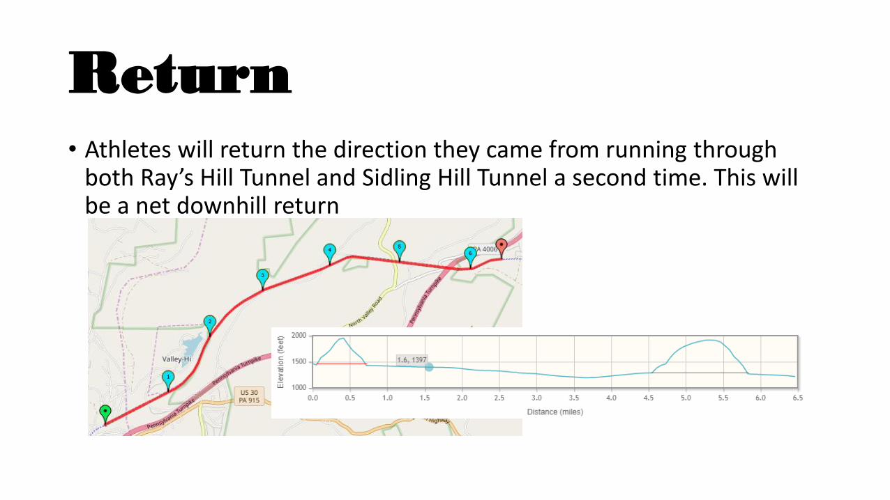
Return• Athletes will return the direction they came from running through
both Ray’s Hill Tunnel and Sidling Hill Tunnel a second time. This will be a net downhill return

Course Markings
Since this is a simple out and back course, the only time you will see the signs on the right, are on The Land Between the Tunnels, where we give you the option to run in the opposite lane. (see previous slides) All Mile markers and U-Turns will look like the sign on the left!

Aid Stations
Aid Station Mile Marker Fuel
1 2.1 Water and Gatorade
2 4.4 Water and Huma Gels
3 5.8 Water, Gatorade, Granola Bars, Candy
4 7.3 Water, Gatorade, Granola Bars, Candy
5 8.7 Water and Huma Gels
6 11 Water, Gatorade, Coke
Marathon Course
• Marathoners on Sunday will U-turn around a cone at the finish line, take in the cheers, and head back out for a second lap. While this is not our original course plan, this will be an awesome opportunity to run the tunnels four times!

Marathon Aid StationsAid Station Mile Marker Fuel
1 2.1 Water and Gatorade
2 4.4 Water and Huma Gels
3 5.8 Water, Gatorade, Granola Bars, Candy
4 7.3 Water, Gatorade, Granola Bars, Candy
5 8.7 Water and Huma Gels
6 11 Water, Gatorade, Coke
7 15.2 Water, Gatorade, Coke
8 17.5 Water and Huma Gels
9 18.9Water, Gatorade, Granola Bars, Candy
10 20.4Water, Gatorade, Granola Bars, Candy
11 21.8Water and Huma Gels
12 24.1Water, Gatorade, Coke

Map of 4 Mile Course
Tunnel Time!

4 Mile Elevation Chart
This is not an overly hilly 4 mile. The red line is a better indicator of the actual elevation. Within the tunnel athletes will see a very gradual increase in elevation on the way out, and on the way back a slight downhill.