Empty Houses Capture & Reporting System
11
Empty Houses Capture & Reporting System Developed to Support Pennsville NJ Town Watch September 26, 2014
-
Upload
hoehndisantis -
Category
Government & Nonprofit
-
view
79 -
download
2
Transcript of Empty Houses Capture & Reporting System
Empty Houses Capture & Reporting System
Developed to Support Pennsville NJ Town Watch
September 26, 2014

Project Mission• Improve appearance of neighborhoods, improve home
values in Pennsville• Improve the general appearance of Pennsville
neighborhoods and the quality of living for its residents• Create a list of abandoned houses (with pictures) to enable
the Township to collect fines that go into the PV Township general revenue to offset property taxes and cleanup expenses
• Provide a meaningful project that empowers Pennsville residents to improve their community
• Create and implement the system without incurring expenses: use volunteers and open source software

Benefits to the Community
• Aug 2014, NJ.com: Hefty fines under new law
• Fines generate revenue– $1,500/day for in-state owners– $2,500/day for out-of-state owners
Example
• Reduce tax burden on PV homeowners• Cleans up neighborhoods & improve
overall home values
Avg In-state Daily Fine 3-Days20 $1,500 $90,000
Avg 0ut-State Daily Fine 3-days10 $2,500 $75,000
Total Rev $165,000
NJ.com Poll Aug
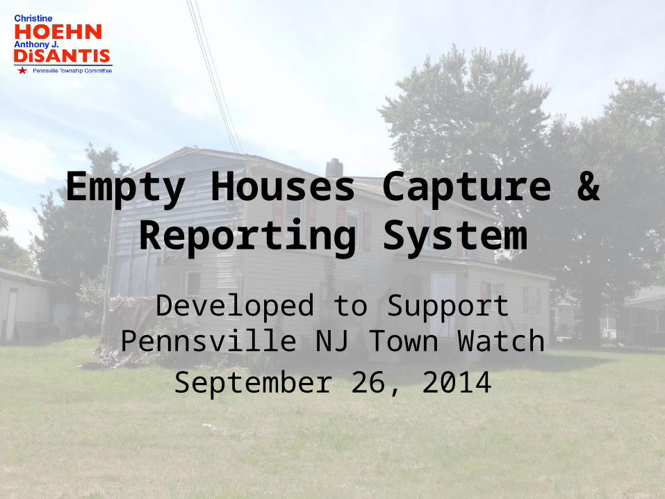
Benchmarking and Best Practices
• Other communities in NJ that have addressed this problem:– Woodbury and Westville's councils recently set up
registries of the abandoned properties that implement annual, gradually-increasing fees for creditors to list them on the registry.
– East Greenwich also enacted the same kind of registry, as well as resurrected its board of health and established a group of volunteers that identify homes in need of maintenance and dole out notifications.
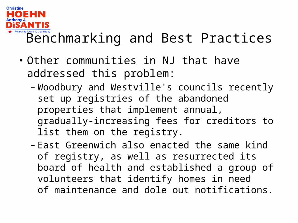
Proposed Process Overview
• “Divide and Conquer”– Partition Pennsville (example partition: census tract)– Identify Abandoned Houses– Photograph Houses with Geo-tagging Devices
• Save Photos in Database– Upload geo-tagged* photos to designated web site
• Subsequent periodic, bulk upload to Google Picasa site
– Includes other tagging information (addresses, damage, offending characteristics)
• Generate Registry [optional: Map onto Google Earth]
• Validate entries with Town Watch assessment• Present tabular Registry to Pennsville Township
Committee*Example of geo-tagging device: Apple iPhone 5
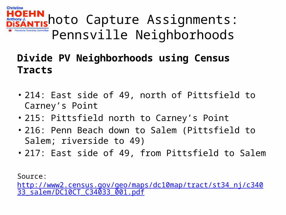
Photo Capture Assignments: Pennsville Neighborhoods
Divide PV Neighborhoods using Census Tracts
• 214: East side of 49, north of Pittsfield to Carney’s Point• 215: Pittsfield north to Carney’s Point• 216: Penn Beach down to Salem (Pittsfield to Salem;
riverside to 49)• 217: East side of 49, from Pittsfield to Salem
Source: http://www2.census.gov/geo/maps/dc10map/tract/st34_nj/c34033_salem/DC10CT_C34033_001.pdf
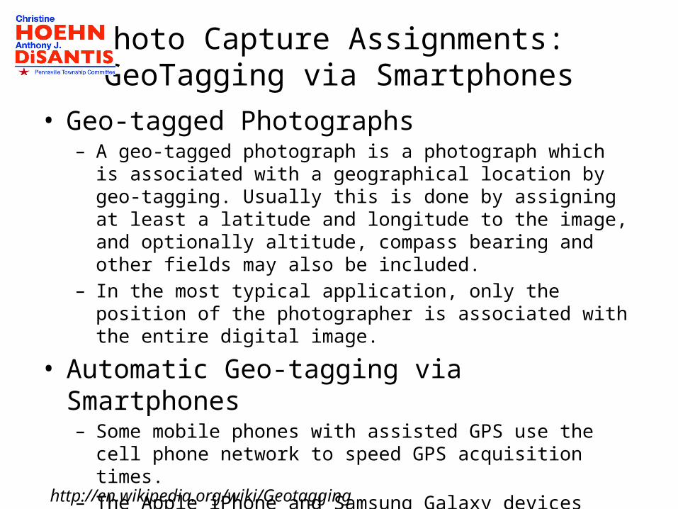
Photo Capture Assignments: GeoTagging via Smartphones
• Geo-tagged Photographs– A geo-tagged photograph is a photograph which is associated with a
geographical location by geo-tagging. Usually this is done by assigning at least a latitude and longitude to the image, and optionally altitude, compass bearing and other fields may also be included.
– In the most typical application, only the position of the photographer is associated with the entire digital image.
• Automatic Geo-tagging via Smartphones– Some mobile phones with assisted GPS use the cell phone network to
speed GPS acquisition times.– The Apple iPhone and Samsung Galaxy devices have automatic geo-
tagging. Tests can be performed to determine if volunteers’ phones have this required capability.
http://en.wikipedia.org/wiki/Geotagging
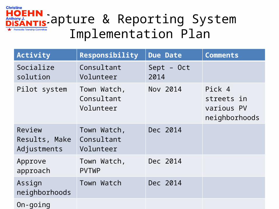
Capture & Reporting SystemImplementation Plan
Activity Responsibility Due Date Comments
Socialize solution Consultant Volunteer Sept – Oct 2014
Pilot system Town Watch, Consultant Volunteer
Nov 2014 Pick 4 streets in various PV neighborhoods
Review Results, Make Adjustments
Town Watch, Consultant Volunteer
Dec 2014
Approve approach Town Watch, PVTWP Dec 2014
Assign neighborhoods
Town Watch Dec 2014
On-going Review
Ad hoc uploads

Google+ Account

Google Picasa Database
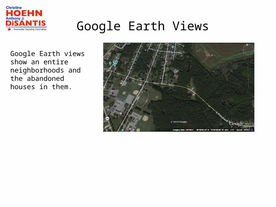
Google Earth Views
Google Earth views show an entire neighborhoods and the abandoned houses in them.