Emergence of Lava Dome from the Crater Lake of Kelud ... · dalam makalah ini. ... mulai...
10
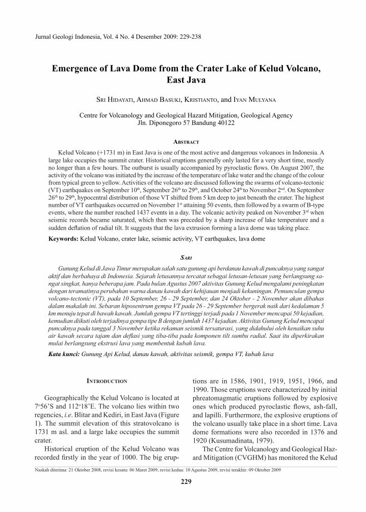
Jurnal Geologi Indonesia, Vol. 4 No. 4 Desember 2009: 229-238 229 Naskah diterima: 21 Oktober 2008, revisi kesatu: 06 Maret 2009, revisi kedua: 10 Agustus 2009, revisi terakhir: 09 Oktober 2009 INTRODUCTION Geographically the Kelud Volcano is located at 7 o 56’S and 112 o 18’E. The volcano lies within two regencies, i.e. Blitar and Kediri, in East Java (Figure 1). The summit elevation of this stratovolcano is 1731 m asl. and a large lake occupies the summit crater. Historical eruption of the Kelud Volcano was recorded firstly in the year of 1000. The big erup- tions are in 1586, 1901, 1919, 1951, 1966, and 1990. Those eruptions were characterized by initial phreatomagmatic eruptions followed by explosive ones which produced pyroclastic flows, ash-fall, and lapilli. Furthermore, the explosive eruptions of the volcano usually take place in a short time. Lava dome formations were also recorded in 1376 and 1920 (Kusumadinata, 1979). The Centre for Volcanology and Geological Haz- ard Mitigation (CVGHM) has monitored the Kelud Emergence of Lava Dome from the Crater Lake of Kelud Volcano, East Java SRI HIDAYATI, AHMAD BASUKI, KRISTIANTO, and IYAN MULYANA Centre for Volcanology and Geological Hazard Mitigation, Geological Agency Jln. Diponegoro 57 Bandung 40122 ABSTRACT Kelud Volcano (+1731 m) in East Java is one of the most active and dangerous volcanoes in Indonesia. A large lake occupies the summit crater. Historical eruptions generally only lasted for a very short time, mostly no longer than a few hours. The outburst is usually accompanied by pyroclastic flows. On August 2007, the activity of the volcano was initiated by the increase of the temperature of lake water and the change of the colour from typical green to yellow. Activities of the volcano are discussed following the swarms of volcano-tectonic (VT) earthquakes on September 10 th , September 26 th to 29 th , and October 24 th to November 2 nd . On September 26 th to 29 th , hypocentral distribution of those VT shifted from 5 km deep to just beneath the crater. The highest number of VT earthquakes occurred on November 1 st attaining 50 events, then followed by a swarm of B-type events, where the number reached 1437 events in a day. The volcanic activity peaked on November 3 rd when seismic records became saturated, which then was preceded by a sharp increase of lake temperature and a sudden deflation of radial tilt. It suggests that the lava extrusion forming a lava dome was taking place. Keywords: Kelud Volcano, crater lake, seismic activity, VT earthquakes, lava dome SARI Gunung Kelud di Jawa Timur merupakan salah satu gunung api berdanau kawah di puncaknya yang sangat aktif dan berbahaya di Indonesia. Sejarah letusannya tercatat sebagai letusan-letusan yang berlangsung sa- ngat singkat, hanya beberapa jam. Pada bulan Agustus 2007 aktivitas Gunung Kelud mengalami peningkatan dengan teramatinya perubahan warna danau kawah dari kehijauan menjadi kekuningan. Pemunculan gempa volcano-tectonic (VT), pada 10 September, 26 - 29 September, dan 24 Oktober - 2 November akan dibahas dalam makalah ini. Sebaran hiposentrum gempa VT pada 26 - 29 September bergerak naik dari kedalaman 5 km menuju tepat di bawah kawah. Jumlah gempa VT tertinggi terjadi pada 1 November mencapai 50 kejadian, kemudian diikuti oleh terjadinya gempa tipe B dengan jumlah 1437 kejadian. Aktivitas Gunung Kelud mencapai puncaknya pada tanggal 3 November ketika rekaman seismik tersaturasi, yang didahului oleh kenaikan suhu air kawah secara tajam dan deflasi yang tiba-tiba pada komponen tilt sumbu radial. Saat itu diperkirakan mulai berlangsung ekstrusi lava yang membentuk kubah lava. Kata kunci: Gunung Api Kelud, danau kawah, aktivitas seismik, gempa VT, kubah lava
Transcript of Emergence of Lava Dome from the Crater Lake of Kelud ... · dalam makalah ini. ... mulai...
Jurnal Geologi Indonesia, Vol. 4 No. 4 Desember 2009: 229-238
229
Naskah diterima: 21 Oktober 2008, revisi kesatu: 06 Maret 2009, revisi kedua: 10 Agustus 2009, revisi terakhir: 09 Oktober 2009
IntroductIon
Geographically the Kelud Volcano is located at 7o56’S and 112o18’E. The volcano lies within two regencies, i.e. Blitar and Kediri, in East Java (Figure 1). The summit elevation of this stratovolcano is 1731 m asl. and a large lake occupies the summit crater.
Historical eruption of the Kelud Volcano was recorded firstly in the year of 1000. The big erup-
tions are in 1586, 1901, 1919, 1951, 1966, and 1990. Those eruptions were characterized by initial phreatomagmatic eruptions followed by explosive ones which produced pyroclastic flows, ash-fall, and lapilli. Furthermore, the explosive eruptions of the volcano usually take place in a short time. Lava dome formations were also recorded in 1376 and 1920 (Kusumadinata, 1979).
The Centre for Volcanology and Geological Haz-ard Mitigation (CVGHM) has monitored the Kelud
Emergence of Lava Dome from the Crater Lake of Kelud Volcano, East Java
Sri Hidayati, aHmad BaSuki, kriStianto, and iyan mulyana
Centre for Volcanology and Geological Hazard Mitigation, Geological AgencyJln. Diponegoro 57 Bandung 40122
AbstrAct
Kelud Volcano (+1731 m) in East Java is one of the most active and dangerous volcanoes in Indonesia. A large lake occupies the summit crater. Historical eruptions generally only lasted for a very short time, mostly no longer than a few hours. The outburst is usually accompanied by pyroclastic flows. On August 2007, the activity of the volcano was initiated by the increase of the temperature of lake water and the change of the colour from typical green to yellow. Activities of the volcano are discussed following the swarms of volcano-tectonic (VT) earthquakes on September 10th, September 26th to 29th, and October 24th to November 2nd. On September 26th to 29th, hypocentral distribution of those VT shifted from 5 km deep to just beneath the crater. The highest number of VT earthquakes occurred on November 1st attaining 50 events, then followed by a swarm of B-type events, where the number reached 1437 events in a day. The volcanic activity peaked on November 3rd when seismic records became saturated, which then was preceded by a sharp increase of lake temperature and a sudden deflation of radial tilt. It suggests that the lava extrusion forming a lava dome was taking place.
Keywords: Kelud Volcano, crater lake, seismic activity, VT earthquakes, lava dome
Sari
Gunung Kelud di Jawa Timur merupakan salah satu gunung api berdanau kawah di puncaknya yang sangat aktif dan berbahaya di Indonesia. Sejarah letusannya tercatat sebagai letusan-letusan yang berlangsung sa-ngat singkat, hanya beberapa jam. Pada bulan Agustus 2007 aktivitas Gunung Kelud mengalami peningkatan dengan teramatinya perubahan warna danau kawah dari kehijauan menjadi kekuningan. Pemunculan gempa volcano-tectonic (VT), pada 10 September, 26 - 29 September, dan 24 Oktober - 2 November akan dibahas dalam makalah ini. Sebaran hiposentrum gempa VT pada 26 - 29 September bergerak naik dari kedalaman 5 km menuju tepat di bawah kawah. Jumlah gempa VT tertinggi terjadi pada 1 November mencapai 50 kejadian, kemudian diikuti oleh terjadinya gempa tipe B dengan jumlah 1437 kejadian. Aktivitas Gunung Kelud mencapai puncaknya pada tanggal 3 November ketika rekaman seismik tersaturasi, yang didahului oleh kenaikan suhu air kawah secara tajam dan deflasi yang tiba-tiba pada komponen tilt sumbu radial. Saat itu diperkirakan mulai berlangsung ekstrusi lava yang membentuk kubah lava.
Kata kunci: Gunung Api Kelud, danau kawah, aktivitas seismik, gempa VT, kubah lava

230 Jurnal Geologi Indonesia, Vol. 4 No. 4 Desember 2009: 229-238
Volcano since 1925 using one station of a single seismometer. In 1987, the number of seismometer was extended into three. All of them were destroyed during the eruption of February 1990. There were some replacements of the seismometers after the eruption. In 2006, a tiltmeter was installed on the west flank and in early 2007 another tiltmeter was added at the southwest flank. Since April 2007, five seismometers (L4-C, 1 Hz) and two tiltmeter stations were set up to monitor the volcano. The seismic stations are KWH, KLD, LRG, SMG and UMB. The data are transmitted to Kelud Observatory in Margomulya Village at a distance of about 8 km from the active crater using a telemetry system.
Since 2006, a sensor of temperature has been installed at the crater lake to monitor the surface of lake water at 10 m and 15 m deep. Moreover, a pe-riodic monitoring of chemical contents of the crater lake water has a significant support to the activity of the volcano. In August 2007, the volcanic activity increased as shown by the change of the water colour from typical green to yellowish. This change was ac-companied by the increase of the CO2 concentration and the temperature of lake water.
The paper will discuss about the seismic activ-ity, hypocentral distribution, ground deformation, and other significant precursors that precede the emergence of the lava dome.
seIsmIc ActIvIty of the Kelud volcAno precedIng the emergence of lAvA dome
CVGHM is used to distinguish volcanic earth-quakes observed at active volcanoes based on the
Minakami classification. Minakami (1974) classi-fied volcanic earthquakes according to the location of their foci and the nature of earthquakes motion into: A-type, B-type, explosion earthquakes, and tremors. The A-type earthquakes originate beneath the volcanoes at the depth ranging from 1 km to 20 km. Their waveform cannot be distinguished from shallow tectonic earthquakes. The P- and S-phases are also clearly defined. The B-type earthquakes occur at shallow depths less than 1 km beneath the active crater and their S-phases are not clear. Fur-thermore, explosion earthquakes always accompany an individual explosive eruption, while volcanic tremors have a form of an irregular sinusoid of rather long duration.
Meanwhile, on the basis of source mechanism, Latter (1981) proposed the earthquakes originating at Ruapehu and Ngauruhoe Volcanoes into two groups: tectonic and volcanic earthquakes. The vol-canic earthquakes take place in a heat-weakened or partially molten material by some extended source mechanisms. Generally, their onset is emergent with poorly-defined phases. This category covers Minakami of B-types, explosion earthquakes, and tremor. Tectonic type is characterized by sharp on-set and well-defined phases. In order to distinguish between earthquakes of tectonic type which origi-nate on or beneath a volcano and those that occur at some distances, a term of volcano-tectonic (VT) earthquakes is proposed. This category includes A-type of Minakami’s. VT earthquakes take place in a competent rock as a result of some instantaneous source mechanism as the tectonic one do. In this pa-per, the term of VT earthquakes will be used instead of A-type, since this term is recently used widely.
During the normal state of activity, the occurrence of VT earthquake is usually less than 5 events/month, meanwhile the B-type and other type of volcanic earthquakes are very rarely recorded (Figure 2).
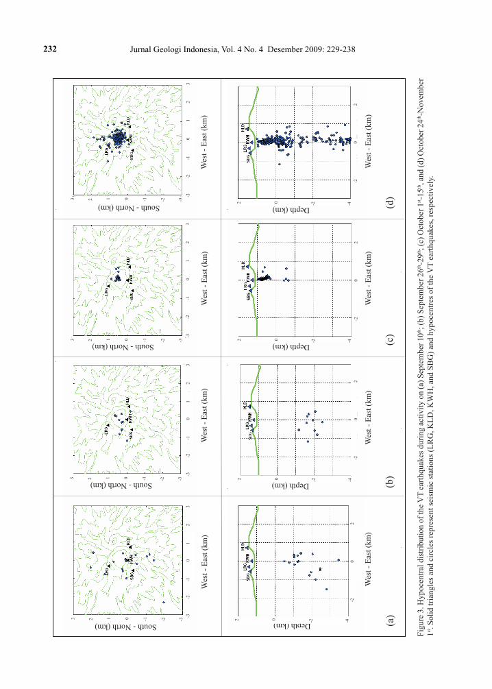
As shown in Figure 2, on September 11th, 2007 the number of VT earthquake reached 13 events within 5 hours. Using GrHypo program (Nishi, 2005) with onset of 4 P-waves and 1 S-wave, their hypocentres were determined. The result showed the distribution ranges at depth of about 2 to 4 km below the crater (Figure 3.a).
The occurrence of VT earthquakes continued in average one event a day. During September 26th to 29th, the number of VT earthquakes increased
Figure 1. Location map of the Kelud Volcano.
G. Raung
G. IjenG. Lamongan
G. Iyang Argopuro
G. Semeru
G. Bromo
G. Arjuno Welirang
G. Kelud
G. Lawu
Central Java
East Java
0 100 km50
N
Java Sea
Indian Ocean

231Emergence of Lava Dome from the Crater Lake of Kelud Volcano, East Java (S. Hidayati et al.)
remarkable to 61 events. However, no significant change was indicated on their hypocentral dis-tribution (Figure 3.b). After September 29th, the occurrence of VT earthquakes still continued but decreasing in number. Their foci shifted to the depth of about 0.5 from 1 km beneath the crater lake. It was supposed that a migration of magma to the surface occurred (Figure 3.c).
On October 16th, swarm of 306 of B-type events occurred within 7 hours. Later, number of B-types earthquakes sharply decreased, until October 21st there were only 4 events recorded. After 2 days in quiescence, on October 24th, the VT earthquakes oc-curred about 10 events. The occurrence was directhly followed by the B-type earthquakes.
On October 31st, other swarms of VT earth-quakes with large amplitude attained 31 events, and their (S-P) time were less than 1 second. This
swarm was followed by the B-type. The number is 89 events. On November 1st, the VT earthquakes reached 55 events while the B-type reached re-markably to 1437. Meanwhile, tremor attained 274 events with dominant amplitude about 0.2 to 5 mm. On November 2nd, number of the VT earthquakes reached 52 events while the B-type 690 events. The hypocentral distributions of VT earthquakes of October 31st, November 1st and 2nd are about 0.5 to 5.0 km of depth (Figure 3.d).
Continues tremor was recorded since Novem-ber 2nd at 11:07 WIB (local time) and followed by the saturated seismic event on November 3rd, at 15:55 for about 10 minutes. In the next morning, in a clear weather, a fuming small black dot raised. It was observed in the middle of crater lake. The phenomena was associated with the emergence of a lava dome.
Figure 2. The number of VT and B-type earthquakes recorded at the Kelud Volcano during July – November 2007. The vertical lines and horizontal arrows represent the change of level activity (level II, III, and IV) as declared by CVGHM.
7/1 7/15 7/29 8/12 8/26 9/9 9/23 10/7 10/21 11/4 11/18
0
10
20
Level IIILevel IV
Level IILevel I
tectonics
2007 Date
7/1 7/15 7/29 8/12 8/26 9/9 9/23 10/7 10/21 11/4 11/18
0
2
4local tectonics
7/1 7/15 7/29 8/12 8/26 9/9 9/23 10/7 10/21 11/4 11/18
0
20
40VT
Nu
mb
er
of
ev
en
ts
7/1 7/15 7/29 8/12 8/26 9/9 9/23 10/7 10/21 11/4 11/18
0
200
400Level III
B-type
232 Jurnal Geologi Indonesia, Vol. 4 No. 4 Desember 2009: 229-238
Figu
re 3
. Hyp
ocen
tral d
istri
butio
n of
the V
T ea
rthqu
akes
dur
ing
activ
ity o
n (a
) Sep
tem
ber 1
0th; (
b) S
epte
mbe
r 26th
-29th
; (c)
Oct
ober
1st-1
5th, a
nd (d
) Oct
ober
24th
-Nov
embe
r 1st
. Sol
id tr
iang
les a
nd c
ircle
s rep
rese
nt se
ism
ic st
atio
ns (L
RG
, KLD
, KW
H, a
nd S
BG
) and
hyp
ocen
tres o
f the
VT
earth
quak
es, r
espe
ctiv
ely.
(b
)
(c
)
(d
)
Wes
t -
Eas
t (k
m)
Wes
t -
Eas
t (k
m)
Wes
t -
Eas
t (k
m)
Wes
t -
Eas
t (k
m)
Wes
t -
Eas
t (k
m)
Wes
t -
Eas
t (k
m)
Depth (km)
Depth (km)
Depth (km)
South - North (km)
South - North (km)
-3
-
2
-1
0
1
2
3
-3
-
2
-1
0
1
2
3
-3
-
2
-
1
0
1
2
3
-2
0
2
-2
0
2
-2
0
2
2 0 -2 -4
2 0 -2 -4
2 0 -2 -4
2 0 -2 -3-13 1
2 0 -2 -3-13 1
2 0 -2 -3-13 1
(a)
Wes
t -
Eas
t (k
m)
Wes
t -
Eas
t (k
m)
Depth (km)South - North (km)
-3
-
2
-1
0
1
2
3
-2
0
2
2 0 -2 -4
2 0 -2 -3-13 1
South - North (km)

233Emergence of Lava Dome from the Crater Lake of Kelud Volcano, East Java (S. Hidayati et al.)
From: 2007/10/16 12:00:00 PM To: 11:59:59 PM KL4-UD Interval 12 hours Scale: 25 % of 40 (Max Amp.) bit:21
12:00
:20:40
13:00
:20:40
14:00
:20:40
15:00
:20:40
16:00
:20:40
17:00
:20:40
18:00
:20:40
19:00
:20:40
20:00
:20:40
21:00
:20:40
22:00
:20:40
23:00
:20:40
Figure 4. A swarm of the B-type took place on October 16th, 2007 recorded by Kawah station, located at about 400 m from the crater lake.
dIscussIon
Magma Supply SystemThe eruption of Kelud Volcano in 1990 was
preceded by a sharp increase in number of VT earth-quakes several days before the outbreak (Lesage and Surono, 1995). However, the significant increased in seismicity and lake temperature was detected three months before the eruption.
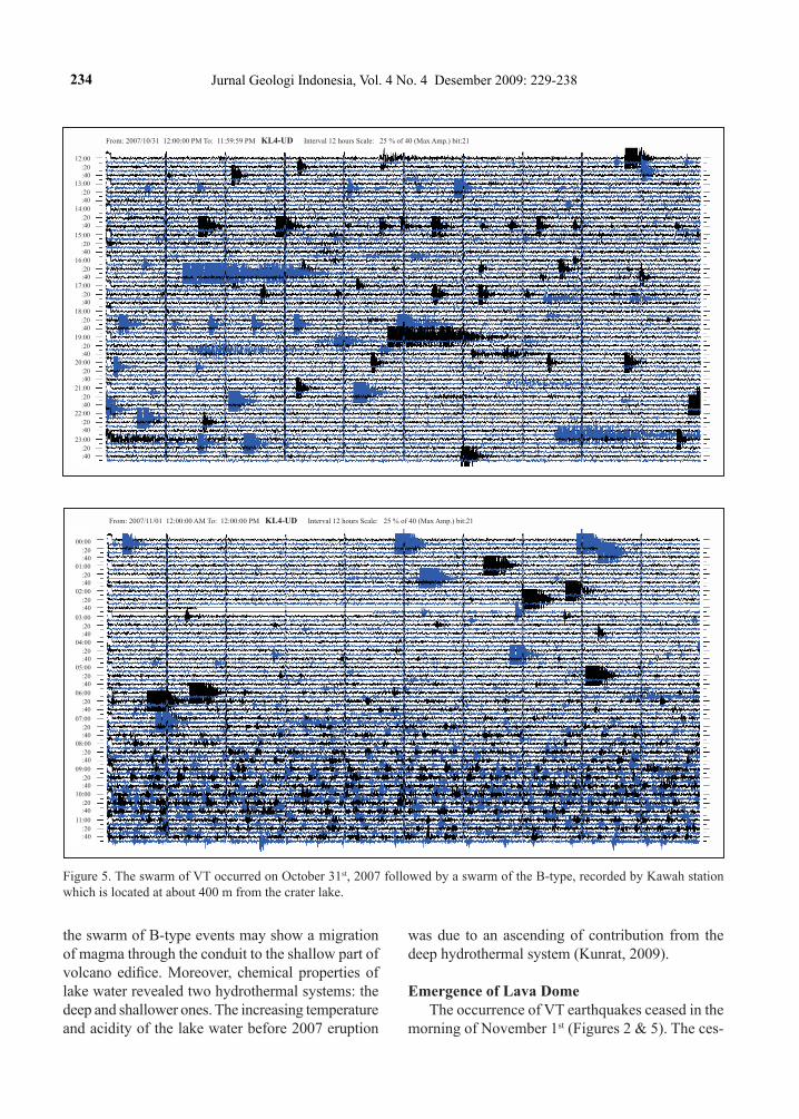
The precursor of the 1990 eruption was also observed in 2007, i.e. the increase of seismicity and the lake temperature. As mentioned above that emergence of lava dome in the middle of crater lake was preceded by the increase of seismicity starting in September 2007. Swarm of the B-type event on October 16th (Figure 4) was preceded by an increas-ing number of VT earthquakes on September 10th, 2007 (Figure 2). These occurrences were repeated on October 31st when a number of VT increased then followed by a swarm of the B-type event on November 1st. The number of the B-type exceeds about 1437 events during the day (Figure 5).
On the other hand, increasing of the lake tem-perature was detected earlier. Since July 2007, an in-tense degassing of the lake floor has been observed. It causes colour of the lake waters changed rapidly
in August and September from the typical green to yellow and bluish. The lake temperature measure-ments showed a gradual increase.
The VT earthquakes often precede a swarm of the B-type, then followed by repeated explosive eruptions similar to the Sakurajima Volcano (Kamo, 1978). Meanwhile, the swarm of B-type is inferred to be related to extrusion of lava to the summit crater (Nishi, 1984). As explained by Latter (1981), the VT earthquakes usually occur in a competent rock as a result of some instantaneous source mechanisms. The VT earthquakes of the Sakurajima Volcano mostly originated outside the crater rim, enclosing other type of volcanic earthquakes such as explo-sion and the B-type earthquakes (Ishihara, 1990; Iguchi, 1994; Hidayati et al., 2007). Meanwhile, the B-type earthquakes originate in partial molten material by some extended source mechanism. Fur-thermore, in the Merapi Volcano, the occurrence of VT earthquakes precedes the increase in number of MP events which are related to lava dome formation (Ratdomopurbo, 1995; Hidayati et al., 1998).
It all explains that the occurrence of VT earth-quakes at the Kelud Volcano may indicate there was a magma supply from deeper part to the depth about 3 - 4 km beneath the crater lake (Figure 3). Meanwhile,
234 Jurnal Geologi Indonesia, Vol. 4 No. 4 Desember 2009: 229-238
Figure 5. The swarm of VT occurred on October 31st, 2007 followed by a swarm of the B-type, recorded by Kawah station which is located at about 400 m from the crater lake.
12:00
:20:40
13:00
:20:40
14:00
:20:40
15:00
:20:40
16:00
:20:40
17:00
:20:40
18:00
:20:40
19:00
:20:40
20:00
:20:40
21:00
:20:40
22:00
:20:40
23:00
:20:40
From: 2007/10/31 12:00:00 PM To: 11:59:59 PM KL4-UD Interval 12 hours Scale: 25 % of 40 (Max Amp.) bit:21
From: 2007/11/01 12:00:00 AM To: 12:00:00 PM KL4-UD Interval 12 hours Scale: 25 % of 40 (Max Amp.) bit:21
00:00
:20:40
01:00
:20:40
02:00
:20:40
03:00
:20:40
04:00
:20:40
05:00
:20:40
06:00
:20:40
07:00
:20:40
08:00
:20:40
09:00
:20:40
10:00
:20:40
11:00
:20:40
the swarm of B-type events may show a migration of magma through the conduit to the shallow part of volcano edifice. Moreover, chemical properties of lake water revealed two hydrothermal systems: the deep and shallower ones. The increasing temperature and acidity of the lake water before 2007 eruption
was due to an ascending of contribution from the deep hydrothermal system (Kunrat, 2009).
Emergence of Lava DomeThe occurrence of VT earthquakes ceased in the
morning of November 1st (Figures 2 & 5). The ces-
235Emergence of Lava Dome from the Crater Lake of Kelud Volcano, East Java (S. Hidayati et al.)
31/11/2007 06:00
31/11/2007 18:00
01/11/2007 06:00
01/11/2007 18:00
02/11/2007 06:00
02/11/2007 18:00
03/11/2007 06:00
03/11/2007 18:00
04/11/2007 06:00
04/11/2007 18:00
40
50
60
70
80
(o C
)
surface temp. 10 m depth 15 m depth
Tem
pera
ture
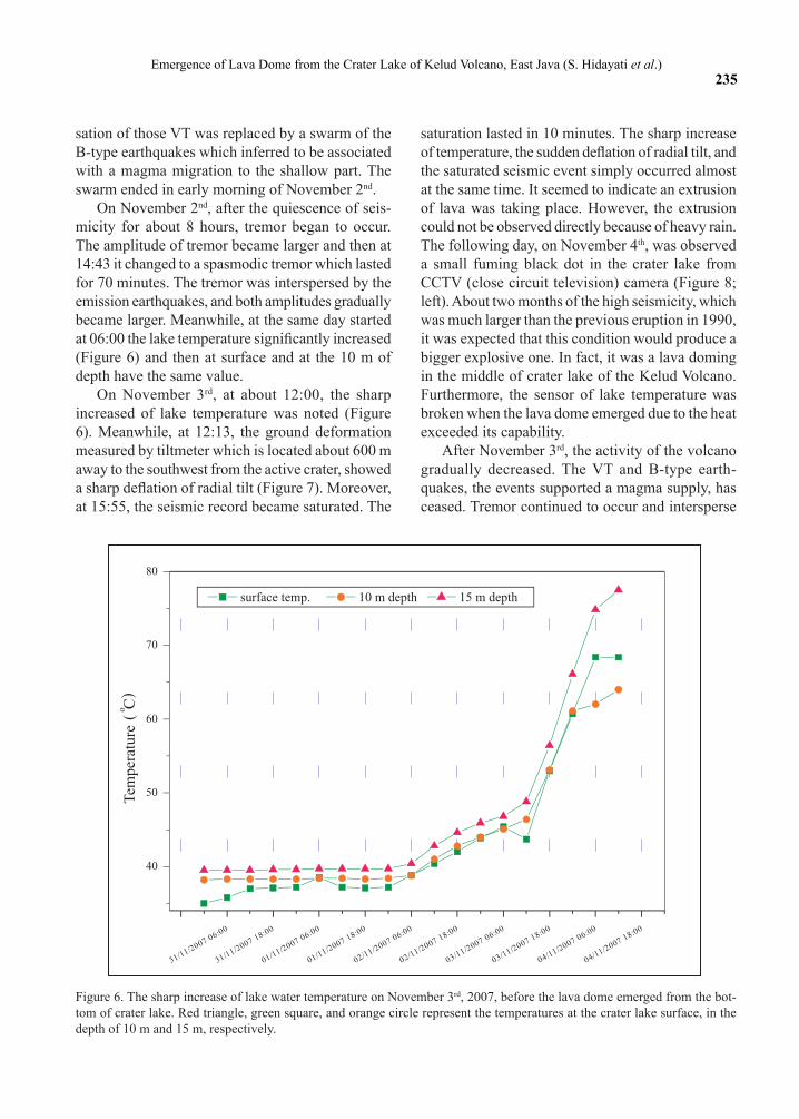
Figure 6. The sharp increase of lake water temperature on November 3rd, 2007, before the lava dome emerged from the bot-tom of crater lake. Red triangle, green square, and orange circle represent the temperatures at the crater lake surface, in the depth of 10 m and 15 m, respectively.
sation of those VT was replaced by a swarm of the B-type earthquakes which inferred to be associated with a magma migration to the shallow part. The swarm ended in early morning of November 2nd.
On November 2nd, after the quiescence of seis-micity for about 8 hours, tremor began to occur. The amplitude of tremor became larger and then at 14:43 it changed to a spasmodic tremor which lasted for 70 minutes. The tremor was interspersed by the emission earthquakes, and both amplitudes gradually became larger. Meanwhile, at the same day started at 06:00 the lake temperature significantly increased (Figure 6) and then at surface and at the 10 m of depth have the same value.
On November 3rd, at about 12:00, the sharp increased of lake temperature was noted (Figure 6). Meanwhile, at 12:13, the ground deformation measured by tiltmeter which is located about 600 m away to the southwest from the active crater, showed a sharp deflation of radial tilt (Figure 7). Moreover, at 15:55, the seismic record became saturated. The
saturation lasted in 10 minutes. The sharp increase of temperature, the sudden deflation of radial tilt, and the saturated seismic event simply occurred almost at the same time. It seemed to indicate an extrusion of lava was taking place. However, the extrusion could not be observed directly because of heavy rain. The following day, on November 4th, was observed a small fuming black dot in the crater lake from CCTV (close circuit television) camera (Figure 8; left). About two months of the high seismicity, which was much larger than the previous eruption in 1990, it was expected that this condition would produce a bigger explosive one. In fact, it was a lava doming in the middle of crater lake of the Kelud Volcano. Furthermore, the sensor of lake temperature was broken when the lava dome emerged due to the heat exceeded its capability.
After November 3rd, the activity of the volcano gradually decreased. The VT and B-type earth-quakes, the events supported a magma supply, has ceased. Tremor continued to occur and intersperse

236 Jurnal Geologi Indonesia, Vol. 4 No. 4 Desember 2009: 229-238
Figure 7. Tilt measurement at the distance about 600 m from the crater on the SW flank. A sharp deflation was observed at 12:13 (local time) on November 3rd, 2007.
Figure 8. The emergence process of lava dome from the crater lake of Kelud Volcano (taken from CCTV camera; courtesy of Local Authority of Kediri).
20
07
-09
-25
15
:33
20
07
-09
-29
2:5
3
20
07
-10
-02
14
:13
20
07
-10
-06
1:3
2
20
07
-10
-09
12
:52
20
07
-10
-13
0:1
2
20
07
-10
-16
11
:32
20
07
-10
-19
23
:52
20
07
-10
-23
11
:11
20
07
-10
-26
12
:31
20
07
-10
-29
23
:51
20
07
-11
-02
11
:11
20
07
-11
-05
22
:31
20
07
-11
-09
9:5
1
11
/12
/20
07
21
:11
20
07
-11
-15
23
:31 --
-140-136-132-128-124-120-116-112-108-104-100
10
15
20
25
30
405060708090
100110
RA
DIA
L(m
rad
)
phreatic eruption on Nov 14, 2007
phreatic eruptionon Nov 11, 2007
Lava extrusion began
Te
mp
era
ture
(oC
)T
AN
GE
NT
IAL
(mra
d)
with emission earthquakes. The seismic record be-came saturated again on November 11th, 15:51 for 36 minutes and on November 14th, 2007 at 03:47, for 17 minutes. At the same time, ash reached about 2500 m high above the volcano and some materials were ejected from the crater as recorded by CCTV camera.
Field observations were carried out on 6th, 9th, 11th, and 17th of November 2007 and found out that the dome grew very rapidly. The height of the dome was gradually raised. Every visual observa-tions at the crater estimated that the height of the dome was 70 m, 100 m, 120 m, and 150 m from crater bottom.
237Emergence of Lava Dome from the Crater Lake of Kelud Volcano, East Java (S. Hidayati et al.)
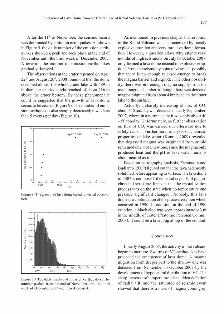
Figure 9. The growth of lava dome based on visual observa-tion.
Figure 10. The daily number of emission earthquakes . The number peaked from the end of November until the third week of December 2007 and then decreased.
Oct Nov Dec Jan Feb Mar Apr May Jun Jul Aug Sep50
100
150
200
250
20082007
April 22, 2008 Aug 26, 2008
He
igh
to
fla
va
do
me
(m)
Date
20082007Nov Dec Jan Feb Mar Apr May Jun Jul Aug
0
200
400
600
800
1000
1200
1400
1600
1800
Nu
mb
er
of
ev
en
ts
Date
After the 11th of November, the seismic record was dominated by emission earthquakes. As shown in Figure 9, the daily number of the emission earth-quakes showed a peak and took place at the end of November until the third week of December 2007. Afterward, the number of emission earthquakes gradually decayed.
The observations at the crater repeated on April 22nd and August 26th, 2008 found out that the dome occupied almost the whole crater lake with 489 m in diameter and its height reached of about 216 m above the crater bottom. By these phenomena it could be suggested that the growth of lava dome seems to be ceased (Figure 9). The number of emis-sion earthquakes also sharply decreased; it was less than 5 events per day (Figure 10).
As mentioned in previous chapter that eruption of the Kelud Volcano was characterized by mostly explosive eruption and very rare lava dome forma-tion. However, a question arises why after several months of high seismicity on July to October 2007, only formed a lava dome instead of explosive erup-tion? From the seismicity point of view, it is possibly that there is no enough released-energy to break the magma barrier and explode. The other possibil-ity, there was not enough magma supply from the main magma chamber, although there was detected magma migrated from about 4 km beneath the crater lake to the surface.
Actually, a sharply increasing of flux of CO2 about 550 ton/day was detected on early September, 2007, where in a normal state it was only about 40 – 50 ton/day. Unfortunately, no further observation on flux of CO2 was carried out afterward due to safety reason. Furthermore, analysis of chemical properties of lake water (Kunrat, 2009) revealed that degassed magma was originated from an old remained one, not a new one, since the magma only produced heat and the pH of lake water remains about neutral as it is.
Based on petrography analysis, Zaennudin and Budianto (2009) figured out that the lava had mostly solidified before appearing to surface. The lava dome of 2007 is composed of euhedral crystals of plagio-clase and pyroxene. It means that the crystallization process was on the state when no temperature and pressure significant changed. Probably, this lava dome is a continuation of the process eruption which occurred in 1990. In addition, at the end of 1990 eruption, a black clod was seen approximately 3 m in the middle of crater (Pratomo, Personal Comm., 2008). It could be a lava plug at top of the conduit.
conclusIon
In early August 2007, the activity of the volcano began to increase. Swarms of VT earthquakes have preceded the emergence of lava dome. A magma migration from deeper part to the shallow one was detected from September to October 2007 by the development of hypocentral distribution of VT. The sharp increase of temperature, the sudden deflation of radial tilt, and the saturated of seismic event showed that there is a mass of magma coming up

238 Jurnal Geologi Indonesia, Vol. 4 No. 4 Desember 2009: 229-238
to the surface on November 3rd. It indicates that an extrusion of magma forming lava dome is began.
Acknowledgments---The authors are grateful to Budi Pri-yanto, Ananto Bagus Kuncoro, and Khairil Huda, the vol-cano observers of Kelud Volcano observatory for their help-ful assistances. Many appreciation to Ahmad Zaennudin for fruitful discussions. Thanks to CVGHM for providing the fund through the fiscal budget of the year 2007.
references
Hidayati, S., Iguchi, M., Ishihara, K., Purbawinata, M.A., Subandriyo, Sinulingga, I.K., and Suharna, 1998. A preliminary result of quantitative evaluation on activity of Merapi volcano. Proccedings On Symposium on Japan - Indonesia IDNDR Project, p. 165 - 180.
Hidayati, S., Ishihara., K., and Iguchi, M., 2007. Volcano-tectonic Earthquakes during the Stage of Magma Accumulation at the Aira Caldera, Southern Kyushu, Japan. Bulletin Volcanological Society of Japan, 52 (6), p.289-309.
Iguchi. M., 1994. A vertical expansion source model for the mechanisms of earthquakes originated in the magma conduit of an andesitic volcano: Sakurajima, Japan. Bulletin Volcanological Society of Japan, 39, p.49-67.
Ishihara, K., 1990. Pressure sources and induces ground deformation associated with explosive eruptions at andesitic volcano: Sakurajima volcano, Japan. In: Ryan, M.P. (Ed.), Magma Transport and Storage, John Willey & Sons, Chischester, p.335 - 356
Kamo, K., 1978. Some phenomena before the summit eruptions at Sakurajima volcano. Bulletin Volcanological Society of Japan, 23, p.53-64. (In Japanese with English abstract)
Kunrat, S.L, 2009. Geochemical and Thermodynamic Modeling of Volcanic Fluids and Their Interpretation for Volcano Monitoring. Université Libre de Bruxelles (unpublished paper).
Kusumadinata, K., 1979. Data Dasar Gunungapi Indonesia. Direktorat Vulkanologi, Bandung.
Latter, J.H., 1981. Volcanic earthquakes and their relationship to eruptions at Ruapehu and Ngauruhoe volcanoes. Journal of Volcanology and Geothermal Research, 9, p.293 - 309.
Lesage, Ph. and Surono, 1995. Seismic precursors of the February 10, 1990 eruption of Kelut volcano, Java. Journal of Volcanology and Geothermal Research, 65, p. 135-146.
Minakami, T. 1974. Seismology and volcanoes in Japan. In: Civetta, L., Gasfarini, P., Luongo, G., and Rapolla, A. (Eds.), Physical Volcanology, p.1 - 27. Elsevier.
Nishi, K., 1984. Volcanic B-type earthquake swarm preceding volcanic explosion. Annual Disaster Prevention Research Institute, Kyoto University, 27B-1, p.29-34. (In Japanese with English abstract).
Nishi, K., 2005. Graphical Hypocentre Calcuation software (GrHypo).
Ratdomopurbo, 1995. Etude sismoloique du Vulcan Merapi et formation du dome de 1994. PhD thesis, L’universite Joseph Fourier-Grenoble I, France, Unpublished.
Zaennudin, A. and Budianto, A., 2009. Prakiraan Bahaya Erupsi G. Kelud (unpublished report).