ELOISE COPPER JV REPORT - Minotaur Exploration · Release LEVEL 1, 8 BEULAH ROAD, NORWOOD, SOUTH...
9
Release LEVEL 1, 8 BEULAH ROAD, NORWOOD, SOUTH AUSTRALIA 5067 T +61 8 8132 3400 F +61 8 8132 3499 E [email protected] www.minotaurexploration.com.au ELOISE COPPER JV REPORT HIGHLIGHTS • Joint venture partner GFR undertakes to resume payments and continue with exploration expenditure contributions • Joint Venture will resume field work upon receipt of final payment from GFR pursuant to agreed payment plan • Results for six diamond drill holes testing Artemis copper-gold-zinc mineralisation reported herein • Analysis of Artemis drill data indicates host structure continues at depth • Down-hole EM survey detects drill-ready off-hole conductor below drill hole EL15D05 • Drill targets identified below adjacent Sandy Creek deposit • Ground reconnaissance of remaining regional VTEM conductors completed with 5 targets identified for 1 Eloise Copper JV, MEP report to ASX dated 5 March 2015 Joint Venture Arrangements The JV work plan was temporarily suspended in March 1 due to financing limitations affecting joint venture partner GFR’s ability to fund its obligations under the JV. Minotaur issued GFR with a Notice of Default requiring remedy by 20 April 2015. GFR represents that it has put arrangements in place that resolve its difficulties and has undertaken to recommence payments according to joint venture terms and conditions. Minotaur, as Manager, has provided GFR with an extension of time in which to complete its payments under an agreed specific payment plan. That plan comprises several payments totaling $3.3 million through May – mid June 2015, upon the satisfaction of which Minotaur will re-commence field exploration activity, and not prior thereto. As consideration for stay of termination of the JV by Minotaur, GFR agreed that its beneficial interest in the tenements is reduced to 0%. GFR’s interest will become 25% upon receipt by Minotaur of payments aggregating $2.3 million (excluding accrued interest). Should GFR default on the payment plan prior to gaining 25% interest and should Minotaur elect to terminate the JV GFR’s interest will be maintained at 0%. Otherwise, and on completion of the payment plan GFR’s interest will increase to 50%. MINOTAUR EXPLORATION www.minotaurexploration.com.au MINOTAUR EXPLORATION LIMITED ACN 108 483 601 ASX: MEP 21 April 2015
Transcript of ELOISE COPPER JV REPORT - Minotaur Exploration · Release LEVEL 1, 8 BEULAH ROAD, NORWOOD, SOUTH...

Release
LEVEL 1, 8 BEULAH ROAD, NORWOOD, SOUTH AUSTRALIA 5067 T +61 8 8132 3400 F +61 8 8132 3499 E [email protected]
www.minotaurexploration.com.au
ELOISE COPPER JV REPORT
HIGHLIGHTS
• Joint venture partner GFR undertakes to resume
payments and continue with exploration expenditure
contributions
• Joint Venture will resume field work upon receipt of
final payment from GFR pursuant to agreed payment
plan
• Results for six diamond drill holes testing Artemis
copper-gold-zinc mineralisation reported herein
• Analysis of Artemis drill data indicates host structure
continues at depth
• Down-hole EM survey detects drill-ready off-hole
conductor below drill hole EL15D05
• Drill targets identified below adjacent Sandy Creek
deposit
• Ground reconnaissance of remaining regional VTEM
conductors completed with 5 targets identified for
1 Eloise Copper JV, MEP report to ASX dated 5 March 2015
Joint Venture Arrangements
The JV work plan was temporarily suspended in March1
due to financing limitations affecting joint venture
partner GFR’s ability to fund its obligations under the JV.
Minotaur issued GFR with a Notice of Default requiring
remedy by 20 April 2015. GFR represents that it has put
arrangements in place that resolve its difficulties and
has undertaken to recommence payments according
to joint venture terms and conditions. Minotaur, as
Manager, has provided GFR with an extension of time
in which to complete its payments under an agreed
specific payment plan. That plan comprises several
payments totaling $3.3 million through May – mid
June 2015, upon the satisfaction of which Minotaur will
re-commence field exploration activity, and not prior
thereto. As consideration for stay of termination of the
JV by Minotaur, GFR agreed that its beneficial interest
in the tenements is reduced to 0%. GFR’s interest will
become 25% upon receipt by Minotaur of payments
aggregating $2.3 million (excluding accrued interest).
Should GFR default on the payment plan prior to gaining
25% interest and should Minotaur elect to terminate the
JV GFR’s interest will be maintained at 0%. Otherwise, and
on completion of the payment plan GFR’s interest will
increase to 50%.
MINOTAUREXPLORATION
www.minotaurexploration.com.au
MINOTAUR EXPLORATION LIMITED ACN 108 483 601 ASX: MEP
21 April 2015
PAGE 2
ASX RELEASE 21 APRIL 2015
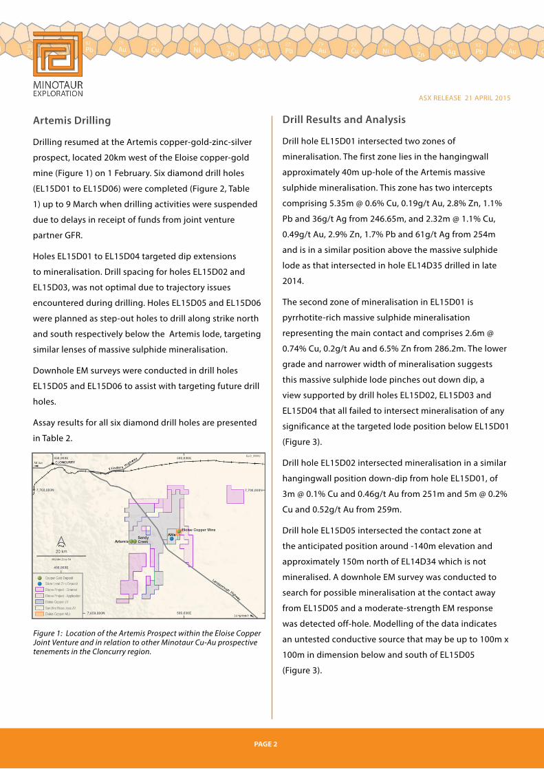
Artemis Drilling
Drilling resumed at the Artemis copper-gold-zinc-silver
prospect, located 20km west of the Eloise copper-gold
mine (Figure 1) on 1 February. Six diamond drill holes
(EL15D01 to EL15D06) were completed (Figure 2, Table
1) up to 9 March when drilling activities were suspended
due to delays in receipt of funds from joint venture
partner GFR.
Holes EL15D01 to EL15D04 targeted dip extensions
to mineralisation. Drill spacing for holes EL15D02 and
EL15D03, was not optimal due to trajectory issues
encountered during drilling. Holes EL15D05 and EL15D06
were planned as step-out holes to drill along strike north
and south respectively below the Artemis lode, targeting
similar lenses of massive sulphide mineralisation.
Downhole EM surveys were conducted in drill holes
EL15D05 and EL15D06 to assist with targeting future drill
holes.
Assay results for all six diamond drill holes are presented
in Table 2.
Drill Results and Analysis
Drill hole EL15D01 intersected two zones of
mineralisation. The first zone lies in the hangingwall
approximately 40m up-hole of the Artemis massive
sulphide mineralisation. This zone has two intercepts
comprising 5.35m @ 0.6% Cu, 0.19g/t Au, 2.8% Zn, 1.1%
Pb and 36g/t Ag from 246.65m, and 2.32m @ 1.1% Cu,
0.49g/t Au, 2.9% Zn, 1.7% Pb and 61g/t Ag from 254m
and is in a similar position above the massive sulphide
lode as that intersected in hole EL14D35 drilled in late
2014.
The second zone of mineralisation in EL15D01 is
pyrrhotite-rich massive sulphide mineralisation
representing the main contact and comprises 2.6m @
0.74% Cu, 0.2g/t Au and 6.5% Zn from 286.2m. The lower
grade and narrower width of mineralisation suggests
this massive sulphide lode pinches out down dip, a
view supported by drill holes EL15D02, EL15D03 and
EL15D04 that all failed to intersect mineralisation of any
significance at the targeted lode position below EL15D01
(Figure 3).
Drill hole EL15D02 intersected mineralisation in a similar
hangingwall position down-dip from hole EL15D01, of
3m @ 0.1% Cu and 0.46g/t Au from 251m and 5m @ 0.2%
Cu and 0.52g/t Au from 259m.
Drill hole EL15D05 intersected the contact zone at
the anticipated position around -140m elevation and
approximately 150m north of EL14D34 which is not
mineralised. A downhole EM survey was conducted to
search for possible mineralisation at the contact away
from EL15D05 and a moderate-strength EM response
was detected off-hole. Modelling of the data indicates
an untested conductive source that may be up to 100m x
100m in dimension below and south of EL15D05
(Figure 3).
Figure 1: Location of the Artemis Prospect within the Eloise Copper Joint Venture and in relation to other Minotaur Cu-Au prospective tenements in the Cloncurry region.

PAGE 3
ASX RELEASE 21 APRIL 2015 ASX RELEASE 21 APRIL 2015
Hole ID Easting (m) Northing (m) Dip Azimuth (T) Depth (m)
EL15D01 479214 7680007 -67 290 318.2
EL15D02 479225 7680030 -73 290 385
EL15D03 479230 7680057 -70 290 382
EL15D04 479230 7680057 -67 290 349
EL15D05 479264 7680180 -70 290 429.5
EL15D06 479171 7679893 -70 290 297.6
Drill hole EL15D06 intersected the contact zone
100m vertically above its intended position at
approximately 0m elevation (Figure 3). A narrow
zone of massive pyrrhotite mineralisation occurs
at the contact that returned 2.55m @ 0.69% Cu
and 0.07g/t Au. The contact is east of its expected
position and appears likely to have been offset
by a later fault, however the implications of
possible fault displacement to mineralisation is
not yet known. A downhole EM survey detected
a strong off-hole response north and above the
hole that is consistent with the position of the
massive sulphide lode.
Significant assay results are presented in Tables 2
and 3 with QAQC discussed in the Appendix.
Assessment of the Artemis Deposit
Evaluation of the data shows the massive
sulphide body at Artemis is fault controlled
where mineralisation has focused in a dilation
zone, or jog, within a fault developed adjacent to
a major lithological boundary.
Data indicates the massive sulphide lode
pinches out up and down dip and potentially
along strike however alteration, typical of that
associated with the sulphide, continues at depth
on or immediately adjacent the lithological
boundary suggesting the system is prospective
along this contact at depth. Drill hole EL14D34
(Figure 3), supports this interpretation and
indeed contains a 1.1m wide zone of semi-
massive sulphide in a 4m wide zone of mafic
alteration at this lithological contact that could
be indicative of further mineralisation developed
at depth associated, potentially, in another
fault jog. Minotaur plans to test this concept
with additional drilling (see future work section
below).
Table 1: Collar details for recent Minotaur drill holes at the Artemis Prospect. All coordinates refer to GDA94 datum, Zone 54. All holes are located by handheld GPS.
Table 2: Key mineralised intervals for holes EL15D01, EL15D02 and EL15D06. Depths tabulated are downhole depths. HW = Hangingwall.
Figure 2: Plan of the Artemis Prospect with Minotaur and historic drill holes shown. Recent Minotaur drill hole traces are shown in red.
HOLE FROM TOINTERVAL
mCu %
Aug/t
Zn%
Agg/t
Pb%
ZONE
EL15D01 246.65 252.00 5.35 0.60 0.19 2.84 36 1.12 HW
and 254.00 256.32 2.32 1.08 0.49 2.92 61 1.68 HW
and 286.20 288.80 2.60 0.74 0.20 6.46 1 <0.01 Main
EL15D02 251.00 254.00 3.00 0.13 0.46 0.11 1 <0.01 HW
and 259.00 264.00 5.00 0.25 0.55 0.19 2 0.01 HW
EL15D06 232.00 234.55 2.55 0.69 0.07 <0.01 0.02 <0.01 Main

ASX RELEASE 21 APRIL 2015
PAGE 4
Future work on the Eloise Copper Joint Venture
Field work will resume once GFR’s compliance with
the agreed payment plan is complete (by mid June
at the latest). The main contact zone at Artemis,
which hosts massive sulphide mineralisation, will
continue to be the focus of further drill testing.
A number of holes are planned to test down
dip and along strike of existing drilling aimed at
defining extensions to known mineralisation and
to test for massive sulphide along the prospective
lithological boundary hosting Artemis (Figure 3).
Drilling will be aided by down-hole EM surveys to
examine the contact away from the holes to give a
wider search area.
A review of the Sandy Creek mineral resource2, located just
350m east of Artemis, is advanced. Sandy Creek appears to
share some features with Artemis; in particular there are
notable zones of strongly elevated zinc with copper-gold
mineralisation that may suggest the systems have a common
link. Sandy Creek remains open in the southern portion of the
deposit. Modelling of historic data suggests mineralisation
plunges south below the existing drilling (Figure 4),
representing valid targets at depth for drill testing.
Hole IDFrom
(m)
To
(m)
Interval
(m)
Cu
%
Au
g/t
Zn
%
Ag
g/t
Pb
%
EL15D01 246.7 248 1.35 0.48 0.10 4.13 27.40 0.69
EL15D01 248 249 1 0.46 0.46 4.60 84.60 2.63
EL15D01 249 250 1 0.80 0.17 2.31 30.50 0.98
EL15D01 250 251 1 0.45 0.14 2.64 35.50 1.37
EL15D01 251 252 1 0.88 0.10 0.05 4.46 0.07
EL15D01 254 255 1 0.95 0.27 2.00 29.60 0.69
EL15D01 255 256.3 1.32 1.18 0.66 3.61 85.40 2.43
EL15D01 286.2 287 0.8 0.53 0.14 2.50 0.64 <0.01
EL15D01 287 288 1 0.98 0.18 14.10 1.69 <0.01
EL15D01 288 288.8 0.8 0.66 0.27 0.88 1.41 0.01
EL15D02 251 252 1 0.26 0.49 0.15 1.08 <0.01
EL15D02 252 253 1 0.04 0.45 0.05 0.54 0.01
EL15D02 253 254 1 0.11 0.45 0.14 1.56 <0.01
EL15D02 259 260 1 0.13 0.34 0.27 2.62 0.02
EL15D02 260 261 1 0.14 0.28 0.06 0.93 0.01
EL15D02 261 262 1 0.41 0.44 0.23 2.65 0.01
EL15D02 262 263 1 0.20 0.51 0.02 0.93 0.01
EL15D02 263 264 1 0.37 1.19 0.35 2.65 0.01
EL15D06 232 232.6 0.58 0.69 0.03 <0.01 0.65 <0.01
EL15D06 232.6 233.5 0.92 0.68 0.07 <0.01 1.45 <0.01
EL15D06 233.5 234.6 1.05 0.71 0.08 <0.01 0.62 <0.01
Table 3: Analytical data for holes EL15D01, EL15D02 and EL15D06. Samples with <0.5% Cu, and/or <0.3g/t Au, and/or <1.5% Zn outside the reported intercepts have been omitted. Drill core analysed at ALS Laboratories (fire assay and AAS for Au, four acid digest and analysis by ICP-MS/ICP-AES for elements other than Au, ore grade analysis of following four acid digest for high Cu, Zn, Pb, Ag samples). Depths tabulated are downhole depths.
2 Sandy Creek Inferred Resource, comprising 2Mt @ 1.32% Cu and 0.3g/t Au, was previously reported according to JORC 2004 by Breakaway Resources Ltd. Minotaur advises that the data has not been re-estimated according to JORC 2012 as the information has not changed in any material aspect.
Figure 3: Long section of “Main Zone” at Artemis (looking WNW along 290 true bearing) showing intersection points of Minotaur drill holes and historic drill holes.

ASX RELEASE 21 APRIL 2015 ASX RELEASE 21 APRIL 2015
PAGE 4 PAGE 5
Regional Exploration
Field reconnaissance of the remaining VTEM anomalies was
completed recently. Five anomalies have been selected
for further work (Figure 5) that is to include detailed soil
sampling and/or IP-resistivity geophysical surveying,
with the view of defining new drill targets for testing. The
targeted mineralisation style is Iron Sulphide Copper Gold
(ISCG) similar to that developed at Eloise, Artemis and
Sandy Creek.
Figure 4: Oblique long section view of Sandy Creek Cu-Au deposit showing interpreted direction where deposit remains open. Coloured blocks show Cu >1.5% as estimated from the historic resource2
model. Artemis mineralisation is represented for spatial comparison purposes.
Figure 5: VTEM conductivity image showing remaining 5 targets to be followed up (yellow dots).
Andrew Woskett(Managing Director)
COMPETENT PERSON’S STATEMENT
Information in this report that relates to Exploration
Results, Mineral Resources or Ore Reserves is based
on information compiled by Mr Glen Little, who
is a full-time employee of the Company and a
Member of the Australian Institute of Geoscientists
(AIG). Mr Little has sufficient experience relevant
to the style of mineralisation and type of deposit
under consideration and to the activity that he
is undertaking to qualify as a Competent Person
as defined in the 2012 Edition of the Australasian
Code for Reporting of Exploration Results, Mineral
Resources and Ore Reserves (JORC Code). Mr
Little consents to inclusion in this document of the
information in the form and context in which it
appears.
Tony Belperio(Director, Business Development)
Minotaur Exploration Ltd T +61 8 8132 3400
www.minotaurexploration.com.au
About the Eloise Copper Joint Venture
The Eloise Copper JV (JV) is managed and operated by
Minotaur Exploration on behalf of joint venture
partner Golden Fields Resources Pty Ltd (GFR) who, upon
expenditure of $6 million, may earn a 50% beneficial
joint venture interest in the tenements (EPM 17838 and
EPM 18442, but excluding those parts subject to the
Altia joint venture with Sandfire Resources NL). As at
31 December 2014 GFR had earned 14% interest in the
tenements.
2 ibid
PAGE 8
APPENDIX Table 4
PAGE 7
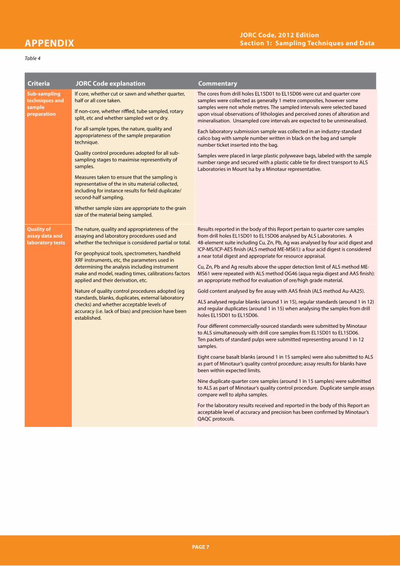
Sub-sampling techniques and sample preparation
If core, whether cut or sawn and whether quarter, half or all core taken.
If non-core, whether riffled, tube sampled, rotary split, etc and whether sampled wet or dry.
For all sample types, the nature, quality and appropriateness of the sample preparation technique.
Quality control procedures adopted for all sub-sampling stages to maximise representivity of samples.
Measures taken to ensure that the sampling is representative of the in situ material collected, including for instance results for field duplicate/second-half sampling.
Whether sample sizes are appropriate to the grain size of the material being sampled.
The cores from drill holes EL15D01 to EL15D06 were cut and quarter core samples were collected as generally 1 metre composites, however some samples were not whole metres. The sampled intervals were selected based upon visual observations of lithologies and perceived zones of alteration and mineralisation. Unsampled core intervals are expected to be unmineralised.
Each laboratory submission sample was collected in an industry-standard calico bag with sample number written in black on the bag and sample number ticket inserted into the bag.
Samples were placed in large plastic polyweave bags, labeled with the sample number range and secured with a plastic cable tie for direct transport to ALS Laboratories in Mount Isa by a Minotaur representative.
Quality of assay data and laboratory tests
The nature, quality and appropriateness of the assaying and laboratory procedures used and whether the technique is considered partial or total.
For geophysical tools, spectrometers, handheld XRF instruments, etc, the parameters used in determining the analysis including instrument make and model, reading times, calibrations factors applied and their derivation, etc.
Nature of quality control procedures adopted (eg standards, blanks, duplicates, external laboratory checks) and whether acceptable levels of accuracy (i.e. lack of bias) and precision have been established.
Results reported in the body of this Report pertain to quarter core samples from drill holes EL15D01 to EL15D06 analysed by ALS Laboratories. A 48-element suite including Cu, Zn, Pb, Ag was analysed by four acid digest and ICP-MS/ICP-AES finish (ALS method ME-MS61): a four acid digest is considered a near total digest and appropriate for resource appraisal.
Cu, Zn, Pb and Ag results above the upper detection limit of ALS method ME-MS61 were repeated with ALS method OG46 (aqua regia digest and AAS finish): an appropriate method for evaluation of ore/high grade material.
Gold content analysed by fire assay with AAS finish (ALS method Au-AA25).
ALS analysed regular blanks (around 1 in 15), regular standards (around 1 in 12) and regular duplicates (around 1 in 15) when analysing the samples from drill holes EL15D01 to EL15D06.
Four different commercially-sourced standards were submitted by Minotaur to ALS simultaneously with drill core samples from EL15D01 to EL15D06. Ten packets of standard pulps were submitted representing around 1 in 12 samples.
Eight coarse basalt blanks (around 1 in 15 samples) were also submitted to ALS as part of Minotaur’s quality control procedure; assay results for blanks have been within expected limits.
Nine duplicate quarter core samples (around 1 in 15 samples) were submitted to ALS as part of Minotaur’s quality control procedure. Duplicate sample assays compare well to alpha samples.
For the laboratory results received and reported in the body of this Report an acceptable level of accuracy and precision has been confirmed by Minotaur’s QAQC protocols.
JORC Code, 2012 EditionSection 1: Sampling Techniques and Data
Criteria JORC Code explanation Commentary

APPENDIX Table 4
PAGE 8
Verification of sampling and assaying
The verification of significant intersections by either independent or alternative company personnel.
The use of twinned holes.
Documentation of primary data, data entry proce-dures, data verification, data storage (physical and electronic) protocols.
Discuss any adjustment to assay data.
All drilling data including collar coordinates, hole orientation, total depth, sampling intervals and lithological logging were recorded using OCRIS Mobile logging software with inbuilt data validation.
Significant intersections have been verified by Minotaur’s Project Geologists: laboratory assays are consistent with mineralised intervals highlighted by geological logging.
No twinned holes were undertaken.
No adjustments to assay data were undertaken.
Location of data points
Accuracy and quality of surveys used to locate drill holes (collar and down-hole surveys), trenches, mine workings and other locations used in Mineral Resource estimation.
Specification of the grid system used.
Quality and adequacy of topographic control.
Drillhole collar locations (GDA94, MGA Zone 54) of holes EL15D01 to EL15D06 have been located using a handheld GPS unit pending DGPS location as soon as possible. The drill collars are considered to be located with an appropriate level of accuracy for early-stage mineralisation appraisal.
DDH1 Drilling used a digital survey system every ~30m downhole to determine hole orientation during diamond drilling, this data have been used to the plot drillhole traces and intercept positions for EL15D01 to EL15D06.
Data spacing and distribution
Data spacing for reporting of Exploration Results.
Whether the data spacing and distribution is sufficient to establish the degree of geological and grade continuity appropriate for the Mineral Resource and Ore Reserve estimation procedure(s) and classifications applied.
Whether sample compositing has been applied.
Results reported in the body of this Report pertain to quarter core samples from drill holes EL15D01 to EL15D06 analysed by ALS Laboratories. Typically 1 metre intervals coincident with mineralisation and alteration selected for downhole geochemical sampling. Same samples were not whole metre intervals. The total intervals sampled in drill holes EL15D01 to EL15D06 are considered appropriate for the perceived degree of mineralisation present.
Historic exploration drilling is of insufficient density to determine extents of mineralisation along strike or at depth from Minotaur drillholes.
No mineral resource or ore reserve estimation has been undertaken.
Orientation of data in relation to geological structure
Whether the orientation of sampling achieves unbiased sampling of possible structures and the extent to which this is known, considering the deposit type.
If the relationship between the drilling orientation and the orientation of key mineralised structures is considered to have introduced a sampling bias, this should be assessed and reported if material.
Drillhole orientation was optimized to intersect the centre of the target geophysical anomalies.
No orientation-based sampling bias has been identified.
Sample security The measures taken to ensure sample security. All drill samples were stored at a secure location and delivered to the Laboratory for analysis by Minotaur personnel. Remnant drill core and laboratory pulps from EL15D01 to EL15D06 have been retained by Minotaur.
Audits or reviews The results of any audits or reviews of sampling techniques and data.
No independent audit or review undertaken.
JORC Code, 2012 EditionSection 1: Sampling Techniques and Data continued
PAGE 7
JORC Code, 2012 EditionSection 1: Sampling Techniques and Data
Criteria JORC Code explanation Commentary
PAGE 10
APPENDIX
Table 5
JORC Code, 2012 Edition Section 2: Reporting of Exploration Results
PAGE 9
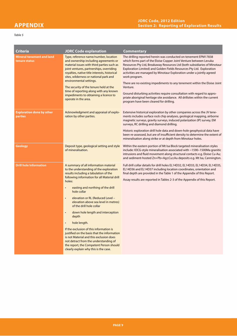
Mineral tenement and land tenure status
Type, reference name/number, location and ownership including agreements or material issues with third parties such as joint ventures, partnerships, overriding royalties, native title interests, historical sites, wilderness or national park and environmental settings.
The security of the tenure held at the time of reporting along with any known impediments to obtaining a licence to operate in the area.
The drilling reported herein was conducted on tenement EPM17838 which forms part of the Eloise Copper Joint Venture between Levuka Resources Pty Ltd, Breakaway Resources Ltd (both subsidiaries of Minotaur Exploration Limited) and Golden Fields Resources Pty Ltd. Exploration activities are managed by Minotaur Exploration under a jointly agreed work program.
There are no existing impediments to any tenement within the Eloise Joint Venture.
Ground disturbing activities require consultation with regard to appro-priate aboriginal heritage site avoidance. All drillsites within the current program have been cleared for drilling.
Exploration done by other parties
Acknowledgment and appraisal of explo-ration by other parties.
Extensive historical exploration by other companies across the JV tene-ments includes surface rock chip analyses, geological mapping, airborne magnetic surveys, gravity surveys, induced polarization (IP) survey, EM surveys, RC drilling and diamond drilling.
Historic exploration drill hole data and down-hole geophysical data have been re-assessed, but are of insufficient density to determine the extent of mineralisation along strike or at depth from Minotaur holes.
Geology Deposit type, geological setting and style of mineralisation.
Within the eastern portion of Mt Isa Block targeted mineralisation styles include: IOCG-style mineralisation associated with ~1590–1500Ma granitic intrusions and fluid movement along structural contacts e.g. Eloise Cu-Au; and sediment-hosted Zn+Pb+Ag±Cu±Au deposits e.g. Mt Isa, Cannington.
Drill hole Information A summary of all information material to the understanding of the exploration results including a tabulation of the following information for all Material drill holes:
• easting and northing of the drill hole collar
• elevation or RL (Reduced Level – elevation above sea level in metres) of the drill hole collar
• down hole length and interception depth
• hole length.
If the exclusion of this information is justified on the basis that the information is not Material and this exclusion does not detract from the understanding of the report, the Competent Person should clearly explain why this is the case.
Full drill collar details for drill holes EL14D32, EL14D33, EL14D34, EL14D35, EL14D36 and EL14D37 including location coordinates, orientation and final depth are provided in the Table 1 of the Appendix of this Report.
Assay results are reported in Tables 2-3 of the Appendix of this Report.
Criteria JORC Code explanation Commentary

APPENDIX Table 5
PAGE 10
Data aggregation methods In reporting Exploration Results, weighting averaging techniques, maximum and/or minimum grade truncations (eg cutting of high grades) and cut-off grades are usually Material and should be stated.
Where aggregate intercepts incorporate short lengths of high grade results and longer lengths of low grade results, the procedure used for such aggregation should be stated and some typical examples of such aggregations should be shown in detail.
The assumptions used for any reporting of metal equivalent values should be clearly stated.
Assay results reported in the body of this Report pertain to quarter core samples from drill holes EL14D32, EL14D33, EL14D34, EL14D35, EL14D36 and EL14D37 analysed by ALS Laboratories.
Drill holes EL14D32-EL14D35 were drilled between –61 and 70 degrees towards azimuth of 290-309 degrees (True bearing) to intersect the interpreted mineralised zone at a moderately high angle.
No maximum and/or minimum grade truncations have been used. Most (but not all) assays are for 1 metre representative splits, therefore intervals and grade reported EL14D32, EL14D33, EL14D34, EL14D35, EL14D36 and EL14D37 include weighted averages based upon down-hole distance were appropriate.
Relationship between mineralisation widths and intercept lengths
These relationships are particularly important in the reporting of Exploration Results.
If the geometry of the mineralisation with respect to the drill hole angle is known, its nature should be reported.
If it is not known and only the down hole lengths are reported, there should be a clear statement to this effect (eg ‘down hole length, true width not known’).
All depths and intervals are reported as downhole measurements. True widths are estimated to be approximately 85% of downhole intervals lengths for EL14D32, EL14D33, EL14D34, EL14D35, 80% for EL14D36 and 75% for EL14D37.
Diagrams Appropriate maps and sections (with scales) and tabulations of intercepts should be included for any significant discovery being reported These should include, but not be limited to a plan view of drill hole collar locations and appropriate sectional views.
See Figures 4 and 5 of this Report.
Balanced reporting Where comprehensive reporting of all Exploration Results is not practicable, representative reporting of both low and high grades and/or widths should be practiced to avoid misleading reporting of Exploration Results.
All results of significance have been reported within this Report.
JORC Code, 2012 Edition Section 2: Reporting of Exploration Results continued
JORC Code, 2012 Edition Section 2: Reporting of Exploration Results
PAGE 9
Mineral tenement and land tenure status
Type, reference name/number, location and ownership including agreements or material issues with third parties such as joint ventures, partnerships, overriding royalties, native title interests, historical sites, wilderness or national park and environmental settings.
The security of the tenure held at the time of reporting along with any known impediments to obtaining a licence to operate in the area.
The drilling reported herein was conducted on tenement EPM17838 which forms part of the Eloise Copper Joint Venture between Levuka Resources Pty Ltd, Breakaway Resources Ltd (both subsidiaries of Minotaur Exploration Limited) and Golden Fields Resources Pty Ltd. Exploration activities are managed by Minotaur Exploration under a jointly agreed work program.
There are no existing impediments to any tenement within the Eloise Joint Venture.
Ground disturbing activities require consultation with regard to appro-priate aboriginal heritage site avoidance. All drillsites within the current program have been cleared for drilling.
Exploration done by other parties
Acknowledgment and appraisal of explo-ration by other parties.
Extensive historical exploration by other companies across the JV tene-ments includes surface rock chip analyses, geological mapping, airborne magnetic surveys, gravity surveys, induced polarization (IP) survey, EM surveys, RC drilling and diamond drilling.
Historic exploration drill hole data and down-hole geophysical data have been re-assessed, but are of insufficient density to determine the extent of mineralisation along strike or at depth from Minotaur holes.
Geology Deposit type, geological setting and style of mineralisation.
Within the eastern portion of Mt Isa Block targeted mineralisation styles include: IOCG-style mineralisation associated with ~1590–1500Ma granitic intrusions and fluid movement along structural contacts e.g. Eloise Cu-Au; and sediment-hosted Zn+Pb+Ag±Cu±Au deposits e.g. Mt Isa, Cannington.
Drill hole Information A summary of all information material to the understanding of the exploration results including a tabulation of the following information for all Material drill holes:
• easting and northing of the drill hole collar
• elevation or RL (Reduced Level – elevation above sea level in metres) of the drill hole collar
• down hole length and interception depth
• hole length.
If the exclusion of this information is justified on the basis that the information is not Material and this exclusion does not detract from the understanding of the report, the Competent Person should clearly explain why this is the case.
Full drill collar details for drill holes EL14D32, EL14D33, EL14D34, EL14D35, EL14D36 and EL14D37 including location coordinates, orientation and final depth are provided in the Table 1 of the Appendix of this Report.
Assay results are reported in Tables 2-3 of the Appendix of this Report.
Criteria JORC Code explanation Commentary