Haines Solar Cookers and Cooking Sleeve A. Haines Cooking ...
Upload
claudiakanterCategory
view
26download
1
Elevations, Heights and Datums in Data
Models and the “Real World”
PPDM Perth Data Management Conference
9 September 2010 – Perth
Jim Stolle – TGS
Paul Haines – Noah Consulting

2
A Typical Drilling Rig
1 Crown Block and Water Table
2 Catline Boom and Hoist Line
3 Drilling Line
4 Monkeyboard
5 Traveling Block
6 Top Drive
7 Mast
8 Drill Pipe
9 Doghouse
10 Blowout Preventer
11 Water Tank
12 Electric Cable Tray
13 Engine Generator Sets
14 Fuel Tanks
15 Electric Control House
16 Mud Pump
17 Bulk Mud Components Storage
18 Mud Pits
19 Reserve Pits
20 Mud Gas Separator
21 Shale Shaker
22 Choke Manifold
23 Pipe Ramp
24 Pipe Racks
25 Accumulator
From: The Univ. of Texas at Austin
KB
DF
RT
From: http://www.osha.gov/SLTC/etools/oilandgas/illustrated_glossary.html
3
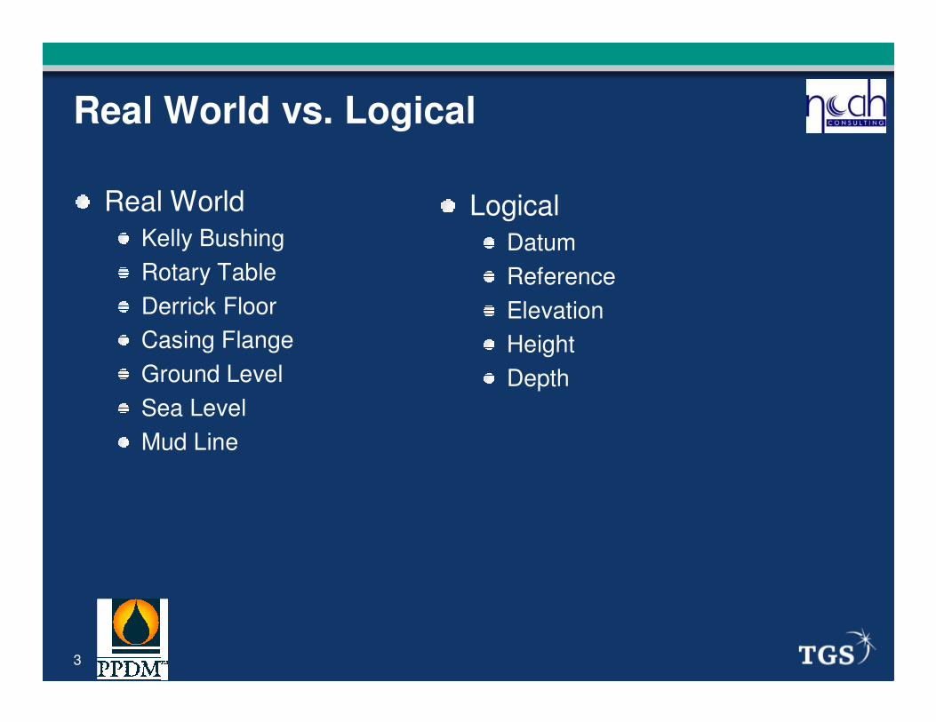
Real World vs. Logical
Real World
Kelly Bushing
Rotary Table
Derrick Floor
Casing Flange
Ground Level
Sea Level
Mud Line
Logical
Datum
Reference
Elevation
Height
Depth

4
Elevation and Height – The Basics
GroundElevation
Mean Sea Level
Heights – Measured above Ground Level
Elevations – Measured above Mean Sea Level
Depths – Measured below a reference point
Height above GL
Elevation
above MSL
Depth below a reference point
5
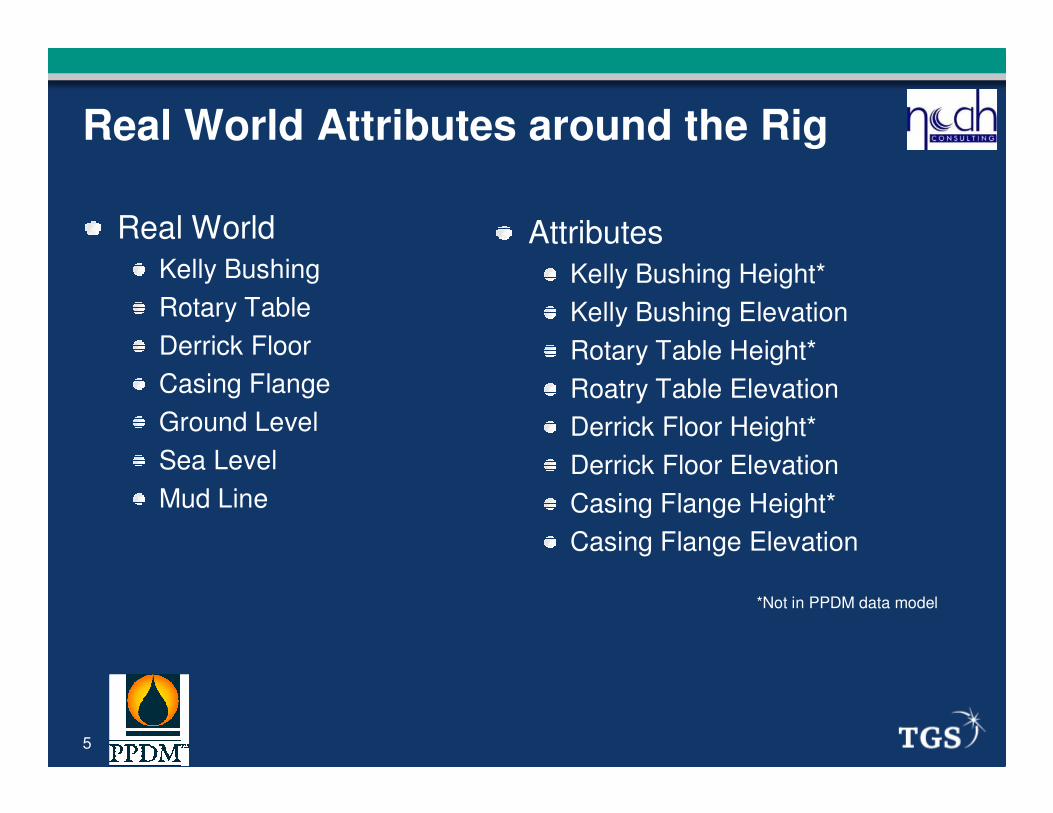
Real World Attributes around the Rig
Real World
Kelly Bushing
Rotary Table
Derrick Floor
Casing Flange
Ground Level
Sea Level
Mud Line
Attributes
Kelly Bushing Height*
Kelly Bushing Elevation
Rotary Table Height*
Roatry Table Elevation
Derrick Floor Height*
Derrick Floor Elevation
Casing Flange Height*
Casing Flange Elevation
*Not in PPDM data model

6
Logical Attributes around the Rig
Logical
Datum
Elevation
Reference
Height
Depth
AttributesPermanent Datum*
Elevation Reference Datum
Elev. Ref Datum Elevation*
Depth Datum (Working)
Depth Datum Elevation
Height Datum*
Height Datum Elevation*
Ground Level Elevation
Mean Sea Level Elevation*
Water Depth Datum
Water Depth
*Not in PPDM data model

7
Data Model Treatment
8
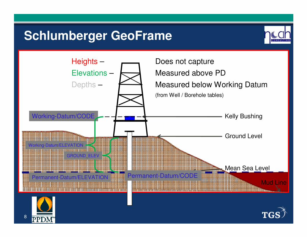
Schlumberger GeoFrame
Heights – Does not capture
Elevations – Measured above PD
Depths – Measured below Working Datum
(from Well / Borehole tables)
Working-Datum/CODE
Working-Datum/ELEVATION
Permanent-Datum/ELEVATION
GROUND_ELEV
Ground Level
Kelly Bushing
Mean Sea Level
Mud LinePermanent-Datum/CODE

9
Schlumberger Seabed
Heights – Does not capture
Elevations – Measured above a Vertical Reference
Depths – Measured below a different Vertical Ref
(from Coordinate-System & Position tables, linked to Well & Borehole tables)
Working-Coor-Syst/Vertical-Ref
Position/Elevation
Position/Elevation
Ground Level
Kelly Bushing
Mean Sea Level
Mud Line
Position/Elevation
Permanent-Coor-Syst/Vertical-Ref

10
Paradigm EPOS
Heights – Does not capture
Elevations – Depends – see note below
Depths – Measured below Measurement Ref
(from Well-database / Well-information tables)
Ground Level
Kelly Bushing
Mean Sea Level
Mud Line
MEASUREMENT_REF
DATUM_ELEVATION
ELEV_MEAS_REF
DEPTH_DATUM_ELEVATION ?
EPD
DATUM_ELEVATION
MSL is implicit permanent datum
Note: If DATUM_ELEVATION = GL in Paradigm, then DEPTH_DATUM_ELEV = EPD + ELEV_MEAS_REF
If DATUM_ELEVATION = MSL in Paradigm, then DEPTH_DATUM_ELEV = ELEV_MEAS_REF

11
Landmark R5000
Heights – Does not capture
Elevations – Measured above implicit MSL
Depths – Measured below Depth Datum Type
(from Well-Master table & Elev-Info table)
DEPTH_DATUM_TYPE
DEPTH_DATUM
GROUND_ELEV
MSL is implicit
Ground Level
Kelly Bushing
Mean Sea Level
Mud Line

12
Open Spirit 2.9
Heights – Does not capture
Elevations – Measured above Vertical Datum
Depths – Measured below Elevation Datum
(from Well table & Wellbore table)
Ground Level
Kelly Bushing
Mean Sea Level
Mud Line
ELEVATION_DATUM
ELEVATION
GROUND_ELEV
MSL is implicit vertical datum

13
PPDM 3.8
Heights – Does not capture
Elevations – Measured above Elevation Ref Datum
Depths – Measured below Depth Datum
(from Well table)
Ground Level
Kelly Bushing
Mean Sea Level
Mud Line
DEPTH_DATUM
DEPTH_DATUM_ELEV
GROUND_ELEV
ELEV_REF_DATUM

14
Comparing Data Models to the Oilfield

15
Attribute Ambiguities
The Level of the Sea?
MSL
LAT
SL
MWL
The Ultimate Origin?
Permanent Datum
Elevation Reference
Datum

16
Temporal Ambiguities
Changes over time
What happens when rigs change out on a particular well
The Depth Datum can change
The Datum Elevation for the same reference can change
Are measurements taken at different times corrected?
Is this handled properly or at all in data models?
PPDM – Well Version table
R5000 – Well Master Alt table
Seabed – Alternate Elevation

17
PPDM
PositivesIt works
Consistent naming
Relatively comprehensive in datums and elevations
Straightforward to model
Opportunities for ImprovementNo Heights
No Permanent Datum
No value for Elev-Ref-Datum
Ground-Level-Type
Mixes Water-Depth and Well-Depth references
Changes in datum names or values over time
Some definitions re-tooled

18
Summary
Real oilfield things and logical concepts
Various data models address topic differently
Potential confusion and ambiguity lessened if:
Use of “height” in addition to datum and elevation
Use of permanent datum and elevation datum
Tighten up definitions and reference tables
Changes over time compromise data quality
© Copyright 2010 All Rights Reserved
Noah Consulting LLC.
TGS