eld Characterisation Study | Final Report | February 2011 ... · En fi eld Characterisation Study...
75
eld Characterisation Study | Final Report | February 2011 5. ENFIELD’S P
Transcript of eld Characterisation Study | Final Report | February 2011 ... · En fi eld Characterisation Study...

Enfi e
ld C
hara
cter
isat
ion
Stud
y |
Fin
al R
epor
t |
Feb
ruar
y 20
11
1285. ENFIELD’S P

Enfi e
ld C
hara
cter
isat
ion
Stud
y |
Fin
al R
epor
t |
Feb
ruar
y 20
11
129PLACES

Enfi e
ld C
hara
cter
isat
ion
Stud
y |
Fin
al R
epor
t |
Feb
ruar
y 20
11
130
ENFIELD’S PLACES
Enfi eld is not a single homogenous place. Rather, it is a collection of separate and distinct places with their own origins. Although these places may have coalesced over time, they still retain their own identity and character. This can be seen in the types of street pattern and architecture, the structure of centres and focal points and the names used to describe the various locations. This is a distinctive characteristic of the village origins of much of London. In each case the history of the origins and growth of a place are crucial to the establishment of the later character, with elements such as the construction of rail and tube lines playing a major role in creating new suburbs which have a profound and lasting imprint on the area.
This section of the report describes three distinct urban zones within Enfi eld, each of which can be broadly described as a radial corridor of development. The list comprises:
Eastern Corridor – the historic chain of • settlements along the old Hertford Road, defi ned on the eastern side by the Lee Valley and on the western side by the Great Cambridge Road;
Central Corridor – comprising the chain • of settlements on the historic route to Enfi eld, later reinforced by the railway which promoted suburbs including Palmers Green and Winchmore Hill; and
Western Corridor – comprising the cluster • of old villages and later suburbs on the western side of the borough which relate closely to the development of the Piccadilly Line stations and which in some cases straddle the border with Barnet.
As a counterpoint to these radial development zones, there is also an overlying east-west corridor which can be applied to describe the infl uence of the North Circular Road on the areas to either side. As with the Western corridor, areas such as Bounds Green overlap the formal borough boundary, leading to a blurring of identity.
Finally, to the north of the urban area lies the green belt, a mixture of farmland, parkland, commercial areas and leisure uses.
This element of work has been informed by a workshop with local stakeholders drawn from across the borough. The plan laid out here draws on the discussions about the various places in the borough and particularly records the various place names used.
It is very diffi cult to make any plan of this type defi nitive, as there will be many different interpretations of what areas are called and where boundaries between areas lie. However, this approach provides a useful framework for introducing the particular character of the areas across the borough and highlighting particular issues.

Enfi e
ld C
hara
cter
isat
ion
Stud
y |
Fin
al R
epor
t |
Feb
ruar
y 20
11
131
This map is reproduced from Ordnance Survey material with the permission of Ordnance Survey on behalf of the Controller of Her Majesty's Stationery Offi ce © Crown copyright. Unauthorised reproduction infringes Crown copyright and may lead to prosecution or civil proceedings. London Borough of Enfi eld DENF003.

Enfi e
ld C
hara
cter
isat
ion
Stud
y |
Fin
al R
epor
t |
Feb
ruar
y 20
11
132
WESTERN CORRIDOR
Overview
Metroland (or its original version, Metro-land) is a term with a long and varied history and has its origins as a name for the smart suburbs which extended north out of London in the inter-war years. It is most commonly associated with the Piccadilly Line, and in this context is taken as the name for the collection of places in the west of Enfi eld. Although this includes some remnants of early settlements such as Southgate Green the prevailing character of the area is of large, generously proportioned inter-war suburbs orientated towards the beacons of Charles Holden’s iconic stations.
As with the southern part of the borough, the western boundary of Enfi eld is straddled by a number of settlements, with Cockfosters and Southgate in particular being right on the borough border.
This map is reproduced from Ordnance Survey material with the permission of Ordnance Survey on behalf of the Controller of Her Majesty's Stationery Offi ce © Crown copyright. Unauthorised reproduction infringes Crown copyright and may lead to prosecution or civil proceedings. London Borough of Enfi eld DENF003.

Enfi e
ld C
hara
cter
isat
ion
Stud
y |
Fin
al R
epor
t |
Feb
ruar
y 20
11
133
HADLEY WOOD
The primary typology found in Hadley Wood is that of large suburbs. The main settlement of Hadleigh Wood has its origins with the opening of the station in 1885. Development in the late Victorian and early Edwardian period was relatively sluggish, but picked up signifi cantly in the inter-war period and proceeded apace post-war until limited by the Green Belt. The settlement is to the east of the historic Monken Hadley with its impressive parish church and historic buildings.
The modern Hadley Wood is essentially a dormitory suburb with a small centre. Its key distinguishing feature is its low density, which particularly on the main roads, has led to very large plots. As with other similar locations such as Totteridge in Barnet, this has been exploited over time by individual owners who have developed and redeveloped a series of increasingly large pseudo-mansions. Whilst the street character was traditionally relatively open with minimal front boundaries, it has become increasingly common for strong boundary treatments and gates to be erected to provide privacy and security.
COCKFOSTERS
The primary typologies found in the Cockfosters area are those of Metroland centre and classic suburbs. Cockfosters straddles the borough boundary, with a signifi cant part in Barnet. Although Cockfosters can trace its origins back to the early 16th Century - the name is believed to refer to the Cock (or Chief) Forester - the place today is mainly characterised by the 1933 Holden-designed tube station and the parades of three storey shops and fl ats which line Cockfoster’s Road.
Away from the main street the suburbs are classic inter-war development. Plot and dwelling sizes tend to be fairly regular, whilst the buildings themselves are generally variations within a limited palette of materials and details which helps to create a cohesive whole.
The northern edge of Cockfosters is defi ned by the extensive sidings for the Piccadilly Line, which span almost all the way from Cockfosters to Oakwood tube station. Cockfosters station has the distinction of being the end of the line, and so has easy access to the street. A notable exception to the otherwise suburban character is the nine storey offi ce block close to the tube station.

Enfi e
ld C
hara
cter
isat
ion
Stud
y |
Fin
al R
epor
t |
Feb
ruar
y 20
11
134
OAKWOOD
The primary typologies found in Oakwood are Metroland centre and classic suburbs. Oakwood is essentially a collection of large suburbs built over the period straddling the Second World War. The tube station (again by Holden) opened in 1933, whilst Oakwood Park was established by Enfi eld Council in 1927.
Of the various areas within Oakwood, South Lodge Estate provides perhaps one of the borough’s best examples of the quintessential inter-war suburb. It was built in the 1930s by Laings, and features a subtle mix of moderne motifs such as curving glass bay windows alongside the more conventional Arts and Crafts-infl uenced designs.
South-east of the South Lodge Estate is the site of the former Highlands Hospital, recently developed for housing following the sale of the site in 1993. The area retains many of the late Victorian hospital buildings which defi ne the conservation area character. However, the street pattern and overall composition is essentially suburban and now referred to as Highlands Village
North of Highlands Village is an area of early post-war public housing. This shows a distinct garden city infl uence, but features such as slender concrete porches and lintels as well as elements of the metal work hint at a modern ‘Festival of Britain’ infl uence.
Enfi e
ld C
hara
cter
isat
ion
Stud
y |
Fin
al R
epor
t |
Feb
ruar
y 20
11
135
SOUTHGATE
Southgate Green
The primary typologies found in Southgate are Metroland centre, suburban fl ats and classic suburbs. As with Oakwood and Cockfosters, modern Southgate owes most to the late inter-war period of development, with rapid suburban expansion following the opening of the tube station in 1933. Like Cockfosters, the modern centre is also located close to the edge of the borough, meaning that a signifi cant proportion of its catchment is in Barnet rather than Enfi eld.
Holden’s tube and bus station for Southgate is particularly characterful and creates a strong terminal feature for the main shopping street. The shopping street itself is clear and strong, with at least two generous storeys above the shops, mostly packaged in a restrained neo-Georgian style. Rather secondary now is the historic core of Southgate to the south of the tube station, which features an attractive group of buildings facing onto a small green.
Like the other suburban areas in the western corridor, Southgate offers some mix of character, but is dominated by classic inter-war suburban housing, including some designed and landscaped to a high specifi cation. Southgate particularly benefi ts from Grovelands Park, the western tip of which almost reaches the town centre. Broomfi eld Park and Arnos Park effectively form the southern boundary of the area.
Enfi e
ld C
hara
cter
isat
ion
Stud
y |
Fin
al R
epor
t |
Feb
ruar
y 20
11
136
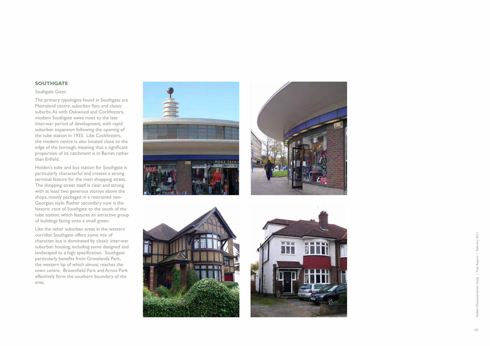
NEW SOUTHGATE
Arnos Grove
The primary typologies found in New Southgate are free-form estates and classic suburbs. New Southgate is a wedge of the urban area which is defi ned by Arnos Park in the north, the North Circular on the south-eastern side and the railway line on the western side, which also lie on the borough boundary. Unlike other places along the Piccadilly line it has signifi cant earlier elements of development, sparked by the opening of New Southgate Station in 1850. As a consequence of this and many layers of development which have followed, the area has a jumbled and fragmented character, including Victorian Villas amongst examples of both low-rise and high-rise post-war housing.
The area is heavily constrained by the impact of transport infrastructure, greatly reducing the potential for integration with the surrounding areas. It also lies at the junction of three boroughs, Barnet, Enfi eld and Haringey and so may have suffered in the past from the divided responsibilities for the area. It is now one of the Borough’s Place Shaping Priority Areas and subject of a new masterplan.
Key issues
The type and quantity of street greenery in the western corridor varies signifi cantly, from the generous coverage in semi-rural Hadley Wood to the almost complete lack of greenery in Arnos Grove. In between these, the green spaces in the classic suburbs of Oakwood, Southgate and Cockfosters are under threat due to the pressure on street and garden areas to provide parking. This results in loss of character and denudes the biodiversity/micro-climate of the area.
Implications
Street trees, verges and planting in front gardens makes a signifi cant contribution to the quality and character of these areas and should be protected. This will help to mitigate against the effects of climate change and support better biodiversity and sustainable drainage. Areas such as Arnos Grove and New Southgate where street trees and planting are less in evidence may benefi t from investment in street greening. The role of both the private and public realm should be explored to identify opportunities for general enhancement and greening. The quality of the public realm varies across the corridor, with scope for improvements to both hard and soft landscape, and removal of street clutter.
Street greenery
KEY ISSUES - WESTERN CORRIDOR

Enfi e
ld C
hara
cter
isat
ion
Stud
y |
Fin
al R
epor
t |
Feb
ruar
y 20
11
137
Key issues
Large areas of the western corridor are low density and are dominated by family housing. Whilst this gives them a pleasing homogeneity it can mean that there is a lack of smaller houses and fl ats which would provide a more mixed community. It also means that these areas are prone to being less sustainable, being diffi cult places to sustain an attractive bus network and as a consequence being very car-orientated.
Implications
Opportunities and strategies should be sought to gradually improve the sustainability of the low density suburbs. This could include the provision of a greater mix of unit types and a greater density around transport and service nodes to improve the mix of accommodation on offer. Consideration should be given as to how this can be achieved whilst protecting the grain and character of the areas.
Low density suburbs
Key issues
Areas of the western corridor, and particularly Hadley Wood, are categorized as large suburbs. These are areas where demand for plots outstrips supply and where it is common for buildings to be heavily modifi ed or completely redeveloped to suit the tastes of each owner. This results in a place which experiences gradual but continuous change, losing any sense of historic or period identity and instead becoming a ‘zoo’ of grand suburban styles.
Implications
Consideration should be given to evaluating the existing stock of buildings in the areas of large suburban houses to identify and potentially protect those where genuine design quality can be found. Clear design guidance may also be helpful in moderating the scale and character of new buildings so that they contribute more positively to the whole. Guidance on front boundaries may also be useful, encouraging a more moderate approach to security and privacy than has been shown in a few examples so that the buildings retain a relationship with the public realm.
Large suburbs
Key issues
Whilst some areas in the western corridor have a clear and identifi able sense of place, others like Oakwood lack a defi ned centre. Oakwood is effectively a series of suburban neighbourhoods which have fi lled the space between more established centres. Whilst these have a recognisable character they lack the sense of a cohesive whole around an identifi ed focus in the way that is found in a more traditional urban structure. The potential risk from this is that it may not build strong community identities and ties and does not create a strong sense of community cohesion.
Implications
Consideration could be given to the way in which the various distinct areas of Oakwood relate to each other. Part of this exercise could help to build a greater sense of the structure of the area with more clearly defi ned focal points for commercial and social activities.
Sense of place
Key issues
The western corridor comprises almost entirely residential development with few signifi cant employment areas, either for offi ce space or industrial development. Whilst this is mitigated to a degree by business areas such as Brunswick Park across the border in Barnet, it means that the majority of people living in the area will not be able to fi nd employment within a short distance from home. At the same time, Middlesex University is reviewing its estate and may move or close a signifi cant proportion of its activities within the western corridor.
Implications
One approach to improving the long term sustainability of the western corridor may be to identify opportunities for employment development, perhaps taking advantage of any campus space which Middlesex University fi nd surplus to requirements.
Lack of mixed use

Enfi e
ld C
hara
cter
isat
ion
Stud
y |
Fin
al R
epor
t |
Feb
ruar
y 20
11
138
CENTRAL CORRIDOR
Overview
Enfi eld Town is particularly special within the Greater London area, being one of the few settlements to retain a strong historic market town character whilst being almost completely absorbed into the wider conurbation. It is the main destination for a meandering historic route which originates in the City and passes through Islington, Newington Green and Wood Green before continuing north to Palmers Green, Winchmore Hill and Bush Hill and arriving in Enfi eld. This historic chain was later reinforced by the railway line which linked together the historic centres but also sparked a new vigour in early suburban growth, leaving a legacy of attractive Victorian and Edwardian suburbs .
To the north of Enfi eld town is a collection of neighbourhoods, many of which have early village or hamlet origins but which have gradually coalesced to create the suburban hinterland to the town.
This map is reproduced from Ordnance Survey material with the permission of Ordnance Survey on behalf of the Controller of Her Majesty's Stationery Offi ce © Crown copyright. Unauthorised reproduction infringes Crown copyright and may lead to prosecution or civil proceedings. London Borough of Enfi eld DENF003.

Enfi e
ld C
hara
cter
isat
ion
Stud
y |
Fin
al R
epor
t |
Feb
ruar
y 20
11
139
Places
FORTY HILL
Forty Hill // Gordon Hill // Clay Hill // Baker Street // Chase Side // Willow Estate
The primary typologies found in the Forty Hill area are classic suburbs, institutions and pre-victorian residential. The area which is described here as Forty Hill is the northern hinterland of Enfi eld Town. The maps from the late Victorian period show it as a collection of settlements interspersed by fi elds and orchards but lacking the intensive development common to so many Victorian suburbs. As a result of these fragmented origins there are a great many varied place names across the area which are diffi cult to map conclusively.
Although much of this historic character remains and leaves a signifi cant mark on the shape of the streets and buildings, later development has in-fi lled substantially to create a continuous urban area, bounded on the west by the railway and on the east by the New River.
Of all the buildings in the borough, Forty Hall was identifi ed as one of the most valued. This signifi cant house in extensive grounds was built in 1629-32 and was home to Sir Nicholas Raynton, a wealthy London haberdasher and Lord Mayor of London. The building today houses a local museum, whilst the grounds are open to the public.
RIDGEWAY
Enfi eld Chase // Chase Farm // World’s End // Frog Bottom
The primary typologies found in the Ridgeway area are suburban fl ats, street-based estates and classic suburbs. Chase Farm Hospital is also a signifi cant infl uence on local character as a major instition and occupier. West of the railway line from Enfi eld Town is Enfi eld Chase which gives its name to the local station. Historic routes defi ne the character of the area including the Ridgeway, heading northwest to Potters Bar and Slades Hill/Enfi eld Road heading west. The original development along these routes was very low density housing in large plots of land. In many cases this has now been taken over by fl atted development taking advantage of the larger site areas available.
Whilst most of the area is characterised by low rise houses there is a group of bulky residential towers along Cedar Road. These are clearly visible from some distance, being on slightly elevated ground.

Enfi e
ld C
hara
cter
isat
ion
Stud
y |
Fin
al R
epor
t |
Feb
ruar
y 20
11
140
ENFIELD TOWN
Enfi eld Town // Gentlemen’s Row
The primary typologies found in Enfi eld Town are historic centre, urban centre and institutions. Despite being absorbed into the urban area of greater London, Enfi eld Town retains the character of a country market town with a great deal of charm and an attractive scale. Although somewhat dominated by traffi c the town centre includes a market square, the historic parish church and the attractive historic area of Gentlemen’s Row. Enfi eld Grammar School occupies a signifi cant area of land immediately to the north of the town centre.
By contrast with the historic character of the northern side of the town the area to the south of the High Street includes two large multi-storey car parks and a new retail development which has helped Enfi eld to retain its appeal as a signifi cant shopping destination in the area.
One of the most signifi cant buildings in Enfi eld is the Council’s Civic Centre, comprising two distinct elements of a low slab block and a twelve storey tower. This building is somewhat out of scale in comparison to the rest of Enfi eld Town, but is a useful landmark.
BUSH HILL
Bush Hill // Bush Hill Park
The primary typologies found in Bush Hill are classic suburbs and urban terraces. Bush Hill Park is a planned Victorian Estate built on what had been the farmland surrounding Bush Hill Park House. Its growth in the late nineteenth century was greatly stimulated by the construction of Bush Hill Park station in 1880 and was largely developed by the North London Estates Company. The legacy of this planned development is a mature and attractive suburb stretching from the Great Cambridge Road in the east to the Bush Hill Park Golf Course in the west. It contains a wide variety of building styles from Baroque revival to Arts and Crafts and the importance of key areas is recognised in the extensive conservation area designation which centres on Wellington Road.

Enfi e
ld C
hara
cter
isat
ion
Stud
y |
Fin
al R
epor
t |
Feb
ruar
y 20
11
141
GRANGE PARK
The primary typologies found in Grange Park are classic suburbs and large suburbs. Grange Park is another example of a settlement which owes most of its existence to the arrival of the railway. It is largely a product of the interwar period and features a consistently low density of development in predominantly semi-detached form. Most of the streets are generously proportioned with verges and trees and combine with the buildings to defi ned the area as classic suburbs. A small local centre is located close to the station whilst the area to the east comprising The Chine and Old Park Ridings is a conservation area.
WINCHMORE HILL
The primary typologies found in Winchmore Hill are historic centre, classic suburbs and large suburbs. Winchmore Hill is an unusual area in that it has more than one centre. The historic centre is to the west of the station focussed around a sloping village green. A short distance east of the railway lines is Green Lanes, the main route up to Enfi eld Town. This later centre is essentially a planned twentieth century development, with set-piece curving terraces of shops.
The areas around the green and Vicars Moor Lane to the north are both conservation areas. Infi lling around these historic areas is classic suburban development. These are gently curving streets of semi-detached houses in noted contrast to the more regimented streets of Edwardian terraces further south Palmers Green. Along Broad Walk area a set of large suburban houses with a distinct character.
A large food store has been developed on the site of the former cricket ground north of Fernleigh Road.

Enfi e
ld C
hara
cter
isat
ion
Stud
y |
Fin
al R
epor
t |
Feb
ruar
y 20
11
142
PALMERS GREEN
The primary typologies found in Palmers Green are Metroland centre, classic suburbs and urban terraces. Palmers Green is an attractive early suburb with a core of Edwardian terraces and semi-detached housing and additional areas of interwar housing, particularly to the east of Green Lanes. The gradual intensity of development heading south from Enfi eld town is visible in the more obvious urban nature of the town centre, with a strong mixture of uses and greater density of activity.
To the west of Palmers Green lies Broomfi eld Park, a signifi cant house and garden. Whilst the garden is open to the public as a park the house has suffered extensive fi re damage and has yet to be repaired. This was identifi ed as a signifi cant loss to the character of the area. The effective eastern boundary of the area is the curve of the New River which wraps around the eastern and southern sides of Palmers Green and effectively breaks the urban form a short distance north of the North Circular, leaving a somewhat poorly defi ned area around streets such as Palmerston Crescent and Ecclesbourne Gardens.
BOUNDS GREEN / BOWES PARK
The primary typology found in Bounds Green / Bowes Park is urban terraces. Bounds Green/Bowes Park is an area which overlaps the borough boundary to the extent that its centre is actually in Haringey. The original focus for development was Bowes Park railway station which initiated the development of a loose grid of relatively tightly packed late Victorian houses. Bounds Green tube station is another Holden design for the Piccadilly Line, and opened in 1932. The fact that it was originally considered to name the station Wood Green North says much about the way in which this location relates more closely to Haringey than to Enfi eld.
The northern boundary of Bounds Green/Bowes Park feels most obviously to be the North Circular. However, other edges such as Pymme’s Brook and the New River may also play their part of defi ning the real extents of the neighbourhood.
Enfi e
ld C
hara
cter
isat
ion
Stud
y |
Fin
al R
epor
t |
Feb
ruar
y 20
11
143
Key issues
The central corridor contains a striking collection of good mature suburbs, ranging from late Victorian terraces in the south to early interwar semis in the north but including a substantial body of very attractive Edwardian streets, some of which show a strong Arts and Crafts infl uence. These vary in design and density very subtly, gradually improving in quality, spaciousness and modernity as one moves north up the railway line.
Implications
These Edwardian suburbs are vulnerable to loss of consistent character within a street. Unlike Victorian housing which tends to have external detailing of stone or brick, Edwardian housing typically has more elaborate and decorative timber detailing which can be costly and diffi cult to maintain. Loss of original detailing such as timber work and stained glass windows can gradually denude streets of their charm, particularly where the houses were previously designed as a group.
Classic suburbs
Key issues
A number of the suburbs in the Central corridor feature grass verges and/or street trees. However, having a higher density and generally tighter plots than some of their later counterpoints to the west there is continued pressure to remove greenery on the street or in front gardens to create space for parking and to reduce maintenance overheads. As the planting in the streets and gardens makes a signifi cant contribution to the character of these areas, removal or reduction can have a signifi cant effect on both the visual appearance and the biodiversity/micro-climate.
Implications
Street trees, verges and planting in front gardens makes a signifi cant contribution to the quality and character of these areas and should be protected. This will help to mitigate against the effects of climate change and support better biodiversity and sustainable drainage. There is potentially scope to reduce the run off created by paved front gardens / parking areas through the restriction of front garden conversion and the requirement for permeable surfaces.
Street greenery
Key issues
As with other suburbs, Palmers Green was historically a centre for local administration and civic functions before the establishment of the existing borough. With the merging of the metropolitan boroughs to create the borough of Enfi eld some of these functions were lost as they were drawn together in Enfi eld. This loss had a denuding effect on the local centre which effectively lost a key anchor use. Southgate Town Hall is an example of such a building which needs a viable new use to support its ongoing role as an historic landmark.
Implications
Opportunities should be sought to bolster the character and role of the historic centres within the central corridor. This could relate to civic or cultural facilities.
Historic identity
Key issues
Some areas of the central corridor, and particularly the suburbs closer to Enfi eld Town have seen signifi cant redevelopment to provide fl atted developments. These are typically found in areas which would have featured large family houses in generous grounds and are often the more historic sites along key routes which are now busy with traffi c. Amalgamation of properties and redevelopment of buildings has resulted in the loss of grain and character, although it could be said to have a benefi cial effect by increasing the density of existing neighbourhoods.
Implications
Gradual intensifi cation of existing neighbourhoods through redevelopment of older buildings may be an appropriate way to improve the long term sustainability and help to meet modern housing needs. However, this approach is most appropriate where the new higher density development is located close to shops, services and public transport access. Consideration should also be given to ways in which development of this nature could be guided to better retain the historic grain and streetscape of areas, avoiding obvious large-scale amalgamations of plots which introduce buildings out of scale and keeping with existing neighbourhoods.
Suburban fl ats
KEY ISSUES - CENTRAL CORRIDOR

Enfi e
ld C
hara
cter
isat
ion
Stud
y |
Fin
al R
epor
t |
Feb
ruar
y 20
11
144
EASTERN CORRIDOR
Overview
The A1010 corridor has been an important historic route for many centuries, and although the modern road does not follow the historic pattern, it takes the same journey as the Roman Ermine Street. It lies parallel with the Lea Navigation which also runs north-south and for centuries provided an important movement route linking Hertford with London and the Thames.
The early settlement origins are largely ribbon development along the historic route, focussed around crossroads. The arrival of railway lines offset to either side of the Hertford Road facilitated the development of early suburbs whilst the location of the Royal Small Arms Factory also stimulated signifi cant housing growth around Enfi eld Lock.
The presence of the historic industrial area at Enfi eld Lock and associated housing along the corridor makes this part of Enfi eld particularly interesting in the wider London context where there would normally be a gradual reduction in urbanisation further out from the city centre.
The western border of the corridor can now be defi ned as the Great Cambridge Road, a large dual carriageway which was an attempt to supersede or alleviate the traffi c on the old Hertford Road but which acts as a barrier or edge rather than the central spine in the same way as the historic route.
The eastern border of the area has also changed signifi cantly over time. The barrier between the urban area and the Lee Valley which was created by the railway is now reinforced by Meridian Way/Mollison Avenue and the industrial areas which have grown up along the urban edge.
This map is reproduced from Ordnance Survey material with the permission of Ordnance Survey on behalf of the Controller of Her Majesty's Stationery Offi ce © Crown copyright. Unauthorised reproduction infringes Crown copyright and may lead to prosecution or civil proceedings. London Borough of Enfi eld DENF003.

Enfi e
ld C
hara
cter
isat
ion
Stud
y |
Fin
al R
epor
t |
Feb
ruar
y 20
11
145
ENFIELD WASH/HIGHWAY
Freezywater // Turkey Street // Enfi eld Lock // Enfi eld Highway // Bullsmoor // Innova
The primary typologies found in Enfi eld Wash/Highway are Garden City and urban terraces. The northern part of the Eastern corridor is a collection of settlements which have merged into one another, but still retain evocative names such as Freezywater and Turkey Street. Freezywater, Enfi eld Wash and Enfi eld Highway are the key historic settlement cores along the main road, becoming progressively more substantial and well defi ned heading south along the road.
The predominant character is narrow traditional shop units with accommodation above, but there are examples such as Enfi eld Wash where the frontage is broken by the inclusion of a food store and parking. The area around Enfi eld Wash and Enfi eld Lock is characterised by Victorian terraces, gradually spreading into small inter-war suburbs. Further south around Enfi eld Highway one is more likely to fi nd planned public sector estates, typifi ed by the area south of Carterhatch Lane or south of Albany Park. There are some areas of more modern development, including clusters of towers at Eastfi eld Road and the western end of Ordnance Road.
Innova Park is a new business and enterprise area in the north of the urban area. It has a high quality landscape treatment compared to many of the older employment areas and also a softer blend of uses, including a new Academy School as the interface between the employment and residential areas. Enfi eld Island stands isolated as modern development on the site of the former Royal Small Arms Factory in the Lee Valley.

Enfi e
ld C
hara
cter
isat
ion
Stud
y |
Fin
al R
epor
t |
Feb
ruar
y 20
11
146
PONDERS END
There primary typologies found in Ponders End are Garden City, urban terraces and free-form estates. Ponders End is a relatively complex area which contains a number of distinct urban types with strong zoning. Although there is a considerable quantity of housing, there are large areas of industrial use as well as retail parks. The area between Southbury Station and the Great Cambridge Road is an area still in transition from industrial use to leisure and retail with frontages onto the Great Cambridge Road offering a high degree of visibility and therefore attracting higher land values for retail uses. Industrial uses continue to survive away from the main road in locations such as Crown Road.
To the east of the station, interesting older industrial areas can be found including examples such as Queensway which demonstrate how industrial and business space can be designed to have a positive street frontage whilst retaining service and access. The historic centre of Ponders End is somewhat diluted by the presence of two large supermarkets in the immediate vicinity. To the east of the rail line is Wrights Flour Mill, the oldest industrial building in Enfi eld. The mill was originally powered by the fl ow of the Lee but was converted to electricity when the Reservoirs were constructed.
At the eastern end of South Street, Ponders End station provides an alternative connection to the City. However, its hinterland is a large area of relatively run down public housing including four residential towers. To the south lie former gas holders which are now the site for a planned academy development. Major growth is planned in Ponders End generally, including sites such as the former Middlesex University site and the High Street.
BRIMSDOWN
The primary typology found in Brimsdown is large scale industry. Brimsdown is predominantly characterised by industrial development to the east of the railway line including large sites and heavy industrial processes. Mollison Avenue runs north-south parallel to the railway line to provide general access and connects with the eastern end of Green Street via a level crossing which provides one of the few connections between the residential area and the business area which is at grade. The relatively small area of housing to the west of the railway lines which is considered to be within Brimsdown includes a large development of relatively modern fl ats on the site of former factories.

Enfi e
ld C
hara
cter
isat
ion
Stud
y |
Fin
al R
epor
t |
Feb
ruar
y 20
11
147
PICKETT’S LOCK
The primary typologies found in Pickett’s Lock are Lee Valley and large scale industry. To the east of Ponder’s End is Pickett’s Lock, now a focal point for leisure including a multiplex cinema with a few other associated uses, a golf course and caravan park, and the Lee Valley Athletics Centre. Whilst this represents one of the most signifi cant leisure resources in the eastern part of the borough it is isolated from the nearby residential area due to the barrier presented by Meridian Way and the railway line. The nearest crossings are over a kilometre to the north and approximately 700m to the south.
The northern part of the Pickett’s lock area includes further industrial development around Morson Road, although much of this has recently been cleared.
CENTRAL LEESIDE
The primary typologies found in Central Leeside are large scale industry and big box retail and leisure. As with other areas of industrial land which have a high visibility due to a location on a main road, the areas fronting the North Circular Road have faced increasing pressure for retail and leisure development. The combination of high visibility and accessibility by car has attracted large retailers including Ikea and also made it a favoured location for large stores such as Tesco, Wicks, Mothercare and others. The northern side of the North Circular Road, which is somewhat less accessible, has also seen a push for retail development with a cluster of furniture and carpet sales and trade sales such as Screwfi x. Coca Cola is one of the largest and best known brands amongst the companies remaining in the industrial area. The Deephams Sewage Treatment works separates the industrial uses and limits potential for encroachment into the open area of Pickett’s Lock to the north.
As a consequence of the large levels of highway infrastructure and grade separated crossings the area is extremely complicated to navigate by car and presents a hostile environment for pedestrians.
The Central Leeside area is presently the subject of long term regeneration plans.

Enfi e
ld C
hara
cter
isat
ion
Stud
y |
Fin
al R
epor
t |
Feb
ruar
y 20
11
148
EDMONTON
Lower Edmonton // Edmonton Green // Upper Edmonton
The primary typologies found in Edmonton are urban centre, urban terraces, Garden City and free-form estates. The southern part of the Eastern Corridor is Edmonton, which divides into a number of historically distinct areas. Edmonton Green is the principal centre for the area, with larger order shopping, a transport interchange and a high density of residential development in residential towers. The centre includes areas of covered shopping and a large indoor market.
To the north and south of Edmonton there is evidence of the important historical legacy in the area with attractive terraces still present along Hertford Road north of St Martins Road and just north of the junction with the North Circular. Other buildings in the area range from a good stock of privately built Victorian and interwar housing as well as a number of good quality public sector estates, including the Beaconsfi eld Estate from the 1950s and the Hyde Estate from the early 1920s.
ANGEL EDMONTON
The primary typologies found in Angel Edmonton are linear centre, urban terraces and large scale industry. The deep incision created by the north circular divides the larger part of Edmonton from Angel Edmonton. This is a bustling centre along the Hertford Road, emphasised by the relative narrowness of the street at this location. The centre is surrounded by terraced housing ranging from late Victorian to interwar as well as a number of tall residential blocks. To the west lies the North Middlesex Hospital and the industrial area of Commercial Road.
Enfi e
ld C
hara
cter
isat
ion
Stud
y |
Fin
al R
epor
t |
Feb
ruar
y 20
11
149
Key issues
The Hertford Road provides the spine of the area and is the focus for the historic settlement patterns which gave rise to today’s town centres. Although the route still carries a high level of traffi c, it serves an important function as a centre for activity and commerce. The Hertford Road includes some of the most signifi cant elements of historic built fabric in the area. Whilst this is recognised by conservation area designation, there is scope for further protection and enhancement of the historic character of the whole corridor.
Implications
As with many linear centres, those along the Hertford Road are struggling, leaving empty shops and potential for piecemeal conversion to the other uses including residential. Given that one of the key issues is the potential for centres to merge with one another this issue could be managed to positive effect, reducing the outer extent of the existing areas to create concentrated and energetic centres with distinct identities. There may also be further scope to consider the historic value of the built fabric along the entire length of the road, particularly those buildings which act as important focal points or which have particular group value.
Key issues
By contrast with the Hertford Road which is the spine of the communities it serves, the Great Cambridge Road and Meridian Way act as signifi cant barriers to movement. There are few crossings, little active frontage and sometimes distinct separation of land uses.
This has a signifi cant effect on the eastern side of the borough in terms of the way it isolates communities from services, centres and open space but also because it can establish a sense of insularity which affects social cohesion and integration.
Implications
Wherever possible options should be explored to reduce the barrier effect created by the major roads and railways. This should include creating more opportunities to cross but also creating better quality environments, particularly to link to areas such as Pickett’s Lock. Efforts should also be made to blur the perceptions of boundaries between areas to promote integration whilst also celebrating the identities of the places and neighbourhoods.
Historic route Barriers Erosion of industrial development
Key issues
Although the area still contains a signifi cant amount of industrial and business use this has been under continued pressure for some time, with the loss of former industrial areas to retail development along the Great Cambridge Road and North Circular. This is likely to continue, with pressure for retail use continuing and other uses such as trade counter retail, self storage and leisure uses such as go-karting being allowed to fragment industrial areas.
Implications
There is a need for strategies to create and sustain well-paid employment in the future to create a foundation for stable communities and reduce levels of deprivation in this corridor. Strategies should be sought to project employment land and to promote uses which can attract higher skills sets and higher intensity of employment to improve and maintain the quality of the employment land in the borough.
Key issues
The Eastern corridor contains the majority of the tall buildings in Enfi eld. Most of these buildings are residential but they vary in terms of location and proximity to centres and transport nodes.
Implications
Consideration should be given to the role of tall buildings in the Eastern corridor. Whilst they play a helpful defi ning role for centres such as Edmonton they may be less appropriate in wholly residential areas which lack shops, services and transport links.
Tall buildings
Key issues
There are a number of signifi cant public sector housing areas, many of which retain a strong sense of their overall design and identity. These are an important part of the social and urban history of the area and in many cases represent well proportioned housing which can serve residents as well as privately-built properties of similar vintage.
Implications
Opportunities should be sought to recognise the value of the better quality publicly built estates, promote their design ethos and protect their character.
Public sector housing
KEY ISSUES - EASTERN CORRIDOR

Enfi e
ld C
hara
cter
isat
ion
Stud
y |
Fin
al R
epor
t |
Feb
ruar
y 20
11
150
NORTH CIRCULAR
The North Circular has a major effect on the southern part of Enfi eld. It effectively separates Bowes Park and Angel Edmonton from the areas to the north and almost takes the role of a natural borough boundary.
It has distinct areas of different character along its length, ranging from the more modern motorway-style road which runs between Edmonton and Angel Edmonton and the earlier street-based road which is found in the western part of the borough.
The eastern part, with its larger capacity, grade-separated roundabouts and faster fl owing character suits the needs of the motorist, but gives little by way of priority to pedestrians or cyclists and is hence a signifi cant barrier to movement.
In the western part of the borough, west of Green Lanes, the road is more street-based in character, with shops and businesses providing active frontage. Whilst this has the effect of limiting the capacity and fl ow of the road it provides a much more pedestrian friendly environment.
In both cases, it would be distinctly advantageous to improve pedestrian links across the North Circular. This would provide a better pedestrian environment and help to integrate the communities south of the road with the rest of their borough.
This map is reproduced from Ordnance Survey material with the permission of Ordnance Survey on behalf of the Controller of Her Majesty's Stationery Offi ce © Crown copyright. Unauthorised reproduction infringes Crown copyright and may lead to prosecution or civil proceedings. London Borough of Enfi eld DENF003.

Enfi e
ld C
hara
cter
isat
ion
Stud
y |
Fin
al R
epor
t |
Feb
ruar
y 20
11
151
Key issues
The North Circular Road represents • a major break in the urban fabric of the borough, and for many people may be regarded as the effective southern boundary of Enfi eld.
The road in its various forms presents a • major barrier to pedestrians and cyclists, although this is particularly noticeable in the grade-separated sections on the eastern side of the borough.
The road has a signifi cant impact in • terms of air quality and noise on the surrounding areas of development.
Implications
The North Circular Road will continue • to be a major barrier. However, improvements are being made, particularly in the western half of the borough to improve the fl ow of traffi c and to enhance the pedestrian and cycle environment.
Wherever possible, new connections • should be considered to improve linkages across the road.
Potential for tree planting and other • landscaping should be reviewed to soften the visual impact of the road, particularly in the eastern part of the borough where it has a hard, urban character.

Enfi e
ld C
hara
cter
isat
ion
Stud
y |
Fin
al R
epor
t |
Feb
ruar
y 20
11
152
URBAN/RURAL INTERFACE
The urban area of Enfi eld meets the Green Belt in a number of different ways, each of which has a particular character and raises different issues.
In the west, Hadley Wood is limited in its potential to expand. However, the area attracts a signifi cant premium and so there is pressure for more intensive development within plots, and this has both visual and ecological impacts.
Cockfosters and Oakwood are both separated from the Green Belt by infrastructure including the railway sidings and Bramley Road/Enfi eld Road which combine with the conservation area status of Trent Park to effectively preclude any signifi cant future development. However, pressure for leisure activity in the area is likely to continue and the potential uncertainty around the future of the university campus in Trent Park may result in pressure for otherwise inappropriate development. Areas of land which fall to the south of the defi ned urban edge, such as the open fi elds between Oakwood station and World’s End should continue to be protected as part of the Green Belt.
Chase Farm is another area where there may be particular pressure on the Green Belt in the event that the hospital site is redeveloped and opens up potential for either new development or pressure for more intense leisure activities.
By contrast, the area around Forty Hall is far more stable and less vulnerable to change given the historic nature of the area.
Finally, Crews Hill represents an increasing problem for the green belt, and is gradually mutating from greenhouse and nursery use to general business and retail. This has a signifi cant effect on the character of the area and in particular the frontage to the traditional lanes.
This map is reproduced from Ordnance Survey material with the permission of Ordnance Survey on behalf of the Controller of Her Majesty's Stationery Offi ce © Crown copyright. Unauthorised reproduction infringes Crown copyright and may lead to prosecution or civil proceedings. London Borough of Enfi eld DENF003.
Enfi e
ld C
hara
cter
isat
ion
Stud
y |
Fin
al R
epor
t |
Feb
ruar
y 20
11
153
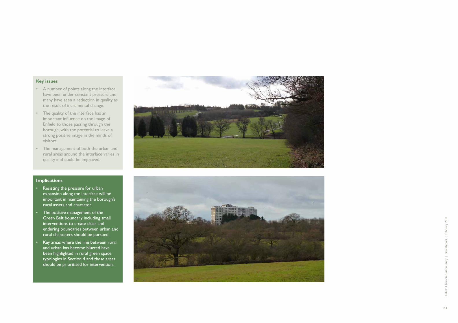
Key issues
A number of points along the interface • have been under constant pressure and many have seen a reduction in quality as the result of incremental change.
The quality of the interface has an • important infl uence on the image of Enfi eld to those passing through the borough, with the potential to leave a strong positive image in the minds of visitors.
The management of both the urban and • rural areas around the interface varies in quality and could be improved.
Implications
Resisting the pressure for urban • expansion along the interface will be important in maintaining the borough’s rural assets and character.
The positive management of the • Green Belt boundary including small interventions to create clear and enduring boundaries between urban and rural characters should be pursued.
Key areas where the line between rural • and urban has become blurred have been highlighted in rural green space typologies in Section 4 and these areas should be prioritised for intervention.

Enfi e
ld C
hara
cter
isat
ion
Stud
y |
Fin
al R
epor
t |
Feb
ruar
y 20
11
154
A total of twelve landscape character areas have been identifi ed for the rural Green Belt areas of landscape in the borough and are shown here. These are separate areas each with their own unique character and particular landscape patterns. Boundary lines have been indicated between these areas although in reality the boundary between adjacent landscape character areas is rarely clearly defi ned and there is often a transition zone between areas of different character. The boundary line should be seen more as the ‘tipping point’ between two areas at which the characteristics of an area become predominantly of one character area rather than another.
Each of the landscape character areas in the borough is described in the following pages.
The character areas are grouped in their landscape types which also have a common spatial location, and therefore summary issues and implications can be drawn out at this larger scale.
ENFIELD’S LANDSCAPES
Key issues
The quality of the farmland varies • across the northern belt of countryside largely due to different management arrangements.
Views south and east from this area • are particularly important and their immediate settings could be improved and then promoted.
This area has a strong rural character • which is a real asset for the borough. but is under threat from urbanisation.
Areas such as Clay Hill are deteriorating • in quality and need attention.
Implications
Future management regimes should • be reviewed and opportunities to enhance the quality of some key sections explored.
Opportunities for enhancing access • to this area of countryside should be explored.
Opportunities for encouraging more • multi-functional use of some spaces could be considered.
Enhancing the quality of the edges of • the countryside should be prioritised to support the rural-urban interface and ensure positive gateways into the countryside
Farmland ridges and valleys - Northern countryside (Ref. Section 4, p.122)
Key issues
The threat of progressive urbanisation • risks losing the character of these historic parklands.
Balancing the protection of historic • landscapes whilst promoting public access is a delicate issue.
Trent Park has an uncertain future which • risks the further deterioration of this asset.
Implications
Careful management regimes are needed • across each of the parklands.
The opportunity to open up these parts • of the landscape as more public facing recreational opportunities with Enfi eld’s countryside could help provide valuable rural retreats for residents of Enfi eld and north London and ease the pressure for access to the wider countryside which is predominantly in agricultural use.
Rural parklands - Trent Park, Whitewebbs and Forty Hall (Ref. Section 4, p.124)
Key issues
The quality of the streetscape in Crew’s • Hill has been progressively reduced as a result of trends for signage, advertising and shifts in boundary treatments, resulting in signifi cant street clutter.
The pressure for development through • new uses and extensions to the built footprint of the settlement risks further deteriorating the area’s character and environmental quality.
Implications
There is a need to retain Crew’s Hill’s • rural character and resist urbanisation.
Enforcement of current policies needs • maintaining to address any current violations of planning consent.
Stronger policies and guidance are • needed to ensure a high quality environment and appropriate future development.
Nursery and glasshouses - Crew’s Hill (Ref. Section 4, p.126)

Enfi e
ld C
hara
cter
isat
ion
Stud
y |
Fin
al R
epor
t |
Feb
ruar
y 20
11
155
Key issues
Access to many parts of the corridor • is poor, particularly those in private ownership and management.
Much of Enfi eld’s section of the valley is • underused and poorly visited.
Industrial activities alongside the • corridor present an additional barrier to access.
Implications
Improvements in the management of • those spaces outside the Lee Valley Park Authority’s remit should be sought.
There is a need to enhance access and • views wherever possible, both in terms of physical connections across to the valley from Enfi eld neighbourhoods, and into the privately owned sections of the valley itself.
Opportunities to support stronger • landscape, visual and physical links between the farmland countryside areas and the valley in the north eastern corner of the borough should be explored
River valley and fl oodplain - Lee Valley (Ref. Section 4, p.128)

Enfi e
ld C
hara
cter
isat
ion
Stud
y |
Fin
al R
epor
t |
Feb
ruar
y 20
11
156
1A SALMONS BROOK VALLEY
Summary
Rural farmed valley landscape with frequent woodland blocks and predominantly pastoral fi elds, and drained by Salmons Brook.
Location
North east corner of the borough bounded by The Ridgeway (A1005) to the north and Hadley Road/Ferny Hill to the south.
Description
Salmon’s Brook Valley is an undulating area of mixed arable and pastoral fi elds which have a strong geometric pattern. This fi eld pattern mainly dates back to the original nineteenth century enclosures and has a well maintained network of mature hedgerows and large mature hedgerow trees. Mature oaks are a key characteristic of the area although many of these are in decline and there is a need for new planting to provide long term replacements. Most of the area is owned by the council and farmed and managed by tenant farmers. It is generally secluded with few roads and little settlement other than scattered farmsteads such as Slopers Pond Farm, Park Farm, Parkside Farm and South Barvin Farm. Despite its proximity to the urban edge, the area feels quiet and rural and in places quite remote.
The area is drained by the upper reaches of Salmon’s Brook and contains frequent small woodland blocks of mixed native species several of which are Ancient or Semi-natural woodland (for example Vault Hill Wood and Little Beechill Wood). These woodlands punctuate the landscape and together with the large number
of mature hedgerow trees give the impression of a well tree’d landscape.
Salmon’s Brook Valley (together with area 1B - Turkey Brook Valley) is one of the areas of highest landscape quality in the borough. This is predominantly due to the high standards of countryside management by the tenant farmers and by the absence of inappropriate development or land uses. The area is highly valued by local residents and is well used by walkers. There are also fi ne long distance views across the undulating landscape towards Enfi eld Chase and Hadley Wood from the Ridgeway.
Key characteristics and distinctive features
Frequent small woodland blocks •
Valley drained by Salmon’s Brook with • undulating valley sides
Geometric fi elds of mainly pastoral farmland • with some arable fi elds
Mature hedgerows with frequent large • mature hedgerow trees (mainly oak)
Secluded with few roads •
Views across the valley from Ferny Hill/• Hadley Road and the Ridgeway
Views south towards Enfi eld Chase and • Hadley Wood
Wrest Lodge Park hotel and Beale • Arboretum
Electricity pylons in north east corner of • area
Scattered farms•

Enfi e
ld C
hara
cter
isat
ion
Stud
y |
Fin
al R
epor
t |
Feb
ruar
y 20
11
157
1a
Reproduced from the Ordnance Survey map with the permission of the controller of Her Majesty’s Stationery Office. License Number 100002205 �Crown Copyright.
Key issues
The quality of the landscape in this • area has been achieved by maintaining agricultural activities and the associated countryside management measures.
Settlement in the area is dispersed • and primarily restricted to scattered farmsteads. This contributes to the area’s secluded quality.
Long distance views across the • landscape are valued and key views should be protected. In some areas, recent development is prominent, for example, the northern edge of Hadley Wood and detracts from the quality of these views.
All of the landscape in this area is • designated as Green Belt and is in good condition. Most of the area is adjacent to other areas of Green Belt, however the south western corner of the area forms the boundary between the urban edge of Hadley Wood and the edge of the Green Belt. This is a well-defi ned boundary which is clearly formed by the road edge of Cockfosters Road and Wagon Road. Proposals for future development on the north side of Wagon Road and the east side of Cockfosters Road should be strongly resisted to ensure that the Green Belt boundary remains a clear and enduring boundary.
Implications
To maintain the area’s character it is • essential that agricultural activities and particularly the associated countryside management measures are maintained in the future and the landscape continues to be a working agricultural landscape.
The area’s hedgerows and woodlands • need to continue to be protected and managed with a variety of different management systems, for example, high forest or coppice with standards to maintain and enhance their ecological diversity and ensure they are retained as landscape features in the future.
New buildings and structures in the • landscape should be minimised and the re-use of existing buildings is preferable where possible. Where new structures are required these should be located in association with existing groups of farm buildings and be designed to be in keeping with the character and scale of existing buildings with sensitive materials employed.
Opportunities should be sought for the • creation of viewing points where traffi c can safely stop and drivers and passengers can enjoy the view. Future development which threatens the character and quality of key views should not be permitted.
Measures are needed to reduce the visual • impact of the edge of the urban area (for example through strategic planting of new woodland blocks) and to control any further development on the edge of the Green Belt.

Enfi e
ld C
hara
cter
isat
ion
Stud
y |
Fin
al R
epor
t |
Feb
ruar
y 20
11
158
1B TURKEY BROOK VALLEY
Summary
Open, undulating farmed landscape of predominantly arable fi elds with occasional large farms.
Location
North east edge of the borough bounded by the M25 to the north, The Ridgeway to the south and railway line to the east.
Description
Turkey Brook Valley is an area of open agricultural land with undulating topography. It differs from the adjacent landscape character area of Salmon’s Brook Valley to the south in that it is predominantly arable farmland (rather than pastoral) and has fewer areas of woodland blocks. The area is characterised by large geometric fi eld patterns most of which date back to the 1803 Enclosure Acts. Hedges are typically clipped, dominated by hawthorn with scattered hedgerow trees (mainly oak). In places these are gappy and in need of new planting to reinforce them. Other key vegetation in the area includes the Crews Hill Golf club which appears in the landscape as a large woodland block although in reality much of the woodland has been removed to create long linear grass areas which form the playing areas of the golf course. A substantial block of mature trees is also present around the perimeter of the St John’s Senior School.
The landscape is generally well maintained and regular farming activities provide seasonal variations in the appearance of the landscape.
The area drops away to the north from the Ridgeway and is drained by the upper reaches of Turkey Brook and its tributary Hollyhill Brook. Both of these are small channels marked
by intermittent lines of trees. The landscape is gently undulating forming an attractive rolling landscape criss-crossed by hedgerow lines. The area feels quiet and remote despite the proximity of the M25 to the north and the edge of Enfi eld to the south. Most views across the area are rural in character with the edge of the urban areas of Enfi eld rarely visible.
The area is relatively inaccessible with few routes crossing the area other than East Lodge Lane and Strayfi elds Road (Bridleway). Although there are some rights of way crossing the area, including the way-marked long distance routes of the London Loop and the Chain Walk, and a number of permissive paths, these are not easy to access due to their distance from settlements and the scarcity of parking areas and public transport stops.
There is little settlement in the area other than the hamlet of Botany Bay and occasional scattered farms such as Rectory Farm, Holly Hill Farm and New Cottage Farm. Botany Bay is a relatively recent settlement established after the enclosure of Enfi eld Chase in 1777. Its name was fi rst recorded on an 1819 map of Middlesex and as a reference to the isolated nature of the settlement, takes its name from the former Australian penal colony of the same name. It has a prominent ridge-top location and a strong framework of mature trees particularly along the Ridgeway (including oak, ash and sycamore). To the north of the hamlet, off East Lodge Lane, the Botany Bay Cricket Club (founded1899) has its own cricket pitch and club pavilion. Adjacent to this is East Lodge a group of small business units with a variety of occupants (formerly including an antiques village). The mix of uses, signage and entrance features to the site create an urban fringe
character which contrasts with and detracts from the site’s rural setting.
Key characteristics and distinctive features
Large geometric fi elds mainly arable, some • pastures on eastern edge
Undulating landscape drained by Turkey • Brook and its tributary Holyhill Brook
Secluded area with few roads or public • rights of way
Mature, well-managed hedgerows with • intermittent mature hedgerow trees (mainly oak)
The Red House – large and prominent • private dwelling
St John’s senior school•
The Ridgeway Water tower (built 1913 -14)•
Botany Bay – recent small linear settlement•
Crews Hill Golf course•
Noise and glimpsed views of M25 traffi c•
New Cottage Farm – white-washed walls •
East Lodge•

Enfi e
ld C
hara
cter
isat
ion
Stud
y |
Fin
al R
epor
t |
Feb
ruar
y 20
11
159
Reproduced from the Ordnance Survey map with the permission of the controller of Her Majesty’s Stationery Office. License Number 100002205 �Crown Copyright.
1b
Key issues
Key issues for the Turkey Brook Valley • area are similar to those of the Salmon’s Brook Valley character area. Despite being very close to the urban edge of Greater London, both areas have a strong rural character with a well maintained landscape.
The presence of such attractive and • well maintained landscapes close to the urban edge is a valuable asset for the borough. They provide a landscape setting for the borough and an attractive gateway area when entering and leaving the borough to the north. They also form an area of high quality landscape close to the urban edge which provides a recreational resource for the local population and contributes to the Borough’s biodiversity.
Maintaining agricultural activities in the • area is key to maintaining the character of these two areas.
Opportunities should be sought • for increasing the accessibility of the countryside for the Borough’s residents and maintaining and improving connections to the Hertfordshire countryside to the north.
Implications
The continued agricultural land use • and the associated management of the landscape (including fi eld boundaries, woodland and hedgerow maintenance and maintaining the public rights of way) will ensure that the high quality rural character of this is maintained. This should include ensuring that the existing geometric pattern of fi eld boundaries is retained.
Opportunities for increasing accessibility • include giving increased publicity to the existing rights of way network and permissive paths and by providing improved opportunities for accessing these routes through public transport routes and creation of small parking areas at the start of routes.
It is essential that the Green Belt roles • of the area are protected and future development is restricted. Botany Bay is particularly prominent on the ridgeline and future development in and around the settlement should be resisted. It is important to the character of the area that Botany Bay remains as an isolated rural hamlet. Retention of the roadside trees in Botany Bay is also important and the protection of these in the form of a Tree Preservation Order(s) should be considered. Development in and around East Lodge requires careful control and should not be seen as an extension of Botany Bay.

Enfi e
ld C
hara
cter
isat
ion
Stud
y |
Fin
al R
epor
t |
Feb
ruar
y 20
11
160
1C MERRYHILLS BROOK VALLEY
Summary
Farmed landscape comprising a mix of small enclosed pastures in the west and larger more open arable fi elds in the east. Public golf course is situated in the centre of the area. It is enclosed by Enfi eld Chase to the north and the urban edge of Enfi eld to the south and east.
Location
Between Enfi eld Chase and Hadley Road to the north and the built up edge of Enfi eld to the south.
Description
Merryhills Brook Valley is a landscape of undulating fi elds and the Trent Park golf course. Hog Hill forms the highest point on the east side (at approximately 60m AOD) with the landform dropping down gently to Leeging Beech Gutter in the east and Merryhills Brook in the south. Both watercourses drain into Salmon’s Brook further south of the area.
The fi eld pattern is geometric with large arable fi elds on the east side and smaller, mainly grass fi elds on the west side (now forming part of the country park but retaining the boundaries of previous agricultural use). Most of the fi elds are enclosed with mature hedgerows with frequent large hedgerow trees (predominantly oak). Snakes Lane passes through the centre of the area and was originally created as the service route to the mansion (probably in the early 19th century). It is lined by a fi ne avenue of mature oak trees which form a key site feature. This is important both due to its historic signifi cance but also as a key landscape feature in views down the road and in defi ning the current entrance to the Trent Park campus. Other signifi cant vegetation in the area includes
mature vegetation lining the two watercourses and mixed mature vegetation within the Trent Park Golf Course.
The area contains few formal rights of way other than a short section of the London Loop on the western side. Several permissive paths have been developed passing through the area from the west and south but there are no routes across the area from the east.
Trent Park Golf Course and the adjacent Trent Park equestrian centre form a large area of recreational land in the centre of the area. The golf course contains many fi ne trees, both mature native trees (from former hedgerow boundaries and lining Merryhills Brook) and more recent stands and lines of conifers. It has a secluded character due to the presence of a well vegetated belt around the perimeter resulting in few views into the area. However, there are occasional glimpsed views through the vegetation of the golf course from Bramley Road and Snakes Lane (particularly in winter).
The area is immediately adjacent to the urban edge of World’s End and in many places there is a clear and well-defi ned boundary between the urban edge and the open countryside. The south-eastern and southern edge is strongly formed by the Cockfosters sidings, Enfi eld Road and the rear boundaries to properties on Lowther Drive and Cotswold Way. By the latter, two fi elds extend to the south side of Enfi eld Road (near Boxer’s Lake) performing an important function of extending the green belt up to the urban edge and creating separation between Slades Hill (World’s End) and Oakwood. The experience of passing through this area of green space is important and provides a valuable connection with and experience of the Green Belt for traffi c moving

Enfi e
ld C
hara
cter
isat
ion
Stud
y |
Fin
al R
epor
t |
Feb
ruar
y 20
11
161
1c
Reproduced from the Ordnance Survey map with the permission of the controller of Her Majesty’s Stationery Office. License Number 100002205 �Crown Copyright.
through the borough on the A110. The eastern edge of the character area is less well defi ned with the area extending right up to the A1005 in one place by the Arnold House Cheshire Home, but elsewhere built development has extended westwards from the A1005.
Key characteristics and distinctive features
Undulating landscape drained by Merryhills • Brook and Leeging Beech Gutter
Geometric fi elds enclosed with hedgerows•
Large arable fi elds to the east•
Small pastoral fi elds to the west•
Mature vegetation lining watercourses•
Trent Park Golf course•
Avenue of oak trees lining Snakes Lane•
Trent Park cemetery•
Key issues
Due to its proximity to the urban edge • this is an area of Green Belt which is signifi cantly under pressure and threat from development and urban blight.
Where the land is owned by the council • and farmed by tenant farmers, the landscape is in good condition and is well-maintained. It is essential that the agricultural activities are continued if the landscape character of the area is to be maintained. Most of the fi eld boundaries date back to the original post enclosure fi eld pattern and this pattern and fi eld boundaries should be maintained.
On the east side, built development • has already extended to the east of the Ridgeway and it is important that this part of the urban edge is not developed further weakening the Green Belt. The existing tree belts on the east side provide a valuable buffer between the urban edge and the agricultural landscape and these should be protected and maintained.
The south side of the area is immediately • adjacent to the urban edge of World’s End and there is generally a clear and well-defi ned boundary between the urban edge and the open countryside of the Green Belt.
Snakes Lanes and its avenue of mature • oak trees is a key feature and it is important that this is retained intact and the trees managed appropriately.
The future of Trent Park golf course is a • key issue for the area.
Implications
Opportunities should be sought for • improving accessibility of the area, particularly the eastern side where permissive paths could be developed to create a footpath link between the urban edge around Slades Hill and the Ridgeway and the public open space in Trent Country Park.
A separate study is being undertaken to • assess possible options for the future of the borough’s golf courses as many are struggling to remain viable in the current economic climate. The results of this study will be published separately. For the Trent Park golf club, the key issue to be considered in any future proposals is that the site plays a signifi cant part in the Trent Park Conservation Area. It provides part of the setting to the historic park and is an important part of the wider Green Belt. It also contains important relic vegetation from the historic fi eld boundaries in the area. These features will need to be retained and carefully managed in any future changes to the golf course.

Enfi e
ld C
hara
cter
isat
ion
Stud
y |
Fin
al R
epor
t |
Feb
ruar
y 20
11
162
1D THEOBOLDS ESTATE SOUTH
Summary
Southern part of larger landscape character area which extends into South Hertfordshire and comprises the former Theobalds Park. Now an area of estate farmland, grazing and some parklands.
Location
Extends from Whitewebbs Lane in the south and across the M25 to Cheshunt and Cuffl ey to the north.
Description
The Theobalds Estate is a large landscape character area which is identifi ed in the Landscape Character Assessment for Southern Hertfordshire (HCC, 2000). It comprises the area which was formerly a hunting park known as Theobalds Park. The park was created by James I and was attached to Theobalds Manor (which became a royal palace in 1604). In 1650, the park is recorded as covering 2,508 acres, containing 15,608 trees suitable for naval use and being enclosed by a 9ft high wall. However, after the execution of Charles 1 the estate passed into the hands of Parliament and the palace was demolished and the parkland deforested. The area was converted to a landscape of arable farmland and discrete woodland blocks. This general fi eld and woodland pattern remains today albeit with the major intrusion of the M25 which severs this historic landscape area in two.
Within the part of this character area which lies within the borough of Enfi eld, the landscape is characterised by gently undulating farmland with geometric fi elds divided by low hedgerows. Unlike other areas of farmland in the borough, most of this agricultural land is in
private ownership and there is consequently a greater variety in appearance and quality of the landscape. Hedgerows and boundaries are less well-maintained and a greater proportion of fi elds are used as horse grazing rather than for arable farming. The M25 is clearly audible in most parts and in places it is also visible.
The area includes Capel House at the eastern end and Owls Hall Farm at the western end both of which are large historic houses which have retained areas of historic parkland with free-standing mature trees. Capel House is now Capel Manor College – a leading educational centre providing a range of courses in plants, animals and the environment and related subjects. It incorporates Capel Manor Gardens an important area of display gardens fi rst established in the thirteenth century as a private garden and now open to the public.
Two key public rights of way cross the area providing important north-south connections between the borough and the Hertfordshire countryside beyond. Burntfarm Ride on the west side is particularly well-used and its cruciform shape gives it a pronounced form in the landscape.
Settlement in the area is dispersed and is of mixed style and type. Originally the area contained just a few farms (Owls Hall Farm, Sloemans Farm and Whitewebbs Farm) but there has been some twentieth century development of agricultural buildings around these and detached residential properties and urban fringe activities along Whitewebbs Lane including a dog kennel and cattery.

Enfi e
ld C
hara
cter
isat
ion
Stud
y |
Fin
al R
epor
t |
Feb
ruar
y 20
11
163
1d
Key characteristics and distinctive features
Gently undulating landform•
Estate farmland•
Geometric fi eld pattern•
Small woodlands•
Mansions (eg Capel House) and isolated • farms (eg Whitewebbs farm and Owls Hall Farm)
Low hedgerows (some poorly maintained•
Capel House and parkland (now Capel • Manor College)
Owls Hall Farm and parkland•
Key issues
The Theobalds Estate is an important • area of historic landscape, and Enfi eld’s section is an important part of the Green Belt that connects with the Hertfordshire countryside to the north and the rural character areas to the west. It plays a key role in providing a sense of openness between Crews Hill and Bullsmoor and is historically signifi cant. However, the construction of the M25 area has been destructive, dividing the historic area in two and creating a barrier to movement.
Although some of this area has become • urbanised in character, it remains an important part of the Green Belt due to its role in containing urban development to the east side of the A1055. It also creates a valuable green gateway.
The landscape quality and Green Belt • qualities of this character area are generally lower than most of the other agricultural areas in the borough and the area is showing signs of pressure. Conversion of arable land to horse grazing, use of barbed wire fencing for boundaries, poor hedgerow management and abandonment of agricultural vehicles has had a detrimental effect on the quality of the landscape in some places.
Footpath routes through the area • are important, particularly the two north-south routes (Burnt Farm Ride and PROW no 8) and these require protection and management in the future.
Implications
There is a need to arrest the • degradation of landscape character in this area and conserve and strengthen this landscape to protect and improve it for the future and strengthen its qualities as Green Belt. Landowners need to be encouraged to safeguard the existing hedgerows with an improved management regime and new planting to repair broken hedgelines and reinstate historic fi eld boundaries. This will both improve the landscape character of the area and strengthen local ecological corridors. The conversion of arable land to horse grazing should be discouraged.
M25 embankments and moving traffi c•
Waymarked routes connecting under M25 • to countryside to the north
Roman Road – Ermine Street•
Electricity pylons•
Reproduced from the Ordnance Survey map with the permission of the controller of Her Majesty’s Stationery Office. License Number 100002205 �Crown Copyright.

Enfi e
ld C
hara
cter
isat
ion
Stud
y |
Fin
al R
epor
t |
Feb
ruar
y 20
11
164
1E CLAY HILL
Summary
Summary – rural area incorporating the linear settlement of Clay Hill along the ridge line and small-sized fi elds (mainly used as horse grazing) on valley sides.
Location
Area centres around Clay Hill village extending from the parish church in the north to the built-up edge of Enfi eld in the south and including Hilly Fields Park to the south.
Description
The Clay Hill character area comprises an area of parkland and rural landscape with the small dispersed settlement of Clay Hill in the centre running along the main ridge line. This ridge rises to 56mAOD at its highest point (by St John’s church) and slopes down either side towards Cuffl ey Brook in the north and Turkey Brook in the south.
The village of Clay Hill is small, comprising a mix of mainly large detached properties set back from the road in large private gardens often with high boundary walls (for example Clay Hill House and Kingswood) and surrounded by mature vegetation. The village also includes two pubs (the Rose and Crown and the Fallow Buck), and the parish church of St John the Baptist and its associated Church of England primary school. The Rose and Crown is the older of the two pubs and is of local historic importance. It dates back to 1700 and was once owned by Dick Turpin’s grandparents (it is also said that Dick Turpin used to use the pub as a hide-out). The church was built in 1858, originally as a chapel, but becoming the parish church of Clay Hill in 1867. It has a prominent site at the junction of Strayfi eld Road and
Clay Hill road and forms a local landmark. It is surrounded by a small greenspace containing a number of important large mature trees including oaks and yew.
Residential properties are concentrated on the higher land around Clay Hill Road, Strayfi eld Road and Flash Lane. To the north of this, the sloping sides of the ridge are mainly small fi elds enclosed with overgrown hedges, several of these are now used as horse paddocks. These are also found to the south around Strayfi elds Road but in addition, the area includes Hilly Fields Park which is a very attractive and popular area of public open space. This was formerly agricultural land owned by Park Farm but was purchased in 1909 by Enfi eld Council to prevent its development. Today it is an area of informal undulating parkland with mature trees, grassland, a variety of routes and a newly restored bandstand. It forms an important area of open space that is easily accessible and acts as a gateway to the wider countryside beyond via the London Loop waymarked trail.
There is a good network of public rights of way through the area including two recently adopted rights of way through Hilly Fields Park created as a result of a campaign by local residents and the Friends of Hilly Fields Park.
The area has a good cover of trees particularly along Clay Hill Road with a large number of mature specimens including many mature oak trees and a fi ne line of holm oak (opposite the Fallow Buck pub).
More detailed information (including the history of the settlement) is provided in the Clay Hill Conservation Area Character Appraisal, 2009)
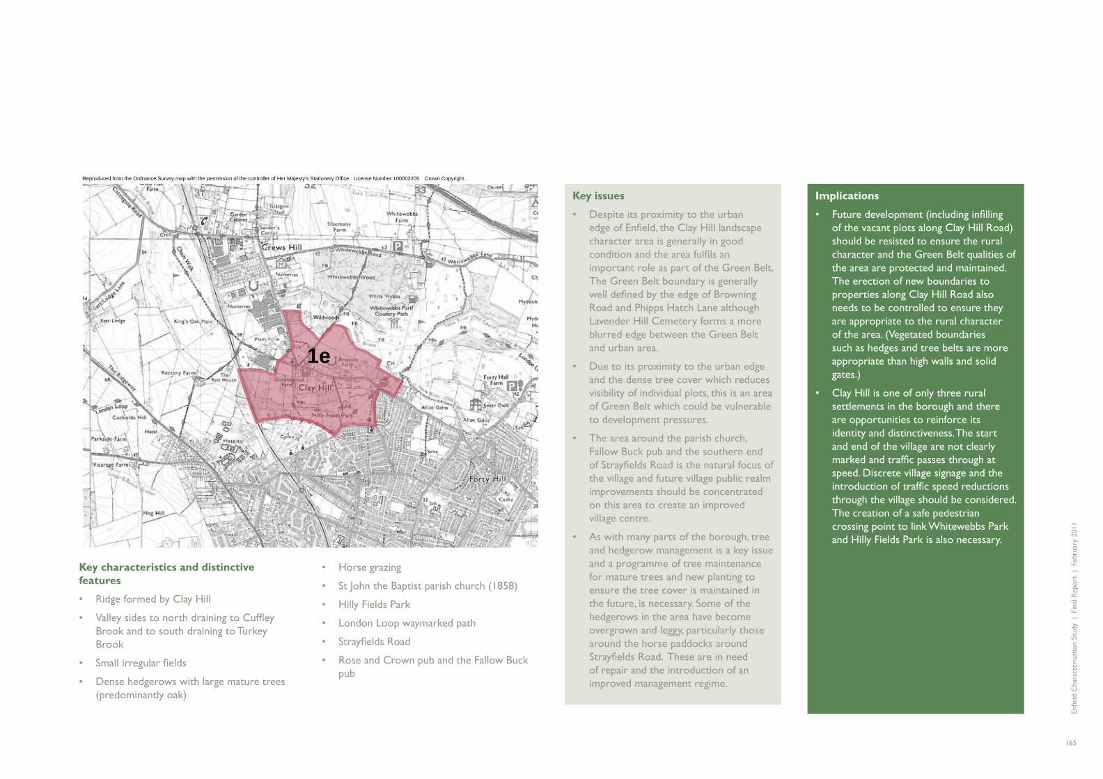
Enfi e
ld C
hara
cter
isat
ion
Stud
y |
Fin
al R
epor
t |
Feb
ruar
y 20
11
165
1e
Key characteristics and distinctive features
Ridge formed by Clay Hill •
Valley sides to north draining to Cuffl ey • Brook and to south draining to Turkey Brook
Small irregular fi elds•
Dense hedgerows with large mature trees • (predominantly oak)
Key issues
Despite its proximity to the urban • edge of Enfi eld, the Clay Hill landscape character area is generally in good condition and the area fulfi ls an important role as part of the Green Belt. The Green Belt boundary is generally well defi ned by the edge of Browning Road and Phipps Hatch Lane although Lavender Hill Cemetery forms a more blurred edge between the Green Belt and urban area.
Due to its proximity to the urban edge • and the dense tree cover which reduces visibility of individual plots, this is an area of Green Belt which could be vulnerable to development pressures.
The area around the parish church, • Fallow Buck pub and the southern end of Strayfi elds Road is the natural focus of the village and future village public realm improvements should be concentrated on this area to create an improved village centre.
As with many parts of the borough, tree • and hedgerow management is a key issue and a programme of tree maintenance for mature trees and new planting to ensure the tree cover is maintained in the future, is necessary. Some of the hedgerows in the area have become overgrown and leggy, particularly those around the horse paddocks around Strayfi elds Road. These are in need of repair and the introduction of an improved management regime.
Implications
Future development (including infi lling • of the vacant plots along Clay Hill Road) should be resisted to ensure the rural character and the Green Belt qualities of the area are protected and maintained. The erection of new boundaries to properties along Clay Hill Road also needs to be controlled to ensure they are appropriate to the rural character of the area. (Vegetated boundaries such as hedges and tree belts are more appropriate than high walls and solid gates.)
Clay Hill is one of only three rural • settlements in the borough and there are opportunities to reinforce its identity and distinctiveness. The start and end of the village are not clearly marked and traffi c passes through at speed. Discrete village signage and the introduction of traffi c speed reductions through the village should be considered. The creation of a safe pedestrian crossing point to link Whitewebbs Park and Hilly Fields Park is also necessary.
Horse grazing•
St John the Baptist parish church (1858)•
Hilly Fields Park•
London Loop waymarked path•
Strayfi elds Road•
Rose and Crown pub and the Fallow Buck • pub
Reproduced from the Ordnance Survey map with the permission of the controller of Her Majesty’s Stationery Office. License Number 100002205 �Crown Copyright.

Enfi e
ld C
hara
cter
isat
ion
Stud
y |
Fin
al R
epor
t |
Feb
ruar
y 20
11
166
1F HORNBEAM HILLS SOUTH
Summary
Southern corner of larger landscape area which extends into South Hertfordshire and centres around the Hornbeam Hills. An area of large scale undulating arable landscape.
Location
North-western edge of Hadley Wood extending out of borough to Potters Bar in the north and Wrotham Park in the west.
Description
The Hornbeam Hills South character area is the south eastern corner of a larger landscape character area which is identifi ed in the Landscape Character Assessment for Southern Hertfordshire (HCC, 2000). This is a strongly undulating arable landscape with a geometric pattern of large fi elds. These are bounded with hedgerows and include a mix of hawthorn and blackthorn with some elm and hornbeam. Hedgerow trees include oak, ash and hornbeam.
A small corner of this character area, comprising four fi elds and an adjacent track (Bartram’s Lane), is located in the borough of Enfi eld next to the edge of Hadley Wood. The area is visible from the public layby on Crescent West, from properties on this road and from the approach to Hadley Wood rail station. This area is similar to the wider area to the west and is an attractive landscape of agricultural land with long distance views to the woods of Wrotham Park to the west. The fi elds are bounded by tall hedges (in places overgrown and leggy) with scattered hedgerow trees. The northernmost fi eld is Hadley Wood public open space, a sloping area of green space incorporating a football pitch and longer grass areas to the north. There are views across
this area to Bartram’s Quash - a small mixed deciduous woodland.
The character area is part of a larger area of signifi cant Green Belt which separates Potters Bar from Hadley Wood.
Key characteristics and distinctive features:
Sloping valley landforms•
Geometric fi eld pattern•
Mainline railway in cutting/tunnel•
Potters Bar and M25 to north west•
Limited rights of way•

Enfi e
ld C
hara
cter
isat
ion
Stud
y |
Fin
al R
epor
t |
Feb
ruar
y 20
11
167
Reproduced from the Ordnance Survey map with the permission of the controller of Her Majesty’s Stationery Office. License Number 100002205 �Crown Copyright.
1f
Key issues
Although a small area within the • borough, this landscape character area is part of an important area of Green Belt and is in good condition.
The Green Belt boundary is clearly • defi ned by Bartrams Lane and the rear boundaries of properties on Camlet Way, Crescent West.
The area includes a valuable area • of public open space that is easily accessible from the adjacent urban area.
Implications
The existing character and pattern of • uses should be retained and existing hedgerows retained and managed.

Enfi e
ld C
hara
cter
isat
ion
Stud
y |
Fin
al R
epor
t |
Feb
ruar
y 20
11
168
2A ENFIELD CHASE / TRENT PARK
Summary
An area of undulating woodland and parkland containing Trent Country Park and part of Middlesex University. A Registered Historic Park formally part of the royal hunting forest of Enfi eld Chase.
Location
Located east of Hadley Wood and bounded by Hadley Road to the north and Cockfosters Road to the west. Trent Park golf course adjoins the area to the south. (The boundary of this character area follows the boundary of the area identifi ed by English Heritage on its ‘Register of Historic Parks and Gardens of Special Historic Interest’)
Description
Trent Park is a valuable area of historic landscape comprising farmland, parkland, woodland and formal gardens. Much of the area is now Trent Country Park (owned and managed by the London Borough of Enfi eld since 1968) and is a popular area for countryside recreation activities. In its centre is the University of Middlesex campus which includes the historic house of Trent Park Mansion.
The area has an undulating topography with a valley in the centre running east – west, drained by Leeging Beech Gutter, and ridges of higher land either side to the north and south. It is all designated as Green Belt and has a rural character which contrasts strongly with the dense urban areas of Cockfosters and Oakwood which are located close by.
In medieval times, Trent Park was part of Enfi eld Chase – a royal hunting park. Camlet Moat on the northern side of the park (now a Scheduled
Monument) is believed to be the site of the medieval manor house but other than this, the area was uninhabited until the construction of the main mansion in its current location in the 1770s. The mansion underwent many changes with the last major changes taking place in the early twentieth century by the Sassoon family when its current appearance, together with the formal gardens, were established. In 1947 a teacher training college was established and this gradually extended becoming Middlesex Polytechnic in 1974 and Middlesex University in 1992. A number of inappropriate and poorly sited buildings were added and the campus today comprises a mix of twentieth century buildings mainly clustered around the mansion and the stable block. The campus derives its current character from the historic mansion and formal landscape features, its spectacular landscape setting and the twentieth century buildings and infrastructure of the university. The mansion was well-sited originally to enjoy fi ne views to the north over the parkland and these remain today with the ornamental lakes forming a focus in the centre of the view and the obelisk viewed in the distance beyond.
The main entrance to the mansion was originally from Cockfosters Road along a formal drive lined with an avenue of Lime trees. This avenue remains today and forms an impressive feature in the park but the main entrance to the campus is now via Snakes Lane to the south (the original service entrance). The Cockfosters Road entrance, however remains as the main entrance to the Country Park and, on entering the site, visitors to the park enjoy fi ne views down the Lime avenue towards the mansion. A visitors centre, café, toilet block and large car park provide important facilities for visitors but

Enfi e
ld C
hara
cter
isat
ion
Stud
y |
Fin
al R
epor
t |
Feb
ruar
y 20
11
169
2a
are not sensitive to the historic character of the site.
A more detailed description of Trent Park and its historic signifi cance is provided in the Trent Park Conservation Area Character Appraisal (2006).
Key characteristics and distinctive features
Undulating landform•
Mixed deciduous woodland•
Pockets of arable farmland and grazing land•
Network of public rights of way and • informal footpaths
Trent Park mansion•
Obelisk•
Ornamental lakes•
University campus buildings•
University sports facilities including all • weather pitches
Reproduced from the Ordnance Survey map with the permission of the controller of Her Majesty’s Stationery Office. License Number 100002205 �Crown Copyright.
Key issues
The Trent Park Area is faced with a • complex range of landscape, historic, ecological and recreation issues which at times themselves refl ect confl icting needs and issues which are diffi cult to balance.
The key historic importance of the • site is as an example of a large and important historic mansion in a designed landscape setting. The use of the site as an institution has allowed this to be preserved as a living/working landscape in a single ownership.
Progressive expansion of the campus • has put pressure on the site resulting in a number of insensitive developments which are poorly sited or inappropriately detailed within the historic landscape. Within the campus, institutional style signage, circulation routes and public realm furniture have detracted from the historic character of the site. Some of the site’s landscape features have also suffered from lack of maintenance and repairs with the mansion terrace and steps and swimming pool in particularly poor condition.
In the wider area a balance is needed • to protect the historic landscape and its features whilst also promoting it as a site for public recreation and as a site of nature conservation importance.
The • areas of working agricultural land are an important part of the historic landscape setting and this agricultural land use should be continued and the agricultural landscape features maintained in good condition.
Implications
The future continued use of the site by • the University of Middlesex is under question and should this use cease, there will be a need to fi nd an alternative use which does not adversely affect the quality of the Green Belt and allows the site to be preserved and maintained for the future. Key to this will be the need to develop proposals which meet the main development principles established in the Conservation Area Management Proposals for Trent Park (2007). In summary, these are:
Protection of the mansion, formal • garden, stables and parkland setting as a priority
Removal of the most damaging • modern buildings from around the mansion.
Protection of the key views from and • of the mansion including key long views from the wider parkland
Landscape management measures are • needed for the wider area including in particular, long term woodland management, management of veteran trees and the two main avenues on the site and management of the existing water features (see Trent Country Park Management Plan 2009 – 2014)

Enfi e
ld C
hara
cter
isat
ion
Stud
y |
Fin
al R
epor
t |
Feb
ruar
y 20
11
170
2B WHITEWEBBS PARK AND FORTY HALL
Summary
An area of undulating woodland, parkland and pockets of open fi elds drained by a criss-cross of watercourses. The area incorporates Whitewebbs Country Park and the historic gardens and parklands of Forty Hall and Myddleton House.
Location
Area bounded by Whitewebbs Lane to the north, Forty Hill/Bulls Cross Road to the east, Crews Hill to the west and the urban edge of Forty Hill to the south.
Description
This character area is a large area of publicly accessible open space containing three main elements: Whitewebbs Country Park, Forty Hall and its gardens and surrounding parkland and Myddleton House and its surroundings. Each area has its own unique character and distinct identity but the boundaries between them are blurred and the area can be experienced as a single area. A good network of footpaths forming circular routes allows visitors to move easily between the areas.
Whitewebbs Park is the largest of the three areas and comprises a large area of woodland and an 18 hole public golf course. Most of the woodland is Ancient or Semi-Natural woodland with a few pockets of Ancient Replanted woodland. It is a dense mixed native species woodland including areas of coppiced hornbeam, scattered large beech trees, mixed stands of ash, elm and fi eld maple and some stands of birch and willow. The woodland is undulating and contains a dense network of paths and small watercourses. It includes a number of features including two ornamental
lakes, Whitewebbs House (a large eighteenth century house - now a Toby carvery), a club house for the Whitewebbs golf club and substantial public car park areas. It is a popular area for informal recreation and contains some interesting remnants of an earlier course of the ‘New River’.
Forty Hall has been described by some local residents as ‘the jewel of the borough’. It is an impressive historic designed landscape which acts as a gateway to the wider countryside beyond and allows fi ne views over the surrounding parkland and woodland landscape. The hall is a Grade I listed building built in 1629 and its 160 acre estate includes a working farm, fi shing lake, parkland and woodland and a double lime avenue. The house is surrounded with formal gardens comprising lawns, herbaceous borders and a large ornamental lake on the north side of the house. The remains of the original walled kitchen garden are also present. The Hall and its estate are an excellent example of a seventeenth century house in a designed landscape and are considered to be of outstanding national importance.
Myddleton House is smaller and more domestic in character than its neighbour Forty Hall, but is also of historic importance. It is a large Regency house (built in 1818) set in gardens landscaped by E. A. Bowles - the famous nineteenth century plantsman and includes a national collection of Iris plants. Is is now used as the main offi ces for the Lee Valley Regional Park Authority and the gardens are open to the public (on payment of an admissions charge). The gardens are set back from the road and enclosed by a wall which give them a quiet, secluded character.

Enfi e
ld C
hara
cter
isat
ion
Stud
y |
Fin
al R
epor
t |
Feb
ruar
y 20
11
171
2b
The three areas of Whitewebbs, Forty Hall and Myddleton House are surrounded by agricultural land and small woodlands which provide a rural setting for these landscaped areas. Some of these to the north of Myddleton House have recently been purchased by Tottenham Football Club and the construction of training grounds in this area is currently underway. This is creating a landscape with a more urban and institutional character which contrasts with the rural character of the adjacent historic landscape.
Key characteristics and distinctive features
Mature mixed species native woodlands•
Network of small water courses including • Turkey Brook, Cuffl ey Brook and New River (Old Course)
Network of waymarked routes, public rights • of way and informal paths
Range of recreational activities including • walking, cycling, riding and golf
Allotment gardens on south side•
Forty Hall and historic garden and parkland•
Myddleton House and historic garden•
Tottenham football club training grounds • (under construction)
Whitewebbs park golf course•
Whitewebbs House (Toby carvery)•
Reproduced from the Ordnance Survey map with the permission of the controller of Her Majesty’s Stationery Office. License Number 100002205 �Crown Copyright.
Key issues
Each of the main parts of this character • area is subject to different pressures and issues. All however share a similar need to balance the confl icting pressures of providing for intense recreational use whilst at the same time preserving the historical elements, landscape features and ecological importance of the area.
The area is ideally located adjacent to • the urban edge of the borough to form an accessible area of high quality open space with a range of facilities and this use should be encouraged.
The area is an important part of the • borough’s Green Belt and performs a signifi cant role in providing accessible countryside recreation for the urban areas of the borough. A key threat to the area as a whole is the risk of progressive urbanisation of the landscape and a weakening of its Green Belt qualities. Its proximity to the urban edge make it vulnerable to piecemeal changes and the introduction of urban elements.
Implications
Careful management measures are • required to ensure that the special qualities of the landscape are protected. A Conservation Management Plan prepared jointly by Enfi eld Council and Capel Manor College (updated 2008) for Forty Hall sets out a framework of management measures for achieving this.
There is a need for careful control of • future land uses in the area and the detailing of each area to ensure that the historic and rural character of the area is not weakened.
As with other landscape areas in the • borough, pro-active tree and woodland management is necessary to ensure the long term continuation of these landscape features. In the Forty Hall parkland, grazing has been stopped and trees have established unchecked which is resulting in the gradual loss of the original open character of the parkland. Management is needed to reverse this process.

Enfi e
ld C
hara
cter
isat
ion
Stud
y |
Fin
al R
epor
t |
Feb
ruar
y 20
11
172
3A CREWS HILL
Summary
Dense concentration of glasshouses, plant nurseries and garden centres interspersed with some residential properties and several equestrian centres.
Location
Area either side of Theobalds Park Road and Cattlegate Road extending to mainline railway on west side.
Description
This area comprises a dense concentration of glass houses, horticultural-based trading activities (such as garden centres and nurseries) and equine activities with residential properties scattered throughout. Similar concentrations of glass houses are found outside the borough on the east side of the Lee Valley (for example at Sewardstone, Nazeing and Broadly Common) but none have such a high concentration or range of commercial and retail activities. In recent years there has been an expansion in non-horticultural based activities with the establishment of urban fringe activities such as waste recycling, scrap metal companies and builders merchants. There are also a number of derelict glass houses and vacant plots which detracts from the quality of the area.
Crews Hill is well known in the borough and is a popular destination for garden centre shopping. It is particularly popular at weekends with people coming on day trips to the area to browse the garden centres and often eating out at the local pubs in Crews Hill and Clay Hill.
Theobalds Park Road and Cattlegate Road pass through the centre of the area and the majority of the businesses and some private detached residential properties are accessed from this.
Behind the businesses and set back from the road, are a number of small, irregular shaped fi elds many of which are used for grazing. Some of these have hedgerow boundaries but these are often poorly managed and overgrown. The main residential centre of the village is Rosewood Drive (leading to Ash Ride, Beech Avenue, and Cypress Avenue) which is a small development of mainly single storey detached mid twentieth century properties which are set back from the road with off road parking.
Vegetation in the area is mixed, ranging from native planting including mature oak trees and hawthorn hedges along the main road to large belts/hedgerows of coniferous plants and stands of ornamental planting within and between the garden centres and plant nurseries.
Crews Hill is in the Green Belt, however the character and quality of much of the area is poor. The large areas of glass houses, warehouses and ancillary buildings are visually intrusive and reduce the sense of openness of the area. Signage and boundary treatments are often also intrusive with a range of different boundary types together with large numbers of small and large signs and advertisements. These give a cluttered appearance to the streetscape and are not in keeping with the rural or Green Belt character of the area.
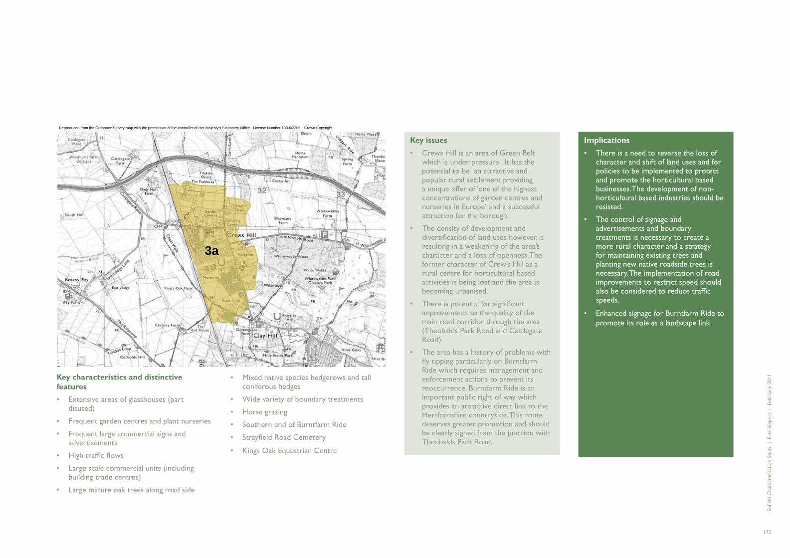
Enfi e
ld C
hara
cter
isat
ion
Stud
y |
Fin
al R
epor
t |
Feb
ruar
y 20
11
173
3a
Key characteristics and distinctive features
Extensive areas of glasshouses (part • disused)
Frequent garden centres and plant nurseries•
Frequent large commercial signs and • advertisements
High traffi c fl ows•
Large scale commercial units (including • building trade centres)
Large mature oak trees along road side•
Key issues
Crews Hill is an area of Green Belt • which is under pressure. It has the potential to be an attractive and popular rural settlement providing a unique offer of ‘one of the highest concentrations of garden centres and nurseries in Europe’ and a successful attraction for the borough.
The density of development and • diversifi cation of land uses however, is resulting in a weakening of the area’s character and a loss of openness. The former character of Crew’s Hill as a rural centre for horticultural based activities is being lost and the area is becoming urbanised.
There is potential for signifi cant • improvements to the quality of the main road corridor through the area (Theobalds Park Road and Cattlegate Road).
The area has a history of problems with • fl y tipping particularly on Burntfarm Ride which requires management and enforcement actions to prevent its reoccurrence. Burntfarm Ride is an important public right of way which provides an attractive direct link to the Hertfordshire countryside. This route deserves greater promotion and should be clearly signed from the junction with Theobalds Park Road.
Implications
There is a need to reverse the loss of • character and shift of land uses and for policies to be implemented to protect and promote the horticultural based businesses. The development of non-horticultural based industries should be resisted.
The control of signage and • advertisements and boundary treatments is necessary to create a more rural character and a strategy for maintaining existing trees and planting new native roadside trees is necessary. The implementation of road improvements to restrict speed should also be considered to reduce traffi c speeds.
Enhanced signage for Burntfarm Ride to • promote its role as a landscape link.
Reproduced from the Ordnance Survey map with the permission of the controller of Her Majesty’s Stationery Office. License Number 100002205 �Crown Copyright.
Mixed native species hedgerows and tall • coniferous hedges
Wide variety of boundary treatments•
Horse grazing•
Southern end of Burntfarm Ride•
Strayfi eld Road Cemetery•
Kings Oak Equestrian Centre•

Enfi e
ld C
hara
cter
isat
ion
Stud
y |
Fin
al R
epor
t |
Feb
ruar
y 20
11
174
4a
4A THE LEE VALLEY RIVERS AND RESERVOIRS
Summary
Long linear area of valley and fl oodplain landscape containing the River Lee, the River Lee Navigation channel and the King George V and William Girling reservoirs. Area forms part of the Lee Valley Regional Park and is a recreation and wildlife area of strategic importance for the borough.
Location
Area approximately bounded by M25 to the north, Banbury Reservoir to the south, the River Lee Navigation to the east (extending to the A1055 around Pickett’s Lock) and the River Lee in the west (extending towards the A1037 in places in the boroughs of Waltham Forest and Epping Forest).
Description
Although the Lee Valley has a variety of uses and local areas of differing character it is identifi ed here as a single area of landscape character within the borough. This aims to refl ect the Lee Valley’s importance as a strategic open space for the borough which performs a key role in providing space for recreation and wildlife. At this strategic level the Lee Valley is a single broad river valley which drains to the River Thames in the south. Its key features include the monumental King George V and William Girling reservoirs, the channel of the River Lee, the separate River Lee Navigation channel and pockets of marshland and open space.
The Upper Lee Valley Landscape Strategy (2010) identifi es three distinct sections of the Upper Lee valley:
Forest and Green Belt – the area between • the M25 and the southern edge of the King
George V’s reservoir characterised by the areas of farmland and woodland to the east and west
Suburban infrastructural – referred to as • Central Leeside this stretches from Banbury Reservoir in the south to the northern end of the William Girling Reservoir.
Urban wild – referred to as the • Walthamstow Wetlands this is characterised by marshlands and naturalistic reservoirs and fi lterbed sites with a relatively open urban area fronting on to it.
The fi rst two of these areas are within the borough of Enfi eld, and the key elements and areas making up each of these are described in more detail below
Marshlands and grasslands
Along the length of the Lee Valley within the borough are many areas of marshland and grassland. These vary in size, character and use but all are included in the borough’s Green Belt. At the southern end of the borough on either side of the A406 are several pockets of rough grassland which form part of the Green Belt and provide a key strategic green link between the Chingford Reservoirs in the north and the Walthamstow reservoirs in the south. These form part of the Lee Valley Regional Park but lack appropriate land uses and management regimes. To the north of these, at Picketts Lock is the Lee Valley Leisure Complex which includes the national athletic centre, Lee Valley Golf course and a camping and caravanning site. This is a substantial area of green space with a mix of open grassland, water and a good framework of mature trees. It feels a world away from the nearby dense urban areas of Edmonton and Ponder’s End providing
opportunities for a unique rural camping and golf experience. However, connections with the waterways are poor and the A1055 and railway line create a barrier to accessing the area on foot from local areas.
Other areas of marshland and grassland include small pockets of rough grazing land, for example by Wright’s fl our mill in Ponder’s End and to the north of the King George V’s Reservoir (either side of Swan and Pike Road), and the long linear strip of grassland (known as South marsh) between Brimsdown and King George V’s Reservoir. These areas are generally inaccessible, (often fenced off with high security fencing) but are important areas of green space which contribute to the sense of openness of the Lee valley.
Rammey Marsh is the largest area of marshland and grassland in the Lee Valley area in the north of the borough. It is an area of low-lying rough grassland forming part of the fl ood plain of the River Lee and mainly managed by Lee Valley Park Authority for recreation and wildlife purposes. It is a site of Metropolitan Importance for Nature Conservation and 225 plant species have been recorded on the site including colonies of orchids. In the past, the northern part was used for gravel extraction but has since been backfi lled. It is now slightly undulating and is gradually being invaded by scrub. The eastern edge is formed by the River Lee navigation which is lined by mature willows and poplars which form a prominent feature in the landscape.
Rammey Marsh is an important area of public space which provides visitors with a large expanse of open land with long distance views across the marshes to the open Essex
Reproduced from the Ordnance Survey map with the permission of the controller of Her Majesty’s Stationery Office. License Number 100002205 �Crown Copyright.

Enfi e
ld C
hara
cter
isat
ion
Stud
y |
Fin
al R
epor
t |
Feb
ruar
y 20
11
175
countryside beyond the M25. Large electricity pylons are prominent in the skyline on the east side. They are large features considered ugly by some and liked by others but are appropriate to the scale of the landscape. The recreational value of this area will be increased in the future if current plans to create a new bridge connection with Gunpowder Park to the east are implemented.
This part of the character area also includes a large area of open land bounded by the M25 to the north, the railway line to the west and Mollison Avenue to the south. This is rough grassland which forms part of the Green Belt and provides a valuable green wedge between the M25 and the Innova Science Park and Freezy Water to the south. It is in need of regular management and improved boundaries to increase its ecological value and improve its appearance.
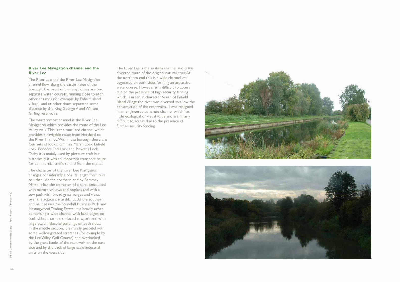
Enfi e
ld C
hara
cter
isat
ion
Stud
y |
Fin
al R
epor
t |
Feb
ruar
y 20
11
176
River Lee Navigation channel and the River Lee
The River Lee and the River Lee Navigation channel fl ow along the eastern side of the borough. For most of the length, they are two separate water courses, running close to each other at times (for example by Enfi eld island village), and at other times separated some distance by the King George V and William Girling reservoirs.
The westernmost channel is the River Lee Navigation which provides the route of the Lee Valley walk. This is the canalised channel which provides a navigable route from Hertford to the River Thames. Within the borough there are four sets of locks: Rammey Marsh Lock, Enfi eld Lock, Ponders End Lock and Pickett’s Lock. Today it is mainly used by pleasure craft but historically it was an important transport route for commercial traffi c to and from the capital.
The character of the River Lee Navigation changes considerably along its length from rural to urban. At the northern end by Rammey Marsh it has the character of a rural canal lined with mature willows and poplars and with a tow path with broad grass verges and views over the adjacent marshland. At the southern end, as it passes the Stonehill Business Park and Hastingwood Trading Estate, it is heavily urban, comprising a wide channel with hard edges on both sides, a tarmac surfaced towpath and with large-scale industrial buildings on both sides. In the middle section, it is mainly peaceful with some well-vegetated stretches (for example by the Lee Valley Golf Course) and overlooked by the grass banks of the reservoir on the east side and by the back of large scale industrial units on the west side.
The River Lee is the eastern channel and is the diverted route of the original natural river. At the northern end this is a wide channel well-vegetated on both sides forming an attractive watercourse. However, it is diffi cult to access due to the presence of high security fencing which is urban in character. South of Enfi eld Island Village the river was diverted to allow the construction of the reservoirs. It was realigned in an engineered concrete channel which has little ecological or visual value and is similarly diffi cult to access due to the presence of further security fencing.

Enfi e
ld C
hara
cter
isat
ion
Stud
y |
Fin
al R
epor
t |
Feb
ruar
y 20
11
177
Chingford Reservoirs
The William Girling and George V Reservoirs are known together as the Chingford Reservoirs. The George V Reservoir was constructed fi rst (completed in 1912) followed by the William Girling Reservoir which was started in 1936 but not completed until 1951. They are owned and managed by Thames Water but currently have no public access other than the George V Reservoir which can be accessed by members of the reservoir sailing club and by permit. They support a large and important bird population and have therefore been designated as a Site of Special Scientifi c Interest.
The reservoirs are large expanses of open water with a concrete lining and high grass perimeter bunds. They are monumental landscape features when seen from the air but are rarely visible at ground level due to the presence of high security fencing and the tall bunds. The lack of visibility of these important areas is frustrating and it is only from tall buildings within the borough and from an elevated viewpoint on the A1307 in Sewardstone that the scale and expansiveness of these features can be appreciated. However, despite the lack of visibility, in landscape terms they are important in providing openness, fresh air and nature for the borough. At ground level, the key visible areas are the external perimeter grass banks which are managed by grazing sheep. This gives a rural feel which contrasts with the adjacent densely urban areas.

Enfi e
ld C
hara
cter
isat
ion
Stud
y |
Fin
al R
epor
t |
Feb
ruar
y 20
11
178
Key issues
The areas of marshlands and • grasslands are key elements of the Lee Valley landscape providing pockets of rural landscape. Together they play an important role in the green infrastructure of the Lee Valley providing green links or stepping stones between the larger areas of greenspace or water in the valley. Some of these areas have little or no management and have poor quality boundaries making them appear like areas of forgotten landscape.
Within the Rammey Marsh area, the • north west corner is the area under greatest pressure. In the past it was excavated for gravel and backfi lled and is now an area of rough ground with poor quality boundaries. It plays an important Green Belt role in providing an area of openness particularly as experienced by traffi c passing through the area on Mollison Avenue and the M25. However, its visual quality is poor (particularly when compared with the adjacent area of Rammey Marsh).
The broad landscape margins of the • Innova Science Park site fall within the Rammey Marsh area. They are an important extension of the area and create the sense that Mollison Avenue is passing through a landscape area rather than defi ning the edge to it.
Implications
The use of the land for grazing is well-• suited to the character of the landscape but there is a need for improved management regimes and landscape structure planting to create stronger boundaries and improve the appearance of the areas.
There is a need for a suitable Green Belt • land use to be found for the Rammey Marsh area and a management regime to improve its landscape quality. This should include landscape measures to mitigate the noise and visual impacts of the M25.
Landscape improvements and • management measures are needed to create improved physical and visual connections between the Innova Science Park and Rammey Marsh areas. Inclusion of the belt of land on the west side of Mollison Avenue within the Lee Valley Regional Park and the introduction of landscape improvements to increase the profi le of the regional park in this area would be benefi cial.
Marshlands and grasslands
Key issues
The River Lee Navigation and the • River Lee are a major asset for the borough forming blue ribbons that stretch the length of the borough and telling a fascinating history of navigation and water engineering. Despite improvements in recent years they still remain diffi cult to access, are under-utilised and have limited biodiversity value. Connection points to routes are often low key and uninviting and long stretches are fenced off by high paladin fencing which is urban and hostile in character.
Implications
There is a need for investment in a • range of improvements which are set out in the Upper Lee Valley Landscape Strategy (2010). These include improved connections with the adjacent areas, circular routes, landscape improvements to create improved biodiversity, improved interpretation of the historic canal features and improved signage and publicity.
River Lee Navigation channel and the River Lee
Key issues
For the few who know and use the • reservoirs, this area is highly valued, providing a breath-taking expanse of openness close to the densely developed urban areas of north London. For most people however, the reservoirs are an inaccessible area hidden by grass bunds and fenced off with security fencing.
Implications
The creation of increased public access • to and use of the reservoirs would provide major benefi ts to local residents and would raise the profi le of the Lee Valley Regional Park. Discussions are underway with Thames Water to investigate opportunities for increased public access whilst still maintaining the necessary safety and security measures.
•
Chingford Reservoirs

Enfi e
ld C
hara
cter
isat
ion
Stud
y |
Fin
al R
epor
t |
Feb
ruar
y 20
11
179

Enfi e
ld C
hara
cter
isat
ion
Stud
y |
Fin
al R
epor
t |
Feb
ruar
y 20
11
1806. CONCLUSIO

Enfi e
ld C
hara
cter
isat
ion
Stud
y |
Fin
al R
epor
t |
Feb
ruar
y 20
11
181NS

Enfi e
ld C
hara
cter
isat
ion
Stud
y |
Fin
al R
epor
t |
Feb
ruar
y 20
11
182
A number of key themes and issues have emerged which particularly defi ne the character of Enfi eld. These are important to the ongoing character of the borough in terms of protecting the key features which make the borough special. They also may provide helpful guidance in terms of directing future policy and design considerations, ensuring that new development proceeds in a way which is consistent with the core character of the borough. This section describes the key characteristics and highlights the issues and opportunities to be addressed.
Overarching borough characteristics
Firstly, there are some important overarching, borough-wide characteristics which are important to recognise and which provide the context for Enfi eld’s unique character.
The borough has a unique character • infl uenced strongly by its topography - as a London borough it has a distinctly different character and contains the full spectrum from dense urban centres, through suburban neighbourhoods to rural countryside.
There are many areas of real quality in • the borough with highly attractive and well managed sections of rural landscape, surviving historic centres within the urban areas of the borough, and buildings and typologies of architectural and urban design quality. These areas are to be celebrated.
The borough is crossed and connected by • a series of historic connections and major routes and there is a need to ensure these routes continue to provide a focus and a sense of place for local centres, and support the network of local connections.
CONCLUSIONS
Grange Park
Winchmore Hill
Enfield Chase
Gordon Hill
Crews Hill
Hadley Wood
Cockfosters
Oakwood
Southgate
Arnos Grove
Palmers Green
Silver Street
Edmonton Green
Bush Hill Park
Enfield Town
Southbury
Turkey Street
Enfield Lock
Brimsdown
Ponders End
Angel Road
This map is reproduced from Ordnance Survey material with the permission of Ordnance Survey on behalf of the Controller of Her Majesty's Stationery Offi ce © Crown copyright. Unauthorised reproduction infringes Crown copyright and may lead to prosecution or civil proceedings. London Borough of Enfi eld DENF003.

Enfi e
ld C
hara
cter
isat
ion
Stud
y |
Fin
al R
epor
t |
Feb
ruar
y 20
11
183
The evolution of the borough has secured the pattern of development and landscape which we see today. Successive periods of growth and pressure for change have established a huge diversity of typologies across the borough. The study has identifi ed a series of issues and opportunities which should inform both Council policy and private landowner actions wherever possible.
Here the study’s conclusions are ordered under the following themes refl ecting the issues and opportunities identifi ed throughout:
Urban issues and opportunities;•
Landscape issues and opportunities; and•
Issues and opportunities at the urban/• landscape interface.
This chapter then concludes with recommendations for further work highlighting some specifi c areas of the borough that require attention, as well as some themes where further guidance and action should be focused.
URBAN ISSUES AND OPPORTUNITIES
The following issues and opportunities have been highlighted through the analysis of the borough’s urban characteristics, typologies and neighbourhoods:
The need to celebrate the good examples • of architecture and urban design throughout the borough.
The importance of the many examples of • good “everyday places” and the need to guard against the cumulative impact of small alterations.
The role of historic connections and major • routes and the opportunities to ensure a positive relationship between key routes and adjacent neighbourhoods and centres.
The prevalence of the perimeter block form • in the borough and the implications this has for future development.
The shift in land uses happening in various • typologies across the borough and the need to act to address trends which threaten established patterns and future character.
The importance of supporting local centres • to ensure more sustainable suburban neighbourhoods in the long term.
The need to learn from the past - both in • terms of ensuring new development takes clear cues from its context, and to avoid past mistakes.
This map is reproduced from Ordnance Survey material with the permission of Ordnance Survey on behalf of the Controller of Her Majesty's Stationery Offi ce © Crown copyright. Unauthorised reproduction infringes Crown copyright and may lead to prosecution or civil proceedings. London Borough of Enfi eld DENF003.

Enfi e
ld C
hara
cter
isat
ion
Stud
y |
Fin
al R
epor
t |
Feb
ruar
y 20
11
184
Celebrating quality: Conservation of the historic environment and the enhancement of undesignated areas of value
Enfi eld has 22 conservation areas, few of which are in the eastern part of the borough. Most of the conservation areas are in the central part of the borough and also give a wide coverage of the parkland to the north of the urban area. The conservation areas generally cover the important elements of historical development before the widespread growth of the suburbs. However, there are now also a number of conservation areas which seek to protect the best examples of suburban development, refl ecting their importance at a time of great change in the interwar years.
The value of the borough’s historic environment makes a highly signifi cant contribution to the quality and sense of place. It forms an important element of community memory and attachment to the area.
Just as innovative, but as yet undesignated are some of the public sector housing areas such as the Hyde Estate close to Edmonton Green. These were signifi cant public projects in their time and were important stages in the development of public sector housing design, strongly infl uenced by the garden city movement. Also signifi cant are the better quality elements of post-war housing, including 1950s developments such as the Beaconsfi eld Estate. Here, the architectural and urban composition, coupled with a sophisticated level of detailing provides a rich and attractive environment which could merit further protection before further original features are lost.
Implications
There are a number of areas in the borough which have a valuable and attractive character and which embody important phases of social history and urban development. These examples, such as the Hyde and Beaconsfi eld estates would benefi t greatly from improved management and local development policies that give greater attention to the quality of the public realm. This would help to reinforce the important and distinctive character of these areas in the borough.
In areas such as this which retain a cohesive feel it is also important to guard against the impact of small cumulative changes that detract from and erode the character. It may be appropriate to consider the designation of such areas as ‘Areas of Distinctive Quality’ with an appropriate set of policies attached.
The Hyde Estate represents a high quality undesignated example of urban design in the borough

Enfi e
ld C
hara
cter
isat
ion
Stud
y |
Fin
al R
epor
t |
Feb
ruar
y 20
11
185
Good everyday places
Whilst conservation areas are important in protecting those areas which have special historic character and buildings of singular merit, greater recognition needs to be afforded to the good everyday places – the suburban areas that make up the rest of the borough.
Enfi eld is fortunate in having a large stock of Victorian, Edwardian and inter-war buildings which create good streets and spaces and have provided robust family housing. However, as fashions and circumstances change these buildings have been much modifi ed by their owners, gradually fragmenting the original composition of the townscape. Modifi cations range from the simple addition of a satellite dish through to major overhauls, but there are a number of changes which have a particular impact:
Changes to the front elevation – including cladding, rendering or painting over the original surface or alternatively choosing a garish colour compared to the original for external decoration;
Loft conversions – this can have a particularly signifi cant impact on semi-detached houses with hipped roofs, where the loft of one house is converted under permitted development, destroying the symmetry of the pair and changing the overall composition of the roof-line along the street; and
Parking in front gardens – many gardens in typical suburban areas have been converted to provide parking, resulting in the loss of boundary defi nition, planting and natural drainage. This weakens the quality of the public realm, changing the relationship between the buildings and the street for the worse.
Implications
Many of the changes noted above can be carried out within permitted development rights meaning that the council has little or no control over what change is acceptable. It is hoped that documents like this one which celebrate the qualities of the borough’s buildings can be used as the basis for information, publicity and guidance which will encourage or require people to pay greater heed to the design of their properties in areas outside the conservation area designations.
Improvements will come from a greater understanding and appreciation of the qualities of the buildings and particularly the relationship between one building and the rest of the terrace or street. Understanding and valuing the collective identity of the street rather than prioritising the individuality of a single building is a key stage in ensuring that where buildings are changed, it is in harmony with the rest of the group.
The importance of the overall group is particularly signifi cant in the light of the many small external changes which can be made to buildings, but which over time lead to a cumulative loss of character. This is an area where local development control policies and management could be developed to provide a more coordinated approach, perhaps also supported by information and education on the value of the cohesive character of streets in the borough. A key tool in this regard might be the development of residential design guidance dealing with small modifi cations and extensions, controlling
features such as side extensions and hip-to-gable loft conversions which can have such an impact on the street character.
Protecting the character and quality of the public realm is also an important piece of maintaining the overall character, using policy and guidance to discourage the removal of hedges, boundaries and front gardens in the private realm and providing adequate maintenance or reinstatement for public realm verges and hedges.
The loss of front gardens and boundary treatments is a problem for many of the typologies in the borough, as illustrated here for Victorian terraces
Changes to front elevations can result in the loss of character and and the appearance of clutter
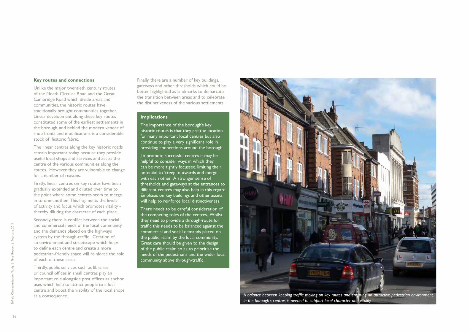
Enfi e
ld C
hara
cter
isat
ion
Stud
y |
Fin
al R
epor
t |
Feb
ruar
y 20
11
186
Key routes and connections
Unlike the major twentieth century routes of the North Circular Road and the Great Cambridge Road which divide areas and communities, the historic routes have traditionally brought communities together. Linear development along these key routes constituted some of the earliest settlements in the borough, and behind the modern veneer of shop fronts and modifi cations is a considerable stock of historic fabric.
The linear centres along the key historic roads remain important today because they provide useful local shops and services and act as the centre of the various communities along the routes. However, they are vulnerable to change for a number of reasons.
Firstly, linear centres on key routes have been gradually extended and diluted over time to the point where some centres seem to merge in to one-another. This fragments the levels of activity and focus which promotes vitality - thereby diluting the character of each place.
Secondly, there is confl ict between the social and commercial needs of the local community and the demands placed on the highways system by the through-traffi c. Creation of an environment and streetscape which helps to defi ne each centre and create a more pedestrian-friendly space will reinforce the role of each of these areas.
Thirdly, public services such as libraries or council offi ces in small centres play an important role alongside post offi ces as anchor uses which help to attract people to a local centre and boost the viability of the local shops as a consequence.
Finally, there are a number of key buildings, gateways and other thresholds which could be better highlighted as landmarks to demarcate the transition between areas and to celebrate the distinctiveness of the various settlements.
Implications
The importance of the borough’s key historic routes is that they are the location for many important local centres but also continue to play a very signifi cant role in providing connections around the borough.
To promote successful centres it may be helpful to consider ways in which they can be more tightly focussed, limiting their potential to ‘creep’ outwards and merge with each other. A stronger sense of thresholds and gateways at the entrances to different centres may also help in this regard. Emphasis on key buildings and other assets will help to reinforce local distinctiveness.
There needs to be careful consideration of the competing roles of the centres. Whilst they need to provide a through-route for traffi c this needs to be balanced against the commercial and social demands placed on the public realm by the local community. Great care should be given to the design of the public realm so as to prioritise the needs of the pedestrians and the wider local community above through-traffi c.
A balance between keeping traffi c moving on key routes and ensuring an attractive pedestrian environment in the borough’s centres is needed to support local character and vitality

Enfi e
ld C
hara
cter
isat
ion
Stud
y |
Fin
al R
epor
t |
Feb
ruar
y 20
11
187
The impact of strategic roads
The North Circular Road and the Great Cambridge Road (A10) are major barriers which have a signifi cant impact on the character of the areas along their route through the borough. The characterisation study has noted the fragmentation of the urban areas on either side of these roads where the original character of neighbourhoods has been adversely affected by these major routes. This is particularly true for the North Circular Road where the environmental quality, and ultimately integrity, of neighbourhoods adjacent to the route is noticeably poorer than similar style neighbourhoods further away.
The impact of the North Circular Road and the Great Cambridge Road has been to separate communities from one-another. Unlike the Hertford Road which acts as the central spine and draws a number of communities together around the activities along its length, the larger roads divide communities. This discourages integration and limits use of what may be intended as communal facilities.
Implications
Where opportunities exist to enable environmental enhancements to neighbourhoods adjacent to the North Circular Road and A10, these should be explored. In addition, the scope for enhancing the quality of the routes themselves could be investigated. This may include making a positive effort to create stronger focal points of activity along the routes which make them positive places to be. Areas such as the retail park on the Great Cambridge Road hold signifi cant potential for reinvention as more urban, integrated centres.
The Area Action Plan being developed for New Southgate and the western part of the North Circular Road offers a signifi cant opportunity to explore new ways in which the urban fabric can relate to these busy roads and deal with the impact of noise. This should include identifying ways in which new development types can be used which are both suited to the particular environment, but which also draw their character and infl uence from the prevailing Enfi eld typology.
It is important to appreciate that the North Circular is a key route and forms an important impression of the borough for many people. Whilst wanting to mitigate against the impact of noise, it is important to provide an appropriate level of engagement with the street, including active frontages rather than blank or secondary elevations.
The impact of strategic routes on adjacent neighbourhoods and their character could be mitigated through environmental enhancements

Enfi e
ld C
hara
cter
isat
ion
Stud
y |
Fin
al R
epor
t |
Feb
ruar
y 20
11
188
Urban block structure – the relevance of perimeter blocks
As has been demonstrated through the typology section of this report, the perimeter block is the prevailing character form within the borough and is successful due to the way in which public and private space is defi ned. Examples ranges from the dense, regular Victorian grids of Enfi eld Lock and Bowes Park through to the classic suburbs and garden city style developments. It incorporates the various elements of historic development and integrates with historic, linear and Metroland centres. Small scale industrial use often loosely follows a perimeter block form and its infl uence can be seen in more recent technology park development.
The perimeter block in all its variations has a number of key strengths which provide important lessons for future development:
It creates networks of streets which are • generally easy to navigate and permeable, offering good conditions for walking and cycling;
The arrangement of buildings around the • edge of the block facing into the street creates an attractive environment which generally feels safe due to the presence of active uses around the block and prevents open access to the centre of the block. Rear gardens back onto one another, creating a safe heart to the block;
The arrangement is very adaptable in terms • of block size and shape, ranging from regular grids through to larger looser patterns. The fl exible grid structure, much more common in the inter-war suburbs, also allows the block structure to adapt to hilly terrain where a regular grid may be diffi cult to build
out. It also adapts well to use in the kind of geometric layouts found in garden city areas which include elements of open space, within otherwise regular patterns;
The grid can adapt to include small cul-• de-sacs within the blocks, in the manner pioneered in the Hampstead Garden Suburb plan;
A wide range of uses can be adapted to • fi t into the grid form, integrating public functions such as schools within otherwise residential areas; and
It can be infi nitely extended and replicated • until constrained by major barriers or other edge condition. This means that new areas can be easily added to and integrated with existing development, forging new links and continuing the urban form.
Implications
The perimeter block, in some form or other, should form the starting point for consideration of any new development in the borough. It is the prevailing form and has proved robust, adaptable and successful over a long period. New development should be required to demonstrate how it integrates with the existing urban structure, and there should be pressure to create as great a sense of continuity as possible between existing development and new development.
The perimeter block form is adaptable to very high densities of development, including high density apartment schemes which create good street frontage around the perimeter and shared amenity space in the centre. Victorian terraced areas represent a high density format for perimeter blocks which is found across the
eastern and central parts of the borough
Extensive areas of Victorian terraced streets in the form of perimeter blocks are found in the borough, as here in Freezywater

Enfi e
ld C
hara
cter
isat
ion
Stud
y |
Fin
al R
epor
t |
Feb
ruar
y 20
11
189
Land use shift
There are a number of instances in the borough where the blurring of traditional land uses has occurred, to the detriment of local character.
In Crew’s Hill the traditional glasshouse and nursery uses have grown substantially in recent years and have gradually become garden centres selling a wide range of products alongside plants. This has created a signifi cant visitor destination, resulting in additional traffi c on local roads, particularly at weekends. In addition, this extension of activities has brought with it signifi cantly more advertising, signage and general street clutter which has had a negative impact on the environmental quality of the main route, which is in the Green Belt.
Within the industrial band adjacent to the Lee Valley corridor there has been a recent trend which has seen retail and leisure uses developing. This has grown out of the establishment of trade retail warehouses in this zone, but has now emerged into public-facing large retail activities including supermarkets, furniture stores and car show-rooms.
Whilst this development of retail activities in non-retail areas represents a growing market and there is a clear demand for these activities. It is important that these activities are located in the most appropriate and accessible locations. Both of the locations highlighted above have comparatively poor public transport accessibility. The Great Cambridge Road cluster of large scale retail is an example of the change that can result, and whilst in this example it is more appropriate to accept the change, there is a need to ensure future changes in the borough happen in a planned way.
Implications
Changes to the pattern of land use and level of activity outlined above present a signifi cant challenge to the borough. It is important to review the conditions in areas such as The Great Cambridge Road and Crews Hill which appear to be in a period of transition from one form of character to another. Measures to address evolving changes of land use that threaten the established patterns by ‘blurring and stretching’ can then be developed and implemented. This particularly applies to the growth of retail and leisure uses in industrial areas and the expansion of retail activity on green belt land.
In some instances, further analysis may recommend that the emerging patterns of land use are acceptable and can continue to expand. However, a more proactive approach would be to look beyond the immediate period of transition and to identify a long term sustainable strategy which would deliver appropriate contextual development for the long term.
Traditionally industrial areas have seen a trend towards big box retail development in recent years, a pattern which needs managing to ensure local character and the vitality of centres do not suffer

Enfi e
ld C
hara
cter
isat
ion
Stud
y |
Fin
al R
epor
t |
Feb
ruar
y 20
11
190
Sustainable suburbs and stronger local centres
The low density and purely residential character of many of the suburban neighbourhoods in the borough represents a challenge in terms of long term sustainability. In many cases a delicate balance between historic character and sustainability objectives will need to be achieved to enable these neighbourhoods to contribute suffi ciently to the borough’s overall aims.
The interwar suburbs and garden city style developments are now mostly over 60 years old and some are up to 90 years old. Even with the benefi t of easy modifi cations such as effi cient boilers, loft insulation and sensitive double-glazing, they are still relatively energy ineffi cient. Combined with an overall urban layout which is low density and encourages many to use their car and there is a pattern of development which is inherently unsustainable.
At the same time there is a need to strengthen some of the local centres in the borough, particularly those linear centres which have ‘stretched’ along routes and become diluted in terms of vibrancy and character. Stronger and more viable local centres will be better used and will promote a more sustainable pattern of day to day activity.
Implications
Consideration needs to be given as to how to improve the overall sustainability of Enfi eld’s suburbs. This should cover both the issues relating to individual buildings but also the pattern and structure of the local areas to ensure that people are offered the best possible chance to shop locally and live more sustainably. This is also likely to have sound community benefi ts, reinforcing the sense of local identity and promoting greater community cohesion.
Suburban local centres offer major opportunities to help support sustainable lifestyle choices and local shopping for those living in Enfi eld’s suburban neighbourhoods

Enfi e
ld C
hara
cter
isat
ion
Stud
y |
Fin
al R
epor
t |
Feb
ruar
y 20
11
191
Learning from the past and building in context
There are a great many positive things which we can learn from the previous phases of development in Enfi eld. We can also learn from past mistakes to avoid making similar errors again in the future.
The key conclusion which is apparent when considering the relative merits of the different forms of development in the borough is that almost all of the issues we perceive as mistakes have happened in the last half century. The clear lessons on good practice to be gleaned from the Victorian, Edwardian and inter-war perimeter block developments were ignored in some later schemes, particularly public sector housing.
Common failures include the following:
Lack of a clear block structure and continuous • building line, with high permeability but a poor defi nition of public and private space;
A break down in the conventional relationship • between the individual house and the street, resulting in a loss of activity and passive surveillance;
Fragmentation of historic block structure and • permeability;
Poor integration of the car, both in terms of • the impact of surface parking and decked/underground parking;
Lack of reference to the prevailing grain, scale • and massing of earlier development;
Lack of integration with surrounding areas • leading to dislocated communities;
Loss of landscaping, hedges and other green • infrastructure; and
Lack of appropriate materials and design style.•
Implications
It is clear that the issue of contextual design should extend well beyond the superfi cial qualities of building style or use of certain materials or motifs to create a purely visual link. Instead, it should focus much more strongly on the potential to integrate new development in a more holistic urban manner into the existing townscape and particularly in terms of the block structure and grain.
It is important that standards of design in the borough are high. This can be supported through providing clear design guidance as to appropriate forms of development and using analysis documents such as this to promote a greater focus on understanding the context for a site and responding to it in an appropriate manner.
The importance of taking cues from the immediate context is illustrated here where a new development (on the right) has been designed with a ground fl oor height out of scale with the rest of the terrace

Enfi e
ld C
hara
cter
isat
ion
Stud
y |
Fin
al R
epor
t |
Feb
ruar
y 20
11
192
LANDSCAPE ISSUES AND OPPORTUNITIES
The following issues and opportunities have been highlighted through the analysis of the borough’s landscape characteristics, typologies and places:
The importance of the borough’s high • quality landscape and the risk of under management;
The importance of views and gateways into • the borough from the higher landscape and the need to manage the incidence of tall buildings; and
The importance of the wider landscape • and green spaces in enabling adaptation to climate change and supporting the borough’s biodiversity.
High quality landscape and the risk of under management
One of the most distinguishing features of Enfi eld as a London Borough is the quality of the open landscape outside the urban areas, combining parklands, woods, farmland and leisure uses.
One of the particular strengths of the green belt area in Enfi eld is that such a large proportion of it is under the management and stewardship of the borough council. It is presently managed in a way which takes careful account of the historic nature of the landscape, particularly around the key country parks, and which also places a high value on the biodiversity and ecology of the area. This has tended to maintain a pattern of smaller fi elds than might have been the case were they managed on a more hard-nosed commercial basis, leading to higher retention of hedgerows, fi eld margins, copses and other features which play an important role in making the landscape so attractive.
The gradual development of Crews Hill as a centre for horticulture has gradually progressed into more general garden-related retail. Whilst the horticultural origins are regarded as appropriate uses in the Green Belt the increased traffi c and the visual impact of signage and buildings is having a signifi cant detrimental effect which should be curbed and then managed.
Forty Hall, Whitewebs Park and Trent Park are all highly regarded and valued by local residents. As a result they are well used and provide an excellent opportunity for people to experience the countryside and enjoy a range of leisure activities. It will be important that
whilst access is promoted the impact of this is on the landscape and historic assets is carefully managed.
Implications
Whilst the landscape in the Green Belt is high quality and well regarded by many people, it does require careful management:
Ongoing management of the agricultural • areas to maintain and extend the existing patterns of hedges, fi eld margins and tree cover to maintain the visual quality and ecology of the landscape;
Pro-active management of the Crews • Hill area to limit the impact of commercial development in the area and to develop an appropriate long term strategy for sustainable uses; and
Management of the historic parks to • promote access whilst at the same time minimising the impact of increased visitor numbers through careful design of parking areas, amenities, access ways and activities.
The agricultural and parkland management regimes of the wider landscape are essential to supporting their character and long term quality

Enfi e
ld C
hara
cter
isat
ion
Stud
y |
Fin
al R
epor
t |
Feb
ruar
y 20
11
193
The relationship between tall buildings and topography
Enfi eld has a clearly defi ned topography, from high ground in the west to the low ground of the Lee Valley in the east. The nature of the landscape also varies across the borough from relatively fl at low lying areas alongside the Lee Valley to undulating landscape in the west and north. This has a number of key impacts on the character of the borough. Firstly, the undulating landscape in the west creates vantage points on ridges for some spectacular long views. However, away from the ridges, the landscape limits the range of vision to create enclosed areas and a sense of a more intimate scale.
This is particularly apparent in some of the agricultural areas where, despite being very close to London, the character is of a completely rural landscape. In an undulating landscape such as this, roofscape plays an important role, whilst buildings on high ground are very visible.
Tall buildings have an important relationship with topography, particularly where there are areas of special character or key views which could be affected by a prominent building. Most of the tall buildings in Enfi eld are located on the eastern side of the borough, with the majority falling into three loose groupings. The fi rst of these is around Edmonton, where the town centre of Edmonton Green has a cluster of tall buildings which plays a legitimate landmarking role, but which also has a number of other tall buildings in the immediate area. The second is the Eastern corridor in the northern part of the borough with four groups of tall buildings. However, these are residential clusters and not particularly noted for their relationship to important locations or centres – their
role as useful or legitimate landmarks which might signify an important place is therefore somewhat limited.
The third and much smaller grouping is around Enfi eld Town, with the Civic Centre joined by the large residential tower on Sydney Road. Although neither of these buildings is greatly admired they do help to mark the administrative centre of the borough.
The offi ce building at Cockfosters station is a clear example of the potential for a tall building to impact on an important landscape. Although it meets a number of locational criteria for a tall building such as being at a transport node and close to shops and services, its position on the ridge over the Trent Country Park means that it has a substantial impact on the Trent Park conservation area.
Implications
Tall buildings will continue to be a signifi cant feature of the borough. Where new examples are being considered, thought should be given to their relationship to the topography, existing clusters of tall buildings, and to centres or other important locations which they usefully mark. A number of major regeneration projects are planned in the borough and these present an opportunity to consider the role of tall buildings. Whilst tall buildings are generally associated with high density development they are not representative of the prevailing perimeter block character of the majority of the urban area and typically do not integrate well with their surroundings. High density perimeter block development models which better relate to this local character are likely to integrate more effectively with their context and provide a more acceptable long term solution to housing.
Further consideration should also be given to the likely pressure for tall buildings along the Lee Valley corridor. Although there are a number of tall buildings on the eastern side of the borough care should be taken before this is assumed to be an indicator that the area is therefore suitable for other tall buildings. Whilst the low lying fl atter landscape can help to obscure tall buildings within tight urban areas they still form a very visible part of longer landscape views, including views from the western half of the borough and from Waltham Forest to the east. The position of future tall buildings in the
borough must be closely informed by the importance of views into and across the borough

Enfi e
ld C
hara
cter
isat
ion
Stud
y |
Fin
al R
epor
t |
Feb
ruar
y 20
11
194
Biodiversity and climate change adaptation
The borough is blessed with a strong network of green infrastructure. Not only is there a well distributed series of open spaces, but many of the planned estates and suburbs were consciously designed to include signifi cant street greenery and gardens. This is a very strong basis upon which to establish the borough’s adaptability to future climate change. In this sense it is therefore important to guard against trends such as the loss of front gardens and street greenery to provide parking spaces particularly in dense urban areas where there is little room for other forms of street greenery. In addition, as the cost of maintaining the high quality green infrastructure in areas such as the classic suburbs rises, its longevity may come into question.
Implications
There is a need to protect existing green infrastructure and look to further opportunities to enhance its functionality to support long term sustainability in the borough. The role of the green infrastructure network in supporting biodiversity, drainage and fl ood risk alleviation as well as climate adaptation is and will be increasingly important. Therefore protecting the existing and best elements and targeting enhancements on poorer quality areas should be the focus.
The role of green infrastructure across the borough in supporting comfortable environments in the face of climate change must be recognised and enhancement opportunities maximised to support character
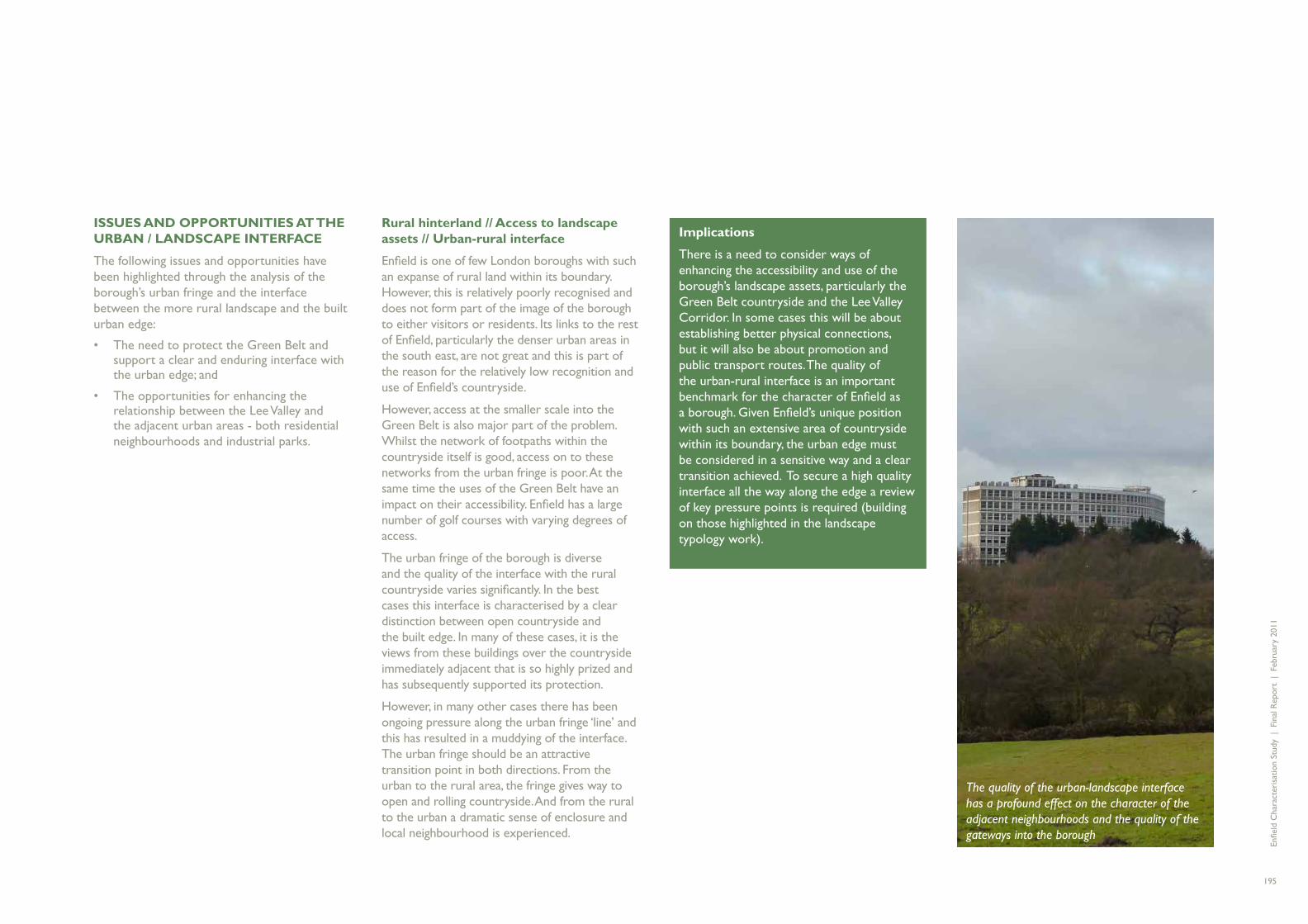
Enfi e
ld C
hara
cter
isat
ion
Stud
y |
Fin
al R
epor
t |
Feb
ruar
y 20
11
195
ISSUES AND OPPORTUNITIES AT THE URBAN / LANDSCAPE INTERFACE
The following issues and opportunities have been highlighted through the analysis of the borough’s urban fringe and the interface between the more rural landscape and the built urban edge:
The need to protect the Green Belt and • support a clear and enduring interface with the urban edge; and
The opportunities for enhancing the • relationship between the Lee Valley and the adjacent urban areas - both residential neighbourhoods and industrial parks.
Rural hinterland // Access to landscape assets // Urban-rural interface
Enfi eld is one of few London boroughs with such an expanse of rural land within its boundary. However, this is relatively poorly recognised and does not form part of the image of the borough to either visitors or residents. Its links to the rest of Enfi eld, particularly the denser urban areas in the south east, are not great and this is part of the reason for the relatively low recognition and use of Enfi eld’s countryside.
However, access at the smaller scale into the Green Belt is also major part of the problem. Whilst the network of footpaths within the countryside itself is good, access on to these networks from the urban fringe is poor. At the same time the uses of the Green Belt have an impact on their accessibility. Enfi eld has a large number of golf courses with varying degrees of access.
The urban fringe of the borough is diverse and the quality of the interface with the rural countryside varies signifi cantly. In the best cases this interface is characterised by a clear distinction between open countryside and the built edge. In many of these cases, it is the views from these buildings over the countryside immediately adjacent that is so highly prized and has subsequently supported its protection.
However, in many other cases there has been ongoing pressure along the urban fringe ‘line’ and this has resulted in a muddying of the interface. The urban fringe should be an attractive transition point in both directions. From the urban to the rural area, the fringe gives way to open and rolling countryside. And from the rural to the urban a dramatic sense of enclosure and local neighbourhood is experienced.
Implications
There is a need to consider ways of enhancing the accessibility and use of the borough’s landscape assets, particularly the Green Belt countryside and the Lee Valley Corridor. In some cases this will be about establishing better physical connections, but it will also be about promotion and public transport routes. The quality of the urban-rural interface is an important benchmark for the character of Enfi eld as a borough. Given Enfi eld’s unique position with such an extensive area of countryside within its boundary, the urban edge must be considered in a sensitive way and a clear transition achieved. To secure a high quality interface all the way along the edge a review of key pressure points is required (building on those highlighted in the landscape typology work).
The quality of the urban-landscape interface has a profound effect on the character of the adjacent neighbourhoods and the quality of the gateways into the borough

Enfi e
ld C
hara
cter
isat
ion
Stud
y |
Fin
al R
epor
t |
Feb
ruar
y 20
11
196
Industrial legacy and the Lee Valley
The history of industry in Enfi eld is a key part of the borough’s evolution, and one that continues to have a major infl uence on its character and sense of place today. The history of successive industrial activities along the line of the River Lee has, over time, created a barrier to access to Enfi eld’s extensive waterfront. Given the intensifi cation of the residential areas immediately to the west of the Lee Valley which has occurred over the last 100 years, there is growing imperative to provide access to the landscape resource and assets of the Lee Valley. The industrial areas therefore need to develop a positive role in facilitating access, whilst not undermining the employment activities which are so important in this location.
Implications
The planned growth around the eastern edge of the borough along the Lee Valley represents a major opportunity for change through the council’s regeneration strategy. One of the dimensions of change is to facilitate better access between residential neighbourhoods and the Lee Valley itself. The proposed growth zones represent once in a lifetime opportunities to reclaim ‘Enfi eld’s waterfront’. New and improved physical connections should form a key characteristic of the area to enable the borough’s residents to access the river valley through new connections created in the growth areas.
Stronger connections between the Lee Valley’s environmental assets and the adjacent residential neighbourhoods and industrial parks will help these areas experience the appropriate lift in character given the proximity of the Lee Valley

Enfi e
ld C
hara
cter
isat
ion
Stud
y |
Fin
al R
epor
t |
Feb
ruar
y 20
11
197
Summary – areas of future work
The characterisation study has highlighted a multitude of assets, strengths and issues across the borough. Parts of the borough are already the subject of signifi cant area-specifi c planning and regeneration strategies. However, this study has identifi ed the following additional areas for future work:
AREAS
Hertford Road corridor
This is an undervalued asset in terms of its historic signifi cance and its buildings, the important role that the chain of centres plays within the local communities and its role as a key transport route. Opportunities exist to strengthen all three facets of the corridor to provide a vibrant and successful spine to the eastern side of the borough, reinforcing the character and viability of key local centres.
Great Cambridge Road corridor
Like the Hertford Road, the Great Cambridge Road is a major transport corridor. However, it lacks the historic origins of the old road and so essentially divides communities rather than joining them together. Opportunities exist to tackle this issue and to improve the pedestrian and cycle environment. In the longer term, there is potential to consider the future of areas such as the trading estate between Lincoln Road and Southbury Road and its possible reconfi guration with the attributes of a town centre rather than as an out-of-town shopping area. This would help to ensure a more positive integration with the surrounding local population.
Crews Hill
Crews Hill is an area of the Green Belt which has seen gradual change that has crept beyond what might be considered reasonable in terms of agricultural and plant nursery uses. A coherent vision would be helpful to control future change, perhaps acknowledging but limiting the retail role the area has acquired, but also considering how to limit the visual and environmental impacts of the garden centres, signage, parking and traffi c
North Circular Road
The North Circular Road has distinct areas of character along its length through the borough. The eastern part is grade separated and so creates a very signifi cant barrier to pedestrians and cyclists whilst the western part has a more conventional arrangement but suffers from the constant pressure of traffi c on surrounding buildings. In both cases there will be ways in which the impacts of the road can be mitigated and in the western part the emerging AAP provides an opportunity to defi ne appropriate building types which properly address the relationship with the road.
These areas are signifi cant in terms of the borough’s evolution, its character and the image projected to residents, businesses and visitors. Each have real strengths, but are also noted for a deterioration of character which, if left unchecked, will continue with environmental, social and ultimately economic impacts for the borough. They represent opportunities where planning and environmental interventions can have a signifi cant impact and restore a strong positive local character.

Enfi e
ld C
hara
cter
isat
ion
Stud
y |
Fin
al R
epor
t |
Feb
ruar
y 20
11
198
THEMES
Views and tall buildings
Tall buildings have an impact across the borough and it is likely that there will continue to be pressure for more tall buildings to respond to increasing population densities, particularly as part of major regeneration projects. Whilst some tall buildings can have a positive impact on the legibility and character of places, they can often be seen as having a negative infl uence. A more detailed views analysis and consideration of tall buildings in the borough would be helpful, taking into account the analysis of topography, key views and landscape characteristics undertaken as part of this study.
Residential alterations and extensions
It would be benefi cial to develop design guidance which can be used to promote a sensitive approach to the extension and modifi cation of houses in the borough. This should emphasise the value of cohesive group design within streets and neighbourhoods and demonstrate appropriate ways in which developments such as side extensions, loft conversions and other modifi cations can be made without having an unduly detrimental impact on the street.
Public realm
The public spaces play an important role in the character of the borough. A coordinated approach to streetscene, perhaps in the form of design guidance to support the borough’s Declaration on Urban Design, would help to raise the overall quality of streets and spaces. Particular attention should be paid to the quality of the urban environment in the shopping and commercial areas of the borough.
Estates
Enfi eld, and particularly the eastern side of the borough has a number of attractive housing areas built by the public sector either in the inter-war period (such as the Hyde Estate) or in the post-war period (such as the Beaconsfi eld Estate). These have an attractive and cohesive character which would benefi t from an appropriate level of protection and management to ensure that this is not allowed to degrade over time, either through owner modifi cations or in terms of the public realm. There may be opportunities to consider the introduction of Areas of Distinctive Quality (ADQs).
Commercial areas
As the boundaries are blurred between industrial uses and commercial uses open to the public consideration needs to be given to the design of industrial areas to ensure that they are legible, accessible and integrate well with their surroundings. It will be increasingly important that they are seen as robust and fl exible urban areas which can accommodate different uses with clear servicing strategies and this could be addressed as part of development management guidance.

Enfi e
ld C
hara
cter
isat
ion
Stud
y |
Fin
al R
epor
t |
Feb
ruar
y 20
11
199
Revealing Enfi eld’s points of quality
Enfi eld has many features of great value and quality, both in terms of the landscape and key buildings and places. There are many important buildings such as Forty Hall, the Piccadilly Line tube stations and others which are much loved and enjoy a high profi le.
However, there are a great many other buildings of various ages which are not in good condition or lack a positive context and which as a result are under-appreciated. Improving the setting and visibility of the best buildings, particularly those in prominent locations on key routes, could greatly improve perceptions of the quality of the borough. This could particularly be applied to the range of interesting historic buildings which can be found along the Hertford Road. For example, the area in front of the short terrace immediately north of the North Circular Road junction with Fore Street is cluttered with planting and the buildings are poorly lit. Addressing this area would strengthen the role of these buildings as a local landmark and reinforce the long and signifi cant history of the area.
Similarly, there are dramatic views across parks and countryside which could be subtly opened up to ensure that they become more visible to promote appreciation of the landscape. This could be particularly benefi cial at points of transition from the urban area to the countryside beyond where the opportunity to experience a marked change in environment could be very refreshing.

Enfi e
ld C
hara
cter
isat
ion
Stud
y |
Fin
al R
epor
t |
Feb
ruar
y 20
11
200
Free-form development
A form of development layout which does not relate to street patterns. Often observed in housing estates built in 1950s and 1960s where blocks of development are located within area of green space with roads providing access, but little building frontage facing immediately on to the streets.
Perimeter block
A form of layout used extensively in Enfi eld where the fronts of buildings face directly on to the street and the backs are at the back and therefore contained within the block.
Public Transport Accessibility Levels (PTALs)
A form of measuring the accessibility of different areas in London used by Transport for London. Areas are zoned according to the relative ease of access to public transport networks. An area zoned as PTAL Level 6 has very good access to multiple public transport modes, whereas an area zoned as Level 1 has very minimal access to a single public transport mode.
Typology
A taxonomic methodology which divides forms of development and landscape into different classifi cations depending upon their physical characteristics.
GLOSSARY

Enfi e
ld C
hara
cter
isat
ion
Stud
y |
Fin
al R
epor
t |
Feb
ruar
y 20
11
201

Enfi e
ld C
hara
cter
isat
ion
Stud
y |
Fin
al R
epor
t |
Feb
ruar
y 20
11
202


![West Contra Costa Unified School District · ELD 2A ELD 2B ELD 3A ELD 3B ELD 4 [P] Eng/Read(R180) English 1 [P] English 2 [P] ... English/Reading Ensemble [P] Environmental Science](https://static.fdocuments.in/doc/165x107/5ed3ab4e89ea24219c3ce538/west-contra-costa-unified-school-district-eld-2a-eld-2b-eld-3a-eld-3b-eld-4-p.jpg)

