
EL1820 Modeling of Dynamical Systems
35
167 Cenozoic Igneous and Tectonic Setting of the Marysvale Volcanic Field and Its Relation to Other Igneous Centers in Utah and Nevada By Peter D. Rowley, Charles G. Cunningham, Thomas A. Steven, Harald H. Mehnert, and Charles W. Naeser CONTENTS Abstract ........................................................................................................................... 168 Introduction..................................................................................................................... 168 Acknowledgments .......................................................................................................... 172 Igneous Rocks ................................................................................................................. 172 Middle Cenozoic Calc-alkaline Rocks ................................................................... 172 Upper Cenozoic Basalt and Alkali Rhyolite ........................................................... 174 Regional Versus Local Extensional Deformation........................................................... 176 Middle Cenozoic Faults .......................................................................................... 176 Late Cenozoic Faults and Basin-fill Deposits......................................................... 179 Igneous Belts and Mineral Belts ..................................................................................... 180 Transverse Structures ...................................................................................................... 181 Plate-tectonic History ..................................................................................................... 184 Spreading ........................................................................................................................ 185 Conclusions ..................................................................................................................... 188 References Cited ............................................................................................................. 189 FIGURES 1. Map showing major igneous and tectonic features of Nevada and Utah................... 169 2. Plot of volumes of volcanic rocks versus age, Marysvale volcanic field ................... 170 3. Maps showing the Marysvale volcanic field and other features of interest in southwestern Utah ..................................................................................................... 171 4. Plot of total alkalies versus silica of calc-alkaline rocks from the Marysvale volcanic field, the Henry, La Sal, and Abajo Mountains, the Iron axis, and the Spry intrusion ....................................................................................................... 174 Volume contents Previous section
Transcript of EL1820 Modeling of Dynamical Systems
Volume contents
Previous section
Cenozoic Igneous and Tectonic Setting of the Marysvale Volcanic Field and Its Relation to Other Igneous Centers in
Utah and Nevada
By Peter D. Rowley, Charles G. Cunningham, Thomas A. Steven,Harald H. Mehnert, and Charles W. Naeser
167
CONTENTSAbstract ........................................................................................................................... 168Introduction..................................................................................................................... 168Acknowledgments .......................................................................................................... 172Igneous Rocks................................................................................................................. 172
Middle Cenozoic Calc-alkaline Rocks ................................................................... 172Upper Cenozoic Basalt and Alkali Rhyolite........................................................... 174
Regional Versus Local Extensional Deformation........................................................... 176Middle Cenozoic Faults .......................................................................................... 176Late Cenozoic Faults and Basin-fill Deposits......................................................... 179
Igneous Belts and Mineral Belts ..................................................................................... 180Transverse Structures...................................................................................................... 181Plate-tectonic History ..................................................................................................... 184Spreading ........................................................................................................................ 185Conclusions..................................................................................................................... 188References Cited ............................................................................................................. 189
FIGURES
1. Map showing major igneous and tectonic features of Nevada and Utah................... 169 2. Plot of volumes of volcanic rocks versus age, Marysvale volcanic field................... 170 3. Maps showing the Marysvale volcanic field and other features of interest in
southwestern Utah ..................................................................................................... 1714. Plot of total alkalies versus silica of calc-alkaline rocks from the Marysvale
volcanic field, the Henry, La Sal, and Abajo Mountains, the Iron axis, andthe Spry intrusion....................................................................................................... 174
LACCOLITH COMPLEXES OF SOUTHEASTERN UTAH
168
ABSTRACT
The Marysvale volcanic field of southwestern Utah,largely in the High Plateaus transition zone of the ColoradoPlateau, lies at the east-northeastern end of the Pioche-Marysvale igneous belt. This belt consists of exposures ofmostly Cenozoic volcanic rocks and is underlain by abatholith complex of even greater volume. The volume ofvolcanic rocks in the Marysvale field totals at least 12,000km3. The field consists mostly of middle Cenozoic, interme-diate-composition, fundamentally calc-alkaline rocks erupt-ed at 34(?)–22 Ma; associated mineral deposits are mostly ofchalcophile elements. Stratovolcano deposits, especiallyvolcanic mudflow breccia and lava flows, dominate; ash-flow tuffs derived from several calderas make up less than10 percent of the volume of the volcanic rocks. Most of thecentral and northern part of the field consists of the BullionCanyon Volcanics of relatively crystal-rich dacite andandesite; source cupolas reached shallow levels, and manyintrusions have associated mineral deposits. The southernpart of the field is dominated by crystal-poor andesite of theMount Dutton Formation; postulated source cupolas aredeep and unexposed, and associated mineral deposits aresparse. Shallow laccoliths that are unrelated to and south ofthe deep Mount Dutton sources were emplaced into lowerTertiary sedimentary rocks at the same time. These lacco-liths are comagmatic with laccoliths and stocks of the “IronAxis,” in the Great Basin southwest of the Marysvale field.Large underlying batholiths fed both the southern Marysvalefield and Iron Axis laccoliths.
The calc-alkaline igneous rocks of the Pioche-Marysvale igneous belt and the slightly youngerDelamar–Iron Springs igneous belt to the south are part of agenerally middle Cenozoic igneous sequence that spansmuch of the Western United States. The igneous rocks prob-ably originated by oblique convergence during subductionof oceanic lithosphere beneath western North America. Theoverall area underlain largely by the igneous rocks is anom-alously wide when compared with igneous areas in otherparts of the Pacific rim, apparently because the subductedslab continued at a shallow depth as far to the east as thelongitude of the Rocky Mountains. The Pioche-Marysvaleand Delamar–Iron Springs igneous belts formed underextension parallel to the subduction direction and werebounded by transverse structures (“lineaments”) of the sametrend that separate areas of different amounts and types ofextension. The generally east-northeast-trending crustalextension of the same age as calc-alkaline magmatism wasespecially profound in the Basin and Range province, butextensional faults were dominant only in some areas, where-as elsewhere extension was accomplished by passiveemplacement of shallow intrusions.
The middle Cenozoic calc-alkaline rocks at Marysvaleare overlain by an upper Cenozoic, fundamentally bimodal(rhyolitic and basaltic) volcanic association of rocks ranging
in age from at least 23 Ma to Quaternary and intertongued inpart with coeval clastic basin-fill sedimentary rocks. Thebimodal association is dominated by high-silica rhyolite ash-flow tuff and volcanic domes, potassium-rich mafic rocks,and basalt cinder cones. Rocks of the bimodal associationare much less voluminous (about 5 percent of the totalvolume of the Marysvale field) than the older calc-alkalinerocks, but they host many metallic mineral deposits, mostlyof gold, silver, and lithophile elements. Bimodal rocks arealso irregularly distributed elsewhere in the Pioche-Marysvale and Delamar–Iron Springs igneous belts. Thelate Cenozoic volcanism and extension began after subduc-tion had started to diminish, as transform motion becamesignificant on the San Andreas transform fault zone.Regional oblique extension, referred to as the basin-rangeepisode and involving mostly faults under a normal-faultstress regime, was oriented generally east-west, and it beganin the Marysvale area and the southeastern Great Basin atabout 10 Ma, as faults formed the present topography.Transverse structures continued to be active in the GreatBasin but most were oriented east-west, parallel to the newextension direction. The eastern Snake River Plain is ayouthful model for volcanism and extension along probableunderlying transverse structures oriented parallel to itscurrent northeastern extension direction.
The overall effect of extension and volcanism in theGreat Basin during the middle and late Cenozoic has beenone of east-west spreading (widening) of the Great Basin,creating a bilateral symmetry. Any single axis of spreadingis unlikely; probably there were many north-northwest- tonorth-northeast-trending axes perpendicular to the then-active extension direction. Extension related to these axeswas expressed by faulting, igneous intrusions, or both.Under each axis, heat flow increased and the brittle-ductiletransition zone rose. Extensional stress migrated with time,parallel to the extension direction, toward the cooler, morebrittle margins of the Great Basin. The transverse structures,oriented parallel to the extension direction of the time,accommodated differing amounts of extension and magma-tism north and south of them; they are fundamental featuresprobably passing down to the brittle-ductile transition.
INTRODUCTION
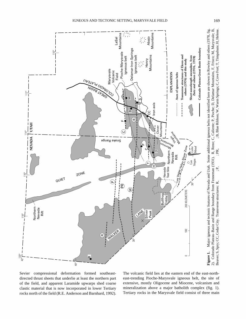
The Marysvale volcanic field of southwestern Utah isone of the largest Cenozoic volcanic fields in the WesternUnited States; it largely straddles the High Plateaus Sectionof the Colorado Plateaus province, but the western part ofthe field is in the Great Basin Section of the Basin and Rangeprovince (fig. 1). The High Plateaus is geologically a transi-tion zone between the Great Basin and the main, much lessdeformed part of the Colorado Plateau. The volcanic fieldoverlies Paleozoic to lower Tertiary sedimentary rocksmostly east of the northeast-trending Cordilleran hingeline;
169
IGNEOUS AND TECTONIC SETTING, MARYSVALE FIELD
110°
112°
114°
116°
118°
120°
42°
40°
38°
36°
010
020
0 KI
LOM
ETER
S
NEV
AD
AU
TAH
Mar
ysva
leVo
lcan
icFi
eld
LaS
alM
ou
nta
ins
Ab
ajo
Mo
un
tain
s
Hen
ryM
ou
nta
ins
GREATBASIN
COLORADOPLATEAU
Snake Range
Iro
n a
xis
No
rth
ern
Nev
ada
Rif
t
Lak
eM
ead
Las
Veg
as
No
rth
ern
Nev
ada
Rif
t
QUIET ZONE
Pio
che-
Mar
ysva
leig
neo
us
bel
t
Del
amar
-Iro
n S
pri
ng
sig
neo
us
bel
t
M
FC
BB
S
CC
P
C
D
T
H
La
sVe
gas
Valle
yS
hea
rZo
ne
Nev
ada
Test
Sit
e
Bu
llfro
gH
ills
P
PR
W
R
R
Silv
erP
eak
MormonMountains
Virg
in
Mou
ntai
nsClo
ver
Mo
un
tain
s
WALKER
LANE
EX
PLA
NAT
ION
Axe
s of
igne
ous
belts
Tran
sver
se s
truc
ture
s of
Ekr
en a
nd o
ther
s (1
976) an
d th
is s
tudy
Sho
rt-w
avel
engt
h an
omal
ies,
fro
m Z
ietz
and
oth
ers
(1976, 1978)
Col
orad
o P
late
au-G
reat
Bas
in b
ound
ary
Fig
ure
1.
M
ajor
igne
ous
and
tect
onic
fea
ture
s of
Nev
ada
and
Uta
h. S
ome
addi
tiona
l ign
eous
bel
ts n
ot id
entif
ied
here
are
sho
wn
in R
owle
y an
d ot
hers
(19
78, f
ig.
2).
Col
orad
o Pl
atea
u–B
asin
and
Ran
ge b
ound
ary
from
Fen
nem
an (
1931
).
R, R
eno;
C, C
alie
nte;
P, P
ioch
e; D
, Del
amar
Mou
ntai
ns, F
, Fri
sco;
M, M
arys
vale
; B
,B
eave
r; S
, Spr
y; C
C, C
edar
City
. T
rans
vers
e st
ruct
ures
: R
,
; P
,
;
PR
,
;
B, B
lue
Rib
bon;
W, W
arm
Spr
ings
; C, C
ove
Fort
; T, T
impa
hute
; H, H
elen
e.
Sevier compressional deformation formed southeast-directed thrust sheets that underlie at least the northern partof the field, and apparent Laramide upwarps shed coarseclastic material that is now incorporated in lower Tertiaryrocks north of the field (R.E. Anderson and Barnhard, 1992).
The volcanic field lies at the eastern end of the east-north-east-trending Pioche-Marysvale igneous belt, the site ofextensive, mostly Oligocene and Miocene, volcanism andmineralization above a major batholith complex (fig. 1).Tertiary rocks in the Marysvale field consist of three main
LACCOLITH COMPLEXES OF SOUTHEASTERN UTAH
170
�����������30 20 10 0
AGE, IN MILLIONS OF YEARS
����
EXPLANATION
Lava flows
Bimodal volcanic rocks
Ash-flow tuffs
Calc-alkaline volcanic rocks
Lava flows and mudflows
Ash-flow tuffs
500
1,000
1,500
2,000
VO
LUM
E, I
N C
UB
IC K
ILO
ME
TE
RS
Total volumeat least
12,000 km3
Figure 2.
Volumes of volcanic rocks versus age, Marysvalevolcanic field, Utah. Each bar represents the estimated volumeerupted during a 1-million-year period.
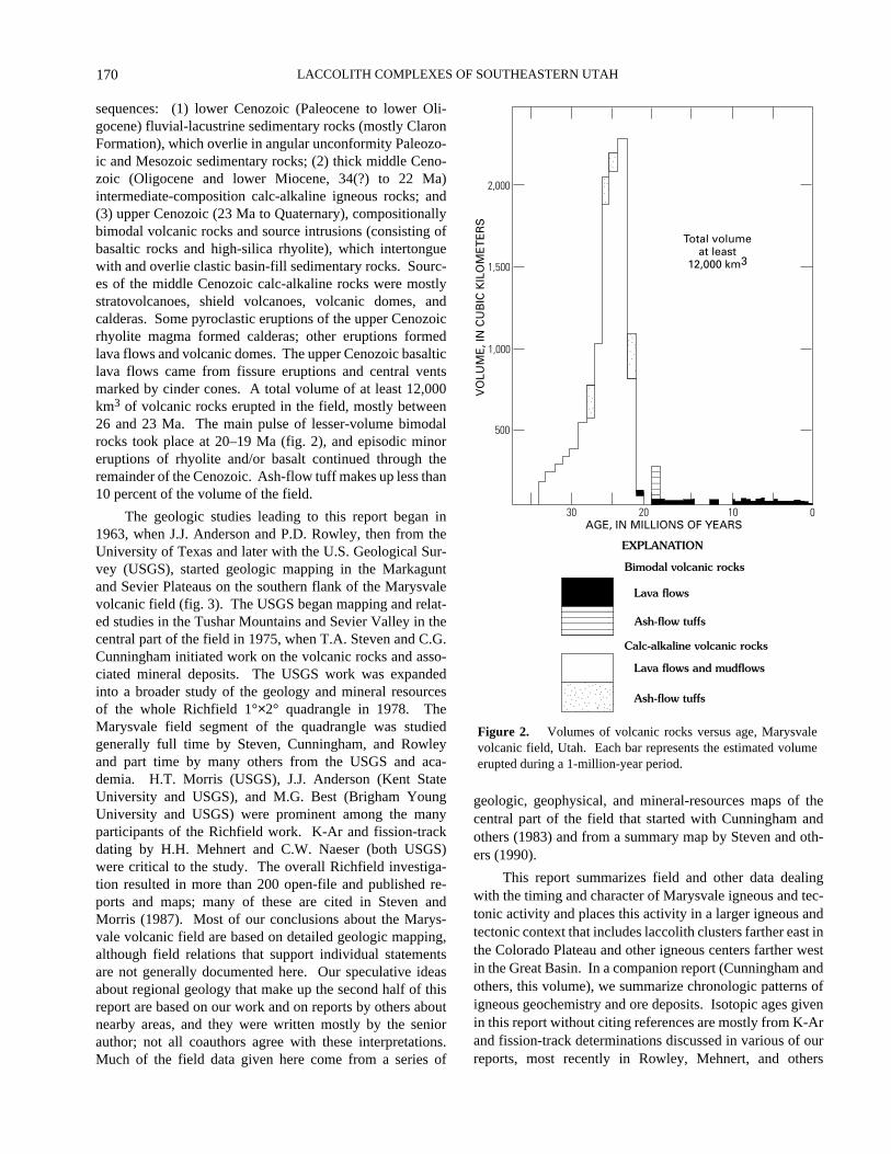
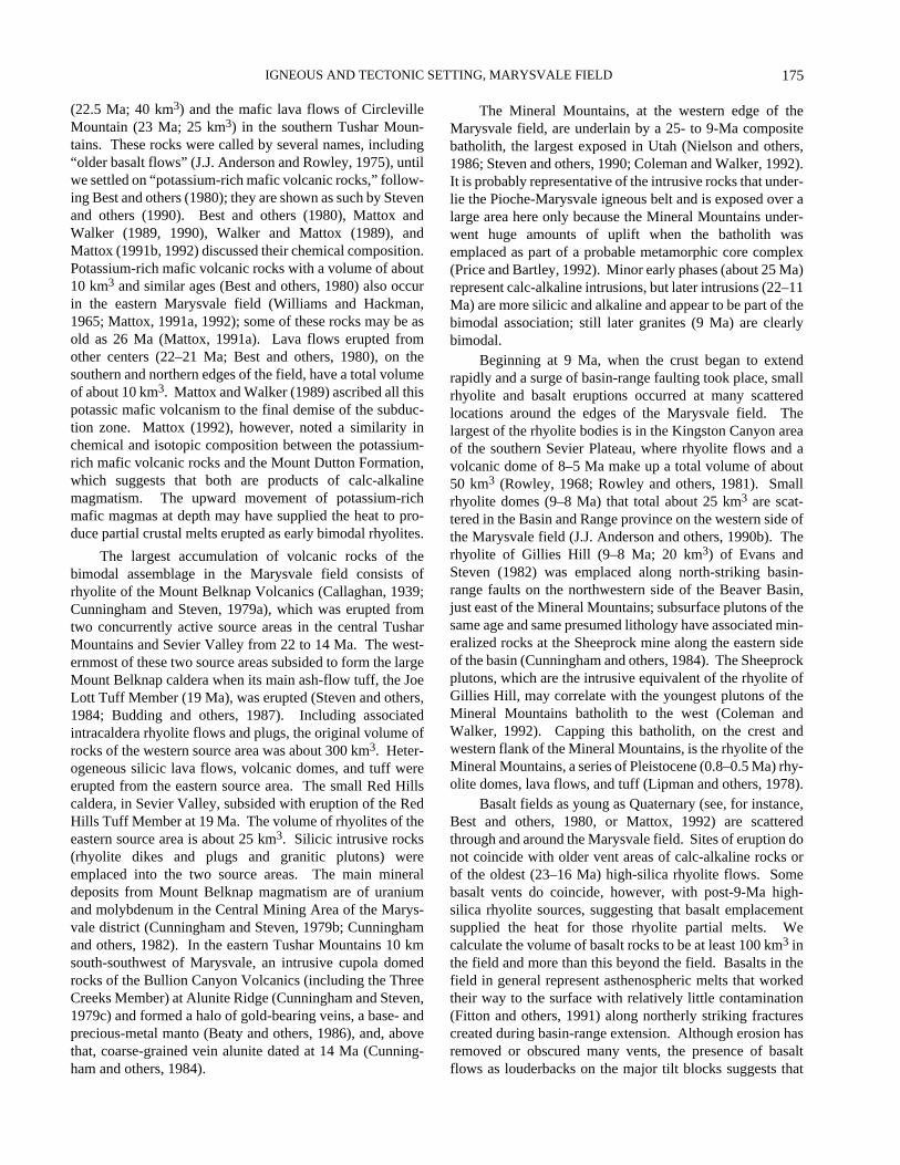
sequences: (1) lower Cenozoic (Paleocene to lower Oli-gocene) fluvial-lacustrine sedimentary rocks (mostly ClaronFormation), which overlie in angular unconformity Paleozo-ic and Mesozoic sedimentary rocks; (2) thick middle Ceno-zoic (Oligocene and lower Miocene, 34(?) to 22 Ma)intermediate-composition calc-alkaline igneous rocks; and(3) upper Cenozoic (23 Ma to Quaternary), compositionallybimodal volcanic rocks and source intrusions (consisting ofbasaltic rocks and high-silica rhyolite), which intertonguewith and overlie clastic basin-fill sedimentary rocks. Sourc-es of the middle Cenozoic calc-alkaline rocks were mostlystratovolcanoes, shield volcanoes, volcanic domes, andcalderas. Some pyroclastic eruptions of the upper Cenozoicrhyolite magma formed calderas; other eruptions formedlava flows and volcanic domes. The upper Cenozoic basalticlava flows came from fissure eruptions and central ventsmarked by cinder cones. A total volume of at least 12,000km3 of volcanic rocks erupted in the field, mostly between26 and 23 Ma. The main pulse of lesser-volume bimodalrocks took place at 20–19 Ma (fig. 2), and episodic minoreruptions of rhyolite and/or basalt continued through theremainder of the Cenozoic. Ash-flow tuff makes up less than10 percent of the volume of the field.
The geologic studies leading to this report began in1963, when J.J. Anderson and P.D. Rowley, then from theUniversity of Texas and later with the U.S. Geological Sur-vey (USGS), started geologic mapping in the Markaguntand Sevier Plateaus on the southern flank of the Marysvalevolcanic field (fig. 3). The USGS began mapping and relat-ed studies in the Tushar Mountains and Sevier Valley in thecentral part of the field in 1975, when T.A. Steven and C.G.Cunningham initiated work on the volcanic rocks and asso-ciated mineral deposits. The USGS work was expandedinto a broader study of the geology and mineral resourcesof the whole Richfield 1°×2° quadrangle in 1978. TheMarysvale field segment of the quadrangle was studiedgenerally full time by Steven, Cunningham, and Rowleyand part time by many others from the USGS and aca-demia. H.T. Morris (USGS), J.J. Anderson (Kent StateUniversity and USGS), and M.G. Best (Brigham YoungUniversity and USGS) were prominent among the manyparticipants of the Richfield work. K-Ar and fission-trackdating by H.H. Mehnert and C.W. Naeser (both USGS)were critical to the study. The overall Richfield investiga-tion resulted in more than 200 open-file and published re-ports and maps; many of these are cited in Steven andMorris (1987). Most of our conclusions about the Marys-vale volcanic field are based on detailed geologic mapping,although field relations that support individual statementsare not generally documented here. Our speculative ideasabout regional geology that make up the second half of thisreport are based on our work and on reports by others aboutnearby areas, and they were written mostly by the seniorauthor; not all coauthors agree with these interpretations.Much of the field data given here come from a series of
��geologic, geophysical, and mineral-resources maps of thecentral part of the field that started with Cunningham andothers (1983) and from a summary map by Steven and oth-ers (1990).
This report summarizes field and other data dealingwith the timing and character of Marysvale igneous and tec-tonic activity and places this activity in a larger igneous andtectonic context that includes laccolith clusters farther east inthe Colorado Plateau and other igneous centers farther westin the Great Basin. In a companion report (Cunningham andothers, this volume), we summarize chronologic patterns ofigneous geochemistry and ore deposits. Isotopic ages givenin this report without citing references are mostly from K-Arand fission-track determinations discussed in various of ourreports, most recently in Rowley, Mehnert, and others
171
IGNEOUS AND TECTONIC SETTING, MARYSVALE FIELD
ll
l
l
ll
ll
ll
ll
l
ll
ll
l
l
l
l
ll
ll
ll
l
l
lll
ll
ll
ll
l
l
l
ll
ll
ll
ll
l
l
l
l l
l
ll
l ll
l
ll
l
l
l
ll
ll
l
l
ll
ll
l
ll
ll
ll
l
ll
ll
ll
l ll
l
l
ll
l
ll
ll
ll
ll l
l
ll
ll
l
ll
ll
l
ll l
l
l l
l
ll
llll
ll
l
l
l
ll l
ll
l
l
l
l
ll l
l
l
l
l l
l
ll
l
ll
l
l
ll
ll
l
l
l
l
l
l
l ll
lll
ll
ll
l
l ll l
l
l l l l
l
ll l l l l l
l
ll
ll
ll
ll
l
lll
ll
ll
l
ll
l
l
ll
ll
ll
ll
ll
ll
ll
ll
lll
l
l
l
ll
ll
l l l
ll
ll
ll
l
l
l ll
ll
ll
ll
ll
ll
ll
ll
l
ll l
l
l l
l
l
ll
l
l
l
l
ll
l
l
ll
l ll
ll
l
l l
ll
l
ll
l
l
l
UTAH
Areaof
figure 3
l
ll
ll
ll
l
ll
l
ll
l
ll
ll
ll
ll
lll
ll
ll
ll
l
l
l
llll
l
l
ll
ll
ll
ll
ll
ll
l ll
ll
ll
ll
ll
ll
ll
l
l l
ll
l
l l
l
l
l ll
l
ll
l
ll
l
ll
ll l
ll
l
ll
l
l
lll
l
l
l
l
l
ll
l
l
ll
ll
l
ll
l
ll
l
ll
l
l
l
l
ll
ll
llll
lll
l l
ll
ll l
l
ll
l
l
l
ll l
l
l
l
ll
l
l
l
ll
l
l
38°
40°
114°
39°
0 20 40 60 KILOMETERS
WAH WAHMOUNTAINS
GRE
AT
BASI
N
BULL VALLEYMOUNTAINS
IRONAXIS
Is
Mo
Mv
B
REDHILLS Pa
C
CB
BH
SEV
IER
VALL
EY
H
P
Sp
JOH
NS
VALL
EY
GR
AS
SVA
LLE
Y
BC
PAU
NS
AU
GU
NT
PLA
TEA
U
K
TABLE CLIFFPLATEAU
AQUARIUS
PLATEAU
AWAPAPLATEAU
FISHLAKE
PLATEAU
WA
SAT
CH
PLA
TEA
U
SEVI
ER
VALL
EY
PAVA
NT
RAN
GE
CO
LOR
AD
O
P
LATE
AU
TUS
HA
RM
OU
NTA
INS
MA
RK
AG
UN
TPL
ATE
AU
CiVu
M
SeJ
EA
R
SF
MINERALMOUNTAINS
Mi
OUTLINE OF MARYSVALEVOLCANIC FIELD
AXIS OF PIOCHE-MARYSVALEIGNEOUS BELT
AXIS OF DELAMAR-IRONSPRINGS IGNEOUS BELT
AXIS OF BLUERIBBON LINEMENT
SE
VIE
R
PLAT
EAU
AR
CF
MP
N
BEAVER DAMMOUNTAINS
37°
113° 112° 111°
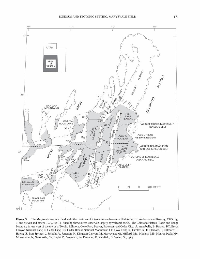
Figure 3.
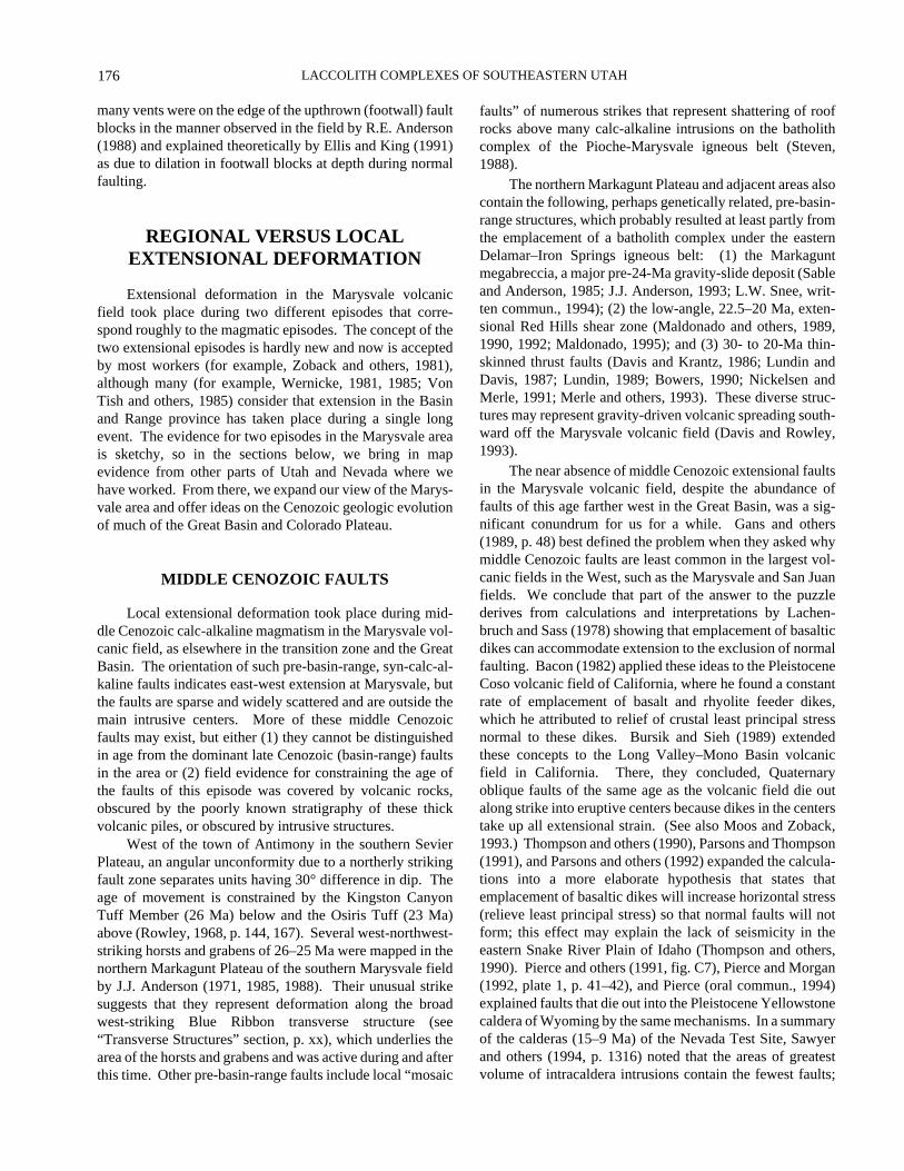
The Marysvale volcanic field and other features of interest in southwestern Utah (after J.J. Anderson and Rowley, 1975, fig.1, and Steven and others, 1979, fig. 1). Shading shows areas underlain largely by volcanic rocks. The Colorado Plateau–Basin and Rangeboundary is just west of the towns of Nephi, Fillmore, Cove Fort, Beaver, Parowan, and Cedar City. A, Annabella; B, Beaver; BC, BryceCanyon National Park; C, Cedar City; CB, Cedar Breaks National Monument; CF, Cove Fort; Ci, Circleville; E, Elsinore, F, Fillmore; H,Hatch; IS, Iron Springs; J, Joseph; Ju, Junction; K, Kingston Canyon; M, Marysvale; Mi, Milford; Mo, Modena; MP, Monroe Peak; Mv,Minersville; N, Newcastle; Ne, Nephi; P, Panguitch; Pa, Parowan; R, Richfield; S, Sevier; Sp, Spry.
LACCOLITH COMPLEXES OF SOUTHEASTERN UTAH
172
(1994) . We are currently compiling data on the igneousisotope geochemistry of the Marysvale volcanic field, andS.R. Mattox and J.A. Walker (Northern Illinois University)are compiling similar data on some of the middle and upperCenozoic volcanic units of the field (see Mattox, 1992, forinstance).
ACKNOWLEDGMENTS
We thank many colleagues for ideas that have becomeso intimately intertwined with ours that we cannot separatethem. Rowley, in particular, appreciates the understandingof structural concepts he gained from patient conversationsover many years with the two Andersons, J.J. and R.E. Forfree exchange of unpublished data that helped us formulateand clarify many of the concepts discussed in this report, wethank J.H. Mackin, Warren Hamilton, H.R. Blank, E.H.McKee, L.W. Snee, K.L. Pierce, D.A. Sawyer, R.B. Scott,R.J. Blakely, M.G. Best, E.B. Ekren, M.A. Kuntz, C.J. Nutt,M.R. Hudson, R.A. Thompson, J.E. Faulds, M.L. Zoback,L.D. Nealey, F.E. Mutschler, Viki Bankey, L.W. Snee, S.A.Minor, D.M. Unruh, D.B. Hacker, A.M. Sarna-Wojcicki,D.S. Barker, D.B. Stoeser, M.C. Reheis, J.K. Otton, M.A.Siders, P.L. Williams, D.M. Miller, C.H. Thorman, W.E.Brooks, J.R. Budahn, F.G. Poole, S.R. Mattox, and I.J.Witkind. We are especially fortunate in being providedunpublished isotopic dates by L.W. Snee, H.H. Mehnert, andA.L. Deino and paleomagnetic data by C.S. Grommé, M.R.Hudson, and J.G. Rosenbaum. We thank R.E. Anderson,M.L. Zoback, and D.B. Stoeser for preprints of their reportsin press and for their comments and suggestions on interpre-tations. We gratefully acknowledge excellent, constructivetechnical reviews by R.E. Anderson, Warren Hamilton,M.G. Best, and L.D. Nealey, who, although they did notagree with some of our interpretations, gave us much counselon how to present them. We thank P.L. Martin for a detailededitorial review.
IGNEOUS ROCKS
MIDDLE CENOZOIC CALC-ALKALINE ROCKS
Middle Cenozoic, fundamentally calc-alkaline volcan-ism centered near Marysvale resulted in huge volumes ofdacitic and andesitic lava flows, ash-flow tuff, flow breccia,and volcanic mudflow breccia from clustered stratovolca-noes and calderas and to a lesser extent from shieldvolcanoes and volcanic domes. The sequence corresponds tovoluminous calc-alkaline igneous rocks common throughoutthe Western United States that probably formed duringsubduction of the Farallon/Vancouver plates (as described,
for instance, by Lipman and others, 1972). Most rocks in thecenter of the Marysvale volcanic field contain abundantphenocrysts, commonly plagioclase, biotite, and horn-blende. These moderately evolved rocks were derived fromshallow magma chambers, and moderate erosion hasexposed numerous plutons. Locally the roofs of high-levelcupolas of the batholith failed, and calderas (Steven andothers, 1984) formed as voluminous ash flows were erupted.The most voluminous stratigraphic unit in the central andnorthern part of the field (Tushar Mountains) is the BullionCanyon Volcanics (Callaghan, 1939; Steven and others,1979, 1984), which formed from magmas erupted from stra-tovolcano and caldera sources. The thickness of the forma-tion is at least 1,500 m, and its original volume was at least1,700 km3. Basal parts of the unit underlie a regional strati-graphic marker, the Wah Wah Springs Formation (>29.5Ma) of the Needles Range Group, an ash-flow unit derivedfrom the Indian Peak caldera complex on the Utah-NevadaState line (Best, Christiansen, and Blank, 1989). Thesebasal, weathered, and locally altered parts of the BullionCanyon may be as old as 34 Ma (Willis, 1985; Kowallis andBest, 1990). Above the level of the Wah Wah Springs, theBullion Canyon includes two ash-flow tuff members: theThree Creeks Tuff Member (27.5 Ma), which was derivedfrom the Three Creeks caldera in the southern Pavant Rangeand had an estimated volume of 200 km3 (Steven and others,1984); and the Delano Peak Tuff Member (about 24 Ma),which was derived from the Big John caldera in the centralTushar Mountains and had an initial volume of 100 km3.Mineralization associated with some of the shallow plutonsthat produced the Bullion Canyon Volcanics formedreplacement alunite and gold deposits in many local districtsin the Bullion Canyon terrain.
In contrast to the crystal-rich, moderately evolvedrocks that formed the Bullion Canyon Volcanics, the rockson the southern side of the Marysvale field (MarkaguntPlateau and southern Sevier Plateau) are dominated bycrystal-poor andesite and subordinate dacite of the MountDutton Formation (J.J. Anderson and Rowley, 1975; Fleckand others, 1975; Mattox and Walker, 1989; Mattox, 1992).Mapping shows that most of these generally pyroxene-bear-ing, less evolved rocks formed clustered stratovolcanoeswhose centers occur along an east-trending belt, the BlueRibbon transverse structure. (See “Transverse Structures”section, p. xx.) The Mount Dutton has a span of ages similarto those of the Bullion Canyon Volcanics, and the twoformations intertongue from base to top across the south-central part of the volcanic field. Some Mount Dutton de-posits underlie the Wah Wah Springs Formation (>29.5 Ma),but most do not; isotopic ages of those deposits above theWah Wah Springs range from 26.7 to 21.2 Ma (Fleck andothers, 1975). The total volume of the Mount DuttonFormation was at least 5,000 km3. Plutons and mineral de-posits are rarely exposed in Mount Dutton rocks, as magmachambers were deep and few convecting hydrothermal cells
173
IGNEOUS AND TECTONIC SETTING, MARYSVALE FIELD
were formed. Members of the Mount Dutton Formationinclude the Beaver Member (25.6 Ma), which consists ofvolcanic domes with an estimated volume of 20 km3 in theeastern Black Mountains, and the Kingston Canyon(25.8±0.4 Ma; volume 20 km3) and Antimony (25.4±0.9 Ma;volume 50 km3) Tuff Members, which are thin, denselywelded, trachytic ash-flow tuffs that intertongue with theMount Dutton, Bullion Canyon, and other sequences ofmudflows and lava flows. The tuff members are synchro-nous with and petrologically similar to the tuff of AlbinusCanyon (25.3±1.3 Ma; volume 60 km3) in the northern partof the field and probably will eventually be determined to beidentical. Probably all were derived from a common as-yetundiscovered source in the southern Pavant Range oradjacent Sevier Valley; Ekren and others (1984) suggesteddeep sources for petrologically similar tuffs in Idaho.
The Marysvale volcanic field contains many localcalc-alkaline volcanic centers; products from these centerswere separated during the mapping from the much more vo-luminous Bullion Canyon Volcanics and Mount DuttonFormation. Among the oldest of these are three informalunits in the northern Tushar Mountains and southern PavantRange that consist of dacitic flows, breccia, and tuff derivedfrom stratovolcanoes and volcanic domes. These units wereincluded in the Bullion Canyon Volcanics by Steven andothers (1990) but they were broken out by Cunningham andothers (1983) as the volcanic rocks of Dog Valley, the over-lying volcanic rocks of Wales Canyon, and an unnameddome. They underlie the Three Creeks Member and havebeen deeply eroded; their total volume was at least 300 km3.The volcanic rocks of Signal Peak overlie the Three CreeksMember mostly in the northern Sevier Plateau. They con-sist of an andesite to basaltic andesite volcanic plateau andshield volcano with a volume of at least 400 km3, not in-cluding unmapped rocks in areas to the east. The BullionCanyon Volcanics and the Mount Dutton Formation inter-tongue eastward with coeval stratovolcano and shield-vol-cano units, whose extensions east of long 112° W. are as yetunmapped. These units include the volcanic rocks of LittleTable, of Willow Spring, and of Langdon Mountain; wherewe mapped them in the Sevier Plateau, they have a com-bined volume of 400 km3. Stratovolcano rocks of the east-ern Marysvale field (Williams and Hackman, 1971; Mattox,1991a) have a volume of about 2,500 km3 and undoubtedlyinclude deposits of these three units as well as of the volca-nic rocks of Signal Peak and the Mount Dutton Formation.In the southern Tushar Mountains, three younger local unitsoverlie the Osiris Tuff (see below): (1) the formation ofLousy Jim, a trachydacite volcanic dome (22 Ma; 25 km3);(2) the tuff of Lion Flat, a local rhyolite ash-flow tuff with avolume of 8 km3, which may represent deposits in and neara small concealed caldera or may represent the tuff-ringdeposits (C.G. Cunningham, unpub. data, 1992) of theoverlying formation of Lousy Jim; and (3) the andesitic lavaflows of Kents Lake (12 km3).
A series of shallow, calc-alkaline laccoliths were em-placed into lower Tertiary sedimentary rocks in the northernMarkagunt Plateau, south of the deep-seated Mount Duttonsources and on the southern flank of the Marysvale field,where the volcanic rocks are relatively thin (J.J. Andersonand Rowley, 1975). The largest of these laccoliths is theSpry intrusion (26–25 Ma; fig. 3), which erupted to form adacitic vent complex containing lava flows and tuffs that in-tertongue with the lower part of the Mount Dutton Formation(J.J. Anderson and others, 1990a). Breccia and flows fromthe complex are called the volcanic rocks of Bull RushCreek, and a regional ash-flow tuff from the complex iscalled the Buckskin Breccia; their combined volume is about60 km3. A prominent short-wavelength gravity low (Blankand Kucks, 1989; Cook and others, 1989, 1990; Saltus andJachens, 1995; Blank and others, this volume; Viki Bankey,USGS, unpub. data, 1992) and short-wavelength aeromag-netic anomalies (Zietz and others, 1976; Blank and Kucks,1989; Viki Bankey, USGS, unpub. data, 1992) underlie andextend 50 km south of the vent complex. These anomaliesprobably mark the upper part of a source batholith thatunderlies and fed the laccolith. Another laccolith on thesouthern flank of the Marysvale field is the Iron Peak intru-sion (formerly called Iron Point intrusion by J.J. Andersonand Rowley, 1975) of apparently 21–20 Ma, which fed a se-ries of flows and breccias that intertongue with the upper partof the Mount Dutton Formation (Spurney, 1984). This plu-ton formed at the northeastern end of the “Iron Axis,” astring of a dozen laccoliths and other plutons in the GreatBasin that formed major iron deposits (Mackin, 1947; Blankand Mackin, 1967; Rowley and Barker, 1978; Van Kooten,1988; Rowley and others, 1989; Barker, 1991; Blank andothers, 1992) in the Iron Springs and Bull Valley miningdistricts west and southwest of Cedar City (fig. 3). Geophys-ical data suggest that most if not all of the Iron Axis lacco-liths (22 Ma) are interconnected at depth, and the nearbyyounger (20.5-Ma) Pine Valley laccolith (Cook, 1957; D.B.Hacker, Kent State University, and L.W. Snee, USGS,unpub. data, 1992) is also part of the trend. All are interpret-ed to be fed by a large underlying composite batholith (Blankand Mackin, 1967; Blank and others, 1992), and thisbatholith may have extended as far northwest as a pluton(Grant and Proctor, 1988) exposed 30 km northwest of CedarCity (H.R. Blank, unpub. data, 1992). Borrowing an idea ofH.R. Blank (oral commun., 1991), which was developed ingreater detail by Nickelsen and Merle (1991), Merle and oth-ers (1993), J.J. Anderson (1993), and Maldonado (1995), wesuggest that the Spry and the other plutons in the northernMarkagunt Plateau may be cupolas on a large compositebatholith that underlies the northern Markagunt Plateau andadjacent areas and led to a variety of deformational featuresin roof rocks above the batholith. This batholith would besimilar to the one that fed the Iron Axis plutons and mayeven be connected to it. Rocks of the Mount DuttonFormation as well as the Iron Axis and northern Markagunt
LACCOLITH COMPLEXES OF SOUTHEASTERN UTAH
174
13
11
9
7
5
3
1
57 61 65 69 73 77SiO2 (WEIGHT PERCENT)
Na 2
O +
K2O
(W
EIG
HT
PE
RC
EN
T)
MarysvaleFieldTrachyte
Rhyolite
Trachy-andesite
Trachydacite Henry, Abajo,and La SalMountains
Spry
DaciteAndesite
Ironaxis
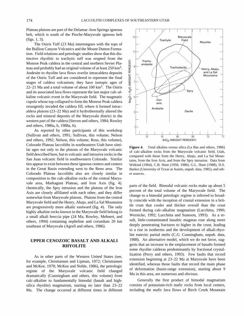
Figure 4.
Total alkalies versus silica (Le Bas and others, 1986)of calc-alkaline rocks from the Marysvale volcanic field, Utah,compared with those from the Henry, Abajo, and La Sal Moun-tains, from the Iron Axis, and from the Spry intrusion. Data fromWitkind (1964), C.B. Hunt (1958, 1980), G.L. Hunt (1988), D.S.Barker (University of Texas at Austin, unpub. data, 1985), and oth-er sources.
Plateau plutons are part of the Delamar–Iron Springs igneousbelt, which is south of the Pioche-Marysvale igneous belt(figs. 1, 3).
The Osiris Tuff (23 Ma) intertongues with the tops ofthe Bullion Canyon Volcanics and the Mount Dutton Forma-tion. Field relations and petrologic studies show that this dis-tinctive rhyolitic to trachytic tuff was erupted from theMonroe Peak caldera in the central and northern Sevier Pla-teau and probably had an original volume of at least 250 km3.Andesite to rhyolite lava flows overlie intracaldera depositsof the Osiris Tuff and are considered to represent the finalstages of caldera volcanism; they have isotopic ages of22–21 Ma and a total volume of about 100 km3. The Osirisand its associated lava flows represent the last major calc-al-kaline volcanic event in the Marysvale field. The magmaticcupola whose top collapsed to form the Monroe Peak calderaresurgently invaded the caldera fill, where it formed intrac-aldera plutons (23–22 Ma) and it hydrothermally altered therocks and mineral deposits of the Marysvale district in thewestern part of the caldera (Steven and others, 1984; Rowleyand others, 1986a, b, 1988a, b).
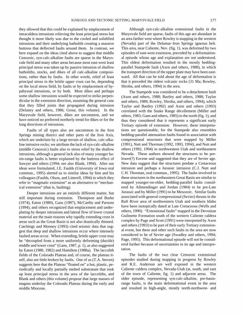
As reported by other participants of this workshop(Sullivan and others, 1991; Sullivan, this volume; Nelsonand others, 1992; Nelson, this volume; Ross, this volume),Colorado Plateau laccoliths in southeastern Utah have simi-lar ages not only to the plutons of the Marysvale volcanicfield described here, but to volcanic and intrusive rocks in theSan Juan volcanic field in southwestern Colorado. Similarties appear to exist between these igneous centers and centersin the Great Basin extending west to the Reno area. TheColorado Plateau laccoliths also are closely similar incomposition to the calc-alkaline rocks of the central Marys-vale area, Markagunt Plateau, and Iron Axis (fig. 4).chemically, the Spry intrusion and the plutons of the IronAxis are closely affiliated with each other, and they differsomewhat from Marysvale plutons. Plutons from the centralMarysvale field and the Henry, Abajo, and La Sal Mountainsare progressively more alkalic eastward (fig. 4). The onlyhighly alkaline rocks known in the Marysvale field belong toa small alkali breccia pipe (24 Ma; Rowley, Mehnert, andothers, 1994) containing nepheline and corundum 20 kmsoutheast of Marysvale (Agrell and others, 1986).
UPPER CENOZOIC BASALT AND ALKALI RHYOLITE
As in other parts of the Western United States (see,for example, Christiansen and Lipman, 1972; Christiansenand McKee, 1978; McKee and Noble, 1986), the petrologicregime of the Marysvale volcanic field changeddramatically (Cunningham and others, this volume) fromcalc-alkaline to fundamentally bimodal (basalt and high-silica rhyolite) magmatism, starting no later than 23–22Ma. The change occurred at different times in different
parts of the field. Bimodal volcanic rocks make up about 5percent of the total volume of the Marysvale field. Thechange to a bimodal petrologic regime is inferred to broad-ly coincide with the inception of crustal extension in a brit-tle crust that cooler and thicker overall than the crustformed during calc-alkaline magmatism (Lucchitta, 1990;Wernicke, 1992; Lucchitta and Suneson, 1993). As a re-sult, little-contaminated basaltic magmas rose along moredeeply penetrating fractures to higher in the crust, leadingto a rise in isotherms and the development of alkali-rhyo-lite eutectic partial melts (C.G. Cunningham, unpub. data,1988). An alternative model, which we do not favor, sug-gests that an increase in the emplacement of basalts formedsome rhyolite calderas predominantly by fractional crystal-lization (Perry and others, 1993). Few faults that recordextension beginning at 23–22 Ma at Marysvale have beenidentified, whereas those faults that record the main phaseof deformation (basin-range extension), starting about 9Ma in this area, are numerous and obvious.
Generally the first product of bimodal magmatismconsists of potassium-rich mafic rocks from local centers,including the mafic lava flows of Birch Creek Mountain
175
IGNEOUS AND TECTONIC SETTING, MARYSVALE FIELD
(22.5 Ma; 40 km3) and the mafic lava flows of CirclevilleMountain (23 Ma; 25 km3) in the southern Tushar Moun-tains. These rocks were called by several names, including“older basalt flows” (J.J. Anderson and Rowley, 1975), untilwe settled on “potassium-rich mafic volcanic rocks,” follow-ing Best and others (1980); they are shown as such by Stevenand others (1990). Best and others (1980), Mattox andWalker (1989, 1990), Walker and Mattox (1989), andMattox (1991b, 1992) discussed their chemical composition.Potassium-rich mafic volcanic rocks with a volume of about10 km3 and similar ages (Best and others, 1980) also occurin the eastern Marysvale field (Williams and Hackman,1965; Mattox, 1991a, 1992); some of these rocks may be asold as 26 Ma (Mattox, 1991a). Lava flows erupted fromother centers (22–21 Ma; Best and others, 1980), on thesouthern and northern edges of the field, have a total volumeof about 10 km3. Mattox and Walker (1989) ascribed all thispotassic mafic volcanism to the final demise of the subduc-tion zone. Mattox (1992), however, noted a similarity inchemical and isotopic composition between the potassium-rich mafic volcanic rocks and the Mount Dutton Formation,which suggests that both are products of calc-alkalinemagmatism. The upward movement of potassium-richmafic magmas at depth may have supplied the heat to pro-duce partial crustal melts erupted as early bimodal rhyolites.
The largest accumulation of volcanic rocks of thebimodal assemblage in the Marysvale field consists ofrhyolite of the Mount Belknap Volcanics (Callaghan, 1939;Cunningham and Steven, 1979a), which was erupted fromtwo concurrently active source areas in the central TusharMountains and Sevier Valley from 22 to 14 Ma. The west-ernmost of these two source areas subsided to form the largeMount Belknap caldera when its main ash-flow tuff, the JoeLott Tuff Member (19 Ma), was erupted (Steven and others,1984; Budding and others, 1987). Including associatedintracaldera rhyolite flows and plugs, the original volume ofrocks of the western source area was about 300 km3. Heter-ogeneous silicic lava flows, volcanic domes, and tuff wereerupted from the eastern source area. The small Red Hillscaldera, in Sevier Valley, subsided with eruption of the RedHills Tuff Member at 19 Ma. The volume of rhyolites of theeastern source area is about 25 km3. Silicic intrusive rocks(rhyolite dikes and plugs and granitic plutons) wereemplaced into the two source areas. The main mineraldeposits from Mount Belknap magmatism are of uraniumand molybdenum in the Central Mining Area of the Marys-vale district (Cunningham and Steven, 1979b; Cunninghamand others, 1982). In the eastern Tushar Mountains 10 kmsouth-southwest of Marysvale, an intrusive cupola domedrocks of the Bullion Canyon Volcanics (including the ThreeCreeks Member) at Alunite Ridge (Cunningham and Steven,1979c) and formed a halo of gold-bearing veins, a base- andprecious-metal manto (Beaty and others, 1986), and, abovethat, coarse-grained vein alunite dated at 14 Ma (Cunning-ham and others, 1984).
The Mineral Mountains, at the western edge of theMarysvale field, are underlain by a 25- to 9-Ma compositebatholith, the largest exposed in Utah (Nielson and others,1986; Steven and others, 1990; Coleman and Walker, 1992).It is probably representative of the intrusive rocks that under-lie the Pioche-Marysvale igneous belt and is exposed over alarge area here only because the Mineral Mountains under-went huge amounts of uplift when the batholith wasemplaced as part of a probable metamorphic core complex(Price and Bartley, 1992). Minor early phases (about 25 Ma)represent calc-alkaline intrusions, but later intrusions (22–11Ma) are more silicic and alkaline and appear to be part of thebimodal association; still later granites (9 Ma) are clearlybimodal.
Beginning at 9 Ma, when the crust began to extendrapidly and a surge of basin-range faulting took place, smallrhyolite and basalt eruptions occurred at many scatteredlocations around the edges of the Marysvale field. Thelargest of the rhyolite bodies is in the Kingston Canyon areaof the southern Sevier Plateau, where rhyolite flows and avolcanic dome of 8–5 Ma make up a total volume of about50 km3 (Rowley, 1968; Rowley and others, 1981). Smallrhyolite domes (9–8 Ma) that total about 25 km3 are scat-tered in the Basin and Range province on the western side ofthe Marysvale field (J.J. Anderson and others, 1990b). Therhyolite of Gillies Hill (9–8 Ma; 20 km3) of Evans andSteven (1982) was emplaced along north-striking basin-range faults on the northwestern side of the Beaver Basin,just east of the Mineral Mountains; subsurface plutons of thesame age and same presumed lithology have associated min-eralized rocks at the Sheeprock mine along the eastern sideof the basin (Cunningham and others, 1984). The Sheeprockplutons, which are the intrusive equivalent of the rhyolite ofGillies Hill, may correlate with the youngest plutons of theMineral Mountains batholith to the west (Coleman andWalker, 1992). Capping this batholith, on the crest andwestern flank of the Mineral Mountains, is the rhyolite of theMineral Mountains, a series of Pleistocene (0.8–0.5 Ma) rhy-olite domes, lava flows, and tuff (Lipman and others, 1978).
Basalt fields as young as Quaternary (see, for instance,Best and others, 1980, or Mattox, 1992) are scatteredthrough and around the Marysvale field. Sites of eruption donot coincide with older vent areas of calc-alkaline rocks orof the oldest (23–16 Ma) high-silica rhyolite flows. Somebasalt vents do coincide, however, with post-9-Ma high-silica rhyolite sources, suggesting that basalt emplacementsupplied the heat for those rhyolite partial melts. Wecalculate the volume of basalt rocks to be at least 100 km3 inthe field and more than this beyond the field. Basalts in thefield in general represent asthenospheric melts that workedtheir way to the surface with relatively little contamination(Fitton and others, 1991) along northerly striking fracturescreated during basin-range extension. Although erosion hasremoved or obscured many vents, the presence of basaltflows as louderbacks on the major tilt blocks suggests that
LACCOLITH COMPLEXES OF SOUTHEASTERN UTAH
176
many vents were on the edge of the upthrown (footwall) faultblocks in the manner observed in the field by R.E. Anderson(1988) and explained theoretically by Ellis and King (1991)as due to dilation in footwall blocks at depth during normalfaulting.
REGIONAL VERSUS LOCAL EXTENSIONAL DEFORMATION
Extensional deformation in the Marysvale volcanicfield took place during two different episodes that corre-spond roughly to the magmatic episodes. The concept of thetwo extensional episodes is hardly new and now is acceptedby most workers (for example, Zoback and others, 1981),although many (for example, Wernicke, 1981, 1985; VonTish and others, 1985) consider that extension in the Basinand Range province has taken place during a single longevent. The evidence for two episodes in the Marysvale areais sketchy, so in the sections below, we bring in mapevidence from other parts of Utah and Nevada where wehave worked. From there, we expand our view of the Marys-vale area and offer ideas on the Cenozoic geologic evolutionof much of the Great Basin and Colorado Plateau.
MIDDLE CENOZOIC FAULTS
Local extensional deformation took place during mid-dle Cenozoic calc-alkaline magmatism in the Marysvale vol-canic field, as elsewhere in the transition zone and the GreatBasin. The orientation of such pre-basin-range, syn-calc-al-kaline faults indicates east-west extension at Marysvale, butthe faults are sparse and widely scattered and are outside themain intrusive centers. More of these middle Cenozoicfaults may exist, but either (1) they cannot be distinguishedin age from the dominant late Cenozoic (basin-range) faultsin the area or (2) field evidence for constraining the age ofthe faults of this episode was covered by volcanic rocks,obscured by the poorly known stratigraphy of these thickvolcanic piles, or obscured by intrusive structures.
West of the town of Antimony in the southern SevierPlateau, an angular unconformity due to a northerly strikingfault zone separates units having 30° difference in dip. Theage of movement is constrained by the Kingston CanyonTuff Member (26 Ma) below and the Osiris Tuff (23 Ma)above (Rowley, 1968, p. 144, 167). Several west-northwest-striking horsts and grabens of 26–25 Ma were mapped in thenorthern Markagunt Plateau of the southern Marysvale fieldby J.J. Anderson (1971, 1985, 1988). Their unusual strikesuggests that they represent deformation along the broadwest-striking Blue Ribbon transverse structure (see“Transverse Structures” section, p. xx), which underlies thearea of the horsts and grabens and was active during and afterthis time. Other pre-basin-range faults include local “mosaic
faults” of numerous strikes that represent shattering of roofrocks above many calc-alkaline intrusions on the batholithcomplex of the Pioche-Marysvale igneous belt (Steven,1988).
The northern Markagunt Plateau and adjacent areas alsocontain the following, perhaps genetically related, pre-basin-range structures, which probably resulted at least partly fromthe emplacement of a batholith complex under the easternDelamar–Iron Springs igneous belt: (1) the Markaguntmegabreccia, a major pre-24-Ma gravity-slide deposit (Sableand Anderson, 1985; J.J. Anderson, 1993; L.W. Snee, writ-ten commun., 1994); (2) the low-angle, 22.5–20 Ma, exten-sional Red Hills shear zone (Maldonado and others, 1989,1990, 1992; Maldonado, 1995); and (3) 30- to 20-Ma thin-skinned thrust faults (Davis and Krantz, 1986; Lundin andDavis, 1987; Lundin, 1989; Bowers, 1990; Nickelsen andMerle, 1991; Merle and others, 1993). These diverse struc-tures may represent gravity-driven volcanic spreading south-ward off the Marysvale volcanic field (Davis and Rowley,1993).
The near absence of middle Cenozoic extensional faultsin the Marysvale volcanic field, despite the abundance offaults of this age farther west in the Great Basin, was a sig-nificant conundrum for us for a while. Gans and others(1989, p. 48) best defined the problem when they asked whymiddle Cenozoic faults are least common in the largest vol-canic fields in the West, such as the Marysvale and San Juanfields. We conclude that part of the answer to the puzzlederives from calculations and interpretations by Lachen-bruch and Sass (1978) showing that emplacement of basalticdikes can accommodate extension to the exclusion of normalfaulting. Bacon (1982) applied these ideas to the PleistoceneCoso volcanic field of California, where he found a constantrate of emplacement of basalt and rhyolite feeder dikes,which he attributed to relief of crustal least principal stressnormal to these dikes. Bursik and Sieh (1989) extendedthese concepts to the Long Valley–Mono Basin volcanicfield in California. There, they concluded, Quaternaryoblique faults of the same age as the volcanic field die outalong strike into eruptive centers because dikes in the centerstake up all extensional strain. (See also Moos and Zoback,1993.) Thompson and others (1990), Parsons and Thompson(1991), and Parsons and others (1992) expanded the calcula-tions into a more elaborate hypothesis that states thatemplacement of basaltic dikes will increase horizontal stress(relieve least principal stress) so that normal faults will notform; this effect may explain the lack of seismicity in theeastern Snake River Plain of Idaho (Thompson and others,1990). Pierce and others (1991, fig. C7), Pierce and Morgan(1992, plate 1, p. 41–42), and Pierce (oral commun., 1994)explained faults that die out into the Pleistocene Yellowstonecaldera of Wyoming by the same mechanisms. In a summaryof the calderas (15–9 Ma) of the Nevada Test Site, Sawyerand others (1994, p. 1316) noted that the areas of greatestvolume of intracaldera intrusions contain the fewest faults;
177
IGNEOUS AND TECTONIC SETTING, MARYSVALE FIELD
they allowed that this could be explained by emplacement ofintracaldera intrusions relieving the least principal stress butthought it more likely was due to the cooled and solidifiedintrusions and their underlying batholith creating a massivebuttress that deflected faults around them. In contrast, wehere expand on the ideas cited above to suggest that middleCenozoic, syn-calc-alkaline faults are sparse in the Marys-vale field and many other areas because most east-west leastprincipal stress was taken up by passive intrusion of shallowbatholiths, stocks, and dikes of all calc-alkaline composi-tions, rather than by faults. In other words, relief of leastprincipal stress in the brittle upper crust can be, dependingon the local stress field, by faults or by emplacement of hy-pabyssal intrusions, or by both. Most dikes and perhapssome shallow intrusions would be expected to strike perpen-dicular to the extension direction, assuming the general casethat they filled joints that propagated during intrusion(Delaney and others, 1986; Grout, this volume). In theMarysvale field, however, dikes are uncommon, and wehave noticed no preferred northerly trend for dikes or for thelong directions of intrusions.
Faults of all types also are uncommon in the IronSprings mining district and other parts of the Iron Axis,which are underlain by a large terrain of shallow, calc-alka-line intrusive rocks; we attribute the lack of syn-calc-alkaline(middle Cenozoic) faults also to stress relief by the shallowintrusions, although a general lack also of many younger ba-sin-range faults is better explained by the buttress effect ofSawyer and others (1994; see also Blank, 1994). After ourideas were formulated, J.E. Faulds (University of Iowa oralcommun., 1995) alerted us to similar ideas by him and hiscolleagues (Faulds, Olson, and Litterell, 1994) in which theyrefer to “magmatic extension” as an alternative to “mechan-ical extension” (that is, faulting).
Deeper intrusions are an entirely different matter, butstill important during extension. Thompson and Burke(1974), Eaton (1980), Gans (1987), McCarthy and Parsons(1994), and others recognized that emplacement and under-plating by deeper intrusions and lateral flow of lower crustalmaterial are the main reasons why rapidly extending crust inareas such as the Great Basin is not also drastically thinned.Catchings and Mooney (1993) cited seismic data that sug-gest that deep and shallow intrusions occur where intenselyfaulted areas occur. When extending, brittle upper crust maybe “decoupled from a more uniformly deforming (ductile)middle and lower crust” (Gans, 1987, p. 1), as also suggestedby Eaton (1980, 1982) and Hamilton (1988a). The laccolithfields of the Colorado Plateau and, of course, the plateau it-self, also are little broken by faults. One of us (T.A. Steven)suggests here that the Plateau “floated on” a hot, plastic, pe-riodically and locally partially melted substratum that tookup least principal stress in the area of the laccoliths, andBlank and others (this volume) propose that large masses ofmagma underlay the Colorado Plateau during the early andmiddle Miocene.
Although syn-calc-alkaline extensional faults in theMarysvale field are sparse, faults of this age are abundant inan area farther west where Rowley is mapping in the western(Nevada) part of the Delamar–Iron Springs igneous belt.This area, near Caliente, Nev. (fig. 1), was deformed by twoepisodes of east-west extension, preceded by a deformation-al episode whose age and explanation are not understood.This oldest deformation resulted in the mostly bedding-parallel Stampede fault (Axen and others, 1988), in whichthe transport direction of the upper plate may have been east-ward. All that can be told about the age of deformation isthat it preceded the oldest volcanic rocks (31 Ma; Rowley,Shroba, and others, 1994) in the area.
The Stampede was considered to be a detachment fault(Axen and others, 1988; Bartley and others, 1988; Taylorand others, 1989; Rowley, Shroba, and others, 1994), whichTaylor and Bartley (1992) and Axen and others (1993)correlated with the Snake Range décollement (Miller andothers, 1983; Gans and others, 1985) to the north (fig. 1), andthus they considered that it represents a significant earlyTertiary episode of extension. However, these interpreta-tions are questionable, for the Stampede also resemblesbedding-parallel attenuation faults found in association withcompressional structures that were mapped by Miller(1991), Nutt and Thorman (1992, 1993, 1994), and Nutt andothers (1992, 1994) in northwestern Utah and northeasternNevada. These authors showed the structures to be pre-lower(?) Eocene and suggested that they are of Sevier age.New data suggest that the structures predate a Cretaceousintrusion and perhaps a Jurassic intrusion (C.J. Nutt andC.H. Thorman, oral commun., 1995). The faults involved inthese structures in the northeastern Great Basin are similar tomapped younger-on-older, bedding-parallel faults consid-ered by Allmendinger and Jordan (1984) to be pre-LateJurassic and by Miller (1991) to be Mesozoic. Similar faultsassociated with general compressional (Sevier) thrusts in theRaft River area of northwestern Utah and southern Idahohave been isotopically dated at Late Cretaceous (Wells andothers, 1990). “Extensional faults” mapped in the DevonianGuilmette Formation south of the western Caliente calderacomplex by Page and Scott (1991) were interpreted by Axenand others (1993) to be part of their early Tertiary extension-al event, but these and other such faults in the area are nowconsidered to be of Sevier age (Swadley and others, 1994;Page, 1995). This deformational episode will not be consid-ered further because of uncertainties in its age and interpre-tation.
The faults of the two clear Cenozoic extensionalepisodes studied during mapping in progress by Rowleyand R.E. Anderson are well exposed in the westernCaliente caldera complex, Nevada-Utah (at, south, and eastof the town of Caliente, fig. 1) and adjacent areas. Theolder episode, representing syn-calc-alkaline, pre-basin-range faults, is the main deformational event in the areaand resulted in high-angle, mostly north-northwest- and
LACCOLITH COMPLEXES OF SOUTHEASTERN UTAH
178
north-northeast-striking oblique-slip, strike-slip, andnormal-slip faults and in north-striking detachment faults(Axen and others, 1988; Burke, 1991; Rowley, Snee, andothers, 1992). The ages of these older faults are wellconstrained by dated dikes (20–16 Ma; Rowley, Snee, andothers, 1992; L.W. Snee, written commun., 1993) intrudedinto the fault zones, and field evidence suggests that theepisode probably began close to 25 Ma; faulting continueduntil about 12 Ma. This episode coincided with magmatismin the Caliente caldera complex (23–13 Ma), a large (80 by35 km) complex of inset calderas that erupted low-silicarhyolite (calc-alkaline) tuffs until about 18 Ma, then high-silica rhyolite (bimodal) tuffs after about 15.5 Ma (Rowley,Snee, and others, 1992; Rowley and others, 1995).
Middle Cenozoic strain in the Caliente area was compli-cated and heterogeneous, and it was similar to that describedand interpreted by R.E. Anderson (1987), Siders and Shubat(1986), R.E. Anderson and Bohannon (1993), R.E. Andersonand Barnhard (1993a, b), R.E. Anderson and others (1994),and Scott, Grommé, and others (1995) east and south of theCaliente caldera complex (see next paragraph). On the basisof mapped structures and of fault kinematic data analyzedaccording to the methods of Angelier and others (1985) andPetit (1987), we follow the reasoning, though not necessarilythe orientation of the extension direction, of Wright (1976;his “field II” faults), R.E. Anderson (1973, 1984, 1986, 1987,1989, 1990), Angelier and others (1985), Zoback (1989),R.E. Anderson and Barnhard (1993a, b), and R.E. Andersonand others (1994). The middle Cenozoic extension direction(that is σ3, the least-principal-stress axis) in the Caliente areais interpreted to be horizontal and east-west on the basis of aconjugate set of predominant north-northwest oblique (right-lateral, normal) and subordinate north-northeast oblique (leftlateral, normal) faults (Rowley, unpub. data). This orienta-tion differs from the east-northeast extension direction sug-gested by R.E. Anderson and Ekren (1977), Zoback andothers (1981), and Michel-Noël and others (1990), all ofwhom interpreted the north-northwest-striking faults to benormal faults. The σ1 (greatest-principal-stress axis) was lo-cally or periodically vertical, in order to explain north-strik-ing normal faults, but more generally it was orientedhorizontally and trended generally northward (that is, it re-flects north-south shortening); furthermore, σ1 and σ2 (inter-mediate-principal-stress axis) may have been similar to eachother in magnitude and they may have interchanged at times(Wright, 1976; Zoback, 1989). When σ1 and σ2 were equal,north-striking dikes and intrusions would be most likely toform; repeated injections of magma as extension continuedwould have resulted in batholith complexes (igneous belts)elongated parallel to σ3. We agree with Angelier and others(1985) that normal and strike-slip faults in the same area“represent stress oscillations in time and space rather thandiscrete stress reorganizations.” The faults of this mainepisode occur both inside and outside the Caliente calderacomplex and so are not a consequence of magmatism. The
Caliente caldera complex differs from the northern andcentral Marysvale volcanic field in that intrusions are notcommonly exposed at Caliente and thus are not shallow.The strike-slip faults in the Caliente area do not parallel theextensional kinematic axis (the direction of extension), sowe do not interpret them as tear faults in the upper plates ofdetachment faults, as did Michel-Noël and others (1990).
There is a considerable literature documenting exten-sion on pre-basin-range faults throughout other parts of theGreat Basin. These are all called middle Cenozoic faultshere, although in the northern Great Basin, they are as old asEocene, as are the Tertiary igneous rocks there. One of thefirst to report these faults was Ekren and others (1968) fromthe Nevada Test Site (fig. 1); their conclusions were furtherdocumented by Ekren and others (1971), R.E. Anderson andEkren (1977), and R.E. Anderson (1978). In fact, extensionis a characteristic feature of subduction-related arc magma-tism (Hamilton, 1988c, 1989, 1995). Like Elston (1984), weconsider that in some parts of the Basin and Range province,including Caliente, middle Cenozoic extension was greaterthan late Cenozoic extension. Basins containing clasticsedimentary fill, smaller than those of the later basin-rangeepisode, have been identified in some areas (for example,Bohannon, 1984; Seedorf, 1991; Christiansen and Yeats,1992; Axen and others, 1993). Miller (1991) and Libertyand others (1994) interpreted seismic data in the central andnorthern Great Basin to indicate that there, as in the Marys-vale area (see section on “Late Cenozoic Faults and Basin-Fill Deposits”) and some other parts of the central GreatBasin that they cited, broad sag basins preceded the narrowfault-bounded basins of the basin-range episode. Otherbasins of this age may be unrecognized or buried underyounger basin-fill sediments deposited in the same place.Metamorphic core complexes and both related and unrelatedlow-angle detachment faults (for example, Proffett, 1977;Crittenden and others, 1980; Wernicke, 1981, 1985, 1992;Wernicke and others, 1985, 1988; Allmendinger and others,1983; Hamilton, 1987, 1988a, b; Davis and Lister, 1988; Ax-en, 1991; Wernicke and Axen, 1988), developed in manyplaces in the Basin and Range province during calc-alkalinemagmatism (Lipman, 1992; Lister and Baldwin, 1993). TheBasin and Range province now is characterized by high heatflow due to extension (Lachenbruch and Sass, 1978;Lachenbruch and others, 1994), and heat flow was probablygreater during the middle Cenozoic (Lachenbruch and oth-ers, 1994), with a resulting high level for the brittle-ductiletransition, thermal softening of brittle crust, and the develop-ment of voluminous plutons and metamorphic corecomplexes (Hamilton, 1988a; Armstrong and Ward, 1991).R.E. Anderson (1990) and R.E. Anderson and others (1994)theorized a method of middle to late Cenozoic “tectonicescape” and structural rafting of the brittle upper crust on alaterally (westward to southwestward) flowing mass of mid-crustal material in order to explain a complex array of faultscharacterized by north-south shortening and east-west
179
IGNEOUS AND TECTONIC SETTING, MARYSVALE FIELD
extension and of synextensional intrusions in the LakeMead–Las Vegas area (fig. 1). This idea is attractive for theextreme southern Great Basin and northern part of the south-ern Basin and Range province, but for other parts of theGreat Basin during the middle Cenozoic, any such tectonicescape must be superimposed on a more regional pattern ofsubduction and extension to explain regional structuraltrends of which the extreme southern Great Basin is a part.
Zoback and others (1981) compiled data on faults of20–10 Ma in the Basin and Range province and concludedthat the overall orientation of σ3 then was east-northeast,parallel to the subduction direction (Hamilton, 1989). Henryand Aranda-Gomez (1992) noted the same orientation formiddle Cenozoic faults in the Basin and Range province ofMexico. This orientation appears to be valid as an average,but there are some exceptions. One is the east-west exten-sion direction in the Caliente area. The Marysvale field alsomay be an exception, although the data are too sparse toconstrain the extension direction to better than a generaleast-west trend.
In the Great Basin and other areas of major extension, adirect, one-to-one causal correlation between extensionalfaulting and older and synchronous calc-alkaline magma-tism has been proposed (Gans and others, 1989), by whichmagmatism thermally weakens the crust and leads to fault-ing. Nonetheless, the hypothesis is difficult to prove (Bestand Christiansen, 1991; Wernicke, 1992; Axen and others,1993): 35–20 Ma ash-flow tuffs were spread over large partsof the central Great Basin but were accompanied by littleevidence of regional extension or topographic relief, such asangular unconformities or clastic sedimentary rocks betweenthem (McKee and others, 1970; Best and Christiansen, 1991;McKee and Noble, 1986; E.H. McKee, oral commun.,1992). However, local angular unconformities are common-ly obscure and difficult to find, and local clastic sedimentaryunits are easily removed by later erosion, so this negativeevidence should be used with caution. Shallow intrusionsare closely associated in time and place with significantextension in some nearby areas, as in the Caliente calderacomplex (Rowley and R.E. Anderson, mapping in progress),Kane Springs Wash caldera (Scott, Grommé, and others,1995) just to the south, and Wilson Ridge pluton in the LakeMead area (R.E. Anderson and Barnhard, 1991; Barnhardand R.E. Anderson, 1991; R.E. Anderson, 1993; R.E.Anderson and others, 1994). A close association has beendocumented between shallow intrusions and extensionalfaulting in other areas in the West, including those describedby Tobisch and others (1986), Hutton (1988), Lipman(1988), Glazner and Ussler (1989), Armstrong (1990),Ferguson (1990), Haxel and others (1990), Armstrong andWard (1991), Hardyman and Oldow (1991), Meyer andFoland (1991), Faulds (1993), Lister and Baldwin (1993),Sawyer and others (1994), and Minor (1995). Thus we con-clude that extensional faulting in the southern Great Basinand Marysvale field took place throughout the episode of
calc-alkaline magmatism, but either could dominate in anyone place, depending on whether faults or passive intrusionstook up the stress. Where they both occur in a local area,they will be the same age. Also, basement structures proba-bly deflected stress trajectories and encouraged heteroge-neous deformation. In other words, magmatism is not due tofaulting nor vice versa; both result from extension in thebrittle upper crust and they may or may not occur in the sameplace. As subduction proceeded, the extension of crustbeneath the Basin and Range province resulted in differentcombinations of normal, oblique, strike-slip, and evenreverse faults of different dip angles (all depending on localstress conditions) and in the generation and shallowemplacement of magma.
LATE CENOZOIC FAULTS AND BASIN-FILL DEPOSITS
In contrast to the poorly exposed middle Cenozoicfaults in the Marysvale volcanic field, the evidence for lateCenozoic faults is strong. Faults of this episode largelypostdate 10 Ma and produced the present topography offault-block plateaus, ranges, and basins (Stewart, 1971).They are called basin-range faults following the definitionof Gilbert (1928) and the spelling of Mackin (1960). Thebest evidence for the age of the main phase of basin-rangefaulting in the Marysvale area comes from the rhyolite inand north of Kingston Canyon, an antecedent canyon thatcuts west through the southern Sevier Plateau (Rowley andothers, 1981). Here rhyolite of about 8 Ma that caps theplateau predated the main part of basin-range extension.Canyon cutting took place during and after uplift of the pla-teau fault block at least 2,000 m along the Sevier faultzone. A rhyolite volcanic dome was emplaced in thebottom of the canyon at 5 Ma, after main-phase faulting.Abundant smaller basin-range faults in the area, however,are as young as Quaternary.
Grabens formed closed basins during basin-range ex-tension in the eastern Great Basin and the transition zone,and they were filled with poorly to moderately consolidated,mostly clastic sedimentary rocks. Most basins in the GreatBasin started to form at about 10 Ma (Zoback and others,1981; R.E. Anderson and others, 1983; R.E. Anderson,1989). The Beaver Basin near the western edge of theMarysvale field is typical. The upper part of its fill containssoil horizons, air-fall tuff, basalt flows, and fossils thatconstrain its age between Pliocene and Quaternary (R.E.Anderson and others, 1978; Machette and others, 1984;Machette, 1985; J.J. Anderson and others, 1990b). The bedsin the lower part of the basin are not exposed, but the age of9 Ma for the rhyolite of Gillies Hill, which is emplaced alongboundary faults on both sides of the basin (Evans andSteven, 1982), and the age of 10 Ma for basalts adjacent tothe basin in the Cedar City area (R.E. Anderson and
LACCOLITH COMPLEXES OF SOUTHEASTERN UTAH
180
Mehnert, 1979) suggest that the basin began to form then. Inmost of the High Plateaus, where drainage is integrated, ba-sin-fill deposits of the Sevier River Formation (Callaghan,1938; J.J. Anderson and Rowley, 1975; J.J. Anderson, 1987;Rowley and others, 1988a, b) contain tuff beds and basaltflows ranging from 14.2 to 7.1 Ma (Steven and others, 1979;Best and others, 1980). The Sevier River Formation predatesbasin-range faults. Rowley and others (1979, p. 16; 1981, p.600) suggested that lower parts of the formation were depos-ited in basins formed by broad warping because we were un-able to find basin-bounding faults of that age. Overlyingbasin-fill deposits that formed synchronously with basin-range faults are probably Pliocene and Quaternary.
Most basin-range faults in the Marysvale volcanic fieldare high-angle normal faults that strike from north-northwestto north-northeast. Many of these faults are subvertical at thesurface and may represent movement on older tensional frac-tures (E.M. Anderson, 1951) that formed perpendicular to ahorizontal σ3 when the amounts of stress in the other twoaxes (σ1 and σ2) were equal (J.J. Anderson and Rowley, un-pub. data, 1992). Alternatively, the faults are subverticalwhere seen because they are close to their original surface oferosion, where σ1 equals σ2; only at greater depth did lithos-tatic pressure increase to produce a greater stress (verticalσ1), and there the faults dip at closer to their ideal 60n.,1994). Tensional fractures related to the faults probably sup-plied subvertical feeders for the many basalt flows in theeastern Great Basin and the High Plateaus. Some faults mayrepresent movement on older subvertical torsional fracturesformed during twisting due to uneven amounts of verticaluplift on various parts of some fault blocks (Rowley, 1968).In most places in the area, the trend of σ3 apparently was gen-erally eastward, and σ1 was vertical in late Miocene toPliocene time. Strain, however, was heterogeneous andcomplex, and it has not been studied in detail. R.E. Anderson(1986) and R.E. Anderson and Barnhard (1992) ascribed anorth-northeast-striking zone of left slip in the southern Pa-vant Range and Sevier Valley to east-west σ3 and variationbetween north-trending σ1 and σ2, similar to relationshipsmentioned above for the Caliente area and the Nevada-Utah-Arizona border area. Similar complications are indicated byleft slip along the north-northeast-striking Hurricane faultzone near Cedar City (R.E. Anderson and Mehnert, 1979)and the north-northeast-striking Paunsaugunt fault zone inJohns Valley (R.E. Anderson and Barnhard, 1993b).
On the basis of mapping by Rowley in the Caliente area,the third and youngest episode of extension, that of basin-range normal faulting, formed north-trending basins andranges there (Rowley, Snee, and others, 1992). The explana-tion there seems relatively simple: namely, east-trending σ3and vertical σ1. In the northeastern Great Basin, the exten-sion direction is east-northeast and east (Pierce and Morgan,1992, fig. 22). Overall in the Great Basin, Zoback and others(1981) interpreted a general west-northwest direction of σ3,partly because many basin ranges trend north-northeast.
More ranges trend north, however, and partly for this reason,an east-west extension direction is more common This di-rection represents a clockwise change with time of about30°–45° from the σ3 direction for pre-basin-range faults.The change took place when extension continued but result-ed from an entirely different tectonic picture, that of obliqueextension (Hamilton and Myers, 1966) of the Great Basin re-sulting from right slip along the San Andreas transform andalong parallel fault zones of significant right-slip transformmotion as far east as the Walker Lane belt. This idea is notmuch different from the concepts of Hamilton and Myers(1966), Atwater (1970, fig. 14), Christiansen and McKee(1978), and McKee and Noble (1986), which in turn relate tosuggestions by Wise (1963) that the Western United Statesis a megashear. The Great Basin became a rift, with raisedshoulders—the Sierra Nevada and Wasatch Front—on itswestern and eastern sides, respectively (Eaton, 1982). Suchshoulders are typical of rift margins and may be related toisostatic responses in the lithosphere due to lithospherechanges (Schmidt and Rowley, 1986) or to unloading offootwalls by normal faults (May and others, 1994).
IGNEOUS BELTS AND MINERAL BELTS
Magmatism and mineralization in the Marysvale volca-nic field were partly controlled by long-lived regional igne-ous and tectonic features. The main regional feature is thePioche-Marysvale igneous belt, which was originally calledthe Pioche mineral belt by Shawe and Stewart (1976). Theyalso noted a parallel subbelt to the south, which they calledthe Delamar–Iron Springs mineral belt. Most igneous rocksof both belts are middle Cenozoic calc-alkaline rocks, butsome are upper Cenozoic high-silica rhyolite. We havemodified the names to call them igneous belts because virtu-ally all the mineral deposits that Shawe and Stewart plottedwere localized by intrusive rocks, which we regard as cupo-las on batholiths that largely underlie the belts (Steven andothers, 1984). The intrusive rocks probably have a volumeconsiderably greater than that of the overlying volcanicrocks. A north-south partial cross section across the Pioche-Marysvale batholith complex is exposed in the MineralMountains, where basin-range uplift as a core complex(Price and Bartley, 1992) led to exposures of 25- to 9-Maplutons (Nielson and others, 1986; Coleman and Walker,1992). Magmatism in the Pioche-Marysvale belt generallymigrated eastward over time (Steven and others, 1984). Theplutons of the Pioche-Marysvale and Delamar–Iron Springsigneous belts are clearly delineated by short-wavelengthaeromagnetic anomalies, and thus we have modified Shaweand Stewart’s shape of the two belts (fig. 1), but not theiroverall trend, to reflect these aeromagnetic data (Zietz andothers, 1976, 1978; Mabey and others, 1978; Hildenbrandand Kucks, 1988a, b; Blank and Kucks, 1989).
181
IGNEOUS AND TECTONIC SETTING, MARYSVALE FIELD
The Pioche-Marysvale and slightly youngerDelamar–Iron Springs igneous belts (fig. 1) are responsiblefor only some of the short-wavelength aeromagnetic anoma-lies in the Great Basin that are interpreted to indicate thepresence of igneous rocks. Maps of mineral belts by Shaweand Stewart (1976) and Bagby (1989) document other east-and east-northeast-trending belts in the eastern half of theGreat Basin, as well as complex, dismembered, northwest-to west-northwest-trending belts in the Walker Lane belt.These alignments of mining districts, which reflect igneouscenters (most of them middle Cenozoic), are also shown byaeromagnetic anomalies (Stewart and others, 1977; Zietzand others, 1976, 1978; Hildenbrand and Kucks, 1988a, b;Blank and Kucks, 1989; Viki Bankey, unpub. data, 1992).The two halves of the Great Basin are separated by a north-trending belt called the “quiet zone” by Stewart and others(1977), which is characterized aeromagnetically by rocks oflow magnetic intensity and relief (fig. 1). The shape of theaeromagnetic anomalies indicates a bilateral symmetry tothe Great Basin about the quiet zone, and this symmetry iseven more obvious in the regional (long wavelength) gravityfield, the topography, and other parameters, but not in theexposed geology (Eaton and others, 1978). The mostly east-northeast-trending belts in the eastern Great Basin parallelthe middle Cenozoic extension direction of Zoback andothers (1981), as do eastern parts of some belts just west ofthe quiet zone (fig. 5 of Stewart and others, 1977). Thus allbelts probably are remnants of middle Cenozoic magmatism.
The Pioche-Marysvale and Delamar–Iron Springs igne-ous belts are integral parts of a great east-trending arcuateswath of middle Cenozoic igneous rocks, which has been de-scribed by Stewart and others (1977) and Best, Christiansen,and others (1989) to extend from west of Reno to Marysvale.It contains the most significant Oligocene and early Mioceneigneous centers in the Great Basin. Best (1988) and Sullivanand others (1991) noted that the Colorado Plateau laccolithsand the San Juan volcanic field seem to be an eastwardextension of the swath, and they referred to the overall beltas the Reno–San Juan magmatic zone. This zone reflects notonly intensity of volcanic activity, but also time; it is only the31- to 20-Ma part of the overall Great Basin calc-alkalinevolcanic province, and represents the “ignimbrite flareup” ofpeak volcanism in the Great Basin (Best and Christiansen,1991). Parallel igneous belts in the Great Basin are progres-sively older (as old as Eocene) to the north and northeast andyounger to the south and southwest (Stewart and others,1977; Cross and Pilger, 1978; Christiansen and Yeats, 1992).This pattern of migration of magmatism is but one of severalin the west (Cross and Pilger, 1978; fig. 4; R.E. Anderson,1989, fig. 6; Best, Christiansen, and others, 1989, fig. 2),some of which diverge from others at high angles. Whentaken together, these complicated patterns are confusing.The southward and southeastward migration of igneous beltsor zones in the Great Basin, which is at an angle to an expect-ed eastward to northeastward subduction trend, has been
explained as a progressive steepening or lateral foundering(first in the north, then progressing southward) of the north-ern part of a subducted slab of oceanic lithosphere (Best andChristiansen, 1991, fig. 2); such foundering allowed a south-ward-moving wedge of asthenosphere (Hamilton, 1995,figs. 5–6) to move upward and to generate mafic magmas,apparently by supplying heat to melt the dewatering slab ofcrustal material (Lipman, 1980, fig. 14b, c; Best and Chris-tiansen, 1991, fig. 2). This explanation is one of several(Cross and Pilger, 1978; Stewart, 1983; Henderson and oth-ers, 1984; Gans and others, 1989) that have been proposed.
The igneous belts in the Great Basin, which are young-er southward, are accompanied by mostly northerly strikingnormal faults of the same age as the magmatism. This idea,stated by Gans and others (1989), Dilles and Gans (1995),and Scott, Unruh, and others (1995), can be further demon-strated by mapping in progress by R.B. Scott, R.E. Ander-son, and Rowley in southeastern Nevada. The middleCenozoic calc-alkaline igneous belts in the Great Basin havegenerally been explained by a petrogenetic model involvinga subduction zone dipping east-northeast beneath the West-ern United States (Stewart, 1983). Although this subductionmodel is not universally accepted, it finds support in theigneous geochemistry, which indicates subduction signa-tures (Gill, 1981; Fitton and others, 1991). Furthermore,when we look at the larger picture, we note that the volcanicrocks of the Mogollon-Datil field in Arizona and NewMexico (McIntosh and others, 1992) and the Sierra MadreOccidental field in Mexico (Ward, 1991) have ages andigneous compositions similar to those of the Reno-San Juanmagmatic zone (Armstrong and Ward, 1991). Thus thevarious trends of southward younging calc-alkaline activityin the Basin and Range province are smaller patterns withinthe more regional pattern of volcanism in North Americaand elsewhere along the Pacific rim. These smaller patternsseem to be most abundant where this global belt is anoma-lously wide, and their explanation is tied probably to thecombination of processes responsible for the large width ofthe calc-alkaline province in the West. Combining thegeochemical signatures linking these rocks with subductionand the overall tectonic evidence, we favor an origin for allthese igneous rocks related ultimately to a subduction zonedipping eastward to northeastward beneath the continent.The flat subducted slab that existed during Sevier andLaramide deformation and during the early Tertiaryapparently slowed, shortened, and perhaps steepened in themiddle Cenozoic as the East Pacific Rise approached thetrench, and thus the oceanic lithosphere became younger andless likely to form coherent, long-lasting slabs whensubducted (Severinghaus and Atwater, 1990).
TRANSVERSE STRUCTURES
In addition to igneous belts, important tectonic featuresin the Great Basin that appear to be locally associated with
LACCOLITH COMPLEXES OF SOUTHEASTERN UTAH
182
volcanism are long-lived, east-northeast- to east-southeast-striking transverse structures (fig. 1). These have been called“lineaments” by many of us for years but, because many ofthese structures have now been mapped and therefore evi-dence for some is finally solid (as opposed to those types of“lineaments” observed only on aerial photos or by remotesensing), the nongenetic term “transverse structure,” fromDuebendorfer and Black (1992) and some others, is hereadopted. Many transverse structures have been recognizedfor years by mining and petroleum geologists (such as Fuller,1964; Hilpert and Roberts, 1964; Roberts, 1964, 1966), andcitations to many others were given by Eaton and others(1978, fig. 3–11B), Mabey and others (1978), Rowley andothers (1978), Stewart (1983), and Duebendorfer and Black(1992). Use of a nongenetic term is required because wenow know that the structures have different types, scales, andorigins, but all are similar in that they strike transverse tomost Great Basin topographic and geologic features and, im-portantly, in that they formed parallel to the extension direc-tion of the time. They can be thought of as “continentaltransform” structures because, on the one hand, they are liketransform faults in the ocean basins in that they may form asthe result of different amounts and directions of magmaticspreading north and south of them. In the Great Basin, on theother hand, only part of this spreading is magmatic, and mostis due to faulting. (R.N. Anderson and Noltimier, 1973,showed that some spreading along ocean-basin spreadingcenters also is by faults.) Transverse structures terminateabruptly along strike as their displacement is taken up by oth-er structures or when spreading or extension north and southof them is the same. In both transform faults (Wilson, 1965)and transverse structures, actual slip may be opposite to theapparent displacement.
The transverse structures were best documented byEkren and others (1976), who showed that they include somebroad and some concentrated zones of recurrent fault offsetand local folding. Most of the transverse structures began inthe Oligocene, though some probably were late Mesozoic,and most are so young that basin ranges are offset or termi-nated along them. In other places along strike, the structuresmark terminations or interruptions of topographic featuresand of magnetic or other geophysical anomalies. Tertiaryvolcanic units terminate or thin across the transversestructures in some places, generally reflecting pre-depositional topographic highs formed by them. Thestructures have localized plutons and volcanic centers over asignificant period, which implies that they have deep crustalcontrol (Ekren and others, 1976). We would not, however,call them rifts, as Bartley and others (1992) did, nor think ofthem as spreading centers, as Bartley (1989) did, becausethey formed parallel to the extension direction.
Offset along the transverse structures is difficult todetermine, probably because some are large, long-livedshear zones that are so badly deformed and hydrothermallyaltered that kinematic indicators were destroyed. Some
transverse structures, however, seem to have undergone ob-lique slip or strike slip, although the sense of strike slip mayreverse itself along strike. Strike-slip motion, wherepresent, does not seem to be great in many transverse struc-tures; those structures that cross the northern Nevada rift(see section on “Spreading”) show little strike-slip offset ofthe rift. Some transverse structures are well-known zonesthat transfer different amounts and types of extension on ei-ther side of them, such as the east-striking, left-lateral Gar-lock fault of California (Davis and Burchfiel, 1973), thewest-northwest-striking right-lateral Las Vegas valley shearzone (fig. 1; Fleck, 1970; R.E. Anderson and others, 1972;Liggett and Childs, 1977), or the related northeast-striking,left-lateral Lake Mead fault system (Duebendorfer andSimpson, 1994; R.E. Anderson and others, 1994) just to thesouth. Other transverse structures are broad zones ofdistributed shear, and these may include individual faultsthat are locally concealed beneath the volcanic rocks thaterupted along them (Rowley and others, 1978; Hudson andothers, 1993, 1995; Hudson and Rosenbaum, 1994). Theterm accommodation zone, which has been around a longtime (for example, Davis and Burchfiel, 1973) and is nowapplied by Faulds and others (1990) to a tilt-block domainboundary, is an appropriate genetic name for the type ofdeformation seen in some transverse structures. Perhapsthe best example of an accommodation zone is the 75-km-long Black Mountains–Highland Spring Range accommo-dation zone of Arizona and Nevada, which separates rocksof opposite structural polarity (domino-like west-dippingfaults with east-dipping beds north of the zone, and east-dipping faults with west-dipping beds south of the zone).Faulds and others (1990) originally explained this zone asan expression of torsion between two oppositely dippingdetachment faults. In a drastic modification of his model,Faulds (1992, 1994) showed that detachment faults andstrike-slip faults are not required under the accommodationzone. His zone thus may actually represent less deformedrock than the terrains north and south of it, inasmuch asnorth-striking faults to the north and south die out, and bedsflatten, into the zone. In another modification of his model,Faulds, Olson, and Littrell (1994) used “rupture barrier” asa synonym for accommodation zone and suggested that thecontrol on a barrier’s location is a belt of igneous rocks.Not all accommodation zones are transverse structuresbecause some are not transverse to regional structures orparallel to the regional extension direction (Faulds, Olson,and Littrell, 1994), and others may be relatively minorstructures. Most transverse structures represent differentamounts of spreading (which we define to consist of bothfaulting and magmatism) north and south of them either byshearing or by scissor-like torsion.
Davis and Burchfiel (1973) and Duebendorfer andBlack (1992) explained how transverse structures can termi-nate along strike or exhibit opposite directions of strike slipalong strike. Mapping by Bartley (1989, 1990), Bartley and
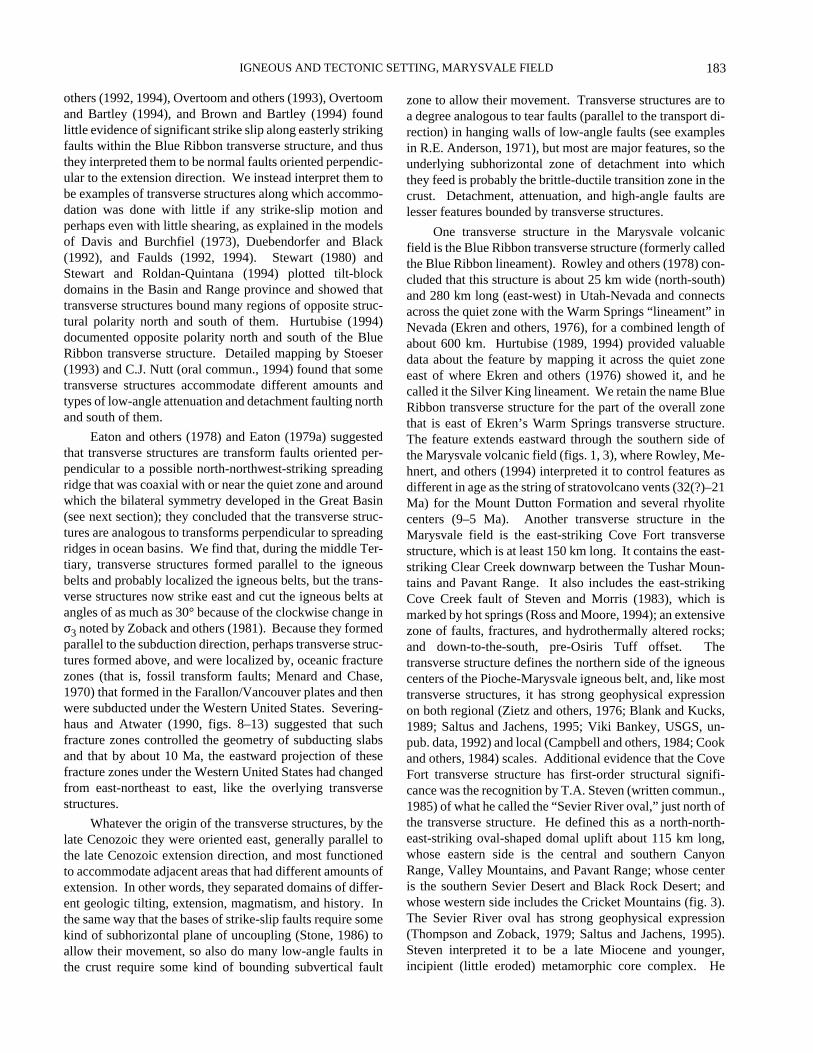
183
IGNEOUS AND TECTONIC SETTING, MARYSVALE FIELD
others (1992, 1994), Overtoom and others (1993), Overtoomand Bartley (1994), and Brown and Bartley (1994) foundlittle evidence of significant strike slip along easterly strikingfaults within the Blue Ribbon transverse structure, and thusthey interpreted them to be normal faults oriented perpendic-ular to the extension direction. We instead interpret them tobe examples of transverse structures along which accommo-dation was done with little if any strike-slip motion andperhaps even with little shearing, as explained in the modelsof Davis and Burchfiel (1973), Duebendorfer and Black(1992), and Faulds (1992, 1994). Stewart (1980) andStewart and Roldan-Quintana (1994) plotted tilt-blockdomains in the Basin and Range province and showed thattransverse structures bound many regions of opposite struc-tural polarity north and south of them. Hurtubise (1994)documented opposite polarity north and south of the BlueRibbon transverse structure. Detailed mapping by Stoeser(1993) and C.J. Nutt (oral commun., 1994) found that sometransverse structures accommodate different amounts andtypes of low-angle attenuation and detachment faulting northand south of them.
Eaton and others (1978) and Eaton (1979a) suggestedthat transverse structures are transform faults oriented per-pendicular to a possible north-northwest-striking spreadingridge that was coaxial with or near the quiet zone and aroundwhich the bilateral symmetry developed in the Great Basin(see next section); they concluded that the transverse struc-tures are analogous to transforms perpendicular to spreadingridges in ocean basins. We find that, during the middle Ter-tiary, transverse structures formed parallel to the igneousbelts and probably localized the igneous belts, but the trans-verse structures now strike east and cut the igneous belts atangles of as much as 30° because of the clockwise change inσ3 noted by Zoback and others (1981). Because they formedparallel to the subduction direction, perhaps transverse struc-tures formed above, and were localized by, oceanic fracturezones (that is, fossil transform faults; Menard and Chase,1970) that formed in the Farallon/Vancouver plates and thenwere subducted under the Western United States. Severing-haus and Atwater (1990, figs. 8–13) suggested that suchfracture zones controlled the geometry of subducting slabsand that by about 10 Ma, the eastward projection of thesefracture zones under the Western United States had changedfrom east-northeast to east, like the overlying transversestructures.
Whatever the origin of the transverse structures, by thelate Cenozoic they were oriented east, generally parallel tothe late Cenozoic extension direction, and most functionedto accommodate adjacent areas that had different amounts ofextension. In other words, they separated domains of differ-ent geologic tilting, extension, magmatism, and history. Inthe same way that the bases of strike-slip faults require somekind of subhorizontal plane of uncoupling (Stone, 1986) toallow their movement, so also do many low-angle faults inthe crust require some kind of bounding subvertical fault
zone to allow their movement. Transverse structures are toa degree analogous to tear faults (parallel to the transport di-rection) in hanging walls of low-angle faults (see examplesin R.E. Anderson, 1971), but most are major features, so theunderlying subhorizontal zone of detachment into whichthey feed is probably the brittle-ductile transition zone in thecrust. Detachment, attenuation, and high-angle faults arelesser features bounded by transverse structures.
One transverse structure in the Marysvale volcanicfield is the Blue Ribbon transverse structure (formerly calledthe Blue Ribbon lineament). Rowley and others (1978) con-cluded that this structure is about 25 km wide (north-south)and 280 km long (east-west) in Utah-Nevada and connectsacross the quiet zone with the Warm Springs “lineament” inNevada (Ekren and others, 1976), for a combined length ofabout 600 km. Hurtubise (1989, 1994) provided valuabledata about the feature by mapping it across the quiet zoneeast of where Ekren and others (1976) showed it, and hecalled it the Silver King lineament. We retain the name BlueRibbon transverse structure for the part of the overall zonethat is east of Ekren’s Warm Springs transverse structure.The feature extends eastward through the southern side ofthe Marysvale volcanic field (figs. 1, 3), where Rowley, Me-hnert, and others (1994) interpreted it to control features asdifferent in age as the string of stratovolcano vents (32(?)–21Ma) for the Mount Dutton Formation and several rhyolitecenters (9–5 Ma). Another transverse structure in theMarysvale field is the east-striking Cove Fort transversestructure, which is at least 150 km long. It contains the east-striking Clear Creek downwarp between the Tushar Moun-tains and Pavant Range. It also includes the east-strikingCove Creek fault of Steven and Morris (1983), which ismarked by hot springs (Ross and Moore, 1994); an extensivezone of faults, fractures, and hydrothermally altered rocks;and down-to-the-south, pre-Osiris Tuff offset. Thetransverse structure defines the northern side of the igneouscenters of the Pioche-Marysvale igneous belt, and, like mosttransverse structures, it has strong geophysical expressionon both regional (Zietz and others, 1976; Blank and Kucks,1989; Saltus and Jachens, 1995; Viki Bankey, USGS, un-pub. data, 1992) and local (Campbell and others, 1984; Cookand others, 1984) scales. Additional evidence that the CoveFort transverse structure has first-order structural signifi-cance was the recognition by T.A. Steven (written commun.,1985) of what he called the “Sevier River oval,” just north ofthe transverse structure. He defined this as a north-north-east-striking oval-shaped domal uplift about 115 km long,whose eastern side is the central and southern CanyonRange, Valley Mountains, and Pavant Range; whose centeris the southern Sevier Desert and Black Rock Desert; andwhose western side includes the Cricket Mountains (fig. 3).The Sevier River oval has strong geophysical expression(Thompson and Zoback, 1979; Saltus and Jachens, 1995).Steven interpreted it to be a late Miocene and younger,incipient (little eroded) metamorphic core complex. He
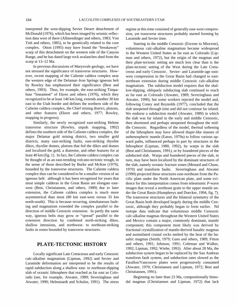
LACCOLITH COMPLEXES OF SOUTHEASTERN UTAH
184
interpreted the west-dipping Sevier Desert detachment ofMcDonald (1976), which has been imaged by seismic reflec-tion data west of there (Allmendinger and others, 1983; VonTish and others, 1985), to be genetically related to the corecomplex. Otton (1995) may have found the “breakaway”scarp of this detachment on the western side of the CanyonRange, and he has dated large rock avalanches shed from thescarp at 13–12 Ma.
In previous discussions of Marysvale geology, we havenot stressed the significance of transverse structures. How-ever, recent mapping of the Caliente caldera complex nearthe western edge of the Delamar–Iron Springs igneous beltby Rowley has emphasized their significance (Best andothers, 1993). Thus, for example, the east-striking Timpa-hute “lineament” of Ekren and others (1976), which theyrecognized to be at least 140 km long, extends another 30 kmeast to the Utah border and defines the northern side of theCaliente caldera complex, the Chief mining district, plutons,and other features (Ekren and others, 1977; Rowley,mapping in progress).
Similarly, the newly recognized east-striking Helenetransverse structure (Rowley, unpub. mapping, 1992)defines the southern side of the Caliente caldera complex, themajor Delamar gold mining district, two smaller golddistricts, many east-striking faults, east-striking rhyolitedikes, rhyolite domes, plutons that fed the dikes and domesand localized the gold, a diatreme, and other features for atleast 40 km (fig. 1). In fact, the Caliente caldera complex canbe thought of as an east-trending volcano-tectonic trough, inthe sense of those described by Burke and McKee (1979),bounded by the transverse structures. The Caliente calderacomplex thus can be considered to be a smaller version of anigneous belt: although it has been recognized for years thatmost simple calderas in the Great Basin are elongate east-west (Best, Christiansen, and others, 1989) due to laterextension, the Caliente caldera complex is much moreasymmetrical than most (80 km east-west versus 35 kmnorth-south). This is because recurring, simultaneous fault-ing and magmatism extended the complex parallel to thedirection of middle Cenozoic extension. In partly the sameway, igneous belts may grow or “spread” parallel to theextension direction by combined north-striking dikes,shallow intrusions, and northwest- to northeast-strikingfaults in zones bounded by transverse structures.
PLATE-TECTONIC HISTORY
Locally significant Late Cretaceous and early Cenozoiccalc-alkaline magmatism (Lipman, 1992) and Sevier andLaramide deformation are interpreted to be the results ofrapid subduction along a shallow east- to northeast-dippingslab of oceanic lithosphere that reached as far east as Colo-rado (see, for example, Atwater, 1989; Severinghaus andAtwater, 1990; Helmstaedt and Schulze, 1991). The stress
regime at this time consisted of generally east-west compres-sion, yet transverse structures probably started forming byLaramide and Sevier time.
Starting in the middle Cenozoic (Eocene to Miocene),voluminous calc-alkaline magmatism became widespreadin the Western United States as far east as Colorado (Lip-man and others, 1972), but the origin of the magmas andtheir plate-tectonic setting are much less clear than is theplate-tectonic setting of the West during the Late Creta-ceous and early Cenozoic. Sevier- and Laramide-age east-west compression in the Great Basin had changed to east-northeast extension during middle Cenozoic calc-alkalinemagmatism. The subduction model requires that the shal-low-dipping, obliquely subducting slab continued to reachas far east as Colorado (Atwater, 1989; Severinghaus andAtwater, 1990), but some workers rejected the model and,following Coney and Reynolds (1977), concluded that theslab steepened through time and did not continue far inland.We endorse a subduction model (Atwater, 1989) in whichthe slab was far inland in the early and middle Cenozoic,then shortened and perhaps steepened throughout the mid-dle Cenozoic. Regardless of the model, thermal softeningof the lithosphere may have allowed diapir-like masses ofasthenospheric mantle (Eaton, 1979a) to follow various up-ward paths, influenced perhaps in part by structures in thelithosphere (Lipman, 1980, 1992), by warps in the slab(Best and Christiansen, 1991), or by foundered pieces of thesubducted slab. Warps and foundered pieces of the slab, inturn, may have been localized by the dominant structures ofthe slab, namely oceanic fracture zones (Menard and Chase,1970) and transform faults. Severinghaus and Atwater(1990) projected these structures east-northeast from the Pa-cific plate under the North American plate, and some evi-dence for this interpretation comes from teleseismic P-waveimages that reveal a northeast grain to the upper mantle un-der the Great Basin (Humphreys and Duecker, 1994, fig. 7).The transverse structures and the bilateral symmetry of theGreat Basin both developed largely during the middle Cen-ozoic, although they probably began to form earlier. Ndisotope data indicate that voluminous middle Cenozoiccalc-alkaline magmas throughout the Western United Statesand Mexico contain a major, commonly dominant, mantlecomponent; this component most likely was derived byfractional crystallization of mantle-derived basaltic magmasand assimilated crustal rocks melted by the heat of the ba-saltic magmas (Smith, 1979; Gans and others, 1989; Fittonand others, 1991; Johnson, 1991; Coleman and Walker,1992; Lipman, 1992; Wiebe, 1993). After about 28 Ma, thesubduction system began to be replaced by the San Andreastransform fault system, and subduction rates slowed as theFarallon/Vancouver plates were progressively consumed(Atwater, 1970; Christiansen and Lipman, 1972; Best andChristiansen, 1991).
Beginning no later than 23 Ma, compositionally bimo-dal magmas (Christiansen and Lipman, 1972) that lack
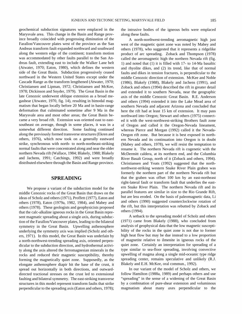
185
IGNEOUS AND TECTONIC SETTING, MARYSVALE FIELD
geochemical subduction signatures were emplaced in theMarysvale area. This change in the Basin and Range prov-ince broadly coincided with progressing diminution of theFarallon/Vancouver plates west of the province as the SanAndreas transform fault expanded northward and southwardalong the western edge of the continent; transform motionwas accommodated by other faults parallel to the San An-dreas fault, extending east to include the Walker Lane belt(Atwater, 1970; Eaton, 1980), which defines the westernside of the Great Basin. Subduction progressively ceasednorthward in the Western United States except under theCascade Range as the transform lengthened (Atwater, 1970;Christiansen and Lipman, 1972; Christiansen and McKee,1978; Dickinson and Snyder, 1979). The Great Basin in thelate Cenozoic underwent oblique extension as a broad me-gashear (Atwater, 1970, fig. 14), resulting in bimodal mag-matism that began locally before 20 Ma and in basin-rangedeformation that culminated sometime after 9 Ma in theMarysvale area and most other areas; the Great Basin be-came a very broad rift. Extension was oriented east to east-southeast on average, though in some places, it was in asomewhat different direction. Some faulting continuedalong the previously formed transverse structures (Ekren andothers, 1976), which now took on a generally eastwardstrike, synchronous with north- to north-northeast-strikingnormal faults that were concentrated along and near the oldernorthern Nevada rift (Wallace, 1984; Blakely, 1988; Blakelyand Jachens, 1991; Catchings, 1992) and were broadlydistributed elsewhere through the Basin and Range province.
SPREADING
We propose a variant of the subduction model for themiddle Cenozoic rocks of the Great Basin that draws on theideas of Scholz and others (1971), Proffett (1977), Eaton andothers (1978), Eaton (1979a, 1982, 1984), and Mabey andothers (1978). These geologists and geophysicists proposedthat the calc-alkaline igneous rocks in the Great Basin repre-sent magmatic spreading about a single axis, during subduc-tion of the Farallon/Vancouver plates, leading to the bilateralsymmetry in the Great Basin. Upwelling asthenosphereunderlying the symmetry axis was implied (Scholz and oth-ers, 1971). In this model, the Great Basin was underlain bya north-northwest-trending spreading axis, oriented perpen-dicular to the subduction direction, and hydrothermal activi-ty along the axis altered the ferromagnesian minerals in therocks and reduced their magnetic susceptibility, therebyforming the magnetically quiet zone. Supposedly, as theelongate asthenosphere diapir hit the base of the crust, itspread out horizontally in both directions, and outward-directed tractional stresses on the crust led to extensionalfaulting and bilateral symmetry. The east-striking transversestructures in this model represent transform faults that strikeperpendicular to the spreading axis (Eaton and others, 1978);
the intrusive bodies of the igneous belts were emplacedalong these faults.
A north-northwest-trending aeromagnetic high justwest of the magnetic quiet zone was noted by Mabey andothers (1978), who suggested that it represents a ridgelikeproduct of arc spreading. Zoback and Thompson (1978)called the aeromagnetic high the northern Nevada rift (fig.1) and noted that (1) it is filled with 17- to 14-Ma basalticand rhyolite dikes, and (2) its trend, like that of normalfaults and dikes in tension fractures, is perpendicular to themiddle Cenozoic direction of extension. McKee and Noble(1986), Blakely (1988), Blakely and Jachens (1991), andZoback and others (1994) described the rift in greater detailand extended it to southern Nevada, near the geographicaxis of the middle Cenozoic Great Basin. R.E. Andersonand others (1994) extended it into the Lake Mead area ofsouthern Nevada and adjacent Arizona and concluded thathere the rift had at least 15 km of extension. It may passnorthward into Oregon; Stewart and others (1975) connect-ed it with the west-northwest-striking Brothers fault zoneof Oregon and called it the Oregon-Nevada lineament,whereas Pierce and Morgan (1992) called it the Nevada-Oregon rift zone. But because it is best exposed in north-ern Nevada and its continuation into Oregon is in doubt(Mabey and others, 1978), we will resist the temptation torename it. The northern Nevada rift is cogenetic with theMcDermitt caldera, at its northern end, and the ColumbiaRiver Basalt Group, north of it (Zoback and others, 1994).Christiansen and Yeats (1992) suggested that the north-northwest-striking western Snake River Plain graben wasformerly the northern part of the northern Nevada rift butthat the graben was offset 100 km by an east-northeastright-lateral fault or transform fault that underlies the east-ern Snake River Plain. The northern Nevada rift and itsparallel features are similar in size to the Rio Grande Rift,but are less eroded. On the basis of paleomagnetic data, Liand others (1990) suggested counterclockwise rotation ofthe rift, but this interpretation was rebutted by Zoback andothers (1994).
A setback to the spreading model of Scholz and others(1971) came from Blakely (1988), who concluded fromanalysis of geophysical data that the low magnetic suscepti-bility of the rocks in the quiet zone is not due to formerhigh heat flow but may be due instead to a low proportionof magnetite relative to ilmenite in igneous rocks of thequiet zone. Certainly an interpretation for spreading of atype similar to sea-floor spreading, involving convectiveupwelling of magma along a single mid-oceanic type ridgespreading center, remains speculative and unlikely (R.J.Blakely and E.H. McKee, oral commun., 1992).
In our variant of the model of Scholz and others, wefollow Hamilton (1988a, 1989) and perhaps others and use“spreading” in the sense of a widening of the Great Basinby a combination of pure-shear extension and voluminousmagmatism about many axes perpendicular to the
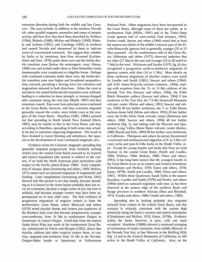
LACCOLITH COMPLEXES OF SOUTHEASTERN UTAH
186
extension direction during both the middle and late Ceno-zoic. The axes include, in addition to the northern Nevadarift, other parallel magnetic anomalies and zones of seismicactivity and heat flow that have been described by Wallace(1984), Blakely (1988), McKee and Blakely (1990), Blake-ly and Jachens (1991), and Catchings (1992) in northernand central Nevada and interpreted by them to indicatezones of concentrated extension. We suggest that, whetherby faults or by intrusions, heat flow increased (Lachen-bruch and Sass, 1978) under these axes and the brittle-duc-tile transition zone (below the seismogenic crust; Sibson,1989) rose and arched under them to form blisterlike forms(metamorphic core complexes) or ridgelike forms. Perhapswith continued extension under these axes, the brittle-duc-tile transition zone rose higher and broadened perpendicu-larly outward, providing a driving force for extension andmagmatism outward in both directions. Either the crust atand above the raised brittle-ductile transition zone softened,leading to a reduction in shear strength, or stresses droppedafter extension along the axis (see Mandl, 1987) and thusextension ceased. East-west least principal stress continuedin the Great Basin, however, and thus extension migratedgenerally toward the cooler, more brittle crust at the mar-gins of the Great Basin. Hamilton (1985, 1988c) pointedout that spreading in North Island, New Zealand (Stern,1985), may be similar to that in the Great Basin, and that,according to Hamilton, spreading in both areas may actual-ly be due to extension outpacing magmatism. The result inNew Zealand is crustal thinning and subsidence, the oppo-site to the development of most continental magmatic arcs.
Evidence exists for Cenozoic magmatic spreading thatgenerally migrated progressively from northerly strikingcenters near the central Great Basin outward to its westernand eastern boundaries (the motion is relative to the cen-ters, if we hold the North American plate motionless withrespect to the Pacific plate) (Eaton, 1980). Early compila-tion of isotopic dates (Armstrong and others, 1969; McKee,1971) noted such an outward migration of magmatism andfaulting. Later compilations (Armstrong and Ward, 1991)showed that this picture is not that simple, because spread-ing as it is known in the ocean basins probably does not oc-cur on continents, because a single center at any one time isunlikely, and because younger centers may have been su-perimposed on or near older ones. The best evidence ofprogressive migrations of eruptive centers is from thenorthwestern Great Basin, where MacLeod and others(1976) noted rhyolite domes and centers just southwest ofthe Brothers fault zone that become progressively youngerwest-northwest, from 10 Ma in southeastern Oregon toQuaternary in central Oregon. Good data from the easternSnake River Plain just north of the northeastern Great Ba-sin, summarized by Pierce and Morgan (1992), shows thatrhyolite calderas and other eruptive centers there, in con-trast, migrated east-northeast from 16 Ma at the Nevada-Oregon-Idaho border to Quaternary at Yellowstone
National Park. Other migrations have been documented inthe Great Basin, although some of these are subtle, as innortheastern Utah (Miller, 1991) and in the Tintic–DeepCreek igneous belt of west-central Utah (Stoeser, 1993).Farther south, Steven and others (1984) noted that at leastthe eastern two-thirds of the middle Cenozoic part of the Pi-oche-Marysvale igneous belt is generally younger (35 to 23Ma) eastward. On the southwestern side of the Great Ba-sin, Silberman and others (1975) observed andesites thatare older (27 Ma) in the east and younger (25 to 20 and 8 to7 Ma) in the west. Dickinson and Snyder (1979, fig. 8) alsorecognized a progressive north-to-northwest migration ofigneous centers with time (16 to 5 Ma). More details onthese northwest migrations of rhyolite centers were notedby Luedke and Smith (1981), Sawyer and others (1994),and A.M. Sarna-Wojcicki (written commun., 1994), start-ing with eruptions from the 15- to 11-Ma calderas of theNevada Test Site (Sawyer and others, 1994), the 9-MaBlack Mountain caldera (Sawyer and others, 1994) 5 kmnorthwest of the Test Site, the 7.5-Ma Stonewall Mountainvolcanic center (Weiss and others, 1993; Sawyer and oth-ers, 1994) 40 km farther northwest, the 7- to 3-Ma MountJackson dome field (Weiss and others, 1993) 20 km fartherwest, the 6-Ma Silver Peak volcanic center (Robinson andothers, 1968; Sawyer and others, 1994) 40 km farthernorthwest (fig. 1), and ending with the Pliocene and Qua-ternary Long Valley–Mono Basin volcanic center (Bailey,1989; Bursik and Sieh, 1989) 80 km farther west-northwest,in California. Thompson and others (in press) documenteda westward and northwestward migration of 8- to 3-Ma vol-canic rocks and post-6.5-Ma faults in the Death Valley ar-ea. Except for young basalts and faults that form an axialfracture in the central Great Basin (Smith and Luedke,1984; Wallace, 1984; Blakely, 1988; Fitton and others,1991), it has long been known that the youngest basalts inthe Great Basin occur on its eastern and western boundaries(Christiansen and McKee, 1978; Eaton and others, 1978;Eaton, 1979b; Smith and Luedke, 1984; Fitton and others,1991). Within these Quaternary basalt fields at the easternboundary, Luedke and Smith (1978) and Nealey and others(1994) noted an eastward migration with time, as has beenobserved at the eastern edge of the southern Basin andRange province in northern Arizona (Best and Brimhall,1974; Tanaka and others, 1986; Condit and others, 1989).
Spreading due to faulting probably also migratedoutward from centers in the central Great Basin, and thisscenario is certainly consistent with the current highseismicity along the basin’s western and eastern boundaries(Christiansen and McKee, 1978; Eaton, 1979b). Evidencewithin the basin, however, is poor, with one mainexception: Hamilton (1988b) showed a westward youngingof termination of major extension, from middle Miocene inthe Nevada Test Site, to late Miocene in the Bullfrog Hills(fig. 1) and in the Funeral Mountains of California, to stillactive in the Death Valley of California. Also, on the

187
IGNEOUS AND TECTONIC SETTING, MARYSVALE FIELD
eastern side of the southern Basin and Range province innorthern Arizona, Faulds, Gans, and Smith (1994) notedprogressively younger faulting eastward (16 to 10 Ma).
Formerly, various names were applied to the type ofmiddle Cenozoic calc-alkaline magmatic arc in the WesternUnited States that contains components of spreading or ex-tension. The terms “ensialic back arc” or “marginal basin”were most commonly used, but these seem inappropriatebecause most back arcs (as described by Saunders and Tar-ney, 1984) are underlain by oceanic lithosphere and containthick marine sedimentary rocks and local basalt rather thansubaerial calc-alkaline volcanic rocks (see, for example,Rowley and others, 1991; Rowley, Kellogg, and others,1992). Furthermore, when applied to the Western UnitedStates, such terms leave unconsidered the location of theconcurrent magmatic arc west of any back arc. Thus Elston(1984) instead proposed “extensional orogen,” but we pre-fer the name “magmatic arc.” Neglecting such semanticmatters, however, the point to be made here is that middleMiocene calc-alkaline magmatism and late Cenozoic bimo-dal magmatism in the Great Basin are associated with sig-nificant extension, possibly along many north-northwest- tonorth-northeast-trending, perhaps diffuse, central axes, andthus a spreading analogy can be made. Thus the GreatBasin extended much more than adjacent areas on thePacific rim.
Spreading was partly accommodated by transversestructures that formed parallel to the spreading direction, thatoccur throughout the Great Basin, and that partly bound thebasin on the north (Christiansen and McKee, 1978; McKeeand Noble, 1986, fig. 6) and the south (Davis and Burchfiel,1973). Accommodation by transverse structures allowed ig-neous belts to grow parallel to the spreading direction alongcenters oriented perpendicular to the spreading direction,whereas areas north and south of the igneous belts spread byfaulting.
A model for the development of igneous belts isprovided by the eastern Snake River Plain. This broad lavaplain is generally shown on physiographic maps to boundthe Great Basin on the northeast, but geologically it is anuneroded version of the igneous belts within the GreatBasin, and to its north, basin-range topography continues(Eaton and others, 1978; Kuntz and others, 1992). Theplain is oriented east-northeast to northeast, parallel to theextension direction in the area (Kuntz, 1992; Kuntz andothers, 1992). Southward from the eastern Snake RiverPlain, this direction has gradually swings about 40-westextension direction of the northeastern Great Basin (Zobackand others, 1981; Zoback, 1989; Pierce and Morgan, 1992,fig. 22). Most rocks at the surface of the plain areQuaternary basalt lava flows that erupted along north-northwest-striking linear vents; basin-range faults north ofthe plain strike in the same direction, whereas those southof the plain strike about north, all being perpendicular tothe extension direction (Kuntz and others, 1992, fig. 11).
Calderas or other vents generally below the surface of theplain erupted mostly rhyolite ash-flow tuffs and record theprogressive east-northeast to northeast migration of erup-tions, from 16 Ma to Quaternary (Pierce and Morgan,1992). In the same way that we would not give the name“rift” to transverse structures, we agree with Kuntz and oth-ers (1992) and Pierce and Morgan (1992) that Hamilton’s(1989) use of “rift” for the eastern Snake River Plain is in-appropriate; the plain was oriented parallel, not perpendicu-lar, to the extension direction when it formed. Wespeculate instead that the eastern Snake River Plain isbound on its north and south sides by buried east-northeast-to northeast-striking transverse structures. No faults of thesame strike are exposed, although they have been modeledby Sparlin and others (1982). The transverse structures thatwe propose may not be expressed primarily by faults.These zones allowed east-northeast spreading to be takenup primarily by magmatism within the plain, and primarilyby normal faulting to the north and south (Kuntz and oth-ers, 1992). The plain is thus an igneous belt formed by ba-salt feeder dikes oriented perpendicular to the spreadingdirection and by shallow rhyolitic intrusions whose roofscollapsed to form calderas. The eastward progression inrhyolite eruptions here in the (geologically defined) easternpart of the Great Basin is contrasted with the westward pro-gression in rhyolite eruptions in the western part of theGreat Basin south of the Brothers fault zone. The Brothersfault zone is a transverse structure that includes right slipand defines part of the northwestern edge of the GreatBasin (Lawrence, 1976; McKee and Noble, 1986).
The two transverse structures that we suggest underliethe eastern Snake River Plain continue northeast of Yel-lowstone into Montana (Eaton and others, 1975; Mabeyand others, 1978), parallel to Precambrian structures (Er-slev and Sutter, 1990; Pierce and Morgan, 1992, p. 32).One of these structures, the northeast-striking ProterozoicMadison mylonite zone of Erslev and Sutter (1990) in thesouthern Madison Range, may have been followed by oursuggested transverse structure that bounds the northwestside of the plain; farther northeast, the transverse structuremay even control the northeast-striking Holocene Emigrantfault of Pierce and Morgan (1992, plate 1) south of Boze-man. Our speculations thus are similar to those of Eatonand others (1975), Mabey and others (1978), and Chris-tiansen and McKee (1978), who suggested that Precam-brian crustal flaws controlled the location of the easternSnake River Plain. We would emphasize, however, thatparallelism to the extension direction is the dominant con-trol of the magmatism in the plain. The two transversestructures also continue southwest into Nevada, and theoverall 1,000-km-long belt in Montana, Idaho, and Nevadawas called the Humboldt zone by Mabey and others (1978)and Rowan and Wetlaufer (1981). The zone is character-ized by high heat flow (Lachenbruch and Sass, 1978;Blakely, 1988) of the Battle Mountain high. Pierce and
LACCOLITH COMPLEXES OF SOUTHEASTERN UTAH
188
Morgan (1992, p. 32), however, doubted that the two“lineaments” of Eaton and others (1975) and Mabey andothers (1978) were the dominant control of the easternSnake River Plain. “Why,” they asked, “would two suchlineaments be exploited simultaneously rather than the fail-ing of one ***?” This remains a good question.
Pierce and Morgan (1992), Zoback and others (1994),and others ascribed the northeast migration of igneousactivity in the eastern Snake River Plain and YellowstoneNational Park area to the passage of the continental plateover a “hot spot” from an underlying mantle plume. Theirevidence is compelling (see also Pierce and others, 1992),but the theory does not explain the synchronous but sym-metrically opposite migration along and near the Brothersfault zone (Lipman, 1992, p. 491), as well as other igneousbelts in the Great Basin.
Was subduction a prerequisite for volcanism in theGreat Basin and nearby areas? Mutschler and others (1987,1991, this volume) answered “no” and proposed instead thatvolcanism is due to subcrustal lithospheric thinning andmantle upwelling above passive hot spots. Lipman (1992)and we disagree with their model (see section on IgneousBelts and Mineral Belts, p. xx). Mutschler and his col-leagues identified several passive hot spots in the WesternUnited States, including the possible Great Basin spreadingcenter discussed above, which they called the Great Basinregional gravity low. Blank and others (this volume) pro-pose another to underlie the entire Colorado Plateau. As-thenospheric upwarps have been suggested by others,including Eaton (1987), who proposed a large bulge that up-lifted the southern Rocky Mountains and formed a crestalgraben, the Rio Grande Rift. White and others (1987) tracedthe development of ocean basins that started to form by up-welling of asthenosphere along continental rifts; decompres-sion of the upwelled material theoretically producedmagmas by partial melting. They suggested that the GreatBasin is an example of a continental rift that did not stretchsufficiently to form a new ocean basin. According to Whiteand others (1987), if stretching stops before the lithospherehas been reduced to less than half its original thickness, thethinned region subsides to form a sedimentary basin like theNorth Sea, whereas if stretching continues and the continen-tal lithosphere breaks, new oceanic lithosphere is formed bysea-floor spreading, bordered on either side by riftedcontinental margins, as in the Red Sea or the Atlantic Ocean.Rosendahl (1987, p. 461) coined the word “pretransform” todescribe transverse structures in the East African rift thatparallel the extension direction and in the future will becometrue transforms in oceanic crust when rifting advances to thestage that the area becomes an ocean basin.
CONCLUSIONS
The large Marysvale and San Juan volcanic fieldsoccur on the edges of the Colorado Plateau, where
voluminous hot mantle-derived magma formed shallowcrustal calc-alkaline magma chambers that congealed toform composite batholiths. In contrast, the laccolith clus-ters in the rigid Colorado Plateau between these volcanicfields are minor, widely scattered igneous features that hadfew effusive products. According to Gilbert (1877) andCorry (1988), laccoliths form, whether in the Colorado Pla-teau or elsewhere, when magma rises to a level in the crustwhere the rocks have about the same specific gravity as themelt. At about that level, relatively close to the surface(about 2–4 km or less in southeastern Utah, the northernMarkagunt Plateau, and the Iron Axis), the magma mayspread out along low-dipping incompetent sedimentarybeds. In this near-surface environment alone, σ3 becomesvertical and σ1 equals σ2, so magma spreads out laterallyand lifts thin roof rocks. Parsons and others (1992), howev-er, argued that rheological boundaries between horizontalpackages of host rocks are sites for emplacement of hori-zontal sills or laccoliths only after the emplacement of ver-tical dikes (perpendicular to horizontal extension) hasrelieved tension and caused the least principal stress abovethis boundary to become vertical, whereas the verticalstress axis below the boundary remains as σ2. Regardlessof the dominating mechanisms, most of the laccoliths of theIron Axis spread out in gypsiferous shale in the lower partof the Carmel Formation and above the massive NavajoSandstone, the laccoliths on the southern flank of theMarysvale field spread out in shale in the lower part of theClaron Formation, and laccoliths of the Colorado Plateauand locally in the San Juan area spread out in the MancosShale and underlying units. Laccoliths differ from un-floored stocks in having much smaller volumes of magmaavailable for eruption, so attendant volcanic units tend to besmaller, although the products erupted from both sourcesare similar. Such volcanic rocks of limited extent wereerupted from the Spry and Iron Peak laccoliths along thesouthern side of the Marysvale field (J.J. Anderson andRowley, 1975; J.J. Anderson and others, 1990a), at somelaccoliths of the Iron Axis farther south (Blank and others,1992; D.B. Hacker, Kent State University, written com-mun., 1992; Rowley, unpub. mapping, 1992), at laccolithsin West Texas (Henry and Price, 1988; Henry and others,1991), and in some other areas (Corry, 1988). Laccolithsform some significant ore bodies, as at Iron Springs (Mack-in, 1947), but most of their hydrothermal-type deposits aresmall.
Generally, middle Cenozoic calc-alkaline volcanicrocks similar to those of the Marysvale field arevoluminous elsewhere in the Western United States(Johnson, 1991), and their eruptive centers are underlain byeven larger batholith complexes. The great breadth of thesesimilar types of igneous rocks is best explained as a resultof magmatism above a subduction zone, as elsewherearound the Pacific margin and other parts of the world. Thegeneration of calc-alkaline rocks appears to be driven by
189
IGNEOUS AND TECTONIC SETTING, MARYSVALE FIELD
“large fluxes of mantle-derived basaltic magmas” (Smith,1979; Johnson, 1991). The intrusive rocks and related hy-drothermal mineral deposits constitute a treasure house ofvaluable resources. During the middle Cenozoic, extensionoriented generally east-northeast was expressed by localhigh-angle normal faults, many of which flatten at depth,by metamorphic core complexes, and by shallow intru-sions. In many places, depending on the stress field,oblique- and strike-slip faults were also produced. Some ofthe most productive mineral belts in the Great Basin,mostly of gold, silver, and chalcophile elements, resultedwhere permeability due to faulting and brecciation coicidedin space and time with magmatism and resulting hydrother-mal convection cells (John and others, 1989, 1991;Hardyman and Oldow, 1991; Henley and Adams, 1992;Rowley, Snee, and others, 1992; Willis and Tosdal, 1992).
Upper Cenozoic bimodal igneous rocks are less volu-minous than calc-alkaline rocks, but they also generatedmany deposits of base and precious metals, as well as litho-phile elements. Bimodal volcanism began in the Marysvalearea by about 23 Ma and in the Caliente area no later than15.5 Ma. Bimodal magmatism in the Basin and Range prov-ince correlates with transform movement on the San Andreasfault zone and the end of subduction. Most rhyolites proba-bly resulted from partial melting of local areas of crust.Extension in the Great Basin continued, although now ori-ented east-west or perhaps east-southeast, yet the main lateCenozoic deformational episode that established the presenttopography, that of basin-range faulting, did not begin untillater (after 10 Ma in the Marysvale area and the southeasternGreat Basin). Most basin-range faults are relatively high-angle normal faults where exposed, probably decreasing tolower angles with depth, but strike-slip faults occur locally.
The result of volcanism and major extension in theGreat Basin during the late Cenozoic and probably the mid-dle Cenozoic can be considered a type of east-west “spread-ing” or widening of continental crust, creating bilateralsymmetry. Numerous northerly trending axes involving dif-ferent combinations of spreading by faulting and hypabyssalintrusion appear to occur in the central Great Basin but mayalso be present throughout the subprovince. Long-lasting,recurring combinations of faults and shallow intrusions, as inthe northern Nevada rift, Wilson Ridge pluton, and Calientecaldera complex represent examples of local extensionalspreading by this twofold combination. Transverse struc-tures oriented east-northeast in the middle Cenozoic, parallelto the subduction direction, represent zones separating dif-ferent amounts of extension and calc-alkaline magmatismnorth and south of them. They controlled the shape of theeast-northeast-trending igneous belts within the Great Basin.The igneous belts became younger to the south-southeast,but each belt grew eastward or westward (generally west-ward in the western Great Basin and eastward in the easternGreat Basin) away from a central axis. In the late Cenozoic,during oblique extension that culminated in basin-range
deformation, accommodation offset continued along someof the transverse structures, bringing them to their presenteast-west trend, and some bimodal volcanism also tookplace along them. The Great Basin continues to spreadabout north-northeast- or north-trending axes, and mostrecent basalts and faults occur at the basin’s axis and easternand western margins.
REFERENCES CITED
Agrell, S.O., Charnley, N.R., and Rowley, P.D., 1986, The occur-rence of hibonite, perovskite, zirconolite, pseudobrookites andother minerals in a metamorphosed hydrothermal system atPine Canyon, Piute County, Utah, U.S.A. [abs.]: Mineralogi-cal Society (London) Bulletin 72, p. 4.
Allmendinger, R.W., and Jordan, T.E., 1984, Mesozoic structure ofthe Newfoundland Mountains, Utah—Horizontal shorteningand subsequent extension in the hinterland of the Sevierorogenic belt: Geological Society of America Bulletin, v. 95,p. 1280–1292.
Allmendinger, R.W., Sharp, J.W., Von Tish, Douglas, Serpa,Laura, Brown, Larry, Kaufman, Sidney, Oliver, Jack, andSmith, R.B., 1983, Cenozoic and Mesozoic structure of theeastern Basin and Range province, Utah, from COCORP seis-mic-reflection data: Geology, v. 11, p. 532–536.
Anderson, E.M., 1951, The dynamics of faulting and dyke forma-tion with applications to Britain: London, Oliver and Boyd,206 p.
Anderson, J.J., 1971, Geology of the southwestern High Plateaus ofUtah—Bear Valley Formation, an Oligocene-Miocene volca-nic arenite: Geological Society of America Bulletin, v. 82, p.1179–1205.
———1985, Mid-Tertiary block faulting along west and northwesttrends, southern High Plateaus, Utah: Geological Society ofAmerica Abstracts with Programs, v. 17, no. 7, p. 513.
———1987, Late Cenozoic drainage history of the northern Mark-agunt Plateau, Utah, in Kopp, R.S., and Cohenour, R.E., eds.,Cenozoic geology of western Utah—Sites for precious metaland hydrocarbon accumulations: Utah Geological AssociationPublication 16, p. 271–278.
———1988, Pre-basin-range block faulting along west and north-west trends, southeastern Great Basin and southern HighPlateaus: Geological Society of America Abstracts withPrograms, v. 20, no. 3, p. 139.
———1993, The Markagunt megabreccia—Large Miocene gravi-ty slides mantling the northern Markagunt Plateau, southwest-ern Utah: Utah Geological Survey Miscellaneous Publication93–2, 37 p.
Anderson, J.J., and Rowley, P.D., 1975, Cenozoic stratigraphy ofthe southwestern High Plateaus of Utah, in Anderson, J.J.,Rowley, P.D., Fleck, R.J., and Nairn, A.E.M., Cenozoic geol-ogy of southwestern High Plateaus of Utah: GeologicalSociety of America Special Paper 160, p. 1–52.
Anderson, J.J., Rowley, P.D., Blackman, J.T., Mehnert, H.H., andGrant, T.C., 1990a, Geologic map of the Circleville Canyonarea, southern Tushar Mountains and northern Markagunt Pla-teau, Beaver, Garfield, Iron, and Piute Counties, Utah: U.S.

LACCOLITH COMPLEXES OF SOUTHEASTERN UTAH
190
Geological Survey Miscellaneous Investigations Series MapI–2000, scale 1:50,000.
Anderson, J.J., Rowley, P.D., Machette, M.N., Decatur, S.H., andMehnert, H.H., 1990b, Geologic map of the Nevershine Hol-low area, eastern Black Mountains, southern Tushar Moun-tains, and northern Markagunt Plateau, Beaver and IronCounties, Utah: U.S. Geological Survey Miscellaneous Inves-tigations Series Map I–1999, scale 1:50,000.
Anderson, R.E., 1971, Thin skin distension in Tertiary rocks ofsoutheastern Nevada: Geological Society of America Bulletin,v. 82, p. 43–58.
———1973, Large-magnitude late Tertiary strike-slip faultingnorth of Lake Mead, Nevada: U.S. Geological Survey Profes-sional Paper 794, 18 p.
———1978, Chemistry of Tertiary volcanic rocks in the EldoradoMountains, Clark County, Nevada, and comparisons withrocks from some nearby areas: U.S. Geological Survey Journalof Research, v. 6, p. 409–424.
———1984, Strike-slip faults associated with extension in andadjacent to the Great Basin: Geological Society of AmericaAbstracts with Programs, v. 16, no. 6, p. 429.
———1986, Coeval mixed-mode dip-slip and strike-slip faultingin and adjacent to the Basin and Range, Utah-Nevada: Geolog-ical Society of America Abstracts with Programs, v. 18, no. 5,p. 338.
———1987, Neogene geologic history of the Nevada-Utah borderarea at and near latitude 379, no. 7, p. 572.
———1988, Hazard implications of joint-controlled basaltic vol-canism in southwestern Utah: Geological Society of AmericaAbstracts with Programs, v. 20, no. 7, p. A115.
———1989, Tectonic evolution of the Intermontane System, Basinand Range, Colorado Plateau, and High Lava Plains, chap. 10of Pakiser, L.C., and Mooney, W.D., eds., Geophysical frame-work of the continental United States: Geological Society ofAmerica Memoir 172, p. 163–176.
———1990, West-directed tectonic escape between the northernand southern sectors of the Basin and Range province: Geolog-ical Society of America Abstracts with Programs, v. 22, no. 3,p. 2.
———1993, Tectonic significance of a Miocene dike swarm andits post-emplacement vertical and meridional collapse, LakeMead area, Nevada, Arizona: Geological Society of AmericaAbstracts with Programs, v. 25, no. 5, p. 3.
Anderson, R.E., and Barnhard, T.P., 1991, Relationship betweenMiocene plutonism, uplift, and extension, Lake Mead area,northernmost Arizona and adjacent Nevada: Geological Soci-ety of America Abstracts with Programs, v. 23, no. 5, p. 245.
———1992, Neotectonic framework of the central Sevier Valleyarea, Utah, and its relationship to seismicity, in Gori, P.L., andHays, W.W., eds., Assessment of regional earthquake hazardsand risk along the Wasatch Front, Utah: U.S. Geological Sur-vey Professional Paper 1500–F, 47 p.
———1993a, Heterogeneous Neogene strain and its bearing onhorizontal extension and horizontal and vertical contraction atthe margin of the extensional orogen, Mormon Mountains area,Nevada and Utah: U.S. Geological Survey Bulletin 2011, 43 p.
———1993b, Aspects of three-dimensional strain at the margin ofthe extensional orogen, Virgin River depression area, Nevada,Utah, and Arizona: Geological Society of America Bulletin, v.105, p. 1019–1052.
Anderson, R.E., Barnhard, T.P., and Snee, L.W., 1994, Roles ofplutonism, mid-crustal flow, tectonic rafting, and horizontalcollapse in shaping the Miocene strain field of the Lake Meadarea, Nevada and Arizona: Tectonics, v. 13, p. 1381–1410.
Anderson, R.E., and Bohannon, R.G., 1993, Three-dimensionalaspects of the Neogene strain field, Nevada-Utah-Arizona tri-corner area, in Lahren, M.M., Trexler, J.H., Jr., and Spinosa,Claude, eds., Crustal evolution of the Great Basin and the Sier-ra Nevada; Geological Society of America Cordilleran/RockyMountain Sections Joint Meeting, Reno, Nev., 1993, Field TripGuidebook: Reno, Nev., University of Nevada, MackaySchool of Mines, p. 167–196.
Anderson, R.E., Bucknam, R.C., and Hamblin, Kenneth, 1978,Road log to the Quaternary tectonics of the Intermountain seis-mic belt between Provo and Cedar City, Utah: GeologicalSociety of America Rocky Mountain Section Annual Meeting,Field Trip 8, 50 p.
Anderson, R.E., and Ekren, E.B., 1977, Comment on Late Cenozo-ic fault patterns and stress fields in the Great Basin and west-ward displacement of the Sierra Nevada block (Wright, 1976):Geology, v. 5, p. 388–389.
Anderson, R.E., Longwell, C.R., Armstrong, R.L., and Marvin,R.F., 1972, Significance of K-Ar ages of Tertiary rocks fromthe Lake Mead region, Nevada-Arizona: Geological Societyof America Bulletin, v. 83, p. 273–288.
Anderson, R.E., and Mehnert, H.H., 1979, Reinterpretation of thehistory of the Hurricane Fault in Utah, in Newman, G.W., andGoode, H.D., eds., Basin and Range Symposium and GreatBasin Field Conference: Denver, Colo., Rocky MountainAssociation of Geologists, p. 145–165.
Anderson, R.E., Zoback, M.L., and Thompson, G.A., 1983, Impli-cations of selected subsurface data on the structural form andevolution of some basins in the northern Basin and Rangeprovince, Nevada and Utah: Geological Society of AmericaBulletin, v. 94, p. 1055–1072.
Anderson, R.N., and Noltimier, H.C., 1973, A model for the horstand graben structure of midocean ridge crests based uponspreading velocity and basalt delivery to the oceanic crust:Geophysics Journal of the Royal Astronomical Society, v. 34,p. 137–147.
Angelier, Jacques, Coletta, Bernard, and Anderson, R.E., 1985,Neogene paleostress changes in the Basin and Range—A casestudy at Hoover Dam, Nevada-Arizona: Geological Society ofAmerica Bulletin, v. 96, p. 347–361.
Armstrong, R.L., 1990, Cenozoic magmatism in the North AmericaCordillera and the origin of metamorphic core complexes:Geological Society of America Abstracts with Programs, v. 22,no. 3, p. 4.
Armstrong, R.L., Ekren, E.B., McKee, E.H., and Noble, E.C., 1969,Space-time relations of Cenozoic silicic volcanism in the GreatBasin of the Western United States: American Journal of Sci-ence, v. 267, p. 478–490.
Armstrong, R.L., and Ward, Peter, 1991, Evolving geographicpatterns of Cenozoic magmatism in the North Americancordillera—The temporal and spatial association ofmagmatism and metamorphic core complexes: Journal ofGeophysical Research, v. 96, no. B8, p. 13,201–13,224.
Atwater, Tanya, 1970, Implications of plate tectonics for the Ceno-zoic tectonic evolution of western North America: GeologicalSociety of America Bulletin, v. 81, p. 3513–3536.
191
IGNEOUS AND TECTONIC SETTING, MARYSVALE FIELD
———1989, Plate tectonic history of the northeast Pacific andwestern North America, in Winterer, E.L., Hussong, D.M., andDecker, R.W., eds., The eastern Pacific Ocean and Hawaii:Geological Society of America, The geology of North Ameri-ca, v. N, p. 21–72.
Axen, G.J., 1991, Tertiary extension, magmatism, and thrust reac-tivation in the southern Great Basin, and a mechanical modelfor detachment faulting: Cambridge, Mass., Harvard Univer-sity Ph. D. dissertation, 235 p.
Axen, G.J., Lewis, P.R., Burke, K.J., Sleeper, K.G., and Fletcher,J.M., 1988, Tertiary extension in the Pioche area, LincolnCounty, Nevada, in Weide, D.L., and Faber, M.L., eds., Thisextended land—Geological journeys in the southern Basin andRange: Geological Society of America, Cordilleran SectionMeeting, Las Vegas, Nev., 1988, Field Trip Guidebook, p. 3–5.
Axen, G.J., Taylor, W.J., and Bartley, J.M., 1993, Space-time pat-terns and tectonic controls of Tertiary extension and magma-tism in the Great Basin of the Western United States:Geological Society of America Bulletin, v. 105, p. 56–76.
Bacon, C.R., 1982, Time-predictable bimodal volcanism in theCoso Range, California: Geology, v. 10, p. 65–69.
Bagby, W.C., 1989, Patterns of gold mineralization in Nevada andUtah, in Shawe, D.R., and Ashley, R.P., eds., United Statesgold terranes—Part I, Chapter B: U.S. Geological Survey Bul-letin 1857, p. B11–B21.
Bailey, R.A., 1989, Geologic map of the Long Valley caldera,Mono–Inyo Craters volcanic chain and vicinity, eastern Cali-fornia: U.S. Geological Survey Miscellaneous InvestigationsSeries Map I–1933.
Barker, D.S., 1991, Quartz monzonite and associated iron deposits,Iron Springs, Utah: Geological Society of America Abstractswith Programs, v. 23, no. 5, p. A388.
Barnhard, T.P., and Anderson, R.E., 1991, Tectonic significance ofdike orientations in the Lake Mead area of Nevada and Arizo-na: Geological Society of America Abstracts with Programs,v. 23, no. 5, p. 233.
Bartley, J.M., 1989, Changing Tertiary extension directions in theDry Lake Valley area, Nevada, and a possible dynamic model,in Garside, L.J., and Shaddrick, D.R., eds., Compressional andextensional structural styles in the northern Basin and Rangeprovince—Seminar Proceedings: Reno, Nev., Nevada Petro-leum Society and Geological Society of Nevada, p. 35–39.
———1990, Hypothetical mid-Tertiary synvolcanic stress rotationin the southeastern Great Basin: Geological Society of Amer-ica Abstracts with Programs, v. 22, no. 3, p. 6.
Bartley, J.M., Axen, G.J., Taylor, W.J., and Fryxell, J.E., 1988,Cenozoic tectonics of a transect through eastern Nevada near38in Weide, D.L., and Faber, M.L., eds., This extendedland—Geological journeys in the southern Basin and Range;Geological Society of America Field Trip Guidebook, Cordil-leran Section Meeting, Las Vegas, Nev., 1988: Las Vegas,Nev., University of Nevada, Department of Geosciences, p.1–20.
Bartley, J.M., Friedrich, A.M., Walker, J.D., Coleman, D.S., andPrice, D.E., 1994, Post-Sevier belt normal faulting insouthwestern Utah: Geological Society of America Abstractswith Programs, v. 26, no. 2, p. 37.
Bartley, J.M., Taylor, W.J., and Lux, D.R., 1992, Blue Ribbon vol-canic rift in southeastern Nevada and its effects on Basin and
Range fault segmentation: Geological Society of AmericaAbstracts with Programs, v. 24, no. 6, p. 2.
Beaty, D.W., Cunningham, C.G., Rye, R.O., Steven, T.A., andGonzalez-Urien, Eliseo, 1986, Geology and geochemistry ofthe Deer Trail Pb-Zn-Ag-Cu manto deposits, Marysvaledistrict, west-central Utah: Economic Geology, v. 81, p.1932–1952.
Best, M.G., 1988, Early Miocene change in direction of leastprincipal stress, Southwestern United States—Conflictinginferences from dikes and metamorphic core-detachment faultterranes: Tectonics, v. 7, no. 2, p. 249–259.
Best, M.G., and Brimhall, W.H., 1974, Late Cenozoic alkalic basal-tic magmas in the western Colorado Plateaus and the Basin andRange transition zone, U.S.A., and their bearing on mantledynamics: Geological Society of America Bulletin, v. 85, p.1677–1690.
Best, M.G., and Christiansen, E.H., 1991, Limited extension duringpeak Tertiary volcanism, Great Basin of Nevada and Utah:Journal of Geophysical Research, v. 96, no. B8, p.13509–13528.
Best, M.G., Christiansen, E.H., and Blank, R.H., Jr., 1989, Oli-gocene caldera complex and calc-alkaline tuffs and lavas of theIndian Peak volcanic field, Nevada and Utah: GeologicalSociety of America Bulletin, v. 101, p. 1076–1090.
Best, M.G., Christiansen, E.H., Deino, A.L., Grommé, C.S., McK-ee, E.H., and Noble, D.C., 1989, Eocene through Miocene vol-canism in the Great Basin of the Western United States: NewMexico Bureau of Mines Memoir 47, p. 91–133.
Best, M.G., McKee, E.H., and Damon, P.E., 1980, Space-time-composition patterns of late Cenozoic mafic volcanism, south-western Utah and adjoining areas: American Journal of Sci-ence, v. 280, p. 1035–1050.
Best, M.G., Scott, R.B., Rowley, P.D., Swadley, W C, Anderson,R.E., Grommé, C.S., Harding, A.E., Deino, A.L., Christiansen,E.H., Tingey, D.G., and Sullivan, K.R., 1993, Oligocene-Miocene caldera complexes, ash-flow sheets, and tectonism inthe central and southeastern Great Basin, in Lahren, M.M.,Trexler, J.H., Jr., and Spinosa, Claude, Crustal evolution of theGreat Basin and the Sierra Nevada; Geological Society ofAmerica Cordilleran/Rocky Mountain Sections Joint Meeting,Reno, Nev., 1993, Field Trip Guidebook: Reno, Nev., Univer-sity of Nevada, Mackay School of Mines, p. 285–311.
Blakely, R.J., 1988, Curie temperature isotherm analysis and tec-tonic implications of aeromagnetic data from Nevada: Journalof Geophysical Research, v. 93, no. B10, p. 11817–11832.
Blakely, R.J., and Jachens, R.C., 1991, Regional study of mineralresources in Nevada—Insights from three-dimensional analy-sis of gravity and magnetic anomalies: Geological Society ofAmerica Bulletin, v. 103, p. 795–803.
Blank, H.R., 1994, Rafting and magmatism in E. Central Neva-da—Insights from gravity and magnetic data: GeologicalSociety of America Abstracts with Programs, v. 26, no. 2, p.39.
Blank, H.R., and Kucks, R.P., 1989, Preliminary aeromagnetic,gravity, and generalized geologic maps of the USGS Basin andRange–Colorado Plateau transition zone study area insouthwestern Utah, southeastern Nevada, and northwesternArizona (the “BARCO” project): U.S. Geological SurveyOpen-File Report 89–432, 16 p.
LACCOLITH COMPLEXES OF SOUTHEASTERN UTAH
192
Blank, H.R., Jr., and Mackin, J.H., 1967, Geologic interpretation ofan aeromagnetic survey of the Iron Springs district, Utah: U.S.Geological Survey Professional Paper 516–B, 14 p.
Blank, H.R., Rowley, P.D., and Hacker, D.B., 1992, Miocenemonzonitic intrusions and associated megabreccias of the IronAxis region, southwestern Utah, in Wilson, J.R., ed., Fieldguide to geologic excursions in Utah and adjacent areas ofNevada, Idaho, and Wyoming; Geological Society of America,Rocky Mountain Section Meeting, Ogden, Utah, 1992: UtahGeological Survey Miscellaneous Publication 92–3, p.399–420.
Bohannon, R.G., 1984, Nonmarine sedimentary rocks of Tertiaryage in the Lake Mead region, southeastern Nevada and north-western Arizona: U.S. Geological Survey Professional Paper1259, 69 p.
Bowers, W.E., 1990, Geologic map of Bryce Canyon National Parkand vicinity, southwestern Utah: U.S. Geological Survey Mis-cellaneous Investigations Series Map I–2108, scale 1:24,000.
Brown, C.L., and Bartley, J.M., 1994, Multiple-phase extension inthe Sheeprock and Simpson Mountains of west-central Utah:Geological Society of America Abstracts with Programs, v. 26,no. 2, p. 41.
Budding, K.E., Cunningham, C.G., Zielinski, R.A., Steven, T.A.,and Stern, C.R., 1987, Petrology and chemistry of the Joe LottTuff Member of the Mount Belknap Volcanics, Marysvale vol-canic field, west-central Utah: U.S. Geological Survey Profes-sional Paper 1354, 47 p.
Burke, D.B., and McKee, E.H., 1979, Mid-Cenozoic volcano-tectonic troughs in central Nevada: Geological Society ofAmerica Bulletin, v. 90, p. 181–184.
Burke, K.J., 1991, Tertiary extensional tectonism in the northernChief and southernmost Highland Ranges, Lincoln County,Nevada: Flagstaff, Ariz., Northern Arizona University M.S.thesis, 91 p.
Bursik, Marcus, and Sieh, Kerry, 1989, Range front faulting andvolcanism in the Mono Basin, eastern California: Journal ofGeophysical Research, v. 94, no. B11, p. 15587–15609.
Callaghan, Eugene, 1938, Preliminary report on the alunite depositsof the Marysvale region, Utah: U.S. Geological Survey Bulle-tin 886–D, p. 91–134.
———1939, Volcanic sequence in the Marysvale region in south-west-central Utah: American Geophysical Union Transac-tions, 20th Annual Meeting, Washington, D.C., pt. 3, p.438–452.
Campbell, D.L., Cunningham, C.G., Steven, T.A., Rowley, P.D.,Glassgold, L.B., and Anderson J.J., 1984, Aeromagnetic mapon a geologic base map of the Tushar Mountains and adjoiningareas, Marysvale volcanic field, Utah: U.S. Geological SurveyMiscellaneous Investigations Series Map I–1430–D, scale1:50,000.
Catchings, R.D., 1992, A relation among geology, tectonics, andvelocity structure, western to central Nevada Basin and Range:Geological Society of America Bulletin, v. 104, p. 1178–1192.
Catchings, R.D., and Mooney, W.D., 1993, Geophysical indicatorsof magmatism and tectonism in the Basin and Range: Geolog-ical Society of America Abstracts with Programs, v. 25, no. 5,p. 19.
Christiansen, R.L., and Lipman, P.W., 1972, Cenozoic volcanismand plate-tectonic evolution of the Western United States—II,
Late Cenozoic: Philosophical Transactions of Royal Society ofLondon, v. A271, p. 249–284.
Christiansen, R.L., and McKee, E.H., 1978, Late Cenozoic volcanicand tectonic evolution of the Great Basin and Columbia inter-montane regions, in Smith, R.B., and Eaton, G.P., eds., Ceno-zoic tectonics and regional geophysics of the westernCordillera: Geological Society of America Memoir 152, p.283–311.
Christiansen, R.L., and Yeats, R.S., 1992, Post-Laramide geologyof the U.S. Cordilleran region, in Burchfiel, B.C., Lipman,P.W., and Zoback, M.L., eds., The Cordilleran orogen—Con-terminous U.S.: Geological Society of America, The Geologyof North America, v. G–3, p. 261–406.
Coleman, D.S., and Walker, J.D., 1992, Evidence for the generationof juvenile granitic crust during continental extension, MineralMountains batholith, Utah: Journal of Geophysical Research,v. 97, no. B7, p. 11011–11024.
Condit, C.D., Crumpler, L.S., Aubele, J.C., and Elston, W.E., 1989,Patterns of volcanism along the southern margin of the Colo-rado Plateau—The Springerville field: Journal of GeophysicalResearch, v. 94, no. B6, p. 7975–7986.
Coney, P.J., and Reynolds, S.J., 1977, Cordilleran Benioff zones:Nature, v. 270, p. 403–406.
Cook, E.F., 1957, Geology of the Pine Valley Mountains, Utah:Utah Geological and Mineralogical Survey Bulletin 58, 111 p.
Cook, K.L., Bankey, Viki, and Mabey, D.R., 1990, Patterns of geo-logic structure determined from new gravity map of Utah:Society of Exploration Geophysicists, 60th Annual Interna-tional Meeting, San Francisco, Sept. 23–27, 1990, Abstracts, p.670–672.
Cook, K.L., Bankey, Viki, Mabey, D.R., and DePangher, Michael,1989, Complete Bouguer gravity anomaly map of Utah: UtahGeological and Mineral Survey Map 122, scale 1:500,000.
Cook, K.L., Halliday, M.E., Cunningham, C.G., Steven, T.A.,Rowley, P.D., Glassgold, L.B., Anderson, J.J., and Coles, L.L.,1984, Complete Bouguer gravity anomaly map on a geologicbase map of the Tushar Mountains and adjoining areas, Marys-vale volcanic field, Utah: U.S. Geological Survey Miscella-neous Investigations Series Map I–1430–C, scale 1:50,000.
Corry, C.E., 1988, Laccoliths—Mechanics of emplacement andgrowth: Geological Society of America Special Paper 220, 110p.
Crittenden, M.D., Jr., Coney, P.J., and Davis, G.H., eds., 1980, Cor-dilleran metamorphic core complexes: Geological Society ofAmerica Memoir 153, 490 p.
Cross, T.A., and Pilger, R.H., Jr., 1978, Constraints on absolutemotion and plate interaction inferred from Cenozoic igneousactivity in the Western United States: American Journal of Sci-ence, v. 278, p. 865–902.
Cunningham, C.G., Ludwig, K.R, Naeser, C.W., Weiland, E.K.,Mehnert, H.H., Steven, T.A., and Rasmussen, J.D., 1982, Geo-chronology of hydrothermal uranium deposits and associatedigneous rocks in the eastern source area of the Mount BelknapVolcanics, Marysvale, Utah: Economic Geology, v. 77, no. 2,p. 453–463.
Cunningham, C.G., Rye, R.O., Steven, T.A., and Mehnert, H.H.,1984, Origins and exploration significance of replacement andvein-type alunite deposits in the Marysvale volcanic field,west-central Utah: Economic Geology, v. 79, p. 50–71.
193
IGNEOUS AND TECTONIC SETTING, MARYSVALE FIELD
Cunningham, C.G., and Steven, T.A., 1979a, Mount Belknap andRed Hills calderas and associated rocks, Marysvale volcanicfield, west-central Utah: U.S. Geological Survey Bulletin1468, 34 p.
———1979b, Uranium in the central mining area, Marysvale dis-trict, west-central Utah: U.S. Geological Survey Miscella-neous Investigations Series Map I–1177, scale 1:24,000.
———1979c, Geologic map of the Deer Trail Mountain–AluniteRidge mining area, west-central Utah: U.S. Geological SurveyMiscellaneous Investigations Series Map I–1230, scale1:24,000.
Cunningham, C.G., Steven, T.A., Rowley, P.D., Glassgold, L.B.,and Anderson, J.J., 1983, Geologic map of the Tushar Moun-tains and adjoining areas, Marysvale volcanic field, Utah: U.S.Geological Survey Miscellaneous Investigations Series MapI–1430–A, scale 1:50,000.
Davis, G.A., and Burchfiel, B.C., 1973, Garlock fault—An intrac-ontinental transform structure, southern California: Geologi-cal Society of America Bulletin, v. 84, p. 1407–1422.
Davis, G.A., and Lister, G.S., 1988, Detachment faulting in conti-nental extension—Perspectives from the southwestern U.S.Cordillera: Geological Society of America Special Paper 218,p. 133–159.
Davis, G.H., and Krantz, R.W., 1986 “Post-Laramide” thrust faultsin the Claron Formation, Bryce Canyon National Park, Utah:Geological Society of America Abstracts with Programs, v. 18,no. 5, p. 98.
Davis, G.H., and Rowley, P.D., 1993, Miocene thrusting, gravitysliding, and near-surface batholithic emplacement, Marysvalevolcanic field, southwestern Utah [abs.]: Eos, v. 74, no. 43, p.647.
Delaney, P.T., Pollard, D.D., Ziony, J.I., and McKee, E.H., 1986,Field relations between dikes and joints—Emplacement pro-cesses and paleostress analysis: Journal of GeophysicalResearch, v. 91, no. B5, p. 4920–4938.
Dickinson, W.R., and Snyder, W.S., 1979, Geometry of subductedslabs related to San Andreas transform: Journal of Geology, v.87, p. 609–627.
Dilles, J.H., and Gans, P.B., 1995, The chronology of Cenozoicvolcanism and deformation in the Yerington area, westernBasin and Range and Walker Lake: Geological Society ofAmerica Bulletin, v. 107, p. 474–486.
Duebendorfer, E.M., and Black, R.A., 1992, Kinematic role oftransverse structures in continental extension—An examplefrom the Las Vegas Valley shear zone, Nevada: Geology, v.20, p. 1107–1110.
Duebendorfer, E.M., and Simpson, D.A., 1994, Kinematics andtiming of Tertiary extension in the western Lake Mead region,Nevada: Geological Society of America Bulletin, v. 106, p.1057–1073.
Eaton, G.P., 1979a, A plate-tectonic model for late Cenozoic crust-al spreading in the Western United States, in Riecker, R.E., ed.,Rio Grande rift—Tectonics and magmatism: Washington,D.C., American Geophysical Union, p. 7–32.
———1979b, Regional geophysics, Cenozoic tectonics, and geo-logic resources of the Basin and Range province and adjoiningregions, in Newman, G.W., and Goode, H.D., eds., Basin andRange Symposium and Great Basin Field Conference: Den-ver, Colo., Rocky Mountain Association of Geologists, p.11–39.
———1980, Geophysical and geological characteristics of thecrust of the Basin and Range province, in Continental tecton-ics, studies in geophysics: Washington, D.C., National Acad-emy of Sciences, p. 96–113.
———1982, The Basin and Range province—Origin and tectonicsignificance: Annual Reviews of Earth and Planetary Scienc-es, v. 10, p. 409–440.
———1984, The Miocene Great Basin of western North Americaas an extending back-arc region: Tectonophysics, v. 102, p.275–295.
———1987, Topography and origin of the southern Rocky Moun-tains and Alvarado ridge, in Coward, M.P., Dewey, J.F., andHancock, P.L., eds., Continental extensional tectonics: Geo-logical Society of London Special Publication 28, p. 355–369.
Eaton, G.P., Christiansen, R.L., Iyer, H.M., Pitt, A.M., Mabey,D.R., Blank, H.R., Jr., Zietz, Isidore, and Gettings, M.E., 1975,Magma beneath Yellowstone National Park: Science, v. 188,p. 787–796.
Eaton, G.P., Wahl, R.R., Prostka, H.J., Mabey, D.R., andKleinkopf, M.D., 1978, Regional gravity and tectonicpatterns—Their relation to late Cenozoic epeirogeny andlateral spreading in the western Cordillera, in Smith, R.B., andEaton, G.P., eds., Cenozoic tectonics and regional geophysicsof the western Cordillera: Geological Society of AmericaMemoir 152, p. 51–91.
Ekren, E.B., Anderson, R.E., Rogers, C.L., and Noble, D.C., 1971,Geology of northern Nellis Air Force Base Bombing and Gun-nery Range, Nye County, Nevada: U.S. Geological SurveyProfessional Paper 651, 91 p.
Ekren, E.B., Bucknam, R.C., Carr, W.J., Dixon, G.L., andQuinlivan, W.D., 1976, East-trending structural lineaments incentral Nevada: U.S. Geological Survey Professional Paper986, 16 p.
Ekren, E.B., McIntyre, D.H., and Bennett, E.H., 1984, High-tem-perature, large-volume, lavalike ash-flow tuffs withoutcalderas in southwestern Idaho: U.S. Geological Survey Pro-fessional Paper 1272, 76 p.
Ekren, E.B., Orkild, P.P., Sargent, K.A., and Dixon, G.L., 1977,Geologic map of Tertiary rocks, Lincoln County, Nevada:U.S. Geological Survey Miscellaneous Investigations SeriesMap I–1041, scale 1:250,000.
Ekren, E.B., Rogers, C.L., Anderson, R.E., and Orkild, P.P., 1968,Age of Basin and Range normal faults in Nevada Test Site andNellis Air Force Range, Nevada, in Eckel, E.B., ed., NevadaTest Site: Geological Society of America Memoir 110, p.247–250.
Ellis, Michael, and King, Geoffrey, 1991, Structural control offlank volcanism in continental rifts: Science, v. 254, p.839–842.
Elston, W.E., 1984, Subduction of young oceanic lithosphere andextensional orogeny in southwestern North America duringmid-Tertiary time: Tectonics, v. 3, no. 2, p. 229–250.
Erslev, E.A., and Sutter, J.F., 1990, Evidence for Proterozoicmylonitization in the northwestern Wyoming province:Geological Society of America Bulletin, v. 102, p. 1681–1694.
Evans, S.H., Jr., and Steven, T.A., 1982, Rhyolites in the GilliesHill–Woodtick Hill area, Beaver County, Utah: GeologicalSociety of America Bulletin, v. 93, p. 1131–1141.
Faulds, J.E., 1992, From accommodation zones to metamorphiccore complexes—Tracking the progressive development of
LACCOLITH COMPLEXES OF SOUTHEASTERN UTAH194
major normal fault systems: Geological Society of AmericaAbstracts with Programs, v. 24, no. 7, p. A158.
———1993, The Mt. Perkins block, northwestern Arizona—Anexposed cross section of a synextensional volcano in highlyextended terrane: Geological Society of America Abstractswith Programs, v. 25, no. 5, p. 36.
———1994, New insights on the geometry and kinematics of theBlack Mountains–Highland Spring Range accommodationzone (BHZ), Arizona and Nevada: Geological Society ofAmerica Abstracts with Programs, v. 26, no. 2, p. 51.
Faulds, J.E., Gans, P.B., and Smith, E.I., 1994, Spatial and temporalpatterns of extension in the northern Colorado River extension-al corridor, northwestern Arizona and southern Nevada: Geo-logical Society of America Abstracts with Programs, v. 26, no.2, p. 51.
Faulds, J.E., Geissman, J.W., and Mawer, C.K., 1990, Structuraldevelopment of a major extensional accommodation zone inthe Basin and Range province, northeastern Arizona and south-ern Nevada—Implications for kinematic models of continentalextension, in Wernicke, Brian, ed., Basin and Range extension-al tectonics near the latitude of Las Vegas, Nevada: GeologicalSociety of America Memoir 176, p. 37–76.
Faulds, J.E., Olson, E.L., and Littrell, R.L., 1994, Magmatic originof rupture barriers and accommodation zones in extensionalorogens—Analogies between continental and oceanic rifts[abs.]: Eos, v. 75, no. 44, p. 678.
Fenneman, N.M., 1931, Physiography of Western United States:New York, McGraw-Hill Book Company, Inc., 534 p.
Ferguson, C.A., 1990, Localized high extension related to emplace-ment of a shallow synvolcanic pluton, Rio Grande Rift, NewMexico: Geological Society of America Abstracts with Pro-grams, v. 22, no. 3, p. 22.
Fitton, J.G., James, Dodie, and Leeman, W.P., 1991, Basic magma-tism associated with late Cenozoic extension in the WesternUnited States—Compositional variations in space and time:Journal of Geophysical Research, v. 96, no. B8, p.13693–13711.
Fleck, R.J., 1970, Age and possible origin of the Las Vegas Valleyshear zone, Clark and Nye Counties, Nevada: Geological Soci-ety of America Abstracts with Programs, v. 2, no. 5, p. 333.
Fleck, R.J., Anderson, J.J., and Rowley, P.D., 1975, Chronology ofmid-Tertiary volcanism in High Plateaus region of Utah, inAnderson, J.J., Rowley, P.D., Fleck, R.J., and Nairn, A.E.M.,Cenozoic geology of southwestern High Plateaus of Utah:Geological Society of America Special Paper 160, p. 53–62.
Fuller, M.D., 1964, Expression of E-W fractures in magnetic sur-veys in parts of the U.S.A.: Geophysics, v. 29, p. 602–622.
Gans, P.B., 1987, An open-system, two-layer crustal stretchingmodel for the eastern Great Basin: Tectonics, v. 6, p. 1–12.
Gans, P.B., Mahood, G.A., and Schermer, Elizabeth, 1989, Synex-tensional magmatism in the Basin and Range province—Acase study from the eastern Great Basin: Geological Society ofAmerica Special Paper 233, 53 p.
Gans, P.B., Miller, E.L., McCarthy, J., and Ouldcott, M.L., 1985,Tertiary extensional faulting and evolving ductile-brittle tran-sition zones in the northern Snake Range and vicinity—Newinsights from seismic data: Geology, v. 13, p. 189–193.
Gilbert, G.K., 1877, Report on the geology of the Henry Mountains:U.S. Geographical and Geological Survey of the Rocky Moun-tains Region (Powell), 160 p.
———1928, Basin Range faulting along the Oquirrh Range, Utah:Geological Society of America Bulletin, v. 39, p. 1103–1130.
Gill, J.B., 1981, Orogenic andesites and plate tectonics: Berlin,Springer-Verlag, 390 p.
Glazner, A.F., and Ussler, William, III, 1989, Crustal extension,crustal density, and the evolution of Cenozoic magmatism inthe Basin and Range of the Western United States: Journal ofGeophysical Research, v. 94, no. B6, p. 7952–7960.
Grant, S.K., and Proctor, P.D., 1988, Geologic map of the AntelopePeak quadrangle, Iron County, Utah: Utah Geological andMineral Survey Open-File Report 130, 20 p., scale 1:20,000.
Hamilton, Warren, 1985, Subduction, magmatic arcs, and forelanddeformation, in Howell, D.G., ed., Tectonostratigraphic ter-ranes of the circum-Pacific region: Houston, Texas, Circum-Pacific Council for Energy and Mineral Resources, Earth Sci-ence Series, no. 1, p. 259–262.
———1987, Crustal extension in the Basin and Range province,Southwestern United States, in Coward, M.P., Dewey, J.F., andHancock, P.L., eds., Continental extensional tectonics: Geo-logical Society Special Publication 28, p. 155–176.
———1988a, Tectonic setting and variations with depth of someCretaceous and Cenozoic structural and magmatic systems ofthe Western United States, in Ernst, W.G., ed., Metamorphismand crustal evolution of the Western United States: EnglewoodCliffs, N.J., Prentice Hall, p. 1–40.
———1988b, Detachment faulting in the Death Valley region,California and Nevada, in Carr, M.D., and Yount, J.C., eds.,Geologic and hydrologic investigations of a potential nuclearwaste disposal site at Yucca Mountain, southern Nevada: U.S.Geological Survey Bulletin 1790, p. 51–86.
———1988c, Plate tectonics and island arcs: Geological Societyof America Bulletin, v. 100, p. 1503–1527.
———1989, Crustal geologic processes of the United States, inPakiser, L.C., and Mooney, W.D., eds., Geophysical frame-work of the continental United States: Geological Society ofAmerica Memoir 172, p. 743–781.
———1995, Subduction systems and magmatism, in Smellie, J.L.,ed., Volcanism associated with extension at consuming platemargins: Geological Society Special Publication 81, p. 3–28.
Hamilton, Warren, and Myers, W.B., 1966, Cenozoic tectonics ofthe Western United States: Reviews of Geophysics, v. 4, p.509–549.
Hardyman, R.F., and Oldow, J.S., 1991, Tertiary tectonic frame-work and Cenozoic history of the central Walker Lane, Neva-da, in Raines, G.L., Lisle, R.E., Schafer, R.W., and Wilkinson,W.H., eds., Geology and ore deposits of the Great Basin: Geo-logical Society of Nevada Symposium Proceedings, v. 1, p.279–301.
Haxel, G.B., Simmons, A.M., and McCarthy, J., 1990, Synexten-sional dioritic magmatism within and beneath metamorphiccore complexes, southern Arizona and southeastern Califor-nia—Integration of structural, petrologic, and seismic refrac-tion data: Geological Society of America Abstracts withPrograms, v. 22, no. 3, p. 28–29.
Helmstaedt, H.H., and Schulze, D.J., 1991, Early to mid-Tertiaryinverted metamorphic gradient under the ColoradoPlateau—Evidence from eclogite xenoliths in ultramaficmicrobreccias, Navajo volcanic field: Journal of GeophysicalResearch, v. 96, no. B8, p. 13225–13235.
195IGNEOUS AND TECTONIC SETTING, MARYSVALE FIELD
Henderson, L.J., Gordon, R.G., and Engebretson, D.C., 1984,Mesozoic aseismic ridges on the Farallon plate and southwardmigration of shallow subduction during the Laramide orogeny:Tectonics, v. 3, p. 121–132.
Henley, R.W., and Adams, D.P.M., 1992, Strike-slip fault reactiva-tion as a control on epithermal vein-style gold mineralization:Geology, v. 20, p. 443–446.
Henry, C.D., and Aranda-Gomez, J.J., 1992, The real southernBasin and Range—Mid- to late Cenozoic extension in Mexico:Geology, v. 20, p. 701–704.
Henry, C.D., Muehlberger, W.R., and Price, J.G., 1991, Igneousand structural evolution of the Solitario laccocaldera, Trans-Pecos Texas: Geological Society of America Abstracts withPrograms, v. 23, no. 5, p. A451.
Henry, C.D., and Price, J.G., 1988, Laccocaldera—A new calderatype from Trans-Pecos Texas: Geological Society of AmericaAbstracts with Programs, v. 20, no. 7, p. 113.
Hildenbrand, T.G., and Kucks, R.P., 1988a, Total intensity magnet-ic anomaly map of Nevada: Nevada Bureau of Mines andGeology Map 93A, scale 1:750,000.
———1988b, Filtered magnetic anomaly maps of Nevada: Neva-da Bureau of Mines and Geology Map 93B, scale 1:1,000,000.
Hilpert, L.S., and Roberts, R.J., 1964, Geology—Economic geolo-gy, in Mineral and water resources of Utah: U.S. Congress,88th, 2d session, Committee Print, p. 28–38.
Hudson, M.R., and Rosenbaum, J.G., 1994, Broad transferzones—Examples of vertical-axis rotation and discontinuousfaulting in the Great Basin: Geological Society of AmericaAbstracts with Programs, v. 26, no. 3, p. 61.
Hudson, M.R., Rosenbaum, J.G., Scott, R.B., Rowley, P.D., andGrommé, C.S., 1993, Paleomagnetic evidence for counter-clockwise rotation in an extensional transfer zone, southeasternGreat Basin [abs.]: Eos, v. 74, no. 43, p. 207–208.
———1995, The western Delamar–Iron Springs belt—A broadzone of sinistral shear in the Basin and Range province, U.S.A.[abs.]: International Union of Geodesy and Geophysics, 21stAssembly, Boulder, Colo., week B, p. B185.
Humphreys, E.D., and Dueker, K.G., 1994, Physical state of theWestern U.S. upper mantle: Journal of Geophysical Research,v. 99, no. B5, p. 9635–9650.
Hunt, C.B., 1958, Structural and igneous geology of the La SalMountains, Utah: U.S. Geological Survey Professional Paper294–I, p. 305–364.
———1980, Structural and igneous geology of the Henry Moun-tains, Utah, in Picard, M.D., ed., Henry Mountains Sympo-sium: Utah Geological Association Publication 8, p. 25–106.
Hunt, G.L., 1988, Petrology of the Mt. Pennell central stock, HenryMountains, Utah: Brigham Young University Geology Stud-ies, v. 35, p. 81–100.
Hurtubise, D.O., 1989, Stratigraphy and structure of the SeamanRange and Fox Mountain area, Lincoln and Nye Counties,Nevada, with an emphasis on the Devonian System: Golden,Colo., Colorado School of Mines Ph. D. dissertation, 443 p.
———1994, Silver King lineament, the missing link of a 500 kmeast-trending structure in the southern Great Basin, in Dobbs,S.W., and Taylor, W.J., eds., Structural and stratigraphic inves-tigations and petroleum potential of Nevada, with specialemphasis south of the Railroad Valley producing trend: Neva-da Petroleum Society, Conference Volume 2, p. 127–139.
Hutton, D.H.W., 1988, Granite emplacement mechanisms andtectonic controls—Inferences from deformational studies:Transactions of the Royal Society of Edinburgh, Earth Scienc-es, v. 79, p. 245–255.
John, D.A., Nash, J.T., Clark, C.W., and Wulftange, N.H., 1991,Geology, hydrothermal alteration, and mineralization at theParadise Peak gold-silver-mercury deposit, Nye County,Nevada, in Raines, G.L., Lisle, R.E., Schafer, R.W., andWilkinson, W.H., eds., Geology and ore deposits of the GreatBasin: Geological Society of Nevada Symposium Proceed-ings, v. 1, p. 1020–1050.
John, D.A., Thomason, R.E., and McKee, E.H., 1989, Geology andK-Ar geochronology of the Paradise Peak mine and the rela-tionship of pre-basin and range extension to early Mioceneprecious metal mineralization in west-central Nevada: Eco-nomic Geology, v. 84, p. 631–649.
Johnson, C.M., 1991, Large-scale crust formation and lithospheremodification beneath middle to late Cenozoic calderas andvolcanic fields, western North America: Journal of Geophys-ical Research, v. 96, no. B8, p. 13485–13507.
Kowallis, B.J., and Best, M.G., 1990, Fission track ages from vol-canic rocks in southwestern Utah and southeastern Nevada:Isochron/West, no. 55, p. 24–27.
Kuntz, M.A., 1992, A model-based perspective of basaltic volcan-ism, eastern Snake River Plain, Idaho, in Link, P.K., Kuntz,M.A., and Platt, L.B., eds., Regional geology of eastern Idahoand western Wyoming: Geological Society of America Mem-oir 179, p. 289–304.
Kuntz, M.A., Covington, H.R., and Schorr, L.J., 1992, An over-view of basaltic volcanism of the eastern Snake River Plain,Idaho, in Link, P.K., Kuntz, M.A., and Platt, L.B., eds.,Regional geology of eastern Idaho and western Wyoming:Geological Society of America Memoir 179, p. 227–267.
Lachenbruch, A.H., and Sass, J.H., 1978, Models of an extendinglithosphere and heat flow in the Basin and Range province, inSmith, R.B., and Eaton, G.P., eds., Cenozoic tectonics andregional geophysics of the western Cordillera: GeologicalSociety of America Memoir 152, p. 209–250.
Lachenbruch, A.H., Sass, J.H., and Morgan, Paul, 1994, Thermalregime of the southern Basin and Range province—2, Implica-tions of heat flow for regional extension and metamorphic corecomplexes: Journal of Geophysical Research, v. 99, no. B11,p. 22121–22133.
Lawrence, R.D., 1976, Strike-slip faulting terminates the Basin andRange province in Oregon: Geological Society of AmericaBulletin, v. 87, p. 846–850.
Le Bas, M.J., Le Maitre, R.W., Streckeisen, A., and Zanettin, B.,1986, A chemical classification of volcanic rocks based on thetotal alkali-silica diagram: Journal of Petrology, v. 27, pt. 3, p.745–750.
Li, Yianping, Geissman, J.W., Nur, Amos, Ron, Hagai, and Huang,Qing, 1990, Paleomagnetic evidence for counterclockwiseblock rotation in the north Nevada rift region: Geology, v. 18,p. 79–82.
Liberty, L.M., Heller, P.L., and Smithson, S.B., 1994, Seismicreflection evidence for two-phase development of Tertiarybasins from east-central Nevada: Geological Society ofAmerica Bulletin, v. 106, p. 1621–1633.
Liggett, M.A., and Childs, J.F., 1977, An application of satelliteimagery to mineral exploration, in Woll, P.W., and Fischer,
LACCOLITH COMPLEXES OF SOUTHEASTERN UTAH196
W.A., eds., Proceedings of the first annual William T. PecoraMemorial Symposium: U.S. Geological Survey ProfessionalPaper 1015, p. 253–270.
Lipman, P.W., 1980, Cenozoic volcanism in the Western UnitedStates—Implications for continental tectonics, in Studies ingeophysics—Continental tectonics: Washington, D.C.,National Academy of Sciences, p. 161–174.
———1988, Evolution of silicic magma in the upper crust—Themid-Tertiary Latir volcanic field and its cogenetic graniticbatholith, northern New Mexico, U.S.A.: Transactions of theRoyal Society of Edinburgh, v. 79, p. 265–288.
———1992, Magmatism in the Cordilleran UnitedStates—Progress and problems, in Burchfiel, B.C., Lipman,P.W., and Zoback, M.L., eds., The Cordilleran orogen—Con-terminous U.S.: Geological Society of America, The Geologyof North America, v. G–3, p. 481–514.
Lipman, P.W., Prostka, H.J., and Christiansen, R.L., 1972, Cenozo-ic volcanism and plate-tectonic evolution of the Western Unit-ed States—I, Early and middle Cenozoic: PhilosophicalTransactions of Royal Society of London, ser. A, v. 271, p.217–248.
Lipman, P.W., Rowley, P.D., Mehnert, H.H., Evans, S.H., Jr.,Nash, W.P., and Brown, F.H., 1978, Pleistocene rhyolite of theMineral Mountains, Utah—Geothermal and archeological sig-nificance, with sections on Fission-track dating, by G.A. Izettand C.W. Naeser, and on Obsidian-hydration dating, by IrvingFriedman: U.S. Geological Survey Journal of Research, v. 6,no. 1, p. 133–147.
Lister, G.S., and Baldwin, S.L., 1993, Plutonism and the origin ofmetamorphic core complexes: Geology, v. 21, p. 607–610.
Lucchitta, Ivo, 1990, Role of heat and detachment in continentalextension as viewed from the eastern Basin and Range prov-ince in Arizona: Tectonophysics, v. 174, p. 77–114.
Lucchitta, Ivo, and Suneson, N.H., 1993, Dips and extension: Geo-logical Society of America Bulletin, v. 105, p. 1346–1356.
Luedke, R.G., and Smith, R.L., 1981, Map showing distribution,composition, and age of late Cenozoic volcanic centers in Cal-ifornia and Nevada: U.S. Geological Survey MiscellaneousInvestigations Series Map I–1091–C, scale 1:1,000,000.
Lundin, E.R., 1989, Thrusting of the Claron Formation, Bryce Can-yon region, Utah: Geological Society of America Bulletin, v.101, p. 1038–1050.
Lundin, E.R., and Davis, G.H., 1987, Southeast vergent thrust fault-ing and folding of the Eocene(?) Claron Formation, Bryce Can-yon National Park, Utah: Geological Society of AmericaAbstracts with Programs, v. 19, no. 5, p. 317.
Mabey, D.R., Zietz, Isidore, Eaton, G.P., and Kleinkopf, M.D.,1978, Regional magnetic patterns in part of the Cordillera inthe Western United States, in Smith, R.B., and Eaton, G.P.,Cenozoic tectonics and regional geophysics of the westernCordillera: Geological Society of America Memoir 152, p.93–106.
Machette, M.N., 1985, Late Cenozoic geology of the Beaver Basin,southwestern Utah: Brigham Young University Studies inGeology, v. 32, pt. 1, p. 19–37.
Machette, M.N., Steven, T.A., Cunningham, C.G., and Anderson,J.J., 1984, Geologic map of the Beaver quadrangle, Beaver andPiute Counties, Utah: U.S. Geological Survey MiscellaneousInvestigations Series Map I–1520, scale 1:50,000.
Mackin, J.H., 1947, Some structural features of the intrusions inthe Iron Springs district: Utah Geological Society Guidebook2, 62 p.
———1960, Structural significance of Tertiary volcanic rocks insouthwestern Utah: American Journal of Science, v. 258, p.81–131.
MacLeod, N.S., Walker, G.W., and McKee, E.H., 1976, Geother-mal significance of eastward increase in age of upper Cenozoicrhyolitic domes in southeastern Oregon, in Second UnitedNations Symposium on the Development and Use of Geother-mal Resources: Washington, D.C., U.S. Government PrintingOffice, v. 1, p. 465–474.
Maldonado, Florian, 1995, Decoupling of mid-Tertiary rocks, RedHills–western Markagunt Plateau, southwestern Utah, in Scott,R.B., and Swadley, W C, eds., Geologic studies in the Basinand Range–Colorado Plateau transition in southeastern Neva-da, southwestern Utah, and northwestern Arizona, 1992: U.S.Geological Survey Bulletin 2056–I, p. 235–254.
Maldonado, Florian, Sable, E.G., and Anderson, J.J., 1989, Evi-dence for shallow detachment faulting of mid-Tertiary rocks,Red Hills (Basin and Range), with implications for a moreextensive detachment zone in the adjacent Markagunt Plateau(Colorado Plateau), southwest Utah [abs.]: Eos, v. 70, no. 43,p. 1336.
———1990, Shallow detachment of mid-Tertiary rocks, Red Hills(Basin and Range), with implications for a regional detachmentzone in the adjacent Markagunt Plateau (Colorado Plateau),southwest Utah: Geological Society of America Abstracts withPrograms, v. 22, no. 3, p. 63.
———1992, Evidence for a Tertiary low-angle shear zone, RedHills, Utah, with implications for a regional shear zone in theadjacent Colorado Plateau, in Harty, K.M., ed., Engineeringand environmental geology of southwestern Utah: Utah Geo-logical Association Publication 21, p. 315–324.
Mandl, G., 1987, Tectonic deformation by rotating parallelfaults—The “bookshelf” mechanism: Tectonophysics, v. 141,p. 177–316.
Mattox, S.R., 1991a, Origin of potassium-rich mafic lava flows,Marysvale volcanic field, Utah: AGU 1991 Fall Meeting, SanFrancisco, Program and Abstracts (supplement to Eos, v. 72,no. 44), p. 561.
———1991b, Petrology, age, geochemistry, and correlation of theTertiary volcanic rocks of the Awapa Plateau, Garfield, Piute,and Wayne Counties, Utah: Utah Geological Survey Miscella-neous Publication 91–5, 46 p.
———1992, Geochemistry, origin, and tectonic implications ofmid-Tertiary and late Tertiary and Quaternary volcanic rocks,southern Marysvale volcanic field, Utah: DeKalb, Ill., North-ern Illinois University Ph. D. dissertation, 502 p.
Mattox, S.R., and Walker, J.A., 1989, Geochemistry and tectonismof lavas erupted during the transition from compression toextension, southern Marysvale complex, southwestern Utah, inContinental magmatism; International Association of Volca-nology and Chemistry of the Earth’s Interior, General Assem-bly, Santa Fe, N. Mex., 1989, Abstracts: New Mexico Bureauof Mines and Mineral Resources Report 131, p. 178.
———1990, Late Cenozoic lavas of the Utah transition zone:Geological Society of America Abstracts with Programs, v. 22,no. 3, p. 65.
197IGNEOUS AND TECTONIC SETTING, MARYSVALE FIELD
May, S.J., Kelley, S.A., and Russell, L.R., 1994, Footwall unload-ing and rift shoulder uplifts in the Albuquerque Basin—Theirrelation to syn-rift fanglomerates and apatite fission-track ages,in Keller, G.R., and Cather, S.M., eds., Basins of the RioGrande Rift—Structure, stratigraphy, and tectonic setting:Geological Society of America Special Paper 291, p. 125–134.
McCarthy, Jill, and Parsons, Tom, 1994, Insights into the kinematicCenozoic evolution of the Basin and Range–Colorado Plateautransition from coincident seismic refraction and reflectiondata: Geological Society of America Bulletin, v. 106, p.747–759.
McDonald, R.E., 1976, Tertiary tectonics and sedimentary rocksalong the transition—Basin and Range province to plateau andthrust belt province, Utah, in Hill, J.G., ed., Symposium ongeology of the Cordilleran hingeline: Denver, Colo., RockyMountain Association of Geologists, p. 281–317.
McIntosh, W.C., Chapin, C.E., Ratté, J.C., and Sutter, J.F., 1992,Time-stratigraphic framework for the Eocene-Oligocene Mog-ollon-Datil volcanic field, southwest New Mexico: GeologicalSociety of America Bulletin, v. 104, p. 851–871.
McKee, E.H., 1971, Tertiary igneous chronology of the Great Basinof Western United States—Implications for tectonic models:Geological Society of America Bulletin, v. 82, p. 3497–3502.
McKee, E.H., and Blakely, R.J., 1990, Tectonic significance of lin-ear, north-trending anomalies in north-central Nevada, inGeology and ore deposits of the Great Basin— Program withabstracts: Reno, Nev., Geological Society of Nevada, p. 49.
McKee, E.H., and Noble, D.C., 1986, Tectonic and magmaticdevelopment of the Great Basin of Western United Statesduring late Cenozoic time: Modern Geology, v. 10, p. 39–49.
McKee, E.H., Noble, D.C., and Silverman, M.L., 1970, MiddleMiocene hiatus in volcanic activity in the Great Basin area ofthe Western United States: Earth and Planetary Science Let-ters, v. 8, no. 2, p. 93–96.
Menard, H.W., and Chase, T.E., 1970, Fracture zones, in Thesea—Ideas and observations on progress in the study of theseas: New York, Wiley-Interscience, v. 4, pt. I, p. 421–443.
Merle, O.R., Davis, G.H., Nickelsen, R.P., and Gourlay, P.A.,1993, Relation of thin-skinned thrusting of Colorado Plateaustrata in southwestern Utah to Cenozoic magmatism: Geolog-ical Society of America Bulletin, v. 105, p. 387–398.
Meyer, Jeff, and Foland, K.A., 1991, Magmatic-tectonic interactionduring early Rio Grande Rift extension at Questa, New Mexi-co: Geological Society of America Bulletin, v. 103, p.993–1006.
Michel-Noël, G., Anderson, R.E., and Angelier, Jacques, 1990,Fault kinematics and estimates of strain partitioning of a Neo-gene extensional fault system in southeastern Nevada, in Wer-nicke, B.P., ed., Basin and Range extensional tectonics near thelatitude of Las Vegas, Nevada: Geological Society of AmericaMemoir 176, p. 155–180.
Miller, D.M., 1991, Mesozoic and Cenozoic tectonic evolution ofthe northeastern Great Basin, in Buffa, R.H., and Coyner, A.R.,eds., Geology and ore deposits of the Great Basin: Reno, Nev.,Geological Society of Nevada, p. 202–228.
Miller, E.L., Gans, P.B., and Garing, John, 1983, The Snake Rangedécollement—An exhumed mid-Tertiary ductile-brittle transi-tion: Tectonics, v. 2, no. 3, p. 239–263.
Minor, S.A., 1995, Superposed local and regional paleostress-es—Fault-slip analysis of Neogene extensional faulting near
coeval caldera complexes, Yucca Flat, Nevada: Journal ofGeophysical Research, v. 100, no. B6, p. 10507–10528.
Moos, Daniel, and Zoback, M.D., 1993, State of stress in the LongValley caldera, California: Geology, v. 21, p. 837–840.
Mutschler, F.E., Johnson, D.C., and Mooney, T.C., 1991, A specu-lative plate tectonic model for the central Montana alkalicprovince and related gold deposits, in Baker, D.W., and Berg,R.B., eds., Guidebook of the central Montana alkalic prov-ince—Geology, ore deposits and origin: Montana Bureau ofMines and Geology Special Paper 100, p. 121–124.
Mutschler, F.E., Larson, E.E., and Bruce, R.M., 1987, Laramideand younger magmatism in Colorado—New petrologic andtectonic variations on old themes: Colorado School of MinesQuarterly, v. 82, no. 4, p. 1–47.
Nealey, L.D., Maldonado, Florian, Unruh, D.M., and Budahn, J.R.,1994, Tectonic implications of Quaternary volcanism in thewestern Markagunt Plateau and Red Hills area, southwesternUtah—Geochemical and geochronological evidence, in Black-ett, R.E., and Moore, J.N., eds., Cenozoic geology and geother-mal systems of southwestern Utah, 1994 Field Symposium:Utah Geological Association Publication 23, p. 117–124.
Nelson, S.T., Davidson, J.P., and Sullivan, K.R., 1992, New agedeterminations of central Colorado Plateau laccoliths,Utah—Recognizing disturbed K-Ar systematics and re-evalu-ating tectonomagmatic relationships: Geological Society ofAmerica Bulletin, v. 104, p. 1547–1560.
Nickelsen, R.P., and Merle, O., 1991, Structural evolution at the tipline of a mid-Tertiary compressional event in south-westernUtah: Geological Society of America Abstracts with Pro-grams, v. 23, no. 1, p. 109.
Nielson, D.L., Evans, S.H., Jr., and Sibbett, B.S., 1986, Magmatic,structural, and hydrothermal evolution of the Mineral Moun-tains intrusive complex, Utah: Geological Society of AmericaBulletin, v. 97, p. 765–777.
Nutt, C.J., and Thorman, C.H., 1992, Pre-late Eocene structuresand their control of gold ore at the Drum Mine, west-centralUtah, in Thorman, C.H., ed., Application of structural geologyto mineral and energy resources of the Central and WesternUnited States: U.S. Geological Survey Bulletin 2012, p.F1–F7.
———1993, Eocene sedimentary and volcanic rocks and their usein dating Mesozoic and Tertiary structures in the southernDeep Creek Range, Nevada and Utah: Geological Society ofAmerica Abstracts with Programs, v. 25, no. 5, p. 128.
———1994, Eocene or older low-angle attenuation faults in theeastern Great Basin—Features of regional extension orcontraction?: Geological Society of America Abstracts withPrograms, v. 26, no. 2, p. 78.
Nutt, C.J., Thorman, C.H., and Brooks, W.E., 1994, Geologic set-ting of the southern part of the Goshute Indian Reservation,Nevada and Utah, in Thorman, C.H., Nutt, C.J., and Potter,C.J., eds., Dating of pre-Tertiary attenuation structures inupper Paleozoic and Mesozoic rocks and the Eocene history innortheast Nevada and northwest Utah: Reno, Nev., NevadaPetroleum Society, Sixth Annual Field Trip, Guidebook, p.47–57.
Nutt, C.J., Thorman, C.H., Snee, L.W., and Zimmermann, R.A.,1992, Mesozoic to early Tertiary low-angle younger-over-older faults in the Drum Mountains, west-central Utah:
LACCOLITH COMPLEXES OF SOUTHEASTERN UTAH198
Geological Society of America Abstracts with Programs, v. 24,no. 6, p. 56.
Otton, J.K., 1995, Western frontal fault of the Canyon Range—Is itthe breakaway zone of the Sevier Desert detachment?: Geolo-gy, v. 23, p. 547–550.
Overtoom, G.J., and Bartley, J.M., 1994, Evidence from the GoldenGate Range for Oligocene synvolcanic stress reorientationalong the Blue Ribbon lineament in east-central Nevada: Geo-logical Society of America Abstracts with Programs, v. 26, no.2, p. 79.
Overtoom, G.J., Bartley, J.M., and Geissman, J.W., 1993, Structur-al and paleomagnetic constraints on the origin and nature ofW–NW striking structures in the Blue Ribbon lineament—Evi-dence from the northern Golden Gate Range, Nevada [abs.]:Eos, v. 74, no. 43, p. 207.
Page, W.R., 1995, Low-angle normal faults in Devonian rocks ofthe southern Delamar Mountains, Lincoln County, Nevada, inScott, R.B., and Swadley, W C, eds., Geologic studies in theBasin and Range–Colorado Plateau transition in southeasternNevada, southwestern Utah, and northwestern Arizona, 1992:U.S. Geological Survey Bulletin 2056–G, p. 203–218.
Page, W.R., and Scott, R.B., 1991, Ramping extensional faults inthe Devonian Guilmette Formation, southern Nevada: Geolog-ical Society of America Abstracts with Programs, v. 23, no. 4,p. 55.
Parsons, Tom, Sleep, N.H., and Thompson, G.A., 1992, Host rockrheology controls on the emplacement of tabular intru-sions—Implications for underplating of extending crust: Tec-tonics, v. 11, p. 1348–1356.
Parsons, Tom, and Thompson, G.A., 1991, The role of magmaoverpressure in suppressing earthquakes and topogra-phy—Worldwide examples: Science, v. 253, p. 1399–1402.
Perry, F.V., DePaolo, D.J., and Baldridge, W.S., 1993, Neodymiumisotopic evidence for decreasing crustal contribution to Ceno-zoic ignimbrites of the Western United States—Implicationsfor the thermal evolution of the Cordilleran crust: GeologicalSociety of America Bulletin, v. 105, p. 872–882.
Petit, J.P., 1987, Criteria for the sense of movement on fault surfac-es in brittle rocks: Journal of Structural Geology, v. 9, p.597–608.
Pierce, K.L., Adams, K.D., and Sturchio, N.C., 1991, Geologic set-ting of the Corwin Springs Known Geothermal ResourcesArea–Mammoth Hot Springs area in and adjacent to Yellow-stone National Park, in Sorey, M.L., ed., Effects of potentialgeothermal development in the Corwin Springs Known Geo-thermal Resources Area, Montana, on the thermal features ofYellowstone National Park: U.S. Geological Survey Water-Resources Investigations Report 91–4052, p. C1–C37.
Pierce, K.L., Milbert, D.G., and Saltus, R.W., 1992, Geoid domeculminates on Yellowstone—Yellowstone hotspot fed by athermal mantle plume? [abs.]: Eos, v. 73, no. 14, p. 284.
Pierce, K.L., and Morgan, L.A., 1992, The track of the Yellowstonehot spot—Volcanism, faulting, and uplift, in Link, P.K., Kuntz,M.A., and Platt, L.B., eds., Regional geology of eastern Idahoand western Wyoming: Geological Society of America Mem-oir 179, p. 1–53.
Price, D.E., and Bartley, J.M., 1992, Three-dimensional extensionalstructure of the southern Mineral Mountains, southwesternUtah: Geological Society of America Abstracts with Pro-grams, v. 24, no. 6, p. 58.
Proffett, J.M., Jr., 1977, Cenozoic geology of the Yerington district,Nevada, and implications for the nature and origin of Basin andRange faulting: Geological Society of America Bulletin, v. 88,p. 247–266.
Roberts, R.J., 1964, Economic geology, in Mineral and waterresources of Nevada: U.S. Congress, 88th, 2d session., SenateDocument 87, p. 39–48.
———1966, Metallogenic provinces and mineral belts in Nevada,in AIME Pacific Southwest Mineral Industry Conference,Sparks, Nev., 1965, Papers: Nevada Bureau of Mines Report13, pt. A, p. 47–72.
Robinson, P.T., McKee, E.H., and Moiola, R.J., 1968, Cenozoicvolcanism and sedimentation, Silver Peak region, westernNevada and adjacent California, in Coats, R.R., Hay, R.L., andAnderson, C.A., Studies in volcanology—A memoir in honorof Howel Williams: Geological Society of America Memoir116, p. 577–611.
Rosendahl, B.R., 1987, Architecture of continental rifts with spe-cial reference to East Africa: Annual Reviews of Earth andPlanetary Science, v. 15, p. 445–503.
Ross, H.P., and Moore, J.N., 1994, Geophysical investigations ofthe Cove Fort–Sulphurdale geothermal system, Utah, in Black-ett, R.E., and Moore, J.N., eds., Cenozoic geology and geother-mal systems of southwestern Utah, 1994 field symposium:Utah Geological Association Publication 23, p. 45–59.
Rowan, L.C., and Wetlaufer, P.H., 1981, Relation between regionallineament systems and structural zones in Nevada: AmericanAssociation of Petroleum Geologists Bulletin, v. 65, p.1414–1432.
Rowley, P.D., 1968, Geology of the southern Sevier Plateau, Utah:Austin, Texas, University of Texas Ph. D. dissertation, 340 p.
Rowley, P.D., and Barker, D.S., 1978, Geology of the Iron Springsmining district, Utah, in Shawe, D.R., and Rowley, P.D., eds.,Guidebook to mineral deposits of southwestern Utah—Fieldexcursion C–2: Utah Geological Association Publication 7, p.49–58.
Rowley, P.D., Cunningham, C.G., Steven, T.A., Mehnert, H.H.,and Naeser, C.W., 1988a, Geologic map of the Marysvalequadrangle, Piute County, Utah: Utah Geological and MineralSurvey Map 105, scale 1:24,000.
———1988b, Geologic map of the Antelope Range quadrangle,Sevier and Piute Counties, Utah: Utah Geological and MineralSurvey Map 106, scale 1:24,000.
Rowley, P.D., Kellogg, K.S., Vennum, W.R., Laudon, T.S., Thom-son, J.W., O’Neill, J.M., and Lidke, D.J., 1991, Tectonic set-ting of the English Coast, eastern Ellsworth Land, Antarctica,in Thomson, M.R.A., Crame, J.A., and Thomson, J.W., eds.,Geological evolution of Antarctica: Cambridge, CambridgeUniversity Press, p. 467–473.
Rowley, P.D., Kellogg, K.S., Williams, P.L., Willan, C.F.H., andThomson, J.W., 1992, Geological map, Sheet 6, SouthernPalmer Land and eastern Ellsworth Land: Cambridge, BritishAntarctic Survey BAS 500G series, scale 1:500,000.
Rowley, P.D., Lipman, P.W., Mehnert, H.H., Lindsey, D.A., andAnderson, J.J., 1978, Blue Ribbon lineament, an east-trendingstructural zone within the Pioche mineral belt of southwesternUtah and eastern Nevada: U.S. Geological Survey Journal ofResearch, v. 6, no. 2, p. 175–192.
Rowley, P.D., McKee, E.H., and Blank, H.R., Jr., 1989, Miocenegravity slides resulting from emplacement of the Iron
199IGNEOUS AND TECTONIC SETTING, MARYSVALE FIELD
Mountain pluton, southern Iron Springs mining district, IronCounty, Utah [abs.]: Eos, v. 70, no. 43, p. 1309.
Rowley, P.D., Mehnert, H.H., Naeser, C.W., Snee, L.W., Cun-ningham, C.G., Steven, T.A., Anderson, J.J., Sable, E.G., andAnderson, R.E., 1994, Isotopic ages and stratigraphy of Cen-ozoic rocks of the Marysvale volcanic field and adjacentareas, west-central Utah: U.S. Geological Survey Bulletin2071, 35 p.
Rowley, P.D., Nealey, L.D., Unruh, D.M., Snee, L.W., Mehnert,H.H., Anderson, R.E., and Grommé, C.S., 1995, Stratigraphyof Miocene ash-flow tuffs in and near the Caliente calderacomplex, southeastern Nevada and southwestern Utah, inScott, R.B., and Swadley, W C, eds., Geologic studies in theBasin and Range–Colorado Plateau transition in southeasternNevada, southwestern Utah, and northwestern Arizona, 1992:U.S. Geological Survey Bulletin 2056–B, p. 42–88.
Rowley, P.D., Shroba, R.R., Simonds, F.W., Burke, K.J., Axen,G.J., and Olmore, S.D., 1994, Geologic map of the ChiefMountain quadrangle, Lincoln County, Nevada: U.S. Geolog-ical Survey Geologic Quadrangle Map GQ–1731, scale1:24,000.
Rowley, P.D., Snee, L.W., Mehnert, H.H., Anderson, R.E., Axen,G.J., Burke, K.J., Simonds, F.W., Shroba, R.R., and Olmore,S.D., 1992, Structural setting of the Chief mining district, east-ern Chief Range, Lincoln County, Nevada, in Thorman, C.H.,ed., Application of structural geology to mineral and energyresources of the Central and Western United States: U.S. Geo-logical Survey Bulletin 2012, p. H1–H17.
Rowley, P.D., Steven, T.A., Anderson, J.J., and Cunningham, C.G.,1979, Cenozoic stratigraphic and structural framework ofsouthwestern Utah: U.S. Geological Survey ProfessionalPaper 1149, 22 p.
Rowley, P.D., Steven, T.A., and Mehnert, H.H., 1981, Origin andstructural implications of upper Miocene rhyolites in KingstonCanyon, Piute County, Utah: Geological Society of AmericaBulletin, pt. I, v. 92, p. 590–602.
Rowley, P.D., Williams, P.L., and Kaplan, A.M., 1986a, Geologicmap of the Greenwich quadrangle, Piute County, Utah: U.S.Geological Survey Geologic Quadrangle Map GQ–1589, scale1:24,000.
———1986b, Geologic map of the Koosharem quadrangle, Sevierand Piute Counties, Utah: U.S. Geological Survey GeologicQuadrangle Map GQ–1590, scale 1:24,000.
Sable, E.G., and Anderson, J.J., 1985, Tertiary tectonic slide mega-breccia, Markagunt Plateau, southwestern Utah: GeologicalSociety of America Abstracts with Programs, v. 17, no. 4, p.263.
Saltus, R.W., and Jachens, R.C., 1995, Gravity and basin-depthmaps of the Basin and Range province, Western United States:U.S. Geological Survey Geophysical Investigations MapGP–1012, scale 1:2,500,000.
Saunders, A.D., and Tarney, J., 1984, Geochemical characteristicsof basaltic volcanism within back-arc basins, in Kokebar, B.P.,and Howells, M.F., eds., Marginal basin geology—Volcanicand associated sedimentary and tectonic processes in modernand ancient marginal basins: Geological Society Special Pub-lication 16, p. 59–76.
Sawyer, D.A., Fleck, R.J., Lanphere, M.A., Warren, R.G., Broxton,D.E., and Hudson, M.R., 1994, Episodic caldera volcanism inthe Miocene southwestern Nevada volcanic field—Revised
stratigraphic framework, 40Ar/39Ar geochronology, andimplications for magmatism and extension: GeologicalSociety of America Bulletin, v. 106, p. 1304–1318.
Schmidt, D.L., and Rowley, P.D., 1986, Continental rifting andtransform faulting along the Jurassic Transantarctic Rift,Antarctica: Tectonics, v. 5, p. 279–291.
Scholz, C.H., Barazangi, Muawia, and Sbar, M.L., 1971, LateCenozoic evolution of the Great Basin, Western United States,as an ensialic interarc basin: Geological Society of AmericaBulletin, v. 82, p. 2979–2990.
Scott, R.B., Grommé, C.S., Best, M.G., Rosenbaum, J.G., and Hud-son, M.R., 1995, Stratigraphic relationships of Tertiary volca-nic rocks in central Lincoln County, southeastern Nevada, inScott, R.B., and Swadley, W C, eds., Geologic studies in theBasin and Range–Colorado Plateau transition in southeasternNevada, southwestern Utah, and northwestern Arizona, 1992:U.S. Geological Survey Bulletin 2056–A, p. 5–41.
Scott, R.B., Unruh, D.M., Snee, L.W., Harding, A.E., Nealey, L.D.,Blank, H.R., Jr., Budahn, J.R., and Mehnert, H.H., 1995, Rela-tion of peralkaline magmatism to heterogeneous extensionduring the middle Miocene, southeastern Nevada: Journal ofGeophysical Research, v. 100, no. B6, p. 10381–10401.
Seedorff, E., 1991, Magmatism, extension, and ore deposits ofEocene to Holocene age in the Great Basin—Mutual effectsand preliminary proposed genetic relationships, in Raines,G.L., Lisle, R.E., Schaefer, R.W., and Wilkinson, W.H., eds.,Geology and ore deposits of the Great Basin: Reno, Nevada,Geological Society of Nevada Symposium, v. 1, p. 133–178.
Severinghaus, Jeff, and Atwater, Tanya, 1990, Cenozoic geometryand thermal state of the subducting slabs beneath westernNorth America, chap. 1 of Wernicke, B.P., ed., Basin andRange extensional tectonics near the latitude of Las Vegas,Nevada: Geological Society of America Memoir 176, p. 1–22.
Shawe, D.R., and Stewart, J.H., 1976, Ore deposits as related to tec-tonics and magmatism, Nevada and Utah: Transactions ofAmerican Institute of Mining, Metallic, and Petroleum Engi-neers, v. 260, p. 225–232.
Sibson, R.H., 1989, Earthquake faulting as a structural process:Journal of Structural Geology, v. 11, p. 1–14.
Siders, M.A, and Shubat, M.A., 1986, Stratigraphy and structure ofthe northern Bull Valley Mountains and Antelope Range, IronCounty, Utah, in Griffen, D.T., and Phillips, W.R., eds.,Thrusting and extensional structures and mineralization in theBeaver Dam Mountains, southwestern Utah: Utah GeologicalAssociation Publication 15, p. 87–102.
Silberman, M.L., 1975, Ages and tectonic implications of the tran-sition of calc-alkaline andesitic to basaltic volcanism in thewestern Great Basin and the Sierra Nevada: Geological Soci-ety of America Abstracts with Programs, v. 7, no. 3, p. 375.
Smith, R.L., 1979, Ash-flow magmatism, in Chapin, C.E., andElston, W.E., eds, Ash-flow tuffs: Geological Society ofAmerica Special Paper 180, p. 5–27.
Smith, R.L., and Luedke, R.G., 1984, Potentially active volcaniclineaments and loci in western conterminous United States, inExplosive volcanism—Inception, evolution, and hazards:Washington, D.C., National Academy Press, Studies in Geo-physics, p. 47–66.
Sparlin, M.A., Braile, L.W., and Smith, R.B., 1982, Crustal struc-ture of the eastern Snake River Plain determined from ray trace

LACCOLITH COMPLEXES OF SOUTHEASTERN UTAH200
modeling of seismic refraction data: Journal of GeophysicalResearch, v. 87, no. B4, p. 2619–2633.
Spurney, J.C., 1984, Geology of the Iron Peak intrusion, Iron Coun-ty, Utah: Kent, Ohio, Kent State University M.S. thesis, 84 p.
Stern, T.A., 1985, A back-arc basin formed within continental litho-sphere—The central volcanic region of New Zealand: Tec-tonophysics, v. 112, p. 385–409.
Steven, T.A., 1988, Mosaic faulting as a guide to mineral explora-tion in the Richfield 1in Schindler, K.S., ed., USGS research onmineral resources—1989 program and abstracts: U.S. Geolog-ical Survey Circular 1035, p. 71.
Steven, T.A., Cunningham, C.G., Naeser, C.W., and Mehnert,H.H., 1979, Revised stratigraphy and radiometric ages of vol-canic rocks and mineral deposits in the Marysvale area, west-central Utah: U.S. Geological Survey Bulletin 1469, 40 p.
Steven, T.A., and Morris, H.T., 1983, Geologic map of the CoveFort quadrangle, west-central Utah: U.S. Geological SurveyMiscellaneous Investigations Series Map I–1481, scale1:50,000.
———1987, Summary mineral resource appraisal of the Richfield1°×2° quadrangle, west-central Utah: U.S. Geological SurveyCircular 916, 24 p.
Steven, T.A., Morris, H.T., and Rowley, P.D., 1990, Geologic mapof the Richfield 1×2ations Series Map I–1901, scale 1:250,000.
Steven, T.A., Rowley, P.D., and Cunningham, C.G., 1984, Calderasof the Marysvale volcanic field, west central Utah: Journal ofGeophysical Research, v. 89, no. B10, p. 8751–8764.
Stewart, J.H., 1971, Basin and range structure—A system of horstsand grabens produced by deep-seated extension: GeologicalSociety of America Bulletin, v. 82, p. 1019–1044.
———1980, Regional tilt patterns of late Cenozoic basin-rangefault blocks, Western United States: Geological Society ofAmerica Bulletin, Part I, v. 91, p. 460–464.
———1983, Cenozoic structure and tectonics of the northernBasin and Range province, California, Nevada, and Utah, inThe role of heat in the development of energy and mineralresources in the northern Basin and Range province: Davis,Calif., Geothermal Resources Council, Special Report 13, p.25–40.
Stewart, J.H., Moore, W.J., and Zietz, Isidore, 1977, East-west pat-terns of Cenozoic igneous rocks, aeromagnetic anomalies, andmineral deposits, Nevada and Utah: Geological Society ofAmerica Bulletin, v. 88, p. 67–77.
Stewart, J.H., and Roldan-Quintana, Jaime, 1994, Tilt domains andlarge-scale segmentation of the Basin and Range province withemphasis on new data from Sonora, Mexico: Geological Soci-ety of America Abstracts with Programs, v. 26, no. 2, p. 96.
Stewart, J.H., Walker, G.W., and Kleinhampl, F.J., 1975, Oregon-Nevada lineament: Geology, v. 3, p. 265–268.
Stoeser, D.B., 1993, Tertiary calderas and regional extension of theeast-central part of the Tintic–Deep Creek mineral belt, easternGreat Basin, Utah, in Scott, R.W., Jr., Detra, P.S., and Berger,B.R., eds., Advances related to United States and internationalmineral resources—Developing frameworks and explorationtechnologies: U.S. Geological Survey Bulletin 2039, p. 5–23.
Stone, D.S., 1986, Wrench faulting and Rocky Mountains tecton-ics: The Mountain Geologist, v. 6, p. 67–79.
Sullivan, K.R., Kowallis, B.J., and Mehnert, H.H., 1991, Isotopicages of igneous intrusions in southeastern Utah—Evidence for
a mid-Cenozoic Reno–San Juan magmatic zone: BrighamYoung University Geology Studies, v. 37, p. 139–144.
Swadley, W C, Page, W.R., Scott, R.B., and Pampeyan, E.H.,1994, Geologic map of the Delamar 3 SE quadrangle, LincolnCounty, Nevada: U.S. Geological Survey GeologicQuadrangle Map GQ–1754, scale 1:24,000.
Tanaka, K.L., Shoemaker, E.M., Ulrich, G.E., and Wolfe, E.W.,1986, Migration of volcanism in the San Francisco volcanicfield, Arizona: Geological Society of America Bulletin, v. 97,p. 129–141.
Taylor, W.J., and Bartley, J.M., 1992, Prevolcanic extensional Sea-man breakaway fault and its geologic implications for easternNevada and western Utah: Geological Society of AmericaBulletin, v. 104, p. 255–266.
Taylor, W.J., Bartley, J.M., Lux, D.R., and Axen, G.J., 1989, Tim-ing of Tertiary extension in the Railroad Valley–Piochetransect, Nevada—Constraints from 40Ar/39Ar ages of volca-nic rocks: Journal of Geophysical Research, v. 94, no. B6, p.7757–7774.
Thompson, G.A., and Burke, D.B., 1974, Regional geophysics ofthe Basin and Range province: Annual Review of Earth andPlanetary Science, v. 2, p. 213–238.
Thompson, G.A., Parsons, Tom, and Smith, Richard, 1990, Exam-ples of magma overpressure suppressing normal faulting andinhibiting seismicity—Snake River Plain, Idaho, Yucca Moun-tain, Nevada, and Mono Craters, California [abs.]: Eos, v. 71,no. 43, p. 1622.
Thompson, G.A., and Zoback, M.L., 1979, Regional geophysics ofthe Colorado Plateau: Tectonophysics, v. 61, p. 149–181.
Thompson, R.A., Milling, M.E., Jr., Fleck, R.J., Wright, L.A., Rog-ers, N.W., and Johnson, C.M., in press, Temporal, spatial, andcompositional constraints on extension-related volcanism incentral Death Valley, California: Journal of GeophysicalResearch.
Tobisch, O.T., Saleeby, J.B., and Fiske, R.S., 1986, Structural his-tory of continental volcanic arc rocks, eastern Sierra Nevada,California—A case for extensional tectonics: Tectonics, v. 5,p. 65–94.
Van Kooten, G.K., 1988, Structure and hydrocarbon potentialbeneath the Iron Springs laccolith, southwestern Utah: Geo-logical Society of America Bulletin, v. 100, no. 10, p.1533–1540.
Von Tish, D.B., Allmendinger, R.W., and Sharp, J.W., 1985,History of Cenozoic extension in central Sevier Desert, west-central Utah, from COCORP seismic reflection data:American Association of Petroleum Geologists Bulletin, v. 69,p. 1077–1087.
Walker, J.A., and Mattox, S.R., 1989, The influences of subductionon mid-late Cenozoic volcanism in southwestern Utah: Geo-logical Society of America Abstracts with Programs, v. 21, no.6, p. A57.
Wallace, R.E., 1984, Patterns and timing of late Quaternary faultingin the Great Basin Province and relation to some regional tec-tonic features: Journal of Geophysical Research, v. 89, no. B7,p. 5763–5769.
Ward, P.L., 1991, On plate tectonics and the geologic evolution ofsouthwestern North America: Journal of GeophysicalResearch, v. 96, no. B7, p. 12479–12496.
Weiss, S.I., Noble, D.C., Worthington, J.E., IV, and McKee, E.H.,1993, Neogene tectonism from the southwestern Nevada
201IGNEOUS AND TECTONIC SETTING, MARYSVALE FIELD
volcanic field to the White Mountains, California—Part I,Miocene volcanic stratigraphy, paleotopography, extensionalfaulting and uplift between northern Death Valley and PahuteMesa, in Lahren, M.M., Trexler, J.H., Jr., and Spinosa, Claude,Crustal evolution of the Great Basin and the Sierra Nevada;Geological Society of America Cordilleran/Rocky MountainSections Joint Meeting, Reno, Nev., 1993, Field Trip Guide-book: Reno, Nev., University of Nevada, Mackay School ofMines, p. 353–369.
Wells, M.L., Dallmeyer, R.D., and Allmendinger, R.W., 1990, LateCretaceous extension in the hinterland of the Sevier thrust belt,northwestern Utah and southern Idaho: Geology, v. 18, p.929–933.
Wernicke, Brian, 1981, Low-angle normal faults in the Basin andRange province—Nappe tectonics in an extending orogen:Nature, v. 291, p. 645–648.
———1985, Uniform-sense normal simple shear of the continentallithosphere: Canadian Journal of Earth Sciences, v. 22, p.108–125.
———1992, Cenozoic extensional tectonics of the U.S. Cordillera,in Burchfiel, B.C., Lipman, P.W., and Zoback, M.L., eds., TheCordilleran orogen—Conterminous U.S.: Geological Societyof America, The Geology of North America, v. G–3, p.553–581.
Wernicke, Brian, and Axen, G.J., 1988, On the role of isostasy inthe evolution of normal fault systems: Geology, v. 16, p.848–851.
Wernicke, Brian, Axen, G.J., and Snow, J.K., 1988, Basin andRange extensional tectonics at the latitude of Las Vegas, Neva-da: Geological Society of America Bulletin, v. 100, p.1738–1757.
Wernicke, Brian, Walker, J.D., and Beaufait, M.S., 1985, Structuraldiscordance between Neogene detachments and frontal Sevierthrusts, central Mormon Mountains, southern Nevada: Tecton-ics, v. 4, no. 2, p. 213–246.
White, R.S., Spence, G.D., Fowler, S.R., McKenzie, D.P., West-brook, G.K., and Bowen, A.N., 1987, Magmatism at rifted con-tinental margins: Nature, v. 330, p. 439–444.
Wiebe, R.A., 1993, Basaltic injections into floored silicic magmachambers [abs.]: Eos, v. 74, no. 1, p. 1–3.
Williams, P.L., and Hackman, R.J., 1971, Geology, structure, anduranium deposits of the Salina quadrangle, Utah: U.S.
Geological Survey Miscellaneous Geologic InvestigationsMap I–591, scale 1:250,000.
Willis, G.C., 1985, Revisions to the geochronology and sourceareas of early Tertiary formations in the Salina area of SevierValley, central Utah: Geological Society of America Abstractswith Programs, v. 17, no. 4, p. 272.
Willis, G.F., and Tosdal, R.M., 1992, Formation of gold veins andbreccias during dextral strike-slip faulting in the Mesquitemining district, southeastern California: Economic Geology,v. 87, p. 2002–2022.
Wilson, J.T., 1965, A new class of faults and their bearing on con-tinental drift: Nature, v. 207, p. 343–347.
Wise, D.U., 1963, An outrageous hypothesis for the tectonic pat-tern of the North American Cordillera: Geological Society ofAmerica Bulletin, v. 74, p. 357–362.
Witkind, I.J., 1964, Geology of the Abajo Mountains area, San JuanCounty, Utah: U.S. Geological Survey Professional Paper453, 110 p.
Wright, Lauren, 1976, Late Cenozoic fault patterns and stress fieldsin the Great Basin and westward displacement of the SierraNevada block: Geology, v. 4, p. 489–494.
Zietz, Isidore, Gilbert, F.P., and Kirby, J.R., 1978, Aeromagneticmap of Nevada—Color coded intensities: U.S. GeologicalSurvey Geophysical Investigations Map GP–922, scale1:1,000,000.
Zietz, Isidore, Shuey, Ralph, and Kirby, J.R., Jr., 1976, Aeromag-netic map of Utah: U.S. Geological Survey GeophysicalInvestigations Map GP–907, scale 1:1,000,000.
Zoback, M.L., 1989, State of stress and modern deformation of thenorthern Basin and Range province: Journal of GeophysicalResearch, v. 94, no. B6, p. 7105–7128.
Zoback, M.L., Anderson, R.E., and Thompson, G.A., 1981, Caino-zoic evolution of the state of stress and style of tectonism in theBasin and Range province of the Western United States: RoyalSociety of London Philosophical Transactions, v. A300, p.407–434.
Zoback, M.L., McKee, E.H., Blakely, R.J., and Thompson, G.A.,1994, The northern Nevada rift—Regional tectono-magmaticrelations and the middle Miocene stress direction: GeologicalSociety of America Bulletin, v. 106, p. 371–382.
Zoback, M.L., and Thompson, G.A., 1978, Basin and Range riftingin northern Nevada—Clues from a mid-Miocene rift and itssubsequent offsets: Geology, v. 6, p. 111–116.
Next section