
EGNOS for ITS: an option now, paving the way for Galileo
16
EGNOS for ITS: an option now, paving the way for Galileo 9 June 2011 – GINA @ ITS Lyon
description
EGNOS for ITS: an option now, paving the way for Galileo. 9 June 2011 – GINA @ ITS Lyon. 0. A long distance travelled at high speed…. Early 2011 Leading service and technology providers acknowledge EGNOS Early adopters in dangerous goods and in road pricing - PowerPoint PPT Presentation
Transcript of EGNOS for ITS: an option now, paving the way for Galileo

EGNOS for ITS: an option now, paving the way for Galileo
9 June 2011 – GINA @ ITS Lyon
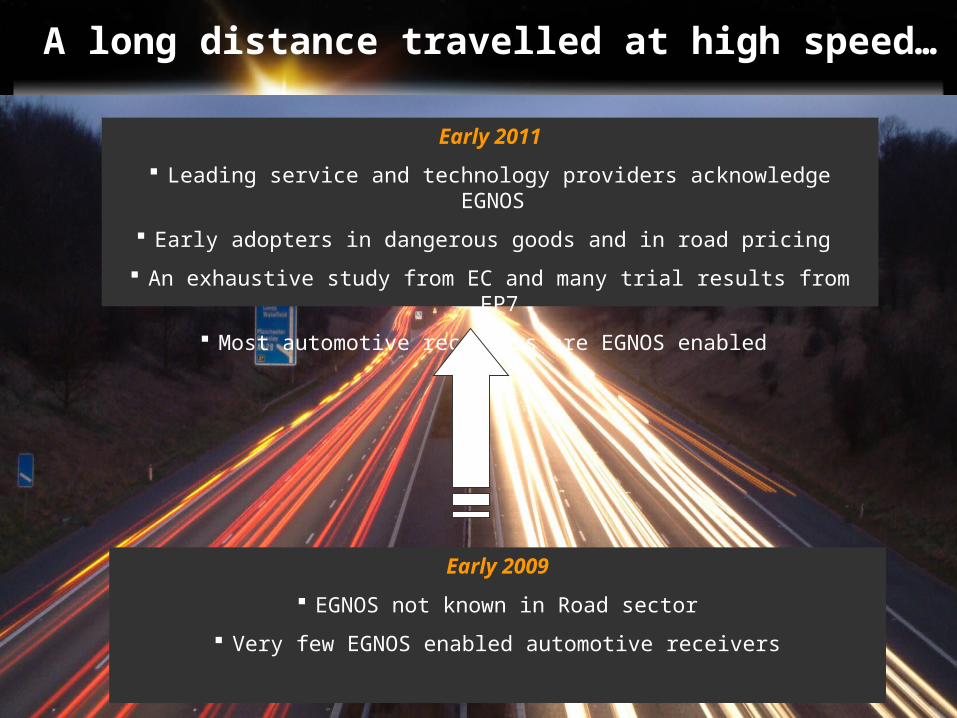
Early 2009
EGNOS not known in Road sector
Very few EGNOS enabled automotive receivers
Early 2011
Leading service and technology providers acknowledge EGNOS
Early adopters in dangerous goods and in road pricing
An exhaustive study from EC and many trial results from FP7
Most automotive receivers are EGNOS enabled
A long distance travelled at high speed…
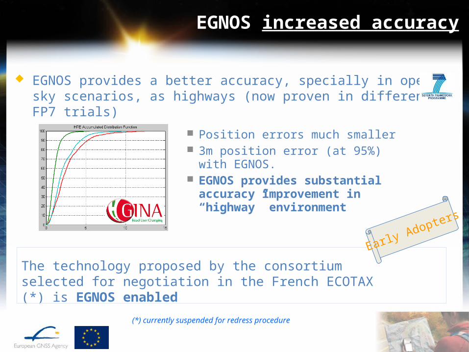
EGNOS increased accuracy
EGNOS provides a better accuracy, specially in open sky scenarios, as highways (now proven in different FP7 trials)
The technology proposed by the consortium selected for negotiation in the French ECOTAX (*) is EGNOS enabled
Early Adopters
Position errors much smaller 3m position error (at 95%) with
EGNOS. EGNOS provides substantial
accuracy improvement in “highway” environment
(*) currently suspended for redress procedure

EGNOS integrity
Operators (toll chargers, EETS, public authorities, logistic operators) have an increasing need to provide a guarantee of positioning
EGNOS integrity can be used to obtain a confidence level in the position
Potential applications: GNSS-based road pricing schemes (to prevent or manage claims), dangerous goods transport
Leading oil & gas company ENI is implementing EGNOS on all the fleet (1,500 trucks) and is experimenting the integrity in operational way.
Early Adopters
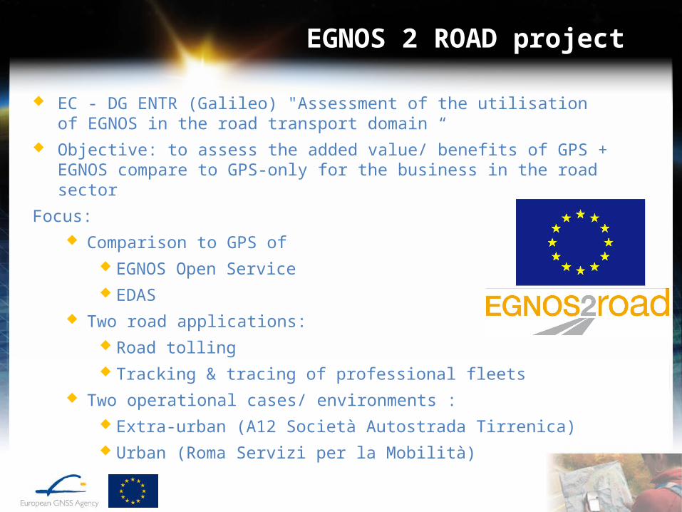
EGNOS 2 ROAD project
EC - DG ENTR (Galileo) "Assessment of the utilisation of EGNOS in the road transport domain “
Objective: to assess the added value/ benefits of GPS + EGNOS compare to GPS-only for the business in the road sector
Focus: Comparison to GPS of
EGNOS Open Service EDAS
Two road applications: Road tolling Tracking & tracing of professional fleets
Two operational cases/ environments : Extra-urban (A12 Società Autostrada Tirrenica) Urban (Roma Servizi per la Mobilità)
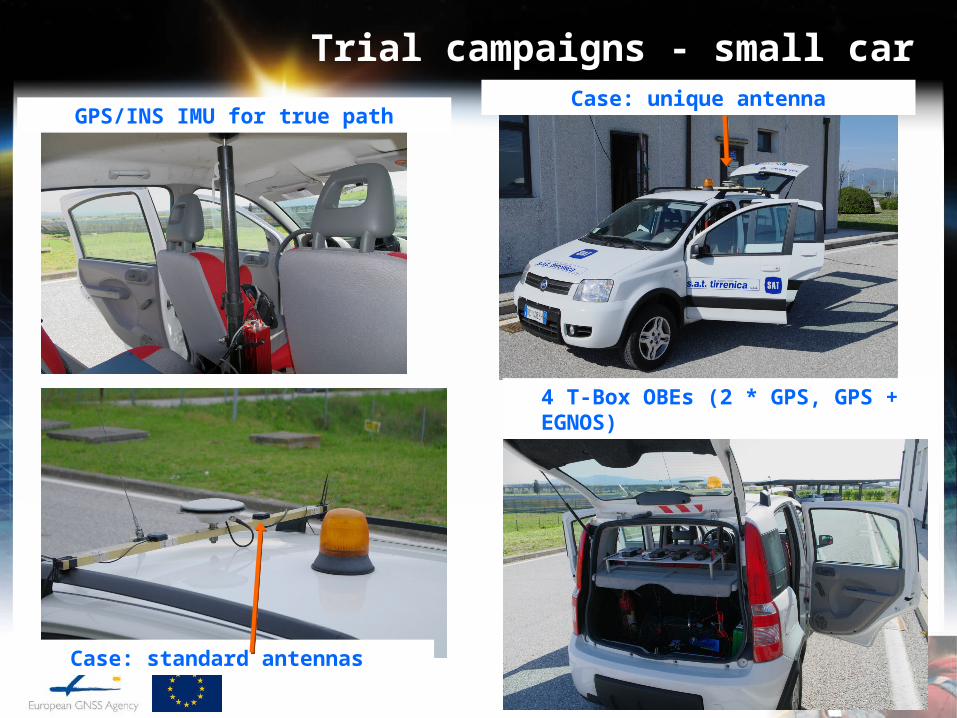
Trial campaigns - small car
GPS/INS IMU for true pathCase: unique antenna
Case: standard antennas
4 T-Box OBEs (2 * GPS, GPS + EGNOS)
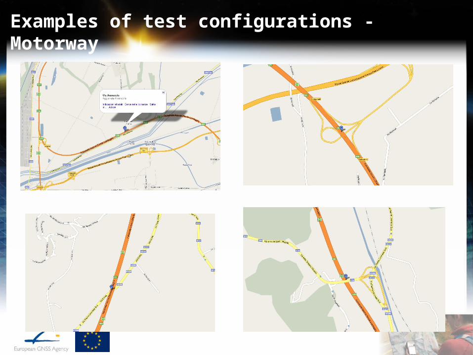
Examples of test configurations - Motorway

Roma Via di Monserrato
Example of test configuration in Roma

Roma Via di Ripetta

Roma Via di Panico
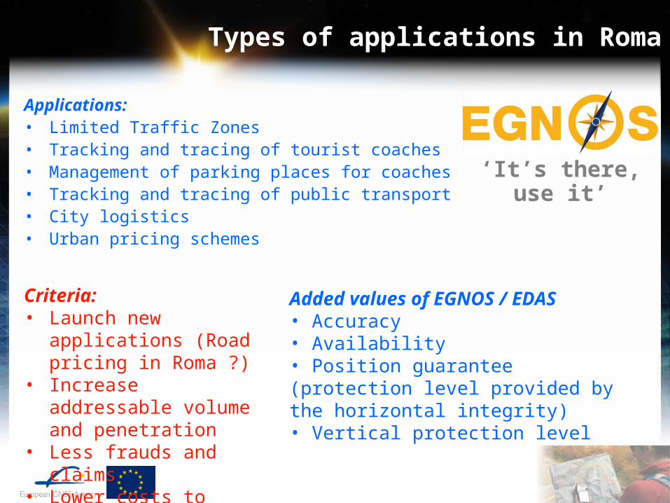
Types of applications in Roma
Applications:• Limited Traffic Zones• Tracking and tracing of tourist coaches• Management of parking places for coaches• Tracking and tracing of public transport• City logistics• Urban pricing schemes
Added values of EGNOS / EDAS• Accuracy• Availability• Position guarantee (protection level provided by the horizontal integrity)• Vertical protection level
‘It’s there, use it’
Criteria:• Launch new applications
(Road pricing in Roma ?)• Increase addressable
volume and penetration• Less frauds and claims• Lower costs to levy fees
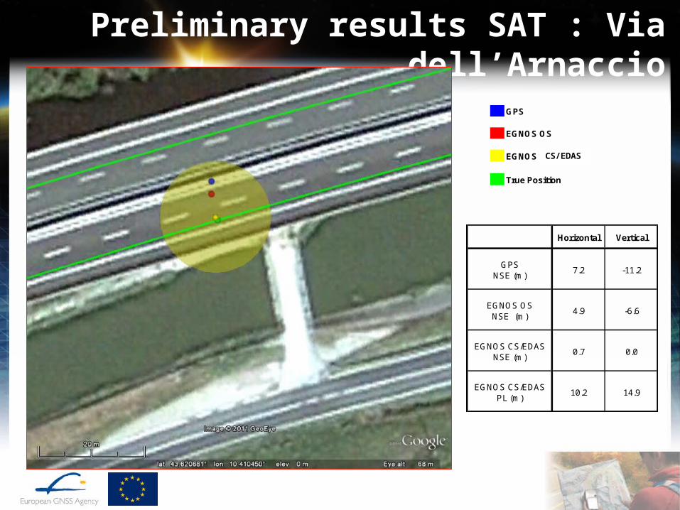
Preliminary results SAT : Via dell’Arnaccio
Horizontal Vertical
GPSNSE (m)
7.2 -11.2
EGNOS OSNSE (m)
4.9 -6.6
EGNOS CS/EDAS NSE (m)
0.7 0.0
EGNOS CS/EDASPL (m)
10.2 14.9
GPS
EGNOS OSEGNOS CS/EDAS from EGNOS OS receiver
True Position
CS/EDAS
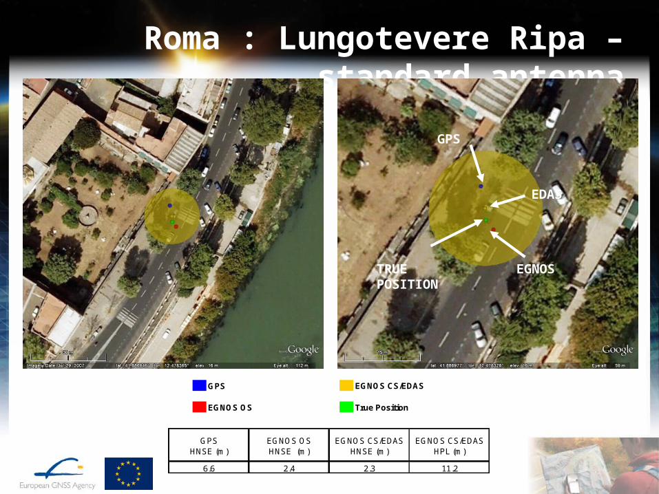
Roma : Lungotevere Ripa – standard antenna
GPS EGNOS CS/EDAS
EGNOS OS True Position
GPSHNSE (m)
EGNOS OSHNSE (m)
EGNOS CS/EDASHNSE (m)
EGNOS CS/EDASHPL (m)
6.6 2.4 2.3 11.2
GPS
EDAS
EGNOSTRUE POSITION
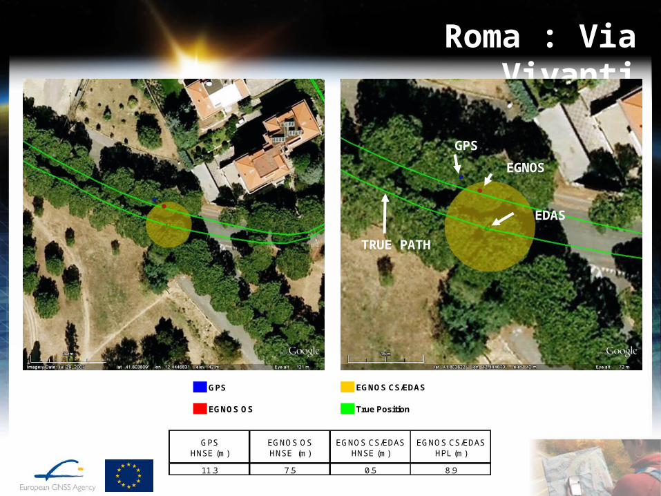
Roma : Via Vivanti
GPS EGNOS CS/EDAS
EGNOS OS True Position
GPSHNSE (m)
EGNOS OSHNSE (m)
EGNOS CS/EDASHNSE (m)
EGNOS CS/EDASHPL (m)
11.3 7.5 0.5 8.9
GPS
EGNOS
EDAS
TRUE PATH
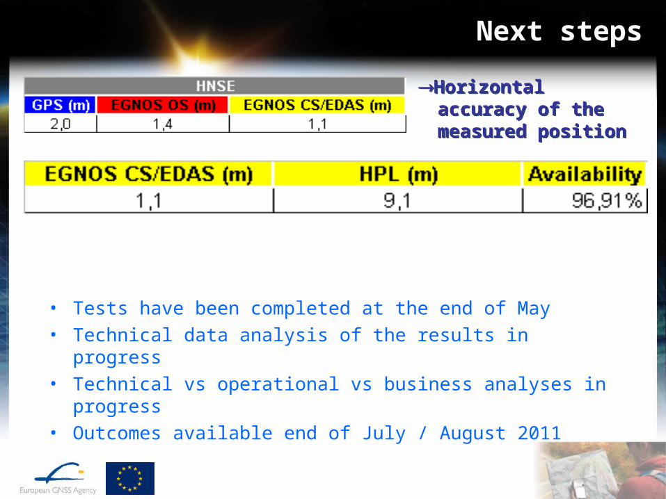
Next steps
• Tests have been completed at the end of May• Technical data analysis of the results in progress• Technical vs operational vs business analyses in progress• Outcomes available end of July / August 2011
Horizontal accuracy of the measured position
Horizontal accuracy of the measured position