Effects of measurement profile configuration on estimation ... · PDF fileEffects of...
10
NGM 2016 Reykjavik Proceedings of the 17 th Nordic Geotechnical Meeting Challenges in Nordic Geotechnic 25 th – 28 th of May IGS 327 NGM 2016 - Proceedings Effects of measurement profile configuration on estimation of stiffness profiles of loose post glacial sites using MASW E. Á. Ólafsdóttir Faculty of Civil and Environmental Engineering, University of Iceland, Reykjavík, Iceland, [email protected] S. Erlingsson, B. Bessason Faculty of Civil and Environmental Engineering, University of Iceland, Reykjavík, Iceland ABSTRACT Post glacial loose surface sediments are common in Iceland. Knowledge of the geotechnical prop- erties of these sites is essential in various civil engineering projects. The shear wave velocity is a key parameter in this sense. Multichannel Analysis of Surface Waves (MASW) is a new and advanced technique to estimate shear wave velocity profiles of soil sites. The MASW method has been applied at two loose sites close to Landeyjahöfn harbour in South Iceland. The MASW field measurements were performed using twenty-four 4.5 Hz geophones as receivers spaced between 0.5 and 2 m apart. A 6.3 kg sledgehammer and jumping were used as impact sources. For each receiver setup, up to seven different source offsets were used, ranging from 5 to 50 m. Fourier analysis and phase velocity scanning was applied to evaluate dispersion curves based on data acquired with diverse receiver setups in order to assess the effects of the receiver spacing and the source offset on the quality of the surface wave records. The results indicate that the configuration of the MASW measurement profile has a substantial effect on the acquired time series and that it is beneficial to combine dis- persion curves obtained from several different records which have been gathered at the same site prior to the inversion analysis. Keywords: Multichannel Analysis of Surface Waves (MASW), field measurements, measure- ment profile configuration, dispersion analysis, shear wave velocity. 1 INTRODUCTION Post glacial loose surface sediments of differ- ent nature are common in Iceland. Knowledge of the geotechnical properties of these sites is essential in various civil engineering projects. The shear wave velocity is a key parameter in this sense. The stiffness of individual soil lay- ers is directly proportional to the square of their characteristic shear wave velocity. Fur- thermore, the shear wave velocity is vital in both liquefaction potential and soil amplifica- tion assessments (Kramer, 1996) and when defining site specific earthquake design load- ing according to Eurocode 8 (CEN, 2004). For two decades, the seismic exploration method Spectral Analysis of Surface Waves (SASW) has been applied in Iceland to esti- mate the shear wave velocity and stiffness pro- files of soil sites (Bessason, Baldvinsson and Þórarinsson, 1998; Bessason and Erlingsson, 2011). The Multichannel Analysis of Surface Waves (MASW) is a relatively new and more advanced technique. Implementation of the MASW method in Iceland began in 2013 (Ólafsdóttir, Bessason and Erlingsson, 2015). The first MASW measurements were carried out in South Iceland and a new set of software tools for analysis of MASW field data is under development at the Faculty of Civil and Envi- ronmental Engineering, University of Iceland (Ólafsdóttir, 2016).
Transcript of Effects of measurement profile configuration on estimation ... · PDF fileEffects of...

NGM 2016 Reykjavik
Proceedings of the 17th Nordic Geotechnical Meeting
Challenges in Nordic Geotechnic 25th – 28th of May
IGS 327 NGM 2016 - Proceedings
Effects of measurement profile configuration on estimation of
stiffness profiles of loose post glacial sites using MASW
E. Á. Ólafsdóttir
Faculty of Civil and Environmental Engineering, University of Iceland, Reykjavík, Iceland,
S. Erlingsson, B. Bessason
Faculty of Civil and Environmental Engineering, University of Iceland, Reykjavík, Iceland
ABSTRACT
Post glacial loose surface sediments are common in Iceland. Knowledge of the geotechnical prop-
erties of these sites is essential in various civil engineering projects. The shear wave velocity is a
key parameter in this sense. Multichannel Analysis of Surface Waves (MASW) is a new and advanced
technique to estimate shear wave velocity profiles of soil sites. The MASW method has been applied
at two loose sites close to Landeyjahöfn harbour in South Iceland. The MASW field measurements
were performed using twenty-four 4.5 Hz geophones as receivers spaced between 0.5 and 2 m apart.
A 6.3 kg sledgehammer and jumping were used as impact sources. For each receiver setup, up to
seven different source offsets were used, ranging from 5 to 50 m. Fourier analysis and phase velocity
scanning was applied to evaluate dispersion curves based on data acquired with diverse receiver
setups in order to assess the effects of the receiver spacing and the source offset on the quality of
the surface wave records. The results indicate that the configuration of the MASW measurement
profile has a substantial effect on the acquired time series and that it is beneficial to combine dis-
persion curves obtained from several different records which have been gathered at the same site
prior to the inversion analysis.
Keywords: Multichannel Analysis of Surface Waves (MASW), field measurements, measure-
ment profile configuration, dispersion analysis, shear wave velocity.
1 INTRODUCTION
Post glacial loose surface sediments of differ-
ent nature are common in Iceland. Knowledge
of the geotechnical properties of these sites is
essential in various civil engineering projects.
The shear wave velocity is a key parameter in
this sense. The stiffness of individual soil lay-
ers is directly proportional to the square of
their characteristic shear wave velocity. Fur-
thermore, the shear wave velocity is vital in
both liquefaction potential and soil amplifica-
tion assessments (Kramer, 1996) and when
defining site specific earthquake design load-
ing according to Eurocode 8 (CEN, 2004).
For two decades, the seismic exploration
method Spectral Analysis of Surface Waves
(SASW) has been applied in Iceland to esti-
mate the shear wave velocity and stiffness pro-
files of soil sites (Bessason, Baldvinsson and
Þórarinsson, 1998; Bessason and Erlingsson,
2011). The Multichannel Analysis of Surface
Waves (MASW) is a relatively new and more
advanced technique. Implementation of the
MASW method in Iceland began in 2013
(Ólafsdóttir, Bessason and Erlingsson, 2015).
The first MASW measurements were carried
out in South Iceland and a new set of software
tools for analysis of MASW field data is under
development at the Faculty of Civil and Envi-
ronmental Engineering, University of Iceland
(Ólafsdóttir, 2016).

Geophysical testing and earhquake engineering
NGM 2016 - Proceedings 328 IGS
The objective of the study presented in this
paper is to develop and customise the new
MASW method. This includes evaluation of
the effects of the measurement profile config-
uration on the quality of the acquired surface
wave records, as well as further development
of the set of software tools used to carry out
the analysis of the MASW field data.
2 MASW
In MASW, Rayleigh waves are generated and
used to infer the shear wave velocity profile of
the test site as a function of depth (Park, Miller
and Xia, 1999). Compared to other available
methods, surface wave analysis methods are
low-cost, as well as being non-invasive and
environmentally friendly since they neither re-
quire heavy machinery nor leave lasting marks
on the surface of the test site.
The main advantages of the MASW
method over the SASW method include a
more efficient data acquisition routine in the
field, faster and less labour consuming data
processing procedures and improved identifi-
cation and elimination of noise from recorded
data (Park et al., 1999; Xia et al., 2002). Fur-
thermore, observation of stiffness properties
as a function of both depth and surface loca-
tion becomes possible and economically fea-
sible by using MASW (Xia, Miller, Park and
Ivanov, 2000). Finally, it is possible to map
significantly deeper shear wave velocity pro-
files when using the same impulsive source,
i.e. a reasonably heavy sledgehammer. The
observed difference between results obtained
by MASW and direct borehole measurements
is approximately 15% or less and random (Xia
et al., 2002).
The maximum depth of investigation in a
MASW survey varies with site, the natural fre-
quency of the geophones that are used in the
field measurements and the type of seismic
source that is used. The investigation depth is
determined by the longest Rayleigh wave
wavelength that is obtained during data acqui-
sition. A commonly adopted empirical crite-
rion (Park and Carnevale, 2010) is that:
𝑧𝑚𝑎𝑥 ≈ 0.5𝜆𝑚𝑎𝑥 (1)
where 𝑧𝑚𝑎𝑥 (m) is the investigation depth and
𝜆𝑚𝑎𝑥 (m) is the longest wavelength.
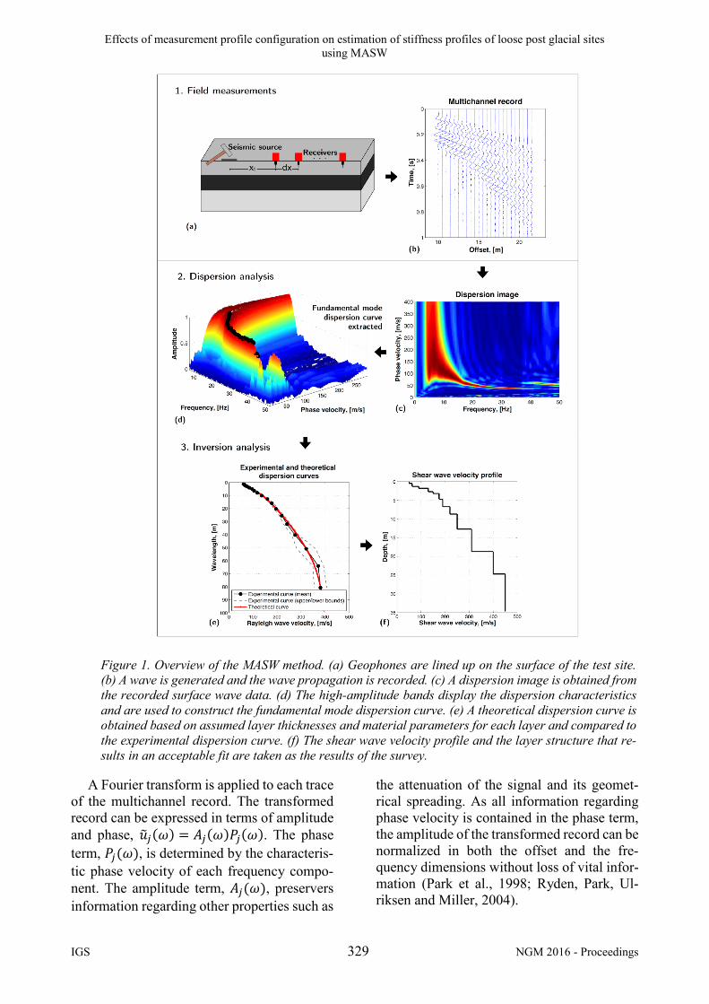
MASW surveys can be broken down into
three steps; field measurements, dispersion
analysis and inversion analysis (Park et al.,
1999). A general overview of the three-step
procedure is provided in Fig. 1.
2.1 Field measurements
For field measurements, low frequency geo-
phones are lined up on the surface of the test
site as shown in Fig. 1a. For active MASW
surveys (Park, Miller, Xia and Ivanov, 2007),
which are the focus of this study, a wave is
generated by an impulsive source that is ap-
plied at one end of the measurement profile.
The geophones record the resulting wave
propagation as a function of time (Fig. 1b).
The distance from the impact load point to the
first receiver in the geophone line up is re-
ferred to as the source offset and denoted by
𝑥1 (see Fig. 1a). The receiver spacing is 𝑑𝑥
and the number of receivers is 𝑛. Hence, the
length of the receiver spread is 𝐿 = (𝑛 − 1)𝑑𝑥
and the total length of the measurement profile
is 𝐿𝑇 = 𝑥1 + (𝑛 − 1)𝑑𝑥.
2.2 Dispersion analysis
In the dispersion analysis, Rayleigh wave dis-
persion curves are obtained using the recorded
time series. Here, the so-called phase shift
method (Park, Miller and Xia, 1998) is em-
ployed to obtain a dispersion image (a phase
velocity spectrum). The dispersion image vis-
ualizes the dispersion properties of all types of
waves contained in the recorded time series in
the frequency – phase velocity domain. Dif-
ferent modes of Rayleigh waves are recog-
nized by their frequency content and charac-
terizing phase velocity at each frequency.
Noise sources, e.g. body waves and re-
flected/scattered waves, are likewise recog-
nized by their frequency content.
The phase shift method can be divided into
three steps; Fourier transformation and ampli-
tude normalization, dispersion imaging and
extraction of dispersion curves (Park et al.,
1998). The three main data processing steps
are illustrated in Fig. 2 and briefly described
below.
Effects of measurement profile configuration on estimation of stiffness profiles of loose post glacial sites
using MASW
IGS 329 NGM 2016 - Proceedings
A Fourier transform is applied to each trace
of the multichannel record. The transformed
record can be expressed in terms of amplitude
and phase, �̃�𝑗(𝜔) = 𝐴𝑗(𝜔)𝑃𝑗(𝜔). The phase
term, 𝑃𝑗(𝜔), is determined by the characteris-
tic phase velocity of each frequency compo-
nent. The amplitude term, 𝐴𝑗(𝜔), preservers
information regarding other properties such as
the attenuation of the signal and its geomet-
rical spreading. As all information regarding
phase velocity is contained in the phase term,
the amplitude of the transformed record can be
normalized in both the offset and the fre-
quency dimensions without loss of vital infor-
mation (Park et al., 1998; Ryden, Park, Ul-
riksen and Miller, 2004).
Figure 1. Overview of the MASW method. (a) Geophones are lined up on the surface of the test site.
(b) A wave is generated and the wave propagation is recorded. (c) A dispersion image is obtained from
the recorded surface wave data. (d) The high-amplitude bands display the dispersion characteristics
and are used to construct the fundamental mode dispersion curve. (e) A theoretical dispersion curve is
obtained based on assumed layer thicknesses and material parameters for each layer and compared to
the experimental dispersion curve. (f) The shear wave velocity profile and the layer structure that re-
sults in an acceptable fit are taken as the results of the survey.

Geophysical testing and earhquake engineering
NGM 2016 - Proceedings 330 IGS
Figure 2. Overview of the phase shift method.
For a given testing phase velocity (𝑉𝑅,𝑇)
and a given frequency (𝜔), the amount of
phase shifts required to counterbalance the
time delay corresponding to specific offsets
are determined. The phase shifts (determined
in step 4 in Fig. 2 for a given testing phase ve-
locity) are applied to distinct traces of the
transformed record that are thereafter added to
obtain the slant-stacked amplitude corre-
sponding to each pair of 𝜔 and 𝑉𝑅,𝑇 (Park et
al., 1998; Ryden et al., 2004). This is repeated
for all the different frequency components of
the transformed record in a scanning manner,
changing the testing phase velocity in small
increments. The dispersion image is obtained
by plotting the summed amplitude in the fre-
quency – phase velocity domain (Fig. 1c). The
high-amplitude bands, which are indicated by
the height of the peaks and/or a colour scale,
display the dispersion characteristics of the
recorded surface waves (Fig. 1d) and are used
to construct the fundamental mode dispersion
curve for the site (Park et al., 1998; Ryden et
al., 2004). Noise is usually automatically re-
moved in this process (Park et al., 2007).
The quality of the acquired surface wave
records can be evaluated in terms of the reso-
lution of the phase velocity spectrum, i.e. the
sharpness of the amplitude peaks observed at
each frequency, the extractable frequency
range and the continuity of the fundamental
mode high-amplitude band.
2.3 Inversion analysis
The third step of the MASW method is to ob-
tain a shear wave velocity profile by inversion
of the fundamental mode dispersion curve.
Computations are based on Rayleigh wave
propagation theory assuming a plane-layered
elastic earth model. The last layer is assumed
to be a half-space.
Inversion problems involving the disper-
sion of Rayleigh waves in a layered medium
must be solved by iterative methods due to
their non-linearity. A theoretical dispersion
curve is obtained based on an assumed num-
ber and thickness of soil layers and assumed
material parameters for each layer. For a lay-
ered earth model, the shear wave velocity pro-
file has a dominant effect on the fundamental
mode dispersion curve (Xia, Miller and Park,
1999). Theoretical dispersion curves are in
most cases determined by matrix methods that
originate in the work of Thomson (1950) and
Haskell (1953). Here, the stiffness matrix
method, developed by Kausel and Roësset
(1981), is used for computations of theoretical
dispersion curves (Fig. 1e).
A simple local search method is employed
to fit observations with theoretical predictions
from assumed soil models (Ólafsdóttir, 2016).
A layered soil model is suggested where the
thickness of the layers increases with depth.
The initial value of the shear wave velocity for
each layer is estimated from the measured dis-
persion curve. It is based on the ratio between
the propagation velocities of Rayleigh waves
and shear waves in a homogeneous medium,
and a simple relation between Rayleigh wave
wavelength and representative depth (Kramer,
1996; Park et al., 1999). Other model parame-
ters, i.e. Poisson’s ratio (or the compressional
wave velocity) and the mass density of each
layer, are either estimated based on independ-
ent soil investigations or on experience of sim-
ilar soil types from other sites. The shear wave
velocity of each layer is updated during the in-
version process while all other model parame-
ters are kept unchanged. In each iteration, the
misfit between the theoretical dispersion

Effects of measurement profile configuration on estimation of stiffness profiles of loose post glacial sites
using MASW
IGS 331 NGM 2016 - Proceedings
curve and the experimental dispersion curve is
evaluated in terms of the root-mean-square
(RMS) error between the theoretical and ex-
perimental Rayleigh wave phase velocities.
The shear wave velocities obtained by this ap-
proach, along with the layer thicknesses, are
then used to represent the soil profile at the
survey site (Fig. 1f).
2.4 Measurement profile configuration
It is commonly recognised that the configura-
tion of the MASW measurement profile can
affect the quality of the surface wave records
that are obtained (Park and Carnevale, 2010;
Park, Miller and Miura, 2002; Park, Miller and
Xia, 2001). The main parameters related to the
setup of the measurement profile are the
length of the receiver spread (or the receiver
spacing if a fixed number of geophones is
used) and the source offset.
The length of the receiver spread is related
to the longest Rayleigh wave wavelength that
is obtained during data acquisition and there-
fore also related to the maximum depth of in-
vestigation:
𝜆𝑚𝑎𝑥 ≈ 𝐿 (2)
where 𝜆𝑚𝑎𝑥 (m) is the longest wavelength and
𝐿 (m) is the length of the receiver spread.
Attempts to analyse longer wavelengths
than indicated by Eq. (2) can lead to less accu-
rate results. A recent study has shown that the
fluctuating inaccuracy will although be within
5% for 𝐿 ≤ 𝜆𝑚𝑎𝑥 ≤ 2𝐿 (Park and Carnevale,
2010).
The minimum source offset required to
avoid undesirable near-field effects, i.e. the
risk of non-planar surface waves being picked
up by the receivers, depends on the longest
wavelength that is analysed. It is commonly
regarded that plane-wave propagation of sur-
face waves first occurs when the source offset
is greater than half the longest wavelength.
However, studies have shown that this crite-
rion can be relaxed significantly for MASW
surveys (Park et al., 1999; 2002).
3 MASW FIELD MEASUREMENTS
MASW field measurements were carried out
in August 2014 at two test sites at Bakkafjara
in South Iceland, referred to as sites B1 and
B2 (see Fig. 3). The soil at Bakkafjara is
mainly uniformly graded dark basalt sand.
The groundwater table is estimated to be at a
4.0 m depth (Ólafsdóttir, 2016).
Figure 3. Location of MASW field measurements
at Bakkafjara in South Iceland. Data were ac-
quired at two test sites, referred to as test site B1
and test site B2.
The field measurements at Bakkafjara were
performed using twenty-four 4.5 Hz geo-
phones as receivers. A 6.3 kg sledgehammer
and a single jump at the end of the measure-
ment profile were used as impact sources. At
each test site, three receiver spreads with the
same midpoint but different receiver spacing,
i.e. 𝑑𝑥 ∈ {0.5, 1.0, 2.0} m, were tested.

Geophysical testing and earhquake engineering
NGM 2016 - Proceedings 332 IGS
(a) x1 = 10.0 m. (b) x1 = 20.0 m. (c) x1 = 30.0 m.
Figure 4. Change in spectral resolution with length of source offset. Top. Typical dispersion images ob-
tained at Bakkafjara test site B2 with a receiver spread of length L = 23.0 m (dx = 1.0 m) and a source
offset of (a) x1 = 10.0 m, (b) x1 = 20.0 m and (c) x1 = 30.0 m. A 6.3 kg sledgehammer was used
as an impact source. Middle/bottom: Cross sections through the dispersion images at f = 20 Hz and
f = 40 Hz. The location of the cross sections is indicated by vertical lines in Fig. 4 (top).
(a) x1 = 10.0 m. (b) x1 = 20.0 m. (c) x1 = 40.0 m.
Figure 5. Change in spectral resolution with length of source offset. Top. Typical dispersion images ob-
tained at Bakkafjara test site B2 with a receiver spread of length L = 46.0 m (dx = 2.0 m) and a source
offset of (a) x1 = 10.0 m, (b) x1 = 20.0 m and (c) x1 = 40.0 m. A 6.3 kg sledgehammer was used as an
impact source. Bottom: Cross sections through the dispersion images at f = 30 Hz.

Effects of measurement profile configuration on estimation of stiffness profiles of loose post glacial sites
using MASW
IGS 333 NGM 2016 - Proceedings
For each receiver setup, up to seven source
offsets in the range of 5 m to 50 m were used.
No systematic difference was observed be-
tween surface wave records where the impact
load was created by a sledgehammer and
where it was created by a jump.
3.1 Observed effects of measurement profile
configuration at Bakkafjara
Typical dispersion images of records acquired
at the Bakkafjara test site B2 with receiver
spreads of fixed length (23.0 m in Fig. 4 and
46.0 m in Fig. 5) but with source offsets of
various lengths are shown in Figs. 4 (top) and
5 (top). A 6.3 kg sledgehammer was used as
an impact source in all cases. Figures 4 and 5
(middle and bottom) show the variation of the
amplitude band with Rayleigh wave phase ve-
locity at frequencies 20 and 40 Hz (Fig. 4) and
30 Hz (Fig. 5). The amplitude band is normal-
ized such that the maximum amplitude at each
frequency is one. The highest peaks corre-
spond in all cases to the identified fundamen-
tal mode.
The results presented in Figs. 4 and 5 indi-
cate that the length of the source offset did not
have a strong effect on the sharpness of the
amplitude peaks. The same was observed
based on data acquired at the Bakkafjara test
site B1. However, for a given length of the re-
ceiver spread, an increased length of the
source offset tended to cause increased dis-
turbances in the spectral high-amplitude band.
Moreover, the presence of overtones and/or
other noise became more evident in the higher
frequency range of the phase velocity spec-
trum with increasing source offset.
Figure 6 (top) shows typical dispersion im-
ages obtained at test site B2 with receiver
spreads of length (a) 11.5 m, (b) 23.0 m and
(c) 46.0 m. The source offset was 5.0 m in all
cases. The impact load was created by a
sledgehammer. Cross sections through the dis-
persion images at frequencies 20 and 40 Hz
(a) L = 11.5 m (dx = 0.5 m). (b) L = 23.0 m (dx = 1.0 m). (c) L = 46.0 m (dx = 2.0 m).
Figure 6. Change in spectral resolution with length of receiver spread. Top. Typical dispersion images
obtained at Bakkafjara test site B2 with receiver spreads of length (a) L = 11.5 m, (b) L = 23.0 m and (c)
L = 46.0 m. The source offset is x1 = 5.0 m in all cases. A 6.3 kg sledgehammer was used as an impact
load. Middle/bottom: Cross sections through the dispersion images at f = 20 Hz and f = 40 Hz.

Geophysical testing and earhquake engineering
NGM 2016 - Proceedings 334 IGS
are shown in Fig. 6 (middle and bottom). The
highest peaks correspond to the fundamental
mode.
Based on the results presented in Fig. 6, the
length of the receiver spread had a substantial
effect on the resolution of the dispersion im-
age. In general, by lengthening the receiver
spread (i.e. increasing the receiver spacing and
keeping the number of geophones used for re-
cording unchanged), the fundamental mode
high-amplitude peaks appeared sharper and
better separation of overtones was observed.
The same was noticed by analysis of surface
wave records acquired at test site B1. At the
Bakkafjara test sites, records acquired with a
46.0 m long receiver spread allowed in general
extraction of the fundamental mode dispersion
curve at lower frequencies than records ac-
quired with receiver spreads of length 11.5 m
or 23.0 m. However, the dispersion images
presented in Fig. 6 (top) indicate that in-
creased length of the receiver spread tended to
have a negative effect on the continuity of the
fundamental mode high-amplitude band, es-
pecially in the higher frequency range, which
counteracted to some extent the benefits of in-
creasing the length of the receiver spread.
4 DISCUSSION
Based on the results acquired at the Bakkafjara
test sites, dispersion images of records ac-
quired with a short receiver spread and/or a
short/medium-length source offset showed in
most cases a relatively unbroken fundamental
mode high-amplitude band and allowed iden-
tification and extraction of the fundamental
mode dispersion curve in the higher frequency
range. Hence, time series recorded by a rela-
tively short measurement profile provided in
general the most information about the disper-
sion properties of the short wavelength wave
components that propagated through the top-
most soil layers.
The high-amplitude band observed in a dis-
persion image acquired with a short receiver
spread can be very wide, especially at the low-
and mid-range frequencies. The low spectral
resolution can cause difficulties in identifica-
tion of the spectral peak values, which risks
less accurate dispersion curves. In general, by
lengthening the receiver spread, the observed
spectral resolution increases, which facilitates
the identification and the extraction of the fun-
damental mode dispersion curve, especially in
the lower frequency range. Hence, the study
found that time series recorded by long re-
ceiver spreads tended to provide the most in-
vestigation depth.
The observed effects of the data acquisition
parameters suggest that an increased range in
investigation depth can be obtained by com-
bining dispersion curves acquired with meas-
urement profiles of different lengths. Further-
more, combining several dispersion curves
creates possibilities to estimate the accuracy
of the extraction process, to compensate for
segments of missing data in the extracted dis-
persion curves and to diminish the effect of
poor quality surface wave records without the
analyst having to selectively choose records
for further analysis.
The dispersion analysis software tool that
is under development includes a special algo-
rithm to obtain an average experimental dis-
persion curve, along with upper and lower
boundary curves (Ólafsdóttir, 2016). The av-
erage dispersion curve is obtained by grouping
data points from multiple dispersion curves to-
gether within 1/3 octave wavelength intervals.
All phase velocity values within each interval
are added up and their mean used as an esti-
mate of the phase velocity of Rayleigh wave
components belonging to the given wave-
length range. Upper and lower boundaries for
the average dispersion curve are obtained us-
ing the standard deviation of the values within
each wavelength band. The average dispersion
curve, along with its upper and lower bounda-
ries, is subsequently used as an input in the in-
version analysis.
The average experimental dispersion
curves obtained for the Bakkafjara test sites
B1 and B2 by using the aforementioned meth-
odology are shown in Figs. 7a and 8a. The up-
per and lower bounds correspond to plus/mi-
nus one standard deviation of the average
curve. Inversion was then used to obtain the
shear wave velocity profiles for the sites (see
Figs. 7b and 8b).

Effects of measurement profile configuration on estimation of stiffness profiles of loose post glacial sites
using MASW
IGS 335 NGM 2016 - Proceedings
Figure 7. (a) Comparison of experimental and the-
oretical dispersion curve based on inversion. (b)
The estimated shear wave velocity profile for the
Bakkafjara test site B1.
Figure 8. (a) Comparison of experimental and the-
oretical dispersion curve based on inversion. (b)
The estimated shear wave velocity profile for the
Bakkafjara test site B2.
5 CONCLUSIONS AND SUMMARY
MASW is a relatively new seismic exploration
method to estimate the shear wave velocity
profile of near-surface materials. MASW
measurements have been carried out at two
test sites at Bakkafjara in South Iceland using
twenty-four 4.5 Hz geophones for recording.
For each receiver setup, up to seven different
source offsets were used, ranging from 5 m to
50 m. Dispersion analysis was then applied to
evaluate a phase velocity spectrum and a dis-
persion curve based on each surface wave rec-
ord that was acquired.
The results indicated that the configuration
of the MASW measurement profile had a sub-
stantial effect on the acquired surface wave
data. Records obtained using a relatively short
measurement profile provided in general the
most information about the dispersion proper-
ties of the short wavelength wave components
that propagated through the top-most soil lay-
ers. However, time series recorded by long re-
ceiver spreads provided in general the most in-
vestigation depth. The observations are in ac-
cordance to existing recommendations where
the obtainable investigation depth is suggested
to be directly related to the length of the re-
ceiver spread.
Analysis of the dispersion images and the
dispersion curves indicated that it is beneficial
to combine results from several measurements
which have been carried out using measure-
ment profiles of different lengths prior to the
inversion analysis. A new algorithm has been
developed to compute an average experi-
mental dispersion curve, along with upper and
lower boundaries, by adding up dispersion
curves obtained based on multiple surface
wave registrations. The new data processing
procedure has been applied to the data ac-
quired at the Bakkafjara test sites to evaluate
average dispersion curves for wavelengths up
to 80 m.
Optimum values of measurement profile
setup parameters for MASW surveys are to
some extent documented in references. An ef-
fort is though necessary to collect more infor-
mation about the optimal setup, since there are
many site-specific factors that may affect the
setup, for instance the depth to bedrock and
the soil type. Future research topics include
further and more detailed analysis of the ef-
fects of the measurement profile configuration
and development of guidelines for the setup of
the measurement profile(s) and the execution
of the MASW measurements in the field.
6 ACKNOWLEDGEMENTS
The project is financially supported by grants
from the University of Iceland Research Fund,
the Icelandic Road and Costal Administration
and the Energy Research Fund of the National
Power Company of Iceland.

Geophysical testing and earhquake engineering
NGM 2016 - Proceedings 336 IGS
7 REFERENCES
Bessason, B., Baldvinsson, G. I., & Þórarinsson, Ó.
(1998). SASW for evaluation of site-specific earth-
quake excitation. Proceedings of the 11th European
Conference on Earthquake Engineering, CD-ROM,
Paris.
Bessason, B., & Erlingsson, S. (2011). Shear wave
velocity in surface sediments. Jökull, 61, 51-64.
CEN. (2004). EN1998-1:2004, Eurocode 8: Design
of structures for earthquake resistance - Part 1: General
rules, seismic actions and rules for buildings. Brussels:
European Committee for Standardization.
Haskell, N. A. (1953). The dispersion of surface
waves on multilayered media. Bulletin of Seismologi-
cal Society of America, 43(1), 17-34.
Kausel, E., & Roësset, J. M. (1981). Stiffness matri-
ces for layered soils. Bulletin of the Seismological So-
ciety of America, 71(6), 1743-1761.
Kramer, S. L. (1996). Geotechnical Earthquake En-
gineering. Upper Saddle River, NJ: Prentice Hall.
Ólafsdóttir, E. Á, Bessason, B. & Erlingsson S
(2015). MASW for assessing liquefaction of loose sites.
Proceedings of the 16th European Conference on Soil
Mechancis and Geotechnical Engineering, 13-17 Sep-
tember 2015, Edinburgh, UK.
Ólafsdóttir, E. Á. (2016). Multichannel Analysis of
Surface Waves for assessing soil stiffness. (Un-
published master’s thesis). Faculty of Civil and Envi-
ronmental Engineering, University of Iceland, Rey-
kjavík, Iceland.
Park, C. B., Miller, R. D., & Xia, J. (1998). Imaging
dispersion curves of surface waves on multichannel rec-
ord. 68th Annual International Meeting Society of Ex-
ploration Geophysicists, Expanded Abstracts, 1377-
1380.
Park, C. B., Miller, R. D., & Xia, J. (1999). Multi-
channel analysis of surface waves. Geophysics, 64(3),
800-808.
Park, C. B., Miller, R. D., & Xia, J. (2001). Offset
and resolution of dispersion curve in multichannel anal-
ysis of surface waves (MASW). Proceedings of the
Symposium on the Application of Geophysics to Engi-
neering and Environmental Problems (SAGEEP 2001),
Denver, Colorado, SSM-4.
Park, C. B., Miller, R. D., & Miura, H. (2002). Op-
timum field parameters of an MASW survey. Expanded
Abstracts, SEG-J, Tokyo, May 22-23, 2002.
Park, C. B., Miller, R. D., Xia, J., & Ivanov, J.
(2007). Multichannel analysis of surface waves
(MASW) - active and passive methods. The Leading
Edge, 26(1), 60-64.
Park, C. B., & Carnevale, M. (2010). Optimum
MASW Survey - Revisit after a Decade of Use. In
Fratta, D. O., Puppala, A. J., & Muhunthan, B. (editors),
GeoFlorida 2010: Advences in Analysis, Modeling and
Design,1303-1312. doi: 10.1061/41095(365)130.
Ryden, N., Park, C. B., Ulriksen, P., & Miller, R. D.
(2004). Multimodal approach to seismic pavement test-
ing. Journal of Geotechnical and Geoenvironmental En-
gineering, 130, 636-645.
Thomson, W. T. (1950). Transmission of elastic
waves through a stratified solid medium. Journal of Ap-
plied Physics, 21(2), 89-93.
Xia, J., Miller, R. D., & Park, C. B. (1999). Estima-
tion of near-surface shear-wave velocity by inversion of
Rayleigh waves. Geophysics, 64(3), 691-700.
Xia, J., Miller, R. D., Park, C. B., & Ivanov, J.
(2000). Construction of 2-D vertical shear-wave veloc-
ity field by the multichannel analysis of surface waves
technique. Proceeding of the Symposium of the Appli-
cation of Geophysics to Engineering Environmental
Problems (SAGEEP 2000) Arlington, VA., February
20-24, 1197-1206.
Xia, J., Miller, R. D., Park, C. B., Hunter, J. A., Har-
ris, J. B., & Ivanov, J. (2002). Comparing shear-wave
velocity profiles from multichannel analysis of surface
wave with borehole measurements. Soil Dynamics and
Earthquake Engineering, 22(3), 181- 190.