Effective Date: January 15, 2009 Report Date: May 28,...
89
Effective Date: January 15, 2009 Report Date: May 28, 2009 2009 MINERAL RESOURCE UPDATE Ruby Creek Molybdenum Project in Northern British Columbia, Canada REPORT Project Number: 08-1439-0011 Distribution: 1 Electronic Copy - Adanac Molybdenum Corporation 2 Copies - Adanac Molybdenum Corporation 2 Copies - Golder Associates, Ltd. Submitted to: Adanac Molybdenum Corporation 200 - 2055 152nd Street Surrey, BC V4A 4N7 Attention: Mr. Christopher Kirby, President and Chief Executive Officer Prepared by: Kevin Palmer, P.Geo.
Transcript of Effective Date: January 15, 2009 Report Date: May 28,...

Effective Date: January 15, 2009 Report Date: May 28, 2009
2009 MINERAL RESOURCE UPDATE
Ruby Creek Molybdenum Project in Northern British Columbia, Canada
REP
OR
T
Project Number: 08-1439-0011
Distribution:
1 Electronic Copy - Adanac Molybdenum Corporation 2 Copies - Adanac Molybdenum Corporation 2 Copies - Golder Associates, Ltd.
Submitted to:Adanac Molybdenum Corporation 200 - 2055 152nd Street Surrey, BC V4A 4N7 Attention: Mr. Christopher Kirby, President and Chief Executive Officer
Prepared by: Kevin Palmer, P.Geo.

RUBY CREEK DEPOSIT MINERAL RESOURCE UPDATE - 2009
Effective Date: January 15, 2009 Report Date: May 28, 2009 Project No. 08-1439-0011 i
Table of Contents
1.0 SUMMARY ........................................................................................................................................................................ 1
1.1 Scope of work ...................................................................................................................................................... 1
1.2 Property Tenure ................................................................................................................................................... 1
1.3 Property Location and Site Description ................................................................................................................ 2
1.4 Geology and Mineralization .................................................................................................................................. 2
1.5 Exploration Concept ............................................................................................................................................. 3
1.6 Status of Exploration ............................................................................................................................................ 3
1.7 Development and Operations .............................................................................................................................. 3
1.8 Author’s Conclusions and Recommendations ...................................................................................................... 3
2.0 INTRODUCTION ............................................................................................................................................................... 6
3.0 RELIANCE ON OTHER EXPERTS ................................................................................................................................... 7
4.0 PROPERTY DESCRIPTION AND LOCATION ................................................................................................................. 8
4.1 Property Area and Location ................................................................................................................................. 8
4.2 Mineral Tenure ..................................................................................................................................................... 8
4.3 Property Boundaries .......................................................................................................................................... 10
4.4 Location of Mineralized Zones ........................................................................................................................... 11
4.5 Royalties and Other Agreements ....................................................................................................................... 11
4.6 Environmental Liabilities and Other Permits ...................................................................................................... 11
5.0 ACCESSIBILITY, CLIMATE, LOCAL RESOURCES, INFRASTRUCTURE AND PHYSIOGRAPHY ............................ 12
5.1 Accessibility and Infrastructure .......................................................................................................................... 12
5.2 Climate, Vegetation and Physiography .............................................................................................................. 14
6.0 HISTORY......................................................................................................................................................................... 15
6.1 Ownership and Exploration History .................................................................................................................... 15
6.2 Historical Resources and Reserves ................................................................................................................... 16
6.3 Production .......................................................................................................................................................... 17
7.0 GEOLOGICAL SETTING ................................................................................................................................................ 18
7.1 Regional Scale ................................................................................................................................................... 18
7.2 Property Scale ................................................................................................................................................... 20

RUBY CREEK DEPOSIT MINERAL RESOURCE UPDATE - 2009
Effective Date: January 15, 2009 Report Date: May 28, 2009 Project No. 08-1439-0011 ii
7.2.1 Lithology ....................................................................................................................................................... 20
7.2.2 Structure ....................................................................................................................................................... 23
7.2.3 Alteration ...................................................................................................................................................... 23
8.0 DEPOSIT TYPE .............................................................................................................................................................. 24
8.1 General Classification ........................................................................................................................................ 24
8.2 Characteristics of the Ruby Creek Deposit ........................................................................................................ 25
9.0 MINERALIZATION .......................................................................................................................................................... 26
9.1 Characteristics of the mineralized vein sets ....................................................................................................... 27
9.2 Description of the different mineralized areas .................................................................................................... 28
9.2.1 Underground working area ........................................................................................................................... 28
9.2.2 Northern area ............................................................................................................................................... 28
9.2.3 Central Deposit Area .................................................................................................................................... 29
10.0 EXPLORATION ............................................................................................................................................................... 30
10.1 Drilling ................................................................................................................................................................ 30
10.1.1 2004 Drilling ................................................................................................................................................. 30
10.1.2 2005 Drilling ................................................................................................................................................. 30
10.1.3 2006 Drilling ................................................................................................................................................. 30
10.1.4 2007-2008 Drilling ........................................................................................................................................ 30
10.2 Drill Hole Surveys ............................................................................................................................................... 31
11.0 DRILLING ........................................................................................................................................................................ 33
11.1 Adanac 2004-2006 Drilling Programs ................................................................................................................ 33
11.2 Adanac 2007 Drilling Program ........................................................................................................................... 34
11.3 Adanac 2008 Drilling Program ........................................................................................................................... 35
11.4 Interpretation of Drilling Data ............................................................................................................................. 36
11.4.1 Development of the Main Mineralized Zone ................................................................................................. 36
11.4.2 Development of the North Zone ................................................................................................................... 37
11.4.3 Development of the Central Higher-grade Zone ........................................................................................... 37
11.4.4 Results of the Condemnation Holes Drilling Program .................................................................................. 37
12.0 SAMPLING METHOD AND APPROACH ....................................................................................................................... 39
12.1 Pre-2004 Sampling Programs ............................................................................................................................ 39

RUBY CREEK DEPOSIT MINERAL RESOURCE UPDATE - 2009
Effective Date: January 15, 2009 Report Date: May 28, 2009 Project No. 08-1439-0011 iii
12.2 Adanac 2004-2006 Sampling Programs ............................................................................................................ 39
12.2.1 Core logging and Sampling Procedures ....................................................................................................... 39
12.2.2 Samples Collection ....................................................................................................................................... 39
12.2.3 Sample Quality and Recovery Factors ......................................................................................................... 40
12.3 Adanac 2007-2008 Sampling Programs ............................................................................................................ 41
12.3.1 Core Logging and Sampling Procedures ...................................................................................................... 41
12.3.2 Sample Collection ........................................................................................................................................ 41
13.0 SAMPLE PREPARATION, ANALYSES AND SECURITY ............................................................................................. 43
13.1 Field Sample Preparation Procedures ............................................................................................................... 43
13.1.1 Adanac 2004- 2006 ...................................................................................................................................... 43
13.1.2 Adanac 2007-2008 ....................................................................................................................................... 43
13.2 Laboratory Sample Preparation Procedures ...................................................................................................... 43
13.3 Analytical Procedures and Results..................................................................................................................... 44
13.3.1 Adanac 2004- 2006 ...................................................................................................................................... 44
13.3.2 Adanac 2007-2008 ....................................................................................................................................... 44
13.3.2.1 Analytical Procedures ............................................................................................................................... 44
13.3.2.2 Analytical Results ...................................................................................................................................... 45
13.4 Quality Assurance and Quality Control .............................................................................................................. 45
13.4.1 Review of Adanac 2006 QA/QC Samples .................................................................................................... 45
13.4.2 Review of Adanac 2007-2008 QA/QC Samples ........................................................................................... 46
13.4.2.1 Blanks ....................................................................................................................................................... 46
13.4.2.2 Standard Reference Material .................................................................................................................... 47
13.4.2.3 Rejects and Pulp Duplicates ..................................................................................................................... 47
13.4.2.4 Cross-Lab checks ..................................................................................................................................... 48
14.0 DATA VERIFICATION .................................................................................................................................................... 51
14.1 Golder 2007 Data Verification ............................................................................................................................ 51
14.2 Golder 2008 Data Verification ............................................................................................................................ 51
14.2.1 Verification of the ADANAC Database ......................................................................................................... 52
14.2.2 Discussion of QA/QC Procedures ................................................................................................................ 52
14.2.3 Site Visit ....................................................................................................................................................... 53

RUBY CREEK DEPOSIT MINERAL RESOURCE UPDATE - 2009
Effective Date: January 15, 2009 Report Date: May 28, 2009 Project No. 08-1439-0011 iv
15.0 ADJACENT PROPERTIES ............................................................................................................................................. 54
16.0 MINERAL PROCESSING AND METALLURGICAL TESTING ...................................................................................... 55
17.0 MINERAL RESOURCE AND MINERAL RESERVE ESTIMATES ................................................................................. 56
17.1 April 2009 Resource Estimate Update ............................................................................................................... 56
17.1.1 Exploratory Data Analysis ............................................................................................................................ 56
17.1.1.1 Drill Holes and Assays .............................................................................................................................. 56
17.1.1.2 Capping ..................................................................................................................................................... 57
17.1.1.3 Compositing .............................................................................................................................................. 57
17.1.2 Bulk Density ................................................................................................................................................. 57
17.1.3 Geological Interpretation .............................................................................................................................. 58
17.1.4 Spatial Analysis ............................................................................................................................................ 59
17.1.5 Resource Block Model .................................................................................................................................. 59
17.1.6 Interpolation Plan ......................................................................................................................................... 59
17.1.7 Mineral Resource Classification ................................................................................................................... 59
17.1.8 Mineral Resource Tabulation ........................................................................................................................ 60
17.1.9 Wireframe and Block Model Validation ......................................................................................................... 62
17.2 Mineral Reserve Estimate .................................................................................................................................. 64
18.0 OTHER RELEVANT DATA AND INFORMATION .......................................................................................................... 65
19.0 INTERPRETATIONS AND CONCLUSIONS ................................................................................................................... 66
20.0 RECOMMENDATIONS ................................................................................................................................................... 69
21.0 CLOSURE ....................................................................................................................................................................... 70
22.0 REFERENCES ................................................................................................................................................................ 71
23.0 CERTIFICATE AND CONSENT OF AUTHOR ............................................................................................................... 73
23.1 Certificate of Kevin Palmer ................................................................................................................................. 73
RUBY CREEK DEPOSIT MINERAL RESOURCE UPDATE - 2009
Effective Date: January 15, 2009 Report Date: May 28, 2009 Project No. 08-1439-0011 v
TABLES
Table 1-1: April 2009 Mineral Resource Estimate Ruby Creek Molybdenum Project ................................................................. 5
Table 2-1: List of Abbreviations .................................................................................................................................................. 6
Table 11-1: Drilling History of the Ruby Creek Deposit ............................................................................................................ 33
Table 11-2: Drill holes in the 2006 Ruby Creek Datamine Database ........................................................................................ 34
Table 17-1: Statistics of Bulk Density by Domain ..................................................................................................................... 58
Table 17-2: April 2009 Mineral Resources at Ruby Creek Tonnes and Grade at Various Mo% Cut-offs ................................. 61
Table 19-1: April 2009 Mineral Resource Estimate Ruby Creek Molybdenum Project ............................................................. 67
FIGURES
Figure 4.1: Location Map, Ruby Creek Molybdenum Project ..................................................................................................... 8
Figure 4.2: Mineral Tenure Location Map, Ruby Creek Molybdenum Project (Provided by Adanac) ......................................... 9
Figure 5.1: Infrastructure Map of the Adanac Property ............................................................................................................. 13
Figure 7.1: Regional Geology Map of the Atlin Area ................................................................................................................. 19
Figure 7.2: Property Geology Map for the Ruby Creek Molybdenum Project including 2007 and 2008 drilling ........................ 22
Figure 9.1: NW-SE cross-section through the Ruby Creek deposit .......................................................................................... 26
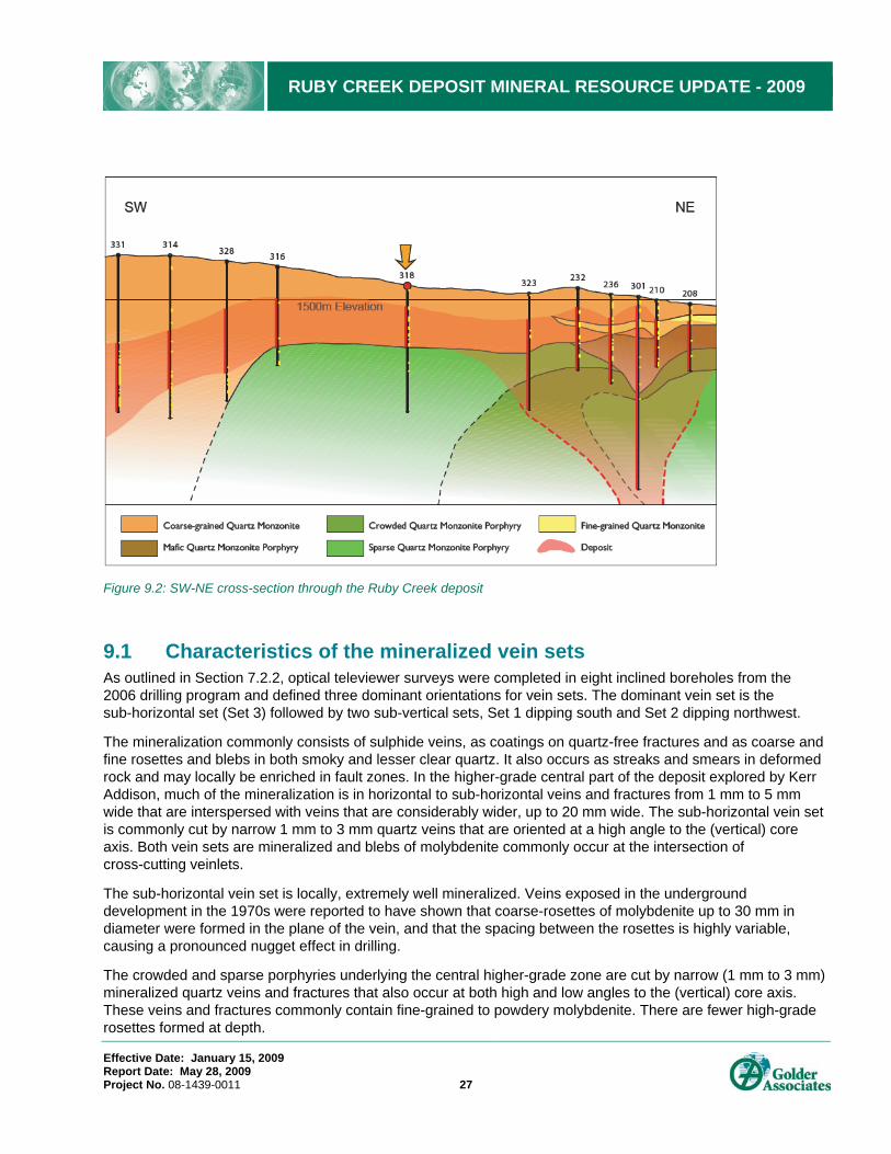
Figure 9.2: SW-NE cross-section through the Ruby Creek deposit .......................................................................................... 27
Figure 10.1: Drill holes location map on the Ruby Creek property ............................................................................................ 32
Figure 11.1: Plan view of drill holes traces ............................................................................................................................... 38
Figure 13.1: Adanac Field Sample Preparation Procedures from 2004 to 2006 (From Pinsent (2005)) ................................... 43
Figure 13.2: Scatter plot and Thompson & Howarth plot for Intralab pulp duplicates ............................................................... 48
Figure 13.3: Interlab Crushed Duplicates EcoTech vs ACME .................................................................................................. 50
Figure 13.4: Interlab Crushed Duplicates ALS Chemex vs ACME ........................................................................................... 50
Figure 17.1: Lognormal Distribution of the population in the three domains ............................................................................. 57
Figure 17.2: Swath Plots for Adanac Ruby Creek Domain A .................................................................................................... 63
APPENDICES
Appendix A: 2007 and 2008 Drilling Summary - Coordinated and Mineralized Intervals

RUBY CREEK DEPOSIT MINERAL RESOURCE UPDATE - 2009
Effective Date: January 15, 2009 Report Date: May 28, 2009 Project No. 08-1439-0011 1
1.0 SUMMARY
1.1 Scope of work Adanac Molybdenum Corporation (Adanac) retained Golder Associates Ltd. (Golder) to provide an independent Mineral Resource Estimate Update for the Ruby Creek Molybdenum Project (Ruby Creek) in Northern British Columbia. The present Mineral Resource Estimate Update has been completed in conformance with the CIM Mineral Resource and Mineral Reserve definitions referred to in National Instrument NI 43-101, Standards of Disclosure for Mineral Projects and has been carried out to support the press release by Adanac on April 15, 2009.
This report represents the fourth reporting of the Ruby Creek mineral resources in accordance with the CIM definitions referred to in NI 43-101. Kevin Palmer, P.Geo., an employee of Golder, served as the independent Qualified Person responsible for preparing the Mineral Resource Estimate and report. The peer review of the Mineral Resource Estimate was completed by Greg Greenough, P.Geo., of Golder, Mississauga. Senior review of this report has been completed by William John Shaw, FAIG, RPGeo, FAusIMM, CPGeo, Principal of Golder, Toronto office.
The April 2009 Mineral Resource Estimate Update is based on new data from 60 drill holes (aggregate length of 19,134.32 m) completed during the 2007 and 2008 field programs, the historical drilling and underground sample data collected on the property from 1966 to 1980, and three field seasons completed by Adanac between 2004 and 2006. All drilling and underground sample data for Ruby Creek is stored as drill hole data in a Datamine database (Ruby Creek Datamine Database) that was compiled by Golder based on Minesight files provided by Adanac. The Ruby Creek Datamine Database currently consists of 345 drill holes totalling 69,083 metres.
Site visits to the Ruby Creek Project were conducted by Kevin Palmer on September 25, 2007 and between September 14 and 16, 2008. The objective of the site visits was to review and observe data collection procedures, storage, QA/QC protocols, and to observe deposit mineralization. Information collected during the 2005 and 2006 site visits has also been included.
1.2 Property Tenure The Ruby Creek molybdenum property was staked by:
from 1966 to 1970: Adanac Mining and Exploration Limited and Canadian John’s Manville Limited, held under option;
from 1970 to 1972: Kerr Addison Mines Limited;
from 1973 to late 1970s: Climax Molybdenum Corporation of British Columbia Limited; and
from 1980 to late 1990s: Placer Development Limited.
In 2002, Adanac Gold Corporation (Adanac Molybdenum Corporation’s predecessor) acquired 100-percent ownership of the Adanac/Ruby Creek molybdenum deposit through staking.
The Ruby Creek property is in the Atlin Mining Division. The property consists of a single, irregularly shaped block of 13 tenures covering the upper southwest part of the Ruby Creek valley and much of the adjacent Boulder Creek valley. The claims are 100-percent owned by Adanac and share a common expiry date of 2015.

RUBY CREEK DEPOSIT MINERAL RESOURCE UPDATE - 2009
Effective Date: January 15, 2009 Report Date: May 28, 2009 Project No. 08-1439-0011 2
1.3 Property Location and Site Description The Adanac/Ruby Creek deposit (Lat. 59º 42.5’ N, Long. 133º 24’ W; NTS 104N/11) is at the head of Ruby Creek, 24 km northeast of Atlin in Northern British Columbia. It underlies the floor of the valley at approximately 1,500 m elevation. The deposit is readily accessible by road from Atlin. The first 19 kilometres from Atlin to the Pine Creek Bridge at Surprise Lake are fully maintained. From there to site, the road is serviced by the company and by local placer miners.
1.4 Geology and Mineralization The Ruby Creek deposit is a disrupted, dome-shaped occurrence formed late in the development of a small plutonic complex peripheral to the Surprise Lake Batholith, east of Atlin. The deposit is associated with granitic to quartz monzonitic rocks. Although recent work clearly shows that the rocks are granite, Adanac has retained and built on the terminology of its predecessors at Ruby Creek and, in the context of this report, they are described as being quartz monzonites.
The Ruby Creek area is underlain by a stock that contains two separate pulses of plutonic rock. The first pulse, which includes the contact phase, consists of a highly, variably textured unit which grades from coarse-grained Quartz Monzonite (CGQM), in the core of the intrusion, into Crowded Quartz Feldspar Porphyry (CQFP) and Sparse Quartz Feldspar Porphyry (SQFP) near the outer contact. The former is well exposed south of the Adera Fault. The latter are mapped on the deposits northern, down-dropped side.
The second pulse consists of a younger, composite intrusion of Crowded and Sparse Quartz Monzonite Porphyry (CQMP, SQMP) that cuts the CGQM south of the Adera Fault. Although the younger porphyries are mineralized, the bulk of the mineralization, volumetrically, is in the coarse-grained rocks above and adjacent to the porphyry intrusion.
The deposit is situated at the intersection of the Adera and Boundary Creek Faults. These large-scale faults and their splays may have provided conduits for mineralizing fluids. The rocks are, for the most part, fresh although there is local evidence of early potassic (primary) alteration and some later pre-mineralization silicification. However, much of the alteration is post-mineralization (secondary) and is associated with fluids that circulated during post-mineralization faulting.
Ruby Creek has recently been classified as a Climax-type deposit (Smith, in preparation). The whole-rock compositions and fluorine content are similar to those described by Westra and Keith (1981) for deposits of this type. They are characterized by a stockwork of molybdenite-bearing quartz veinlets and fractures in intermediate to felsic intrusive rocks. They are typically low-grade mineralization amenable to bulk mining methods and commonly have higher-grade mineralization which may be suitable for underground mining.
The Ruby Creek deposit is a stockwork of molybdenite and quartz-molybdenite-bearing veins. Molybdenite-bearing quartz veins and dry fractures are found in all the principal rock-types but are best developed in the CGQM units, which seem to be more amenable to deformation and mineralization than the more porphyritic phases (Pinsent, 2005, 2006, 2007 and 2008). The feldspars in the coarse-grained varieties are commonly cracked and/or broken and the rocks are locally cut by ductile shears and narrow zones of intense silicification that are not found in the other units.

RUBY CREEK DEPOSIT MINERAL RESOURCE UPDATE - 2009
Effective Date: January 15, 2009 Report Date: May 28, 2009 Project No. 08-1439-0011 3
1.5 Exploration Concept Several drilling programs were conducted by Adanac between 2006 and 2008 following compilation of drill-data obtained from previous property owners. The holes were drilled to confirm previous results and explore the periphery of the deposit as it was then known. One aspect of the 2006 drilling field program was an inclined drilling program (13 holes) in the proposed stage-one pit area, where previously Kerr Addison had driven an adit and raises and collected bulk samples in the early 1970s. The program was designed to improve the confidence of the Mineral Resource Estimate (move indicated to measured resources) and provide structural orientation data on the sub-vertical and sub-horizontal molybdenum-hosting veins. The last two drilling campaigns, in 2007 and 2008, were focused on:
drilling through the north zone, a block of mineralization north of the Adera Fault, adjacent to the northwest margin of the proposed pit (2007);
completing a condemnation drill-program at lower elevation, further down the valley (Pinsent, 2008); and
completing the previously planned program north of the Adera Fault and in the main deposit area (2008).
1.6 Status of Exploration Adanac completed the autumn of 2008 drill program and announced the results for the final 13 drill holes in a news release issued on January 20, 2009. There has been no further exploration on the property.
1.7 Development and Operations In 2007 and 2008, the company substantially rebuilt the main access road from the camp near Surprise Lake to the deposit and started to clear its proposed mill-site. There has been no other development work on site.
1.8 Author’s Conclusions and Recommendations The conclusions and recommendations that have been identified from the April 2009 Mineral Resource Estimate Update are as follows:
The majority of the geology of the Ruby Creek Molybdenum Project is well understood.
Drilling north of the Adera Fault has significantly increased the mineral resources and this fault, which was initially interpreted as being post-mineralization, may be syn- or pre-mineralization.
The database was reviewed by Golder using statistical and geostatistical analyses and comparisons between field logs and the digital database. This database was considered acceptable for mineral resource estimation.
A bulk density of 2.559 g/cm3 was applied to the mineralized zone outside the core area, 2.575 g/cm3 within the core area, and 2.572 g/cm3 outside of the interpreted mineralized envelope. To date, over 2,081 samples have been collected from the 2004 to 2008 drilling programs. Very little difference has been identified from the various lithological units. Ongoing sampling should be considered if new lithological samples have been identified in areas where only pre-2004 drilling was available and if the sulphide content of the samples is higher than typically collected.

RUBY CREEK DEPOSIT MINERAL RESOURCE UPDATE - 2009
Effective Date: January 15, 2009 Report Date: May 28, 2009 Project No. 08-1439-0011 4
A drill hole sample database should be created by Adanac, using a system such as acQuire or Datashed, that includes drill hole data, QA/QC sample results, metallurgical testing, specific gravity testing, and environmental testing. Currently, this data is stored in many Excel spreadsheets and as the project goes forward needs to be put in a system more robust and auditable. The estimated cost of the software and implementation is $50,000.
The results of the April 2009 Mineral Resource Estimate for Ruby Creek based on 0.02 to 0.10% Mo cut-off grades for the Measured, Indicated and Inferred Mineral Resource categories are tabulated in Table 1-1. The pounds of Mo are In situ pounds and have not had mill recovery factors applied to them.
The total Measured Mineral Resource Estimate using a 0.04% Mo cut-off grade is 43.642 million tonnes, 0.078% Mo and 75.361 million lbs Mo. The total Indicated Mineral Resource Estimate at the same cut-off grade is 231.712 million tonnes, 0.065% Mo and 332.550 million lbs Mo. The total Inferred Mineral Resource Estimate using a 0.04% Mo cut-off grade is 39.076 million tonnes, 0.062% Mo and 53.719 million lbs Mo.
The Mineral Resource Estimate identified in Table 1-1 is based on the Ordinary Kriged interpolation method and Mo capped assay values.
Golder Associates updated these Mineral Resource Estimates following the 2006 drill program and at that time Adanac announced a February 2007, Measured plus Indicated resource of 212,907,000 tonnes grading 0.063% Mo at a 0.04% Mo cut-off on March 20, 2007 (Palmer, 2007). The resource contains 295,699,000 pounds of molybdenum. The new resource represents an increase of 62,447,000 tonnes and 112,212,000 pounds of molybdenum in the Indicated and Measured categories. The increase is largely attributable to the drilling in the vicinity of the Adera Fault which increased the volume of the mineralized envelope by 39%. This, together with recognition of a core area and a resultant lower cap being applied, increased the overall metal tonnes by 38%.
The 2007 and 2008 drilling suggested that the Adera Fault is either syn- or pre-mineralization. Prior to this the fault was assumed to be primarily post mineralization, offsetting the mineralized envelopes. A review of the geology of the fault should lead to a better understanding and an improved grade model. Estimated cost, $15,000.
A conditional simulation exercise is recommended prior to any future economic analysis to confirm the resource categories. Estimated cost $40,000.
A preliminary assessment of the April 2009 Mineral Resource is recommended to investigate what percentage of the Mineral Resource could be converted to a Mineral Reserve. The estimated cost would be approximately $60,000.

RUBY CREEK DEPOSIT MINERAL RESOURCE UPDATE - 2009
Effective Date: January 15, 2009 Report Date: May 28, 2009 Project No. 08-1439-0011 5
Table 1-1: April 2009 Mineral Resource Estimate Ruby Creek Molybdenum Project
Resource Category Cut-off (Mo%) Tonnes Mo (%) Mo (lbs)
0.02 54,055,000 0.069 82,209,000
0.03 48,676,000 0.074 79,263,000
0.04 43,642,000 0.078 75,361,000
0.05 36,978,000 0.084 68,734,000
0.06 30,273,000 0.091 60,626,000
0.07 23,377,000 0.098 50,733,000
0.08 17,075,000 0.107 40,342,000
0.09 11,711,000 0.117 30,303,000
0.10 8,228,000 0.127 23,037,000
0.02 437,348,000 0.047 451,659,000
0.03 278,313,000 0.060 368,503,000
0.04 231,712,000 0.065 332,550,000
0.05 174,643,000 0.072 275,839,000
0.06 117,696,000 0.080 206,897,000
0.07 71,669,000 0.089 141,157,000
0.08 42,546,000 0.100 93,329,000
0.09 24,127,000 0.111 58,975,000
0.10 14,114,000 0.122 38,101,000
0.02 491,403,000 0.049 533,868,000
0.03 326,989,000 0.062 447,766,000
0.04 275,354,000 0.067 407,911,000
0.05 211,621,000 0.074 344,573,000
0.06 147,969,000 0.082 267,523,000
0.07 95,046,000 0.092 191,890,000
0.08 59,621,000 0.102 133,671,000
0.09 35,838,000 0.113 89,278,000
0.10 22,342,000 0.124 61,138,000
0.02 299,478,000 0.030 196,082,000
0.03 78,232,000 0.048 83,147,000
0.04 39,076,000 0.062 53,719,000
0.05 25,781,000 0.072 40,701,000
0.06 17,533,000 0.080 30,746,000
0.07 10,437,000 0.090 20,608,000
0.08 5,460,000 0.103 12,451,000
0.09 3,180,000 0.117 8,206,000
0.10 2,142,000 0.128 6,048,000
Measured
Indicated
Subtotal Measured & Indicated
Inferred

RUBY CREEK DEPOSIT MINERAL RESOURCE UPDATE - 2009
Effective Date: January 15, 2009 Report Date: May 28, 2009 Project No. 08-1439-0011 6
2.0 INTRODUCTION Adanac Molybdenum Corporation (Adanac) retained Golder Associates Ltd. (Golder) to provide an independent Mineral Resource Estimate Update for the Ruby Creek Molybdenum Project (Ruby Creek) in Northern British Columbia. The present Mineral Resource Estimate Update has been completed in conformance with the CIM Mineral Resource and Mineral Reserve definitions referred to in National Instrument NI 43-101, Standards of Disclosure for Mineral Projects and supports the press release by Adanac on April 15, 2009.
This report represents the fourth reporting of the Ruby Creek mineral resources in accordance with the CIM definitions referred to in NI 43-101. Kevin Palmer, P.Geo., an employee of Golder, served as the independent Qualified Person responsible for preparing the Mineral Resource Estimate Update and report. Senior review of this report has been completed by William John Shaw, FAIG, RPGeo, FAusIMM, CPGeo, Principal of Golder, Toronto office.
Information and data for the Mineral Resource Estimate were obtained from Adanac, and from the Technical Reports by Blower (2005) and Palmer (2006, 2007).
Site visits to the Ruby Creek Project were conducted by Kevin Palmer on September 25, 2007 and between September 14 and 16, 2008. The objective of the site visits was to review and observe the data collection procedures, storage, QA/QC protocols and observe deposit mineralization. Information collected during the 2005 and 2006 site visits is also included. A list of general abbreviations is included in Table 2-1. The lithology abbreviations can be found in Table 7-1.
Table 2-1: List of Abbreviations
Feet Ft Percentage %
Grams g Tonne (1,000 kg) T
Grams per Tonne g/t Tonnes per Day t/d
Kilometres km Ton (2,000 lb) ton
Metres m Percentage %
Metres Above Sea Level masl Kilograms kg
Millimetres mm Universal Trans Mercator UTM
Diameter dia Digital Terrain Model DTM
Cubic Centimetres cm3 Ordinary Kriging OK
Pounds lb Nearest Neighbour NN
Quality Assurance and Quality Control QA/QC Inverse Distance Squared ID2

RUBY CREEK DEPOSIT MINERAL RESOURCE UPDATE - 2009
Effective Date: January 15, 2009 Report Date: May 28, 2009 Project No. 08-1439-0011 7
3.0 RELIANCE ON OTHER EXPERTS Golder did not complete, as part of this report, a legal survey of the property, did not identify terms of royalties, back-in rights, payments or other agreements, and did not identify if there were encumbrances to the Ruby Creek Property. All property information was provided by Adanac. Golder did not review if permitting of the property was obtained prior to work completed on the property.

RUBY CREEK DEPOSIT MINERAL RESOURCE UPDATE - 2009
Effective Date: January 15, 2009 Report Date: May 28, 2009 Project No. 08-1439-0011 8
4.0 PROPERTY DESCRIPTION AND LOCATION
4.1 Property Area and Location The Ruby Creek Molybdenum Project is located in the Atlin Mining Division at the head of Ruby Creek at Lat. 59 42.5’ N, Long. 133 24’ W, Elevation 1,500 m according to National Topographic Map Sheet 104N/11 (1:50 000). The property is approximately 24 km northeast of Atlin in Northern British Columbia, covering an area of approximately 5,450 hectares (Figure 4-1).
Figure 4.1: Location Map, Ruby Creek Molybdenum Project
4.2 Mineral Tenure The Ruby Creek Molybdenum Project consists of a single, irregularly shaped block of 13 tenures covering the upper southwest part of the Ruby Creek valley and much of the adjacent Boulder Creek valley. The claims are 100-percent owned by Adanac, and share a common expiry date of 2015. As presented by the company, the claims are listed in Table 4-1 and shown on Figure 4-2.
The mineralization and published Mineral Resource Estimates for the Ruby Creek Molybdenum Project are located in the north area of the Adanac claims. In 1973, Kerr Addison Mines Limited undertook the only mine development so far completed on the project site. They drove an underground drift (589 m) and cross-cuts (246 m) and cut raises (6) in the central area of the deposit. The underground excavations are not currently accessible.

RUBY CREEK DEPOSIT MINERAL RESOURCE UPDATE - 2009
Effective Date: January 15, 2009 Report Date: May 28, 2009 Project No. 08-1439-0011 9
Figure 4.2: Mineral Tenure Location Map, Ruby Creek Molybdenum Project (Provided by Adanac)
N
Phase 1 Pit Outline

RUBY CREEK DEPOSIT MINERAL RESOURCE UPDATE - 2009
Effective Date: January 15, 2009 Report Date: May 28, 2009 Project No. 08-1439-0011 10
Table 4-1: List of Adanac mineral tenements in 2009. Tenures in Atlin Mining Division; 100% Owned by Adanac Moly Corporation (#140154)
Mineral Tenure Number
Tenure Type
Tenure Name New Good to Date Area in Hectares
555153 Mining Lease District Lot 7348 2037/Mar/27 2466.00
510311 Mineral District Lot 7351 2019/Aug/31 245.02
408341 Mineral LAKE VIEW 1 2018/Aug/31 450.0
408342 Mineral LAKE VIEW 2 2018/Aug/31 450.0
510319 Mineral 2019/Aug/31 1405.50
510320 Mineral 2019/Aug/31 458.19
510382 Mineral 2019/Aug/31 376.08
503346 Mineral KILO 2018/Aug/31 81.66
519616 Mineral 2019/Aug/31 408.23
519782 Mineral 2019/Aug/31 16.33
523437 Mineral BASALT 1 2019/Aug/31 228.75
531946 Mineral BIRCH 1 2018/Aug/31 147.20
532097 Mineral BIRCH 2 2018/Aug/31 408.81
532099 Mineral BIRCH 4 2018/Aug/31 163.60
532102 Mineral BIRCH 4 2018/Aug/31 343.20
563549 Mineral Ruby 2 2019/Aug/31 343.20
563550 Mineral Ruby 2019/Aug/31 65.36
563552 Mineral Ruby 4 2019/Aug/31 343.19
563553 Mineral Ruby 5 2019/Aug/31 65.39
563556 Mineral 2019/Aug/31 16.34
563557 Mineral Ruby Center 2019/Aug/31 147.09
563558 Mineral Ruby 6 2019/Aug/31 98.14
563618 Mineral Ruby Creek SL 2019/Aug/31 392.70
563619 Mineral Ruby Creek SL1 2019/Aug/31 179.90
4.3 Property Boundaries Adanac holds a contiguous block of tenures north of Surprise Lake, east of Atlin in British Columbia. These cover most of the Ruby and Boulder Creek drainages; however, there is a small block of claims held by others to the north lake shore (Figure 4-2). In 2006, Adanac surveyed-in the two most important mineral tenures in the

RUBY CREEK DEPOSIT MINERAL RESOURCE UPDATE - 2009
Effective Date: January 15, 2009 Report Date: May 28, 2009 Project No. 08-1439-0011 11
central part of the block as District Lots (DL 7348 and DL7351). They cover the proposed pit, mill-site and tailings pond. The former is now a Mining Lease.
4.4 Location of Mineralized Zones The Ruby Creek deposit is in the west-central part of the Mining Lease. The deposit underlies the cirque at the head of Ruby Creek. Kerr Addison’s underground workings, which are in the middle of the proposed phase 1 pit area, are approximately 400 meters to the southeast of the outflow of a small hanging lake, informally known as Molly Lake (Figure 4-2).
4.5 Royalties and Other Agreements No information regarding the terms of royalties, back-in rights, payments, or other agreements and encumbrances have been included in this report.
4.6 Environmental Liabilities and Other Permits The project received its Environmental Assessment Certificate on September 11, 2007 and its Mines Act Permit on June 24, 2008. Adanac has recently completed the Government of Canada Environmental Assessment Process and has entered the final approval state for operating a tailings impoundment through a Schedule 2 Amendment to the Metal Mining Effluent Regulations. This is the final permit required to build and operate a mine. It should be issued in 2009.

RUBY CREEK DEPOSIT MINERAL RESOURCE UPDATE - 2009
Effective Date: January 15, 2009 Report Date: May 28, 2009 Project No. 08-1439-0011 12
5.0 ACCESSIBILITY, CLIMATE, LOCAL RESOURCES, INFRASTRUCTURE AND PHYSIOGRAPHY
5.1 Accessibility and Infrastructure The Ruby Creek Molybdenum Project is accessible via a 40 km road from Atlin, of which the first 19 km to the bridge at Surprise Lake is fully maintained. Thereafter, the remaining 21 km of road is a recently rebuilt mine-access road. Atlin is accessible via 100 km of all-weather road south of Whitehorse, Yukon, and 90 km of well maintained gravel road south of Jakes Corner.
Kerr Addison’s underground workings and pilot tailings pond are the only infrastructures remaining on site (Figure 5-1). In 2007, Adanac moved its core processing building and drill core racks off the property, down to company-owned land close to Surprise Lake.
All power on the property during the 2006 to 2008 exploration programs was provided by generators. The town of Atlin is a source for fuel, groceries, accommodation, and charter aircraft services. It is a three-hour drive from tidewater at Skagway, Alaska. Whitehorse is the major supply centre for the region, with daily commercial flights to Vancouver, British Columbia, and other cities.
Details of planned mining operations, availability and sources of power, water, mining personnel, potential tailings storage areas and potential processing facilities are provided in the report by Golder Associates Ltd., by Rodgers and Buck (2006) (Figure 5-1).

RUBY CREEK DEPOSIT MINERAL RESOURCE UPDATE - 2009
Effective Date: January 15, 2009 Report Date: May 28, 2009 Project No. 08-1439-0011 13
Proposed ultimate pit perimeter
Low grade ore stockpile
Employee village
Tailing Pond
Fresh Water Pumps
200 0 200 400 600 m
Process Plant
Power plant
Figure 5.1: Infrastructure Map of the Adanac Property

RUBY CREEK DEPOSIT MINERAL RESOURCE UPDATE - 2009
Effective Date: January 15, 2009 Report Date: May 28, 2009 Project No. 08-1439-0011 14
5.2 Climate, Vegetation and Physiography The Ruby Creek property is located within the Northern Alplands Biotic Area (alpine terrain) at an approximate elevation of 1,500 m. The headwaters of Ruby Creek are located within the property boundaries and flow into Surprise Lake as illustrated on Figure 4-1. The deposit underlies a flat, relatively unvegetated cirque near the head of the valley. The walls of the cirque are moderately steep, but the floor is glacially scoured and flat.
The climate is temperate. Summers are mild, and may be either wet or dry. Winters tend to be cold and the area receives a moderate amount of snowfall that accumulates between October and May. Klohn Leonoff Consultants Limited studied the climate for Placer Development Limited in the early 1980s, and its successor, Klohn Crippen Berger Consultants Limited, established a weather station on site for Adanac early in 2005 and has been monitoring it ever since. The environmental baseline report by Klohn Crippen, “Ruby Creek Molybdenum Project Environmental Baseline”, dated December, 2004 (Thorpe, 2004) provides details of the local climate.

RUBY CREEK DEPOSIT MINERAL RESOURCE UPDATE - 2009
Effective Date: January 15, 2009 Report Date: May 28, 2009 Project No. 08-1439-0011 15
6.0 HISTORY A detailed history of the Ruby Creek deposit is provided in the Technical Report by Palmer (2006), which was based on reports by Pinsent (2005) and Blower (2005). The following section has been updated with the most recent exploration history and includes information that is not technically historic.
6.1 Ownership and Exploration History The Ruby Creek molybdenum deposit was discovered in 1905 but saw limited exploration prior to 1966, when it was staked by Adanac Mining and Exploration Limited (Adanac Mining) and Canadian John’s Manville Limited. Adanac Mining acquired the controlling interest the following year and drilled 80 holes for an aggregate length of 12,775 m (Sutherland Brown, 1970). It optioned the property to Kerr Addison Mines Limited (Kerr Addison) in 1970.
Kerr Addison diamond-drilled a further 47 holes for a total depth of 5,626 m and drove 589 m of drift, 246 m of cross-cut, and 281 m of raise in the higher-grade core of the deposit, which underlies the floor of the valley. It extracted 9,545 tonnes of ore from the cross-cut and six raises and processed them on site to evaluate the nugget effect caused by coarse-grained molybdenite (Janes, 1971). Chapman, Wood and Griswold Limited completed a feasibility study in 1972 and deemed the deposit to be uneconomic. As a result, Kerr Addison relinquished ownership of the property.
The following year, 1973, Climax Molybdenum Corporation of British Columbia Limited (Climax) diamond-drilled seven new holes and deepened two others, for an aggregate depth of 2,672 m. Climax later released its option but its staff went on to publish the first comprehensive geological description of the deposit (White et al., 1976). The property then remained dormant until metal prices improved in the late 1970s.
In 1978, Placer Development Limited (Placer) re-evaluated Kerr Addison’s feasibility study, optioned the property and started a full-scale technical and socio-economic review. In 1979, Placer drilled a further 6,028 m in 49 diamond holes in-and-around Kerr Addison’s proposed initial pit (Tennant, 1979), and the following year it drilled a further 27 holes with an aggregate depth of 4,858 m, in-and-around the margins of its ultimate pit (Pinsent, 1980). Although Placer nearly finished all the work required for a formal bankable feasibility study, it was never completed. The price of molybdenum which had been rising in the 1970s dropped sharply in 1982 to 1983. Placer held on to the option for a few years, but eventually returned the property to Adanac Mining. The claims lapsed in the late 1990s.
Andris Kikauka staked the deposit for Adanac Gold Corporation (Adanac) in 2002. The following year, the company compiled a considerable amount of existing drill-data which included the results of the Kerr Addison work, from a file in the possession of Dr. A. Sinclair (ex-Department of Earth and Ocean Science, University of British Columbia, Sinclair, 2005), from some of Climax’s drill results obtained from assessment reports, and from all of Placer Development’s results which were also filed for assessment. Adanac worked on a scoping study that led to the 2004 drill program. The program had three objectives: 1) to assess the quality of the old assay data, 2) to fill gaps in its distribution, and 3) to improve the company understanding of the extent of the deposit. The program was designed with input on QA/QC procedures from Amec Americas Limited (AMEC), who later calculated the NI 43-101 compliant resource based on a combination of new and historic data (Blower, 2005). Adanac Gold drilled 36 holes for an aggregate depth of 8,983 m in-and-around the periphery of the previously proposed open-pit (Pinsent, 2005).
In 2005, Adanac drilled a further 19 holes for an aggregate depth of 4,984 m. Seven were collared in the main pit area to provide material for metallurgical test work and greater understanding of the deposit at depth. Six were angled into the walls of the proposed pit and studied for geotechnical considerations, and six were drilled as

RUBY CREEK DEPOSIT MINERAL RESOURCE UPDATE - 2009
Effective Date: January 15, 2009 Report Date: May 28, 2009 Project No. 08-1439-0011 16
exploration holes. Three were located on the south side of the deposit, as currently defined, and three were drilled outside of the pit area. The results are discussed in Pinsent (2006).
In 2006, Adanac concentrated its drilling in the main pit area, in the vicinity of the underground workings, where previous work by Kerr Addison and Placer had established the presence of a significant volume of relatively higher-grade mineralization. In total, the company diamond-drilled sixteen holes for an aggregate depth of 3,920.7 m. Of these, thirteen were angled holes collared in the proposed Phase 1&2 pit area as defined by Golder Associates in March 2006 (Rodgers and Buck, 2006). They were drilled in a westerly direction at a dip angle of approximately -50 degrees. The remaining three were exploration holes. Two were drilled to the southeast at -50 degrees, into the south wall of the proposed pit, and one was a vertical hole drilled beyond the current southwest limits of the pit (Pinsent, 2007).
In 2007, Adanac focused its attention on the north zone, a down-faulted block of mineralization adjacent to the northwest margin of the proposed pit. Adanac also completed a condemnation drilling program at lower elevation, further down the valley (Pinsent, 2008). Between the start of the 2007 program and the completion of the condemnation drilling in 2008, E. Caron Diamond Drilling Ltd. and Foraco (Connors) Drilling Limited completed 22 diamond-drill holes (A-07-372 to A-07-393) for an aggregate depth of 6,550 metres.
In the spring of 2008, Adanac returned to the north zone and the main deposit area and completed its previously planned program. Foraco (Connors) Drilling Limited diamond-drilled 38 holes (A-08-394 to A-08-431) for an aggregate depth of 14,700 metres.
6.2 Historical Resources and Reserves Previous Independent Mineral Resource Estimates for the Ruby Creek deposit were completed in 2005, 2006 and 2007. Prior to 2005, the deposit had been twice to a feasibility stage. It had been systematically drilled and bulk-sampled by Adanac Mining and Kerr Addison between 1969 and 1972. Unfortunately, it was judged to be uneconomic at the time, given the limited infrastructure in the Atlin area. Placer evaluated the property in 1979 and 1980, but shelved plans for production when the price of molybdenum collapsed, around 1982 to 1983. Placer reported an undiluted mineable mineral reserve of 151,971,000 tonnes grading 0.063% Mo at a cut-off grade of 0.04% Mo and a strip ratio of 1.5:1 (Pinsent and Christopher, 1995).
After Adanac Gold Corporation acquired 100-percent ownership of the Adanac/Ruby Creek molybdenum deposit in 2002, a substantial amount of old technical data was reviewed and the first drilling program was conducted in 2004. The following year AMEC used both new and old data to calculate an NI 43-101 compliant mineral resource (Blower, 2005). In May 2005, Adanac announced that the deposit had a Measured plus Indicated resource of 205,100,000 tonnes grading 0.062% Mo at a cut-off grade of 0.04% Mo. In 2005, Adanac diamond-drilled an additional 4,984.1 m in 19 drill holes. This enabled Adanac to revise the estimate and complete a full feasibility study.
On April 12, 2006, Adanac announced the results of a feasibility study for the Ruby Creek project. Work by Golder, Wardrop Engineering Inc. (Wardrop), and others indicated an open-pit, mineable, Proven plus Probable reserves of 113,400,000 tonnes grading 0.066% Mo at 0.04% Mo cut-off. This, along with a stockpile of 31,300,000 tonnes of Proven and Probable low-grade ore grading 0.034% Mo, was deemed sufficient to feed a 20,000 tonnes/day flotation mill for approximately twenty years. The deposit underlies the floor of Ruby Creek and the operation has an estimated strip ratio of 0.95 (waste) to 1.0 (ore). The study shows that mill feed would average 0.082% Mo during the first five years of operation, and that approximately 98% would likely be recoverable (Rodgers and Buck, 2006).

RUBY CREEK DEPOSIT MINERAL RESOURCE UPDATE - 2009
Effective Date: January 15, 2009 Report Date: May 28, 2009 Project No. 08-1439-0011 17
Golder Associates updated these results following the 2006 drill program and Adanac announced in February 2009 to a Measured plus Indicated resource of 211,907,000 tonnes grading 0.063% Mo at a 0.04% Mo cut-off on March 20, 2007 (Palmer, 2007). The resource contains 295,699,000 pounds of molybdenum, which represents an increase of 6,532,000 tonnes and 10,095,000 pounds of molybdenum over previous estimates based on the earlier drilling. The increase was largely attributed to the inclined drilling in 2006 (tonnage and grade) and a re-interpretation of the 2006 mineralized geometries (tonnage).
An updated Mineral Reserve Estimate was developed based on the February 2007 Mineral Resource Estimate and on a new updated mine design using a 0.04% Mo mining grade cut-off and a 0.03% milling grade cut-off. Upon completion of Phases 1 to 4, an estimate of 157,564,000 tonnes with a grade of 0.058% Mo is extracted based on the updated mine design (Rodgers et al, 2007).
6.3 Production Kerr Addison extracted 9,545 tonnes of ore from the cross-cut and six raises and processed them on site to evaluate the nugget effect caused by coarse-grained molybdenite (Janes, 1971). These tonnes have not been deducted from the Mineral Resource Estimate as they are not significant given the precision of the resource estimate.
RUBY CREEK DEPOSIT MINERAL RESOURCE UPDATE - 2009
Effective Date: January 15, 2009 Report Date: May 28, 2009 Project No. 08-1439-0011 18
7.0 GEOLOGICAL SETTING The regional and local geological setting descriptions of the Ruby Creek deposit are provided in reports by Pinsent (2005), Blower (2005) and Palmer (2006 and 2007).
Analysis completed during the 2006 drilling program helped to better understand the sub-vertical and sub-horizontal vein orientations and molybdenum mineralization using in-hole optical televiewer cameras. The 2006 drilling results indicated that high-grade mineralization did occur along both sub-vertical and sub-horizontal veins. Angled and vertical holes were drilled in 2007 and 2008 and help to better understand the relationship between sub-vertical and sub-horizontal vein orientations and higher-grade molybdenum mineralization.
In Golder’s opinion, geology of the Ruby Creek deposit and the controls on mineralization are sufficiently well understood for resource estimation.
7.1 Regional Scale The Ruby Creek deposit is a disrupted, dome-shaped occurrence formed late in the development of a localized plutonic complex. It is associated with granitic to quartz monzonitic rocks of the Surprise Lake Batholith, east of Atlin (Figure 7-1).
The geology of the Atlin area was mapped by Aitken (1959), and the regional setting of the deposit was discussed by Christopher and Pinsent (1982). Described simply, the Atlin area, illustrated on Figure 7-1, is underlain by deformed and weakly metamorphosed ophiolitic rocks of the Pennsylvanian and/or Permian-aged Cache Creek Group (Monger, 1975). These rocks, which include serpentinites and basalts as well as limestones, cherts and shales, are thought to be the source of much of the placer gold found in the Atlin area. This stratigraphy is intruded by two younger batholiths. North of Pine Creek, a Jurassic-age granodiorite to diorite intrusion is known as the Fourth of July Batholith (Figure 7-1). North and south of Surprise Lake, the stratigraphy is cut by a Cretaceous-age granitic to quartz monzonitic intrusion known as the Surprise Lake Batholith (Figure 7-1).
Ruby Mountain, immediately to the south of the deposit (Figure 7-1), is underlain by a Late Tertiary to Quaternary volcano that erupted and filled the lower part of the Ruby Creek drainage with columnar basalt and volcanoclastic debris. The volcanic rocks unconformably overlie placer, gold-bearing gravels. The origin of the gold is uncertain; however, most of it probably comes from quartz-carbonate veins hosted by shears that cut Cache Creek Group strata.
The rocks are locally, strongly faulted and the Ruby Creek deposit is located in a disrupted stock peripheral to the Surprise Lake Batholith (Figure 7-1). The deposit is near the intersection of two major, pre- to post-mineralization fault systems and is partially controlled and offset by the Adera Fault system, which trends from southwest to northeast down Ruby Creek and defines much of the southern boundary of the Fourth of July Batholith. It is also partially controlled by the Boulder Creek Fault system. This runs due north up Boulder Creek and cuts across the head of the Ruby Creek drainage. The Boulder Creek Fault appears to have helped localize emplacement of the deposit and is intimately associated with late-stage porphyritic and aplitic plutonic rocks.

RUBY CREEK DEPOSIT MINERAL RESOURCE UPDATE - 2009
Effective Date: January 15, 2009 Report Date: May 28, 2009 Project No. 08-1439-0011 19
Figure 7.1: Regional Geology Map of the Atlin Area

RUBY CREEK DEPOSIT MINERAL RESOURCE UPDATE - 2009
Effective Date: January 15, 2009 Report Date: May 28, 2009 Project No. 08-1439-0011 20
7.2 Property Scale 7.2.1 Lithology The Mount Leonard stock which underlies the Ruby Creek area is characterized by two separate pulses of plutonic rock. The first pulse, which includes the contact phase between the stock and the Fourth of July Batholith, consists of a highly, variably textured unit that grades from Coarse-grained Quartz Monzonite (CGQM) south of the Adera Fault (Figure 7-2), through a number of texturally transitional phases including Transitional and/or Hybrid Coarse-grained Quartz Monzonite (CGQM-T; CGQM-H) and Crowded Quartz Feldspar Porphyry (CQFP) to Sparse Quartz Feldspar Porphyry (SQFP) upward and outward from the deposit. The latter is well exposed north of the Adera Fault, near the diorite contact (Figure 7-2).
The CGQM is weakly to moderately deformed, and consists of pink to grey equigranular, coarse-grained (0.5 to 3.0 cm) quartz monzonite, containing equal amounts of orthoclase, plagioclase and grey quartz (Christopher and Pinsent, 1982). The feldspar is commonly seriate and, locally, includes a small amount of fine-grained (2 to 4 mm) matrix. CGQM grades to SQFP with increase in matrix content, and increased isolation of constituent phenocrystic crystals, particularly orthoclase and quartz.
The first phase of intrusion also includes a distinctive Mafic Quartz Monzonite Porphyry (MQMP) unit that is present east of the deposit (Figure 7-2). This distinctive, grey rock-type shows short intervals of porphyritic texture (1 to 4 mm). It is composed largely of chalky white plagioclase, disseminated biotite and phenocrysts of ragged plagioclase and lesser quartz. These rocks were fractured and deformed prior to emplacement of the second pulse of magma.
There are three main distinctive phases to the second intrusive pulse (Figure 7-2). They include Crowded Quartz Monzonite Porphyry (CQMP); Sparse Quartz Monzonite Porphyry (SQMP) and Fine-Grained Quartz Monzonite (FGQM).
The CQMP has an average of 50 percent (2 to 6 mm) subhedral to euhedral plagioclase, orthoclase, quartz and biotite phenocrysts in an aphanitic matrix. The SQMP variety is similar, but has fewer (10% to 30%) phenocrysts. The rocks are fresher and generally less deformed than the surrounding first phase intrusions, and they have a much finer, more chilled matrix. The SQMP phase is distinctively different to the SQFP phase described above. The second phase porphyries cut out the older rock units and are exposed locally in the floor of the valley. They are also found in the subsurface, under the valley floor. Near the head of the valley, CGQM and its variants are intruded by a buried cupola of SQMP. Its shape has strongly influenced the locus of mineralization, as shown by Placer’s 0.06% and 0.1% Mo assay contours at 1,448 m elevation. Mineralization surrounds the buried cupola and, to a lesser extent, covers it.
The FGQM is a variably textured aplite that intrudes the CGQM (and also its variants) and the MQMP, above and around the sparse and crowded porphyry intrusions. This rock-type is not exposed on surface, but it forms a series of 0.05 m to 10 m thick, approximately flat-lying, structurally-controlled sills in the higher-grade (northeastern) portion of the deposit. The sills are well exposed in Kerr Addison’s cross-cut. There, some of the rock immediately north of Ruby Creek can best be described as being plutonic breccias. FGQM dykes are found elsewhere, around the buried sparse-porphyry cupola; however, they are generally less frequent and smaller, and occur as narrow dykes.
In addition to these rock-types, drilling at the southwest end of the deposit has located a Megacrystic Feldspar Porphyry (MFP). This lithology is not well constrained; however, it appears to be a relatively young phase of the intrusion. It consists of rare to abundant large (>10 mm), euhedral, orthoclase phenocrysts in a chilled, locally glassy, matrix. Coarse-grained quartz-feldspar pegmatite is also found locally within the deposit. It is not abundant, but covers a wide area as small dykes and structurally controlled sills.

RUBY CREEK DEPOSIT MINERAL RESOURCE UPDATE - 2009
Effective Date: January 15, 2009 Report Date: May 28, 2009 Project No. 08-1439-0011 21
Table 7-1 summarizes the lithology text codes applied to the 2004 to 2008 campaigns for mapping and drill hole core logging. The same codes, where possible, were applied to the older (pre-2004) drill hole data.
Table 7-1: Lithological Units at the Ruby Creek Molybdenum Project
Text Code Description
CGQM Coarse Grained Quartz Monzonite
CGQM-T ; CGQM-H CGQM – Transition and/or Hybrid Variety
CQFP Crowded Quartz Feldspar Porphyry
SQFP Sparse Quartz Feldspar Porphyry
MQMP Mafic Quartz Monzonite Porphyry
SQMP Sparse Quartz Monzonite Porphyry
CQMP Crowded Quartz Monzonite Porphyry
FGQM Fine-Grained Quartz Monzonite
MFP Megacrsytic Feldspar Porphyry
BSLT Basalt

RUBY CREEK DEPOSIT MINERAL RESOURCE UPDATE - 2009
Effective Date: January 15, 2009 Report Date: May 28, 2009 Project No. 08-1439-0011 22
Figure 7.2: Property Geology Map for the Ruby Creek Molybdenum Project including 2007 and 2008 drilling

RUBY CREEK DEPOSIT MINERAL RESOURCE UPDATE - 2009
Effective Date: January 15, 2009 Report Date: May 28, 2009 Project No. 08-1439-0011 23
7.2.2 Structure The deposit is situated at the intersection of the Adera and Boundary Creek Faults (Figure 7-2). These large-scale structures and their splays appear to have provided conduits for mineralizing fluids and have localized mineralization. The Adera Fault is particularly important because it also locally offsets the northern portion of the deposit. It is a composite structure that dips steeply to the northwest, is normal in character and appears to have locally down-dropped (to the north) the northwestern part of what was originally a dome, or ring-shaped deposit, formed above and around a SQMP intrusion. Mineralization has been found in the coarser-grained rocks northwest of the fault. However, it has not been found in finer-grained (probably similarly-aged) rocks near the intrusion contact. Rocks similar to these are well exposed in the creek canyon below Molly Lake. They contain abundant barren quartz veins and disseminated pyrite. They are gossanous, but barren.
During the 2006 drilling program, eight drill holes (AD-357, AD 359, AD-361, AD-363, AD-364, and AD-366 to AD-368) from the inclined drilling program were surveyed with an optical televiewer camera to determine dominant dip and dip directions of the mineralized veins. This work was completed by the Golder Burnaby office as a separate project. At the time of the Mineral Resource Estimate, a review of this data collected by Golder was examined by Paul Palmer and three dominant vein orientation sets were identified as follows:
Set 1: 50-80° dip/170-195° dip direction.
Set 2: 50-85° dip/300-310° dip direction.
Set 3: 5-15° dip/350-010° dip direction.
The structural data collected from the inclined holes were based on veins of three size ranges: <5 mm, 5-10 mm and >10 mm. Set 3, the sub-horizontal veins, had the largest number of veins identified in the analysis, which is consistent with the current understanding of mineralization. Sub-vertical mineralization veins (Sets 1 and 2) had been previously noted in the underground workings but their orientations were poorly defined.
Set 2 could be a subset of the Adera Fault since it is estimated as dipping steeply to the northwest.
7.2.3 Alteration The rocks at Ruby Creek are, for the most part, fresh and much of the alteration that is observed in drill-core is post-mineralization (secondary), associated with fluids that circulated during later faulting. There is little primary alteration; however, orthoclase and less commonly sericite are found as vein envelopes to mineralized quartz veins, and there are local potassium feldspar flooded areas scattered throughout the deposit. In addition, there are slightly younger sill-like zones of intense silicification intermixed with bodies of aplite in the higher-grade, northeastern part of the deposit. In one locality, the silicification can be shown to pre-date both intrusion of aplite and emplacement of mineralized quartz veins.
Near post-mineral faults, fractured rocks have commonly undergone late hydrothermal alteration. They are either weakly or strongly altered to a mixture of sericite, carbonate, clay and locally chlorite. There is no addition of secondary quartz. The altered rocks are soft and friable and core recoveries were lower in these areas in the 1960s and 1970s than they are today. Major faults commonly contain breccias cemented by a grey gouge of similar mineralogy, with or without smeared molybdenite. Some of the altered rocks contain fluorite veins. Work by Placer in 1980 shows that most of the light-coloured clay is montmorillonite; however, the grey clay in the main Adera Fault zone consists largely of kaolinite.
RUBY CREEK DEPOSIT MINERAL RESOURCE UPDATE - 2009
Effective Date: January 15, 2009 Report Date: May 28, 2009 Project No. 08-1439-0011 24
8.0 DEPOSIT TYPE This section of the report is based on reports by Sinclair (1995) and Blower (2005).
8.1 General Classification Recent work (Smith, in preparation) indicates that the porphyry is a high-fluorine Climax-type based on Rb, Sr and K2O57.5 content. The whole-rock compositions and fluorine content are similar to those described by Westra and Keith (1981) for deposits of this type. They are characterized by a stockwork of molybdenite-bearing quartz veinlets and fractures in intermediate to felsic intrusive rocks. They are typically low-grade mineralization amenable to bulk mining methods and commonly have higher-grade mineralization which may be suitable for underground mining. Previously, Ruby Creek had been classified as a low-fluorine porphyry molybdenum deposit (Sinclair, 1995). Such deposits do not normally have higher-grade portions suitable for underground mining.
Porphyry molybdenum deposits vary in shape from an inverted cup, to roughly cylindrical, to highly irregular. They are typically hundreds of metres across and range from tens to hundreds of metres in vertical extent. Mineralization is predominantly structurally controlled, consisting mainly of a stockwork of cross-cutting fractures and quartz veinlets, with veins, vein sets and breccias. Molybdenite is the principal ore mineral; chalcopyrite, scheelite, and galena may be present but are generally subordinate (Sinclair, 1995).
These deposits are thought to originate from large volumes of magmatic, highly saline aqueous fluids under pressure. Multiple stages of brecciation, related to explosive fluid pressure released from the upper parts of small intrusions, result in the deposition of potentially economic mineralization and gangue minerals in cross-cutting fractures, veinlets and breccias in the outer carapace of the intrusions and in associated country rocks. Incursion of meteoric water during the waning stages of the magmatic-hydrothermal system may result in late alteration of the host rocks, but does not play a significant role in the mineralization (Sinclair, 1995).
These deposits are typically of the order of 100 Mt at 0.1 to 0.15% Mo. Some examples are provided below with tonnages and grades (Sinclair, 1995):
Endako (B.C.) 336 Mt at 0.087% Mo
Boss Mountain (B.C.) 63 Mt. at 0.074% Mo
Kitsault (B.C.) 108 Mt at 0.115% Mo
Carmi (B.C.) 3 4 Mt at 0.091% Mo
Red Bird (B.C.) 34 Mt at 0.108% Mo
Storie Moly (B.C.) 101 Mt at 0.078% Mo
Trout Lake (B.C.) 50 Mt at 0.138% Mo
Glacier Gulch (B.C.) 125 Mt at 0.151% Mo
Red Mountain (Yukon) 187 Mt at 0.100% Mo
Quartz Hill (Alaska) 793 Mt at 0.091% Mo

RUBY CREEK DEPOSIT MINERAL RESOURCE UPDATE - 2009
Effective Date: January 15, 2009 Report Date: May 28, 2009 Project No. 08-1439-0011 25
Thompson Creek (Idaho) 181 Mt at 0.110% Mo
Compaccha (Peru) 100 Mt at 0.072% Mo
East Kounrad (Russia) 30 Mt at 0.150% Mo
8.2 Characteristics of the Ruby Creek Deposit The Ruby Creek deposit is a stockwork of molybdenite- and quartz-molybdenite-bearing veins. The Ruby Creek deposit underlies the valley floor near the head of Ruby Creek. It is largely buried and has very little surface expression. There is little outcrop in the lower part of the valley and molybdenite is only rarely found in float and/or in veins in outcrop in the bed of the creek.
The deposit area is variously described by Sutherland Brown (1970), Janes (1971), White et al. (1976), Tennant (1979), Pinsent (1980), Christopher and Pinsent (1982) and Pinsent and Christopher (1995), among others. For consistency, the Surprise Lake granitic to quartz monzonitic rocks are described using the terminology used by Placer from 1979 to 1980 (Tennant, 1979; Pinsent, 1980; and Pinsent and Christopher, 1995). A detailed description of the mineralization is provided in Section 9.0.
Molybdenite-bearing quartz veins and fractures are found in all the principal rock-types but are best developed in the coarse-grained quartz monzonite units (CGQM), which seem to be more deformed and amenable to mineralization than the intermixed sparse (SQFP) and crowded (CQFP) quartz feldspar porphyry and cross-cutting sparse (SQMP) and crowded (CQMP) quartz monzonite phases (Figure 7-2; Pinsent, 2005, 2006, 2007 and 2008). The feldspars in the coarse-grained varieties are commonly cracked and/or broken and the rocks are locally cut by ductile shears and narrow zones of intense silicification not found in the other units.
The approximate Ruby Creek deposit mineralization zone has approximate dimensions of 1,500 m strike length, 300 m to 900 m width (average 600 m) and depths to 500 m (average 200 m depth) excluding the overburden (4 to 13 m thick).

RUBY CREEK DEPOSIT MINERAL RESOURCE UPDATE - 2009
Effective Date: January 15, 2009 Report Date: May 28, 2009 Project No. 08-1439-0011 26
9.0 MINERALIZATION The mineralization description for the Ruby Creek deposit is based on reports by Pinsent (2005) and Palmer (2007).
The results of Adanac’s 2008 drill program, combined with previous work on the property, shows that the deposit consists of a blanket of mineralization that underlies the floor of the Ruby Creek valley (Figure 9-1). The blanket is characterized by a stockwork of quartz-molybdenite and molybdenite-bearing veins that is best developed in the early stage plutonic rocks (MQMP and CGQM) that overlie and surround the buried porphyry stock under the Ruby Creek valley. Mineralization is rare within the porphyry itself and relatively weak immediately above it. The mineralization appears to dip away from the porphyry intrusion to the southeast, and to be down-dropped slightly by the Adera Fault to the northwest of Ruby Creek.
Figure 9-2 is a simplified southwest to northeast section from south of the Adera Fault and shows that the blanket also dips to the southwest, away from the porphyry intrusion near the head of the valley. Improved grades and interesting textures have been encountered at depth in some of the westernmost holes (A-06-369, A-08-418 etc.) and the deposit is open to the southwest. The mineralized veins appear to have formed late in the development of the stock.
Figure 9.1: NW-SE cross-section through the Ruby Creek deposit
RUBY CREEK DEPOSIT MINERAL RESOURCE UPDATE - 2009
Effective Date: January 15, 2009 Report Date: May 28, 2009 Project No. 08-1439-0011 27
Figure 9.2: SW-NE cross-section through the Ruby Creek deposit
9.1 Characteristics of the mineralized vein sets As outlined in Section 7.2.2, optical televiewer surveys were completed in eight inclined boreholes from the 2006 drilling program and defined three dominant orientations for vein sets. The dominant vein set is the sub-horizontal set (Set 3) followed by two sub-vertical sets, Set 1 dipping south and Set 2 dipping northwest.
The mineralization commonly consists of sulphide veins, as coatings on quartz-free fractures and as coarse and fine rosettes and blebs in both smoky and lesser clear quartz. It also occurs as streaks and smears in deformed rock and may locally be enriched in fault zones. In the higher-grade central part of the deposit explored by Kerr Addison, much of the mineralization is in horizontal to sub-horizontal veins and fractures from 1 mm to 5 mm wide that are interspersed with veins that are considerably wider, up to 20 mm wide. The sub-horizontal vein set is commonly cut by narrow 1 mm to 3 mm quartz veins that are oriented at a high angle to the (vertical) core axis. Both vein sets are mineralized and blebs of molybdenite commonly occur at the intersection of cross-cutting veinlets.
The sub-horizontal vein set is locally, extremely well mineralized. Veins exposed in the underground development in the 1970s were reported to have shown that coarse-rosettes of molybdenite up to 30 mm in diameter were formed in the plane of the vein, and that the spacing between the rosettes is highly variable, causing a pronounced nugget effect in drilling.
The crowded and sparse porphyries underlying the central higher-grade zone are cut by narrow (1 mm to 3 mm) mineralized quartz veins and fractures that also occur at both high and low angles to the (vertical) core axis. These veins and fractures commonly contain fine-grained to powdery molybdenite. There are fewer high-grade rosettes formed at depth.
RUBY CREEK DEPOSIT MINERAL RESOURCE UPDATE - 2009
Effective Date: January 15, 2009 Report Date: May 28, 2009 Project No. 08-1439-0011 28
Locally, some of the veins contain orthoclase and biotite, and others contain sericite and/or fluorite, and small, visible traces of pyrite, chalcopyrite and wolframite. Some of them must also contain trace amounts of sphalerite and arsenopyrite as geochemically significant amounts of copper, lead, silver, zinc and arsenic, with or without tungsten and tin, are found in some 3.048-metre long sample intervals. More typically, the polymetallic veins are lower in grade and found on the periphery of the deposit. They are better developed in the mill-site and tailings pond area, east of the main deposit (Figure 5-1).
The tungsten content of the main deposit is generally low (< 200 ppm W) however, higher grades are found in scattered samples within it and extended runs of samples peripheral to it locally.
9.2 Description of the different mineralized areas 9.2.1 Underground working area The geology on the northeast side of the deposit, in the vicinity of the underground workings, is complex. There, the coarse-grained and mafic quartz monzonite (granite) cover rocks immediately above the porphyry dome is thoroughly injected with fine-grained, aplitic, granite dykes and is well mineralized. The dykes are flat-lying and projectable, although of limited extent. They appear to wedge out towards the porphyry intrusion to the southwest and they may terminate on a northwesterly trending fault to the northeast. The deposit is most likely cut out by a north-westerly trending fault that comes down from Ruby Mountain.
Extensive drilling in the vicinity of the underground workings shows that the mineralized veins are well developed in coarse-grained quartz monzonites (CGQM-T and CGQM), mafic quartz monzonite porphyry (MQMP) and dykes of fine-grained quartz monzonite (FGQM) above and adjacent to their contact with the underlying, sparse and crowded quartz monzonite porphyry (SQMP and CQMP) intrusion. However in this particular area, mineralized veins also cut through those two younger units and mineralization has been traced to a considerable depth into the porphyry. The veins are most commonly without other metallic phases, although pyrite is found locally and chalcopyrite has been observed. They locally contain traces of scheelite, orthoclase, fluorite, biotite, sericite and carbonate.
9.2.2 Northern area Further up the Ruby Creek valley, and north of the Adera Fault the mineralization is almost entirely contained in the coarser-grained quartz monzonite units (CQFP, CGQM-T and CGQM), and in fine-grained quartz monzonite (FGQM) dykes intruded within them. In these areas the mineralized blanket is essentially horizontal and largely overlies the sparse quartz monzonite porphyry (SQMP) dome without penetrating into it. It extends away from the dome to the south, south of Ruby Creek, and dips away from it to the west at the head of the valley. It appears to dip to the north, away from the porphyry dome, north of the Adera Fault.
The precise shape and orientation of the mineralized body north of the Adera Fault is unknown; however, it appears to be traceable as a continuous entity from the footwall of the main zone in the northern part of the proposed pit (drill hole A-08-415) through the Adera Fault and for a minimum of 1,000 metres to the southwest (A-08-416). The mineralized body appears to split into two towards the southwest, as both vertical and northwesterly-directed, angled holes commonly intercept two zones of mineralization. One is near surface, flat-lying but relatively narrow. The other is a continuous stockwork of unknown shape and size that is found at greater depth. The latter is open at depth and in the southwest contains at least one zone of higher-grade mineralization.

RUBY CREEK DEPOSIT MINERAL RESOURCE UPDATE - 2009
Effective Date: January 15, 2009 Report Date: May 28, 2009 Project No. 08-1439-0011 29
9.2.3 Central Deposit Area In the central part of the deposit, south of the Adera Fault, the mineralized blanket covers the SQMP stock and dips off in all directions. Mineralization is generally at higher grades in the northeast, near the underground workings than in other parts of the deposit. Mineralization post-dates emplacement of the FGQM. In this area, there appears to be a crude positive correlation between the presence of dykes and sills and the amount of mineralization observed. However, the same relationship does not hold on top of the cupola or in the southwestern side of the deposit.

RUBY CREEK DEPOSIT MINERAL RESOURCE UPDATE - 2009
Effective Date: January 15, 2009 Report Date: May 28, 2009 Project No. 08-1439-0011 30
10.0 EXPLORATION Past exploration campaigns are detailed in the previous Technical Reports by Blower (2005) and Palmer (2006 and 2007) and in Section 6.1 of the current report. The following sections focus on the exploration programs completed by Adanac from 2004 to 2008. The drilling methods and results are detailed in Section 11.0.
10.1 Drilling 10.1.1 2004 Drilling Adanac conducted a major exploration drilling campaign in 2004. The company drilled 38 holes for an aggregate depth of 9,087 m, in-and-around the deposit as then defined by Placer (Section 6.1).
Ten holes were twinned with drill holes from earlier campaigns so as to validate historic drilling (five twinned with Kerr Addison and five with Placer Development). The remaining holes were located to infill past campaigns to improve Adanac’s understanding of the overall shape of the deposit. The results were reviewed, validated, and mineral resources were first reported in the April 2005 Technical Report (Blower, 2005).
10.1.2 2005 Drilling In 2005, Adanac drilled 19 holes for an aggregate depth of 4,984 m in-and-around the previously established deposit as well as on the deposit fringes. Five of the holes were geotechnical, designed to gather the necessary parameters for pit slope stability assessment. The remaining 12 were located to infill past campaigns and, on the fringes of the deposit, to improve Adanac’s understanding of the overall shape, depth and extremities of the deposit.
10.1.3 2006 Drilling In 2006, the Company drilled 16 holes for an aggregate depth of 3,921 m in-and-around the previously established deposit (central deposit area) as well as the south and southwest edges of the deposit. Three of the holes were located on the fringes to improve Adanac’s understanding of the overall shape, depth and extremities
of the deposit. The remaining 13 holes were located to infill past campaigns and drilled at approximately -50° dip
and 270° Azimuth.
10.1.4 2007-2008 Drilling In 2007, Adanac focused its attention on the north zone, a locally down-faulted block of mineralization adjacent to the northwest margin of the proposed pit (Figure 7-2). The company also completed a condemnation drill program at lower elevation, further down the valley (Pinsent, 2008). Between the start of the 2007 program and the completion of the condemnation drilling in 2008, E. Caron Diamond Drilling Ltd. and Foraco (Connors) Drilling Limited (who took over in November) completed 22 diamond-drill holes (A-07-372 to A-07-393) for an aggregate depth of 6,567.5 metres.
In the spring of 2008, the company returned to the main deposit area and completed its previously planned program. Foraco (Connors) Drilling Limited completed 38 diamond-drill holes (A-08-394 to A-08-431) for an

RUBY CREEK DEPOSIT MINERAL RESOURCE UPDATE - 2009
Effective Date: January 15, 2009 Report Date: May 28, 2009 Project No. 08-1439-0011 31
aggregate depth of 14,707.82 metres. Drillholes from the successive drilling campaigns are located in Figure 10-1.
10.2 Drill Hole Surveys All 2004 to 2008 drill hole collars were surveyed at the end of each drill program by Underhill Geomatics Ltd. of Whitehorse, Yukon. The NAD 27 UTM coordinate system was used after the 2004 and 2005 programs, as well as after the historical drilling programs. From 2006 onward, the collars were surveyed using the NAD 83 UTM coordinate system and the old NAD 27 UTM coordinates were converted to NAD 83. The survey consulting company re-surveyed ten historical drill holes in the NAD 83 UTM coordinate system to confirm locations. They also surveyed the roads.
Following the decision to use the NAD 83 UTM coordinate system for future mine site construction, the company’s entire database was converted to the NAD 83 UTM coordinate system. Thus, some of the holes have been surveyed in NAD 83 UTM and the others have been translated from NAD 27 UTM to NAD 83 UTM, by adding 174N (Y), and subtracting 104E (X).
The five 2005 geotechnical drill holes were downhole surveyed by Golder using an Optical Televiewer system. The drill hole dip and azimuth direction as well as a video record of the borehole wall information was recorded using the Televiewer. The 13 infill holes drilled in 2006 were also inclined and eight of these were surveyed by Golder using the Optical Televiewer system.
From 2004 to late 2007, the drill hole casing was left in the ground to mark the drill hole collar. In 2007 and 2008, the company conducted downhole surveys after the completion of most of its drill holes.

RUBY CREEK DEPOSIT MINERAL RESOURCE UPDATE - 2009
Effective Date: January 15, 2009 Report Date: May 28, 2009 Project No. 08-1439-0011 32
661
9750
N66
200
00N
662
0250
N66
205
00N
662
0750
N66
210
00N
662
1250
N66
215
00N
662
1750
N66
220
00N
6619750N
6620000N
6620250N
6620500N
6620750N
6621000N
6621250N
6621500N
6621750N
6622000N
588500E 588750E 589000E 589250E 589500E 589750E 590000E 590250E 590500E 590750E 591000E 591250E 591500E 591750E 592000E 592250E 592500E
588500E 588750E 589000E 589250E 589500E 589750E 590000E 590250E 590500E 590750E 591000E 591250E 591500E 591750E 592000E 592250E 592500E
AD-301AD-302
AD-303
AD-304
AD-305AD-306
AD-307
AD-308AD-309
AD-310
AD-311AD-312
AD-313
AD-314
AD-315
AD-316
AD-317
AD-318AD-319
AD-320
AD-321
AD-322
AD-323
AD-324 AD-325AD-326
AD-327
AD-328
AD-329
AD-330
AD-331
AD-332
AD-333
AD-334
AD-335
AD-336
AD-337
AD-338
AD-339
AD-340
AD-341
AD-342
AD-343
AD-344
AD-345
AD-346
AD-347
AD-348
AD-349AD-350
AD-351
AD-352
AD-353
AD-354
AD-355
AD-356
AD-357
AD-358
AD-359
AD-360
AD-361
AD-362AD-363
AD-364AD-365
AD-366
AD-367AD-368
AD-369
AD-370
AD-371
AD-372AD-373
AD-374
AD-375
AD-376
AD-377
AD-378
AD-379AD-380
AD-381
AD-382
AD-383
AD-384
AD-385
AD-386
AD-387
AD-388
AD-389
AD-390
AD-391
AD-392
AD-393
AD-394AD-395
AD-396
AD-397
AD-398
AD-399
AD-400
AD-401
AD-402
AD-403AD-404
AD-405AD-406
AD-407AD-408
AD-409
AD-410
AD-411AD-412
AD-413 AD-414AD-415
AD-416
AD-417AD-418
AD-419
AD-420
AD-421
AD-422AD-423
AD-424
AD-425AD-426
AD-427
AD-428
AD-429
AD-430
AD-431
CL-138CL-139
CL-140
CL-141CL-142CL-143
CL-145
CL-146
DH-08-02
DH-T2-79
DH-T3-79
KA-001-92
KA-002-91
KA-003KA-004
KA-005
KA-006
KA-007KA-008
KA-009
KA-010
KA-011
KA-012
KA-013
KA-014
KA-015
KA-016
KA-017
KA-018
KA-019
KA-020
KA-021
KA-022
KA-023
KA-024
KA-025
KA-026
KA-027
KA-028
KA-029
KA-030
KA-031
KA-032
KA-033
KA-034
KA-036
KA-037
KA-038
KA-039
KA-040
KA-041
KA-042
KA-043
KA-044
KA-045
KA-046
KA-047
KA-048
KA-049
KA-050
KA-051
KA-052
KA-053-97KA-054
KA-055
KA-056
KA-057-96KA-058
KA-060-117
KA-061KA-062KA-063
KA-064
KA-065KA-066
KA-067
KA-068
KA-069KA-070-94
KA-071 KA-072-118
KA-073
KA-074-111
KA-075
KA-079
KA-080
KA-093KA-094-70
KA-095-124
KA-100
KA-101
KA-102
KA-103KA-104
KA-105
KA-106KA-107
KA-108
KA-109
KA-110
KA-112
KA-113
KA-114
KA-115
KA-116KA-120
KA-121
KA-122
KA-123
KA-125
KA-126
KA-127
KA-128
KA-DRIFT-1
KA-DRIFT-2
KA-DRIFT-3
KA-JM-1KA-JM-2
KA-RAISE1
KA-RAISE2
KA-RAISE3KA-RAISE4
KA-RAISE5
KA-RAISE6
KA-RAISE7
KA-RAISE8
KA-RDH-6
KA-X3S-1-3
KA-XCN-1-1KA-XCN-1-2KA-XCS-1-1
KA-XCS-1-2
KA-XCS-1-4
PD-200PD-201
PD-202
PD-203PD-204PD-205
PD-206
PD-207PD-208 PD-209PD-210PD-211PD-212 PD-213
PD-214
PD-215
PD-216
PD-217
PD-218PD-219
PD-220
PD-221
PD-222
PD-223
PD-224
PD-225PD-226
PD-227
PD-228
PD-229
PD-230
PD-231
PD-232
PD-233 PD-234PD-235
PD-236
PD-237
PD-238
PD-239
PD-240
PD-241
PD-242
PD-243
PD-244
PD-245
PD-246
PD-247
PD-248
PD-249PD-250
PD-251
PD-252
PD-253
PD-254
PD-255
PD-256
PD-257
PD-258
PD-259
PD-260PD-261
PD-262 PD-263
PD-264PD-265
PH-07-01PH-07-02
PH-07-03PH-07-04
PH-07-05
PH-07-06
PH-07-07PH-07-08
250 0 250 500
(meters)NAD83(CSRS98) / UTM zone 8N
Scale 1:11500
Adanac Molybdenum Corp.Ruby Creek Project, Northern BC
Drillholes location map on the Ruby Creek Property
Golder Associates Ltd. April 16, 2009
Figure 10.1: Drill holes location map on the Ruby Creek property

RUBY CREEK DEPOSIT MINERAL RESOURCE UPDATE - 2009
Effective Date: January 15, 2009 Report Date: May 28, 2009 Project No. 08-1439-0011 33
11.0 DRILLING The Ruby Creek deposit underwent several drilling campaigns between 2004 and 2008. Some are described in the previous Technical Reports by Palmer (2006 and 2007), Blower (2005) and Pinsent (2005) and summarized in Section 10.1 and 11.1 of the present report. Data from the 2007-2008 drilling campaigns are given in the following Sections11.2 and 11.3.
The history of the drilling programs from 1966 to 2008 is summarized in Table 11-1. The holes were typically diamond-drill holes except for a small number of early rotary-drill holes.
Table 11-1: Drilling History of the Ruby Creek Deposit
Company Years Drill holes (m)
Adanac Mining and Exploration, & John’s Manville 1966 to 1970 80 12775
Kerr Addison Mines 1970 to 1972 47 5626
Climax Molybdenum 1973 91 2672
Placer Development 1979 to 1980 76 10886
Adanac Gold (Adanac Moly Corp.)
2004 382 9087
Adanac Moly Corp. 2005 193 4984
Adanac Moly Corp. 2006 16 3921
Adanac Moly Corp. 2007 224 6567.5
Adanac Moly Corp. 2008 38 14707.82
Total - 345 69083.32
Notes: 1 Includes 2 re-drills of holes 2 Includes 10 twinned holes 3 Includes 6 geotechnical holes 4Includes 10 condemnation holes
More than 90% of the pre-2007 drill holes are vertical in orientation, with the exception of the geotechnical holes drilled in 2005, the televiewer holes surveyed in 2006, and the pseudo-drill holes (which includes raises) representing the underground sampling completed by Kerr Addison. During the 2007 and 2008 campaigns, both vertical and angled holes were drilled.
11.1 Adanac 2004-2006 Drilling Programs Drilling programs from 2004 to 2006 are described in Section 10.1 of this report. A total of 73 holes were drilled between 2004 and 2006 for an aggregate depth of 17,992 metres.
Historical drilling has been detailed in Section 6.1. The historical drilling data was originally transferred from paper logs to electronic spreadsheets by Adanac and then entered into a database that was used for the April 2005 Mineral Resource Estimate (Blower, 2005). This database was provided to Golder as ASCII files and was incorporated in the 2006 Ruby Creek Datamine Database. Drill hole information provided by Adanac from the 2004 and 2005 drilling programs, as Microsoft Excel spreadsheets, was incorporated into the Ruby Creek Datamine Database.

RUBY CREEK DEPOSIT MINERAL RESOURCE UPDATE - 2009
Effective Date: January 15, 2009 Report Date: May 28, 2009 Project No. 08-1439-0011 34
The 2006 Ruby Creek Datamine Database naming convention for drill holes is based on the various drilling campaigns and included four main groups. The original drill hole names have been re-labelled originally during the 2005 Mineral Resource Estimate (Blower, 2005), and with the same naming convention continuing in the 2006 Ruby Creek Datamine Database. All drill holes were labelled with a prefix of KA for Kerr Addison, CM for Climax Moly, PD for Placer and AD for Adanac (2004, 2005 and 2006 drilling). Table 11-2 summarizes the drill holes compiled in the 2006 Ruby Creek Datamine Database that were used in the February 22, 2007 estimate.
Table 11-2: Drill holes in the 2006 Ruby Creek Datamine Database
Campaign Years Drill Holes (m)
Kerr Addison Mines (including Adanac Mining and Exploration, & John’s Manville)
1966 – 1972 105 16,897
Climax Molybdenum 1973 7 1,148
Placer Development Limited 1979 – 1980 66 9,975
Adanac Gold Corporation (Adanac Moly Corp.)
2004 36 8,984
Adanac Moly Corporation 2005 19 4,982
Adanac Moly Corporation 2006 16 3,921
Kerr Addison Mine (underground sampling as pseudo (includes raises) drill holes
1972 17 1,005
Total 266 46,912
The 2006 database also contained 17 “pseudo-drill holes” (including raises) created from data from the underground sampling program, by Kerr Addison. They total 1,005 metres. The Company collected representative samples from drift rounds in the adits and raises. It is no longer possible to access the underground workings.
Adanac geology staff noted increased molybdenite mineralization in zones dominated by both horizontal and vertical veins-sets in the vicinity of the underground workings and, in 2006, drilled inclined boreholes in the area to improve their chance of sampling these vein sets.
11.2 Adanac 2007 Drilling Program In 2007, Adanac drilled 12 vertical or angled holes (A-07-372 to A-07-383) for an aggregate depth of 4,426.5 m in-and-around the northwest wall of its proposed pit. The 2007 drill holes are described by Pinsent (2008).
The first five holes (A-07-372 to A-07-376) were collared on the southeast facing slope above Ruby Creek. They were vertical and northwest-dipping, angled holes designed to evaluate the mineralization on the northwest side of the Adera Fault. They were collared to test the continuity of mineralization found in drill hole A-04-310, drilled in 2004. The latter returned an intercept of 109.73 m averaging 0.108% Mo between 190.8 m and 300.53 m depth.
The sixth hole (A-07-377) was collared at high elevation on the southeast side of Ruby Creek. It was a vertical hole drilled to see if the mineralization observed in A-06-369, which averaged 0.081% Mo over 137.17 m between 236.83 m and 374.0 m, extends to the south and projects towards the neighbouring Boulder Creek drainage. The hole was stopped prematurely and temporarily abandoned when the drill-contractor

RUBY CREEK DEPOSIT MINERAL RESOURCE UPDATE - 2009
Effective Date: January 15, 2009 Report Date: May 28, 2009 Project No. 08-1439-0011 35
(E. Caron Diamond Drilling Ltd.) left because of winter weather. It was not deep enough to reach mineralization. All the subsequent holes on the property were drilled by Foraco (Connors) Drilling Limited.
The following six drill holes (A-07-378 to A-07-383) were also collared on the southeast facing slope above Ruby Creek. They were vertical and north-westerly directed angled holes designed to provide more complete coverage north of the Adera Fault (Figure 11-1). In December 2007, Adanac pulled back from that part of the program and completed ten condemnation holes (A-07-384 to A-08-393) in the proposed mill-site/tailings pond area (Figure 5-1).
E. Caron Diamond Drilling Ltd. operated using a Val Dor 2 drill. Foraco (Connors) Drilling Ltd. used two (HH30 and L37) drills for the first phase of the program and a single L37 drill for the condemnation drill hole drilling program. Both companies used imperial measure equipment. The core barrels and rods were 10 feet (3.048 m) in length, and all on-site measurements were made in feet. NQ diameter drill core was placed in four-channel, wooden core boxes and transported to the Company’s processing facility. During the first phase of drilling, core processing facilities were on site. However, they were later moved to Company-owned land in the Pine Creek valley, near the mouth of Surprise Lake.
11.3 Adanac 2008 Drilling Program In 2008, Adanac returned to the main deposit area and completed 38 diamond-drill holes (A-08-394 to A-08-431) for an aggregate depth of 14,707.82 m (Figure 11-1). Twenty-six holes (A-08-394 to A-08-419) were drilled north of the Adera Fault and 12 holes (A-08-420 to A-08-431) south of the fault (Figure 11-1). Most (but not all) of the sites have a vertical hole and a northwesterly-oriented, angled hole. These holes were drilled to establish lateral and vertical continuity of mineralization in a northeasterly direction. Some have south to southeasterly-oriented, angled holes that were drilled to define the location and orientation of the Adera Fault.
The first 26 holes drilled in 2008 (A-08-394 to A-08-419), with an aggregate depth of 10,930 m, were vertical or angled holes collared on the southeast facing slope above Ruby Creek and drilled to establish the extent of the mineralization north of the Adera Fault. This zone underlies the northern part of the proposed pit and extends for an unknown distance beyond it to the west. It was first identified by Placer Development Limited in drill hole PD-263, which was angled at a moderate depth into the hillside. The grades were later confirmed by Adanac in 2004. Drill hole A-04-310 twinned PD-263 and returned an intercept of 0.108% Mo over 109.73 m. Although several other holes (A-04-329 to A-04-330, A-04-332, A-04-334 and A-04-335) were also drilled north of the fault that year, they were vertical holes that missed the main body of mineralization. They were collared too close to the northwest dipping fault and cut through it into the footwall (Pinsent, 2005). The 2008 drill-holes north of the Adera Fault show continuity of mineralization from the northwest edge of the proposed pit to the southwest limit of drilling. Some show significant grades extending to considerable (apparent) depth and intermittent high-grade mineralization, at depth, in the southwest. Drill hole A-08-408 was unusual. It intersected an apparent 27.43 m-long interval of hydrothermal breccia (from 59.44 to 86.87 m) that grades in excess of 10,000 ppm lead, zinc and arsenic, and contains amounts of silver (average approximately 70 ppm) and significant traces of gold and tungsten.
The final 12 holes (A-08-420 to A-08-431) have a total depth of 3,778.31 m. They consist of vertical or angled holes collared south of the Adera Fault to improve the Company’s understanding of the geology of the previously better known part of the deposit and to look for deep mineralization below the floor of the defined pit. In 2006, Golder Associates televiewer work in the main zone area, south of the Adera Fault determined that although the main vein-set was sub-horizontal, there was a significant, high-angle vein-set that ran in a more easterly to northeasterly direction. These veins were poorly tested by angled drilling in 2006 and eight of the 2008 holes (A-08-420 to A-08-427) were angled to the southeast to provide better coverage in this higher-grade area (Figure 11-1). Another hole (A-08-428), collared further up the valley on the south side of Ruby Creek, was drilled to the northwest to test for mineralization on the south contact of the buried sparse porphyry (SQMP)

RUBY CREEK DEPOSIT MINERAL RESOURCE UPDATE - 2009
Effective Date: January 15, 2009 Report Date: May 28, 2009 Project No. 08-1439-0011 36
intrusion. Three more vertical holes (A-08-429 to A-08-43) (Figure 11-1) were collared in the southern part of the proposed pit. They were drilled into a fault block where there was poor previous coverage. Possibly significant elevated tungsten values were observed in two of the holes (A-08-429 and A-08-430). These holes are geographically close to the historical producing Black Diamond (wolframite) tungsten vein, which is located in the Boulder Creek drainage on the south side of the nearby cirque wall.
Drill hole locations for all the 2007 and 2008 holes drilled in the main deposit area are shown in Figure 11-1, and Universal Transverse Mercator (UTM) surveyed locations, depths, and molybdenum assay intervals are tabulated in Appendix A.
Foraco (Connors) Drilling Ltd. used a Longyear L37 drill for the 2008 program, which was conducted using imperial measure equipment. The core barrels and rods were 10 feet (3.048 m) in length, and all on-site measurements were made in feet. NQ diameter drill core was placed in four-channel, wooden core boxes and transported to the Company’s processing facility on Company-owned land in the Pine Creek valley, near the mouth of Surprise Lake.
11.4 Interpretation of Drilling Data Adanac’s drilling on Ruby Creek has expanded the known area of the deposit for a considerable distance beyond that delineated by Kerr Addison and Placer Development. Adanac’s vertical and angled holes provide even coverage over a broad area and allow for an improved level of confidence in the classification of the resource (Palmer, 2007). A summary of the 2007 and 2008 drill intersection is included in Appendix A.
11.4.1 Development of the Main Mineralized Zone The main mineralized zone is about 1,580 m long by 980 m wide, following an east – west trend (Figure 11-1). Mineralization can be found at depth up to 300 m (180 m average) below surface. The main zone is cross-cut by the NW dipping Adera Fault to the north, delimiting the north zone from the rest of the mineralized body.
Except A-07-377, drill holes A-07-372 to A-08-383 were collared on the side-slope of the hill northwest of Ruby Creek. They were drilled in two fences at slightly different elevations to provide a range of intercepts through a block of mineralization first identified by Placer Development in 1980 and subsequently confirmed by Adanac in drill hole A-04-310. The holes tested a block of ground 400 m long and approximately 200 m wide to a depth of several hundred metres. Seven of the holes were directed to the northwest at between -50 and -70 degrees. The others were vertical.
The results show that all eleven holes are mineralized. The mineralized vein-stockwork is present relatively near surface and extends to considerable depth into the hill. Several of the holes show two zones of mineralization, one at relatively shallow depth and another further down (e.g. A-07-372; 33.53 m grading 0.102% Mo between 62.48 and 96.01 m, and 94.49 m grading 0.090% Mo between 239.27 m and 333.76 m). Drill hole A-07-383 entered mineralized rock but was stopped early as the drill was needed for condemnation drilling.
Despite the presence of coarse-grained molybdenite in some of the quartz veins, there is relatively little nugget effect at the sampled spacing. Only thirty-six samples assayed in excess of 0.2% Mo over 3.05 m (10-ft core run lengths) and of those, only ten were in excess of 0.5% Mo, with one over 1.0% Mo. When evaluated over intervals of 3.05 m, the deposit seems relatively consistent in grade. Drill hole A-07-374 assayed 0.080% Mo over 256.03 m (apparent thickness) without having any sample interval assay in excess of 0.4% Mo.
Examination of the mineralized assay intervals from the 2008 drilling program shows that there is no systematic variation in grade between those holes drilled vertically and those angled through the mineralization north of the

RUBY CREEK DEPOSIT MINERAL RESOURCE UPDATE - 2009
Effective Date: January 15, 2009 Report Date: May 28, 2009 Project No. 08-1439-0011 37
Adera Fault. Despite the coarseness of the molybdenite observed in some veins, there is very little nugget effect when comparing samples collected over 3.05 m. Only 110 samples out of all those submitted for chemical analysis contained in excess of 0.2% Mo and of those, only 26 had greater than 0.5% Mo. Many of those are found at depth near the current southwestern limit of the deposit.
11.4.2 Development of the North Zone Prior to Placer Development drilling PD-263, there was no indication of significant mineralization north of the Adera Fault and both Kerr Addison and Placer terminated their respective resource estimates along the fault. Adanac included a few shallow holes north of the fault in its 2006 and 2007 resource calculations but was, at that time, unaware of the significance of the mineralization northwest of the fault. In 2007, the company diamond-drilled 11 holes (A-07-372 to A-07-376 and A-07-378 to A-07-383) to evaluate the area, and it added a further 26 holes (A-08-394 to A-08-319) as part of the 2008 program. The combined results show that there is a large body of mineralization north of the fault, and that there may be higher-grade sections within the zone (Figure 11-1). Hole A-08-400 contains a zone of quartz flooding containing a sample, from 355.09 m to 358.14 m that assayed 3.11% Mo. Hole A-08-416, collared approximately 60 m to the southwest of the above, assayed 0.715% Mo over 15.25 m between 345.64 m and 360.88 m down the hole. Drilling on both sides of the Adera Fault shows that the north zone shows very little offset from the main zone. Both sections of the deposit have been incorporated into a single deposit model for the April 2009 Mineral Resource Estimate.
11.4.3 Development of the Central Higher-grade Zone Drilling and underground development has identified a higher-grade zone south of the Adera Fault, at the northeastern end of the deposit. It has a rounded shape with a diameter of approximately 545 metres (Figure 11-1). In this area, the deposit consists of a mineralized blanket that covers elements of the sparse and crowded porphyry (SQMP, CQMP) stock. There is a spatial correlation between higher-grade mineralization and the presence of dykes and sills of fine-grained quartz monzonite (FGQM). In this area, which was tested by the televiewer, the mineralization is found in a mixture of sub-vertical and sub-horizontal veins. It has been tested by vertical, east and southeast dipping holes and comparison between them shows that, in general, the mineralized drill intercepts are representative of the true thickness. There may be exceptions in some areas where the vein-hosted mineralization is both sub-vertical and sub-horizontal.
11.4.4 Results of the Condemnation Holes Drilling Program The condemnation drill holes were drilled in the mill-site and in the tailings pond area, downstream from the proposed pit. The results from the condemnation drilling part of the program (A-07-384 to A-07-393) are discussed in a separate report by Pinsent (2008). The data show that these samples contain very little molybdenum but are locally, very weakly enriched in a variety of trace elements, including copper, lead, zinc, arsenic, silver, tungsten and tin.

RUBY CREEK DEPOSIT MINERAL RESOURCE UPDATE - 2009
Effective Date: January 15, 2009 Report Date: May 28, 2009 Project No. 08-1439-0011 38
66
19
60
0N
66
19
80
0N
66
20
00
0N
66
20
20
0N
66
20
40
0N
66
20
60
0N
66
20
80
0N
66
21
00
0N
66
19
60
0N
66
19
80
0N
66
20
00
0N
66
20
20
0N
66
20
40
0N
66
20
60
0N
66
20
80
0N
66
21
00
0N
588600E 588800E 589000E 589200E 589400E 589600E 589800E 590000E 590200E 590400E
588600E 588800E 589000E 589200E 589400E 589600E 589800E 590000E 590200E 590400E
AD-301
AD-302
AD-303
AD-304
AD-305AD-306
AD-307
AD-308
AD- 309
AD- 310
AD-311
AD- 312
AD-313
AD-314
AD-315
AD-316
AD-317
AD-318AD-319
AD-320
AD-321
AD-322
AD-323
AD-324
AD-325 AD-326
AD-327
AD-328
AD-329
AD-330
AD-331
AD-332
AD-333
AD-334
AD-335
AD-336
AD-337
AD-338
AD-339
AD-340
AD-341
AD-342
AD-343
AD-347
AD-348
AD-349
AD-350
AD - 351
AD-352
AD-353AD-35
4
AD-355
AD
-356
AD- 3
57
AD
-358
AD-3 59
AD
-360
AD-3 6 1
AD
-362A
D-3 63
AD-3 6 4
AD
-365
AD-3 6 6 A
D-3 6 7
AD -3 6 8
AD-369
AD- 370
AD- 371
AD- 372
AD- 373
AD- 374
AD- 375
AD- 376
AD-377
AD-378
AD-379AD- 380
AD- 381
AD-382
AD-383
AD- 394AD- 395
AD- 396
AD-397
AD- 398
AD-399
AD- 400
AD- 401
AD- 402
AD-403AD- 404
AD-405AD- 406
AD-407AD- 408AD- 409
AD- 410
AD- 411
AD-412AD-413 AD-414
AD- 415
AD- 416
AD-417
AD- 418
AD- 419
AD- 420
AD- 421
AD- 422 AD- 423
AD- 424
AD- 425AD- 426
AD- 427
AD- 428
AD-429
AD-430
AD-431
CL-138CL-139
CL-140
CL-141CL-142CL-143
CL-145
CL-146
KA-001-92
KA-002-91
KA-003
KA-004
KA-005
KA-006
KA-007
KA-008
KA-009
KA-010
KA-011
KA-012
KA-013
KA-014
KA-015
KA-016
KA-017
KA-018
KA-019
KA-020
KA-021
KA-022
KA-023
KA-024
KA-025
KA-026
KA-027
KA-028
KA-029
KA-030
KA-031
KA-032
KA-033
KA-034
KA-036
KA-037
KA-038
KA-039
KA-040
KA-041
KA-042
KA-043
KA-044
KA-045
KA-046
KA-047
KA-048
KA-049
KA-050
KA-051
KA-052
KA-053-97
KA-054
KA-055
KA-056
KA-057-96
KA-058
KA-060-117
KA-061
KA-062
KA- 063
KA-064
KA- 065
KA-066
KA- 067
KA-068KA-069
KA-070-94
KA-071KA-072-118
KA-073
KA-074-111
KA-075
KA-079
KA-080
KA-093
KA-094-70
KA-095-124
KA-100
KA-101
KA-102
KA-103
KA-104
KA-105
KA-106
KA-107
KA-108KA-109
KA-110
KA-112
KA-113
KA-114
KA-115
KA-116 KA-120
KA-121
KA-122
KA-123
KA-125
KA-126
KA-127
KA-128
KA -DRIFT-1
K A- DR
I FT-2
K A-D R
I FT- 3
KA-JM-1KA-JM-2
KA-RAISE1
KA-RAISE2
KA-RAISE3
KA-RAISE4KA-RAISE5
KA-RAISE6KA-RAISE7
KA-RAISE8
KA-RDH-6
KA-X3S-1-3
K A-XCN
-1-1
KA- XCN-1-2KA-XCS- 1-1
KA-XCS-1-2
KA-XCS-1 -4
PD-200
PD-201
PD-202
PD-203
PD-204
PD-205
PD-206
PD-207
PD-208PD-209
PD-210 PD-211
PD-212
PD-213
PD-214
PD-215
PD-216
PD-217
PD-218
PD-219
PD-220
PD-221
PD-222
PD-223
PD-224
PD-225PD-226
PD-227 PD-228
PD-229
PD-230
PD-231PD-232
PD-233PD-234 PD-235
PD-236
PD-237
PD-238
PD-239
PD-240
PD-241
PD- 242
PD-243
PD-244
PD-245
PD-246
PD-247
PD-248
PD-249
PD-250
PD-251
PD-252
PD-253
PD-254
PD-255
PD-256
PD-257
PD- 258
PD-259
PD-260PD- 261
PD-262
PD- 263
PD- 264PD- 265
100 0 100 200 300
(meters)NAD83(CSRS98) / UTM zone 8N
Scale 1:9500 Adanac Moly bdenum Corp.Ruby Creek Proj ect, Northern BC
Drillhole location and traces in mineralized area
Golder Associates Ltd. April 15, 2009
Simplified trace of Adera Fault
Central Mineralized Zone
Main Mineralized Zone
Figure 11.1: Plan view of drill holes traces

RUBY CREEK DEPOSIT MINERAL RESOURCE UPDATE - 2009
Effective Date: January 15, 2009 Report Date: May 28, 2009 Project No. 08-1439-0011 39
12.0 SAMPLING METHOD AND APPROACH
12.1 Pre-2004 Sampling Programs In the drill programs completed prior to 2004, the standard practice was to crush and split all core, saving only a small lithological specimen from each 10-foot interval. This approach was taken to minimize handling, reduce molybdenite loss through splitting or sawing, and increase the volume of material sampled, all in order to improve the sampling quality. Consequently there are no representative drill core samples available from prior to the 2004 drilling program.
12.2 Adanac 2004-2006 Sampling Programs 12.2.1 Core logging and Sampling Procedures After drilling was completed, all new core boxes were taken to a central building for processing. Groups of 4 boxes were placed on an angled stand, wetted down and photographed using a digital camera. The boxes were then placed on open-air benches and the core logged and marked-up for processing. Each 10-foot interval was: 1) given a multi-digit (assay tag) sample number; 2) measured for percentage recovery; 3) measured for RQD (Rock Quality Designation–the cumulative length of core pieces longer than 10 centimetres measured in between natural breaks); and 4), where appropriate, marked with a wax crayon to indicate the required orientation of the core to go through the saw or the splitter. The boxes were then affixed with aluminum tags on one end showing the drill hole number, the box number, and blocks inserted to mark depth.
During the core logging process, samples were selected for assaying. All drill holes were sampled from the bedrock interface. No overburden samples were collected for assaying in the 2004, 2005 and 2006 drill programs. Sample selection was based on a combination of lithology type and length. However, in practice the typical sample-length was 3.05 m (10 ft) which was the same length as the drill core run and similar to historical sample lengths previously collected. The maximum (4.8 m) and minimum (1.2 m) sample lengths collected in 2004, 2005 and 2006 programs were typically the first or last samples collected in each drill hole.
The drill core logging procedures for 2004 to 2006 were observed during the 2005 site visit by Paul Palmer. All core logging and sampling by the Adanac geologists was first entered on paper logs and later entered electronically onto computers for permanent storage as Excel spreadsheets. There was no core stored on site or available prior to the 2004 drilling program. After the core from the 2004 and 2005 programs was sampled from the core trays, any remaining core (typically half) was stored on wooden-rebar rack structures in their original open core trays. The core rack structures are stored outside, but are protected under wooden roofs. Each core rack structure is labelled with the drill-hole name. During the 2006 site visit, it was noted that new core racks had been constructed to store the 2006 drill core and that there was split core stored from the 2004 and 2005 programs (excluding any samples that used whole core for duplicate sampling, metallurgical and specific gravity testing) still on site.
In Golder’s opinion, the drilling practice, logging, handling and storage of core employed at the Ruby Creek deposit is of an industry standard.
12.2.2 Samples Collection All samples that were collected from the 2004, 2005 and 2006 drilling programs by Adanac were either sawed or split in half so as to obtain a sample and retain material in an archive of core samples. The archive is complete, with the exception of selected duplicate, metallurgical, geochemical and specific gravity samples collected from the split core and a few holes that were sampled in their entirety in order to compare assay results with historical data. These archived split samples are stored on the permanent core racks on the property site.

RUBY CREEK DEPOSIT MINERAL RESOURCE UPDATE - 2009
Effective Date: January 15, 2009 Report Date: May 28, 2009 Project No. 08-1439-0011 40
In practice, the drill core was processed in three ways. The competent sections of the drill holes were either split using a classic hand-cranked core splitter or sawed using an Almonte core saw. In each case, half the core was returned to the box and half was bagged for further processing. Core intervals that were structurally weak and/or too poorly consolidated to split were totally crushed and then passed through a riffle splitter three times to homogenize the sample before being split into two halves. One half was then treated in the same way as the other half-core, crushed samples obtained by cutting and/or sawing, and the other was double-bagged and stored as a primary crush reject.
In 2004, Adanac submitted 2,830 samples for molybdenum assaying. Additionally, 256 samples were collected for specific gravity testing by ALS Chemex Laboratories (ALS Chemex) in Vancouver, BC. During the 2004 drilling program, three drill holes were totally crushed to reproduce the sample-handling processes of Kerr Addison and Placer Development. These holes (AD-303, AD-307 and AD-308) were “twins” collared adjacent to pre-existing holes drilled by Kerr Addison (KA-60-117) and Placer (PD-221 and PD-227). The data from these holes was reviewed in Blower (2005).
Drill core sampling for the 2005 drilling program was the same as the 2004 QA/QC program developed by Adanac. A total of 1,559 drill core samples were submitted to ACME Analytical Laboratories (ACME) in Vancouver, BC, for analysis. The seven holes internal to the established deposit, AD-337 to AD-343, were submitted for molybdenum assays. The three short distal exploration holes, AD-344 to AD-346, were submitted for molybdenum analysis as a trace element. The remaining drill holes (including geotechnical holes), AD-347 to AD-355, were also analyzed for molybdenum as a trace element. Additionally, 60 samples from seven drill holes (AD-337 to AD-343) were submitted for assay checks to ALS Chemex as part of the quality control program. A total of 615 samples were also collected for specific gravity testing. They were also submitted to ALS Chemex. The samples selected for specific gravity testing included 332 samples from 19 drill holes in the 2005 program and 283 samples from 30 holes in the 2004 drilling program. The specific gravity data are similar to the testing results presented in Blower (2005). Results of the specific gravity testing program are summarized in Section 17.1.2.
The drill core sampling protocol for the 2006 drilling program was also based on the 2004 and 2005 QA/QC program developed by Adanac. A total of 1,238 drill core samples were submitted to ACME in Vancouver, BC, for analysis, including 295 samples from drill holes AD-356 to AD-368 which were also submitted for molybdenum oxide analysis. For quality control purposes, samples from drill holes AD-369 to AD-371 were also analyzed for molybdenum as a trace element and analyzed for 40 other elements. Additionally, 186 samples from 13 drill holes (AD-356 to AD-368) were submitted to G&T Metallurgical Services for metallurgical testing. A total of 176 samples from the 2006 drill program were submitted to ALS Chemex for specific gravity testing. One sample was selected approximately every 50 linear feet.
12.2.3 Sample Quality and Recovery Factors As part of Adanac’s QA/QC program, approximately 5 percent of the (split sample) material left in the boxes was analyzed as “core” duplicate samples. In addition to these breaks in the archive, several sets of representative samples (0.5 m to 0.1 m long) were collected and removed for specific gravity, acid-generating potential determination, and metallurgical testing. A total of approximately 1,000 samples have been collected from the 2004, 2005 and 2006 drilling programs for specific gravity testing alone (approximately one per 50-ft spacing). The residual core left on site is incomplete. However, most of the specific gravity and representative samples taken from the 2006 drill core are in the Company’s office in White Rock, BC.
Although the process of sawing or splitting the core can cause some loss of molybdenite, it is worth noting that the measured drill hole recoveries obtained in the 2004 through 2006 programs were often higher (>95%). This is high when compared to the losses through downhole erosion reported by Kerr Addison and Placer Development.

RUBY CREEK DEPOSIT MINERAL RESOURCE UPDATE - 2009
Effective Date: January 15, 2009 Report Date: May 28, 2009 Project No. 08-1439-0011 41
In Golder’s opinion, the sampling procedures used in the 2006 drilling program are consistent with the 2004 and 2005 practices and consistent with accepted industry practices.
12.3 Adanac 2007-2008 Sampling Programs 12.3.1 Core Logging and Sampling Procedures During the 2007 and 2008 drilling programs the boxes of core were examined in the open air during the summer, and they were taken into a custom-built laboratory for examination over the fall and winter. The boxes were placed on an angled stand, wetted down and photographed using a digital camera. The photographs provide back-up information on recovery, geology, structure and mineralization. The core was then marked for processing and logged. Each 10-foot interval was: 1) given a multi-digit (assay tag) sample number that was stapled into the box, 2) measured for percentage recovery, 3) assigned an RQD value, and 4) logged by a qualified geologist.
The core boxes were affixed with aluminum tags showing the drill hole number, the box number, and the depths of some of the included footage blocks to show the approximate starting and ending footage of the box. In some cases the actual footages were noted. The boxes are stored, with those from 2004 to 2006 in racks at Adanac’s processing facility at Surprise Lake.
During the 2007 and 2008 site visits conducted by Golder, the logging and sampling procedures were reviewed. Drill blocks were checked and RQD and recoveries were estimated prior to logging and sampling. Paper sample tickets were stapled to the core boxes at the appropriate position. All logging was carried out in imperial units due to the core barrels being 10 feet in length. Each 10-foot run was labelled with a rock-type based on the dominant type in that run. Contacts were also noted. The sampling procedure was the same as that described in Palmer (2007) by Golder.
During the 2008 site visit the core storage facility was inspected. Drill hole core (split and sawed) is stored in racks at the Surprise Lake office site. The company’s intention is to store the pulps, presently located at ACME, and the coarse rejects, located in shipping containers, at the same site as the core. No core prior to 2004 has been stored as the previous owners sampled the entire core.
12.3.2 Sample Collection During the 2007 and 2008 campaigns, the core was examined and sampled systematically at 10-foot (3.048-metre) intervals and it was then processed to produce crushed material for shipment.
Adanac analyzed half the core from all the holes drilled in the mill-site and tailings pond area in 2007-2008. The competent sections of core were sawn using an Almonte core saw, and the incompetent sections were split by hand. In each case, half the core was returned to the box and half was bagged for further processing. The boxes were then placed in covered core racks. The bagged half-core samples were processed on site. They were crushed to less than approximately 10 mm (3/8th inch) using a compressed-air-cleaned, Nelson Machinery “Atlas” core crusher. The crushed sample was then weighed (6.0 – 8.0 kg) and subjected to a systematic splitting process using an industry standard riffle splitter. Samples from holes A-07-372 to A-08-390 were mixed by being passed through the splitter several times. They were then split into two half-samples that were, in turn, split into (four) smaller samples. Two of these (one from each of the original splits) were assigned to a reject bag and the remaining two were split again to produce four, approximate 1 kg samples. Two of these (again, one from each of the original 4 kg splits) were then mixed to form the “main” assay sample. Where appropriate, the remaining two were also mixed to make a primary crush “duplicate”. Those samples (“main” and “duplicate”) destined for analysis were then weighed, assigned their assay tags and sealed using a single-use cinch-tie. For
RUBY CREEK DEPOSIT MINERAL RESOURCE UPDATE - 2009
Effective Date: January 15, 2009 Report Date: May 28, 2009 Project No. 08-1439-0011 42
these holes, “core duplicates” were also collected and processed in the same way. These are randomly selected samples of the second half of the core that were taken from the box and processed to test for any bias introduced through cutting. The reject material from each sample was double-bagged and stored on site in sea-cans.
The sampling procedure was simplified for drill holes A-08-391 to A-08-393. For these holes, the samples were mixed and split once. From that point on, the material from one side of the splitter was reduced in size down to approximately 1.0 kg to create the “main”, and the residue from the last split was, where appropriate, designated the “duplicate” sample. The reject material from each sample is double-bagged and stored on site, in sea-cans.
The samples were shipped to ACME Analytical Laboratories in Vancouver, BC, in rice sacks, where they were processed for analysis.

RUBY CREEK DEPOSIT MINERAL RESOURCE UPDATE - 2009
Effective Date: January 15, 2009 Report Date: May 28, 2009 Project No. 08-1439-0011 43
13.0 SAMPLE PREPARATION, ANALYSES AND SECURITY
13.1 Field Sample Preparation Procedures 13.1.1 Adanac 2004- 2006 The sampling procedures used (Figure 13-1) prior to Adanac’s 2004, 2005 and 2006 drilling programs are summarized in Palmer (2006) and Blower (2005). Sampling procedures from 2004 to 2006 are detailed in Section 12.2 of this report.
Golder considers that the sample security, sample preparation and analytical procedures are of an industry standard and appropriate for resource estimation.
8.0 kg
4.0 kg 4.0 kg
2.0 kg
1.0
2.0 kg 2.0 kg 2.0 kg
1.0 1.0 1.0
2.0 kg 2.0 kgMain Sample, for Acme Labs.
Duplicate Sample, if requested.
6.0 kgor 4.0 kg
Reject for storage
Half Core8.0 kg
4.0 kg 4.0 kg
2.0 kg
1.0
2.0 kg 2.0 kg 2.0 kg
1.0 1.0 1.0
2.0 kg 2.0 kgMain Sample, for Acme Labs.
Duplicate Sample, if requested.
6.0 kgor 4.0 kg
Reject for storage
Half Core
Figure 13.1: Adanac Field Sample Preparation Procedures from 2004 to 2006 (From Pinsent (2005))
13.1.2 Adanac 2007-2008 During the 2007 and 2008 campaigns, the core was examined and sampled systematically at 10-foot (3.048-metre) intervals and was then processed to produce crushed material for shipment. The field sampling procedures for the 2007 and 2008 programs are detailed in Section 12.3 of this report.
13.2 Laboratory Sample Preparation Procedures Sample preparation prior to the 2004 drilling program was based on information provided in the Technical Reports by Palmer (2006) and Blower (2005).

RUBY CREEK DEPOSIT MINERAL RESOURCE UPDATE - 2009
Effective Date: January 15, 2009 Report Date: May 28, 2009 Project No. 08-1439-0011 44
Samples from the 2004 to 2008 drilling programs were submitted to ACME Laboratory in Vancouver, BC, for molybdenum analysis and trace element analysis. ACME Laboratory is accredited under the International Standards Organization (ISO) 9001 Model for Quality Assurance and ISO/IEC 17025 General Requirements for the Competence of Testing and Calibration Laboratories.
Check sampling and specific gravity sampling was submitted to ALS Chemex Laboratory in Vancouver, BC. ALS laboratories operate in compliance with ISO17025. Additionally, a total of 186 crushed reject samples from 14 drill holes (AD-356 to AD-368) were submitted to G&T Metallurgical Services for flotation testing. G&T Metallurgical Services are registered under ISO9001:2000 certification.
13.3 Analytical Procedures and Results 13.3.1 Adanac 2004- 2006 Analytical procedures for samples assayed prior to 2004 are summarized from Palmer (2006 and 2007) and Blower (2005).
Before analysis, samples were crushed to 70% passing - 10 mesh (1.70 mm) and splits weighing 250g were then pulverized to 95% passing -150 mesh (105 microns). The molybdenum assaying method that was applied to all the 2004 to 2006 samples (including blanks, duplicates and standard samples) by ACME was the multi-element method. This method takes a 1.0 gram split pulverized sample, first digested by aqua regia, and then analyzes the resultant solution for molybdenum (% Mo) using Inductively Coupled Plasma Emission Mass Spectrometry (ICP-MS).
Trace element assaying of the 2004 to 2006 samples by ACME was prepared the same as described above and then a 0.25 gram sample was heated in HNO3-HCLO4-HF to fuming and taken to dryness. The residue sample was dissolved in HCL and the resultant solution was then analyzed for 41 elements (in parts per million) using ICP-MS.
The Mo values returned are the total molybdenum content of the rock, as the assay method vaporizes both sulphide and any oxide components of molybdenum that may be present. Previous work showed that there is little or no molybdenum present in oxide form.
13.3.2 Adanac 2007-2008
13.3.2.1 Analytical Procedures The pulps and standards from holes A-07-372 to A-08-393 were all analyzed using ACME’s 41-element “1EX” package. A 0.25 gram sample was heated in nitric (HNO3), perchloric (HCL04) and hydrofluoric (HF) acid to dryness, dissolved in hydrochloric (HCL) acid and analyzed by ICP-Mass Spectrometry. The elements reported include molybdenum, copper, lead, zinc, silver, gold, arsenic, uranium, tin and tungsten, in parts per million (ppm) and sulphur in percent (%).
There is an upper limit of 0.4% Mo inherent in the “1EX” procedure and those samples that assayed in excess of that value were re-assayed using ACME’s “7TD” total-digestion procedure. This procedure was applied to samples from drill holes A-07-372 to A-07-377. A one-gram sample was digested by aqua regia (HCL-HNO3-H2O) and the resultant solution was analyzed for molybdenum (% Mo) by ICP Emission Spectrometry. The same samples were also analyzed for fluorine by Specific Ion Electrode analysis. For 2008 samples, a 0.5 gram sample was dissolved in a similar manner to the above and was analyzed by ICP-Emission Spectroscopy. The values reported are for the total amount of molybdenum (oxide and sulphide) in the rock.

RUBY CREEK DEPOSIT MINERAL RESOURCE UPDATE - 2009
Effective Date: January 15, 2009 Report Date: May 28, 2009 Project No. 08-1439-0011 45
The company received the analytical data in digital form and merged it with the shipping data. As well as providing field data, the “LabUse files” show the distribution of duplicates and quality control samples in each of the drill hole batches. The results initially obtained for drill hole A-08-425 were questioned and the samples were re-run. The second set was used in the resource calculation.
Although there was only a minor amount of near-surface oxidation; ACME analyzed surface samples from each hole for molybdenum in oxide form. One gram of rock pulp from each of the samples was digested in 30 ml of 30% hydrochloric acid (HCl) and analyzed for molybdenum (% Mo) by ICP Emission Spectrometry. This procedure does not dissolve molybdenite (MoS2) and so the resultant values are for non-recoverable, oxide-related molybdenum. The amount determined was subtracted from the total molybdenum content obtained by “1EX” and/or “7TD” digestion to provide sulphide molybdenum data which was then used for the resource estimation.
13.3.2.2 Analytical Results The two analytical processes (ACME’s 41-element “1EX” package and ACME’s “7AR” procedure) used for molybdenum both provide the total amount of molybdenum present in the rock. The value includes both the sulphide and oxide molybdenum content.
13.4 Quality Assurance and Quality Control 13.4.1 Review of Adanac 2006 QA/QC Samples In 2006, Adanac introduced a comprehensive program of QA/QC consisting of inserted blanks (5%), standards (5-10%) and duplicate samples (5%). The program employed in 2006 followed the same QA/QC program developed in 2004 and 2005, which is described in Palmer (2006) and Blower (2005). There is no information available on QA/QC procedures or results from the drilling completed prior to 2004.
Samples submitted to ACME included split drill core samples, blanks (two types) and standards (two types). The analytical methods employed on the 2006 samples from the Ruby Creek deposit by ACME were the same as those used during the 2004 and 2005 sampling programs. The ICP-MS analytical method used on the 2006 samples is considered appropriate for measuring the molybdenum content in the drill core samples. The 2006 procedures for the blanks, standards and duplicates are described in Palmer (2007).
The assay results from the blanks, standards and duplicates from the 2006 QA/QC program were reviewed by Golder (Palmer, 2007) with the following results:
18 Blank samples were reviewed and had an assay range between 0.0005 and 0.004% Mo. Only one sample had an assay of 0.004% Mo with the remaining at or below 0.001% Mo.
27 Blank-S samples were reviewed and had an assay range between 0 (below detection) and 0.006% Mo.
39 WCM Cu 111 standard samples were reviewed and had a range of 0.103 and 0.123% Mo with a mean and standard deviation of 0.111% Mo and 0.0049% Mo, respectively. Only one of the 39 samples exceeded 2 certified standard deviations.
39 WCM Cu 132 standard samples were reviewed and had a range of 0.0398 and 0.048% Mo with a mean and standard deviation of 0.0432% Mo and 0.002% Mo, respectively. Only one of the 39 samples exceeded 2 standard deviations.

RUBY CREEK DEPOSIT MINERAL RESOURCE UPDATE - 2009
Effective Date: January 15, 2009 Report Date: May 28, 2009 Project No. 08-1439-0011 46
172 field duplicate samples were reviewed using Q-Q plots of assay 1 versus assay 2. In general, these plots showed reasonable agreement with some outliers occurring at all grades (both low and high).
In general, Golder concluded that there appeared to be no contamination in the samples crushed on site since the Blank-S samples had a maximum assay of 0.006% Mo. Also, the standards and second blanks submitted showed no obvious contamination and were reasonably accurate and precise with only two of the 78 standards reviewed exceeding 2 standard deviations above their recorded assay grade. The duplicate samples reviewed also showed reasonable agreement, with reasonable precision and no contamination between samples. The review of the 2006 sampling program indicated that the samples were sufficiently accurate, free from contamination, precise, under control and were included in the Ruby Creek Datamine Database for the calculation of the February 22, 2007 Mineral Resource Estimate.
13.4.2 Review of Adanac 2007-2008 QA/QC Samples The QA/QC program implemented by Adanac up to 2007 was described in the report by Palmer (2007). Collection of the field duplicates (which was stopped in 2008) is described in Section 12.3. In Golder’s opinion, the QA/QC support for the assay databases is of a high standard and is being thoroughly implemented.
13.4.2.1 Blanks In 2007, the company typically shipped and analyzed two types of blank samples. Those referred to as “Blank” were bags of pre-crushed, commercially purchased, “poultry grit” quartzite. They did not go through the crusher and were inserted between samples. Those designated as “Blank-S” were composed of locally derived volcanic scoria from Ruby Mountain, west of Ruby Creek. They went through the crusher as indicated in the run-stream, and provided a check on “sample to sample” contamination during the crushing process. Both types of blank were submitted with the early holes; however only pre-crushed “Blanks” were shipped with A-08-391 to A-08-393.
In 2008, the company typically shipped and analyzed two types of blank samples with each hole-length batch of samples. Those referred to as “Blank” were in some cases bags of untouched, commercially purchased “poultry grit” quartzite sand and in other cases bags of pre- and separately-crushed dolomitic limestone. They were introduced into the run-stream before shipment. Those samples designated as “Blank-Crushed in Order” were composed of the same dolomitic limestone; however, the commercially purchased chips went through the crusher as indicated in the run-stream. They provide a check on “sample to sample” contamination during the crushing process.
The procedure for inserting blanks changed several times during the 2008 program. Drill holes A-08-394 to A-08-397 were shipped with quartzite sand inserted before shipment. They are true “Blanks”. The quartzite ran out during the shipment of A-08-398. For this hole, the top half was shipped with quartzite sand as a blank and the bottom half with bags of crushed dolomite inserted before shipment. Drill holes A-08-399 to A-08-403 and A-08-411 to A-08-416 only had crushed dolomite blanks inserted before shipment. Drill holes A-08-404 to A-08-407 had alternating bags of quartzite and crushed dolomite added prior to shipping. However, A-08-408 to A-08-410 and A-08-417 to A-08-431 were shipped with quartzite sand “Blanks” alternating with dolomite “Blanks Crushed in Order” inserted in the run-stream.
As part of the 2009 QA/QC review conducted by Golder:

RUBY CREEK DEPOSIT MINERAL RESOURCE UPDATE - 2009
Effective Date: January 15, 2009 Report Date: May 28, 2009 Project No. 08-1439-0011 47
20 Blank samples from 2007 were reviewed and had an assay range between 0.001 and 0.011% Mo. Two samples had an assay value higher than three times the tolerance limit (0.003% in this case), with the remaining at or below the tolerance value of 0.001%;
20 Blank-S samples were reviewed and had an assay range between 0.0005 and 0.002% Mo. All assay values were at or below twice the tolerance limit of 0.002%;
there was a total of 152 Blanks and 169 Blank-S. Apart from a few outliers, most of the values are at or below the tolerance limit of 0.001%; and
in 2008, 159 ACME pulp blanks were reviewed and had an assay range between 0.00003 and 0.005 % Mo. Only 2 samples had a value higher than twice the tolerance limit (0.002% Mo in this case).
13.4.2.2 Standard Reference Material In 2007, the company submitted four commercially purchased molybdenum standards (in phials) from the field: usually two types with each run of samples. Two came from WCM Sales Limited. “WCM Cu 111” is reported to contain 0.83% Cu, 0.117% Mo and 105 g/t Ag, and “WCM Cu 132” is reported to contain 0.17% Cu, 0.045% Mo, 27 g/t Ag and 0.17 g/t Au. The other two came from CanMet Mining and Mineral Sciences Laboratories. Standard “MP-2” is reported to contain 0.65% W, 0.281% Mo, 0.245% Bi, 0.043% Sn and 4.9 g/t Ag, and standard HV-2 is reported to contain 0.57% Cu and 0.048% Mo. Standards were run with every sample batch. In addition, ACME Analytical Laboratories also ran its own in-house standards (1EX-DST6 and 7AR-R3) and blanks.
In 2008, the company used five commercially purchased molybdenum standards. The standards were chosen to replicate the cut-off grade of 0.04%, average grade of 0.05 to 0.07%, and high-grade content of 0.11% Mo. They were shipped (in phials) from the field with every batch of samples. Usually, there were two or three different standard-types submitted with each (hole-length) run of samples. Four of the standards came from WCM Sales Limited. “WCM Cu 111” is reported to contain 0.83% Cu, 0.117% Mo and 105 g/t Ag. “WCM Cu 132” is reported to contain 0.17% Cu, 0.045% Mo, 27 g/t Ag and 0.17 g/t Au. “WCM Cu 134” is reported to contain 1.07% Cu, 0.04% Mo and 25 g/t Ag, and “WCM Cu 159” has 0.51% Cu, 0.104% Mo, 49 g/t Ag and 2.14% Au. The fifth standard came from CanMet Mining and Mineral Sciences Laboratories. Standard HV-2 is reported to contain 0.57% Cu and 0.048% Mo.
Quality control samples (duplicates, blanks and standards) were initially submitted randomly and in each case constituted five percent of the samples submitted. Towards the end of the program, one or other of the quality control materials were submitted after every fifth core sample. Drill hole A-08-405 (which was drilled to a fairly typical depth of 439.8 m) contained nine “duplicate”, five crushed dolomite and four quartzite sand “blanks” and ten “standard” samples. They consisted of four Cu 111 samples, and three each of Cu 134 and HV-2. In addition, ACME Analytical Laboratories also ran its own in-house standards and blanks.
13.4.2.3 Rejects and Pulp Duplicates For drill holes A-07-372 through A-08-390, ACME inserted “reject duplicates”—pulps from a second 250 grams, split from the original sample—and ACME inserted “pulp duplicates”—a second split from the original pulp, in the run-stream where requested by Adanac.

RUBY CREEK DEPOSIT MINERAL RESOURCE UPDATE - 2009
Effective Date: January 15, 2009 Report Date: May 28, 2009 Project No. 08-1439-0011 48
13.4.2.4 Cross-Lab checks As part of its 2007 and 2008 programs, Adanac undertook a comparative assay program to ensure that the data obtained from ACME Analytical Laboratories are reliable. There were three parts to the program: 1) Selected sample pulps were resubmitted by Adanac to ACME under different numbers (Intralab blind pulp duplicates), 2) selected sample pulps were sent from ACME to ALS-Chemex for analysis by ICP by their methodology (ACME Interlab pulp duplicates), and 3) subsets of crushed rock from several holes were submitted by Adanac to ACME, ALS-Chemex and Eco-Tech Laboratories to test for inter-laboratory variation (Interlab crush duplicates).
Intralab Blind Pulp Duplicates
Pulps from 13 holes drilled in 2008 (A-08-394, A-08-403 to A-08-409, A-08-411, A-08-414 to A-08-415 and A-08-420 to A-08-421) were retrieved from ACME and part of the sample was re-bagged and resubmitted to ACME with a different number. It was then analyzed as ACME batch VAN08010515 in the conventional way. Intralab blind pulp duplicates submitted by Adanac to ACME show a good correlation (Figure 13-2). The bias, expressed by the HARD value, is low. However, the precision is relatively high (Figure 13-2).
Figure 13.2: Scatter plot and Thompson & Howarth plot for Intralab pulp duplicates
ACME Interlab Pulp Duplicates
Pulps from 22 holes drilled in 2007 and 2008 were sent from ACME to ALS-Chemex and analyzed in two batches. The first, including samples from 13 holes (A-07-372 to A-07-376, A-07-378 to A-07-383 and A-08-395 to A-08-396) was re-assayed as ALS-Chemex batch VA08099694 and the second, including pulps from nine holes (A-08-397 to A-08-402, A-08-412 to A-08-413 and A-08-416) was re-assayed as batch VA08130224. Interlab pulp duplicates submitted by ACME to ALS Chemex show good correlation. There is no bias but the precision is moderate (±19%).
Interlab Crushed Duplicates
Selected duplicate samples of crushed core from 15 holes drilled in 2008 were shipped to ALS-Chemex (A-08-417 to A-08-431), and samples from nine holes (A-08-417 to A-08-419, A-08-425 to A-08-426 and A-08-428 to A-08-431) were shipped to Eco Tech Laboratories for check analysis. The samples were collected as part of the same process that led to the selection of the equivalent ACME sample. The samples were shipped with the same combination of blanks, duplicates and standards as the main ACME batch. For the first three

RUBY CREEK DEPOSIT MINERAL RESOURCE UPDATE - 2009
Effective Date: January 15, 2009 Report Date: May 28, 2009 Project No. 08-1439-0011 49
holes sampled for Eco Tech (A-08-417 to A-08-419), the samples selected were different from those selected for ALS-Chemex. However, for the remaining six holes (A-08-425 to A-08-426 and A-08-428 to A-08-431), the intervals sampled were the same as for ALS-Chemex and there is direct correlation between the three laboratories.
Selected samples from 15 holes drilled relatively late in the program (A-08-417 to A-08-431) were submitted to ALS Chemex Analytical Laboratories, in North Vancouver, BC, for check analysis. In each case, between nine and 13 crushed core samples were submitted with one or two “duplicates”, “blanks” and “standards” in a similar fashion to the samples submitted to ACME. The samples were crushed such that 70% passed 2 mm, and then a 250 gram subsample was pulverized down to 85% less than 75 microns. A 0.25 gram aliquot was digested with HCL04, HNO3, HF, and HCL acids, and topped up with dilute hydrochloric acid. The resultant solution was analyzed for 33 elements including molybdenum, copper, lead, zinc, silver, arsenic, uranium and tungsten in parts per million (ppm) and sulphur in percent (%) by ICP-Atomic Emission Spectroscopy (ALS Chemex ME-ICP61). The procedure provides Mo determinations in the range 1 to 10,000 ppm. The method used is equivalent to that described above for ACME and the results serve as a check on equivalent primary samples submitted to ACME Analytical Laboratories.
Samples from nine holes (A-08-417, 418, 419, 425, 426, 428, 429, 430 and 431) were sent to Eco Tech Laboratories Limited, in Kamloops, BC. Of these, the samples from six (A-08-425, 426, 428, 429, 430 and 431) were cut from the same intervals that were submitted to ACME Analytical Laboratories and to ALS Chemex (above) and serve as a check on both primary and secondary analytical results. The others are only a check on the ACME results. The Eco Tech samples were prepared in a similar way to the others. A 0.5 gram pulp was digested with HCL04, HNO3, HF, and HCL. The sample was taken to dryness and re-dissolved in 3 ml of HCl, HNO3 and H2O (in a 3:1:2 ratio). It was then diluted to 10 ml with water. The solution was analyzed by ICP-Atomic Emission Spectroscopy for 44 elements, including molybdenum, copper, lead, zinc, silver, arsenic, uranium and tungsten, all as ppm.
Interlab crushed duplicates were submitted by Adanac to ACME, ALS Chemex and EcoTech Laboratories. ACME vs. ALS Chemex comparison shows poor precision (Figure 13-4). ACME vs. EcoTech comparison also shows poor precision (Figure 13-3).
The interlab comparison of crushed duplicates shows high variability (poor precision) as would be expected due to the coarse particle size of the crushing (2 mm) and the presence of relatively coarse bladed molybdenite. Statistical analysis of this data for bias is not appropriate due to the significant variability.

RUBY CREEK DEPOSIT MINERAL RESOURCE UPDATE - 2009
Effective Date: January 15, 2009 Report Date: May 28, 2009 Project No. 08-1439-0011 50
Figure 13.3: Interlab Crushed Duplicates EcoTech vs ACME
Figure 13.4: Interlab Crushed Duplicates ALS Chemex vs ACME

RUBY CREEK DEPOSIT MINERAL RESOURCE UPDATE - 2009
Effective Date: January 15, 2009 Report Date: May 28, 2009 Project No. 08-1439-0011 51
14.0 DATA VERIFICATION
14.1 Golder 2007 Data Verification The data verification checks that were completed on the drill hole data prior to them being used in the February 22, 2007 Mineral Resource Estimate included the following:
a check of the drill hole data against original spreadsheet records in the database;
a review of the 2006 blanks, duplicates (Q-Q plots) and standards; and
a site visit was completed on August 22, 2006 to review core logging and sampling procedures. No independent samples were collected during the site visit, but visible molybdenum mineralization was observed and independent samples were collected in 2004 (Blower, 2005) and 2005 (Palmer, 2006).
Verification checks were completed on the 2005 and earlier data and are provided in the Technical Reports by Palmer (2006) and Blower (2005). The data verification checks completed on the 2006 data are discussed above with the exception of the drill hole coordinate translation from UTM NAD-27 to UTM NAD 83 described in the following sections. No drilling was occurring during Paul Palmer’s site visit (August 24 and 25, 2005), but core logging, handling, sampling and storage were observed. Two drills were on the property and in the process of moving to other drill hole set-ups. Additionally, no access was available to the underground adits during the site visit and it has been that way since Adanac has owned the property.
Approximately 5 percent of the 2006 drill hole Excel spreadsheets were visually reviewed against the Datamine drill hole database. The drill hole samples in the database prior to 2004 were provided as ASCII files. These ASCII files were provided by Adanac based on electronic spreadsheets from AMEC. These drill hole samples were added to the Ruby Creek Datamine Database created in 2006 and were visually checked against the 3D geological and mineralization models created. Excel spreadsheets of the geological and assaying data for the 2006 drilling program were reviewed by Golder and included in the Ruby Creek Datamine Database.
No significant discrepancies were encountered during the check. The collar locations for drilling data from 2005 and earlier have undergone a conversion and translation from UTM NAD-27 to UTM NAD 83. Some drill hole samples (pre-2004 historical data) did not have information pertaining to percent recovery and main lithology identification, but were still included in the Mineral Resource Estimate since assay data was available. All drill holes with missing information (e.g. no Mo assay values for overburden samples) were flagged with a negative value (typically -2) and were not included in the mineral estimate.
The QA/QC program was reviewed during the site visit by Paul Palmer and was consistent with the previous site visit and, in Golder’s opinion, demonstrated that it was appropriate for the data to be used in the February 22, 2007 Mineral Resource Estimate. A review of the 2006 sampling data including blanks, duplicates and standards was completed and is described in Section 13.4.1.
Golder concluded that the assay and survey data used in the January 2006 mineral estimate were appropriate for resource estimation of the Ruby Creek Molybdenum deposit.
14.2 Golder 2008 Data Verification The data verification checks that were completed on the drill hole data prior to them being used in the April 2009 Mineral Resource Estimate included the following:
A check of the Adanac database against original spreadsheet records.

RUBY CREEK DEPOSIT MINERAL RESOURCE UPDATE - 2009
Effective Date: January 15, 2009 Report Date: May 28, 2009 Project No. 08-1439-0011 52
A review of the 2005-2007 and 2008 blanks, duplicates (Q-Q plots) and standards.
Site visits to the Ruby Creek Project were conducted by Kevin Palmer on September 25, 2007 and between September 14 and 16, 2008 to review the 2007 and 2008 drilling progress, drill setups, geological logging, sampling and storage facilities.
No limitations were placed on Golder during the data verification process.
14.2.1 Verification of the ADANAC Database The database provided by Adanac in December 2008 was extracted from Minesight and contains collar, survey, lithology, recovery, assay and density data for the drill holes.
Golder reviewed 5 percent of the drill holes for lithology, recovery and density data. A 100-percent check was conducted for assay data and collar positions. Downhole survey data were reviewed when original information was available (on most of the 2007-2008 holes, some of the older holes).
Some discrepancies were encountered during the check, and corrected for the final estimation database:
Collar database: Some of the 2005 and earlier collar locations which had undergone a conversion and translation from UTM NAD-27 to UTM NAD 83 had been physically surveyed by Underhill in 2006 but not modified in the database. The old translated coordinates have been replaced by the physical 2006 Underhill survey.
Survey database: Only a few discrepancies were observed and corrections have been made in the database when necessary based on Adanac downhole probe data and Golder 2006 downhole surveys.
Lithology and Recovery database: Some of the geological and core information in 2004-2006 Kerr Addison and Placer Dome holes was either incomplete or missing from the database. The database was updated by Adanac following Golder’s request.
No major discrepancies were observed in the Assay and Density databases.
After the necessary corrections had been made to the database, Golder concluded that the assay and survey data were sufficiently free of error to be adequately used for the resource estimation update of the Ruby Creek Molybdenum deposit.
14.2.2 Discussion of QA/QC Procedures QA/QC data received from Adanac were plotted for blanks, duplicates and standards. Duplicates include coarse reject duplicates, core duplicates, lab duplicates and pulp duplicates. The results of the 2007 and 2008 QA/QC reviews are detailed in Section 13.4.2. In Golder’s opinion, the sample preparation, security and analytical procedures are adequate for conducting a resource estimate.

RUBY CREEK DEPOSIT MINERAL RESOURCE UPDATE - 2009
Effective Date: January 15, 2009 Report Date: May 28, 2009 Project No. 08-1439-0011 53
14.2.3 Site Visit Kevin Palmer of Golder visited the Adanac Ruby Creek site near Atlin on September 25, 2007 and between September 14 and 16, 2008 to review the 2007 and 2008 drilling programs, drill setups, geological logging and sampling, and storage facilities. Robert Pinsent, Adanac’s Exploration Manager, lead the site visits.
The drilling procedures could not be reviewed during the site visits as drilling was not in progress during either visit. Sites of previous drill holes viewed during the site visit had been cleaned. Drill hole collars were marked with wooden stakes and had been painted with fluorescent paint. Drill hole collars were surveyed by professional surveyors of Underhill Geomatics Ltd. During the 2008 site visit, a total of eight drill hole collars were surveyed using a Garmin eTrex GPS when the accuracy was approximately 7 m. No significant differences were noted.
Geological logging and sampling procedures were also reviewed during the site visit. They are described in Section 12.3 of this report. Two drill holes (A-07-364 and A-07-372) were laid out for Golder to examine the geology nomenclature used on the project. Visible molybdenite is present in both holes. Some core is missing from the boxes as every 20th sample was taken as a field duplicate for the QA/QC program. Three contacts were noted on drill hole A-07-364 and these corresponded to the typed-up version of the hand logs.
Five independent samples were selected at random from the coarse rejects stored in sea-cans at Surprise Lake. The grades of the samples ranged from 0.009% Mo to 0.223% Mo and confirm the presence of Mo mineralization on the property.

RUBY CREEK DEPOSIT MINERAL RESOURCE UPDATE - 2009
Effective Date: January 15, 2009 Report Date: May 28, 2009 Project No. 08-1439-0011 54
15.0 ADJACENT PROPERTIES There are no relevant properties adjacent to the Ruby Creek Molybdenum Project.

RUBY CREEK DEPOSIT MINERAL RESOURCE UPDATE - 2009
Effective Date: January 15, 2009 Report Date: May 28, 2009 Project No. 08-1439-0011 55
16.0 MINERAL PROCESSING AND METALLURGICAL TESTING Several campaigns of metallurgical testing have been completed at Adanac, including Kerr Addison’s feasibility study (Chapman, Wood & Griswold, 1971). Work has also been completed by Placer Development Limited. The results generally demonstrated that the mineralization is amenable to concentration with standard flotation techniques. In addition, 186 core samples, from the 2006 drilling program, were submitted to G&T Metallurgical Services for metallurgical testing.
The comprehensive testing carried out between 2005 and 2006 produced results which corroborated the Kerr Addison pilot plant results (1969-1971). High recovery of molybdenite into a high-grade concentrate containing minimal impurities should be expected from a full-scale operation. Although recoveries in excess of 90 percent were obtained during test work, the recovery was set at 90 percent for economic modelling (Rodgers et al, 2007).

RUBY CREEK DEPOSIT MINERAL RESOURCE UPDATE - 2009
Effective Date: January 15, 2009 Report Date: May 28, 2009 Project No. 08-1439-0011 56
17.0 MINERAL RESOURCE AND MINERAL RESERVE ESTIMATES
17.1 April 2009 Resource Estimate Update
The 2009 Mineral Resource update for the Ruby Creek Molybdenum Project was estimated in conformance with the Canadian Institute of Mining, Metallurgy and Petroleum (CIM) Mineral Resource and Mineral Reserve definitions referred to in the NI 43-101, Standards of Disclosure for Mineral Projects. The resource estimation work was completed in February 2009, and is based on information provided by Adanac. This is the fourth NI 43-101 Mineral Resource Estimate that has been prepared for Ruby Creek.
Kevin Palmer, P.Geo., of Golder, Burnaby, is the Qualified Person responsible for this April 2009 Mineral Resource Estimate for Ruby Creek, with the peer review completed by Greg Greenough, P.Geo., of Golder, Mississauga.
17.1.1 Exploratory Data Analysis
17.1.1.1 Drill Holes and Assays In total, 338 drill holes with a combined length of approximately 69,200 m and 21,651 assay samples were used in the April 2009 Mineral Resource Estimate. This drill hole data includes information obtained from drilling completed by Kerr Addison (1966 to 1972), Climax Moly (1973), Placer Development (1979-1980), Adanac Gold Corporation (2004) and Adanac (2005 to 2008).
2004-2006: AD 301 to AD-371, CL, PD and KA holes
2007: AD-372 to AD-377
2008: AD-378 to AD-431
The drill hole database provided to Golder was reviewed and verified using statistical analyses and comparisons between a random selection of field logs, assay certificates and the digital database. This database was considered acceptable for mineral resource estimation. The distribution in all three zones shows an almost lognormal population. Domain A represents the samples in the mineralized envelope excluding those from the core (Domain B). Domain OUT represents the samples lying outside of the mineralized envelope (Figure 17-1).

RUBY CREEK DEPOSIT MINERAL RESOURCE UPDATE - 2009
Effective Date: January 15, 2009 Report Date: May 28, 2009 Project No. 08-1439-0011 57
Figure 17.1: Lognormal Distribution of the population in the three domains
17.1.1.2 Capping Log histogram and log probability plots were created for the Mo-captured-sample drill hole data, for each mineralized wireframe, in order to define a capping strategy. A total of 30 sample values were capped. A capping value of 0.80% Mo was used for assays within the mineralized envelopes and 0.35% Mo for those outside of the envelopes.
17.1.1.3 Compositing Upon a statistical review of the drill hole sample length data, a compositing length of 6.0 m was selected for mineral resource estimating. The compositing was carried out after the capping.
17.1.2 Bulk Density Density values were estimated from a total of 2,083 drill core samples (all from the Adanac drilling programs). The mean density value obtained from each of the two wireframes that contained data was applied to the individual zone. A bulk density of 2.575 g/cm3 was applied to the higher grade central zone (Domain B) and 2.559 g/cm3 to the remainder of the blocks (Domain A) in the mineralized envelope Table 17-1. A density of 2.572 g/cm3 was applied to the material lying outside the mineralized envelope.

RUBY CREEK DEPOSIT MINERAL RESOURCE UPDATE - 2009
Effective Date: January 15, 2009 Report Date: May 28, 2009 Project No. 08-1439-0011 58
Table 17-1: Statistics of Bulk Density by Domain
DENSITY A B OUT
2,083 615 435 1,033
2.120 2.232 2.250 2.120
2.870 2.870 2.660 2.770
2.569 2.559 2.575 2.572
0.050 0.052 0.048 0.050
0.020 0.021 0.019 0.019
0.003 0.003 0.002 0.002
-1.885 -0.998 -2.059 -2.470
10th 2.510 2.490 2.520 2.519
20th 2.540 2.529 2.550 2.543
30th 2.559 2.545 2.570 2.560
40th 2.570 2.560 2.580 2.570
Median 2.580 2.570 2.590 2.580
60th 2.590 2.579 2.600 2.590
70th 2.600 2.588 2.600 2.600
80th 2.605 2.598 2.610 2.610
90th 2.610 2.610 2.620 2.611
95th 2.620 2.614 2.620 2.620
97.5 2.630 2.630 2.630 2.630
99th 2.640 2.650 2.640 2.640
Skewness
Gra
de a
t pe
rcen
tile
Mean
Std. Deviation
Coef. of Var
Variance
Statistic
Samples
Minimum
Maximum
17.1.3 Geological Interpretation The geological and mineralized 3D wireframes and block model were generated using Datamine Studio 3 software.
The geological model that was generated for the Ruby Creek deposit comprised 3D wireframe geometries of geological interpretations and a 3D block model created in Datamine. Five 3D geometries were created: three representing the main lithological units (primary), and two representing the main molybdenum mineralization.
Only the main wireframe representing the majority of the mineralization was updated for this estimate. An additional mineralization geometry was included in the April 2009 Mineral Resource Estimate, which was located in the central pit area and represents a higher-grade mineralized zone. This central zone had been recognized in previous estimates but was not regarded as a separate zone.
Two surfaces (DTM) were also used to represent the overburden/bedrock interface and the topographic surface.
The model previously used for the 2007 Mineral Resource Estimate was updated to include information obtained from the 60 new drill holes in the mineralized area, with a combined length of approximately 19,200 metres. This

RUBY CREEK DEPOSIT MINERAL RESOURCE UPDATE - 2009
Effective Date: January 15, 2009 Report Date: May 28, 2009 Project No. 08-1439-0011 59
new drilling information suggests that the Mo mineralization postdates the first movement of the Adera Fault and that there is only minor offset in the mineralization. Due to this new interpretation the two zones that had been separated by the Adera Fault from earlier estimates were combined to form a single mineralized wireframe. The core area of the deposit, defined previously, was modeled as a separate subzone within the wireframe (Figure 11-1).
A cut-off of 0.04% Mo, the same as that used in the previous estimates, was used as a guide when defining the mineralized wireframes. These wireframes were used to code the sample drill hole data for the statistical analyses used in the mineral resource estimation. The grade for the material below the overburden and lying adjacent to the mineralized wireframe was also estimated.
17.1.4 Spatial Analysis Lognormal variograms were modeled for the main mineralized zone, the core zone, and for the data lying outside of the mineralized envelopes. The modelled variograms are anisotropic with a maximum range of 150 m in Domain A and 170 m in Domain B. The grades outside of the mineralized envelopes show a much larger range (600 m to 650 m) due to the lower variability of the lower grade assays. The modeled lognormal variograms were corrected to normal space prior to kriging. The corrected nuggets varied from 0.28 to 0.45.
17.1.5 Resource Block Model The block model used for mineral resource estimation included a parent block size of 20 m (x) by 20 m (y) by 12 m (z) and was based on the drill hole spacing and potential mining method. In order to provide resolution at geological zone boundaries, sub-blocking to a minimum size of 5 m (x) by 5 m (y) by 2 m (z) was employed. A comparison of the total block model volume generated from the wireframe (152,889,225 m3) to the wireframe volume (152,897,861 m3) indicates a difference of 8,636 m3 (less than 1%).
17.1.6 Interpolation Plan The Ordinary Kriging (OK) interpolation method was used for mineral resource estimation purposes using variography parameters defined from the geostatistical analysis. Inverse distance squared (ID2) and nearest neighbour (NN) estimation models were run to validate the OK interpolation. The direction and distance defined in the modeled variograms were used as a guide for interpolating Molybdenum. The variogram ranges were not used for defining resource categories (Section 16.1.7). Discretisation was applied to the parent blocks using a 5 (x) by 5 (y) by 2 (z) matrix.
17.1.7 Mineral Resource Classification Classification of blocks used the same search parameters as previous Mineral Resource Estimates by Golder in 2005, 2006 and 2007, as follows:
Blocks within a 30 m by 30 m by 30 m search radius with a minimum of two drill holes were defined as a Measured Mineral Resource.
Blocks not classified as Measured but within a 90 m by 90 m by 90 m search radius with a minimum of two drill holes were defined as an Indicated Mineral Resource.
Blocks not classified as Measured and Indicated but within a 150 m by 150 m by 150 m search radius with one drill hole were defined as an Inferred Mineral Resource.

RUBY CREEK DEPOSIT MINERAL RESOURCE UPDATE - 2009
Effective Date: January 15, 2009 Report Date: May 28, 2009 Project No. 08-1439-0011 60
17.1.8 Mineral Resource Tabulation Summarized in Table 17-2 is the independent April 2009 Mineral Resource Estimate for Ruby Creek based on 0.02 to 0.10% Mo cut-off grades for the Measured, Indicated and Inferred Mineral Resource categories.
For the purpose of reporting, using a 0.04% Mo cut-off grade the Measured Mineral Resource is 43.642 million tonnes at a grade of 0.078% Mo, the Indicated Mineral Resource is 231.712 million tonnes at 0.065% Mo, and the Inferred Mineral Resource is 39.076 million tonnes at 0.062% M. The lbs of Mo represent in situ metal and have had no recovery factor applied to them.
The Mineral Resource Estimate identified in Table 17-2 is based on the Ordinary Kriged interpolation method and Mo capped assay values. No mill recovery factor has been applied to the in situ contained metal (Mo (lbs)).

RUBY CREEK DEPOSIT MINERAL RESOURCE UPDATE - 2009
Effective Date: January 15, 2009 Report Date: May 28, 2009 Project No. 08-1439-0011 61
Table 17-2: April 2009 Mineral Resources at Ruby Creek Tonnes and Grade at Various Mo% Cut-offs Resource Category Cut-off (Mo%) Tonnes Mo (%) Mo (lbs)
0.02 54,055,000 0.069 82,209,000
0.03 48,676,000 0.074 79,263,000
0.04 43,642,000 0.078 75,361,000
0.05 36,978,000 0.084 68,734,000
0.06 30,273,000 0.091 60,626,000
0.07 23,377,000 0.098 50,733,000
0.08 17,075,000 0.107 40,342,000
0.09 11,711,000 0.117 30,303,000
0.10 8,228,000 0.127 23,037,000
0.02 437,348,000 0.047 451,659,000
0.03 278,313,000 0.060 368,503,000
0.04 231,712,000 0.065 332,550,000
0.05 174,643,000 0.072 275,839,000
0.06 117,696,000 0.080 206,897,000
0.07 71,669,000 0.089 141,157,000
0.08 42,546,000 0.100 93,329,000
0.09 24,127,000 0.111 58,975,000
0.10 14,114,000 0.122 38,101,000
0.02 491,403,000 0.049 533,868,000
0.03 326,989,000 0.062 447,766,000
0.04 275,354,000 0.067 407,911,000
0.05 211,621,000 0.074 344,573,000
0.06 147,969,000 0.082 267,523,000
0.07 95,046,000 0.092 191,890,000
0.08 59,621,000 0.102 133,671,000
0.09 35,838,000 0.113 89,278,000
0.10 22,342,000 0.124 61,138,000
0.02 299,478,000 0.030 196,082,000
0.03 78,232,000 0.048 83,147,000
0.04 39,076,000 0.062 53,719,000
0.05 25,781,000 0.072 40,701,000
0.06 17,533,000 0.080 30,746,000
0.07 10,437,000 0.090 20,608,000
0.08 5,460,000 0.103 12,451,000
0.09 3,180,000 0.117 8,206,000
0.10 2,142,000 0.128 6,048,000
Measured
Indicated
Subtotal Measured & Indicated
Inferred

RUBY CREEK DEPOSIT MINERAL RESOURCE UPDATE - 2009
Effective Date: January 15, 2009 Report Date: May 28, 2009 Project No. 08-1439-0011 62
17.1.9 Wireframe and Block Model Validation Prior to block model generation and populating of the block model, the Datamine 3D geometries were validated using standard wireframe validation check routines and by slicing sections through the individual wireframes.
In order to validate the block model estimate, the OK interpolation estimate was compared to the declustered drill hole average grade value, as well as the NN and ID2 interpolated grades. This validation showed a difference of less than 10 percent between the various estimation methods when compared against the OK estimate indicating that the reported mineral resource model is robust. Further validation was carried out by visually comparing sections cut through the model with adjacent drill holes.
The model was also reviewed by subdividing the model into strips in X, Y and Z directions and plotting the average of the OK, NN, ID2 and drill hole values for each strip. These swath plots were reviewed to see if there was any excessive smoothing or deviation between the interpolation and drill hole values. Examples of the swath plots are presented in Figure 17-2. No significant problems were noted although at depth, below approximately 1,160 m elevation, a difference in the means of the different methods is noted.

RUBY CREEK DEPOSIT MINERAL RESOURCE UPDATE - 2009
Effective Date: January 15, 2009 Report Date: May 28, 2009 Project No. 08-1439-0011 63
Figure 17.2: Swath Plots for Adanac Ruby Creek Domain A

RUBY CREEK DEPOSIT MINERAL RESOURCE UPDATE - 2009
Effective Date: January 15, 2009 Report Date: May 28, 2009 Project No. 08-1439-0011 64
17.2 Mineral Reserve Estimate No Mineral Reserves have yet been developed from the April 2009 Mineral Resource Estimate. Mine planning and other economic studies must be carried out before these could be reported.

RUBY CREEK DEPOSIT MINERAL RESOURCE UPDATE - 2009
Effective Date: January 15, 2009 Report Date: May 28, 2009 Project No. 08-1439-0011 65
18.0 OTHER RELEVANT DATA AND INFORMATION No other data or information is relevant for this report.

RUBY CREEK DEPOSIT MINERAL RESOURCE UPDATE - 2009
Effective Date: January 15, 2009 Report Date: May 28, 2009 Project No. 08-1439-0011 66
19.0 INTERPRETATIONS AND CONCLUSIONS
The majority of the geology of the Ruby Creek Molybdenum Project is well understood.
The original objectives of the project were:
delineate the mineralization north of the Adera Fault, identifying possible higher grade areas;
increase the tonnage in the Measured and Indicated categories; and
improve the grade of the reserves during the early mining stages.
The project successfully achieved the first two objectives. A minimum of a pre-Feasibility will be required to see if the third objective was met.
Drilling north of the Adera Fault has significantly increased the mineral resources and this fault which was initially interpreted as being post-mineralization may be largely syn- or pre-mineralization.
The database was reviewed by Golder using statistical analyses and comparisons between field logs and the digital database. This database was considered acceptable for mineral resource estimation.
A bulk density of 2.559 g/cm3 was applied to the mineralized zone outside the core area, 2.575 g/cm3 within the core area, and 2.572 g/cm3 outside of the interpreted mineralized envelope. To date, over 2,081 samples have been collected from the 2004 to 2008 drilling programs. Very little difference has been identified between the various lithological units. Ongoing sampling should be considered if new lithological samples have been identified, in areas where only pre-2004 drilling was available and if the sulphide content of the samples is higher than typically collected.
The results of the April 2009 Mineral Resource Estimate for Ruby Creek based on 0.02 to 0.10% Mo cut-off grades for the Measured, Indicated and Inferred Mineral Resource categories are tabulated in Table 19-1.
For the purpose of reporting, using a 0.04% Mo cut-off grade the Measured Mineral Resource is 43.642 million tonnes at a grade of 0.078% Mo, the Indicated Mineral Resource is 231.712 million tonnes at 0.065% Mo, and the Inferred Mineral Resource is 39.076 million tonnes at 0.062% Mo. The lbs of Mo represent in situ metal and have had no recovery factor applied to them.
The Mineral Resource Estimate identified in Table 19-1 is based on the Ordinary Kriged interpolation method and Mo capped assay values.

RUBY CREEK DEPOSIT MINERAL RESOURCE UPDATE - 2009
Effective Date: January 15, 2009 Report Date: May 28, 2009 Project No. 08-1439-0011 67
Table 19-1: April 2009 Mineral Resource Estimate Ruby Creek Molybdenum Project
Resource Category Cut-off (Mo%) Tonnes Mo (%) Mo (lbs)
0.02 54,055,000 0.069 82,209,000
0.03 48,676,000 0.074 79,263,000
0.04 43,642,000 0.078 75,361,000
0.05 36,978,000 0.084 68,734,000
0.06 30,273,000 0.091 60,626,000
0.07 23,377,000 0.098 50,733,000
0.08 17,075,000 0.107 40,342,000
0.09 11,711,000 0.117 30,303,000
0.10 8,228,000 0.127 23,037,000
0.02 437,348,000 0.047 451,659,000
0.03 278,313,000 0.060 368,503,000
0.04 231,712,000 0.065 332,550,000
0.05 174,643,000 0.072 275,839,000
0.06 117,696,000 0.080 206,897,000
0.07 71,669,000 0.089 141,157,000
0.08 42,546,000 0.100 93,329,000
0.09 24,127,000 0.111 58,975,000
0.10 14,114,000 0.122 38,101,000
0.02 491,403,000 0.049 533,868,000
0.03 326,989,000 0.062 447,766,000
0.04 275,354,000 0.067 407,911,000
0.05 211,621,000 0.074 344,573,000
0.06 147,969,000 0.082 267,523,000
0.07 95,046,000 0.092 191,890,000
0.08 59,621,000 0.102 133,671,000
0.09 35,838,000 0.113 89,278,000
0.10 22,342,000 0.124 61,138,000
0.02 299,478,000 0.030 196,082,000
0.03 78,232,000 0.048 83,147,000
0.04 39,076,000 0.062 53,719,000
0.05 25,781,000 0.072 40,701,000
0.06 17,533,000 0.080 30,746,000
0.07 10,437,000 0.090 20,608,000
0.08 5,460,000 0.103 12,451,000
0.09 3,180,000 0.117 8,206,000
0.10 2,142,000 0.128 6,048,000
Measured
Indicated
Subtotal Measured & Indicated
Inferred

RUBY CREEK DEPOSIT MINERAL RESOURCE UPDATE - 2009
Effective Date: January 15, 2009 Report Date: May 28, 2009 Project No. 08-1439-0011 68
Golder Associates updated these Mineral Resource Estimates following the 2006 drill program and at that time Adanac announced a February 2007, Measured plus Indicated resource of 212,907,000 tonnes grading 0.063% Mo at a 0.04% Mo cut-off on March 20, 2007 (Palmer, 2007). The resource contains 295,699,000 pounds of molybdenum. The new resource represents an increase of 62,447,000 tonnes and 112,212,000 pounds of molybdenum in the Indicated and Measured categories. The increase is largely attributable to the drilling in the vicinity of the Adera Fault which increased the volume of the mineralized envelope by 39%. This together with recognition of a core area and a resultant lower cap being applied increased the overall metal tonnes by 38%.
The updated mineral resource using a 0.04% Mo cut-off grade contains 43.642 million tonnes at a grade of 0.078% Mo in the Measured Mineral Resource. This is similar to the February 2007 Measured Mineral Resource which contained 49.106 million tonnes at a grade of 0.073% Mo at the same cut-off.

RUBY CREEK DEPOSIT MINERAL RESOURCE UPDATE - 2009
Effective Date: January 15, 2009 Report Date: May 28, 2009 Project No. 08-1439-0011 69
20.0 RECOMMENDATIONS
A drill hole sample database should be created by Adanac, using a system such as acQuire or Datashed, that includes drill hole data, QA/QC sample results, metallurgical testing, specific gravity testing and environmental testing. Currently, this data is stored in many Excel spreadsheets and as the project goes forward needs to be put in a system more robust and auditable. The estimated cost for software and implementation would be $50,000.
The 2007 and 2008 drilling suggest that the Adera Fault is either syn- or pre-mineralization. Prior to this the fault was assumed to be post-mineralization, offsetting the mineralized envelopes. A review of the geology of the fault should lead to a better understanding and an improved grade model. Estimated cost, $15,000.
A conditional simulation exercise is recommended prior to any future economic analysis to confirm the resource categories. Estimated cost $40,000.
A preliminary assessment of the April 2009 Mineral Resource is recommended to investigate what percentage of the Mineral Resource could be converted to a Mineral Reserve. The estimated cost would be approximately $60,000.

RUBY CREEK DEPOSIT MINERAL RESOURCE UPDATE - 2009
Effective Date: January 15, 2009 Report Date: May 28, 2009 Project No. 08-1439-0011 70
21.0 CLOSURE The report was prepared and signed by Kevin Palmer, a QP as outlined by NI 43-101, and peer reviewed by William Shaw. This Technical Report is dated May 28, 2009.
GOLDER ASSOCIATES LTD.
ORIGINAL SIGNED ORIGINAL SIGNED Kevin Palmer, P.Geo. William J. Shaw, FAIG, RPGeo, FAusIMM, CPGeo. Associate, Senior Resource Geologist Principal
KJP/WJS/mrb
\\bur1-s-filesrv2\final\2008\1439\08-1439-0011\rpt-0528_09 adanac-2009 mineral resource update\final document\rpt-0528_09 adanac-2009 mineral resource update_ruby creek.docx

RUBY CREEK DEPOSIT MINERAL RESOURCE UPDATE - 2009
Effective Date: January 15, 2009 Report Date: May 28, 2009 Project No. 08-1439-0011 71
22.0 REFERENCES Aitken, J.D. (1959): Atlin Map Area, British Columbia (104N); Geological Survey of Canada, Memoir 307, pp 1-
81.
Blower, S. (2005): Technical Report – Mineral Resource Estimate Ruby Creek Molybdenum Project, report dated April 11, 2005. (AMEC Americas Limited).
Chapman, Wood & Griswold Ltd., 1971. Feasibility Study Kerr Addison Mines Limited Adanac Project (Volume II of II – Engineering and Economic Detail).
Christopher, P.A. and Pinsent, R.H. (1982): Geology of the Ruby Creek – Boulder Creek area (Adanac Molybdenum Deposit); British Columbia Ministry of Energy, Mines and Petroleum Resources, Preliminary Map Number 52.
Janes, R.H. (1971): The Geology of the Ruby Creek Molybdenum Deposit; in Chapman, Wood and Griswold, Economic Feasibility Study, Volume VII, pp 1-14 (unpublished).
Monger, J.W.H. (1975): Upper Paleozoic Rocks of the Atlin Terrane, Northwestern British Columbia and South Central Yukon; Geological Survey of Canada, Paper 74 – 47, pp 1-63.
Palmer, P., (2006): Technical Report Mineral Resource Estimate Ruby Creek Molybdenum Project, report dated February 17, 2006, Golder Associates Ltd.
Palmer, P., (2007): Technical Report Mineral Resource Estimate Update Ruby Creek Molybdenum Project, report dated June 5, 2007, Golder Associates Ltd.
Pinsent, R.H. (1980): Diamond Drilling Report on the Adanac Property, Adera 1, 4-8, Hobo 8, 19-20, 47 and Key 27 Mineral Claims, Atlin Mining Division; British Columbia Ministry of Energy, Mines and Petroleum Resources, Assessment Report #8861, 3 pages plus appendices.
Pinsent, R.H. and Christopher, P.A. (1995): Adanac (Ruby Creek) Molybdenum Deposit, Northwestern British Columbia; Canadian Institute of Mining and Metallurgy Special Volume No. 46, pp 712-717.
Pinsent, R.H. (2005): Diamond Drilling Report on the Adanac (Ruby Creek) Property, British Columbia Ministry of Energy, Mines and Petroleum Resources, Assessment Report, dated January 31, 2005.
Pinsent, R.H. (2006): Diamond Drilling Report on the Adanac (Ruby Creek) Property, Atlin Mining Division, British Columbia Ministry of Energy, Mines and Petroleum Resources, Assessment Report
Pinsent, R.H. (2007): Diamond Drilling Report on the Adanac (Ruby Creek) Property, Atlin Mining Division, British Columbia Ministry of Energy, Mines and Petroleum Resources, Assessment Report
Pinsent, R.H. (2008): Diamond Drilling Report on the Adanac (Ruby Creek) Property, Atlin Mining Division, British Columbia Ministry of Energy, Mines and Petroleum Resources, Assessment Report
Rodgers, K., and Buck, M., (2006): Ruby Creek Molybdenum Project Mining Feasibility Study (Golder Associates Ltd.)
Rodgers, K., Palmer, P., Puritch, E., Pendreigh, R., Buck, M. and Alexander, R. (2007): Feasibility Study Update, Ruby Creek Project, Northern British Columbia, Canada (Golder Associates Ltd.)
Sinclair, W.D. (1995): Porphyry Mo (Low-F-type), in Selected British Columbia Mineral Deposit Profiles, Volume 1 - Metallics and Coal, Lefebvre, D.V. and Ray, G.E., Editors; British Columbia Ministry of Energy of Employment and Investment, Open File 1995-20, pp 93-96.

RUBY CREEK DEPOSIT MINERAL RESOURCE UPDATE - 2009
Effective Date: January 15, 2009 Report Date: May 28, 2009 Project No. 08-1439-0011 72
Sinclair, A.J. (2005): Quality Control of the 2004 Adanac Moly Corp. Drilling Program, Ruby Creek Deposit. Unpublished consultant’s report to Adanac Moly Corp.
Smith, J. L. (in preparation): New Models for Mineral Exploration in British Columbia: Is there a continuum between Porphyry Molybdenum and Intrusion-hosted Gold Deposits? Unpublished M.Sc. Thesis, University of Nevada, Reno, Nevada.
Sutherland Brown, A. (1970): Adera, in Geology, Exploration and Mining in British Columbia, 1969; British Columbia Ministry of Energy, Mines and Petroleum Resources, pp 29-35.
Tennant, S. (1979): Adanac Drill Programme; British Columbia Ministry of Energy, Mines and Petroleum Resources, Assessment Report #7727, 5 pages plus appendices.
Thorpe, M. (2004): Ruby Creek Molybdenum Project Environmental Baseline, Klohn Klippen Report to Adanac
Westra, G. and Keith, S.B. (1981): Classification and genesis of stockwork molybdenum deposits; Economic Geology, volume 76, pages 844-873
White, W.H., Stewart, D.R. and Ganster, M.W. (1976): Adanac (Ruby Creek) in Porphyry Deposits of the Canadian Cordillera, Edited by A. Sutherland Brown; Canadian Institute of Mining and Metallurgy Special Volume No. 15, pp 476-483.

RUBY CREEK DEPOSIT MINERAL RESOURCE UPDATE - 2009
Effective Date: January 15, 2009 Report Date: May 28, 2009 Project No. 08-1439-0011 73
23.0 CERTIFICATE AND CONSENT OF AUTHOR
23.1 Certificate of Kevin Palmer I, Kevin Palmer, of Nanaimo, British Columbia, Canada, do hereby certify that as the author of this “2009 Mineral Resource Update, Ruby Creek Molybdenum Project in Northern British Columbia, Canada”, dated May 28, 2009, I hereby make the following statements:
I am employed as a Senior Resource Geologist with Golder Associates Ltd. with a business address at 4260 Still Creek Drive, Suite 500, Burnaby, British Columbia, Canada V5C 6C6.
I am a graduate of the University of the Witwatersrand, Johannesburg, South Africa (B.Sc. (Honours) Geology, 1984).
I am a member in good standing of the Association of Professional Engineers and Geoscientists of British Columbia (License #30020). I am also a member in good standing of The South African Council for Natural Science Professions (License #400320/04).
I have practiced my profession continuously since graduation.
I have read the definition of “qualified person” set out in National Instrument 43-101 (NI 43-101) and certify that, by reason of my education, affiliation with a professional association (as defined in NI 43-101), and past relevant work experience, I fulfill the requirements to be a “qualified person” for the purpose of NI 43-101.
My relevant experience with respect to Ruby Creek project includes over 21 years in exploration, mining geology and grade estimation in Canada and southern Africa. Over my working career, I have worked and/or carried out Mineral Resource Estimates following CIM guidelines on a number of molybdenum projects in Canada.
I am responsible for the preparation of all of the sections of this technical report titled “2009 Mineral Resource Update, Ruby Creek Molybdenum Project in Northern British Columbia, Canada”, dated April 30, 2009. In addition, I visited the Property on September 25, 2007 and during the period September 14 to 16, 2008.
I have no prior involvement with the Property that is the subject of the Technical Report.
As of the date of this Certificate, to my knowledge, information and belief, the sections of this Technical Report for which I am responsible contain all scientific and technical information that is required to be disclosed to make the technical report not misleading.
I am independent of the Issuer as defined by Section 1.4 of the Instrument. I have read National Instrument 43-101 and the sections for which I am responsible in this Technical Report have been prepared in compliance with National Instrument 43-101 and Form 43-101F1.
Signed and dated this 28th day of May, 2009 at Burnaby, British Columbia, Canada.
ORIGINAL SIGNED AND SEALED Kevin Palmer, P.Geo.

RUBY CREEK DEPOSIT MINERAL RESOURCE UPDATE - 2009
Effective Date: January 15, 2009 Report Date: May 28, 2009 Project No. 08-1439-0011
APPENDIX A September Compiled Intervals 2007 and 2008 Summary

RUBY CREEK DEPOSIT MINERAL RESOURCE UPDATE - 2009
Effective Date: January 15, 2009 Report Date: May 28, 2009 Project No. 08-1439-0011
Adanac Ruby Creek 2007 and 2008 Drilling Summary: Coordinated and Mineralized Intervals
Drill
Hole
Number
Easting
(m)
Northing
(m)
Elevation
(m)
Azimuth
(degrees)
Dip
(degrees)
Depth
(m)
From
(m)
To
(m)
Length
(m)
Average
% Mo
AD-372 588836.35 6620220.01 1588.39 330 -45 384.05 62.48 96.01 33.53 0.102
Includes 68.58 71.63 3.05 0.696
239.27 333.76 94.49 0.090
Includes 254.51 257.56 3.05 0.351
Includes 260.60 263.65 3.05 0.555
376.43 379.48 3.05 0.482
AD-373 588836.35 6620220.01 1588.39 330 -70 397.76 44.20 77.72 33.52 0.162
Includes 44.20 47.25 3.05 0.291
Includes 62.48 65.53 3.05 0.510
Includes 65.53 68.58 3.05 0.334
92.96 96.01 3.05 0.485
AD-374 588957.50 6620330.85 1597.57 330 -60 361.19 47.24 50.29 3.05 0.491
105.16 361.19 256.03 0.080
Includes 227.08 306.32 79.24 0.120
Includes 160.02 163.07 3.05 0.255
Includes 239.27 242.32 3.05 0.373
Includes 248.41 251.46 3.05 0.273
Includes 284.99 288.04 3.05 0.290
Includes 321.56 324.61 3.05 0.219
Includes 345.95 349.00 3.05 0.208
AD-375 588685.68 6620177.70 1618.04 30 -65 529.44 276.14 364.54 88.40 0.039
AD-376 589098.71 6620392.37 1585.40 330 -60 529.74 133.50 352.96 219.46 0.062
Includes 203.61 261.52 57.91 0.090
Includes 215.80 218.85 3.05 0.294
398.68 450.49 51.81 0.068
Includes 410.87 413.92 3.05 0.297
AD-377 588763.02 6619718.45 1652.17 0 -90 142.14
Abandoned
Drill-hole
AD-378 588706.43 6620250.00 1635.50 0 -90 399.29 108.20 111.25 3.05 0.274
281.94 284.99 3.05 0.472
312.42 367.28 54.86 0.057
Includes 330.71 333.76 3.05 0.218

RUBY CREEK DEPOSIT MINERAL RESOURCE UPDATE - 2009
Effective Date: January 15, 2009 Report Date: May 28, 2009 Project No. 08-1439-0011
Drill
Hole
Number
Easting
(m)
Northing
(m)
Elevation
(m)
Azimuth
(degrees)
Dip
(degrees)
Depth
(m)
From
(m)
To
(m)
Length
(m)
Average
% Mo
AD-379 588783.79 6620308.28 1638.80 0 -90 416.66 66.14 99.67 33.53 0.064
Includes 87.48 90.53 3.05 0.239
AD-380 588783.51 6620308.84 1638.90 330 -60 343.20 56.69 99.36 42.67 0.150
Includes 84.12 87.17 3.05 0.689
Includes 87.17 90.22 3.05 0.977
175.56 343.20 167.64 0.062
Includes 212.14 215.19 3.05 0.251
Includes 294.44 297.49 3.05 0.650
Includes 334.06 377.11 3.05 0.341
AD-381 588706.02 6620250.85 1635.75 330 -50 364.24 77.72 80.77 3.05 0.313
242.32 364.24 121.92 0.107
Includes 242.32 245.37 3.05 0.329
Includes 312.42 315.47 3.05 0.366
Includes 315.47 318.52 3.05 0.267
Includes 333.75 336.80 3.05 0.275
Includes 348.99 352.04 3.05 1.036
AD-382 588841.12 6620350.80 1637.89 0 -90 395.63 81.69 157.89 76.20 0.110
Includes 99.97 103.02 3.05 0.856
Includes 103.02 106.07 3.05 0.510
Includes 142.34 145.39 3.05 0.479
AD-383 588737.72 6620207.12 1612.53 0 -90 74.07 47.24 74.07 26.83 0.146
Includes 53.34 56.39 3.05 0.728
AD-384 590227.95 6621197.44 1416.23 0 -90 156.7
Condemnation
Drill-hole
AD-385 592360.02 6620897.30 1322.58 0 -90 215.5
Condemnation
Drill-hole
AD-386 590985.35 6621865.09 1370.32 0 -90 169.5
Condemnation
Drill-hole
AD-387 591043.98 6622050.06 1397.10 0 -90 215.2
Condemnation
Drill-hole
AD-388 591451.11 6621138.99 1375.25 0 -90 105.5
Condemnation
Drill-hole

RUBY CREEK DEPOSIT MINERAL RESOURCE UPDATE - 2009
Effective Date: January 15, 2009 Report Date: May 28, 2009 Project No. 08-1439-0011
Drill
Hole
Number
Easting
(m)
Northing
(m)
Elevation
(m)
Azimuth
(degrees)
Dip
(degrees)
Depth
(m)
From
(m)
To
(m)
Length
(m)
Average
% Mo
AD-389 591493.00 6622103.64 1382.60 0 -90 141.7
Condemnation
Drill-hole
AD-390 591992.05 6621799.85 1341.97 0 -90 227.1
Condemnation
Drill-hole
AD-391 592310.25 6621358.72 1322.63 0 -90 312.4
Condemnation
Drill-hole
AD-392 592304.17 6620440.26 1323.04 0 -90 309.4
Condemnation
Drill-hole
AD-393 591925.80 6620828.09 1334.30 270 -60 288.0
Condemnation
Drill-hole
AD-394 589293.37 6620699.98 1592.66 150 -70 499.57 275.84 342.90 67.10 0.066
Includes 300.23 303.28 3.05 0.525
AD-395 589293.36 6620699.99 1592.66 190 -70 409.96 272.80 288.04 15.24 0.072
300.23 367.28 67.05 0.049
Includes 309.37 342.90 33.53 0.059
AD-396 589293.37 6620699.99 1592.66 190 -50 366.67 253.90 296.57 42.67 0.070
AD-397 588921.50 6620414.90 1636.96 0 -90 413.00 71.63 150.88 79.25 0.208
Includes 71.63 74.68 3.05 3.608
86.87 89.92 3.05 0.223
99.06 102.11 3.05 0.303
120.40 123.45 3.05 0.322
263.65 370.33 106.68 0.067
Includes 263.65 266.70 3.05 0.204
288.04 291.09 3.05 0.233
309.37 312.42 3.05 0.317
AD-398 588841.21 6620350.71 1637.91 330 -60 575.16 83.82 370.33 286.51 0.046
Includes 129.54 132.59 3.05 0.255
169.16 172.21 3.05 0.765
409.96 544.07 134.11 0.056
Includes 440.44 443.48 3.05 0.320

RUBY CREEK DEPOSIT MINERAL RESOURCE UPDATE - 2009
Effective Date: January 15, 2009 Report Date: May 28, 2009 Project No. 08-1439-0011
Drill
Hole
Number
Easting
(m)
Northing
(m)
Elevation
(m)
Azimuth
(degrees)
Dip
(degrees)
Depth
(m)
From
(m)
To
(m)
Length
(m)
Average
% Mo
AD-399 588684.68 6620177.21 1618.08 0 -90 391.06 47.24 53.34 6.05 0.421
Includes 50.29 53.34 3.05 0.733
254.51 367.28 112.77 0.053
Includes 336.60 339.85 3.05 0.245
AD-400 588737.28 6620207.52 1612.50 330 -50 477.32 50.29 86.87 36.58 0.147
Includes 50.29 53.34 3.05 1.142
53.34 56.39 3.05 0.249
266.70 464.82 198.12 0.133
Includes 266.70 269.75 3.05 1.272
291.08 294.13 3.05 0.375
355.09 358.14 3.05 3.111
358.14 361.19 3.05 0.274
361.19 3.64.24 3.05 0.267
373.38 376.43 3.05 0.281
379.48 382.53 3.05 0.201
AD-401 588995.28 6620352.20 1594.88 330 -60 431.29 56.39 144.78 88.39 0.102
Includes 80.77 83.22 3.05 1.649
169.16 428.24 259.08 0.076
Includes 236.22 239.27 3.05 0.266
281.94 284.99 3.05 0.247
288.04 291.09 3.05 0.282
AD-402 588921.36 6620415.16 1636.97 330 -60 483.11 80.77 236.22 155.45 0.045
Includes 80.77 83.82 3.05 0.504
138.68 141.73 3.05 0.344
291.08 394.72 103.64 0.039
428.24 483.11 54.87 0.045
Includes 480.06 483.11 3.05 0.323

RUBY CREEK DEPOSIT MINERAL RESOURCE UPDATE - 2009
Effective Date: January 15, 2009 Report Date: May 28, 2009 Project No. 08-1439-0011
Drill
Hole
Number
Easting
(m)
Northing
(m)
Elevation
(m)
Azimuth
(degrees)
Dip
(degrees)
Depth
(m)
From
(m)
To
(m)
Length
(m)
Average
% Mo
AD-403 589205.88 6620613.80 1598.65 0 -90 477.01 254.51 294.13 39.62 0.049 306.32 446.53 140.21 0.087
Includes 342.90 345.95 3.05 0.345
349.00 352.05 3.05 0.383
361.19 364.24 3.05 0.202
406.91 409.96 3.05 0.338
AD-404 589206.29 6620613.18 1598.65 330 -60 391.67
No Significant
Results
AD-405 589125.92 6620535.50 1612.60 0 -90 439.83 236.22 382.52 146.30 0.098 Includes 324.61 327.66 3.05 0.862
349.00 352.05 3.05 0.431
AD-406 589125.52 6620535.61 1612.66 330 -60 373.38
No Significant
Results
AD-407 589045.61 6620476.59 1628.95 0 -90 385.57 135.64 355.09 219.45 0.090
Includes 163.07 166.12 3.05 0.273
166.12 169.17 3.05 0.214
193.55 196.60 3.05 0.204
224.03 227.08 3.05 0.291
227.08 230.13 3.05 0.789
230.12 233.17 3.05 0.505
309.37 312.42 3.05 0.484
333.76 336.81 3.05 0.205
AD-408 589045.34 6620477.23 1629.10 330 -60 352.04 306.32 330.71 24.39 0.048
AD-409 589045.90 6620476.59 1628.99 150 -60 375.51 108.81 224.64 115.83 0.040
AD-410 589126.27 6620535.18 1612.57 150 -60 341.07 135.64 239.27 103.63 0.044
Includes 147.83 150.88 3.05 0.240
AD-411 589205.42 6620614.36 1598.62 150 -60 271.27 190.50 220.98 30.48 0.053
AD-412 589289.93 6620634.97 1598.42 0 -90 463.30 288.04 452.63 164.59 0.076
Includes 342.90 345.95 3.05 0.255
394.72 397.77 3.05 0.346
431.29 434.34 3.05 0.270
437.39 440.44 3.05 0.258

RUBY CREEK DEPOSIT MINERAL RESOURCE UPDATE - 2009
Effective Date: January 15, 2009 Report Date: May 28, 2009 Project No. 08-1439-0011
Drill
Hole
Number
Easting
(m)
Northing
(m)
Elevation
(m)
Azimuth
(degrees)
Dip
(degrees)
Depth
(m)
From
(m)
To
(m)
Length
(m)
Average
% Mo
AD-413 589351.45 6620644.99 1591.49 0 -90 446.53 260.60 425.2 164.60 0.056
Includes 352.04 425.2 73.16 0.066
AD-414 589424.80 6620647.26 1573.48 0 -90 443.79 227.08 376.43 149.35 0.070
AD-415 589501.98 6620630.64 1547.15 0 -90 384.05 141.73 355.09 213.36 0.081
Includes 197.82 200.87 3.05 0.387
Includes 214.88 294.13 79.25 0.136
Includes 214.88 217.93 3.05 0.232
220.98 224.03 3.05 0.673
227.08 230.13 3.05 0.238
230.12 233.17 3.05 0.395
245.36 248.41 3.05 0.291
257.56 260.61 3.05 0.204
AD-416 588685.08 6620176.52 1618.04 330 -60 507.18 318.21 501.09 182.88 0.097
Includes 345.64 360.88 15.25 0.715
Includes 345.64 348.69 3.05 0.344
348.69 351.74 3.05 0.833
351.74 354.79 3.05 1.568
354.79 357.84 3.05 0.510
357.84 360.88 3.05 0.317
AD-417 588557.82 6620074.99 1619.04 0 -90 400.20 44.20 102.11 57.91 0.065
Includes 44.20 46.25 3.05 0.352
355.09 397.76 42.67 0.249
Includes 361.19 364.24 3.05 0.352
Includes 364.24 367.29 3.05 1.518
Includes 370.33 373.38 3.05 0.211
Includes 373.38 376.43 3.05 0.574
AD-418 588557.23 6620075.73 1619.17 330 -60 407.82 52.73 86.26 33.53 0.035
AD-419 588556.63 6620078.09 1619.44 150 -70 422.15 44.2 47.25 3.050 0.216
327.66 406.91 79.250 0.042
AD-420 589415.22 6620555.59 1572.24 150 -65 315.47 41.45 315.47 274.02 0.063
Includes 56.69 59.74 3.05 0.278
74.98 78.03 3.05 0.232
145.08 148.13 3.05 0.233
160.32 163.37 3.05 0.488

RUBY CREEK DEPOSIT MINERAL RESOURCE UPDATE - 2009
Effective Date: January 15, 2009 Report Date: May 28, 2009 Project No. 08-1439-0011
Drill
Hole
Number
Easting
(m)
Northing
(m)
Elevation
(m)
Azimuth
(degrees)
Dip
(degrees)
Depth
(m)
From
(m)
To
(m)
Length
(m)
Average
% Mo
AD-421 589499.39 6620528.40 1544.53 150 -65 328.57 46.94 328.57 281.63 0.086
Includes 62.18 65.23 3.05 0.345
65.23 68.28 3.05 0.400
68.28 71.33 3.05 0.525
214.58 217.63 3.05 0.200
232.87 235.92 3.05 0.483
284.68 287.73 3.05 0.510
299.92 302.97 3.05 0.221
AD-422 589529.04 6620598.55 1536.50 150 -65 406.91 38.10 315.47 277.37 0.094
Includes 86.87 89.92 3.05 0.660
89.92 92.97 3.05 0.313
92.97 96.02 3.05 0.682
102.11 105.16 3.05 0.290
105.16 108.21 3.05 0.441
108.21 111.25 3.05 0.239
120.40 123.45 3.05 0.238
AD-423 589649.63 6620619.98 1515.73 150 -65 368.81 35.05 327.66 292.61 0.078
Includes 35.05 38.10 3.05 0.313
117.35 120.40 3.05 0.279
260.60 263.65 3.05 0.211
269.75 272.80 3.05 0.704
275.84 278.89 3.05 0.225
AD-424 589493.56 6620436.86 1521.76 150 -65 307.85 83.82 193.55 109.73 0.054
AD-425 589629.12 6620531.03 1503.60 150 -65 331.32 22.86 199.64 176.78 0.113
Includes 38.10 41.15 3.05 0.439
41.15 44.2 3.05 0.320
59.44 62.49 3.05 0.370
77.72 80.77 3.05 0.317
89.92 92.97 3.05 0.264
92.96 96.01 3.05 0.450
AD-426 589807.94 6620560.30 1468.00 150 -65 309.37 10.67 251.46 240.79 0.062
Includes 71.63 74.68 3.05 0.295
AD-427 589599.44 6620450.35 1497.66 150 -65 324.92 22.86 208.79 185.93 0.099
Includes 25.91 28.96 3.05 0.292
28.96 32.01 3.05 0.314
41.15 44.20 3.05 0.530

RUBY CREEK DEPOSIT MINERAL RESOURCE UPDATE - 2009
Effective Date: January 15, 2009 Report Date: May 28, 2009 Project No. 08-1439-0011
Drill
Hole
Number
Easting
(m)
Northing
(m)
Elevation
(m)
Azimuth
(degrees)
Dip
(degrees)
Depth
(m)
From
(m)
To
(m)
Length
(m)
Average
% Mo
56.39 59.44 3.05 0.373
80.77 83.82 3.05 0.346
205.74 208.79 3.05 0.282
AD-428 589239.23 6620034.22 1570.59 330 -60 315.47 117.35 236.22 118.87 0.054
120.40 123.46 3.05 0.230
172.21 175.26 3.05 0.227
AD-429 589890.16 6620005.53 1503.86 0 -90 257.56 102.11 160.02 57.91 0.077
102.11 105.16 3.05 0.261
156.97 160.02 3.05 0.245
AD-430 589917.19 6620097.21 1490.93 0 -90 266.70 38.10 172.21 134.11 0.067
138.68 141.73 3.05 0.217
153.92 156.97 3.05 0.220
156.97 150.02 3.05 0.419
AD-431 589871.73 6620201.82 1480.60 0 -90 245.36 99.06 117.35 18.29 0.085
193.55 217.93 24.38 0.122
Includes 193.55 196.6 3.05 0.569
Analysis performed by Acme Analytical Laboratories Ltd. of Vancouver, B.C. All assay values > 0.2% Mo listed separately. Determinations based on assay intervals of 3.05 metres. Drill-hole location are by Underhill Geomatics Ltd. of Whitehorse. They are in UTM (CSRS) Coordinates, NAD 83, Zone 8.

Golder Associates Ltd.
500 - 4260 Still Creek Drive
Burnaby, British Columbia, V5C 6C6
Canada
T: +1 (604) 296 4200